

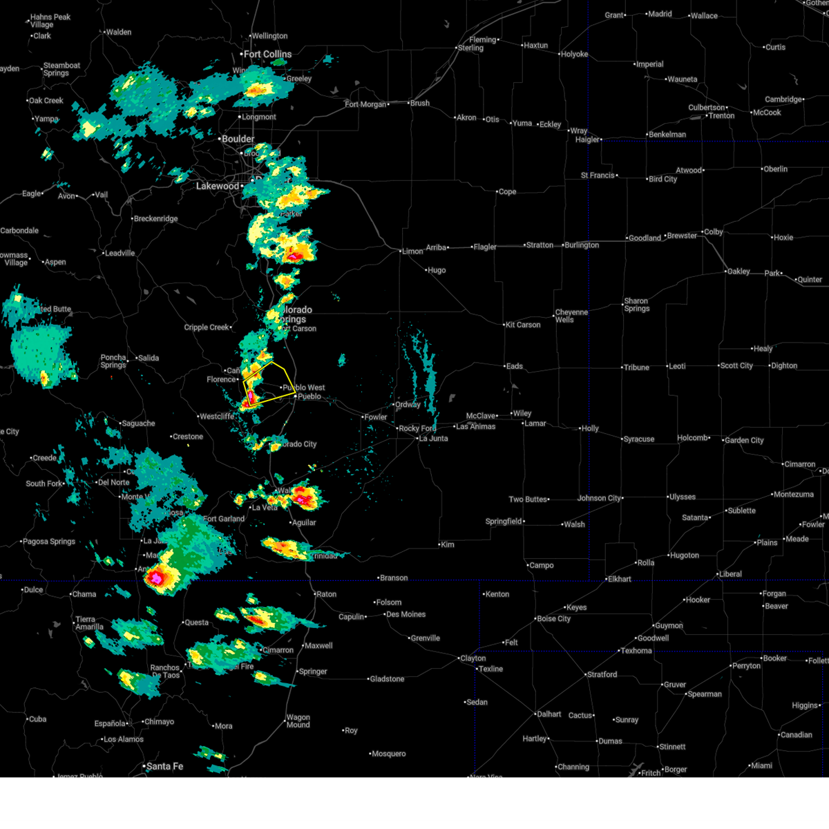
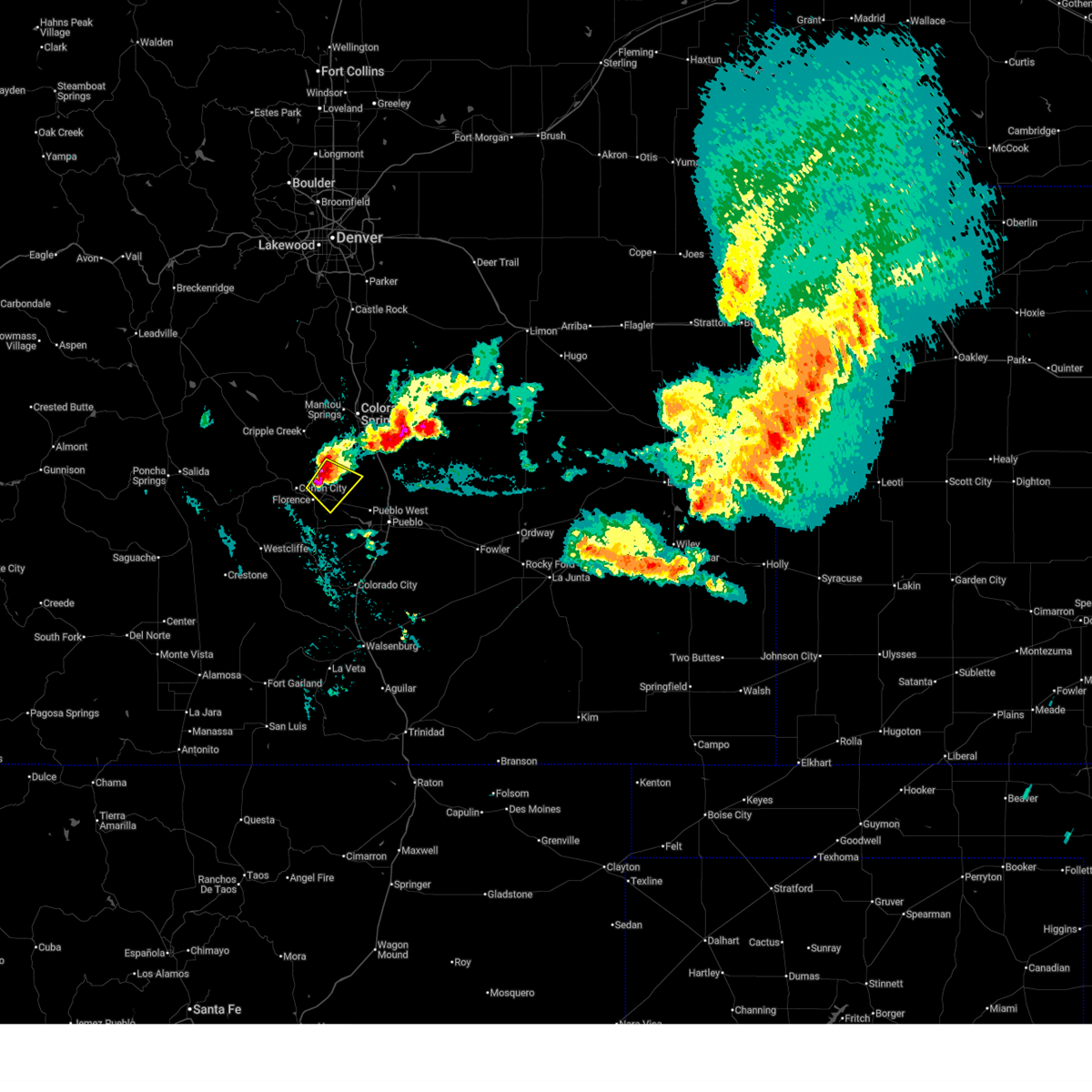
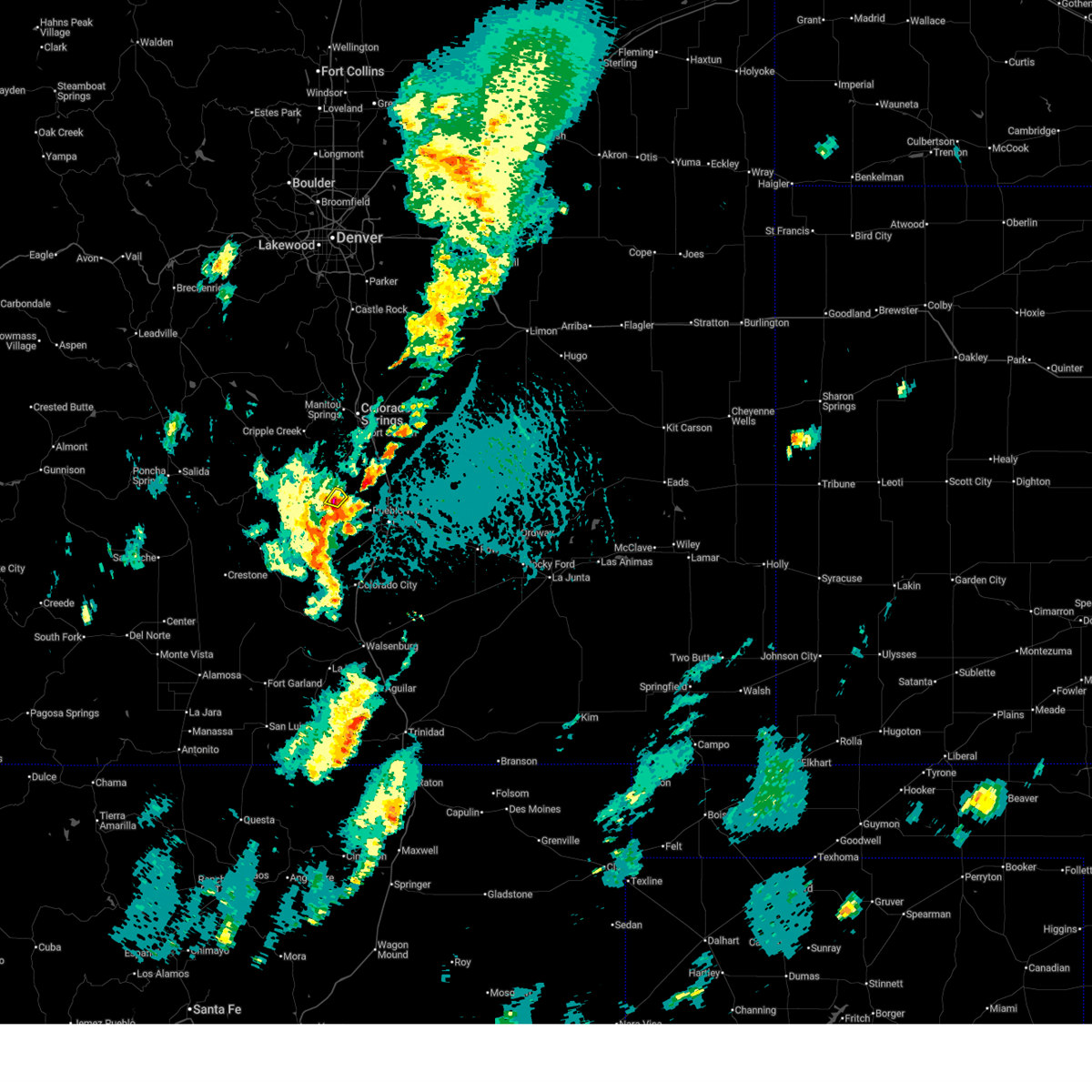
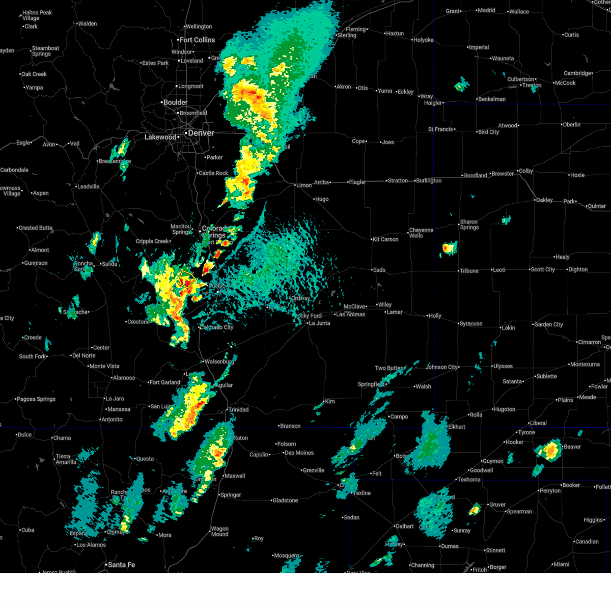
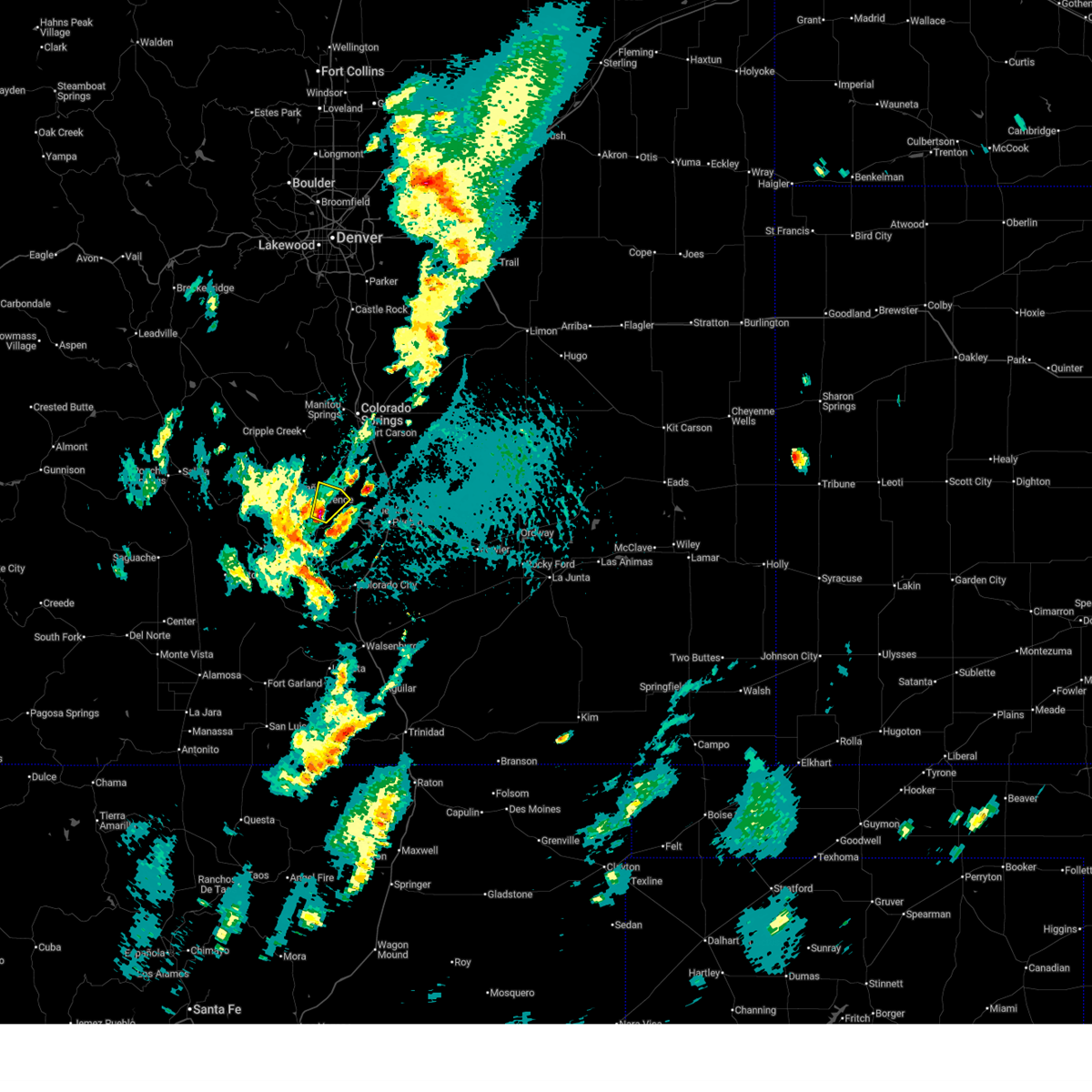
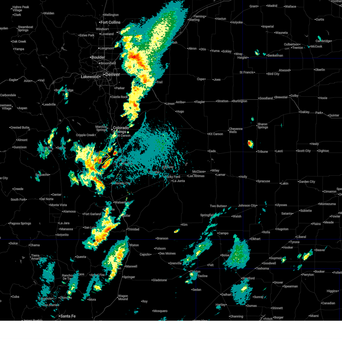
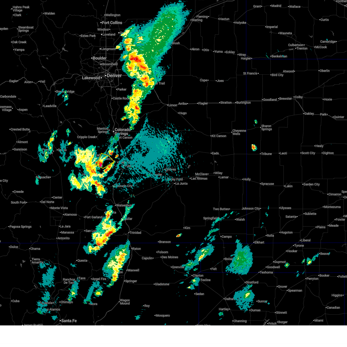
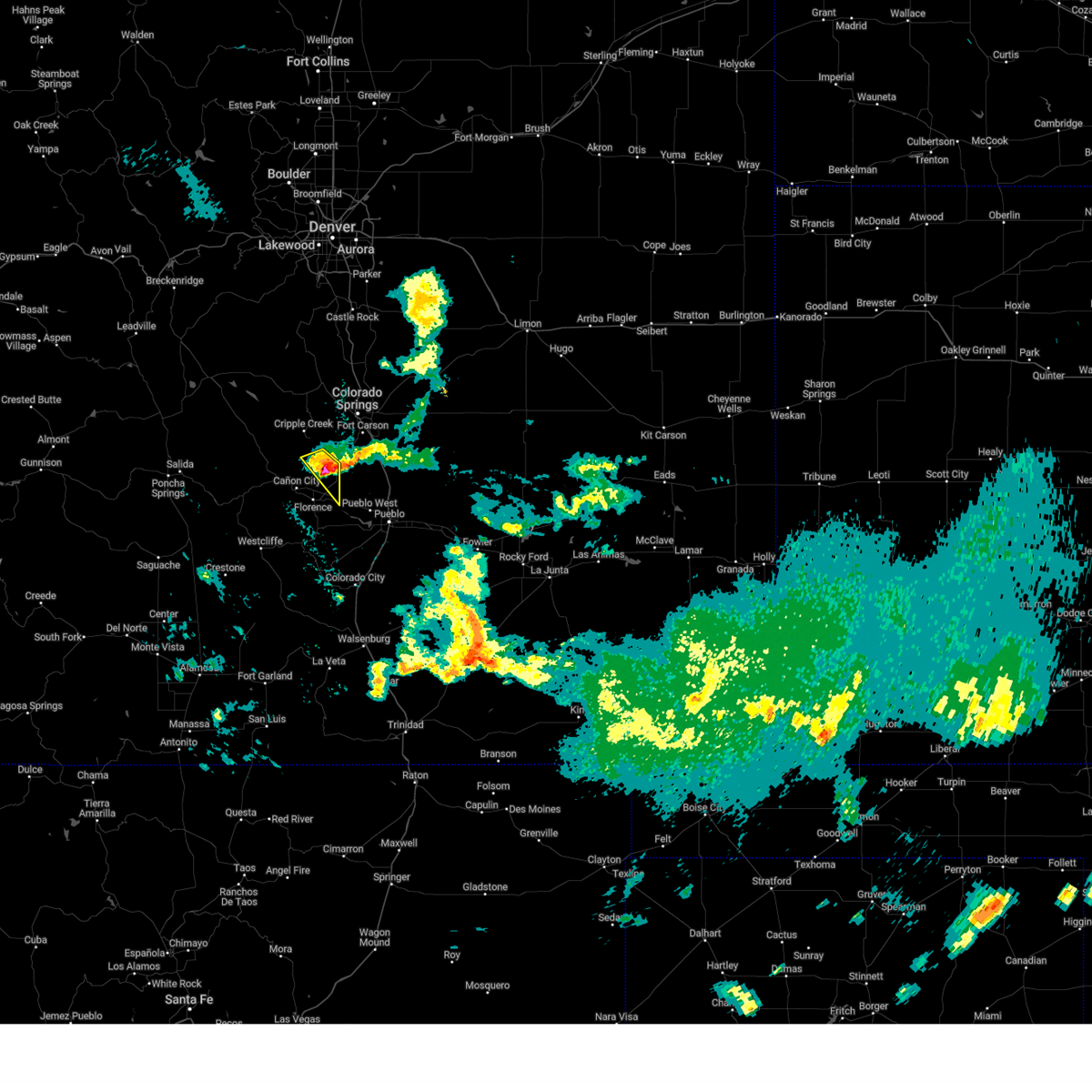
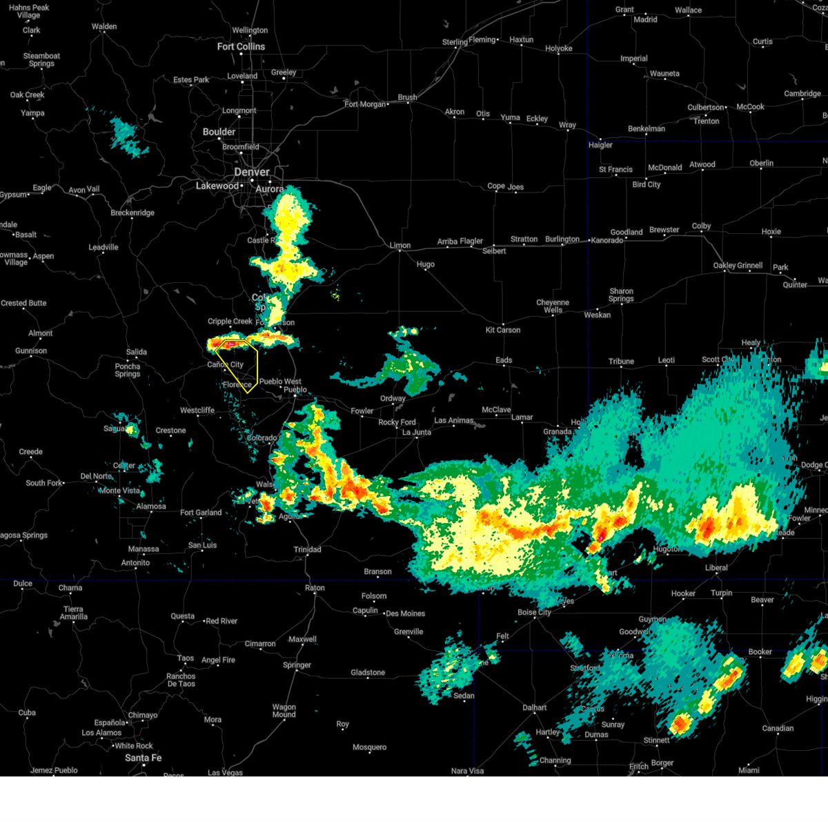
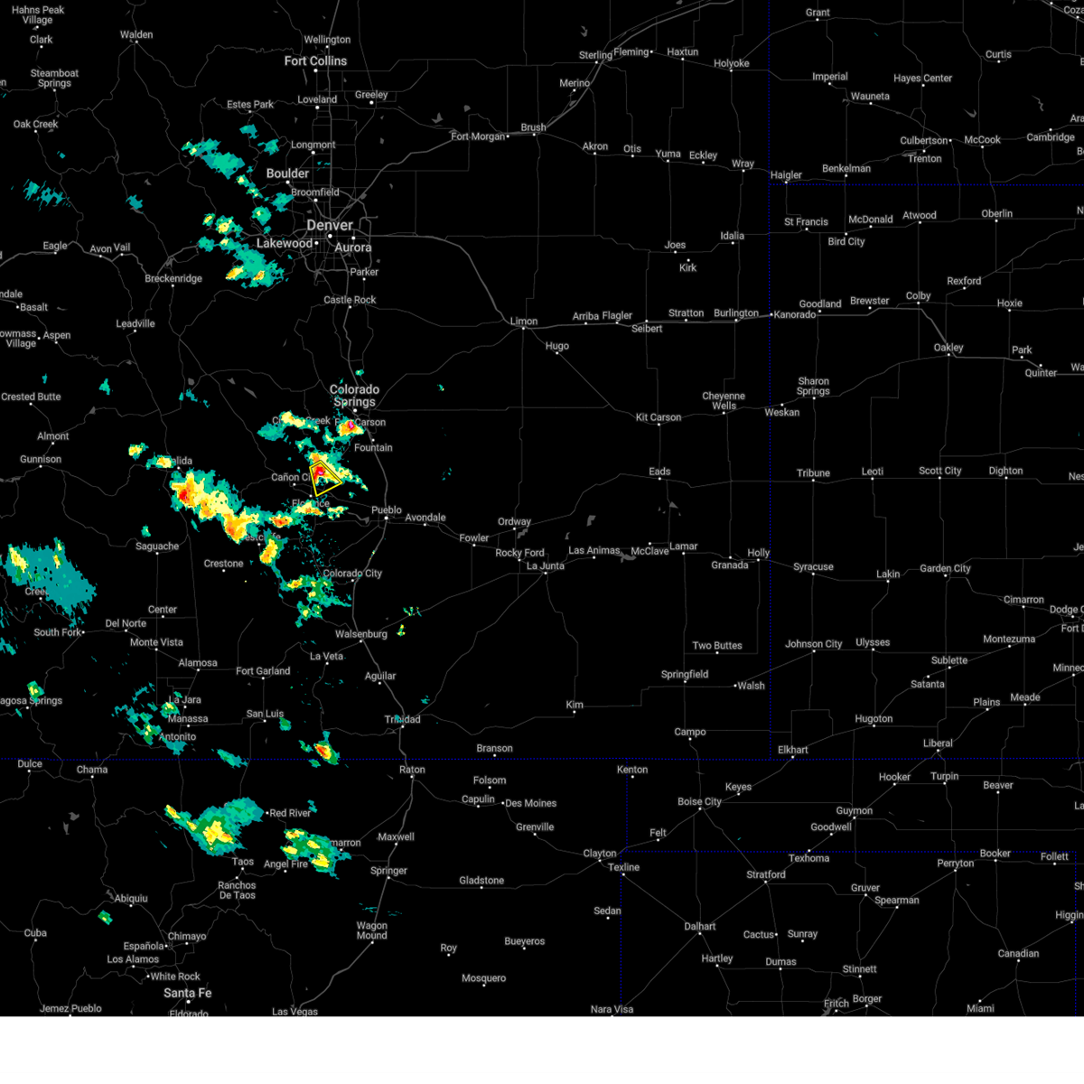
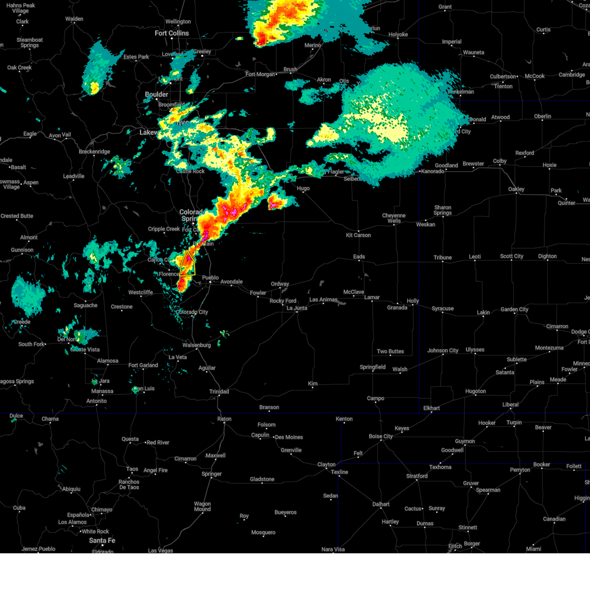
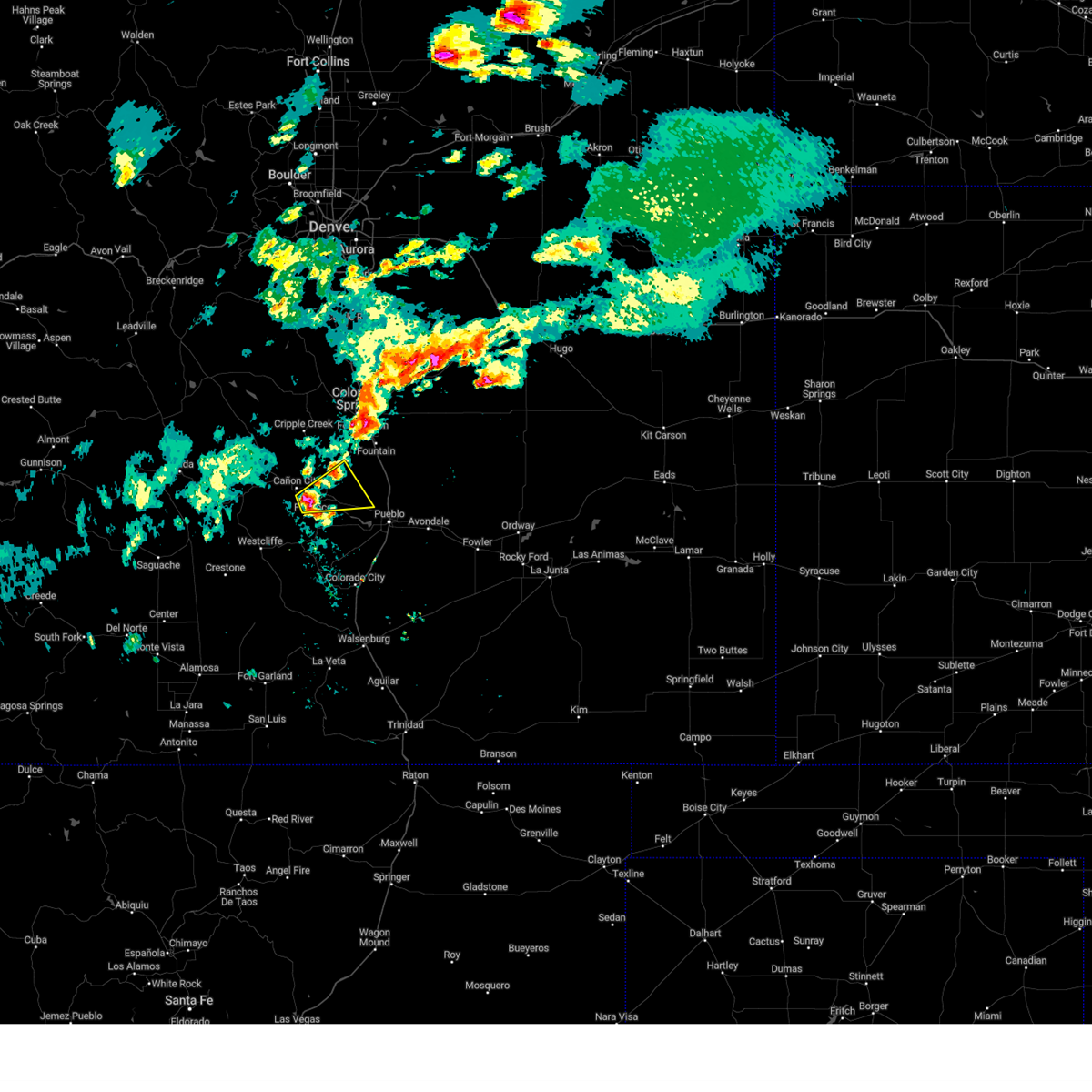
Hail Map for Penrose, CO
The Penrose, CO area has had 8 reports of on-the-ground hail by trained spotters, and has been under severe weather warnings 18 times during the past 12 months. Doppler radar has detected hail at or near Penrose, CO on 74 occasions, including 8 occasions during the past year.
| Name: | Penrose, CO |
| Where Located: | 24.7 miles WNW of Pueblo, CO |
| Map: | Google Map for Penrose, CO |
| Population: | 3582 |
| Housing Units: | 1575 |
| More Info: | Search Google for Penrose, CO |
2
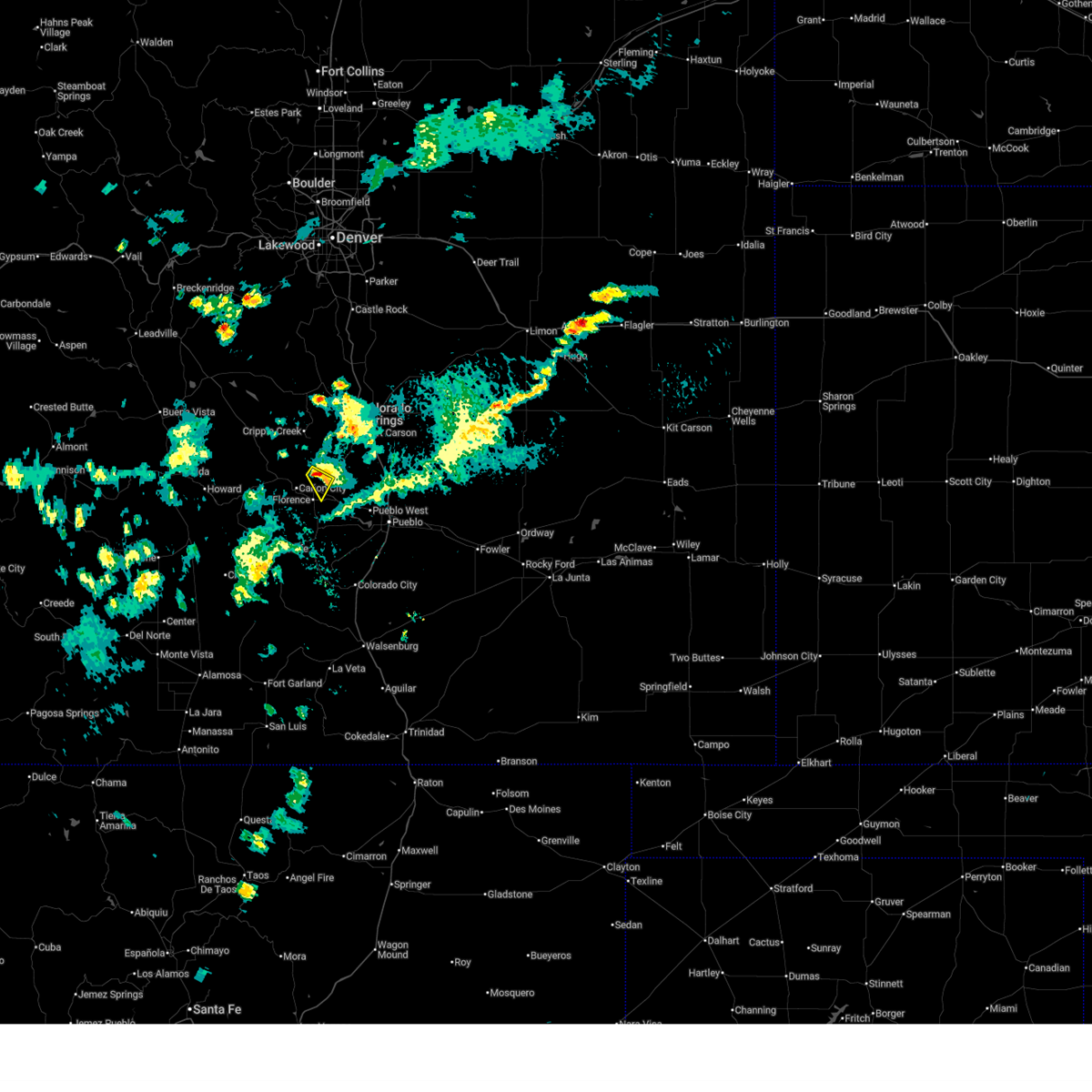
The Top Recent Hail Date for Penrose, CO is Wednesday, September 17, 2025 (6th out of 74)
Hail and Wind Damage Spotted near Penrose, CO
| Date / Time | Report Details |
|---|---|
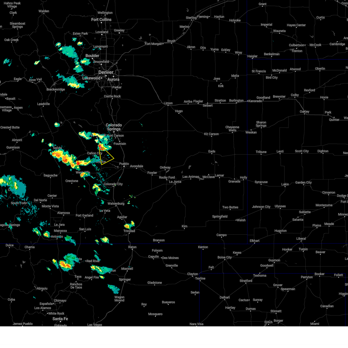
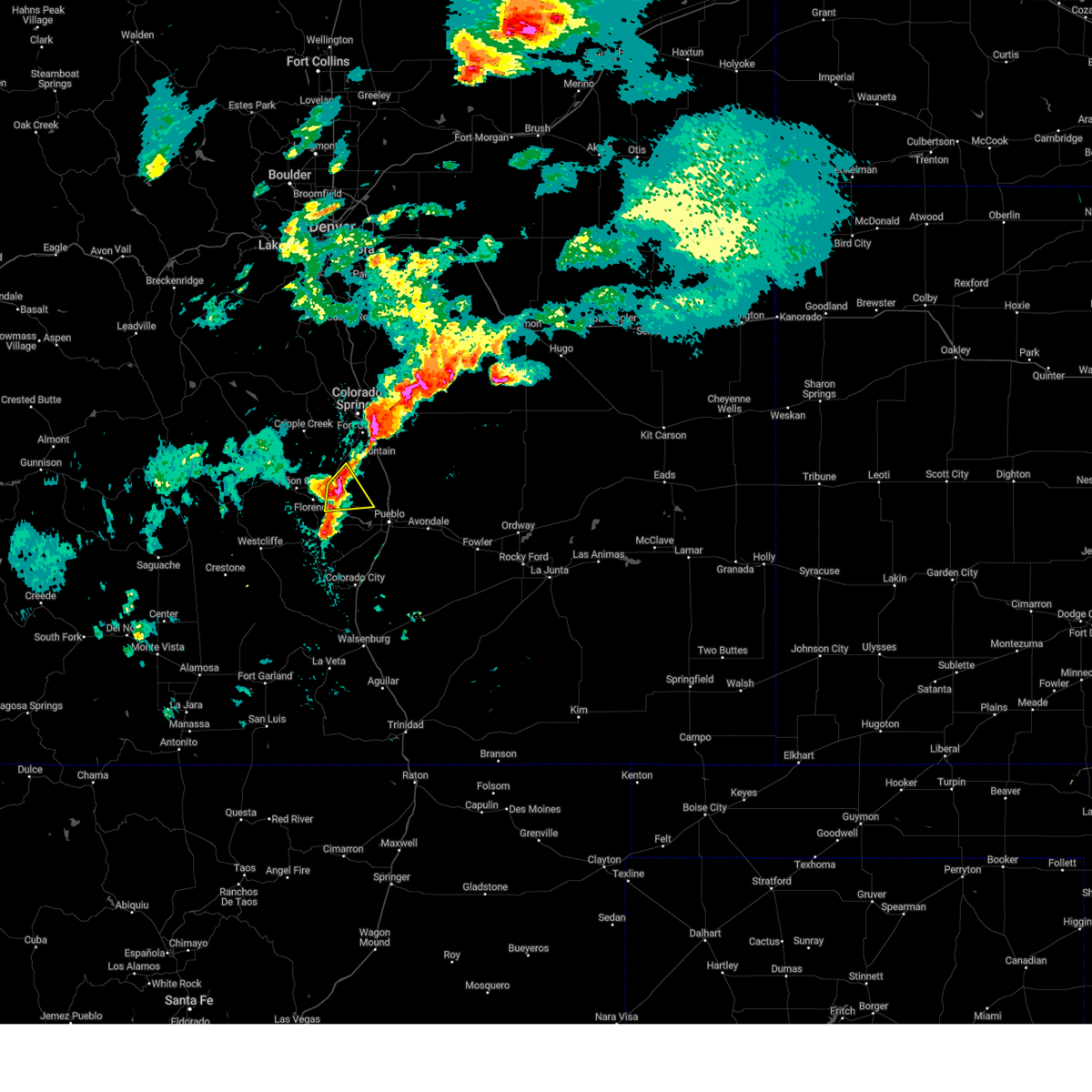
| 9/17/2025 7:51 PM MDT | The storm which prompted the warning has weakened below severe limits, and no longer poses an immediate threat to life or property. therefore, the warning will be allowed to expire. however, small hail, gusty winds and heavy rain are still possible with this thunderstorm. a severe thunderstorm watch remains in effect until 1000 pm mdt for central, southeastern and east central colorado. |
| 9/17/2025 7:44 PM MDT | At 744 pm mdt, a severe thunderstorm was located over penrose, or 23 miles northwest of pueblo, moving northeast at 25 mph (radar indicated). Hazards include 60 mph wind gusts and half dollar size hail. Hail damage to vehicles is expected. expect wind damage to roofs, siding, and trees. Locations impacted include, penrose and pueblo west. |
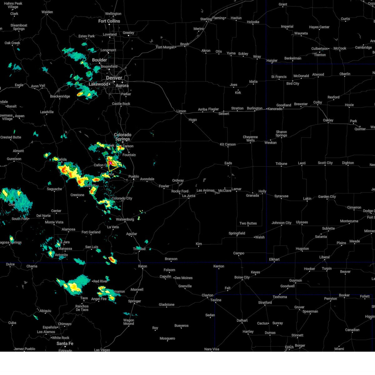
| 9/17/2025 7:37 PM MDT | At 737 pm mdt, a severe thunderstorm was located over penrose, or 25 miles northwest of pueblo, moving northeast at 25 mph (radar indicated). Hazards include golf ball size hail and 60 mph wind gusts. People and animals outdoors will be injured. expect hail damage to roofs, siding, windows, and vehicles. expect wind damage to roofs, siding, and trees. Locations impacted include, florence, penrose, and pueblo west. |
| 9/17/2025 7:30 PM MDT | Svrpub the national weather service in pueblo has issued a * severe thunderstorm warning for, southeastern fremont county in central colorado, southern el paso county in east central colorado, northwestern pueblo county in southeastern colorado, * until 800 pm mdt. * at 730 pm mdt, a severe thunderstorm was located near penrose, or 26 miles northwest of pueblo, moving northeast at 25 mph (radar indicated). Hazards include 60 mph wind gusts and half dollar size hail. Hail damage to vehicles is expected. Expect wind damage to roofs, siding, and trees. |
| 8/22/2025 4:06 PM MDT |
 The storm which prompted the warning has weakened below severe limits, and no longer poses an immediate threat to life or property. therefore, the warning will be allowed to expire. The storm which prompted the warning has weakened below severe limits, and no longer poses an immediate threat to life or property. therefore, the warning will be allowed to expire.
|
| 8/22/2025 3:57 PM MDT |
 At 357 pm mdt, a severe thunderstorm was located near penrose, or 26 miles southwest of colorado springs, moving southeast at 10 mph (radar indicated). Hazards include quarter size hail. Damage to vehicles is expected. Locations impacted include, penrose. At 357 pm mdt, a severe thunderstorm was located near penrose, or 26 miles southwest of colorado springs, moving southeast at 10 mph (radar indicated). Hazards include quarter size hail. Damage to vehicles is expected. Locations impacted include, penrose.
|
| 8/22/2025 3:39 PM MDT |
 Svrpub the national weather service in pueblo has issued a * severe thunderstorm warning for, east central fremont county in central colorado, * until 415 pm mdt. * at 339 pm mdt, a severe thunderstorm was located 8 miles northeast of canon city, or 25 miles southwest of colorado springs, moving southeast at 15 mph (radar indicated). Hazards include 60 mph wind gusts and quarter size hail. Hail damage to vehicles is expected. Expect wind damage to roofs, siding, and trees. Svrpub the national weather service in pueblo has issued a * severe thunderstorm warning for, east central fremont county in central colorado, * until 415 pm mdt. * at 339 pm mdt, a severe thunderstorm was located 8 miles northeast of canon city, or 25 miles southwest of colorado springs, moving southeast at 15 mph (radar indicated). Hazards include 60 mph wind gusts and quarter size hail. Hail damage to vehicles is expected. Expect wind damage to roofs, siding, and trees.
|
| 8/1/2025 3:36 PM MDT |
 At 335 pm mdt, a severe thunderstorm was located near pueblo reservoir, or 12 miles west of pueblo, moving northeast at 30 mph (radar indicated). Hazards include ping pong ball size hail and 60 mph wind gusts. People and animals outdoors will be injured. expect hail damage to roofs, siding, windows, and vehicles. expect wind damage to roofs, siding, and trees. Locations impacted include, northern pueblo, pueblo west, pueblo reservoir, and penrose. At 335 pm mdt, a severe thunderstorm was located near pueblo reservoir, or 12 miles west of pueblo, moving northeast at 30 mph (radar indicated). Hazards include ping pong ball size hail and 60 mph wind gusts. People and animals outdoors will be injured. expect hail damage to roofs, siding, windows, and vehicles. expect wind damage to roofs, siding, and trees. Locations impacted include, northern pueblo, pueblo west, pueblo reservoir, and penrose.
|
| 8/1/2025 3:22 PM MDT |
 Svrpub the national weather service in pueblo has issued a * severe thunderstorm warning for, southeastern fremont county in central colorado, northwestern pueblo county in southeastern colorado, * until 345 pm mdt. * at 321 pm mdt, a severe thunderstorm was located 8 miles southeast of penrose, or 18 miles west of pueblo, moving northeast at 30 mph (radar indicated). Hazards include ping pong ball size hail and 60 mph wind gusts. People and animals outdoors will be injured. expect hail damage to roofs, siding, windows, and vehicles. Expect wind damage to roofs, siding, and trees. Svrpub the national weather service in pueblo has issued a * severe thunderstorm warning for, southeastern fremont county in central colorado, northwestern pueblo county in southeastern colorado, * until 345 pm mdt. * at 321 pm mdt, a severe thunderstorm was located 8 miles southeast of penrose, or 18 miles west of pueblo, moving northeast at 30 mph (radar indicated). Hazards include ping pong ball size hail and 60 mph wind gusts. People and animals outdoors will be injured. expect hail damage to roofs, siding, windows, and vehicles. Expect wind damage to roofs, siding, and trees.
|
| 7/6/2025 10:54 PM MDT |
 The severe thunderstorm which prompted the warning has weakened. moved out of the warned area. therefore, the warning will be allowed to expire. however, small hail and heavy rain are still possible with this thunderstorm. The severe thunderstorm which prompted the warning has weakened. moved out of the warned area. therefore, the warning will be allowed to expire. however, small hail and heavy rain are still possible with this thunderstorm.
|
| 7/6/2025 10:38 PM MDT |
 At 1038 pm mdt, a severe thunderstorm was located over penrose, or 22 miles northwest of pueblo, moving southeast at 10 mph (radar indicated). Hazards include 60 mph wind gusts and half dollar size hail. Hail damage to vehicles is expected. expect wind damage to roofs, siding, and trees. Locations impacted include, penrose. At 1038 pm mdt, a severe thunderstorm was located over penrose, or 22 miles northwest of pueblo, moving southeast at 10 mph (radar indicated). Hazards include 60 mph wind gusts and half dollar size hail. Hail damage to vehicles is expected. expect wind damage to roofs, siding, and trees. Locations impacted include, penrose.
|
| 7/6/2025 10:22 PM MDT |
 At 1022 pm mdt, a severe thunderstorm was located over penrose, or 25 miles northwest of pueblo, moving southeast at 10 mph (radar indicated). Hazards include golf ball size hail and 60 mph wind gusts. People and animals outdoors will be injured. expect hail damage to roofs, siding, windows, and vehicles. expect wind damage to roofs, siding, and trees. Locations impacted include, penrose. At 1022 pm mdt, a severe thunderstorm was located over penrose, or 25 miles northwest of pueblo, moving southeast at 10 mph (radar indicated). Hazards include golf ball size hail and 60 mph wind gusts. People and animals outdoors will be injured. expect hail damage to roofs, siding, windows, and vehicles. expect wind damage to roofs, siding, and trees. Locations impacted include, penrose.
|
| 7/6/2025 10:12 PM MDT |
 Svrpub the national weather service in pueblo has issued a * severe thunderstorm warning for, east central fremont county in central colorado, southern el paso county in east central colorado, northwestern pueblo county in southeastern colorado, * until 1100 pm mdt. * at 1012 pm mdt, a severe thunderstorm was located near penrose, or 27 miles southwest of colorado springs, moving southeast at 10 mph (radar indicated). Hazards include ping pong ball size hail and 60 mph wind gusts. People and animals outdoors will be injured. expect hail damage to roofs, siding, windows, and vehicles. Expect wind damage to roofs, siding, and trees. Svrpub the national weather service in pueblo has issued a * severe thunderstorm warning for, east central fremont county in central colorado, southern el paso county in east central colorado, northwestern pueblo county in southeastern colorado, * until 1100 pm mdt. * at 1012 pm mdt, a severe thunderstorm was located near penrose, or 27 miles southwest of colorado springs, moving southeast at 10 mph (radar indicated). Hazards include ping pong ball size hail and 60 mph wind gusts. People and animals outdoors will be injured. expect hail damage to roofs, siding, windows, and vehicles. Expect wind damage to roofs, siding, and trees.
|
| 6/24/2025 3:32 PM MDT |
 At 332 pm mdt, a severe thunderstorm was located near penrose, or 20 miles northwest of pueblo, moving northeast at 20 mph (radar indicated). Hazards include 60 mph wind gusts and quarter size hail. Hail damage to vehicles is expected. expect wind damage to roofs, siding, and trees. Locations impacted include, penrose. At 332 pm mdt, a severe thunderstorm was located near penrose, or 20 miles northwest of pueblo, moving northeast at 20 mph (radar indicated). Hazards include 60 mph wind gusts and quarter size hail. Hail damage to vehicles is expected. expect wind damage to roofs, siding, and trees. Locations impacted include, penrose.
|
| 6/24/2025 3:23 PM MDT |
 At 323 pm mdt, a severe thunderstorm was located near penrose, or 22 miles west of pueblo, moving northeast at 15 mph (radar indicated). Hazards include 60 mph wind gusts and quarter size hail. Hail damage to vehicles is expected. expect wind damage to roofs, siding, and trees. Locations impacted include, penrose. At 323 pm mdt, a severe thunderstorm was located near penrose, or 22 miles west of pueblo, moving northeast at 15 mph (radar indicated). Hazards include 60 mph wind gusts and quarter size hail. Hail damage to vehicles is expected. expect wind damage to roofs, siding, and trees. Locations impacted include, penrose.
|
| 6/24/2025 3:16 PM MDT |
 the severe thunderstorm warning has been cancelled and is no longer in effect the severe thunderstorm warning has been cancelled and is no longer in effect
|
| 6/24/2025 3:16 PM MDT |
 At 315 pm mdt, a severe thunderstorm was located near florence, or 23 miles west of pueblo, moving northeast at 15 mph (radar indicated). Hazards include 60 mph wind gusts and quarter size hail. Hail damage to vehicles is expected. expect wind damage to roofs, siding, and trees. Locations impacted include, florence and penrose. At 315 pm mdt, a severe thunderstorm was located near florence, or 23 miles west of pueblo, moving northeast at 15 mph (radar indicated). Hazards include 60 mph wind gusts and quarter size hail. Hail damage to vehicles is expected. expect wind damage to roofs, siding, and trees. Locations impacted include, florence and penrose.
|
| 6/24/2025 3:08 PM MDT |
 Svrpub the national weather service in pueblo has issued a * severe thunderstorm warning for, southeastern fremont county in central colorado, northeastern custer county in southeastern colorado, northwestern pueblo county in southeastern colorado, * until 345 pm mdt. * at 308 pm mdt, a severe thunderstorm was located near florence, or 24 miles west of pueblo, moving northeast at 15 mph (radar indicated). Hazards include 60 mph wind gusts and quarter size hail. Hail damage to vehicles is expected. Expect wind damage to roofs, siding, and trees. Svrpub the national weather service in pueblo has issued a * severe thunderstorm warning for, southeastern fremont county in central colorado, northeastern custer county in southeastern colorado, northwestern pueblo county in southeastern colorado, * until 345 pm mdt. * at 308 pm mdt, a severe thunderstorm was located near florence, or 24 miles west of pueblo, moving northeast at 15 mph (radar indicated). Hazards include 60 mph wind gusts and quarter size hail. Hail damage to vehicles is expected. Expect wind damage to roofs, siding, and trees.
|
| 5/28/2025 8:08 PM MDT |
 At 808 pm mdt, a severe thunderstorm was located near penrose, or 26 miles northwest of pueblo, moving southeast at 25 mph (radar indicated). Hazards include 60 mph wind gusts and quarter size hail. Hail damage to vehicles is expected. expect wind damage to roofs, siding, and trees. Locations impacted include, penrose. At 808 pm mdt, a severe thunderstorm was located near penrose, or 26 miles northwest of pueblo, moving southeast at 25 mph (radar indicated). Hazards include 60 mph wind gusts and quarter size hail. Hail damage to vehicles is expected. expect wind damage to roofs, siding, and trees. Locations impacted include, penrose.
|
| 5/28/2025 7:42 PM MDT |
 Svrpub the national weather service in pueblo has issued a * severe thunderstorm warning for, eastern fremont county in central colorado, * until 815 pm mdt. * at 742 pm mdt, a severe thunderstorm was located 7 miles south of victor, or 24 miles southwest of colorado springs, moving southeast at 25 mph (radar indicated). Hazards include 60 mph wind gusts and quarter size hail. Hail damage to vehicles is expected. Expect wind damage to roofs, siding, and trees. Svrpub the national weather service in pueblo has issued a * severe thunderstorm warning for, eastern fremont county in central colorado, * until 815 pm mdt. * at 742 pm mdt, a severe thunderstorm was located 7 miles south of victor, or 24 miles southwest of colorado springs, moving southeast at 25 mph (radar indicated). Hazards include 60 mph wind gusts and quarter size hail. Hail damage to vehicles is expected. Expect wind damage to roofs, siding, and trees.
|
| 9/7/2024 6:22 PM MDT |
 the severe thunderstorm warning has been cancelled and is no longer in effect the severe thunderstorm warning has been cancelled and is no longer in effect
|
| 9/7/2024 6:17 PM MDT |
 At 617 pm mdt, a severe thunderstorm was located near penrose, or 25 miles southwest of colorado springs, moving southeast at 15 mph (radar indicated). Hazards include 60 mph wind gusts and quarter size hail. Hail damage to vehicles is expected. expect wind damage to roofs, siding, and trees. Locations impacted include, penrose. At 617 pm mdt, a severe thunderstorm was located near penrose, or 25 miles southwest of colorado springs, moving southeast at 15 mph (radar indicated). Hazards include 60 mph wind gusts and quarter size hail. Hail damage to vehicles is expected. expect wind damage to roofs, siding, and trees. Locations impacted include, penrose.
|
| 9/7/2024 6:05 PM MDT |
 Svrpub the national weather service in pueblo has issued a * severe thunderstorm warning for, southeastern fremont county in central colorado, northwestern pueblo county in southeastern colorado, * until 645 pm mdt. * at 605 pm mdt, a severe thunderstorm was located near penrose, or 25 miles southwest of colorado springs, moving southeast at 20 mph (radar indicated). Hazards include 60 mph wind gusts and quarter size hail. Hail damage to vehicles is expected. Expect wind damage to roofs, siding, and trees. Svrpub the national weather service in pueblo has issued a * severe thunderstorm warning for, southeastern fremont county in central colorado, northwestern pueblo county in southeastern colorado, * until 645 pm mdt. * at 605 pm mdt, a severe thunderstorm was located near penrose, or 25 miles southwest of colorado springs, moving southeast at 20 mph (radar indicated). Hazards include 60 mph wind gusts and quarter size hail. Hail damage to vehicles is expected. Expect wind damage to roofs, siding, and trees.
|
| 8/19/2024 5:23 PM MDT |
 The storm which prompted the warning has weakened below severe limits, and has exited the warned area. therefore, the warning will be allowed to expire. however, small hail, gusty winds and heavy rain are still possible with this thunderstorm. a severe thunderstorm watch remains in effect until 900 pm mdt for southeastern and east central colorado. to report severe weather, contact your nearest law enforcement agency. they will relay your report to the national weather service pueblo. The storm which prompted the warning has weakened below severe limits, and has exited the warned area. therefore, the warning will be allowed to expire. however, small hail, gusty winds and heavy rain are still possible with this thunderstorm. a severe thunderstorm watch remains in effect until 900 pm mdt for southeastern and east central colorado. to report severe weather, contact your nearest law enforcement agency. they will relay your report to the national weather service pueblo.
|
| 8/19/2024 5:15 PM MDT |
 At 514 pm mdt, a severe thunderstorm was located 8 miles northeast of penrose, or 21 miles northwest of pueblo, moving northeast at 30 mph (radar indicated). Hazards include 60 mph wind gusts and quarter size hail. Hail damage to vehicles is expected. expect wind damage to roofs, siding, and trees. Locations impacted include, penrose and pueblo west. At 514 pm mdt, a severe thunderstorm was located 8 miles northeast of penrose, or 21 miles northwest of pueblo, moving northeast at 30 mph (radar indicated). Hazards include 60 mph wind gusts and quarter size hail. Hail damage to vehicles is expected. expect wind damage to roofs, siding, and trees. Locations impacted include, penrose and pueblo west.
|
| 8/19/2024 5:07 PM MDT |
 At 506 pm mdt, a severe thunderstorm was located near penrose, or 20 miles northwest of pueblo, moving east at 30 mph (radar indicated). Hazards include 60 mph wind gusts and quarter size hail. Hail damage to vehicles is expected. expect wind damage to roofs, siding, and trees. Locations impacted include, pueblo west and penrose. At 506 pm mdt, a severe thunderstorm was located near penrose, or 20 miles northwest of pueblo, moving east at 30 mph (radar indicated). Hazards include 60 mph wind gusts and quarter size hail. Hail damage to vehicles is expected. expect wind damage to roofs, siding, and trees. Locations impacted include, pueblo west and penrose.
|
| 8/19/2024 4:59 PM MDT |
 At 458 pm mdt, a severe thunderstorm was located over penrose, or 23 miles northwest of pueblo, moving east at 30 mph (radar indicated). Hazards include 60 mph wind gusts and quarter size hail. Hail damage to vehicles is expected. expect wind damage to roofs, siding, and trees. Locations impacted include, pueblo west and penrose. At 458 pm mdt, a severe thunderstorm was located over penrose, or 23 miles northwest of pueblo, moving east at 30 mph (radar indicated). Hazards include 60 mph wind gusts and quarter size hail. Hail damage to vehicles is expected. expect wind damage to roofs, siding, and trees. Locations impacted include, pueblo west and penrose.
|
| 8/19/2024 4:58 PM MDT | Mesonet station co132 050e290 penros in fremont county CO, 1.4 miles ENE of Penrose, CO |
| 8/19/2024 4:51 PM MDT |
 At 451 pm mdt, a severe thunderstorm was located over florence, or 26 miles west of pueblo, moving east at 30 mph (radar indicated). Hazards include 60 mph wind gusts and half dollar size hail. Hail damage to vehicles is expected. expect wind damage to roofs, siding, and trees. Locations impacted include, florence, pueblo west, and penrose. At 451 pm mdt, a severe thunderstorm was located over florence, or 26 miles west of pueblo, moving east at 30 mph (radar indicated). Hazards include 60 mph wind gusts and half dollar size hail. Hail damage to vehicles is expected. expect wind damage to roofs, siding, and trees. Locations impacted include, florence, pueblo west, and penrose.
|
| 8/19/2024 4:46 PM MDT |
 Svrpub the national weather service in pueblo has issued a * severe thunderstorm warning for, southeastern fremont county in central colorado, southwestern el paso county in east central colorado, northwestern pueblo county in southeastern colorado, * until 530 pm mdt. * at 446 pm mdt, a severe thunderstorm was located over florence, or 28 miles west of pueblo, moving east at 30 mph (radar indicated). Hazards include 60 mph wind gusts and quarter size hail. Hail damage to vehicles is expected. Expect wind damage to roofs, siding, and trees. Svrpub the national weather service in pueblo has issued a * severe thunderstorm warning for, southeastern fremont county in central colorado, southwestern el paso county in east central colorado, northwestern pueblo county in southeastern colorado, * until 530 pm mdt. * at 446 pm mdt, a severe thunderstorm was located over florence, or 28 miles west of pueblo, moving east at 30 mph (radar indicated). Hazards include 60 mph wind gusts and quarter size hail. Hail damage to vehicles is expected. Expect wind damage to roofs, siding, and trees.
|
| 6/8/2024 9:46 PM MDT |
 the severe thunderstorm warning has been cancelled and is no longer in effect the severe thunderstorm warning has been cancelled and is no longer in effect
|
| 6/8/2024 9:29 PM MDT |
 Svrpub the national weather service in pueblo has issued a * severe thunderstorm warning for, east central fremont county in central colorado, northwestern pueblo county in southeastern colorado, * until 1000 pm mdt. * at 928 pm mdt, a severe thunderstorm was located near penrose, or 23 miles west of pueblo, moving northeast at 10 mph (radar indicated). Hazards include 60 mph wind gusts and half dollar size hail. Hail damage to vehicles is expected. Expect wind damage to roofs, siding, and trees. Svrpub the national weather service in pueblo has issued a * severe thunderstorm warning for, east central fremont county in central colorado, northwestern pueblo county in southeastern colorado, * until 1000 pm mdt. * at 928 pm mdt, a severe thunderstorm was located near penrose, or 23 miles west of pueblo, moving northeast at 10 mph (radar indicated). Hazards include 60 mph wind gusts and half dollar size hail. Hail damage to vehicles is expected. Expect wind damage to roofs, siding, and trees.
|
| 6/8/2024 9:22 PM MDT |
 At 921 pm mdt, a severe thunderstorm was located just south of penrose, or 26 miles northwest of pueblo, moving northeast at 15 mph (radar indicated). Hazards include ping pong ball size hail and 60 mph wind gusts. People and animals outdoors will be injured. expect hail damage to roofs, siding, windows, and vehicles. expect wind damage to roofs, siding, and trees. Locations impacted include, florence and penrose. At 921 pm mdt, a severe thunderstorm was located just south of penrose, or 26 miles northwest of pueblo, moving northeast at 15 mph (radar indicated). Hazards include ping pong ball size hail and 60 mph wind gusts. People and animals outdoors will be injured. expect hail damage to roofs, siding, windows, and vehicles. expect wind damage to roofs, siding, and trees. Locations impacted include, florence and penrose.
|
| 6/8/2024 9:22 PM MDT |
 the severe thunderstorm warning has been cancelled and is no longer in effect the severe thunderstorm warning has been cancelled and is no longer in effect
|
| 6/8/2024 9:11 PM MDT |
 At 911 pm mdt, a severe thunderstorm was located over florence, or 26 miles west of pueblo, moving northeast at 15 mph (radar indicated). Hazards include ping pong ball size hail and 60 mph wind gusts. People and animals outdoors will be injured. expect hail damage to roofs, siding, windows, and vehicles. expect wind damage to roofs, siding, and trees. Locations impacted include, florence, penrose, and wetmore. At 911 pm mdt, a severe thunderstorm was located over florence, or 26 miles west of pueblo, moving northeast at 15 mph (radar indicated). Hazards include ping pong ball size hail and 60 mph wind gusts. People and animals outdoors will be injured. expect hail damage to roofs, siding, windows, and vehicles. expect wind damage to roofs, siding, and trees. Locations impacted include, florence, penrose, and wetmore.
|
| 6/8/2024 8:58 PM MDT |
 At 857 pm mdt, a severe thunderstorm was located just south of florence, or 27 miles west of pueblo, moving northeast at 15 mph (radar indicated). Hazards include ping pong ball size hail and 60 mph wind gusts. People and animals outdoors will be injured. expect hail damage to roofs, siding, windows, and vehicles. expect wind damage to roofs, siding, and trees. Locations impacted include, florence, penrose, and wetmore. At 857 pm mdt, a severe thunderstorm was located just south of florence, or 27 miles west of pueblo, moving northeast at 15 mph (radar indicated). Hazards include ping pong ball size hail and 60 mph wind gusts. People and animals outdoors will be injured. expect hail damage to roofs, siding, windows, and vehicles. expect wind damage to roofs, siding, and trees. Locations impacted include, florence, penrose, and wetmore.
|
| 6/8/2024 8:45 PM MDT |
 Svrpub the national weather service in pueblo has issued a * severe thunderstorm warning for, southeastern fremont county in central colorado, northeastern custer county in southeastern colorado, west central pueblo county in southeastern colorado, * until 930 pm mdt. * at 845 pm mdt, a severe thunderstorm was located just south of florence, or 28 miles west of pueblo, moving northeast at 15 mph (radar indicated). Hazards include 60 mph wind gusts and half dollar size hail. Hail damage to vehicles is expected. Expect wind damage to roofs, siding, and trees. Svrpub the national weather service in pueblo has issued a * severe thunderstorm warning for, southeastern fremont county in central colorado, northeastern custer county in southeastern colorado, west central pueblo county in southeastern colorado, * until 930 pm mdt. * at 845 pm mdt, a severe thunderstorm was located just south of florence, or 28 miles west of pueblo, moving northeast at 15 mph (radar indicated). Hazards include 60 mph wind gusts and half dollar size hail. Hail damage to vehicles is expected. Expect wind damage to roofs, siding, and trees.
|
| 7/29/2023 8:22 PM MDT |
 The severe thunderstorm warning for north central huerfano, southeastern fremont, northeastern custer and western pueblo counties will expire at 830 pm mdt, the storm which prompted the warning has weakened below severe limits, and no longer poses an immediate threat to life or property. therefore, the warning will be allowed to expire. however gusty winds and heavy rain are still possible with this thunderstorm. The severe thunderstorm warning for north central huerfano, southeastern fremont, northeastern custer and western pueblo counties will expire at 830 pm mdt, the storm which prompted the warning has weakened below severe limits, and no longer poses an immediate threat to life or property. therefore, the warning will be allowed to expire. however gusty winds and heavy rain are still possible with this thunderstorm.
|
| 7/29/2023 8:00 PM MDT |
 At 800 pm mdt, a severe thunderstorm was located near pueblo reservoir, or 12 miles west of pueblo, moving southeast at 15 mph (radar indicated). Hazards include 60 mph wind gusts and quarter size hail. Hail damage to vehicles is expected. expect wind damage to roofs, siding, and trees. Locations impacted include, pueblo, pueblo airport, pueblo reservoir, salt creek, blende, pueblo west, penrose, beulah and colorado city. At 800 pm mdt, a severe thunderstorm was located near pueblo reservoir, or 12 miles west of pueblo, moving southeast at 15 mph (radar indicated). Hazards include 60 mph wind gusts and quarter size hail. Hail damage to vehicles is expected. expect wind damage to roofs, siding, and trees. Locations impacted include, pueblo, pueblo airport, pueblo reservoir, salt creek, blende, pueblo west, penrose, beulah and colorado city.
|
| 7/29/2023 7:47 PM MDT |
 At 746 pm mdt, a severe thunderstorm was located 8 miles northwest of pueblo reservoir, or 15 miles west of pueblo, moving southeast at 15 mph (radar indicated). Hazards include 60 mph wind gusts and quarter size hail. Hail damage to vehicles is expected. Expect wind damage to roofs, siding, and trees. At 746 pm mdt, a severe thunderstorm was located 8 miles northwest of pueblo reservoir, or 15 miles west of pueblo, moving southeast at 15 mph (radar indicated). Hazards include 60 mph wind gusts and quarter size hail. Hail damage to vehicles is expected. Expect wind damage to roofs, siding, and trees.
|
| 7/29/2023 7:30 PM MDT |
 At 730 pm mdt, severe thunderstorms were located along a line extending from near pueblo west to near penrose, and are nearly stationary (radar indicated). Hazards include 60 mph wind gusts and quarter size hail. Hail damage to vehicles is expected. Expect wind damage to roofs, siding, and trees. At 730 pm mdt, severe thunderstorms were located along a line extending from near pueblo west to near penrose, and are nearly stationary (radar indicated). Hazards include 60 mph wind gusts and quarter size hail. Hail damage to vehicles is expected. Expect wind damage to roofs, siding, and trees.
|
| 7/27/2023 3:35 PM MDT |
 At 334 pm mdt, a severe thunderstorm was located near penrose, or 23 miles southwest of colorado springs, moving northeast at 10 mph (radar indicated). Hazards include 60 mph wind gusts and quarter size hail. Hail damage to vehicles is expected. expect wind damage to roofs, siding, and trees. locations impacted include, penrose. hail threat, radar indicated max hail size, 1. 00 in wind threat, radar indicated max wind gust, 60 mph. At 334 pm mdt, a severe thunderstorm was located near penrose, or 23 miles southwest of colorado springs, moving northeast at 10 mph (radar indicated). Hazards include 60 mph wind gusts and quarter size hail. Hail damage to vehicles is expected. expect wind damage to roofs, siding, and trees. locations impacted include, penrose. hail threat, radar indicated max hail size, 1. 00 in wind threat, radar indicated max wind gust, 60 mph.
|
| 7/27/2023 3:28 PM MDT |
 At 328 pm mdt, a severe thunderstorm was located near penrose, or 25 miles southwest of colorado springs, moving northeast at 10 mph (radar indicated). Hazards include 60 mph wind gusts and quarter size hail. Hail damage to vehicles is expected. expect wind damage to roofs, siding, and trees. locations impacted include, penrose. hail threat, radar indicated max hail size, 1. 00 in wind threat, radar indicated max wind gust, 60 mph. At 328 pm mdt, a severe thunderstorm was located near penrose, or 25 miles southwest of colorado springs, moving northeast at 10 mph (radar indicated). Hazards include 60 mph wind gusts and quarter size hail. Hail damage to vehicles is expected. expect wind damage to roofs, siding, and trees. locations impacted include, penrose. hail threat, radar indicated max hail size, 1. 00 in wind threat, radar indicated max wind gust, 60 mph.
|
| 7/27/2023 3:16 PM MDT |
 At 316 pm mdt, a severe thunderstorm was located near penrose, or 24 miles north of junkins burn scar, moving northeast at 10 mph (radar indicated). Hazards include 60 mph wind gusts and quarter size hail. Hail damage to vehicles is expected. Expect wind damage to roofs, siding, and trees. At 316 pm mdt, a severe thunderstorm was located near penrose, or 24 miles north of junkins burn scar, moving northeast at 10 mph (radar indicated). Hazards include 60 mph wind gusts and quarter size hail. Hail damage to vehicles is expected. Expect wind damage to roofs, siding, and trees.
|
| 7/20/2023 4:58 PM MDT |
 At 457 pm mdt, a severe thunderstorm was located near pueblo reservoir, or 13 miles west of pueblo, moving southeast at 20 mph (radar indicated). Hazards include ping pong ball size hail, torrential rainfall, and 60 mph wind gusts. People and animals outdoors will be injured. expect hail damage to roofs, siding, windows, and vehicles. Expect wind damage to roofs, siding, and trees. At 457 pm mdt, a severe thunderstorm was located near pueblo reservoir, or 13 miles west of pueblo, moving southeast at 20 mph (radar indicated). Hazards include ping pong ball size hail, torrential rainfall, and 60 mph wind gusts. People and animals outdoors will be injured. expect hail damage to roofs, siding, windows, and vehicles. Expect wind damage to roofs, siding, and trees.
|
| 7/20/2023 4:49 PM MDT |
 At 449 pm mdt, a severe thunderstorm was located 8 miles west of pueblo west, or 15 miles northwest of pueblo, moving southeast at 25 mph (radar indicated). Hazards include golf ball size hail, torrential rainfall and 60 mph wind gusts. People and animals outdoors will be injured. expect hail damage to roofs, siding, windows, and vehicles. expect wind damage to roofs, siding, and trees. locations impacted include, penrose and pueblo west. thunderstorm damage threat, considerable hail threat, radar indicated max hail size, 1. 75 in wind threat, radar indicated max wind gust, 60 mph. At 449 pm mdt, a severe thunderstorm was located 8 miles west of pueblo west, or 15 miles northwest of pueblo, moving southeast at 25 mph (radar indicated). Hazards include golf ball size hail, torrential rainfall and 60 mph wind gusts. People and animals outdoors will be injured. expect hail damage to roofs, siding, windows, and vehicles. expect wind damage to roofs, siding, and trees. locations impacted include, penrose and pueblo west. thunderstorm damage threat, considerable hail threat, radar indicated max hail size, 1. 75 in wind threat, radar indicated max wind gust, 60 mph.
|
| 7/20/2023 4:37 PM MDT | Ping Pong Ball sized hail reported 0.9 miles ENE of Penrose, CO, report from mping: ping pong ball (1.50 in.). |
| 7/20/2023 4:30 PM MDT | Half Dollar sized hail reported 0.9 miles ENE of Penrose, CO, report from mping: half dollar (1.25 in.). |
| 7/20/2023 4:29 PM MDT | Quarter sized hail reported 0.9 miles ENE of Penrose, CO, report from mping: quarter (1.00 in.). |
| 7/20/2023 4:28 PM MDT |
 At 427 pm mdt, a severe thunderstorm was located over penrose, moving southeast at 30 mph (radar indicated). Hazards include golf ball size hail, torrential rainfall, and 60 mph wind gusts. People and animals outdoors will be injured. expect hail damage to roofs, siding, windows, and vehicles. Expect wind damage to roofs, siding, and trees. At 427 pm mdt, a severe thunderstorm was located over penrose, moving southeast at 30 mph (radar indicated). Hazards include golf ball size hail, torrential rainfall, and 60 mph wind gusts. People and animals outdoors will be injured. expect hail damage to roofs, siding, windows, and vehicles. Expect wind damage to roofs, siding, and trees.
|
| 7/20/2023 4:17 PM MDT |
 At 416 pm mdt, a severe thunderstorm was located near penrose, moving southeast at 25 mph (radar indicated). Hazards include torrential rainfall, 60 mph wind gusts, and half dollar size hail. Hail damage to vehicles is expected. expect wind damage to roofs, siding, and trees. locations impacted include, florence, canon city and penrose. hail threat, radar indicated max hail size, 1. 25 in wind threat, radar indicated max wind gust, 60 mph. At 416 pm mdt, a severe thunderstorm was located near penrose, moving southeast at 25 mph (radar indicated). Hazards include torrential rainfall, 60 mph wind gusts, and half dollar size hail. Hail damage to vehicles is expected. expect wind damage to roofs, siding, and trees. locations impacted include, florence, canon city and penrose. hail threat, radar indicated max hail size, 1. 25 in wind threat, radar indicated max wind gust, 60 mph.
|
| 7/20/2023 4:04 PM MDT |
 At 404 pm mdt, a severe thunderstorm was located near canon city, moving southeast at 30 mph (radar indicated). Hazards include torrential rainfall, 60 mph wind gusts, and half dollar size hail. Hail damage to vehicles is expected. Expect wind damage to roofs, siding, and trees. At 404 pm mdt, a severe thunderstorm was located near canon city, moving southeast at 30 mph (radar indicated). Hazards include torrential rainfall, 60 mph wind gusts, and half dollar size hail. Hail damage to vehicles is expected. Expect wind damage to roofs, siding, and trees.
|
| 7/15/2023 4:38 PM MDT |
 At 438 pm mdt, a severe thunderstorm was located near penrose, or 22 miles northwest of pueblo, moving southeast at 20 mph (radar indicated). Hazards include 60 mph wind gusts and quarter size hail. Hail damage to vehicles is expected. expect wind damage to roofs, siding, and trees. this severe thunderstorm will remain over mainly rural areas of east central fremont, southern el paso and northwestern pueblo counties. hail threat, radar indicated max hail size, 1. 00 in wind threat, radar indicated max wind gust, 60 mph. At 438 pm mdt, a severe thunderstorm was located near penrose, or 22 miles northwest of pueblo, moving southeast at 20 mph (radar indicated). Hazards include 60 mph wind gusts and quarter size hail. Hail damage to vehicles is expected. expect wind damage to roofs, siding, and trees. this severe thunderstorm will remain over mainly rural areas of east central fremont, southern el paso and northwestern pueblo counties. hail threat, radar indicated max hail size, 1. 00 in wind threat, radar indicated max wind gust, 60 mph.
|
| 7/15/2023 4:29 PM MDT |
 At 429 pm mdt, a severe thunderstorm was located near penrose, or 23 miles south of colorado springs, moving southeast at 20 mph (radar indicated). Hazards include 60 mph wind gusts and quarter size hail. Hail damage to vehicles is expected. expect wind damage to roofs, siding, and trees. this severe thunderstorm will be near, penrose around 435 pm mdt. hail threat, radar indicated max hail size, 1. 00 in wind threat, radar indicated max wind gust, 60 mph. At 429 pm mdt, a severe thunderstorm was located near penrose, or 23 miles south of colorado springs, moving southeast at 20 mph (radar indicated). Hazards include 60 mph wind gusts and quarter size hail. Hail damage to vehicles is expected. expect wind damage to roofs, siding, and trees. this severe thunderstorm will be near, penrose around 435 pm mdt. hail threat, radar indicated max hail size, 1. 00 in wind threat, radar indicated max wind gust, 60 mph.
|
| 7/15/2023 4:14 PM MDT |
 At 414 pm mdt, a severe thunderstorm was located 8 miles south of victor, or 22 miles southwest of colorado springs, moving southeast at 20 mph (radar indicated). Hazards include 60 mph wind gusts and quarter size hail. Hail damage to vehicles is expected. expect wind damage to roofs, siding, and trees. locations impacted include, penrose. hail threat, radar indicated max hail size, 1. 00 in wind threat, radar indicated max wind gust, 60 mph. At 414 pm mdt, a severe thunderstorm was located 8 miles south of victor, or 22 miles southwest of colorado springs, moving southeast at 20 mph (radar indicated). Hazards include 60 mph wind gusts and quarter size hail. Hail damage to vehicles is expected. expect wind damage to roofs, siding, and trees. locations impacted include, penrose. hail threat, radar indicated max hail size, 1. 00 in wind threat, radar indicated max wind gust, 60 mph.
|
| 7/15/2023 4:04 PM MDT |
 At 404 pm mdt, a severe thunderstorm was located near victor, or 22 miles southwest of colorado springs, moving southeast at 20 mph (radar indicated). Hazards include 60 mph wind gusts and quarter size hail. Hail damage to vehicles is expected. Expect wind damage to roofs, siding, and trees. At 404 pm mdt, a severe thunderstorm was located near victor, or 22 miles southwest of colorado springs, moving southeast at 20 mph (radar indicated). Hazards include 60 mph wind gusts and quarter size hail. Hail damage to vehicles is expected. Expect wind damage to roofs, siding, and trees.
|
| 6/12/2023 1:45 PM MDT |
 At 144 pm mdt, a severe thunderstorm was located near pueblo west, or 13 miles northwest of pueblo, moving east at 15 mph (radar indicated). Hazards include 60 mph wind gusts and quarter size hail. Hail damage to vehicles is expected. expect wind damage to roofs, siding, and trees. this storm has a history of producing hail of 1 to 2 inches in diameter. locations impacted include, pueblo, pueblo west, pueblo reservoir, pinon and penrose. hail threat, radar indicated max hail size, 1. 00 in wind threat, radar indicated max wind gust, 60 mph. At 144 pm mdt, a severe thunderstorm was located near pueblo west, or 13 miles northwest of pueblo, moving east at 15 mph (radar indicated). Hazards include 60 mph wind gusts and quarter size hail. Hail damage to vehicles is expected. expect wind damage to roofs, siding, and trees. this storm has a history of producing hail of 1 to 2 inches in diameter. locations impacted include, pueblo, pueblo west, pueblo reservoir, pinon and penrose. hail threat, radar indicated max hail size, 1. 00 in wind threat, radar indicated max wind gust, 60 mph.
|
| 6/12/2023 1:32 PM MDT |
 At 131 pm mdt, a severe thunderstorm was located near pueblo west, or 11 miles northwest of pueblo, moving east at 25 mph (public reported 2 inch hail near penrose). Hazards include golf ball size hail and 60 mph wind gusts. People and animals outdoors will be injured. expect hail damage to roofs, siding, windows, and vehicles. expect wind damage to roofs, siding, and trees. locations impacted include, pueblo, pueblo west, pueblo reservoir, pinon and penrose. thunderstorm damage threat, considerable hail threat, radar indicated max hail size, 1. 75 in wind threat, radar indicated max wind gust, 60 mph. At 131 pm mdt, a severe thunderstorm was located near pueblo west, or 11 miles northwest of pueblo, moving east at 25 mph (public reported 2 inch hail near penrose). Hazards include golf ball size hail and 60 mph wind gusts. People and animals outdoors will be injured. expect hail damage to roofs, siding, windows, and vehicles. expect wind damage to roofs, siding, and trees. locations impacted include, pueblo, pueblo west, pueblo reservoir, pinon and penrose. thunderstorm damage threat, considerable hail threat, radar indicated max hail size, 1. 75 in wind threat, radar indicated max wind gust, 60 mph.
|
| 6/12/2023 1:30 PM MDT | Hen Egg sized hail reported 1.4 miles ENE of Penrose, CO |
| 6/12/2023 1:22 PM MDT |
 At 121 pm mdt, a severe thunderstorm was located 7 miles southeast of penrose, or 17 miles west of pueblo, moving east at 25 mph (radar indicated). Hazards include golf ball size hail and 60 mph wind gusts. People and animals outdoors will be injured. expect hail damage to roofs, siding, windows, and vehicles. expect wind damage to roofs, siding, and trees. locations impacted include, pueblo, pueblo west, pueblo reservoir, pinon and penrose. thunderstorm damage threat, considerable hail threat, radar indicated max hail size, 1. 75 in wind threat, radar indicated max wind gust, 60 mph. At 121 pm mdt, a severe thunderstorm was located 7 miles southeast of penrose, or 17 miles west of pueblo, moving east at 25 mph (radar indicated). Hazards include golf ball size hail and 60 mph wind gusts. People and animals outdoors will be injured. expect hail damage to roofs, siding, windows, and vehicles. expect wind damage to roofs, siding, and trees. locations impacted include, pueblo, pueblo west, pueblo reservoir, pinon and penrose. thunderstorm damage threat, considerable hail threat, radar indicated max hail size, 1. 75 in wind threat, radar indicated max wind gust, 60 mph.
|
| 6/12/2023 1:10 PM MDT |
 At 109 pm mdt, a severe thunderstorm was located near penrose, moving east at 30 mph (radar indicated). Hazards include 60 mph wind gusts and half dollar size hail. Hail damage to vehicles is expected. expect wind damage to roofs, siding, and trees. locations impacted include, pueblo, florence, pueblo west, pueblo reservoir, pinon and penrose. hail threat, radar indicated max hail size, 1. 25 in wind threat, radar indicated max wind gust, 60 mph. At 109 pm mdt, a severe thunderstorm was located near penrose, moving east at 30 mph (radar indicated). Hazards include 60 mph wind gusts and half dollar size hail. Hail damage to vehicles is expected. expect wind damage to roofs, siding, and trees. locations impacted include, pueblo, florence, pueblo west, pueblo reservoir, pinon and penrose. hail threat, radar indicated max hail size, 1. 25 in wind threat, radar indicated max wind gust, 60 mph.
|
| 6/12/2023 12:58 PM MDT |
 At 1257 pm mdt, a severe thunderstorm was located near florence, or 20 miles north of junkins burn scar, moving east at 25 mph (radar indicated). Hazards include 60 mph wind gusts and quarter size hail. Hail damage to vehicles is expected. expect wind damage to roofs, siding, and trees. This storm has a history of producing 1 inch hail as it moved over canon city. At 1257 pm mdt, a severe thunderstorm was located near florence, or 20 miles north of junkins burn scar, moving east at 25 mph (radar indicated). Hazards include 60 mph wind gusts and quarter size hail. Hail damage to vehicles is expected. expect wind damage to roofs, siding, and trees. This storm has a history of producing 1 inch hail as it moved over canon city.
|
| 6/12/2023 12:49 PM MDT |
 At 1248 pm mdt, a severe thunderstorm was located near canon city, or 21 miles north of junkins burn scar, moving east at 15 mph (law enforcement). Hazards include quarter size hail. Hail damage to vehicles is expected. expect wind damage to roofs, siding, and trees. locations impacted include, florence, royal gorge, canon city and penrose. this storm has the potential to produce hail up to 2 inches in diameter. hail threat, radar indicated max hail size, 1. 00 in wind threat, radar indicated max wind gust, 60 mph. At 1248 pm mdt, a severe thunderstorm was located near canon city, or 21 miles north of junkins burn scar, moving east at 15 mph (law enforcement). Hazards include quarter size hail. Hail damage to vehicles is expected. expect wind damage to roofs, siding, and trees. locations impacted include, florence, royal gorge, canon city and penrose. this storm has the potential to produce hail up to 2 inches in diameter. hail threat, radar indicated max hail size, 1. 00 in wind threat, radar indicated max wind gust, 60 mph.
|
| 6/12/2023 12:37 PM MDT |
 At 1237 pm mdt, a severe thunderstorm was located over canon city, or 21 miles north of junkins burn scar, moving east at 15 mph (radar indicated). Hazards include two inch hail and 60 mph wind gusts. People and animals outdoors will be injured. expect hail damage to roofs, siding, windows, and vehicles. Expect wind damage to roofs, siding, and trees. At 1237 pm mdt, a severe thunderstorm was located over canon city, or 21 miles north of junkins burn scar, moving east at 15 mph (radar indicated). Hazards include two inch hail and 60 mph wind gusts. People and animals outdoors will be injured. expect hail damage to roofs, siding, windows, and vehicles. Expect wind damage to roofs, siding, and trees.
|
| 5/26/2023 3:07 PM MDT |
 At 306 pm mdt, a severe thunderstorm was located near florence, or 14 miles north of junkins burn scar, moving northeast at 10 mph (radar indicated). Hazards include 60 mph wind gusts and quarter size hail. Hail damage to vehicles is expected. expect wind damage to roofs, siding, and trees. locations impacted include, florence and penrose. hail threat, radar indicated max hail size, 1. 00 in wind threat, radar indicated max wind gust, 60 mph. At 306 pm mdt, a severe thunderstorm was located near florence, or 14 miles north of junkins burn scar, moving northeast at 10 mph (radar indicated). Hazards include 60 mph wind gusts and quarter size hail. Hail damage to vehicles is expected. expect wind damage to roofs, siding, and trees. locations impacted include, florence and penrose. hail threat, radar indicated max hail size, 1. 00 in wind threat, radar indicated max wind gust, 60 mph.
|
| 5/26/2023 2:56 PM MDT |
 At 255 pm mdt, a severe thunderstorm was located 7 miles south of florence, or 9 miles north of junkins burn scar, moving east at 10 mph (radar indicated). Hazards include 60 mph wind gusts and quarter size hail. Hail damage to vehicles is expected. expect wind damage to roofs, siding, and trees. locations impacted include, florence, penrose, canon city and wetmore. hail threat, radar indicated max hail size, 1. 00 in wind threat, radar indicated max wind gust, 60 mph. At 255 pm mdt, a severe thunderstorm was located 7 miles south of florence, or 9 miles north of junkins burn scar, moving east at 10 mph (radar indicated). Hazards include 60 mph wind gusts and quarter size hail. Hail damage to vehicles is expected. expect wind damage to roofs, siding, and trees. locations impacted include, florence, penrose, canon city and wetmore. hail threat, radar indicated max hail size, 1. 00 in wind threat, radar indicated max wind gust, 60 mph.
|
| 5/26/2023 2:46 PM MDT |
 At 245 pm mdt, a severe thunderstorm was located 7 miles south of florence, or 10 miles north of junkins burn scar, moving east at 10 mph (radar indicated). Hazards include 60 mph wind gusts and quarter size hail. Hail damage to vehicles is expected. expect wind damage to roofs, siding, and trees. this severe thunderstorm will remain over mainly rural areas of southeastern fremont, northeastern custer and west central pueblo counties, including the following locations, wetmore. hail threat, radar indicated max hail size, 1. 00 in wind threat, radar indicated max wind gust, 60 mph. At 245 pm mdt, a severe thunderstorm was located 7 miles south of florence, or 10 miles north of junkins burn scar, moving east at 10 mph (radar indicated). Hazards include 60 mph wind gusts and quarter size hail. Hail damage to vehicles is expected. expect wind damage to roofs, siding, and trees. this severe thunderstorm will remain over mainly rural areas of southeastern fremont, northeastern custer and west central pueblo counties, including the following locations, wetmore. hail threat, radar indicated max hail size, 1. 00 in wind threat, radar indicated max wind gust, 60 mph.
|
| 7/8/2022 6:31 PM MDT |
 At 630 pm mdt, a severe thunderstorm was located near penrose, or 23 miles north of junkins burn scar, moving south at 10 mph (radar indicated). Hazards include 60 mph wind gusts and quarter size hail. Hail damage to vehicles is expected. expect wind damage to roofs, siding, and trees. locations impacted include, florence, penrose and far eastern portions of canon city. hail threat, radar indicated max hail size, 1. 00 in wind threat, radar indicated max wind gust, 60 mph. At 630 pm mdt, a severe thunderstorm was located near penrose, or 23 miles north of junkins burn scar, moving south at 10 mph (radar indicated). Hazards include 60 mph wind gusts and quarter size hail. Hail damage to vehicles is expected. expect wind damage to roofs, siding, and trees. locations impacted include, florence, penrose and far eastern portions of canon city. hail threat, radar indicated max hail size, 1. 00 in wind threat, radar indicated max wind gust, 60 mph.
|
| 7/8/2022 6:13 PM MDT |
 At 612 pm mdt, a severe thunderstorm was located near penrose, or 22 miles north of junkins burn scar, moving southwest at 15 mph (radar indicated). Hazards include 60 mph wind gusts and quarter size hail. Hail damage to vehicles is expected. expect wind damage to roofs, siding, and trees. locations impacted include, florence, penrose and canon city. hail threat, radar indicated max hail size, 1. 00 in wind threat, radar indicated max wind gust, 60 mph. At 612 pm mdt, a severe thunderstorm was located near penrose, or 22 miles north of junkins burn scar, moving southwest at 15 mph (radar indicated). Hazards include 60 mph wind gusts and quarter size hail. Hail damage to vehicles is expected. expect wind damage to roofs, siding, and trees. locations impacted include, florence, penrose and canon city. hail threat, radar indicated max hail size, 1. 00 in wind threat, radar indicated max wind gust, 60 mph.
|
| 7/8/2022 5:41 PM MDT |
 At 540 pm mdt, a severe thunderstorm was located 10 miles southeast of victor, or 19 miles southwest of colorado springs, moving southwest at 15 mph (radar indicated). Hazards include 60 mph wind gusts and half dollar size hail. Hail damage to vehicles is expected. expect wind damage to roofs, siding, and trees. this severe thunderstorm will be near, penrose around 610 pm mdt. florence and canon city around 630 pm mdt. hail threat, radar indicated max hail size, 1. 25 in wind threat, radar indicated max wind gust, 60 mph. At 540 pm mdt, a severe thunderstorm was located 10 miles southeast of victor, or 19 miles southwest of colorado springs, moving southwest at 15 mph (radar indicated). Hazards include 60 mph wind gusts and half dollar size hail. Hail damage to vehicles is expected. expect wind damage to roofs, siding, and trees. this severe thunderstorm will be near, penrose around 610 pm mdt. florence and canon city around 630 pm mdt. hail threat, radar indicated max hail size, 1. 25 in wind threat, radar indicated max wind gust, 60 mph.
|
| 7/3/2021 3:51 PM MDT |
 At 350 pm mdt, a severe thunderstorm was located near florence, or 18 miles north of junkins burn scar, moving south at 15 mph (radar indicated). Hazards include 60 mph wind gusts and quarter size hail. Hail damage to vehicles is expected. expect wind damage to roofs, siding, and trees. Locations impacted include, florence, canon city and penrose. At 350 pm mdt, a severe thunderstorm was located near florence, or 18 miles north of junkins burn scar, moving south at 15 mph (radar indicated). Hazards include 60 mph wind gusts and quarter size hail. Hail damage to vehicles is expected. expect wind damage to roofs, siding, and trees. Locations impacted include, florence, canon city and penrose.
|
| 7/3/2021 3:36 PM MDT |
 At 335 pm mdt, a severe thunderstorm was located over canon city, or 22 miles north of junkins burn scar, moving south at 15 mph (radar indicated). Hazards include 60 mph wind gusts and quarter size hail. Hail damage to vehicles is expected. expect wind damage to roofs, siding, and trees. Locations impacted include, florence, canon city and penrose. At 335 pm mdt, a severe thunderstorm was located over canon city, or 22 miles north of junkins burn scar, moving south at 15 mph (radar indicated). Hazards include 60 mph wind gusts and quarter size hail. Hail damage to vehicles is expected. expect wind damage to roofs, siding, and trees. Locations impacted include, florence, canon city and penrose.
|
| 7/3/2021 3:25 PM MDT |
 At 325 pm mdt, a severe thunderstorm was located near canon city, or 25 miles north of junkins burn scar, moving southeast at 15 mph (radar indicated). Hazards include 60 mph wind gusts and quarter size hail. Hail damage to vehicles is expected. Expect wind damage to roofs, siding, and trees. At 325 pm mdt, a severe thunderstorm was located near canon city, or 25 miles north of junkins burn scar, moving southeast at 15 mph (radar indicated). Hazards include 60 mph wind gusts and quarter size hail. Hail damage to vehicles is expected. Expect wind damage to roofs, siding, and trees.
|
| 6/1/2021 1:30 PM MDT |
 At 130 pm mdt, a severe thunderstorm was located near penrose, or 23 miles northwest of pueblo, moving southeast at 15 mph (radar indicated). Hazards include 60 mph wind gusts and quarter size hail. Hail damage to vehicles is expected. expect wind damage to roofs, siding, and trees. Locations impacted include, penrose and pueblo west. At 130 pm mdt, a severe thunderstorm was located near penrose, or 23 miles northwest of pueblo, moving southeast at 15 mph (radar indicated). Hazards include 60 mph wind gusts and quarter size hail. Hail damage to vehicles is expected. expect wind damage to roofs, siding, and trees. Locations impacted include, penrose and pueblo west.
|
| 6/1/2021 1:07 PM MDT |
 At 107 pm mdt, a severe thunderstorm was located near penrose, or 24 miles southwest of colorado springs, moving southeast at 15 mph (radar indicated). Hazards include 60 mph wind gusts and quarter size hail. Hail damage to vehicles is expected. Expect wind damage to roofs, siding, and trees. At 107 pm mdt, a severe thunderstorm was located near penrose, or 24 miles southwest of colorado springs, moving southeast at 15 mph (radar indicated). Hazards include 60 mph wind gusts and quarter size hail. Hail damage to vehicles is expected. Expect wind damage to roofs, siding, and trees.
|
| 7/30/2020 8:08 PM MDT |
 At 808 pm mdt, a severe thunderstorm was located 17 miles east of greenhorn mountain, or 22 miles south of pueblo, moving southeast at 65 mph (radar indicated). Hazards include 60 mph wind gusts and quarter size hail. Expect damage to roofs, siding, and trees. Hail damage to vehicles is expected. At 808 pm mdt, a severe thunderstorm was located 17 miles east of greenhorn mountain, or 22 miles south of pueblo, moving southeast at 65 mph (radar indicated). Hazards include 60 mph wind gusts and quarter size hail. Expect damage to roofs, siding, and trees. Hail damage to vehicles is expected.
|
| 7/15/2020 3:56 PM MDT |
 At 356 pm mdt, severe thunderstorms were located along a line extending from 6 miles east of fountain to near pueblo west to 9 miles west of pueblo reservoir, moving southeast at 35 mph (radar indicated). Hazards include 60 mph wind gusts and half dollar size hail. Hail damage to vehicles is expected. Expect wind damage to roofs, siding, and trees. At 356 pm mdt, severe thunderstorms were located along a line extending from 6 miles east of fountain to near pueblo west to 9 miles west of pueblo reservoir, moving southeast at 35 mph (radar indicated). Hazards include 60 mph wind gusts and half dollar size hail. Hail damage to vehicles is expected. Expect wind damage to roofs, siding, and trees.
|
| 7/15/2020 3:30 PM MDT |
 At 330 pm mdt, a severe thunderstorm was located near penrose, or 24 miles north of junkins burn scar, moving east at 20 mph (radar indicated). Hazards include 60 mph wind gusts and quarter size hail. Hail damage to vehicles is expected. expect wind damage to roofs, siding, and trees. Locations impacted include, penrose. At 330 pm mdt, a severe thunderstorm was located near penrose, or 24 miles north of junkins burn scar, moving east at 20 mph (radar indicated). Hazards include 60 mph wind gusts and quarter size hail. Hail damage to vehicles is expected. expect wind damage to roofs, siding, and trees. Locations impacted include, penrose.
|
| 7/15/2020 3:15 PM MDT |
 At 315 pm mdt, a severe thunderstorm was located near penrose, or 24 miles north of junkins burn scar, moving east at 20 mph (radar indicated). Hazards include 60 mph wind gusts and quarter size hail. Hail damage to vehicles is expected. Expect wind damage to roofs, siding, and trees. At 315 pm mdt, a severe thunderstorm was located near penrose, or 24 miles north of junkins burn scar, moving east at 20 mph (radar indicated). Hazards include 60 mph wind gusts and quarter size hail. Hail damage to vehicles is expected. Expect wind damage to roofs, siding, and trees.
|
| 7/12/2020 4:57 PM MDT |
 The severe thunderstorm warning for east central fremont and northwestern pueblo counties will expire at 500 pm mdt, the storm which prompted the warning has weakened below severe limits, and no longer poses an immediate threat to life or property. therefore, the warning will be allowed to expire. a severe thunderstorm over west central pueblo county remains in effect until 5:30 pm. a severe thunderstorm watch remains in effect until 900 pm mdt for southeastern colorado. The severe thunderstorm warning for east central fremont and northwestern pueblo counties will expire at 500 pm mdt, the storm which prompted the warning has weakened below severe limits, and no longer poses an immediate threat to life or property. therefore, the warning will be allowed to expire. a severe thunderstorm over west central pueblo county remains in effect until 5:30 pm. a severe thunderstorm watch remains in effect until 900 pm mdt for southeastern colorado.
|
| 7/12/2020 4:47 PM MDT |
 At 446 pm mdt, a severe thunderstorm was located over penrose, or 20 miles north of junkins burn scar, moving east at 20 mph (radar indicated). Hazards include 60 mph wind gusts and quarter size hail. Hail damage to vehicles is expected. expect wind damage to roofs, siding, and trees. Locations impacted include, florence, canon city, penrose and pueblo west. At 446 pm mdt, a severe thunderstorm was located over penrose, or 20 miles north of junkins burn scar, moving east at 20 mph (radar indicated). Hazards include 60 mph wind gusts and quarter size hail. Hail damage to vehicles is expected. expect wind damage to roofs, siding, and trees. Locations impacted include, florence, canon city, penrose and pueblo west.
|
| 7/12/2020 4:32 PM MDT |
 At 431 pm mdt, a severe thunderstorm was located near canon city, or 21 miles north of junkins burn scar, moving east at 30 mph (radar indicated. this storm produced quarter size hail in canon city at 4:13 pm). Hazards include 60 mph wind gusts and quarter size hail. Hail damage to vehicles is expected. expect wind damage to roofs, siding, and trees. Locations impacted include, florence, canon city, penrose and pueblo west. At 431 pm mdt, a severe thunderstorm was located near canon city, or 21 miles north of junkins burn scar, moving east at 30 mph (radar indicated. this storm produced quarter size hail in canon city at 4:13 pm). Hazards include 60 mph wind gusts and quarter size hail. Hail damage to vehicles is expected. expect wind damage to roofs, siding, and trees. Locations impacted include, florence, canon city, penrose and pueblo west.
|
| 7/12/2020 4:17 PM MDT |
 At 416 pm mdt, a severe thunderstorm was located near penrose, or 24 miles south of colorado springs, moving east at 20 mph (the public reported hail up to the size of quarters in northwest canon city at 4:13 pm). Hazards include 60 mph wind gusts and quarter size hail. Hail damage to vehicles is expected. Expect wind damage to roofs, siding, and trees. At 416 pm mdt, a severe thunderstorm was located near penrose, or 24 miles south of colorado springs, moving east at 20 mph (the public reported hail up to the size of quarters in northwest canon city at 4:13 pm). Hazards include 60 mph wind gusts and quarter size hail. Hail damage to vehicles is expected. Expect wind damage to roofs, siding, and trees.
|
| 7/12/2020 4:03 PM MDT |
 At 403 pm mdt, severe thunderstorms were located along a line extending from 9 miles southwest of fountain to 7 miles northwest of penrose, moving southeast at 15 mph (radar indicated). Hazards include 60 mph wind gusts and nickel size hail. Expect damage to roofs, siding, and trees. Locations impacted include, florence, penrose and canon city. At 403 pm mdt, severe thunderstorms were located along a line extending from 9 miles southwest of fountain to 7 miles northwest of penrose, moving southeast at 15 mph (radar indicated). Hazards include 60 mph wind gusts and nickel size hail. Expect damage to roofs, siding, and trees. Locations impacted include, florence, penrose and canon city.
|
| 7/12/2020 3:52 PM MDT |
 At 351 pm mdt, severe thunderstorms were located along a line extending from 9 miles southwest of fountain to 7 miles northeast of canon city, moving southeast at 15 mph (radar indicated). Hazards include 60 mph wind gusts and nickel size hail. Expect damage to roofs, siding, and trees. Locations impacted include, florence, penrose and canon city. At 351 pm mdt, severe thunderstorms were located along a line extending from 9 miles southwest of fountain to 7 miles northeast of canon city, moving southeast at 15 mph (radar indicated). Hazards include 60 mph wind gusts and nickel size hail. Expect damage to roofs, siding, and trees. Locations impacted include, florence, penrose and canon city.
|
| 7/12/2020 3:38 PM MDT |
 At 337 pm mdt, severe thunderstorms were located along a line extending from 10 miles southwest of fort carson to 7 miles north of canon city, moving east at 25 mph (radar indicated). Hazards include 60 mph wind gusts and quarter size hail. Hail damage to vehicles is expected. expect wind damage to roofs, siding, and trees. Locations impacted include, florence, penrose and canon city. At 337 pm mdt, severe thunderstorms were located along a line extending from 10 miles southwest of fort carson to 7 miles north of canon city, moving east at 25 mph (radar indicated). Hazards include 60 mph wind gusts and quarter size hail. Hail damage to vehicles is expected. expect wind damage to roofs, siding, and trees. Locations impacted include, florence, penrose and canon city.
|
| 7/12/2020 3:30 PM MDT |
 At 330 pm mdt, a severe thunderstorm was located 10 miles southeast of victor, or 19 miles southwest of colorado springs, moving southeast at 20 mph (radar indicated). Hazards include 60 mph wind gusts and quarter size hail. Hail damage to vehicles is expected. Expect wind damage to roofs, siding, and trees. At 330 pm mdt, a severe thunderstorm was located 10 miles southeast of victor, or 19 miles southwest of colorado springs, moving southeast at 20 mph (radar indicated). Hazards include 60 mph wind gusts and quarter size hail. Hail damage to vehicles is expected. Expect wind damage to roofs, siding, and trees.
|
| 6/6/2020 4:19 PM MDT |
 At 419 pm mdt, a severe thunderstorm was located near penrose, or 23 miles northwest of pueblo, moving northeast at 50 mph (radar indicated). Hazards include 60 mph wind gusts and quarter size hail. Hail damage to vehicles is expected. Expect wind damage to roofs, siding, and trees. At 419 pm mdt, a severe thunderstorm was located near penrose, or 23 miles northwest of pueblo, moving northeast at 50 mph (radar indicated). Hazards include 60 mph wind gusts and quarter size hail. Hail damage to vehicles is expected. Expect wind damage to roofs, siding, and trees.
|
| 6/6/2020 3:15 PM MDT |
 At 315 pm mdt, a severe thunderstorm was located 7 miles north of penrose, or 22 miles south of colorado springs, moving north at 65 mph (radar indicated). Hazards include 60 mph wind gusts and quarter size hail. Hail damage to vehicles is expected. Expect wind damage to roofs, siding, and trees. At 315 pm mdt, a severe thunderstorm was located 7 miles north of penrose, or 22 miles south of colorado springs, moving north at 65 mph (radar indicated). Hazards include 60 mph wind gusts and quarter size hail. Hail damage to vehicles is expected. Expect wind damage to roofs, siding, and trees.
|
| 6/3/2020 2:07 PM MDT |
 The severe thunderstorm warning for southeastern fremont and northwestern pueblo counties will expire at 215 pm mdt, the storm which prompted the warning has weakened below severe limits, and no longer poses an immediate threat to life or property. therefore, the warning will be allowed to expire. however gusty winds are still possible with this thunderstorm. The severe thunderstorm warning for southeastern fremont and northwestern pueblo counties will expire at 215 pm mdt, the storm which prompted the warning has weakened below severe limits, and no longer poses an immediate threat to life or property. therefore, the warning will be allowed to expire. however gusty winds are still possible with this thunderstorm.
|
| 6/3/2020 1:54 PM MDT |
 At 154 pm mdt, a severe thunderstorm was located over florence, or 17 miles north of junkins burn scar, moving east at 25 mph (radar indicated). Hazards include 60 mph wind gusts. Expect damage to roofs, siding, and trees. Locations impacted include, florence, penrose and pueblo west. At 154 pm mdt, a severe thunderstorm was located over florence, or 17 miles north of junkins burn scar, moving east at 25 mph (radar indicated). Hazards include 60 mph wind gusts. Expect damage to roofs, siding, and trees. Locations impacted include, florence, penrose and pueblo west.
|
| 6/3/2020 1:47 PM MDT |
 At 146 pm mdt, a severe thunderstorm was located over florence, or 18 miles north of junkins burn scar, moving east at 25 mph (radar indicated. at 140 pm, a wind gust to 62 mph was reported 2 miles north northeast of florence at the fremont county airport). Hazards include 60 mph wind gusts. expect damage to roofs, siding, and trees At 146 pm mdt, a severe thunderstorm was located over florence, or 18 miles north of junkins burn scar, moving east at 25 mph (radar indicated. at 140 pm, a wind gust to 62 mph was reported 2 miles north northeast of florence at the fremont county airport). Hazards include 60 mph wind gusts. expect damage to roofs, siding, and trees
|
| 6/3/2020 1:40 PM MDT | Awos station k1v6 fremont county arp in fremont county CO, 4.6 miles E of Penrose, CO |
| 5/24/2020 6:36 PM MDT |
 At 636 pm mdt, a severe thunderstorm was located near penrose, or 23 miles northwest of pueblo, moving northeast at 25 mph (radar indicated). Hazards include 60 mph wind gusts and quarter size hail. Hail damage to vehicles is expected. expect wind damage to roofs, siding, and trees. Locations impacted include, penrose and canon city. At 636 pm mdt, a severe thunderstorm was located near penrose, or 23 miles northwest of pueblo, moving northeast at 25 mph (radar indicated). Hazards include 60 mph wind gusts and quarter size hail. Hail damage to vehicles is expected. expect wind damage to roofs, siding, and trees. Locations impacted include, penrose and canon city.
|
| 5/24/2020 6:32 PM MDT | Quarter sized hail reported 1.8 miles NW of Penrose, CO |
| 5/24/2020 6:26 PM MDT |
 At 626 pm mdt, a severe thunderstorm was located over penrose, or 22 miles north of junkins burn scar, moving northeast at 30 mph (radar indicated). Hazards include 60 mph wind gusts and quarter size hail. Hail damage to vehicles is expected. expect wind damage to roofs, siding, and trees. Locations impacted include, florence, penrose and canon city. At 626 pm mdt, a severe thunderstorm was located over penrose, or 22 miles north of junkins burn scar, moving northeast at 30 mph (radar indicated). Hazards include 60 mph wind gusts and quarter size hail. Hail damage to vehicles is expected. expect wind damage to roofs, siding, and trees. Locations impacted include, florence, penrose and canon city.
|
| 5/24/2020 6:13 PM MDT |
 At 613 pm mdt, a severe thunderstorm was located over florence, or 19 miles north of junkins burn scar, moving northeast at 25 mph (radar indicated). Hazards include 60 mph wind gusts and quarter size hail. Hail damage to vehicles is expected. Expect wind damage to roofs, siding, and trees. At 613 pm mdt, a severe thunderstorm was located over florence, or 19 miles north of junkins burn scar, moving northeast at 25 mph (radar indicated). Hazards include 60 mph wind gusts and quarter size hail. Hail damage to vehicles is expected. Expect wind damage to roofs, siding, and trees.
|
| 5/24/2020 6:05 PM MDT |
 At 605 pm mdt, a severe thunderstorm was located over florence, or 20 miles north of junkins burn scar, moving northeast at 25 mph (radar indicated). Hazards include 60 mph wind gusts and quarter size hail. Hail damage to vehicles is expected. expect wind damage to roofs, siding, and trees. Locations impacted include, florence, canon city and penrose. At 605 pm mdt, a severe thunderstorm was located over florence, or 20 miles north of junkins burn scar, moving northeast at 25 mph (radar indicated). Hazards include 60 mph wind gusts and quarter size hail. Hail damage to vehicles is expected. expect wind damage to roofs, siding, and trees. Locations impacted include, florence, canon city and penrose.
|
| 5/24/2020 5:51 PM MDT |
 At 551 pm mdt, a severe thunderstorm was located near florence, or 17 miles north of junkins burn scar, moving northeast at 25 mph (radar indicated). Hazards include 60 mph wind gusts and quarter size hail. Hail damage to vehicles is expected. Expect wind damage to roofs, siding, and trees. At 551 pm mdt, a severe thunderstorm was located near florence, or 17 miles north of junkins burn scar, moving northeast at 25 mph (radar indicated). Hazards include 60 mph wind gusts and quarter size hail. Hail damage to vehicles is expected. Expect wind damage to roofs, siding, and trees.
|
| 8/21/2019 3:30 PM MDT |
 At 307 pm mdt, a severe thunderstorm was located 11 miles southwest of fountain, or 16 miles south of colorado springs, moving south at 15 mph (public). Hazards include half dollar size hail. damage to vehicles is expected At 307 pm mdt, a severe thunderstorm was located 11 miles southwest of fountain, or 16 miles south of colorado springs, moving south at 15 mph (public). Hazards include half dollar size hail. damage to vehicles is expected
|
| 8/21/2019 3:17 PM MDT |
 At 316 pm mdt, a severe thunderstorm was located 11 miles northeast of penrose, or 19 miles south of colorado springs, moving south at 15 mph (radar indicated). Hazards include 60 mph wind gusts and quarter size hail. half dollar size hail was reported with this storm around 3:05 pm. Hail damage to vehicles is expected. expect wind damage to roofs, siding, and trees. Locations impacted include, pueblo west and penrose. At 316 pm mdt, a severe thunderstorm was located 11 miles northeast of penrose, or 19 miles south of colorado springs, moving south at 15 mph (radar indicated). Hazards include 60 mph wind gusts and quarter size hail. half dollar size hail was reported with this storm around 3:05 pm. Hail damage to vehicles is expected. expect wind damage to roofs, siding, and trees. Locations impacted include, pueblo west and penrose.
|
| 8/21/2019 3:08 PM MDT |
 The national weather service in pueblo has issued a * severe thunderstorm warning for. east central fremont county in central colorado. southwestern el paso county in east central colorado. northwestern pueblo county in southeastern colorado. Until 400 pm mdt. The national weather service in pueblo has issued a * severe thunderstorm warning for. east central fremont county in central colorado. southwestern el paso county in east central colorado. northwestern pueblo county in southeastern colorado. Until 400 pm mdt.
|
| 7/27/2019 5:01 PM MDT |
 At 501 pm mdt, a severe thunderstorm capable of producing a tornado was located over canon city, or 25 miles north of junkins burn scar, moving east at 20 mph (radar indicated rotation). Hazards include tornado. Flying debris will be dangerous to those caught without shelter. mobile homes will be damaged or destroyed. damage to roofs, windows, and vehicles will occur. tree damage is likely. This dangerous storm will be near, penrose around 515 pm mdt. At 501 pm mdt, a severe thunderstorm capable of producing a tornado was located over canon city, or 25 miles north of junkins burn scar, moving east at 20 mph (radar indicated rotation). Hazards include tornado. Flying debris will be dangerous to those caught without shelter. mobile homes will be damaged or destroyed. damage to roofs, windows, and vehicles will occur. tree damage is likely. This dangerous storm will be near, penrose around 515 pm mdt.
|
| 7/27/2019 4:52 PM MDT |
 At 452 pm mdt, a severe thunderstorm capable of producing a tornado was located over royal gorge, or 25 miles northwest of junkins burn scar, moving east at 20 mph (radar indicated rotation). Hazards include tornado. Flying debris will be dangerous to those caught without shelter. mobile homes will be damaged or destroyed. damage to roofs, windows, and vehicles will occur. tree damage is likely. this dangerous storm will be near, canon city around 500 pm mdt. Penrose around 515 pm mdt. At 452 pm mdt, a severe thunderstorm capable of producing a tornado was located over royal gorge, or 25 miles northwest of junkins burn scar, moving east at 20 mph (radar indicated rotation). Hazards include tornado. Flying debris will be dangerous to those caught without shelter. mobile homes will be damaged or destroyed. damage to roofs, windows, and vehicles will occur. tree damage is likely. this dangerous storm will be near, canon city around 500 pm mdt. Penrose around 515 pm mdt.
|
| 7/21/2019 9:52 PM MDT |
 The severe thunderstorm warning for northeastern fremont county will expire at 1000 pm mdt, the storm which prompted the warning has weakened below severe limits, and no longer poses an immediate threat to life or property. therefore, the warning will be allowed to expire. The severe thunderstorm warning for northeastern fremont county will expire at 1000 pm mdt, the storm which prompted the warning has weakened below severe limits, and no longer poses an immediate threat to life or property. therefore, the warning will be allowed to expire.
|
| 7/21/2019 9:26 PM MDT |
 At 924 pm mdt, a severe thunderstorm was located over pueblo reservoir, or near pueblo, moving southeast at 25 mph. numerous other strong to severe thunderstorms are expected to develop across most of puelbl county through 10 pm. very intense rain is likely with these storms (radar indicated). Hazards include 60 mph wind gusts and quarter size hail. very intense rainfall is also likely. Hail damage to vehicles is expected. Expect wind damage to roofs, siding, and trees. At 924 pm mdt, a severe thunderstorm was located over pueblo reservoir, or near pueblo, moving southeast at 25 mph. numerous other strong to severe thunderstorms are expected to develop across most of puelbl county through 10 pm. very intense rain is likely with these storms (radar indicated). Hazards include 60 mph wind gusts and quarter size hail. very intense rainfall is also likely. Hail damage to vehicles is expected. Expect wind damage to roofs, siding, and trees.
|
| 7/21/2019 9:08 PM MDT |
 At 907 pm mdt, a severe thunderstorm was located 8 miles northeast of canon city, or 25 miles southwest of colorado springs, moving west at 30 mph (radar indicated). Hazards include 60 mph wind gusts and quarter size hail. Hail damage to vehicles is expected. Expect wind damage to roofs, siding, and trees. At 907 pm mdt, a severe thunderstorm was located 8 miles northeast of canon city, or 25 miles southwest of colorado springs, moving west at 30 mph (radar indicated). Hazards include 60 mph wind gusts and quarter size hail. Hail damage to vehicles is expected. Expect wind damage to roofs, siding, and trees.
|
| 7/20/2019 5:02 PM MDT |
 At 502 pm mdt, a severe thunderstorm was located over pueblo reservoir, or near pueblo, moving northwest at 20 mph (radar indicated). Hazards include golf ball size hail and 70 mph wind gusts. People and animals outdoors will be injured. expect hail damage to roofs, siding, windows, and vehicles. expect considerable tree damage. wind damage is also likely to mobile homes, roofs, and outbuildings. Locations impacted include, pueblo, pueblo reservoir, salt creek, blende, pueblo west, pinon, avondale, pueblo depot and penrose. At 502 pm mdt, a severe thunderstorm was located over pueblo reservoir, or near pueblo, moving northwest at 20 mph (radar indicated). Hazards include golf ball size hail and 70 mph wind gusts. People and animals outdoors will be injured. expect hail damage to roofs, siding, windows, and vehicles. expect considerable tree damage. wind damage is also likely to mobile homes, roofs, and outbuildings. Locations impacted include, pueblo, pueblo reservoir, salt creek, blende, pueblo west, pinon, avondale, pueblo depot and penrose.
|
| 7/20/2019 4:52 PM MDT |
 At 452 pm mdt, a severe thunderstorm was located over salt creek, or over pueblo, moving northwest at 15 mph (radar indicated). Hazards include golf ball size hail and 70 mph wind gusts. People and animals outdoors will be injured. expect hail damage to roofs, siding, windows, and vehicles. expect considerable tree damage. wind damage is also likely to mobile homes, roofs, and outbuildings. Locations impacted include, pueblo, pueblo reservoir, salt creek, blende, pueblo west, pinon, avondale, pueblo depot and penrose. At 452 pm mdt, a severe thunderstorm was located over salt creek, or over pueblo, moving northwest at 15 mph (radar indicated). Hazards include golf ball size hail and 70 mph wind gusts. People and animals outdoors will be injured. expect hail damage to roofs, siding, windows, and vehicles. expect considerable tree damage. wind damage is also likely to mobile homes, roofs, and outbuildings. Locations impacted include, pueblo, pueblo reservoir, salt creek, blende, pueblo west, pinon, avondale, pueblo depot and penrose.
|
| 7/20/2019 4:39 PM MDT |
 At 439 pm mdt, a severe thunderstorm was located over salt creek, or near pueblo, moving northwest at 15 mph. other severe storms were oted over northern side of pueblo west (radar indicated). Hazards include 70 mph wind gusts and quarter size hail. Hail damage to vehicles is expected. expect considerable tree damage. Wind damage is also likely to mobile homes, roofs, and outbuildings. At 439 pm mdt, a severe thunderstorm was located over salt creek, or near pueblo, moving northwest at 15 mph. other severe storms were oted over northern side of pueblo west (radar indicated). Hazards include 70 mph wind gusts and quarter size hail. Hail damage to vehicles is expected. expect considerable tree damage. Wind damage is also likely to mobile homes, roofs, and outbuildings.
|
| 6/18/2019 3:57 PM MDT |
 The severe thunderstorm warning for east central fremont, southeastern teller, western el paso and northwestern pueblo counties will expire at 400 pm mdt, the storm which prompted the warning has weakened below severe limits, and no longer poses an immediate threat to life or property. therefore, the warning will be allowed to expire. however small hail, gusty winds and heavy rain are still possible with this thunderstorm. a severe thunderstorm watch remains in effect until 1000 pm mdt for southeastern and east central colorado. The severe thunderstorm warning for east central fremont, southeastern teller, western el paso and northwestern pueblo counties will expire at 400 pm mdt, the storm which prompted the warning has weakened below severe limits, and no longer poses an immediate threat to life or property. therefore, the warning will be allowed to expire. however small hail, gusty winds and heavy rain are still possible with this thunderstorm. a severe thunderstorm watch remains in effect until 1000 pm mdt for southeastern and east central colorado.
|
| 6/18/2019 3:44 PM MDT |
 At 343 pm mdt, a severe thunderstorm was located 10 miles north of penrose, or 22 miles southwest of colorado springs, moving east at 10 mph (radar indicated). Hazards include 60 mph wind gusts and quarter size hail. Hail damage to vehicles is expected. expect wind damage to roofs, siding, and trees. Locations impacted include, penrose. At 343 pm mdt, a severe thunderstorm was located 10 miles north of penrose, or 22 miles southwest of colorado springs, moving east at 10 mph (radar indicated). Hazards include 60 mph wind gusts and quarter size hail. Hail damage to vehicles is expected. expect wind damage to roofs, siding, and trees. Locations impacted include, penrose.
|
| 6/18/2019 3:26 PM MDT |
 At 326 pm mdt, a severe thunderstorm was located 8 miles south of victor, or 23 miles southwest of colorado springs, moving east at 35 mph (radar indicated). Hazards include 60 mph wind gusts and quarter size hail. Hail damage to vehicles is expected. Expect wind damage to roofs, siding, and trees. At 326 pm mdt, a severe thunderstorm was located 8 miles south of victor, or 23 miles southwest of colorado springs, moving east at 35 mph (radar indicated). Hazards include 60 mph wind gusts and quarter size hail. Hail damage to vehicles is expected. Expect wind damage to roofs, siding, and trees.
|
| 8/14/2018 4:49 PM MDT |
 At 449 pm mdt, a severe thunderstorm was located 8 miles north of penrose, or 21 miles southwest of colorado springs, moving south at 20 mph (radar indicated). Hazards include 60 mph wind gusts and quarter size hail. Hail damage to vehicles is expected. expect wind damage to roofs, siding, and trees. Locations impacted include, penrose. At 449 pm mdt, a severe thunderstorm was located 8 miles north of penrose, or 21 miles southwest of colorado springs, moving south at 20 mph (radar indicated). Hazards include 60 mph wind gusts and quarter size hail. Hail damage to vehicles is expected. expect wind damage to roofs, siding, and trees. Locations impacted include, penrose.
|
| 8/14/2018 4:31 PM MDT |
 At 430 pm mdt, a severe thunderstorm was located near victor, or 17 miles southwest of colorado springs, moving southeast at 25 mph (radar indicated). Hazards include 60 mph wind gusts and quarter size hail. Hail damage to vehicles is expected. Expect wind damage to roofs, siding, and trees. At 430 pm mdt, a severe thunderstorm was located near victor, or 17 miles southwest of colorado springs, moving southeast at 25 mph (radar indicated). Hazards include 60 mph wind gusts and quarter size hail. Hail damage to vehicles is expected. Expect wind damage to roofs, siding, and trees.
|
| 7/26/2018 1:54 PM MDT |
 At 151 pm mdt, a severe thunderstorm was located 8 miles east of penrose, or 16 miles northwest of pueblo, moving south at 10 mph (radar indicated). Hazards include 60 mph wind gusts and quarter size hail. Hail damage to vehicles is expected. expect wind damage to roofs, siding, and trees. Locations impacted include, southwestern pueblo, pueblo west, pueblo reservoir and penrose. At 151 pm mdt, a severe thunderstorm was located 8 miles east of penrose, or 16 miles northwest of pueblo, moving south at 10 mph (radar indicated). Hazards include 60 mph wind gusts and quarter size hail. Hail damage to vehicles is expected. expect wind damage to roofs, siding, and trees. Locations impacted include, southwestern pueblo, pueblo west, pueblo reservoir and penrose.
|
| 7/26/2018 1:36 PM MDT |
 At 135 pm mdt, a severe thunderstorm was located 7 miles east of penrose, or 17 miles northwest of pueblo, moving south at 25 mph (radar indicated). Hazards include 60 mph wind gusts and quarter size hail. Hail damage to vehicles is expected. Expect wind damage to roofs, siding, and trees. At 135 pm mdt, a severe thunderstorm was located 7 miles east of penrose, or 17 miles northwest of pueblo, moving south at 25 mph (radar indicated). Hazards include 60 mph wind gusts and quarter size hail. Hail damage to vehicles is expected. Expect wind damage to roofs, siding, and trees.
|
| 7/23/2018 6:47 PM MDT |
 At 647 pm mdt, a severe thunderstorm was located 9 miles south of florence, or 26 miles west of pueblo, moving southeast at 25 mph (radar indicated). Hazards include golf ball size hail and 70 mph wind gusts. People and animals outdoors will be injured. expect hail damage to roofs, siding, windows, and vehicles. expect considerable tree damage. wind damage is also likely to mobile homes, roofs, and outbuildings. Locations impacted include, florence, pueblo reservoir, penrose, pueblo west, beulah, wetmore and san isabel. At 647 pm mdt, a severe thunderstorm was located 9 miles south of florence, or 26 miles west of pueblo, moving southeast at 25 mph (radar indicated). Hazards include golf ball size hail and 70 mph wind gusts. People and animals outdoors will be injured. expect hail damage to roofs, siding, windows, and vehicles. expect considerable tree damage. wind damage is also likely to mobile homes, roofs, and outbuildings. Locations impacted include, florence, pueblo reservoir, penrose, pueblo west, beulah, wetmore and san isabel.
|
| 7/23/2018 6:30 PM MDT |
 At 630 pm mdt, a severe thunderstorm was located near florence, or 31 miles west of pueblo, moving southeast at 25 mph (radar indicated). Hazards include golf ball size hail and 70 mph wind gusts. People and animals outdoors will be injured. expect hail damage to roofs, siding, windows, and vehicles. expect considerable tree damage. Wind damage is also likely to mobile homes, roofs, and outbuildings. At 630 pm mdt, a severe thunderstorm was located near florence, or 31 miles west of pueblo, moving southeast at 25 mph (radar indicated). Hazards include golf ball size hail and 70 mph wind gusts. People and animals outdoors will be injured. expect hail damage to roofs, siding, windows, and vehicles. expect considerable tree damage. Wind damage is also likely to mobile homes, roofs, and outbuildings.
|
| 7/23/2018 6:22 PM MDT |
 At 622 pm mdt, a severe thunderstorm was located near florence, or 32 miles west of pueblo, moving southeast at 25 mph (radar indicated). Hazards include golf ball size hail and 70 mph wind gusts. People and animals outdoors will be injured. expect hail damage to roofs, siding, windows, and vehicles. expect considerable tree damage. wind damage is also likely to mobile homes, roofs, and outbuildings. Locations impacted include, florence, canon city and penrose. At 622 pm mdt, a severe thunderstorm was located near florence, or 32 miles west of pueblo, moving southeast at 25 mph (radar indicated). Hazards include golf ball size hail and 70 mph wind gusts. People and animals outdoors will be injured. expect hail damage to roofs, siding, windows, and vehicles. expect considerable tree damage. wind damage is also likely to mobile homes, roofs, and outbuildings. Locations impacted include, florence, canon city and penrose.
|
| 7/23/2018 5:59 PM MDT |
 At 558 pm mdt, a severe thunderstorm was located over royal gorge, or 35 miles southwest of colorado springs, moving southeast at 25 mph (radar indicated). Hazards include ping pong ball size hail and 60 mph wind gusts. People and animals outdoors will be injured. expect hail damage to roofs, siding, windows, and vehicles. expect wind damage to roofs, siding, and trees. Locations impacted include, florence, royal gorge, canon city and penrose. At 558 pm mdt, a severe thunderstorm was located over royal gorge, or 35 miles southwest of colorado springs, moving southeast at 25 mph (radar indicated). Hazards include ping pong ball size hail and 60 mph wind gusts. People and animals outdoors will be injured. expect hail damage to roofs, siding, windows, and vehicles. expect wind damage to roofs, siding, and trees. Locations impacted include, florence, royal gorge, canon city and penrose.
|
| 7/23/2018 5:46 PM MDT |
 At 546 pm mdt, a severe thunderstorm was located near royal gorge, or 36 miles southwest of colorado springs, moving southeast at 25 mph (radar indicated). Hazards include ping pong ball size hail and 60 mph wind gusts. People and animals outdoors will be injured. expect hail damage to roofs, siding, windows, and vehicles. expect wind damage to roofs, siding, and trees. Locations impacted include, florence, royal gorge, canon city and penrose. At 546 pm mdt, a severe thunderstorm was located near royal gorge, or 36 miles southwest of colorado springs, moving southeast at 25 mph (radar indicated). Hazards include ping pong ball size hail and 60 mph wind gusts. People and animals outdoors will be injured. expect hail damage to roofs, siding, windows, and vehicles. expect wind damage to roofs, siding, and trees. Locations impacted include, florence, royal gorge, canon city and penrose.
|
| 7/23/2018 5:39 PM MDT |
 At 539 pm mdt, a severe thunderstorm was located 10 miles north of royal gorge, or 33 miles southwest of colorado springs, moving southeast at 25 mph (radar indicated). Hazards include ping pong ball size hail and 60 mph wind gusts. People and animals outdoors will be injured. expect hail damage to roofs, siding, windows, and vehicles. expect wind damage to roofs, siding, and trees. Locations impacted include, florence, royal gorge, canon city and penrose. At 539 pm mdt, a severe thunderstorm was located 10 miles north of royal gorge, or 33 miles southwest of colorado springs, moving southeast at 25 mph (radar indicated). Hazards include ping pong ball size hail and 60 mph wind gusts. People and animals outdoors will be injured. expect hail damage to roofs, siding, windows, and vehicles. expect wind damage to roofs, siding, and trees. Locations impacted include, florence, royal gorge, canon city and penrose.
|
| 7/23/2018 5:26 PM MDT |
 At 526 pm mdt, a severe thunderstorm was located 8 miles southeast of guffey, or 35 miles west of colorado springs, moving southeast at 25 mph (radar indicated). Hazards include ping pong ball size hail and 60 mph wind gusts. People and animals outdoors will be injured. expect hail damage to roofs, siding, windows, and vehicles. Expect wind damage to roofs, siding, and trees. At 526 pm mdt, a severe thunderstorm was located 8 miles southeast of guffey, or 35 miles west of colorado springs, moving southeast at 25 mph (radar indicated). Hazards include ping pong ball size hail and 60 mph wind gusts. People and animals outdoors will be injured. expect hail damage to roofs, siding, windows, and vehicles. Expect wind damage to roofs, siding, and trees.
|
| 5/28/2018 4:20 PM MDT |
 At 419 pm mdt, a severe thunderstorm was located 8 miles northeast of penrose, or 20 miles northwest of pueblo, moving northeast at 20 mph (radar indicated). Hazards include 60 mph wind gusts and half dollar size hail. Hail damage to vehicles is expected. expect wind damage to roofs, siding, and trees. Locations impacted include, southern fort carson and rural areas northeast of penrose. At 419 pm mdt, a severe thunderstorm was located 8 miles northeast of penrose, or 20 miles northwest of pueblo, moving northeast at 20 mph (radar indicated). Hazards include 60 mph wind gusts and half dollar size hail. Hail damage to vehicles is expected. expect wind damage to roofs, siding, and trees. Locations impacted include, southern fort carson and rural areas northeast of penrose.
|
| 5/28/2018 4:10 PM MDT |
 At 409 pm mdt, a severe thunderstorm was located near penrose, or 21 miles northwest of pueblo, moving northeast at 20 mph (radar indicated). Hazards include 60 mph wind gusts and half dollar size hail. Hail damage to vehicles is expected. Expect wind damage to roofs, siding, and trees. At 409 pm mdt, a severe thunderstorm was located near penrose, or 21 miles northwest of pueblo, moving northeast at 20 mph (radar indicated). Hazards include 60 mph wind gusts and half dollar size hail. Hail damage to vehicles is expected. Expect wind damage to roofs, siding, and trees.
|
| 5/18/2018 5:55 PM MDT |
 At 554 pm mdt, a severe thunderstorm was located 10 miles west of pueblo reservoir, or 18 miles west of pueblo, moving east at 10 mph (radar indicated). Hazards include 60 mph wind gusts and quarter size hail. Hail damage to vehicles is expected. expect wind damage to roofs, siding, and trees. Locations impacted include, rural areas of western pueblo and extreme southeast fremont counties. At 554 pm mdt, a severe thunderstorm was located 10 miles west of pueblo reservoir, or 18 miles west of pueblo, moving east at 10 mph (radar indicated). Hazards include 60 mph wind gusts and quarter size hail. Hail damage to vehicles is expected. expect wind damage to roofs, siding, and trees. Locations impacted include, rural areas of western pueblo and extreme southeast fremont counties.
|
| 5/18/2018 5:46 PM MDT |
 At 544 pm mdt, a severe thunderstorm was located 11 miles southeast of florence, or 19 miles west of pueblo, moving southeast at 15 mph (radar indicated). Hazards include 60 mph wind gusts and quarter size hail. Hail damage to vehicles is expected. expect wind damage to roofs, siding, and trees. Locations impacted include, rural areas of extreme western pueblo and extreme southeast fremont counties. At 544 pm mdt, a severe thunderstorm was located 11 miles southeast of florence, or 19 miles west of pueblo, moving southeast at 15 mph (radar indicated). Hazards include 60 mph wind gusts and quarter size hail. Hail damage to vehicles is expected. expect wind damage to roofs, siding, and trees. Locations impacted include, rural areas of extreme western pueblo and extreme southeast fremont counties.
|
| 5/18/2018 5:34 PM MDT |
 At 534 pm mdt, a severe thunderstorm was located 9 miles southeast of florence, or 20 miles west of pueblo, moving northeast at 5 mph (radar indicated). Hazards include 60 mph wind gusts and quarter size hail. Hail damage to vehicles is expected. Expect wind damage to roofs, siding, and trees. At 534 pm mdt, a severe thunderstorm was located 9 miles southeast of florence, or 20 miles west of pueblo, moving northeast at 5 mph (radar indicated). Hazards include 60 mph wind gusts and quarter size hail. Hail damage to vehicles is expected. Expect wind damage to roofs, siding, and trees.
|
| 5/18/2018 4:21 PM MDT |
 At 421 pm mdt, a severe thunderstorm was located near florence, or 30 miles west of pueblo, moving northeast at 15 mph (radar indicated). Hazards include 60 mph wind gusts and quarter size hail. Hail damage to vehicles is expected. expect wind damage to roofs, siding, and trees. Locations impacted include, florence, royal gorge, canon city and penrose. At 421 pm mdt, a severe thunderstorm was located near florence, or 30 miles west of pueblo, moving northeast at 15 mph (radar indicated). Hazards include 60 mph wind gusts and quarter size hail. Hail damage to vehicles is expected. expect wind damage to roofs, siding, and trees. Locations impacted include, florence, royal gorge, canon city and penrose.
|
| 5/18/2018 4:08 PM MDT |
 At 407 pm mdt, a severe thunderstorm was located near canon city, or 34 miles west of pueblo, moving northeast at 10 mph (radar indicated). Hazards include 60 mph wind gusts and quarter size hail. Hail damage to vehicles is expected. expect wind damage to roofs, siding, and trees. Locations impacted include, florence, royal gorge, canon city and penrose. At 407 pm mdt, a severe thunderstorm was located near canon city, or 34 miles west of pueblo, moving northeast at 10 mph (radar indicated). Hazards include 60 mph wind gusts and quarter size hail. Hail damage to vehicles is expected. expect wind damage to roofs, siding, and trees. Locations impacted include, florence, royal gorge, canon city and penrose.
|
| 5/18/2018 3:55 PM MDT |
 At 355 pm mdt, a severe thunderstorm was located near canon city, or 34 miles west of pueblo, moving northeast at 10 mph (radar indicated). Hazards include 60 mph wind gusts and quarter size hail. Hail damage to vehicles is expected. Expect wind damage to roofs, siding, and trees. At 355 pm mdt, a severe thunderstorm was located near canon city, or 34 miles west of pueblo, moving northeast at 10 mph (radar indicated). Hazards include 60 mph wind gusts and quarter size hail. Hail damage to vehicles is expected. Expect wind damage to roofs, siding, and trees.
|
| 8/20/2017 5:44 PM MDT |
 At 544 pm mdt, a severe thunderstorm was located 9 miles southeast of victor, or 20 miles southwest of colorado springs, moving southeast at 10 mph (radar indicated). Hazards include 60 mph wind gusts and quarter size hail. Hail damage to vehicles is expected. expect wind damage to roofs, siding, and trees. Locations impacted include, fountain and penrose. At 544 pm mdt, a severe thunderstorm was located 9 miles southeast of victor, or 20 miles southwest of colorado springs, moving southeast at 10 mph (radar indicated). Hazards include 60 mph wind gusts and quarter size hail. Hail damage to vehicles is expected. expect wind damage to roofs, siding, and trees. Locations impacted include, fountain and penrose.
|
| 8/20/2017 5:32 PM MDT |
 At 531 pm mdt, a severe thunderstorm was located 8 miles southeast of victor, or 20 miles southwest of colorado springs, moving southeast at 15 mph (radar indicated). Hazards include 60 mph wind gusts and quarter size hail. Hail damage to vehicles is expected. Expect wind damage to roofs, siding, and trees. At 531 pm mdt, a severe thunderstorm was located 8 miles southeast of victor, or 20 miles southwest of colorado springs, moving southeast at 15 mph (radar indicated). Hazards include 60 mph wind gusts and quarter size hail. Hail damage to vehicles is expected. Expect wind damage to roofs, siding, and trees.
|
| 8/9/2017 8:08 PM MDT |
 At 808 pm mdt, a severe thunderstorm was located 8 miles west of pueblo reservoir, or 15 miles west of pueblo, moving southeast at 30 mph (radar indicated). Hazards include 60 mph wind gusts and quarter size hail. Hail damage to vehicles is expected. expect wind damage to roofs, siding, and trees. Locations impacted include, pueblo west, pueblo reservoir and penrose. At 808 pm mdt, a severe thunderstorm was located 8 miles west of pueblo reservoir, or 15 miles west of pueblo, moving southeast at 30 mph (radar indicated). Hazards include 60 mph wind gusts and quarter size hail. Hail damage to vehicles is expected. expect wind damage to roofs, siding, and trees. Locations impacted include, pueblo west, pueblo reservoir and penrose.
|
| 8/9/2017 7:59 PM MDT |
 At 759 pm mdt, a severe thunderstorm was located near penrose, or 20 miles west of pueblo, moving southeast at 35 mph (radar indicated). Hazards include 60 mph wind gusts and quarter size hail. Hail damage to vehicles is expected. Expect wind damage to roofs, siding, and trees. At 759 pm mdt, a severe thunderstorm was located near penrose, or 20 miles west of pueblo, moving southeast at 35 mph (radar indicated). Hazards include 60 mph wind gusts and quarter size hail. Hail damage to vehicles is expected. Expect wind damage to roofs, siding, and trees.
|
| 8/8/2017 3:03 PM MDT |
 At 301 pm mdt, a severe thunderstorm was located near pueblo reservoir, or 12 miles west of pueblo, moving southeast at 30 mph (radar indicated). Hazards include 60 mph wind gusts and quarter size hail. Hail damage to vehicles is possible. wind damage to roofs, siding, and trees is possible. Locations impacted include, penrose, pueblo west, pueblo reservoir, wetmore, beulah and possibly parts of pueblo. At 301 pm mdt, a severe thunderstorm was located near pueblo reservoir, or 12 miles west of pueblo, moving southeast at 30 mph (radar indicated). Hazards include 60 mph wind gusts and quarter size hail. Hail damage to vehicles is possible. wind damage to roofs, siding, and trees is possible. Locations impacted include, penrose, pueblo west, pueblo reservoir, wetmore, beulah and possibly parts of pueblo.
|
| 8/8/2017 2:48 PM MDT |
 At 247 pm mdt, a severe thunderstorm was located 7 miles south of penrose, or 20 miles west of pueblo, moving southeast at 25 mph (radar indicated). Hazards include 60 mph wind gusts and quarter size hail. Hail damage to vehicles is possible. wind damage to roofs, siding, and trees is possible. Locations impacted include, southwestern pueblo, florence, pueblo reservoir, penrose, pueblo west, beulah and wetmore. At 247 pm mdt, a severe thunderstorm was located 7 miles south of penrose, or 20 miles west of pueblo, moving southeast at 25 mph (radar indicated). Hazards include 60 mph wind gusts and quarter size hail. Hail damage to vehicles is possible. wind damage to roofs, siding, and trees is possible. Locations impacted include, southwestern pueblo, florence, pueblo reservoir, penrose, pueblo west, beulah and wetmore.
|
| 8/8/2017 2:33 PM MDT |
 At 232 pm mdt, a severe thunderstorm was located over florence, or 28 miles west of pueblo, moving southeast at 25 mph (radar indicated). Hazards include 60 mph wind gusts and quarter size hail. Hail damage to vehicles is expected. Expect wind damage to roofs, siding, and trees. At 232 pm mdt, a severe thunderstorm was located over florence, or 28 miles west of pueblo, moving southeast at 25 mph (radar indicated). Hazards include 60 mph wind gusts and quarter size hail. Hail damage to vehicles is expected. Expect wind damage to roofs, siding, and trees.
|
| 6/6/2017 4:12 PM MDT |
 At 412 pm mdt, a severe thunderstorm was located 8 miles west of pueblo reservoir, or 16 miles west of pueblo, moving east at 15 mph (radar indicated). Hazards include 60 mph wind gusts and quarter size hail. Hail damage to vehicles is expected. expect wind damage to roofs, siding, and trees. Locations impacted include, pueblo reservoir, pueblo west, penrose and wetmore. At 412 pm mdt, a severe thunderstorm was located 8 miles west of pueblo reservoir, or 16 miles west of pueblo, moving east at 15 mph (radar indicated). Hazards include 60 mph wind gusts and quarter size hail. Hail damage to vehicles is expected. expect wind damage to roofs, siding, and trees. Locations impacted include, pueblo reservoir, pueblo west, penrose and wetmore.
|
| 6/6/2017 4:04 PM MDT |
 At 404 pm mdt, a severe thunderstorm was located 10 miles west of pueblo reservoir, or 18 miles west of pueblo, moving southeast at 10 mph (radar indicated). Hazards include 60 mph wind gusts and quarter size hail. Hail damage to vehicles is expected. expect wind damage to roofs, siding, and trees. Locations impacted include, pueblo reservoir, pueblo west, penrose and wetmore. At 404 pm mdt, a severe thunderstorm was located 10 miles west of pueblo reservoir, or 18 miles west of pueblo, moving southeast at 10 mph (radar indicated). Hazards include 60 mph wind gusts and quarter size hail. Hail damage to vehicles is expected. expect wind damage to roofs, siding, and trees. Locations impacted include, pueblo reservoir, pueblo west, penrose and wetmore.
|
| 6/6/2017 3:52 PM MDT |
 At 352 pm mdt, a severe thunderstorm was located 10 miles southeast of florence, or 19 miles west of pueblo, moving southeast at 20 mph (radar indicated). Hazards include 60 mph wind gusts and quarter size hail. Hail damage to vehicles is expected. expect wind damage to roofs, siding, and trees. Locations impacted include, pueblo reservoir, pueblo west, penrose and wetmore. At 352 pm mdt, a severe thunderstorm was located 10 miles southeast of florence, or 19 miles west of pueblo, moving southeast at 20 mph (radar indicated). Hazards include 60 mph wind gusts and quarter size hail. Hail damage to vehicles is expected. expect wind damage to roofs, siding, and trees. Locations impacted include, pueblo reservoir, pueblo west, penrose and wetmore.
|
| 6/6/2017 3:38 PM MDT |
 At 338 pm mdt, a severe thunderstorm was located near florence, or 23 miles west of pueblo, moving east at 15 mph (radar indicated). Hazards include 60 mph wind gusts and quarter size hail. Hail damage to vehicles is expected. Expect wind damage to roofs, siding, and trees. At 338 pm mdt, a severe thunderstorm was located near florence, or 23 miles west of pueblo, moving east at 15 mph (radar indicated). Hazards include 60 mph wind gusts and quarter size hail. Hail damage to vehicles is expected. Expect wind damage to roofs, siding, and trees.
|
| 5/8/2017 4:56 PM MDT |
 The severe thunderstorm warning for southeastern fremont, southwestern el paso and northwestern pueblo counties will expire at 500 pm mdt, the storms which prompted the warning have weakened. therefore, the warning will be allowed to expire. a severe thunderstorm watch remains in effect until 800 pm mdt for central, southeastern and east central colorado. The severe thunderstorm warning for southeastern fremont, southwestern el paso and northwestern pueblo counties will expire at 500 pm mdt, the storms which prompted the warning have weakened. therefore, the warning will be allowed to expire. a severe thunderstorm watch remains in effect until 800 pm mdt for central, southeastern and east central colorado.
|
| 5/8/2017 4:39 PM MDT |
 At 438 pm mdt, severe thunderstorms were located along a line extending from 9 miles east of penrose to near pueblo west to near pueblo reservoir, moving northeast at 25 mph (radar indicated). Hazards include golf ball size hail and 70 mph wind gusts. People and animals outdoors will be injured. expect hail damage to roofs, siding, windows, and vehicles. expect considerable tree damage. wind damage is also likely to mobile homes, roofs, and outbuildings. Locations impacted include, western pueblo, pueblo west, pueblo reservoir, pinon and penrose. At 438 pm mdt, severe thunderstorms were located along a line extending from 9 miles east of penrose to near pueblo west to near pueblo reservoir, moving northeast at 25 mph (radar indicated). Hazards include golf ball size hail and 70 mph wind gusts. People and animals outdoors will be injured. expect hail damage to roofs, siding, windows, and vehicles. expect considerable tree damage. wind damage is also likely to mobile homes, roofs, and outbuildings. Locations impacted include, western pueblo, pueblo west, pueblo reservoir, pinon and penrose.
|
| 5/8/2017 4:20 PM MDT |
 At 420 pm mdt, severe thunderstorms were located along a line extending from near pueblo west to near pueblo reservoir, moving north at 20 mph (radar indicated). Hazards include golf ball size hail and 70 mph wind gusts. People and animals outdoors will be injured. expect hail damage to roofs, siding, windows, and vehicles. expect considerable tree damage. wind damage is also likely to mobile homes, roofs, and outbuildings. Locations impacted include, western pueblo, pueblo west, pueblo reservoir, pinon, penrose and beulah. At 420 pm mdt, severe thunderstorms were located along a line extending from near pueblo west to near pueblo reservoir, moving north at 20 mph (radar indicated). Hazards include golf ball size hail and 70 mph wind gusts. People and animals outdoors will be injured. expect hail damage to roofs, siding, windows, and vehicles. expect considerable tree damage. wind damage is also likely to mobile homes, roofs, and outbuildings. Locations impacted include, western pueblo, pueblo west, pueblo reservoir, pinon, penrose and beulah.
|
| 5/8/2017 3:54 PM MDT |
 At 353 pm mdt, severe thunderstorms were located along a line extending from 6 miles west of pueblo reservoir to 19 miles southwest of pueblo west to 12 miles northeast of greenhorn mountain, moving northwest at 15 mph (radar indicated). Hazards include golf ball size hail and 70 mph wind gusts. People and animals outdoors will be injured. expect hail damage to roofs, siding, windows, and vehicles. expect considerable tree damage. Wind damage is also likely to mobile homes, roofs, and outbuildings. At 353 pm mdt, severe thunderstorms were located along a line extending from 6 miles west of pueblo reservoir to 19 miles southwest of pueblo west to 12 miles northeast of greenhorn mountain, moving northwest at 15 mph (radar indicated). Hazards include golf ball size hail and 70 mph wind gusts. People and animals outdoors will be injured. expect hail damage to roofs, siding, windows, and vehicles. expect considerable tree damage. Wind damage is also likely to mobile homes, roofs, and outbuildings.
|
| 5/8/2017 3:49 PM MDT |
 At 348 pm mdt, severe thunderstorms were located along a line extending from 6 miles west of pueblo reservoir to 19 miles southwest of pueblo west to 12 miles northeast of greenhorn mountain, moving north at 10 mph (radar indicated). Hazards include golf ball size hail and 70 mph wind gusts. People and animals outdoors will be injured. expect hail damage to roofs, siding, windows, and vehicles. expect considerable tree damage. wind damage is also likely to mobile homes, roofs, and outbuildings. Locations impacted include, western pueblo, pueblo reservoir, pueblo west, pinon, penrose, beulah, san isabel and colorado city. At 348 pm mdt, severe thunderstorms were located along a line extending from 6 miles west of pueblo reservoir to 19 miles southwest of pueblo west to 12 miles northeast of greenhorn mountain, moving north at 10 mph (radar indicated). Hazards include golf ball size hail and 70 mph wind gusts. People and animals outdoors will be injured. expect hail damage to roofs, siding, windows, and vehicles. expect considerable tree damage. wind damage is also likely to mobile homes, roofs, and outbuildings. Locations impacted include, western pueblo, pueblo reservoir, pueblo west, pinon, penrose, beulah, san isabel and colorado city.
|
| 5/8/2017 3:41 PM MDT |
 At 340 pm mdt, severe thunderstorms were located along a line extending from 6 miles west of pueblo reservoir to 11 miles northeast of greenhorn mountain, moving north at 20 mph (radar indicated). Hazards include golf ball size hail and 70 mph wind gusts. People and animals outdoors will be injured. expect hail damage to roofs, siding, windows, and vehicles. expect considerable tree damage. wind damage is also likely to mobile homes, roofs, and outbuildings. Locations impacted include, western pueblo, pueblo reservoir, pueblo west, pinon, penrose, beulah, san isabel and colorado city. At 340 pm mdt, severe thunderstorms were located along a line extending from 6 miles west of pueblo reservoir to 11 miles northeast of greenhorn mountain, moving north at 20 mph (radar indicated). Hazards include golf ball size hail and 70 mph wind gusts. People and animals outdoors will be injured. expect hail damage to roofs, siding, windows, and vehicles. expect considerable tree damage. wind damage is also likely to mobile homes, roofs, and outbuildings. Locations impacted include, western pueblo, pueblo reservoir, pueblo west, pinon, penrose, beulah, san isabel and colorado city.
|
| 5/8/2017 3:22 PM MDT |
 At 321 pm mdt, severe thunderstorms were located along a line extending from 8 miles southwest of pueblo reservoir to 10 miles east of greenhorn mountain, moving northwest at 15 mph (radar indicated). Hazards include golf ball size hail and 70 mph wind gusts. People and animals outdoors will be injured. expect hail damage to roofs, siding, windows, and vehicles. expect considerable tree damage. Wind damage is also likely to mobile homes, roofs, and outbuildings. At 321 pm mdt, severe thunderstorms were located along a line extending from 8 miles southwest of pueblo reservoir to 10 miles east of greenhorn mountain, moving northwest at 15 mph (radar indicated). Hazards include golf ball size hail and 70 mph wind gusts. People and animals outdoors will be injured. expect hail damage to roofs, siding, windows, and vehicles. expect considerable tree damage. Wind damage is also likely to mobile homes, roofs, and outbuildings.
|
| 8/8/2016 3:35 PM MDT |
 The severe thunderstorm warning for east central fremont, south central el paso and northwestern pueblo counties will expire at 345 pm mdt, the storm which prompted the warning has weakened below severe limits, and no longer pose an immediate threat to life or property. therefore the warning will be allowed to expire. however small hail and heavy rain are still possible with this thunderstorm. The severe thunderstorm warning for east central fremont, south central el paso and northwestern pueblo counties will expire at 345 pm mdt, the storm which prompted the warning has weakened below severe limits, and no longer pose an immediate threat to life or property. therefore the warning will be allowed to expire. however small hail and heavy rain are still possible with this thunderstorm.
|
| 8/8/2016 3:26 PM MDT |
 At 326 pm mdt, a severe thunderstorm was located 8 miles northwest of pueblo west, or 17 miles northwest of pueblo, moving southeast at 15 mph (radar indicated). Hazards include 60 mph wind gusts and quarter size hail. Hail damage to vehicles is expected. expect wind damage to roofs, siding, and trees. Locations impacted include, pinon, pueblo west and penrose. At 326 pm mdt, a severe thunderstorm was located 8 miles northwest of pueblo west, or 17 miles northwest of pueblo, moving southeast at 15 mph (radar indicated). Hazards include 60 mph wind gusts and quarter size hail. Hail damage to vehicles is expected. expect wind damage to roofs, siding, and trees. Locations impacted include, pinon, pueblo west and penrose.
|
| 8/8/2016 3:19 PM MDT |
 At 319 pm mdt, a severe thunderstorm was located 9 miles east of penrose, or 18 miles northwest of pueblo, moving southeast at 15 mph (radar indicated). Hazards include 60 mph wind gusts and quarter size hail. Hail damage to vehicles is expected. expect wind damage to roofs, siding, and trees. Locations impacted include, pinon, pueblo west and penrose. At 319 pm mdt, a severe thunderstorm was located 9 miles east of penrose, or 18 miles northwest of pueblo, moving southeast at 15 mph (radar indicated). Hazards include 60 mph wind gusts and quarter size hail. Hail damage to vehicles is expected. expect wind damage to roofs, siding, and trees. Locations impacted include, pinon, pueblo west and penrose.
|
| 8/8/2016 3:11 PM MDT |
 At 311 pm mdt, a severe thunderstorm was located 8 miles northeast of penrose, or 20 miles northwest of pueblo, moving southeast at 15 mph (radar indicated). Hazards include 60 mph wind gusts and quarter size hail. Hail damage to vehicles is expected. expect wind damage to roofs, siding, and trees. Locations impacted include, pinon, pueblo west and penrose. At 311 pm mdt, a severe thunderstorm was located 8 miles northeast of penrose, or 20 miles northwest of pueblo, moving southeast at 15 mph (radar indicated). Hazards include 60 mph wind gusts and quarter size hail. Hail damage to vehicles is expected. expect wind damage to roofs, siding, and trees. Locations impacted include, pinon, pueblo west and penrose.
|
| 8/8/2016 3:03 PM MDT |
 At 303 pm mdt, a severe thunderstorm was located 7 miles northeast of penrose, or 22 miles northwest of pueblo, moving southeast at 15 mph (radar indicated). Hazards include 60 mph wind gusts and quarter size hail. Hail damage to vehicles is expected. Expect wind damage to roofs, siding, and trees. At 303 pm mdt, a severe thunderstorm was located 7 miles northeast of penrose, or 22 miles northwest of pueblo, moving southeast at 15 mph (radar indicated). Hazards include 60 mph wind gusts and quarter size hail. Hail damage to vehicles is expected. Expect wind damage to roofs, siding, and trees.
|
| 7/28/2016 6:36 PM MDT |
 The severe thunderstorm warning for southeastern fremont, southwestern el paso and northwestern pueblo counties will expire at 645 pm mdt, the storm which prompted the warning has weakened below severe limits, and no longer pose an immediate threat to life or property. therefore the warning will be allowed to expire. however small hail, gusty winds and heavy rain are still possible with this thunderstorm. The severe thunderstorm warning for southeastern fremont, southwestern el paso and northwestern pueblo counties will expire at 645 pm mdt, the storm which prompted the warning has weakened below severe limits, and no longer pose an immediate threat to life or property. therefore the warning will be allowed to expire. however small hail, gusty winds and heavy rain are still possible with this thunderstorm.
|
| 7/28/2016 6:29 PM MDT |
 At 629 pm mdt, a severe thunderstorm was located 7 miles northeast of penrose, or 22 miles south of colorado springs, moving southeast at 25 mph (radar indicated). Hazards include 60 mph wind gusts and quarter size hail. Hail damage to vehicles is expected. expect wind damage to roofs, siding, and trees. Locations impacted include, pinon, pueblo west and penrose. At 629 pm mdt, a severe thunderstorm was located 7 miles northeast of penrose, or 22 miles south of colorado springs, moving southeast at 25 mph (radar indicated). Hazards include 60 mph wind gusts and quarter size hail. Hail damage to vehicles is expected. expect wind damage to roofs, siding, and trees. Locations impacted include, pinon, pueblo west and penrose.
|
| 7/28/2016 6:22 PM MDT |
 At 622 pm mdt, a severe thunderstorm was located 8 miles northeast of penrose, or 21 miles south of colorado springs, moving southeast at 20 mph (radar indicated). Hazards include 60 mph wind gusts and quarter size hail. Hail damage to vehicles is expected. expect wind damage to roofs, siding, and trees. Locations impacted include, pinon, penrose and pueblo west. At 622 pm mdt, a severe thunderstorm was located 8 miles northeast of penrose, or 21 miles south of colorado springs, moving southeast at 20 mph (radar indicated). Hazards include 60 mph wind gusts and quarter size hail. Hail damage to vehicles is expected. expect wind damage to roofs, siding, and trees. Locations impacted include, pinon, penrose and pueblo west.
|
| 7/28/2016 6:10 PM MDT |
 At 610 pm mdt, a severe thunderstorm was located 8 miles north of penrose, or 21 miles southwest of colorado springs, moving southeast at 25 mph (radar indicated). Hazards include 60 mph wind gusts and quarter size hail. Hail damage to vehicles is expected. Expect wind damage to roofs, siding, and trees. At 610 pm mdt, a severe thunderstorm was located 8 miles north of penrose, or 21 miles southwest of colorado springs, moving southeast at 25 mph (radar indicated). Hazards include 60 mph wind gusts and quarter size hail. Hail damage to vehicles is expected. Expect wind damage to roofs, siding, and trees.
|
| 9/29/2015 5:36 PM MDT |
 At 536 pm mdt, a severe thunderstorm was located 7 miles southeast of florence, or 21 miles west of pueblo, moving southeast at 20 mph (radar indicated). Hazards include 60 mph wind gusts and half dollar size hail. Hail damage to vehicles is expected. Expect wind damage to roofs, siding and trees. At 536 pm mdt, a severe thunderstorm was located 7 miles southeast of florence, or 21 miles west of pueblo, moving southeast at 20 mph (radar indicated). Hazards include 60 mph wind gusts and half dollar size hail. Hail damage to vehicles is expected. Expect wind damage to roofs, siding and trees.
|
| 9/29/2015 5:29 PM MDT |
 At 528 pm mdt, a severe thunderstorm was located near florence, or 23 miles west of pueblo, moving southeast at 20 mph (radar indicated). Hazards include 60 mph wind gusts and quarter size hail. Hail damage to vehicles is expected. expect wind damage to roofs, siding and trees. Locations impacted include, southeast portions of florence and penrose. At 528 pm mdt, a severe thunderstorm was located near florence, or 23 miles west of pueblo, moving southeast at 20 mph (radar indicated). Hazards include 60 mph wind gusts and quarter size hail. Hail damage to vehicles is expected. expect wind damage to roofs, siding and trees. Locations impacted include, southeast portions of florence and penrose.
|
| 9/29/2015 5:23 PM MDT |
 At 522 pm mdt, a severe thunderstorm was located near florence, or 24 miles west of pueblo, moving southeast at 25 mph (radar indicated. at 520 pm...hail 1 inch in diameter was reported 1 mile east northeast of florence). Hazards include 60 mph wind gusts and quarter size hail. Hail damage to vehicles is expected. expect wind damage to roofs, siding and trees. Locations impacted include, florence, penrose and wetmore. At 522 pm mdt, a severe thunderstorm was located near florence, or 24 miles west of pueblo, moving southeast at 25 mph (radar indicated. at 520 pm...hail 1 inch in diameter was reported 1 mile east northeast of florence). Hazards include 60 mph wind gusts and quarter size hail. Hail damage to vehicles is expected. expect wind damage to roofs, siding and trees. Locations impacted include, florence, penrose and wetmore.
|
| 9/29/2015 5:13 PM MDT |
 At 512 pm mdt, a severe thunderstorm was located over florence, or 29 miles west of pueblo, moving southeast at 20 mph (radar indicated). Hazards include 60 mph wind gusts and quarter size hail. Hail damage to vehicles is expected. expect wind damage to roofs, siding and trees. Locations impacted include, florence, penrose, and wetmore. At 512 pm mdt, a severe thunderstorm was located over florence, or 29 miles west of pueblo, moving southeast at 20 mph (radar indicated). Hazards include 60 mph wind gusts and quarter size hail. Hail damage to vehicles is expected. expect wind damage to roofs, siding and trees. Locations impacted include, florence, penrose, and wetmore.
|
| 9/29/2015 5:04 PM MDT |
 At 503 pm mdt, a severe thunderstorm was located near canon city, or 31 miles southwest of colorado springs, moving southeast at 20 mph (radar indicated). Hazards include 60 mph wind gusts and quarter size hail. Hail damage to vehicles is expected. expect wind damage to roofs, siding and trees. Locations impacted include, florence, eastern portions of canon city, penrose. At 503 pm mdt, a severe thunderstorm was located near canon city, or 31 miles southwest of colorado springs, moving southeast at 20 mph (radar indicated). Hazards include 60 mph wind gusts and quarter size hail. Hail damage to vehicles is expected. expect wind damage to roofs, siding and trees. Locations impacted include, florence, eastern portions of canon city, penrose.
|
| 9/29/2015 4:53 PM MDT |
 At 452 pm mdt, a severe thunderstorm was located near canon city, or 30 miles southwest of colorado springs, moving southeast at 20 mph (radar indicated). Hazards include 60 mph wind gusts and quarter size hail. Hail damage to vehicles is expected. Expect wind damage to roofs, siding and trees. At 452 pm mdt, a severe thunderstorm was located near canon city, or 30 miles southwest of colorado springs, moving southeast at 20 mph (radar indicated). Hazards include 60 mph wind gusts and quarter size hail. Hail damage to vehicles is expected. Expect wind damage to roofs, siding and trees.
|
| 9/29/2015 4:49 PM MDT |
 At 449 pm mdt, a severe thunderstorm was located near canon city, or 30 miles southwest of colorado springs, moving southeast at 20 mph (radar indicated). Hazards include 60 mph wind gusts and quarter size hail. Hail damage to vehicles is expected. expect wind damage to roofs, siding and trees. Locations impacted include, florence, canon city and penrose. At 449 pm mdt, a severe thunderstorm was located near canon city, or 30 miles southwest of colorado springs, moving southeast at 20 mph (radar indicated). Hazards include 60 mph wind gusts and quarter size hail. Hail damage to vehicles is expected. expect wind damage to roofs, siding and trees. Locations impacted include, florence, canon city and penrose.
|
| 9/29/2015 4:37 PM MDT |
 At 436 pm mdt, a severe thunderstorm was located near royal gorge, or 31 miles southwest of colorado springs, moving southeast at 20 mph (radar indicated). Hazards include 60 mph wind gusts and quarter size hail. Hail damage to vehicles is expected. Expect wind damage to roofs, siding and trees. At 436 pm mdt, a severe thunderstorm was located near royal gorge, or 31 miles southwest of colorado springs, moving southeast at 20 mph (radar indicated). Hazards include 60 mph wind gusts and quarter size hail. Hail damage to vehicles is expected. Expect wind damage to roofs, siding and trees.
|
| 6/18/2015 5:47 PM MDT | At 547 pm mdt, a severe thunderstorm was located near florence, or 31 miles west of pueblo, moving northeast at 15 mph (radar indicated). Hazards include 60 mph wind gusts and quarter size hail. Hail damage to vehicles is expected. expect wind damage to roofs, siding and trees. Locations impacted include, florence, royal gorge, canon city, penrose, wetmore and beulah. |
| 6/18/2015 5:35 PM MDT | At 534 pm mdt, a severe thunderstorm was located near florence, or 33 miles west of pueblo, moving northeast at 15 mph. another severe storm was noted near beulah, and it was moving northeast at 15 mph (radar indicated). Hazards include 60 mph wind gusts and quarter size hail. Hail damage to vehicles is expected. expect wind damage to roofs, siding and trees. Locations impacted include, florence, royal gorge, canon city, penrose, wetmore and beulah. |
| 6/18/2015 5:24 PM MDT | At 524 pm mdt, a severe thunderstorm was located 8 miles southwest of florence, or 34 miles west of pueblo, moving northeast at 15 mph (radar indicated). Hazards include 60 mph wind gusts and quarter size hail. Hail damage to vehicles is expected. Expect wind damage to roofs, siding and trees. |
| 6/18/2015 5:12 PM MDT | At 512 pm mdt, a severe thunderstorm was located 9 miles southwest of florence, or 31 miles west of pueblo, moving east at 10 mph (radar indicated). Hazards include 60 mph wind gusts and half dollar size hail. Hail damage to vehicles is expected. expect wind damage to roofs, siding and trees. Locations impacted include, penrose and wetmore. |
| 6/18/2015 5:01 PM MDT | At 501 pm mdt, a severe thunderstorm was located 11 miles south of florence, or 30 miles west of pueblo, moving east at 10 mph (radar indicated). Hazards include 60 mph wind gusts and half dollar size hail. Hail damage to vehicles is expected. Expect wind damage to roofs, siding and trees. |
| 6/11/2015 5:32 PM MDT |
 At 532 pm mdt, a severe thunderstorm was located near penrose, or 20 miles northwest of pueblo, moving northeast at 20 mph (radar indicated). Hazards include 60 mph wind gusts and quarter size hail. Hail damage to vehicles is expected. Expect wind damage to roofs, siding and trees. At 532 pm mdt, a severe thunderstorm was located near penrose, or 20 miles northwest of pueblo, moving northeast at 20 mph (radar indicated). Hazards include 60 mph wind gusts and quarter size hail. Hail damage to vehicles is expected. Expect wind damage to roofs, siding and trees.
|
| 6/11/2015 5:13 PM MDT |
 At 513 pm mdt, a severe thunderstorm was located over florence, or 25 miles west of pueblo, moving northeast at 15 mph (radar indicated). Hazards include 60 mph wind gusts and quarter size hail. Hail damage to vehicles is expected. expect wind damage to roofs, siding and trees. Locations impacted include, florence and penrose. At 513 pm mdt, a severe thunderstorm was located over florence, or 25 miles west of pueblo, moving northeast at 15 mph (radar indicated). Hazards include 60 mph wind gusts and quarter size hail. Hail damage to vehicles is expected. expect wind damage to roofs, siding and trees. Locations impacted include, florence and penrose.
|
| 6/11/2015 4:59 PM MDT |
 At 459 pm mdt, a severe thunderstorm was located over florence, or 28 miles west of pueblo, moving northeast at 15 mph (radar indicated). Hazards include 60 mph wind gusts and quarter size hail. Hail damage to vehicles is expected. Expect wind damage to roofs, siding and trees. At 459 pm mdt, a severe thunderstorm was located over florence, or 28 miles west of pueblo, moving northeast at 15 mph (radar indicated). Hazards include 60 mph wind gusts and quarter size hail. Hail damage to vehicles is expected. Expect wind damage to roofs, siding and trees.
|
| 6/11/2015 4:33 PM MDT |
 At 433 pm mdt, a severe thunderstorm was located over florence, or 28 miles west of pueblo, moving northeast at 15 mph (radar indicated). Hazards include 60 mph wind gusts and quarter size hail. Hail damage to vehicles is expected. expect wind damage to roofs, siding and trees. Locations impacted include, florence and penrose. At 433 pm mdt, a severe thunderstorm was located over florence, or 28 miles west of pueblo, moving northeast at 15 mph (radar indicated). Hazards include 60 mph wind gusts and quarter size hail. Hail damage to vehicles is expected. expect wind damage to roofs, siding and trees. Locations impacted include, florence and penrose.
|
| 6/11/2015 4:10 PM MDT |
 At 410 pm mdt, a severe thunderstorm was located near florence, or 31 miles west of pueblo, and is nearly stationary (radar indicated). Hazards include 60 mph wind gusts and quarter size hail. Hail damage to vehicles is expected. Expect wind damage to roofs, siding and trees. At 410 pm mdt, a severe thunderstorm was located near florence, or 31 miles west of pueblo, and is nearly stationary (radar indicated). Hazards include 60 mph wind gusts and quarter size hail. Hail damage to vehicles is expected. Expect wind damage to roofs, siding and trees.
|
| 5/26/2015 7:41 PM MDT | At 739 pm mdt, severe thunderstorms were located along a line extending from near midway to 19 miles northeast of walsenburg, moving north at 15 mph. the strongest storms were located 5 to 15 miles south of pueblo, and across far northwestern pueblo county (radar indicated). Hazards include 60 mph wind gusts and quarter size hail. Hail damage to vehicles is expected. expect wind damage to roofs, siding and trees. Locations impacted include, pueblo, fountain, pueblo west, pinon, blende, salt creek, pueblo reservoir, penrose and midway. |
| 5/26/2015 7:24 PM MDT | At 723 pm mdt, severe thunderstorms were located along a line extending from 6 miles northeast of penrose to 15 miles northeast of walsenburg, moving northeast at 15 mph (radar indicated). Hazards include 60 mph wind gusts and quarter size hail. Hail damage to vehicles is expected. Expect wind damage to roofs, siding and trees. |
| 5/23/2015 10:16 PM MDT | At 1012 pm mdt, a severe thunderstorm was over far northwestern pueblo county, or 22 miles northwest of pueblo, moving northeast at 10 mph (radar indicated). Hazards include quarter size hail. Damage to vehicles is expected. Locations impacted include, primarily over open country of eastern fremont, northwestern pueblo and southwestern el paso counties. |
| 5/23/2015 9:58 PM MDT | At 956 pm mdt, a severe thunderstorm was located near penrose, or 23 miles northwest of pueblo. another severe thunderstorm was located 3 miles to the east of canon city. these severe thunderstorms were moving to the northeast at 15 mph (radar indicated). Hazards include quarter size hail. Damage to vehicles is expected. Locations impacted include, canon city, penrose and midway. |
| 5/23/2015 9:43 PM MDT | At 943 pm mdt, a severe thunderstorm was located over penrose, or 24 miles northwest of pueblo, moving northeast at 15 mph (radar indicated). Hazards include quarter size hail. damage to vehicles is expected |
| 5/23/2015 9:41 PM MDT | Quarter sized hail reported 1.2 miles SW of Penrose, CO, ened 0943 mdt |
| 5/23/2015 9:37 PM MDT | Quarter sized hail reported 1.2 miles SE of Penrose, CO, lasted about 7 minutes |
| 5/9/2015 2:39 PM MDT | The severe thunderstorm warning for northwestern pueblo and eastern fremont counties will expire at 245 pm mdt, the storm which prompted the warning over the pueblo west area has weakened below severe limits, and no longer pose an immediate threat to life or property. therefore the warning will be allowed to expire. however small hail is still possible with this thunderstorm. a tornado watch remains in effect until 900 pm mdt for southeastern colorado. remember, a severe thunderstorm warning still remains in effect for portions of pueblo county through 315 pm. remember, a tornado warning still remains in effect for northeast pueblo county until 300 pm. |
| 5/9/2015 2:10 PM MDT | At 210 pm mdt, a severe thunderstorm was located over pueblo west, or 8 miles northwest of pueblo, moving northwest at 10 mph (radar indicated). Hazards include quarter size hail. damage to vehicles is expected |
| 6/8/2014 1:45 PM MDT | Quarter sized hail reported 0.4 miles WSW of Penrose, CO |
Hail Maps for Penrose, CO
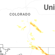
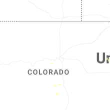
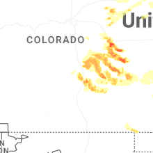
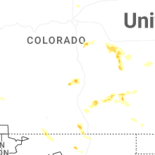
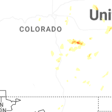
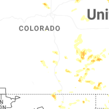

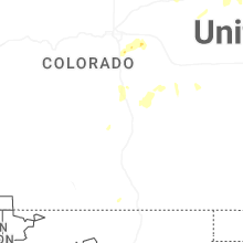
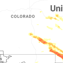
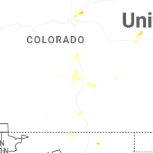


Connect with Interactive Hail Maps