

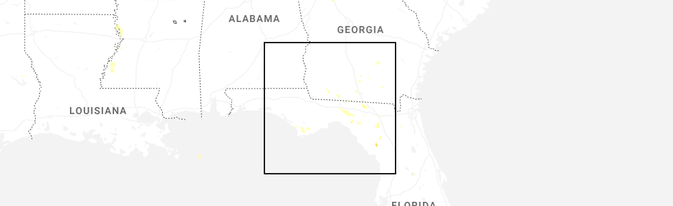
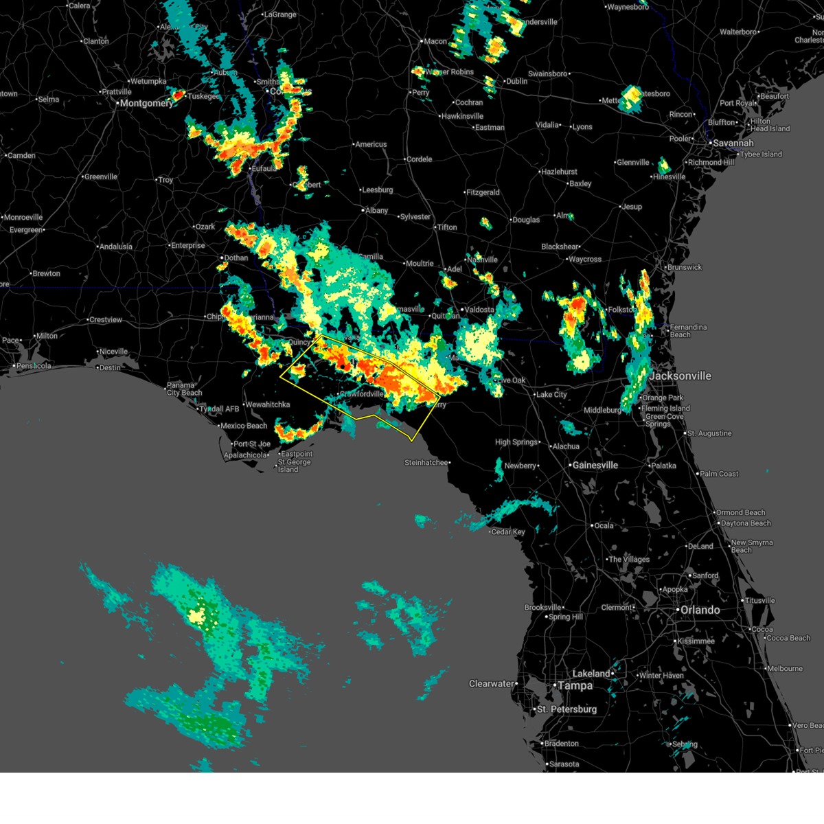
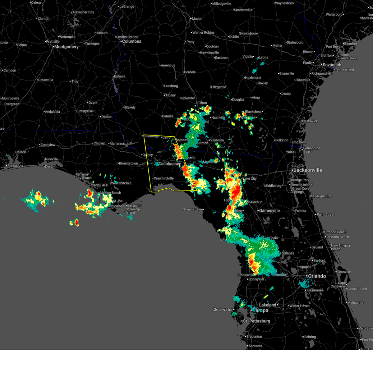
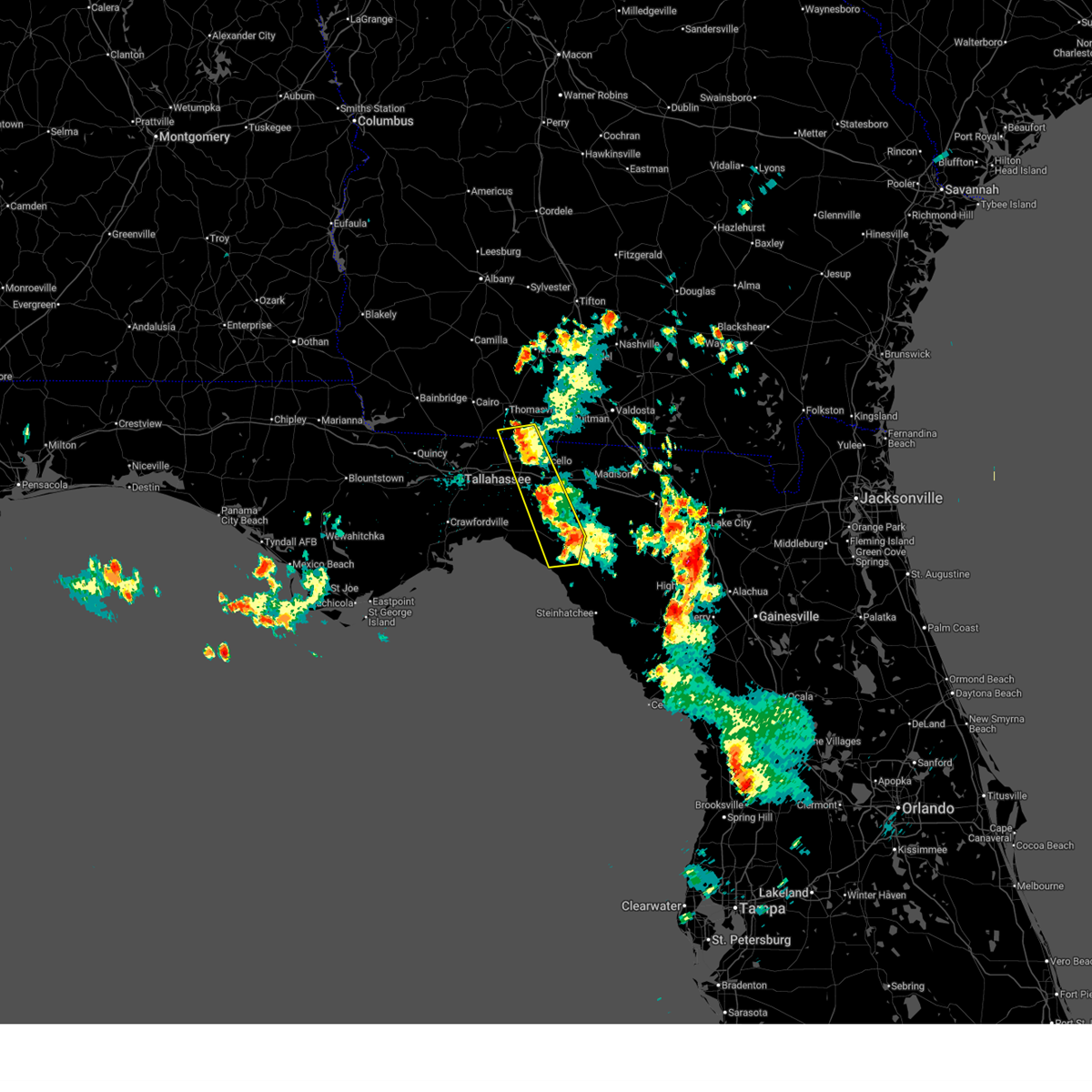
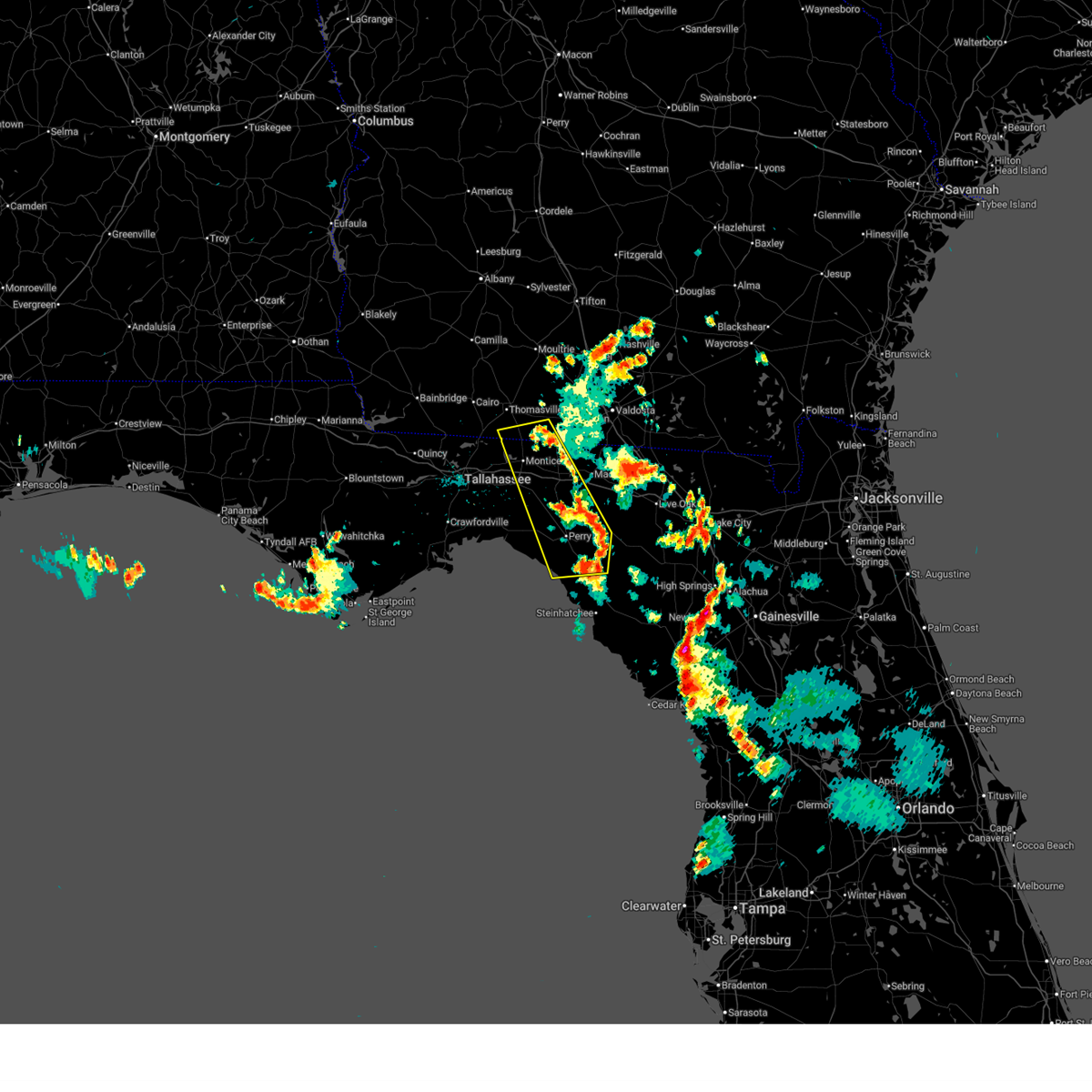
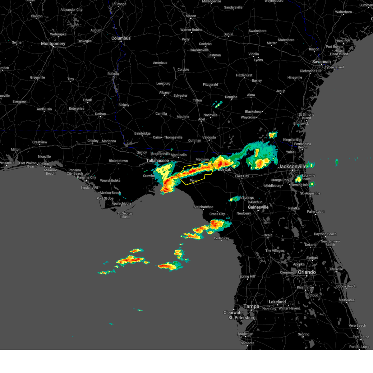
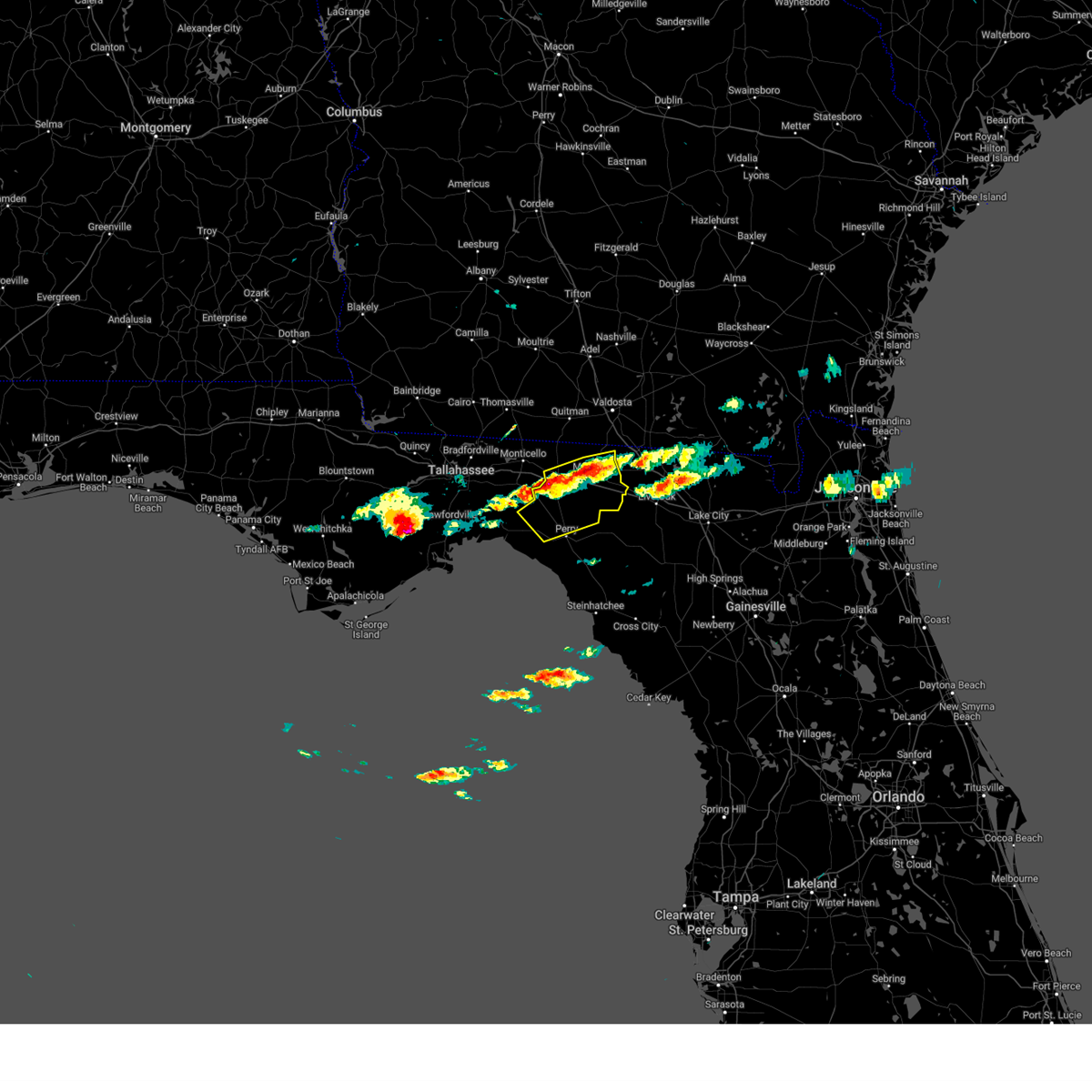
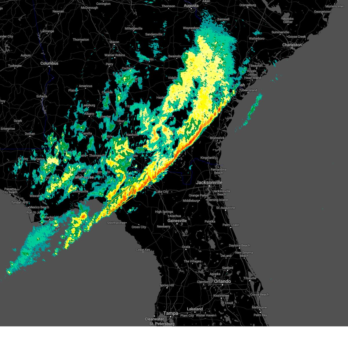
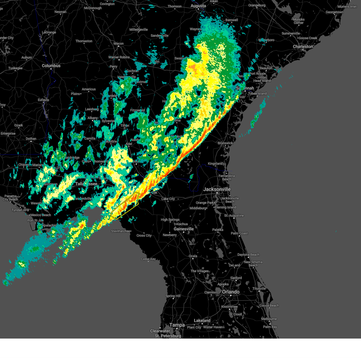
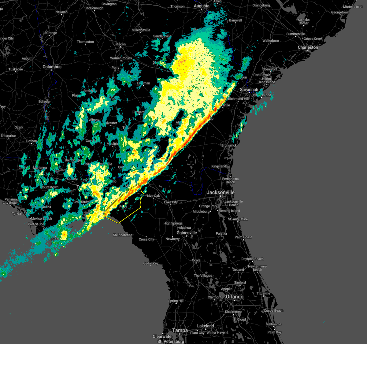
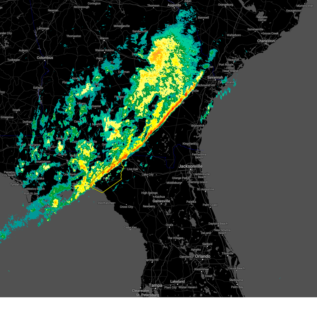
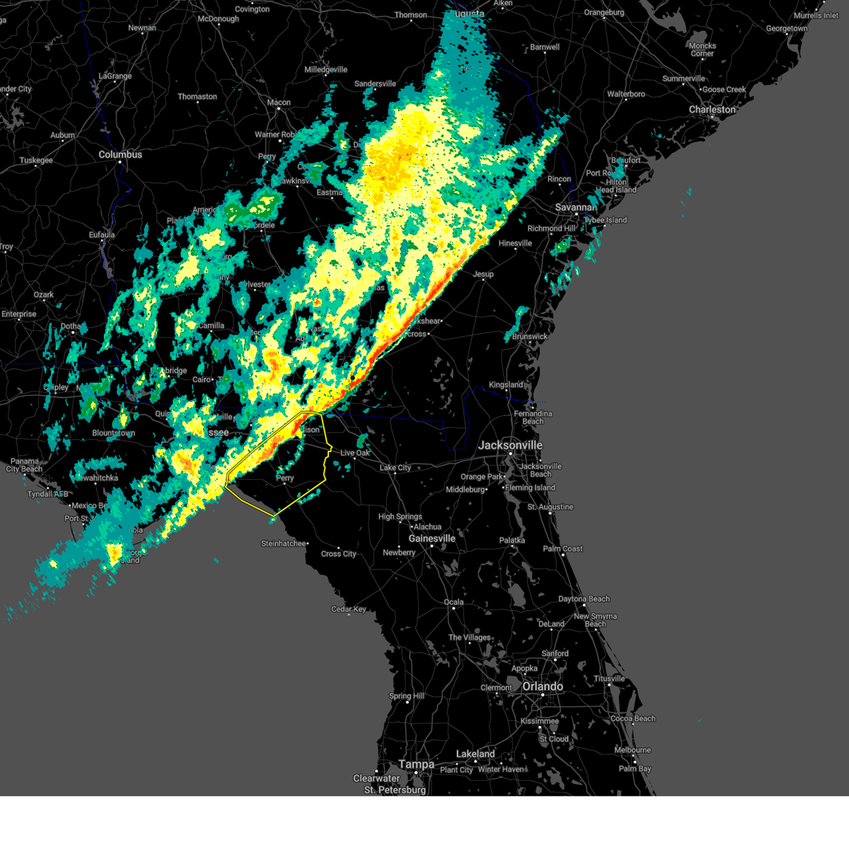
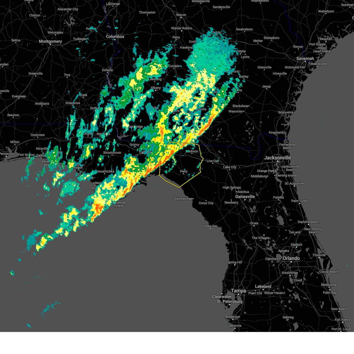
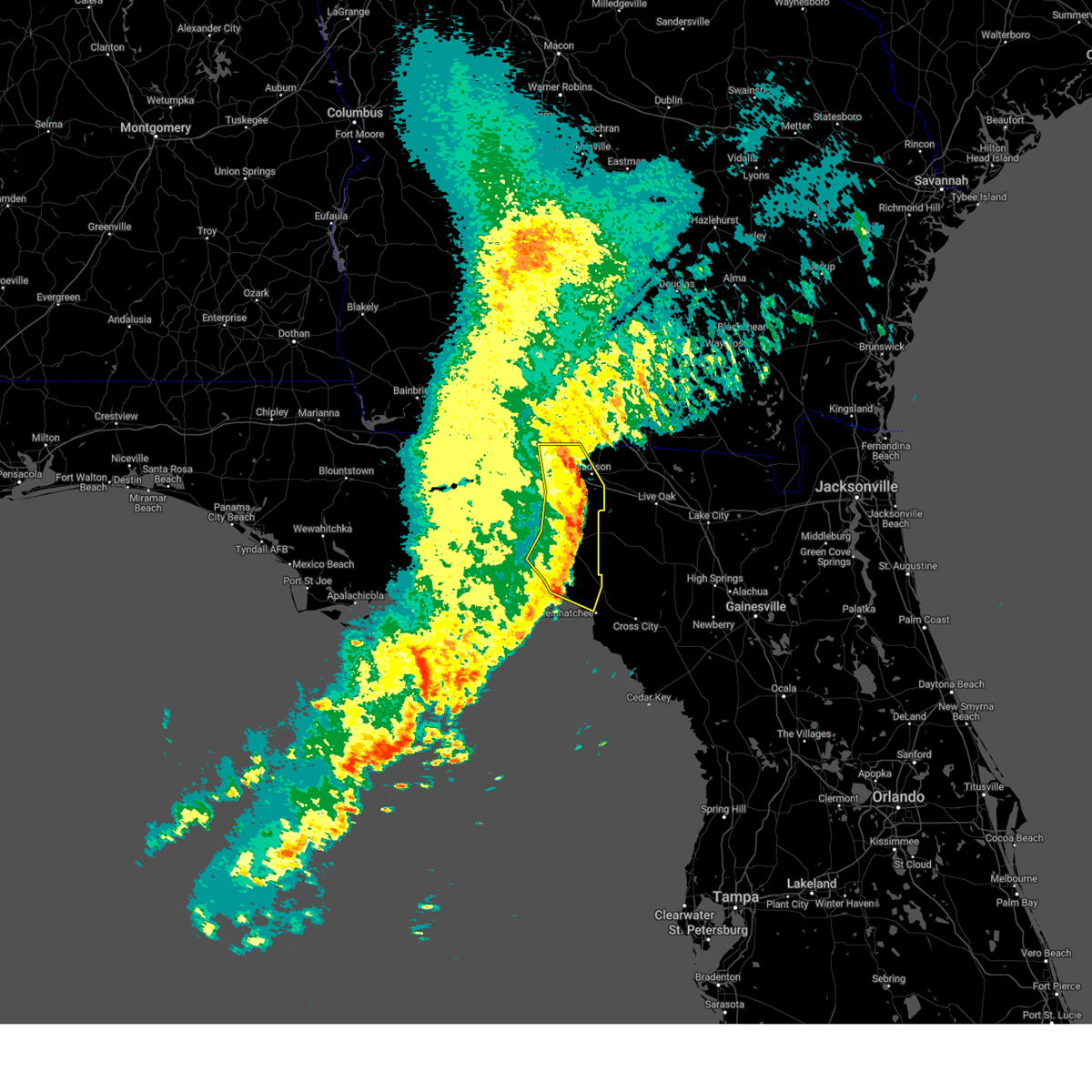
Hail Map for Perry, FL
The Perry, FL area has had 1 report of on-the-ground hail by trained spotters, and has been under severe weather warnings 4 times during the past 12 months. Doppler radar has detected hail at or near Perry, FL on 41 occasions.
| Name: | Perry, FL |
| Where Located: | 47.5 miles ESE of Tallahassee, FL |
| Map: | Google Map for Perry, FL |
| Population: | 7017 |
| Housing Units: | 3115 |
| More Info: | Search Google for Perry, FL |
2
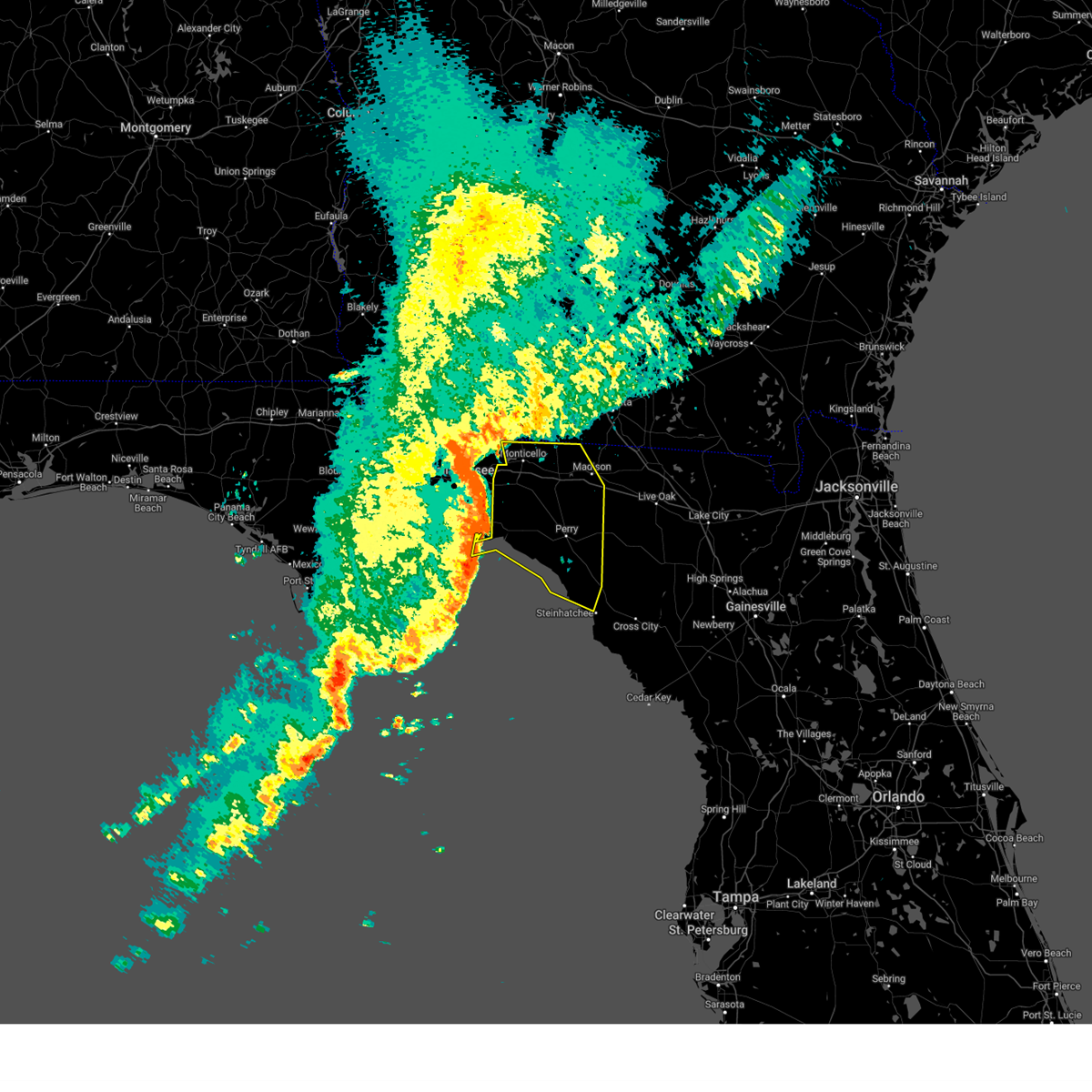
The Top Recent Hail Date for Perry, FL is Thursday, June 26, 2025 (7th out of 41)
Hail and Wind Damage Spotted near Perry, FL
| Date / Time | Report Details |
|---|---|
| 6/20/2026 3:49 PM EDT |
 Svrtae the national weather service in tallahassee has issued a * severe thunderstorm warning for, northwestern lafayette county in big bend florida, northeastern taylor county in big bend florida, * until 430 pm edt. * at 349 pm edt, a severe thunderstorm was located 11 miles northeast of perry, moving east at 30 mph (radar indicated). Hazards include 60 mph wind gusts. expect damage to roofs, siding, and trees Svrtae the national weather service in tallahassee has issued a * severe thunderstorm warning for, northwestern lafayette county in big bend florida, northeastern taylor county in big bend florida, * until 430 pm edt. * at 349 pm edt, a severe thunderstorm was located 11 miles northeast of perry, moving east at 30 mph (radar indicated). Hazards include 60 mph wind gusts. expect damage to roofs, siding, and trees
|
| 5/7/2026 2:25 PM EDT |
 At 224 pm edt, severe thunderstorms were located along a line extending from near madison to 16 miles northwest of perry, moving east at 40 mph (radar indicated). Hazards include 60 mph wind gusts and quarter size hail. Hail damage to vehicles is expected. expect wind damage to roofs, siding, and trees. Locations impacted include, madison, perry, greenville, lee, ebb, iddo, moseley hall, secotan, boyd, hopewell, cherry lake, hamburg, pinetta, eridu, cabbage grove, lovett, lake bird, foley, hanson, and sirmans. At 224 pm edt, severe thunderstorms were located along a line extending from near madison to 16 miles northwest of perry, moving east at 40 mph (radar indicated). Hazards include 60 mph wind gusts and quarter size hail. Hail damage to vehicles is expected. expect wind damage to roofs, siding, and trees. Locations impacted include, madison, perry, greenville, lee, ebb, iddo, moseley hall, secotan, boyd, hopewell, cherry lake, hamburg, pinetta, eridu, cabbage grove, lovett, lake bird, foley, hanson, and sirmans.
|
| 5/7/2026 1:52 PM EDT |
 Svrtae the national weather service in tallahassee has issued a * severe thunderstorm warning for, jefferson county in big bend florida, northern taylor county in big bend florida, madison county in big bend florida, * until 245 pm edt. * at 152 pm edt, severe thunderstorms were located along a line extending from 9 miles northeast of monticello to 11 miles northeast of woodville, moving east at 35 mph (radar indicated). Hazards include 60 mph wind gusts and quarter size hail. Hail damage to vehicles is expected. Expect wind damage to roofs, siding, and trees. Svrtae the national weather service in tallahassee has issued a * severe thunderstorm warning for, jefferson county in big bend florida, northern taylor county in big bend florida, madison county in big bend florida, * until 245 pm edt. * at 152 pm edt, severe thunderstorms were located along a line extending from 9 miles northeast of monticello to 11 miles northeast of woodville, moving east at 35 mph (radar indicated). Hazards include 60 mph wind gusts and quarter size hail. Hail damage to vehicles is expected. Expect wind damage to roofs, siding, and trees.
|
| 2/15/2026 3:12 PM EST | A wash house... including clothes washer and dryer... were thrown into a pon in taylor county FL, 19.6 miles N of Perry, FL |
| 7/22/2025 3:34 PM EDT |
 Svrtae the national weather service in tallahassee has issued a * severe thunderstorm warning for, wakulla county in big bend florida, central gadsden county in big bend florida, east central liberty county in big bend florida, southwestern jefferson county in big bend florida, northwestern taylor county in big bend florida, leon county in big bend florida, southwestern madison county in big bend florida, * until 415 pm edt. * at 334 pm edt, severe thunderstorms were located along a line extending from near midway to 7 miles west of perry, moving southwest at 15 mph (radar indicated). Hazards include 60 mph wind gusts. expect damage to roofs, siding, and trees Svrtae the national weather service in tallahassee has issued a * severe thunderstorm warning for, wakulla county in big bend florida, central gadsden county in big bend florida, east central liberty county in big bend florida, southwestern jefferson county in big bend florida, northwestern taylor county in big bend florida, leon county in big bend florida, southwestern madison county in big bend florida, * until 415 pm edt. * at 334 pm edt, severe thunderstorms were located along a line extending from near midway to 7 miles west of perry, moving southwest at 15 mph (radar indicated). Hazards include 60 mph wind gusts. expect damage to roofs, siding, and trees
|
| 6/26/2025 5:52 PM EDT | Small tree down with two reports of wires down nearby as wel in taylor county FL, 2.4 miles N of Perry, FL |
| 6/26/2025 5:52 PM EDT |
 Svrtae the national weather service in tallahassee has issued a * severe thunderstorm warning for, eastern wakulla county in big bend florida, eastern gadsden county in big bend florida, jefferson county in big bend florida, northwestern taylor county in big bend florida, leon county in big bend florida, southwestern madison county in big bend florida, southeastern decatur county in southwestern georgia, southern grady county in southwestern georgia, southwestern thomas county in south central georgia, * until 730 pm edt. * at 552 pm edt, severe thunderstorms were located along a line extending from 6 miles south of thomasville to near perry, moving west at 30 mph (radar indicated). Hazards include 60 mph wind gusts. expect damage to roofs, siding, and trees Svrtae the national weather service in tallahassee has issued a * severe thunderstorm warning for, eastern wakulla county in big bend florida, eastern gadsden county in big bend florida, jefferson county in big bend florida, northwestern taylor county in big bend florida, leon county in big bend florida, southwestern madison county in big bend florida, southeastern decatur county in southwestern georgia, southern grady county in southwestern georgia, southwestern thomas county in south central georgia, * until 730 pm edt. * at 552 pm edt, severe thunderstorms were located along a line extending from 6 miles south of thomasville to near perry, moving west at 30 mph (radar indicated). Hazards include 60 mph wind gusts. expect damage to roofs, siding, and trees
|
| 6/26/2025 5:47 PM EDT |
 the severe thunderstorm warning has been cancelled and is no longer in effect the severe thunderstorm warning has been cancelled and is no longer in effect
|
| 6/26/2025 5:47 PM EDT |
 At 547 pm edt, severe thunderstorms were located along a line extending from 7 miles north of monticello to near perry, moving west at 10 mph (radar indicated). Hazards include 60 mph wind gusts and quarter size hail. Hail damage to vehicles is expected. expect wind damage to roofs, siding, and trees. Locations impacted include, monticello, perry, greenville, alma, pinland, dills, ebb, lamont, everett, eridu, nash, drifton, casa blanco, foley, perry-foley airport, hampton springs, sirmans, shady grove, fincher, and iddo. At 547 pm edt, severe thunderstorms were located along a line extending from 7 miles north of monticello to near perry, moving west at 10 mph (radar indicated). Hazards include 60 mph wind gusts and quarter size hail. Hail damage to vehicles is expected. expect wind damage to roofs, siding, and trees. Locations impacted include, monticello, perry, greenville, alma, pinland, dills, ebb, lamont, everett, eridu, nash, drifton, casa blanco, foley, perry-foley airport, hampton springs, sirmans, shady grove, fincher, and iddo.
|
| 6/26/2025 5:03 PM EDT |
 Svrtae the national weather service in tallahassee has issued a * severe thunderstorm warning for, northwestern lafayette county in big bend florida, northeastern jefferson county in big bend florida, taylor county in big bend florida, western madison county in big bend florida, southeastern thomas county in south central georgia, southwestern brooks county in south central georgia, * until 615 pm edt. * at 503 pm edt, severe thunderstorms were located along a line extending from 10 miles northeast of monticello to 14 miles southeast of perry, moving southwest at 15 mph (radar indicated). Hazards include 60 mph wind gusts and quarter size hail. Hail damage to vehicles is expected. Expect wind damage to roofs, siding, and trees. Svrtae the national weather service in tallahassee has issued a * severe thunderstorm warning for, northwestern lafayette county in big bend florida, northeastern jefferson county in big bend florida, taylor county in big bend florida, western madison county in big bend florida, southeastern thomas county in south central georgia, southwestern brooks county in south central georgia, * until 615 pm edt. * at 503 pm edt, severe thunderstorms were located along a line extending from 10 miles northeast of monticello to 14 miles southeast of perry, moving southwest at 15 mph (radar indicated). Hazards include 60 mph wind gusts and quarter size hail. Hail damage to vehicles is expected. Expect wind damage to roofs, siding, and trees.
|
| 4/11/2025 5:41 PM EDT |
 The storms which prompted the warning have weakened below severe limits, and no longer pose an immediate threat to life or property. therefore, the warning will be allowed to expire. however, small hail and gusty winds are still possible with these thunderstorms. The storms which prompted the warning have weakened below severe limits, and no longer pose an immediate threat to life or property. therefore, the warning will be allowed to expire. however, small hail and gusty winds are still possible with these thunderstorms.
|
| 4/11/2025 5:31 PM EDT |
 At 531 pm edt, severe thunderstorms were located along a line extending from near suwannee river state park to 11 miles northwest of perry, moving southeast at 15 mph (radar indicated). Hazards include 60 mph wind gusts and quarter size hail. Hail damage to vehicles is expected. expect wind damage to roofs, siding, and trees. Locations impacted include, lake bird, iddo, moseley hall, ebb, secotan, boyd, hopewell, eridu, lee, sirmans, shady grove, and perry. At 531 pm edt, severe thunderstorms were located along a line extending from near suwannee river state park to 11 miles northwest of perry, moving southeast at 15 mph (radar indicated). Hazards include 60 mph wind gusts and quarter size hail. Hail damage to vehicles is expected. expect wind damage to roofs, siding, and trees. Locations impacted include, lake bird, iddo, moseley hall, ebb, secotan, boyd, hopewell, eridu, lee, sirmans, shady grove, and perry.
|
| 4/11/2025 4:49 PM EDT |
 Svrtae the national weather service in tallahassee has issued a * severe thunderstorm warning for, northeastern taylor county in big bend florida, madison county in big bend florida, * until 545 pm edt. * at 449 pm edt, severe thunderstorms were located along a line extending from near madison to 15 miles south of monticello, moving southeast at 15 mph (radar indicated). Hazards include 60 mph wind gusts and quarter size hail. Hail damage to vehicles is expected. Expect wind damage to roofs, siding, and trees. Svrtae the national weather service in tallahassee has issued a * severe thunderstorm warning for, northeastern taylor county in big bend florida, madison county in big bend florida, * until 545 pm edt. * at 449 pm edt, severe thunderstorms were located along a line extending from near madison to 15 miles south of monticello, moving southeast at 15 mph (radar indicated). Hazards include 60 mph wind gusts and quarter size hail. Hail damage to vehicles is expected. Expect wind damage to roofs, siding, and trees.
|
| 2/16/2025 10:05 AM EST |
 The storms which prompted the warning have weakened below severe limits, and have exited the warned area. therefore, the warning will be allowed to expire. to report severe weather, contact your nearest law enforcement agency. they will relay your report to the national weather service tallahassee. The storms which prompted the warning have weakened below severe limits, and have exited the warned area. therefore, the warning will be allowed to expire. to report severe weather, contact your nearest law enforcement agency. they will relay your report to the national weather service tallahassee.
|
| 2/16/2025 9:51 AM EST |
 At 951 am est, severe thunderstorms were located along a line extending from near dowling park to 19 miles southwest of perry, moving southeast at 30 mph (radar indicated). Hazards include 60 mph wind gusts. Expect damage to roofs, siding, and trees. Locations impacted include, perry, pinland, chancey, smith, buckville, mayo junction, townsend, foley, perry-foley airport, bucell junction, athena, day, fenholloway, and hampton springs. At 951 am est, severe thunderstorms were located along a line extending from near dowling park to 19 miles southwest of perry, moving southeast at 30 mph (radar indicated). Hazards include 60 mph wind gusts. Expect damage to roofs, siding, and trees. Locations impacted include, perry, pinland, chancey, smith, buckville, mayo junction, townsend, foley, perry-foley airport, bucell junction, athena, day, fenholloway, and hampton springs.
|
| 2/16/2025 9:30 AM EST |
 the severe thunderstorm warning has been cancelled and is no longer in effect the severe thunderstorm warning has been cancelled and is no longer in effect
|
| 2/16/2025 9:30 AM EST |
 At 930 am est, severe thunderstorms were located along a line extending from near blue springs to 17 miles west of perry, moving east at 40 mph (radar indicated). Hazards include 60 mph wind gusts. Expect damage to roofs, siding, and trees. Locations impacted include, madison, perry, lee, pinland, moseley hall, chancey, secotan, boyd, smith, hopewell, buckville, mayo junction, townsend, econfina, lake bird, foley, perry-foley airport, bucell junction, athena, and day. At 930 am est, severe thunderstorms were located along a line extending from near blue springs to 17 miles west of perry, moving east at 40 mph (radar indicated). Hazards include 60 mph wind gusts. Expect damage to roofs, siding, and trees. Locations impacted include, madison, perry, lee, pinland, moseley hall, chancey, secotan, boyd, smith, hopewell, buckville, mayo junction, townsend, econfina, lake bird, foley, perry-foley airport, bucell junction, athena, and day.
|
| 2/16/2025 9:08 AM EST |
 At 908 am est, severe thunderstorms were located along a line extending from 10 miles north of madison to 10 miles east of st. marks, moving east at 45 mph (radar indicated). Hazards include 60 mph wind gusts. Expect damage to roofs, siding, and trees. Locations impacted include, madison, perry, greenville, lee, pinland, hells half acre, ebb, lamont, hamburg, buckville, pinetta, eridu, cabbage grove, scanlon, foley, hanson, perry-foley airport, hampton springs, sirmans, and shady grove. At 908 am est, severe thunderstorms were located along a line extending from 10 miles north of madison to 10 miles east of st. marks, moving east at 45 mph (radar indicated). Hazards include 60 mph wind gusts. Expect damage to roofs, siding, and trees. Locations impacted include, madison, perry, greenville, lee, pinland, hells half acre, ebb, lamont, hamburg, buckville, pinetta, eridu, cabbage grove, scanlon, foley, hanson, perry-foley airport, hampton springs, sirmans, and shady grove.
|
| 2/16/2025 8:51 AM EST |
 Svrtae the national weather service in tallahassee has issued a * severe thunderstorm warning for, northwestern lafayette county in big bend florida, taylor county in big bend florida, jefferson county in big bend florida, madison county in big bend florida, * until 1015 am est. * at 851 am est, severe thunderstorms were located along a line extending from 8 miles east of monticello to 10 miles east of woodville, moving east at 50 mph (radar indicated). Hazards include 60 mph wind gusts. expect damage to roofs, siding, and trees Svrtae the national weather service in tallahassee has issued a * severe thunderstorm warning for, northwestern lafayette county in big bend florida, taylor county in big bend florida, jefferson county in big bend florida, madison county in big bend florida, * until 1015 am est. * at 851 am est, severe thunderstorms were located along a line extending from 8 miles east of monticello to 10 miles east of woodville, moving east at 50 mph (radar indicated). Hazards include 60 mph wind gusts. expect damage to roofs, siding, and trees
|
| 12/29/2024 9:32 AM EST |
 At 932 am est, severe thunderstorms were located along a line extending from 12 miles south of quitman to 6 miles southwest of madison to near perry, moving east at 40 mph (radar indicated). Hazards include 60 mph wind gusts and penny size hail. Expect damage to roofs, siding, and trees. Locations impacted include, madison, perry, greenville, pinland, jug island, ebb, hamburg, lovett, dekle beach, jack lee island, foley, salem, perry-foley airport, hampton springs, sirmans, shady grove, cedar island, fish creek, iddo, and howell place. At 932 am est, severe thunderstorms were located along a line extending from 12 miles south of quitman to 6 miles southwest of madison to near perry, moving east at 40 mph (radar indicated). Hazards include 60 mph wind gusts and penny size hail. Expect damage to roofs, siding, and trees. Locations impacted include, madison, perry, greenville, pinland, jug island, ebb, hamburg, lovett, dekle beach, jack lee island, foley, salem, perry-foley airport, hampton springs, sirmans, shady grove, cedar island, fish creek, iddo, and howell place.
|
| 12/29/2024 8:38 AM EST |
 Svrtae the national weather service in tallahassee has issued a * severe thunderstorm warning for, taylor county in big bend florida, jefferson county in big bend florida, madison county in big bend florida, * until 945 am est. * at 838 am est, severe thunderstorms were located along a line extending from near tallahassee to 7 miles east of woodville to 14 miles south of st. marks, moving east at 40 mph (radar indicated). Hazards include 60 mph wind gusts and penny size hail. expect damage to roofs, siding, and trees Svrtae the national weather service in tallahassee has issued a * severe thunderstorm warning for, taylor county in big bend florida, jefferson county in big bend florida, madison county in big bend florida, * until 945 am est. * at 838 am est, severe thunderstorms were located along a line extending from near tallahassee to 7 miles east of woodville to 14 miles south of st. marks, moving east at 40 mph (radar indicated). Hazards include 60 mph wind gusts and penny size hail. expect damage to roofs, siding, and trees
|
| 5/17/2024 11:59 PM EDT |
 the severe thunderstorm warning has been cancelled and is no longer in effect the severe thunderstorm warning has been cancelled and is no longer in effect
|
| 5/17/2024 11:59 PM EDT |
 At 1159 pm edt, severe thunderstorms were located along a line extending from 9 miles north of perry to 25 miles southeast of woodville to near st. marks, moving east at 20 mph (radar indicated). Hazards include 60 mph wind gusts and penny size hail. Expect damage to roofs, siding, and trees. locations impacted include, perry, st. Marks, goose pasture, hells half acre, iddo, secotan, boyd, cabbage grove, plum orchard, scanlon, econfina, lake bird, port leon, wakulla beach, hampton springs, shady grove, and liveoak island. At 1159 pm edt, severe thunderstorms were located along a line extending from 9 miles north of perry to 25 miles southeast of woodville to near st. marks, moving east at 20 mph (radar indicated). Hazards include 60 mph wind gusts and penny size hail. Expect damage to roofs, siding, and trees. locations impacted include, perry, st. Marks, goose pasture, hells half acre, iddo, secotan, boyd, cabbage grove, plum orchard, scanlon, econfina, lake bird, port leon, wakulla beach, hampton springs, shady grove, and liveoak island.
|
| 5/17/2024 11:25 PM EDT |
 Svrtae the national weather service in tallahassee has issued a * severe thunderstorm warning for, east central wakulla county in big bend florida, northern taylor county in big bend florida, southwestern jefferson county in big bend florida, southwestern madison county in big bend florida, * until 1230 am edt. * at 1125 pm edt, severe thunderstorms were located along a line extending from 15 miles northwest of perry to 14 miles southeast of woodville to 7 miles southwest of st. marks, moving east at 20 mph (radar indicated). Hazards include 60 mph wind gusts and penny size hail. expect damage to roofs, siding, and trees Svrtae the national weather service in tallahassee has issued a * severe thunderstorm warning for, east central wakulla county in big bend florida, northern taylor county in big bend florida, southwestern jefferson county in big bend florida, southwestern madison county in big bend florida, * until 1230 am edt. * at 1125 pm edt, severe thunderstorms were located along a line extending from 15 miles northwest of perry to 14 miles southeast of woodville to 7 miles southwest of st. marks, moving east at 20 mph (radar indicated). Hazards include 60 mph wind gusts and penny size hail. expect damage to roofs, siding, and trees
|
| 5/10/2024 8:09 AM EDT | the tornado warning has been cancelled and is no longer in effect |
| 5/10/2024 7:41 AM EDT | Tortae the national weather service in tallahassee has issued a * tornado warning for, lafayette county in big bend florida, taylor county in big bend florida, * until 845 am edt. * at 740 am edt, severe thunderstorms capable of producing a tornado were located along a line extending from 12 miles north of perry to 30 miles northwest of steinhatchee, moving east at 70 mph (radar indicated rotation). Hazards include tornado. Flying debris will be dangerous to those caught without shelter. mobile homes will be damaged or destroyed. damage to roofs, windows, and vehicles will occur. tree damage is likely. these dangerous storms will be near, perry around 745 am edt. mayo around 805 am edt. Other locations impacted by these tornadic storms include pinland, jug island, buckville, dekle beach, jack lee island, grady, hatch bend, foley, salem, and perry-foley airport. |
| 5/10/2024 6:54 AM EDT |
 the severe thunderstorm warning has been cancelled and is no longer in effect the severe thunderstorm warning has been cancelled and is no longer in effect
|
| 5/10/2024 6:54 AM EDT |
 At 654 am edt/554 am cdt/, severe thunderstorms were located along a line extending from near tallahassee to 18 miles west of crawfordville to 11 miles northeast of port st. joe, moving east at 70 mph (radar indicated). Hazards include 70 mph wind gusts and penny size hail. Expect considerable tree damage. damage is likely to mobile homes, roofs, and outbuildings. locations impacted include, tallahassee, woodville, carrabelle, monticello, havana, perry, midway, florida state university, eastpoint, apalachicola, tallahassee community college, st. marks, madison, crawfordville, florida a and m, st george island, port st. Joe, mexico beach, doak campbell stadium, and wewahitchka. At 654 am edt/554 am cdt/, severe thunderstorms were located along a line extending from near tallahassee to 18 miles west of crawfordville to 11 miles northeast of port st. joe, moving east at 70 mph (radar indicated). Hazards include 70 mph wind gusts and penny size hail. Expect considerable tree damage. damage is likely to mobile homes, roofs, and outbuildings. locations impacted include, tallahassee, woodville, carrabelle, monticello, havana, perry, midway, florida state university, eastpoint, apalachicola, tallahassee community college, st. marks, madison, crawfordville, florida a and m, st george island, port st. Joe, mexico beach, doak campbell stadium, and wewahitchka.
|
| 5/10/2024 6:21 AM EDT |
 Svrtae the national weather service in tallahassee has issued a * severe thunderstorm warning for, southeastern jackson county in the panhandle of florida, gulf county in the panhandle of florida, southeastern bay county in the panhandle of florida, calhoun county in the panhandle of florida, wakulla county in big bend florida, gadsden county in big bend florida, liberty county in big bend florida, taylor county in big bend florida, jefferson county in big bend florida, leon county in big bend florida, franklin county in big bend florida, madison county in big bend florida, * until 745 am edt/645 am cdt/. * at 620 am edt/520 am cdt/, severe thunderstorms were located along a line extending from chattahoochee to 14 miles northwest of stonemill creek to 9 miles southwest of panama city, moving east at 70 mph (radar indicated). Hazards include 70 mph wind gusts. Expect considerable tree damage. Damage is likely to mobile homes, roofs, and outbuildings. Svrtae the national weather service in tallahassee has issued a * severe thunderstorm warning for, southeastern jackson county in the panhandle of florida, gulf county in the panhandle of florida, southeastern bay county in the panhandle of florida, calhoun county in the panhandle of florida, wakulla county in big bend florida, gadsden county in big bend florida, liberty county in big bend florida, taylor county in big bend florida, jefferson county in big bend florida, leon county in big bend florida, franklin county in big bend florida, madison county in big bend florida, * until 745 am edt/645 am cdt/. * at 620 am edt/520 am cdt/, severe thunderstorms were located along a line extending from chattahoochee to 14 miles northwest of stonemill creek to 9 miles southwest of panama city, moving east at 70 mph (radar indicated). Hazards include 70 mph wind gusts. Expect considerable tree damage. Damage is likely to mobile homes, roofs, and outbuildings.
|
| 4/11/2024 7:22 AM EDT |
 At 721 am edt, a severe thunderstorm was located over suwannee river state park, moving northeast at 50 mph. numerous trees down has been reported in taylor county (radar indicated). Hazards include 60 mph wind gusts. Expect damage to roofs, siding, and trees. Locations impacted include, perry, lee, pinland, jug island, buckville, dekle beach, jack lee island, foley, perry-foley airport, hampton springs, cedar island, fish creek, chancey, secotan, boyd, smith, hopewell, carbur, mayo junction, and adams beach. At 721 am edt, a severe thunderstorm was located over suwannee river state park, moving northeast at 50 mph. numerous trees down has been reported in taylor county (radar indicated). Hazards include 60 mph wind gusts. Expect damage to roofs, siding, and trees. Locations impacted include, perry, lee, pinland, jug island, buckville, dekle beach, jack lee island, foley, perry-foley airport, hampton springs, cedar island, fish creek, chancey, secotan, boyd, smith, hopewell, carbur, mayo junction, and adams beach.
|
| 4/11/2024 6:46 AM EDT | Power lines downed at veterans and orange s in taylor county FL, 0.4 miles S of Perry, FL |
| 4/11/2024 6:46 AM EDT | Multiple trees dow in taylor county FL, 12.5 miles NNE of Perry, FL |
| 4/11/2024 6:41 AM EDT | Trees down at e roberts aman rd. and wayne roberts l in taylor county FL, 4.5 miles S of Perry, FL |
| 4/11/2024 6:41 AM EDT | Tree down across park s in taylor county FL, 1 miles N of Perry, FL |
| 4/11/2024 6:32 AM EDT |
 Svrtae the national weather service in tallahassee has issued a * severe thunderstorm warning for, northwestern lafayette county in big bend florida, taylor county in big bend florida, madison county in big bend florida, * until 745 am edt. * at 632 am edt, a severe thunderstorm was located 10 miles west of perry, moving northeast at 50 mph (radar indicated). Hazards include 60 mph wind gusts. expect damage to roofs, siding, and trees Svrtae the national weather service in tallahassee has issued a * severe thunderstorm warning for, northwestern lafayette county in big bend florida, taylor county in big bend florida, madison county in big bend florida, * until 745 am edt. * at 632 am edt, a severe thunderstorm was located 10 miles west of perry, moving northeast at 50 mph (radar indicated). Hazards include 60 mph wind gusts. expect damage to roofs, siding, and trees
|
| 3/9/2024 3:53 PM EST |
 The storms which prompted the warning have moved out of the area. therefore, the warning will be allowed to expire. The storms which prompted the warning have moved out of the area. therefore, the warning will be allowed to expire.
|
| 3/9/2024 3:35 PM EST |
 Svrtae the national weather service in tallahassee has issued a * severe thunderstorm warning for, northwestern lafayette county in big bend florida, northeastern taylor county in big bend florida, southeastern madison county in big bend florida, * until 400 pm est. * at 334 pm est, severe thunderstorms were located along a line extending from suwannee river state park to 6 miles west of dowling park to near perry, moving northeast at 60 mph (radar indicated). Hazards include 60 mph wind gusts. expect damage to roofs, siding, and trees Svrtae the national weather service in tallahassee has issued a * severe thunderstorm warning for, northwestern lafayette county in big bend florida, northeastern taylor county in big bend florida, southeastern madison county in big bend florida, * until 400 pm est. * at 334 pm est, severe thunderstorms were located along a line extending from suwannee river state park to 6 miles west of dowling park to near perry, moving northeast at 60 mph (radar indicated). Hazards include 60 mph wind gusts. expect damage to roofs, siding, and trees
|
| 1/9/2024 12:01 PM EST |
 At 1200 pm est, severe thunderstorms were located along a line extending from near boston to 10 miles south of monticello to 14 miles southeast of st. marks, moving east at 25 mph (radar indicated). Hazards include 70 mph wind gusts and quarter size hail. Hail damage to vehicles is expected. expect considerable tree damage. wind damage is also likely to mobile homes, roofs, and outbuildings. Locations impacted include, perry, greenville, iddo, moseley hall, ebb, secotan, boyd, hamburg, eridu, cabbage grove, scanlon, lovett, econfina, lake bird, ashville, hampton springs, sirmans, shady grove, and aucilla. At 1200 pm est, severe thunderstorms were located along a line extending from near boston to 10 miles south of monticello to 14 miles southeast of st. marks, moving east at 25 mph (radar indicated). Hazards include 70 mph wind gusts and quarter size hail. Hail damage to vehicles is expected. expect considerable tree damage. wind damage is also likely to mobile homes, roofs, and outbuildings. Locations impacted include, perry, greenville, iddo, moseley hall, ebb, secotan, boyd, hamburg, eridu, cabbage grove, scanlon, lovett, econfina, lake bird, ashville, hampton springs, sirmans, shady grove, and aucilla.
|
| 1/9/2024 11:58 AM EST |
 At 1158 am est, severe thunderstorms were located along a line extending from 10 miles south of quitman to 32 miles southwest of perry, moving east at 45 mph (radar indicated). Hazards include 70 mph wind gusts and penny size hail. Expect considerable tree damage. Damage is likely to mobile homes, roofs, and outbuildings. At 1158 am est, severe thunderstorms were located along a line extending from 10 miles south of quitman to 32 miles southwest of perry, moving east at 45 mph (radar indicated). Hazards include 70 mph wind gusts and penny size hail. Expect considerable tree damage. Damage is likely to mobile homes, roofs, and outbuildings.
|
| 1/9/2024 11:14 AM EST |
 At 1113 am est, severe thunderstorms were located along a line extending from 11 miles southwest of thomasville to near woodville to 13 miles east of carrabelle, moving east at 25 mph (radar indicated). Hazards include 70 mph wind gusts and quarter size hail. Hail damage to vehicles is expected. expect considerable tree damage. Wind damage is also likely to mobile homes, roofs, and outbuildings. At 1113 am est, severe thunderstorms were located along a line extending from 11 miles southwest of thomasville to near woodville to 13 miles east of carrabelle, moving east at 25 mph (radar indicated). Hazards include 70 mph wind gusts and quarter size hail. Hail damage to vehicles is expected. expect considerable tree damage. Wind damage is also likely to mobile homes, roofs, and outbuildings.
|
| 1/6/2024 5:25 AM EST | At least two trees and a power line down so far in the perry are in taylor county FL, 0.4 miles S of Perry, FL |
| 1/6/2024 5:23 AM EST |
 At 523 am est, severe thunderstorms were located along a line extending from 7 miles west of luraville to 19 miles west of steinhatchee, moving east at 40 mph. there are reports of trees and power lines down in the perry area with these storms (radar indicated). Hazards include 60 mph wind gusts. expect damage to roofs, siding, and trees At 523 am est, severe thunderstorms were located along a line extending from 7 miles west of luraville to 19 miles west of steinhatchee, moving east at 40 mph. there are reports of trees and power lines down in the perry area with these storms (radar indicated). Hazards include 60 mph wind gusts. expect damage to roofs, siding, and trees
|
| 1/6/2024 4:55 AM EST |
 At 455 am est, severe thunderstorms were located along a line extending from 7 miles northwest of blue springs to 37 miles west of steinhatchee, moving east at 30 mph (radar indicated). Hazards include 60 mph wind gusts. Expect damage to roofs, siding, and trees. locations impacted include, mayo, madison, perry, steinhatchee, lee, pinland, jug island, ebb, buckville, dekle beach, jack lee island, foley, salem, hanson, perry-foley airport, san pedro junction, hampton springs, sirmans, shady grove, and cedar island. hail threat, radar indicated max hail size, <. 75 in wind threat, radar indicated max wind gust, 60 mph. At 455 am est, severe thunderstorms were located along a line extending from 7 miles northwest of blue springs to 37 miles west of steinhatchee, moving east at 30 mph (radar indicated). Hazards include 60 mph wind gusts. Expect damage to roofs, siding, and trees. locations impacted include, mayo, madison, perry, steinhatchee, lee, pinland, jug island, ebb, buckville, dekle beach, jack lee island, foley, salem, hanson, perry-foley airport, san pedro junction, hampton springs, sirmans, shady grove, and cedar island. hail threat, radar indicated max hail size, <. 75 in wind threat, radar indicated max wind gust, 60 mph.
|
| 1/6/2024 4:29 AM EST |
 At 429 am est, severe thunderstorms were located along a line extending from 10 miles north of madison to 32 miles southeast of carrabelle, moving east at 40 mph (radar indicated). Hazards include 60 mph wind gusts. Expect damage to roofs, siding, and trees. locations impacted include, mayo, perry, steinhatchee, madison, greenville, lee, pinland, jug island, pinetta, scanlon, foley, hanson, perry-foley airport, san pedro junction, hampton springs, iddo, moseley hall, secotan, boyd, and smith. hail threat, radar indicated max hail size, <. 75 in wind threat, radar indicated max wind gust, 60 mph. At 429 am est, severe thunderstorms were located along a line extending from 10 miles north of madison to 32 miles southeast of carrabelle, moving east at 40 mph (radar indicated). Hazards include 60 mph wind gusts. Expect damage to roofs, siding, and trees. locations impacted include, mayo, perry, steinhatchee, madison, greenville, lee, pinland, jug island, pinetta, scanlon, foley, hanson, perry-foley airport, san pedro junction, hampton springs, iddo, moseley hall, secotan, boyd, and smith. hail threat, radar indicated max hail size, <. 75 in wind threat, radar indicated max wind gust, 60 mph.
|
| 1/6/2024 4:07 AM EST |
 At 407 am est, severe thunderstorms were located along a line extending from 6 miles east of monticello to 33 miles southeast of st george island, moving east at 30 mph (radar indicated). Hazards include 60 mph wind gusts. expect damage to roofs, siding, and trees At 407 am est, severe thunderstorms were located along a line extending from 6 miles east of monticello to 33 miles southeast of st george island, moving east at 30 mph (radar indicated). Hazards include 60 mph wind gusts. expect damage to roofs, siding, and trees
|
| 9/8/2023 8:22 AM EDT |
 The severe thunderstorm warning for western lafayette and northeastern taylor counties will expire at 830 am edt, the storm which prompted the warning has weakened below severe limits, and no longer poses an immediate threat to life or property. therefore, the warning will be allowed to expire. however, gusty winds and heavy rain are still possible with this thunderstorm. The severe thunderstorm warning for western lafayette and northeastern taylor counties will expire at 830 am edt, the storm which prompted the warning has weakened below severe limits, and no longer poses an immediate threat to life or property. therefore, the warning will be allowed to expire. however, gusty winds and heavy rain are still possible with this thunderstorm.
|
| 9/8/2023 8:04 AM EDT |
 At 804 am edt, a severe thunderstorm was located 9 miles north of perry, moving southeast at 30 mph (radar indicated). Hazards include 60 mph wind gusts. Expect damage to roofs, siding, and trees. locations impacted include, perry, pinland, cooks hammock, iddo, chancey, secotan, boyd, smith, buckville, carbur, mayo junction, townsend, lake bird, foley, salem, perry-foley airport, bucell junction, athena, day, and hampton springs. hail threat, radar indicated max hail size, <. 75 in wind threat, observed max wind gust, 60 mph. At 804 am edt, a severe thunderstorm was located 9 miles north of perry, moving southeast at 30 mph (radar indicated). Hazards include 60 mph wind gusts. Expect damage to roofs, siding, and trees. locations impacted include, perry, pinland, cooks hammock, iddo, chancey, secotan, boyd, smith, buckville, carbur, mayo junction, townsend, lake bird, foley, salem, perry-foley airport, bucell junction, athena, day, and hampton springs. hail threat, radar indicated max hail size, <. 75 in wind threat, observed max wind gust, 60 mph.
|
| 9/8/2023 7:40 AM EDT |
 At 739 am edt, a severe thunderstorm was located 14 miles south of monticello, moving southeast at 30 mph (ambient weather station in the big bend wildlife preserve gusted to 57mph). Hazards include 60 mph wind gusts. expect damage to roofs, siding, and trees At 739 am edt, a severe thunderstorm was located 14 miles south of monticello, moving southeast at 30 mph (ambient weather station in the big bend wildlife preserve gusted to 57mph). Hazards include 60 mph wind gusts. expect damage to roofs, siding, and trees
|
| 8/10/2023 12:46 PM EDT | Tree down across road on highway 19 north and providence roa in taylor county FL, 8.1 miles SE of Perry, FL |
| 8/4/2023 7:46 PM EDT |
 At 746 pm edt, severe thunderstorms were located along a line extending from 13 miles southeast of st. marks to 12 miles south of mayo, moving east at 25 mph (radar indicated). Hazards include 60 mph wind gusts. Expect damage to roofs, siding, and trees. locations impacted include, perry, pinland, newport, goose pasture, hells half acre, carbur, plum orchard, adams beach, scanlon, econfina, salem, perry-foley airport, bucell junction, athena, hampton springs and dekle beach. hail threat, radar indicated max hail size, <. 75 in wind threat, radar indicated max wind gust, 60 mph. At 746 pm edt, severe thunderstorms were located along a line extending from 13 miles southeast of st. marks to 12 miles south of mayo, moving east at 25 mph (radar indicated). Hazards include 60 mph wind gusts. Expect damage to roofs, siding, and trees. locations impacted include, perry, pinland, newport, goose pasture, hells half acre, carbur, plum orchard, adams beach, scanlon, econfina, salem, perry-foley airport, bucell junction, athena, hampton springs and dekle beach. hail threat, radar indicated max hail size, <. 75 in wind threat, radar indicated max wind gust, 60 mph.
|
| 8/4/2023 7:29 PM EDT |
 At 728 pm edt, severe thunderstorms were located along a line extending from 8 miles east of st. marks to 8 miles southwest of mayo, moving southeast at 25 mph (radar indicated). Hazards include 60 mph wind gusts. Expect damage to roofs, siding, and trees. locations impacted include, woodville, perry, pinland, newport, goose pasture, hells half acre, secotan, boyd, smith, carbur, cabbage grove, plum orchard, adams beach, scanlon, econfina, fanlew, foley, salem, perry-foley airport and bucell junction. hail threat, radar indicated max hail size, <. 75 in wind threat, radar indicated max wind gust, 60 mph. At 728 pm edt, severe thunderstorms were located along a line extending from 8 miles east of st. marks to 8 miles southwest of mayo, moving southeast at 25 mph (radar indicated). Hazards include 60 mph wind gusts. Expect damage to roofs, siding, and trees. locations impacted include, woodville, perry, pinland, newport, goose pasture, hells half acre, secotan, boyd, smith, carbur, cabbage grove, plum orchard, adams beach, scanlon, econfina, fanlew, foley, salem, perry-foley airport and bucell junction. hail threat, radar indicated max hail size, <. 75 in wind threat, radar indicated max wind gust, 60 mph.
|
| 8/4/2023 7:13 PM EDT | Multiple trees reported down throughout the county. time for the northern half of the county estimated by rada in taylor county FL, 0.4 miles S of Perry, FL |
| 8/4/2023 7:10 PM EDT |
 At 710 pm edt, severe thunderstorms were located along a line extending from 6 miles northeast of st. marks to 7 miles west of mayo, moving southeast at 25 mph (radar indicated). Hazards include 60 mph wind gusts. expect damage to roofs, siding, and trees At 710 pm edt, severe thunderstorms were located along a line extending from 6 miles northeast of st. marks to 7 miles west of mayo, moving southeast at 25 mph (radar indicated). Hazards include 60 mph wind gusts. expect damage to roofs, siding, and trees
|
| 7/23/2023 12:00 PM EDT | Fallen trees or limbs resulted in a power outage along foley cut-off roa in taylor county FL, 3.4 miles NW of Perry, FL |
| 7/23/2023 11:50 AM EDT |
 At 1150 am edt, a severe thunderstorm was located near perry, moving northeast at 25 mph (radar indicated). Hazards include 60 mph wind gusts. expect damage to roofs, siding, and trees At 1150 am edt, a severe thunderstorm was located near perry, moving northeast at 25 mph (radar indicated). Hazards include 60 mph wind gusts. expect damage to roofs, siding, and trees
|
| 7/16/2023 2:39 PM EDT |
 At 238 pm edt, a severe thunderstorm was located 7 miles northeast of perry, moving east at 25 mph (radar indicated). Hazards include 60 mph wind gusts. Expect damage to roofs, siding, and trees. locations impacted include, mayo, perry, chancey, boyd, smith, hopewell, buckville, mayo junction, townsend, foley, perry-foley airport, bucell junction, day and fenholloway. hail threat, radar indicated max hail size, <. 75 in wind threat, radar indicated max wind gust, 60 mph. At 238 pm edt, a severe thunderstorm was located 7 miles northeast of perry, moving east at 25 mph (radar indicated). Hazards include 60 mph wind gusts. Expect damage to roofs, siding, and trees. locations impacted include, mayo, perry, chancey, boyd, smith, hopewell, buckville, mayo junction, townsend, foley, perry-foley airport, bucell junction, day and fenholloway. hail threat, radar indicated max hail size, <. 75 in wind threat, radar indicated max wind gust, 60 mph.
|
| 7/16/2023 1:54 PM EDT |
 At 154 pm edt, a severe thunderstorm was located 17 miles northwest of perry, moving east at 15 mph (radar indicated). Hazards include 60 mph wind gusts. expect damage to roofs, siding, and trees At 154 pm edt, a severe thunderstorm was located 17 miles northwest of perry, moving east at 15 mph (radar indicated). Hazards include 60 mph wind gusts. expect damage to roofs, siding, and trees
|
| 7/7/2023 5:42 PM EDT | Tree on power line on paul poppell roa in taylor county FL, 4.3 miles ESE of Perry, FL |
| 7/7/2023 5:41 PM EDT |
 At 541 pm edt, severe thunderstorms were located along a line extending from 6 miles southeast of madison to 13 miles west of perry, moving east at 35 mph (radar indicated). Hazards include 60 mph wind gusts. Expect damage to roofs, siding, and trees. locations impacted include, perry, madison, lee, pinland, chancey, secotan, boyd, smith, hopewell, buckville, mayo junction, townsend, econfina, lake bird, foley, perry-foley airport, bucell junction, athena, day and hampton springs. hail threat, radar indicated max hail size, <. 75 in wind threat, radar indicated max wind gust, 60 mph. At 541 pm edt, severe thunderstorms were located along a line extending from 6 miles southeast of madison to 13 miles west of perry, moving east at 35 mph (radar indicated). Hazards include 60 mph wind gusts. Expect damage to roofs, siding, and trees. locations impacted include, perry, madison, lee, pinland, chancey, secotan, boyd, smith, hopewell, buckville, mayo junction, townsend, econfina, lake bird, foley, perry-foley airport, bucell junction, athena, day and hampton springs. hail threat, radar indicated max hail size, <. 75 in wind threat, radar indicated max wind gust, 60 mph.
|
| 7/7/2023 5:38 PM EDT | Duke energy reports power outages on the northeast side of perry due to tree damag in taylor county FL, 2.5 miles SE of Perry, FL |
| 7/7/2023 5:17 PM EDT |
 At 516 pm edt, a severe thunderstorm was located 17 miles west of perry, moving east at 30 mph (radar indicated). Hazards include 60 mph wind gusts. Expect damage to roofs, siding, and trees. locations impacted include, perry, madison, greenville, lee, pinland, ebb, buckville, eridu, cabbage grove, scanlon, foley, perry-foley airport, hampton springs, sirmans, shady grove, iddo, moseley hall, chancey, secotan and boyd. hail threat, radar indicated max hail size, <. 75 in wind threat, radar indicated max wind gust, 60 mph. At 516 pm edt, a severe thunderstorm was located 17 miles west of perry, moving east at 30 mph (radar indicated). Hazards include 60 mph wind gusts. Expect damage to roofs, siding, and trees. locations impacted include, perry, madison, greenville, lee, pinland, ebb, buckville, eridu, cabbage grove, scanlon, foley, perry-foley airport, hampton springs, sirmans, shady grove, iddo, moseley hall, chancey, secotan and boyd. hail threat, radar indicated max hail size, <. 75 in wind threat, radar indicated max wind gust, 60 mph.
|
| 7/7/2023 5:02 PM EDT |
 At 502 pm edt, severe thunderstorms were located along a line extending from 15 miles south of monticello to 9 miles southeast of st. marks, moving east at 25 mph (radar indicated). Hazards include 60 mph wind gusts. expect damage to roofs, siding, and trees At 502 pm edt, severe thunderstorms were located along a line extending from 15 miles south of monticello to 9 miles southeast of st. marks, moving east at 25 mph (radar indicated). Hazards include 60 mph wind gusts. expect damage to roofs, siding, and trees
|
| 7/2/2023 4:35 PM EDT |
 The severe thunderstorm warning for northeastern taylor county will expire at 445 pm edt, the storm which prompted the warning has weakened below severe limits, and no longer poses an immediate threat to life or property. therefore, the warning will be allowed to expire. to report severe weather, contact your nearest law enforcement agency. they will relay your report to the national weather service tallahassee. The severe thunderstorm warning for northeastern taylor county will expire at 445 pm edt, the storm which prompted the warning has weakened below severe limits, and no longer poses an immediate threat to life or property. therefore, the warning will be allowed to expire. to report severe weather, contact your nearest law enforcement agency. they will relay your report to the national weather service tallahassee.
|
| 7/2/2023 4:08 PM EDT | Taylor county dispatch reports a power line down on martin luther king ave in perr in taylor county FL, 0.6 miles ENE of Perry, FL |
| 7/2/2023 3:50 PM EDT |
 At 350 pm edt, a severe thunderstorm was located over perry, moving southeast at 5 mph (radar indicated). Hazards include 60 mph wind gusts. expect damage to roofs, siding, and trees At 350 pm edt, a severe thunderstorm was located over perry, moving southeast at 5 mph (radar indicated). Hazards include 60 mph wind gusts. expect damage to roofs, siding, and trees
|
| 6/23/2023 2:14 AM EDT | 911 call center reported a power line was knocked down along beach road in perr in taylor county FL, 5.9 miles NNW of Perry, FL |
| 6/23/2023 2:04 AM EDT |
 At 204 am edt, a severe thunderstorm capable of producing a tornado was located 9 miles southwest of perry, moving east at 45 mph (radar indicated rotation). Hazards include tornado. Flying debris will be dangerous to those caught without shelter. mobile homes will be damaged or destroyed. damage to roofs, windows, and vehicles will occur. tree damage is likely. Locations impacted include, perry, pinland, foley, perry-foley airport and bucell junction. At 204 am edt, a severe thunderstorm capable of producing a tornado was located 9 miles southwest of perry, moving east at 45 mph (radar indicated rotation). Hazards include tornado. Flying debris will be dangerous to those caught without shelter. mobile homes will be damaged or destroyed. damage to roofs, windows, and vehicles will occur. tree damage is likely. Locations impacted include, perry, pinland, foley, perry-foley airport and bucell junction.
|
| 6/23/2023 2:00 AM EDT |
 At 200 am edt, a severe thunderstorm was located 12 miles southwest of perry, moving east at 35 mph (radar indicated). Hazards include 70 mph wind gusts. Expect considerable tree damage. damage is likely to mobile homes, roofs, and outbuildings. Locations impacted include, perry, pinland, secotan, boyd, foley, perry-foley airport, bucell junction and hampton springs. At 200 am edt, a severe thunderstorm was located 12 miles southwest of perry, moving east at 35 mph (radar indicated). Hazards include 70 mph wind gusts. Expect considerable tree damage. damage is likely to mobile homes, roofs, and outbuildings. Locations impacted include, perry, pinland, secotan, boyd, foley, perry-foley airport, bucell junction and hampton springs.
|
| 6/23/2023 1:52 AM EDT |
 At 152 am edt, a severe thunderstorm capable of producing a tornado was located 15 miles southwest of perry, moving east at 45 mph (radar indicated rotation). Hazards include tornado. Flying debris will be dangerous to those caught without shelter. mobile homes will be damaged or destroyed. damage to roofs, windows, and vehicles will occur. tree damage is likely. This tornadic thunderstorm will remain over mainly rural areas of central taylor county, including the following locations, pinland, foley, perry-foley airport, bucell junction and hampton springs. At 152 am edt, a severe thunderstorm capable of producing a tornado was located 15 miles southwest of perry, moving east at 45 mph (radar indicated rotation). Hazards include tornado. Flying debris will be dangerous to those caught without shelter. mobile homes will be damaged or destroyed. damage to roofs, windows, and vehicles will occur. tree damage is likely. This tornadic thunderstorm will remain over mainly rural areas of central taylor county, including the following locations, pinland, foley, perry-foley airport, bucell junction and hampton springs.
|
| 6/23/2023 1:41 AM EDT |
 At 141 am edt, a severe thunderstorm was located 18 miles southeast of st. marks, moving east at 35 mph (radar indicated). Hazards include 60 mph wind gusts. expect damage to roofs, siding, and trees At 141 am edt, a severe thunderstorm was located 18 miles southeast of st. marks, moving east at 35 mph (radar indicated). Hazards include 60 mph wind gusts. expect damage to roofs, siding, and trees
|
| 6/17/2023 7:16 PM EDT |
 At 716 pm edt, a severe thunderstorm was located 11 miles west of dowling park, or 11 miles northeast of perry, moving southeast at 35 mph (radar indicated). Hazards include 60 mph wind gusts. Expect damage to roofs, siding, and trees. locations impacted include, mayo, madison, perry, lee, pinland, hamburg, buckville, pinetta, foley, salem, hanson, perry-foley airport, san pedro junction, hampton springs, shady grove, cooks hammock, moseley hall, chancey, secotan and boyd. hail threat, radar indicated max hail size, <. 75 in wind threat, radar indicated max wind gust, 60 mph. At 716 pm edt, a severe thunderstorm was located 11 miles west of dowling park, or 11 miles northeast of perry, moving southeast at 35 mph (radar indicated). Hazards include 60 mph wind gusts. Expect damage to roofs, siding, and trees. locations impacted include, mayo, madison, perry, lee, pinland, hamburg, buckville, pinetta, foley, salem, hanson, perry-foley airport, san pedro junction, hampton springs, shady grove, cooks hammock, moseley hall, chancey, secotan and boyd. hail threat, radar indicated max hail size, <. 75 in wind threat, radar indicated max wind gust, 60 mph.
|
| 6/17/2023 6:53 PM EDT |
 At 653 pm edt, a severe thunderstorm was located 14 miles southwest of madison, moving southeast at 40 mph (radar indicated). Hazards include 60 mph wind gusts and nickel size hail. Expect damage to roofs, siding, and trees. locations impacted include, mayo, madison, perry, greenville, lee, pinland, ebb, hamburg, buckville, pinetta, eridu, cabbage grove, lovett, foley, salem, hanson, perry-foley airport, san pedro junction, hampton springs and sirmans. hail threat, radar indicated max hail size, 0. 88 in wind threat, radar indicated max wind gust, 60 mph. At 653 pm edt, a severe thunderstorm was located 14 miles southwest of madison, moving southeast at 40 mph (radar indicated). Hazards include 60 mph wind gusts and nickel size hail. Expect damage to roofs, siding, and trees. locations impacted include, mayo, madison, perry, greenville, lee, pinland, ebb, hamburg, buckville, pinetta, eridu, cabbage grove, lovett, foley, salem, hanson, perry-foley airport, san pedro junction, hampton springs and sirmans. hail threat, radar indicated max hail size, 0. 88 in wind threat, radar indicated max wind gust, 60 mph.
|
| 6/17/2023 6:15 PM EDT |
 At 615 pm edt, a severe thunderstorm was located 10 miles west of monticello, moving southeast at 35 mph (radar indicated). Hazards include 60 mph wind gusts and quarter size hail. Hail damage to vehicles is expected. Expect wind damage to roofs, siding, and trees. At 615 pm edt, a severe thunderstorm was located 10 miles west of monticello, moving southeast at 35 mph (radar indicated). Hazards include 60 mph wind gusts and quarter size hail. Hail damage to vehicles is expected. Expect wind damage to roofs, siding, and trees.
|
| 6/16/2023 1:21 PM EDT | A couple of trees were blown down along beach roa in taylor county FL, 9.3 miles N of Perry, FL |
| 6/16/2023 12:54 PM EDT |
 At 1254 pm edt, severe thunderstorms were located along a line extending from 19 miles east of st. marks to 21 miles southwest of perry to 34 miles west of steinhatchee, moving east at 55 mph (radar indicated). Hazards include 60 mph wind gusts. expect damage to roofs, siding, and trees At 1254 pm edt, severe thunderstorms were located along a line extending from 19 miles east of st. marks to 21 miles southwest of perry to 34 miles west of steinhatchee, moving east at 55 mph (radar indicated). Hazards include 60 mph wind gusts. expect damage to roofs, siding, and trees
|
| 6/16/2023 4:08 AM EDT |
 At 408 am edt, a severe thunderstorm capable of producing a tornado was located over perry, moving east at 30 mph (radar indicated rotation). Hazards include tornado. Flying debris will be dangerous to those caught without shelter. mobile homes will be damaged or destroyed. damage to roofs, windows, and vehicles will occur. tree damage is likely. This tornadic thunderstorm will remain over mainly rural areas of west central lafayette and northeastern taylor counties, including the following locations, pinland, townsend, secotan, smith, foley, perry-foley airport, bucell junction, hampton springs and fenholloway. At 408 am edt, a severe thunderstorm capable of producing a tornado was located over perry, moving east at 30 mph (radar indicated rotation). Hazards include tornado. Flying debris will be dangerous to those caught without shelter. mobile homes will be damaged or destroyed. damage to roofs, windows, and vehicles will occur. tree damage is likely. This tornadic thunderstorm will remain over mainly rural areas of west central lafayette and northeastern taylor counties, including the following locations, pinland, townsend, secotan, smith, foley, perry-foley airport, bucell junction, hampton springs and fenholloway.
|
| 6/16/2023 4:01 AM EDT |
 At 401 am edt, a severe thunderstorm capable of producing a tornado was located near perry, moving east at 20 mph (radar indicated rotation). Hazards include tornado. Flying debris will be dangerous to those caught without shelter. mobile homes will be damaged or destroyed. damage to roofs, windows, and vehicles will occur. tree damage is likely. This tornadic thunderstorm will remain over mainly rural areas of southwestern lafayette and northeastern taylor counties, including the following locations, pinland, townsend, cooks hammock, smith, foley, buckville, bucell junction, athena, san pedro junction and alton. At 401 am edt, a severe thunderstorm capable of producing a tornado was located near perry, moving east at 20 mph (radar indicated rotation). Hazards include tornado. Flying debris will be dangerous to those caught without shelter. mobile homes will be damaged or destroyed. damage to roofs, windows, and vehicles will occur. tree damage is likely. This tornadic thunderstorm will remain over mainly rural areas of southwestern lafayette and northeastern taylor counties, including the following locations, pinland, townsend, cooks hammock, smith, foley, buckville, bucell junction, athena, san pedro junction and alton.
|
| 6/16/2023 3:27 AM EDT |
 At 327 am edt, a severe thunderstorm capable of producing a tornado was located near perry, moving east at 20 mph (radar indicated rotation). Hazards include tornado. Flying debris will be dangerous to those caught without shelter. mobile homes will be damaged or destroyed. damage to roofs, windows, and vehicles will occur. tree damage is likely. this dangerous storm will be near, perry around 350 am edt. Other locations impacted by this tornadic thunderstorm include secotan, boyd, foley, perry-foley airport, bucell junction, hampton springs and fenholloway. At 327 am edt, a severe thunderstorm capable of producing a tornado was located near perry, moving east at 20 mph (radar indicated rotation). Hazards include tornado. Flying debris will be dangerous to those caught without shelter. mobile homes will be damaged or destroyed. damage to roofs, windows, and vehicles will occur. tree damage is likely. this dangerous storm will be near, perry around 350 am edt. Other locations impacted by this tornadic thunderstorm include secotan, boyd, foley, perry-foley airport, bucell junction, hampton springs and fenholloway.
|
| 6/15/2023 5:00 PM EDT | Tree reported down in econfin in taylor county FL, 16.7 miles E of Perry, FL |
| 6/15/2023 4:44 PM EDT |
 At 444 pm edt, a severe thunderstorm was located 16 miles west of perry, moving east at 30 mph (radar indicated). Hazards include 60 mph wind gusts. expect damage to roofs, siding, and trees At 444 pm edt, a severe thunderstorm was located 16 miles west of perry, moving east at 30 mph (radar indicated). Hazards include 60 mph wind gusts. expect damage to roofs, siding, and trees
|
| 6/14/2023 10:20 PM EDT | Tree down on courtney grade roa in taylor county FL, 7.5 miles NE of Perry, FL |
| 6/14/2023 10:04 PM EDT | Tree down on n reddick roa in taylor county FL, 2 miles ESE of Perry, FL |
| 6/14/2023 9:46 PM EDT |
 At 946 pm edt, severe thunderstorms were located along a line extending from 6 miles west of madison to 18 miles east of st. marks to 12 miles south of crawfordville, moving southeast at 60 mph (radar indicated). Hazards include 60 mph wind gusts and quarter size hail. Hail damage to vehicles is expected. Expect wind damage to roofs, siding, and trees. At 946 pm edt, severe thunderstorms were located along a line extending from 6 miles west of madison to 18 miles east of st. marks to 12 miles south of crawfordville, moving southeast at 60 mph (radar indicated). Hazards include 60 mph wind gusts and quarter size hail. Hail damage to vehicles is expected. Expect wind damage to roofs, siding, and trees.
|
| 4/27/2023 6:04 PM EDT |
 At 604 pm edt, severe thunderstorms were located along a line extending from 10 miles northwest of monticello to 21 miles southeast of st george island, moving northeast at 55 mph (radar indicated). Hazards include 60 mph wind gusts. expect damage to roofs, siding, and trees At 604 pm edt, severe thunderstorms were located along a line extending from 10 miles northwest of monticello to 21 miles southeast of st george island, moving northeast at 55 mph (radar indicated). Hazards include 60 mph wind gusts. expect damage to roofs, siding, and trees
|
| 4/15/2023 10:19 PM EDT |
 At 1019 pm edt, severe thunderstorms were located along a line extending from 12 miles southwest of madison to 12 miles southwest of steinhatchee, moving east at 40 mph (radar indicated). Hazards include 60 mph wind gusts. Expect damage to roofs, siding, and trees. locations impacted include, steinhatchee, perry, pinland, fish creek, jug island, howell place, secotan, boyd, smith, carbur, adams beach, dekle beach, jack lee island, keaton beach, bird island, foley, salem, blue springs, perry-foley airport and bucell junction. hail threat, radar indicated max hail size, <. 75 in wind threat, radar indicated max wind gust, 60 mph. At 1019 pm edt, severe thunderstorms were located along a line extending from 12 miles southwest of madison to 12 miles southwest of steinhatchee, moving east at 40 mph (radar indicated). Hazards include 60 mph wind gusts. Expect damage to roofs, siding, and trees. locations impacted include, steinhatchee, perry, pinland, fish creek, jug island, howell place, secotan, boyd, smith, carbur, adams beach, dekle beach, jack lee island, keaton beach, bird island, foley, salem, blue springs, perry-foley airport and bucell junction. hail threat, radar indicated max hail size, <. 75 in wind threat, radar indicated max wind gust, 60 mph.
|
| 4/15/2023 10:08 PM EDT | Power lines dow in taylor county FL, 11 miles NNE of Perry, FL |
| 4/15/2023 10:05 PM EDT | Power lines dow in taylor county FL, 0.4 miles S of Perry, FL |
| 4/15/2023 9:54 PM EDT |
 At 954 pm edt, severe thunderstorms were located along a line extending from 17 miles northwest of perry to 30 miles west of steinhatchee, moving east at 30 mph (radar indicated). Hazards include 60 mph wind gusts. expect damage to roofs, siding, and trees At 954 pm edt, severe thunderstorms were located along a line extending from 17 miles northwest of perry to 30 miles west of steinhatchee, moving east at 30 mph (radar indicated). Hazards include 60 mph wind gusts. expect damage to roofs, siding, and trees
|
| 3/12/2023 7:49 PM EDT |
 At 749 pm edt, a severe thunderstorm was located 7 miles east of perry, moving east at 40 mph (radar indicated). Hazards include 60 mph wind gusts. expect damage to roofs, siding, and trees At 749 pm edt, a severe thunderstorm was located 7 miles east of perry, moving east at 40 mph (radar indicated). Hazards include 60 mph wind gusts. expect damage to roofs, siding, and trees
|
| 3/10/2023 5:34 PM EST |
 At 533 pm est, severe thunderstorms were located along a line extending from 6 miles west of dowling park to near perry, moving southeast at 35 mph (radar indicated). Hazards include 60 mph wind gusts and quarter size hail. Hail damage to vehicles is expected. Expect wind damage to roofs, siding, and trees. At 533 pm est, severe thunderstorms were located along a line extending from 6 miles west of dowling park to near perry, moving southeast at 35 mph (radar indicated). Hazards include 60 mph wind gusts and quarter size hail. Hail damage to vehicles is expected. Expect wind damage to roofs, siding, and trees.
|
| 1/25/2023 11:14 AM EST |
 At 1113 am est, severe thunderstorms were located along a line extending from 11 miles northeast of woodville to 6 miles southeast of carrabelle, moving east at 40 mph (radar indicated). Hazards include 60 mph wind gusts. expect damage to roofs, siding, and trees At 1113 am est, severe thunderstorms were located along a line extending from 11 miles northeast of woodville to 6 miles southeast of carrabelle, moving east at 40 mph (radar indicated). Hazards include 60 mph wind gusts. expect damage to roofs, siding, and trees
|
| 1/4/2023 11:53 AM EST |
 The severe thunderstorm warning for western lafayette, northwestern dixie, jefferson, taylor and madison counties will expire at noon est, the storms which prompted the warning have weakened below severe limits, and no longer pose an immediate threat to life or property. therefore, the warning will be allowed to expire. however gusty winds are still possible with these thunderstorms. a tornado watch remains in effect until 200 pm est for big bend of florida, and south central georgia. The severe thunderstorm warning for western lafayette, northwestern dixie, jefferson, taylor and madison counties will expire at noon est, the storms which prompted the warning have weakened below severe limits, and no longer pose an immediate threat to life or property. therefore, the warning will be allowed to expire. however gusty winds are still possible with these thunderstorms. a tornado watch remains in effect until 200 pm est for big bend of florida, and south central georgia.
|
| 1/4/2023 10:31 AM EST |
 At 1031 am est, severe thunderstorms were located along a line extending from near omega to 7 miles south of monticello to near carrabelle, moving northeast at 50 mph (radar indicated). Hazards include 60 mph wind gusts. expect damage to roofs, siding, and trees At 1031 am est, severe thunderstorms were located along a line extending from near omega to 7 miles south of monticello to near carrabelle, moving northeast at 50 mph (radar indicated). Hazards include 60 mph wind gusts. expect damage to roofs, siding, and trees
|
| 8/9/2022 4:40 PM EDT | Fallen trees or limbs resulted in a small power outag in taylor county FL, 1.3 miles SSW of Perry, FL |
| 8/9/2022 4:37 PM EDT | Fallen trees or limbs resulted in a small power outag in taylor county FL, 1.3 miles WNW of Perry, FL |
| 8/9/2022 4:26 PM EDT |
 At 426 pm edt, severe thunderstorms were located along a line extending from 10 miles northeast of perry to 15 miles northwest of steinhatchee, moving north at 15 mph (radar indicated). Hazards include 60 mph wind gusts. expect damage to roofs, siding, and trees At 426 pm edt, severe thunderstorms were located along a line extending from 10 miles northeast of perry to 15 miles northwest of steinhatchee, moving north at 15 mph (radar indicated). Hazards include 60 mph wind gusts. expect damage to roofs, siding, and trees
|
| 8/8/2022 7:24 PM EDT |
 The severe thunderstorm warning for eastern taylor and southeastern madison counties will expire at 730 pm edt, the storms which prompted the warning have weakened below severe limits, and no longer pose an immediate threat to life or property. therefore, the warning will be allowed to expire. however gusty winds are still possible with these thunderstorms. The severe thunderstorm warning for eastern taylor and southeastern madison counties will expire at 730 pm edt, the storms which prompted the warning have weakened below severe limits, and no longer pose an immediate threat to life or property. therefore, the warning will be allowed to expire. however gusty winds are still possible with these thunderstorms.
|
| 8/8/2022 7:00 PM EDT |
 At 700 pm edt, severe thunderstorms were located along a line extending from near madison to 19 miles northwest of steinhatchee, moving northwest at 15 mph (radar indicated). Hazards include 60 mph wind gusts. Expect damage to roofs, siding, and trees. locations impacted include, madison, perry, pinland, fish creek, jug island, moseley hall, secotan, boyd, hopewell, adams beach, dekle beach, lake bird, jack lee island, keaton beach, bird island, foley, blue springs, perry-foley airport, bucell junction and athena. hail threat, radar indicated max hail size, <. 75 in wind threat, radar indicated max wind gust, 60 mph. At 700 pm edt, severe thunderstorms were located along a line extending from near madison to 19 miles northwest of steinhatchee, moving northwest at 15 mph (radar indicated). Hazards include 60 mph wind gusts. Expect damage to roofs, siding, and trees. locations impacted include, madison, perry, pinland, fish creek, jug island, moseley hall, secotan, boyd, hopewell, adams beach, dekle beach, lake bird, jack lee island, keaton beach, bird island, foley, blue springs, perry-foley airport, bucell junction and athena. hail threat, radar indicated max hail size, <. 75 in wind threat, radar indicated max wind gust, 60 mph.
|
| 8/8/2022 6:36 PM EDT |
 At 636 pm edt, severe thunderstorms were located along a line extending from near madison to 13 miles northwest of steinhatchee, moving northwest at 20 mph (radar indicated). Hazards include 60 mph wind gusts. Expect damage to roofs, siding, and trees. locations impacted include, madison, perry, lee, pinland, jug island, dekle beach, jack lee island, foley, salem, perry-foley airport, hampton springs, cedar island, fish creek, howell place, moseley hall, secotan, boyd, smith, hopewell and carbur. hail threat, radar indicated max hail size, <. 75 in wind threat, radar indicated max wind gust, 60 mph. At 636 pm edt, severe thunderstorms were located along a line extending from near madison to 13 miles northwest of steinhatchee, moving northwest at 20 mph (radar indicated). Hazards include 60 mph wind gusts. Expect damage to roofs, siding, and trees. locations impacted include, madison, perry, lee, pinland, jug island, dekle beach, jack lee island, foley, salem, perry-foley airport, hampton springs, cedar island, fish creek, howell place, moseley hall, secotan, boyd, smith, hopewell and carbur. hail threat, radar indicated max hail size, <. 75 in wind threat, radar indicated max wind gust, 60 mph.
|
| 8/8/2022 6:09 PM EDT |
 At 609 pm edt, severe thunderstorms were located along a line extending from near luraville to near steinhatchee, moving northwest at 15 mph (radar indicated). Hazards include 60 mph wind gusts. expect damage to roofs, siding, and trees At 609 pm edt, severe thunderstorms were located along a line extending from near luraville to near steinhatchee, moving northwest at 15 mph (radar indicated). Hazards include 60 mph wind gusts. expect damage to roofs, siding, and trees
|
| 7/26/2022 9:21 PM EDT |
 At 921 pm edt, a severe thunderstorm was located 8 miles northwest of perry, moving northwest at 15 mph (radar indicated). Hazards include 60 mph wind gusts. Expect damage to roofs, siding, and trees. locations impacted include, perry, econfina, lake bird, iddo, secotan, boyd, hampton springs and shady grove. hail threat, radar indicated max hail size, <. 75 in wind threat, radar indicated max wind gust, 60 mph. At 921 pm edt, a severe thunderstorm was located 8 miles northwest of perry, moving northwest at 15 mph (radar indicated). Hazards include 60 mph wind gusts. Expect damage to roofs, siding, and trees. locations impacted include, perry, econfina, lake bird, iddo, secotan, boyd, hampton springs and shady grove. hail threat, radar indicated max hail size, <. 75 in wind threat, radar indicated max wind gust, 60 mph.
|
| 7/26/2022 9:00 PM EDT | A few trees and at least one power line were down in the perry are in taylor county FL, 0.4 miles S of Perry, FL |
| 7/26/2022 8:58 PM EDT |
 At 858 pm edt, a severe thunderstorm was located over perry, moving northwest at 15 mph (radar indicated). Hazards include 60 mph wind gusts. expect damage to roofs, siding, and trees At 858 pm edt, a severe thunderstorm was located over perry, moving northwest at 15 mph (radar indicated). Hazards include 60 mph wind gusts. expect damage to roofs, siding, and trees
|
| 7/24/2022 4:37 PM EDT |
 At 437 pm edt, a severe thunderstorm was located near perry, moving west at 10 mph (radar indicated). Hazards include 60 mph wind gusts and penny size hail. Expect damage to roofs, siding, and trees. locations impacted include, perry, lake bird, hampton springs, secotan and boyd. hail threat, radar indicated max hail size, 0. 75 in wind threat, radar indicated max wind gust, 60 mph. At 437 pm edt, a severe thunderstorm was located near perry, moving west at 10 mph (radar indicated). Hazards include 60 mph wind gusts and penny size hail. Expect damage to roofs, siding, and trees. locations impacted include, perry, lake bird, hampton springs, secotan and boyd. hail threat, radar indicated max hail size, 0. 75 in wind threat, radar indicated max wind gust, 60 mph.
|
| 7/24/2022 4:24 PM EDT |
 At 424 pm edt, a severe thunderstorm was located over perry, moving west at 5 mph (radar indicated). Hazards include 60 mph wind gusts and penny size hail. expect damage to roofs, siding, and trees At 424 pm edt, a severe thunderstorm was located over perry, moving west at 5 mph (radar indicated). Hazards include 60 mph wind gusts and penny size hail. expect damage to roofs, siding, and trees
|
| 6/14/2022 5:44 PM EDT |
 At 544 pm edt, severe thunderstorms were located along a line extending from 11 miles west of monticello to near dowling park, moving south at 30 mph (radar indicated). Hazards include 60 mph wind gusts. expect damage to roofs, siding, and trees At 544 pm edt, severe thunderstorms were located along a line extending from 11 miles west of monticello to near dowling park, moving south at 30 mph (radar indicated). Hazards include 60 mph wind gusts. expect damage to roofs, siding, and trees
|
| 5/30/2022 4:03 PM EDT |
 At 403 pm edt, a severe thunderstorm was located 12 miles north of perry, moving north at 10 mph (radar indicated). Hazards include 60 mph wind gusts. Expect damage to roofs, siding, and trees. locations impacted include, perry, iddo, moseley hall, ebb, secotan, boyd, smith, eridu, lake bird, foley, perry-foley airport, bucell junction, hampton springs, sirmans, shady grove and fenholloway. hail threat, radar indicated max hail size, <. 75 in wind threat, radar indicated max wind gust, 60 mph. At 403 pm edt, a severe thunderstorm was located 12 miles north of perry, moving north at 10 mph (radar indicated). Hazards include 60 mph wind gusts. Expect damage to roofs, siding, and trees. locations impacted include, perry, iddo, moseley hall, ebb, secotan, boyd, smith, eridu, lake bird, foley, perry-foley airport, bucell junction, hampton springs, sirmans, shady grove and fenholloway. hail threat, radar indicated max hail size, <. 75 in wind threat, radar indicated max wind gust, 60 mph.
|
| 5/30/2022 3:50 PM EDT | Fallen limbs/trees on wires along east ash street. time estimated from rada in taylor county FL, 9 miles E of Perry, FL |
| 5/30/2022 3:46 PM EDT |
 At 346 pm edt, a severe thunderstorm was located over perry, moving northwest at 10 mph (radar indicated). Hazards include 60 mph wind gusts. expect damage to roofs, siding, and trees At 346 pm edt, a severe thunderstorm was located over perry, moving northwest at 10 mph (radar indicated). Hazards include 60 mph wind gusts. expect damage to roofs, siding, and trees
|
| 5/6/2022 7:05 PM EDT |
 At 705 pm edt, a severe thunderstorm capable of producing a tornado was located over perry, moving east at 30 mph (radar indicated rotation). Hazards include tornado. Flying debris will be dangerous to those caught without shelter. mobile homes will be damaged or destroyed. damage to roofs, windows, and vehicles will occur. tree damage is likely. This tornadic thunderstorm will remain over mainly rural areas of northeastern taylor county, including the following locations, boyd, smith, foley, perry-foley airport, bucell junction, hampton springs and fenholloway. At 705 pm edt, a severe thunderstorm capable of producing a tornado was located over perry, moving east at 30 mph (radar indicated rotation). Hazards include tornado. Flying debris will be dangerous to those caught without shelter. mobile homes will be damaged or destroyed. damage to roofs, windows, and vehicles will occur. tree damage is likely. This tornadic thunderstorm will remain over mainly rural areas of northeastern taylor county, including the following locations, boyd, smith, foley, perry-foley airport, bucell junction, hampton springs and fenholloway.
|
| 5/6/2022 7:03 PM EDT | Taylor county em reports structural and tree damage in perry near 221 and 27 intersectio in taylor county FL, 0.3 miles N of Perry, FL |
| 5/6/2022 6:52 PM EDT |
 At 651 pm edt, a severe thunderstorm capable of producing a tornado was located 7 miles west of perry, moving east at 30 mph (radar indicated rotation). Hazards include tornado. Flying debris will be dangerous to those caught without shelter. mobile homes will be damaged or destroyed. damage to roofs, windows, and vehicles will occur. tree damage is likely. this dangerous storm will be near, perry around 710 pm edt. Other locations impacted by this tornadic thunderstorm include secotan, boyd, smith, foley, perry-foley airport, bucell junction, hampton springs and fenholloway. At 651 pm edt, a severe thunderstorm capable of producing a tornado was located 7 miles west of perry, moving east at 30 mph (radar indicated rotation). Hazards include tornado. Flying debris will be dangerous to those caught without shelter. mobile homes will be damaged or destroyed. damage to roofs, windows, and vehicles will occur. tree damage is likely. this dangerous storm will be near, perry around 710 pm edt. Other locations impacted by this tornadic thunderstorm include secotan, boyd, smith, foley, perry-foley airport, bucell junction, hampton springs and fenholloway.
|
| 3/12/2022 3:33 AM EST |
 At 333 am est, a severe thunderstorm was located near perry, moving northeast at 45 mph (radar indicated). Hazards include 60 mph wind gusts. expect damage to roofs, siding, and trees At 333 am est, a severe thunderstorm was located near perry, moving northeast at 45 mph (radar indicated). Hazards include 60 mph wind gusts. expect damage to roofs, siding, and trees
|
| 1/2/2022 11:05 PM EST |
 At 1105 pm est, severe thunderstorms were located along a line extending from 7 miles north of madison to 13 miles south of perry, moving east at 25 mph (radar indicated). Hazards include 60 mph wind gusts. Expect damage to roofs, siding, and trees. locations impacted include, madison, perry, lee, pinland, fish creek, jug island, boyd, hopewell, cherry lake, pinetta, adams beach, dekle beach, jack lee island, keaton beach, bird island, foley, blue springs, hanson, perry-foley airport and bucell junction. hail threat, radar indicated max hail size, <. 75 in wind threat, radar indicated max wind gust, 60 mph. At 1105 pm est, severe thunderstorms were located along a line extending from 7 miles north of madison to 13 miles south of perry, moving east at 25 mph (radar indicated). Hazards include 60 mph wind gusts. Expect damage to roofs, siding, and trees. locations impacted include, madison, perry, lee, pinland, fish creek, jug island, boyd, hopewell, cherry lake, pinetta, adams beach, dekle beach, jack lee island, keaton beach, bird island, foley, blue springs, hanson, perry-foley airport and bucell junction. hail threat, radar indicated max hail size, <. 75 in wind threat, radar indicated max wind gust, 60 mph.
|
| 1/2/2022 10:43 PM EST |
 At 1043 pm est, severe thunderstorms were located along a line extending from 8 miles south of quitman to 13 miles southwest of perry, moving east at 30 mph (radar indicated). Hazards include 60 mph wind gusts. Expect damage to roofs, siding, and trees. locations impacted include, madison, perry, greenville, lee, pinland, jug island, ebb, hamburg, pinetta, eridu, lovett, dekle beach, jack lee island, foley, hanson, perry-foley airport, hampton springs, sirmans, shady grove and cedar island. hail threat, radar indicated max hail size, <. 75 in wind threat, radar indicated max wind gust, 60 mph. At 1043 pm est, severe thunderstorms were located along a line extending from 8 miles south of quitman to 13 miles southwest of perry, moving east at 30 mph (radar indicated). Hazards include 60 mph wind gusts. Expect damage to roofs, siding, and trees. locations impacted include, madison, perry, greenville, lee, pinland, jug island, ebb, hamburg, pinetta, eridu, lovett, dekle beach, jack lee island, foley, hanson, perry-foley airport, hampton springs, sirmans, shady grove and cedar island. hail threat, radar indicated max hail size, <. 75 in wind threat, radar indicated max wind gust, 60 mph.
|
| 1/2/2022 10:09 PM EST |
 At 1009 pm est, severe thunderstorms were located along a line extending from 6 miles north of monticello to 14 miles southeast of st. marks, moving northeast at 30 mph (radar indicated). Hazards include 60 mph wind gusts. expect damage to roofs, siding, and trees At 1009 pm est, severe thunderstorms were located along a line extending from 6 miles north of monticello to 14 miles southeast of st. marks, moving northeast at 30 mph (radar indicated). Hazards include 60 mph wind gusts. expect damage to roofs, siding, and trees
|
| 8/27/2021 6:00 PM EDT | Report of trees down with power outages near foley rd and hwy1 in taylor county FL, 3.3 miles NNW of Perry, FL |
| 6/29/2021 3:52 PM EDT |
 At 352 pm edt, severe thunderstorms were located along a line extending from 9 miles south of madison to 17 miles northwest of steinhatchee, moving east at 30 mph (radar indicated). Hazards include 60 mph wind gusts. Expect damage to roofs, siding, and trees. Locations impacted include, perry, pinland, dekle beach, jug island, jack lee island, keaton beach, foley, perry-foley airport, bucell junction, hampton springs, fenholloway and adams beach. At 352 pm edt, severe thunderstorms were located along a line extending from 9 miles south of madison to 17 miles northwest of steinhatchee, moving east at 30 mph (radar indicated). Hazards include 60 mph wind gusts. Expect damage to roofs, siding, and trees. Locations impacted include, perry, pinland, dekle beach, jug island, jack lee island, keaton beach, foley, perry-foley airport, bucell junction, hampton springs, fenholloway and adams beach.
|
| 6/29/2021 3:50 PM EDT | Trained spotter reported large tree limbs down along puckett roa in taylor county FL, 1.8 miles NNE of Perry, FL |
| 6/29/2021 3:47 PM EDT |
 At 347 pm edt, severe thunderstorms were located along a line extending from 12 miles south of madison to 16 miles south of perry, moving northwest at 20 mph (radar indicated). Hazards include 60 mph wind gusts. expect damage to roofs, siding, and trees At 347 pm edt, severe thunderstorms were located along a line extending from 12 miles south of madison to 16 miles south of perry, moving northwest at 20 mph (radar indicated). Hazards include 60 mph wind gusts. expect damage to roofs, siding, and trees
|
| 6/29/2021 3:34 PM EDT |
 At 334 pm edt, severe thunderstorms were located along a line extending from 6 miles west of dowling park to 11 miles west of steinhatchee, moving northwest at 20 mph (radar indicated). Hazards include 60 mph wind gusts. Expect damage to roofs, siding, and trees. Locations impacted include, perry, pinland, jug island, buckville, dekle beach, jack lee island, foley, salem, perry-foley airport, hampton springs, cedar island, fish creek, howell place, smith, carbur, mayo junction, adams beach, townsend, keaton beach and bird island. At 334 pm edt, severe thunderstorms were located along a line extending from 6 miles west of dowling park to 11 miles west of steinhatchee, moving northwest at 20 mph (radar indicated). Hazards include 60 mph wind gusts. Expect damage to roofs, siding, and trees. Locations impacted include, perry, pinland, jug island, buckville, dekle beach, jack lee island, foley, salem, perry-foley airport, hampton springs, cedar island, fish creek, howell place, smith, carbur, mayo junction, adams beach, townsend, keaton beach and bird island.
|
| 6/29/2021 3:11 PM EDT |
 At 311 pm edt, severe thunderstorms were located along a line extending from near mayo to 8 miles northwest of horseshoe point, moving northwest at 30 mph (radar indicated). Hazards include 60 mph wind gusts. expect damage to roofs, siding, and trees At 311 pm edt, severe thunderstorms were located along a line extending from near mayo to 8 miles northwest of horseshoe point, moving northwest at 30 mph (radar indicated). Hazards include 60 mph wind gusts. expect damage to roofs, siding, and trees
|
| 2/15/2021 5:53 PM EST |
 At 553 pm est, severe thunderstorms were located along a line extending from 8 miles west of madison to 11 miles south of perry, moving northeast at 55 mph (radar indicated). Hazards include 60 mph wind gusts and quarter size hail. Hail damage to vehicles is expected. Expect wind damage to roofs, siding, and trees. At 553 pm est, severe thunderstorms were located along a line extending from 8 miles west of madison to 11 miles south of perry, moving northeast at 55 mph (radar indicated). Hazards include 60 mph wind gusts and quarter size hail. Hail damage to vehicles is expected. Expect wind damage to roofs, siding, and trees.
|
| 2/15/2021 5:11 PM EST |
 At 510 pm est, severe thunderstorms were located along a line extending from 10 miles east of st. marks to 37 miles west of steinhatchee, moving northeast at 70 mph (radar indicated). Hazards include 60 mph wind gusts and quarter size hail. Hail damage to vehicles is expected. Expect wind damage to roofs, siding, and trees. At 510 pm est, severe thunderstorms were located along a line extending from 10 miles east of st. marks to 37 miles west of steinhatchee, moving northeast at 70 mph (radar indicated). Hazards include 60 mph wind gusts and quarter size hail. Hail damage to vehicles is expected. Expect wind damage to roofs, siding, and trees.
|
| 2/15/2021 2:43 PM EST |
 At 243 pm est, a severe thunderstorm was located 17 miles west of steinhatchee, moving north at 55 mph (radar indicated). Hazards include 60 mph wind gusts and quarter size hail. Hail damage to vehicles is expected. Expect wind damage to roofs, siding, and trees. At 243 pm est, a severe thunderstorm was located 17 miles west of steinhatchee, moving north at 55 mph (radar indicated). Hazards include 60 mph wind gusts and quarter size hail. Hail damage to vehicles is expected. Expect wind damage to roofs, siding, and trees.
|
| 12/24/2020 4:10 PM EST |
 At 409 pm est, severe thunderstorms were located along a line extending from 12 miles south of madison to 46 miles southwest of steinhatchee, moving east at 45 mph (radar indicated). Hazards include 60 mph wind gusts. expect damage to roofs, siding, and trees At 409 pm est, severe thunderstorms were located along a line extending from 12 miles south of madison to 46 miles southwest of steinhatchee, moving east at 45 mph (radar indicated). Hazards include 60 mph wind gusts. expect damage to roofs, siding, and trees
|
| 9/16/2020 11:48 PM EDT |
 At 1148 pm edt, a severe thunderstorm capable of producing a tornado was located near perry, moving north at 35 mph (radar indicated rotation). Hazards include tornado. Flying debris will be dangerous to those caught without shelter. mobile homes will be damaged or destroyed. damage to roofs, windows, and vehicles will occur. tree damage is likely. This tornadic thunderstorm will remain over mainly rural areas of north central taylor county, including the following locations, hampton springs, secotan and boyd. At 1148 pm edt, a severe thunderstorm capable of producing a tornado was located near perry, moving north at 35 mph (radar indicated rotation). Hazards include tornado. Flying debris will be dangerous to those caught without shelter. mobile homes will be damaged or destroyed. damage to roofs, windows, and vehicles will occur. tree damage is likely. This tornadic thunderstorm will remain over mainly rural areas of north central taylor county, including the following locations, hampton springs, secotan and boyd.
|
| 7/22/2020 4:03 PM EDT |
 At 403 pm edt, severe thunderstorms were located along a line extending from 16 miles south of monticello to 21 miles southwest of perry, moving west at 40 mph (radar indicated). Hazards include 60 mph wind gusts. Expect damage to roofs, siding, and trees. Locations impacted include, perry, scanlon, econfina, lake bird, iddo, secotan, boyd, cabbage grove, hampton springs and shady grove. At 403 pm edt, severe thunderstorms were located along a line extending from 16 miles south of monticello to 21 miles southwest of perry, moving west at 40 mph (radar indicated). Hazards include 60 mph wind gusts. Expect damage to roofs, siding, and trees. Locations impacted include, perry, scanlon, econfina, lake bird, iddo, secotan, boyd, cabbage grove, hampton springs and shady grove.
|
| 7/22/2020 3:35 PM EDT | Two trees reported down on county road in taylor county FL, 0.4 miles S of Perry, FL |
| 7/22/2020 3:35 PM EDT |
 At 334 pm edt, severe thunderstorms were located along a line extending from 9 miles northeast of perry to 11 miles northwest of steinhatchee, moving west at 25 mph (radar indicated). Hazards include 60 mph wind gusts. Expect damage to roofs, siding, and trees. Locations impacted include, perry, pinland, jug island, clara, cabbage grove, scanlon, dekle beach, jack lee island, foley, salem, perry-foley airport, hampton springs, shady grove, cedar island, fish creek, iddo, secotan, boyd, smith and carbur. At 334 pm edt, severe thunderstorms were located along a line extending from 9 miles northeast of perry to 11 miles northwest of steinhatchee, moving west at 25 mph (radar indicated). Hazards include 60 mph wind gusts. Expect damage to roofs, siding, and trees. Locations impacted include, perry, pinland, jug island, clara, cabbage grove, scanlon, dekle beach, jack lee island, foley, salem, perry-foley airport, hampton springs, shady grove, cedar island, fish creek, iddo, secotan, boyd, smith and carbur.
|
| 7/22/2020 3:06 PM EDT |
 At 306 pm edt, severe thunderstorms were located along a line extending from near luraville to 9 miles northeast of steinhatchee, moving west at 40 mph (radar indicated). Hazards include 60 mph wind gusts. expect damage to roofs, siding, and trees At 306 pm edt, severe thunderstorms were located along a line extending from near luraville to 9 miles northeast of steinhatchee, moving west at 40 mph (radar indicated). Hazards include 60 mph wind gusts. expect damage to roofs, siding, and trees
|
| 7/21/2020 6:15 PM EDT | Numerous trees down in taylor count in taylor county FL, 0.4 miles S of Perry, FL |
| 7/21/2020 6:15 PM EDT | Spotter estimated 60 mph gusts 1 mile south of perr in taylor county FL, 1 miles N of Perry, FL |
| 7/21/2020 6:13 PM EDT |
 At 612 pm edt, severe thunderstorms were located along a line extending from 16 miles west of steinhatchee to 7 miles northeast of perry, moving northwest at 30 mph (radar indicated). Hazards include 60 mph wind gusts. Expect damage to roofs, siding, and trees. Locations impacted include, perry, pinland, fish creek, jug island, secotan, boyd, smith, adams beach, dekle beach, jack lee island, keaton beach, bird island, foley, blue springs, perry-foley airport, bucell junction, athena, hampton springs, cedar island and fenholloway. At 612 pm edt, severe thunderstorms were located along a line extending from 16 miles west of steinhatchee to 7 miles northeast of perry, moving northwest at 30 mph (radar indicated). Hazards include 60 mph wind gusts. Expect damage to roofs, siding, and trees. Locations impacted include, perry, pinland, fish creek, jug island, secotan, boyd, smith, adams beach, dekle beach, jack lee island, keaton beach, bird island, foley, blue springs, perry-foley airport, bucell junction, athena, hampton springs, cedar island and fenholloway.
|
| 7/21/2020 6:06 PM EDT |
 At 605 pm edt, severe thunderstorms were located along a line extending from 7 miles east of perry to 17 miles west of steinhatchee, moving west at 20 mph (radar indicated). Hazards include 60 mph wind gusts. expect damage to roofs, siding, and trees At 605 pm edt, severe thunderstorms were located along a line extending from 7 miles east of perry to 17 miles west of steinhatchee, moving west at 20 mph (radar indicated). Hazards include 60 mph wind gusts. expect damage to roofs, siding, and trees
|
| 7/21/2020 5:43 PM EDT |
 At 543 pm edt, severe thunderstorms were located along a line extending from 7 miles southwest of steinhatchee to near mayo, moving northwest at 25 mph (radar indicated). Hazards include 60 mph wind gusts. Expect damage to roofs, siding, and trees. Locations impacted include, perry, steinhatchee, pinland, tennille, jug island, clara, buckville, dekle beach, jack lee island, foley, salem, perry-foley airport, hampton springs, cedar island, fish creek, cooks hammock, howell place, secotan, boyd and smith. At 543 pm edt, severe thunderstorms were located along a line extending from 7 miles southwest of steinhatchee to near mayo, moving northwest at 25 mph (radar indicated). Hazards include 60 mph wind gusts. Expect damage to roofs, siding, and trees. Locations impacted include, perry, steinhatchee, pinland, tennille, jug island, clara, buckville, dekle beach, jack lee island, foley, salem, perry-foley airport, hampton springs, cedar island, fish creek, cooks hammock, howell place, secotan, boyd and smith.
|
| 7/21/2020 5:18 PM EDT |
 The national weather service in tallahassee has issued a * severe thunderstorm warning for. lafayette county in big bend of florida. taylor county in big bend of florida. until 645 pm edt. At 518 pm edt, a severe thunderstorm was located 8 miles northwest. The national weather service in tallahassee has issued a * severe thunderstorm warning for. lafayette county in big bend of florida. taylor county in big bend of florida. until 645 pm edt. At 518 pm edt, a severe thunderstorm was located 8 miles northwest.
|
| 4/24/2020 2:04 AM EDT |
 At 204 am edt, severe thunderstorms were located along a line extending from 6 miles east of perry to near horseshoe point, moving east at 60 mph (radar indicated). Hazards include 60 mph wind gusts. Expect damage to roofs, siding, and trees. Locations impacted include, mayo, perry, cross city, steinhatchee, horseshoe point, suwannee, horseshoe beach, pinland, tennille, shamrock, jug island, clara, cross city airport, shired island, old town, buckville, dekle beach, jonesboro, jack lee island and hatch bend. At 204 am edt, severe thunderstorms were located along a line extending from 6 miles east of perry to near horseshoe point, moving east at 60 mph (radar indicated). Hazards include 60 mph wind gusts. Expect damage to roofs, siding, and trees. Locations impacted include, mayo, perry, cross city, steinhatchee, horseshoe point, suwannee, horseshoe beach, pinland, tennille, shamrock, jug island, clara, cross city airport, shired island, old town, buckville, dekle beach, jonesboro, jack lee island and hatch bend.
|
| 4/24/2020 1:25 AM EDT |
 At 125 am edt, severe thunderstorms were located along a line extending from 17 miles southeast of st. marks to 53 miles southwest of horseshoe point, moving east at 50 mph (radar indicated). Hazards include 60 mph wind gusts. expect damage to roofs, siding, and trees At 125 am edt, severe thunderstorms were located along a line extending from 17 miles southeast of st. marks to 53 miles southwest of horseshoe point, moving east at 50 mph (radar indicated). Hazards include 60 mph wind gusts. expect damage to roofs, siding, and trees
|
| 4/24/2020 1:05 AM EDT |
 The severe thunderstorm warning for taylor, central jefferson, madison, southern lowndes and southeastern brooks counties will expire at 115 am edt, the storms which prompted the warning have moved out of the area. therefore, the warning will be allowed to expire. to report severe weather, contact your nearest law enforcement agency. they will relay your report to the national weather service tallahassee. The severe thunderstorm warning for taylor, central jefferson, madison, southern lowndes and southeastern brooks counties will expire at 115 am edt, the storms which prompted the warning have moved out of the area. therefore, the warning will be allowed to expire. to report severe weather, contact your nearest law enforcement agency. they will relay your report to the national weather service tallahassee.
|
| 4/24/2020 12:45 AM EDT |
 At 1245 am edt, severe thunderstorms were located along a line extending from 7 miles west of mayday to 20 miles southwest of perry, moving east at 40 mph (radar indicated). Hazards include 60 mph wind gusts. Expect damage to roofs, siding, and trees. Locations impacted include, madison, lake park, perry, valdosta, i-75 at exit 16, dasher, greenville, lee, pinland, hells half acre, ebb, lamont, hamburg, pinetta, eridu, cabbage grove, scanlon, lovett, nankin and empress. At 1245 am edt, severe thunderstorms were located along a line extending from 7 miles west of mayday to 20 miles southwest of perry, moving east at 40 mph (radar indicated). Hazards include 60 mph wind gusts. Expect damage to roofs, siding, and trees. Locations impacted include, madison, lake park, perry, valdosta, i-75 at exit 16, dasher, greenville, lee, pinland, hells half acre, ebb, lamont, hamburg, pinetta, eridu, cabbage grove, scanlon, lovett, nankin and empress.
|
| 4/24/2020 12:32 AM EDT |
 At 1231 am edt, severe thunderstorms were located along a line extending from valdosta to 15 miles southeast of st. marks, moving east at 40 mph (radar indicated). Hazards include 60 mph wind gusts. Expect damage to roofs, siding, and trees. locations impacted include, st. Marks, perry, madison, lake park, valdosta, i-75 at exit 16, dasher, greenville, lee, pinland, pinetta, scanlon, lovett, empress, clyattville, foley, hanson, perry-foley airport, hampton springs and liveoak island. At 1231 am edt, severe thunderstorms were located along a line extending from valdosta to 15 miles southeast of st. marks, moving east at 40 mph (radar indicated). Hazards include 60 mph wind gusts. Expect damage to roofs, siding, and trees. locations impacted include, st. Marks, perry, madison, lake park, valdosta, i-75 at exit 16, dasher, greenville, lee, pinland, pinetta, scanlon, lovett, empress, clyattville, foley, hanson, perry-foley airport, hampton springs and liveoak island.
|
| 4/24/2020 12:15 AM EDT |
 At 1214 am edt, severe thunderstorms were located along a line extending from 8 miles northeast of quitman to 10 miles south of st. marks, moving east at 40 mph (radar indicated). Hazards include 60 mph wind gusts. Expect damage to roofs, siding, and trees. locations impacted include, monticello, st. Marks, perry, woodville, valdosta, madison, lake park, quitman, crawfordville, i-75 at exit 16, wakulla, remerton, dasher, greenville, morven, lee, alma, pinland, cody and shadeville. At 1214 am edt, severe thunderstorms were located along a line extending from 8 miles northeast of quitman to 10 miles south of st. marks, moving east at 40 mph (radar indicated). Hazards include 60 mph wind gusts. Expect damage to roofs, siding, and trees. locations impacted include, monticello, st. Marks, perry, woodville, valdosta, madison, lake park, quitman, crawfordville, i-75 at exit 16, wakulla, remerton, dasher, greenville, morven, lee, alma, pinland, cody and shadeville.
|
| 4/23/2020 11:58 PM EDT |
 At 1157 pm edt, severe thunderstorms were located along a line extending from 7 miles southeast of pavo to 10 miles south of crawfordville, moving east at 40 mph (radar indicated). Hazards include 60 mph wind gusts. expect damage to roofs, siding, and trees At 1157 pm edt, severe thunderstorms were located along a line extending from 7 miles southeast of pavo to 10 miles south of crawfordville, moving east at 40 mph (radar indicated). Hazards include 60 mph wind gusts. expect damage to roofs, siding, and trees
|
| 4/23/2020 8:25 PM EDT |
 The tornado warning for eastern taylor county will expire at 830 pm edt, the storms which prompted the warning have moved out of the area. therefore, the warning will be allowed to expire. a tornado watch remains in effect until 1000 pm edt for big bend of florida. to report severe weather, contact your nearest law enforcement agency. they will relay your report to the national weather service tallahassee. The tornado warning for eastern taylor county will expire at 830 pm edt, the storms which prompted the warning have moved out of the area. therefore, the warning will be allowed to expire. a tornado watch remains in effect until 1000 pm edt for big bend of florida. to report severe weather, contact your nearest law enforcement agency. they will relay your report to the national weather service tallahassee.
|
| 4/23/2020 8:17 PM EDT |
 At 817 pm edt, a severe squall line capable of producing both tornadoes and extensive straight line wind damage was located along a line extending from 9 miles northeast of perry to 12 miles north of steinhatchee, moving east at 35 mph (radar indicated rotation). Hazards include tornado. Flying debris will be dangerous to those caught without shelter. mobile homes will be damaged or destroyed. damage to roofs, windows, and vehicles will occur. tree damage is likely. Locations impacted include, perry, pinland, lake bird, boyd, foley, salem, carbur, perry-foley airport, bucell junction, athena and fenholloway. At 817 pm edt, a severe squall line capable of producing both tornadoes and extensive straight line wind damage was located along a line extending from 9 miles northeast of perry to 12 miles north of steinhatchee, moving east at 35 mph (radar indicated rotation). Hazards include tornado. Flying debris will be dangerous to those caught without shelter. mobile homes will be damaged or destroyed. damage to roofs, windows, and vehicles will occur. tree damage is likely. Locations impacted include, perry, pinland, lake bird, boyd, foley, salem, carbur, perry-foley airport, bucell junction, athena and fenholloway.
|
| 4/23/2020 8:08 PM EDT |
 At 808 pm edt, severe thunderstorms were located along a line extending from 11 miles south of madison to 18 miles west of steinhatchee, moving east at 30 mph (radar indicated). Hazards include 60 mph wind gusts. expect damage to roofs, siding, and trees At 808 pm edt, severe thunderstorms were located along a line extending from 11 miles south of madison to 18 miles west of steinhatchee, moving east at 30 mph (radar indicated). Hazards include 60 mph wind gusts. expect damage to roofs, siding, and trees
|
| 4/23/2020 7:58 PM EDT | Tin roof damaged. tornado possibl in taylor county FL, 16.2 miles N of Perry, FL |
| 4/23/2020 7:57 PM EDT |
 At 757 pm edt, severe thunderstorms were located along a line extending from near du pont to near jennings to 7 miles southeast of madison to near perry to 24 miles northwest of steinhatchee, moving east at 40 mph (radar indicated). Hazards include 60 mph wind gusts and penny size hail. Expect damage to roofs, siding, and trees. Locations impacted include, perry, madison, lake park, lakeland, valdosta, dasher, lee, pinland, jug island, pinetta, clyattville, foley, hanson, perry-foley airport, hampton springs, naylor, iddo, moseley hall, greenwood and twin lakes. At 757 pm edt, severe thunderstorms were located along a line extending from near du pont to near jennings to 7 miles southeast of madison to near perry to 24 miles northwest of steinhatchee, moving east at 40 mph (radar indicated). Hazards include 60 mph wind gusts and penny size hail. Expect damage to roofs, siding, and trees. Locations impacted include, perry, madison, lake park, lakeland, valdosta, dasher, lee, pinland, jug island, pinetta, clyattville, foley, hanson, perry-foley airport, hampton springs, naylor, iddo, moseley hall, greenwood and twin lakes.
|
| 4/23/2020 7:57 PM EDT |
 A severe thunderstorm warning remains in effect until 815 pm edt for western lafayette. taylor. madison. southern lanier. eastern lowndes and southeastern brooks counties. At 757 pm edt, severe thunderstorms were located along a line extending from near du pont to near jennings to 7 miles southeast of madison to near perry to 24 miles northwest of steinhatchee, moving. A severe thunderstorm warning remains in effect until 815 pm edt for western lafayette. taylor. madison. southern lanier. eastern lowndes and southeastern brooks counties. At 757 pm edt, severe thunderstorms were located along a line extending from near du pont to near jennings to 7 miles southeast of madison to near perry to 24 miles northwest of steinhatchee, moving.
|
| 4/23/2020 7:51 PM EDT |
 At 751 pm edt, a severe squall line capable of producing both tornadoes and extensive straight line wind damage was located along a line extending from 12 miles northwest of perry to 21 miles northwest of steinhatchee, moving northeast at 40 mph (radar indicated rotation). Hazards include tornado. Flying debris will be dangerous to those caught without shelter. mobile homes will be damaged or destroyed. damage to roofs, windows, and vehicles will occur. tree damage is likely. These tornadic storms will remain over mainly rural areas of taylor county, including the following locations, pinland, fish creek, jug island, howell place, secotan, boyd, carbur, adams beach, dekle beach and lake bird. At 751 pm edt, a severe squall line capable of producing both tornadoes and extensive straight line wind damage was located along a line extending from 12 miles northwest of perry to 21 miles northwest of steinhatchee, moving northeast at 40 mph (radar indicated rotation). Hazards include tornado. Flying debris will be dangerous to those caught without shelter. mobile homes will be damaged or destroyed. damage to roofs, windows, and vehicles will occur. tree damage is likely. These tornadic storms will remain over mainly rural areas of taylor county, including the following locations, pinland, fish creek, jug island, howell place, secotan, boyd, carbur, adams beach, dekle beach and lake bird.
|
| 4/23/2020 7:30 PM EDT |
 At 730 pm edt, severe thunderstorms capable of producing both tornadoes and extensive straight line wind damage were located along a line extending from 18 miles east of st. marks to 39 miles east of carrabelle, moving northeast at 40 mph (radar indicated rotation). Hazards include tornado. Flying debris will be dangerous to those caught without shelter. mobile homes will be damaged or destroyed. damage to roofs, windows, and vehicles will occur. tree damage is likely. these dangerous storms will be near, perry around 830 pm edt. Other locations impacted by these tornadic storms include pinland, fish creek, jug island, howell place, secotan, boyd, carbur, adams beach, dekle beach and lake bird. At 730 pm edt, severe thunderstorms capable of producing both tornadoes and extensive straight line wind damage were located along a line extending from 18 miles east of st. marks to 39 miles east of carrabelle, moving northeast at 40 mph (radar indicated rotation). Hazards include tornado. Flying debris will be dangerous to those caught without shelter. mobile homes will be damaged or destroyed. damage to roofs, windows, and vehicles will occur. tree damage is likely. these dangerous storms will be near, perry around 830 pm edt. Other locations impacted by these tornadic storms include pinland, fish creek, jug island, howell place, secotan, boyd, carbur, adams beach, dekle beach and lake bird.
|
| 4/23/2020 7:09 PM EDT |
 At 708 pm edt, severe thunderstorms were located along a line extending from hahira to 9 miles south of quitman to 9 miles south of monticello to 8 miles east of st. marks to 17 miles southeast of crawfordville, moving east at 40 mph (radar indicated). Hazards include 60 mph wind gusts and penny size hail. expect damage to roofs, siding, and trees At 708 pm edt, severe thunderstorms were located along a line extending from hahira to 9 miles south of quitman to 9 miles south of monticello to 8 miles east of st. marks to 17 miles southeast of crawfordville, moving east at 40 mph (radar indicated). Hazards include 60 mph wind gusts and penny size hail. expect damage to roofs, siding, and trees
|
| 4/23/2020 7:09 PM EDT |
 The national weather service in tallahassee has issued a * severe thunderstorm warning for. western lafayette county in big bend of florida. taylor county in big bend of florida. central jefferson county in big bend of florida. Madison county in big bend of florida. The national weather service in tallahassee has issued a * severe thunderstorm warning for. western lafayette county in big bend of florida. taylor county in big bend of florida. central jefferson county in big bend of florida. Madison county in big bend of florida.
|
| 4/20/2020 6:13 AM EDT |
 At 613 am edt, a severe thunderstorm was located 9 miles south of perry, moving east at 60 mph (radar indicated). Hazards include 60 mph wind gusts and penny size hail. expect damage to roofs, siding, and trees At 613 am edt, a severe thunderstorm was located 9 miles south of perry, moving east at 60 mph (radar indicated). Hazards include 60 mph wind gusts and penny size hail. expect damage to roofs, siding, and trees
|
| 4/14/2020 9:30 PM EDT | Part of a tree fell on a power line and resulted in a power outage south of perry. likely due to outflow winds from storms just south of the are in taylor county FL, 13.4 miles NNW of Perry, FL |
| 4/13/2020 9:38 AM EDT |
 At 937 am edt, doppler radar indicated a line of severe thunderstorms capable of producing destructive winds in excess of 70 mph. these storms were located along a line extending from near jasper to 25 miles south of st george island, and moving east at 25 mph. At 937 am edt, doppler radar indicated a line of severe thunderstorms capable of producing destructive winds in excess of 70 mph. these storms were located along a line extending from near jasper to 25 miles south of st george island, and moving east at 25 mph.
|
| 4/13/2020 9:17 AM EDT |
 At 917 am edt, severe thunderstorms were located along a line extending from near jennings to 23 miles south of st george island, moving east at 25 mph (radar indicated). Hazards include 70 mph wind gusts. Expect considerable tree damage. damage is likely to mobile homes, roofs, and outbuildings. Locations impacted include, madison, perry, lee, pinland, jug island, buckville, dekle beach, jack lee island, foley, salem, hanson, perry-foley airport, hampton springs, cedar island, fish creek, howell place, chancey, secotan, boyd and smith. At 917 am edt, severe thunderstorms were located along a line extending from near jennings to 23 miles south of st george island, moving east at 25 mph (radar indicated). Hazards include 70 mph wind gusts. Expect considerable tree damage. damage is likely to mobile homes, roofs, and outbuildings. Locations impacted include, madison, perry, lee, pinland, jug island, buckville, dekle beach, jack lee island, foley, salem, hanson, perry-foley airport, hampton springs, cedar island, fish creek, howell place, chancey, secotan, boyd and smith.
|
| 4/13/2020 9:07 AM EDT | Tree down near boyd road and us-22 in taylor county FL, 5.3 miles SSE of Perry, FL |
| 4/13/2020 9:04 AM EDT | 1 tree down near slaughter roa in taylor county FL, 3 miles SE of Perry, FL |
| 4/13/2020 8:42 AM EDT |
 At 842 am edt, doppler radar indicated a line of severe thunderstorms capable of producing damaging winds in excess of 60 mph. these storms were located along a line extending from 8 miles southwest of lake park to 25 miles southwest of st george island, and moving east at 25 mph. At 842 am edt, doppler radar indicated a line of severe thunderstorms capable of producing damaging winds in excess of 60 mph. these storms were located along a line extending from 8 miles southwest of lake park to 25 miles southwest of st george island, and moving east at 25 mph.
|
| 4/13/2020 8:21 AM EDT |
 At 820 am edt, doppler radar indicated a line of severe thunderstorms capable of producing damaging winds in excess of 60 mph. these storms were located along a line extending from 11 miles north of madison to 29 miles southwest of st george island, and moving east at 25 mph. At 820 am edt, doppler radar indicated a line of severe thunderstorms capable of producing damaging winds in excess of 60 mph. these storms were located along a line extending from 11 miles north of madison to 29 miles southwest of st george island, and moving east at 25 mph.
|
| 2/6/2020 7:15 PM EST |
 At 715 pm est, severe thunderstorms were located along a line extending from jennings to 7 miles northeast of perry to 20 miles northwest of steinhatchee to 61 miles southeast of st george island, moving northeast at 60 mph (radar indicated). Hazards include 60 mph wind gusts. Expect damage to roofs, siding, and trees. Locations impacted include, mayo, madison, perry, lee, pinland, jug island, clara, buckville, pinetta, dekle beach, jack lee island, foley, salem, hanson, perry-foley airport, san pedro junction, hampton springs, cedar island, fish creek and cooks hammock. At 715 pm est, severe thunderstorms were located along a line extending from jennings to 7 miles northeast of perry to 20 miles northwest of steinhatchee to 61 miles southeast of st george island, moving northeast at 60 mph (radar indicated). Hazards include 60 mph wind gusts. Expect damage to roofs, siding, and trees. Locations impacted include, mayo, madison, perry, lee, pinland, jug island, clara, buckville, pinetta, dekle beach, jack lee island, foley, salem, hanson, perry-foley airport, san pedro junction, hampton springs, cedar island, fish creek and cooks hammock.
|
| 2/6/2020 6:53 PM EST |
 At 653 pm est, severe thunderstorms were located along a line extending from near madison to 14 miles southwest of perry to 26 miles west of steinhatchee to 66 miles south of st george island, moving northeast at 60 mph (radar indicated). Hazards include 60 mph wind gusts. expect damage to roofs, siding, and trees At 653 pm est, severe thunderstorms were located along a line extending from near madison to 14 miles southwest of perry to 26 miles west of steinhatchee to 66 miles south of st george island, moving northeast at 60 mph (radar indicated). Hazards include 60 mph wind gusts. expect damage to roofs, siding, and trees
|
| 2/6/2020 6:29 PM EST |
 At 629 pm est, severe thunderstorms were located along a line extending from 11 miles north of madison to 28 miles southwest of perry, moving east at 15 mph (radar indicated). Hazards include 60 mph wind gusts. Expect damage to roofs, siding, and trees. Locations impacted include, madison, perry, greenville, pinland, jug island, ebb, hamburg, eridu, cabbage grove, scanlon, lovett, dekle beach, jack lee island, foley, hanson, perry-foley airport, hampton springs, sirmans, shady grove and cedar island. At 629 pm est, severe thunderstorms were located along a line extending from 11 miles north of madison to 28 miles southwest of perry, moving east at 15 mph (radar indicated). Hazards include 60 mph wind gusts. Expect damage to roofs, siding, and trees. Locations impacted include, madison, perry, greenville, pinland, jug island, ebb, hamburg, eridu, cabbage grove, scanlon, lovett, dekle beach, jack lee island, foley, hanson, perry-foley airport, hampton springs, sirmans, shady grove and cedar island.
|
| 2/6/2020 6:25 PM EST |
 At 623 pm est, severe thunderstorms were located along a line extending from 10 miles southwest of adel to 13 miles southwest of perry, moving northeast at 60 mph (radar indicated). Hazards include 60 mph wind gusts. Expect damage to roofs, siding, and trees. Locations impacted include, madison, perry, quitman, greenville, morven, pinland, jug island, ebb, hamburg, eridu, cabbage grove, scanlon, lovett, nankin, dekle beach, jack lee island, empress, brooks co a/p, foley and hanson. At 623 pm est, severe thunderstorms were located along a line extending from 10 miles southwest of adel to 13 miles southwest of perry, moving northeast at 60 mph (radar indicated). Hazards include 60 mph wind gusts. Expect damage to roofs, siding, and trees. Locations impacted include, madison, perry, quitman, greenville, morven, pinland, jug island, ebb, hamburg, eridu, cabbage grove, scanlon, lovett, nankin, dekle beach, jack lee island, empress, brooks co a/p, foley and hanson.
|
| 2/6/2020 6:05 PM EST |
 At 604 pm est, severe thunderstorms were located along a line extending from 6 miles north of boston to 23 miles southeast of st. marks, moving northeast at 60 mph (radar indicated). Hazards include 60 mph wind gusts. Expect damage to roofs, siding, and trees. Locations impacted include, monticello, perry, thomasville, quitman, boston, greenville, morven, barwick, alma, cody, jug island, everett, drifton, scanlon, lovett, empress, brooks co a/p, foley, perry-foley airport and hampton springs. At 604 pm est, severe thunderstorms were located along a line extending from 6 miles north of boston to 23 miles southeast of st. marks, moving northeast at 60 mph (radar indicated). Hazards include 60 mph wind gusts. Expect damage to roofs, siding, and trees. Locations impacted include, monticello, perry, thomasville, quitman, boston, greenville, morven, barwick, alma, cody, jug island, everett, drifton, scanlon, lovett, empress, brooks co a/p, foley, perry-foley airport and hampton springs.
|
| 2/6/2020 5:52 PM EST |
 At 551 pm est, severe thunderstorms were located along a line extending from near thomasville to 28 miles south of st. marks, moving northeast at 60 mph (radar indicated). Hazards include 60 mph wind gusts. expect damage to roofs, siding, and trees At 551 pm est, severe thunderstorms were located along a line extending from near thomasville to 28 miles south of st. marks, moving northeast at 60 mph (radar indicated). Hazards include 60 mph wind gusts. expect damage to roofs, siding, and trees
|
| 9/18/2019 4:42 PM EDT |
 The national weather service in tallahassee has issued a * severe thunderstorm warning for. northeastern taylor county in big bend of florida. until 530 pm edt. At 442 pm edt, a severe thunderstorm was located near perry, moving west at 10 mph. The national weather service in tallahassee has issued a * severe thunderstorm warning for. northeastern taylor county in big bend of florida. until 530 pm edt. At 442 pm edt, a severe thunderstorm was located near perry, moving west at 10 mph.
|
| 4/26/2019 12:36 AM EDT |
 At 1235 am edt, a severe thunderstorm was located 17 miles northwest of perry, moving northeast at 35 mph (radar indicated). Hazards include 60 mph wind gusts. expect damage to roofs, siding, and trees At 1235 am edt, a severe thunderstorm was located 17 miles northwest of perry, moving northeast at 35 mph (radar indicated). Hazards include 60 mph wind gusts. expect damage to roofs, siding, and trees
|
| 3/3/2019 9:20 PM EST | Fallen trees or limbs resulted in a power outag in taylor county FL, 3.9 miles SE of Perry, FL |
| 3/3/2019 9:09 PM EST |
 At 909 pm est, severe thunderstorms were located along a line extending from near crossroads to 17 miles southwest of perry to near st george island, moving east at 65 mph (radar indicated). Hazards include 60 mph wind gusts. Expect damage to roofs, siding, and trees. locations impacted include, carrabelle, mayo, perry, eastpoint, apalachicola, madison, st george island, franklin, greenville, lee, pinland, jug island, royal bluff, st george island st pk, scanlon, foley, hanson, perry-foley airport, san pedro junction and hampton springs. A tornado watch remains in effect until 1000 pm est for big bend of florida. At 909 pm est, severe thunderstorms were located along a line extending from near crossroads to 17 miles southwest of perry to near st george island, moving east at 65 mph (radar indicated). Hazards include 60 mph wind gusts. Expect damage to roofs, siding, and trees. locations impacted include, carrabelle, mayo, perry, eastpoint, apalachicola, madison, st george island, franklin, greenville, lee, pinland, jug island, royal bluff, st george island st pk, scanlon, foley, hanson, perry-foley airport, san pedro junction and hampton springs. A tornado watch remains in effect until 1000 pm est for big bend of florida.
|
| 3/3/2019 8:43 PM EST |
 At 842 pm est/742 pm cst/, severe thunderstorms were located along a line extending from 14 miles northwest of madison to 12 miles south of st. marks to 11 miles south of port st. joe, moving east at 65 mph (radar indicated). Hazards include 60 mph wind gusts. expect damage to roofs, siding, and trees At 842 pm est/742 pm cst/, severe thunderstorms were located along a line extending from 14 miles northwest of madison to 12 miles south of st. marks to 11 miles south of port st. joe, moving east at 65 mph (radar indicated). Hazards include 60 mph wind gusts. expect damage to roofs, siding, and trees
|
| 11/26/2018 7:06 AM EST |
 At 706 am est, a severe thunderstorm was located over perry, moving northeast at 55 mph (radar indicated). Hazards include 60 mph wind gusts. expect damage to roofs, siding, and trees At 706 am est, a severe thunderstorm was located over perry, moving northeast at 55 mph (radar indicated). Hazards include 60 mph wind gusts. expect damage to roofs, siding, and trees
|
| 9/3/2018 3:01 PM EDT |
 At 301 pm edt, a severe thunderstorm was located 9 miles north of perry, moving west at 20 mph (radar indicated). Hazards include 60 mph wind gusts. Expect damage to roofs, siding, and trees. Locations impacted include, perry, lake bird, iddo, moseley hall, ebb, secotan, boyd, eridu, sirmans and shady grove. At 301 pm edt, a severe thunderstorm was located 9 miles north of perry, moving west at 20 mph (radar indicated). Hazards include 60 mph wind gusts. Expect damage to roofs, siding, and trees. Locations impacted include, perry, lake bird, iddo, moseley hall, ebb, secotan, boyd, eridu, sirmans and shady grove.
|
| 9/3/2018 3:00 PM EDT | Tree down on a three phase line resulted in a power outage in the lake bird are in taylor county FL, 9.6 miles SSE of Perry, FL |
| 9/3/2018 2:45 PM EDT |
 At 245 pm edt, a severe thunderstorm was located 11 miles northeast of perry, moving west at 20 mph (radar indicated). Hazards include 60 mph wind gusts. expect damage to roofs, siding, and trees At 245 pm edt, a severe thunderstorm was located 11 miles northeast of perry, moving west at 20 mph (radar indicated). Hazards include 60 mph wind gusts. expect damage to roofs, siding, and trees
|
| 8/30/2018 5:15 PM EDT |
 At 515 pm edt, a severe thunderstorm was located 9 miles southwest of perry, moving west at 20 mph (radar indicated). Hazards include 60 mph wind gusts. expect damage to roofs, siding, and trees At 515 pm edt, a severe thunderstorm was located 9 miles southwest of perry, moving west at 20 mph (radar indicated). Hazards include 60 mph wind gusts. expect damage to roofs, siding, and trees
|
| 8/28/2018 6:02 PM EDT |
 At 545 pm edt, a severe thunderstorm was located 9 miles southeast of perry, moving northwest at 15 mph (radar indicated). Hazards include 60 mph wind gusts. expect damage to roofs, siding, and trees At 545 pm edt, a severe thunderstorm was located 9 miles southeast of perry, moving northwest at 15 mph (radar indicated). Hazards include 60 mph wind gusts. expect damage to roofs, siding, and trees
|
| 8/28/2018 5:45 PM EDT | Tree down near the intersection of puckett and potts still road. time estimated by rada in taylor county FL, 4.5 miles N of Perry, FL |
| 8/28/2018 5:45 PM EDT |
 At 545 pm edt, a severe thunderstorm was located 9 miles southeast of perry, moving northwest at 15 mph (radar indicated). Hazards include 60 mph wind gusts. expect damage to roofs, siding, and trees At 545 pm edt, a severe thunderstorm was located 9 miles southeast of perry, moving northwest at 15 mph (radar indicated). Hazards include 60 mph wind gusts. expect damage to roofs, siding, and trees
|
| 8/28/2018 5:35 PM EDT |
 At 535 pm edt, a severe thunderstorm was located 8 miles southeast of perry, moving northwest at 25 mph (radar indicated). Hazards include 60 mph wind gusts. Expect damage to roofs, siding, and trees. Locations impacted include, perry, pinland, foley, perry-foley airport, bucell junction, athena and fenholloway. At 535 pm edt, a severe thunderstorm was located 8 miles southeast of perry, moving northwest at 25 mph (radar indicated). Hazards include 60 mph wind gusts. Expect damage to roofs, siding, and trees. Locations impacted include, perry, pinland, foley, perry-foley airport, bucell junction, athena and fenholloway.
|
| 8/28/2018 5:22 PM EDT |
 At 522 pm edt, a severe thunderstorm was located 14 miles southeast of perry, moving northwest at 25 mph (radar indicated). Hazards include 60 mph wind gusts. expect damage to roofs, siding, and trees At 522 pm edt, a severe thunderstorm was located 14 miles southeast of perry, moving northwest at 25 mph (radar indicated). Hazards include 60 mph wind gusts. expect damage to roofs, siding, and trees
|
| 7/22/2018 6:53 PM EDT |
 At 652 pm edt, a severe thunderstorm was located 12 miles west of dowling park, or 12 miles northeast of perry, moving east at 35 mph (radar indicated). Hazards include 60 mph wind gusts and penny size hail. expect damage to roofs, siding, and trees At 652 pm edt, a severe thunderstorm was located 12 miles west of dowling park, or 12 miles northeast of perry, moving east at 35 mph (radar indicated). Hazards include 60 mph wind gusts and penny size hail. expect damage to roofs, siding, and trees
|
| 7/22/2018 6:40 PM EDT |
 A severe thunderstorm warning remains in effect until 700 pm edt for north central taylor and southwestern madison counties. at 640 pm edt, a severe thunderstorm was located near perry, moving southeast at 40 mph. hazard. 60 mph wind gusts and quarter size hail. source. Radar indicated. A severe thunderstorm warning remains in effect until 700 pm edt for north central taylor and southwestern madison counties. at 640 pm edt, a severe thunderstorm was located near perry, moving southeast at 40 mph. hazard. 60 mph wind gusts and quarter size hail. source. Radar indicated.
|
| 7/22/2018 6:26 PM EDT |
 At 626 pm edt, a severe thunderstorm was located 15 miles northwest of perry, moving southeast at 40 mph (radar indicated). Hazards include 60 mph wind gusts and quarter size hail. Hail damage to vehicles is expected. expect wind damage to roofs, siding, and trees. Locations impacted include, perry, iddo, moseley hall, ebb, secotan, boyd, lamont, hopewell, capps, eridu, lake bird, waukeenah, hampton springs, sirmans and shady grove. At 626 pm edt, a severe thunderstorm was located 15 miles northwest of perry, moving southeast at 40 mph (radar indicated). Hazards include 60 mph wind gusts and quarter size hail. Hail damage to vehicles is expected. expect wind damage to roofs, siding, and trees. Locations impacted include, perry, iddo, moseley hall, ebb, secotan, boyd, lamont, hopewell, capps, eridu, lake bird, waukeenah, hampton springs, sirmans and shady grove.
|
| 7/22/2018 6:15 PM EDT |
 At 615 pm edt, severe thunderstorms were located along a line extending from 8 miles southwest of ichetucknee spring to 10 miles southeast of perry, moving east at 20 mph (radar indicated). Hazards include 60 mph wind gusts and penny size hail. Expect damage to roofs, siding, and trees. Locations impacted include, mayo, cross city, perry, pinland, tennille, clara, old town, buckville, grady, hatch bend, foley, salem, perry-foley airport, san pedro junction, cooks hammock, smith, guaranto springs, carbur, alton and townsend. At 615 pm edt, severe thunderstorms were located along a line extending from 8 miles southwest of ichetucknee spring to 10 miles southeast of perry, moving east at 20 mph (radar indicated). Hazards include 60 mph wind gusts and penny size hail. Expect damage to roofs, siding, and trees. Locations impacted include, mayo, cross city, perry, pinland, tennille, clara, old town, buckville, grady, hatch bend, foley, salem, perry-foley airport, san pedro junction, cooks hammock, smith, guaranto springs, carbur, alton and townsend.
|
| 7/22/2018 6:14 PM EDT |
 At 614 pm edt, a severe thunderstorm was located 16 miles south of monticello, moving southeast at 35 mph (radar indicated). Hazards include 60 mph wind gusts and quarter size hail. Hail damage to vehicles is expected. Expect wind damage to roofs, siding, and trees. At 614 pm edt, a severe thunderstorm was located 16 miles south of monticello, moving southeast at 35 mph (radar indicated). Hazards include 60 mph wind gusts and quarter size hail. Hail damage to vehicles is expected. Expect wind damage to roofs, siding, and trees.
|
| 7/22/2018 5:30 PM EDT | Tree down on the roadway near the intersection of highway 27 and walter schmidt lane. reported via fhp websit in taylor county FL, 2.1 miles WNW of Perry, FL |
| 7/22/2018 5:26 PM EDT |
 At 525 pm edt, severe thunderstorms were located along a line extending from 7 miles southwest of obrien to 12 miles west of perry, moving southeast at 10 mph (radar indicated). Hazards include 60 mph wind gusts and penny size hail. expect damage to roofs, siding, and trees At 525 pm edt, severe thunderstorms were located along a line extending from 7 miles southwest of obrien to 12 miles west of perry, moving southeast at 10 mph (radar indicated). Hazards include 60 mph wind gusts and penny size hail. expect damage to roofs, siding, and trees
|
| 7/22/2018 4:49 PM EDT |
 The national weather service in tallahassee has issued a * severe thunderstorm warning for. central taylor county in big bend of florida. until 530 pm edt. At 448 pm edt, a severe thunderstorm was located near perry, moving east at 40 mph. The national weather service in tallahassee has issued a * severe thunderstorm warning for. central taylor county in big bend of florida. until 530 pm edt. At 448 pm edt, a severe thunderstorm was located near perry, moving east at 40 mph.
|
| 7/22/2018 3:56 PM EDT |
 At 356 pm edt, a severe thunderstorm was located near perry, moving east at 30 mph (radar indicated). Hazards include 60 mph wind gusts and penny size hail. expect damage to roofs, siding, and trees At 356 pm edt, a severe thunderstorm was located near perry, moving east at 30 mph (radar indicated). Hazards include 60 mph wind gusts and penny size hail. expect damage to roofs, siding, and trees
|
| 7/22/2018 3:19 PM EDT |
 At 319 pm edt, a severe thunderstorm was located near perry, moving east at 25 mph (radar indicated). Hazards include 60 mph wind gusts and penny size hail. expect damage to roofs, siding, and trees At 319 pm edt, a severe thunderstorm was located near perry, moving east at 25 mph (radar indicated). Hazards include 60 mph wind gusts and penny size hail. expect damage to roofs, siding, and trees
|
| 7/21/2018 2:23 PM EDT |
 A severe thunderstorm warning remains in effect until 245 pm edt for east central wakulla. southwestern jefferson and northwestern taylor counties. at 223 pm edt, a severe thunderstorm was located 14 miles west of perry, moving southeast at 45 mph. hazard. 60 mph wind gusts and nickel size hail. A severe thunderstorm warning remains in effect until 245 pm edt for east central wakulla. southwestern jefferson and northwestern taylor counties. at 223 pm edt, a severe thunderstorm was located 14 miles west of perry, moving southeast at 45 mph. hazard. 60 mph wind gusts and nickel size hail.
|
| 7/21/2018 2:20 PM EDT | Fallen trees and limbs resulted in a power outage on mcdaniel road via duke energy websit in taylor county FL, 3 miles SE of Perry, FL |
| 7/21/2018 2:04 PM EDT |
 At 204 pm edt, a severe thunderstorm was located 13 miles east of st. marks, moving southeast at 45 mph (radar indicated). Hazards include 60 mph wind gusts and nickel size hail. Expect damage to roofs, siding, and trees. locations impacted include, st. Marks, perry, woodville, crawfordville, wakulla, pinland, newport, cody, shadeville, hells half acre, lake munson, wakulla springs, lamont, eridu, cabbage grove, eight mile pond, thomas city, scanlon, foley and wacissa. At 204 pm edt, a severe thunderstorm was located 13 miles east of st. marks, moving southeast at 45 mph (radar indicated). Hazards include 60 mph wind gusts and nickel size hail. Expect damage to roofs, siding, and trees. locations impacted include, st. Marks, perry, woodville, crawfordville, wakulla, pinland, newport, cody, shadeville, hells half acre, lake munson, wakulla springs, lamont, eridu, cabbage grove, eight mile pond, thomas city, scanlon, foley and wacissa.
|
| 7/21/2018 1:40 PM EDT |
 At 139 pm edt, a severe thunderstorm was located near woodville, moving southeast at 45 mph (radar indicated). Hazards include 60 mph wind gusts and nickel size hail. expect damage to roofs, siding, and trees At 139 pm edt, a severe thunderstorm was located near woodville, moving southeast at 45 mph (radar indicated). Hazards include 60 mph wind gusts and nickel size hail. expect damage to roofs, siding, and trees
|
| 7/3/2018 7:36 PM EDT | Tree down off puckett r in taylor county FL, 6.9 miles NNE of Perry, FL |
| 6/26/2018 4:01 PM EDT | Tree across southbound lane of us-27 near the rest area. time estimated by rada in taylor county FL, 11.7 miles SE of Perry, FL |
| 6/26/2018 4:00 PM EDT | Report via social media of a tree down on highway 22 in taylor county FL, 5.3 miles SSE of Perry, FL |
| 6/26/2018 3:44 PM EDT |
 At 344 pm edt, doppler radar indicated a severe thunderstorm capable of producing damaging winds in excess of 60 mph. this storm was located near perry, and moving northwest at 15 mph. At 344 pm edt, doppler radar indicated a severe thunderstorm capable of producing damaging winds in excess of 60 mph. this storm was located near perry, and moving northwest at 15 mph.
|
| 6/2/2018 4:28 PM EDT | Tree and power line reported down near hwy 27 and san pedr in taylor county FL, 0.3 miles N of Perry, FL |
| 6/2/2018 4:21 PM EDT |
 At 421 pm edt, a severe thunderstorm was located over perry, moving southeast at 35 mph (radar indicated). Hazards include 60 mph wind gusts. expect damage to roofs, siding, and trees At 421 pm edt, a severe thunderstorm was located over perry, moving southeast at 35 mph (radar indicated). Hazards include 60 mph wind gusts. expect damage to roofs, siding, and trees
|
| 6/2/2018 4:16 PM EDT |
 At 416 pm edt, a severe thunderstorm was located 10 miles west of perry, moving southeast at 25 mph (radar indicated). Hazards include 70 mph wind gusts. Expect considerable tree damage. damage is likely to mobile homes, roofs, and outbuildings. Locations impacted include, perry, scanlon, econfina, lake bird, iddo, secotan, boyd, hampton springs and shady grove. At 416 pm edt, a severe thunderstorm was located 10 miles west of perry, moving southeast at 25 mph (radar indicated). Hazards include 70 mph wind gusts. Expect considerable tree damage. damage is likely to mobile homes, roofs, and outbuildings. Locations impacted include, perry, scanlon, econfina, lake bird, iddo, secotan, boyd, hampton springs and shady grove.
|
| 6/2/2018 3:47 PM EDT |
 At 347 pm edt, a severe thunderstorm was located 16 miles east of st. marks, moving southeast at 25 mph (radar indicated). Hazards include 70 mph wind gusts. Expect considerable tree damage. Damage is likely to mobile homes, roofs, and outbuildings. At 347 pm edt, a severe thunderstorm was located 16 miles east of st. marks, moving southeast at 25 mph (radar indicated). Hazards include 70 mph wind gusts. Expect considerable tree damage. Damage is likely to mobile homes, roofs, and outbuildings.
|
| 4/15/2018 9:55 AM EDT | Fallen trees or limbs resulted in a power outage to 81 customer in taylor county FL, 2 miles ESE of Perry, FL |
| 4/15/2018 9:11 AM EDT |
 At 911 am edt, severe thunderstorms were located along a line extending from near coolidge to 11 miles southeast of monticello to 15 miles southwest of perry, moving east at 30 mph (radar indicated). Hazards include 60 mph wind gusts. expect damage to roofs, siding, and trees At 911 am edt, severe thunderstorms were located along a line extending from near coolidge to 11 miles southeast of monticello to 15 miles southwest of perry, moving east at 30 mph (radar indicated). Hazards include 60 mph wind gusts. expect damage to roofs, siding, and trees
|
| 4/15/2018 8:34 AM EDT |
 At 834 am edt, severe thunderstorms were located along a line extending from 6 miles northeast of woodville to 26 miles south of st. marks, moving northeast at 45 mph (radar indicated). Hazards include 60 mph wind gusts. expect damage to roofs, siding, and trees At 834 am edt, severe thunderstorms were located along a line extending from 6 miles northeast of woodville to 26 miles south of st. marks, moving northeast at 45 mph (radar indicated). Hazards include 60 mph wind gusts. expect damage to roofs, siding, and trees
|
| 3/19/2018 5:27 AM EDT |
 At 527 am edt, a severe thunderstorm was located 9 miles southeast of perry, moving southeast at 55 mph (radar indicated). Hazards include 60 mph wind gusts. expect damage to roofs, siding, and trees At 527 am edt, a severe thunderstorm was located 9 miles southeast of perry, moving southeast at 55 mph (radar indicated). Hazards include 60 mph wind gusts. expect damage to roofs, siding, and trees
|
| 7/13/2017 4:55 PM EDT | Report of a tree down on a powerline in taylor county in taylor county FL, 11.5 miles E of Perry, FL |
| 7/13/2017 4:47 PM EDT |
 At 446 pm edt, a severe thunderstorm was located 9 miles northwest of perry, moving west at 15 mph (radar indicated). Hazards include 60 mph wind gusts and penny size hail. expect damage to roofs, siding, and trees At 446 pm edt, a severe thunderstorm was located 9 miles northwest of perry, moving west at 15 mph (radar indicated). Hazards include 60 mph wind gusts and penny size hail. expect damage to roofs, siding, and trees
|
| 5/12/2017 9:16 PM EDT |
 At 915 pm edt, severe thunderstorms were located north of perry, moving east at 40 mph. these storms have a history of producing high winds and wind damage (radar indicated). Hazards include 60 mph wind gusts. Expect damage to roofs, siding, and trees. Locations impacted include, perry, pinland, iddo, moseley hall, ebb, secotan, boyd, hopewell, eridu, econfina, lake bird, foley, perry-foley airport, bucell junction, athena, hampton springs, sirmans, shady grove and fenholloway. At 915 pm edt, severe thunderstorms were located north of perry, moving east at 40 mph. these storms have a history of producing high winds and wind damage (radar indicated). Hazards include 60 mph wind gusts. Expect damage to roofs, siding, and trees. Locations impacted include, perry, pinland, iddo, moseley hall, ebb, secotan, boyd, hopewell, eridu, econfina, lake bird, foley, perry-foley airport, bucell junction, athena, hampton springs, sirmans, shady grove and fenholloway.
|
| 5/12/2017 8:57 PM EDT |
 At 856 pm edt, severe thunderstorms were located 17 miles northwest of perry, moving east at 40 mph. these storms have a history of producing high winds (radar indicated). Hazards include 60 mph wind gusts. expect damage to roofs, siding, and trees At 856 pm edt, severe thunderstorms were located 17 miles northwest of perry, moving east at 40 mph. these storms have a history of producing high winds (radar indicated). Hazards include 60 mph wind gusts. expect damage to roofs, siding, and trees
|
| 2/7/2017 8:19 PM EST |
 At 819 pm est, a severe thunderstorm was located near dowling park, or near suwannee river state park, moving east at 45 mph (radar indicated). Hazards include 60 mph wind gusts. Expect damage to roofs, siding, and trees. Locations impacted include, madison, perry, lee, hampton springs, smith, howell place, perry-foley airport, townsend, keaton beach, blue springs, jack lee island, pinetta, salem, day, fish creek, athena, dekle beach, cedar island, bucell junction and jug island. At 819 pm est, a severe thunderstorm was located near dowling park, or near suwannee river state park, moving east at 45 mph (radar indicated). Hazards include 60 mph wind gusts. Expect damage to roofs, siding, and trees. Locations impacted include, madison, perry, lee, hampton springs, smith, howell place, perry-foley airport, townsend, keaton beach, blue springs, jack lee island, pinetta, salem, day, fish creek, athena, dekle beach, cedar island, bucell junction and jug island.
|
| 2/7/2017 8:16 PM EST | Report of tree down in taylor county FL, 4.8 miles ENE of Perry, FL |
| 2/7/2017 8:07 PM EST |
 At 806 pm est, a severe thunderstorm was located 9 miles northwest of dowling park, or 10 miles south of madison, moving east at 45 mph (radar indicated). Hazards include 60 mph wind gusts. Expect damage to roofs, siding, and trees. Locations impacted include, madison, perry, greenville, lee, econfina, hampton springs, smith, eridu, howell place, perry-foley airport, townsend, keaton beach, blue springs, jack lee island, pinetta, hamburg, salem, day, fish creek and shady grove. At 806 pm est, a severe thunderstorm was located 9 miles northwest of dowling park, or 10 miles south of madison, moving east at 45 mph (radar indicated). Hazards include 60 mph wind gusts. Expect damage to roofs, siding, and trees. Locations impacted include, madison, perry, greenville, lee, econfina, hampton springs, smith, eridu, howell place, perry-foley airport, townsend, keaton beach, blue springs, jack lee island, pinetta, hamburg, salem, day, fish creek and shady grove.
|
| 2/7/2017 7:59 PM EST |
 At 759 pm est, a severe thunderstorm capable of producing a tornado was located over perry, moving east at 45 mph (radar indicated rotation). Hazards include tornado. Flying debris will be dangerous to those caught without shelter. mobile homes will be damaged or destroyed. damage to roofs, windows, and vehicles will occur. tree damage is likely. This tornadic thunderstorm will remain over mainly rural areas of northeastern taylor and northwestern lafayette counties, including the following locations: smith, perry-foley airport, townsend, foley, fenholloway, buckville, bucell junction, day, secotan and mayo junction. At 759 pm est, a severe thunderstorm capable of producing a tornado was located over perry, moving east at 45 mph (radar indicated rotation). Hazards include tornado. Flying debris will be dangerous to those caught without shelter. mobile homes will be damaged or destroyed. damage to roofs, windows, and vehicles will occur. tree damage is likely. This tornadic thunderstorm will remain over mainly rural areas of northeastern taylor and northwestern lafayette counties, including the following locations: smith, perry-foley airport, townsend, foley, fenholloway, buckville, bucell junction, day, secotan and mayo junction.
|
| 2/7/2017 7:48 PM EST |
 At 747 pm est, a severe thunderstorm capable of producing a tornado was located 7 miles west of perry, moving east at 45 mph (radar indicated rotation). Hazards include tornado. Flying debris will be dangerous to those caught without shelter. mobile homes will be damaged or destroyed. damage to roofs, windows, and vehicles will occur. tree damage is likely. this dangerous storm will be near, perry around 800 pm est. Other locations impacted by this tornadic thunderstorm include hampton springs, bucell junction, perry-foley airport, foley, secotan and boyd. At 747 pm est, a severe thunderstorm capable of producing a tornado was located 7 miles west of perry, moving east at 45 mph (radar indicated rotation). Hazards include tornado. Flying debris will be dangerous to those caught without shelter. mobile homes will be damaged or destroyed. damage to roofs, windows, and vehicles will occur. tree damage is likely. this dangerous storm will be near, perry around 800 pm est. Other locations impacted by this tornadic thunderstorm include hampton springs, bucell junction, perry-foley airport, foley, secotan and boyd.
|
| 2/7/2017 7:37 PM EST |
 At 737 pm est, a severe thunderstorm capable of producing a tornado was located 15 miles west of perry, moving east at 45 mph (radar indicated rotation). Hazards include tornado. Flying debris will be dangerous to those caught without shelter. mobile homes will be damaged or destroyed. damage to roofs, windows, and vehicles will occur. tree damage is likely. this dangerous storm will be near, perry around 800 pm est. Other locations impacted by this tornadic thunderstorm include econfina, hampton springs, scanlon, perry-foley airport, foley, bucell junction, secotan and boyd. At 737 pm est, a severe thunderstorm capable of producing a tornado was located 15 miles west of perry, moving east at 45 mph (radar indicated rotation). Hazards include tornado. Flying debris will be dangerous to those caught without shelter. mobile homes will be damaged or destroyed. damage to roofs, windows, and vehicles will occur. tree damage is likely. this dangerous storm will be near, perry around 800 pm est. Other locations impacted by this tornadic thunderstorm include econfina, hampton springs, scanlon, perry-foley airport, foley, bucell junction, secotan and boyd.
|
| 2/7/2017 7:23 PM EST |
 At 722 pm est, a severe thunderstorm was located 15 miles east of woodville, moving east at 45 mph (radar indicated). Hazards include 60 mph wind gusts. expect damage to roofs, siding, and trees At 722 pm est, a severe thunderstorm was located 15 miles east of woodville, moving east at 45 mph (radar indicated). Hazards include 60 mph wind gusts. expect damage to roofs, siding, and trees
|
| 9/1/2016 10:45 PM EDT |
 At 1045 pm edt, a severe thunderstorm capable of producing a tornado was located 16 miles north of steinhatchee, moving north at 30 mph (radar indicated rotation). Hazards include tornado. Flying debris will be dangerous to those caught without shelter. mobile homes will be damaged or destroyed. damage to roofs, windows, and vehicles will occur. tree damage is likely. this dangerous storm will be near, perry around 1115 pm edt. Other locations impacted by this tornadic thunderstorm include athena, smith, perry-foley airport, townsend, foley, fenholloway, bucell junction, salem, pinland and carbur. At 1045 pm edt, a severe thunderstorm capable of producing a tornado was located 16 miles north of steinhatchee, moving north at 30 mph (radar indicated rotation). Hazards include tornado. Flying debris will be dangerous to those caught without shelter. mobile homes will be damaged or destroyed. damage to roofs, windows, and vehicles will occur. tree damage is likely. this dangerous storm will be near, perry around 1115 pm edt. Other locations impacted by this tornadic thunderstorm include athena, smith, perry-foley airport, townsend, foley, fenholloway, bucell junction, salem, pinland and carbur.
|
| 9/1/2016 8:48 PM EDT |
 At 848 pm edt, a severe thunderstorm capable of producing a tornado was located near perry, moving northwest at 55 mph (radar indicated rotation). Hazards include tornado. Flying debris will be dangerous to those caught without shelter. mobile homes will be damaged or destroyed. damage to roofs, windows, and vehicles will occur. tree damage is likely. This tornadic thunderstorm will remain over mainly rural areas of northern taylor county, including the following locations: cabbage grove, athena, hampton springs, perry-foley airport, foley, fenholloway, bucell junction, pinland, secotan and boyd. At 848 pm edt, a severe thunderstorm capable of producing a tornado was located near perry, moving northwest at 55 mph (radar indicated rotation). Hazards include tornado. Flying debris will be dangerous to those caught without shelter. mobile homes will be damaged or destroyed. damage to roofs, windows, and vehicles will occur. tree damage is likely. This tornadic thunderstorm will remain over mainly rural areas of northern taylor county, including the following locations: cabbage grove, athena, hampton springs, perry-foley airport, foley, fenholloway, bucell junction, pinland, secotan and boyd.
|
| 9/1/2016 8:40 PM EDT |
 At 840 pm edt, a severe thunderstorm capable of producing a tornado was located 8 miles south of perry, moving northwest at 55 mph (radar indicated rotation). Hazards include tornado. Flying debris will be dangerous to those caught without shelter. mobile homes will be damaged or destroyed. damage to roofs, windows, and vehicles will occur. tree damage is likely. this dangerous storm will be near, perry around 850 pm edt. Other locations impacted by this tornadic thunderstorm include cabbage grove, athena, hampton springs, perry-foley airport, foley, fenholloway, bucell junction, pinland, secotan and boyd. At 840 pm edt, a severe thunderstorm capable of producing a tornado was located 8 miles south of perry, moving northwest at 55 mph (radar indicated rotation). Hazards include tornado. Flying debris will be dangerous to those caught without shelter. mobile homes will be damaged or destroyed. damage to roofs, windows, and vehicles will occur. tree damage is likely. this dangerous storm will be near, perry around 850 pm edt. Other locations impacted by this tornadic thunderstorm include cabbage grove, athena, hampton springs, perry-foley airport, foley, fenholloway, bucell junction, pinland, secotan and boyd.
|
| 9/1/2016 8:34 PM EDT |
 At 834 pm edt, a severe thunderstorm capable of producing a tornado was located 14 miles south of perry, moving northwest at 55 mph (radar indicated rotation). Hazards include tornado. Flying debris will be dangerous to those caught without shelter. mobile homes will be damaged or destroyed. damage to roofs, windows, and vehicles will occur. tree damage is likely. this dangerous storm will be near, perry around 850 pm edt. Other locations impacted by this tornadic thunderstorm include hampton springs, adams beach, perry-foley airport, bird island, fenholloway, keaton beach, blue springs, jack lee island, pinland and lake bird. At 834 pm edt, a severe thunderstorm capable of producing a tornado was located 14 miles south of perry, moving northwest at 55 mph (radar indicated rotation). Hazards include tornado. Flying debris will be dangerous to those caught without shelter. mobile homes will be damaged or destroyed. damage to roofs, windows, and vehicles will occur. tree damage is likely. this dangerous storm will be near, perry around 850 pm edt. Other locations impacted by this tornadic thunderstorm include hampton springs, adams beach, perry-foley airport, bird island, fenholloway, keaton beach, blue springs, jack lee island, pinland and lake bird.
|
| 5/20/2016 9:42 AM EDT | Fallen trees or limbs resulting in power outages near helen street on the northeast side of perry. reported on the duke energy outage website in taylor county FL, 1.6 miles SW of Perry, FL |
| 5/20/2016 9:40 AM EDT | Tree down on ash street in taylor county FL, 0.8 miles WSW of Perry, FL |
| 5/20/2016 9:39 AM EDT |
 At 939 am edt, severe thunderstorms were located along a line extending from 9 miles north of perry to 19 miles west of steinhatchee, moving southeast at 25 mph (radar indicated). Hazards include 60 mph wind gusts. Expect damage to roofs. siding. And trees. At 939 am edt, severe thunderstorms were located along a line extending from 9 miles north of perry to 19 miles west of steinhatchee, moving southeast at 25 mph (radar indicated). Hazards include 60 mph wind gusts. Expect damage to roofs. siding. And trees.
|
| 5/20/2016 9:36 AM EDT | A severe thunderstorm warning remains in effect until 1000 am edt for western taylor county. at 935 am edt. severe thunderstorms were located along a line extending from 8 miles northwest of perry to 26 miles northwest of steinhatchee. moving east at 30 mph. hazard. 60 mph wind gusts. |
| 5/20/2016 9:32 AM EDT | 53 knot or 61 mph gust measured at ktnf1 c-man station in taylor county FL, 20.3 miles N of Perry, FL |
| 5/20/2016 9:18 AM EDT | A severe thunderstorm warning remains in effect until 1000 am edt for taylor county. at 918 am edt. severe thunderstorms were located along a line extending from 15 miles northwest of perry to 26 miles southeast of st. marks. moving east at 30 mph. hazard. 60 mph wind gusts. |
| 3/24/2016 8:29 PM EDT |
 At 828 pm edt, a severe thunderstorm was located 14 miles northwest of perry, moving east at 40 mph (radar indicated). Hazards include 60 mph wind gusts. Expect damage to roofs. siding. And trees. At 828 pm edt, a severe thunderstorm was located 14 miles northwest of perry, moving east at 40 mph (radar indicated). Hazards include 60 mph wind gusts. Expect damage to roofs. siding. And trees.
|
| 3/4/2016 12:17 AM EST |
 At 1217 am est, severe thunderstorms were located along a line extending from near dowling park to 18 miles southwest of perry, moving east at 40 mph (radar indicated). Hazards include 60 mph wind gusts. Expect damage to roofs. siding. and trees. Locations impacted include, mayo, perry, smith, perry-foley airport, townsend, fenholloway, pinland, day, athena, alton, foley, chancey, buckville, san pedro junction, bucell junction and mayo junction. At 1217 am est, severe thunderstorms were located along a line extending from near dowling park to 18 miles southwest of perry, moving east at 40 mph (radar indicated). Hazards include 60 mph wind gusts. Expect damage to roofs. siding. and trees. Locations impacted include, mayo, perry, smith, perry-foley airport, townsend, fenholloway, pinland, day, athena, alton, foley, chancey, buckville, san pedro junction, bucell junction and mayo junction.
|
| 3/4/2016 12:05 AM EST |
 At 1205 am est, severe thunderstorms were located along a line extending from near suwannee river state park to 19 miles southeast of st. marks, moving southeast at 30 mph (radar indicated). Hazards include 60 mph wind gusts. Expect damage to roofs. siding. and trees. Locations impacted include, mayo, perry, hampton springs, smith, perry-foley airport, townsend, fenholloway, pinland, day, athena, alton, foley, chancey, buckville, san pedro junction, bucell junction, secotan, mayo junction and boyd. At 1205 am est, severe thunderstorms were located along a line extending from near suwannee river state park to 19 miles southeast of st. marks, moving southeast at 30 mph (radar indicated). Hazards include 60 mph wind gusts. Expect damage to roofs. siding. and trees. Locations impacted include, mayo, perry, hampton springs, smith, perry-foley airport, townsend, fenholloway, pinland, day, athena, alton, foley, chancey, buckville, san pedro junction, bucell junction, secotan, mayo junction and boyd.
|
| 3/3/2016 11:43 PM EST |
 At 1143 pm est, severe thunderstorms were located along a line extending from near blue springs to 10 miles southeast of st. marks, moving east at 55 mph (radar indicated). Hazards include 60 mph wind gusts. Expect damage to roofs. siding. And trees. At 1143 pm est, severe thunderstorms were located along a line extending from near blue springs to 10 miles southeast of st. marks, moving east at 55 mph (radar indicated). Hazards include 60 mph wind gusts. Expect damage to roofs. siding. And trees.
|
| 1/15/2016 7:30 AM EST | Tree down at courtney grade rd and puckett r in taylor county FL, 6.5 miles NNE of Perry, FL |
| 9/12/2015 11:07 AM EDT | Tree down in taylor county FL, 15.6 miles N of Perry, FL |
| 9/12/2015 10:22 AM EDT |
 At 1022 am edt, doppler radar indicated a severe thunderstorm capable of producing a tornado. this dangerous storm was located over perry, moving northeast at 25 mph. locations impacted include, perry, bucell junction, perry-foley airport, foley and fenholloway. At 1022 am edt, doppler radar indicated a severe thunderstorm capable of producing a tornado. this dangerous storm was located over perry, moving northeast at 25 mph. locations impacted include, perry, bucell junction, perry-foley airport, foley and fenholloway.
|
| 9/12/2015 10:02 AM EDT |
 At 1002 am edt, doppler radar indicated a severe thunderstorm capable of producing a tornado. this dangerous storm was located near perry, and moving northeast at 25 mph. At 1002 am edt, doppler radar indicated a severe thunderstorm capable of producing a tornado. this dangerous storm was located near perry, and moving northeast at 25 mph.
|
| 8/27/2015 4:00 PM EDT |
 At 359 pm edt, doppler radar continued to indicated a severe thunderstorm capable of producing quarter size hail and damaging winds of 60 mph. this storm was located 12 miles west of mayo, moving north at 5 mph. locations impacted include, buckville, smith, townsend and fenholloway. At 359 pm edt, doppler radar continued to indicated a severe thunderstorm capable of producing quarter size hail and damaging winds of 60 mph. this storm was located 12 miles west of mayo, moving north at 5 mph. locations impacted include, buckville, smith, townsend and fenholloway.
|
| 8/27/2015 3:42 PM EDT |
 At 341 pm edt, the national weather service has detected a severe thunderstorm capable of producing quarter size hail and damaging winds of 60 mph. this storm was located 12 miles southwest of mayo, and moving north at 5 mph. At 341 pm edt, the national weather service has detected a severe thunderstorm capable of producing quarter size hail and damaging winds of 60 mph. this storm was located 12 miles southwest of mayo, and moving north at 5 mph.
|
| 8/7/2015 7:36 PM EDT |
 At 736 pm edt, doppler radar indicated a severe thunderstorm capable of producing damaging winds in excess of 60 mph. this storm was located 12 miles northwest of perry, moving southeast at 40 mph. locations impacted include, perry, hampton springs, smith, eridu, perry-foley airport, fenholloway, pinland, lake bird, shady grove, athena, foley, bucell junction, sirmans, secotan, boyd and iddo. At 736 pm edt, doppler radar indicated a severe thunderstorm capable of producing damaging winds in excess of 60 mph. this storm was located 12 miles northwest of perry, moving southeast at 40 mph. locations impacted include, perry, hampton springs, smith, eridu, perry-foley airport, fenholloway, pinland, lake bird, shady grove, athena, foley, bucell junction, sirmans, secotan, boyd and iddo.
|
| 8/7/2015 7:19 PM EDT |
 At 719 pm edt, the national weather service has detected a severe thunderstorm capable of producing damaging winds in excess of 60 mph. this storm was located 15 miles south of monticello, and moving southeast at 40 mph. At 719 pm edt, the national weather service has detected a severe thunderstorm capable of producing damaging winds in excess of 60 mph. this storm was located 15 miles south of monticello, and moving southeast at 40 mph.
|
| 8/7/2015 5:36 PM EDT |
 At 536 pm edt, the national weather service has detected a severe thunderstorm capable of producing damaging winds in excess of 60 mph. this storm was located 10 miles southeast of perry, and moving southeast at 25 mph. At 536 pm edt, the national weather service has detected a severe thunderstorm capable of producing damaging winds in excess of 60 mph. this storm was located 10 miles southeast of perry, and moving southeast at 25 mph.
|
| 8/7/2015 5:25 PM EDT |
 At 524 pm edt, doppler radar indicated a line of severe thunderstorms capable of producing damaging winds in excess of 60 mph. these storms were located along a line extending from perry to 29 miles northwest of steinhatchee, moving southeast at 25 mph. locations impacted include, perry, econfina, hampton springs, scanlon, perry-foley airport, foley, fenholloway, bucell junction and pinland. At 524 pm edt, doppler radar indicated a line of severe thunderstorms capable of producing damaging winds in excess of 60 mph. these storms were located along a line extending from perry to 29 miles northwest of steinhatchee, moving southeast at 25 mph. locations impacted include, perry, econfina, hampton springs, scanlon, perry-foley airport, foley, fenholloway, bucell junction and pinland.
|
| 8/7/2015 4:50 PM EDT |
 At 450 pm edt, the national weather service has detected a line of severe thunderstorms capable of producing damaging winds in excess of 60 mph. these storms were located along a line extending from 15 miles northwest of perry to 16 miles east of st. marks, and moving southeast at 25 mph. At 450 pm edt, the national weather service has detected a line of severe thunderstorms capable of producing damaging winds in excess of 60 mph. these storms were located along a line extending from 15 miles northwest of perry to 16 miles east of st. marks, and moving southeast at 25 mph.
|
| 7/29/2015 4:53 PM EDT |
 At 452 pm edt, local law enforcement reported a line of severe thunderstorms producing damaging winds in excess of 60 mph. these storms were located along a line extending from 15 miles south of monticello to 6 miles southeast of perry, and moving southwest at 30 mph. trees have been blown down in madison county with these storms. At 452 pm edt, local law enforcement reported a line of severe thunderstorms producing damaging winds in excess of 60 mph. these storms were located along a line extending from 15 miles south of monticello to 6 miles southeast of perry, and moving southwest at 30 mph. trees have been blown down in madison county with these storms.
|
| 7/29/2015 4:26 PM EDT |
 At 426 pm edt, the national weather service has detected a line of severe thunderstorms capable of producing damaging winds in excess of 60 mph. these storms were located along a line extending from 7 miles southeast of monticello to 12 miles northeast of perry, and moving south at 20 mph. At 426 pm edt, the national weather service has detected a line of severe thunderstorms capable of producing damaging winds in excess of 60 mph. these storms were located along a line extending from 7 miles southeast of monticello to 12 miles northeast of perry, and moving south at 20 mph.
|
| 7/17/2015 6:00 PM EDT |
 At 600 pm edt, the national weather service has detected a severe thunderstorm capable of producing damaging winds in excess of 60 mph. this storm was located 9 miles north of perry, and moving southwest at 20 mph. At 600 pm edt, the national weather service has detected a severe thunderstorm capable of producing damaging winds in excess of 60 mph. this storm was located 9 miles north of perry, and moving southwest at 20 mph.
|
| 7/2/2015 2:56 PM EDT |
 At 255 pm edt, doppler radar indicated a severe thunderstorm capable of producing damaging winds in excess of 60 mph. this storm was located 9 miles southeast of perry, moving east at 45 mph. locations impacted include, mayo, perry, smith, perry-foley airport, townsend, fenholloway, pinland, day, carbur, athena, foley, buckville, san pedro junction, cooks hammock, bucell junction and mayo junction. At 255 pm edt, doppler radar indicated a severe thunderstorm capable of producing damaging winds in excess of 60 mph. this storm was located 9 miles southeast of perry, moving east at 45 mph. locations impacted include, mayo, perry, smith, perry-foley airport, townsend, fenholloway, pinland, day, carbur, athena, foley, buckville, san pedro junction, cooks hammock, bucell junction and mayo junction.
|
| 7/2/2015 2:42 PM EDT | Tree down on woods creek roa in taylor county FL, 4.7 miles SE of Perry, FL |
| 7/2/2015 2:33 PM EDT |
 At 233 pm edt, the national weather service has detected a severe thunderstorm capable of producing damaging winds in excess of 60 mph. this storm was located 8 miles west of perry, and moving east at 45 mph. At 233 pm edt, the national weather service has detected a severe thunderstorm capable of producing damaging winds in excess of 60 mph. this storm was located 8 miles west of perry, and moving east at 45 mph.
|
| 6/30/2015 7:03 PM EDT | Widespread trees down and wind damage across the count in taylor county FL, 5.5 miles SSE of Perry, FL |
| 6/30/2015 6:50 PM EDT |
 At 649 pm edt, the national weather service has detected a line of severe thunderstorms capable of producing damaging winds in excess of 60 mph. these storms were located along a line extending from near boston to 16 miles west of perry, and moving east at 60 mph. these storms have a history of producing widespread wind damage. At 649 pm edt, the national weather service has detected a line of severe thunderstorms capable of producing damaging winds in excess of 60 mph. these storms were located along a line extending from near boston to 16 miles west of perry, and moving east at 60 mph. these storms have a history of producing widespread wind damage.
|
| 6/30/2015 6:44 PM EDT |
 At 643 pm edt, doppler radar indicated a line of severe thunderstorms capable of producing damaging winds in excess of 60 mph. these storms were located along a line extending from near thomasville to 14 miles southeast of st. marks, moving east at 40 mph. locations impacted include, monticello, thomasville, quitman, perry, boston, greenville, barwick, dixie, econfina, dills, eridu, capps, casa blanco, blue springs, montivilla, waukeenah, lloyd, oaklawn, thomasville municipal a/p and empress. At 643 pm edt, doppler radar indicated a line of severe thunderstorms capable of producing damaging winds in excess of 60 mph. these storms were located along a line extending from near thomasville to 14 miles southeast of st. marks, moving east at 40 mph. locations impacted include, monticello, thomasville, quitman, perry, boston, greenville, barwick, dixie, econfina, dills, eridu, capps, casa blanco, blue springs, montivilla, waukeenah, lloyd, oaklawn, thomasville municipal a/p and empress.
|
| 6/30/2015 6:12 PM EDT |
 At 612 pm edt, the national weather service has detected a line of severe thunderstorms capable of producing destructive winds in excess of 70 mph. these storms were located along a line extending from near cairo to near crawfordville, and moving east at 40 mph. measured wind gusts in excess of 60 mph have occurred in tallahassee. At 612 pm edt, the national weather service has detected a line of severe thunderstorms capable of producing destructive winds in excess of 70 mph. these storms were located along a line extending from near cairo to near crawfordville, and moving east at 40 mph. measured wind gusts in excess of 60 mph have occurred in tallahassee.
|
| 6/30/2015 3:40 PM EDT | Trees and tree limbs down on power lines causing power outages in the area in taylor county FL, 9.6 miles SSE of Perry, FL |
| 6/30/2015 3:36 PM EDT |
 At 336 pm edt, the national weather service has detected a severe thunderstorm capable of producing damaging winds in excess of 60 mph. this storm was located 9 miles northeast of perry, and moving east at 25 mph. At 336 pm edt, the national weather service has detected a severe thunderstorm capable of producing damaging winds in excess of 60 mph. this storm was located 9 miles northeast of perry, and moving east at 25 mph.
|
| 6/23/2015 12:17 PM EDT |
 At 1217 pm edt, the national weather service has detected a severe thunderstorm capable of producing damaging winds in excess of 60 mph. this storm was located 17 miles west of perry, and moving southeast at 10 mph. At 1217 pm edt, the national weather service has detected a severe thunderstorm capable of producing damaging winds in excess of 60 mph. this storm was located 17 miles west of perry, and moving southeast at 10 mph.
|
| 6/16/2015 6:39 PM EDT |
 At 638 pm edt, the national weather service has detected a severe thunderstorm capable of producing quarter size hail and damaging winds of 60 mph. this storm was located 12 miles south of madison, and moving west at 10 mph. At 638 pm edt, the national weather service has detected a severe thunderstorm capable of producing quarter size hail and damaging winds of 60 mph. this storm was located 12 miles south of madison, and moving west at 10 mph.
|
| 6/13/2015 7:23 PM EDT | Trees down on power lines caused several power outages in northern taylor count in taylor county FL, 9.6 miles SSE of Perry, FL |
| 6/13/2015 6:58 PM EDT |
 At 657 pm edt, the national weather service has detected a severe thunderstorm capable of producing damaging winds in excess of 60 mph. this storm was located near perry, and moving north at 20 mph. At 657 pm edt, the national weather service has detected a severe thunderstorm capable of producing damaging winds in excess of 60 mph. this storm was located near perry, and moving north at 20 mph.
|
| 4/19/2015 3:00 PM EDT | Several trees down on highway 19 near bill howell road in taylor county FL, 12.5 miles NNW of Perry, FL |
| 4/19/2015 2:56 PM EDT | this alert has expired |
| 4/19/2015 2:42 PM EDT | At 241 pm edt, doppler radar indicated a line of severe thunderstorms capable of producing damaging winds in excess of 60 mph. these storms were located along a line extending from near hahira to 19 miles southwest of perry, moving northeast at 30 mph. locations impacted include, perry, valdosta, madison, lake park, hahira, i-75 at exit 16, moody air force base, remerton, dasher, greenville, morven, lee, smith, townsend, blue springs, nankin, i-75 at exit 11, valdosta regional airport, bucell junction and barretts. |
| 4/19/2015 2:42 PM EDT | At 241 pm edt, doppler radar indicated a line of severe thunderstorms capable of producing damaging winds in excess of 60 mph. these storms were located along a line extending from near hahira to 19 miles southwest of perry, moving northeast at 30 mph. locations impacted include, perry, valdosta, madison, lake park, hahira, i-75 at exit 16, moody air force base, remerton, dasher, greenville, morven, lee, smith, townsend, blue springs, nankin, i-75 at exit 11, valdosta regional airport, bucell junction and barretts. |
| 4/19/2015 2:40 PM EDT | Tree down on woods creek road in taylor county FL, 4.8 miles ESE of Perry, FL |
| 4/19/2015 2:15 PM EDT | At 215 pm edt, the national weather service has detected a line of severe thunderstorms capable of producing damaging winds in excess of 60 mph. these storms were located along a line extending from 6 miles east of pavo to 29 miles west of steinhatchee, and moving east at 30 mph. |
| 4/19/2015 2:15 PM EDT | At 215 pm edt, the national weather service has detected a line of severe thunderstorms capable of producing damaging winds in excess of 60 mph. these storms were located along a line extending from 6 miles east of pavo to 29 miles west of steinhatchee, and moving east at 30 mph. |
| 2/25/2015 11:15 PM EST | Tree down on powerlines on highway 98 west in taylor county FL, 4.8 miles ENE of Perry, FL |
| 2/25/2015 11:00 PM EST | Trees down on highway 221 nort in taylor county FL, 5.5 miles SSE of Perry, FL |
| 2/25/2015 10:45 PM EST | Multiple trees and powerlines down in taylor count in taylor county FL, 3.1 miles N of Perry, FL |
| 2/25/2015 10:45 PM EST | Multiple trees and powerlines down in taylor count in taylor county FL, 0.4 miles S of Perry, FL |
| 10/14/2014 12:38 PM EDT | Power line down in taylor county FL, 3.4 miles NW of Perry, FL |
| 8/21/2014 6:30 PM EDT | Trees and power lines down around perry in taylor county FL, 0.4 miles S of Perry, FL |
| 5/14/2014 5:52 PM EDT | Two trees down in the city of perr in taylor county FL, 0.4 miles S of Perry, FL |
| 7/12/2012 7:15 PM EDT | Powerlines down in perry..focused on main street and highway 19 in taylor county FL, 0.4 miles S of Perry, FL |
| 5/9/2012 6:35 PM EDT | One tree down on hampton springs road. corrected time of even in taylor county FL, 5.6 miles NE of Perry, FL |
| 5/9/2012 3:35 PM EDT | One tree down on hampton springs roa in taylor county FL, 5.6 miles NE of Perry, FL |
| 1/1/0001 12:00 AM | Several small trees down on the north side of perry and spotter estimated 65 mph wind gus in taylor county FL, 0.3 miles N of Perry, FL |
| 1/1/0001 12:00 AM | Quarter sized hail reported 6.1 miles SE of Perry, FL, several reports of hail throughout the county received by law enforcement. largest was estimated at quarter size. time estimated by radar. |
| 1/1/0001 12:00 AM | A couple of trees were blown down on shipman lane. time estimated by rada in taylor county FL, 5.1 miles NNW of Perry, FL |
| 1/1/0001 12:00 AM | Trees down on foley cutoff road and mixon road near perry. time estimated by rada in taylor county FL, 3.9 miles NW of Perry, FL |
Hail Maps for Perry, FL


Connect with Interactive Hail Maps