

Hail Map for Pewamo, MI
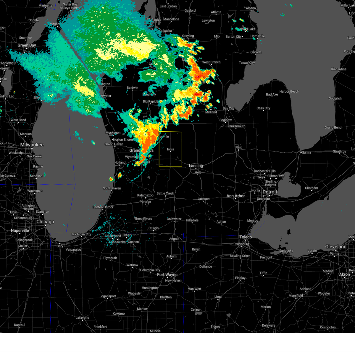
The Pewamo, MI area has had 1 report of on-the-ground hail by trained spotters, and has been under severe weather warnings 26 times during the past 12 months. Doppler radar has detected hail at or near Pewamo, MI on 29 occasions, including 3 occasions during the past year.
| Name: | Pewamo, MI |
| Where Located: | 41.9 miles E of Grand Rapids, MI |
| Map: | Google Map for Pewamo, MI |
| Population: | 469 |
| Housing Units: | 204 |
| More Info: | Search Google for Pewamo, MI |
0
The Top Recent Hail Date for Pewamo, MI is Tuesday, June 16, 2026 (29th out of 29)
Hail and Wind Damage Spotted near Pewamo, MI
| Date / Time | Report Details |
|---|---|
| 6/11/2026 10:00 PM EDT |
 Svrgrr the national weather service in grand rapids has issued a * severe thunderstorm warning for, ingham county in south central michigan, clinton county in south central michigan, * until 1100 pm edt. * at 959 pm edt, severe thunderstorms were located along a line extending from 7 miles southwest of carson city to near bellevue, moving east at 55 mph (radar indicated). Hazards include 70 mph wind gusts. Expect considerable tree damage. Damage is likely to mobile homes, roofs, and outbuildings. Svrgrr the national weather service in grand rapids has issued a * severe thunderstorm warning for, ingham county in south central michigan, clinton county in south central michigan, * until 1100 pm edt. * at 959 pm edt, severe thunderstorms were located along a line extending from 7 miles southwest of carson city to near bellevue, moving east at 55 mph (radar indicated). Hazards include 70 mph wind gusts. Expect considerable tree damage. Damage is likely to mobile homes, roofs, and outbuildings.
|
| 6/11/2026 10:00 PM EDT |
 At 1000 pm edt, a severe thunderstorm was located near portland, moving east at 50 mph (radar indicated). Hazards include 70 mph wind gusts. Expect considerable tree damage. damage is likely to mobile homes, roofs, and outbuildings. Locations impacted include, lansing, ionia, charlotte, eaton rapids, portland, grand ledge, potterville, lake odessa, bellevue, edgemont park, orleans, kalamo, olivet, brookfield, dimondale, sebewa, lyons, vermontville, muir, sunfield,. At 1000 pm edt, a severe thunderstorm was located near portland, moving east at 50 mph (radar indicated). Hazards include 70 mph wind gusts. Expect considerable tree damage. damage is likely to mobile homes, roofs, and outbuildings. Locations impacted include, lansing, ionia, charlotte, eaton rapids, portland, grand ledge, potterville, lake odessa, bellevue, edgemont park, orleans, kalamo, olivet, brookfield, dimondale, sebewa, lyons, vermontville, muir, sunfield,.
|
| 6/11/2026 9:38 PM EDT |
 Svrgrr the national weather service in grand rapids has issued a * severe thunderstorm warning for, ionia county in south central michigan, eaton county in south central michigan, * until 1045 pm edt. * at 937 pm edt, a severe thunderstorm was located near freeport, or 11 miles north of hastings, moving east at 50 mph (radar indicated). Hazards include 70 mph wind gusts. Expect considerable tree damage. Damage is likely to mobile homes, roofs, and outbuildings. Svrgrr the national weather service in grand rapids has issued a * severe thunderstorm warning for, ionia county in south central michigan, eaton county in south central michigan, * until 1045 pm edt. * at 937 pm edt, a severe thunderstorm was located near freeport, or 11 miles north of hastings, moving east at 50 mph (radar indicated). Hazards include 70 mph wind gusts. Expect considerable tree damage. Damage is likely to mobile homes, roofs, and outbuildings.
|
| 6/10/2026 7:59 PM EDT |
 At 758 pm edt, severe thunderstorms were located along a line extending from 8 miles southwest of farwell to 5 miles north of dewitt to 6 miles southwest of homer, moving east at 45 mph (radar indicated). Hazards include 60 mph wind gusts and penny size hail. Expect damage to roofs, siding, and trees. locations impacted include, lansing, jackson, mount pleasant, alma, mason, st. johns, clare, ithaca, east lansing, grand ledge, st. Louis, williamston, leslie, shepherd, breckenridge, stockbridge, brooklyn, grass lake, elsie, rosebush,. At 758 pm edt, severe thunderstorms were located along a line extending from 8 miles southwest of farwell to 5 miles north of dewitt to 6 miles southwest of homer, moving east at 45 mph (radar indicated). Hazards include 60 mph wind gusts and penny size hail. Expect damage to roofs, siding, and trees. locations impacted include, lansing, jackson, mount pleasant, alma, mason, st. johns, clare, ithaca, east lansing, grand ledge, st. Louis, williamston, leslie, shepherd, breckenridge, stockbridge, brooklyn, grass lake, elsie, rosebush,.
|
| 6/10/2026 7:44 PM EDT |
 At 744 pm edt, severe thunderstorms were located along a line extending from 8 miles east of edmore to 7 miles northeast of portland to near burlington, moving northeast at 35 mph (radar indicated). Hazards include 60 mph wind gusts. Expect damage to roofs, siding, and trees. Locations impacted include, lansing, ionia, charlotte, albion, marshall, battle creek, eaton rapids, portland, grand ledge, belding, potterville, lake odessa, homer, bellevue, burlington, brownlee park, edgemont park, orleans, marengo, kalamo,. At 744 pm edt, severe thunderstorms were located along a line extending from 8 miles east of edmore to 7 miles northeast of portland to near burlington, moving northeast at 35 mph (radar indicated). Hazards include 60 mph wind gusts. Expect damage to roofs, siding, and trees. Locations impacted include, lansing, ionia, charlotte, albion, marshall, battle creek, eaton rapids, portland, grand ledge, belding, potterville, lake odessa, homer, bellevue, burlington, brownlee park, edgemont park, orleans, marengo, kalamo,.
|
| 6/10/2026 7:39 PM EDT |
 Svrgrr the national weather service in grand rapids has issued a * severe thunderstorm warning for, jackson county in south central michigan, ingham county in south central michigan, gratiot county in central michigan, isabella county in central michigan, clinton county in south central michigan, * until 845 pm edt. * at 738 pm edt, severe thunderstorms were located along a line extending from near stanton to 6 miles southeast of bellevue, moving east at 60 mph. these storms have a history of producing 50 to 60 mph wind gusts which have caused tens of thousands of power outages across west michigan (radar indicated). Hazards include 60 mph wind gusts and penny size hail. expect damage to roofs, siding, and trees Svrgrr the national weather service in grand rapids has issued a * severe thunderstorm warning for, jackson county in south central michigan, ingham county in south central michigan, gratiot county in central michigan, isabella county in central michigan, clinton county in south central michigan, * until 845 pm edt. * at 738 pm edt, severe thunderstorms were located along a line extending from near stanton to 6 miles southeast of bellevue, moving east at 60 mph. these storms have a history of producing 50 to 60 mph wind gusts which have caused tens of thousands of power outages across west michigan (radar indicated). Hazards include 60 mph wind gusts and penny size hail. expect damage to roofs, siding, and trees
|
| 6/10/2026 7:12 PM EDT |
 Svrgrr the national weather service in grand rapids has issued a * severe thunderstorm warning for, calhoun county in south central michigan, ionia county in south central michigan, eaton county in south central michigan, * until 815 pm edt. * at 711 pm edt, severe thunderstorms were located along a line extending from near howard city to 7 miles southeast of climax, moving east at 55 mph. these storms have been leading to tens of thousands of power outages across west michigan along with observed wind gusts of 50 to 60 mph (radar indicated). Hazards include 60 mph wind gusts. expect damage to roofs, siding, and trees Svrgrr the national weather service in grand rapids has issued a * severe thunderstorm warning for, calhoun county in south central michigan, ionia county in south central michigan, eaton county in south central michigan, * until 815 pm edt. * at 711 pm edt, severe thunderstorms were located along a line extending from near howard city to 7 miles southeast of climax, moving east at 55 mph. these storms have been leading to tens of thousands of power outages across west michigan along with observed wind gusts of 50 to 60 mph (radar indicated). Hazards include 60 mph wind gusts. expect damage to roofs, siding, and trees
|
| 5/18/2026 3:29 PM EDT |
 At 329 pm edt, severe thunderstorms were located along a line extending from near edmore to near st. johns to 9 miles northeast of jonesville, moving northeast at 60 mph (radar indicated). Hazards include 70 mph wind gusts. Expect considerable tree damage. damage is likely to mobile homes, roofs, and outbuildings. locations impacted include, lansing, jackson, mason, ithaca, east lansing, leslie, elsie, vandercook lake, alma, st. Louis, williamston, mount pleasant, shepherd, breckenridge, stockbridge and grass lake. At 329 pm edt, severe thunderstorms were located along a line extending from near edmore to near st. johns to 9 miles northeast of jonesville, moving northeast at 60 mph (radar indicated). Hazards include 70 mph wind gusts. Expect considerable tree damage. damage is likely to mobile homes, roofs, and outbuildings. locations impacted include, lansing, jackson, mason, ithaca, east lansing, leslie, elsie, vandercook lake, alma, st. Louis, williamston, mount pleasant, shepherd, breckenridge, stockbridge and grass lake.
|
| 5/18/2026 3:19 PM EDT |
 At 319 pm edt, severe thunderstorms were located along a line extending from near lakeview to 5 miles west of st. johns to near litchfield, moving northeast at 55 mph (radar indicated). Hazards include 70 mph wind gusts and quarter size hail. Hail damage to vehicles is expected. expect considerable tree damage. wind damage is also likely to mobile homes, roofs, and outbuildings. Locations impacted include, lansing, ionia, charlotte, albion, greenville, marshall, eaton rapids, portland, stanton, grand ledge, potterville, howard city, homer, edmore, carson city, lakeview, edgemont park, orleans, crystal, sidney,. At 319 pm edt, severe thunderstorms were located along a line extending from near lakeview to 5 miles west of st. johns to near litchfield, moving northeast at 55 mph (radar indicated). Hazards include 70 mph wind gusts and quarter size hail. Hail damage to vehicles is expected. expect considerable tree damage. wind damage is also likely to mobile homes, roofs, and outbuildings. Locations impacted include, lansing, ionia, charlotte, albion, greenville, marshall, eaton rapids, portland, stanton, grand ledge, potterville, howard city, homer, edmore, carson city, lakeview, edgemont park, orleans, crystal, sidney,.
|
| 5/18/2026 3:10 PM EDT | Maple tree down and golf cart turned ove in ionia county MI, 4.6 miles NNE of Pewamo, MI |
| 5/18/2026 3:10 PM EDT |
 At 310 pm edt, severe thunderstorms were located along a line extending from near portland to near grand ledge, moving northeast at 60 mph. these are destructive storms for lansing and the capital region (radar indicated). Hazards include 80 mph wind gusts. Flying debris will be dangerous to those caught without shelter. mobile homes will be heavily damaged. expect considerable damage to roofs, windows, and vehicles. extensive tree damage and power outages are likely. locations impacted include, lansing, charlotte, mason, st. Johns, portland, east lansing, grand ledge, potterville, elsie, edgemont park, dewitt, capital region inter, eureka, ovid, dimondale, fowler, sebewa, westphalia, lyons, vermontville,. At 310 pm edt, severe thunderstorms were located along a line extending from near portland to near grand ledge, moving northeast at 60 mph. these are destructive storms for lansing and the capital region (radar indicated). Hazards include 80 mph wind gusts. Flying debris will be dangerous to those caught without shelter. mobile homes will be heavily damaged. expect considerable damage to roofs, windows, and vehicles. extensive tree damage and power outages are likely. locations impacted include, lansing, charlotte, mason, st. Johns, portland, east lansing, grand ledge, potterville, elsie, edgemont park, dewitt, capital region inter, eureka, ovid, dimondale, fowler, sebewa, westphalia, lyons, vermontville,.
|
| 5/18/2026 3:07 PM EDT |
 Svrgrr the national weather service in grand rapids has issued a * severe thunderstorm warning for, jackson county in south central michigan, ingham county in south central michigan, gratiot county in central michigan, southern isabella county in central michigan, clinton county in south central michigan, * until 400 pm edt. * at 307 pm edt, severe thunderstorms were located along a line extending from 7 miles southeast of howard city to near portland to near homer, moving northeast at 55 mph (radar indicated). Hazards include 70 mph wind gusts. Expect considerable tree damage. damage is likely to mobile homes, roofs, and outbuildings. severe thunderstorms will be near, grand ledge around 310 pm edt. lansing, dewitt, capital region international airport, and edgemont park around 315 pm edt. jackson, mason, st. johns, east lansing, and leslie around 320 pm edt. other locations in the path of these severe thunderstorms include alma, ithaca, williamston, elsie, st. Louis, stockbridge, mount pleasant, shepherd and breckenridge. Svrgrr the national weather service in grand rapids has issued a * severe thunderstorm warning for, jackson county in south central michigan, ingham county in south central michigan, gratiot county in central michigan, southern isabella county in central michigan, clinton county in south central michigan, * until 400 pm edt. * at 307 pm edt, severe thunderstorms were located along a line extending from 7 miles southeast of howard city to near portland to near homer, moving northeast at 55 mph (radar indicated). Hazards include 70 mph wind gusts. Expect considerable tree damage. damage is likely to mobile homes, roofs, and outbuildings. severe thunderstorms will be near, grand ledge around 310 pm edt. lansing, dewitt, capital region international airport, and edgemont park around 315 pm edt. jackson, mason, st. johns, east lansing, and leslie around 320 pm edt. other locations in the path of these severe thunderstorms include alma, ithaca, williamston, elsie, st. Louis, stockbridge, mount pleasant, shepherd and breckenridge.
|
| 5/18/2026 2:59 PM EDT |
 Svrgrr the national weather service in grand rapids has issued a * severe thunderstorm warning for, northwestern ingham county in south central michigan, southeastern ionia county in south central michigan, clinton county in south central michigan, northern eaton county in south central michigan, * until 345 pm edt. * at 259 pm edt, severe thunderstorms were located along a line extending from 6 miles southwest of portland to 5 miles northwest of charlotte, moving northeast at 60 mph. these are destructive storms for lansing and the capital region (radar indicated). Hazards include 80 mph wind gusts. Flying debris will be dangerous to those caught without shelter. mobile homes will be heavily damaged. expect considerable damage to roofs, windows, and vehicles. Extensive tree damage and power outages are likely. Svrgrr the national weather service in grand rapids has issued a * severe thunderstorm warning for, northwestern ingham county in south central michigan, southeastern ionia county in south central michigan, clinton county in south central michigan, northern eaton county in south central michigan, * until 345 pm edt. * at 259 pm edt, severe thunderstorms were located along a line extending from 6 miles southwest of portland to 5 miles northwest of charlotte, moving northeast at 60 mph. these are destructive storms for lansing and the capital region (radar indicated). Hazards include 80 mph wind gusts. Flying debris will be dangerous to those caught without shelter. mobile homes will be heavily damaged. expect considerable damage to roofs, windows, and vehicles. Extensive tree damage and power outages are likely.
|
| 5/18/2026 2:55 PM EDT |
 At 254 pm edt, severe thunderstorms were located along a line extending from 7 miles south of howard city to 8 miles southwest of portland to 5 miles west of homer, moving east at 75 mph (asos. at 244 pm 74 mph winds were reported at battle creek asos). Hazards include 70 mph wind gusts and quarter size hail. Hail damage to vehicles is expected. expect considerable tree damage. wind damage is also likely to mobile homes, roofs, and outbuildings. Locations impacted include, lansing, ionia, charlotte, albion, greenville, marshall, eaton rapids, portland, stanton, grand ledge, belding, potterville, lake odessa, howard city, homer, saranac, bellevue, edmore, carson city, lakeview,. At 254 pm edt, severe thunderstorms were located along a line extending from 7 miles south of howard city to 8 miles southwest of portland to 5 miles west of homer, moving east at 75 mph (asos. at 244 pm 74 mph winds were reported at battle creek asos). Hazards include 70 mph wind gusts and quarter size hail. Hail damage to vehicles is expected. expect considerable tree damage. wind damage is also likely to mobile homes, roofs, and outbuildings. Locations impacted include, lansing, ionia, charlotte, albion, greenville, marshall, eaton rapids, portland, stanton, grand ledge, belding, potterville, lake odessa, howard city, homer, saranac, bellevue, edmore, carson city, lakeview,.
|
| 5/18/2026 2:34 PM EDT |
 Svrgrr the national weather service in grand rapids has issued a * severe thunderstorm warning for, calhoun county in south central michigan, ionia county in south central michigan, eaton county in south central michigan, montcalm county in central michigan, * until 400 pm edt. * at 234 pm edt, severe thunderstorms were located along a line extending from near walker to near middleville to near battle creek, moving northeast at 55 mph (radar indicated). Hazards include 70 mph wind gusts. Expect considerable tree damage. Damage is likely to mobile homes, roofs, and outbuildings. Svrgrr the national weather service in grand rapids has issued a * severe thunderstorm warning for, calhoun county in south central michigan, ionia county in south central michigan, eaton county in south central michigan, montcalm county in central michigan, * until 400 pm edt. * at 234 pm edt, severe thunderstorms were located along a line extending from near walker to near middleville to near battle creek, moving northeast at 55 mph (radar indicated). Hazards include 70 mph wind gusts. Expect considerable tree damage. Damage is likely to mobile homes, roofs, and outbuildings.
|
| 5/16/2026 5:23 AM EDT |
 Svrgrr the national weather service in grand rapids has issued a * severe thunderstorm warning for, northeastern ionia county in south central michigan, gratiot county in central michigan, northwestern clinton county in south central michigan, southeastern montcalm county in central michigan, * until 615 am edt. * at 522 am edt, a severe thunderstorm was located 6 miles north of ionia, moving east at 55 mph (radar indicated). Hazards include 60 mph wind gusts and quarter size hail. Hail damage to vehicles is expected. Expect wind damage to roofs, siding, and trees. Svrgrr the national weather service in grand rapids has issued a * severe thunderstorm warning for, northeastern ionia county in south central michigan, gratiot county in central michigan, northwestern clinton county in south central michigan, southeastern montcalm county in central michigan, * until 615 am edt. * at 522 am edt, a severe thunderstorm was located 6 miles north of ionia, moving east at 55 mph (radar indicated). Hazards include 60 mph wind gusts and quarter size hail. Hail damage to vehicles is expected. Expect wind damage to roofs, siding, and trees.
|
| 4/14/2026 11:14 PM EDT |
 Torgrr the national weather service in grand rapids has issued a * tornado warning for, central clinton county in south central michigan, * until midnight edt. * at 1114 pm edt, severe thunderstorms capable of producing both tornadoes and extensive straight line wind damage were located 10 miles northeast of portland, moving east at 45 mph (radar indicated rotation). Hazards include tornado. Flying debris will be dangerous to those caught without shelter. mobile homes will be damaged or destroyed. damage to roofs, windows, and vehicles will occur. tree damage is likely. these dangerous storms will be near, st. Johns around 1125 pm edt. Torgrr the national weather service in grand rapids has issued a * tornado warning for, central clinton county in south central michigan, * until midnight edt. * at 1114 pm edt, severe thunderstorms capable of producing both tornadoes and extensive straight line wind damage were located 10 miles northeast of portland, moving east at 45 mph (radar indicated rotation). Hazards include tornado. Flying debris will be dangerous to those caught without shelter. mobile homes will be damaged or destroyed. damage to roofs, windows, and vehicles will occur. tree damage is likely. these dangerous storms will be near, st. Johns around 1125 pm edt.
|
| 4/14/2026 10:49 PM EDT |
 Svrgrr the national weather service in grand rapids has issued a * severe thunderstorm warning for, ionia county in south central michigan, * until 1145 pm edt. * at 1048 pm edt, severe thunderstorms were located along a line extending from 7 miles northeast of belding to near gerald r. ford international airport, moving east at 40 mph (radar indicated). Hazards include 60 mph wind gusts. expect damage to roofs, siding, and trees Svrgrr the national weather service in grand rapids has issued a * severe thunderstorm warning for, ionia county in south central michigan, * until 1145 pm edt. * at 1048 pm edt, severe thunderstorms were located along a line extending from 7 miles northeast of belding to near gerald r. ford international airport, moving east at 40 mph (radar indicated). Hazards include 60 mph wind gusts. expect damage to roofs, siding, and trees
|
| 4/13/2026 8:53 PM EDT |
 At 852 pm edt, severe thunderstorms were located along a line extending from 9 miles south of carson city to near st. johns to near dewitt, moving northeast at 40 mph (radar indicated). Hazards include 60 mph wind gusts and quarter size hail. Hail damage to vehicles is expected. expect wind damage to roofs, siding, and trees. locations impacted include, st. Johns, elsie, dewitt, capital region inter, eureka, ovid, fowler, westphalia, maple rapids, hubbardston, wacousta, bath,. At 852 pm edt, severe thunderstorms were located along a line extending from 9 miles south of carson city to near st. johns to near dewitt, moving northeast at 40 mph (radar indicated). Hazards include 60 mph wind gusts and quarter size hail. Hail damage to vehicles is expected. expect wind damage to roofs, siding, and trees. locations impacted include, st. Johns, elsie, dewitt, capital region inter, eureka, ovid, fowler, westphalia, maple rapids, hubbardston, wacousta, bath,.
|
| 4/13/2026 8:39 PM EDT |
 Svrgrr the national weather service in grand rapids has issued a * severe thunderstorm warning for, east central ionia county in south central michigan, * until 915 pm edt. * at 839 pm edt, a severe thunderstorm was located near portland, moving northeast at 30 mph (radar indicated). Hazards include 60 mph wind gusts and quarter size hail. Hail damage to vehicles is expected. Expect wind damage to roofs, siding, and trees. Svrgrr the national weather service in grand rapids has issued a * severe thunderstorm warning for, east central ionia county in south central michigan, * until 915 pm edt. * at 839 pm edt, a severe thunderstorm was located near portland, moving northeast at 30 mph (radar indicated). Hazards include 60 mph wind gusts and quarter size hail. Hail damage to vehicles is expected. Expect wind damage to roofs, siding, and trees.
|
| 4/13/2026 8:29 PM EDT |
 Svrgrr the national weather service in grand rapids has issued a * severe thunderstorm warning for, southeastern ionia county in south central michigan, clinton county in south central michigan, * until 930 pm edt. * at 829 pm edt, severe thunderstorms were located along a line extending from near portland to 12 miles west of dewitt to near grand ledge, moving northeast at 40 mph (radar indicated). Hazards include 60 mph wind gusts and quarter size hail. Hail damage to vehicles is expected. Expect wind damage to roofs, siding, and trees. Svrgrr the national weather service in grand rapids has issued a * severe thunderstorm warning for, southeastern ionia county in south central michigan, clinton county in south central michigan, * until 930 pm edt. * at 829 pm edt, severe thunderstorms were located along a line extending from near portland to 12 miles west of dewitt to near grand ledge, moving northeast at 40 mph (radar indicated). Hazards include 60 mph wind gusts and quarter size hail. Hail damage to vehicles is expected. Expect wind damage to roofs, siding, and trees.
|
| 3/10/2026 10:23 PM EDT |
 At 1023 pm edt, severe thunderstorms were located along a line extending from 6 miles north of ionia to 7 miles southeast of ithaca, moving northeast at 35 mph (radar indicated). Hazards include quarter size hail. Damage to vehicles is expected. Locations impacted include, ionia, ithaca, carson city, elsie, eureka, north star, lyons, maple rapids, muir, ashley, pewamo, perrinton, hubbardston, bannister, palo, pompeii, middleton, butternut, fenwick,. At 1023 pm edt, severe thunderstorms were located along a line extending from 6 miles north of ionia to 7 miles southeast of ithaca, moving northeast at 35 mph (radar indicated). Hazards include quarter size hail. Damage to vehicles is expected. Locations impacted include, ionia, ithaca, carson city, elsie, eureka, north star, lyons, maple rapids, muir, ashley, pewamo, perrinton, hubbardston, bannister, palo, pompeii, middleton, butternut, fenwick,.
|
| 3/10/2026 10:04 PM EDT |
 At 1004 pm edt, a severe thunderstorm was located 8 miles east of carson city, or 9 miles southwest of ithaca, moving east at 35 mph (radar indicated). Hazards include quarter size hail. Damage to vehicles is expected. Locations impacted include, ionia, ithaca, carson city, elsie, eureka, north star, lyons, maple rapids, muir, ashley, pewamo, perrinton, hubbardston, bannister, palo, pompeii, middleton, butternut, fenwick,. At 1004 pm edt, a severe thunderstorm was located 8 miles east of carson city, or 9 miles southwest of ithaca, moving east at 35 mph (radar indicated). Hazards include quarter size hail. Damage to vehicles is expected. Locations impacted include, ionia, ithaca, carson city, elsie, eureka, north star, lyons, maple rapids, muir, ashley, pewamo, perrinton, hubbardston, bannister, palo, pompeii, middleton, butternut, fenwick,.
|
| 3/10/2026 9:41 PM EDT |
 Svrgrr the national weather service in grand rapids has issued a * severe thunderstorm warning for, southern gratiot county in central michigan, northeastern ionia county in south central michigan, northern clinton county in south central michigan, southeastern montcalm county in central michigan, * until 1045 pm edt. * at 941 pm edt, a severe thunderstorm was located 8 miles southwest of carson city, or 9 miles northeast of ionia, moving east at 35 mph (radar indicated). Hazards include quarter size hail. damage to vehicles is expected Svrgrr the national weather service in grand rapids has issued a * severe thunderstorm warning for, southern gratiot county in central michigan, northeastern ionia county in south central michigan, northern clinton county in south central michigan, southeastern montcalm county in central michigan, * until 1045 pm edt. * at 941 pm edt, a severe thunderstorm was located 8 miles southwest of carson city, or 9 miles northeast of ionia, moving east at 35 mph (radar indicated). Hazards include quarter size hail. damage to vehicles is expected
|
| 10/6/2025 9:06 PM EDT | At 905 pm edt, severe thunderstorms were located along a line extending from near saranac to near lake odessa, moving east at 30 mph (radar indicated). Hazards include 60 mph wind gusts. Expect damage to roofs, siding, and trees. Locations impacted include, ionia, portland, lake odessa, saranac, freeport, sebewa, lyons, muir, sunfield, mulliken, pewamo, woodland, clarksville, woodbury,. |
| 10/6/2025 9:06 PM EDT | the severe thunderstorm warning has been cancelled and is no longer in effect |
| 10/6/2025 8:47 PM EDT | Svrgrr the national weather service in grand rapids has issued a * severe thunderstorm warning for, southeastern kent county in southwestern michigan, northern barry county in southwestern michigan, ionia county in south central michigan, northwestern eaton county in south central michigan, * until 930 pm edt. * at 846 pm edt, severe thunderstorms were located along a line extending from 6 miles south of lowell to near freeport, moving east at 35 mph (radar indicated). Hazards include 60 mph wind gusts. expect damage to roofs, siding, and trees |
| 5/15/2025 11:44 PM EDT |
 the severe thunderstorm warning has been cancelled and is no longer in effect the severe thunderstorm warning has been cancelled and is no longer in effect
|
| 5/15/2025 11:32 PM EDT |
 Torgrr the national weather service in grand rapids has issued a * tornado warning for, gratiot county in central michigan, northern clinton county in south central michigan, * until 1215 am edt. * at 1132 pm edt, severe thunderstorms capable of producing both tornadoes and extensive straight line wind damage were located along a line extending from 5 miles west of ithaca to 10 miles south of carson city, moving northeast at 50 mph (radar indicated rotation). Hazards include tornado. Flying debris will be dangerous to those caught without shelter. mobile homes will be damaged or destroyed. damage to roofs, windows, and vehicles will occur. Tree damage is likely. Torgrr the national weather service in grand rapids has issued a * tornado warning for, gratiot county in central michigan, northern clinton county in south central michigan, * until 1215 am edt. * at 1132 pm edt, severe thunderstorms capable of producing both tornadoes and extensive straight line wind damage were located along a line extending from 5 miles west of ithaca to 10 miles south of carson city, moving northeast at 50 mph (radar indicated rotation). Hazards include tornado. Flying debris will be dangerous to those caught without shelter. mobile homes will be damaged or destroyed. damage to roofs, windows, and vehicles will occur. Tree damage is likely.
|
| 5/15/2025 10:33 PM EDT |
 Svrgrr the national weather service in grand rapids has issued a * severe thunderstorm warning for, barry county in southwestern michigan, ionia county in south central michigan, kalamazoo county in southwestern michigan, * until midnight edt. * at 1032 pm edt, severe thunderstorms were located along a line extending from 7 miles south of howard city to kentwood to near decatur, moving east at 55 mph (radar indicated). Hazards include 60 mph wind gusts. expect damage to roofs, siding, and trees Svrgrr the national weather service in grand rapids has issued a * severe thunderstorm warning for, barry county in southwestern michigan, ionia county in south central michigan, kalamazoo county in southwestern michigan, * until midnight edt. * at 1032 pm edt, severe thunderstorms were located along a line extending from 7 miles south of howard city to kentwood to near decatur, moving east at 55 mph (radar indicated). Hazards include 60 mph wind gusts. expect damage to roofs, siding, and trees
|
| 4/18/2025 10:21 AM EDT |
 the severe thunderstorm warning has been cancelled and is no longer in effect the severe thunderstorm warning has been cancelled and is no longer in effect
|
| 4/18/2025 10:21 AM EDT |
 At 1019 am edt, severe thunderstorms were located along a line extending from near fruitport to near allendale to near zeeland, moving east at 65 mph. this is a second area of thunderstorms that was following strong but non severe thunderstorms currently over the ionia area that are also moving east (radar indicated). Hazards include 60 mph wind gusts and quarter size hail. Hail damage to vehicles is expected. expect wind damage to roofs, siding, and trees. Locations impacted include, port sheldon, clarksville, belmont, muskegon heights, alto, orleans, marne, dutton, comstock park, hudsonville, sheridan, belding, sullivan, rockford, ionia, murray lake, fenwick, north muskegon, portland, conklin,. At 1019 am edt, severe thunderstorms were located along a line extending from near fruitport to near allendale to near zeeland, moving east at 65 mph. this is a second area of thunderstorms that was following strong but non severe thunderstorms currently over the ionia area that are also moving east (radar indicated). Hazards include 60 mph wind gusts and quarter size hail. Hail damage to vehicles is expected. expect wind damage to roofs, siding, and trees. Locations impacted include, port sheldon, clarksville, belmont, muskegon heights, alto, orleans, marne, dutton, comstock park, hudsonville, sheridan, belding, sullivan, rockford, ionia, murray lake, fenwick, north muskegon, portland, conklin,.
|
| 4/18/2025 10:08 AM EDT |
 At 1005 am edt, severe thunderstorms were located along a line extending from near fruitport to near beechwood, moving east at 55 mph. this is a second area of thunderstorms that was following strong but non severe thunderstorms currently over the grand rapids area that were also moving east (radar indicated). Hazards include 60 mph wind gusts and quarter size hail. Hail damage to vehicles is expected. expect wind damage to roofs, siding, and trees. Locations impacted include, port sheldon, clarksville, reeman, cedar lake, stanton, belmont, lakewood club, muskegon heights, dalton, alto, wyman, orleans, whitehall, marne, dutton, brunswick, holton, comstock park, hudsonville, sheridan,. At 1005 am edt, severe thunderstorms were located along a line extending from near fruitport to near beechwood, moving east at 55 mph. this is a second area of thunderstorms that was following strong but non severe thunderstorms currently over the grand rapids area that were also moving east (radar indicated). Hazards include 60 mph wind gusts and quarter size hail. Hail damage to vehicles is expected. expect wind damage to roofs, siding, and trees. Locations impacted include, port sheldon, clarksville, reeman, cedar lake, stanton, belmont, lakewood club, muskegon heights, dalton, alto, wyman, orleans, whitehall, marne, dutton, brunswick, holton, comstock park, hudsonville, sheridan,.
|
| 4/18/2025 9:48 AM EDT |
 Svrgrr the national weather service in grand rapids has issued a * severe thunderstorm warning for, kent county in southwestern michigan, ottawa county in southwestern michigan, southern newaygo county in west central michigan, ionia county in south central michigan, muskegon county in west central michigan, northwestern eaton county in south central michigan, southeastern oceana county in west central michigan, montcalm county in central michigan, * until 1115 am edt. * at 947 am edt, severe thunderstorms were located along a line extending from near fruitport to 5 miles southwest of allendale to near zeeland, moving east at 65 mph (radar indicated). Hazards include 60 mph wind gusts and quarter size hail. Hail damage to vehicles is expected. Expect wind damage to roofs, siding, and trees. Svrgrr the national weather service in grand rapids has issued a * severe thunderstorm warning for, kent county in southwestern michigan, ottawa county in southwestern michigan, southern newaygo county in west central michigan, ionia county in south central michigan, muskegon county in west central michigan, northwestern eaton county in south central michigan, southeastern oceana county in west central michigan, montcalm county in central michigan, * until 1115 am edt. * at 947 am edt, severe thunderstorms were located along a line extending from near fruitport to 5 miles southwest of allendale to near zeeland, moving east at 65 mph (radar indicated). Hazards include 60 mph wind gusts and quarter size hail. Hail damage to vehicles is expected. Expect wind damage to roofs, siding, and trees.
|
| 3/30/2025 7:03 PM EDT |
 the severe thunderstorm warning has been cancelled and is no longer in effect the severe thunderstorm warning has been cancelled and is no longer in effect
|
| 3/30/2025 6:47 PM EDT |
 At 645 pm edt, severe thunderstorms were located along a line extending from 8 miles southwest of shepherd to near ann arbor, moving east at 70 mph. these are destructive storms for central and southern michigan (at 6:32 pm lansing asos gusted to 62 mph). Hazards include 80 mph wind gusts. Flying debris will be dangerous to those caught without shelter. mobile homes will be heavily damaged. expect considerable damage to roofs, windows, and vehicles. extensive tree damage and power outages are likely. Locations impacted include, alma, williamston, edgemont park, elm hall, ovid, ithaca, north star, bunker hill, bell oak, bath, gratiot community ai, holt, maple rapids, forest hill, breckenridge, dewitt, pompeii, sumner, east lansing, riverdale,. At 645 pm edt, severe thunderstorms were located along a line extending from 8 miles southwest of shepherd to near ann arbor, moving east at 70 mph. these are destructive storms for central and southern michigan (at 6:32 pm lansing asos gusted to 62 mph). Hazards include 80 mph wind gusts. Flying debris will be dangerous to those caught without shelter. mobile homes will be heavily damaged. expect considerable damage to roofs, windows, and vehicles. extensive tree damage and power outages are likely. Locations impacted include, alma, williamston, edgemont park, elm hall, ovid, ithaca, north star, bunker hill, bell oak, bath, gratiot community ai, holt, maple rapids, forest hill, breckenridge, dewitt, pompeii, sumner, east lansing, riverdale,.
|
| 3/30/2025 6:39 PM EDT |
 The storms which prompted the warning are moving out of the area. therefore, the warning will be allowed to expire. a severe thunderstorm watch remains in effect until 900 pm edt for south central, central and southwestern michigan. The storms which prompted the warning are moving out of the area. therefore, the warning will be allowed to expire. a severe thunderstorm watch remains in effect until 900 pm edt for south central, central and southwestern michigan.
|
| 3/30/2025 6:28 PM EDT |
 At 626 pm edt, severe thunderstorms were located along a line extending from lakeview to near grass lake, moving northeast at 55 mph. these are destructive storms for central and southern michigan (jackson asos reported 96 mph winds at 6:17 pm). Hazards include wind gusts in excess of 80 mph. Flying debris will be dangerous to those caught without shelter. mobile homes will be heavily damaged. expect considerable damage to roofs, windows, and vehicles. extensive tree damage and power outages are likely. Locations impacted include, alma, charlotte, elm hall, eden, jackson, bell oak, bath, forest hill, pompeii, spring arbor, riverdale, michigan center, eagle, onondaga, springport, oak point, dansville, lansing, norvell, bannister,. At 626 pm edt, severe thunderstorms were located along a line extending from lakeview to near grass lake, moving northeast at 55 mph. these are destructive storms for central and southern michigan (jackson asos reported 96 mph winds at 6:17 pm). Hazards include wind gusts in excess of 80 mph. Flying debris will be dangerous to those caught without shelter. mobile homes will be heavily damaged. expect considerable damage to roofs, windows, and vehicles. extensive tree damage and power outages are likely. Locations impacted include, alma, charlotte, elm hall, eden, jackson, bell oak, bath, forest hill, pompeii, spring arbor, riverdale, michigan center, eagle, onondaga, springport, oak point, dansville, lansing, norvell, bannister,.
|
| 3/30/2025 6:26 PM EDT |
 Torgrr the national weather service in grand rapids has issued a * tornado warning for, gratiot county in central michigan, eastern ionia county in south central michigan, clinton county in south central michigan, southeastern montcalm county in central michigan, * until 715 pm edt. * at 626 pm edt, severe thunderstorms capable of producing both tornadoes and extensive straight line wind damage were located along a line extending from near carson city to 10 miles northeast of ionia to near portland, moving northeast at 55 mph (radar indicated rotation). Hazards include tornado. Flying debris will be dangerous to those caught without shelter. mobile homes will be damaged or destroyed. damage to roofs, windows, and vehicles will occur. tree damage is likely. these dangerous storms will be near, carson city around 630 pm edt. ithaca and st. johns around 640 pm edt. Other locations in the path of these tornadic storms include elsie. Torgrr the national weather service in grand rapids has issued a * tornado warning for, gratiot county in central michigan, eastern ionia county in south central michigan, clinton county in south central michigan, southeastern montcalm county in central michigan, * until 715 pm edt. * at 626 pm edt, severe thunderstorms capable of producing both tornadoes and extensive straight line wind damage were located along a line extending from near carson city to 10 miles northeast of ionia to near portland, moving northeast at 55 mph (radar indicated rotation). Hazards include tornado. Flying debris will be dangerous to those caught without shelter. mobile homes will be damaged or destroyed. damage to roofs, windows, and vehicles will occur. tree damage is likely. these dangerous storms will be near, carson city around 630 pm edt. ithaca and st. johns around 640 pm edt. Other locations in the path of these tornadic storms include elsie.
|
| 3/30/2025 6:19 PM EDT |
 At 618 pm edt, severe thunderstorms were located along a line extending from 10 miles southeast of baldwin to 7 miles east of greenville to 6 miles south of ionia, moving northeast at 75 mph. these are destructive storms for western and southern michigan (radar indicated). Hazards include 80 mph wind gusts and penny size hail. Flying debris will be dangerous to those caught without shelter. mobile homes will be heavily damaged. expect considerable damage to roofs, windows, and vehicles. extensive tree damage and power outages are likely. Locations impacted include, clarksville, cedar lake, stanton, vestaburg, wyman, orleans, langston, hawkins, lakeview, greenville, six lakes, pierson, woodville, sidney, sheridan, howard city, belding, carson city, bitely, ionia,. At 618 pm edt, severe thunderstorms were located along a line extending from 10 miles southeast of baldwin to 7 miles east of greenville to 6 miles south of ionia, moving northeast at 75 mph. these are destructive storms for western and southern michigan (radar indicated). Hazards include 80 mph wind gusts and penny size hail. Flying debris will be dangerous to those caught without shelter. mobile homes will be heavily damaged. expect considerable damage to roofs, windows, and vehicles. extensive tree damage and power outages are likely. Locations impacted include, clarksville, cedar lake, stanton, vestaburg, wyman, orleans, langston, hawkins, lakeview, greenville, six lakes, pierson, woodville, sidney, sheridan, howard city, belding, carson city, bitely, ionia,.
|
| 3/30/2025 6:07 PM EDT |
 At 606 pm edt, severe thunderstorms were located along a line extending from 9 miles south of portland to 7 miles west of cement city, moving east at 70 mph (trained weather spotters at 5 pm reported 70 mph winds southwest of nashville). Hazards include 70 mph wind gusts. Expect considerable tree damage. damage is likely to mobile homes, roofs, and outbuildings. Locations impacted include, alma, charlotte, elm hall, eden, jackson, bell oak, bath, forest hill, pompeii, spring arbor, riverdale, michigan center, eagle, onondaga, springport, oak point, dansville, lansing, norvell, bannister,. At 606 pm edt, severe thunderstorms were located along a line extending from 9 miles south of portland to 7 miles west of cement city, moving east at 70 mph (trained weather spotters at 5 pm reported 70 mph winds southwest of nashville). Hazards include 70 mph wind gusts. Expect considerable tree damage. damage is likely to mobile homes, roofs, and outbuildings. Locations impacted include, alma, charlotte, elm hall, eden, jackson, bell oak, bath, forest hill, pompeii, spring arbor, riverdale, michigan center, eagle, onondaga, springport, oak point, dansville, lansing, norvell, bannister,.
|
| 3/30/2025 6:02 PM EDT |
 At 601 pm edt, severe thunderstorms were located along a line extending from near hesperia to near freeport, moving east at 60 mph. these are destructive storms for western michigan (at 5:50 pm 80 mph winds were observed at grand rapids asos). Hazards include 80 mph wind gusts and penny size hail. Flying debris will be dangerous to those caught without shelter. mobile homes will be heavily damaged. expect considerable damage to roofs, windows, and vehicles. extensive tree damage and power outages are likely. Locations impacted include, clarksville, reeman, cedar lake, stanton, vestaburg, wyman, newaygo, orleans, langston, hawkins, lakeview, greenville, six lakes, pierson, woodville, sidney, sheridan, howard city, belding, carson city,. At 601 pm edt, severe thunderstorms were located along a line extending from near hesperia to near freeport, moving east at 60 mph. these are destructive storms for western michigan (at 5:50 pm 80 mph winds were observed at grand rapids asos). Hazards include 80 mph wind gusts and penny size hail. Flying debris will be dangerous to those caught without shelter. mobile homes will be heavily damaged. expect considerable damage to roofs, windows, and vehicles. extensive tree damage and power outages are likely. Locations impacted include, clarksville, reeman, cedar lake, stanton, vestaburg, wyman, newaygo, orleans, langston, hawkins, lakeview, greenville, six lakes, pierson, woodville, sidney, sheridan, howard city, belding, carson city,.
|
| 3/30/2025 5:56 PM EDT |
 Svrgrr the national weather service in grand rapids has issued a * severe thunderstorm warning for, jackson county in south central michigan, ingham county in south central michigan, gratiot county in central michigan, clinton county in south central michigan, eaton county in south central michigan, * until 730 pm edt. * at 555 pm edt, severe thunderstorms were located along a line extending from near lake odessa to 5 miles east of litchfield, moving east at 70 mph. these storms have a history of producing destructive wind gusts of 70 mph (radar indicated). Hazards include 70 mph wind gusts. Expect considerable tree damage. Damage is likely to mobile homes, roofs, and outbuildings. Svrgrr the national weather service in grand rapids has issued a * severe thunderstorm warning for, jackson county in south central michigan, ingham county in south central michigan, gratiot county in central michigan, clinton county in south central michigan, eaton county in south central michigan, * until 730 pm edt. * at 555 pm edt, severe thunderstorms were located along a line extending from near lake odessa to 5 miles east of litchfield, moving east at 70 mph. these storms have a history of producing destructive wind gusts of 70 mph (radar indicated). Hazards include 70 mph wind gusts. Expect considerable tree damage. Damage is likely to mobile homes, roofs, and outbuildings.
|
| 3/30/2025 5:48 PM EDT |
 Svrgrr the national weather service in grand rapids has issued a * severe thunderstorm warning for, newaygo county in west central michigan, ionia county in south central michigan, montcalm county in central michigan, * until 645 pm edt. * at 547 pm edt, severe thunderstorms were located along a line extending from 6 miles northeast of hart to near middleville, moving northeast at 85 mph (radar indicated). Hazards include 70 mph wind gusts and penny size hail. Expect considerable tree damage. Damage is likely to mobile homes, roofs, and outbuildings. Svrgrr the national weather service in grand rapids has issued a * severe thunderstorm warning for, newaygo county in west central michigan, ionia county in south central michigan, montcalm county in central michigan, * until 645 pm edt. * at 547 pm edt, severe thunderstorms were located along a line extending from 6 miles northeast of hart to near middleville, moving northeast at 85 mph (radar indicated). Hazards include 70 mph wind gusts and penny size hail. Expect considerable tree damage. Damage is likely to mobile homes, roofs, and outbuildings.
|
| 8/27/2024 4:28 PM EDT |
 The storms which prompted the warning have moved out of the area. therefore, the warning will be allowed to expire. a severe thunderstorm watch remains in effect until 800 pm edt for south central, central and southwestern michigan. The storms which prompted the warning have moved out of the area. therefore, the warning will be allowed to expire. a severe thunderstorm watch remains in effect until 800 pm edt for south central, central and southwestern michigan.
|
| 8/27/2024 4:14 PM EDT |
 At 412 pm edt, severe thunderstorms were located along a line extending from near hubbardston to near saranac moving east at 35 mph (radar indicated). Hazards include 60 mph wind gusts. Expect damage to roofs, siding, and trees. Locations impacted include, ionia, portland, lake odessa, sebewa, lyons, muir, mulliken, pewamo, hubbardston, clarksville, palo,. At 412 pm edt, severe thunderstorms were located along a line extending from near hubbardston to near saranac moving east at 35 mph (radar indicated). Hazards include 60 mph wind gusts. Expect damage to roofs, siding, and trees. Locations impacted include, ionia, portland, lake odessa, sebewa, lyons, muir, mulliken, pewamo, hubbardston, clarksville, palo,.
|
| 8/27/2024 4:14 PM EDT |
 the severe thunderstorm warning has been cancelled and is no longer in effect the severe thunderstorm warning has been cancelled and is no longer in effect
|
| 8/27/2024 3:36 PM EDT |
 Svrgrr the national weather service in grand rapids has issued a * severe thunderstorm warning for, ionia county in south central michigan, southern montcalm county in central michigan, * until 430 pm edt. * at 335 pm edt, severe thunderstorms were located along a line extending from near greenville to near grand rapids, moving east at 45 mph (radar indicated. numerous power outages due to strong winds were reported in kent county). Hazards include 60 mph wind gusts. expect damage to roofs, siding, and trees Svrgrr the national weather service in grand rapids has issued a * severe thunderstorm warning for, ionia county in south central michigan, southern montcalm county in central michigan, * until 430 pm edt. * at 335 pm edt, severe thunderstorms were located along a line extending from near greenville to near grand rapids, moving east at 45 mph (radar indicated. numerous power outages due to strong winds were reported in kent county). Hazards include 60 mph wind gusts. expect damage to roofs, siding, and trees
|
| 7/8/2024 5:45 PM EDT |
 Svrgrr the national weather service in grand rapids has issued a * severe thunderstorm warning for, northeastern ionia county in south central michigan, southwestern gratiot county in central michigan, northwestern clinton county in south central michigan, southeastern montcalm county in central michigan, * until 630 pm edt. * at 545 pm edt, a severe thunderstorm was located 7 miles south of carson city, or just north of lyons and muir, moving northeast at 25 mph (radar indicated). Hazards include 60 mph wind gusts and penny size hail. expect damage to roofs, siding, and trees Svrgrr the national weather service in grand rapids has issued a * severe thunderstorm warning for, northeastern ionia county in south central michigan, southwestern gratiot county in central michigan, northwestern clinton county in south central michigan, southeastern montcalm county in central michigan, * until 630 pm edt. * at 545 pm edt, a severe thunderstorm was located 7 miles south of carson city, or just north of lyons and muir, moving northeast at 25 mph (radar indicated). Hazards include 60 mph wind gusts and penny size hail. expect damage to roofs, siding, and trees
|
| 4/23/2024 8:26 PM EDT |
 the severe thunderstorm warning has been cancelled and is no longer in effect the severe thunderstorm warning has been cancelled and is no longer in effect
|
| 4/23/2024 8:20 PM EDT |
 At 820 pm edt, a severe thunderstorm was located near ionia, moving east at 30 mph (radar indicated). Hazards include quarter size hail. Damage to vehicles is expected. this severe storm will be near, ionia and portland around 825 pm edt. Other locations impacted by this severe thunderstorm include sebewa, lyons, pewamo, muir, and mulliken. At 820 pm edt, a severe thunderstorm was located near ionia, moving east at 30 mph (radar indicated). Hazards include quarter size hail. Damage to vehicles is expected. this severe storm will be near, ionia and portland around 825 pm edt. Other locations impacted by this severe thunderstorm include sebewa, lyons, pewamo, muir, and mulliken.
|
| 4/23/2024 8:13 PM EDT |
 At 812 pm edt, a severe thunderstorm was located over saranac, or 7 miles southwest of ionia, moving east at 25 mph. hail of greater than 1 inch in diameter was reported north of lowell with this storm (radar indicated). Hazards include quarter size hail. Damage to vehicles is expected. this severe storm will be near, ionia and saranac around 815 pm edt. portland around 825 pm edt. Other locations impacted by this severe thunderstorm include sebewa, lyons, pewamo, muir, and mulliken. At 812 pm edt, a severe thunderstorm was located over saranac, or 7 miles southwest of ionia, moving east at 25 mph. hail of greater than 1 inch in diameter was reported north of lowell with this storm (radar indicated). Hazards include quarter size hail. Damage to vehicles is expected. this severe storm will be near, ionia and saranac around 815 pm edt. portland around 825 pm edt. Other locations impacted by this severe thunderstorm include sebewa, lyons, pewamo, muir, and mulliken.
|
| 4/23/2024 8:00 PM EDT |
 Svrgrr the national weather service in grand rapids has issued a * severe thunderstorm warning for, ionia county in south central michigan, * until 845 pm edt. * at 759 pm edt, a severe thunderstorm was located near saranac, or 9 miles west of ionia, moving east at 30 mph (radar indicated). Hazards include quarter size hail. damage to vehicles is expected Svrgrr the national weather service in grand rapids has issued a * severe thunderstorm warning for, ionia county in south central michigan, * until 845 pm edt. * at 759 pm edt, a severe thunderstorm was located near saranac, or 9 miles west of ionia, moving east at 30 mph (radar indicated). Hazards include quarter size hail. damage to vehicles is expected
|
| 8/24/2023 9:07 PM EDT |
 At 906 pm edt, severe thunderstorms were located along a line extending from 12 miles west of st. johns to 6 miles south of portland, moving east at 60 mph (radar indicated). Hazards include 70 mph wind gusts. Expect considerable tree damage. damage is likely to mobile homes, roofs, and outbuildings. locations impacted include, portland, lake odessa, sebewa, lyons, muir, mulliken, pewamo, ionia county airport, thunderstorm damage threat, considerable hail threat, radar indicated max hail size, <. 75 in wind threat, radar indicated max wind gust, 70 mph. At 906 pm edt, severe thunderstorms were located along a line extending from 12 miles west of st. johns to 6 miles south of portland, moving east at 60 mph (radar indicated). Hazards include 70 mph wind gusts. Expect considerable tree damage. damage is likely to mobile homes, roofs, and outbuildings. locations impacted include, portland, lake odessa, sebewa, lyons, muir, mulliken, pewamo, ionia county airport, thunderstorm damage threat, considerable hail threat, radar indicated max hail size, <. 75 in wind threat, radar indicated max wind gust, 70 mph.
|
| 8/24/2023 8:56 PM EDT |
 At 855 pm edt, severe thunderstorms were located along a line extending from 8 miles northeast of ionia to 7 miles west of portland to lake odessa, moving east at 25 mph. these are destructive storms especially across southern ionia county (radar indicated). Hazards include 80 mph wind gusts and quarter size hail. Flying debris will be dangerous to those caught without shelter. mobile homes will be heavily damaged. expect considerable damage to roofs, windows, and vehicles. extensive tree damage and power outages are likely. Locations impacted include, ionia, greenville, portland, belding, lake odessa, saranac, carson city, orleans, sebewa, lyons, sheridan, muir, mulliken, pewamo, hubbardston, clarksville, palo, ionia county airport, butternut, fenwick,. At 855 pm edt, severe thunderstorms were located along a line extending from 8 miles northeast of ionia to 7 miles west of portland to lake odessa, moving east at 25 mph. these are destructive storms especially across southern ionia county (radar indicated). Hazards include 80 mph wind gusts and quarter size hail. Flying debris will be dangerous to those caught without shelter. mobile homes will be heavily damaged. expect considerable damage to roofs, windows, and vehicles. extensive tree damage and power outages are likely. Locations impacted include, ionia, greenville, portland, belding, lake odessa, saranac, carson city, orleans, sebewa, lyons, sheridan, muir, mulliken, pewamo, hubbardston, clarksville, palo, ionia county airport, butternut, fenwick,.
|
| 8/24/2023 8:38 PM EDT |
 At 838 pm edt, severe thunderstorms were located along a line extending from near sparta to 5 miles northeast of grand rapids to near wyoming, moving east at 60 mph (radar indicated). Hazards include 60 mph wind gusts and quarter size hail. Hail damage to vehicles is expected. Expect wind damage to roofs, siding, and trees. At 838 pm edt, severe thunderstorms were located along a line extending from near sparta to 5 miles northeast of grand rapids to near wyoming, moving east at 60 mph (radar indicated). Hazards include 60 mph wind gusts and quarter size hail. Hail damage to vehicles is expected. Expect wind damage to roofs, siding, and trees.
|
| 7/20/2023 2:11 PM EDT |
 The severe thunderstorm warning for southeastern kent and southern ionia counties will expire at 215 pm edt, the storms which prompted the warning have weakened below severe limits, and no longer pose an immediate threat to life or property. therefore, the warning will be allowed to expire. a severe thunderstorm watch remains in effect until 800 pm edt for south central and southwestern michigan. The severe thunderstorm warning for southeastern kent and southern ionia counties will expire at 215 pm edt, the storms which prompted the warning have weakened below severe limits, and no longer pose an immediate threat to life or property. therefore, the warning will be allowed to expire. a severe thunderstorm watch remains in effect until 800 pm edt for south central and southwestern michigan.
|
| 7/20/2023 1:58 PM EDT |
 At 156 pm edt, severe thunderstorms were located along a line extending from near lyons to clarksville to near caledonia, moving southeast at 30 mph (radar indicated). Hazards include 60 mph wind gusts and penny size hail. Expect damage to roofs, siding, and trees. locations impacted include, ionia, portland, lake odessa, caledonia, sebewa, lyons, muir, mulliken, pewamo, clarksville, ionia county airport, alto, hail threat, radar indicated max hail size, 0. 75 in wind threat, radar indicated max wind gust, 60 mph. At 156 pm edt, severe thunderstorms were located along a line extending from near lyons to clarksville to near caledonia, moving southeast at 30 mph (radar indicated). Hazards include 60 mph wind gusts and penny size hail. Expect damage to roofs, siding, and trees. locations impacted include, ionia, portland, lake odessa, caledonia, sebewa, lyons, muir, mulliken, pewamo, clarksville, ionia county airport, alto, hail threat, radar indicated max hail size, 0. 75 in wind threat, radar indicated max wind gust, 60 mph.
|
| 7/20/2023 1:31 PM EDT |
 At 131 pm edt, severe thunderstorms were located along a line extending from near carson city to near grandville, moving east at 55 mph (radar indicated). Hazards include 60 mph wind gusts and penny size hail. expect damage to roofs, siding, and trees At 131 pm edt, severe thunderstorms were located along a line extending from near carson city to near grandville, moving east at 55 mph (radar indicated). Hazards include 60 mph wind gusts and penny size hail. expect damage to roofs, siding, and trees
|
| 7/12/2023 11:30 PM EDT |
 At 1129 pm edt, severe thunderstorms were located along a line extending from 10 miles east of ionia to 7 miles southwest of portland, moving east at 15 mph (radar indicated). Hazards include 60 mph wind gusts. Expect damage to roofs, siding, and trees. locations impacted include, portland, sebewa, mulliken, pewamo, hail threat, radar indicated max hail size, <. 75 in wind threat, radar indicated max wind gust, 60 mph. At 1129 pm edt, severe thunderstorms were located along a line extending from 10 miles east of ionia to 7 miles southwest of portland, moving east at 15 mph (radar indicated). Hazards include 60 mph wind gusts. Expect damage to roofs, siding, and trees. locations impacted include, portland, sebewa, mulliken, pewamo, hail threat, radar indicated max hail size, <. 75 in wind threat, radar indicated max wind gust, 60 mph.
|
| 7/12/2023 11:03 PM EDT |
 At 1102 pm edt, a severe thunderstorm was located near lake odessa, or 8 miles northeast of hastings, moving northeast at 30 mph (radar indicated). Hazards include 60 mph wind gusts. expect damage to roofs, siding, and trees At 1102 pm edt, a severe thunderstorm was located near lake odessa, or 8 miles northeast of hastings, moving northeast at 30 mph (radar indicated). Hazards include 60 mph wind gusts. expect damage to roofs, siding, and trees
|
| 6/25/2023 5:22 PM EDT |
 At 522 pm edt, a severe thunderstorm was located over portland, moving north at 30 mph (radar indicated). Hazards include 60 mph wind gusts. Expect damage to roofs, siding, and trees. locations impacted include, ionia, portland, grand ledge, lake odessa, eureka, fowler, sebewa, westphalia, lyons, maple rapids, muir, mulliken, pewamo, hubbardston, eagle, wacousta, abrams municipal air, ionia county airport, hail threat, radar indicated max hail size, <. 75 in wind threat, radar indicated max wind gust, 60 mph. At 522 pm edt, a severe thunderstorm was located over portland, moving north at 30 mph (radar indicated). Hazards include 60 mph wind gusts. Expect damage to roofs, siding, and trees. locations impacted include, ionia, portland, grand ledge, lake odessa, eureka, fowler, sebewa, westphalia, lyons, maple rapids, muir, mulliken, pewamo, hubbardston, eagle, wacousta, abrams municipal air, ionia county airport, hail threat, radar indicated max hail size, <. 75 in wind threat, radar indicated max wind gust, 60 mph.
|
| 6/25/2023 4:53 PM EDT |
 At 453 pm edt, a severe thunderstorm was located 8 miles northeast of nashville, or 10 miles northwest of charlotte, moving north at 30 mph (radar indicated). Hazards include 60 mph wind gusts. expect damage to roofs, siding, and trees At 453 pm edt, a severe thunderstorm was located 8 miles northeast of nashville, or 10 miles northwest of charlotte, moving north at 30 mph (radar indicated). Hazards include 60 mph wind gusts. expect damage to roofs, siding, and trees
|
| 4/5/2023 10:17 AM EDT |
 At 1017 am edt, severe thunderstorms were located along a line extending from lakeview to near freeport, moving east at 60 mph (radar indicated). Hazards include 60 mph wind gusts. expect damage to roofs, siding, and trees At 1017 am edt, severe thunderstorms were located along a line extending from lakeview to near freeport, moving east at 60 mph (radar indicated). Hazards include 60 mph wind gusts. expect damage to roofs, siding, and trees
|
| 9/21/2022 9:54 AM EDT |
 The severe thunderstorm warning for ionia county will expire at 1000 am edt, the storms which prompted the warning have weakened. therefore, the warning will be allowed to expire. a severe thunderstorm watch remains in effect until 100 pm edt for south central michigan. The severe thunderstorm warning for ionia county will expire at 1000 am edt, the storms which prompted the warning have weakened. therefore, the warning will be allowed to expire. a severe thunderstorm watch remains in effect until 100 pm edt for south central michigan.
|
| 9/21/2022 9:39 AM EDT |
 At 939 am edt, severe thunderstorms were located along a line extending from 6 miles east of carson city to 7 miles north of lake odessa, moving east at 50 mph (radar indicated). Hazards include 60 mph wind gusts and quarter size hail. Hail damage to vehicles is expected. expect wind damage to roofs, siding, and trees. locations impacted include, ionia, portland, lake odessa, saranac, sebewa, lyons, muir, mulliken, pewamo, hubbardston, clarksville, palo, ionia county airport, hail threat, radar indicated max hail size, 1. 00 in wind threat, radar indicated max wind gust, 60 mph. At 939 am edt, severe thunderstorms were located along a line extending from 6 miles east of carson city to 7 miles north of lake odessa, moving east at 50 mph (radar indicated). Hazards include 60 mph wind gusts and quarter size hail. Hail damage to vehicles is expected. expect wind damage to roofs, siding, and trees. locations impacted include, ionia, portland, lake odessa, saranac, sebewa, lyons, muir, mulliken, pewamo, hubbardston, clarksville, palo, ionia county airport, hail threat, radar indicated max hail size, 1. 00 in wind threat, radar indicated max wind gust, 60 mph.
|
| 9/21/2022 9:10 AM EDT |
 At 909 am edt, severe thunderstorms were located along a line extending from 5 miles northeast of greenville to near east grand rapids, moving east at 50 mph (radar indicated). Hazards include ping pong ball size hail and 60 mph wind gusts. People and animals outdoors will be injured. expect hail damage to roofs, siding, windows, and vehicles. Expect wind damage to roofs, siding, and trees. At 909 am edt, severe thunderstorms were located along a line extending from 5 miles northeast of greenville to near east grand rapids, moving east at 50 mph (radar indicated). Hazards include ping pong ball size hail and 60 mph wind gusts. People and animals outdoors will be injured. expect hail damage to roofs, siding, windows, and vehicles. Expect wind damage to roofs, siding, and trees.
|
| 8/29/2022 4:31 PM EDT |
 At 430 pm edt, severe thunderstorms were located along a line extending from near ithaca to near st. johns to 6 miles northwest of charlotte, moving east at 55 mph (trained weather spotters). Hazards include 60 mph wind gusts and quarter size hail. Hail damage to vehicles is expected. expect wind damage to roofs, siding, and trees. locations impacted include, lansing, alma, charlotte, mason, st. johns, ithaca, east lansing, grand ledge, st. louis, williamston, potterville, breckenridge, elsie, edgemont park, dewitt, capital region inter, eureka, wheeler, sumner, ovid, hail threat, radar indicated max hail size, 1. 00 in wind threat, radar indicated max wind gust, 60 mph. At 430 pm edt, severe thunderstorms were located along a line extending from near ithaca to near st. johns to 6 miles northwest of charlotte, moving east at 55 mph (trained weather spotters). Hazards include 60 mph wind gusts and quarter size hail. Hail damage to vehicles is expected. expect wind damage to roofs, siding, and trees. locations impacted include, lansing, alma, charlotte, mason, st. johns, ithaca, east lansing, grand ledge, st. louis, williamston, potterville, breckenridge, elsie, edgemont park, dewitt, capital region inter, eureka, wheeler, sumner, ovid, hail threat, radar indicated max hail size, 1. 00 in wind threat, radar indicated max wind gust, 60 mph.
|
| 8/29/2022 3:47 PM EDT |
 At 345 pm edt, a line of severe thunderstorms was located along a line from grand rapids to near stanton, moving east at 45 mph. these storms have a history of producing wind damage and power outages. seek shelter inside a sturdy building (trained weather spotters). Hazards include 60 mph wind gusts and quarter size hail. Hail damage to vehicles is expected. Expect wind damage to roofs, siding, and trees. At 345 pm edt, a line of severe thunderstorms was located along a line from grand rapids to near stanton, moving east at 45 mph. these storms have a history of producing wind damage and power outages. seek shelter inside a sturdy building (trained weather spotters). Hazards include 60 mph wind gusts and quarter size hail. Hail damage to vehicles is expected. Expect wind damage to roofs, siding, and trees.
|
| 8/3/2022 3:36 PM EDT |
 The severe thunderstorm warning for ionia county will expire at 345 pm edt, the storm which prompted the warning has moved out of the area. therefore, the warning will be allowed to expire. however, gusty winds, lightning and heavy rain are still possible with this thunderstorm. a severe thunderstorm watch remains in effect until 900 pm edt for south central, central and southwestern michigan. The severe thunderstorm warning for ionia county will expire at 345 pm edt, the storm which prompted the warning has moved out of the area. therefore, the warning will be allowed to expire. however, gusty winds, lightning and heavy rain are still possible with this thunderstorm. a severe thunderstorm watch remains in effect until 900 pm edt for south central, central and southwestern michigan.
|
| 8/3/2022 2:48 PM EDT |
 At 248 pm edt, a severe thunderstorm was located near lake odessa, or 9 miles southeast of lowell, moving east at 35 mph (radar indicated). Hazards include 60 mph wind gusts and quarter size hail. Hail damage to vehicles is expected. Expect wind damage to roofs, siding, and trees. At 248 pm edt, a severe thunderstorm was located near lake odessa, or 9 miles southeast of lowell, moving east at 35 mph (radar indicated). Hazards include 60 mph wind gusts and quarter size hail. Hail damage to vehicles is expected. Expect wind damage to roofs, siding, and trees.
|
| 7/23/2022 11:07 PM EDT |
 The severe thunderstorm warning for ionia and southeastern montcalm counties will expire at 1115 pm edt, the storms which prompted the warning have weakened below severe limits, and have exited the warned area. therefore, the warning will be allowed to expire. a severe thunderstorm watch remains in effect until midnight edt for south central, central and southwestern michigan. The severe thunderstorm warning for ionia and southeastern montcalm counties will expire at 1115 pm edt, the storms which prompted the warning have weakened below severe limits, and have exited the warned area. therefore, the warning will be allowed to expire. a severe thunderstorm watch remains in effect until midnight edt for south central, central and southwestern michigan.
|
| 7/23/2022 10:49 PM EDT |
 At 1048 pm edt, severe thunderstorms were located along a line extending from near stanton to 7 miles southwest of carson city to 6 miles east of lake odessa, moving east at 50 mph (radar indicated). Hazards include 60 mph wind gusts. Expect damage to roofs, siding, and trees. locations impacted include, ionia, greenville, belding, portland, stanton, lake odessa, saranac, carson city, orleans, crystal, sidney, sebewa, lyons, sheridan, muir, mulliken, pewamo, hubbardston, clarksville, gowen, hail threat, radar indicated max hail size, <. 75 in wind threat, radar indicated max wind gust, 60 mph. At 1048 pm edt, severe thunderstorms were located along a line extending from near stanton to 7 miles southwest of carson city to 6 miles east of lake odessa, moving east at 50 mph (radar indicated). Hazards include 60 mph wind gusts. Expect damage to roofs, siding, and trees. locations impacted include, ionia, greenville, belding, portland, stanton, lake odessa, saranac, carson city, orleans, crystal, sidney, sebewa, lyons, sheridan, muir, mulliken, pewamo, hubbardston, clarksville, gowen, hail threat, radar indicated max hail size, <. 75 in wind threat, radar indicated max wind gust, 60 mph.
|
| 7/23/2022 10:16 PM EDT |
 At 1016 pm edt, severe thunderstorms were located along a line extending from 5 miles southwest of howard city to 6 miles southeast of rockford to near caledonia, moving east at 40 mph (radar indicated). Hazards include 60 mph wind gusts. expect damage to roofs, siding, and trees At 1016 pm edt, severe thunderstorms were located along a line extending from 5 miles southwest of howard city to 6 miles southeast of rockford to near caledonia, moving east at 40 mph (radar indicated). Hazards include 60 mph wind gusts. expect damage to roofs, siding, and trees
|
| 7/11/2022 10:14 PM EDT |
 At 1014 pm edt, a severe thunderstorm capable of producing a tornado was located 6 miles northeast of portland, moving east at 40 mph (radar indicated rotation). Hazards include tornado. Flying debris will be dangerous to those caught without shelter. mobile homes will be damaged or destroyed. damage to roofs, windows, and vehicles will occur. tree damage is likely. this dangerous storm will be near, st. johns around 1030 pm edt. Other locations in the path of this tornadic thunderstorm include dewitt. At 1014 pm edt, a severe thunderstorm capable of producing a tornado was located 6 miles northeast of portland, moving east at 40 mph (radar indicated rotation). Hazards include tornado. Flying debris will be dangerous to those caught without shelter. mobile homes will be damaged or destroyed. damage to roofs, windows, and vehicles will occur. tree damage is likely. this dangerous storm will be near, st. johns around 1030 pm edt. Other locations in the path of this tornadic thunderstorm include dewitt.
|
| 5/14/2022 6:50 PM EDT |
 At 649 pm edt, a severe thunderstorm was located 7 miles south of carson city, or 10 miles northeast of ionia, moving southeast at 15 mph (radar indicated). Hazards include quarter size hail. damage to vehicles is expected At 649 pm edt, a severe thunderstorm was located 7 miles south of carson city, or 10 miles northeast of ionia, moving southeast at 15 mph (radar indicated). Hazards include quarter size hail. damage to vehicles is expected
|
| 5/10/2022 3:30 AM EDT | Quarter sized hail reported 0.3 miles WNW of Pewamo, MI, picture from social media. |
| 9/7/2021 3:40 PM EDT |
 At 339 pm edt, severe thunderstorms were located along a line extending from 5 miles northwest of merrill to 6 miles north of ionia, moving east at 40 mph (trained weather spotters. at 336 pm quarter sized hail was reported just east of alma). Hazards include 60 mph wind gusts and quarter size hail. Hail damage to vehicles is expected. expect wind damage to roofs, siding, and trees. locations impacted include, ionia, alma, st. johns, belding, portland, ithaca, grand ledge, st. louis, lake odessa, breckenridge, saranac, elsie, dewitt, eureka, wheeler, orleans, sumner, ovid, fowler, sebewa, hail threat, observed max hail size, 1. 00 in wind threat, radar indicated max wind gust, 60 mph. At 339 pm edt, severe thunderstorms were located along a line extending from 5 miles northwest of merrill to 6 miles north of ionia, moving east at 40 mph (trained weather spotters. at 336 pm quarter sized hail was reported just east of alma). Hazards include 60 mph wind gusts and quarter size hail. Hail damage to vehicles is expected. expect wind damage to roofs, siding, and trees. locations impacted include, ionia, alma, st. johns, belding, portland, ithaca, grand ledge, st. louis, lake odessa, breckenridge, saranac, elsie, dewitt, eureka, wheeler, orleans, sumner, ovid, fowler, sebewa, hail threat, observed max hail size, 1. 00 in wind threat, radar indicated max wind gust, 60 mph.
|
| 9/7/2021 3:26 PM EDT |
 At 326 pm edt, a severe thunderstorm was located 6 miles southeast of carson city, or 12 miles southwest of ithaca, moving east at 35 mph (radar indicated). Hazards include 60 mph wind gusts and quarter size hail. Hail damage to vehicles is expected. Expect wind damage to roofs, siding, and trees. At 326 pm edt, a severe thunderstorm was located 6 miles southeast of carson city, or 12 miles southwest of ithaca, moving east at 35 mph (radar indicated). Hazards include 60 mph wind gusts and quarter size hail. Hail damage to vehicles is expected. Expect wind damage to roofs, siding, and trees.
|
| 8/29/2021 4:25 PM EDT |
 At 425 pm edt, a severe thunderstorm was located near st. johns, moving east at 40 mph (radar indicated). Hazards include 60 mph wind gusts and penny size hail. Expect damage to roofs, siding, and trees. locations impacted include, st. johns, elsie, eureka, ovid, fowler, westphalia, hail threat, radar indicated max hail size, 0. 75 in wind threat, radar indicated max wind gust, 60 mph. At 425 pm edt, a severe thunderstorm was located near st. johns, moving east at 40 mph (radar indicated). Hazards include 60 mph wind gusts and penny size hail. Expect damage to roofs, siding, and trees. locations impacted include, st. johns, elsie, eureka, ovid, fowler, westphalia, hail threat, radar indicated max hail size, 0. 75 in wind threat, radar indicated max wind gust, 60 mph.
|
| 8/29/2021 4:04 PM EDT |
 At 404 pm edt, a severe thunderstorm was located near portland, moving east at 40 mph (radar indicated). Hazards include 60 mph wind gusts and penny size hail. expect damage to roofs, siding, and trees At 404 pm edt, a severe thunderstorm was located near portland, moving east at 40 mph (radar indicated). Hazards include 60 mph wind gusts and penny size hail. expect damage to roofs, siding, and trees
|
| 8/24/2021 6:50 PM EDT |
 At 650 pm edt, a severe thunderstorm was located 8 miles west of st. johns, moving east at 30 mph (radar indicated). Hazards include 60 mph wind gusts. Expect damage to roofs, siding, and trees. locations impacted include, ionia, st. johns, ithaca, breckenridge, saranac, elsie, eureka, wheeler, ovid, fowler, north star, westphalia, lyons, maple rapids, muir, ashley, pewamo, perrinton, hubbardston, bannister, hail threat, radar indicated max hail size, <. 75 in wind threat, radar indicated max wind gust, 60 mph. At 650 pm edt, a severe thunderstorm was located 8 miles west of st. johns, moving east at 30 mph (radar indicated). Hazards include 60 mph wind gusts. Expect damage to roofs, siding, and trees. locations impacted include, ionia, st. johns, ithaca, breckenridge, saranac, elsie, eureka, wheeler, ovid, fowler, north star, westphalia, lyons, maple rapids, muir, ashley, pewamo, perrinton, hubbardston, bannister, hail threat, radar indicated max hail size, <. 75 in wind threat, radar indicated max wind gust, 60 mph.
|
| 8/24/2021 6:06 PM EDT |
 At 606 pm edt, a severe thunderstorm was located near carson city, or 10 miles southeast of stanton, moving east at 20 mph (radar indicated). Hazards include 60 mph wind gusts. expect damage to roofs, siding, and trees At 606 pm edt, a severe thunderstorm was located near carson city, or 10 miles southeast of stanton, moving east at 20 mph (radar indicated). Hazards include 60 mph wind gusts. expect damage to roofs, siding, and trees
|
| 8/11/2021 2:11 PM EDT |
 At 211 pm edt, a severe thunderstorm was located near carson city, or 11 miles northeast of ionia, moving east at 40 mph (radar indicated). Hazards include 60 mph wind gusts. Expect damage to roofs, siding, and trees. this severe thunderstorm will be near, carson city around 220 pm edt. other locations in the path of this severe thunderstorm include ithaca. hail threat, radar indicated max hail size, <. 75 in wind threat, radar indicated max wind gust, 60 mph. At 211 pm edt, a severe thunderstorm was located near carson city, or 11 miles northeast of ionia, moving east at 40 mph (radar indicated). Hazards include 60 mph wind gusts. Expect damage to roofs, siding, and trees. this severe thunderstorm will be near, carson city around 220 pm edt. other locations in the path of this severe thunderstorm include ithaca. hail threat, radar indicated max hail size, <. 75 in wind threat, radar indicated max wind gust, 60 mph.
|
| 8/10/2021 11:35 PM EDT |
 The severe thunderstorm warning for calhoun, ionia, osceola, eaton, mecosta and montcalm counties will expire at 1145 pm edt, the storms which prompted the warning have moved out of the area. therefore, the warning will be allowed to expire. a severe thunderstorm watch remains in effect until 300 am edt for south central, central and southwestern michigan. The severe thunderstorm warning for calhoun, ionia, osceola, eaton, mecosta and montcalm counties will expire at 1145 pm edt, the storms which prompted the warning have moved out of the area. therefore, the warning will be allowed to expire. a severe thunderstorm watch remains in effect until 300 am edt for south central, central and southwestern michigan.
|
| 8/10/2021 10:41 PM EDT |
 At 1040 pm edt, severe thunderstorms were located along a line extending from near copemish to near reed city to near rockford to middleville to portage, moving east at 55 mph (radar indicated). Hazards include 60 mph wind gusts. expect damage to roofs, siding, and trees At 1040 pm edt, severe thunderstorms were located along a line extending from near copemish to near reed city to near rockford to middleville to portage, moving east at 55 mph (radar indicated). Hazards include 60 mph wind gusts. expect damage to roofs, siding, and trees
|
| 6/26/2021 5:00 PM EDT |
 At 500 pm edt, a severe thunderstorm capable of producing a tornado was located near portland, moving northeast at 45 mph (radar indicated rotation). Hazards include tornado. Flying debris will be dangerous to those caught without shelter. mobile homes will be damaged or destroyed. damage to roofs, windows, and vehicles will occur. tree damage is likely. This tornadic thunderstorm will remain over mainly rural areas of southeastern ionia county, including the following locations, lyons, pewamo, muir and hubbardston. At 500 pm edt, a severe thunderstorm capable of producing a tornado was located near portland, moving northeast at 45 mph (radar indicated rotation). Hazards include tornado. Flying debris will be dangerous to those caught without shelter. mobile homes will be damaged or destroyed. damage to roofs, windows, and vehicles will occur. tree damage is likely. This tornadic thunderstorm will remain over mainly rural areas of southeastern ionia county, including the following locations, lyons, pewamo, muir and hubbardston.
|
| 6/26/2021 4:48 PM EDT |
 At 448 pm edt, a confirmed tornado was located near lake odessa, or 9 miles west of portland, moving northeast at 40 mph (radar confirmed tornado). Hazards include damaging tornado. Flying debris will be dangerous to those caught without shelter. mobile homes will be damaged or destroyed. damage to roofs, windows, and vehicles will occur. tree damage is likely. this tornado will be near, ionia around 455 pm edt. portland around 500 pm edt. Other locations impacted by this tornadic thunderstorm include lyons, hubbardston, pewamo and muir. At 448 pm edt, a confirmed tornado was located near lake odessa, or 9 miles west of portland, moving northeast at 40 mph (radar confirmed tornado). Hazards include damaging tornado. Flying debris will be dangerous to those caught without shelter. mobile homes will be damaged or destroyed. damage to roofs, windows, and vehicles will occur. tree damage is likely. this tornado will be near, ionia around 455 pm edt. portland around 500 pm edt. Other locations impacted by this tornadic thunderstorm include lyons, hubbardston, pewamo and muir.
|
| 6/26/2021 4:44 PM EDT |
 At 444 pm edt, a severe thunderstorm capable of producing a tornado was located near lake odessa, or 11 miles west of portland, moving northeast at 40 mph (radar indicated rotation). Hazards include tornado. Flying debris will be dangerous to those caught without shelter. mobile homes will be damaged or destroyed. damage to roofs, windows, and vehicles will occur. tree damage is likely. this dangerous storm will be near, ionia around 455 pm edt. portland around 500 pm edt. Other locations impacted by this tornadic thunderstorm include lyons, sebewa, clarksville, hubbardston, pewamo and muir. At 444 pm edt, a severe thunderstorm capable of producing a tornado was located near lake odessa, or 11 miles west of portland, moving northeast at 40 mph (radar indicated rotation). Hazards include tornado. Flying debris will be dangerous to those caught without shelter. mobile homes will be damaged or destroyed. damage to roofs, windows, and vehicles will occur. tree damage is likely. this dangerous storm will be near, ionia around 455 pm edt. portland around 500 pm edt. Other locations impacted by this tornadic thunderstorm include lyons, sebewa, clarksville, hubbardston, pewamo and muir.
|
| 6/12/2021 8:37 PM EDT |
 At 836 pm edt, a severe thunderstorm was located 8 miles northeast of portland, moving southeast at 20 mph. another storm northwest of fowler in far northwest clinton county was also moving southeast (radar indicated). Hazards include 60 mph wind gusts and quarter size hail. Hail damage to vehicles is expected. expect wind damage to roofs, siding, and trees. locations impacted include, st. Johns, elsie, dewitt, eureka, ovid, fowler, westphalia, maple rapids, hubbardston, bath,. At 836 pm edt, a severe thunderstorm was located 8 miles northeast of portland, moving southeast at 20 mph. another storm northwest of fowler in far northwest clinton county was also moving southeast (radar indicated). Hazards include 60 mph wind gusts and quarter size hail. Hail damage to vehicles is expected. expect wind damage to roofs, siding, and trees. locations impacted include, st. Johns, elsie, dewitt, eureka, ovid, fowler, westphalia, maple rapids, hubbardston, bath,.
|
| 6/12/2021 8:16 PM EDT |
 At 816 pm edt, a severe thunderstorm was located near carson city, or 14 miles northeast of ionia, moving southeast at 25 mph (radar indicated). Hazards include 60 mph wind gusts and quarter size hail. Hail damage to vehicles is expected. Expect wind damage to roofs, siding, and trees. At 816 pm edt, a severe thunderstorm was located near carson city, or 14 miles northeast of ionia, moving southeast at 25 mph (radar indicated). Hazards include 60 mph wind gusts and quarter size hail. Hail damage to vehicles is expected. Expect wind damage to roofs, siding, and trees.
|
| 10/23/2020 12:37 PM EDT |
 At 1237 pm edt, severe thunderstorms were located along a line extending from near breckenridge to 9 miles northeast of portland, moving northeast at 45 mph (radar indicated). Hazards include 60 mph wind gusts and penny size hail. expect damage to roofs, siding, and trees At 1237 pm edt, severe thunderstorms were located along a line extending from near breckenridge to 9 miles northeast of portland, moving northeast at 45 mph (radar indicated). Hazards include 60 mph wind gusts and penny size hail. expect damage to roofs, siding, and trees
|
| 8/28/2020 10:46 PM EDT |
 At 1046 pm edt, severe thunderstorms were located along a line extending from near carson city to 12 miles west of st. johns to near portland, moving east at 40 mph (radar indicated). Hazards include 60 mph wind gusts and penny size hail. expect damage to roofs, siding, and trees At 1046 pm edt, severe thunderstorms were located along a line extending from near carson city to 12 miles west of st. johns to near portland, moving east at 40 mph (radar indicated). Hazards include 60 mph wind gusts and penny size hail. expect damage to roofs, siding, and trees
|
| 8/28/2020 10:26 PM EDT |
 At 1026 pm edt, a severe thunderstorm was located near belding, moving east at 25 mph (radar indicated). Hazards include 60 mph wind gusts and quarter size hail. Hail damage to vehicles is expected. Expect wind damage to roofs, siding, and trees. At 1026 pm edt, a severe thunderstorm was located near belding, moving east at 25 mph (radar indicated). Hazards include 60 mph wind gusts and quarter size hail. Hail damage to vehicles is expected. Expect wind damage to roofs, siding, and trees.
|
| 6/10/2020 1:11 PM EDT |
 At 111 pm edt, a severe thunderstorm was located near portland, moving northeast at 35 mph (radar indicated). Hazards include 60 mph wind gusts and quarter size hail. Hail damage to vehicles is expected. expect wind damage to roofs, siding, and trees. locations impacted include, st. Johns, portland, eureka, fowler, westphalia, maple rapids, muir, pewamo, hubbardston, wacousta,. At 111 pm edt, a severe thunderstorm was located near portland, moving northeast at 35 mph (radar indicated). Hazards include 60 mph wind gusts and quarter size hail. Hail damage to vehicles is expected. expect wind damage to roofs, siding, and trees. locations impacted include, st. Johns, portland, eureka, fowler, westphalia, maple rapids, muir, pewamo, hubbardston, wacousta,.
|
| 6/10/2020 1:00 PM EDT |
 At 1259 pm edt, severe thunderstorms were located along a line extending from near carson city to 6 miles south of portland, moving east at 45 mph. another strong thunderstorm was located near st. johns moving to the northeast (radar indicated). Hazards include 60 mph wind gusts. Expect damage to roofs, siding, and trees. locations impacted include, ionia, st. Johns, portland, grand ledge, lake odessa, eureka, fowler, sebewa, westphalia, lyons, maple rapids, muir, mulliken, pewamo, hubbardston, eagle, wacousta, palo,. At 1259 pm edt, severe thunderstorms were located along a line extending from near carson city to 6 miles south of portland, moving east at 45 mph. another strong thunderstorm was located near st. johns moving to the northeast (radar indicated). Hazards include 60 mph wind gusts. Expect damage to roofs, siding, and trees. locations impacted include, ionia, st. Johns, portland, grand ledge, lake odessa, eureka, fowler, sebewa, westphalia, lyons, maple rapids, muir, mulliken, pewamo, hubbardston, eagle, wacousta, palo,.
|
| 6/10/2020 12:30 PM EDT |
 At 1229 pm edt, a severe thunderstorm was located 9 miles northwest of st. johns, moving northeast at 50 mph (radar indicated). Hazards include 60 mph wind gusts and penny size hail. Expect damage to roofs, siding, and trees. locations impacted include, ionia, st. Johns, belding, portland, grand ledge, lake odessa, saranac, eureka, orleans, fowler, sebewa, westphalia, lyons, maple rapids, muir, mulliken, pewamo, hubbardston, clarksville, eagle,. At 1229 pm edt, a severe thunderstorm was located 9 miles northwest of st. johns, moving northeast at 50 mph (radar indicated). Hazards include 60 mph wind gusts and penny size hail. Expect damage to roofs, siding, and trees. locations impacted include, ionia, st. Johns, belding, portland, grand ledge, lake odessa, saranac, eureka, orleans, fowler, sebewa, westphalia, lyons, maple rapids, muir, mulliken, pewamo, hubbardston, clarksville, eagle,.
|
| 6/10/2020 12:00 PM EDT |
 At 1159 am edt, a severe thunderstorm was located near portland, moving northeast at 55 mph. an additional severe thunderstorm was moving into the grand rapids area (radar indicated). Hazards include 60 mph wind gusts and penny size hail. expect damage to roofs, siding, and trees At 1159 am edt, a severe thunderstorm was located near portland, moving northeast at 55 mph. an additional severe thunderstorm was moving into the grand rapids area (radar indicated). Hazards include 60 mph wind gusts and penny size hail. expect damage to roofs, siding, and trees
|
| 6/3/2020 1:58 AM EDT |
 At 1252 am edt, severe thunderstorms were located along a line extending from near evart to near ionia, moving east at 50 mph (radar indicated). Hazards include 60 mph wind gusts. expect damage to roofs, siding, and trees At 1252 am edt, severe thunderstorms were located along a line extending from near evart to near ionia, moving east at 50 mph (radar indicated). Hazards include 60 mph wind gusts. expect damage to roofs, siding, and trees
|
| 6/3/2020 1:27 AM EDT |
 The severe thunderstorm warning for kent, ionia, southern osceola, mecosta and montcalm counties will expire at 130 am edt, the storms which prompted the warning have weakened below severe limits, and no longer pose an immediate threat to life or property. therefore, the warning will be allowed to expire. however gusty winds are still possible with these thunderstorms through 200 am. a severe thunderstorm watch remains in effect until 400 am edt for central, south central, southwestern and west central michigan. The severe thunderstorm warning for kent, ionia, southern osceola, mecosta and montcalm counties will expire at 130 am edt, the storms which prompted the warning have weakened below severe limits, and no longer pose an immediate threat to life or property. therefore, the warning will be allowed to expire. however gusty winds are still possible with these thunderstorms through 200 am. a severe thunderstorm watch remains in effect until 400 am edt for central, south central, southwestern and west central michigan.
|
| 6/3/2020 12:58 AM EDT |
 At 1255 am edt, severe thunderstorms were located along a line extending from 5 miles northwest of barryton to near belding, moving east at 35 mph (radar indicated). Hazards include 60 mph wind gusts. Expect damage to roofs, siding, and trees. Locations impacted include, grand rapids, ionia, big rapids, greenville, belding, portland, lowell, evart, stanton, wyoming, kentwood, walker, east grand rapids, rockford, sparta, reed city, lake odessa, howard city, caledonia, saranac,. At 1255 am edt, severe thunderstorms were located along a line extending from 5 miles northwest of barryton to near belding, moving east at 35 mph (radar indicated). Hazards include 60 mph wind gusts. Expect damage to roofs, siding, and trees. Locations impacted include, grand rapids, ionia, big rapids, greenville, belding, portland, lowell, evart, stanton, wyoming, kentwood, walker, east grand rapids, rockford, sparta, reed city, lake odessa, howard city, caledonia, saranac,.
|
| 6/3/2020 12:54 AM EDT |
 At 1252 am edt, severe thunderstorms were located along a line extending from near evart to near ionia, moving east at 50 mph (radar indicated). Hazards include 60 mph wind gusts. expect damage to roofs, siding, and trees At 1252 am edt, severe thunderstorms were located along a line extending from near evart to near ionia, moving east at 50 mph (radar indicated). Hazards include 60 mph wind gusts. expect damage to roofs, siding, and trees
|
| 6/3/2020 12:26 AM EDT |
 At 1225 am edt, severe thunderstorms were located along a line extending from near reed city to near walker, moving east at 50 mph (radar indicated). Hazards include 60 mph wind gusts. expect damage to roofs, siding, and trees At 1225 am edt, severe thunderstorms were located along a line extending from near reed city to near walker, moving east at 50 mph (radar indicated). Hazards include 60 mph wind gusts. expect damage to roofs, siding, and trees
|
| 4/7/2020 8:56 PM EDT |
 The severe thunderstorm warning for ionia county will expire at 900 pm edt, the storms which prompted the warning have moved out of the area. therefore, the warning will be allowed to expire. a severe thunderstorm watch remains in effect until 1000 pm edt for south central and southwestern michigan. The severe thunderstorm warning for ionia county will expire at 900 pm edt, the storms which prompted the warning have moved out of the area. therefore, the warning will be allowed to expire. a severe thunderstorm watch remains in effect until 1000 pm edt for south central and southwestern michigan.
|
| 4/7/2020 8:19 PM EDT |
 At 819 pm edt, severe thunderstorms were located along a line extending from near lowell to near freeport, moving east at 35 mph (radar indicated). Hazards include 60 mph wind gusts and quarter size hail. Hail damage to vehicles is expected. Expect wind damage to roofs, siding, and trees. At 819 pm edt, severe thunderstorms were located along a line extending from near lowell to near freeport, moving east at 35 mph (radar indicated). Hazards include 60 mph wind gusts and quarter size hail. Hail damage to vehicles is expected. Expect wind damage to roofs, siding, and trees.
|
| 4/7/2020 7:13 PM EDT |
 At 713 pm edt, severe thunderstorms were located along a line extending from near belding to near lowell, moving southeast at 65 mph (radar indicated). Hazards include 60 mph wind gusts and quarter size hail. Hail damage to vehicles is expected. Expect wind damage to roofs, siding, and trees. At 713 pm edt, severe thunderstorms were located along a line extending from near belding to near lowell, moving southeast at 65 mph (radar indicated). Hazards include 60 mph wind gusts and quarter size hail. Hail damage to vehicles is expected. Expect wind damage to roofs, siding, and trees.
|
| 9/11/2019 7:58 PM EDT |
 At 756 pm edt, a severe thunderstorm was located near forest hills, or near lowell, moving east at 55 mph. other strong storms were oriented along a line from belding to maple rapids and were moving south (radar indicated). Hazards include 60 mph wind gusts and penny size hail. expect damage to roofs, siding, and trees At 756 pm edt, a severe thunderstorm was located near forest hills, or near lowell, moving east at 55 mph. other strong storms were oriented along a line from belding to maple rapids and were moving south (radar indicated). Hazards include 60 mph wind gusts and penny size hail. expect damage to roofs, siding, and trees
|
| 8/29/2019 8:38 PM EDT |
 At 837 pm edt, a severe thunderstorm was located near st. johns, moving east at 50 mph (radar indicated). Hazards include 60 mph wind gusts and penny size hail. Expect damage to roofs, siding, and trees. this severe storm will be near, elsie around 850 pm edt. Other locations impacted by this severe thunderstorm include fowler, eureka, ovid, maple rapids, hubbardston and pewamo. At 837 pm edt, a severe thunderstorm was located near st. johns, moving east at 50 mph (radar indicated). Hazards include 60 mph wind gusts and penny size hail. Expect damage to roofs, siding, and trees. this severe storm will be near, elsie around 850 pm edt. Other locations impacted by this severe thunderstorm include fowler, eureka, ovid, maple rapids, hubbardston and pewamo.
|
| 8/29/2019 8:29 PM EDT |
 At 828 pm edt, a severe thunderstorm was located 8 miles south of carson city, or 13 miles east of ionia, moving east at 40 mph (radar indicated). Hazards include 60 mph wind gusts and penny size hail. Expect damage to roofs, siding, and trees. this severe storm will be near, st. johns around 850 pm edt. elsie around 900 pm edt. Other locations impacted by this severe thunderstorm include lyons, hubbardston, muir, ovid, pewamo, fowler, eureka and maple rapids. At 828 pm edt, a severe thunderstorm was located 8 miles south of carson city, or 13 miles east of ionia, moving east at 40 mph (radar indicated). Hazards include 60 mph wind gusts and penny size hail. Expect damage to roofs, siding, and trees. this severe storm will be near, st. johns around 850 pm edt. elsie around 900 pm edt. Other locations impacted by this severe thunderstorm include lyons, hubbardston, muir, ovid, pewamo, fowler, eureka and maple rapids.
|
| 8/29/2019 8:17 PM EDT |
 At 815 pm edt, a severe thunderstorm was located 7 miles northeast of ionia, moving east-southeast at 45 mph (radar indicated). Hazards include 60 mph wind gusts. expect damage to roofs, siding, and trees At 815 pm edt, a severe thunderstorm was located 7 miles northeast of ionia, moving east-southeast at 45 mph (radar indicated). Hazards include 60 mph wind gusts. expect damage to roofs, siding, and trees
|
| 7/20/2019 2:37 AM EDT |
 The severe thunderstorm warning for southern ionia county will expire at 245 am edt, the storms which prompted the warning have moved out of the area. therefore, the warning will be allowed to expire. however heavy rain is still possible with these thunderstorms. The severe thunderstorm warning for southern ionia county will expire at 245 am edt, the storms which prompted the warning have moved out of the area. therefore, the warning will be allowed to expire. however heavy rain is still possible with these thunderstorms.
|
| 7/20/2019 2:11 AM EDT |
 At 210 am edt, severe thunderstorms were located along a line extending from 10 miles northeast of portland to near freeport, moving southeast at 50 mph (radar indicated). Hazards include 60 mph wind gusts. Expect damage to roofs, siding, and trees. Locations impacted include, ionia, portland, lake odessa, sebewa, lyons, muir, mulliken, pewamo, clarksville,. At 210 am edt, severe thunderstorms were located along a line extending from 10 miles northeast of portland to near freeport, moving southeast at 50 mph (radar indicated). Hazards include 60 mph wind gusts. Expect damage to roofs, siding, and trees. Locations impacted include, ionia, portland, lake odessa, sebewa, lyons, muir, mulliken, pewamo, clarksville,.
|
| 7/20/2019 1:45 AM EDT |
 At 144 am edt, severe thunderstorms were located along a line extending from near rockford to near wyoming, moving southeast at 50 mph (radar indicated). Hazards include 60 mph wind gusts. expect damage to roofs, siding, and trees At 144 am edt, severe thunderstorms were located along a line extending from near rockford to near wyoming, moving southeast at 50 mph (radar indicated). Hazards include 60 mph wind gusts. expect damage to roofs, siding, and trees
|
| 7/2/2019 4:39 PM EDT |
 At 430 pm edt, a severe thunderstorm was located 8 miles southwest of carson city, or 9 miles northeast of ionia, moving east at 35 mph. although this storm has been gradually weakening there still remains a slight possibility for damaging wind gusts (radar indicated). Hazards include 60 mph wind gusts. Expect damage to roofs, siding, and trees. Locations impacted include, greenville, belding, carson city, orleans, lyons, sheridan, muir, pewamo, hubbardston, palo, fenwick, butternut,. At 430 pm edt, a severe thunderstorm was located 8 miles southwest of carson city, or 9 miles northeast of ionia, moving east at 35 mph. although this storm has been gradually weakening there still remains a slight possibility for damaging wind gusts (radar indicated). Hazards include 60 mph wind gusts. Expect damage to roofs, siding, and trees. Locations impacted include, greenville, belding, carson city, orleans, lyons, sheridan, muir, pewamo, hubbardston, palo, fenwick, butternut,.
|
| 7/2/2019 4:33 PM EDT |
 At 430 pm edt, a severe thunderstorm was located 8 miles southwest of carson city, or 9 miles northeast of ionia, moving east at 35 mph. although this storm has been gradually weakening there still remains a slight possibility for damaging wind gusts (radar indicated). Hazards include 60 mph wind gusts. Expect damage to roofs, siding, and trees. Locations impacted include, greenville, belding, carson city, orleans, lyons, sheridan, muir, pewamo, hubbardston, palo, fenwick, butternut,. At 430 pm edt, a severe thunderstorm was located 8 miles southwest of carson city, or 9 miles northeast of ionia, moving east at 35 mph. although this storm has been gradually weakening there still remains a slight possibility for damaging wind gusts (radar indicated). Hazards include 60 mph wind gusts. Expect damage to roofs, siding, and trees. Locations impacted include, greenville, belding, carson city, orleans, lyons, sheridan, muir, pewamo, hubbardston, palo, fenwick, butternut,.
|
| 7/2/2019 4:18 PM EDT |
 At 417 pm edt, a severe thunderstorm was located 7 miles east of belding, moving east at 35 mph (radar indicated). Hazards include 60 mph wind gusts and penny size hail. expect damage to roofs, siding, and trees At 417 pm edt, a severe thunderstorm was located 7 miles east of belding, moving east at 35 mph (radar indicated). Hazards include 60 mph wind gusts and penny size hail. expect damage to roofs, siding, and trees
|
| 5/25/2019 1:11 AM EDT |
 At 111 am edt, a severe thunderstorm was located 7 miles north of grand ledge, or 8 miles east of portland, moving northeast at 30 mph (radar indicated). Hazards include 60 mph wind gusts and quarter size hail. Hail damage to vehicles is expected. Expect wind damage to roofs, siding, and trees. At 111 am edt, a severe thunderstorm was located 7 miles north of grand ledge, or 8 miles east of portland, moving northeast at 30 mph (radar indicated). Hazards include 60 mph wind gusts and quarter size hail. Hail damage to vehicles is expected. Expect wind damage to roofs, siding, and trees.
|
| 9/25/2018 6:31 PM EDT |
 At 631 pm edt, a severe thunderstorm was located 6 miles south of carson city, or 12 miles northeast of ionia, moving northeast at 45 mph (radar indicated). Hazards include 60 mph wind gusts. expect damage to roofs, siding, and trees At 631 pm edt, a severe thunderstorm was located 6 miles south of carson city, or 12 miles northeast of ionia, moving northeast at 45 mph (radar indicated). Hazards include 60 mph wind gusts. expect damage to roofs, siding, and trees
|
| 8/2/2018 5:39 PM EDT |
 At 538 pm edt, a severe thunderstorm was located 9 miles south of carson city, or 12 miles west of st. johns, moving northeast at 30 mph (radar indicated). Hazards include 60 mph wind gusts and quarter size hail. Hail damage to vehicles is expected. Expect wind damage to roofs, siding, and trees. At 538 pm edt, a severe thunderstorm was located 9 miles south of carson city, or 12 miles west of st. johns, moving northeast at 30 mph (radar indicated). Hazards include 60 mph wind gusts and quarter size hail. Hail damage to vehicles is expected. Expect wind damage to roofs, siding, and trees.
|
| 7/7/2017 3:55 AM EDT |
 The severe thunderstorm warning for east central kent and ionia counties will expire at 400 am edt. the storms which prompted the warning have weakened below severe limits, and no longer pose an immediate threat to life or property. therefore the warning will be allowed to expire. Warnings continue for far southeast kent county, as well as far southern ionia county. The severe thunderstorm warning for east central kent and ionia counties will expire at 400 am edt. the storms which prompted the warning have weakened below severe limits, and no longer pose an immediate threat to life or property. therefore the warning will be allowed to expire. Warnings continue for far southeast kent county, as well as far southern ionia county.
|
| 7/7/2017 3:24 AM EDT |
 At 323 am edt, severe thunderstorms were located along a line extending from near northview to near kentwood, moving east at 75 mph (radar indicated). Hazards include 60 mph wind gusts. expect damage to roofs, siding, and trees At 323 am edt, severe thunderstorms were located along a line extending from near northview to near kentwood, moving east at 75 mph (radar indicated). Hazards include 60 mph wind gusts. expect damage to roofs, siding, and trees
|
| 8/20/2016 4:14 PM EDT |
 At 413 pm edt, severe thunderstorms were located along a line extending from rosebush to 8 miles south of ithaca to 9 miles northeast of portland, moving northeast at 40 mph (radar indicated). Hazards include 60 mph wind gusts. Expect damage to roofs. siding. And trees. At 413 pm edt, severe thunderstorms were located along a line extending from rosebush to 8 miles south of ithaca to 9 miles northeast of portland, moving northeast at 40 mph (radar indicated). Hazards include 60 mph wind gusts. Expect damage to roofs. siding. And trees.
|
| 8/20/2016 4:00 PM EDT |
 At 359 pm edt, severe thunderstorms were located along a line extending from rosebush to pleasant valley to 5 miles southwest of ithaca, moving northeast at 55 mph (radar indicated). Hazards include 60 mph wind gusts. Expect damage to roofs. siding. and trees. locations impacted include, mount pleasant, alma, st. johns, clare, ithaca, st. Louis, shepherd, breckenridge, carson city, elsie, rosebush, eureka, wheeler, sumner, fowler, westphalia, maple rapids, ashley, perrinton, hubbardston,. At 359 pm edt, severe thunderstorms were located along a line extending from rosebush to pleasant valley to 5 miles southwest of ithaca, moving northeast at 55 mph (radar indicated). Hazards include 60 mph wind gusts. Expect damage to roofs. siding. and trees. locations impacted include, mount pleasant, alma, st. johns, clare, ithaca, st. Louis, shepherd, breckenridge, carson city, elsie, rosebush, eureka, wheeler, sumner, fowler, westphalia, maple rapids, ashley, perrinton, hubbardston,.
|
| 8/20/2016 3:33 PM EDT |
 At 332 pm edt, severe thunderstorms were located along a line extending from edmore to carson city to near ionia, moving northeast at 55 mph (radar indicated). Hazards include 60 mph wind gusts. Expect damage to roofs. siding. And trees. At 332 pm edt, severe thunderstorms were located along a line extending from edmore to carson city to near ionia, moving northeast at 55 mph (radar indicated). Hazards include 60 mph wind gusts. Expect damage to roofs. siding. And trees.
|
| 8/20/2016 3:04 PM EDT |
 At 302 pm edt, a severe thunderstorm was located near nashville, moving northeast at 40 mph. other severe storms were located in a line from belding to hastings (radar indicated). Hazards include 60 mph wind gusts. Expect damage to roofs. siding. And trees. At 302 pm edt, a severe thunderstorm was located near nashville, moving northeast at 40 mph. other severe storms were located in a line from belding to hastings (radar indicated). Hazards include 60 mph wind gusts. Expect damage to roofs. siding. And trees.
|
| 7/8/2016 4:33 PM EDT |
 At 433 pm edt, a severe thunderstorm was located over portland, moving east at 40 mph (radar indicated). Hazards include 60 mph wind gusts and quarter size hail. Hail damage to vehicles is expected. Expect wind damage to roofs, siding and trees. At 433 pm edt, a severe thunderstorm was located over portland, moving east at 40 mph (radar indicated). Hazards include 60 mph wind gusts and quarter size hail. Hail damage to vehicles is expected. Expect wind damage to roofs, siding and trees.
|
| 7/8/2016 3:59 PM EDT |
 At 358 pm edt, a severe thunderstorm was located over ionia, moving east at 30 mph (radar indicated). Hazards include 60 mph wind gusts and quarter size hail. Hail damage to vehicles is expected. expect wind damage to roofs, siding and trees. Locations impacted include, ionia, lyons, muir, pewamo,. At 358 pm edt, a severe thunderstorm was located over ionia, moving east at 30 mph (radar indicated). Hazards include 60 mph wind gusts and quarter size hail. Hail damage to vehicles is expected. expect wind damage to roofs, siding and trees. Locations impacted include, ionia, lyons, muir, pewamo,.
|
| 7/8/2016 3:50 PM EDT |
 At 350 pm edt, a severe thunderstorm was located near ionia, moving east at 30 mph (radar indicated). Hazards include quarter size hail. damage to vehicles is expected At 350 pm edt, a severe thunderstorm was located near ionia, moving east at 30 mph (radar indicated). Hazards include quarter size hail. damage to vehicles is expected
|
| 10/24/2015 2:56 PM EDT |
 At 255 pm edt, severe thunderstorms were located along a line extending from near shepherd to ionia, moving northeast at 40 mph (radar indicated). Hazards include 60 mph wind gusts. Expect damage to roofs. Siding and trees. At 255 pm edt, severe thunderstorms were located along a line extending from near shepherd to ionia, moving northeast at 40 mph (radar indicated). Hazards include 60 mph wind gusts. Expect damage to roofs. Siding and trees.
|
| 8/14/2015 5:21 PM EDT |
 At 519 pm edt, a severe thunderstorm was located near ionia, moving southeast at 25 mph (radar indicated). Hazards include 60 mph wind gusts and quarter size hail. Hail damage to vehicles is expected. expect wind damage to roofs, siding and trees. Locations impacted include, ionia, portland, lyons, muir, pewamo, hubbardston,. At 519 pm edt, a severe thunderstorm was located near ionia, moving southeast at 25 mph (radar indicated). Hazards include 60 mph wind gusts and quarter size hail. Hail damage to vehicles is expected. expect wind damage to roofs, siding and trees. Locations impacted include, ionia, portland, lyons, muir, pewamo, hubbardston,.
|
| 8/14/2015 4:49 PM EDT |
 At 440 pm edt, hail to the size of quarters and half dollars was reported in greenville. this storm was moving southeast at 20 mph (trained weather spotters). Hazards include 60 mph wind gusts and quarter size hail. Hail damage to vehicles is expected. expect wind damage to roofs, siding and trees. Locations impacted include, orleans, and lyons. At 440 pm edt, hail to the size of quarters and half dollars was reported in greenville. this storm was moving southeast at 20 mph (trained weather spotters). Hazards include 60 mph wind gusts and quarter size hail. Hail damage to vehicles is expected. expect wind damage to roofs, siding and trees. Locations impacted include, orleans, and lyons.
|
| 8/14/2015 4:30 PM EDT |
 At 430 pm edt, a severe thunderstorm was located near greenville, moving southeast at 30 mph (radar indicated). Hazards include 60 mph wind gusts and quarter size hail. Hail damage to vehicles is expected. Expect wind damage to roofs, siding and trees. At 430 pm edt, a severe thunderstorm was located near greenville, moving southeast at 30 mph (radar indicated). Hazards include 60 mph wind gusts and quarter size hail. Hail damage to vehicles is expected. Expect wind damage to roofs, siding and trees.
|
| 8/2/2015 9:11 PM EDT | Large tree down blocking all of m21 in ionia county MI, 0.8 miles NNE of Pewamo, MI |
| 8/2/2015 9:00 PM EDT |
 At 859 pm edt, severe thunderstorms were located along a line extending from near belding to 8 miles northwest of beechwood, moving south at 35 mph (radar indicated). Hazards include 60 mph wind gusts. Expect damage to roofs. Siding and trees. At 859 pm edt, severe thunderstorms were located along a line extending from near belding to 8 miles northwest of beechwood, moving south at 35 mph (radar indicated). Hazards include 60 mph wind gusts. Expect damage to roofs. Siding and trees.
|
| 7/14/2015 1:59 AM EDT |
 At 158 am edt, a severe thunderstorm was located near st. johns, moving east at 50 mph (radar indicated). Hazards include 60 mph wind gusts. Expect damage to roofs. siding and trees. locations impacted include, st. Johns, northwestern east la, grand ledge, dewitt, elsie, de witt, eureka, ovid, fowler, westphalia, maple rapids, pewamo, hubbardston, eagle, wacousta, bath,. At 158 am edt, a severe thunderstorm was located near st. johns, moving east at 50 mph (radar indicated). Hazards include 60 mph wind gusts. Expect damage to roofs. siding and trees. locations impacted include, st. Johns, northwestern east la, grand ledge, dewitt, elsie, de witt, eureka, ovid, fowler, westphalia, maple rapids, pewamo, hubbardston, eagle, wacousta, bath,.
|
| 7/14/2015 1:57 AM EDT | The severe thunderstorm warning for ionia county will expire at 200 am edt. the storm which prompted the warning has weakened below severe limits and exited the warned area. Therefore the warning will be allowed to expire. |
| 7/14/2015 1:40 AM EDT |
 At 140 am edt, a severe thunderstorm was located near portland, moving east at 50 mph (radar indicated). Hazards include 60 mph wind gusts. Expect damage to roofs. Siding and trees. At 140 am edt, a severe thunderstorm was located near portland, moving east at 50 mph (radar indicated). Hazards include 60 mph wind gusts. Expect damage to roofs. Siding and trees.
|
| 7/14/2015 1:11 AM EDT |
 At 111 am edt, a severe thunderstorm was located over lowell, moving east at 45 mph (radar indicated). Hazards include 60 mph wind gusts. Expect damage to roofs. siding and trees. Locations impacted include, ionia, belding, portland, lake odessa, saranac, orleans, sebewa, lyons, muir, mulliken, pewamo, hubbardston, clarksville, smyrna, palo,. At 111 am edt, a severe thunderstorm was located over lowell, moving east at 45 mph (radar indicated). Hazards include 60 mph wind gusts. Expect damage to roofs. siding and trees. Locations impacted include, ionia, belding, portland, lake odessa, saranac, orleans, sebewa, lyons, muir, mulliken, pewamo, hubbardston, clarksville, smyrna, palo,.
|
| 7/14/2015 1:09 AM EDT |
 At 109 am edt, a severe thunderstorm was located over lowell, moving northeast at 35 mph (radar indicated). Hazards include 60 mph wind gusts. Expect damage to roofs. Siding and trees. At 109 am edt, a severe thunderstorm was located over lowell, moving northeast at 35 mph (radar indicated). Hazards include 60 mph wind gusts. Expect damage to roofs. Siding and trees.
|
| 6/22/2015 2:41 PM EDT |
 At 240 pm edt, severe thunderstorms were located along a line extending from st. johns to near portland, moving east at 50 mph (radar indicated). Hazards include 60 mph wind gusts. Expect damage to roofs. Siding and trees. At 240 pm edt, severe thunderstorms were located along a line extending from st. johns to near portland, moving east at 50 mph (radar indicated). Hazards include 60 mph wind gusts. Expect damage to roofs. Siding and trees.
|
Hail Maps for Pewamo, MI


Connect with Interactive Hail Maps