

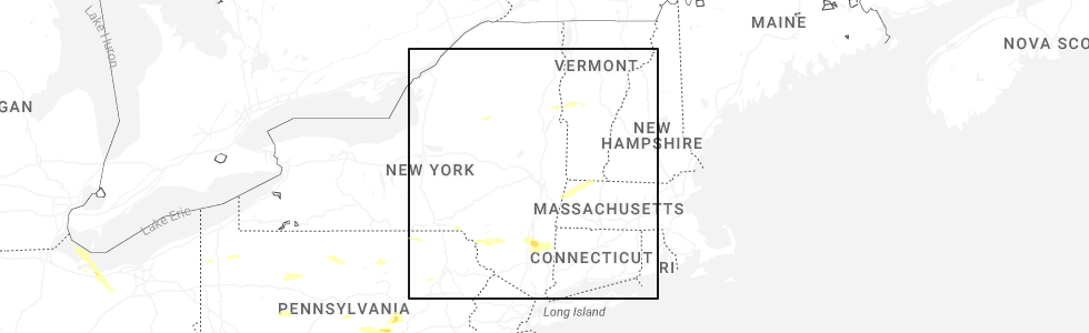
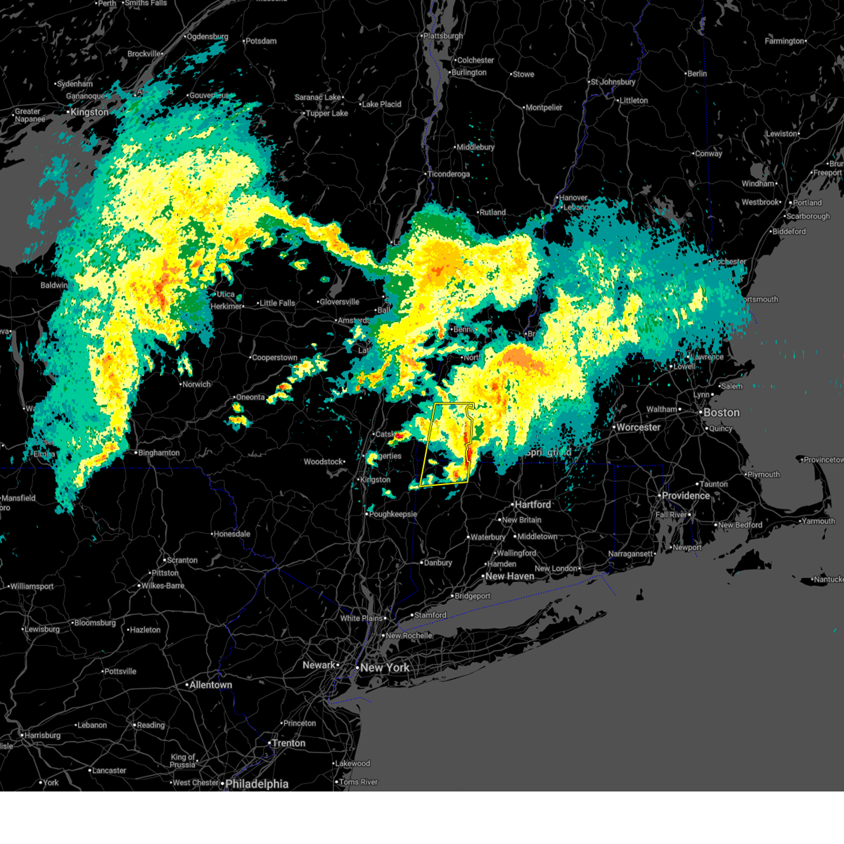
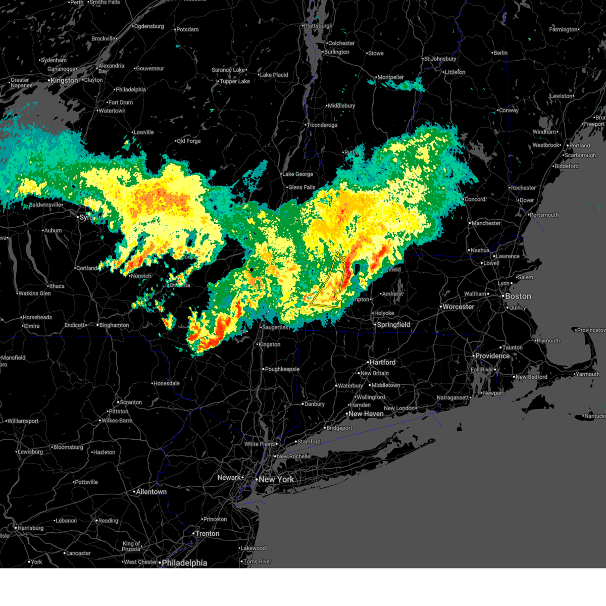
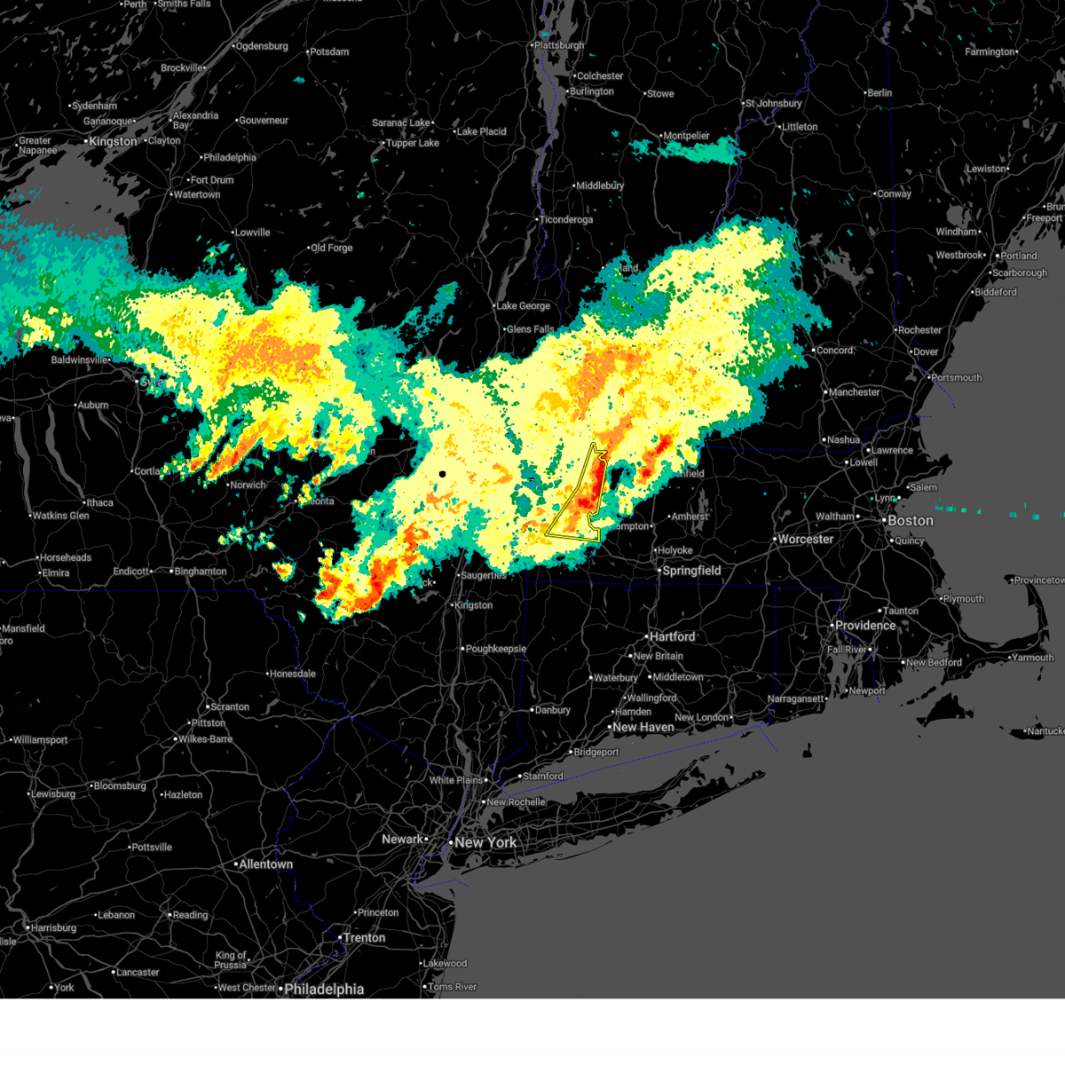
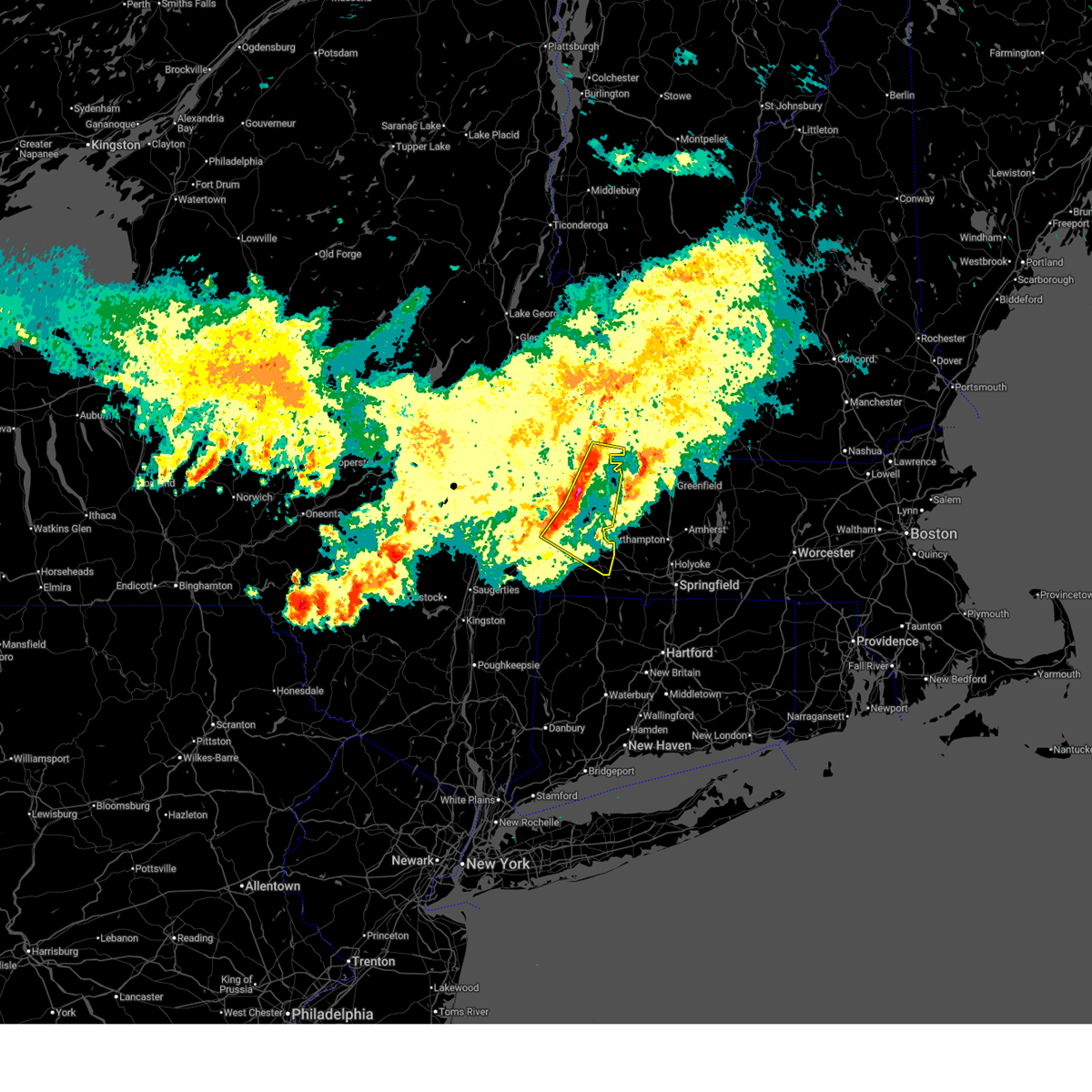
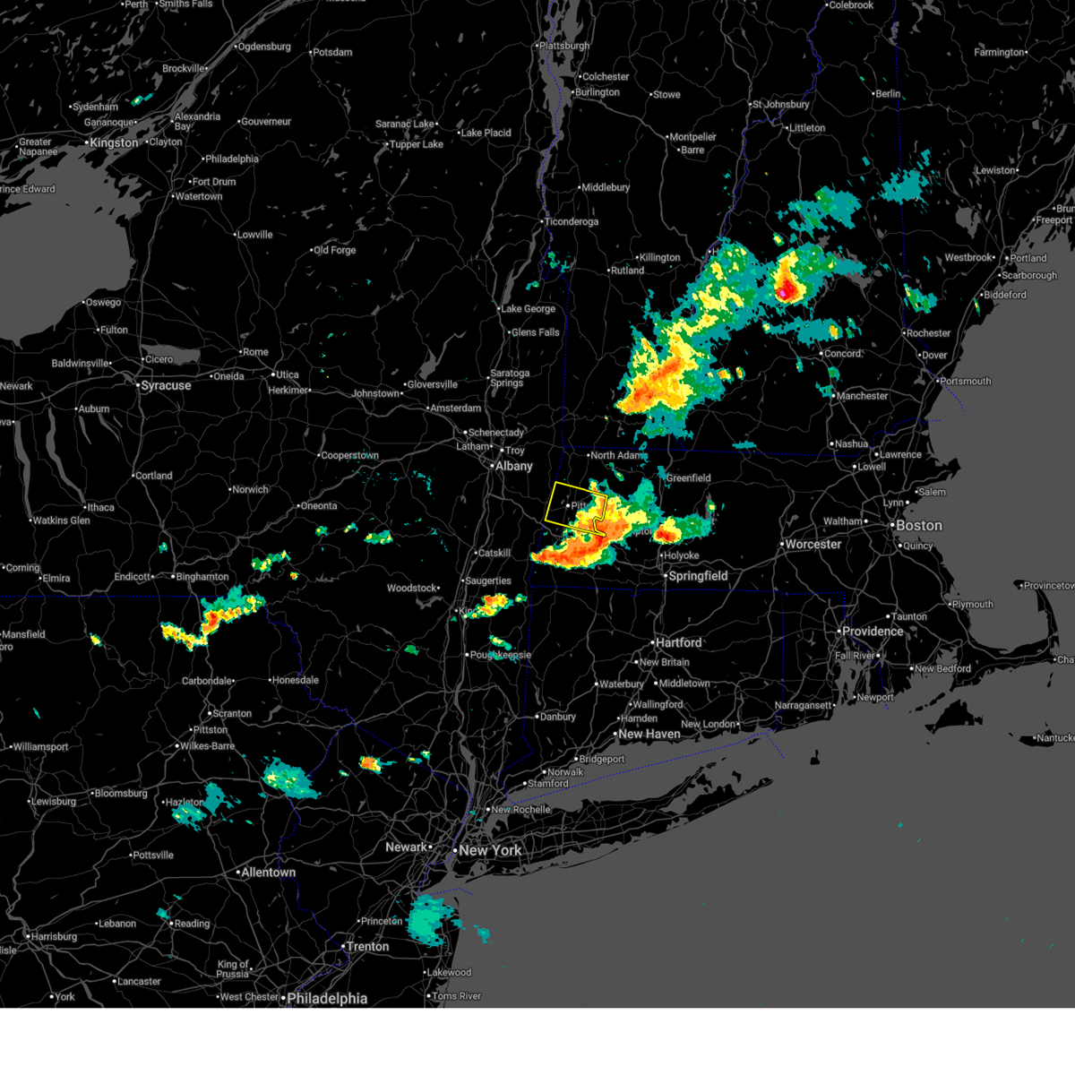
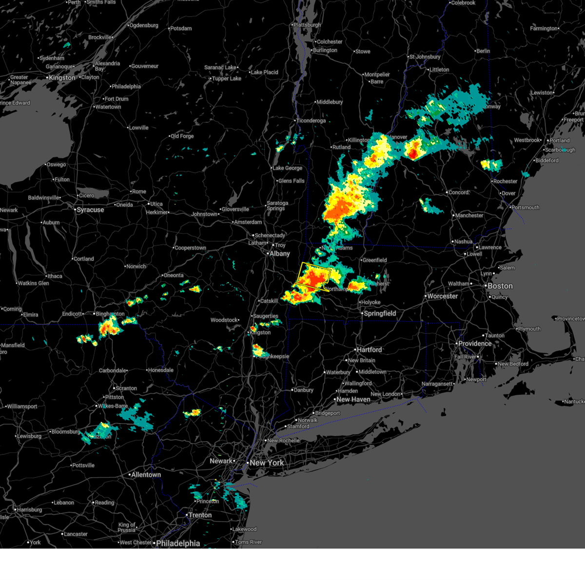
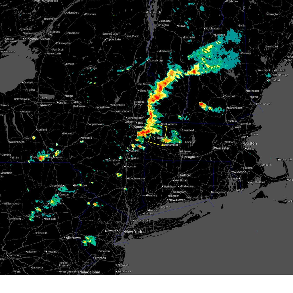
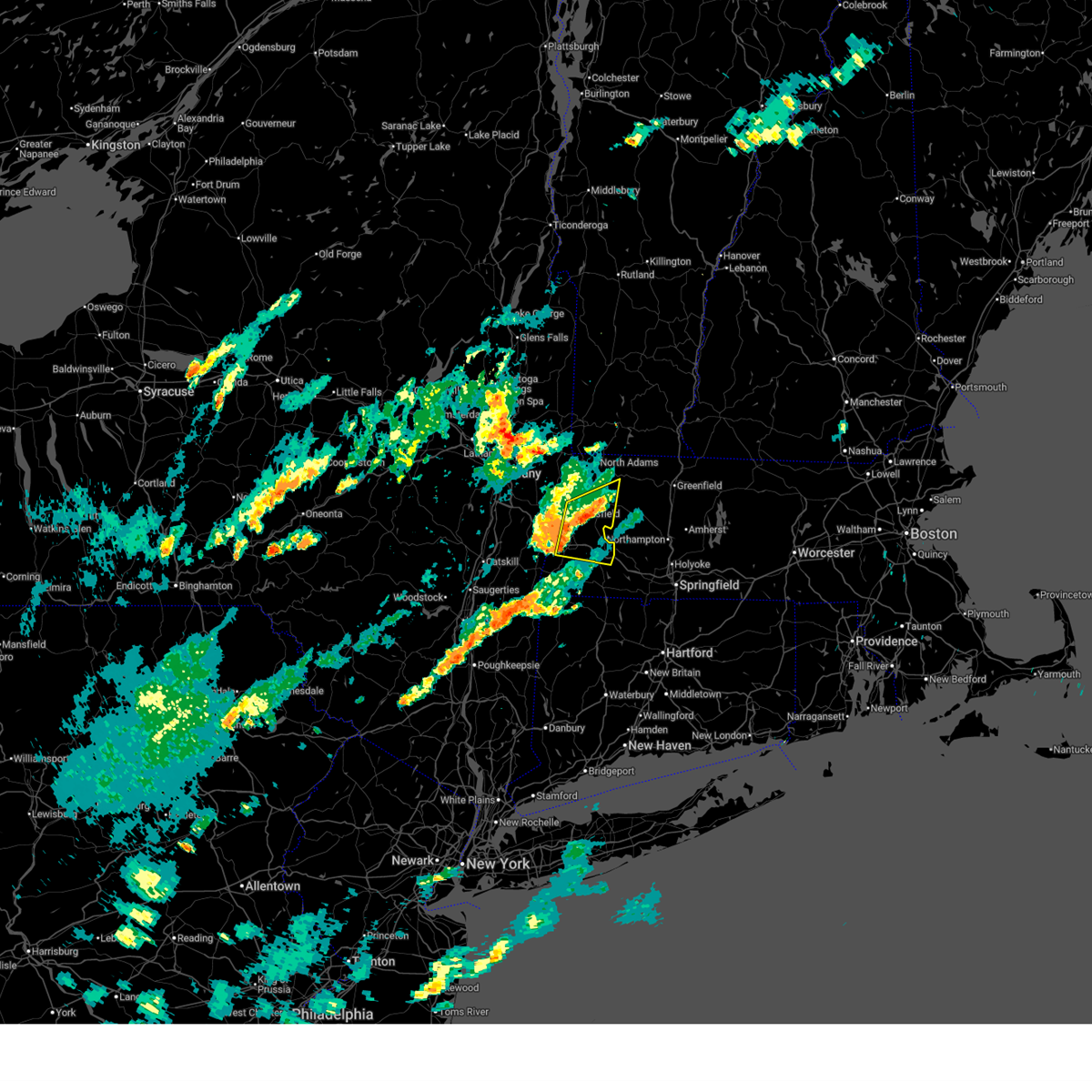
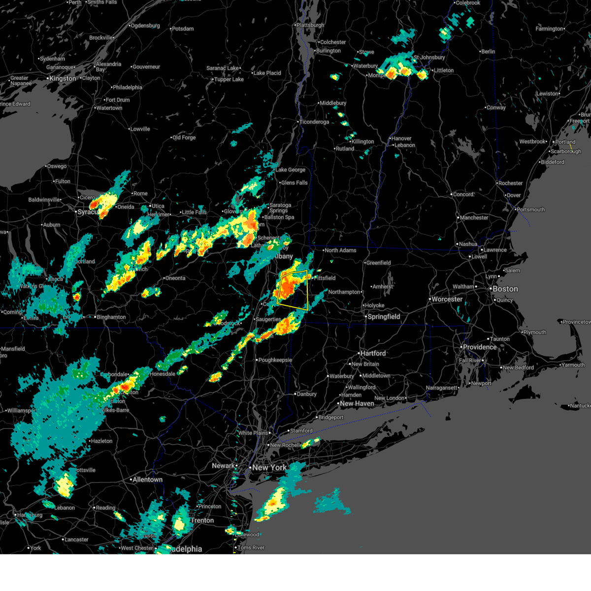
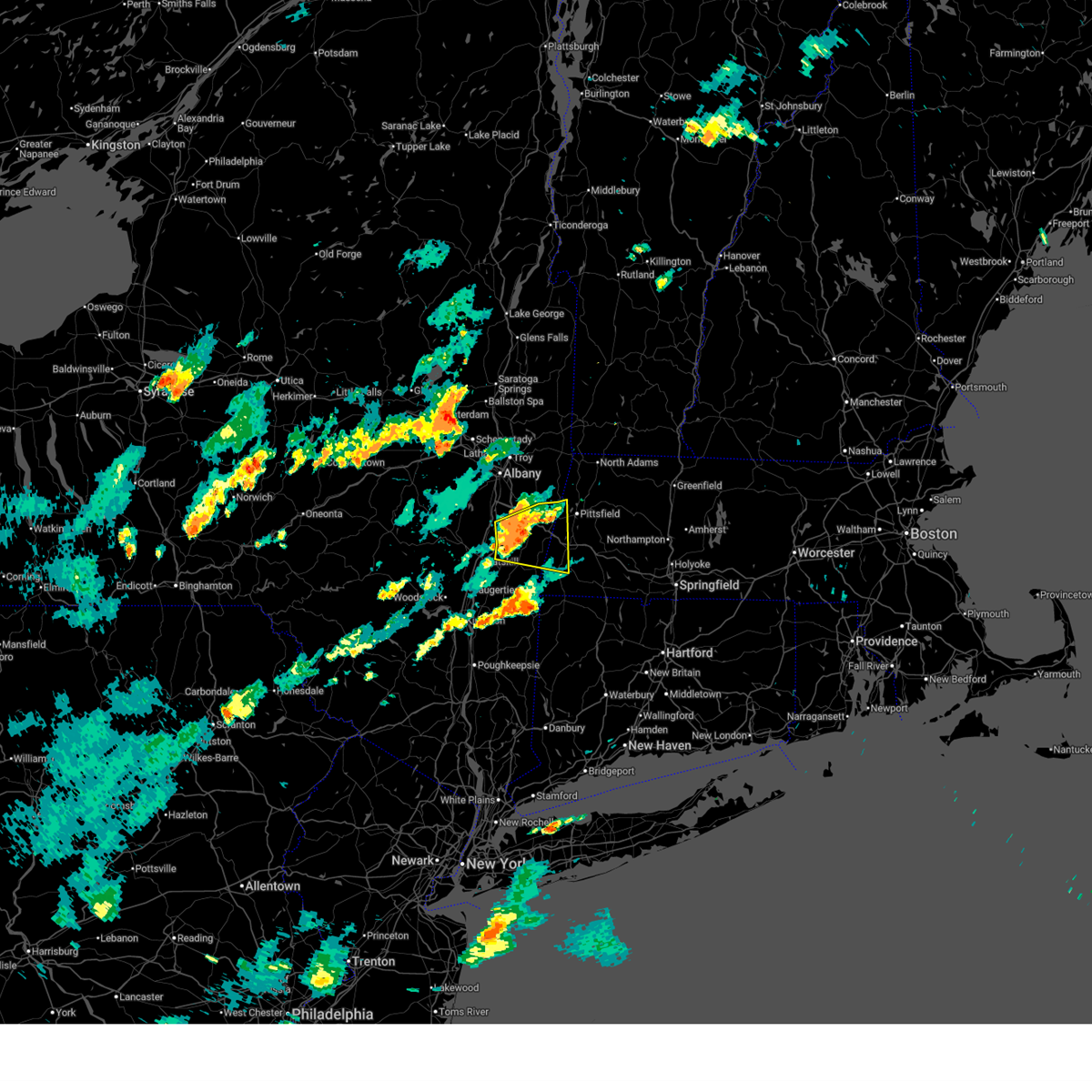
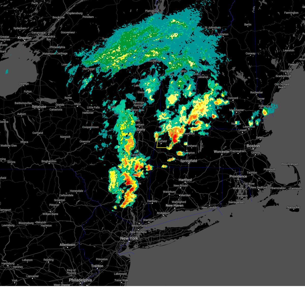
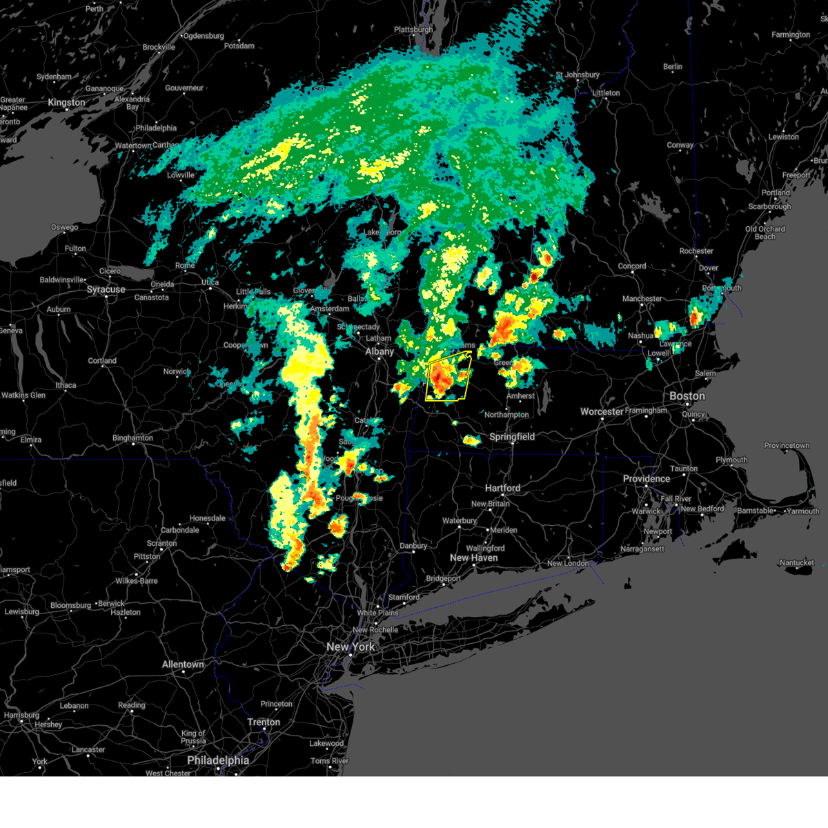
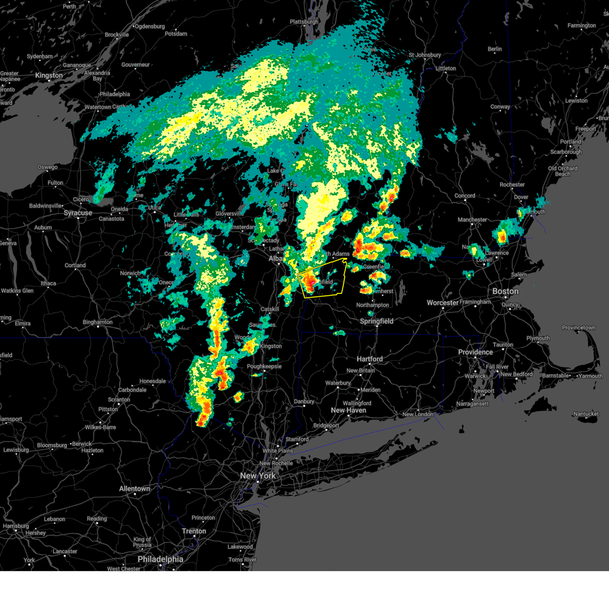
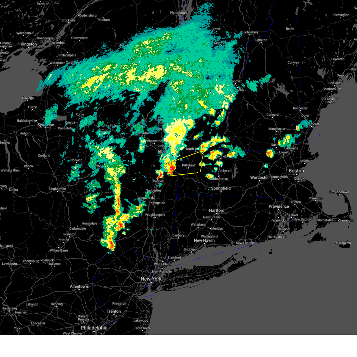
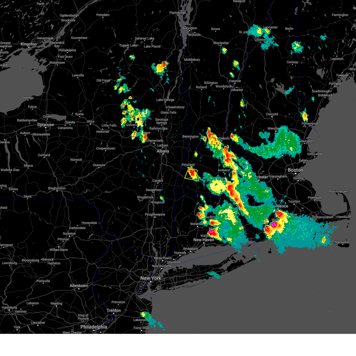
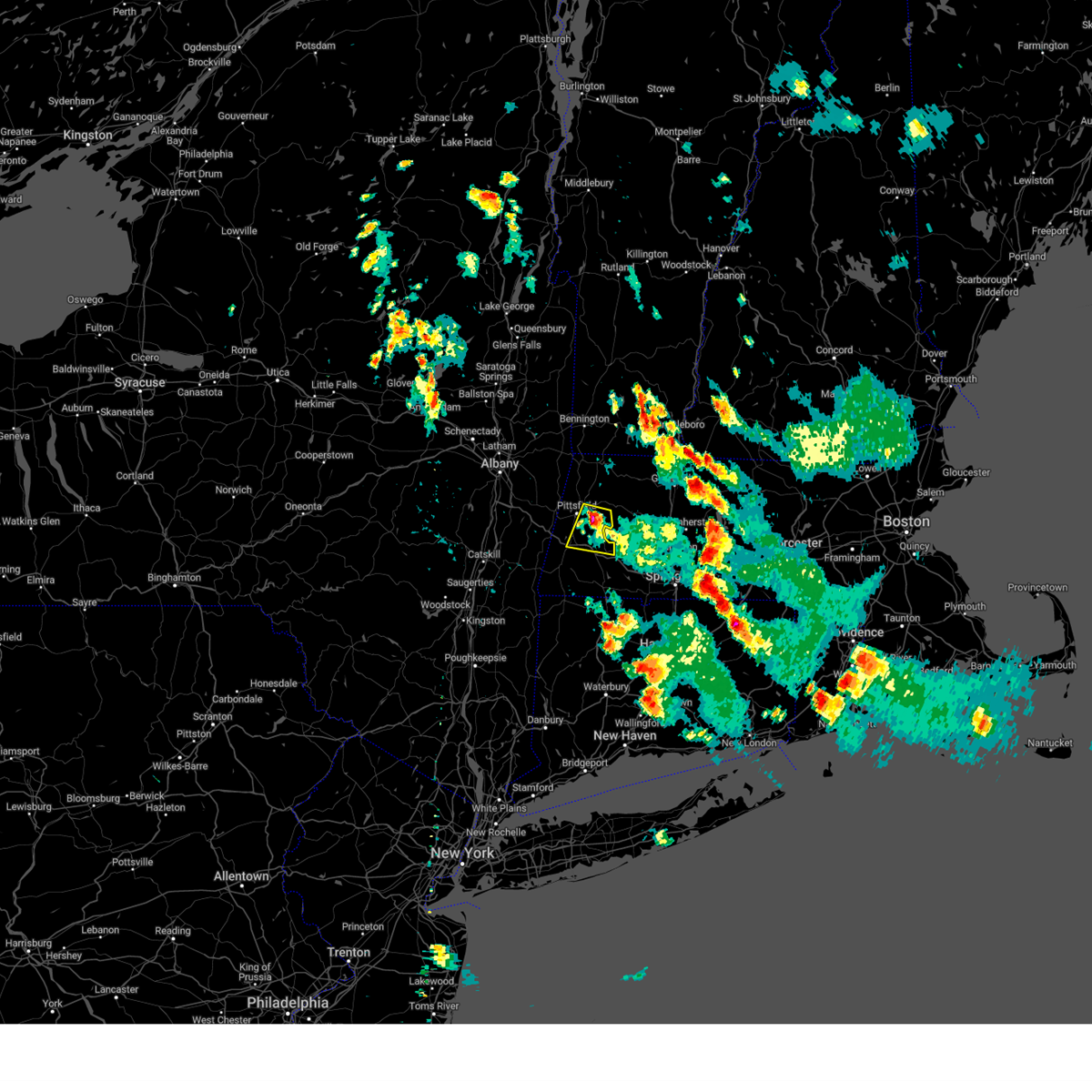
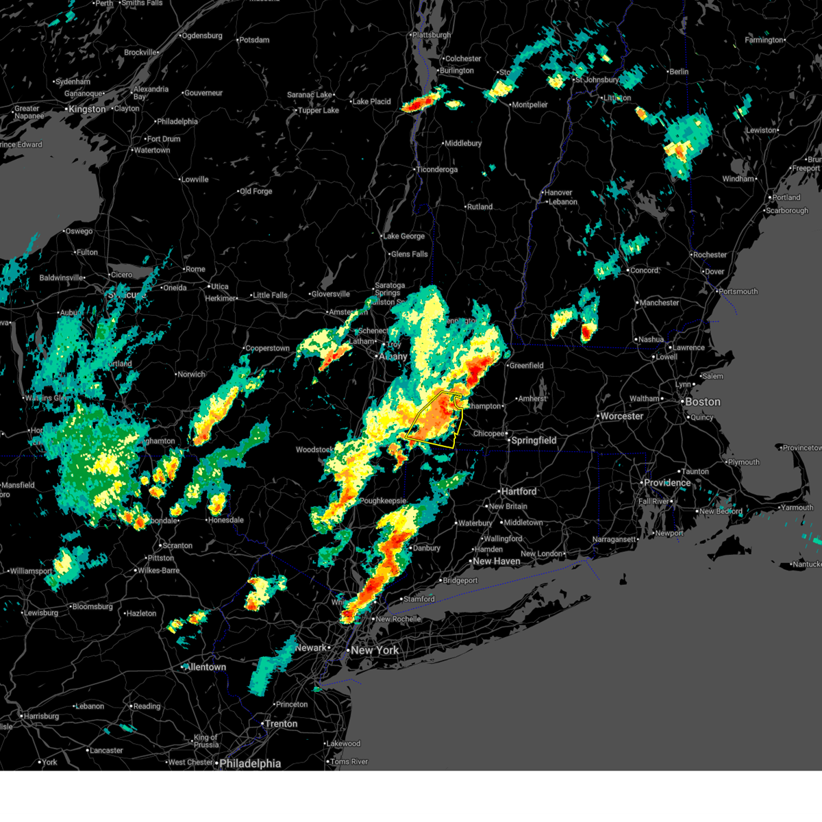
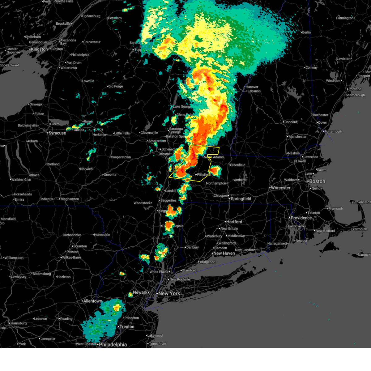
Hail Map for Pittsfield, MA
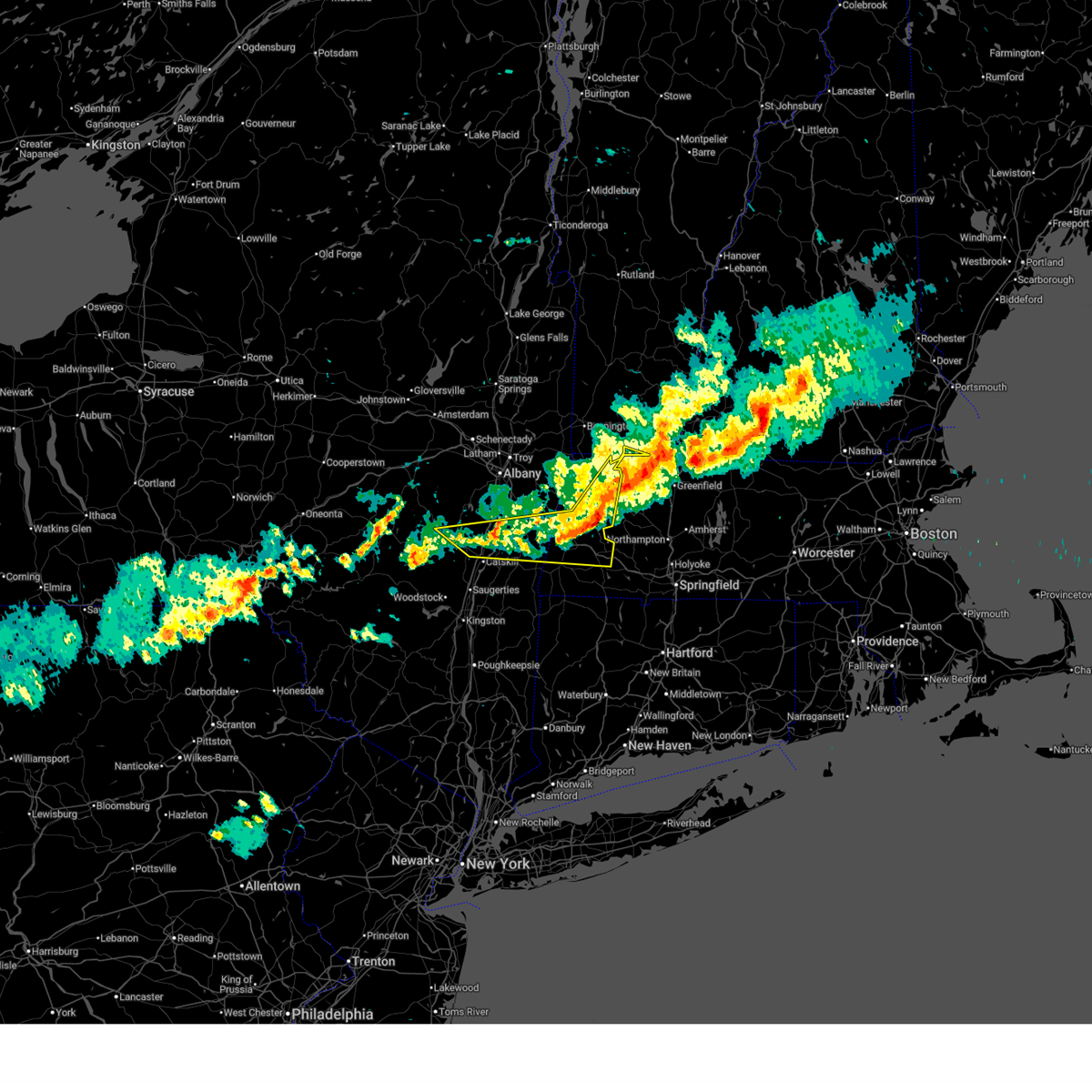
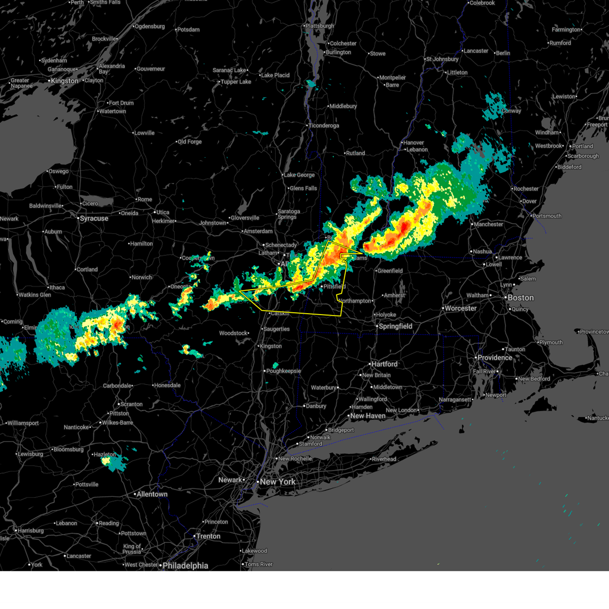
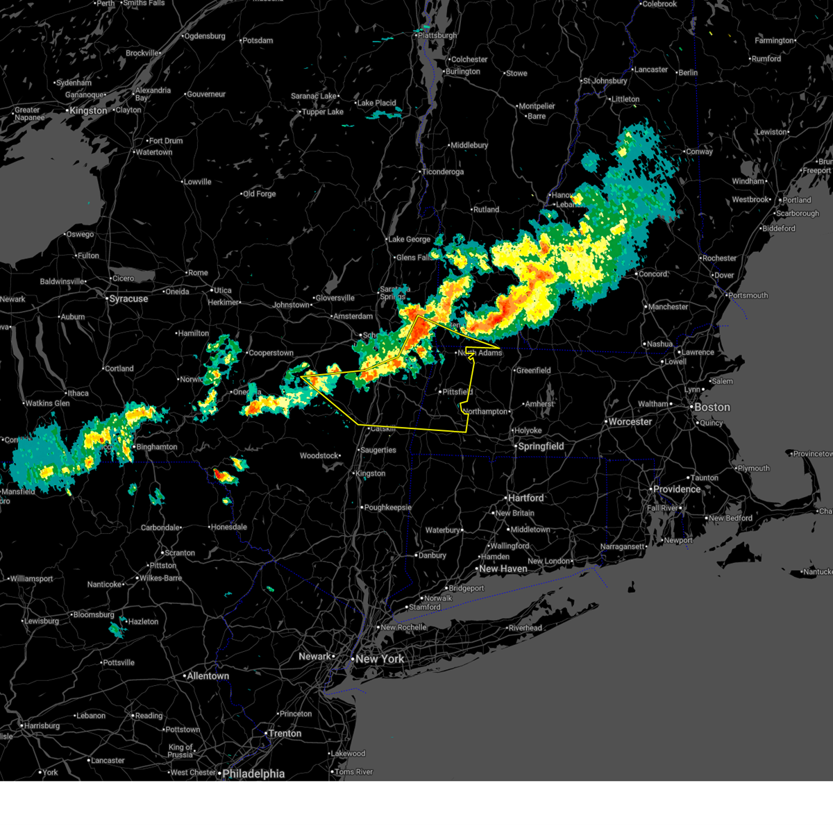
The Pittsfield, MA area has had 14 reports of on-the-ground hail by trained spotters, and has been under severe weather warnings 21 times during the past 12 months. Doppler radar has detected hail at or near Pittsfield, MA on 45 occasions, including 1 occasion during the past year.
| Name: | Pittsfield, MA |
| Where Located: | 43.1 miles SE of Schenectady, NY |
| Map: | Google Map for Pittsfield, MA |
| Population: | 44737 |
| Housing Units: | 21487 |
| More Info: | Search Google for Pittsfield, MA |
1
The Top Recent Hail Date for Pittsfield, MA is Saturday, June 6, 2026 (18th out of 45)
Hail and Wind Damage Spotted near Pittsfield, MA
| Date / Time | Report Details |
|---|---|
| 4/14/2026 7:08 PM EDT |
 At 707 pm edt, severe thunderstorms were located along a line extending from hawley to near becket to near housatonic, moving east at 65 mph (public. at 6:58 pm, the pittsfield airport had a wind gust to 59 mph). Hazards include 60 mph wind gusts. Expect damage to roofs, siding, and trees. Locations impacted include, pittsfield, hudson, chatham, monroe, adams, lee, lenox, cheshire, coxsackie, valatie, becket, athens, austerlitz, otis, philmont, kinderhook, florida, savoy, lorenz park, and housatonic. At 707 pm edt, severe thunderstorms were located along a line extending from hawley to near becket to near housatonic, moving east at 65 mph (public. at 6:58 pm, the pittsfield airport had a wind gust to 59 mph). Hazards include 60 mph wind gusts. Expect damage to roofs, siding, and trees. Locations impacted include, pittsfield, hudson, chatham, monroe, adams, lee, lenox, cheshire, coxsackie, valatie, becket, athens, austerlitz, otis, philmont, kinderhook, florida, savoy, lorenz park, and housatonic.
|
| 4/14/2026 6:58 PM EDT | Storm damage reported in berkshire county MA, 2.7 miles NE of Pittsfield, MA |
| 4/14/2026 6:56 PM EDT | Report of tree down blocking road on swamp r in berkshire county MA, 4.3 miles SSW of Pittsfield, MA |
| 4/14/2026 6:51 PM EDT |
 the severe thunderstorm warning has been cancelled and is no longer in effect the severe thunderstorm warning has been cancelled and is no longer in effect
|
| 4/14/2026 6:51 PM EDT |
 At 651 pm edt, severe thunderstorms were located along a line extending from florida to near cheshire to near chatham to 10 miles south of westerlo, moving southeast at 50 mph (radar indicated). Hazards include 60 mph wind gusts. Expect damage to roofs, siding, and trees. Locations impacted include, pittsfield, north adams, hudson, chatham, adams, williamstown, lee, lenox, new baltimore, cheshire, coxsackie, new lebanon, valatie, becket, athens, austerlitz, otis, philmont, kinderhook, and stamford. At 651 pm edt, severe thunderstorms were located along a line extending from florida to near cheshire to near chatham to 10 miles south of westerlo, moving southeast at 50 mph (radar indicated). Hazards include 60 mph wind gusts. Expect damage to roofs, siding, and trees. Locations impacted include, pittsfield, north adams, hudson, chatham, adams, williamstown, lee, lenox, new baltimore, cheshire, coxsackie, new lebanon, valatie, becket, athens, austerlitz, otis, philmont, kinderhook, and stamford.
|
| 4/14/2026 6:23 PM EDT |
 Svraly the national weather service in albany has issued a * severe thunderstorm warning for, berkshire county in western massachusetts, northern columbia county in east central new york, southern albany county in east central new york, northeastern greene county in east central new york, southeastern schoharie county in east central new york, rensselaer county in east central new york, southwestern bennington county in southern vermont, south central windham county in southern vermont, * until 730 pm edt. * at 623 pm edt, severe thunderstorms were located along a line extending from near hoosick falls to averill park to near selkirk to breakabeen, moving southeast at 40 mph (radar indicated). Hazards include 60 mph wind gusts. expect damage to roofs, siding, and trees Svraly the national weather service in albany has issued a * severe thunderstorm warning for, berkshire county in western massachusetts, northern columbia county in east central new york, southern albany county in east central new york, northeastern greene county in east central new york, southeastern schoharie county in east central new york, rensselaer county in east central new york, southwestern bennington county in southern vermont, south central windham county in southern vermont, * until 730 pm edt. * at 623 pm edt, severe thunderstorms were located along a line extending from near hoosick falls to averill park to near selkirk to breakabeen, moving southeast at 40 mph (radar indicated). Hazards include 60 mph wind gusts. expect damage to roofs, siding, and trees
|
| 3/31/2026 10:23 PM EDT |
 The storm which prompted the warning has moved out of the area. therefore, the warning will be allowed to expire. The storm which prompted the warning has moved out of the area. therefore, the warning will be allowed to expire.
|
| 3/31/2026 10:09 PM EDT |
 At 1009 pm edt, a severe thunderstorm was located near sandisfield, or 8 miles southeast of great barrington, moving east at 55 mph (radar indicated). Hazards include 60 mph wind gusts and quarter size hail. Hail damage to vehicles is expected. expect wind damage to roofs, siding, and trees. Locations impacted include, great barrington, lee, lenox, sheffield, becket, norfolk, otis, canaan, sandisfield, ashley falls, falls village, winsted, housatonic, salisbury, stockbridge, new marlborough, colebrook, monterey, washington, and tyringham. At 1009 pm edt, a severe thunderstorm was located near sandisfield, or 8 miles southeast of great barrington, moving east at 55 mph (radar indicated). Hazards include 60 mph wind gusts and quarter size hail. Hail damage to vehicles is expected. expect wind damage to roofs, siding, and trees. Locations impacted include, great barrington, lee, lenox, sheffield, becket, norfolk, otis, canaan, sandisfield, ashley falls, falls village, winsted, housatonic, salisbury, stockbridge, new marlborough, colebrook, monterey, washington, and tyringham.
|
| 3/31/2026 10:09 PM EDT |
 the severe thunderstorm warning has been cancelled and is no longer in effect the severe thunderstorm warning has been cancelled and is no longer in effect
|
| 3/31/2026 9:48 PM EDT |
 the severe thunderstorm warning has been cancelled and is no longer in effect the severe thunderstorm warning has been cancelled and is no longer in effect
|
| 3/31/2026 9:48 PM EDT |
 At 948 pm edt, a severe thunderstorm was located over lee, or 7 miles north of great barrington, moving east at 50 mph (radar indicated). Hazards include 60 mph wind gusts and quarter size hail. Hail damage to vehicles is expected. expect wind damage to roofs, siding, and trees. Locations impacted include, great barrington, chatham, claverack, lee, lenox, livingston, copake, sheffield, pine plains, valatie, becket, norfolk, austerlitz, otis, ancram, philmont, canaan, millerton, sandisfield, and stanfordville. At 948 pm edt, a severe thunderstorm was located over lee, or 7 miles north of great barrington, moving east at 50 mph (radar indicated). Hazards include 60 mph wind gusts and quarter size hail. Hail damage to vehicles is expected. expect wind damage to roofs, siding, and trees. Locations impacted include, great barrington, chatham, claverack, lee, lenox, livingston, copake, sheffield, pine plains, valatie, becket, norfolk, austerlitz, otis, ancram, philmont, canaan, millerton, sandisfield, and stanfordville.
|
| 3/31/2026 9:25 PM EDT |
 Svraly the national weather service in albany has issued a * severe thunderstorm warning for, northwestern litchfield county in northern connecticut, southern berkshire county in western massachusetts, northeastern ulster county in east central new york, northern dutchess county in east central new york, columbia county in east central new york, eastern greene county in east central new york, * until 1030 pm edt. * at 925 pm edt, a severe thunderstorm was located over lorenz park, or near hudson, moving east at 40 mph (radar indicated). Hazards include 60 mph wind gusts and quarter size hail. Hail damage to vehicles is expected. Expect wind damage to roofs, siding, and trees. Svraly the national weather service in albany has issued a * severe thunderstorm warning for, northwestern litchfield county in northern connecticut, southern berkshire county in western massachusetts, northeastern ulster county in east central new york, northern dutchess county in east central new york, columbia county in east central new york, eastern greene county in east central new york, * until 1030 pm edt. * at 925 pm edt, a severe thunderstorm was located over lorenz park, or near hudson, moving east at 40 mph (radar indicated). Hazards include 60 mph wind gusts and quarter size hail. Hail damage to vehicles is expected. Expect wind damage to roofs, siding, and trees.
|
| 3/31/2026 8:50 PM EDT |
 The storms which prompted the warning have moved out of the area. therefore, the warning will be allowed to expire. The storms which prompted the warning have moved out of the area. therefore, the warning will be allowed to expire.
|
| 3/31/2026 8:45 PM EDT |
 the severe thunderstorm warning has been cancelled and is no longer in effect the severe thunderstorm warning has been cancelled and is no longer in effect
|
| 3/31/2026 8:45 PM EDT |
 At 844 pm edt, severe thunderstorms were located along a line extending from rowe to 6 miles west of otis, moving east at 45 mph (radar indicated). Hazards include 60 mph wind gusts. a confirmed wind gust to 50mph was reported at the pittsfield airport. Expect damage to roofs, siding, and trees. Locations impacted include, pittsfield, lee, lenox, becket, florida, savoy, dalton, hinsdale, stockbridge, windsor, peru, washington, glendale, new lenox, lenox dale, eastern summit, yankee orchards, wheatleigh, whitcomb summit, and lenox station. At 844 pm edt, severe thunderstorms were located along a line extending from rowe to 6 miles west of otis, moving east at 45 mph (radar indicated). Hazards include 60 mph wind gusts. a confirmed wind gust to 50mph was reported at the pittsfield airport. Expect damage to roofs, siding, and trees. Locations impacted include, pittsfield, lee, lenox, becket, florida, savoy, dalton, hinsdale, stockbridge, windsor, peru, washington, glendale, new lenox, lenox dale, eastern summit, yankee orchards, wheatleigh, whitcomb summit, and lenox station.
|
| 3/31/2026 8:31 PM EDT |
 Svraly the national weather service in albany has issued a * severe thunderstorm warning for, berkshire county in western massachusetts, east central columbia county in east central new york, south central bennington county in southern vermont, * until 900 pm edt. * at 831 pm edt, severe thunderstorms were located along a line extending from stamford to housatonic, moving east at 45 mph (radar indicated). Hazards include 60 mph wind gusts. expect damage to roofs, siding, and trees Svraly the national weather service in albany has issued a * severe thunderstorm warning for, berkshire county in western massachusetts, east central columbia county in east central new york, south central bennington county in southern vermont, * until 900 pm edt. * at 831 pm edt, severe thunderstorms were located along a line extending from stamford to housatonic, moving east at 45 mph (radar indicated). Hazards include 60 mph wind gusts. expect damage to roofs, siding, and trees
|
| 7/20/2025 5:02 PM EDT |
 the severe thunderstorm warning has been cancelled and is no longer in effect the severe thunderstorm warning has been cancelled and is no longer in effect
|
| 7/20/2025 4:45 PM EDT | Tree down on wires blocking road - washington mountain r in berkshire county MA, 8.5 miles NW of Pittsfield, MA |
| 7/20/2025 4:40 PM EDT |
 At 440 pm edt, a severe thunderstorm was located near becket, or 9 miles southeast of pittsfield, moving southeast at 35 mph (radar indicated). Hazards include 60 mph wind gusts and quarter size hail. Hail damage to vehicles is expected. expect wind damage to roofs, siding, and trees. Locations impacted include, pittsfield, lenox, becket, hancock, berkshire, dalton, lanesborough, hinsdale, richmond, windsor, peru, washington, barkerville, new lenox, lakeview terrace, the boulders, the center at lenox, adams junction, yankee orchards, and stearnsville. At 440 pm edt, a severe thunderstorm was located near becket, or 9 miles southeast of pittsfield, moving southeast at 35 mph (radar indicated). Hazards include 60 mph wind gusts and quarter size hail. Hail damage to vehicles is expected. expect wind damage to roofs, siding, and trees. Locations impacted include, pittsfield, lenox, becket, hancock, berkshire, dalton, lanesborough, hinsdale, richmond, windsor, peru, washington, barkerville, new lenox, lakeview terrace, the boulders, the center at lenox, adams junction, yankee orchards, and stearnsville.
|
| 7/20/2025 4:15 PM EDT |
 Svraly the national weather service in albany has issued a * severe thunderstorm warning for, northern berkshire county in western massachusetts, * until 515 pm edt. * at 414 pm edt, a severe thunderstorm was located over hancock, or 7 miles northwest of pittsfield, moving east at 40 mph (radar indicated). Hazards include 60 mph wind gusts and quarter size hail. Hail damage to vehicles is expected. Expect wind damage to roofs, siding, and trees. Svraly the national weather service in albany has issued a * severe thunderstorm warning for, northern berkshire county in western massachusetts, * until 515 pm edt. * at 414 pm edt, a severe thunderstorm was located over hancock, or 7 miles northwest of pittsfield, moving east at 40 mph (radar indicated). Hazards include 60 mph wind gusts and quarter size hail. Hail damage to vehicles is expected. Expect wind damage to roofs, siding, and trees.
|
| 7/20/2025 4:12 PM EDT | Downed tree across road at route 22 and provost r in rensselaer county NY, 8.2 miles SE of Pittsfield, MA |
| 7/1/2025 4:20 PM EDT |
 The storm which prompted the warning has moved out of the area. therefore, the warning will be allowed to expire. The storm which prompted the warning has moved out of the area. therefore, the warning will be allowed to expire.
|
| 7/1/2025 4:17 PM EDT |
 Svraly the national weather service in albany has issued a * severe thunderstorm warning for, central berkshire county in western massachusetts, * until 500 pm edt. * at 417 pm edt, severe thunderstorms were located along a line extending from near savoy to housatonic, moving northeast at 30 mph (radar indicated). Hazards include 60 mph wind gusts. expect damage to roofs, siding, and trees Svraly the national weather service in albany has issued a * severe thunderstorm warning for, central berkshire county in western massachusetts, * until 500 pm edt. * at 417 pm edt, severe thunderstorms were located along a line extending from near savoy to housatonic, moving northeast at 30 mph (radar indicated). Hazards include 60 mph wind gusts. expect damage to roofs, siding, and trees
|
| 7/1/2025 3:58 PM EDT |
 At 358 pm edt, a severe thunderstorm was located near chatham, moving east at 25 mph (radar indicated). Hazards include 60 mph wind gusts. Expect damage to roofs, siding, and trees. Locations impacted include, pittsfield, great barrington, chatham, new lebanon, austerlitz, philmont, housatonic, ghent, stockbridge, canaan, richmond, west stockbridge, alford, barkerville, glendale, rayville, north hillsdale, williamsville, harlemville, and north egremont. At 358 pm edt, a severe thunderstorm was located near chatham, moving east at 25 mph (radar indicated). Hazards include 60 mph wind gusts. Expect damage to roofs, siding, and trees. Locations impacted include, pittsfield, great barrington, chatham, new lebanon, austerlitz, philmont, housatonic, ghent, stockbridge, canaan, richmond, west stockbridge, alford, barkerville, glendale, rayville, north hillsdale, williamsville, harlemville, and north egremont.
|
| 7/1/2025 3:42 PM EDT |
 Svraly the national weather service in albany has issued a * severe thunderstorm warning for, southwestern berkshire county in western massachusetts, northeastern columbia county in east central new york, * until 430 pm edt. * at 342 pm edt, a severe thunderstorm was located near chatham, moving east at 25 mph (radar indicated). Hazards include 60 mph wind gusts. expect damage to roofs, siding, and trees Svraly the national weather service in albany has issued a * severe thunderstorm warning for, southwestern berkshire county in western massachusetts, northeastern columbia county in east central new york, * until 430 pm edt. * at 342 pm edt, a severe thunderstorm was located near chatham, moving east at 25 mph (radar indicated). Hazards include 60 mph wind gusts. expect damage to roofs, siding, and trees
|
| 5/17/2025 6:18 PM EDT | Report of wires down and arching near the intersection of washington mt road and kirchner roa in berkshire county MA, 3 miles NW of Pittsfield, MA |
| 5/17/2025 6:18 PM EDT | Several trees were down along may terrace in pittsfiel in berkshire county MA, 1.3 miles NW of Pittsfield, MA |
| 5/17/2025 6:17 PM EDT | Several trees were down along may terrace in pittsfiel in berkshire county MA, 1.3 miles NW of Pittsfield, MA |
| 5/17/2025 6:17 PM EDT | Tree down on a wire along putnam avenue in the city of pittsfiel in berkshire county MA, 1.3 miles NW of Pittsfield, MA |
| 5/17/2025 6:16 PM EDT | Tree and wire down along strong avenue in the city of pittsfiel in berkshire county MA, 1.3 miles NW of Pittsfield, MA |
| 5/17/2025 6:16 PM EDT | Tree down on a wire along putnam avenue in the city of pittsfiel in berkshire county MA, 1.3 miles NW of Pittsfield, MA |
| 5/17/2025 6:16 PM EDT |
 Svraly the national weather service in albany has issued a * severe thunderstorm warning for, east central berkshire county in western massachusetts, * until 700 pm edt. * at 616 pm edt, a severe thunderstorm was located near pittsfield, moving east at 35 mph (radar indicated). Hazards include 60 mph wind gusts and quarter size hail. Hail damage to vehicles is expected. Expect wind damage to roofs, siding, and trees. Svraly the national weather service in albany has issued a * severe thunderstorm warning for, east central berkshire county in western massachusetts, * until 700 pm edt. * at 616 pm edt, a severe thunderstorm was located near pittsfield, moving east at 35 mph (radar indicated). Hazards include 60 mph wind gusts and quarter size hail. Hail damage to vehicles is expected. Expect wind damage to roofs, siding, and trees.
|
| 5/17/2025 6:12 PM EDT | Report of wires down and arching near the intersection of washington mt road and kirchner roa in berkshire county MA, 3 miles NW of Pittsfield, MA |
| 5/17/2025 6:10 PM EDT | Report of a tree down near may terrace in pittsfiel in berkshire county MA, 1.3 miles NW of Pittsfield, MA |
| 5/17/2025 6:05 PM EDT |
 the severe thunderstorm warning has been cancelled and is no longer in effect the severe thunderstorm warning has been cancelled and is no longer in effect
|
| 5/17/2025 6:05 PM EDT |
 At 605 pm edt, a severe thunderstorm was located near new lebanon, or near pittsfield, moving east at 20 mph (radar indicated). Hazards include 60 mph wind gusts and penny size hail. Expect damage to roofs, siding, and trees. Locations impacted include, lenox, barkerville, washington, new lenox, lakeview terrace, berkshire, the boulders, the center at lenox, dalton, adams junction, yankee orchards, stearnsville, carey corner, tanglewood performing arts center, west pittsfield, stevens corner, victory hill, richmond furnace, lanesborough, and lenox station. At 605 pm edt, a severe thunderstorm was located near new lebanon, or near pittsfield, moving east at 20 mph (radar indicated). Hazards include 60 mph wind gusts and penny size hail. Expect damage to roofs, siding, and trees. Locations impacted include, lenox, barkerville, washington, new lenox, lakeview terrace, berkshire, the boulders, the center at lenox, dalton, adams junction, yankee orchards, stearnsville, carey corner, tanglewood performing arts center, west pittsfield, stevens corner, victory hill, richmond furnace, lanesborough, and lenox station.
|
| 5/17/2025 5:54 PM EDT | Tree down on ny 22 northbound between flints crossing road and peaceful valley road. time estimated from rada in columbia county NY, 11.3 miles NE of Pittsfield, MA |
| 5/17/2025 5:51 PM EDT |
 Svraly the national weather service in albany has issued a * severe thunderstorm warning for, central berkshire county in western massachusetts, northeastern columbia county in east central new york, * until 630 pm edt. * at 551 pm edt, a severe thunderstorm was located near new lebanon, or 9 miles northeast of chatham, moving east at 25 mph (radar indicated). Hazards include 60 mph wind gusts and quarter size hail. Hail damage to vehicles is expected. Expect wind damage to roofs, siding, and trees. Svraly the national weather service in albany has issued a * severe thunderstorm warning for, central berkshire county in western massachusetts, northeastern columbia county in east central new york, * until 630 pm edt. * at 551 pm edt, a severe thunderstorm was located near new lebanon, or 9 miles northeast of chatham, moving east at 25 mph (radar indicated). Hazards include 60 mph wind gusts and quarter size hail. Hail damage to vehicles is expected. Expect wind damage to roofs, siding, and trees.
|
| 5/3/2025 2:20 PM EDT |
 The storm which prompted the warning has moved out of the area. therefore, the warning will be allowed to expire. a severe thunderstorm watch remains in effect until 800 pm edt for western massachusetts. The storm which prompted the warning has moved out of the area. therefore, the warning will be allowed to expire. a severe thunderstorm watch remains in effect until 800 pm edt for western massachusetts.
|
| 5/3/2025 2:01 PM EDT |
 At 200 pm edt, a severe thunderstorm was located over cheshire, or 7 miles northeast of pittsfield, moving east at 40 mph (radar indicated). Hazards include 60 mph wind gusts and quarter size hail. Hail damage to vehicles is expected. expect wind damage to roofs, siding, and trees. Locations impacted include, barkerville, windsor, new ashford, soldiers memorial field, north hancock, cheshire harbor, arnoldville, savoy, town crest village, new lenox, lakeview terrace, maple grove, eastern summit, berkshire, the boulders, the center at lenox, dalton, adams junction, zylonite, and yankee orchards. At 200 pm edt, a severe thunderstorm was located over cheshire, or 7 miles northeast of pittsfield, moving east at 40 mph (radar indicated). Hazards include 60 mph wind gusts and quarter size hail. Hail damage to vehicles is expected. expect wind damage to roofs, siding, and trees. Locations impacted include, barkerville, windsor, new ashford, soldiers memorial field, north hancock, cheshire harbor, arnoldville, savoy, town crest village, new lenox, lakeview terrace, maple grove, eastern summit, berkshire, the boulders, the center at lenox, dalton, adams junction, zylonite, and yankee orchards.
|
| 5/3/2025 2:01 PM EDT |
 the severe thunderstorm warning has been cancelled and is no longer in effect the severe thunderstorm warning has been cancelled and is no longer in effect
|
| 5/3/2025 1:50 PM EDT | Downed trees blocking a roadway in lanesboroug in berkshire county MA, 6 miles S of Pittsfield, MA |
| 5/3/2025 1:45 PM EDT |
 At 144 pm edt, a severe thunderstorm was located over new lebanon, or 7 miles northwest of pittsfield, moving east at 40 mph (radar indicated). Hazards include 60 mph wind gusts and quarter size hail. Hail damage to vehicles is expected. expect wind damage to roofs, siding, and trees. Locations impacted include, barkerville, soldiers memorial field, north hancock, cheshire harbor, arnoldville, savoy, berkshire, the center at lenox, dalton, adams junction, zylonite, stearnsville, carey corner, bowens corners, west pittsfield, new lebanon center, stephentown, victory hill, hinsdale, and stephentown center. At 144 pm edt, a severe thunderstorm was located over new lebanon, or 7 miles northwest of pittsfield, moving east at 40 mph (radar indicated). Hazards include 60 mph wind gusts and quarter size hail. Hail damage to vehicles is expected. expect wind damage to roofs, siding, and trees. Locations impacted include, barkerville, soldiers memorial field, north hancock, cheshire harbor, arnoldville, savoy, berkshire, the center at lenox, dalton, adams junction, zylonite, stearnsville, carey corner, bowens corners, west pittsfield, new lebanon center, stephentown, victory hill, hinsdale, and stephentown center.
|
| 5/3/2025 1:27 PM EDT |
 Svraly the national weather service in albany has issued a * severe thunderstorm warning for, northern berkshire county in western massachusetts, northeastern columbia county in east central new york, southeastern rensselaer county in east central new york, * until 230 pm edt. * at 127 pm edt, a severe thunderstorm was located near nassau, moving east at 40 mph (radar indicated). Hazards include 60 mph wind gusts and quarter size hail. Hail damage to vehicles is expected. Expect wind damage to roofs, siding, and trees. Svraly the national weather service in albany has issued a * severe thunderstorm warning for, northern berkshire county in western massachusetts, northeastern columbia county in east central new york, southeastern rensselaer county in east central new york, * until 230 pm edt. * at 127 pm edt, a severe thunderstorm was located near nassau, moving east at 40 mph (radar indicated). Hazards include 60 mph wind gusts and quarter size hail. Hail damage to vehicles is expected. Expect wind damage to roofs, siding, and trees.
|
| 8/26/2024 3:14 PM EDT |
 At 314 pm edt, a severe thunderstorm was located near becket, or 7 miles southeast of pittsfield, moving south at 10 mph (radar indicated). Hazards include 60 mph wind gusts and quarter size hail. Hail damage to vehicles is expected. expect wind damage to roofs, siding, and trees. Locations impacted include, pittsfield, lee, lenox, becket, washington, lenox station, leisure lee, bonny rigg corners, eastover, new lenox, becket center, lenox dale, east lee, west becket, and lakewood. At 314 pm edt, a severe thunderstorm was located near becket, or 7 miles southeast of pittsfield, moving south at 10 mph (radar indicated). Hazards include 60 mph wind gusts and quarter size hail. Hail damage to vehicles is expected. expect wind damage to roofs, siding, and trees. Locations impacted include, pittsfield, lee, lenox, becket, washington, lenox station, leisure lee, bonny rigg corners, eastover, new lenox, becket center, lenox dale, east lee, west becket, and lakewood.
|
| 8/26/2024 2:57 PM EDT |
 Svraly the national weather service in albany has issued a * severe thunderstorm warning for, east central berkshire county in western massachusetts, * until 400 pm edt. * at 255 pm edt, a severe thunderstorm was located near pittsfield, moving south at 10 mph (radar indicated). Hazards include 60 mph wind gusts and quarter size hail. Hail damage to vehicles is expected. Expect wind damage to roofs, siding, and trees. Svraly the national weather service in albany has issued a * severe thunderstorm warning for, east central berkshire county in western massachusetts, * until 400 pm edt. * at 255 pm edt, a severe thunderstorm was located near pittsfield, moving south at 10 mph (radar indicated). Hazards include 60 mph wind gusts and quarter size hail. Hail damage to vehicles is expected. Expect wind damage to roofs, siding, and trees.
|
| 7/17/2024 4:58 PM EDT |
 the severe thunderstorm warning has been cancelled and is no longer in effect the severe thunderstorm warning has been cancelled and is no longer in effect
|
| 7/17/2024 4:32 PM EDT |
 At 432 pm edt, severe thunderstorms were located along a line extending from near east windsor to near otis to near sheffield, moving east at 25 mph (radar indicated). Hazards include 60 mph wind gusts. Expect damage to roofs, siding, and trees. Locations impacted include, great barrington, lee, sheffield, becket, otis, sandisfield, housatonic, stockbridge, new marlborough, monterey, washington, alford, tyringham, hartsville, konkapot, montville, glendale, williamsville, lenox dale, and southfield. At 432 pm edt, severe thunderstorms were located along a line extending from near east windsor to near otis to near sheffield, moving east at 25 mph (radar indicated). Hazards include 60 mph wind gusts. Expect damage to roofs, siding, and trees. Locations impacted include, great barrington, lee, sheffield, becket, otis, sandisfield, housatonic, stockbridge, new marlborough, monterey, washington, alford, tyringham, hartsville, konkapot, montville, glendale, williamsville, lenox dale, and southfield.
|
| 7/17/2024 4:12 PM EDT |
 Svraly the national weather service in albany has issued a * severe thunderstorm warning for, berkshire county in western massachusetts, * until 515 pm edt. * at 411 pm edt, severe thunderstorms were located along a line extending from near pittsfield to near lee to near sheffield, moving east at 25 mph (radar indicated). Hazards include 60 mph wind gusts. expect damage to roofs, siding, and trees Svraly the national weather service in albany has issued a * severe thunderstorm warning for, berkshire county in western massachusetts, * until 515 pm edt. * at 411 pm edt, severe thunderstorms were located along a line extending from near pittsfield to near lee to near sheffield, moving east at 25 mph (radar indicated). Hazards include 60 mph wind gusts. expect damage to roofs, siding, and trees
|
| 7/16/2024 6:39 PM EDT |
 Svraly the national weather service in albany has issued a * severe thunderstorm warning for, northeastern berkshire county in western massachusetts, southeastern rensselaer county in east central new york, southwestern bennington county in southern vermont, southwestern windham county in southern vermont, * until 715 pm edt. * at 638 pm edt, severe thunderstorms were located along a line extending from wilmington to near charlemont to worthington to near lenox, moving east at 55 mph (radar indicated). Hazards include 70 mph wind gusts. Expect considerable tree damage. Damage is likely to mobile homes, roofs, and outbuildings. Svraly the national weather service in albany has issued a * severe thunderstorm warning for, northeastern berkshire county in western massachusetts, southeastern rensselaer county in east central new york, southwestern bennington county in southern vermont, southwestern windham county in southern vermont, * until 715 pm edt. * at 638 pm edt, severe thunderstorms were located along a line extending from wilmington to near charlemont to worthington to near lenox, moving east at 55 mph (radar indicated). Hazards include 70 mph wind gusts. Expect considerable tree damage. Damage is likely to mobile homes, roofs, and outbuildings.
|
| 7/16/2024 6:31 PM EDT | Several trees down around lanesborough. time estimated from rada in berkshire county MA, 6 miles S of Pittsfield, MA |
| 7/16/2024 6:29 PM EDT | Trees down in pittsfiel in berkshire county MA, 0.6 miles SW of Pittsfield, MA |
| 7/16/2024 6:25 PM EDT | Numerous trees and wires down on throughout the town of canaan including on barden road... route 295... and route in columbia county NY, 10.8 miles ENE of Pittsfield, MA |
| 7/16/2024 6:21 PM EDT | Several trees and wires down throughout new lebanon on route 20... route 22... and mill roa in columbia county NY, 7.3 miles E of Pittsfield, MA |
| 7/16/2024 6:20 PM EDT |
 At 619 pm edt, severe thunderstorms were located along a line extending from bennington to near adams to near chatham, moving east at 50 mph (radar indicated). Hazards include 70 mph wind gusts. Expect considerable tree damage. damage is likely to mobile homes, roofs, and outbuildings. Locations impacted include, pittsfield, bennington, north adams, nassau, adams, williamstown, lenox, pownal, cheshire, stephentown, new lebanon, berlin, valatie, kinderhook, stamford, readsboro, florida, hancock, savoy, and new ashford. At 619 pm edt, severe thunderstorms were located along a line extending from bennington to near adams to near chatham, moving east at 50 mph (radar indicated). Hazards include 70 mph wind gusts. Expect considerable tree damage. damage is likely to mobile homes, roofs, and outbuildings. Locations impacted include, pittsfield, bennington, north adams, nassau, adams, williamstown, lenox, pownal, cheshire, stephentown, new lebanon, berlin, valatie, kinderhook, stamford, readsboro, florida, hancock, savoy, and new ashford.
|
| 7/16/2024 6:20 PM EDT |
 the severe thunderstorm warning has been cancelled and is no longer in effect the severe thunderstorm warning has been cancelled and is no longer in effect
|
| 7/16/2024 6:07 PM EDT |
 Svraly the national weather service in albany has issued a * severe thunderstorm warning for, northern berkshire county in western massachusetts, northeastern columbia county in east central new york, east central greene county in east central new york, eastern rensselaer county in east central new york, southwestern bennington county in southern vermont, southwestern windham county in southern vermont, * until 645 pm edt. * at 606 pm edt, severe thunderstorms were located along a line extending from near hoosick falls to near stephentown to near coxsackie, moving east at 25 mph (radar indicated). Hazards include 70 mph wind gusts. Expect considerable tree damage. Damage is likely to mobile homes, roofs, and outbuildings. Svraly the national weather service in albany has issued a * severe thunderstorm warning for, northern berkshire county in western massachusetts, northeastern columbia county in east central new york, east central greene county in east central new york, eastern rensselaer county in east central new york, southwestern bennington county in southern vermont, southwestern windham county in southern vermont, * until 645 pm edt. * at 606 pm edt, severe thunderstorms were located along a line extending from near hoosick falls to near stephentown to near coxsackie, moving east at 25 mph (radar indicated). Hazards include 70 mph wind gusts. Expect considerable tree damage. Damage is likely to mobile homes, roofs, and outbuildings.
|
| 7/16/2024 5:40 PM EDT |
 Svraly the national weather service in albany has issued a * severe thunderstorm warning for, northern berkshire county in western massachusetts, * until 615 pm edt. * at 540 pm edt, a severe thunderstorm was located over lenox, or near pittsfield, moving northeast at 25 mph (radar indicated). Hazards include 60 mph wind gusts and quarter size hail. Hail damage to vehicles is expected. Expect wind damage to roofs, siding, and trees. Svraly the national weather service in albany has issued a * severe thunderstorm warning for, northern berkshire county in western massachusetts, * until 615 pm edt. * at 540 pm edt, a severe thunderstorm was located over lenox, or near pittsfield, moving northeast at 25 mph (radar indicated). Hazards include 60 mph wind gusts and quarter size hail. Hail damage to vehicles is expected. Expect wind damage to roofs, siding, and trees.
|
| 7/16/2024 5:25 PM EDT | Numerous trees and wires down on throughout the town of canaan including on barden road... route 295... and route in columbia county NY, 10.8 miles ENE of Pittsfield, MA |
| 7/16/2024 5:21 PM EDT | Several trees and wires down throughout new lebanon on route 20... route 22... and mill roa in columbia county NY, 7.3 miles E of Pittsfield, MA |
| 7/9/2024 2:54 PM EDT |
 The storm which prompted the warning has weakened below severe limits, and no longer poses an immediate threat to life or property. therefore, the warning will be allowed to expire. however, small hail and gusty winds are still possible with this thunderstorm. therefore, a special weather statement has been issued for portions of northern berkshire county. The storm which prompted the warning has weakened below severe limits, and no longer poses an immediate threat to life or property. therefore, the warning will be allowed to expire. however, small hail and gusty winds are still possible with this thunderstorm. therefore, a special weather statement has been issued for portions of northern berkshire county.
|
| 7/9/2024 2:40 PM EDT |
 At 240 pm edt, a severe thunderstorm was located near hancock, or 11 miles northwest of pittsfield, moving east at 15 mph (radar indicated). Hazards include 60 mph wind gusts and quarter size hail. Hail damage to vehicles is expected. expect wind damage to roofs, siding, and trees. Locations impacted include, stephentown, hancock, center berlin, garfield, wyomanock, cherryplain, stephentown center, north stephentown, west stephentown, north hancock, south williamstown, and steeles corners. At 240 pm edt, a severe thunderstorm was located near hancock, or 11 miles northwest of pittsfield, moving east at 15 mph (radar indicated). Hazards include 60 mph wind gusts and quarter size hail. Hail damage to vehicles is expected. expect wind damage to roofs, siding, and trees. Locations impacted include, stephentown, hancock, center berlin, garfield, wyomanock, cherryplain, stephentown center, north stephentown, west stephentown, north hancock, south williamstown, and steeles corners.
|
| 7/9/2024 2:19 PM EDT |
 Svraly the national weather service in albany has issued a * severe thunderstorm warning for, north central berkshire county in western massachusetts, southeastern rensselaer county in east central new york, * until 300 pm edt. * at 219 pm edt, a severe thunderstorm was located near averill park, or 10 miles northeast of nassau, moving east at 15 mph (radar indicated). Hazards include 60 mph wind gusts and quarter size hail. Hail damage to vehicles is expected. Expect wind damage to roofs, siding, and trees. Svraly the national weather service in albany has issued a * severe thunderstorm warning for, north central berkshire county in western massachusetts, southeastern rensselaer county in east central new york, * until 300 pm edt. * at 219 pm edt, a severe thunderstorm was located near averill park, or 10 miles northeast of nassau, moving east at 15 mph (radar indicated). Hazards include 60 mph wind gusts and quarter size hail. Hail damage to vehicles is expected. Expect wind damage to roofs, siding, and trees.
|
| 6/21/2024 4:21 PM EDT |
 The storm which prompted the warning has weakened below severe limits, and no longer poses an immediate threat to life or property. therefore, the warning will be allowed to expire. however, gusty winds are still possible with this thunderstorm. a severe thunderstorm watch remains in effect until 800 pm edt for western massachusetts. The storm which prompted the warning has weakened below severe limits, and no longer poses an immediate threat to life or property. therefore, the warning will be allowed to expire. however, gusty winds are still possible with this thunderstorm. a severe thunderstorm watch remains in effect until 800 pm edt for western massachusetts.
|
| 6/21/2024 3:57 PM EDT |
 At 357 pm edt, a severe thunderstorm was located over lenox, or 7 miles southwest of pittsfield, moving east at 30 mph (radar indicated). Hazards include 60 mph wind gusts and penny size hail. Expect damage to roofs, siding, and trees. Locations impacted include, pittsfield, lee, lenox, housatonic, dalton, hinsdale, stockbridge, richmond, west stockbridge, washington, barkerville, mahkeenac heights, glendale, tanglewood, new lenox, williamsville, lenox dale, the boulders, the center at lenox, and adams junction. At 357 pm edt, a severe thunderstorm was located over lenox, or 7 miles southwest of pittsfield, moving east at 30 mph (radar indicated). Hazards include 60 mph wind gusts and penny size hail. Expect damage to roofs, siding, and trees. Locations impacted include, pittsfield, lee, lenox, housatonic, dalton, hinsdale, stockbridge, richmond, west stockbridge, washington, barkerville, mahkeenac heights, glendale, tanglewood, new lenox, williamsville, lenox dale, the boulders, the center at lenox, and adams junction.
|
| 6/21/2024 3:57 PM EDT |
 the severe thunderstorm warning has been cancelled and is no longer in effect the severe thunderstorm warning has been cancelled and is no longer in effect
|
| 6/21/2024 3:39 PM EDT |
 Svraly the national weather service in albany has issued a * severe thunderstorm warning for, central berkshire county in western massachusetts, northeastern columbia county in east central new york, * until 430 pm edt. * at 339 pm edt, a severe thunderstorm was located over austerlitz, or near chatham, moving northeast at 35 mph (radar indicated). Hazards include 60 mph wind gusts and penny size hail. expect damage to roofs, siding, and trees Svraly the national weather service in albany has issued a * severe thunderstorm warning for, central berkshire county in western massachusetts, northeastern columbia county in east central new york, * until 430 pm edt. * at 339 pm edt, a severe thunderstorm was located over austerlitz, or near chatham, moving northeast at 35 mph (radar indicated). Hazards include 60 mph wind gusts and penny size hail. expect damage to roofs, siding, and trees
|
| 6/20/2024 7:22 PM EDT | Tree and wires down along route 295. time estimated from rada in columbia county NY, 9.5 miles ENE of Pittsfield, MA |
| 6/20/2024 7:00 PM EDT |
 Svraly the national weather service in albany has issued a * severe thunderstorm warning for, west central berkshire county in western massachusetts, northeastern columbia county in east central new york, * until 730 pm edt. * at 700 pm edt, severe thunderstorms were located along a line extending from near new lebanon to near coxsackie, moving east at 15 mph (radar indicated). Hazards include 60 mph wind gusts. expect damage to roofs, siding, and trees Svraly the national weather service in albany has issued a * severe thunderstorm warning for, west central berkshire county in western massachusetts, northeastern columbia county in east central new york, * until 730 pm edt. * at 700 pm edt, severe thunderstorms were located along a line extending from near new lebanon to near coxsackie, moving east at 15 mph (radar indicated). Hazards include 60 mph wind gusts. expect damage to roofs, siding, and trees
|
| 9/8/2023 4:30 PM EDT |
 At 429 pm edt, a severe thunderstorm was located over hancock, or near pittsfield, moving northeast at 25 mph (radar indicated). Hazards include 60 mph wind gusts and quarter size hail. Hail damage to vehicles is expected. Expect wind damage to roofs, siding, and trees. At 429 pm edt, a severe thunderstorm was located over hancock, or near pittsfield, moving northeast at 25 mph (radar indicated). Hazards include 60 mph wind gusts and quarter size hail. Hail damage to vehicles is expected. Expect wind damage to roofs, siding, and trees.
|
| 9/7/2023 8:59 PM EDT |
 At 859 pm edt, a severe thunderstorm was located over new ashford, or 9 miles southwest of north adams, moving northeast at 50 mph (radar indicated). Hazards include 60 mph wind gusts and quarter size hail. Hail damage to vehicles is expected. Expect wind damage to roofs, siding, and trees. At 859 pm edt, a severe thunderstorm was located over new ashford, or 9 miles southwest of north adams, moving northeast at 50 mph (radar indicated). Hazards include 60 mph wind gusts and quarter size hail. Hail damage to vehicles is expected. Expect wind damage to roofs, siding, and trees.
|
| 9/7/2023 8:51 PM EDT | Tree down on pecks r in berkshire county MA, 2.1 miles SSE of Pittsfield, MA |
| 9/7/2023 8:50 PM EDT | Tree down on house on lebanon moutain rd. time estimated from rada in berkshire county MA, 5.5 miles ENE of Pittsfield, MA |
| 9/7/2023 8:50 PM EDT | Tree down on house on benedict r in berkshire county MA, 1 miles WSW of Pittsfield, MA |
| 9/7/2023 8:50 PM EDT | Tree and wires down on stoddard av in berkshire county MA, 0.4 miles SSE of Pittsfield, MA |
| 9/7/2023 8:50 PM EDT | Tree and phone pole down on berkshire av in berkshire county MA, 1.2 miles SSW of Pittsfield, MA |
| 9/7/2023 8:50 PM EDT | Tree and wires down on alcove s in berkshire county MA, 1.1 miles S of Pittsfield, MA |
| 9/7/2023 8:45 PM EDT | Tree and wires down on gulf r in berkshire county MA, 3.9 miles SW of Pittsfield, MA |
| 9/7/2023 8:22 PM EDT |
 At 822 pm edt, a severe thunderstorm was located near chatham, moving northeast at 40 mph (radar indicated). Hazards include 60 mph wind gusts and quarter size hail. Hail damage to vehicles is expected. Expect wind damage to roofs, siding, and trees. At 822 pm edt, a severe thunderstorm was located near chatham, moving northeast at 40 mph (radar indicated). Hazards include 60 mph wind gusts and quarter size hail. Hail damage to vehicles is expected. Expect wind damage to roofs, siding, and trees.
|
| 7/29/2023 5:12 PM EDT |
 At 511 pm edt, a severe thunderstorm was located near cheshire, or near pittsfield, moving east at 25 mph (radar indicated). Hazards include 60 mph wind gusts. expect damage to roofs, siding, and trees At 511 pm edt, a severe thunderstorm was located near cheshire, or near pittsfield, moving east at 25 mph (radar indicated). Hazards include 60 mph wind gusts. expect damage to roofs, siding, and trees
|
| 7/29/2023 4:59 PM EDT |
 At 459 pm edt, a severe thunderstorm was located over hancock, or near pittsfield, moving east at 30 mph (radar indicated). Hazards include 60 mph wind gusts. Expect damage to roofs, siding, and trees. locations impacted include, pittsfield, adams, cheshire, stephentown, new lebanon, hancock, savoy, new ashford, berkshire, dalton, lanesborough, hinsdale, windsor, peru, garfield, north stephentown, soldiers memorial field, north hancock, cheshire harbor and arnoldville. hail threat, radar indicated max hail size, <. 75 in wind threat, radar indicated max wind gust, 60 mph. At 459 pm edt, a severe thunderstorm was located over hancock, or near pittsfield, moving east at 30 mph (radar indicated). Hazards include 60 mph wind gusts. Expect damage to roofs, siding, and trees. locations impacted include, pittsfield, adams, cheshire, stephentown, new lebanon, hancock, savoy, new ashford, berkshire, dalton, lanesborough, hinsdale, windsor, peru, garfield, north stephentown, soldiers memorial field, north hancock, cheshire harbor and arnoldville. hail threat, radar indicated max hail size, <. 75 in wind threat, radar indicated max wind gust, 60 mph.
|
| 7/29/2023 4:38 PM EDT |
 At 437 pm edt, a severe thunderstorm was located over stephentown, or near nassau, moving east at 40 mph (radar indicated). Hazards include 60 mph wind gusts. expect damage to roofs, siding, and trees At 437 pm edt, a severe thunderstorm was located over stephentown, or near nassau, moving east at 40 mph (radar indicated). Hazards include 60 mph wind gusts. expect damage to roofs, siding, and trees
|
| 7/13/2023 8:16 PM EDT |
 At 816 pm edt, a severe thunderstorm was located near ancram, or 11 miles east of saugerties, moving east at 10 mph (radar indicated). Hazards include 60 mph wind gusts and quarter size hail. Hail damage to vehicles is expected. expect wind damage to roofs, siding, and trees. Locations impacted include, great barrington, claverack, lee, lenox, livingston, copake, sheffield, pine plains, clermont, red hook, austerlitz, ancram, philmont, claverack-red mills, housatonic, germantown, stockbridge, hillsdale, taghkanic and west stockbridge. At 816 pm edt, a severe thunderstorm was located near ancram, or 11 miles east of saugerties, moving east at 10 mph (radar indicated). Hazards include 60 mph wind gusts and quarter size hail. Hail damage to vehicles is expected. expect wind damage to roofs, siding, and trees. Locations impacted include, great barrington, claverack, lee, lenox, livingston, copake, sheffield, pine plains, clermont, red hook, austerlitz, ancram, philmont, claverack-red mills, housatonic, germantown, stockbridge, hillsdale, taghkanic and west stockbridge.
|
| 7/13/2023 8:16 PM EDT |
 At 816 pm edt, severe thunderstorms were located along a line extending from near pownal to near kinderhook, moving east at 25 mph (radar indicated). Hazards include 60 mph wind gusts and penny size hail. Expect damage to roofs, siding, and trees. locations impacted include, pittsfield, chatham, stephentown, new lebanon, berlin, valatie, austerlitz, hancock, ghent, canaan, richmond, east nassau, west stephentown, jacks corners, north hancock, rayville, riders mills, taborton, center berlin and petersburg. hail threat, radar indicated max hail size, 0. 75 in wind threat, radar indicated max wind gust, 60 mph. At 816 pm edt, severe thunderstorms were located along a line extending from near pownal to near kinderhook, moving east at 25 mph (radar indicated). Hazards include 60 mph wind gusts and penny size hail. Expect damage to roofs, siding, and trees. locations impacted include, pittsfield, chatham, stephentown, new lebanon, berlin, valatie, austerlitz, hancock, ghent, canaan, richmond, east nassau, west stephentown, jacks corners, north hancock, rayville, riders mills, taborton, center berlin and petersburg. hail threat, radar indicated max hail size, 0. 75 in wind threat, radar indicated max wind gust, 60 mph.
|
| 7/13/2023 7:58 PM EDT |
 At 757 pm edt, severe thunderstorms were located along a line extending from near berlin to near coxsackie, moving east at 25 mph (radar indicated). Hazards include 60 mph wind gusts and quarter size hail. Hail damage to vehicles is expected. Expect wind damage to roofs, siding, and trees. At 757 pm edt, severe thunderstorms were located along a line extending from near berlin to near coxsackie, moving east at 25 mph (radar indicated). Hazards include 60 mph wind gusts and quarter size hail. Hail damage to vehicles is expected. Expect wind damage to roofs, siding, and trees.
|
| 7/13/2023 7:54 PM EDT |
 At 754 pm edt, a severe thunderstorm was located over clermont, or 8 miles east of saugerties, moving east at 25 mph (radar indicated). Hazards include 60 mph wind gusts and quarter size hail. Hail damage to vehicles is expected. Expect wind damage to roofs, siding, and trees. At 754 pm edt, a severe thunderstorm was located over clermont, or 8 miles east of saugerties, moving east at 25 mph (radar indicated). Hazards include 60 mph wind gusts and quarter size hail. Hail damage to vehicles is expected. Expect wind damage to roofs, siding, and trees.
|
| 1/1/0001 12:00 AM | Trees down in and around pittsfield... ma in berkshire county MA, 0.7 miles ENE of Pittsfield, MA |
| 7/13/2023 7:47 PM EDT |
 At 747 pm edt, severe thunderstorms were located along a line extending from near stamford to 6 miles west of east windsor to near becket to lenox, moving east at 40 mph (radar indicated). Hazards include 60 mph wind gusts and quarter size hail. Hail damage to vehicles is expected. Expect wind damage to roofs, siding, and trees. At 747 pm edt, severe thunderstorms were located along a line extending from near stamford to 6 miles west of east windsor to near becket to lenox, moving east at 40 mph (radar indicated). Hazards include 60 mph wind gusts and quarter size hail. Hail damage to vehicles is expected. Expect wind damage to roofs, siding, and trees.
|
| 7/13/2023 7:19 PM EDT |
 At 718 pm edt, a severe thunderstorm was located near pittsfield, moving east at 25 mph (radar indicated). Hazards include 60 mph wind gusts and quarter size hail. Hail damage to vehicles is expected. expect wind damage to roofs, siding, and trees. Locations impacted include, pittsfield, lee, lenox, new lebanon, berkshire, dalton, lanesborough, hinsdale, stockbridge, canaan, richmond, west stockbridge, washington, barkerville, glendale, williamsville, lenox dale, the center at lenox, adams junction and stearnsville. At 718 pm edt, a severe thunderstorm was located near pittsfield, moving east at 25 mph (radar indicated). Hazards include 60 mph wind gusts and quarter size hail. Hail damage to vehicles is expected. expect wind damage to roofs, siding, and trees. Locations impacted include, pittsfield, lee, lenox, new lebanon, berkshire, dalton, lanesborough, hinsdale, stockbridge, canaan, richmond, west stockbridge, washington, barkerville, glendale, williamsville, lenox dale, the center at lenox, adams junction and stearnsville.
|
| 7/13/2023 7:04 PM EDT |
 At 704 pm edt, a severe thunderstorm was located near austerlitz, or 8 miles east of chatham, moving east at 20 mph (radar indicated). Hazards include 60 mph wind gusts and quarter size hail. Hail damage to vehicles is expected. Expect wind damage to roofs, siding, and trees. At 704 pm edt, a severe thunderstorm was located near austerlitz, or 8 miles east of chatham, moving east at 20 mph (radar indicated). Hazards include 60 mph wind gusts and quarter size hail. Hail damage to vehicles is expected. Expect wind damage to roofs, siding, and trees.
|
| 7/12/2023 4:56 PM EDT |
 The severe thunderstorm warning for central berkshire, northeastern columbia and southeastern rensselaer counties will expire at 500 pm edt, the storm which prompted the warning has weakened below severe limits, and has exited the warned area. therefore, the warning will be allowed to expire. The severe thunderstorm warning for central berkshire, northeastern columbia and southeastern rensselaer counties will expire at 500 pm edt, the storm which prompted the warning has weakened below severe limits, and has exited the warned area. therefore, the warning will be allowed to expire.
|
| 7/12/2023 4:38 PM EDT |
 At 438 pm edt, a severe thunderstorm was located over new lebanon, or 7 miles west of pittsfield, moving east at 20 mph (radar indicated). Hazards include 60 mph wind gusts and quarter size hail. Hail damage to vehicles is expected. expect wind damage to roofs, siding, and trees. locations impacted include, pittsfield, new lebanon, hancock, lanesborough, new lebanon center, west lebanon, barkerville, garfield, wyomanock, pontoosuc, ponterril, lakeview terrace, shaker village, lebanon springs, stearnsville and west pittsfield. hail threat, radar indicated max hail size, 1. 00 in wind threat, radar indicated max wind gust, 60 mph. At 438 pm edt, a severe thunderstorm was located over new lebanon, or 7 miles west of pittsfield, moving east at 20 mph (radar indicated). Hazards include 60 mph wind gusts and quarter size hail. Hail damage to vehicles is expected. expect wind damage to roofs, siding, and trees. locations impacted include, pittsfield, new lebanon, hancock, lanesborough, new lebanon center, west lebanon, barkerville, garfield, wyomanock, pontoosuc, ponterril, lakeview terrace, shaker village, lebanon springs, stearnsville and west pittsfield. hail threat, radar indicated max hail size, 1. 00 in wind threat, radar indicated max wind gust, 60 mph.
|
| 7/12/2023 4:14 PM EDT |
 At 413 pm edt, a severe thunderstorm was located over nassau, moving east at 20 mph (radar indicated). Hazards include 60 mph wind gusts and quarter size hail. Hail damage to vehicles is expected. Expect wind damage to roofs, siding, and trees. At 413 pm edt, a severe thunderstorm was located over nassau, moving east at 20 mph (radar indicated). Hazards include 60 mph wind gusts and quarter size hail. Hail damage to vehicles is expected. Expect wind damage to roofs, siding, and trees.
|
| 8/26/2022 2:04 PM EDT | At 204 pm edt, a severe thunderstorm was located over lenox, or near pittsfield, moving east at 40 mph (radar indicated). Hazards include 60 mph wind gusts and quarter size hail. Hail damage to vehicles is expected. expect wind damage to roofs, siding, and trees. locations impacted include, pittsfield, chatham, claverack, lee, lenox, new lebanon, becket, austerlitz, philmont, hancock, claverack-red mills, housatonic, berkshire, dalton, ghent, lanesborough, hinsdale, stockbridge, canaan and richmond. those attending tanglewood are in the path of this storm and should prepare for imminent dangerous weather conditions. seek shelter now! hail threat, radar indicated max hail size, 1. 00 in wind threat, radar indicated max wind gust, 60 mph. |
| 8/26/2022 2:04 PM EDT | At 204 pm edt, a severe thunderstorm was located over lenox, or near pittsfield, moving east at 40 mph (radar indicated). Hazards include 60 mph wind gusts and quarter size hail. Hail damage to vehicles is expected. expect wind damage to roofs, siding, and trees. locations impacted include, pittsfield, chatham, claverack, lee, lenox, new lebanon, becket, austerlitz, philmont, hancock, claverack-red mills, housatonic, berkshire, dalton, ghent, lanesborough, hinsdale, stockbridge, canaan and richmond. those attending tanglewood are in the path of this storm and should prepare for imminent dangerous weather conditions. seek shelter now! hail threat, radar indicated max hail size, 1. 00 in wind threat, radar indicated max wind gust, 60 mph. |
| 8/26/2022 1:59 PM EDT | Trees and wires down on swamp rd. time radar estimate in berkshire county MA, 5.2 miles NE of Pittsfield, MA |
| 8/26/2022 1:43 PM EDT | At 142 pm edt, a severe thunderstorm was located over chatham, moving east at 40 mph (radar indicated). Hazards include 60 mph wind gusts and quarter size hail. Hail damage to vehicles is expected. Expect wind damage to roofs, siding, and trees. |
| 8/26/2022 1:43 PM EDT | At 142 pm edt, a severe thunderstorm was located over chatham, moving east at 40 mph (radar indicated). Hazards include 60 mph wind gusts and quarter size hail. Hail damage to vehicles is expected. Expect wind damage to roofs, siding, and trees. |
| 8/26/2022 1:02 PM EDT | The national weather service in albany has issued a * severe thunderstorm warning for. northwestern berkshire county in western massachusetts. northeastern columbia county in east central new york. southeastern albany county in east central new york. Northeastern greene county in east central new york. |
| 8/26/2022 1:02 PM EDT | At 102 pm edt, a severe thunderstorm was located over selkirk, or 7 miles south of delmar, moving east at 40 mph (radar indicated). Hazards include 60 mph wind gusts and nickel size hail. expect damage to roofs, siding, and trees |
| 7/28/2022 5:59 PM EDT |
 At 559 pm edt, a severe thunderstorm was located over new ashford, or 7 miles west of north adams, moving east at 30 mph (radar indicated). Hazards include 60 mph wind gusts and penny size hail. expect damage to roofs, siding, and trees At 559 pm edt, a severe thunderstorm was located over new ashford, or 7 miles west of north adams, moving east at 30 mph (radar indicated). Hazards include 60 mph wind gusts and penny size hail. expect damage to roofs, siding, and trees
|
| 7/24/2022 8:37 PM EDT |
 At 836 pm edt, severe thunderstorms were located along a line extending from near valatie to near livingston to near sharon, moving east at 35 mph (radar indicated). Hazards include 60 mph wind gusts. expect damage to roofs, siding, and trees At 836 pm edt, severe thunderstorms were located along a line extending from near valatie to near livingston to near sharon, moving east at 35 mph (radar indicated). Hazards include 60 mph wind gusts. expect damage to roofs, siding, and trees
|
| 7/24/2022 8:12 PM EDT | Tree down on stormview road. time estimated from the rada in berkshire county MA, 4 miles SSW of Pittsfield, MA |
| 7/24/2022 8:00 PM EDT | Tree down on miner rd. tree and wires down on narragansett ave. time estimated from rada in berkshire county MA, 3.9 miles S of Pittsfield, MA |
| 7/24/2022 7:55 PM EDT |
 At 754 pm edt, severe thunderstorms were located along a line extending from near bennington to near new ashford to near pittsfield to near housatonic, moving east at 40 mph (radar indicated). Hazards include 60 mph wind gusts. expect damage to roofs, siding, and trees At 754 pm edt, severe thunderstorms were located along a line extending from near bennington to near new ashford to near pittsfield to near housatonic, moving east at 40 mph (radar indicated). Hazards include 60 mph wind gusts. expect damage to roofs, siding, and trees
|
| 7/24/2022 7:48 PM EDT | Tree leaning on wires... ny-22 in the area of old post road. time estimated from rada in columbia county NY, 7 miles ESE of Pittsfield, MA |
| 7/24/2022 7:48 PM EDT | Large tree split in half on ny-22 between provost and knapps rd. in stephentown... ny. time estimated by rada in rensselaer county NY, 8.2 miles SE of Pittsfield, MA |
| 7/24/2022 7:36 PM EDT |
 At 736 pm edt, severe thunderstorms were located along a line extending from near grafton to stephentown to near chatham, moving east at 40 mph (radar indicated). Hazards include 60 mph wind gusts. Expect damage to roofs, siding, and trees. locations impacted include, pittsfield, bennington, north adams, hudson, hoosick falls, chatham, nassau, adams, williamstown, lee, lenox, pownal, cheshire, stephentown, coxsackie, new lebanon, grafton, berlin, valatie and becket. hail threat, radar indicated max hail size, <. 75 in wind threat, radar indicated max wind gust, 60 mph. At 736 pm edt, severe thunderstorms were located along a line extending from near grafton to stephentown to near chatham, moving east at 40 mph (radar indicated). Hazards include 60 mph wind gusts. Expect damage to roofs, siding, and trees. locations impacted include, pittsfield, bennington, north adams, hudson, hoosick falls, chatham, nassau, adams, williamstown, lee, lenox, pownal, cheshire, stephentown, coxsackie, new lebanon, grafton, berlin, valatie and becket. hail threat, radar indicated max hail size, <. 75 in wind threat, radar indicated max wind gust, 60 mph.
|
| 7/24/2022 7:14 PM EDT |
 At 714 pm edt, severe thunderstorms were located along a line extending from near latham to near castleton-on-hudson to 6 miles west of athens, moving east at 50 mph (radar indicated). Hazards include 60 mph wind gusts. expect damage to roofs, siding, and trees At 714 pm edt, severe thunderstorms were located along a line extending from near latham to near castleton-on-hudson to 6 miles west of athens, moving east at 50 mph (radar indicated). Hazards include 60 mph wind gusts. expect damage to roofs, siding, and trees
|
| 7/12/2022 5:06 PM EDT |
 At 506 pm edt, severe thunderstorms were located along a line extending from rowe to near lenox, moving east at 45 mph (radar indicated). Hazards include 70 mph wind gusts. Expect considerable tree damage. damage is likely to mobile homes, roofs, and outbuildings. locations impacted include, pittsfield, great barrington, lee, lenox, copake, sheffield, pine plains, new lebanon, becket, austerlitz, ancram, millerton, hancock, housatonic, berkshire, dalton, lanesborough, hinsdale, stockbridge and hillsdale. thunderstorm damage threat, considerable hail threat, radar indicated max hail size, <. 75 in wind threat, radar indicated max wind gust, 70 mph. At 506 pm edt, severe thunderstorms were located along a line extending from rowe to near lenox, moving east at 45 mph (radar indicated). Hazards include 70 mph wind gusts. Expect considerable tree damage. damage is likely to mobile homes, roofs, and outbuildings. locations impacted include, pittsfield, great barrington, lee, lenox, copake, sheffield, pine plains, new lebanon, becket, austerlitz, ancram, millerton, hancock, housatonic, berkshire, dalton, lanesborough, hinsdale, stockbridge and hillsdale. thunderstorm damage threat, considerable hail threat, radar indicated max hail size, <. 75 in wind threat, radar indicated max wind gust, 70 mph.
|
| 7/12/2022 4:50 PM EDT |
 At 450 pm edt, severe thunderstorms were located along a line extending from adams to near chatham, moving east at 45 mph (radar indicated). Hazards include 70 mph wind gusts. Expect considerable tree damage. damage is likely to mobile homes, roofs, and outbuildings. locations impacted include, pittsfield, great barrington, hudson, catskill, chatham, claverack, lee, lenox, livingston, copake, sheffield, stephentown, coxsackie, pine plains, new lebanon, clermont, valatie, becket, athens and austerlitz. thunderstorm damage threat, considerable hail threat, radar indicated max hail size, <. 75 in wind threat, radar indicated max wind gust, 70 mph. At 450 pm edt, severe thunderstorms were located along a line extending from adams to near chatham, moving east at 45 mph (radar indicated). Hazards include 70 mph wind gusts. Expect considerable tree damage. damage is likely to mobile homes, roofs, and outbuildings. locations impacted include, pittsfield, great barrington, hudson, catskill, chatham, claverack, lee, lenox, livingston, copake, sheffield, stephentown, coxsackie, pine plains, new lebanon, clermont, valatie, becket, athens and austerlitz. thunderstorm damage threat, considerable hail threat, radar indicated max hail size, <. 75 in wind threat, radar indicated max wind gust, 70 mph.
|
| 7/12/2022 4:46 PM EDT | Trees down on route 295 near county route 5 in the town of canaa in columbia county NY, 10.8 miles ENE of Pittsfield, MA |
| 7/12/2022 4:32 PM EDT |
 At 432 pm edt, severe thunderstorms were located along a line extending from near hancock to near athens, moving east at 45 mph (radar indicated). Hazards include 60 mph wind gusts. expect damage to roofs, siding, and trees At 432 pm edt, severe thunderstorms were located along a line extending from near hancock to near athens, moving east at 45 mph (radar indicated). Hazards include 60 mph wind gusts. expect damage to roofs, siding, and trees
|
| 7/2/2022 12:29 AM EDT |
 At 1228 am edt, a severe thunderstorm was located over cheshire, or 9 miles northeast of pittsfield, moving northeast at 40 mph (radar indicated). Hazards include 60 mph wind gusts. expect damage to roofs, siding, and trees At 1228 am edt, a severe thunderstorm was located over cheshire, or 9 miles northeast of pittsfield, moving northeast at 40 mph (radar indicated). Hazards include 60 mph wind gusts. expect damage to roofs, siding, and trees
|
| 7/2/2022 12:19 AM EDT |
 At 1218 am edt, a severe thunderstorm was located over pittsfield, moving east at 40 mph (radar indicated). Hazards include 60 mph wind gusts. Expect damage to roofs, siding, and trees. locations impacted include, pittsfield, adams, cheshire, florida, hancock, savoy, berkshire, dalton, lanesborough, hinsdale, windsor, peru, barkerville, soldiers memorial field, cheshire harbor, arnoldville, town crest village, lakeview terrace, maple grove and the boulders. hail threat, radar indicated max hail size, <. 75 in wind threat, radar indicated max wind gust, 60 mph. At 1218 am edt, a severe thunderstorm was located over pittsfield, moving east at 40 mph (radar indicated). Hazards include 60 mph wind gusts. Expect damage to roofs, siding, and trees. locations impacted include, pittsfield, adams, cheshire, florida, hancock, savoy, berkshire, dalton, lanesborough, hinsdale, windsor, peru, barkerville, soldiers memorial field, cheshire harbor, arnoldville, town crest village, lakeview terrace, maple grove and the boulders. hail threat, radar indicated max hail size, <. 75 in wind threat, radar indicated max wind gust, 60 mph.
|
| 7/2/2022 12:05 AM EDT |
 At 1204 am edt, a severe thunderstorm was located near new lebanon, or 8 miles west of pittsfield, moving east at 40 mph (radar indicated). Hazards include 60 mph wind gusts. Expect damage to roofs, siding, and trees. locations impacted include, pittsfield, adams, lenox, cheshire, new lebanon, austerlitz, florida, hancock, savoy, berkshire, dalton, lanesborough, hinsdale, canaan, richmond, west stockbridge, windsor, peru, east nassau and barkerville. hail threat, radar indicated max hail size, <. 75 in wind threat, radar indicated max wind gust, 60 mph. At 1204 am edt, a severe thunderstorm was located near new lebanon, or 8 miles west of pittsfield, moving east at 40 mph (radar indicated). Hazards include 60 mph wind gusts. Expect damage to roofs, siding, and trees. locations impacted include, pittsfield, adams, lenox, cheshire, new lebanon, austerlitz, florida, hancock, savoy, berkshire, dalton, lanesborough, hinsdale, canaan, richmond, west stockbridge, windsor, peru, east nassau and barkerville. hail threat, radar indicated max hail size, <. 75 in wind threat, radar indicated max wind gust, 60 mph.
|
| 7/1/2022 11:54 PM EDT |
 At 1154 pm edt, a severe thunderstorm was located near chatham, moving east at 40 mph (radar indicated). Hazards include 60 mph wind gusts. expect damage to roofs, siding, and trees At 1154 pm edt, a severe thunderstorm was located near chatham, moving east at 40 mph (radar indicated). Hazards include 60 mph wind gusts. expect damage to roofs, siding, and trees
|
| 5/22/2022 6:34 PM EDT |
 At 633 pm edt, a severe thunderstorm was located near chatham, moving east at 20 mph (radar indicated). Hazards include 60 mph wind gusts and quarter size hail. Hail damage to vehicles is expected. expect wind damage to roofs, siding, and trees. locations impacted include, pittsfield, lee, lenox, new lebanon, austerlitz, lanesborough, stockbridge, canaan, richmond, west stockbridge, barkerville, glendale, rayville, riders mills, williamsville, lenox dale, the center at lenox, adams junction, stearnsville and carey corner. hail threat, radar indicated max hail size, 1. 00 in wind threat, radar indicated max wind gust, 60 mph. At 633 pm edt, a severe thunderstorm was located near chatham, moving east at 20 mph (radar indicated). Hazards include 60 mph wind gusts and quarter size hail. Hail damage to vehicles is expected. expect wind damage to roofs, siding, and trees. locations impacted include, pittsfield, lee, lenox, new lebanon, austerlitz, lanesborough, stockbridge, canaan, richmond, west stockbridge, barkerville, glendale, rayville, riders mills, williamsville, lenox dale, the center at lenox, adams junction, stearnsville and carey corner. hail threat, radar indicated max hail size, 1. 00 in wind threat, radar indicated max wind gust, 60 mph.
|
| 5/22/2022 6:24 PM EDT |
 At 622 pm edt, severe thunderstorms were located along a line extending from near salem to near pittsfield, moving east at 50 mph (radar indicated). Hazards include 60 mph wind gusts and nickel size hail. expect damage to roofs, siding, and trees At 622 pm edt, severe thunderstorms were located along a line extending from near salem to near pittsfield, moving east at 50 mph (radar indicated). Hazards include 60 mph wind gusts and nickel size hail. expect damage to roofs, siding, and trees
|
| 5/22/2022 6:18 PM EDT | Large tree down blocking old cheshire rd in berkshire county MA, 4.8 miles SSW of Pittsfield, MA |
| 5/22/2022 6:04 PM EDT |
 At 603 pm edt, a severe thunderstorm was located over kinderhook, or near chatham, moving east at 20 mph (radar indicated). Hazards include 60 mph wind gusts and quarter size hail. Hail damage to vehicles is expected. Expect wind damage to roofs, siding, and trees. At 603 pm edt, a severe thunderstorm was located over kinderhook, or near chatham, moving east at 20 mph (radar indicated). Hazards include 60 mph wind gusts and quarter size hail. Hail damage to vehicles is expected. Expect wind damage to roofs, siding, and trees.
|
| 5/16/2022 5:17 PM EDT |
 At 516 pm edt, a severe thunderstorm was located near stamford, or 7 miles southeast of bennington, moving northeast at 60 mph (radar indicated). Hazards include 60 mph wind gusts and quarter size hail. Hail damage to vehicles is expected. expect wind damage to roofs, siding, and trees. locations impacted include, pittsfield, bennington, great barrington, hudson, chatham, williamstown, claverack, lee, lenox, livingston, copake, pownal, sheffield, pine plains, new lebanon, clermont, red hook, valatie, athens and austerlitz. hail threat, radar indicated max hail size, 1. 00 in wind threat, radar indicated max wind gust, 60 mph. At 516 pm edt, a severe thunderstorm was located near stamford, or 7 miles southeast of bennington, moving northeast at 60 mph (radar indicated). Hazards include 60 mph wind gusts and quarter size hail. Hail damage to vehicles is expected. expect wind damage to roofs, siding, and trees. locations impacted include, pittsfield, bennington, great barrington, hudson, chatham, williamstown, claverack, lee, lenox, livingston, copake, pownal, sheffield, pine plains, new lebanon, clermont, red hook, valatie, athens and austerlitz. hail threat, radar indicated max hail size, 1. 00 in wind threat, radar indicated max wind gust, 60 mph.
|
| 5/16/2022 4:53 PM EDT |
 At 452 pm edt, severe thunderstorms were located along a line extending from near great barrington to sharon to brewster, moving northeast at 75 mph (radar indicated). Hazards include 60 mph wind gusts and quarter size hail. Hail damage to vehicles is expected. Expect wind damage to roofs, siding, and trees. At 452 pm edt, severe thunderstorms were located along a line extending from near great barrington to sharon to brewster, moving northeast at 75 mph (radar indicated). Hazards include 60 mph wind gusts and quarter size hail. Hail damage to vehicles is expected. Expect wind damage to roofs, siding, and trees.
|
| 5/16/2022 4:31 PM EDT |
 At 431 pm edt, a severe thunderstorm was located over nassau, moving northeast at 50 mph (radar indicated). Hazards include 60 mph wind gusts and quarter size hail. Hail damage to vehicles is expected. Expect wind damage to roofs, siding, and trees. At 431 pm edt, a severe thunderstorm was located over nassau, moving northeast at 50 mph (radar indicated). Hazards include 60 mph wind gusts and quarter size hail. Hail damage to vehicles is expected. Expect wind damage to roofs, siding, and trees.
|
| 5/16/2022 3:34 PM EDT | Tree down on roadwa in berkshire county MA, 8.5 miles ENE of Pittsfield, MA |
| 5/16/2022 3:29 PM EDT |
 At 328 pm edt, a severe thunderstorm was located near pittsfield, moving northeast at 20 mph (radar indicated). Hazards include 60 mph wind gusts and quarter size hail. Hail damage to vehicles is expected. expect wind damage to roofs, siding, and trees. locations impacted include, pittsfield, north adams, adams, williamstown, lenox, cheshire, florida, hancock, savoy, new ashford, berkshire, dalton, lanesborough, richmond, west stockbridge, windsor, hairpin turn, barkerville, greylock and soldiers memorial field. hail threat, radar indicated max hail size, 1. 00 in wind threat, radar indicated max wind gust, 60 mph. At 328 pm edt, a severe thunderstorm was located near pittsfield, moving northeast at 20 mph (radar indicated). Hazards include 60 mph wind gusts and quarter size hail. Hail damage to vehicles is expected. expect wind damage to roofs, siding, and trees. locations impacted include, pittsfield, north adams, adams, williamstown, lenox, cheshire, florida, hancock, savoy, new ashford, berkshire, dalton, lanesborough, richmond, west stockbridge, windsor, hairpin turn, barkerville, greylock and soldiers memorial field. hail threat, radar indicated max hail size, 1. 00 in wind threat, radar indicated max wind gust, 60 mph.
|
| 5/16/2022 2:54 PM EDT |
 At 254 pm edt, a severe thunderstorm was located over austerlitz, or 8 miles east of chatham, moving northeast at 30 mph (radar indicated). Hazards include 60 mph wind gusts and quarter size hail. Hail damage to vehicles is expected. Expect wind damage to roofs, siding, and trees. At 254 pm edt, a severe thunderstorm was located over austerlitz, or 8 miles east of chatham, moving northeast at 30 mph (radar indicated). Hazards include 60 mph wind gusts and quarter size hail. Hail damage to vehicles is expected. Expect wind damage to roofs, siding, and trees.
|
| 3/7/2022 9:01 PM EST | Storm damage reported in berkshire county MA, 2.7 miles NE of Pittsfield, MA |
| 3/7/2022 9:00 PM EST | Tree down on richard dr in berkshire county MA, 0.7 miles ENE of Pittsfield, MA |
| 3/7/2022 8:59 PM EST | Large branch down blocking old windsor rd in berkshire county MA, 4.6 miles WSW of Pittsfield, MA |
| 3/7/2022 8:50 PM EST |
 At 849 pm est, severe thunderstorms were located along a line extending from near new lebanon to new paltz, moving east at 55 mph (radar indicated). Hazards include 60 mph wind gusts. Expect damage to roofs, siding, and trees. these severe storms will be near, new lebanon around 855 pm est. lenox around 900 pm est. pittsfield, pleasant valley, lee and red oaks mill around 905 pm est. becket and millbrook around 910 pm est. middlefield, dover plains and wingdale around 920 pm est. sherman, kent and gaylordsville around 925 pm est. new milford around 930 pm est. new preston around 935 pm est. Other locations impacted by these severe thunderstorms include norrie heights, lithgow, hoxie corner, south amenia, pleasant ridge, jackson corners, verbank, bulls bridge, niverville and dempsey landing. At 849 pm est, severe thunderstorms were located along a line extending from near new lebanon to new paltz, moving east at 55 mph (radar indicated). Hazards include 60 mph wind gusts. Expect damage to roofs, siding, and trees. these severe storms will be near, new lebanon around 855 pm est. lenox around 900 pm est. pittsfield, pleasant valley, lee and red oaks mill around 905 pm est. becket and millbrook around 910 pm est. middlefield, dover plains and wingdale around 920 pm est. sherman, kent and gaylordsville around 925 pm est. new milford around 930 pm est. new preston around 935 pm est. Other locations impacted by these severe thunderstorms include norrie heights, lithgow, hoxie corner, south amenia, pleasant ridge, jackson corners, verbank, bulls bridge, niverville and dempsey landing.
|
| 3/7/2022 8:47 PM EST | Tree down on wires on rte 43 in berkshire county MA, 7 miles SSE of Pittsfield, MA |
| 3/7/2022 8:41 PM EST |
 At 841 pm est, severe thunderstorms were located along a line extending from near valatie to near kerhonkson, moving east at 55 mph (radar indicated). Hazards include 60 mph wind gusts. Expect damage to roofs, siding, and trees. severe thunderstorms will be near, chatham and valatie around 845 pm est. austerlitz around 850 pm est. hyde park, highland and new lebanon around 855 pm est. poughkeepsie, lenox, fairview and red oaks mill around 900 pm est. pittsfield, pleasant valley and lee around 905 pm est. becket and millbrook around 910 pm est. dover plains around 915 pm est. sherman, kent, middlefield, gaylordsville and wingdale around 920 pm est. other locations impacted by these severe thunderstorms include norrie heights, lithgow, hoxie corner, south amenia, pleasant ridge, jackson corners, verbank, bulls bridge, niverville and dempsey landing. please report hail size, damaging winds and reports of trees down to the national weather service by email at alb. stormreport@noaa. gov, on facebook at www. facebook. com/nwsalbany or twitter @nwsalbany hail threat, radar indicated max hail size, <. 75 in wind threat, radar indicated max wind gust, 60 mph. At 841 pm est, severe thunderstorms were located along a line extending from near valatie to near kerhonkson, moving east at 55 mph (radar indicated). Hazards include 60 mph wind gusts. Expect damage to roofs, siding, and trees. severe thunderstorms will be near, chatham and valatie around 845 pm est. austerlitz around 850 pm est. hyde park, highland and new lebanon around 855 pm est. poughkeepsie, lenox, fairview and red oaks mill around 900 pm est. pittsfield, pleasant valley and lee around 905 pm est. becket and millbrook around 910 pm est. dover plains around 915 pm est. sherman, kent, middlefield, gaylordsville and wingdale around 920 pm est. other locations impacted by these severe thunderstorms include norrie heights, lithgow, hoxie corner, south amenia, pleasant ridge, jackson corners, verbank, bulls bridge, niverville and dempsey landing. please report hail size, damaging winds and reports of trees down to the national weather service by email at alb. stormreport@noaa. gov, on facebook at www. facebook. com/nwsalbany or twitter @nwsalbany hail threat, radar indicated max hail size, <. 75 in wind threat, radar indicated max wind gust, 60 mph.
|
| 12/11/2021 10:09 PM EST |
 At 1008 pm est, heavy showers with very strong winds were located along a line extending from near east windsor to near sandisfield to near new preston, moving east at 50 mph (radar indicated). Hazards include 60 mph wind gusts. Expect damage to roofs, siding, and trees. locations impacted include, pittsfield, torrington, great barrington, lee, lenox, sheffield, kent, sharon, becket, norfolk, otis, litchfield, canaan, sandisfield, ashley falls, falls village, new preston, cornwall bridge, housatonic and winsted. hail threat, radar indicated max hail size, <. 75 in wind threat, radar indicated max wind gust, 60 mph. At 1008 pm est, heavy showers with very strong winds were located along a line extending from near east windsor to near sandisfield to near new preston, moving east at 50 mph (radar indicated). Hazards include 60 mph wind gusts. Expect damage to roofs, siding, and trees. locations impacted include, pittsfield, torrington, great barrington, lee, lenox, sheffield, kent, sharon, becket, norfolk, otis, litchfield, canaan, sandisfield, ashley falls, falls village, new preston, cornwall bridge, housatonic and winsted. hail threat, radar indicated max hail size, <. 75 in wind threat, radar indicated max wind gust, 60 mph.
|
| 12/11/2021 9:49 PM EST |
 At 947 pm est, severe thunderstorms were located along a line extending from near nassau to near copake to near pleasant valley, moving east at 35 mph (radar indicated). Hazards include 60 mph wind gusts. expect damage to roofs, siding, and trees At 947 pm est, severe thunderstorms were located along a line extending from near nassau to near copake to near pleasant valley, moving east at 35 mph (radar indicated). Hazards include 60 mph wind gusts. expect damage to roofs, siding, and trees
|
| 10/16/2021 5:55 PM EDT | Tree and wires down on cleveland rd. time estimated from rada in berkshire county MA, 6.3 miles WSW of Pittsfield, MA |
| 10/16/2021 5:54 PM EDT | Orchard rd closed due to downed trees near wahconah country club. time estiamted from rada in berkshire county MA, 5.8 miles WSW of Pittsfield, MA |
| 10/16/2021 5:54 PM EDT |
 At 554 pm edt, a severe thunderstorm was located near cheshire, or near pittsfield, moving northeast at 35 mph (radar indicated). Hazards include 60 mph wind gusts. Expect damage to roofs, siding, and trees. this severe storm will be near, adams and east windsor around 605 pm edt. savoy around 610 pm edt. florida around 615 pm edt. Other locations impacted by this severe thunderstorm include windsor, soldiers memorial field, cheshire harbor, arnoldville, town crest village, lakeview terrace, maple grove, eastern summit, berkshire and the boulders. At 554 pm edt, a severe thunderstorm was located near cheshire, or near pittsfield, moving northeast at 35 mph (radar indicated). Hazards include 60 mph wind gusts. Expect damage to roofs, siding, and trees. this severe storm will be near, adams and east windsor around 605 pm edt. savoy around 610 pm edt. florida around 615 pm edt. Other locations impacted by this severe thunderstorm include windsor, soldiers memorial field, cheshire harbor, arnoldville, town crest village, lakeview terrace, maple grove, eastern summit, berkshire and the boulders.
|
| 10/16/2021 5:53 PM EDT | Public reported several large branches down and power flickering. time estiamted based on rada in berkshire county MA, 4.6 miles WSW of Pittsfield, MA |
| 10/16/2021 5:53 PM EDT | Several multiple large branches down on marcella way. time estimated based on rada in berkshire county MA, 5.3 miles WSW of Pittsfield, MA |
| 10/16/2021 5:53 PM EDT |
 At 553 pm edt, a severe thunderstorm was located near cheshire, or near pittsfield, moving northeast at 35 mph (radar indicated). Hazards include 60 mph wind gusts. Expect damage to roofs, siding, and trees. this severe thunderstorm will be near, adams and east windsor around 605 pm edt. savoy around 610 pm edt. florida around 615 pm edt. other locations impacted by this severe thunderstorm include windsor, soldiers memorial field, cheshire harbor, arnoldville, town crest village, lakeview terrace, maple grove, eastern summit, berkshire and the boulders. please report hail size, damaging winds and reports of trees down to the national weather service by email at alb. stormreport@noaa. gov, on facebook at www. facebook. com/nwsalbany or twitter @nwsalbany hail threat, radar indicated max hail size, <. 75 in wind threat, radar indicated max wind gust, 60 mph. At 553 pm edt, a severe thunderstorm was located near cheshire, or near pittsfield, moving northeast at 35 mph (radar indicated). Hazards include 60 mph wind gusts. Expect damage to roofs, siding, and trees. this severe thunderstorm will be near, adams and east windsor around 605 pm edt. savoy around 610 pm edt. florida around 615 pm edt. other locations impacted by this severe thunderstorm include windsor, soldiers memorial field, cheshire harbor, arnoldville, town crest village, lakeview terrace, maple grove, eastern summit, berkshire and the boulders. please report hail size, damaging winds and reports of trees down to the national weather service by email at alb. stormreport@noaa. gov, on facebook at www. facebook. com/nwsalbany or twitter @nwsalbany hail threat, radar indicated max hail size, <. 75 in wind threat, radar indicated max wind gust, 60 mph.
|
| 9/15/2021 5:22 PM EDT |
 The severe thunderstorm warning for central berkshire, northeastern columbia and southeastern rensselaer counties will expire at 530 pm edt, the storm which prompted the warning has weakened below severe limits, and no longer poses an immediate threat to life or property. therefore, the warning will be allowed to expire. however heavy rain is still possible with this thunderstorm. a severe thunderstorm watch remains in effect until 800 pm edt for western massachusetts, and east central new york. The severe thunderstorm warning for central berkshire, northeastern columbia and southeastern rensselaer counties will expire at 530 pm edt, the storm which prompted the warning has weakened below severe limits, and no longer poses an immediate threat to life or property. therefore, the warning will be allowed to expire. however heavy rain is still possible with this thunderstorm. a severe thunderstorm watch remains in effect until 800 pm edt for western massachusetts, and east central new york.
|
| 9/15/2021 5:02 PM EDT |
 At 502 pm edt, a severe thunderstorm was located over chatham, moving northeast at 40 mph (radar indicated). Hazards include 60 mph wind gusts and penny size hail. Expect damage to roofs, siding, and trees. locations impacted include, pittsfield, chatham, lenox, new lebanon, austerlitz, philmont, kinderhook, hancock, berkshire, dalton, ghent, lanesborough, hinsdale, canaan, richmond, west stockbridge, barkerville, rossman, rayville and harlemville. hail threat, radar indicated max hail size, 0. 75 in wind threat, radar indicated max wind gust, 60 mph. At 502 pm edt, a severe thunderstorm was located over chatham, moving northeast at 40 mph (radar indicated). Hazards include 60 mph wind gusts and penny size hail. Expect damage to roofs, siding, and trees. locations impacted include, pittsfield, chatham, lenox, new lebanon, austerlitz, philmont, kinderhook, hancock, berkshire, dalton, ghent, lanesborough, hinsdale, canaan, richmond, west stockbridge, barkerville, rossman, rayville and harlemville. hail threat, radar indicated max hail size, 0. 75 in wind threat, radar indicated max wind gust, 60 mph.
|
| 9/15/2021 4:31 PM EDT |
 At 431 pm edt, a severe thunderstorm was located over lorenz park, or near hudson, moving northeast at 35 mph (radar indicated). Hazards include 60 mph wind gusts and quarter size hail. Hail damage to vehicles is expected. Expect wind damage to roofs, siding, and trees. At 431 pm edt, a severe thunderstorm was located over lorenz park, or near hudson, moving northeast at 35 mph (radar indicated). Hazards include 60 mph wind gusts and quarter size hail. Hail damage to vehicles is expected. Expect wind damage to roofs, siding, and trees.
|
| 9/8/2021 9:32 PM EDT |
 At 931 pm edt, a severe thunderstorm was located near lenox, or near pittsfield, moving east at 25 mph (radar indicated). Hazards include 60 mph wind gusts. Expect damage to roofs, siding, and trees. locations impacted include, pittsfield, hancock, new ashford, berkshire, dalton, lanesborough, hinsdale, richmond, peru, barkerville, north hancock, new lenox, lakeview terrace, the boulders, adams junction, yankee orchards, stearnsville, west pittsfield, stevens corner and victory hill. hail threat, radar indicated max hail size, <. 75 in wind threat, radar indicated max wind gust, 60 mph. At 931 pm edt, a severe thunderstorm was located near lenox, or near pittsfield, moving east at 25 mph (radar indicated). Hazards include 60 mph wind gusts. Expect damage to roofs, siding, and trees. locations impacted include, pittsfield, hancock, new ashford, berkshire, dalton, lanesborough, hinsdale, richmond, peru, barkerville, north hancock, new lenox, lakeview terrace, the boulders, adams junction, yankee orchards, stearnsville, west pittsfield, stevens corner and victory hill. hail threat, radar indicated max hail size, <. 75 in wind threat, radar indicated max wind gust, 60 mph.
|
| 9/8/2021 9:30 PM EDT | Wires down on wahconah street in berkshire county MA, 0.4 miles SSE of Pittsfield, MA |
| 9/8/2021 9:24 PM EDT |
 At 923 pm edt, a severe thunderstorm was located near austerlitz, or 8 miles east of chatham, moving east at 25 mph (radar indicated). Hazards include 60 mph wind gusts. expect damage to roofs, siding, and trees At 923 pm edt, a severe thunderstorm was located near austerlitz, or 8 miles east of chatham, moving east at 25 mph (radar indicated). Hazards include 60 mph wind gusts. expect damage to roofs, siding, and trees
|
| 9/8/2021 9:16 PM EDT |
 At 916 pm edt, a severe thunderstorm was located near austerlitz, or near chatham, moving east at 25 mph (radar indicated). Hazards include 60 mph wind gusts. Expect damage to roofs, siding, and trees. locations impacted include, pittsfield, chatham, stephentown, new lebanon, hancock, new ashford, berkshire, dalton, lanesborough, hinsdale, canaan, richmond, peru, east nassau, barkerville, west stephentown, jacks corners, north hancock, rayville and riders mills. hail threat, radar indicated max hail size, <. 75 in wind threat, radar indicated max wind gust, 60 mph. At 916 pm edt, a severe thunderstorm was located near austerlitz, or near chatham, moving east at 25 mph (radar indicated). Hazards include 60 mph wind gusts. Expect damage to roofs, siding, and trees. locations impacted include, pittsfield, chatham, stephentown, new lebanon, hancock, new ashford, berkshire, dalton, lanesborough, hinsdale, canaan, richmond, peru, east nassau, barkerville, west stephentown, jacks corners, north hancock, rayville and riders mills. hail threat, radar indicated max hail size, <. 75 in wind threat, radar indicated max wind gust, 60 mph.
|
| 9/8/2021 9:01 PM EDT |
 At 901 pm edt, a severe thunderstorm was located 8 miles northwest of wilmington, or 9 miles southwest of stratton, moving northeast at 25 mph (radar indicated). Hazards include 60 mph wind gusts and penny size hail. Expect damage to roofs, siding, and trees. locations impacted include, north adams, stratton, adams, williamstown, cheshire, wilmington, stamford, readsboro, florida, hancock, savoy, new ashford, west wardsboro, lanesborough, whitingham, dover, halifax, jacksonville, searsburg and somerset. hail threat, radar indicated max hail size, 0. 75 in wind threat, radar indicated max wind gust, 60 mph. At 901 pm edt, a severe thunderstorm was located 8 miles northwest of wilmington, or 9 miles southwest of stratton, moving northeast at 25 mph (radar indicated). Hazards include 60 mph wind gusts and penny size hail. Expect damage to roofs, siding, and trees. locations impacted include, north adams, stratton, adams, williamstown, cheshire, wilmington, stamford, readsboro, florida, hancock, savoy, new ashford, west wardsboro, lanesborough, whitingham, dover, halifax, jacksonville, searsburg and somerset. hail threat, radar indicated max hail size, 0. 75 in wind threat, radar indicated max wind gust, 60 mph.
|
| 9/8/2021 8:31 PM EDT |
 At 830 pm edt, a severe thunderstorm was located over coxsackie, or 8 miles north of hudson, moving east at 25 mph (radar indicated). Hazards include 60 mph wind gusts. expect damage to roofs, siding, and trees At 830 pm edt, a severe thunderstorm was located over coxsackie, or 8 miles north of hudson, moving east at 25 mph (radar indicated). Hazards include 60 mph wind gusts. expect damage to roofs, siding, and trees
|
| 9/8/2021 8:09 PM EDT |
 At 808 pm edt, a severe thunderstorm was located over grafton, or 7 miles south of hoosick falls, moving northeast at 25 mph (radar indicated). Hazards include 60 mph wind gusts and penny size hail. expect damage to roofs, siding, and trees At 808 pm edt, a severe thunderstorm was located over grafton, or 7 miles south of hoosick falls, moving northeast at 25 mph (radar indicated). Hazards include 60 mph wind gusts and penny size hail. expect damage to roofs, siding, and trees
|
| 8/12/2021 4:54 PM EDT | Tree down on washington mountain road in berkshire county MA, 7.2 miles NW of Pittsfield, MA |
| 8/12/2021 4:29 PM EDT |
 At 428 pm edt, a severe thunderstorm was located over austerlitz, or 8 miles east of chatham, moving east at 35 mph (radar indicated). Hazards include 60 mph wind gusts and penny size hail. expect damage to roofs, siding, and trees At 428 pm edt, a severe thunderstorm was located over austerlitz, or 8 miles east of chatham, moving east at 35 mph (radar indicated). Hazards include 60 mph wind gusts and penny size hail. expect damage to roofs, siding, and trees
|
| 8/12/2021 3:58 PM EDT |
 At 358 pm edt, severe thunderstorms were located along a line extending from near shaftsbury to near new ashford to stephentown, moving east at 30 mph (law enforcement). Hazards include 60 mph wind gusts and penny size hail. Expect damage to roofs, siding, and trees. locations impacted include, pittsfield, bennington, east greenbush, north adams, nassau, adams, williamstown, pownal, cheshire, stephentown, new lebanon, berlin, stamford, readsboro, florida, hancock, savoy, new ashford, west sand lake and averill park. hail threat, radar indicated max hail size, 0. 75 in wind threat, radar indicated max wind gust, 60 mph. At 358 pm edt, severe thunderstorms were located along a line extending from near shaftsbury to near new ashford to stephentown, moving east at 30 mph (law enforcement). Hazards include 60 mph wind gusts and penny size hail. Expect damage to roofs, siding, and trees. locations impacted include, pittsfield, bennington, east greenbush, north adams, nassau, adams, williamstown, pownal, cheshire, stephentown, new lebanon, berlin, stamford, readsboro, florida, hancock, savoy, new ashford, west sand lake and averill park. hail threat, radar indicated max hail size, 0. 75 in wind threat, radar indicated max wind gust, 60 mph.
|
| 8/12/2021 3:29 PM EDT |
 At 328 pm edt, severe thunderstorms were located along a line extending from near hoosick falls to near averill park to near castleton-on-hudson, moving east at 30 mph (law enforcement). Hazards include 60 mph wind gusts and penny size hail. expect damage to roofs, siding, and trees At 328 pm edt, severe thunderstorms were located along a line extending from near hoosick falls to near averill park to near castleton-on-hudson, moving east at 30 mph (law enforcement). Hazards include 60 mph wind gusts and penny size hail. expect damage to roofs, siding, and trees
|
| 7/29/2021 9:30 PM EDT | Road closure between route 22 and county route 5 due to tree and wires down. time estimated by rada in columbia county NY, 10.8 miles ENE of Pittsfield, MA |
| 7/29/2021 9:10 PM EDT |
 At 910 pm edt, a severe thunderstorm was located over north adams, moving east at 45 mph (radar indicated). Hazards include 60 mph wind gusts. expect damage to roofs, siding, and trees At 910 pm edt, a severe thunderstorm was located over north adams, moving east at 45 mph (radar indicated). Hazards include 60 mph wind gusts. expect damage to roofs, siding, and trees
|
| 7/27/2021 5:48 PM EDT |
 At 548 pm edt, a severe thunderstorm was located over becket, or 14 miles southeast of pittsfield, moving east at 30 mph (radar indicated). Hazards include 60 mph wind gusts. Expect damage to roofs, siding, and trees. Locations impacted include, pittsfield, lee, lenox, becket, otis, stockbridge, washington, tyringham, mahkeenac heights, north otis, tanglewood, new lenox, lenox dale, the center at lenox, yankee orchards, stearnsville, mahkeenac terrace, tanglewood performing arts center, interlaken and wheatleigh. At 548 pm edt, a severe thunderstorm was located over becket, or 14 miles southeast of pittsfield, moving east at 30 mph (radar indicated). Hazards include 60 mph wind gusts. Expect damage to roofs, siding, and trees. Locations impacted include, pittsfield, lee, lenox, becket, otis, stockbridge, washington, tyringham, mahkeenac heights, north otis, tanglewood, new lenox, lenox dale, the center at lenox, yankee orchards, stearnsville, mahkeenac terrace, tanglewood performing arts center, interlaken and wheatleigh.
|
| 7/27/2021 5:24 PM EDT | Tree downed on circular avenue in berkshire county MA, 0.7 miles ENE of Pittsfield, MA |
| 7/27/2021 5:19 PM EDT |
 At 519 pm edt, a severe thunderstorm was located near lenox, or near pittsfield, moving east at 35 mph (radar indicated). Hazards include 60 mph wind gusts. expect damage to roofs, siding, and trees At 519 pm edt, a severe thunderstorm was located near lenox, or near pittsfield, moving east at 35 mph (radar indicated). Hazards include 60 mph wind gusts. expect damage to roofs, siding, and trees
|
| 7/27/2021 4:48 PM EDT |
 At 448 pm edt, severe thunderstorms were located along a line extending from north adams to cheshire to near pittsfield, moving east at 25 mph (radar indicated). Hazards include 60 mph wind gusts and nickel size hail. Expect damage to roofs, siding, and trees. Locations impacted include, pittsfield, north adams, adams, williamstown, cheshire, florida, hancock, savoy, new ashford, berkshire, dalton, lanesborough, hinsdale, windsor, peru, hairpin turn, barkerville, greylock, soldiers memorial field and north hancock. At 448 pm edt, severe thunderstorms were located along a line extending from north adams to cheshire to near pittsfield, moving east at 25 mph (radar indicated). Hazards include 60 mph wind gusts and nickel size hail. Expect damage to roofs, siding, and trees. Locations impacted include, pittsfield, north adams, adams, williamstown, cheshire, florida, hancock, savoy, new ashford, berkshire, dalton, lanesborough, hinsdale, windsor, peru, hairpin turn, barkerville, greylock, soldiers memorial field and north hancock.
|
| 7/27/2021 4:47 PM EDT | Tree downed on balance road road in berkshire county MA, 3.9 miles S of Pittsfield, MA |
| 7/27/2021 4:47 PM EDT | Wires downed on bridge street in berkshire county MA, 4.6 miles SSW of Pittsfield, MA |
| 7/27/2021 4:30 PM EDT |
 At 429 pm edt, severe thunderstorms were located along a line extending from near pownal to near hancock to near stephentown, moving east at 25 mph (radar indicated). Hazards include 60 mph wind gusts and nickel size hail. expect damage to roofs, siding, and trees At 429 pm edt, severe thunderstorms were located along a line extending from near pownal to near hancock to near stephentown, moving east at 25 mph (radar indicated). Hazards include 60 mph wind gusts and nickel size hail. expect damage to roofs, siding, and trees
|
| 7/20/2021 10:43 PM EDT |
 The severe thunderstorm warning for central berkshire county will expire at 1045 pm edt, the storm which prompted the warning has weakened below severe limits, and has exited the warned area. therefore, the warning will be allowed to expire. a severe thunderstorm watch remains in effect until 1100 pm edt for western massachusetts. The severe thunderstorm warning for central berkshire county will expire at 1045 pm edt, the storm which prompted the warning has weakened below severe limits, and has exited the warned area. therefore, the warning will be allowed to expire. a severe thunderstorm watch remains in effect until 1100 pm edt for western massachusetts.
|
| 7/20/2021 10:21 PM EDT |
 At 1020 pm edt, a severe thunderstorm was located near pittsfield, moving east at 40 mph (radar indicated). Hazards include 60 mph wind gusts. Expect damage to roofs, siding, and trees. Locations impacted include, pittsfield, lee, lenox, becket, berkshire, dalton, lanesborough, hinsdale, peru, washington, barkerville, tanglewood, new lenox, lakeview terrace, lenox dale, the boulders, the center at lenox, adams junction, yankee orchards and stearnsville. At 1020 pm edt, a severe thunderstorm was located near pittsfield, moving east at 40 mph (radar indicated). Hazards include 60 mph wind gusts. Expect damage to roofs, siding, and trees. Locations impacted include, pittsfield, lee, lenox, becket, berkshire, dalton, lanesborough, hinsdale, peru, washington, barkerville, tanglewood, new lenox, lakeview terrace, lenox dale, the boulders, the center at lenox, adams junction, yankee orchards and stearnsville.
|
| 7/20/2021 9:46 PM EDT |
 At 946 pm edt, a severe thunderstorm was located over stephentown, or 8 miles northeast of nassau, moving southeast at 30 mph (radar indicated). Hazards include 60 mph wind gusts. expect damage to roofs, siding, and trees At 946 pm edt, a severe thunderstorm was located over stephentown, or 8 miles northeast of nassau, moving southeast at 30 mph (radar indicated). Hazards include 60 mph wind gusts. expect damage to roofs, siding, and trees
|
| 7/17/2021 6:21 PM EDT |
 The severe thunderstorm warning for southwestern berkshire, columbia and southeastern greene counties will expire at 630 pm edt, the storm which prompted the warning has weakened below severe limits, and no longer poses an immediate threat to life or property. therefore, the warning will be allowed to expire. however heavy rain is still possible with this thunderstorm. a severe thunderstorm watch remains in effect until 1100 pm edt for western massachusetts, and east central new york. The severe thunderstorm warning for southwestern berkshire, columbia and southeastern greene counties will expire at 630 pm edt, the storm which prompted the warning has weakened below severe limits, and no longer poses an immediate threat to life or property. therefore, the warning will be allowed to expire. however heavy rain is still possible with this thunderstorm. a severe thunderstorm watch remains in effect until 1100 pm edt for western massachusetts, and east central new york.
|
| 7/17/2021 6:00 PM EDT |
 At 559 pm edt, a severe thunderstorm was located over philmont, or 7 miles south of chatham, moving northeast at 30 mph (radar indicated). Hazards include 60 mph wind gusts and quarter size hail. Hail damage to vehicles is expected. expect wind damage to roofs, siding, and trees. Locations impacted include, pittsfield, great barrington, hudson, catskill, chatham, claverack, lenox, livingston, coxsackie, clermont, valatie, athens, austerlitz, philmont, kinderhook, lorenz park, claverack-red mills, housatonic, ghent and stockport. At 559 pm edt, a severe thunderstorm was located over philmont, or 7 miles south of chatham, moving northeast at 30 mph (radar indicated). Hazards include 60 mph wind gusts and quarter size hail. Hail damage to vehicles is expected. expect wind damage to roofs, siding, and trees. Locations impacted include, pittsfield, great barrington, hudson, catskill, chatham, claverack, lenox, livingston, coxsackie, clermont, valatie, athens, austerlitz, philmont, kinderhook, lorenz park, claverack-red mills, housatonic, ghent and stockport.
|
| 7/17/2021 5:25 PM EDT |
 At 525 pm edt, a severe thunderstorm was located near clermont, or 10 miles east of saugerties, moving northeast at 30 mph (radar indicated). Hazards include 60 mph wind gusts and half dollar size hail. Hail damage to vehicles is expected. Expect wind damage to roofs, siding, and trees. At 525 pm edt, a severe thunderstorm was located near clermont, or 10 miles east of saugerties, moving northeast at 30 mph (radar indicated). Hazards include 60 mph wind gusts and half dollar size hail. Hail damage to vehicles is expected. Expect wind damage to roofs, siding, and trees.
|
| 7/7/2021 3:32 PM EDT | A tree was downed on wires on north main street in lanesborough in berkshire county MA, 5.3 miles S of Pittsfield, MA |
| 7/7/2021 3:27 PM EDT |
 At 327 pm edt, a severe thunderstorm was located near new ashford, or 7 miles north of pittsfield, moving east at 25 mph (radar indicated). Hazards include 60 mph wind gusts and penny size hail. expect damage to roofs, siding, and trees At 327 pm edt, a severe thunderstorm was located near new ashford, or 7 miles north of pittsfield, moving east at 25 mph (radar indicated). Hazards include 60 mph wind gusts and penny size hail. expect damage to roofs, siding, and trees
|
| 7/6/2021 4:00 PM EDT |
 At 400 pm edt, a severe thunderstorm was located near cheshire, or near pittsfield, moving east at 30 mph (radar indicated). Hazards include 60 mph wind gusts. Expect damage to roofs, siding, and trees. Locations impacted include, pittsfield, adams, cheshire, hancock, savoy, new ashford, berkshire, dalton, lanesborough, hinsdale, windsor, peru, soldiers memorial field, north hancock, cheshire harbor, arnoldville, town crest village, lakeview terrace, maple grove and the boulders. At 400 pm edt, a severe thunderstorm was located near cheshire, or near pittsfield, moving east at 30 mph (radar indicated). Hazards include 60 mph wind gusts. Expect damage to roofs, siding, and trees. Locations impacted include, pittsfield, adams, cheshire, hancock, savoy, new ashford, berkshire, dalton, lanesborough, hinsdale, windsor, peru, soldiers memorial field, north hancock, cheshire harbor, arnoldville, town crest village, lakeview terrace, maple grove and the boulders.
|
| 7/6/2021 3:50 PM EDT | Trees down. time estimated by rada in berkshire county MA, 4.6 miles SSW of Pittsfield, MA |
| 7/6/2021 3:15 PM EDT |
 At 314 pm edt, a severe thunderstorm was located near savoy, or 10 miles south of north adams, moving east at 30 mph (radar indicated). Hazards include 60 mph wind gusts. expect damage to roofs, siding, and trees At 314 pm edt, a severe thunderstorm was located near savoy, or 10 miles south of north adams, moving east at 30 mph (radar indicated). Hazards include 60 mph wind gusts. expect damage to roofs, siding, and trees
|
| 6/30/2021 4:07 PM EDT | Several large trees down on route 8 and blocking washington mtn roa in berkshire county MA, 6.3 miles NW of Pittsfield, MA |
| 6/30/2021 4:05 PM EDT | Trees on wires and nearby residence. time estimated by rada in berkshire county MA, 9.6 miles NW of Pittsfield, MA |
| 6/30/2021 3:59 PM EDT |
 At 359 pm edt, a severe thunderstorm was located near lee, or 7 miles south of pittsfield, moving east at 30 mph. this is a very dangerous storm (radar indicated). Hazards include 80 mph wind gusts and golf ball size hail. Flying debris will be dangerous to those caught without shelter. mobile homes will be heavily damaged. expect considerable damage to roofs, windows, and vehicles. extensive tree damage and power outages are likely. Locations impacted include, pittsfield, lee, lenox, becket, hinsdale, peru, washington, wheatleigh, lenox station, bonny rigg corners, tanglewood, eastover, new lenox, becket center, lenox dale, the center at lenox, lenox house country shops and tanglewood performing arts center. At 359 pm edt, a severe thunderstorm was located near lee, or 7 miles south of pittsfield, moving east at 30 mph. this is a very dangerous storm (radar indicated). Hazards include 80 mph wind gusts and golf ball size hail. Flying debris will be dangerous to those caught without shelter. mobile homes will be heavily damaged. expect considerable damage to roofs, windows, and vehicles. extensive tree damage and power outages are likely. Locations impacted include, pittsfield, lee, lenox, becket, hinsdale, peru, washington, wheatleigh, lenox station, bonny rigg corners, tanglewood, eastover, new lenox, becket center, lenox dale, the center at lenox, lenox house country shops and tanglewood performing arts center.
|
| 6/30/2021 3:51 PM EDT | Numerous trees down... 15 reports... in richmond in berkshire county MA, 7.6 miles NE of Pittsfield, MA |
| 6/30/2021 3:51 PM EDT |
 At 351 pm edt, a severe thunderstorm was located over lenox, or near pittsfield, moving east at 25 mph (radar indicated). Hazards include 70 mph wind gusts and half dollar size hail. Hail damage to vehicles is expected. expect considerable tree damage. wind damage is also likely to mobile homes, roofs, and outbuildings. Locations impacted include, pittsfield, lee, lenox, becket, hinsdale, peru, washington, barkerville, tanglewood, new lenox, lenox dale, the center at lenox, adams junction, yankee orchards, stearnsville, mahkeenac terrace, tanglewood performing arts center, west pittsfield, wheatleigh and stevens corner. At 351 pm edt, a severe thunderstorm was located over lenox, or near pittsfield, moving east at 25 mph (radar indicated). Hazards include 70 mph wind gusts and half dollar size hail. Hail damage to vehicles is expected. expect considerable tree damage. wind damage is also likely to mobile homes, roofs, and outbuildings. Locations impacted include, pittsfield, lee, lenox, becket, hinsdale, peru, washington, barkerville, tanglewood, new lenox, lenox dale, the center at lenox, adams junction, yankee orchards, stearnsville, mahkeenac terrace, tanglewood performing arts center, west pittsfield, wheatleigh and stevens corner.
|
| 6/30/2021 3:36 PM EDT | Tree and wires down along route 22 and miller r in columbia county NY, 9.8 miles ENE of Pittsfield, MA |
| 6/30/2021 3:36 PM EDT | Multiple trees and wires down on route 295 between route 22 and massachusetts line. time estimated by rada in columbia county NY, 10.3 miles ENE of Pittsfield, MA |
| 6/30/2021 3:36 PM EDT | Tree and wires down on lilly rd. time estimated by rada in columbia county NY, 9.4 miles ENE of Pittsfield, MA |
| 6/30/2021 3:35 PM EDT |
 At 335 pm edt, a severe thunderstorm was located near austerlitz, or 8 miles east of chatham, moving east at 25 mph (radar indicated). Hazards include 60 mph wind gusts and penny size hail. expect damage to roofs, siding, and trees At 335 pm edt, a severe thunderstorm was located near austerlitz, or 8 miles east of chatham, moving east at 25 mph (radar indicated). Hazards include 60 mph wind gusts and penny size hail. expect damage to roofs, siding, and trees
|
| 6/30/2021 3:33 PM EDT | Multiple trees down on tunnel hill rd. time estimated by rada in columbia county NY, 11.1 miles ENE of Pittsfield, MA |
| 6/30/2021 3:33 PM EDT | Tree down on road...route 295 and queechy lake dr. time estimated from rada in columbia county NY, 10 miles ENE of Pittsfield, MA |
| 6/29/2021 6:07 PM EDT |
 At 606 pm edt, a severe thunderstorm was located over becket, or 12 miles southeast of pittsfield, moving east at 30 mph (radar indicated). Hazards include 60 mph wind gusts. Expect damage to roofs, siding, and trees. Locations impacted include, pittsfield, lee, lenox, becket, hinsdale, peru, washington, lenox station, leisure lee, eastover, new lenox, lenox dale, east lee, the center at lenox and lenox house country shops. At 606 pm edt, a severe thunderstorm was located over becket, or 12 miles southeast of pittsfield, moving east at 30 mph (radar indicated). Hazards include 60 mph wind gusts. Expect damage to roofs, siding, and trees. Locations impacted include, pittsfield, lee, lenox, becket, hinsdale, peru, washington, lenox station, leisure lee, eastover, new lenox, lenox dale, east lee, the center at lenox and lenox house country shops.
|
| 6/29/2021 5:15 PM EDT |
 At 515 pm edt, severe thunderstorms were located along a line extending from williamstown to near pittsfield to chatham, moving east at 25 mph (radar indicated). Hazards include 60 mph wind gusts and penny size hail. expect damage to roofs, siding, and trees At 515 pm edt, severe thunderstorms were located along a line extending from williamstown to near pittsfield to chatham, moving east at 25 mph (radar indicated). Hazards include 60 mph wind gusts and penny size hail. expect damage to roofs, siding, and trees
|
| 6/29/2021 5:11 PM EDT |
 At 509 pm edt, a severe thunderstorm was located near new lebanon, or 8 miles southeast of nassau, moving southeast at 25 mph (public). Hazards include 60 mph wind gusts and penny size hail. Expect damage to roofs, siding, and trees. locations impacted include, pittsfield, lenox, cheshire, stephentown, new lebanon, hancock, berkshire, lanesborough, canaan, richmond, west stockbridge, east nassau, barkerville, west stephentown, jacks corners, rayville, riders mills, denault corners, the center at lenox and adams junction. Large tree limbs reported down in the nassau area. At 509 pm edt, a severe thunderstorm was located near new lebanon, or 8 miles southeast of nassau, moving southeast at 25 mph (public). Hazards include 60 mph wind gusts and penny size hail. Expect damage to roofs, siding, and trees. locations impacted include, pittsfield, lenox, cheshire, stephentown, new lebanon, hancock, berkshire, lanesborough, canaan, richmond, west stockbridge, east nassau, barkerville, west stephentown, jacks corners, rayville, riders mills, denault corners, the center at lenox and adams junction. Large tree limbs reported down in the nassau area.
|
| 6/29/2021 4:42 PM EDT |
 At 442 pm edt, a severe thunderstorm was located near stephentown, or near nassau, moving southeast at 15 mph (radar indicated). Hazards include 60 mph wind gusts and penny size hail. expect damage to roofs, siding, and trees At 442 pm edt, a severe thunderstorm was located near stephentown, or near nassau, moving southeast at 15 mph (radar indicated). Hazards include 60 mph wind gusts and penny size hail. expect damage to roofs, siding, and trees
|
| 5/26/2021 4:57 PM EDT |
 At 457 pm edt, a line of showers and thunderstorms were located along a line extending from weston to near wilmington to adams, moving east at 45 mph (radar indicated). Hazards include 60 mph wind gusts. expect damage to roofs, siding, and trees At 457 pm edt, a line of showers and thunderstorms were located along a line extending from weston to near wilmington to adams, moving east at 45 mph (radar indicated). Hazards include 60 mph wind gusts. expect damage to roofs, siding, and trees
|
| 10/7/2020 4:34 PM EDT | Large tree limb down in berkshire county MA, 4.6 miles WSW of Pittsfield, MA |
| 10/7/2020 4:33 PM EDT | Storm damage reported in berkshire county MA, 2.7 miles NE of Pittsfield, MA |
| 10/7/2020 4:31 PM EDT | Multiple trees down in berkshire county MA, 7 miles SSE of Pittsfield, MA |
| 10/7/2020 4:27 PM EDT |
 At 426 pm edt, severe thunderstorms were located along a line extending from near townshend to wilmington to near rowe to pittsfield to near chatham to near coxsackie to 6 miles south of prattsville, moving southeast at 105 mph (radar indicated). Hazards include 70 mph wind gusts. Expect considerable tree damage. Damage is likely to mobile homes, roofs, and outbuildings. At 426 pm edt, severe thunderstorms were located along a line extending from near townshend to wilmington to near rowe to pittsfield to near chatham to near coxsackie to 6 miles south of prattsville, moving southeast at 105 mph (radar indicated). Hazards include 70 mph wind gusts. Expect considerable tree damage. Damage is likely to mobile homes, roofs, and outbuildings.
|
| 10/7/2020 4:25 PM EDT | Tree down in lanesboro near route 8 in berkshire county MA, 4.6 miles SSW of Pittsfield, MA |
| 10/7/2020 4:09 PM EDT |
 At 408 pm edt, a severe thunderstorm was located near pownal, or near bennington, moving east at 70 mph. this is a very dangerous storm (radar indicated). Hazards include 80 mph wind gusts and nickel size hail. Flying debris will be dangerous to those caught without shelter. mobile homes will be heavily damaged. expect considerable damage to roofs, windows, and vehicles. extensive tree damage and power outages are likely. Locations impacted include, albany, troy, pittsfield, bennington, kingston, east greenbush, cohoes, north adams, brattleboro, watervliet, rensselaer, colonie, great barrington, new paltz, hudson, ellenville, catskill, saugerties, hoosick falls and bellows falls. At 408 pm edt, a severe thunderstorm was located near pownal, or near bennington, moving east at 70 mph. this is a very dangerous storm (radar indicated). Hazards include 80 mph wind gusts and nickel size hail. Flying debris will be dangerous to those caught without shelter. mobile homes will be heavily damaged. expect considerable damage to roofs, windows, and vehicles. extensive tree damage and power outages are likely. Locations impacted include, albany, troy, pittsfield, bennington, kingston, east greenbush, cohoes, north adams, brattleboro, watervliet, rensselaer, colonie, great barrington, new paltz, hudson, ellenville, catskill, saugerties, hoosick falls and bellows falls.
|
| 10/7/2020 3:56 PM EDT |
 At 356 pm edt, severe thunderstorms were located along a line extending from near pawlet to center brunswick to near davenport, moving southeast at 80 mph (radar indicated). Hazards include 70 mph wind gusts. Expect considerable tree damage. Damage is likely to mobile homes, roofs, and outbuildings. At 356 pm edt, severe thunderstorms were located along a line extending from near pawlet to center brunswick to near davenport, moving southeast at 80 mph (radar indicated). Hazards include 70 mph wind gusts. Expect considerable tree damage. Damage is likely to mobile homes, roofs, and outbuildings.
|
| 8/29/2020 8:16 PM EDT |
 At 816 pm edt, severe thunderstorms were located along a line extending from near hoosick falls to new lebanon, moving east at 35 mph (radar indicated). Hazards include 60 mph wind gusts. Expect damage to roofs, siding, and trees. Locations impacted include, bennington, north adams, adams, williamstown, pownal, cheshire, hancock, new ashford, berkshire, lanesborough, north bennington, woodford, old bennington, paper mill village, sodom, garfield, greylock, north stephentown, sweets corner and north hancock. At 816 pm edt, severe thunderstorms were located along a line extending from near hoosick falls to new lebanon, moving east at 35 mph (radar indicated). Hazards include 60 mph wind gusts. Expect damage to roofs, siding, and trees. Locations impacted include, bennington, north adams, adams, williamstown, pownal, cheshire, hancock, new ashford, berkshire, lanesborough, north bennington, woodford, old bennington, paper mill village, sodom, garfield, greylock, north stephentown, sweets corner and north hancock.
|
| 8/29/2020 7:40 PM EDT |
 At 740 pm edt, severe thunderstorms were located along a line extending from near greenwich to castleton-on-hudson, moving southeast at 25 mph (radar indicated). Hazards include 60 mph wind gusts. expect damage to roofs, siding, and trees At 740 pm edt, severe thunderstorms were located along a line extending from near greenwich to castleton-on-hudson, moving southeast at 25 mph (radar indicated). Hazards include 60 mph wind gusts. expect damage to roofs, siding, and trees
|
| 7/2/2020 5:48 PM EDT |
 At 548 pm edt, a severe thunderstorm was located near nassau, moving south at 35 mph (radar indicated). Hazards include 60 mph wind gusts. expect damage to roofs, siding, and trees At 548 pm edt, a severe thunderstorm was located near nassau, moving south at 35 mph (radar indicated). Hazards include 60 mph wind gusts. expect damage to roofs, siding, and trees
|
| 5/15/2020 7:29 PM EDT |
 At 729 pm edt, a severe thunderstorm was located near east windsor, or 10 miles east of pittsfield, moving east at 60 mph (radar indicated). Hazards include 60 mph wind gusts and penny size hail. expect damage to roofs, siding, and trees At 729 pm edt, a severe thunderstorm was located near east windsor, or 10 miles east of pittsfield, moving east at 60 mph (radar indicated). Hazards include 60 mph wind gusts and penny size hail. expect damage to roofs, siding, and trees
|
| 5/15/2020 7:19 PM EDT | Wires down on holmes road in berkshire county MA, 1.7 miles NNW of Pittsfield, MA |
| 5/15/2020 7:19 PM EDT | Tree down blocking route 8 across from berkshire house of corrections in berkshire county MA, 3.5 miles SW of Pittsfield, MA |
| 5/15/2020 7:18 PM EDT | Tree down into a house on pecks road in berkshire county MA, 1.3 miles SSE of Pittsfield, MA |
| 5/15/2020 7:16 PM EDT | Trees down on county route 5 just north of state route 295 in canaan in columbia county NY, 10.8 miles ENE of Pittsfield, MA |
| 5/15/2020 7:15 PM EDT | Trees and power lines down on old mountain road in new lebanon in columbia county NY, 6.5 miles ESE of Pittsfield, MA |
| 5/15/2020 6:47 PM EDT |
 At 647 pm edt, a severe thunderstorm was located near berlin, or 9 miles west of north adams, moving east at 55 mph (radar indicated). Hazards include 60 mph wind gusts and penny size hail. expect damage to roofs, siding, and trees At 647 pm edt, a severe thunderstorm was located near berlin, or 9 miles west of north adams, moving east at 55 mph (radar indicated). Hazards include 60 mph wind gusts and penny size hail. expect damage to roofs, siding, and trees
|
| 8/21/2019 6:05 PM EDT |
 The national weather service in albany has issued a * severe thunderstorm warning for. berkshire county in western massachusetts. until 700 pm edt. At 605 pm edt, severe thunderstorms were located along a line extending from williamstown to clermont, moving east at 30 mph. The national weather service in albany has issued a * severe thunderstorm warning for. berkshire county in western massachusetts. until 700 pm edt. At 605 pm edt, severe thunderstorms were located along a line extending from williamstown to clermont, moving east at 30 mph.
|
| 8/18/2019 8:19 PM EDT |
 At 819 pm edt, a severe thunderstorm was located near bennington, moving northeast at 45 mph (radar indicated). Hazards include 60 mph wind gusts. expect damage to roofs, siding, and trees At 819 pm edt, a severe thunderstorm was located near bennington, moving northeast at 45 mph (radar indicated). Hazards include 60 mph wind gusts. expect damage to roofs, siding, and trees
|
| 8/18/2019 8:19 PM EDT |
 The national weather service in albany has issued a * severe thunderstorm warning for. northern berkshire county in western massachusetts. northeastern columbia county in east central new york. southeastern washington county in east central new york. Eastern rensselaer county in east central new york. The national weather service in albany has issued a * severe thunderstorm warning for. northern berkshire county in western massachusetts. northeastern columbia county in east central new york. southeastern washington county in east central new york. Eastern rensselaer county in east central new york.
|
| 8/18/2019 8:11 PM EDT |
 At 811 pm edt, severe thunderstorms were located along a line extending from near austerlitz to gaylordsville, moving east at 35 mph (radar indicated). Hazards include 60 mph wind gusts. expect damage to roofs, siding, and trees At 811 pm edt, severe thunderstorms were located along a line extending from near austerlitz to gaylordsville, moving east at 35 mph (radar indicated). Hazards include 60 mph wind gusts. expect damage to roofs, siding, and trees
|
| 8/18/2019 8:11 PM EDT |
 The national weather service in albany has issued a * severe thunderstorm warning for. litchfield county in northern connecticut. southwestern berkshire county in western massachusetts. eastern dutchess county in east central new york. Eastern columbia county in east central new york. The national weather service in albany has issued a * severe thunderstorm warning for. litchfield county in northern connecticut. southwestern berkshire county in western massachusetts. eastern dutchess county in east central new york. Eastern columbia county in east central new york.
|
| 8/8/2019 6:14 PM EDT |
 At 613 pm edt, severe thunderstorms were located along a line extending from near greenwich to near cheshire to ashley falls, moving east at 35 mph (trained weather spotters reported trees and wires down in stockbridge, ma, and ghent, ny). Hazards include 60 mph wind gusts. Expect damage to roofs, siding, and trees. severe thunderstorms will be near, cheshire and savoy around 620 pm edt. shaftsbury, sandisfield and hawley around 635 pm edt. arlington around 640 pm edt. manchester around 645 pm edt. tolland and manchester center around 650 pm edt. stratton around 700 pm edt. west wardsboro around 705 pm edt. townshend around 715 pm edt. Other locations impacted by these severe thunderstorms include goose city, chiselville, north hancock, readsboro falls, cheshire harbor, south shaftsbury, south windham, middle falls, dalton and adams junction. At 613 pm edt, severe thunderstorms were located along a line extending from near greenwich to near cheshire to ashley falls, moving east at 35 mph (trained weather spotters reported trees and wires down in stockbridge, ma, and ghent, ny). Hazards include 60 mph wind gusts. Expect damage to roofs, siding, and trees. severe thunderstorms will be near, cheshire and savoy around 620 pm edt. shaftsbury, sandisfield and hawley around 635 pm edt. arlington around 640 pm edt. manchester around 645 pm edt. tolland and manchester center around 650 pm edt. stratton around 700 pm edt. west wardsboro around 705 pm edt. townshend around 715 pm edt. Other locations impacted by these severe thunderstorms include goose city, chiselville, north hancock, readsboro falls, cheshire harbor, south shaftsbury, south windham, middle falls, dalton and adams junction.
|
| 8/8/2019 6:10 PM EDT | Multiple reports of trees down in and near the town of pittsfiel in berkshire county MA, 0.7 miles ENE of Pittsfield, MA |
| 8/8/2019 6:03 PM EDT |
 At 602 pm edt, severe thunderstorms were located along a line extending from near new ashford to near cheshire to near sheffield, moving east at 45 mph (trained weather spotters). Hazards include 60 mph wind gusts. Expect damage to roofs, siding, and trees. Locations impacted include, pittsfield, north adams, great barrington, adams, williamstown, lee, lenox, copake, sheffield, cheshire, stephentown, new lebanon, berlin, becket, austerlitz, otis, ancram, sandisfield, florida and hancock. At 602 pm edt, severe thunderstorms were located along a line extending from near new ashford to near cheshire to near sheffield, moving east at 45 mph (trained weather spotters). Hazards include 60 mph wind gusts. Expect damage to roofs, siding, and trees. Locations impacted include, pittsfield, north adams, great barrington, adams, williamstown, lee, lenox, copake, sheffield, cheshire, stephentown, new lebanon, berlin, becket, austerlitz, otis, ancram, sandisfield, florida and hancock.
|
| 8/8/2019 5:48 PM EDT | Tree down on a car in columbia county NY, 7.3 miles E of Pittsfield, MA |
| 8/8/2019 5:33 PM EDT |
 At 533 pm edt, severe thunderstorms were located along a line extending from near wynantskill to nassau to clermont, moving east at 50 mph (trained weather spotters). Hazards include 60 mph wind gusts. expect damage to roofs, siding, and trees At 533 pm edt, severe thunderstorms were located along a line extending from near wynantskill to nassau to clermont, moving east at 50 mph (trained weather spotters). Hazards include 60 mph wind gusts. expect damage to roofs, siding, and trees
|
| 8/7/2019 5:49 PM EDT |
 At 549 pm edt, severe thunderstorms were located along a line extending from near lee to near sandisfield to near norfolk, moving northeast at 40 mph (radar indicated). Hazards include 60 mph wind gusts and penny size hail. expect damage to roofs, siding, and trees At 549 pm edt, severe thunderstorms were located along a line extending from near lee to near sandisfield to near norfolk, moving northeast at 40 mph (radar indicated). Hazards include 60 mph wind gusts and penny size hail. expect damage to roofs, siding, and trees
|
| 8/7/2019 4:23 PM EDT |
 At 423 pm edt, a severe thunderstorm was located over new lebanon, or near pittsfield, moving northeast at 30 mph (radar indicated). Hazards include 60 mph wind gusts and penny size hail. expect damage to roofs, siding, and trees At 423 pm edt, a severe thunderstorm was located over new lebanon, or near pittsfield, moving northeast at 30 mph (radar indicated). Hazards include 60 mph wind gusts and penny size hail. expect damage to roofs, siding, and trees
|
| 8/7/2019 4:21 PM EDT |
 The severe thunderstorm warning for west central berkshire and northeastern columbia counties will expire at 430 pm edt, the storm which prompted the warning has weakened below severe limits, and no longer poses an immediate threat to life or property. therefore, the warning will be allowed to expire. a severe thunderstorm watch remains in effect until 900 pm edt for western massachusetts, and east central new york. The severe thunderstorm warning for west central berkshire and northeastern columbia counties will expire at 430 pm edt, the storm which prompted the warning has weakened below severe limits, and no longer poses an immediate threat to life or property. therefore, the warning will be allowed to expire. a severe thunderstorm watch remains in effect until 900 pm edt for western massachusetts, and east central new york.
|
| 8/7/2019 4:10 PM EDT | Power lines down on lillie road in the town of caanan in columbia county NY, 9.5 miles ENE of Pittsfield, MA |
| 8/7/2019 3:49 PM EDT |
 At 349 pm edt, a severe thunderstorm was located over philmont, or 8 miles south of chatham, moving northeast at 25 mph (radar indicated). Hazards include 60 mph wind gusts and penny size hail. expect damage to roofs, siding, and trees At 349 pm edt, a severe thunderstorm was located over philmont, or 8 miles south of chatham, moving northeast at 25 mph (radar indicated). Hazards include 60 mph wind gusts and penny size hail. expect damage to roofs, siding, and trees
|
| 7/17/2019 4:10 PM EDT |
 The severe thunderstorm warning for central berkshire county will expire at 415 pm edt, the storm which prompted the warning has weakened below severe limits, and has exited the warned area. therefore, the warning will be allowed to expire. a severe thunderstorm watch remains in effect until 1000 pm edt for western massachusetts, and east central new york. The severe thunderstorm warning for central berkshire county will expire at 415 pm edt, the storm which prompted the warning has weakened below severe limits, and has exited the warned area. therefore, the warning will be allowed to expire. a severe thunderstorm watch remains in effect until 1000 pm edt for western massachusetts, and east central new york.
|
| 7/17/2019 3:48 PM EDT |
 At 347 pm edt, a severe thunderstorm was located over lenox, or near pittsfield, moving east at 40 mph (radar indicated). Hazards include 60 mph wind gusts and quarter size hail. Hail damage to vehicles is expected. expect wind damage to roofs, siding, and trees. Locations impacted include, pittsfield, lee, lenox, becket, hancock, berkshire, dalton, lanesborough, hinsdale, richmond, west stockbridge, windsor, peru, washington, barkerville, mahkeenac heights, tanglewood, new lenox, lakeview terrace and lenox dale. At 347 pm edt, a severe thunderstorm was located over lenox, or near pittsfield, moving east at 40 mph (radar indicated). Hazards include 60 mph wind gusts and quarter size hail. Hail damage to vehicles is expected. expect wind damage to roofs, siding, and trees. Locations impacted include, pittsfield, lee, lenox, becket, hancock, berkshire, dalton, lanesborough, hinsdale, richmond, west stockbridge, windsor, peru, washington, barkerville, mahkeenac heights, tanglewood, new lenox, lakeview terrace and lenox dale.
|
| 7/17/2019 3:40 PM EDT | Trees on wire in columbia county NY, 10.5 miles ENE of Pittsfield, MA |
| 7/17/2019 3:34 PM EDT |
 At 334 pm edt, a severe thunderstorm capable of producing a tornado was located near new lebanon, or 8 miles northeast of chatham, moving southeast at 40 mph (radar indicated rotation). Hazards include tornado and quarter size hail. Flying debris will be dangerous to those caught without shelter. mobile homes will be damaged or destroyed. damage to roofs, windows, and vehicles will occur. tree damage is likely. this dangerous storm will be near, pittsfield and lenox around 350 pm edt. lee around 355 pm edt. other locations impacted by this tornadic thunderstorm include canaan, barkerville, washington, tanglewood, new lenox, lenox dale, the center at lenox, carey corner, mahkeenac terrace and tanglewood performing arts center. People attending tanglewood performing arts center should seek safe shelter immediately!. At 334 pm edt, a severe thunderstorm capable of producing a tornado was located near new lebanon, or 8 miles northeast of chatham, moving southeast at 40 mph (radar indicated rotation). Hazards include tornado and quarter size hail. Flying debris will be dangerous to those caught without shelter. mobile homes will be damaged or destroyed. damage to roofs, windows, and vehicles will occur. tree damage is likely. this dangerous storm will be near, pittsfield and lenox around 350 pm edt. lee around 355 pm edt. other locations impacted by this tornadic thunderstorm include canaan, barkerville, washington, tanglewood, new lenox, lenox dale, the center at lenox, carey corner, mahkeenac terrace and tanglewood performing arts center. People attending tanglewood performing arts center should seek safe shelter immediately!.
|
| 7/17/2019 3:19 PM EDT |
 The national weather service in albany has issued a * severe thunderstorm warning for. central berkshire county in western massachusetts. northeastern columbia county in east central new york. southern rensselaer county in east central new york. Until 415 pm edt. The national weather service in albany has issued a * severe thunderstorm warning for. central berkshire county in western massachusetts. northeastern columbia county in east central new york. southern rensselaer county in east central new york. Until 415 pm edt.
|
| 7/17/2019 3:19 PM EDT |
 At 319 pm edt, a severe thunderstorm was located near nassau, moving east at 30 mph (radar indicated). Hazards include 60 mph wind gusts and quarter size hail. Hail damage to vehicles is expected. Expect wind damage to roofs, siding, and trees. At 319 pm edt, a severe thunderstorm was located near nassau, moving east at 30 mph (radar indicated). Hazards include 60 mph wind gusts and quarter size hail. Hail damage to vehicles is expected. Expect wind damage to roofs, siding, and trees.
|
| 7/17/2019 2:37 PM EDT |
 At 237 pm edt, a severe thunderstorm was located over lenox, or near pittsfield, moving southeast at 25 mph (radar indicated). Hazards include 60 mph wind gusts and quarter size hail. Hail damage to vehicles is expected. expect wind damage to roofs, siding, and trees. Locations impacted include, pittsfield, lenox, becket, hancock, berkshire, dalton, lanesborough, hinsdale, richmond, peru, washington, barkerville, tanglewood, new lenox, lakeview terrace, lenox dale, the boulders, the center at lenox, adams junction and yankee orchards. At 237 pm edt, a severe thunderstorm was located over lenox, or near pittsfield, moving southeast at 25 mph (radar indicated). Hazards include 60 mph wind gusts and quarter size hail. Hail damage to vehicles is expected. expect wind damage to roofs, siding, and trees. Locations impacted include, pittsfield, lenox, becket, hancock, berkshire, dalton, lanesborough, hinsdale, richmond, peru, washington, barkerville, tanglewood, new lenox, lakeview terrace, lenox dale, the boulders, the center at lenox, adams junction and yankee orchards.
|
| 7/17/2019 1:59 PM EDT |
 The national weather service in albany has issued a * severe thunderstorm warning for. central berkshire county in western massachusetts. northeastern columbia county in east central new york. southeastern rensselaer county in east central new york. Until 300 pm edt. The national weather service in albany has issued a * severe thunderstorm warning for. central berkshire county in western massachusetts. northeastern columbia county in east central new york. southeastern rensselaer county in east central new york. Until 300 pm edt.
|
| 7/6/2019 2:21 PM EDT |
 At 221 pm edt, severe thunderstorms were located along a line extending from near hancock to near new lebanon to coxsackie, moving southeast at 10 mph (radar indicated). Hazards include 60 mph wind gusts. Expect damage to roofs, siding, and trees. Locations impacted include, pittsfield, chatham, coxsackie, new lebanon, valatie, kinderhook, ghent, stockport, stuyvesant, canaan, richmond, barkerville, rossman, rayville, otter hook, riders mills, climax, west ghent, fitchs wharf and stearnsville. At 221 pm edt, severe thunderstorms were located along a line extending from near hancock to near new lebanon to coxsackie, moving southeast at 10 mph (radar indicated). Hazards include 60 mph wind gusts. Expect damage to roofs, siding, and trees. Locations impacted include, pittsfield, chatham, coxsackie, new lebanon, valatie, kinderhook, ghent, stockport, stuyvesant, canaan, richmond, barkerville, rossman, rayville, otter hook, riders mills, climax, west ghent, fitchs wharf and stearnsville.
|
| 7/6/2019 2:21 PM EDT |
 At 147 pm edt, severe thunderstorms were located along a line extending from near stephentown to near nassau to near coxsackie, moving southeast at 10 mph (radar indicated). Hazards include 60 mph wind gusts. expect damage to roofs, siding, and trees At 147 pm edt, severe thunderstorms were located along a line extending from near stephentown to near nassau to near coxsackie, moving southeast at 10 mph (radar indicated). Hazards include 60 mph wind gusts. expect damage to roofs, siding, and trees
|
| 7/6/2019 1:48 PM EDT |
 At 147 pm edt, severe thunderstorms were located along a line extending from near stephentown to near nassau to near coxsackie, moving southeast at 10 mph (radar indicated). Hazards include 60 mph wind gusts. expect damage to roofs, siding, and trees At 147 pm edt, severe thunderstorms were located along a line extending from near stephentown to near nassau to near coxsackie, moving southeast at 10 mph (radar indicated). Hazards include 60 mph wind gusts. expect damage to roofs, siding, and trees
|
| 5/23/2019 10:57 PM EDT |
 At 1056 pm edt, severe thunderstorms were located along a line extending from williamsburg to near westhampton to montgomery, moving southeast at 55 mph (radar indicated). Hazards include 60 mph wind gusts and nickel size hail. Expect damage to roofs, siding, and trees. Locations impacted include, pittsfield, lenox, becket, dalton, hinsdale, richmond, windsor, peru, washington, barkerville, tanglewood, new lenox, lenox dale, the center at lenox, adams junction, yankee orchards, stearnsville, carey corner, tanglewood performing arts center and west pittsfield. At 1056 pm edt, severe thunderstorms were located along a line extending from williamsburg to near westhampton to montgomery, moving southeast at 55 mph (radar indicated). Hazards include 60 mph wind gusts and nickel size hail. Expect damage to roofs, siding, and trees. Locations impacted include, pittsfield, lenox, becket, dalton, hinsdale, richmond, windsor, peru, washington, barkerville, tanglewood, new lenox, lenox dale, the center at lenox, adams junction, yankee orchards, stearnsville, carey corner, tanglewood performing arts center and west pittsfield.
|
| 5/23/2019 10:53 PM EDT | Downed tree blocking roa in berkshire county MA, 8.7 miles NW of Pittsfield, MA |
| 5/23/2019 10:46 PM EDT |
 At 1046 pm edt, severe thunderstorms were located along a line extending from goshen to near huntington to chester, moving southeast at 55 mph (radar indicated). Hazards include 60 mph wind gusts and nickel size hail. Expect damage to roofs, siding, and trees. Locations impacted include, pittsfield, lenox, new lebanon, becket, dalton, hinsdale, canaan, richmond, windsor, peru, washington, barkerville, tanglewood, new lenox, lenox dale, the center at lenox, adams junction, yankee orchards, stearnsville and carey corner. At 1046 pm edt, severe thunderstorms were located along a line extending from goshen to near huntington to chester, moving southeast at 55 mph (radar indicated). Hazards include 60 mph wind gusts and nickel size hail. Expect damage to roofs, siding, and trees. Locations impacted include, pittsfield, lenox, new lebanon, becket, dalton, hinsdale, canaan, richmond, windsor, peru, washington, barkerville, tanglewood, new lenox, lenox dale, the center at lenox, adams junction, yankee orchards, stearnsville and carey corner.
|
| 5/23/2019 10:19 PM EDT |
 At 1019 pm edt, severe thunderstorms were located along a line extending from new ashford to near hancock to new lebanon, moving southeast at 55 mph (radar indicated). Hazards include 60 mph wind gusts and nickel size hail. expect damage to roofs, siding, and trees At 1019 pm edt, severe thunderstorms were located along a line extending from new ashford to near hancock to new lebanon, moving southeast at 55 mph (radar indicated). Hazards include 60 mph wind gusts and nickel size hail. expect damage to roofs, siding, and trees
|
| 5/23/2019 10:19 PM EDT |
 The national weather service in albany has issued a * severe thunderstorm warning for. central berkshire county in western massachusetts. northeastern columbia county in east central new york. southeastern rensselaer county in east central new york. Until 1115 pm edt. The national weather service in albany has issued a * severe thunderstorm warning for. central berkshire county in western massachusetts. northeastern columbia county in east central new york. southeastern rensselaer county in east central new york. Until 1115 pm edt.
|
| 9/6/2018 2:26 PM EDT |
 At 226 pm edt, a severe thunderstorm was located over lenox, or 8 miles south of pittsfield, moving east at 25 mph (radar indicated). Hazards include 60 mph wind gusts and penny size hail. Expect damage to roofs, siding, and trees. this severe storm will be near, lee around 235 pm edt. becket around 250 pm edt. Other locations impacted by this severe thunderstorm include barkerville, glendale, williamsville, lenox dale, the center at lenox, stearnsville, carey corner, west pittsfield, west stockbridge center and leisure lee. At 226 pm edt, a severe thunderstorm was located over lenox, or 8 miles south of pittsfield, moving east at 25 mph (radar indicated). Hazards include 60 mph wind gusts and penny size hail. Expect damage to roofs, siding, and trees. this severe storm will be near, lee around 235 pm edt. becket around 250 pm edt. Other locations impacted by this severe thunderstorm include barkerville, glendale, williamsville, lenox dale, the center at lenox, stearnsville, carey corner, west pittsfield, west stockbridge center and leisure lee.
|
| 9/6/2018 2:06 PM EDT |
 At 206 pm edt, a severe thunderstorm was located near austerlitz, or 9 miles east of chatham, moving east at 30 mph (radar indicated). Hazards include 60 mph wind gusts and penny size hail. Expect damage to roofs, siding, and trees. this severe thunderstorm will be near, lenox around 220 pm edt. lee around 225 pm edt. pittsfield around 230 pm edt. becket around 245 pm edt. Other locations impacted by this severe thunderstorm include barkerville, glendale, williamsville, lenox dale, the center at lenox, stearnsville, carey corner, west pittsfield, west stockbridge center and leisure lee. At 206 pm edt, a severe thunderstorm was located near austerlitz, or 9 miles east of chatham, moving east at 30 mph (radar indicated). Hazards include 60 mph wind gusts and penny size hail. Expect damage to roofs, siding, and trees. this severe thunderstorm will be near, lenox around 220 pm edt. lee around 225 pm edt. pittsfield around 230 pm edt. becket around 245 pm edt. Other locations impacted by this severe thunderstorm include barkerville, glendale, williamsville, lenox dale, the center at lenox, stearnsville, carey corner, west pittsfield, west stockbridge center and leisure lee.
|
| 8/17/2018 8:17 PM EDT |
 At 816 pm edt, a severe thunderstorm was located near lenox, or 7 miles southwest of pittsfield, moving east at 30 mph (radar indicated). Hazards include 65 mph wind gusts and quarter size hail. Hail damage to vehicles is expected. expect wind damage to roofs, siding, and trees. this severe storm will be near, lenox around 825 pm edt. lee around 830 pm edt. pittsfield around 835 pm edt. becket around 845 pm edt. Other locations impacted by this severe thunderstorm include barkerville, glendale, lenox dale, the center at lenox, adams junction, stearnsville, carey corner, west pittsfield, buckleyville and west stockbridge center. At 816 pm edt, a severe thunderstorm was located near lenox, or 7 miles southwest of pittsfield, moving east at 30 mph (radar indicated). Hazards include 65 mph wind gusts and quarter size hail. Hail damage to vehicles is expected. expect wind damage to roofs, siding, and trees. this severe storm will be near, lenox around 825 pm edt. lee around 830 pm edt. pittsfield around 835 pm edt. becket around 845 pm edt. Other locations impacted by this severe thunderstorm include barkerville, glendale, lenox dale, the center at lenox, adams junction, stearnsville, carey corner, west pittsfield, buckleyville and west stockbridge center.
|
| 8/17/2018 7:52 PM EDT |
 At 752 pm edt, a severe thunderstorm was located over chatham, moving east at 30 mph (radar indicated). Hazards include 60 mph wind gusts and quarter size hail. Hail damage to vehicles is expected. expect wind damage to roofs, siding, and trees. this severe thunderstorm will be near, austerlitz around 805 pm edt. lenox around 825 pm edt. lee around 830 pm edt. pittsfield around 835 pm edt. becket around 845 pm edt. Other locations impacted by this severe thunderstorm include barkerville, glendale, lenox dale, the center at lenox, adams junction, west ghent, stearnsville, carey corner, west pittsfield and buckleyville. At 752 pm edt, a severe thunderstorm was located over chatham, moving east at 30 mph (radar indicated). Hazards include 60 mph wind gusts and quarter size hail. Hail damage to vehicles is expected. expect wind damage to roofs, siding, and trees. this severe thunderstorm will be near, austerlitz around 805 pm edt. lenox around 825 pm edt. lee around 830 pm edt. pittsfield around 835 pm edt. becket around 845 pm edt. Other locations impacted by this severe thunderstorm include barkerville, glendale, lenox dale, the center at lenox, adams junction, west ghent, stearnsville, carey corner, west pittsfield and buckleyville.
|
| 8/7/2018 5:48 PM EDT |
 At 546 pm edt, a severe thunderstorm was located over worthington, or 14 miles east of pittsfield, moving east at 20 mph (radar indicated). Hazards include 60 mph wind gusts. Expect damage to roofs, siding, and trees. the severe storm is moving east across the berkshires east of pittsfield. this storm has resulted in scattered wind damage in pittsfield, lenox and richmond. Another strong storm is moving east across southwest berkshire county and will track near or just north of great barrington through 615 pm. At 546 pm edt, a severe thunderstorm was located over worthington, or 14 miles east of pittsfield, moving east at 20 mph (radar indicated). Hazards include 60 mph wind gusts. Expect damage to roofs, siding, and trees. the severe storm is moving east across the berkshires east of pittsfield. this storm has resulted in scattered wind damage in pittsfield, lenox and richmond. Another strong storm is moving east across southwest berkshire county and will track near or just north of great barrington through 615 pm.
|
| 8/7/2018 5:40 PM EDT | Large tree down blocking one lane in berkshire county MA, 1.7 miles NNW of Pittsfield, MA |
| 8/7/2018 5:20 PM EDT | Tree down blocking lake road in berkshire county MA, 4.8 miles NE of Pittsfield, MA |
| 8/7/2018 5:10 PM EDT |
 At 508 pm edt, a severe thunderstorm was located over philmont, or 7 miles south of chatham, moving east at 30 mph. another severe storm was located in berkshire county near pittsfield, moving east at 30 mph (radar indicated). Hazards include 60 mph wind gusts and quarter size hail. Hail damage to vehicles is expected. expect wind damage to roofs, siding, and trees. this severe storm will be near, austerlitz around 525 pm edt. housatonic around 535 pm edt. Other locations impacted by this severe thunderstorm include barkerville, alford, rossman, glendale, rayville, riders mills, north hillsdale, williamsville, brick tavern and harlemville. At 508 pm edt, a severe thunderstorm was located over philmont, or 7 miles south of chatham, moving east at 30 mph. another severe storm was located in berkshire county near pittsfield, moving east at 30 mph (radar indicated). Hazards include 60 mph wind gusts and quarter size hail. Hail damage to vehicles is expected. expect wind damage to roofs, siding, and trees. this severe storm will be near, austerlitz around 525 pm edt. housatonic around 535 pm edt. Other locations impacted by this severe thunderstorm include barkerville, alford, rossman, glendale, rayville, riders mills, north hillsdale, williamsville, brick tavern and harlemville.
|
| 8/7/2018 5:10 PM EDT |
 A severe thunderstorm warning remains in effect until 545 pm edt for west central berkshire and northern columbia counties. at 508 pm edt, a severe thunderstorm was located over philmont, or 7 miles south of chatham, moving east at 30 mph. Another severe storm was located in berkshire county near pittsfield, moving east at 30 mph. A severe thunderstorm warning remains in effect until 545 pm edt for west central berkshire and northern columbia counties. at 508 pm edt, a severe thunderstorm was located over philmont, or 7 miles south of chatham, moving east at 30 mph. Another severe storm was located in berkshire county near pittsfield, moving east at 30 mph.
|
| 8/7/2018 5:02 PM EDT |
 At 502 pm edt, a severe thunderstorm was located over lenox, or near pittsfield, moving east at 40 mph (radar indicated). Hazards include 60 mph wind gusts and quarter size hail. Hail damage to vehicles is expected. expect wind damage to roofs, siding, and trees. this severe thunderstorm will be near, becket around 530 pm edt. Other locations impacted by this severe thunderstorm include barkerville, mahkeenac heights, washington, tanglewood, new lenox, lenox dale, the boulders, the center at lenox, dalton and adams junction. At 502 pm edt, a severe thunderstorm was located over lenox, or near pittsfield, moving east at 40 mph (radar indicated). Hazards include 60 mph wind gusts and quarter size hail. Hail damage to vehicles is expected. expect wind damage to roofs, siding, and trees. this severe thunderstorm will be near, becket around 530 pm edt. Other locations impacted by this severe thunderstorm include barkerville, mahkeenac heights, washington, tanglewood, new lenox, lenox dale, the boulders, the center at lenox, dalton and adams junction.
|
| 8/7/2018 4:38 PM EDT |
 At 437 pm edt, a severe thunderstorm was located over lorenz park, or near hudson, moving east at 40 mph (radar indicated). Hazards include 60 mph wind gusts and quarter size hail. Hail damage to vehicles is expected. expect wind damage to roofs, siding, and trees. this severe thunderstorm will be near, valatie and philmont around 445 pm edt. chatham around 450 pm edt. austerlitz around 500 pm edt. housatonic around 510 pm edt. lenox around 515 pm edt. pittsfield around 525 pm edt. Other locations impacted by this severe thunderstorm include barkerville, alford, rossman, glendale, rayville, otter hook, riders mills, north hillsdale, williamsville and climax. At 437 pm edt, a severe thunderstorm was located over lorenz park, or near hudson, moving east at 40 mph (radar indicated). Hazards include 60 mph wind gusts and quarter size hail. Hail damage to vehicles is expected. expect wind damage to roofs, siding, and trees. this severe thunderstorm will be near, valatie and philmont around 445 pm edt. chatham around 450 pm edt. austerlitz around 500 pm edt. housatonic around 510 pm edt. lenox around 515 pm edt. pittsfield around 525 pm edt. Other locations impacted by this severe thunderstorm include barkerville, alford, rossman, glendale, rayville, otter hook, riders mills, north hillsdale, williamsville and climax.
|
| 8/4/2018 7:22 PM EDT |
 The severe thunderstorm warning for central berkshire, central columbia and northeastern greene counties will expire at 730 pm edt, the storms which prompted the warning have weakened below severe limits, and no longer pose an immediate threat to life or property. therefore, the warning will be allowed to expire. however gusty winds in excess of 40 mph are still possible with these thunderstorms. The severe thunderstorm warning for central berkshire, central columbia and northeastern greene counties will expire at 730 pm edt, the storms which prompted the warning have weakened below severe limits, and no longer pose an immediate threat to life or property. therefore, the warning will be allowed to expire. however gusty winds in excess of 40 mph are still possible with these thunderstorms.
|
| 8/4/2018 7:08 PM EDT |
 At 708 pm edt, severe thunderstorms were located along a line extending from near coxsackie to chatham to near hancock, moving south at 30 mph (radar indicated). Hazards include 60 mph wind gusts. Expect damage to roofs, siding, and trees. these severe storms will be near, pittsfield, athens, austerlitz and philmont around 720 pm edt. hudson, lenox and lorenz park around 725 pm edt. great barrington, claverack, lee, claverack-red mills and housatonic around 730 pm edt. Other locations impacted by these severe thunderstorms include rossman, glendale, otter hook, north hillsdale, brick tavern, lenox dale, harlemville, the center at lenox, dalton and adams junction. At 708 pm edt, severe thunderstorms were located along a line extending from near coxsackie to chatham to near hancock, moving south at 30 mph (radar indicated). Hazards include 60 mph wind gusts. Expect damage to roofs, siding, and trees. these severe storms will be near, pittsfield, athens, austerlitz and philmont around 720 pm edt. hudson, lenox and lorenz park around 725 pm edt. great barrington, claverack, lee, claverack-red mills and housatonic around 730 pm edt. Other locations impacted by these severe thunderstorms include rossman, glendale, otter hook, north hillsdale, brick tavern, lenox dale, harlemville, the center at lenox, dalton and adams junction.
|
| 8/4/2018 6:35 PM EDT |
 At 635 pm edt, severe thunderstorms were located along a line extending from guilderland to near berlin, moving southeast at 30 mph (radar indicated). Hazards include 60 mph wind gusts. Expect damage to roofs, siding, and trees. severe thunderstorms will be near, berlin around 640 pm edt. east greenbush, hancock and new ashford around 650 pm edt. castleton-on-hudson and selkirk around 655 pm edt. ravena and cheshire around 700 pm edt. nassau and new baltimore around 705 pm edt. pittsfield around 710 pm edt. coxsackie, valatie and kinderhook around 715 pm edt. chatham around 725 pm edt. Other locations impacted by these severe thunderstorms include bleecker stadium, brookview, van hoesen station, north hancock, cheshire harbor, beckers corners, otter hook, harlemville, south schodack and houcks corners. At 635 pm edt, severe thunderstorms were located along a line extending from guilderland to near berlin, moving southeast at 30 mph (radar indicated). Hazards include 60 mph wind gusts. Expect damage to roofs, siding, and trees. severe thunderstorms will be near, berlin around 640 pm edt. east greenbush, hancock and new ashford around 650 pm edt. castleton-on-hudson and selkirk around 655 pm edt. ravena and cheshire around 700 pm edt. nassau and new baltimore around 705 pm edt. pittsfield around 710 pm edt. coxsackie, valatie and kinderhook around 715 pm edt. chatham around 725 pm edt. Other locations impacted by these severe thunderstorms include bleecker stadium, brookview, van hoesen station, north hancock, cheshire harbor, beckers corners, otter hook, harlemville, south schodack and houcks corners.
|
| 8/3/2018 5:38 PM EDT |
 At 538 pm edt, severe thunderstorms were located along a line extending from hancock to near east windsor, moving north at 35 mph (radar indicated). Hazards include 60 mph wind gusts. Expect damage to roofs, siding, and trees. these severe storms will be near, savoy and hawley around 545 pm edt. adams and florida around 555 pm edt. north adams and williamstown around 605 pm edt. Other locations impacted by these severe thunderstorms include hairpin turn, greylock, soldiers memorial field, north hancock, cheshire harbor, arnoldville, braytonville, berkshire, dalton and adams junction. At 538 pm edt, severe thunderstorms were located along a line extending from hancock to near east windsor, moving north at 35 mph (radar indicated). Hazards include 60 mph wind gusts. Expect damage to roofs, siding, and trees. these severe storms will be near, savoy and hawley around 545 pm edt. adams and florida around 555 pm edt. north adams and williamstown around 605 pm edt. Other locations impacted by these severe thunderstorms include hairpin turn, greylock, soldiers memorial field, north hancock, cheshire harbor, arnoldville, braytonville, berkshire, dalton and adams junction.
|
| 8/3/2018 5:30 PM EDT | Numerous wires dow in berkshire county MA, 2 miles NE of Pittsfield, MA |
| 8/3/2018 5:19 PM EDT |
 At 519 pm edt, severe thunderstorms were located along a line extending from near lenox to becket, moving north at 40 mph (radar indicated). Hazards include 60 mph wind gusts. Expect damage to roofs, siding, and trees. severe thunderstorms will be near, hancock around 535 pm edt. cheshire around 540 pm edt. savoy, hawley and new ashford around 545 pm edt. adams around 550 pm edt. north adams, williamstown and florida around 555 pm edt. Other locations impacted by these severe thunderstorms include hairpin turn, barkerville, greylock, soldiers memorial field, north hancock, cheshire harbor, arnoldville, glendale, williamsville and lenox dale. At 519 pm edt, severe thunderstorms were located along a line extending from near lenox to becket, moving north at 40 mph (radar indicated). Hazards include 60 mph wind gusts. Expect damage to roofs, siding, and trees. severe thunderstorms will be near, hancock around 535 pm edt. cheshire around 540 pm edt. savoy, hawley and new ashford around 545 pm edt. adams around 550 pm edt. north adams, williamstown and florida around 555 pm edt. Other locations impacted by these severe thunderstorms include hairpin turn, barkerville, greylock, soldiers memorial field, north hancock, cheshire harbor, arnoldville, glendale, williamsville and lenox dale.
|
| 7/17/2018 11:27 AM EDT |
 The national weather service in albany has issued a * severe thunderstorm warning for. central berkshire county in western massachusetts. until 1215 pm edt. At 1127 am edt, a severe thunderstorm was located near lenox, or near pittsfield, moving northeast at 30 mph. The national weather service in albany has issued a * severe thunderstorm warning for. central berkshire county in western massachusetts. until 1215 pm edt. At 1127 am edt, a severe thunderstorm was located near lenox, or near pittsfield, moving northeast at 30 mph.
|
| 5/15/2018 3:13 PM EDT |
 At 252 pm edt, a severe thunderstorm was located near valatie, or near chatham, moving northeast at 40 mph (radar indicated). Hazards include 60 mph wind gusts and quarter size hail. Hail damage to vehicles is expected. expect wind damage to roofs, siding, and trees. this severe thunderstorm will be near, stephentown and new lebanon around 310 pm edt. hancock around 315 pm edt. pittsfield and new ashford around 325 pm edt. cheshire around 330 pm edt. north adams and adams around 335 pm edt. savoy around 340 pm edt. florida around 345 pm edt. other locations impacted by this severe thunderstorm include hairpin turn, barkerville, greylock, soldiers memorial field, west stephentown, jacks corners, north hancock, cheshire harbor, arnoldville and rayville. A tornado watch remains in effect until 800 pm edt for western massachusetts, and east central new york. At 252 pm edt, a severe thunderstorm was located near valatie, or near chatham, moving northeast at 40 mph (radar indicated). Hazards include 60 mph wind gusts and quarter size hail. Hail damage to vehicles is expected. expect wind damage to roofs, siding, and trees. this severe thunderstorm will be near, stephentown and new lebanon around 310 pm edt. hancock around 315 pm edt. pittsfield and new ashford around 325 pm edt. cheshire around 330 pm edt. north adams and adams around 335 pm edt. savoy around 340 pm edt. florida around 345 pm edt. other locations impacted by this severe thunderstorm include hairpin turn, barkerville, greylock, soldiers memorial field, west stephentown, jacks corners, north hancock, cheshire harbor, arnoldville and rayville. A tornado watch remains in effect until 800 pm edt for western massachusetts, and east central new york.
|
| 5/15/2018 2:53 PM EDT |
 At 252 pm edt, a severe thunderstorm was located near valatie, or near chatham, moving northeast at 40 mph (radar indicated). Hazards include 60 mph wind gusts and quarter size hail. Hail damage to vehicles is expected. expect wind damage to roofs, siding, and trees. this severe thunderstorm will be near, stephentown and new lebanon around 310 pm edt. hancock around 315 pm edt. pittsfield and new ashford around 325 pm edt. cheshire around 330 pm edt. north adams and adams around 335 pm edt. savoy around 340 pm edt. florida around 345 pm edt. other locations impacted by this severe thunderstorm include hairpin turn, barkerville, greylock, soldiers memorial field, west stephentown, jacks corners, north hancock, cheshire harbor, arnoldville and rayville. A tornado watch remains in effect until 800 pm edt for western massachusetts, and east central new york. At 252 pm edt, a severe thunderstorm was located near valatie, or near chatham, moving northeast at 40 mph (radar indicated). Hazards include 60 mph wind gusts and quarter size hail. Hail damage to vehicles is expected. expect wind damage to roofs, siding, and trees. this severe thunderstorm will be near, stephentown and new lebanon around 310 pm edt. hancock around 315 pm edt. pittsfield and new ashford around 325 pm edt. cheshire around 330 pm edt. north adams and adams around 335 pm edt. savoy around 340 pm edt. florida around 345 pm edt. other locations impacted by this severe thunderstorm include hairpin turn, barkerville, greylock, soldiers memorial field, west stephentown, jacks corners, north hancock, cheshire harbor, arnoldville and rayville. A tornado watch remains in effect until 800 pm edt for western massachusetts, and east central new york.
|
| 5/4/2018 9:43 PM EDT |
 At 942 pm edt, severe thunderstorms were located along a line extending from near middlefield to near sheffield, moving southeast at 50 mph. these storms have a history of producing wind damage (radar indicated). Hazards include 60 mph wind gusts. Expect damage to roofs, siding, and trees. these severe storms will be near, becket around 950 pm edt. sandisfield around 1010 pm edt. Other locations impacted by these severe thunderstorms include hartsville, konkapot, alford, montville, glendale, williamsville, lenox dale, southfield, the center at lenox and east otis. At 942 pm edt, severe thunderstorms were located along a line extending from near middlefield to near sheffield, moving southeast at 50 mph. these storms have a history of producing wind damage (radar indicated). Hazards include 60 mph wind gusts. Expect damage to roofs, siding, and trees. these severe storms will be near, becket around 950 pm edt. sandisfield around 1010 pm edt. Other locations impacted by these severe thunderstorms include hartsville, konkapot, alford, montville, glendale, williamsville, lenox dale, southfield, the center at lenox and east otis.
|
| 5/4/2018 9:32 PM EDT | Storm damage reported in berkshire county MA, 2.7 miles NE of Pittsfield, MA |
| 5/4/2018 9:29 PM EDT |
 At 928 pm edt, severe thunderstorms were located along a line extending from westmoreland to near guilford center to savoy, moving east at 60 mph. these storms have a history of producing wind damage across the area (radar indicated). Hazards include 60 mph wind gusts. Expect damage to roofs, siding, and trees. These severe thunderstorms will remain over mainly rural areas of northern berkshire, northeastern columbia and southwestern bennington counties, including the following locations, hairpin turn, barkerville, greylock, soldiers memorial field, north hancock, cheshire harbor, arnoldville, rayville, riders mills and braytonville. At 928 pm edt, severe thunderstorms were located along a line extending from westmoreland to near guilford center to savoy, moving east at 60 mph. these storms have a history of producing wind damage across the area (radar indicated). Hazards include 60 mph wind gusts. Expect damage to roofs, siding, and trees. These severe thunderstorms will remain over mainly rural areas of northern berkshire, northeastern columbia and southwestern bennington counties, including the following locations, hairpin turn, barkerville, greylock, soldiers memorial field, north hancock, cheshire harbor, arnoldville, rayville, riders mills and braytonville.
|
| 5/4/2018 9:27 PM EDT | Storm damage reported in berkshire county MA, 2.7 miles NE of Pittsfield, MA |
| 5/4/2018 9:24 PM EDT | Tree down on mcarthur s in berkshire county MA, 1.6 miles SE of Pittsfield, MA |
| 5/4/2018 9:23 PM EDT | Tree down on west housatonic st in berkshire county MA, 1.9 miles ENE of Pittsfield, MA |
| 5/4/2018 9:23 PM EDT | Tree down on melbourne rd in berkshire county MA, 3.6 miles ENE of Pittsfield, MA |
| 5/4/2018 9:22 PM EDT | Several trees down on rte 20 at hancock shaker village in berkshire county MA, 5 miles ENE of Pittsfield, MA |
| 5/4/2018 9:14 PM EDT |
 At 913 pm edt, severe thunderstorms were located along a line extending from new lebanon to claverack-red mills, moving east at 55 mph (radar indicated). Hazards include 60 mph wind gusts. Expect damage to roofs, siding, and trees. severe thunderstorms will be near, lenox around 920 pm edt. great barrington, becket and housatonic around 935 pm edt. sheffield around 940 pm edt. sandisfield around 950 pm edt. Other locations impacted by these severe thunderstorms include hartsville, konkapot, alford, churchtown, montville, glendale, north hillsdale, williamsville, brick tavern and lenox dale. At 913 pm edt, severe thunderstorms were located along a line extending from new lebanon to claverack-red mills, moving east at 55 mph (radar indicated). Hazards include 60 mph wind gusts. Expect damage to roofs, siding, and trees. severe thunderstorms will be near, lenox around 920 pm edt. great barrington, becket and housatonic around 935 pm edt. sheffield around 940 pm edt. sandisfield around 950 pm edt. Other locations impacted by these severe thunderstorms include hartsville, konkapot, alford, churchtown, montville, glendale, north hillsdale, williamsville, brick tavern and lenox dale.
|
| 5/4/2018 8:56 PM EDT |
 At 855 pm edt, severe thunderstorms were located along a line extending from near bennington to berlin to near castleton-on-hudson, moving east at 70 mph (radar indicated). Hazards include 60 mph wind gusts. Expect damage to roofs, siding, and trees. severe thunderstorms will be near, north adams, adams, williamstown and pownal around 905 pm edt. stephentown, new lebanon, stamford and florida around 910 pm edt. monroe, readsboro and hancock around 915 pm edt. pittsfield, cheshire and new ashford around 920 pm edt. savoy around 925 pm edt. hawley around 935 pm edt. Other locations impacted by these severe thunderstorms include van hoesen station, north hancock, cheshire harbor, millers corners, rayville, riders mills, south schodack, the center at lenox, dalton and adams junction. At 855 pm edt, severe thunderstorms were located along a line extending from near bennington to berlin to near castleton-on-hudson, moving east at 70 mph (radar indicated). Hazards include 60 mph wind gusts. Expect damage to roofs, siding, and trees. severe thunderstorms will be near, north adams, adams, williamstown and pownal around 905 pm edt. stephentown, new lebanon, stamford and florida around 910 pm edt. monroe, readsboro and hancock around 915 pm edt. pittsfield, cheshire and new ashford around 920 pm edt. savoy around 925 pm edt. hawley around 935 pm edt. Other locations impacted by these severe thunderstorms include van hoesen station, north hancock, cheshire harbor, millers corners, rayville, riders mills, south schodack, the center at lenox, dalton and adams junction.
|
| 5/4/2018 5:56 PM EDT |
 The severe thunderstorm warning for northeastern berkshire county will expire at 600 pm edt, the storm which prompted the warning has moved out of the area. therefore, the warning will be allowed to expire. The severe thunderstorm warning for northeastern berkshire county will expire at 600 pm edt, the storm which prompted the warning has moved out of the area. therefore, the warning will be allowed to expire.
|
| 5/4/2018 5:42 PM EDT |
 At 541 pm edt, a severe thunderstorm was located near cheshire, or near pittsfield, moving northeast at 60 mph (radar indicated). Hazards include 60 mph wind gusts and penny size hail. Expect damage to roofs, siding, and trees. this severe storm will be near, savoy around 550 pm edt. florida and hawley around 555 pm edt. Other locations impacted by this severe thunderstorm include victory hill, lanesborough, farnams, windsor, hinsdale, pontoosuc, ponterril, cheshire harbor, arnoldville and lakewood. At 541 pm edt, a severe thunderstorm was located near cheshire, or near pittsfield, moving northeast at 60 mph (radar indicated). Hazards include 60 mph wind gusts and penny size hail. Expect damage to roofs, siding, and trees. this severe storm will be near, savoy around 550 pm edt. florida and hawley around 555 pm edt. Other locations impacted by this severe thunderstorm include victory hill, lanesborough, farnams, windsor, hinsdale, pontoosuc, ponterril, cheshire harbor, arnoldville and lakewood.
|
| 5/4/2018 5:19 PM EDT |
 At 519 pm edt, a severe thunderstorm was located over austerlitz, or near chatham, moving northeast at 60 mph (radar indicated). Hazards include 60 mph wind gusts and penny size hail. Expect damage to trees and power lines. this severe storm will be near, lee and lenox around 530 pm edt. pittsfield around 535 pm edt. cheshire around 545 pm edt. savoy around 550 pm edt. hawley around 555 pm edt. Other locations impacted by this severe thunderstorm include barkerville, arnoldville, glendale, north hillsdale, williamsville, lenox dale, harlemville, hoosac tunnel, berkshire and the center at lenox. At 519 pm edt, a severe thunderstorm was located over austerlitz, or near chatham, moving northeast at 60 mph (radar indicated). Hazards include 60 mph wind gusts and penny size hail. Expect damage to trees and power lines. this severe storm will be near, lee and lenox around 530 pm edt. pittsfield around 535 pm edt. cheshire around 545 pm edt. savoy around 550 pm edt. hawley around 555 pm edt. Other locations impacted by this severe thunderstorm include barkerville, arnoldville, glendale, north hillsdale, williamsville, lenox dale, harlemville, hoosac tunnel, berkshire and the center at lenox.
|
| 5/4/2018 5:03 PM EDT |
 At 501 pm edt, a severe thunderstorm was located near livingston, or near catskill, moving northeast at 60 mph (radar indicated). Hazards include 60 mph wind gusts and penny size hail. Expect damage to trees and power lines. this severe thunderstorm will be near, hudson around 505 pm edt. claverack, athens, claverack-red mills and lorenz park around 510 pm edt. philmont around 515 pm edt. chatham around 520 pm edt. austerlitz and housatonic around 525 pm edt. new lebanon around 530 pm edt. lee and lenox around 535 pm edt. pittsfield around 540 pm edt. Other locations impacted by this severe thunderstorm include cheshire harbor, burden, glendale, north hillsdale, brick tavern, lenox dale, harlemville, the center at lenox, dalton and adams junction. At 501 pm edt, a severe thunderstorm was located near livingston, or near catskill, moving northeast at 60 mph (radar indicated). Hazards include 60 mph wind gusts and penny size hail. Expect damage to trees and power lines. this severe thunderstorm will be near, hudson around 505 pm edt. claverack, athens, claverack-red mills and lorenz park around 510 pm edt. philmont around 515 pm edt. chatham around 520 pm edt. austerlitz and housatonic around 525 pm edt. new lebanon around 530 pm edt. lee and lenox around 535 pm edt. pittsfield around 540 pm edt. Other locations impacted by this severe thunderstorm include cheshire harbor, burden, glendale, north hillsdale, brick tavern, lenox dale, harlemville, the center at lenox, dalton and adams junction.
|
| 8/22/2017 10:29 PM EDT |
 At 1029 pm edt, a severe thunderstorm was located over savoy, or 11 miles southeast of north adams, moving east at 10 mph (radar indicated). Hazards include 60 mph wind gusts and penny size hail. Expect damage to trees, and power lines. this severe storm will be near, hawley around 1045 pm edt. Other locations impacted by this severe thunderstorm include hairpin turn, hartsville, konkapot, gomorrah, soldiers memorial field, cheshire harbor, arnoldville, montville, mill river and lenox dale. At 1029 pm edt, a severe thunderstorm was located over savoy, or 11 miles southeast of north adams, moving east at 10 mph (radar indicated). Hazards include 60 mph wind gusts and penny size hail. Expect damage to trees, and power lines. this severe storm will be near, hawley around 1045 pm edt. Other locations impacted by this severe thunderstorm include hairpin turn, hartsville, konkapot, gomorrah, soldiers memorial field, cheshire harbor, arnoldville, montville, mill river and lenox dale.
|
| 8/22/2017 9:38 PM EDT |
 At 938 pm edt, severe thunderstorms were located along a line extending from near north adams to near austerlitz, moving east at 45 mph (radar indicated). Hazards include 60 mph wind gusts and penny size hail. Expect damage to trees, and power lines. severe thunderstorms will be near, north adams, adams and florida around 945 pm edt. lee and lenox around 1000 pm edt. pittsfield around 1005 pm edt. becket around 1010 pm edt. hawley around 1030 pm edt. Other locations impacted by these severe thunderstorms include north hancock, cheshire harbor, glendale, north hillsdale, alander, lenox dale, the center at lenox, dalton, adams junction and zylonite. At 938 pm edt, severe thunderstorms were located along a line extending from near north adams to near austerlitz, moving east at 45 mph (radar indicated). Hazards include 60 mph wind gusts and penny size hail. Expect damage to trees, and power lines. severe thunderstorms will be near, north adams, adams and florida around 945 pm edt. lee and lenox around 1000 pm edt. pittsfield around 1005 pm edt. becket around 1010 pm edt. hawley around 1030 pm edt. Other locations impacted by these severe thunderstorms include north hancock, cheshire harbor, glendale, north hillsdale, alander, lenox dale, the center at lenox, dalton, adams junction and zylonite.
|
| 8/12/2017 10:58 PM EDT | Large tree and wires down on residence in berkshire county MA, 1.6 miles E of Pittsfield, MA |
| 6/30/2017 5:00 PM EDT |
 At 459 pm edt, a severe thunderstorm was located over cheshire, or 8 miles northeast of pittsfield, moving east at 40 mph (radar indicated). Hazards include 60 mph wind gusts and quarter size hail. Minor damage to vehicles is possible. expect wind damage to trees, and power lines. Locations impacted include, pittsfield, north adams, monroe, adams, williamstown, cheshire, florida, savoy, plainfield, new ashford, berkshire, dalton, lanesborough, hinsdale, windsor, peru, hairpin turn, barkerville, greylock and soldiers memorial field. At 459 pm edt, a severe thunderstorm was located over cheshire, or 8 miles northeast of pittsfield, moving east at 40 mph (radar indicated). Hazards include 60 mph wind gusts and quarter size hail. Minor damage to vehicles is possible. expect wind damage to trees, and power lines. Locations impacted include, pittsfield, north adams, monroe, adams, williamstown, cheshire, florida, savoy, plainfield, new ashford, berkshire, dalton, lanesborough, hinsdale, windsor, peru, hairpin turn, barkerville, greylock and soldiers memorial field.
|
| 6/30/2017 4:57 PM EDT |
 At 456 pm edt, severe thunderstorms were located along a line extending from near lenox to near ashley falls to near amenia, moving east at 35 mph (radar indicated). Hazards include 60 mph wind gusts and quarter size hail. Minor damage to vehicles is possible. Expect wind damage to trees, and power lines. At 456 pm edt, severe thunderstorms were located along a line extending from near lenox to near ashley falls to near amenia, moving east at 35 mph (radar indicated). Hazards include 60 mph wind gusts and quarter size hail. Minor damage to vehicles is possible. Expect wind damage to trees, and power lines.
|
| 6/30/2017 4:51 PM EDT | Tree down blocking road at cherry and willo in berkshire county MA, 0.6 miles SW of Pittsfield, MA |
| 6/30/2017 4:40 PM EDT | Tree down blocking us highway 20 in columbia county NY, 6.8 miles E of Pittsfield, MA |
| 6/30/2017 4:34 PM EDT |
 At 434 pm edt, a severe thunderstorm was located near stephentown, or near nassau, moving east at 35 mph (radar indicated). Hazards include 60 mph wind gusts and quarter size hail. Minor damage to vehicles is possible. expect wind damage to trees, and power lines. this severe thunderstorm will be near, new lebanon around 440 pm edt. hancock around 450 pm edt. new ashford around 455 pm edt. pittsfield around 500 pm edt. cheshire around 505 pm edt. adams around 510 pm edt. savoy around 515 pm edt. Other locations impacted by this severe thunderstorm include north hancock, cheshire harbor, millers corners, rayville, riders mills, dalton, adams junction, zylonite, best and luther. At 434 pm edt, a severe thunderstorm was located near stephentown, or near nassau, moving east at 35 mph (radar indicated). Hazards include 60 mph wind gusts and quarter size hail. Minor damage to vehicles is possible. expect wind damage to trees, and power lines. this severe thunderstorm will be near, new lebanon around 440 pm edt. hancock around 450 pm edt. new ashford around 455 pm edt. pittsfield around 500 pm edt. cheshire around 505 pm edt. adams around 510 pm edt. savoy around 515 pm edt. Other locations impacted by this severe thunderstorm include north hancock, cheshire harbor, millers corners, rayville, riders mills, dalton, adams junction, zylonite, best and luther.
|
| 6/27/2017 11:59 AM EDT |
 At 358 pm edt, a severe thunderstorm was located over new lebanon, or 9 miles west of pittsfield, moving northeast at 45 mph (radar indicated). Hazards include 60 mph wind gusts and quarter size hail. Minor damage to vehicles is possible. expect wind damage to trees, and power lines. this severe storm will be near, hancock around 410 pm edt. new ashford around 415 pm edt. cheshire around 420 pm edt. adams around 425 pm edt. north adams around 430 pm edt. Other locations impacted by this severe thunderstorm include hairpin turn, barkerville, soldiers memorial field, west stephentown, jacks corners, north hancock, cheshire harbor, arnoldville, rayville and riders mills. At 358 pm edt, a severe thunderstorm was located over new lebanon, or 9 miles west of pittsfield, moving northeast at 45 mph (radar indicated). Hazards include 60 mph wind gusts and quarter size hail. Minor damage to vehicles is possible. expect wind damage to trees, and power lines. this severe storm will be near, hancock around 410 pm edt. new ashford around 415 pm edt. cheshire around 420 pm edt. adams around 425 pm edt. north adams around 430 pm edt. Other locations impacted by this severe thunderstorm include hairpin turn, barkerville, soldiers memorial field, west stephentown, jacks corners, north hancock, cheshire harbor, arnoldville, rayville and riders mills.
|
| 6/27/2017 11:39 AM EDT |
 At 338 pm edt, a severe thunderstorm was located over kinderhook, or near chatham, moving northeast at 40 mph (radar indicated). Hazards include 60 mph wind gusts and quarter size hail. Minor damage to vehicles is possible. expect wind damage to trees, and power lines. this severe thunderstorm will be near, nassau around 350 pm edt. stephentown and new lebanon around 400 pm edt. hancock around 410 pm edt. cheshire and new ashford around 420 pm edt. williamstown around 425 pm edt. north adams and adams around 430 pm edt. Other locations impacted by this severe thunderstorm include north hancock, cheshire harbor, rossman, rayville, riders mills, dalton, adams junction, zylonite, bowens corners and buckleyville. At 338 pm edt, a severe thunderstorm was located over kinderhook, or near chatham, moving northeast at 40 mph (radar indicated). Hazards include 60 mph wind gusts and quarter size hail. Minor damage to vehicles is possible. expect wind damage to trees, and power lines. this severe thunderstorm will be near, nassau around 350 pm edt. stephentown and new lebanon around 400 pm edt. hancock around 410 pm edt. cheshire and new ashford around 420 pm edt. williamstown around 425 pm edt. north adams and adams around 430 pm edt. Other locations impacted by this severe thunderstorm include north hancock, cheshire harbor, rossman, rayville, riders mills, dalton, adams junction, zylonite, bowens corners and buckleyville.
|
| 6/19/2017 4:37 PM EDT |
 At 436 pm edt, severe thunderstorms were located along a line extending from near monroe to near becket to near tolland to near litchfield, moving northeast at 50 mph (trained weather spotters reported multiple trees down in great barrington). Hazards include 60 mph wind gusts. Expect damage to trees, and power lines. these severe storms will be near, monroe, becket and florida around 440 pm edt. middlefield around 445 pm edt. torrington around 450 pm edt. hawley around 500 pm edt. Other locations impacted by these severe thunderstorms include cornwall, west torrington, south canaan, cheshire harbor, wrightville, lenox dale, east litchfield, dalton, adams junction and zylonite. At 436 pm edt, severe thunderstorms were located along a line extending from near monroe to near becket to near tolland to near litchfield, moving northeast at 50 mph (trained weather spotters reported multiple trees down in great barrington). Hazards include 60 mph wind gusts. Expect damage to trees, and power lines. these severe storms will be near, monroe, becket and florida around 440 pm edt. middlefield around 445 pm edt. torrington around 450 pm edt. hawley around 500 pm edt. Other locations impacted by these severe thunderstorms include cornwall, west torrington, south canaan, cheshire harbor, wrightville, lenox dale, east litchfield, dalton, adams junction and zylonite.
|
| 6/19/2017 4:03 PM EDT |
 At 402 pm edt, severe thunderstorms were located along a line extending from near averill park to near copake to near millerton, moving northeast at 40 mph (radar indicated). Hazards include 60 mph wind gusts. Expect damage to trees, and power lines. severe thunderstorms will be near, stephentown around 410 pm edt. great barrington, berlin, new ashford and housatonic around 415 pm edt. williamstown, canaan and ashley falls around 425 pm edt. lee, lenox, sheffield and norfolk around 430 pm edt. north adams around 435 pm edt. pittsfield and becket around 440 pm edt. sandisfield around 445 pm edt. middlefield around 450 pm edt. Other locations impacted by these severe thunderstorms include south canaan, lithgow, north hancock, cheshire harbor, wrightville, salisbury, south amenia, east litchfield, dalton and adams junction. At 402 pm edt, severe thunderstorms were located along a line extending from near averill park to near copake to near millerton, moving northeast at 40 mph (radar indicated). Hazards include 60 mph wind gusts. Expect damage to trees, and power lines. severe thunderstorms will be near, stephentown around 410 pm edt. great barrington, berlin, new ashford and housatonic around 415 pm edt. williamstown, canaan and ashley falls around 425 pm edt. lee, lenox, sheffield and norfolk around 430 pm edt. north adams around 435 pm edt. pittsfield and becket around 440 pm edt. sandisfield around 445 pm edt. middlefield around 450 pm edt. Other locations impacted by these severe thunderstorms include south canaan, lithgow, north hancock, cheshire harbor, wrightville, salisbury, south amenia, east litchfield, dalton and adams junction.
|
| 6/19/2017 2:28 PM EDT |
 At 227 pm edt, a severe thunderstorm was located over hancock, or 8 miles northwest of pittsfield, moving northeast at 30 mph (radar indicated). Hazards include 60 mph wind gusts and penny size hail. Expect damage to trees, and power lines. this severe thunderstorm will be near, hancock around 230 pm edt. new ashford around 240 pm edt. cheshire around 245 pm edt. adams and williamstown around 255 pm edt. north adams around 300 pm edt. stamford and florida around 305 pm edt. monroe and readsboro around 320 pm edt. wilmington around 330 pm edt. Other locations impacted by this severe thunderstorm include hairpin turn, barkerville, greylock, soldiers memorial field, west stephentown, north hancock, readsboro falls, cheshire harbor, arnoldville and whitingham. At 227 pm edt, a severe thunderstorm was located over hancock, or 8 miles northwest of pittsfield, moving northeast at 30 mph (radar indicated). Hazards include 60 mph wind gusts and penny size hail. Expect damage to trees, and power lines. this severe thunderstorm will be near, hancock around 230 pm edt. new ashford around 240 pm edt. cheshire around 245 pm edt. adams and williamstown around 255 pm edt. north adams around 300 pm edt. stamford and florida around 305 pm edt. monroe and readsboro around 320 pm edt. wilmington around 330 pm edt. Other locations impacted by this severe thunderstorm include hairpin turn, barkerville, greylock, soldiers memorial field, west stephentown, north hancock, readsboro falls, cheshire harbor, arnoldville and whitingham.
|
| 6/19/2017 2:00 PM EDT | Tree and wires down blocking upper valley road and large limb down blocking route 8 in berkshire county MA, 8.3 miles NW of Pittsfield, MA |
| 6/19/2017 1:47 PM EDT |
 At 147 pm edt, a severe thunderstorm was located over stephentown, or 8 miles east of nassau, moving east at 25 mph (radar indicated). Hazards include 60 mph wind gusts and quarter size hail. Minor damage to vehicles is possible. expect wind damage to trees, and power lines. this severe storm will be near, hancock around 205 pm edt. cheshire and new ashford around 215 pm edt. Other locations impacted by this severe thunderstorm include greylock, soldiers memorial field, west stephentown, north hancock, cheshire harbor, arnoldville, millers corners, taborton, center berlin and denault corners. At 147 pm edt, a severe thunderstorm was located over stephentown, or 8 miles east of nassau, moving east at 25 mph (radar indicated). Hazards include 60 mph wind gusts and quarter size hail. Minor damage to vehicles is possible. expect wind damage to trees, and power lines. this severe storm will be near, hancock around 205 pm edt. cheshire and new ashford around 215 pm edt. Other locations impacted by this severe thunderstorm include greylock, soldiers memorial field, west stephentown, north hancock, cheshire harbor, arnoldville, millers corners, taborton, center berlin and denault corners.
|
| 6/19/2017 1:22 PM EDT |
 At 122 pm edt, a severe thunderstorm was located over nassau, moving east at 25 mph (radar indicated). Hazards include 60 mph wind gusts and quarter size hail. Minor damage to vehicles is possible. expect wind damage to trees, and power lines. this severe thunderstorm will be near, nassau around 125 pm edt. stephentown and new lebanon around 150 pm edt. hancock around 205 pm edt. cheshire and new ashford around 215 pm edt. Other locations impacted by this severe thunderstorm include greylock, soldiers memorial field, west stephentown, jacks corners, north hancock, cheshire harbor, arnoldville, millers corners, rayville and riders mills. At 122 pm edt, a severe thunderstorm was located over nassau, moving east at 25 mph (radar indicated). Hazards include 60 mph wind gusts and quarter size hail. Minor damage to vehicles is possible. expect wind damage to trees, and power lines. this severe thunderstorm will be near, nassau around 125 pm edt. stephentown and new lebanon around 150 pm edt. hancock around 205 pm edt. cheshire and new ashford around 215 pm edt. Other locations impacted by this severe thunderstorm include greylock, soldiers memorial field, west stephentown, jacks corners, north hancock, cheshire harbor, arnoldville, millers corners, rayville and riders mills.
|
| 5/18/2017 8:33 PM EDT |
 At 833 pm edt, severe thunderstorms were located along a line extending from near westerlo to 6 miles southeast of preston hollow to near windham, moving east at 50 mph (radar indicated). Hazards include 60 mph wind gusts and quarter size hail. Hail damage to vehicles is expected. expect wind damage to roofs, siding, and trees. severe thunderstorms will be near, new baltimore, ravena and selkirk around 845 pm edt. coxsackie and castleton-on-hudson around 850 pm edt. catskill and nassau around 855 pm edt. hudson, valatie, athens, kinderhook and lorenz park around 900 pm edt. chatham, claverack and claverack-red mills around 905 pm edt. new lebanon and philmont around 910 pm edt. pittsfield and austerlitz around 915 pm edt. Other locations impacted by these severe thunderstorms include van hoesen station, burden, dormansville, rossman, rayville, otter hook, riders mills, north hillsdale, kiskatom and sunside. At 833 pm edt, severe thunderstorms were located along a line extending from near westerlo to 6 miles southeast of preston hollow to near windham, moving east at 50 mph (radar indicated). Hazards include 60 mph wind gusts and quarter size hail. Hail damage to vehicles is expected. expect wind damage to roofs, siding, and trees. severe thunderstorms will be near, new baltimore, ravena and selkirk around 845 pm edt. coxsackie and castleton-on-hudson around 850 pm edt. catskill and nassau around 855 pm edt. hudson, valatie, athens, kinderhook and lorenz park around 900 pm edt. chatham, claverack and claverack-red mills around 905 pm edt. new lebanon and philmont around 910 pm edt. pittsfield and austerlitz around 915 pm edt. Other locations impacted by these severe thunderstorms include van hoesen station, burden, dormansville, rossman, rayville, otter hook, riders mills, north hillsdale, kiskatom and sunside.
|
| 2/25/2017 7:09 PM EST |
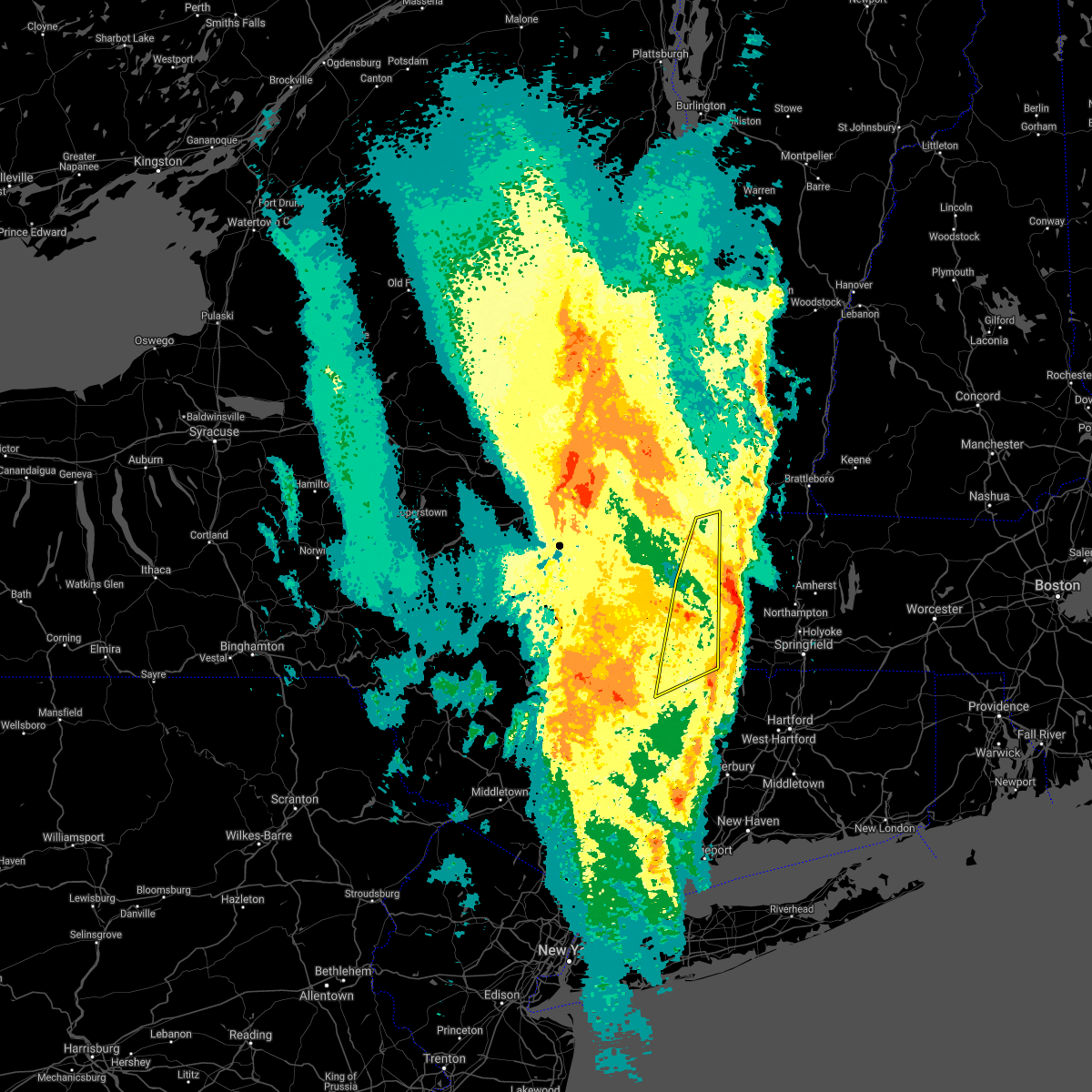 The severe thunderstorm warning for northwestern litchfield and berkshire counties will expire at 715 pm est, the storm which prompted the warning has weakened below severe levels, and has exited the warned area. therefore, the warning will be allowed to expire. a severe thunderstorm watch remains in effect until 900 pm est for northern connecticut, and western massachusetts. The severe thunderstorm warning for northwestern litchfield and berkshire counties will expire at 715 pm est, the storm which prompted the warning has weakened below severe levels, and has exited the warned area. therefore, the warning will be allowed to expire. a severe thunderstorm watch remains in effect until 900 pm est for northern connecticut, and western massachusetts.
|
| 2/25/2017 7:09 PM EST |
 The severe thunderstorm warning for northwestern litchfield and berkshire counties will expire at 715 pm est. the storm which prompted the warning has weakened below severe levels, and has exited the warned area. therefore, the warning will be allowed to expire. A severe thunderstorm watch remains in effect until 900 pm est for. The severe thunderstorm warning for northwestern litchfield and berkshire counties will expire at 715 pm est. the storm which prompted the warning has weakened below severe levels, and has exited the warned area. therefore, the warning will be allowed to expire. A severe thunderstorm watch remains in effect until 900 pm est for.
|
| 2/25/2017 6:52 PM EST |
 At 651 pm est, a severe thunderstorm was located near lee, or 7 miles east of great barrington, moving northeast at 50 mph (radar indicated). Hazards include 60 mph wind gusts. Expect damage to roofs, siding, and trees. This severe thunderstorm will remain over mainly rural areas of northwestern litchfield and berkshire counties, including the following locations: cheshire harbor, glendale, salisbury, lenox dale, the center at lenox, taconic, dalton, adams junction, zylonite and bowens corners. At 651 pm est, a severe thunderstorm was located near lee, or 7 miles east of great barrington, moving northeast at 50 mph (radar indicated). Hazards include 60 mph wind gusts. Expect damage to roofs, siding, and trees. This severe thunderstorm will remain over mainly rural areas of northwestern litchfield and berkshire counties, including the following locations: cheshire harbor, glendale, salisbury, lenox dale, the center at lenox, taconic, dalton, adams junction, zylonite and bowens corners.
|
| 2/25/2017 6:43 PM EST | Tree down on south state rd in berkshire county MA, 4.6 miles SSW of Pittsfield, MA |
| 2/25/2017 6:39 PM EST | Tree down cheshire rd allandale ctr in berkshire county MA, 2.7 miles WSW of Pittsfield, MA |
| 2/25/2017 6:28 PM EST | Weathernet6 spotter in berkshire county MA, 7 miles SSE of Pittsfield, MA |
| 2/25/2017 6:08 PM EST |
 At 608 pm est, a severe thunderstorm was located over nassau, moving northeast at 55 mph (radar indicated). Hazards include 60 mph wind gusts. Expect damage to roofs, siding, and trees. this severe thunderstorm will be near, stephentown and averill park around 620 pm est. hancock around 625 pm est. new ashford around 630 pm est. north adams, adams and williamstown around 640 pm est. Other locations impacted by this severe thunderstorm include brookview, norrie heights, van hoesen station, katsbaan, north hancock, cheshire harbor, burden, linden acres, salisbury and otter hook. At 608 pm est, a severe thunderstorm was located over nassau, moving northeast at 55 mph (radar indicated). Hazards include 60 mph wind gusts. Expect damage to roofs, siding, and trees. this severe thunderstorm will be near, stephentown and averill park around 620 pm est. hancock around 625 pm est. new ashford around 630 pm est. north adams, adams and williamstown around 640 pm est. Other locations impacted by this severe thunderstorm include brookview, norrie heights, van hoesen station, katsbaan, north hancock, cheshire harbor, burden, linden acres, salisbury and otter hook.
|
| 9/11/2016 7:53 AM EDT |
 At 752 am edt, severe thunderstorms were located along a line extending from near nassau to near philmont to near stanfordville, moving east at 35 mph (radar indicated). Hazards include 60 mph wind gusts. Expect damage to roofs. siding. and trees. these severe storms will be near, copake around 800 am edt. great barrington, new lebanon and housatonic around 810 am edt. sheffield around 820 am edt. pittsfield and lenox around 825 am edt. lee around 830 am edt. Other locations impacted by these severe thunderstorms include east chatham, riders, elizaville, lenox house country shops, braeside, berkshire heights, lanesborough, new lebanon center, copake falls and east hillsdale. At 752 am edt, severe thunderstorms were located along a line extending from near nassau to near philmont to near stanfordville, moving east at 35 mph (radar indicated). Hazards include 60 mph wind gusts. Expect damage to roofs. siding. and trees. these severe storms will be near, copake around 800 am edt. great barrington, new lebanon and housatonic around 810 am edt. sheffield around 820 am edt. pittsfield and lenox around 825 am edt. lee around 830 am edt. Other locations impacted by these severe thunderstorms include east chatham, riders, elizaville, lenox house country shops, braeside, berkshire heights, lanesborough, new lebanon center, copake falls and east hillsdale.
|
| 9/11/2016 7:26 AM EDT |
 At 726 am edt, severe thunderstorms were located along a line extending from near selkirk to near athens to lake katrine, moving east at 35 mph (radar indicated). Hazards include 60 mph wind gusts. Expect damage to roofs. siding. and trees. severe thunderstorms will be near, athens around 730 am edt. east greenbush, hudson, red hook and lorenz park around 735 am edt. claverack and claverack-red mills around 740 am edt. nassau, valatie, philmont and kinderhook around 745 am edt. pine plains around 755 am edt. copake and stephentown around 800 am edt. great barrington, new lebanon and housatonic around 810 am edt. lenox and sheffield around 820 am edt. Other locations impacted by these severe thunderstorms include cheviot, elizaville, lenox house country shops, fitchs wharf, dunham hollow, mount ross, mellenville, callanans corners, mahkeenac heights and ancramdale. At 726 am edt, severe thunderstorms were located along a line extending from near selkirk to near athens to lake katrine, moving east at 35 mph (radar indicated). Hazards include 60 mph wind gusts. Expect damage to roofs. siding. and trees. severe thunderstorms will be near, athens around 730 am edt. east greenbush, hudson, red hook and lorenz park around 735 am edt. claverack and claverack-red mills around 740 am edt. nassau, valatie, philmont and kinderhook around 745 am edt. pine plains around 755 am edt. copake and stephentown around 800 am edt. great barrington, new lebanon and housatonic around 810 am edt. lenox and sheffield around 820 am edt. Other locations impacted by these severe thunderstorms include cheviot, elizaville, lenox house country shops, fitchs wharf, dunham hollow, mount ross, mellenville, callanans corners, mahkeenac heights and ancramdale.
|
| 8/13/2016 9:31 PM EDT |
 At 930 pm edt, severe thunderstorms were located along a line extending from rowe to near russell to torrington, moving east at 35 mph (radar indicated). Hazards include 60 mph wind gusts and quarter size hail. Hail damage to vehicles is expected. expect wind damage to roofs, siding, and trees. these severe storms will be near, canton around 945 pm edt. Other locations impacted by these severe thunderstorms include konkapot, goose green, nepaug, maple grove, east otis, kelly corner, south sandisfield, winchester center, east renfrew and coltsville. At 930 pm edt, severe thunderstorms were located along a line extending from rowe to near russell to torrington, moving east at 35 mph (radar indicated). Hazards include 60 mph wind gusts and quarter size hail. Hail damage to vehicles is expected. expect wind damage to roofs, siding, and trees. these severe storms will be near, canton around 945 pm edt. Other locations impacted by these severe thunderstorms include konkapot, goose green, nepaug, maple grove, east otis, kelly corner, south sandisfield, winchester center, east renfrew and coltsville.
|
| 8/13/2016 9:12 PM EDT |
 At 912 pm edt, severe thunderstorms were located along a line extending from florida to otis to cornwall bridge, moving east at 35 mph (radar indicated). Hazards include 60 mph wind gusts and quarter size hail. Hail damage to vehicles is expected. expect wind damage to roofs, siding, and trees. severe thunderstorms will be near, north adams, adams, otis, florida and tolland around 915 pm edt. monroe around 920 pm edt. northwest harwinton around 935 pm edt. torrington around 940 pm edt. canton, new hartford, new hartford center and winsted around 945 pm edt. Other locations impacted by these severe thunderstorms include dean corners, konkapot, the cedars, huntsville, lenox house country shops, berkshire heights, lanesborough, goose green, nepaug and east cornwall. At 912 pm edt, severe thunderstorms were located along a line extending from florida to otis to cornwall bridge, moving east at 35 mph (radar indicated). Hazards include 60 mph wind gusts and quarter size hail. Hail damage to vehicles is expected. expect wind damage to roofs, siding, and trees. severe thunderstorms will be near, north adams, adams, otis, florida and tolland around 915 pm edt. monroe around 920 pm edt. northwest harwinton around 935 pm edt. torrington around 940 pm edt. canton, new hartford, new hartford center and winsted around 945 pm edt. Other locations impacted by these severe thunderstorms include dean corners, konkapot, the cedars, huntsville, lenox house country shops, berkshire heights, lanesborough, goose green, nepaug and east cornwall.
|
| 8/13/2016 9:02 PM EDT |
 At 902 pm edt, a severe thunderstorm was located over berlin, or 12 miles west of north adams, moving northeast at 40 mph (radar indicated). Hazards include 60 mph wind gusts and quarter size hail. Hail damage to vehicles is expected. expect wind damage to roofs, siding, and trees. this severe storm will be near, new ashford around 910 pm edt. north adams, williamstown, pownal and stamford around 915 pm edt. Other locations impacted by this severe thunderstorm include petersburg junction, sweets corner, denault corners, pownal center, white oaks, petersburg, briggsville, lanesborough, eagle mills and little egypt. At 902 pm edt, a severe thunderstorm was located over berlin, or 12 miles west of north adams, moving northeast at 40 mph (radar indicated). Hazards include 60 mph wind gusts and quarter size hail. Hail damage to vehicles is expected. expect wind damage to roofs, siding, and trees. this severe storm will be near, new ashford around 910 pm edt. north adams, williamstown, pownal and stamford around 915 pm edt. Other locations impacted by this severe thunderstorm include petersburg junction, sweets corner, denault corners, pownal center, white oaks, petersburg, briggsville, lanesborough, eagle mills and little egypt.
|
| 8/13/2016 9:00 PM EDT |
 At 833 pm edt, severe thunderstorms were located along a line extending from philmont to near stanfordville, moving east at 45 mph (radar indicated). Hazards include 60 mph wind gusts and quarter size hail. Hail damage to vehicles is expected. expect wind damage to roofs, siding, and trees. severe thunderstorms will be near, chatham around 840 pm edt. austerlitz around 845 pm edt. great barrington, amenia and housatonic around 850 pm edt. lenox, sharon and millerton around 855 pm edt. lee around 900 pm edt. canaan and falls village around 905 pm edt. becket around 910 pm edt. torrington, norfolk, middlefield and winsted around 915 pm edt. Other locations impacted by these severe thunderstorms include dean corners, konkapot, the cedars, sharon valley, lenox house country shops, mount ross, mellenville, east otis, kelly corner and shunpike. At 833 pm edt, severe thunderstorms were located along a line extending from philmont to near stanfordville, moving east at 45 mph (radar indicated). Hazards include 60 mph wind gusts and quarter size hail. Hail damage to vehicles is expected. expect wind damage to roofs, siding, and trees. severe thunderstorms will be near, chatham around 840 pm edt. austerlitz around 845 pm edt. great barrington, amenia and housatonic around 850 pm edt. lenox, sharon and millerton around 855 pm edt. lee around 900 pm edt. canaan and falls village around 905 pm edt. becket around 910 pm edt. torrington, norfolk, middlefield and winsted around 915 pm edt. Other locations impacted by these severe thunderstorms include dean corners, konkapot, the cedars, sharon valley, lenox house country shops, mount ross, mellenville, east otis, kelly corner and shunpike.
|
| 8/13/2016 9:00 PM EDT |
 At 900 pm edt, severe thunderstorms were located along a line extending from near pittsfield to near sandisfield to falls village, moving east at 40 mph (radar indicated). Hazards include 60 mph wind gusts and quarter size hail. Hail damage to vehicles is expected. expect wind damage to roofs, siding, and trees. these severe storms will be near, sandisfield around 905 pm edt. otis around 910 pm edt. torrington, winsted and east windsor around 915 pm edt. Other locations impacted by these severe thunderstorms include dean corners, konkapot, east chatham, the cedars, huntsville, sharon valley, lenox house country shops, berkshire heights, new lebanon center and copake falls. At 900 pm edt, severe thunderstorms were located along a line extending from near pittsfield to near sandisfield to falls village, moving east at 40 mph (radar indicated). Hazards include 60 mph wind gusts and quarter size hail. Hail damage to vehicles is expected. expect wind damage to roofs, siding, and trees. these severe storms will be near, sandisfield around 905 pm edt. otis around 910 pm edt. torrington, winsted and east windsor around 915 pm edt. Other locations impacted by these severe thunderstorms include dean corners, konkapot, east chatham, the cedars, huntsville, sharon valley, lenox house country shops, berkshire heights, new lebanon center and copake falls.
|
| 8/13/2016 9:00 PM EDT |
 At 833 pm edt, severe thunderstorms were located along a line extending from philmont to near stanfordville, moving east at 45 mph (radar indicated). Hazards include 60 mph wind gusts and quarter size hail. Hail damage to vehicles is expected. expect wind damage to roofs, siding, and trees. severe thunderstorms will be near, chatham around 840 pm edt. austerlitz around 845 pm edt. great barrington, amenia and housatonic around 850 pm edt. lenox, sharon and millerton around 855 pm edt. lee around 900 pm edt. canaan and falls village around 905 pm edt. becket around 910 pm edt. torrington, norfolk, middlefield and winsted around 915 pm edt. Other locations impacted by these severe thunderstorms include dean corners, konkapot, the cedars, sharon valley, lenox house country shops, mount ross, mellenville, east otis, kelly corner and shunpike. At 833 pm edt, severe thunderstorms were located along a line extending from philmont to near stanfordville, moving east at 45 mph (radar indicated). Hazards include 60 mph wind gusts and quarter size hail. Hail damage to vehicles is expected. expect wind damage to roofs, siding, and trees. severe thunderstorms will be near, chatham around 840 pm edt. austerlitz around 845 pm edt. great barrington, amenia and housatonic around 850 pm edt. lenox, sharon and millerton around 855 pm edt. lee around 900 pm edt. canaan and falls village around 905 pm edt. becket around 910 pm edt. torrington, norfolk, middlefield and winsted around 915 pm edt. Other locations impacted by these severe thunderstorms include dean corners, konkapot, the cedars, sharon valley, lenox house country shops, mount ross, mellenville, east otis, kelly corner and shunpike.
|
| 8/13/2016 8:44 PM EDT |
 At 843 pm edt, a severe thunderstorm was located over averill park, or near nassau, moving northeast at 45 mph (radar indicated). Hazards include 60 mph wind gusts and quarter size hail. Hail damage to vehicles is expected. expect wind damage to roofs, siding, and trees. this severe thunderstorm will be near, stephentown around 850 pm edt. berlin around 900 pm edt. new ashford around 905 pm edt. williamstown and pownal around 910 pm edt. north adams, adams, stamford and florida around 915 pm edt. other locations impacted by this severe thunderstorm include denault corners, braeside, lanesborough, dunham hollow, maple grove, east renfrew, brunswick center, braytonville, totem lodge and savoy center. this includes the following highways, interstate 90 between mile markers 8 and 5a, and between mile markers 8 and 6-5a. interstate 87 near mile marker 6, near mile marker 2 , near mile marker 4, and between mile markers 2-4 and 4-5. Interstate 787 between mile markers 2 and 8-7. At 843 pm edt, a severe thunderstorm was located over averill park, or near nassau, moving northeast at 45 mph (radar indicated). Hazards include 60 mph wind gusts and quarter size hail. Hail damage to vehicles is expected. expect wind damage to roofs, siding, and trees. this severe thunderstorm will be near, stephentown around 850 pm edt. berlin around 900 pm edt. new ashford around 905 pm edt. williamstown and pownal around 910 pm edt. north adams, adams, stamford and florida around 915 pm edt. other locations impacted by this severe thunderstorm include denault corners, braeside, lanesborough, dunham hollow, maple grove, east renfrew, brunswick center, braytonville, totem lodge and savoy center. this includes the following highways, interstate 90 between mile markers 8 and 5a, and between mile markers 8 and 6-5a. interstate 87 near mile marker 6, near mile marker 2 , near mile marker 4, and between mile markers 2-4 and 4-5. Interstate 787 between mile markers 2 and 8-7.
|
| 8/13/2016 8:33 PM EDT |
 At 833 pm edt, severe thunderstorms were located along a line extending from philmont to near stanfordville, moving east at 45 mph (radar indicated). Hazards include 60 mph wind gusts and quarter size hail. Hail damage to vehicles is expected. expect wind damage to roofs, siding, and trees. severe thunderstorms will be near, chatham around 840 pm edt. austerlitz around 845 pm edt. great barrington, amenia and housatonic around 850 pm edt. lenox, sharon and millerton around 855 pm edt. lee around 900 pm edt. canaan and falls village around 905 pm edt. becket around 910 pm edt. torrington, norfolk, middlefield and winsted around 915 pm edt. Other locations impacted by these severe thunderstorms include dean corners, konkapot, the cedars, sharon valley, lenox house country shops, mount ross, mellenville, east otis, kelly corner and shunpike. At 833 pm edt, severe thunderstorms were located along a line extending from philmont to near stanfordville, moving east at 45 mph (radar indicated). Hazards include 60 mph wind gusts and quarter size hail. Hail damage to vehicles is expected. expect wind damage to roofs, siding, and trees. severe thunderstorms will be near, chatham around 840 pm edt. austerlitz around 845 pm edt. great barrington, amenia and housatonic around 850 pm edt. lenox, sharon and millerton around 855 pm edt. lee around 900 pm edt. canaan and falls village around 905 pm edt. becket around 910 pm edt. torrington, norfolk, middlefield and winsted around 915 pm edt. Other locations impacted by these severe thunderstorms include dean corners, konkapot, the cedars, sharon valley, lenox house country shops, mount ross, mellenville, east otis, kelly corner and shunpike.
|
| 8/13/2016 8:20 PM EDT |
 At 819 pm edt, a severe thunderstorm was located over new baltimore, or 10 miles northwest of chatham, moving east at 50 mph (radar indicated). Hazards include 60 mph wind gusts and quarter size hail. Hail damage to vehicles is expected. expect wind damage to roofs, siding, and trees. this severe thunderstorm will be near, valatie around 825 pm edt. chatham and nassau around 830 pm edt. stephentown around 840 pm edt. new lebanon around 845 pm edt. Other locations impacted by this severe thunderstorm include east chatham, riders, denault corners, lenox house country shops, braeside, roberts hill, new lebanon center, dunham hollow, queechy and coeymans hollow. At 819 pm edt, a severe thunderstorm was located over new baltimore, or 10 miles northwest of chatham, moving east at 50 mph (radar indicated). Hazards include 60 mph wind gusts and quarter size hail. Hail damage to vehicles is expected. expect wind damage to roofs, siding, and trees. this severe thunderstorm will be near, valatie around 825 pm edt. chatham and nassau around 830 pm edt. stephentown around 840 pm edt. new lebanon around 845 pm edt. Other locations impacted by this severe thunderstorm include east chatham, riders, denault corners, lenox house country shops, braeside, roberts hill, new lebanon center, dunham hollow, queechy and coeymans hollow.
|
| 8/12/2016 5:24 PM EDT |
 At 523 pm edt, a severe thunderstorm was located over east windsor, or 13 miles east of pittsfield, moving east at 40 mph (radar indicated). Hazards include 60 mph wind gusts. Expect damage to roofs. siding. and trees. This severe thunderstorm will remain over mainly rural areas of northeastern berkshire county, including the following locations: washington, lenox station, lenox house country shops, new lenox, lakewood, adams junction, yankee orchards, dalton, brier and the boulders. At 523 pm edt, a severe thunderstorm was located over east windsor, or 13 miles east of pittsfield, moving east at 40 mph (radar indicated). Hazards include 60 mph wind gusts. Expect damage to roofs. siding. and trees. This severe thunderstorm will remain over mainly rural areas of northeastern berkshire county, including the following locations: washington, lenox station, lenox house country shops, new lenox, lakewood, adams junction, yankee orchards, dalton, brier and the boulders.
|
| 8/12/2016 5:13 PM EDT | Tree and wires down in berkshire county MA, 6 miles ENE of Pittsfield, MA |
| 8/12/2016 5:06 PM EDT | Wires down on pecks road in berkshire county MA, 2.7 miles SSE of Pittsfield, MA |
| 8/12/2016 5:05 PM EDT |
 At 503 pm edt, a severe thunderstorm was located over pittsfield, moving east at 40 mph (radar indicated). Hazards include 60 mph wind gusts. Expect damage to roofs. siding. and trees. this severe thunderstorm will be near, cheshire around 510 pm edt. savoy around 520 pm edt. Other locations impacted by this severe thunderstorm include cheshire harbor, lenox house country shops, lanesborough, lakewood, dalton, the boulders, coltsville, stearnsville, shaker village and peru. At 503 pm edt, a severe thunderstorm was located over pittsfield, moving east at 40 mph (radar indicated). Hazards include 60 mph wind gusts. Expect damage to roofs. siding. and trees. this severe thunderstorm will be near, cheshire around 510 pm edt. savoy around 520 pm edt. Other locations impacted by this severe thunderstorm include cheshire harbor, lenox house country shops, lanesborough, lakewood, dalton, the boulders, coltsville, stearnsville, shaker village and peru.
|
| 7/18/2016 1:43 PM EDT | Numerous trees and wires down across the are in berkshire county MA, 4.6 miles SSW of Pittsfield, MA |
| 7/18/2016 1:25 PM EDT |
 At 124 pm edt, severe thunderstorms were located along a line extending from near grafton to near hancock to 6 miles west of new lebanon, moving east at 35 mph (radar indicated). Hazards include 60 mph wind gusts. Expect damage to roofs. siding. And trees. At 124 pm edt, severe thunderstorms were located along a line extending from near grafton to near hancock to 6 miles west of new lebanon, moving east at 35 mph (radar indicated). Hazards include 60 mph wind gusts. Expect damage to roofs. siding. And trees.
|
| 6/21/2016 3:53 AM EDT |
 The severe thunderstorm warning for central berkshire county will expire at 400 am edt, the storm which prompted the warning has moved out of the area. therefore, the warning will be allowed to expire. The severe thunderstorm warning for central berkshire county will expire at 400 am edt, the storm which prompted the warning has moved out of the area. therefore, the warning will be allowed to expire.
|
| 6/21/2016 3:31 AM EDT |
 At 331 am edt, a severe thunderstorm was located near becket, or 13 miles northeast of great barrington, moving southeast at 45 mph (radar indicated). Hazards include 60 mph wind gusts. Expect damage to roofs. siding. and trees. Locations impacted include, pittsfield, lee, lenox, becket, middlefield, housatonic, dalton, hinsdale, stockbridge, peru, washington, tyringham, beachwood, becket center, lenox house country shops, mahkeenac shores, rockdale mills, lakewood, williamsville and south lee. At 331 am edt, a severe thunderstorm was located near becket, or 13 miles northeast of great barrington, moving southeast at 45 mph (radar indicated). Hazards include 60 mph wind gusts. Expect damage to roofs. siding. and trees. Locations impacted include, pittsfield, lee, lenox, becket, middlefield, housatonic, dalton, hinsdale, stockbridge, peru, washington, tyringham, beachwood, becket center, lenox house country shops, mahkeenac shores, rockdale mills, lakewood, williamsville and south lee.
|
| 6/21/2016 2:58 AM EDT |
 At 257 am edt, a severe thunderstorm was located over new baltimore, or 9 miles west of chatham, moving east at 45 mph (radar indicated). Hazards include 60 mph wind gusts and quarter size hail. Hail damage to vehicles is expected. Expect wind damage to roofs, siding, and trees. At 257 am edt, a severe thunderstorm was located over new baltimore, or 9 miles west of chatham, moving east at 45 mph (radar indicated). Hazards include 60 mph wind gusts and quarter size hail. Hail damage to vehicles is expected. Expect wind damage to roofs, siding, and trees.
|
| 5/30/2016 7:35 PM EDT | Trees down on elm street and dorchester avenue. time estimated by rada in berkshire county MA, 1.3 miles NW of Pittsfield, MA |
| 5/30/2016 7:35 PM EDT | Large tree down on wires at west street and westbrook terrance. time estimated by rada in berkshire county MA, 3.7 miles E of Pittsfield, MA |
| 5/30/2016 7:20 PM EDT |
 At 720 pm edt, a severe thunderstorm was located over new lebanon, or 7 miles west of pittsfield, moving east at 30 mph (radar indicated). Hazards include 60 mph wind gusts. Expect damage to roofs. siding. and trees. Locations impacted include, pittsfield, chatham, nassau, lee, lenox, cheshire, stephentown, new lebanon, austerlitz, hancock, new ashford, berkshire, dalton, lanesborough, stockbridge, canaan, richmond, west stockbridge, east nassau and east chatham. At 720 pm edt, a severe thunderstorm was located over new lebanon, or 7 miles west of pittsfield, moving east at 30 mph (radar indicated). Hazards include 60 mph wind gusts. Expect damage to roofs. siding. and trees. Locations impacted include, pittsfield, chatham, nassau, lee, lenox, cheshire, stephentown, new lebanon, austerlitz, hancock, new ashford, berkshire, dalton, lanesborough, stockbridge, canaan, richmond, west stockbridge, east nassau and east chatham.
|
| 5/30/2016 6:56 PM EDT |
 At 656 pm edt, a severe thunderstorm was located over nassau, moving east at 25 mph (radar indicated). Hazards include 60 mph wind gusts. Expect damage to roofs. siding. And trees. At 656 pm edt, a severe thunderstorm was located over nassau, moving east at 25 mph (radar indicated). Hazards include 60 mph wind gusts. Expect damage to roofs. siding. And trees.
|
| 4/7/2016 4:28 PM EDT |
 At 427 pm edt, severe thunderstorms were located along a line extending from near johnsburg to near averill park, moving east at 25 mph (radar indicated). Hazards include 60 mph wind gusts and penny size hail. Expect damage to roofs. siding. And trees. At 427 pm edt, severe thunderstorms were located along a line extending from near johnsburg to near averill park, moving east at 25 mph (radar indicated). Hazards include 60 mph wind gusts and penny size hail. Expect damage to roofs. siding. And trees.
|
| 2/25/2016 12:31 AM EST |
 At 1230 am est, severe thunderstorms were located along a line extending from near shaftsbury to near savoy to kent, moving northeast at 85 mph (radar indicated). Hazards include 60 mph wind gusts. Expect damage to roofs. siding and trees. these severe storms will be near, north adams, adams, charlemont, stamford and florida around 1235 am est. monroe, readsboro, heath and rowe around 1240 am est. wilmington, norfolk, canaan, falls village and ashley falls around 1245 am est. sheffield and west wardsboro around 1250 am est. sandisfield, tolland and newfane around 1255 am est. becket and otis around 100 am est. Other locations impacted by these severe thunderstorms include dean corners, konkapot, medburyville, the cedars, sharon valley, minortown, lenox house country shops, paper mill village, east cornwall and maple grove. At 1230 am est, severe thunderstorms were located along a line extending from near shaftsbury to near savoy to kent, moving northeast at 85 mph (radar indicated). Hazards include 60 mph wind gusts. Expect damage to roofs. siding and trees. these severe storms will be near, north adams, adams, charlemont, stamford and florida around 1235 am est. monroe, readsboro, heath and rowe around 1240 am est. wilmington, norfolk, canaan, falls village and ashley falls around 1245 am est. sheffield and west wardsboro around 1250 am est. sandisfield, tolland and newfane around 1255 am est. becket and otis around 100 am est. Other locations impacted by these severe thunderstorms include dean corners, konkapot, medburyville, the cedars, sharon valley, minortown, lenox house country shops, paper mill village, east cornwall and maple grove.
|
| 2/24/2016 11:57 PM EST |
 At 1156 pm est, severe thunderstorms were located along a line extending from near wyantskill to near copake to near lake carmel, moving northeast at 65 mph (radar indicated). Hazards include 60 mph wind gusts. Expect damage to roofs. siding and trees. severe thunderstorms will be near, sheffield, wyantskill, west sand lake and averill park around 1200 am est. troy, great barrington, austerlitz, housatonic and center brunswick around 1205 am est. sherman, lee, grafton, gaylordsville and wingdale around 1210 am est. new milford, lenox and kent around 1215 am est. pittsfield, hoosick falls, becket and new preston around 1220 am est. bennington, cheshire, litchfield and cornwall bridge around 1225 am est. savoy around 1230 am est. torrington, norfolk and florida around 1235 am est. Other locations impacted by these severe thunderstorms include medburyville, arthursburg, the cedars, sharon valley, birch groves, east cornwall, dunham hollow, mount ross, maple grove and kelly corner. At 1156 pm est, severe thunderstorms were located along a line extending from near wyantskill to near copake to near lake carmel, moving northeast at 65 mph (radar indicated). Hazards include 60 mph wind gusts. Expect damage to roofs. siding and trees. severe thunderstorms will be near, sheffield, wyantskill, west sand lake and averill park around 1200 am est. troy, great barrington, austerlitz, housatonic and center brunswick around 1205 am est. sherman, lee, grafton, gaylordsville and wingdale around 1210 am est. new milford, lenox and kent around 1215 am est. pittsfield, hoosick falls, becket and new preston around 1220 am est. bennington, cheshire, litchfield and cornwall bridge around 1225 am est. savoy around 1230 am est. torrington, norfolk and florida around 1235 am est. Other locations impacted by these severe thunderstorms include medburyville, arthursburg, the cedars, sharon valley, birch groves, east cornwall, dunham hollow, mount ross, maple grove and kelly corner.
|
| 8/4/2015 1:27 PM EDT |
 At 126 pm edt, a severe thunderstorm was located over east windsor, or 11 miles east of pittsfield, moving east at 45 mph (radar indicated). Hazards include ping pong ball size hail and 60 mph wind gusts. People and animals outdoors will be injured. expect hail damage to roofs, siding, windows and vehicles. expect wind damage to roofs, siding and trees. this severe thunderstorm will be near, east windsor around 130 pm edt. worthington around 135 pm edt. cummington and plainfield around 140 pm edt. Other locations impacted by this severe thunderstorm include arnoldville, washington, farnams, adams junction, yankee orchards, berkshire, dalton, town crest village, brier and the boulders. At 126 pm edt, a severe thunderstorm was located over east windsor, or 11 miles east of pittsfield, moving east at 45 mph (radar indicated). Hazards include ping pong ball size hail and 60 mph wind gusts. People and animals outdoors will be injured. expect hail damage to roofs, siding, windows and vehicles. expect wind damage to roofs, siding and trees. this severe thunderstorm will be near, east windsor around 130 pm edt. worthington around 135 pm edt. cummington and plainfield around 140 pm edt. Other locations impacted by this severe thunderstorm include arnoldville, washington, farnams, adams junction, yankee orchards, berkshire, dalton, town crest village, brier and the boulders.
|
| 8/4/2015 1:26 PM EDT | Quarter sized hail reported 4.6 miles WSW of Pittsfield, MA |
| 8/4/2015 1:20 PM EDT | Quarter sized hail reported 1 miles WSW of Pittsfield, MA, hail at intersection of dalton ave and westminster ave |
| 8/4/2015 1:14 PM EDT |
 At 113 pm edt, a strong thunderstorm was located near pittsfield, moving east at 40 mph (spotters have reported up to two inch hail with this storm). Hazards include two inch hail and 60 mph wind gusts. People and animals outdoors will be injured. expect hail damage to roofs, siding, windows and vehicles. expect wind damage to roofs, siding and trees. this severe storm will be near, worthington, cummington, savoy, plainfield and east windsor around 130 pm edt. Other locations impacted by this severe thunderstorm include richmond furnace, cheshire harbor, rusek whipple square, lenox house country shops, lanesborough, richmond, lakewood, little egypt, maple grove and dalton. At 113 pm edt, a strong thunderstorm was located near pittsfield, moving east at 40 mph (spotters have reported up to two inch hail with this storm). Hazards include two inch hail and 60 mph wind gusts. People and animals outdoors will be injured. expect hail damage to roofs, siding, windows and vehicles. expect wind damage to roofs, siding and trees. this severe storm will be near, worthington, cummington, savoy, plainfield and east windsor around 130 pm edt. Other locations impacted by this severe thunderstorm include richmond furnace, cheshire harbor, rusek whipple square, lenox house country shops, lanesborough, richmond, lakewood, little egypt, maple grove and dalton.
|
| 8/4/2015 12:55 PM EDT |
 At 1254 pm edt, a severe thunderstorm was located over new lebanon, or 8 miles east of nassau, moving east at 40 mph (trained weather spotter has reported two inch hail in valatie). Hazards include two inch hail and 60 mph wind gusts. People and animals outdoors will be injured. expect hail damage to roofs, siding, windows and vehicles. expect wind damage to roofs, siding and trees. this severe storm will be near, hancock around 105 pm edt. new ashford around 110 pm edt. pittsfield around 115 pm edt. cheshire around 120 pm edt. worthington, cummington, savoy, plainfield and east windsor around 130 pm edt. Other locations impacted by this severe thunderstorm include east chatham, riders, denault corners, lenox house country shops, braeside, lanesborough, new lebanon center, little egypt, dunham hollow and maple grove. At 1254 pm edt, a severe thunderstorm was located over new lebanon, or 8 miles east of nassau, moving east at 40 mph (trained weather spotter has reported two inch hail in valatie). Hazards include two inch hail and 60 mph wind gusts. People and animals outdoors will be injured. expect hail damage to roofs, siding, windows and vehicles. expect wind damage to roofs, siding and trees. this severe storm will be near, hancock around 105 pm edt. new ashford around 110 pm edt. pittsfield around 115 pm edt. cheshire around 120 pm edt. worthington, cummington, savoy, plainfield and east windsor around 130 pm edt. Other locations impacted by this severe thunderstorm include east chatham, riders, denault corners, lenox house country shops, braeside, lanesborough, new lebanon center, little egypt, dunham hollow and maple grove.
|
| 8/4/2015 12:44 PM EDT |
 At 1243 pm edt, a severe thunderstorm was located over nassau, moving east at 40 mph (radar indicated). Hazards include 60 mph wind gusts and quarter size hail. Hail damage to vehicles is expected. expect wind damage to roofs, siding and trees. this severe thunderstorm will be near, stephentown around 1255 pm edt. new lebanon around 100 pm edt. hancock around 105 pm edt. lenox around 110 pm edt. pittsfield around 115 pm edt. cheshire around 120 pm edt. worthington, cummington, savoy, plainfield and east windsor around 130 pm edt. Other locations impacted by this severe thunderstorm include east chatham, riders, denault corners, lenox house country shops, braeside, lanesborough, new lebanon center, little egypt, dunham hollow and maple grove. At 1243 pm edt, a severe thunderstorm was located over nassau, moving east at 40 mph (radar indicated). Hazards include 60 mph wind gusts and quarter size hail. Hail damage to vehicles is expected. expect wind damage to roofs, siding and trees. this severe thunderstorm will be near, stephentown around 1255 pm edt. new lebanon around 100 pm edt. hancock around 105 pm edt. lenox around 110 pm edt. pittsfield around 115 pm edt. cheshire around 120 pm edt. worthington, cummington, savoy, plainfield and east windsor around 130 pm edt. Other locations impacted by this severe thunderstorm include east chatham, riders, denault corners, lenox house country shops, braeside, lanesborough, new lebanon center, little egypt, dunham hollow and maple grove.
|
| 7/26/2015 5:44 PM EDT |
 At 543 pm edt, a severe thunderstorm was located near lee, or 7 miles east of great barrington, moving east at 45 mph (trained weather spotters). Hazards include 60 mph wind gusts. Expect damage to roofs. siding and trees. this severe thunderstorm will be near, otis and tolland around 550 pm edt. becket around 555 pm edt. blandford around 600 pm edt. chester and middlefield around 605 pm edt. Other locations impacted by this severe thunderstorm include beachwood, becket center, mahkeenac shores, rockdale mills, hephzibah heights, south lee, larrywaug, east otis, leisure lee and mahkeenac heights. At 543 pm edt, a severe thunderstorm was located near lee, or 7 miles east of great barrington, moving east at 45 mph (trained weather spotters). Hazards include 60 mph wind gusts. Expect damage to roofs. siding and trees. this severe thunderstorm will be near, otis and tolland around 550 pm edt. becket around 555 pm edt. blandford around 600 pm edt. chester and middlefield around 605 pm edt. Other locations impacted by this severe thunderstorm include beachwood, becket center, mahkeenac shores, rockdale mills, hephzibah heights, south lee, larrywaug, east otis, leisure lee and mahkeenac heights.
|
| 7/19/2015 5:23 PM EDT |
 At 522 pm edt, a severe thunderstorm was located over austerlitz, or near chatham, moving southeast at 15 mph (trained weather spotters). Hazards include golf ball size hail and 60 mph wind gusts. People and animals outdoors will be injured. expect hail damage to roofs, siding, windows and vehicles. expect wind damage to roofs, siding and trees. this severe thunderstorm will be near, austerlitz around 530 pm edt. housatonic around 555 pm edt. great barrington and lee around 605 pm edt. Other locations impacted by this severe thunderstorm include east chatham, riders, lenox house country shops, berkshire heights, williamsville, new lebanon center, copake falls, east hillsdale, mellenville and queechy. At 522 pm edt, a severe thunderstorm was located over austerlitz, or near chatham, moving southeast at 15 mph (trained weather spotters). Hazards include golf ball size hail and 60 mph wind gusts. People and animals outdoors will be injured. expect hail damage to roofs, siding, windows and vehicles. expect wind damage to roofs, siding and trees. this severe thunderstorm will be near, austerlitz around 530 pm edt. housatonic around 555 pm edt. great barrington and lee around 605 pm edt. Other locations impacted by this severe thunderstorm include east chatham, riders, lenox house country shops, berkshire heights, williamsville, new lebanon center, copake falls, east hillsdale, mellenville and queechy.
|
| 6/23/2015 4:50 PM EDT |
 The severe thunderstorm warning for central berkshire county will expire at 500 pm edt, the severe thunderstorm which prompted the warning has moved out of the warned area. therefore the warning will be allowed to expire. a severe thunderstorm watch remains in effect until 900 pm edt for western massachusetts and east central new york. The severe thunderstorm warning for central berkshire county will expire at 500 pm edt, the severe thunderstorm which prompted the warning has moved out of the warned area. therefore the warning will be allowed to expire. a severe thunderstorm watch remains in effect until 900 pm edt for western massachusetts and east central new york.
|
| 6/23/2015 4:27 PM EDT |
 At 427 pm edt, a severe thunderstorm was located near lee, or near great barrington, moving northeast at 45 mph (radar indicated). Hazards include 60 mph wind gusts and quarter size hail. Hail damage to vehicles is expected. expect wind damage to roofs, siding and trees. this severe storm will be near, lee and lenox around 430 pm edt. becket around 440 pm edt. chester and middlefield around 450 pm edt. cummington and plainfield around 500 pm edt. Other locations impacted by this severe thunderstorm include lenox house country shops, berkshire heights, williamsville, mahkeenac heights, coltsville, east lee, mahkeenac terrace, eastover, the center at lenox and west stockbridge. At 427 pm edt, a severe thunderstorm was located near lee, or near great barrington, moving northeast at 45 mph (radar indicated). Hazards include 60 mph wind gusts and quarter size hail. Hail damage to vehicles is expected. expect wind damage to roofs, siding and trees. this severe storm will be near, lee and lenox around 430 pm edt. becket around 440 pm edt. chester and middlefield around 450 pm edt. cummington and plainfield around 500 pm edt. Other locations impacted by this severe thunderstorm include lenox house country shops, berkshire heights, williamsville, mahkeenac heights, coltsville, east lee, mahkeenac terrace, eastover, the center at lenox and west stockbridge.
|
| 6/23/2015 4:11 PM EDT |
 At 410 pm edt, a severe thunderstorm was located near philmont, or 9 miles west of great barrington, moving northeast at 45 mph (radar indicated). Hazards include 60 mph wind gusts and quarter size hail. Hail damage to vehicles is expected. expect wind damage to roofs, siding and trees. this severe thunderstorm will be near, great barrington, austerlitz and housatonic around 420 pm edt. lenox around 430 pm edt. lee around 435 pm edt. becket around 445 pm edt. chester and middlefield around 450 pm edt. cummington and plainfield around 500 pm edt. Other locations impacted by this severe thunderstorm include hollowville, lenox house country shops, berkshire heights, williamsville, copake falls, east hillsdale, mellenville, mahkeenac heights, east lee and mahkeenac terrace. At 410 pm edt, a severe thunderstorm was located near philmont, or 9 miles west of great barrington, moving northeast at 45 mph (radar indicated). Hazards include 60 mph wind gusts and quarter size hail. Hail damage to vehicles is expected. expect wind damage to roofs, siding and trees. this severe thunderstorm will be near, great barrington, austerlitz and housatonic around 420 pm edt. lenox around 430 pm edt. lee around 435 pm edt. becket around 445 pm edt. chester and middlefield around 450 pm edt. cummington and plainfield around 500 pm edt. Other locations impacted by this severe thunderstorm include hollowville, lenox house country shops, berkshire heights, williamsville, copake falls, east hillsdale, mellenville, mahkeenac heights, east lee and mahkeenac terrace.
|
| 6/12/2015 10:25 PM EDT |
 At 1024 pm edt, severe thunderstorms were located along a line extending from near pittsfield to near great barrington to near copake to near red hook, moving east at 30 mph (radar indicated). Hazards include 60 mph wind gusts and penny size hail. Expect damage to roofs. siding and trees. these severe storms will be near, great barrington, lee, hancock and housatonic around 1030 pm edt. lenox around 1035 pm edt. pittsfield and sheffield around 1040 pm edt. pine plains, otis, ancram, canaan, sandisfield, tolland, ashley falls and east windsor around 1045 pm edt. other locations impacted by these severe thunderstorms include konkapot, elizaville, lenox house country shops, berkshire heights, lanesborough, copake falls, east hillsdale, mount ross, east otis and south sandisfield. A tornado watch remains in effect until 1100 pm edt for western massachusetts and east central new york. At 1024 pm edt, severe thunderstorms were located along a line extending from near pittsfield to near great barrington to near copake to near red hook, moving east at 30 mph (radar indicated). Hazards include 60 mph wind gusts and penny size hail. Expect damage to roofs. siding and trees. these severe storms will be near, great barrington, lee, hancock and housatonic around 1030 pm edt. lenox around 1035 pm edt. pittsfield and sheffield around 1040 pm edt. pine plains, otis, ancram, canaan, sandisfield, tolland, ashley falls and east windsor around 1045 pm edt. other locations impacted by these severe thunderstorms include konkapot, elizaville, lenox house country shops, berkshire heights, lanesborough, copake falls, east hillsdale, mount ross, east otis and south sandisfield. A tornado watch remains in effect until 1100 pm edt for western massachusetts and east central new york.
|
| 6/12/2015 9:50 PM EDT |
 At 949 pm edt, severe thunderstorms were located along a line extending from near nassau to near chatham to near claverack to near kenneth l wilson campground, moving east at 30 mph (radar indicated). Hazards include 60 mph wind gusts and penny size hail. Expect damage to roofs. siding and trees. severe thunderstorms will be near, livingston, philmont, averill park and west sand lake around 955 pm edt. austerlitz around 1000 pm edt. stephentown around 1005 pm edt. ancram around 1010 pm edt. saugerties, new lebanon and housatonic around 1015 pm edt. great barrington, copake, hancock and saugerties south around 1020 pm edt. lee around 1025 pm edt. clermont around 1030 pm edt. other locations impacted by these severe thunderstorms include konkapot, east chatham, riders, cheviot, denault corners, elizaville, lenox house country shops, berkshire heights, blue mountain and lanesborough. A tornado watch remains in effect until 1100 pm edt for western massachusetts and east central new york. At 949 pm edt, severe thunderstorms were located along a line extending from near nassau to near chatham to near claverack to near kenneth l wilson campground, moving east at 30 mph (radar indicated). Hazards include 60 mph wind gusts and penny size hail. Expect damage to roofs. siding and trees. severe thunderstorms will be near, livingston, philmont, averill park and west sand lake around 955 pm edt. austerlitz around 1000 pm edt. stephentown around 1005 pm edt. ancram around 1010 pm edt. saugerties, new lebanon and housatonic around 1015 pm edt. great barrington, copake, hancock and saugerties south around 1020 pm edt. lee around 1025 pm edt. clermont around 1030 pm edt. other locations impacted by these severe thunderstorms include konkapot, east chatham, riders, cheviot, denault corners, elizaville, lenox house country shops, berkshire heights, blue mountain and lanesborough. A tornado watch remains in effect until 1100 pm edt for western massachusetts and east central new york.
|
| 6/9/2015 3:39 PM EDT |
 At 338 pm edt, severe thunderstorms were located along a line extending from near cohoes to near kinderhook, moving northeast at 45 mph (radar indicated). Hazards include 70 mph wind gusts and quarter size hail. Hail damage to vehicles is expected. expect considerable tree damage. wind damage is also likely to mobile homes, roofs and outbuildings. these severe storms will be near, troy and center brunswick around 345 pm edt. Other locations impacted by these severe thunderstorms include east chatham, riders, denault corners, lincolnville, lenox house country shops, braeside, lanesborough, new lebanon center, dunham hollow and queechy. At 338 pm edt, severe thunderstorms were located along a line extending from near cohoes to near kinderhook, moving northeast at 45 mph (radar indicated). Hazards include 70 mph wind gusts and quarter size hail. Hail damage to vehicles is expected. expect considerable tree damage. wind damage is also likely to mobile homes, roofs and outbuildings. these severe storms will be near, troy and center brunswick around 345 pm edt. Other locations impacted by these severe thunderstorms include east chatham, riders, denault corners, lincolnville, lenox house country shops, braeside, lanesborough, new lebanon center, dunham hollow and queechy.
|
| 6/9/2015 3:28 PM EDT |
 At 328 pm edt, severe thunderstorms were located along a line extending from near salem to near new ashford, moving northeast at 60 mph (radar indicated). Hazards include 60 mph wind gusts and quarter size hail. Hail damage to vehicles is expected. expect wind damage to roofs, siding and trees. severe thunderstorms will be near, manchester and manchester center around 340 pm edt. stamford around 345 pm edt. londonderry, monroe, charlemont, readsboro and rowe around 350 pm edt. wilmington and heath around 355 pm edt. colrain around 400 pm edt. guilford center around 405 pm edt. brattleboro, hinsdale and newfane around 410 pm edt. putney around 415 pm edt. Other locations impacted by these severe thunderstorms include medburyville, dummerston center, peru town center, rawsonville, halifax, paper mill village, lanesborough, manchester depot, maple grove and wardsboro center. At 328 pm edt, severe thunderstorms were located along a line extending from near salem to near new ashford, moving northeast at 60 mph (radar indicated). Hazards include 60 mph wind gusts and quarter size hail. Hail damage to vehicles is expected. expect wind damage to roofs, siding and trees. severe thunderstorms will be near, manchester and manchester center around 340 pm edt. stamford around 345 pm edt. londonderry, monroe, charlemont, readsboro and rowe around 350 pm edt. wilmington and heath around 355 pm edt. colrain around 400 pm edt. guilford center around 405 pm edt. brattleboro, hinsdale and newfane around 410 pm edt. putney around 415 pm edt. Other locations impacted by these severe thunderstorms include medburyville, dummerston center, peru town center, rawsonville, halifax, paper mill village, lanesborough, manchester depot, maple grove and wardsboro center.
|
| 6/9/2015 2:50 PM EDT |
 At 249 pm edt, severe thunderstorms were located along a line extending from cohoes to near kinderhook, moving northeast at 40 mph (radar indicated). Hazards include 70 mph wind gusts and quarter size hail. Hail damage to vehicles is expected. expect considerable tree damage. wind damage is also likely to mobile homes, roofs and outbuildings. severe thunderstorms will be near, troy, cohoes, watervliet, latham, green island, waterford and center brunswick around 255 pm edt. stephentown and averill park around 315 pm edt. hancock around 325 pm edt. berlin and new ashford around 330 pm edt. williamstown and pownal around 340 pm edt. Other locations impacted by these severe thunderstorms include fullers, denault corners, lenox house country shops, fitchs wharf, dunham hollow, lisha kill, callanans corners, coltsville, beckers corners and east poestenkill. At 249 pm edt, severe thunderstorms were located along a line extending from cohoes to near kinderhook, moving northeast at 40 mph (radar indicated). Hazards include 70 mph wind gusts and quarter size hail. Hail damage to vehicles is expected. expect considerable tree damage. wind damage is also likely to mobile homes, roofs and outbuildings. severe thunderstorms will be near, troy, cohoes, watervliet, latham, green island, waterford and center brunswick around 255 pm edt. stephentown and averill park around 315 pm edt. hancock around 325 pm edt. berlin and new ashford around 330 pm edt. williamstown and pownal around 340 pm edt. Other locations impacted by these severe thunderstorms include fullers, denault corners, lenox house country shops, fitchs wharf, dunham hollow, lisha kill, callanans corners, coltsville, beckers corners and east poestenkill.
|
| 5/28/2015 2:14 PM EDT | At 213 pm edt, a severe thunderstorm was located over cheshire, or 8 miles south of north adams, moving east at 45 mph. Hazards include 60 mph wind gusts and quarter size hail. Hail damage to vehicles is expected. expect wind damage to roofs, siding and trees. this severe storm will be near, florida around 225 pm edt. charlemont, plainfield and hawley around 230 pm edt. Other locations impacted by this severe thunderstorm include cheshire harbor, steeles corners, rusek whipple square, whitcomb summit, lanesborough, lakewood, little egypt, drury, maple grove and dalton. |
| 5/28/2015 1:45 PM EDT | At 145 pm edt, a severe thunderstorm was located over hancock, or 7 miles northwest of pittsfield, moving east at 55 mph (radar indicated). Hazards include 60 mph wind gusts and quarter size hail. Hail damage to vehicles is expected. expect wind damage to roofs, siding and trees. this severe thunderstorm will be near, cheshire and new ashford around 155 pm edt. adams around 200 pm edt. florida and savoy around 205 pm edt. plainfield and hawley around 210 pm edt. charlemont around 215 pm edt. Other locations impacted by this severe thunderstorm include sweets corner, east chatham, riders, denault corners, lanesborough, new lebanon center, little egypt, dunham hollow, maple grove and north hancock. |
| 5/28/2015 1:45 PM EDT | At 145 pm edt, a severe thunderstorm was located over hancock, or 7 miles northwest of pittsfield, moving east at 55 mph (radar indicated). Hazards include 60 mph wind gusts and quarter size hail. Hail damage to vehicles is expected. expect wind damage to roofs, siding and trees. this severe thunderstorm will be near, cheshire and new ashford around 155 pm edt. adams around 200 pm edt. florida and savoy around 205 pm edt. plainfield and hawley around 210 pm edt. charlemont around 215 pm edt. Other locations impacted by this severe thunderstorm include sweets corner, east chatham, riders, denault corners, lanesborough, new lebanon center, little egypt, dunham hollow, maple grove and north hancock. |
| 5/27/2015 5:59 PM EDT | At 558 pm edt, a severe thunderstorm was located near becket, or 12 miles southeast of pittsfield, moving northeast at 35 mph (radar indicated). Hazards include 60 mph wind gusts and penny size hail. Expect damage to roofs. siding and trees. this severe thunderstorm will be near, blandford around 605 pm edt. chester and middlefield around 615 pm edt. Other locations impacted by this severe thunderstorm include konkapot, lenox house country shops, berkshire heights, lanesborough, williamsville, east otis, south sandisfield, mahkeenac heights, the boulders and monterey. |
| 5/27/2015 5:55 PM EDT | Trees down in berkshire county MA, 0.7 miles ENE of Pittsfield, MA |
| 5/27/2015 5:28 PM EDT | At 527 pm edt, a severe thunderstorm was located near austerlitz, or 8 miles east of chatham, moving northeast at 35 mph (law enforcement). Hazards include 60 mph wind gusts and penny size hail. Expect damage to roofs. siding and trees. this severe storm will be near, new lebanon around 535 pm edt. lenox around 540 pm edt. hancock around 545 pm edt. pittsfield around 550 pm edt. cheshire and savoy around 600 pm edt. Other locations impacted by this severe thunderstorm include hollowville, east chatham, riders, lenox house country shops, lanesborough, williamsville, new lebanon center, little egypt, mellenville and queechy. |
| 5/27/2015 5:28 PM EDT | At 527 pm edt, a severe thunderstorm was located near austerlitz, or 8 miles east of chatham, moving northeast at 35 mph (law enforcement). Hazards include 60 mph wind gusts and penny size hail. Expect damage to roofs. siding and trees. this severe storm will be near, new lebanon around 535 pm edt. lenox around 540 pm edt. hancock around 545 pm edt. pittsfield around 550 pm edt. cheshire and savoy around 600 pm edt. Other locations impacted by this severe thunderstorm include hollowville, east chatham, riders, lenox house country shops, lanesborough, williamsville, new lebanon center, little egypt, mellenville and queechy. |
| 5/27/2015 5:02 PM EDT | At 502 pm edt, a severe thunderstorm was located near philmont, or near hudson, moving northeast at 35 mph (radar indicated). Hazards include 60 mph wind gusts and penny size hail. Expect damage to roofs. siding and trees. this severe thunderstorm will be near, valatie and kinderhook around 510 pm edt. chatham around 515 pm edt. austerlitz around 525 pm edt. new lebanon around 535 pm edt. lee and lenox around 540 pm edt. hancock around 545 pm edt. pittsfield around 555 pm edt. cheshire and savoy around 600 pm edt. Other locations impacted by this severe thunderstorm include hollowville, east chatham, riders, stockport, lenox house country shops, lanesborough, williamsville, new lebanon center, little egypt and mellenville. |
| 5/27/2015 5:02 PM EDT | At 502 pm edt, a severe thunderstorm was located near philmont, or near hudson, moving northeast at 35 mph (radar indicated). Hazards include 60 mph wind gusts and penny size hail. Expect damage to roofs. siding and trees. this severe thunderstorm will be near, valatie and kinderhook around 510 pm edt. chatham around 515 pm edt. austerlitz around 525 pm edt. new lebanon around 535 pm edt. lee and lenox around 540 pm edt. hancock around 545 pm edt. pittsfield around 555 pm edt. cheshire and savoy around 600 pm edt. Other locations impacted by this severe thunderstorm include hollowville, east chatham, riders, stockport, lenox house country shops, lanesborough, williamsville, new lebanon center, little egypt and mellenville. |
| 5/19/2015 8:13 PM EDT | The national weather service in albany has issued a * severe thunderstorm warning for. southern berkshire county in western massachusetts. until 915 pm edt * at 812 pm edt. a severe thunderstorm was located over lenox. or 7 miles south of pittsfield. Moving east at 35 mph. |
| 7/27/2014 5:01 PM EDT | Tree down in berkshire county MA, 6.1 miles W of Pittsfield, MA |
| 7/27/2014 4:55 PM EDT | Possible microburst. several trees down and damage to houses. time estimated by rada in berkshire county MA, 4.6 miles WSW of Pittsfield, MA |
| 7/27/2014 4:50 PM EDT | Trees down on holmes road in berkshire county MA, 0.7 miles ENE of Pittsfield, MA |
| 7/27/2014 4:40 PM EDT | Tree down on wires on powder mtn r in berkshire county MA, 4.6 miles SSW of Pittsfield, MA |
| 7/7/2014 7:25 PM EDT | Trees down on cars in berkshire county MA, 0.7 miles ENE of Pittsfield, MA |
| 7/7/2014 7:24 PM EDT | Trees and wires down in berkshire county MA, 0.7 miles ENE of Pittsfield, MA |
| 7/7/2014 7:17 PM EDT | Trees down in berkshire county MA, 4.6 miles WSW of Pittsfield, MA |
| 7/7/2014 7:01 PM EDT | Trees down in columbia county NY, 7.3 miles E of Pittsfield, MA |
| 10/7/2013 4:00 PM EDT | Tree and large limbs down across west st between fort hill ave and churchill st in berkshire county MA, 2.7 miles E of Pittsfield, MA |
| 10/7/2013 4:00 PM EDT | Tree and large limbs down at churchill street and west street in berkshire county MA, 2.7 miles E of Pittsfield, MA |
| 10/7/2013 3:45 PM EDT | Trees down on winslow r in columbia county NY, 7.3 miles E of Pittsfield, MA |
| 10/7/2013 3:41 PM EDT | Trees and wires down several location in columbia county NY, 10.8 miles ENE of Pittsfield, MA |
| 6/24/2013 5:08 PM EDT | Quarter sized hail reported 0.7 miles ENE of Pittsfield, MA |
| 5/29/2013 7:51 PM EDT | Widespread trees down...winds estimate at 65 mph in berkshire county MA, 4.6 miles SSW of Pittsfield, MA |
| 9/8/2012 5:46 PM EDT | Trees down in berkshire county MA, 4.6 miles WSW of Pittsfield, MA |
| 5/29/2012 6:11 PM EDT | Tree down in berkshire county MA, 4.6 miles SSW of Pittsfield, MA |
| 1/1/0001 12:00 AM | Tree down on frisbee street blocking roa in columbia county NY, 10.8 miles ENE of Pittsfield, MA |
| 1/1/0001 12:00 AM | Tree down on mobile home in berkshire county MA, 0.7 miles ENE of Pittsfield, MA |
| 8/19/2011 5:31 PM EDT | Quarter sized hail reported 0.7 miles ENE of Pittsfield, MA |
| 8/19/2011 5:25 PM EDT | Quarter sized hail reported 0.7 miles ENE of Pittsfield, MA |
| 1/1/0001 12:00 AM | Trees down and power outages in the are in berkshire county MA, 0.7 miles ENE of Pittsfield, MA |
| 1/1/0001 12:00 AM | Multiple trees down...tree down on vehicl in berkshire county MA, 0.7 miles ENE of Pittsfield, MA |
| 1/1/0001 12:00 AM | Multiple trees on homes...pecks roa in berkshire county MA, 0.7 miles ENE of Pittsfield, MA |
| 1/1/0001 12:00 AM | Tree blocking us route 20 near lebanon av in berkshire county MA, 4 miles ENE of Pittsfield, MA |
| 1/1/0001 12:00 AM | Tree fell on vehicle on route 2 in columbia county NY, 7.2 miles ESE of Pittsfield, MA |
| 1/1/0001 12:00 AM | Trees and wires down on route 20 and 2 in columbia county NY, 7.3 miles E of Pittsfield, MA |
| 1/1/0001 12:00 AM | Several trees down and damage to gazeeb in berkshire county MA, 4.6 miles SSW of Pittsfield, MA |
| 1/1/0001 12:00 AM | Trees and wires down in columbia county NY, 7.3 miles E of Pittsfield, MA |
| 1/1/0001 12:00 AM | Ping Pong Ball sized hail reported 0.7 miles ENE of Pittsfield, MA |
| 1/1/0001 12:00 AM | Quarter sized hail reported 0.7 miles ENE of Pittsfield, MA |
| 1/1/0001 12:00 AM | Golf Ball sized hail reported 0.7 miles ENE of Pittsfield, MA |
| 1/1/0001 12:00 AM | Quarter sized hail reported 11.7 miles ENE of Pittsfield, MA |
| 1/1/0001 12:00 AM | Quarter sized hail reported 11.7 miles ENE of Pittsfield, MA |
| 1/1/0001 12:00 AM | Wires dow in berkshire county MA, 8.5 miles WSW of Pittsfield, MA |
| 1/1/0001 12:00 AM | Golf Ball sized hail reported 6.1 miles W of Pittsfield, MA |
| 1/1/0001 12:00 AM | Quarter sized hail reported 0.7 miles ENE of Pittsfield, MA |
| 1/1/0001 12:00 AM | Quarter sized hail reported 0.7 miles ENE of Pittsfield, MA |
| 1/1/0001 12:00 AM | Multiple trees down on highland street in berkshire county MA, 0.7 miles ENE of Pittsfield, MA |
| 1/1/0001 12:00 AM | Tree down across rd at 2347 sr 2 in columbia county NY, 7.3 miles E of Pittsfield, MA |
| 1/1/0001 12:00 AM | Numerous trees and wires down. construction barrels and light barricades blown over on north s in berkshire county MA, 0.7 miles ENE of Pittsfield, MA |
| 1/1/0001 12:00 AM | Quarter sized hail reported 10.8 miles ENE of Pittsfield, MA, estimated wind gust 60 mph |
| 1/1/0001 12:00 AM | Tree down route 20 in berkshire county MA, 0.7 miles ENE of Pittsfield, MA |
Hail Maps for Pittsfield, MA
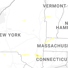
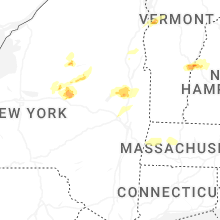


Connect with Interactive Hail Maps