

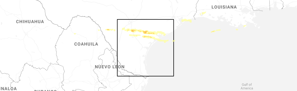
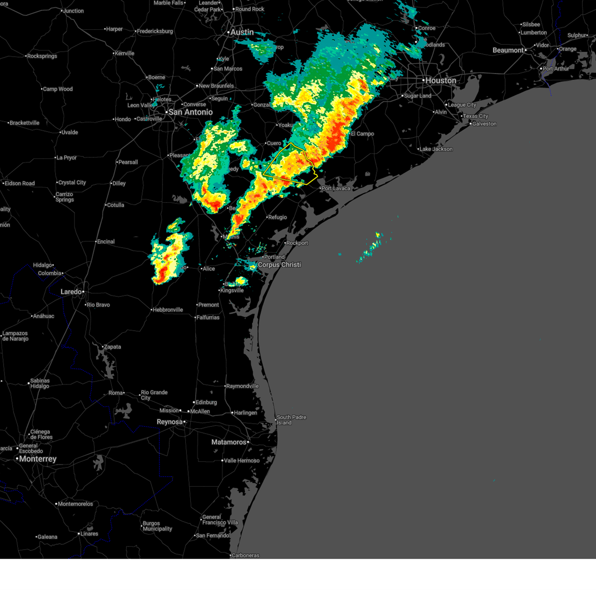
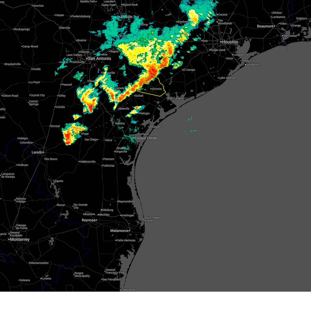
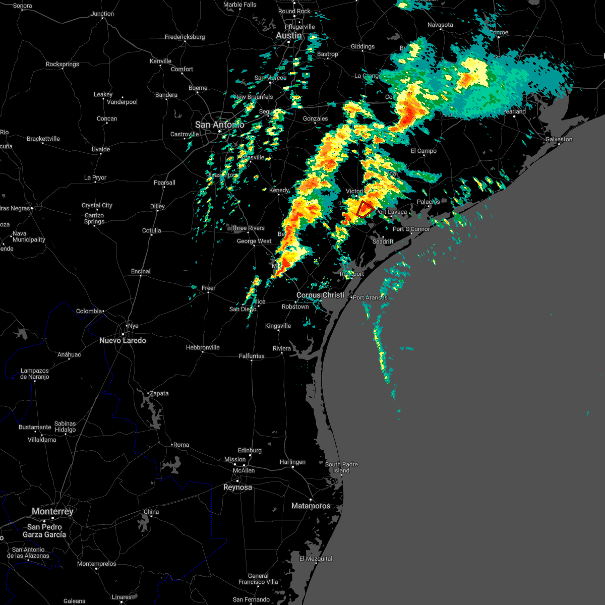
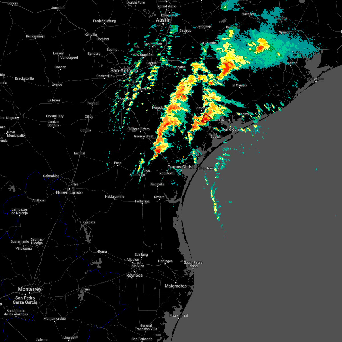
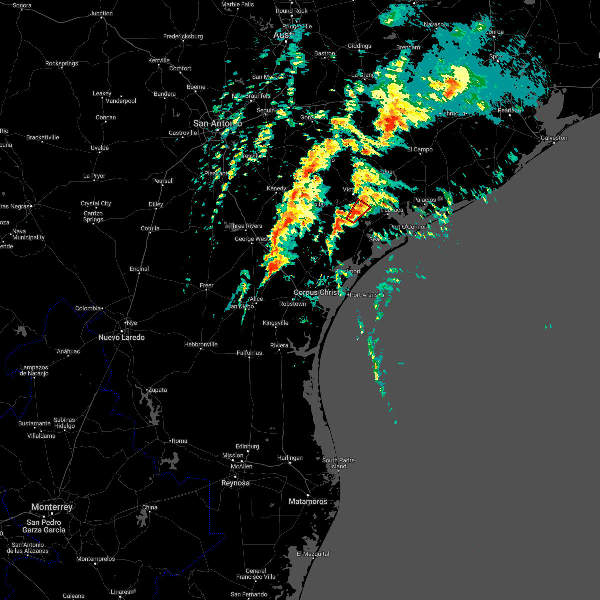
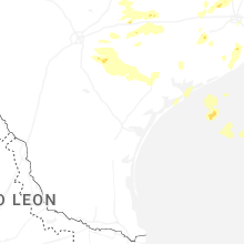
Hail Map for Placedo, TX
The Placedo, TX area has had 0 reports of on-the-ground hail by trained spotters, and has been under severe weather warnings 5 times during the past 12 months. Doppler radar has detected hail at or near Placedo, TX on 17 occasions, including 1 occasion during the past year.
| Name: | Placedo, TX |
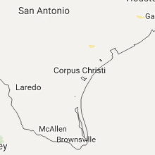
| Where Located: | 71.1 miles NNE of Corpus Christi, TX |
| Map: | Google Map for Placedo, TX |
| Population: | 692 |
| Housing Units: | 261 |
| More Info: | Search Google for Placedo, TX |
5
The Top Recent Hail Date for Placedo, TX is Friday, May 1, 2026 (4th out of 17)
Hail and Wind Damage Spotted near Placedo, TX
| Date / Time | Report Details |
|---|---|
| 5/27/2026 8:11 AM CDT |
 the severe thunderstorm warning has been cancelled and is no longer in effect the severe thunderstorm warning has been cancelled and is no longer in effect
|
| 5/27/2026 7:42 AM CDT |
 Svrcrp the national weather service in corpus christi has issued a * severe thunderstorm warning for, aransas county in south central texas, calhoun county in south texas, victoria county in south central texas, southeastern goliad county in south central texas, refugio county in south central texas, * until 845 am cdt. * at 742 am cdt, severe thunderstorms were located along a line extending from near fannin to 7 miles south of mcfaddin to copano village to 13 miles southeast of key allegro to 13 miles east of port aransas, moving northeast at 35 mph (radar indicated). Hazards include 60 mph wind gusts and nickel size hail. expect damage to roofs, siding, and trees Svrcrp the national weather service in corpus christi has issued a * severe thunderstorm warning for, aransas county in south central texas, calhoun county in south texas, victoria county in south central texas, southeastern goliad county in south central texas, refugio county in south central texas, * until 845 am cdt. * at 742 am cdt, severe thunderstorms were located along a line extending from near fannin to 7 miles south of mcfaddin to copano village to 13 miles southeast of key allegro to 13 miles east of port aransas, moving northeast at 35 mph (radar indicated). Hazards include 60 mph wind gusts and nickel size hail. expect damage to roofs, siding, and trees
|
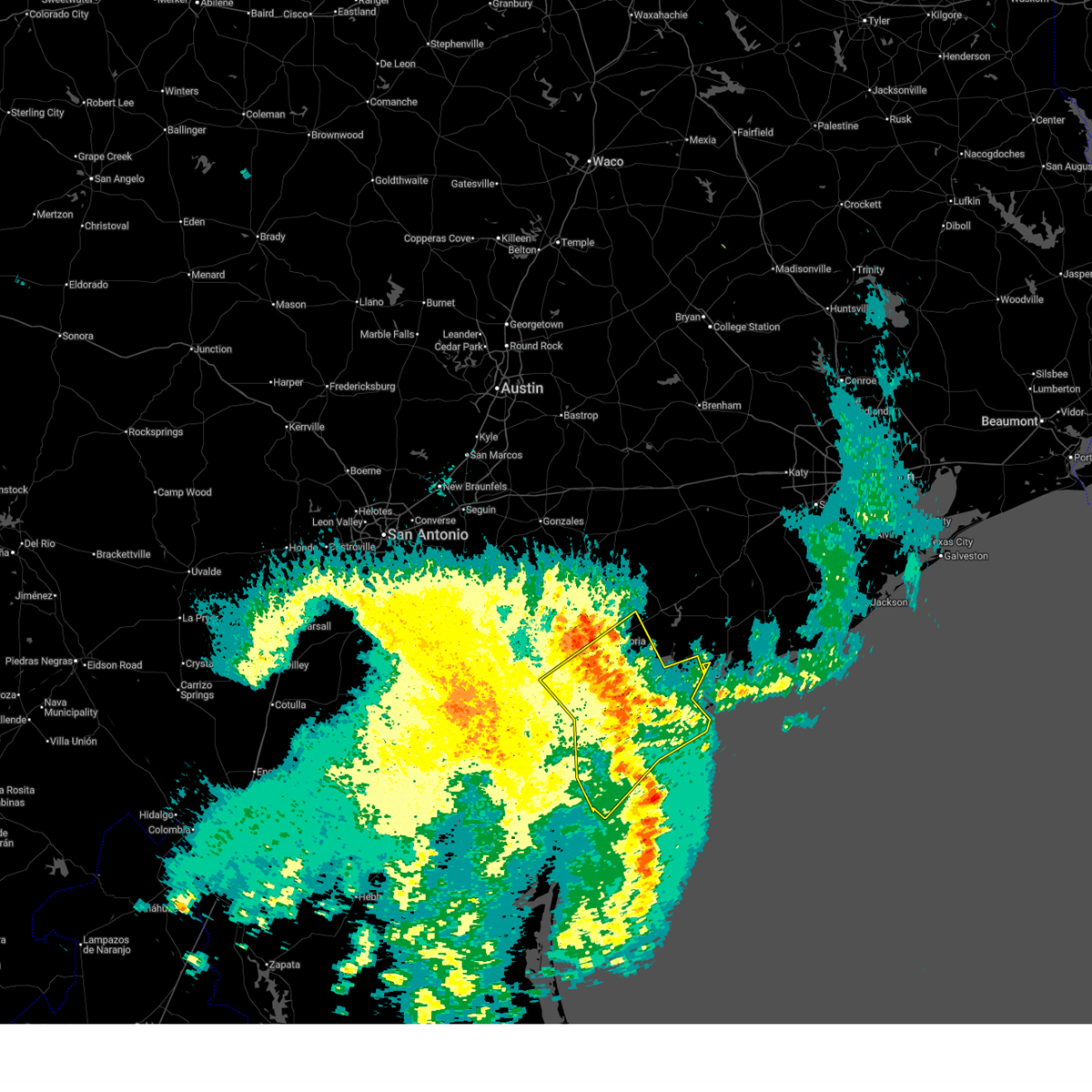
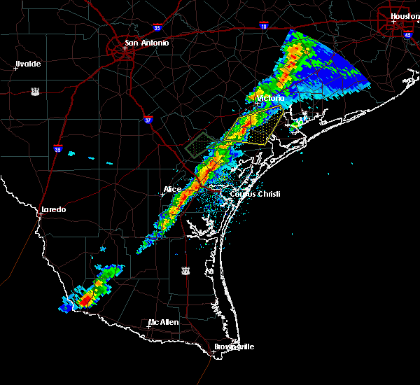
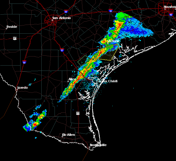
| 5/1/2026 2:08 PM CDT |
 Svrcrp the national weather service in corpus christi has issued a * severe thunderstorm warning for, northeastern calhoun county in south texas, east central victoria county in south central texas, * until 300 pm cdt. * at 207 pm cdt, a severe thunderstorm was located over dacosta, or 8 miles southeast of victoria, moving east at 50 mph (radar indicated. public reported quarter size hail). Hazards include 60 mph wind gusts and half dollar size hail. Hail damage to vehicles is expected. Expect wind damage to roofs, siding, and trees. Svrcrp the national weather service in corpus christi has issued a * severe thunderstorm warning for, northeastern calhoun county in south texas, east central victoria county in south central texas, * until 300 pm cdt. * at 207 pm cdt, a severe thunderstorm was located over dacosta, or 8 miles southeast of victoria, moving east at 50 mph (radar indicated. public reported quarter size hail). Hazards include 60 mph wind gusts and half dollar size hail. Hail damage to vehicles is expected. Expect wind damage to roofs, siding, and trees.
|
| 2/14/2026 5:45 PM CST |
 the severe thunderstorm warning has been cancelled and is no longer in effect the severe thunderstorm warning has been cancelled and is no longer in effect
|
| 2/14/2026 5:17 PM CST |
 Svrcrp the national weather service in corpus christi has issued a * severe thunderstorm warning for, victoria county in south central texas, northeastern goliad county in south central texas, * until 600 pm cst. * at 517 pm cst, severe thunderstorms were located along a line extending from 10 miles northwest of edna to ball airport area to near goliad, moving east at 50 mph (radar indicated). Hazards include 60 mph wind gusts and penny size hail. expect damage to roofs, siding, and trees Svrcrp the national weather service in corpus christi has issued a * severe thunderstorm warning for, victoria county in south central texas, northeastern goliad county in south central texas, * until 600 pm cst. * at 517 pm cst, severe thunderstorms were located along a line extending from 10 miles northwest of edna to ball airport area to near goliad, moving east at 50 mph (radar indicated). Hazards include 60 mph wind gusts and penny size hail. expect damage to roofs, siding, and trees
|
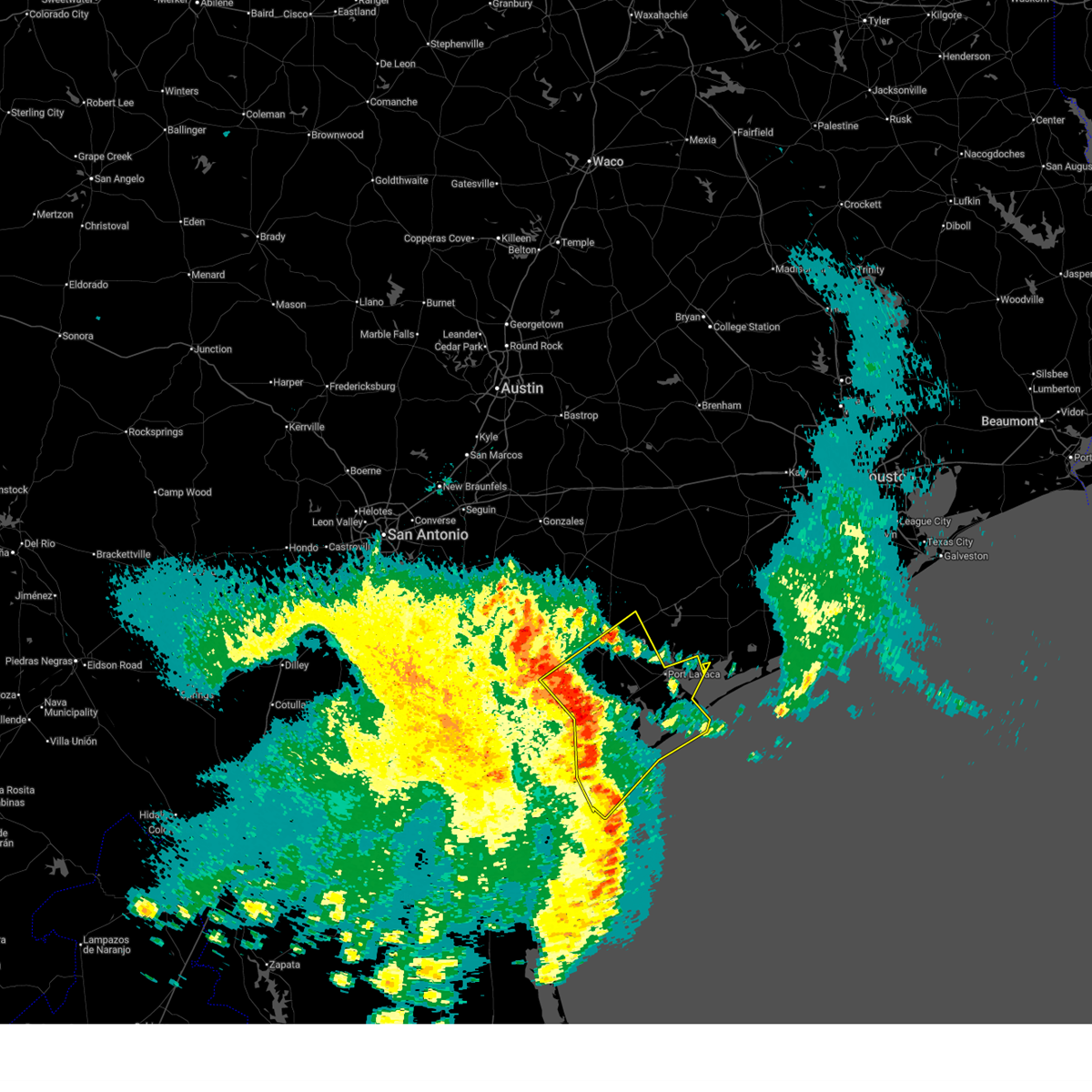
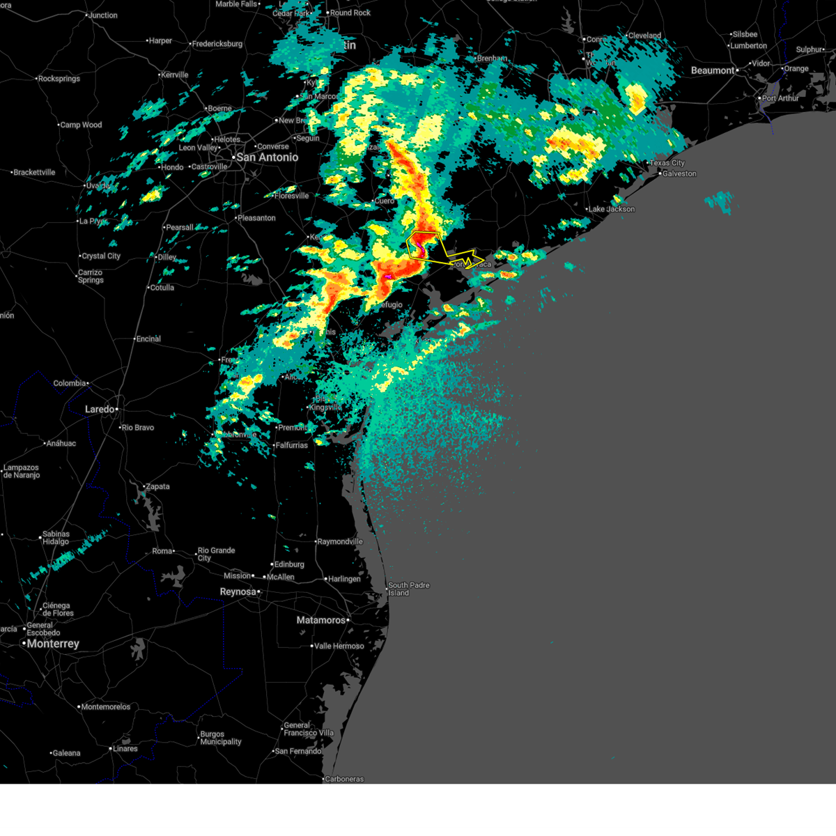
| 5/13/2024 3:11 PM CDT |
 At 311 pm cdt, a severe thunderstorm was located near point comfort, or near port lavaca, moving east at 55 mph (radar indicated). Hazards include 60 mph wind gusts and quarter size hail. Hail damage to vehicles is expected. expect wind damage to roofs, siding, and trees. locations impacted include, port lavaca, point comfort, placedo, and schicke point. This includes us highway 87 between mile markers 824 and 840. At 311 pm cdt, a severe thunderstorm was located near point comfort, or near port lavaca, moving east at 55 mph (radar indicated). Hazards include 60 mph wind gusts and quarter size hail. Hail damage to vehicles is expected. expect wind damage to roofs, siding, and trees. locations impacted include, port lavaca, point comfort, placedo, and schicke point. This includes us highway 87 between mile markers 824 and 840.
|
| 5/13/2024 3:02 PM CDT |
 Svrcrp the national weather service in corpus christi has issued a * severe thunderstorm warning for, northern calhoun county in south texas, east central victoria county in south central texas, * until 330 pm cdt. * at 302 pm cdt, a severe thunderstorm was located near placedo, or 11 miles northwest of port lavaca, moving east at 45 mph (radar indicated). Hazards include quarter size hail. damage to vehicles is expected Svrcrp the national weather service in corpus christi has issued a * severe thunderstorm warning for, northern calhoun county in south texas, east central victoria county in south central texas, * until 330 pm cdt. * at 302 pm cdt, a severe thunderstorm was located near placedo, or 11 miles northwest of port lavaca, moving east at 45 mph (radar indicated). Hazards include quarter size hail. damage to vehicles is expected
|
| 10/5/2023 8:48 AM CDT |
 At 847 am cdt, severe thunderstorms were located along a line extending from near lolita to near port lavaca to near mcfaddin, moving southeast at 35 mph (radar indicated). Hazards include 60 mph wind gusts. Expect damage to roofs, siding, and trees. locations impacted include, victoria, mcfaddin, guadalupe, alamo beach, dacosta, wood hi, bloomington, long mott, placedo, green lake, telferner, tivoli, and magnolia beach. this includes the following highways, us highway 59 between mile markers 628 and 642. us highway 77 between mile markers 586 and 606. us highway 87 between mile markers 814 and 840. hail threat, radar indicated max hail size, <. 75 in wind threat, radar indicated max wind gust, 60 mph. At 847 am cdt, severe thunderstorms were located along a line extending from near lolita to near port lavaca to near mcfaddin, moving southeast at 35 mph (radar indicated). Hazards include 60 mph wind gusts. Expect damage to roofs, siding, and trees. locations impacted include, victoria, mcfaddin, guadalupe, alamo beach, dacosta, wood hi, bloomington, long mott, placedo, green lake, telferner, tivoli, and magnolia beach. this includes the following highways, us highway 59 between mile markers 628 and 642. us highway 77 between mile markers 586 and 606. us highway 87 between mile markers 814 and 840. hail threat, radar indicated max hail size, <. 75 in wind threat, radar indicated max wind gust, 60 mph.
|
| 10/5/2023 8:30 AM CDT |
 At 830 am cdt, severe thunderstorms were located along a line extending from 6 miles south of edna to near placedo to near mcfaddin, moving southeast at 35 mph (radar indicated). Hazards include 60 mph wind gusts. Expect damage to roofs, siding, and trees. locations impacted include, victoria, goliad, mcfaddin, guadalupe, fannin, point comfort, victoria colony creek country club, long mott, victoria riverside park, victoria college, victoria mall, saxet lakes, green lake, brentwood subdivision, inez, salem, telferner, tivoli, downtown victoria, and alamo beach. this includes the following highways, us highway 183 between mile markers 638 and 640. us highway 59 between mile markers 624 and 664. us highway 77 between mile markers 562 and 606. us highway 87 between mile markers 804 and 840. hail threat, radar indicated max hail size, <. 75 in wind threat, radar indicated max wind gust, 60 mph. At 830 am cdt, severe thunderstorms were located along a line extending from 6 miles south of edna to near placedo to near mcfaddin, moving southeast at 35 mph (radar indicated). Hazards include 60 mph wind gusts. Expect damage to roofs, siding, and trees. locations impacted include, victoria, goliad, mcfaddin, guadalupe, fannin, point comfort, victoria colony creek country club, long mott, victoria riverside park, victoria college, victoria mall, saxet lakes, green lake, brentwood subdivision, inez, salem, telferner, tivoli, downtown victoria, and alamo beach. this includes the following highways, us highway 183 between mile markers 638 and 640. us highway 59 between mile markers 624 and 664. us highway 77 between mile markers 562 and 606. us highway 87 between mile markers 804 and 840. hail threat, radar indicated max hail size, <. 75 in wind threat, radar indicated max wind gust, 60 mph.
|
| 10/5/2023 8:13 AM CDT |
 At 813 am cdt, severe thunderstorms were located along a line extending from near inez to near telferner to coleto creek park, moving southeast at 35 mph (radar indicated). Hazards include 60 mph wind gusts. expect damage to roofs, siding, and trees At 813 am cdt, severe thunderstorms were located along a line extending from near inez to near telferner to coleto creek park, moving southeast at 35 mph (radar indicated). Hazards include 60 mph wind gusts. expect damage to roofs, siding, and trees
|
| 4/28/2023 8:32 PM CDT |
 At 831 pm cdt, severe thunderstorms were located along a line extending from 7 miles northeast of fordtran to near ander, moving southeast at 45 mph (radar indicated). Hazards include 60 mph wind gusts and quarter size hail. Hail damage to vehicles is expected. Expect wind damage to roofs, siding, and trees. At 831 pm cdt, severe thunderstorms were located along a line extending from 7 miles northeast of fordtran to near ander, moving southeast at 45 mph (radar indicated). Hazards include 60 mph wind gusts and quarter size hail. Hail damage to vehicles is expected. Expect wind damage to roofs, siding, and trees.
|
| 1/24/2023 12:55 PM CST |
 At 1255 pm cst, a severe thunderstorm capable of producing a tornado was located near mcfaddin, moving northeast at 45 mph (radar indicated rotation). Hazards include tornado. Flying debris will be dangerous to those caught without shelter. mobile homes will be damaged or destroyed. damage to roofs, windows, and vehicles will occur. tree damage is likely. this dangerous storm will be near, bloomington around 105 pm cst. guadalupe around 110 pm cst. dacosta and placedo around 115 pm cst. wood hi and telferner around 120 pm cst. this includes the following highways, us highway 59 between mile markers 628 and 630, and between mile markers 632 and 638. us highway 77 between mile markers 588 and 594. Us highway 87 between mile markers 816 and 824. At 1255 pm cst, a severe thunderstorm capable of producing a tornado was located near mcfaddin, moving northeast at 45 mph (radar indicated rotation). Hazards include tornado. Flying debris will be dangerous to those caught without shelter. mobile homes will be damaged or destroyed. damage to roofs, windows, and vehicles will occur. tree damage is likely. this dangerous storm will be near, bloomington around 105 pm cst. guadalupe around 110 pm cst. dacosta and placedo around 115 pm cst. wood hi and telferner around 120 pm cst. this includes the following highways, us highway 59 between mile markers 628 and 630, and between mile markers 632 and 638. us highway 77 between mile markers 588 and 594. Us highway 87 between mile markers 816 and 824.
|
| 1/24/2023 11:24 AM CST |
 The tornado warning for south central victoria county will expire at 1130 am cst, the storm which prompted the warning has weakened below severe limits, and no longer appears capable of producing a tornado. therefore, the warning will be allowed to expire. however gusty winds are still possible with this thunderstorm. a tornado watch remains in effect until 600 pm cst for south central texas. The tornado warning for south central victoria county will expire at 1130 am cst, the storm which prompted the warning has weakened below severe limits, and no longer appears capable of producing a tornado. therefore, the warning will be allowed to expire. however gusty winds are still possible with this thunderstorm. a tornado watch remains in effect until 600 pm cst for south central texas.
|
| 1/24/2023 11:16 AM CST |
 At 1116 am cst, a severe thunderstorm capable of producing a tornado was located over bloomington, or 7 miles northeast of mcfaddin, moving northeast at 35 mph (radar indicated rotation). Hazards include tornado. Flying debris will be dangerous to those caught without shelter. mobile homes will be damaged or destroyed. damage to roofs, windows, and vehicles will occur. tree damage is likely. this dangerous storm will be near, dacosta and placedo around 1125 am cst. This includes us highway 87 between mile markers 824 and 826. At 1116 am cst, a severe thunderstorm capable of producing a tornado was located over bloomington, or 7 miles northeast of mcfaddin, moving northeast at 35 mph (radar indicated rotation). Hazards include tornado. Flying debris will be dangerous to those caught without shelter. mobile homes will be damaged or destroyed. damage to roofs, windows, and vehicles will occur. tree damage is likely. this dangerous storm will be near, dacosta and placedo around 1125 am cst. This includes us highway 87 between mile markers 824 and 826.
|
| 1/24/2023 11:08 AM CST |
 At 1107 am cst, a severe thunderstorm capable of producing a tornado was located over mcfaddin, moving northeast at 35 mph (radar indicated rotation). Hazards include tornado. Flying debris will be dangerous to those caught without shelter. mobile homes will be damaged or destroyed. damage to roofs, windows, and vehicles will occur. tree damage is likely. this dangerous storm will be near, bloomington around 1120 am cst. placedo around 1130 am cst. this includes the following highways, us highway 77 between mile markers 594 and 596. Us highway 87 near mile marker 826. At 1107 am cst, a severe thunderstorm capable of producing a tornado was located over mcfaddin, moving northeast at 35 mph (radar indicated rotation). Hazards include tornado. Flying debris will be dangerous to those caught without shelter. mobile homes will be damaged or destroyed. damage to roofs, windows, and vehicles will occur. tree damage is likely. this dangerous storm will be near, bloomington around 1120 am cst. placedo around 1130 am cst. this includes the following highways, us highway 77 between mile markers 594 and 596. Us highway 87 near mile marker 826.
|
| 1/24/2023 10:56 AM CST |
 At 1055 am cst, a severe thunderstorm capable of producing a tornado was located near mcfaddin, moving northeast at 35 mph (radar indicated rotation). Hazards include tornado. Flying debris will be dangerous to those caught without shelter. mobile homes will be damaged or destroyed. damage to roofs, windows, and vehicles will occur. tree damage is likely. this dangerous storm will be near, mcfaddin around 1105 am cst. bloomington around 1120 am cst. placedo around 1130 am cst. this includes the following highways, us highway 77 between mile markers 592 and 606. Us highway 87 near mile marker 826. At 1055 am cst, a severe thunderstorm capable of producing a tornado was located near mcfaddin, moving northeast at 35 mph (radar indicated rotation). Hazards include tornado. Flying debris will be dangerous to those caught without shelter. mobile homes will be damaged or destroyed. damage to roofs, windows, and vehicles will occur. tree damage is likely. this dangerous storm will be near, mcfaddin around 1105 am cst. bloomington around 1120 am cst. placedo around 1130 am cst. this includes the following highways, us highway 77 between mile markers 592 and 606. Us highway 87 near mile marker 826.
|
| 1/8/2023 12:04 AM CST |
 At 1203 am cst, a severe thunderstorm was located near nursery, or 7 miles west of victoria, moving east at 25 mph (radar indicated). Hazards include 60 mph wind gusts and quarter size hail. Hail damage to vehicles is expected. Expect wind damage to roofs, siding, and trees. At 1203 am cst, a severe thunderstorm was located near nursery, or 7 miles west of victoria, moving east at 25 mph (radar indicated). Hazards include 60 mph wind gusts and quarter size hail. Hail damage to vehicles is expected. Expect wind damage to roofs, siding, and trees.
|
| 7/14/2022 5:42 PM CDT |
 At 541 pm cdt, severe thunderstorms were located along a line extending from near placedo to near oak village to near goliad, moving south at 25 mph. at 509 pm cdt, kvct reported a peak wind gust of 58 mph (radar indicated). Hazards include 60 mph wind gusts. Expect damage to roofs, siding, and trees. locations impacted include, victoria, guadalupe, fannin, victoria riverside park, schroeder, placedo, coleto creek park, dacosta, saxet lakes, oak village, bloomington and downtown victoria. this includes the following highways, us highway 183 between mile markers 632 and 634. us highway 59 between mile markers 636 and 664. us highway 77 between mile markers 580 and 594. us highway 87 between mile markers 812 and 830. hail threat, radar indicated max hail size, <. 75 in wind threat, observed max wind gust, 60 mph. At 541 pm cdt, severe thunderstorms were located along a line extending from near placedo to near oak village to near goliad, moving south at 25 mph. at 509 pm cdt, kvct reported a peak wind gust of 58 mph (radar indicated). Hazards include 60 mph wind gusts. Expect damage to roofs, siding, and trees. locations impacted include, victoria, guadalupe, fannin, victoria riverside park, schroeder, placedo, coleto creek park, dacosta, saxet lakes, oak village, bloomington and downtown victoria. this includes the following highways, us highway 183 between mile markers 632 and 634. us highway 59 between mile markers 636 and 664. us highway 77 between mile markers 580 and 594. us highway 87 between mile markers 812 and 830. hail threat, radar indicated max hail size, <. 75 in wind threat, observed max wind gust, 60 mph.
|
| 7/14/2022 5:12 PM CDT |
 At 512 pm cdt, severe thunderstorms were located along a line extending from near inez to victoria detar hospital north to near ander, moving south at 20 mph (radar indicated). Hazards include 60 mph wind gusts and penny size hail. expect damage to roofs, siding, and trees At 512 pm cdt, severe thunderstorms were located along a line extending from near inez to victoria detar hospital north to near ander, moving south at 20 mph (radar indicated). Hazards include 60 mph wind gusts and penny size hail. expect damage to roofs, siding, and trees
|
| 5/25/2022 2:55 AM CDT |
 The severe thunderstorm warning for aransas, calhoun, southeastern victoria, southeastern goliad and refugio counties will expire at 300 am cdt, the storms which prompted the warning have weakened below severe limits, and no longer pose an immediate threat to life or property. therefore, the warning will be allowed to expire. however heavy rain is still possible with these thunderstorms. a severe thunderstorm watch remains in effect until 500 am cdt for south central and south texas. to report severe weather, contact your nearest law enforcement agency. they will relay your report to the national weather service corpus christi. The severe thunderstorm warning for aransas, calhoun, southeastern victoria, southeastern goliad and refugio counties will expire at 300 am cdt, the storms which prompted the warning have weakened below severe limits, and no longer pose an immediate threat to life or property. therefore, the warning will be allowed to expire. however heavy rain is still possible with these thunderstorms. a severe thunderstorm watch remains in effect until 500 am cdt for south central and south texas. to report severe weather, contact your nearest law enforcement agency. they will relay your report to the national weather service corpus christi.
|
| 5/25/2022 1:56 AM CDT |
 At 155 am cdt, severe thunderstorms were located along a line extending from near inez to near bloomington to near quintana, moving southeast at 45 mph (radar indicated). Hazards include 70 mph wind gusts and penny size hail. Expect considerable tree damage. Damage is likely to mobile homes, roofs, and outbuildings. At 155 am cdt, severe thunderstorms were located along a line extending from near inez to near bloomington to near quintana, moving southeast at 45 mph (radar indicated). Hazards include 70 mph wind gusts and penny size hail. Expect considerable tree damage. Damage is likely to mobile homes, roofs, and outbuildings.
|
| 6/5/2021 8:03 PM CDT |
 At 802 pm cdt, a severe thunderstorm was located over guadalupe, or 8 miles southeast of victoria, moving east at 15 mph (radar indicated). Hazards include 60 mph wind gusts and penny size hail. Expect damage to roofs, siding, and trees. locations impacted include, guadalupe, placedo, dacosta and bloomington. this includes the following highways, us highway 59 between mile markers 638 and 640. us highway 87 between mile markers 816 and 824. Precautionary/preparedness actions, for your protection move to an interior room on the lowest floor of a building. At 802 pm cdt, a severe thunderstorm was located over guadalupe, or 8 miles southeast of victoria, moving east at 15 mph (radar indicated). Hazards include 60 mph wind gusts and penny size hail. Expect damage to roofs, siding, and trees. locations impacted include, guadalupe, placedo, dacosta and bloomington. this includes the following highways, us highway 59 between mile markers 638 and 640. us highway 87 between mile markers 816 and 824. Precautionary/preparedness actions, for your protection move to an interior room on the lowest floor of a building.
|
| 6/5/2021 7:57 PM CDT |
 At 756 pm cdt, a severe thunderstorm was located over guadalupe, or just south of victoria, moving east at 20 mph (radar indicated). Hazards include 60 mph wind gusts and nickel size hail. Expect damage to roofs, siding, and trees. locations impacted include, victoria, guadalupe, placedo, dacosta, saxet lakes and bloomington. this includes the following highways, us highway 59 between mile markers 638 and 645. us highway 77 between mile markers 586 and 590. us highway 87 between mile markers 816 and 824. Precautionary/preparedness actions, for your protection move to an interior room on the lowest floor of a building. At 756 pm cdt, a severe thunderstorm was located over guadalupe, or just south of victoria, moving east at 20 mph (radar indicated). Hazards include 60 mph wind gusts and nickel size hail. Expect damage to roofs, siding, and trees. locations impacted include, victoria, guadalupe, placedo, dacosta, saxet lakes and bloomington. this includes the following highways, us highway 59 between mile markers 638 and 645. us highway 77 between mile markers 586 and 590. us highway 87 between mile markers 816 and 824. Precautionary/preparedness actions, for your protection move to an interior room on the lowest floor of a building.
|
| 6/5/2021 7:46 PM CDT |
 At 746 pm cdt, a severe thunderstorm was located near saxet lakes, or near victoria, moving east at 20 mph (radar indicated). Hazards include 60 mph wind gusts and quarter size hail. Hail damage to vehicles is expected. Expect wind damage to roofs, siding, and trees. At 746 pm cdt, a severe thunderstorm was located near saxet lakes, or near victoria, moving east at 20 mph (radar indicated). Hazards include 60 mph wind gusts and quarter size hail. Hail damage to vehicles is expected. Expect wind damage to roofs, siding, and trees.
|
| 8/2/2020 8:17 PM CDT |
 At 817 pm cdt, severe thunderstorms were located along a line extending from near weesatche to near oak village to 8 miles northwest of point comfort, moving south at 20 mph (radar indicated). Hazards include 60 mph wind gusts and quarter size hail. Hail damage to vehicles is expected. Expect wind damage to roofs, siding, and trees. At 817 pm cdt, severe thunderstorms were located along a line extending from near weesatche to near oak village to 8 miles northwest of point comfort, moving south at 20 mph (radar indicated). Hazards include 60 mph wind gusts and quarter size hail. Hail damage to vehicles is expected. Expect wind damage to roofs, siding, and trees.
|
| 5/16/2020 2:04 AM CDT |
 At 203 am cdt, severe thunderstorms were located along a line extending from 9 miles southwest of speaks to near quintana, moving east at 35 mph (radar indicated). Hazards include 60 mph wind gusts and penny size hail. Expect damage to roofs, siding, and trees. Locations impacted include, victoria, refugio, woodsboro, mcfaddin, guadalupe, fannin, quintana, victoria colony creek country club, nursery, victoria riverside park, victoria college, victoria mall, saxet lakes, inez, salem, telferner, tivoli, downtown victoria, dacosta and wood hi. At 203 am cdt, severe thunderstorms were located along a line extending from 9 miles southwest of speaks to near quintana, moving east at 35 mph (radar indicated). Hazards include 60 mph wind gusts and penny size hail. Expect damage to roofs, siding, and trees. Locations impacted include, victoria, refugio, woodsboro, mcfaddin, guadalupe, fannin, quintana, victoria colony creek country club, nursery, victoria riverside park, victoria college, victoria mall, saxet lakes, inez, salem, telferner, tivoli, downtown victoria, dacosta and wood hi.
|
| 5/16/2020 1:09 AM CDT |
 At 108 am cdt, severe thunderstorms were located along a line extending from near cuero to near papalote, moving east at 35 mph (radar indicated). Hazards include 60 mph wind gusts and penny size hail. expect damage to roofs, siding, and trees At 108 am cdt, severe thunderstorms were located along a line extending from near cuero to near papalote, moving east at 35 mph (radar indicated). Hazards include 60 mph wind gusts and penny size hail. expect damage to roofs, siding, and trees
|
| 6/6/2019 6:18 PM CDT |
 At 617 pm cdt, a severe thunderstorm was located near mission valley, or 13 miles west of victoria, moving southeast at 30 mph (radar indicated). Hazards include 60 mph wind gusts and half dollar size hail. Hail damage to vehicles is expected. Expect wind damage to roofs, siding, and trees. At 617 pm cdt, a severe thunderstorm was located near mission valley, or 13 miles west of victoria, moving southeast at 30 mph (radar indicated). Hazards include 60 mph wind gusts and half dollar size hail. Hail damage to vehicles is expected. Expect wind damage to roofs, siding, and trees.
|
| 5/9/2019 11:41 PM CDT |
 At 1140 pm cdt, severe thunderstorms were located along a line extending from 8 miles northeast of salem to 18 miles east of key allegro, moving east at 35 mph (radar indicated). Hazards include 60 mph wind gusts and penny size hail. expect damage to roofs, siding, and trees At 1140 pm cdt, severe thunderstorms were located along a line extending from 8 miles northeast of salem to 18 miles east of key allegro, moving east at 35 mph (radar indicated). Hazards include 60 mph wind gusts and penny size hail. expect damage to roofs, siding, and trees
|
| 5/9/2019 11:30 PM CDT |
 At 1129 pm cdt, severe thunderstorms were located along a line extending from 9 miles northwest of point comfort to near aransas national wildlife refuge, moving east at 40 mph (radar indicated). Hazards include 60 mph wind gusts and penny size hail. Expect damage to roofs, siding, and trees. Locations impacted include, victoria, port lavaca, seadrift, mcfaddin, guadalupe, point comfort, quintana, victoria colony creek country club, alamo beach, dacosta, wood hi, bloomington, long mott, victoria riverside park, placedo, victoria college, saxet lakes, green lake, holiday beach and tivoli. At 1129 pm cdt, severe thunderstorms were located along a line extending from 9 miles northwest of point comfort to near aransas national wildlife refuge, moving east at 40 mph (radar indicated). Hazards include 60 mph wind gusts and penny size hail. Expect damage to roofs, siding, and trees. Locations impacted include, victoria, port lavaca, seadrift, mcfaddin, guadalupe, point comfort, quintana, victoria colony creek country club, alamo beach, dacosta, wood hi, bloomington, long mott, victoria riverside park, placedo, victoria college, saxet lakes, green lake, holiday beach and tivoli.
|
| 5/9/2019 10:56 PM CDT |
 At 1055 pm cdt, severe thunderstorms were located along a line extending from near saxet lakes to near quintana, moving east at 40 mph (radar indicated). Hazards include 60 mph wind gusts and quarter size hail. Hail damage to vehicles is expected. Expect wind damage to roofs, siding, and trees. At 1055 pm cdt, severe thunderstorms were located along a line extending from near saxet lakes to near quintana, moving east at 40 mph (radar indicated). Hazards include 60 mph wind gusts and quarter size hail. Hail damage to vehicles is expected. Expect wind damage to roofs, siding, and trees.
|
| 5/3/2019 11:13 PM CDT |
 At 1113 pm cdt, severe thunderstorms were located along a line extending from near placedo to lagarto, moving southeast at 30 mph (radar indicated). Hazards include 60 mph wind gusts and quarter size hail. Hail damage to vehicles is expected. expect wind damage to roofs, siding, and trees. Locations impacted include, victoria, beeville, george west, goliad, three rivers, mcfaddin, skidmore, guadalupe, fannin, victoria colony creek country club, river creek acres, nursery, victoria riverside park, victoria college, victoria mall, saxet lakes, argenta, karon, mount lucas and salem. At 1113 pm cdt, severe thunderstorms were located along a line extending from near placedo to lagarto, moving southeast at 30 mph (radar indicated). Hazards include 60 mph wind gusts and quarter size hail. Hail damage to vehicles is expected. expect wind damage to roofs, siding, and trees. Locations impacted include, victoria, beeville, george west, goliad, three rivers, mcfaddin, skidmore, guadalupe, fannin, victoria colony creek country club, river creek acres, nursery, victoria riverside park, victoria college, victoria mall, saxet lakes, argenta, karon, mount lucas and salem.
|
| 5/3/2019 11:13 PM CDT |
 A severe thunderstorm warning remains in effect until 1130 pm cdt for northwestern calhoun. victoria. goliad. central live oak. northwestern refugio and bee counties. at 1113 pm cdt, severe thunderstorms were located along a line extending from near placedo to lagarto, moving southeast at 30 mph. hazard. 60 mph wind gusts and quarter size hail. A severe thunderstorm warning remains in effect until 1130 pm cdt for northwestern calhoun. victoria. goliad. central live oak. northwestern refugio and bee counties. at 1113 pm cdt, severe thunderstorms were located along a line extending from near placedo to lagarto, moving southeast at 30 mph. hazard. 60 mph wind gusts and quarter size hail.
|
| 5/3/2019 10:41 PM CDT |
 At 1041 pm cdt, severe thunderstorms were located along a line extending from near telferner to george west, moving southeast at 30 mph (radar indicated). Hazards include 60 mph wind gusts and quarter size hail. Hail damage to vehicles is expected. Expect wind damage to roofs, siding, and trees. At 1041 pm cdt, severe thunderstorms were located along a line extending from near telferner to george west, moving southeast at 30 mph (radar indicated). Hazards include 60 mph wind gusts and quarter size hail. Hail damage to vehicles is expected. Expect wind damage to roofs, siding, and trees.
|
| 4/24/2019 7:40 PM CDT |
 The severe thunderstorm warning for northwestern calhoun, southern victoria, southeastern goliad and northeastern refugio counties will expire at 745 pm cdt, the storm which prompted the warning has weakened below severe limits, and no longer poses an immediate threat to life or property. therefore, the warning will be allowed to expire. however gusty winds are still possible with this thunderstorm. The severe thunderstorm warning for northwestern calhoun, southern victoria, southeastern goliad and northeastern refugio counties will expire at 745 pm cdt, the storm which prompted the warning has weakened below severe limits, and no longer poses an immediate threat to life or property. therefore, the warning will be allowed to expire. however gusty winds are still possible with this thunderstorm.
|
| 4/24/2019 7:30 PM CDT |
 At 730 pm cdt, a severe thunderstorm was located near mcfaddin, moving east at 40 mph (radar indicated). Hazards include 60 mph wind gusts and penny size hail. Expect damage to roofs, siding, and trees. Locations impacted include, mcfaddin, placedo, dacosta, green lake, bloomington, tivoli and austwell. At 730 pm cdt, a severe thunderstorm was located near mcfaddin, moving east at 40 mph (radar indicated). Hazards include 60 mph wind gusts and penny size hail. Expect damage to roofs, siding, and trees. Locations impacted include, mcfaddin, placedo, dacosta, green lake, bloomington, tivoli and austwell.
|
| 4/24/2019 7:13 PM CDT |
 At 713 pm cdt, a severe thunderstorm was located 12 miles south of fannin, or 13 miles southeast of goliad, moving east at 30 mph (radar indicated). Hazards include 60 mph wind gusts and penny size hail. Expect damage to roofs, siding, and trees. Locations impacted include, mcfaddin, quintana, placedo, dacosta, green lake, bloomington, tivoli and austwell. At 713 pm cdt, a severe thunderstorm was located 12 miles south of fannin, or 13 miles southeast of goliad, moving east at 30 mph (radar indicated). Hazards include 60 mph wind gusts and penny size hail. Expect damage to roofs, siding, and trees. Locations impacted include, mcfaddin, quintana, placedo, dacosta, green lake, bloomington, tivoli and austwell.
|
| 4/24/2019 7:06 PM CDT |
 At 705 pm cdt, severe thunderstorms were located along a line extending from near schroeder to near woodsboro, moving east at 40 mph (radar indicated). Hazards include 60 mph wind gusts and nickel size hail. Expect damage to roofs, siding, and trees. Locations impacted include, victoria, mcfaddin, guadalupe, fannin, quintana, victoria colony creek country club, nursery, victoria riverside park, victoria college, victoria mall, saxet lakes, green lake, inez, salem, telferner, tivoli, downtown victoria, fordtran, schroeder and dacosta. At 705 pm cdt, severe thunderstorms were located along a line extending from near schroeder to near woodsboro, moving east at 40 mph (radar indicated). Hazards include 60 mph wind gusts and nickel size hail. Expect damage to roofs, siding, and trees. Locations impacted include, victoria, mcfaddin, guadalupe, fannin, quintana, victoria colony creek country club, nursery, victoria riverside park, victoria college, victoria mall, saxet lakes, green lake, inez, salem, telferner, tivoli, downtown victoria, fordtran, schroeder and dacosta.
|
| 4/24/2019 6:53 PM CDT |
 At 652 pm cdt, severe thunderstorms were located along a line extending from near schroeder to 9 miles northeast of papalote, moving east at 40 mph (radar indicated). Hazards include 60 mph wind gusts and quarter size hail. Hail damage to vehicles is expected. Expect wind damage to roofs, siding, and trees. At 652 pm cdt, severe thunderstorms were located along a line extending from near schroeder to 9 miles northeast of papalote, moving east at 40 mph (radar indicated). Hazards include 60 mph wind gusts and quarter size hail. Hail damage to vehicles is expected. Expect wind damage to roofs, siding, and trees.
|
| 4/14/2018 2:07 AM CDT |
 At 207 am cdt, severe thunderstorms were located along a line extending from near point comfort to 7 miles south of berclair to san patricio, moving southeast at 50 mph (radar indicated). Hazards include 60 mph wind gusts. Expect damage to roofs, siding, and trees. Locations impacted include, victoria, portland, beeville, port lavaca, rockport, sinton, mathis, taft, refugio, goliad, woodsboro, seadrift, mcfaddin, port oconnor, skidmore, guadalupe, lamar, fannin, ingleside and aransas pass. At 207 am cdt, severe thunderstorms were located along a line extending from near point comfort to 7 miles south of berclair to san patricio, moving southeast at 50 mph (radar indicated). Hazards include 60 mph wind gusts. Expect damage to roofs, siding, and trees. Locations impacted include, victoria, portland, beeville, port lavaca, rockport, sinton, mathis, taft, refugio, goliad, woodsboro, seadrift, mcfaddin, port oconnor, skidmore, guadalupe, lamar, fannin, ingleside and aransas pass.
|
| 4/14/2018 1:45 AM CDT |
 At 144 am cdt, severe thunderstorms were located along a line extending from near inez to pettus to near mount lucas, moving southeast at 50 mph (radar indicated). Hazards include 60 mph wind gusts and penny size hail. expect damage to roofs, siding, and trees At 144 am cdt, severe thunderstorms were located along a line extending from near inez to pettus to near mount lucas, moving southeast at 50 mph (radar indicated). Hazards include 60 mph wind gusts and penny size hail. expect damage to roofs, siding, and trees
|
| 7/15/2017 6:19 PM CDT |
 At 617 pm cdt, a severe thunderstorm was located over dacosta, or 7 miles southeast of victoria, moving southwest at 20 mph (trained weather spotter reported a wind gust of 57 mph 8 miles east of the victoria airport). Hazards include 60 mph wind gusts and quarter size hail. Hail damage to vehicles is expected. expect wind damage to roofs, siding, and trees. Locations impacted include, victoria, guadalupe, victoria colony creek country club, placedo, victoria college, dacosta, wood hi, bloomington, inez, victoria regional airport and telferner. At 617 pm cdt, a severe thunderstorm was located over dacosta, or 7 miles southeast of victoria, moving southwest at 20 mph (trained weather spotter reported a wind gust of 57 mph 8 miles east of the victoria airport). Hazards include 60 mph wind gusts and quarter size hail. Hail damage to vehicles is expected. expect wind damage to roofs, siding, and trees. Locations impacted include, victoria, guadalupe, victoria colony creek country club, placedo, victoria college, dacosta, wood hi, bloomington, inez, victoria regional airport and telferner.
|
| 7/15/2017 5:53 PM CDT |
 At 553 pm cdt, a severe thunderstorm was located near inez, or 11 miles east of victoria, moving southwest at 20 mph (radar indicated). Hazards include 60 mph wind gusts and quarter size hail. Hail damage to vehicles is expected. Expect wind damage to roofs, siding, and trees. At 553 pm cdt, a severe thunderstorm was located near inez, or 11 miles east of victoria, moving southwest at 20 mph (radar indicated). Hazards include 60 mph wind gusts and quarter size hail. Hail damage to vehicles is expected. Expect wind damage to roofs, siding, and trees.
|
| 6/19/2016 4:47 AM CDT |
 At 447 am cdt, severe thunderstorms were located along a line extending from near tivoli to near ander, moving southwest at 50 mph (radar indicated). Hazards include 60 mph wind gusts. Expect damage to roofs. siding. and trees. Locations impacted include, victoria, port lavaca, mcfaddin, guadalupe, fannin, point comfort, point comfort, victoria detar hospital north, dacosta, coleto creek park, nursery, wood hi, victoria regional airport, downtown victoria, kamey, tivoli, kamay, victoria colony creek country club, victoria college and saxet lakes. At 447 am cdt, severe thunderstorms were located along a line extending from near tivoli to near ander, moving southwest at 50 mph (radar indicated). Hazards include 60 mph wind gusts. Expect damage to roofs. siding. and trees. Locations impacted include, victoria, port lavaca, mcfaddin, guadalupe, fannin, point comfort, point comfort, victoria detar hospital north, dacosta, coleto creek park, nursery, wood hi, victoria regional airport, downtown victoria, kamey, tivoli, kamay, victoria colony creek country club, victoria college and saxet lakes.
|
| 6/19/2016 4:10 AM CDT |
 At 410 am cdt, a severe thunderstorm was located over guadalupe, or near victoria, moving southwest at 55 mph (radar indicated). Hazards include 60 mph wind gusts. Expect damage to roofs. siding. And trees. At 410 am cdt, a severe thunderstorm was located over guadalupe, or near victoria, moving southwest at 55 mph (radar indicated). Hazards include 60 mph wind gusts. Expect damage to roofs. siding. And trees.
|
| 5/27/2016 7:20 PM CDT |
 At 719 pm cdt, severe thunderstorms were located along a line extending from inez to near victoria regional airport to near saxet lakes, moving southeast at 20 mph (radar indicated). Hazards include 60 mph wind gusts and quarter size hail. Hail damage to vehicles is expected. expect wind damage to roofs, siding, and trees. Locations impacted include, victoria, guadalupe, victoria detar hospital north, salem, dacosta, inez, nursery, victoria mall, wood hi, victoria regional airport, downtown victoria, victoria riverside park, fordtran, telferner, victoria colony creek country club, victoria college, mission valley, saxet lakes and placedo. At 719 pm cdt, severe thunderstorms were located along a line extending from inez to near victoria regional airport to near saxet lakes, moving southeast at 20 mph (radar indicated). Hazards include 60 mph wind gusts and quarter size hail. Hail damage to vehicles is expected. expect wind damage to roofs, siding, and trees. Locations impacted include, victoria, guadalupe, victoria detar hospital north, salem, dacosta, inez, nursery, victoria mall, wood hi, victoria regional airport, downtown victoria, victoria riverside park, fordtran, telferner, victoria colony creek country club, victoria college, mission valley, saxet lakes and placedo.
|
| 5/27/2016 6:40 PM CDT |
 At 639 pm cdt, severe thunderstorms were located along a line extending from near fordtran to near nursery to near mission valley, moving southeast at 20 mph (radar indicated). Hazards include 60 mph wind gusts and quarter size hail. Hail damage to vehicles is expected. Expect wind damage to roofs, siding, and trees. At 639 pm cdt, severe thunderstorms were located along a line extending from near fordtran to near nursery to near mission valley, moving southeast at 20 mph (radar indicated). Hazards include 60 mph wind gusts and quarter size hail. Hail damage to vehicles is expected. Expect wind damage to roofs, siding, and trees.
|
| 3/18/2016 11:53 PM CDT |
 At 1151 pm cdt, a strong to severe thunderstorm was located over victoria colony creek country club, or over victoria, moving southeast at 15 mph. this storm has weakened slightly, but could still become severe. we will monitor and re-issue a warning if the storm intensifies again (radar indicated). Hazards include 50 to 60 mph wind gusts and dime to quarter size hail. Hail damage to vehicles is expected. expect wind damage to roofs, siding, and trees. Locations impacted include, victoria, guadalupe, victoria detar hospital north, salem, dacosta, inez, nursery, victoria mall, wood hi, victoria regional airport, downtown victoria, victoria riverside park, telferner, victoria colony creek country club, victoria college, mission valley, saxet lakes and placedo. At 1151 pm cdt, a strong to severe thunderstorm was located over victoria colony creek country club, or over victoria, moving southeast at 15 mph. this storm has weakened slightly, but could still become severe. we will monitor and re-issue a warning if the storm intensifies again (radar indicated). Hazards include 50 to 60 mph wind gusts and dime to quarter size hail. Hail damage to vehicles is expected. expect wind damage to roofs, siding, and trees. Locations impacted include, victoria, guadalupe, victoria detar hospital north, salem, dacosta, inez, nursery, victoria mall, wood hi, victoria regional airport, downtown victoria, victoria riverside park, telferner, victoria colony creek country club, victoria college, mission valley, saxet lakes and placedo.
|
| 3/18/2016 11:34 PM CDT |
 At 1133 pm cdt, a severe thunderstorm was located near thomaston, or 12 miles northwest of victoria, moving northeast at 20 mph. another strong to severe storm is approaching the victoria area. take cover now! (radar indicated). Hazards include 60 mph wind gusts and quarter size hail. Hail damage to vehicles is expected. expect wind damage to roofs, siding, and trees. Locations impacted include, victoria, guadalupe, victoria detar hospital north, salem, dacosta, inez, nursery, victoria mall, wood hi, victoria regional airport, downtown victoria, victoria riverside park, fordtran, telferner, victoria colony creek country club, victoria college, mission valley, saxet lakes and placedo. At 1133 pm cdt, a severe thunderstorm was located near thomaston, or 12 miles northwest of victoria, moving northeast at 20 mph. another strong to severe storm is approaching the victoria area. take cover now! (radar indicated). Hazards include 60 mph wind gusts and quarter size hail. Hail damage to vehicles is expected. expect wind damage to roofs, siding, and trees. Locations impacted include, victoria, guadalupe, victoria detar hospital north, salem, dacosta, inez, nursery, victoria mall, wood hi, victoria regional airport, downtown victoria, victoria riverside park, fordtran, telferner, victoria colony creek country club, victoria college, mission valley, saxet lakes and placedo.
|
| 3/18/2016 11:11 PM CDT |
 At 1110 pm cdt, a severe thunderstorm was located over nursery, or 10 miles northwest of victoria, moving northeast at 15 mph (radar indicated). Hazards include 60 mph wind gusts and quarter size hail. Hail damage to vehicles is expected. Expect wind damage to roofs, siding, and trees. At 1110 pm cdt, a severe thunderstorm was located over nursery, or 10 miles northwest of victoria, moving northeast at 15 mph (radar indicated). Hazards include 60 mph wind gusts and quarter size hail. Hail damage to vehicles is expected. Expect wind damage to roofs, siding, and trees.
|
| 3/9/2016 8:55 AM CST |
 At 854 am cst, severe thunderstorms were located along a line extending from near cuero to 7 miles southeast of fannin to near tivoli, moving northeast at 40 mph (radar indicated). Hazards include 60 mph wind gusts. Expect damage to roofs. siding. and trees. Locations impacted include, victoria, port lavaca, seadrift, mcfaddin, guadalupe, fannin, victoria detar hospital north, long mott, dacosta, coleto creek park, nursery, wood hi, victoria regional airport, downtown victoria, kamey, tivoli, kamay, victoria colony creek country club, victoria college and saxet lakes. At 854 am cst, severe thunderstorms were located along a line extending from near cuero to 7 miles southeast of fannin to near tivoli, moving northeast at 40 mph (radar indicated). Hazards include 60 mph wind gusts. Expect damage to roofs. siding. and trees. Locations impacted include, victoria, port lavaca, seadrift, mcfaddin, guadalupe, fannin, victoria detar hospital north, long mott, dacosta, coleto creek park, nursery, wood hi, victoria regional airport, downtown victoria, kamey, tivoli, kamay, victoria colony creek country club, victoria college and saxet lakes.
|
| 3/9/2016 8:33 AM CST |
 At 832 am cst, severe thunderstorms were located along a line extending from weser to 6 miles east of blanconia to near holiday beach, moving northeast at 40 mph (radar indicated). Hazards include 60 mph wind gusts. Expect damage to roofs. siding. And trees. At 832 am cst, severe thunderstorms were located along a line extending from weser to 6 miles east of blanconia to near holiday beach, moving northeast at 40 mph (radar indicated). Hazards include 60 mph wind gusts. Expect damage to roofs. siding. And trees.
|
| 7/31/2015 4:23 PM CDT |
 The severe thunderstorm warning for east central victoria and northern calhoun counties will expire at 430 pm cdt, the storm which prompted the warning has weakened below severe limits, and no longer poses an immediate threat to life or property. therefore the warning will be allowed to expire. however gusty winds to around 40 mph and heavy rain are still possible with this thunderstorm. The severe thunderstorm warning for east central victoria and northern calhoun counties will expire at 430 pm cdt, the storm which prompted the warning has weakened below severe limits, and no longer poses an immediate threat to life or property. therefore the warning will be allowed to expire. however gusty winds to around 40 mph and heavy rain are still possible with this thunderstorm.
|
| 7/31/2015 3:57 PM CDT |
 At 356 pm cdt, doppler radar indicated a severe thunderstorm capable of producing damaging winds in excess of 60 mph. this storm was located near alamo beach, or near port lavaca, and moving southwest at 20 mph. penny size hail may also accompany the damaging winds. At 356 pm cdt, doppler radar indicated a severe thunderstorm capable of producing damaging winds in excess of 60 mph. this storm was located near alamo beach, or near port lavaca, and moving southwest at 20 mph. penny size hail may also accompany the damaging winds.
|
| 5/24/2015 3:12 AM CDT | At 312 am cdt, doppler radar indicated a line of severe thunderstorms capable of producing damaging winds in excess of 60 mph. these storms were located along a line extending from salem to near kamey to 10 miles southeast of aransas nwr, and moving northeast at 50 mph. |
| 5/24/2015 2:58 AM CDT | At 257 am cdt, doppler radar indicated a line of severe thunderstorms capable of producing damaging winds in excess of 60 mph. these storms were located along a line extending from near downtown victoria to near kamay to 7 miles south of aransas nwr, moving northeast at 45 mph. locations impacted include, victoria, port lavaca, seadrift, mcfaddin, guadalupe, victoria detar hospital north, long mott, dacosta, wood hi, downtown victoria, victoria regional airport, kamey, tivoli, kamay, victoria colony creek country club, victoria college, placedo, green lake, saxet lakes and inez. |
| 5/24/2015 2:28 AM CDT | At 227 am cdt, doppler radar indicated a line of severe thunderstorms capable of producing destructive winds in excess of 70 mph. these storms were located along a line extending from 7 miles northwest of quintana to 7 miles north of holiday beach to near port aransas, and moving northeast at 50 mph. |
| 4/22/2015 4:56 PM CDT | At 456 pm cdt, doppler radar indicated a severe thunderstorm capable of producing large damaging hail up to golf ball size and damaging winds in excess of 60 mph. this storm was located near mcfaddin, moving east-southeast at 50 mph. locations impacted include, port lavaca, seadrift, mcfaddin, guadalupe, fannin, quintana, long mott, dacosta, coleto creek park, oak village, kamey, tivoli, bloomington, magnolia beach, alamo beach, kamay, green lake, placedo and austwell. a tornado watch remains in effect until 600 pm cdt for south texas. |
| 4/22/2015 4:44 PM CDT | At 442 pm cdt, doppler radar indicated a severe thunderstorm capable of producing large destructive hail up to baseball size and damaging winds in excess of 60 mph. this storm was located near coleto creek park, or 11 miles northwest of mcfaddin, and moving east-southeast at 50 mph. |
| 5/10/2012 11:46 PM CDT | Survey determined straight line winds of approx 60 mph struck a small community in rural eastern victoria county approx 13 miles south of inez on fm 444. one barn was d in victoria county TX, 2.8 miles WSW of Placedo, TX |
| 1/1/0001 12:00 AM | Portion of roof blown off house and barn on highway 87 just south of fm 61 in victoria county TX, 1.5 miles NNE of Placedo, TX |
| 1/1/0001 12:00 AM | Portion of roof blown off house and barn on highway 87 just south of fm 616. winds of 70 mph estimated by storm survey tea in victoria county TX, 1.5 miles NNE of Placedo, TX |
| 1/1/0001 12:00 AM | Guardrail damage to placedo bridge. power lines down in the area and street signs dow in victoria county TX, 3.7 miles WNW of Placedo, TX |
Hail Maps for Placedo, TX


Connect with Interactive Hail Maps