

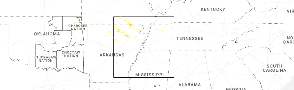
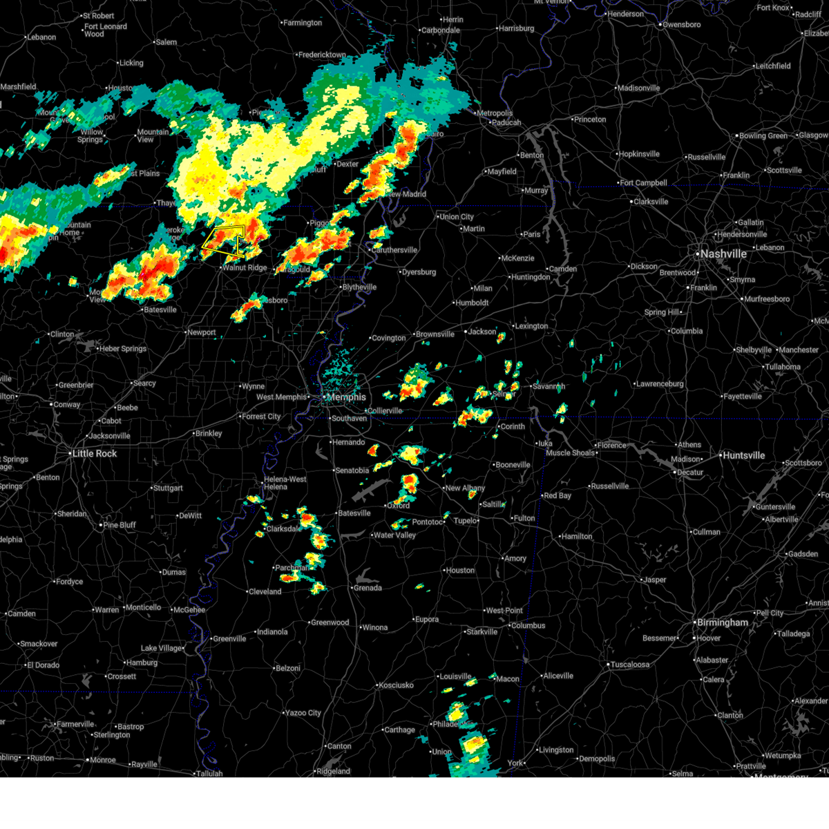
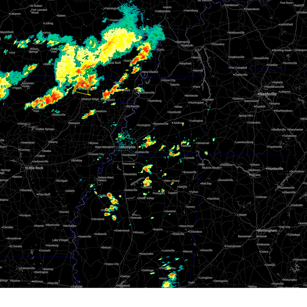
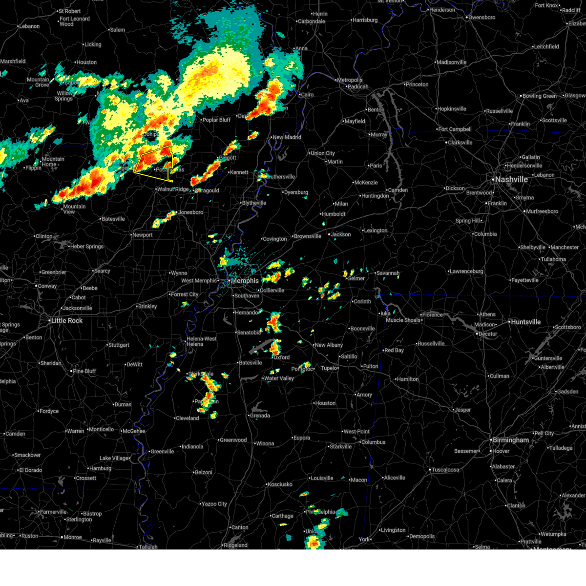
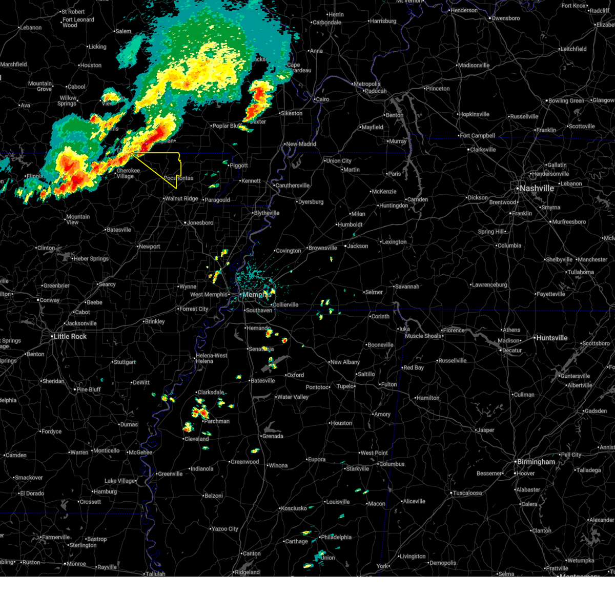
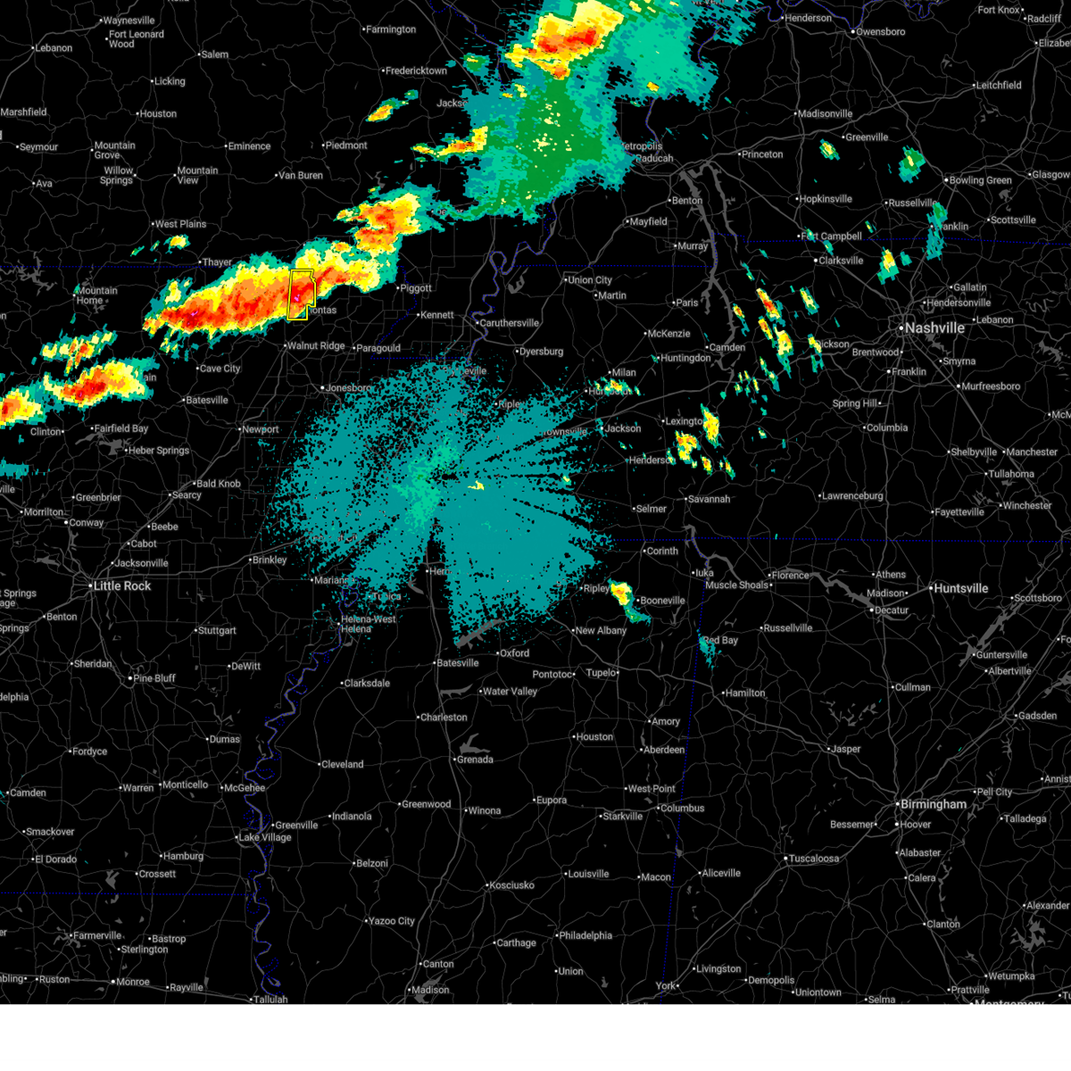
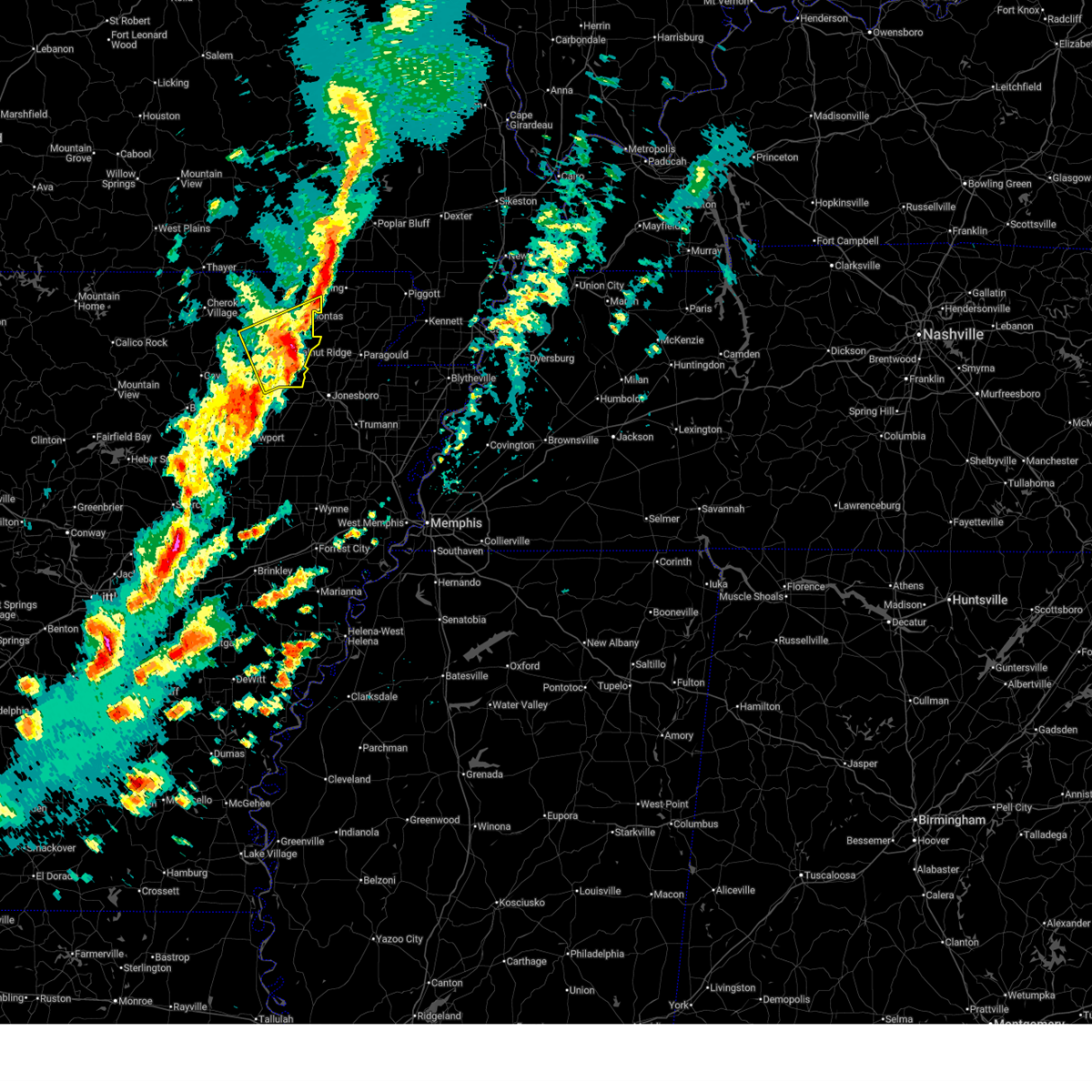
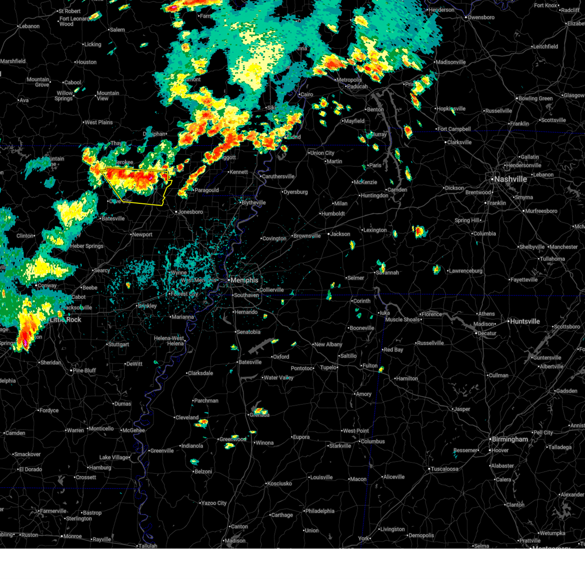
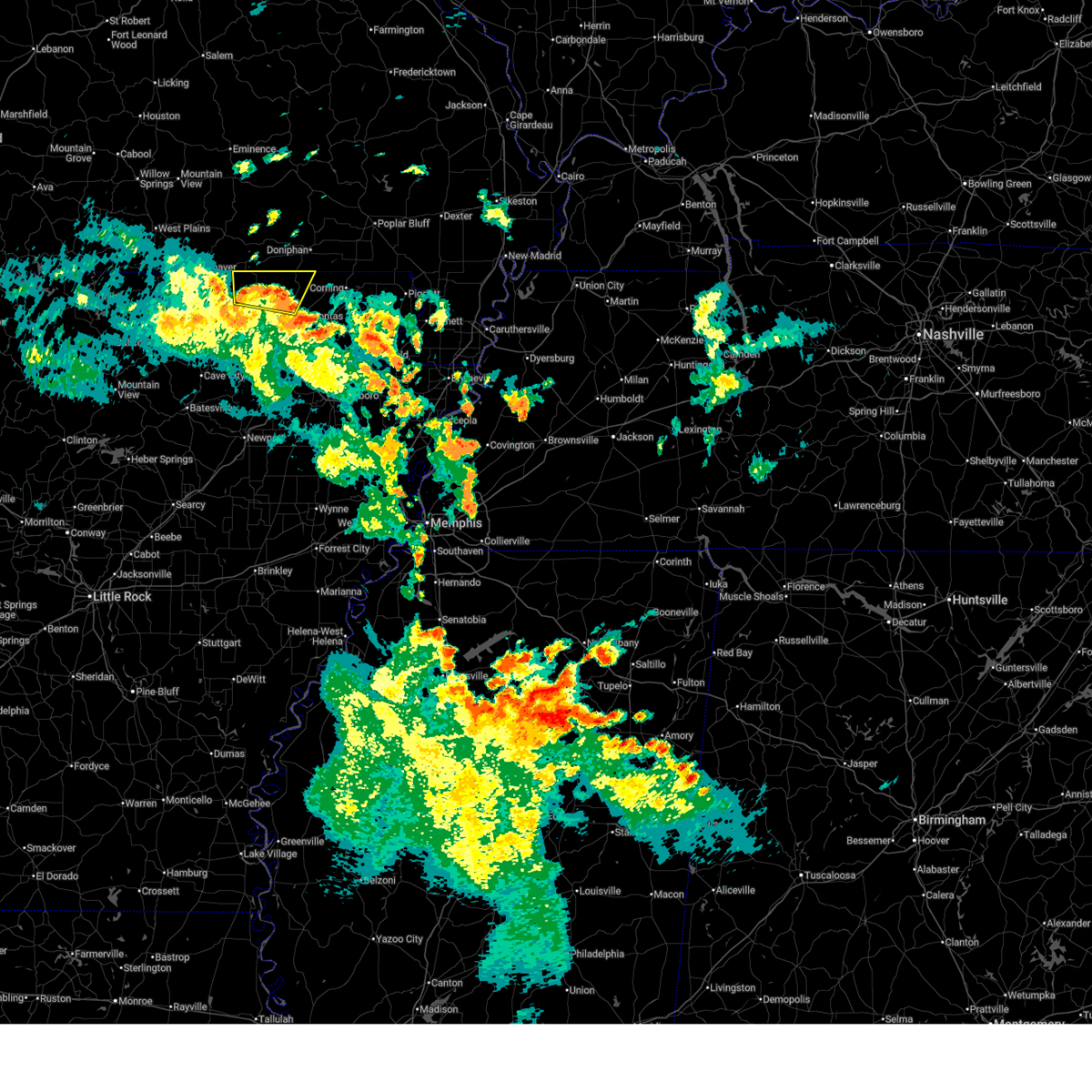
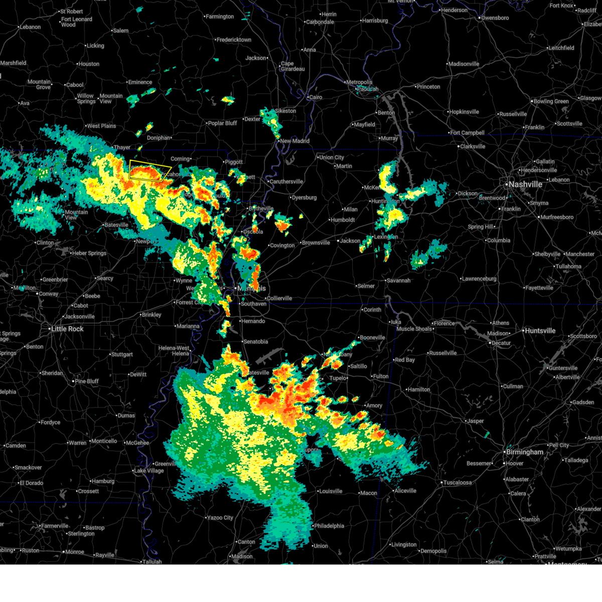
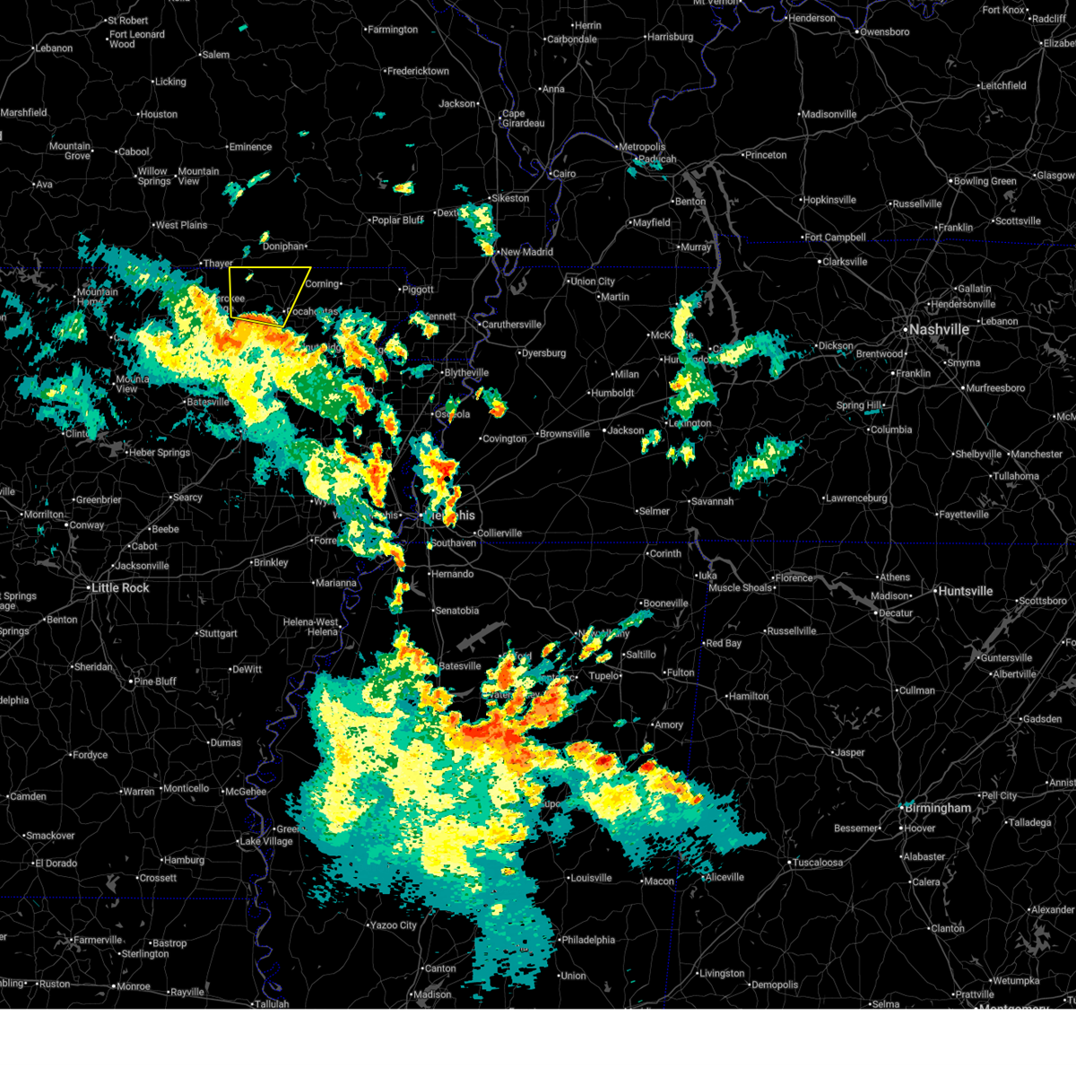
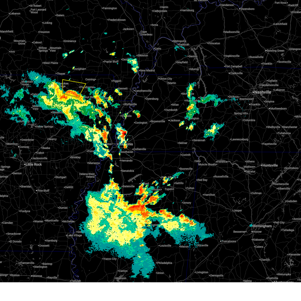
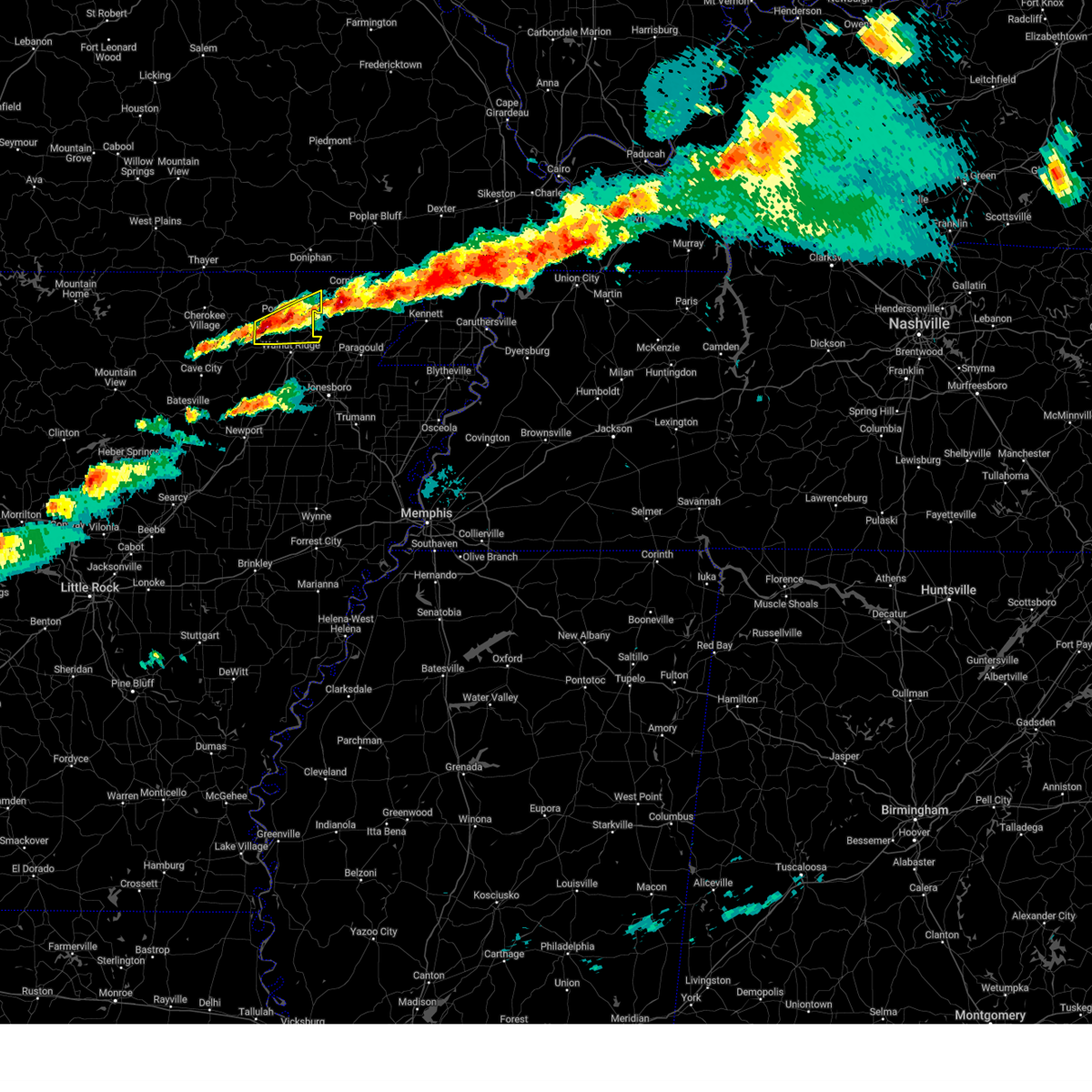
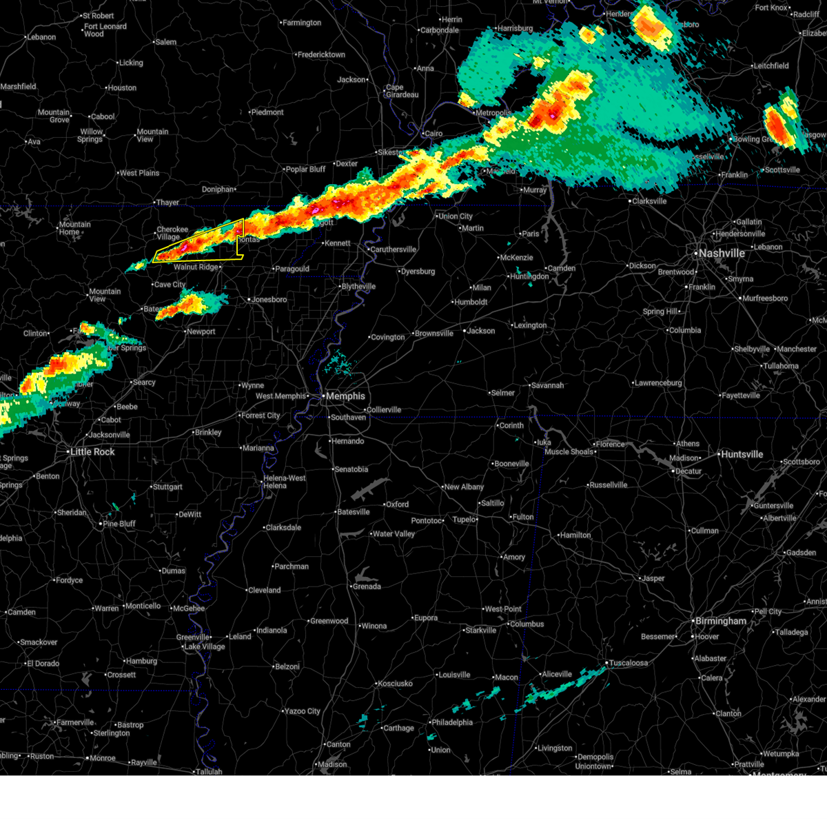
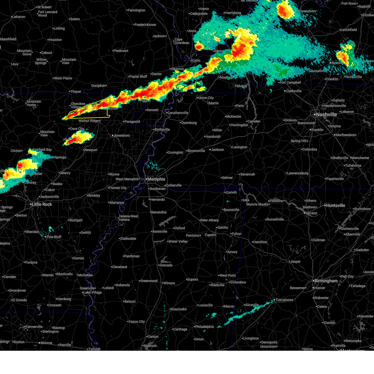
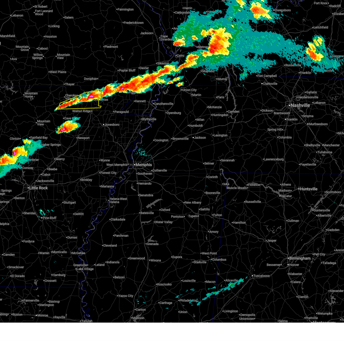
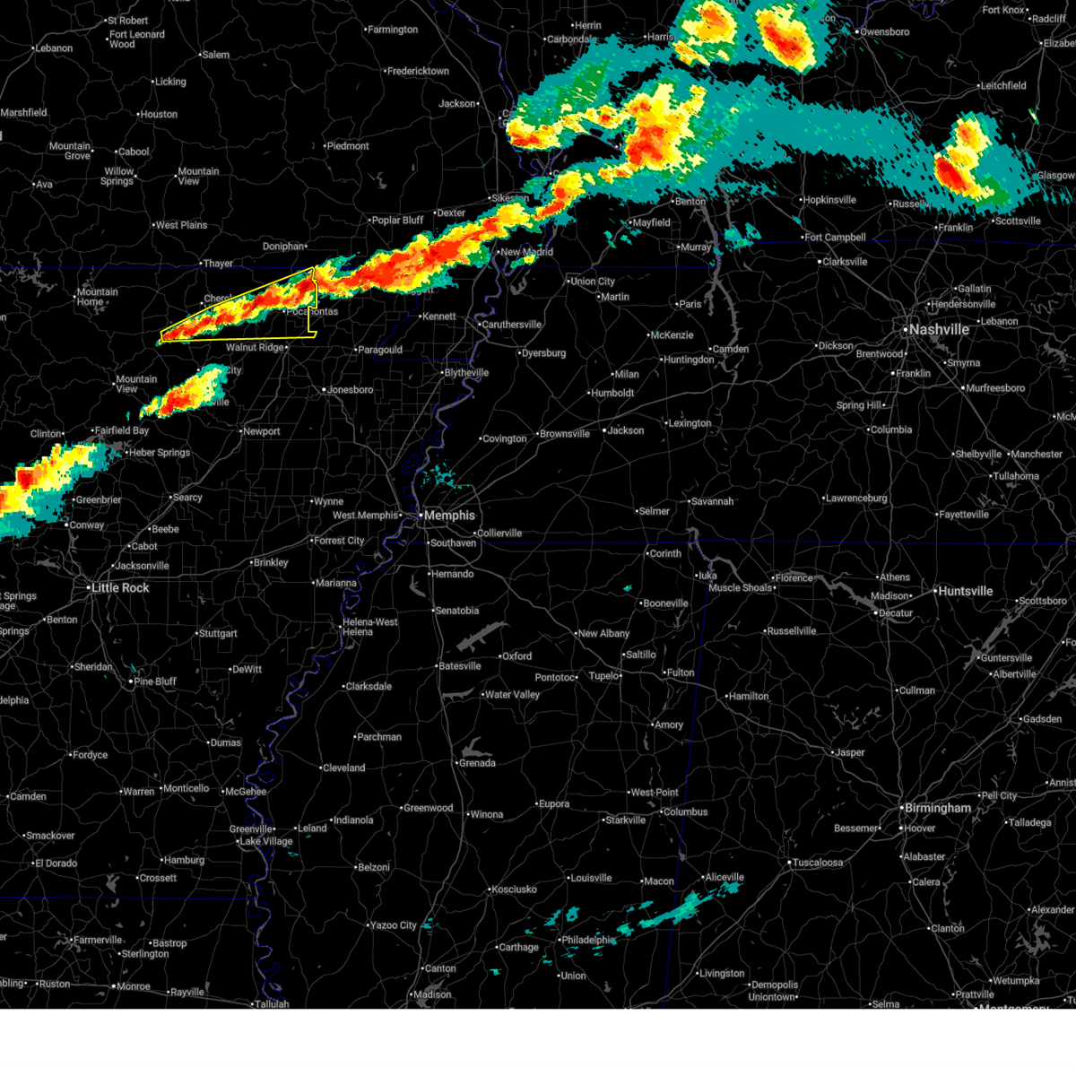
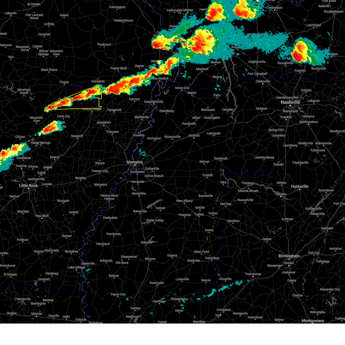
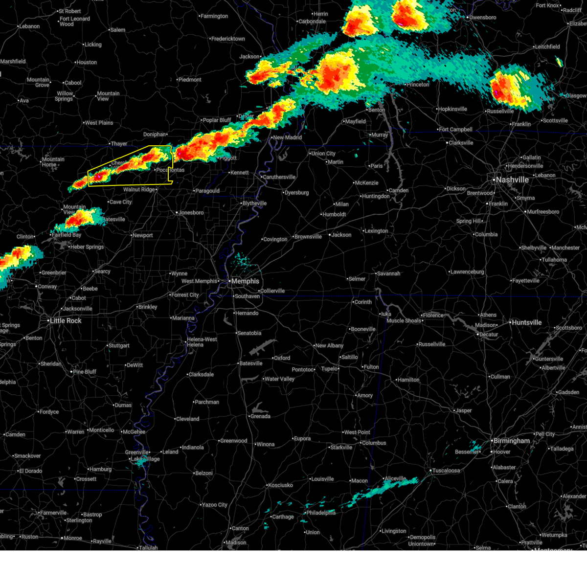
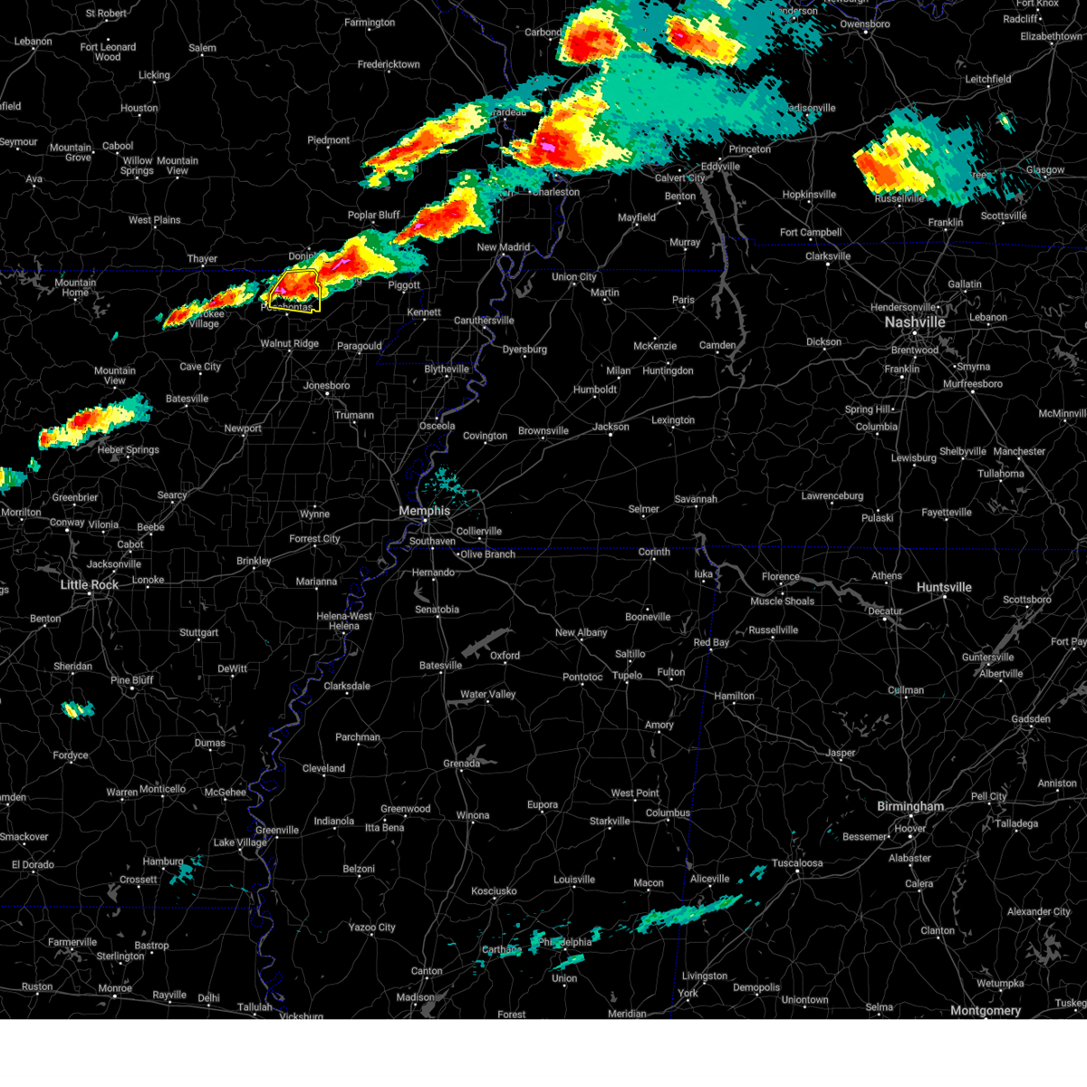
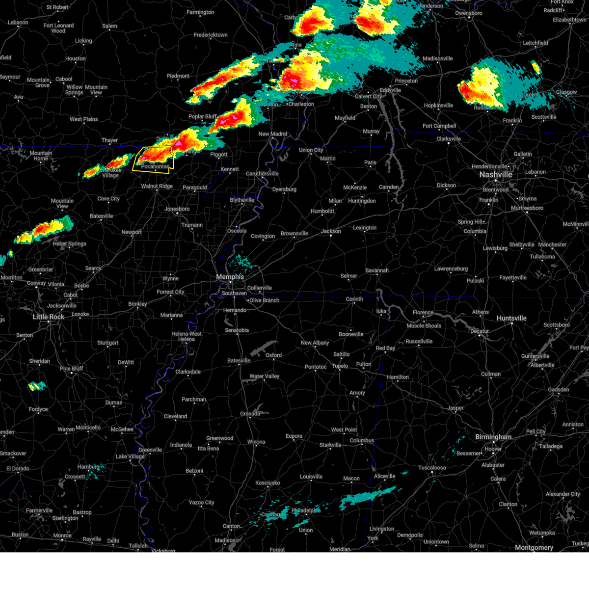
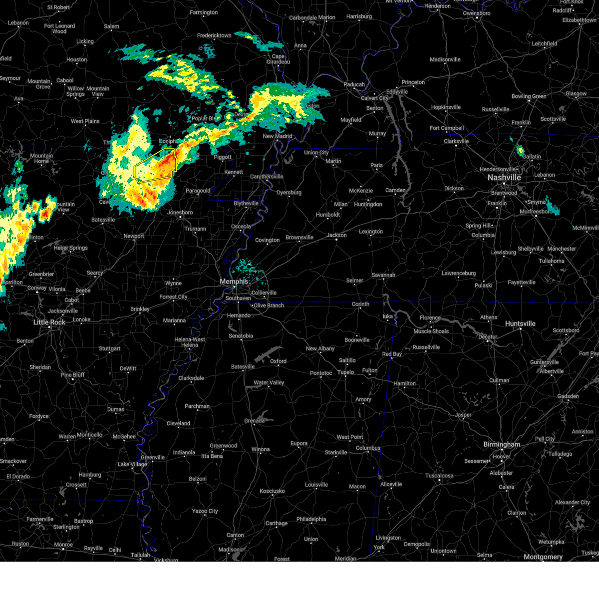
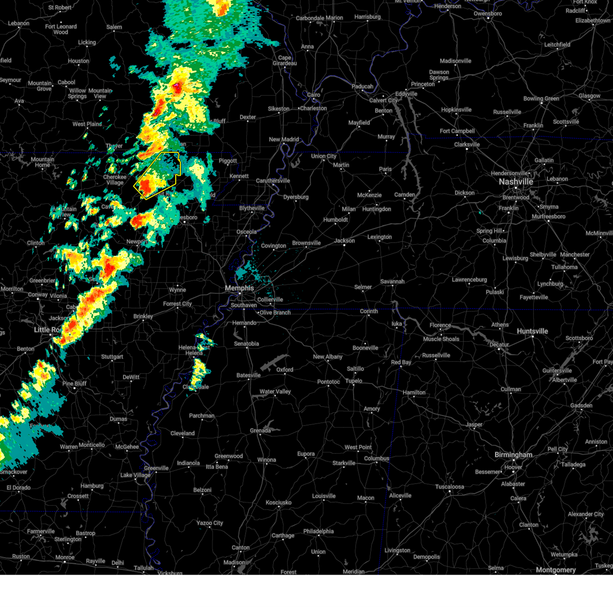
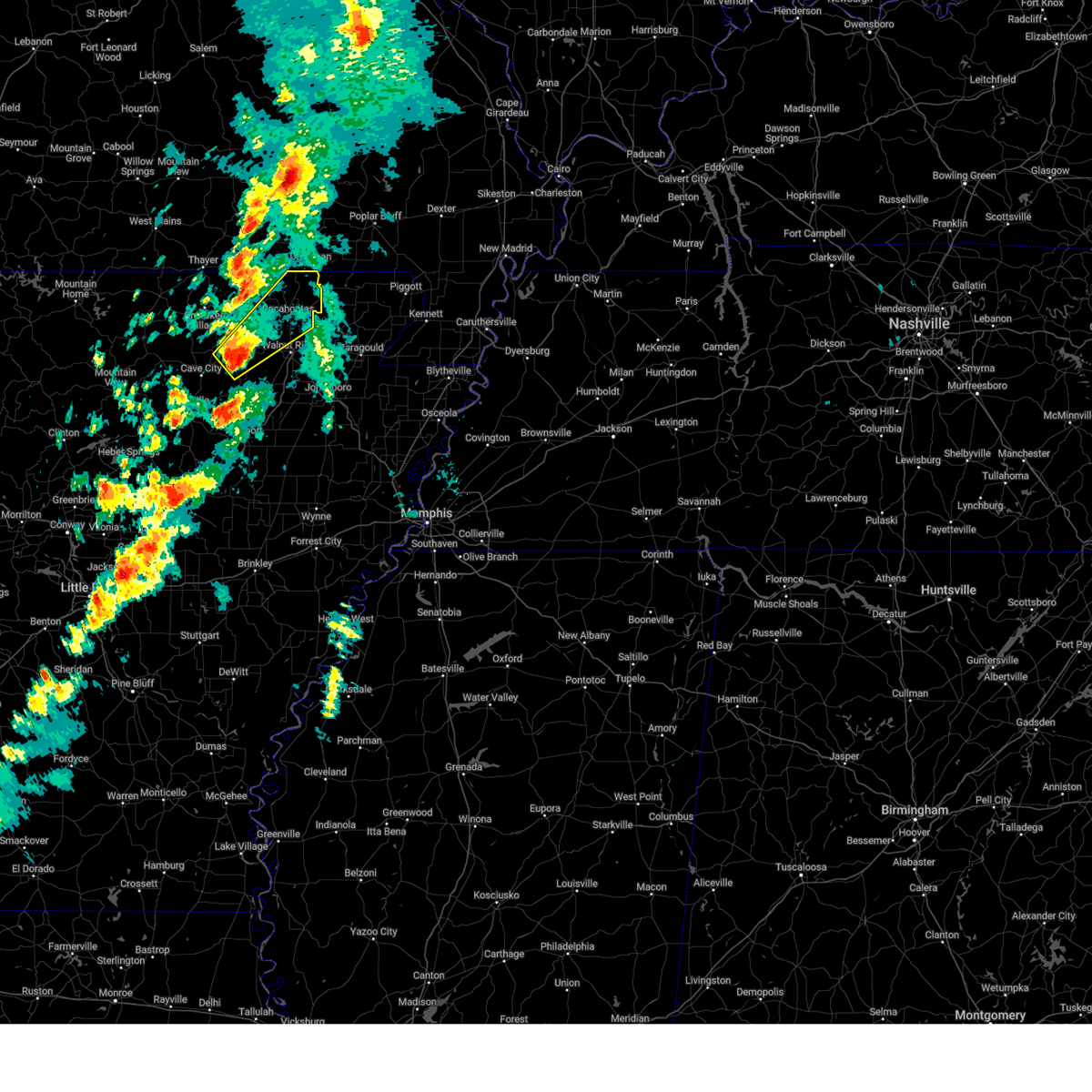
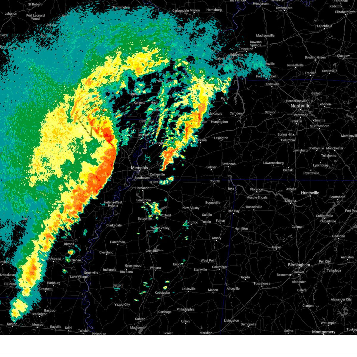
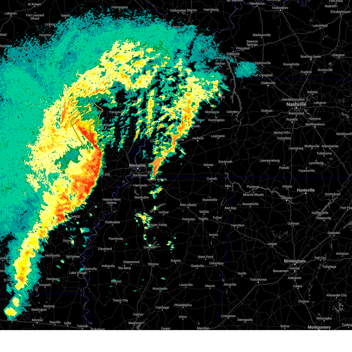
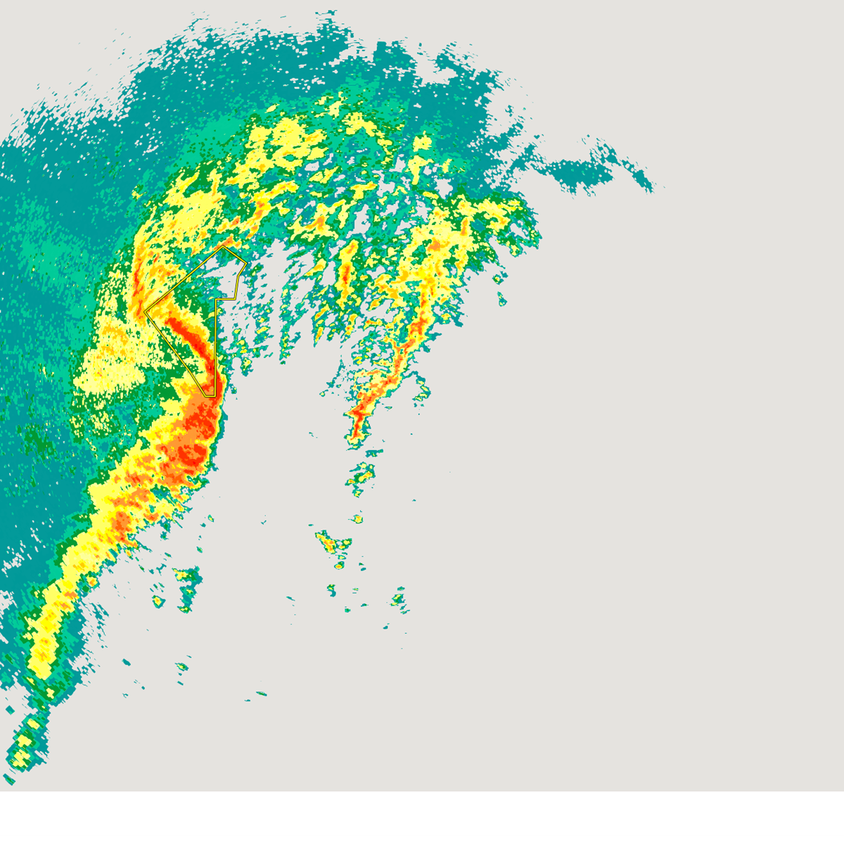
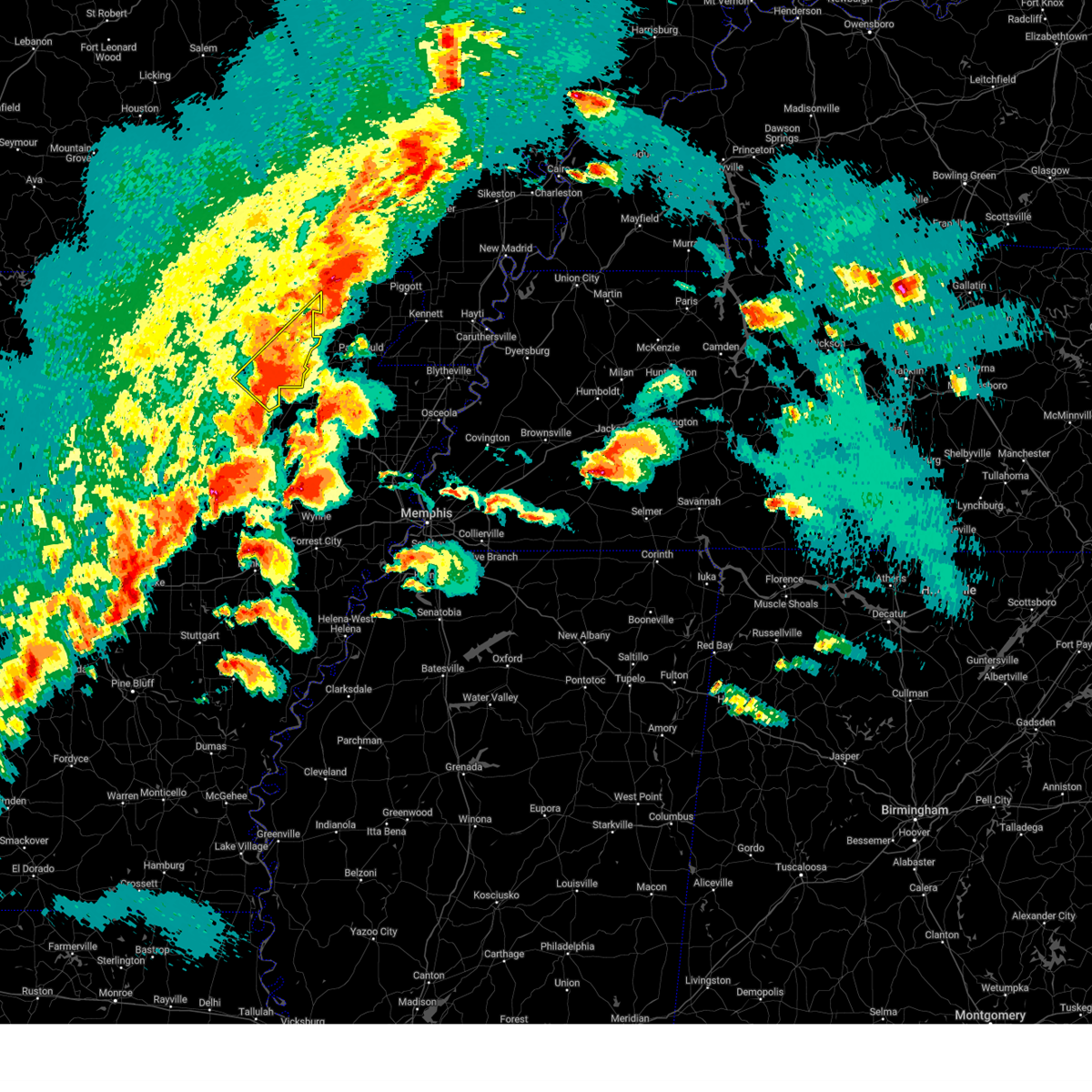
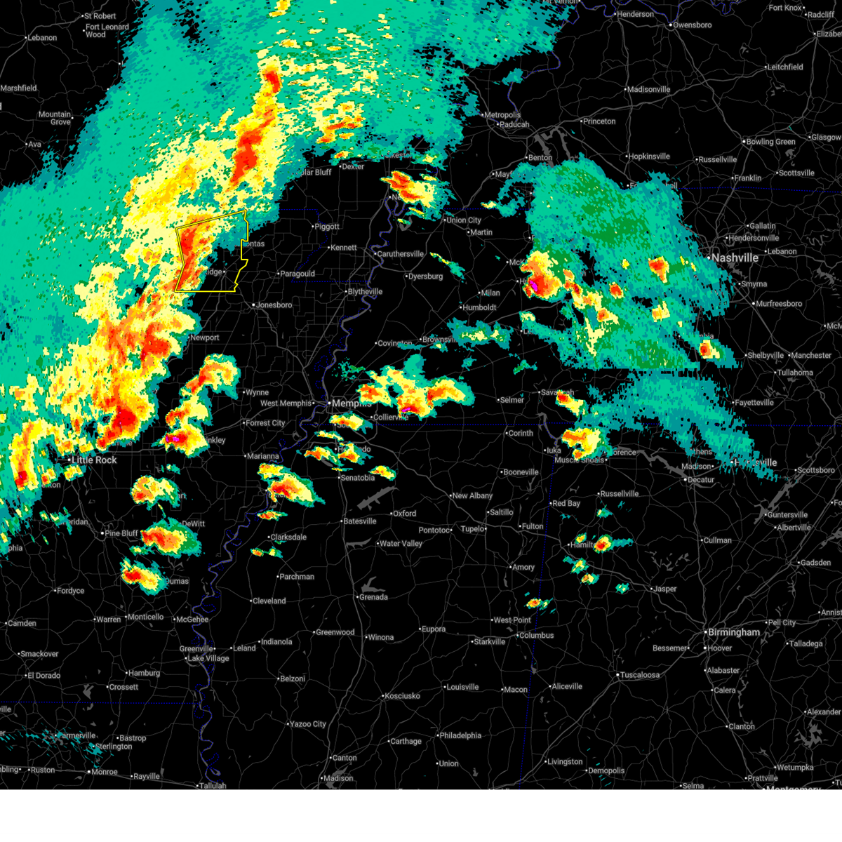
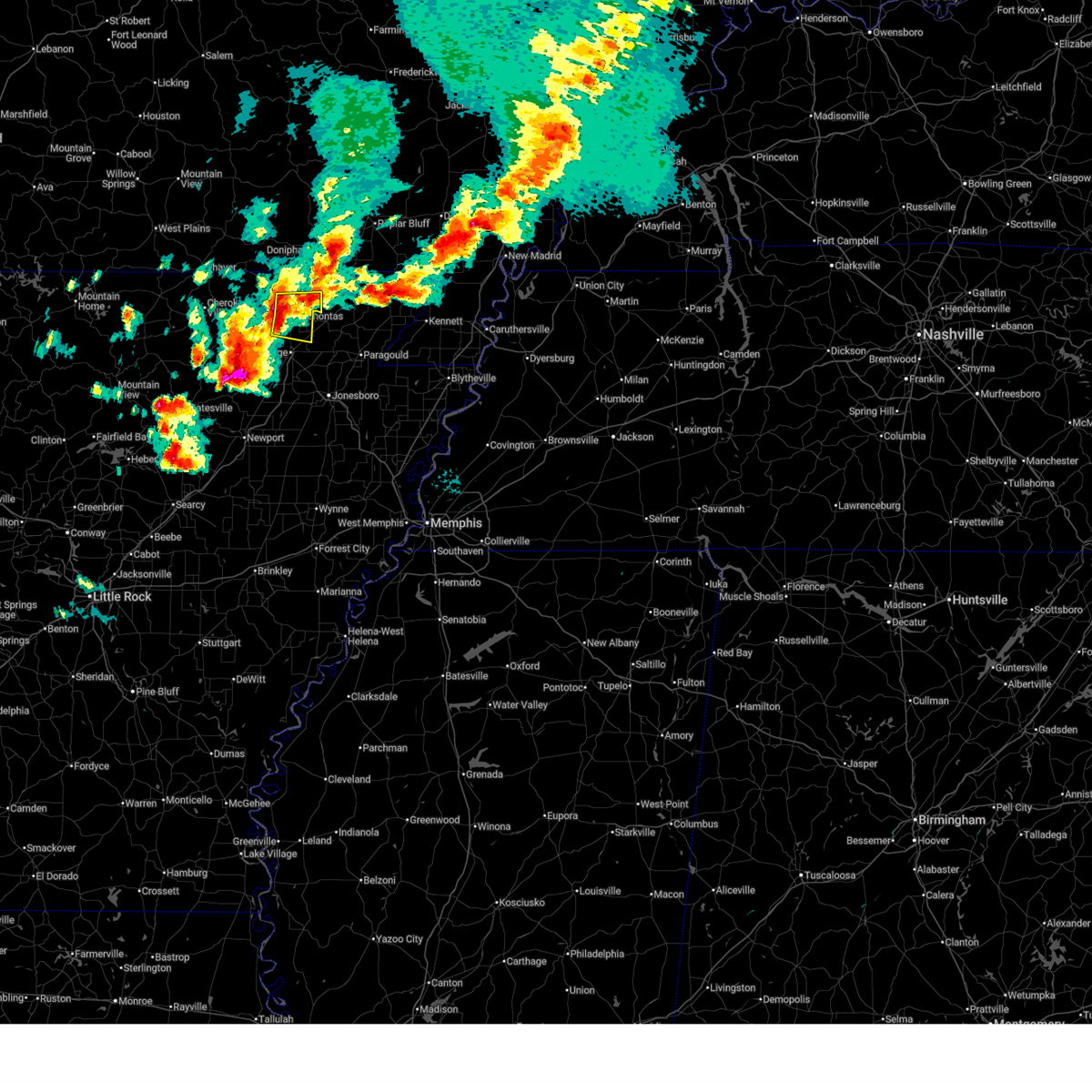
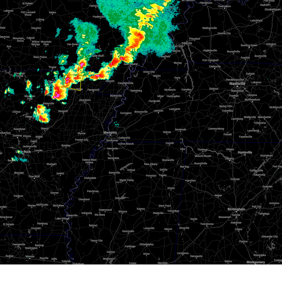
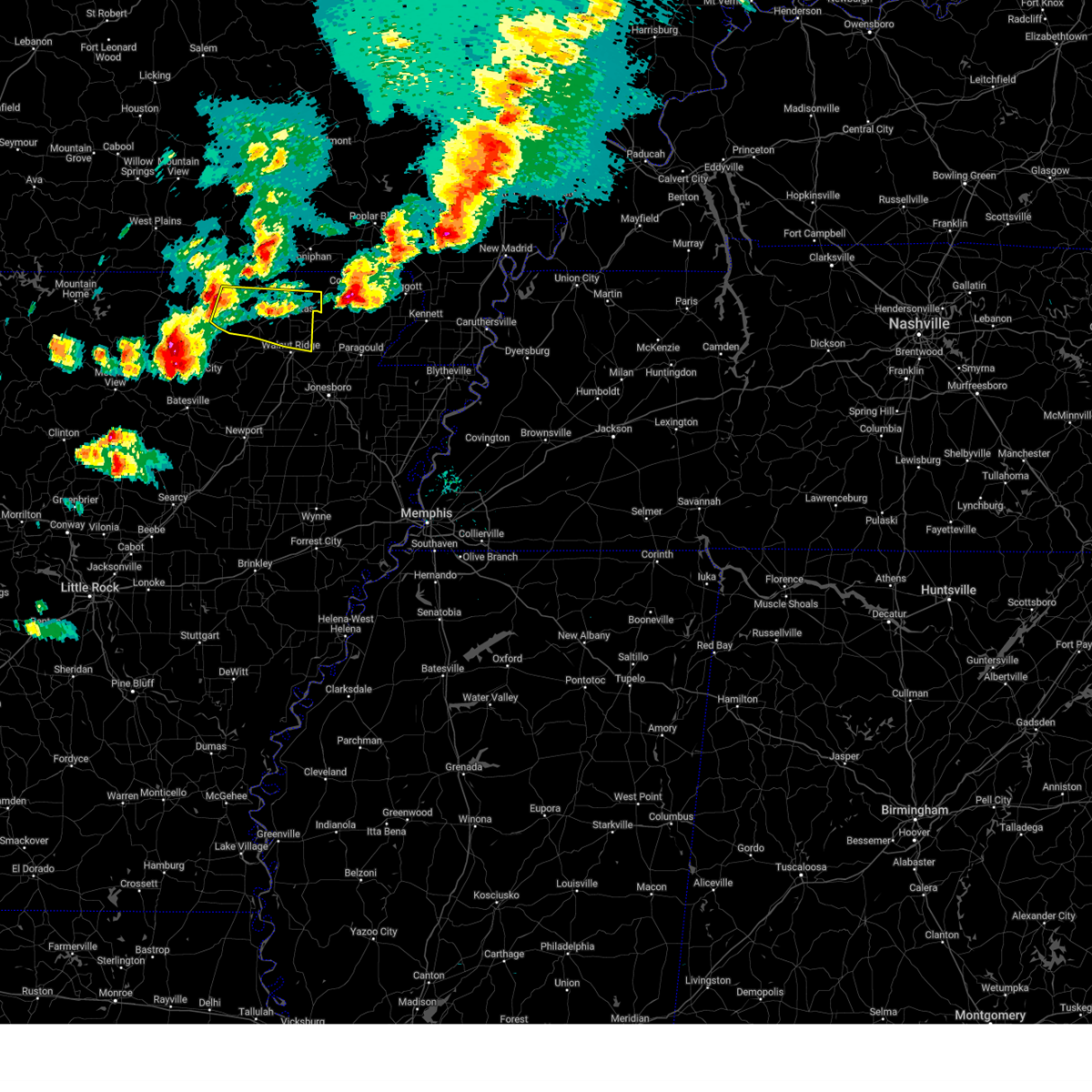
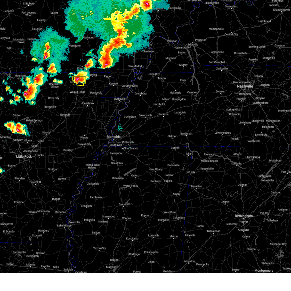
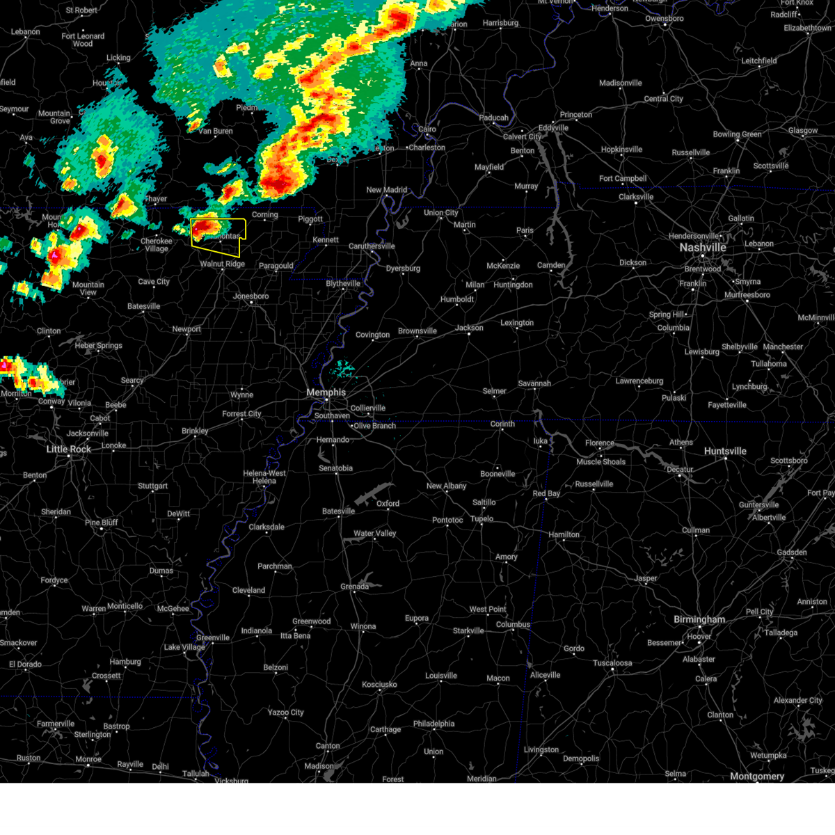
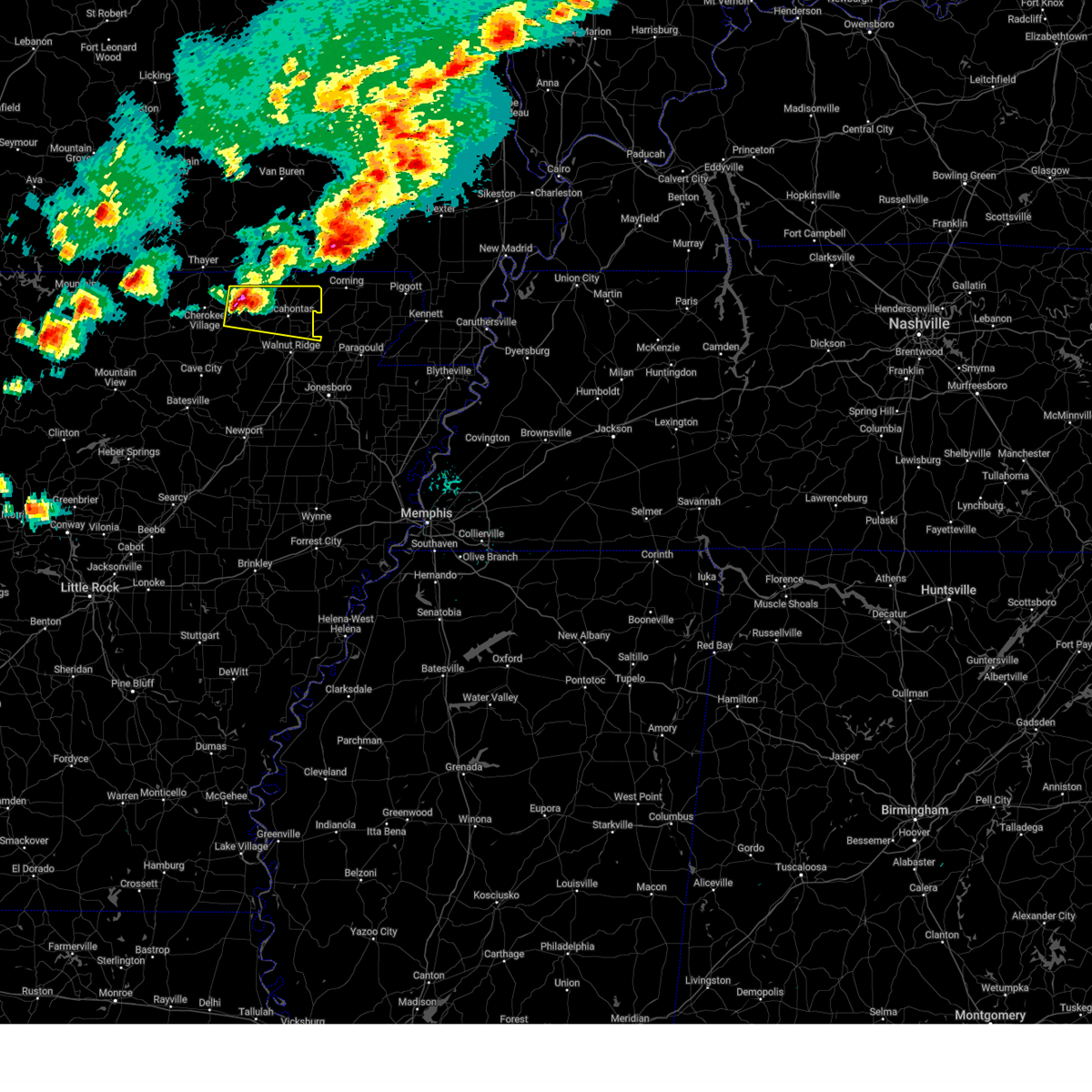
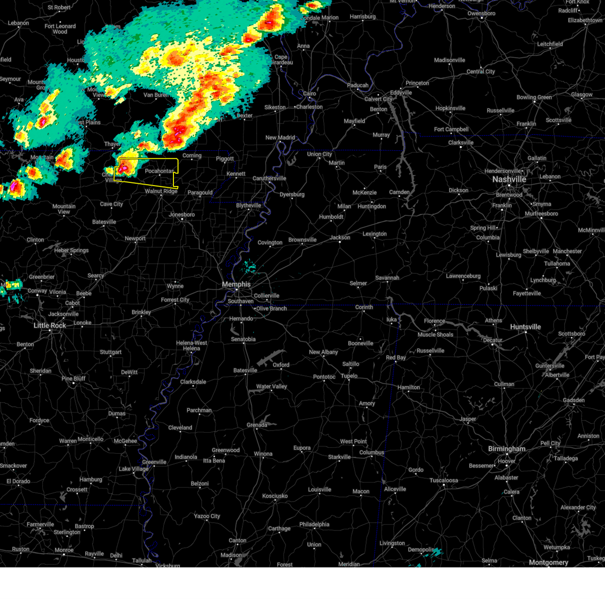
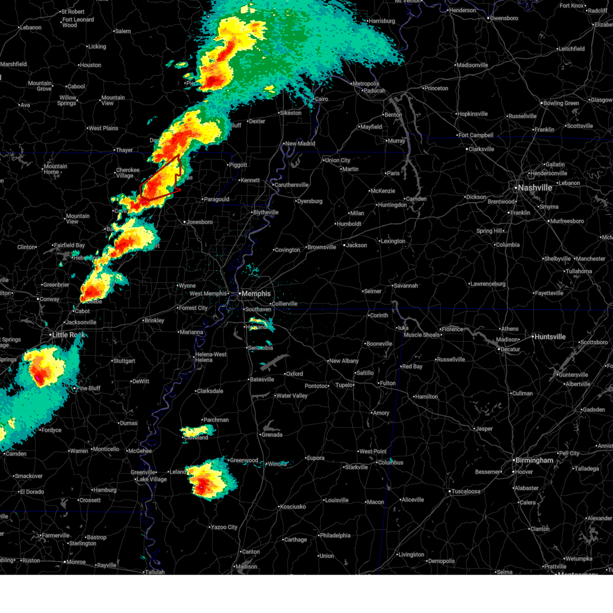
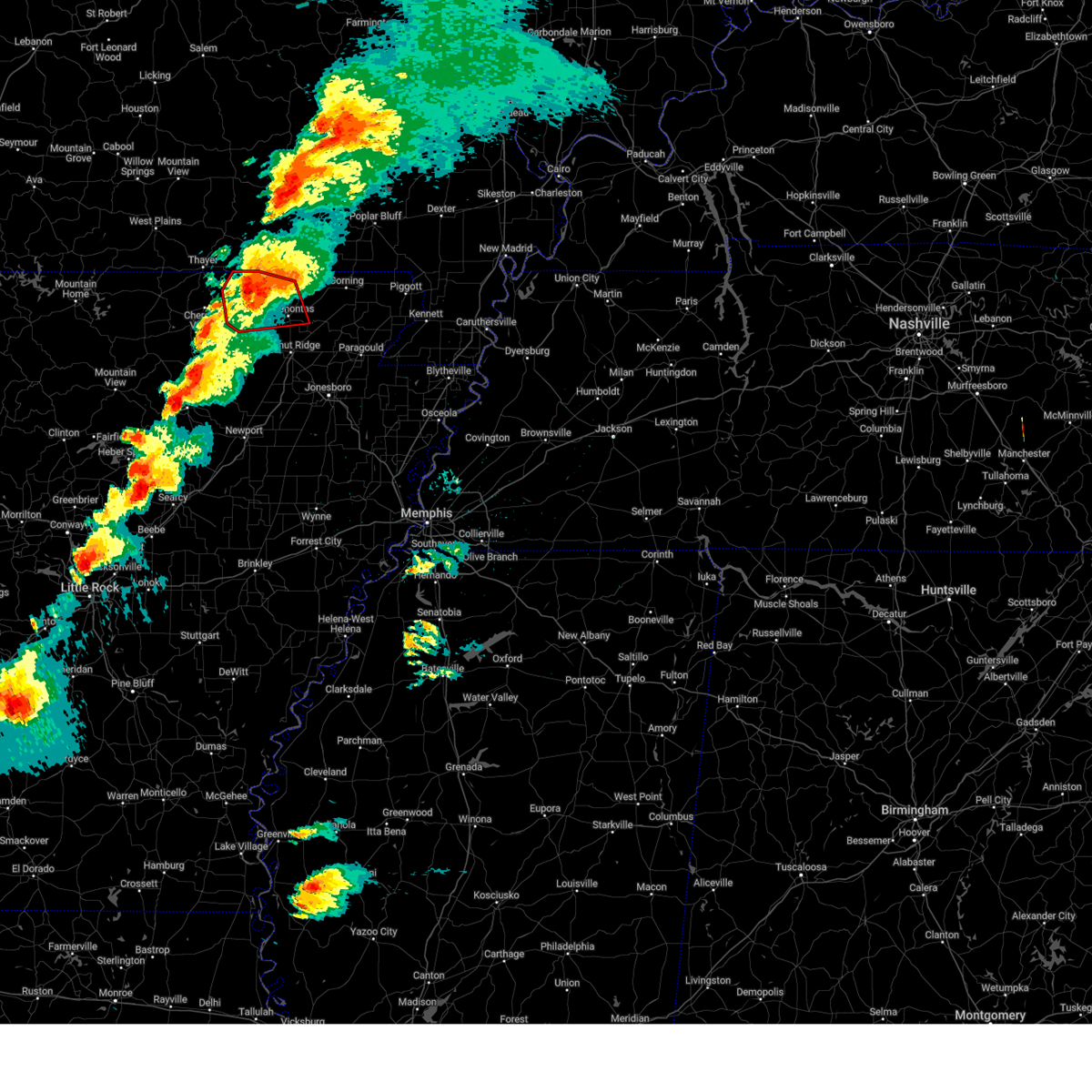
Hail Map for Pocahontas, AR
The Pocahontas, AR area has had 13 reports of on-the-ground hail by trained spotters, and has been under severe weather warnings 20 times during the past 12 months. Doppler radar has detected hail at or near Pocahontas, AR on 77 occasions, including 5 occasions during the past year.
| Name: | Pocahontas, AR |
| Where Located: | 92.9 miles NW of Memphis, TN |
| Map: | Google Map for Pocahontas, AR |
| Population: | 6608 |
| Housing Units: | 3056 |
| More Info: | Search Google for Pocahontas, AR |
2
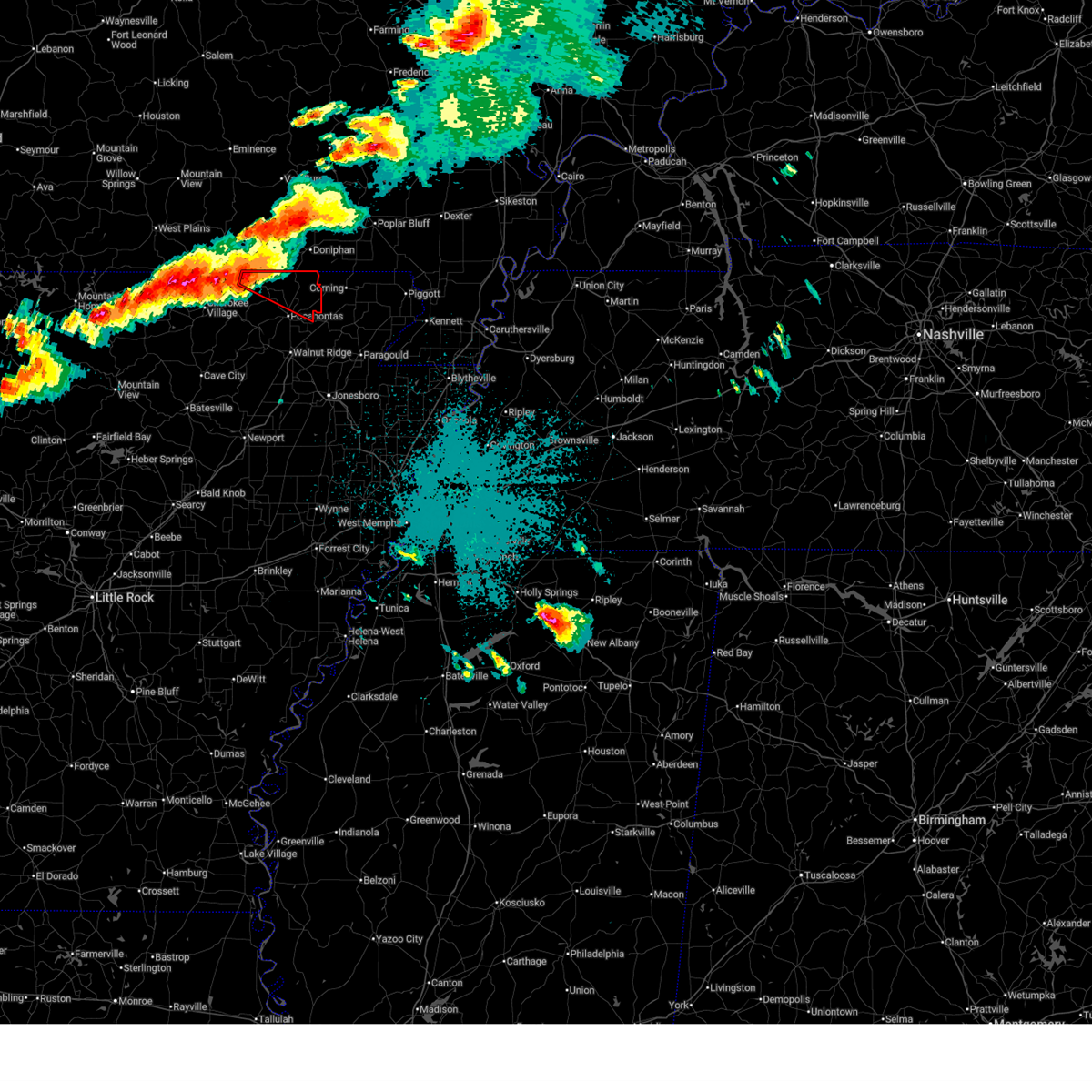
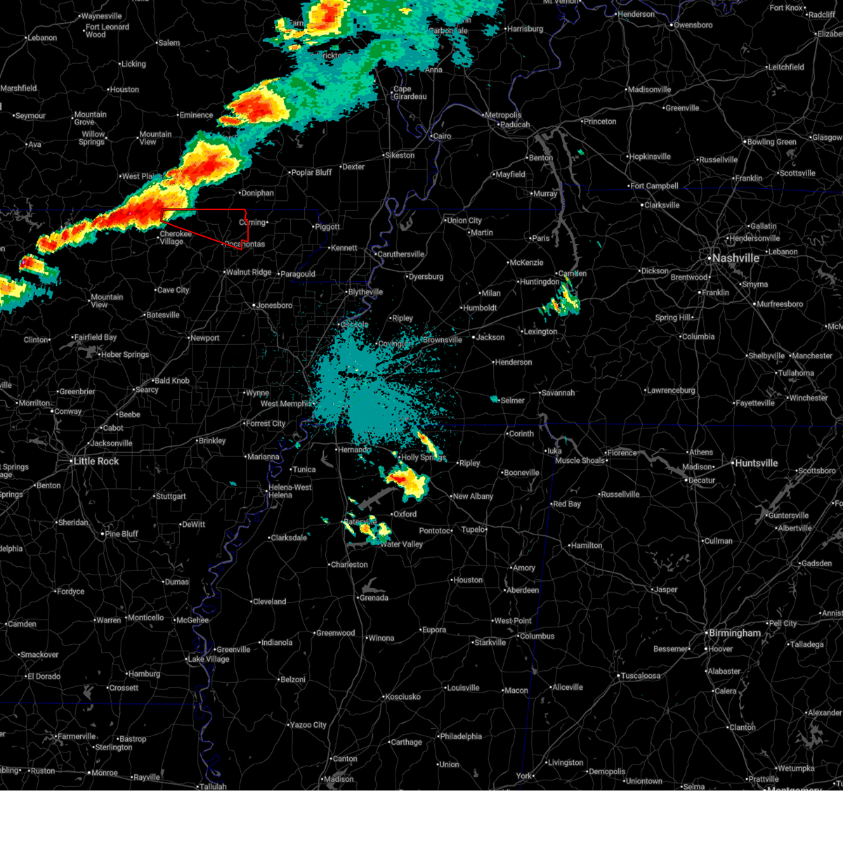
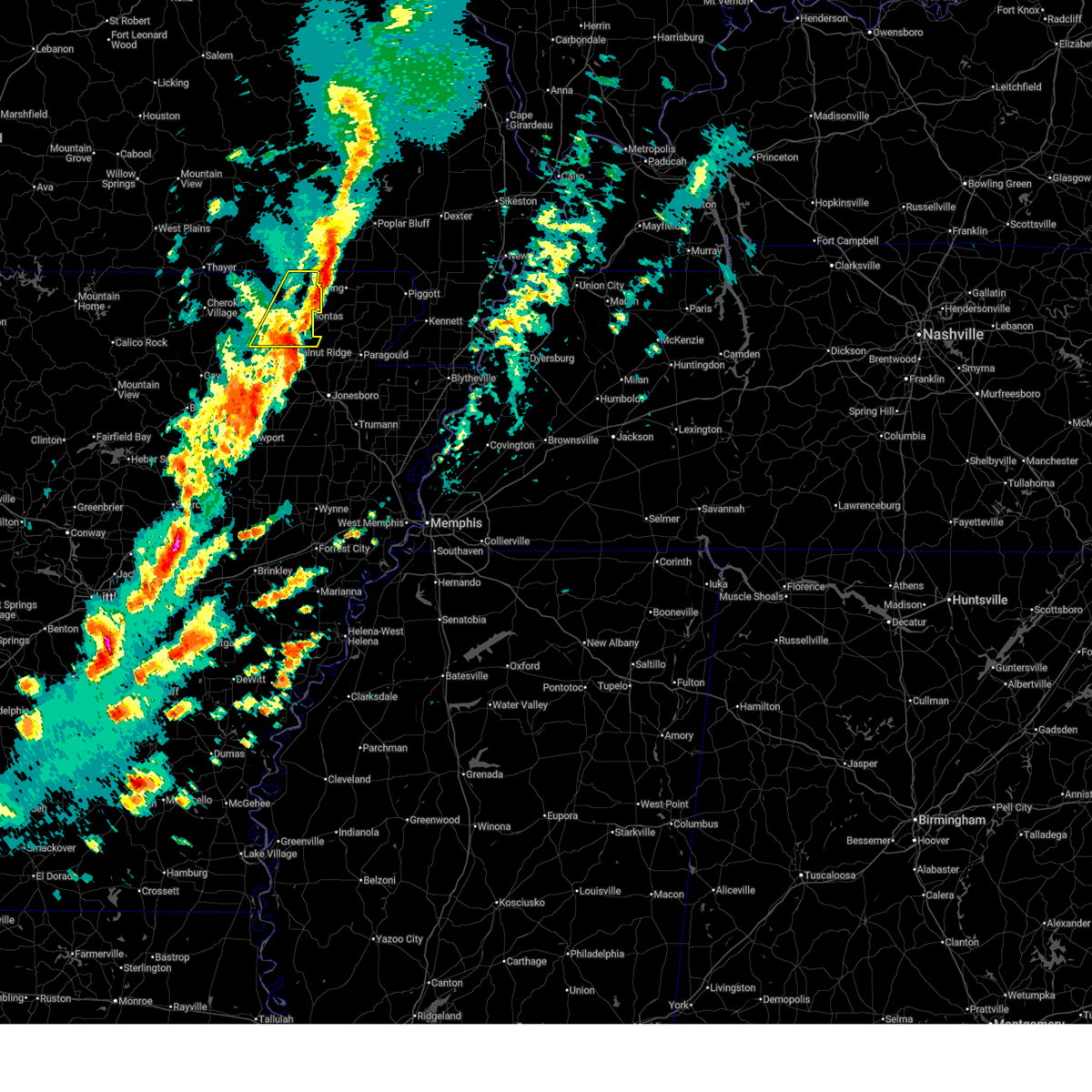
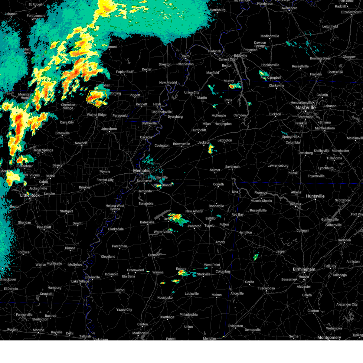
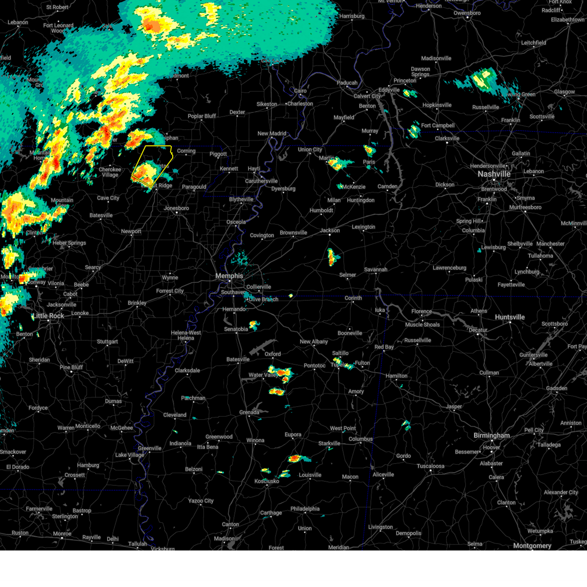
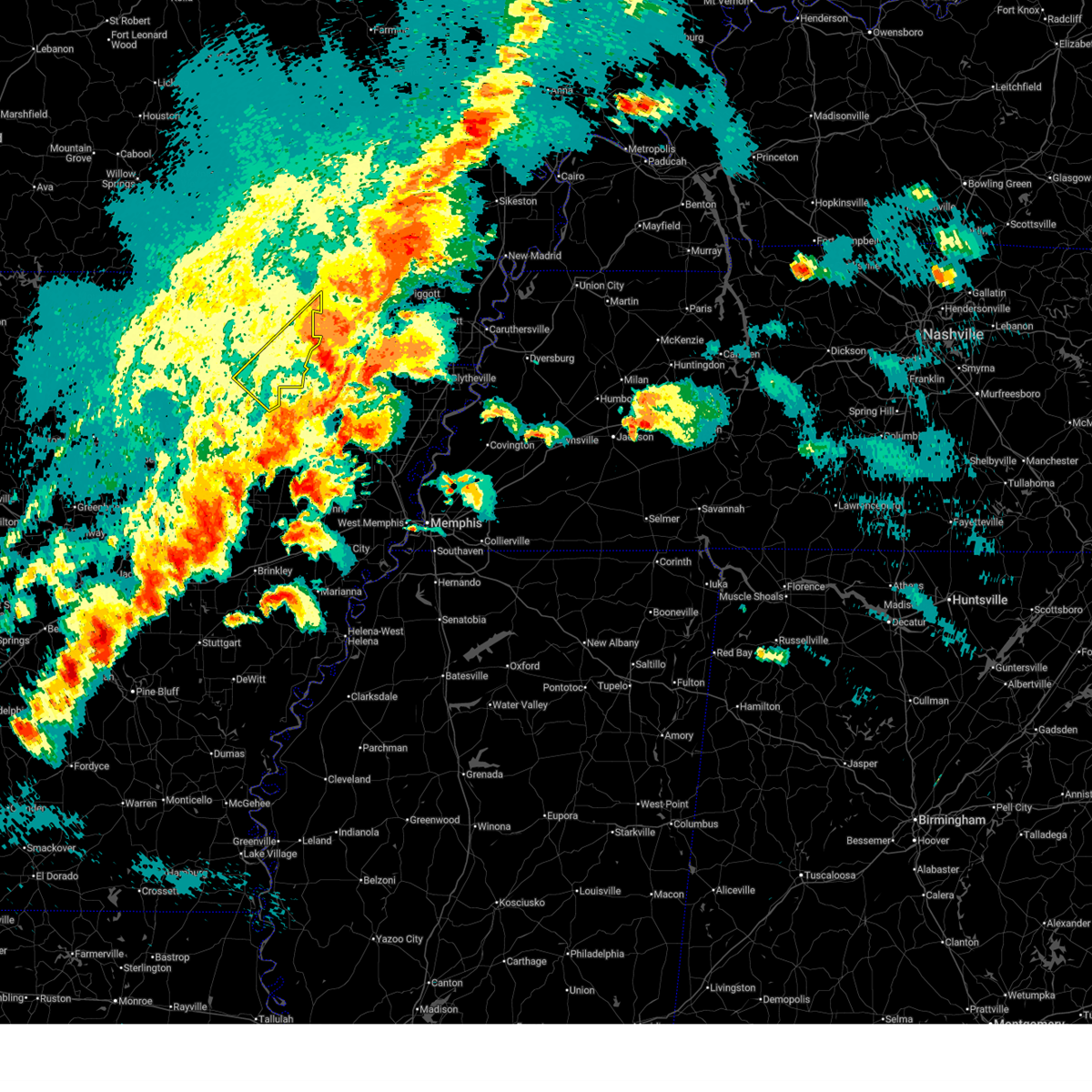
The Top Recent Hail Date for Pocahontas, AR is Saturday, June 13, 2026 (16th out of 77)
Hail and Wind Damage Spotted near Pocahontas, AR
| Date / Time | Report Details |
|---|---|
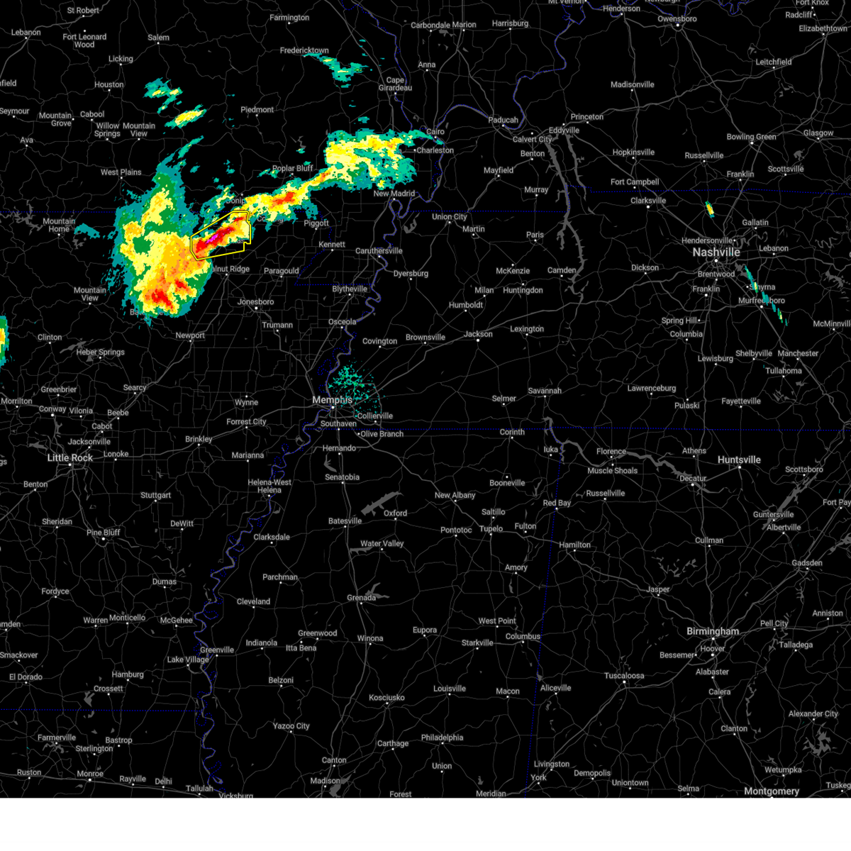
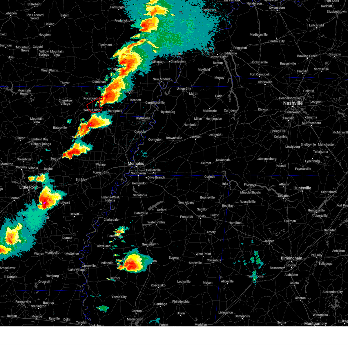
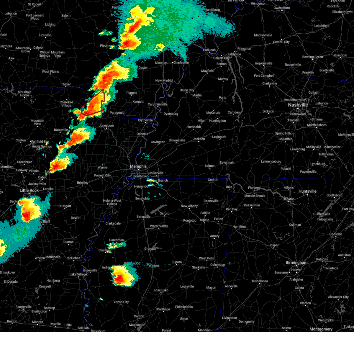
| 6/13/2026 2:45 PM CDT |
 At 245 pm cdt, a severe thunderstorm was located over pocahontas, moving east at 25 mph (radar indicated). Hazards include 60 mph wind gusts and quarter size hail. Hail damage to vehicles is expected. expect wind damage to roofs, siding, and trees. Locations impacted include, pocahontas, reyno, biggers, o'kean, birdell, engelberg, fender, sharum, manson, shannon, brockett,. At 245 pm cdt, a severe thunderstorm was located over pocahontas, moving east at 25 mph (radar indicated). Hazards include 60 mph wind gusts and quarter size hail. Hail damage to vehicles is expected. expect wind damage to roofs, siding, and trees. Locations impacted include, pocahontas, reyno, biggers, o'kean, birdell, engelberg, fender, sharum, manson, shannon, brockett,.
|
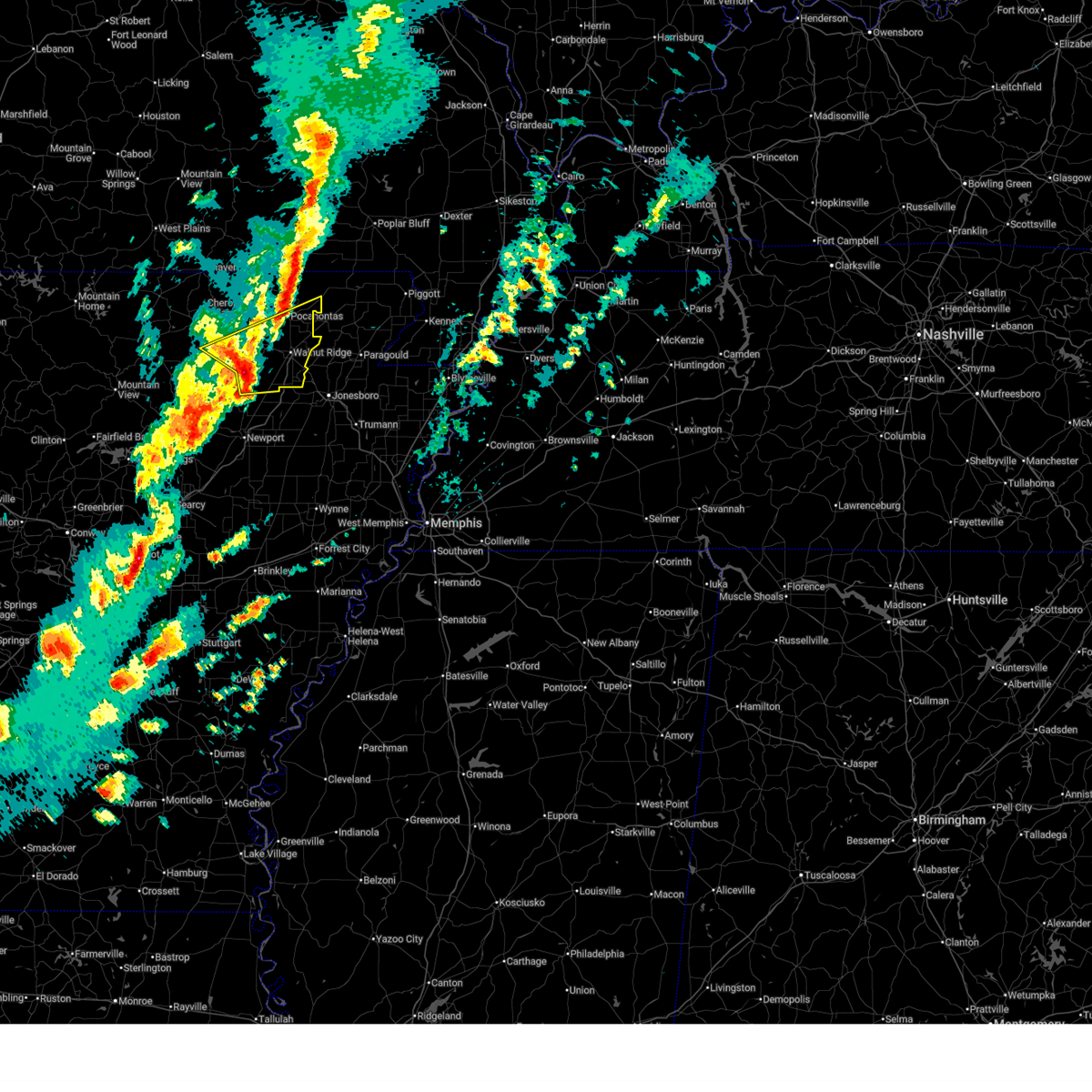
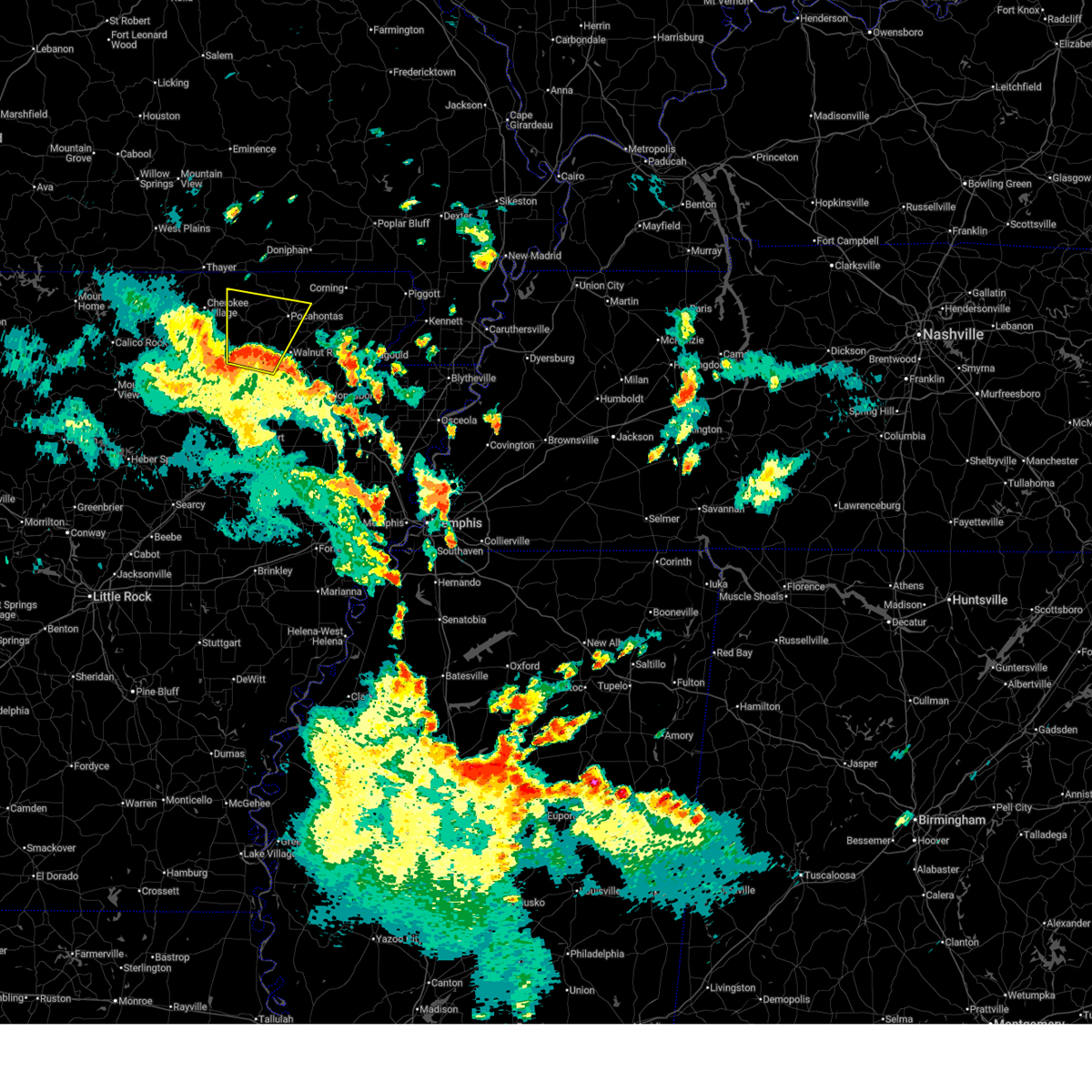
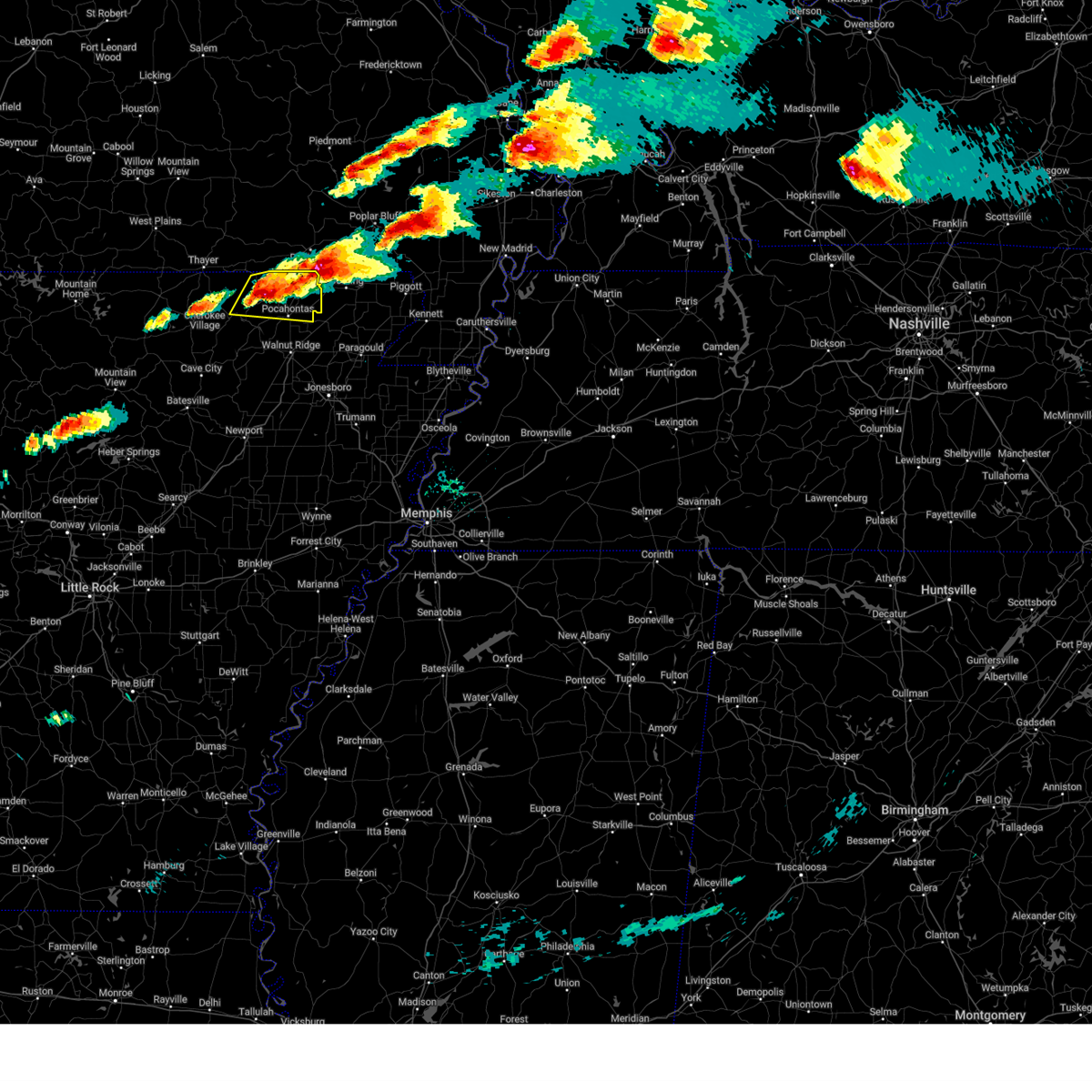
| 6/13/2026 2:35 PM CDT |
 At 235 pm cdt, severe thunderstorms were located along a line extending from near biggers to near pocahontas, moving east at 25 mph (radar indicated). Hazards include 60 mph wind gusts and quarter size hail. Hail damage to vehicles is expected. expect wind damage to roofs, siding, and trees. Locations impacted include, pocahontas, reyno, biggers, o'kean, attica, shannon, birdell, engelberg, stokes, fender, sharum, manson, brockett,. At 235 pm cdt, severe thunderstorms were located along a line extending from near biggers to near pocahontas, moving east at 25 mph (radar indicated). Hazards include 60 mph wind gusts and quarter size hail. Hail damage to vehicles is expected. expect wind damage to roofs, siding, and trees. Locations impacted include, pocahontas, reyno, biggers, o'kean, attica, shannon, birdell, engelberg, stokes, fender, sharum, manson, brockett,.
|
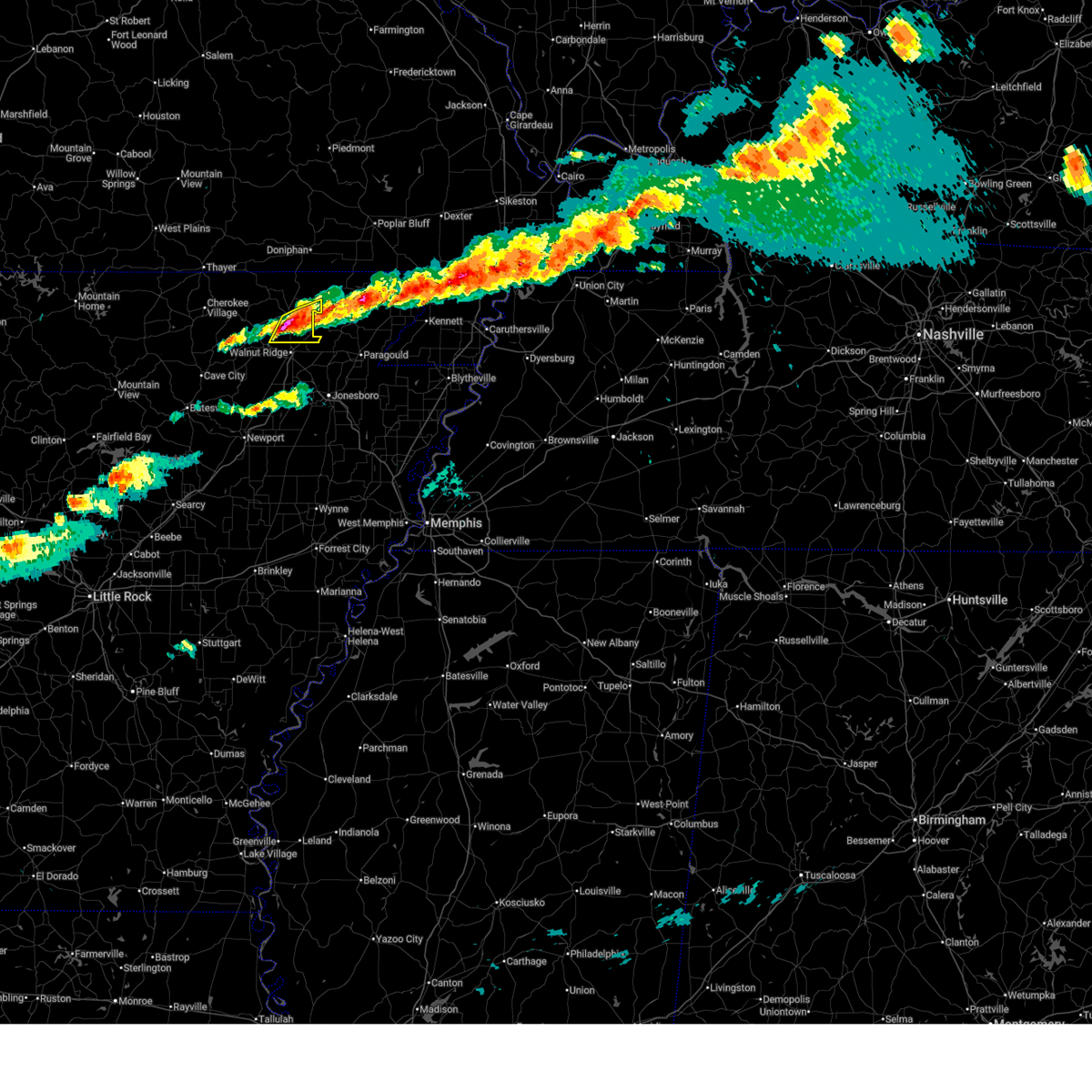
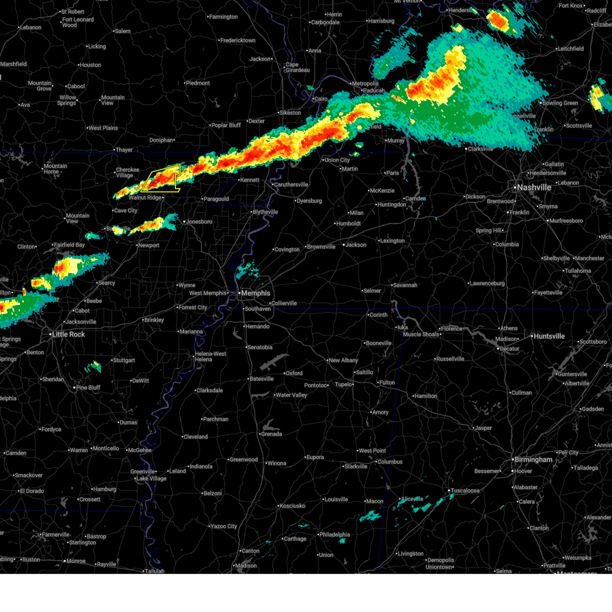
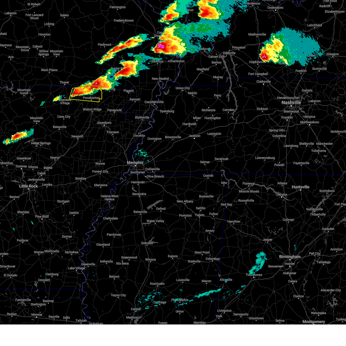
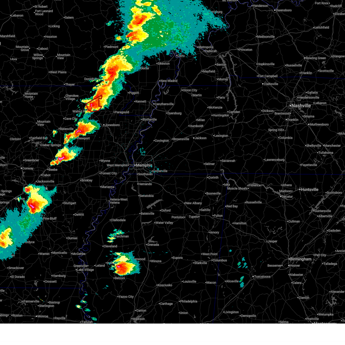
| 6/13/2026 2:22 PM CDT |
 Svrlzk the national weather service in little rock has issued a * severe thunderstorm warning for, randolph county in eastern arkansas, northeastern lawrence county in eastern arkansas, * until 315 pm cdt. * at 222 pm cdt, a severe thunderstorm was located over attica, or near pocahontas, moving east at 35 mph (radar indicated). Hazards include 60 mph wind gusts and quarter size hail. Hail damage to vehicles is expected. Expect wind damage to roofs, siding, and trees. Svrlzk the national weather service in little rock has issued a * severe thunderstorm warning for, randolph county in eastern arkansas, northeastern lawrence county in eastern arkansas, * until 315 pm cdt. * at 222 pm cdt, a severe thunderstorm was located over attica, or near pocahontas, moving east at 35 mph (radar indicated). Hazards include 60 mph wind gusts and quarter size hail. Hail damage to vehicles is expected. Expect wind damage to roofs, siding, and trees.
|
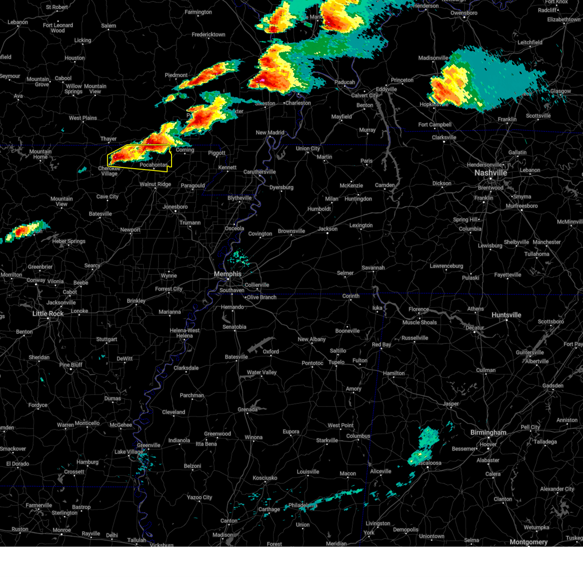
| 6/13/2026 1:39 PM CDT |
 At 138 pm cdt, a severe thunderstorm was located near gatewood, or 17 miles southwest of doniphan, moving southeast at 20 mph (radar indicated). Hazards include ping pong ball size hail and 60 mph wind gusts. People and animals outdoors will be injured. expect hail damage to roofs, siding, windows, and vehicles. expect wind damage to roofs, siding, and trees. Locations impacted include, pocahontas, reyno, maynard, biggers, o'kean, attica, dalton, elkins park, brakebill, middlebrook, warm springs, ingram, engelberg, hamil, stokes, elm store, brockett, pitman,. At 138 pm cdt, a severe thunderstorm was located near gatewood, or 17 miles southwest of doniphan, moving southeast at 20 mph (radar indicated). Hazards include ping pong ball size hail and 60 mph wind gusts. People and animals outdoors will be injured. expect hail damage to roofs, siding, windows, and vehicles. expect wind damage to roofs, siding, and trees. Locations impacted include, pocahontas, reyno, maynard, biggers, o'kean, attica, dalton, elkins park, brakebill, middlebrook, warm springs, ingram, engelberg, hamil, stokes, elm store, brockett, pitman,.
|
| 6/13/2026 1:32 PM CDT |
 Svrlzk the national weather service in little rock has issued a * severe thunderstorm warning for, northeastern randolph county in eastern arkansas, * until 230 pm cdt. * at 132 pm cdt, a severe thunderstorm was located near dalton, or 19 miles northwest of pocahontas, moving southeast at 20 mph (radar indicated). Hazards include 60 mph wind gusts and quarter size hail. Hail damage to vehicles is expected. Expect wind damage to roofs, siding, and trees. Svrlzk the national weather service in little rock has issued a * severe thunderstorm warning for, northeastern randolph county in eastern arkansas, * until 230 pm cdt. * at 132 pm cdt, a severe thunderstorm was located near dalton, or 19 miles northwest of pocahontas, moving southeast at 20 mph (radar indicated). Hazards include 60 mph wind gusts and quarter size hail. Hail damage to vehicles is expected. Expect wind damage to roofs, siding, and trees.
|
| 4/27/2026 10:52 PM CDT |
 the tornado warning has been cancelled and is no longer in effect the tornado warning has been cancelled and is no longer in effect
|
| 4/27/2026 10:37 PM CDT |
 Svrlzk the national weather service in little rock has issued a * severe thunderstorm warning for, central randolph county in eastern arkansas, northern lawrence county in eastern arkansas, east central sharp county in north central arkansas, * until 1130 pm cdt. * at 1037 pm cdt, a severe thunderstorm was located over ash flat, moving east at 40 mph (radar indicated). Hazards include 60 mph wind gusts and quarter size hail. Hail damage to vehicles is expected. Expect wind damage to roofs, siding, and trees. Svrlzk the national weather service in little rock has issued a * severe thunderstorm warning for, central randolph county in eastern arkansas, northern lawrence county in eastern arkansas, east central sharp county in north central arkansas, * until 1130 pm cdt. * at 1037 pm cdt, a severe thunderstorm was located over ash flat, moving east at 40 mph (radar indicated). Hazards include 60 mph wind gusts and quarter size hail. Hail damage to vehicles is expected. Expect wind damage to roofs, siding, and trees.
|
| 4/27/2026 10:35 PM CDT |
 Torlzk the national weather service in little rock has issued a * tornado warning for, southeastern randolph county in eastern arkansas, northern lawrence county in eastern arkansas, east central sharp county in north central arkansas, * until 1115 pm cdt. * at 1035 pm cdt, a severe thunderstorm capable of producing a tornado was located near ravenden, or 13 miles northwest of lake charles state park, moving east at 45 mph (radar indicated rotation). Hazards include tornado and quarter size hail. Flying debris will be dangerous to those caught without shelter. mobile homes will be damaged or destroyed. damage to roofs, windows, and vehicles will occur. Tree damage is likely. Torlzk the national weather service in little rock has issued a * tornado warning for, southeastern randolph county in eastern arkansas, northern lawrence county in eastern arkansas, east central sharp county in north central arkansas, * until 1115 pm cdt. * at 1035 pm cdt, a severe thunderstorm capable of producing a tornado was located near ravenden, or 13 miles northwest of lake charles state park, moving east at 45 mph (radar indicated rotation). Hazards include tornado and quarter size hail. Flying debris will be dangerous to those caught without shelter. mobile homes will be damaged or destroyed. damage to roofs, windows, and vehicles will occur. Tree damage is likely.
|
| 4/27/2026 10:17 PM CDT |
 Svrlzk the national weather service in little rock has issued a * severe thunderstorm warning for, northeastern randolph county in eastern arkansas, * until 1100 pm cdt. * at 1017 pm cdt, a severe thunderstorm was located over reyno, or 11 miles southwest of corning, moving east at 40 mph (radar indicated). Hazards include 60 mph wind gusts and quarter size hail. Hail damage to vehicles is expected. Expect wind damage to roofs, siding, and trees. Svrlzk the national weather service in little rock has issued a * severe thunderstorm warning for, northeastern randolph county in eastern arkansas, * until 1100 pm cdt. * at 1017 pm cdt, a severe thunderstorm was located over reyno, or 11 miles southwest of corning, moving east at 40 mph (radar indicated). Hazards include 60 mph wind gusts and quarter size hail. Hail damage to vehicles is expected. Expect wind damage to roofs, siding, and trees.
|
| 4/27/2026 9:19 PM CDT |
 At 919 pm cdt, a severe thunderstorm capable of producing a tornado was located near dalton, or 18 miles east of mammoth spring, moving east at 35 mph (radar indicated rotation). Hazards include tornado and quarter size hail. Flying debris will be dangerous to those caught without shelter. mobile homes will be damaged or destroyed. damage to roofs, windows, and vehicles will occur. tree damage is likely. Locations impacted include, reyno, maynard, biggers, attica, dalton, elkins park, brakebill, middlebrook, warm springs, ingram, engelberg, hamil, stokes, elm store, brockett, pitman,. At 919 pm cdt, a severe thunderstorm capable of producing a tornado was located near dalton, or 18 miles east of mammoth spring, moving east at 35 mph (radar indicated rotation). Hazards include tornado and quarter size hail. Flying debris will be dangerous to those caught without shelter. mobile homes will be damaged or destroyed. damage to roofs, windows, and vehicles will occur. tree damage is likely. Locations impacted include, reyno, maynard, biggers, attica, dalton, elkins park, brakebill, middlebrook, warm springs, ingram, engelberg, hamil, stokes, elm store, brockett, pitman,.
|
| 4/27/2026 9:00 PM CDT |
 Torlzk the national weather service in little rock has issued a * tornado warning for, randolph county in eastern arkansas, northeastern fulton county in north central arkansas, northeastern sharp county in north central arkansas, * until 945 pm cdt. * at 900 pm cdt, a severe thunderstorm capable of producing a tornado was located near mammoth spring state park, or near mammoth spring, moving east at 40 mph (radar indicated rotation). Hazards include tornado and quarter size hail. Flying debris will be dangerous to those caught without shelter. mobile homes will be damaged or destroyed. damage to roofs, windows, and vehicles will occur. Tree damage is likely. Torlzk the national weather service in little rock has issued a * tornado warning for, randolph county in eastern arkansas, northeastern fulton county in north central arkansas, northeastern sharp county in north central arkansas, * until 945 pm cdt. * at 900 pm cdt, a severe thunderstorm capable of producing a tornado was located near mammoth spring state park, or near mammoth spring, moving east at 40 mph (radar indicated rotation). Hazards include tornado and quarter size hail. Flying debris will be dangerous to those caught without shelter. mobile homes will be damaged or destroyed. damage to roofs, windows, and vehicles will occur. Tree damage is likely.
|
| 3/15/2026 5:52 PM CDT |
 At 552 pm cdt, severe thunderstorms were located along a line extending from near fairdealing to near o'kean, moving east at 50 mph (radar indicated). Hazards include 60 mph wind gusts. Expect damage to roofs, siding, and trees. Locations impacted include, pocahontas, walnut ridge, black rock, reyno, college city, maynard, biggers, o'kean, attica, whiskerville, giles spur, middlebrook, ingram, shannon, birdell, engelberg, elnora, brakebill, elkins park, stokes,. At 552 pm cdt, severe thunderstorms were located along a line extending from near fairdealing to near o'kean, moving east at 50 mph (radar indicated). Hazards include 60 mph wind gusts. Expect damage to roofs, siding, and trees. Locations impacted include, pocahontas, walnut ridge, black rock, reyno, college city, maynard, biggers, o'kean, attica, whiskerville, giles spur, middlebrook, ingram, shannon, birdell, engelberg, elnora, brakebill, elkins park, stokes,.
|
| 3/15/2026 5:52 PM CDT |
 the severe thunderstorm warning has been cancelled and is no longer in effect the severe thunderstorm warning has been cancelled and is no longer in effect
|
| 3/15/2026 5:51 PM CDT |
 At 551 pm cdt, severe thunderstorms were located along a line extending from near black rock to hoxie to near minturn, moving east at 65 mph (radar indicated). Hazards include 70 mph wind gusts. Expect considerable tree damage. damage is likely to mobile homes, roofs, and outbuildings. Locations impacted include, pocahontas, walnut ridge, hoxie, black rock, lake charles state park, imboden, reyno, college city, portia, biggers, o'kean, alicia, minturn, annieville, sedgwick, powhatan, strangers home, whiskerville, giles spur, shannon,. At 551 pm cdt, severe thunderstorms were located along a line extending from near black rock to hoxie to near minturn, moving east at 65 mph (radar indicated). Hazards include 70 mph wind gusts. Expect considerable tree damage. damage is likely to mobile homes, roofs, and outbuildings. Locations impacted include, pocahontas, walnut ridge, hoxie, black rock, lake charles state park, imboden, reyno, college city, portia, biggers, o'kean, alicia, minturn, annieville, sedgwick, powhatan, strangers home, whiskerville, giles spur, shannon,.
|
| 3/15/2026 5:51 PM CDT |
 the severe thunderstorm warning has been cancelled and is no longer in effect the severe thunderstorm warning has been cancelled and is no longer in effect
|
| 3/15/2026 5:34 PM CDT |
 Svrlzk the national weather service in little rock has issued a * severe thunderstorm warning for, northeastern independence county in north central arkansas, southeastern randolph county in eastern arkansas, northeastern jackson county in eastern arkansas, lawrence county in eastern arkansas, southeastern sharp county in north central arkansas, * until 615 pm cdt. * at 533 pm cdt, severe thunderstorms were located along a line extending from 10 miles northeast of cave city to near strawberry to 7 miles northwest of swifton, moving east at 65 mph (radar indicated). Hazards include 70 mph wind gusts. Expect considerable tree damage. Damage is likely to mobile homes, roofs, and outbuildings. Svrlzk the national weather service in little rock has issued a * severe thunderstorm warning for, northeastern independence county in north central arkansas, southeastern randolph county in eastern arkansas, northeastern jackson county in eastern arkansas, lawrence county in eastern arkansas, southeastern sharp county in north central arkansas, * until 615 pm cdt. * at 533 pm cdt, severe thunderstorms were located along a line extending from 10 miles northeast of cave city to near strawberry to 7 miles northwest of swifton, moving east at 65 mph (radar indicated). Hazards include 70 mph wind gusts. Expect considerable tree damage. Damage is likely to mobile homes, roofs, and outbuildings.
|
| 3/15/2026 5:10 PM CDT |
 Svrlzk the national weather service in little rock has issued a * severe thunderstorm warning for, randolph county in eastern arkansas, northern lawrence county in eastern arkansas, east central sharp county in north central arkansas, * until 600 pm cdt. * at 510 pm cdt, severe thunderstorms were located along a line extending from 6 miles northwest of dalton to 11 miles west of annieville, moving east at 50 mph (radar indicated). Hazards include 60 mph wind gusts and penny size hail. expect damage to roofs, siding, and trees Svrlzk the national weather service in little rock has issued a * severe thunderstorm warning for, randolph county in eastern arkansas, northern lawrence county in eastern arkansas, east central sharp county in north central arkansas, * until 600 pm cdt. * at 510 pm cdt, severe thunderstorms were located along a line extending from 6 miles northwest of dalton to 11 miles west of annieville, moving east at 50 mph (radar indicated). Hazards include 60 mph wind gusts and penny size hail. expect damage to roofs, siding, and trees
|
| 3/4/2026 5:17 PM CST |
 Svrlzk the national weather service in little rock has issued a * severe thunderstorm warning for, northeastern randolph county in eastern arkansas, * until 600 pm cst. * at 517 pm cst, a severe thunderstorm was located near dalton, or 10 miles northwest of pocahontas, moving east at 30 mph (radar indicated). Hazards include 60 mph wind gusts and quarter size hail. Hail damage to vehicles is expected. Expect wind damage to roofs, siding, and trees. Svrlzk the national weather service in little rock has issued a * severe thunderstorm warning for, northeastern randolph county in eastern arkansas, * until 600 pm cst. * at 517 pm cst, a severe thunderstorm was located near dalton, or 10 miles northwest of pocahontas, moving east at 30 mph (radar indicated). Hazards include 60 mph wind gusts and quarter size hail. Hail damage to vehicles is expected. Expect wind damage to roofs, siding, and trees.
|
| 8/19/2025 4:39 PM CDT |
 The storms which prompted the warning have weakened below severe limits, and no longer pose an immediate threat to life or property. therefore, the warning will be allowed to expire. however gusty winds are still possible with these thunderstorms. The storms which prompted the warning have weakened below severe limits, and no longer pose an immediate threat to life or property. therefore, the warning will be allowed to expire. however gusty winds are still possible with these thunderstorms.
|
| 8/19/2025 4:01 PM CDT |
 Svrlzk the national weather service in little rock has issued a * severe thunderstorm warning for, southeastern randolph county in eastern arkansas, lawrence county in eastern arkansas, central sharp county in north central arkansas, * until 445 pm cdt. * at 401 pm cdt, severe thunderstorms were located along a line extending from near o'kean to 8 miles south of highland in sharp county, moving southeast at 25 mph (radar indicated). Hazards include 60 mph wind gusts. expect damage to roofs, siding, and trees Svrlzk the national weather service in little rock has issued a * severe thunderstorm warning for, southeastern randolph county in eastern arkansas, lawrence county in eastern arkansas, central sharp county in north central arkansas, * until 445 pm cdt. * at 401 pm cdt, severe thunderstorms were located along a line extending from near o'kean to 8 miles south of highland in sharp county, moving southeast at 25 mph (radar indicated). Hazards include 60 mph wind gusts. expect damage to roofs, siding, and trees
|
| 6/12/2025 7:36 PM CDT |
 the severe thunderstorm warning has been cancelled and is no longer in effect the severe thunderstorm warning has been cancelled and is no longer in effect
|
| 6/12/2025 7:36 PM CDT |
 At 736 pm cdt, a severe thunderstorm was located near dalton, or 15 miles northwest of pocahontas, moving north at 40 mph (radar indicated). Hazards include 60 mph wind gusts. Expect damage to roofs, siding, and trees. Locations impacted include, attica, maynard, elkins park, brakebill, middlebrook, warm springs, ingram, eleven point, armstrong, engelberg, hamil, stokes, dalton, elm store, brockett, pitman, ravenden springs, pocahontas,. At 736 pm cdt, a severe thunderstorm was located near dalton, or 15 miles northwest of pocahontas, moving north at 40 mph (radar indicated). Hazards include 60 mph wind gusts. Expect damage to roofs, siding, and trees. Locations impacted include, attica, maynard, elkins park, brakebill, middlebrook, warm springs, ingram, eleven point, armstrong, engelberg, hamil, stokes, dalton, elm store, brockett, pitman, ravenden springs, pocahontas,.
|
| 6/12/2025 7:22 PM CDT |
 At 721 pm cdt, a severe thunderstorm was located near dalton, or 10 miles northwest of pocahontas, moving north at 45 mph (radar indicated). Hazards include 60 mph wind gusts. Expect damage to roofs, siding, and trees. Locations impacted include, birdell, armstrong, engelberg, pocahontas, attica, ravenden springs, ravenden, sharum, manson, shannon, eleven point, brockett,. At 721 pm cdt, a severe thunderstorm was located near dalton, or 10 miles northwest of pocahontas, moving north at 45 mph (radar indicated). Hazards include 60 mph wind gusts. Expect damage to roofs, siding, and trees. Locations impacted include, birdell, armstrong, engelberg, pocahontas, attica, ravenden springs, ravenden, sharum, manson, shannon, eleven point, brockett,.
|
| 6/12/2025 7:20 PM CDT |
 Svrlzk the national weather service in little rock has issued a * severe thunderstorm warning for, randolph county in eastern arkansas, northwestern lawrence county in eastern arkansas, northeastern sharp county in north central arkansas, * until 745 pm cdt. * at 719 pm cdt, a severe thunderstorm was located near ravenden springs, or 9 miles west of pocahontas, moving north at 40 mph (radar indicated). Hazards include 60 mph wind gusts. expect damage to roofs, siding, and trees Svrlzk the national weather service in little rock has issued a * severe thunderstorm warning for, randolph county in eastern arkansas, northwestern lawrence county in eastern arkansas, northeastern sharp county in north central arkansas, * until 745 pm cdt. * at 719 pm cdt, a severe thunderstorm was located near ravenden springs, or 9 miles west of pocahontas, moving north at 40 mph (radar indicated). Hazards include 60 mph wind gusts. expect damage to roofs, siding, and trees
|
| 6/12/2025 7:16 PM CDT |
 At 716 pm cdt, a severe thunderstorm was located near ravenden springs, or 9 miles west of pocahontas, moving north at 45 mph (radar indicated). Hazards include 60 mph wind gusts. Expect damage to roofs, siding, and trees. Locations impacted include, pocahontas, attica, ravenden, portia, shannon, eleven point, black rock, birdell, armstrong, engelberg, annieville, williford, elnora, ravenden springs, sharum, manson, davidsonville historic state pa, lesterville, imboden, brockett,. At 716 pm cdt, a severe thunderstorm was located near ravenden springs, or 9 miles west of pocahontas, moving north at 45 mph (radar indicated). Hazards include 60 mph wind gusts. Expect damage to roofs, siding, and trees. Locations impacted include, pocahontas, attica, ravenden, portia, shannon, eleven point, black rock, birdell, armstrong, engelberg, annieville, williford, elnora, ravenden springs, sharum, manson, davidsonville historic state pa, lesterville, imboden, brockett,.
|
| 6/12/2025 6:54 PM CDT |
 Svrlzk the national weather service in little rock has issued a * severe thunderstorm warning for, central randolph county in eastern arkansas, western lawrence county in eastern arkansas, eastern sharp county in north central arkansas, * until 730 pm cdt. * at 654 pm cdt, a severe thunderstorm was located over lake charles state park, moving north at 45 mph (radar indicated). Hazards include 60 mph wind gusts. expect damage to roofs, siding, and trees Svrlzk the national weather service in little rock has issued a * severe thunderstorm warning for, central randolph county in eastern arkansas, western lawrence county in eastern arkansas, eastern sharp county in north central arkansas, * until 730 pm cdt. * at 654 pm cdt, a severe thunderstorm was located over lake charles state park, moving north at 45 mph (radar indicated). Hazards include 60 mph wind gusts. expect damage to roofs, siding, and trees
|
| 5/16/2025 8:32 PM CDT |
 At 831 pm cdt, a severe thunderstorm was located near pocahontas, moving east at 45 mph (radar indicated). Hazards include ping pong ball size hail and 60 mph wind gusts. People and animals outdoors will be injured. expect hail damage to roofs, siding, windows, and vehicles. expect wind damage to roofs, siding, and trees. Locations impacted include, college city, pocahontas, fender, elnora, manson, o'kean, davidsonville historic state pa, lesterville, giles spur, biggers, shannon, whiskerville,. At 831 pm cdt, a severe thunderstorm was located near pocahontas, moving east at 45 mph (radar indicated). Hazards include ping pong ball size hail and 60 mph wind gusts. People and animals outdoors will be injured. expect hail damage to roofs, siding, windows, and vehicles. expect wind damage to roofs, siding, and trees. Locations impacted include, college city, pocahontas, fender, elnora, manson, o'kean, davidsonville historic state pa, lesterville, giles spur, biggers, shannon, whiskerville,.
|
| 5/16/2025 8:23 PM CDT |
 Svrlzk the national weather service in little rock has issued a * severe thunderstorm warning for, southeastern randolph county in eastern arkansas, northeastern lawrence county in eastern arkansas, * until 915 pm cdt. * at 823 pm cdt, a severe thunderstorm was located near imboden, or near black rock, moving east at 45 mph (radar indicated). Hazards include ping pong ball size hail and 60 mph wind gusts. People and animals outdoors will be injured. expect hail damage to roofs, siding, windows, and vehicles. Expect wind damage to roofs, siding, and trees. Svrlzk the national weather service in little rock has issued a * severe thunderstorm warning for, southeastern randolph county in eastern arkansas, northeastern lawrence county in eastern arkansas, * until 915 pm cdt. * at 823 pm cdt, a severe thunderstorm was located near imboden, or near black rock, moving east at 45 mph (radar indicated). Hazards include ping pong ball size hail and 60 mph wind gusts. People and animals outdoors will be injured. expect hail damage to roofs, siding, windows, and vehicles. Expect wind damage to roofs, siding, and trees.
|
| 5/16/2025 8:19 PM CDT |
 the severe thunderstorm warning has been cancelled and is no longer in effect the severe thunderstorm warning has been cancelled and is no longer in effect
|
| 5/16/2025 8:19 PM CDT |
 At 819 pm cdt, a severe thunderstorm was located over imboden, or near black rock, moving east at 45 mph (radar indicated). Hazards include golf ball size hail and 60 mph wind gusts. People and animals outdoors will be injured. expect hail damage to roofs, siding, windows, and vehicles. expect wind damage to roofs, siding, and trees. Locations impacted include, college city, pocahontas, whiskerville, o'kean, giles spur, shannon, birdell, engelberg, fender, elnora, reyno, sharum, manson, davidsonville historic state pa, lesterville, imboden, biggers, black rock, walnut ridge,. At 819 pm cdt, a severe thunderstorm was located over imboden, or near black rock, moving east at 45 mph (radar indicated). Hazards include golf ball size hail and 60 mph wind gusts. People and animals outdoors will be injured. expect hail damage to roofs, siding, windows, and vehicles. expect wind damage to roofs, siding, and trees. Locations impacted include, college city, pocahontas, whiskerville, o'kean, giles spur, shannon, birdell, engelberg, fender, elnora, reyno, sharum, manson, davidsonville historic state pa, lesterville, imboden, biggers, black rock, walnut ridge,.
|
| 5/16/2025 8:08 PM CDT |
 At 808 pm cdt, a severe thunderstorm was located near ravenden, or 10 miles northwest of black rock, moving east at 50 mph (radar indicated). Hazards include golf ball size hail and 60 mph wind gusts. People and animals outdoors will be injured. expect hail damage to roofs, siding, windows, and vehicles. expect wind damage to roofs, siding, and trees. Locations impacted include, pocahontas, whiskerville, o'kean, giles spur, shannon, birdell, engelberg, annieville, elnora, sitka, imboden, biggers, center, college city, ravenden, stokes, fender, reyno, sharum, manson,. At 808 pm cdt, a severe thunderstorm was located near ravenden, or 10 miles northwest of black rock, moving east at 50 mph (radar indicated). Hazards include golf ball size hail and 60 mph wind gusts. People and animals outdoors will be injured. expect hail damage to roofs, siding, windows, and vehicles. expect wind damage to roofs, siding, and trees. Locations impacted include, pocahontas, whiskerville, o'kean, giles spur, shannon, birdell, engelberg, annieville, elnora, sitka, imboden, biggers, center, college city, ravenden, stokes, fender, reyno, sharum, manson,.
|
| 5/16/2025 8:00 PM CDT |
 At 800 pm cdt, a severe thunderstorm was located 8 miles southwest of ravenden, or 12 miles southeast of cherokee village, moving east at 55 mph (radar indicated). Hazards include golf ball size hail and 60 mph wind gusts. People and animals outdoors will be injured. expect hail damage to roofs, siding, windows, and vehicles. expect wind damage to roofs, siding, and trees. Locations impacted include, pocahontas, whiskerville, o'kean, giles spur, shannon, birdell, engelberg, annieville, elnora, sitka, imboden, biggers, center, college city, attica, ravenden, stokes, williford, fender, reyno,. At 800 pm cdt, a severe thunderstorm was located 8 miles southwest of ravenden, or 12 miles southeast of cherokee village, moving east at 55 mph (radar indicated). Hazards include golf ball size hail and 60 mph wind gusts. People and animals outdoors will be injured. expect hail damage to roofs, siding, windows, and vehicles. expect wind damage to roofs, siding, and trees. Locations impacted include, pocahontas, whiskerville, o'kean, giles spur, shannon, birdell, engelberg, annieville, elnora, sitka, imboden, biggers, center, college city, attica, ravenden, stokes, williford, fender, reyno,.
|
| 5/16/2025 7:55 PM CDT | Ping Pong Ball sized hail reported 1 miles SSE of Pocahontas, AR |
| 5/16/2025 7:52 PM CDT | Golf Ball sized hail reported 1 miles SSE of Pocahontas, AR, measured golfball sized hail at pocahontas high school. |
| 5/16/2025 7:52 PM CDT |
 the severe thunderstorm warning has been cancelled and is no longer in effect the severe thunderstorm warning has been cancelled and is no longer in effect
|
| 5/16/2025 7:52 PM CDT |
 At 751 pm cdt, a severe thunderstorm was located over attica, or near pocahontas, moving east at 55 mph (radar indicated). Hazards include golf ball size hail and 60 mph wind gusts. People and animals outdoors will be injured. expect hail damage to roofs, siding, windows, and vehicles. expect wind damage to roofs, siding, and trees. Locations impacted include, pocahontas, whiskerville, o'kean, giles spur, ingram, shannon, birdell, engelberg, annieville, elnora, ravenden springs, sitka, imboden, biggers, center, college city, attica, ravenden, elkins park, stokes,. At 751 pm cdt, a severe thunderstorm was located over attica, or near pocahontas, moving east at 55 mph (radar indicated). Hazards include golf ball size hail and 60 mph wind gusts. People and animals outdoors will be injured. expect hail damage to roofs, siding, windows, and vehicles. expect wind damage to roofs, siding, and trees. Locations impacted include, pocahontas, whiskerville, o'kean, giles spur, ingram, shannon, birdell, engelberg, annieville, elnora, ravenden springs, sitka, imboden, biggers, center, college city, attica, ravenden, elkins park, stokes,.
|
| 5/16/2025 7:51 PM CDT | Quarter sized hail reported 2.2 miles SE of Pocahontas, AR |
| 5/16/2025 7:42 PM CDT |
 the severe thunderstorm warning has been cancelled and is no longer in effect the severe thunderstorm warning has been cancelled and is no longer in effect
|
| 5/16/2025 7:42 PM CDT |
 At 741 pm cdt, a severe thunderstorm was located near ravenden springs, or 9 miles west of pocahontas, moving east at 45 mph (radar indicated). Hazards include ping pong ball size hail and 60 mph wind gusts. People and animals outdoors will be injured. expect hail damage to roofs, siding, windows, and vehicles. expect wind damage to roofs, siding, and trees. Locations impacted include, pocahontas, whiskerville, o'kean, maynard, giles spur, ingram, shannon, birdell, engelberg, annieville, elnora, ravenden springs, sitka, imboden, biggers, center, college city, attica, ravenden, elkins park,. At 741 pm cdt, a severe thunderstorm was located near ravenden springs, or 9 miles west of pocahontas, moving east at 45 mph (radar indicated). Hazards include ping pong ball size hail and 60 mph wind gusts. People and animals outdoors will be injured. expect hail damage to roofs, siding, windows, and vehicles. expect wind damage to roofs, siding, and trees. Locations impacted include, pocahontas, whiskerville, o'kean, maynard, giles spur, ingram, shannon, birdell, engelberg, annieville, elnora, ravenden springs, sitka, imboden, biggers, center, college city, attica, ravenden, elkins park,.
|
| 5/16/2025 7:30 PM CDT |
 At 730 pm cdt, severe thunderstorms were located along a line extending from near ballard to near ravenden to near attica, moving east at 45 mph (radar indicated). Hazards include ping pong ball size hail and 60 mph wind gusts. People and animals outdoors will be injured. expect hail damage to roofs, siding, windows, and vehicles. expect wind damage to roofs, siding, and trees. Locations impacted include, franklin, pocahontas, whiskerville, o'kean, maynard, giles spur, middlebrook, ingram, shannon, birdell, ballard, engelberg, annieville, elnora, ravenden springs, ash flat, sitka, imboden, biggers, center,. At 730 pm cdt, severe thunderstorms were located along a line extending from near ballard to near ravenden to near attica, moving east at 45 mph (radar indicated). Hazards include ping pong ball size hail and 60 mph wind gusts. People and animals outdoors will be injured. expect hail damage to roofs, siding, windows, and vehicles. expect wind damage to roofs, siding, and trees. Locations impacted include, franklin, pocahontas, whiskerville, o'kean, maynard, giles spur, middlebrook, ingram, shannon, birdell, ballard, engelberg, annieville, elnora, ravenden springs, ash flat, sitka, imboden, biggers, center,.
|
| 5/16/2025 7:24 PM CDT |
 Svrlzk the national weather service in little rock has issued a * severe thunderstorm warning for, randolph county in eastern arkansas, northeastern izard county in north central arkansas, southeastern fulton county in north central arkansas, northern lawrence county in eastern arkansas, central sharp county in north central arkansas, * until 830 pm cdt. * at 723 pm cdt, severe thunderstorms were located along a line extending from myron to near hardy to near dalton, moving east at 45 mph (radar indicated). Hazards include ping pong ball size hail and 60 mph wind gusts. People and animals outdoors will be injured. expect hail damage to roofs, siding, windows, and vehicles. Expect wind damage to roofs, siding, and trees. Svrlzk the national weather service in little rock has issued a * severe thunderstorm warning for, randolph county in eastern arkansas, northeastern izard county in north central arkansas, southeastern fulton county in north central arkansas, northern lawrence county in eastern arkansas, central sharp county in north central arkansas, * until 830 pm cdt. * at 723 pm cdt, severe thunderstorms were located along a line extending from myron to near hardy to near dalton, moving east at 45 mph (radar indicated). Hazards include ping pong ball size hail and 60 mph wind gusts. People and animals outdoors will be injured. expect hail damage to roofs, siding, windows, and vehicles. Expect wind damage to roofs, siding, and trees.
|
| 5/16/2025 7:02 PM CDT |
 At 702 pm cdt, a severe thunderstorm was located near attica, or 9 miles north of pocahontas, moving east at 45 mph (radar indicated). Hazards include golf ball size hail and 60 mph wind gusts. People and animals outdoors will be injured. expect hail damage to roofs, siding, windows, and vehicles. expect wind damage to roofs, siding, and trees. Locations impacted include, attica, maynard, elkins park, brakebill, middlebrook, ingram, engelberg, stokes, reyno, biggers, brockett, pitman, pocahontas,. At 702 pm cdt, a severe thunderstorm was located near attica, or 9 miles north of pocahontas, moving east at 45 mph (radar indicated). Hazards include golf ball size hail and 60 mph wind gusts. People and animals outdoors will be injured. expect hail damage to roofs, siding, windows, and vehicles. expect wind damage to roofs, siding, and trees. Locations impacted include, attica, maynard, elkins park, brakebill, middlebrook, ingram, engelberg, stokes, reyno, biggers, brockett, pitman, pocahontas,.
|
| 5/16/2025 6:57 PM CDT |
 At 657 pm cdt, a severe thunderstorm was located near attica, or 9 miles northwest of pocahontas, moving east at 35 mph (radar indicated). Hazards include golf ball size hail and 60 mph wind gusts. People and animals outdoors will be injured. expect hail damage to roofs, siding, windows, and vehicles. expect wind damage to roofs, siding, and trees. Locations impacted include, pocahontas, attica, maynard, elkins park, brakebill, middlebrook, ingram, engelberg, hamil, stokes, reyno, biggers, brockett, pitman,. At 657 pm cdt, a severe thunderstorm was located near attica, or 9 miles northwest of pocahontas, moving east at 35 mph (radar indicated). Hazards include golf ball size hail and 60 mph wind gusts. People and animals outdoors will be injured. expect hail damage to roofs, siding, windows, and vehicles. expect wind damage to roofs, siding, and trees. Locations impacted include, pocahontas, attica, maynard, elkins park, brakebill, middlebrook, ingram, engelberg, hamil, stokes, reyno, biggers, brockett, pitman,.
|
| 5/16/2025 6:52 PM CDT |
 At 651 pm cdt, a severe thunderstorm was located near dalton, or 10 miles northwest of pocahontas, moving east at 60 mph (radar indicated). Hazards include golf ball size hail and 60 mph wind gusts. People and animals outdoors will be injured. expect hail damage to roofs, siding, windows, and vehicles. expect wind damage to roofs, siding, and trees. Locations impacted include, pocahontas, attica, maynard, elkins park, brakebill, middlebrook, warm springs, ingram, engelberg, hamil, stokes, reyno, ravenden springs, dalton, biggers, brockett, pitman,. At 651 pm cdt, a severe thunderstorm was located near dalton, or 10 miles northwest of pocahontas, moving east at 60 mph (radar indicated). Hazards include golf ball size hail and 60 mph wind gusts. People and animals outdoors will be injured. expect hail damage to roofs, siding, windows, and vehicles. expect wind damage to roofs, siding, and trees. Locations impacted include, pocahontas, attica, maynard, elkins park, brakebill, middlebrook, warm springs, ingram, engelberg, hamil, stokes, reyno, ravenden springs, dalton, biggers, brockett, pitman,.
|
| 5/16/2025 6:52 PM CDT |
 the severe thunderstorm warning has been cancelled and is no longer in effect the severe thunderstorm warning has been cancelled and is no longer in effect
|
| 5/16/2025 6:47 PM CDT |
 At 647 pm cdt, a severe thunderstorm was located near dalton, or 16 miles northwest of pocahontas, moving east at 45 mph (radar indicated). Hazards include ping pong ball size hail and 60 mph wind gusts. People and animals outdoors will be injured. expect hail damage to roofs, siding, windows, and vehicles. expect wind damage to roofs, siding, and trees. Locations impacted include, pocahontas, attica, maynard, elkins park, brakebill, middlebrook, warm springs, ingram, eleven point, engelberg, hamil, stokes, reyno, ravenden springs, dalton, elm store, biggers, brockett, pitman,. At 647 pm cdt, a severe thunderstorm was located near dalton, or 16 miles northwest of pocahontas, moving east at 45 mph (radar indicated). Hazards include ping pong ball size hail and 60 mph wind gusts. People and animals outdoors will be injured. expect hail damage to roofs, siding, windows, and vehicles. expect wind damage to roofs, siding, and trees. Locations impacted include, pocahontas, attica, maynard, elkins park, brakebill, middlebrook, warm springs, ingram, eleven point, engelberg, hamil, stokes, reyno, ravenden springs, dalton, elm store, biggers, brockett, pitman,.
|
| 5/16/2025 6:39 PM CDT |
 the severe thunderstorm warning has been cancelled and is no longer in effect the severe thunderstorm warning has been cancelled and is no longer in effect
|
| 5/16/2025 6:39 PM CDT |
 At 639 pm cdt, a severe thunderstorm was located 7 miles northwest of ravenden springs, or 13 miles southeast of mammoth spring, moving east at 40 mph (radar indicated). Hazards include ping pong ball size hail and 60 mph wind gusts. People and animals outdoors will be injured. expect hail damage to roofs, siding, windows, and vehicles. expect wind damage to roofs, siding, and trees. Locations impacted include, pocahontas, attica, maynard, elkins park, brakebill, middlebrook, warm springs, ingram, eleven point, armstrong, ozark acres, engelberg, hamil, stokes, reyno, ravenden springs, dalton, elm store, biggers, brockett,. At 639 pm cdt, a severe thunderstorm was located 7 miles northwest of ravenden springs, or 13 miles southeast of mammoth spring, moving east at 40 mph (radar indicated). Hazards include ping pong ball size hail and 60 mph wind gusts. People and animals outdoors will be injured. expect hail damage to roofs, siding, windows, and vehicles. expect wind damage to roofs, siding, and trees. Locations impacted include, pocahontas, attica, maynard, elkins park, brakebill, middlebrook, warm springs, ingram, eleven point, armstrong, ozark acres, engelberg, hamil, stokes, reyno, ravenden springs, dalton, elm store, biggers, brockett,.
|
| 5/16/2025 6:32 PM CDT |
 Svrlzk the national weather service in little rock has issued a * severe thunderstorm warning for, randolph county in eastern arkansas, east central fulton county in north central arkansas, northeastern sharp county in north central arkansas, * until 715 pm cdt. * at 632 pm cdt, a severe thunderstorm was located 7 miles northwest of maynard, or 14 miles southwest of doniphan, moving east at 40 mph (radar indicated). Hazards include ping pong ball size hail and 60 mph wind gusts. People and animals outdoors will be injured. expect hail damage to roofs, siding, windows, and vehicles. Expect wind damage to roofs, siding, and trees. Svrlzk the national weather service in little rock has issued a * severe thunderstorm warning for, randolph county in eastern arkansas, east central fulton county in north central arkansas, northeastern sharp county in north central arkansas, * until 715 pm cdt. * at 632 pm cdt, a severe thunderstorm was located 7 miles northwest of maynard, or 14 miles southwest of doniphan, moving east at 40 mph (radar indicated). Hazards include ping pong ball size hail and 60 mph wind gusts. People and animals outdoors will be injured. expect hail damage to roofs, siding, windows, and vehicles. Expect wind damage to roofs, siding, and trees.
|
| 5/16/2025 4:30 AM CDT |
 the severe thunderstorm warning has been cancelled and is no longer in effect the severe thunderstorm warning has been cancelled and is no longer in effect
|
| 5/16/2025 4:30 AM CDT |
 At 429 am cdt, a severe thunderstorm was located near minturn, or near hoxie, moving northeast at 55 mph (radar indicated). Hazards include 60 mph wind gusts and quarter size hail. Hail damage to vehicles is expected. expect wind damage to roofs, siding, and trees. Locations impacted include, walnut ridge, pocahontas, whiskerville, o'kean, lynn, giles spur, shannon, black rock, engelberg, dicus, elnora, powhatan historic state park, biggers, minturn, college city, lake charles state park, hoxie, portia, eaton, lauratown,. At 429 am cdt, a severe thunderstorm was located near minturn, or near hoxie, moving northeast at 55 mph (radar indicated). Hazards include 60 mph wind gusts and quarter size hail. Hail damage to vehicles is expected. expect wind damage to roofs, siding, and trees. Locations impacted include, walnut ridge, pocahontas, whiskerville, o'kean, lynn, giles spur, shannon, black rock, engelberg, dicus, elnora, powhatan historic state park, biggers, minturn, college city, lake charles state park, hoxie, portia, eaton, lauratown,.
|
| 5/16/2025 4:16 AM CDT |
 At 416 am cdt, a severe thunderstorm was located over alicia, or 13 miles south of lake charles state park, moving northeast at 65 mph (radar indicated). Hazards include 60 mph wind gusts and quarter size hail. Hail damage to vehicles is expected. expect wind damage to roofs, siding, and trees. Locations impacted include, walnut ridge, charlotte, strangers home, pocahontas, whiskerville, o'kean, lynn, giles spur, shannon, black rock, engelberg, dicus, elnora, strawberry, powhatan historic state park, kenyon, elgin, biggers, minturn, cord,. At 416 am cdt, a severe thunderstorm was located over alicia, or 13 miles south of lake charles state park, moving northeast at 65 mph (radar indicated). Hazards include 60 mph wind gusts and quarter size hail. Hail damage to vehicles is expected. expect wind damage to roofs, siding, and trees. Locations impacted include, walnut ridge, charlotte, strangers home, pocahontas, whiskerville, o'kean, lynn, giles spur, shannon, black rock, engelberg, dicus, elnora, strawberry, powhatan historic state park, kenyon, elgin, biggers, minturn, cord,.
|
| 5/16/2025 4:04 AM CDT |
 At 403 am cdt, a severe thunderstorm was located over newark, or 9 miles east of batesville, moving northeast at 60 mph. another severe thunderstorm was located just northeast of pocahontas, also moving northeast at 60 mph (radar indicated). Hazards include 60 mph wind gusts and quarter size hail. Hail damage to vehicles is expected. expect wind damage to roofs, siding, and trees. Locations impacted include, charlotte, strangers home, whiskerville, salado, smithville, lynn, shannon, moorefield, black rock, dicus, elnora, strawberry, biggers, minturn, cord, aetna, college city, lake charles state park, gainesboro, tuckerman,. At 403 am cdt, a severe thunderstorm was located over newark, or 9 miles east of batesville, moving northeast at 60 mph. another severe thunderstorm was located just northeast of pocahontas, also moving northeast at 60 mph (radar indicated). Hazards include 60 mph wind gusts and quarter size hail. Hail damage to vehicles is expected. expect wind damage to roofs, siding, and trees. Locations impacted include, charlotte, strangers home, whiskerville, salado, smithville, lynn, shannon, moorefield, black rock, dicus, elnora, strawberry, biggers, minturn, cord, aetna, college city, lake charles state park, gainesboro, tuckerman,.
|
| 5/16/2025 4:04 AM CDT |
 the severe thunderstorm warning has been cancelled and is no longer in effect the severe thunderstorm warning has been cancelled and is no longer in effect
|
| 5/16/2025 3:54 AM CDT |
 Svrlzk the national weather service in little rock has issued a * severe thunderstorm warning for, independence county in north central arkansas, southeastern randolph county in eastern arkansas, northeastern jackson county in eastern arkansas, northeastern cleburne county in north central arkansas, north central white county in central arkansas, lawrence county in eastern arkansas, southeastern sharp county in north central arkansas, * until 445 am cdt. * at 354 am cdt, a severe thunderstorm was located over southside in independence county, or near batesville, moving northeast at 55 mph (radar indicated). Hazards include 60 mph wind gusts and quarter size hail. Hail damage to vehicles is expected. Expect wind damage to roofs, siding, and trees. Svrlzk the national weather service in little rock has issued a * severe thunderstorm warning for, independence county in north central arkansas, southeastern randolph county in eastern arkansas, northeastern jackson county in eastern arkansas, northeastern cleburne county in north central arkansas, north central white county in central arkansas, lawrence county in eastern arkansas, southeastern sharp county in north central arkansas, * until 445 am cdt. * at 354 am cdt, a severe thunderstorm was located over southside in independence county, or near batesville, moving northeast at 55 mph (radar indicated). Hazards include 60 mph wind gusts and quarter size hail. Hail damage to vehicles is expected. Expect wind damage to roofs, siding, and trees.
|
| 5/15/2025 3:11 PM CDT |
 the severe thunderstorm warning has been cancelled and is no longer in effect the severe thunderstorm warning has been cancelled and is no longer in effect
|
| 5/15/2025 2:55 PM CDT |
 Svrlzk the national weather service in little rock has issued a * severe thunderstorm warning for, randolph county in eastern arkansas, north central lawrence county in eastern arkansas, * until 345 pm cdt. * at 254 pm cdt, a severe thunderstorm was located near imboden, or 7 miles west of pocahontas, moving northeast at 50 mph (radar indicated). Hazards include 60 mph wind gusts and quarter size hail. Hail damage to vehicles is expected. Expect wind damage to roofs, siding, and trees. Svrlzk the national weather service in little rock has issued a * severe thunderstorm warning for, randolph county in eastern arkansas, north central lawrence county in eastern arkansas, * until 345 pm cdt. * at 254 pm cdt, a severe thunderstorm was located near imboden, or 7 miles west of pocahontas, moving northeast at 50 mph (radar indicated). Hazards include 60 mph wind gusts and quarter size hail. Hail damage to vehicles is expected. Expect wind damage to roofs, siding, and trees.
|
| 4/20/2025 8:12 PM CDT |
 At 811 pm cdt, a severe thunderstorm capable of producing a tornado was located near pocahontas, moving northeast at 35 mph (radar indicated rotation). Hazards include tornado. Flying debris will be dangerous to those caught without shelter. mobile homes will be damaged or destroyed. damage to roofs, windows, and vehicles will occur. tree damage is likely. Locations impacted include, pocahontas, attica, maynard, elkins park, brakebill, middlebrook, ingram, shannon, birdell, engelberg, hamil, stokes, reyno, sharum, manson, biggers, brockett, pitman,. At 811 pm cdt, a severe thunderstorm capable of producing a tornado was located near pocahontas, moving northeast at 35 mph (radar indicated rotation). Hazards include tornado. Flying debris will be dangerous to those caught without shelter. mobile homes will be damaged or destroyed. damage to roofs, windows, and vehicles will occur. tree damage is likely. Locations impacted include, pocahontas, attica, maynard, elkins park, brakebill, middlebrook, ingram, shannon, birdell, engelberg, hamil, stokes, reyno, sharum, manson, biggers, brockett, pitman,.
|
| 4/20/2025 8:12 PM CDT |
 the tornado warning has been cancelled and is no longer in effect the tornado warning has been cancelled and is no longer in effect
|
| 4/20/2025 8:03 PM CDT |
 Torlzk the national weather service in little rock has issued a * tornado warning for, randolph county in eastern arkansas, north central lawrence county in eastern arkansas, * until 845 pm cdt. * at 802 pm cdt, a severe thunderstorm capable of producing a tornado was located near imboden, or near black rock, moving northeast at 35 mph (radar indicated rotation). Hazards include tornado. Flying debris will be dangerous to those caught without shelter. mobile homes will be damaged or destroyed. damage to roofs, windows, and vehicles will occur. Tree damage is likely. Torlzk the national weather service in little rock has issued a * tornado warning for, randolph county in eastern arkansas, north central lawrence county in eastern arkansas, * until 845 pm cdt. * at 802 pm cdt, a severe thunderstorm capable of producing a tornado was located near imboden, or near black rock, moving northeast at 35 mph (radar indicated rotation). Hazards include tornado. Flying debris will be dangerous to those caught without shelter. mobile homes will be damaged or destroyed. damage to roofs, windows, and vehicles will occur. Tree damage is likely.
|
| 4/20/2025 7:56 PM CDT |
 At 755 pm cdt, a severe thunderstorm was located near imboden, or near black rock, moving northeast at 50 mph (radar indicated). Hazards include 60 mph wind gusts and quarter size hail. Hail damage to vehicles is expected. expect wind damage to roofs, siding, and trees. Locations impacted include, pocahontas, maynard, middlebrook, ingram, shannon, black rock, birdell, engelberg, annieville, elnora, powhatan historic state park, imboden, biggers, attica, lake charles state park, ravenden, elkins park, brakebill, hamil, stokes,. At 755 pm cdt, a severe thunderstorm was located near imboden, or near black rock, moving northeast at 50 mph (radar indicated). Hazards include 60 mph wind gusts and quarter size hail. Hail damage to vehicles is expected. expect wind damage to roofs, siding, and trees. Locations impacted include, pocahontas, maynard, middlebrook, ingram, shannon, black rock, birdell, engelberg, annieville, elnora, powhatan historic state park, imboden, biggers, attica, lake charles state park, ravenden, elkins park, brakebill, hamil, stokes,.
|
| 4/20/2025 7:56 PM CDT |
 the severe thunderstorm warning has been cancelled and is no longer in effect the severe thunderstorm warning has been cancelled and is no longer in effect
|
| 4/20/2025 7:40 PM CDT |
 Svrlzk the national weather service in little rock has issued a * severe thunderstorm warning for, randolph county in eastern arkansas, northwestern lawrence county in eastern arkansas, southeastern sharp county in north central arkansas, * until 830 pm cdt. * at 739 pm cdt, a severe thunderstorm was located near lynn, or 10 miles west of lake charles state park, moving northeast at 50 mph (radar indicated). Hazards include 60 mph wind gusts and quarter size hail. Hail damage to vehicles is expected. Expect wind damage to roofs, siding, and trees. Svrlzk the national weather service in little rock has issued a * severe thunderstorm warning for, randolph county in eastern arkansas, northwestern lawrence county in eastern arkansas, southeastern sharp county in north central arkansas, * until 830 pm cdt. * at 739 pm cdt, a severe thunderstorm was located near lynn, or 10 miles west of lake charles state park, moving northeast at 50 mph (radar indicated). Hazards include 60 mph wind gusts and quarter size hail. Hail damage to vehicles is expected. Expect wind damage to roofs, siding, and trees.
|
| 4/5/2025 1:08 PM CDT |
 The storms which prompted the warning have moved out of the area. therefore, the warning will be allowed to expire. however gusty winds are still possible with these thunderstorms. a tornado watch remains in effect until 700 pm cdt for eastern arkansas. to report severe weather, contact your nearest law enforcement agency. they will relay your report to the national weather service little rock. The storms which prompted the warning have moved out of the area. therefore, the warning will be allowed to expire. however gusty winds are still possible with these thunderstorms. a tornado watch remains in effect until 700 pm cdt for eastern arkansas. to report severe weather, contact your nearest law enforcement agency. they will relay your report to the national weather service little rock.
|
| 4/5/2025 1:00 PM CDT |
 At 100 pm cdt, severe thunderstorms were located along a line extending from minturn to near jonesboro, moving northeast at 55 mph (radar indicated). Hazards include 60 mph wind gusts and penny size hail. Expect damage to roofs, siding, and trees. Locations impacted include, walnut ridge, strangers home, whiskerville, lynn, giles spur, shannon, black rock, dicus, elnora, powhatan historic state park, minturn, college city, lake charles state park, hoxie, portia, eaton, lauratown, sedgwick, clover bend, calvin,. At 100 pm cdt, severe thunderstorms were located along a line extending from minturn to near jonesboro, moving northeast at 55 mph (radar indicated). Hazards include 60 mph wind gusts and penny size hail. Expect damage to roofs, siding, and trees. Locations impacted include, walnut ridge, strangers home, whiskerville, lynn, giles spur, shannon, black rock, dicus, elnora, powhatan historic state park, minturn, college city, lake charles state park, hoxie, portia, eaton, lauratown, sedgwick, clover bend, calvin,.
|
| 4/5/2025 1:00 PM CDT |
 the severe thunderstorm warning has been cancelled and is no longer in effect the severe thunderstorm warning has been cancelled and is no longer in effect
|
| 4/5/2025 12:41 PM CDT |
 the severe thunderstorm warning has been cancelled and is no longer in effect the severe thunderstorm warning has been cancelled and is no longer in effect
|
| 4/5/2025 12:41 PM CDT |
 At 1240 pm cdt, severe thunderstorms were located along a line extending from 6 miles southeast of strawberry to near waldenburg to near vanndale, moving northeast at 55 mph (radar indicated). Hazards include 60 mph wind gusts and quarter size hail. Hail damage to vehicles is expected. expect wind damage to roofs, siding, and trees. Locations impacted include, walnut ridge, newport, strangers home, whiskerville, stegall, algoa, lynn, giles spur, amagon, shannon, grubbs, black rock, dicus, elnora, strawberry, powhatan historic state park, kenyon, elgin, balch, minturn,. At 1240 pm cdt, severe thunderstorms were located along a line extending from 6 miles southeast of strawberry to near waldenburg to near vanndale, moving northeast at 55 mph (radar indicated). Hazards include 60 mph wind gusts and quarter size hail. Hail damage to vehicles is expected. expect wind damage to roofs, siding, and trees. Locations impacted include, walnut ridge, newport, strangers home, whiskerville, stegall, algoa, lynn, giles spur, amagon, shannon, grubbs, black rock, dicus, elnora, strawberry, powhatan historic state park, kenyon, elgin, balch, minturn,.
|
| 4/5/2025 12:28 PM CDT |
 Svrlzk the national weather service in little rock has issued a * severe thunderstorm warning for, northeastern woodruff county in eastern arkansas, eastern independence county in north central arkansas, southeastern randolph county in eastern arkansas, jackson county in eastern arkansas, lawrence county in eastern arkansas, south central sharp county in north central arkansas, * until 115 pm cdt. * at 1228 pm cdt, severe thunderstorms were located along a line extending from 7 miles northeast of newark to near mcfadden to near fair oaks, moving northeast at 55 mph (radar indicated). Hazards include 70 mph wind gusts and quarter size hail. Hail damage to vehicles is expected. expect considerable tree damage. Wind damage is also likely to mobile homes, roofs, and outbuildings. Svrlzk the national weather service in little rock has issued a * severe thunderstorm warning for, northeastern woodruff county in eastern arkansas, eastern independence county in north central arkansas, southeastern randolph county in eastern arkansas, jackson county in eastern arkansas, lawrence county in eastern arkansas, south central sharp county in north central arkansas, * until 115 pm cdt. * at 1228 pm cdt, severe thunderstorms were located along a line extending from 7 miles northeast of newark to near mcfadden to near fair oaks, moving northeast at 55 mph (radar indicated). Hazards include 70 mph wind gusts and quarter size hail. Hail damage to vehicles is expected. expect considerable tree damage. Wind damage is also likely to mobile homes, roofs, and outbuildings.
|
| 4/4/2025 5:19 PM CDT |
 At 519 pm cdt, a severe thunderstorm was located near maynard, or 11 miles north of pocahontas, moving northeast at 60 mph (radar indicated). Hazards include 60 mph wind gusts. Expect damage to roofs, siding, and trees. Locations impacted include, pocahontas, attica, maynard, elkins park, brakebill, middlebrook, warm springs, ingram, engelberg, hamil, stokes, biggers, brockett, pitman, reyno,. At 519 pm cdt, a severe thunderstorm was located near maynard, or 11 miles north of pocahontas, moving northeast at 60 mph (radar indicated). Hazards include 60 mph wind gusts. Expect damage to roofs, siding, and trees. Locations impacted include, pocahontas, attica, maynard, elkins park, brakebill, middlebrook, warm springs, ingram, engelberg, hamil, stokes, biggers, brockett, pitman, reyno,.
|
| 4/4/2025 5:19 PM CDT |
 the severe thunderstorm warning has been cancelled and is no longer in effect the severe thunderstorm warning has been cancelled and is no longer in effect
|
| 4/4/2025 5:04 PM CDT |
 Svrlzk the national weather service in little rock has issued a * severe thunderstorm warning for, randolph county in eastern arkansas, north central lawrence county in eastern arkansas, * until 545 pm cdt. * at 503 pm cdt, a severe thunderstorm was located near imboden, or 7 miles west of pocahontas, moving northeast at 60 mph (radar indicated). Hazards include 60 mph wind gusts. expect damage to roofs, siding, and trees Svrlzk the national weather service in little rock has issued a * severe thunderstorm warning for, randolph county in eastern arkansas, north central lawrence county in eastern arkansas, * until 545 pm cdt. * at 503 pm cdt, a severe thunderstorm was located near imboden, or 7 miles west of pocahontas, moving northeast at 60 mph (radar indicated). Hazards include 60 mph wind gusts. expect damage to roofs, siding, and trees
|
| 4/2/2025 6:50 PM CDT |
 The storm which prompted the warning has moved out of the area. therefore, the warning will be allowed to expire. a tornado watch remains in effect until midnight cdt for eastern and north central arkansas. The storm which prompted the warning has moved out of the area. therefore, the warning will be allowed to expire. a tornado watch remains in effect until midnight cdt for eastern and north central arkansas.
|
| 4/2/2025 6:21 PM CDT |
 Svrlzk the national weather service in little rock has issued a * severe thunderstorm warning for, northeastern independence county in north central arkansas, southeastern randolph county in eastern arkansas, northeastern jackson county in eastern arkansas, lawrence county in eastern arkansas, * until 700 pm cdt. * at 620 pm cdt, a severe thunderstorm was located over alicia, or 13 miles south of lake charles state park, moving northeast at 55 mph (radar indicated). Hazards include 60 mph wind gusts and quarter size hail. Hail damage to vehicles is expected. Expect wind damage to roofs, siding, and trees. Svrlzk the national weather service in little rock has issued a * severe thunderstorm warning for, northeastern independence county in north central arkansas, southeastern randolph county in eastern arkansas, northeastern jackson county in eastern arkansas, lawrence county in eastern arkansas, * until 700 pm cdt. * at 620 pm cdt, a severe thunderstorm was located over alicia, or 13 miles south of lake charles state park, moving northeast at 55 mph (radar indicated). Hazards include 60 mph wind gusts and quarter size hail. Hail damage to vehicles is expected. Expect wind damage to roofs, siding, and trees.
|
| 4/2/2025 5:38 PM CDT |
 Svrlzk the national weather service in little rock has issued a * severe thunderstorm warning for, randolph county in eastern arkansas, lawrence county in eastern arkansas, eastern sharp county in north central arkansas, * until 630 pm cdt. * at 538 pm cdt, severe thunderstorms were located along a line extending from near ravenden springs to near annieville to near lynn, moving east at 45 mph (radar indicated). Hazards include 60 mph wind gusts. expect damage to roofs, siding, and trees Svrlzk the national weather service in little rock has issued a * severe thunderstorm warning for, randolph county in eastern arkansas, lawrence county in eastern arkansas, eastern sharp county in north central arkansas, * until 630 pm cdt. * at 538 pm cdt, severe thunderstorms were located along a line extending from near ravenden springs to near annieville to near lynn, moving east at 45 mph (radar indicated). Hazards include 60 mph wind gusts. expect damage to roofs, siding, and trees
|
| 3/30/2025 6:29 PM CDT |
 the severe thunderstorm warning has been cancelled and is no longer in effect the severe thunderstorm warning has been cancelled and is no longer in effect
|
| 3/30/2025 6:29 PM CDT |
 At 629 pm cdt, a severe thunderstorm was located near pocahontas, moving east at 55 mph (radar indicated). Hazards include 60 mph wind gusts and quarter size hail. Hail damage to vehicles is expected. expect wind damage to roofs, siding, and trees. Locations impacted include, pocahontas, attica, o'kean, giles spur, shannon, engelberg, stokes, fender, elnora, reyno, manson, davidsonville historic state pa, lesterville, biggers, brockett,. At 629 pm cdt, a severe thunderstorm was located near pocahontas, moving east at 55 mph (radar indicated). Hazards include 60 mph wind gusts and quarter size hail. Hail damage to vehicles is expected. expect wind damage to roofs, siding, and trees. Locations impacted include, pocahontas, attica, o'kean, giles spur, shannon, engelberg, stokes, fender, elnora, reyno, manson, davidsonville historic state pa, lesterville, biggers, brockett,.
|
| 3/30/2025 6:14 PM CDT |
 At 614 pm cdt, a severe thunderstorm was located near ravenden springs, or 10 miles west of pocahontas, moving east at 55 mph (radar indicated). Hazards include 60 mph wind gusts and quarter size hail. Hail damage to vehicles is expected. expect wind damage to roofs, siding, and trees. Locations impacted include, college city, pocahontas, attica, ravenden, o'kean, giles spur, ingram, shannon, birdell, engelberg, hamil, stokes, fender, elnora, reyno, ravenden springs, sharum, manson, davidsonville historic state pa, lesterville,. At 614 pm cdt, a severe thunderstorm was located near ravenden springs, or 10 miles west of pocahontas, moving east at 55 mph (radar indicated). Hazards include 60 mph wind gusts and quarter size hail. Hail damage to vehicles is expected. expect wind damage to roofs, siding, and trees. Locations impacted include, college city, pocahontas, attica, ravenden, o'kean, giles spur, ingram, shannon, birdell, engelberg, hamil, stokes, fender, elnora, reyno, ravenden springs, sharum, manson, davidsonville historic state pa, lesterville,.
|
| 3/30/2025 6:04 PM CDT |
 Svrlzk the national weather service in little rock has issued a * severe thunderstorm warning for, randolph county in eastern arkansas, northern lawrence county in eastern arkansas, northeastern sharp county in north central arkansas, * until 645 pm cdt. * at 603 pm cdt, a severe thunderstorm was located near ravenden springs, or 12 miles east of cherokee village, moving east at 55 mph (radar indicated). Hazards include 60 mph wind gusts and quarter size hail. Hail damage to vehicles is expected. Expect wind damage to roofs, siding, and trees. Svrlzk the national weather service in little rock has issued a * severe thunderstorm warning for, randolph county in eastern arkansas, northern lawrence county in eastern arkansas, northeastern sharp county in north central arkansas, * until 645 pm cdt. * at 603 pm cdt, a severe thunderstorm was located near ravenden springs, or 12 miles east of cherokee village, moving east at 55 mph (radar indicated). Hazards include 60 mph wind gusts and quarter size hail. Hail damage to vehicles is expected. Expect wind damage to roofs, siding, and trees.
|
| 3/30/2025 5:29 PM CDT |
 At 529 pm cdt, a severe thunderstorm was located over pocahontas, moving east at 45 mph (radar indicated). Hazards include ping pong ball size hail and 60 mph wind gusts. People and animals outdoors will be injured. expect hail damage to roofs, siding, windows, and vehicles. expect wind damage to roofs, siding, and trees. Locations impacted include, engelberg, hamil, stokes, pocahontas, reyno, attica, elkins park, ingram, biggers, brockett, maynard,. At 529 pm cdt, a severe thunderstorm was located over pocahontas, moving east at 45 mph (radar indicated). Hazards include ping pong ball size hail and 60 mph wind gusts. People and animals outdoors will be injured. expect hail damage to roofs, siding, windows, and vehicles. expect wind damage to roofs, siding, and trees. Locations impacted include, engelberg, hamil, stokes, pocahontas, reyno, attica, elkins park, ingram, biggers, brockett, maynard,.
|
| 3/30/2025 5:18 PM CDT |
 At 518 pm cdt, a severe thunderstorm was located near ravenden springs, or 8 miles west of pocahontas, moving east at 50 mph (radar indicated). Hazards include golf ball size hail and 60 mph wind gusts. People and animals outdoors will be injured. expect hail damage to roofs, siding, windows, and vehicles. expect wind damage to roofs, siding, and trees. Locations impacted include, pocahontas, attica, o'kean, elkins park, ingram, shannon, birdell, engelberg, hamil, stokes, fender, reyno, ravenden springs, sharum, manson, dalton, biggers, brockett, maynard,. At 518 pm cdt, a severe thunderstorm was located near ravenden springs, or 8 miles west of pocahontas, moving east at 50 mph (radar indicated). Hazards include golf ball size hail and 60 mph wind gusts. People and animals outdoors will be injured. expect hail damage to roofs, siding, windows, and vehicles. expect wind damage to roofs, siding, and trees. Locations impacted include, pocahontas, attica, o'kean, elkins park, ingram, shannon, birdell, engelberg, hamil, stokes, fender, reyno, ravenden springs, sharum, manson, dalton, biggers, brockett, maynard,.
|
| 3/30/2025 5:18 PM CDT |
 the severe thunderstorm warning has been cancelled and is no longer in effect the severe thunderstorm warning has been cancelled and is no longer in effect
|
| 3/30/2025 5:06 PM CDT |
 At 506 pm cdt, a severe thunderstorm was located near ravenden, or 15 miles east of cherokee village, moving east at 45 mph (radar indicated). Hazards include golf ball size hail and 60 mph wind gusts. People and animals outdoors will be injured. expect hail damage to roofs, siding, windows, and vehicles. expect wind damage to roofs, siding, and trees. Locations impacted include, pocahontas, o'kean, ingram, shannon, birdell, armstrong, engelberg, elnora, ravenden springs, dalton, imboden, biggers, attica, ravenden, elkins park, eleven point, hamil, stokes, williford, fender,. At 506 pm cdt, a severe thunderstorm was located near ravenden, or 15 miles east of cherokee village, moving east at 45 mph (radar indicated). Hazards include golf ball size hail and 60 mph wind gusts. People and animals outdoors will be injured. expect hail damage to roofs, siding, windows, and vehicles. expect wind damage to roofs, siding, and trees. Locations impacted include, pocahontas, o'kean, ingram, shannon, birdell, armstrong, engelberg, elnora, ravenden springs, dalton, imboden, biggers, attica, ravenden, elkins park, eleven point, hamil, stokes, williford, fender,.
|
| 3/30/2025 4:57 PM CDT |
 Svrlzk the national weather service in little rock has issued a * severe thunderstorm warning for, randolph county in eastern arkansas, northern lawrence county in eastern arkansas, northeastern sharp county in north central arkansas, * until 545 pm cdt. * at 457 pm cdt, a severe thunderstorm was located near hardy, or 7 miles east of cherokee village, moving east at 45 mph (radar indicated). Hazards include ping pong ball size hail and 60 mph wind gusts. People and animals outdoors will be injured. expect hail damage to roofs, siding, windows, and vehicles. Expect wind damage to roofs, siding, and trees. Svrlzk the national weather service in little rock has issued a * severe thunderstorm warning for, randolph county in eastern arkansas, northern lawrence county in eastern arkansas, northeastern sharp county in north central arkansas, * until 545 pm cdt. * at 457 pm cdt, a severe thunderstorm was located near hardy, or 7 miles east of cherokee village, moving east at 45 mph (radar indicated). Hazards include ping pong ball size hail and 60 mph wind gusts. People and animals outdoors will be injured. expect hail damage to roofs, siding, windows, and vehicles. Expect wind damage to roofs, siding, and trees.
|
| 3/14/2025 11:47 PM CDT |
 the tornado warning has been cancelled and is no longer in effect the tornado warning has been cancelled and is no longer in effect
|
| 3/14/2025 11:46 PM CDT |
 the tornado warning has been cancelled and is no longer in effect the tornado warning has been cancelled and is no longer in effect
|
| 3/14/2025 11:31 PM CDT |
 Torlzk the national weather service in little rock has issued a * tornado warning for, southeastern randolph county in eastern arkansas, east central lawrence county in eastern arkansas, * until 1215 am cdt. * at 1130 pm cdt, a severe thunderstorm capable of producing a tornado was located over college city, or near walnut ridge, moving northeast at 55 mph (radar indicated rotation). Hazards include tornado. Flying debris will be dangerous to those caught without shelter. mobile homes will be damaged or destroyed. damage to roofs, windows, and vehicles will occur. Tree damage is likely. Torlzk the national weather service in little rock has issued a * tornado warning for, southeastern randolph county in eastern arkansas, east central lawrence county in eastern arkansas, * until 1215 am cdt. * at 1130 pm cdt, a severe thunderstorm capable of producing a tornado was located over college city, or near walnut ridge, moving northeast at 55 mph (radar indicated rotation). Hazards include tornado. Flying debris will be dangerous to those caught without shelter. mobile homes will be damaged or destroyed. damage to roofs, windows, and vehicles will occur. Tree damage is likely.
|
| 3/14/2025 11:26 PM CDT |
 the tornado warning has been cancelled and is no longer in effect the tornado warning has been cancelled and is no longer in effect
|
| 3/14/2025 11:26 PM CDT |
 At 1125 pm cdt, a confirmed large and extremely dangerous tornado was located near pocahontas, moving northeast at 60 mph. this is a particularly dangerous situation. take cover now! (radar confirmed tornado). Hazards include damaging tornado. You are in a life-threatening situation. flying debris may be deadly to those caught without shelter. mobile homes will be destroyed. considerable damage to homes, businesses, and vehicles is likely and complete destruction is possible. Locations impacted include, engelberg, stokes, pocahontas, fender, elnora, reyno, manson, o'kean, lesterville, biggers, shannon, brockett,. At 1125 pm cdt, a confirmed large and extremely dangerous tornado was located near pocahontas, moving northeast at 60 mph. this is a particularly dangerous situation. take cover now! (radar confirmed tornado). Hazards include damaging tornado. You are in a life-threatening situation. flying debris may be deadly to those caught without shelter. mobile homes will be destroyed. considerable damage to homes, businesses, and vehicles is likely and complete destruction is possible. Locations impacted include, engelberg, stokes, pocahontas, fender, elnora, reyno, manson, o'kean, lesterville, biggers, shannon, brockett,.
|
| 3/14/2025 11:18 PM CDT |
 At 1118 pm cdt, a confirmed large and extremely dangerous tornado was located near pocahontas, moving northeast at 55 mph. this is a particularly dangerous situation. take cover now! (radar confirmed tornado). Hazards include damaging tornado. You are in a life-threatening situation. flying debris may be deadly to those caught without shelter. mobile homes will be destroyed. considerable damage to homes, businesses, and vehicles is likely and complete destruction is possible. Locations impacted include, college city, pocahontas, lake charles state park, o'kean, giles spur, portia, shannon, black rock, birdell, engelberg, stokes, fender, elnora, reyno, sharum, manson, davidsonville historic state pa, powhatan historic state park, lesterville, powhatan,. At 1118 pm cdt, a confirmed large and extremely dangerous tornado was located near pocahontas, moving northeast at 55 mph. this is a particularly dangerous situation. take cover now! (radar confirmed tornado). Hazards include damaging tornado. You are in a life-threatening situation. flying debris may be deadly to those caught without shelter. mobile homes will be destroyed. considerable damage to homes, businesses, and vehicles is likely and complete destruction is possible. Locations impacted include, college city, pocahontas, lake charles state park, o'kean, giles spur, portia, shannon, black rock, birdell, engelberg, stokes, fender, elnora, reyno, sharum, manson, davidsonville historic state pa, powhatan historic state park, lesterville, powhatan,.
|
| 3/14/2025 11:10 PM CDT |
 Torlzk the national weather service in little rock has issued a * tornado warning for, southeastern randolph county in eastern arkansas, central lawrence county in eastern arkansas, * until midnight cdt. * at 1110 pm cdt, a confirmed large and extremely dangerous tornado was located over black rock, moving northeast at 45 mph. this is a particularly dangerous situation. take cover now! (radar confirmed tornado). Hazards include damaging tornado. You are in a life-threatening situation. flying debris may be deadly to those caught without shelter. mobile homes will be destroyed. Considerable damage to homes, businesses, and vehicles is likely and complete destruction is possible. Torlzk the national weather service in little rock has issued a * tornado warning for, southeastern randolph county in eastern arkansas, central lawrence county in eastern arkansas, * until midnight cdt. * at 1110 pm cdt, a confirmed large and extremely dangerous tornado was located over black rock, moving northeast at 45 mph. this is a particularly dangerous situation. take cover now! (radar confirmed tornado). Hazards include damaging tornado. You are in a life-threatening situation. flying debris may be deadly to those caught without shelter. mobile homes will be destroyed. Considerable damage to homes, businesses, and vehicles is likely and complete destruction is possible.
|
| 3/14/2025 10:33 PM CDT |
 the tornado warning has been cancelled and is no longer in effect the tornado warning has been cancelled and is no longer in effect
|
| 3/14/2025 10:33 PM CDT |
 Torlzk the national weather service in little rock has issued a * tornado warning for, randolph county in eastern arkansas, northern lawrence county in eastern arkansas, northeastern sharp county in north central arkansas, * until 1115 pm cdt. * at 1033 pm cdt, a tornado producing storm was located near dalton, or 13 miles northwest of pocahontas, moving northeast at 55 mph (radar confirmed tornado). Hazards include damaging tornado and quarter size hail. Flying debris will be dangerous to those caught without shelter. mobile homes will be damaged or destroyed. damage to roofs, windows, and vehicles will occur. Tree damage is likely. Torlzk the national weather service in little rock has issued a * tornado warning for, randolph county in eastern arkansas, northern lawrence county in eastern arkansas, northeastern sharp county in north central arkansas, * until 1115 pm cdt. * at 1033 pm cdt, a tornado producing storm was located near dalton, or 13 miles northwest of pocahontas, moving northeast at 55 mph (radar confirmed tornado). Hazards include damaging tornado and quarter size hail. Flying debris will be dangerous to those caught without shelter. mobile homes will be damaged or destroyed. damage to roofs, windows, and vehicles will occur. Tree damage is likely.
|
| 3/14/2025 10:28 PM CDT |
 the tornado warning has been cancelled and is no longer in effect the tornado warning has been cancelled and is no longer in effect
|
| 3/14/2025 10:28 PM CDT |
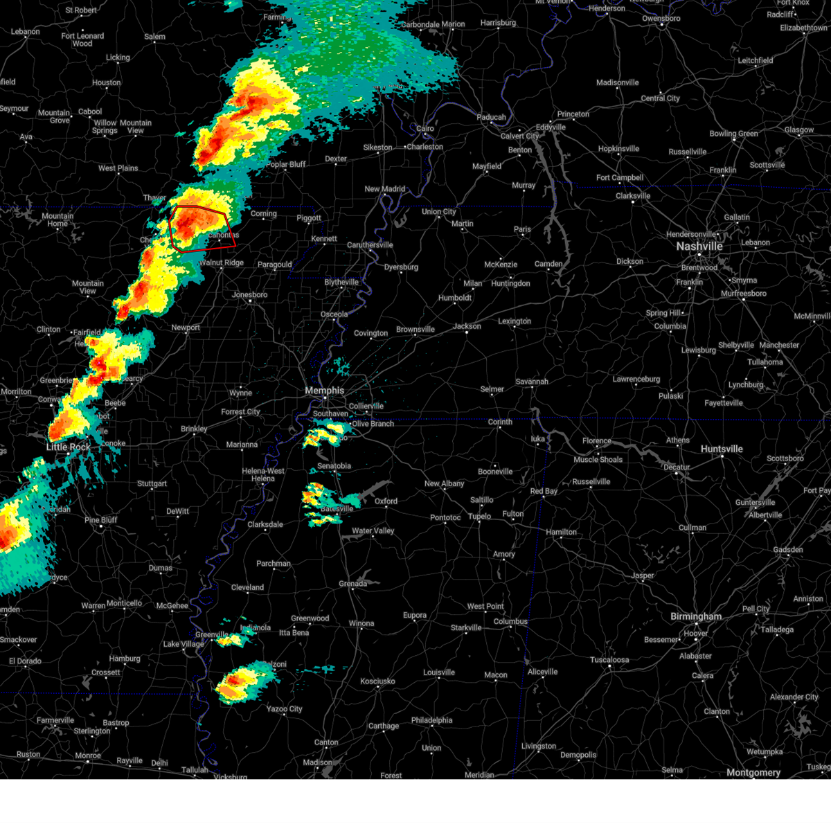 At 1027 pm cdt, a confirmed large and extremely dangerous tornado was located near ravenden springs, or 16 miles east of cherokee village, moving northeast at 55 mph. this is a particularly dangerous situation. take cover now! (radar confirmed tornado). Hazards include damaging tornado. You are in a life-threatening situation. flying debris may be deadly to those caught without shelter. mobile homes will be destroyed. considerable damage to homes, businesses, and vehicles is likely and complete destruction is possible. Locations impacted include, pocahontas, attica, ravenden, brakebill, ingram, eleven point, birdell, armstrong, ozark acres, engelberg, hamil, stokes, williford, ravenden springs, sharum, dalton, elm store, imboden, brockett, wirth,. At 1027 pm cdt, a confirmed large and extremely dangerous tornado was located near ravenden springs, or 16 miles east of cherokee village, moving northeast at 55 mph. this is a particularly dangerous situation. take cover now! (radar confirmed tornado). Hazards include damaging tornado. You are in a life-threatening situation. flying debris may be deadly to those caught without shelter. mobile homes will be destroyed. considerable damage to homes, businesses, and vehicles is likely and complete destruction is possible. Locations impacted include, pocahontas, attica, ravenden, brakebill, ingram, eleven point, birdell, armstrong, ozark acres, engelberg, hamil, stokes, williford, ravenden springs, sharum, dalton, elm store, imboden, brockett, wirth,.
|
| 3/14/2025 10:17 PM CDT |
 the tornado warning has been cancelled and is no longer in effect the tornado warning has been cancelled and is no longer in effect
|
| 3/14/2025 10:17 PM CDT |
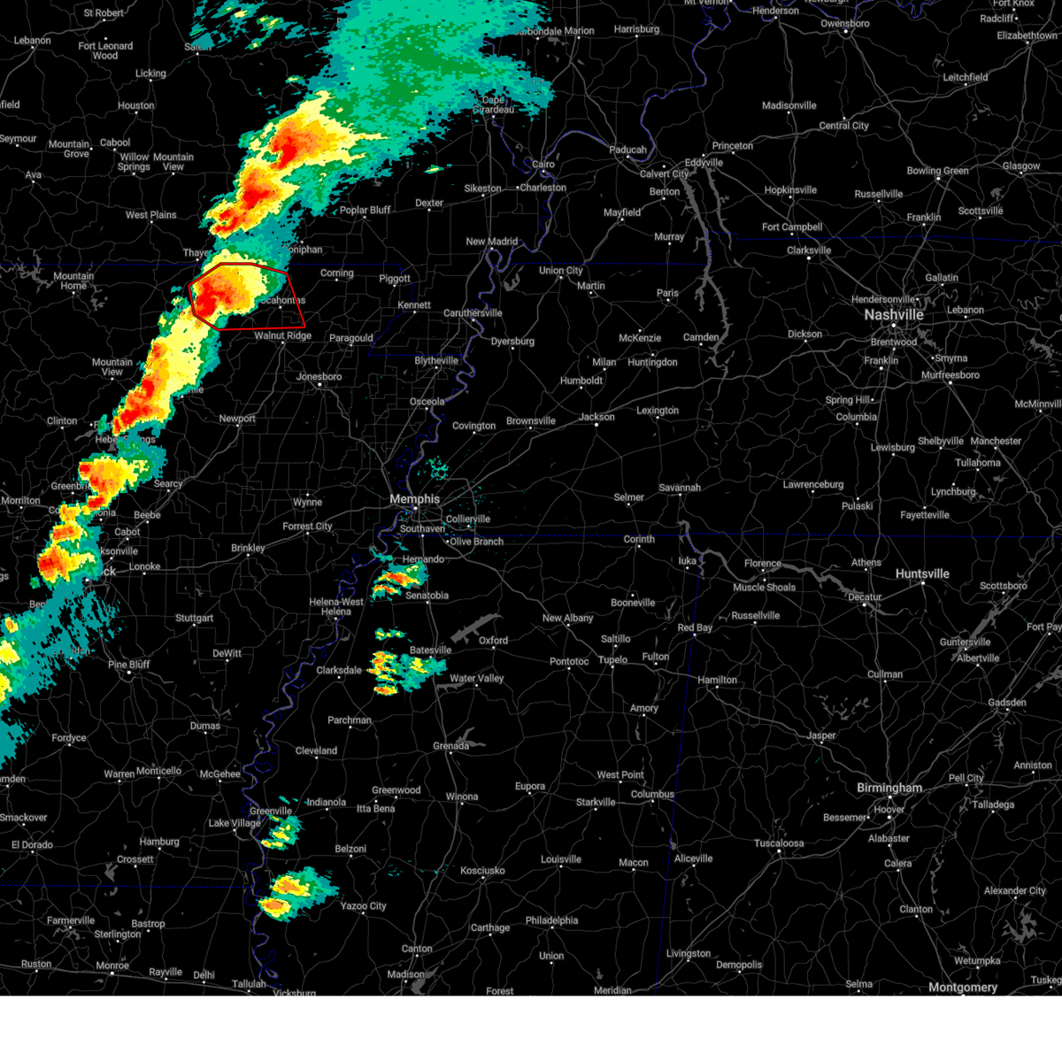 At 1016 pm cdt, a confirmed large and extremely dangerous tornado was located near hardy, or 7 miles east of cherokee village, moving northeast at 55 mph. this is a particularly dangerous situation. take cover now! (radar confirmed tornado). Hazards include damaging tornado. You are in a life-threatening situation. flying debris may be deadly to those caught without shelter. mobile homes will be destroyed. considerable damage to homes, businesses, and vehicles is likely and complete destruction is possible. Locations impacted include, pocahontas, o'kean, ingram, shannon, wirth, birdell, armstrong, engelberg, annieville, elnora, ravenden springs, cherokee village, dalton, sitka, imboden, attica, ravenden, brakebill, hardy, highland in sharp county,. At 1016 pm cdt, a confirmed large and extremely dangerous tornado was located near hardy, or 7 miles east of cherokee village, moving northeast at 55 mph. this is a particularly dangerous situation. take cover now! (radar confirmed tornado). Hazards include damaging tornado. You are in a life-threatening situation. flying debris may be deadly to those caught without shelter. mobile homes will be destroyed. considerable damage to homes, businesses, and vehicles is likely and complete destruction is possible. Locations impacted include, pocahontas, o'kean, ingram, shannon, wirth, birdell, armstrong, engelberg, annieville, elnora, ravenden springs, cherokee village, dalton, sitka, imboden, attica, ravenden, brakebill, hardy, highland in sharp county,.
|
| 3/14/2025 10:01 PM CDT |
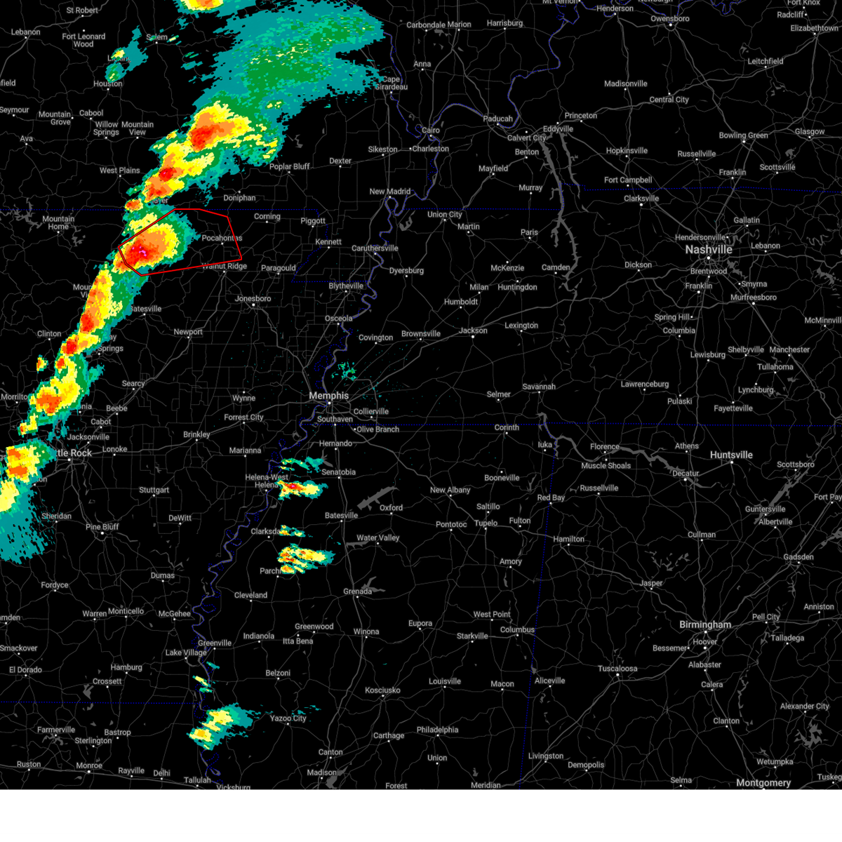 Torlzk the national weather service in little rock has issued a * tornado warning for, randolph county in eastern arkansas, northeastern izard county in north central arkansas, southeastern fulton county in north central arkansas, northern lawrence county in eastern arkansas, sharp county in north central arkansas, * until 1045 pm cdt. * at 1000 pm cdt, a confirmed large and extremely dangerous tornado was located over ballard, or near ash flat, moving northeast at 50 mph. this is a particularly dangerous situation. take cover now! (radar confirmed tornado). Hazards include damaging tornado. You are in a life-threatening situation. flying debris may be deadly to those caught without shelter. mobile homes will be destroyed. Considerable damage to homes, businesses, and vehicles is likely and complete destruction is possible. Torlzk the national weather service in little rock has issued a * tornado warning for, randolph county in eastern arkansas, northeastern izard county in north central arkansas, southeastern fulton county in north central arkansas, northern lawrence county in eastern arkansas, sharp county in north central arkansas, * until 1045 pm cdt. * at 1000 pm cdt, a confirmed large and extremely dangerous tornado was located over ballard, or near ash flat, moving northeast at 50 mph. this is a particularly dangerous situation. take cover now! (radar confirmed tornado). Hazards include damaging tornado. You are in a life-threatening situation. flying debris may be deadly to those caught without shelter. mobile homes will be destroyed. Considerable damage to homes, businesses, and vehicles is likely and complete destruction is possible.
|
| 5/26/2024 7:09 AM CDT |
 The storm which prompted the warning has moved out of the area. therefore, the warning will be allowed to expire. a tornado watch remains in effect until 1000 am cdt for eastern arkansas. The storm which prompted the warning has moved out of the area. therefore, the warning will be allowed to expire. a tornado watch remains in effect until 1000 am cdt for eastern arkansas.
|
| 5/26/2024 6:56 AM CDT |
 the severe thunderstorm warning has been cancelled and is no longer in effect the severe thunderstorm warning has been cancelled and is no longer in effect
|
| 5/26/2024 6:56 AM CDT |
 At 656 am cdt, a severe thunderstorm was located over pocahontas, moving east at 55 mph (radar indicated). Hazards include 60 mph wind gusts and quarter size hail. Hail damage to vehicles is expected. expect wind damage to roofs, siding, and trees. Locations impacted include, reyno, biggers, o'kean, engelberg,. At 656 am cdt, a severe thunderstorm was located over pocahontas, moving east at 55 mph (radar indicated). Hazards include 60 mph wind gusts and quarter size hail. Hail damage to vehicles is expected. expect wind damage to roofs, siding, and trees. Locations impacted include, reyno, biggers, o'kean, engelberg,.
|
| 5/26/2024 6:42 AM CDT |
 Svrlzk the national weather service in little rock has issued a * severe thunderstorm warning for, southeastern randolph county in eastern arkansas, northern lawrence county in eastern arkansas, * until 715 am cdt. * at 641 am cdt, a severe thunderstorm was located over imboden, or 9 miles north of black rock, moving east at 55 mph (radar indicated). Hazards include 60 mph wind gusts and quarter size hail. Hail damage to vehicles is expected. Expect wind damage to roofs, siding, and trees. Svrlzk the national weather service in little rock has issued a * severe thunderstorm warning for, southeastern randolph county in eastern arkansas, northern lawrence county in eastern arkansas, * until 715 am cdt. * at 641 am cdt, a severe thunderstorm was located over imboden, or 9 miles north of black rock, moving east at 55 mph (radar indicated). Hazards include 60 mph wind gusts and quarter size hail. Hail damage to vehicles is expected. Expect wind damage to roofs, siding, and trees.
|
| 5/26/2024 6:36 AM CDT |
 At 635 am cdt, severe thunderstorms were located along a line extending from success to biggers to near pocahontas to near black rock, moving east at 60 mph (radar indicated). Hazards include 60 mph wind gusts and quarter size hail. Hail damage to vehicles is expected. expect wind damage to roofs, siding, and trees. Locations impacted include, pocahontas, walnut ridge, hoxie, black rock, lake charles state park, imboden, ravenden, reyno, college city, portia, biggers, o'kean, ravenden springs, annieville, williford, powhatan, whiskerville, giles spur, shannon, birdell,. At 635 am cdt, severe thunderstorms were located along a line extending from success to biggers to near pocahontas to near black rock, moving east at 60 mph (radar indicated). Hazards include 60 mph wind gusts and quarter size hail. Hail damage to vehicles is expected. expect wind damage to roofs, siding, and trees. Locations impacted include, pocahontas, walnut ridge, hoxie, black rock, lake charles state park, imboden, ravenden, reyno, college city, portia, biggers, o'kean, ravenden springs, annieville, williford, powhatan, whiskerville, giles spur, shannon, birdell,.
|
| 5/26/2024 6:34 AM CDT |
 the tornado warning has been cancelled and is no longer in effect the tornado warning has been cancelled and is no longer in effect
|
| 5/26/2024 6:34 AM CDT |
 At 634 am cdt, a severe thunderstorm capable of producing a tornado was located near biggers, or near pocahontas, moving east at 45 mph (radar indicated rotation). Hazards include tornado and quarter size hail. Flying debris will be dangerous to those caught without shelter. mobile homes will be damaged or destroyed. damage to roofs, windows, and vehicles will occur. tree damage is likely. Locations impacted include, pocahontas, reyno, biggers, o'kean, whiskerville, giles spur, shannon, engelberg, stokes, fender, elnora, manson, lesterville, brockett,. At 634 am cdt, a severe thunderstorm capable of producing a tornado was located near biggers, or near pocahontas, moving east at 45 mph (radar indicated rotation). Hazards include tornado and quarter size hail. Flying debris will be dangerous to those caught without shelter. mobile homes will be damaged or destroyed. damage to roofs, windows, and vehicles will occur. tree damage is likely. Locations impacted include, pocahontas, reyno, biggers, o'kean, whiskerville, giles spur, shannon, engelberg, stokes, fender, elnora, manson, lesterville, brockett,.
|
| 5/26/2024 6:18 AM CDT |
 the severe thunderstorm warning has been cancelled and is no longer in effect the severe thunderstorm warning has been cancelled and is no longer in effect
|
| 5/26/2024 6:18 AM CDT |
 At 617 am cdt, severe thunderstorms were located along a line extending from 6 miles northeast of dalton to near attica to near imboden to 7 miles west of annieville, moving east at 60 mph. these are destructive storms for pocahontas (radar indicated). Hazards include 80 mph wind gusts and quarter size hail. Flying debris will be dangerous to those caught without shelter. mobile homes will be heavily damaged. expect considerable damage to roofs, windows, and vehicles. extensive tree damage and power outages are likely. Locations impacted include, pocahontas, walnut ridge, hoxie, black rock, lake charles state park, imboden, ravenden, reyno, college city, portia, maynard, biggers, o'kean, ravenden springs, annieville, dalton, attica, williford, powhatan, whiskerville,. At 617 am cdt, severe thunderstorms were located along a line extending from 6 miles northeast of dalton to near attica to near imboden to 7 miles west of annieville, moving east at 60 mph. these are destructive storms for pocahontas (radar indicated). Hazards include 80 mph wind gusts and quarter size hail. Flying debris will be dangerous to those caught without shelter. mobile homes will be heavily damaged. expect considerable damage to roofs, windows, and vehicles. extensive tree damage and power outages are likely. Locations impacted include, pocahontas, walnut ridge, hoxie, black rock, lake charles state park, imboden, ravenden, reyno, college city, portia, maynard, biggers, o'kean, ravenden springs, annieville, dalton, attica, williford, powhatan, whiskerville,.
|
| 5/26/2024 6:16 AM CDT |
 Torlzk the national weather service in little rock has issued a * tornado warning for, central randolph county in eastern arkansas, northern lawrence county in eastern arkansas, east central sharp county in north central arkansas, * until 645 am cdt. * at 615 am cdt, a severe thunderstorm capable of producing a tornado was located near ravenden springs, or 10 miles northwest of pocahontas, moving east at 70 mph (radar indicated rotation). Hazards include tornado. Flying debris will be dangerous to those caught without shelter. mobile homes will be damaged or destroyed. damage to roofs, windows, and vehicles will occur. Tree damage is likely. Torlzk the national weather service in little rock has issued a * tornado warning for, central randolph county in eastern arkansas, northern lawrence county in eastern arkansas, east central sharp county in north central arkansas, * until 645 am cdt. * at 615 am cdt, a severe thunderstorm capable of producing a tornado was located near ravenden springs, or 10 miles northwest of pocahontas, moving east at 70 mph (radar indicated rotation). Hazards include tornado. Flying debris will be dangerous to those caught without shelter. mobile homes will be damaged or destroyed. damage to roofs, windows, and vehicles will occur. Tree damage is likely.
|
| 5/26/2024 5:49 AM CDT |
 Svrlzk the national weather service in little rock has issued a * severe thunderstorm warning for, randolph county in eastern arkansas, northeastern izard county in north central arkansas, eastern fulton county in north central arkansas, central lawrence county in eastern arkansas, central sharp county in north central arkansas, * until 645 am cdt. * at 549 am cdt, severe thunderstorms were located along a line extending from near mammoth spring state park to cherokee village to ballard to near franklin, moving east at 60 mph (radar indicated). Hazards include 60 mph wind gusts and quarter size hail. Hail damage to vehicles is expected. Expect wind damage to roofs, siding, and trees. Svrlzk the national weather service in little rock has issued a * severe thunderstorm warning for, randolph county in eastern arkansas, northeastern izard county in north central arkansas, eastern fulton county in north central arkansas, central lawrence county in eastern arkansas, central sharp county in north central arkansas, * until 645 am cdt. * at 549 am cdt, severe thunderstorms were located along a line extending from near mammoth spring state park to cherokee village to ballard to near franklin, moving east at 60 mph (radar indicated). Hazards include 60 mph wind gusts and quarter size hail. Hail damage to vehicles is expected. Expect wind damage to roofs, siding, and trees.
|
| 3/14/2024 6:49 PM CDT |
 At 648 pm cdt, severe thunderstorms were located along a line extending from 6 miles south of gatewood to near ravenden springs to near annieville, moving east at 45 mph (radar indicated). Hazards include 60 mph wind gusts and penny size hail. Expect damage to roofs, siding, and trees. Locations impacted include, pocahontas, walnut ridge, black rock, imboden, ravenden, reyno, college city, portia, maynard, biggers, o'kean, ravenden springs, annieville, dalton, attica, smithville, williford, powhatan, whiskerville, giles spur,. At 648 pm cdt, severe thunderstorms were located along a line extending from 6 miles south of gatewood to near ravenden springs to near annieville, moving east at 45 mph (radar indicated). Hazards include 60 mph wind gusts and penny size hail. Expect damage to roofs, siding, and trees. Locations impacted include, pocahontas, walnut ridge, black rock, imboden, ravenden, reyno, college city, portia, maynard, biggers, o'kean, ravenden springs, annieville, dalton, attica, smithville, williford, powhatan, whiskerville, giles spur,.
|
| 3/14/2024 6:49 PM CDT |
 the severe thunderstorm warning has been cancelled and is no longer in effect the severe thunderstorm warning has been cancelled and is no longer in effect
|
| 3/14/2024 6:23 PM CDT |
 Svrlzk the national weather service in little rock has issued a * severe thunderstorm warning for, randolph county in eastern arkansas, eastern fulton county in north central arkansas, northern lawrence county in eastern arkansas, sharp county in north central arkansas, * until 715 pm cdt. * at 622 pm cdt, severe thunderstorms were located along a line extending from mammoth spring to hardy to near myron, moving east at 45 mph (radar indicated). Hazards include 60 mph wind gusts and penny size hail. expect damage to roofs, siding, and trees Svrlzk the national weather service in little rock has issued a * severe thunderstorm warning for, randolph county in eastern arkansas, eastern fulton county in north central arkansas, northern lawrence county in eastern arkansas, sharp county in north central arkansas, * until 715 pm cdt. * at 622 pm cdt, severe thunderstorms were located along a line extending from mammoth spring to hardy to near myron, moving east at 45 mph (radar indicated). Hazards include 60 mph wind gusts and penny size hail. expect damage to roofs, siding, and trees
|
| 8/26/2023 3:04 PM CDT |
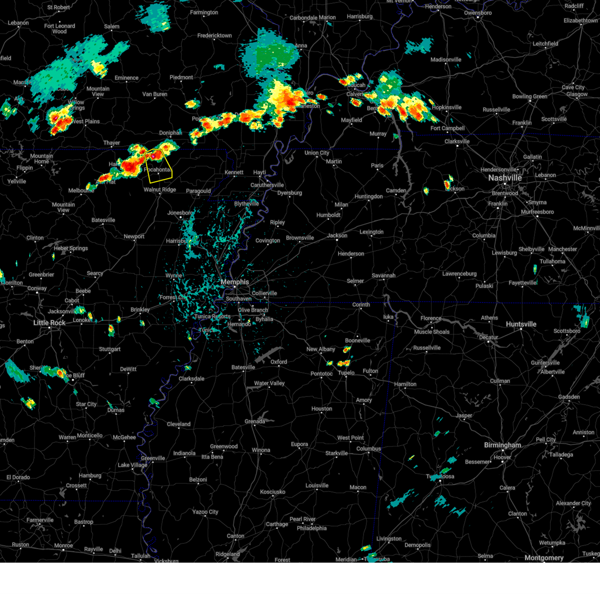 At 304 pm cdt, a severe thunderstorm was located over attica, or near pocahontas, moving south at 15 mph (radar indicated). Hazards include 60 mph wind gusts and penny size hail. Expect damage to roofs, siding, and trees. locations impacted include, pocahontas, maynard, attica, elkins park, brakebill, middlebrook, warm springs, ingram, shannon, birdell, hamil, stokes, engelerg, sharum, manson, brockett, hail threat, radar indicated max hail size, 0. 75 in wind threat, radar indicated max wind gust, 60 mph. At 304 pm cdt, a severe thunderstorm was located over attica, or near pocahontas, moving south at 15 mph (radar indicated). Hazards include 60 mph wind gusts and penny size hail. Expect damage to roofs, siding, and trees. locations impacted include, pocahontas, maynard, attica, elkins park, brakebill, middlebrook, warm springs, ingram, shannon, birdell, hamil, stokes, engelerg, sharum, manson, brockett, hail threat, radar indicated max hail size, 0. 75 in wind threat, radar indicated max wind gust, 60 mph.
|
| 8/26/2023 2:43 PM CDT |
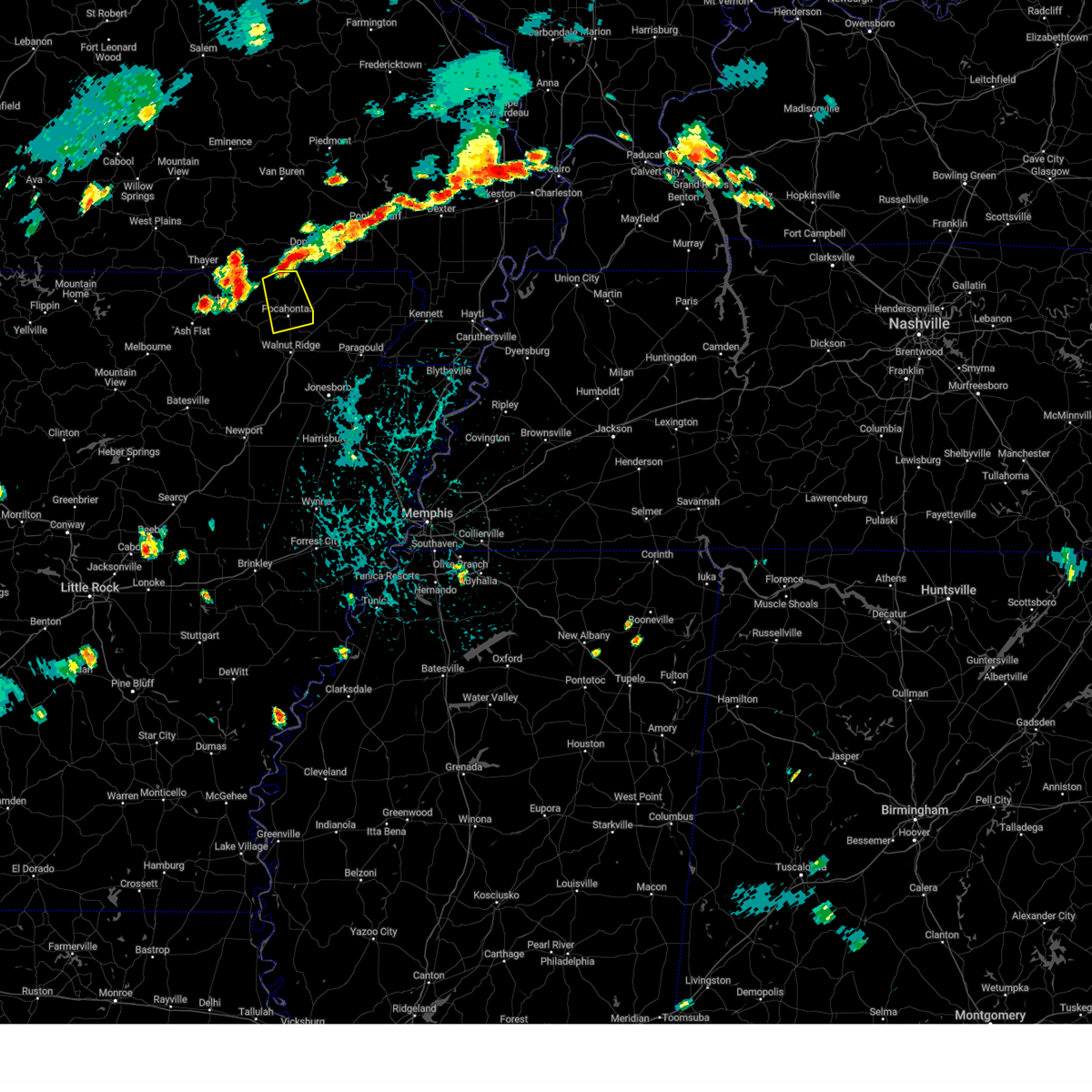 At 243 pm cdt, a severe thunderstorm was located near attica, or 10 miles north of pocahontas, moving south at 20 mph (radar indicated). Hazards include 60 mph wind gusts and quarter size hail. Hail damage to vehicles is expected. Expect wind damage to roofs, siding, and trees. At 243 pm cdt, a severe thunderstorm was located near attica, or 10 miles north of pocahontas, moving south at 20 mph (radar indicated). Hazards include 60 mph wind gusts and quarter size hail. Hail damage to vehicles is expected. Expect wind damage to roofs, siding, and trees.
|
| 8/9/2023 9:07 PM CDT |
 At 906 pm cdt, a severe thunderstorm was located near annieville, or near lake charles state park, moving southeast at 55 mph (radar indicated). Hazards include 70 mph wind gusts and quarter size hail. Hail damage to vehicles is possible. expect considerable tree damage. Wind damage is also likely to mobile homes, roofs, and outbuildings. At 906 pm cdt, a severe thunderstorm was located near annieville, or near lake charles state park, moving southeast at 55 mph (radar indicated). Hazards include 70 mph wind gusts and quarter size hail. Hail damage to vehicles is possible. expect considerable tree damage. Wind damage is also likely to mobile homes, roofs, and outbuildings.
|
| 7/13/2023 6:48 PM CDT |
 At 648 pm cdt, a severe thunderstorm was located near imboden, or near black rock, moving south at 30 mph (radar indicated). Hazards include 60 mph wind gusts and quarter size hail. Hail damage to vehicles is expected. expect wind damage to roofs, siding, and trees. locations impacted include, pocahontas, black rock, lake charles state park, imboden, ravenden, ravenden springs, annieville, dalton, attica, powhatan, armstrong, ingram, shannon, birdell, eleven point, eaton, hamil, stokes, engelerg, sharum, hail threat, radar indicated max hail size, 1. 00 in wind threat, radar indicated max wind gust, 60 mph. At 648 pm cdt, a severe thunderstorm was located near imboden, or near black rock, moving south at 30 mph (radar indicated). Hazards include 60 mph wind gusts and quarter size hail. Hail damage to vehicles is expected. expect wind damage to roofs, siding, and trees. locations impacted include, pocahontas, black rock, lake charles state park, imboden, ravenden, ravenden springs, annieville, dalton, attica, powhatan, armstrong, ingram, shannon, birdell, eleven point, eaton, hamil, stokes, engelerg, sharum, hail threat, radar indicated max hail size, 1. 00 in wind threat, radar indicated max wind gust, 60 mph.
|
| 7/13/2023 6:29 PM CDT |
 At 628 pm cdt, a severe thunderstorm was located near ravenden springs, or 9 miles northwest of pocahontas, moving southeast at 30 mph (radar indicated). Hazards include ping pong ball size hail and 60 mph wind gusts. People and animals outdoors will be injured. expect hail damage to roofs, siding, windows, and vehicles. expect wind damage to roofs, siding, and trees. locations impacted include, pocahontas, black rock, lake charles state park, imboden, ravenden, ravenden springs, annieville, dalton, attica, powhatan, armstrong, ingram, shannon, birdell, eleven point, eaton, hamil, stokes, engelerg, sharum, hail threat, radar indicated max hail size, 1. 50 in wind threat, radar indicated max wind gust, 60 mph. At 628 pm cdt, a severe thunderstorm was located near ravenden springs, or 9 miles northwest of pocahontas, moving southeast at 30 mph (radar indicated). Hazards include ping pong ball size hail and 60 mph wind gusts. People and animals outdoors will be injured. expect hail damage to roofs, siding, windows, and vehicles. expect wind damage to roofs, siding, and trees. locations impacted include, pocahontas, black rock, lake charles state park, imboden, ravenden, ravenden springs, annieville, dalton, attica, powhatan, armstrong, ingram, shannon, birdell, eleven point, eaton, hamil, stokes, engelerg, sharum, hail threat, radar indicated max hail size, 1. 50 in wind threat, radar indicated max wind gust, 60 mph.
|
| 7/13/2023 6:20 PM CDT |
 At 620 pm cdt, a severe thunderstorm was located over dalton, or 14 miles northwest of pocahontas, moving southeast at 30 mph (radar indicated). Hazards include 60 mph wind gusts and quarter size hail. Hail damage to vehicles is expected. Expect wind damage to roofs, siding, and trees. At 620 pm cdt, a severe thunderstorm was located over dalton, or 14 miles northwest of pocahontas, moving southeast at 30 mph (radar indicated). Hazards include 60 mph wind gusts and quarter size hail. Hail damage to vehicles is expected. Expect wind damage to roofs, siding, and trees.
|
| 7/5/2023 3:28 PM CDT |
 At 328 pm cdt, a severe thunderstorm was located near black rock, moving east at 20 mph (radar indicated). Hazards include 60 mph wind gusts and penny size hail. expect damage to roofs, siding, and trees At 328 pm cdt, a severe thunderstorm was located near black rock, moving east at 20 mph (radar indicated). Hazards include 60 mph wind gusts and penny size hail. expect damage to roofs, siding, and trees
|
| 7/4/2023 7:01 PM CDT |
 At 701 pm cdt, a severe thunderstorm was located over college city, or near walnut ridge, moving south at 30 mph (radar indicated). Hazards include 60 mph wind gusts and quarter size hail. Hail damage to vehicles is expected. expect wind damage to roofs, siding, and trees. locations impacted include, pocahontas, walnut ridge, hoxie, college city, o`kean, sedgwick, whiskerville, giles spur, shannon, dicus, fender, elnora, manson, lesterville, hail threat, radar indicated max hail size, 1. 00 in wind threat, radar indicated max wind gust, 60 mph. At 701 pm cdt, a severe thunderstorm was located over college city, or near walnut ridge, moving south at 30 mph (radar indicated). Hazards include 60 mph wind gusts and quarter size hail. Hail damage to vehicles is expected. expect wind damage to roofs, siding, and trees. locations impacted include, pocahontas, walnut ridge, hoxie, college city, o`kean, sedgwick, whiskerville, giles spur, shannon, dicus, fender, elnora, manson, lesterville, hail threat, radar indicated max hail size, 1. 00 in wind threat, radar indicated max wind gust, 60 mph.
|
| 7/4/2023 6:56 PM CDT |
 At 656 pm cdt, a severe thunderstorm was located near college city, or near pocahontas, moving south at 30 mph (radar indicated). Hazards include 60 mph wind gusts and quarter size hail. Hail damage to vehicles is expected. expect wind damage to roofs, siding, and trees. locations impacted include, pocahontas, walnut ridge, hoxie, black rock, college city, portia, o`kean, minturn, sedgwick, whiskerville, giles spur, shannon, birdell, dicus, fender, elnora, sharum, manson, lesterville, arbor grove, hail threat, radar indicated max hail size, 1. 00 in wind threat, radar indicated max wind gust, 60 mph. At 656 pm cdt, a severe thunderstorm was located near college city, or near pocahontas, moving south at 30 mph (radar indicated). Hazards include 60 mph wind gusts and quarter size hail. Hail damage to vehicles is expected. expect wind damage to roofs, siding, and trees. locations impacted include, pocahontas, walnut ridge, hoxie, black rock, college city, portia, o`kean, minturn, sedgwick, whiskerville, giles spur, shannon, birdell, dicus, fender, elnora, sharum, manson, lesterville, arbor grove, hail threat, radar indicated max hail size, 1. 00 in wind threat, radar indicated max wind gust, 60 mph.
|
| 7/4/2023 6:43 PM CDT |
 At 643 pm cdt, a severe thunderstorm was located over pocahontas, moving south at 30 mph (radar indicated). Hazards include 60 mph wind gusts and quarter size hail. Hail damage to vehicles is expected. Expect wind damage to roofs, siding, and trees. At 643 pm cdt, a severe thunderstorm was located over pocahontas, moving south at 30 mph (radar indicated). Hazards include 60 mph wind gusts and quarter size hail. Hail damage to vehicles is expected. Expect wind damage to roofs, siding, and trees.
|
| 7/4/2023 6:34 PM CDT |
 At 633 pm cdt, severe thunderstorms were located along a line extending from near maynard to attica to near ravenden springs, moving southeast at 20 mph (radar indicated). Hazards include 60 mph wind gusts and nickel size hail. Expect damage to roofs, siding, and trees. locations impacted include, pocahontas, reyno, maynard, biggers, ravenden springs, attica, dalton, elkins park, ingram, shannon, eleven point, birdell, hamil, stokes, engelerg, sharum, brockett, hail threat, radar indicated max hail size, 0. 88 in wind threat, radar indicated max wind gust, 60 mph. At 633 pm cdt, severe thunderstorms were located along a line extending from near maynard to attica to near ravenden springs, moving southeast at 20 mph (radar indicated). Hazards include 60 mph wind gusts and nickel size hail. Expect damage to roofs, siding, and trees. locations impacted include, pocahontas, reyno, maynard, biggers, ravenden springs, attica, dalton, elkins park, ingram, shannon, eleven point, birdell, hamil, stokes, engelerg, sharum, brockett, hail threat, radar indicated max hail size, 0. 88 in wind threat, radar indicated max wind gust, 60 mph.
|
| 7/4/2023 6:08 PM CDT |
 At 607 pm cdt, severe thunderstorms were located along a line extending from 3 miles northwest of maynard to dalton to 3 miles northwest of ravenden springs, moving southeast at 25 mph (radar indicated). Hazards include 60 mph wind gusts and nickel size hail. Expect damage to roofs, siding, and trees. locations impacted include, pocahontas, reyno, maynard, biggers, ravenden springs, attica, dalton, elkins park, brakebill, middlebrook, warm springs, ingram, shannon, eleven point, birdell, hamil, stokes, engelerg, sharum, brockett, hail threat, radar indicated max hail size, 0. 88 in wind threat, radar indicated max wind gust, 60 mph. At 607 pm cdt, severe thunderstorms were located along a line extending from 3 miles northwest of maynard to dalton to 3 miles northwest of ravenden springs, moving southeast at 25 mph (radar indicated). Hazards include 60 mph wind gusts and nickel size hail. Expect damage to roofs, siding, and trees. locations impacted include, pocahontas, reyno, maynard, biggers, ravenden springs, attica, dalton, elkins park, brakebill, middlebrook, warm springs, ingram, shannon, eleven point, birdell, hamil, stokes, engelerg, sharum, brockett, hail threat, radar indicated max hail size, 0. 88 in wind threat, radar indicated max wind gust, 60 mph.
|
| 7/4/2023 5:54 PM CDT |
 At 553 pm cdt, severe thunderstorms were located along a line extending from 6 miles northwest of maynard to near dalton to 10 miles east of mammoth spring, moving southeast at 25 mph (radar indicated). Hazards include 60 mph wind gusts and nickel size hail. expect damage to roofs, siding, and trees At 553 pm cdt, severe thunderstorms were located along a line extending from 6 miles northwest of maynard to near dalton to 10 miles east of mammoth spring, moving southeast at 25 mph (radar indicated). Hazards include 60 mph wind gusts and nickel size hail. expect damage to roofs, siding, and trees
|
| 7/1/2023 1:28 PM CDT |
 At 127 pm cdt, a severe thunderstorm was located over biggers, or 10 miles northeast of pocahontas, moving northeast at 30 mph (radar indicated). Hazards include 60 mph wind gusts and quarter size hail. Hail damage to vehicles is expected. expect wind damage to roofs, siding, and trees. locations impacted include, pocahontas, reyno, biggers, stokes, brockett, engelerg, hail threat, radar indicated max hail size, 1. 00 in wind threat, radar indicated max wind gust, 60 mph. At 127 pm cdt, a severe thunderstorm was located over biggers, or 10 miles northeast of pocahontas, moving northeast at 30 mph (radar indicated). Hazards include 60 mph wind gusts and quarter size hail. Hail damage to vehicles is expected. expect wind damage to roofs, siding, and trees. locations impacted include, pocahontas, reyno, biggers, stokes, brockett, engelerg, hail threat, radar indicated max hail size, 1. 00 in wind threat, radar indicated max wind gust, 60 mph.
|
| 7/1/2023 1:18 PM CDT |
 At 118 pm cdt, a severe thunderstorm was located near pocahontas, moving east at 25 mph (radar indicated). Hazards include 60 mph wind gusts and quarter size hail. Hail damage to vehicles is expected. expect wind damage to roofs, siding, and trees. locations impacted include, pocahontas, reyno, maynard, biggers, stokes, engelerg, brockett, hail threat, radar indicated max hail size, 1. 00 in wind threat, radar indicated max wind gust, 60 mph. At 118 pm cdt, a severe thunderstorm was located near pocahontas, moving east at 25 mph (radar indicated). Hazards include 60 mph wind gusts and quarter size hail. Hail damage to vehicles is expected. expect wind damage to roofs, siding, and trees. locations impacted include, pocahontas, reyno, maynard, biggers, stokes, engelerg, brockett, hail threat, radar indicated max hail size, 1. 00 in wind threat, radar indicated max wind gust, 60 mph.
|
| 7/1/2023 1:05 PM CDT |
 At 105 pm cdt, a severe thunderstorm was located over pocahontas, moving east at 25 mph (radar indicated). Hazards include 60 mph wind gusts and quarter size hail. Hail damage to vehicles is expected. Expect wind damage to roofs, siding, and trees. At 105 pm cdt, a severe thunderstorm was located over pocahontas, moving east at 25 mph (radar indicated). Hazards include 60 mph wind gusts and quarter size hail. Hail damage to vehicles is expected. Expect wind damage to roofs, siding, and trees.
|
| 6/18/2023 5:05 PM CDT | A few trees were uprooted a couple miles south of pocahonta in randolph county AR, 1.9 miles N of Pocahontas, AR |
| 6/18/2023 5:05 PM CDT |
 At 505 pm cdt, a severe thunderstorm capable of producing a tornado was located near pocahontas, moving east at 25 mph (radar indicated rotation). Hazards include tornado and quarter size hail. Flying debris will be dangerous to those caught without shelter. mobile homes will be damaged or destroyed. damage to roofs, windows, and vehicles will occur. tree damage is likely. Locations impacted include, pocahontas, walnut ridge, college city, o`kean, whiskerville, giles spur, shannon, fender, elnora, sharum, manson, lesterville, davidsonville historic state pa,. At 505 pm cdt, a severe thunderstorm capable of producing a tornado was located near pocahontas, moving east at 25 mph (radar indicated rotation). Hazards include tornado and quarter size hail. Flying debris will be dangerous to those caught without shelter. mobile homes will be damaged or destroyed. damage to roofs, windows, and vehicles will occur. tree damage is likely. Locations impacted include, pocahontas, walnut ridge, college city, o`kean, whiskerville, giles spur, shannon, fender, elnora, sharum, manson, lesterville, davidsonville historic state pa,.
|
| 6/18/2023 4:53 PM CDT |
 At 453 pm cdt, a severe thunderstorm capable of producing a tornado was located near pocahontas, moving east at 25 mph (radar indicated rotation). Hazards include tornado and quarter size hail. Flying debris will be dangerous to those caught without shelter. mobile homes will be damaged or destroyed. damage to roofs, windows, and vehicles will occur. Tree damage is likely. At 453 pm cdt, a severe thunderstorm capable of producing a tornado was located near pocahontas, moving east at 25 mph (radar indicated rotation). Hazards include tornado and quarter size hail. Flying debris will be dangerous to those caught without shelter. mobile homes will be damaged or destroyed. damage to roofs, windows, and vehicles will occur. Tree damage is likely.
|
| 4/5/2023 11:06 AM CDT |
 At 1106 am cdt, a severe thunderstorm was located near pocahontas, moving northeast at 55 mph (radar indicated). Hazards include 60 mph wind gusts. Expect damage to roofs, siding, and trees. locations impacted include, pocahontas, walnut ridge, black rock, lake charles state park, reyno, college city, portia, maynard, biggers, o`kean, attica, powhatan, whiskerville, giles spur, middlebrook, ingram, shannon, birdell, dicus, elnora, hail threat, radar indicated max hail size, <. 75 in wind threat, radar indicated max wind gust, 60 mph. At 1106 am cdt, a severe thunderstorm was located near pocahontas, moving northeast at 55 mph (radar indicated). Hazards include 60 mph wind gusts. Expect damage to roofs, siding, and trees. locations impacted include, pocahontas, walnut ridge, black rock, lake charles state park, reyno, college city, portia, maynard, biggers, o`kean, attica, powhatan, whiskerville, giles spur, middlebrook, ingram, shannon, birdell, dicus, elnora, hail threat, radar indicated max hail size, <. 75 in wind threat, radar indicated max wind gust, 60 mph.
|
| 4/5/2023 10:53 AM CDT |
 At 1052 am cdt, a severe thunderstorm was located over black rock, moving east at 55 mph (radar indicated). Hazards include 60 mph wind gusts. expect damage to roofs, siding, and trees At 1052 am cdt, a severe thunderstorm was located over black rock, moving east at 55 mph (radar indicated). Hazards include 60 mph wind gusts. expect damage to roofs, siding, and trees
|
| 4/5/2023 3:21 AM CDT |
 The severe thunderstorm warning for northeastern randolph county will expire at 330 am cdt, the storm which prompted the warning has weakened below severe limits, and no longer poses an immediate threat to life or property. therefore, the warning will be allowed to expire. a tornado watch remains in effect until 900 am cdt for eastern arkansas. The severe thunderstorm warning for northeastern randolph county will expire at 330 am cdt, the storm which prompted the warning has weakened below severe limits, and no longer poses an immediate threat to life or property. therefore, the warning will be allowed to expire. a tornado watch remains in effect until 900 am cdt for eastern arkansas.
|
| 4/5/2023 3:03 AM CDT |
 At 303 am cdt, a severe thunderstorm was located over maynard, or 9 miles north of pocahontas, moving northeast at 65 mph (broadcast media). Hazards include 60 mph wind gusts and quarter size hail. Hail damage to vehicles is expected. expect wind damage to roofs, siding, and trees. locations impacted include, pocahontas, reyno, maynard, biggers, attica, elkins park, brakebill, middlebrook, ingram, hamil, stokes, engelerg, brockett, pitman, hail threat, radar indicated max hail size, 1. 00 in wind threat, radar indicated max wind gust, 60 mph. At 303 am cdt, a severe thunderstorm was located over maynard, or 9 miles north of pocahontas, moving northeast at 65 mph (broadcast media). Hazards include 60 mph wind gusts and quarter size hail. Hail damage to vehicles is expected. expect wind damage to roofs, siding, and trees. locations impacted include, pocahontas, reyno, maynard, biggers, attica, elkins park, brakebill, middlebrook, ingram, hamil, stokes, engelerg, brockett, pitman, hail threat, radar indicated max hail size, 1. 00 in wind threat, radar indicated max wind gust, 60 mph.
|
| 4/5/2023 2:45 AM CDT |
 At 245 am cdt, a severe thunderstorm was located over imboden, or near black rock, moving northeast at 65 mph (radar indicated). Hazards include 60 mph wind gusts and half dollar size hail. Hail damage to vehicles is expected. Expect wind damage to roofs, siding, and trees. At 245 am cdt, a severe thunderstorm was located over imboden, or near black rock, moving northeast at 65 mph (radar indicated). Hazards include 60 mph wind gusts and half dollar size hail. Hail damage to vehicles is expected. Expect wind damage to roofs, siding, and trees.
|
| 2/16/2023 4:39 AM CST |
 At 438 am cst, a severe thunderstorm was located near stella, or 9 miles east of melbourne, moving northeast at 50 mph (radar indicated). Hazards include 60 mph wind gusts and quarter size hail. Hail damage to vehicles is expected. Expect wind damage to roofs, siding, and trees. At 438 am cst, a severe thunderstorm was located near stella, or 9 miles east of melbourne, moving northeast at 50 mph (radar indicated). Hazards include 60 mph wind gusts and quarter size hail. Hail damage to vehicles is expected. Expect wind damage to roofs, siding, and trees.
|
| 7/17/2022 7:57 PM CDT |
 At 757 pm cdt, severe thunderstorms were located along a line extending from fairdealing to 7 miles northwest of maynard to 9 miles east of mammoth spring, moving southeast at 35 mph (radar indicated). Hazards include 60 mph wind gusts and penny size hail. expect damage to roofs, siding, and trees At 757 pm cdt, severe thunderstorms were located along a line extending from fairdealing to 7 miles northwest of maynard to 9 miles east of mammoth spring, moving southeast at 35 mph (radar indicated). Hazards include 60 mph wind gusts and penny size hail. expect damage to roofs, siding, and trees
|
| 5/21/2022 6:30 PM CDT |
 At 629 pm cdt, severe thunderstorms were located along a line extending from 6 miles north of maynard to near beech grove to egypt, moving east at 70 mph (radar indicated). Hazards include 60 mph wind gusts and quarter size hail. Hail damage to vehicles is expected. Expect wind damage to roofs, siding, and trees. At 629 pm cdt, severe thunderstorms were located along a line extending from 6 miles north of maynard to near beech grove to egypt, moving east at 70 mph (radar indicated). Hazards include 60 mph wind gusts and quarter size hail. Hail damage to vehicles is expected. Expect wind damage to roofs, siding, and trees.
|
| 5/21/2022 6:13 PM CDT | Video of large tree uproote in randolph county AR, 0.5 miles NNW of Pocahontas, AR |
| 5/21/2022 5:44 PM CDT |
 At 544 pm cdt, severe thunderstorms were located along a line extending from near thayer to 8 miles southeast of highland in sharp county to near cave city, moving east at 45 mph (radar indicated). Hazards include 70 mph wind gusts and quarter size hail. Hail damage to vehicles is expected. expect considerable tree damage. Wind damage is also likely to mobile homes, roofs, and outbuildings. At 544 pm cdt, severe thunderstorms were located along a line extending from near thayer to 8 miles southeast of highland in sharp county to near cave city, moving east at 45 mph (radar indicated). Hazards include 70 mph wind gusts and quarter size hail. Hail damage to vehicles is expected. expect considerable tree damage. Wind damage is also likely to mobile homes, roofs, and outbuildings.
|
| 5/21/2022 2:29 PM CDT |
 At 229 pm cdt, a severe thunderstorm was located over college city, or near walnut ridge, moving northeast at 30 mph (radar indicated). Hazards include 60 mph wind gusts and quarter size hail. Hail damage to vehicles is expected. Expect wind damage to roofs, siding, and trees. At 229 pm cdt, a severe thunderstorm was located over college city, or near walnut ridge, moving northeast at 30 mph (radar indicated). Hazards include 60 mph wind gusts and quarter size hail. Hail damage to vehicles is expected. Expect wind damage to roofs, siding, and trees.
|
| 4/15/2022 7:45 PM CDT |
 Tornado emergency for imboden, black rock and walnut ridge, the national weather service in little rock has issued a * tornado warning for, southeastern randolph county in eastern arkansas, northeastern jackson county in eastern arkansas, lawrence county in eastern arkansas, east central sharp county in north central arkansas, * until 830 pm cdt. * at 743 pm cdt, a confirmed large and destructive tornado was observed near ravenden, or 14 miles east of cherokee village, moving east at 45 mph. tornado emergency for imboden, black rock and walnut ridge. this is a particularly dangerous situation. take cover now! (weather spotters confirmed tornado). Hazards include deadly tornado. You are in a life-threatening situation. flying debris may be deadly to those caught without shelter. mobile homes will be destroyed. Considerable damage to homes, businesses, and vehicles is likely and complete destruction is possible. Tornado emergency for imboden, black rock and walnut ridge, the national weather service in little rock has issued a * tornado warning for, southeastern randolph county in eastern arkansas, northeastern jackson county in eastern arkansas, lawrence county in eastern arkansas, east central sharp county in north central arkansas, * until 830 pm cdt. * at 743 pm cdt, a confirmed large and destructive tornado was observed near ravenden, or 14 miles east of cherokee village, moving east at 45 mph. tornado emergency for imboden, black rock and walnut ridge. this is a particularly dangerous situation. take cover now! (weather spotters confirmed tornado). Hazards include deadly tornado. You are in a life-threatening situation. flying debris may be deadly to those caught without shelter. mobile homes will be destroyed. Considerable damage to homes, businesses, and vehicles is likely and complete destruction is possible.
|
| 3/6/2022 8:13 PM CST |
 At 812 pm cst, a severe thunderstorm capable of producing a tornado was located over ravenden springs, or 12 miles west of pocahontas, moving northeast at 45 mph (weather spotters reported a funnel cloud). Hazards include tornado and half dollar size hail. Flying debris will be dangerous to those caught without shelter. mobile homes will be damaged or destroyed. damage to roofs, windows, and vehicles will occur. tree damage is likely. Locations impacted include, pocahontas, reyno, maynard, biggers, ravenden springs, attica, dalton, elkins park, brakebill, middlebrook, warm springs, ingram, birdell, hamil, stokes, engelerg, brockett, pitman,. At 812 pm cst, a severe thunderstorm capable of producing a tornado was located over ravenden springs, or 12 miles west of pocahontas, moving northeast at 45 mph (weather spotters reported a funnel cloud). Hazards include tornado and half dollar size hail. Flying debris will be dangerous to those caught without shelter. mobile homes will be damaged or destroyed. damage to roofs, windows, and vehicles will occur. tree damage is likely. Locations impacted include, pocahontas, reyno, maynard, biggers, ravenden springs, attica, dalton, elkins park, brakebill, middlebrook, warm springs, ingram, birdell, hamil, stokes, engelerg, brockett, pitman,.
|
| 3/6/2022 8:05 PM CST | Several power poles knocked down along with damage to poultry houses and two structure in randolph county AR, 12.3 miles SE of Pocahontas, AR |
| 3/6/2022 7:59 PM CST |
 At 758 pm cst, a severe thunderstorm capable of producing a tornado was located near ravenden, or 12 miles east of cherokee village, moving northeast at 45 mph (radar indicated rotation). Hazards include tornado and ping pong ball size hail. Flying debris will be dangerous to those caught without shelter. mobile homes will be damaged or destroyed. damage to roofs, windows, and vehicles will occur. Tree damage is likely. At 758 pm cst, a severe thunderstorm capable of producing a tornado was located near ravenden, or 12 miles east of cherokee village, moving northeast at 45 mph (radar indicated rotation). Hazards include tornado and ping pong ball size hail. Flying debris will be dangerous to those caught without shelter. mobile homes will be damaged or destroyed. damage to roofs, windows, and vehicles will occur. Tree damage is likely.
|
| 3/6/2022 5:56 PM CST |
 At 555 pm cst, a confirmed tornado was located near birdell, moving northeast at 50 mph (weather spotters confirmed tornado). Hazards include damaging tornado. Flying debris will be dangerous to those caught without shelter. mobile homes will be damaged or destroyed. damage to roofs, windows, and vehicles will occur. tree damage is likely. Locations impacted include, pocahontas, reyno, maynard, biggers, o`kean, attica, elkins park, brakebill, middlebrook, ingram, shannon, birdell, hamil, stokes, fender, elnora, engelerg, sharum, manson, lesterville,. At 555 pm cst, a confirmed tornado was located near birdell, moving northeast at 50 mph (weather spotters confirmed tornado). Hazards include damaging tornado. Flying debris will be dangerous to those caught without shelter. mobile homes will be damaged or destroyed. damage to roofs, windows, and vehicles will occur. tree damage is likely. Locations impacted include, pocahontas, reyno, maynard, biggers, o`kean, attica, elkins park, brakebill, middlebrook, ingram, shannon, birdell, hamil, stokes, fender, elnora, engelerg, sharum, manson, lesterville,.
|
| 3/6/2022 5:37 PM CST |
 At 536 pm cst, a confirmed tornado was located over lake charles state park, moving northeast at 60 mph (weather spotters confirmed tornado). Hazards include damaging tornado. Flying debris will be dangerous to those caught without shelter. mobile homes will be damaged or destroyed. damage to roofs, windows, and vehicles will occur. tree damage is likely. Locations impacted include, pocahontas, walnut ridge, hoxie, black rock, lake charles state park, imboden, reyno, college city, portia, maynard, biggers, lynn, o`kean, annieville, attica, smithville, powhatan, middlebrook, ingram, shannon,. At 536 pm cst, a confirmed tornado was located over lake charles state park, moving northeast at 60 mph (weather spotters confirmed tornado). Hazards include damaging tornado. Flying debris will be dangerous to those caught without shelter. mobile homes will be damaged or destroyed. damage to roofs, windows, and vehicles will occur. tree damage is likely. Locations impacted include, pocahontas, walnut ridge, hoxie, black rock, lake charles state park, imboden, reyno, college city, portia, maynard, biggers, lynn, o`kean, annieville, attica, smithville, powhatan, middlebrook, ingram, shannon,.
|
| 3/6/2022 5:30 PM CST |
 At 529 pm cst, a severe thunderstorm capable of producing a tornado was located over lynn, or near lake charles state park, moving northeast at 55 mph (weather spotters reported funnel cloud). Hazards include tornado. Flying debris will be dangerous to those caught without shelter. mobile homes will be damaged or destroyed. damage to roofs, windows, and vehicles will occur. Tree damage is likely. At 529 pm cst, a severe thunderstorm capable of producing a tornado was located over lynn, or near lake charles state park, moving northeast at 55 mph (weather spotters reported funnel cloud). Hazards include tornado. Flying debris will be dangerous to those caught without shelter. mobile homes will be damaged or destroyed. damage to roofs, windows, and vehicles will occur. Tree damage is likely.
|
| 10/25/2021 12:26 AM CDT |
 The severe thunderstorm warning for southeastern randolph county will expire at 1230 am cdt, the storms which prompted the warning have moved out of the area. therefore, the warning will be allowed to expire. however gusty winds are still possible with these thunderstorms. a tornado watch remains in effect until 400 am cdt for eastern arkansas. The severe thunderstorm warning for southeastern randolph county will expire at 1230 am cdt, the storms which prompted the warning have moved out of the area. therefore, the warning will be allowed to expire. however gusty winds are still possible with these thunderstorms. a tornado watch remains in effect until 400 am cdt for eastern arkansas.
|
| 10/25/2021 12:18 AM CDT |
 At 1217 am cdt, severe thunderstorms were located along a line extending from near corning to near black rock, moving east at 40 mph (radar indicated). Hazards include 60 mph wind gusts. Expect damage to roofs, siding, and trees. locations impacted include, pocahontas, reyno, biggers, o`kean, stokes, engelerg, brockett, hail threat, radar indicated max hail size, <. 75 in wind threat, radar indicated max wind gust, 60 mph. At 1217 am cdt, severe thunderstorms were located along a line extending from near corning to near black rock, moving east at 40 mph (radar indicated). Hazards include 60 mph wind gusts. Expect damage to roofs, siding, and trees. locations impacted include, pocahontas, reyno, biggers, o`kean, stokes, engelerg, brockett, hail threat, radar indicated max hail size, <. 75 in wind threat, radar indicated max wind gust, 60 mph.
|
| 10/24/2021 11:50 PM CDT |
 At 1150 pm cdt, severe thunderstorms were located along a line extending from near maynard to 7 miles southwest of ravenden, moving east at 40 mph (radar indicated). Hazards include 60 mph wind gusts and quarter size hail. Hail damage to vehicles is expected. Expect wind damage to roofs, siding, and trees. At 1150 pm cdt, severe thunderstorms were located along a line extending from near maynard to 7 miles southwest of ravenden, moving east at 40 mph (radar indicated). Hazards include 60 mph wind gusts and quarter size hail. Hail damage to vehicles is expected. Expect wind damage to roofs, siding, and trees.
|
| 5/6/2021 1:37 PM CDT |
 At 137 pm cdt, a severe thunderstorm was located near pocahontas, moving southeast at 40 mph (radar indicated). Hazards include 60 mph wind gusts and quarter size hail. Hail damage to vehicles is expected. expect wind damage to roofs, siding, and trees. Locations impacted include, pocahontas, walnut ridge, college city, o`kean, attica, whiskerville, giles spur, ingram, shannon, birdell, stokes, fender, elnora, engelerg, manson, lesterville, brockett,. At 137 pm cdt, a severe thunderstorm was located near pocahontas, moving southeast at 40 mph (radar indicated). Hazards include 60 mph wind gusts and quarter size hail. Hail damage to vehicles is expected. expect wind damage to roofs, siding, and trees. Locations impacted include, pocahontas, walnut ridge, college city, o`kean, attica, whiskerville, giles spur, ingram, shannon, birdell, stokes, fender, elnora, engelerg, manson, lesterville, brockett,.
|
| 5/6/2021 1:21 PM CDT |
 At 121 pm cdt, a severe thunderstorm was located near attica, or 7 miles northwest of pocahontas, moving southeast at 40 mph (radar indicated). Hazards include 60 mph wind gusts and quarter size hail. Hail damage to vehicles is expected. expect wind damage to roofs, siding, and trees. Locations impacted include, pocahontas, walnut ridge, college city, biggers, o`kean, ravenden springs, attica, dalton, whiskerville, giles spur, ingram, shannon, birdell, hamil, stokes, dicus, fender, elnora, engelerg, sharum,. At 121 pm cdt, a severe thunderstorm was located near attica, or 7 miles northwest of pocahontas, moving southeast at 40 mph (radar indicated). Hazards include 60 mph wind gusts and quarter size hail. Hail damage to vehicles is expected. expect wind damage to roofs, siding, and trees. Locations impacted include, pocahontas, walnut ridge, college city, biggers, o`kean, ravenden springs, attica, dalton, whiskerville, giles spur, ingram, shannon, birdell, hamil, stokes, dicus, fender, elnora, engelerg, sharum,.
|
| 5/6/2021 1:03 PM CDT |
 At 103 pm cdt, a severe thunderstorm was located near dalton, or 15 miles east of mammoth spring, moving southeast at 40 mph (radar indicated). Hazards include 60 mph wind gusts and quarter size hail. Hail damage to vehicles is expected. Expect wind damage to roofs, siding, and trees. At 103 pm cdt, a severe thunderstorm was located near dalton, or 15 miles east of mammoth spring, moving southeast at 40 mph (radar indicated). Hazards include 60 mph wind gusts and quarter size hail. Hail damage to vehicles is expected. Expect wind damage to roofs, siding, and trees.
|
| 5/4/2021 1:53 AM CDT | General public reported winds around 60 mph in the cit in randolph county AR, 0.5 miles NNW of Pocahontas, AR |
| 5/4/2021 1:46 AM CDT |
 At 146 am cdt, severe thunderstorms were located along a line extending from near gatewood to near pocahontas to near minturn, moving east at 45 mph (radar indicated). Hazards include 60 mph wind gusts and quarter size hail. Hail damage to vehicles is expected. expect wind damage to roofs, siding, and trees. Locations impacted include, pocahontas, walnut ridge, hoxie, black rock, lake charles state park, imboden, reyno, college city, portia, maynard, biggers, lynn, o`kean, ravenden springs, annieville, dalton, attica, powhatan, whiskerville, giles spur, this includes us highway 67 between mile markers 120 and 121. At 146 am cdt, severe thunderstorms were located along a line extending from near gatewood to near pocahontas to near minturn, moving east at 45 mph (radar indicated). Hazards include 60 mph wind gusts and quarter size hail. Hail damage to vehicles is expected. expect wind damage to roofs, siding, and trees. Locations impacted include, pocahontas, walnut ridge, hoxie, black rock, lake charles state park, imboden, reyno, college city, portia, maynard, biggers, lynn, o`kean, ravenden springs, annieville, dalton, attica, powhatan, whiskerville, giles spur, this includes us highway 67 between mile markers 120 and 121.
|
| 5/4/2021 1:32 AM CDT |
 At 132 am cdt, severe thunderstorms were located along a line extending from 10 miles northwest of dalton to near ravenden to lynn, moving east at 45 mph (radar indicated). Hazards include 60 mph wind gusts and quarter size hail. Hail damage to vehicles is expected. Expect wind damage to roofs, siding, and trees. At 132 am cdt, severe thunderstorms were located along a line extending from 10 miles northwest of dalton to near ravenden to lynn, moving east at 45 mph (radar indicated). Hazards include 60 mph wind gusts and quarter size hail. Hail damage to vehicles is expected. Expect wind damage to roofs, siding, and trees.
|
| 5/4/2021 1:29 AM CDT | Numerous trees and powerlines down across the county. a tree was blown onto a home near pocahonta in randolph county AR, 3.1 miles W of Pocahontas, AR |
| 5/4/2021 12:59 AM CDT |
 At 1258 am cdt, a severe thunderstorm was located over walnut ridge, moving northeast at 30 mph. this storm has had a history of penny sized hail (radar indicated). Hazards include 60 mph wind gusts and quarter size hail. Hail damage to vehicles is expected. Expect wind damage to roofs, siding, and trees. At 1258 am cdt, a severe thunderstorm was located over walnut ridge, moving northeast at 30 mph. this storm has had a history of penny sized hail (radar indicated). Hazards include 60 mph wind gusts and quarter size hail. Hail damage to vehicles is expected. Expect wind damage to roofs, siding, and trees.
|
| 4/7/2021 3:55 PM CDT |
 At 355 pm cdt, a severe thunderstorm was located over attica, or near pocahontas, moving northeast at 55 mph (radar indicated). Hazards include 60 mph wind gusts and quarter size hail. Hail damage to vehicles is expected. expect wind damage to roofs, siding, and trees. Locations impacted include, pocahontas, reyno, maynard, biggers, attica, elkins park, ingram, shannon, birdell, stokes, engelerg, sharum, brockett, pitman,. At 355 pm cdt, a severe thunderstorm was located over attica, or near pocahontas, moving northeast at 55 mph (radar indicated). Hazards include 60 mph wind gusts and quarter size hail. Hail damage to vehicles is expected. expect wind damage to roofs, siding, and trees. Locations impacted include, pocahontas, reyno, maynard, biggers, attica, elkins park, ingram, shannon, birdell, stokes, engelerg, sharum, brockett, pitman,.
|
| 4/7/2021 3:45 PM CDT |
 At 344 pm cdt, a severe thunderstorm was located over imboden, or 7 miles north of black rock, moving northeast at 50 mph (radar indicated). Hazards include 60 mph wind gusts and quarter size hail. Hail damage to vehicles is expected. expect wind damage to roofs, siding, and trees. Locations impacted include, pocahontas, black rock, imboden, reyno, maynard, biggers, attica, elkins park, ingram, shannon, birdell, stokes, elnora, engelerg, sharum, manson, brockett, pitman, davidsonville historic state pa,. At 344 pm cdt, a severe thunderstorm was located over imboden, or 7 miles north of black rock, moving northeast at 50 mph (radar indicated). Hazards include 60 mph wind gusts and quarter size hail. Hail damage to vehicles is expected. expect wind damage to roofs, siding, and trees. Locations impacted include, pocahontas, black rock, imboden, reyno, maynard, biggers, attica, elkins park, ingram, shannon, birdell, stokes, elnora, engelerg, sharum, manson, brockett, pitman, davidsonville historic state pa,.
|
| 4/7/2021 3:35 PM CDT |
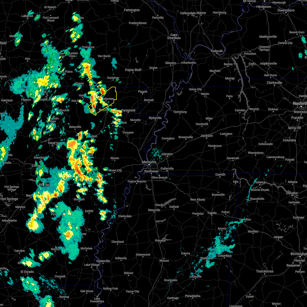 At 335 pm cdt, a severe thunderstorm was located over annieville, or near lake charles state park, moving northeast at 55 mph (radar indicated). Hazards include 60 mph wind gusts and quarter size hail. Hail damage to vehicles is expected. Expect wind damage to roofs, siding, and trees. At 335 pm cdt, a severe thunderstorm was located over annieville, or near lake charles state park, moving northeast at 55 mph (radar indicated). Hazards include 60 mph wind gusts and quarter size hail. Hail damage to vehicles is expected. Expect wind damage to roofs, siding, and trees.
|
| 11/15/2020 12:29 AM CST |
 At 1229 am cst, a severe thunderstorm was located over imboden, or 7 miles north of black rock, moving east at 45 mph (radar indicated). Hazards include 60 mph wind gusts and penny size hail. expect damage to roofs, siding, and trees At 1229 am cst, a severe thunderstorm was located over imboden, or 7 miles north of black rock, moving east at 45 mph (radar indicated). Hazards include 60 mph wind gusts and penny size hail. expect damage to roofs, siding, and trees
|
| 11/15/2020 12:15 AM CST |
 At 1215 am cst, a severe thunderstorm capable of producing a tornado was located 3 miles southwest of annieville, or 9 miles west of lake charles state park, moving east at 55 mph (radar indicated rotation). Hazards include tornado and quarter size hail. Flying debris will be dangerous to those caught without shelter. mobile homes will be damaged or destroyed. damage to roofs, windows, and vehicles will occur. tree damage is likely. Locations impacted include, pocahontas, walnut ridge, black rock, lake charles state park, imboden, ravenden, college city, portia, annieville, smithville, powhatan, giles spur, shannon, birdell, nelsonville, elnora, sitka, fender, engelerg, sharum,. At 1215 am cst, a severe thunderstorm capable of producing a tornado was located 3 miles southwest of annieville, or 9 miles west of lake charles state park, moving east at 55 mph (radar indicated rotation). Hazards include tornado and quarter size hail. Flying debris will be dangerous to those caught without shelter. mobile homes will be damaged or destroyed. damage to roofs, windows, and vehicles will occur. tree damage is likely. Locations impacted include, pocahontas, walnut ridge, black rock, lake charles state park, imboden, ravenden, college city, portia, annieville, smithville, powhatan, giles spur, shannon, birdell, nelsonville, elnora, sitka, fender, engelerg, sharum,.
|
| 11/15/2020 12:06 AM CST |
 At 1206 am cst, a severe thunderstorm capable of producing a tornado was located 10 miles southeast of ash flat, moving east at 50 mph (radar indicated rotation). Hazards include tornado and quarter size hail. Flying debris will be dangerous to those caught without shelter. mobile homes will be damaged or destroyed. damage to roofs, windows, and vehicles will occur. Tree damage is likely. At 1206 am cst, a severe thunderstorm capable of producing a tornado was located 10 miles southeast of ash flat, moving east at 50 mph (radar indicated rotation). Hazards include tornado and quarter size hail. Flying debris will be dangerous to those caught without shelter. mobile homes will be damaged or destroyed. damage to roofs, windows, and vehicles will occur. Tree damage is likely.
|
| 5/25/2020 3:57 PM CDT | A large tree was blown down on a home. winds from an observation site near town measured between 45 and 50 mph around that tim in randolph county AR, 0.5 miles NNW of Pocahontas, AR |
| 5/3/2020 1:24 PM CDT |
 At 123 pm cdt, a severe thunderstorm was located near college city, or near walnut ridge, moving east at 50 mph (radar indicated). Hazards include 60 mph wind gusts and quarter size hail. Hail damage to vehicles is expected. expect wind damage to roofs, siding, and trees. Locations impacted include, pocahontas, walnut ridge, hoxie, black rock, imboden, college city, portia, o`kean, annieville, powhatan, giles spur, shannon, birdell, dicus, fender, elnora, sharum, manson, lesterville, davidsonville historic state pa, this includes us highway 67 between mile markers 119 and 121. At 123 pm cdt, a severe thunderstorm was located near college city, or near walnut ridge, moving east at 50 mph (radar indicated). Hazards include 60 mph wind gusts and quarter size hail. Hail damage to vehicles is expected. expect wind damage to roofs, siding, and trees. Locations impacted include, pocahontas, walnut ridge, hoxie, black rock, imboden, college city, portia, o`kean, annieville, powhatan, giles spur, shannon, birdell, dicus, fender, elnora, sharum, manson, lesterville, davidsonville historic state pa, this includes us highway 67 between mile markers 119 and 121.
|
| 5/3/2020 1:01 PM CDT |
 At 100 pm cdt, a severe thunderstorm was located near ravenden, or 13 miles east of cherokee village, moving east at 50 mph (radar indicated). Hazards include 60 mph wind gusts and quarter size hail. Hail damage to vehicles is expected. Expect wind damage to roofs, siding, and trees. At 100 pm cdt, a severe thunderstorm was located near ravenden, or 13 miles east of cherokee village, moving east at 50 mph (radar indicated). Hazards include 60 mph wind gusts and quarter size hail. Hail damage to vehicles is expected. Expect wind damage to roofs, siding, and trees.
|
| 4/20/2020 6:00 PM CDT |
 At 558 pm cdt, a severe thunderstorm was located 4 miles northwest of college city, or 3 miles southwest of pocahontas, moving southeast at 35 mph. hail may cover the ground in places (radar indicated). Hazards include quarter size hail. Damage to vehicles is expected. Locations impacted include, pocahontas, walnut ridge, hoxie, college city, o`kean, sedgwick, whiskerville, giles spur, shannon, birdell, dicus, fender, elnora, sharum, manson, lesterville, davidsonville historic state pa, this includes us highway 67 between mile markers 120 and 121. At 558 pm cdt, a severe thunderstorm was located 4 miles northwest of college city, or 3 miles southwest of pocahontas, moving southeast at 35 mph. hail may cover the ground in places (radar indicated). Hazards include quarter size hail. Damage to vehicles is expected. Locations impacted include, pocahontas, walnut ridge, hoxie, college city, o`kean, sedgwick, whiskerville, giles spur, shannon, birdell, dicus, fender, elnora, sharum, manson, lesterville, davidsonville historic state pa, this includes us highway 67 between mile markers 120 and 121.
|
| 4/20/2020 5:41 PM CDT |
 At 540 pm cdt, a severe thunderstorm was located near ravenden springs, or 11 miles west of pocahontas, moving southeast at 35 mph. hail may cover the ground in places (radar indicated). Hazards include quarter size hail. damage to vehicles is expected At 540 pm cdt, a severe thunderstorm was located near ravenden springs, or 11 miles west of pocahontas, moving southeast at 35 mph. hail may cover the ground in places (radar indicated). Hazards include quarter size hail. damage to vehicles is expected
|
| 4/8/2020 7:00 PM CDT |
 At 700 pm cdt, a severe thunderstorm was located near pocahontas, moving east at 30 mph (radar indicated). Hazards include 60 mph wind gusts and quarter size hail. Hail damage to vehicles is expected. Expect wind damage to roofs, siding, and trees. At 700 pm cdt, a severe thunderstorm was located near pocahontas, moving east at 30 mph (radar indicated). Hazards include 60 mph wind gusts and quarter size hail. Hail damage to vehicles is expected. Expect wind damage to roofs, siding, and trees.
|
| 4/8/2020 6:37 PM CDT |
 At 637 pm cdt, a severe thunderstorm was located 7 miles north of strawberry, or 12 miles west of lake charles state park, moving southeast at 35 mph (radar indicated). Hazards include 60 mph wind gusts and half dollar size hail. Hail damage to vehicles is expected. expect wind damage to roofs, siding, and trees. Locations impacted include, pocahontas, black rock, lake charles state park, imboden, ravenden, strawberry, lynn, ravenden springs, annieville, smithville, williford, powhatan, calamine, poughkeepsie, eaton, birdell, nelsonville, sharum, sitka, driftwood,. At 637 pm cdt, a severe thunderstorm was located 7 miles north of strawberry, or 12 miles west of lake charles state park, moving southeast at 35 mph (radar indicated). Hazards include 60 mph wind gusts and half dollar size hail. Hail damage to vehicles is expected. expect wind damage to roofs, siding, and trees. Locations impacted include, pocahontas, black rock, lake charles state park, imboden, ravenden, strawberry, lynn, ravenden springs, annieville, smithville, williford, powhatan, calamine, poughkeepsie, eaton, birdell, nelsonville, sharum, sitka, driftwood,.
|
| 4/8/2020 6:15 PM CDT |
 At 615 pm cdt, a severe thunderstorm was located near ash flat, moving east at 35 mph (radar indicated). Hazards include golf ball size hail and 60 mph wind gusts. People and animals outdoors will be injured. expect hail damage to roofs, siding, windows, and vehicles. Expect wind damage to roofs, siding, and trees. At 615 pm cdt, a severe thunderstorm was located near ash flat, moving east at 35 mph (radar indicated). Hazards include golf ball size hail and 60 mph wind gusts. People and animals outdoors will be injured. expect hail damage to roofs, siding, windows, and vehicles. Expect wind damage to roofs, siding, and trees.
|
| 3/24/2020 10:32 AM CDT |
 At 1032 am cdt, severe thunderstorms were located along a line extending from near maynard to near portia, moving east at 55 mph (radar indicated). Hazards include 60 mph wind gusts and quarter size hail. Hail damage to vehicles is expected. expect wind damage to roofs, siding, and trees. Locations impacted include, pocahontas, walnut ridge, hoxie, black rock, imboden, reyno, college city, portia, maynard, biggers, o`kean, annieville, attica, whiskerville, giles spur, middlebrook, ingram, shannon, birdell, dicus, this includes us highway 67 near mile marker 121. At 1032 am cdt, severe thunderstorms were located along a line extending from near maynard to near portia, moving east at 55 mph (radar indicated). Hazards include 60 mph wind gusts and quarter size hail. Hail damage to vehicles is expected. expect wind damage to roofs, siding, and trees. Locations impacted include, pocahontas, walnut ridge, hoxie, black rock, imboden, reyno, college city, portia, maynard, biggers, o`kean, annieville, attica, whiskerville, giles spur, middlebrook, ingram, shannon, birdell, dicus, this includes us highway 67 near mile marker 121.
|
| 3/24/2020 10:14 AM CDT |
 At 1013 am cdt, severe thunderstorms were located along a line extending from near dalton to near ravenden, moving east at 45 mph (law enforcement). Hazards include 60 mph wind gusts and half dollar size hail. Hail damage to vehicles is expected. Expect wind damage to roofs, siding, and trees. At 1013 am cdt, severe thunderstorms were located along a line extending from near dalton to near ravenden, moving east at 45 mph (law enforcement). Hazards include 60 mph wind gusts and half dollar size hail. Hail damage to vehicles is expected. Expect wind damage to roofs, siding, and trees.
|
| 1/11/2020 12:28 AM CST |
 The severe thunderstorm warning for southeastern independence, randolph, northeastern jackson and southeastern lawrence counties will expire at 1230 am cst, the storms which prompted the warning have weakened below severe limits, and no longer pose an immediate threat to life or property. therefore, the warning will be allowed to expire. however gusty winds and heavy rain are still possible with these thunderstorms. a tornado watch remains in effect until 600 am cst for eastern and north central arkansas. The severe thunderstorm warning for southeastern independence, randolph, northeastern jackson and southeastern lawrence counties will expire at 1230 am cst, the storms which prompted the warning have weakened below severe limits, and no longer pose an immediate threat to life or property. therefore, the warning will be allowed to expire. however gusty winds and heavy rain are still possible with these thunderstorms. a tornado watch remains in effect until 600 am cst for eastern and north central arkansas.
|
| 1/11/2020 12:21 AM CST |
 At 1221 am cst, severe thunderstorms were located along a line extending from near maynard to near o`kean to minturn to diaz, moving east at 55 mph (radar indicated). Hazards include 60 mph wind gusts. Expect damage to roofs, siding, and trees. Locations impacted include, newport, pocahontas, walnut ridge, hoxie, black rock, lake charles state park, tuckerman, diaz, swifton, reyno, college city, portia, maynard, grubbs, biggers, oil trough, jacksonport, o`kean, alicia, minturn, this includes us highway 67 between mile markers 85 and 101, and between mile markers 109 and 121. At 1221 am cst, severe thunderstorms were located along a line extending from near maynard to near o`kean to minturn to diaz, moving east at 55 mph (radar indicated). Hazards include 60 mph wind gusts. Expect damage to roofs, siding, and trees. Locations impacted include, newport, pocahontas, walnut ridge, hoxie, black rock, lake charles state park, tuckerman, diaz, swifton, reyno, college city, portia, maynard, grubbs, biggers, oil trough, jacksonport, o`kean, alicia, minturn, this includes us highway 67 between mile markers 85 and 101, and between mile markers 109 and 121.
|
| 1/10/2020 11:30 PM CST |
 At 1130 pm cst, severe thunderstorms were located along a line extending from 11 miles northwest of dalton to near ravenden to near strawberry to near southside in independence county, moving east at 25 mph (radar indicated). Hazards include 60 mph wind gusts. expect damage to roofs, siding, and trees At 1130 pm cst, severe thunderstorms were located along a line extending from 11 miles northwest of dalton to near ravenden to near strawberry to near southside in independence county, moving east at 25 mph (radar indicated). Hazards include 60 mph wind gusts. expect damage to roofs, siding, and trees
|
| 9/25/2019 3:59 PM CDT |
 At 359 pm cdt, severe thunderstorms were located along a line extending from near highland in sharp county to near stella to mount pleasant, moving east at 20 mph (radar indicated). Hazards include 60 mph wind gusts and quarter size hail. Hail damage to vehicles is expected. Expect wind damage to roofs, siding, and trees. At 359 pm cdt, severe thunderstorms were located along a line extending from near highland in sharp county to near stella to mount pleasant, moving east at 20 mph (radar indicated). Hazards include 60 mph wind gusts and quarter size hail. Hail damage to vehicles is expected. Expect wind damage to roofs, siding, and trees.
|
| 8/27/2019 1:55 AM CDT |
 At 155 am cdt, severe thunderstorms were located along a line extending from near pocahontas to 8 miles north of cave city to lacrosse, moving southeast at 50 mph (radar indicated). Hazards include 60 mph wind gusts. expect damage to roofs, siding, and trees At 155 am cdt, severe thunderstorms were located along a line extending from near pocahontas to 8 miles north of cave city to lacrosse, moving southeast at 50 mph (radar indicated). Hazards include 60 mph wind gusts. expect damage to roofs, siding, and trees
|
| 8/18/2019 6:35 PM CDT |
 The severe thunderstorm warning for central randolph county will expire at 645 pm cdt, the storm which prompted the warning has weakened below severe limits, and no longer poses an immediate threat to life or property. therefore, the warning will be allowed to expire. however gusty winds and heavy rain are still possible with this thunderstorm. The severe thunderstorm warning for central randolph county will expire at 645 pm cdt, the storm which prompted the warning has weakened below severe limits, and no longer poses an immediate threat to life or property. therefore, the warning will be allowed to expire. however gusty winds and heavy rain are still possible with this thunderstorm.
|
| 8/18/2019 6:25 PM CDT |
 At 607 pm cdt, a severe thunderstorm was located near attica, or 8 miles northwest of pocahontas, moving east at 5 mph (radar indicated). Hazards include 60 mph wind gusts and quarter size hail. Hail damage to vehicles is expected. Expect wind damage to roofs, siding, and trees. At 607 pm cdt, a severe thunderstorm was located near attica, or 8 miles northwest of pocahontas, moving east at 5 mph (radar indicated). Hazards include 60 mph wind gusts and quarter size hail. Hail damage to vehicles is expected. Expect wind damage to roofs, siding, and trees.
|
| 8/18/2019 6:08 PM CDT |
 The national weather service in little rock has issued a * severe thunderstorm warning for. central randolph county in eastern arkansas. until 645 pm cdt. At 607 pm cdt, a severe thunderstorm was located near attica, or 8 miles northwest of pocahontas, moving east at 5 mph. The national weather service in little rock has issued a * severe thunderstorm warning for. central randolph county in eastern arkansas. until 645 pm cdt. At 607 pm cdt, a severe thunderstorm was located near attica, or 8 miles northwest of pocahontas, moving east at 5 mph.
|
| 8/18/2019 4:52 PM CDT |
 The severe thunderstorm warning for southeastern randolph and east central lawrence counties will expire at 500 pm cdt. the storm which prompted the warning has moved out of the area. Therefore, the warning will be allowed to expire. The severe thunderstorm warning for southeastern randolph and east central lawrence counties will expire at 500 pm cdt. the storm which prompted the warning has moved out of the area. Therefore, the warning will be allowed to expire.
|
| 8/18/2019 4:19 PM CDT |
 At 419 pm cdt, a severe thunderstorm was located over college city, or near walnut ridge, moving east at 20 mph (radar indicated). Hazards include 60 mph wind gusts and quarter size hail. Hail damage to vehicles is expected. expect wind damage to roofs, siding, and trees. Locations impacted include, pocahontas, walnut ridge, hoxie, black rock, college city, portia, o`kean, whiskerville, giles spur, shannon, dicus, fender, elnora, manson, lesterville, davidsonville historic state pa, this includes us highway 67 between mile markers 119 and 121. At 419 pm cdt, a severe thunderstorm was located over college city, or near walnut ridge, moving east at 20 mph (radar indicated). Hazards include 60 mph wind gusts and quarter size hail. Hail damage to vehicles is expected. expect wind damage to roofs, siding, and trees. Locations impacted include, pocahontas, walnut ridge, hoxie, black rock, college city, portia, o`kean, whiskerville, giles spur, shannon, dicus, fender, elnora, manson, lesterville, davidsonville historic state pa, this includes us highway 67 between mile markers 119 and 121.
|
| 8/18/2019 4:08 PM CDT |
 At 407 pm cdt, a severe thunderstorm was located near black rock, moving east at 20 mph (radar indicated). Hazards include 60 mph wind gusts and quarter size hail. Hail damage to vehicles is expected. Expect wind damage to roofs, siding, and trees. At 407 pm cdt, a severe thunderstorm was located near black rock, moving east at 20 mph (radar indicated). Hazards include 60 mph wind gusts and quarter size hail. Hail damage to vehicles is expected. Expect wind damage to roofs, siding, and trees.
|
| 8/18/2019 3:42 PM CDT |
 At 322 pm cdt, a severe thunderstorm was located near attica, or near pocahontas, moving east at 20 mph (radar indicated). Hazards include 60 mph wind gusts and quarter size hail. Hail damage to vehicles is expected. expect wind damage to roofs, siding, and trees. Locations impacted include, pocahontas, reyno, maynard, biggers, attica, elkins park, brakebill, middlebrook, ingram, birdell, stokes, engelerg, brockett, hamil,. At 322 pm cdt, a severe thunderstorm was located near attica, or near pocahontas, moving east at 20 mph (radar indicated). Hazards include 60 mph wind gusts and quarter size hail. Hail damage to vehicles is expected. expect wind damage to roofs, siding, and trees. Locations impacted include, pocahontas, reyno, maynard, biggers, attica, elkins park, brakebill, middlebrook, ingram, birdell, stokes, engelerg, brockett, hamil,.
|
| 8/18/2019 3:40 PM CDT | Multiple trees and powerlines were blown dow in randolph county AR, 0.5 miles NNW of Pocahontas, AR |
| 8/18/2019 3:22 PM CDT |
 At 322 pm cdt, a severe thunderstorm was located near attica, or near pocahontas, moving east at 20 mph (radar indicated). Hazards include 60 mph wind gusts and quarter size hail. Hail damage to vehicles is expected. expect wind damage to roofs, siding, and trees. Locations impacted include, pocahontas, reyno, maynard, biggers, attica, elkins park, brakebill, middlebrook, ingram, birdell, stokes, engelerg, brockett, hamil,. At 322 pm cdt, a severe thunderstorm was located near attica, or near pocahontas, moving east at 20 mph (radar indicated). Hazards include 60 mph wind gusts and quarter size hail. Hail damage to vehicles is expected. expect wind damage to roofs, siding, and trees. Locations impacted include, pocahontas, reyno, maynard, biggers, attica, elkins park, brakebill, middlebrook, ingram, birdell, stokes, engelerg, brockett, hamil,.
|
| 8/18/2019 3:20 PM CDT | Several trees snapped or uprooted between pocahontas and attica. a metal barn was also destroyed. relayed via social medi in randolph county AR, 3.7 miles S of Pocahontas, AR |
| 8/18/2019 3:09 PM CDT |
 The national weather service in little rock has issued a * severe thunderstorm warning for. northeastern randolph county in eastern arkansas. until 400 pm cdt. At 309 pm cdt, a severe thunderstorm was located over attica, or near pocahontas, moving east at 20 mph. The national weather service in little rock has issued a * severe thunderstorm warning for. northeastern randolph county in eastern arkansas. until 400 pm cdt. At 309 pm cdt, a severe thunderstorm was located over attica, or near pocahontas, moving east at 20 mph.
|
| 7/5/2019 3:36 PM CDT |
 The severe thunderstorm warning for northeastern randolph county will expire at 345 pm cdt, the storm which prompted the warning has weakened below severe limits, and no longer poses an immediate threat to life or property. therefore, the warning will be allowed to expire. however gusty winds are still possible with this thunderstorm. to report severe weather, contact your nearest law enforcement agency. they will relay your report to the national weather service little rock. The severe thunderstorm warning for northeastern randolph county will expire at 345 pm cdt, the storm which prompted the warning has weakened below severe limits, and no longer poses an immediate threat to life or property. therefore, the warning will be allowed to expire. however gusty winds are still possible with this thunderstorm. to report severe weather, contact your nearest law enforcement agency. they will relay your report to the national weather service little rock.
|
| 7/5/2019 3:32 PM CDT | Randolph county emergency management reports power lines downed blocking a portion of highway 304... 5 miles out of pocahonta in randolph county AR, 5 miles WSW of Pocahontas, AR |
| 7/5/2019 3:22 PM CDT |
 At 322 pm cdt, a severe thunderstorm was located over attica, or 7 miles north of pocahontas, moving east at 30 mph (radar indicated). Hazards include 60 mph wind gusts and penny size hail. Expect damage to roofs, siding, and trees. Locations impacted include, pocahontas, reyno, maynard, biggers, attica, elkins park, brakebill, middlebrook, warm springs, ingram, hamil, stokes, engelerg, elm store, brockett, pitman,. At 322 pm cdt, a severe thunderstorm was located over attica, or 7 miles north of pocahontas, moving east at 30 mph (radar indicated). Hazards include 60 mph wind gusts and penny size hail. Expect damage to roofs, siding, and trees. Locations impacted include, pocahontas, reyno, maynard, biggers, attica, elkins park, brakebill, middlebrook, warm springs, ingram, hamil, stokes, engelerg, elm store, brockett, pitman,.
|
| 7/5/2019 3:03 PM CDT |
 At 303 pm cdt, a severe thunderstorm was located over dalton, or 12 miles northwest of pocahontas, moving northeast at 35 mph (radar indicated). Hazards include 60 mph wind gusts and penny size hail. expect damage to roofs, siding, and trees At 303 pm cdt, a severe thunderstorm was located over dalton, or 12 miles northwest of pocahontas, moving northeast at 35 mph (radar indicated). Hazards include 60 mph wind gusts and penny size hail. expect damage to roofs, siding, and trees
|
| 6/26/2019 5:22 PM CDT |
 At 521 pm cdt, severe thunderstorms were located along a line extending from near maynard to pocahontas to near black rock, moving northeast at 20 mph (radar indicated). Hazards include 60 mph wind gusts and quarter size hail. Hail damage to vehicles is expected. Expect wind damage to roofs, siding, and trees. At 521 pm cdt, severe thunderstorms were located along a line extending from near maynard to pocahontas to near black rock, moving northeast at 20 mph (radar indicated). Hazards include 60 mph wind gusts and quarter size hail. Hail damage to vehicles is expected. Expect wind damage to roofs, siding, and trees.
|
| 6/23/2019 2:32 PM CDT |
 At 231 pm cdt, severe thunderstorms were located along a line extending from near success to o`kean to near minturn, moving east at 35 mph (radar indicated). Hazards include 60 mph wind gusts. Expect damage to roofs, siding, and trees. Locations impacted include, pocahontas, walnut ridge, hoxie, black rock, college city, portia, o`kean, minturn, sedgwick, whiskerville, giles spur, shannon, lauratown, clover bend, dicus, fender, elnora, coffman, manson, lesterville, this includes us highway 67 between mile markers 114 and 121. At 231 pm cdt, severe thunderstorms were located along a line extending from near success to o`kean to near minturn, moving east at 35 mph (radar indicated). Hazards include 60 mph wind gusts. Expect damage to roofs, siding, and trees. Locations impacted include, pocahontas, walnut ridge, hoxie, black rock, college city, portia, o`kean, minturn, sedgwick, whiskerville, giles spur, shannon, lauratown, clover bend, dicus, fender, elnora, coffman, manson, lesterville, this includes us highway 67 between mile markers 114 and 121.
|
| 6/23/2019 2:29 PM CDT |
 At 228 pm cdt, severe thunderstorms were located along a line extending from near maynard to near pocahontas to near minturn, moving east at 35 mph (radar indicated). Hazards include 60 mph wind gusts. Expect damage to roofs, siding, and trees. Locations impacted include, pocahontas, reyno, maynard, biggers, attica, elkins park, brakebill, middlebrook, ingram, hamil, stokes, engelerg, brockett, pitman, warm springs,. At 228 pm cdt, severe thunderstorms were located along a line extending from near maynard to near pocahontas to near minturn, moving east at 35 mph (radar indicated). Hazards include 60 mph wind gusts. Expect damage to roofs, siding, and trees. Locations impacted include, pocahontas, reyno, maynard, biggers, attica, elkins park, brakebill, middlebrook, ingram, hamil, stokes, engelerg, brockett, pitman, warm springs,.
|
| 6/23/2019 2:23 PM CDT | Trees and power lines were blown down. a tree was blown down onto a truc in randolph county AR, 0.5 miles NNW of Pocahontas, AR |
| 6/23/2019 2:02 PM CDT |
 At 202 pm cdt, severe thunderstorms were located along a line extending from near gatewood to near ravenden springs, moving east at 30 mph (radar indicated). Hazards include 60 mph wind gusts. expect damage to roofs, siding, and trees At 202 pm cdt, severe thunderstorms were located along a line extending from near gatewood to near ravenden springs, moving east at 30 mph (radar indicated). Hazards include 60 mph wind gusts. expect damage to roofs, siding, and trees
|
| 6/23/2019 1:59 PM CDT |
 The national weather service in little rock has issued a * severe thunderstorm warning for. southeastern randolph county in eastern arkansas. lawrence county in eastern arkansas. southeastern sharp county in north central arkansas. Until 245 pm cdt. The national weather service in little rock has issued a * severe thunderstorm warning for. southeastern randolph county in eastern arkansas. lawrence county in eastern arkansas. southeastern sharp county in north central arkansas. Until 245 pm cdt.
|
| 5/29/2019 5:32 PM CDT |
 At 532 pm cdt, severe thunderstorms were located along a line extending from near gatewood to attica to near black rock, moving east at 30 mph (radar indicated). Hazards include 60 mph wind gusts and nickel size hail. Expect damage to roofs, siding, and trees. Locations impacted include, pocahontas, maynard, biggers, o`kean, attica, dalton, elkins park, brakebill, middlebrook, warm springs, ingram, shannon, birdell, hamil, stokes, fender, elnora, engelerg, sharum, manson, a tornado watch remains in effect until 800 pm cdt for eastern arkansas. At 532 pm cdt, severe thunderstorms were located along a line extending from near gatewood to attica to near black rock, moving east at 30 mph (radar indicated). Hazards include 60 mph wind gusts and nickel size hail. Expect damage to roofs, siding, and trees. Locations impacted include, pocahontas, maynard, biggers, o`kean, attica, dalton, elkins park, brakebill, middlebrook, warm springs, ingram, shannon, birdell, hamil, stokes, fender, elnora, engelerg, sharum, manson, a tornado watch remains in effect until 800 pm cdt for eastern arkansas.
|
| 5/29/2019 5:15 PM CDT |
 At 514 pm cdt, severe thunderstorms were located along a line extending from 7 miles northwest of dalton to near ravenden springs to near annieville, moving east at 30 mph (radar indicated). Hazards include 60 mph wind gusts and quarter size hail. Hail damage to vehicles is expected. Expect wind damage to roofs, siding, and trees. At 514 pm cdt, severe thunderstorms were located along a line extending from 7 miles northwest of dalton to near ravenden springs to near annieville, moving east at 30 mph (radar indicated). Hazards include 60 mph wind gusts and quarter size hail. Hail damage to vehicles is expected. Expect wind damage to roofs, siding, and trees.
|
| 5/29/2019 5:56 AM CDT |
 At 556 am cdt, severe thunderstorms were located along a line extending from mount pleasant to near pangburn, moving east at 45 mph (radar indicated). Hazards include 60 mph wind gusts and quarter size hail. Hail damage to vehicles is expected. Expect wind damage to roofs, siding, and trees. At 556 am cdt, severe thunderstorms were located along a line extending from mount pleasant to near pangburn, moving east at 45 mph (radar indicated). Hazards include 60 mph wind gusts and quarter size hail. Hail damage to vehicles is expected. Expect wind damage to roofs, siding, and trees.
|
| 5/21/2019 12:56 PM CDT |
 The national weather service in little rock has issued a * severe thunderstorm warning for. randolph county in eastern arkansas. western lawrence county in eastern arkansas. until 645 pm cdt. At 555 pm cdt, a severe thunderstorm was located just southeast of. The national weather service in little rock has issued a * severe thunderstorm warning for. randolph county in eastern arkansas. western lawrence county in eastern arkansas. until 645 pm cdt. At 555 pm cdt, a severe thunderstorm was located just southeast of.
|
| 5/15/2019 5:27 PM CDT |
 At 527 pm cdt, a severe thunderstorm was located near black rock, moving southeast at 20 mph (radar indicated). Hazards include 60 mph wind gusts and quarter size hail. Hail damage to vehicles is expected. expect wind damage to roofs, siding, and trees. Locations impacted include, pocahontas, walnut ridge, black rock, college city, portia, fender, elnora, sharum, manson, lesterville, shannon, davidsonville historic state pa,. At 527 pm cdt, a severe thunderstorm was located near black rock, moving southeast at 20 mph (radar indicated). Hazards include 60 mph wind gusts and quarter size hail. Hail damage to vehicles is expected. expect wind damage to roofs, siding, and trees. Locations impacted include, pocahontas, walnut ridge, black rock, college city, portia, fender, elnora, sharum, manson, lesterville, shannon, davidsonville historic state pa,.
|
| 5/15/2019 4:59 PM CDT |
 At 459 pm cdt, a severe thunderstorm was located near pocahontas, moving southeast at 15 mph (radar indicated). Hazards include 60 mph wind gusts and quarter size hail. Hail damage to vehicles is expected. Expect wind damage to roofs, siding, and trees. At 459 pm cdt, a severe thunderstorm was located near pocahontas, moving southeast at 15 mph (radar indicated). Hazards include 60 mph wind gusts and quarter size hail. Hail damage to vehicles is expected. Expect wind damage to roofs, siding, and trees.
|
| 3/9/2019 10:13 AM CST |
 At 1013 am cst, a severe thunderstorm was located near alicia, or 8 miles south of lake charles state park, moving northeast at 70 mph (radar indicated). Hazards include 60 mph wind gusts. expect damage to roofs, siding, and trees At 1013 am cst, a severe thunderstorm was located near alicia, or 8 miles south of lake charles state park, moving northeast at 70 mph (radar indicated). Hazards include 60 mph wind gusts. expect damage to roofs, siding, and trees
|
| 12/1/2018 2:19 AM CST |
 At 217 am cst, severe thunderstorms were located along a line extending from 8 miles northwest of dalton to near ravenden springs to annieville to 8 miles southwest of strawberry, moving east at 50 mph (radar indicated). Hazards include 70 mph wind gusts. Expect considerable tree damage. damage is likely to mobile homes, roofs, and outbuildings. locations impacted include, pocahontas, walnut ridge, hoxie, black rock, lake charles state park, swifton, imboden, ravenden, reyno, college city, portia, maynard, biggers, strawberry, lynn, o`kean, moorefield, alicia, ravenden springs, minturn, this includes us highway 67 between mile markers 109 and 121. A tornado watch remains in effect until 800 am cst for eastern and north central arkansas. At 217 am cst, severe thunderstorms were located along a line extending from 8 miles northwest of dalton to near ravenden springs to annieville to 8 miles southwest of strawberry, moving east at 50 mph (radar indicated). Hazards include 70 mph wind gusts. Expect considerable tree damage. damage is likely to mobile homes, roofs, and outbuildings. locations impacted include, pocahontas, walnut ridge, hoxie, black rock, lake charles state park, swifton, imboden, ravenden, reyno, college city, portia, maynard, biggers, strawberry, lynn, o`kean, moorefield, alicia, ravenden springs, minturn, this includes us highway 67 between mile markers 109 and 121. A tornado watch remains in effect until 800 am cst for eastern and north central arkansas.
|
| 12/1/2018 2:07 AM CST |
 At 207 am cst, severe thunderstorms were located along a line extending from near mammoth spring to 7 miles southeast of hardy to 7 miles west of annieville to near moorefield, moving northeast at 65 mph (radar indicated). Hazards include 60 mph wind gusts. expect damage to roofs, siding, and trees At 207 am cst, severe thunderstorms were located along a line extending from near mammoth spring to 7 miles southeast of hardy to 7 miles west of annieville to near moorefield, moving northeast at 65 mph (radar indicated). Hazards include 60 mph wind gusts. expect damage to roofs, siding, and trees
|
| 8/6/2018 3:38 PM CDT |
 The severe thunderstorm warning for western greene, southeastern randolph and east central lawrence counties will expire at 345 pm cdt, the storm which prompted the warning has weakened below severe limits, and no longer poses an immediate threat to life or property. therefore, the warning will be allowed to expire. however gusty winds are still possible with this thunderstorm. The severe thunderstorm warning for western greene, southeastern randolph and east central lawrence counties will expire at 345 pm cdt, the storm which prompted the warning has weakened below severe limits, and no longer poses an immediate threat to life or property. therefore, the warning will be allowed to expire. however gusty winds are still possible with this thunderstorm.
|
| 8/6/2018 3:06 PM CDT |
 At 306 pm cdt, a severe thunderstorm was located over college city, or near walnut ridge, moving east at 15 mph (radar indicated). Hazards include 60 mph wind gusts and quarter size hail. Hail damage to vehicles is expected. Expect wind damage to roofs, siding, and trees. At 306 pm cdt, a severe thunderstorm was located over college city, or near walnut ridge, moving east at 15 mph (radar indicated). Hazards include 60 mph wind gusts and quarter size hail. Hail damage to vehicles is expected. Expect wind damage to roofs, siding, and trees.
|
| 8/6/2018 2:48 PM CDT |
 At 247 pm cdt, a severe thunderstorm was located near pocahontas, moving northeast at 20 mph (radar indicated). Hazards include 60 mph wind gusts and quarter size hail. Hail damage to vehicles is expected. expect wind damage to roofs, siding, and trees. Locations impacted include, pocahontas, o`kean, attica, shannon, birdell, stokes, fender, elnora, engelerg, sharum, manson, lesterville, brockett and davidsonville historic state park. At 247 pm cdt, a severe thunderstorm was located near pocahontas, moving northeast at 20 mph (radar indicated). Hazards include 60 mph wind gusts and quarter size hail. Hail damage to vehicles is expected. expect wind damage to roofs, siding, and trees. Locations impacted include, pocahontas, o`kean, attica, shannon, birdell, stokes, fender, elnora, engelerg, sharum, manson, lesterville, brockett and davidsonville historic state park.
|
| 8/6/2018 2:45 PM CDT | Aluminum roof blown off of aid building on commerce drive behind walmar in randolph county AR, 0.5 miles NNW of Pocahontas, AR |
| 8/6/2018 2:33 PM CDT |
 At 233 pm cdt, a severe thunderstorm was located over imboden, or near black rock, moving northeast at 15 mph (radar indicated). Hazards include 60 mph wind gusts and quarter size hail. Hail damage to vehicles is expected. Expect wind damage to roofs, siding, and trees. At 233 pm cdt, a severe thunderstorm was located over imboden, or near black rock, moving northeast at 15 mph (radar indicated). Hazards include 60 mph wind gusts and quarter size hail. Hail damage to vehicles is expected. Expect wind damage to roofs, siding, and trees.
|
| 8/6/2018 2:15 PM CDT | Several trees down north of pocahontas. thomasville and olive rd for main area of damag in randolph county AR, 0.5 miles NNW of Pocahontas, AR |
| 6/28/2018 11:33 PM CDT |
 At 1133 pm cdt, a severe thunderstorm was located over fontaine, or near bono, moving southwest at 35 mph (radar indicated). Hazards include 60 mph wind gusts and quarter size hail. Hail damage to vehicles is expected. expect wind damage to roofs, siding, and trees. Locations impacted include, paragould, pocahontas, walnut ridge, hoxie, black rock, crowleys ridge state park, lake frierson state park, imboden, ravenden, college city, portia, o`kean, ravenden springs, minturn, evening star, dalton, walcott, attica, fontaine and sedgwick. At 1133 pm cdt, a severe thunderstorm was located over fontaine, or near bono, moving southwest at 35 mph (radar indicated). Hazards include 60 mph wind gusts and quarter size hail. Hail damage to vehicles is expected. expect wind damage to roofs, siding, and trees. Locations impacted include, paragould, pocahontas, walnut ridge, hoxie, black rock, crowleys ridge state park, lake frierson state park, imboden, ravenden, college city, portia, o`kean, ravenden springs, minturn, evening star, dalton, walcott, attica, fontaine and sedgwick.
|
| 6/28/2018 11:24 PM CDT |
 At 1124 pm cdt, a severe thunderstorm was located near bay, moving southwest at 55 mph (radar indicated). Hazards include 60 mph wind gusts. expect damage to roofs, siding, and trees At 1124 pm cdt, a severe thunderstorm was located near bay, moving southwest at 55 mph (radar indicated). Hazards include 60 mph wind gusts. expect damage to roofs, siding, and trees
|
| 6/28/2018 10:54 PM CDT |
 At 1054 pm cdt, a severe thunderstorm was located over lafe, or near marmaduke, moving southwest at 50 mph (radar indicated). Hazards include 60 mph wind gusts and quarter size hail. Hail damage to vehicles is expected. Expect wind damage to roofs, siding, and trees. At 1054 pm cdt, a severe thunderstorm was located over lafe, or near marmaduke, moving southwest at 50 mph (radar indicated). Hazards include 60 mph wind gusts and quarter size hail. Hail damage to vehicles is expected. Expect wind damage to roofs, siding, and trees.
|
| 6/2/2018 9:19 PM CDT |
 At 919 pm cdt, severe thunderstorms were located along a line extending from near biggers to near lynn, moving southeast at 30 mph (radar indicated). Hazards include 60 mph wind gusts and quarter size hail. Hail damage to vehicles is expected. expect wind damage to roofs, siding, and trees. Locations impacted include, pocahontas, walnut ridge, hoxie, black rock, lake charles state park, imboden, ravenden, college city, portia, biggers, lynn, o`kean, ravenden springs, delaplaine, minturn, annieville, attica, fontaine, sedgwick and smithville. At 919 pm cdt, severe thunderstorms were located along a line extending from near biggers to near lynn, moving southeast at 30 mph (radar indicated). Hazards include 60 mph wind gusts and quarter size hail. Hail damage to vehicles is expected. expect wind damage to roofs, siding, and trees. Locations impacted include, pocahontas, walnut ridge, hoxie, black rock, lake charles state park, imboden, ravenden, college city, portia, biggers, lynn, o`kean, ravenden springs, delaplaine, minturn, annieville, attica, fontaine, sedgwick and smithville.
|
| 6/2/2018 8:46 PM CDT |
 At 845 pm cdt, a severe thunderstorm was located near dalton, or 18 miles northwest of pocahontas, moving southeast at 35 mph (radar indicated). Hazards include 70 mph wind gusts and quarter size hail. Hail damage to vehicles is expected. expect considerable tree damage. wind damage is also likely to mobile homes, roofs, and outbuildings. Locations impacted include, pocahontas, maynard, biggers, ravenden springs, attica, dalton, elkins park, brakebill, middlebrook, warm springs, ingram, shannon, eleven point, birdell, hamil, stokes, engelerg, sharum, elm store and brockett. At 845 pm cdt, a severe thunderstorm was located near dalton, or 18 miles northwest of pocahontas, moving southeast at 35 mph (radar indicated). Hazards include 70 mph wind gusts and quarter size hail. Hail damage to vehicles is expected. expect considerable tree damage. wind damage is also likely to mobile homes, roofs, and outbuildings. Locations impacted include, pocahontas, maynard, biggers, ravenden springs, attica, dalton, elkins park, brakebill, middlebrook, warm springs, ingram, shannon, eleven point, birdell, hamil, stokes, engelerg, sharum, elm store and brockett.
|
| 6/2/2018 8:30 PM CDT |
 At 830 pm cdt, a severe thunderstorm was located 8 miles west of gatewood, or 17 miles east of thayer, moving southeast at 30 mph (radar indicated). Hazards include 60 mph wind gusts and quarter size hail. Hail damage to vehicles is expected. Expect wind damage to roofs, siding, and trees. At 830 pm cdt, a severe thunderstorm was located 8 miles west of gatewood, or 17 miles east of thayer, moving southeast at 30 mph (radar indicated). Hazards include 60 mph wind gusts and quarter size hail. Hail damage to vehicles is expected. Expect wind damage to roofs, siding, and trees.
|
| 5/31/2018 11:15 PM CDT |
 At 1115 pm cdt, severe thunderstorms were located along a line extending from near dalton to near myron, moving east at 35 mph (radar indicated). Hazards include 60 mph wind gusts and quarter size hail. Hail damage to vehicles is expected. Expect wind damage to roofs, siding, and trees. At 1115 pm cdt, severe thunderstorms were located along a line extending from near dalton to near myron, moving east at 35 mph (radar indicated). Hazards include 60 mph wind gusts and quarter size hail. Hail damage to vehicles is expected. Expect wind damage to roofs, siding, and trees.
|
| 5/31/2018 11:05 PM CDT |
 At 1104 pm cdt, severe thunderstorms were located along a line extending from near peach orchard to lake charles state park, moving southeast at 25 mph (radar indicated). Hazards include 60 mph wind gusts. expect damage to roofs, siding, and trees At 1104 pm cdt, severe thunderstorms were located along a line extending from near peach orchard to lake charles state park, moving southeast at 25 mph (radar indicated). Hazards include 60 mph wind gusts. expect damage to roofs, siding, and trees
|
| 5/31/2018 10:56 PM CDT |
 At 1056 pm cdt, a severe thunderstorm was located near imboden, or near black rock, moving east at 30 mph (public). Hazards include 60 mph wind gusts and quarter size hail. Hail damage to vehicles is expected. expect wind damage to roofs, siding, and trees. Locations impacted include, pocahontas, walnut ridge, hoxie, black rock, college city, portia, o`kean, powhatan, whiskerville, giles spur, shannon, birdell, dicus, fender, elnora, sharum, manson, lesterville, powhatan historic state park and davidsonville historic state park. At 1056 pm cdt, a severe thunderstorm was located near imboden, or near black rock, moving east at 30 mph (public). Hazards include 60 mph wind gusts and quarter size hail. Hail damage to vehicles is expected. expect wind damage to roofs, siding, and trees. Locations impacted include, pocahontas, walnut ridge, hoxie, black rock, college city, portia, o`kean, powhatan, whiskerville, giles spur, shannon, birdell, dicus, fender, elnora, sharum, manson, lesterville, powhatan historic state park and davidsonville historic state park.
|
| 5/31/2018 10:42 PM CDT |
 The national weather service in memphis has issued a * severe thunderstorm warning for. southern randolph county in eastern arkansas. central lawrence county in eastern arkansas. until 1115 pm cdt. At 1042 pm cdt, a severe thunderstorm was located over imboden, or. The national weather service in memphis has issued a * severe thunderstorm warning for. southern randolph county in eastern arkansas. central lawrence county in eastern arkansas. until 1115 pm cdt. At 1042 pm cdt, a severe thunderstorm was located over imboden, or.
|
| 5/31/2018 10:33 PM CDT |
 At 1033 pm cdt, a severe thunderstorm was located over ravenden, or 13 miles northwest of black rock, moving east at 30 mph (law enforcement). Hazards include ping pong ball size hail and 60 mph wind gusts. People and animals outdoors will be injured. expect hail damage to roofs, siding, windows, and vehicles. expect wind damage to roofs, siding, and trees. Locations impacted include, pocahontas, black rock, imboden, ravenden, ravenden springs, annieville, attica, birdell, sharum, eleven point and davidsonville historic state park. At 1033 pm cdt, a severe thunderstorm was located over ravenden, or 13 miles northwest of black rock, moving east at 30 mph (law enforcement). Hazards include ping pong ball size hail and 60 mph wind gusts. People and animals outdoors will be injured. expect hail damage to roofs, siding, windows, and vehicles. expect wind damage to roofs, siding, and trees. Locations impacted include, pocahontas, black rock, imboden, ravenden, ravenden springs, annieville, attica, birdell, sharum, eleven point and davidsonville historic state park.
|
| 5/31/2018 10:07 PM CDT |
 At 1006 pm cdt, a severe thunderstorm was located over hardy, or near cherokee village, moving east at 30 mph (law enforcement). Hazards include ping pong ball size hail and 60 mph wind gusts. People and animals outdoors will be injured. expect hail damage to roofs, siding, windows, and vehicles. Expect wind damage to roofs, siding, and trees. At 1006 pm cdt, a severe thunderstorm was located over hardy, or near cherokee village, moving east at 30 mph (law enforcement). Hazards include ping pong ball size hail and 60 mph wind gusts. People and animals outdoors will be injured. expect hail damage to roofs, siding, windows, and vehicles. Expect wind damage to roofs, siding, and trees.
|
| 5/20/2018 2:00 PM CDT | Quarter sized hail reported 11.1 miles NNE of Pocahontas, AR, quarter size hail in davidsonville state park. |
| 5/20/2018 12:44 PM CDT |
 At 1244 pm cdt, a severe thunderstorm was located near lynn, or 7 miles west of lake charles state park, moving east at 10 mph (radar indicated). Hazards include 60 mph wind gusts and quarter size hail. Hail damage to vehicles is expected. Expect wind damage to roofs, siding, and trees. At 1244 pm cdt, a severe thunderstorm was located near lynn, or 7 miles west of lake charles state park, moving east at 10 mph (radar indicated). Hazards include 60 mph wind gusts and quarter size hail. Hail damage to vehicles is expected. Expect wind damage to roofs, siding, and trees.
|
| 3/26/2018 5:37 AM CDT |
 At 537 am cdt, a severe thunderstorm was located near pocahontas, moving east northeast at 35 mph (trained weather spotters). Hazards include half dollar size hail. damage to vehicles is expected At 537 am cdt, a severe thunderstorm was located near pocahontas, moving east northeast at 35 mph (trained weather spotters). Hazards include half dollar size hail. damage to vehicles is expected
|
| 3/26/2018 5:32 AM CDT |
 At 532 am cdt, a severe thunderstorm was located over knobel, or near corning, moving east at 45 mph (radar indicated). Hazards include quarter size hail. Damage to vehicles is expected. Locations impacted include, pocahontas, reyno, biggers, o`kean, shannon, case, stokes, fender, elnora, engelerg, manson, lesterville and brockett. At 532 am cdt, a severe thunderstorm was located over knobel, or near corning, moving east at 45 mph (radar indicated). Hazards include quarter size hail. Damage to vehicles is expected. Locations impacted include, pocahontas, reyno, biggers, o`kean, shannon, case, stokes, fender, elnora, engelerg, manson, lesterville and brockett.
|
| 3/26/2018 5:31 AM CDT | Half Dollar sized hail reported 1.4 miles NW of Pocahontas, AR, quarter to half dollar size hail just south of pocahontas. |
| 3/26/2018 5:15 AM CDT |
 At 515 am cdt, a severe thunderstorm was located near biggers, or near pocahontas, moving east at 45 mph (radar indicated). Hazards include half dollar size hail. Damage to vehicles is expected. Locations impacted include, pocahontas, reyno, biggers, o`kean, shannon, case, birdell, stokes, fender, elnora, engelerg, sharum, manson, lesterville and brockett. At 515 am cdt, a severe thunderstorm was located near biggers, or near pocahontas, moving east at 45 mph (radar indicated). Hazards include half dollar size hail. Damage to vehicles is expected. Locations impacted include, pocahontas, reyno, biggers, o`kean, shannon, case, birdell, stokes, fender, elnora, engelerg, sharum, manson, lesterville and brockett.
|
| 3/26/2018 5:01 AM CDT |
 At 501 am cdt, a severe thunderstorm was located near pocahontas, moving east at 45 mph (radar indicated). Hazards include half dollar size hail. Damage to vehicles is expected. Locations impacted include, pocahontas, black rock, imboden, reyno, college city, biggers, o`kean, shannon, case, birdell, stokes, fender, elnora, engelerg, sharum, manson, lesterville and brockett. At 501 am cdt, a severe thunderstorm was located near pocahontas, moving east at 45 mph (radar indicated). Hazards include half dollar size hail. Damage to vehicles is expected. Locations impacted include, pocahontas, black rock, imboden, reyno, college city, biggers, o`kean, shannon, case, birdell, stokes, fender, elnora, engelerg, sharum, manson, lesterville and brockett.
|
| 3/26/2018 4:56 AM CDT |
 At 456 am cdt, a severe thunderstorm was located near imboden, or 7 miles north of black rock, moving east at 45 mph (radar indicated). Hazards include ping pong ball size hail. People and animals outdoors will be injured. expect damage to roofs, siding, windows, and vehicles. Locations impacted include, pocahontas, black rock, imboden, reyno, college city, biggers, o`kean, shannon, case, birdell, stokes, fender, elnora, engelerg, sharum, manson, lesterville and brockett. At 456 am cdt, a severe thunderstorm was located near imboden, or 7 miles north of black rock, moving east at 45 mph (radar indicated). Hazards include ping pong ball size hail. People and animals outdoors will be injured. expect damage to roofs, siding, windows, and vehicles. Locations impacted include, pocahontas, black rock, imboden, reyno, college city, biggers, o`kean, shannon, case, birdell, stokes, fender, elnora, engelerg, sharum, manson, lesterville and brockett.
|
| 3/26/2018 4:53 AM CDT |
 At 453 am cdt, a severe thunderstorm was located over imboden, or 7 miles north of black rock, moving east northeast at 45 mph (radar indicated). Hazards include golf ball size hail. People and animals outdoors will be injured. Expect damage to roofs, siding, windows, and vehicles. At 453 am cdt, a severe thunderstorm was located over imboden, or 7 miles north of black rock, moving east northeast at 45 mph (radar indicated). Hazards include golf ball size hail. People and animals outdoors will be injured. Expect damage to roofs, siding, windows, and vehicles.
|
| 2/24/2018 4:51 PM CST |
 At 451 pm cst, a severe thunderstorm was located over pocahontas, moving northeast at 55 mph (radar indicated). Hazards include 60 mph wind gusts. expect damage to roofs, siding, and trees At 451 pm cst, a severe thunderstorm was located over pocahontas, moving northeast at 55 mph (radar indicated). Hazards include 60 mph wind gusts. expect damage to roofs, siding, and trees
|
| 2/20/2018 11:10 PM CST | 1 grain bin toppled and 9 utility poles broken in randolph county AR, 4.4 miles NW of Pocahontas, AR |
| 6/23/2017 4:08 PM CDT |
 At 408 pm cdt, severe thunderstorms were located along a line extending from near pocahontas to near alicia, moving east at 25 mph (radar indicated). Hazards include 60 mph wind gusts. expect damage to roofs, siding, and trees At 408 pm cdt, severe thunderstorms were located along a line extending from near pocahontas to near alicia, moving east at 25 mph (radar indicated). Hazards include 60 mph wind gusts. expect damage to roofs, siding, and trees
|
| 6/23/2017 3:54 PM CDT | Large tree down near first baptist church on n. thomasville roa in randolph county AR, 1 miles SSE of Pocahontas, AR |
| 6/23/2017 3:52 PM CDT | Partial structural damage to factory. trees and power lines dow in randolph county AR, 0.5 miles NNW of Pocahontas, AR |
| 6/23/2017 3:34 PM CDT |
 At 334 pm cdt, a severe thunderstorm was located near dalton, or 13 miles northwest of pocahontas, moving east at 25 mph (radar indicated). Hazards include 60 mph wind gusts. expect damage to roofs, siding, and trees At 334 pm cdt, a severe thunderstorm was located near dalton, or 13 miles northwest of pocahontas, moving east at 25 mph (radar indicated). Hazards include 60 mph wind gusts. expect damage to roofs, siding, and trees
|
| 6/23/2017 3:14 PM CDT |
 At 313 pm cdt, severe thunderstorms were located along a line extending from 7 miles northwest of ravenden springs to 9 miles southwest of croker, moving southeast at 30 mph (radar indicated). Hazards include 60 mph wind gusts. expect damage to roofs, siding, and trees At 313 pm cdt, severe thunderstorms were located along a line extending from 7 miles northwest of ravenden springs to 9 miles southwest of croker, moving southeast at 30 mph (radar indicated). Hazards include 60 mph wind gusts. expect damage to roofs, siding, and trees
|
| 5/27/2017 9:25 PM CDT |
 At 925 pm cdt, severe thunderstorms were located along a line extending from mcdougal to near walcott to near strawberry, moving east at 60 mph (radar indicated). Hazards include 70 mph wind gusts. Expect considerable tree damage. damage is likely to mobile homes, roofs, and outbuildings. locations impacted include, jonesboro, paragould, kennett, pocahontas, walnut ridge, piggott, corning, hoxie, bono, lake city, leachville, campbell, rector, senath, brookland, monette, marmaduke, black rock, lake charles state park and chalk bluff natural area. A tornado watch remains in effect until 200 am cdt for eastern arkansas, and southeastern missouri. At 925 pm cdt, severe thunderstorms were located along a line extending from mcdougal to near walcott to near strawberry, moving east at 60 mph (radar indicated). Hazards include 70 mph wind gusts. Expect considerable tree damage. damage is likely to mobile homes, roofs, and outbuildings. locations impacted include, jonesboro, paragould, kennett, pocahontas, walnut ridge, piggott, corning, hoxie, bono, lake city, leachville, campbell, rector, senath, brookland, monette, marmaduke, black rock, lake charles state park and chalk bluff natural area. A tornado watch remains in effect until 200 am cdt for eastern arkansas, and southeastern missouri.
|
| 5/27/2017 9:06 PM CDT |
 At 906 pm cdt, severe thunderstorms were located along a line extending from near doniphan to near pocahontas to near sidney, moving southeast at 60 mph (radar indicated). Hazards include 70 mph wind gusts. Expect considerable tree damage. Damage is likely to mobile homes, roofs, and outbuildings. At 906 pm cdt, severe thunderstorms were located along a line extending from near doniphan to near pocahontas to near sidney, moving southeast at 60 mph (radar indicated). Hazards include 70 mph wind gusts. Expect considerable tree damage. Damage is likely to mobile homes, roofs, and outbuildings.
|
| 5/27/2017 8:49 PM CDT |
 At 847 pm cdt, severe thunderstorms were located along a line extending from 7 miles southeast of handy to 7 miles southeast of hardy to near oxford, moving southeast at 65 mph. trees were blown down and quarter size hail were reported near thayer, mo with these thunderstorms (emergency management). Hazards include 70 mph wind gusts and quarter size hail. Hail damage to vehicles is expected. expect considerable tree damage. wind damage is also likely to mobile homes, roofs, and outbuildings. locations impacted include, pocahontas, walnut ridge, corning, hoxie, black rock, lake charles state park, imboden, ravenden, reyno, college city, portia, maynard, biggers, strawberry, lynn, o`kean, success, peach orchard, ravenden springs and delaplaine. A tornado watch remains in effect until 200 am cdt for eastern arkansas. At 847 pm cdt, severe thunderstorms were located along a line extending from 7 miles southeast of handy to 7 miles southeast of hardy to near oxford, moving southeast at 65 mph. trees were blown down and quarter size hail were reported near thayer, mo with these thunderstorms (emergency management). Hazards include 70 mph wind gusts and quarter size hail. Hail damage to vehicles is expected. expect considerable tree damage. wind damage is also likely to mobile homes, roofs, and outbuildings. locations impacted include, pocahontas, walnut ridge, corning, hoxie, black rock, lake charles state park, imboden, ravenden, reyno, college city, portia, maynard, biggers, strawberry, lynn, o`kean, success, peach orchard, ravenden springs and delaplaine. A tornado watch remains in effect until 200 am cdt for eastern arkansas.
|
| 5/27/2017 8:24 PM CDT |
 At 824 pm cdt, severe thunderstorms were located along a line extending from 9 miles northeast of alton to near mammoth spring to viola, moving southeast at 65 mph (radar indicated). Hazards include 70 mph wind gusts and quarter size hail. Hail damage to vehicles is expected. expect considerable tree damage. Wind damage is also likely to mobile homes, roofs, and outbuildings. At 824 pm cdt, severe thunderstorms were located along a line extending from 9 miles northeast of alton to near mammoth spring to viola, moving southeast at 65 mph (radar indicated). Hazards include 70 mph wind gusts and quarter size hail. Hail damage to vehicles is expected. expect considerable tree damage. Wind damage is also likely to mobile homes, roofs, and outbuildings.
|
| 5/27/2017 5:14 AM CDT |
 At 514 am cdt, severe thunderstorms were located along a line extending from near doniphan to peach orchard to near hoxie, moving east at 45 mph (radar indicated). Hazards include 60 mph wind gusts and quarter size hail. Hail damage to vehicles is expected. expect wind damage to roofs, siding, and trees. Locations impacted include, pocahontas, walnut ridge, corning, lafe, reyno, college city, maynard, biggers, knobel, o`kean, success, peach orchard, delaplaine, datto, evening star, beech grove, attica, whiskerville, stonewall and giles spur. At 514 am cdt, severe thunderstorms were located along a line extending from near doniphan to peach orchard to near hoxie, moving east at 45 mph (radar indicated). Hazards include 60 mph wind gusts and quarter size hail. Hail damage to vehicles is expected. expect wind damage to roofs, siding, and trees. Locations impacted include, pocahontas, walnut ridge, corning, lafe, reyno, college city, maynard, biggers, knobel, o`kean, success, peach orchard, delaplaine, datto, evening star, beech grove, attica, whiskerville, stonewall and giles spur.
|
| 5/27/2017 4:47 AM CDT |
 At 446 am cdt, severe thunderstorms were located along a line extending from near gatewood to near attica to 6 miles northwest of lynn, moving east at 45 mph (radar indicated). Hazards include 60 mph wind gusts and quarter size hail. Hail damage to vehicles is expected. Expect wind damage to roofs, siding, and trees. At 446 am cdt, severe thunderstorms were located along a line extending from near gatewood to near attica to 6 miles northwest of lynn, moving east at 45 mph (radar indicated). Hazards include 60 mph wind gusts and quarter size hail. Hail damage to vehicles is expected. Expect wind damage to roofs, siding, and trees.
|
| 5/27/2017 4:36 AM CDT |
 At 436 am cdt, severe thunderstorms were located along a line extending from 8 miles northwest of gatewood to near ravenden springs to 10 miles northwest of strawberry, moving east at 45 mph (radar indicated). Hazards include 60 mph wind gusts and quarter size hail. Hail damage to vehicles is expected. expect wind damage to roofs, siding, and trees. Locations impacted include, pocahontas, walnut ridge, black rock, lake charles state park, imboden, ravenden, college city, portia, maynard, biggers, lynn, ravenden springs, annieville, dalton, attica, smithville, powhatan, middlebrook, ingram and shannon. At 436 am cdt, severe thunderstorms were located along a line extending from 8 miles northwest of gatewood to near ravenden springs to 10 miles northwest of strawberry, moving east at 45 mph (radar indicated). Hazards include 60 mph wind gusts and quarter size hail. Hail damage to vehicles is expected. expect wind damage to roofs, siding, and trees. Locations impacted include, pocahontas, walnut ridge, black rock, lake charles state park, imboden, ravenden, college city, portia, maynard, biggers, lynn, ravenden springs, annieville, dalton, attica, smithville, powhatan, middlebrook, ingram and shannon.
|
| 5/27/2017 4:13 AM CDT |
 At 412 am cdt, severe thunderstorms were located along a line extending from near thayer to near hardy to near myron, moving east at 45 mph (radar indicated). Hazards include 60 mph wind gusts and quarter size hail. Hail damage to vehicles is expected. Expect wind damage to roofs, siding, and trees. At 412 am cdt, severe thunderstorms were located along a line extending from near thayer to near hardy to near myron, moving east at 45 mph (radar indicated). Hazards include 60 mph wind gusts and quarter size hail. Hail damage to vehicles is expected. Expect wind damage to roofs, siding, and trees.
|
| 5/19/2017 6:58 PM CDT |
 The severe thunderstorm warning for northeastern randolph and western clay counties will expire at 700 pm cdt. the storm which prompted the warning has weakened below severe limits, and has exited the warned area. Therefore, the warning will be allowed to expire. The severe thunderstorm warning for northeastern randolph and western clay counties will expire at 700 pm cdt. the storm which prompted the warning has weakened below severe limits, and has exited the warned area. Therefore, the warning will be allowed to expire.
|
| 5/19/2017 6:40 PM CDT |
 At 639 pm cdt, a severe thunderstorm was located over attica, or near pocahontas, moving north at 30 mph (radar indicated). Hazards include 60 mph wind gusts and quarter size hail. Hail damage to vehicles is expected. expect wind damage to roofs, siding, and trees. Locations impacted include, pocahontas, corning, reyno, maynard, biggers, knobel, success, peach orchard, datto, attica, heelstring, elkins park, brakebill, middlebrook, warm springs, ingram, brookings, hamil, stokes and engelerg. At 639 pm cdt, a severe thunderstorm was located over attica, or near pocahontas, moving north at 30 mph (radar indicated). Hazards include 60 mph wind gusts and quarter size hail. Hail damage to vehicles is expected. expect wind damage to roofs, siding, and trees. Locations impacted include, pocahontas, corning, reyno, maynard, biggers, knobel, success, peach orchard, datto, attica, heelstring, elkins park, brakebill, middlebrook, warm springs, ingram, brookings, hamil, stokes and engelerg.
|
| 5/19/2017 6:22 PM CDT |
 At 622 pm cdt, a severe thunderstorm was located near delaplaine, or 10 miles east of pocahontas, moving north at 35 mph (radar indicated). Hazards include 60 mph wind gusts and quarter size hail. Hail damage to vehicles is expected. Expect wind damage to roofs, siding, and trees. At 622 pm cdt, a severe thunderstorm was located near delaplaine, or 10 miles east of pocahontas, moving north at 35 mph (radar indicated). Hazards include 60 mph wind gusts and quarter size hail. Hail damage to vehicles is expected. Expect wind damage to roofs, siding, and trees.
|
| 5/19/2017 5:48 PM CDT |
 At 548 pm cdt, a severe thunderstorm was located near college city, or 7 miles northeast of walnut ridge, moving northeast at 10 mph (radar indicated). Hazards include ping pong ball size hail and 60 mph wind gusts. People and animals outdoors will be injured. expect hail damage to roofs, siding, windows, and vehicles. expect wind damage to roofs, siding, and trees. Locations impacted include, pocahontas, walnut ridge, reyno, college city, biggers, o`kean, delaplaine, attica, heelstring, whiskerville, giles spur, shannon, case, brookings, stokes, fender, elnora, engelerg, manson and lesterville. At 548 pm cdt, a severe thunderstorm was located near college city, or 7 miles northeast of walnut ridge, moving northeast at 10 mph (radar indicated). Hazards include ping pong ball size hail and 60 mph wind gusts. People and animals outdoors will be injured. expect hail damage to roofs, siding, windows, and vehicles. expect wind damage to roofs, siding, and trees. Locations impacted include, pocahontas, walnut ridge, reyno, college city, biggers, o`kean, delaplaine, attica, heelstring, whiskerville, giles spur, shannon, case, brookings, stokes, fender, elnora, engelerg, manson and lesterville.
|
| 5/19/2017 5:40 PM CDT |
 At 540 pm cdt, a severe thunderstorm was located over college city, or near walnut ridge, moving northeast at 20 mph (radar indicated). Hazards include 60 mph wind gusts and half dollar size hail. Hail damage to vehicles is expected. Expect wind damage to roofs, siding, and trees. At 540 pm cdt, a severe thunderstorm was located over college city, or near walnut ridge, moving northeast at 20 mph (radar indicated). Hazards include 60 mph wind gusts and half dollar size hail. Hail damage to vehicles is expected. Expect wind damage to roofs, siding, and trees.
|
| 4/30/2017 12:52 AM CDT |
 At 1252 am cdt, severe thunderstorms were located along a line extending from near attica to near minturn, moving northeast at 55 mph (radar indicated). Hazards include 60 mph wind gusts and quarter size hail. Hail damage to vehicles is expected. Expect wind damage to roofs, siding, and trees. At 1252 am cdt, severe thunderstorms were located along a line extending from near attica to near minturn, moving northeast at 55 mph (radar indicated). Hazards include 60 mph wind gusts and quarter size hail. Hail damage to vehicles is expected. Expect wind damage to roofs, siding, and trees.
|
| 4/30/2017 12:41 AM CDT |
 At 1241 am cdt, a severe thunderstorm was located over hoxie, moving northeast at 40 mph (radar indicated). Hazards include 60 mph wind gusts and quarter size hail. Hail damage to vehicles is expected. expect wind damage to roofs, siding, and trees. Locations impacted include, pocahontas, walnut ridge, corning, hoxie, black rock, lake charles state park, reyno, college city, portia, maynard, biggers, knobel, o`kean, success, peach orchard, alicia, delaplaine, minturn, datto and evening star. At 1241 am cdt, a severe thunderstorm was located over hoxie, moving northeast at 40 mph (radar indicated). Hazards include 60 mph wind gusts and quarter size hail. Hail damage to vehicles is expected. expect wind damage to roofs, siding, and trees. Locations impacted include, pocahontas, walnut ridge, corning, hoxie, black rock, lake charles state park, reyno, college city, portia, maynard, biggers, knobel, o`kean, success, peach orchard, alicia, delaplaine, minturn, datto and evening star.
|
| 4/30/2017 12:24 AM CDT |
 At 1223 am cdt, a severe thunderstorm was located near alicia, or 7 miles south of lake charles state park, moving northeast at 45 mph (radar indicated). Hazards include 60 mph wind gusts and quarter size hail. Hail damage to vehicles is expected. Expect wind damage to roofs, siding, and trees. At 1223 am cdt, a severe thunderstorm was located near alicia, or 7 miles south of lake charles state park, moving northeast at 45 mph (radar indicated). Hazards include 60 mph wind gusts and quarter size hail. Hail damage to vehicles is expected. Expect wind damage to roofs, siding, and trees.
|
| 3/9/2017 8:10 PM CST |
 At 810 pm cst, severe thunderstorms were located along a line extending from near wardell to 6 miles south of mcdougal to near maynard, moving southeast at 40 mph (radar indicated). Hazards include 60 mph wind gusts and quarter size hail. Hail damage to vehicles is expected. Expect wind damage to roofs, siding, and trees. At 810 pm cst, severe thunderstorms were located along a line extending from near wardell to 6 miles south of mcdougal to near maynard, moving southeast at 40 mph (radar indicated). Hazards include 60 mph wind gusts and quarter size hail. Hail damage to vehicles is expected. Expect wind damage to roofs, siding, and trees.
|
| 3/7/2017 2:19 AM CST |
 At 218 am cst, a severe thunderstorm was located near annieville, or 9 miles northwest of lake charles state park, moving northeast at 50 mph (radar indicated). Hazards include 60 mph wind gusts and quarter size hail. Hail damage to vehicles is expected. Expect wind damage to roofs, siding, and trees. At 218 am cst, a severe thunderstorm was located near annieville, or 9 miles northwest of lake charles state park, moving northeast at 50 mph (radar indicated). Hazards include 60 mph wind gusts and quarter size hail. Hail damage to vehicles is expected. Expect wind damage to roofs, siding, and trees.
|
| 3/1/2017 3:30 AM CST |
 At 330 am cst, severe thunderstorms were located along a line extending from near gatewood to near college city to 6 miles north of grubbs, moving east at 70 mph (radar indicated). Hazards include 60 mph wind gusts. Expect damage to roofs, siding, and trees. locations impacted include, pocahontas, walnut ridge, hoxie, black rock, lake charles state park, imboden, ravenden, reyno, college city, portia, maynard, biggers, lynn, o`kean, alicia, ravenden springs, minturn, annieville, dalton and attica. A tornado watch remains in effect until 800 am cst for eastern arkansas. At 330 am cst, severe thunderstorms were located along a line extending from near gatewood to near college city to 6 miles north of grubbs, moving east at 70 mph (radar indicated). Hazards include 60 mph wind gusts. Expect damage to roofs, siding, and trees. locations impacted include, pocahontas, walnut ridge, hoxie, black rock, lake charles state park, imboden, ravenden, reyno, college city, portia, maynard, biggers, lynn, o`kean, alicia, ravenden springs, minturn, annieville, dalton and attica. A tornado watch remains in effect until 800 am cst for eastern arkansas.
|
| 3/1/2017 3:06 AM CST |
 At 306 am cst, severe thunderstorms were located along a line extending from near mammoth spring state park to 6 miles southeast of pleasant plains, moving east at 70 mph (radar indicated). Hazards include 60 mph wind gusts. expect damage to roofs, siding, and trees At 306 am cst, severe thunderstorms were located along a line extending from near mammoth spring state park to 6 miles southeast of pleasant plains, moving east at 70 mph (radar indicated). Hazards include 60 mph wind gusts. expect damage to roofs, siding, and trees
|
| 7/8/2016 3:05 PM CDT |
 At 305 pm cdt, a severe thunderstorm was located over portia, or near black rock, moving east at 35 mph (radar indicated). Hazards include 60 mph wind gusts and quarter size hail. Hail damage to vehicles is expected. expect wind damage to roofs, siding, and trees. Locations impacted include, pocahontas, walnut ridge, hoxie, black rock, lake charles state park, imboden, ravenden, college city, portia, o`kean, minturn, annieville, sedgwick, smithville, powhatan, giles spur, whiskerville, coffman, lauratown and eaton. At 305 pm cdt, a severe thunderstorm was located over portia, or near black rock, moving east at 35 mph (radar indicated). Hazards include 60 mph wind gusts and quarter size hail. Hail damage to vehicles is expected. expect wind damage to roofs, siding, and trees. Locations impacted include, pocahontas, walnut ridge, hoxie, black rock, lake charles state park, imboden, ravenden, college city, portia, o`kean, minturn, annieville, sedgwick, smithville, powhatan, giles spur, whiskerville, coffman, lauratown and eaton.
|
| 7/8/2016 2:42 PM CDT |
 At 242 pm cdt, a severe thunderstorm was located near annieville, or 11 miles northwest of lake charles state park, moving southeast at 15 mph (radar indicated). Hazards include 60 mph wind gusts and quarter size hail. Hail damage to vehicles is expected. Expect wind damage to roofs, siding, and trees. At 242 pm cdt, a severe thunderstorm was located near annieville, or 11 miles northwest of lake charles state park, moving southeast at 15 mph (radar indicated). Hazards include 60 mph wind gusts and quarter size hail. Hail damage to vehicles is expected. Expect wind damage to roofs, siding, and trees.
|
| 7/6/2016 12:00 PM CDT | A large tree was down across highway 90 west near springview road. time is radar estimate in randolph county AR, 5.2 miles SE of Pocahontas, AR |
| 7/6/2016 11:46 AM CDT |
 At 1146 am cdt, a severe thunderstorm was located near attica, or 7 miles northwest of pocahontas, moving east at 35 mph (radar indicated). Hazards include 60 mph wind gusts and penny size hail. Expect damage to roofs. siding. And trees. At 1146 am cdt, a severe thunderstorm was located near attica, or 7 miles northwest of pocahontas, moving east at 35 mph (radar indicated). Hazards include 60 mph wind gusts and penny size hail. Expect damage to roofs. siding. And trees.
|
| 6/26/2016 9:53 PM CDT |
 At 953 pm cdt, a severe thunderstorm was located over ravenden, or 11 miles northwest of black rock, moving east at 40 mph (radar indicated). Hazards include 60 mph wind gusts and penny size hail. Expect damage to roofs. siding. And trees. At 953 pm cdt, a severe thunderstorm was located over ravenden, or 11 miles northwest of black rock, moving east at 40 mph (radar indicated). Hazards include 60 mph wind gusts and penny size hail. Expect damage to roofs. siding. And trees.
|
| 5/9/2016 8:20 PM CDT | A few trees dow in randolph county AR, 14.4 miles SE of Pocahontas, AR |
| 4/30/2016 10:36 PM CDT |
 At 1034 pm cdt, a severe thunderstorm was located near pocahontas, moving northeast at 40 mph (radar indicated). Hazards include 60 mph wind gusts and quarter size hail. Hail damage to vehicles is expected. expect wind damage to roofs, siding, and trees. reports of pea to marble sized hail have been received from this storm. Locations impacted include, pocahontas, reyno, maynard, biggers, attica, elkins park, hamil, middlebrook, brockett, ingram, stokes, brakebill, pitman, engelerg and warm springs. At 1034 pm cdt, a severe thunderstorm was located near pocahontas, moving northeast at 40 mph (radar indicated). Hazards include 60 mph wind gusts and quarter size hail. Hail damage to vehicles is expected. expect wind damage to roofs, siding, and trees. reports of pea to marble sized hail have been received from this storm. Locations impacted include, pocahontas, reyno, maynard, biggers, attica, elkins park, hamil, middlebrook, brockett, ingram, stokes, brakebill, pitman, engelerg and warm springs.
|
| 4/30/2016 10:13 PM CDT |
 At 1012 pm cdt, a severe thunderstorm was located near imboden, or 8 miles west of pocahontas, moving east at 45 mph (radar indicated). Hazards include 60 mph wind gusts and half dollar size hail. Hail damage to vehicles is expected. Expect wind damage to roofs, siding, and trees. At 1012 pm cdt, a severe thunderstorm was located near imboden, or 8 miles west of pocahontas, moving east at 45 mph (radar indicated). Hazards include 60 mph wind gusts and half dollar size hail. Hail damage to vehicles is expected. Expect wind damage to roofs, siding, and trees.
|
| 4/30/2016 10:02 PM CDT |
 At 1000 pm cdt, a severe thunderstorm was located near dalton, or 11 miles northwest of pocahontas, moving northeast at 50 mph (radar indicated). Hazards include 60 mph wind gusts and quarter size hail. Hail damage to vehicles is expected. expect wind damage to roofs, siding, and trees. Locations impacted include, pocahontas, walnut ridge, black rock, imboden, ravenden, reyno, college city, portia, maynard, biggers, o`kean, ravenden springs, annieville, dalton, attica, smithville, powhatan, giles spur, elkins park and elm store. At 1000 pm cdt, a severe thunderstorm was located near dalton, or 11 miles northwest of pocahontas, moving northeast at 50 mph (radar indicated). Hazards include 60 mph wind gusts and quarter size hail. Hail damage to vehicles is expected. expect wind damage to roofs, siding, and trees. Locations impacted include, pocahontas, walnut ridge, black rock, imboden, ravenden, reyno, college city, portia, maynard, biggers, o`kean, ravenden springs, annieville, dalton, attica, smithville, powhatan, giles spur, elkins park and elm store.
|
| 4/30/2016 9:32 PM CDT |
 At 931 pm cdt, a severe thunderstorm was located near highland in sharp county, or near cherokee village, moving northeast at 40 mph (radar indicated). Hazards include 60 mph wind gusts and half dollar size hail. Hail damage to vehicles is expected. Expect wind damage to roofs, siding, and trees. At 931 pm cdt, a severe thunderstorm was located near highland in sharp county, or near cherokee village, moving northeast at 40 mph (radar indicated). Hazards include 60 mph wind gusts and half dollar size hail. Hail damage to vehicles is expected. Expect wind damage to roofs, siding, and trees.
|
| 2/21/2016 8:15 AM CST | An out building had walls blown in. powerpoles down on long roa in randolph county AR, 4 miles NNW of Pocahontas, AR |
| 2/21/2016 8:13 AM CST |
 At 812 am cst, a severe thunderstorm was located near pocahontas, moving southeast at 35 mph (radar indicated). Hazards include 60 mph wind gusts and quarter size hail. Hail damage to vehicles is expected. expect wind damage to roofs, siding, and trees. Locations impacted include, pocahontas, walnut ridge, college city, o`kean, giles spur, elnora, fender, manson, whiskerville, lesterville and shannon. At 812 am cst, a severe thunderstorm was located near pocahontas, moving southeast at 35 mph (radar indicated). Hazards include 60 mph wind gusts and quarter size hail. Hail damage to vehicles is expected. expect wind damage to roofs, siding, and trees. Locations impacted include, pocahontas, walnut ridge, college city, o`kean, giles spur, elnora, fender, manson, whiskerville, lesterville and shannon.
|
| 2/21/2016 7:55 AM CST |
 At 755 am cst, a severe thunderstorm was located near pocahontas, moving southeast at 35 mph (radar indicated). Hazards include 60 mph wind gusts and quarter size hail. Hail damage to vehicles is expected. expect wind damage to roofs, siding, and trees. Locations impacted include, pocahontas, walnut ridge, imboden, college city, o`kean, attica, giles spur, brockett, elnora, whiskerville, lesterville, shannon, sharum, birdell, fender, manson and engelerg. At 755 am cst, a severe thunderstorm was located near pocahontas, moving southeast at 35 mph (radar indicated). Hazards include 60 mph wind gusts and quarter size hail. Hail damage to vehicles is expected. expect wind damage to roofs, siding, and trees. Locations impacted include, pocahontas, walnut ridge, imboden, college city, o`kean, attica, giles spur, brockett, elnora, whiskerville, lesterville, shannon, sharum, birdell, fender, manson and engelerg.
|
| 2/21/2016 7:45 AM CST |
 At 745 am cst, a severe thunderstorm was located over ravenden springs, or 12 miles west of pocahontas, moving southeast at 35 mph (radar indicated). Hazards include 60 mph wind gusts and quarter size hail. Hail damage to vehicles is expected. Expect wind damage to roofs, siding, and trees. At 745 am cst, a severe thunderstorm was located over ravenden springs, or 12 miles west of pocahontas, moving southeast at 35 mph (radar indicated). Hazards include 60 mph wind gusts and quarter size hail. Hail damage to vehicles is expected. Expect wind damage to roofs, siding, and trees.
|
| 12/23/2015 10:17 AM CST | At 1017 am cst, a severe thunderstorm was located near qulin, or 7 miles southeast of poplar bluff, moving northeast at 70 mph (law enforcement). Hazards include 70 mph wind gusts. Expect considerable tree damage. damage is likely to mobile homes, roofs and outbuildings. locations impacted include, walnut ridge, corning, hoxie, reyno, college city, biggers, knobel, o`kean, mcdougal, success, peach orchard, delaplaine, datto, evening star, giles spur, whiskerville, brookings, heelstring, case and tipperary. A tornado watch remains in effect until 500 pm cst for eastern arkansas. |
| 12/23/2015 10:03 AM CST | At 1001 am cst, a severe thunderstorm was located over naylor, or 8 miles north of corning, moving northeast at 70 mph (law enforcement. trees were reported down in ravenden and imboden around 930 am). Hazards include 70 mph wind gusts. Expect considerable tree damage. damage is likely to mobile homes, roofs and outbuildings. locations impacted include, pocahontas, walnut ridge, corning, hoxie, reyno, college city, maynard, biggers, knobel, o`kean, mcdougal, success, peach orchard, delaplaine, datto, evening star, attica, giles spur, elkins park and whiskerville. A tornado watch remains in effect until 500 pm cst for eastern arkansas. |
| 12/23/2015 9:56 AM CST | At 955 am cst, a severe thunderstorm was located over success, or 8 miles northwest of corning, moving northeast at 70 mph (radar indicated). Hazards include 70 mph wind gusts. Expect considerable tree damage. damage is likely to mobile homes, roofs and outbuildings. this severe thunderstorm will remain over mainly rural areas of eastern randolph, northwestern greene, western clay and east central lawrence counties, including the following locations, giles spur, elkins park, dicus, middlebrook, brockett, elnora, ingram, whiskerville, stokes and lesterville. A tornado watch remains in effect until 500 pm cst for eastern arkansas. |
| 12/23/2015 9:41 AM CST | The national weather service in memphis has issued a * severe thunderstorm warning for. eastern randolph county in eastern arkansas. northwestern greene county in eastern arkansas. western clay county in eastern arkansas. East central lawrence county in eastern arkansas. |
| 12/23/2015 9:30 AM CST | A severe thunderstorm warning remains in effect until 945 am cst for randolph and lawrence counties. at 930 am cst. a severe thunderstorm was located near imboden. or 7 miles west of pocahontas. moving northeast at 60 mph. hazard. 60 mph wind gusts. source. Radar indicated. |
| 12/23/2015 9:14 AM CST | At 913 am cst, a severe thunderstorm was located 10 miles west of annieville, or 12 miles southeast of ash flat, moving northeast at 70 mph (radar indicated). Hazards include 70 mph wind gusts. Expect damage to roofs. siding and trees. this severe thunderstorm will be near, annieville around 920 am cst. imboden and ravenden around 925 am cst. ravenden springs around 930 am cst. pocahontas around 935 am cst. attica around 940 am cst. other locations impacted by this severe thunderstorm include giles spur, eaton, clover bend, dicus, hamil, elm store, elnora, eleven point, ingram and whiskerville. a tornado watch remains in effect until 100 pm cst for eastern arkansas. A tornado watch also remains in effect until 500 pm cst for eastern arkansas. |
| 7/14/2015 2:48 PM CDT |
 At 247 pm cdt, a severe thunderstorm was located near brookland, moving southeast at 60 mph (trained weather spotters. walnut ridge airport reports 66 mph). Hazards include 70 mph wind gusts and quarter size hail. Hail damage to vehicles is expected. expect considerable tree damage. wind damage is also likely to mobile homes, roofs and outbuildings. Locations impacted include, jonesboro, paragould, pocahontas, walnut ridge, hoxie, bono, lake city, bay, brookland, monette, black rock, lake charles state park, lake frierson state park, crowleys ridge state park, oak grove heights, weiner, lafe, reyno, college city and portia. At 247 pm cdt, a severe thunderstorm was located near brookland, moving southeast at 60 mph (trained weather spotters. walnut ridge airport reports 66 mph). Hazards include 70 mph wind gusts and quarter size hail. Hail damage to vehicles is expected. expect considerable tree damage. wind damage is also likely to mobile homes, roofs and outbuildings. Locations impacted include, jonesboro, paragould, pocahontas, walnut ridge, hoxie, bono, lake city, bay, brookland, monette, black rock, lake charles state park, lake frierson state park, crowleys ridge state park, oak grove heights, weiner, lafe, reyno, college city and portia.
|
| 7/14/2015 2:35 PM CDT | Several trees down across randolph county. winds estimated to be between 60 and 70 mp in randolph county AR, 0.5 miles NNW of Pocahontas, AR |
| 7/14/2015 2:28 PM CDT |
 At 227 pm cdt, a severe thunderstorm was located near fontaine, or near walnut ridge, moving southeast at 60 mph (trained weather spotters). Hazards include 70 mph wind gusts and quarter size hail. Hail damage to vehicles is expected. expect considerable tree damage. wind damage is also likely to mobile homes, roofs and outbuildings. Locations impacted include, jonesboro, paragould, pocahontas, walnut ridge, hoxie, bono, lake city, bay, brookland, monette, black rock, lake charles state park, lake frierson state park, crowleys ridge state park, oak grove heights, weiner, imboden, ravenden, lafe and reyno. At 227 pm cdt, a severe thunderstorm was located near fontaine, or near walnut ridge, moving southeast at 60 mph (trained weather spotters). Hazards include 70 mph wind gusts and quarter size hail. Hail damage to vehicles is expected. expect considerable tree damage. wind damage is also likely to mobile homes, roofs and outbuildings. Locations impacted include, jonesboro, paragould, pocahontas, walnut ridge, hoxie, bono, lake city, bay, brookland, monette, black rock, lake charles state park, lake frierson state park, crowleys ridge state park, oak grove heights, weiner, imboden, ravenden, lafe and reyno.
|
| 7/14/2015 2:23 PM CDT | Tree across the roa in randolph county AR, 0.5 miles NNW of Pocahontas, AR |
| 7/14/2015 2:17 PM CDT |
 At 216 pm cdt, a severe thunderstorm was located near college city, or near pocahontas, moving southeast at 60 mph (trained weather spotters). Hazards include 60 mph wind gusts and quarter size hail. Hail damage to vehicles is expected. Expect wind damage to roofs, siding and trees. At 216 pm cdt, a severe thunderstorm was located near college city, or near pocahontas, moving southeast at 60 mph (trained weather spotters). Hazards include 60 mph wind gusts and quarter size hail. Hail damage to vehicles is expected. Expect wind damage to roofs, siding and trees.
|
| 7/8/2015 9:09 PM CDT |
 The severe thunderstorm warning for eastern randolph, northwestern greene, northwestern clay and southeastern lawrence counties will expire at 915 pm cdt, the storm which prompted the warning has weakened below severe limits and exited the warned area. therefore the warning will be allowed to expire. The severe thunderstorm warning for eastern randolph, northwestern greene, northwestern clay and southeastern lawrence counties will expire at 915 pm cdt, the storm which prompted the warning has weakened below severe limits and exited the warned area. therefore the warning will be allowed to expire.
|
| 7/8/2015 8:53 PM CDT |
 At 853 pm cdt, a severe thunderstorm was located 9 miles northeast of success, or 10 miles north of corning, and is nearly stationary (radar indicated). Hazards include 60 mph wind gusts. Expect damage to roofs. siding and trees. Locations impacted include, pocahontas, walnut ridge, corning, hoxie, reyno, college city, biggers, knobel, o`kean, success, peach orchard, alicia, delaplaine, minturn, datto, sedgwick, giles spur, strangers home, calvin and whiskerville. At 853 pm cdt, a severe thunderstorm was located 9 miles northeast of success, or 10 miles north of corning, and is nearly stationary (radar indicated). Hazards include 60 mph wind gusts. Expect damage to roofs. siding and trees. Locations impacted include, pocahontas, walnut ridge, corning, hoxie, reyno, college city, biggers, knobel, o`kean, success, peach orchard, alicia, delaplaine, minturn, datto, sedgwick, giles spur, strangers home, calvin and whiskerville.
|
| 7/8/2015 8:18 PM CDT |
 At 818 pm cdt, a severe thunderstorm was located over attica, or near pocahontas, moving northeast at 50 mph (radar indicated). Hazards include 60 mph wind gusts and penny size hail. Expect damage to roofs. Siding and trees. At 818 pm cdt, a severe thunderstorm was located over attica, or near pocahontas, moving northeast at 50 mph (radar indicated). Hazards include 60 mph wind gusts and penny size hail. Expect damage to roofs. Siding and trees.
|
| 7/8/2015 8:07 PM CDT |
 At 807 pm cdt, a severe thunderstorm was located over ravenden springs, or 14 miles west of pocahontas, moving northeast at 50 mph (radar indicated). Hazards include 60 mph wind gusts and penny size hail. Expect damage to roofs. siding and trees. Locations impacted include, pocahontas, walnut ridge, hoxie, black rock, lake charles state park, imboden, ravenden, portia, maynard, strawberry, lynn, alicia, ravenden springs, minturn, annieville, dalton, attica, smithville, powhatan and strangers home. At 807 pm cdt, a severe thunderstorm was located over ravenden springs, or 14 miles west of pocahontas, moving northeast at 50 mph (radar indicated). Hazards include 60 mph wind gusts and penny size hail. Expect damage to roofs. siding and trees. Locations impacted include, pocahontas, walnut ridge, hoxie, black rock, lake charles state park, imboden, ravenden, portia, maynard, strawberry, lynn, alicia, ravenden springs, minturn, annieville, dalton, attica, smithville, powhatan and strangers home.
|
| 7/8/2015 7:39 PM CDT |
 At 739 pm cdt, a severe thunderstorm was located 11 miles northwest of strawberry, or 19 miles west of lake charles state park, moving northeast at 50 mph (radar indicated). Hazards include 60 mph wind gusts and penny size hail. Expect damage to roofs. Siding and trees. At 739 pm cdt, a severe thunderstorm was located 11 miles northwest of strawberry, or 19 miles west of lake charles state park, moving northeast at 50 mph (radar indicated). Hazards include 60 mph wind gusts and penny size hail. Expect damage to roofs. Siding and trees.
|
| 6/5/2015 6:05 PM CDT | At 605 pm cdt, a severe thunderstorm was located over college city, or near walnut ridge, moving southeast at 20 mph (public). Hazards include 60 mph wind gusts and half dollar size hail. Hail damage to vehicles is expected. Expect wind damage to roofs, siding and trees. |
| 6/5/2015 5:34 PM CDT | At 534 pm cdt, a severe thunderstorm was located over pocahontas, moving southeast at 10 mph (radar indicated). Hazards include 60 mph wind gusts. Expect damage to roofs. Siding and trees. |
| 6/5/2015 5:00 PM CDT | At 500 pm cdt, a severe thunderstorm was located near attica, or 9 miles north of pocahontas, moving southeast at 20 mph (radar indicated). Hazards include 60 mph wind gusts and quarter size hail. Hail damage to vehicles is expected. expect wind damage to roofs, siding and trees. Locations impacted include, pocahontas, reyno, maynard, biggers, o`kean, dalton, attica, elkins park, middlebrook, hamil, brockett, elnora, ingram, stokes, lesterville, shannon, brakebill, engelerg, warm springs and fender. |
| 6/5/2015 4:38 PM CDT | At 438 pm cdt, a severe thunderstorm was located near dalton, or 16 miles northwest of pocahontas, moving southeast at 15 mph (radar indicated). Hazards include 60 mph wind gusts and quarter size hail. Hail damage to vehicles is expected. Expect wind damage to roofs, siding and trees. |
| 5/24/2015 7:12 PM CDT | At 711 pm cdt, a severe thunderstorm was located over biggers, or 9 miles east of pocahontas, moving northeast at 45 mph (radar indicated). Hazards include 60 mph wind gusts and quarter size hail. Hail damage to vehicles is expected. expect wind damage to roofs, siding and trees. locations impacted include, pocahontas, corning, reyno, maynard, biggers, o`kean, success, peach orchard, delaplaine, datto, elkins park, stokes, brookings, heelstring, case, engelerg, brockett, elnora, palatka and lesterville. A tornado watch remains in effect until 1000 pm cdt for eastern arkansas. |
| 5/24/2015 6:50 PM CDT | At 650 pm cdt, a severe thunderstorm was located over college city, or near walnut ridge, moving northeast at 35 mph (radar indicated). Hazards include 60 mph wind gusts and quarter size hail. Hail damage to vehicles is expected. expect wind damage to roofs, siding and trees. locations impacted include, pocahontas, walnut ridge, corning, hoxie, reyno, college city, portia, maynard, biggers, o`kean, success, peach orchard, delaplaine, datto, giles spur, elkins park, whiskerville, stokes, brookings and heelstring. A tornado watch remains in effect until 1000 pm cdt for eastern arkansas. |
| 5/24/2015 6:40 PM CDT | At 640 pm cdt, a severe thunderstorm was located over walnut ridge, moving northeast at 35 mph (radar indicated). Hazards include 60 mph wind gusts and penny size hail. Expect damage to roofs. Siding and trees. |
| 4/19/2015 7:50 PM CDT | A severe thunderstorm warning remains in effect until 800 pm cdt for eastern randolph county. at 749 pm cdt. a severe thunderstorm was located near knobel. or 7 miles southeast of corning. and is nearly stationary. hazard. 60 mph wind gusts and quarter size hail. source. Radar indicated. |
| 4/19/2015 7:18 PM CDT | At 718 pm cdt, a severe thunderstorm was located over imboden, or near black rock, moving northeast at 55 mph (radar indicated). Hazards include 60 mph wind gusts and quarter size hail. Hail damage to vehicles is expected. Expect wind damage to roofs, siding and trees. |
| 3/25/2015 9:53 PM CDT | The severe thunderstorm warning for randolph county will expire at 1000 pm cdt. the storm which prompted the warning has weakened below severe limits. and no longer poses an immediate threat to life or property. therefore the warning will be allowed to expire. However heavy rain is still possible with this thunderstorm. |
| 3/25/2015 9:28 PM CDT | A severe thunderstorm warning remains in effect until 1000 pm cdt for randolph county. at 928 pm cdt. doppler radar indicated a severe thunderstorm producing quarter size hail and damaging winds in excess of 60 mph. this storm was located 8 miles south of alton. or 8 miles east of thayer. Moving east at 25 mph. |
| 3/25/2015 8:57 PM CDT | The national weather service in memphis has issued a * severe thunderstorm warning for. randolph county in eastern arkansas. until 1000 pm cdt * at 857 pm cdt. Doppler radar indicated a severe thunderstorm producing large hail up to ping pong ball size and damaging winds. |
| 10/6/2014 8:00 PM CDT | Quarter sized hail reported 4 miles NNW of Pocahontas, AR |
| 7/23/2014 3:12 PM CDT | Trees down along highway 115 near maynar in randolph county AR, 0.5 miles NNW of Pocahontas, AR |
| 7/23/2014 3:10 PM CDT | Large tree fell on house damaging roo in randolph county AR, 0.5 miles NNW of Pocahontas, AR |
| 7/26/2012 7:00 PM CDT | Trees down county wide... some blocking roadways in randolph county AR, 6.2 miles SW of Pocahontas, AR |
| 6/3/2012 7:00 PM CDT | Power line down at highway 166 and 6 in randolph county AR, 0.5 miles NNW of Pocahontas, AR |
| 1/1/0001 12:00 AM | Half Dollar sized hail reported 4 miles NNW of Pocahontas, AR |
| 1/1/0001 12:00 AM | Quarter sized hail reported 6.3 miles SSW of Pocahontas, AR |
| 1/1/0001 12:00 AM | Quarter sized hail reported 5.9 miles SSE of Pocahontas, AR |
| 1/1/0001 12:00 AM | Quarter sized hail reported 0.5 miles NNW of Pocahontas, AR, quarter sized hail in pocahontas |
| 1/1/0001 12:00 AM | Several trees down and a 6 foot fence blown ove in randolph county AR, 0.5 miles NNW of Pocahontas, AR |
| 1/1/0001 12:00 AM | Trees down in pocahonta in randolph county AR, 0.5 miles NNW of Pocahontas, AR |
| 1/1/0001 12:00 AM | Half Dollar sized hail reported 0.5 miles NNW of Pocahontas, AR |
| 1/1/0001 12:00 AM | Baseball sized hail reported 0.5 miles NNW of Pocahontas, AR |
| 1/1/0001 12:00 AM | Half Dollar sized hail reported 0.5 miles NNW of Pocahontas, AR |
Hail Maps for Pocahontas, AR
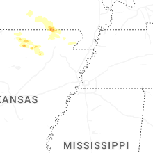
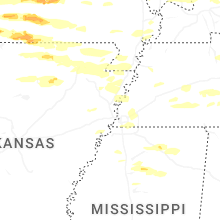
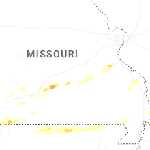
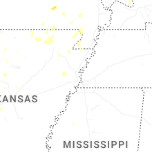
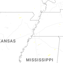

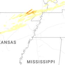


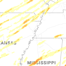


Connect with Interactive Hail Maps