

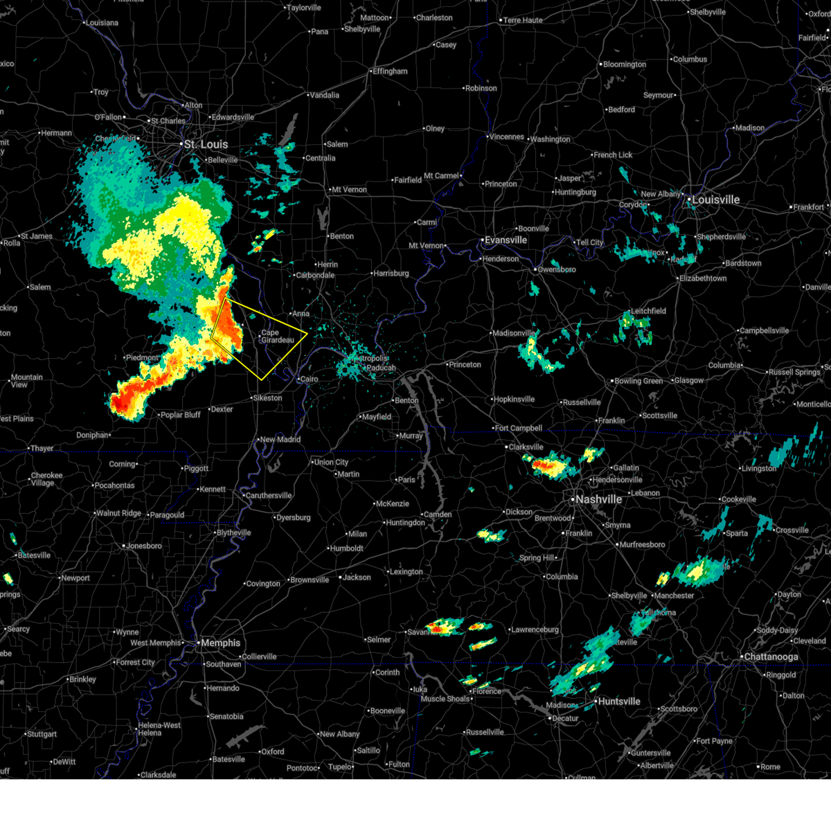
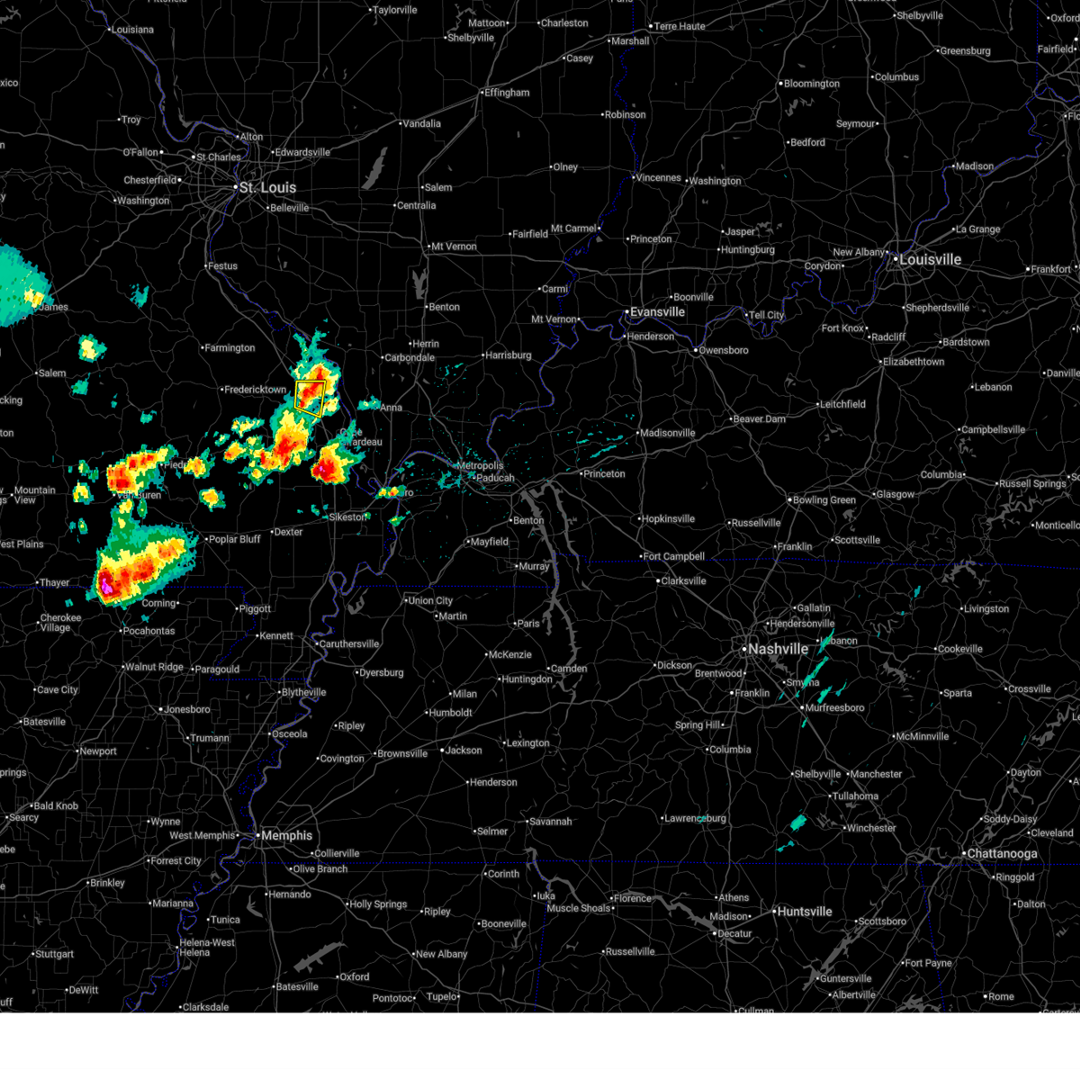
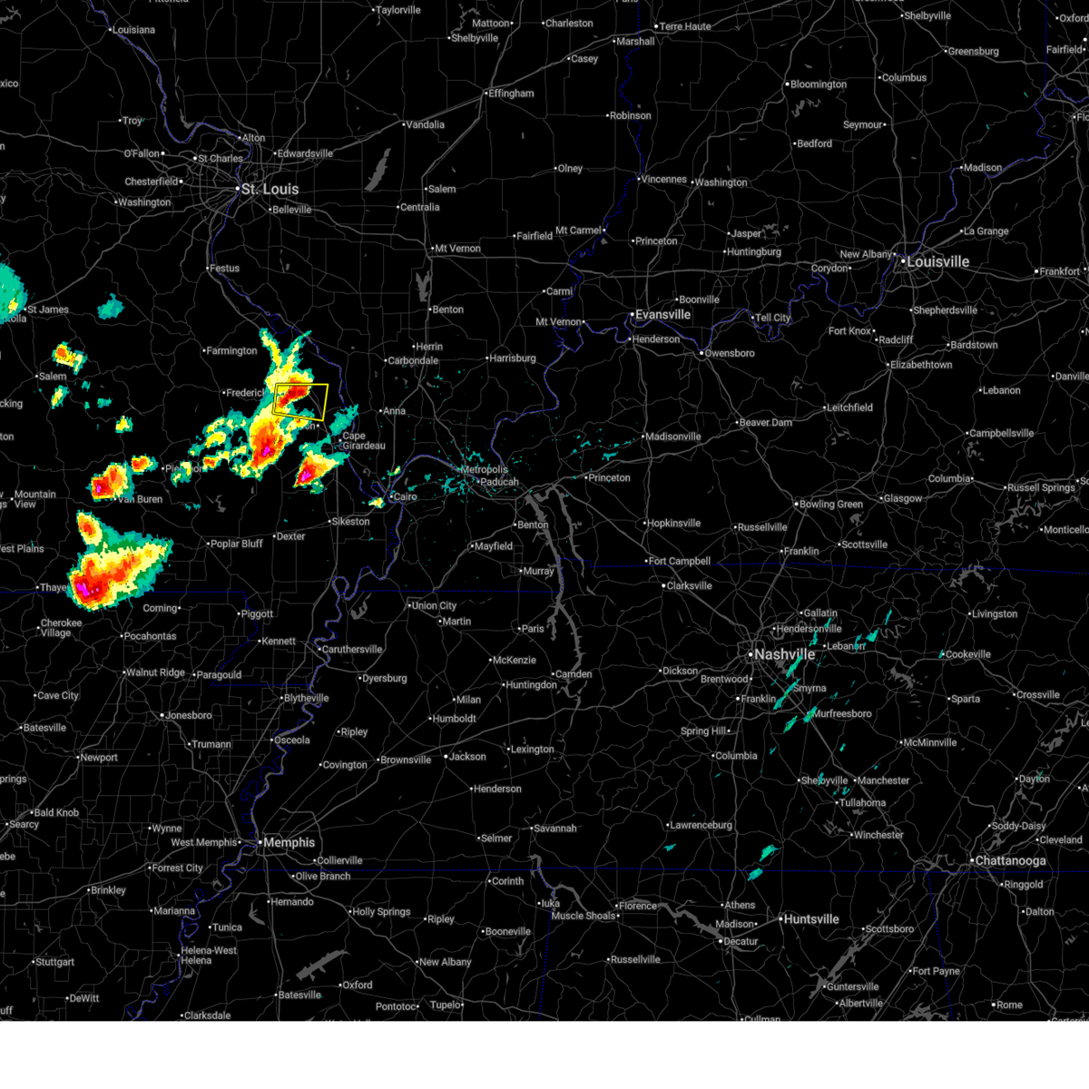
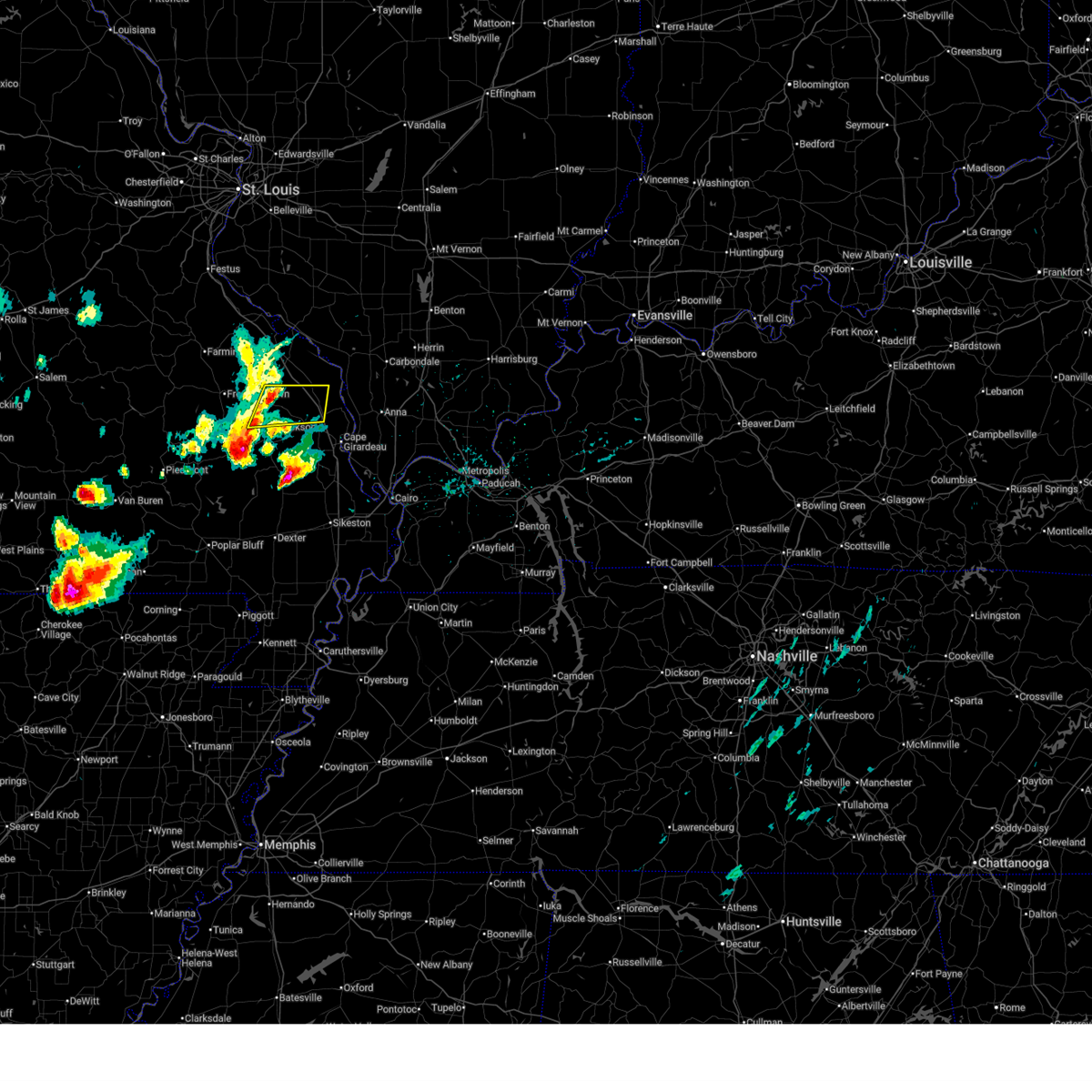
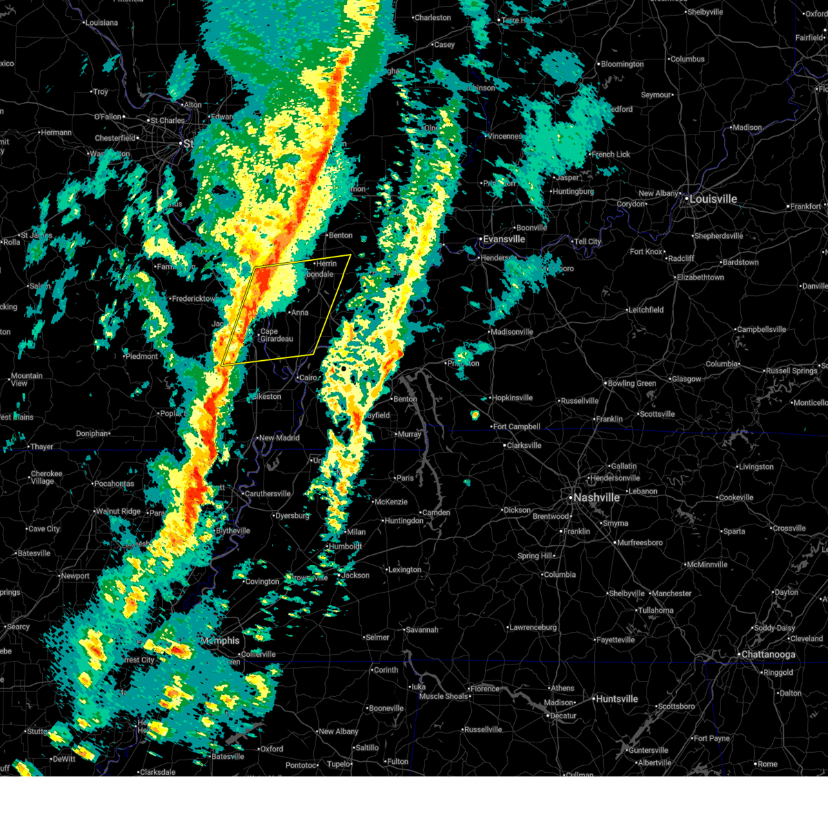
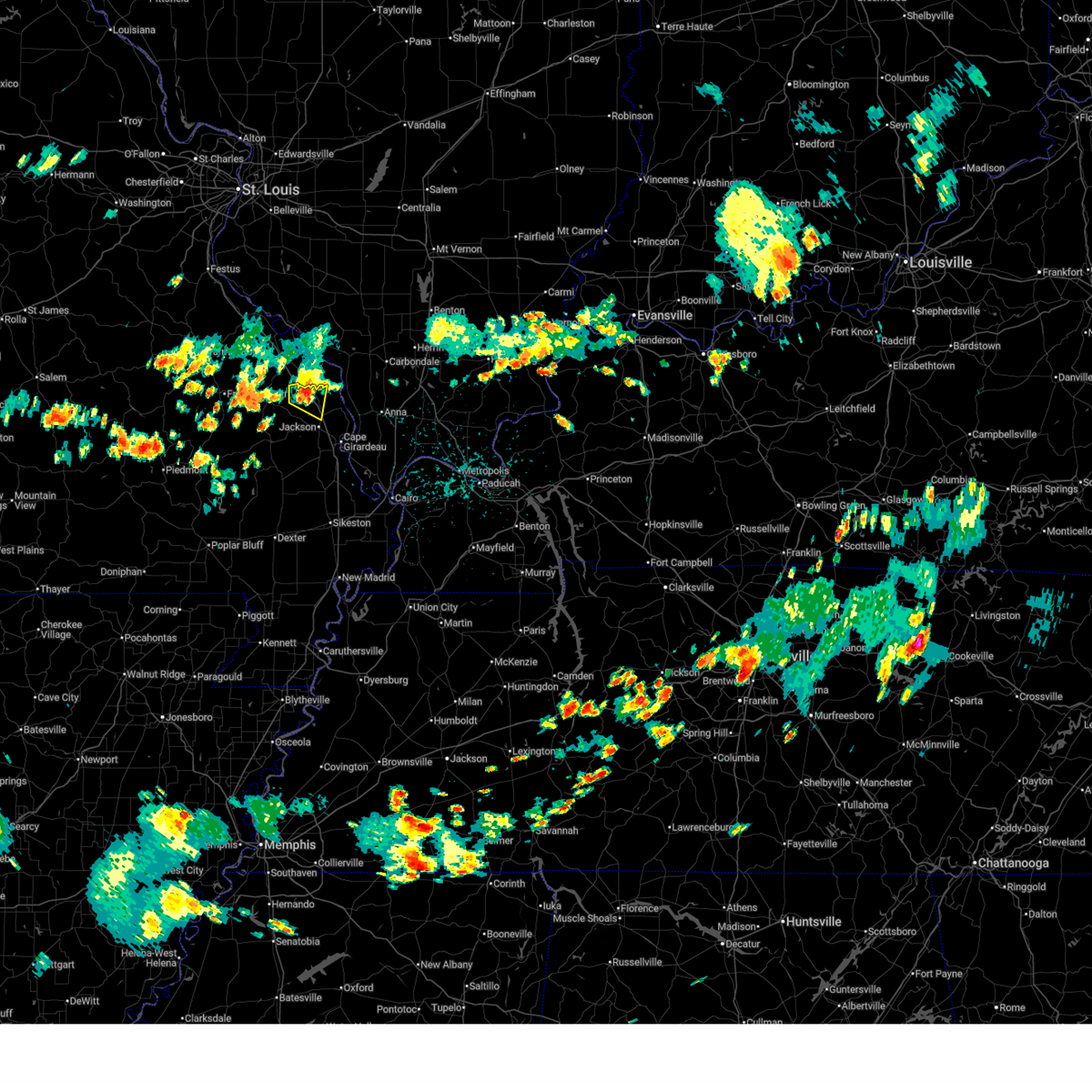
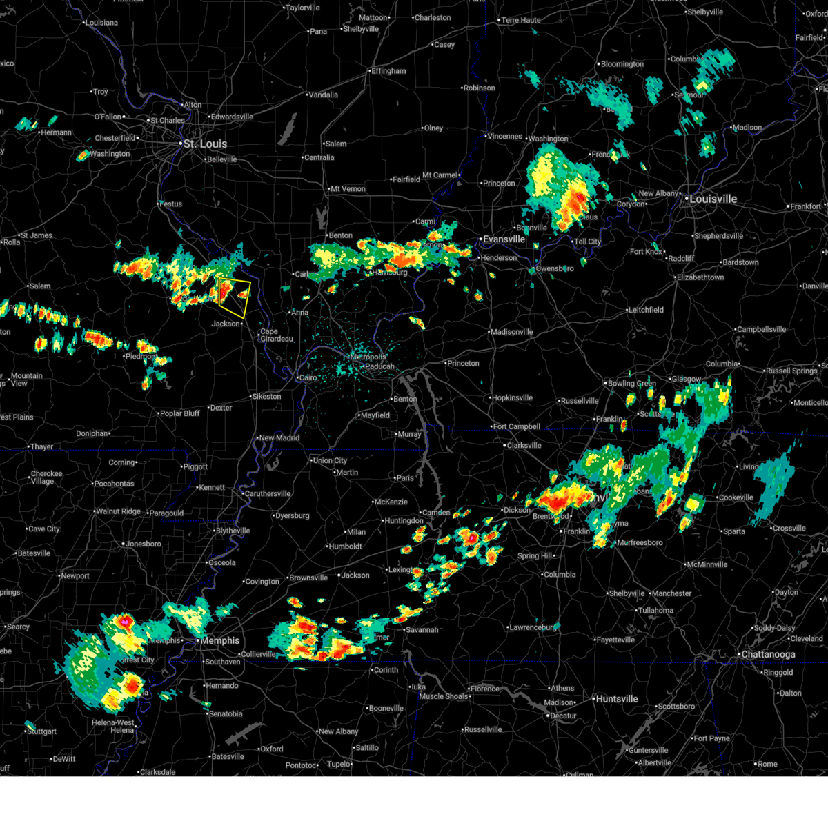
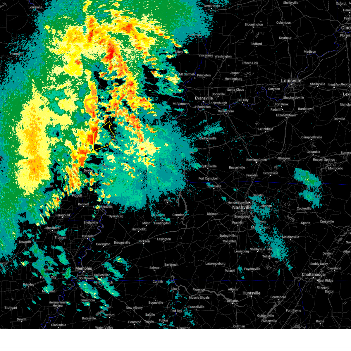
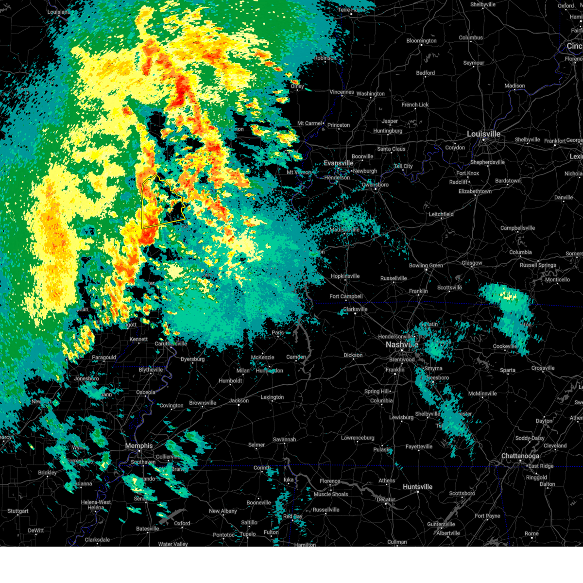
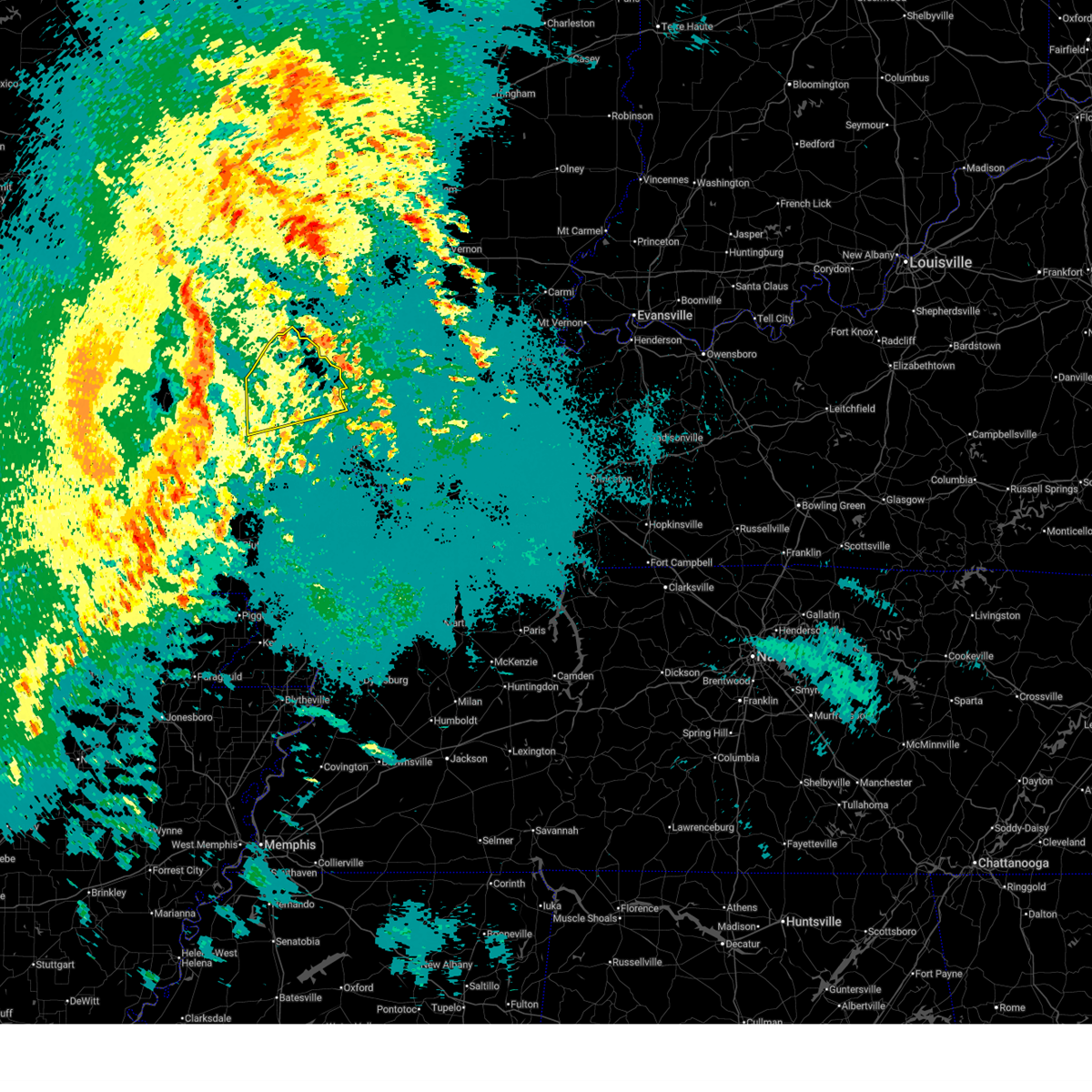
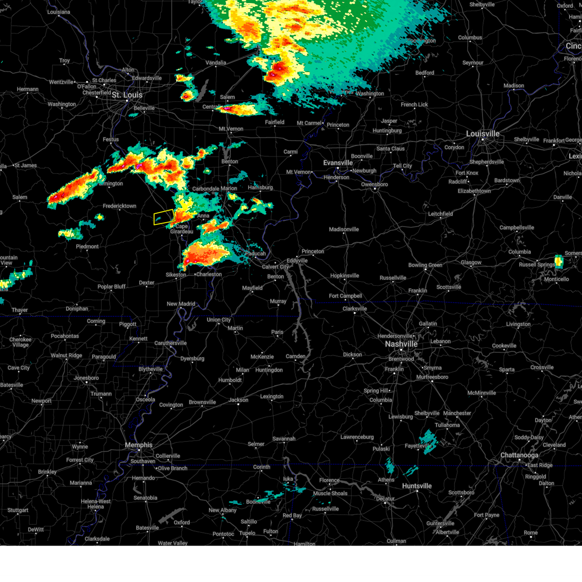
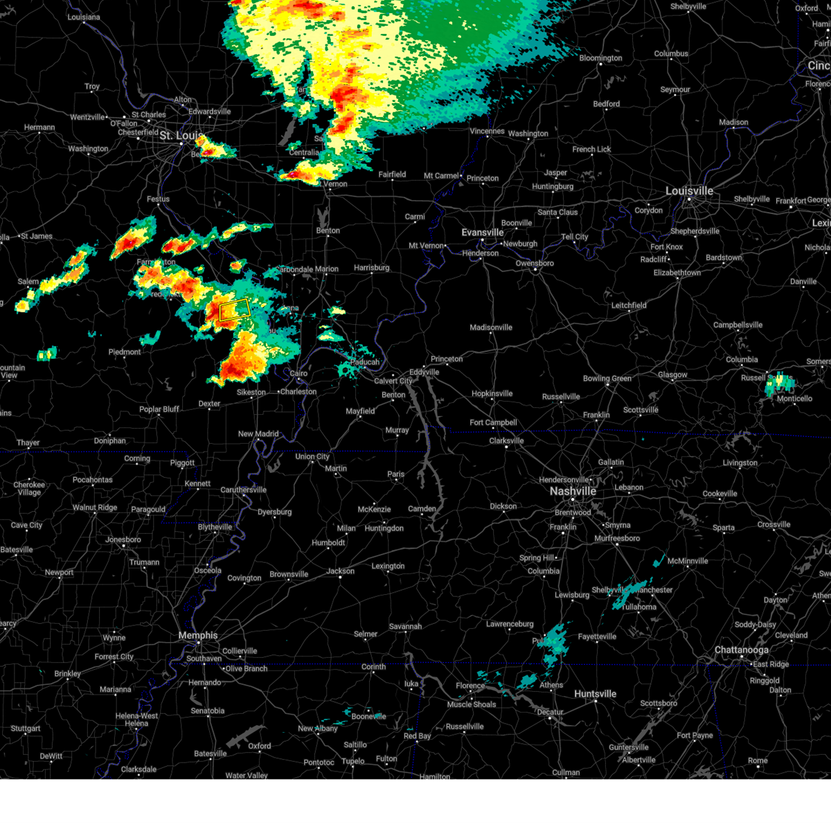
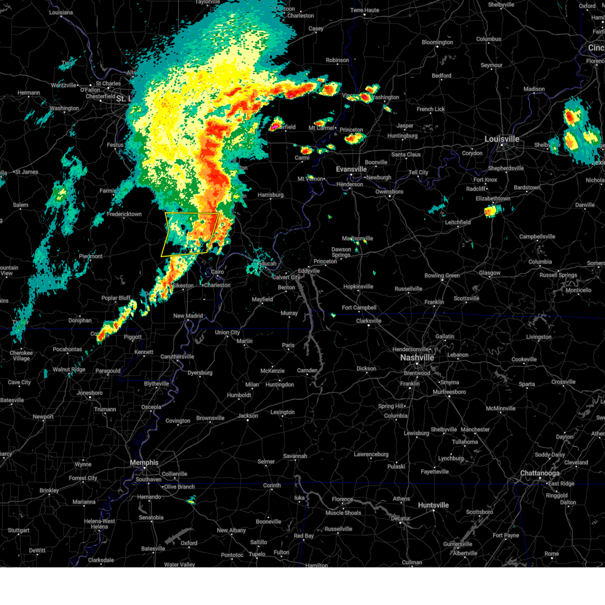
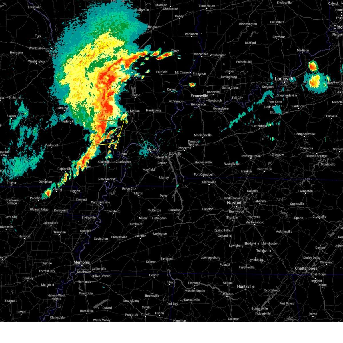
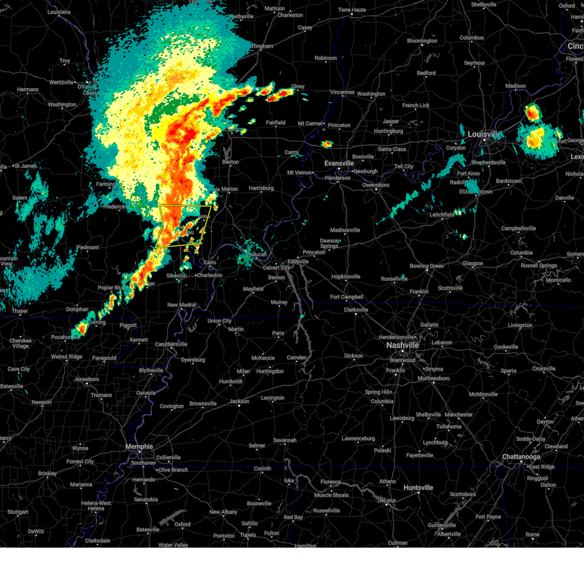
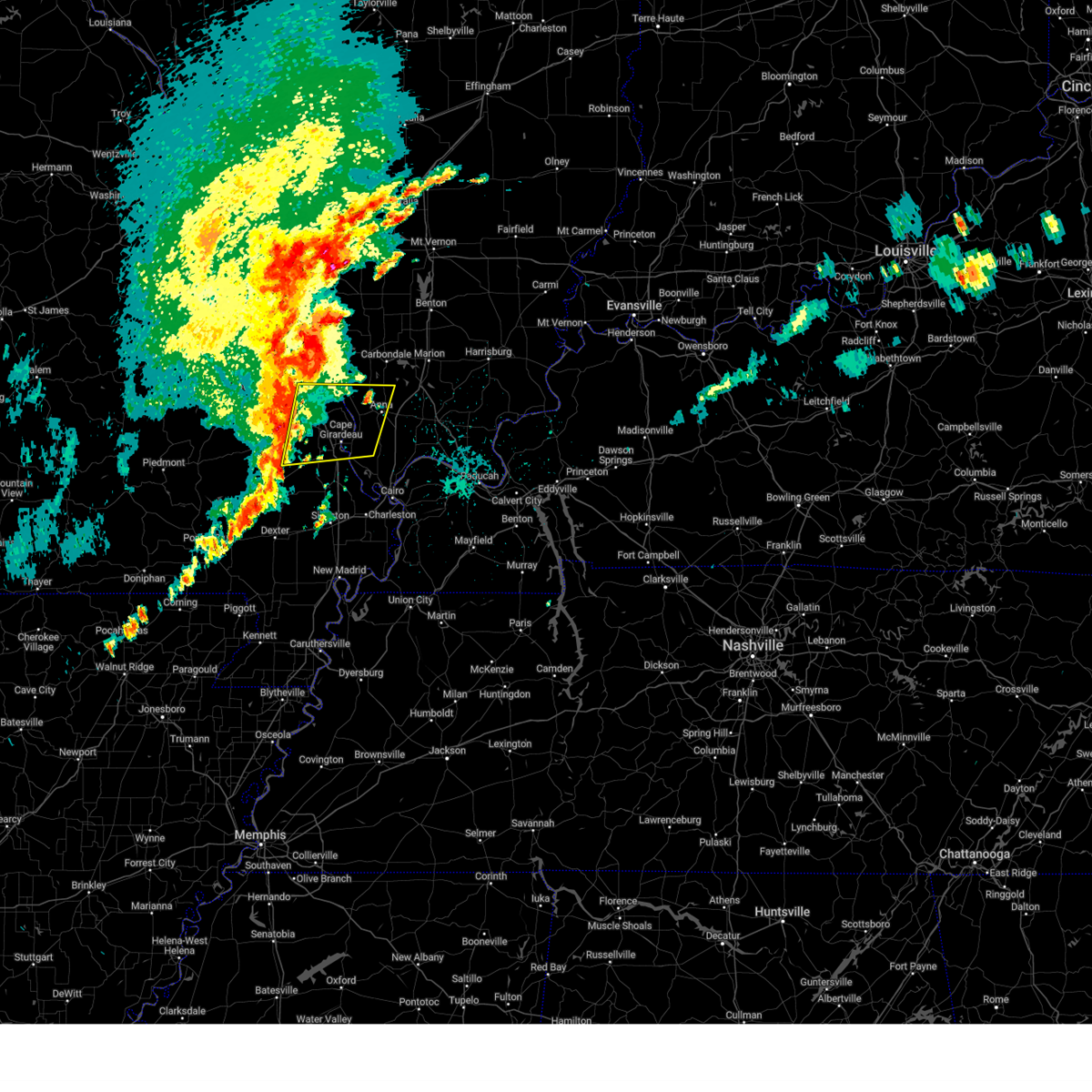
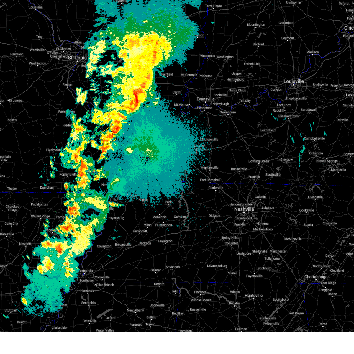
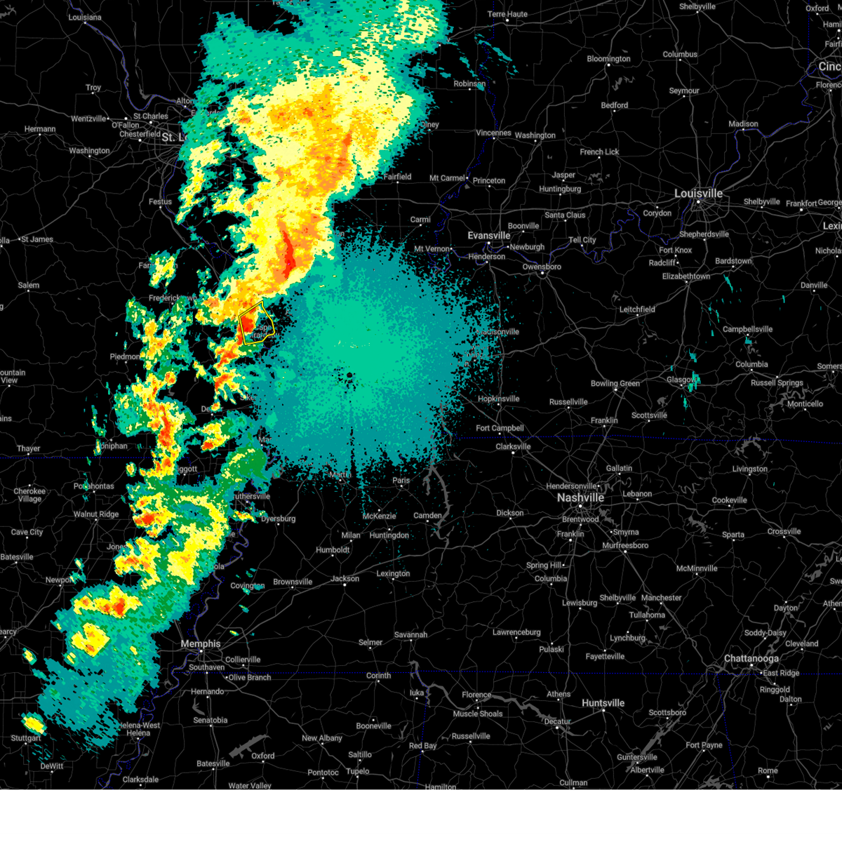
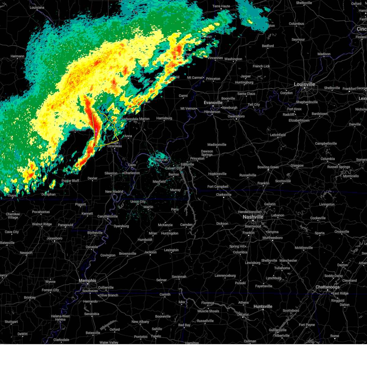
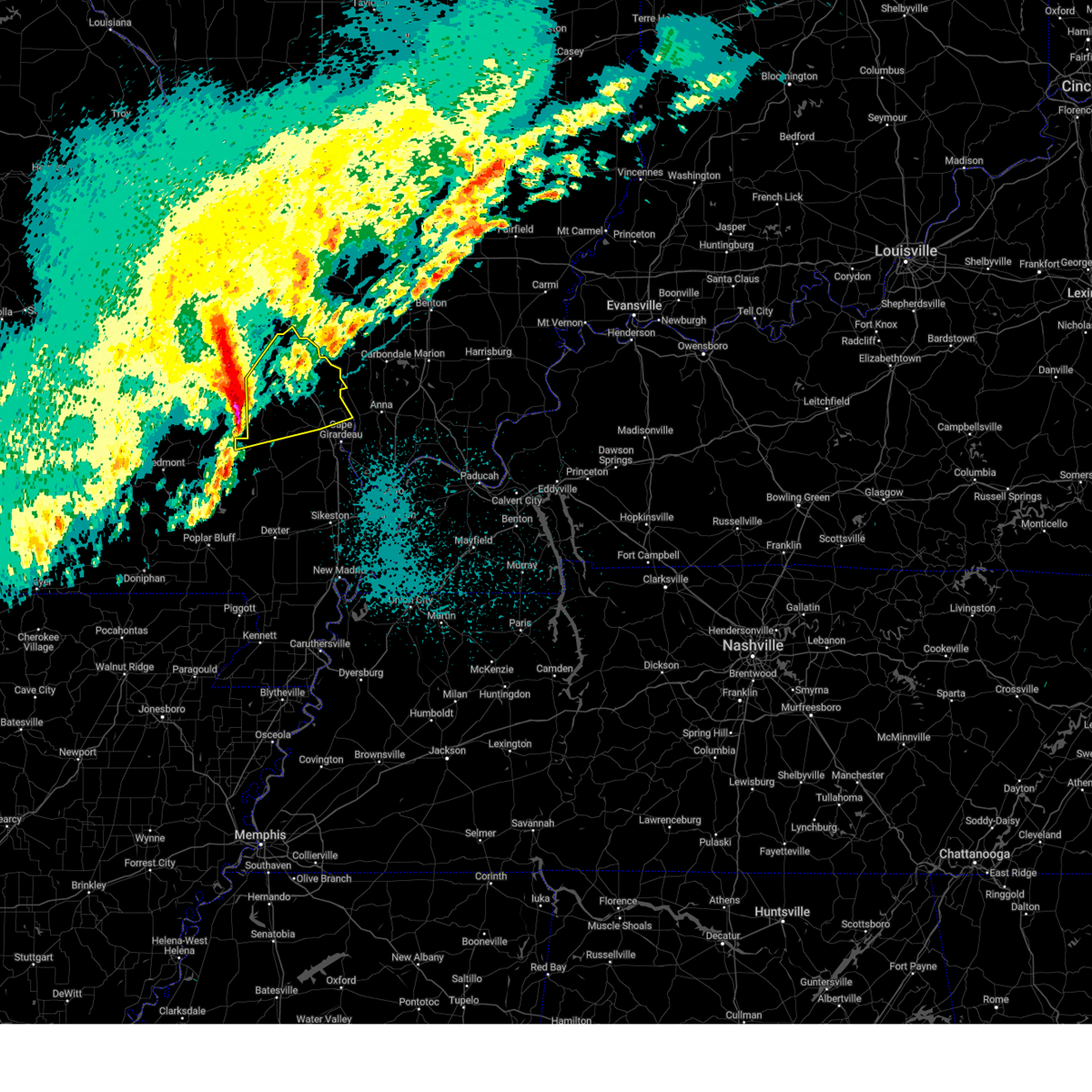
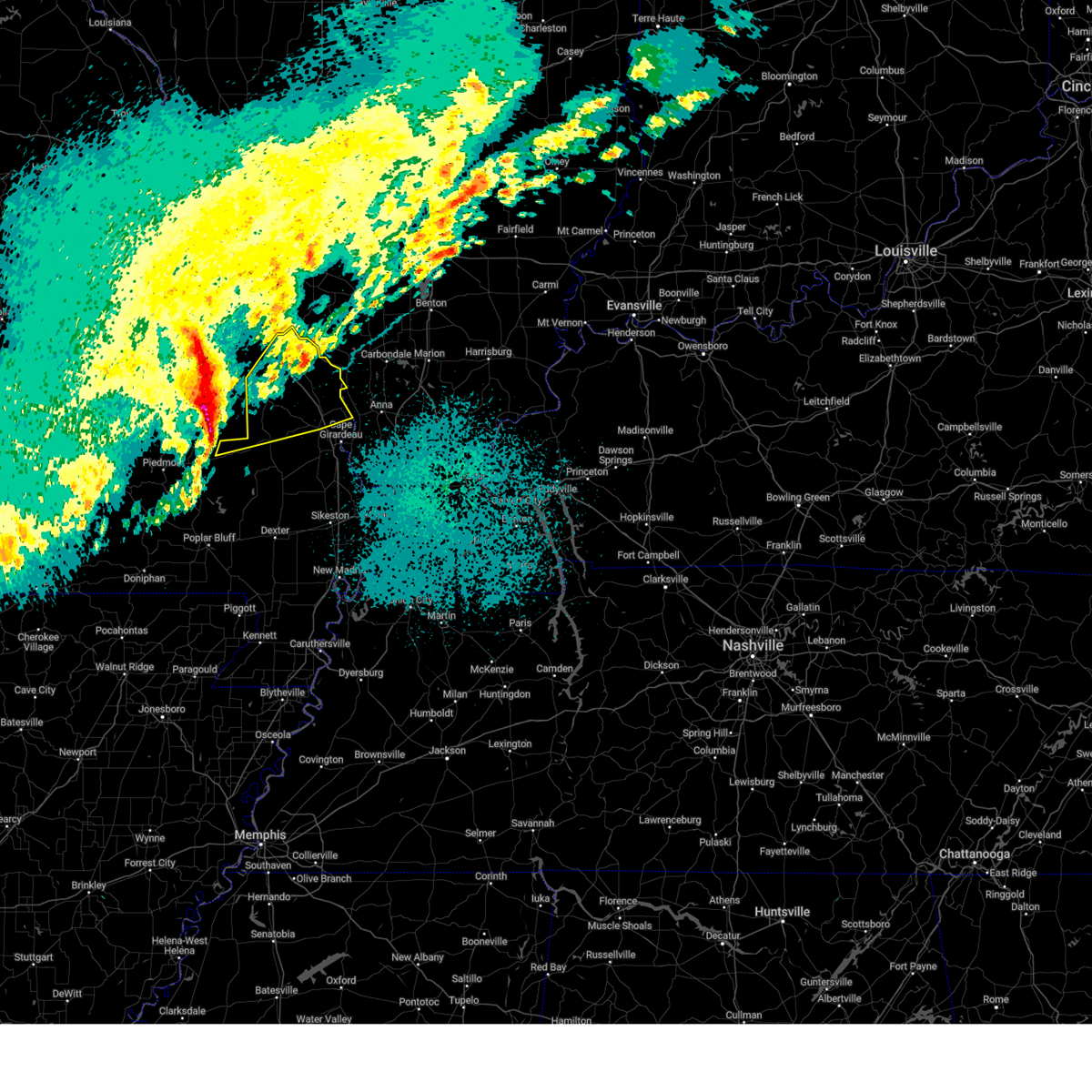
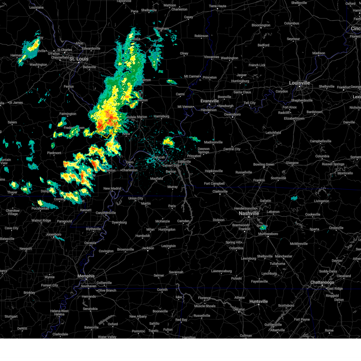
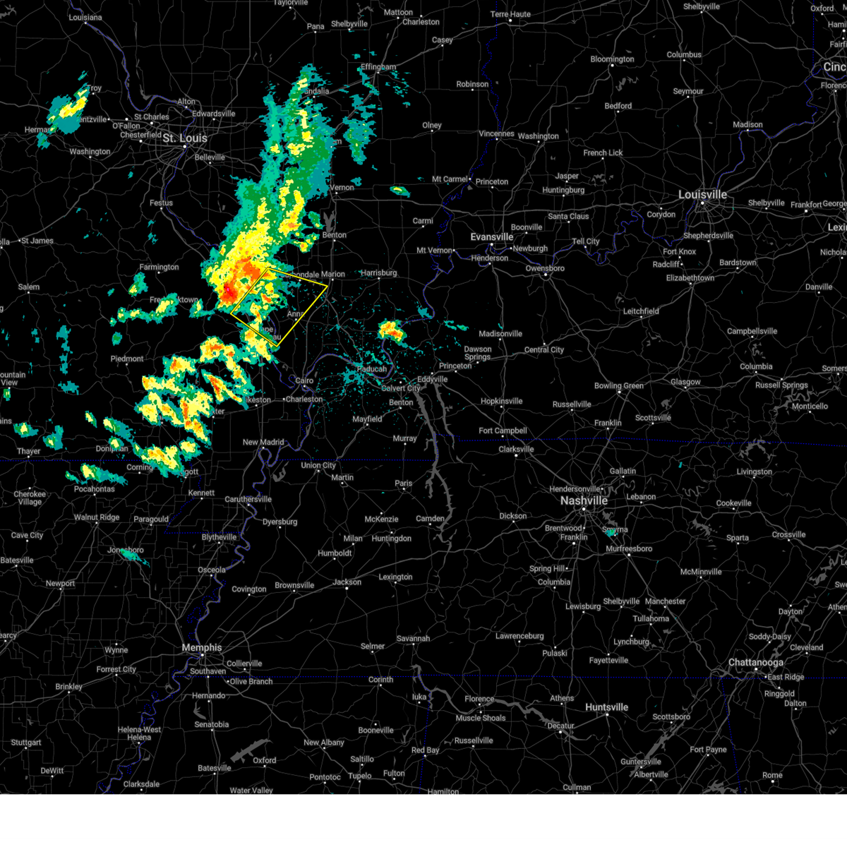
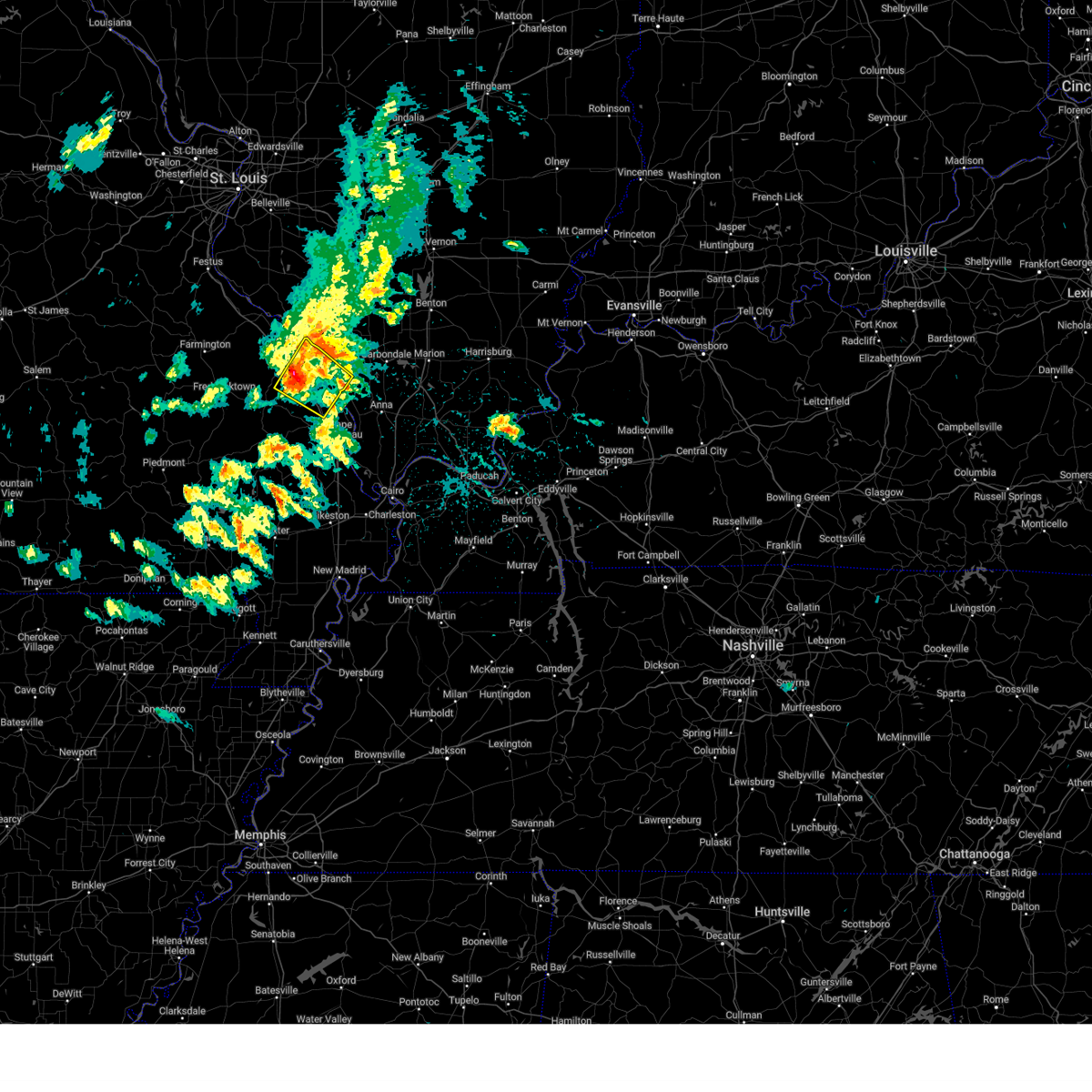
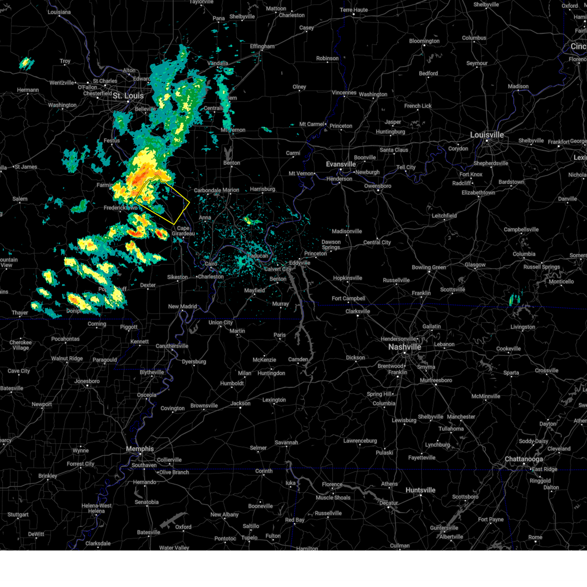
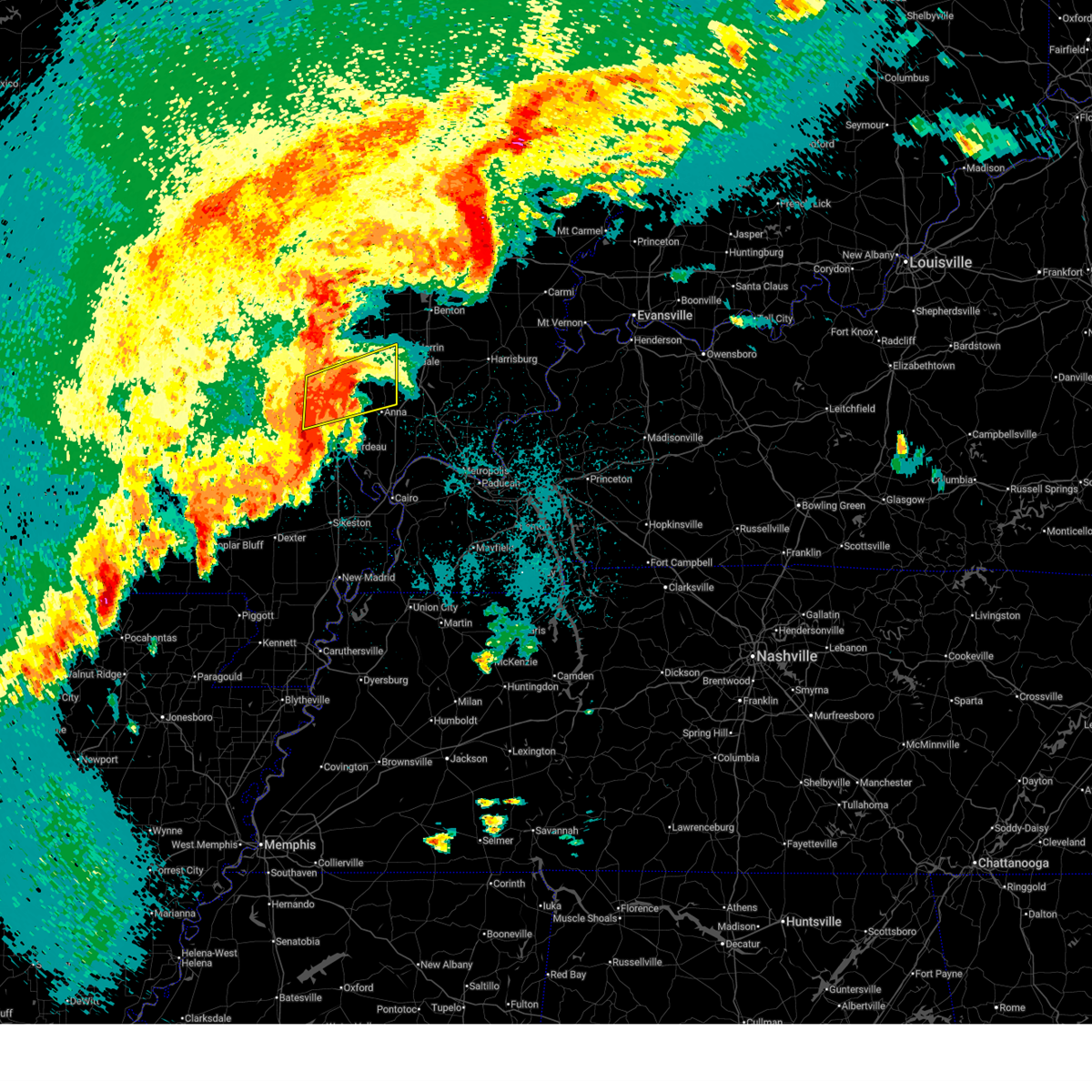
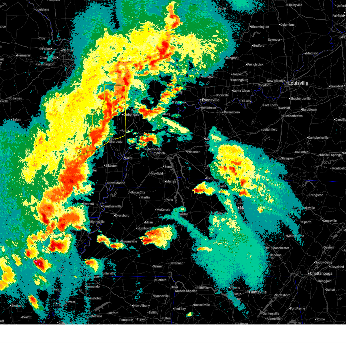
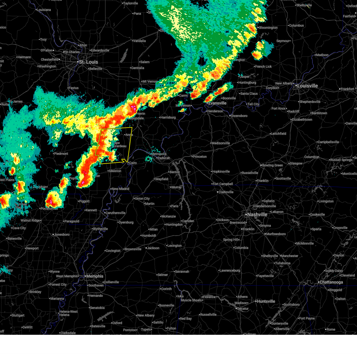
Hail Map for Pocahontas, MO
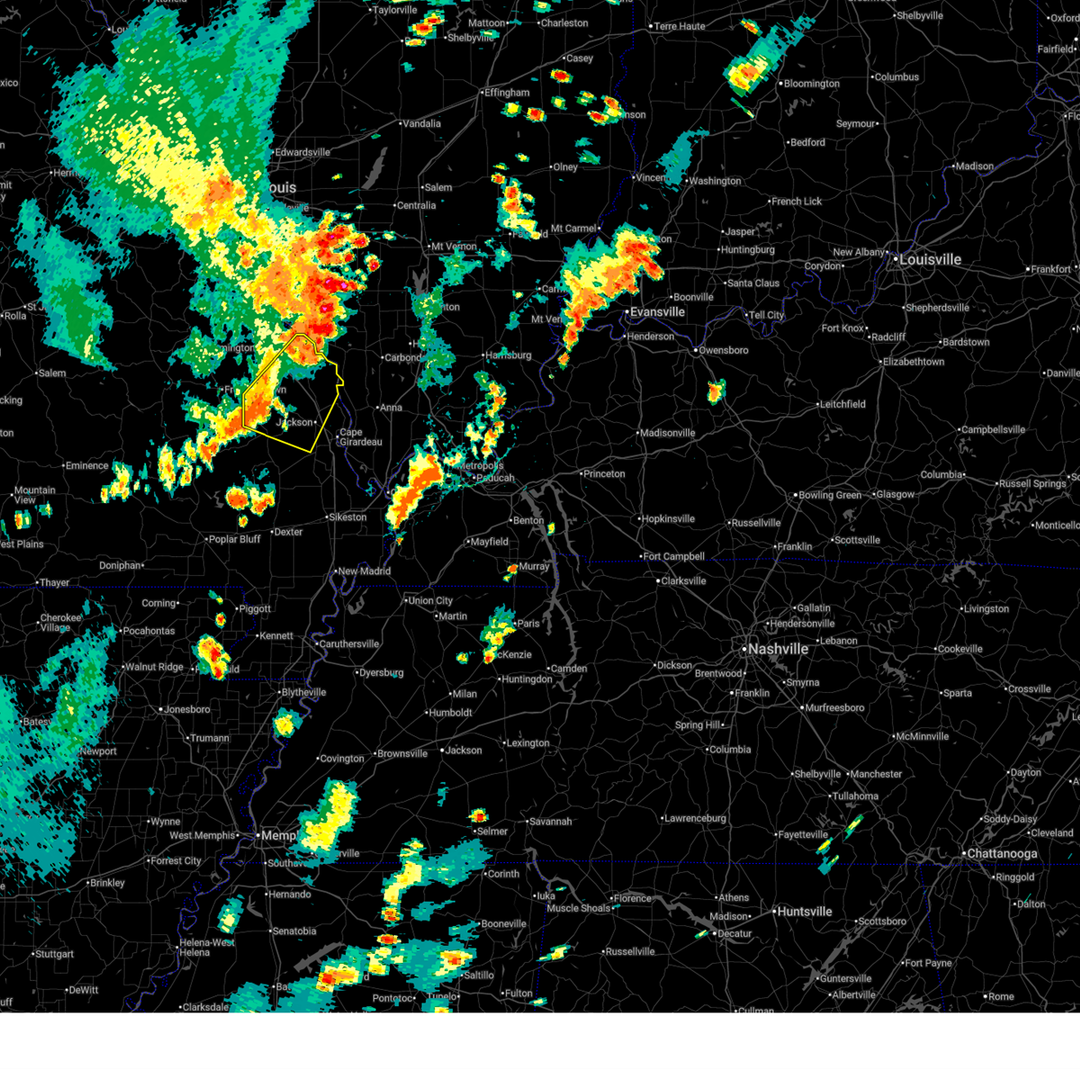
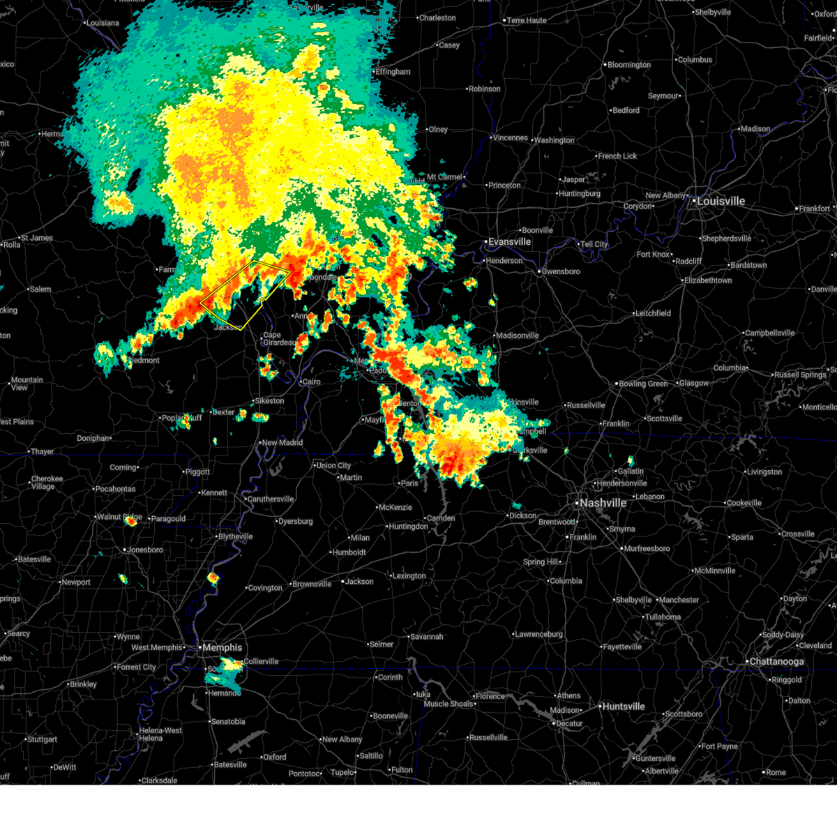
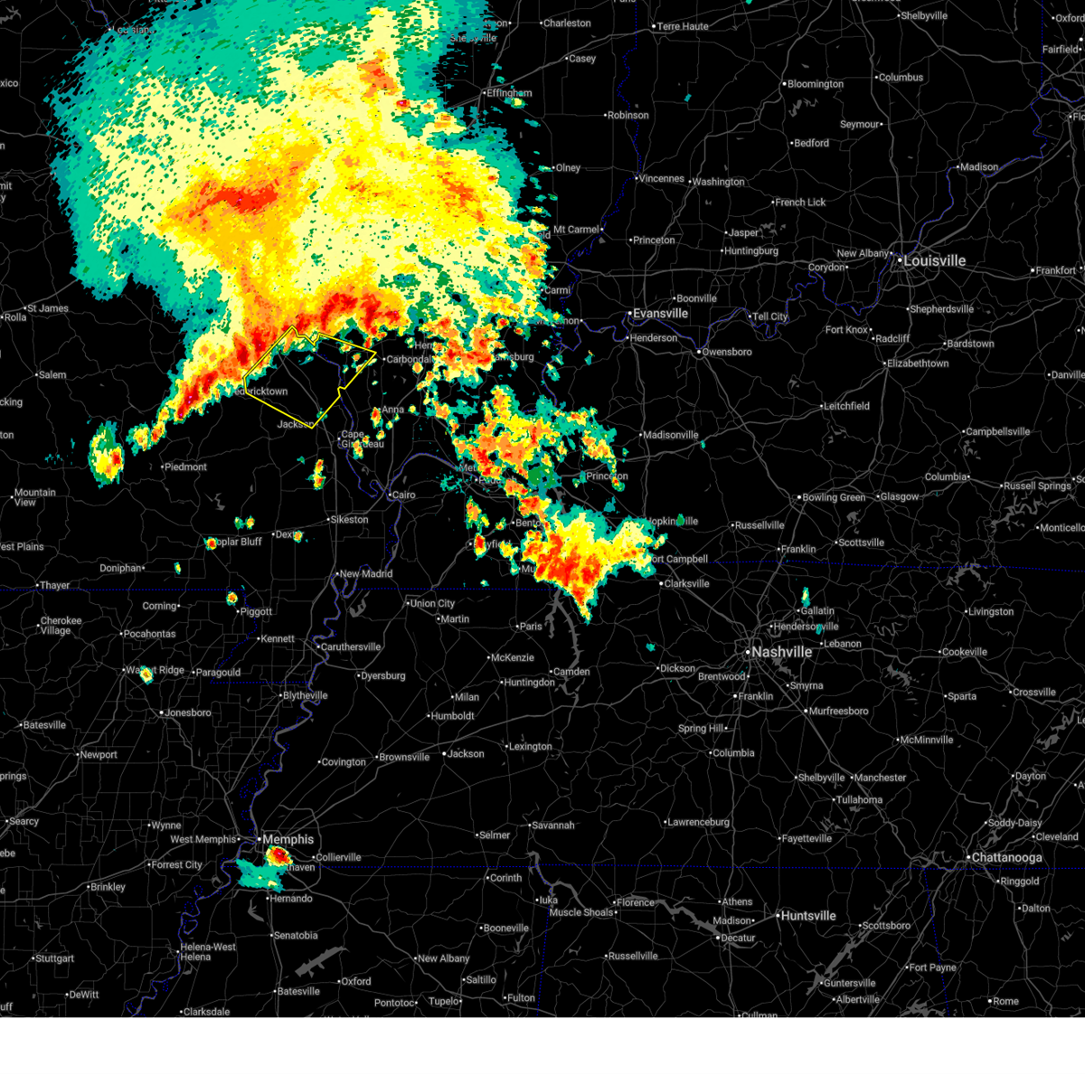
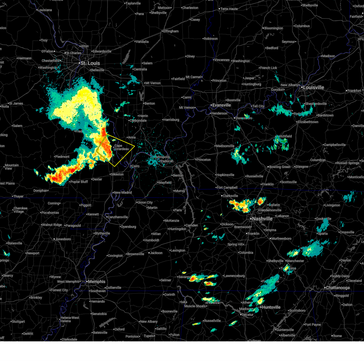
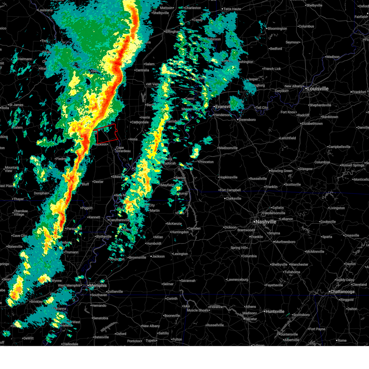
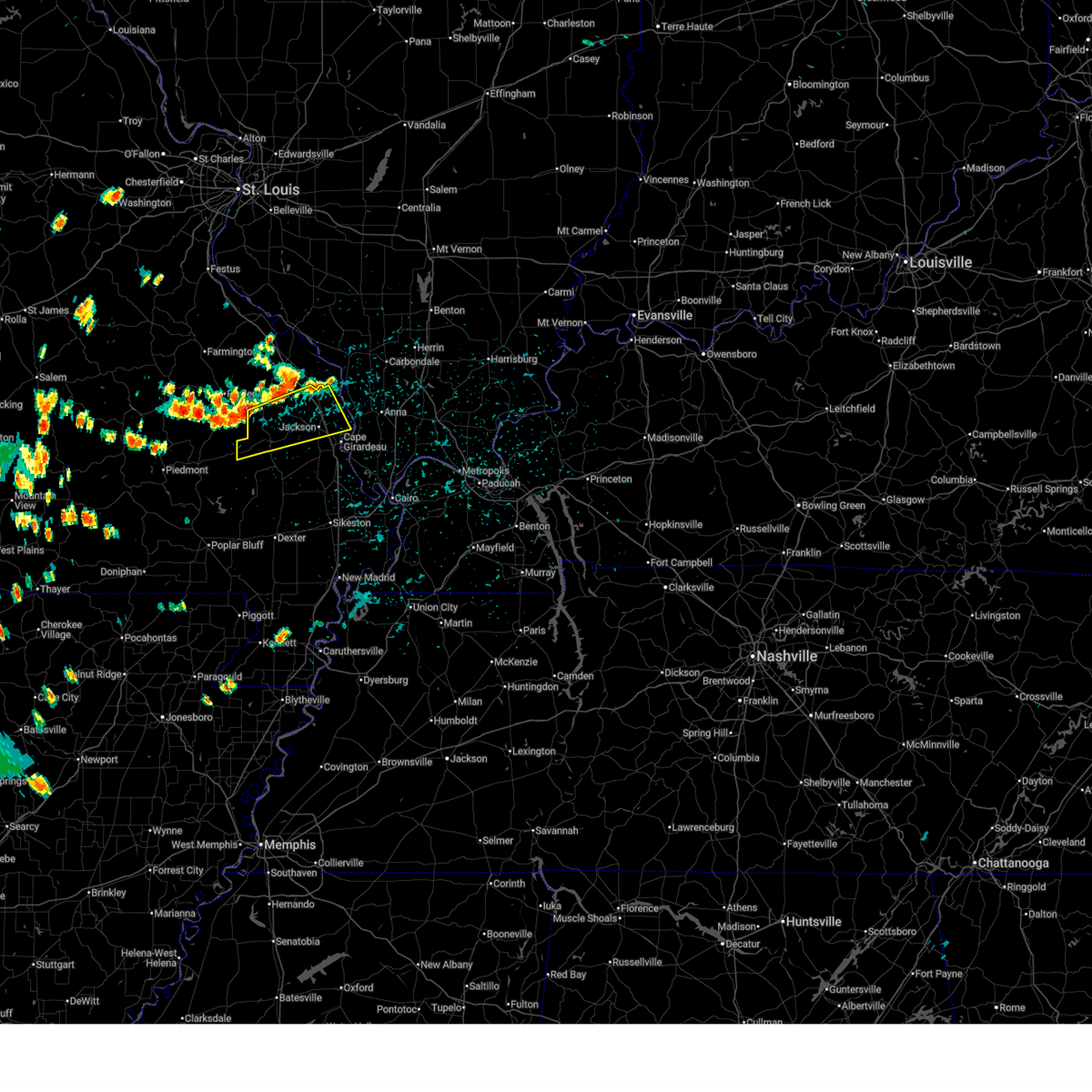
The Pocahontas, MO area has had 0 reports of on-the-ground hail by trained spotters, and has been under severe weather warnings 18 times during the past 12 months. Doppler radar has detected hail at or near Pocahontas, MO on 68 occasions, including 4 occasions during the past year.
| Name: | Pocahontas, MO |
| Where Located: | 14.7 miles NNW of Cape Girardeau, MO |
| Map: | Google Map for Pocahontas, MO |
| Population: | 114 |
| Housing Units: | 52 |
| More Info: | Search Google for Pocahontas, MO |
3
The Top Recent Hail Date for Pocahontas, MO is Monday, April 27, 2026 (5th out of 68)

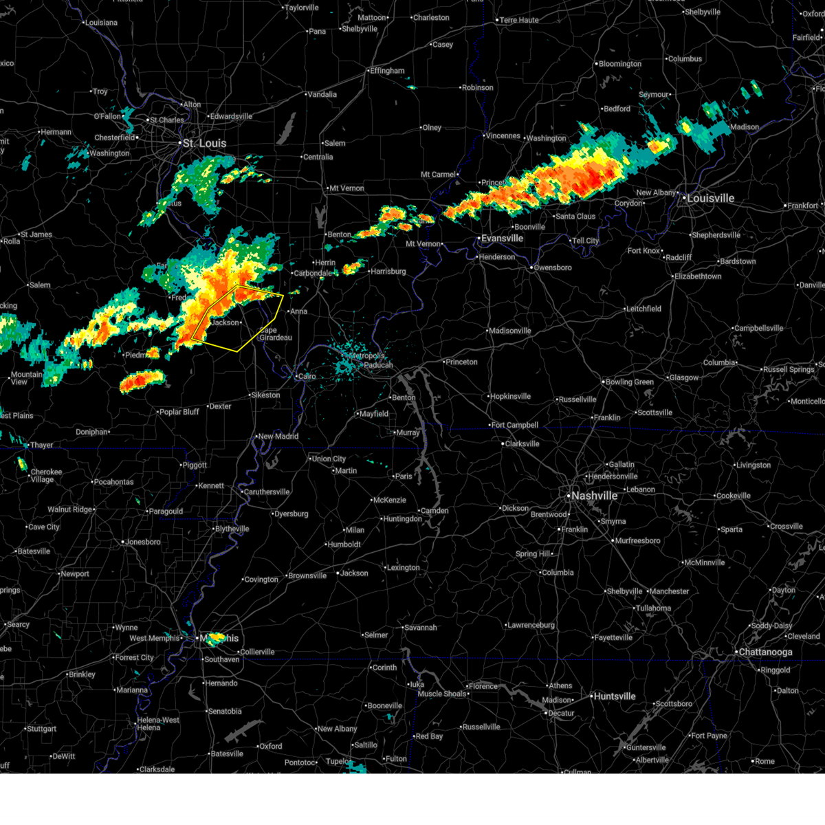
Hail and Wind Damage Spotted near Pocahontas, MO
| Date / Time | Report Details |
|---|---|
| 7/4/2026 5:42 PM CDT | the severe thunderstorm warning has been cancelled and is no longer in effect |
| 7/4/2026 5:30 PM CDT |
 At 530 pm cdt, severe thunderstorms were located along a line extending from 8 miles southwest of ava to near burfordville, moving east at 35 mph (radar indicated). Hazards include 60 mph wind gusts. Expect damage to roofs, siding, and trees. locations impacted include, jackson, perryville, marble hill, bollinger mill state historic site, gordonville, altenburg, patton, millersville, burfordville, alliance, daisy, frohna, oak ridge, sedgewickville, pocahontas, longtown, and old appleton. This includes interstate 55 between mile markers 102 and 132. At 530 pm cdt, severe thunderstorms were located along a line extending from 8 miles southwest of ava to near burfordville, moving east at 35 mph (radar indicated). Hazards include 60 mph wind gusts. Expect damage to roofs, siding, and trees. locations impacted include, jackson, perryville, marble hill, bollinger mill state historic site, gordonville, altenburg, patton, millersville, burfordville, alliance, daisy, frohna, oak ridge, sedgewickville, pocahontas, longtown, and old appleton. This includes interstate 55 between mile markers 102 and 132.
|
| 7/4/2026 5:11 PM CDT | Svrpah the national weather service in paducah has issued a * severe thunderstorm warning for, northeastern bollinger county in southeastern missouri, perry county in southeastern missouri, cape girardeau county in southeastern missouri, * until 600 pm cdt. * at 511 pm cdt, severe thunderstorms were located along a line extending from near chester to 6 miles south of patton, moving east at 35 mph (radar indicated). Hazards include 60 mph wind gusts. expect damage to roofs, siding, and trees |
| 6/1/2026 7:40 AM CDT |
 At 740 am cdt, severe thunderstorms were located along a line extending from 7 miles north of grand tower to near daisy, moving southeast at 40 mph (radar indicated). Hazards include 60 mph wind gusts. Expect damage to roofs, siding, and trees. locations impacted include, carbondale, jackson, murphysboro, grand tower, altenburg, millersville, alliance, daisy, frohna, oak ridge, gorham, sedgewickville, pocahontas, longtown, and old appleton. This includes interstate 55 between mile markers 105 and 126. At 740 am cdt, severe thunderstorms were located along a line extending from 7 miles north of grand tower to near daisy, moving southeast at 40 mph (radar indicated). Hazards include 60 mph wind gusts. Expect damage to roofs, siding, and trees. locations impacted include, carbondale, jackson, murphysboro, grand tower, altenburg, millersville, alliance, daisy, frohna, oak ridge, gorham, sedgewickville, pocahontas, longtown, and old appleton. This includes interstate 55 between mile markers 105 and 126.
|
| 6/1/2026 7:19 AM CDT |
 Svrpah the national weather service in paducah has issued a * severe thunderstorm warning for, southwestern jackson county in southern illinois, northeastern bollinger county in southeastern missouri, perry county in southeastern missouri, northwestern cape girardeau county in southeastern missouri, * until 800 am cdt. * at 718 am cdt, severe thunderstorms were located along a line extending from 6 miles southeast of chester to near alliance, moving southeast at 35 mph (radar indicated). Hazards include 60 mph wind gusts. expect damage to roofs, siding, and trees Svrpah the national weather service in paducah has issued a * severe thunderstorm warning for, southwestern jackson county in southern illinois, northeastern bollinger county in southeastern missouri, perry county in southeastern missouri, northwestern cape girardeau county in southeastern missouri, * until 800 am cdt. * at 718 am cdt, severe thunderstorms were located along a line extending from 6 miles southeast of chester to near alliance, moving southeast at 35 mph (radar indicated). Hazards include 60 mph wind gusts. expect damage to roofs, siding, and trees
|
| 5/31/2026 4:00 PM CDT |
 At 358 pm cdt, a severe thunderstorm was located over cape girardeau, moving southeast at 45 mph (radar indicated). Hazards include 70 mph wind gusts. the asos at cape girardeau airport measured 59 mph at 3:53 pm. Expect considerable tree damage. damage is likely to mobile homes, roofs, and outbuildings. locations impacted include, cape girardeau, jackson, scott city, chaffee, benton, tamms, kelso, delta, gordonville, dutchtown, olive branch, cape girardeau airport, ullin, thebes, whitewater, allenville, pocahontas, commerce, mill creek, and lambert. this includes the following highways, interstate 57 in illinois between mile markers 18 and 22. Interstate 55 between mile markers 77 and 110. At 358 pm cdt, a severe thunderstorm was located over cape girardeau, moving southeast at 45 mph (radar indicated). Hazards include 70 mph wind gusts. the asos at cape girardeau airport measured 59 mph at 3:53 pm. Expect considerable tree damage. damage is likely to mobile homes, roofs, and outbuildings. locations impacted include, cape girardeau, jackson, scott city, chaffee, benton, tamms, kelso, delta, gordonville, dutchtown, olive branch, cape girardeau airport, ullin, thebes, whitewater, allenville, pocahontas, commerce, mill creek, and lambert. this includes the following highways, interstate 57 in illinois between mile markers 18 and 22. Interstate 55 between mile markers 77 and 110.
|
| 5/31/2026 4:00 PM CDT |
 the severe thunderstorm warning has been cancelled and is no longer in effect the severe thunderstorm warning has been cancelled and is no longer in effect
|
| 5/31/2026 3:42 PM CDT |
 Svrpah the national weather service in paducah has issued a * severe thunderstorm warning for, southwestern union county in southern illinois, northwestern pulaski county in southern illinois, alexander county in southern illinois, east central bollinger county in southeastern missouri, northern scott county in southeastern missouri, cape girardeau county in southeastern missouri, * until 430 pm cdt. * at 342 pm cdt, a severe thunderstorm was located over millersville, or near bollinger mill state historic site, moving southeast at 45 mph (radar indicated). Hazards include 70 mph wind gusts. Expect considerable tree damage. Damage is likely to mobile homes, roofs, and outbuildings. Svrpah the national weather service in paducah has issued a * severe thunderstorm warning for, southwestern union county in southern illinois, northwestern pulaski county in southern illinois, alexander county in southern illinois, east central bollinger county in southeastern missouri, northern scott county in southeastern missouri, cape girardeau county in southeastern missouri, * until 430 pm cdt. * at 342 pm cdt, a severe thunderstorm was located over millersville, or near bollinger mill state historic site, moving southeast at 45 mph (radar indicated). Hazards include 70 mph wind gusts. Expect considerable tree damage. Damage is likely to mobile homes, roofs, and outbuildings.
|
| 4/16/2026 3:05 PM CDT |
 At 305 pm cdt, a severe thunderstorm was located near daisy, or 9 miles northwest of jackson, moving east at 30 mph (radar indicated). Hazards include ping pong ball size hail and 60 mph wind gusts. People and animals outdoors will be injured. expect hail damage to roofs, siding, windows, and vehicles. expect wind damage to roofs, siding, and trees. locations impacted include, daisy, oak ridge, pocahontas, and old appleton. This includes interstate 55 between mile markers 105 and 120. At 305 pm cdt, a severe thunderstorm was located near daisy, or 9 miles northwest of jackson, moving east at 30 mph (radar indicated). Hazards include ping pong ball size hail and 60 mph wind gusts. People and animals outdoors will be injured. expect hail damage to roofs, siding, windows, and vehicles. expect wind damage to roofs, siding, and trees. locations impacted include, daisy, oak ridge, pocahontas, and old appleton. This includes interstate 55 between mile markers 105 and 120.
|
| 4/16/2026 2:53 PM CDT |
 At 253 pm cdt, a severe thunderstorm was located over daisy, or 9 miles north of bollinger mill state historic site, moving east at 30 mph (radar indicated). Hazards include ping pong ball size hail and 60 mph wind gusts. People and animals outdoors will be injured. expect hail damage to roofs, siding, windows, and vehicles. expect wind damage to roofs, siding, and trees. locations impacted include, daisy, millersville, oak ridge, sedgewickville, pocahontas, and old appleton. This includes interstate 55 between mile markers 105 and 120. At 253 pm cdt, a severe thunderstorm was located over daisy, or 9 miles north of bollinger mill state historic site, moving east at 30 mph (radar indicated). Hazards include ping pong ball size hail and 60 mph wind gusts. People and animals outdoors will be injured. expect hail damage to roofs, siding, windows, and vehicles. expect wind damage to roofs, siding, and trees. locations impacted include, daisy, millersville, oak ridge, sedgewickville, pocahontas, and old appleton. This includes interstate 55 between mile markers 105 and 120.
|
| 4/16/2026 2:39 PM CDT |
 Svrpah the national weather service in paducah has issued a * severe thunderstorm warning for, northeastern bollinger county in southeastern missouri, south central perry county in southeastern missouri, northwestern cape girardeau county in southeastern missouri, * until 330 pm cdt. * at 239 pm cdt, a severe thunderstorm was located near patton, or 13 miles northwest of bollinger mill state historic site, moving east at 30 mph (radar indicated). Hazards include 60 mph wind gusts and quarter size hail. Hail damage to vehicles is expected. Expect wind damage to roofs, siding, and trees. Svrpah the national weather service in paducah has issued a * severe thunderstorm warning for, northeastern bollinger county in southeastern missouri, south central perry county in southeastern missouri, northwestern cape girardeau county in southeastern missouri, * until 330 pm cdt. * at 239 pm cdt, a severe thunderstorm was located near patton, or 13 miles northwest of bollinger mill state historic site, moving east at 30 mph (radar indicated). Hazards include 60 mph wind gusts and quarter size hail. Hail damage to vehicles is expected. Expect wind damage to roofs, siding, and trees.
|
| 3/15/2026 6:52 PM CDT |
 Svrpah the national weather service in paducah has issued a * severe thunderstorm warning for, union county in southern illinois, pulaski county in southern illinois, western johnson county in southern illinois, williamson county in southern illinois, southern jackson county in southern illinois, alexander county in southern illinois, north central ballard county in western kentucky, northern scott county in southeastern missouri, southeastern perry county in southeastern missouri, central cape girardeau county in southeastern missouri, northern stoddard county in southeastern missouri, * until 730 pm cdt. * at 652 pm cdt, severe thunderstorms were located along a line extending from murphysboro to near oran, moving east at 50 mph (radar indicated). Hazards include 60 mph wind gusts. expect damage to roofs, siding, and trees Svrpah the national weather service in paducah has issued a * severe thunderstorm warning for, union county in southern illinois, pulaski county in southern illinois, western johnson county in southern illinois, williamson county in southern illinois, southern jackson county in southern illinois, alexander county in southern illinois, north central ballard county in western kentucky, northern scott county in southeastern missouri, southeastern perry county in southeastern missouri, central cape girardeau county in southeastern missouri, northern stoddard county in southeastern missouri, * until 730 pm cdt. * at 652 pm cdt, severe thunderstorms were located along a line extending from murphysboro to near oran, moving east at 50 mph (radar indicated). Hazards include 60 mph wind gusts. expect damage to roofs, siding, and trees
|
| 3/15/2026 6:22 PM CDT |
 Torpah the national weather service in paducah has issued a * tornado warning for, southeastern perry county in southeastern missouri, northern cape girardeau county in southeastern missouri, * until 645 pm cdt. * at 622 pm cdt, severe thunderstorms capable of producing both tornadoes and extensive straight line wind damage were located near patton, or 11 miles northwest of bollinger mill state historic site, moving east at 60 mph (radar indicated rotation). Hazards include tornado. Flying debris will be dangerous to those caught without shelter. mobile homes will be damaged or destroyed. damage to roofs, windows, and vehicles will occur. tree damage is likely. these dangerous storms will be near, daisy and millersville around 625 pm cdt. altenburg around 635 pm cdt. other locations impacted by this tornadic thunderstorm include old appleton, pocahontas, frohna, and oak ridge. This includes interstate 55 between mile markers 106 and 123. Torpah the national weather service in paducah has issued a * tornado warning for, southeastern perry county in southeastern missouri, northern cape girardeau county in southeastern missouri, * until 645 pm cdt. * at 622 pm cdt, severe thunderstorms capable of producing both tornadoes and extensive straight line wind damage were located near patton, or 11 miles northwest of bollinger mill state historic site, moving east at 60 mph (radar indicated rotation). Hazards include tornado. Flying debris will be dangerous to those caught without shelter. mobile homes will be damaged or destroyed. damage to roofs, windows, and vehicles will occur. tree damage is likely. these dangerous storms will be near, daisy and millersville around 625 pm cdt. altenburg around 635 pm cdt. other locations impacted by this tornadic thunderstorm include old appleton, pocahontas, frohna, and oak ridge. This includes interstate 55 between mile markers 106 and 123.
|
| 8/19/2025 1:16 PM CDT |
 Svrpah the national weather service in paducah has issued a * severe thunderstorm warning for, central bollinger county in southeastern missouri, northern cape girardeau county in southeastern missouri, * until 200 pm cdt. * at 116 pm cdt, severe thunderstorms were located along a line extending from 7 miles southwest of altenburg to near marquand, moving southeast at 15 mph (radar indicated). Hazards include 60 mph wind gusts. expect damage to roofs, siding, and trees Svrpah the national weather service in paducah has issued a * severe thunderstorm warning for, central bollinger county in southeastern missouri, northern cape girardeau county in southeastern missouri, * until 200 pm cdt. * at 116 pm cdt, severe thunderstorms were located along a line extending from 7 miles southwest of altenburg to near marquand, moving southeast at 15 mph (radar indicated). Hazards include 60 mph wind gusts. expect damage to roofs, siding, and trees
|
| 7/7/2025 2:11 PM CDT |
 The storm which prompted the warning has weakened below severe limits, and no longer poses an immediate threat to life or property. therefore, the warning will be allowed to expire. The storm which prompted the warning has weakened below severe limits, and no longer poses an immediate threat to life or property. therefore, the warning will be allowed to expire.
|
| 7/7/2025 1:56 PM CDT |
 the severe thunderstorm warning has been cancelled and is no longer in effect the severe thunderstorm warning has been cancelled and is no longer in effect
|
| 7/7/2025 1:56 PM CDT |
 At 156 pm cdt, a severe thunderstorm was located near daisy, or 12 miles north of jackson, moving east at 10 mph (radar indicated). Hazards include 60 mph wind gusts. Expect damage to roofs, siding, and trees. locations impacted include, daisy, oak ridge, pocahontas, and old appleton. This includes interstate 55 between mile markers 107 and 119. At 156 pm cdt, a severe thunderstorm was located near daisy, or 12 miles north of jackson, moving east at 10 mph (radar indicated). Hazards include 60 mph wind gusts. Expect damage to roofs, siding, and trees. locations impacted include, daisy, oak ridge, pocahontas, and old appleton. This includes interstate 55 between mile markers 107 and 119.
|
| 7/7/2025 1:37 PM CDT |
 Svrpah the national weather service in paducah has issued a * severe thunderstorm warning for, southeastern perry county in southeastern missouri, northwestern cape girardeau county in southeastern missouri, * until 215 pm cdt. * at 137 pm cdt, a severe thunderstorm was located near daisy, or 10 miles south of perryville, moving east at 10 mph (radar indicated). Hazards include 60 mph wind gusts. expect damage to roofs, siding, and trees Svrpah the national weather service in paducah has issued a * severe thunderstorm warning for, southeastern perry county in southeastern missouri, northwestern cape girardeau county in southeastern missouri, * until 215 pm cdt. * at 137 pm cdt, a severe thunderstorm was located near daisy, or 10 miles south of perryville, moving east at 10 mph (radar indicated). Hazards include 60 mph wind gusts. expect damage to roofs, siding, and trees
|
| 5/20/2025 1:07 AM CDT |
 At 107 am cdt, severe thunderstorms were located along a line extending from 8 miles south of altenburg to gordonville, moving northeast at 30 mph (radar indicated). Hazards include 60 mph wind gusts. Expect damage to roofs, siding, and trees. locations impacted include, cape girardeau, jackson, trail of tears state park, delta, gordonville, dutchtown, oak ridge, allenville, and pocahontas. This includes interstate 55 between mile markers 93 and 113. At 107 am cdt, severe thunderstorms were located along a line extending from 8 miles south of altenburg to gordonville, moving northeast at 30 mph (radar indicated). Hazards include 60 mph wind gusts. Expect damage to roofs, siding, and trees. locations impacted include, cape girardeau, jackson, trail of tears state park, delta, gordonville, dutchtown, oak ridge, allenville, and pocahontas. This includes interstate 55 between mile markers 93 and 113.
|
| 5/20/2025 12:48 AM CDT |
 Svrpah the national weather service in paducah has issued a * severe thunderstorm warning for, southeastern perry county in southeastern missouri, cape girardeau county in southeastern missouri, * until 130 am cdt. * at 1248 am cdt, severe thunderstorms were located along a line extending from near millersville to near leopold, moving northeast at 30 mph (radar indicated). Hazards include 60 mph wind gusts. expect damage to roofs, siding, and trees Svrpah the national weather service in paducah has issued a * severe thunderstorm warning for, southeastern perry county in southeastern missouri, cape girardeau county in southeastern missouri, * until 130 am cdt. * at 1248 am cdt, severe thunderstorms were located along a line extending from near millersville to near leopold, moving northeast at 30 mph (radar indicated). Hazards include 60 mph wind gusts. expect damage to roofs, siding, and trees
|
| 5/20/2025 12:46 AM CDT |
 At 1246 am cdt, severe thunderstorms were located along a line extending from near perryville to 7 miles north of daisy to millersville, moving east at 45 mph (radar indicated). Hazards include 60 mph wind gusts. Expect damage to roofs, siding, and trees. locations impacted include, chester, perryville, altenburg, millersville, daisy, alliance, frohna, oak ridge, sedgewickville, pocahontas, longtown, old appleton, lithium, and silver lake. This includes interstate 55 between mile markers 107 and 139. At 1246 am cdt, severe thunderstorms were located along a line extending from near perryville to 7 miles north of daisy to millersville, moving east at 45 mph (radar indicated). Hazards include 60 mph wind gusts. Expect damage to roofs, siding, and trees. locations impacted include, chester, perryville, altenburg, millersville, daisy, alliance, frohna, oak ridge, sedgewickville, pocahontas, longtown, old appleton, lithium, and silver lake. This includes interstate 55 between mile markers 107 and 139.
|
| 5/20/2025 12:03 AM CDT |
 Svrpah the national weather service in paducah has issued a * severe thunderstorm warning for, northeastern bollinger county in southeastern missouri, perry county in southeastern missouri, northern cape girardeau county in southeastern missouri, * until 100 am cdt. * at 1203 am cdt, severe thunderstorms were located along a line extending from near fredericktown to near cobalt to near buckhorn, moving east at 45 mph (radar indicated). Hazards include 60 mph wind gusts. expect damage to roofs, siding, and trees Svrpah the national weather service in paducah has issued a * severe thunderstorm warning for, northeastern bollinger county in southeastern missouri, perry county in southeastern missouri, northern cape girardeau county in southeastern missouri, * until 100 am cdt. * at 1203 am cdt, severe thunderstorms were located along a line extending from near fredericktown to near cobalt to near buckhorn, moving east at 45 mph (radar indicated). Hazards include 60 mph wind gusts. expect damage to roofs, siding, and trees
|
| 5/16/2025 4:21 PM CDT |
 the severe thunderstorm warning has been cancelled and is no longer in effect the severe thunderstorm warning has been cancelled and is no longer in effect
|
| 5/16/2025 4:01 PM CDT |
 Svrpah the national weather service in paducah has issued a * severe thunderstorm warning for, northwestern cape girardeau county in southeastern missouri, * until 445 pm cdt. * at 401 pm cdt, a severe thunderstorm was located near millersville, or near bollinger mill state historic site, moving east at 35 mph (radar indicated). Hazards include 60 mph wind gusts and quarter size hail. Hail damage to vehicles is expected. expect wind damage to roofs, siding, and trees. this severe thunderstorm will be near, daisy and millersville around 405 pm cdt. other locations impacted by this severe thunderstorm include pocahontas and oak ridge. This includes interstate 55 between mile markers 107 and 115. Svrpah the national weather service in paducah has issued a * severe thunderstorm warning for, northwestern cape girardeau county in southeastern missouri, * until 445 pm cdt. * at 401 pm cdt, a severe thunderstorm was located near millersville, or near bollinger mill state historic site, moving east at 35 mph (radar indicated). Hazards include 60 mph wind gusts and quarter size hail. Hail damage to vehicles is expected. expect wind damage to roofs, siding, and trees. this severe thunderstorm will be near, daisy and millersville around 405 pm cdt. other locations impacted by this severe thunderstorm include pocahontas and oak ridge. This includes interstate 55 between mile markers 107 and 115.
|
| 4/29/2025 2:17 PM CDT |
 the severe thunderstorm warning has been cancelled and is no longer in effect the severe thunderstorm warning has been cancelled and is no longer in effect
|
| 4/29/2025 1:55 PM CDT |
 the severe thunderstorm warning has been cancelled and is no longer in effect the severe thunderstorm warning has been cancelled and is no longer in effect
|
| 4/29/2025 1:55 PM CDT |
 At 154 pm cdt, severe thunderstorms were located along a line extending from near grand tower to chaffee, moving east at 50 mph (radar indicated). Hazards include 60 mph wind gusts and penny size hail. Expect damage to roofs, siding, and trees. locations impacted include, old appleton, cape girardeau, pocahontas, cobden, jackson, whitewater, alto pass, cape girardeau airport, dutchtown, gordonville, ware, jonesboro, allenville, trail of tears state park, east cape girardeau, scott city, oak ridge, anna, thebes, and delta. This includes interstate 55 between mile markers 90 and 121. At 154 pm cdt, severe thunderstorms were located along a line extending from near grand tower to chaffee, moving east at 50 mph (radar indicated). Hazards include 60 mph wind gusts and penny size hail. Expect damage to roofs, siding, and trees. locations impacted include, old appleton, cape girardeau, pocahontas, cobden, jackson, whitewater, alto pass, cape girardeau airport, dutchtown, gordonville, ware, jonesboro, allenville, trail of tears state park, east cape girardeau, scott city, oak ridge, anna, thebes, and delta. This includes interstate 55 between mile markers 90 and 121.
|
| 4/29/2025 1:37 PM CDT |
 Svrpah the national weather service in paducah has issued a * severe thunderstorm warning for, union county in southern illinois, southeastern jackson county in southern illinois, northwestern alexander county in southern illinois, east central bollinger county in southeastern missouri, north central scott county in southeastern missouri, southeastern perry county in southeastern missouri, cape girardeau county in southeastern missouri, * until 230 pm cdt. * at 136 pm cdt, severe thunderstorms were located along a line extending from near daisy to near advance, moving east at 40 mph (radar indicated). Hazards include 60 mph wind gusts and penny size hail. expect damage to roofs, siding, and trees Svrpah the national weather service in paducah has issued a * severe thunderstorm warning for, union county in southern illinois, southeastern jackson county in southern illinois, northwestern alexander county in southern illinois, east central bollinger county in southeastern missouri, north central scott county in southeastern missouri, southeastern perry county in southeastern missouri, cape girardeau county in southeastern missouri, * until 230 pm cdt. * at 136 pm cdt, severe thunderstorms were located along a line extending from near daisy to near advance, moving east at 40 mph (radar indicated). Hazards include 60 mph wind gusts and penny size hail. expect damage to roofs, siding, and trees
|
| 4/20/2025 10:18 PM CDT |
 the severe thunderstorm warning has been cancelled and is no longer in effect the severe thunderstorm warning has been cancelled and is no longer in effect
|
| 4/20/2025 9:59 PM CDT |
 At 958 pm cdt, a severe thunderstorm was located over jackson, moving northeast at 45 mph (radar indicated). Hazards include 60 mph wind gusts. Expect damage to roofs, siding, and trees. locations impacted include, trail of tears state park, jackson, cape girardeau, gordonville, and pocahontas. This includes interstate 55 between mile markers 96 and 110. At 958 pm cdt, a severe thunderstorm was located over jackson, moving northeast at 45 mph (radar indicated). Hazards include 60 mph wind gusts. Expect damage to roofs, siding, and trees. locations impacted include, trail of tears state park, jackson, cape girardeau, gordonville, and pocahontas. This includes interstate 55 between mile markers 96 and 110.
|
| 4/20/2025 9:39 PM CDT |
 Svrpah the national weather service in paducah has issued a * severe thunderstorm warning for, cape girardeau county in southeastern missouri, * until 1030 pm cdt. * at 939 pm cdt, a severe thunderstorm was located near grassy, or 11 miles southwest of marble hill, moving northeast at 55 mph (radar indicated). Hazards include 60 mph wind gusts. expect damage to roofs, siding, and trees Svrpah the national weather service in paducah has issued a * severe thunderstorm warning for, cape girardeau county in southeastern missouri, * until 1030 pm cdt. * at 939 pm cdt, a severe thunderstorm was located near grassy, or 11 miles southwest of marble hill, moving northeast at 55 mph (radar indicated). Hazards include 60 mph wind gusts. expect damage to roofs, siding, and trees
|
| 4/19/2025 6:38 AM CDT |
 The storms which prompted the warning have moved out of the area. therefore, the warning will be allowed to expire. The storms which prompted the warning have moved out of the area. therefore, the warning will be allowed to expire.
|
| 4/19/2025 6:26 AM CDT |
 the severe thunderstorm warning has been cancelled and is no longer in effect the severe thunderstorm warning has been cancelled and is no longer in effect
|
| 4/19/2025 6:26 AM CDT |
 At 625 am cdt, severe thunderstorms were located along a line extending from 10 miles east of perryville to 8 miles northwest of trail of tears state park, moving east at 60 mph (radar indicated). Hazards include 60 mph wind gusts and quarter size hail. Hail damage to vehicles is expected. expect wind damage to roofs, siding, and trees. locations impacted include, trail of tears state park, pocahontas, altenburg, and frohna. This includes interstate 55 between mile markers 106 and 110. At 625 am cdt, severe thunderstorms were located along a line extending from 10 miles east of perryville to 8 miles northwest of trail of tears state park, moving east at 60 mph (radar indicated). Hazards include 60 mph wind gusts and quarter size hail. Hail damage to vehicles is expected. expect wind damage to roofs, siding, and trees. locations impacted include, trail of tears state park, pocahontas, altenburg, and frohna. This includes interstate 55 between mile markers 106 and 110.
|
| 4/19/2025 6:15 AM CDT |
 At 614 am cdt, severe thunderstorms were located along a line extending from perryville to near millersville, moving east at 65 mph (radar indicated). Hazards include 60 mph wind gusts and quarter size hail. Hail damage to vehicles is expected. expect wind damage to roofs, siding, and trees. locations impacted include, old appleton, pocahontas, perryville, millersville, lithium, jackson, longtown, burfordville, bollinger mill state historic site, frohna, trail of tears state park, daisy, altenburg, sedgewickville, and oak ridge. This includes interstate 55 between mile markers 103 and 137. At 614 am cdt, severe thunderstorms were located along a line extending from perryville to near millersville, moving east at 65 mph (radar indicated). Hazards include 60 mph wind gusts and quarter size hail. Hail damage to vehicles is expected. expect wind damage to roofs, siding, and trees. locations impacted include, old appleton, pocahontas, perryville, millersville, lithium, jackson, longtown, burfordville, bollinger mill state historic site, frohna, trail of tears state park, daisy, altenburg, sedgewickville, and oak ridge. This includes interstate 55 between mile markers 103 and 137.
|
| 4/19/2025 6:02 AM CDT |
 At 602 am cdt, severe thunderstorms were located along a line extending from near womac to near grassy, moving east at 60 mph (radar indicated). Hazards include 60 mph wind gusts and quarter size hail. Hail damage to vehicles is expected. expect wind damage to roofs, siding, and trees. locations impacted include, old appleton, patton, pocahontas, perryville, millersville, lithium, jackson, longtown, burfordville, glenallen, silver lake, bollinger mill state historic site, frohna, trail of tears state park, daisy, alliance, altenburg, sedgewickville, oak ridge, and marble hill. This includes interstate 55 between mile markers 103 and 139. At 602 am cdt, severe thunderstorms were located along a line extending from near womac to near grassy, moving east at 60 mph (radar indicated). Hazards include 60 mph wind gusts and quarter size hail. Hail damage to vehicles is expected. expect wind damage to roofs, siding, and trees. locations impacted include, old appleton, patton, pocahontas, perryville, millersville, lithium, jackson, longtown, burfordville, glenallen, silver lake, bollinger mill state historic site, frohna, trail of tears state park, daisy, alliance, altenburg, sedgewickville, oak ridge, and marble hill. This includes interstate 55 between mile markers 103 and 139.
|
| 4/19/2025 6:02 AM CDT |
 the severe thunderstorm warning has been cancelled and is no longer in effect the severe thunderstorm warning has been cancelled and is no longer in effect
|
| 4/19/2025 5:50 AM CDT |
 Svrpah the national weather service in paducah has issued a * severe thunderstorm warning for, northern bollinger county in southeastern missouri, perry county in southeastern missouri, northeastern wayne county in southeastern missouri, northern cape girardeau county in southeastern missouri, * until 645 am cdt. * at 550 am cdt, severe thunderstorms were located along a line extending from near knob lick to near buckhorn, moving east at 60 mph (radar indicated). Hazards include 60 mph wind gusts and quarter size hail. Hail damage to vehicles is expected. Expect wind damage to roofs, siding, and trees. Svrpah the national weather service in paducah has issued a * severe thunderstorm warning for, northern bollinger county in southeastern missouri, perry county in southeastern missouri, northeastern wayne county in southeastern missouri, northern cape girardeau county in southeastern missouri, * until 645 am cdt. * at 550 am cdt, severe thunderstorms were located along a line extending from near knob lick to near buckhorn, moving east at 60 mph (radar indicated). Hazards include 60 mph wind gusts and quarter size hail. Hail damage to vehicles is expected. Expect wind damage to roofs, siding, and trees.
|
| 4/10/2025 1:36 PM CDT |
 At 136 pm cdt, a severe thunderstorm was located near altenburg, or 13 miles northwest of trail of tears state park, moving southeast at 40 mph (radar indicated). Hazards include 60 mph wind gusts and quarter size hail. Hail damage to vehicles is expected. expect wind damage to roofs, siding, and trees. locations impacted include, old appleton, pocahontas, frohna, daisy, grand tower, altenburg, and oak ridge. This includes interstate 55 between mile markers 107 and 119. At 136 pm cdt, a severe thunderstorm was located near altenburg, or 13 miles northwest of trail of tears state park, moving southeast at 40 mph (radar indicated). Hazards include 60 mph wind gusts and quarter size hail. Hail damage to vehicles is expected. expect wind damage to roofs, siding, and trees. locations impacted include, old appleton, pocahontas, frohna, daisy, grand tower, altenburg, and oak ridge. This includes interstate 55 between mile markers 107 and 119.
|
| 4/10/2025 1:36 PM CDT |
 the severe thunderstorm warning has been cancelled and is no longer in effect the severe thunderstorm warning has been cancelled and is no longer in effect
|
| 4/10/2025 1:33 PM CDT |
 Svrpah the national weather service in paducah has issued a * severe thunderstorm warning for, central union county in southern illinois, southwestern williamson county in southern illinois, southern jackson county in southern illinois, north central alexander county in southern illinois, southeastern perry county in southeastern missouri, northern cape girardeau county in southeastern missouri, * until 215 pm cdt. * at 133 pm cdt, severe thunderstorms were located along a line extending from 7 miles west of murphysboro to near daisy, moving southeast at 35 mph (radar indicated). Hazards include 60 mph wind gusts and quarter size hail. Hail damage to vehicles is expected. Expect wind damage to roofs, siding, and trees. Svrpah the national weather service in paducah has issued a * severe thunderstorm warning for, central union county in southern illinois, southwestern williamson county in southern illinois, southern jackson county in southern illinois, north central alexander county in southern illinois, southeastern perry county in southeastern missouri, northern cape girardeau county in southeastern missouri, * until 215 pm cdt. * at 133 pm cdt, severe thunderstorms were located along a line extending from 7 miles west of murphysboro to near daisy, moving southeast at 35 mph (radar indicated). Hazards include 60 mph wind gusts and quarter size hail. Hail damage to vehicles is expected. Expect wind damage to roofs, siding, and trees.
|
| 4/10/2025 1:26 PM CDT |
 At 126 pm cdt, a severe thunderstorm was located 7 miles north of daisy, or 7 miles southeast of perryville, moving southeast at 35 mph (radar indicated). Hazards include 60 mph wind gusts and quarter size hail. Hail damage to vehicles is expected. expect wind damage to roofs, siding, and trees. locations impacted include, old appleton, pocahontas, frohna, daisy, grand tower, longtown, altenburg, oak ridge, and perryville. This includes interstate 55 between mile markers 107 and 128. At 126 pm cdt, a severe thunderstorm was located 7 miles north of daisy, or 7 miles southeast of perryville, moving southeast at 35 mph (radar indicated). Hazards include 60 mph wind gusts and quarter size hail. Hail damage to vehicles is expected. expect wind damage to roofs, siding, and trees. locations impacted include, old appleton, pocahontas, frohna, daisy, grand tower, longtown, altenburg, oak ridge, and perryville. This includes interstate 55 between mile markers 107 and 128.
|
| 4/10/2025 1:05 PM CDT |
 Svrpah the national weather service in paducah has issued a * severe thunderstorm warning for, southwestern jackson county in southern illinois, northeastern bollinger county in southeastern missouri, perry county in southeastern missouri, northwestern cape girardeau county in southeastern missouri, * until 145 pm cdt. * at 105 pm cdt, a severe thunderstorm was located near perryville, moving southeast at 40 mph (radar indicated). Hazards include 60 mph wind gusts and quarter size hail. Hail damage to vehicles is expected. Expect wind damage to roofs, siding, and trees. Svrpah the national weather service in paducah has issued a * severe thunderstorm warning for, southwestern jackson county in southern illinois, northeastern bollinger county in southeastern missouri, perry county in southeastern missouri, northwestern cape girardeau county in southeastern missouri, * until 145 pm cdt. * at 105 pm cdt, a severe thunderstorm was located near perryville, moving southeast at 40 mph (radar indicated). Hazards include 60 mph wind gusts and quarter size hail. Hail damage to vehicles is expected. Expect wind damage to roofs, siding, and trees.
|
| 4/4/2025 8:20 PM CDT |
 Svrpah the national weather service in paducah has issued a * severe thunderstorm warning for, northern union county in southern illinois, southeastern jackson county in southern illinois, southeastern perry county in southeastern missouri, northeastern cape girardeau county in southeastern missouri, * until 900 pm cdt. * at 820 pm cdt, severe thunderstorms were located along a line extending from near altenburg to near jackson, moving northeast at 40 mph (radar indicated). Hazards include 60 mph wind gusts and quarter size hail. Hail damage to vehicles is expected. Expect wind damage to roofs, siding, and trees. Svrpah the national weather service in paducah has issued a * severe thunderstorm warning for, northern union county in southern illinois, southeastern jackson county in southern illinois, southeastern perry county in southeastern missouri, northeastern cape girardeau county in southeastern missouri, * until 900 pm cdt. * at 820 pm cdt, severe thunderstorms were located along a line extending from near altenburg to near jackson, moving northeast at 40 mph (radar indicated). Hazards include 60 mph wind gusts and quarter size hail. Hail damage to vehicles is expected. Expect wind damage to roofs, siding, and trees.
|
| 4/2/2025 6:43 PM CDT |
 At 643 pm cdt, severe thunderstorms were located along a line extending from willisville to 6 miles north of grand tower to near delta, moving northeast at 65 mph (radar indicated). Hazards include 60 mph wind gusts and quarter size hail. Hail damage to vehicles is expected. expect wind damage to roofs, siding, and trees. locations impacted include, cape girardeau, pocahontas, millersville, jackson, cutler, alto pass, bollinger mill state historic site, gorham, dutchtown, jonesboro, frohna, allenville, elkville, grand tower, murphysboro, pinckneyville, oak ridge, anna, old appleton, and dowell. This includes interstate 55 between mile markers 93 and 124. At 643 pm cdt, severe thunderstorms were located along a line extending from willisville to 6 miles north of grand tower to near delta, moving northeast at 65 mph (radar indicated). Hazards include 60 mph wind gusts and quarter size hail. Hail damage to vehicles is expected. expect wind damage to roofs, siding, and trees. locations impacted include, cape girardeau, pocahontas, millersville, jackson, cutler, alto pass, bollinger mill state historic site, gorham, dutchtown, jonesboro, frohna, allenville, elkville, grand tower, murphysboro, pinckneyville, oak ridge, anna, old appleton, and dowell. This includes interstate 55 between mile markers 93 and 124.
|
| 4/2/2025 6:33 PM CDT |
 At 632 pm cdt, a severe squall line capable of producing both tornadoes and extensive straight line wind damage was located along a line extending from 9 miles east of perryville to 6 miles west of altenburg to near bollinger mill state historic site, moving east at 55 mph (radar indicated rotation). Hazards include tornado. Flying debris will be dangerous to those caught without shelter. mobile homes will be damaged or destroyed. damage to roofs, windows, and vehicles will occur. tree damage is likely. these dangerous storms will be near, altenburg around 640 pm cdt. trail of tears state park around 645 pm cdt. other locations impacted by these tornadic storms include old appleton, pocahontas, longtown, frohna, and oak ridge. This includes interstate 55 between mile markers 105 and 118. At 632 pm cdt, a severe squall line capable of producing both tornadoes and extensive straight line wind damage was located along a line extending from 9 miles east of perryville to 6 miles west of altenburg to near bollinger mill state historic site, moving east at 55 mph (radar indicated rotation). Hazards include tornado. Flying debris will be dangerous to those caught without shelter. mobile homes will be damaged or destroyed. damage to roofs, windows, and vehicles will occur. tree damage is likely. these dangerous storms will be near, altenburg around 640 pm cdt. trail of tears state park around 645 pm cdt. other locations impacted by these tornadic storms include old appleton, pocahontas, longtown, frohna, and oak ridge. This includes interstate 55 between mile markers 105 and 118.
|
| 4/2/2025 6:33 PM CDT |
 the tornado warning has been cancelled and is no longer in effect the tornado warning has been cancelled and is no longer in effect
|
| 4/2/2025 6:10 PM CDT |
 Torpah the national weather service in paducah has issued a * tornado warning for, northeastern bollinger county in southeastern missouri, southeastern perry county in southeastern missouri, northern cape girardeau county in southeastern missouri, * until 700 pm cdt. * at 610 pm cdt, severe thunderstorms capable of producing both tornadoes and extensive straight line wind damage were located along a line extending from alliance to patton to near marble hill, moving east at 50 mph (radar indicated rotation). Hazards include tornado and quarter size hail. Flying debris will be dangerous to those caught without shelter. mobile homes will be damaged or destroyed. damage to roofs, windows, and vehicles will occur. tree damage is likely. these dangerous storms will be near, daisy and millersville around 620 pm cdt. jackson around 625 pm cdt. altenburg around 630 pm cdt. trail of tears state park around 640 pm cdt. other locations impacted by these tornadic storms include old appleton, pocahontas, longtown, frohna, sedgewickville, and oak ridge. This includes interstate 55 between mile markers 104 and 128. Torpah the national weather service in paducah has issued a * tornado warning for, northeastern bollinger county in southeastern missouri, southeastern perry county in southeastern missouri, northern cape girardeau county in southeastern missouri, * until 700 pm cdt. * at 610 pm cdt, severe thunderstorms capable of producing both tornadoes and extensive straight line wind damage were located along a line extending from alliance to patton to near marble hill, moving east at 50 mph (radar indicated rotation). Hazards include tornado and quarter size hail. Flying debris will be dangerous to those caught without shelter. mobile homes will be damaged or destroyed. damage to roofs, windows, and vehicles will occur. tree damage is likely. these dangerous storms will be near, daisy and millersville around 620 pm cdt. jackson around 625 pm cdt. altenburg around 630 pm cdt. trail of tears state park around 640 pm cdt. other locations impacted by these tornadic storms include old appleton, pocahontas, longtown, frohna, sedgewickville, and oak ridge. This includes interstate 55 between mile markers 104 and 128.
|
| 4/2/2025 6:01 PM CDT |
 Svrpah the national weather service in paducah has issued a * severe thunderstorm warning for, perry county in south central illinois, union county in southern illinois, jackson county in southern illinois, bollinger county in southeastern missouri, perry county in southeastern missouri, eastern wayne county in southeastern missouri, cape girardeau county in southeastern missouri, * until 700 pm cdt. * at 601 pm cdt, severe thunderstorms were located along a line extending from near womac to marquand to hendrickson, moving northeast at 65 mph (radar indicated). Hazards include 60 mph wind gusts and quarter size hail. Hail damage to vehicles is expected. Expect wind damage to roofs, siding, and trees. Svrpah the national weather service in paducah has issued a * severe thunderstorm warning for, perry county in south central illinois, union county in southern illinois, jackson county in southern illinois, bollinger county in southeastern missouri, perry county in southeastern missouri, eastern wayne county in southeastern missouri, cape girardeau county in southeastern missouri, * until 700 pm cdt. * at 601 pm cdt, severe thunderstorms were located along a line extending from near womac to marquand to hendrickson, moving northeast at 65 mph (radar indicated). Hazards include 60 mph wind gusts and quarter size hail. Hail damage to vehicles is expected. Expect wind damage to roofs, siding, and trees.
|
| 3/30/2025 5:43 PM CDT |
 Svrpah the national weather service in paducah has issued a * severe thunderstorm warning for, union county in southern illinois, western pulaski county in southern illinois, alexander county in southern illinois, scott county in southeastern missouri, cape girardeau county in southeastern missouri, * until 630 pm cdt. * at 543 pm cdt, severe thunderstorms were located along a line extending from 7 miles east of daisy to near bell city, moving east at 55 mph (radar indicated). Hazards include 60 mph wind gusts and quarter size hail. Hail damage to vehicles is expected. Expect wind damage to roofs, siding, and trees. Svrpah the national weather service in paducah has issued a * severe thunderstorm warning for, union county in southern illinois, western pulaski county in southern illinois, alexander county in southern illinois, scott county in southeastern missouri, cape girardeau county in southeastern missouri, * until 630 pm cdt. * at 543 pm cdt, severe thunderstorms were located along a line extending from 7 miles east of daisy to near bell city, moving east at 55 mph (radar indicated). Hazards include 60 mph wind gusts and quarter size hail. Hail damage to vehicles is expected. Expect wind damage to roofs, siding, and trees.
|
| 3/30/2025 4:59 PM CDT |
 Svrpah the national weather service in paducah has issued a * severe thunderstorm warning for, northeastern bollinger county in southeastern missouri, southeastern perry county in southeastern missouri, northern cape girardeau county in southeastern missouri, * until 545 pm cdt. * at 459 pm cdt, a severe thunderstorm was located near daisy, or 11 miles south of perryville, moving east at 25 mph (radar indicated). Hazards include 60 mph wind gusts and half dollar size hail. Hail damage to vehicles is expected. Expect wind damage to roofs, siding, and trees. Svrpah the national weather service in paducah has issued a * severe thunderstorm warning for, northeastern bollinger county in southeastern missouri, southeastern perry county in southeastern missouri, northern cape girardeau county in southeastern missouri, * until 545 pm cdt. * at 459 pm cdt, a severe thunderstorm was located near daisy, or 11 miles south of perryville, moving east at 25 mph (radar indicated). Hazards include 60 mph wind gusts and half dollar size hail. Hail damage to vehicles is expected. Expect wind damage to roofs, siding, and trees.
|
| 3/14/2025 11:51 PM CDT |
 At 1151 pm cdt, a large and extremely dangerous tornado was located over daisy, or 12 miles north of bollinger mill state historic site, moving northeast at 65 mph. this is a particularly dangerous situation. take cover now! (radar indicated rotation). Hazards include damaging tornado. You are in a life-threatening situation. flying debris may be deadly to those caught without shelter. mobile homes will be destroyed. considerable damage to homes, businesses, and vehicles is likely and complete destruction is possible. the tornado will be near, altenburg around 1155 pm cdt. grand tower around 1200 am cdt. other locations impacted by this tornadic thunderstorm include old appleton, gorham, pocahontas, frohna, oak ridge, and alto pass. This includes interstate 55 between mile markers 110 and 122. At 1151 pm cdt, a large and extremely dangerous tornado was located over daisy, or 12 miles north of bollinger mill state historic site, moving northeast at 65 mph. this is a particularly dangerous situation. take cover now! (radar indicated rotation). Hazards include damaging tornado. You are in a life-threatening situation. flying debris may be deadly to those caught without shelter. mobile homes will be destroyed. considerable damage to homes, businesses, and vehicles is likely and complete destruction is possible. the tornado will be near, altenburg around 1155 pm cdt. grand tower around 1200 am cdt. other locations impacted by this tornadic thunderstorm include old appleton, gorham, pocahontas, frohna, oak ridge, and alto pass. This includes interstate 55 between mile markers 110 and 122.
|
| 3/14/2025 11:38 PM CDT |
 Torpah the national weather service in paducah has issued a * tornado warning for, northwestern union county in southern illinois, southwestern jackson county in southern illinois, northeastern bollinger county in southeastern missouri, southeastern perry county in southeastern missouri, northern cape girardeau county in southeastern missouri, * until 1230 am cdt. * at 1138 pm cdt, a confirmed large and extremely dangerous tornado was located near marble hill, moving northeast at 55 mph. this is a particularly dangerous situation. take cover now! (radar confirmed tornado). Hazards include damaging tornado. You are in a life-threatening situation. flying debris may be deadly to those caught without shelter. mobile homes will be destroyed. considerable damage to homes, businesses, and vehicles is likely and complete destruction is possible. the tornado will be near, daisy, patton, and millersville around 1145 pm cdt. altenburg around 1200 am cdt. grand tower around 1205 am cdt. other locations impacted by this tornadic thunderstorm include old appleton, glenallen, gorham, pocahontas, frohna, longtown, sedgewickville, oak ridge, and alto pass. This includes interstate 55 between mile markers 106 and 123. Torpah the national weather service in paducah has issued a * tornado warning for, northwestern union county in southern illinois, southwestern jackson county in southern illinois, northeastern bollinger county in southeastern missouri, southeastern perry county in southeastern missouri, northern cape girardeau county in southeastern missouri, * until 1230 am cdt. * at 1138 pm cdt, a confirmed large and extremely dangerous tornado was located near marble hill, moving northeast at 55 mph. this is a particularly dangerous situation. take cover now! (radar confirmed tornado). Hazards include damaging tornado. You are in a life-threatening situation. flying debris may be deadly to those caught without shelter. mobile homes will be destroyed. considerable damage to homes, businesses, and vehicles is likely and complete destruction is possible. the tornado will be near, daisy, patton, and millersville around 1145 pm cdt. altenburg around 1200 am cdt. grand tower around 1205 am cdt. other locations impacted by this tornadic thunderstorm include old appleton, glenallen, gorham, pocahontas, frohna, longtown, sedgewickville, oak ridge, and alto pass. This includes interstate 55 between mile markers 106 and 123.
|
| 7/3/2024 5:35 PM CDT |
 At 535 pm cdt, severe thunderstorms were located along a line extending from near cobden to near trail of tears state park to jackson to gordonville, moving east at 40 mph (radar indicated). Hazards include 60 mph wind gusts and penny size hail. Expect damage to roofs, siding, and trees. locations impacted include, cape girardeau, jackson, bollinger mill state historic site, trail of tears state park, delta, gordonville, dutchtown, burfordville, ware, alto pass, whitewater, allenville, and pocahontas. This includes interstate 55 between mile markers 95 and 110. At 535 pm cdt, severe thunderstorms were located along a line extending from near cobden to near trail of tears state park to jackson to gordonville, moving east at 40 mph (radar indicated). Hazards include 60 mph wind gusts and penny size hail. Expect damage to roofs, siding, and trees. locations impacted include, cape girardeau, jackson, bollinger mill state historic site, trail of tears state park, delta, gordonville, dutchtown, burfordville, ware, alto pass, whitewater, allenville, and pocahontas. This includes interstate 55 between mile markers 95 and 110.
|
| 7/3/2024 5:35 PM CDT |
 the severe thunderstorm warning has been cancelled and is no longer in effect the severe thunderstorm warning has been cancelled and is no longer in effect
|
| 7/3/2024 5:12 PM CDT |
 Svrpah the national weather service in paducah has issued a * severe thunderstorm warning for, western union county in southern illinois, southwestern jackson county in southern illinois, northeastern bollinger county in southeastern missouri, southeastern perry county in southeastern missouri, cape girardeau county in southeastern missouri, * until 600 pm cdt. * at 511 pm cdt, severe thunderstorms were located along a line extending from 6 miles south of altenburg to near daisy to 6 miles west of millersville to near marble hill, moving east at 35 mph (radar indicated). Hazards include 60 mph wind gusts and penny size hail. expect damage to roofs, siding, and trees Svrpah the national weather service in paducah has issued a * severe thunderstorm warning for, western union county in southern illinois, southwestern jackson county in southern illinois, northeastern bollinger county in southeastern missouri, southeastern perry county in southeastern missouri, cape girardeau county in southeastern missouri, * until 600 pm cdt. * at 511 pm cdt, severe thunderstorms were located along a line extending from 6 miles south of altenburg to near daisy to 6 miles west of millersville to near marble hill, moving east at 35 mph (radar indicated). Hazards include 60 mph wind gusts and penny size hail. expect damage to roofs, siding, and trees
|
| 6/25/2024 10:01 PM CDT |
 Svrpah the national weather service in paducah has issued a * severe thunderstorm warning for, union county in southern illinois, alexander county in southern illinois, southeastern bollinger county in southeastern missouri, northern scott county in southeastern missouri, cape girardeau county in southeastern missouri, * until 1045 pm cdt. * at 1001 pm cdt, severe thunderstorms were located along a line extending from near daisy to near leopold, moving east at 35 mph (radar indicated). Hazards include 60 mph wind gusts and quarter size hail. Hail damage to vehicles is expected. Expect wind damage to roofs, siding, and trees. Svrpah the national weather service in paducah has issued a * severe thunderstorm warning for, union county in southern illinois, alexander county in southern illinois, southeastern bollinger county in southeastern missouri, northern scott county in southeastern missouri, cape girardeau county in southeastern missouri, * until 1045 pm cdt. * at 1001 pm cdt, severe thunderstorms were located along a line extending from near daisy to near leopold, moving east at 35 mph (radar indicated). Hazards include 60 mph wind gusts and quarter size hail. Hail damage to vehicles is expected. Expect wind damage to roofs, siding, and trees.
|
| 5/26/2024 8:37 PM CDT |
 The storms which prompted the warning have moved out of the warned area. therefore, the warning has been allowed to expire. a tornado watch remains in effect until 1100 pm cdt for southern illinois, and southeastern missouri. The storms which prompted the warning have moved out of the warned area. therefore, the warning has been allowed to expire. a tornado watch remains in effect until 1100 pm cdt for southern illinois, and southeastern missouri.
|
| 5/26/2024 8:06 PM CDT |
 At 806 pm cdt, severe thunderstorms were located along a line extending from near murphysboro to near altenburg to near burfordville, moving east at 45 mph (radar indicated). Hazards include 70 mph wind gusts and quarter size hail. Hail damage to vehicles is expected. expect considerable tree damage. wind damage is also likely to mobile homes, roofs, and outbuildings. locations impacted include, carbondale, murphysboro, bollinger mill state historic site, de soto, grand tower, altenburg, burfordville, millersville, frohna, oak ridge, gorham, and pocahontas. This includes interstate 55 between mile markers 107 and 114. At 806 pm cdt, severe thunderstorms were located along a line extending from near murphysboro to near altenburg to near burfordville, moving east at 45 mph (radar indicated). Hazards include 70 mph wind gusts and quarter size hail. Hail damage to vehicles is expected. expect considerable tree damage. wind damage is also likely to mobile homes, roofs, and outbuildings. locations impacted include, carbondale, murphysboro, bollinger mill state historic site, de soto, grand tower, altenburg, burfordville, millersville, frohna, oak ridge, gorham, and pocahontas. This includes interstate 55 between mile markers 107 and 114.
|
| 5/26/2024 7:48 PM CDT |
 At 748 pm cdt, severe thunderstorms were located along a line extending from 9 miles north of altenburg to near daisy to near marble hill, moving east at 30 mph (radar indicated). Hazards include 70 mph wind gusts and quarter size hail. Hail damage to vehicles is expected. expect considerable tree damage. wind damage is also likely to mobile homes, roofs, and outbuildings. locations impacted include, carbondale, perryville, murphysboro, marble hill, bollinger mill state historic site, de soto, grand tower, altenburg, patton, millersville, burfordville, daisy, frohna, oak ridge, gorham, sedgewickville, pocahontas, longtown, old appleton, and glenallen. This includes interstate 55 between mile markers 107 and 128. At 748 pm cdt, severe thunderstorms were located along a line extending from 9 miles north of altenburg to near daisy to near marble hill, moving east at 30 mph (radar indicated). Hazards include 70 mph wind gusts and quarter size hail. Hail damage to vehicles is expected. expect considerable tree damage. wind damage is also likely to mobile homes, roofs, and outbuildings. locations impacted include, carbondale, perryville, murphysboro, marble hill, bollinger mill state historic site, de soto, grand tower, altenburg, patton, millersville, burfordville, daisy, frohna, oak ridge, gorham, sedgewickville, pocahontas, longtown, old appleton, and glenallen. This includes interstate 55 between mile markers 107 and 128.
|
| 5/26/2024 7:29 PM CDT |
 At 729 pm cdt, severe thunderstorms were located along a line extending from 6 miles northeast of perryville to near alliance to near grassy, moving east at 45 mph (radar indicated). Hazards include 70 mph wind gusts and quarter size hail. Hail damage to vehicles is expected. expect considerable tree damage. wind damage is also likely to mobile homes, roofs, and outbuildings. locations impacted include, carbondale, perryville, murphysboro, marble hill, bollinger mill state historic site, de soto, grand tower, altenburg, patton, millersville, burfordville, daisy, alliance, frohna, oak ridge, gorham, sedgewickville, pocahontas, longtown, and old appleton. This includes interstate 55 between mile markers 107 and 139. At 729 pm cdt, severe thunderstorms were located along a line extending from 6 miles northeast of perryville to near alliance to near grassy, moving east at 45 mph (radar indicated). Hazards include 70 mph wind gusts and quarter size hail. Hail damage to vehicles is expected. expect considerable tree damage. wind damage is also likely to mobile homes, roofs, and outbuildings. locations impacted include, carbondale, perryville, murphysboro, marble hill, bollinger mill state historic site, de soto, grand tower, altenburg, patton, millersville, burfordville, daisy, alliance, frohna, oak ridge, gorham, sedgewickville, pocahontas, longtown, and old appleton. This includes interstate 55 between mile markers 107 and 139.
|
| 5/26/2024 7:26 PM CDT |
 Svrpah the national weather service in paducah has issued a * severe thunderstorm warning for, central jackson county in southern illinois, northern bollinger county in southeastern missouri, perry county in southeastern missouri, northwestern cape girardeau county in southeastern missouri, * until 830 pm cdt. * at 726 pm cdt, severe thunderstorms were located along a line extending from 6 miles southwest of st. mary to buckhorn, moving east at 25 mph (radar indicated). Hazards include 60 mph wind gusts and quarter size hail. Hail damage to vehicles is expected. Expect wind damage to roofs, siding, and trees. Svrpah the national weather service in paducah has issued a * severe thunderstorm warning for, central jackson county in southern illinois, northern bollinger county in southeastern missouri, perry county in southeastern missouri, northwestern cape girardeau county in southeastern missouri, * until 830 pm cdt. * at 726 pm cdt, severe thunderstorms were located along a line extending from 6 miles southwest of st. mary to buckhorn, moving east at 25 mph (radar indicated). Hazards include 60 mph wind gusts and quarter size hail. Hail damage to vehicles is expected. Expect wind damage to roofs, siding, and trees.
|
| 5/8/2024 10:03 PM CDT |
 the severe thunderstorm warning has been cancelled and is no longer in effect the severe thunderstorm warning has been cancelled and is no longer in effect
|
| 5/8/2024 10:03 PM CDT |
 At 1003 pm cdt, severe thunderstorms were located along a line extending from 7 miles southwest of ava to near trail of tears state park, moving east at 45 mph (radar indicated). Hazards include 60 mph wind gusts. Expect damage to roofs, siding, and trees. locations impacted include, carbondale, jackson, murphysboro, anna, jonesboro, trail of tears state park, de soto, cobden, elkville, hurst, ava, grand tower, altenburg, ware, cedar lake area, makanda, dowell, alto pass, vergennes, and frohna. this includes the following highways, interstate 57 in illinois between mile markers 33 and 39. Interstate 55 between mile markers 102 and 114. At 1003 pm cdt, severe thunderstorms were located along a line extending from 7 miles southwest of ava to near trail of tears state park, moving east at 45 mph (radar indicated). Hazards include 60 mph wind gusts. Expect damage to roofs, siding, and trees. locations impacted include, carbondale, jackson, murphysboro, anna, jonesboro, trail of tears state park, de soto, cobden, elkville, hurst, ava, grand tower, altenburg, ware, cedar lake area, makanda, dowell, alto pass, vergennes, and frohna. this includes the following highways, interstate 57 in illinois between mile markers 33 and 39. Interstate 55 between mile markers 102 and 114.
|
| 5/8/2024 9:52 PM CDT |
 At 952 pm cdt, severe thunderstorms were located along a line extending from 9 miles east of perryville to near jackson, moving east at 55 mph (radar indicated). Hazards include 60 mph wind gusts. Expect damage to roofs, siding, and trees. locations impacted include, carbondale, jackson, perryville, murphysboro, anna, jonesboro, marble hill, bollinger mill state historic site, trail of tears state park, de soto, cobden, elkville, hurst, ava, grand tower, altenburg, millersville, alliance, patton, and burfordville. this includes the following highways, interstate 57 in illinois between mile markers 33 and 39. Interstate 55 between mile markers 102 and 134. At 952 pm cdt, severe thunderstorms were located along a line extending from 9 miles east of perryville to near jackson, moving east at 55 mph (radar indicated). Hazards include 60 mph wind gusts. Expect damage to roofs, siding, and trees. locations impacted include, carbondale, jackson, perryville, murphysboro, anna, jonesboro, marble hill, bollinger mill state historic site, trail of tears state park, de soto, cobden, elkville, hurst, ava, grand tower, altenburg, millersville, alliance, patton, and burfordville. this includes the following highways, interstate 57 in illinois between mile markers 33 and 39. Interstate 55 between mile markers 102 and 134.
|
| 5/8/2024 9:33 PM CDT |
 Svrpah the national weather service in paducah has issued a * severe thunderstorm warning for, northern union county in southern illinois, jackson county in southern illinois, northeastern bollinger county in southeastern missouri, perry county in southeastern missouri, northern cape girardeau county in southeastern missouri, * until 1030 pm cdt. * at 933 pm cdt, severe thunderstorms were located along a line extending from 7 miles north of alliance to near marble hill, moving east at 50 mph (radar indicated). Hazards include 70 mph wind gusts. Expect considerable tree damage. Damage is likely to mobile homes, roofs, and outbuildings. Svrpah the national weather service in paducah has issued a * severe thunderstorm warning for, northern union county in southern illinois, jackson county in southern illinois, northeastern bollinger county in southeastern missouri, perry county in southeastern missouri, northern cape girardeau county in southeastern missouri, * until 1030 pm cdt. * at 933 pm cdt, severe thunderstorms were located along a line extending from 7 miles north of alliance to near marble hill, moving east at 50 mph (radar indicated). Hazards include 70 mph wind gusts. Expect considerable tree damage. Damage is likely to mobile homes, roofs, and outbuildings.
|
| 5/8/2024 9:26 PM CDT |
 At 925 pm cdt, severe thunderstorms were located along a line extending from near womac to near marquand, moving east at 60 mph (law enforcement. numerous reports of damage have been recieved). Hazards include 70 mph wind gusts. Expect considerable tree damage. damage is likely to mobile homes, roofs, and outbuildings. locations impacted include, cape girardeau, jackson, perryville, marble hill, bollinger mill state historic site, altenburg, patton, millersville, burfordville, daisy, alliance, frohna, oak ridge, sedgewickville, pocahontas, longtown, old appleton, lithium, glenallen, and silver lake. This includes interstate 55 between mile markers 100 and 139. At 925 pm cdt, severe thunderstorms were located along a line extending from near womac to near marquand, moving east at 60 mph (law enforcement. numerous reports of damage have been recieved). Hazards include 70 mph wind gusts. Expect considerable tree damage. damage is likely to mobile homes, roofs, and outbuildings. locations impacted include, cape girardeau, jackson, perryville, marble hill, bollinger mill state historic site, altenburg, patton, millersville, burfordville, daisy, alliance, frohna, oak ridge, sedgewickville, pocahontas, longtown, old appleton, lithium, glenallen, and silver lake. This includes interstate 55 between mile markers 100 and 139.
|
| 5/8/2024 9:26 PM CDT |
 the severe thunderstorm warning has been cancelled and is no longer in effect the severe thunderstorm warning has been cancelled and is no longer in effect
|
| 5/8/2024 9:04 PM CDT |
 Svrpah the national weather service in paducah has issued a * severe thunderstorm warning for, northern bollinger county in southeastern missouri, perry county in southeastern missouri, northeastern wayne county in southeastern missouri, northern cape girardeau county in southeastern missouri, * until 945 pm cdt. * at 904 pm cdt, severe thunderstorms were located along a line extending from near roselle to near lodi, moving east at 60 mph (law enforcement). Hazards include 70 mph wind gusts. Expect considerable tree damage. Damage is likely to mobile homes, roofs, and outbuildings. Svrpah the national weather service in paducah has issued a * severe thunderstorm warning for, northern bollinger county in southeastern missouri, perry county in southeastern missouri, northeastern wayne county in southeastern missouri, northern cape girardeau county in southeastern missouri, * until 945 pm cdt. * at 904 pm cdt, severe thunderstorms were located along a line extending from near roselle to near lodi, moving east at 60 mph (law enforcement). Hazards include 70 mph wind gusts. Expect considerable tree damage. Damage is likely to mobile homes, roofs, and outbuildings.
|
| 5/4/2024 7:35 PM CDT |
 The storms which prompted the warning have weakened below severe limits, and no longer pose an immediate threat to life or property. therefore, the warning will be allowed to expire. however, gusty winds and heavy rain are still possible with these thunderstorms. The storms which prompted the warning have weakened below severe limits, and no longer pose an immediate threat to life or property. therefore, the warning will be allowed to expire. however, gusty winds and heavy rain are still possible with these thunderstorms.
|
| 5/4/2024 7:21 PM CDT |
 At 721 pm cdt, severe thunderstorms were located along a line extending from near sparta to near perryville to 6 miles north of marble hill, moving east at 30 mph (radar indicated). Hazards include 60 mph wind gusts and penny size hail. Expect damage to roofs, siding, and trees. locations impacted include, jackson, chester, perryville, bollinger mill state historic site, altenburg, millersville, burfordville, daisy, campbell hill, frohna, oak ridge, sedgewickville, pocahontas, longtown, and old appleton. This includes interstate 55 between mile markers 105 and 130. At 721 pm cdt, severe thunderstorms were located along a line extending from near sparta to near perryville to 6 miles north of marble hill, moving east at 30 mph (radar indicated). Hazards include 60 mph wind gusts and penny size hail. Expect damage to roofs, siding, and trees. locations impacted include, jackson, chester, perryville, bollinger mill state historic site, altenburg, millersville, burfordville, daisy, campbell hill, frohna, oak ridge, sedgewickville, pocahontas, longtown, and old appleton. This includes interstate 55 between mile markers 105 and 130.
|
| 5/4/2024 7:06 PM CDT |
 At 706 pm cdt, severe thunderstorms were located along a line extending from near sparta to 6 miles west of perryville to 6 miles southeast of marquand, moving east at 25 mph (radar indicated). Hazards include 60 mph wind gusts and penny size hail. Expect damage to roofs, siding, and trees. locations impacted include, jackson, chester, perryville, bollinger mill state historic site, altenburg, patton, millersville, burfordville, daisy, alliance, campbell hill, frohna, oak ridge, sedgewickville, pocahontas, longtown, old appleton, lithium, and silver lake. This includes interstate 55 between mile markers 105 and 137. At 706 pm cdt, severe thunderstorms were located along a line extending from near sparta to 6 miles west of perryville to 6 miles southeast of marquand, moving east at 25 mph (radar indicated). Hazards include 60 mph wind gusts and penny size hail. Expect damage to roofs, siding, and trees. locations impacted include, jackson, chester, perryville, bollinger mill state historic site, altenburg, patton, millersville, burfordville, daisy, alliance, campbell hill, frohna, oak ridge, sedgewickville, pocahontas, longtown, old appleton, lithium, and silver lake. This includes interstate 55 between mile markers 105 and 137.
|
| 5/4/2024 6:43 PM CDT |
 Svrpah the national weather service in paducah has issued a * severe thunderstorm warning for, northwestern jackson county in southern illinois, northeastern bollinger county in southeastern missouri, perry county in southeastern missouri, northwestern cape girardeau county in southeastern missouri, * until 745 pm cdt. * at 643 pm cdt, severe thunderstorms were located along a line extending from near evansville to near womac to near cascade, moving east at 30 mph (radar indicated). Hazards include 60 mph wind gusts and penny size hail. expect damage to roofs, siding, and trees Svrpah the national weather service in paducah has issued a * severe thunderstorm warning for, northwestern jackson county in southern illinois, northeastern bollinger county in southeastern missouri, perry county in southeastern missouri, northwestern cape girardeau county in southeastern missouri, * until 745 pm cdt. * at 643 pm cdt, severe thunderstorms were located along a line extending from near evansville to near womac to near cascade, moving east at 30 mph (radar indicated). Hazards include 60 mph wind gusts and penny size hail. expect damage to roofs, siding, and trees
|
| 4/2/2024 4:24 AM CDT |
 the severe thunderstorm warning has been cancelled and is no longer in effect the severe thunderstorm warning has been cancelled and is no longer in effect
|
| 4/2/2024 4:24 AM CDT |
 At 423 am cdt, severe thunderstorms were located along a line extending from near grand tower to near kelso, moving east at 65 mph (emergency management. damage was reported in jackson, mo). Hazards include 70 mph wind gusts. Expect considerable tree damage. damage is likely to mobile homes, roofs, and outbuildings. locations impacted include, cape girardeau, jackson, scott city, anna, chaffee, jonesboro, vienna, oran, benton, trail of tears state park, cobden, goreville, mounds, dongola, tamms, mound city, kelso, karnak, delta, and gordonville. this includes the following highways, interstate 24 in illinois between mile markers 2 and 11. interstate 57 in illinois between mile markers 5 and 43. Interstate 55 between mile markers 80 and 113. At 423 am cdt, severe thunderstorms were located along a line extending from near grand tower to near kelso, moving east at 65 mph (emergency management. damage was reported in jackson, mo). Hazards include 70 mph wind gusts. Expect considerable tree damage. damage is likely to mobile homes, roofs, and outbuildings. locations impacted include, cape girardeau, jackson, scott city, anna, chaffee, jonesboro, vienna, oran, benton, trail of tears state park, cobden, goreville, mounds, dongola, tamms, mound city, kelso, karnak, delta, and gordonville. this includes the following highways, interstate 24 in illinois between mile markers 2 and 11. interstate 57 in illinois between mile markers 5 and 43. Interstate 55 between mile markers 80 and 113.
|
| 4/2/2024 3:59 AM CDT |
 Svrpah the national weather service in paducah has issued a * severe thunderstorm warning for, union county in southern illinois, pulaski county in southern illinois, western johnson county in southern illinois, alexander county in southern illinois, eastern bollinger county in southeastern missouri, northern scott county in southeastern missouri, south central perry county in southeastern missouri, cape girardeau county in southeastern missouri, north central stoddard county in southeastern missouri, * until 445 am cdt. * at 358 am cdt, severe thunderstorms were located along a line extending from near perryville to near leopold, moving east at 65 mph (radar indicated). Hazards include 70 mph wind gusts. Expect considerable tree damage. Damage is likely to mobile homes, roofs, and outbuildings. Svrpah the national weather service in paducah has issued a * severe thunderstorm warning for, union county in southern illinois, pulaski county in southern illinois, western johnson county in southern illinois, alexander county in southern illinois, eastern bollinger county in southeastern missouri, northern scott county in southeastern missouri, south central perry county in southeastern missouri, cape girardeau county in southeastern missouri, north central stoddard county in southeastern missouri, * until 445 am cdt. * at 358 am cdt, severe thunderstorms were located along a line extending from near perryville to near leopold, moving east at 65 mph (radar indicated). Hazards include 70 mph wind gusts. Expect considerable tree damage. Damage is likely to mobile homes, roofs, and outbuildings.
|
| 4/2/2024 3:46 AM CDT |
 Svrpah the national weather service in paducah has issued a * severe thunderstorm warning for, northern bollinger county in southeastern missouri, perry county in southeastern missouri, northern wayne county in southeastern missouri, cape girardeau county in southeastern missouri, * until 430 am cdt. * at 345 am cdt, severe thunderstorms were located along a line extending from 7 miles southwest of st. mary to near buckhorn, moving east at 60 mph (radar indicated). Hazards include 60 mph wind gusts. expect damage to roofs, siding, and trees Svrpah the national weather service in paducah has issued a * severe thunderstorm warning for, northern bollinger county in southeastern missouri, perry county in southeastern missouri, northern wayne county in southeastern missouri, cape girardeau county in southeastern missouri, * until 430 am cdt. * at 345 am cdt, severe thunderstorms were located along a line extending from 7 miles southwest of st. mary to near buckhorn, moving east at 60 mph (radar indicated). Hazards include 60 mph wind gusts. expect damage to roofs, siding, and trees
|
| 8/5/2023 3:06 AM CDT |
 At 306 am cdt, severe thunderstorms were located along a line extending from 6 miles west of murphysboro to near grand tower to 6 miles east of daisy, moving east at 25 mph (radar indicated). Hazards include 60 mph wind gusts. Expect damage to roofs, siding, and trees. locations impacted include, murphysboro, grand tower, altenburg, frohna, gorham, pocahontas and old appleton. this includes interstate 55 between mile markers 113 and 119. hail threat, radar indicated max hail size, <. 75 in wind threat, radar indicated max wind gust, 60 mph. At 306 am cdt, severe thunderstorms were located along a line extending from 6 miles west of murphysboro to near grand tower to 6 miles east of daisy, moving east at 25 mph (radar indicated). Hazards include 60 mph wind gusts. Expect damage to roofs, siding, and trees. locations impacted include, murphysboro, grand tower, altenburg, frohna, gorham, pocahontas and old appleton. this includes interstate 55 between mile markers 113 and 119. hail threat, radar indicated max hail size, <. 75 in wind threat, radar indicated max wind gust, 60 mph.
|
| 8/5/2023 2:36 AM CDT |
 At 236 am cdt, severe thunderstorms were located along a line extending from near willisville to 8 miles northwest of altenburg to 6 miles northeast of alliance, moving east at 25 mph (radar indicated). Hazards include 60 mph wind gusts. expect damage to roofs, siding, and trees At 236 am cdt, severe thunderstorms were located along a line extending from near willisville to 8 miles northwest of altenburg to 6 miles northeast of alliance, moving east at 25 mph (radar indicated). Hazards include 60 mph wind gusts. expect damage to roofs, siding, and trees
|
| 8/3/2023 6:28 AM CDT |
 At 628 am cdt, severe thunderstorms were located along a line extending from near daisy to near patton, moving southeast at 55 mph (radar indicated). Hazards include 60 mph wind gusts and penny size hail. Expect damage to roofs, siding, and trees. locations impacted include, cape girardeau, jackson, scott city, marble hill, bollinger mill state historic site, delta, gordonville, dutchtown, patton, millersville, leopold, burfordville, alliance, daisy, oak ridge, sedgewickville, whitewater, allenville, pocahontas and glenallen. this includes interstate 55 between mile markers 92 and 115. hail threat, radar indicated max hail size, 0. 75 in wind threat, radar indicated max wind gust, 60 mph. At 628 am cdt, severe thunderstorms were located along a line extending from near daisy to near patton, moving southeast at 55 mph (radar indicated). Hazards include 60 mph wind gusts and penny size hail. Expect damage to roofs, siding, and trees. locations impacted include, cape girardeau, jackson, scott city, marble hill, bollinger mill state historic site, delta, gordonville, dutchtown, patton, millersville, leopold, burfordville, alliance, daisy, oak ridge, sedgewickville, whitewater, allenville, pocahontas and glenallen. this includes interstate 55 between mile markers 92 and 115. hail threat, radar indicated max hail size, 0. 75 in wind threat, radar indicated max wind gust, 60 mph.
|
| 8/3/2023 6:13 AM CDT |
 At 612 am cdt, severe thunderstorms were located along a line extending from 7 miles east of womac to near cobalt, moving southeast at 50 mph (radar indicated). Hazards include 60 mph wind gusts and quarter size hail. Hail damage to vehicles is expected. Expect wind damage to roofs, siding, and trees. At 612 am cdt, severe thunderstorms were located along a line extending from 7 miles east of womac to near cobalt, moving southeast at 50 mph (radar indicated). Hazards include 60 mph wind gusts and quarter size hail. Hail damage to vehicles is expected. Expect wind damage to roofs, siding, and trees.
|
| 8/3/2023 12:21 AM CDT |
 At 1221 am cdt, severe thunderstorms were located along a line extending from near carbondale to near jonesboro to chaffee, moving east at 50 mph (radar indicated). Hazards include 70 mph wind gusts. Expect considerable tree damage. damage is likely to mobile homes, roofs, and outbuildings. locations impacted include, cape girardeau, carbondale, jackson, murphysboro, carterville, scott city, anna, chaffee, jonesboro, benton, trail of tears state park, cobden, goreville, dongola, tamms, grand tower, kelso, delta, gordonville and altenburg. this includes the following highways, interstate 24 in illinois between mile markers 1 and 2. interstate 57 in illinois between mile markers 16 and 51. interstate 55 between mile markers 82 and 109. thunderstorm damage threat, considerable hail threat, radar indicated max hail size, <. 75 in wind threat, radar indicated max wind gust, 70 mph. At 1221 am cdt, severe thunderstorms were located along a line extending from near carbondale to near jonesboro to chaffee, moving east at 50 mph (radar indicated). Hazards include 70 mph wind gusts. Expect considerable tree damage. damage is likely to mobile homes, roofs, and outbuildings. locations impacted include, cape girardeau, carbondale, jackson, murphysboro, carterville, scott city, anna, chaffee, jonesboro, benton, trail of tears state park, cobden, goreville, dongola, tamms, grand tower, kelso, delta, gordonville and altenburg. this includes the following highways, interstate 24 in illinois between mile markers 1 and 2. interstate 57 in illinois between mile markers 16 and 51. interstate 55 between mile markers 82 and 109. thunderstorm damage threat, considerable hail threat, radar indicated max hail size, <. 75 in wind threat, radar indicated max wind gust, 70 mph.
|
| 8/3/2023 12:11 AM CDT |
 At 1210 am cdt, severe thunderstorms were located along a line extending from 6 miles west of murphysboro to near ware to near delta, moving east at 50 mph (radar indicated). Hazards include 70 mph wind gusts. Expect considerable tree damage. damage is likely to mobile homes, roofs, and outbuildings. locations impacted include, cape girardeau, carbondale, jackson, murphysboro, carterville, scott city, anna, chaffee, jonesboro, marble hill, benton, bollinger mill state historic site, trail of tears state park, cobden, goreville, dongola, tamms, grand tower, kelso and delta. this includes the following highways, interstate 24 in illinois between mile markers 1 and 2. interstate 57 in illinois between mile markers 16 and 51. Interstate 55 between mile markers 82 and 117. At 1210 am cdt, severe thunderstorms were located along a line extending from 6 miles west of murphysboro to near ware to near delta, moving east at 50 mph (radar indicated). Hazards include 70 mph wind gusts. Expect considerable tree damage. damage is likely to mobile homes, roofs, and outbuildings. locations impacted include, cape girardeau, carbondale, jackson, murphysboro, carterville, scott city, anna, chaffee, jonesboro, marble hill, benton, bollinger mill state historic site, trail of tears state park, cobden, goreville, dongola, tamms, grand tower, kelso and delta. this includes the following highways, interstate 24 in illinois between mile markers 1 and 2. interstate 57 in illinois between mile markers 16 and 51. Interstate 55 between mile markers 82 and 117.
|
| 8/2/2023 11:53 PM CDT |
 At 1153 pm cdt, severe thunderstorms were located along a line extending from 7 miles southwest of ava to near jackson to near marquand, moving east at 50 mph (radar indicated). Hazards include 70 mph wind gusts and penny size hail. Expect considerable tree damage. Damage is likely to mobile homes, roofs, and outbuildings. At 1153 pm cdt, severe thunderstorms were located along a line extending from 7 miles southwest of ava to near jackson to near marquand, moving east at 50 mph (radar indicated). Hazards include 70 mph wind gusts and penny size hail. Expect considerable tree damage. Damage is likely to mobile homes, roofs, and outbuildings.
|
| 8/2/2023 11:42 PM CDT |
 At 1142 pm cdt, severe thunderstorms were located along a line extending from 10 miles southwest of ava to near daisy to 6 miles southeast of patton, moving southeast at 45 mph (radar indicated). Hazards include 70 mph wind gusts and quarter size hail. Hail damage to vehicles is expected. expect considerable tree damage. wind damage is also likely to mobile homes, roofs, and outbuildings. locations impacted include, chester, perryville, altenburg, patton, millersville, alliance, daisy, frohna, oak ridge, sedgewickville, pocahontas, longtown, old appleton, lithium and silver lake. This includes interstate 55 between mile markers 110 and 136. At 1142 pm cdt, severe thunderstorms were located along a line extending from 10 miles southwest of ava to near daisy to 6 miles southeast of patton, moving southeast at 45 mph (radar indicated). Hazards include 70 mph wind gusts and quarter size hail. Hail damage to vehicles is expected. expect considerable tree damage. wind damage is also likely to mobile homes, roofs, and outbuildings. locations impacted include, chester, perryville, altenburg, patton, millersville, alliance, daisy, frohna, oak ridge, sedgewickville, pocahontas, longtown, old appleton, lithium and silver lake. This includes interstate 55 between mile markers 110 and 136.
|
| 8/2/2023 11:27 PM CDT |
 At 1126 pm cdt, severe thunderstorms were located along a line extending from 9 miles southeast of chester to near perryville to near patton, moving southeast at 45 mph (radar indicated). Hazards include 70 mph wind gusts and quarter size hail. Hail damage to vehicles is expected. expect considerable tree damage. wind damage is also likely to mobile homes, roofs, and outbuildings. locations impacted include, chester, perryville, altenburg, patton, millersville, alliance, daisy, frohna, oak ridge, sedgewickville, pocahontas, longtown, old appleton, lithium and silver lake. this includes interstate 55 between mile markers 110 and 139. thunderstorm damage threat, considerable hail threat, radar indicated max hail size, 1. 00 in wind threat, observed max wind gust, 70 mph. At 1126 pm cdt, severe thunderstorms were located along a line extending from 9 miles southeast of chester to near perryville to near patton, moving southeast at 45 mph (radar indicated). Hazards include 70 mph wind gusts and quarter size hail. Hail damage to vehicles is expected. expect considerable tree damage. wind damage is also likely to mobile homes, roofs, and outbuildings. locations impacted include, chester, perryville, altenburg, patton, millersville, alliance, daisy, frohna, oak ridge, sedgewickville, pocahontas, longtown, old appleton, lithium and silver lake. this includes interstate 55 between mile markers 110 and 139. thunderstorm damage threat, considerable hail threat, radar indicated max hail size, 1. 00 in wind threat, observed max wind gust, 70 mph.
|
| 8/2/2023 11:12 PM CDT |
 At 1111 pm cdt, severe thunderstorms were located along a line extending from near chester to 6 miles west of perryville to near junction city, moving southeast at 45 mph (radar indicated). Hazards include 70 mph wind gusts and quarter size hail. Hail damage to vehicles is expected. expect considerable tree damage. Wind damage is also likely to mobile homes, roofs, and outbuildings. At 1111 pm cdt, severe thunderstorms were located along a line extending from near chester to 6 miles west of perryville to near junction city, moving southeast at 45 mph (radar indicated). Hazards include 70 mph wind gusts and quarter size hail. Hail damage to vehicles is expected. expect considerable tree damage. Wind damage is also likely to mobile homes, roofs, and outbuildings.
|
| 7/20/2023 9:14 AM CDT |
 At 914 am cdt, a severe thunderstorm was located over trail of tears state park, moving southeast at 35 mph (radar indicated). Hazards include 60 mph wind gusts and penny size hail. Expect damage to roofs, siding, and trees. locations impacted include, jackson, anna, jonesboro, trail of tears state park, ware, pocahontas and mill creek. this includes interstate 55 between mile markers 103 and 110. hail threat, radar indicated max hail size, 0. 75 in wind threat, radar indicated max wind gust, 60 mph. At 914 am cdt, a severe thunderstorm was located over trail of tears state park, moving southeast at 35 mph (radar indicated). Hazards include 60 mph wind gusts and penny size hail. Expect damage to roofs, siding, and trees. locations impacted include, jackson, anna, jonesboro, trail of tears state park, ware, pocahontas and mill creek. this includes interstate 55 between mile markers 103 and 110. hail threat, radar indicated max hail size, 0. 75 in wind threat, radar indicated max wind gust, 60 mph.
|
| 7/20/2023 9:13 AM CDT |
 The severe thunderstorm warning for northwestern cape girardeau county will expire at 915 am cdt, the storm which prompted the warning has moved out of the area. therefore, the warning will be allowed to expire. however small hail and gusty winds are still possible with this thunderstorm. The severe thunderstorm warning for northwestern cape girardeau county will expire at 915 am cdt, the storm which prompted the warning has moved out of the area. therefore, the warning will be allowed to expire. however small hail and gusty winds are still possible with this thunderstorm.
|
| 7/20/2023 9:02 AM CDT |
 At 901 am cdt, a severe thunderstorm was located near daisy, or 7 miles north of jackson, moving southeast at 30 mph (radar indicated). Hazards include 60 mph wind gusts and quarter size hail. Hail damage to vehicles is expected. expect wind damage to roofs, siding, and trees. locations impacted include, oak ridge, pocahontas and old appleton. this includes interstate 55 between mile markers 109 and 115. hail threat, radar indicated max hail size, 1. 00 in wind threat, radar indicated max wind gust, 60 mph. At 901 am cdt, a severe thunderstorm was located near daisy, or 7 miles north of jackson, moving southeast at 30 mph (radar indicated). Hazards include 60 mph wind gusts and quarter size hail. Hail damage to vehicles is expected. expect wind damage to roofs, siding, and trees. locations impacted include, oak ridge, pocahontas and old appleton. this includes interstate 55 between mile markers 109 and 115. hail threat, radar indicated max hail size, 1. 00 in wind threat, radar indicated max wind gust, 60 mph.
|
| 7/20/2023 9:00 AM CDT |
 At 900 am cdt, a severe thunderstorm was located 7 miles north of jackson, moving southeast at 35 mph (radar indicated). Hazards include 60 mph wind gusts and quarter size hail. Hail damage to vehicles is expected. Expect wind damage to roofs, siding, and trees. At 900 am cdt, a severe thunderstorm was located 7 miles north of jackson, moving southeast at 35 mph (radar indicated). Hazards include 60 mph wind gusts and quarter size hail. Hail damage to vehicles is expected. Expect wind damage to roofs, siding, and trees.
|
| 7/20/2023 8:51 AM CDT |
 At 850 am cdt, a severe thunderstorm was located over daisy, or 10 miles north of bollinger mill state historic site, moving southeast at 30 mph (radar indicated). Hazards include 60 mph wind gusts and half dollar size hail. Hail damage to vehicles is expected. expect wind damage to roofs, siding, and trees. locations impacted include, altenburg, daisy, millersville, frohna, oak ridge, sedgewickville, pocahontas and old appleton. this includes interstate 55 between mile markers 109 and 124. hail threat, radar indicated max hail size, 1. 25 in wind threat, radar indicated max wind gust, 60 mph. At 850 am cdt, a severe thunderstorm was located over daisy, or 10 miles north of bollinger mill state historic site, moving southeast at 30 mph (radar indicated). Hazards include 60 mph wind gusts and half dollar size hail. Hail damage to vehicles is expected. expect wind damage to roofs, siding, and trees. locations impacted include, altenburg, daisy, millersville, frohna, oak ridge, sedgewickville, pocahontas and old appleton. this includes interstate 55 between mile markers 109 and 124. hail threat, radar indicated max hail size, 1. 25 in wind threat, radar indicated max wind gust, 60 mph.
|
| 7/20/2023 8:36 AM CDT |
 At 836 am cdt, a severe thunderstorm was located near alliance, or 11 miles southwest of perryville, moving southeast at 30 mph (radar indicated). Hazards include golf ball size hail and 70 mph wind gusts. People and animals outdoors will be injured. expect hail damage to roofs, siding, windows, and vehicles. expect considerable tree damage. wind damage is also likely to mobile homes, roofs, and outbuildings. locations impacted include, perryville, altenburg, patton, alliance, daisy, millersville, frohna, oak ridge, sedgewickville, pocahontas, longtown and old appleton. this includes interstate 55 between mile markers 109 and 129. thunderstorm damage threat, considerable hail threat, radar indicated max hail size, 1. 75 in wind threat, radar indicated max wind gust, 70 mph. At 836 am cdt, a severe thunderstorm was located near alliance, or 11 miles southwest of perryville, moving southeast at 30 mph (radar indicated). Hazards include golf ball size hail and 70 mph wind gusts. People and animals outdoors will be injured. expect hail damage to roofs, siding, windows, and vehicles. expect considerable tree damage. wind damage is also likely to mobile homes, roofs, and outbuildings. locations impacted include, perryville, altenburg, patton, alliance, daisy, millersville, frohna, oak ridge, sedgewickville, pocahontas, longtown and old appleton. this includes interstate 55 between mile markers 109 and 129. thunderstorm damage threat, considerable hail threat, radar indicated max hail size, 1. 75 in wind threat, radar indicated max wind gust, 70 mph.
|
| 7/20/2023 8:28 AM CDT |
 At 828 am cdt, a severe thunderstorm was located over alliance, or 11 miles southwest of perryville, moving southeast at 30 mph (radar indicated). Hazards include 60 mph wind gusts and half dollar size hail. Hail damage to vehicles is expected. Expect wind damage to roofs, siding, and trees. At 828 am cdt, a severe thunderstorm was located over alliance, or 11 miles southwest of perryville, moving southeast at 30 mph (radar indicated). Hazards include 60 mph wind gusts and half dollar size hail. Hail damage to vehicles is expected. Expect wind damage to roofs, siding, and trees.
|
| 7/19/2023 7:00 AM CDT | At 700 am cdt, a severe thunderstorm was located over trail of tears state park, moving southeast at 50 mph (radar indicated). Hazards include 60 mph wind gusts. Expect damage to roofs, siding, and trees. locations impacted include, cape girardeau, jackson, anna, jonesboro, trail of tears state park, dongola, tamms, grand tower, ware, ullin, pulaski, pocahontas, mill creek and east cape girardeau. this includes the following highways, interstate 57 in illinois between mile markers 14 and 24. interstate 55 between mile markers 102 and 111. hail threat, radar indicated max hail size, <. 75 in wind threat, radar indicated max wind gust, 60 mph. |
| 7/19/2023 7:00 AM CDT | At 700 am cdt, a severe thunderstorm was located over trail of tears state park, moving southeast at 50 mph (radar indicated). Hazards include 60 mph wind gusts. Expect damage to roofs, siding, and trees. locations impacted include, cape girardeau, jackson, anna, jonesboro, trail of tears state park, dongola, tamms, grand tower, ware, ullin, pulaski, pocahontas, mill creek and east cape girardeau. this includes the following highways, interstate 57 in illinois between mile markers 14 and 24. interstate 55 between mile markers 102 and 111. hail threat, radar indicated max hail size, <. 75 in wind threat, radar indicated max wind gust, 60 mph. |
| 7/19/2023 6:48 AM CDT |
 At 648 am cdt, a severe thunderstorm was located near altenburg, or 12 miles northwest of trail of tears state park, moving southeast at 50 mph (radar indicated). Hazards include 60 mph wind gusts. expect damage to roofs, siding, and trees At 648 am cdt, a severe thunderstorm was located near altenburg, or 12 miles northwest of trail of tears state park, moving southeast at 50 mph (radar indicated). Hazards include 60 mph wind gusts. expect damage to roofs, siding, and trees
|
| 7/18/2023 12:14 PM CDT |
 At 1213 pm cdt, severe thunderstorms were located along a line extending from near grand tower to near chaffee to near bloomfield, moving east at 55 mph (radar indicated. at 1212 pm, 66 mph winds were measured at cape girardeau regional airport). Hazards include 70 mph wind gusts and penny size hail. Expect considerable tree damage. damage is likely to mobile homes, roofs, and outbuildings. locations impacted include, cape girardeau, carbondale, jackson, scott city, chaffee, bloomfield, advance, oran, benton, trail of tears state park, cobden, puxico, morley, grand tower, kelso, bell city, delta, gordonville, altenburg and dutchtown. this includes interstate 55 between mile markers 76 and 111. thunderstorm damage threat, considerable hail threat, radar indicated max hail size, 0. 75 in wind threat, radar indicated max wind gust, 70 mph. At 1213 pm cdt, severe thunderstorms were located along a line extending from near grand tower to near chaffee to near bloomfield, moving east at 55 mph (radar indicated. at 1212 pm, 66 mph winds were measured at cape girardeau regional airport). Hazards include 70 mph wind gusts and penny size hail. Expect considerable tree damage. damage is likely to mobile homes, roofs, and outbuildings. locations impacted include, cape girardeau, carbondale, jackson, scott city, chaffee, bloomfield, advance, oran, benton, trail of tears state park, cobden, puxico, morley, grand tower, kelso, bell city, delta, gordonville, altenburg and dutchtown. this includes interstate 55 between mile markers 76 and 111. thunderstorm damage threat, considerable hail threat, radar indicated max hail size, 0. 75 in wind threat, radar indicated max wind gust, 70 mph.
|
| 7/18/2023 11:46 AM CDT |
 At 1145 am cdt, severe thunderstorms were located along a line extending from perryville to near marble hill to near shook, moving east, southeast at 55 mph (radar indicated). Hazards include 60 mph wind gusts and nickel size hail. expect damage to roofs, siding, and trees At 1145 am cdt, severe thunderstorms were located along a line extending from perryville to near marble hill to near shook, moving east, southeast at 55 mph (radar indicated). Hazards include 60 mph wind gusts and nickel size hail. expect damage to roofs, siding, and trees
|
| 7/12/2023 10:33 PM CDT |
 At 1032 pm cdt, severe thunderstorms were located along a line extending from near daisy to near grassy, moving southeast at 35 mph (radar indicated). Hazards include 60 mph wind gusts and penny size hail. Expect damage to roofs, siding, and trees. locations impacted include, jackson, marble hill, grassy, oak ridge, whitewater, zalma, pocahontas and glenallen. this includes interstate 55 between mile markers 100 and 116. hail threat, radar indicated max hail size, 0. 75 in wind threat, radar indicated max wind gust, 60 mph. At 1032 pm cdt, severe thunderstorms were located along a line extending from near daisy to near grassy, moving southeast at 35 mph (radar indicated). Hazards include 60 mph wind gusts and penny size hail. Expect damage to roofs, siding, and trees. locations impacted include, jackson, marble hill, grassy, oak ridge, whitewater, zalma, pocahontas and glenallen. this includes interstate 55 between mile markers 100 and 116. hail threat, radar indicated max hail size, 0. 75 in wind threat, radar indicated max wind gust, 60 mph.
|
| 7/12/2023 10:05 PM CDT |
 At 1004 pm cdt, severe thunderstorms were located along a line extending from near perryville to near cobalt, moving southeast at 35 mph (radar indicated). Hazards include 60 mph wind gusts and penny size hail. expect damage to roofs, siding, and trees At 1004 pm cdt, severe thunderstorms were located along a line extending from near perryville to near cobalt, moving southeast at 35 mph (radar indicated). Hazards include 60 mph wind gusts and penny size hail. expect damage to roofs, siding, and trees
|
| 4/5/2023 4:39 AM CDT |
 At 439 am cdt, severe thunderstorms were located along a line extending from near gordonville to 8 miles south of grassy, moving northeast at 80 mph (radar indicated). Hazards include 60 mph wind gusts. Expect damage to roofs, siding, and trees. locations impacted include, cape girardeau, carbondale, jackson, anna, jonesboro, trail of tears state park, cobden, dongola, grand tower, gordonville, altenburg, dutchtown, ware, cedar lake area, makanda, alto pass, whitewater, allenville, pocahontas and mill creek. this includes the following highways, interstate 57 in illinois between mile markers 23 and 39. interstate 55 between mile markers 94 and 110. hail threat, radar indicated max hail size, <. 75 in wind threat, radar indicated max wind gust, 60 mph. At 439 am cdt, severe thunderstorms were located along a line extending from near gordonville to 8 miles south of grassy, moving northeast at 80 mph (radar indicated). Hazards include 60 mph wind gusts. Expect damage to roofs, siding, and trees. locations impacted include, cape girardeau, carbondale, jackson, anna, jonesboro, trail of tears state park, cobden, dongola, grand tower, gordonville, altenburg, dutchtown, ware, cedar lake area, makanda, alto pass, whitewater, allenville, pocahontas and mill creek. this includes the following highways, interstate 57 in illinois between mile markers 23 and 39. interstate 55 between mile markers 94 and 110. hail threat, radar indicated max hail size, <. 75 in wind threat, radar indicated max wind gust, 60 mph.
|
| 4/5/2023 4:18 AM CDT |
 At 418 am cdt, severe thunderstorms were located along a line extending from 6 miles west of elkville to near gordonville, moving northeast at 55 mph (trained weather spotters near grand tower). Hazards include 60 mph wind gusts. expect damage to roofs, siding, and trees At 418 am cdt, severe thunderstorms were located along a line extending from 6 miles west of elkville to near gordonville, moving northeast at 55 mph (trained weather spotters near grand tower). Hazards include 60 mph wind gusts. expect damage to roofs, siding, and trees
|
| 4/5/2023 4:07 AM CDT |
 At 407 am cdt, a severe thunderstorm capable of producing a tornado was located near daisy, or 10 miles northwest of jackson, moving northeast at 50 mph (radar indicated rotation). Hazards include tornado and ping pong ball size hail. Flying debris will be dangerous to those caught without shelter. mobile homes will be damaged or destroyed. damage to roofs, windows, and vehicles will occur. tree damage is likely. this tornadic thunderstorm will remain over mainly rural areas of northern cape girardeau county, including the following locations, pocahontas and oak ridge. This includes interstate 55 between mile markers 108 and 116. At 407 am cdt, a severe thunderstorm capable of producing a tornado was located near daisy, or 10 miles northwest of jackson, moving northeast at 50 mph (radar indicated rotation). Hazards include tornado and ping pong ball size hail. Flying debris will be dangerous to those caught without shelter. mobile homes will be damaged or destroyed. damage to roofs, windows, and vehicles will occur. tree damage is likely. this tornadic thunderstorm will remain over mainly rural areas of northern cape girardeau county, including the following locations, pocahontas and oak ridge. This includes interstate 55 between mile markers 108 and 116.
|
| 4/5/2023 4:00 AM CDT |
 At 400 am cdt, a severe thunderstorm capable of producing a tornado was located over millersville, or near bollinger mill state historic site, moving northeast at 45 mph (radar indicated rotation). Hazards include tornado and ping pong ball size hail. Flying debris will be dangerous to those caught without shelter. mobile homes will be damaged or destroyed. damage to roofs, windows, and vehicles will occur. tree damage is likely. this dangerous storm will be near, daisy around 405 am cdt. other locations in the path of this tornadic thunderstorm include trail of tears state park. This includes interstate 55 between mile markers 103 and 116. At 400 am cdt, a severe thunderstorm capable of producing a tornado was located over millersville, or near bollinger mill state historic site, moving northeast at 45 mph (radar indicated rotation). Hazards include tornado and ping pong ball size hail. Flying debris will be dangerous to those caught without shelter. mobile homes will be damaged or destroyed. damage to roofs, windows, and vehicles will occur. tree damage is likely. this dangerous storm will be near, daisy around 405 am cdt. other locations in the path of this tornadic thunderstorm include trail of tears state park. This includes interstate 55 between mile markers 103 and 116.
|
| 4/5/2023 3:56 AM CDT |
 At 356 am cdt, a confirmed tornado was located near millersville, or near bollinger mill state historic site, moving northeast at 45 mph (radar confirmed tornado). Hazards include damaging tornado and ping pong ball size hail. Flying debris will be dangerous to those caught without shelter. mobile homes will be damaged or destroyed. damage to roofs, windows, and vehicles will occur. tree damage is likely. this tornado will be near, millersville around 400 am cdt. daisy around 405 am cdt. other locations in the path of this tornadic thunderstorm include trail of tears state park. This includes interstate 55 between mile markers 103 and 116. At 356 am cdt, a confirmed tornado was located near millersville, or near bollinger mill state historic site, moving northeast at 45 mph (radar confirmed tornado). Hazards include damaging tornado and ping pong ball size hail. Flying debris will be dangerous to those caught without shelter. mobile homes will be damaged or destroyed. damage to roofs, windows, and vehicles will occur. tree damage is likely. this tornado will be near, millersville around 400 am cdt. daisy around 405 am cdt. other locations in the path of this tornadic thunderstorm include trail of tears state park. This includes interstate 55 between mile markers 103 and 116.
|
| 4/5/2023 3:48 AM CDT |
 At 348 am cdt, a confirmed large and extremely dangerous tornado was located near marble hill, moving northeast at 40 mph. homes have been damaged in bollinger county. this is a particularly dangerous situation. take cover now! (radar confirmed tornado). Hazards include damaging tornado. You are in a life-threatening situation. flying debris may be deadly to those caught without shelter. mobile homes will be destroyed. considerable damage to homes, businesses, and vehicles is likely and complete destruction is possible. the tornado will be near, bollinger mill state historic site and burfordville around 400 am cdt. other locations in the path of this tornadic thunderstorm include millersville and daisy. This includes interstate 55 between mile markers 102 and 116. At 348 am cdt, a confirmed large and extremely dangerous tornado was located near marble hill, moving northeast at 40 mph. homes have been damaged in bollinger county. this is a particularly dangerous situation. take cover now! (radar confirmed tornado). Hazards include damaging tornado. You are in a life-threatening situation. flying debris may be deadly to those caught without shelter. mobile homes will be destroyed. considerable damage to homes, businesses, and vehicles is likely and complete destruction is possible. the tornado will be near, bollinger mill state historic site and burfordville around 400 am cdt. other locations in the path of this tornadic thunderstorm include millersville and daisy. This includes interstate 55 between mile markers 102 and 116.
|
| 4/5/2023 3:44 AM CDT |
 At 344 am cdt, a confirmed large and extremely dangerous tornado was located near glenallen, moving northeast at 45 mph. this is a particularly dangerous situation. take cover now! (radar confirmed tornado). Hazards include damaging tornado. You are in a life-threatening situation. flying debris may be deadly to those caught without shelter. mobile homes will be destroyed. considerable damage to homes, businesses, and vehicles is likely and complete destruction is possible. the tornado will be near, bollinger mill state historic site, millersville and burfordville around 400 am cdt. other locations in the path of this tornadic thunderstorm include daisy and trail of tears state park. This includes interstate 55 between mile markers 102 and 116. At 344 am cdt, a confirmed large and extremely dangerous tornado was located near glenallen, moving northeast at 45 mph. this is a particularly dangerous situation. take cover now! (radar confirmed tornado). Hazards include damaging tornado. You are in a life-threatening situation. flying debris may be deadly to those caught without shelter. mobile homes will be destroyed. considerable damage to homes, businesses, and vehicles is likely and complete destruction is possible. the tornado will be near, bollinger mill state historic site, millersville and burfordville around 400 am cdt. other locations in the path of this tornadic thunderstorm include daisy and trail of tears state park. This includes interstate 55 between mile markers 102 and 116.
|
| 2/22/2023 2:58 PM CST |
 At 257 pm cst, severe thunderstorms were located along a line extending from near grand tower to near scott city to near east prairie, moving east at 50 mph. there have been numerous reports of trees down with the storms moving through cape girardeau (radar indicated). Hazards include 60 mph wind gusts. Expect damage to roofs, siding, and trees. these severe storms will be near, charleston and anniston around 300 pm cst. other locations in the path of these severe thunderstorms include olive branch, cobden, tamms and wyatt. this includes the following highways, interstate 57 in missouri between mile markers 1 and 21. interstate 55 between mile markers 61 and 120. hail threat, radar indicated max hail size, <. 75 in wind threat, radar indicated max wind gust, 60 mph. At 257 pm cst, severe thunderstorms were located along a line extending from near grand tower to near scott city to near east prairie, moving east at 50 mph. there have been numerous reports of trees down with the storms moving through cape girardeau (radar indicated). Hazards include 60 mph wind gusts. Expect damage to roofs, siding, and trees. these severe storms will be near, charleston and anniston around 300 pm cst. other locations in the path of these severe thunderstorms include olive branch, cobden, tamms and wyatt. this includes the following highways, interstate 57 in missouri between mile markers 1 and 21. interstate 55 between mile markers 61 and 120. hail threat, radar indicated max hail size, <. 75 in wind threat, radar indicated max wind gust, 60 mph.
|
| 2/22/2023 2:40 PM CST |
 At 240 pm cst, severe thunderstorms were located along a line extending from 6 miles northeast of daisy to near dutchtown to near morehouse, moving east at 50 mph (radar indicated). Hazards include 60 mph wind gusts. Expect damage to roofs, siding, and trees. severe thunderstorms will be near, sikeston around 245 pm cst. scott city, miner, kelso and cape girardeau airport around 250 pm cst. cape girardeau and bertrand around 255 pm cst. charleston and anniston around 300 pm cst. other locations in the path of these severe thunderstorms include olive branch, cobden, tamms and wyatt. this includes the following highways, interstate 57 in missouri between mile markers 1 and 21. interstate 55 between mile markers 61 and 120. hail threat, radar indicated max hail size, <. 75 in wind threat, radar indicated max wind gust, 60 mph. At 240 pm cst, severe thunderstorms were located along a line extending from 6 miles northeast of daisy to near dutchtown to near morehouse, moving east at 50 mph (radar indicated). Hazards include 60 mph wind gusts. Expect damage to roofs, siding, and trees. severe thunderstorms will be near, sikeston around 245 pm cst. scott city, miner, kelso and cape girardeau airport around 250 pm cst. cape girardeau and bertrand around 255 pm cst. charleston and anniston around 300 pm cst. other locations in the path of these severe thunderstorms include olive branch, cobden, tamms and wyatt. this includes the following highways, interstate 57 in missouri between mile markers 1 and 21. interstate 55 between mile markers 61 and 120. hail threat, radar indicated max hail size, <. 75 in wind threat, radar indicated max wind gust, 60 mph.
|
| 7/17/2022 8:38 PM CDT |
 At 838 pm cdt, severe thunderstorms were located along a line extending from near altenburg to near daisy to near bollinger mill state historic site to near advance to near puxico, moving east at 25 mph (radar indicated). Hazards include 60 mph wind gusts and penny size hail. Expect damage to roofs, siding, and trees. locations impacted include, jackson, marble hill, advance, bollinger mill state historic site, altenburg, millersville, leopold, burfordville, daisy, frohna, oak ridge, whitewater, zalma, pocahontas and old appleton. this includes interstate 55 between mile markers 106 and 121. hail threat, radar indicated max hail size, 0. 75 in wind threat, radar indicated max wind gust, 60 mph. At 838 pm cdt, severe thunderstorms were located along a line extending from near altenburg to near daisy to near bollinger mill state historic site to near advance to near puxico, moving east at 25 mph (radar indicated). Hazards include 60 mph wind gusts and penny size hail. Expect damage to roofs, siding, and trees. locations impacted include, jackson, marble hill, advance, bollinger mill state historic site, altenburg, millersville, leopold, burfordville, daisy, frohna, oak ridge, whitewater, zalma, pocahontas and old appleton. this includes interstate 55 between mile markers 106 and 121. hail threat, radar indicated max hail size, 0. 75 in wind threat, radar indicated max wind gust, 60 mph.
|
| 7/17/2022 8:29 PM CDT |
 At 828 pm cdt, severe thunderstorms were located along a line extending from 6 miles west of altenburg to near alliance to near bollinger mill state historic site to near grassy to puxico, moving east at 35 mph (radar indicated). Hazards include 70 mph wind gusts and penny size hail. Expect considerable tree damage. damage is likely to mobile homes, roofs, and outbuildings. locations impacted include, bollinger mill state historic site, burfordville, altenburg, daisy, millersville and jackson. this includes interstate 55 between mile markers 106 and 123. thunderstorm damage threat, considerable hail threat, radar indicated max hail size, 0. 75 in wind threat, radar indicated max wind gust, 70 mph. At 828 pm cdt, severe thunderstorms were located along a line extending from 6 miles west of altenburg to near alliance to near bollinger mill state historic site to near grassy to puxico, moving east at 35 mph (radar indicated). Hazards include 70 mph wind gusts and penny size hail. Expect considerable tree damage. damage is likely to mobile homes, roofs, and outbuildings. locations impacted include, bollinger mill state historic site, burfordville, altenburg, daisy, millersville and jackson. this includes interstate 55 between mile markers 106 and 123. thunderstorm damage threat, considerable hail threat, radar indicated max hail size, 0. 75 in wind threat, radar indicated max wind gust, 70 mph.
|
| 7/17/2022 8:14 PM CDT |
 At 814 pm cdt, severe thunderstorms were located along a line extending from near perryville to alliance to near patton to near grassy to near shook, moving east at 30 mph (radar indicated). Hazards include 60 mph wind gusts and penny size hail. Expect damage to roofs, siding, and trees. these severe storms will be near, alliance and patton around 820 pm cdt. other locations in the path of these severe thunderstorms include marble hill, daisy, altenburg, leopold, burfordville, bollinger mill state historic site, millersville, jackson and advance. this includes interstate 55 between mile markers 106 and 123. hail threat, radar indicated max hail size, 0. 75 in wind threat, radar indicated max wind gust, 60 mph. At 814 pm cdt, severe thunderstorms were located along a line extending from near perryville to alliance to near patton to near grassy to near shook, moving east at 30 mph (radar indicated). Hazards include 60 mph wind gusts and penny size hail. Expect damage to roofs, siding, and trees. these severe storms will be near, alliance and patton around 820 pm cdt. other locations in the path of these severe thunderstorms include marble hill, daisy, altenburg, leopold, burfordville, bollinger mill state historic site, millersville, jackson and advance. this includes interstate 55 between mile markers 106 and 123. hail threat, radar indicated max hail size, 0. 75 in wind threat, radar indicated max wind gust, 60 mph.
|
| 7/17/2022 8:00 PM CDT |
 At 759 pm cdt, severe thunderstorms were located along a line extending from 6 miles northeast of alliance to near buckhorn to near cascade to near greenville, moving east at 25 mph (radar indicated). Hazards include 60 mph wind gusts and penny size hail. Expect damage to roofs, siding, and trees. severe thunderstorms will be near, alliance around 805 pm cdt. other locations in the path of these severe thunderstorms include grassy, daisy, marble hill, patton, altenburg and leopold. this includes interstate 55 between mile markers 106 and 123. hail threat, radar indicated max hail size, 0. 75 in wind threat, radar indicated max wind gust, 60 mph. At 759 pm cdt, severe thunderstorms were located along a line extending from 6 miles northeast of alliance to near buckhorn to near cascade to near greenville, moving east at 25 mph (radar indicated). Hazards include 60 mph wind gusts and penny size hail. Expect damage to roofs, siding, and trees. severe thunderstorms will be near, alliance around 805 pm cdt. other locations in the path of these severe thunderstorms include grassy, daisy, marble hill, patton, altenburg and leopold. this includes interstate 55 between mile markers 106 and 123. hail threat, radar indicated max hail size, 0. 75 in wind threat, radar indicated max wind gust, 60 mph.
|
| 5/15/2022 4:25 PM CDT |
 The severe thunderstorm warning for southeastern bollinger and western cape girardeau counties will expire at 430 pm cdt, the storms which prompted the warning have weakened below severe limits, and no longer pose an immediate threat to life or property. therefore, the warning will be allowed to expire. a severe thunderstorm watch remains in effect until 800 pm cdt for southeastern missouri. The severe thunderstorm warning for southeastern bollinger and western cape girardeau counties will expire at 430 pm cdt, the storms which prompted the warning have weakened below severe limits, and no longer pose an immediate threat to life or property. therefore, the warning will be allowed to expire. a severe thunderstorm watch remains in effect until 800 pm cdt for southeastern missouri.
|
| 5/15/2022 4:15 PM CDT |
 At 414 pm cdt, severe thunderstorms were located along a line extending from near millersville to near leopold, moving east at 25 mph (radar indicated). Hazards include 60 mph wind gusts and quarter size hail. Hail damage to vehicles is expected. expect wind damage to roofs, siding, and trees. locations impacted include, bollinger mill state historic site, millersville, daisy, burfordville and jackson. this includes interstate 55 between mile markers 104 and 114. hail threat, radar indicated max hail size, 1. 00 in wind threat, radar indicated max wind gust, 60 mph. At 414 pm cdt, severe thunderstorms were located along a line extending from near millersville to near leopold, moving east at 25 mph (radar indicated). Hazards include 60 mph wind gusts and quarter size hail. Hail damage to vehicles is expected. expect wind damage to roofs, siding, and trees. locations impacted include, bollinger mill state historic site, millersville, daisy, burfordville and jackson. this includes interstate 55 between mile markers 104 and 114. hail threat, radar indicated max hail size, 1. 00 in wind threat, radar indicated max wind gust, 60 mph.
|
| 5/15/2022 3:55 PM CDT |
 At 355 pm cdt, severe thunderstorms were located along a line extending from 7 miles southwest of daisy to near grassy, moving east at 25 mph (radar indicated). Hazards include 60 mph wind gusts and quarter size hail. Hail damage to vehicles is expected. expect wind damage to roofs, siding, and trees. severe thunderstorms will be near, bollinger mill state historic site, millersville, daisy and burfordville around 410 pm cdt. leopold around 415 pm cdt. other locations in the path of these severe thunderstorms include jackson. this includes interstate 55 between mile markers 104 and 114. hail threat, radar indicated max hail size, 1. 00 in wind threat, radar indicated max wind gust, 60 mph. At 355 pm cdt, severe thunderstorms were located along a line extending from 7 miles southwest of daisy to near grassy, moving east at 25 mph (radar indicated). Hazards include 60 mph wind gusts and quarter size hail. Hail damage to vehicles is expected. expect wind damage to roofs, siding, and trees. severe thunderstorms will be near, bollinger mill state historic site, millersville, daisy and burfordville around 410 pm cdt. leopold around 415 pm cdt. other locations in the path of these severe thunderstorms include jackson. this includes interstate 55 between mile markers 104 and 114. hail threat, radar indicated max hail size, 1. 00 in wind threat, radar indicated max wind gust, 60 mph.
|
| 10/24/2021 11:22 PM CDT |
 At 1122 pm cdt, a severe thunderstorm capable of producing a tornado was located near jackson, moving east at 40 mph (radar indicated rotation). Hazards include tornado. Flying debris will be dangerous to those caught without shelter. mobile homes will be damaged or destroyed. damage to roofs, windows, and vehicles will occur. tree damage is likely. locations impacted include, trail of tears state park. This includes interstate 55 between mile markers 102 and 112. At 1122 pm cdt, a severe thunderstorm capable of producing a tornado was located near jackson, moving east at 40 mph (radar indicated rotation). Hazards include tornado. Flying debris will be dangerous to those caught without shelter. mobile homes will be damaged or destroyed. damage to roofs, windows, and vehicles will occur. tree damage is likely. locations impacted include, trail of tears state park. This includes interstate 55 between mile markers 102 and 112.
|
| 10/24/2021 11:13 PM CDT |
 At 1113 pm cdt, a severe thunderstorm capable of producing a tornado was located over millersville, or near bollinger mill state historic site, moving east at 40 mph (radar indicated rotation). Hazards include tornado. Flying debris will be dangerous to those caught without shelter. mobile homes will be damaged or destroyed. damage to roofs, windows, and vehicles will occur. tree damage is likely. this dangerous storm will be near, jackson around 1125 pm cdt. other locations in the path of this tornadic thunderstorm include trail of tears state park. This includes interstate 55 between mile markers 102 and 113. At 1113 pm cdt, a severe thunderstorm capable of producing a tornado was located over millersville, or near bollinger mill state historic site, moving east at 40 mph (radar indicated rotation). Hazards include tornado. Flying debris will be dangerous to those caught without shelter. mobile homes will be damaged or destroyed. damage to roofs, windows, and vehicles will occur. tree damage is likely. this dangerous storm will be near, jackson around 1125 pm cdt. other locations in the path of this tornadic thunderstorm include trail of tears state park. This includes interstate 55 between mile markers 102 and 113.
|
| 10/24/2021 10:54 PM CDT |
 At 1054 pm cdt, a severe thunderstorm was located near marble hill, moving east at 40 mph (radar indicated). Hazards include 60 mph wind gusts. Expect damage to roofs, siding, and trees. this severe thunderstorm will be near, bollinger mill state historic site and burfordville around 1110 pm cdt. other locations in the path of this severe thunderstorm include millersville, jackson and trail of tears state park. This includes interstate 55 between mile markers 99 and 115. At 1054 pm cdt, a severe thunderstorm was located near marble hill, moving east at 40 mph (radar indicated). Hazards include 60 mph wind gusts. Expect damage to roofs, siding, and trees. this severe thunderstorm will be near, bollinger mill state historic site and burfordville around 1110 pm cdt. other locations in the path of this severe thunderstorm include millersville, jackson and trail of tears state park. This includes interstate 55 between mile markers 99 and 115.
|
| 10/24/2021 10:25 PM CDT |
 The severe thunderstorm warning for northeastern bollinger, southern perry and northern cape girardeau counties will expire at 1030 pm cdt, the storms which prompted the warning have weakened below severe limits, and no longer pose an immediate threat to life or property. therefore, the warning will be allowed to expire. a tornado watch remains in effect until 100 am cdt for southern illinois, and southeastern missouri. The severe thunderstorm warning for northeastern bollinger, southern perry and northern cape girardeau counties will expire at 1030 pm cdt, the storms which prompted the warning have weakened below severe limits, and no longer pose an immediate threat to life or property. therefore, the warning will be allowed to expire. a tornado watch remains in effect until 100 am cdt for southern illinois, and southeastern missouri.
|
| 10/24/2021 9:58 PM CDT |
 At 958 pm cdt, severe thunderstorms were located along a line extending from 7 miles east of perryville to near alliance, moving east at 55 mph (radar indicated). Hazards include 60 mph wind gusts and quarter size hail. Hail damage to vehicles is expected. expect wind damage to roofs, siding, and trees. locations impacted include, daisy and altenburg. This includes interstate 55 between mile markers 107 and 126. At 958 pm cdt, severe thunderstorms were located along a line extending from 7 miles east of perryville to near alliance, moving east at 55 mph (radar indicated). Hazards include 60 mph wind gusts and quarter size hail. Hail damage to vehicles is expected. expect wind damage to roofs, siding, and trees. locations impacted include, daisy and altenburg. This includes interstate 55 between mile markers 107 and 126.
|
| 10/24/2021 9:33 PM CDT |
 At 932 pm cdt, a severe thunderstorm was located near cobalt, or 7 miles east of fredericktown, moving east at 40 mph (radar indicated). Hazards include 60 mph wind gusts and quarter size hail. Hail damage to vehicles is expected. expect wind damage to roofs, siding, and trees. this severe thunderstorm will be near, alliance around 945 pm cdt. other locations in the path of this severe thunderstorm include altenburg. This includes interstate 55 between mile markers 107 and 126. At 932 pm cdt, a severe thunderstorm was located near cobalt, or 7 miles east of fredericktown, moving east at 40 mph (radar indicated). Hazards include 60 mph wind gusts and quarter size hail. Hail damage to vehicles is expected. expect wind damage to roofs, siding, and trees. this severe thunderstorm will be near, alliance around 945 pm cdt. other locations in the path of this severe thunderstorm include altenburg. This includes interstate 55 between mile markers 107 and 126.
|
| 8/12/2021 8:35 PM CDT |
 At 835 pm cdt, severe thunderstorms were located along a line extending from near murphysboro to near altenburg to alliance, moving southeast at 40 mph (radar indicated). Hazards include 60 mph wind gusts. Expect damage to roofs, siding, and trees. locations impacted include, murphysboro, altenburg and grand tower. this includes interstate 55 between mile markers 111 and 131. hail threat, radar indicated max hail size, <. 75 in wind threat, radar indicated max wind gust, 60 mph. At 835 pm cdt, severe thunderstorms were located along a line extending from near murphysboro to near altenburg to alliance, moving southeast at 40 mph (radar indicated). Hazards include 60 mph wind gusts. Expect damage to roofs, siding, and trees. locations impacted include, murphysboro, altenburg and grand tower. this includes interstate 55 between mile markers 111 and 131. hail threat, radar indicated max hail size, <. 75 in wind threat, radar indicated max wind gust, 60 mph.
|
| 3/11/2021 3:09 PM CST |
 At 308 pm cst, a severe thunderstorm was located over altenburg, moving east at 50 mph (trained weather spotters). Hazards include 60 mph wind gusts and quarter size hail. Hail damage to vehicles is expected. Expect wind damage to roofs, siding, and trees. At 308 pm cst, a severe thunderstorm was located over altenburg, moving east at 50 mph (trained weather spotters). Hazards include 60 mph wind gusts and quarter size hail. Hail damage to vehicles is expected. Expect wind damage to roofs, siding, and trees.
|
| 3/11/2021 2:46 PM CST |
 At 244 pm cst, a severe thunderstorm was located near alliance, or 7 miles southwest of perryville, moving east at 55 mph (trained weather spotters. around 230 pm, trees were snapped and a garage roof was damaged in the fredericktown area). Hazards include 70 mph wind gusts and quarter size hail. Hail damage to vehicles is expected. expect considerable tree damage. wind damage is also likely to mobile homes, roofs, and outbuildings. Locations impacted include, altenburg, alliance, longtown, old appleton and silver lake. At 244 pm cst, a severe thunderstorm was located near alliance, or 7 miles southwest of perryville, moving east at 55 mph (trained weather spotters. around 230 pm, trees were snapped and a garage roof was damaged in the fredericktown area). Hazards include 70 mph wind gusts and quarter size hail. Hail damage to vehicles is expected. expect considerable tree damage. wind damage is also likely to mobile homes, roofs, and outbuildings. Locations impacted include, altenburg, alliance, longtown, old appleton and silver lake.
|
| 3/11/2021 2:34 PM CST |
 At 233 pm cst, a severe thunderstorm was located near womac, or 9 miles northeast of fredericktown, moving east at 55 mph (radar indicated). Hazards include 60 mph wind gusts and quarter size hail. Hail damage to vehicles is expected. Expect wind damage to roofs, siding, and trees. At 233 pm cst, a severe thunderstorm was located near womac, or 9 miles northeast of fredericktown, moving east at 55 mph (radar indicated). Hazards include 60 mph wind gusts and quarter size hail. Hail damage to vehicles is expected. Expect wind damage to roofs, siding, and trees.
|
| 7/15/2020 8:52 PM CDT |
 At 852 pm cdt, severe thunderstorms were located along a line extending from near altenburg to near daisy to 6 miles west of alliance, moving southeast at 25 mph (radar indicated). Hazards include 60 mph wind gusts and penny size hail. expect damage to roofs, siding, and trees At 852 pm cdt, severe thunderstorms were located along a line extending from near altenburg to near daisy to 6 miles west of alliance, moving southeast at 25 mph (radar indicated). Hazards include 60 mph wind gusts and penny size hail. expect damage to roofs, siding, and trees
|
| 6/30/2020 5:56 PM CDT |
 The severe thunderstorm warning for western union, south central jackson and cape girardeau counties will expire at 600 pm cdt, the storms which prompted the warning have moved out of the area. therefore, the warning will be allowed to expire. The severe thunderstorm warning for western union, south central jackson and cape girardeau counties will expire at 600 pm cdt, the storms which prompted the warning have moved out of the area. therefore, the warning will be allowed to expire.
|
| 6/30/2020 5:38 PM CDT |
 At 537 pm cdt, severe thunderstorms were located along a line extending from near grand tower to near dutchtown, moving southeast at 25 mph (radar indicated). Hazards include 70 mph wind gusts and nickel size hail. Expect considerable tree damage. damage is likely to mobile homes, roofs, and outbuildings. Locations impacted include, cape girardeau, jackson, scott city, anna, and jonesboro. At 537 pm cdt, severe thunderstorms were located along a line extending from near grand tower to near dutchtown, moving southeast at 25 mph (radar indicated). Hazards include 70 mph wind gusts and nickel size hail. Expect considerable tree damage. damage is likely to mobile homes, roofs, and outbuildings. Locations impacted include, cape girardeau, jackson, scott city, anna, and jonesboro.
|
| 6/30/2020 5:10 PM CDT |
 At 510 pm cdt, severe thunderstorms were located along a line extending from 7 miles south of ava to millersville, moving southeast at 25 mph (radar indicated). Hazards include 70 mph wind gusts and nickel size hail. Expect considerable tree damage. Damage is likely to mobile homes, roofs, and outbuildings. At 510 pm cdt, severe thunderstorms were located along a line extending from 7 miles south of ava to millersville, moving southeast at 25 mph (radar indicated). Hazards include 70 mph wind gusts and nickel size hail. Expect considerable tree damage. Damage is likely to mobile homes, roofs, and outbuildings.
|
| 5/24/2020 7:06 PM CDT |
 At 705 pm cdt, a severe thunderstorm was located near grand tower, or 11 miles north of trail of tears state park, moving northeast at 20 mph. a second storm was near pocahontas also moving northeast at 20 mph (radar indicated). Hazards include 60 mph wind gusts and penny size hail. Expect damage to roofs, siding, and trees. Locations impacted include, grand tower, altenburg, gorham and pocahontas. At 705 pm cdt, a severe thunderstorm was located near grand tower, or 11 miles north of trail of tears state park, moving northeast at 20 mph. a second storm was near pocahontas also moving northeast at 20 mph (radar indicated). Hazards include 60 mph wind gusts and penny size hail. Expect damage to roofs, siding, and trees. Locations impacted include, grand tower, altenburg, gorham and pocahontas.
|
| 5/24/2020 6:53 PM CDT |
 At 652 pm cdt, a severe thunderstorm was located near altenburg, or 8 miles northwest of trail of tears state park, moving northeast at 20 mph (radar indicated). Hazards include 60 mph wind gusts and penny size hail. expect damage to roofs, siding, and trees At 652 pm cdt, a severe thunderstorm was located near altenburg, or 8 miles northwest of trail of tears state park, moving northeast at 20 mph (radar indicated). Hazards include 60 mph wind gusts and penny size hail. expect damage to roofs, siding, and trees
|
| 4/8/2020 6:58 PM CDT |
 At 658 pm cdt, severe thunderstorms were located along a line extending from 6 miles southeast of grand tower to near trail of tears state park to near daisy, moving east southeast at 45 mph (radar indicated). Hazards include 60 mph wind gusts and quarter size hail. Hail damage to vehicles is expected. expect wind damage to roofs, siding, and trees. Locations impacted include, pocahontas. At 658 pm cdt, severe thunderstorms were located along a line extending from 6 miles southeast of grand tower to near trail of tears state park to near daisy, moving east southeast at 45 mph (radar indicated). Hazards include 60 mph wind gusts and quarter size hail. Hail damage to vehicles is expected. expect wind damage to roofs, siding, and trees. Locations impacted include, pocahontas.
|
| 4/8/2020 6:51 PM CDT |
 At 651 pm cdt, severe thunderstorms were located along a line extending from near grand tower to near trail of tears state park to near daisy, moving southeast at 45 mph (radar indicated). Hazards include 60 mph wind gusts and quarter size hail. Hail damage to vehicles is expected. expect wind damage to roofs, siding, and trees. Locations impacted include, daisy, alto pass, oak ridge, pocahontas and old appleton. At 651 pm cdt, severe thunderstorms were located along a line extending from near grand tower to near trail of tears state park to near daisy, moving southeast at 45 mph (radar indicated). Hazards include 60 mph wind gusts and quarter size hail. Hail damage to vehicles is expected. expect wind damage to roofs, siding, and trees. Locations impacted include, daisy, alto pass, oak ridge, pocahontas and old appleton.
|
| 4/8/2020 6:31 PM CDT |
 At 631 pm cdt, severe thunderstorms were located along a line extending from 10 miles southeast of chester to 6 miles southeast of perryville to alliance, moving east at 40 mph (radar indicated). Hazards include 60 mph wind gusts and quarter size hail. Hail damage to vehicles is expected. Expect wind damage to roofs, siding, and trees. At 631 pm cdt, severe thunderstorms were located along a line extending from 10 miles southeast of chester to 6 miles southeast of perryville to alliance, moving east at 40 mph (radar indicated). Hazards include 60 mph wind gusts and quarter size hail. Hail damage to vehicles is expected. Expect wind damage to roofs, siding, and trees.
|
| 10/21/2019 3:01 AM CDT |
 At 301 am cdt, a severe thunderstorm was located near daisy, or 10 miles north of jackson, moving northeast at 50 mph (radar indicated). Hazards include quarter size hail. damage to vehicles is expected At 301 am cdt, a severe thunderstorm was located near daisy, or 10 miles north of jackson, moving northeast at 50 mph (radar indicated). Hazards include quarter size hail. damage to vehicles is expected
|
| 8/20/2019 2:45 PM CDT |
 The national weather service in paducah has issued a * severe thunderstorm warning for. northeastern bollinger county in southeastern missouri. southern perry county in southeastern missouri. northern cape girardeau county in southeastern missouri. Until 330 pm cdt. The national weather service in paducah has issued a * severe thunderstorm warning for. northeastern bollinger county in southeastern missouri. southern perry county in southeastern missouri. northern cape girardeau county in southeastern missouri. Until 330 pm cdt.
|
| 7/17/2019 6:45 PM CDT |
 At 643 pm cdt, severe thunderstorms were located along a line extending from near grand tower to trail of tears state park, moving east at 35 mph. a tree was snapped when the storms hit just north of jackson, missouri (trained weather spotters). Hazards include 60 mph wind gusts and penny size hail. Expect damage to roofs, siding, and trees. Locations impacted include, cape girardeau, jackson, bollinger mill state historic site, trail of tears state park, altenburg, burfordville, frohna, oak ridge and pocahontas. At 643 pm cdt, severe thunderstorms were located along a line extending from near grand tower to trail of tears state park, moving east at 35 mph. a tree was snapped when the storms hit just north of jackson, missouri (trained weather spotters). Hazards include 60 mph wind gusts and penny size hail. Expect damage to roofs, siding, and trees. Locations impacted include, cape girardeau, jackson, bollinger mill state historic site, trail of tears state park, altenburg, burfordville, frohna, oak ridge and pocahontas.
|
| 7/17/2019 6:24 PM CDT |
 At 623 pm cdt, severe thunderstorms were located along a line extending from near altenburg to near jackson, moving east at 35 mph (radar indicated). Hazards include 60 mph wind gusts and penny size hail. Expect damage to roofs, siding, and trees. Locations impacted include, cape girardeau, jackson, chester, perryville, bollinger mill state historic site, trail of tears state park, altenburg, millersville, burfordville, daisy, frohna, oak ridge, pocahontas, longtown, old appleton and lithium. At 623 pm cdt, severe thunderstorms were located along a line extending from near altenburg to near jackson, moving east at 35 mph (radar indicated). Hazards include 60 mph wind gusts and penny size hail. Expect damage to roofs, siding, and trees. Locations impacted include, cape girardeau, jackson, chester, perryville, bollinger mill state historic site, trail of tears state park, altenburg, millersville, burfordville, daisy, frohna, oak ridge, pocahontas, longtown, old appleton and lithium.
|
| 7/17/2019 6:10 PM CDT |
 At 610 pm cdt, severe thunderstorms were located along a line extending from near perryville to bollinger mill state historic site, moving east at 35 mph (radar indicated). Hazards include 60 mph wind gusts and penny size hail. expect damage to roofs, siding, and trees At 610 pm cdt, severe thunderstorms were located along a line extending from near perryville to bollinger mill state historic site, moving east at 35 mph (radar indicated). Hazards include 60 mph wind gusts and penny size hail. expect damage to roofs, siding, and trees
|
| 6/23/2019 3:31 PM CDT |
 At 330 pm cdt, severe thunderstorms were located along a line extending from near altenburg to near miner to near kennett, moving east at 45 mph (radar indicated). Hazards include 60 mph wind gusts and nickel size hail. expect damage to roofs, siding, and trees At 330 pm cdt, severe thunderstorms were located along a line extending from near altenburg to near miner to near kennett, moving east at 45 mph (radar indicated). Hazards include 60 mph wind gusts and nickel size hail. expect damage to roofs, siding, and trees
|
| 6/23/2019 3:18 PM CDT |
 At 317 pm cdt, severe thunderstorms were located along a line extending from near burfordville to 6 miles west of canalou, moving east at 40 mph (radar indicated). Hazards include 60 mph wind gusts. Expect damage to roofs, siding, and trees. Locations impacted include, cape girardeau, sikeston, jackson, dexter, scott city, chaffee, bloomfield, marble hill, advance, oran, miner, benton, bollinger mill state historic site, trail of tears state park, morehouse, morley, matthews, kelso, essex and bell city. At 317 pm cdt, severe thunderstorms were located along a line extending from near burfordville to 6 miles west of canalou, moving east at 40 mph (radar indicated). Hazards include 60 mph wind gusts. Expect damage to roofs, siding, and trees. Locations impacted include, cape girardeau, sikeston, jackson, dexter, scott city, chaffee, bloomfield, marble hill, advance, oran, miner, benton, bollinger mill state historic site, trail of tears state park, morehouse, morley, matthews, kelso, essex and bell city.
|
| 6/23/2019 2:56 PM CDT |
 At 255 pm cdt, severe thunderstorms were located along a line extending from near marble hill to near bernie, moving east at 55 mph (radar indicated. this storm has a history of producing signicant tree and power line damamage in the poplar bluff area). Hazards include 70 mph wind gusts. Expect considerable tree damage. damage is likely to mobile homes, roofs, and outbuildings. Locations impacted include, cape girardeau, sikeston, jackson, dexter, scott city, chaffee, bloomfield, marble hill, advance, oran, miner, benton, bollinger mill state historic site, trail of tears state park, morehouse, puxico, morley, matthews, kelso and essex. At 255 pm cdt, severe thunderstorms were located along a line extending from near marble hill to near bernie, moving east at 55 mph (radar indicated. this storm has a history of producing signicant tree and power line damamage in the poplar bluff area). Hazards include 70 mph wind gusts. Expect considerable tree damage. damage is likely to mobile homes, roofs, and outbuildings. Locations impacted include, cape girardeau, sikeston, jackson, dexter, scott city, chaffee, bloomfield, marble hill, advance, oran, miner, benton, bollinger mill state historic site, trail of tears state park, morehouse, puxico, morley, matthews, kelso and essex.
|
| 6/23/2019 2:42 PM CDT |
 At 241 pm cdt, severe thunderstorms were located along a line extending from near cascade to near qulin, moving east at 50 mph (radar indicated. at 2:30 pm tree and powerline damage was reported four miles south of poplar bluff by emergency management). Hazards include 70 mph wind gusts. Expect considerable tree damage. damage is likely to mobile homes, roofs, and outbuildings. Locations impacted include, cape girardeau, poplar bluff, sikeston, jackson, dexter, scott city, chaffee, bloomfield, marble hill, advance, oran, miner, benton, bollinger mill state historic site, greenville, trail of tears state park, lake wappapello state park, morehouse, puxico and morley. At 241 pm cdt, severe thunderstorms were located along a line extending from near cascade to near qulin, moving east at 50 mph (radar indicated. at 2:30 pm tree and powerline damage was reported four miles south of poplar bluff by emergency management). Hazards include 70 mph wind gusts. Expect considerable tree damage. damage is likely to mobile homes, roofs, and outbuildings. Locations impacted include, cape girardeau, poplar bluff, sikeston, jackson, dexter, scott city, chaffee, bloomfield, marble hill, advance, oran, miner, benton, bollinger mill state historic site, greenville, trail of tears state park, lake wappapello state park, morehouse, puxico and morley.
|
| 6/23/2019 2:27 PM CDT |
 At 226 pm cdt, severe thunderstorms were located along a line extending from near saco to near harviell, moving east at 60 mph (radar indicated). Hazards include 60 mph wind gusts. expect damage to roofs, siding, and trees At 226 pm cdt, severe thunderstorms were located along a line extending from near saco to near harviell, moving east at 60 mph (radar indicated). Hazards include 60 mph wind gusts. expect damage to roofs, siding, and trees
|
| 6/21/2019 3:38 PM CDT |
 At 338 pm cdt, a severe thunderstorm was located near perryville, moving east at 50 mph (radar indicated). Hazards include 60 mph wind gusts and quarter size hail. Hail damage to vehicles is expected. Expect wind damage to roofs, siding, and trees. At 338 pm cdt, a severe thunderstorm was located near perryville, moving east at 50 mph (radar indicated). Hazards include 60 mph wind gusts and quarter size hail. Hail damage to vehicles is expected. Expect wind damage to roofs, siding, and trees.
|
| 5/21/2019 3:51 PM CDT |
 At 850 pm cdt, a severe thunderstorm capable of producing a tornado was located near jackson, moving northeast at 45 mph (radar indicated rotation. a spotter reported a funnel cloud northeast of jackson). Hazards include tornado and quarter size hail. Flying debris will be dangerous to those caught without shelter. mobile homes will be damaged or destroyed. damage to roofs, windows, and vehicles will occur. tree damage is likely. this dangerous storm will be near, trail of tears state park around 900 pm cdt. altenburg around 910 pm cdt. Other locations impacted by this tornadic thunderstorm include pocahontas and frohna. At 850 pm cdt, a severe thunderstorm capable of producing a tornado was located near jackson, moving northeast at 45 mph (radar indicated rotation. a spotter reported a funnel cloud northeast of jackson). Hazards include tornado and quarter size hail. Flying debris will be dangerous to those caught without shelter. mobile homes will be damaged or destroyed. damage to roofs, windows, and vehicles will occur. tree damage is likely. this dangerous storm will be near, trail of tears state park around 900 pm cdt. altenburg around 910 pm cdt. Other locations impacted by this tornadic thunderstorm include pocahontas and frohna.
|
| 5/21/2019 3:47 PM CDT |
 At 847 pm cdt, a severe thunderstorm was located over jackson, moving northeast at 45 mph (radar indicated). Hazards include 60 mph wind gusts and nickel size hail. Expect damage to roofs, siding, and trees. Locations impacted include, cape girardeau, jackson, gordonville and pocahontas. At 847 pm cdt, a severe thunderstorm was located over jackson, moving northeast at 45 mph (radar indicated). Hazards include 60 mph wind gusts and nickel size hail. Expect damage to roofs, siding, and trees. Locations impacted include, cape girardeau, jackson, gordonville and pocahontas.
|
| 5/21/2019 3:44 PM CDT |
 At 844 pm cdt, a severe thunderstorm capable of producing a tornado was located near burfordville, or near bollinger mill state historic site, moving northeast at 45 mph (radar indicated rotation). Hazards include tornado and quarter size hail. Flying debris will be dangerous to those caught without shelter. mobile homes will be damaged or destroyed. damage to roofs, windows, and vehicles will occur. tree damage is likely. this dangerous storm will be near, trail of tears state park around 900 pm cdt. altenburg around 910 pm cdt. Other locations impacted by this tornadic thunderstorm include pocahontas and frohna. At 844 pm cdt, a severe thunderstorm capable of producing a tornado was located near burfordville, or near bollinger mill state historic site, moving northeast at 45 mph (radar indicated rotation). Hazards include tornado and quarter size hail. Flying debris will be dangerous to those caught without shelter. mobile homes will be damaged or destroyed. damage to roofs, windows, and vehicles will occur. tree damage is likely. this dangerous storm will be near, trail of tears state park around 900 pm cdt. altenburg around 910 pm cdt. Other locations impacted by this tornadic thunderstorm include pocahontas and frohna.
|
| 5/21/2019 3:31 PM CDT |
 At 830 pm cdt, a severe thunderstorm was located near leopold, or 9 miles northeast of advance, moving northeast at 45 mph (radar indicated). Hazards include 60 mph wind gusts and nickel size hail. expect damage to roofs, siding, and trees At 830 pm cdt, a severe thunderstorm was located near leopold, or 9 miles northeast of advance, moving northeast at 45 mph (radar indicated). Hazards include 60 mph wind gusts and nickel size hail. expect damage to roofs, siding, and trees
|
| 8/7/2018 1:30 PM CDT |
 A severe thunderstorm warning remains in effect until 145 pm cdt for southeastern perry and northern cape girardeau counties. at 129 pm cdt, a severe thunderstorm was located near daisy, or 11 miles southeast of perryville, moving east at 20 mph. hazard. 60 mph wind gusts and quarter size hail. source. Radar indicated. A severe thunderstorm warning remains in effect until 145 pm cdt for southeastern perry and northern cape girardeau counties. at 129 pm cdt, a severe thunderstorm was located near daisy, or 11 miles southeast of perryville, moving east at 20 mph. hazard. 60 mph wind gusts and quarter size hail. source. Radar indicated.
|
| 8/7/2018 1:09 PM CDT |
 The national weather service in paducah has issued a * severe thunderstorm warning for. northeastern bollinger county in southeastern missouri. southern perry county in southeastern missouri. northern cape girardeau county in southeastern missouri. Until 145 pm cdt. The national weather service in paducah has issued a * severe thunderstorm warning for. northeastern bollinger county in southeastern missouri. southern perry county in southeastern missouri. northern cape girardeau county in southeastern missouri. Until 145 pm cdt.
|
| 6/28/2018 7:43 PM CDT |
 At 743 pm cdt, severe thunderstorms were located along a line extending from 6 miles south of st. mary to near trail of tears state park, moving south at 55 mph (radar indicated). Hazards include 60 mph wind gusts and quarter size hail. Hail damage to vehicles is expected. Expect wind damage to roofs, siding, and trees. At 743 pm cdt, severe thunderstorms were located along a line extending from 6 miles south of st. mary to near trail of tears state park, moving south at 55 mph (radar indicated). Hazards include 60 mph wind gusts and quarter size hail. Hail damage to vehicles is expected. Expect wind damage to roofs, siding, and trees.
|
| 6/12/2018 2:10 PM CDT |
 At 209 pm cdt, a severe thunderstorm was located near trail of tears state park, moving east at 25 mph (radar indicated). Hazards include 60 mph wind gusts and nickel size hail. spotters reported small limbs down in jackson as these storms moved through. expect damage to roofs, siding, and trees At 209 pm cdt, a severe thunderstorm was located near trail of tears state park, moving east at 25 mph (radar indicated). Hazards include 60 mph wind gusts and nickel size hail. spotters reported small limbs down in jackson as these storms moved through. expect damage to roofs, siding, and trees
|
| 5/31/2018 8:50 AM CDT |
 At 849 am cdt, a severe thunderstorm was located over daisy, or 12 miles north of bollinger mill state historic site, moving east at 35 mph (radar indicated). Hazards include 60 mph wind gusts and quarter size hail. Hail damage to vehicles is expected. Expect wind damage to roofs, siding, and trees. At 849 am cdt, a severe thunderstorm was located over daisy, or 12 miles north of bollinger mill state historic site, moving east at 35 mph (radar indicated). Hazards include 60 mph wind gusts and quarter size hail. Hail damage to vehicles is expected. Expect wind damage to roofs, siding, and trees.
|
| 5/19/2018 4:51 PM CDT |
 At 450 pm cdt, a severe thunderstorm was located near trail of tears state park, moving east at 50 mph (radar indicated). Hazards include 60 mph wind gusts and quarter size hail. Hail damage to vehicles is expected. Expect wind damage to roofs, siding, and trees. At 450 pm cdt, a severe thunderstorm was located near trail of tears state park, moving east at 50 mph (radar indicated). Hazards include 60 mph wind gusts and quarter size hail. Hail damage to vehicles is expected. Expect wind damage to roofs, siding, and trees.
|
| 5/27/2017 5:50 PM CDT |
 At 548 pm cdt, severe thunderstorms were located along a line extending from 7 miles south of grand tower to near scott city to bell city, moving east at 60 mph (trained weather spotters. 60 mph wind gusts were reported in perryville missouri as these storms moved through). Hazards include 60 mph wind gusts and quarter size hail. Hail damage to vehicles is expected. expect wind damage to roofs, siding, and trees. locations impacted include, cape girardeau, jackson, perryville, scott city, chaffee, marble hill, advance, oran, benton, grand tower, kelso, bell city, delta, gordonville, altenburg, dutchtown, glen allen, millersville, biehle and alliance. A tornado watch remains in effect until 700 pm cdt for southeastern missouri. At 548 pm cdt, severe thunderstorms were located along a line extending from 7 miles south of grand tower to near scott city to bell city, moving east at 60 mph (trained weather spotters. 60 mph wind gusts were reported in perryville missouri as these storms moved through). Hazards include 60 mph wind gusts and quarter size hail. Hail damage to vehicles is expected. expect wind damage to roofs, siding, and trees. locations impacted include, cape girardeau, jackson, perryville, scott city, chaffee, marble hill, advance, oran, benton, grand tower, kelso, bell city, delta, gordonville, altenburg, dutchtown, glen allen, millersville, biehle and alliance. A tornado watch remains in effect until 700 pm cdt for southeastern missouri.
|
| 5/27/2017 5:27 PM CDT |
 At 525 pm cdt, severe thunderstorms were located along a line extending from near biehle to near leopold to near shook, moving east at 80 mph. these are very dangerous storms (radar indicated. no reports have been received by the nws so far). Hazards include 80 mph wind gusts and quarter size hail. Flying debris will be dangerous to those caught without shelter. mobile homes will be heavily damaged. expect considerable damage to roofs, windows, and vehicles. extensive tree damage and power outages are likely. locations impacted include, cape girardeau, jackson, perryville, scott city, chaffee, marble hill, advance, oran, benton, grand tower, kelso, bell city, delta, gordonville, altenburg, dutchtown, glen allen, millersville, biehle and alliance. A tornado watch remains in effect until 700 pm cdt for southeastern missouri. At 525 pm cdt, severe thunderstorms were located along a line extending from near biehle to near leopold to near shook, moving east at 80 mph. these are very dangerous storms (radar indicated. no reports have been received by the nws so far). Hazards include 80 mph wind gusts and quarter size hail. Flying debris will be dangerous to those caught without shelter. mobile homes will be heavily damaged. expect considerable damage to roofs, windows, and vehicles. extensive tree damage and power outages are likely. locations impacted include, cape girardeau, jackson, perryville, scott city, chaffee, marble hill, advance, oran, benton, grand tower, kelso, bell city, delta, gordonville, altenburg, dutchtown, glen allen, millersville, biehle and alliance. A tornado watch remains in effect until 700 pm cdt for southeastern missouri.
|
| 5/27/2017 5:10 PM CDT |
 At 509 pm cdt, severe thunderstorms were located along a line extending from near womac to cascade to near greenville, moving east at 60 mph. these are very dangerous storms (radar indicated. numerous trees have been reported downed by this line of storms). Hazards include 80 mph wind gusts and quarter size hail. Flying debris will be dangerous to those caught without shelter. mobile homes will be heavily damaged. expect considerable damage to roofs, windows, and vehicles. Extensive tree damage and power outages are likely. At 509 pm cdt, severe thunderstorms were located along a line extending from near womac to cascade to near greenville, moving east at 60 mph. these are very dangerous storms (radar indicated. numerous trees have been reported downed by this line of storms). Hazards include 80 mph wind gusts and quarter size hail. Flying debris will be dangerous to those caught without shelter. mobile homes will be heavily damaged. expect considerable damage to roofs, windows, and vehicles. Extensive tree damage and power outages are likely.
|
| 5/27/2017 3:18 PM CDT |
 At 317 pm cdt, severe thunderstorms were located along a line extending from near murphysboro to 8 miles southeast of biehle to near daisy to near millersville, moving east at 40 mph (radar indicated). Hazards include 60 mph wind gusts and quarter size hail. no reports have been received at the national weather service yet. Hail damage to vehicles is expected. expect wind damage to roofs, siding, and trees. locations impacted include, murphysboro, de soto, ava, grand tower, altenburg, patton, millersville, burfordville, biehle, daisy, campbell hill, vergennes, frohna, oak ridge, gorham, sedgewickville, pocahontas, longtown and old appleton. A tornado watch remains in effect until 700 pm cdt for southeastern missouri. At 317 pm cdt, severe thunderstorms were located along a line extending from near murphysboro to 8 miles southeast of biehle to near daisy to near millersville, moving east at 40 mph (radar indicated). Hazards include 60 mph wind gusts and quarter size hail. no reports have been received at the national weather service yet. Hail damage to vehicles is expected. expect wind damage to roofs, siding, and trees. locations impacted include, murphysboro, de soto, ava, grand tower, altenburg, patton, millersville, burfordville, biehle, daisy, campbell hill, vergennes, frohna, oak ridge, gorham, sedgewickville, pocahontas, longtown and old appleton. A tornado watch remains in effect until 700 pm cdt for southeastern missouri.
|
| 5/27/2017 2:59 PM CDT |
 At 258 pm cdt, severe thunderstorms were located along a line extending from 9 miles west of ava to 7 miles west of biehle to near alliance to near patton, moving southeast at 20 mph (radar indicated). Hazards include 60 mph wind gusts and half dollar size hail. Hail damage to vehicles is expected. Expect wind damage to roofs, siding, and trees. At 258 pm cdt, severe thunderstorms were located along a line extending from 9 miles west of ava to 7 miles west of biehle to near alliance to near patton, moving southeast at 20 mph (radar indicated). Hazards include 60 mph wind gusts and half dollar size hail. Hail damage to vehicles is expected. Expect wind damage to roofs, siding, and trees.
|
| 4/30/2017 3:21 AM CDT |
 At 321 am cdt, severe thunderstorms were located along a line extending from near altenburg to 6 miles southwest of ware to near olive branch, moving northeast at 50 mph (radar indicated). Hazards include 60 mph wind gusts. expect damage to roofs, siding, and trees At 321 am cdt, severe thunderstorms were located along a line extending from near altenburg to 6 miles southwest of ware to near olive branch, moving northeast at 50 mph (radar indicated). Hazards include 60 mph wind gusts. expect damage to roofs, siding, and trees
|
| 4/26/2017 2:13 PM CDT |
 At 212 pm cdt, a severe thunderstorm was located 7 miles northwest of altenburg, or 12 miles east of perryville, moving northeast at 45 mph (radar indicated). Hazards include 60 mph wind gusts and quarter size hail. Hail damage to vehicles is expected. Expect wind damage to roofs, siding, and trees. At 212 pm cdt, a severe thunderstorm was located 7 miles northwest of altenburg, or 12 miles east of perryville, moving northeast at 45 mph (radar indicated). Hazards include 60 mph wind gusts and quarter size hail. Hail damage to vehicles is expected. Expect wind damage to roofs, siding, and trees.
|
| 4/26/2017 2:03 PM CDT |
 At 203 pm cdt, a severe thunderstorm was located near perryville, moving northeast at 60 mph (radar indicated). Hazards include 60 mph wind gusts and quarter size hail. Hail damage to vehicles is expected. expect wind damage to roofs, siding, and trees. locations impacted include, chester, perryville, st. Mary, altenburg, biehle, daisy, frohna, oak ridge, sedgewickville, pocahontas, longtown, old appleton and lithium. At 203 pm cdt, a severe thunderstorm was located near perryville, moving northeast at 60 mph (radar indicated). Hazards include 60 mph wind gusts and quarter size hail. Hail damage to vehicles is expected. expect wind damage to roofs, siding, and trees. locations impacted include, chester, perryville, st. Mary, altenburg, biehle, daisy, frohna, oak ridge, sedgewickville, pocahontas, longtown, old appleton and lithium.
|
| 4/26/2017 1:49 PM CDT |
 At 149 pm cdt, a severe thunderstorm was located over alliance, or 12 miles south of perryville, moving northeast at 60 mph (radar indicated). Hazards include 60 mph wind gusts and quarter size hail. Hail damage to vehicles is expected. Expect wind damage to roofs, siding, and trees. At 149 pm cdt, a severe thunderstorm was located over alliance, or 12 miles south of perryville, moving northeast at 60 mph (radar indicated). Hazards include 60 mph wind gusts and quarter size hail. Hail damage to vehicles is expected. Expect wind damage to roofs, siding, and trees.
|
| 3/1/2017 4:01 AM CST |
 At 401 am cst, severe thunderstorms were located along a line extending from alliance to near marble hill to grassy, moving east at 85 mph (radar indicated). Hazards include 60 mph wind gusts and quarter size hail. Hail damage to vehicles is expected. Expect wind damage to roofs, siding, and trees. At 401 am cst, severe thunderstorms were located along a line extending from alliance to near marble hill to grassy, moving east at 85 mph (radar indicated). Hazards include 60 mph wind gusts and quarter size hail. Hail damage to vehicles is expected. Expect wind damage to roofs, siding, and trees.
|
| 2/28/2017 9:58 PM CST |
 At 958 pm cst, a severe thunderstorm was located near daisy, or 12 miles north of jackson, moving east at 55 mph (radar indicated). Hazards include two inch hail and 60 mph wind gusts. People and animals outdoors will be injured. expect hail damage to roofs, siding, windows, and vehicles. Expect wind damage to roofs, siding, and trees. At 958 pm cst, a severe thunderstorm was located near daisy, or 12 miles north of jackson, moving east at 55 mph (radar indicated). Hazards include two inch hail and 60 mph wind gusts. People and animals outdoors will be injured. expect hail damage to roofs, siding, windows, and vehicles. Expect wind damage to roofs, siding, and trees.
|
| 2/28/2017 9:51 PM CST |
 At 950 pm cst, a severe thunderstorm capable of producing a tornado was located near millersville, or 12 miles northeast of marble hill, moving east at 50 mph (weather spotters reported a funnel cloud). Hazards include tornado and two inch hail. Flying debris will be dangerous to those caught without shelter. mobile homes will be damaged or destroyed. damage to roofs, windows, and vehicles will occur. tree damage is likely. Locations impacted include, daisy, millersville, oak ridge, sedgewickville, pocahontas and old appleton. At 950 pm cst, a severe thunderstorm capable of producing a tornado was located near millersville, or 12 miles northeast of marble hill, moving east at 50 mph (weather spotters reported a funnel cloud). Hazards include tornado and two inch hail. Flying debris will be dangerous to those caught without shelter. mobile homes will be damaged or destroyed. damage to roofs, windows, and vehicles will occur. tree damage is likely. Locations impacted include, daisy, millersville, oak ridge, sedgewickville, pocahontas and old appleton.
|
| 2/28/2017 9:44 PM CST |
 At 944 pm cst, a severe thunderstorm was located near alliance, or 13 miles north of marble hill, moving east at 45 mph (radar indicated). Hazards include two inch hail and 60 mph wind gusts. People and animals outdoors will be injured. expect hail damage to roofs, siding, windows, and vehicles. expect wind damage to roofs, siding, and trees. locations impacted include, jackson, patton, biehle, daisy, alliance, millersville, oak ridge, sedgewickville, pocahontas and old appleton. A tornado watch remains in effect until 400 am cst for southeastern missouri. At 944 pm cst, a severe thunderstorm was located near alliance, or 13 miles north of marble hill, moving east at 45 mph (radar indicated). Hazards include two inch hail and 60 mph wind gusts. People and animals outdoors will be injured. expect hail damage to roofs, siding, windows, and vehicles. expect wind damage to roofs, siding, and trees. locations impacted include, jackson, patton, biehle, daisy, alliance, millersville, oak ridge, sedgewickville, pocahontas and old appleton. A tornado watch remains in effect until 400 am cst for southeastern missouri.
|
| 2/28/2017 9:38 PM CST |
 At 937 pm cst, a severe thunderstorm capable of producing a tornado was located over patton, or 9 miles northwest of marble hill, moving northeast at 55 mph (radar indicated rotation). Hazards include tornado and quarter size hail. Flying debris will be dangerous to those caught without shelter. mobile homes will be damaged or destroyed. damage to roofs, windows, and vehicles will occur. Tree damage is likely. At 937 pm cst, a severe thunderstorm capable of producing a tornado was located over patton, or 9 miles northwest of marble hill, moving northeast at 55 mph (radar indicated rotation). Hazards include tornado and quarter size hail. Flying debris will be dangerous to those caught without shelter. mobile homes will be damaged or destroyed. damage to roofs, windows, and vehicles will occur. Tree damage is likely.
|
| 2/28/2017 9:32 PM CST |
 At 931 pm cst, a severe thunderstorm was located near marquand, or 11 miles northwest of marble hill, moving northeast at 55 mph (radar indicated). Hazards include 60 mph wind gusts and quarter size hail. Hail damage to vehicles is expected. Expect wind damage to roofs, siding, and trees. At 931 pm cst, a severe thunderstorm was located near marquand, or 11 miles northwest of marble hill, moving northeast at 55 mph (radar indicated). Hazards include 60 mph wind gusts and quarter size hail. Hail damage to vehicles is expected. Expect wind damage to roofs, siding, and trees.
|
| 7/6/2016 12:42 PM CDT |
 At 1241 pm cdt, severe thunderstorms were located along a line extending from 6 miles northeast of daisy to chaffee to campbell, moving east at 50 mph (radar indicated). Hazards include 60 mph wind gusts and nickel size hail. Expect damage to roofs. siding. And trees. At 1241 pm cdt, severe thunderstorms were located along a line extending from 6 miles northeast of daisy to chaffee to campbell, moving east at 50 mph (radar indicated). Hazards include 60 mph wind gusts and nickel size hail. Expect damage to roofs. siding. And trees.
|
| 7/6/2016 12:30 PM CDT |
 At 1229 pm cdt, severe thunderstorms were located along a line extending from near alliance to near advance to near glennonville, moving east at 50 mph (radar indicated). Hazards include 70 mph wind gusts and penny size hail. Expect considerable tree damage. damage is likely to mobile homes, roofs, and outbuildings. Locations impacted include, cape girardeau, sikeston, jackson, perryville, dexter, scott city, chaffee, bernie, bloomfield, marble hill, advance, oran, miner, benton, morehouse, morley, matthews, grand tower, kelso and essex. At 1229 pm cdt, severe thunderstorms were located along a line extending from near alliance to near advance to near glennonville, moving east at 50 mph (radar indicated). Hazards include 70 mph wind gusts and penny size hail. Expect considerable tree damage. damage is likely to mobile homes, roofs, and outbuildings. Locations impacted include, cape girardeau, sikeston, jackson, perryville, dexter, scott city, chaffee, bernie, bloomfield, marble hill, advance, oran, miner, benton, morehouse, morley, matthews, grand tower, kelso and essex.
|
| 7/6/2016 12:03 PM CDT |
 At 1202 pm cdt, severe thunderstorms were located along a line extending from near junction city to near cascade to near poplar bluff, moving east at 45 mph (radar indicated). Hazards include 60 mph wind gusts and penny size hail. Expect damage to roofs. siding. And trees. At 1202 pm cdt, severe thunderstorms were located along a line extending from near junction city to near cascade to near poplar bluff, moving east at 45 mph (radar indicated). Hazards include 60 mph wind gusts and penny size hail. Expect damage to roofs. siding. And trees.
|
| 12/23/2015 11:04 AM CST | At 1103 am cst, severe thunderstorms were located along a line extending from 11 miles southwest of ava to jackson to near bell city, moving northeast at 70 mph (radar indicated. law enforcement reported trees down in a few locations in perry and bollinger counties). Hazards include 70 mph wind gusts. Expect considerable tree damage. damage is likely to mobile homes, roofs and outbuildings. locations impacted include, cape girardeau, sikeston, jackson, chester, dexter, scott city, chaffee, bernie, bloomfield, oran, benton, morehouse, morley, grand tower, kelso, essex, bell city, delta, gordonville and altenburg. A tornado watch remains in effect until 500 pm cst for southern illinois and southeastern missouri. |
| 12/23/2015 10:44 AM CST | At 1044 am cst, severe thunderstorms were located along a line extending from near alliance to near leopold to near dudley, moving northeast at 70 mph (radar indicated). Hazards include 70 mph wind gusts. Expect considerable tree damage. Damage is likely to mobile homes, roofs and outbuildings. |
| 8/9/2015 8:34 PM CDT |
 At 834 pm cdt, severe thunderstorms were located along a line extending from near tilden to near chester to near alliance, moving east southeast at 45 mph (radar indicated). Hazards include 60 mph wind gusts. Expect damage to roofs. Siding and trees. At 834 pm cdt, severe thunderstorms were located along a line extending from near tilden to near chester to near alliance, moving east southeast at 45 mph (radar indicated). Hazards include 60 mph wind gusts. Expect damage to roofs. Siding and trees.
|
| 4/9/2015 9:36 PM CDT | A severe thunderstorm warning remains in effect until 1000 pm cdt for northwestern union. southeastern jackson. cape girardeau. southeastern perry and east central bollinger counties. at 935 pm cdt. severe thunderstorms were located along a line extending from near altenburg to 6 miles northwest of advance. Moving east at 45 mph. |
| 4/9/2015 9:36 PM CDT | A severe thunderstorm warning remains in effect until 1000 pm cdt for northwestern union. southeastern jackson. cape girardeau. southeastern perry and east central bollinger counties. at 935 pm cdt. severe thunderstorms were located along a line extending from near altenburg to 6 miles northwest of advance. Moving east at 45 mph. |
| 4/9/2015 9:28 PM CDT | A severe thunderstorm warning remains in effect until 1000 pm cdt for northwestern union. southeastern jackson. cape girardeau. southeastern perry and east central bollinger counties. at 927 pm cdt. severe thunderstorms were located along a line extending from near daisy to 8 miles southeast of grassy. Moving east at 25 mph. |
| 4/9/2015 9:28 PM CDT | A severe thunderstorm warning remains in effect until 1000 pm cdt for northwestern union. southeastern jackson. cape girardeau. southeastern perry and east central bollinger counties. at 927 pm cdt. severe thunderstorms were located along a line extending from near daisy to 8 miles southeast of grassy. Moving east at 25 mph. |
| 4/9/2015 9:11 PM CDT | The national weather service in paducah has issued a * severe thunderstorm warning for. northwestern union county in southern illinois. southeastern jackson county in southern illinois. cape girardeau county in southeastern missouri. Southeastern perry county in southeastern missouri. |
| 4/9/2015 9:11 PM CDT | The national weather service in paducah has issued a * severe thunderstorm warning for. northwestern union county in southern illinois. southeastern jackson county in southern illinois. cape girardeau county in southeastern missouri. Southeastern perry county in southeastern missouri. |
| 4/9/2015 9:04 PM CDT | A severe thunderstorm warning remains in effect until 915 pm cdt for northwestern cape girardeau county. at 903 pm cdt. a severe thunderstorm was located over daisy. or 10 miles northwest of jackson. moving northeast at 50 mph. hazard. 60 mph wind gusts and quarter size hail. source. Radar indicated. |
| 4/9/2015 8:44 PM CDT | The national weather service in paducah has issued a * severe thunderstorm warning for. northwestern cape girardeau county in southeastern missouri. east central bollinger county in southeastern missouri. until 915 pm cdt * at 844 pm cdt. A severe thunderstorm was located near glen. |
| 4/8/2015 6:34 PM CDT | A severe thunderstorm warning remains in effect until 700 pm cdt for northwestern cape girardeau and southeastern perry counties. at 631 pm cdt. a severe thunderstorm was located along interstate 55 at the perry. cape girardeau county line. this is about 10 miles southeast of perryville. the storm was moving east at 25 mph. hazard. 60 mph wind gusts and half dollar size hail. |
| 4/8/2015 6:12 PM CDT | The national weather service in paducah has issued a * severe thunderstorm warning for. northwestern cape girardeau county in southeastern missouri. southern perry county in southeastern missouri. northeastern bollinger county in southeastern missouri. Until 700 pm cdt. |
| 1/1/0001 12:00 AM | From new wells to the perry county line...numerous trees down...3 to 4 barns with roofs blown off...shingles off a few houses in cape girardeau county MO, 4.1 miles SSW of Pocahontas, MO |
Hail Maps for Pocahontas, MO


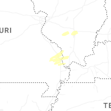
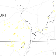

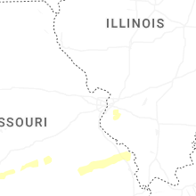


Connect with Interactive Hail Maps