

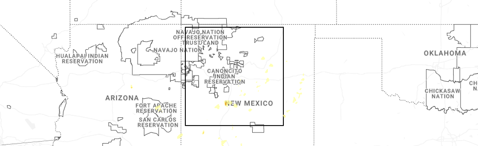
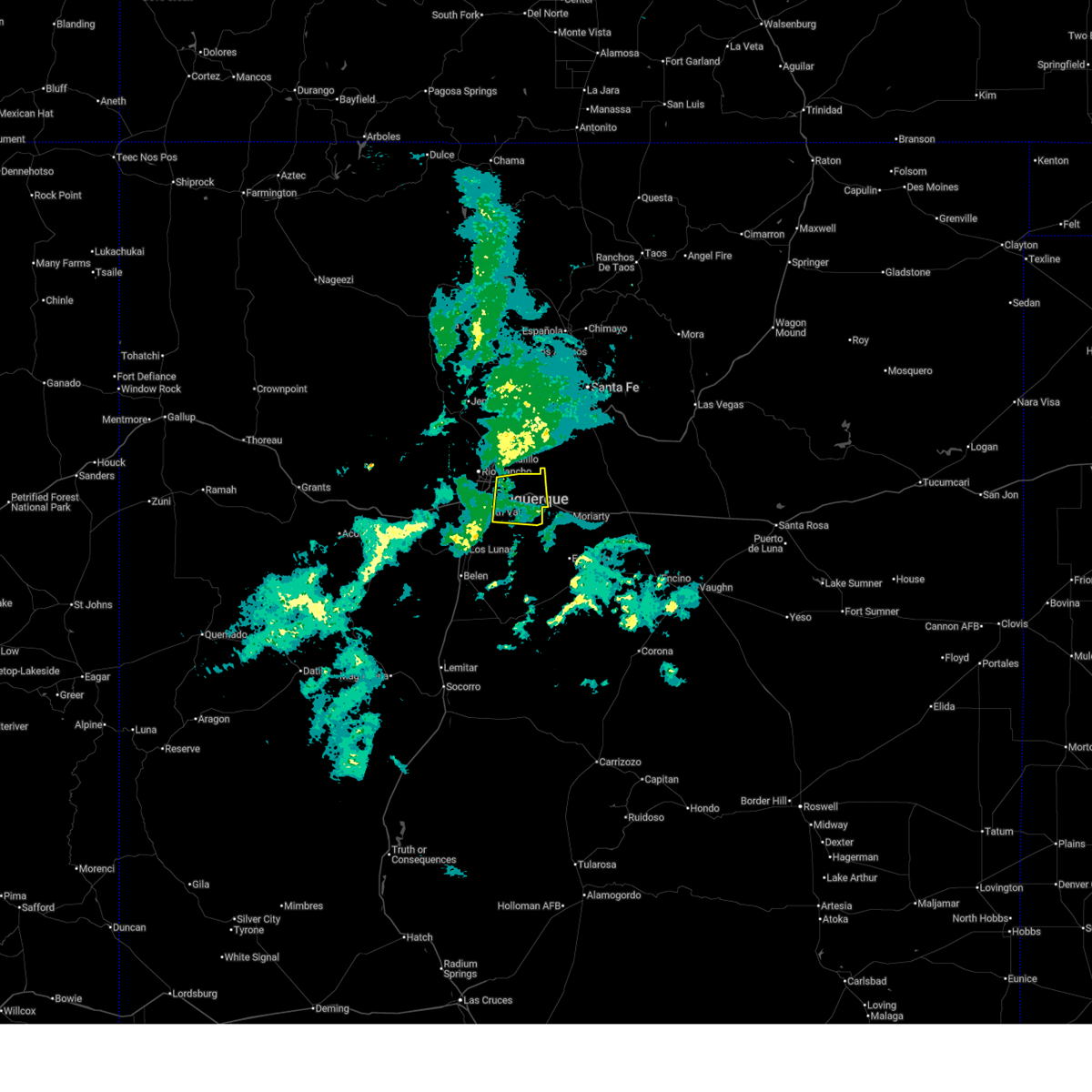
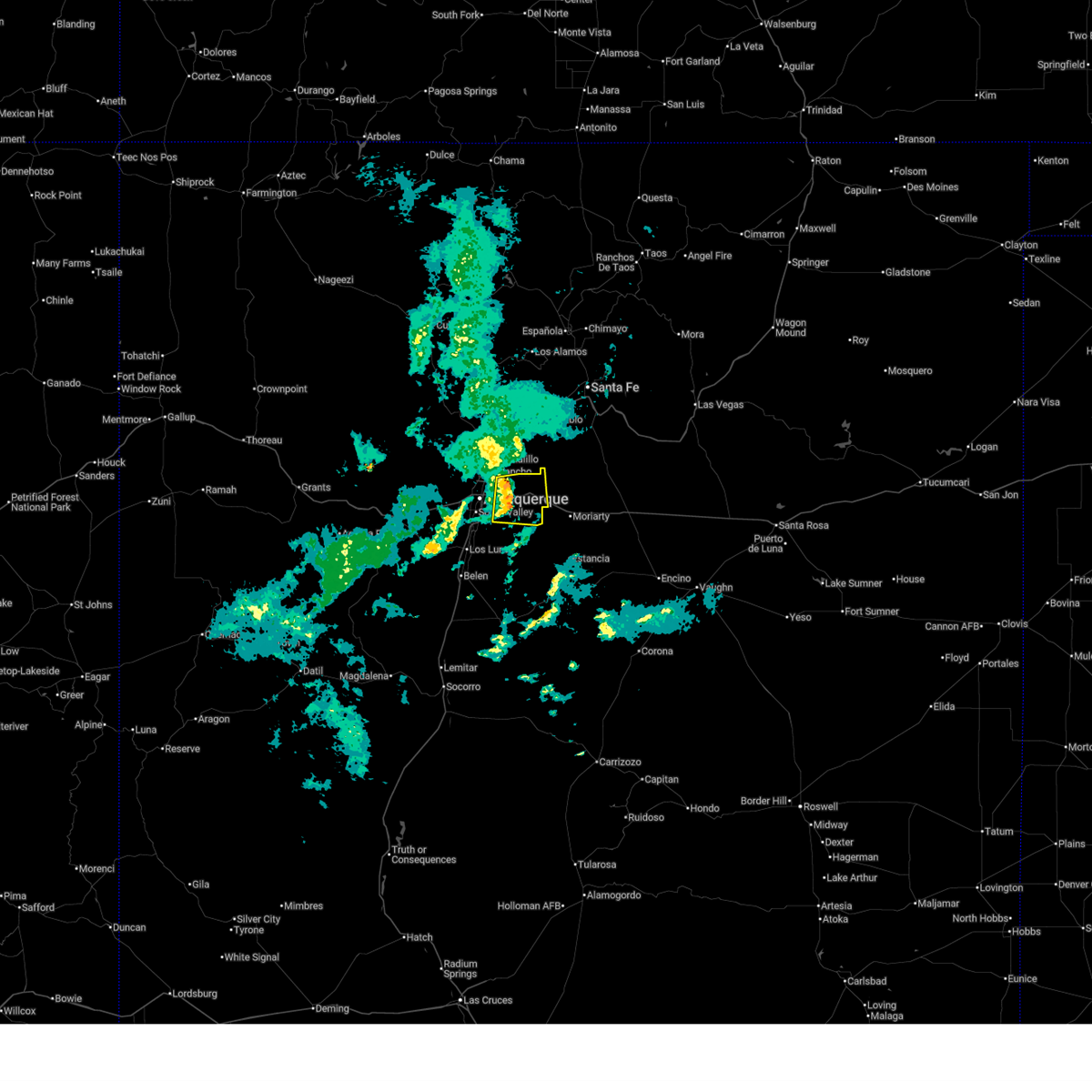
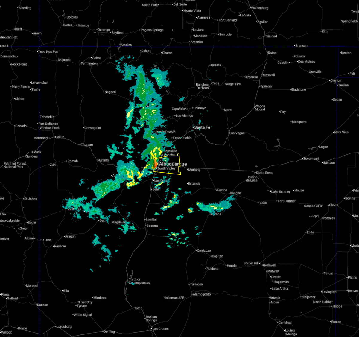
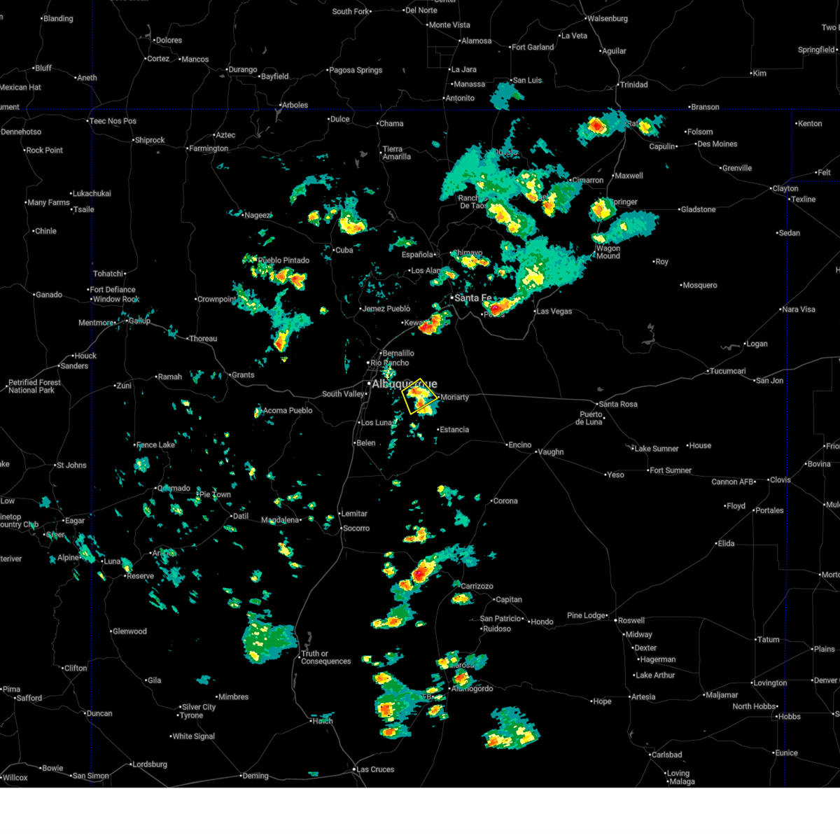
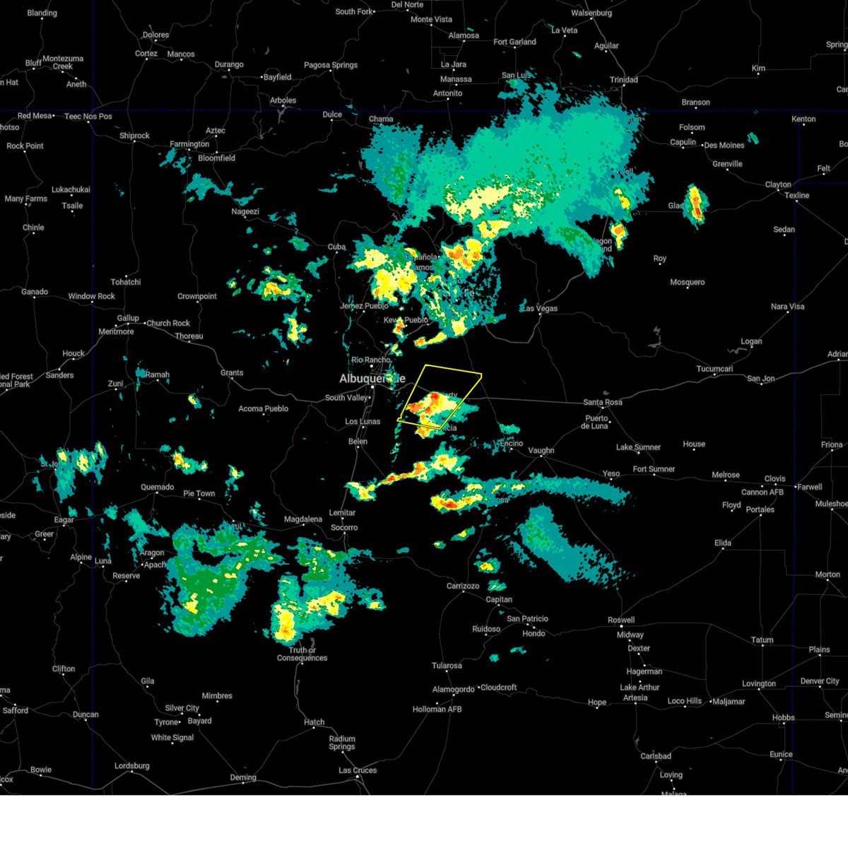
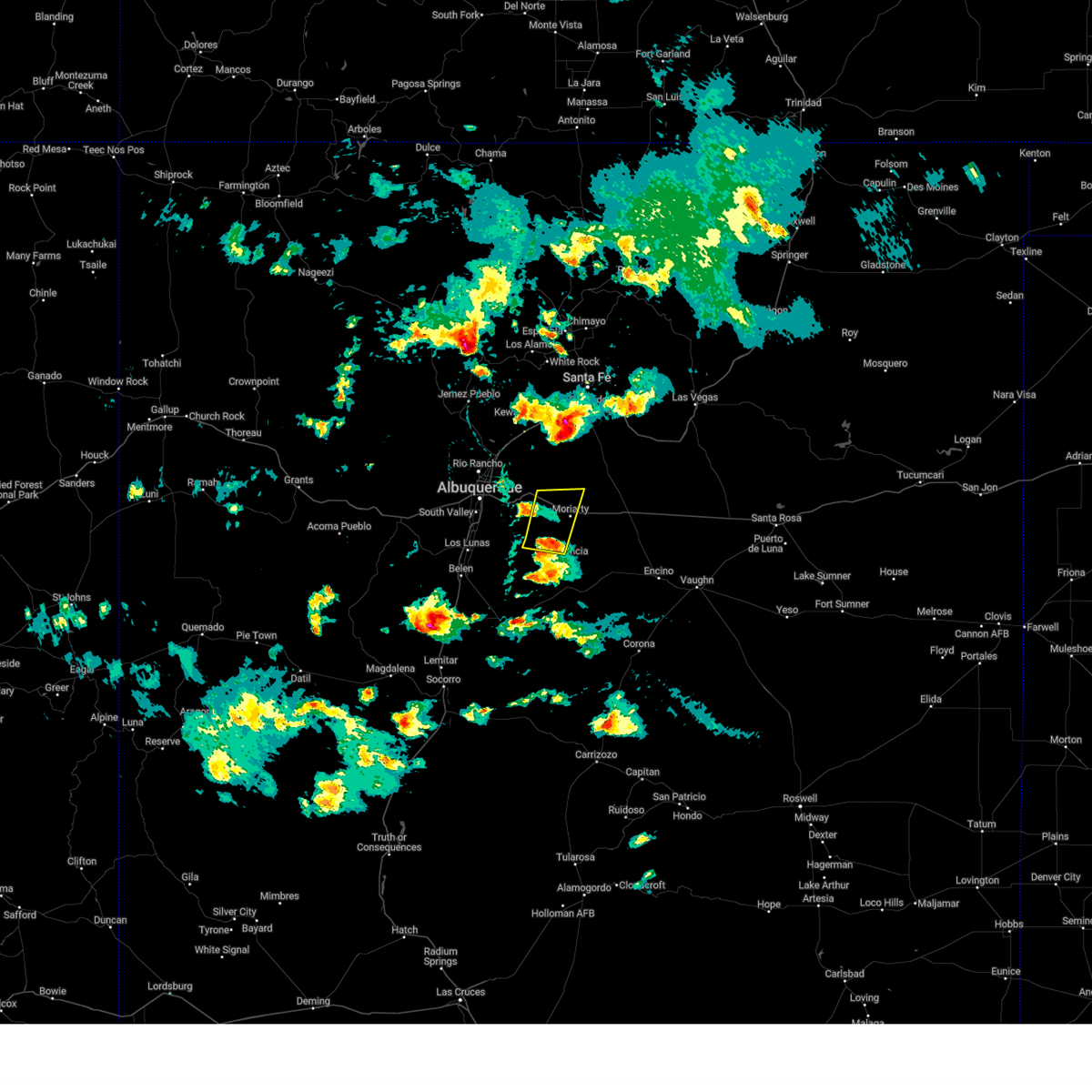
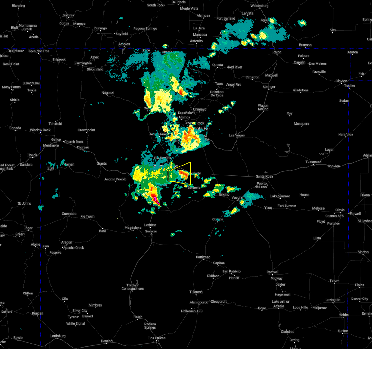
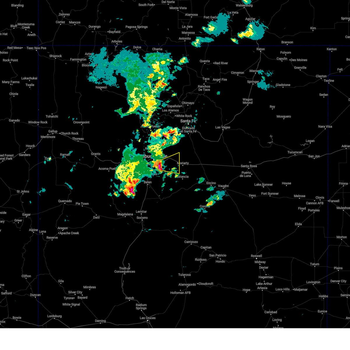
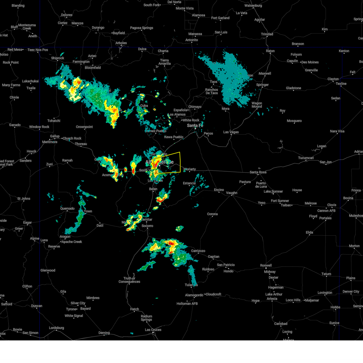
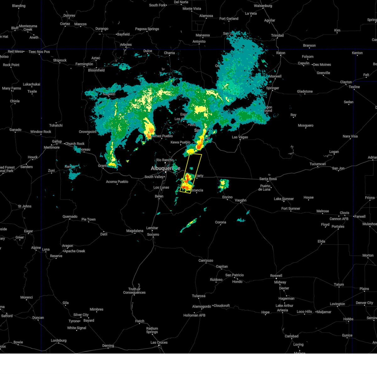
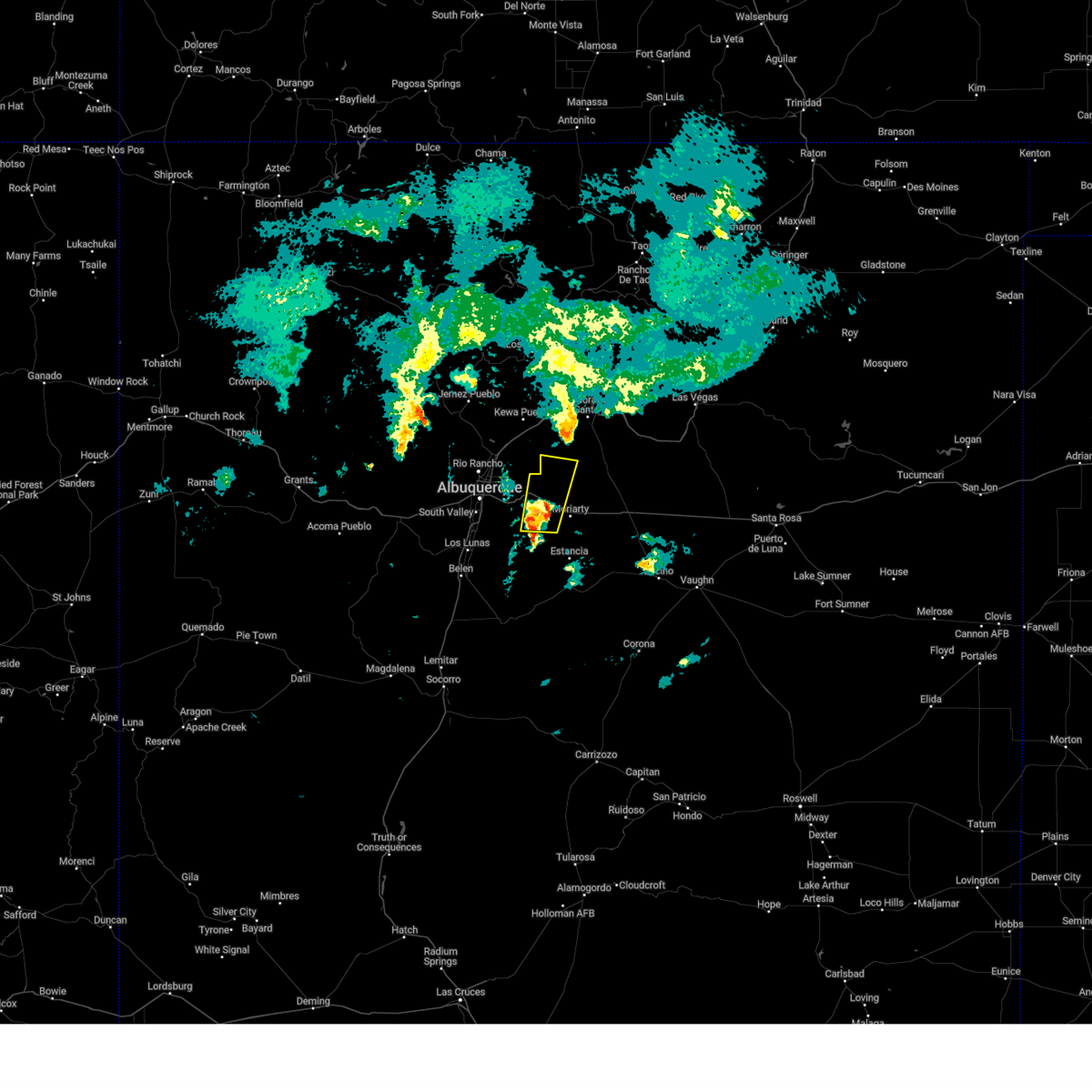
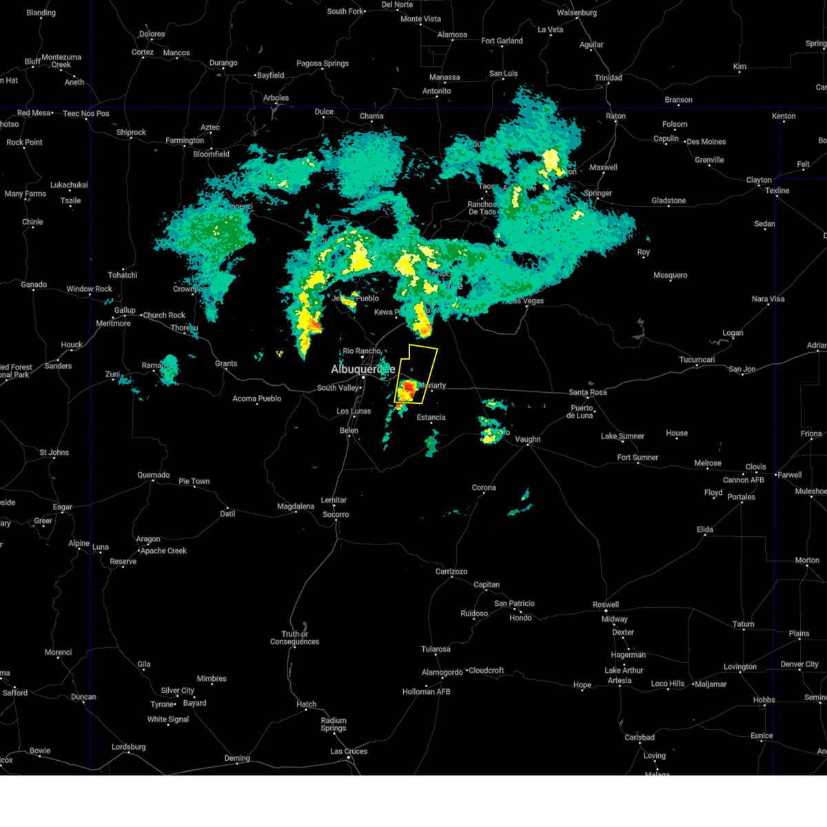
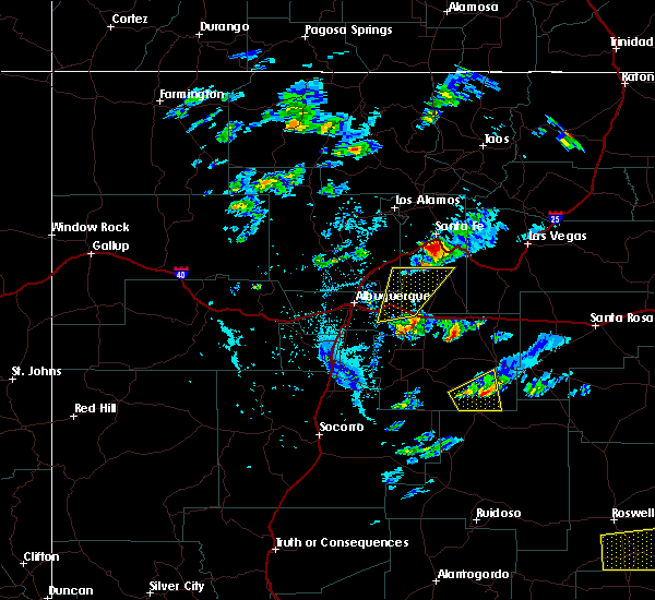
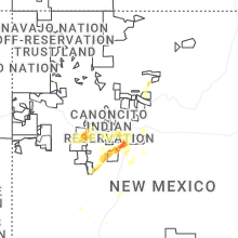
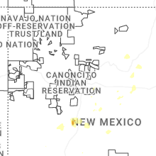
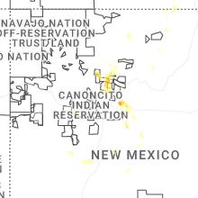
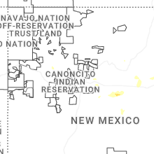
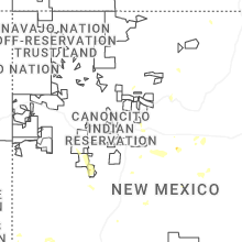
Hail Map for Ponderosa Pine, NM
The Ponderosa Pine, NM area has had 0 reports of on-the-ground hail by trained spotters, and has been under severe weather warnings 3 times during the past 12 months. Doppler radar has detected hail at or near Ponderosa Pine, NM on 45 occasions, including 3 occasions during the past year.
| Name: | Ponderosa Pine, NM |
| Where Located: | 19.2 miles ESE of Albuquerque, NM |
| Map: | Google Map for Ponderosa Pine, NM |
| Population: | 1195 |
| Housing Units: | 600 |
| More Info: | Search Google for Ponderosa Pine, NM |
1
The Top Recent Hail Date for Ponderosa Pine, NM is Sunday, July 13, 2025 (15th out of 45)
Hail and Wind Damage Spotted near Ponderosa Pine, NM
| Date / Time | Report Details |
|---|---|
| 1/8/2026 6:36 PM MST |
 The storm which prompted the warning has weakened below severe limits, and no longer poses an immediate threat to life or property. therefore, the warning will be allowed to expire. however, small hail and graupel accumulating on roadways are still possible with this thunderstorm. The storm which prompted the warning has weakened below severe limits, and no longer poses an immediate threat to life or property. therefore, the warning will be allowed to expire. however, small hail and graupel accumulating on roadways are still possible with this thunderstorm.
|
| 1/8/2026 6:17 PM MST |
 At 617 pm mst, a severe thunderstorm was located near tijeras, or 12 miles east of albuquerque, moving east at 30 mph (trained spotters reported. at 600 pm, 1 inch hail was observed at the albuquerque sunport). Hazards include quarter size hail. Damage to vehicles is expected. locations impacted include, eastern albuquerque, edgewood, tijeras, cedar crest, sandia park, sedillo, sandia heights, cedar grove, canoncito in bernalillo county and cedro. This includes interstate 40 between mile markers 164 and 186. At 617 pm mst, a severe thunderstorm was located near tijeras, or 12 miles east of albuquerque, moving east at 30 mph (trained spotters reported. at 600 pm, 1 inch hail was observed at the albuquerque sunport). Hazards include quarter size hail. Damage to vehicles is expected. locations impacted include, eastern albuquerque, edgewood, tijeras, cedar crest, sandia park, sedillo, sandia heights, cedar grove, canoncito in bernalillo county and cedro. This includes interstate 40 between mile markers 164 and 186.
|
| 1/8/2026 6:01 PM MST |
 Svrabq the national weather service in albuquerque has issued a * severe thunderstorm warning for, bernalillo county in central new mexico, southwestern santa fe county in north central new mexico, * until 645 pm mst. * at 601 pm mst, a severe thunderstorm was located near albuquerque, moving east at 30 mph (trained spotters reported. at 600 pm, 1 inch hail was observed at the albuquerque sunport). Hazards include quarter size hail. damage to vehicles is expected Svrabq the national weather service in albuquerque has issued a * severe thunderstorm warning for, bernalillo county in central new mexico, southwestern santa fe county in north central new mexico, * until 645 pm mst. * at 601 pm mst, a severe thunderstorm was located near albuquerque, moving east at 30 mph (trained spotters reported. at 600 pm, 1 inch hail was observed at the albuquerque sunport). Hazards include quarter size hail. damage to vehicles is expected
|
| 7/6/2025 2:38 PM MDT |
 the severe thunderstorm warning has been cancelled and is no longer in effect the severe thunderstorm warning has been cancelled and is no longer in effect
|
| 7/6/2025 2:16 PM MDT |
 Svrabq the national weather service in albuquerque has issued a * severe thunderstorm warning for, bernalillo county in central new mexico, northwestern torrance county in central new mexico, southwestern santa fe county in north central new mexico, * until 300 pm mdt. * at 216 pm mdt, a severe thunderstorm was located 6 miles southeast of sedillo, or 12 miles west of moriarty. this storm was stationary (radar indicated). Hazards include 60 mph wind gusts and quarter size hail. Hail damage to vehicles is expected. Expect wind damage to roofs, siding, and trees. Svrabq the national weather service in albuquerque has issued a * severe thunderstorm warning for, bernalillo county in central new mexico, northwestern torrance county in central new mexico, southwestern santa fe county in north central new mexico, * until 300 pm mdt. * at 216 pm mdt, a severe thunderstorm was located 6 miles southeast of sedillo, or 12 miles west of moriarty. this storm was stationary (radar indicated). Hazards include 60 mph wind gusts and quarter size hail. Hail damage to vehicles is expected. Expect wind damage to roofs, siding, and trees.
|
| 6/9/2025 4:48 PM MDT |
 At 448 pm mdt, a severe thunderstorm was located near stanley, or 7 miles north of moriarty, moving northeast at 20 mph (broadcast media reported). Hazards include 60 mph wind gusts and half dollar size hail. Hail damage to vehicles is expected. expect wind damage to roofs, siding, and trees. locations impacted include, moriarty, edgewood, cedar grove, mcintosh, chilili, stanley, escabosa, miera and ponderosa pines. This includes interstate 40 between mile markers 182 and 206. At 448 pm mdt, a severe thunderstorm was located near stanley, or 7 miles north of moriarty, moving northeast at 20 mph (broadcast media reported). Hazards include 60 mph wind gusts and half dollar size hail. Hail damage to vehicles is expected. expect wind damage to roofs, siding, and trees. locations impacted include, moriarty, edgewood, cedar grove, mcintosh, chilili, stanley, escabosa, miera and ponderosa pines. This includes interstate 40 between mile markers 182 and 206.
|
| 6/9/2025 4:29 PM MDT |
 The severe thunderstorm warning that was previously in effect has been reissued for bernalillo, santa fe, and torrance counties and is in effect until 500 pm mdt. please refer to that bulletin for the latest severe weather information. a severe thunderstorm watch remains in effect until 1000 pm mdt monday for portions of central and north central new mexico. The severe thunderstorm warning that was previously in effect has been reissued for bernalillo, santa fe, and torrance counties and is in effect until 500 pm mdt. please refer to that bulletin for the latest severe weather information. a severe thunderstorm watch remains in effect until 1000 pm mdt monday for portions of central and north central new mexico.
|
| 6/9/2025 4:29 PM MDT |
 Svrabq the national weather service in albuquerque has issued a * severe thunderstorm warning for, bernalillo county in central new mexico, northwestern torrance county in central new mexico, southern santa fe county in north central new mexico, * until 500 pm mdt. * at 429 pm mdt, a severe thunderstorm was located near moriarty, moving northeast at 25 mph (radar indicated). Hazards include ping pong ball size hail and 60 mph wind gusts. People and animals outdoors will be injured. expect hail damage to roofs, siding, windows, and vehicles. Expect wind damage to roofs, siding, and trees. Svrabq the national weather service in albuquerque has issued a * severe thunderstorm warning for, bernalillo county in central new mexico, northwestern torrance county in central new mexico, southern santa fe county in north central new mexico, * until 500 pm mdt. * at 429 pm mdt, a severe thunderstorm was located near moriarty, moving northeast at 25 mph (radar indicated). Hazards include ping pong ball size hail and 60 mph wind gusts. People and animals outdoors will be injured. expect hail damage to roofs, siding, windows, and vehicles. Expect wind damage to roofs, siding, and trees.
|
| 6/9/2025 3:56 PM MDT |
 At 356 pm mdt, a severe thunderstorm was located 6 miles south of edgewood, or 7 miles west of moriarty, moving northeast at 20 mph (radar indicated). Hazards include golf ball size hail and 60 mph wind gusts. People and animals outdoors will be injured. expect hail damage to roofs, siding, windows, and vehicles. expect wind damage to roofs, siding, and trees. locations impacted include, moriarty, edgewood, chilili, escabosa, miera and ponderosa pines. This includes interstate 40 between mile markers 182 and 198. At 356 pm mdt, a severe thunderstorm was located 6 miles south of edgewood, or 7 miles west of moriarty, moving northeast at 20 mph (radar indicated). Hazards include golf ball size hail and 60 mph wind gusts. People and animals outdoors will be injured. expect hail damage to roofs, siding, windows, and vehicles. expect wind damage to roofs, siding, and trees. locations impacted include, moriarty, edgewood, chilili, escabosa, miera and ponderosa pines. This includes interstate 40 between mile markers 182 and 198.
|
| 6/9/2025 3:41 PM MDT |
 Svrabq the national weather service in albuquerque has issued a * severe thunderstorm warning for, bernalillo county in central new mexico, northwestern torrance county in central new mexico, southwestern santa fe county in north central new mexico, * until 430 pm mdt. * at 341 pm mdt, a severe thunderstorm was located over chilili, or 13 miles southwest of moriarty, moving northeast at 20 mph (radar indicated). Hazards include 60 mph wind gusts and half dollar size hail. Hail damage to vehicles is expected. Expect wind damage to roofs, siding, and trees. Svrabq the national weather service in albuquerque has issued a * severe thunderstorm warning for, bernalillo county in central new mexico, northwestern torrance county in central new mexico, southwestern santa fe county in north central new mexico, * until 430 pm mdt. * at 341 pm mdt, a severe thunderstorm was located over chilili, or 13 miles southwest of moriarty, moving northeast at 20 mph (radar indicated). Hazards include 60 mph wind gusts and half dollar size hail. Hail damage to vehicles is expected. Expect wind damage to roofs, siding, and trees.
|
| 6/4/2025 4:18 PM MDT |
 the severe thunderstorm warning has been cancelled and is no longer in effect the severe thunderstorm warning has been cancelled and is no longer in effect
|
| 6/4/2025 3:50 PM MDT |
 Svrabq the national weather service in albuquerque has issued a * severe thunderstorm warning for, bernalillo county in central new mexico, northwestern torrance county in central new mexico, southwestern santa fe county in north central new mexico, * until 430 pm mdt. * at 350 pm mdt, a severe thunderstorm was located 9 miles southwest of tijeras, or 14 miles southeast of albuquerque, moving east at 30 mph (radar indicated). Hazards include 60 mph wind gusts and quarter size hail. Hail damage to vehicles is expected. Expect wind damage to roofs, siding, and trees. Svrabq the national weather service in albuquerque has issued a * severe thunderstorm warning for, bernalillo county in central new mexico, northwestern torrance county in central new mexico, southwestern santa fe county in north central new mexico, * until 430 pm mdt. * at 350 pm mdt, a severe thunderstorm was located 9 miles southwest of tijeras, or 14 miles southeast of albuquerque, moving east at 30 mph (radar indicated). Hazards include 60 mph wind gusts and quarter size hail. Hail damage to vehicles is expected. Expect wind damage to roofs, siding, and trees.
|
| 6/2/2025 2:48 PM MDT |
 Svrabq the national weather service in albuquerque has issued a * severe thunderstorm warning for, bernalillo county in central new mexico, southeastern sandoval county in north central new mexico, * until 330 pm mdt. * at 248 pm mdt, a severe thunderstorm was located over albuquerque, moving east at 35 mph (radar indicated). Hazards include 60 mph wind gusts and quarter size hail. Hail damage to vehicles is expected. Expect wind damage to roofs, siding, and trees. Svrabq the national weather service in albuquerque has issued a * severe thunderstorm warning for, bernalillo county in central new mexico, southeastern sandoval county in north central new mexico, * until 330 pm mdt. * at 248 pm mdt, a severe thunderstorm was located over albuquerque, moving east at 35 mph (radar indicated). Hazards include 60 mph wind gusts and quarter size hail. Hail damage to vehicles is expected. Expect wind damage to roofs, siding, and trees.
|
| 5/4/2025 9:14 PM MDT |
 The severe thunderstorm warning that was previously in effect has been reissued for torrance, bernalillo, and santa fe counties and is in effect until 1015 pm mdt. please refer to that bulletin for the latest severe weather information. The severe thunderstorm warning that was previously in effect has been reissued for torrance, bernalillo, and santa fe counties and is in effect until 1015 pm mdt. please refer to that bulletin for the latest severe weather information.
|
| 5/4/2025 9:01 PM MDT |
 At 901 pm mdt, a severe thunderstorm was located near edgewood, or 11 miles northwest of moriarty, moving north at 10 mph (trained spotters reported quarter sized hail north of edgewood). Hazards include half dollar size hail. Damage to vehicles is expected. locations impacted include, edgewood, cedar grove, golden, escabosa, chilili, ponderosa pines and miera. This includes interstate 40 between mile markers 182 and 193. At 901 pm mdt, a severe thunderstorm was located near edgewood, or 11 miles northwest of moriarty, moving north at 10 mph (trained spotters reported quarter sized hail north of edgewood). Hazards include half dollar size hail. Damage to vehicles is expected. locations impacted include, edgewood, cedar grove, golden, escabosa, chilili, ponderosa pines and miera. This includes interstate 40 between mile markers 182 and 193.
|
| 5/4/2025 8:37 PM MDT |
 At 837 pm mdt, a severe thunderstorm was located over cedar grove, or 13 miles northwest of moriarty, moving north at 20 mph (trained spotters reported half dollar sized hail near chilili). Hazards include half dollar size hail. Damage to vehicles is expected. locations impacted include, edgewood, cedar grove, chilili, escabosa, golden, tajique, ponderosa pines and miera. This includes interstate 40 between mile markers 182 and 193. At 837 pm mdt, a severe thunderstorm was located over cedar grove, or 13 miles northwest of moriarty, moving north at 20 mph (trained spotters reported half dollar sized hail near chilili). Hazards include half dollar size hail. Damage to vehicles is expected. locations impacted include, edgewood, cedar grove, chilili, escabosa, golden, tajique, ponderosa pines and miera. This includes interstate 40 between mile markers 182 and 193.
|
| 5/4/2025 8:29 PM MDT |
 Svrabq the national weather service in albuquerque has issued a * severe thunderstorm warning for, bernalillo county in central new mexico, northwestern torrance county in central new mexico, southwestern santa fe county in north central new mexico, * until 915 pm mdt. * at 829 pm mdt, a severe thunderstorm was located near cedar grove, or 12 miles northwest of moriarty, moving north at 20 mph (radar indicated). Hazards include quarter size hail. damage to vehicles is expected Svrabq the national weather service in albuquerque has issued a * severe thunderstorm warning for, bernalillo county in central new mexico, northwestern torrance county in central new mexico, southwestern santa fe county in north central new mexico, * until 915 pm mdt. * at 829 pm mdt, a severe thunderstorm was located near cedar grove, or 12 miles northwest of moriarty, moving north at 20 mph (radar indicated). Hazards include quarter size hail. damage to vehicles is expected
|
| 5/4/2025 8:06 PM MDT |
 At 806 pm mdt, a severe thunderstorm was located near sedillo, or 13 miles west of moriarty, moving north at 15 mph (trained spotters reported half dollar size hail near edgewood). Hazards include half dollar size hail. Damage to vehicles is expected. locations impacted include, edgewood, cedar grove, sedillo, golden, escabosa, chilili, ponderosa pines, miera and cedro. This includes interstate 40 between mile markers 178 and 193. At 806 pm mdt, a severe thunderstorm was located near sedillo, or 13 miles west of moriarty, moving north at 15 mph (trained spotters reported half dollar size hail near edgewood). Hazards include half dollar size hail. Damage to vehicles is expected. locations impacted include, edgewood, cedar grove, sedillo, golden, escabosa, chilili, ponderosa pines, miera and cedro. This includes interstate 40 between mile markers 178 and 193.
|
| 5/4/2025 7:49 PM MDT |
 Svrabq the national weather service in albuquerque has issued a * severe thunderstorm warning for, bernalillo county in central new mexico, northwestern torrance county in central new mexico, southwestern santa fe county in north central new mexico, * until 830 pm mdt. * at 749 pm mdt, a severe thunderstorm was located 6 miles north of escabosa, or 12 miles west of moriarty, moving north at 15 mph (radar indicated). Hazards include quarter size hail. damage to vehicles is expected Svrabq the national weather service in albuquerque has issued a * severe thunderstorm warning for, bernalillo county in central new mexico, northwestern torrance county in central new mexico, southwestern santa fe county in north central new mexico, * until 830 pm mdt. * at 749 pm mdt, a severe thunderstorm was located 6 miles north of escabosa, or 12 miles west of moriarty, moving north at 15 mph (radar indicated). Hazards include quarter size hail. damage to vehicles is expected
|
| 5/31/2023 4:36 PM MDT |
 At 436 pm mdt, a severe thunderstorm was located near moriarty, moving northeast at 15 mph (trained weather spotters). Hazards include 60 mph wind gusts and quarter size hail. Hail damage to vehicles is expected. expect wind damage to roofs, siding, and trees. locations impacted include, edgewood, moriarty, mcintosh, escabosa, chilili, ponderosa pines, miera, stanley, tajique and cedar grove. this includes interstate 40 between mile markers 185 and 209. hail threat, radar indicated max hail size, 1. 00 in wind threat, radar indicated max wind gust, 60 mph. At 436 pm mdt, a severe thunderstorm was located near moriarty, moving northeast at 15 mph (trained weather spotters). Hazards include 60 mph wind gusts and quarter size hail. Hail damage to vehicles is expected. expect wind damage to roofs, siding, and trees. locations impacted include, edgewood, moriarty, mcintosh, escabosa, chilili, ponderosa pines, miera, stanley, tajique and cedar grove. this includes interstate 40 between mile markers 185 and 209. hail threat, radar indicated max hail size, 1. 00 in wind threat, radar indicated max wind gust, 60 mph.
|
| 5/26/2023 1:26 PM MDT |
 At 125 pm mdt, a severe thunderstorm was located over chilili, or 10 miles southwest of moriarty, moving northeast at 20 mph (radar indicated). Hazards include two inch hail and 60 mph wind gusts. People and animals outdoors will be injured. expect hail damage to roofs, siding, windows, and vehicles. expect wind damage to roofs, siding, and trees. locations impacted include, edgewood, moriarty, chilili, escabosa, ponderosa pines and miera. this includes interstate 40 between mile markers 184 and 197. thunderstorm damage threat, considerable hail threat, observed max hail size, 2. 00 in wind threat, radar indicated max wind gust, 60 mph. At 125 pm mdt, a severe thunderstorm was located over chilili, or 10 miles southwest of moriarty, moving northeast at 20 mph (radar indicated). Hazards include two inch hail and 60 mph wind gusts. People and animals outdoors will be injured. expect hail damage to roofs, siding, windows, and vehicles. expect wind damage to roofs, siding, and trees. locations impacted include, edgewood, moriarty, chilili, escabosa, ponderosa pines and miera. this includes interstate 40 between mile markers 184 and 197. thunderstorm damage threat, considerable hail threat, observed max hail size, 2. 00 in wind threat, radar indicated max wind gust, 60 mph.
|
| 5/26/2023 1:09 PM MDT |
 At 108 pm mdt, a severe thunderstorm was located over escabosa, or 15 miles southwest of moriarty, moving north at 15 mph (radar indicated). Hazards include 60 mph wind gusts and half dollar size hail. Hail damage to vehicles is expected. Expect wind damage to roofs, siding, and trees. At 108 pm mdt, a severe thunderstorm was located over escabosa, or 15 miles southwest of moriarty, moving north at 15 mph (radar indicated). Hazards include 60 mph wind gusts and half dollar size hail. Hail damage to vehicles is expected. Expect wind damage to roofs, siding, and trees.
|
| 8/15/2021 7:22 PM MDT |
 At 720 pm mdt, an outflow boundary racing southward from strong thunderstorms were located along a line extending from about 6 miles north of sandia park to near sandia pueblo to rio rancho to 10 miles west of northern meadows, moving south to souteast at 40 mph (radar indicated). Hazards include 60 mph wind gusts. expect damage to roofs, siding, and trees At 720 pm mdt, an outflow boundary racing southward from strong thunderstorms were located along a line extending from about 6 miles north of sandia park to near sandia pueblo to rio rancho to 10 miles west of northern meadows, moving south to souteast at 40 mph (radar indicated). Hazards include 60 mph wind gusts. expect damage to roofs, siding, and trees
|
| 7/12/2021 7:51 PM MDT |
 At 750 pm mdt, severe thunderstorms were located along a line extending from near cedar grove to 9 miles southeast of moriarty, moving southwest at 20 mph (radar indicated). Hazards include 60 mph wind gusts and quarter size hail. Hail damage to vehicles is expected. expect wind damage to roofs, siding, and trees. locations impacted include, edgewood, moriarty, tijeras, cedar crest, cedar grove, sedillo, chilili, mcintosh, escabosa and cedro. this includes interstate 40 between mile markers 172 and 205. Significant blowing dust has been observed with this storm. At 750 pm mdt, severe thunderstorms were located along a line extending from near cedar grove to 9 miles southeast of moriarty, moving southwest at 20 mph (radar indicated). Hazards include 60 mph wind gusts and quarter size hail. Hail damage to vehicles is expected. expect wind damage to roofs, siding, and trees. locations impacted include, edgewood, moriarty, tijeras, cedar crest, cedar grove, sedillo, chilili, mcintosh, escabosa and cedro. this includes interstate 40 between mile markers 172 and 205. Significant blowing dust has been observed with this storm.
|
| 7/12/2021 7:22 PM MDT |
 At 720 pm mdt, severe thunderstorms were located along a line extending from near stanley to 9 miles west of clines corners, moving southwest at 25 mph (radar and trained weather spotters). Hazards include 60 mph wind gusts and half dollar size hail. Hail damage to vehicles is expected. expect wind damage to roofs, siding, and trees. locations impacted include, edgewood, moriarty, estancia, tijeras, cedar crest, cedar grove, sedillo, chilili, mcintosh and stanley. a storm spotter in stanley observed quarter size hail with these storms at 717 pm mdt. This includes interstate 40 between mile markers 172 and 215. At 720 pm mdt, severe thunderstorms were located along a line extending from near stanley to 9 miles west of clines corners, moving southwest at 25 mph (radar and trained weather spotters). Hazards include 60 mph wind gusts and half dollar size hail. Hail damage to vehicles is expected. expect wind damage to roofs, siding, and trees. locations impacted include, edgewood, moriarty, estancia, tijeras, cedar crest, cedar grove, sedillo, chilili, mcintosh and stanley. a storm spotter in stanley observed quarter size hail with these storms at 717 pm mdt. This includes interstate 40 between mile markers 172 and 215.
|
| 7/12/2021 7:12 PM MDT |
 At 711 pm mdt, severe thunderstorms were located along a line extending from near stanley to 7 miles west of clines corners, moving southwest at 25 mph (radar indicated). Hazards include 60 mph wind gusts and quarter size hail. Hail damage to vehicles is expected. Expect wind damage to roofs, siding, and trees. At 711 pm mdt, severe thunderstorms were located along a line extending from near stanley to 7 miles west of clines corners, moving southwest at 25 mph (radar indicated). Hazards include 60 mph wind gusts and quarter size hail. Hail damage to vehicles is expected. Expect wind damage to roofs, siding, and trees.
|
| 8/3/2020 7:22 PM MDT |
 At 722 pm mdt, a severe thunderstorm was located near escabosa, or 13 miles west of moriarty, moving southeast at 10 mph (radar indicated). Hazards include 60 mph wind gusts and quarter size hail. Hail damage to vehicles is expected. expect wind damage to roofs, siding, and trees. Locations impacted include, moriarty, chilili, escabosa, cedro, ponderosa pines and miera. At 722 pm mdt, a severe thunderstorm was located near escabosa, or 13 miles west of moriarty, moving southeast at 10 mph (radar indicated). Hazards include 60 mph wind gusts and quarter size hail. Hail damage to vehicles is expected. expect wind damage to roofs, siding, and trees. Locations impacted include, moriarty, chilili, escabosa, cedro, ponderosa pines and miera.
|
| 8/3/2020 7:08 PM MDT |
 At 708 pm mdt, a severe thunderstorm was located near sedillo, or 14 miles west of moriarty, moving southeast at 10 mph (radar indicated). Hazards include 60 mph wind gusts and quarter size hail. Hail damage to vehicles is expected. Expect wind damage to roofs, siding, and trees. At 708 pm mdt, a severe thunderstorm was located near sedillo, or 14 miles west of moriarty, moving southeast at 10 mph (radar indicated). Hazards include 60 mph wind gusts and quarter size hail. Hail damage to vehicles is expected. Expect wind damage to roofs, siding, and trees.
|
| 7/31/2020 7:17 PM MDT |
 At 716 pm mdt, a severe thunderstorm was located over rio communities, or near belen, moving south at 30 mph (radar indicated). Hazards include 60 mph wind gusts. Expect damage to roofs, siding, and trees. locations impacted include, southern albuquerque, valencia, los lunas, belen, bosque farms, peralta, mountainair, rio communities north, abo and jarales. this includes the following highways, interstate 40 between mile markers 122 and 141, and near mile marker 170. interstate 25 between mile markers 164 and 222. Highway 60 between mile markers 166 and 198, and between mile markers 201 and 206. At 716 pm mdt, a severe thunderstorm was located over rio communities, or near belen, moving south at 30 mph (radar indicated). Hazards include 60 mph wind gusts. Expect damage to roofs, siding, and trees. locations impacted include, southern albuquerque, valencia, los lunas, belen, bosque farms, peralta, mountainair, rio communities north, abo and jarales. this includes the following highways, interstate 40 between mile markers 122 and 141, and near mile marker 170. interstate 25 between mile markers 164 and 222. Highway 60 between mile markers 166 and 198, and between mile markers 201 and 206.
|
| 7/31/2020 6:43 PM MDT |
 At 642 pm mdt, a severe thunderstorm was located over bosque farms, or near los lunas, moving south at 45 mph. a 64 mph wind gust has already been reported at the albuquerque sunport (radar indicated). Hazards include 70 mph wind gusts. Expect considerable tree damage. Damage is likely to mobile homes, roofs, and outbuildings. At 642 pm mdt, a severe thunderstorm was located over bosque farms, or near los lunas, moving south at 45 mph. a 64 mph wind gust has already been reported at the albuquerque sunport (radar indicated). Hazards include 70 mph wind gusts. Expect considerable tree damage. Damage is likely to mobile homes, roofs, and outbuildings.
|
| 7/31/2020 6:20 PM MDT |
 At 619 pm mdt, a severe thunderstorm was located over northeastern albuquerque, moving south at 35 mph (radar indicated). Hazards include 70 mph wind gusts. Expect considerable tree damage. damage is likely to mobile homes, roofs, and outbuildings. locations impacted include, albuquerque, rio rancho, valencia, los lunas, corrales, bernalillo, los ranchos de albuquerque, bosque farms, edgewood and peralta. this includes the following highways, interstate 40 between mile markers 143 and 193. interstate 25 between mile markers 201 and 253. Highway 550 between mile markers 1 and 10. At 619 pm mdt, a severe thunderstorm was located over northeastern albuquerque, moving south at 35 mph (radar indicated). Hazards include 70 mph wind gusts. Expect considerable tree damage. damage is likely to mobile homes, roofs, and outbuildings. locations impacted include, albuquerque, rio rancho, valencia, los lunas, corrales, bernalillo, los ranchos de albuquerque, bosque farms, edgewood and peralta. this includes the following highways, interstate 40 between mile markers 143 and 193. interstate 25 between mile markers 201 and 253. Highway 550 between mile markers 1 and 10.
|
| 7/31/2020 5:57 PM MDT |
 At 556 pm mdt, a severe thunderstorm was located over bernalillo, moving south at 40 mph (radar indicated). Hazards include 70 mph wind gusts. Expect considerable tree damage. Damage is likely to mobile homes, roofs, and outbuildings. At 556 pm mdt, a severe thunderstorm was located over bernalillo, moving south at 40 mph (radar indicated). Hazards include 70 mph wind gusts. Expect considerable tree damage. Damage is likely to mobile homes, roofs, and outbuildings.
|
| 6/2/2019 5:10 PM MDT |
 The severe thunderstorm warning for southeastern sandoval, southern santa fe, bernalillo and northwestern torrance counties will expire at 515 pm mdt, the storm which prompted the warning has weakened below severe limits, and has exited the warned area. therefore the warning will be allowed to expire. however gusty winds and heavy rain are still possible with this thunderstorm. a severe thunderstorm watch remains in effect until 800 pm mdt for central and north central new mexico. to report severe weather, contact your nearest law enforcement agency. they will relay your report to the national weather service albuquerque. The severe thunderstorm warning for southeastern sandoval, southern santa fe, bernalillo and northwestern torrance counties will expire at 515 pm mdt, the storm which prompted the warning has weakened below severe limits, and has exited the warned area. therefore the warning will be allowed to expire. however gusty winds and heavy rain are still possible with this thunderstorm. a severe thunderstorm watch remains in effect until 800 pm mdt for central and north central new mexico. to report severe weather, contact your nearest law enforcement agency. they will relay your report to the national weather service albuquerque.
|
| 6/2/2019 4:47 PM MDT |
 At 447 pm mdt, severe thunderstorms were located along a line extending from near edgewood to near tajique, moving east at 25 mph (radar indicated). Hazards include 60 mph wind gusts and penny size hail. Expect damage to roofs, siding, and trees. Locations impacted include, torreon, tajique, chilili, escabosa, ponderosa pines and miera. At 447 pm mdt, severe thunderstorms were located along a line extending from near edgewood to near tajique, moving east at 25 mph (radar indicated). Hazards include 60 mph wind gusts and penny size hail. Expect damage to roofs, siding, and trees. Locations impacted include, torreon, tajique, chilili, escabosa, ponderosa pines and miera.
|
| 6/2/2019 4:34 PM MDT |
 At 433 pm mdt, a severe thunderstorm was located over sedillo, or 15 miles northwest of moriarty, moving north at 30 mph (radar indicated). Hazards include ping pong ball size hail and 60 mph wind gusts. People and animals outdoors will be injured. expect hail damage to roofs, siding, windows, and vehicles. expect wind damage to roofs, siding, and trees. locations impacted include, edgewood, tijeras, cedar crest, madrid, cedar grove, sedillo, sandia park, galisteo, golden and cedro. this includes the following highways, interstate 40 between mile markers 175 and 192. Highway 285 between mile markers 276 and 279. At 433 pm mdt, a severe thunderstorm was located over sedillo, or 15 miles northwest of moriarty, moving north at 30 mph (radar indicated). Hazards include ping pong ball size hail and 60 mph wind gusts. People and animals outdoors will be injured. expect hail damage to roofs, siding, windows, and vehicles. expect wind damage to roofs, siding, and trees. locations impacted include, edgewood, tijeras, cedar crest, madrid, cedar grove, sedillo, sandia park, galisteo, golden and cedro. this includes the following highways, interstate 40 between mile markers 175 and 192. Highway 285 between mile markers 276 and 279.
|
| 6/2/2019 4:30 PM MDT |
 At 430 pm mdt, a severe thunderstorm was located near escabosa, or 19 miles west of estancia, moving east at 30 mph (radar indicated). Hazards include ping pong ball size hail and 60 mph wind gusts. People and animals outdoors will be injured. expect hail damage to roofs, siding, windows, and vehicles. Expect wind damage to roofs, siding, and trees. At 430 pm mdt, a severe thunderstorm was located near escabosa, or 19 miles west of estancia, moving east at 30 mph (radar indicated). Hazards include ping pong ball size hail and 60 mph wind gusts. People and animals outdoors will be injured. expect hail damage to roofs, siding, windows, and vehicles. Expect wind damage to roofs, siding, and trees.
|
| 6/2/2019 4:20 PM MDT |
 At 420 pm mdt, a severe thunderstorm was located near escabosa, or 13 miles west of moriarty, moving north at 30 mph (radar indicated). Hazards include 60 mph wind gusts and quarter size hail. Hail damage to vehicles is expected. Expect wind damage to roofs, siding, and trees. At 420 pm mdt, a severe thunderstorm was located near escabosa, or 13 miles west of moriarty, moving north at 30 mph (radar indicated). Hazards include 60 mph wind gusts and quarter size hail. Hail damage to vehicles is expected. Expect wind damage to roofs, siding, and trees.
|
| 8/22/2018 5:57 PM MDT |
 At 541 pm mdt, an outflow boundary associated with severe thunderstorms was located along a line extending from rio rancho to albuquerque to 10 miles northeast of meadow lake, moving northeast at 40 mph. this outflow boundary has already produced peak wind gusts of 55 mph at the double eagle ii airport (radar indicated). Hazards include 60 mph wind gusts. Expect damage to roofs, siding, and trees. very poor visibility due to blowing dust is expected. locations impacted include, albuquerque, rio rancho, los lunas, corrales, bernalillo, los ranchos de albuquerque, bosque farms, peralta, tijeras and coronado state monument. this includes the following highways, interstate 40 between mile markers 145 and 176. Interstate 25 between mile markers 204 and 244. At 541 pm mdt, an outflow boundary associated with severe thunderstorms was located along a line extending from rio rancho to albuquerque to 10 miles northeast of meadow lake, moving northeast at 40 mph. this outflow boundary has already produced peak wind gusts of 55 mph at the double eagle ii airport (radar indicated). Hazards include 60 mph wind gusts. Expect damage to roofs, siding, and trees. very poor visibility due to blowing dust is expected. locations impacted include, albuquerque, rio rancho, los lunas, corrales, bernalillo, los ranchos de albuquerque, bosque farms, peralta, tijeras and coronado state monument. this includes the following highways, interstate 40 between mile markers 145 and 176. Interstate 25 between mile markers 204 and 244.
|
| 8/22/2018 5:43 PM MDT |
 At 541 pm mdt, an outflow boundary associated with severe thunderstorms was located along a line extending from rio rancho to albuquerque to 10 miles northeast of meadow lake, moving northeast at 40 mph. this outflow boundary has already produced peak wind gusts of 55 mph at the double eagle ii airport (radar indicated). Hazards include 60 mph wind gusts. Expect damage to roofs, siding, and trees. very poor visibility due to blowing dust is expected. locations impacted include, albuquerque, rio rancho, los lunas, corrales, bernalillo, los ranchos de albuquerque, bosque farms, peralta, tijeras and coronado state monument. this includes the following highways, interstate 40 between mile markers 145 and 176. Interstate 25 between mile markers 204 and 244. At 541 pm mdt, an outflow boundary associated with severe thunderstorms was located along a line extending from rio rancho to albuquerque to 10 miles northeast of meadow lake, moving northeast at 40 mph. this outflow boundary has already produced peak wind gusts of 55 mph at the double eagle ii airport (radar indicated). Hazards include 60 mph wind gusts. Expect damage to roofs, siding, and trees. very poor visibility due to blowing dust is expected. locations impacted include, albuquerque, rio rancho, los lunas, corrales, bernalillo, los ranchos de albuquerque, bosque farms, peralta, tijeras and coronado state monument. this includes the following highways, interstate 40 between mile markers 145 and 176. Interstate 25 between mile markers 204 and 244.
|
| 8/22/2018 5:29 PM MDT |
 At 528 pm mdt, an outflow boundary from severe thunderstorms was located along a line extending from 6 miles west of cabezon to albuquerque to near bosque farms, moving northeast at 35 mph (radar indicated). Hazards include 60 mph wind gusts. Expect damage to roofs, siding, and trees. Very poor visibility from blowing dust is also expected. At 528 pm mdt, an outflow boundary from severe thunderstorms was located along a line extending from 6 miles west of cabezon to albuquerque to near bosque farms, moving northeast at 35 mph (radar indicated). Hazards include 60 mph wind gusts. Expect damage to roofs, siding, and trees. Very poor visibility from blowing dust is also expected.
|
| 5/21/2018 2:44 PM MDT |
 At 243 pm mdt, severe thunderstorms were located along a line extending from 12 miles northeast of marquez to sandia park, moving north at 35 mph (radar indicated). Hazards include 60 mph wind gusts and quarter size hail. Hail damage to vehicles is expected. Expect wind damage to roofs, siding, and trees. At 243 pm mdt, severe thunderstorms were located along a line extending from 12 miles northeast of marquez to sandia park, moving north at 35 mph (radar indicated). Hazards include 60 mph wind gusts and quarter size hail. Hail damage to vehicles is expected. Expect wind damage to roofs, siding, and trees.
|
| 5/9/2017 11:22 AM MDT |
 At 1121 am mdt, a severe thunderstorm was located over chilili, or 11 miles southwest of moriarty, moving north at 15 mph (radar indicated). Hazards include 60 mph wind gusts and penny size hail. Expect damage to roofs, siding, and trees. Locations impacted include, chilili, escabosa and miera. At 1121 am mdt, a severe thunderstorm was located over chilili, or 11 miles southwest of moriarty, moving north at 15 mph (radar indicated). Hazards include 60 mph wind gusts and penny size hail. Expect damage to roofs, siding, and trees. Locations impacted include, chilili, escabosa and miera.
|
| 5/9/2017 11:03 AM MDT |
 At 1103 am mdt, a severe thunderstorm was located near chilili, or 7 miles northwest of estancia, moving north at 20 mph (radar indicated). Hazards include 60 mph wind gusts and quarter size hail. Hail damage to vehicles is expected. Expect wind damage to roofs, siding, and trees. At 1103 am mdt, a severe thunderstorm was located near chilili, or 7 miles northwest of estancia, moving north at 20 mph (radar indicated). Hazards include 60 mph wind gusts and quarter size hail. Hail damage to vehicles is expected. Expect wind damage to roofs, siding, and trees.
|
| 9/29/2016 5:50 PM MDT |
 At 550 pm mdt, severe thunderstorms were located along a line extending from albuquerque to 9 miles east of south valley, moving northeast at 40 mph (radar indicated). Hazards include 60 mph wind gusts. Expect damage to roofs. siding. And trees. At 550 pm mdt, severe thunderstorms were located along a line extending from albuquerque to 9 miles east of south valley, moving northeast at 40 mph (radar indicated). Hazards include 60 mph wind gusts. Expect damage to roofs. siding. And trees.
|
| 9/9/2015 1:03 PM MDT |
 At 103 pm mdt, a severe thunderstorm was located over sedillo, or 12 miles northwest of moriarty, moving southeast at 5 mph (trained weather spotters). Hazards include quarter size hail and 60 mph wind gusts. Hail damage to vehicles is expected. Expect wind damage to roofs, siding and trees. At 103 pm mdt, a severe thunderstorm was located over sedillo, or 12 miles northwest of moriarty, moving southeast at 5 mph (trained weather spotters). Hazards include quarter size hail and 60 mph wind gusts. Hail damage to vehicles is expected. Expect wind damage to roofs, siding and trees.
|
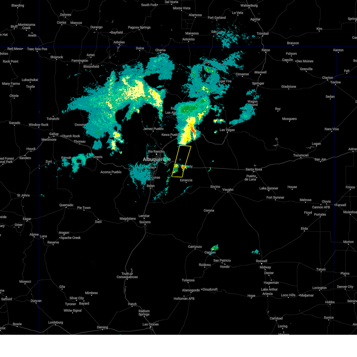
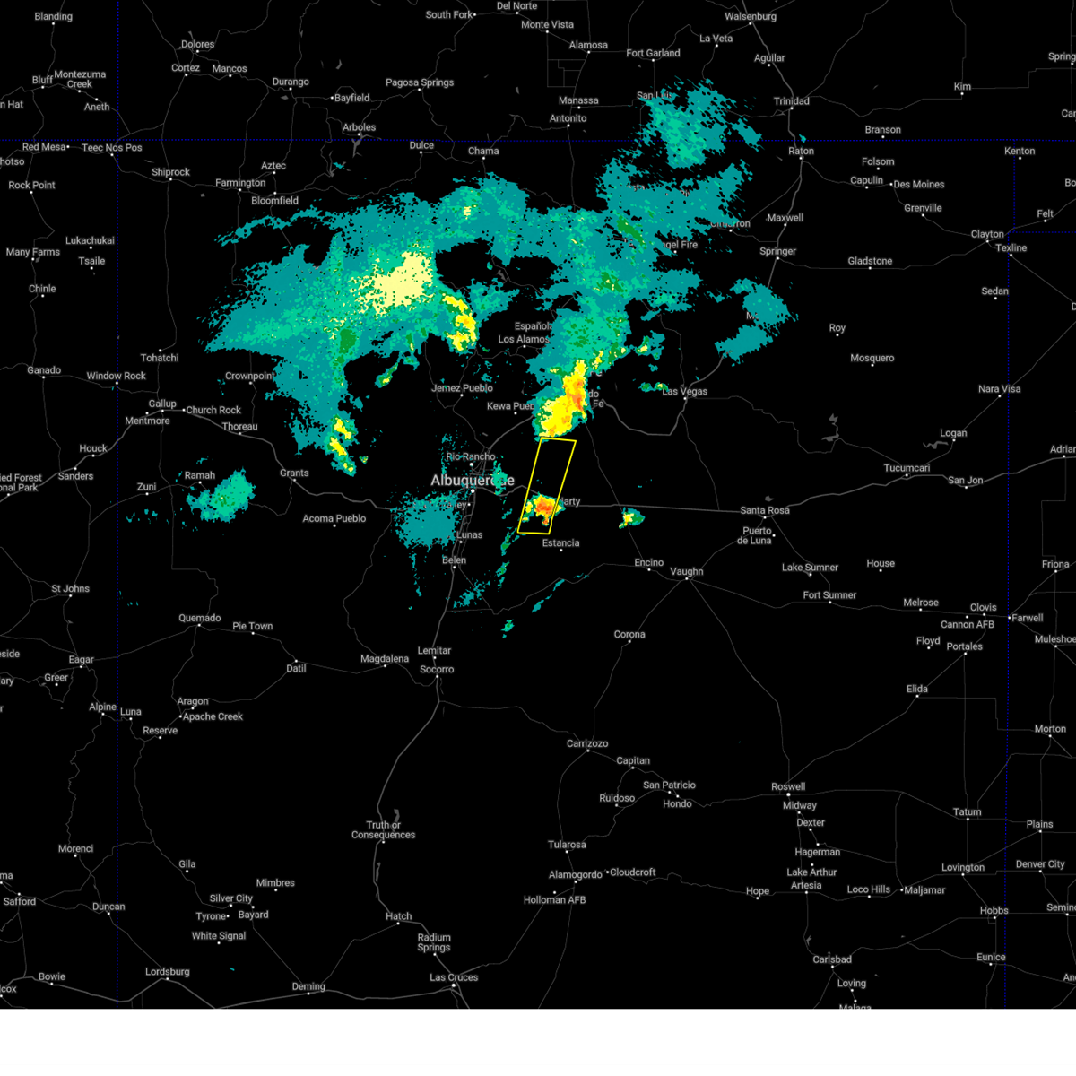
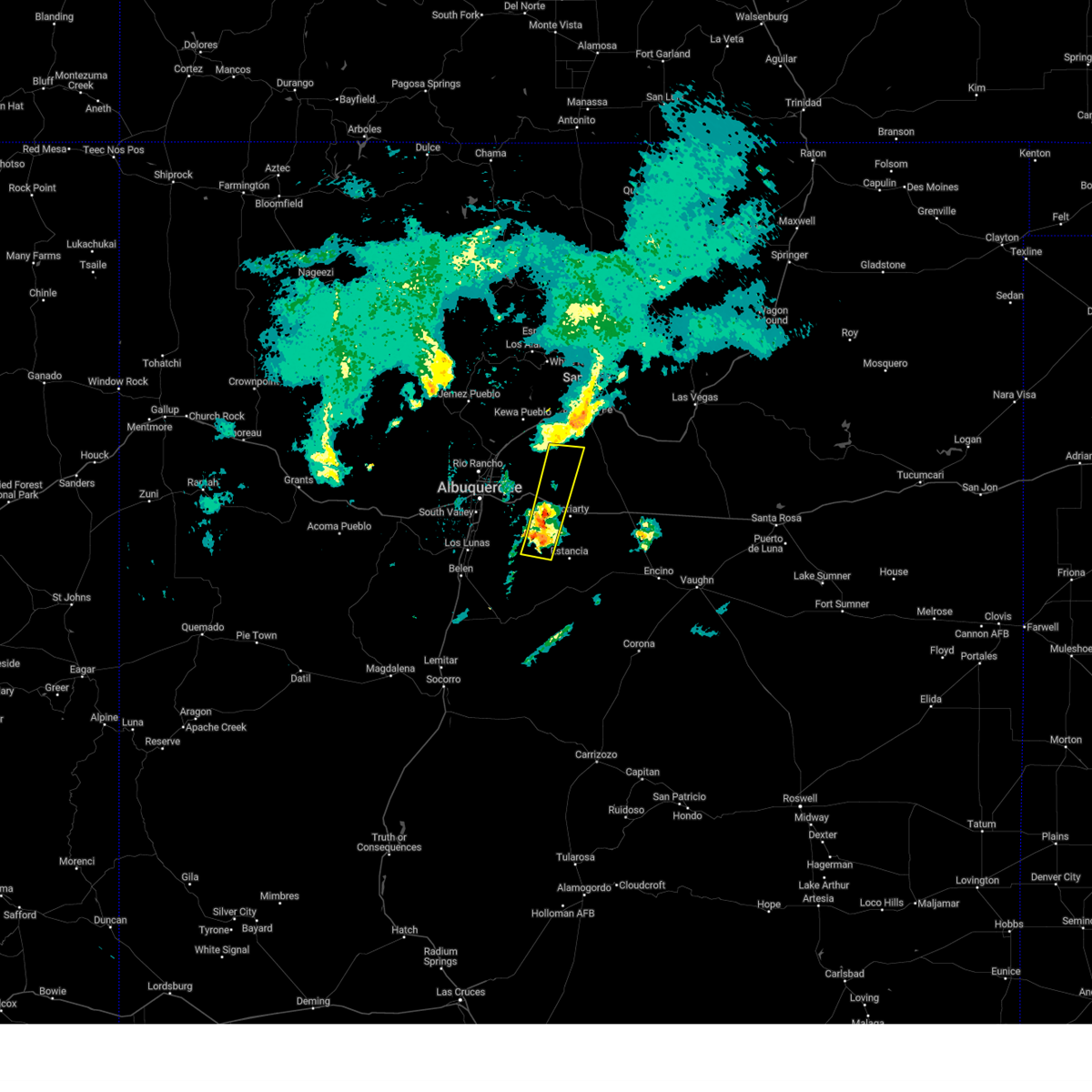
Hail Maps for Ponderosa Pine, NM


Connect with Interactive Hail Maps