

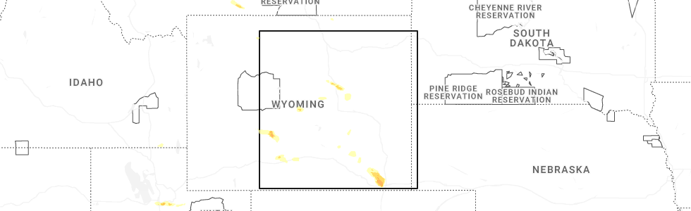
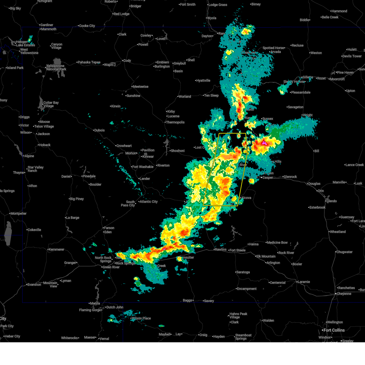
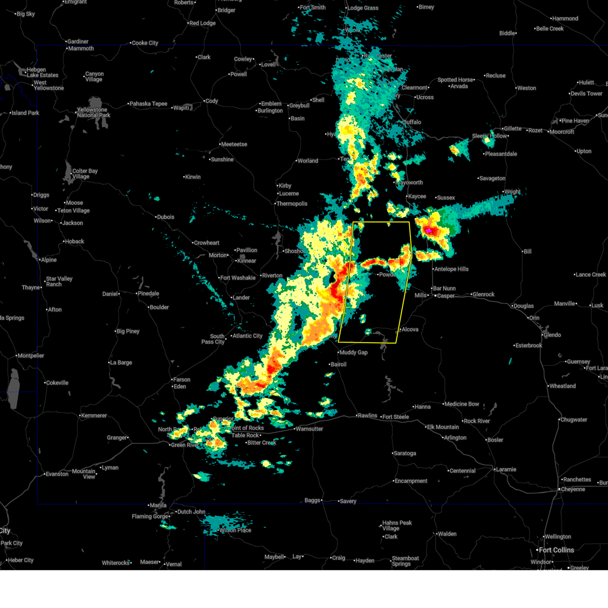
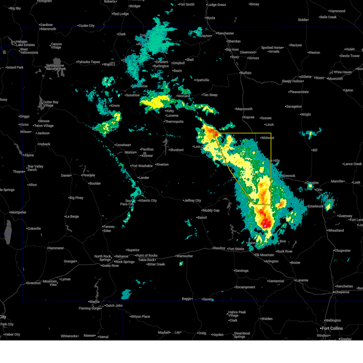
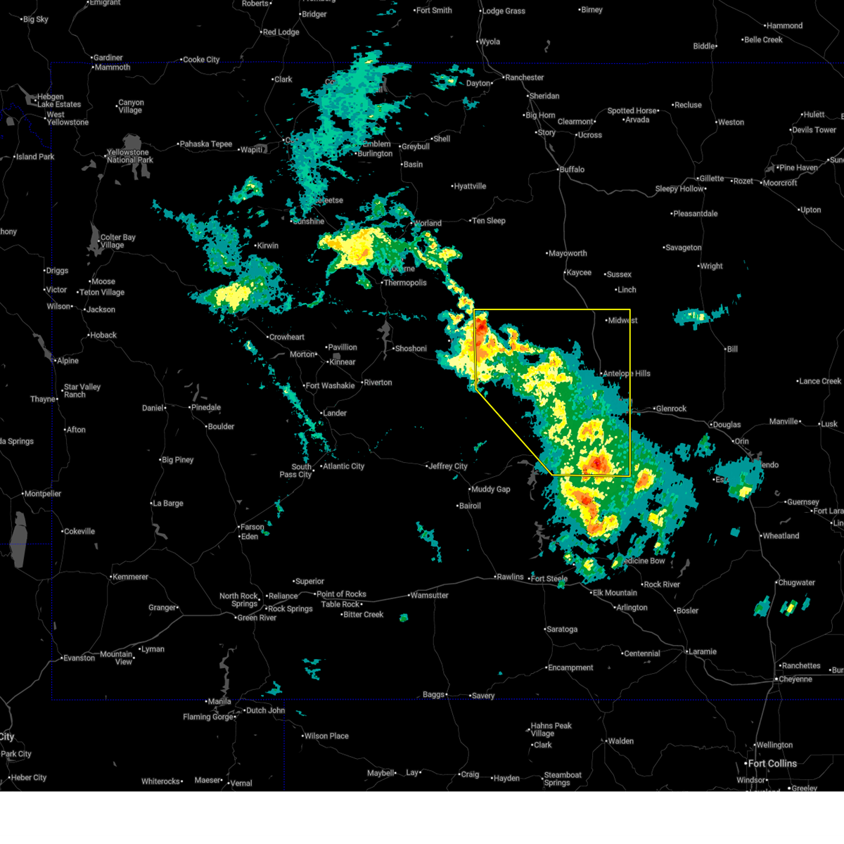
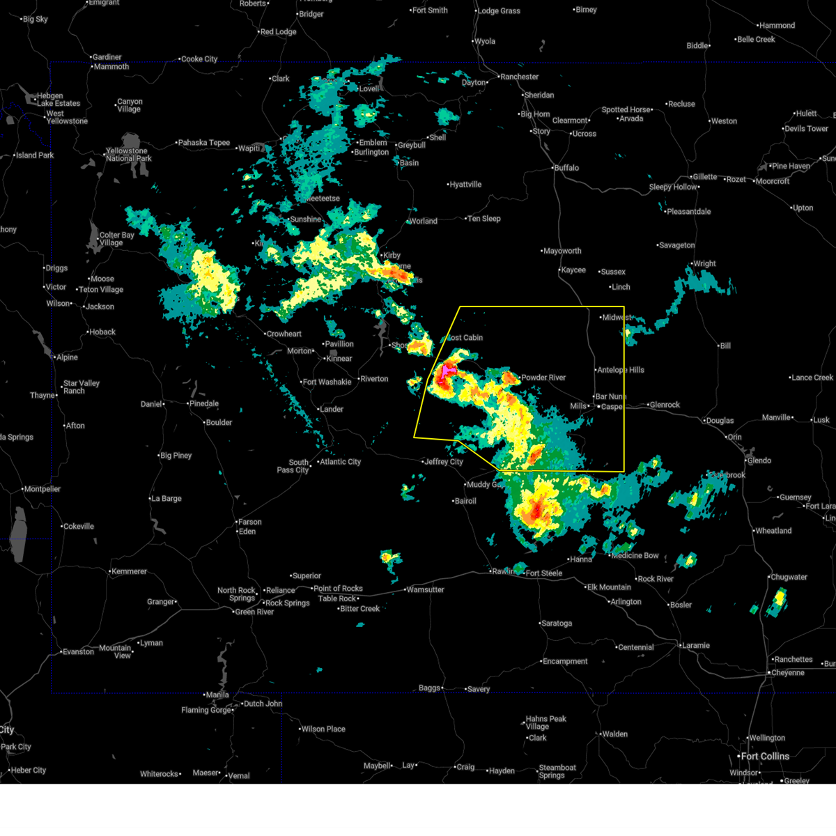
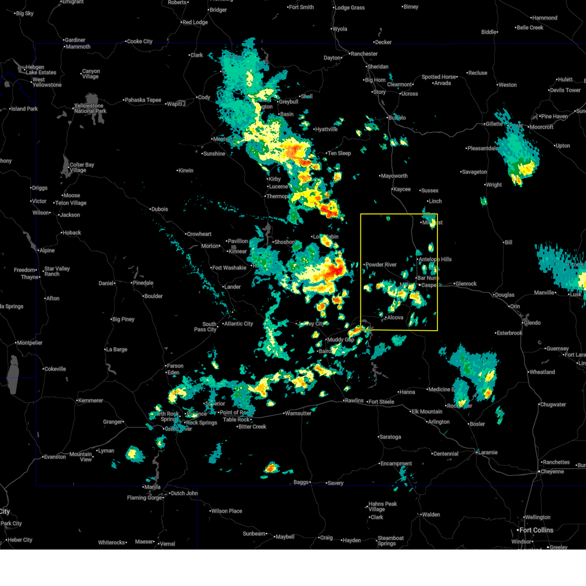
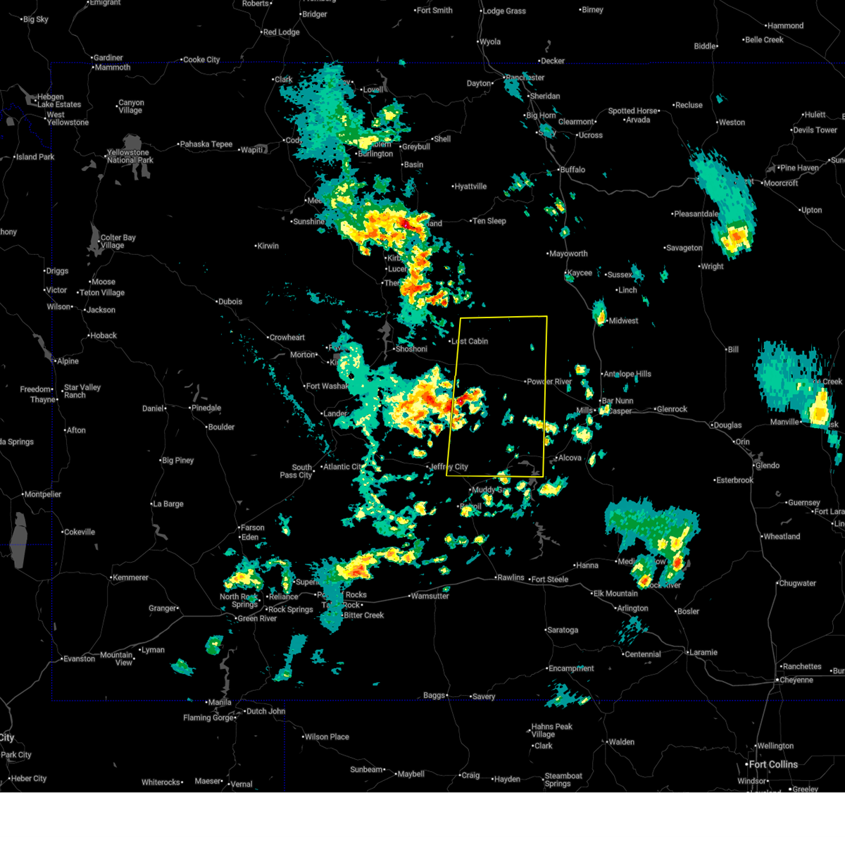
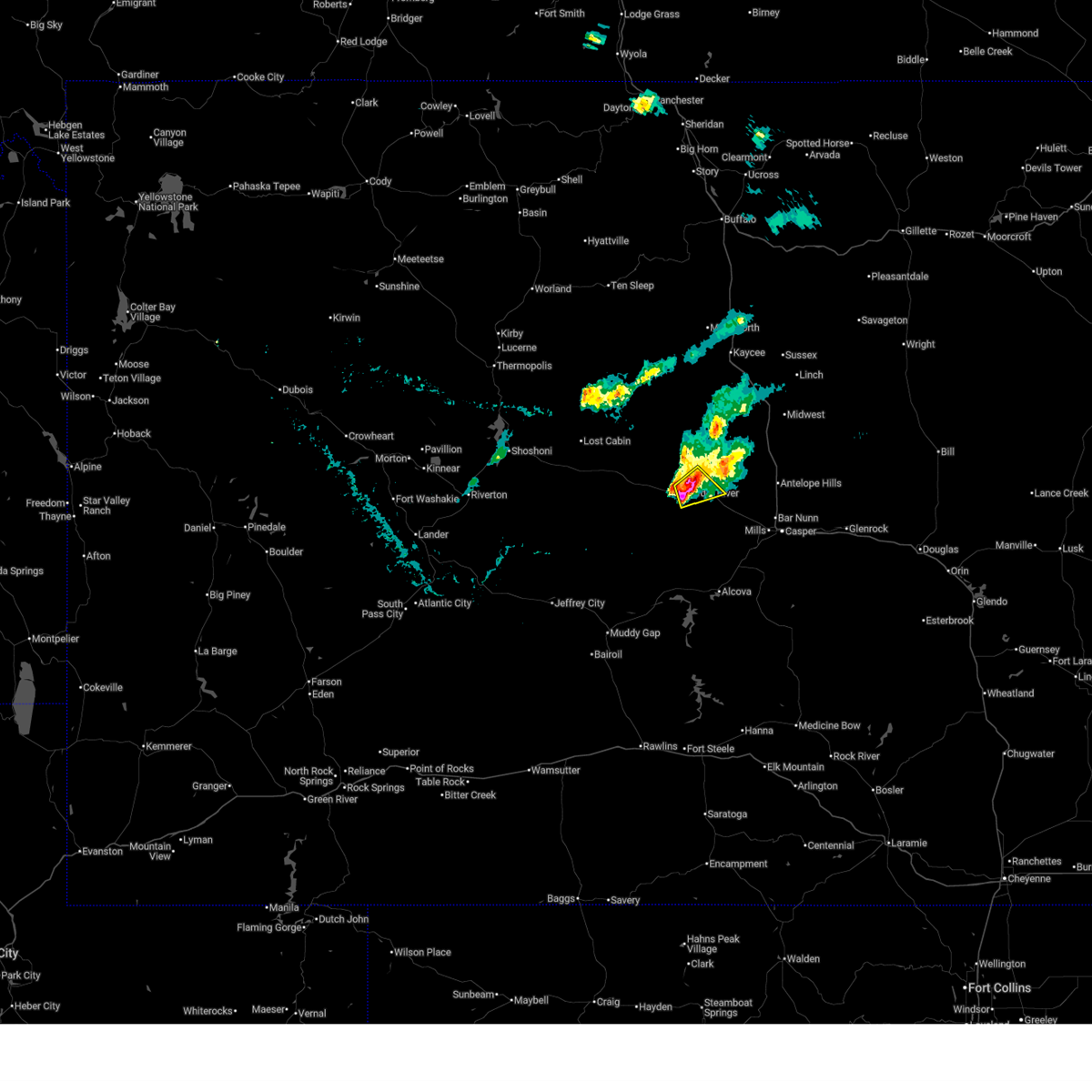
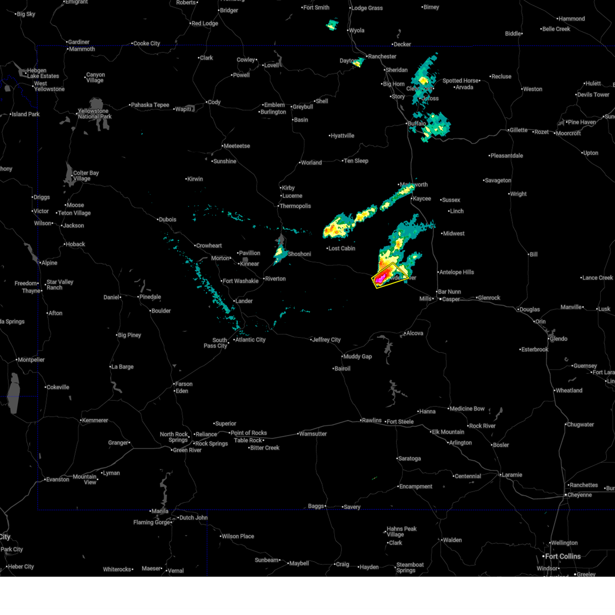
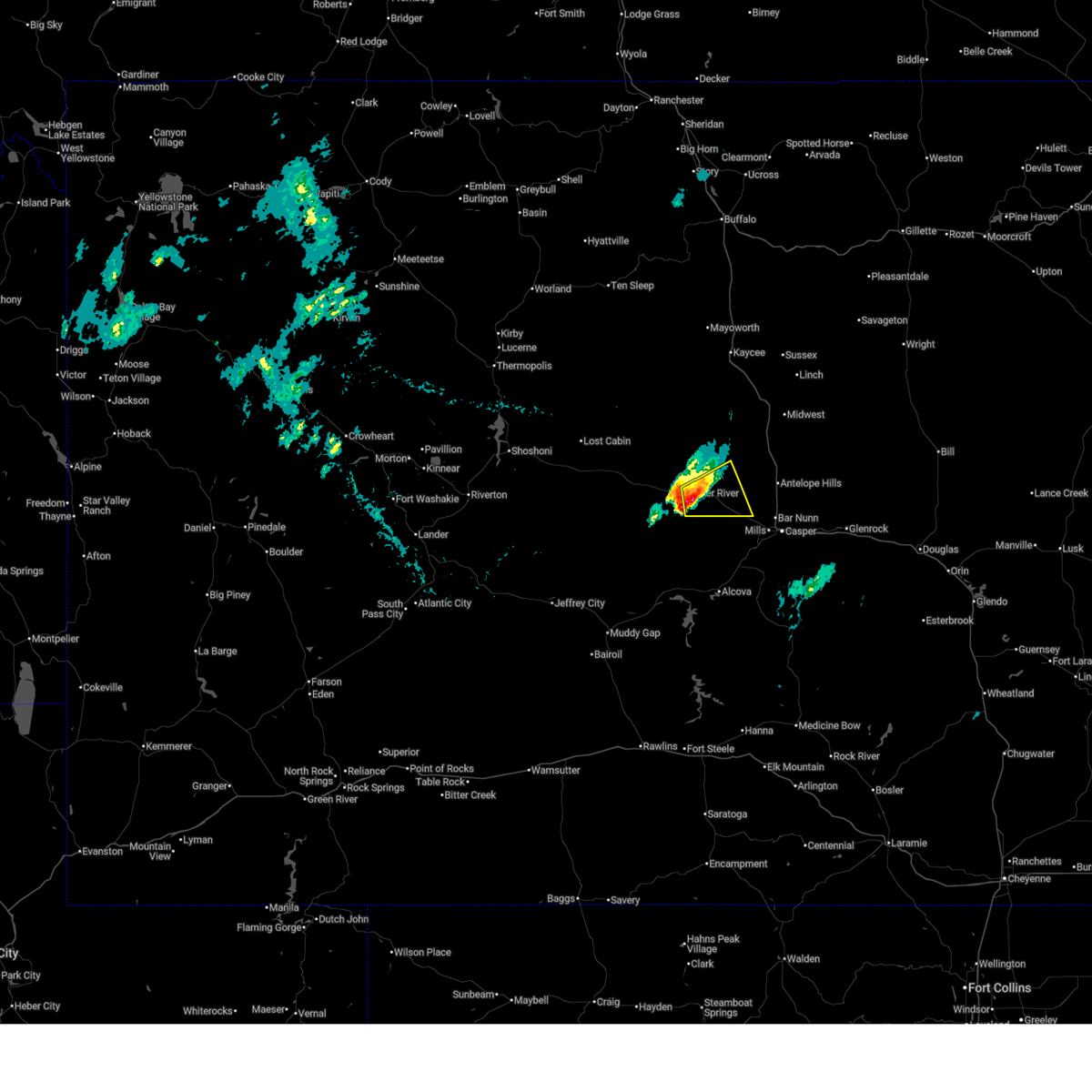
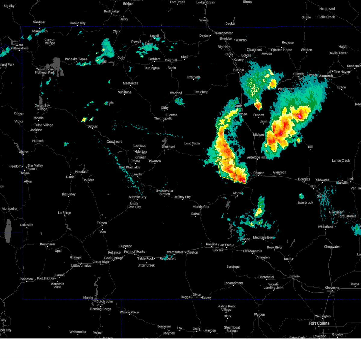
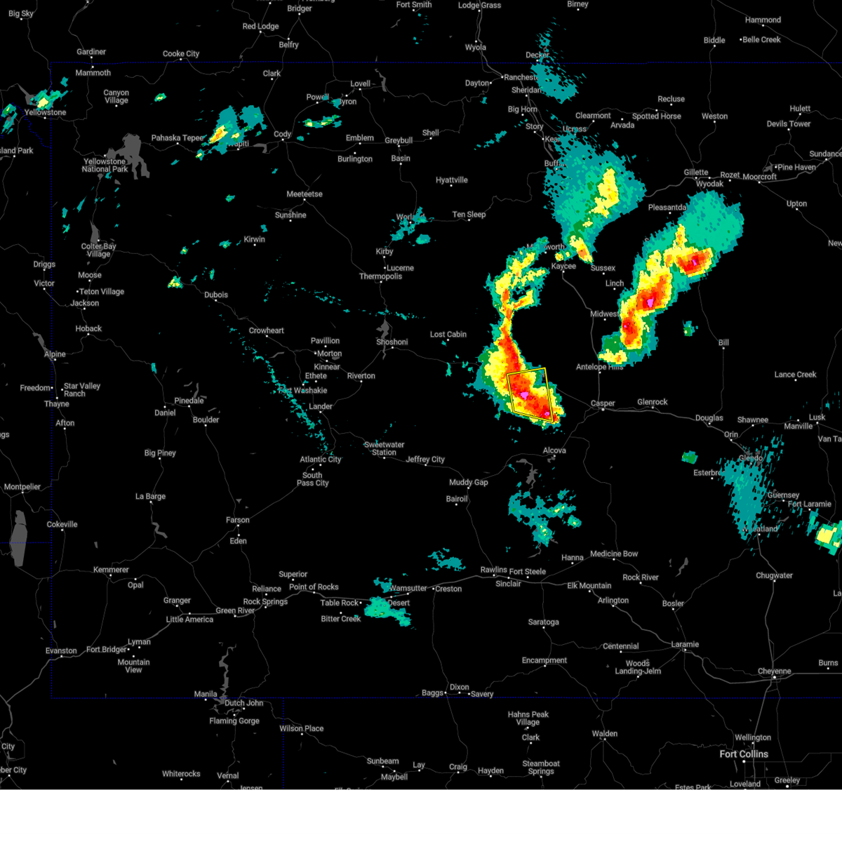
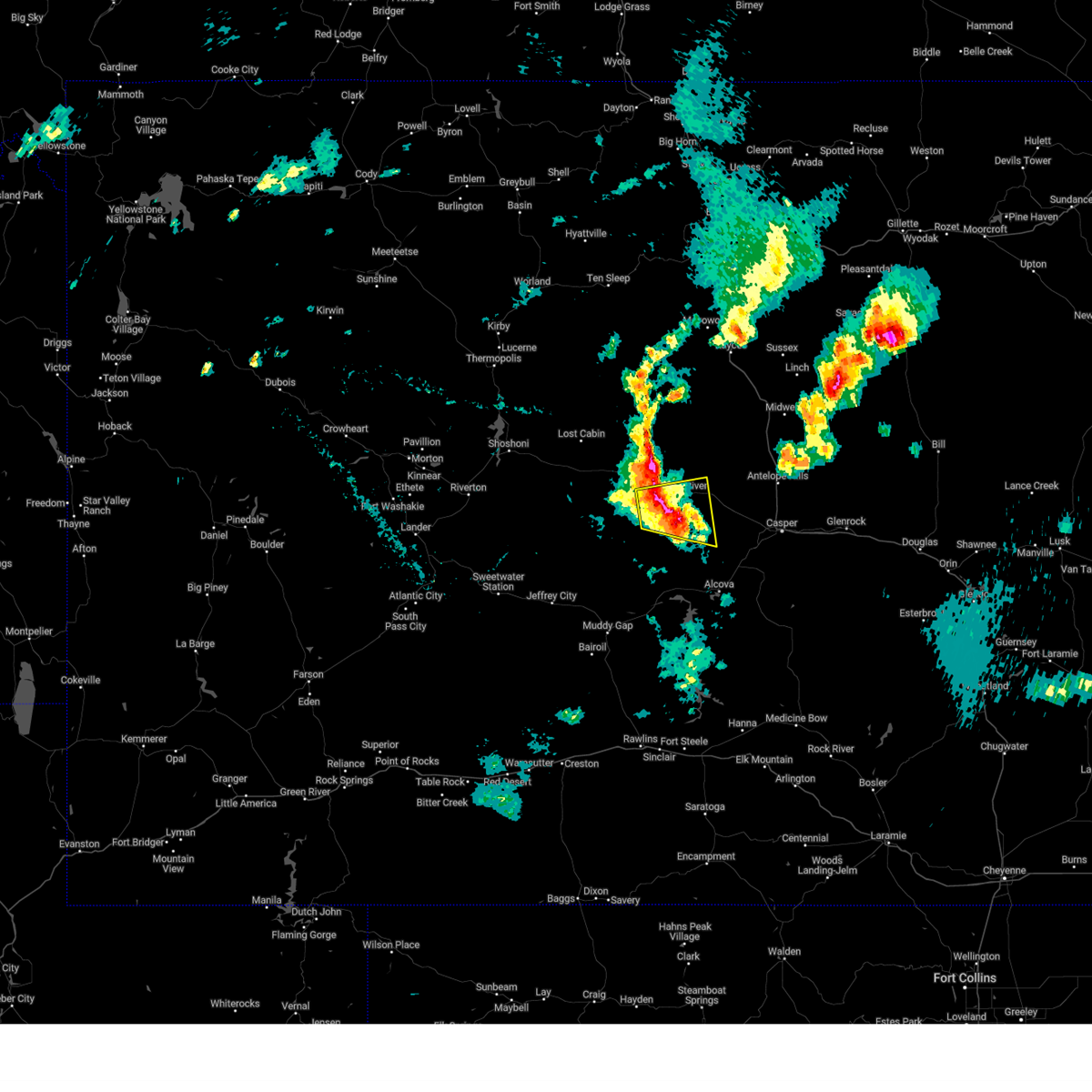
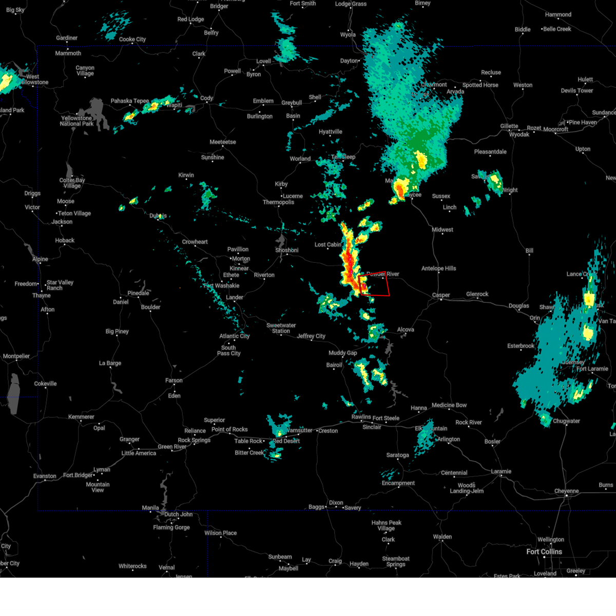
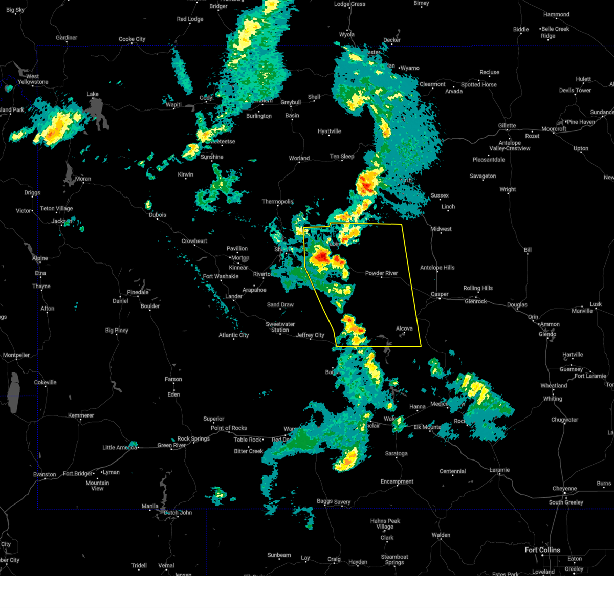
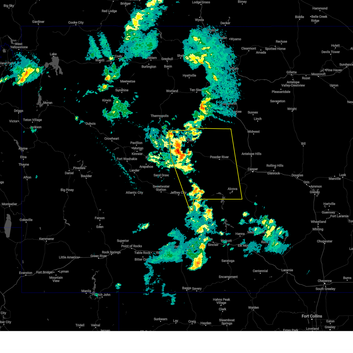
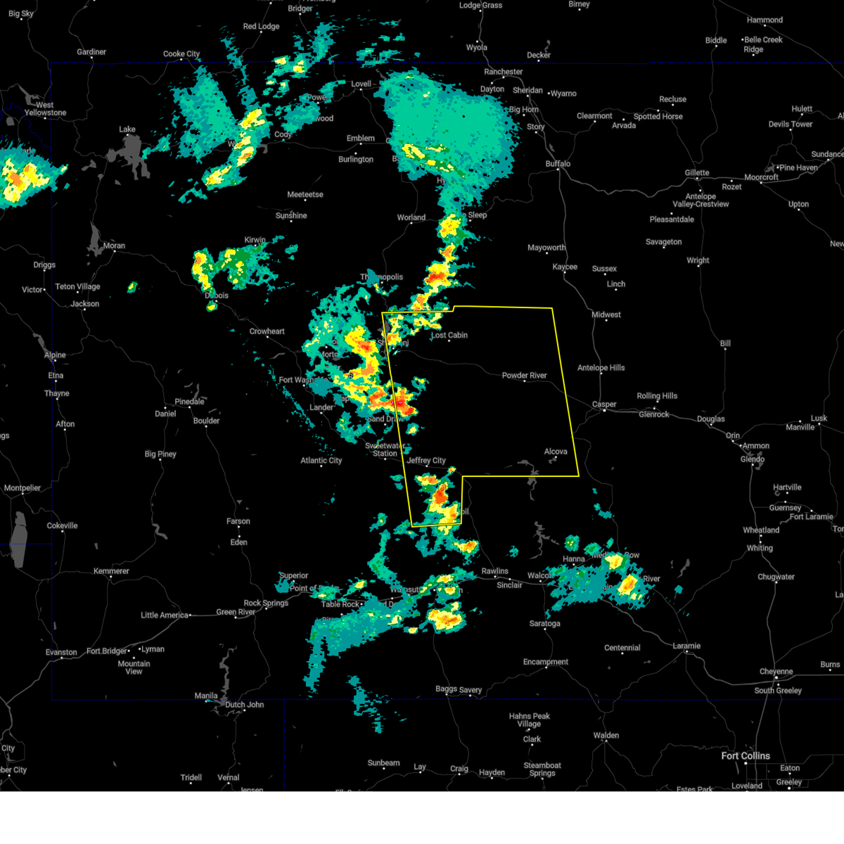
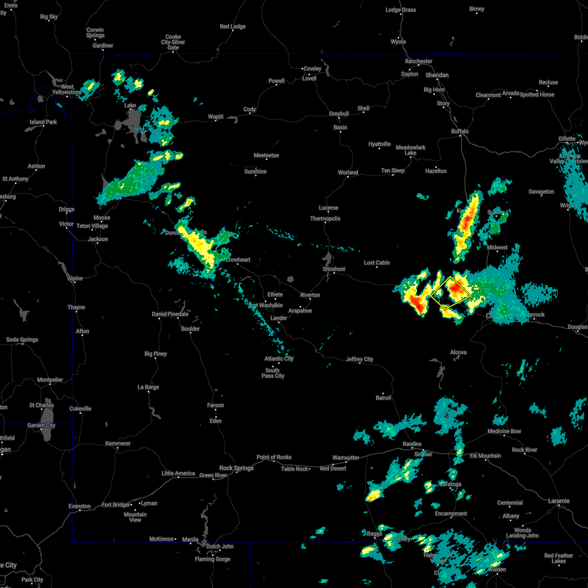
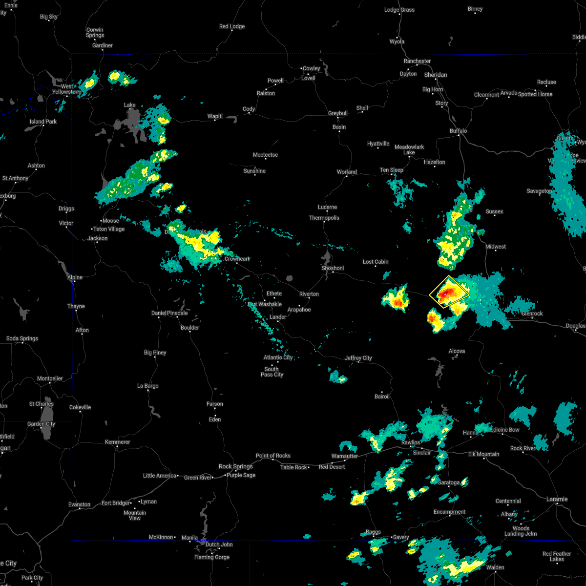
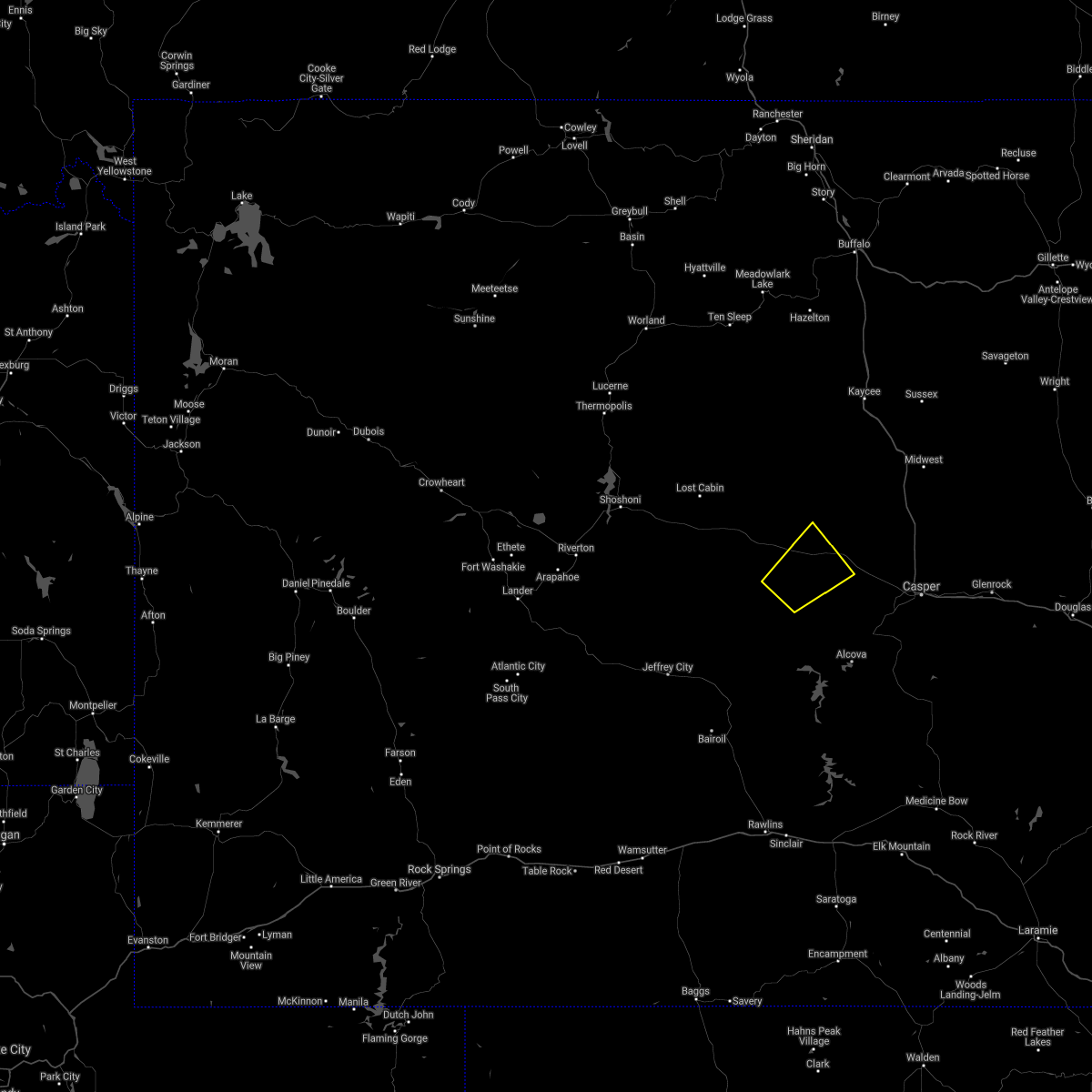
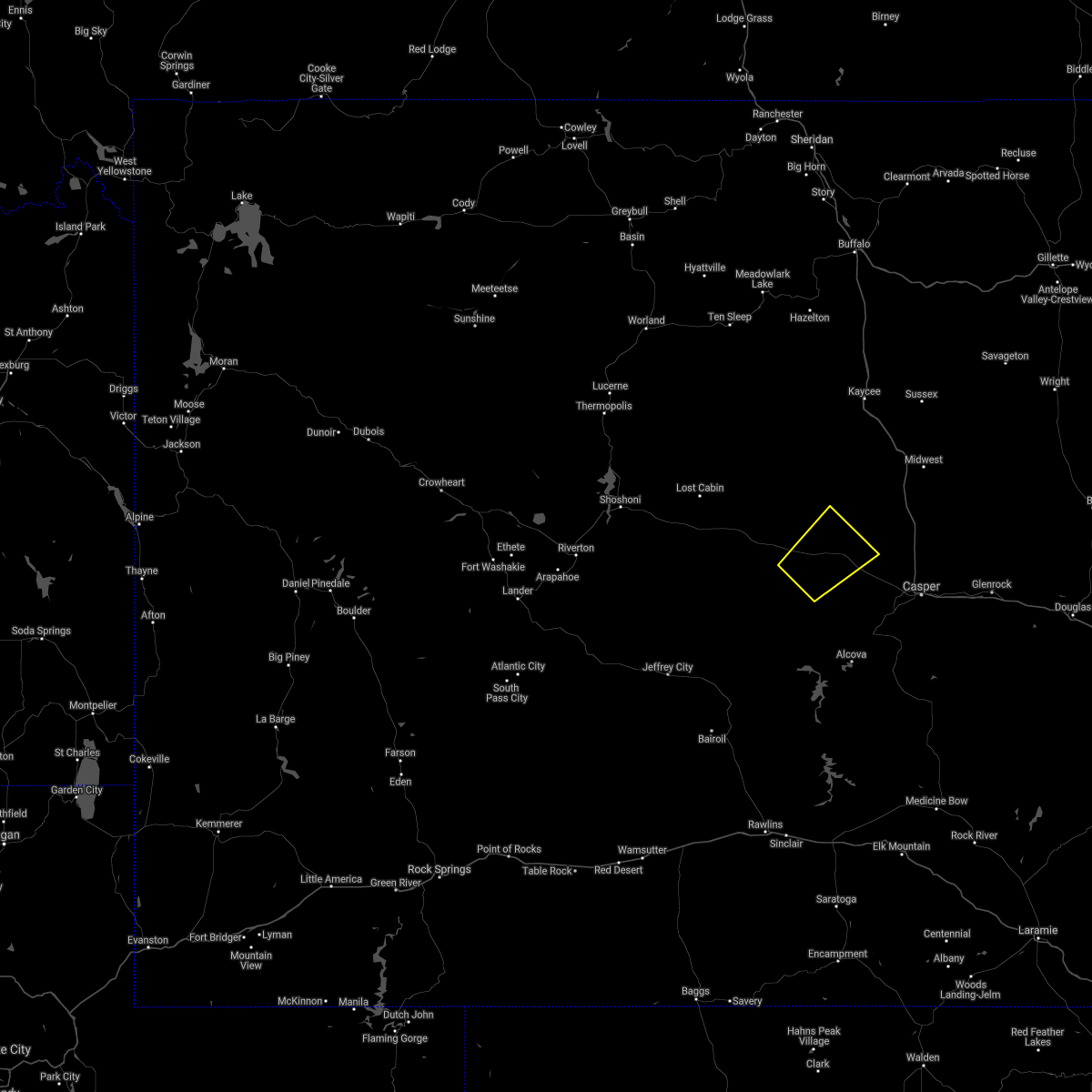
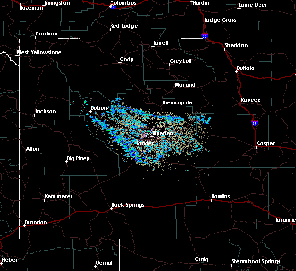
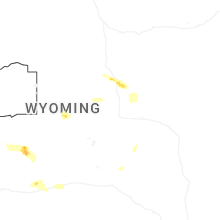
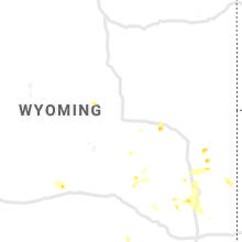
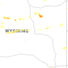
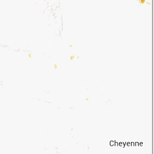
Hail Map for Powder River, WY
The Powder River, WY area has had 3 reports of on-the-ground hail by trained spotters, and has been under severe weather warnings 8 times during the past 12 months. Doppler radar has detected hail at or near Powder River, WY on 30 occasions, including 1 occasion during the past year.
| Name: | Powder River, WY |
| Where Located: | 36.8 miles WNW of Casper, WY |
| Map: | Google Map for Powder River, WY |
| Population: | 44 |
| Housing Units: | 28 |
| More Info: | Search Google for Powder River, WY |
0
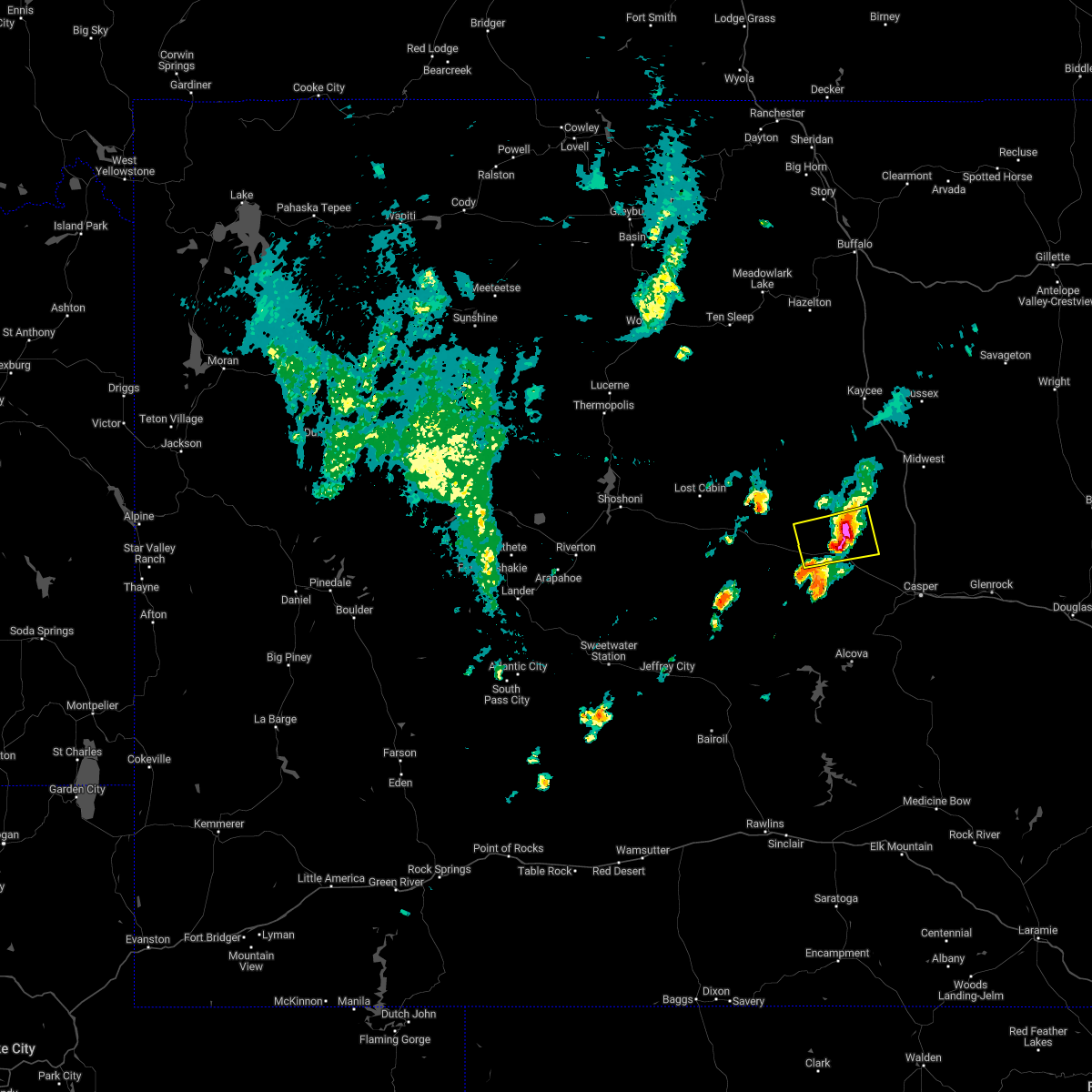
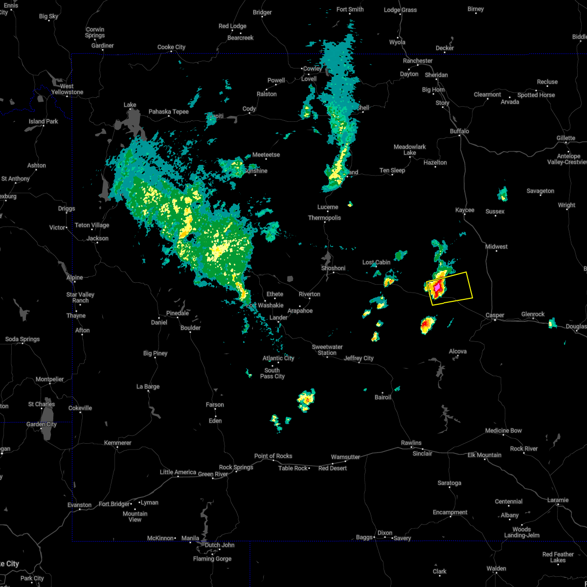
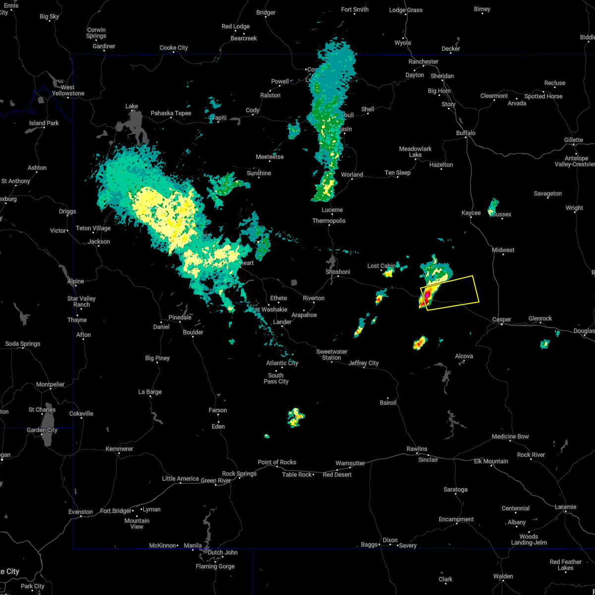
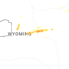
The Top Recent Hail Date for Powder River, WY is Thursday, June 25, 2026 (30th out of 30)
Hail and Wind Damage Spotted near Powder River, WY
| Date / Time | Report Details |
|---|---|
| 6/27/2026 3:50 PM MDT |
 The storms which prompted the warning have weakened below severe limits, and have exited the warned area. therefore, the warning will be allowed to expire. however, gusty winds are still possible with these thunderstorms. The storms which prompted the warning have weakened below severe limits, and have exited the warned area. therefore, the warning will be allowed to expire. however, gusty winds are still possible with these thunderstorms.
|
| 6/27/2026 3:35 PM MDT |
 At 335 pm mdt, severe thunderstorms were located along a line extending from 6 miles southeast of cottonwood pass to hiland to near ervay, moving east at 60 mph (radar indicated). Hazards include 60 mph wind gusts. Expect damage to roofs, siding, and trees. Locations impacted include, waltman, waltman rest area and powder river. At 335 pm mdt, severe thunderstorms were located along a line extending from 6 miles southeast of cottonwood pass to hiland to near ervay, moving east at 60 mph (radar indicated). Hazards include 60 mph wind gusts. Expect damage to roofs, siding, and trees. Locations impacted include, waltman, waltman rest area and powder river.
|
| 6/27/2026 3:13 PM MDT |
 Svrriw the national weather service in riverton has issued a * severe thunderstorm warning for, northwestern natrona county in central wyoming, east central fremont county in central wyoming, * until 400 pm mdt. * at 312 pm mdt, severe thunderstorms were located along a line extending from 10 miles northeast of shoshoni to 8 miles southwest of moneta to 13 miles west of castle gardens, moving east at 60 mph (radar indicated). Hazards include 60 mph wind gusts. Expect damage to roofs, siding, and trees. severe thunderstorms will be near, lysite, moneta, lost cabin, and castle gardens around 320 pm mdt. hiland around 330 pm mdt. Other locations in the path of these severe thunderstorms include waltman rest area, waltman and powder river. Svrriw the national weather service in riverton has issued a * severe thunderstorm warning for, northwestern natrona county in central wyoming, east central fremont county in central wyoming, * until 400 pm mdt. * at 312 pm mdt, severe thunderstorms were located along a line extending from 10 miles northeast of shoshoni to 8 miles southwest of moneta to 13 miles west of castle gardens, moving east at 60 mph (radar indicated). Hazards include 60 mph wind gusts. Expect damage to roofs, siding, and trees. severe thunderstorms will be near, lysite, moneta, lost cabin, and castle gardens around 320 pm mdt. hiland around 330 pm mdt. Other locations in the path of these severe thunderstorms include waltman rest area, waltman and powder river.
|
| 6/25/2026 2:41 PM MDT |
 At 241 pm mdt, severe thunderstorms were located along a line extending from near hole in the wall to 12 miles northeast of powder river to 19 miles southwest of goldeneye reservoir to independence rock, moving east at 45 mph (radar indicated). Hazards include 70 mph wind gusts and quarter size hail. Hail damage to vehicles is expected. expect considerable tree damage. wind damage is also likely to mobile homes, roofs, and outbuildings. Locations impacted include, independence rock and goldeneye reservoir. At 241 pm mdt, severe thunderstorms were located along a line extending from near hole in the wall to 12 miles northeast of powder river to 19 miles southwest of goldeneye reservoir to independence rock, moving east at 45 mph (radar indicated). Hazards include 70 mph wind gusts and quarter size hail. Hail damage to vehicles is expected. expect considerable tree damage. wind damage is also likely to mobile homes, roofs, and outbuildings. Locations impacted include, independence rock and goldeneye reservoir.
|
| 6/25/2026 2:10 PM MDT |
 Svrriw the national weather service in riverton has issued a * severe thunderstorm warning for, western natrona county in central wyoming, * until 300 pm mdt. * at 210 pm mdt, severe thunderstorms were located along a line extending from 13 miles east of cottonwood pass to near hiland to 7 miles south of ervay to near split rock, moving east at 45 mph (radar indicated). Hazards include 70 mph wind gusts and quarter size hail. Hail damage to vehicles is expected. expect considerable tree damage. wind damage is also likely to mobile homes, roofs, and outbuildings. severe thunderstorms will be near, waltman and waltman rest area around 215 pm mdt. powder river around 225 pm mdt. devil's gate around 230 pm mdt. Other locations in the path of these severe thunderstorms include independence rock, red wall and goldeneye reservoir. Svrriw the national weather service in riverton has issued a * severe thunderstorm warning for, western natrona county in central wyoming, * until 300 pm mdt. * at 210 pm mdt, severe thunderstorms were located along a line extending from 13 miles east of cottonwood pass to near hiland to 7 miles south of ervay to near split rock, moving east at 45 mph (radar indicated). Hazards include 70 mph wind gusts and quarter size hail. Hail damage to vehicles is expected. expect considerable tree damage. wind damage is also likely to mobile homes, roofs, and outbuildings. severe thunderstorms will be near, waltman and waltman rest area around 215 pm mdt. powder river around 225 pm mdt. devil's gate around 230 pm mdt. Other locations in the path of these severe thunderstorms include independence rock, red wall and goldeneye reservoir.
|
| 6/20/2026 3:49 PM MDT |
 At 348 pm mdt, severe thunderstorms were located along a line extending from 7 miles west of hole in the wall to near midwest to near deer creek, moving northeast at 40 mph (radar indicated). Hazards include 70 mph wind gusts. Expect considerable tree damage. damage is likely to mobile homes, roofs, and outbuildings. locations impacted include, casper, mills, evansville, bar nunn, red butte, midwest, homa hills, edgerton, antelope hills, teapot rock, goldeneye reservoir, bates hole, emigrant gap, beartrap meadows county park, paradise valley, red wall, natrona, casper natural gas processing plant, fort caspar campground, and casper mountain. This includes interstate 25 between mile markers 176 and 232. At 348 pm mdt, severe thunderstorms were located along a line extending from 7 miles west of hole in the wall to near midwest to near deer creek, moving northeast at 40 mph (radar indicated). Hazards include 70 mph wind gusts. Expect considerable tree damage. damage is likely to mobile homes, roofs, and outbuildings. locations impacted include, casper, mills, evansville, bar nunn, red butte, midwest, homa hills, edgerton, antelope hills, teapot rock, goldeneye reservoir, bates hole, emigrant gap, beartrap meadows county park, paradise valley, red wall, natrona, casper natural gas processing plant, fort caspar campground, and casper mountain. This includes interstate 25 between mile markers 176 and 232.
|
| 6/20/2026 3:28 PM MDT |
 At 327 pm mdt, severe thunderstorms were located along a line extending from 16 miles northwest of red wall to near antelope hills to 7 miles southwest of boxelder, moving northeast at 40 mph (radar indicated). Hazards include 70 mph wind gusts. Expect considerable tree damage. damage is likely to mobile homes, roofs, and outbuildings. locations impacted include, antelope hills, teapot rock, red wall, midwest and edgerton. This includes interstate 25 between mile markers 176 and 232. At 327 pm mdt, severe thunderstorms were located along a line extending from 16 miles northwest of red wall to near antelope hills to 7 miles southwest of boxelder, moving northeast at 40 mph (radar indicated). Hazards include 70 mph wind gusts. Expect considerable tree damage. damage is likely to mobile homes, roofs, and outbuildings. locations impacted include, antelope hills, teapot rock, red wall, midwest and edgerton. This includes interstate 25 between mile markers 176 and 232.
|
| 6/20/2026 3:22 PM MDT | Mesonet station wy45 us20 natrona (dot in natrona county WY, 10.3 miles W of Powder River, WY |
| 6/20/2026 2:59 PM MDT |
 Svrriw the national weather service in riverton has issued a * severe thunderstorm warning for, natrona county in central wyoming, east central fremont county in central wyoming, * until 400 pm mdt. * at 258 pm mdt, severe thunderstorms were located along a line extending from near cottonwood pass to near powder river to 8 miles south of alcova, moving east at 40 mph (radar indicated). Hazards include 60 mph wind gusts. Expect damage to roofs, siding, and trees. severe thunderstorms will be near, bates hole and goldeneye reservoir around 310 pm mdt. emigrant gap around 315 pm mdt. other locations in the path of these severe thunderstorms include casper, mills, red butte, red wall, paradise valley, bar nunn, beartrap meadows county park, evansville, homa hills and antelope hills. This includes interstate 25 between mile markers 176 and 233. Svrriw the national weather service in riverton has issued a * severe thunderstorm warning for, natrona county in central wyoming, east central fremont county in central wyoming, * until 400 pm mdt. * at 258 pm mdt, severe thunderstorms were located along a line extending from near cottonwood pass to near powder river to 8 miles south of alcova, moving east at 40 mph (radar indicated). Hazards include 60 mph wind gusts. Expect damage to roofs, siding, and trees. severe thunderstorms will be near, bates hole and goldeneye reservoir around 310 pm mdt. emigrant gap around 315 pm mdt. other locations in the path of these severe thunderstorms include casper, mills, red butte, red wall, paradise valley, bar nunn, beartrap meadows county park, evansville, homa hills and antelope hills. This includes interstate 25 between mile markers 176 and 233.
|
| 6/6/2026 3:47 PM MDT | Mesonet station khld us20 hiland (dot in natrona county WY, 16.3 miles E of Powder River, WY |
| 8/13/2025 7:36 PM MDT | Mesonet station wy45 natrona (wydot in natrona county WY, 10.3 miles W of Powder River, WY |
| 8/13/2025 6:32 PM MDT | Corrects previous non-tstm wnd gst report from 2 se hiland. mesonet station khld hiland 2.4 se (wydot in natrona county WY, 16.3 miles E of Powder River, WY |
| 7/31/2025 7:37 PM MDT | Mesonet station khld hiland 2.4 se (wydot). associated with an outflow boundar in natrona county WY, 16.3 miles E of Powder River, WY |
| 7/4/2025 5:42 PM MDT | Wy dot weather senso in natrona county WY, 10.3 miles W of Powder River, WY |
| 7/4/2025 5:20 PM MDT | Mesonet station rsnw4 hiland 16 s... time estimate... fales roc in natrona county WY, 18.9 miles NE of Powder River, WY |
| 7/4/2025 5:12 PM MDT | Wy dot weather statio in natrona county WY, 10.3 miles W of Powder River, WY |
| 7/4/2025 4:54 PM MDT |
 Svrriw the national weather service in riverton has issued a * severe thunderstorm warning for, natrona county in central wyoming, * until 545 pm mdt. * at 452 pm mdt, a severe thunderstorm was located over powder river, which is 37 miles west of casper, moving east at 70 mph (radar indicated. at 4:47 pm a 69 mph wind gust was reported at hiland). Hazards include 70 mph wind gusts. Expect considerable tree damage. damage is likely to mobile homes, roofs, and outbuildings. this severe thunderstorm will be near, goldeneye reservoir around 505 pm mdt. other locations in the path of this severe thunderstorm include homa hills and antelope hills. This includes interstate 25 between mile markers 176 and 234. Svrriw the national weather service in riverton has issued a * severe thunderstorm warning for, natrona county in central wyoming, * until 545 pm mdt. * at 452 pm mdt, a severe thunderstorm was located over powder river, which is 37 miles west of casper, moving east at 70 mph (radar indicated. at 4:47 pm a 69 mph wind gust was reported at hiland). Hazards include 70 mph wind gusts. Expect considerable tree damage. damage is likely to mobile homes, roofs, and outbuildings. this severe thunderstorm will be near, goldeneye reservoir around 505 pm mdt. other locations in the path of this severe thunderstorm include homa hills and antelope hills. This includes interstate 25 between mile markers 176 and 234.
|
| 7/4/2025 4:47 PM MDT | Wy dot weather senso in natrona county WY, 16.3 miles E of Powder River, WY |
| 7/4/2025 4:32 PM MDT |
 Svrriw the national weather service in riverton has issued a * severe thunderstorm warning for, western natrona county in central wyoming, east central fremont county in central wyoming, * until 500 pm mdt. * at 432 pm mdt, a severe thunderstorm was located near castle gardens, which is 33 miles southeast of shoshoni, moving east at 70 mph (radar indicated). Hazards include 60 mph wind gusts. expect damage to roofs, siding, and trees Svrriw the national weather service in riverton has issued a * severe thunderstorm warning for, western natrona county in central wyoming, east central fremont county in central wyoming, * until 500 pm mdt. * at 432 pm mdt, a severe thunderstorm was located near castle gardens, which is 33 miles southeast of shoshoni, moving east at 70 mph (radar indicated). Hazards include 60 mph wind gusts. expect damage to roofs, siding, and trees
|
| 6/24/2025 9:53 PM MDT |
 At 953 pm mdt, a severe thunderstorm was located near powder river, which is 31 miles northwest of casper, moving northeast at 25 mph (radar indicated). Hazards include half dollar size hail. Damage to vehicles is expected. Locations impacted include, powder river, goldeneye reservoir, and natrona. At 953 pm mdt, a severe thunderstorm was located near powder river, which is 31 miles northwest of casper, moving northeast at 25 mph (radar indicated). Hazards include half dollar size hail. Damage to vehicles is expected. Locations impacted include, powder river, goldeneye reservoir, and natrona.
|
| 6/24/2025 9:39 PM MDT |
 Svrriw the national weather service in riverton has issued a * severe thunderstorm warning for, central natrona county in central wyoming, * until 1015 pm mdt. * at 939 pm mdt, a severe thunderstorm was located over powder river, which is 35 miles west of casper, moving northeast at 25 mph (radar indicated). Hazards include half dollar size hail. Damage to vehicles is expected. This severe thunderstorm will remain over mainly rural areas of central natrona county, including the following locations, natrona. Svrriw the national weather service in riverton has issued a * severe thunderstorm warning for, central natrona county in central wyoming, * until 1015 pm mdt. * at 939 pm mdt, a severe thunderstorm was located over powder river, which is 35 miles west of casper, moving northeast at 25 mph (radar indicated). Hazards include half dollar size hail. Damage to vehicles is expected. This severe thunderstorm will remain over mainly rural areas of central natrona county, including the following locations, natrona.
|
| 6/24/2025 4:56 PM MDT |
 Svrriw the national weather service in riverton has issued a * severe thunderstorm warning for, central natrona county in central wyoming, * until 545 pm mdt. * at 456 pm mdt, a severe thunderstorm was located 7 miles west of goldeneye reservoir, which is 27 miles west of casper, moving east at 20 mph (radar indicated). Hazards include 60 mph wind gusts and quarter size hail. Hail damage to vehicles is expected. expect wind damage to roofs, siding, and trees. This severe thunderstorm will be near, goldeneye reservoir around 505 pm mdt. Svrriw the national weather service in riverton has issued a * severe thunderstorm warning for, central natrona county in central wyoming, * until 545 pm mdt. * at 456 pm mdt, a severe thunderstorm was located 7 miles west of goldeneye reservoir, which is 27 miles west of casper, moving east at 20 mph (radar indicated). Hazards include 60 mph wind gusts and quarter size hail. Hail damage to vehicles is expected. expect wind damage to roofs, siding, and trees. This severe thunderstorm will be near, goldeneye reservoir around 505 pm mdt.
|
| 6/11/2025 6:52 PM MDT | Mesonet station khld hiland 2.4 se (wydot in natrona county WY, 16.3 miles E of Powder River, WY |
| 6/1/2025 7:44 PM MDT |
 The storm which prompted the warning has weakened below severe limits, and has exited the warned area. therefore, the warning will be allowed to expire. however, small hail, gusty winds and heavy rain are still possible with this thunderstorm. remember, severe thunderstorm warnings still remain in effect for southern and northern portions of natrona county. The storm which prompted the warning has weakened below severe limits, and has exited the warned area. therefore, the warning will be allowed to expire. however, small hail, gusty winds and heavy rain are still possible with this thunderstorm. remember, severe thunderstorm warnings still remain in effect for southern and northern portions of natrona county.
|
| 6/1/2025 7:24 PM MDT |
 At 724 pm mdt, a severe thunderstorm was located near powder river, which is 30 miles west of casper, moving east at 25 mph (radar indicated). Hazards include half dollar size hail. Damage to vehicles is expected. This severe thunderstorm will remain over mainly rural areas of central natrona county, including the following locations, natrona. At 724 pm mdt, a severe thunderstorm was located near powder river, which is 30 miles west of casper, moving east at 25 mph (radar indicated). Hazards include half dollar size hail. Damage to vehicles is expected. This severe thunderstorm will remain over mainly rural areas of central natrona county, including the following locations, natrona.
|
| 6/1/2025 7:09 PM MDT |
 Svrriw the national weather service in riverton has issued a * severe thunderstorm warning for, central natrona county in central wyoming, * until 745 pm mdt. * at 708 pm mdt, a severe thunderstorm was located near powder river, which is 37 miles west of casper, moving east at 25 mph (radar indicated). Hazards include half dollar size hail. Damage to vehicles is expected. This severe thunderstorm will be near, powder river around 715 pm mdt. Svrriw the national weather service in riverton has issued a * severe thunderstorm warning for, central natrona county in central wyoming, * until 745 pm mdt. * at 708 pm mdt, a severe thunderstorm was located near powder river, which is 37 miles west of casper, moving east at 25 mph (radar indicated). Hazards include half dollar size hail. Damage to vehicles is expected. This severe thunderstorm will be near, powder river around 715 pm mdt.
|
| 6/1/2025 6:42 PM MDT |
 Torriw the national weather service in riverton has issued a * tornado warning for, west central natrona county in central wyoming, * until 715 pm mdt. * at 641 pm mdt, a severe thunderstorm capable of producing a tornado was located near waltman, which is 44 miles west of casper, moving east at 25 mph (radar indicated rotation). Hazards include tornado. Expect damage to mobile homes, roofs, and vehicles. This dangerous storm will be near, powder river around 700 pm mdt. Torriw the national weather service in riverton has issued a * tornado warning for, west central natrona county in central wyoming, * until 715 pm mdt. * at 641 pm mdt, a severe thunderstorm capable of producing a tornado was located near waltman, which is 44 miles west of casper, moving east at 25 mph (radar indicated rotation). Hazards include tornado. Expect damage to mobile homes, roofs, and vehicles. This dangerous storm will be near, powder river around 700 pm mdt.
|
| 8/25/2024 6:46 PM MDT | Mesonet station wy45 natrona (wydot in natrona county WY, 10.3 miles W of Powder River, WY |
| 7/15/2024 4:02 PM MDT | Peak wind gust at hiland wydot mesonet statio in natrona county WY, 16.3 miles E of Powder River, WY |
| 7/3/2023 6:41 PM MDT |
 At 640 pm mdt, severe thunderstorms were moving through natrona county, moving east at 50 mph (emergency management). Hazards include 70 mph wind gusts and half dollar size hail. Hail damage to vehicles is expected. expect considerable tree damage. wind damage is also likely to mobile homes, roofs, and outbuildings. locations impacted include, casper, mills, evansville, bar nunn, red butte, midwest, homa hills, edgerton, antelope hills, alcova, teapot rock, goldeneye reservoir, bates hole, emigrant gap, beartrap meadows county park, paradise valley, red wall, natrona, casper natural gas processing plant and fort caspar campground. This includes interstate 25 between mile markers 176 and 234. At 640 pm mdt, severe thunderstorms were moving through natrona county, moving east at 50 mph (emergency management). Hazards include 70 mph wind gusts and half dollar size hail. Hail damage to vehicles is expected. expect considerable tree damage. wind damage is also likely to mobile homes, roofs, and outbuildings. locations impacted include, casper, mills, evansville, bar nunn, red butte, midwest, homa hills, edgerton, antelope hills, alcova, teapot rock, goldeneye reservoir, bates hole, emigrant gap, beartrap meadows county park, paradise valley, red wall, natrona, casper natural gas processing plant and fort caspar campground. This includes interstate 25 between mile markers 176 and 234.
|
| 7/3/2023 6:20 PM MDT |
 At 617 pm mdt, severe thunderstorms were located along a line extending across most of natrona county, moving east at 60 mph. the strongest storms are currently north of powder river (radar indicated). Hazards include 70 mph wind gusts and half dollar size hail. Hail damage to vehicles is expected. expect considerable tree damage. wind damage is also likely to mobile homes, roofs, and outbuildings. locations impacted include, casper, mills, evansville, bar nunn, red butte, midwest, homa hills, edgerton, antelope hills, alcova, powder river, waltman, teapot rock, goldeneye reservoir, devil`s gate, independence rock, bates hole, emigrant gap, beartrap meadows county park and paradise valley. This includes interstate 25 between mile markers 176 and 234. At 617 pm mdt, severe thunderstorms were located along a line extending across most of natrona county, moving east at 60 mph. the strongest storms are currently north of powder river (radar indicated). Hazards include 70 mph wind gusts and half dollar size hail. Hail damage to vehicles is expected. expect considerable tree damage. wind damage is also likely to mobile homes, roofs, and outbuildings. locations impacted include, casper, mills, evansville, bar nunn, red butte, midwest, homa hills, edgerton, antelope hills, alcova, powder river, waltman, teapot rock, goldeneye reservoir, devil`s gate, independence rock, bates hole, emigrant gap, beartrap meadows county park and paradise valley. This includes interstate 25 between mile markers 176 and 234.
|
| 7/3/2023 6:13 PM MDT |
 At 610 pm mdt, severe thunderstorms were moving east across natrona county at 55 mph (surface observation. at 606 pm mdt, wind gusts to 67 mph were reported near alcova reservoir). Hazards include 70 mph wind gusts and quarter size hail. Hail damage to vehicles is expected. expect considerable tree damage. wind damage is also likely to mobile homes, roofs, and outbuildings. locations impacted include, casper, mills, evansville, bar nunn, red butte, midwest, homa hills, edgerton, antelope hills, alcova, powder river, hiland, waltman, ervay, teapot rock, goldeneye reservoir, devil`s gate, independence rock, bates hole and emigrant gap. this includes interstate 25 between mile markers 176 and 234. thunderstorm damage threat, considerable hail threat, radar indicated max hail size, 1. 00 in wind threat, observed max wind gust, 70 mph. At 610 pm mdt, severe thunderstorms were moving east across natrona county at 55 mph (surface observation. at 606 pm mdt, wind gusts to 67 mph were reported near alcova reservoir). Hazards include 70 mph wind gusts and quarter size hail. Hail damage to vehicles is expected. expect considerable tree damage. wind damage is also likely to mobile homes, roofs, and outbuildings. locations impacted include, casper, mills, evansville, bar nunn, red butte, midwest, homa hills, edgerton, antelope hills, alcova, powder river, hiland, waltman, ervay, teapot rock, goldeneye reservoir, devil`s gate, independence rock, bates hole and emigrant gap. this includes interstate 25 between mile markers 176 and 234. thunderstorm damage threat, considerable hail threat, radar indicated max hail size, 1. 00 in wind threat, observed max wind gust, 70 mph.
|
| 7/3/2023 6:10 PM MDT | Mesonet station rsnw4 hiland 16 in natrona county WY, 18.9 miles NE of Powder River, WY |
| 7/3/2023 6:00 PM MDT |
 At 559 pm mdt, severe thunderstorms were located along a line extending from 9 miles west of red wall to near waltman to 11 miles east of independence rock, moving east at 50 mph (public). Hazards include 60 mph wind gusts. expect damage to roofs, siding, and trees At 559 pm mdt, severe thunderstorms were located along a line extending from 9 miles west of red wall to near waltman to 11 miles east of independence rock, moving east at 50 mph (public). Hazards include 60 mph wind gusts. expect damage to roofs, siding, and trees
|
| 7/3/2023 5:49 PM MDT |
 At 549 pm mdt, severe thunderstorms were located along a line extending from 7 miles east of lost cabin to 6 miles south of waltman rest area to near independence rock, moving east at 50 mph (radar indicated). Hazards include 70 mph wind gusts and penny size hail. Expect considerable tree damage. damage is likely to mobile homes, roofs, and outbuildings. locations impacted include, alcova, powder river, lysite, moneta, hiland, waltman, ervay, castle gardens, lost cabin, goldeneye reservoir, devil`s gate, independence rock, cottonwood pass, waltman rest area, red wall, arminto, natrona and alcova dam. thunderstorm damage threat, considerable hail threat, radar indicated max hail size, 0. 75 in wind threat, observed max wind gust, 70 mph. At 549 pm mdt, severe thunderstorms were located along a line extending from 7 miles east of lost cabin to 6 miles south of waltman rest area to near independence rock, moving east at 50 mph (radar indicated). Hazards include 70 mph wind gusts and penny size hail. Expect considerable tree damage. damage is likely to mobile homes, roofs, and outbuildings. locations impacted include, alcova, powder river, lysite, moneta, hiland, waltman, ervay, castle gardens, lost cabin, goldeneye reservoir, devil`s gate, independence rock, cottonwood pass, waltman rest area, red wall, arminto, natrona and alcova dam. thunderstorm damage threat, considerable hail threat, radar indicated max hail size, 0. 75 in wind threat, observed max wind gust, 70 mph.
|
| 7/3/2023 5:39 PM MDT |
 At 539 pm mdt, severe thunderstorms were located along a line extending from lost cabin to 7 miles south of waltman rest area to near independence rock, moving east at 70 mph (radar indicated). Hazards include 70 mph wind gusts and penny size hail. Expect considerable tree damage. damage is likely to mobile homes, roofs, and outbuildings. locations impacted include, powder river, alcova, goldeneye reservoir and red wall. thunderstorm damage threat, considerable hail threat, radar indicated max hail size, 0. 75 in wind threat, observed max wind gust, 70 mph. At 539 pm mdt, severe thunderstorms were located along a line extending from lost cabin to 7 miles south of waltman rest area to near independence rock, moving east at 70 mph (radar indicated). Hazards include 70 mph wind gusts and penny size hail. Expect considerable tree damage. damage is likely to mobile homes, roofs, and outbuildings. locations impacted include, powder river, alcova, goldeneye reservoir and red wall. thunderstorm damage threat, considerable hail threat, radar indicated max hail size, 0. 75 in wind threat, observed max wind gust, 70 mph.
|
| 7/3/2023 5:14 PM MDT |
 At 511 pm mdt, severe thunderstorms were moving from fremont county into natrona county, moving east at 70 mph (radar indicated). Hazards include 70 mph wind gusts and penny size hail. Expect considerable tree damage. damage is likely to mobile homes, roofs, and outbuildings. severe thunderstorms will be near, split rock around 515 pm mdt. lysite and castle gardens around 525 pm mdt. devil`s gate, lost cabin and cottonwood pass around 530 pm mdt. other locations in the path of these severe thunderstorms include ervay, independence rock and red wall. thunderstorm damage threat, considerable hail threat, radar indicated max hail size, 0. 75 in wind threat, observed max wind gust, 70 mph. At 511 pm mdt, severe thunderstorms were moving from fremont county into natrona county, moving east at 70 mph (radar indicated). Hazards include 70 mph wind gusts and penny size hail. Expect considerable tree damage. damage is likely to mobile homes, roofs, and outbuildings. severe thunderstorms will be near, split rock around 515 pm mdt. lysite and castle gardens around 525 pm mdt. devil`s gate, lost cabin and cottonwood pass around 530 pm mdt. other locations in the path of these severe thunderstorms include ervay, independence rock and red wall. thunderstorm damage threat, considerable hail threat, radar indicated max hail size, 0. 75 in wind threat, observed max wind gust, 70 mph.
|
| 6/20/2023 5:29 PM MDT |
 At 529 pm mdt, a severe thunderstorm was located near goldeneye reservoir, which is also 26 miles west of casper, moving northeast at 45 mph (radar indicated). Hazards include 60 mph wind gusts and quarter size hail. Hail damage to vehicles is expected. expect wind damage to roofs, siding, and trees. Locations impacted include, powder river, goldeneye reservoir, natrona and casper-natrona county international airport. At 529 pm mdt, a severe thunderstorm was located near goldeneye reservoir, which is also 26 miles west of casper, moving northeast at 45 mph (radar indicated). Hazards include 60 mph wind gusts and quarter size hail. Hail damage to vehicles is expected. expect wind damage to roofs, siding, and trees. Locations impacted include, powder river, goldeneye reservoir, natrona and casper-natrona county international airport.
|
| 6/20/2023 5:12 PM MDT |
 At 512 pm mdt, a severe thunderstorm was located 12 miles southwest of powder river, which is also 38 miles west of casper, moving northeast at 40 mph (radar indicated). Hazards include 60 mph wind gusts and quarter size hail. Hail damage to vehicles is expected. expect wind damage to roofs, siding, and trees. Locations impacted include, southwestern casper, mills, red butte, powder river, emigrant gap, beartrap meadows county park, goldeneye reservoir, paradise valley, natrona, fort caspar campground, casper mountain, casper-natrona county international airport, central wyoming fairgrounds, casper mountain county park, rotary park and bessemer bend. At 512 pm mdt, a severe thunderstorm was located 12 miles southwest of powder river, which is also 38 miles west of casper, moving northeast at 40 mph (radar indicated). Hazards include 60 mph wind gusts and quarter size hail. Hail damage to vehicles is expected. expect wind damage to roofs, siding, and trees. Locations impacted include, southwestern casper, mills, red butte, powder river, emigrant gap, beartrap meadows county park, goldeneye reservoir, paradise valley, natrona, fort caspar campground, casper mountain, casper-natrona county international airport, central wyoming fairgrounds, casper mountain county park, rotary park and bessemer bend.
|
| 6/20/2023 5:01 PM MDT |
 At 501 pm mdt, a severe thunderstorm was located near ervay, which is also 34 miles northeast of jeffrey city, moving northeast at 40 mph (radar indicated). Hazards include 60 mph wind gusts and quarter size hail. Hail damage to vehicles is expected. Expect wind damage to roofs, siding, and trees. At 501 pm mdt, a severe thunderstorm was located near ervay, which is also 34 miles northeast of jeffrey city, moving northeast at 40 mph (radar indicated). Hazards include 60 mph wind gusts and quarter size hail. Hail damage to vehicles is expected. Expect wind damage to roofs, siding, and trees.
|
| 8/6/2022 2:55 PM MDT |
 The severe thunderstorm warning for central natrona county will expire at 300 pm mdt, the storm which prompted the warning has weakened below severe limits, and no longer poses an immediate threat to life or property. therefore, the warning will be allowed to expire. however small hail and gusty winds are still possible with this thunderstorm. The severe thunderstorm warning for central natrona county will expire at 300 pm mdt, the storm which prompted the warning has weakened below severe limits, and no longer poses an immediate threat to life or property. therefore, the warning will be allowed to expire. however small hail and gusty winds are still possible with this thunderstorm.
|
| 8/6/2022 2:36 PM MDT |
 At 236 pm mdt, a severe thunderstorm was located 8 miles northwest of goldeneye reservoir, or 30 miles northwest of casper, moving east at 40 mph (radar indicated). Hazards include 60 mph wind gusts and quarter size hail. Hail damage to vehicles is expected. expect wind damage to roofs, siding, and trees. Locations impacted include, powder river, goldeneye reservoir and natrona. At 236 pm mdt, a severe thunderstorm was located 8 miles northwest of goldeneye reservoir, or 30 miles northwest of casper, moving east at 40 mph (radar indicated). Hazards include 60 mph wind gusts and quarter size hail. Hail damage to vehicles is expected. expect wind damage to roofs, siding, and trees. Locations impacted include, powder river, goldeneye reservoir and natrona.
|
| 8/6/2022 2:19 PM MDT |
 At 218 pm mdt, a severe thunderstorm was located near powder river, or 38 miles northwest of casper, moving east at 40 mph (radar indicated). Hazards include 60 mph wind gusts and quarter size hail. Hail damage to vehicles is expected. expect wind damage to roofs, siding, and trees. this severe thunderstorm will remain over mainly rural areas of central natrona county, including the following locations, natrona. hail threat, radar indicated max hail size, 1. 00 in wind threat, radar indicated max wind gust, 60 mph. At 218 pm mdt, a severe thunderstorm was located near powder river, or 38 miles northwest of casper, moving east at 40 mph (radar indicated). Hazards include 60 mph wind gusts and quarter size hail. Hail damage to vehicles is expected. expect wind damage to roofs, siding, and trees. this severe thunderstorm will remain over mainly rural areas of central natrona county, including the following locations, natrona. hail threat, radar indicated max hail size, 1. 00 in wind threat, radar indicated max wind gust, 60 mph.
|
| 8/6/2021 5:50 PM MDT |
 The severe thunderstorm warning for central natrona county will expire at 600 pm mdt, the storm which prompted the warning has weakened below severe limits, and no longer poses an immediate threat to life or property. therefore, the warning will be allowed to expire. a severe thunderstorm watch remains in effect until 800 pm mdt for central wyoming. The severe thunderstorm warning for central natrona county will expire at 600 pm mdt, the storm which prompted the warning has weakened below severe limits, and no longer poses an immediate threat to life or property. therefore, the warning will be allowed to expire. a severe thunderstorm watch remains in effect until 800 pm mdt for central wyoming.
|
| 8/6/2021 5:40 PM MDT |
 At 540 pm mdt, a severe thunderstorm was located 9 miles northeast of powder river, or 32 miles northwest of casper, moving northeast at 35 mph (radar indicated). Hazards include 60 mph wind gusts and nickel size hail. Expect damage to roofs, siding, and trees. locations impacted include, powder river, goldeneye reservoir and natrona. hail threat, radar indicated max hail size, 0. 88 in wind threat, radar indicated max wind gust, 60 mph. At 540 pm mdt, a severe thunderstorm was located 9 miles northeast of powder river, or 32 miles northwest of casper, moving northeast at 35 mph (radar indicated). Hazards include 60 mph wind gusts and nickel size hail. Expect damage to roofs, siding, and trees. locations impacted include, powder river, goldeneye reservoir and natrona. hail threat, radar indicated max hail size, 0. 88 in wind threat, radar indicated max wind gust, 60 mph.
|
| 8/6/2021 5:25 PM MDT |
 The severe thunderstorm warning for central natrona county will expire at 530 pm mdt, the storm which prompted the warning has moved out of the area. therefore, the warning will be allowed to expire. a severe thunderstorm watch remains in effect until 800 pm mdt for central wyoming. The severe thunderstorm warning for central natrona county will expire at 530 pm mdt, the storm which prompted the warning has moved out of the area. therefore, the warning will be allowed to expire. a severe thunderstorm watch remains in effect until 800 pm mdt for central wyoming.
|
| 8/6/2021 5:23 PM MDT |
 At 523 pm mdt, a severe thunderstorm was located over powder river, or 34 miles west of casper, moving northeast at 35 mph (radar indicated). Hazards include 60 mph wind gusts and quarter size hail. Hail damage to vehicles is expected. expect wind damage to roofs, siding, and trees. this severe thunderstorm will remain over mainly rural areas of central natrona county, including the following locations, natrona. hail threat, radar indicated max hail size, 1. 00 in wind threat, radar indicated max wind gust, 60 mph. At 523 pm mdt, a severe thunderstorm was located over powder river, or 34 miles west of casper, moving northeast at 35 mph (radar indicated). Hazards include 60 mph wind gusts and quarter size hail. Hail damage to vehicles is expected. expect wind damage to roofs, siding, and trees. this severe thunderstorm will remain over mainly rural areas of central natrona county, including the following locations, natrona. hail threat, radar indicated max hail size, 1. 00 in wind threat, radar indicated max wind gust, 60 mph.
|
| 8/6/2021 5:10 PM MDT |
 At 510 pm mdt, a severe thunderstorm was located 7 miles southwest of powder river, or 38 miles west of casper, moving northeast at 35 mph (radar indicated). Hazards include ping pong ball size hail and 60 mph wind gusts. People and animals outdoors will be injured. expect hail damage to roofs, siding, windows, and vehicles. expect wind damage to roofs, siding, and trees. locations impacted include, powder river and natrona. hail threat, radar indicated max hail size, 1. 50 in wind threat, radar indicated max wind gust, 60 mph. At 510 pm mdt, a severe thunderstorm was located 7 miles southwest of powder river, or 38 miles west of casper, moving northeast at 35 mph (radar indicated). Hazards include ping pong ball size hail and 60 mph wind gusts. People and animals outdoors will be injured. expect hail damage to roofs, siding, windows, and vehicles. expect wind damage to roofs, siding, and trees. locations impacted include, powder river and natrona. hail threat, radar indicated max hail size, 1. 50 in wind threat, radar indicated max wind gust, 60 mph.
|
| 8/6/2021 4:53 PM MDT |
 At 453 pm mdt, a severe thunderstorm was located 8 miles east of ervay, or 39 miles northeast of jeffrey city, moving northeast at 35 mph (radar indicated). Hazards include 60 mph wind gusts and quarter size hail. Hail damage to vehicles is expected. Expect wind damage to roofs, siding, and trees. At 453 pm mdt, a severe thunderstorm was located 8 miles east of ervay, or 39 miles northeast of jeffrey city, moving northeast at 35 mph (radar indicated). Hazards include 60 mph wind gusts and quarter size hail. Hail damage to vehicles is expected. Expect wind damage to roofs, siding, and trees.
|
| 6/6/2020 4:24 PM MDT |
 The severe thunderstorm warning for natrona county will expire at 430 pm mdt, the storms which prompted the warning have moved northeast out of the area. therefore, the warning will be allowed to expire. however gusty winds are still possible with these thunderstorms. a severe thunderstorm watch remains in effect until 800 pm mdt for central wyoming. The severe thunderstorm warning for natrona county will expire at 430 pm mdt, the storms which prompted the warning have moved northeast out of the area. therefore, the warning will be allowed to expire. however gusty winds are still possible with these thunderstorms. a severe thunderstorm watch remains in effect until 800 pm mdt for central wyoming.
|
| 6/6/2020 4:03 PM MDT |
 At 400 pm mdt, severe thunderstorms were located along a line extending from 7 miles east of cottonwood pass to 12 miles northeast of goldeneye reservoir to 8 miles northeast of evansville, moving north at 65 mph (radar indicated. at 351 pm a 71 mph wind gust was reported at 351 pm at the natrona county airport west of casper). Hazards include 70 mph wind gusts and dime size hail. Expect considerable tree damage. damage is likely to mobile homes, roofs, and outbuildings. these severe thunderstorms will remain over mainly rural areas of natrona county, including the following locations, casper, casper mountain, and casper-natrona county international airport, this includes interstate 25 between mile markers 176 and 208. Time, mot, loc 2200z 181deg 143kt 4351 10743 4319 10660 4294 10613. At 400 pm mdt, severe thunderstorms were located along a line extending from 7 miles east of cottonwood pass to 12 miles northeast of goldeneye reservoir to 8 miles northeast of evansville, moving north at 65 mph (radar indicated. at 351 pm a 71 mph wind gust was reported at 351 pm at the natrona county airport west of casper). Hazards include 70 mph wind gusts and dime size hail. Expect considerable tree damage. damage is likely to mobile homes, roofs, and outbuildings. these severe thunderstorms will remain over mainly rural areas of natrona county, including the following locations, casper, casper mountain, and casper-natrona county international airport, this includes interstate 25 between mile markers 176 and 208. Time, mot, loc 2200z 181deg 143kt 4351 10743 4319 10660 4294 10613.
|
| 6/6/2020 3:34 PM MDT |
 At 332 pm mdt, severe thunderstorms were located along a line extending from 6 miles southeast of hidden valley to near alcova, moving east at 65 mph (radar indicated). Hazards include 60 to 65 mph wind gusts. Expect damage to roofs, siding, and trees. severe thunderstorms will be near, hiland, waltman and waltman rest area around 350 pm mdt. powder river around 355 pm mdt. goldeneye reservoir around 400 pm mdt. casper, bar nunn, homa hills and antelope hills around 410 pm mdt. other locations impacted by these severe thunderstorms include atlantic city, casper mountain, and casper-natrona county international airport. this includes interstate 25 between mile markers 176 and 208. Time, mot, loc 2132z 273deg 134kt 4310 10813 4208 10660 4251 10665. At 332 pm mdt, severe thunderstorms were located along a line extending from 6 miles southeast of hidden valley to near alcova, moving east at 65 mph (radar indicated). Hazards include 60 to 65 mph wind gusts. Expect damage to roofs, siding, and trees. severe thunderstorms will be near, hiland, waltman and waltman rest area around 350 pm mdt. powder river around 355 pm mdt. goldeneye reservoir around 400 pm mdt. casper, bar nunn, homa hills and antelope hills around 410 pm mdt. other locations impacted by these severe thunderstorms include atlantic city, casper mountain, and casper-natrona county international airport. this includes interstate 25 between mile markers 176 and 208. Time, mot, loc 2132z 273deg 134kt 4310 10813 4208 10660 4251 10665.
|
| 8/23/2019 4:34 PM MDT |
 At 433 pm mdt, a severe thunderstorm was located 7 miles south of powder river, which is 32 miles west of casper, moving east at 25 mph (radar indicated). Hazards include quarter size hail. Damage to vehicles is expected. This severe thunderstorm will remain over mainly rural areas of central natrona county, including the following locations, natrona. At 433 pm mdt, a severe thunderstorm was located 7 miles south of powder river, which is 32 miles west of casper, moving east at 25 mph (radar indicated). Hazards include quarter size hail. Damage to vehicles is expected. This severe thunderstorm will remain over mainly rural areas of central natrona county, including the following locations, natrona.
|
| 8/21/2019 5:41 PM MDT |
 A severe thunderstorm warning remains in effect until 615 pm mdt for central natrona county. at 539 pm mdt, a severe thunderstorm was located near powder river, which is 30 miles northwest of casper, moving northeast at 10 mph. The strongest part of the thunderstorm will remain north of highway 20 26, north of powder river. A severe thunderstorm warning remains in effect until 615 pm mdt for central natrona county. at 539 pm mdt, a severe thunderstorm was located near powder river, which is 30 miles northwest of casper, moving northeast at 10 mph. The strongest part of the thunderstorm will remain north of highway 20 26, north of powder river.
|
| 8/21/2019 5:31 PM MDT |
 At 531 pm mdt, a severe thunderstorm was located near powder river, which is 31 miles northwest of casper, moving northeast at 5 to 10 mph (radar indicated). Hazards include quarter size hail. Damage to vehicles is expected. this severe thunderstorm will be near, goldeneye reservoir around 610 pm mdt. Other locations impacted by this severe thunderstorm include natrona. At 531 pm mdt, a severe thunderstorm was located near powder river, which is 31 miles northwest of casper, moving northeast at 5 to 10 mph (radar indicated). Hazards include quarter size hail. Damage to vehicles is expected. this severe thunderstorm will be near, goldeneye reservoir around 610 pm mdt. Other locations impacted by this severe thunderstorm include natrona.
|
| 7/4/2019 4:28 PM MDT |
 At 427 pm mdt, a severe thunderstorm was located near waltman, which is 45 miles northwest of casper, moving northeast at 15 mph (radar indicated). Hazards include 60 mph wind gusts and quarter size hail. Hail damage to vehicles is expected. expect wind damage to roofs, siding, and trees. Locations impacted include, waltman, waltman rest area and arminto. At 427 pm mdt, a severe thunderstorm was located near waltman, which is 45 miles northwest of casper, moving northeast at 15 mph (radar indicated). Hazards include 60 mph wind gusts and quarter size hail. Hail damage to vehicles is expected. expect wind damage to roofs, siding, and trees. Locations impacted include, waltman, waltman rest area and arminto.
|
| 7/4/2019 4:03 PM MDT |
 At 402 pm mdt, a severe thunderstorm was located over waltman rest area, which is 45 miles east of shoshoni, moving northeast at 15 mph (radar indicated). Hazards include 60 mph wind gusts and quarter size hail. Hail damage to vehicles is expected. expect wind damage to roofs, siding, and trees. This severe thunderstorm will remain over mainly rural areas of northwestern natrona county, including the following locations, arminto. At 402 pm mdt, a severe thunderstorm was located over waltman rest area, which is 45 miles east of shoshoni, moving northeast at 15 mph (radar indicated). Hazards include 60 mph wind gusts and quarter size hail. Hail damage to vehicles is expected. expect wind damage to roofs, siding, and trees. This severe thunderstorm will remain over mainly rural areas of northwestern natrona county, including the following locations, arminto.
|
| 7/4/2019 5:19 AM MDT |
 At 518 am mdt, a severe thunderstorm was located 10 miles northwest of goldeneye reservoir, which is 33 miles northwest of casper, moving east at 30 mph (radar indicated). Hazards include golf ball size hail and 60 mph wind gusts. People and animals outdoors will be injured. expect hail damage to roofs, siding, windows, and vehicles. expect wind damage to roofs, siding, and trees. this severe storm will be near, antelope hills and teapot rock around 600 am mdt. This includes interstate 25 between mile markers 201 and 224. At 518 am mdt, a severe thunderstorm was located 10 miles northwest of goldeneye reservoir, which is 33 miles northwest of casper, moving east at 30 mph (radar indicated). Hazards include golf ball size hail and 60 mph wind gusts. People and animals outdoors will be injured. expect hail damage to roofs, siding, windows, and vehicles. expect wind damage to roofs, siding, and trees. this severe storm will be near, antelope hills and teapot rock around 600 am mdt. This includes interstate 25 between mile markers 201 and 224.
|
| 7/4/2019 5:05 AM MDT |
 At 504 am mdt, a severe thunderstorm was located 8 miles north of powder river, which is 38 miles northwest of casper, moving east at 30 mph (radar indicated). Hazards include quarter size hail. Damage to vehicles is expected. this severe thunderstorm will be near, antelope hills and teapot rock around 600 am mdt. this includes interstate 25 between mile markers 201 and 224. This severe thunderstorm warning replaces the previous severe thunderstorm warning for natrona county. At 504 am mdt, a severe thunderstorm was located 8 miles north of powder river, which is 38 miles northwest of casper, moving east at 30 mph (radar indicated). Hazards include quarter size hail. Damage to vehicles is expected. this severe thunderstorm will be near, antelope hills and teapot rock around 600 am mdt. this includes interstate 25 between mile markers 201 and 224. This severe thunderstorm warning replaces the previous severe thunderstorm warning for natrona county.
|
| 7/4/2019 4:45 AM MDT |
 At 443 am mdt, a severe thunderstorm was located near waltman rest area, which is 45 miles east of shoshoni, moving east at 30 mph (radar indicated). Hazards include 60 mph wind gusts and quarter size hail. Hail damage to vehicles is expected. expect wind damage to roofs, siding, and trees. also a bunch of small hail could also be occurring with this thunderstorm which could cause highway 20, 26 to become slick from hail covering the road. This severe thunderstorm will remain over mainly rural areas of northwestern natrona county, including the following locations, arminto. At 443 am mdt, a severe thunderstorm was located near waltman rest area, which is 45 miles east of shoshoni, moving east at 30 mph (radar indicated). Hazards include 60 mph wind gusts and quarter size hail. Hail damage to vehicles is expected. expect wind damage to roofs, siding, and trees. also a bunch of small hail could also be occurring with this thunderstorm which could cause highway 20, 26 to become slick from hail covering the road. This severe thunderstorm will remain over mainly rural areas of northwestern natrona county, including the following locations, arminto.
|
| 7/4/2019 4:14 AM MDT |
 At 412 am mdt, a severe thunderstorm was located about 5 miles west of hiland, which is 33 miles east of shoshoni, moving east at 30 mph (radar indicated). Hazards include 60 mph wind gusts and quarter size hail. Hail damage to vehicles is expected. expect wind damage to roofs, siding, and trees. this severe thunderstorm will be near, hiland around 425 am mdt. waltman rest area around 435 am mdt. waltman around 440 am mdt. other locations impacted by this severe thunderstorm include arminto. This severe thunderstorm warning replaces the severe thunderstorm warning that was in place for this thunderstorm. At 412 am mdt, a severe thunderstorm was located about 5 miles west of hiland, which is 33 miles east of shoshoni, moving east at 30 mph (radar indicated). Hazards include 60 mph wind gusts and quarter size hail. Hail damage to vehicles is expected. expect wind damage to roofs, siding, and trees. this severe thunderstorm will be near, hiland around 425 am mdt. waltman rest area around 435 am mdt. waltman around 440 am mdt. other locations impacted by this severe thunderstorm include arminto. This severe thunderstorm warning replaces the severe thunderstorm warning that was in place for this thunderstorm.
|
| 5/27/2018 5:10 PM MDT |
 The severe thunderstorm warning for eastern natrona county will expire at 515 pm mdt, the storms which prompted the warning have weakened below severe limits, and no longer pose an immediate threat to life or property. therefore, the warning will be allowed to expire. heavy rain is still possible through 600 pm with these weakening thunderstorms. a flood advisory is in effect until 645 pm for casper and the surrounding towns and communities. a severe thunderstorm watch remains in effect until 800 pm mdt for central wyoming. The severe thunderstorm warning for eastern natrona county will expire at 515 pm mdt, the storms which prompted the warning have weakened below severe limits, and no longer pose an immediate threat to life or property. therefore, the warning will be allowed to expire. heavy rain is still possible through 600 pm with these weakening thunderstorms. a flood advisory is in effect until 645 pm for casper and the surrounding towns and communities. a severe thunderstorm watch remains in effect until 800 pm mdt for central wyoming.
|
| 5/27/2018 4:52 PM MDT |
 At 451 pm mdt, severe thunderstorms were located along a line extending from near antelope hills to 9 miles southwest of emigrant gap, moving northwest at 15 mph (trained weather spotters). Hazards include 60 mph wind gusts and quarter size hail. Hail damage to vehicles is expected. expect wind damage to roofs, siding, and trees. locations impacted include, casper, homa hills, bar nunn, and the surrounding communities. this includes interstate 25 between mile markers 176 and 221. most of the hail will likely be smaller than one inch in diameter as the current trend is for weakening storms. Also, a flood advisory is in effect until 645 pm for the same general area including casper. At 451 pm mdt, severe thunderstorms were located along a line extending from near antelope hills to 9 miles southwest of emigrant gap, moving northwest at 15 mph (trained weather spotters). Hazards include 60 mph wind gusts and quarter size hail. Hail damage to vehicles is expected. expect wind damage to roofs, siding, and trees. locations impacted include, casper, homa hills, bar nunn, and the surrounding communities. this includes interstate 25 between mile markers 176 and 221. most of the hail will likely be smaller than one inch in diameter as the current trend is for weakening storms. Also, a flood advisory is in effect until 645 pm for the same general area including casper.
|
| 5/27/2018 4:29 PM MDT |
 At 427 pm mdt, severe thunderstorms were located along a line extending from near antelope hills to around alcova, moving northwest at 15 mph (trained weather spotters). Hazards include 60 mph wind gusts and quarter size hail. Hail damage to vehicles is expected. expect wind damage to roofs, siding, and trees. severe thunderstorms will be impact casper and the communities around casper, including homa hills, paradise valley, evansville, and edness kimball wilkins state park. this includes interstate 25 between mile markers 176 and 221. these storms have a history of producing brief funnel clouds. precautionary/preparedness actions, these storms are producing large hail. seek shelter now inside a sturdy structure and stay away from windows! very heavy rainfall is occurring with these storms, and may lead to flash flooding. do not drive your vehicle through flooded roadways. At 427 pm mdt, severe thunderstorms were located along a line extending from near antelope hills to around alcova, moving northwest at 15 mph (trained weather spotters). Hazards include 60 mph wind gusts and quarter size hail. Hail damage to vehicles is expected. expect wind damage to roofs, siding, and trees. severe thunderstorms will be impact casper and the communities around casper, including homa hills, paradise valley, evansville, and edness kimball wilkins state park. this includes interstate 25 between mile markers 176 and 221. these storms have a history of producing brief funnel clouds. precautionary/preparedness actions, these storms are producing large hail. seek shelter now inside a sturdy structure and stay away from windows! very heavy rainfall is occurring with these storms, and may lead to flash flooding. do not drive your vehicle through flooded roadways.
|
| 5/27/2018 3:58 PM MDT |
 At 341 pm mdt, a severe thunderstorm was located near alcova, which is 23 miles southwest of casper, moving north at 15 mph (radar indicated). Hazards include 60 mph wind gusts and half dollar size hail. Hail damage to vehicles is expected. Expect wind damage to roofs, siding, and trees. At 341 pm mdt, a severe thunderstorm was located near alcova, which is 23 miles southwest of casper, moving north at 15 mph (radar indicated). Hazards include 60 mph wind gusts and half dollar size hail. Hail damage to vehicles is expected. Expect wind damage to roofs, siding, and trees.
|
| 5/27/2018 3:42 PM MDT |
 At 341 pm mdt, a severe thunderstorm was located near alcova, which is 23 miles southwest of casper, moving north at 15 mph (radar indicated). Hazards include 60 mph wind gusts and half dollar size hail. Hail damage to vehicles is expected. Expect wind damage to roofs, siding, and trees. At 341 pm mdt, a severe thunderstorm was located near alcova, which is 23 miles southwest of casper, moving north at 15 mph (radar indicated). Hazards include 60 mph wind gusts and half dollar size hail. Hail damage to vehicles is expected. Expect wind damage to roofs, siding, and trees.
|
| 5/22/2018 6:13 PM MDT |
 At 612 pm mdt, a severe thunderstorm was located 16 miles northwest of alcova, which is 33 miles west of casper, moving northeast at 25 mph (radar indicated). Hazards include 60 mph wind gusts and quarter size hail. Hail damage to vehicles is expected. expect wind damage to roofs, siding, and trees. this severe thunderstorm will be near, goldeneye reservoir around 700 pm mdt. Other locations impacted by this severe thunderstorm include natrona and austin creek natural gas processing plant. At 612 pm mdt, a severe thunderstorm was located 16 miles northwest of alcova, which is 33 miles west of casper, moving northeast at 25 mph (radar indicated). Hazards include 60 mph wind gusts and quarter size hail. Hail damage to vehicles is expected. expect wind damage to roofs, siding, and trees. this severe thunderstorm will be near, goldeneye reservoir around 700 pm mdt. Other locations impacted by this severe thunderstorm include natrona and austin creek natural gas processing plant.
|
| 6/5/2017 9:34 PM MDT |
 At 932 pm mdt, a severe thunderstorm was located near just northeast of waltman, moving east northeast at 10 to 15 mph (radar indicated). Hazards include quarter size hail. Damage to vehicles is expected. The strongest part of thunderstorm has pushed north of highway 20 26. At 932 pm mdt, a severe thunderstorm was located near just northeast of waltman, moving east northeast at 10 to 15 mph (radar indicated). Hazards include quarter size hail. Damage to vehicles is expected. The strongest part of thunderstorm has pushed north of highway 20 26.
|
| 6/5/2017 9:15 PM MDT |
 At 912 pm mdt, a severe thunderstorm was located near waltman moving east northeast at 5 to 10 mph (radar indicated). Hazards include half dollar size hail. Damage to vehicles is expected. This severe storm will impact areas between waltman and powder river, as well as points just south of highway 20 26. At 912 pm mdt, a severe thunderstorm was located near waltman moving east northeast at 5 to 10 mph (radar indicated). Hazards include half dollar size hail. Damage to vehicles is expected. This severe storm will impact areas between waltman and powder river, as well as points just south of highway 20 26.
|
| 6/5/2017 9:00 PM MDT |
 The national weather service in riverton has issued a * severe thunderstorm warning for. west central natrona county in central wyoming. Until 945 pm mdt * at 859 pm mdt, a severe thunderstorm was located just south of waltman, which is about 40 miles west of casper, moving east at 20. The national weather service in riverton has issued a * severe thunderstorm warning for. west central natrona county in central wyoming. Until 945 pm mdt * at 859 pm mdt, a severe thunderstorm was located just south of waltman, which is about 40 miles west of casper, moving east at 20.
|
| 6/28/2016 2:37 PM MDT |
 At 235 pm mdt, severe thunderstorms were located along a line extending from 14 miles southeast of red wall to near emigrant gap to near alcova, moving east at 40 mph (radar indicated. at 205 pm mdt...a 64 mph wind gust was measured at hiland). Hazards include 60 mph wind gusts and penny size hail. Expect damage to roofs. siding and trees. severe thunderstorms will be near, emigrant gap around 240 pm mdt. natrona county airport around 245 pm mdt. mills, bar nunn, bates hole, hogadon ski area and beartrap casper, evansville and teapot rock around 300 pm mdt. edness k wilkins state park around 305 pm mdt. this includes the following highways, interstate 25 between mile markers 176 and 221. Interstate 90 near mile marker 42. At 235 pm mdt, severe thunderstorms were located along a line extending from 14 miles southeast of red wall to near emigrant gap to near alcova, moving east at 40 mph (radar indicated. at 205 pm mdt...a 64 mph wind gust was measured at hiland). Hazards include 60 mph wind gusts and penny size hail. Expect damage to roofs. siding and trees. severe thunderstorms will be near, emigrant gap around 240 pm mdt. natrona county airport around 245 pm mdt. mills, bar nunn, bates hole, hogadon ski area and beartrap casper, evansville and teapot rock around 300 pm mdt. edness k wilkins state park around 305 pm mdt. this includes the following highways, interstate 25 between mile markers 176 and 221. Interstate 90 near mile marker 42.
|
| 6/28/2016 2:05 PM MDT | 2 se hiland /khld in natrona county WY, 16.3 miles E of Powder River, WY |
| 5/24/2016 5:50 PM MDT | Storm damage reported in natrona county WY, 18.3 miles ESE of Powder River, WY |
| 7/17/2015 2:12 PM MDT |
 At 211 pm mdt, a severe thunderstorm was located near hell`s half acre, which is 39 miles west of casper, moving east at 40 mph (radar indicated). Hazards include 60 mph wind gusts and quarter size hail. Hail damage to vehicles is expected. expect wind damage to roofs, siding and trees. this severe thunderstorm will be near, powder river around 220 pm mdt. goldeneye reservoir around 240 pm mdt. Other locations impacted by this severe thunderstorm include natrona. At 211 pm mdt, a severe thunderstorm was located near hell`s half acre, which is 39 miles west of casper, moving east at 40 mph (radar indicated). Hazards include 60 mph wind gusts and quarter size hail. Hail damage to vehicles is expected. expect wind damage to roofs, siding and trees. this severe thunderstorm will be near, powder river around 220 pm mdt. goldeneye reservoir around 240 pm mdt. Other locations impacted by this severe thunderstorm include natrona.
|
| 6/5/2015 5:09 PM MDT | The severe thunderstorm warning for east central fremont and northwestern natrona counties will expire at 515 pm mdt, the storm which prompted the warning has moved out of the area. therefore the warning will be allowed to expire. however small. |
| 6/5/2015 4:40 PM MDT | At 440 pm mdt, a severe thunderstorm was located 9 miles north of waltman rest area, which is 44 miles southwest of kaycee, moving northwest at 25 mph (radar indicated). Hazards include golf ball size hail and 60 mph wind gusts. People and animals outdoors will be injured. expect hail damage to roofs, siding, windows and vehicles. expect wind damage to roofs, siding and trees. locations impacted include, lysite, hiland, waltman, waltman rest area, lost cabin, lost cabin gas plant, hell`s half acre and arminto. |
| 6/5/2015 4:29 PM MDT | At 428 pm mdt, a severe thunderstorm was located near waltman, which is 46 miles northwest of casper, moving north at 25 mph (radar indicated). Hazards include 60 mph wind gusts and quarter size hail. Hail damage to vehicles is expected. expect wind damage to roofs, siding and trees. this severe thunderstorm will remain over mainly rural areas of east central fremont and northwestern natrona counties, including the following locations, arminto. |
| 6/5/2015 4:14 PM MDT | At 414 pm mdt, a severe thunderstorm was located over waltman, which is 45 miles west of casper, moving northwest at 25 mph (radar indicated). Hazards include quarter size hail. Damage to vehicles is expected. this severe thunderstorm will be near, waltman rest area around 425 pm mdt. hiland around 435 pm mdt. lost cabin gas plant and lost cabin around 515 pm mdt. Other locations impacted by this severe thunderstorm include arminto. |
| 6/3/2015 5:27 PM MDT | The severe thunderstorm warning for central natrona county will expire at 530 pm mdt, the storms which prompted the warning have weakened below severe limits, and no longer pose an immediate threat to life or property. therefore the warning will be allowed to expire. however small. |
| 6/3/2015 5:05 PM MDT | At 503 pm mdt, severe thunderstorms were located along a line extending from 8 miles northwest of rolling hills estates to 15 miles south of powder river, moving north at 25 mph (radar indicated). Hazards include 60 mph wind gusts and quarter size hail. Hail damage to vehicles is expected. expect wind damage to roofs, siding and trees. these severe storms will be near, powder river and hell`s half acre around 530 pm mdt. this severe thunderstorm will be moving through casper between now and 530 pm mdt. this includes interstate 25 between mile markers 176 and 211. A tornado watch remains in effect until 900 pm mdt for central wyoming. |
| 6/3/2015 4:43 PM MDT | At 442 pm mdt, severe thunderstorms were located along a line extending from 8 miles west of glenrock to 14 miles north of independence rock, moving north at 25 mph (radar indicated). Hazards include 60 mph wind gusts and quarter size hail. Hail damage to vehicles is expected. expect wind damage to roofs, siding and trees. severe thunderstorms will be near, powder river and hell`s half acre around 530 pm mdt. this severe thunderstorm warning includes casper. this includes interstate 25 between mile markers 176 and 211. A tornado watch remains in effect until 900 pm mdt for central wyoming. |
| 6/22/2013 12:47 PM MDT | Baseball sized hail reported 1.8 miles NW of Powder River, WY, cars with damage pulled over on highway |
| 6/22/2013 12:30 PM MDT | Ping Pong Ball sized hail reported 1.8 miles NW of Powder River, WY, hail broke windows in spotters home. |
| 7/11/2012 4:25 PM MDT | Storm damage reported in natrona county WY, 18.3 miles ESE of Powder River, WY |
| 7/11/2012 4:20 PM MDT | Storm damage reported in natrona county WY, 18.3 miles ESE of Powder River, WY |
| 1/1/0001 12:00 AM | Quarter sized hail reported 9.8 miles W of Powder River, WY |
Hail Maps for Powder River, WY


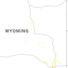


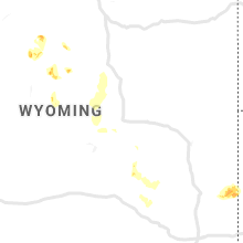
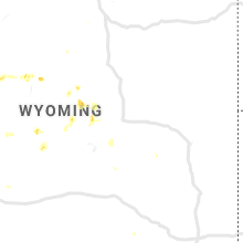


Connect with Interactive Hail Maps