

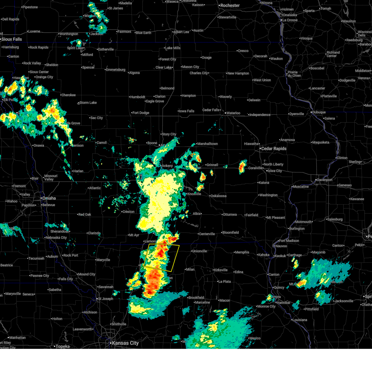
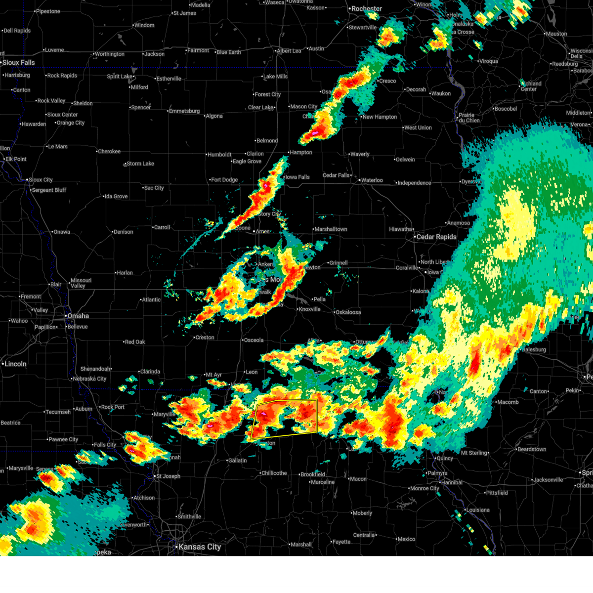
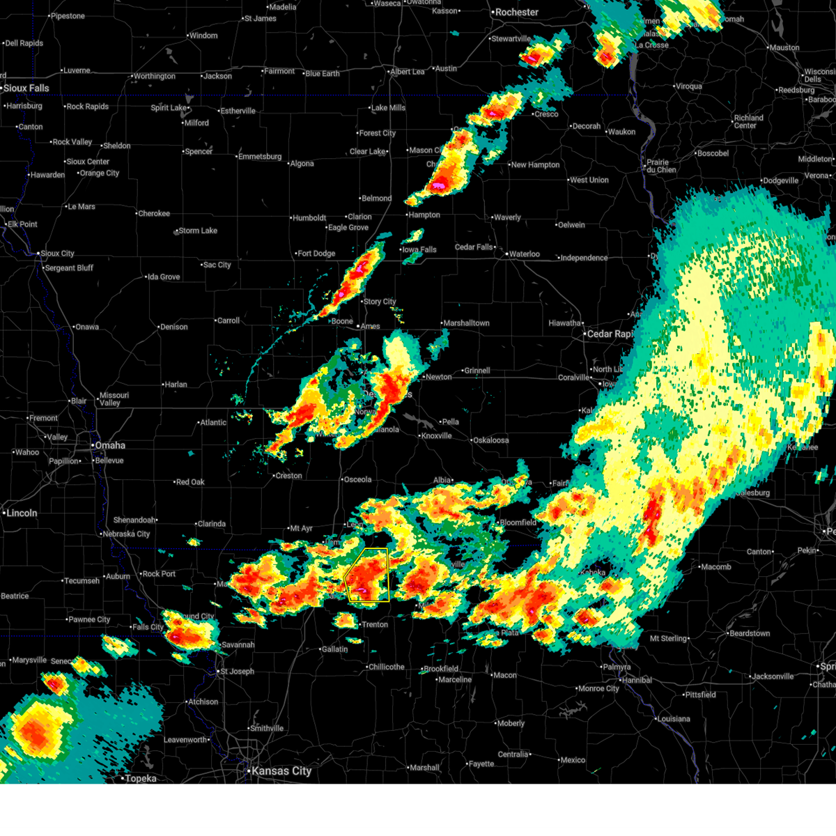
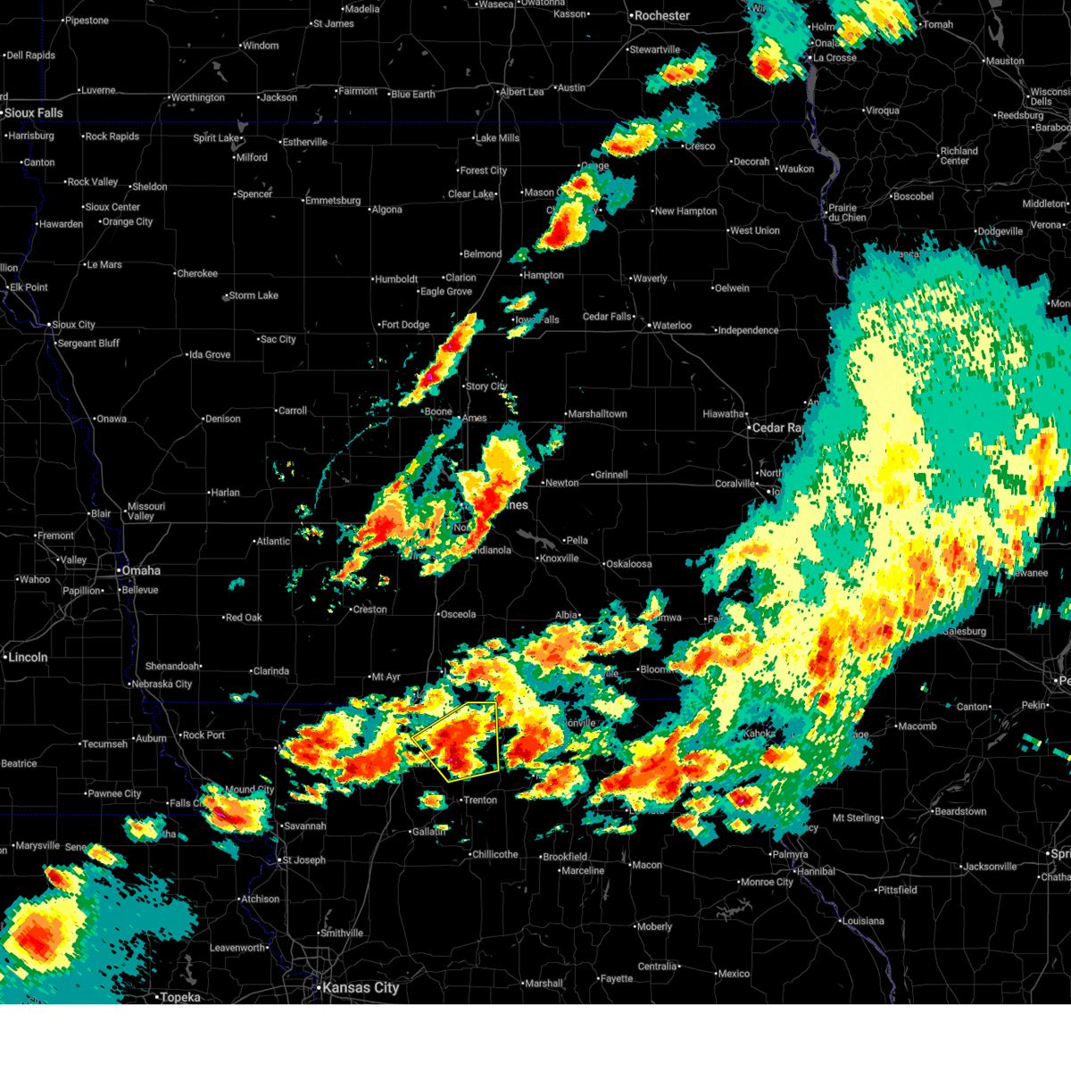
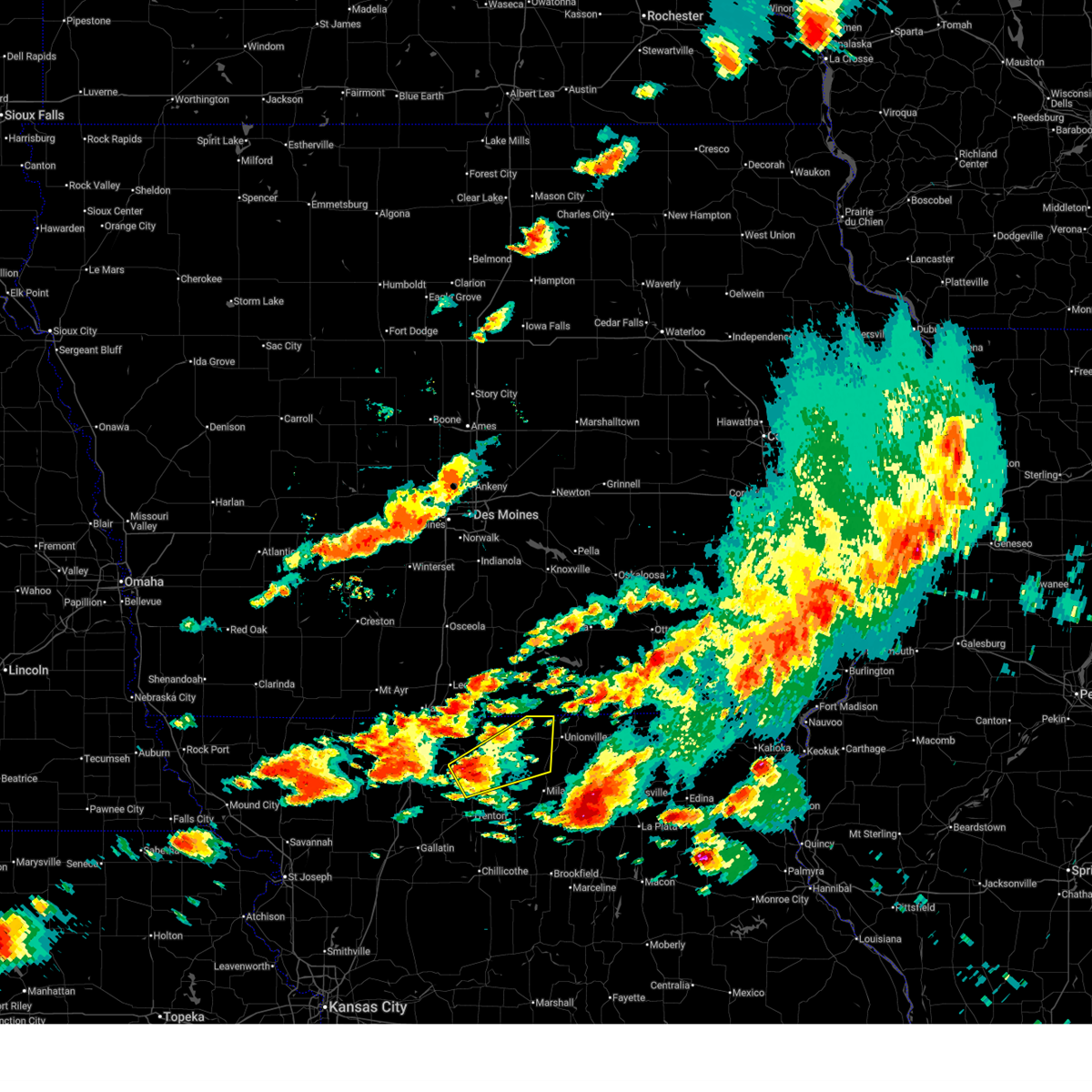
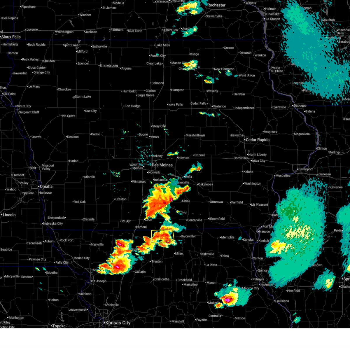
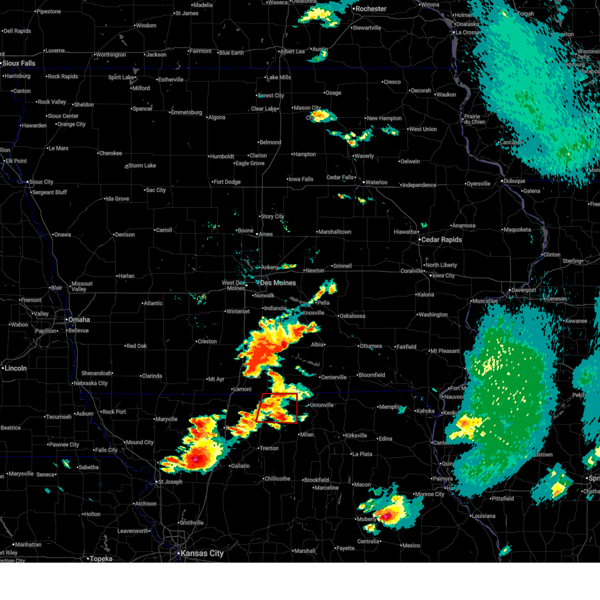
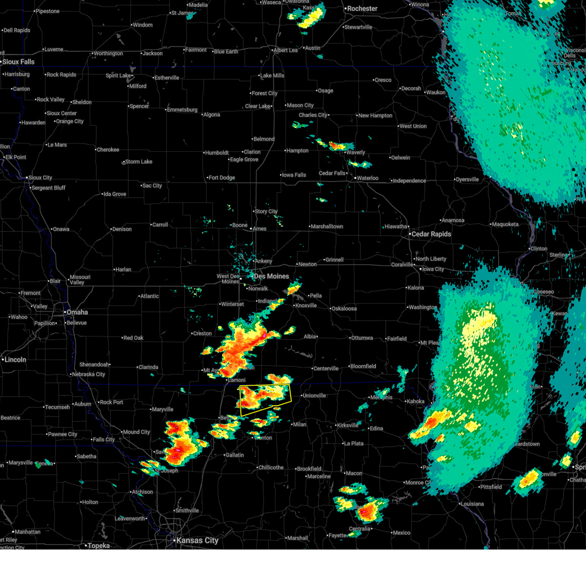
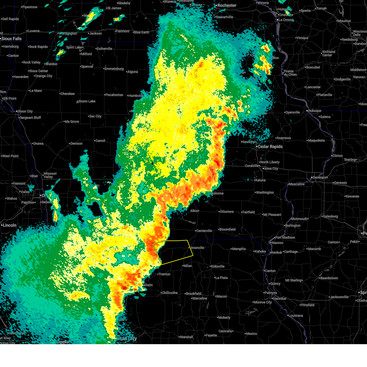
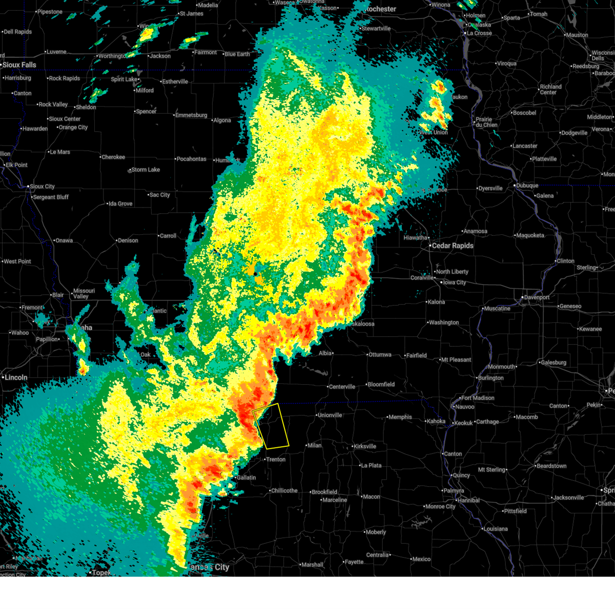
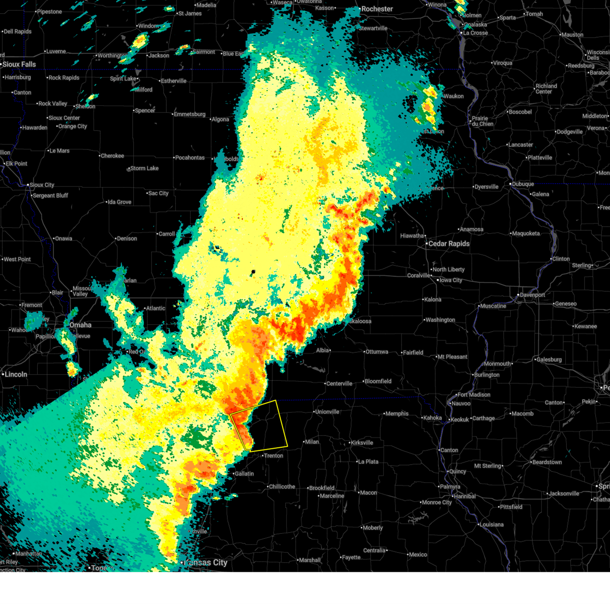
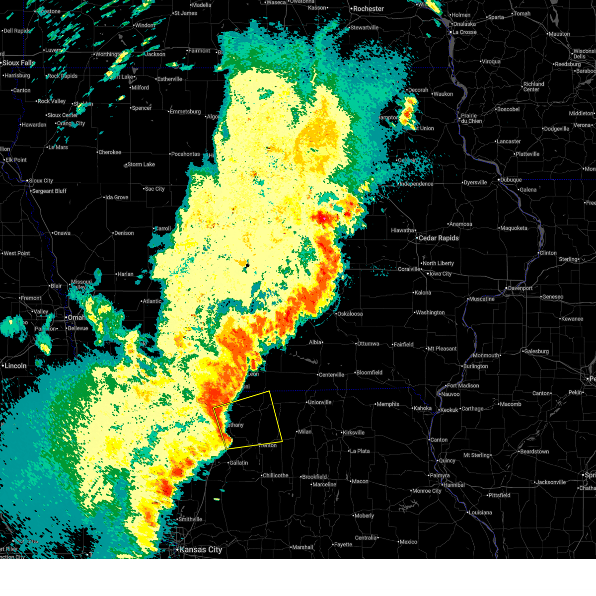
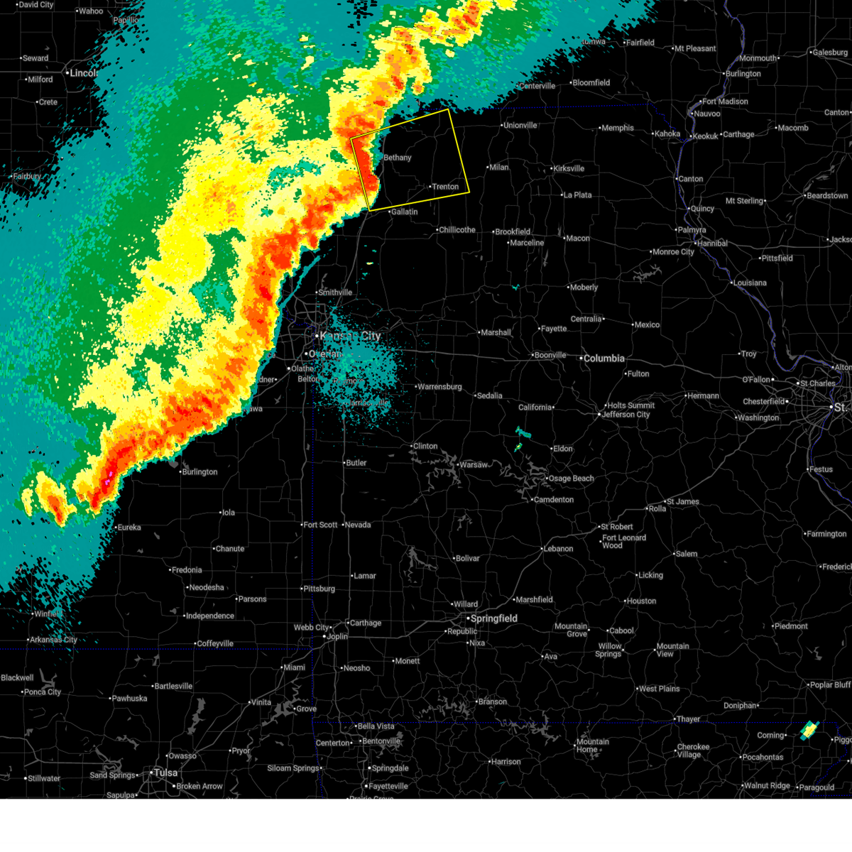
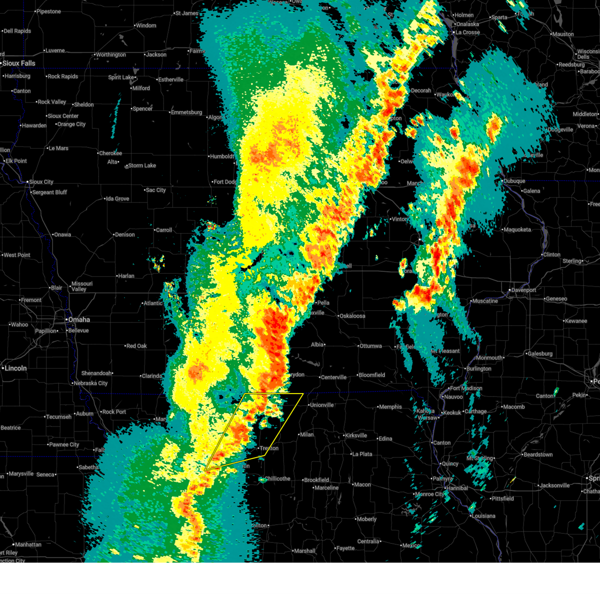
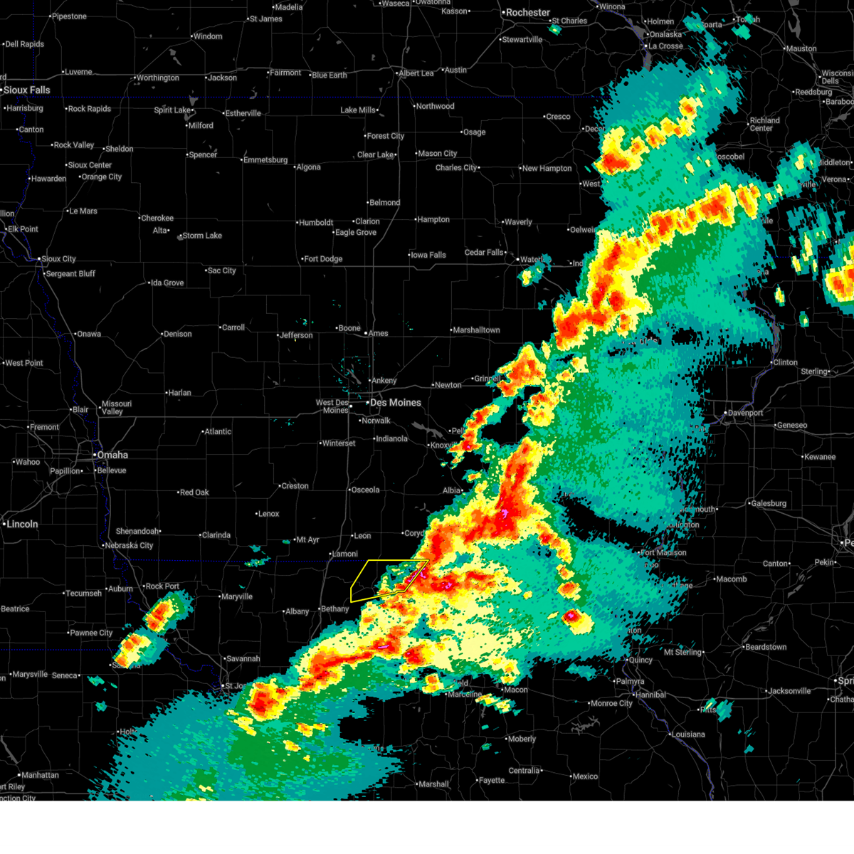
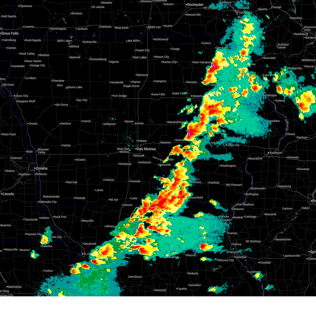
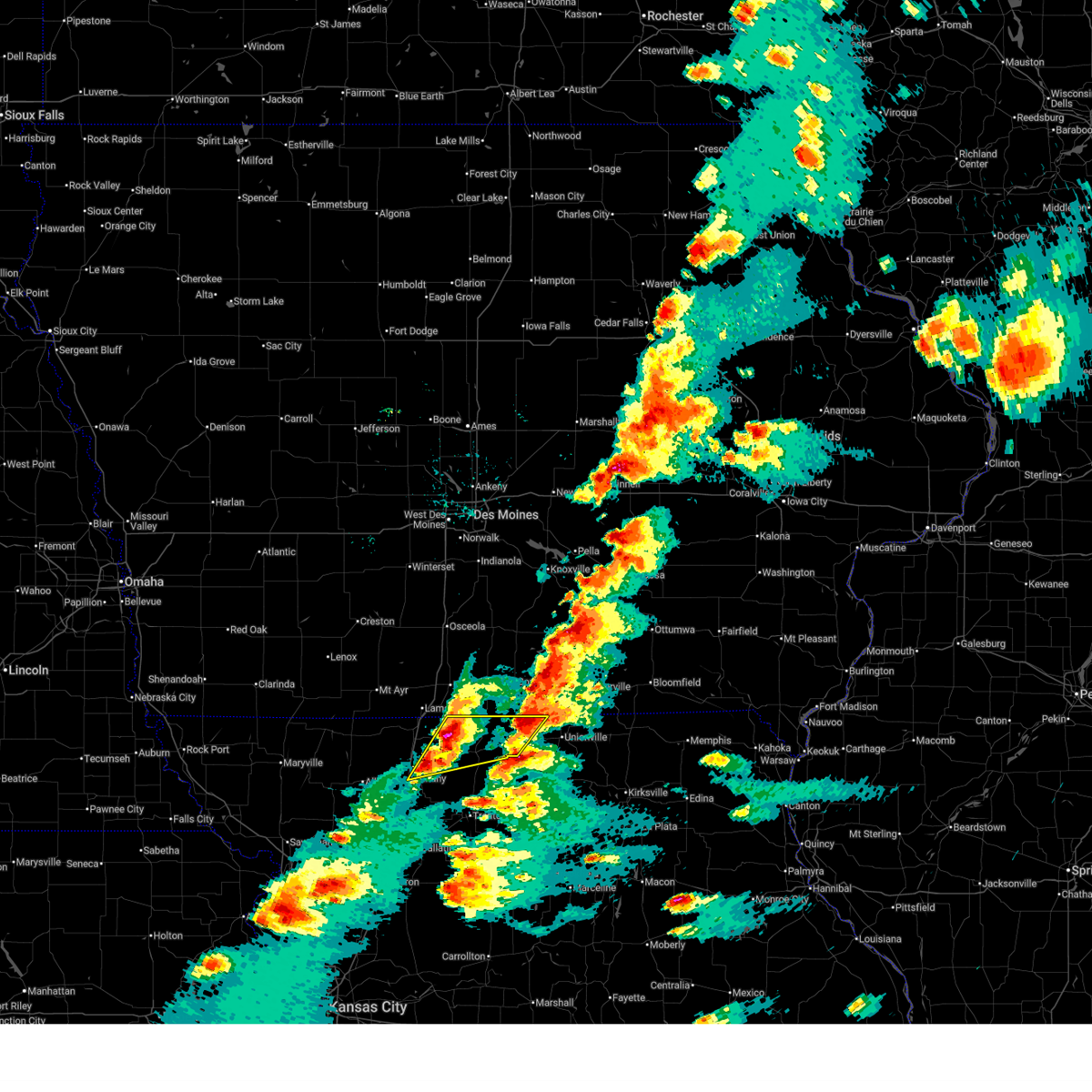
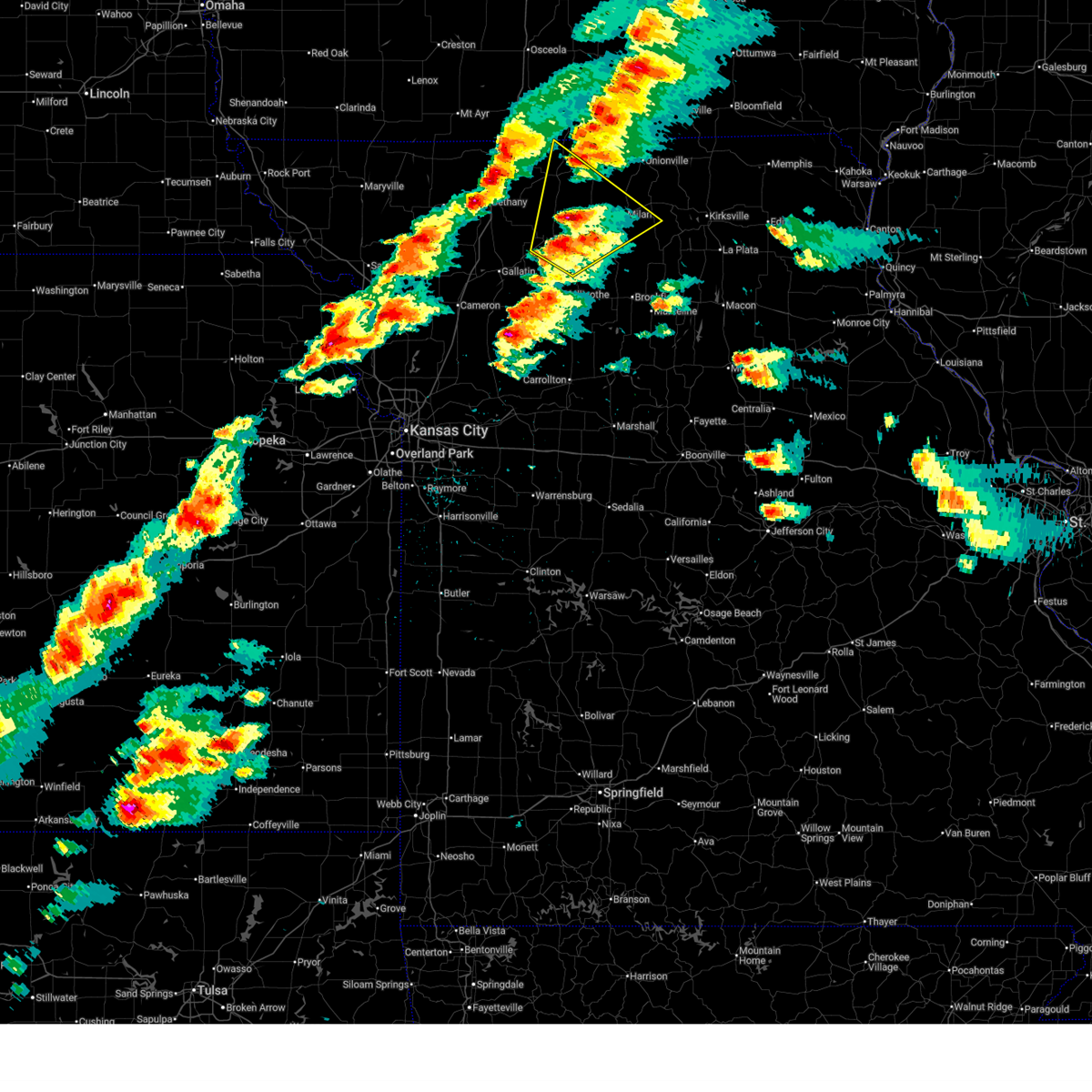
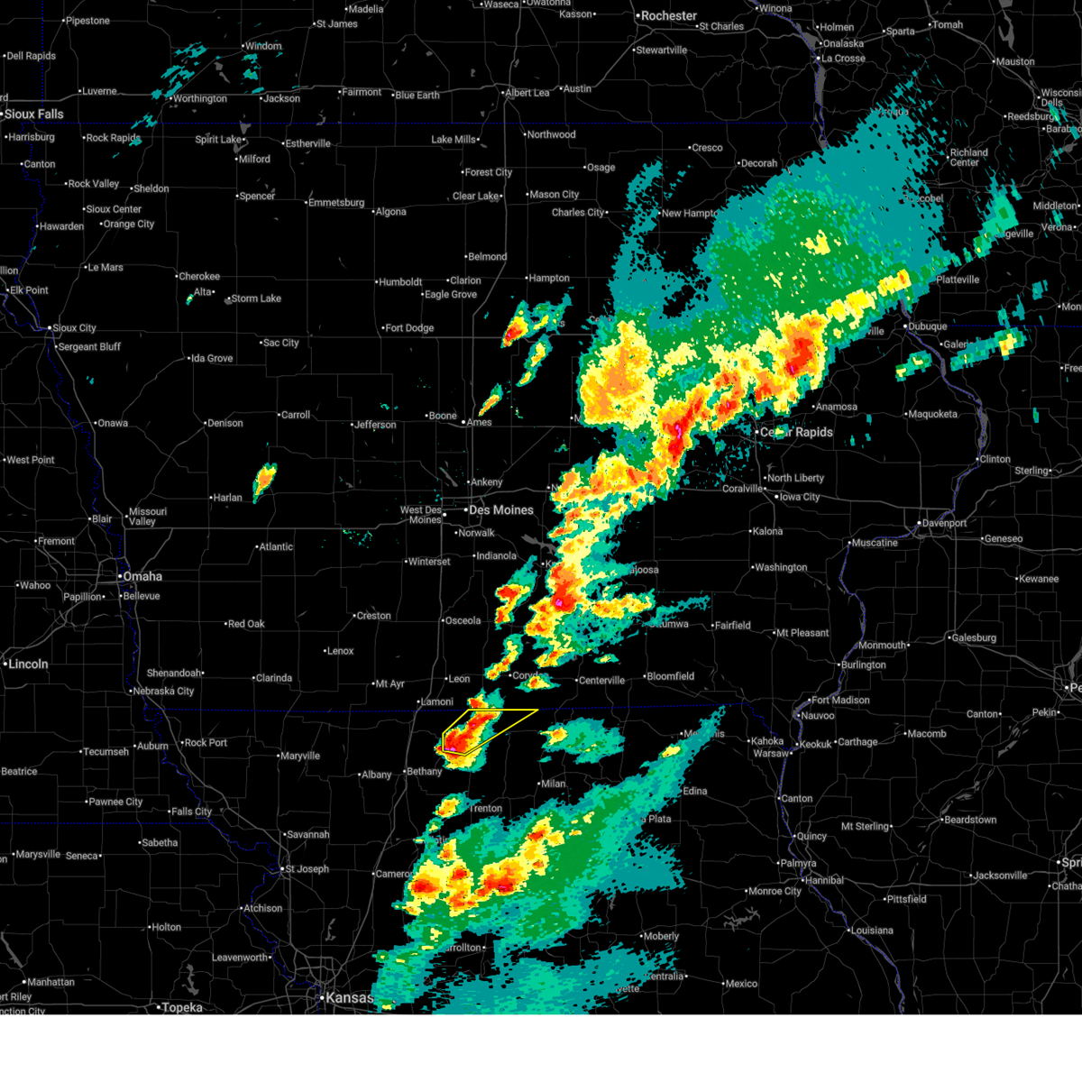
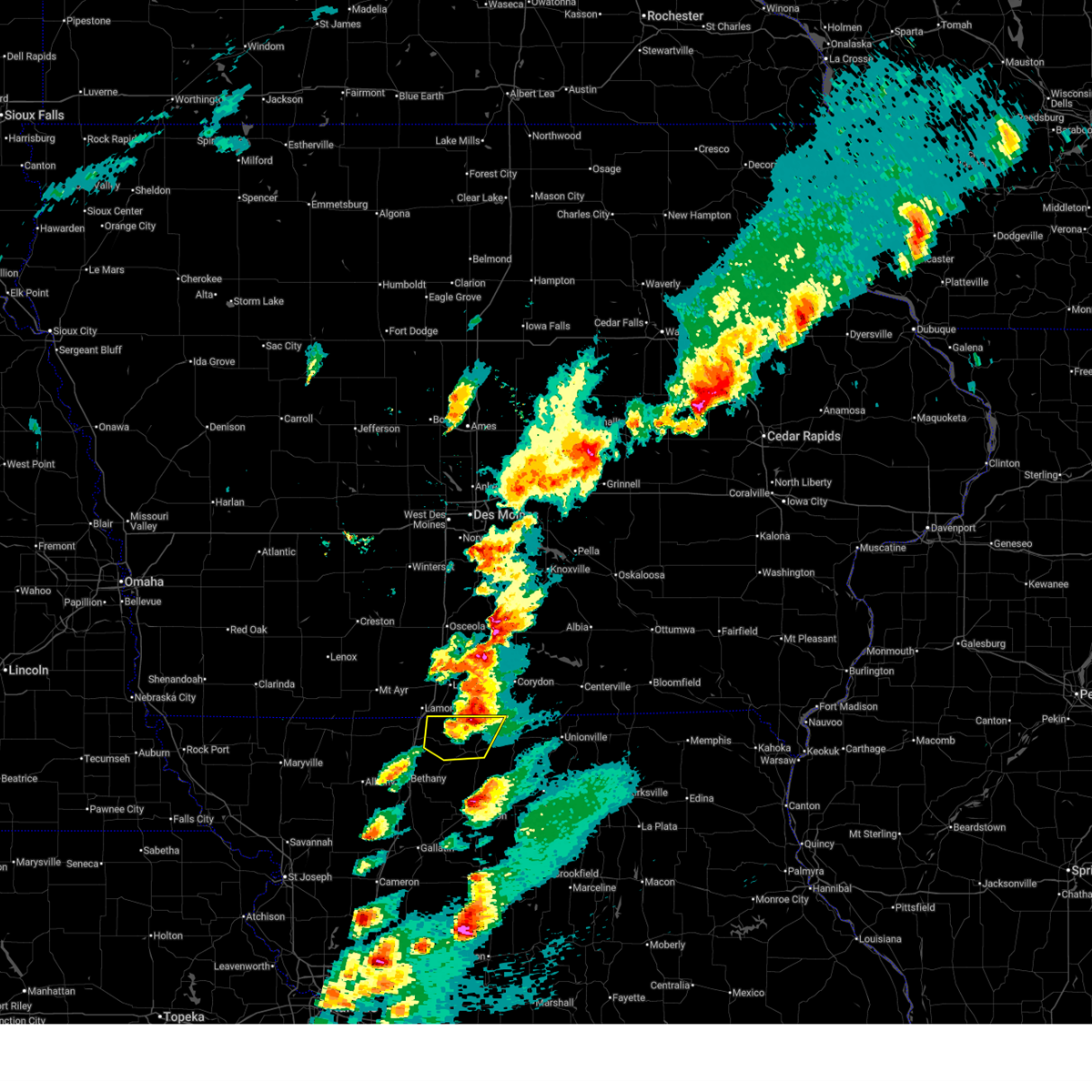
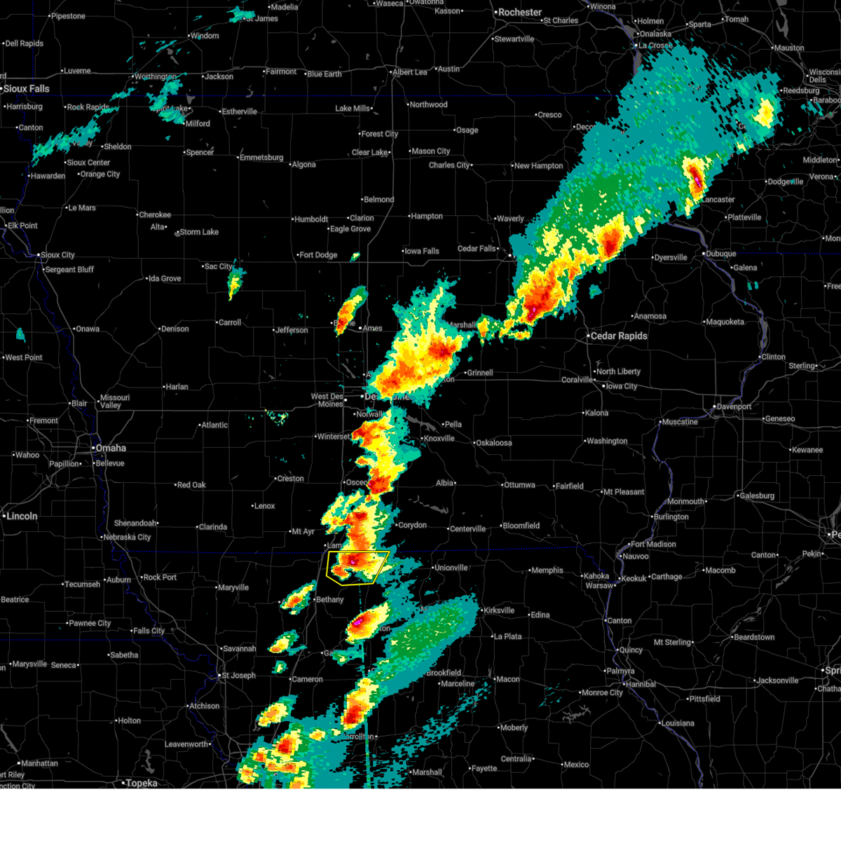
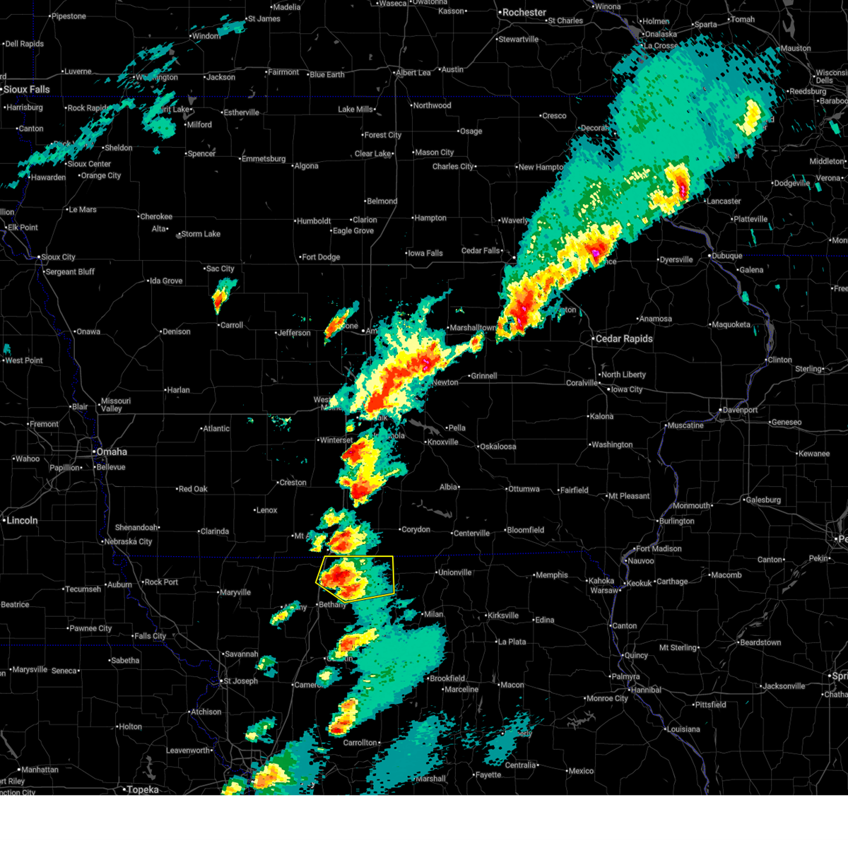
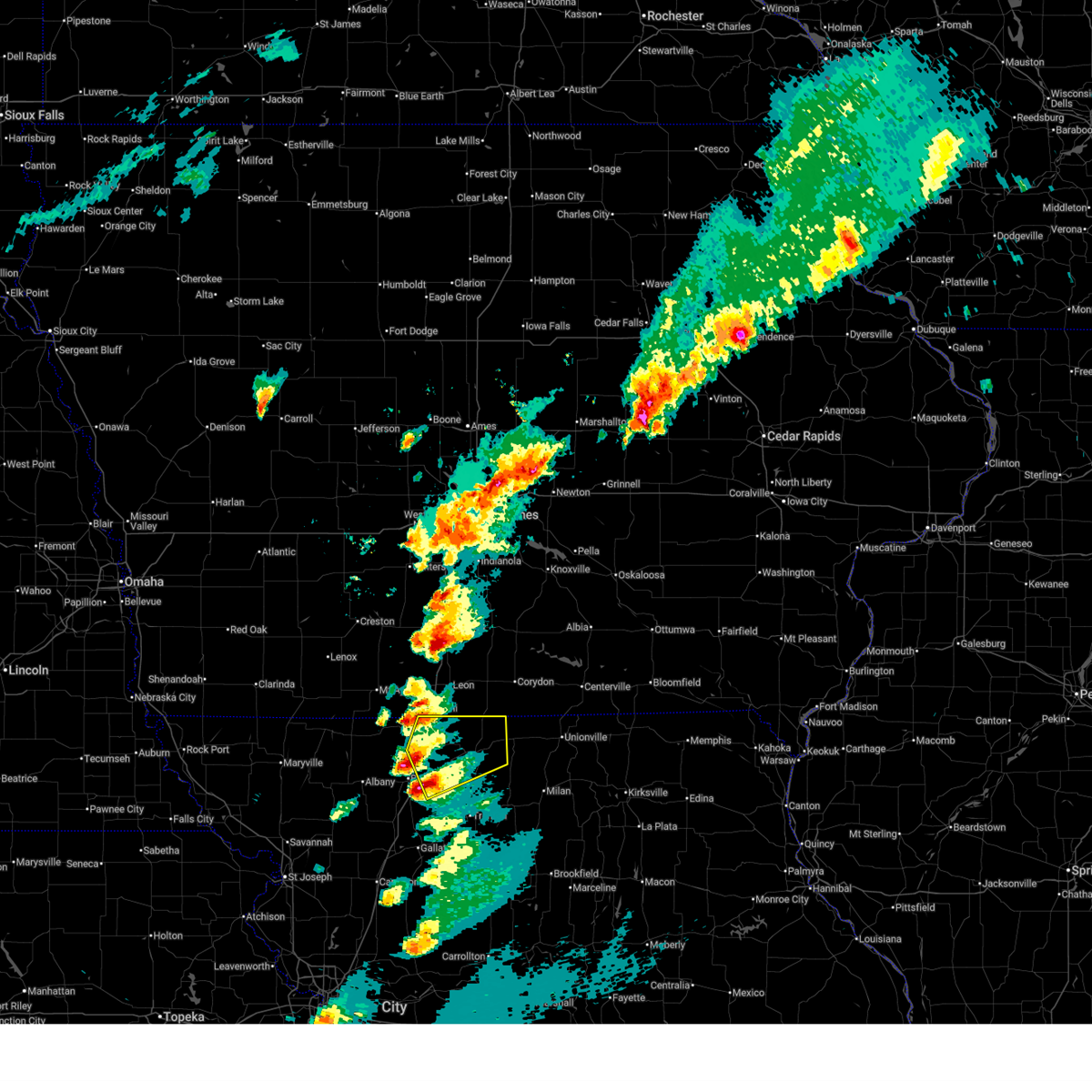
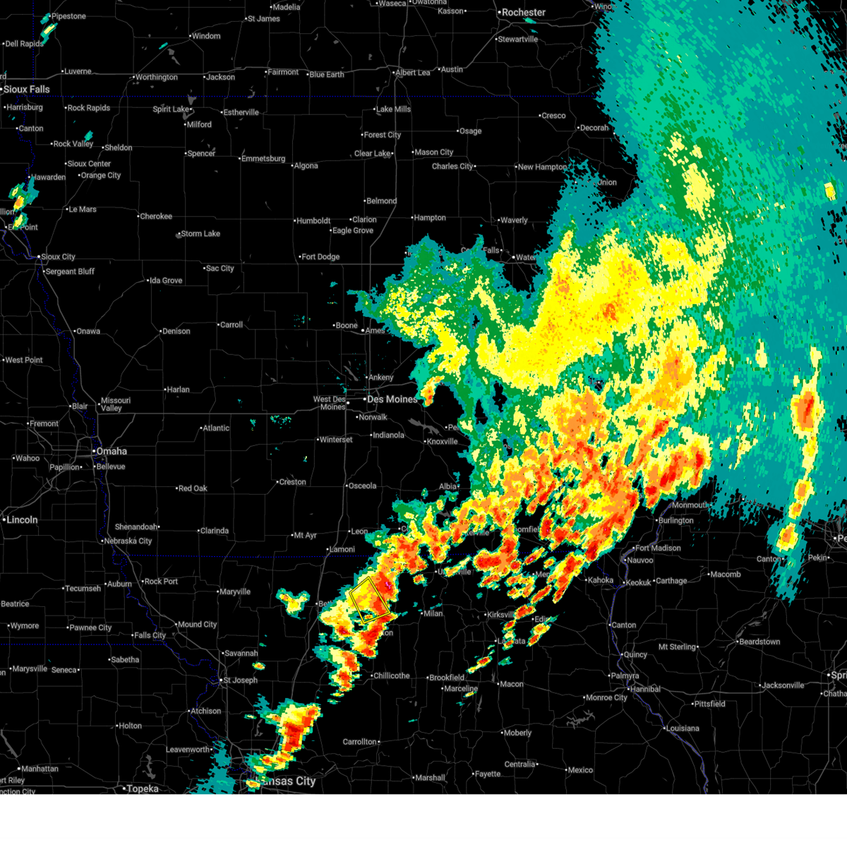
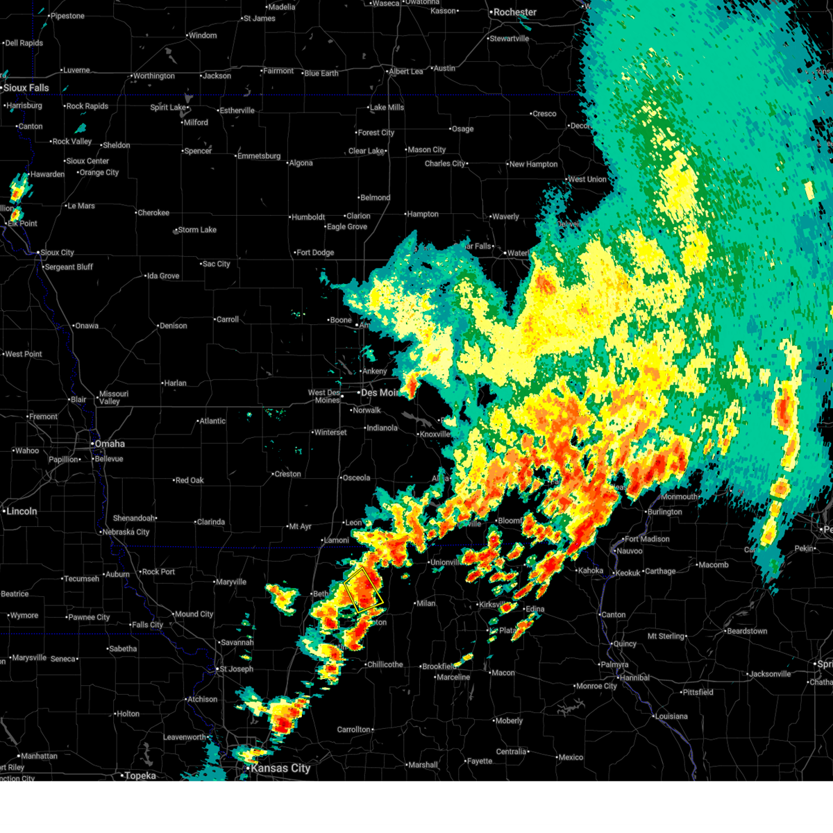
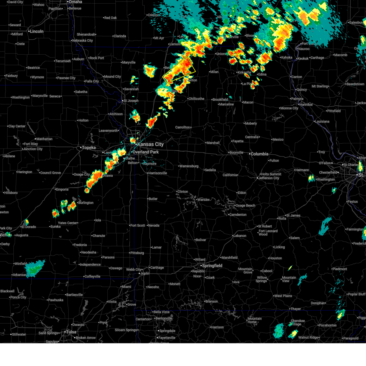
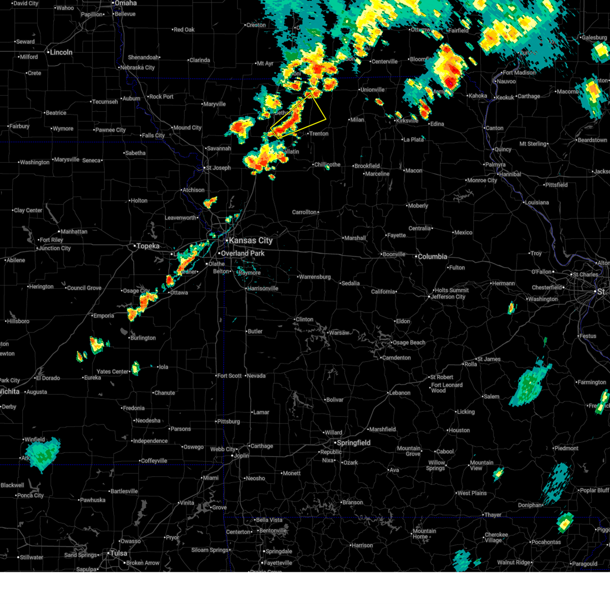
Hail Map for Princeton, MO
The Princeton, MO area has had 15 reports of on-the-ground hail by trained spotters, and has been under severe weather warnings 53 times during the past 12 months. Doppler radar has detected hail at or near Princeton, MO on 71 occasions, including 7 occasions during the past year.
| Name: | Princeton, MO |
| Where Located: | 82.3 miles S of Des Moines, IA |
| Map: | Google Map for Princeton, MO |
| Population: | 1166 |
| Housing Units: | 632 |
| More Info: | Search Google for Princeton, MO |
1
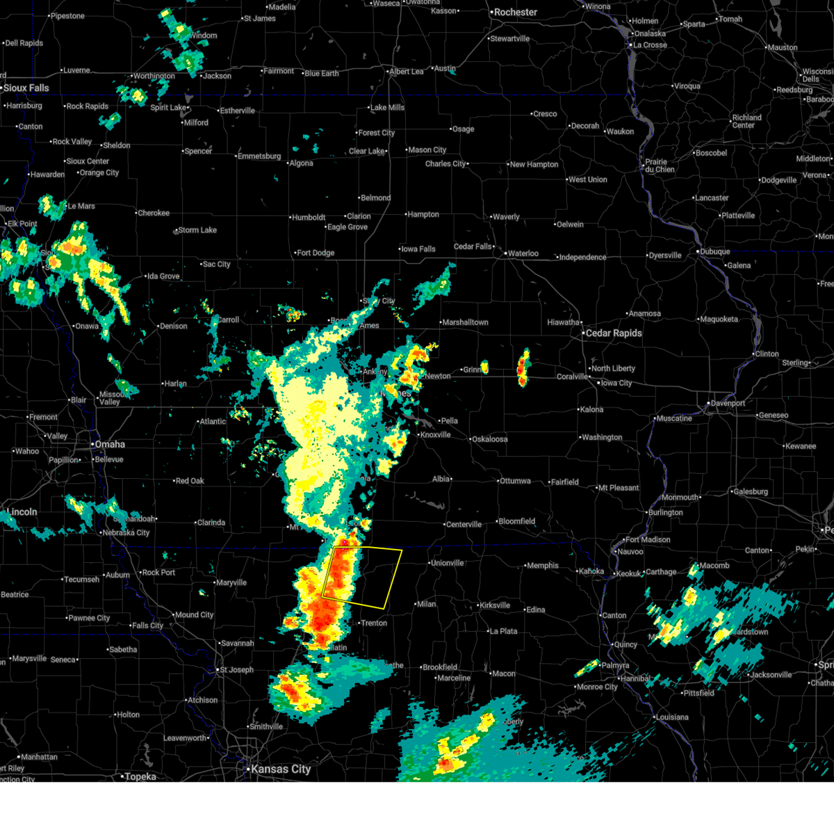
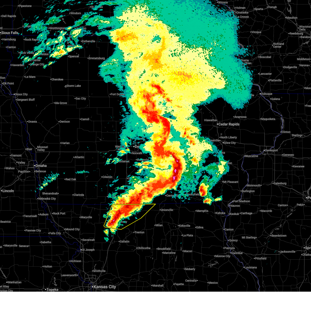
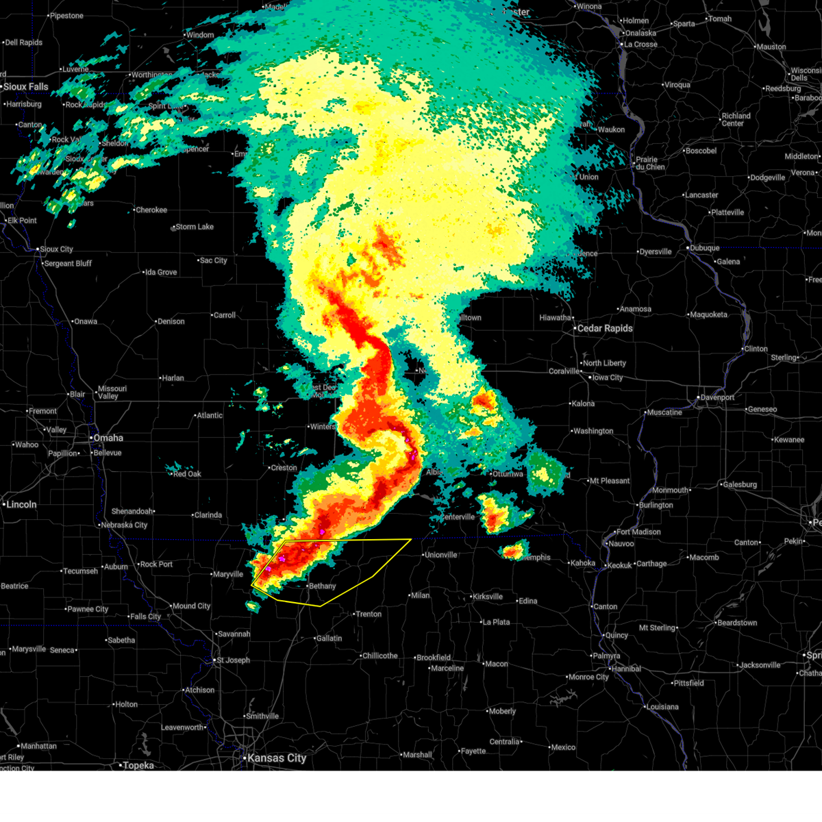
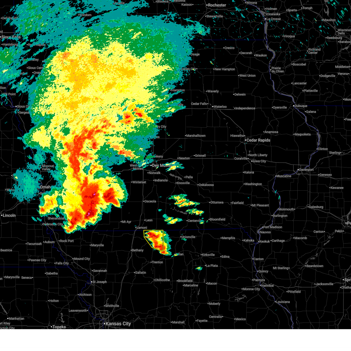
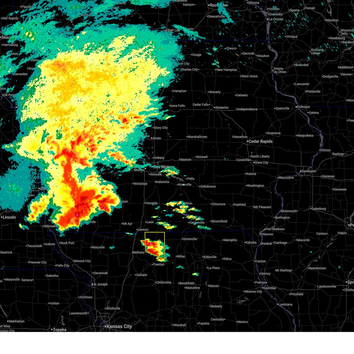
The Top Recent Hail Date for Princeton, MO is Wednesday, June 10, 2026 (11th out of 71)

Hail and Wind Damage Spotted near Princeton, MO
| Date / Time | Report Details |
|---|---|
| 6/13/2026 12:11 PM CDT |
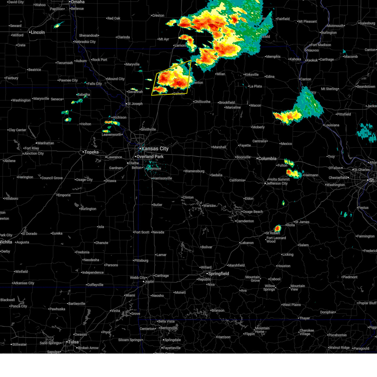
 The storms which prompted the warning have weakened below severe limits, and no longer pose an immediate threat to life or property. therefore, the warning will be allowed to expire. a severe thunderstorm watch remains in effect until 300 pm cdt for north central missouri. The storms which prompted the warning have weakened below severe limits, and no longer pose an immediate threat to life or property. therefore, the warning will be allowed to expire. a severe thunderstorm watch remains in effect until 300 pm cdt for north central missouri.
|
| 6/13/2026 11:49 AM CDT |
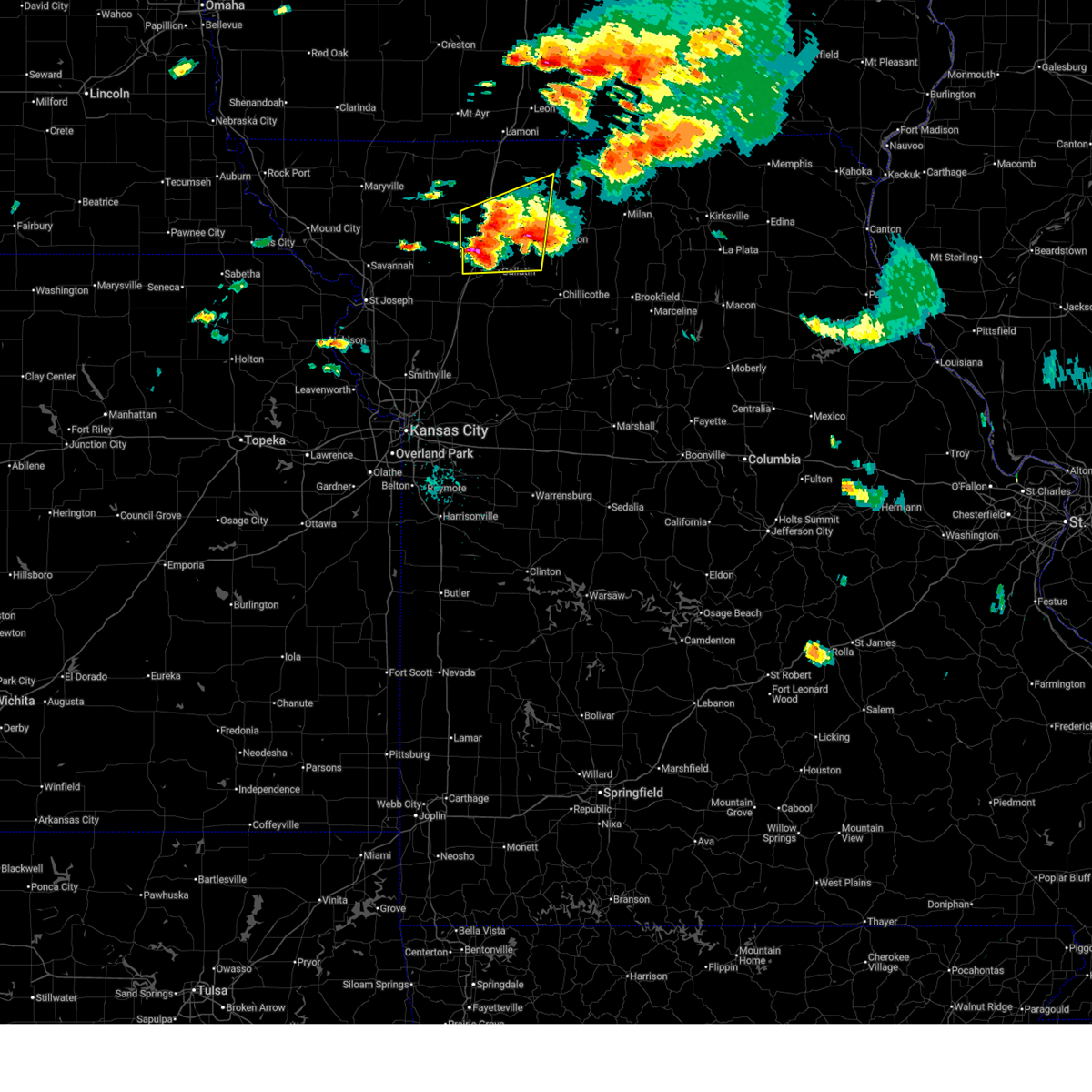
 At 1149 am cdt, severe thunderstorms were located along a line extending from 7 miles northwest of mercer to 8 miles northeast of gilman city, moving east at 30 mph (radar indicated). Hazards include 60 mph wind gusts and penny size hail. Expect damage to roofs, siding, and trees. Locations impacted include, princeton, mercer, cainsville, spickard, newtown, mount moriah, lucerne, harris, powersville, pleasanton, south lineville, modena, and mill grove. At 1149 am cdt, severe thunderstorms were located along a line extending from 7 miles northwest of mercer to 8 miles northeast of gilman city, moving east at 30 mph (radar indicated). Hazards include 60 mph wind gusts and penny size hail. Expect damage to roofs, siding, and trees. Locations impacted include, princeton, mercer, cainsville, spickard, newtown, mount moriah, lucerne, harris, powersville, pleasanton, south lineville, modena, and mill grove.
|
| 6/13/2026 11:28 AM CDT |
 Svreax the national weather service in pleasant hill has issued a * severe thunderstorm warning for, northern grundy county in north central missouri, northwestern sullivan county in north central missouri, mercer county in north central missouri, northwestern putnam county in north central missouri, northeastern harrison county in north central missouri, * until 1215 pm cdt. * at 1128 am cdt, severe thunderstorms were located along a line extending from 7 miles north of cainsville to 6 miles southeast of bethany, moving east at 40 mph (radar indicated). Hazards include 60 mph wind gusts and penny size hail. expect damage to roofs, siding, and trees Svreax the national weather service in pleasant hill has issued a * severe thunderstorm warning for, northern grundy county in north central missouri, northwestern sullivan county in north central missouri, mercer county in north central missouri, northwestern putnam county in north central missouri, northeastern harrison county in north central missouri, * until 1215 pm cdt. * at 1128 am cdt, severe thunderstorms were located along a line extending from 7 miles north of cainsville to 6 miles southeast of bethany, moving east at 40 mph (radar indicated). Hazards include 60 mph wind gusts and penny size hail. expect damage to roofs, siding, and trees
|
| 6/11/2026 9:07 AM CDT |
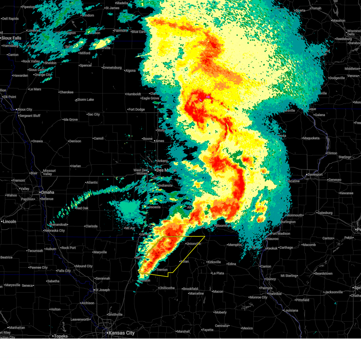
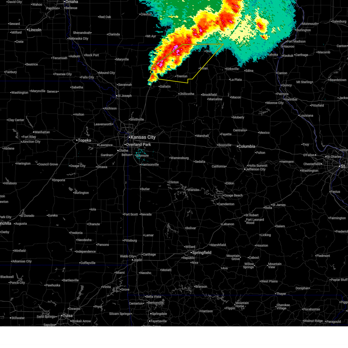
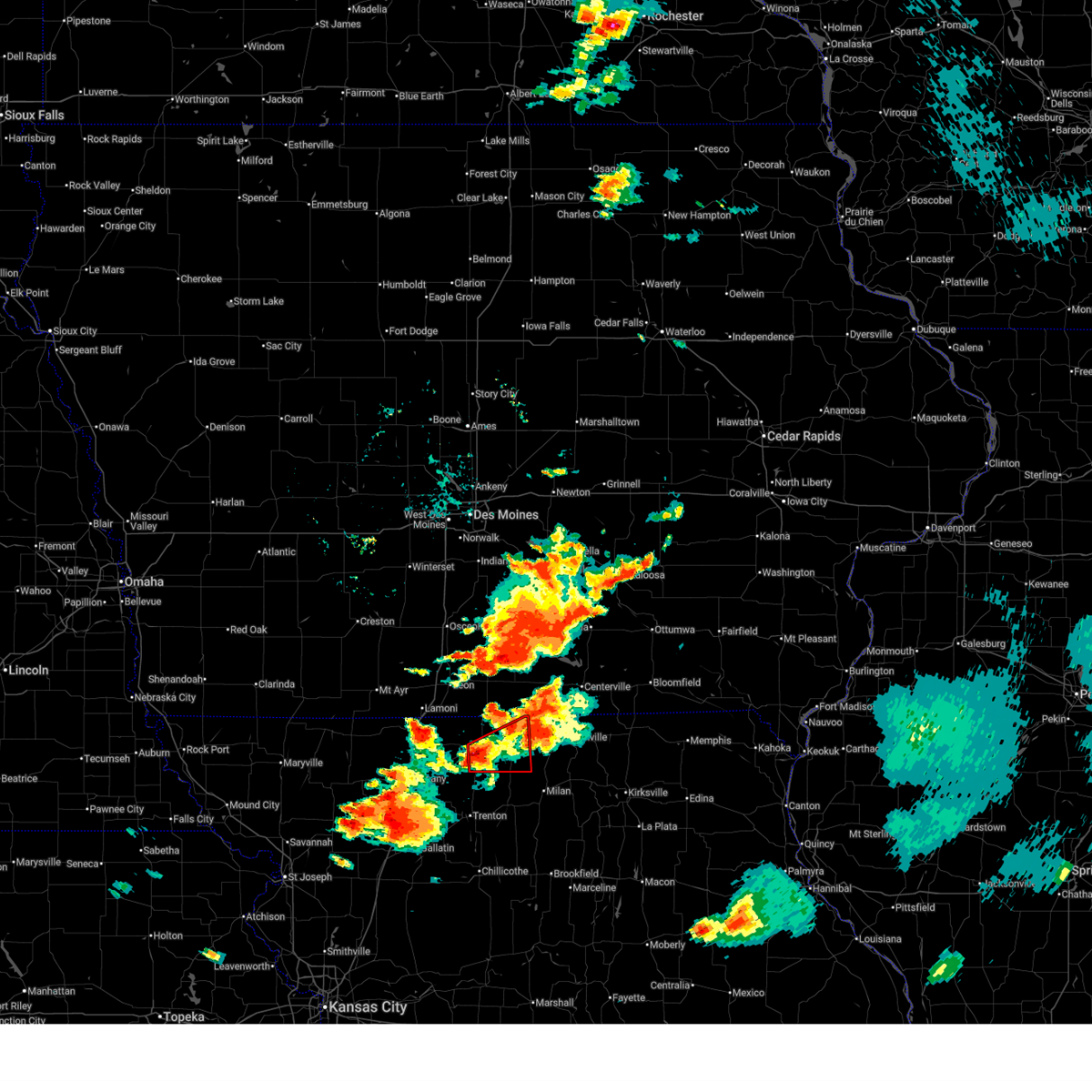
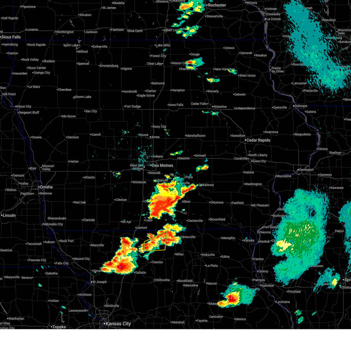
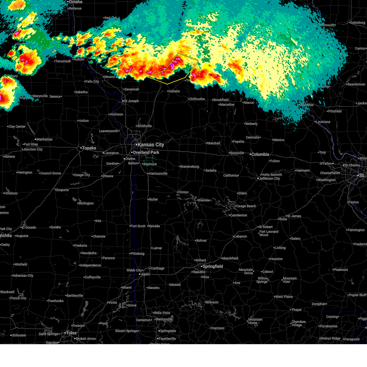
 At 907 am cdt, severe thunderstorms were located along a line extending from 7 miles east of centerville to 7 miles south of unionville to 10 miles north of galt to near trenton, moving northeast at 45 mph (radar indicated). Hazards include 70 mph wind gusts and ping pong ball size hail. People and animals outdoors will be injured. expect hail damage to roofs, siding, windows, and vehicles. expect considerable tree damage. wind damage is also likely to mobile homes, roofs, and outbuildings. Locations impacted include, trenton, milan, unionville, princeton, spickard, galt, laredo, newtown, humphreys, pollock, lucerne, tindall, harris, powersville, osgood, modena, mill grove, lemons, and reger. At 907 am cdt, severe thunderstorms were located along a line extending from 7 miles east of centerville to 7 miles south of unionville to 10 miles north of galt to near trenton, moving northeast at 45 mph (radar indicated). Hazards include 70 mph wind gusts and ping pong ball size hail. People and animals outdoors will be injured. expect hail damage to roofs, siding, windows, and vehicles. expect considerable tree damage. wind damage is also likely to mobile homes, roofs, and outbuildings. Locations impacted include, trenton, milan, unionville, princeton, spickard, galt, laredo, newtown, humphreys, pollock, lucerne, tindall, harris, powersville, osgood, modena, mill grove, lemons, and reger.
|
| 6/11/2026 8:55 AM CDT |
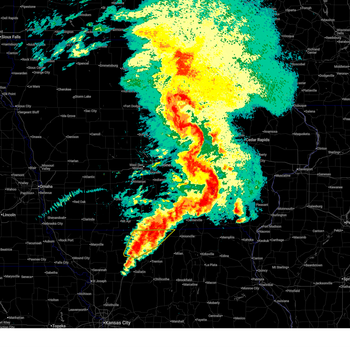
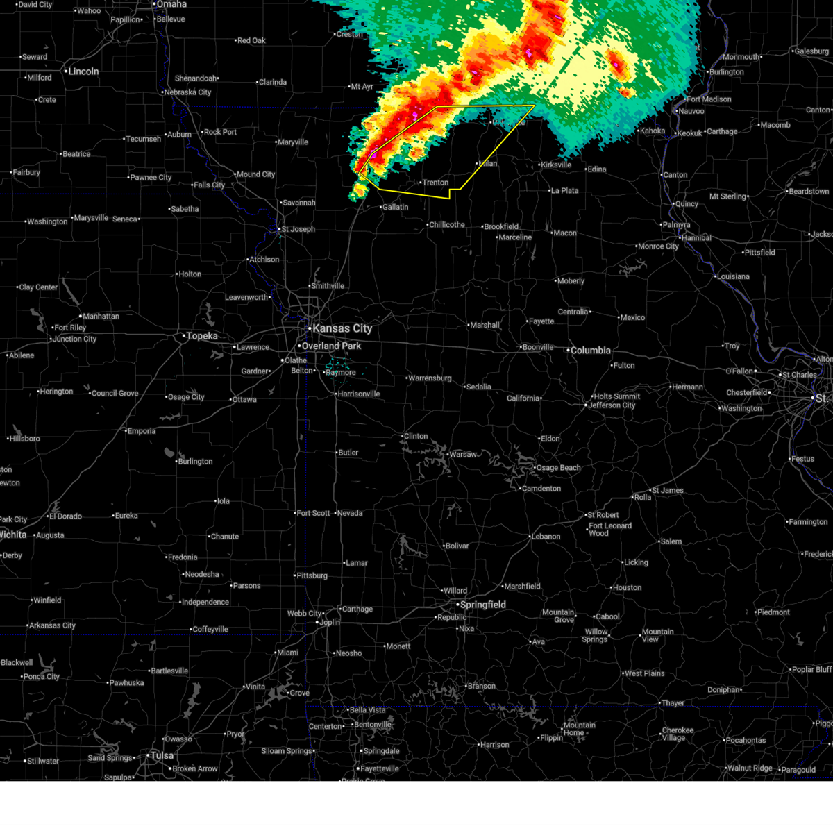
 At 855 am cdt, severe thunderstorms were located along a line extending from near centerville to 12 miles northwest of milan to near spickard to near jamesport, moving east at 55 mph (radar indicated). Hazards include 70 mph wind gusts and ping pong ball size hail. People and animals outdoors will be injured. expect hail damage to roofs, siding, windows, and vehicles. expect considerable tree damage. wind damage is also likely to mobile homes, roofs, and outbuildings. Locations impacted include, trenton, milan, unionville, princeton, gilman city, mercer, spickard, galt, laredo, newtown, humphreys, pollock, lucerne, tindall, brimson, harris, powersville, osgood, modena, and mill grove. At 855 am cdt, severe thunderstorms were located along a line extending from near centerville to 12 miles northwest of milan to near spickard to near jamesport, moving east at 55 mph (radar indicated). Hazards include 70 mph wind gusts and ping pong ball size hail. People and animals outdoors will be injured. expect hail damage to roofs, siding, windows, and vehicles. expect considerable tree damage. wind damage is also likely to mobile homes, roofs, and outbuildings. Locations impacted include, trenton, milan, unionville, princeton, gilman city, mercer, spickard, galt, laredo, newtown, humphreys, pollock, lucerne, tindall, brimson, harris, powersville, osgood, modena, and mill grove.
|
| 6/11/2026 8:34 AM CDT |
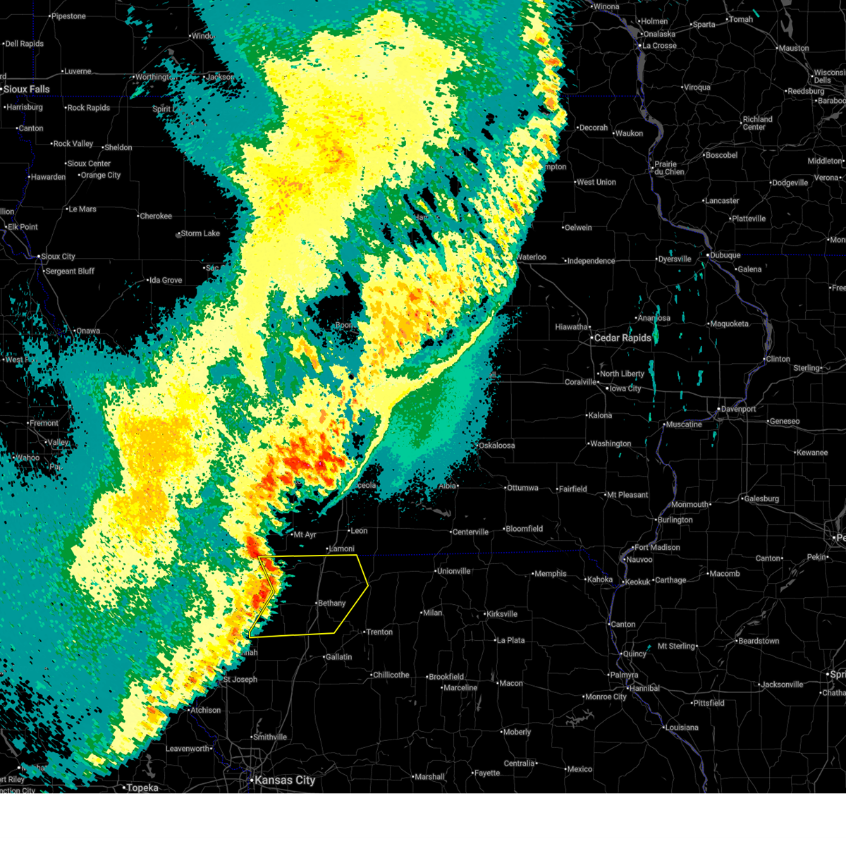
 At 833 am cdt, severe thunderstorms were located along a line extending from 12 miles northwest of unionville to near princeton to near gilman city, moving east at 55 mph (emergency management reported ping pong ball size hail at hwy. 69 and hwy. 136 in harrison county missouri. this line of storms has a history of 60 to 65 mph winds). Hazards include ping pong ball size hail and 60 mph wind gusts. People and animals outdoors will be injured. expect hail damage to roofs, siding, windows, and vehicles. expect wind damage to roofs, siding, and trees. locations impacted include, trenton, bethany, milan, unionville, princeton, gilman city, mercer, spickard, galt, laredo, newtown, coffey, humphreys, pollock, mount moriah, lucerne, tindall, brimson, harris, and powersville. This includes interstate 35 in missouri between mile markers 80 and 93. At 833 am cdt, severe thunderstorms were located along a line extending from 12 miles northwest of unionville to near princeton to near gilman city, moving east at 55 mph (emergency management reported ping pong ball size hail at hwy. 69 and hwy. 136 in harrison county missouri. this line of storms has a history of 60 to 65 mph winds). Hazards include ping pong ball size hail and 60 mph wind gusts. People and animals outdoors will be injured. expect hail damage to roofs, siding, windows, and vehicles. expect wind damage to roofs, siding, and trees. locations impacted include, trenton, bethany, milan, unionville, princeton, gilman city, mercer, spickard, galt, laredo, newtown, coffey, humphreys, pollock, mount moriah, lucerne, tindall, brimson, harris, and powersville. This includes interstate 35 in missouri between mile markers 80 and 93.
|
| 6/11/2026 8:32 AM CDT |
 At 831 am cdt, severe thunderstorms were located along a line extending from 13 miles east of mercer to near princeton to near gilman city, moving east at 40 mph (emergency management reported ping pong ball size hail at hwy. 69 and hwy. 136 in harrison county missouri. this line of storms has a history of 60 to 65 mph winds). Hazards include ping pong ball size hail and 60 mph wind gusts. People and animals outdoors will be injured. expect hail damage to roofs, siding, windows, and vehicles. expect wind damage to roofs, siding, and trees. locations impacted include, bethany, princeton, ridgeway, mercer, eagleville, cainsville, blythedale, mount moriah, lucerne, powersville, modena, and mill grove. This includes interstate 35 in missouri between mile markers 84 and 113. At 831 am cdt, severe thunderstorms were located along a line extending from 13 miles east of mercer to near princeton to near gilman city, moving east at 40 mph (emergency management reported ping pong ball size hail at hwy. 69 and hwy. 136 in harrison county missouri. this line of storms has a history of 60 to 65 mph winds). Hazards include ping pong ball size hail and 60 mph wind gusts. People and animals outdoors will be injured. expect hail damage to roofs, siding, windows, and vehicles. expect wind damage to roofs, siding, and trees. locations impacted include, bethany, princeton, ridgeway, mercer, eagleville, cainsville, blythedale, mount moriah, lucerne, powersville, modena, and mill grove. This includes interstate 35 in missouri between mile markers 84 and 113.
|
| 6/11/2026 8:28 AM CDT |
 Svreax the national weather service in pleasant hill has issued a * severe thunderstorm warning for, northeastern daviess county in north central missouri, grundy county in north central missouri, northwestern sullivan county in north central missouri, mercer county in north central missouri, putnam county in north central missouri, southeastern harrison county in north central missouri, northwestern schuyler county in northeastern missouri, * until 915 am cdt. * at 827 am cdt, severe thunderstorms were located along a line extending from 13 miles south of corydon to near cainsville to near gilman city, moving east at 55 mph (radar indicated). Hazards include ping pong ball size hail and 60 mph wind gusts. People and animals outdoors will be injured. expect hail damage to roofs, siding, windows, and vehicles. Expect wind damage to roofs, siding, and trees. Svreax the national weather service in pleasant hill has issued a * severe thunderstorm warning for, northeastern daviess county in north central missouri, grundy county in north central missouri, northwestern sullivan county in north central missouri, mercer county in north central missouri, putnam county in north central missouri, southeastern harrison county in north central missouri, northwestern schuyler county in northeastern missouri, * until 915 am cdt. * at 827 am cdt, severe thunderstorms were located along a line extending from 13 miles south of corydon to near cainsville to near gilman city, moving east at 55 mph (radar indicated). Hazards include ping pong ball size hail and 60 mph wind gusts. People and animals outdoors will be injured. expect hail damage to roofs, siding, windows, and vehicles. Expect wind damage to roofs, siding, and trees.
|
| 6/11/2026 8:17 AM CDT |
 At 816 am cdt, severe thunderstorms were located along a line extending from near mercer to 6 miles south of cainsville to 6 miles north of pattonsburg, moving east at 40 mph (emergency management reported 60 to 65 mph winds in mercer missouri around 815 am cdt). Hazards include ping pong ball size hail and 60 mph wind gusts. People and animals outdoors will be injured. expect hail damage to roofs, siding, windows, and vehicles. expect wind damage to roofs, siding, and trees. locations impacted include, bethany, princeton, ridgeway, mercer, eagleville, new hampton, cainsville, blythedale, mount moriah, lucerne, powersville, south lineville, modena, mill grove, and martinsville. This includes interstate 35 in missouri between mile markers 84 and 113. At 816 am cdt, severe thunderstorms were located along a line extending from near mercer to 6 miles south of cainsville to 6 miles north of pattonsburg, moving east at 40 mph (emergency management reported 60 to 65 mph winds in mercer missouri around 815 am cdt). Hazards include ping pong ball size hail and 60 mph wind gusts. People and animals outdoors will be injured. expect hail damage to roofs, siding, windows, and vehicles. expect wind damage to roofs, siding, and trees. locations impacted include, bethany, princeton, ridgeway, mercer, eagleville, new hampton, cainsville, blythedale, mount moriah, lucerne, powersville, south lineville, modena, mill grove, and martinsville. This includes interstate 35 in missouri between mile markers 84 and 113.
|
| 6/11/2026 7:55 AM CDT |
 Svreax the national weather service in pleasant hill has issued a * severe thunderstorm warning for, southeastern worth county in northwestern missouri, northwestern grundy county in north central missouri, northeastern gentry county in northwestern missouri, mercer county in north central missouri, northwestern putnam county in north central missouri, harrison county in north central missouri, * until 845 am cdt. * at 755 am cdt, severe thunderstorms were located along a line extending from 9 miles northeast of cainsville to near bethany to albany, moving east at 40 mph (radar indicated). Hazards include ping pong ball size hail and 60 mph wind gusts. People and animals outdoors will be injured. expect hail damage to roofs, siding, windows, and vehicles. Expect wind damage to roofs, siding, and trees. Svreax the national weather service in pleasant hill has issued a * severe thunderstorm warning for, southeastern worth county in northwestern missouri, northwestern grundy county in north central missouri, northeastern gentry county in northwestern missouri, mercer county in north central missouri, northwestern putnam county in north central missouri, harrison county in north central missouri, * until 845 am cdt. * at 755 am cdt, severe thunderstorms were located along a line extending from 9 miles northeast of cainsville to near bethany to albany, moving east at 40 mph (radar indicated). Hazards include ping pong ball size hail and 60 mph wind gusts. People and animals outdoors will be injured. expect hail damage to roofs, siding, windows, and vehicles. Expect wind damage to roofs, siding, and trees.
|
| 6/11/2026 6:23 AM CDT |
 At 623 am cdt, severe thunderstorms were located along a line extending from 7 miles west of mercer to 11 miles northeast of spickard, moving northeast at 40 mph (radar indicated). Hazards include 60 mph wind gusts and quarter size hail. Hail damage to vehicles is expected. expect wind damage to roofs, siding, and trees. Locations impacted include, princeton, mercer, pleasanton, south lineville, and mill grove. At 623 am cdt, severe thunderstorms were located along a line extending from 7 miles west of mercer to 11 miles northeast of spickard, moving northeast at 40 mph (radar indicated). Hazards include 60 mph wind gusts and quarter size hail. Hail damage to vehicles is expected. expect wind damage to roofs, siding, and trees. Locations impacted include, princeton, mercer, pleasanton, south lineville, and mill grove.
|
| 6/11/2026 6:12 AM CDT |
 Svreax the national weather service in pleasant hill has issued a * severe thunderstorm warning for, northeastern grundy county in north central missouri, mercer county in north central missouri, * until 700 am cdt. * at 612 am cdt, a severe thunderstorm was located over princeton, or 23 miles north of trenton, moving northeast at 40 mph (radar indicated). Hazards include 60 mph wind gusts and quarter size hail. Hail damage to vehicles is expected. Expect wind damage to roofs, siding, and trees. Svreax the national weather service in pleasant hill has issued a * severe thunderstorm warning for, northeastern grundy county in north central missouri, mercer county in north central missouri, * until 700 am cdt. * at 612 am cdt, a severe thunderstorm was located over princeton, or 23 miles north of trenton, moving northeast at 40 mph (radar indicated). Hazards include 60 mph wind gusts and quarter size hail. Hail damage to vehicles is expected. Expect wind damage to roofs, siding, and trees.
|
| 6/10/2026 7:30 PM CDT | Quarter sized hail reported 8.8 miles WNW of Princeton, MO, social media report. time estimated from radar. |
| 6/10/2026 7:29 PM CDT |
 Svreax the national weather service in pleasant hill has issued a * severe thunderstorm warning for, northeastern grundy county in north central missouri, sullivan county in north central missouri, southeastern mercer county in north central missouri, southwestern putnam county in north central missouri, * until 815 pm cdt. * at 729 pm cdt, a severe thunderstorm was located 8 miles east of spickard, or 15 miles northeast of trenton, moving east at 40 mph (radar indicated). Hazards include 70 mph wind gusts and half dollar size hail. Hail damage to vehicles is expected. expect considerable tree damage. Wind damage is also likely to mobile homes, roofs, and outbuildings. Svreax the national weather service in pleasant hill has issued a * severe thunderstorm warning for, northeastern grundy county in north central missouri, sullivan county in north central missouri, southeastern mercer county in north central missouri, southwestern putnam county in north central missouri, * until 815 pm cdt. * at 729 pm cdt, a severe thunderstorm was located 8 miles east of spickard, or 15 miles northeast of trenton, moving east at 40 mph (radar indicated). Hazards include 70 mph wind gusts and half dollar size hail. Hail damage to vehicles is expected. expect considerable tree damage. Wind damage is also likely to mobile homes, roofs, and outbuildings.
|
| 6/10/2026 7:19 PM CDT |
 the severe thunderstorm warning has been cancelled and is no longer in effect the severe thunderstorm warning has been cancelled and is no longer in effect
|
| 6/10/2026 7:19 PM CDT |
 At 719 pm cdt, a severe thunderstorm was located near princeton, or 17 miles north of trenton, moving northeast at 35 mph (radar indicated). Hazards include ping pong ball size hail and 60 mph wind gusts. People and animals outdoors will be injured. expect hail damage to roofs, siding, windows, and vehicles. expect wind damage to roofs, siding, and trees. Locations impacted include, princeton, mercer, spickard, south lineville, mill grove, and modena. At 719 pm cdt, a severe thunderstorm was located near princeton, or 17 miles north of trenton, moving northeast at 35 mph (radar indicated). Hazards include ping pong ball size hail and 60 mph wind gusts. People and animals outdoors will be injured. expect hail damage to roofs, siding, windows, and vehicles. expect wind damage to roofs, siding, and trees. Locations impacted include, princeton, mercer, spickard, south lineville, mill grove, and modena.
|
| 6/10/2026 7:15 PM CDT | Ping Pong Ball sized hail reported 6.1 miles N of Princeton, MO, fire department reported ping pong ball sized hail. report relayed by em. |
| 6/10/2026 7:04 PM CDT |
 Svreax the national weather service in pleasant hill has issued a * severe thunderstorm warning for, northern grundy county in north central missouri, mercer county in north central missouri, east central harrison county in north central missouri, * until 745 pm cdt. * at 704 pm cdt, a severe thunderstorm was located near spickard, or 15 miles north of trenton, moving northeast at 35 mph (radar indicated). Hazards include 60 mph wind gusts and quarter size hail. Hail damage to vehicles is expected. Expect wind damage to roofs, siding, and trees. Svreax the national weather service in pleasant hill has issued a * severe thunderstorm warning for, northern grundy county in north central missouri, mercer county in north central missouri, east central harrison county in north central missouri, * until 745 pm cdt. * at 704 pm cdt, a severe thunderstorm was located near spickard, or 15 miles north of trenton, moving northeast at 35 mph (radar indicated). Hazards include 60 mph wind gusts and quarter size hail. Hail damage to vehicles is expected. Expect wind damage to roofs, siding, and trees.
|
| 6/10/2026 6:24 PM CDT |
 Svreax the national weather service in pleasant hill has issued a * severe thunderstorm warning for, northeastern grundy county in north central missouri, northwestern sullivan county in north central missouri, southern mercer county in north central missouri, western putnam county in north central missouri, * until 715 pm cdt. * at 624 pm cdt, a severe thunderstorm was located near spickard, or 14 miles north of trenton, moving northeast at 50 mph (radar indicated). Hazards include 60 mph wind gusts and half dollar size hail. Hail damage to vehicles is expected. Expect wind damage to roofs, siding, and trees. Svreax the national weather service in pleasant hill has issued a * severe thunderstorm warning for, northeastern grundy county in north central missouri, northwestern sullivan county in north central missouri, southern mercer county in north central missouri, western putnam county in north central missouri, * until 715 pm cdt. * at 624 pm cdt, a severe thunderstorm was located near spickard, or 14 miles north of trenton, moving northeast at 50 mph (radar indicated). Hazards include 60 mph wind gusts and half dollar size hail. Hail damage to vehicles is expected. Expect wind damage to roofs, siding, and trees.
|
| 6/10/2026 4:39 PM CDT |
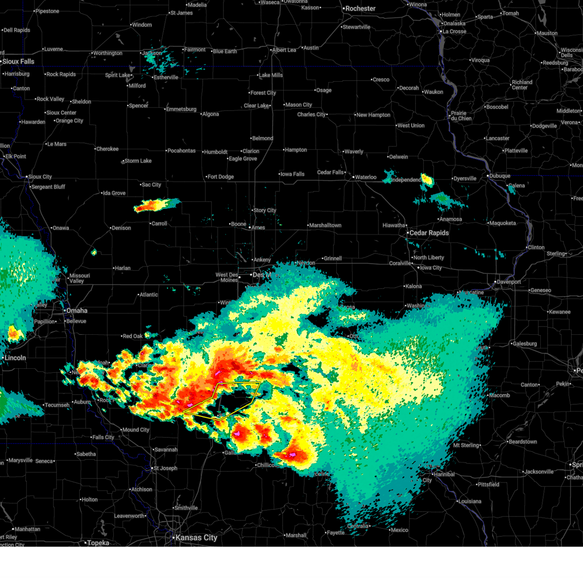
 At 439 pm cdt, severe thunderstorms were located along a line extending from near bethany to near pattonsburg, moving northeast at 45 mph (radar indicated). Hazards include tennis ball size hail and 60 mph wind gusts. People and animals outdoors will be injured. expect hail damage to roofs, siding, windows, and vehicles. expect wind damage to roofs, siding, and trees. locations impacted include, bethany, gallatin, princeton, jamesport, gilman city, pattonsburg, coffey, jameson, mcfall, mount moriah, brimson, and modena. This includes interstate 35 in missouri between mile markers 65 and 93. At 439 pm cdt, severe thunderstorms were located along a line extending from near bethany to near pattonsburg, moving northeast at 45 mph (radar indicated). Hazards include tennis ball size hail and 60 mph wind gusts. People and animals outdoors will be injured. expect hail damage to roofs, siding, windows, and vehicles. expect wind damage to roofs, siding, and trees. locations impacted include, bethany, gallatin, princeton, jamesport, gilman city, pattonsburg, coffey, jameson, mcfall, mount moriah, brimson, and modena. This includes interstate 35 in missouri between mile markers 65 and 93.
|
| 6/10/2026 4:28 PM CDT |
 Svreax the national weather service in pleasant hill has issued a * severe thunderstorm warning for, daviess county in north central missouri, western grundy county in north central missouri, southeastern gentry county in northwestern missouri, southwestern mercer county in north central missouri, southern harrison county in north central missouri, northeastern dekalb county in northwestern missouri, northwestern livingston county in north central missouri, * until 530 pm cdt. * at 428 pm cdt, severe thunderstorms were located along a line extending from 6 miles north of pattonsburg to 8 miles northeast of maysville, moving northeast at 45 mph (radar indicated). Hazards include golf ball size hail and 60 mph wind gusts. People and animals outdoors will be injured. expect hail damage to roofs, siding, windows, and vehicles. Expect wind damage to roofs, siding, and trees. Svreax the national weather service in pleasant hill has issued a * severe thunderstorm warning for, daviess county in north central missouri, western grundy county in north central missouri, southeastern gentry county in northwestern missouri, southwestern mercer county in north central missouri, southern harrison county in north central missouri, northeastern dekalb county in northwestern missouri, northwestern livingston county in north central missouri, * until 530 pm cdt. * at 428 pm cdt, severe thunderstorms were located along a line extending from 6 miles north of pattonsburg to 8 miles northeast of maysville, moving northeast at 45 mph (radar indicated). Hazards include golf ball size hail and 60 mph wind gusts. People and animals outdoors will be injured. expect hail damage to roofs, siding, windows, and vehicles. Expect wind damage to roofs, siding, and trees.
|
| 6/10/2026 4:13 PM CDT |
 Toreax the national weather service in pleasant hill has issued a * tornado warning for, northwestern sullivan county in north central missouri, southeastern mercer county in north central missouri, western putnam county in north central missouri, * until 500 pm cdt. * at 412 pm cdt, a severe thunderstorm capable of producing a tornado was located near princeton, or 19 miles north of trenton, moving northeast at 40 mph (radar indicated rotation. the public reported a funnel cloud with this storm). Hazards include tornado and half dollar size hail. Flying debris will be dangerous to those caught without shelter. mobile homes will be damaged or destroyed. damage to roofs, windows, and vehicles will occur. Tree damage is likely. Toreax the national weather service in pleasant hill has issued a * tornado warning for, northwestern sullivan county in north central missouri, southeastern mercer county in north central missouri, western putnam county in north central missouri, * until 500 pm cdt. * at 412 pm cdt, a severe thunderstorm capable of producing a tornado was located near princeton, or 19 miles north of trenton, moving northeast at 40 mph (radar indicated rotation. the public reported a funnel cloud with this storm). Hazards include tornado and half dollar size hail. Flying debris will be dangerous to those caught without shelter. mobile homes will be damaged or destroyed. damage to roofs, windows, and vehicles will occur. Tree damage is likely.
|
| 6/10/2026 4:08 PM CDT | Golf Ball sized hail reported 0.4 miles ESE of Princeton, MO, social media report. time estimated from radar. |
| 6/10/2026 4:02 PM CDT |
 Svreax the national weather service in pleasant hill has issued a * severe thunderstorm warning for, northwestern sullivan county in north central missouri, mercer county in north central missouri, west central putnam county in north central missouri, * until 445 pm cdt. * at 402 pm cdt, a severe thunderstorm was located near princeton, or 17 miles north of trenton, moving east at 30 mph (radar indicated). Hazards include 60 mph wind gusts and quarter size hail. Hail damage to vehicles is expected. Expect wind damage to roofs, siding, and trees. Svreax the national weather service in pleasant hill has issued a * severe thunderstorm warning for, northwestern sullivan county in north central missouri, mercer county in north central missouri, west central putnam county in north central missouri, * until 445 pm cdt. * at 402 pm cdt, a severe thunderstorm was located near princeton, or 17 miles north of trenton, moving east at 30 mph (radar indicated). Hazards include 60 mph wind gusts and quarter size hail. Hail damage to vehicles is expected. Expect wind damage to roofs, siding, and trees.
|
| 6/10/2026 3:47 PM CDT |
 At 346 pm cdt, a severe thunderstorm was located near mercer, or 20 miles south of corydon, moving northeast at 30 mph (emergency management reported damage in the town of mercer). Hazards include 60 mph wind gusts and quarter size hail. Hail damage to vehicles is expected. expect wind damage to roofs, siding, and trees. Locations impacted include, princeton, mercer, lucerne, and powersville. At 346 pm cdt, a severe thunderstorm was located near mercer, or 20 miles south of corydon, moving northeast at 30 mph (emergency management reported damage in the town of mercer). Hazards include 60 mph wind gusts and quarter size hail. Hail damage to vehicles is expected. expect wind damage to roofs, siding, and trees. Locations impacted include, princeton, mercer, lucerne, and powersville.
|
| 6/10/2026 3:39 PM CDT |
 Toreax the national weather service in pleasant hill has issued a * tornado warning for, northwestern sullivan county in north central missouri, eastern mercer county in north central missouri, western putnam county in north central missouri, * until 430 pm cdt. * at 339 pm cdt, tornado producing storms were located along a line extending from 8 miles east of mercer to princeton, moving east at 25 mph (weather spotters confirmed tornado). Hazards include damaging tornado and quarter size hail. Flying debris will be dangerous to those caught without shelter. mobile homes will be damaged or destroyed. damage to roofs, windows, and vehicles will occur. Tree damage is likely. Toreax the national weather service in pleasant hill has issued a * tornado warning for, northwestern sullivan county in north central missouri, eastern mercer county in north central missouri, western putnam county in north central missouri, * until 430 pm cdt. * at 339 pm cdt, tornado producing storms were located along a line extending from 8 miles east of mercer to princeton, moving east at 25 mph (weather spotters confirmed tornado). Hazards include damaging tornado and quarter size hail. Flying debris will be dangerous to those caught without shelter. mobile homes will be damaged or destroyed. damage to roofs, windows, and vehicles will occur. Tree damage is likely.
|
| 6/10/2026 3:35 PM CDT | Several reports of tree limbs and wires down between princeton and mercer. time estimated from radar. location estimate in mercer county MO, 3 miles SSW of Princeton, MO |
| 6/10/2026 3:35 PM CDT | Quarter sized hail reported 3 miles SSW of Princeton, MO, social media report. time and location estimated. |
| 6/10/2026 3:20 PM CDT |
 Svreax the national weather service in pleasant hill has issued a * severe thunderstorm warning for, mercer county in north central missouri, western putnam county in north central missouri, * until 400 pm cdt. * at 320 pm cdt, a severe thunderstorm was located near cainsville, or 19 miles northeast of bethany, moving east at 40 mph (radar indicated). Hazards include 60 mph wind gusts and quarter size hail. Hail damage to vehicles is expected. Expect wind damage to roofs, siding, and trees. Svreax the national weather service in pleasant hill has issued a * severe thunderstorm warning for, mercer county in north central missouri, western putnam county in north central missouri, * until 400 pm cdt. * at 320 pm cdt, a severe thunderstorm was located near cainsville, or 19 miles northeast of bethany, moving east at 40 mph (radar indicated). Hazards include 60 mph wind gusts and quarter size hail. Hail damage to vehicles is expected. Expect wind damage to roofs, siding, and trees.
|
| 5/18/2026 9:43 PM CDT |
 Svreax the national weather service in pleasant hill has issued a * severe thunderstorm warning for, northeastern grundy county in north central missouri, northwestern sullivan county in north central missouri, mercer county in north central missouri, western putnam county in north central missouri, * until 1030 pm cdt. * at 943 pm cdt, a severe thunderstorm was located over princeton, or 23 miles north of trenton, moving northeast at 50 mph (radar indicated). Hazards include 60 mph wind gusts and penny size hail. expect damage to roofs, siding, and trees Svreax the national weather service in pleasant hill has issued a * severe thunderstorm warning for, northeastern grundy county in north central missouri, northwestern sullivan county in north central missouri, mercer county in north central missouri, western putnam county in north central missouri, * until 1030 pm cdt. * at 943 pm cdt, a severe thunderstorm was located over princeton, or 23 miles north of trenton, moving northeast at 50 mph (radar indicated). Hazards include 60 mph wind gusts and penny size hail. expect damage to roofs, siding, and trees
|
| 5/18/2026 9:39 PM CDT |
 At 938 pm cdt, severe thunderstorms were located along a line extending from 7 miles west of mercer to near spickard, moving northeast at 55 mph (radar indicated). Hazards include 70 mph wind gusts and penny size hail. Expect considerable tree damage. damage is likely to mobile homes, roofs, and outbuildings. Locations impacted include, princeton, mercer, spickard, osgood, and mill grove. At 938 pm cdt, severe thunderstorms were located along a line extending from 7 miles west of mercer to near spickard, moving northeast at 55 mph (radar indicated). Hazards include 70 mph wind gusts and penny size hail. Expect considerable tree damage. damage is likely to mobile homes, roofs, and outbuildings. Locations impacted include, princeton, mercer, spickard, osgood, and mill grove.
|
| 5/18/2026 9:39 PM CDT |
 the severe thunderstorm warning has been cancelled and is no longer in effect the severe thunderstorm warning has been cancelled and is no longer in effect
|
| 5/18/2026 9:26 PM CDT |
 At 926 pm cdt, severe thunderstorms were located along a line extending from near cainsville to 7 miles east of gilman city, moving northeast at 55 mph (radar indicated). Hazards include 70 mph wind gusts and penny size hail. Expect considerable tree damage. damage is likely to mobile homes, roofs, and outbuildings. locations impacted include, princeton, ridgeway, mercer, cainsville, spickard, mount moriah, tindall, brimson, osgood, modena, and mill grove. This includes interstate 35 in missouri between mile markers 104 and 105. At 926 pm cdt, severe thunderstorms were located along a line extending from near cainsville to 7 miles east of gilman city, moving northeast at 55 mph (radar indicated). Hazards include 70 mph wind gusts and penny size hail. Expect considerable tree damage. damage is likely to mobile homes, roofs, and outbuildings. locations impacted include, princeton, ridgeway, mercer, cainsville, spickard, mount moriah, tindall, brimson, osgood, modena, and mill grove. This includes interstate 35 in missouri between mile markers 104 and 105.
|
| 5/18/2026 9:15 PM CDT |
 At 914 pm cdt, severe thunderstorms were located along a line extending from ridgeway to 6 miles north of gallatin, moving northeast at 55 mph (radar indicated). Hazards include 60 mph wind gusts and nickel size hail. Expect damage to roofs, siding, and trees. locations impacted include, trenton, bethany, princeton, ridgeway, gilman city, mercer, cainsville, spickard, galt, coffey, humphreys, mount moriah, tindall, brimson, osgood, modena, and mill grove. This includes interstate 35 in missouri between mile markers 85 and 105. At 914 pm cdt, severe thunderstorms were located along a line extending from ridgeway to 6 miles north of gallatin, moving northeast at 55 mph (radar indicated). Hazards include 60 mph wind gusts and nickel size hail. Expect damage to roofs, siding, and trees. locations impacted include, trenton, bethany, princeton, ridgeway, gilman city, mercer, cainsville, spickard, galt, coffey, humphreys, mount moriah, tindall, brimson, osgood, modena, and mill grove. This includes interstate 35 in missouri between mile markers 85 and 105.
|
| 5/18/2026 9:15 PM CDT |
 the severe thunderstorm warning has been cancelled and is no longer in effect the severe thunderstorm warning has been cancelled and is no longer in effect
|
| 5/18/2026 9:06 PM CDT |
 Svreax the national weather service in pleasant hill has issued a * severe thunderstorm warning for, southeastern worth county in northwestern missouri, northern daviess county in north central missouri, grundy county in north central missouri, southwestern sullivan county in north central missouri, northeastern gentry county in northwestern missouri, mercer county in north central missouri, harrison county in north central missouri, * until 945 pm cdt. * at 906 pm cdt, severe thunderstorms were located along a line extending from near bethany to 6 miles southeast of pattonsburg, moving east at 55 mph (radar indicated). Hazards include 60 mph wind gusts and nickel size hail. expect damage to roofs, siding, and trees Svreax the national weather service in pleasant hill has issued a * severe thunderstorm warning for, southeastern worth county in northwestern missouri, northern daviess county in north central missouri, grundy county in north central missouri, southwestern sullivan county in north central missouri, northeastern gentry county in northwestern missouri, mercer county in north central missouri, harrison county in north central missouri, * until 945 pm cdt. * at 906 pm cdt, severe thunderstorms were located along a line extending from near bethany to 6 miles southeast of pattonsburg, moving east at 55 mph (radar indicated). Hazards include 60 mph wind gusts and nickel size hail. expect damage to roofs, siding, and trees
|
| 5/17/2026 11:45 PM CDT |
 Svreax the national weather service in pleasant hill has issued a * severe thunderstorm warning for, worth county in northwestern missouri, northwestern daviess county in north central missouri, northwestern grundy county in north central missouri, gentry county in northwestern missouri, western mercer county in north central missouri, harrison county in north central missouri, * until 1230 am cdt. * at 1145 pm cdt, severe thunderstorms were located along a line extending from near irena to 6 miles north of albany to near king city, moving east at 55 mph (law enforcement). Hazards include 60 mph wind gusts. expect damage to roofs, siding, and trees Svreax the national weather service in pleasant hill has issued a * severe thunderstorm warning for, worth county in northwestern missouri, northwestern daviess county in north central missouri, northwestern grundy county in north central missouri, gentry county in northwestern missouri, western mercer county in north central missouri, harrison county in north central missouri, * until 1230 am cdt. * at 1145 pm cdt, severe thunderstorms were located along a line extending from near irena to 6 miles north of albany to near king city, moving east at 55 mph (law enforcement). Hazards include 60 mph wind gusts. expect damage to roofs, siding, and trees
|
| 5/16/2026 8:33 PM CDT |
 Svreax the national weather service in pleasant hill has issued a * severe thunderstorm warning for, northern daviess county in north central missouri, northwestern grundy county in north central missouri, east central gentry county in northwestern missouri, southern mercer county in north central missouri, southern harrison county in north central missouri, * until 900 pm cdt. * at 833 pm cdt, severe thunderstorms were located along a line extending from near princeton to near gilman city to 9 miles northwest of pattonsburg, moving east at 40 mph (radar indicated). Hazards include 60 mph wind gusts and quarter size hail. Hail damage to vehicles is expected. Expect wind damage to roofs, siding, and trees. Svreax the national weather service in pleasant hill has issued a * severe thunderstorm warning for, northern daviess county in north central missouri, northwestern grundy county in north central missouri, east central gentry county in northwestern missouri, southern mercer county in north central missouri, southern harrison county in north central missouri, * until 900 pm cdt. * at 833 pm cdt, severe thunderstorms were located along a line extending from near princeton to near gilman city to 9 miles northwest of pattonsburg, moving east at 40 mph (radar indicated). Hazards include 60 mph wind gusts and quarter size hail. Hail damage to vehicles is expected. Expect wind damage to roofs, siding, and trees.
|
| 5/16/2026 7:51 PM CDT |
 Svreax the national weather service in pleasant hill has issued a * severe thunderstorm warning for, northeastern gentry county in northwestern missouri, northwestern mercer county in north central missouri, central harrison county in north central missouri, * until 830 pm cdt. * at 751 pm cdt, severe thunderstorms were located along a line extending from near lamoni to near eagleville to near albany, moving east at 35 mph (radar indicated). Hazards include 60 mph wind gusts and quarter size hail. Hail damage to vehicles is expected. Expect wind damage to roofs, siding, and trees. Svreax the national weather service in pleasant hill has issued a * severe thunderstorm warning for, northeastern gentry county in northwestern missouri, northwestern mercer county in north central missouri, central harrison county in north central missouri, * until 830 pm cdt. * at 751 pm cdt, severe thunderstorms were located along a line extending from near lamoni to near eagleville to near albany, moving east at 35 mph (radar indicated). Hazards include 60 mph wind gusts and quarter size hail. Hail damage to vehicles is expected. Expect wind damage to roofs, siding, and trees.
|
| 4/23/2026 9:36 PM CDT |
 At 936 pm cdt, severe thunderstorms were located along a line extending from near corydon to near jamesport, moving east at 50 mph (radar indicated). Hazards include 60 mph wind gusts and penny size hail. Expect damage to roofs, siding, and trees. Locations impacted include, trenton, gallatin, princeton, jamesport, gilman city, mercer, cainsville, spickard, newtown, jameson, mount moriah, lucerne, tindall, brimson, harris, powersville, south lineville, modena, and mill grove. At 936 pm cdt, severe thunderstorms were located along a line extending from near corydon to near jamesport, moving east at 50 mph (radar indicated). Hazards include 60 mph wind gusts and penny size hail. Expect damage to roofs, siding, and trees. Locations impacted include, trenton, gallatin, princeton, jamesport, gilman city, mercer, cainsville, spickard, newtown, jameson, mount moriah, lucerne, tindall, brimson, harris, powersville, south lineville, modena, and mill grove.
|
| 4/23/2026 9:16 PM CDT |
 Svreax the national weather service in pleasant hill has issued a * severe thunderstorm warning for, northern daviess county in north central missouri, grundy county in north central missouri, northwestern sullivan county in north central missouri, mercer county in north central missouri, western putnam county in north central missouri, eastern harrison county in north central missouri, east central dekalb county in northwestern missouri, * until 1000 pm cdt. * at 916 pm cdt, severe thunderstorms were located along a line extending from 8 miles north of mercer to near gallatin, moving east at 50 mph (radar indicated). Hazards include 60 mph wind gusts and penny size hail. expect damage to roofs, siding, and trees Svreax the national weather service in pleasant hill has issued a * severe thunderstorm warning for, northern daviess county in north central missouri, grundy county in north central missouri, northwestern sullivan county in north central missouri, mercer county in north central missouri, western putnam county in north central missouri, eastern harrison county in north central missouri, east central dekalb county in northwestern missouri, * until 1000 pm cdt. * at 916 pm cdt, severe thunderstorms were located along a line extending from 8 miles north of mercer to near gallatin, moving east at 50 mph (radar indicated). Hazards include 60 mph wind gusts and penny size hail. expect damage to roofs, siding, and trees
|
| 4/17/2026 4:24 PM CDT |
 The storms which prompted the warning have moved out of the area. therefore, the warning will be allowed to expire. a tornado watch remains in effect until 900 pm cdt for north central missouri. to report severe weather, contact your nearest law enforcement agency. they will relay your report to the national weather service pleasant hill. The storms which prompted the warning have moved out of the area. therefore, the warning will be allowed to expire. a tornado watch remains in effect until 900 pm cdt for north central missouri. to report severe weather, contact your nearest law enforcement agency. they will relay your report to the national weather service pleasant hill.
|
| 4/17/2026 3:57 PM CDT |
 the severe thunderstorm warning has been cancelled and is no longer in effect the severe thunderstorm warning has been cancelled and is no longer in effect
|
| 4/17/2026 3:57 PM CDT |
 At 357 pm cdt, severe thunderstorms were located along a line extending from 6 miles east of mercer to near princeton, moving northeast at 40 mph (radar indicated). Hazards include 60 mph wind gusts and half dollar size hail. Hail damage to vehicles is expected. expect wind damage to roofs, siding, and trees. Locations impacted include, princeton, mercer, lucerne, powersville, and south lineville. At 357 pm cdt, severe thunderstorms were located along a line extending from 6 miles east of mercer to near princeton, moving northeast at 40 mph (radar indicated). Hazards include 60 mph wind gusts and half dollar size hail. Hail damage to vehicles is expected. expect wind damage to roofs, siding, and trees. Locations impacted include, princeton, mercer, lucerne, powersville, and south lineville.
|
| 4/17/2026 3:33 PM CDT |
 Svreax the national weather service in pleasant hill has issued a * severe thunderstorm warning for, mercer county in north central missouri, western putnam county in north central missouri, east central harrison county in north central missouri, * until 430 pm cdt. * at 333 pm cdt, severe thunderstorms were located along a line extending from near cainsville to near ridgeway, moving east at 40 mph (radar indicated). Hazards include golf ball size hail and 60 mph wind gusts. People and animals outdoors will be injured. expect hail damage to roofs, siding, windows, and vehicles. Expect wind damage to roofs, siding, and trees. Svreax the national weather service in pleasant hill has issued a * severe thunderstorm warning for, mercer county in north central missouri, western putnam county in north central missouri, east central harrison county in north central missouri, * until 430 pm cdt. * at 333 pm cdt, severe thunderstorms were located along a line extending from near cainsville to near ridgeway, moving east at 40 mph (radar indicated). Hazards include golf ball size hail and 60 mph wind gusts. People and animals outdoors will be injured. expect hail damage to roofs, siding, windows, and vehicles. Expect wind damage to roofs, siding, and trees.
|
| 4/17/2026 3:17 PM CDT |
 the severe thunderstorm warning has been cancelled and is no longer in effect the severe thunderstorm warning has been cancelled and is no longer in effect
|
| 4/17/2026 3:17 PM CDT |
 At 316 pm cdt, a severe thunderstorm was located 8 miles north of galt, or 14 miles northeast of trenton, moving northeast at 55 mph (radar indicated). Hazards include ping pong ball size hail and 60 mph wind gusts. People and animals outdoors will be injured. expect hail damage to roofs, siding, windows, and vehicles. expect wind damage to roofs, siding, and trees. Locations impacted include, trenton, milan, princeton, mercer, browning, spickard, galt, chula, laredo, newtown, humphreys, tindall, harris, osgood, mill grove, and reger. At 316 pm cdt, a severe thunderstorm was located 8 miles north of galt, or 14 miles northeast of trenton, moving northeast at 55 mph (radar indicated). Hazards include ping pong ball size hail and 60 mph wind gusts. People and animals outdoors will be injured. expect hail damage to roofs, siding, windows, and vehicles. expect wind damage to roofs, siding, and trees. Locations impacted include, trenton, milan, princeton, mercer, browning, spickard, galt, chula, laredo, newtown, humphreys, tindall, harris, osgood, mill grove, and reger.
|
| 4/17/2026 2:51 PM CDT |
 Svreax the national weather service in pleasant hill has issued a * severe thunderstorm warning for, east central daviess county in north central missouri, northwestern linn county in north central missouri, grundy county in north central missouri, sullivan county in north central missouri, mercer county in north central missouri, southwestern putnam county in north central missouri, northwestern livingston county in north central missouri, * until 330 pm cdt. * at 250 pm cdt, a severe thunderstorm was located near trenton, moving northeast at 45 mph (radar indicated). Hazards include 60 mph wind gusts and half dollar size hail. Hail damage to vehicles is expected. Expect wind damage to roofs, siding, and trees. Svreax the national weather service in pleasant hill has issued a * severe thunderstorm warning for, east central daviess county in north central missouri, northwestern linn county in north central missouri, grundy county in north central missouri, sullivan county in north central missouri, mercer county in north central missouri, southwestern putnam county in north central missouri, northwestern livingston county in north central missouri, * until 330 pm cdt. * at 250 pm cdt, a severe thunderstorm was located near trenton, moving northeast at 45 mph (radar indicated). Hazards include 60 mph wind gusts and half dollar size hail. Hail damage to vehicles is expected. Expect wind damage to roofs, siding, and trees.
|
| 4/15/2026 6:19 PM CDT |
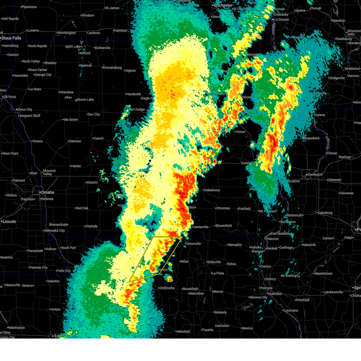
 At 619 pm cdt, a severe thunderstorm was located near princeton, or 22 miles south of leon, moving northeast at 45 mph (radar indicated). Hazards include two inch hail and 60 mph wind gusts. People and animals outdoors will be injured. expect hail damage to roofs, siding, windows, and vehicles. expect wind damage to roofs, siding, and trees. Locations impacted include, princeton, mercer, cainsville, powersville, and south lineville. At 619 pm cdt, a severe thunderstorm was located near princeton, or 22 miles south of leon, moving northeast at 45 mph (radar indicated). Hazards include two inch hail and 60 mph wind gusts. People and animals outdoors will be injured. expect hail damage to roofs, siding, windows, and vehicles. expect wind damage to roofs, siding, and trees. Locations impacted include, princeton, mercer, cainsville, powersville, and south lineville.
|
| 4/15/2026 5:35 PM CDT |
 The storms which prompted the warning have moved out of the area. therefore, the warning will be allowed to expire. a tornado watch remains in effect until 900 pm cdt for north central missouri. The storms which prompted the warning have moved out of the area. therefore, the warning will be allowed to expire. a tornado watch remains in effect until 900 pm cdt for north central missouri.
|
| 4/15/2026 5:23 PM CDT |
 At 523 pm cdt, severe thunderstorms were located along a line extending from 9 miles west of mercer to near cainsville, moving northeast at 45 mph (emergency management). Hazards include golf ball size hail and 60 mph wind gusts. People and animals outdoors will be injured. expect hail damage to roofs, siding, windows, and vehicles. expect wind damage to roofs, siding, and trees. Locations impacted include, princeton, mercer, cainsville, pleasanton, and south lineville. At 523 pm cdt, severe thunderstorms were located along a line extending from 9 miles west of mercer to near cainsville, moving northeast at 45 mph (emergency management). Hazards include golf ball size hail and 60 mph wind gusts. People and animals outdoors will be injured. expect hail damage to roofs, siding, windows, and vehicles. expect wind damage to roofs, siding, and trees. Locations impacted include, princeton, mercer, cainsville, pleasanton, and south lineville.
|
| 4/15/2026 5:11 PM CDT |
 At 510 pm cdt, severe thunderstorms were located along a line extending from near cainsville to 8 miles southeast of ridgeway, moving northeast at 55 mph (emergency management). Hazards include two inch hail and 60 mph wind gusts. People and animals outdoors will be injured. expect hail damage to roofs, siding, windows, and vehicles. expect wind damage to roofs, siding, and trees. locations impacted include, princeton, ridgeway, mercer, eagleville, cainsville, blythedale, mount moriah, pleasanton, south lineville, modena, and mill grove. This includes interstate 35 in missouri between mile markers 101 and 114. At 510 pm cdt, severe thunderstorms were located along a line extending from near cainsville to 8 miles southeast of ridgeway, moving northeast at 55 mph (emergency management). Hazards include two inch hail and 60 mph wind gusts. People and animals outdoors will be injured. expect hail damage to roofs, siding, windows, and vehicles. expect wind damage to roofs, siding, and trees. locations impacted include, princeton, ridgeway, mercer, eagleville, cainsville, blythedale, mount moriah, pleasanton, south lineville, modena, and mill grove. This includes interstate 35 in missouri between mile markers 101 and 114.
|
| 4/15/2026 5:04 PM CDT |
 Svreax the national weather service in pleasant hill has issued a * severe thunderstorm warning for, northwestern grundy county in north central missouri, mercer county in north central missouri, eastern harrison county in north central missouri, * until 545 pm cdt. * at 503 pm cdt, severe thunderstorms were located along a line extending from ridgeway to 7 miles east of bethany, moving northeast at 45 mph (emergency management. this storm has a history of producing large hail and wind damage). Hazards include two inch hail and 60 mph wind gusts. People and animals outdoors will be injured. expect hail damage to roofs, siding, windows, and vehicles. Expect wind damage to roofs, siding, and trees. Svreax the national weather service in pleasant hill has issued a * severe thunderstorm warning for, northwestern grundy county in north central missouri, mercer county in north central missouri, eastern harrison county in north central missouri, * until 545 pm cdt. * at 503 pm cdt, severe thunderstorms were located along a line extending from ridgeway to 7 miles east of bethany, moving northeast at 45 mph (emergency management. this storm has a history of producing large hail and wind damage). Hazards include two inch hail and 60 mph wind gusts. People and animals outdoors will be injured. expect hail damage to roofs, siding, windows, and vehicles. Expect wind damage to roofs, siding, and trees.
|
| 7/11/2025 6:53 PM CDT |
 The storm which prompted the warning has moved out of the area. therefore, the warning will be allowed to expire. a tornado watch remains in effect until 800 pm cdt for north central missouri. a severe thunderstorm watch remains in effect until 1000 pm cdt for north central missouri. The storm which prompted the warning has moved out of the area. therefore, the warning will be allowed to expire. a tornado watch remains in effect until 800 pm cdt for north central missouri. a severe thunderstorm watch remains in effect until 1000 pm cdt for north central missouri.
|
| 7/11/2025 6:42 PM CDT |
 the severe thunderstorm warning has been cancelled and is no longer in effect the severe thunderstorm warning has been cancelled and is no longer in effect
|
| 7/11/2025 6:42 PM CDT |
 At 641 pm cdt, a severe thunderstorm was located near spickard, or 16 miles north of trenton, moving northeast at 30 mph (radar indicated). Hazards include 60 mph wind gusts and quarter size hail. Hail damage to vehicles is expected. expect wind damage to roofs, siding, and trees. Locations impacted include, princeton, spickard, tindall, mill grove, and modena. At 641 pm cdt, a severe thunderstorm was located near spickard, or 16 miles north of trenton, moving northeast at 30 mph (radar indicated). Hazards include 60 mph wind gusts and quarter size hail. Hail damage to vehicles is expected. expect wind damage to roofs, siding, and trees. Locations impacted include, princeton, spickard, tindall, mill grove, and modena.
|
| 7/11/2025 6:36 PM CDT |
 At 635 pm cdt, a severe thunderstorm was located near spickard, or 11 miles northwest of trenton, moving northeast at 15 mph (radar indicated). Hazards include 60 mph wind gusts and quarter size hail. Hail damage to vehicles is expected. expect wind damage to roofs, siding, and trees. locations impacted include, princeton, gilman city, spickard, coffey, tindall, brimson, modena, and mill grove. This includes interstate 35 in missouri between mile markers 82 and 83. At 635 pm cdt, a severe thunderstorm was located near spickard, or 11 miles northwest of trenton, moving northeast at 15 mph (radar indicated). Hazards include 60 mph wind gusts and quarter size hail. Hail damage to vehicles is expected. expect wind damage to roofs, siding, and trees. locations impacted include, princeton, gilman city, spickard, coffey, tindall, brimson, modena, and mill grove. This includes interstate 35 in missouri between mile markers 82 and 83.
|
| 7/11/2025 6:16 PM CDT |
 Svreax the national weather service in pleasant hill has issued a * severe thunderstorm warning for, northeastern daviess county in north central missouri, northern grundy county in north central missouri, southwestern mercer county in north central missouri, southeastern harrison county in north central missouri, * until 700 pm cdt. * at 616 pm cdt, a severe thunderstorm was located 7 miles northeast of gilman city, or 11 miles northwest of trenton, moving northeast at 15 mph (radar indicated). Hazards include 60 mph wind gusts and quarter size hail. Hail damage to vehicles is expected. Expect wind damage to roofs, siding, and trees. Svreax the national weather service in pleasant hill has issued a * severe thunderstorm warning for, northeastern daviess county in north central missouri, northern grundy county in north central missouri, southwestern mercer county in north central missouri, southeastern harrison county in north central missouri, * until 700 pm cdt. * at 616 pm cdt, a severe thunderstorm was located 7 miles northeast of gilman city, or 11 miles northwest of trenton, moving northeast at 15 mph (radar indicated). Hazards include 60 mph wind gusts and quarter size hail. Hail damage to vehicles is expected. Expect wind damage to roofs, siding, and trees.
|
| 7/31/2024 9:07 PM CDT |
 The storm which prompted the warning has weakened below severe limits, and no longer poses an immediate threat to life or property. therefore, the warning will be allowed to expire. a severe thunderstorm watch remains in effect until 100 am cdt for north central missouri. The storm which prompted the warning has weakened below severe limits, and no longer poses an immediate threat to life or property. therefore, the warning will be allowed to expire. a severe thunderstorm watch remains in effect until 100 am cdt for north central missouri.
|
| 7/31/2024 8:30 PM CDT |
 Svreax the national weather service in pleasant hill has issued a * severe thunderstorm warning for, northwestern sullivan county in north central missouri, mercer county in north central missouri, western putnam county in north central missouri, northern harrison county in north central missouri, * until 915 pm cdt. * at 830 pm cdt, a severe thunderstorm was located near cainsville, or 16 miles south of leon, moving east at 45 mph (radar indicated). Hazards include 60 mph wind gusts and penny size hail. expect damage to roofs, siding, and trees Svreax the national weather service in pleasant hill has issued a * severe thunderstorm warning for, northwestern sullivan county in north central missouri, mercer county in north central missouri, western putnam county in north central missouri, northern harrison county in north central missouri, * until 915 pm cdt. * at 830 pm cdt, a severe thunderstorm was located near cainsville, or 16 miles south of leon, moving east at 45 mph (radar indicated). Hazards include 60 mph wind gusts and penny size hail. expect damage to roofs, siding, and trees
|
| 7/2/2024 5:22 PM CDT |
 Svreax the national weather service in pleasant hill has issued a * severe thunderstorm warning for, northwestern sullivan county in north central missouri, mercer county in north central missouri, western putnam county in north central missouri, east central harrison county in north central missouri, * until 615 pm cdt. * at 520 pm cdt, a severe thunderstorm was located near cainsville, or 15 miles northeast of bethany, moving northeast at 30 mph. additional severe thunderstorms were located near princeton in northeast mercer county and powersville in northwest putnam county (radar indicated). Hazards include 60 mph wind gusts and half dollar size hail. Hail damage to vehicles is expected. Expect wind damage to roofs, siding, and trees. Svreax the national weather service in pleasant hill has issued a * severe thunderstorm warning for, northwestern sullivan county in north central missouri, mercer county in north central missouri, western putnam county in north central missouri, east central harrison county in north central missouri, * until 615 pm cdt. * at 520 pm cdt, a severe thunderstorm was located near cainsville, or 15 miles northeast of bethany, moving northeast at 30 mph. additional severe thunderstorms were located near princeton in northeast mercer county and powersville in northwest putnam county (radar indicated). Hazards include 60 mph wind gusts and half dollar size hail. Hail damage to vehicles is expected. Expect wind damage to roofs, siding, and trees.
|
| 7/2/2024 5:15 PM CDT |
 At 514 pm cdt, a severe thunderstorm was located over cainsville, or 16 miles northeast of bethany, moving northeast at 30 mph. additional severe storms were located east of the cities of princeton and mercer, moving northeast at 30 mph (radar indicated). Hazards include 60 mph wind gusts and quarter size hail. Hail damage to vehicles is expected. expect wind damage to roofs, siding, and trees. Locations impacted include, princeton, ridgeway, mercer, cainsville, mount moriah, pleasanton, south lineville, modena, and mill grove. At 514 pm cdt, a severe thunderstorm was located over cainsville, or 16 miles northeast of bethany, moving northeast at 30 mph. additional severe storms were located east of the cities of princeton and mercer, moving northeast at 30 mph (radar indicated). Hazards include 60 mph wind gusts and quarter size hail. Hail damage to vehicles is expected. expect wind damage to roofs, siding, and trees. Locations impacted include, princeton, ridgeway, mercer, cainsville, mount moriah, pleasanton, south lineville, modena, and mill grove.
|
| 7/2/2024 5:03 PM CDT |
 At 502 pm cdt, a severe thunderstorm was located near ridgeway, or 10 miles northeast of bethany, moving northeast at 30 mph. additional severe thunderstorms are located near the cities of princeton and mercer moving northeast at 30 mph (radar indicated). Hazards include 60 mph wind gusts and quarter size hail. Hail damage to vehicles is expected. expect wind damage to roofs, siding, and trees. locations impacted include, bethany, princeton, ridgeway, mercer, eagleville, cainsville, blythedale, mount moriah, pleasanton, south lineville, modena, and mill grove. This includes interstate 35 in missouri between mile markers 89 and 114. At 502 pm cdt, a severe thunderstorm was located near ridgeway, or 10 miles northeast of bethany, moving northeast at 30 mph. additional severe thunderstorms are located near the cities of princeton and mercer moving northeast at 30 mph (radar indicated). Hazards include 60 mph wind gusts and quarter size hail. Hail damage to vehicles is expected. expect wind damage to roofs, siding, and trees. locations impacted include, bethany, princeton, ridgeway, mercer, eagleville, cainsville, blythedale, mount moriah, pleasanton, south lineville, modena, and mill grove. This includes interstate 35 in missouri between mile markers 89 and 114.
|
| 7/2/2024 4:42 PM CDT |
 At 440 pm cdt, a severe thunderstorm was located over bethany, moving northeast at 30 mph. additional severe thunderstorms were located near the city of mercer headed northeast at 30 mph (radar indicated). Hazards include 60 mph wind gusts and quarter size hail. Hail damage to vehicles is expected. expect wind damage to roofs, siding, and trees. locations impacted include, bethany, princeton, ridgeway, mercer, eagleville, new hampton, cainsville, blythedale, mount moriah, pleasanton, south lineville, modena, mill grove, and martinsville. This includes interstate 35 in missouri between mile markers 83 and 114. At 440 pm cdt, a severe thunderstorm was located over bethany, moving northeast at 30 mph. additional severe thunderstorms were located near the city of mercer headed northeast at 30 mph (radar indicated). Hazards include 60 mph wind gusts and quarter size hail. Hail damage to vehicles is expected. expect wind damage to roofs, siding, and trees. locations impacted include, bethany, princeton, ridgeway, mercer, eagleville, new hampton, cainsville, blythedale, mount moriah, pleasanton, south lineville, modena, mill grove, and martinsville. This includes interstate 35 in missouri between mile markers 83 and 114.
|
| 7/2/2024 4:42 PM CDT |
 the severe thunderstorm warning has been cancelled and is no longer in effect the severe thunderstorm warning has been cancelled and is no longer in effect
|
| 7/2/2024 4:28 PM CDT |
 Svreax the national weather service in pleasant hill has issued a * severe thunderstorm warning for, northeastern gentry county in northwestern missouri, mercer county in north central missouri, harrison county in north central missouri, * until 530 pm cdt. * at 427 pm cdt, a severe thunderstorms was located near new hampton, or 8 miles southwest of bethany, moving northeast at 30 mph. other strong to severe thunderstorms were located in portion of mercer county moving northeast at 30 mph (radar indicated). Hazards include 60 mph wind gusts and quarter size hail. Hail damage to vehicles is expected. Expect wind damage to roofs, siding, and trees. Svreax the national weather service in pleasant hill has issued a * severe thunderstorm warning for, northeastern gentry county in northwestern missouri, mercer county in north central missouri, harrison county in north central missouri, * until 530 pm cdt. * at 427 pm cdt, a severe thunderstorms was located near new hampton, or 8 miles southwest of bethany, moving northeast at 30 mph. other strong to severe thunderstorms were located in portion of mercer county moving northeast at 30 mph (radar indicated). Hazards include 60 mph wind gusts and quarter size hail. Hail damage to vehicles is expected. Expect wind damage to roofs, siding, and trees.
|
| 6/26/2024 12:27 AM CDT |
 The storms which prompted the warning have moved out of the area. therefore, the warning will be allowed to expire. however, gusty winds and heavy rain are still possible with these thunderstorms. a severe thunderstorm watch remains in effect until 700 am cdt for north central and northwestern missouri. The storms which prompted the warning have moved out of the area. therefore, the warning will be allowed to expire. however, gusty winds and heavy rain are still possible with these thunderstorms. a severe thunderstorm watch remains in effect until 700 am cdt for north central and northwestern missouri.
|
| 6/25/2024 11:56 PM CDT |
 At 1155 pm cdt, severe thunderstorms were located along a line extending from near cainsville to near new hampton to near albany to 10 miles southeast of maryville, moving southeast at 65 mph (law enforcement 70 mph winds in albany). Hazards include 70 mph wind gusts and nickel size hail. Expect considerable tree damage. damage is likely to mobile homes, roofs, and outbuildings. locations impacted include, maryville, bethany, albany, stanberry, princeton, king city, ridgeway, ravenwood, gilman city, pattonsburg, mercer, eagleville, new hampton, cainsville, spickard, barnard, conception junction, blythedale, bolckow, and coffey. This includes interstate 35 in missouri between mile markers 75 and 107. At 1155 pm cdt, severe thunderstorms were located along a line extending from near cainsville to near new hampton to near albany to 10 miles southeast of maryville, moving southeast at 65 mph (law enforcement 70 mph winds in albany). Hazards include 70 mph wind gusts and nickel size hail. Expect considerable tree damage. damage is likely to mobile homes, roofs, and outbuildings. locations impacted include, maryville, bethany, albany, stanberry, princeton, king city, ridgeway, ravenwood, gilman city, pattonsburg, mercer, eagleville, new hampton, cainsville, spickard, barnard, conception junction, blythedale, bolckow, and coffey. This includes interstate 35 in missouri between mile markers 75 and 107.
|
| 6/25/2024 11:36 PM CDT |
 Svreax the national weather service in pleasant hill has issued a * severe thunderstorm warning for, northern daviess county in north central missouri, northwestern grundy county in north central missouri, gentry county in northwestern missouri, mercer county in north central missouri, harrison county in north central missouri, southeastern nodaway county in northwestern missouri, northeastern andrew county in northwestern missouri, * until 1230 am cdt. * at 1135 pm cdt, severe thunderstorms were located along a line extending from near lamoni to grant city to near ravenwood, moving southeast at 45 mph (radar indicated). Hazards include 70 mph wind gusts and nickel size hail. Expect considerable tree damage. Damage is likely to mobile homes, roofs, and outbuildings. Svreax the national weather service in pleasant hill has issued a * severe thunderstorm warning for, northern daviess county in north central missouri, northwestern grundy county in north central missouri, gentry county in northwestern missouri, mercer county in north central missouri, harrison county in north central missouri, southeastern nodaway county in northwestern missouri, northeastern andrew county in northwestern missouri, * until 1230 am cdt. * at 1135 pm cdt, severe thunderstorms were located along a line extending from near lamoni to grant city to near ravenwood, moving southeast at 45 mph (radar indicated). Hazards include 70 mph wind gusts and nickel size hail. Expect considerable tree damage. Damage is likely to mobile homes, roofs, and outbuildings.
|
| 5/26/2024 9:25 PM CDT |
 The storm which prompted the warning has moved out of the area. therefore, the warning will be allowed to expire. The storm which prompted the warning has moved out of the area. therefore, the warning will be allowed to expire.
|
| 5/26/2024 9:20 PM CDT | Hen Egg sized hail reported 7.5 miles WSW of Princeton, MO |
| 5/26/2024 9:15 PM CDT | Ping Pong Ball sized hail reported 7.8 miles WSW of Princeton, MO |
| 5/26/2024 9:12 PM CDT | Storm damage reported in mercer county MO, 7.5 miles WSW of Princeton, MO |
| 5/26/2024 8:44 PM CDT |
 Svreax the national weather service in pleasant hill has issued a * severe thunderstorm warning for, northwestern mercer county in north central missouri, * until 930 pm cdt. * at 843 pm cdt, a severe thunderstorm was located 9 miles northwest of mercer, or 10 miles southeast of leon, moving southeast at 25 mph (radar indicated). Hazards include 60 mph wind gusts and quarter size hail. Hail damage to vehicles is expected. Expect wind damage to roofs, siding, and trees. Svreax the national weather service in pleasant hill has issued a * severe thunderstorm warning for, northwestern mercer county in north central missouri, * until 930 pm cdt. * at 843 pm cdt, a severe thunderstorm was located 9 miles northwest of mercer, or 10 miles southeast of leon, moving southeast at 25 mph (radar indicated). Hazards include 60 mph wind gusts and quarter size hail. Hail damage to vehicles is expected. Expect wind damage to roofs, siding, and trees.
|
| 5/24/2024 2:27 AM CDT |
 Svreax the national weather service in pleasant hill has issued a * severe thunderstorm warning for, northwestern sullivan county in north central missouri, eastern mercer county in north central missouri, western putnam county in north central missouri, * until 315 am cdt. * at 227 am cdt, a severe thunderstorm was located near spickard, or 14 miles north of trenton, moving northeast at 25 mph (radar indicated). Hazards include 60 mph wind gusts and quarter size hail. Hail damage to vehicles is expected. Expect wind damage to roofs, siding, and trees. Svreax the national weather service in pleasant hill has issued a * severe thunderstorm warning for, northwestern sullivan county in north central missouri, eastern mercer county in north central missouri, western putnam county in north central missouri, * until 315 am cdt. * at 227 am cdt, a severe thunderstorm was located near spickard, or 14 miles north of trenton, moving northeast at 25 mph (radar indicated). Hazards include 60 mph wind gusts and quarter size hail. Hail damage to vehicles is expected. Expect wind damage to roofs, siding, and trees.
|
| 5/21/2024 5:06 PM CDT |
 The storm which prompted the warning has moved out of the area. therefore, the warning will be allowed to expire. a tornado watch remains in effect until 1000 pm cdt for north central missouri. The storm which prompted the warning has moved out of the area. therefore, the warning will be allowed to expire. a tornado watch remains in effect until 1000 pm cdt for north central missouri.
|
| 5/21/2024 4:51 PM CDT |
 Toreax the national weather service in pleasant hill has issued a * tornado warning for, northern mercer county in north central missouri, * until 515 pm cdt. * at 450 pm cdt, a severe thunderstorm capable of producing a tornado was located near mercer, or 17 miles southeast of leon, moving north at 50 mph (radar indicated rotation). Hazards include tornado. Flying debris will be dangerous to those caught without shelter. mobile homes will be damaged or destroyed. damage to roofs, windows, and vehicles will occur. Tree damage is likely. Toreax the national weather service in pleasant hill has issued a * tornado warning for, northern mercer county in north central missouri, * until 515 pm cdt. * at 450 pm cdt, a severe thunderstorm capable of producing a tornado was located near mercer, or 17 miles southeast of leon, moving north at 50 mph (radar indicated rotation). Hazards include tornado. Flying debris will be dangerous to those caught without shelter. mobile homes will be damaged or destroyed. damage to roofs, windows, and vehicles will occur. Tree damage is likely.
|
| 5/21/2024 4:46 PM CDT |
 Svreax the national weather service in pleasant hill has issued a * severe thunderstorm warning for, northern mercer county in north central missouri, * until 515 pm cdt. * at 446 pm cdt, a severe thunderstorm was located near princeton, or 21 miles south of leon, moving northeast at 65 mph (radar indicated). Hazards include 60 mph wind gusts and quarter size hail. Hail damage to vehicles is expected. Expect wind damage to roofs, siding, and trees. Svreax the national weather service in pleasant hill has issued a * severe thunderstorm warning for, northern mercer county in north central missouri, * until 515 pm cdt. * at 446 pm cdt, a severe thunderstorm was located near princeton, or 21 miles south of leon, moving northeast at 65 mph (radar indicated). Hazards include 60 mph wind gusts and quarter size hail. Hail damage to vehicles is expected. Expect wind damage to roofs, siding, and trees.
|
| 5/21/2024 4:09 PM CDT |
 Svreax the national weather service in pleasant hill has issued a * severe thunderstorm warning for, northwestern mercer county in north central missouri, southeastern harrison county in north central missouri, * until 445 pm cdt. * at 408 pm cdt, a severe thunderstorm was located near pattonsburg, or 11 miles south of bethany, moving northeast at 85 mph (radar indicated). Hazards include 60 mph wind gusts and quarter size hail. Hail damage to vehicles is expected. Expect wind damage to roofs, siding, and trees. Svreax the national weather service in pleasant hill has issued a * severe thunderstorm warning for, northwestern mercer county in north central missouri, southeastern harrison county in north central missouri, * until 445 pm cdt. * at 408 pm cdt, a severe thunderstorm was located near pattonsburg, or 11 miles south of bethany, moving northeast at 85 mph (radar indicated). Hazards include 60 mph wind gusts and quarter size hail. Hail damage to vehicles is expected. Expect wind damage to roofs, siding, and trees.
|
| 5/7/2024 12:51 AM CDT |
 At 1250 am cdt, severe thunderstorms were located along a line extending from 6 miles north of mercer to near wheeling, moving northeast at 45 mph (emergency management. a 57 mph wind gust was reported in trenton. numerous power outages have been reported in harrison county). Hazards include 60 mph wind gusts. Expect damage to roofs, siding, and trees. Locations impacted include, chillicothe, trenton, brookfield, marceline, milan, unionville, princeton, meadville, laclede, mercer, cainsville, linneus, wheeling, utica, browning, spickard, galt, chula, laredo, and purdin. At 1250 am cdt, severe thunderstorms were located along a line extending from 6 miles north of mercer to near wheeling, moving northeast at 45 mph (emergency management. a 57 mph wind gust was reported in trenton. numerous power outages have been reported in harrison county). Hazards include 60 mph wind gusts. Expect damage to roofs, siding, and trees. Locations impacted include, chillicothe, trenton, brookfield, marceline, milan, unionville, princeton, meadville, laclede, mercer, cainsville, linneus, wheeling, utica, browning, spickard, galt, chula, laredo, and purdin.
|
| 5/7/2024 12:51 AM CDT |
 the severe thunderstorm warning has been cancelled and is no longer in effect the severe thunderstorm warning has been cancelled and is no longer in effect
|
| 5/7/2024 12:21 AM CDT |
 Svreax the national weather service in pleasant hill has issued a * severe thunderstorm warning for, northwestern chariton county in north central missouri, eastern daviess county in north central missouri, linn county in north central missouri, grundy county in north central missouri, sullivan county in north central missouri, mercer county in north central missouri, western putnam county in north central missouri, harrison county in north central missouri, northeastern caldwell county in north central missouri, livingston county in north central missouri, * until 115 am cdt. * at 1220 am cdt, severe thunderstorms were located along a line extending from near eagleville to near braymer, moving northeast at 45 mph (radar indicated). Hazards include 60 mph wind gusts. expect damage to roofs, siding, and trees Svreax the national weather service in pleasant hill has issued a * severe thunderstorm warning for, northwestern chariton county in north central missouri, eastern daviess county in north central missouri, linn county in north central missouri, grundy county in north central missouri, sullivan county in north central missouri, mercer county in north central missouri, western putnam county in north central missouri, harrison county in north central missouri, northeastern caldwell county in north central missouri, livingston county in north central missouri, * until 115 am cdt. * at 1220 am cdt, severe thunderstorms were located along a line extending from near eagleville to near braymer, moving northeast at 45 mph (radar indicated). Hazards include 60 mph wind gusts. expect damage to roofs, siding, and trees
|
| 4/30/2024 9:40 PM CDT |
 The storm which prompted the warning has weakened below severe limits, and no longer poses an immediate threat to life or property. therefore, the warning will be allowed to expire. however, heavy rain is still possible with this thunderstorm. a severe thunderstorm watch remains in effect until midnight cdt for north central missouri. to report severe weather, contact your nearest law enforcement agency. they will relay your report to the national weather service pleasant hill. The storm which prompted the warning has weakened below severe limits, and no longer poses an immediate threat to life or property. therefore, the warning will be allowed to expire. however, heavy rain is still possible with this thunderstorm. a severe thunderstorm watch remains in effect until midnight cdt for north central missouri. to report severe weather, contact your nearest law enforcement agency. they will relay your report to the national weather service pleasant hill.
|
| 4/30/2024 9:26 PM CDT |
 At 925 pm cdt, a severe thunderstorm was located near spickard, or 10 miles northeast of trenton, moving east at 40 mph (radar indicated). Hazards include 60 mph wind gusts and quarter size hail. Hail damage to vehicles is expected. expect wind damage to roofs, siding, and trees. Locations impacted include, princeton, spickard, newtown, mount moriah, harris, osgood, modena, and mill grove. At 925 pm cdt, a severe thunderstorm was located near spickard, or 10 miles northeast of trenton, moving east at 40 mph (radar indicated). Hazards include 60 mph wind gusts and quarter size hail. Hail damage to vehicles is expected. expect wind damage to roofs, siding, and trees. Locations impacted include, princeton, spickard, newtown, mount moriah, harris, osgood, modena, and mill grove.
|
| 4/30/2024 9:00 PM CDT |
 Svreax the national weather service in pleasant hill has issued a * severe thunderstorm warning for, northern grundy county in north central missouri, northwestern sullivan county in north central missouri, southern mercer county in north central missouri, southwestern putnam county in north central missouri, southeastern harrison county in north central missouri, * until 945 pm cdt. * at 859 pm cdt, a severe thunderstorm was located 8 miles west of spickard, or 14 miles east of bethany, moving east at 40 mph (emergency management). Hazards include ping pong ball size hail and 60 mph wind gusts. People and animals outdoors will be injured. expect hail damage to roofs, siding, windows, and vehicles. Expect wind damage to roofs, siding, and trees. Svreax the national weather service in pleasant hill has issued a * severe thunderstorm warning for, northern grundy county in north central missouri, northwestern sullivan county in north central missouri, southern mercer county in north central missouri, southwestern putnam county in north central missouri, southeastern harrison county in north central missouri, * until 945 pm cdt. * at 859 pm cdt, a severe thunderstorm was located 8 miles west of spickard, or 14 miles east of bethany, moving east at 40 mph (emergency management). Hazards include ping pong ball size hail and 60 mph wind gusts. People and animals outdoors will be injured. expect hail damage to roofs, siding, windows, and vehicles. Expect wind damage to roofs, siding, and trees.
|
| 4/30/2024 8:56 PM CDT |
 At 856 pm cdt, severe thunderstorms were located along a line extending from near princeton to 8 miles north of gilman city, moving east at 35 mph (emergency management. a 58 mph wind gust was observed in bethany). Hazards include ping pong ball size hail and 60 mph wind gusts. People and animals outdoors will be injured. expect hail damage to roofs, siding, windows, and vehicles. expect wind damage to roofs, siding, and trees. locations impacted include, bethany, princeton, ridgeway, mercer, new hampton, cainsville, mount moriah, modena, and martinsville. This includes interstate 35 in missouri between mile markers 85 and 101. At 856 pm cdt, severe thunderstorms were located along a line extending from near princeton to 8 miles north of gilman city, moving east at 35 mph (emergency management. a 58 mph wind gust was observed in bethany). Hazards include ping pong ball size hail and 60 mph wind gusts. People and animals outdoors will be injured. expect hail damage to roofs, siding, windows, and vehicles. expect wind damage to roofs, siding, and trees. locations impacted include, bethany, princeton, ridgeway, mercer, new hampton, cainsville, mount moriah, modena, and martinsville. This includes interstate 35 in missouri between mile markers 85 and 101.
|
| 4/30/2024 8:44 PM CDT |
 At 843 pm cdt, severe thunderstorms were located along a line extending from near cainsville to near bethany, moving east at 35 mph (radar indicated). Hazards include ping pong ball size hail and 60 mph wind gusts. People and animals outdoors will be injured. expect hail damage to roofs, siding, windows, and vehicles. expect wind damage to roofs, siding, and trees. locations impacted include, bethany, princeton, ridgeway, mercer, new hampton, cainsville, mount moriah, modena, and martinsville. This includes interstate 35 in missouri between mile markers 85 and 101. At 843 pm cdt, severe thunderstorms were located along a line extending from near cainsville to near bethany, moving east at 35 mph (radar indicated). Hazards include ping pong ball size hail and 60 mph wind gusts. People and animals outdoors will be injured. expect hail damage to roofs, siding, windows, and vehicles. expect wind damage to roofs, siding, and trees. locations impacted include, bethany, princeton, ridgeway, mercer, new hampton, cainsville, mount moriah, modena, and martinsville. This includes interstate 35 in missouri between mile markers 85 and 101.
|
| 4/30/2024 8:44 PM CDT |
 the severe thunderstorm warning has been cancelled and is no longer in effect the severe thunderstorm warning has been cancelled and is no longer in effect
|
| 4/30/2024 8:26 PM CDT |
 Svreax the national weather service in pleasant hill has issued a * severe thunderstorm warning for, northeastern gentry county in northwestern missouri, central mercer county in north central missouri, harrison county in north central missouri, * until 915 pm cdt. * at 826 pm cdt, severe thunderstorms were located along a line extending from near ridgeway to near albany, moving east at 35 mph (radar indicated). Hazards include ping pong ball size hail and 60 mph wind gusts. People and animals outdoors will be injured. expect hail damage to roofs, siding, windows, and vehicles. Expect wind damage to roofs, siding, and trees. Svreax the national weather service in pleasant hill has issued a * severe thunderstorm warning for, northeastern gentry county in northwestern missouri, central mercer county in north central missouri, harrison county in north central missouri, * until 915 pm cdt. * at 826 pm cdt, severe thunderstorms were located along a line extending from near ridgeway to near albany, moving east at 35 mph (radar indicated). Hazards include ping pong ball size hail and 60 mph wind gusts. People and animals outdoors will be injured. expect hail damage to roofs, siding, windows, and vehicles. Expect wind damage to roofs, siding, and trees.
|
| 4/27/2024 5:45 PM CDT |
 At 545 pm cdt, severe thunderstorms were located along a line extending from near mercer to near spickard to 7 miles west of browning, moving east at 45 mph (public. quarter size hail was reported in spickard at 541 pm). Hazards include 60 mph wind gusts and half dollar size hail. Hail damage to vehicles is expected. expect wind damage to roofs, siding, and trees. Locations impacted include, trenton, milan, unionville, princeton, green city, mercer, greencastle, browning, spickard, galt, laredo, newtown, humphreys, pollock, lucerne, tindall, harris, powersville, osgood, and winigan. At 545 pm cdt, severe thunderstorms were located along a line extending from near mercer to near spickard to 7 miles west of browning, moving east at 45 mph (public. quarter size hail was reported in spickard at 541 pm). Hazards include 60 mph wind gusts and half dollar size hail. Hail damage to vehicles is expected. expect wind damage to roofs, siding, and trees. Locations impacted include, trenton, milan, unionville, princeton, green city, mercer, greencastle, browning, spickard, galt, laredo, newtown, humphreys, pollock, lucerne, tindall, harris, powersville, osgood, and winigan.
|
| 4/27/2024 5:36 PM CDT |
 Svreax the national weather service in pleasant hill has issued a * severe thunderstorm warning for, northern linn county in north central missouri, northeastern grundy county in north central missouri, sullivan county in north central missouri, eastern mercer county in north central missouri, putnam county in north central missouri, * until 615 pm cdt. * at 535 pm cdt, severe thunderstorms were located along a line extending from near princeton to spickard to 8 miles south of galt, moving east at 45 mph (public). Hazards include 60 mph wind gusts and half dollar size hail. Hail damage to vehicles is expected. Expect wind damage to roofs, siding, and trees. Svreax the national weather service in pleasant hill has issued a * severe thunderstorm warning for, northern linn county in north central missouri, northeastern grundy county in north central missouri, sullivan county in north central missouri, eastern mercer county in north central missouri, putnam county in north central missouri, * until 615 pm cdt. * at 535 pm cdt, severe thunderstorms were located along a line extending from near princeton to spickard to 8 miles south of galt, moving east at 45 mph (public). Hazards include 60 mph wind gusts and half dollar size hail. Hail damage to vehicles is expected. Expect wind damage to roofs, siding, and trees.
|
| 4/27/2024 5:32 PM CDT |
 the severe thunderstorm warning has been cancelled and is no longer in effect the severe thunderstorm warning has been cancelled and is no longer in effect
|
| 4/27/2024 5:32 PM CDT |
 At 531 pm cdt, severe thunderstorms were located along a line extending from near princeton to near spickard to 13 miles southeast of mercer, moving northeast at 50 mph (public). Hazards include 60 mph wind gusts and half dollar size hail. Hail damage to vehicles is expected. expect wind damage to roofs, siding, and trees. Locations impacted include, princeton, spickard, newtown, lucerne, tindall, harris, modena, and mill grove. At 531 pm cdt, severe thunderstorms were located along a line extending from near princeton to near spickard to 13 miles southeast of mercer, moving northeast at 50 mph (public). Hazards include 60 mph wind gusts and half dollar size hail. Hail damage to vehicles is expected. expect wind damage to roofs, siding, and trees. Locations impacted include, princeton, spickard, newtown, lucerne, tindall, harris, modena, and mill grove.
|
| 4/27/2024 5:15 PM CDT |
 At 514 pm cdt, severe thunderstorms were located along a line extending from 6 miles southeast of ridgeway to near spickard to 11 miles east of princeton, moving northeast at 60 mph (public. quarter size hail was reported in bethany). Hazards include golf ball size hail and 60 mph wind gusts. People and animals outdoors will be injured. expect hail damage to roofs, siding, windows, and vehicles. expect wind damage to roofs, siding, and trees. Locations impacted include, trenton, princeton, ridgeway, gilman city, cainsville, spickard, newtown, mount moriah, lucerne, tindall, brimson, harris, modena, and mill grove. At 514 pm cdt, severe thunderstorms were located along a line extending from 6 miles southeast of ridgeway to near spickard to 11 miles east of princeton, moving northeast at 60 mph (public. quarter size hail was reported in bethany). Hazards include golf ball size hail and 60 mph wind gusts. People and animals outdoors will be injured. expect hail damage to roofs, siding, windows, and vehicles. expect wind damage to roofs, siding, and trees. Locations impacted include, trenton, princeton, ridgeway, gilman city, cainsville, spickard, newtown, mount moriah, lucerne, tindall, brimson, harris, modena, and mill grove.
|
| 4/27/2024 4:56 PM CDT |
 Svreax the national weather service in pleasant hill has issued a * severe thunderstorm warning for, northeastern daviess county in north central missouri, northern grundy county in north central missouri, northwestern sullivan county in north central missouri, mercer county in north central missouri, southwestern putnam county in north central missouri, southern harrison county in north central missouri, * until 545 pm cdt. * at 455 pm cdt, severe thunderstorms were located along a line extending from near bethany to near gilman city to spickard, moving northeast at 60 mph (radar indicated). Hazards include 60 mph wind gusts and half dollar size hail. Hail damage to vehicles is expected. Expect wind damage to roofs, siding, and trees. Svreax the national weather service in pleasant hill has issued a * severe thunderstorm warning for, northeastern daviess county in north central missouri, northern grundy county in north central missouri, northwestern sullivan county in north central missouri, mercer county in north central missouri, southwestern putnam county in north central missouri, southern harrison county in north central missouri, * until 545 pm cdt. * at 455 pm cdt, severe thunderstorms were located along a line extending from near bethany to near gilman city to spickard, moving northeast at 60 mph (radar indicated). Hazards include 60 mph wind gusts and half dollar size hail. Hail damage to vehicles is expected. Expect wind damage to roofs, siding, and trees.
|
| 4/16/2024 12:23 PM CDT |
 The storm which prompted the warning has moved out of the area. therefore, the warning will be allowed to expire. a tornado watch remains in effect until 600 pm cdt for north central missouri. The storm which prompted the warning has moved out of the area. therefore, the warning will be allowed to expire. a tornado watch remains in effect until 600 pm cdt for north central missouri.
|
| 4/16/2024 12:12 PM CDT |
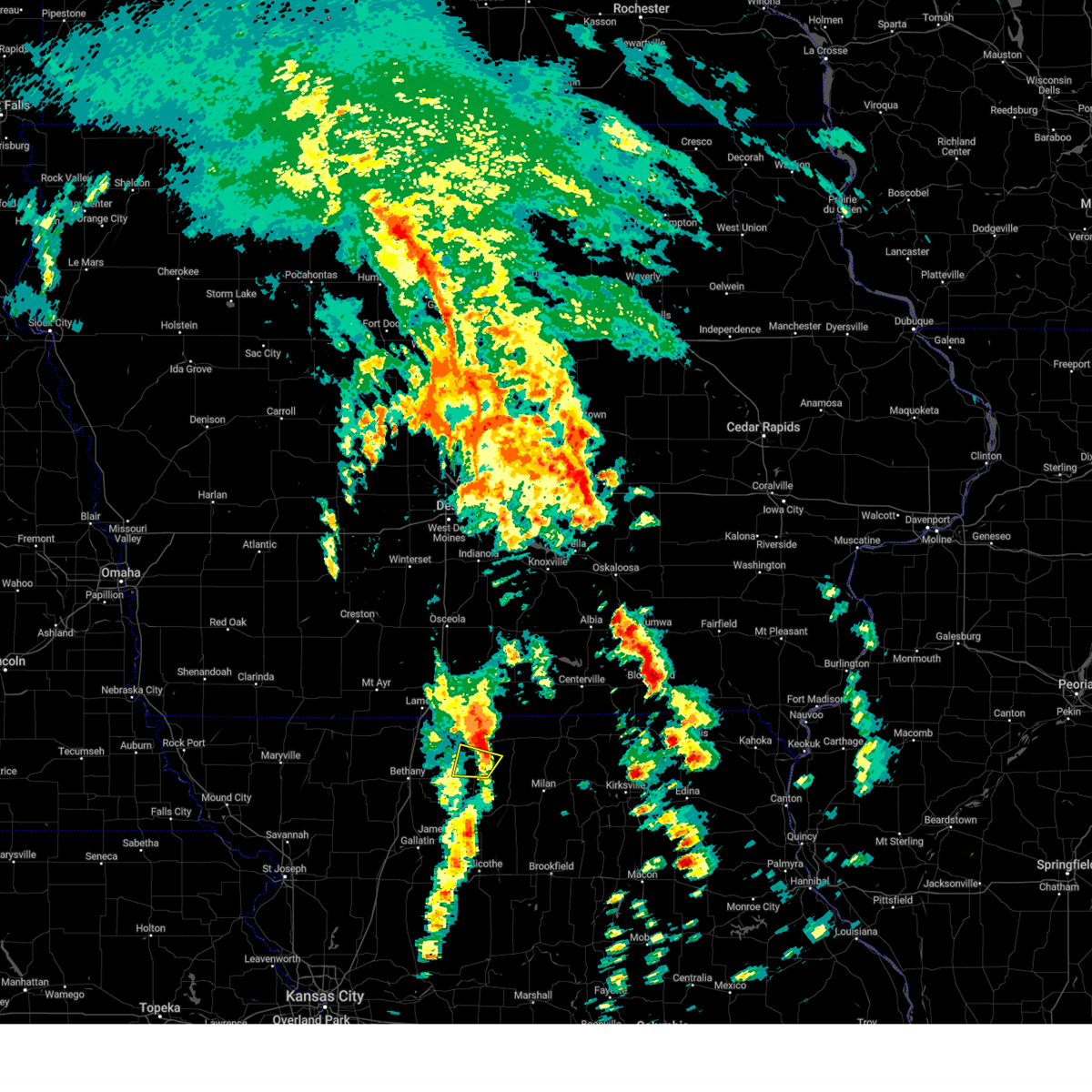 The storm which prompted the warning has moved out of the area. therefore, the warning will be allowed to expire. a tornado watch remains in effect until 600 pm cdt for north central missouri. The storm which prompted the warning has moved out of the area. therefore, the warning will be allowed to expire. a tornado watch remains in effect until 600 pm cdt for north central missouri.
|
| 4/16/2024 12:05 PM CDT |
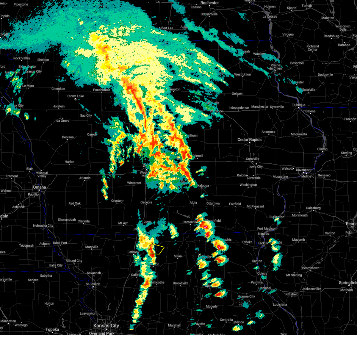 At 1204 pm cdt, a severe thunderstorm was located over princeton, or 20 miles north of trenton, moving northeast at 50 mph (radar indicated). Hazards include 60 mph wind gusts and quarter size hail. Hail damage to vehicles is expected. expect wind damage to roofs, siding, and trees. Locations impacted include, princeton, modena, and mill grove. At 1204 pm cdt, a severe thunderstorm was located over princeton, or 20 miles north of trenton, moving northeast at 50 mph (radar indicated). Hazards include 60 mph wind gusts and quarter size hail. Hail damage to vehicles is expected. expect wind damage to roofs, siding, and trees. Locations impacted include, princeton, modena, and mill grove.
|
| 4/16/2024 12:05 PM CDT |
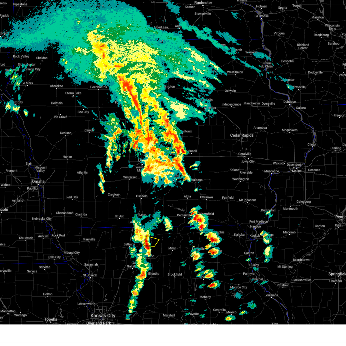 the severe thunderstorm warning has been cancelled and is no longer in effect the severe thunderstorm warning has been cancelled and is no longer in effect
|
| 4/16/2024 12:03 PM CDT |
 Svreax the national weather service in pleasant hill has issued a * severe thunderstorm warning for, central mercer county in north central missouri, west central putnam county in north central missouri, * until 1230 pm cdt. * at 1203 pm cdt, a severe thunderstorm was located over princeton, or 20 miles north of trenton, moving northeast at 60 mph (radar indicated). Hazards include 60 mph wind gusts and quarter size hail. Hail damage to vehicles is expected. Expect wind damage to roofs, siding, and trees. Svreax the national weather service in pleasant hill has issued a * severe thunderstorm warning for, central mercer county in north central missouri, west central putnam county in north central missouri, * until 1230 pm cdt. * at 1203 pm cdt, a severe thunderstorm was located over princeton, or 20 miles north of trenton, moving northeast at 60 mph (radar indicated). Hazards include 60 mph wind gusts and quarter size hail. Hail damage to vehicles is expected. Expect wind damage to roofs, siding, and trees.
|
| 4/16/2024 11:59 AM CDT |
 At 1158 am cdt, a severe thunderstorm was located near spickard, or 14 miles north of trenton, moving northeast at 50 mph (radar indicated). Hazards include 60 mph wind gusts and quarter size hail. Hail damage to vehicles is expected. expect wind damage to roofs, siding, and trees. Locations impacted include, princeton, spickard, tindall, harris, modena, and mill grove. At 1158 am cdt, a severe thunderstorm was located near spickard, or 14 miles north of trenton, moving northeast at 50 mph (radar indicated). Hazards include 60 mph wind gusts and quarter size hail. Hail damage to vehicles is expected. expect wind damage to roofs, siding, and trees. Locations impacted include, princeton, spickard, tindall, harris, modena, and mill grove.
|
| 4/16/2024 11:50 AM CDT |
 the severe thunderstorm warning has been cancelled and is no longer in effect the severe thunderstorm warning has been cancelled and is no longer in effect
|
| 4/16/2024 11:50 AM CDT |
 At 1149 am cdt, a severe thunderstorm was located near spickard, or 8 miles northwest of trenton, moving northeast at 50 mph (radar indicated). Hazards include 60 mph wind gusts and penny size hail. Expect damage to roofs, siding, and trees. Locations impacted include, trenton, princeton, spickard, tindall, brimson, harris, modena, and mill grove. At 1149 am cdt, a severe thunderstorm was located near spickard, or 8 miles northwest of trenton, moving northeast at 50 mph (radar indicated). Hazards include 60 mph wind gusts and penny size hail. Expect damage to roofs, siding, and trees. Locations impacted include, trenton, princeton, spickard, tindall, brimson, harris, modena, and mill grove.
|
| 4/16/2024 11:44 AM CDT |
 Svreax the national weather service in pleasant hill has issued a * severe thunderstorm warning for, northeastern daviess county in north central missouri, northwestern grundy county in north central missouri, northwestern sullivan county in north central missouri, southern mercer county in north central missouri, southeastern harrison county in north central missouri, * until 1215 pm cdt. * at 1143 am cdt, a severe thunderstorm was located near trenton, moving northeast at 50 mph (radar indicated). Hazards include 60 mph wind gusts and penny size hail. expect damage to roofs, siding, and trees Svreax the national weather service in pleasant hill has issued a * severe thunderstorm warning for, northeastern daviess county in north central missouri, northwestern grundy county in north central missouri, northwestern sullivan county in north central missouri, southern mercer county in north central missouri, southeastern harrison county in north central missouri, * until 1215 pm cdt. * at 1143 am cdt, a severe thunderstorm was located near trenton, moving northeast at 50 mph (radar indicated). Hazards include 60 mph wind gusts and penny size hail. expect damage to roofs, siding, and trees
|
| 8/11/2023 11:37 PM CDT |
 At 1136 pm cdt, severe thunderstorms were located along a line extending from near cainsville to 6 miles northwest of trenton, moving east at 30 mph (radar indicated). Hazards include 60 mph wind gusts and half dollar size hail. Hail damage to vehicles is expected. expect wind damage to roofs, siding, and trees. locations impacted include, princeton, ridgeway, eagleville, cainsville, spickard, blythedale, mount moriah, tindall, brimson, modena and mill grove. this includes interstate 35 in missouri between mile markers 101 and 113. hail threat, radar indicated max hail size, 1. 25 in wind threat, radar indicated max wind gust, 60 mph. At 1136 pm cdt, severe thunderstorms were located along a line extending from near cainsville to 6 miles northwest of trenton, moving east at 30 mph (radar indicated). Hazards include 60 mph wind gusts and half dollar size hail. Hail damage to vehicles is expected. expect wind damage to roofs, siding, and trees. locations impacted include, princeton, ridgeway, eagleville, cainsville, spickard, blythedale, mount moriah, tindall, brimson, modena and mill grove. this includes interstate 35 in missouri between mile markers 101 and 113. hail threat, radar indicated max hail size, 1. 25 in wind threat, radar indicated max wind gust, 60 mph.
|
| 8/11/2023 11:19 PM CDT |
 At 1119 pm cdt, severe thunderstorms were located along a line extending from near eagleville to near gilman city, moving east at 25 mph (radar indicated). Hazards include 60 mph wind gusts and half dollar size hail. Hail damage to vehicles is expected. Expect wind damage to roofs, siding, and trees. At 1119 pm cdt, severe thunderstorms were located along a line extending from near eagleville to near gilman city, moving east at 25 mph (radar indicated). Hazards include 60 mph wind gusts and half dollar size hail. Hail damage to vehicles is expected. Expect wind damage to roofs, siding, and trees.
|
| 8/2/2023 2:07 AM CDT |
 At 207 am cdt, a severe thunderstorm was located near milan, moving southeast at 30 mph (radar indicated). Hazards include 60 mph wind gusts and quarter size hail. Hail damage to vehicles is expected. Expect wind damage to roofs, siding, and trees. At 207 am cdt, a severe thunderstorm was located near milan, moving southeast at 30 mph (radar indicated). Hazards include 60 mph wind gusts and quarter size hail. Hail damage to vehicles is expected. Expect wind damage to roofs, siding, and trees.
|
| 7/29/2023 12:26 PM CDT |
 At 1226 pm cdt, severe thunderstorms were located along a line extending from near princeton to near linneus to keytesville, moving east at 30 mph (trained weather spotters). Hazards include 60 mph wind gusts. Expect damage to roofs, siding, and trees. locations impacted include, trenton, brookfield, fayette, marceline, milan, slater, salisbury, glasgow, princeton, brunswick, keytesville, bucklin, meadville, laclede, armstrong, linneus, wheeling, browning, spickard and galt. hail threat, radar indicated max hail size, <. 75 in wind threat, observed max wind gust, 60 mph. At 1226 pm cdt, severe thunderstorms were located along a line extending from near princeton to near linneus to keytesville, moving east at 30 mph (trained weather spotters). Hazards include 60 mph wind gusts. Expect damage to roofs, siding, and trees. locations impacted include, trenton, brookfield, fayette, marceline, milan, slater, salisbury, glasgow, princeton, brunswick, keytesville, bucklin, meadville, laclede, armstrong, linneus, wheeling, browning, spickard and galt. hail threat, radar indicated max hail size, <. 75 in wind threat, observed max wind gust, 60 mph.
|
| 7/29/2023 12:16 PM CDT |
 At 1215 pm cdt, severe thunderstorms were located along a line extending from near cainsville to near linneus to near keytesville, moving east at 30 mph (trained weather spotters). Hazards include 60 mph wind gusts. Expect damage to roofs, siding, and trees. locations impacted include, trenton, brookfield, fayette, marceline, milan, slater, salisbury, glasgow, princeton, brunswick, keytesville, bucklin, ridgeway, meadville, gilman city, laclede, armstrong, linneus, wheeling and browning. hail threat, radar indicated max hail size, <. 75 in wind threat, observed max wind gust, 60 mph. At 1215 pm cdt, severe thunderstorms were located along a line extending from near cainsville to near linneus to near keytesville, moving east at 30 mph (trained weather spotters). Hazards include 60 mph wind gusts. Expect damage to roofs, siding, and trees. locations impacted include, trenton, brookfield, fayette, marceline, milan, slater, salisbury, glasgow, princeton, brunswick, keytesville, bucklin, ridgeway, meadville, gilman city, laclede, armstrong, linneus, wheeling and browning. hail threat, radar indicated max hail size, <. 75 in wind threat, observed max wind gust, 60 mph.
|
| 7/29/2023 12:09 PM CDT |
 At 1209 pm cdt, severe thunderstorms were located along a line extending from near cainsville to near linneus to brunswick, moving east at 35 mph (trained weather spotters). Hazards include 60 mph wind gusts. expect damage to roofs, siding, and trees At 1209 pm cdt, severe thunderstorms were located along a line extending from near cainsville to near linneus to brunswick, moving east at 35 mph (trained weather spotters). Hazards include 60 mph wind gusts. expect damage to roofs, siding, and trees
|
| 7/12/2023 8:58 AM CDT |
 The severe thunderstorm warning for northeastern grundy, northwestern sullivan, eastern mercer and western putnam counties will expire at 900 am cdt, the storms which prompted the warning have weakened below severe limits, and no longer pose an immediate threat to life or property. therefore, the warning will be allowed to expire. however gusty winds and heavy rain are still possible with these thunderstorms. a severe thunderstorm watch remains in effect until 1100 am cdt for north central missouri. The severe thunderstorm warning for northeastern grundy, northwestern sullivan, eastern mercer and western putnam counties will expire at 900 am cdt, the storms which prompted the warning have weakened below severe limits, and no longer pose an immediate threat to life or property. therefore, the warning will be allowed to expire. however gusty winds and heavy rain are still possible with these thunderstorms. a severe thunderstorm watch remains in effect until 1100 am cdt for north central missouri.
|
| 7/12/2023 8:39 AM CDT |
 At 839 am cdt, severe thunderstorms were located along a line extending from 12 miles southeast of corydon to 10 miles east of princeton to 8 miles east of bethany, moving southeast at 60 mph (radar indicated). Hazards include 60 mph wind gusts and penny size hail. Expect damage to roofs, siding, and trees. locations impacted include, princeton, mercer, spickard, newtown, pollock, lucerne, harris, powersville, osgood and mill grove. hail threat, radar indicated max hail size, 0. 75 in wind threat, radar indicated max wind gust, 60 mph. At 839 am cdt, severe thunderstorms were located along a line extending from 12 miles southeast of corydon to 10 miles east of princeton to 8 miles east of bethany, moving southeast at 60 mph (radar indicated). Hazards include 60 mph wind gusts and penny size hail. Expect damage to roofs, siding, and trees. locations impacted include, princeton, mercer, spickard, newtown, pollock, lucerne, harris, powersville, osgood and mill grove. hail threat, radar indicated max hail size, 0. 75 in wind threat, radar indicated max wind gust, 60 mph.
|
| 7/12/2023 8:36 AM CDT |
 At 836 am cdt, severe thunderstorms were located along a line extending from 11 miles southeast of corydon to 8 miles east of princeton to 6 miles east of bethany, moving southeast at 60 mph (radar indicated). Hazards include 60 mph wind gusts and penny size hail. Expect damage to roofs, siding, and trees. locations impacted include, princeton, mercer, cainsville, spickard, newtown, pollock, lucerne, harris, powersville, osgood, modena and mill grove. hail threat, radar indicated max hail size, 0. 75 in wind threat, radar indicated max wind gust, 60 mph. At 836 am cdt, severe thunderstorms were located along a line extending from 11 miles southeast of corydon to 8 miles east of princeton to 6 miles east of bethany, moving southeast at 60 mph (radar indicated). Hazards include 60 mph wind gusts and penny size hail. Expect damage to roofs, siding, and trees. locations impacted include, princeton, mercer, cainsville, spickard, newtown, pollock, lucerne, harris, powersville, osgood, modena and mill grove. hail threat, radar indicated max hail size, 0. 75 in wind threat, radar indicated max wind gust, 60 mph.
|
| 7/12/2023 8:31 AM CDT |
 At 831 am cdt, severe thunderstorms were located along a line extending from 9 miles south of corydon to 6 miles east of princeton to near bethany, moving southeast at 60 mph (radar indicated). Hazards include 60 mph wind gusts and penny size hail. Expect damage to roofs, siding, and trees. locations impacted include, princeton, ridgeway, mercer, cainsville, spickard, newtown, pollock, mount moriah, lucerne, tindall, harris, powersville, osgood, south lineville, modena and mill grove. this includes interstate 35 in missouri between mile markers 96 and 98. hail threat, radar indicated max hail size, 0. 75 in wind threat, radar indicated max wind gust, 60 mph. At 831 am cdt, severe thunderstorms were located along a line extending from 9 miles south of corydon to 6 miles east of princeton to near bethany, moving southeast at 60 mph (radar indicated). Hazards include 60 mph wind gusts and penny size hail. Expect damage to roofs, siding, and trees. locations impacted include, princeton, ridgeway, mercer, cainsville, spickard, newtown, pollock, mount moriah, lucerne, tindall, harris, powersville, osgood, south lineville, modena and mill grove. this includes interstate 35 in missouri between mile markers 96 and 98. hail threat, radar indicated max hail size, 0. 75 in wind threat, radar indicated max wind gust, 60 mph.
|
| 7/12/2023 8:24 AM CDT |
 At 824 am cdt, severe thunderstorms were located along a line extending from 6 miles southwest of corydon to near princeton to near bethany, moving southeast at 60 mph (radar indicated). Hazards include 60 mph wind gusts and penny size hail. Expect damage to roofs, siding, and trees. locations impacted include, princeton, ridgeway, mercer, eagleville, cainsville, spickard, blythedale, newtown, pollock, mount moriah, lucerne, tindall, harris, powersville, osgood, south lineville, modena and mill grove. this includes interstate 35 in missouri between mile markers 97 and 113. hail threat, radar indicated max hail size, 0. 75 in wind threat, radar indicated max wind gust, 60 mph. At 824 am cdt, severe thunderstorms were located along a line extending from 6 miles southwest of corydon to near princeton to near bethany, moving southeast at 60 mph (radar indicated). Hazards include 60 mph wind gusts and penny size hail. Expect damage to roofs, siding, and trees. locations impacted include, princeton, ridgeway, mercer, eagleville, cainsville, spickard, blythedale, newtown, pollock, mount moriah, lucerne, tindall, harris, powersville, osgood, south lineville, modena and mill grove. this includes interstate 35 in missouri between mile markers 97 and 113. hail threat, radar indicated max hail size, 0. 75 in wind threat, radar indicated max wind gust, 60 mph.
|
| 7/12/2023 8:07 AM CDT |
 At 807 am cdt, severe thunderstorms were located along a line extending from 6 miles northeast of leon to near lamoni to near grant city, moving southeast at 65 mph (radar indicated). Hazards include 60 mph wind gusts and penny size hail. expect damage to roofs, siding, and trees At 807 am cdt, severe thunderstorms were located along a line extending from 6 miles northeast of leon to near lamoni to near grant city, moving southeast at 65 mph (radar indicated). Hazards include 60 mph wind gusts and penny size hail. expect damage to roofs, siding, and trees
|
| 6/30/2023 7:38 AM CDT |
 At 737 am cdt, severe thunderstorms were located along a line extending from 14 miles southeast of leon to near mercer to near princeton, moving east at 55 mph (public). Hazards include 60 mph wind gusts. Expect damage to roofs, siding, and trees. locations impacted include, unionville, princeton, mercer, lucerne, powersville, south lineville and lemons. hail threat, radar indicated max hail size, <. 75 in wind threat, observed max wind gust, 60 mph. At 737 am cdt, severe thunderstorms were located along a line extending from 14 miles southeast of leon to near mercer to near princeton, moving east at 55 mph (public). Hazards include 60 mph wind gusts. Expect damage to roofs, siding, and trees. locations impacted include, unionville, princeton, mercer, lucerne, powersville, south lineville and lemons. hail threat, radar indicated max hail size, <. 75 in wind threat, observed max wind gust, 60 mph.
|
| 6/30/2023 7:25 AM CDT |
 At 725 am cdt, severe thunderstorms were located along a line extending from 9 miles east of lamoni to 11 miles east of eagleville to near cainsville, moving east at 45 mph (public). Hazards include 60 mph wind gusts. Expect damage to roofs, siding, and trees. locations impacted include, unionville, princeton, mercer, cainsville, newtown, pollock, mount moriah, lucerne, powersville, pleasanton, south lineville and lemons. hail threat, radar indicated max hail size, <. 75 in wind threat, observed max wind gust, 60 mph. At 725 am cdt, severe thunderstorms were located along a line extending from 9 miles east of lamoni to 11 miles east of eagleville to near cainsville, moving east at 45 mph (public). Hazards include 60 mph wind gusts. Expect damage to roofs, siding, and trees. locations impacted include, unionville, princeton, mercer, cainsville, newtown, pollock, mount moriah, lucerne, powersville, pleasanton, south lineville and lemons. hail threat, radar indicated max hail size, <. 75 in wind threat, observed max wind gust, 60 mph.
|
| 6/30/2023 7:21 AM CDT |
 At 720 am cdt, severe thunderstorms were located along a line extending from 8 miles southeast of lamoni to near cainsville to near ridgeway, moving east at 50 mph (radar indicated). Hazards include 60 mph wind gusts. expect damage to roofs, siding, and trees At 720 am cdt, severe thunderstorms were located along a line extending from 8 miles southeast of lamoni to near cainsville to near ridgeway, moving east at 50 mph (radar indicated). Hazards include 60 mph wind gusts. expect damage to roofs, siding, and trees
|
| 6/29/2023 9:08 AM CDT |
 At 906 am cdt, severe thunderstorms were located along a line extending from 8 miles northeast of mercer to near green city to browning, moving east at 50 mph (radar indicated). Hazards include 70 mph wind gusts. Expect considerable tree damage. Damage is likely to mobile homes, roofs, and outbuildings. At 906 am cdt, severe thunderstorms were located along a line extending from 8 miles northeast of mercer to near green city to browning, moving east at 50 mph (radar indicated). Hazards include 70 mph wind gusts. Expect considerable tree damage. Damage is likely to mobile homes, roofs, and outbuildings.
|
| 6/29/2023 8:52 AM CDT |
 At 851 am cdt, severe thunderstorms were located along a line extending from 7 miles southeast of mercer to 11 miles east of spickard to near galt, moving east at 55 mph (trained weather spotters). Hazards include 60 mph wind gusts. Expect damage to roofs, siding, and trees. locations impacted include, trenton, milan, unionville, princeton, green city, mercer, greencastle, browning, spickard, galt, newtown, humphreys, pollock, lucerne, tindall, harris, powersville, osgood, mill grove and reger. hail threat, radar indicated max hail size, <. 75 in wind threat, observed max wind gust, 60 mph. At 851 am cdt, severe thunderstorms were located along a line extending from 7 miles southeast of mercer to 11 miles east of spickard to near galt, moving east at 55 mph (trained weather spotters). Hazards include 60 mph wind gusts. Expect damage to roofs, siding, and trees. locations impacted include, trenton, milan, unionville, princeton, green city, mercer, greencastle, browning, spickard, galt, newtown, humphreys, pollock, lucerne, tindall, harris, powersville, osgood, mill grove and reger. hail threat, radar indicated max hail size, <. 75 in wind threat, observed max wind gust, 60 mph.
|
| 6/29/2023 8:50 AM CDT | Multiple large tree limbs down. one tree uproote in mercer county MO, 0.4 miles ESE of Princeton, MO |
| 6/29/2023 8:39 AM CDT |
 At 839 am cdt, severe thunderstorms were located along a line extending from near cainsville to near spickard to 6 miles west of trenton, moving east at 55 mph (trained weather spotters). Hazards include 70 mph wind gusts. Expect considerable tree damage. damage is likely to mobile homes, roofs, and outbuildings. locations impacted include, trenton, milan, unionville, princeton, green city, jamesport, ridgeway, mercer, cainsville, greencastle, browning, spickard, galt, laredo, blythedale, purdin, newtown, humphreys, pollock and mount moriah. this includes interstate 35 in missouri between mile markers 108 and 111. thunderstorm damage threat, considerable hail threat, radar indicated max hail size, <. 75 in wind threat, observed max wind gust, 70 mph. At 839 am cdt, severe thunderstorms were located along a line extending from near cainsville to near spickard to 6 miles west of trenton, moving east at 55 mph (trained weather spotters). Hazards include 70 mph wind gusts. Expect considerable tree damage. damage is likely to mobile homes, roofs, and outbuildings. locations impacted include, trenton, milan, unionville, princeton, green city, jamesport, ridgeway, mercer, cainsville, greencastle, browning, spickard, galt, laredo, blythedale, purdin, newtown, humphreys, pollock and mount moriah. this includes interstate 35 in missouri between mile markers 108 and 111. thunderstorm damage threat, considerable hail threat, radar indicated max hail size, <. 75 in wind threat, observed max wind gust, 70 mph.
|
| 6/29/2023 8:33 AM CDT | Tree over highway in mercer county MO, 6.1 miles N of Princeton, MO |
| 6/29/2023 8:23 AM CDT |
 At 822 am cdt, severe thunderstorms were located along a line extending from ridgeway to 7 miles east of bethany to near gilman city, moving east at 55 mph (trained weather spotters). Hazards include 70 mph wind gusts. Expect considerable tree damage. Damage is likely to mobile homes, roofs, and outbuildings. At 822 am cdt, severe thunderstorms were located along a line extending from ridgeway to 7 miles east of bethany to near gilman city, moving east at 55 mph (trained weather spotters). Hazards include 70 mph wind gusts. Expect considerable tree damage. Damage is likely to mobile homes, roofs, and outbuildings.
|
| 5/7/2023 11:16 PM CDT | At 1116 pm cdt, a severe thunderstorm was located 13 miles west of unionville, moving east at 45 mph (radar indicated). Hazards include 60 mph wind gusts and nickel size hail. expect damage to roofs, siding, and trees |
| 3/31/2023 2:46 PM CDT | Metal lean-to knocked ove in mercer county MO, 6.1 miles N of Princeton, MO |
| 3/31/2023 2:06 PM CDT | Golf Ball sized hail reported 9.1 miles NNE of Princeton, MO |
| 3/31/2023 2:02 PM CDT | Quarter sized hail reported 0.4 miles ESE of Princeton, MO |
| 3/31/2023 2:00 PM CDT | Ping Pong Ball sized hail reported 0.4 miles ESE of Princeton, MO |
| 3/31/2023 2:00 PM CDT | Quarter sized hail reported 0.4 miles ESE of Princeton, MO |
| 7/7/2022 3:51 AM CDT |
 At 351 am cdt, a severe thunderstorm was located 9 miles northeast of gilman city, or 13 miles east of bethany, moving east at 40 mph (radar indicated). Hazards include 60 mph wind gusts. Expect damage to roofs, siding, and trees. locations impacted include, princeton, ridgeway, gilman city, mercer, cainsville, spickard, blythedale, mount moriah, tindall, brimson, modena and mill grove. this includes interstate 35 in missouri between mile markers 108 and 112. hail threat, radar indicated max hail size, <. 75 in wind threat, radar indicated max wind gust, 60 mph. At 351 am cdt, a severe thunderstorm was located 9 miles northeast of gilman city, or 13 miles east of bethany, moving east at 40 mph (radar indicated). Hazards include 60 mph wind gusts. Expect damage to roofs, siding, and trees. locations impacted include, princeton, ridgeway, gilman city, mercer, cainsville, spickard, blythedale, mount moriah, tindall, brimson, modena and mill grove. this includes interstate 35 in missouri between mile markers 108 and 112. hail threat, radar indicated max hail size, <. 75 in wind threat, radar indicated max wind gust, 60 mph.
|
| 7/7/2022 3:36 AM CDT |
 At 336 am cdt, a severe thunderstorm was located over bethany, moving east at 45 mph (radar indicated). Hazards include 60 mph wind gusts. expect damage to roofs, siding, and trees At 336 am cdt, a severe thunderstorm was located over bethany, moving east at 45 mph (radar indicated). Hazards include 60 mph wind gusts. expect damage to roofs, siding, and trees
|
| 6/21/2022 8:41 PM CDT |
 At 840 pm cdt, a severe thunderstorm was located near mercer, or 23 miles south of corydon, moving east at 30 mph (radar indicated). Hazards include 60 mph wind gusts and penny size hail. expect damage to roofs, siding, and trees At 840 pm cdt, a severe thunderstorm was located near mercer, or 23 miles south of corydon, moving east at 30 mph (radar indicated). Hazards include 60 mph wind gusts and penny size hail. expect damage to roofs, siding, and trees
|
| 6/21/2022 8:40 PM CDT | Storm damage reported in mercer county MO, 0.4 miles ESE of Princeton, MO |
| 6/17/2022 1:52 AM CDT |
 The severe thunderstorm warning for northwestern linn, eastern grundy, sullivan, southeastern mercer and southwestern putnam counties will expire at 200 am cdt, the storm which prompted the warning has weakened below severe limits, and no longer poses an immediate threat to life or property. therefore, the warning will be allowed to expire. however gusty winds and heavy rain are still possible with this thunderstorm. a severe thunderstorm watch remains in effect until 400 am cdt for north central missouri. a severe thunderstorm watch also remains in effect until 800 am cdt for north central and northeastern missouri. The severe thunderstorm warning for northwestern linn, eastern grundy, sullivan, southeastern mercer and southwestern putnam counties will expire at 200 am cdt, the storm which prompted the warning has weakened below severe limits, and no longer poses an immediate threat to life or property. therefore, the warning will be allowed to expire. however gusty winds and heavy rain are still possible with this thunderstorm. a severe thunderstorm watch remains in effect until 400 am cdt for north central missouri. a severe thunderstorm watch also remains in effect until 800 am cdt for north central and northeastern missouri.
|
| 6/17/2022 1:43 AM CDT |
 At 143 am cdt, a severe thunderstorm was located near galt, or 8 miles southwest of milan, moving southeast at 40 mph (radar indicated). Hazards include 60 mph wind gusts and quarter size hail. Hail damage to vehicles is expected. expect wind damage to roofs, siding, and trees. locations impacted include, milan, princeton, green city, galt, laredo, newtown, humphreys, pollock, lucerne, harris, osgood, mill grove, reger and lemons. hail threat, radar indicated max hail size, 1. 00 in wind threat, radar indicated max wind gust, 60 mph. At 143 am cdt, a severe thunderstorm was located near galt, or 8 miles southwest of milan, moving southeast at 40 mph (radar indicated). Hazards include 60 mph wind gusts and quarter size hail. Hail damage to vehicles is expected. expect wind damage to roofs, siding, and trees. locations impacted include, milan, princeton, green city, galt, laredo, newtown, humphreys, pollock, lucerne, harris, osgood, mill grove, reger and lemons. hail threat, radar indicated max hail size, 1. 00 in wind threat, radar indicated max wind gust, 60 mph.
|
| 6/17/2022 1:39 AM CDT |
 At 139 am cdt, a severe thunderstorm was located near galt, or 9 miles west of milan, moving southeast at 40 mph (radar indicated). Hazards include 60 mph wind gusts and penny size hail. Expect damage to roofs, siding, and trees. locations impacted include, milan, princeton, green city, galt, laredo, newtown, humphreys, pollock, lucerne, harris, osgood, mill grove, reger and lemons. hail threat, radar indicated max hail size, 0. 75 in wind threat, radar indicated max wind gust, 60 mph. At 139 am cdt, a severe thunderstorm was located near galt, or 9 miles west of milan, moving southeast at 40 mph (radar indicated). Hazards include 60 mph wind gusts and penny size hail. Expect damage to roofs, siding, and trees. locations impacted include, milan, princeton, green city, galt, laredo, newtown, humphreys, pollock, lucerne, harris, osgood, mill grove, reger and lemons. hail threat, radar indicated max hail size, 0. 75 in wind threat, radar indicated max wind gust, 60 mph.
|
| 6/17/2022 1:21 AM CDT |
 At 121 am cdt, a severe thunderstorm was located 9 miles southeast of princeton, or 18 miles northwest of milan, moving southeast at 40 mph (radar indicated). Hazards include 60 mph wind gusts and nickel size hail. expect damage to roofs, siding, and trees At 121 am cdt, a severe thunderstorm was located 9 miles southeast of princeton, or 18 miles northwest of milan, moving southeast at 40 mph (radar indicated). Hazards include 60 mph wind gusts and nickel size hail. expect damage to roofs, siding, and trees
|
| 6/11/2022 8:48 PM CDT |
 At 848 pm cdt, a severe thunderstorm was located near spickard, or 14 miles north of trenton, moving east at 40 mph (radar indicated). Hazards include 60 mph wind gusts and quarter size hail. Hail damage to vehicles is expected. expect wind damage to roofs, siding, and trees. locations impacted include, princeton, spickard, mill grove and modena. hail threat, radar indicated max hail size, 1. 00 in wind threat, radar indicated max wind gust, 60 mph. At 848 pm cdt, a severe thunderstorm was located near spickard, or 14 miles north of trenton, moving east at 40 mph (radar indicated). Hazards include 60 mph wind gusts and quarter size hail. Hail damage to vehicles is expected. expect wind damage to roofs, siding, and trees. locations impacted include, princeton, spickard, mill grove and modena. hail threat, radar indicated max hail size, 1. 00 in wind threat, radar indicated max wind gust, 60 mph.
|
| 6/11/2022 8:37 PM CDT |
 At 836 pm cdt, a severe thunderstorm was located 9 miles northwest of spickard, or 14 miles east of bethany, moving east at 45 mph (radar indicated). Hazards include 60 mph wind gusts and quarter size hail. Hail damage to vehicles is expected. expect wind damage to roofs, siding, and trees. locations impacted include, princeton, cainsville, spickard, mount moriah, mill grove and modena. hail threat, radar indicated max hail size, 1. 00 in wind threat, radar indicated max wind gust, 60 mph. At 836 pm cdt, a severe thunderstorm was located 9 miles northwest of spickard, or 14 miles east of bethany, moving east at 45 mph (radar indicated). Hazards include 60 mph wind gusts and quarter size hail. Hail damage to vehicles is expected. expect wind damage to roofs, siding, and trees. locations impacted include, princeton, cainsville, spickard, mount moriah, mill grove and modena. hail threat, radar indicated max hail size, 1. 00 in wind threat, radar indicated max wind gust, 60 mph.
|
| 6/11/2022 8:21 PM CDT |
 At 821 pm cdt, a severe thunderstorm was located over ridgeway, or 8 miles northeast of bethany, moving east at 40 mph (radar indicated). Hazards include 60 mph wind gusts and quarter size hail. Hail damage to vehicles is expected. Expect wind damage to roofs, siding, and trees. At 821 pm cdt, a severe thunderstorm was located over ridgeway, or 8 miles northeast of bethany, moving east at 40 mph (radar indicated). Hazards include 60 mph wind gusts and quarter size hail. Hail damage to vehicles is expected. Expect wind damage to roofs, siding, and trees.
|
| 8/12/2021 5:55 AM CDT |
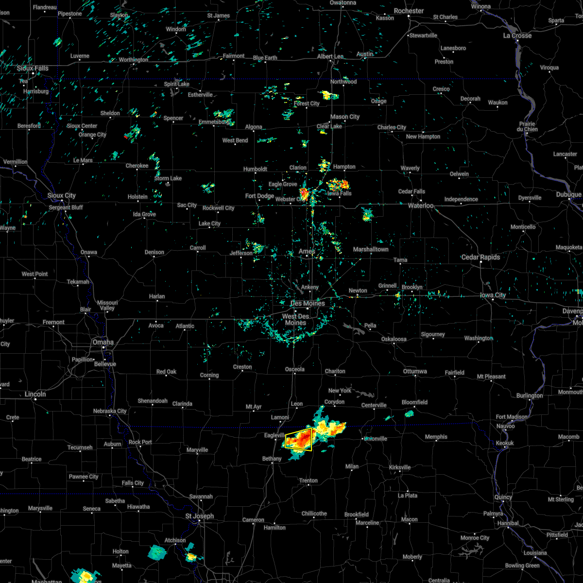 The severe thunderstorm warning for northwestern mercer and northeastern harrison counties will expire at 600 am cdt, the storm which prompted the warning has weakened below severe limits, and no longer poses an immediate threat to life or property. therefore, the warning will be allowed to expire. The severe thunderstorm warning for northwestern mercer and northeastern harrison counties will expire at 600 am cdt, the storm which prompted the warning has weakened below severe limits, and no longer poses an immediate threat to life or property. therefore, the warning will be allowed to expire.
|
| 8/12/2021 5:31 AM CDT |
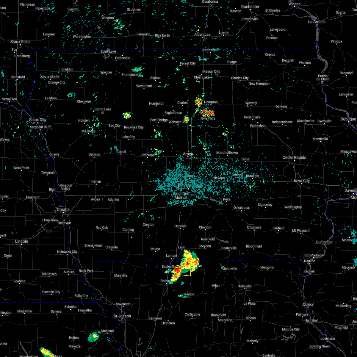 At 531 am cdt, a severe thunderstorm was located over cainsville, or 17 miles northeast of bethany, moving east at 25 mph (radar indicated). Hazards include quarter size hail. damage to vehicles is expected At 531 am cdt, a severe thunderstorm was located over cainsville, or 17 miles northeast of bethany, moving east at 25 mph (radar indicated). Hazards include quarter size hail. damage to vehicles is expected
|
| 7/30/2021 10:59 PM CDT |
 At 1059 pm cdt, a severe thunderstorm was located near lamoni, or 14 miles southwest of leon, moving south at 25 mph (radar indicated). Hazards include 60 mph wind gusts and quarter size hail. Hail damage to vehicles is expected. expect wind damage to roofs, siding, and trees. this severe thunderstorm will be near, eagleville around 1110 pm cdt. other locations in the path of this severe thunderstorm include ridgeway and cainsville. This includes interstate 35 in missouri between mile markers 99 and 113. At 1059 pm cdt, a severe thunderstorm was located near lamoni, or 14 miles southwest of leon, moving south at 25 mph (radar indicated). Hazards include 60 mph wind gusts and quarter size hail. Hail damage to vehicles is expected. expect wind damage to roofs, siding, and trees. this severe thunderstorm will be near, eagleville around 1110 pm cdt. other locations in the path of this severe thunderstorm include ridgeway and cainsville. This includes interstate 35 in missouri between mile markers 99 and 113.
|
| 6/24/2021 9:29 PM CDT |
 At 929 pm cdt, severe thunderstorms were located along a line extending from 10 miles southeast of mercer to 6 miles northeast of galt to 7 miles west of browning to 6 miles north of wheeling to near utica to near hamilton, moving east at 45 mph (radar indicated). Hazards include 70 mph wind gusts and penny size hail. Expect considerable tree damage. Damage is likely to mobile homes, roofs, and outbuildings. At 929 pm cdt, severe thunderstorms were located along a line extending from 10 miles southeast of mercer to 6 miles northeast of galt to 7 miles west of browning to 6 miles north of wheeling to near utica to near hamilton, moving east at 45 mph (radar indicated). Hazards include 70 mph wind gusts and penny size hail. Expect considerable tree damage. Damage is likely to mobile homes, roofs, and outbuildings.
|
| 6/24/2021 9:22 PM CDT |
 At 921 pm cdt, severe thunderstorms were located along a line extending from 8 miles southeast of princeton to galt to 12 miles southeast of trenton to 8 miles north of chillicothe to near breckenridge, moving east at 45 mph (radar indicated). Hazards include 70 mph wind gusts and penny size hail. Expect considerable tree damage. damage is likely to mobile homes, roofs, and outbuildings. Locations impacted include, cameron, chillicothe, trenton, milan, hamilton, gallatin, maysville, princeton, jamesport, breckenridge, kingston, mercer, linneus, wheeling, utica, browning, spickard, galt, kidder and winston. At 921 pm cdt, severe thunderstorms were located along a line extending from 8 miles southeast of princeton to galt to 12 miles southeast of trenton to 8 miles north of chillicothe to near breckenridge, moving east at 45 mph (radar indicated). Hazards include 70 mph wind gusts and penny size hail. Expect considerable tree damage. damage is likely to mobile homes, roofs, and outbuildings. Locations impacted include, cameron, chillicothe, trenton, milan, hamilton, gallatin, maysville, princeton, jamesport, breckenridge, kingston, mercer, linneus, wheeling, utica, browning, spickard, galt, kidder and winston.
|
| 6/24/2021 9:02 PM CDT |
 At 902 pm cdt, severe thunderstorms were located along a line extending from 6 miles south of cainsville to near trenton to near jamesport to 7 miles northeast of cameron, moving east at 50 mph (law enforcement). Hazards include 70 mph wind gusts and penny size hail. Expect considerable tree damage. damage is likely to mobile homes, roofs, and outbuildings. Locations impacted include, cameron, chillicothe, trenton, milan, hamilton, gallatin, maysville, princeton, jamesport, ridgeway, gilman city, breckenridge, kingston, mercer, cainsville, linneus, wheeling, utica, browning and spickard. At 902 pm cdt, severe thunderstorms were located along a line extending from 6 miles south of cainsville to near trenton to near jamesport to 7 miles northeast of cameron, moving east at 50 mph (law enforcement). Hazards include 70 mph wind gusts and penny size hail. Expect considerable tree damage. damage is likely to mobile homes, roofs, and outbuildings. Locations impacted include, cameron, chillicothe, trenton, milan, hamilton, gallatin, maysville, princeton, jamesport, ridgeway, gilman city, breckenridge, kingston, mercer, cainsville, linneus, wheeling, utica, browning and spickard.
|
| 6/24/2021 8:51 PM CDT |
 At 850 pm cdt, severe thunderstorms were located along a line extending from near ridgeway to gilman city to near jamesport to gallatin to near maysville, moving east at 45 mph (law enforcement). Hazards include 70 mph wind gusts and penny size hail. Expect considerable tree damage. damage is likely to mobile homes, roofs, and outbuildings. severe thunderstorms will be near, jamesport and gilman city around 855 pm cdt. cainsville around 900 pm cdt. trenton around 905 pm cdt. hamilton, princeton and spickard around 910 pm cdt. other locations in the path of these severe thunderstorms include galt, breckenridge, utica, browning, chillicothe and milan. This includes interstate 35 in missouri between mile markers 53 and 106. At 850 pm cdt, severe thunderstorms were located along a line extending from near ridgeway to gilman city to near jamesport to gallatin to near maysville, moving east at 45 mph (law enforcement). Hazards include 70 mph wind gusts and penny size hail. Expect considerable tree damage. damage is likely to mobile homes, roofs, and outbuildings. severe thunderstorms will be near, jamesport and gilman city around 855 pm cdt. cainsville around 900 pm cdt. trenton around 905 pm cdt. hamilton, princeton and spickard around 910 pm cdt. other locations in the path of these severe thunderstorms include galt, breckenridge, utica, browning, chillicothe and milan. This includes interstate 35 in missouri between mile markers 53 and 106.
|
| 6/24/2021 8:14 PM CDT |
 At 813 pm cdt, a severe thunderstorm was located over princeton, or 22 miles north of trenton, moving northeast at 20 mph (radar indicated). Hazards include 60 mph wind gusts and quarter size hail. Hail damage to vehicles is expected. Expect wind damage to roofs, siding, and trees. At 813 pm cdt, a severe thunderstorm was located over princeton, or 22 miles north of trenton, moving northeast at 20 mph (radar indicated). Hazards include 60 mph wind gusts and quarter size hail. Hail damage to vehicles is expected. Expect wind damage to roofs, siding, and trees.
|
| 6/20/2021 7:38 PM CDT |
 At 738 pm cdt, a severe thunderstorm was located 9 miles southeast of princeton, or 18 miles northwest of milan, moving east at 40 mph (radar indicated). Hazards include 60 mph wind gusts and quarter size hail. Hail damage to vehicles is expected. expect wind damage to roofs, siding, and trees. Locations impacted include, milan, green city and greencastle. At 738 pm cdt, a severe thunderstorm was located 9 miles southeast of princeton, or 18 miles northwest of milan, moving east at 40 mph (radar indicated). Hazards include 60 mph wind gusts and quarter size hail. Hail damage to vehicles is expected. expect wind damage to roofs, siding, and trees. Locations impacted include, milan, green city and greencastle.
|
| 6/20/2021 7:17 PM CDT | Quarter sized hail reported 0.3 miles SW of Princeton, MO, also estimated 60mph winds. |
| 6/20/2021 7:15 PM CDT |
 At 715 pm cdt, a severe thunderstorm was located near cainsville, or 18 miles northeast of bethany, moving east at 40 mph (radar indicated). Hazards include 60 mph wind gusts and half dollar size hail. Hail damage to vehicles is expected. expect wind damage to roofs, siding, and trees. this severe thunderstorm will be near, princeton around 725 pm cdt. spickard around 730 pm cdt. other locations in the path of this severe thunderstorm include milan. This includes interstate 35 in missouri between mile markers 91 and 98. At 715 pm cdt, a severe thunderstorm was located near cainsville, or 18 miles northeast of bethany, moving east at 40 mph (radar indicated). Hazards include 60 mph wind gusts and half dollar size hail. Hail damage to vehicles is expected. expect wind damage to roofs, siding, and trees. this severe thunderstorm will be near, princeton around 725 pm cdt. spickard around 730 pm cdt. other locations in the path of this severe thunderstorm include milan. This includes interstate 35 in missouri between mile markers 91 and 98.
|
| 6/20/2021 6:52 PM CDT |
 At 652 pm cdt, a severe thunderstorm was located near lamoni, or 13 miles south of leon, moving east at 30 mph (radar indicated). Hazards include 60 mph wind gusts and quarter size hail. Hail damage to vehicles is expected. expect wind damage to roofs, siding, and trees. this severe thunderstorm will be near, cainsville around 705 pm cdt. other locations in the path of this severe thunderstorm include mercer. This includes interstate 35 in missouri between mile markers 99 and 113. At 652 pm cdt, a severe thunderstorm was located near lamoni, or 13 miles south of leon, moving east at 30 mph (radar indicated). Hazards include 60 mph wind gusts and quarter size hail. Hail damage to vehicles is expected. expect wind damage to roofs, siding, and trees. this severe thunderstorm will be near, cainsville around 705 pm cdt. other locations in the path of this severe thunderstorm include mercer. This includes interstate 35 in missouri between mile markers 99 and 113.
|
| 3/10/2021 6:52 PM CST |
 At 651 pm cst, a severe thunderstorm was located near spickard, or 16 miles north of trenton, moving northeast at 50 mph (radar indicated). Hazards include 60 mph wind gusts and quarter size hail. Hail damage to vehicles is expected. Expect wind damage to roofs, siding, and trees. At 651 pm cst, a severe thunderstorm was located near spickard, or 16 miles north of trenton, moving northeast at 50 mph (radar indicated). Hazards include 60 mph wind gusts and quarter size hail. Hail damage to vehicles is expected. Expect wind damage to roofs, siding, and trees.
|
| 8/10/2020 2:15 PM CDT |
 At 214 pm cdt, severe thunderstorms were located along a line extending from 11 miles north of galt to near milan to near greencastle to 8 miles west of la plata to near atlanta, moving northeast at 40 mph (radar indicated). Hazards include 60 mph wind gusts and quarter size hail. Hail damage to vehicles is expected. expect wind damage to roofs, siding, and trees. Locations impacted include, kirksville, macon, milan, unionville, la plata, lancaster, princeton, bevier, green city, queen city, novinger, greentop, atlanta, downing, mercer, callao, greencastle, brashear, spickard and glenwood. At 214 pm cdt, severe thunderstorms were located along a line extending from 11 miles north of galt to near milan to near greencastle to 8 miles west of la plata to near atlanta, moving northeast at 40 mph (radar indicated). Hazards include 60 mph wind gusts and quarter size hail. Hail damage to vehicles is expected. expect wind damage to roofs, siding, and trees. Locations impacted include, kirksville, macon, milan, unionville, la plata, lancaster, princeton, bevier, green city, queen city, novinger, greentop, atlanta, downing, mercer, callao, greencastle, brashear, spickard and glenwood.
|
| 8/10/2020 1:58 PM CDT |
 At 157 pm cdt, severe thunderstorms were located along a line extending from near spickard to 6 miles west of milan to 9 miles south of green city to 14 miles north of bucklin to near callao, moving northeast at 40 mph (radar indicated). Hazards include 60 mph wind gusts and penny size hail. expect damage to roofs, siding, and trees At 157 pm cdt, severe thunderstorms were located along a line extending from near spickard to 6 miles west of milan to 9 miles south of green city to 14 miles north of bucklin to near callao, moving northeast at 40 mph (radar indicated). Hazards include 60 mph wind gusts and penny size hail. expect damage to roofs, siding, and trees
|
| 8/10/2020 1:32 PM CDT |
 At 131 pm cdt, severe thunderstorms were located along a line extending from near gilman city to 8 miles southwest of spickard to near trenton to 7 miles southwest of galt to 8 miles northwest of linneus, moving northeast at 30 mph (radar indicated). Hazards include 60 mph wind gusts and penny size hail. Expect damage to roofs, siding, and trees. Locations impacted include, trenton, princeton, gilman city, cainsville, browning, spickard, galt, chula, laredo, purdin, humphreys, mount moriah, tindall, brimson, harris, osgood, modena, mill grove and reger. At 131 pm cdt, severe thunderstorms were located along a line extending from near gilman city to 8 miles southwest of spickard to near trenton to 7 miles southwest of galt to 8 miles northwest of linneus, moving northeast at 30 mph (radar indicated). Hazards include 60 mph wind gusts and penny size hail. Expect damage to roofs, siding, and trees. Locations impacted include, trenton, princeton, gilman city, cainsville, browning, spickard, galt, chula, laredo, purdin, humphreys, mount moriah, tindall, brimson, harris, osgood, modena, mill grove and reger.
|
| 8/10/2020 1:20 PM CDT |
 At 120 pm cdt, severe thunderstorms were located along a line extending from 7 miles south of bethany to near gilman city to near trenton to 12 miles east of jamesport to 7 miles north of wheeling, moving northeast at 30 mph (radar indicated). Hazards include 60 mph wind gusts and penny size hail. Expect damage to roofs, siding, and trees. Locations impacted include, trenton, bethany, princeton, jamesport, ridgeway, gilman city, pattonsburg, eagleville, cainsville, linneus, wheeling, browning, spickard, galt, chula, laredo, blythedale, purdin, coffey and jameson. At 120 pm cdt, severe thunderstorms were located along a line extending from 7 miles south of bethany to near gilman city to near trenton to 12 miles east of jamesport to 7 miles north of wheeling, moving northeast at 30 mph (radar indicated). Hazards include 60 mph wind gusts and penny size hail. Expect damage to roofs, siding, and trees. Locations impacted include, trenton, bethany, princeton, jamesport, ridgeway, gilman city, pattonsburg, eagleville, cainsville, linneus, wheeling, browning, spickard, galt, chula, laredo, blythedale, purdin, coffey and jameson.
|
| 8/10/2020 12:58 PM CDT |
 At 1258 pm cdt, severe thunderstorms were located along a line extending from near pattonsburg to 8 miles northeast of gallatin to jamesport to 11 miles south of trenton to near chillicothe, moving northeast at 25 mph (emergency management). Hazards include 60 mph wind gusts and penny size hail. expect damage to roofs, siding, and trees At 1258 pm cdt, severe thunderstorms were located along a line extending from near pattonsburg to 8 miles northeast of gallatin to jamesport to 11 miles south of trenton to near chillicothe, moving northeast at 25 mph (emergency management). Hazards include 60 mph wind gusts and penny size hail. expect damage to roofs, siding, and trees
|
| 8/10/2020 11:29 AM CDT |
 At 1128 am cdt, a severe thunderstorm gust front was located along a line extending from 7 miles northwest of mercer to near cainsville to near ridgeway to near bethany, moving east at 55 mph (automated surface observation). Hazards include 60 mph wind gusts. expect damage to roofs, siding, and trees At 1128 am cdt, a severe thunderstorm gust front was located along a line extending from 7 miles northwest of mercer to near cainsville to near ridgeway to near bethany, moving east at 55 mph (automated surface observation). Hazards include 60 mph wind gusts. expect damage to roofs, siding, and trees
|
| 6/26/2020 11:37 PM CDT |
 At 1136 pm cdt, a severe thunderstorm was located near mercer, or 15 miles southeast of leon, moving southeast at 35 mph (radar indicated). Hazards include 60 mph wind gusts and quarter size hail. Hail damage to vehicles is expected. Expect wind damage to roofs, siding, and trees. At 1136 pm cdt, a severe thunderstorm was located near mercer, or 15 miles southeast of leon, moving southeast at 35 mph (radar indicated). Hazards include 60 mph wind gusts and quarter size hail. Hail damage to vehicles is expected. Expect wind damage to roofs, siding, and trees.
|
| 5/25/2020 5:06 PM CDT |
 At 506 pm cdt, a severe thunderstorm was located near princeton, or 22 miles northwest of milan, moving north at 40 mph (radar indicated). Hazards include 60 mph wind gusts and nickel size hail. Expect damage to roofs, siding, and trees. Locations impacted include, princeton, mercer and south lineville. At 506 pm cdt, a severe thunderstorm was located near princeton, or 22 miles northwest of milan, moving north at 40 mph (radar indicated). Hazards include 60 mph wind gusts and nickel size hail. Expect damage to roofs, siding, and trees. Locations impacted include, princeton, mercer and south lineville.
|
| 5/25/2020 4:56 PM CDT |
 The severe thunderstorm warning for northeastern grundy, southeastern mercer and northwestern sullivan counties will expire at 500 pm cdt, the storm which prompted the warning has moved out of the area. therefore, the warning will be allowed to expire. remember, a severe thunderstorm warning still remains in effect for portions of southern mercer county. The severe thunderstorm warning for northeastern grundy, southeastern mercer and northwestern sullivan counties will expire at 500 pm cdt, the storm which prompted the warning has moved out of the area. therefore, the warning will be allowed to expire. remember, a severe thunderstorm warning still remains in effect for portions of southern mercer county.
|
| 5/25/2020 4:51 PM CDT |
 At 451 pm cdt, a severe thunderstorm was located near spickard, or 14 miles north of trenton, moving north at 40 mph (radar indicated). Hazards include 60 mph wind gusts and nickel size hail. expect damage to roofs, siding, and trees At 451 pm cdt, a severe thunderstorm was located near spickard, or 14 miles north of trenton, moving north at 40 mph (radar indicated). Hazards include 60 mph wind gusts and nickel size hail. expect damage to roofs, siding, and trees
|
| 5/25/2020 4:46 PM CDT |
 At 446 pm cdt, a severe thunderstorm was located near galt, or 12 miles northeast of trenton, moving north at 45 mph (radar indicated). Hazards include 60 mph wind gusts and quarter size hail. Hail damage to vehicles is expected. expect wind damage to roofs, siding, and trees. Locations impacted include, princeton, spickard, galt, humphreys, tindall, harris, osgood and mill grove. At 446 pm cdt, a severe thunderstorm was located near galt, or 12 miles northeast of trenton, moving north at 45 mph (radar indicated). Hazards include 60 mph wind gusts and quarter size hail. Hail damage to vehicles is expected. expect wind damage to roofs, siding, and trees. Locations impacted include, princeton, spickard, galt, humphreys, tindall, harris, osgood and mill grove.
|
| 5/25/2020 4:31 PM CDT |
 At 431 pm cdt, a severe thunderstorm was located near trenton, moving north at 45 mph (radar indicated). Hazards include 60 mph wind gusts and quarter size hail. Hail damage to vehicles is expected. Expect wind damage to roofs, siding, and trees. At 431 pm cdt, a severe thunderstorm was located near trenton, moving north at 45 mph (radar indicated). Hazards include 60 mph wind gusts and quarter size hail. Hail damage to vehicles is expected. Expect wind damage to roofs, siding, and trees.
|
| 9/27/2019 7:10 PM CDT |
 At 710 pm cdt, a severe thunderstorm was located over mercer, or 20 miles southeast of leon, moving east at 40 mph (radar indicated). Hazards include ping pong ball size hail and 60 mph wind gusts. People and animals outdoors will be injured. expect hail damage to roofs, siding, windows, and vehicles. Expect wind damage to roofs, siding, and trees. At 710 pm cdt, a severe thunderstorm was located over mercer, or 20 miles southeast of leon, moving east at 40 mph (radar indicated). Hazards include ping pong ball size hail and 60 mph wind gusts. People and animals outdoors will be injured. expect hail damage to roofs, siding, windows, and vehicles. Expect wind damage to roofs, siding, and trees.
|
| 9/8/2019 1:15 AM CDT |
 At 115 am cdt, severe thunderstorms were located along a line extending from near mercer to spickard to near jamesport, moving east at 55 mph (emergency management). Hazards include 60 mph wind gusts. Expect damage to roofs, siding, and trees. Locations impacted include, chillicothe, trenton, brookfield, milan, unionville, gallatin, princeton, green city, jamesport, meadville, gilman city, laclede, mercer, cainsville, linneus, greencastle, wheeling, browning, spickard and galt. At 115 am cdt, severe thunderstorms were located along a line extending from near mercer to spickard to near jamesport, moving east at 55 mph (emergency management). Hazards include 60 mph wind gusts. Expect damage to roofs, siding, and trees. Locations impacted include, chillicothe, trenton, brookfield, milan, unionville, gallatin, princeton, green city, jamesport, meadville, gilman city, laclede, mercer, cainsville, linneus, greencastle, wheeling, browning, spickard and galt.
|
| 9/8/2019 12:59 AM CDT |
 The national weather service in pleasant hill has issued a * severe thunderstorm warning for. eastern daviess county in north central missouri. linn county in north central missouri. grundy county in north central missouri. Southwestern putnam county in north central missouri. The national weather service in pleasant hill has issued a * severe thunderstorm warning for. eastern daviess county in north central missouri. linn county in north central missouri. grundy county in north central missouri. Southwestern putnam county in north central missouri.
|
| 6/28/2019 11:24 AM CDT |
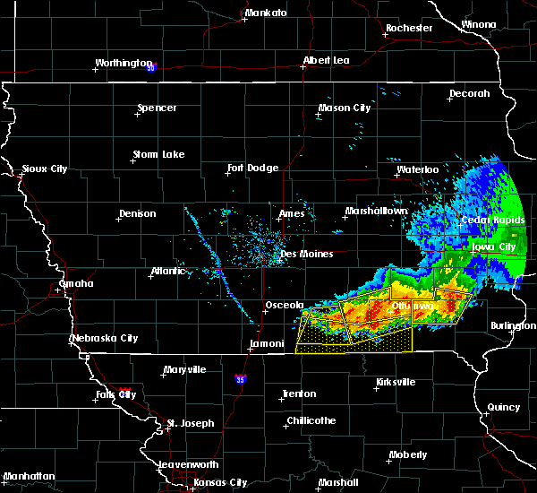 At 1123 am cdt, severe thunderstorms were located along a line extending from near leon to 10 miles southwest of centerville to 7 miles southwest of milton, moving south at 30 mph (radar indicated). Hazards include 60 mph wind gusts. expect damage to roofs, siding, and trees At 1123 am cdt, severe thunderstorms were located along a line extending from near leon to 10 miles southwest of centerville to 7 miles southwest of milton, moving south at 30 mph (radar indicated). Hazards include 60 mph wind gusts. expect damage to roofs, siding, and trees
|
| 6/25/2019 7:02 PM CDT |
 At 702 pm cdt, a severe thunderstorm was located near mercer, or 17 miles southwest of corydon, moving east at 60 mph (radar indicated). Hazards include 60 mph wind gusts and quarter size hail. Hail damage to vehicles is expected. expect wind damage to roofs, siding, and trees. Locations impacted include, princeton, mercer, cainsville and south lineville. At 702 pm cdt, a severe thunderstorm was located near mercer, or 17 miles southwest of corydon, moving east at 60 mph (radar indicated). Hazards include 60 mph wind gusts and quarter size hail. Hail damage to vehicles is expected. expect wind damage to roofs, siding, and trees. Locations impacted include, princeton, mercer, cainsville and south lineville.
|
| 6/25/2019 6:47 PM CDT |
 At 646 pm cdt, a severe thunderstorm was located 10 miles north of cainsville, or 10 miles south of leon, moving east at 60 mph (radar indicated). Hazards include 60 mph wind gusts and half dollar size hail. Hail damage to vehicles is expected. Expect wind damage to roofs, siding, and trees. At 646 pm cdt, a severe thunderstorm was located 10 miles north of cainsville, or 10 miles south of leon, moving east at 60 mph (radar indicated). Hazards include 60 mph wind gusts and half dollar size hail. Hail damage to vehicles is expected. Expect wind damage to roofs, siding, and trees.
|
| 6/22/2019 7:43 PM CDT |
 At 742 pm cdt, severe thunderstorms were located along a line extending from 8 miles northwest of mercer to near braymer, moving east at 40 mph (radar indicated). Hazards include 70 mph wind gusts and quarter size hail. Hail damage to vehicles is expected. expect considerable tree damage. Wind damage is also likely to mobile homes, roofs, and outbuildings. At 742 pm cdt, severe thunderstorms were located along a line extending from 8 miles northwest of mercer to near braymer, moving east at 40 mph (radar indicated). Hazards include 70 mph wind gusts and quarter size hail. Hail damage to vehicles is expected. expect considerable tree damage. Wind damage is also likely to mobile homes, roofs, and outbuildings.
|
| 6/22/2019 7:30 PM CDT |
 At 729 pm cdt, severe thunderstorms were located along a line extending from 9 miles west of spickard to near lawson, moving east at 40 mph (radar indicated). Hazards include 70 mph wind gusts and quarter size hail. Hail damage to vehicles is expected. expect considerable tree damage. wind damage is also likely to mobile homes, roofs, and outbuildings. Locations impacted include, excelsior springs, trenton, bethany, lawson, hamilton, gallatin, princeton, braymer, polo, jamesport, breckenridge, gilman city, crystal lakes, kingston, spickard, cowgill, excelsior estates, woods heights, kidder and winston. At 729 pm cdt, severe thunderstorms were located along a line extending from 9 miles west of spickard to near lawson, moving east at 40 mph (radar indicated). Hazards include 70 mph wind gusts and quarter size hail. Hail damage to vehicles is expected. expect considerable tree damage. wind damage is also likely to mobile homes, roofs, and outbuildings. Locations impacted include, excelsior springs, trenton, bethany, lawson, hamilton, gallatin, princeton, braymer, polo, jamesport, breckenridge, gilman city, crystal lakes, kingston, spickard, cowgill, excelsior estates, woods heights, kidder and winston.
|
| 6/22/2019 7:07 PM CDT |
 At 706 pm cdt, severe thunderstorms were located along a line extending from bethany to near holt, moving east at 40 mph (radar indicated). Hazards include 70 mph wind gusts and quarter size hail. Hail damage to vehicles is expected. expect considerable tree damage. Wind damage is also likely to mobile homes, roofs, and outbuildings. At 706 pm cdt, severe thunderstorms were located along a line extending from bethany to near holt, moving east at 40 mph (radar indicated). Hazards include 70 mph wind gusts and quarter size hail. Hail damage to vehicles is expected. expect considerable tree damage. Wind damage is also likely to mobile homes, roofs, and outbuildings.
|
| 5/28/2019 5:22 PM CDT |
 At 522 pm cdt, a severe thunderstorm was located near mercer, or 18 miles south of corydon, moving northeast at 55 mph (radar indicated). Hazards include golf ball size hail and 60 mph wind gusts. People and animals outdoors will be injured. expect hail damage to roofs, siding, windows, and vehicles. expect wind damage to roofs, siding, and trees. Locations impacted include, princeton and mercer. At 522 pm cdt, a severe thunderstorm was located near mercer, or 18 miles south of corydon, moving northeast at 55 mph (radar indicated). Hazards include golf ball size hail and 60 mph wind gusts. People and animals outdoors will be injured. expect hail damage to roofs, siding, windows, and vehicles. expect wind damage to roofs, siding, and trees. Locations impacted include, princeton and mercer.
|
| 5/28/2019 5:08 PM CDT |
 At 507 pm cdt, a severe thunderstorm was located near princeton, or 22 miles northeast of bethany, moving northeast at 55 mph (radar indicated). Hazards include golf ball size hail and 60 mph wind gusts. People and animals outdoors will be injured. expect hail damage to roofs, siding, windows, and vehicles. expect wind damage to roofs, siding, and trees. Locations impacted include, princeton, mercer, cainsville and south lineville. At 507 pm cdt, a severe thunderstorm was located near princeton, or 22 miles northeast of bethany, moving northeast at 55 mph (radar indicated). Hazards include golf ball size hail and 60 mph wind gusts. People and animals outdoors will be injured. expect hail damage to roofs, siding, windows, and vehicles. expect wind damage to roofs, siding, and trees. Locations impacted include, princeton, mercer, cainsville and south lineville.
|
| 5/28/2019 5:00 PM CDT |
 At 459 pm cdt, a severe thunderstorm was located near gilman city, or 11 miles northwest of trenton, moving northeast at 55 mph (radar indicated). Hazards include ping pong ball size hail and 60 mph wind gusts. People and animals outdoors will be injured. expect hail damage to roofs, siding, windows, and vehicles. expect wind damage to roofs, siding, and trees. Locations impacted include, princeton, gilman city, spickard, tindall, brimson, modena and mill grove. At 459 pm cdt, a severe thunderstorm was located near gilman city, or 11 miles northwest of trenton, moving northeast at 55 mph (radar indicated). Hazards include ping pong ball size hail and 60 mph wind gusts. People and animals outdoors will be injured. expect hail damage to roofs, siding, windows, and vehicles. expect wind damage to roofs, siding, and trees. Locations impacted include, princeton, gilman city, spickard, tindall, brimson, modena and mill grove.
|
| 5/28/2019 4:54 PM CDT |
 At 454 pm cdt, a severe thunderstorm was located near ridgeway, or 9 miles northeast of bethany, moving northeast at 55 mph (radar indicated). Hazards include golf ball size hail and 60 mph wind gusts. People and animals outdoors will be injured. expect hail damage to roofs, siding, windows, and vehicles. Expect wind damage to roofs, siding, and trees. At 454 pm cdt, a severe thunderstorm was located near ridgeway, or 9 miles northeast of bethany, moving northeast at 55 mph (radar indicated). Hazards include golf ball size hail and 60 mph wind gusts. People and animals outdoors will be injured. expect hail damage to roofs, siding, windows, and vehicles. Expect wind damage to roofs, siding, and trees.
|
| 5/28/2019 4:53 PM CDT |
 At 453 pm cdt, a severe thunderstorm was located over gilman city, or 10 miles southeast of bethany, moving northeast at 55 mph (radar indicated). Hazards include golf ball size hail and 60 mph wind gusts. People and animals outdoors will be injured. expect hail damage to roofs, siding, windows, and vehicles. Expect wind damage to roofs, siding, and trees. At 453 pm cdt, a severe thunderstorm was located over gilman city, or 10 miles southeast of bethany, moving northeast at 55 mph (radar indicated). Hazards include golf ball size hail and 60 mph wind gusts. People and animals outdoors will be injured. expect hail damage to roofs, siding, windows, and vehicles. Expect wind damage to roofs, siding, and trees.
|
| 5/28/2019 3:44 PM CDT |
 At 343 pm cdt, a severe thunderstorm was located near cainsville, or 17 miles south of leon, moving northeast at 45 mph (radar indicated). Hazards include ping pong ball size hail and 60 mph wind gusts. People and animals outdoors will be injured. expect hail damage to roofs, siding, windows, and vehicles. expect wind damage to roofs, siding, and trees. Locations impacted include, princeton, ridgeway, mercer, eagleville, cainsville, blythedale, mount moriah and pleasanton. At 343 pm cdt, a severe thunderstorm was located near cainsville, or 17 miles south of leon, moving northeast at 45 mph (radar indicated). Hazards include ping pong ball size hail and 60 mph wind gusts. People and animals outdoors will be injured. expect hail damage to roofs, siding, windows, and vehicles. expect wind damage to roofs, siding, and trees. Locations impacted include, princeton, ridgeway, mercer, eagleville, cainsville, blythedale, mount moriah and pleasanton.
|
| 5/28/2019 3:33 PM CDT |
 At 333 pm cdt, a severe thunderstorm was located over cainsville, or 15 miles northeast of bethany, moving east at 45 mph (radar indicated). Hazards include ping pong ball size hail and 60 mph wind gusts. People and animals outdoors will be injured. expect hail damage to roofs, siding, windows, and vehicles. expect wind damage to roofs, siding, and trees. Locations impacted include, bethany, princeton, ridgeway, mercer, eagleville, cainsville, blythedale, mount moriah and pleasanton. At 333 pm cdt, a severe thunderstorm was located over cainsville, or 15 miles northeast of bethany, moving east at 45 mph (radar indicated). Hazards include ping pong ball size hail and 60 mph wind gusts. People and animals outdoors will be injured. expect hail damage to roofs, siding, windows, and vehicles. expect wind damage to roofs, siding, and trees. Locations impacted include, bethany, princeton, ridgeway, mercer, eagleville, cainsville, blythedale, mount moriah and pleasanton.
|
| 5/28/2019 3:11 PM CDT |
 At 311 pm cdt, a severe thunderstorm was located near bethany, moving northeast at 45 mph (radar indicated). Hazards include 60 mph wind gusts and quarter size hail. Hail damage to vehicles is expected. Expect wind damage to roofs, siding, and trees. At 311 pm cdt, a severe thunderstorm was located near bethany, moving northeast at 45 mph (radar indicated). Hazards include 60 mph wind gusts and quarter size hail. Hail damage to vehicles is expected. Expect wind damage to roofs, siding, and trees.
|
| 5/28/2019 1:01 AM CDT |
 At 101 am cdt, a severe thunderstorm was located near princeton, or 22 miles southeast of leon, moving east at 40 mph (radar indicated). Hazards include 60 mph wind gusts and quarter size hail. Hail damage to vehicles is expected. Expect wind damage to roofs, siding, and trees. At 101 am cdt, a severe thunderstorm was located near princeton, or 22 miles southeast of leon, moving east at 40 mph (radar indicated). Hazards include 60 mph wind gusts and quarter size hail. Hail damage to vehicles is expected. Expect wind damage to roofs, siding, and trees.
|
| 5/25/2019 7:03 PM CDT |
 At 703 pm cdt, a severe thunderstorm was located near new hampton, or near bethany, moving east at 35 mph (radar indicated). Hazards include 60 mph wind gusts and half dollar size hail. Hail damage to vehicles is expected. expect wind damage to roofs, siding, and trees. Locations impacted include, trenton, bethany, princeton, ridgeway, gilman city, eagleville, new hampton, cainsville, spickard, coffey, mount moriah, tindall, brimson, modena, mill grove and martinsville. At 703 pm cdt, a severe thunderstorm was located near new hampton, or near bethany, moving east at 35 mph (radar indicated). Hazards include 60 mph wind gusts and half dollar size hail. Hail damage to vehicles is expected. expect wind damage to roofs, siding, and trees. Locations impacted include, trenton, bethany, princeton, ridgeway, gilman city, eagleville, new hampton, cainsville, spickard, coffey, mount moriah, tindall, brimson, modena, mill grove and martinsville.
|
| 5/25/2019 6:49 PM CDT |
 At 649 pm cdt, severe thunderstorms were located along a line extending from near ridgeway to near albany, moving east at 35 mph (radar indicated). Hazards include 60 mph wind gusts and quarter size hail. Hail damage to vehicles is expected. Expect wind damage to roofs, siding, and trees. At 649 pm cdt, severe thunderstorms were located along a line extending from near ridgeway to near albany, moving east at 35 mph (radar indicated). Hazards include 60 mph wind gusts and quarter size hail. Hail damage to vehicles is expected. Expect wind damage to roofs, siding, and trees.
|
| 10/9/2018 4:53 PM CDT |
 The tornado warning for central mercer county will expire at 500 pm cdt, the storm which prompted the warning has weakened below severe limits, and has exited the warned area. therefore, the warning will be allowed to expire. a tornado watch remains in effect until 900 pm cdt for north central missouri. The tornado warning for central mercer county will expire at 500 pm cdt, the storm which prompted the warning has weakened below severe limits, and has exited the warned area. therefore, the warning will be allowed to expire. a tornado watch remains in effect until 900 pm cdt for north central missouri.
|
| 10/9/2018 4:29 PM CDT |
 At 429 pm cdt, a severe thunderstorm capable of producing a tornado was located near princeton, or 18 miles north of trenton, moving north at 35 mph (radar indicated rotation). Hazards include tornado. Flying debris will be dangerous to those caught without shelter. mobile homes will be damaged or destroyed. damage to roofs, windows, and vehicles will occur. Tree damage is likely. At 429 pm cdt, a severe thunderstorm capable of producing a tornado was located near princeton, or 18 miles north of trenton, moving north at 35 mph (radar indicated rotation). Hazards include tornado. Flying debris will be dangerous to those caught without shelter. mobile homes will be damaged or destroyed. damage to roofs, windows, and vehicles will occur. Tree damage is likely.
|
| 8/28/2018 7:11 PM CDT |
 At 710 pm cdt, a severe thunderstorm was located near princeton, or 18 miles east of bethany, moving east at 40 mph (radar indicated). Hazards include 60 mph wind gusts and quarter size hail. Hail damage to vehicles is expected. expect wind damage to roofs, siding, and trees. Locations impacted include, princeton, mount moriah, mill grove and modena. At 710 pm cdt, a severe thunderstorm was located near princeton, or 18 miles east of bethany, moving east at 40 mph (radar indicated). Hazards include 60 mph wind gusts and quarter size hail. Hail damage to vehicles is expected. expect wind damage to roofs, siding, and trees. Locations impacted include, princeton, mount moriah, mill grove and modena.
|
| 8/28/2018 7:02 PM CDT |
 The national weather service in pleasant hill has issued a * severe thunderstorm warning for. southern mercer county in north central missouri. east central harrison county in north central missouri. until 730 pm cdt. At 702 pm cdt, a severe thunderstorm was located 7 miles south of. The national weather service in pleasant hill has issued a * severe thunderstorm warning for. southern mercer county in north central missouri. east central harrison county in north central missouri. until 730 pm cdt. At 702 pm cdt, a severe thunderstorm was located 7 miles south of.
|
| 8/16/2018 4:46 PM CDT |
 At 446 pm cdt, a severe thunderstorm was located near mercer, or 23 miles southeast of leon, moving east at 20 mph (radar indicated). Hazards include 60 mph wind gusts and quarter size hail. Hail damage to vehicles is expected. Expect wind damage to roofs, siding, and trees. At 446 pm cdt, a severe thunderstorm was located near mercer, or 23 miles southeast of leon, moving east at 20 mph (radar indicated). Hazards include 60 mph wind gusts and quarter size hail. Hail damage to vehicles is expected. Expect wind damage to roofs, siding, and trees.
|
| 8/6/2018 8:27 PM CDT |
 The severe thunderstorm warning for southwestern putnam, northeastern mercer and northwestern sullivan counties will expire at 830 pm cdt, the storm which prompted the warning has weakened below severe limits, and no longer poses an immediate threat to life or property. therefore, the warning will be allowed to expire. The severe thunderstorm warning for southwestern putnam, northeastern mercer and northwestern sullivan counties will expire at 830 pm cdt, the storm which prompted the warning has weakened below severe limits, and no longer poses an immediate threat to life or property. therefore, the warning will be allowed to expire.
|
| 8/6/2018 8:02 PM CDT |
 At 802 pm cdt, a severe thunderstorm was located near princeton, or 23 miles southeast of leon, moving east at 30 mph (radar indicated). Hazards include 60 mph wind gusts and quarter size hail. Hail damage to vehicles is expected. Expect wind damage to roofs, siding, and trees. At 802 pm cdt, a severe thunderstorm was located near princeton, or 23 miles southeast of leon, moving east at 30 mph (radar indicated). Hazards include 60 mph wind gusts and quarter size hail. Hail damage to vehicles is expected. Expect wind damage to roofs, siding, and trees.
|
| 6/28/2018 5:05 AM CDT |
 At 505 am cdt, a severe thunderstorm was located 8 miles east of princeton, or 21 miles northwest of milan, moving southeast at 20 mph (radar indicated). Hazards include 60 mph wind gusts and half dollar size hail. Hail damage to vehicles is expected. Expect wind damage to roofs, siding, and trees. At 505 am cdt, a severe thunderstorm was located 8 miles east of princeton, or 21 miles northwest of milan, moving southeast at 20 mph (radar indicated). Hazards include 60 mph wind gusts and half dollar size hail. Hail damage to vehicles is expected. Expect wind damage to roofs, siding, and trees.
|
| 6/11/2018 1:34 AM CDT |
 At 134 am cdt, severe thunderstorms were located along a line extending from 9 miles west of corydon to near lamoni to 6 miles south of mount ayr, moving south at 20 mph (radar indicated). Hazards include 70 mph wind gusts and quarter size hail. Hail damage to vehicles is expected. expect considerable tree damage. wind damage is also likely to mobile homes, roofs, and outbuildings. locations impacted include, bethany, princeton, ridgeway, mercer, eagleville, cainsville, blythedale, mount moriah and south lineville. This includes interstate 35 in missouri between mile markers 94 and 113. At 134 am cdt, severe thunderstorms were located along a line extending from 9 miles west of corydon to near lamoni to 6 miles south of mount ayr, moving south at 20 mph (radar indicated). Hazards include 70 mph wind gusts and quarter size hail. Hail damage to vehicles is expected. expect considerable tree damage. wind damage is also likely to mobile homes, roofs, and outbuildings. locations impacted include, bethany, princeton, ridgeway, mercer, eagleville, cainsville, blythedale, mount moriah and south lineville. This includes interstate 35 in missouri between mile markers 94 and 113.
|
| 6/11/2018 1:01 AM CDT |
 At 101 am cdt, severe thunderstorms were located along a line extending from 14 miles northwest of corydon to 9 miles west of leon to near mount ayr, moving south at 20 mph (radar indicated). Hazards include 70 mph wind gusts and quarter size hail. Hail damage to vehicles is expected. expect considerable tree damage. Wind damage is also likely to mobile homes, roofs, and outbuildings. At 101 am cdt, severe thunderstorms were located along a line extending from 14 miles northwest of corydon to 9 miles west of leon to near mount ayr, moving south at 20 mph (radar indicated). Hazards include 70 mph wind gusts and quarter size hail. Hail damage to vehicles is expected. expect considerable tree damage. Wind damage is also likely to mobile homes, roofs, and outbuildings.
|
| 6/2/2018 4:35 AM CDT | Storm damage reported in mercer county MO, 4.8 miles NE of Princeton, MO |
| 6/2/2018 4:27 AM CDT |
 At 427 am cdt, a severe thunderstorm was located near princeton, or 19 miles northeast of bethany, moving east at 30 mph (radar indicated). Hazards include 60 mph wind gusts and quarter size hail. Hail damage to vehicles is expected. Expect wind damage to roofs, siding, and trees. At 427 am cdt, a severe thunderstorm was located near princeton, or 19 miles northeast of bethany, moving east at 30 mph (radar indicated). Hazards include 60 mph wind gusts and quarter size hail. Hail damage to vehicles is expected. Expect wind damage to roofs, siding, and trees.
|
| 5/28/2018 4:58 PM CDT |
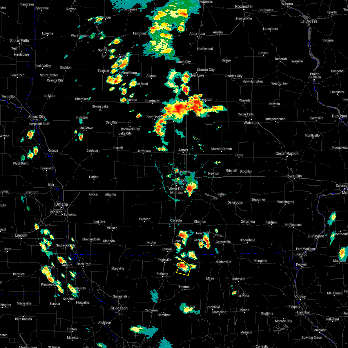 The severe thunderstorm warning for southwestern mercer county will expire at 500 pm cdt, the storm which prompted the warning has weakened below severe limits, and no longer poses an immediate threat to life or property. therefore, the warning will be allowed to expire. however small hail, gusty winds and heavy rain are still possible with this thunderstorm. The severe thunderstorm warning for southwestern mercer county will expire at 500 pm cdt, the storm which prompted the warning has weakened below severe limits, and no longer poses an immediate threat to life or property. therefore, the warning will be allowed to expire. however small hail, gusty winds and heavy rain are still possible with this thunderstorm.
|
| 5/28/2018 4:33 PM CDT |
 At 432 pm cdt, a severe thunderstorm was located over princeton, or 20 miles north of trenton, moving west at 10 mph (radar indicated). Hazards include 60 mph wind gusts and quarter size hail. Hail damage to vehicles is expected. Expect wind damage to roofs, siding, and trees. At 432 pm cdt, a severe thunderstorm was located over princeton, or 20 miles north of trenton, moving west at 10 mph (radar indicated). Hazards include 60 mph wind gusts and quarter size hail. Hail damage to vehicles is expected. Expect wind damage to roofs, siding, and trees.
|
| 5/20/2018 12:19 AM CDT |
 At 1219 am cdt, a severe thunderstorm was located near princeton, or 20 miles north of trenton, moving east at 40 mph (radar indicated). Hazards include 60 mph wind gusts and half dollar size hail. Hail damage to vehicles is expected. expect wind damage to roofs, siding, and trees. Locations impacted include, milan, princeton, spickard, newtown, pollock, lucerne, harris and mill grove. At 1219 am cdt, a severe thunderstorm was located near princeton, or 20 miles north of trenton, moving east at 40 mph (radar indicated). Hazards include 60 mph wind gusts and half dollar size hail. Hail damage to vehicles is expected. expect wind damage to roofs, siding, and trees. Locations impacted include, milan, princeton, spickard, newtown, pollock, lucerne, harris and mill grove.
|
| 5/20/2018 12:15 AM CDT | Hen Egg sized hail reported 5.5 miles NNW of Princeton, MO, accompanied by very strong straight-line winds. |
| 5/20/2018 12:15 AM CDT | Quarter sized hail reported 8.1 miles N of Princeton, MO, drifts of nickel to quarter size hail on us 65...hail fog and slick roads. |
| 5/20/2018 12:15 AM CDT | Small tree limbs down 2 to 3 inches in diameter...2 miles south of cr e on us 6 in mercer county MO, 3.5 miles NNW of Princeton, MO |
| 5/20/2018 12:06 AM CDT |
 At 1205 am cdt, a severe thunderstorm was located near princeton, or 18 miles north of trenton, moving east at 40 mph (radar indicated). Hazards include tennis ball size hail and 60 mph wind gusts. People and animals outdoors will be injured. expect hail damage to roofs, siding, windows, and vehicles. expect wind damage to roofs, siding, and trees. Locations impacted include, milan, princeton, spickard, newtown, pollock, lucerne, harris, modena and mill grove. At 1205 am cdt, a severe thunderstorm was located near princeton, or 18 miles north of trenton, moving east at 40 mph (radar indicated). Hazards include tennis ball size hail and 60 mph wind gusts. People and animals outdoors will be injured. expect hail damage to roofs, siding, windows, and vehicles. expect wind damage to roofs, siding, and trees. Locations impacted include, milan, princeton, spickard, newtown, pollock, lucerne, harris, modena and mill grove.
|
| 5/19/2018 11:58 PM CDT |
 At 1157 pm cdt, a severe thunderstorm was located near cainsville, or 14 miles northeast of bethany, moving east at 40 mph (radar indicated). Hazards include ping pong ball size hail and 60 mph wind gusts. People and animals outdoors will be injured. expect hail damage to roofs, siding, windows, and vehicles. Expect wind damage to roofs, siding, and trees. At 1157 pm cdt, a severe thunderstorm was located near cainsville, or 14 miles northeast of bethany, moving east at 40 mph (radar indicated). Hazards include ping pong ball size hail and 60 mph wind gusts. People and animals outdoors will be injured. expect hail damage to roofs, siding, windows, and vehicles. Expect wind damage to roofs, siding, and trees.
|
| 5/14/2018 8:41 PM CDT |
 The severe thunderstorm warning for west central putnam and eastern mercer counties will expire at 845 pm cdt, the storm which prompted the warning has weakened below severe limits, and no longer poses an immediate threat to life or property. therefore, the warning will be allowed to expire. The severe thunderstorm warning for west central putnam and eastern mercer counties will expire at 845 pm cdt, the storm which prompted the warning has weakened below severe limits, and no longer poses an immediate threat to life or property. therefore, the warning will be allowed to expire.
|
| 5/14/2018 8:28 PM CDT |
 At 827 pm cdt, a severe thunderstorm was located near mercer, or 22 miles south of corydon, moving southeast at 20 mph (radar indicated). Hazards include 60 mph wind gusts and quarter size hail. Hail damage to vehicles is expected. expect wind damage to roofs, siding, and trees. Locations impacted include, princeton and mercer. At 827 pm cdt, a severe thunderstorm was located near mercer, or 22 miles south of corydon, moving southeast at 20 mph (radar indicated). Hazards include 60 mph wind gusts and quarter size hail. Hail damage to vehicles is expected. expect wind damage to roofs, siding, and trees. Locations impacted include, princeton and mercer.
|
| 5/14/2018 8:04 PM CDT |
 At 804 pm cdt, a severe thunderstorm was located over mercer, or 18 miles southeast of leon, moving southeast at 20 mph (radar indicated). Hazards include ping pong ball size hail and 60 mph wind gusts. People and animals outdoors will be injured. expect hail damage to roofs, siding, windows, and vehicles. Expect wind damage to roofs, siding, and trees. At 804 pm cdt, a severe thunderstorm was located over mercer, or 18 miles southeast of leon, moving southeast at 20 mph (radar indicated). Hazards include ping pong ball size hail and 60 mph wind gusts. People and animals outdoors will be injured. expect hail damage to roofs, siding, windows, and vehicles. Expect wind damage to roofs, siding, and trees.
|
| 6/28/2017 3:16 PM CDT |
 At 816 pm cdt, a severe thunderstorm was located near new hampton, or 8 miles northeast of albany, moving east at 25 mph (radar indicated). Hazards include 60 mph wind gusts and half dollar size hail. Hail damage to vehicles is expected. expect wind damage to roofs, siding, and trees. locations impacted include, maryville, trenton, bethany, albany, stanberry, princeton, burlington junction, ridgeway, ravenwood, gilman city, new hampton, skidmore, spickard, galt, conception junction, parnell, pickering, darlington, mount moriah and clyde. this includes interstate 35 in missouri between mile markers 84 and 103. A tornado watch remains in effect until 1000 pm cdt for north central and northwestern missouri. At 816 pm cdt, a severe thunderstorm was located near new hampton, or 8 miles northeast of albany, moving east at 25 mph (radar indicated). Hazards include 60 mph wind gusts and half dollar size hail. Hail damage to vehicles is expected. expect wind damage to roofs, siding, and trees. locations impacted include, maryville, trenton, bethany, albany, stanberry, princeton, burlington junction, ridgeway, ravenwood, gilman city, new hampton, skidmore, spickard, galt, conception junction, parnell, pickering, darlington, mount moriah and clyde. this includes interstate 35 in missouri between mile markers 84 and 103. A tornado watch remains in effect until 1000 pm cdt for north central and northwestern missouri.
|
| 6/28/2017 2:30 PM CDT |
 At 730 pm cdt, a severe thunderstorm was located 8 miles southeast of ridgeway, or 10 miles east of bethany, moving east at 35 mph (radar indicated). Hazards include golf ball size hail and 60 mph wind gusts. People and animals outdoors will be injured. expect hail damage to roofs, siding, windows, and vehicles. Expect wind damage to roofs, siding, and trees. At 730 pm cdt, a severe thunderstorm was located 8 miles southeast of ridgeway, or 10 miles east of bethany, moving east at 35 mph (radar indicated). Hazards include golf ball size hail and 60 mph wind gusts. People and animals outdoors will be injured. expect hail damage to roofs, siding, windows, and vehicles. Expect wind damage to roofs, siding, and trees.
|
| 6/28/2017 2:13 PM CDT |
 At 713 pm cdt, a severe thunderstorm capable of producing a tornado was located near princeton, or 22 miles southeast of leon, moving east at 35 mph (radar indicated rotation). Hazards include tornado and half dollar size hail. Flying debris will be dangerous to those caught without shelter. mobile homes will be damaged or destroyed. damage to roofs, windows, and vehicles will occur. tree damage is likely. Locations impacted include, princeton and mercer. At 713 pm cdt, a severe thunderstorm capable of producing a tornado was located near princeton, or 22 miles southeast of leon, moving east at 35 mph (radar indicated rotation). Hazards include tornado and half dollar size hail. Flying debris will be dangerous to those caught without shelter. mobile homes will be damaged or destroyed. damage to roofs, windows, and vehicles will occur. tree damage is likely. Locations impacted include, princeton and mercer.
|
| 6/28/2017 1:51 PM CDT |
 At 651 pm cdt, a severe thunderstorm capable of producing a tornado was located near cainsville, or 17 miles northeast of bethany, moving east at 30 mph (radar indicated rotation). Hazards include tornado and half dollar size hail. Flying debris will be dangerous to those caught without shelter. mobile homes will be damaged or destroyed. damage to roofs, windows, and vehicles will occur. Tree damage is likely. At 651 pm cdt, a severe thunderstorm capable of producing a tornado was located near cainsville, or 17 miles northeast of bethany, moving east at 30 mph (radar indicated rotation). Hazards include tornado and half dollar size hail. Flying debris will be dangerous to those caught without shelter. mobile homes will be damaged or destroyed. damage to roofs, windows, and vehicles will occur. Tree damage is likely.
|
| 6/16/2017 11:15 PM CDT |
 At 1115 pm cdt, severe thunderstorms were located along a line extending from 13 miles west of unionville to near galt to 10 miles north of chillicothe, moving east at 55 mph (radar indicated). Hazards include 60 mph wind gusts. Expect damage to roofs, siding, and trees. locations impacted include, trenton, milan, gallatin, princeton, jamesport, pattonsburg, mercer, browning, spickard, galt, chula, laredo, newtown, jameson, humphreys, pollock, lucerne, tindall, brimson and harris. This includes interstate 35 in missouri between mile markers 67 and 77. At 1115 pm cdt, severe thunderstorms were located along a line extending from 13 miles west of unionville to near galt to 10 miles north of chillicothe, moving east at 55 mph (radar indicated). Hazards include 60 mph wind gusts. Expect damage to roofs, siding, and trees. locations impacted include, trenton, milan, gallatin, princeton, jamesport, pattonsburg, mercer, browning, spickard, galt, chula, laredo, newtown, jameson, humphreys, pollock, lucerne, tindall, brimson and harris. This includes interstate 35 in missouri between mile markers 67 and 77.
|
| 6/16/2017 11:00 PM CDT |
 At 1059 pm cdt, severe thunderstorms were located along a line extending from near mercer to near spickard to near jamesport, moving east at 40 mph (radar indicated). Hazards include 70 mph wind gusts. Expect considerable tree damage. damage is likely to mobile homes, roofs, and outbuildings. locations impacted include, trenton, milan, gallatin, princeton, jamesport, gilman city, pattonsburg, mercer, cainsville, browning, spickard, galt, chula, laredo, newtown, coffey, jameson, humphreys, mcfall and pollock. This includes interstate 35 in missouri between mile markers 67 and 91. At 1059 pm cdt, severe thunderstorms were located along a line extending from near mercer to near spickard to near jamesport, moving east at 40 mph (radar indicated). Hazards include 70 mph wind gusts. Expect considerable tree damage. damage is likely to mobile homes, roofs, and outbuildings. locations impacted include, trenton, milan, gallatin, princeton, jamesport, gilman city, pattonsburg, mercer, cainsville, browning, spickard, galt, chula, laredo, newtown, coffey, jameson, humphreys, mcfall and pollock. This includes interstate 35 in missouri between mile markers 67 and 91.
|
| 6/16/2017 10:44 PM CDT |
 At 1043 pm cdt, severe thunderstorms were located along a line extending from near cainsville to 7 miles west of spickard to near pattonsburg, moving southeast at 40 mph (radar indicated). Hazards include 70 mph wind gusts. Expect considerable tree damage. Damage is likely to mobile homes, roofs, and outbuildings. At 1043 pm cdt, severe thunderstorms were located along a line extending from near cainsville to 7 miles west of spickard to near pattonsburg, moving southeast at 40 mph (radar indicated). Hazards include 70 mph wind gusts. Expect considerable tree damage. Damage is likely to mobile homes, roofs, and outbuildings.
|
| 6/16/2017 10:34 PM CDT |
 At 1034 pm cdt, severe thunderstorms were located along a line extending from near ridgeway to near gilman city to pattonsburg, moving southeast at 55 mph (radar indicated). Hazards include 70 mph wind gusts. Expect considerable tree damage. damage is likely to mobile homes, roofs, and outbuildings. locations impacted include, bethany, gallatin, albany, princeton, jamesport, ridgeway, gilman city, pattonsburg, mercer, eagleville, new hampton, cainsville, spickard, blythedale, coffey, jameson, mcfall, mount moriah, tindall and brimson. This includes interstate 35 in missouri between mile markers 67 and 113. At 1034 pm cdt, severe thunderstorms were located along a line extending from near ridgeway to near gilman city to pattonsburg, moving southeast at 55 mph (radar indicated). Hazards include 70 mph wind gusts. Expect considerable tree damage. damage is likely to mobile homes, roofs, and outbuildings. locations impacted include, bethany, gallatin, albany, princeton, jamesport, ridgeway, gilman city, pattonsburg, mercer, eagleville, new hampton, cainsville, spickard, blythedale, coffey, jameson, mcfall, mount moriah, tindall and brimson. This includes interstate 35 in missouri between mile markers 67 and 113.
|
| 6/16/2017 10:07 PM CDT |
 At 1007 pm cdt, severe thunderstorms were located along a line extending from 8 miles east of grant city to near albany, moving east at 50 mph. these are very dangerous storms (radar indicated). Hazards include 80 mph wind gusts and quarter size hail. Flying debris will be dangerous to those caught without shelter. mobile homes will be heavily damaged. expect considerable damage to roofs, windows, and vehicles. Extensive tree damage and power outages are likely. At 1007 pm cdt, severe thunderstorms were located along a line extending from 8 miles east of grant city to near albany, moving east at 50 mph. these are very dangerous storms (radar indicated). Hazards include 80 mph wind gusts and quarter size hail. Flying debris will be dangerous to those caught without shelter. mobile homes will be heavily damaged. expect considerable damage to roofs, windows, and vehicles. Extensive tree damage and power outages are likely.
|
| 6/15/2017 11:15 PM CDT | Tree limbs down blocking roads...time estimated in mercer county MO, 0.4 miles ESE of Princeton, MO |
| 3/6/2017 7:48 PM CST |
 At 748 pm cst, a severe thunderstorm capable of producing a tornado was located near cainsville, or 21 miles northeast of bethany, moving northeast at 45 mph (radar indicated rotation). Hazards include tornado. Flying debris will be dangerous to those caught without shelter. mobile homes will be damaged or destroyed. damage to roofs, windows, and vehicles will occur. Tree damage is likely. At 748 pm cst, a severe thunderstorm capable of producing a tornado was located near cainsville, or 21 miles northeast of bethany, moving northeast at 45 mph (radar indicated rotation). Hazards include tornado. Flying debris will be dangerous to those caught without shelter. mobile homes will be damaged or destroyed. damage to roofs, windows, and vehicles will occur. Tree damage is likely.
|
| 9/19/2016 7:36 PM CDT |
 At 735 pm cdt, a severe thunderstorm was located 14 miles southeast of mercer, or 15 miles northwest of milan, moving southeast at 30 mph (radar indicated). Hazards include ping pong ball size hail and 60 mph wind gusts. People and animals outdoors will be injured. expect hail damage to roofs, siding, windows, and vehicles. Expect wind damage to roofs, siding, and trees. At 735 pm cdt, a severe thunderstorm was located 14 miles southeast of mercer, or 15 miles northwest of milan, moving southeast at 30 mph (radar indicated). Hazards include ping pong ball size hail and 60 mph wind gusts. People and animals outdoors will be injured. expect hail damage to roofs, siding, windows, and vehicles. Expect wind damage to roofs, siding, and trees.
|
| 9/19/2016 7:20 PM CDT | Several trees down...unknown condition in linn county MO, 7 miles SW of Princeton, MO |
| 9/19/2016 6:37 PM CDT |
 At 636 pm cdt, a severe thunderstorm was located near corydon, moving south at 35 mph (radar indicated). Hazards include ping pong ball size hail and 60 mph wind gusts. People and animals outdoors will be injured. expect hail damage to roofs, siding, windows, and vehicles. Expect wind damage to roofs, siding, and trees. At 636 pm cdt, a severe thunderstorm was located near corydon, moving south at 35 mph (radar indicated). Hazards include ping pong ball size hail and 60 mph wind gusts. People and animals outdoors will be injured. expect hail damage to roofs, siding, windows, and vehicles. Expect wind damage to roofs, siding, and trees.
|
| 7/7/2016 5:17 AM CDT |
 At 517 am cdt, severe thunderstorms were located along a line extending from 8 miles southeast of lamoni to near cainsville to 6 miles west of spickard to 7 miles east of jamesport, moving east at 60 mph (radar indicated). Hazards include 60 mph wind gusts. Expect damage to roofs. siding. and trees. locations impacted include, trenton, princeton, jamesport, ridgeway, gilman city, mercer, cainsville, spickard, galt, chula, laredo, blythedale, mount moriah, tindall, brimson, south lineville, mill grove, modena and spring hill. This includes interstate 35 in missouri between mile markers 111 and 113. At 517 am cdt, severe thunderstorms were located along a line extending from 8 miles southeast of lamoni to near cainsville to 6 miles west of spickard to 7 miles east of jamesport, moving east at 60 mph (radar indicated). Hazards include 60 mph wind gusts. Expect damage to roofs. siding. and trees. locations impacted include, trenton, princeton, jamesport, ridgeway, gilman city, mercer, cainsville, spickard, galt, chula, laredo, blythedale, mount moriah, tindall, brimson, south lineville, mill grove, modena and spring hill. This includes interstate 35 in missouri between mile markers 111 and 113.
|
| 7/7/2016 4:26 AM CDT |
 At 426 am cdt, severe thunderstorms were located along a line extending from near irena to 8 miles south of grant city to near albany to near maysville, moving east at 50 mph (radar indicated). Hazards include 60 mph wind gusts. Expect damage to roofs. siding. And trees. At 426 am cdt, severe thunderstorms were located along a line extending from near irena to 8 miles south of grant city to near albany to near maysville, moving east at 50 mph (radar indicated). Hazards include 60 mph wind gusts. Expect damage to roofs. siding. And trees.
|
| 5/27/2016 7:53 PM CDT |
 The severe thunderstorm warning for northern mercer county will expire at 800 pm cdt, the storm which prompted the warning has weakened below severe limits, and no longer pose an immediate threat to life or property. therefore the warning will be allowed to expire. however heavy rain is still possible with this thunderstorm. to report severe weather, contact your nearest law enforcement agency. they will relay your report to the national weather service pleasant hill. The severe thunderstorm warning for northern mercer county will expire at 800 pm cdt, the storm which prompted the warning has weakened below severe limits, and no longer pose an immediate threat to life or property. therefore the warning will be allowed to expire. however heavy rain is still possible with this thunderstorm. to report severe weather, contact your nearest law enforcement agency. they will relay your report to the national weather service pleasant hill.
|
| 5/27/2016 7:46 PM CDT |
 At 745 pm cdt, a severe thunderstorm was located near mercer, or 16 miles southeast of leon, moving north at 30 mph. Hazards include 60 mph wind gusts and quarter size hail. Hail damage to vehicles is expected. expect wind damage to roofs, siding, and trees. Locations impacted include, princeton, mercer, cainsville, pleasanton and south lineville. At 745 pm cdt, a severe thunderstorm was located near mercer, or 16 miles southeast of leon, moving north at 30 mph. Hazards include 60 mph wind gusts and quarter size hail. Hail damage to vehicles is expected. expect wind damage to roofs, siding, and trees. Locations impacted include, princeton, mercer, cainsville, pleasanton and south lineville.
|
| 5/27/2016 7:30 PM CDT |
 At 729 pm cdt, a severe thunderstorm was located over princeton, or 22 miles south of leon, moving north at 30 mph (trained weather spotters). Hazards include 60 mph wind gusts and nickel size hail. Expect damage to roofs. siding. and trees. Locations impacted include, princeton, mercer, cainsville, pleasanton, south lineville, modena and mill grove. At 729 pm cdt, a severe thunderstorm was located over princeton, or 22 miles south of leon, moving north at 30 mph (trained weather spotters). Hazards include 60 mph wind gusts and nickel size hail. Expect damage to roofs. siding. and trees. Locations impacted include, princeton, mercer, cainsville, pleasanton, south lineville, modena and mill grove.
|
| 5/27/2016 7:14 PM CDT |
 At 714 pm cdt, a severe thunderstorm was located near princeton, or 17 miles north of trenton, moving north at 30 mph (trained weather spotters). Hazards include 60 mph wind gusts and nickel size hail. Expect damage to roofs. siding. and trees. Locations impacted include, princeton, mercer, cainsville, spickard, tindall, pleasanton, south lineville, mill grove and modena. At 714 pm cdt, a severe thunderstorm was located near princeton, or 17 miles north of trenton, moving north at 30 mph (trained weather spotters). Hazards include 60 mph wind gusts and nickel size hail. Expect damage to roofs. siding. and trees. Locations impacted include, princeton, mercer, cainsville, spickard, tindall, pleasanton, south lineville, mill grove and modena.
|
| 5/27/2016 7:13 PM CDT |
 At 714 pm cdt, a severe thunderstorm was located near princeton, or 17 miles north of trenton, moving north at 30 mph (trained weather spotters). Hazards include 60 mph wind gusts and nickel size hail. Expect damage to roofs. siding. and trees. Locations impacted include, princeton, mercer, cainsville, spickard, tindall, pleasanton, south lineville, mill grove and modena. At 714 pm cdt, a severe thunderstorm was located near princeton, or 17 miles north of trenton, moving north at 30 mph (trained weather spotters). Hazards include 60 mph wind gusts and nickel size hail. Expect damage to roofs. siding. and trees. Locations impacted include, princeton, mercer, cainsville, spickard, tindall, pleasanton, south lineville, mill grove and modena.
|
| 4/27/2016 6:27 PM CDT | The severe thunderstorm warning for mercer, western sullivan, western putnam, grundy and northwestern linn counties will expire at 630 pm cdt, the storms which prompted the warning have weakened below severe limits, and no longer pose an immediate threat to life or property. therefore the warning will be allowed to expire. however small hail and gusty winds are still possible with these thunderstorms. a tornado watch remains in effect until 900 pm cdt for north central missouri. |
| 4/27/2016 6:19 PM CDT |
 At 618 pm cdt, severe thunderstorms were located along a line extending from near mercer to near spickard to 11 miles south of galt, moving east at 30 mph (radar indicated). Hazards include 60 mph wind gusts and quarter size hail. Hail damage to vehicles is expected. expect wind damage to roofs, siding, and trees. locations impacted include, trenton, milan, princeton, mercer, browning, spickard, galt, laredo, newtown, humphreys, lucerne, tindall, harris, powersville, pleasanton, osgood, south lineville, mill grove, modena and reger. A tornado watch remains in effect until 900 pm cdt for north central missouri. At 618 pm cdt, severe thunderstorms were located along a line extending from near mercer to near spickard to 11 miles south of galt, moving east at 30 mph (radar indicated). Hazards include 60 mph wind gusts and quarter size hail. Hail damage to vehicles is expected. expect wind damage to roofs, siding, and trees. locations impacted include, trenton, milan, princeton, mercer, browning, spickard, galt, laredo, newtown, humphreys, lucerne, tindall, harris, powersville, pleasanton, osgood, south lineville, mill grove, modena and reger. A tornado watch remains in effect until 900 pm cdt for north central missouri.
|
| 4/27/2016 5:52 PM CDT |
 At 552 pm cdt, severe thunderstorms were located along a line extending from 6 miles southeast of lamoni to 7 miles west of spickard to 6 miles east of jamesport, moving east at 30 mph (radar indicated). Hazards include 60 mph wind gusts and quarter size hail. Hail damage to vehicles is expected. Expect wind damage to roofs, siding, and trees. At 552 pm cdt, severe thunderstorms were located along a line extending from 6 miles southeast of lamoni to 7 miles west of spickard to 6 miles east of jamesport, moving east at 30 mph (radar indicated). Hazards include 60 mph wind gusts and quarter size hail. Hail damage to vehicles is expected. Expect wind damage to roofs, siding, and trees.
|
| 3/15/2016 3:51 AM CDT |
 At 350 am cdt, severe thunderstorms were located along a line extending from 10 miles south of leon to near princeton to near trenton, moving east at 45 mph (radar indicated). Hazards include 60 mph wind gusts and penny size hail. Expect damage to roofs. siding. and trees. Locations impacted include, princeton, mercer, spickard, galt, tindall and mill grove. At 350 am cdt, severe thunderstorms were located along a line extending from 10 miles south of leon to near princeton to near trenton, moving east at 45 mph (radar indicated). Hazards include 60 mph wind gusts and penny size hail. Expect damage to roofs. siding. and trees. Locations impacted include, princeton, mercer, spickard, galt, tindall and mill grove.
|
| 3/15/2016 3:40 AM CDT |
 A severe thunderstorm warning remains in effect until 415 am cdt for mercer and northern grundy counties. at 340 am cdt. severe thunderstorms were located along a line extending from 7 miles southeast of lamoni to near princeton to 6 miles east of gilman city. moving east at 45 mph. hazard. 60 mph wind gusts and quarter size hail. A severe thunderstorm warning remains in effect until 415 am cdt for mercer and northern grundy counties. at 340 am cdt. severe thunderstorms were located along a line extending from 7 miles southeast of lamoni to near princeton to 6 miles east of gilman city. moving east at 45 mph. hazard. 60 mph wind gusts and quarter size hail.
|
| 3/15/2016 3:28 AM CDT |
 At 327 am cdt, severe thunderstorms were located along a line extending from near eagleville to near cainsville to near gilman city, moving east at 45 mph (radar indicated). Hazards include 60 mph wind gusts and quarter size hail. Hail damage to vehicles is expected. Expect wind damage to roofs, siding, and trees. At 327 am cdt, severe thunderstorms were located along a line extending from near eagleville to near cainsville to near gilman city, moving east at 45 mph (radar indicated). Hazards include 60 mph wind gusts and quarter size hail. Hail damage to vehicles is expected. Expect wind damage to roofs, siding, and trees.
|
| 11/11/2015 3:03 PM CST |
 At 302 pm cst, severe thunderstorms were located along a line extending from 10 miles east of mercer to near browning to near bosworth, moving northeast at 55 mph (radar indicated). Hazards include 70 mph wind gusts. Expect considerable tree damage. damage is likely to mobile homes, roofs and outbuildings. locations impacted include, chillicothe, trenton, brookfield, carrollton, marceline, milan, unionville, princeton, brunswick, green city, meadville, hale, laclede, mercer, bosworth, linneus, wheeling, browning, spickard and galt. A tornado watch remains in effect until 600 pm cst for north central missouri. At 302 pm cst, severe thunderstorms were located along a line extending from 10 miles east of mercer to near browning to near bosworth, moving northeast at 55 mph (radar indicated). Hazards include 70 mph wind gusts. Expect considerable tree damage. damage is likely to mobile homes, roofs and outbuildings. locations impacted include, chillicothe, trenton, brookfield, carrollton, marceline, milan, unionville, princeton, brunswick, green city, meadville, hale, laclede, mercer, bosworth, linneus, wheeling, browning, spickard and galt. A tornado watch remains in effect until 600 pm cst for north central missouri.
|
| 11/11/2015 2:43 PM CST |
 At 242 pm cst, severe thunderstorms were located along a line extending from near mercer to 9 miles northwest of norborne, moving northeast at 55 mph (radar indicated). Hazards include 60 mph wind gusts. Expect damage to roofs. Siding and trees. At 242 pm cst, severe thunderstorms were located along a line extending from near mercer to 9 miles northwest of norborne, moving northeast at 55 mph (radar indicated). Hazards include 60 mph wind gusts. Expect damage to roofs. Siding and trees.
|
| 11/11/2015 2:38 PM CST |
 At 237 pm cst, a severe thunderstorm capable of producing a tornado was located near mercer, or 24 miles southwest of corydon, moving northeast at 50 mph (radar indicated rotation). Hazards include tornado. Flying debris will be dangerous to those caught without shelter. mobile homes will be damaged or destroyed. damage to roofs, windows and vehicles will occur. tree damage is likely. Locations impacted include, princeton, mercer, powersville and south lineville. At 237 pm cst, a severe thunderstorm capable of producing a tornado was located near mercer, or 24 miles southwest of corydon, moving northeast at 50 mph (radar indicated rotation). Hazards include tornado. Flying debris will be dangerous to those caught without shelter. mobile homes will be damaged or destroyed. damage to roofs, windows and vehicles will occur. tree damage is likely. Locations impacted include, princeton, mercer, powersville and south lineville.
|
| 11/11/2015 2:30 PM CST |
 At 230 pm cst, a severe thunderstorm capable of producing a tornado was located over princeton, or 21 miles north of trenton, moving northeast at 55 mph (radar indicated rotation). Hazards include tornado. Flying debris will be dangerous to those caught without shelter. mobile homes will be damaged or destroyed. damage to roofs, windows and vehicles will occur. Tree damage is likely. At 230 pm cst, a severe thunderstorm capable of producing a tornado was located over princeton, or 21 miles north of trenton, moving northeast at 55 mph (radar indicated rotation). Hazards include tornado. Flying debris will be dangerous to those caught without shelter. mobile homes will be damaged or destroyed. damage to roofs, windows and vehicles will occur. Tree damage is likely.
|
| 11/11/2015 2:18 PM CST |
 At 217 pm cst, severe thunderstorms were located along a line extending from 6 miles southwest of spickard to near hamilton, moving northeast at 55 mph (radar indicated). Hazards include 60 mph wind gusts. Expect damage to roofs. siding and trees. locations impacted include, chillicothe, trenton, hamilton, gallatin, princeton, jamesport, gilman city, breckenridge, utica, spickard, galt, chula, laredo, newtown, mooresville, mount moriah, lucerne, tindall, brimson and harris. A tornado watch remains in effect until 600 pm cst for north central missouri. At 217 pm cst, severe thunderstorms were located along a line extending from 6 miles southwest of spickard to near hamilton, moving northeast at 55 mph (radar indicated). Hazards include 60 mph wind gusts. Expect damage to roofs. siding and trees. locations impacted include, chillicothe, trenton, hamilton, gallatin, princeton, jamesport, gilman city, breckenridge, utica, spickard, galt, chula, laredo, newtown, mooresville, mount moriah, lucerne, tindall, brimson and harris. A tornado watch remains in effect until 600 pm cst for north central missouri.
|
| 11/11/2015 2:02 PM CST |
 At 202 pm cst, severe thunderstorms were located along a line extending from near gilman city to near hamilton, moving northeast at 65 mph (radar indicated). Hazards include 60 mph wind gusts. Expect damage to roofs. Siding and trees. At 202 pm cst, severe thunderstorms were located along a line extending from near gilman city to near hamilton, moving northeast at 65 mph (radar indicated). Hazards include 60 mph wind gusts. Expect damage to roofs. Siding and trees.
|
| 7/28/2015 9:55 PM CDT |
 At 955 pm cdt, severe thunderstorms were located along a line extending from 8 miles southwest of rathbun lake to 6 miles south of corydon to near mercer, moving southeast at 30 mph (radar indicated). Hazards include 60 mph wind gusts. Expect damage to roofs. siding and trees. Locations impacted include, unionville, princeton, mercer, lineville, lucerne, powersville, pleasanton and south lineville. At 955 pm cdt, severe thunderstorms were located along a line extending from 8 miles southwest of rathbun lake to 6 miles south of corydon to near mercer, moving southeast at 30 mph (radar indicated). Hazards include 60 mph wind gusts. Expect damage to roofs. siding and trees. Locations impacted include, unionville, princeton, mercer, lineville, lucerne, powersville, pleasanton and south lineville.
|
| 7/28/2015 9:40 PM CDT |
 At 940 pm cdt, severe thunderstorms were located along a line extending from near rathbun lake to near corydon to 9 miles south of leon, moving southeast at 30 mph (radar indicated). Hazards include 60 mph wind gusts. Expect damage to roofs. Siding and trees. At 940 pm cdt, severe thunderstorms were located along a line extending from near rathbun lake to near corydon to 9 miles south of leon, moving southeast at 30 mph (radar indicated). Hazards include 60 mph wind gusts. Expect damage to roofs. Siding and trees.
|
| 7/13/2015 4:16 PM CDT | 6 inch tree limb down... along with numerous 2-3 inch limbs down in cit in mercer county MO, 0.4 miles ESE of Princeton, MO |
| 7/13/2015 4:13 PM CDT |
 At 413 pm cdt, a severe thunderstorm was located near princeton, or 17 miles north of trenton, moving east at 40 mph (radar indicated). Hazards include 60 mph wind gusts and quarter size hail. Hail damage to vehicles is expected. Expect wind damage to roofs, siding and trees. At 413 pm cdt, a severe thunderstorm was located near princeton, or 17 miles north of trenton, moving east at 40 mph (radar indicated). Hazards include 60 mph wind gusts and quarter size hail. Hail damage to vehicles is expected. Expect wind damage to roofs, siding and trees.
|
| 7/13/2015 4:04 PM CDT | Multiple trees down along route in mercer county MO, 2.4 miles E of Princeton, MO |
| 7/13/2015 3:59 PM CDT |
 At 358 pm cdt, a severe thunderstorm was located near cainsville, or 13 miles northeast of bethany, moving east at 40 mph (radar indicated). Hazards include 60 mph wind gusts and quarter size hail. Hail damage to vehicles is expected. expect wind damage to roofs, siding and trees. locations impacted include, bethany, princeton, ridgeway, eagleville, cainsville, spickard, blythedale, mount moriah, modena and mill grove. This includes interstate 35 in missouri between mile markers 92 and 110. At 358 pm cdt, a severe thunderstorm was located near cainsville, or 13 miles northeast of bethany, moving east at 40 mph (radar indicated). Hazards include 60 mph wind gusts and quarter size hail. Hail damage to vehicles is expected. expect wind damage to roofs, siding and trees. locations impacted include, bethany, princeton, ridgeway, eagleville, cainsville, spickard, blythedale, mount moriah, modena and mill grove. This includes interstate 35 in missouri between mile markers 92 and 110.
|
| 7/13/2015 3:36 PM CDT |
 At 335 pm cdt, a severe thunderstorm was located 7 miles northwest of bethany, moving east at 40 mph (radar indicated). Hazards include 60 mph wind gusts and quarter size hail. Hail damage to vehicles is expected. Expect wind damage to roofs, siding and trees. At 335 pm cdt, a severe thunderstorm was located 7 miles northwest of bethany, moving east at 40 mph (radar indicated). Hazards include 60 mph wind gusts and quarter size hail. Hail damage to vehicles is expected. Expect wind damage to roofs, siding and trees.
|
| 6/21/2015 7:20 PM CDT |
 At 630 pm, trained weather spotters reported quarter size hail in eagleville. at 718 pm cdt, a severe thunderstorm was located 7 miles northwest of spickard, and moving southeast at 20 mph (radar indicated). Hazards include quarter size hail. Damage to vehicles is expected. Locations impacted include, princeton, spickard, modena and mill grove. At 630 pm, trained weather spotters reported quarter size hail in eagleville. at 718 pm cdt, a severe thunderstorm was located 7 miles northwest of spickard, and moving southeast at 20 mph (radar indicated). Hazards include quarter size hail. Damage to vehicles is expected. Locations impacted include, princeton, spickard, modena and mill grove.
|
| 6/21/2015 6:57 PM CDT |
 At 655 pm cdt, a severe thunderstorm was located near cainsville, and moving southeast at 20 mph. at 652 pm, public reported quarter size hail in ridgeway (trained weather spotters). Hazards include quarter size hail. damage to vehicles is expected At 655 pm cdt, a severe thunderstorm was located near cainsville, and moving southeast at 20 mph. at 652 pm, public reported quarter size hail in ridgeway (trained weather spotters). Hazards include quarter size hail. damage to vehicles is expected
|
| 6/11/2015 7:05 PM CDT | Power outages in mercer county MO, 3.3 miles N of Princeton, MO |
| 6/11/2015 6:55 PM CDT |
 At 654 pm cdt, a severe thunderstorm was located near princeton, and moving east at 35 mph (radar indicated). Hazards include 60 mph wind gusts and quarter size hail. Hail damage to vehicles is expected. Expect wind damage to roofs, siding and trees. At 654 pm cdt, a severe thunderstorm was located near princeton, and moving east at 35 mph (radar indicated). Hazards include 60 mph wind gusts and quarter size hail. Hail damage to vehicles is expected. Expect wind damage to roofs, siding and trees.
|
| 6/11/2015 6:20 PM CDT |
 At 619 pm cdt, a severe thunderstorm was located near ridgeway, and moving southeast at 35 mph. at 550 pm, trained weather spotters reported a 60 mph wind gust in grant city. at 555 pm, local law enforcement reported straight line wind damage in grant city. at 607 pm, the public reported a 60 mph wind gust in hatfield (radar indicated). Hazards include 60 mph wind gusts and quarter size hail. Hail damage to vehicles is expected. Expect wind damage to roofs, siding and trees. At 619 pm cdt, a severe thunderstorm was located near ridgeway, and moving southeast at 35 mph. at 550 pm, trained weather spotters reported a 60 mph wind gust in grant city. at 555 pm, local law enforcement reported straight line wind damage in grant city. at 607 pm, the public reported a 60 mph wind gust in hatfield (radar indicated). Hazards include 60 mph wind gusts and quarter size hail. Hail damage to vehicles is expected. Expect wind damage to roofs, siding and trees.
|
| 5/17/2015 1:03 AM CDT | At 101 am cdt, severe thunderstorms were located along a line extending from 5 miles northwest of cainsville to spickard, and moving northeast at 55 mph. at 1244 am, the public reported a 60 mph wind gust in jamesport (radar indicated). Hazards include 60 mph wind gusts. Expect damage to roofs. Siding and trees. |
| 6/30/2014 6:29 PM CDT | Sheet metal and tree damage across road e and hazel road in mercer county MO, 5.6 miles NW of Princeton, MO |
| 6/30/2014 6:25 PM CDT | Quarter sized hail reported 0.4 miles ESE of Princeton, MO |
| 6/30/2014 6:11 PM CDT | Wind gusts estimated 50 to 60 mph. heavy rain. small branches about 1 inch in diameter dow in mercer county MO, 1 miles ENE of Princeton, MO |
| 6/29/2014 9:35 PM CDT | Several live maple limbs 2 inches in diameter broken off...time estimated in mercer county MO, 0.4 miles ESE of Princeton, MO |
| 6/3/2014 6:47 PM CDT | Golf Ball sized hail reported 0.4 miles ESE of Princeton, MO, golf ball sized hail and 70 mph winds reported by spotter. |
| 6/3/2014 6:40 PM CDT | 8 inch limbs snapped... 30 foot steel ham tower bent to the groun in mercer county MO, 1.4 miles E of Princeton, MO |
| 5/19/2013 8:25 PM CDT | 60 mph wnd gusts in mercer county MO, 1 miles ENE of Princeton, MO |
| 1/1/0001 12:00 AM | Very heavy rain and pea-sized hail as wel in mercer county MO, 0.4 miles ESE of Princeton, MO |
| 1/1/0001 12:00 AM | Large tree limb down. power out in mill grov in mercer county MO, 5.4 miles N of Princeton, MO |
Hail Maps for Princeton, MO
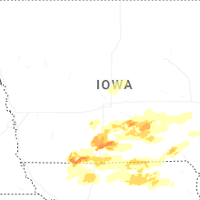

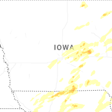

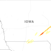
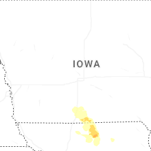

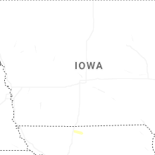


Connect with Interactive Hail Maps