

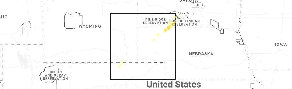
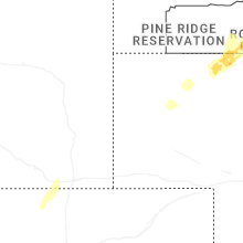
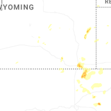
Hail Map for Red Feather Lakes, CO
The Red Feather Lakes, CO area has had 10 reports of on-the-ground hail by trained spotters, and has been under severe weather warnings 0 times during the past 12 months. Doppler radar has detected hail at or near Red Feather Lakes, CO on 29 occasions, including 2 occasions during the past year.
| Name: | Red Feather Lakes, CO |
| Where Located: | 35.1 miles S of Laramie, WY |
| Map: | Google Map for Red Feather Lakes, CO |
| Population: | 343 |
| Housing Units: | 1060 |
| More Info: | Search Google for Red Feather Lakes, CO |
0
The Top Recent Hail Date for Red Feather Lakes, CO is Saturday, October 4, 2025 (20th out of 29)
Hail and Wind Damage Spotted near Red Feather Lakes, CO
| Date / Time | Report Details |
|---|---|
| 6/8/2024 1:15 PM MDT |
 Svrbou the national weather service in denver colorado has issued a * severe thunderstorm warning for, northeastern larimer county in north central colorado, * until 200 pm mdt. * at 114 pm mdt, a severe thunderstorm was located 4 miles northeast of rustic, or 26 miles northwest of fort collins, moving east at 40 mph (radar indicated). Hazards include 60 mph wind gusts and quarter size hail. Expect damage to roofs, siding, and trees. hail damage to vehicles is expected. this severe thunderstorm will be near, red feather lakes around 120 pm mdt. mishawaka around 125 pm mdt. poudre park around 130 pm mdt. Other locations in the path of this severe thunderstorm include livermore and wellington. Svrbou the national weather service in denver colorado has issued a * severe thunderstorm warning for, northeastern larimer county in north central colorado, * until 200 pm mdt. * at 114 pm mdt, a severe thunderstorm was located 4 miles northeast of rustic, or 26 miles northwest of fort collins, moving east at 40 mph (radar indicated). Hazards include 60 mph wind gusts and quarter size hail. Expect damage to roofs, siding, and trees. hail damage to vehicles is expected. this severe thunderstorm will be near, red feather lakes around 120 pm mdt. mishawaka around 125 pm mdt. poudre park around 130 pm mdt. Other locations in the path of this severe thunderstorm include livermore and wellington.
|
| 8/10/2023 12:37 PM MDT | Mesonet station co036 virginia dal in larimer county CO, 15.6 miles SW of Red Feather Lakes, CO |
| 7/4/2023 6:02 PM MDT |
 At 602 pm mdt, severe thunderstorms were located along a line extending from 5 miles north of virginia dale to 3 miles northeast of rustic, or along a line extending from 22 miles southeast of laramie to 27 miles northwest of fort collins, moving east at 30 mph (radar indicated). Hazards include 60 mph wind gusts and half dollar size hail. Expect damage to roofs, siding, and trees. hail damage to vehicles is expected. severe thunderstorms will be near, virginia dale around 610 pm mdt. other locations in the path of these severe thunderstorms include poudre park and livermore. hail threat, radar indicated max hail size, 1. 25 in wind threat, radar indicated max wind gust, 60 mph. At 602 pm mdt, severe thunderstorms were located along a line extending from 5 miles north of virginia dale to 3 miles northeast of rustic, or along a line extending from 22 miles southeast of laramie to 27 miles northwest of fort collins, moving east at 30 mph (radar indicated). Hazards include 60 mph wind gusts and half dollar size hail. Expect damage to roofs, siding, and trees. hail damage to vehicles is expected. severe thunderstorms will be near, virginia dale around 610 pm mdt. other locations in the path of these severe thunderstorms include poudre park and livermore. hail threat, radar indicated max hail size, 1. 25 in wind threat, radar indicated max wind gust, 60 mph.
|
| 7/4/2023 5:57 PM MDT |
 The severe thunderstorm warning for north central larimer county will expire at 600 pm mdt, the storms which prompted the warning have weakened below severe limits, and no longer pose an immediate threat to life or property. therefore, the warning will be allowed to expire. however small hail, gusty winds and heavy rain are still possible with these thunderstorms. a severe thunderstorm watch remains in effect until 1100 pm mdt for north central colorado. The severe thunderstorm warning for north central larimer county will expire at 600 pm mdt, the storms which prompted the warning have weakened below severe limits, and no longer pose an immediate threat to life or property. therefore, the warning will be allowed to expire. however small hail, gusty winds and heavy rain are still possible with these thunderstorms. a severe thunderstorm watch remains in effect until 1100 pm mdt for north central colorado.
|
| 7/4/2023 5:45 PM MDT |
 At 545 pm mdt, severe thunderstorms were located along a line extending from 11 miles south of hutton lake to kinikinik, or along a line extending from 22 miles south of laramie to 37 miles west of fort collins, moving east at 35 mph (radar indicated). Hazards include 70 mph wind gusts and ping pong ball size hail. Expect considerable tree damage. damage is likely to mobile homes, roofs, and outbuildings. people and animals outdoors will be injured. expect hail damage to roofs, siding, windows, and vehicles. locations impacted include, red feather lakes. thunderstorm damage threat, considerable hail threat, radar indicated max hail size, 1. 50 in wind threat, radar indicated max wind gust, 70 mph. At 545 pm mdt, severe thunderstorms were located along a line extending from 11 miles south of hutton lake to kinikinik, or along a line extending from 22 miles south of laramie to 37 miles west of fort collins, moving east at 35 mph (radar indicated). Hazards include 70 mph wind gusts and ping pong ball size hail. Expect considerable tree damage. damage is likely to mobile homes, roofs, and outbuildings. people and animals outdoors will be injured. expect hail damage to roofs, siding, windows, and vehicles. locations impacted include, red feather lakes. thunderstorm damage threat, considerable hail threat, radar indicated max hail size, 1. 50 in wind threat, radar indicated max wind gust, 70 mph.
|
| 7/4/2023 5:40 PM MDT | Storm damage reported in larimer county CO, 15.6 miles SE of Red Feather Lakes, CO |
| 7/4/2023 5:36 PM MDT |
 At 535 pm mdt, severe thunderstorms were located along a line extending from 10 miles northeast of four corners to 4 miles west of kinikinik, or along a line extending from 24 miles southwest of laramie to 41 miles west of fort collins, moving east at 35 mph (radar indicated). Hazards include 70 mph wind gusts and quarter size hail. Expect considerable tree damage. damage is likely to mobile homes, roofs, and outbuildings. hail damage to vehicles is expected. these severe thunderstorms will remain over mainly rural areas of north central larimer county. thunderstorm damage threat, considerable hail threat, radar indicated max hail size, 1. 00 in wind threat, radar indicated max wind gust, 70 mph. At 535 pm mdt, severe thunderstorms were located along a line extending from 10 miles northeast of four corners to 4 miles west of kinikinik, or along a line extending from 24 miles southwest of laramie to 41 miles west of fort collins, moving east at 35 mph (radar indicated). Hazards include 70 mph wind gusts and quarter size hail. Expect considerable tree damage. damage is likely to mobile homes, roofs, and outbuildings. hail damage to vehicles is expected. these severe thunderstorms will remain over mainly rural areas of north central larimer county. thunderstorm damage threat, considerable hail threat, radar indicated max hail size, 1. 00 in wind threat, radar indicated max wind gust, 70 mph.
|
| 6/29/2022 1:41 PM MDT |
 The severe thunderstorm warning for north central larimer county will expire at 145 pm mdt, the storm which prompted the warning has weakened below severe limits, and no longer poses an immediate threat to life or property. therefore, the warning will be allowed to expire. however gusty winds up to 50 mph are still possible with additional showers and thunderstorms moving across. The severe thunderstorm warning for north central larimer county will expire at 145 pm mdt, the storm which prompted the warning has weakened below severe limits, and no longer poses an immediate threat to life or property. therefore, the warning will be allowed to expire. however gusty winds up to 50 mph are still possible with additional showers and thunderstorms moving across.
|
| 6/29/2022 1:27 PM MDT |
 At 126 pm mdt, a severe thunderstorm was located near red feather lakes, or 27 miles northwest of fort collins, moving east at 30 mph (radar indicated). Hazards include 60 mph wind gusts. Expect damage to roofs, siding, and trees. this severe thunderstorm will remain over mainly rural areas of north central larimer county. hail threat, radar indicated max hail size, <. 75 in wind threat, radar indicated max wind gust, 60 mph. At 126 pm mdt, a severe thunderstorm was located near red feather lakes, or 27 miles northwest of fort collins, moving east at 30 mph (radar indicated). Hazards include 60 mph wind gusts. Expect damage to roofs, siding, and trees. this severe thunderstorm will remain over mainly rural areas of north central larimer county. hail threat, radar indicated max hail size, <. 75 in wind threat, radar indicated max wind gust, 60 mph.
|
| 6/29/2022 1:15 PM MDT |
 At 115 pm mdt, a severe thunderstorm was located near red feather lakes, or 31 miles northwest of fort collins, moving east at 30 mph (radar indicated). Hazards include 60 mph wind gusts. Expect damage to roofs, siding, and trees. this severe thunderstorm will be near, cherokee park around 130 pm mdt. hail threat, radar indicated max hail size, <. 75 in wind threat, radar indicated max wind gust, 60 mph. At 115 pm mdt, a severe thunderstorm was located near red feather lakes, or 31 miles northwest of fort collins, moving east at 30 mph (radar indicated). Hazards include 60 mph wind gusts. Expect damage to roofs, siding, and trees. this severe thunderstorm will be near, cherokee park around 130 pm mdt. hail threat, radar indicated max hail size, <. 75 in wind threat, radar indicated max wind gust, 60 mph.
|
| 8/26/2021 10:06 PM MDT | Mesonet station kpum pumpkin vine (wydot in albany county WY, 17.9 miles SSW of Red Feather Lakes, CO |
| 8/6/2021 7:12 PM MDT | Mesonet station co036 287n381 virginia dal in larimer county CO, 15.6 miles SW of Red Feather Lakes, CO |
| 8/4/2020 8:26 PM MDT |
 At 826 pm mdt, a severe thunderstorm was located 7 miles east of four corners, or 31 miles south of laramie, moving southeast at 25 mph (radar indicated). Hazards include 60 mph wind gusts and quarter size hail. Expect damage to roofs, siding, and trees. hail damage to vehicles is expected. Locations impacted include, red feather lakes. At 826 pm mdt, a severe thunderstorm was located 7 miles east of four corners, or 31 miles south of laramie, moving southeast at 25 mph (radar indicated). Hazards include 60 mph wind gusts and quarter size hail. Expect damage to roofs, siding, and trees. hail damage to vehicles is expected. Locations impacted include, red feather lakes.
|
| 8/4/2020 8:18 PM MDT | Golf Ball sized hail reported 15.1 miles SE of Red Feather Lakes, CO, minor damage to gutters. time estimated from radar. |
| 8/4/2020 8:04 PM MDT |
 At 804 pm mdt, a severe thunderstorm was located 7 miles north of four corners, or 27 miles southwest of laramie, moving south at 20 mph (radar indicated). Hazards include 60 mph wind gusts and half dollar size hail. Expect damage to roofs, siding, and trees. Hail damage to vehicles is expected. At 804 pm mdt, a severe thunderstorm was located 7 miles north of four corners, or 27 miles southwest of laramie, moving south at 20 mph (radar indicated). Hazards include 60 mph wind gusts and half dollar size hail. Expect damage to roofs, siding, and trees. Hail damage to vehicles is expected.
|
| 8/1/2020 6:58 PM MDT | Golf Ball sized hail reported 5 miles W of Red Feather Lakes, CO, hail was 1.5 to 1.75 inches in diameter. delayed report. |
| 8/1/2020 6:58 PM MDT | Quarter sized hail reported 8 miles WNW of Red Feather Lakes, CO |
| 8/1/2020 6:44 PM MDT | Ping Pong Ball sized hail reported 5.5 miles WNW of Red Feather Lakes, CO, delayed report. |
| 8/1/2020 6:41 PM MDT | Quarter sized hail reported 0.3 miles NE of Red Feather Lakes, CO, delayed report. |
| 8/1/2020 6:33 PM MDT |
 At 633 pm mdt, a severe thunderstorm was located 5 miles southeast of cherokee park, or 28 miles northwest of fort collins, moving south at 25 mph (radar indicated). Hazards include 60 mph wind gusts and quarter size hail. Expect damage to roofs, siding, and trees. hail damage to vehicles is expected. Locations impacted include, cherokee park and red feather lakes. At 633 pm mdt, a severe thunderstorm was located 5 miles southeast of cherokee park, or 28 miles northwest of fort collins, moving south at 25 mph (radar indicated). Hazards include 60 mph wind gusts and quarter size hail. Expect damage to roofs, siding, and trees. hail damage to vehicles is expected. Locations impacted include, cherokee park and red feather lakes.
|
| 8/1/2020 6:03 PM MDT |
 At 601 pm mdt, a severe thunderstorm was located over pumpkin vine, or 19 miles south of laramie, moving south at 25 mph (radar indicated). Hazards include 60 mph wind gusts and quarter size hail. Expect damage to roofs, siding, and trees. Hail damage to vehicles is expected. At 601 pm mdt, a severe thunderstorm was located over pumpkin vine, or 19 miles south of laramie, moving south at 25 mph (radar indicated). Hazards include 60 mph wind gusts and quarter size hail. Expect damage to roofs, siding, and trees. Hail damage to vehicles is expected.
|
| 7/13/2020 3:55 PM MDT | Upr site 60mph mesonet wind gus in laramie county WY, 21.8 miles SW of Red Feather Lakes, CO |
| 7/13/2020 3:42 PM MDT | Mesonet station kpum pumpkin vine (wydot in albany county WY, 17.9 miles SSW of Red Feather Lakes, CO |
| 7/13/2020 3:36 PM MDT |
 At 335 pm mdt, severe thunderstorms were located along a line extending from 11 miles south of hutton lake to 6 miles west of buckhorn mountain to near allenspark, or along a line extending from 22 miles south of laramie to 20 miles west of fort collins to 43 miles northwest of denver, moving east at 45 mph (radar indicated). Hazards include 60 mph wind gusts. expect damage to roofs, siding, and trees At 335 pm mdt, severe thunderstorms were located along a line extending from 11 miles south of hutton lake to 6 miles west of buckhorn mountain to near allenspark, or along a line extending from 22 miles south of laramie to 20 miles west of fort collins to 43 miles northwest of denver, moving east at 45 mph (radar indicated). Hazards include 60 mph wind gusts. expect damage to roofs, siding, and trees
|
| 7/13/2020 3:23 PM MDT |
 At 321 pm mdt, severe thunderstorms were located along a line extending from 5 miles east of boswell creek campground to 6 miles southeast of grand lake, or along a line extending from 30 miles southwest of laramie to 45 miles southwest of fort collins, moving northeast at 25 mph. a 63 mph wind gust as recorded at the airport in walden as this storm moved through (radar indicated). Hazards include 60 mph wind gusts. Expect damage to roofs, siding, and trees. Locations impacted include, estes park, trail ridge, bear lake, grand lake, raymond, allenspark, red feather lakes, rustic, longs peak, glendevey, pingree park, cameron pass, glen haven, four corners, meeker park, gould and cherokee park. At 321 pm mdt, severe thunderstorms were located along a line extending from 5 miles east of boswell creek campground to 6 miles southeast of grand lake, or along a line extending from 30 miles southwest of laramie to 45 miles southwest of fort collins, moving northeast at 25 mph. a 63 mph wind gust as recorded at the airport in walden as this storm moved through (radar indicated). Hazards include 60 mph wind gusts. Expect damage to roofs, siding, and trees. Locations impacted include, estes park, trail ridge, bear lake, grand lake, raymond, allenspark, red feather lakes, rustic, longs peak, glendevey, pingree park, cameron pass, glen haven, four corners, meeker park, gould and cherokee park.
|
| 7/13/2020 3:00 PM MDT |
 At 259 pm mdt, severe thunderstorms were located along a line extending from 3 miles southeast of six mile campground to 6 miles northwest of granby, or along a line extending from 45 miles southwest of laramie to 57 miles southwest of fort collins, moving east at 45 mph (radar indicated). Hazards include 60 mph wind gusts. expect damage to roofs, siding, and trees At 259 pm mdt, severe thunderstorms were located along a line extending from 3 miles southeast of six mile campground to 6 miles northwest of granby, or along a line extending from 45 miles southwest of laramie to 57 miles southwest of fort collins, moving east at 45 mph (radar indicated). Hazards include 60 mph wind gusts. expect damage to roofs, siding, and trees
|
| 6/6/2020 3:46 PM MDT |
 At 342 pm mdt, severe thunderstorms were located along a line extending from 3 miles north of drake to near aspen springs to 7 miles west of elevenmile canyon reservoir, or along a line extending from 15 miles west of fort collins to 28 miles west of denver to 39 miles north of hayden pass burn scar, the storms are moving northeast at 60 mph. these are very dangerous storms (an automated weather station in lakewood recorded a peak wind gust to 70 mph at bear creek golf club in southwest lakewood). Hazards include 75 mph wind gusts. Flying debris will be dangerous to those caught without shelter. mobile homes will be heavily damaged. expect considerable damage to roofs, windows, and vehicles. extensive tree damage and power outages are likely. Locations impacted include, denver, fort collins, greeley, aurora, lakewood, thornton, arvada, westminster, centennial, boulder, longmont, loveland, broomfield, highlands ranch, castle rock, commerce city, parker, littleton, northglenn and brighton. At 342 pm mdt, severe thunderstorms were located along a line extending from 3 miles north of drake to near aspen springs to 7 miles west of elevenmile canyon reservoir, or along a line extending from 15 miles west of fort collins to 28 miles west of denver to 39 miles north of hayden pass burn scar, the storms are moving northeast at 60 mph. these are very dangerous storms (an automated weather station in lakewood recorded a peak wind gust to 70 mph at bear creek golf club in southwest lakewood). Hazards include 75 mph wind gusts. Flying debris will be dangerous to those caught without shelter. mobile homes will be heavily damaged. expect considerable damage to roofs, windows, and vehicles. extensive tree damage and power outages are likely. Locations impacted include, denver, fort collins, greeley, aurora, lakewood, thornton, arvada, westminster, centennial, boulder, longmont, loveland, broomfield, highlands ranch, castle rock, commerce city, parker, littleton, northglenn and brighton.
|
| 6/6/2020 3:03 PM MDT |
 At 303 pm mdt, severe thunderstorms were located along a line extending from 3 miles north of drake to near aspen springs to 8 miles west of elevenmile canyon reservoir, or along a line extending from 15 miles west of fort collins to 28 miles west of denver to 39 miles north of hayden pass burn scar, moving northeast at 65 mph. these are very dangerous storms (radar indicated). Hazards include 80 mph wind gusts. Flying debris will be dangerous to those caught without shelter. mobile homes will be heavily damaged. expect considerable damage to roofs, windows, and vehicles. Extensive tree damage and power outages are likely. At 303 pm mdt, severe thunderstorms were located along a line extending from 3 miles north of drake to near aspen springs to 8 miles west of elevenmile canyon reservoir, or along a line extending from 15 miles west of fort collins to 28 miles west of denver to 39 miles north of hayden pass burn scar, moving northeast at 65 mph. these are very dangerous storms (radar indicated). Hazards include 80 mph wind gusts. Flying debris will be dangerous to those caught without shelter. mobile homes will be heavily damaged. expect considerable damage to roofs, windows, and vehicles. Extensive tree damage and power outages are likely.
|
| 6/6/2020 2:33 PM MDT |
 At 232 pm mdt, severe thunderstorms were located along a line extending from near cowdrey to near berthoud pass to 10 miles northwest of guffey, or along a line extending from 51 miles southwest of laramie to 43 miles west of denver to 36 miles north of hayden pass burn scar, moving northeast at 65 mph. these are very dangerous storms (radar indicated). Hazards include 80 mph wind gusts. Flying debris will be dangerous to those caught without shelter. mobile homes will be heavily damaged. expect considerable damage to roofs, windows, and vehicles. Extensive tree damage and power outages are likely. At 232 pm mdt, severe thunderstorms were located along a line extending from near cowdrey to near berthoud pass to 10 miles northwest of guffey, or along a line extending from 51 miles southwest of laramie to 43 miles west of denver to 36 miles north of hayden pass burn scar, moving northeast at 65 mph. these are very dangerous storms (radar indicated). Hazards include 80 mph wind gusts. Flying debris will be dangerous to those caught without shelter. mobile homes will be heavily damaged. expect considerable damage to roofs, windows, and vehicles. Extensive tree damage and power outages are likely.
|
| 4/26/2019 5:04 PM MDT |
 At 503 pm mdt, a severe thunderstorm was located 4 miles east of virginia dale, or 27 miles southwest of cheyenne, moving east at 45 mph (radar indicated). Hazards include 60 mph wind gusts. Expect damage to roofs, siding, and trees. Locations impacted include, virginia dale, cherokee park and red feather lakes. At 503 pm mdt, a severe thunderstorm was located 4 miles east of virginia dale, or 27 miles southwest of cheyenne, moving east at 45 mph (radar indicated). Hazards include 60 mph wind gusts. Expect damage to roofs, siding, and trees. Locations impacted include, virginia dale, cherokee park and red feather lakes.
|
| 4/26/2019 4:39 PM MDT |
 At 439 pm mdt, a severe thunderstorm was located 6 miles northwest of red feather lakes, or 29 miles south of laramie, moving east at 45 mph (radar indicated). Hazards include 60 mph wind gusts. expect damage to roofs, siding, and trees At 439 pm mdt, a severe thunderstorm was located 6 miles northwest of red feather lakes, or 29 miles south of laramie, moving east at 45 mph (radar indicated). Hazards include 60 mph wind gusts. expect damage to roofs, siding, and trees
|
| 7/29/2018 6:22 PM MDT | Quarter sized hail reported 22.2 miles SW of Red Feather Lakes, CO |
| 7/29/2018 6:00 PM MDT | Tennis Ball sized hail reported 15.6 miles SW of Red Feather Lakes, CO |
| 7/29/2018 5:54 PM MDT |
 At 554 pm mdt, a severe thunderstorm was located 4 miles southwest of the buttes, or 13 miles south of laramie, moving southeast at 45 mph (radar indicated). Hazards include ping pong ball size hail and 60 mph wind gusts. Expect damage to roofs, siding, and trees. people and animals outdoors will be injured. Expect hail damage to roofs, siding, windows, and vehicles. At 554 pm mdt, a severe thunderstorm was located 4 miles southwest of the buttes, or 13 miles south of laramie, moving southeast at 45 mph (radar indicated). Hazards include ping pong ball size hail and 60 mph wind gusts. Expect damage to roofs, siding, and trees. people and animals outdoors will be injured. Expect hail damage to roofs, siding, windows, and vehicles.
|
| 6/19/2018 12:55 PM MDT | Hen Egg sized hail reported 15 miles WSW of Red Feather Lakes, CO |
| 6/19/2018 12:47 PM MDT | Golf Ball sized hail reported 11.8 miles SSW of Red Feather Lakes, CO, broken house windows. |
| 6/19/2018 12:33 PM MDT |
 The national weather service in denver colorado has issued a * severe thunderstorm warning for. northeastern larimer county in north central colorado. until 115 pm mdt. At 1233 pm mdt, a severe thunderstorm was located 5 miles northeast of red feather lakes, or 30 miles south of laramie, moving east at. The national weather service in denver colorado has issued a * severe thunderstorm warning for. northeastern larimer county in north central colorado. until 115 pm mdt. At 1233 pm mdt, a severe thunderstorm was located 5 miles northeast of red feather lakes, or 30 miles south of laramie, moving east at.
|
| 7/3/2015 6:26 PM MDT | Ping Pong Ball sized hail reported 22.2 miles SW of Red Feather Lakes, CO |
| 5/22/2014 2:20 PM MDT | Powerlines down on cr 6 in larimer county CO, 3 miles N of Red Feather Lakes, CO |
| 1/1/0001 12:00 AM | Storm damage reported in larimer county CO, 15.1 miles SE of Red Feather Lakes, CO |
Hail Maps for Red Feather Lakes, CO


Connect with Interactive Hail Maps