

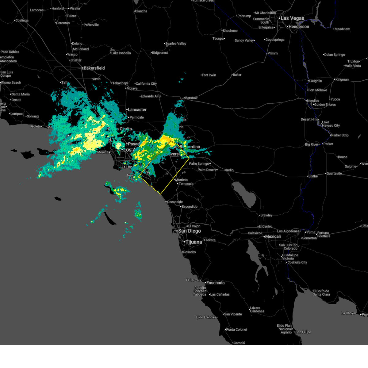
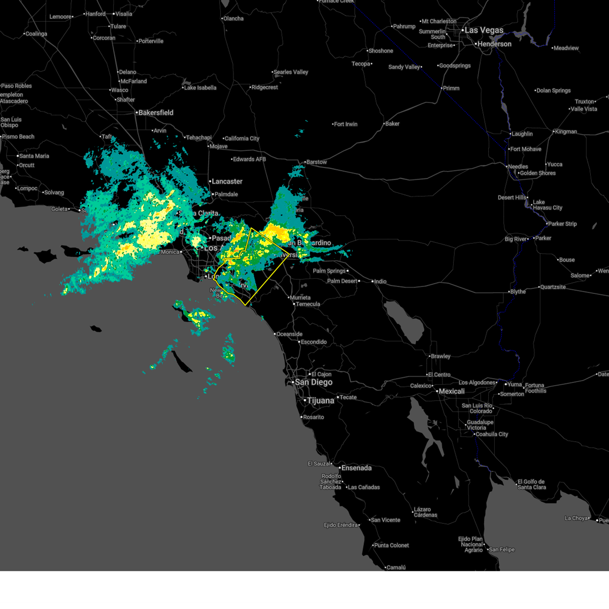
Hail Map for Riverside, CA
The Riverside, CA area has had 0 reports of on-the-ground hail by trained spotters, and has been under severe weather warnings 2 times during the past 12 months. Doppler radar has detected hail at or near Riverside, CA on 5 occasions.
| Name: | Riverside, CA |
| Where Located: | 51.2 miles E of Los Angeles, CA |
| Map: | Google Map for Riverside, CA |
| Population: | 303871 |
| Housing Units: | 98444 |
| More Info: | Search Google for Riverside, CA |
5
The Top Recent Hail Date for Riverside, CA is Sunday, September 8, 2024 (1st out of 5)

Hail and Wind Damage Spotted near Riverside, CA
| Date / Time | Report Details |
|---|---|
| 2/18/2026 2:28 AM PST |
 Svrsgx the national weather service in san diego has issued a * severe thunderstorm warning for, san bernardino county in southern california, riverside county in southern california, northwestern san diego county in southwestern california, eastern orange county in southwestern california, * until 330 am pst. * at 226 am pst, a band of severe thunderstorms extended from newport beach to san bernardino and was moving slowly southeast into southern orange county and western riverside county (radar indicated). Hazards include 60 mph wind gusts. expect damage to roofs, siding, and trees Svrsgx the national weather service in san diego has issued a * severe thunderstorm warning for, san bernardino county in southern california, riverside county in southern california, northwestern san diego county in southwestern california, eastern orange county in southwestern california, * until 330 am pst. * at 226 am pst, a band of severe thunderstorms extended from newport beach to san bernardino and was moving slowly southeast into southern orange county and western riverside county (radar indicated). Hazards include 60 mph wind gusts. expect damage to roofs, siding, and trees
|
| 2/18/2026 1:26 AM PST |
 Svrsgx the national weather service in san diego has issued a * severe thunderstorm warning for, san bernardino county in southern california, riverside county in southern california, orange county in southwestern california, * until 230 am pst. * at 124 am pst, a band of severe thunderstorms was located near the the los angeles orange county line moving slowly southeast. it will move through northern orange county and the northwest inland empire through 230 am pst (radar indicated). Hazards include 60 mph wind gusts. expect damage to roofs, siding, and trees Svrsgx the national weather service in san diego has issued a * severe thunderstorm warning for, san bernardino county in southern california, riverside county in southern california, orange county in southwestern california, * until 230 am pst. * at 124 am pst, a band of severe thunderstorms was located near the the los angeles orange county line moving slowly southeast. it will move through northern orange county and the northwest inland empire through 230 am pst (radar indicated). Hazards include 60 mph wind gusts. expect damage to roofs, siding, and trees
|
| 9/2/2025 9:53 AM PDT | Large tree reported down across lanes at the intersection of gamble ave and van buren blv in riverside county CA, 4.1 miles NNW of Riverside, CA |
| 9/8/2024 3:10 PM PDT |
 Svrsgx the national weather service in san diego has issued a * severe thunderstorm warning for, san bernardino county in southern california, riverside county in southern california, * until 400 pm pdt. * at 309 pm pdt, a severe thunderstorm was located over colton, or near rialto, and is nearly stationary (radar indicated). Hazards include 60 mph wind gusts and half dollar size hail. heavy rainfall causing flash flooding. Hail damage to vehicles is expected. Expect wind damage to roofs, siding, and trees. Svrsgx the national weather service in san diego has issued a * severe thunderstorm warning for, san bernardino county in southern california, riverside county in southern california, * until 400 pm pdt. * at 309 pm pdt, a severe thunderstorm was located over colton, or near rialto, and is nearly stationary (radar indicated). Hazards include 60 mph wind gusts and half dollar size hail. heavy rainfall causing flash flooding. Hail damage to vehicles is expected. Expect wind damage to roofs, siding, and trees.
|
| 9/8/2024 2:55 PM PDT |
 At 255 pm pdt, a severe thunderstorm was located over colton, or near rialto, and is nearly stationary (radar indicated). Hazards include 60 mph wind gusts and quarter size hail. Hail damage to vehicles is expected. expect wind damage to roofs, siding, and trees. Locations impacted include, riverside, san bernardino, fontana, moreno valley, rialto, redlands, colton, loma linda, rubidoux, grand terrace, highgrove, and bloomington. At 255 pm pdt, a severe thunderstorm was located over colton, or near rialto, and is nearly stationary (radar indicated). Hazards include 60 mph wind gusts and quarter size hail. Hail damage to vehicles is expected. expect wind damage to roofs, siding, and trees. Locations impacted include, riverside, san bernardino, fontana, moreno valley, rialto, redlands, colton, loma linda, rubidoux, grand terrace, highgrove, and bloomington.
|
| 9/8/2024 2:27 PM PDT |
 Svrsgx the national weather service in san diego has issued a * severe thunderstorm warning for, san bernardino county in southern california, riverside county in southern california, * until 315 pm pdt. * at 227 pm pdt, a severe thunderstorm was located near colton, or near riverside, moving northwest at 5 mph (radar indicated). Hazards include 60 mph wind gusts and quarter size hail. Hail damage to vehicles is expected. Expect wind damage to roofs, siding, and trees. Svrsgx the national weather service in san diego has issued a * severe thunderstorm warning for, san bernardino county in southern california, riverside county in southern california, * until 315 pm pdt. * at 227 pm pdt, a severe thunderstorm was located near colton, or near riverside, moving northwest at 5 mph (radar indicated). Hazards include 60 mph wind gusts and quarter size hail. Hail damage to vehicles is expected. Expect wind damage to roofs, siding, and trees.
|
| 3/14/2024 4:54 PM PDT | Tree down. 4 ft diameter italian stone pin in riverside county CA, 3.8 miles SW of Riverside, CA |
| 3/14/2024 9:00 AM PDT | Corrects previous tstm wnd dmg report from 3 ese riverside: tree down... 4 ft diameter italian stone pine between 8 and 10 am. root failure in wet soil. small car crush in riverside county CA, 3.8 miles SW of Riverside, CA |
| 9/11/2022 3:46 PM PDT |
 At 346 pm pdt, a severe thunderstorm was located over lake mathews, or 7 miles east of corona, moving northwest at 15 mph (radar indicated). Hazards include 60 mph wind gusts and nickel size hail. expect damage to roofs, siding, and trees At 346 pm pdt, a severe thunderstorm was located over lake mathews, or 7 miles east of corona, moving northwest at 15 mph (radar indicated). Hazards include 60 mph wind gusts and nickel size hail. expect damage to roofs, siding, and trees
|
| 9/4/2022 3:33 PM PDT |
 At 333 pm pdt, a severe thunderstorm was located over highland, or near redlands, moving west at 15 mph (radar indicated). Hazards include 60 mph wind gusts and quarter size hail. Hail damage to vehicles is expected. Expect wind damage to roofs, siding, and trees. At 333 pm pdt, a severe thunderstorm was located over highland, or near redlands, moving west at 15 mph (radar indicated). Hazards include 60 mph wind gusts and quarter size hail. Hail damage to vehicles is expected. Expect wind damage to roofs, siding, and trees.
|
| 8/31/2017 4:28 PM PDT |
 The severe thunderstorm warning for san bernardino and riverside counties will expire at 430 pm pdt, the storm which prompted the warning has weakened below severe limits, and no longer poses an immediate threat to life or property. therefore the warning will be allowed to expire. however gusty winds and heavy rain are still possible with this thunderstorm. to report severe weather, contact your nearest law enforcement agency. they will relay your report to the national weather service san diego. The severe thunderstorm warning for san bernardino and riverside counties will expire at 430 pm pdt, the storm which prompted the warning has weakened below severe limits, and no longer poses an immediate threat to life or property. therefore the warning will be allowed to expire. however gusty winds and heavy rain are still possible with this thunderstorm. to report severe weather, contact your nearest law enforcement agency. they will relay your report to the national weather service san diego.
|
| 8/31/2017 4:10 PM PDT |
 At 409 pm pdt, nearly stationary severe thunderstorms stretched from near fontana south to woodcrest (radar indicated). Hazards include 60 mph wind gusts and penny size hail. Expect damage to roofs, siding, and trees. Locations impacted include, riverside, fontana, ontario, rialto, rancho cucamonga, colton, woodcrest, pedley, rubidoux, grand terrace, glen avon and highgrove. At 409 pm pdt, nearly stationary severe thunderstorms stretched from near fontana south to woodcrest (radar indicated). Hazards include 60 mph wind gusts and penny size hail. Expect damage to roofs, siding, and trees. Locations impacted include, riverside, fontana, ontario, rialto, rancho cucamonga, colton, woodcrest, pedley, rubidoux, grand terrace, glen avon and highgrove.
|
| 8/31/2017 4:00 PM PDT | Strong winds tore roof panels from several mobile homes and damaged a dec in riverside county CA, 7.7 miles ENE of Riverside, CA |
| 8/31/2017 3:35 PM PDT |
 At 333 pm pdt, nearly stationary severe thunderstorms stretched from near fontana south to woodcrest (radar indicated). Hazards include 60 mph wind gusts and penny size hail. expect damage to roofs, siding, and trees At 333 pm pdt, nearly stationary severe thunderstorms stretched from near fontana south to woodcrest (radar indicated). Hazards include 60 mph wind gusts and penny size hail. expect damage to roofs, siding, and trees
|
| 8/1/2017 4:40 PM PDT |
 The severe thunderstorm warning for riverside county will expire at 445 pm pdt, the severe thunderstorm which prompted the warning has weakened. therefore, the warning will be allowed to expire. The severe thunderstorm warning for riverside county will expire at 445 pm pdt, the severe thunderstorm which prompted the warning has weakened. therefore, the warning will be allowed to expire.
|
| 8/1/2017 4:00 PM PDT |
 At 359 pm pdt, a severe thunderstorm was located near woodcrest, or 9 miles southeast of riverside, and is nearly stationary (radar indicated). Hazards include 60 mph wind gusts and penny size hail. expect damage to roofs, siding, and trees At 359 pm pdt, a severe thunderstorm was located near woodcrest, or 9 miles southeast of riverside, and is nearly stationary (radar indicated). Hazards include 60 mph wind gusts and penny size hail. expect damage to roofs, siding, and trees
|
| 8/1/2017 3:33 PM PDT |
 At 331 pm pdt, a severe thunderstorm was between perris and lake elsinore, and is nearly stationary (radar indicated). Hazards include 60 mph wind gusts and nickel size hail. Expect damage to roofs, siding, powerlines and trees. Locations impacted include, riverside, moreno valley, western lake elsinore, perris, san jacinto, march airforce base, woodcrest, lake mathews, sun city, temescal valley, menifee and homeland. At 331 pm pdt, a severe thunderstorm was between perris and lake elsinore, and is nearly stationary (radar indicated). Hazards include 60 mph wind gusts and nickel size hail. Expect damage to roofs, siding, powerlines and trees. Locations impacted include, riverside, moreno valley, western lake elsinore, perris, san jacinto, march airforce base, woodcrest, lake mathews, sun city, temescal valley, menifee and homeland.
|
| 8/1/2017 3:01 PM PDT |
 At 259 pm pdt, a severe thunderstorm was located over perris, nuevo, and lakeview and is nearly stationary (radar indicated). Hazards include 60 mph wind gusts and nickel size hail. expect damage to roofs, siding,power lines and trees At 259 pm pdt, a severe thunderstorm was located over perris, nuevo, and lakeview and is nearly stationary (radar indicated). Hazards include 60 mph wind gusts and nickel size hail. expect damage to roofs, siding,power lines and trees
|
| 3/11/2016 3:37 PM PST | Power poles snapped at intersection according to police dept. 51 mph wind gusts at riverside airpor in riverside county CA, 8.2 miles ENE of Riverside, CA |
| 3/7/2016 7:58 AM PST |
 The national weather service in san diego has issued a * severe thunderstorm warning for. eastern orange county in southwestern california. san bernardino county in southern california. riverside county in southern california. Northwestern san diego county in southwestern california. The national weather service in san diego has issued a * severe thunderstorm warning for. eastern orange county in southwestern california. san bernardino county in southern california. riverside county in southern california. Northwestern san diego county in southwestern california.
|
| 3/7/2016 7:43 AM PST |
 At 740 am pst, doppler radar indicated a line of severe thunderstorms capable of producing damaging wind gusts of 45 to 60 mph over eastern orange county. this line of storms was located near canyon lake, moving east at 30 mph. the storms will progress eastward over the next hour, impacting the inland empire and northwest san diego county. locations impacted include but are not limited to, riverside, san bernardino, oceanside, ontario, irvine, moreno valley, corona, rialto, tustin, chino, redlands. At 740 am pst, doppler radar indicated a line of severe thunderstorms capable of producing damaging wind gusts of 45 to 60 mph over eastern orange county. this line of storms was located near canyon lake, moving east at 30 mph. the storms will progress eastward over the next hour, impacting the inland empire and northwest san diego county. locations impacted include but are not limited to, riverside, san bernardino, oceanside, ontario, irvine, moreno valley, corona, rialto, tustin, chino, redlands.
|
| 3/7/2016 7:10 AM PST |
 At 706 am pst, doppler radar indicated a line of severe thunderstorms capable of producing damaging wind gusts of 45 to 60 mph moving through central orange county. this line of storms was located near el toro, moving east at 35 mph. the stroms will progress eastward over the next hour, impacting the inland empire and northwest san diego county. locations impacted include, santa ana, anaheim, riverside, huntington beach, san bernardino, oceanside, ontario, irvine, fontana, orange, rancho cucamonga, corona, costa mesa, mission viejo, rialto. At 706 am pst, doppler radar indicated a line of severe thunderstorms capable of producing damaging wind gusts of 45 to 60 mph moving through central orange county. this line of storms was located near el toro, moving east at 35 mph. the stroms will progress eastward over the next hour, impacting the inland empire and northwest san diego county. locations impacted include, santa ana, anaheim, riverside, huntington beach, san bernardino, oceanside, ontario, irvine, fontana, orange, rancho cucamonga, corona, costa mesa, mission viejo, rialto.
|
| 3/7/2016 6:36 AM PST |
 At 635 am pst, doppler radar indicated a line of severe thunderstorms capable of producing damaging wind gusts of 45 to 60 mph approaching the orange county coast. the leading edge of the storms was located 5 miles southwest of seal beach, and moving east at 35 mph. At 635 am pst, doppler radar indicated a line of severe thunderstorms capable of producing damaging wind gusts of 45 to 60 mph approaching the orange county coast. the leading edge of the storms was located 5 miles southwest of seal beach, and moving east at 35 mph.
|
| 1/6/2016 1:12 PM PST |
 At 106 pm pst, doppler radar indicated a severe thunderstorm capable of producing damaging winds in excess of 60 mph. this storm was located near corona, moving northeast at 20 mph. locations impacted include, santa ana, anaheim, riverside, garden grove, ontario, irvine, moreno valley, fontana, orange, corona, mission viejo, rialto, tustin, chino, el toro, yorba linda, colton, placentia, perris and laguna hills. At 106 pm pst, doppler radar indicated a severe thunderstorm capable of producing damaging winds in excess of 60 mph. this storm was located near corona, moving northeast at 20 mph. locations impacted include, santa ana, anaheim, riverside, garden grove, ontario, irvine, moreno valley, fontana, orange, corona, mission viejo, rialto, tustin, chino, el toro, yorba linda, colton, placentia, perris and laguna hills.
|
| 1/6/2016 12:46 PM PST |
 At 1244 pm pst, doppler radar indicated a severe thunderstorm capable of producing damaging winds in excess of 60 mph. this storm was located over southwestern corona, and moving northeast at 25 mph. a line of storms will be capable of severe wind and heavy rain. cities of tustin and norco are in the path of the severe storm. At 1244 pm pst, doppler radar indicated a severe thunderstorm capable of producing damaging winds in excess of 60 mph. this storm was located over southwestern corona, and moving northeast at 25 mph. a line of storms will be capable of severe wind and heavy rain. cities of tustin and norco are in the path of the severe storm.
|
| 9/9/2015 3:12 PM PDT | The severe thunderstorm warning for san bernardino and riverside counties will expire at 315 pm pdt, the storm which prompted the warning has weakened below severe limits, and no longer poses an immediate threat to life or property. therefore the warning will be allowed to expire. however heavy rain is still possible with a thunderstorm near perris over the next hour. |
| 9/9/2015 2:40 PM PDT |
 At 230 pm pdt, doppler radar indicated a group of severe thunderstorms moving west around 5 mph, capable of producing damaging winds in excess of 60 mph. a wind gust to 49 mph was observed at lake mathews at 216 pm. nickel size hail may also accompany the damaging winds. locations impacted include, ontario, moreno valley, rancho cucamonga, corona, upland, chino, montclair, norco, mira loma, glen avon, pedley, home gardens, woodcrest and march afb. At 230 pm pdt, doppler radar indicated a group of severe thunderstorms moving west around 5 mph, capable of producing damaging winds in excess of 60 mph. a wind gust to 49 mph was observed at lake mathews at 216 pm. nickel size hail may also accompany the damaging winds. locations impacted include, ontario, moreno valley, rancho cucamonga, corona, upland, chino, montclair, norco, mira loma, glen avon, pedley, home gardens, woodcrest and march afb.
|
| 9/9/2015 2:10 PM PDT |
 At 209 pm pdt, doppler radar indicated a few severe thunderstorms capable of producing quarter size hail and damaging winds in excess of 60 mph. these storms were nearly stationary. flash flooding is also possible near these storms. At 209 pm pdt, doppler radar indicated a few severe thunderstorms capable of producing quarter size hail and damaging winds in excess of 60 mph. these storms were nearly stationary. flash flooding is also possible near these storms.
|
| 7/19/2015 2:55 PM PDT |
 The severe thunderstorm warning for riverside county will expire at 300 pm pdt, the storm which prompted the warning has weakened below severe limits, and no longer pose an immediate threat to life or property. therefore the warning will be allowed to expire. to report severe weather, contact your nearest law enforcement agency. they will relay your report to the national weather service san diego. The severe thunderstorm warning for riverside county will expire at 300 pm pdt, the storm which prompted the warning has weakened below severe limits, and no longer pose an immediate threat to life or property. therefore the warning will be allowed to expire. to report severe weather, contact your nearest law enforcement agency. they will relay your report to the national weather service san diego.
|
| 7/19/2015 2:15 PM PDT |
 At 206 pm pdt, doppler radar continued to indicate a severe thunderstorm capable of producing damaging winds in excess of 60 mph. this storm was located over perris and was moving northwest at 10 to 15 mph. locations impacted include, hemet, perris, lake elsinore, san jacinto, sun city, wildomar, canyon lake, woodcrest, lakeland village, nuevo, homeland, sedco hills, romoland, winchester, quail valley and lakeview. At 206 pm pdt, doppler radar continued to indicate a severe thunderstorm capable of producing damaging winds in excess of 60 mph. this storm was located over perris and was moving northwest at 10 to 15 mph. locations impacted include, hemet, perris, lake elsinore, san jacinto, sun city, wildomar, canyon lake, woodcrest, lakeland village, nuevo, homeland, sedco hills, romoland, winchester, quail valley and lakeview.
|
| 7/19/2015 1:55 PM PDT |
 At 154 pm pdt, doppler radar indicated a severe thunderstorm capable of producing damaging winds in excess of 60 mph. this storm was located 5 miles east of sun city, and moving west northwest at 10 mph. At 154 pm pdt, doppler radar indicated a severe thunderstorm capable of producing damaging winds in excess of 60 mph. this storm was located 5 miles east of sun city, and moving west northwest at 10 mph.
|
| 8/29/2013 3:08 PM PDT | Estimated wind gust up to 70 mph at ucr. very heavy rain with reduced visibilitie in riverside county CA, 2 miles E of Riverside, CA |
| 8/29/2013 3:08 PM PDT | Large tree feel on the rubidoux blvd offramp along highway 6 in riverside county CA, 2 miles E of Riverside, CA |
| 8/30/2012 2:47 PM PDT | An atmo science professor at uc riverside estimated wind gusts to 60 mph from a passing thunderstorm going through campu in riverside county CA, 2 miles E of Riverside, CA |
Hail Maps for Riverside, CA


Connect with Interactive Hail Maps