

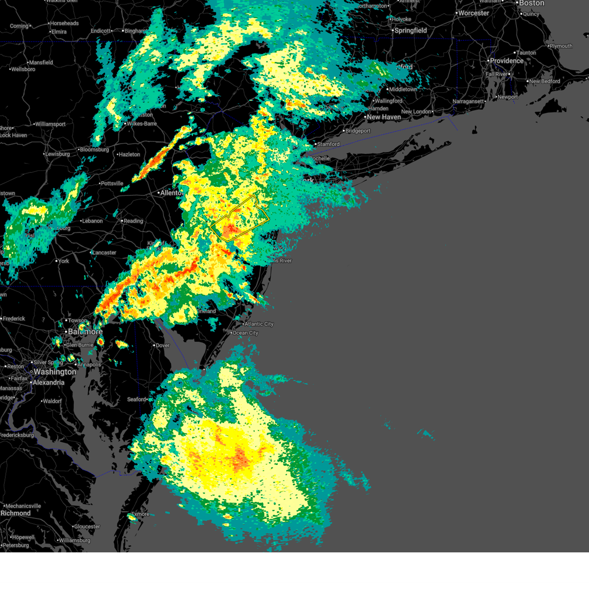
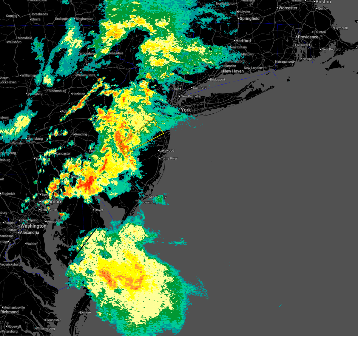
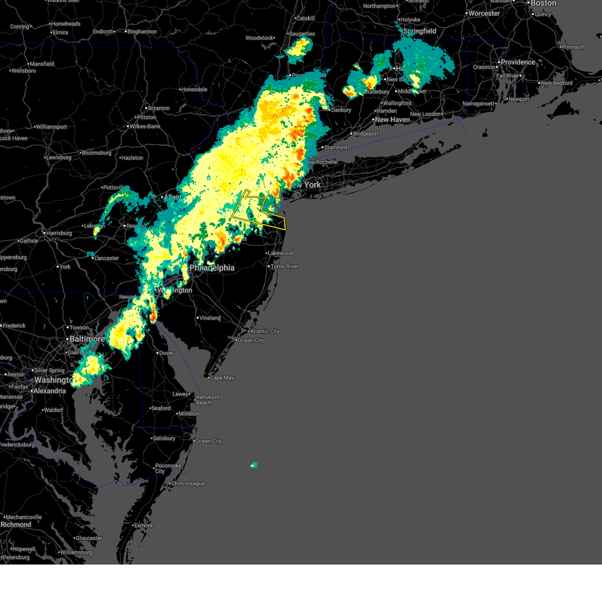
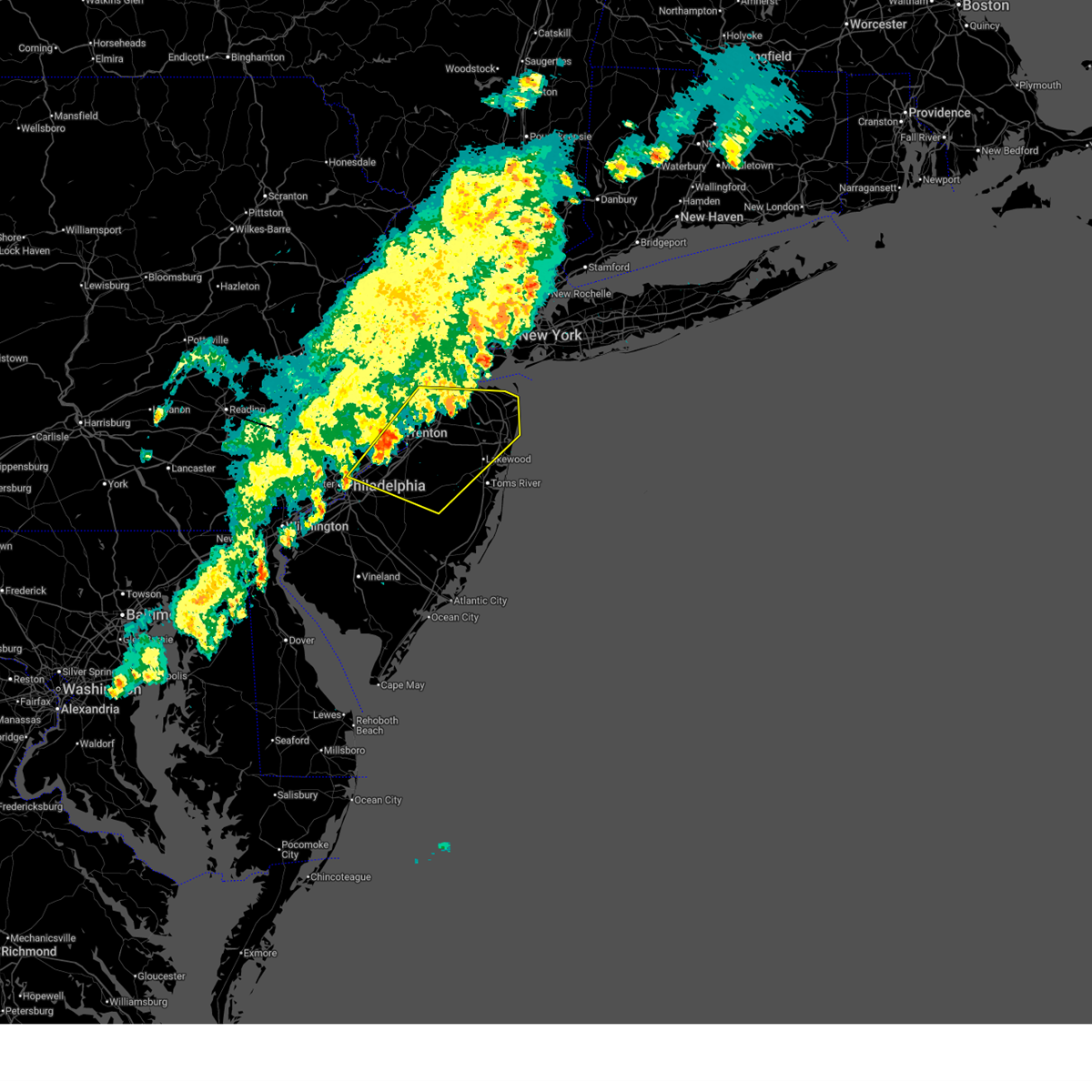
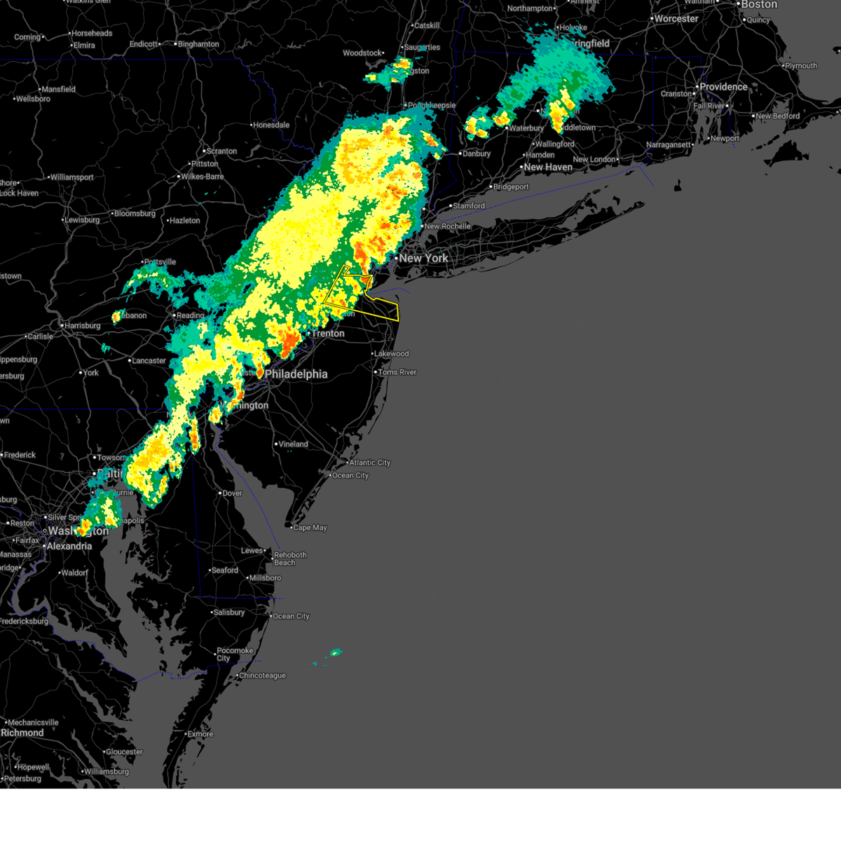
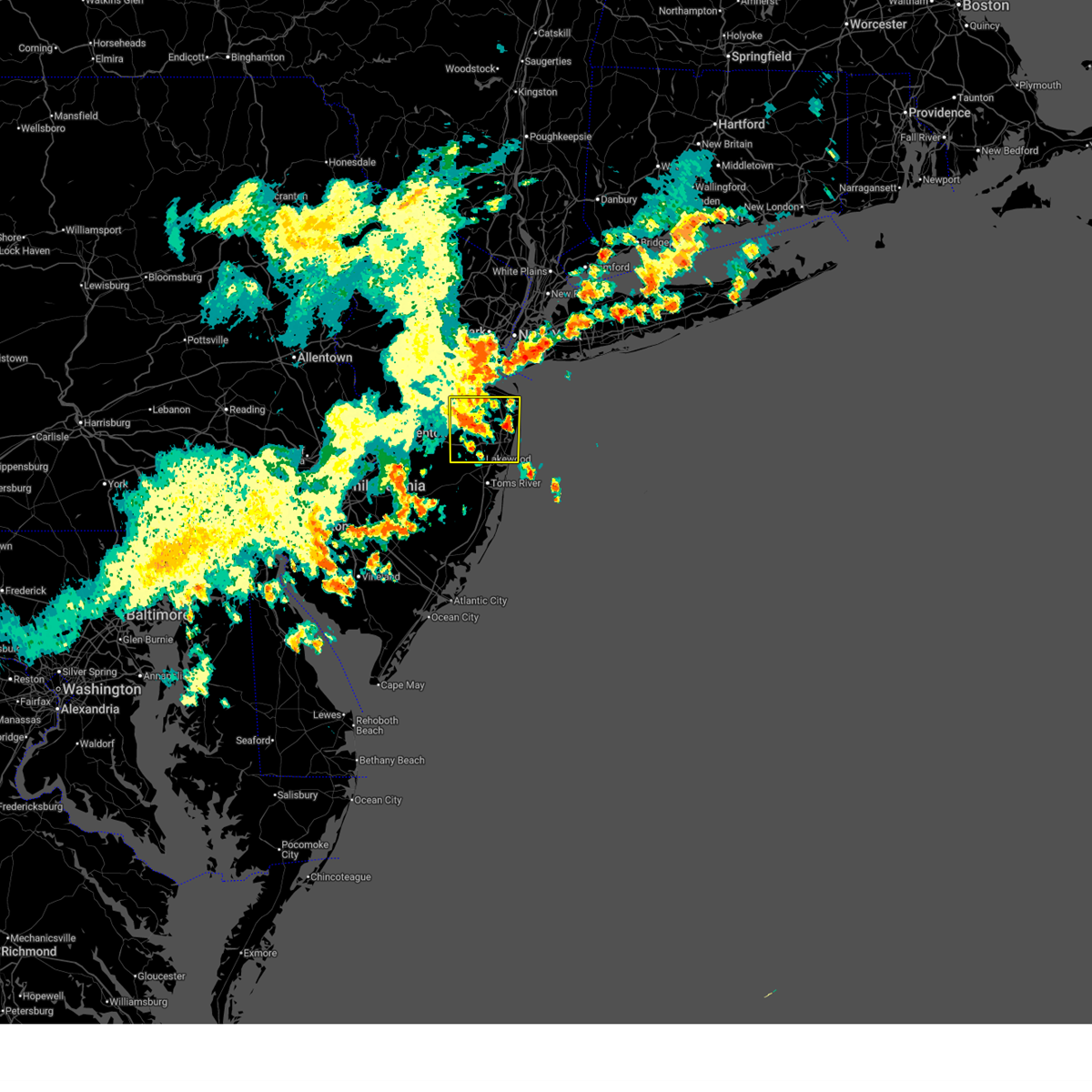
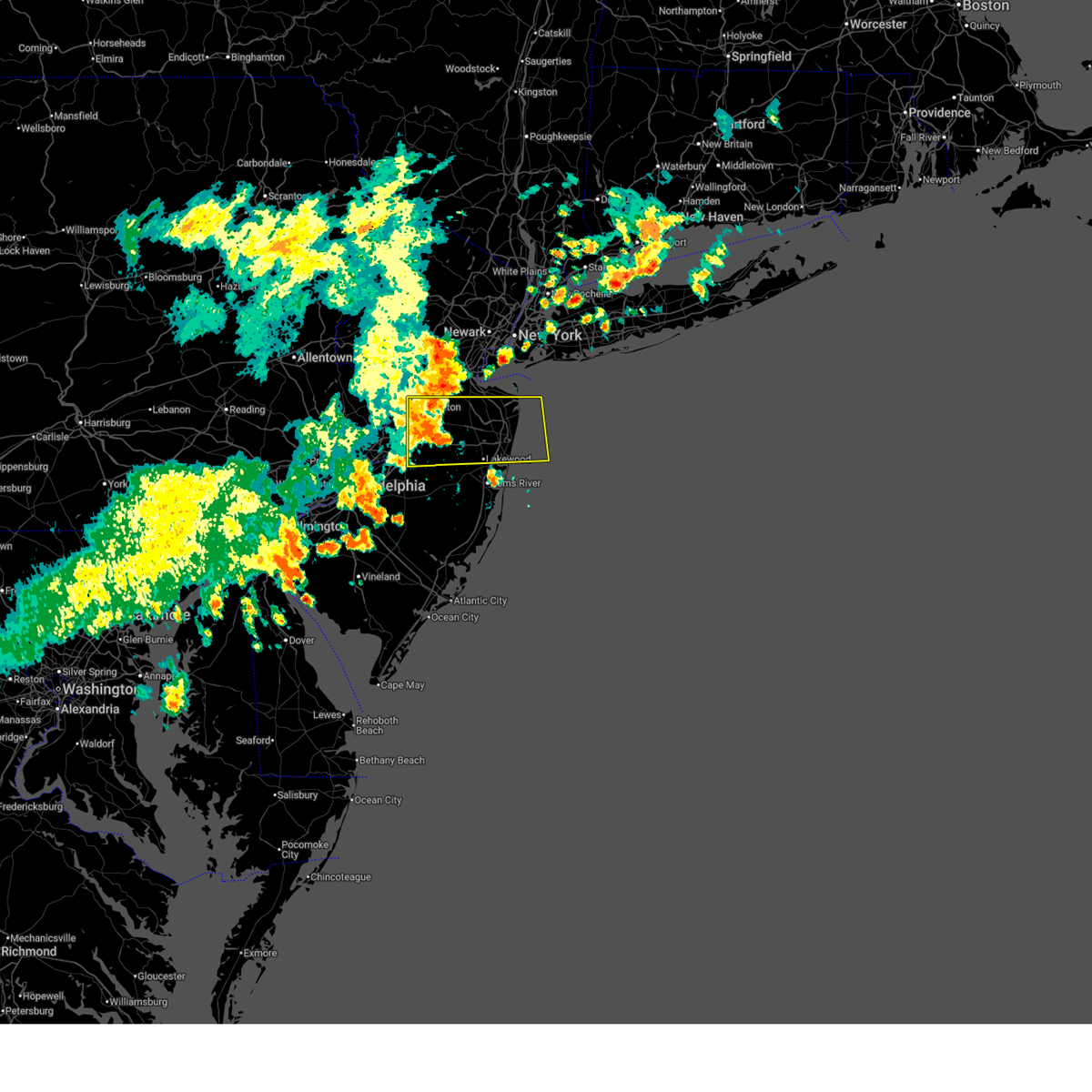
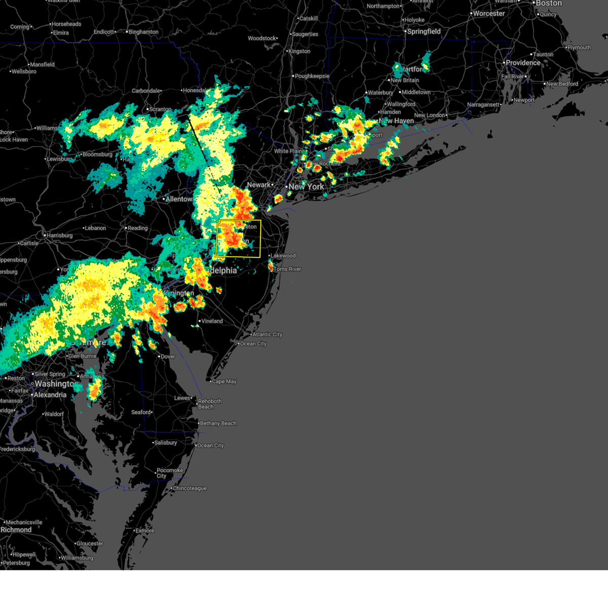
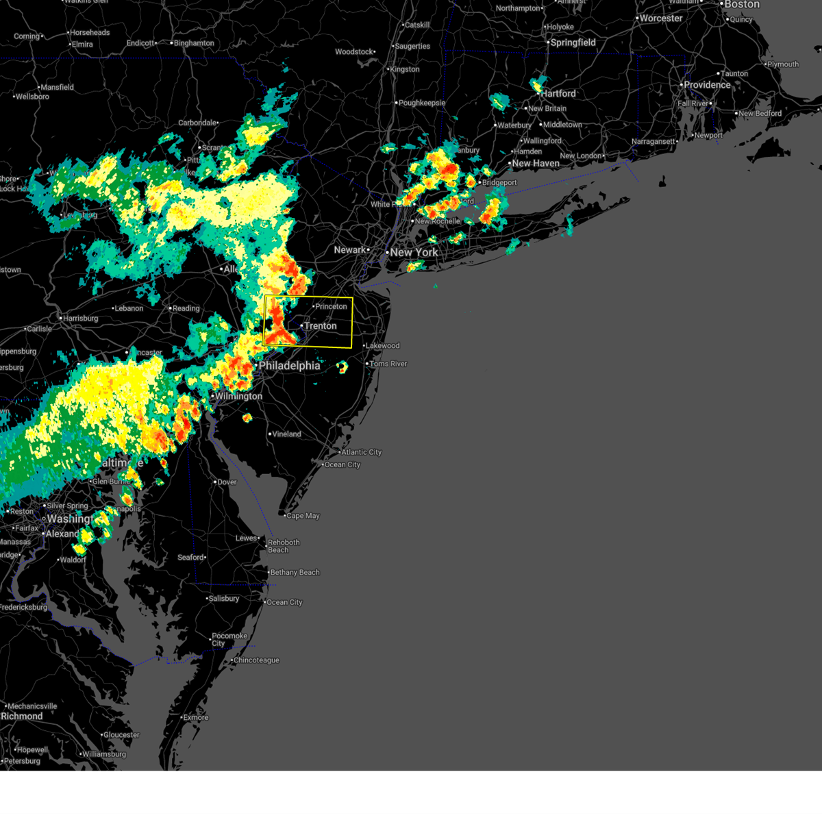
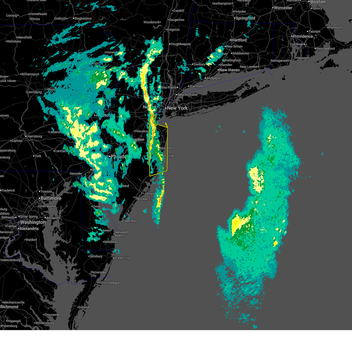
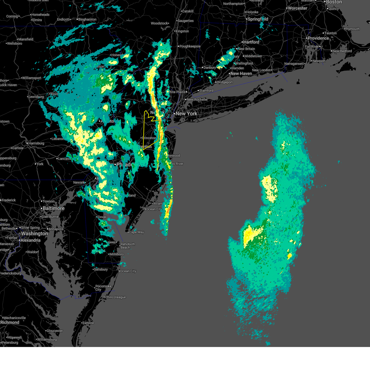
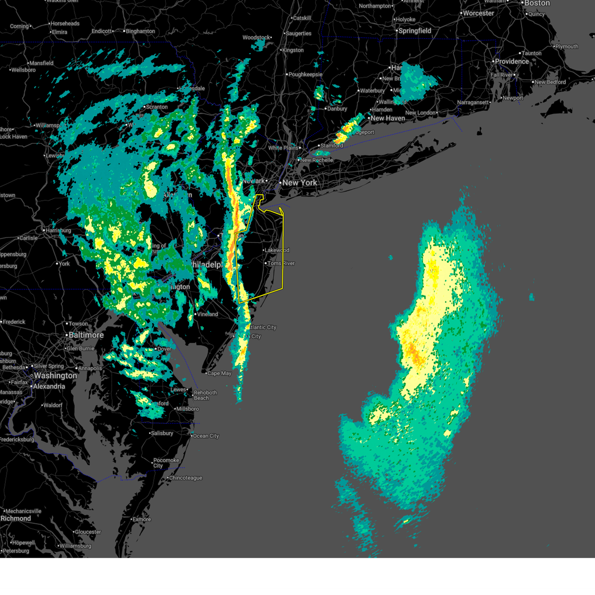
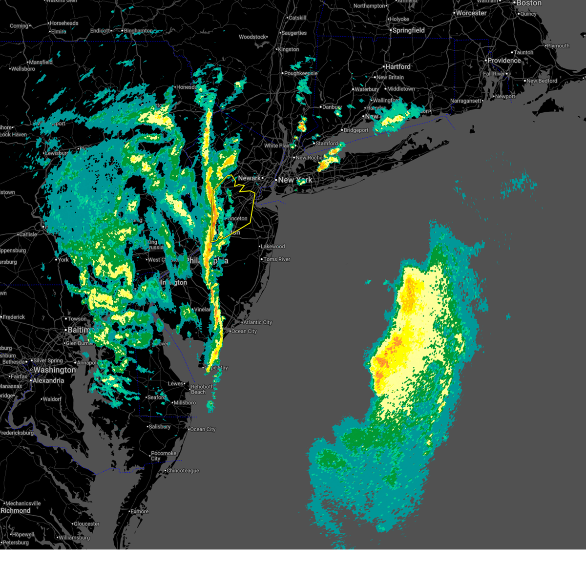
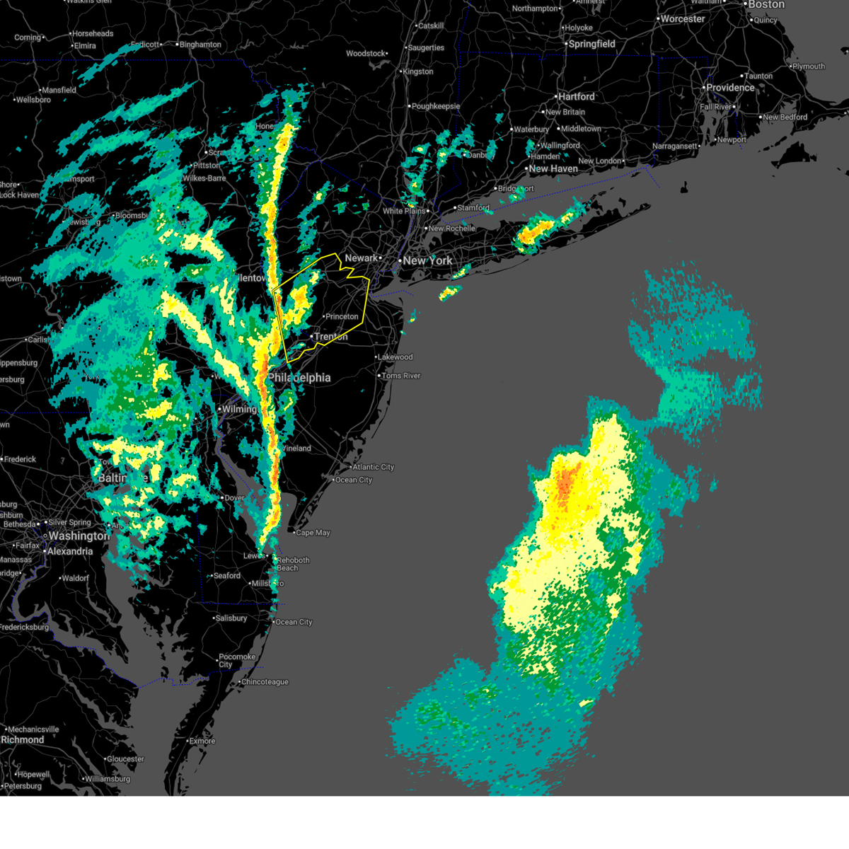
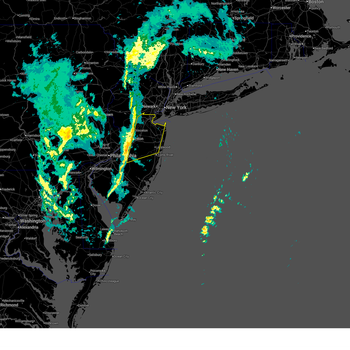
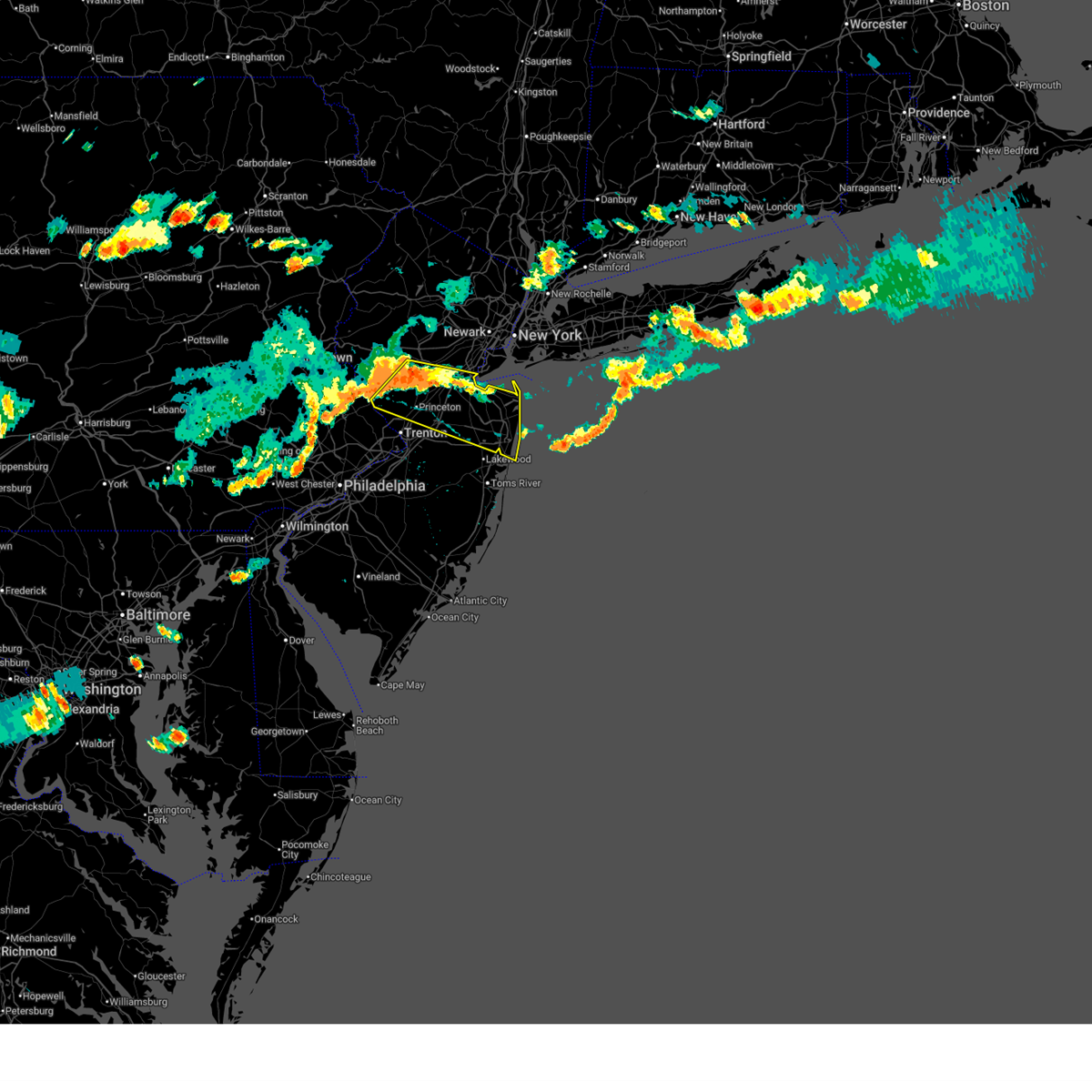
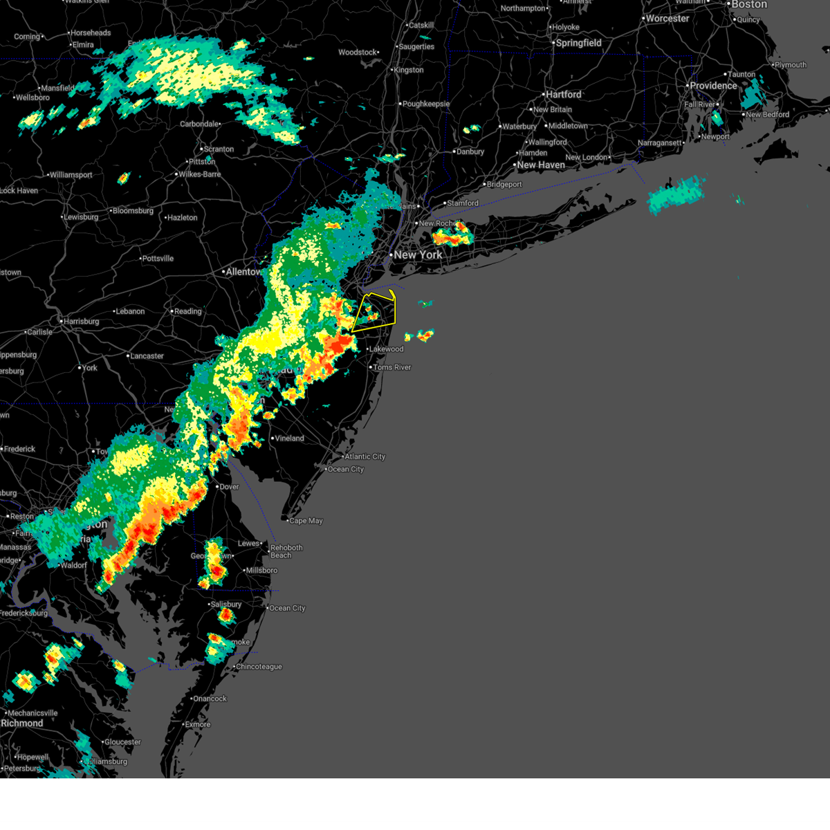
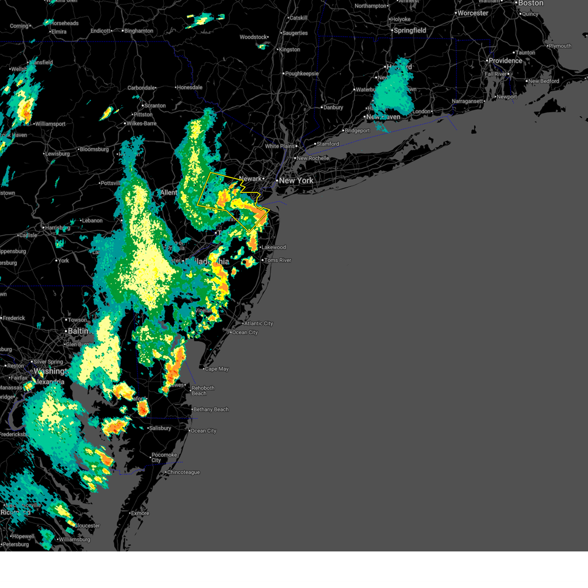
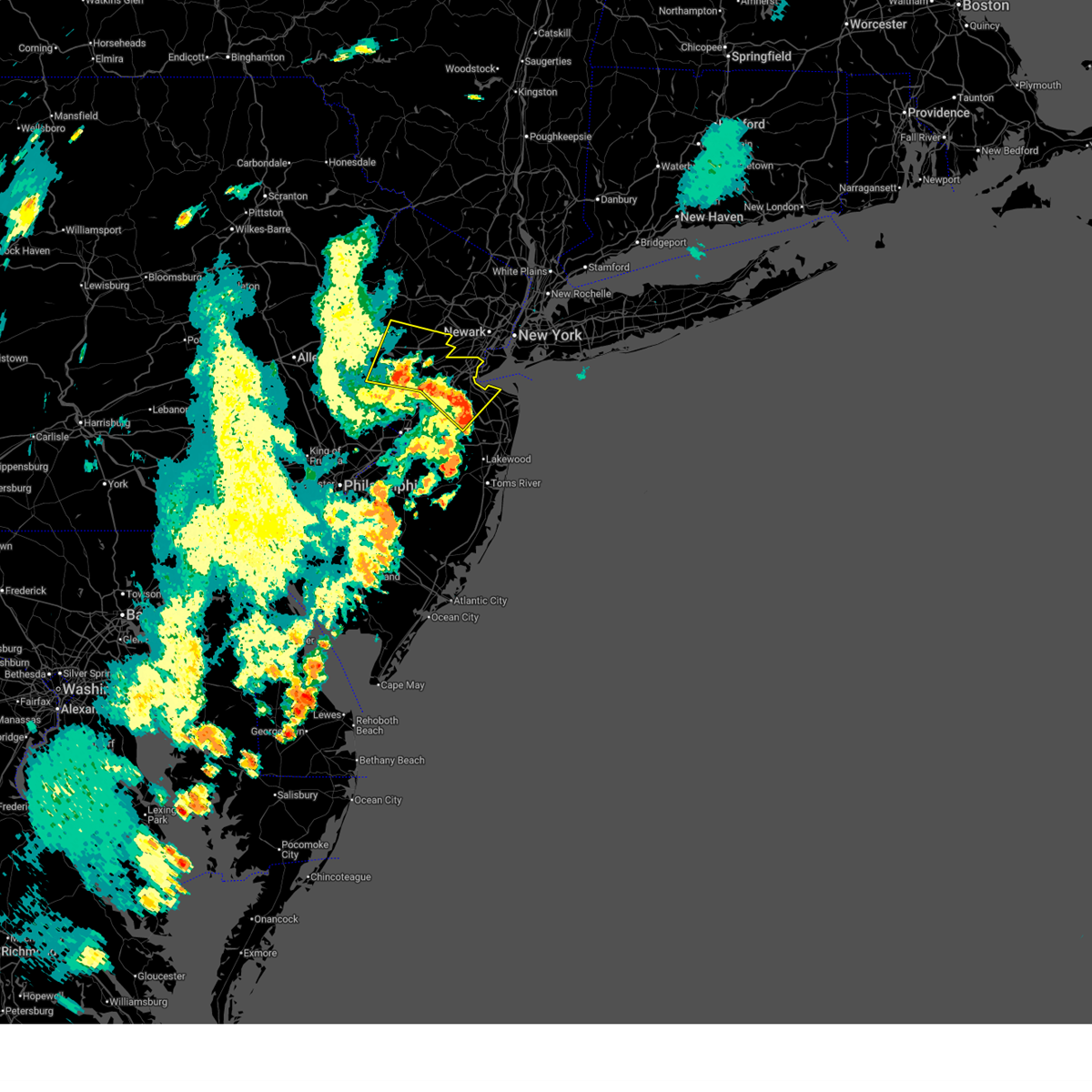
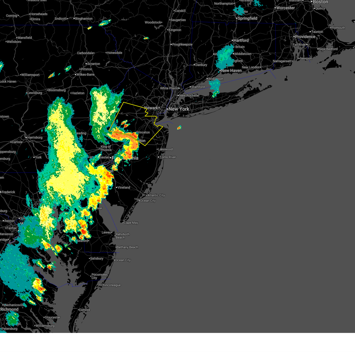
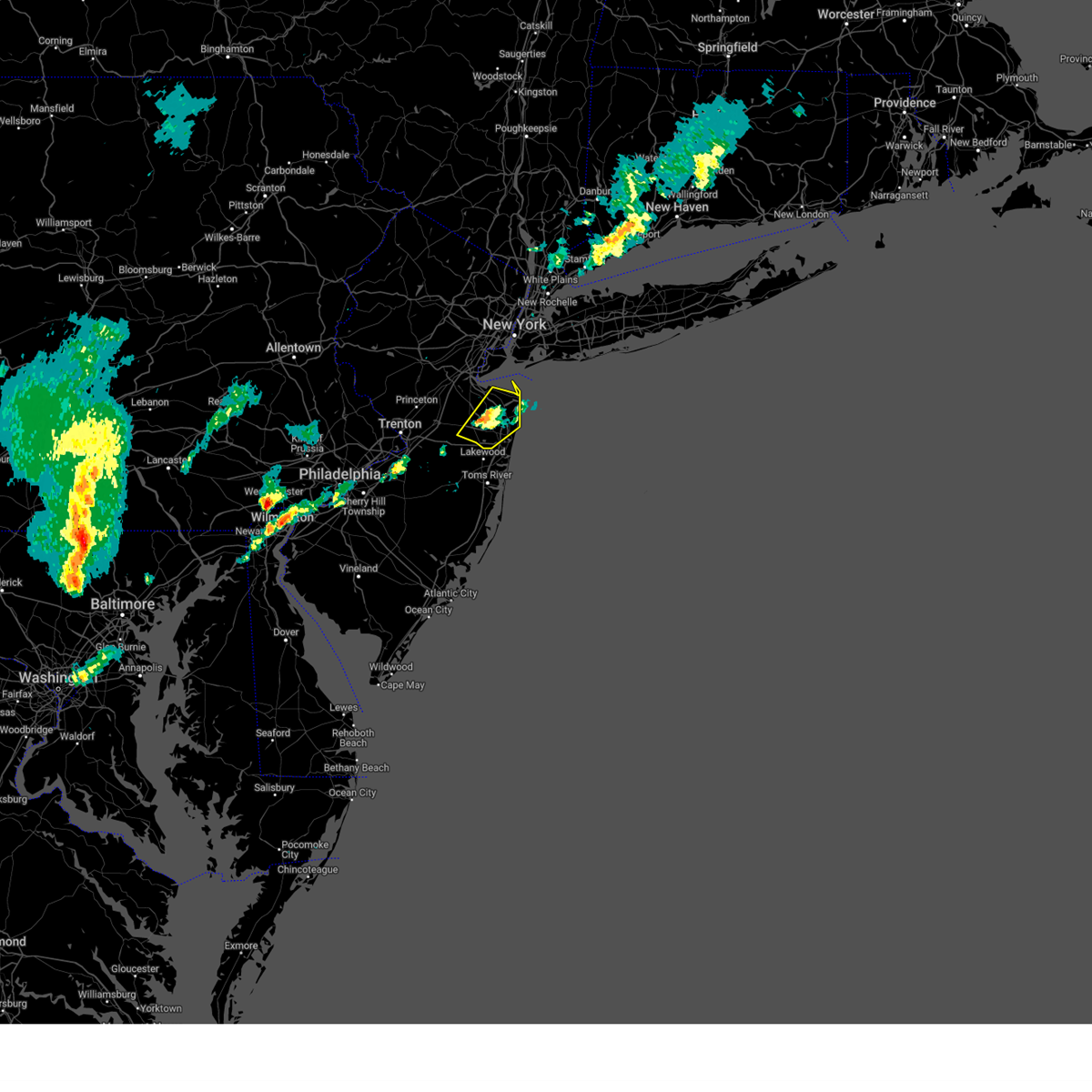
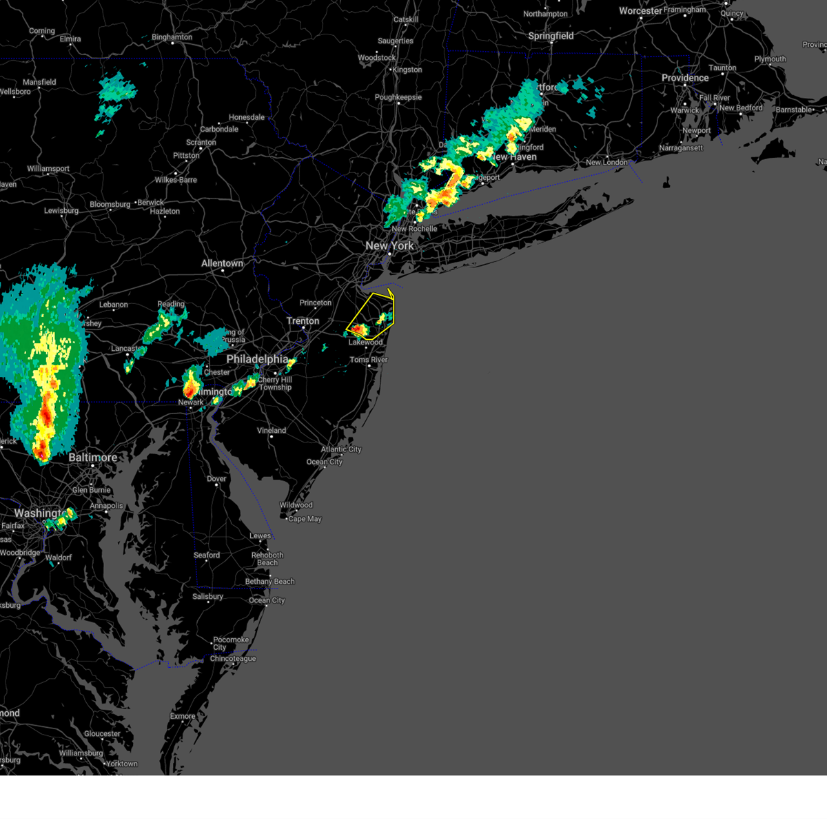
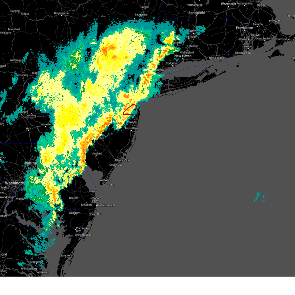
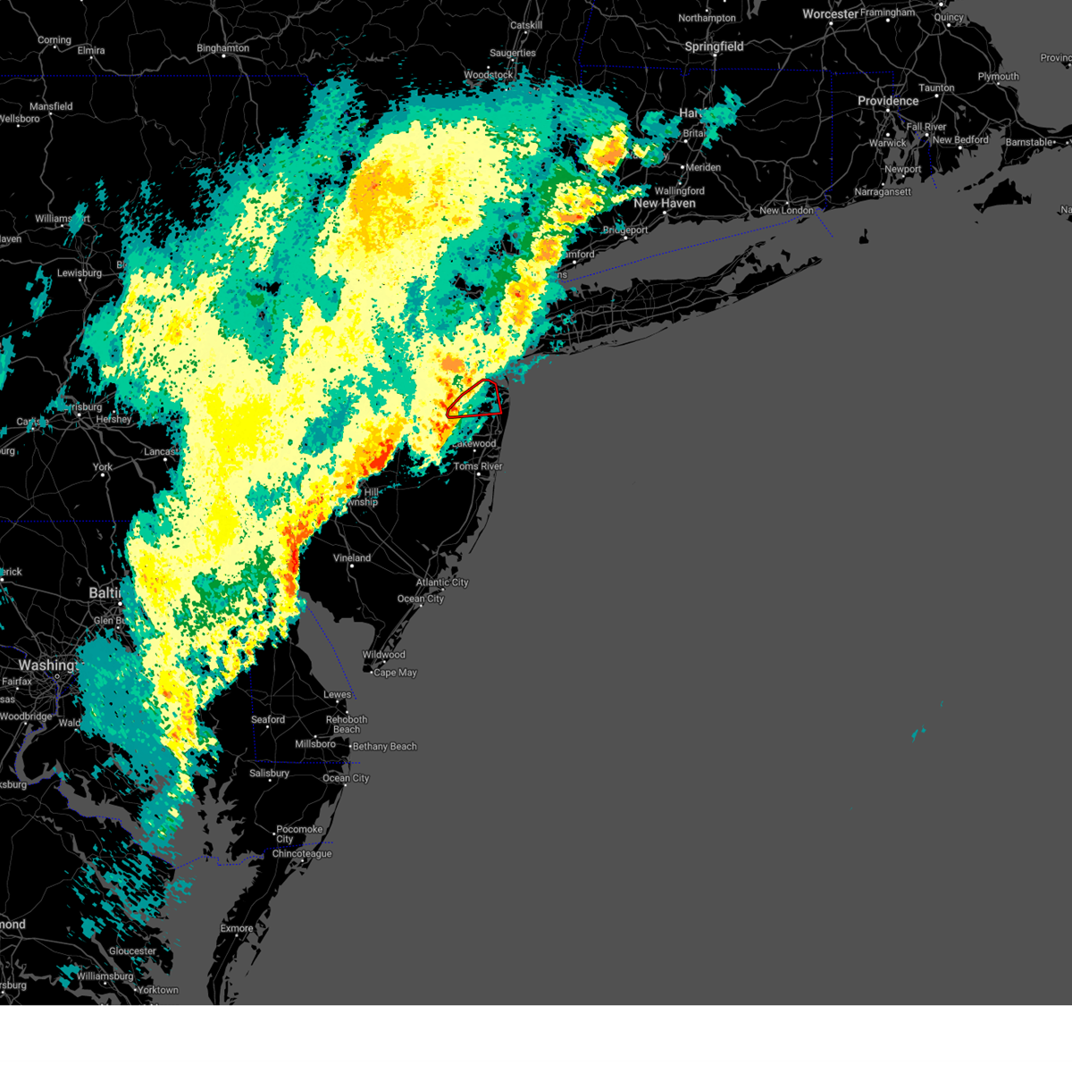
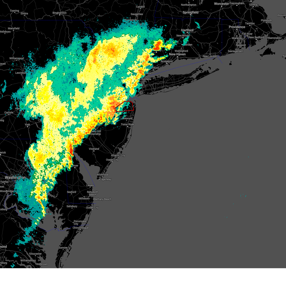
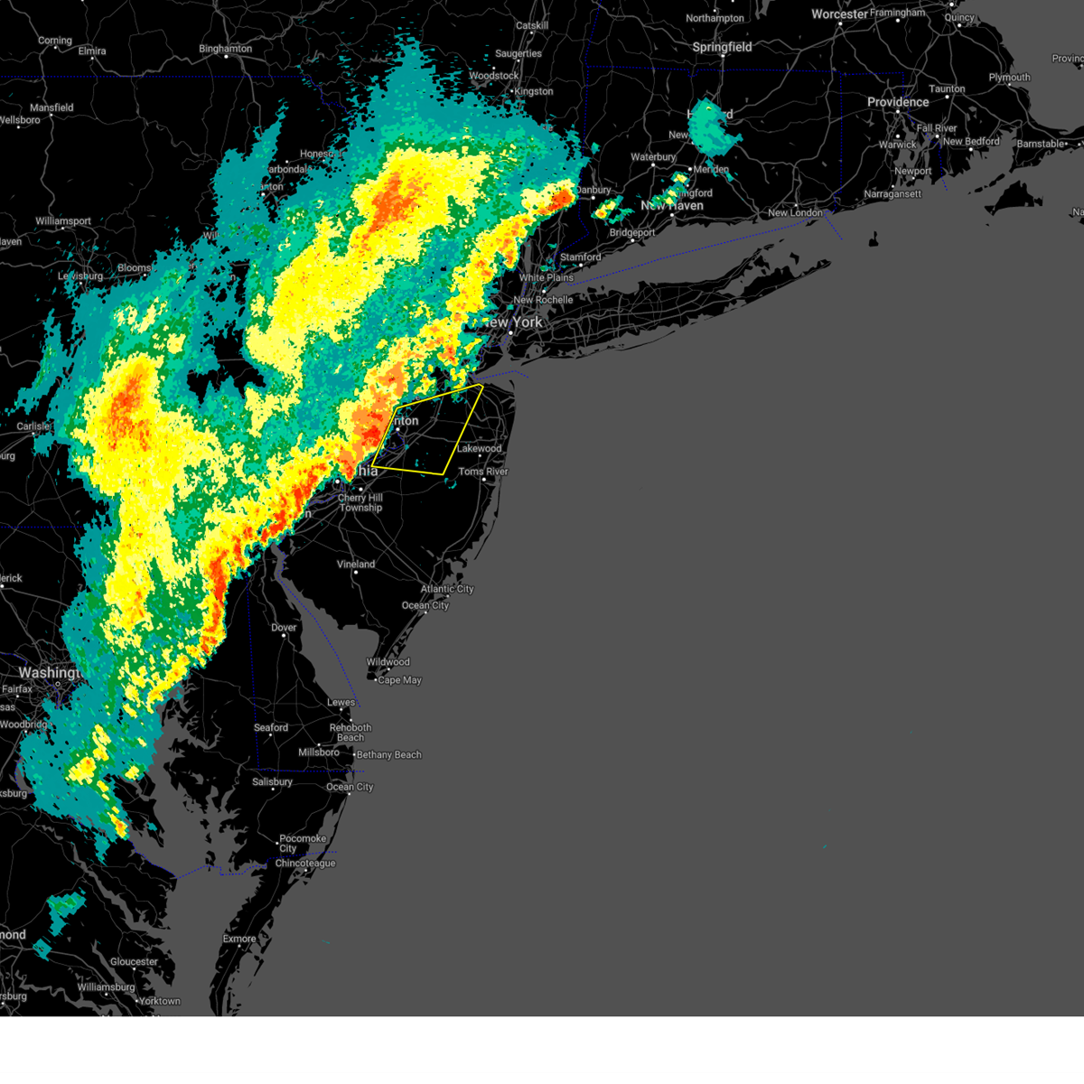
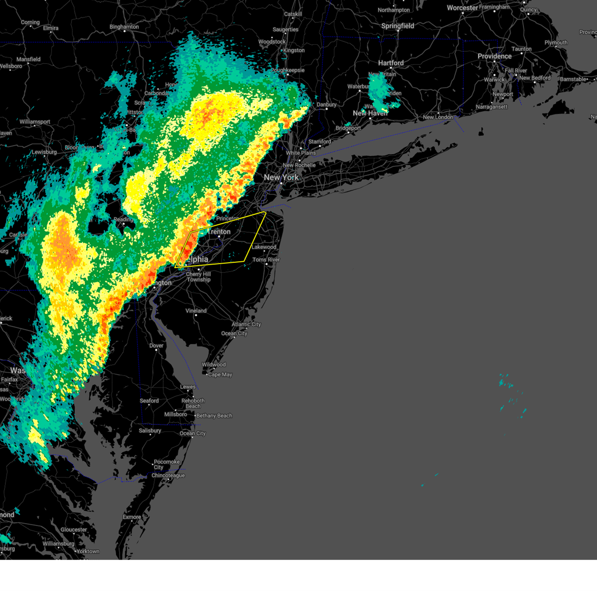
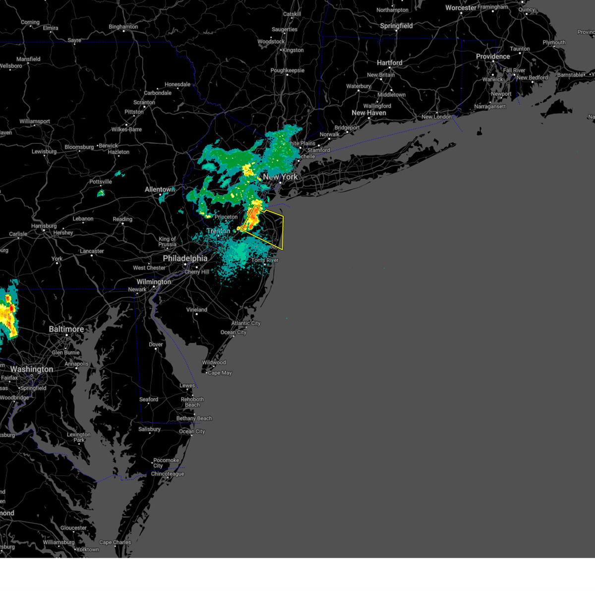
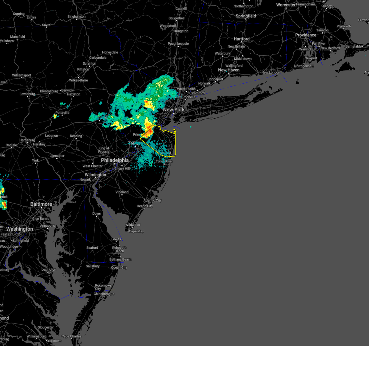
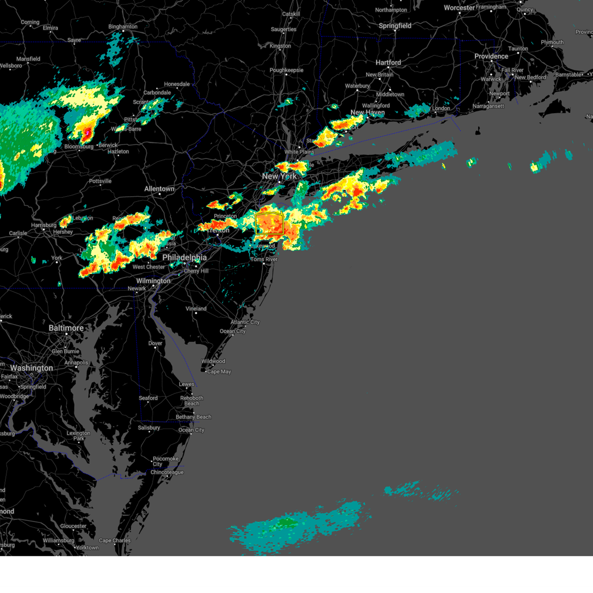
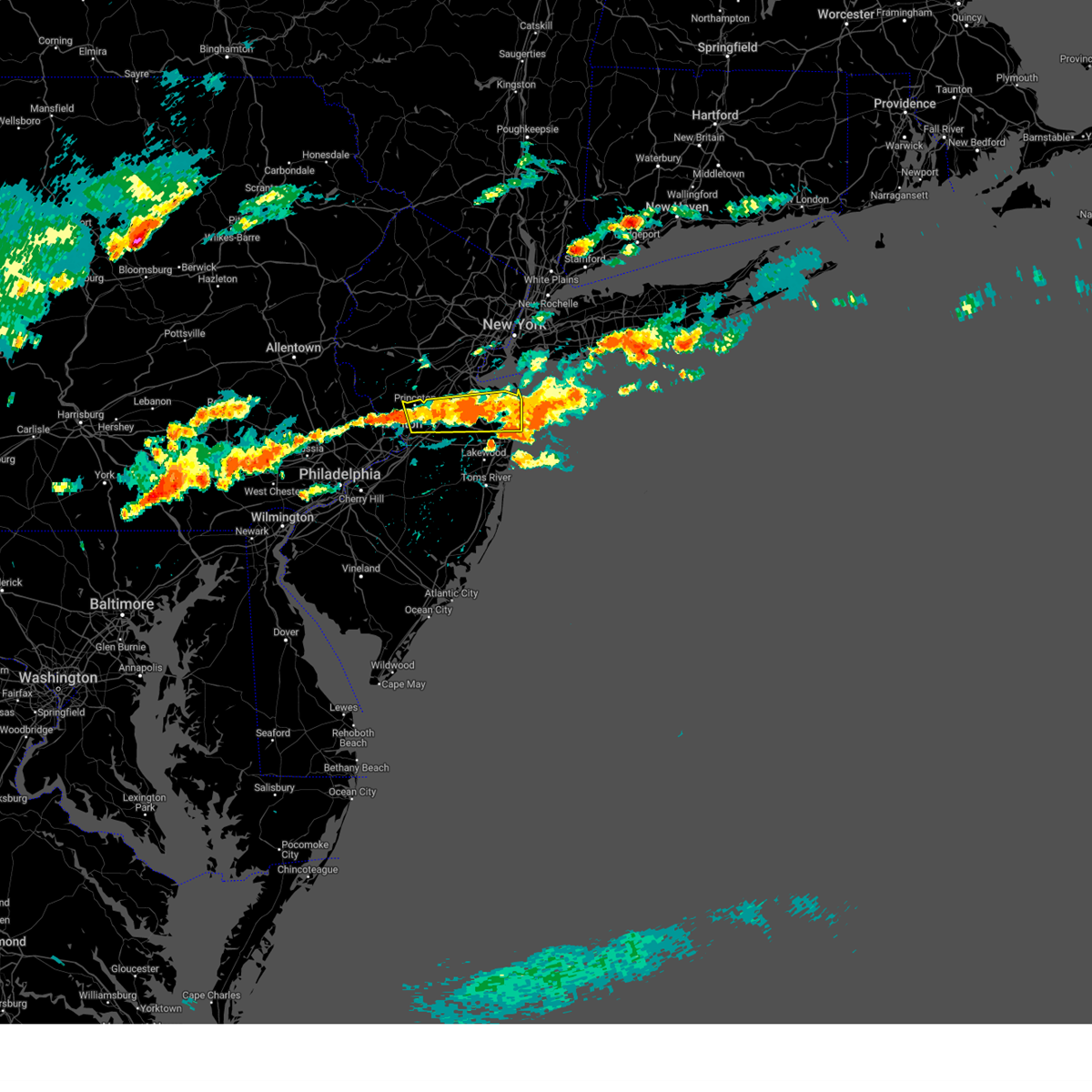
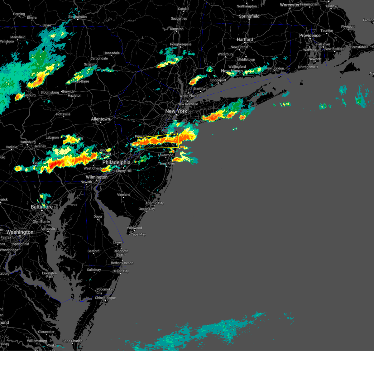
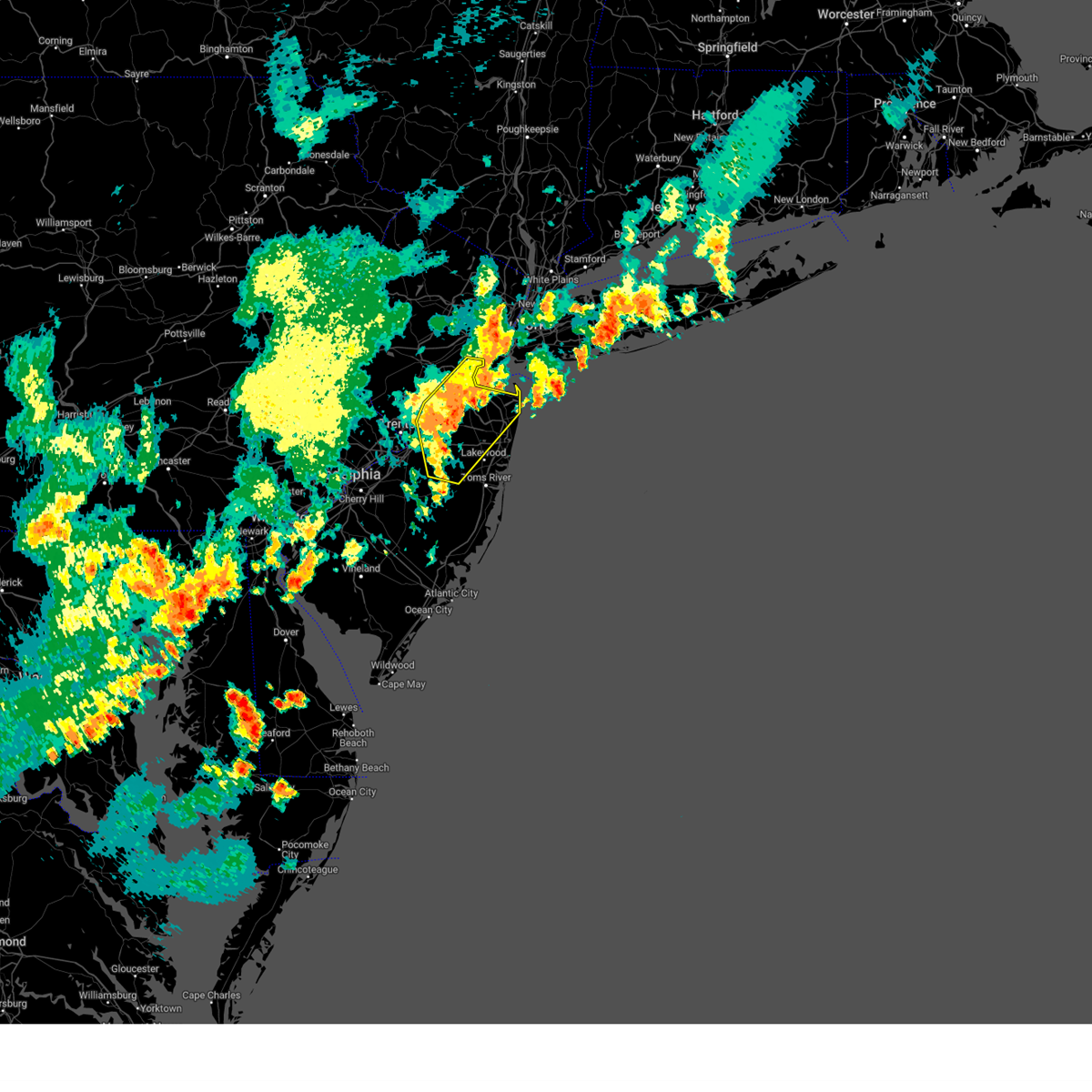
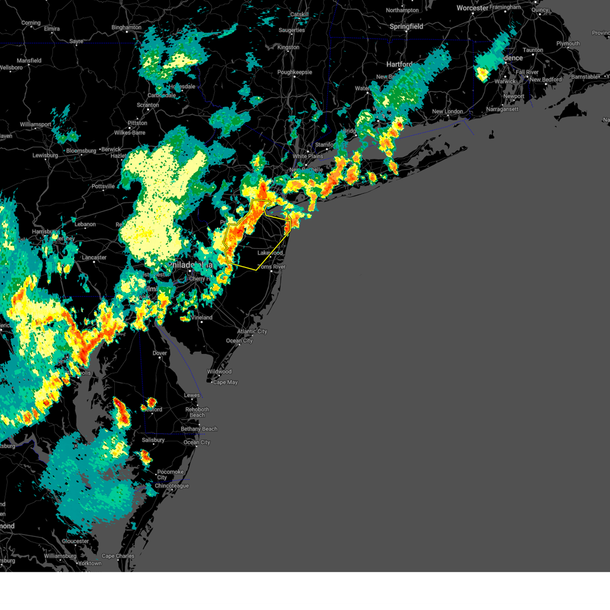
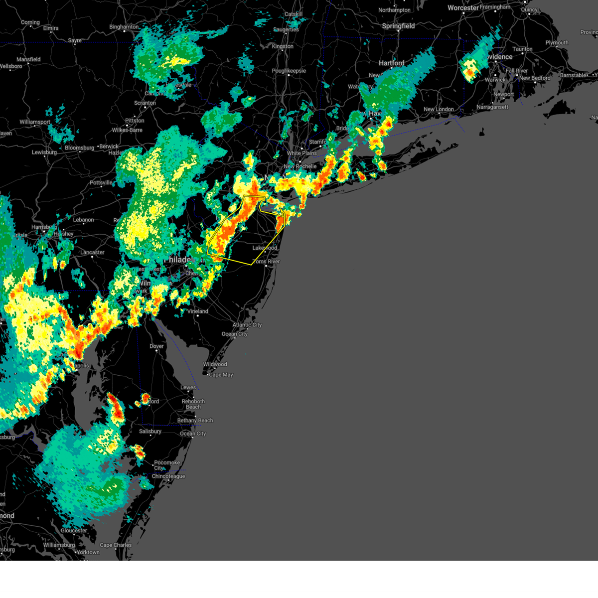
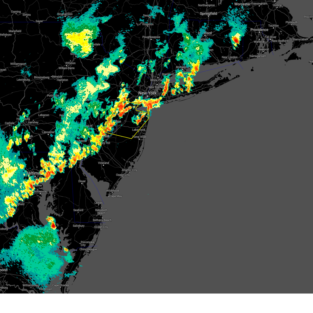
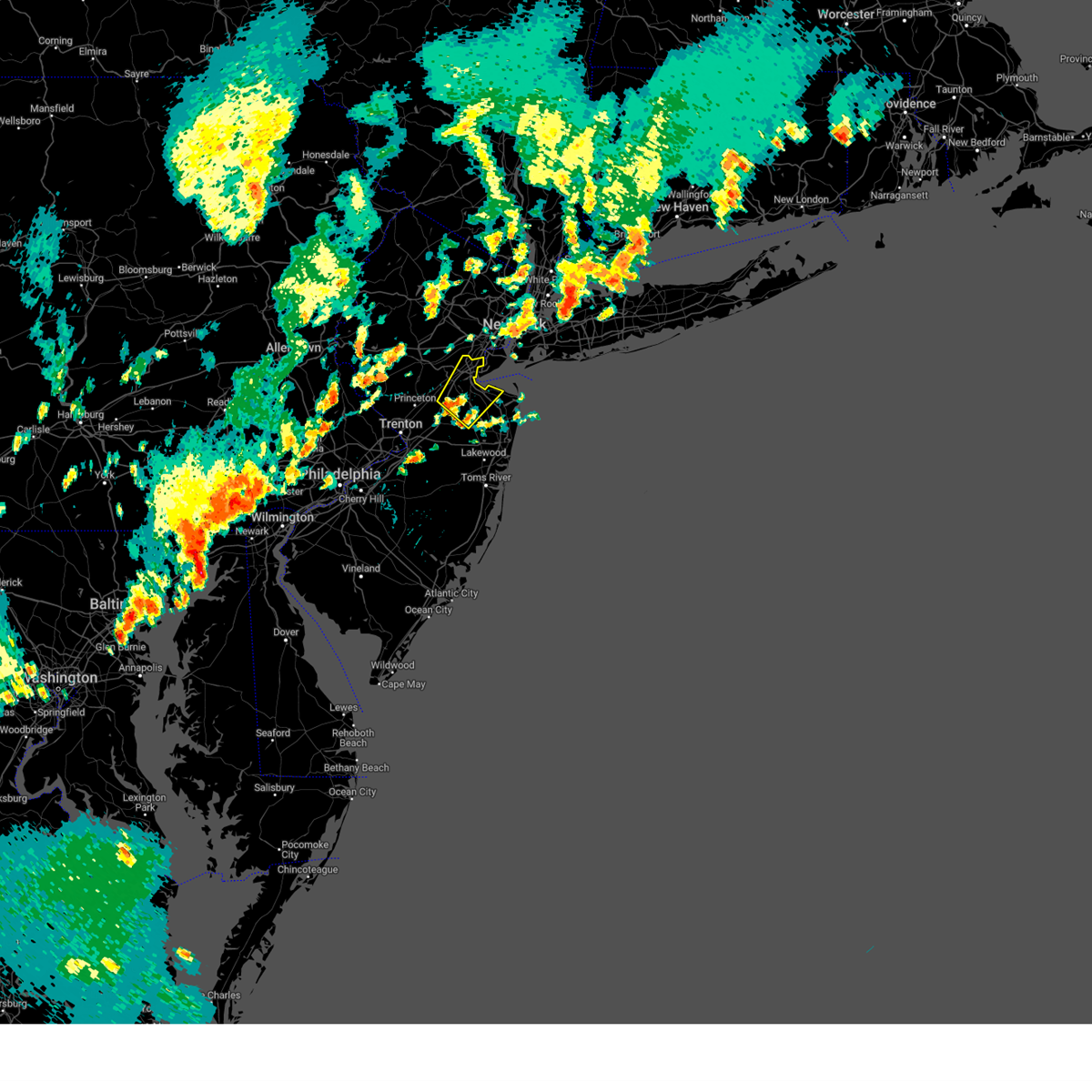
Hail Map for Robertsville, NJ
The Robertsville, NJ area has had 0 reports of on-the-ground hail by trained spotters, and has been under severe weather warnings 41 times during the past 12 months. Doppler radar has detected hail at or near Robertsville, NJ on 25 occasions.
| Name: | Robertsville, NJ |
| Where Located: | 28.9 miles SSW of Brooklyn, NY |
| Map: | Google Map for Robertsville, NJ |
| Population: | 11297 |
| Housing Units: | 3941 |
| More Info: | Search Google for Robertsville, NJ |
0
The Top Recent Hail Date for Robertsville, NJ is Tuesday, August 6, 2024 (25th out of 25)

Hail and Wind Damage Spotted near Robertsville, NJ
| Date / Time | Report Details |
|---|---|
| 6/14/2026 11:21 PM EDT |
 At 1120 pm edt, a severe thunderstorm was located over princeton meadows, or 11 miles northeast of trenton, moving northeast at 45 mph (radar indicated). Hazards include 60 mph wind gusts. Damage to roofs, siding, trees, and power lines is possible. locations impacted include, trenton, new brunswick, perth amboy, edison, old bridge, east brunswick, south brunswick, sayreville, north brunswick, marlboro, manalapan, ewing, holmdel, princeton, matawan, jamesburg, hightstown, cranbury, allentown, and roosevelt. this includes the following highways, new jersey turnpike between exits 8 and 12. interstate 195 in new jersey between mile markers 0 and 10. interstate 295 in new jersey between mile markers 60 and 75. interstate 287 in new jersey between mile markers 0 and 2. Garden state parkway between mile markers 112 and 131. At 1120 pm edt, a severe thunderstorm was located over princeton meadows, or 11 miles northeast of trenton, moving northeast at 45 mph (radar indicated). Hazards include 60 mph wind gusts. Damage to roofs, siding, trees, and power lines is possible. locations impacted include, trenton, new brunswick, perth amboy, edison, old bridge, east brunswick, south brunswick, sayreville, north brunswick, marlboro, manalapan, ewing, holmdel, princeton, matawan, jamesburg, hightstown, cranbury, allentown, and roosevelt. this includes the following highways, new jersey turnpike between exits 8 and 12. interstate 195 in new jersey between mile markers 0 and 10. interstate 295 in new jersey between mile markers 60 and 75. interstate 287 in new jersey between mile markers 0 and 2. Garden state parkway between mile markers 112 and 131.
|
| 6/14/2026 10:58 PM EDT |
 Svrphi the national weather service in mount holly nj has issued a * severe thunderstorm warning for, mercer county in central new jersey, north central burlington county in southern new jersey, central monmouth county in central new jersey, middlesex county in northern new jersey, southeastern bucks county in southeastern pennsylvania, * until 1145 pm edt. * at 1057 pm edt, a severe thunderstorm was located over levittown, or near trenton, moving northeast at 45 mph (radar indicated). Hazards include 60 mph wind gusts. damage to roofs, siding, trees, and power lines is possible Svrphi the national weather service in mount holly nj has issued a * severe thunderstorm warning for, mercer county in central new jersey, north central burlington county in southern new jersey, central monmouth county in central new jersey, middlesex county in northern new jersey, southeastern bucks county in southeastern pennsylvania, * until 1145 pm edt. * at 1057 pm edt, a severe thunderstorm was located over levittown, or near trenton, moving northeast at 45 mph (radar indicated). Hazards include 60 mph wind gusts. damage to roofs, siding, trees, and power lines is possible
|
| 6/6/2026 7:52 PM EDT |
 The storms which prompted the warning have weakened below severe limits, and no longer pose an immediate threat to life or property. therefore, the warning will be allowed to expire. however gusty winds are still possible with these thunderstorms. a severe thunderstorm watch remains in effect until 1000 pm edt for southern, central and northern new jersey, and southeastern pennsylvania. The storms which prompted the warning have weakened below severe limits, and no longer pose an immediate threat to life or property. therefore, the warning will be allowed to expire. however gusty winds are still possible with these thunderstorms. a severe thunderstorm watch remains in effect until 1000 pm edt for southern, central and northern new jersey, and southeastern pennsylvania.
|
| 6/6/2026 7:51 PM EDT |
 The storms which prompted the warning have weakened below severe limits, and no longer pose an immediate threat to life or property. therefore, the warning will be allowed to expire. however gusty winds are still possible with these thunderstorms. a severe thunderstorm watch remains in effect until 1000 pm edt for northern and central new jersey. The storms which prompted the warning have weakened below severe limits, and no longer pose an immediate threat to life or property. therefore, the warning will be allowed to expire. however gusty winds are still possible with these thunderstorms. a severe thunderstorm watch remains in effect until 1000 pm edt for northern and central new jersey.
|
| 6/6/2026 7:42 PM EDT |
 At 742 pm edt, severe thunderstorms were located along a line extending from near robertsville to jacksonville, moving east at 45 mph (radar indicated). Hazards include 60 mph wind gusts. Damage to roofs, siding, trees, and power lines is possible. Locations impacted include, philadelphia, toms river, trenton, long branch, asbury park, lakewood, middletown, old bridge, bensalem, jackson, howell, east brunswick, south brunswick, marlboro, manalapan, ewing, willingboro, medford, tinton falls, and holmdel. At 742 pm edt, severe thunderstorms were located along a line extending from near robertsville to jacksonville, moving east at 45 mph (radar indicated). Hazards include 60 mph wind gusts. Damage to roofs, siding, trees, and power lines is possible. Locations impacted include, philadelphia, toms river, trenton, long branch, asbury park, lakewood, middletown, old bridge, bensalem, jackson, howell, east brunswick, south brunswick, marlboro, manalapan, ewing, willingboro, medford, tinton falls, and holmdel.
|
| 6/6/2026 7:40 PM EDT |
 At 739 pm edt, severe thunderstorms were located along a line extending from near nyack to harrison to near sayreville, moving east at 40 mph (radar indicated). Hazards include 60 mph wind gusts. Damage to roofs, siding, trees, and power lines is possible. Locations impacted include, new brunswick, perth amboy, long branch, somerset, edison, middletown, old bridge, east brunswick, sayreville, north brunswick, carteret, tinton falls, holmdel, middlesex, red bank, bound brook, matawan, brownville, navesink, and society hill. At 739 pm edt, severe thunderstorms were located along a line extending from near nyack to harrison to near sayreville, moving east at 40 mph (radar indicated). Hazards include 60 mph wind gusts. Damage to roofs, siding, trees, and power lines is possible. Locations impacted include, new brunswick, perth amboy, long branch, somerset, edison, middletown, old bridge, east brunswick, sayreville, north brunswick, carteret, tinton falls, holmdel, middlesex, red bank, bound brook, matawan, brownville, navesink, and society hill.
|
| 6/6/2026 7:25 PM EDT |
 At 724 pm edt, severe thunderstorms were located along a line extending from suffern to millburn to near millstone, moving east at 40 mph (radar indicated). Hazards include 60 mph wind gusts. Damage to roofs, siding, trees, and power lines is possible. Locations impacted include, new brunswick, perth amboy, long branch, morristown, somerville, somerset, edison, middletown, old bridge, east brunswick, bridgewater, south brunswick, sayreville, north brunswick, carteret, dover, tinton falls, holmdel, madison, and middlesex. At 724 pm edt, severe thunderstorms were located along a line extending from suffern to millburn to near millstone, moving east at 40 mph (radar indicated). Hazards include 60 mph wind gusts. Damage to roofs, siding, trees, and power lines is possible. Locations impacted include, new brunswick, perth amboy, long branch, morristown, somerville, somerset, edison, middletown, old bridge, east brunswick, bridgewater, south brunswick, sayreville, north brunswick, carteret, dover, tinton falls, holmdel, madison, and middlesex.
|
| 6/6/2026 7:19 PM EDT |
 Svrphi the national weather service in mount holly nj has issued a * severe thunderstorm warning for, northwestern ocean county in southern new jersey, southeastern hunterdon county in northwestern new jersey, northwestern camden county in southern new jersey, mercer county in central new jersey, northern burlington county in southern new jersey, southwestern somerset county in northern new jersey, monmouth county in central new jersey, southern middlesex county in northern new jersey, southeastern montgomery county in southeastern pennsylvania, southeastern bucks county in southeastern pennsylvania, northern philadelphia county in southeastern pennsylvania, * until 800 pm edt. * at 719 pm edt, severe thunderstorms were located along a line extending from kingston to rockledge, moving east at 45 mph (radar indicated). Hazards include 60 mph wind gusts. damage to roofs, siding, trees, and power lines is possible Svrphi the national weather service in mount holly nj has issued a * severe thunderstorm warning for, northwestern ocean county in southern new jersey, southeastern hunterdon county in northwestern new jersey, northwestern camden county in southern new jersey, mercer county in central new jersey, northern burlington county in southern new jersey, southwestern somerset county in northern new jersey, monmouth county in central new jersey, southern middlesex county in northern new jersey, southeastern montgomery county in southeastern pennsylvania, southeastern bucks county in southeastern pennsylvania, northern philadelphia county in southeastern pennsylvania, * until 800 pm edt. * at 719 pm edt, severe thunderstorms were located along a line extending from kingston to rockledge, moving east at 45 mph (radar indicated). Hazards include 60 mph wind gusts. damage to roofs, siding, trees, and power lines is possible
|
| 6/6/2026 6:59 PM EDT |
 Svrphi the national weather service in mount holly nj has issued a * severe thunderstorm warning for, northeastern hunterdon county in northwestern new jersey, morris county in northern new jersey, central sussex county in northwestern new jersey, east central warren county in northwestern new jersey, somerset county in northern new jersey, northeastern monmouth county in central new jersey, middlesex county in northern new jersey, * until 800 pm edt. * at 658 pm edt, severe thunderstorms were located along a line extending from near highland lake to near mendham to flemington, moving east at 40 mph (radar indicated). Hazards include 60 mph wind gusts. damage to roofs, siding, trees, and power lines is possible Svrphi the national weather service in mount holly nj has issued a * severe thunderstorm warning for, northeastern hunterdon county in northwestern new jersey, morris county in northern new jersey, central sussex county in northwestern new jersey, east central warren county in northwestern new jersey, somerset county in northern new jersey, northeastern monmouth county in central new jersey, middlesex county in northern new jersey, * until 800 pm edt. * at 658 pm edt, severe thunderstorms were located along a line extending from near highland lake to near mendham to flemington, moving east at 40 mph (radar indicated). Hazards include 60 mph wind gusts. damage to roofs, siding, trees, and power lines is possible
|
| 5/20/2026 6:48 PM EDT |
 At 648 pm edt, a severe thunderstorm was located over howell, or 10 miles west of asbury park, moving east at 25 mph (radar indicated). Hazards include 60 mph wind gusts. Damage to roofs, siding, trees, and power lines is possible. Locations impacted include, long branch, asbury park, lakewood, middletown, old bridge, jackson, howell, east brunswick, marlboro, manalapan, tinton falls, holmdel, red bank, matawan, jamesburg, manasquan, point pleasant beach, farmingdale, allenwood, and east freehold. At 648 pm edt, a severe thunderstorm was located over howell, or 10 miles west of asbury park, moving east at 25 mph (radar indicated). Hazards include 60 mph wind gusts. Damage to roofs, siding, trees, and power lines is possible. Locations impacted include, long branch, asbury park, lakewood, middletown, old bridge, jackson, howell, east brunswick, marlboro, manalapan, tinton falls, holmdel, red bank, matawan, jamesburg, manasquan, point pleasant beach, farmingdale, allenwood, and east freehold.
|
| 5/20/2026 6:23 PM EDT |
 Svrphi the national weather service in mount holly nj has issued a * severe thunderstorm warning for, northern ocean county in southern new jersey, eastern mercer county in central new jersey, northern burlington county in southern new jersey, south central somerset county in northern new jersey, monmouth county in central new jersey, southern middlesex county in northern new jersey, * until 730 pm edt. * at 623 pm edt, a severe thunderstorm was located over clarksburg, or 17 miles northwest of toms river, moving east at 25 mph (radar indicated). Hazards include 60 mph wind gusts. damage to roofs, siding, trees, and power lines is possible Svrphi the national weather service in mount holly nj has issued a * severe thunderstorm warning for, northern ocean county in southern new jersey, eastern mercer county in central new jersey, northern burlington county in southern new jersey, south central somerset county in northern new jersey, monmouth county in central new jersey, southern middlesex county in northern new jersey, * until 730 pm edt. * at 623 pm edt, a severe thunderstorm was located over clarksburg, or 17 miles northwest of toms river, moving east at 25 mph (radar indicated). Hazards include 60 mph wind gusts. damage to roofs, siding, trees, and power lines is possible
|
| 5/20/2026 6:18 PM EDT |
 At 617 pm edt, a severe thunderstorm was located over edinburg, or 7 miles east of trenton, moving east at 30 mph (radar indicated). Hazards include 60 mph wind gusts. Damage to roofs, siding, trees, and power lines is possible. Locations impacted include, trenton, old bridge, east brunswick, south brunswick, manalapan, ewing, princeton, florence, burlington, bristol, jamesburg, hightstown, bordentown, cranbury, pennington, yardley, hopewell, tullytown, allentown, and roosevelt. At 617 pm edt, a severe thunderstorm was located over edinburg, or 7 miles east of trenton, moving east at 30 mph (radar indicated). Hazards include 60 mph wind gusts. Damage to roofs, siding, trees, and power lines is possible. Locations impacted include, trenton, old bridge, east brunswick, south brunswick, manalapan, ewing, princeton, florence, burlington, bristol, jamesburg, hightstown, bordentown, cranbury, pennington, yardley, hopewell, tullytown, allentown, and roosevelt.
|
| 5/20/2026 5:52 PM EDT |
 Svrphi the national weather service in mount holly nj has issued a * severe thunderstorm warning for, northwestern ocean county in southern new jersey, south central hunterdon county in northwestern new jersey, mercer county in central new jersey, north central burlington county in southern new jersey, south central somerset county in northern new jersey, southwestern monmouth county in central new jersey, southwestern middlesex county in northern new jersey, east central montgomery county in southeastern pennsylvania, southeastern bucks county in southeastern pennsylvania, northeastern philadelphia county in southeastern pennsylvania, * until 630 pm edt. * at 552 pm edt, a severe thunderstorm was located over washington crossing, or 7 miles northwest of trenton, moving east at 30 mph (radar indicated). Hazards include 60 mph wind gusts. damage to roofs, siding, trees, and power lines is possible Svrphi the national weather service in mount holly nj has issued a * severe thunderstorm warning for, northwestern ocean county in southern new jersey, south central hunterdon county in northwestern new jersey, mercer county in central new jersey, north central burlington county in southern new jersey, south central somerset county in northern new jersey, southwestern monmouth county in central new jersey, southwestern middlesex county in northern new jersey, east central montgomery county in southeastern pennsylvania, southeastern bucks county in southeastern pennsylvania, northeastern philadelphia county in southeastern pennsylvania, * until 630 pm edt. * at 552 pm edt, a severe thunderstorm was located over washington crossing, or 7 miles northwest of trenton, moving east at 30 mph (radar indicated). Hazards include 60 mph wind gusts. damage to roofs, siding, trees, and power lines is possible
|
| 3/17/2026 12:10 AM EDT |
 At 1210 am edt, severe thunderstorms were located along a line extending from near vista center to tuckerton, moving east at 55 mph (radar indicated). Hazards include 60 mph wind gusts. Damage to roofs, siding, trees, and power lines is possible. Locations impacted include, toms river, perth amboy, long branch, asbury park, sandy hook, lakewood, middletown, old bridge, jackson, howell, sayreville, marlboro, carteret, barnegat, tinton falls, holmdel, red bank, beachwood, matawan, and manasquan. At 1210 am edt, severe thunderstorms were located along a line extending from near vista center to tuckerton, moving east at 55 mph (radar indicated). Hazards include 60 mph wind gusts. Damage to roofs, siding, trees, and power lines is possible. Locations impacted include, toms river, perth amboy, long branch, asbury park, sandy hook, lakewood, middletown, old bridge, jackson, howell, sayreville, marlboro, carteret, barnegat, tinton falls, holmdel, red bank, beachwood, matawan, and manasquan.
|
| 3/17/2026 12:10 AM EDT |
 the severe thunderstorm warning has been cancelled and is no longer in effect the severe thunderstorm warning has been cancelled and is no longer in effect
|
| 3/17/2026 12:08 AM EDT |
 The storms which prompted the warning have moved out of the area. therefore, the warning will be allowed to expire. to report severe weather, contact your nearest law enforcement agency. they will relay your report to the national weather service mount holly nj. The storms which prompted the warning have moved out of the area. therefore, the warning will be allowed to expire. to report severe weather, contact your nearest law enforcement agency. they will relay your report to the national weather service mount holly nj.
|
| 3/16/2026 11:53 PM EDT |
 At 1153 pm edt, severe thunderstorms were located along a line extending from far hills to near mercerville-hamilton square, moving northeast at 60 mph (radar indicated). Hazards include 70 mph wind gusts. Expect considerable tree damage. damage is likely to mobile homes, roofs, and outbuildings. Locations impacted include, new brunswick, somerville, somerset, edison, old bridge, east brunswick, south brunswick, sayreville, north brunswick, middlesex, bound brook, manville, jamesburg, hightstown, cranbury, millstone, martinsville, yorketown, twin rivers, and society hill. At 1153 pm edt, severe thunderstorms were located along a line extending from far hills to near mercerville-hamilton square, moving northeast at 60 mph (radar indicated). Hazards include 70 mph wind gusts. Expect considerable tree damage. damage is likely to mobile homes, roofs, and outbuildings. Locations impacted include, new brunswick, somerville, somerset, edison, old bridge, east brunswick, south brunswick, sayreville, north brunswick, middlesex, bound brook, manville, jamesburg, hightstown, cranbury, millstone, martinsville, yorketown, twin rivers, and society hill.
|
| 3/16/2026 11:53 PM EDT |
 the severe thunderstorm warning has been cancelled and is no longer in effect the severe thunderstorm warning has been cancelled and is no longer in effect
|
| 3/16/2026 11:51 PM EDT |
 Svrphi the national weather service in mount holly nj has issued a * severe thunderstorm warning for, ocean county in southern new jersey, east central mercer county in central new jersey, eastern burlington county in southern new jersey, monmouth county in central new jersey, eastern middlesex county in northern new jersey, * until 100 am edt. * at 1151 pm edt, severe thunderstorms were located along a line extending from allentown to near egg harbor city, moving east at 55 mph (radar indicated). Hazards include 60 mph wind gusts. damage to roofs, siding, trees, and power lines is possible Svrphi the national weather service in mount holly nj has issued a * severe thunderstorm warning for, ocean county in southern new jersey, east central mercer county in central new jersey, eastern burlington county in southern new jersey, monmouth county in central new jersey, eastern middlesex county in northern new jersey, * until 100 am edt. * at 1151 pm edt, severe thunderstorms were located along a line extending from allentown to near egg harbor city, moving east at 55 mph (radar indicated). Hazards include 60 mph wind gusts. damage to roofs, siding, trees, and power lines is possible
|
| 3/16/2026 11:38 PM EDT |
 At 1138 pm edt, severe thunderstorms were located along a line extending from near white house station to florence, moving northeast at 65 mph (radar indicated. at 11:33 pm, trenton mercer airport gusted to 58 mph). Hazards include 60 mph wind gusts. Damage to roofs, siding, trees, and power lines is possible. Locations impacted include, trenton, new brunswick, somerville, somerset, edison, old bridge, east brunswick, bridgewater, south brunswick, sayreville, north brunswick, ewing, middlesex, princeton, bound brook, manville, jamesburg, hightstown, mendham, and cranbury. At 1138 pm edt, severe thunderstorms were located along a line extending from near white house station to florence, moving northeast at 65 mph (radar indicated. at 11:33 pm, trenton mercer airport gusted to 58 mph). Hazards include 60 mph wind gusts. Damage to roofs, siding, trees, and power lines is possible. Locations impacted include, trenton, new brunswick, somerville, somerset, edison, old bridge, east brunswick, bridgewater, south brunswick, sayreville, north brunswick, ewing, middlesex, princeton, bound brook, manville, jamesburg, hightstown, mendham, and cranbury.
|
| 3/16/2026 11:38 PM EDT |
 the severe thunderstorm warning has been cancelled and is no longer in effect the severe thunderstorm warning has been cancelled and is no longer in effect
|
| 3/16/2026 11:16 PM EDT |
 Svrphi the national weather service in mount holly nj has issued a * severe thunderstorm warning for, hunterdon county in northwestern new jersey, mercer county in central new jersey, somerset county in northern new jersey, west central monmouth county in central new jersey, middlesex county in northern new jersey, eastern bucks county in southeastern pennsylvania, northeastern philadelphia county in southeastern pennsylvania, * until 1215 am edt. * at 1116 pm edt, severe thunderstorms were located along a line extending from near lumberville to near south philadelphia, moving northeast at 60 mph (radar indicated). Hazards include 60 mph wind gusts. damage to roofs, siding, trees, and power lines is possible Svrphi the national weather service in mount holly nj has issued a * severe thunderstorm warning for, hunterdon county in northwestern new jersey, mercer county in central new jersey, somerset county in northern new jersey, west central monmouth county in central new jersey, middlesex county in northern new jersey, eastern bucks county in southeastern pennsylvania, northeastern philadelphia county in southeastern pennsylvania, * until 1215 am edt. * at 1116 pm edt, severe thunderstorms were located along a line extending from near lumberville to near south philadelphia, moving northeast at 60 mph (radar indicated). Hazards include 60 mph wind gusts. damage to roofs, siding, trees, and power lines is possible
|
| 12/19/2025 3:44 PM EST |
 The showers which prompted the warning have moved out of the area. therefore, the warning will be allowed to expire. The showers which prompted the warning have moved out of the area. therefore, the warning will be allowed to expire.
|
| 12/19/2025 3:25 PM EST |
 the severe thunderstorm warning has been cancelled and is no longer in effect the severe thunderstorm warning has been cancelled and is no longer in effect
|
| 12/19/2025 3:25 PM EST |
 At 325 pm est, showers with damaging winds were located along a line extending from edison to near warren grove, moving east at 55 mph (radar indicated). Hazards include 60 mph wind gusts. Damage to roofs, siding, trees, and power lines is possible. Locations impacted include, toms river, trenton, new brunswick, perth amboy, long branch, asbury park, somerville, sandy hook, somerset, edison, lakewood, middletown, old bridge, jackson, howell, east brunswick, evesham, south brunswick, sayreville, and north brunswick. At 325 pm est, showers with damaging winds were located along a line extending from edison to near warren grove, moving east at 55 mph (radar indicated). Hazards include 60 mph wind gusts. Damage to roofs, siding, trees, and power lines is possible. Locations impacted include, toms river, trenton, new brunswick, perth amboy, long branch, asbury park, somerville, sandy hook, somerset, edison, lakewood, middletown, old bridge, jackson, howell, east brunswick, evesham, south brunswick, sayreville, and north brunswick.
|
| 12/19/2025 2:51 PM EST |
 Svrphi the national weather service in mount holly nj has issued a * severe thunderstorm warning for, ocean county in southern new jersey, camden county in southern new jersey, mercer county in central new jersey, somerset county in northern new jersey, northern atlantic county in southern new jersey, southeastern hunterdon county in northwestern new jersey, central gloucester county in southern new jersey, burlington county in southern new jersey, monmouth county in central new jersey, middlesex county in northern new jersey, east central montgomery county in southeastern pennsylvania, southeastern bucks county in southeastern pennsylvania, central philadelphia county in southeastern pennsylvania, * until 345 pm est. * at 251 pm est, showers with damaging winds were located along a line extending from near new hope to turnersville, moving east at 50 mph (radar indicated). Hazards include 60 mph wind gusts. damage to roofs, siding, trees, and power lines is possible Svrphi the national weather service in mount holly nj has issued a * severe thunderstorm warning for, ocean county in southern new jersey, camden county in southern new jersey, mercer county in central new jersey, somerset county in northern new jersey, northern atlantic county in southern new jersey, southeastern hunterdon county in northwestern new jersey, central gloucester county in southern new jersey, burlington county in southern new jersey, monmouth county in central new jersey, middlesex county in northern new jersey, east central montgomery county in southeastern pennsylvania, southeastern bucks county in southeastern pennsylvania, central philadelphia county in southeastern pennsylvania, * until 345 pm est. * at 251 pm est, showers with damaging winds were located along a line extending from near new hope to turnersville, moving east at 50 mph (radar indicated). Hazards include 60 mph wind gusts. damage to roofs, siding, trees, and power lines is possible
|
| 12/19/2025 10:20 AM EST |
 The storms which prompted the warning have weakened below severe limits, and no longer pose an immediate threat to life or property. therefore, the warning will be allowed to expire. The storms which prompted the warning have weakened below severe limits, and no longer pose an immediate threat to life or property. therefore, the warning will be allowed to expire.
|
| 12/19/2025 10:05 AM EST |
 the severe thunderstorm warning has been cancelled and is no longer in effect the severe thunderstorm warning has been cancelled and is no longer in effect
|
| 12/19/2025 10:05 AM EST |
 At 1005 am est, severe thunderstorms were located along a line extending from society hill to near pemberton, moving east at 60 mph (radar indicated). Hazards include 60 mph wind gusts. Damage to roofs, siding, trees, and power lines is possible. Locations impacted include, toms river, new brunswick, perth amboy, somerset, edison, lakewood, middletown, old bridge, jackson, howell, east brunswick, south brunswick, sayreville, north brunswick, marlboro, manalapan, carteret, tinton falls, holmdel, and middlesex. At 1005 am est, severe thunderstorms were located along a line extending from society hill to near pemberton, moving east at 60 mph (radar indicated). Hazards include 60 mph wind gusts. Damage to roofs, siding, trees, and power lines is possible. Locations impacted include, toms river, new brunswick, perth amboy, somerset, edison, lakewood, middletown, old bridge, jackson, howell, east brunswick, south brunswick, sayreville, north brunswick, marlboro, manalapan, carteret, tinton falls, holmdel, and middlesex.
|
| 12/19/2025 9:41 AM EST |
 Svrphi the national weather service in mount holly nj has issued a * severe thunderstorm warning for, northern ocean county in southern new jersey, southeastern hunterdon county in northwestern new jersey, northwestern camden county in southern new jersey, mercer county in central new jersey, northeastern gloucester county in southern new jersey, northern burlington county in southern new jersey, southern somerset county in northern new jersey, monmouth county in central new jersey, middlesex county in northern new jersey, southeastern bucks county in southeastern pennsylvania, northeastern philadelphia county in southeastern pennsylvania, * until 1030 am est. * at 941 am est, severe thunderstorms were located along a line extending from near hopewell to magnolia, moving east at 60 mph (radar indicated). Hazards include 60 mph wind gusts. damage to roofs, siding, trees, and power lines is possible Svrphi the national weather service in mount holly nj has issued a * severe thunderstorm warning for, northern ocean county in southern new jersey, southeastern hunterdon county in northwestern new jersey, northwestern camden county in southern new jersey, mercer county in central new jersey, northeastern gloucester county in southern new jersey, northern burlington county in southern new jersey, southern somerset county in northern new jersey, monmouth county in central new jersey, middlesex county in northern new jersey, southeastern bucks county in southeastern pennsylvania, northeastern philadelphia county in southeastern pennsylvania, * until 1030 am est. * at 941 am est, severe thunderstorms were located along a line extending from near hopewell to magnolia, moving east at 60 mph (radar indicated). Hazards include 60 mph wind gusts. damage to roofs, siding, trees, and power lines is possible
|
| 7/25/2025 5:35 PM EDT |
 At 535 pm edt, a severe thunderstorm was located over clearbrook park, or 13 miles south of new brunswick, moving southeast at 35 mph (radar indicated). Hazards include 60 mph wind gusts. Damage to roofs, siding, trees, and power lines is possible. Locations impacted include, new brunswick, long branch, asbury park, sandy hook, somerset, middletown, old bridge, howell, east brunswick, south brunswick, north brunswick, marlboro, manalapan, tinton falls, holmdel, princeton, red bank, matawan, jamesburg, and manasquan. At 535 pm edt, a severe thunderstorm was located over clearbrook park, or 13 miles south of new brunswick, moving southeast at 35 mph (radar indicated). Hazards include 60 mph wind gusts. Damage to roofs, siding, trees, and power lines is possible. Locations impacted include, new brunswick, long branch, asbury park, sandy hook, somerset, middletown, old bridge, howell, east brunswick, south brunswick, north brunswick, marlboro, manalapan, tinton falls, holmdel, princeton, red bank, matawan, jamesburg, and manasquan.
|
| 7/25/2025 5:35 PM EDT |
 the severe thunderstorm warning has been cancelled and is no longer in effect the severe thunderstorm warning has been cancelled and is no longer in effect
|
| 7/25/2025 5:09 PM EDT |
 Svrphi the national weather service in mount holly nj has issued a * severe thunderstorm warning for, southeastern hunterdon county in northwestern new jersey, northern mercer county in central new jersey, southern somerset county in northern new jersey, monmouth county in central new jersey, middlesex county in northern new jersey, * until 615 pm edt. * at 509 pm edt, a severe thunderstorm was located over belle mead, or 8 miles south of somerville, moving east at 40 mph (radar indicated). Hazards include 60 mph wind gusts. damage to roofs, siding, trees, and power lines is possible Svrphi the national weather service in mount holly nj has issued a * severe thunderstorm warning for, southeastern hunterdon county in northwestern new jersey, northern mercer county in central new jersey, southern somerset county in northern new jersey, monmouth county in central new jersey, middlesex county in northern new jersey, * until 615 pm edt. * at 509 pm edt, a severe thunderstorm was located over belle mead, or 8 miles south of somerville, moving east at 40 mph (radar indicated). Hazards include 60 mph wind gusts. damage to roofs, siding, trees, and power lines is possible
|
| 7/16/2025 8:20 PM EDT |
 the severe thunderstorm warning has been cancelled and is no longer in effect the severe thunderstorm warning has been cancelled and is no longer in effect
|
| 7/16/2025 7:54 PM EDT |
 Svrphi the national weather service in mount holly nj has issued a * severe thunderstorm warning for, north central ocean county in southern new jersey, central monmouth county in central new jersey, southeastern middlesex county in northern new jersey, * until 845 pm edt. * at 754 pm edt, a severe thunderstorm was located over west freehold, or 17 miles west of asbury park, moving northeast at 10 mph (radar indicated). Hazards include 60 mph wind gusts and penny size hail. damage to roofs, siding, trees, and power lines is possible Svrphi the national weather service in mount holly nj has issued a * severe thunderstorm warning for, north central ocean county in southern new jersey, central monmouth county in central new jersey, southeastern middlesex county in northern new jersey, * until 845 pm edt. * at 754 pm edt, a severe thunderstorm was located over west freehold, or 17 miles west of asbury park, moving northeast at 10 mph (radar indicated). Hazards include 60 mph wind gusts and penny size hail. damage to roofs, siding, trees, and power lines is possible
|
| 7/8/2025 7:21 PM EDT |
 the severe thunderstorm warning has been cancelled and is no longer in effect the severe thunderstorm warning has been cancelled and is no longer in effect
|
| 7/8/2025 7:21 PM EDT |
 At 720 pm edt, a severe thunderstorm was located over navesink, or near sandy hook, moving east at 35 mph (radar indicated). Hazards include 60 mph wind gusts and penny size hail. Damage to roofs, siding, trees, and power lines is possible. Locations impacted include, long branch, sandy hook, middletown, marlboro, tinton falls, holmdel, red bank, matawan, highlands, east freehold, west freehold, adelphia, elberon, navesink, lincroft, morganville, eatontown, freehold, west long branch, and keyport. At 720 pm edt, a severe thunderstorm was located over navesink, or near sandy hook, moving east at 35 mph (radar indicated). Hazards include 60 mph wind gusts and penny size hail. Damage to roofs, siding, trees, and power lines is possible. Locations impacted include, long branch, sandy hook, middletown, marlboro, tinton falls, holmdel, red bank, matawan, highlands, east freehold, west freehold, adelphia, elberon, navesink, lincroft, morganville, eatontown, freehold, west long branch, and keyport.
|
| 7/8/2025 7:00 PM EDT |
 The storm which prompted the warning has moved out of the area. therefore, the warning has been allowed to expire. however gusty winds are still possible with this thunderstorm. a severe thunderstorm watch remains in effect until 900 pm edt for central and northern new jersey. remember, a severe thunderstorm warning still remains in effect for southern middlesex county and northern monmouth county in new jersey. The storm which prompted the warning has moved out of the area. therefore, the warning has been allowed to expire. however gusty winds are still possible with this thunderstorm. a severe thunderstorm watch remains in effect until 900 pm edt for central and northern new jersey. remember, a severe thunderstorm warning still remains in effect for southern middlesex county and northern monmouth county in new jersey.
|
| 7/8/2025 6:53 PM EDT |
 Svrphi the national weather service in mount holly nj has issued a * severe thunderstorm warning for, northeastern monmouth county in central new jersey, eastern middlesex county in northern new jersey, * until 745 pm edt. * at 653 pm edt, a severe thunderstorm was located over robertsville, or 10 miles southeast of new brunswick, moving east at 35 mph (radar indicated). Hazards include 60 mph wind gusts and penny size hail. damage to roofs, siding, trees, and power lines is possible Svrphi the national weather service in mount holly nj has issued a * severe thunderstorm warning for, northeastern monmouth county in central new jersey, eastern middlesex county in northern new jersey, * until 745 pm edt. * at 653 pm edt, a severe thunderstorm was located over robertsville, or 10 miles southeast of new brunswick, moving east at 35 mph (radar indicated). Hazards include 60 mph wind gusts and penny size hail. damage to roofs, siding, trees, and power lines is possible
|
| 7/8/2025 6:49 PM EDT |
 At 649 pm edt, a severe thunderstorm was located over yorketown, or 12 miles south of new brunswick, moving east at 35 mph (radar indicated). Hazards include 60 mph wind gusts and penny size hail. Damage to roofs, siding, trees, and power lines is possible. Locations impacted include, new brunswick, old bridge, east brunswick, south brunswick, sayreville, north brunswick, marlboro, manalapan, tinton falls, holmdel, matawan, jamesburg, hightstown, cranbury, roosevelt, rocky hill, brownville, east freehold, west freehold, and adelphia. At 649 pm edt, a severe thunderstorm was located over yorketown, or 12 miles south of new brunswick, moving east at 35 mph (radar indicated). Hazards include 60 mph wind gusts and penny size hail. Damage to roofs, siding, trees, and power lines is possible. Locations impacted include, new brunswick, old bridge, east brunswick, south brunswick, sayreville, north brunswick, marlboro, manalapan, tinton falls, holmdel, matawan, jamesburg, hightstown, cranbury, roosevelt, rocky hill, brownville, east freehold, west freehold, and adelphia.
|
| 7/8/2025 6:22 PM EDT |
 Svrphi the national weather service in mount holly nj has issued a * severe thunderstorm warning for, mercer county in central new jersey, south central somerset county in northern new jersey, central monmouth county in central new jersey, middlesex county in northern new jersey, * until 700 pm edt. * at 621 pm edt, a severe thunderstorm was located over mercerville-hamilton square, or near trenton, moving east at 35 mph (radar indicated). Hazards include 60 mph wind gusts and penny size hail. damage to roofs, siding, trees, and power lines is possible Svrphi the national weather service in mount holly nj has issued a * severe thunderstorm warning for, mercer county in central new jersey, south central somerset county in northern new jersey, central monmouth county in central new jersey, middlesex county in northern new jersey, * until 700 pm edt. * at 621 pm edt, a severe thunderstorm was located over mercerville-hamilton square, or near trenton, moving east at 35 mph (radar indicated). Hazards include 60 mph wind gusts and penny size hail. damage to roofs, siding, trees, and power lines is possible
|
| 6/19/2025 6:45 PM EDT |
 The storms which prompted the warning have weakened below severe limits, and have exited the warned area. therefore, the warning will be allowed to expire. however gusty winds and heavy rain are still possible with these thunderstorms. a severe thunderstorm watch remains in effect until 900 pm edt for northern, central and northwestern new jersey. to report severe weather, contact your nearest law enforcement agency. they will relay your report to the national weather service mount holly nj. The storms which prompted the warning have weakened below severe limits, and have exited the warned area. therefore, the warning will be allowed to expire. however gusty winds and heavy rain are still possible with these thunderstorms. a severe thunderstorm watch remains in effect until 900 pm edt for northern, central and northwestern new jersey. to report severe weather, contact your nearest law enforcement agency. they will relay your report to the national weather service mount holly nj.
|
| 6/19/2025 6:33 PM EDT |
 At 632 pm edt, severe thunderstorms were located along a line extending from near flemington to millstone to near yorketown, moving northeast at 45 mph (radar indicated). Hazards include 60 mph wind gusts and penny size hail. Damage to roofs, siding, trees, and power lines is possible. Locations impacted include, new brunswick, perth amboy, somerville, somerset, edison, old bridge, east brunswick, bridgewater, south brunswick, sayreville, north brunswick, marlboro, carteret, middlesex, bound brook, manville, matawan, jamesburg, mendham, and flemington. At 632 pm edt, severe thunderstorms were located along a line extending from near flemington to millstone to near yorketown, moving northeast at 45 mph (radar indicated). Hazards include 60 mph wind gusts and penny size hail. Damage to roofs, siding, trees, and power lines is possible. Locations impacted include, new brunswick, perth amboy, somerville, somerset, edison, old bridge, east brunswick, bridgewater, south brunswick, sayreville, north brunswick, marlboro, carteret, middlesex, bound brook, manville, matawan, jamesburg, mendham, and flemington.
|
| 6/19/2025 6:33 PM EDT |
 the severe thunderstorm warning has been cancelled and is no longer in effect the severe thunderstorm warning has been cancelled and is no longer in effect
|
| 6/19/2025 6:14 PM EDT |
 Svrphi the national weather service in mount holly nj has issued a * severe thunderstorm warning for, southwestern morris county in northern new jersey, hunterdon county in northwestern new jersey, mercer county in central new jersey, east central warren county in northwestern new jersey, somerset county in northern new jersey, central monmouth county in central new jersey, middlesex county in northern new jersey, central bucks county in southeastern pennsylvania, * until 645 pm edt. * at 613 pm edt, severe thunderstorms were located along a line extending from near byram to skillman to twin rivers, moving northeast at 55 mph (radar indicated). Hazards include 60 mph wind gusts and penny size hail. damage to roofs, siding, trees, and power lines is possible Svrphi the national weather service in mount holly nj has issued a * severe thunderstorm warning for, southwestern morris county in northern new jersey, hunterdon county in northwestern new jersey, mercer county in central new jersey, east central warren county in northwestern new jersey, somerset county in northern new jersey, central monmouth county in central new jersey, middlesex county in northern new jersey, central bucks county in southeastern pennsylvania, * until 645 pm edt. * at 613 pm edt, severe thunderstorms were located along a line extending from near byram to skillman to twin rivers, moving northeast at 55 mph (radar indicated). Hazards include 60 mph wind gusts and penny size hail. damage to roofs, siding, trees, and power lines is possible
|
| 5/3/2025 7:10 PM EDT |
 the severe thunderstorm warning has been cancelled and is no longer in effect the severe thunderstorm warning has been cancelled and is no longer in effect
|
| 5/3/2025 6:55 PM EDT |
 At 655 pm edt, a severe thunderstorm was located over adelphia, or 12 miles west of asbury park, moving northeast at 35 mph (radar indicated). Hazards include 60 mph wind gusts and quarter size hail. Minor damage to vehicles is possible. wind damage to roofs, siding, trees, and power lines is possible. locations impacted include, allenhurst, west long branch, howell, wanamassa, loch arbour, tinton falls, east freehold, oakhurst, oceanport, shrewsbury, red bank, middletown, interlaken, west freehold, long branch, adelphia, sandy hook, marlboro, elberon, and eatontown. this includes the following highways, interstate 195 in new jersey between mile markers 27 and 34. Garden state parkway between mile markers 99 and 117. At 655 pm edt, a severe thunderstorm was located over adelphia, or 12 miles west of asbury park, moving northeast at 35 mph (radar indicated). Hazards include 60 mph wind gusts and quarter size hail. Minor damage to vehicles is possible. wind damage to roofs, siding, trees, and power lines is possible. locations impacted include, allenhurst, west long branch, howell, wanamassa, loch arbour, tinton falls, east freehold, oakhurst, oceanport, shrewsbury, red bank, middletown, interlaken, west freehold, long branch, adelphia, sandy hook, marlboro, elberon, and eatontown. this includes the following highways, interstate 195 in new jersey between mile markers 27 and 34. Garden state parkway between mile markers 99 and 117.
|
| 5/3/2025 6:55 PM EDT |
 the severe thunderstorm warning has been cancelled and is no longer in effect the severe thunderstorm warning has been cancelled and is no longer in effect
|
| 5/3/2025 6:46 PM EDT |
 Svrphi the national weather service in mount holly nj has issued a * severe thunderstorm warning for, north central ocean county in southern new jersey, monmouth county in central new jersey, * until 730 pm edt. * at 645 pm edt, a severe thunderstorm was located over vista center, or 13 miles northwest of toms river, moving northeast at 35 mph (radar indicated). Hazards include 60 mph wind gusts and quarter size hail. Minor damage to vehicles is possible. Wind damage to roofs, siding, trees, and power lines is possible. Svrphi the national weather service in mount holly nj has issued a * severe thunderstorm warning for, north central ocean county in southern new jersey, monmouth county in central new jersey, * until 730 pm edt. * at 645 pm edt, a severe thunderstorm was located over vista center, or 13 miles northwest of toms river, moving northeast at 35 mph (radar indicated). Hazards include 60 mph wind gusts and quarter size hail. Minor damage to vehicles is possible. Wind damage to roofs, siding, trees, and power lines is possible.
|
| 3/31/2025 9:42 PM EDT |
 the tornado warning has been cancelled and is no longer in effect the tornado warning has been cancelled and is no longer in effect
|
| 3/31/2025 9:34 PM EDT |
 At 933 pm edt, a severe thunderstorm capable of producing a tornado was located over yorketown, or 15 miles south of new brunswick, moving east at 35 mph (radar indicated rotation). Hazards include tornado. Flying debris will be dangerous to those caught without shelter. mobile homes will be damaged or destroyed. damage to roofs, windows, and vehicles will occur. tree damage is likely. locations impacted include, keansburg, yorketown, marlboro, strathmore, east freehold, eatontown, holmdel, robertsville, shrewsbury, north middletown, red bank, englishtown, lincroft, morganville, middletown, matawan, tinton falls, freehold, little silver, and west long branch. This includes garden state parkway between mile markers 106 and 118. At 933 pm edt, a severe thunderstorm capable of producing a tornado was located over yorketown, or 15 miles south of new brunswick, moving east at 35 mph (radar indicated rotation). Hazards include tornado. Flying debris will be dangerous to those caught without shelter. mobile homes will be damaged or destroyed. damage to roofs, windows, and vehicles will occur. tree damage is likely. locations impacted include, keansburg, yorketown, marlboro, strathmore, east freehold, eatontown, holmdel, robertsville, shrewsbury, north middletown, red bank, englishtown, lincroft, morganville, middletown, matawan, tinton falls, freehold, little silver, and west long branch. This includes garden state parkway between mile markers 106 and 118.
|
| 3/31/2025 9:34 PM EDT |
 the tornado warning has been cancelled and is no longer in effect the tornado warning has been cancelled and is no longer in effect
|
| 3/31/2025 9:23 PM EDT |
 Torphi the national weather service in mount holly nj has issued a * tornado warning for, northeastern monmouth county in central new jersey, southeastern middlesex county in northern new jersey, * until 1000 pm edt. * at 922 pm edt, a severe thunderstorm capable of producing a tornado was located over clearbrook park, or 12 miles south of new brunswick, moving east at 30 mph (radar indicated rotation). Hazards include tornado. Flying debris will be dangerous to those caught without shelter. mobile homes will be damaged or destroyed. damage to roofs, windows, and vehicles will occur. Tree damage is likely. Torphi the national weather service in mount holly nj has issued a * tornado warning for, northeastern monmouth county in central new jersey, southeastern middlesex county in northern new jersey, * until 1000 pm edt. * at 922 pm edt, a severe thunderstorm capable of producing a tornado was located over clearbrook park, or 12 miles south of new brunswick, moving east at 30 mph (radar indicated rotation). Hazards include tornado. Flying debris will be dangerous to those caught without shelter. mobile homes will be damaged or destroyed. damage to roofs, windows, and vehicles will occur. Tree damage is likely.
|
| 3/31/2025 9:04 PM EDT |
 At 903 pm edt, severe thunderstorms were located along a line extending from near lawrenceville to burlington, moving east at 45 mph (radar indicated). Hazards include 60 mph wind gusts and penny size hail. Damage to roofs, siding, trees, and power lines is possible. locations impacted include, hightstown, florence, florence-roebling, brownville, strathmore, six flags theme park, jamesburg, bristol, edgewater park, morrisville, wrightstown, jacksonville, georgetown, roosevelt, helmetta, mcguire afb, concordia, clarksburg, princeton, and white horse. this includes the following highways, new jersey turnpike between exits 5 and 9. pennsylvania turnpike between mile markers 357 and 359. interstate 95 in pennsylvania between mile markers 39 and 40. interstate 195 in new jersey between mile markers 0 and 20. interstate 295 in new jersey between mile markers 46 and 72. Garden state parkway between mile markers 119 and 121. At 903 pm edt, severe thunderstorms were located along a line extending from near lawrenceville to burlington, moving east at 45 mph (radar indicated). Hazards include 60 mph wind gusts and penny size hail. Damage to roofs, siding, trees, and power lines is possible. locations impacted include, hightstown, florence, florence-roebling, brownville, strathmore, six flags theme park, jamesburg, bristol, edgewater park, morrisville, wrightstown, jacksonville, georgetown, roosevelt, helmetta, mcguire afb, concordia, clarksburg, princeton, and white horse. this includes the following highways, new jersey turnpike between exits 5 and 9. pennsylvania turnpike between mile markers 357 and 359. interstate 95 in pennsylvania between mile markers 39 and 40. interstate 195 in new jersey between mile markers 0 and 20. interstate 295 in new jersey between mile markers 46 and 72. Garden state parkway between mile markers 119 and 121.
|
| 3/31/2025 9:04 PM EDT |
 the severe thunderstorm warning has been cancelled and is no longer in effect the severe thunderstorm warning has been cancelled and is no longer in effect
|
| 3/31/2025 8:38 PM EDT |
 Svrphi the national weather service in mount holly nj has issued a * severe thunderstorm warning for, northwestern ocean county in southern new jersey, northwestern camden county in southern new jersey, mercer county in central new jersey, northern burlington county in southern new jersey, central monmouth county in central new jersey, southern middlesex county in northern new jersey, southeastern montgomery county in southeastern pennsylvania, southeastern bucks county in southeastern pennsylvania, philadelphia county in southeastern pennsylvania, northeastern delaware county in southeastern pennsylvania, * until 930 pm edt. * at 837 pm edt, severe thunderstorms were located along a line extending from ivyland to germantown, moving east at 45 mph (radar indicated). Hazards include 60 mph wind gusts and penny size hail. damage to roofs, siding, trees, and power lines is possible Svrphi the national weather service in mount holly nj has issued a * severe thunderstorm warning for, northwestern ocean county in southern new jersey, northwestern camden county in southern new jersey, mercer county in central new jersey, northern burlington county in southern new jersey, central monmouth county in central new jersey, southern middlesex county in northern new jersey, southeastern montgomery county in southeastern pennsylvania, southeastern bucks county in southeastern pennsylvania, philadelphia county in southeastern pennsylvania, northeastern delaware county in southeastern pennsylvania, * until 930 pm edt. * at 837 pm edt, severe thunderstorms were located along a line extending from ivyland to germantown, moving east at 45 mph (radar indicated). Hazards include 60 mph wind gusts and penny size hail. damage to roofs, siding, trees, and power lines is possible
|
| 8/28/2024 9:00 PM EDT |
 the severe thunderstorm warning has been cancelled and is no longer in effect the severe thunderstorm warning has been cancelled and is no longer in effect
|
| 8/28/2024 9:00 PM EDT |
 At 859 pm edt, a severe thunderstorm was located over marlboro, or 11 miles west of long branch, moving east at 35 mph (radar indicated). Hazards include 60 mph wind gusts. Damage to roofs, siding, trees, and power lines is possible. locations impacted include, long branch, asbury park, middletown, old bridge, howell, east brunswick, sayreville, marlboro, manalapan, tinton falls, holmdel, red bank, matawan, jamesburg, manasquan, highlands, farmingdale, allenwood, brownville, and east freehold. this includes the following highways, interstate 195 in new jersey between mile markers 31 and 34. Garden state parkway between mile markers 97 and 126. At 859 pm edt, a severe thunderstorm was located over marlboro, or 11 miles west of long branch, moving east at 35 mph (radar indicated). Hazards include 60 mph wind gusts. Damage to roofs, siding, trees, and power lines is possible. locations impacted include, long branch, asbury park, middletown, old bridge, howell, east brunswick, sayreville, marlboro, manalapan, tinton falls, holmdel, red bank, matawan, jamesburg, manasquan, highlands, farmingdale, allenwood, brownville, and east freehold. this includes the following highways, interstate 195 in new jersey between mile markers 31 and 34. Garden state parkway between mile markers 97 and 126.
|
| 8/28/2024 8:39 PM EDT |
 Svrphi the national weather service in mount holly nj has issued a * severe thunderstorm warning for, northeastern ocean county in southern new jersey, northeastern mercer county in central new jersey, monmouth county in central new jersey, middlesex county in northern new jersey, * until 915 pm edt. * at 839 pm edt, a severe thunderstorm was located over jamesburg, or 8 miles south of new brunswick, moving southeast at 40 mph (radar indicated). Hazards include 60 mph wind gusts. damage to roofs, siding, trees, and power lines is possible Svrphi the national weather service in mount holly nj has issued a * severe thunderstorm warning for, northeastern ocean county in southern new jersey, northeastern mercer county in central new jersey, monmouth county in central new jersey, middlesex county in northern new jersey, * until 915 pm edt. * at 839 pm edt, a severe thunderstorm was located over jamesburg, or 8 miles south of new brunswick, moving southeast at 40 mph (radar indicated). Hazards include 60 mph wind gusts. damage to roofs, siding, trees, and power lines is possible
|
| 8/28/2024 8:25 PM EDT |
 the severe thunderstorm warning has been cancelled and is no longer in effect the severe thunderstorm warning has been cancelled and is no longer in effect
|
| 8/28/2024 8:25 PM EDT |
 At 824 pm edt, a severe thunderstorm was located over somerset, or near new brunswick, moving southeast at 35 mph (radar indicated). Hazards include 60 mph wind gusts. Damage to roofs, siding, trees, and power lines is possible. locations impacted include, new brunswick, perth amboy, somerville, somerset, edison, old bridge, east brunswick, bridgewater, south brunswick, sayreville, north brunswick, manalapan, middlesex, princeton, bound brook, manville, matawan, jamesburg, cranbury, and rocky hill. this includes the following highways, new jersey turnpike between exits 9 and 12. interstate 78 in new jersey between mile markers 30 and 33. interstate 287 in new jersey between mile markers 0 and 22. Garden state parkway between mile markers 117 and 131. At 824 pm edt, a severe thunderstorm was located over somerset, or near new brunswick, moving southeast at 35 mph (radar indicated). Hazards include 60 mph wind gusts. Damage to roofs, siding, trees, and power lines is possible. locations impacted include, new brunswick, perth amboy, somerville, somerset, edison, old bridge, east brunswick, bridgewater, south brunswick, sayreville, north brunswick, manalapan, middlesex, princeton, bound brook, manville, matawan, jamesburg, cranbury, and rocky hill. this includes the following highways, new jersey turnpike between exits 9 and 12. interstate 78 in new jersey between mile markers 30 and 33. interstate 287 in new jersey between mile markers 0 and 22. Garden state parkway between mile markers 117 and 131.
|
| 8/28/2024 7:59 PM EDT |
 Svrphi the national weather service in mount holly nj has issued a * severe thunderstorm warning for, eastern hunterdon county in northwestern new jersey, northeastern mercer county in central new jersey, somerset county in northern new jersey, central monmouth county in central new jersey, middlesex county in northern new jersey, * until 845 pm edt. * at 759 pm edt, a severe thunderstorm was located near white house station, or 9 miles west of somerville, moving southeast at 35 mph (radar indicated). Hazards include 60 mph wind gusts. damage to roofs, siding, trees, and power lines is possible Svrphi the national weather service in mount holly nj has issued a * severe thunderstorm warning for, eastern hunterdon county in northwestern new jersey, northeastern mercer county in central new jersey, somerset county in northern new jersey, central monmouth county in central new jersey, middlesex county in northern new jersey, * until 845 pm edt. * at 759 pm edt, a severe thunderstorm was located near white house station, or 9 miles west of somerville, moving southeast at 35 mph (radar indicated). Hazards include 60 mph wind gusts. damage to roofs, siding, trees, and power lines is possible
|
| 8/6/2024 4:41 PM EDT |
 The storm which prompted the warning has weakened below severe limits, and has exited the warned area. therefore, the warning will be allowed to expire. however gusty winds are still possible with this thunderstorm. a severe thunderstorm watch remains in effect until 1100 pm edt for northern and central new jersey. The storm which prompted the warning has weakened below severe limits, and has exited the warned area. therefore, the warning will be allowed to expire. however gusty winds are still possible with this thunderstorm. a severe thunderstorm watch remains in effect until 1100 pm edt for northern and central new jersey.
|
| 8/6/2024 4:25 PM EDT |
 At 424 pm edt, a severe thunderstorm was located over tinton falls, or near long branch, moving east at 15 mph (radar indicated). Hazards include 60 mph wind gusts and penny size hail. Damage to roofs, siding, trees, and power lines is possible. locations impacted include, long branch, asbury park, middletown, old bridge, marlboro, tinton falls, holmdel, red bank, matawan, highlands, brownville, east freehold, elberon, navesink, lincroft, morganville, west freehold, eatontown, freehold, and west long branch. This includes garden state parkway between mile markers 103 and 118. At 424 pm edt, a severe thunderstorm was located over tinton falls, or near long branch, moving east at 15 mph (radar indicated). Hazards include 60 mph wind gusts and penny size hail. Damage to roofs, siding, trees, and power lines is possible. locations impacted include, long branch, asbury park, middletown, old bridge, marlboro, tinton falls, holmdel, red bank, matawan, highlands, brownville, east freehold, elberon, navesink, lincroft, morganville, west freehold, eatontown, freehold, and west long branch. This includes garden state parkway between mile markers 103 and 118.
|
| 8/6/2024 4:25 PM EDT |
 the severe thunderstorm warning has been cancelled and is no longer in effect the severe thunderstorm warning has been cancelled and is no longer in effect
|
| 8/6/2024 4:07 PM EDT |
 At 405 pm edt, a severe thunderstorm was located over hightstown, or 13 miles east of trenton, moving east at 10 mph. additional thunderstorms continue along a west to east line all the way to coastal monmouth county. areas of damaging downbursts winds can occur at any time with these thunderstorms (radar indicated). Hazards include 60 mph wind gusts and penny size hail. Damage to roofs, siding, trees, and power lines is possible. locations impacted include, long branch, asbury park, middletown, old bridge, east brunswick, marlboro, manalapan, tinton falls, holmdel, princeton, red bank, matawan, jamesburg, hightstown, highlands, cranbury, roosevelt, brownville, east freehold, and west freehold. this includes the following highways, new jersey turnpike between exits 8a and 9. interstate 295 in new jersey between mile markers 65 and 68. Garden state parkway between mile markers 103 and 118. At 405 pm edt, a severe thunderstorm was located over hightstown, or 13 miles east of trenton, moving east at 10 mph. additional thunderstorms continue along a west to east line all the way to coastal monmouth county. areas of damaging downbursts winds can occur at any time with these thunderstorms (radar indicated). Hazards include 60 mph wind gusts and penny size hail. Damage to roofs, siding, trees, and power lines is possible. locations impacted include, long branch, asbury park, middletown, old bridge, east brunswick, marlboro, manalapan, tinton falls, holmdel, princeton, red bank, matawan, jamesburg, hightstown, highlands, cranbury, roosevelt, brownville, east freehold, and west freehold. this includes the following highways, new jersey turnpike between exits 8a and 9. interstate 295 in new jersey between mile markers 65 and 68. Garden state parkway between mile markers 103 and 118.
|
| 8/6/2024 3:49 PM EDT |
 Svrphi the national weather service in mount holly nj has issued a * severe thunderstorm warning for, northeastern mercer county in central new jersey, northern monmouth county in central new jersey, southern middlesex county in northern new jersey, * until 445 pm edt. * at 348 pm edt, a severe thunderstorm was located over hightstown, or 10 miles east of trenton, moving east at 10 mph. additional thunderstorms are along a west to east line all the way to coastal monmouth county (radar indicated). Hazards include 60 mph wind gusts and penny size hail. damage to roofs, siding, trees, and power lines is possible Svrphi the national weather service in mount holly nj has issued a * severe thunderstorm warning for, northeastern mercer county in central new jersey, northern monmouth county in central new jersey, southern middlesex county in northern new jersey, * until 445 pm edt. * at 348 pm edt, a severe thunderstorm was located over hightstown, or 10 miles east of trenton, moving east at 10 mph. additional thunderstorms are along a west to east line all the way to coastal monmouth county (radar indicated). Hazards include 60 mph wind gusts and penny size hail. damage to roofs, siding, trees, and power lines is possible
|
| 8/3/2024 7:35 PM EDT |
 At 735 pm edt, severe thunderstorms were located along a line extending from near keansburg to yorketown to near woodruff, moving east at 30 mph (radar indicated). Hazards include 60 mph wind gusts and quarter size hail. Minor damage to vehicles is possible. wind damage to roofs, siding, trees, and power lines is possible. locations impacted include, new brunswick, perth amboy, long branch, sandy hook, edison, lakewood, middletown, old bridge, jackson, howell, east brunswick, south brunswick, sayreville, north brunswick, marlboro, manalapan, carteret, tinton falls, holmdel, and red bank. this includes the following highways, new jersey turnpike between exits 8 and 12. interstate 195 in new jersey between mile markers 5 and 31. interstate 287 in new jersey between mile markers 0 and 3. Garden state parkway between mile markers 101 and 134. At 735 pm edt, severe thunderstorms were located along a line extending from near keansburg to yorketown to near woodruff, moving east at 30 mph (radar indicated). Hazards include 60 mph wind gusts and quarter size hail. Minor damage to vehicles is possible. wind damage to roofs, siding, trees, and power lines is possible. locations impacted include, new brunswick, perth amboy, long branch, sandy hook, edison, lakewood, middletown, old bridge, jackson, howell, east brunswick, south brunswick, sayreville, north brunswick, marlboro, manalapan, carteret, tinton falls, holmdel, and red bank. this includes the following highways, new jersey turnpike between exits 8 and 12. interstate 195 in new jersey between mile markers 5 and 31. interstate 287 in new jersey between mile markers 0 and 3. Garden state parkway between mile markers 101 and 134.
|
| 8/3/2024 7:22 PM EDT |
 At 722 pm edt, severe thunderstorms were located along a line extending from tottenville to clearbrook park to georgetown, moving east at 30 mph (radar indicated). Hazards include 60 mph wind gusts and quarter size hail. Minor damage to vehicles is possible. wind damage to roofs, siding, trees, and power lines is possible. locations impacted include, trenton, new brunswick, perth amboy, long branch, sandy hook, edison, lakewood, middletown, old bridge, jackson, howell, east brunswick, south brunswick, sayreville, north brunswick, marlboro, manalapan, ewing, carteret, and tinton falls. this includes the following highways, new jersey turnpike between exits 7 and 12. interstate 195 in new jersey between mile markers 0 and 31. interstate 295 in new jersey between mile markers 55 and 69. interstate 287 in new jersey between mile markers 0 and 5. Garden state parkway between mile markers 101 and 133. At 722 pm edt, severe thunderstorms were located along a line extending from tottenville to clearbrook park to georgetown, moving east at 30 mph (radar indicated). Hazards include 60 mph wind gusts and quarter size hail. Minor damage to vehicles is possible. wind damage to roofs, siding, trees, and power lines is possible. locations impacted include, trenton, new brunswick, perth amboy, long branch, sandy hook, edison, lakewood, middletown, old bridge, jackson, howell, east brunswick, south brunswick, sayreville, north brunswick, marlboro, manalapan, ewing, carteret, and tinton falls. this includes the following highways, new jersey turnpike between exits 7 and 12. interstate 195 in new jersey between mile markers 0 and 31. interstate 295 in new jersey between mile markers 55 and 69. interstate 287 in new jersey between mile markers 0 and 5. Garden state parkway between mile markers 101 and 133.
|
| 8/3/2024 7:22 PM EDT |
 the severe thunderstorm warning has been cancelled and is no longer in effect the severe thunderstorm warning has been cancelled and is no longer in effect
|
| 8/3/2024 7:12 PM EDT |
 At 711 pm edt, severe thunderstorms were located along a line extending from near perth amboy to cranbury to bordentown, moving east at 25 mph (radar indicated). Hazards include 60 mph wind gusts and quarter size hail. Minor damage to vehicles is possible. wind damage to roofs, siding, trees, and power lines is possible. locations impacted include, trenton, new brunswick, perth amboy, long branch, sandy hook, somerset, edison, lakewood, middletown, old bridge, jackson, howell, east brunswick, south brunswick, sayreville, north brunswick, marlboro, manalapan, ewing, and carteret. this includes the following highways, new jersey turnpike between exits 6 and 12. pennsylvania turnpike between mile markers 356 and 359. interstate 95 in pennsylvania between mile markers 39 and 40. interstate 195 in new jersey between mile markers 0 and 31. interstate 295 in new jersey between mile markers 48 and 72. interstate 287 in new jersey between mile markers 0 and 8. Garden state parkway between mile markers 101 and 133. At 711 pm edt, severe thunderstorms were located along a line extending from near perth amboy to cranbury to bordentown, moving east at 25 mph (radar indicated). Hazards include 60 mph wind gusts and quarter size hail. Minor damage to vehicles is possible. wind damage to roofs, siding, trees, and power lines is possible. locations impacted include, trenton, new brunswick, perth amboy, long branch, sandy hook, somerset, edison, lakewood, middletown, old bridge, jackson, howell, east brunswick, south brunswick, sayreville, north brunswick, marlboro, manalapan, ewing, and carteret. this includes the following highways, new jersey turnpike between exits 6 and 12. pennsylvania turnpike between mile markers 356 and 359. interstate 95 in pennsylvania between mile markers 39 and 40. interstate 195 in new jersey between mile markers 0 and 31. interstate 295 in new jersey between mile markers 48 and 72. interstate 287 in new jersey between mile markers 0 and 8. Garden state parkway between mile markers 101 and 133.
|
| 8/3/2024 6:49 PM EDT |
 Svrphi the national weather service in mount holly nj has issued a * severe thunderstorm warning for, northwestern ocean county in southern new jersey, mercer county in central new jersey, northern burlington county in southern new jersey, southern somerset county in northern new jersey, monmouth county in central new jersey, middlesex county in northern new jersey, southeastern bucks county in southeastern pennsylvania, * until 745 pm edt. * at 649 pm edt, severe thunderstorms were located along a line extending from near north brunswick township to near levittown, moving east at 30 mph (radar indicated). Hazards include 60 mph wind gusts and quarter size hail. Minor damage to vehicles is possible. Wind damage to roofs, siding, trees, and power lines is possible. Svrphi the national weather service in mount holly nj has issued a * severe thunderstorm warning for, northwestern ocean county in southern new jersey, mercer county in central new jersey, northern burlington county in southern new jersey, southern somerset county in northern new jersey, monmouth county in central new jersey, middlesex county in northern new jersey, southeastern bucks county in southeastern pennsylvania, * until 745 pm edt. * at 649 pm edt, severe thunderstorms were located along a line extending from near north brunswick township to near levittown, moving east at 30 mph (radar indicated). Hazards include 60 mph wind gusts and quarter size hail. Minor damage to vehicles is possible. Wind damage to roofs, siding, trees, and power lines is possible.
|
| 8/3/2024 6:04 PM EDT |
 Svrphi the national weather service in mount holly nj has issued a * severe thunderstorm warning for, north central monmouth county in central new jersey, eastern middlesex county in northern new jersey, * until 645 pm edt. * at 604 pm edt, a severe thunderstorm was located over old bridge, or near new brunswick, moving northeast at 30 mph (radar indicated). Hazards include 60 mph wind gusts and quarter size hail. Minor damage to vehicles is possible. Wind damage to roofs, siding, trees, and power lines is possible. Svrphi the national weather service in mount holly nj has issued a * severe thunderstorm warning for, north central monmouth county in central new jersey, eastern middlesex county in northern new jersey, * until 645 pm edt. * at 604 pm edt, a severe thunderstorm was located over old bridge, or near new brunswick, moving northeast at 30 mph (radar indicated). Hazards include 60 mph wind gusts and quarter size hail. Minor damage to vehicles is possible. Wind damage to roofs, siding, trees, and power lines is possible.
|
| 8/2/2024 6:58 PM EDT |
 the severe thunderstorm warning has been cancelled and is no longer in effect the severe thunderstorm warning has been cancelled and is no longer in effect
|
| 8/2/2024 6:42 PM EDT |
 At 641 pm edt, severe thunderstorms were located along a line extending from near yorketown to six flags theme park to near wrightstown, moving southeast at 15 mph (radar indicated). Hazards include 60 mph wind gusts. Damage to roofs, siding, trees, and power lines is possible. locations impacted include, toms river, long branch, asbury park, lakewood, middletown, old bridge, jackson, howell, marlboro, manalapan, tinton falls, holmdel, red bank, matawan, manasquan, point pleasant beach, lakehurst, farmingdale, roosevelt, and mantoloking. this includes the following highways, interstate 195 in new jersey between mile markers 13 and 34. Garden state parkway between mile markers 84 and 117. At 641 pm edt, severe thunderstorms were located along a line extending from near yorketown to six flags theme park to near wrightstown, moving southeast at 15 mph (radar indicated). Hazards include 60 mph wind gusts. Damage to roofs, siding, trees, and power lines is possible. locations impacted include, toms river, long branch, asbury park, lakewood, middletown, old bridge, jackson, howell, marlboro, manalapan, tinton falls, holmdel, red bank, matawan, manasquan, point pleasant beach, lakehurst, farmingdale, roosevelt, and mantoloking. this includes the following highways, interstate 195 in new jersey between mile markers 13 and 34. Garden state parkway between mile markers 84 and 117.
|
| 8/2/2024 6:42 PM EDT |
 the severe thunderstorm warning has been cancelled and is no longer in effect the severe thunderstorm warning has been cancelled and is no longer in effect
|
| 8/2/2024 6:19 PM EDT |
 Svrphi the national weather service in mount holly nj has issued a * severe thunderstorm warning for, northern ocean county in southern new jersey, southeastern mercer county in central new jersey, northeastern burlington county in southern new jersey, monmouth county in central new jersey, southern middlesex county in northern new jersey, * until 715 pm edt. * at 618 pm edt, severe thunderstorms were located along a line extending from jamesburg to near roosevelt to georgetown, moving southeast at 15 mph (radar indicated). Hazards include 60 mph wind gusts. damage to roofs, siding, trees, and power lines is possible Svrphi the national weather service in mount holly nj has issued a * severe thunderstorm warning for, northern ocean county in southern new jersey, southeastern mercer county in central new jersey, northeastern burlington county in southern new jersey, monmouth county in central new jersey, southern middlesex county in northern new jersey, * until 715 pm edt. * at 618 pm edt, severe thunderstorms were located along a line extending from jamesburg to near roosevelt to georgetown, moving southeast at 15 mph (radar indicated). Hazards include 60 mph wind gusts. damage to roofs, siding, trees, and power lines is possible
|
| 7/16/2024 10:06 PM EDT |
 The storm which prompted the warning has weakened below severe limits, and has exited the warned area offshore. therefore, the warning will be allowed to expire. a severe thunderstorm watch remains in effect until 1100 pm edt for northern and central new jersey. to report severe weather, contact your nearest law enforcement agency. they will relay your report to the national weather service mount holly nj. The storm which prompted the warning has weakened below severe limits, and has exited the warned area offshore. therefore, the warning will be allowed to expire. a severe thunderstorm watch remains in effect until 1100 pm edt for northern and central new jersey. to report severe weather, contact your nearest law enforcement agency. they will relay your report to the national weather service mount holly nj.
|
| 7/16/2024 9:33 PM EDT |
 At 933 pm edt, a severe thunderstorm was located over morganville, or 10 miles south of perth amboy, moving east at 30 mph (radar indicated). Hazards include 60 mph wind gusts. Damage to roofs, siding, trees, and power lines is possible. locations impacted include, long branch, asbury park, sandy hook, middletown, old bridge, east brunswick, sayreville, marlboro, manalapan, tinton falls, holmdel, red bank, matawan, jamesburg, highlands, roosevelt, brownville, east freehold, west freehold, and yorketown. This includes garden state parkway between mile markers 102 and 124. At 933 pm edt, a severe thunderstorm was located over morganville, or 10 miles south of perth amboy, moving east at 30 mph (radar indicated). Hazards include 60 mph wind gusts. Damage to roofs, siding, trees, and power lines is possible. locations impacted include, long branch, asbury park, sandy hook, middletown, old bridge, east brunswick, sayreville, marlboro, manalapan, tinton falls, holmdel, red bank, matawan, jamesburg, highlands, roosevelt, brownville, east freehold, west freehold, and yorketown. This includes garden state parkway between mile markers 102 and 124.
|
| 7/16/2024 9:33 PM EDT |
 the severe thunderstorm warning has been cancelled and is no longer in effect the severe thunderstorm warning has been cancelled and is no longer in effect
|
| 7/16/2024 9:07 PM EDT |
 Svrphi the national weather service in mount holly nj has issued a * severe thunderstorm warning for, northeastern mercer county in central new jersey, southern somerset county in northern new jersey, northern monmouth county in central new jersey, middlesex county in northern new jersey, * until 1015 pm edt. * at 907 pm edt, a severe thunderstorm was located over kingston, or 10 miles southwest of new brunswick, moving east at 30 mph (radar indicated). Hazards include 60 mph wind gusts. damage to roofs, siding, trees, and power lines is possible Svrphi the national weather service in mount holly nj has issued a * severe thunderstorm warning for, northeastern mercer county in central new jersey, southern somerset county in northern new jersey, northern monmouth county in central new jersey, middlesex county in northern new jersey, * until 1015 pm edt. * at 907 pm edt, a severe thunderstorm was located over kingston, or 10 miles southwest of new brunswick, moving east at 30 mph (radar indicated). Hazards include 60 mph wind gusts. damage to roofs, siding, trees, and power lines is possible
|
| 6/30/2024 7:17 PM EDT |
 At 716 pm edt, a severe thunderstorm was located over tinton falls, or near long branch, moving east at 25 mph (radar indicated). Hazards include 60 mph wind gusts. Damage to roofs, siding, trees, and power lines is possible. locations impacted include, long branch, asbury park, middletown, marlboro, tinton falls, holmdel, red bank, highlands, farmingdale, east freehold, west freehold, adelphia, elberon, navesink, collingwood park, lincroft, morganville, eatontown, freehold, and west long branch. this includes the following highways, interstate 195 in new jersey near mile marker 34. Garden state parkway between mile markers 98 and 118. At 716 pm edt, a severe thunderstorm was located over tinton falls, or near long branch, moving east at 25 mph (radar indicated). Hazards include 60 mph wind gusts. Damage to roofs, siding, trees, and power lines is possible. locations impacted include, long branch, asbury park, middletown, marlboro, tinton falls, holmdel, red bank, highlands, farmingdale, east freehold, west freehold, adelphia, elberon, navesink, collingwood park, lincroft, morganville, eatontown, freehold, and west long branch. this includes the following highways, interstate 195 in new jersey near mile marker 34. Garden state parkway between mile markers 98 and 118.
|
| 6/30/2024 7:17 PM EDT |
 the severe thunderstorm warning has been cancelled and is no longer in effect the severe thunderstorm warning has been cancelled and is no longer in effect
|
| 6/30/2024 6:42 PM EDT |
 Svrphi the national weather service in mount holly nj has issued a * severe thunderstorm warning for, monmouth county in central new jersey, southeastern middlesex county in northern new jersey, * until 730 pm edt. * at 642 pm edt, a severe thunderstorm was located over robertsville, or 11 miles southeast of new brunswick, moving east at 25 mph (radar indicated). Hazards include 60 mph wind gusts. damage to roofs, siding, trees, and power lines is possible Svrphi the national weather service in mount holly nj has issued a * severe thunderstorm warning for, monmouth county in central new jersey, southeastern middlesex county in northern new jersey, * until 730 pm edt. * at 642 pm edt, a severe thunderstorm was located over robertsville, or 11 miles southeast of new brunswick, moving east at 25 mph (radar indicated). Hazards include 60 mph wind gusts. damage to roofs, siding, trees, and power lines is possible
|
| 6/30/2024 6:21 PM EDT |
 the severe thunderstorm warning has been cancelled and is no longer in effect the severe thunderstorm warning has been cancelled and is no longer in effect
|
| 6/30/2024 6:21 PM EDT |
 At 620 pm edt, a severe thunderstorm was located over matawan, or near perth amboy, moving east at 30 mph (radar indicated). Hazards include 60 mph wind gusts. Damage to roofs, siding, trees, and power lines is possible. locations impacted include, new brunswick, perth amboy, long branch, sandy hook, edison, middletown, old bridge, east brunswick, sayreville, north brunswick, tinton falls, holmdel, red bank, matawan, highlands, brownville, robertsville, north brunswick township, elberon, and navesink. this includes the following highways, new jersey turnpike between exits 10 and 12. interstate 287 in new jersey between mile markers 0 and 3. Garden state parkway between mile markers 106 and 130. At 620 pm edt, a severe thunderstorm was located over matawan, or near perth amboy, moving east at 30 mph (radar indicated). Hazards include 60 mph wind gusts. Damage to roofs, siding, trees, and power lines is possible. locations impacted include, new brunswick, perth amboy, long branch, sandy hook, edison, middletown, old bridge, east brunswick, sayreville, north brunswick, tinton falls, holmdel, red bank, matawan, highlands, brownville, robertsville, north brunswick township, elberon, and navesink. this includes the following highways, new jersey turnpike between exits 10 and 12. interstate 287 in new jersey between mile markers 0 and 3. Garden state parkway between mile markers 106 and 130.
|
| 6/30/2024 5:55 PM EDT |
 Svrphi the national weather service in mount holly nj has issued a * severe thunderstorm warning for, southeastern somerset county in northern new jersey, northeastern monmouth county in central new jersey, middlesex county in northern new jersey, * until 645 pm edt. * at 555 pm edt, a severe thunderstorm was located over new brunswick, moving east at 30 mph (radar indicated). Hazards include 60 mph wind gusts. damage to roofs, siding, trees, and power lines is possible Svrphi the national weather service in mount holly nj has issued a * severe thunderstorm warning for, southeastern somerset county in northern new jersey, northeastern monmouth county in central new jersey, middlesex county in northern new jersey, * until 645 pm edt. * at 555 pm edt, a severe thunderstorm was located over new brunswick, moving east at 30 mph (radar indicated). Hazards include 60 mph wind gusts. damage to roofs, siding, trees, and power lines is possible
|
| 6/23/2024 7:08 PM EDT |
 At 708 pm edt, severe thunderstorms were located along a line extending from lincroft to lakewood to near beachwood to near penn state forest, moving east at 40 mph (radar indicated). Hazards include 60 mph wind gusts. Damage to roofs, siding, trees, and power lines is possible. locations impacted include, toms river, long branch, asbury park, sandy hook, lakewood, middletown, jackson, howell, marlboro, barnegat, tinton falls, holmdel, red bank, beachwood, matawan, shamong, manasquan, highlands, point pleasant beach, and tuckerton. this includes the following highways, interstate 195 in new jersey between mile markers 20 and 34. Garden state parkway between mile markers 56 and 118. At 708 pm edt, severe thunderstorms were located along a line extending from lincroft to lakewood to near beachwood to near penn state forest, moving east at 40 mph (radar indicated). Hazards include 60 mph wind gusts. Damage to roofs, siding, trees, and power lines is possible. locations impacted include, toms river, long branch, asbury park, sandy hook, lakewood, middletown, jackson, howell, marlboro, barnegat, tinton falls, holmdel, red bank, beachwood, matawan, shamong, manasquan, highlands, point pleasant beach, and tuckerton. this includes the following highways, interstate 195 in new jersey between mile markers 20 and 34. Garden state parkway between mile markers 56 and 118.
|
| 6/23/2024 7:08 PM EDT |
 the severe thunderstorm warning has been cancelled and is no longer in effect the severe thunderstorm warning has been cancelled and is no longer in effect
|
| 6/23/2024 6:51 PM EDT |
 At 650 pm edt, severe thunderstorms were located along a line extending from near yorketown to near woodruff to near old halfway to near wharton state forest, moving east at 40 mph. these storms have a history of producing damaging winds across the philadelphia metro area (public). Hazards include 60 mph wind gusts. Damage to roofs, siding, trees, and power lines is possible. locations impacted include, toms river, long branch, asbury park, sandy hook, lakewood, middletown, old bridge, jackson, howell, marlboro, manalapan, barnegat, tinton falls, holmdel, red bank, beachwood, matawan, tabernacle, shamong, and jamesburg. this includes the following highways, interstate 195 in new jersey between mile markers 10 and 34. Garden state parkway between mile markers 56 and 120. At 650 pm edt, severe thunderstorms were located along a line extending from near yorketown to near woodruff to near old halfway to near wharton state forest, moving east at 40 mph. these storms have a history of producing damaging winds across the philadelphia metro area (public). Hazards include 60 mph wind gusts. Damage to roofs, siding, trees, and power lines is possible. locations impacted include, toms river, long branch, asbury park, sandy hook, lakewood, middletown, old bridge, jackson, howell, marlboro, manalapan, barnegat, tinton falls, holmdel, red bank, beachwood, matawan, tabernacle, shamong, and jamesburg. this includes the following highways, interstate 195 in new jersey between mile markers 10 and 34. Garden state parkway between mile markers 56 and 120.
|
| 6/23/2024 6:51 PM EDT |
 the severe thunderstorm warning has been cancelled and is no longer in effect the severe thunderstorm warning has been cancelled and is no longer in effect
|
| 6/23/2024 6:32 PM EDT |
 Svrphi the national weather service in mount holly nj has issued a * severe thunderstorm warning for, northern atlantic county in southern new jersey, ocean county in southern new jersey, southeastern camden county in southern new jersey, southeastern mercer county in central new jersey, burlington county in southern new jersey, monmouth county in central new jersey, southeastern middlesex county in northern new jersey, * until 730 pm edt. * at 632 pm edt, severe thunderstorms were located along a line extending from near windsor to georgetown to near leisuretowne to near chesilhurst, moving east at 40 mph (public). Hazards include 60 mph wind gusts. damage to roofs, siding, trees, and power lines is possible Svrphi the national weather service in mount holly nj has issued a * severe thunderstorm warning for, northern atlantic county in southern new jersey, ocean county in southern new jersey, southeastern camden county in southern new jersey, southeastern mercer county in central new jersey, burlington county in southern new jersey, monmouth county in central new jersey, southeastern middlesex county in northern new jersey, * until 730 pm edt. * at 632 pm edt, severe thunderstorms were located along a line extending from near windsor to georgetown to near leisuretowne to near chesilhurst, moving east at 40 mph (public). Hazards include 60 mph wind gusts. damage to roofs, siding, trees, and power lines is possible
|
| 6/14/2024 7:11 PM EDT |
 The storms which prompted the warning have weakened below severe limits, and have exited the warned area. therefore, the warning will be allowed to expire. a severe thunderstorm watch remains in effect until 900 pm edt for northern, central and southern new jersey. The storms which prompted the warning have weakened below severe limits, and have exited the warned area. therefore, the warning will be allowed to expire. a severe thunderstorm watch remains in effect until 900 pm edt for northern, central and southern new jersey.
|
| 6/14/2024 6:52 PM EDT |
 At 651 pm edt, severe thunderstorms were located along a line extending from near sandy hook to near asbury park to near bamber lake, moving east at 45 mph (radar indicated). Hazards include 60 mph wind gusts. Damage to roofs, siding, trees, and power lines is possible. locations impacted include, toms river, long branch, asbury park, sandy hook, lakewood, middletown, old bridge, jackson, howell, marlboro, tinton falls, holmdel, red bank, beachwood, matawan, manasquan, highlands, point pleasant beach, seaside heights, and lakehurst. this includes the following highways, interstate 195 in new jersey between mile markers 21 and 34. Garden state parkway between mile markers 80 and 121. At 651 pm edt, severe thunderstorms were located along a line extending from near sandy hook to near asbury park to near bamber lake, moving east at 45 mph (radar indicated). Hazards include 60 mph wind gusts. Damage to roofs, siding, trees, and power lines is possible. locations impacted include, toms river, long branch, asbury park, sandy hook, lakewood, middletown, old bridge, jackson, howell, marlboro, tinton falls, holmdel, red bank, beachwood, matawan, manasquan, highlands, point pleasant beach, seaside heights, and lakehurst. this includes the following highways, interstate 195 in new jersey between mile markers 21 and 34. Garden state parkway between mile markers 80 and 121.
|
| 6/14/2024 6:52 PM EDT |
 the severe thunderstorm warning has been cancelled and is no longer in effect the severe thunderstorm warning has been cancelled and is no longer in effect
|
| 6/14/2024 6:24 PM EDT |
 Svrphi the national weather service in mount holly nj has issued a * severe thunderstorm warning for, northern ocean county in southern new jersey, southeastern mercer county in central new jersey, northeastern burlington county in southern new jersey, monmouth county in central new jersey, southern middlesex county in northern new jersey, * until 715 pm edt. * at 623 pm edt, a cluster of severe thunderstorms were located along a line extending from near sayreville to near clarksburg to lumberton, moving east at 45 mph (radar indicated). Hazards include 60 mph wind gusts. damage to roofs, siding, trees, and power lines is possible Svrphi the national weather service in mount holly nj has issued a * severe thunderstorm warning for, northern ocean county in southern new jersey, southeastern mercer county in central new jersey, northeastern burlington county in southern new jersey, monmouth county in central new jersey, southern middlesex county in northern new jersey, * until 715 pm edt. * at 623 pm edt, a cluster of severe thunderstorms were located along a line extending from near sayreville to near clarksburg to lumberton, moving east at 45 mph (radar indicated). Hazards include 60 mph wind gusts. damage to roofs, siding, trees, and power lines is possible
|
| 6/14/2024 6:10 PM EDT |
 The storms which prompted the warning have weakened below severe limits, and have exited the warned area. therefore, the warning will be allowed to expire. however gusty winds are still possible with these thunderstorms. a severe thunderstorm watch remains in effect until 900 pm edt for central, northern and northwestern new jersey. to report severe weather, contact your nearest law enforcement agency. they will relay your report to the national weather service mount holly nj. The storms which prompted the warning have weakened below severe limits, and have exited the warned area. therefore, the warning will be allowed to expire. however gusty winds are still possible with these thunderstorms. a severe thunderstorm watch remains in effect until 900 pm edt for central, northern and northwestern new jersey. to report severe weather, contact your nearest law enforcement agency. they will relay your report to the national weather service mount holly nj.
|
| 6/14/2024 5:59 PM EDT |
 the severe thunderstorm warning has been cancelled and is no longer in effect the severe thunderstorm warning has been cancelled and is no longer in effect
|
| 6/14/2024 5:59 PM EDT |
 At 559 pm edt, severe thunderstorms were located along a line extending from mendham to near cloverhill, moving east at 30 mph (radar indicated). Hazards include 60 mph wind gusts. Damage to roofs, siding, trees, and power lines is possible. locations impacted include, new brunswick, perth amboy, morristown, somerville, somerset, edison, old bridge, east brunswick, bridgewater, south brunswick, sayreville, north brunswick, carteret, madison, middlesex, bound brook, manville, chatham, matawan, and jamesburg. this includes the following highways, new jersey turnpike between exits 10 and 12. interstate 78 in new jersey between mile markers 28 and 42. interstate 287 in new jersey between mile markers 0 and 35. Garden state parkway between mile markers 121 and 133. At 559 pm edt, severe thunderstorms were located along a line extending from mendham to near cloverhill, moving east at 30 mph (radar indicated). Hazards include 60 mph wind gusts. Damage to roofs, siding, trees, and power lines is possible. locations impacted include, new brunswick, perth amboy, morristown, somerville, somerset, edison, old bridge, east brunswick, bridgewater, south brunswick, sayreville, north brunswick, carteret, madison, middlesex, bound brook, manville, chatham, matawan, and jamesburg. this includes the following highways, new jersey turnpike between exits 10 and 12. interstate 78 in new jersey between mile markers 28 and 42. interstate 287 in new jersey between mile markers 0 and 35. Garden state parkway between mile markers 121 and 133.
|
| 6/14/2024 5:51 PM EDT |
 Svrphi the national weather service in mount holly nj has issued a * severe thunderstorm warning for, northwestern ocean county in southern new jersey, eastern mercer county in central new jersey, northeastern burlington county in southern new jersey, western monmouth county in central new jersey, southern middlesex county in northern new jersey, * until 630 pm edt. * at 550 pm edt, a cluster of severe thunderstorms was located over crosswicks, or near trenton, moving east at 20 mph (radar indicated). Hazards include 60 mph wind gusts. damage to roofs, siding, trees, and power lines is possible Svrphi the national weather service in mount holly nj has issued a * severe thunderstorm warning for, northwestern ocean county in southern new jersey, eastern mercer county in central new jersey, northeastern burlington county in southern new jersey, western monmouth county in central new jersey, southern middlesex county in northern new jersey, * until 630 pm edt. * at 550 pm edt, a cluster of severe thunderstorms was located over crosswicks, or near trenton, moving east at 20 mph (radar indicated). Hazards include 60 mph wind gusts. damage to roofs, siding, trees, and power lines is possible
|
| 6/14/2024 5:23 PM EDT |
 Svrphi the national weather service in mount holly nj has issued a * severe thunderstorm warning for, hunterdon county in northwestern new jersey, southern morris county in northern new jersey, south central warren county in northwestern new jersey, somerset county in northern new jersey, middlesex county in northern new jersey, north central bucks county in southeastern pennsylvania, * until 615 pm edt. * at 523 pm edt, severe thunderstorms were located along a line extending from near washington to near erwinna, moving east at 50 mph (radar indicated). Hazards include 60 mph wind gusts. damage to roofs, siding, trees, and power lines is possible Svrphi the national weather service in mount holly nj has issued a * severe thunderstorm warning for, hunterdon county in northwestern new jersey, southern morris county in northern new jersey, south central warren county in northwestern new jersey, somerset county in northern new jersey, middlesex county in northern new jersey, north central bucks county in southeastern pennsylvania, * until 615 pm edt. * at 523 pm edt, severe thunderstorms were located along a line extending from near washington to near erwinna, moving east at 50 mph (radar indicated). Hazards include 60 mph wind gusts. damage to roofs, siding, trees, and power lines is possible
|
| 4/3/2024 5:51 PM EDT |
 the severe thunderstorm warning has been cancelled and is no longer in effect the severe thunderstorm warning has been cancelled and is no longer in effect
|
| 4/3/2024 5:36 PM EDT |
 the severe thunderstorm warning has been cancelled and is no longer in effect the severe thunderstorm warning has been cancelled and is no longer in effect
|
| 4/3/2024 5:36 PM EDT |
 At 536 pm edt, a severe thunderstorm was located over lincroft, or near long branch, moving northeast at 50 mph (radar indicated). Hazards include quarter size hail. Minor damage to vehicles is possible. locations impacted include, long branch, sandy hook, middletown, old bridge, marlboro, manalapan, tinton falls, holmdel, red bank, matawan, highlands, brownville, east freehold, robertsville, west freehold, yorketown, elberon, navesink, lincroft, and morganville. This includes garden state parkway between mile markers 105 and 123. At 536 pm edt, a severe thunderstorm was located over lincroft, or near long branch, moving northeast at 50 mph (radar indicated). Hazards include quarter size hail. Minor damage to vehicles is possible. locations impacted include, long branch, sandy hook, middletown, old bridge, marlboro, manalapan, tinton falls, holmdel, red bank, matawan, highlands, brownville, east freehold, robertsville, west freehold, yorketown, elberon, navesink, lincroft, and morganville. This includes garden state parkway between mile markers 105 and 123.
|
| 4/3/2024 5:23 PM EDT |
 the severe thunderstorm warning has been cancelled and is no longer in effect the severe thunderstorm warning has been cancelled and is no longer in effect
|
| 4/3/2024 5:23 PM EDT |
 At 522 pm edt, a severe thunderstorm was located over freewood acres, or 12 miles north of toms river, moving northeast at 40 mph (radar indicated). Hazards include quarter size hail. Minor damage to vehicles is possible. locations impacted include, toms river, long branch, asbury park, sandy hook, lakewood, middletown, old bridge, jackson, howell, marlboro, manalapan, tinton falls, holmdel, red bank, matawan, highlands, farmingdale, roosevelt, allenwood, and brownville. this includes the following highways, interstate 195 in new jersey between mile markers 12 and 34. Garden state parkway between mile markers 90 and 123. At 522 pm edt, a severe thunderstorm was located over freewood acres, or 12 miles north of toms river, moving northeast at 40 mph (radar indicated). Hazards include quarter size hail. Minor damage to vehicles is possible. locations impacted include, toms river, long branch, asbury park, sandy hook, lakewood, middletown, old bridge, jackson, howell, marlboro, manalapan, tinton falls, holmdel, red bank, matawan, highlands, farmingdale, roosevelt, allenwood, and brownville. this includes the following highways, interstate 195 in new jersey between mile markers 12 and 34. Garden state parkway between mile markers 90 and 123.
|
| 4/3/2024 5:08 PM EDT |
 Svrphi the national weather service in mount holly nj has issued a * severe thunderstorm warning for, northwestern ocean county in southern new jersey, northeastern burlington county in southern new jersey, monmouth county in central new jersey, southeastern middlesex county in northern new jersey, * until 615 pm edt. * at 508 pm edt, a severe thunderstorm was located over woodruff, or 12 miles west of toms river, moving northeast at 45 mph (radar indicated). Hazards include quarter size hail. minor damage to vehicles is possible Svrphi the national weather service in mount holly nj has issued a * severe thunderstorm warning for, northwestern ocean county in southern new jersey, northeastern burlington county in southern new jersey, monmouth county in central new jersey, southeastern middlesex county in northern new jersey, * until 615 pm edt. * at 508 pm edt, a severe thunderstorm was located over woodruff, or 12 miles west of toms river, moving northeast at 45 mph (radar indicated). Hazards include quarter size hail. minor damage to vehicles is possible
|
| 9/9/2023 2:47 PM EDT |
 At 246 pm edt, a severe thunderstorm was located over east brunswick, or near new brunswick, moving north at 10 mph (radar indicated). Hazards include 60 mph wind gusts and half dollar size hail. Minor damage to vehicles is possible. wind damage to roofs, siding, trees, and power lines is possible. locations impacted include, new brunswick, perth amboy, somerville, somerset, edison, old bridge, east brunswick, south brunswick, sayreville, north brunswick, bound brook, manville, matawan, jamesburg, cranbury, millstone, princeton meadows, brownville, kingston and dayton. this includes the following highways, new jersey turnpike between exits 9 and 12. interstate 287 in new jersey between mile markers 0 and 4, and between mile markers 9 and 12. garden state parkway between mile markers 120 and 130. hail threat, radar indicated max hail size, 1. 25 in wind threat, radar indicated max wind gust, 60 mph. At 246 pm edt, a severe thunderstorm was located over east brunswick, or near new brunswick, moving north at 10 mph (radar indicated). Hazards include 60 mph wind gusts and half dollar size hail. Minor damage to vehicles is possible. wind damage to roofs, siding, trees, and power lines is possible. locations impacted include, new brunswick, perth amboy, somerville, somerset, edison, old bridge, east brunswick, south brunswick, sayreville, north brunswick, bound brook, manville, matawan, jamesburg, cranbury, millstone, princeton meadows, brownville, kingston and dayton. this includes the following highways, new jersey turnpike between exits 9 and 12. interstate 287 in new jersey between mile markers 0 and 4, and between mile markers 9 and 12. garden state parkway between mile markers 120 and 130. hail threat, radar indicated max hail size, 1. 25 in wind threat, radar indicated max wind gust, 60 mph.
|
| 9/9/2023 2:42 PM EDT |
 At 242 pm edt, a severe thunderstorm was located over east brunswick, or 7 miles south of new brunswick, moving north at 10 mph (radar indicated). Hazards include 60 mph wind gusts and quarter size hail. Minor damage to vehicles is possible. Wind damage to roofs, siding, trees, and power lines is possible. At 242 pm edt, a severe thunderstorm was located over east brunswick, or 7 miles south of new brunswick, moving north at 10 mph (radar indicated). Hazards include 60 mph wind gusts and quarter size hail. Minor damage to vehicles is possible. Wind damage to roofs, siding, trees, and power lines is possible.
|
| 9/8/2023 2:59 PM EDT |
 At 259 pm edt, a severe thunderstorm was located over woodruff, or 15 miles west of toms river, and is nearly stationary (radar indicated). Hazards include ping pong ball size hail and 60 mph wind gusts. People and animals outdoors will be injured. expect hail damage to roofs, siding, windows, and vehicles. wind damage to roofs, siding, trees, and power lines is possible. locations impacted include, toms river, lakewood, old bridge, jackson, howell, marlboro, manalapan, tinton falls, holmdel, red bank, jamesburg, lakehurst, farmingdale, roosevelt, east freehold, six flags theme park, west freehold, cassville, adelphia and clarksburg. this includes the following highways, interstate 195 in new jersey between mile markers 14 and 34. garden state parkway between mile markers 97 and 111. hail threat, radar indicated max hail size, 1. 50 in wind threat, radar indicated max wind gust, 60 mph. At 259 pm edt, a severe thunderstorm was located over woodruff, or 15 miles west of toms river, and is nearly stationary (radar indicated). Hazards include ping pong ball size hail and 60 mph wind gusts. People and animals outdoors will be injured. expect hail damage to roofs, siding, windows, and vehicles. wind damage to roofs, siding, trees, and power lines is possible. locations impacted include, toms river, lakewood, old bridge, jackson, howell, marlboro, manalapan, tinton falls, holmdel, red bank, jamesburg, lakehurst, farmingdale, roosevelt, east freehold, six flags theme park, west freehold, cassville, adelphia and clarksburg. this includes the following highways, interstate 195 in new jersey between mile markers 14 and 34. garden state parkway between mile markers 97 and 111. hail threat, radar indicated max hail size, 1. 50 in wind threat, radar indicated max wind gust, 60 mph.
|
| 9/8/2023 2:30 PM EDT |
 At 230 pm edt, severe thunderstorms were located along a line extending from near west freehold to freewood acres to near browns mills, moving east at 10 mph (radar indicated). Hazards include 60 mph wind gusts and quarter size hail. Minor damage to vehicles is possible. Wind damage to roofs, siding, trees, and power lines is possible. At 230 pm edt, severe thunderstorms were located along a line extending from near west freehold to freewood acres to near browns mills, moving east at 10 mph (radar indicated). Hazards include 60 mph wind gusts and quarter size hail. Minor damage to vehicles is possible. Wind damage to roofs, siding, trees, and power lines is possible.
|
| 9/8/2023 2:27 PM EDT |
 At 226 pm edt, a severe thunderstorm was located over matawan, or 9 miles southeast of perth amboy, moving northeast at 15 mph (radar indicated). Hazards include 60 mph wind gusts and quarter size hail. Minor damage to vehicles is possible. Wind damage to roofs, siding, trees, and power lines is possible. At 226 pm edt, a severe thunderstorm was located over matawan, or 9 miles southeast of perth amboy, moving northeast at 15 mph (radar indicated). Hazards include 60 mph wind gusts and quarter size hail. Minor damage to vehicles is possible. Wind damage to roofs, siding, trees, and power lines is possible.
|
| 8/7/2023 8:03 PM EDT |
 At 802 pm edt, severe thunderstorms were located along a line extending from kendall park to near east brunswick to east freehold to leisure village east to brookville, moving east at 50 mph (radar indicated). Hazards include 60 mph wind gusts and nickel size hail. Damage to roofs, siding, trees, and power lines is possible. locations impacted include, toms river, new brunswick, perth amboy, long branch, asbury park, sandy hook, somerset, edison, lakewood, middletown, old bridge, jackson, howell, east brunswick, south brunswick, sayreville, north brunswick, marlboro, manalapan and carteret. this includes the following highways, new jersey turnpike between exits 9 and 12. interstate 195 in new jersey between mile markers 19 and 34. interstate 287 in new jersey between mile markers 0 and 11. garden state parkway between mile markers 47 and 134. hail threat, radar indicated max hail size, 0. 88 in wind threat, radar indicated max wind gust, 60 mph. At 802 pm edt, severe thunderstorms were located along a line extending from kendall park to near east brunswick to east freehold to leisure village east to brookville, moving east at 50 mph (radar indicated). Hazards include 60 mph wind gusts and nickel size hail. Damage to roofs, siding, trees, and power lines is possible. locations impacted include, toms river, new brunswick, perth amboy, long branch, asbury park, sandy hook, somerset, edison, lakewood, middletown, old bridge, jackson, howell, east brunswick, south brunswick, sayreville, north brunswick, marlboro, manalapan and carteret. this includes the following highways, new jersey turnpike between exits 9 and 12. interstate 195 in new jersey between mile markers 19 and 34. interstate 287 in new jersey between mile markers 0 and 11. garden state parkway between mile markers 47 and 134. hail threat, radar indicated max hail size, 0. 88 in wind threat, radar indicated max wind gust, 60 mph.
|
| 8/7/2023 7:48 PM EDT |
 At 748 pm edt, severe thunderstorms were located along a line extending from hopewell to south brunswick to near roosevelt to whiting to penn state forest, moving east at 50 mph (radar indicated). Hazards include 60 mph wind gusts and nickel size hail. Damage to roofs, siding, trees, and power lines is possible. locations impacted include, toms river, new brunswick, perth amboy, long branch, asbury park, sandy hook, somerset, edison, lakewood, middletown, old bridge, jackson, howell, east brunswick, south brunswick, sayreville, north brunswick, marlboro, manalapan and carteret. this includes the following highways, new jersey turnpike between exits 8a and 12. interstate 195 in new jersey between mile markers 9 and 34. interstate 287 in new jersey between mile markers 0 and 11. garden state parkway between mile markers 47 and 134. atlantic city expressway between mile markers 22 and 28. hail threat, radar indicated max hail size, 0. 88 in wind threat, radar indicated max wind gust, 60 mph. At 748 pm edt, severe thunderstorms were located along a line extending from hopewell to south brunswick to near roosevelt to whiting to penn state forest, moving east at 50 mph (radar indicated). Hazards include 60 mph wind gusts and nickel size hail. Damage to roofs, siding, trees, and power lines is possible. locations impacted include, toms river, new brunswick, perth amboy, long branch, asbury park, sandy hook, somerset, edison, lakewood, middletown, old bridge, jackson, howell, east brunswick, south brunswick, sayreville, north brunswick, marlboro, manalapan and carteret. this includes the following highways, new jersey turnpike between exits 8a and 12. interstate 195 in new jersey between mile markers 9 and 34. interstate 287 in new jersey between mile markers 0 and 11. garden state parkway between mile markers 47 and 134. atlantic city expressway between mile markers 22 and 28. hail threat, radar indicated max hail size, 0. 88 in wind threat, radar indicated max wind gust, 60 mph.
|
| 8/7/2023 7:20 PM EDT |
 At 720 pm edt, severe thunderstorms were located along a line extending from doylestown to near washington crossing to tullytown to near medford to near hammonton, moving east at 50 mph (radar indicated). Hazards include 60 mph wind gusts and nickel size hail. damage to roofs, siding, trees, and power lines is possible At 720 pm edt, severe thunderstorms were located along a line extending from doylestown to near washington crossing to tullytown to near medford to near hammonton, moving east at 50 mph (radar indicated). Hazards include 60 mph wind gusts and nickel size hail. damage to roofs, siding, trees, and power lines is possible
|
| 7/29/2023 7:42 PM EDT |
 The severe thunderstorm warning for northeastern monmouth county will expire at 745 pm edt, the storm which prompted the warning has moved out of the area. therefore, the warning will be allowed to expire. however gusty winds are still possible with this thunderstorm. a severe thunderstorm watch remains in effect until 900 pm edt for central new jersey. to report severe weather, contact your nearest law enforcement agency. they will relay your report to the national weather service mount holly nj. The severe thunderstorm warning for northeastern monmouth county will expire at 745 pm edt, the storm which prompted the warning has moved out of the area. therefore, the warning will be allowed to expire. however gusty winds are still possible with this thunderstorm. a severe thunderstorm watch remains in effect until 900 pm edt for central new jersey. to report severe weather, contact your nearest law enforcement agency. they will relay your report to the national weather service mount holly nj.
|
| 7/29/2023 7:23 PM EDT |
 At 722 pm edt, severe thunderstorms were located along a line extending from huguenot to middletown to near princeton, moving east at 40 mph (radar indicated). Hazards include 60 mph wind gusts. Damage to roofs, siding, trees, and power lines is possible. locations impacted include, trenton, new brunswick, perth amboy, somerset, old bridge, east brunswick, south brunswick, sayreville, north brunswick, marlboro, manalapan, ewing, holmdel, princeton, matawan, jamesburg, hightstown, cranbury, allentown and roosevelt. this includes the following highways, new jersey turnpike between exits 8 and 10. interstate 195 in new jersey between mile markers 0 and 11. interstate 295 in new jersey between mile markers 60 and 71. garden state parkway between mile markers 113 and 128. hail threat, radar indicated max hail size, <. 75 in wind threat, radar indicated max wind gust, 60 mph. At 722 pm edt, severe thunderstorms were located along a line extending from huguenot to middletown to near princeton, moving east at 40 mph (radar indicated). Hazards include 60 mph wind gusts. Damage to roofs, siding, trees, and power lines is possible. locations impacted include, trenton, new brunswick, perth amboy, somerset, old bridge, east brunswick, south brunswick, sayreville, north brunswick, marlboro, manalapan, ewing, holmdel, princeton, matawan, jamesburg, hightstown, cranbury, allentown and roosevelt. this includes the following highways, new jersey turnpike between exits 8 and 10. interstate 195 in new jersey between mile markers 0 and 11. interstate 295 in new jersey between mile markers 60 and 71. garden state parkway between mile markers 113 and 128. hail threat, radar indicated max hail size, <. 75 in wind threat, radar indicated max wind gust, 60 mph.
|
| 7/29/2023 7:19 PM EDT |
 At 719 pm edt, a severe thunderstorm was located over lincroft, or 7 miles west of long branch, moving east at 45 mph (radar indicated). Hazards include 60 mph wind gusts. damage to roofs, siding, trees, and power lines is possible At 719 pm edt, a severe thunderstorm was located over lincroft, or 7 miles west of long branch, moving east at 45 mph (radar indicated). Hazards include 60 mph wind gusts. damage to roofs, siding, trees, and power lines is possible
|
| 7/29/2023 7:02 PM EDT |
 At 701 pm edt, severe thunderstorms were located along a line extending from near edison to near jamesburg to near washington crossing, moving east at 40 mph (radar indicated). Hazards include 60 mph wind gusts. Damage to roofs, siding, trees, and power lines is possible. locations impacted include, trenton, new brunswick, perth amboy, somerset, edison, old bridge, east brunswick, south brunswick, sayreville, north brunswick, marlboro, manalapan, ewing, holmdel, princeton, manville, matawan, jamesburg, hightstown and cranbury. this includes the following highways, new jersey turnpike between exits 8 and 11. interstate 195 in new jersey between mile markers 0 and 12. interstate 295 in new jersey between mile markers 60 and 76. interstate 287 in new jersey near mile marker 1, and between mile markers 10 and 11. garden state parkway between mile markers 113 and 128. hail threat, radar indicated max hail size, <. 75 in wind threat, radar indicated max wind gust, 60 mph. At 701 pm edt, severe thunderstorms were located along a line extending from near edison to near jamesburg to near washington crossing, moving east at 40 mph (radar indicated). Hazards include 60 mph wind gusts. Damage to roofs, siding, trees, and power lines is possible. locations impacted include, trenton, new brunswick, perth amboy, somerset, edison, old bridge, east brunswick, south brunswick, sayreville, north brunswick, marlboro, manalapan, ewing, holmdel, princeton, manville, matawan, jamesburg, hightstown and cranbury. this includes the following highways, new jersey turnpike between exits 8 and 11. interstate 195 in new jersey between mile markers 0 and 12. interstate 295 in new jersey between mile markers 60 and 76. interstate 287 in new jersey near mile marker 1, and between mile markers 10 and 11. garden state parkway between mile markers 113 and 128. hail threat, radar indicated max hail size, <. 75 in wind threat, radar indicated max wind gust, 60 mph.
|
| 7/29/2023 6:41 PM EDT |
 At 641 pm edt, severe thunderstorms were located along a line extending from flagtown to princeton to doylestown, moving east at 40 mph (radar indicated). Hazards include 60 mph wind gusts and penny size hail. damage to roofs, siding, trees, and power lines is possible At 641 pm edt, severe thunderstorms were located along a line extending from flagtown to princeton to doylestown, moving east at 40 mph (radar indicated). Hazards include 60 mph wind gusts and penny size hail. damage to roofs, siding, trees, and power lines is possible
|
| 7/25/2023 4:03 PM EDT |
 At 402 pm edt, a severe thunderstorm was located over collingwood park, or 8 miles west of asbury park, moving northeast at 20 mph (radar indicated). Hazards include 60 mph wind gusts and quarter size hail. Minor damage to vehicles is possible. wind damage to roofs, siding, trees, and power lines is possible. locations impacted include, long branch, asbury park, sandy hook, lakewood, middletown, howell, marlboro, tinton falls, holmdel, red bank, keansburg, matawan, highlands, farmingdale, allenwood, east freehold, west freehold, adelphia, vista center and elberon. this includes the following highways, interstate 195 in new jersey between mile markers 20 and 34. garden state parkway between mile markers 93 and 119. hail threat, radar indicated max hail size, 1. 00 in wind threat, radar indicated max wind gust, 60 mph. At 402 pm edt, a severe thunderstorm was located over collingwood park, or 8 miles west of asbury park, moving northeast at 20 mph (radar indicated). Hazards include 60 mph wind gusts and quarter size hail. Minor damage to vehicles is possible. wind damage to roofs, siding, trees, and power lines is possible. locations impacted include, long branch, asbury park, sandy hook, lakewood, middletown, howell, marlboro, tinton falls, holmdel, red bank, keansburg, matawan, highlands, farmingdale, allenwood, east freehold, west freehold, adelphia, vista center and elberon. this includes the following highways, interstate 195 in new jersey between mile markers 20 and 34. garden state parkway between mile markers 93 and 119. hail threat, radar indicated max hail size, 1. 00 in wind threat, radar indicated max wind gust, 60 mph.
|
| 7/25/2023 3:40 PM EDT |
 At 339 pm edt, a severe thunderstorm was located over freewood acres, or 11 miles north of toms river, moving northeast at 20 mph (radar indicated). Hazards include 60 mph wind gusts and quarter size hail. Minor damage to vehicles is possible. Wind damage to roofs, siding, trees, and power lines is possible. At 339 pm edt, a severe thunderstorm was located over freewood acres, or 11 miles north of toms river, moving northeast at 20 mph (radar indicated). Hazards include 60 mph wind gusts and quarter size hail. Minor damage to vehicles is possible. Wind damage to roofs, siding, trees, and power lines is possible.
|
| 7/25/2023 3:28 PM EDT |
 At 328 pm edt, a severe thunderstorm was located over huguenot, moving east at 30 mph (radar indicated). Hazards include 60 mph wind gusts and penny size hail. Damage to roofs, siding, trees, and power lines is possible. locations impacted include, new brunswick, perth amboy, sandy hook, somerset, edison, middletown, old bridge, east brunswick, south brunswick, sayreville, north brunswick, carteret, manville, matawan, jamesburg, highlands, millstone, princeton meadows, brownville and dayton. this includes the following highways, new jersey turnpike between exits 9 and 13. interstate 287 in new jersey between mile markers 0 and 7, and between mile markers 9 and 11. garden state parkway between mile markers 114 and 132. hail threat, radar indicated max hail size, 0. 75 in wind threat, radar indicated max wind gust, 60 mph. At 328 pm edt, a severe thunderstorm was located over huguenot, moving east at 30 mph (radar indicated). Hazards include 60 mph wind gusts and penny size hail. Damage to roofs, siding, trees, and power lines is possible. locations impacted include, new brunswick, perth amboy, sandy hook, somerset, edison, middletown, old bridge, east brunswick, south brunswick, sayreville, north brunswick, carteret, manville, matawan, jamesburg, highlands, millstone, princeton meadows, brownville and dayton. this includes the following highways, new jersey turnpike between exits 9 and 13. interstate 287 in new jersey between mile markers 0 and 7, and between mile markers 9 and 11. garden state parkway between mile markers 114 and 132. hail threat, radar indicated max hail size, 0. 75 in wind threat, radar indicated max wind gust, 60 mph.
|
| 7/25/2023 2:53 PM EDT |
 At 253 pm edt, a severe thunderstorm was located over new brunswick, moving east at 30 mph (radar indicated). Hazards include 60 mph wind gusts and penny size hail. damage to roofs, siding, trees, and power lines is possible At 253 pm edt, a severe thunderstorm was located over new brunswick, moving east at 30 mph (radar indicated). Hazards include 60 mph wind gusts and penny size hail. damage to roofs, siding, trees, and power lines is possible
|
| 7/8/2023 2:19 PM EDT |
 At 219 pm edt, a severe thunderstorm was located over east brunswick, or near new brunswick, moving east at 10 mph (radar indicated). Hazards include 60 mph wind gusts. damage to roofs, siding, trees, and power lines is possible At 219 pm edt, a severe thunderstorm was located over east brunswick, or near new brunswick, moving east at 10 mph (radar indicated). Hazards include 60 mph wind gusts. damage to roofs, siding, trees, and power lines is possible
|
| 7/4/2023 3:58 PM EDT |
 The severe thunderstorm warning for northwestern ocean, east central mercer, southern monmouth and south central middlesex counties will expire at 400 pm edt, the storm which prompted the warning has moved out of the area. therefore, the warning will be allowed to expire. however small hail, gusty winds and heavy rain are still possible with this thunderstorm. remember, a severe thunderstorm warning still remains in effect for northern ocean, southeastern mercer, southern monmouth, and south central middlesex counties until 430 pm edt. The severe thunderstorm warning for northwestern ocean, east central mercer, southern monmouth and south central middlesex counties will expire at 400 pm edt, the storm which prompted the warning has moved out of the area. therefore, the warning will be allowed to expire. however small hail, gusty winds and heavy rain are still possible with this thunderstorm. remember, a severe thunderstorm warning still remains in effect for northern ocean, southeastern mercer, southern monmouth, and south central middlesex counties until 430 pm edt.
|
| 7/4/2023 3:52 PM EDT |
 At 351 pm edt, severe thunderstorms were located along a line extending from west freehold to near six flags theme park to florence, moving southeast at 20 mph (radar indicated). Hazards include 60 mph wind gusts and penny size hail. damage to roofs, siding, trees, and power lines is possible At 351 pm edt, severe thunderstorms were located along a line extending from west freehold to near six flags theme park to florence, moving southeast at 20 mph (radar indicated). Hazards include 60 mph wind gusts and penny size hail. damage to roofs, siding, trees, and power lines is possible
|
| 7/4/2023 3:36 PM EDT |
 At 336 pm edt, a severe thunderstorm was located over manalapan, or 17 miles south of new brunswick, moving southeast at 20 mph (radar indicated). Hazards include 60 mph wind gusts and penny size hail. Damage to roofs, siding, trees, and power lines is possible. locations impacted include, toms river, lakewood, jackson, howell, marlboro, manalapan, tinton falls, jamesburg, hightstown, cranbury, lakehurst, farmingdale, roosevelt, windsor, east freehold, six flags theme park, cedar glen west, jacksons mills, west freehold and clearbrook park. this includes the following highways, new jersey turnpike near exit 8a. interstate 195 in new jersey between mile markers 9 and 34. garden state parkway between mile markers 98 and 104. hail threat, radar indicated max hail size, 0. 75 in wind threat, radar indicated max wind gust, 60 mph. At 336 pm edt, a severe thunderstorm was located over manalapan, or 17 miles south of new brunswick, moving southeast at 20 mph (radar indicated). Hazards include 60 mph wind gusts and penny size hail. Damage to roofs, siding, trees, and power lines is possible. locations impacted include, toms river, lakewood, jackson, howell, marlboro, manalapan, tinton falls, jamesburg, hightstown, cranbury, lakehurst, farmingdale, roosevelt, windsor, east freehold, six flags theme park, cedar glen west, jacksons mills, west freehold and clearbrook park. this includes the following highways, new jersey turnpike near exit 8a. interstate 195 in new jersey between mile markers 9 and 34. garden state parkway between mile markers 98 and 104. hail threat, radar indicated max hail size, 0. 75 in wind threat, radar indicated max wind gust, 60 mph.
|
| 7/4/2023 3:22 PM EDT |
 At 322 pm edt, a severe thunderstorm was located over twin rivers, or 14 miles south of new brunswick, moving southeast at 20 mph (radar indicated). Hazards include 60 mph wind gusts and penny size hail. damage to roofs, siding, trees, and power lines is possible At 322 pm edt, a severe thunderstorm was located over twin rivers, or 14 miles south of new brunswick, moving southeast at 20 mph (radar indicated). Hazards include 60 mph wind gusts and penny size hail. damage to roofs, siding, trees, and power lines is possible
|
| 6/17/2023 4:29 PM EDT |
 At 428 pm edt, a severe thunderstorm was located over dayton, or 9 miles south of new brunswick, moving southeast at 30 mph (radar indicated). Hazards include 60 mph wind gusts and penny size hail. Damage to roofs, siding, trees, and power lines is possible. locations impacted include, old bridge, east brunswick, south brunswick, marlboro, manalapan, jamesburg, cranbury, roosevelt, princeton meadows, kingston, dayton, robertsville, clearbrook park, yorketown, whittingham, morganville, brownville, twin rivers, kendall park and north brunswick township. this includes new jersey turnpike near exit 9. hail threat, radar indicated max hail size, 0. 75 in wind threat, radar indicated max wind gust, 60 mph. At 428 pm edt, a severe thunderstorm was located over dayton, or 9 miles south of new brunswick, moving southeast at 30 mph (radar indicated). Hazards include 60 mph wind gusts and penny size hail. Damage to roofs, siding, trees, and power lines is possible. locations impacted include, old bridge, east brunswick, south brunswick, marlboro, manalapan, jamesburg, cranbury, roosevelt, princeton meadows, kingston, dayton, robertsville, clearbrook park, yorketown, whittingham, morganville, brownville, twin rivers, kendall park and north brunswick township. this includes new jersey turnpike near exit 9. hail threat, radar indicated max hail size, 0. 75 in wind threat, radar indicated max wind gust, 60 mph.
|
| 6/17/2023 4:19 PM EDT |
 At 419 pm edt, a severe thunderstorm was located over kendall park, or 8 miles southwest of new brunswick, moving southeast at 30 mph (radar indicated). Hazards include 60 mph wind gusts and penny size hail. damage to roofs, siding, trees, and power lines is possible At 419 pm edt, a severe thunderstorm was located over kendall park, or 8 miles southwest of new brunswick, moving southeast at 30 mph (radar indicated). Hazards include 60 mph wind gusts and penny size hail. damage to roofs, siding, trees, and power lines is possible
|
| 4/22/2023 8:31 PM EDT |
 At 830 pm edt, a severe thunderstorm was located over six flags theme park, or 16 miles northwest of toms river, moving north at 40 mph (radar indicated). Hazards include 60 mph wind gusts and quarter size hail. Minor damage to vehicles is possible. wind damage to roofs, siding, trees, and power lines is possible. locations impacted include, new brunswick, perth amboy, somerset, edison, old bridge, east brunswick, sayreville, north brunswick, manalapan, carteret, middlesex, matawan, jamesburg, colonia, brownville, robertsville, north brunswick township, clearbrook park, yorketown and whittingham. this includes the following highways, new jersey turnpike between exits 10 and 13. interstate 287 in new jersey between mile markers 0 and 8. garden state parkway between mile markers 120 and 134. hail threat, radar indicated max hail size, 1. 00 in wind threat, radar indicated max wind gust, 60 mph. At 830 pm edt, a severe thunderstorm was located over six flags theme park, or 16 miles northwest of toms river, moving north at 40 mph (radar indicated). Hazards include 60 mph wind gusts and quarter size hail. Minor damage to vehicles is possible. wind damage to roofs, siding, trees, and power lines is possible. locations impacted include, new brunswick, perth amboy, somerset, edison, old bridge, east brunswick, sayreville, north brunswick, manalapan, carteret, middlesex, matawan, jamesburg, colonia, brownville, robertsville, north brunswick township, clearbrook park, yorketown and whittingham. this includes the following highways, new jersey turnpike between exits 10 and 13. interstate 287 in new jersey between mile markers 0 and 8. garden state parkway between mile markers 120 and 134. hail threat, radar indicated max hail size, 1. 00 in wind threat, radar indicated max wind gust, 60 mph.
|
| 4/22/2023 8:16 PM EDT |
 At 816 pm edt, a severe thunderstorm was located near woodruff, or 11 miles west of toms river, moving north at 40 mph (radar indicated). Hazards include 60 mph wind gusts and quarter size hail. Minor damage to vehicles is possible. Wind damage to roofs, siding, trees, and power lines is possible. At 816 pm edt, a severe thunderstorm was located near woodruff, or 11 miles west of toms river, moving north at 40 mph (radar indicated). Hazards include 60 mph wind gusts and quarter size hail. Minor damage to vehicles is possible. Wind damage to roofs, siding, trees, and power lines is possible.
|
| 4/1/2023 7:37 PM EDT |
 At 736 pm edt, severe thunderstorms were located along a line extending from middletown to leisure village to near hammonton, moving east at 50 mph. this line of storms has a history of producing damaging winds (trained weather spotters). Hazards include 70 mph wind gusts and quarter size hail. Minor damage to vehicles is possible. expect considerable tree damage. wind damage is also likely to mobile homes, roofs, and outbuildings. locations impacted include, toms river, long branch, asbury park, sandy hook, lakewood, middletown, old bridge, jackson, howell, marlboro, manalapan, medford, barnegat, glassboro, tinton falls, holmdel, hammonton, red bank, beachwood and matawan. this includes the following highways, interstate 195 in new jersey between mile markers 13 and 34. garden state parkway between mile markers 42 and 123. Atlantic city expressway between mile markers 10 and 42. At 736 pm edt, severe thunderstorms were located along a line extending from middletown to leisure village to near hammonton, moving east at 50 mph. this line of storms has a history of producing damaging winds (trained weather spotters). Hazards include 70 mph wind gusts and quarter size hail. Minor damage to vehicles is possible. expect considerable tree damage. wind damage is also likely to mobile homes, roofs, and outbuildings. locations impacted include, toms river, long branch, asbury park, sandy hook, lakewood, middletown, old bridge, jackson, howell, marlboro, manalapan, medford, barnegat, glassboro, tinton falls, holmdel, hammonton, red bank, beachwood and matawan. this includes the following highways, interstate 195 in new jersey between mile markers 13 and 34. garden state parkway between mile markers 42 and 123. Atlantic city expressway between mile markers 10 and 42.
|
| 4/1/2023 7:22 PM EDT |
 At 721 pm edt, severe thunderstorms were located along a line extending from near matawan to near wrightstown to pitman, moving southeast at 40 mph. the philadelphia international airport measured a 63 mph wind gust (trained weather spotters). Hazards include 70 mph wind gusts and quarter size hail. Minor damage to vehicles is possible. expect considerable tree damage. wind damage is also likely to mobile homes, roofs, and outbuildings. locations impacted include, toms river, camden, new brunswick, perth amboy, long branch, asbury park, gloucester city, sandy hook, somerset, edison, lakewood, cherry hill, middletown, old bridge, jackson, howell, east brunswick, evesham, south brunswick and sayreville. this includes the following highways, new jersey turnpike between exits 2 and 13. interstate 76 in new jersey between mile markers 0 and 2. interstate 195 in new jersey between mile markers 2 and 34. interstate 295 in new jersey between mile markers 16 and 58. interstate 287 in new jersey between mile markers 0 and 5. interstate 676 in new jersey near mile marker 0. garden state parkway between mile markers 42 and 134. Atlantic city expressway between mile markers 10 and 44. At 721 pm edt, severe thunderstorms were located along a line extending from near matawan to near wrightstown to pitman, moving southeast at 40 mph. the philadelphia international airport measured a 63 mph wind gust (trained weather spotters). Hazards include 70 mph wind gusts and quarter size hail. Minor damage to vehicles is possible. expect considerable tree damage. wind damage is also likely to mobile homes, roofs, and outbuildings. locations impacted include, toms river, camden, new brunswick, perth amboy, long branch, asbury park, gloucester city, sandy hook, somerset, edison, lakewood, cherry hill, middletown, old bridge, jackson, howell, east brunswick, evesham, south brunswick and sayreville. this includes the following highways, new jersey turnpike between exits 2 and 13. interstate 76 in new jersey between mile markers 0 and 2. interstate 195 in new jersey between mile markers 2 and 34. interstate 295 in new jersey between mile markers 16 and 58. interstate 287 in new jersey between mile markers 0 and 5. interstate 676 in new jersey near mile marker 0. garden state parkway between mile markers 42 and 134. Atlantic city expressway between mile markers 10 and 44.
|
| 4/1/2023 7:11 PM EDT |
 At 711 pm edt, severe thunderstorms were located along a line extending from near sayreville to georgetown to near mullica hill, moving southeast at 40 mph (radar indicated). Hazards include 70 mph wind gusts and quarter size hail. Minor damage to vehicles is possible. expect considerable tree damage. Wind damage is also likely to mobile homes, roofs, and outbuildings. At 711 pm edt, severe thunderstorms were located along a line extending from near sayreville to georgetown to near mullica hill, moving southeast at 40 mph (radar indicated). Hazards include 70 mph wind gusts and quarter size hail. Minor damage to vehicles is possible. expect considerable tree damage. Wind damage is also likely to mobile homes, roofs, and outbuildings.
|
| 8/4/2022 10:20 PM EDT |
 The severe thunderstorm warning for central monmouth and south central middlesex counties will expire at 1030 pm edt, the storm which prompted the warning has weakened below severe limits, and no longer poses an immediate threat to life or property. therefore, the warning will be allowed to expire. to report severe weather, contact your nearest law enforcement agency. they will relay your report to the national weather service mount holly nj. The severe thunderstorm warning for central monmouth and south central middlesex counties will expire at 1030 pm edt, the storm which prompted the warning has weakened below severe limits, and no longer poses an immediate threat to life or property. therefore, the warning will be allowed to expire. to report severe weather, contact your nearest law enforcement agency. they will relay your report to the national weather service mount holly nj.
|
| 8/4/2022 10:00 PM EDT |
 At 1000 pm edt, a severe thunderstorm was located over yorketown, or 12 miles south of new brunswick, moving east at 10 mph (radar indicated). Hazards include 60 mph wind gusts and penny size hail. Damage to roofs, siding, trees, and power lines is possible. locations impacted include, old bridge, east brunswick, manalapan, jamesburg, roosevelt, yorketown, whittingham, west freehold, clearbrook park, morganville, freehold, spotswood, helmetta, englishtown and concordia. hail threat, radar indicated max hail size, 0. 75 in wind threat, radar indicated max wind gust, 60 mph. At 1000 pm edt, a severe thunderstorm was located over yorketown, or 12 miles south of new brunswick, moving east at 10 mph (radar indicated). Hazards include 60 mph wind gusts and penny size hail. Damage to roofs, siding, trees, and power lines is possible. locations impacted include, old bridge, east brunswick, manalapan, jamesburg, roosevelt, yorketown, whittingham, west freehold, clearbrook park, morganville, freehold, spotswood, helmetta, englishtown and concordia. hail threat, radar indicated max hail size, 0. 75 in wind threat, radar indicated max wind gust, 60 mph.
|
| 8/4/2022 9:39 PM EDT |
 At 939 pm edt, a severe thunderstorm was located over twin rivers, or 13 miles south of new brunswick, moving east at 5 mph (radar indicated). Hazards include 60 mph wind gusts and penny size hail. damage to roofs, siding, trees, and power lines is possible At 939 pm edt, a severe thunderstorm was located over twin rivers, or 13 miles south of new brunswick, moving east at 5 mph (radar indicated). Hazards include 60 mph wind gusts and penny size hail. damage to roofs, siding, trees, and power lines is possible
|
| 7/16/2022 4:01 PM EDT | Wires down in marlboro... nj. time estimated via rada in monmouth county NJ, 2.4 miles WNW of Robertsville, NJ |
| 7/16/2022 3:57 PM EDT |
 At 357 pm edt, a severe thunderstorm was located over holmdel, or 10 miles west of long branch, moving southeast at 10 mph (radar indicated). Hazards include 60 mph wind gusts and quarter size hail. Minor damage to vehicles is possible. Wind damage to roofs, siding, trees, and power lines is possible. At 357 pm edt, a severe thunderstorm was located over holmdel, or 10 miles west of long branch, moving southeast at 10 mph (radar indicated). Hazards include 60 mph wind gusts and quarter size hail. Minor damage to vehicles is possible. Wind damage to roofs, siding, trees, and power lines is possible.
|
| 5/27/2022 4:39 PM EDT |
 The severe thunderstorm warning for north central ocean, central somerset, monmouth and middlesex counties will expire at 445 pm edt, the storms which prompted the warning have weakened below severe limits, and no longer pose an immediate threat to life or property. therefore, the warning will be allowed to expire. however gusty winds and heavy rain are still possible with these thunderstorms. a severe thunderstorm watch remains in effect until 700 pm edt for northern, central and southern new jersey. to report severe weather, contact your nearest law enforcement agency. they will relay your report to the national weather service mount holly nj. The severe thunderstorm warning for north central ocean, central somerset, monmouth and middlesex counties will expire at 445 pm edt, the storms which prompted the warning have weakened below severe limits, and no longer pose an immediate threat to life or property. therefore, the warning will be allowed to expire. however gusty winds and heavy rain are still possible with these thunderstorms. a severe thunderstorm watch remains in effect until 700 pm edt for northern, central and southern new jersey. to report severe weather, contact your nearest law enforcement agency. they will relay your report to the national weather service mount holly nj.
|
| 5/27/2022 4:33 PM EDT |
 At 433 pm edt, severe thunderstorms were located along a line extending from near millstone to near manalapan to lakewood, moving northeast at 45 mph (radar indicated). Hazards include 60 mph wind gusts and penny size hail. Damage to roofs, siding, trees, and power lines is possible. locations impacted include, new brunswick, perth amboy, asbury park, somerville, somerset, edison, lakewood, middletown, old bridge, howell, east brunswick, south brunswick, sayreville, north brunswick, marlboro, manalapan, tinton falls, holmdel, middlesex and red bank. this includes the following highways, new jersey turnpike between exits 9 and 12. interstate 78 in new jersey between mile markers 37 and 41. interstate 195 in new jersey between mile markers 24 and 34. interstate 287 in new jersey between mile markers 0 and 16. garden state parkway between mile markers 97 and 132. hail threat, radar indicated max hail size, 0. 75 in wind threat, radar indicated max wind gust, 60 mph. At 433 pm edt, severe thunderstorms were located along a line extending from near millstone to near manalapan to lakewood, moving northeast at 45 mph (radar indicated). Hazards include 60 mph wind gusts and penny size hail. Damage to roofs, siding, trees, and power lines is possible. locations impacted include, new brunswick, perth amboy, asbury park, somerville, somerset, edison, lakewood, middletown, old bridge, howell, east brunswick, south brunswick, sayreville, north brunswick, marlboro, manalapan, tinton falls, holmdel, middlesex and red bank. this includes the following highways, new jersey turnpike between exits 9 and 12. interstate 78 in new jersey between mile markers 37 and 41. interstate 195 in new jersey between mile markers 24 and 34. interstate 287 in new jersey between mile markers 0 and 16. garden state parkway between mile markers 97 and 132. hail threat, radar indicated max hail size, 0. 75 in wind threat, radar indicated max wind gust, 60 mph.
|
| 5/27/2022 4:27 PM EDT |
 At 427 pm edt, severe thunderstorms were located along a line extending from belle mead to twin rivers to jacksons mills, moving northeast at 45 mph (radar indicated). Hazards include 60 mph wind gusts and penny size hail. Damage to roofs, siding, trees, and power lines is possible. locations impacted include, new brunswick, perth amboy, asbury park, somerville, somerset, edison, lakewood, old bridge, jackson, howell, east brunswick, south brunswick, sayreville, north brunswick, marlboro, manalapan, tinton falls, holmdel, middlesex and princeton. this includes the following highways, new jersey turnpike between exits 8a and 12. interstate 78 in new jersey between mile markers 36 and 41. interstate 195 in new jersey between mile markers 14 and 34. interstate 287 in new jersey between mile markers 0 and 17. garden state parkway between mile markers 96 and 132. hail threat, radar indicated max hail size, 0. 75 in wind threat, radar indicated max wind gust, 60 mph. At 427 pm edt, severe thunderstorms were located along a line extending from belle mead to twin rivers to jacksons mills, moving northeast at 45 mph (radar indicated). Hazards include 60 mph wind gusts and penny size hail. Damage to roofs, siding, trees, and power lines is possible. locations impacted include, new brunswick, perth amboy, asbury park, somerville, somerset, edison, lakewood, old bridge, jackson, howell, east brunswick, south brunswick, sayreville, north brunswick, marlboro, manalapan, tinton falls, holmdel, middlesex and princeton. this includes the following highways, new jersey turnpike between exits 8a and 12. interstate 78 in new jersey between mile markers 36 and 41. interstate 195 in new jersey between mile markers 14 and 34. interstate 287 in new jersey between mile markers 0 and 17. garden state parkway between mile markers 96 and 132. hail threat, radar indicated max hail size, 0. 75 in wind threat, radar indicated max wind gust, 60 mph.
|
| 5/27/2022 4:18 PM EDT |
 At 418 pm edt, severe thunderstorms were located along a line extending from hopewell to windsor to cassville, moving northeast at 50 mph (radar indicated). Hazards include 60 mph wind gusts and penny size hail. damage to roofs, siding, trees, and power lines is possible At 418 pm edt, severe thunderstorms were located along a line extending from hopewell to windsor to cassville, moving northeast at 50 mph (radar indicated). Hazards include 60 mph wind gusts and penny size hail. damage to roofs, siding, trees, and power lines is possible
|
| 3/7/2022 9:35 PM EST |
 At 934 pm est, severe showers and embedded thunderstorms were located along a line extending from near rye to near sheepshead bay to crosswicks, moving east at 55 mph (radar indicated). Hazards include 60 mph wind gusts. Damage to roofs, siding, trees, and power lines is possible. locations impacted include, long branch, asbury park, middletown, old bridge, howell, marlboro, manalapan, tinton falls, holmdel, red bank, matawan, jamesburg, hightstown, cranbury, farmingdale, roosevelt, brownville, east freehold, west freehold and adelphia. this includes the following highways, new jersey turnpike between exits 8 and 8a. interstate 195 in new jersey between mile markers 2 and 8. interstate 295 in new jersey between mile markers 61 and 62. garden state parkway between mile markers 99 and 123. hail threat, radar indicated max hail size, <. 75 in wind threat, radar indicated max wind gust, 60 mph. At 934 pm est, severe showers and embedded thunderstorms were located along a line extending from near rye to near sheepshead bay to crosswicks, moving east at 55 mph (radar indicated). Hazards include 60 mph wind gusts. Damage to roofs, siding, trees, and power lines is possible. locations impacted include, long branch, asbury park, middletown, old bridge, howell, marlboro, manalapan, tinton falls, holmdel, red bank, matawan, jamesburg, hightstown, cranbury, farmingdale, roosevelt, brownville, east freehold, west freehold and adelphia. this includes the following highways, new jersey turnpike between exits 8 and 8a. interstate 195 in new jersey between mile markers 2 and 8. interstate 295 in new jersey between mile markers 61 and 62. garden state parkway between mile markers 99 and 123. hail threat, radar indicated max hail size, <. 75 in wind threat, radar indicated max wind gust, 60 mph.
|
| 3/7/2022 9:10 PM EST |
 At 909 pm est, severe showers and embedded thunderstorms were located along a line extending from near ridgewood to plainfield to near richboro, moving east at 60 mph. this line has a history of producing areas of wind damage (radar indicated). Hazards include 70 mph wind gusts. Expect considerable tree damage. damage is likely to mobile homes, roofs, and outbuildings. locations impacted include, trenton, new brunswick, perth amboy, long branch, morristown, asbury park, somerville, somerset, edison, middletown, old bridge, howell, east brunswick, bridgewater, south brunswick, sayreville, north brunswick, marlboro, manalapan and ewing. this includes the following highways, new jersey turnpike between exits 8 and 12. interstate 78 in new jersey between mile markers 32 and 41. interstate 80 in new jersey between mile markers 44 and 47. interstate 195 in new jersey between mile markers 0 and 9. interstate 295 in new jersey between mile markers 61 and 76. interstate 287 in new jersey between mile markers 0 and 20, between mile markers 25 and 42, and between mile markers 47 and 53. garden state parkway between mile markers 99 and 133. thunderstorm damage threat, considerable hail threat, radar indicated max hail size, <. 75 in wind threat, radar indicated max wind gust, 70 mph. At 909 pm est, severe showers and embedded thunderstorms were located along a line extending from near ridgewood to plainfield to near richboro, moving east at 60 mph. this line has a history of producing areas of wind damage (radar indicated). Hazards include 70 mph wind gusts. Expect considerable tree damage. damage is likely to mobile homes, roofs, and outbuildings. locations impacted include, trenton, new brunswick, perth amboy, long branch, morristown, asbury park, somerville, somerset, edison, middletown, old bridge, howell, east brunswick, bridgewater, south brunswick, sayreville, north brunswick, marlboro, manalapan and ewing. this includes the following highways, new jersey turnpike between exits 8 and 12. interstate 78 in new jersey between mile markers 32 and 41. interstate 80 in new jersey between mile markers 44 and 47. interstate 195 in new jersey between mile markers 0 and 9. interstate 295 in new jersey between mile markers 61 and 76. interstate 287 in new jersey between mile markers 0 and 20, between mile markers 25 and 42, and between mile markers 47 and 53. garden state parkway between mile markers 99 and 133. thunderstorm damage threat, considerable hail threat, radar indicated max hail size, <. 75 in wind threat, radar indicated max wind gust, 70 mph.
|
| 3/7/2022 8:54 PM EST |
 At 853 pm est, severe showers and embedded thunderstorms were located along a line extending from near kinnelon to near bridgewater to near east norriton, moving east at 60 mph. this line has a history of producing areas of wind damage (radar indicated). Hazards include 70 mph wind gusts. Expect considerable tree damage. Damage is likely to mobile homes, roofs, and outbuildings. At 853 pm est, severe showers and embedded thunderstorms were located along a line extending from near kinnelon to near bridgewater to near east norriton, moving east at 60 mph. this line has a history of producing areas of wind damage (radar indicated). Hazards include 70 mph wind gusts. Expect considerable tree damage. Damage is likely to mobile homes, roofs, and outbuildings.
|
| 1/17/2022 2:09 AM EST |
 At 209 am est, a severe thunderstorm was located over allenwood, or near asbury park, moving north at 50 mph (radar indicated). Hazards include 70 mph wind gusts and penny size hail. Expect considerable tree damage. damage is likely to mobile homes, roofs, and outbuildings. locations impacted include, long branch, asbury park, sandy hook, lakewood, middletown, howell, marlboro, tinton falls, holmdel, red bank, matawan, manasquan, highlands, point pleasant beach, farmingdale, mantoloking, allenwood, east freehold, adelphia and elberon. this includes the following highways, interstate 195 in new jersey between mile markers 25 and 34. Garden state parkway between mile markers 90 and 120. At 209 am est, a severe thunderstorm was located over allenwood, or near asbury park, moving north at 50 mph (radar indicated). Hazards include 70 mph wind gusts and penny size hail. Expect considerable tree damage. damage is likely to mobile homes, roofs, and outbuildings. locations impacted include, long branch, asbury park, sandy hook, lakewood, middletown, howell, marlboro, tinton falls, holmdel, red bank, matawan, manasquan, highlands, point pleasant beach, farmingdale, mantoloking, allenwood, east freehold, adelphia and elberon. this includes the following highways, interstate 195 in new jersey between mile markers 25 and 34. Garden state parkway between mile markers 90 and 120.
|
| 1/17/2022 1:52 AM EST |
 At 152 am est, a severe thunderstorm was located over seaside heights, or near toms river, moving north at 55 mph (radar indicated). Hazards include 70 mph wind gusts. Expect considerable tree damage. Damage is likely to mobile homes, roofs, and outbuildings. At 152 am est, a severe thunderstorm was located over seaside heights, or near toms river, moving north at 55 mph (radar indicated). Hazards include 70 mph wind gusts. Expect considerable tree damage. Damage is likely to mobile homes, roofs, and outbuildings.
|
| 9/13/2021 10:06 PM EDT |
 At 1006 pm edt, severe thunderstorms were located along a line extending from near oakwood to princeton meadows, moving east at 60 mph (radar indicated). Hazards include 60 mph wind gusts and nickel size hail. Damage to roofs, siding, trees, and power lines is possible. locations impacted include, new brunswick, long branch, asbury park, sandy hook, somerset, middletown, old bridge, east brunswick, south brunswick, sayreville, north brunswick, marlboro, manalapan, tinton falls, holmdel, red bank, keansburg, matawan, jamesburg and hightstown. this includes the following highways, new jersey turnpike between exits 9 and 10. garden state parkway between mile markers 100 and 126. hail threat, radar indicated max hail size, 0. 88 in wind threat, radar indicated max wind gust, 60 mph. At 1006 pm edt, severe thunderstorms were located along a line extending from near oakwood to princeton meadows, moving east at 60 mph (radar indicated). Hazards include 60 mph wind gusts and nickel size hail. Damage to roofs, siding, trees, and power lines is possible. locations impacted include, new brunswick, long branch, asbury park, sandy hook, somerset, middletown, old bridge, east brunswick, south brunswick, sayreville, north brunswick, marlboro, manalapan, tinton falls, holmdel, red bank, keansburg, matawan, jamesburg and hightstown. this includes the following highways, new jersey turnpike between exits 9 and 10. garden state parkway between mile markers 100 and 126. hail threat, radar indicated max hail size, 0. 88 in wind threat, radar indicated max wind gust, 60 mph.
|
| 9/13/2021 9:53 PM EDT |
 At 952 pm edt, severe thunderstorms were located along a line extending from carteret to hopewell, moving east at 60 mph (radar indicated). Hazards include 60 mph wind gusts and nickel size hail. damage to roofs, siding, trees, and power lines is possible At 952 pm edt, severe thunderstorms were located along a line extending from carteret to hopewell, moving east at 60 mph (radar indicated). Hazards include 60 mph wind gusts and nickel size hail. damage to roofs, siding, trees, and power lines is possible
|
| 9/1/2021 7:54 PM EDT |
 The severe thunderstorm warning for southeastern hunterdon, southeastern morris, mercer, somerset, north central monmouth, middlesex and southeastern bucks counties will expire at 800 pm edt, the storms which prompted the warning have weakened below severe limits, and no longer pose an immediate threat to life or property. therefore, the warning will be allowed to expire. a tornado watch remains in effect until 1000 pm edt for central, northern and northwestern new jersey, and southeastern pennsylvania. The severe thunderstorm warning for southeastern hunterdon, southeastern morris, mercer, somerset, north central monmouth, middlesex and southeastern bucks counties will expire at 800 pm edt, the storms which prompted the warning have weakened below severe limits, and no longer pose an immediate threat to life or property. therefore, the warning will be allowed to expire. a tornado watch remains in effect until 1000 pm edt for central, northern and northwestern new jersey, and southeastern pennsylvania.
|
| 9/1/2021 7:50 PM EDT |
 At 750 pm edt, severe thunderstorms were located along a line extending from cloverhill to palmyra, moving southwest at 50 mph (radar indicated). Hazards include 60 mph wind gusts. Damage to roofs, siding, trees, and power lines is possible. locations impacted include, trenton, new brunswick, perth amboy, morristown, somerville, somerset, edison, old bridge, east brunswick, bridgewater, south brunswick, sayreville, north brunswick, ewing, carteret, madison, middlesex, princeton, florham park and east hanover. this includes the following highways, new jersey turnpike between exits 9 and 13. interstate 78 in new jersey between mile markers 21 and 42. interstate 80 in new jersey between mile markers 45 and 51. interstate 295 in new jersey between mile markers 64 and 76. interstate 287 in new jersey between mile markers 0 and 40. Garden state parkway between mile markers 117 and 134. At 750 pm edt, severe thunderstorms were located along a line extending from cloverhill to palmyra, moving southwest at 50 mph (radar indicated). Hazards include 60 mph wind gusts. Damage to roofs, siding, trees, and power lines is possible. locations impacted include, trenton, new brunswick, perth amboy, morristown, somerville, somerset, edison, old bridge, east brunswick, bridgewater, south brunswick, sayreville, north brunswick, ewing, carteret, madison, middlesex, princeton, florham park and east hanover. this includes the following highways, new jersey turnpike between exits 9 and 13. interstate 78 in new jersey between mile markers 21 and 42. interstate 80 in new jersey between mile markers 45 and 51. interstate 295 in new jersey between mile markers 64 and 76. interstate 287 in new jersey between mile markers 0 and 40. Garden state parkway between mile markers 117 and 134.
|
| 9/1/2021 6:59 PM EDT |
 At 659 pm edt, severe thunderstorms were located along a line extending from white house station to lawrenceville, moving northeast at 65 mph (radar indicated). Hazards include 60 mph wind gusts. damage to roofs, siding, trees, and power lines is possible At 659 pm edt, severe thunderstorms were located along a line extending from white house station to lawrenceville, moving northeast at 65 mph (radar indicated). Hazards include 60 mph wind gusts. damage to roofs, siding, trees, and power lines is possible
|
| 9/1/2021 6:59 PM EDT |
 The national weather service in mount holly nj has issued a * severe thunderstorm warning for. hunterdon county in northwestern new jersey. southeastern morris county in northern new jersey. mercer county in central new jersey. Somerset county in northern new jersey. The national weather service in mount holly nj has issued a * severe thunderstorm warning for. hunterdon county in northwestern new jersey. southeastern morris county in northern new jersey. mercer county in central new jersey. Somerset county in northern new jersey.
|
| 7/29/2021 8:03 PM EDT |
 At 803 pm edt, severe thunderstorms were located along a line extending from near holmdel to near penn state forest, moving east at 30 mph (radar indicated). Hazards include 60 mph wind gusts and quarter size hail. Minor damage to vehicles is possible. Wind damage to roofs, siding, trees, and power lines is possible. At 803 pm edt, severe thunderstorms were located along a line extending from near holmdel to near penn state forest, moving east at 30 mph (radar indicated). Hazards include 60 mph wind gusts and quarter size hail. Minor damage to vehicles is possible. Wind damage to roofs, siding, trees, and power lines is possible.
|
| 7/29/2021 7:18 PM EDT |
 At 718 pm edt, a severe thunderstorm capable of producing a tornado was located over twin rivers, or 15 miles east of trenton, moving east at 15 mph (radar indicated rotation). Hazards include tornado and quarter size hail. Flying debris will be dangerous to those caught without shelter. mobile homes will be damaged or destroyed. damage to roofs, windows, and vehicles will occur. Tree damage is likely. At 718 pm edt, a severe thunderstorm capable of producing a tornado was located over twin rivers, or 15 miles east of trenton, moving east at 15 mph (radar indicated rotation). Hazards include tornado and quarter size hail. Flying debris will be dangerous to those caught without shelter. mobile homes will be damaged or destroyed. damage to roofs, windows, and vehicles will occur. Tree damage is likely.
|
| 7/17/2021 11:04 PM EDT |
 At 1104 pm edt, severe thunderstorms were located along a line extending from jamesburg to near jacksons mills to near cedar glen lakes, moving east at 35 mph (radar indicated). Hazards include 60 mph wind gusts and quarter size hail. Minor damage to vehicles is possible. wind damage to roofs, siding, trees, and power lines is possible. locations impacted include, toms river, lakewood, old bridge, jackson, howell, east brunswick, marlboro, manalapan, holmdel, matawan, jamesburg, hightstown, cranbury, presidential lakes estates, lakehurst, farmingdale, roosevelt, brownville, east freehold and six flags theme park. this includes the following highways, new jersey turnpike between exits 8a and 9. interstate 195 in new jersey between mile markers 13 and 31. Garden state parkway between mile markers 118 and 122. At 1104 pm edt, severe thunderstorms were located along a line extending from jamesburg to near jacksons mills to near cedar glen lakes, moving east at 35 mph (radar indicated). Hazards include 60 mph wind gusts and quarter size hail. Minor damage to vehicles is possible. wind damage to roofs, siding, trees, and power lines is possible. locations impacted include, toms river, lakewood, old bridge, jackson, howell, east brunswick, marlboro, manalapan, holmdel, matawan, jamesburg, hightstown, cranbury, presidential lakes estates, lakehurst, farmingdale, roosevelt, brownville, east freehold and six flags theme park. this includes the following highways, new jersey turnpike between exits 8a and 9. interstate 195 in new jersey between mile markers 13 and 31. Garden state parkway between mile markers 118 and 122.
|
| 7/17/2021 10:49 PM EDT |
 At 1048 pm edt, severe thunderstorms were located along a line extending from near edinburg to six flags theme park to presidential lakes estates, moving east at 40 mph (radar indicated). Hazards include 60 mph wind gusts and quarter size hail. Minor damage to vehicles is possible. wind damage to roofs, siding, trees, and power lines is possible. locations impacted include, toms river, lakewood, old bridge, jackson, howell, east brunswick, marlboro, manalapan, holmdel, princeton, matawan, jamesburg, hightstown, cranbury, presidential lakes estates, lakehurst, allentown, pemberton, farmingdale and roosevelt. this includes the following highways, new jersey turnpike between exits 8 and 9. interstate 195 in new jersey between mile markers 1 and 31. interstate 295 in new jersey between mile markers 62 and 69. Garden state parkway between mile markers 118 and 122. At 1048 pm edt, severe thunderstorms were located along a line extending from near edinburg to six flags theme park to presidential lakes estates, moving east at 40 mph (radar indicated). Hazards include 60 mph wind gusts and quarter size hail. Minor damage to vehicles is possible. wind damage to roofs, siding, trees, and power lines is possible. locations impacted include, toms river, lakewood, old bridge, jackson, howell, east brunswick, marlboro, manalapan, holmdel, princeton, matawan, jamesburg, hightstown, cranbury, presidential lakes estates, lakehurst, allentown, pemberton, farmingdale and roosevelt. this includes the following highways, new jersey turnpike between exits 8 and 9. interstate 195 in new jersey between mile markers 1 and 31. interstate 295 in new jersey between mile markers 62 and 69. Garden state parkway between mile markers 118 and 122.
|
| 7/17/2021 10:38 PM EDT |
 At 1038 pm edt, severe thunderstorms were located along a line extending from mercerville-hamilton square to near cream ridge to pemberton, moving east at 45 mph (radar indicated). Hazards include 60 mph wind gusts and quarter size hail. Minor damage to vehicles is possible. wind damage to roofs, siding, trees, and power lines is possible. locations impacted include, toms river, trenton, lakewood, old bridge, jackson, howell, east brunswick, marlboro, manalapan, ewing, medford, holmdel, lumberton, princeton, florence, burlington, bristol, mount holly, matawan and jamesburg. this includes the following highways, new jersey turnpike between exits 5 and 9. pennsylvania turnpike between mile markers 358 and 359. interstate 195 in new jersey between mile markers 0 and 31. interstate 295 in new jersey between mile markers 47 and 75. Garden state parkway between mile markers 118 and 122. At 1038 pm edt, severe thunderstorms were located along a line extending from mercerville-hamilton square to near cream ridge to pemberton, moving east at 45 mph (radar indicated). Hazards include 60 mph wind gusts and quarter size hail. Minor damage to vehicles is possible. wind damage to roofs, siding, trees, and power lines is possible. locations impacted include, toms river, trenton, lakewood, old bridge, jackson, howell, east brunswick, marlboro, manalapan, ewing, medford, holmdel, lumberton, princeton, florence, burlington, bristol, mount holly, matawan and jamesburg. this includes the following highways, new jersey turnpike between exits 5 and 9. pennsylvania turnpike between mile markers 358 and 359. interstate 195 in new jersey between mile markers 0 and 31. interstate 295 in new jersey between mile markers 47 and 75. Garden state parkway between mile markers 118 and 122.
|
| 7/17/2021 10:21 PM EDT |
 At 1021 pm edt, severe thunderstorms were located along a line extending from woodside to bristol to lumberton, moving east at 35 mph (radar indicated). Hazards include 60 mph wind gusts and quarter size hail. Minor damage to vehicles is possible. Wind damage to roofs, siding, trees, and power lines is possible. At 1021 pm edt, severe thunderstorms were located along a line extending from woodside to bristol to lumberton, moving east at 35 mph (radar indicated). Hazards include 60 mph wind gusts and quarter size hail. Minor damage to vehicles is possible. Wind damage to roofs, siding, trees, and power lines is possible.
|
| 7/17/2021 9:04 PM EDT |
 At 903 pm edt, severe thunderstorms were located along a line extending from dayton to near wrightstown, moving east at 25 mph (radar indicated). Hazards include 60 mph wind gusts. Damage to roofs, siding, trees, and power lines is possible. locations impacted include, toms river, trenton, new brunswick, perth amboy, somerset, old bridge, jackson, east brunswick, south brunswick, sayreville, north brunswick, marlboro, manalapan, princeton, matawan, jamesburg, hightstown, bordentown, cranbury and lakehurst. this includes the following highways, new jersey turnpike between exits 7 and 10. interstate 195 in new jersey between mile markers 0 and 27. interstate 295 in new jersey between mile markers 54 and 70. Garden state parkway between mile markers 119 and 127. At 903 pm edt, severe thunderstorms were located along a line extending from dayton to near wrightstown, moving east at 25 mph (radar indicated). Hazards include 60 mph wind gusts. Damage to roofs, siding, trees, and power lines is possible. locations impacted include, toms river, trenton, new brunswick, perth amboy, somerset, old bridge, jackson, east brunswick, south brunswick, sayreville, north brunswick, marlboro, manalapan, princeton, matawan, jamesburg, hightstown, bordentown, cranbury and lakehurst. this includes the following highways, new jersey turnpike between exits 7 and 10. interstate 195 in new jersey between mile markers 0 and 27. interstate 295 in new jersey between mile markers 54 and 70. Garden state parkway between mile markers 119 and 127.
|
| 7/17/2021 8:36 PM EDT |
 At 836 pm edt, severe thunderstorms were located along a line extending from princeton to mount holly, moving east at 25 mph (radar indicated). Hazards include 60 mph wind gusts. damage to roofs, siding, trees, and power lines is possible At 836 pm edt, severe thunderstorms were located along a line extending from princeton to mount holly, moving east at 25 mph (radar indicated). Hazards include 60 mph wind gusts. damage to roofs, siding, trees, and power lines is possible
|
| 7/12/2021 3:45 PM EDT |
 At 344 pm edt, a severe thunderstorm was located over old bridge, or 7 miles southeast of new brunswick, moving northeast at 15 mph. power outages have been reported in the jamesburg area (radar indicated). Hazards include 60 mph wind gusts and nickel size hail. Damage to roofs, siding, trees, and power lines is possible. locations impacted include, new brunswick, perth amboy, sandy hook, edison, middletown, old bridge, east brunswick, sayreville, north brunswick, marlboro, carteret, tinton falls, holmdel, red bank, keansburg, matawan, jamesburg, highlands, brownville and yorketown. this includes the following highways, new jersey turnpike between exits 10 and 12. interstate 287 in new jersey between mile markers 0 and 3. Garden state parkway between mile markers 110 and 132. At 344 pm edt, a severe thunderstorm was located over old bridge, or 7 miles southeast of new brunswick, moving northeast at 15 mph. power outages have been reported in the jamesburg area (radar indicated). Hazards include 60 mph wind gusts and nickel size hail. Damage to roofs, siding, trees, and power lines is possible. locations impacted include, new brunswick, perth amboy, sandy hook, edison, middletown, old bridge, east brunswick, sayreville, north brunswick, marlboro, carteret, tinton falls, holmdel, red bank, keansburg, matawan, jamesburg, highlands, brownville and yorketown. this includes the following highways, new jersey turnpike between exits 10 and 12. interstate 287 in new jersey between mile markers 0 and 3. Garden state parkway between mile markers 110 and 132.
|
| 7/12/2021 3:43 PM EDT |
 At 343 pm edt, a severe thunderstorm was located over old bridge, or 7 miles southeast of new brunswick, moving northeast at 20 mph. other strong to potentially severe storms were located from northeast philadelphia to cream ridge, and were nearly stationary (radar indicated). Hazards include 60 mph wind gusts and nickel size hail. Damage to roofs, siding, trees, and power lines is possible. locations impacted include, philadelphia, old bridge, bensalem, east brunswick, manalapan, willingboro, florence, burlington, bristol, matawan, riverside, palmyra, jamesburg, hightstown, bordentown, cranbury, beverly, tullytown, allentown and roosevelt. this includes the following highways, new jersey turnpike between exits 5 and 9. pennsylvania turnpike between mile markers 352 and 359. interstate 95 in pennsylvania between mile markers 30 and 40. interstate 195 in new jersey between mile markers 2 and 18. Interstate 295 in new jersey between mile markers 44 and 58, and between mile markers 63 and 64. At 343 pm edt, a severe thunderstorm was located over old bridge, or 7 miles southeast of new brunswick, moving northeast at 20 mph. other strong to potentially severe storms were located from northeast philadelphia to cream ridge, and were nearly stationary (radar indicated). Hazards include 60 mph wind gusts and nickel size hail. Damage to roofs, siding, trees, and power lines is possible. locations impacted include, philadelphia, old bridge, bensalem, east brunswick, manalapan, willingboro, florence, burlington, bristol, matawan, riverside, palmyra, jamesburg, hightstown, bordentown, cranbury, beverly, tullytown, allentown and roosevelt. this includes the following highways, new jersey turnpike between exits 5 and 9. pennsylvania turnpike between mile markers 352 and 359. interstate 95 in pennsylvania between mile markers 30 and 40. interstate 195 in new jersey between mile markers 2 and 18. Interstate 295 in new jersey between mile markers 44 and 58, and between mile markers 63 and 64.
|
| 7/12/2021 3:31 PM EDT |
 At 331 pm edt, a severe thunderstorm was located over east brunswick, or near new brunswick, moving northeast at 15 mph (radar indicated). Hazards include 60 mph wind gusts and nickel size hail. damage to roofs, siding, trees, and power lines is possible At 331 pm edt, a severe thunderstorm was located over east brunswick, or near new brunswick, moving northeast at 15 mph (radar indicated). Hazards include 60 mph wind gusts and nickel size hail. damage to roofs, siding, trees, and power lines is possible
|
| 7/12/2021 3:25 PM EDT |
 At 325 pm edt, a severe thunderstorm was located over whittingham, or 10 miles south of new brunswick, moving northeast at 15 mph. other strong to potentially severe storms extended from northeast philadelphia to cream ridge, and were nearly stationary (radar indicated). Hazards include 60 mph wind gusts and penny size hail. Damage to roofs, siding, trees, and power lines is possible. locations impacted include, philadelphia, old bridge, bensalem, east brunswick, manalapan, willingboro, florence, burlington, bristol, matawan, riverside, palmyra, jamesburg, hightstown, bordentown, cranbury, beverly, tullytown, allentown and roosevelt. this includes the following highways, new jersey turnpike between exits 5 and 9. pennsylvania turnpike between mile markers 352 and 359. interstate 95 in pennsylvania between mile markers 30 and 40. interstate 195 in new jersey between mile markers 2 and 18. Interstate 295 in new jersey between mile markers 44 and 58, and between mile markers 63 and 67. At 325 pm edt, a severe thunderstorm was located over whittingham, or 10 miles south of new brunswick, moving northeast at 15 mph. other strong to potentially severe storms extended from northeast philadelphia to cream ridge, and were nearly stationary (radar indicated). Hazards include 60 mph wind gusts and penny size hail. Damage to roofs, siding, trees, and power lines is possible. locations impacted include, philadelphia, old bridge, bensalem, east brunswick, manalapan, willingboro, florence, burlington, bristol, matawan, riverside, palmyra, jamesburg, hightstown, bordentown, cranbury, beverly, tullytown, allentown and roosevelt. this includes the following highways, new jersey turnpike between exits 5 and 9. pennsylvania turnpike between mile markers 352 and 359. interstate 95 in pennsylvania between mile markers 30 and 40. interstate 195 in new jersey between mile markers 2 and 18. Interstate 295 in new jersey between mile markers 44 and 58, and between mile markers 63 and 67.
|
| 7/12/2021 3:08 PM EDT |
 The national weather service in mount holly nj has issued a * severe thunderstorm warning for. northwestern ocean county in southern new jersey. eastern mercer county in central new jersey. northern burlington county in southern new jersey. Central monmouth county in central new jersey. The national weather service in mount holly nj has issued a * severe thunderstorm warning for. northwestern ocean county in southern new jersey. eastern mercer county in central new jersey. northern burlington county in southern new jersey. Central monmouth county in central new jersey.
|
| 7/6/2021 10:15 PM EDT |
 At 1015 pm edt, severe thunderstorms were located along a line extending from near elberon to lawrenceville, moving southeast at 25 mph (radar indicated). Hazards include 60 mph wind gusts and quarter size hail. Minor damage to vehicles is possible. wind damage to roofs, siding, trees, and power lines is possible. locations impacted include, new brunswick, perth amboy, long branch, asbury park, sandy hook, somerset, edison, middletown, old bridge, howell, east brunswick, south brunswick, sayreville, north brunswick, marlboro, manalapan, ewing, carteret, tinton falls and holmdel. this includes the following highways, new jersey turnpike between exits 8a and 13. interstate 195 in new jersey between mile markers 28 and 34. interstate 295 in new jersey between mile markers 65 and 75. interstate 287 in new jersey between mile markers 0 and 11. Garden state parkway between mile markers 97 and 134. At 1015 pm edt, severe thunderstorms were located along a line extending from near elberon to lawrenceville, moving southeast at 25 mph (radar indicated). Hazards include 60 mph wind gusts and quarter size hail. Minor damage to vehicles is possible. wind damage to roofs, siding, trees, and power lines is possible. locations impacted include, new brunswick, perth amboy, long branch, asbury park, sandy hook, somerset, edison, middletown, old bridge, howell, east brunswick, south brunswick, sayreville, north brunswick, marlboro, manalapan, ewing, carteret, tinton falls and holmdel. this includes the following highways, new jersey turnpike between exits 8a and 13. interstate 195 in new jersey between mile markers 28 and 34. interstate 295 in new jersey between mile markers 65 and 75. interstate 287 in new jersey between mile markers 0 and 11. Garden state parkway between mile markers 97 and 134.
|
| 7/6/2021 9:53 PM EDT |
 At 952 pm edt, severe thunderstorms were located along a line extending from plainfield to lincroft to near lawrenceville, moving east at 40 mph (radar indicated). Hazards include 60 mph wind gusts and half dollar size hail. Minor damage to vehicles is possible. wind damage to roofs, siding, trees, and power lines is possible. locations impacted include, new brunswick, perth amboy, long branch, asbury park, somerville, sandy hook, somerset, edison, middletown, old bridge, howell, east brunswick, bridgewater, south brunswick, sayreville, north brunswick, marlboro, manalapan, ewing and carteret. this includes the following highways, new jersey turnpike between exits 8a and 13. interstate 78 in new jersey between mile markers 36 and 42. interstate 195 in new jersey between mile markers 28 and 34. interstate 295 in new jersey between mile markers 65 and 75. interstate 287 in new jersey between mile markers 0 and 20. Garden state parkway between mile markers 97 and 134. At 952 pm edt, severe thunderstorms were located along a line extending from plainfield to lincroft to near lawrenceville, moving east at 40 mph (radar indicated). Hazards include 60 mph wind gusts and half dollar size hail. Minor damage to vehicles is possible. wind damage to roofs, siding, trees, and power lines is possible. locations impacted include, new brunswick, perth amboy, long branch, asbury park, somerville, sandy hook, somerset, edison, middletown, old bridge, howell, east brunswick, bridgewater, south brunswick, sayreville, north brunswick, marlboro, manalapan, ewing and carteret. this includes the following highways, new jersey turnpike between exits 8a and 13. interstate 78 in new jersey between mile markers 36 and 42. interstate 195 in new jersey between mile markers 28 and 34. interstate 295 in new jersey between mile markers 65 and 75. interstate 287 in new jersey between mile markers 0 and 20. Garden state parkway between mile markers 97 and 134.
|
| 7/6/2021 9:29 PM EDT |
 At 929 pm edt, severe thunderstorms were located along a line extending from madison to white house station to near new hope, moving east at 35 mph (radar indicated). Hazards include 60 mph wind gusts and half dollar size hail. Minor damage to vehicles is possible. Wind damage to roofs, siding, trees, and power lines is possible. At 929 pm edt, severe thunderstorms were located along a line extending from madison to white house station to near new hope, moving east at 35 mph (radar indicated). Hazards include 60 mph wind gusts and half dollar size hail. Minor damage to vehicles is possible. Wind damage to roofs, siding, trees, and power lines is possible.
|
| 7/6/2021 9:01 PM EDT |
 At 901 pm edt, severe thunderstorms were located along a line extending from near martinsville to near colonia to near east brunswick, moving east at 40 mph (radar indicated). Hazards include 70 mph wind gusts and half dollar size hail. Minor damage to vehicles is possible. expect considerable tree damage. wind damage is also likely to mobile homes, roofs, and outbuildings. locations impacted include, new brunswick, perth amboy, long branch, morristown, somerville, sandy hook, somerset, edison, middletown, old bridge, east brunswick, bridgewater, sayreville, north brunswick, carteret, tinton falls, holmdel, madison, middlesex and red bank. this includes the following highways, new jersey turnpike between exits 10 and 13. interstate 78 in new jersey between mile markers 21 and 42. interstate 287 in new jersey between mile markers 0 and 36. Garden state parkway between mile markers 110 and 134. At 901 pm edt, severe thunderstorms were located along a line extending from near martinsville to near colonia to near east brunswick, moving east at 40 mph (radar indicated). Hazards include 70 mph wind gusts and half dollar size hail. Minor damage to vehicles is possible. expect considerable tree damage. wind damage is also likely to mobile homes, roofs, and outbuildings. locations impacted include, new brunswick, perth amboy, long branch, morristown, somerville, sandy hook, somerset, edison, middletown, old bridge, east brunswick, bridgewater, sayreville, north brunswick, carteret, tinton falls, holmdel, madison, middlesex and red bank. this includes the following highways, new jersey turnpike between exits 10 and 13. interstate 78 in new jersey between mile markers 21 and 42. interstate 287 in new jersey between mile markers 0 and 36. Garden state parkway between mile markers 110 and 134.
|
| 7/6/2021 8:42 PM EDT |
 At 842 pm edt, severe thunderstorms were located along a line extending from near mantoloking to pleasant plains to near manalapan, moving southeast at 30 mph (radar indicated). Hazards include 60 mph wind gusts and quarter size hail. Minor damage to vehicles is possible. wind damage to roofs, siding, trees, and power lines is possible. locations impacted include, toms river, long branch, asbury park, lakewood, jackson, howell, marlboro, manalapan, tinton falls, holmdel, red bank, manasquan, point pleasant beach, seaside heights, farmingdale, mantoloking, allenwood, east freehold, west freehold and adelphia. this includes the following highways, interstate 195 in new jersey between mile markers 20 and 34. Garden state parkway between mile markers 83 and 110. At 842 pm edt, severe thunderstorms were located along a line extending from near mantoloking to pleasant plains to near manalapan, moving southeast at 30 mph (radar indicated). Hazards include 60 mph wind gusts and quarter size hail. Minor damage to vehicles is possible. wind damage to roofs, siding, trees, and power lines is possible. locations impacted include, toms river, long branch, asbury park, lakewood, jackson, howell, marlboro, manalapan, tinton falls, holmdel, red bank, manasquan, point pleasant beach, seaside heights, farmingdale, mantoloking, allenwood, east freehold, west freehold and adelphia. this includes the following highways, interstate 195 in new jersey between mile markers 20 and 34. Garden state parkway between mile markers 83 and 110.
|
| 7/6/2021 8:37 PM EDT |
 At 837 pm edt, an area of severe thunderstorms were located along a line extending from peapack and gladstone to white house station to society hill to near east brunswick, moving east at 40 mph (radar indicated). Hazards include 60 mph wind gusts and quarter size hail. Minor damage to vehicles is possible. Wind damage to roofs, siding, trees, and power lines is possible. At 837 pm edt, an area of severe thunderstorms were located along a line extending from peapack and gladstone to white house station to society hill to near east brunswick, moving east at 40 mph (radar indicated). Hazards include 60 mph wind gusts and quarter size hail. Minor damage to vehicles is possible. Wind damage to roofs, siding, trees, and power lines is possible.
|
| 7/6/2021 8:20 PM EDT |
 At 820 pm edt, severe thunderstorms were located along a line extending from near point pleasant beach to near lakewood to hightstown, moving southeast at 35 mph (radar indicated). Hazards include 60 mph wind gusts and quarter size hail. Minor damage to vehicles is possible. wind damage to roofs, siding, trees, and power lines is possible. locations impacted include, toms river, long branch, asbury park, lakewood, jackson, howell, marlboro, manalapan, tinton falls, holmdel, red bank, jamesburg, manasquan, hightstown, point pleasant beach, cranbury, seaside heights, lakehurst, farmingdale and roosevelt. this includes the following highways, new jersey turnpike near exit 8a. interstate 195 in new jersey between mile markers 9 and 34. Garden state parkway between mile markers 83 and 110. At 820 pm edt, severe thunderstorms were located along a line extending from near point pleasant beach to near lakewood to hightstown, moving southeast at 35 mph (radar indicated). Hazards include 60 mph wind gusts and quarter size hail. Minor damage to vehicles is possible. wind damage to roofs, siding, trees, and power lines is possible. locations impacted include, toms river, long branch, asbury park, lakewood, jackson, howell, marlboro, manalapan, tinton falls, holmdel, red bank, jamesburg, manasquan, hightstown, point pleasant beach, cranbury, seaside heights, lakehurst, farmingdale and roosevelt. this includes the following highways, new jersey turnpike near exit 8a. interstate 195 in new jersey between mile markers 9 and 34. Garden state parkway between mile markers 83 and 110.
|
| 7/6/2021 7:59 PM EDT |
 At 759 pm edt, severe thunderstorms were located along a line extending from near asbury park to roosevelt to princeton, moving southeast at 35 mph (radar indicated). Hazards include 60 mph wind gusts and quarter size hail. Minor damage to vehicles is possible. Wind damage to roofs, siding, trees, and power lines is possible. At 759 pm edt, severe thunderstorms were located along a line extending from near asbury park to roosevelt to princeton, moving southeast at 35 mph (radar indicated). Hazards include 60 mph wind gusts and quarter size hail. Minor damage to vehicles is possible. Wind damage to roofs, siding, trees, and power lines is possible.
|
| 7/6/2021 7:45 PM EDT |
 At 745 pm edt, severe thunderstorms were located along a line extending from asbury park to cranbury to hopewell, moving southeast at 30 mph (radar indicated). Hazards include 60 mph wind gusts and quarter size hail. Minor damage to vehicles is possible. wind damage to roofs, siding, trees, and power lines is possible. locations impacted include, trenton, new brunswick, long branch, asbury park, sandy hook, somerset, lakewood, middletown, old bridge, howell, east brunswick, south brunswick, sayreville, north brunswick, marlboro, manalapan, ewing, tinton falls, holmdel and princeton. this includes the following highways, new jersey turnpike between exits 7a and 10. interstate 195 in new jersey between mile markers 0 and 34. interstate 295 in new jersey between mile markers 57 and 76. Garden state parkway between mile markers 94 and 126. At 745 pm edt, severe thunderstorms were located along a line extending from asbury park to cranbury to hopewell, moving southeast at 30 mph (radar indicated). Hazards include 60 mph wind gusts and quarter size hail. Minor damage to vehicles is possible. wind damage to roofs, siding, trees, and power lines is possible. locations impacted include, trenton, new brunswick, long branch, asbury park, sandy hook, somerset, lakewood, middletown, old bridge, howell, east brunswick, south brunswick, sayreville, north brunswick, marlboro, manalapan, ewing, tinton falls, holmdel and princeton. this includes the following highways, new jersey turnpike between exits 7a and 10. interstate 195 in new jersey between mile markers 0 and 34. interstate 295 in new jersey between mile markers 57 and 76. Garden state parkway between mile markers 94 and 126.
|
| 7/6/2021 7:26 PM EDT |
 At 726 pm edt, severe thunderstorms were located along a line extending from near long branch to near east freehold to cloverhill, moving southeast at 35 mph (radar indicated). Hazards include 70 mph wind gusts and quarter size hail. Minor damage to vehicles is possible. expect considerable tree damage. wind damage is also likely to mobile homes, roofs, and outbuildings. locations impacted include, trenton, new brunswick, perth amboy, long branch, asbury park, somerville, sandy hook, somerset, edison, lakewood, middletown, old bridge, howell, east brunswick, south brunswick, sayreville, north brunswick, marlboro, manalapan and ewing. this includes the following highways, new jersey turnpike between exits 7a and 11. interstate 195 in new jersey between mile markers 0 and 34. interstate 295 in new jersey between mile markers 57 and 76. interstate 287 in new jersey between mile markers 0 and 4, and between mile markers 6 and 13. Garden state parkway between mile markers 94 and 129. At 726 pm edt, severe thunderstorms were located along a line extending from near long branch to near east freehold to cloverhill, moving southeast at 35 mph (radar indicated). Hazards include 70 mph wind gusts and quarter size hail. Minor damage to vehicles is possible. expect considerable tree damage. wind damage is also likely to mobile homes, roofs, and outbuildings. locations impacted include, trenton, new brunswick, perth amboy, long branch, asbury park, somerville, sandy hook, somerset, edison, lakewood, middletown, old bridge, howell, east brunswick, south brunswick, sayreville, north brunswick, marlboro, manalapan and ewing. this includes the following highways, new jersey turnpike between exits 7a and 11. interstate 195 in new jersey between mile markers 0 and 34. interstate 295 in new jersey between mile markers 57 and 76. interstate 287 in new jersey between mile markers 0 and 4, and between mile markers 6 and 13. Garden state parkway between mile markers 94 and 129.
|
| 7/6/2021 7:09 PM EDT |
 At 708 pm edt, severe thunderstorms were located along a line extending from near sandy hook to matawan to belle mead, moving southeast at 35 mph. this storm has a history of producing wind damage (public). Hazards include 70 mph wind gusts and quarter size hail. Minor damage to vehicles is possible. expect considerable tree damage. wind damage is also likely to mobile homes, roofs, and outbuildings. locations impacted include, new brunswick, perth amboy, somerville, somerset, edison, middletown, old bridge, east brunswick, bridgewater, south brunswick, sayreville, north brunswick, marlboro, carteret, holmdel, middlesex, bound brook, manville, matawan and jamesburg. this includes the following highways, new jersey turnpike between exits 9 and 12. interstate 78 in new jersey between mile markers 20 and 42. interstate 287 in new jersey between mile markers 0 and 27. Garden state parkway between mile markers 112 and 133. At 708 pm edt, severe thunderstorms were located along a line extending from near sandy hook to matawan to belle mead, moving southeast at 35 mph. this storm has a history of producing wind damage (public). Hazards include 70 mph wind gusts and quarter size hail. Minor damage to vehicles is possible. expect considerable tree damage. wind damage is also likely to mobile homes, roofs, and outbuildings. locations impacted include, new brunswick, perth amboy, somerville, somerset, edison, middletown, old bridge, east brunswick, bridgewater, south brunswick, sayreville, north brunswick, marlboro, carteret, holmdel, middlesex, bound brook, manville, matawan and jamesburg. this includes the following highways, new jersey turnpike between exits 9 and 12. interstate 78 in new jersey between mile markers 20 and 42. interstate 287 in new jersey between mile markers 0 and 27. Garden state parkway between mile markers 112 and 133.
|
| 7/6/2021 7:01 PM EDT |
 At 700 pm edt, severe thunderstorms were located along a line extending from sandy hook to brownville to cloverhill, moving southeast at 35 mph. this line of storms has a history of producing wind damage across portions of eastern pennsylvania and northern new jersey (radar indicated). Hazards include 70 mph wind gusts and quarter size hail. Minor damage to vehicles is possible. expect considerable tree damage. Wind damage is also likely to mobile homes, roofs, and outbuildings. At 700 pm edt, severe thunderstorms were located along a line extending from sandy hook to brownville to cloverhill, moving southeast at 35 mph. this line of storms has a history of producing wind damage across portions of eastern pennsylvania and northern new jersey (radar indicated). Hazards include 70 mph wind gusts and quarter size hail. Minor damage to vehicles is possible. expect considerable tree damage. Wind damage is also likely to mobile homes, roofs, and outbuildings.
|
| 7/6/2021 6:55 PM EDT |
 At 655 pm edt, severe thunderstorms were located along a line extending from near keansburg to near sayreville to cloverhill, moving southeast at 35 mph. this line of storms has a history of producing wind damage (public). Hazards include 70 mph wind gusts and quarter size hail. Minor damage to vehicles is possible. expect considerable tree damage. wind damage is also likely to mobile homes, roofs, and outbuildings. locations impacted include, new brunswick, perth amboy, somerville, somerset, edison, middletown, old bridge, east brunswick, bridgewater, south brunswick, sayreville, north brunswick, marlboro, carteret, holmdel, middlesex, bound brook, manville, matawan and jamesburg. this includes the following highways, new jersey turnpike between exits 9 and 12. interstate 78 in new jersey between mile markers 20 and 42. interstate 287 in new jersey between mile markers 0 and 30. Garden state parkway between mile markers 112 and 133. At 655 pm edt, severe thunderstorms were located along a line extending from near keansburg to near sayreville to cloverhill, moving southeast at 35 mph. this line of storms has a history of producing wind damage (public). Hazards include 70 mph wind gusts and quarter size hail. Minor damage to vehicles is possible. expect considerable tree damage. wind damage is also likely to mobile homes, roofs, and outbuildings. locations impacted include, new brunswick, perth amboy, somerville, somerset, edison, middletown, old bridge, east brunswick, bridgewater, south brunswick, sayreville, north brunswick, marlboro, carteret, holmdel, middlesex, bound brook, manville, matawan and jamesburg. this includes the following highways, new jersey turnpike between exits 9 and 12. interstate 78 in new jersey between mile markers 20 and 42. interstate 287 in new jersey between mile markers 0 and 30. Garden state parkway between mile markers 112 and 133.
|
| 7/6/2021 6:17 PM EDT |
 At 617 pm edt, severe thunderstorms were located along a line extending from chatham to near bridgewater, moving southeast at 35 mph (radar indicated). Hazards include 60 mph wind gusts and quarter size hail. Minor damage to vehicles is possible. Wind damage to roofs, siding, trees, and power lines is possible. At 617 pm edt, severe thunderstorms were located along a line extending from chatham to near bridgewater, moving southeast at 35 mph (radar indicated). Hazards include 60 mph wind gusts and quarter size hail. Minor damage to vehicles is possible. Wind damage to roofs, siding, trees, and power lines is possible.
|
| 7/1/2021 5:50 PM EDT |
 At 550 pm edt, severe thunderstorms were located along a line extending from matawan to wharton state forest to near weymouth to near wildwood crest, moving east at 30 mph (radar indicated). Hazards include 70 mph wind gusts. Expect considerable tree damage. damage is likely to mobile homes, roofs, and outbuildings. locations impacted include, toms river, vineland, atlantic city, long branch, millville, asbury park, ocean city, cape may, sandy hook, cumberland, lakewood, middletown, old bridge, jackson, howell, east brunswick, marlboro, manalapan, barnegat and pleasantville. this includes the following highways, interstate 195 in new jersey between mile markers 10 and 34. garden state parkway between mile markers 0 and 123. Atlantic city expressway between mile markers 0 and 34. At 550 pm edt, severe thunderstorms were located along a line extending from matawan to wharton state forest to near weymouth to near wildwood crest, moving east at 30 mph (radar indicated). Hazards include 70 mph wind gusts. Expect considerable tree damage. damage is likely to mobile homes, roofs, and outbuildings. locations impacted include, toms river, vineland, atlantic city, long branch, millville, asbury park, ocean city, cape may, sandy hook, cumberland, lakewood, middletown, old bridge, jackson, howell, east brunswick, marlboro, manalapan, barnegat and pleasantville. this includes the following highways, interstate 195 in new jersey between mile markers 10 and 34. garden state parkway between mile markers 0 and 123. Atlantic city expressway between mile markers 0 and 34.
|
| 7/1/2021 5:27 PM EDT |
 At 527 pm edt, severe thunderstorms were located along a line extending from jamesburg to near chesilhurst to near newfield to near west cape may, moving east at 45 mph (radar indicated). Hazards include 70 mph wind gusts. Expect considerable tree damage. Damage is likely to mobile homes, roofs, and outbuildings. At 527 pm edt, severe thunderstorms were located along a line extending from jamesburg to near chesilhurst to near newfield to near west cape may, moving east at 45 mph (radar indicated). Hazards include 70 mph wind gusts. Expect considerable tree damage. Damage is likely to mobile homes, roofs, and outbuildings.
|
| 6/14/2021 7:36 PM EDT |
 The severe thunderstorm warning for central monmouth and southeastern middlesex counties will expire at 745 pm edt, the storm which prompted the warning has weakened below severe limits, and no longer poses an immediate threat to life or property. therefore, the warning will be allowed to expire. however small hail is still possible with this thunderstorm. a severe thunderstorm watch remains in effect until 900 pm edt for northern and central new jersey. The severe thunderstorm warning for central monmouth and southeastern middlesex counties will expire at 745 pm edt, the storm which prompted the warning has weakened below severe limits, and no longer poses an immediate threat to life or property. therefore, the warning will be allowed to expire. however small hail is still possible with this thunderstorm. a severe thunderstorm watch remains in effect until 900 pm edt for northern and central new jersey.
|
| 6/14/2021 7:27 PM EDT |
 At 727 pm edt, a severe thunderstorm was located over yorketown, or 14 miles southeast of new brunswick, moving east at 10 mph (radar indicated). Hazards include 60 mph wind gusts and quarter size hail. Minor damage to vehicles is possible. wind damage to roofs, siding, trees, and power lines is possible. Locations impacted include, old bridge, manalapan, robertsville, yorketown, morganville, brownville, west freehold, freehold and englishtown. At 727 pm edt, a severe thunderstorm was located over yorketown, or 14 miles southeast of new brunswick, moving east at 10 mph (radar indicated). Hazards include 60 mph wind gusts and quarter size hail. Minor damage to vehicles is possible. wind damage to roofs, siding, trees, and power lines is possible. Locations impacted include, old bridge, manalapan, robertsville, yorketown, morganville, brownville, west freehold, freehold and englishtown.
|
| 6/14/2021 7:20 PM EDT |
 At 719 pm edt, a severe thunderstorm was located over yorketown, or 14 miles south of new brunswick, moving east at 10 mph (radar indicated). Hazards include 60 mph wind gusts and quarter size hail. Minor damage to vehicles is possible. wind damage to roofs, siding, trees, and power lines is possible. locations impacted include, old bridge, east brunswick, manalapan, jamesburg, hightstown, cranbury, roosevelt, princeton meadows, yorketown, brownville, twin rivers, whittingham, robertsville, morganville, west freehold, clearbrook park, dayton, freehold, spotswood and helmetta. This includes new jersey turnpike between exits 8a and 9. At 719 pm edt, a severe thunderstorm was located over yorketown, or 14 miles south of new brunswick, moving east at 10 mph (radar indicated). Hazards include 60 mph wind gusts and quarter size hail. Minor damage to vehicles is possible. wind damage to roofs, siding, trees, and power lines is possible. locations impacted include, old bridge, east brunswick, manalapan, jamesburg, hightstown, cranbury, roosevelt, princeton meadows, yorketown, brownville, twin rivers, whittingham, robertsville, morganville, west freehold, clearbrook park, dayton, freehold, spotswood and helmetta. This includes new jersey turnpike between exits 8a and 9.
|
| 6/14/2021 7:02 PM EDT |
 At 701 pm edt, a severe thunderstorm was located over clearbrook park, or 11 miles south of new brunswick, moving east at 10 mph (radar indicated). Hazards include 60 mph wind gusts and quarter size hail. Minor damage to vehicles is possible. Wind damage to roofs, siding, trees, and power lines is possible. At 701 pm edt, a severe thunderstorm was located over clearbrook park, or 11 miles south of new brunswick, moving east at 10 mph (radar indicated). Hazards include 60 mph wind gusts and quarter size hail. Minor damage to vehicles is possible. Wind damage to roofs, siding, trees, and power lines is possible.
|
| 6/4/2021 5:13 PM EDT |
 The severe thunderstorm warning for northern ocean and monmouth counties will expire at 515 pm edt, the storm which prompted the warning has moved out of the area. therefore, the warning will be allowed to expire. however, gusty winds and heavy rain are still possible with this thunderstorm. a severe thunderstorm watch remains in effect until 800 pm edt for southern, northern and central new jersey. The severe thunderstorm warning for northern ocean and monmouth counties will expire at 515 pm edt, the storm which prompted the warning has moved out of the area. therefore, the warning will be allowed to expire. however, gusty winds and heavy rain are still possible with this thunderstorm. a severe thunderstorm watch remains in effect until 800 pm edt for southern, northern and central new jersey.
|
| 6/4/2021 4:38 PM EDT |
 At 437 pm edt, a severe thunderstorm was located over red bank, or near long branch, moving southeast at 30 mph (radar indicated). Hazards include 60 mph wind gusts and nickel size hail. Damage to roofs, siding, trees, and power lines is possible. locations impacted include, toms river, long branch, asbury park, sandy hook, lakewood, middletown, jackson, howell, marlboro, tinton falls, holmdel, red bank, matawan, manasquan, highlands, point pleasant beach, seaside heights, lakehurst, farmingdale and mantoloking. this includes the following highways, interstate 195 in new jersey between mile markers 16 and 34. Garden state parkway between mile markers 82 and 120. At 437 pm edt, a severe thunderstorm was located over red bank, or near long branch, moving southeast at 30 mph (radar indicated). Hazards include 60 mph wind gusts and nickel size hail. Damage to roofs, siding, trees, and power lines is possible. locations impacted include, toms river, long branch, asbury park, sandy hook, lakewood, middletown, jackson, howell, marlboro, tinton falls, holmdel, red bank, matawan, manasquan, highlands, point pleasant beach, seaside heights, lakehurst, farmingdale and mantoloking. this includes the following highways, interstate 195 in new jersey between mile markers 16 and 34. Garden state parkway between mile markers 82 and 120.
|
| 6/4/2021 4:12 PM EDT |
 At 412 pm edt, a severe thunderstorm was located over brownville, or 8 miles south of perth amboy, moving southeast at 30 mph (radar indicated). Hazards include 60 mph wind gusts and nickel size hail. damage to roofs, siding, trees, and power lines is possible At 412 pm edt, a severe thunderstorm was located over brownville, or 8 miles south of perth amboy, moving southeast at 30 mph (radar indicated). Hazards include 60 mph wind gusts and nickel size hail. damage to roofs, siding, trees, and power lines is possible
|
| 6/3/2021 9:06 PM EDT |
 At 905 pm edt, a severe thunderstorm was located over marlboro, or 12 miles west of long branch, moving east at 45 mph (radar indicated). Hazards include 60 mph wind gusts and penny size hail. Damage to roofs, siding, trees, and power lines is possible. locations impacted include, old bridge, east brunswick, sayreville, manalapan, jamesburg, hightstown, cranbury, allentown, roosevelt, windsor, brownville, robertsville, west freehold, clearbrook park, clarksburg, yorketown, twin rivers, whittingham, imlaystown and cream ridge. this includes the following highways, new jersey turnpike between exits 8 and 9. interstate 195 in new jersey between mile markers 7 and 16. Garden state parkway near mile marker 125. At 905 pm edt, a severe thunderstorm was located over marlboro, or 12 miles west of long branch, moving east at 45 mph (radar indicated). Hazards include 60 mph wind gusts and penny size hail. Damage to roofs, siding, trees, and power lines is possible. locations impacted include, old bridge, east brunswick, sayreville, manalapan, jamesburg, hightstown, cranbury, allentown, roosevelt, windsor, brownville, robertsville, west freehold, clearbrook park, clarksburg, yorketown, twin rivers, whittingham, imlaystown and cream ridge. this includes the following highways, new jersey turnpike between exits 8 and 9. interstate 195 in new jersey between mile markers 7 and 16. Garden state parkway near mile marker 125.
|
| 6/3/2021 8:44 PM EDT |
 At 843 pm edt, a severe thunderstorm was located over hightstown, or 12 miles east of trenton, moving east at 40 mph (radar indicated). Hazards include 60 mph wind gusts and penny size hail. damage to roofs, siding, trees, and power lines is possible At 843 pm edt, a severe thunderstorm was located over hightstown, or 12 miles east of trenton, moving east at 40 mph (radar indicated). Hazards include 60 mph wind gusts and penny size hail. damage to roofs, siding, trees, and power lines is possible
|
| 6/3/2021 8:14 PM EDT |
 At 811 pm edt, a severe thunderstorm was located over lakehurst, or 8 miles west of toms river, moving northeast at 40 mph (radar indicated). Hazards include 60 mph wind gusts. damage to roofs, siding, trees, and power lines is possible At 811 pm edt, a severe thunderstorm was located over lakehurst, or 8 miles west of toms river, moving northeast at 40 mph (radar indicated). Hazards include 60 mph wind gusts. damage to roofs, siding, trees, and power lines is possible
|
| 5/26/2021 6:53 PM EDT |
 The severe thunderstorm warning for northwestern ocean, southeastern mercer, northern burlington, central monmouth and central middlesex counties will expire at 700 pm edt, the storms which prompted the warning have weakened below severe limits, and no longer pose an immediate threat to life or property. therefore, the warning will be allowed to expire. a severe thunderstorm watch remains in effect until 1000 pm edt for southern, central and northern new jersey. The severe thunderstorm warning for northwestern ocean, southeastern mercer, northern burlington, central monmouth and central middlesex counties will expire at 700 pm edt, the storms which prompted the warning have weakened below severe limits, and no longer pose an immediate threat to life or property. therefore, the warning will be allowed to expire. a severe thunderstorm watch remains in effect until 1000 pm edt for southern, central and northern new jersey.
|
| 5/26/2021 6:37 PM EDT |
 At 636 pm edt, severe thunderstorms were located along a line extending from twin rivers to georgetown, moving east at 30 mph (radar indicated). Hazards include 60 mph wind gusts. Damage to roofs, siding, trees, and power lines is possible. locations impacted include, old bridge, east brunswick, sayreville, marlboro, manalapan, lumberton, mount holly, matawan, jamesburg, hightstown, cranbury, presidential lakes estates, allentown, pemberton, roosevelt, wrightstown, brownville, six flags theme park, leisuretowne and jacksonville. people at the middlesex county mega site should seek safe shelter immediately! this includes the following highways, new jersey turnpike near exit 5, and between exits 7 and 9. interstate 195 in new jersey between mile markers 5 and 19. interstate 295 in new jersey between mile markers 52 and 53, and between mile markers 55 and 56. Garden state parkway between mile markers 116 and 126. At 636 pm edt, severe thunderstorms were located along a line extending from twin rivers to georgetown, moving east at 30 mph (radar indicated). Hazards include 60 mph wind gusts. Damage to roofs, siding, trees, and power lines is possible. locations impacted include, old bridge, east brunswick, sayreville, marlboro, manalapan, lumberton, mount holly, matawan, jamesburg, hightstown, cranbury, presidential lakes estates, allentown, pemberton, roosevelt, wrightstown, brownville, six flags theme park, leisuretowne and jacksonville. people at the middlesex county mega site should seek safe shelter immediately! this includes the following highways, new jersey turnpike near exit 5, and between exits 7 and 9. interstate 195 in new jersey between mile markers 5 and 19. interstate 295 in new jersey between mile markers 52 and 53, and between mile markers 55 and 56. Garden state parkway between mile markers 116 and 126.
|
| 5/26/2021 5:53 PM EDT |
 At 553 pm edt, severe thunderstorms were located along a line extending from near washington crossing to northeast philadelphia, moving east at 30 mph (radar indicated). Hazards include 60 mph wind gusts. damage to roofs, siding, trees, and power lines is possible At 553 pm edt, severe thunderstorms were located along a line extending from near washington crossing to northeast philadelphia, moving east at 30 mph (radar indicated). Hazards include 60 mph wind gusts. damage to roofs, siding, trees, and power lines is possible
|
| 3/28/2021 7:42 PM EDT | Numerous trees down in marlboro. time estimated from rada in monmouth county NJ, 2.2 miles NW of Robertsville, NJ |
| 3/28/2021 7:35 PM EDT |
 At 734 pm edt, severe thunderstorms were located along a line extending from colonia to near manalapan, moving east at 50 mph (radar indicated). Hazards include 60 mph wind gusts. Damage to roofs, siding, trees, and power lines is possible. locations impacted include, new brunswick, perth amboy, long branch, asbury park, sandy hook, edison, lakewood, middletown, old bridge, howell, east brunswick, sayreville, marlboro, manalapan, carteret, tinton falls, holmdel, red bank, matawan and jamesburg. this includes the following highways, new jersey turnpike between exits 8 and 12. interstate 195 in new jersey between mile markers 6 and 34. interstate 287 in new jersey between mile markers 0 and 4. Garden state parkway between mile markers 93 and 133. At 734 pm edt, severe thunderstorms were located along a line extending from colonia to near manalapan, moving east at 50 mph (radar indicated). Hazards include 60 mph wind gusts. Damage to roofs, siding, trees, and power lines is possible. locations impacted include, new brunswick, perth amboy, long branch, asbury park, sandy hook, edison, lakewood, middletown, old bridge, howell, east brunswick, sayreville, marlboro, manalapan, carteret, tinton falls, holmdel, red bank, matawan and jamesburg. this includes the following highways, new jersey turnpike between exits 8 and 12. interstate 195 in new jersey between mile markers 6 and 34. interstate 287 in new jersey between mile markers 0 and 4. Garden state parkway between mile markers 93 and 133.
|
| 3/28/2021 7:17 PM EDT |
 At 716 pm edt, severe thunderstorms were located along a line extending from morristown to millstone to trenton, moving east at 45 mph (radar indicated). Hazards include 60 mph wind gusts. damage to roofs, siding, trees, and power lines is possible At 716 pm edt, severe thunderstorms were located along a line extending from morristown to millstone to trenton, moving east at 45 mph (radar indicated). Hazards include 60 mph wind gusts. damage to roofs, siding, trees, and power lines is possible
|
| 11/15/2020 8:43 PM EST |
 At 842 pm est, intense showers and some embedded severe thunderstorms were located along a line extending from near crown heights to six flags theme park, moving east at 55 mph. this line may contain little or no lightning. do not wait until you hear thunder before taking cover (trained weather spotters). Hazards include 60 mph wind gusts. damage to roofs, siding, trees, and power lines is possible At 842 pm est, intense showers and some embedded severe thunderstorms were located along a line extending from near crown heights to six flags theme park, moving east at 55 mph. this line may contain little or no lightning. do not wait until you hear thunder before taking cover (trained weather spotters). Hazards include 60 mph wind gusts. damage to roofs, siding, trees, and power lines is possible
|
| 11/15/2020 8:37 PM EST |
 At 836 pm est, intense showers and some embedded severe thunderstorms were located along a line extending from near fahnestock state park to near peekskill to bergenfield to oakwood to near matawan to near windsor, moving east at 45 mph. this line may contain little or no lightning. do not wait until you hear thunder before taking cover (trained weather spotters). Hazards include 60 mph wind gusts. Damage to roofs, siding, trees, and power lines is possible. locations impacted include, perth amboy, long branch, asbury park, sandy hook, middletown, old bridge, howell, east brunswick, sayreville, marlboro, manalapan, carteret, tinton falls, holmdel, red bank, matawan, jamesburg, hightstown, highlands and cranbury. this includes the following highways, new jersey turnpike between exits 8 and 9, and between exits 11 and 13. interstate 195 in new jersey between mile markers 6 and 9. interstate 287 in new jersey between mile markers 0 and 1. Garden state parkway between mile markers 99 and 131. At 836 pm est, intense showers and some embedded severe thunderstorms were located along a line extending from near fahnestock state park to near peekskill to bergenfield to oakwood to near matawan to near windsor, moving east at 45 mph. this line may contain little or no lightning. do not wait until you hear thunder before taking cover (trained weather spotters). Hazards include 60 mph wind gusts. Damage to roofs, siding, trees, and power lines is possible. locations impacted include, perth amboy, long branch, asbury park, sandy hook, middletown, old bridge, howell, east brunswick, sayreville, marlboro, manalapan, carteret, tinton falls, holmdel, red bank, matawan, jamesburg, hightstown, highlands and cranbury. this includes the following highways, new jersey turnpike between exits 8 and 9, and between exits 11 and 13. interstate 195 in new jersey between mile markers 6 and 9. interstate 287 in new jersey between mile markers 0 and 1. Garden state parkway between mile markers 99 and 131.
|
| 11/15/2020 8:16 PM EST |
 At 816 pm est, intense showers and embedded severe thunderstorms were located along a line extending from near new windsor to near greenwood lake to lincoln park to edison to kendall park to near woodside, moving east at 45 mph. this line may contain little or no lightning. do not wait until you hear thunder before taking cover (trained weather spotters). Hazards include 60 mph wind gusts. Damage to roofs, siding, trees, and power lines is possible. locations impacted include, trenton, new brunswick, perth amboy, long branch, morristown, asbury park, somerville, sandy hook, somerset, edison, middletown, old bridge, howell, east brunswick, bridgewater, south brunswick, sayreville, north brunswick, marlboro and manalapan. this includes the following highways, new jersey turnpike between exits 8 and 13. interstate 78 in new jersey between mile markers 29 and 41. interstate 80 in new jersey between mile markers 35 and 48. interstate 195 in new jersey between mile markers 0 and 9. interstate 295 in new jersey between mile markers 60 and 76. interstate 287 in new jersey between mile markers 0 and 54. Garden state parkway between mile markers 99 and 134. At 816 pm est, intense showers and embedded severe thunderstorms were located along a line extending from near new windsor to near greenwood lake to lincoln park to edison to kendall park to near woodside, moving east at 45 mph. this line may contain little or no lightning. do not wait until you hear thunder before taking cover (trained weather spotters). Hazards include 60 mph wind gusts. Damage to roofs, siding, trees, and power lines is possible. locations impacted include, trenton, new brunswick, perth amboy, long branch, morristown, asbury park, somerville, sandy hook, somerset, edison, middletown, old bridge, howell, east brunswick, bridgewater, south brunswick, sayreville, north brunswick, marlboro and manalapan. this includes the following highways, new jersey turnpike between exits 8 and 13. interstate 78 in new jersey between mile markers 29 and 41. interstate 80 in new jersey between mile markers 35 and 48. interstate 195 in new jersey between mile markers 0 and 9. interstate 295 in new jersey between mile markers 60 and 76. interstate 287 in new jersey between mile markers 0 and 54. Garden state parkway between mile markers 99 and 134.
|
| 11/15/2020 7:31 PM EST |
 At 730 pm est, intense showers and embedded severe thunderstorms were located along a line extending from near millrift to dingmans ferry to near great meadows-vienna to near frenchtown to dublin to collegeville, moving east at 45 mph. this line may contain little or no lightning. do not wait until you hear thunder before taking cover (trained weather spotters). Hazards include 60 mph wind gusts. damage to roofs, siding, trees, and power lines is possible At 730 pm est, intense showers and embedded severe thunderstorms were located along a line extending from near millrift to dingmans ferry to near great meadows-vienna to near frenchtown to dublin to collegeville, moving east at 45 mph. this line may contain little or no lightning. do not wait until you hear thunder before taking cover (trained weather spotters). Hazards include 60 mph wind gusts. damage to roofs, siding, trees, and power lines is possible
|
| 8/27/2020 10:06 PM EDT |
 The severe thunderstorm warning for northeastern ocean, southeastern mercer, monmouth and southwestern middlesex counties will expire at 1015 pm edt, the storm which prompted the warning has moved out of the area. therefore the warning will be allowed to expire. The severe thunderstorm warning for northeastern ocean, southeastern mercer, monmouth and southwestern middlesex counties will expire at 1015 pm edt, the storm which prompted the warning has moved out of the area. therefore the warning will be allowed to expire.
|
| 8/27/2020 9:39 PM EDT |
 At 939 pm edt, a severe thunderstorm was located over manalapan, or 17 miles south of new brunswick, moving east at 40 mph (radar indicated). Hazards include 60 mph wind gusts. Damage to roofs, siding, trees, and power lines is possible. locations impacted include, long branch, asbury park, lakewood, howell, marlboro, manalapan, tinton falls, jamesburg, manasquan, hightstown, point pleasant beach, cranbury, farmingdale, roosevelt, mantoloking, allenwood, east freehold, west freehold, adelphia and clarksburg. this includes the following highways, new jersey turnpike between exits 8a and 9. interstate 195 in new jersey between mile markers 14 and 34. Garden state parkway between mile markers 92 and 107. At 939 pm edt, a severe thunderstorm was located over manalapan, or 17 miles south of new brunswick, moving east at 40 mph (radar indicated). Hazards include 60 mph wind gusts. Damage to roofs, siding, trees, and power lines is possible. locations impacted include, long branch, asbury park, lakewood, howell, marlboro, manalapan, tinton falls, jamesburg, manasquan, hightstown, point pleasant beach, cranbury, farmingdale, roosevelt, mantoloking, allenwood, east freehold, west freehold, adelphia and clarksburg. this includes the following highways, new jersey turnpike between exits 8a and 9. interstate 195 in new jersey between mile markers 14 and 34. Garden state parkway between mile markers 92 and 107.
|
| 8/27/2020 9:28 PM EDT |
 At 927 pm edt, a severe thunderstorm was located over twin rivers, or 14 miles south of new brunswick, moving east at 40 mph (radar indicated). Hazards include 60 mph wind gusts. damage to roofs, siding, trees, and power lines is possible At 927 pm edt, a severe thunderstorm was located over twin rivers, or 14 miles south of new brunswick, moving east at 40 mph (radar indicated). Hazards include 60 mph wind gusts. damage to roofs, siding, trees, and power lines is possible
|
| 8/27/2020 9:12 PM EDT |
 The severe thunderstorm warning for southeastern hunterdon, mercer, somerset, monmouth, middlesex and east central bucks counties will expire at 915 pm edt, the storms which prompted the warning have weakened below severe limits, and no longer pose an immediate threat to life or property. therefore, the warning will be allowed to expire. however gusty winds are still possible with these thunderstorms. to report severe weather, contact your nearest law enforcement agency. they will relay your report to the national weather service mount holly nj. The severe thunderstorm warning for southeastern hunterdon, mercer, somerset, monmouth, middlesex and east central bucks counties will expire at 915 pm edt, the storms which prompted the warning have weakened below severe limits, and no longer pose an immediate threat to life or property. therefore, the warning will be allowed to expire. however gusty winds are still possible with these thunderstorms. to report severe weather, contact your nearest law enforcement agency. they will relay your report to the national weather service mount holly nj.
|
| 8/27/2020 8:55 PM EDT |
 At 855 pm edt, severe thunderstorms were located along a line extending from highlands to somerset to near pipersville, moving southeast at 30 mph (radar indicated). Hazards include 60 mph wind gusts. Damage to roofs, siding, trees, and power lines is possible. locations impacted include, trenton, new brunswick, perth amboy, long branch, asbury park, somerville, sandy hook, somerset, edison, middletown, old bridge, east brunswick, bridgewater, south brunswick, sayreville, north brunswick, marlboro, manalapan, ewing and carteret. this includes the following highways, new jersey turnpike between exits 8a and 13. interstate 78 in new jersey between mile markers 14 and 40. interstate 195 in new jersey between mile markers 0 and 6. interstate 295 in new jersey between mile markers 60 and 76. interstate 287 in new jersey between mile markers 0 and 24. Garden state parkway between mile markers 102 and 134. At 855 pm edt, severe thunderstorms were located along a line extending from highlands to somerset to near pipersville, moving southeast at 30 mph (radar indicated). Hazards include 60 mph wind gusts. Damage to roofs, siding, trees, and power lines is possible. locations impacted include, trenton, new brunswick, perth amboy, long branch, asbury park, somerville, sandy hook, somerset, edison, middletown, old bridge, east brunswick, bridgewater, south brunswick, sayreville, north brunswick, marlboro, manalapan, ewing and carteret. this includes the following highways, new jersey turnpike between exits 8a and 13. interstate 78 in new jersey between mile markers 14 and 40. interstate 195 in new jersey between mile markers 0 and 6. interstate 295 in new jersey between mile markers 60 and 76. interstate 287 in new jersey between mile markers 0 and 24. Garden state parkway between mile markers 102 and 134.
|
| 8/27/2020 8:29 PM EDT |
 At 828 pm edt, severe thunderstorms were located along a line extending from oakwood to near far hills to pleasant valley, moving southeast at 30 mph (radar indicated). Hazards include 60 mph wind gusts. damage to roofs, siding, trees, and power lines is possible At 828 pm edt, severe thunderstorms were located along a line extending from oakwood to near far hills to pleasant valley, moving southeast at 30 mph (radar indicated). Hazards include 60 mph wind gusts. damage to roofs, siding, trees, and power lines is possible
|
| 8/19/2020 9:48 AM EDT | Downed tree on nj-18 southbound at exit 25. all lanes closed. time estimated from rada in monmouth county NJ, 2.7 miles NW of Robertsville, NJ |
| 8/3/2020 8:25 PM EDT |
 At 824 pm edt, a severe thunderstorm was located over old bridge, or 9 miles southeast of new brunswick, moving northeast at 45 mph (radar indicated). Hazards include 60 mph wind gusts. Damage to roofs, siding, trees, and power lines is possible. locations impacted include, new brunswick, perth amboy, sandy hook, somerset, edison, middletown, old bridge, east brunswick, south brunswick, sayreville, north brunswick, marlboro, manalapan, carteret, tinton falls, holmdel, red bank, matawan, jamesburg and highlands. this includes the following highways, new jersey turnpike between exits 9 and 13. interstate 287 in new jersey between mile markers 0 and 8. Garden state parkway between mile markers 109 and 134. At 824 pm edt, a severe thunderstorm was located over old bridge, or 9 miles southeast of new brunswick, moving northeast at 45 mph (radar indicated). Hazards include 60 mph wind gusts. Damage to roofs, siding, trees, and power lines is possible. locations impacted include, new brunswick, perth amboy, sandy hook, somerset, edison, middletown, old bridge, east brunswick, south brunswick, sayreville, north brunswick, marlboro, manalapan, carteret, tinton falls, holmdel, red bank, matawan, jamesburg and highlands. this includes the following highways, new jersey turnpike between exits 9 and 13. interstate 287 in new jersey between mile markers 0 and 8. Garden state parkway between mile markers 109 and 134.
|
| 8/3/2020 7:56 PM EDT |
 At 755 pm edt, a severe thunderstorm was located over crosswicks, or 9 miles southeast of trenton, moving northeast at 45 mph (radar indicated). Hazards include 60 mph wind gusts. damage to roofs, siding, trees, and power lines is possible At 755 pm edt, a severe thunderstorm was located over crosswicks, or 9 miles southeast of trenton, moving northeast at 45 mph (radar indicated). Hazards include 60 mph wind gusts. damage to roofs, siding, trees, and power lines is possible
|
| 7/31/2020 1:13 AM EDT |
 The severe thunderstorm warning for southeastern morris, east central hunterdon, somerset, central monmouth and middlesex counties will expire at 115 am edt, the storms which prompted the warning have moved out of the area. therefore, the warning will be allowed to expire. a new severe thunderstorm warning still remains in effect for portions of morris, somerset, monmouth, and middlesex counties until 145 am. The severe thunderstorm warning for southeastern morris, east central hunterdon, somerset, central monmouth and middlesex counties will expire at 115 am edt, the storms which prompted the warning have moved out of the area. therefore, the warning will be allowed to expire. a new severe thunderstorm warning still remains in effect for portions of morris, somerset, monmouth, and middlesex counties until 145 am.
|
| 7/31/2020 12:54 AM EDT |
 The severe thunderstorm warning for northwestern ocean, mercer, northeastern burlington, southeastern somerset, southwestern monmouth, southwestern middlesex and southeastern bucks counties will expire at 100 am edt, the storm which prompted the warning has moved out of the area. therefore, the warning will be allowed to expire. The severe thunderstorm warning for northwestern ocean, mercer, northeastern burlington, southeastern somerset, southwestern monmouth, southwestern middlesex and southeastern bucks counties will expire at 100 am edt, the storm which prompted the warning has moved out of the area. therefore, the warning will be allowed to expire.
|
| 7/31/2020 12:53 AM EDT |
 At 1253 am edt, severe thunderstorms were located along a line extending from millington to collingwood park, moving east at 45 mph (radar indicated). Hazards include 60 mph wind gusts. Damage to roofs, siding, trees, and power lines is possible. locations impacted include, new brunswick, perth amboy, somerville, sandy hook, somerset, edison, middletown, old bridge, east brunswick, bridgewater, south brunswick, sayreville, north brunswick, marlboro, manalapan, carteret, tinton falls, holmdel, madison and middlesex. this includes the following highways, new jersey turnpike between exits 9 and 13. interstate 78 in new jersey between mile markers 28 and 42. interstate 287 in new jersey between mile markers 0 and 28. Garden state parkway between mile markers 109 and 134. At 1253 am edt, severe thunderstorms were located along a line extending from millington to collingwood park, moving east at 45 mph (radar indicated). Hazards include 60 mph wind gusts. Damage to roofs, siding, trees, and power lines is possible. locations impacted include, new brunswick, perth amboy, somerville, sandy hook, somerset, edison, middletown, old bridge, east brunswick, bridgewater, south brunswick, sayreville, north brunswick, marlboro, manalapan, carteret, tinton falls, holmdel, madison and middlesex. this includes the following highways, new jersey turnpike between exits 9 and 13. interstate 78 in new jersey between mile markers 28 and 42. interstate 287 in new jersey between mile markers 0 and 28. Garden state parkway between mile markers 109 and 134.
|
| 7/31/2020 12:33 AM EDT |
 At 1232 am edt, severe thunderstorms were located along a line extending from white house station to near vista center, moving east at 45 mph (radar indicated). Hazards include 60 mph wind gusts. damage to roofs, siding, trees, and power lines is possible At 1232 am edt, severe thunderstorms were located along a line extending from white house station to near vista center, moving east at 45 mph (radar indicated). Hazards include 60 mph wind gusts. damage to roofs, siding, trees, and power lines is possible
|
| 7/31/2020 12:10 AM EDT |
 At 1209 am edt, a severe thunderstorm was located over bordentown, or 7 miles southeast of trenton, moving northeast at 35 mph (radar indicated. this storm has a history of producing scattered tree and power line damage). Hazards include 60 mph wind gusts. damage to roofs, siding, trees, and power lines is possible At 1209 am edt, a severe thunderstorm was located over bordentown, or 7 miles southeast of trenton, moving northeast at 35 mph (radar indicated. this storm has a history of producing scattered tree and power line damage). Hazards include 60 mph wind gusts. damage to roofs, siding, trees, and power lines is possible
|
| 7/24/2020 1:49 AM EDT |
 At 149 am edt, severe thunderstorms were located along a line extending from kingston to brownville to lincroft, moving east at 10 mph (radar indicated). Hazards include 60 mph wind gusts and penny size hail. Damage to roofs, siding, trees, and power lines is possible. locations impacted include, new brunswick, long branch, asbury park, sandy hook, middletown, old bridge, east brunswick, south brunswick, sayreville, north brunswick, marlboro, tinton falls, holmdel, red bank, matawan, jamesburg, highlands, rocky hill, brownville and east freehold. this includes the following highways, new jersey turnpike between exits 9 and 10. Garden state parkway between mile markers 102 and 126. At 149 am edt, severe thunderstorms were located along a line extending from kingston to brownville to lincroft, moving east at 10 mph (radar indicated). Hazards include 60 mph wind gusts and penny size hail. Damage to roofs, siding, trees, and power lines is possible. locations impacted include, new brunswick, long branch, asbury park, sandy hook, middletown, old bridge, east brunswick, south brunswick, sayreville, north brunswick, marlboro, tinton falls, holmdel, red bank, matawan, jamesburg, highlands, rocky hill, brownville and east freehold. this includes the following highways, new jersey turnpike between exits 9 and 10. Garden state parkway between mile markers 102 and 126.
|
| 7/24/2020 1:34 AM EDT |
 At 134 am edt, severe thunderstorms were located along a line extending from princeton to old bridge to holmdel, moving east at 15 mph (radar indicated). Hazards include 60 mph wind gusts and penny size hail. Damage to roofs, siding, trees, and power lines is possible. locations impacted include, new brunswick, long branch, asbury park, sandy hook, somerset, middletown, old bridge, east brunswick, south brunswick, sayreville, north brunswick, marlboro, tinton falls, holmdel, princeton, red bank, matawan, jamesburg, highlands and cranbury. this includes the following highways, new jersey turnpike between exits 9 and 10. Garden state parkway between mile markers 103 and 126. At 134 am edt, severe thunderstorms were located along a line extending from princeton to old bridge to holmdel, moving east at 15 mph (radar indicated). Hazards include 60 mph wind gusts and penny size hail. Damage to roofs, siding, trees, and power lines is possible. locations impacted include, new brunswick, long branch, asbury park, sandy hook, somerset, middletown, old bridge, east brunswick, south brunswick, sayreville, north brunswick, marlboro, tinton falls, holmdel, princeton, red bank, matawan, jamesburg, highlands and cranbury. this includes the following highways, new jersey turnpike between exits 9 and 10. Garden state parkway between mile markers 103 and 126.
|
| 7/24/2020 1:13 AM EDT |
 At 113 am edt, a severe thunderstorm was located over plainsboro center, or 10 miles northeast of trenton, moving east at 10 mph (radar indicated). Hazards include 60 mph wind gusts and penny size hail. damage to roofs, siding, trees, and power lines is possible At 113 am edt, a severe thunderstorm was located over plainsboro center, or 10 miles northeast of trenton, moving east at 10 mph (radar indicated). Hazards include 60 mph wind gusts and penny size hail. damage to roofs, siding, trees, and power lines is possible
|
| 7/24/2020 1:08 AM EDT |
 The severe thunderstorm warning for southeastern somerset, northeastern monmouth and central middlesex counties will expire at 115 am edt, the storms which prompted the warning have weakened below severe limits, and no longer pose an immediate threat to life or property. therefore, the warning will be allowed to expire. however gusty winds and heavy rain are still possible with these thunderstorms. The severe thunderstorm warning for southeastern somerset, northeastern monmouth and central middlesex counties will expire at 115 am edt, the storms which prompted the warning have weakened below severe limits, and no longer pose an immediate threat to life or property. therefore, the warning will be allowed to expire. however gusty winds and heavy rain are still possible with these thunderstorms.
|
| 7/24/2020 12:49 AM EDT |
 At 1249 am edt, severe thunderstorms were located along a line extending from kendall park to near brownville to near middletown, moving east at 15 mph (radar indicated). Hazards include 60 mph wind gusts and penny size hail. Damage to roofs, siding, trees, and power lines is possible. locations impacted include, new brunswick, sandy hook, somerset, middletown, old bridge, east brunswick, south brunswick, sayreville, north brunswick, red bank, matawan, highlands, millstone, skillman, brownville, north brunswick township, navesink, kendall park, belle mead and lincroft. this includes the following highways, new jersey turnpike near exit 10. Garden state parkway between mile markers 111 and 126. At 1249 am edt, severe thunderstorms were located along a line extending from kendall park to near brownville to near middletown, moving east at 15 mph (radar indicated). Hazards include 60 mph wind gusts and penny size hail. Damage to roofs, siding, trees, and power lines is possible. locations impacted include, new brunswick, sandy hook, somerset, middletown, old bridge, east brunswick, south brunswick, sayreville, north brunswick, red bank, matawan, highlands, millstone, skillman, brownville, north brunswick township, navesink, kendall park, belle mead and lincroft. this includes the following highways, new jersey turnpike near exit 10. Garden state parkway between mile markers 111 and 126.
|
| 7/24/2020 12:23 AM EDT |
 At 1223 am edt, severe thunderstorms were located along a line extending from skillman to near holmdel, moving east at 10 mph (radar indicated). Hazards include 60 mph wind gusts and penny size hail. damage to roofs, siding, trees, and power lines is possible At 1223 am edt, severe thunderstorms were located along a line extending from skillman to near holmdel, moving east at 10 mph (radar indicated). Hazards include 60 mph wind gusts and penny size hail. damage to roofs, siding, trees, and power lines is possible
|
| 7/23/2020 8:04 PM EDT |
 At 804 pm edt, severe thunderstorms were located along a line extending from near middletown to near lincroft to howell, moving east at 25 mph (law enforcement). Hazards include 60 mph wind gusts. damage to roofs, siding, trees, and power lines is possible At 804 pm edt, severe thunderstorms were located along a line extending from near middletown to near lincroft to howell, moving east at 25 mph (law enforcement). Hazards include 60 mph wind gusts. damage to roofs, siding, trees, and power lines is possible
|
| 7/22/2020 7:06 PM EDT |
 At 705 pm edt, severe thunderstorms were located along a line extending from tottenville to near manalapan, moving east at 25 mph (law enforcement. several reports of wind damage have been received from the edison and new brunswick areas). Hazards include 60 mph wind gusts. Damage to roofs, siding, trees, and power lines is possible. locations impacted include, toms river, new brunswick, perth amboy, long branch, asbury park, sandy hook, edison, lakewood, middletown, old bridge, jackson, howell, east brunswick, sayreville, marlboro, manalapan, tinton falls, holmdel, red bank and keansburg. this includes the following highways, new jersey turnpike between exits 10 and 12. interstate 195 in new jersey between mile markers 12 and 34. interstate 287 in new jersey between mile markers 0 and 3. Garden state parkway between mile markers 88 and 130. At 705 pm edt, severe thunderstorms were located along a line extending from tottenville to near manalapan, moving east at 25 mph (law enforcement. several reports of wind damage have been received from the edison and new brunswick areas). Hazards include 60 mph wind gusts. Damage to roofs, siding, trees, and power lines is possible. locations impacted include, toms river, new brunswick, perth amboy, long branch, asbury park, sandy hook, edison, lakewood, middletown, old bridge, jackson, howell, east brunswick, sayreville, marlboro, manalapan, tinton falls, holmdel, red bank and keansburg. this includes the following highways, new jersey turnpike between exits 10 and 12. interstate 195 in new jersey between mile markers 12 and 34. interstate 287 in new jersey between mile markers 0 and 3. Garden state parkway between mile markers 88 and 130.
|
| 7/22/2020 6:47 PM EDT |
 At 645 pm edt, severe thunderstorms were located along a line extending from edison to cranbury, moving east at 20 mph (law enforcement. reports of trees and wires down have been received from millstone, new brunswick, and milltown). Hazards include 60 mph wind gusts and quarter size hail. Minor damage to vehicles is possible. wind damage to roofs, siding, trees, and power lines is possible. locations impacted include, toms river, new brunswick, perth amboy, long branch, asbury park, sandy hook, somerset, edison, lakewood, middletown, old bridge, jackson, howell, east brunswick, south brunswick, sayreville, north brunswick, marlboro, manalapan and tinton falls. this includes the following highways, new jersey turnpike between exits 8 and 12. interstate 195 in new jersey between mile markers 2 and 34. interstate 295 in new jersey near mile marker 58. interstate 287 in new jersey between mile markers 0 and 4, and between mile markers 9 and 11. Garden state parkway between mile markers 88 and 130. At 645 pm edt, severe thunderstorms were located along a line extending from edison to cranbury, moving east at 20 mph (law enforcement. reports of trees and wires down have been received from millstone, new brunswick, and milltown). Hazards include 60 mph wind gusts and quarter size hail. Minor damage to vehicles is possible. wind damage to roofs, siding, trees, and power lines is possible. locations impacted include, toms river, new brunswick, perth amboy, long branch, asbury park, sandy hook, somerset, edison, lakewood, middletown, old bridge, jackson, howell, east brunswick, south brunswick, sayreville, north brunswick, marlboro, manalapan and tinton falls. this includes the following highways, new jersey turnpike between exits 8 and 12. interstate 195 in new jersey between mile markers 2 and 34. interstate 295 in new jersey near mile marker 58. interstate 287 in new jersey between mile markers 0 and 4, and between mile markers 9 and 11. Garden state parkway between mile markers 88 and 130.
|
| 7/22/2020 6:17 PM EDT |
 At 617 pm edt, severe thunderstorms were located along a line extending from near somerset to burlington, moving east at 20 mph (radar indicated). Hazards include 60 mph wind gusts. damage to roofs, siding, trees, and power lines is possible At 617 pm edt, severe thunderstorms were located along a line extending from near somerset to burlington, moving east at 20 mph (radar indicated). Hazards include 60 mph wind gusts. damage to roofs, siding, trees, and power lines is possible
|
| 7/6/2020 3:10 PM EDT |
 At 309 pm edt, a severe thunderstorm was located over marlboro, or 11 miles south of perth amboy, moving northeast at 10 mph (radar indicated). Hazards include 60 mph wind gusts and quarter size hail. Minor damage to vehicles is possible. wind damage to roofs, siding, trees, and power lines is possible. locations impacted include, long branch, sandy hook, middletown, old bridge, east brunswick, sayreville, marlboro, tinton falls, holmdel, red bank, matawan, highlands, brownville, robertsville, elberon, navesink, lincroft, morganville, yorketown and east freehold. This includes garden state parkway between mile markers 106 and 126. At 309 pm edt, a severe thunderstorm was located over marlboro, or 11 miles south of perth amboy, moving northeast at 10 mph (radar indicated). Hazards include 60 mph wind gusts and quarter size hail. Minor damage to vehicles is possible. wind damage to roofs, siding, trees, and power lines is possible. locations impacted include, long branch, sandy hook, middletown, old bridge, east brunswick, sayreville, marlboro, tinton falls, holmdel, red bank, matawan, highlands, brownville, robertsville, elberon, navesink, lincroft, morganville, yorketown and east freehold. This includes garden state parkway between mile markers 106 and 126.
|
| 7/6/2020 2:51 PM EDT |
 At 250 pm edt, a severe thunderstorm was located over morganville, or 12 miles south of perth amboy, moving northeast at 20 mph (radar indicated). Hazards include 60 mph wind gusts and quarter size hail. Minor damage to vehicles is possible. Wind damage to roofs, siding, trees, and power lines is possible. At 250 pm edt, a severe thunderstorm was located over morganville, or 12 miles south of perth amboy, moving northeast at 20 mph (radar indicated). Hazards include 60 mph wind gusts and quarter size hail. Minor damage to vehicles is possible. Wind damage to roofs, siding, trees, and power lines is possible.
|
| 7/6/2020 2:19 PM EDT |
 At 217 pm edt, severe thunderstorms were located along a line extending from twin rivers to near clarksburg to near woodruff to near leisuretowne, moving east at 15 mph. the most intense storms was in far southeastern mercer county and moving into western monmouth county (public. hail to the size of ping pong balls was reported in hamilton mercer county). Hazards include ping pong ball size hail and 60 mph wind gusts. People and animals outdoors will be injured. expect hail damage to roofs, siding, windows, and vehicles. wind damage to roofs, siding, trees, and power lines is possible. locations impacted include, toms river, long branch, asbury park, lakewood, jackson, howell, marlboro, manalapan, tinton falls, red bank, beachwood, manasquan, hightstown, point pleasant beach, presidential lakes estates, seaside heights, lakehurst, allentown, pemberton and farmingdale. this includes the following highways, new jersey turnpike between exits 8 and 8a. interstate 195 in new jersey between mile markers 2 and 34. interstate 295 in new jersey near mile marker 65. Garden state parkway between mile markers 73 and 111. At 217 pm edt, severe thunderstorms were located along a line extending from twin rivers to near clarksburg to near woodruff to near leisuretowne, moving east at 15 mph. the most intense storms was in far southeastern mercer county and moving into western monmouth county (public. hail to the size of ping pong balls was reported in hamilton mercer county). Hazards include ping pong ball size hail and 60 mph wind gusts. People and animals outdoors will be injured. expect hail damage to roofs, siding, windows, and vehicles. wind damage to roofs, siding, trees, and power lines is possible. locations impacted include, toms river, long branch, asbury park, lakewood, jackson, howell, marlboro, manalapan, tinton falls, red bank, beachwood, manasquan, hightstown, point pleasant beach, presidential lakes estates, seaside heights, lakehurst, allentown, pemberton and farmingdale. this includes the following highways, new jersey turnpike between exits 8 and 8a. interstate 195 in new jersey between mile markers 2 and 34. interstate 295 in new jersey near mile marker 65. Garden state parkway between mile markers 73 and 111.
|
| 7/6/2020 2:00 PM EDT |
 At 200 pm edt, severe thunderstorms were located along a line extending from windsor to cream ridge to browns mills to near tabernacle, moving east at 15 mph (radar indicated). Hazards include 60 mph wind gusts and quarter size hail. Minor damage to vehicles is possible. Wind damage to roofs, siding, trees, and power lines is possible. At 200 pm edt, severe thunderstorms were located along a line extending from windsor to cream ridge to browns mills to near tabernacle, moving east at 15 mph (radar indicated). Hazards include 60 mph wind gusts and quarter size hail. Minor damage to vehicles is possible. Wind damage to roofs, siding, trees, and power lines is possible.
|
| 7/3/2020 8:49 PM EDT |
 At 848 pm edt, a severe thunderstorm was located over old bridge, or 7 miles southeast of new brunswick, moving south at 25 mph (law enforcement. power lines were downed in south plainfield as this storm passed). Hazards include 60 mph wind gusts and penny size hail. Damage to roofs, siding, trees, and power lines is possible. locations impacted include, new brunswick, sandy hook, middletown, old bridge, east brunswick, sayreville, matawan, highlands, brownville, navesink, morganville, lincroft, north brunswick township, south river, highland park, spotswood, keyport, milltown, helmetta and madison park. this includes the following highways, new jersey turnpike near exit 10. Garden state parkway between mile markers 114 and 126. At 848 pm edt, a severe thunderstorm was located over old bridge, or 7 miles southeast of new brunswick, moving south at 25 mph (law enforcement. power lines were downed in south plainfield as this storm passed). Hazards include 60 mph wind gusts and penny size hail. Damage to roofs, siding, trees, and power lines is possible. locations impacted include, new brunswick, sandy hook, middletown, old bridge, east brunswick, sayreville, matawan, highlands, brownville, navesink, morganville, lincroft, north brunswick township, south river, highland park, spotswood, keyport, milltown, helmetta and madison park. this includes the following highways, new jersey turnpike near exit 10. Garden state parkway between mile markers 114 and 126.
|
| 7/3/2020 8:25 PM EDT |
 At 824 pm edt, a severe thunderstorm was located over colonia, or near plainfield, moving south at 25 mph (radar indicated. there are strong indications a microburst with damaging wind gusts and large hail is imminent in northeastern middlesex county). Hazards include 70 mph wind gusts and quarter size hail. Minor damage to vehicles is possible. expect considerable tree damage. wind damage is also likely to mobile homes, roofs, and outbuildings. locations impacted include, new brunswick, perth amboy, sandy hook, edison, middletown, old bridge, east brunswick, sayreville, carteret, matawan, highlands, colonia, brownville, navesink, morganville, society hill, north brunswick township, lincroft, woodbridge and south plainfield. this includes the following highways, new jersey turnpike between exits 10 and 13. interstate 287 in new jersey between mile markers 0 and 6. Garden state parkway between mile markers 114 and 134. At 824 pm edt, a severe thunderstorm was located over colonia, or near plainfield, moving south at 25 mph (radar indicated. there are strong indications a microburst with damaging wind gusts and large hail is imminent in northeastern middlesex county). Hazards include 70 mph wind gusts and quarter size hail. Minor damage to vehicles is possible. expect considerable tree damage. wind damage is also likely to mobile homes, roofs, and outbuildings. locations impacted include, new brunswick, perth amboy, sandy hook, edison, middletown, old bridge, east brunswick, sayreville, carteret, matawan, highlands, colonia, brownville, navesink, morganville, society hill, north brunswick township, lincroft, woodbridge and south plainfield. this includes the following highways, new jersey turnpike between exits 10 and 13. interstate 287 in new jersey between mile markers 0 and 6. Garden state parkway between mile markers 114 and 134.
|
| 7/3/2020 8:19 PM EDT |
 At 819 pm edt, a severe thunderstorm was located over plainfield, moving south at 25 mph (radar indicated). Hazards include 70 mph wind gusts. Expect considerable tree damage. Damage is likely to mobile homes, roofs, and outbuildings. At 819 pm edt, a severe thunderstorm was located over plainfield, moving south at 25 mph (radar indicated). Hazards include 70 mph wind gusts. Expect considerable tree damage. Damage is likely to mobile homes, roofs, and outbuildings.
|
| 6/27/2020 5:13 PM EDT |
 The severe thunderstorm warning for northeastern ocean, southeastern mercer, monmouth and south central middlesex counties will expire at 515 pm edt, the storms which prompted the warning have weakened below severe limits, and have exited the warned area. therefore, the warning will be allowed to expire. however, gusty winds and heavy rain are still possible with these thunderstorms. a severe thunderstorm watch remains in effect until 800 pm edt for central, northern and southern new jersey. The severe thunderstorm warning for northeastern ocean, southeastern mercer, monmouth and south central middlesex counties will expire at 515 pm edt, the storms which prompted the warning have weakened below severe limits, and have exited the warned area. therefore, the warning will be allowed to expire. however, gusty winds and heavy rain are still possible with these thunderstorms. a severe thunderstorm watch remains in effect until 800 pm edt for central, northern and southern new jersey.
|
| 6/27/2020 4:55 PM EDT |
 At 454 pm edt, severe thunderstorms were located along a line extending from near red bank to near farmingdale, moving east at 45 mph (law enforcement. several reports of downed trees and power lines have been received from somerset and monmouth counties with the passage of these storms). Hazards include 60 mph wind gusts. Damage to roofs, siding, trees, and power lines is possible. locations impacted include, long branch, asbury park, sandy hook, lakewood, middletown, howell, marlboro, manalapan, tinton falls, holmdel, red bank, jamesburg, manasquan, hightstown, highlands, point pleasant beach, cranbury, farmingdale, roosevelt and mantoloking. this includes the following highways, new jersey turnpike near exit 8a. interstate 195 in new jersey between mile markers 11 and 34. Garden state parkway between mile markers 90 and 114. At 454 pm edt, severe thunderstorms were located along a line extending from near red bank to near farmingdale, moving east at 45 mph (law enforcement. several reports of downed trees and power lines have been received from somerset and monmouth counties with the passage of these storms). Hazards include 60 mph wind gusts. Damage to roofs, siding, trees, and power lines is possible. locations impacted include, long branch, asbury park, sandy hook, lakewood, middletown, howell, marlboro, manalapan, tinton falls, holmdel, red bank, jamesburg, manasquan, hightstown, highlands, point pleasant beach, cranbury, farmingdale, roosevelt and mantoloking. this includes the following highways, new jersey turnpike near exit 8a. interstate 195 in new jersey between mile markers 11 and 34. Garden state parkway between mile markers 90 and 114.
|
| 6/27/2020 4:42 PM EDT |
 At 441 pm edt, severe thunderstorms were located along a line extending from holmdel to near west freehold, moving southeast at 45 mph (law enforcement. reports of trees and power lines down have been received from hunterdon and somerset counties with these storms). Hazards include 60 mph wind gusts. Damage to roofs, siding, trees, and power lines is possible. locations impacted include, long branch, asbury park, sandy hook, lakewood, middletown, old bridge, howell, marlboro, manalapan, ewing, tinton falls, holmdel, princeton, red bank, matawan, jamesburg, manasquan, hightstown, highlands and point pleasant beach. this includes the following highways, new jersey turnpike between exits 8a and 9. interstate 195 in new jersey between mile markers 11 and 34. interstate 295 in new jersey between mile markers 65 and 71. Garden state parkway between mile markers 90 and 122. At 441 pm edt, severe thunderstorms were located along a line extending from holmdel to near west freehold, moving southeast at 45 mph (law enforcement. reports of trees and power lines down have been received from hunterdon and somerset counties with these storms). Hazards include 60 mph wind gusts. Damage to roofs, siding, trees, and power lines is possible. locations impacted include, long branch, asbury park, sandy hook, lakewood, middletown, old bridge, howell, marlboro, manalapan, ewing, tinton falls, holmdel, princeton, red bank, matawan, jamesburg, manasquan, hightstown, highlands and point pleasant beach. this includes the following highways, new jersey turnpike between exits 8a and 9. interstate 195 in new jersey between mile markers 11 and 34. interstate 295 in new jersey between mile markers 65 and 71. Garden state parkway between mile markers 90 and 122.
|
| 6/27/2020 4:17 PM EDT |
 At 416 pm edt, severe thunderstorms were located along a line extending from near north brunswick township to plainsboro center, moving east at 45 mph (law enforcement. several reports of trees and wires down have been received from lehigh, northampton, and hunterdon counties with the passage of these storms). Hazards include 60 mph wind gusts. damage to roofs, siding, trees, and power lines is possible At 416 pm edt, severe thunderstorms were located along a line extending from near north brunswick township to plainsboro center, moving east at 45 mph (law enforcement. several reports of trees and wires down have been received from lehigh, northampton, and hunterdon counties with the passage of these storms). Hazards include 60 mph wind gusts. damage to roofs, siding, trees, and power lines is possible
|
| 6/3/2020 1:21 PM EDT |
 The severe thunderstorm warning for ocean, southeastern mercer, central burlington, monmouth and central middlesex counties will expire at 130 pm edt, the storms which prompted the warning have moved offshore and out of the area. therefore, the warning will be allowed to expire. a severe thunderstorm watch remains in effect until 300 pm edt for southern, central and northern new jersey. The severe thunderstorm warning for ocean, southeastern mercer, central burlington, monmouth and central middlesex counties will expire at 130 pm edt, the storms which prompted the warning have moved offshore and out of the area. therefore, the warning will be allowed to expire. a severe thunderstorm watch remains in effect until 300 pm edt for southern, central and northern new jersey.
|
| 6/3/2020 12:54 PM EDT |
 At 1253 pm edt, severe thunderstorms were located along a line extending from near matawan to jacksons mills to near browns mills, moving east at 70 mph. these are very dangerous storms (radar indicated). Hazards include 80 mph wind gusts. these storms continue to produce widespread wind damage. Flying debris will be dangerous to those caught without shelter. mobile homes will be heavily damaged. expect considerable damage to roofs, windows, and vehicles. extensive tree damage and power outages are likely. locations impacted include, toms river, new brunswick, long branch, asbury park, sandy hook, lakewood, middletown, old bridge, jackson, howell, east brunswick, sayreville, marlboro, manalapan, medford, tinton falls, holmdel, red bank, beachwood and matawan. this includes the following highways, garden state parkway between mile markers 74 and 126. interstate 195 in new jersey between mile markers 9 and 34. New jersey turnpike between exits 8a and 10. At 1253 pm edt, severe thunderstorms were located along a line extending from near matawan to jacksons mills to near browns mills, moving east at 70 mph. these are very dangerous storms (radar indicated). Hazards include 80 mph wind gusts. these storms continue to produce widespread wind damage. Flying debris will be dangerous to those caught without shelter. mobile homes will be heavily damaged. expect considerable damage to roofs, windows, and vehicles. extensive tree damage and power outages are likely. locations impacted include, toms river, new brunswick, long branch, asbury park, sandy hook, lakewood, middletown, old bridge, jackson, howell, east brunswick, sayreville, marlboro, manalapan, medford, tinton falls, holmdel, red bank, beachwood and matawan. this includes the following highways, garden state parkway between mile markers 74 and 126. interstate 195 in new jersey between mile markers 9 and 34. New jersey turnpike between exits 8a and 10.
|
| 6/3/2020 12:35 PM EDT |
 At 1234 pm edt, severe thunderstorms were located along a line extending from near rocky hill to florence to mount laurel, moving east at 75 mph. these are very dangerous storms (radar indicated). Hazards include 80 mph wind gusts and penny size hail. these storms have a history of producing widespread wind damage. Flying debris will be dangerous to those caught without shelter. mobile homes will be heavily damaged. expect considerable damage to roofs, windows, and vehicles. Extensive tree damage and power outages are likely. At 1234 pm edt, severe thunderstorms were located along a line extending from near rocky hill to florence to mount laurel, moving east at 75 mph. these are very dangerous storms (radar indicated). Hazards include 80 mph wind gusts and penny size hail. these storms have a history of producing widespread wind damage. Flying debris will be dangerous to those caught without shelter. mobile homes will be heavily damaged. expect considerable damage to roofs, windows, and vehicles. Extensive tree damage and power outages are likely.
|
| 4/21/2020 2:51 PM EDT |
 At 250 pm edt, severe thunderstorms were located along a line extending from near stamford to tinton falls to chatsworth, moving east at 45 mph (radar indicated). Hazards include 60 mph wind gusts. Damage to roofs, siding, trees, and power lines is possible. locations impacted include, toms river, long branch, asbury park, sandy hook, lakewood, middletown, jackson, howell, marlboro, manalapan, barnegat, tinton falls, holmdel, red bank, beachwood, matawan, tabernacle, manasquan, highlands and point pleasant beach. people attending covid-19 drive through testing should seek safe shelter immediately! this includes the following highways, garden state parkway between mile markers 64 and 120. Interstate 195 in new jersey between mile markers 9 and 34. At 250 pm edt, severe thunderstorms were located along a line extending from near stamford to tinton falls to chatsworth, moving east at 45 mph (radar indicated). Hazards include 60 mph wind gusts. Damage to roofs, siding, trees, and power lines is possible. locations impacted include, toms river, long branch, asbury park, sandy hook, lakewood, middletown, jackson, howell, marlboro, manalapan, barnegat, tinton falls, holmdel, red bank, beachwood, matawan, tabernacle, manasquan, highlands and point pleasant beach. people attending covid-19 drive through testing should seek safe shelter immediately! this includes the following highways, garden state parkway between mile markers 64 and 120. Interstate 195 in new jersey between mile markers 9 and 34.
|
| 4/21/2020 2:30 PM EDT |
 At 230 pm edt, severe thunderstorms were located along a line extending from white plains to near yorketown to medford, moving southeast at 40 mph (radar indicated). Hazards include 60 mph wind gusts. Damage to roofs, siding, trees, and power lines is possible. locations impacted include, toms river, new brunswick, perth amboy, long branch, asbury park, sandy hook, somerset, edison, lakewood, middletown, old bridge, jackson, howell, east brunswick, south brunswick, sayreville, north brunswick, marlboro, manalapan and medford. this includes the following highways, garden state parkway between mile markers 64 and 136. interstate 195 in new jersey between mile markers 0 and 34. interstate 287 in new jersey between mile markers 0 and 8. interstate 295 in new jersey between mile markers 43 and 65. New jersey turnpike between exits 5 and 13. At 230 pm edt, severe thunderstorms were located along a line extending from white plains to near yorketown to medford, moving southeast at 40 mph (radar indicated). Hazards include 60 mph wind gusts. Damage to roofs, siding, trees, and power lines is possible. locations impacted include, toms river, new brunswick, perth amboy, long branch, asbury park, sandy hook, somerset, edison, lakewood, middletown, old bridge, jackson, howell, east brunswick, south brunswick, sayreville, north brunswick, marlboro, manalapan and medford. this includes the following highways, garden state parkway between mile markers 64 and 136. interstate 195 in new jersey between mile markers 0 and 34. interstate 287 in new jersey between mile markers 0 and 8. interstate 295 in new jersey between mile markers 43 and 65. New jersey turnpike between exits 5 and 13.
|
| 4/21/2020 1:59 PM EDT |
 The national weather service in mount holly nj has issued a * severe thunderstorm warning for. ocean county in southern new jersey. southeastern morris county in northern new jersey. southeastern hunterdon county in northwestern new jersey. Northwestern camden county in southern new jersey. The national weather service in mount holly nj has issued a * severe thunderstorm warning for. ocean county in southern new jersey. southeastern morris county in northern new jersey. southeastern hunterdon county in northwestern new jersey. Northwestern camden county in southern new jersey.
|
| 4/9/2020 2:09 PM EDT |
 The severe thunderstorm warning for southeastern mercer, monmouth and middlesex counties will expire at 215 pm edt, the storms which prompted the warning have moved out of the area. therefore, the warning will be allowed to expire. however gusty winds are still possible with these thunderstorms. a severe thunderstorm watch remains in effect until 400 pm edt for central and northern new jersey. to report severe weather, contact your nearest law enforcement agency. they will relay your report to the national weather service mount holly nj. The severe thunderstorm warning for southeastern mercer, monmouth and middlesex counties will expire at 215 pm edt, the storms which prompted the warning have moved out of the area. therefore, the warning will be allowed to expire. however gusty winds are still possible with these thunderstorms. a severe thunderstorm watch remains in effect until 400 pm edt for central and northern new jersey. to report severe weather, contact your nearest law enforcement agency. they will relay your report to the national weather service mount holly nj.
|
| 4/9/2020 1:47 PM EDT |
 At 147 pm edt, severe thunderstorms were located along a line extending from union to old bridge to roosevelt, moving east at 70 mph (radar indicated). Hazards include 60 mph wind gusts and penny size hail. Damage to roofs, siding, trees, and power lines is possible. locations impacted include, new brunswick, perth amboy, long branch, asbury park, sandy hook, edison, middletown, old bridge, howell, east brunswick, sayreville, marlboro, manalapan, carteret, tinton falls, holmdel, red bank, matawan, jamesburg and hightstown. people attending covid-19 drive through testing should seek safe shelter immediately! this includes the following highways, garden state parkway between mile markers 100 and 134. interstate 287 in new jersey between mile markers 0 and 4. New jersey turnpike between exits 8a and 13. At 147 pm edt, severe thunderstorms were located along a line extending from union to old bridge to roosevelt, moving east at 70 mph (radar indicated). Hazards include 60 mph wind gusts and penny size hail. Damage to roofs, siding, trees, and power lines is possible. locations impacted include, new brunswick, perth amboy, long branch, asbury park, sandy hook, edison, middletown, old bridge, howell, east brunswick, sayreville, marlboro, manalapan, carteret, tinton falls, holmdel, red bank, matawan, jamesburg and hightstown. people attending covid-19 drive through testing should seek safe shelter immediately! this includes the following highways, garden state parkway between mile markers 100 and 134. interstate 287 in new jersey between mile markers 0 and 4. New jersey turnpike between exits 8a and 13.
|
| 4/9/2020 1:23 PM EDT |
 At 123 pm edt, severe thunderstorms were located along a line extending from near bridgewater to pennington to langhorne, moving east at 70 mph (radar indicated). Hazards include 60 mph wind gusts and penny size hail. damage to roofs, siding, trees, and power lines is possible At 123 pm edt, severe thunderstorms were located along a line extending from near bridgewater to pennington to langhorne, moving east at 70 mph (radar indicated). Hazards include 60 mph wind gusts and penny size hail. damage to roofs, siding, trees, and power lines is possible
|
| 2/7/2020 11:37 AM EST |
 The severe thunderstorm warning for northeastern ocean, monmouth and middlesex counties will expire at 1145 am est, the storms which prompted the warning have moved out of the area. therefore, the warning will be allowed to expire. however strong to damaging winds are still possible in the wake of these storms. a high wind warning remains in effect for ocean and monmouth counties until 7 pm est. The severe thunderstorm warning for northeastern ocean, monmouth and middlesex counties will expire at 1145 am est, the storms which prompted the warning have moved out of the area. therefore, the warning will be allowed to expire. however strong to damaging winds are still possible in the wake of these storms. a high wind warning remains in effect for ocean and monmouth counties until 7 pm est.
|
| 2/7/2020 11:13 AM EST |
 The severe thunderstorm warning for northwestern ocean, east central camden, mercer, central burlington, southern somerset, central monmouth, middlesex and eastern bucks counties will expire at 1115 am est, the storms which prompted the warning have moved out of the area. therefore, the warning will be allowed to expire. however gusty winds are still possible with these thunderstorms. remember, a severe thunderstorm warning still remains in effect for portions of monmouth and middlesex counties until 1145 am. The severe thunderstorm warning for northwestern ocean, east central camden, mercer, central burlington, southern somerset, central monmouth, middlesex and eastern bucks counties will expire at 1115 am est, the storms which prompted the warning have moved out of the area. therefore, the warning will be allowed to expire. however gusty winds are still possible with these thunderstorms. remember, a severe thunderstorm warning still remains in effect for portions of monmouth and middlesex counties until 1145 am.
|
| 2/7/2020 11:01 AM EST |
 The national weather service in mount holly nj has issued a * severe thunderstorm warning for. northeastern ocean county in southern new jersey. monmouth county in central new jersey. middlesex county in northern new jersey. Until 1145 am est. The national weather service in mount holly nj has issued a * severe thunderstorm warning for. northeastern ocean county in southern new jersey. monmouth county in central new jersey. middlesex county in northern new jersey. Until 1145 am est.
|
| 2/7/2020 10:55 AM EST |
 At 1054 am est, severe thunderstorms were located along a line extending from kendall park to near crosswicks to near atsion, moving northeast at 55 mph (radar indicated). Hazards include 70 mph wind gusts and penny size hail. Expect considerable tree damage. damage is likely to mobile homes, roofs, and outbuildings. locations impacted include, trenton, new brunswick, perth amboy, somerset, edison, old bridge, jackson, east brunswick, south brunswick, sayreville, north brunswick, marlboro, manalapan, ewing, medford, carteret, holmdel, middlesex, princeton and mount holly. this includes the following highways, garden state parkway between mile markers 116 and 134. interstate 195 in new jersey between mile markers 0 and 27. interstate 287 in new jersey between mile markers 0 and 12. interstate 295 in new jersey between mile markers 51 and 72. New jersey turnpike near exit 6, and between exits 7 and 13. At 1054 am est, severe thunderstorms were located along a line extending from kendall park to near crosswicks to near atsion, moving northeast at 55 mph (radar indicated). Hazards include 70 mph wind gusts and penny size hail. Expect considerable tree damage. damage is likely to mobile homes, roofs, and outbuildings. locations impacted include, trenton, new brunswick, perth amboy, somerset, edison, old bridge, jackson, east brunswick, south brunswick, sayreville, north brunswick, marlboro, manalapan, ewing, medford, carteret, holmdel, middlesex, princeton and mount holly. this includes the following highways, garden state parkway between mile markers 116 and 134. interstate 195 in new jersey between mile markers 0 and 27. interstate 287 in new jersey between mile markers 0 and 12. interstate 295 in new jersey between mile markers 51 and 72. New jersey turnpike near exit 6, and between exits 7 and 13.
|
| 2/7/2020 10:14 AM EST |
 At 1013 am est, severe thunderstorms were located along a line extending from near ambler to darby township to near quinton, moving northeast at 55 mph (radar indicated). Hazards include 70 mph wind gusts and penny size hail. Expect considerable tree damage. Damage is likely to mobile homes, roofs, and outbuildings. At 1013 am est, severe thunderstorms were located along a line extending from near ambler to darby township to near quinton, moving northeast at 55 mph (radar indicated). Hazards include 70 mph wind gusts and penny size hail. Expect considerable tree damage. Damage is likely to mobile homes, roofs, and outbuildings.
|
| 11/1/2019 12:59 AM EDT |
 At 1257 am edt, severe thunderstorms were located along a line extending from near holmdel to somers point, moving east at 55 mph (radar indicated). Hazards include 60 mph wind gusts. Damage to roofs, siding, trees, and power lines is possible. locations impacted include, toms river, atlantic city, long branch, asbury park, ocean city, cape may, sandy hook, lakewood, middletown, old bridge, jackson, howell, marlboro, barnegat, pleasantville, tinton falls, holmdel, hammonton, red bank and beachwood. this includes the following highways, atlantic city expressway between mile markers 0 and 23. garden state parkway between mile markers 0 and 120. Interstate 195 in new jersey between mile markers 16 and 34. At 1257 am edt, severe thunderstorms were located along a line extending from near holmdel to somers point, moving east at 55 mph (radar indicated). Hazards include 60 mph wind gusts. Damage to roofs, siding, trees, and power lines is possible. locations impacted include, toms river, atlantic city, long branch, asbury park, ocean city, cape may, sandy hook, lakewood, middletown, old bridge, jackson, howell, marlboro, barnegat, pleasantville, tinton falls, holmdel, hammonton, red bank and beachwood. this includes the following highways, atlantic city expressway between mile markers 0 and 23. garden state parkway between mile markers 0 and 120. Interstate 195 in new jersey between mile markers 16 and 34.
|
| 11/1/2019 12:35 AM EDT |
 At 1234 am edt, severe thunderstorms were located along a line extending from near new brunswick to near shamong, moving northeast at 45 mph (radar indicated). Hazards include 60 mph wind gusts. Damage to roofs, siding, trees, and power lines is possible. locations impacted include, trenton, vineland, new brunswick, perth amboy, somerset, edison, old bridge, east brunswick, evesham, south brunswick, sayreville, north brunswick, manalapan, ewing, medford, carteret, hammonton, middlesex, lumberton and princeton. this includes the following highways, atlantic city expressway between mile markers 29 and 37. garden state parkway between mile markers 121 and 133. interstate 195 in new jersey between mile markers 0 and 16. interstate 287 in new jersey between mile markers 0 and 10. interstate 295 in new jersey between mile markers 44 and 71. New jersey turnpike between exits 5 and 13. At 1234 am edt, severe thunderstorms were located along a line extending from near new brunswick to near shamong, moving northeast at 45 mph (radar indicated). Hazards include 60 mph wind gusts. Damage to roofs, siding, trees, and power lines is possible. locations impacted include, trenton, vineland, new brunswick, perth amboy, somerset, edison, old bridge, east brunswick, evesham, south brunswick, sayreville, north brunswick, manalapan, ewing, medford, carteret, hammonton, middlesex, lumberton and princeton. this includes the following highways, atlantic city expressway between mile markers 29 and 37. garden state parkway between mile markers 121 and 133. interstate 195 in new jersey between mile markers 0 and 16. interstate 287 in new jersey between mile markers 0 and 10. interstate 295 in new jersey between mile markers 44 and 71. New jersey turnpike between exits 5 and 13.
|
| 11/1/2019 12:07 AM EDT |
 At 1207 am edt, severe thunderstorms were located along a line extending from mount laurel to bridgeton, moving northeast at 50 mph (radar indicated). Hazards include 60 mph wind gusts. damage to roofs, siding, trees, and power lines is possible At 1207 am edt, severe thunderstorms were located along a line extending from mount laurel to bridgeton, moving northeast at 50 mph (radar indicated). Hazards include 60 mph wind gusts. damage to roofs, siding, trees, and power lines is possible
|
| 10/31/2019 11:54 PM EDT |
 At 1154 pm edt, severe thunderstorms were located along a line extending from near richboro to near alloway, moving northeast at 70 mph (radar indicated). Hazards include 60 mph wind gusts. damage to roofs, siding, trees, and power lines is possible At 1154 pm edt, severe thunderstorms were located along a line extending from near richboro to near alloway, moving northeast at 70 mph (radar indicated). Hazards include 60 mph wind gusts. damage to roofs, siding, trees, and power lines is possible
|
| 8/19/2019 3:58 PM EDT |
 At 358 pm edt, a severe thunderstorm was located over west freehold, or 16 miles south of new brunswick, moving east at 10 mph (radar indicated). Hazards include 60 mph wind gusts and quarter size hail. Minor damage to vehicles is possible. Wind damage to roofs, siding, trees, and power lines is possible. At 358 pm edt, a severe thunderstorm was located over west freehold, or 16 miles south of new brunswick, moving east at 10 mph (radar indicated). Hazards include 60 mph wind gusts and quarter size hail. Minor damage to vehicles is possible. Wind damage to roofs, siding, trees, and power lines is possible.
|
| 8/7/2019 7:36 PM EDT |
 At 736 pm edt, severe thunderstorms were located along a line extending from elberon to near wharton state forest, moving northeast at 35 mph (radar indicated). Hazards include 60 mph wind gusts and half dollar size hail. Minor damage to vehicles is possible. wind damage to roofs, siding, trees, and power lines is possible. locations impacted include, toms river, lakewood, middletown, jackson, howell, marlboro, barnegat, tinton falls, holmdel, red bank, beachwood, tabernacle, shamong, manasquan, point pleasant beach, tuckerton, presidential lakes estates, seaside heights, lakehurst and pemberton. this includes the following highways, garden state parkway between mile markers 51 and 116. Interstate 195 in new jersey between mile markers 14 and 34. At 736 pm edt, severe thunderstorms were located along a line extending from elberon to near wharton state forest, moving northeast at 35 mph (radar indicated). Hazards include 60 mph wind gusts and half dollar size hail. Minor damage to vehicles is possible. wind damage to roofs, siding, trees, and power lines is possible. locations impacted include, toms river, lakewood, middletown, jackson, howell, marlboro, barnegat, tinton falls, holmdel, red bank, beachwood, tabernacle, shamong, manasquan, point pleasant beach, tuckerton, presidential lakes estates, seaside heights, lakehurst and pemberton. this includes the following highways, garden state parkway between mile markers 51 and 116. Interstate 195 in new jersey between mile markers 14 and 34.
|
| 8/7/2019 7:15 PM EDT |
 At 714 pm edt, severe thunderstorms with a history of producing large hail and wind damage were located along a line extending from farmingdale to hammonton, moving northeast at 35 mph (radar indicated). Hazards include 60 mph wind gusts and half dollar size hail. Minor damage to vehicles is possible. Wind damage to roofs, siding, trees, and power lines is possible. At 714 pm edt, severe thunderstorms with a history of producing large hail and wind damage were located along a line extending from farmingdale to hammonton, moving northeast at 35 mph (radar indicated). Hazards include 60 mph wind gusts and half dollar size hail. Minor damage to vehicles is possible. Wind damage to roofs, siding, trees, and power lines is possible.
|
| 8/7/2019 7:01 PM EDT |
 At 701 pm edt, severe thunderstorms were located along a line extending from near manalapan to jackson to near tabernacle, moving east at 30 mph (radar indicated). Hazards include 60 mph wind gusts and quarter size hail. Minor damage to vehicles is possible. wind damage to roofs, siding, trees, and power lines is possible. locations impacted include, toms river, long branch, asbury park, lakewood, cherry hill, jackson, howell, evesham, mount laurel, marlboro, manalapan, voorhees, medford, barnegat, tinton falls, lindenwold, holmdel, lumberton, red bank and beachwood. this includes the following highways, atlantic city expressway between mile markers 42 and 44. garden state parkway between mile markers 68 and 113. interstate 195 in new jersey between mile markers 7 and 34. Interstate 295 in new jersey between mile markers 31 and 47, and between mile markers 50 and 53. At 701 pm edt, severe thunderstorms were located along a line extending from near manalapan to jackson to near tabernacle, moving east at 30 mph (radar indicated). Hazards include 60 mph wind gusts and quarter size hail. Minor damage to vehicles is possible. wind damage to roofs, siding, trees, and power lines is possible. locations impacted include, toms river, long branch, asbury park, lakewood, cherry hill, jackson, howell, evesham, mount laurel, marlboro, manalapan, voorhees, medford, barnegat, tinton falls, lindenwold, holmdel, lumberton, red bank and beachwood. this includes the following highways, atlantic city expressway between mile markers 42 and 44. garden state parkway between mile markers 68 and 113. interstate 195 in new jersey between mile markers 7 and 34. Interstate 295 in new jersey between mile markers 31 and 47, and between mile markers 50 and 53.
|
| 8/7/2019 6:37 PM EDT |
 At 637 pm edt, severe thunderstorms were located along a line extending from windsor to near woodruff to near marlton lakes, moving east at 25 mph (radar indicated). Hazards include ping pong ball size hail and 60 mph wind gusts. People and animals outdoors will be injured. expect hail damage to roofs, siding, windows, and vehicles. wind damage to roofs, siding, trees, and power lines is possible. locations impacted include, toms river, trenton, long branch, asbury park, lakewood, cherry hill, jackson, howell, evesham, mount laurel, marlboro, manalapan, voorhees, medford, tinton falls, lindenwold, holmdel, lumberton, princeton and red bank. this includes the following highways, atlantic city expressway between mile markers 43 and 44. garden state parkway between mile markers 70 and 113. interstate 195 in new jersey between mile markers 0 and 34. Interstate 295 in new jersey between mile markers 29 and 67. At 637 pm edt, severe thunderstorms were located along a line extending from windsor to near woodruff to near marlton lakes, moving east at 25 mph (radar indicated). Hazards include ping pong ball size hail and 60 mph wind gusts. People and animals outdoors will be injured. expect hail damage to roofs, siding, windows, and vehicles. wind damage to roofs, siding, trees, and power lines is possible. locations impacted include, toms river, trenton, long branch, asbury park, lakewood, cherry hill, jackson, howell, evesham, mount laurel, marlboro, manalapan, voorhees, medford, tinton falls, lindenwold, holmdel, lumberton, princeton and red bank. this includes the following highways, atlantic city expressway between mile markers 43 and 44. garden state parkway between mile markers 70 and 113. interstate 195 in new jersey between mile markers 0 and 34. Interstate 295 in new jersey between mile markers 29 and 67.
|
| 8/7/2019 5:57 PM EDT |
 At 557 pm edt, severe thunderstorms were located along a line extending from clearbrook park to near mount holly to woodbury heights, moving east at 30 mph (radar indicated). Hazards include 60 mph wind gusts and penny size hail. damage to roofs, siding, trees, and power lines is possible At 557 pm edt, severe thunderstorms were located along a line extending from clearbrook park to near mount holly to woodbury heights, moving east at 30 mph (radar indicated). Hazards include 60 mph wind gusts and penny size hail. damage to roofs, siding, trees, and power lines is possible
|
| 8/7/2019 5:41 PM EDT |
 At 541 pm edt, a severe thunderstorm was located near east freehold, or 9 miles northwest of asbury park, moving northeast at 30 mph (radar indicated). Hazards include 60 mph wind gusts and penny size hail. damage to roofs, siding, trees, and power lines is possible At 541 pm edt, a severe thunderstorm was located near east freehold, or 9 miles northwest of asbury park, moving northeast at 30 mph (radar indicated). Hazards include 60 mph wind gusts and penny size hail. damage to roofs, siding, trees, and power lines is possible
|
| 8/7/2019 5:03 PM EDT |
 At 503 pm edt, a severe thunderstorm was located over sayreville, or near perth amboy, moving northeast at 30 mph (radar indicated). Hazards include 60 mph wind gusts and penny size hail. Damage to roofs, siding, trees, and power lines is possible. locations impacted include, new brunswick, perth amboy, edison, old bridge, east brunswick, sayreville, north brunswick, carteret, keansburg, matawan, jamesburg, hightstown, cranbury, colonia, brownville, dayton, robertsville, north brunswick township, clearbrook park and yorketown. this includes the following highways, garden state parkway between mile markers 117 and 134. Interstate 287 in new jersey between mile markers 0 and 4. At 503 pm edt, a severe thunderstorm was located over sayreville, or near perth amboy, moving northeast at 30 mph (radar indicated). Hazards include 60 mph wind gusts and penny size hail. Damage to roofs, siding, trees, and power lines is possible. locations impacted include, new brunswick, perth amboy, edison, old bridge, east brunswick, sayreville, north brunswick, carteret, keansburg, matawan, jamesburg, hightstown, cranbury, colonia, brownville, dayton, robertsville, north brunswick township, clearbrook park and yorketown. this includes the following highways, garden state parkway between mile markers 117 and 134. Interstate 287 in new jersey between mile markers 0 and 4.
|
| 8/7/2019 4:51 PM EDT |
 At 450 pm edt, a severe thunderstorm was located over old bridge, or near new brunswick, moving northeast at 30 mph (radar indicated). Hazards include 60 mph wind gusts and penny size hail. Damage to roofs, siding, trees, and power lines is possible. locations impacted include, new brunswick, perth amboy, edison, old bridge, east brunswick, sayreville, north brunswick, manalapan, carteret, keansburg, matawan, jamesburg, hightstown, cranbury, roosevelt, colonia, brownville, dayton, robertsville and north brunswick township. this includes the following highways, garden state parkway between mile markers 117 and 134. interstate 195 in new jersey between mile markers 15 and 16. Interstate 287 in new jersey between mile markers 0 and 4. At 450 pm edt, a severe thunderstorm was located over old bridge, or near new brunswick, moving northeast at 30 mph (radar indicated). Hazards include 60 mph wind gusts and penny size hail. Damage to roofs, siding, trees, and power lines is possible. locations impacted include, new brunswick, perth amboy, edison, old bridge, east brunswick, sayreville, north brunswick, manalapan, carteret, keansburg, matawan, jamesburg, hightstown, cranbury, roosevelt, colonia, brownville, dayton, robertsville and north brunswick township. this includes the following highways, garden state parkway between mile markers 117 and 134. interstate 195 in new jersey between mile markers 15 and 16. Interstate 287 in new jersey between mile markers 0 and 4.
|
| 8/7/2019 4:34 PM EDT |
 At 434 pm edt, a severe thunderstorm was located over twin rivers, or 13 miles south of new brunswick, moving northeast at 30 mph (radar indicated). Hazards include 60 mph wind gusts and penny size hail. damage to roofs, siding, trees, and power lines is possible At 434 pm edt, a severe thunderstorm was located over twin rivers, or 13 miles south of new brunswick, moving northeast at 30 mph (radar indicated). Hazards include 60 mph wind gusts and penny size hail. damage to roofs, siding, trees, and power lines is possible
|
| 8/7/2019 4:16 PM EDT |
 At 415 pm edt, a severe thunderstorm was located near tottenville, or near perth amboy, moving northeast at 20 mph (radar indicated). Hazards include 60 mph wind gusts and penny size hail. Damage to roofs, siding, trees, and power lines is possible. locations impacted include, perth amboy, old bridge, east brunswick, sayreville, carteret, keansburg, matawan, jamesburg, brownville, robertsville, morganville, yorketown, woodbridge, south river, spotswood, keyport, helmetta, port reading, strathmore and laurence harbor. This includes garden state parkway between mile markers 115 and 130. At 415 pm edt, a severe thunderstorm was located near tottenville, or near perth amboy, moving northeast at 20 mph (radar indicated). Hazards include 60 mph wind gusts and penny size hail. Damage to roofs, siding, trees, and power lines is possible. locations impacted include, perth amboy, old bridge, east brunswick, sayreville, carteret, keansburg, matawan, jamesburg, brownville, robertsville, morganville, yorketown, woodbridge, south river, spotswood, keyport, helmetta, port reading, strathmore and laurence harbor. This includes garden state parkway between mile markers 115 and 130.
|
| 8/7/2019 3:59 PM EDT |
 At 359 pm edt, a severe thunderstorm was located over brownville, or 7 miles south of perth amboy, moving northeast at 20 mph (radar indicated). Hazards include 60 mph wind gusts and penny size hail. damage to roofs, siding, trees, and power lines is possible At 359 pm edt, a severe thunderstorm was located over brownville, or 7 miles south of perth amboy, moving northeast at 20 mph (radar indicated). Hazards include 60 mph wind gusts and penny size hail. damage to roofs, siding, trees, and power lines is possible
|
| 8/7/2019 3:50 PM EDT |
 The severe thunderstorm warning for northeastern monmouth county will expire at 400 pm edt, the storms which prompted the warning have weakened below severe limits, and no longer pose an immediate threat to life or property. therefore, the warning will be allowed to expire. however gusty winds are still possible with these thunderstorms. a severe thunderstorm watch remains in effect until 900 pm edt for central new jersey. The severe thunderstorm warning for northeastern monmouth county will expire at 400 pm edt, the storms which prompted the warning have weakened below severe limits, and no longer pose an immediate threat to life or property. therefore, the warning will be allowed to expire. however gusty winds are still possible with these thunderstorms. a severe thunderstorm watch remains in effect until 900 pm edt for central new jersey.
|
| 8/7/2019 3:24 PM EDT |
 At 324 pm edt, severe thunderstorms were located along a line extending from near keansburg to marlboro, moving northeast at 15 mph (radar indicated). Hazards include 60 mph wind gusts and penny size hail. Damage to roofs, siding, trees, and power lines is possible. locations impacted include, long branch, sandy hook, middletown, marlboro, tinton falls, holmdel, red bank, keansburg, matawan, highlands, robertsville, yorketown, navesink, lincroft, morganville, east freehold, eatontown, west long branch, keyport and rumson. This includes garden state parkway between mile markers 107 and 120. At 324 pm edt, severe thunderstorms were located along a line extending from near keansburg to marlboro, moving northeast at 15 mph (radar indicated). Hazards include 60 mph wind gusts and penny size hail. Damage to roofs, siding, trees, and power lines is possible. locations impacted include, long branch, sandy hook, middletown, marlboro, tinton falls, holmdel, red bank, keansburg, matawan, highlands, robertsville, yorketown, navesink, lincroft, morganville, east freehold, eatontown, west long branch, keyport and rumson. This includes garden state parkway between mile markers 107 and 120.
|
| 8/7/2019 3:07 PM EDT |
 At 306 pm edt, severe thunderstorms were located along a line extending from keansburg to yorketown, moving northeast at 15 mph (radar indicated). Hazards include 60 mph wind gusts and penny size hail. damage to roofs, siding, trees, and power lines is possible At 306 pm edt, severe thunderstorms were located along a line extending from keansburg to yorketown, moving northeast at 15 mph (radar indicated). Hazards include 60 mph wind gusts and penny size hail. damage to roofs, siding, trees, and power lines is possible
|
| 8/7/2019 3:03 PM EDT |
 At 302 pm edt, severe thunderstorms were located along a line extending from todt hill to keansburg, moving east at 25 mph (radar indicated). Hazards include 60 mph wind gusts. Damage to roofs, siding, trees, and power lines is possible. locations impacted include, sandy hook, middletown, old bridge, marlboro, tinton falls, holmdel, red bank, keansburg, matawan, highlands, yorketown, brownville, navesink, robertsville, lincroft, morganville, keyport, rumson, little silver and shrewsbury. This includes garden state parkway between mile markers 109 and 124. At 302 pm edt, severe thunderstorms were located along a line extending from todt hill to keansburg, moving east at 25 mph (radar indicated). Hazards include 60 mph wind gusts. Damage to roofs, siding, trees, and power lines is possible. locations impacted include, sandy hook, middletown, old bridge, marlboro, tinton falls, holmdel, red bank, keansburg, matawan, highlands, yorketown, brownville, navesink, robertsville, lincroft, morganville, keyport, rumson, little silver and shrewsbury. This includes garden state parkway between mile markers 109 and 124.
|
| 8/7/2019 2:49 PM EDT |
 At 248 pm edt, severe thunderstorms were located along a line extending from carteret to matawan, moving east at 25 mph (radar indicated). Hazards include 60 mph wind gusts and penny size hail. Damage to roofs, siding, trees, and power lines is possible. locations impacted include, perth amboy, sandy hook, middletown, old bridge, sayreville, marlboro, carteret, tinton falls, holmdel, red bank, keansburg, matawan, highlands, colonia, brownville, robertsville, yorketown, navesink, lincroft and morganville. this includes the following highways, garden state parkway between mile markers 109 and 134. Interstate 287 in new jersey near mile marker 0. At 248 pm edt, severe thunderstorms were located along a line extending from carteret to matawan, moving east at 25 mph (radar indicated). Hazards include 60 mph wind gusts and penny size hail. Damage to roofs, siding, trees, and power lines is possible. locations impacted include, perth amboy, sandy hook, middletown, old bridge, sayreville, marlboro, carteret, tinton falls, holmdel, red bank, keansburg, matawan, highlands, colonia, brownville, robertsville, yorketown, navesink, lincroft and morganville. this includes the following highways, garden state parkway between mile markers 109 and 134. Interstate 287 in new jersey near mile marker 0.
|
| 8/7/2019 2:30 PM EDT |
 At 230 pm edt, severe thunderstorms were located along a line extending from edison to old bridge, moving east at 25 mph (radar indicated). Hazards include 70 mph wind gusts and penny size hail. Expect considerable tree damage. Damage is likely to mobile homes, roofs, and outbuildings. At 230 pm edt, severe thunderstorms were located along a line extending from edison to old bridge, moving east at 25 mph (radar indicated). Hazards include 70 mph wind gusts and penny size hail. Expect considerable tree damage. Damage is likely to mobile homes, roofs, and outbuildings.
|
| 7/31/2019 2:42 PM EDT |
 At 241 pm edt, a severe thunderstorm was located over princeton, or 8 miles northeast of trenton, moving northeast at 20 mph (radar indicated). Hazards include 60 mph wind gusts and penny size hail. Damage to roofs, siding, trees, and power lines is possible. locations impacted include, trenton, east brunswick, south brunswick, manalapan, ewing, princeton, burlington, jamesburg, hightstown, bordentown, cranbury, pennington, hopewell, allentown, roosevelt, wrightstown, rocky hill, millstone, skillman and east freehold. this includes the following highways, interstate 195 in new jersey between mile markers 1 and 18. Interstate 295 in new jersey between mile markers 49 and 57, and between mile markers 61 and 75. At 241 pm edt, a severe thunderstorm was located over princeton, or 8 miles northeast of trenton, moving northeast at 20 mph (radar indicated). Hazards include 60 mph wind gusts and penny size hail. Damage to roofs, siding, trees, and power lines is possible. locations impacted include, trenton, east brunswick, south brunswick, manalapan, ewing, princeton, burlington, jamesburg, hightstown, bordentown, cranbury, pennington, hopewell, allentown, roosevelt, wrightstown, rocky hill, millstone, skillman and east freehold. this includes the following highways, interstate 195 in new jersey between mile markers 1 and 18. Interstate 295 in new jersey between mile markers 49 and 57, and between mile markers 61 and 75.
|
| 7/31/2019 2:11 PM EDT |
 At 209 pm edt, severe thunderstorms were located over yardley extending south into burlington county new jersey, moving northeast at 25 mph (radar indicated). Hazards include 60 mph wind gusts and quarter size hail. Minor damage to vehicles is possible. Wind damage to roofs, siding, trees, and power lines is possible. At 209 pm edt, severe thunderstorms were located over yardley extending south into burlington county new jersey, moving northeast at 25 mph (radar indicated). Hazards include 60 mph wind gusts and quarter size hail. Minor damage to vehicles is possible. Wind damage to roofs, siding, trees, and power lines is possible.
|
| 7/22/2019 6:55 PM EDT |
 The severe thunderstorm warning for northwestern atlantic, northeastern cumberland, ocean, southeastern camden, southeastern mercer, southeastern gloucester, burlington, monmouth and southern middlesex counties will expire at 700 pm edt, the storms which prompted the warning have moved out of the area. therefore, the warning will be allowed to expire. a severe thunderstorm watch remains in effect until 1000 pm edt for southern, central and northern new jersey. remember, a severe thunderstorm warning still remains in effect for portions of the warned area. The severe thunderstorm warning for northwestern atlantic, northeastern cumberland, ocean, southeastern camden, southeastern mercer, southeastern gloucester, burlington, monmouth and southern middlesex counties will expire at 700 pm edt, the storms which prompted the warning have moved out of the area. therefore, the warning will be allowed to expire. a severe thunderstorm watch remains in effect until 1000 pm edt for southern, central and northern new jersey. remember, a severe thunderstorm warning still remains in effect for portions of the warned area.
|
| 7/22/2019 6:31 PM EDT |
 At 630 pm edt, severe thunderstorms were located along a line extending from near red bank to brick township to warren grove, moving east at 75 mph (radar indicated). Hazards include 70 mph wind gusts. Expect considerable tree damage. damage is likely to mobile homes, roofs, and outbuildings. Locations impacted include, toms river, vineland, long branch, asbury park, lakewood, middletown, old bridge, jackson, howell, marlboro, manalapan, barnegat, tinton falls, holmdel, hammonton, red bank, beachwood, matawan, tabernacle and shamong. At 630 pm edt, severe thunderstorms were located along a line extending from near red bank to brick township to warren grove, moving east at 75 mph (radar indicated). Hazards include 70 mph wind gusts. Expect considerable tree damage. damage is likely to mobile homes, roofs, and outbuildings. Locations impacted include, toms river, vineland, long branch, asbury park, lakewood, middletown, old bridge, jackson, howell, marlboro, manalapan, barnegat, tinton falls, holmdel, hammonton, red bank, beachwood, matawan, tabernacle and shamong.
|
| 7/22/2019 5:40 PM EDT |
 At 540 pm edt, severe thunderstorms were located along a line extending from andalusia to lindenwold to shiloh, moving northeast at 65 mph. these are very dangerous storms (radar indicated). Hazards include 80 mph wind gusts. Flying debris will be dangerous to those caught without shelter. mobile homes will be heavily damaged. expect considerable damage to roofs, windows, and vehicles. Extensive tree damage and power outages are likely. At 540 pm edt, severe thunderstorms were located along a line extending from andalusia to lindenwold to shiloh, moving northeast at 65 mph. these are very dangerous storms (radar indicated). Hazards include 80 mph wind gusts. Flying debris will be dangerous to those caught without shelter. mobile homes will be heavily damaged. expect considerable damage to roofs, windows, and vehicles. Extensive tree damage and power outages are likely.
|
| 7/22/2019 5:40 PM EDT |
 The national weather service in mount holly nj has issued a * severe thunderstorm warning for. northwestern atlantic county in southern new jersey. northern cumberland county in southern new jersey. east central salem county in southern new jersey. Ocean county in southern new jersey. The national weather service in mount holly nj has issued a * severe thunderstorm warning for. northwestern atlantic county in southern new jersey. northern cumberland county in southern new jersey. east central salem county in southern new jersey. Ocean county in southern new jersey.
|
| 7/21/2019 11:02 PM EDT |
 At 1102 pm edt, a severe thunderstorm was located near tinton falls, or 8 miles northwest of asbury park, moving east at 25 mph (radar indicated). Hazards include 60 mph wind gusts and quarter size hail. Minor damage to vehicles is possible. Wind damage to roofs, siding, trees, and power lines is possible. At 1102 pm edt, a severe thunderstorm was located near tinton falls, or 8 miles northwest of asbury park, moving east at 25 mph (radar indicated). Hazards include 60 mph wind gusts and quarter size hail. Minor damage to vehicles is possible. Wind damage to roofs, siding, trees, and power lines is possible.
|
| 7/21/2019 10:30 PM EDT |
 At 1029 pm edt, severe thunderstorms were located along a line extending from near summit to near martinsville to east brunswick, moving southeast at 20 mph (radar indicated). Hazards include 60 mph wind gusts. Damage to roofs, siding, trees, and power lines is possible. Locations impacted include, new brunswick, perth amboy, somerville, somerset, edison, old bridge, east brunswick, sayreville, north brunswick, carteret, madison, middlesex, bound brook, manville, chatham, matawan, millstone, flagtown, colonia and brownville. At 1029 pm edt, severe thunderstorms were located along a line extending from near summit to near martinsville to east brunswick, moving southeast at 20 mph (radar indicated). Hazards include 60 mph wind gusts. Damage to roofs, siding, trees, and power lines is possible. Locations impacted include, new brunswick, perth amboy, somerville, somerset, edison, old bridge, east brunswick, sayreville, north brunswick, carteret, madison, middlesex, bound brook, manville, chatham, matawan, millstone, flagtown, colonia and brownville.
|
| 7/21/2019 10:12 PM EDT |
 At 1011 pm edt, severe thunderstorms were located along a line extending from madison to basking ridge to near flagtown, moving east at 30 mph (radar indicated). Hazards include 60 mph wind gusts. damage to roofs, siding, trees, and power lines is possible At 1011 pm edt, severe thunderstorms were located along a line extending from madison to basking ridge to near flagtown, moving east at 30 mph (radar indicated). Hazards include 60 mph wind gusts. damage to roofs, siding, trees, and power lines is possible
|
| 7/21/2019 8:07 PM EDT |
 The severe thunderstorm warning for central monmouth and middlesex counties will expire at 815 pm edt, the storm which prompted the warning has weakened below severe limits, and no longer poses an immediate threat to life or property. therefore, the warning will be allowed to expire. however gusty winds are still possible with this thunderstorm. The severe thunderstorm warning for central monmouth and middlesex counties will expire at 815 pm edt, the storm which prompted the warning has weakened below severe limits, and no longer poses an immediate threat to life or property. therefore, the warning will be allowed to expire. however gusty winds are still possible with this thunderstorm.
|
| 7/21/2019 7:55 PM EDT |
 At 755 pm edt, a severe thunderstorm was located over old bridge, or near new brunswick, moving southeast at 30 mph (radar indicated). Hazards include 60 mph wind gusts and quarter size hail. Minor damage to vehicles is possible. wind damage to roofs, siding, trees, and power lines is possible. Locations impacted include, new brunswick, perth amboy, somerset, edison, middletown, old bridge, east brunswick, sayreville, north brunswick, marlboro, manalapan, holmdel, matawan, jamesburg, colonia, brownville, robertsville, north brunswick township, clearbrook park and yorketown. At 755 pm edt, a severe thunderstorm was located over old bridge, or near new brunswick, moving southeast at 30 mph (radar indicated). Hazards include 60 mph wind gusts and quarter size hail. Minor damage to vehicles is possible. wind damage to roofs, siding, trees, and power lines is possible. Locations impacted include, new brunswick, perth amboy, somerset, edison, middletown, old bridge, east brunswick, sayreville, north brunswick, marlboro, manalapan, holmdel, matawan, jamesburg, colonia, brownville, robertsville, north brunswick township, clearbrook park and yorketown.
|
| 7/21/2019 7:43 PM EDT |
 At 742 pm edt, a severe thunderstorm was located over new brunswick, moving southeast at 20 mph (radar indicated). Hazards include 70 mph wind gusts and quarter size hail. Minor damage to vehicles is possible. expect considerable tree damage. wind damage is also likely to mobile homes, roofs, and outbuildings. Locations impacted include, new brunswick, perth amboy, somerset, edison, middletown, old bridge, east brunswick, south brunswick, sayreville, north brunswick, marlboro, manalapan, carteret, holmdel, middlesex, matawan, jamesburg, cranbury, millstone and brownville. At 742 pm edt, a severe thunderstorm was located over new brunswick, moving southeast at 20 mph (radar indicated). Hazards include 70 mph wind gusts and quarter size hail. Minor damage to vehicles is possible. expect considerable tree damage. wind damage is also likely to mobile homes, roofs, and outbuildings. Locations impacted include, new brunswick, perth amboy, somerset, edison, middletown, old bridge, east brunswick, south brunswick, sayreville, north brunswick, marlboro, manalapan, carteret, holmdel, middlesex, matawan, jamesburg, cranbury, millstone and brownville.
|
| 7/21/2019 7:23 PM EDT |
 At 722 pm edt, a severe thunderstorm was located over bound brook, or near somerville, moving southeast at 30 mph (radar indicated). Hazards include 70 mph wind gusts and quarter size hail. Minor damage to vehicles is possible. expect considerable tree damage. Wind damage is also likely to mobile homes, roofs, and outbuildings. At 722 pm edt, a severe thunderstorm was located over bound brook, or near somerville, moving southeast at 30 mph (radar indicated). Hazards include 70 mph wind gusts and quarter size hail. Minor damage to vehicles is possible. expect considerable tree damage. Wind damage is also likely to mobile homes, roofs, and outbuildings.
|
| 7/17/2019 9:38 PM EDT |
 At 937 pm edt, severe thunderstorms were located along a line extending from keansburg to 10 miles east of dover beaches south, moving northeast at 40 mph (radar indicated). Hazards include 60 mph wind gusts and nickel size hail. Damage to roofs, siding, trees, and power lines is possible. Locations impacted include, long branch, asbury park, middletown, old bridge, marlboro, tinton falls, holmdel, red bank, matawan, manasquan, point pleasant beach, farmingdale, allenwood, elberon, navesink, collingwood park, lincroft, morganville, east freehold and ramtown. At 937 pm edt, severe thunderstorms were located along a line extending from keansburg to 10 miles east of dover beaches south, moving northeast at 40 mph (radar indicated). Hazards include 60 mph wind gusts and nickel size hail. Damage to roofs, siding, trees, and power lines is possible. Locations impacted include, long branch, asbury park, middletown, old bridge, marlboro, tinton falls, holmdel, red bank, matawan, manasquan, point pleasant beach, farmingdale, allenwood, elberon, navesink, collingwood park, lincroft, morganville, east freehold and ramtown.
|
| 7/17/2019 9:19 PM EDT |
 The national weather service in mount holly nj has issued a * severe thunderstorm warning for. northeastern ocean county in southern new jersey. monmouth county in central new jersey. southeastern middlesex county in northern new jersey. Until 1000 pm edt. The national weather service in mount holly nj has issued a * severe thunderstorm warning for. northeastern ocean county in southern new jersey. monmouth county in central new jersey. southeastern middlesex county in northern new jersey. Until 1000 pm edt.
|
| 7/11/2019 7:43 PM EDT |
 At 742 pm edt, a severe thunderstorm was located over jamesburg, or 7 miles south of new brunswick, moving east at 25 mph (radar indicated). Hazards include 60 mph wind gusts. Damage to roofs, siding, trees, and power lines is possible. Locations impacted include, new brunswick, somerset, edison, old bridge, east brunswick, south brunswick, north brunswick, jamesburg, cranbury, princeton meadows, dayton, north brunswick township, whittingham, kendall park, society hill, brownville, morganville, south plainfield, south river and highland park. At 742 pm edt, a severe thunderstorm was located over jamesburg, or 7 miles south of new brunswick, moving east at 25 mph (radar indicated). Hazards include 60 mph wind gusts. Damage to roofs, siding, trees, and power lines is possible. Locations impacted include, new brunswick, somerset, edison, old bridge, east brunswick, south brunswick, north brunswick, jamesburg, cranbury, princeton meadows, dayton, north brunswick township, whittingham, kendall park, society hill, brownville, morganville, south plainfield, south river and highland park.
|
| 7/11/2019 6:58 PM EDT |
 At 658 pm edt, a severe thunderstorm was located over hopewell, or 10 miles north of trenton, moving east at 25 mph (radar indicated). Hazards include 60 mph wind gusts. damage to roofs, siding, trees, and power lines is possible At 658 pm edt, a severe thunderstorm was located over hopewell, or 10 miles north of trenton, moving east at 25 mph (radar indicated). Hazards include 60 mph wind gusts. damage to roofs, siding, trees, and power lines is possible
|
| 6/29/2019 5:32 PM EDT |
 At 532 pm edt, severe thunderstorms were located along a line extending from near huguenot to near vista center, moving east at 45 mph (radar indicated). Hazards include 60 mph wind gusts and penny size hail. damage to roofs, siding, trees, and power lines is possible At 532 pm edt, severe thunderstorms were located along a line extending from near huguenot to near vista center, moving east at 45 mph (radar indicated). Hazards include 60 mph wind gusts and penny size hail. damage to roofs, siding, trees, and power lines is possible
|
| 6/20/2019 4:55 PM EDT |
 The severe thunderstorm warning for northeastern monmouth and east central middlesex counties will expire at 500 pm edt, the storms which prompted the warning have weakened below severe limits, and no longer pose an immediate threat to life or property. therefore, the warning will be allowed to expire. however, heavy rain is still occuring with these thunderstorms. do not drive through flooded roads. The severe thunderstorm warning for northeastern monmouth and east central middlesex counties will expire at 500 pm edt, the storms which prompted the warning have weakened below severe limits, and no longer pose an immediate threat to life or property. therefore, the warning will be allowed to expire. however, heavy rain is still occuring with these thunderstorms. do not drive through flooded roads.
|
| 6/20/2019 4:45 PM EDT |
 At 445 pm edt, severe thunderstorms were located along a line extending from near matawan to middletown to tinton falls, moving northeast at 35 mph (radar indicated). Hazards include 60 mph wind gusts and penny size hail. Damage to roofs, siding, trees, and power lines is possible. Locations impacted include, long branch, sandy hook, middletown, old bridge, east brunswick, sayreville, marlboro, tinton falls, holmdel, red bank, matawan, highlands, brownville, east freehold, robertsville, navesink, lincroft, morganville, south river and eatontown. At 445 pm edt, severe thunderstorms were located along a line extending from near matawan to middletown to tinton falls, moving northeast at 35 mph (radar indicated). Hazards include 60 mph wind gusts and penny size hail. Damage to roofs, siding, trees, and power lines is possible. Locations impacted include, long branch, sandy hook, middletown, old bridge, east brunswick, sayreville, marlboro, tinton falls, holmdel, red bank, matawan, highlands, brownville, east freehold, robertsville, navesink, lincroft, morganville, south river and eatontown.
|
| 6/20/2019 4:24 PM EDT |
 At 424 pm edt, a severe thunderstorm was located over yorketown, or 13 miles south of new brunswick, moving northeast at 35 mph (radar indicated). Hazards include 60 mph wind gusts and penny size hail. Damage to roofs, siding, trees, and power lines is possible. Locations impacted include, long branch, sandy hook, middletown, old bridge, east brunswick, sayreville, marlboro, manalapan, tinton falls, holmdel, red bank, matawan, jamesburg, hightstown, highlands, cranbury, roosevelt, brownville, east freehold and six flags theme park. At 424 pm edt, a severe thunderstorm was located over yorketown, or 13 miles south of new brunswick, moving northeast at 35 mph (radar indicated). Hazards include 60 mph wind gusts and penny size hail. Damage to roofs, siding, trees, and power lines is possible. Locations impacted include, long branch, sandy hook, middletown, old bridge, east brunswick, sayreville, marlboro, manalapan, tinton falls, holmdel, red bank, matawan, jamesburg, hightstown, highlands, cranbury, roosevelt, brownville, east freehold and six flags theme park.
|
| 6/20/2019 4:06 PM EDT |
 At 405 pm edt, a severe thunderstorm was located over windsor, or 11 miles east of trenton, moving northeast at 35 mph (radar indicated). Hazards include 60 mph wind gusts and penny size hail. damage to roofs, siding, trees, and power lines is possible At 405 pm edt, a severe thunderstorm was located over windsor, or 11 miles east of trenton, moving northeast at 35 mph (radar indicated). Hazards include 60 mph wind gusts and penny size hail. damage to roofs, siding, trees, and power lines is possible
|
| 6/18/2019 2:58 PM EDT |
 The severe thunderstorm warning for northeastern monmouth county will expire at 300 pm edt, the storm which prompted the warning has weakened below severe limits, and no longer poses an immediate threat to life or property. therefore, the warning will be allowed to expire. however small hail and gusty winds are still possible with this thunderstorm. cloud to ground lightning is still occurring with this storm. a severe thunderstorm watch remains in effect until 1000 pm edt for northern and central new jersey. The severe thunderstorm warning for northeastern monmouth county will expire at 300 pm edt, the storm which prompted the warning has weakened below severe limits, and no longer poses an immediate threat to life or property. therefore, the warning will be allowed to expire. however small hail and gusty winds are still possible with this thunderstorm. cloud to ground lightning is still occurring with this storm. a severe thunderstorm watch remains in effect until 1000 pm edt for northern and central new jersey.
|
| 6/18/2019 2:42 PM EDT |
 At 241 pm edt, a severe thunderstorm was located over marlboro, or 13 miles south of perth amboy, moving east at 25 mph (radar indicated). Hazards include 60 mph wind gusts and quarter size hail. Minor damage to vehicles is possible. wind damage to roofs, siding, trees, and power lines is possible. Locations impacted include, asbury park, middletown, marlboro, tinton falls, holmdel, red bank, matawan, farmingdale, east freehold, robertsville, yorketown, navesink, collingwood park, lincroft, morganville, west freehold, eatontown, freehold, west long branch and keyport. At 241 pm edt, a severe thunderstorm was located over marlboro, or 13 miles south of perth amboy, moving east at 25 mph (radar indicated). Hazards include 60 mph wind gusts and quarter size hail. Minor damage to vehicles is possible. wind damage to roofs, siding, trees, and power lines is possible. Locations impacted include, asbury park, middletown, marlboro, tinton falls, holmdel, red bank, matawan, farmingdale, east freehold, robertsville, yorketown, navesink, collingwood park, lincroft, morganville, west freehold, eatontown, freehold, west long branch and keyport.
|
| 6/18/2019 2:28 PM EDT |
 At 228 pm edt, a severe thunderstorm was located over yorketown, or 10 miles southeast of new brunswick, moving east at 30 mph (radar indicated). Hazards include 60 mph wind gusts and quarter size hail. Minor damage to vehicles is possible. wind damage to roofs, siding, trees, and power lines is possible. Locations impacted include, asbury park, middletown, old bridge, east brunswick, marlboro, tinton falls, holmdel, red bank, matawan, jamesburg, cranbury, farmingdale, brownville, east freehold, yorketown, navesink, collingwood park, morganville, robertsville and clearbrook park. At 228 pm edt, a severe thunderstorm was located over yorketown, or 10 miles southeast of new brunswick, moving east at 30 mph (radar indicated). Hazards include 60 mph wind gusts and quarter size hail. Minor damage to vehicles is possible. wind damage to roofs, siding, trees, and power lines is possible. Locations impacted include, asbury park, middletown, old bridge, east brunswick, marlboro, tinton falls, holmdel, red bank, matawan, jamesburg, cranbury, farmingdale, brownville, east freehold, yorketown, navesink, collingwood park, morganville, robertsville and clearbrook park.
|
| 6/18/2019 2:18 PM EDT |
 At 217 pm edt, a severe thunderstorm was located over jamesburg, or 8 miles south of new brunswick, moving east at 30 mph (radar indicated). Hazards include 60 mph wind gusts and quarter size hail. Minor damage to vehicles is possible. wind damage to roofs, siding, trees, and power lines is possible. Locations impacted include, asbury park, middletown, old bridge, east brunswick, marlboro, tinton falls, holmdel, red bank, matawan, jamesburg, cranbury, farmingdale, brownville, east freehold, west freehold, adelphia, yorketown, navesink, collingwood park and morganville. At 217 pm edt, a severe thunderstorm was located over jamesburg, or 8 miles south of new brunswick, moving east at 30 mph (radar indicated). Hazards include 60 mph wind gusts and quarter size hail. Minor damage to vehicles is possible. wind damage to roofs, siding, trees, and power lines is possible. Locations impacted include, asbury park, middletown, old bridge, east brunswick, marlboro, tinton falls, holmdel, red bank, matawan, jamesburg, cranbury, farmingdale, brownville, east freehold, west freehold, adelphia, yorketown, navesink, collingwood park and morganville.
|
| 6/18/2019 2:06 PM EDT |
 At 205 pm edt, a severe thunderstorm was located over kingston, or 11 miles southwest of new brunswick, moving east at 30 mph (radar indicated). Hazards include 60 mph wind gusts and penny size hail. damage to roofs, siding, trees, and power lines is possible At 205 pm edt, a severe thunderstorm was located over kingston, or 11 miles southwest of new brunswick, moving east at 30 mph (radar indicated). Hazards include 60 mph wind gusts and penny size hail. damage to roofs, siding, trees, and power lines is possible
|
| 6/2/2019 9:14 PM EDT |
 At 913 pm edt, severe thunderstorms were located along a line extending from old bridge to near allenwood, moving east at 55 mph (radar indicated). Hazards include 60 mph wind gusts and quarter size hail. Minor damage to vehicles is possible. Wind damage to roofs, siding, trees, and power lines is possible. At 913 pm edt, severe thunderstorms were located along a line extending from old bridge to near allenwood, moving east at 55 mph (radar indicated). Hazards include 60 mph wind gusts and quarter size hail. Minor damage to vehicles is possible. Wind damage to roofs, siding, trees, and power lines is possible.
|
| 6/2/2019 4:46 PM EDT |
 At 446 pm edt, a severe thunderstorm was located near vista center, or 17 miles west of asbury park, moving northeast at 30 mph (radar indicated). Hazards include 60 mph wind gusts and quarter size hail. Minor damage to vehicles is possible. wind damage to roofs, siding, trees, and power lines is possible. Locations impacted include, asbury park, lakewood, middletown, jackson, howell, marlboro, manalapan, tinton falls, holmdel, red bank, keansburg, matawan, farmingdale, allenwood, east freehold, west freehold, adelphia, vista center, yorketown and collingwood park. At 446 pm edt, a severe thunderstorm was located near vista center, or 17 miles west of asbury park, moving northeast at 30 mph (radar indicated). Hazards include 60 mph wind gusts and quarter size hail. Minor damage to vehicles is possible. wind damage to roofs, siding, trees, and power lines is possible. Locations impacted include, asbury park, lakewood, middletown, jackson, howell, marlboro, manalapan, tinton falls, holmdel, red bank, keansburg, matawan, farmingdale, allenwood, east freehold, west freehold, adelphia, vista center, yorketown and collingwood park.
|
| 6/2/2019 4:34 PM EDT |
 At 434 pm edt, a severe thunderstorm was located over six flags theme park, or 17 miles east of trenton, moving northeast at 30 mph (radar indicated). Hazards include 60 mph wind gusts and quarter size hail. Minor damage to vehicles is possible. Wind damage to roofs, siding, trees, and power lines is possible. At 434 pm edt, a severe thunderstorm was located over six flags theme park, or 17 miles east of trenton, moving northeast at 30 mph (radar indicated). Hazards include 60 mph wind gusts and quarter size hail. Minor damage to vehicles is possible. Wind damage to roofs, siding, trees, and power lines is possible.
|
| 5/29/2019 6:12 PM EDT |
 At 611 pm edt, severe thunderstorms were located along a line extending from sayreville to near woodruff, moving east at 35 mph (radar indicated). Hazards include 60 mph wind gusts and quarter size hail. Minor damage to vehicles is possible. wind damage to roofs, siding, trees, and power lines is possible. Locations impacted include, toms river, trenton, new brunswick, perth amboy, long branch, asbury park, sandy hook, lakewood, middletown, old bridge, jackson, howell, east brunswick, south brunswick, sayreville, north brunswick, marlboro, manalapan, ewing and tinton falls. At 611 pm edt, severe thunderstorms were located along a line extending from sayreville to near woodruff, moving east at 35 mph (radar indicated). Hazards include 60 mph wind gusts and quarter size hail. Minor damage to vehicles is possible. wind damage to roofs, siding, trees, and power lines is possible. Locations impacted include, toms river, trenton, new brunswick, perth amboy, long branch, asbury park, sandy hook, lakewood, middletown, old bridge, jackson, howell, east brunswick, south brunswick, sayreville, north brunswick, marlboro, manalapan, ewing and tinton falls.
|
| 5/29/2019 5:39 PM EDT |
 The national weather service in mount holly nj has issued a * severe thunderstorm warning for. ocean county in southern new jersey. southeastern hunterdon county in northwestern new jersey. mercer county in central new jersey. Northern burlington county in southern new jersey. The national weather service in mount holly nj has issued a * severe thunderstorm warning for. ocean county in southern new jersey. southeastern hunterdon county in northwestern new jersey. mercer county in central new jersey. Northern burlington county in southern new jersey.
|
| 5/29/2019 5:39 PM EDT |
 At 538 pm edt, severe thunderstorms were located along a line extending from flagtown to burlington, moving east at 35 mph (radar indicated). Hazards include 60 mph wind gusts and quarter size hail. Minor damage to vehicles is possible. Wind damage to roofs, siding, trees, and power lines is possible. At 538 pm edt, severe thunderstorms were located along a line extending from flagtown to burlington, moving east at 35 mph (radar indicated). Hazards include 60 mph wind gusts and quarter size hail. Minor damage to vehicles is possible. Wind damage to roofs, siding, trees, and power lines is possible.
|
| 5/29/2019 5:01 PM EDT |
 At 500 pm edt, a severe thunderstorm was located over six flags theme park, or 18 miles east of trenton, moving east at 30 mph (radar indicated). Hazards include 60 mph wind gusts and quarter size hail. Minor damage to vehicles is possible. wind damage to roofs, siding, trees, and power lines is possible. Locations impacted include, toms river, sandy hook, lakewood, middletown, old bridge, jackson, howell, east brunswick, marlboro, manalapan, tinton falls, holmdel, red bank, keansburg, matawan, jamesburg, manasquan, hightstown, point pleasant beach and cranbury. At 500 pm edt, a severe thunderstorm was located over six flags theme park, or 18 miles east of trenton, moving east at 30 mph (radar indicated). Hazards include 60 mph wind gusts and quarter size hail. Minor damage to vehicles is possible. wind damage to roofs, siding, trees, and power lines is possible. Locations impacted include, toms river, sandy hook, lakewood, middletown, old bridge, jackson, howell, east brunswick, marlboro, manalapan, tinton falls, holmdel, red bank, keansburg, matawan, jamesburg, manasquan, hightstown, point pleasant beach and cranbury.
|
| 5/29/2019 4:37 PM EDT |
 At 437 pm edt, a severe thunderstorm was located over princeton meadows, or 12 miles northeast of trenton, moving east at 35 mph (radar indicated). Hazards include 60 mph wind gusts and quarter size hail. Minor damage to vehicles is possible. Wind damage to roofs, siding, trees, and power lines is possible. At 437 pm edt, a severe thunderstorm was located over princeton meadows, or 12 miles northeast of trenton, moving east at 35 mph (radar indicated). Hazards include 60 mph wind gusts and quarter size hail. Minor damage to vehicles is possible. Wind damage to roofs, siding, trees, and power lines is possible.
|
| 5/19/2019 10:27 PM EDT |
 At 1025 pm edt, thunderstorms, some of them possibly severe, were moving through far eastern bucks county in pennsylvania and hunterdon county in western new jersey. these thunderstorms were moving east at 45 mph and will be moving through new jersey through the late evening hours (radar indicated). Hazards include 60 mph wind gusts and quarter size hail. Minor damage to vehicles is possible. Wind damage to roofs, siding, trees, and power lines is possible. At 1025 pm edt, thunderstorms, some of them possibly severe, were moving through far eastern bucks county in pennsylvania and hunterdon county in western new jersey. these thunderstorms were moving east at 45 mph and will be moving through new jersey through the late evening hours (radar indicated). Hazards include 60 mph wind gusts and quarter size hail. Minor damage to vehicles is possible. Wind damage to roofs, siding, trees, and power lines is possible.
|
| 4/15/2019 4:02 AM EDT |
 At 401 am edt, severe thunderstorms were located along a line extending from near rocky hill to jacksonville, moving northeast at 60 mph (radar indicated). Hazards include 60 mph wind gusts and penny size hail. Damage to roofs, siding, trees, and power lines is possible. locations impacted include, trenton, new brunswick, perth amboy, somerset, edison, old bridge, east brunswick, south brunswick, sayreville, north brunswick, manalapan, ewing, carteret, lumberton, princeton, florence, mount holly, jamesburg, hightstown and bordentown. A tornado watch remains in effect until 700 am edt for southern, central and northern new jersey, and southeastern pennsylvania. At 401 am edt, severe thunderstorms were located along a line extending from near rocky hill to jacksonville, moving northeast at 60 mph (radar indicated). Hazards include 60 mph wind gusts and penny size hail. Damage to roofs, siding, trees, and power lines is possible. locations impacted include, trenton, new brunswick, perth amboy, somerset, edison, old bridge, east brunswick, south brunswick, sayreville, north brunswick, manalapan, ewing, carteret, lumberton, princeton, florence, mount holly, jamesburg, hightstown and bordentown. A tornado watch remains in effect until 700 am edt for southern, central and northern new jersey, and southeastern pennsylvania.
|
| 4/15/2019 3:39 AM EDT |
 At 338 am edt, severe thunderstorms were located along a line extending from near newtown to bellmawr, moving northeast at 60 mph (radar indicated). Hazards include 60 mph wind gusts and penny size hail. damage to roofs, siding, trees, and power lines is possible At 338 am edt, severe thunderstorms were located along a line extending from near newtown to bellmawr, moving northeast at 60 mph (radar indicated). Hazards include 60 mph wind gusts and penny size hail. damage to roofs, siding, trees, and power lines is possible
|
| 9/25/2018 7:21 PM EDT |
 At 720 pm edt, a severe thunderstorm was located over east freehold, or 14 miles west of asbury park, moving northeast at 15 mph (radar indicated). Hazards include 60 mph wind gusts. damage to roofs, siding, trees, and power lines is possible At 720 pm edt, a severe thunderstorm was located over east freehold, or 14 miles west of asbury park, moving northeast at 15 mph (radar indicated). Hazards include 60 mph wind gusts. damage to roofs, siding, trees, and power lines is possible
|
| 5/15/2018 5:22 PM EDT |
 At 521 pm edt, severe thunderstorms were located along a line extending from near keansburg to valley forge, moving east at 60 mph (radar indicated). Hazards include 60 mph wind gusts and nickel size hail. strong winds precede the heaviest rains and thunder. damage to roofs, siding, trees, and power lines is possible At 521 pm edt, severe thunderstorms were located along a line extending from near keansburg to valley forge, moving east at 60 mph (radar indicated). Hazards include 60 mph wind gusts and nickel size hail. strong winds precede the heaviest rains and thunder. damage to roofs, siding, trees, and power lines is possible
|
| 4/4/2018 1:28 PM EDT |
 The severe thunderstorm warning for northwestern ocean. camden. eastern mercer. northeastern gloucester. northern burlington. southern middlesex. central monmouth and southeastern bucks counties will expire at 130 pm edt. the storms which prompted the warning have weakened below severe limits, and have exited the warned area. Therefore the warning will. The severe thunderstorm warning for northwestern ocean. camden. eastern mercer. northeastern gloucester. northern burlington. southern middlesex. central monmouth and southeastern bucks counties will expire at 130 pm edt. the storms which prompted the warning have weakened below severe limits, and have exited the warned area. Therefore the warning will.
|
| 4/4/2018 1:28 PM EDT |
 The severe thunderstorm warning for northwestern ocean, camden, eastern mercer, northeastern gloucester, northern burlington, southern middlesex, central monmouth and southeastern bucks counties will expire at 130 pm edt, the storms which prompted the warning have weakened below severe limits, and have exited the warned area. therefore the warning will be allowed to expire. however gusty winds are still possible with these thunderstorms. The severe thunderstorm warning for northwestern ocean, camden, eastern mercer, northeastern gloucester, northern burlington, southern middlesex, central monmouth and southeastern bucks counties will expire at 130 pm edt, the storms which prompted the warning have weakened below severe limits, and have exited the warned area. therefore the warning will be allowed to expire. however gusty winds are still possible with these thunderstorms.
|
| 4/4/2018 1:14 PM EDT |
 At 113 pm edt, severe thunderstorms were located along a line extending from cranbury to columbus to near magnolia to near clayton, moving east at 45 mph (radar indicated). Hazards include 60 mph wind gusts. Expect damage to trees and power lines. these severe storms will be near, jamesburg, hightstown, bordentown, cranbury, pemberton, roosevelt, wrightstown, georgetown, clearbrook park and whittingham around 120 pm edt. manalapan, allentown, chesilhurst, victory lakes and browns mills around 125 pm edt. old bridge, marlboro, medford, tabernacle, yorketown, robertsville, woodruff, morganville, cream ridge and west freehold around 130 pm edt. Other locations impacted by these severe thunderstorms include oak valley, runnemede, glendora, barrington, moorestown-lenola, merchantville, princeton junction, tavistock, woodlynne and gibbsboro. At 113 pm edt, severe thunderstorms were located along a line extending from cranbury to columbus to near magnolia to near clayton, moving east at 45 mph (radar indicated). Hazards include 60 mph wind gusts. Expect damage to trees and power lines. these severe storms will be near, jamesburg, hightstown, bordentown, cranbury, pemberton, roosevelt, wrightstown, georgetown, clearbrook park and whittingham around 120 pm edt. manalapan, allentown, chesilhurst, victory lakes and browns mills around 125 pm edt. old bridge, marlboro, medford, tabernacle, yorketown, robertsville, woodruff, morganville, cream ridge and west freehold around 130 pm edt. Other locations impacted by these severe thunderstorms include oak valley, runnemede, glendora, barrington, moorestown-lenola, merchantville, princeton junction, tavistock, woodlynne and gibbsboro.
|
| 4/4/2018 12:58 PM EDT |
 At 1257 pm edt, severe thunderstorms were located along a line extending from lawrenceville to near bristol to near swedesboro, moving east at 50 mph (radar indicated). Hazards include 60 mph wind gusts. Expect damage to trees and power lines. these severe storms will be near, trenton, princeton, florence, burlington, bristol, tullytown, florence-roebling, levittown, edinburg and columbus around 105 pm edt. ewing, hightstown, bordentown, cranbury, princeton meadows, plainsboro center, kingston, white horse, georgetown and jobstown around 110 pm edt. lindenwold, jamesburg, magnolia, allentown, whittingham, crosswicks, clearbrook park, sicklerville, dayton and williamstown around 115 pm edt. evesham, voorhees, berlin, imlaystown, atco, marlton lakes, cream ridge, yorketown and windsor around 120 pm edt. old bridge, chesilhurst, roosevelt, morganville, clarksburg, robertsville and six flags theme park around 125 pm edt. marlboro, manalapan, medford, matawan, tabernacle, vista center, west freehold, cassville and east freehold around 130 pm edt. Other locations impacted by these severe thunderstorms include oak valley, cornwells heights-eddington, clifton heights, collingdale, churchville, hulmeville, moorestown-lenola, merchantville, eddystone and tavistock. At 1257 pm edt, severe thunderstorms were located along a line extending from lawrenceville to near bristol to near swedesboro, moving east at 50 mph (radar indicated). Hazards include 60 mph wind gusts. Expect damage to trees and power lines. these severe storms will be near, trenton, princeton, florence, burlington, bristol, tullytown, florence-roebling, levittown, edinburg and columbus around 105 pm edt. ewing, hightstown, bordentown, cranbury, princeton meadows, plainsboro center, kingston, white horse, georgetown and jobstown around 110 pm edt. lindenwold, jamesburg, magnolia, allentown, whittingham, crosswicks, clearbrook park, sicklerville, dayton and williamstown around 115 pm edt. evesham, voorhees, berlin, imlaystown, atco, marlton lakes, cream ridge, yorketown and windsor around 120 pm edt. old bridge, chesilhurst, roosevelt, morganville, clarksburg, robertsville and six flags theme park around 125 pm edt. marlboro, manalapan, medford, matawan, tabernacle, vista center, west freehold, cassville and east freehold around 130 pm edt. Other locations impacted by these severe thunderstorms include oak valley, cornwells heights-eddington, clifton heights, collingdale, churchville, hulmeville, moorestown-lenola, merchantville, eddystone and tavistock.
|
| 4/4/2018 12:39 PM EDT |
 At 1239 pm edt, severe thunderstorms were located along a line extending from near richboro to chestnut hill to near wilmington, moving east at 50 mph (radar indicated). Hazards include 60 mph wind gusts. expect damage to trees and power lines At 1239 pm edt, severe thunderstorms were located along a line extending from near richboro to chestnut hill to near wilmington, moving east at 50 mph (radar indicated). Hazards include 60 mph wind gusts. expect damage to trees and power lines
|
| 8/22/2017 11:06 PM EDT |
 At 1106 pm edt, severe thunderstorms were located along a line extending from near perth amboy to princeton to near fricks, moving east at 25 mph (radar indicated). Hazards include 60 mph wind gusts. Expect damage to trees and power lines. Locations impacted include, new brunswick, perth amboy, long branch, somerville, sandy hook, somerset, edison, middletown, old bridge, east brunswick, south brunswick, sayreville, north brunswick, marlboro, ewing, carteret, tinton falls, holmdel, middlesex and princeton. At 1106 pm edt, severe thunderstorms were located along a line extending from near perth amboy to princeton to near fricks, moving east at 25 mph (radar indicated). Hazards include 60 mph wind gusts. Expect damage to trees and power lines. Locations impacted include, new brunswick, perth amboy, long branch, somerville, sandy hook, somerset, edison, middletown, old bridge, east brunswick, south brunswick, sayreville, north brunswick, marlboro, ewing, carteret, tinton falls, holmdel, middlesex and princeton.
|
| 8/22/2017 10:45 PM EDT |
 At 1044 pm edt, severe thunderstorms were located along a line extending from near todt hill to near new brunswick to near souderton, moving east at 45 mph. wind damage has been reported in somerset, hunterdon, and morris counties as these storms passed through (radar indicated). Hazards include 60 mph wind gusts and penny size hail. Expect damage to trees and power lines. Locations impacted include, new brunswick, perth amboy, long branch, somerville, sandy hook, somerset, edison, middletown, old bridge, east brunswick, south brunswick, sayreville, north brunswick, marlboro, ewing, carteret, tinton falls, holmdel, middlesex and princeton. At 1044 pm edt, severe thunderstorms were located along a line extending from near todt hill to near new brunswick to near souderton, moving east at 45 mph. wind damage has been reported in somerset, hunterdon, and morris counties as these storms passed through (radar indicated). Hazards include 60 mph wind gusts and penny size hail. Expect damage to trees and power lines. Locations impacted include, new brunswick, perth amboy, long branch, somerville, sandy hook, somerset, edison, middletown, old bridge, east brunswick, south brunswick, sayreville, north brunswick, marlboro, ewing, carteret, tinton falls, holmdel, middlesex and princeton.
|
| 8/22/2017 10:27 PM EDT |
 At 1026 pm edt, severe thunderstorms were located along a line extending from near plainfield to near belle mead to green lane, moving east at 20 mph. wind damage has been reported in hunterdon and somerset counties in association with these storms (public). Hazards include 70 mph wind gusts and penny size hail. Expect considerable tree damage. Damage is likely to mobile homes, roofs, and outbuildings. At 1026 pm edt, severe thunderstorms were located along a line extending from near plainfield to near belle mead to green lane, moving east at 20 mph. wind damage has been reported in hunterdon and somerset counties in association with these storms (public). Hazards include 70 mph wind gusts and penny size hail. Expect considerable tree damage. Damage is likely to mobile homes, roofs, and outbuildings.
|
| 8/18/2017 7:55 PM EDT |
 The severe thunderstorm warning for northern ocean, southeastern mercer, northeastern burlington, monmouth and southeastern middlesex counties will expire at 800 pm edt, the storms which prompted the warning have moved out of the area. therefore the warning will be allowed to expire. however heavy rain is still possible with thunderstorms trailing behind the main line. a severe thunderstorm watch remains in effect until 900 pm edt for southern and central new jersey. The severe thunderstorm warning for northern ocean, southeastern mercer, northeastern burlington, monmouth and southeastern middlesex counties will expire at 800 pm edt, the storms which prompted the warning have moved out of the area. therefore the warning will be allowed to expire. however heavy rain is still possible with thunderstorms trailing behind the main line. a severe thunderstorm watch remains in effect until 900 pm edt for southern and central new jersey.
|
| 8/18/2017 7:22 PM EDT |
 At 719 pm edt, severe thunderstorms were located along a line extending from near keansburg to woodruff, moving east at 25 mph (radar indicated. at 715 pm an weather station at perth amboy reported winds near 50 mph. additionally, public reported trees and wires down across portions of middlesex county when the storm went through there earlier). Hazards include 60 mph wind gusts and penny size hail. Expect damage to trees and power lines. Locations impacted include, toms river, long branch, asbury park, sandy hook, lakewood, middletown, old bridge, jackson, howell, marlboro, manalapan, tinton falls, holmdel, red bank, matawan, manasquan, highlands, point pleasant beach, allentown and farmingdale. At 719 pm edt, severe thunderstorms were located along a line extending from near keansburg to woodruff, moving east at 25 mph (radar indicated. at 715 pm an weather station at perth amboy reported winds near 50 mph. additionally, public reported trees and wires down across portions of middlesex county when the storm went through there earlier). Hazards include 60 mph wind gusts and penny size hail. Expect damage to trees and power lines. Locations impacted include, toms river, long branch, asbury park, sandy hook, lakewood, middletown, old bridge, jackson, howell, marlboro, manalapan, tinton falls, holmdel, red bank, matawan, manasquan, highlands, point pleasant beach, allentown and farmingdale.
|
| 8/18/2017 7:00 PM EDT |
 At 700 pm edt, severe thunderstorms were located along a line extending from tottenville to near georgetown, moving northeast at 30 mph (radar indicated). Hazards include 60 mph wind gusts and penny size hail. expect damage to trees and power lines At 700 pm edt, severe thunderstorms were located along a line extending from tottenville to near georgetown, moving northeast at 30 mph (radar indicated). Hazards include 60 mph wind gusts and penny size hail. expect damage to trees and power lines
|
| 7/13/2017 5:46 PM EDT |
 At 545 pm edt, severe thunderstorms were located along a line extending from near matawan to burlington, moving east at 40 mph (radar indicated). Hazards include 60 mph wind gusts and quarter size hail. Minor damage to vehicles is possible. expect damage to trees and power lines. Locations impacted include, toms river, long branch, asbury park, sandy hook, lakewood, middletown, old bridge, jackson, howell, marlboro, manalapan, tinton falls, holmdel, red bank, florence, burlington, bristol, matawan, jamesburg and manasquan. At 545 pm edt, severe thunderstorms were located along a line extending from near matawan to burlington, moving east at 40 mph (radar indicated). Hazards include 60 mph wind gusts and quarter size hail. Minor damage to vehicles is possible. expect damage to trees and power lines. Locations impacted include, toms river, long branch, asbury park, sandy hook, lakewood, middletown, old bridge, jackson, howell, marlboro, manalapan, tinton falls, holmdel, red bank, florence, burlington, bristol, matawan, jamesburg and manasquan.
|
| 7/13/2017 5:39 PM EDT |
 The severe thunderstorm warning for southeastern somerset, northeastern monmouth and middlesex counties will expire at 545 pm edt, the storm which prompted the warning has moved out of somerset county. therefore the warning will be allowed to expire. a severe thunderstorm warning still remains in effect for southeastern middlesex and monmouth counties until 615 pm. a severe thunderstorm watch remains in effect until 900 pm edt for northern and central new jersey. The severe thunderstorm warning for southeastern somerset, northeastern monmouth and middlesex counties will expire at 545 pm edt, the storm which prompted the warning has moved out of somerset county. therefore the warning will be allowed to expire. a severe thunderstorm warning still remains in effect for southeastern middlesex and monmouth counties until 615 pm. a severe thunderstorm watch remains in effect until 900 pm edt for northern and central new jersey.
|
| 7/13/2017 5:21 PM EDT |
 At 521 pm edt, severe thunderstorms were located along a line extending from north brunswick township to near jenkintown, moving east at 40 mph (radar indicated). Hazards include 60 mph wind gusts and quarter size hail. Minor damage to vehicles is possible. Expect damage to trees and power lines. At 521 pm edt, severe thunderstorms were located along a line extending from north brunswick township to near jenkintown, moving east at 40 mph (radar indicated). Hazards include 60 mph wind gusts and quarter size hail. Minor damage to vehicles is possible. Expect damage to trees and power lines.
|
| 7/13/2017 5:20 PM EDT |
 At 520 pm edt, a severe thunderstorm was located over east brunswick, or over new brunswick, moving east at 40 mph (radar indicated). Hazards include 60 mph wind gusts. Expect damage to trees and power lines. this severe storm will be near, old bridge around 525 pm edt. perth amboy, sayreville and brownville around 530 pm edt. matawan around 535 pm edt. lincroft around 540 pm edt. keansburg around 545 pm edt. Other locations impacted by this severe thunderstorm include madison park, highland park, south plainfield, iselin, metuchen, sewaren, keyport, port reading, strathmore and milltown. At 520 pm edt, a severe thunderstorm was located over east brunswick, or over new brunswick, moving east at 40 mph (radar indicated). Hazards include 60 mph wind gusts. Expect damage to trees and power lines. this severe storm will be near, old bridge around 525 pm edt. perth amboy, sayreville and brownville around 530 pm edt. matawan around 535 pm edt. lincroft around 540 pm edt. keansburg around 545 pm edt. Other locations impacted by this severe thunderstorm include madison park, highland park, south plainfield, iselin, metuchen, sewaren, keyport, port reading, strathmore and milltown.
|
| 7/13/2017 4:50 PM EDT |
 At 449 pm edt, a severe thunderstorm was located near white house station, or near somerville, moving east at 30 mph (radar indicated). Hazards include 60 mph wind gusts. Expect damage to trees and power lines. this severe thunderstorm will be near, belle mead around 455 pm edt. somerville and bridgewater around 500 pm edt. manville, millstone and martinsville around 505 pm edt. bound brook and millington around 510 pm edt. somerset, middlesex and society hill around 515 pm edt. new brunswick and north brunswick township around 520 pm edt. east brunswick around 525 pm edt. edison around 530 pm edt. Other locations impacted by this severe thunderstorm include iselin, bernardsville, watchung, port reading, strathmore, dunellen, milltown, heathcote, south river and laurence harbor. At 449 pm edt, a severe thunderstorm was located near white house station, or near somerville, moving east at 30 mph (radar indicated). Hazards include 60 mph wind gusts. Expect damage to trees and power lines. this severe thunderstorm will be near, belle mead around 455 pm edt. somerville and bridgewater around 500 pm edt. manville, millstone and martinsville around 505 pm edt. bound brook and millington around 510 pm edt. somerset, middlesex and society hill around 515 pm edt. new brunswick and north brunswick township around 520 pm edt. east brunswick around 525 pm edt. edison around 530 pm edt. Other locations impacted by this severe thunderstorm include iselin, bernardsville, watchung, port reading, strathmore, dunellen, milltown, heathcote, south river and laurence harbor.
|
| 6/24/2017 7:08 AM EDT |
 The tornado warning for southeastern mercer, northern monmouth and southeastern middlesex counties will expire at 715 am edt, the storms which prompted the warning have weakened below severe limits, and no longer appear capable of producing a tornado. therefore the warning will be allowed to expire. however gusty winds are still possible with these thunderstorms. The tornado warning for southeastern mercer, northern monmouth and southeastern middlesex counties will expire at 715 am edt, the storms which prompted the warning have weakened below severe limits, and no longer appear capable of producing a tornado. therefore the warning will be allowed to expire. however gusty winds are still possible with these thunderstorms.
|
| 6/24/2017 6:39 AM EDT |
 At 639 am edt, severe thunderstorms capable of producing both tornadoes and extensive straight line wind damage were located along a line extending from near yorketown to windsor, moving east at 35 mph (radar indicated rotation). Hazards include tornado. Flying debris will be dangerous to those caught without shelter. mobile homes will be damaged or destroyed. damage to roofs, windows, and vehicles will occur. Tree damage is likely. At 639 am edt, severe thunderstorms capable of producing both tornadoes and extensive straight line wind damage were located along a line extending from near yorketown to windsor, moving east at 35 mph (radar indicated rotation). Hazards include tornado. Flying debris will be dangerous to those caught without shelter. mobile homes will be damaged or destroyed. damage to roofs, windows, and vehicles will occur. Tree damage is likely.
|
| 6/19/2017 5:45 PM EDT |
 At 544 pm edt, severe thunderstorms were located along a line extending from new brunswick to clearbrook park to near browns mills to tabernacle, moving northeast at 65 mph (radar indicated). Hazards include 60 mph wind gusts. Expect damage to trees and power lines. these severe storms will be near, new brunswick, somerset, edison, east brunswick, sayreville, manalapan, jamesburg, yorketown, whittingham and society hill around 550 pm edt. old bridge, morganville, brownville, colonia and clarksburg around 555 pm edt. Other locations impacted by these severe thunderstorms include country lake estates, highland park, concordia, iselin, metuchen, milltown, pemberton heights, woodbridge, new egypt and fords. At 544 pm edt, severe thunderstorms were located along a line extending from new brunswick to clearbrook park to near browns mills to tabernacle, moving northeast at 65 mph (radar indicated). Hazards include 60 mph wind gusts. Expect damage to trees and power lines. these severe storms will be near, new brunswick, somerset, edison, east brunswick, sayreville, manalapan, jamesburg, yorketown, whittingham and society hill around 550 pm edt. old bridge, morganville, brownville, colonia and clarksburg around 555 pm edt. Other locations impacted by these severe thunderstorms include country lake estates, highland park, concordia, iselin, metuchen, milltown, pemberton heights, woodbridge, new egypt and fords.
|
| 6/19/2017 5:33 PM EDT |
 At 532 pm edt, severe thunderstorms were located along a line extending from near princeton to bordentown to medford to marlton lakes, moving east at 45 mph (radar indicated). Hazards include 60 mph wind gusts. Expect damage to trees and power lines. these severe storms will be near, princeton, bordentown, hopewell, crosswicks, white horse, georgetown, lawrenceville and mercerville-hamilton square around 535 pm edt. allentown, rocky hill, kingston, plainsboro center, princeton meadows, cream ridge, windsor, edinburg and jobstown around 540 pm edt. south brunswick, hightstown, cranbury, roosevelt, wrightstown, dayton, imlaystown, kendall park and clearbrook park around 545 pm edt. somerset, north brunswick, jamesburg, clarksburg, browns mills, six flags theme park, whittingham and twin rivers around 550 pm edt. new brunswick, east brunswick, manalapan, presidential lakes, north brunswick township and woodruff around 555 pm edt. edison, old bridge, sayreville, presidential lakes estates, brownville, morganville and yorketown around 600 pm edt. Other locations impacted by these severe thunderstorms include country lake estates, iselin, princeton junction, milltown, pemberton heights, new egypt, yardville-groveville, monmouth junction, heathcote and medford lakes. At 532 pm edt, severe thunderstorms were located along a line extending from near princeton to bordentown to medford to marlton lakes, moving east at 45 mph (radar indicated). Hazards include 60 mph wind gusts. Expect damage to trees and power lines. these severe storms will be near, princeton, bordentown, hopewell, crosswicks, white horse, georgetown, lawrenceville and mercerville-hamilton square around 535 pm edt. allentown, rocky hill, kingston, plainsboro center, princeton meadows, cream ridge, windsor, edinburg and jobstown around 540 pm edt. south brunswick, hightstown, cranbury, roosevelt, wrightstown, dayton, imlaystown, kendall park and clearbrook park around 545 pm edt. somerset, north brunswick, jamesburg, clarksburg, browns mills, six flags theme park, whittingham and twin rivers around 550 pm edt. new brunswick, east brunswick, manalapan, presidential lakes, north brunswick township and woodruff around 555 pm edt. edison, old bridge, sayreville, presidential lakes estates, brownville, morganville and yorketown around 600 pm edt. Other locations impacted by these severe thunderstorms include country lake estates, iselin, princeton junction, milltown, pemberton heights, new egypt, yardville-groveville, monmouth junction, heathcote and medford lakes.
|
| 7/25/2016 7:00 PM EDT |
 At 700 pm edt, severe thunderstorms were located along a line extending from society hill to jamesburg to crosswicks, moving east at 55 mph (radar indicated). Hazards include 60 mph wind gusts and penny size hail. frequent cloud to ground lightning is occurring. Expect damage to roofs. siding. and trees. Locations impacted include, new brunswick, perth amboy, long branch, asbury park, somerville, sandy hook, somerset, edison, middletown, old bridge, east brunswick, south brunswick, sayreville, north brunswick, marlboro, manalapan, carteret, tinton falls, holmdel and middlesex. At 700 pm edt, severe thunderstorms were located along a line extending from society hill to jamesburg to crosswicks, moving east at 55 mph (radar indicated). Hazards include 60 mph wind gusts and penny size hail. frequent cloud to ground lightning is occurring. Expect damage to roofs. siding. and trees. Locations impacted include, new brunswick, perth amboy, long branch, asbury park, somerville, sandy hook, somerset, edison, middletown, old bridge, east brunswick, south brunswick, sayreville, north brunswick, marlboro, manalapan, carteret, tinton falls, holmdel and middlesex.
|
| 7/25/2016 6:39 PM EDT |
 At 638 pm edt, severe thunderstorms were located along a line extending from lebanon to cloverhill to near richboro, moving east at 45 mph (radar indicated). Hazards include 60 mph wind gusts and penny size hail. Expect damage to roofs. siding. And trees. At 638 pm edt, severe thunderstorms were located along a line extending from lebanon to cloverhill to near richboro, moving east at 45 mph (radar indicated). Hazards include 60 mph wind gusts and penny size hail. Expect damage to roofs. siding. And trees.
|
| 7/25/2016 5:15 PM EDT |
 At 514 pm edt, a severe thunderstorm was located over stockton, or 18 miles northwest of trenton, moving east at 55 mph (radar indicated). Hazards include 60 mph wind gusts and quarter size hail. Hail damage to vehicles is expected. Expect wind damage to roofs, siding, and trees. At 514 pm edt, a severe thunderstorm was located over stockton, or 18 miles northwest of trenton, moving east at 55 mph (radar indicated). Hazards include 60 mph wind gusts and quarter size hail. Hail damage to vehicles is expected. Expect wind damage to roofs, siding, and trees.
|
| 7/1/2016 2:57 PM EDT |
 At 256 pm edt, a severe thunderstorm was located over manalapan, or 16 miles south of new brunswick, moving east at 25 mph (radar indicated). Hazards include 60 mph wind gusts and quarter size hail. Hail damage to vehicles is expected. Expect wind damage to roofs, siding, and trees. At 256 pm edt, a severe thunderstorm was located over manalapan, or 16 miles south of new brunswick, moving east at 25 mph (radar indicated). Hazards include 60 mph wind gusts and quarter size hail. Hail damage to vehicles is expected. Expect wind damage to roofs, siding, and trees.
|
| 6/21/2016 6:38 AM EDT |
 At 636 am edt, a severe thunderstorm was located over six flags theme park, or 18 miles northwest of toms river, moving east at 35 mph (radar indicated). Hazards include 60 mph wind gusts and penny size hail. Expect damage to roofs. siding. and trees. Locations impacted include, toms river, long branch, asbury park, lakewood, jackson, howell, marlboro, manalapan, tinton falls, manasquan, point pleasant beach, seaside heights, lakehurst, farmingdale, roosevelt, mantoloking, pleasant plains, cedar glen west, elberon and allenwood. At 636 am edt, a severe thunderstorm was located over six flags theme park, or 18 miles northwest of toms river, moving east at 35 mph (radar indicated). Hazards include 60 mph wind gusts and penny size hail. Expect damage to roofs. siding. and trees. Locations impacted include, toms river, long branch, asbury park, lakewood, jackson, howell, marlboro, manalapan, tinton falls, manasquan, point pleasant beach, seaside heights, lakehurst, farmingdale, roosevelt, mantoloking, pleasant plains, cedar glen west, elberon and allenwood.
|
| 6/8/2016 1:08 PM EDT |
 The severe thunderstorm warning for southeastern monmouth county will expire at 115 pm edt, the severe thunderstorm which prompted the warning has moved offshore and out of the warned area. therefore the warning will be allowed to expire. The severe thunderstorm warning for southeastern monmouth county will expire at 115 pm edt, the severe thunderstorm which prompted the warning has moved offshore and out of the warned area. therefore the warning will be allowed to expire.
|
| 6/8/2016 12:47 PM EDT |
 At 1246 pm edt, a severe thunderstorm was located over howell, or 10 miles west of asbury park, moving east at 40 mph (radar indicated). Hazards include 60 mph wind gusts. Expect damage to roofs. siding. and trees. this severe thunderstorm will be near, collingwood park around 1250 pm edt. allenwood around 1255 pm edt. asbury park and manasquan around 100 pm edt. elberon around 105 pm edt. Other locations impacted by this severe thunderstorm include freehold, oakhurst, bradley beach, shark river hills, spring lake heights, shrewsbury, deal, spring lake, west long branch and eatontown. At 1246 pm edt, a severe thunderstorm was located over howell, or 10 miles west of asbury park, moving east at 40 mph (radar indicated). Hazards include 60 mph wind gusts. Expect damage to roofs. siding. and trees. this severe thunderstorm will be near, collingwood park around 1250 pm edt. allenwood around 1255 pm edt. asbury park and manasquan around 100 pm edt. elberon around 105 pm edt. Other locations impacted by this severe thunderstorm include freehold, oakhurst, bradley beach, shark river hills, spring lake heights, shrewsbury, deal, spring lake, west long branch and eatontown.
|
| 6/8/2016 12:04 PM EDT |
 At 1203 pm edt, severe thunderstorms were located along a line extending from near flemington to near mercerville-hamilton square to bristol, moving east at 35 mph (radar indicated). Hazards include 60 mph wind gusts. Expect damage to roofs. siding. And trees. At 1203 pm edt, severe thunderstorms were located along a line extending from near flemington to near mercerville-hamilton square to bristol, moving east at 35 mph (radar indicated). Hazards include 60 mph wind gusts. Expect damage to roofs. siding. And trees.
|
| 4/2/2016 11:56 PM EDT | At 1155 pm edt, doppler radar indicated a line of severe thunderstorms capable of producing damaging winds in excess of 60 mph. these storms were located along a line extending from near pennington to marlton, and moving northeast at 70 to 75 mph. pea to penny size hail may also accompany the damaging winds. * severe thunderstorms will be near, princeton, pennington, hopewell, rocky hill, skillman, kingston and plainsboro center around 1200 am edt. south brunswick, north brunswick, florence, burlington, bristol, wrightstown, millstone, columbus, jobstown and belle mead around 1205 am edt. new brunswick, somerset, east brunswick, middlesex, bound brook, manville, bordentown, society hill, crosswicks and georgetown around 1210 am edt. edison, allentown, imlaystown, cream ridge, windsor, colonia, edinburg, six flags theme park and mercerville-hamilton square around 1215 am edt. manalapan, hightstown, cranbury, roosevelt, twin rivers, clearbrook park and clarksburg around 1220 am edt. jamesburg, yorketown, robertsville, whittingham, west freehold and east freehold around 1225 am edt. old bridge, sayreville, marlboro, holmdel, matawan, brownville, morganville and lincroft around 1230 am edt. other locations impacted by these severe thunderstorms include fords, watchung, rossmoor, freehold, shrewsbury, metuchen, laurence harbor, eatontown, south river and yardville-groveville. |
| 4/2/2016 11:56 PM EDT | At 1155 pm edt, doppler radar indicated a line of severe thunderstorms capable of producing damaging winds in excess of 60 mph. these storms were located along a line extending from near pennington to marlton, and moving northeast at 70 to 75 mph. pea to penny size hail may also accompany the damaging winds. * severe thunderstorms will be near, princeton, pennington, hopewell, rocky hill, skillman, kingston and plainsboro center around 1200 am edt. south brunswick, north brunswick, florence, burlington, bristol, wrightstown, millstone, columbus, jobstown and belle mead around 1205 am edt. new brunswick, somerset, east brunswick, middlesex, bound brook, manville, bordentown, society hill, crosswicks and georgetown around 1210 am edt. edison, allentown, imlaystown, cream ridge, windsor, colonia, edinburg, six flags theme park and mercerville-hamilton square around 1215 am edt. manalapan, hightstown, cranbury, roosevelt, twin rivers, clearbrook park and clarksburg around 1220 am edt. jamesburg, yorketown, robertsville, whittingham, west freehold and east freehold around 1225 am edt. old bridge, sayreville, marlboro, holmdel, matawan, brownville, morganville and lincroft around 1230 am edt. other locations impacted by these severe thunderstorms include fords, watchung, rossmoor, freehold, shrewsbury, metuchen, laurence harbor, eatontown, south river and yardville-groveville. |
| 2/16/2016 2:17 PM EST |
 At 213 pm est, doppler radar indicated a line of heavy rain with embedded strong to severe winds, some in excess of 60 mph.this line was moving east at 40 mph and will reach the coast by 230 pm. locations impacted include, toms river, perth amboy, long branch, asbury park, edison, lakewood, middletown, old bridge, jackson, howell, east brunswick, sayreville, marlboro, carteret, barnegat, tinton falls, holmdel, red bank, beachwood and keansburg. At 213 pm est, doppler radar indicated a line of heavy rain with embedded strong to severe winds, some in excess of 60 mph.this line was moving east at 40 mph and will reach the coast by 230 pm. locations impacted include, toms river, perth amboy, long branch, asbury park, edison, lakewood, middletown, old bridge, jackson, howell, east brunswick, sayreville, marlboro, carteret, barnegat, tinton falls, holmdel, red bank, beachwood and keansburg.
|
| 2/16/2016 1:11 PM EST |
 At 108 pm est, doppler radar indicated a line of severe thunderstorms just east of the delaware river moving east at 45 mph.these thunderstorms have a history of producing wind gusts near 60 mph, with tree and wire damage. At 108 pm est, doppler radar indicated a line of severe thunderstorms just east of the delaware river moving east at 45 mph.these thunderstorms have a history of producing wind gusts near 60 mph, with tree and wire damage.
|
| 8/21/2015 1:02 AM EDT |
 At 101 am edt, doppler radar indicated a severe thunderstorm capable of producing quarter size hail and damaging winds in excess of 60 mph. this storm was located over allentown, or 8 miles east of trenton, and moving east at 25 mph. At 101 am edt, doppler radar indicated a severe thunderstorm capable of producing quarter size hail and damaging winds in excess of 60 mph. this storm was located over allentown, or 8 miles east of trenton, and moving east at 25 mph.
|
| 5/31/2015 7:11 PM EDT | At 710 pm edt, doppler radar indicated a severe thunderstorm capable of producing large hail up to ping pong ball size and damaging winds to 60 mph. this storm was located over old bridge, or near new brunswick, moving east at 15 mph. locations impacted include, new brunswick, perth amboy, middletown, old bridge, east brunswick, sayreville, keansburg, matawan, brownville, robertsville, morganville, woodbridge, south river, keyport, laurence harbor, sewaren, north middletown, strathmore, madison park and fords. |
| 5/31/2015 6:50 PM EDT | At 650 pm edt, doppler radar indicated a severe thunderstorm capable of producing large hail up to ping pong ball size and damaging winds to 60 mph. this storm was located over matawan, or near perth amboy, and moving east at 20 mph. |
| 4/22/2015 3:42 PM EDT | At 339 pm edt, doppler radar indicated a line of severe showers and thunderstorms capable of producing damaging winds to 60 mph. these storms were located along a line extending from yorketown to presidential lakes to near hammonton, moving east at 50 mph. locations impacted include, toms river, long branch, asbury park, lakewood, jackson, howell, marlboro, manalapan, barnegat, tinton falls, holmdel, hammonton, red bank, beachwood, tabernacle, shamong, manasquan, hightstown, point pleasant beach and buena. |
| 4/22/2015 3:29 PM EDT | At 324 pm edt, doppler radar indicated a line of severe showers and thunderstorms capable of producing damaging winds in excess of 60 mph. these storms were located along a line extending from princeton meadows to medford to monroe township, moving east at 50 mph. locations impacted include, toms river, trenton, vineland, long branch, asbury park, lakewood, pemberton, bensalem, jackson, howell, evesham, mount laurel, marlboro, manalapan, ewing, willingboro, voorhees, medford, barnegat and tinton falls. |
| 4/22/2015 3:29 PM EDT | At 324 pm edt, doppler radar indicated a line of severe showers and thunderstorms capable of producing damaging winds in excess of 60 mph. these storms were located along a line extending from princeton meadows to medford to monroe township, moving east at 50 mph. locations impacted include, toms river, trenton, vineland, long branch, asbury park, lakewood, pemberton, bensalem, jackson, howell, evesham, mount laurel, marlboro, manalapan, ewing, willingboro, voorhees, medford, barnegat and tinton falls. |
| 4/22/2015 3:09 PM EDT | At 307 pm edt, doppler radar indicated a line of severe thunderstorms capable of producing destructive winds up to 70 mph. these storms were located along a line extending from ewing to magnolia to near elmer, and moving east at 50 mph. philadelphia international airport reported a wind gust to 71 mph with these storms. |
| 4/22/2015 3:09 PM EDT | At 307 pm edt, doppler radar indicated a line of severe thunderstorms capable of producing destructive winds up to 70 mph. these storms were located along a line extending from ewing to magnolia to near elmer, and moving east at 50 mph. philadelphia international airport reported a wind gust to 71 mph with these storms. |
Hail Maps for Robertsville, NJ


Connect with Interactive Hail Maps