

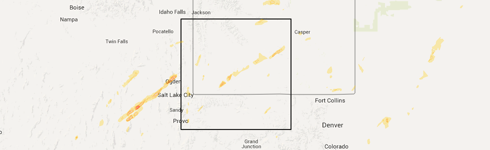
Hail Map for Rock Springs, WY
The Rock Springs, WY area has had 2 reports of on-the-ground hail by trained spotters, and has been under severe weather warnings 0 times during the past 12 months. Doppler radar has detected hail at or near Rock Springs, WY on 1 occasion.
| Name: | Rock Springs, WY |
| Where Located: | 0.5 miles N of Rock Springs, WY |
| Map: | Google Map for Rock Springs, WY |
| Population: | 23036 |
| Housing Units: | 10070 |
| More Info: | Search Google for Rock Springs, WY |
5
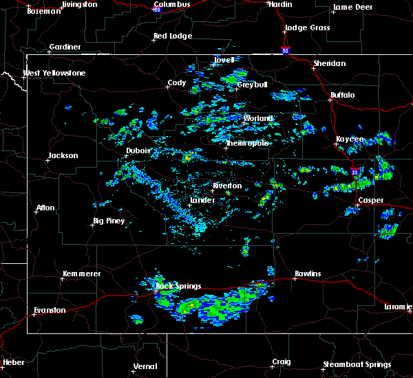
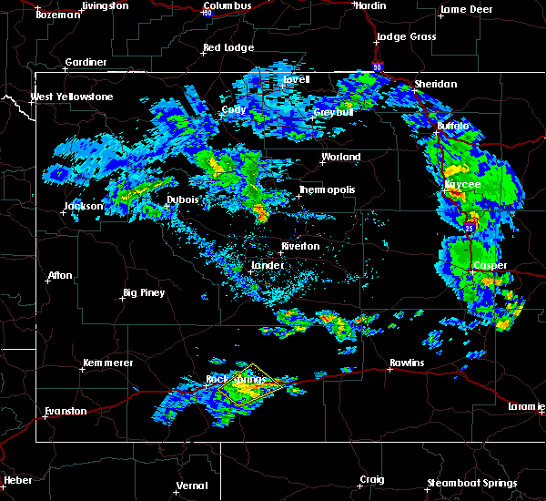
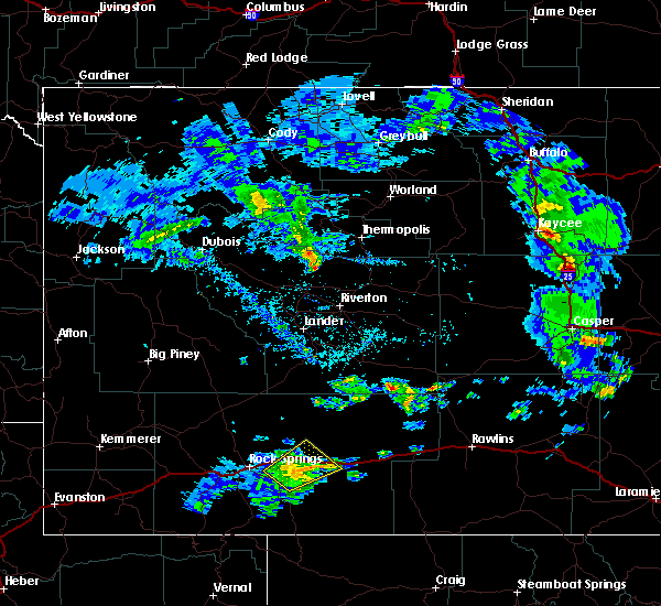
The Top Recent Hail Date for Rock Springs, WY is Sunday, June 12, 2016 (1st out of 1)
Hail and Wind Damage Spotted near Rock Springs, WY
| Date / Time | Report Details |
|---|---|
| 9/1/2023 4:16 PM MDT | Asos station krks rock springs airpor in sweetwater county WY, 8 miles W of Rock Springs, WY |
| 7/24/2023 2:52 PM MDT | Asos station krks rock springs airpor in sweetwater county WY, 8 miles W of Rock Springs, WY |
| 7/3/2023 9:17 PM MDT | Asos station krks rock springs airpor in sweetwater county WY, 8 miles W of Rock Springs, WY |
| 5/26/2023 2:20 PM MDT | Quarter sized hail reported 8.6 miles SSE of Rock Springs, WY |
| 7/2/2022 8:48 PM MDT | Asos station krks rock springs airpor in sweetwater county WY, 8 miles W of Rock Springs, WY |
| 7/2/2022 4:08 PM MDT | Asos station krks rock springs airpor in sweetwater county WY, 8 miles W of Rock Springs, WY |
| 6/29/2022 2:49 PM MDT | Rock springs airpor in sweetwater county WY, 9.1 miles W of Rock Springs, WY |
| 5/16/2022 4:31 PM MDT | Asos station krks rock springs airpor in sweetwater county WY, 8 miles W of Rock Springs, WY |
| 7/4/2021 4:54 PM MDT | Asos station krks rock springs airport. high based convection produced dry microburs in sweetwater county WY, 8 miles W of Rock Springs, WY |
| 5/7/2021 6:31 PM MDT | Peak wind gust at krks was from a weak showe in sweetwater county WY, 8 miles W of Rock Springs, WY |
| 8/12/2020 1:34 PM MDT |
 At 132 pm mdt, a severe thunderstorm was located near superior, which is 14 miles northeast of rock springs, moving northeast at 20 mph. this is a very dangerous storm (radar indicated. at 121 pm mdt a gust of 78 mph was reported rock springs-sweetwater county airport). Hazards include 80 mph wind gusts. Flying debris will be dangerous to those caught without shelter. mobile homes will be heavily damaged. expect considerable damage to roofs, windows, and vehicles. extensive tree damage and power outages are likely. this severe thunderstorm will be near, superior around 145 pm mdt. other locations impacted by this severe thunderstorm include southwest wyoming regional airport, reliance and point of rocks. This includes interstate 80 between mile markers 110 and 148. At 132 pm mdt, a severe thunderstorm was located near superior, which is 14 miles northeast of rock springs, moving northeast at 20 mph. this is a very dangerous storm (radar indicated. at 121 pm mdt a gust of 78 mph was reported rock springs-sweetwater county airport). Hazards include 80 mph wind gusts. Flying debris will be dangerous to those caught without shelter. mobile homes will be heavily damaged. expect considerable damage to roofs, windows, and vehicles. extensive tree damage and power outages are likely. this severe thunderstorm will be near, superior around 145 pm mdt. other locations impacted by this severe thunderstorm include southwest wyoming regional airport, reliance and point of rocks. This includes interstate 80 between mile markers 110 and 148.
|
| 8/12/2020 1:21 PM MDT | Measured at rock springs airpor in sweetwater county WY, 9.1 miles W of Rock Springs, WY |
| 6/28/2020 2:18 PM MDT | Asos station krks rock springs airpor in sweetwater county WY, 8 miles W of Rock Springs, WY |
| 6/28/2020 1:41 PM MDT | Asos station krks rock springs airpor in sweetwater county WY, 8 miles W of Rock Springs, WY |
| 6/25/2020 2:25 PM MDT |
 The severe thunderstorm warning for central sweetwater county will expire at 230 pm mdt, the storm which prompted the warning has weakened below severe limits, and no longer poses an immediate threat to life or property. therefore, the warning will be allowed to expire. however gusty winds are still possible with this thunderstorm. to report severe weather, contact your nearest law enforcement agency. they will relay your report to the national weather service riverton. The severe thunderstorm warning for central sweetwater county will expire at 230 pm mdt, the storm which prompted the warning has weakened below severe limits, and no longer poses an immediate threat to life or property. therefore, the warning will be allowed to expire. however gusty winds are still possible with this thunderstorm. to report severe weather, contact your nearest law enforcement agency. they will relay your report to the national weather service riverton.
|
| 6/25/2020 2:18 PM MDT |
 At 217 pm mdt, a severe thunderstorm was located 12 miles west of bitter creek rest area, which is 24 miles east of rock springs, moving northeast at 35 mph (radar indicated). Hazards include 60 mph wind gusts. Expect damage to roofs, siding, and trees. this severe storm will be near, bitter creek rest area around 235 pm mdt. other locations impacted by this severe thunderstorm include point of rocks, bitter creek and southwest wyoming regional airport. This includes interstate 80 between mile markers 122 and 149. At 217 pm mdt, a severe thunderstorm was located 12 miles west of bitter creek rest area, which is 24 miles east of rock springs, moving northeast at 35 mph (radar indicated). Hazards include 60 mph wind gusts. Expect damage to roofs, siding, and trees. this severe storm will be near, bitter creek rest area around 235 pm mdt. other locations impacted by this severe thunderstorm include point of rocks, bitter creek and southwest wyoming regional airport. This includes interstate 80 between mile markers 122 and 149.
|
| 6/25/2020 2:02 PM MDT |
 At 201 pm mdt, a severe thunderstorm was located 17 miles south of superior, which is 18 miles east of rock springs, moving northeast at 35 mph (radar indicated). Hazards include 60 mph wind gusts. Expect damage to roofs, siding, and trees. this severe thunderstorm will be near, bitter creek rest area around 230 pm mdt. other locations impacted by this severe thunderstorm include point of rocks, bitter creek and southwest wyoming regional airport. This includes interstate 80 between mile markers 122 and 149. At 201 pm mdt, a severe thunderstorm was located 17 miles south of superior, which is 18 miles east of rock springs, moving northeast at 35 mph (radar indicated). Hazards include 60 mph wind gusts. Expect damage to roofs, siding, and trees. this severe thunderstorm will be near, bitter creek rest area around 230 pm mdt. other locations impacted by this severe thunderstorm include point of rocks, bitter creek and southwest wyoming regional airport. This includes interstate 80 between mile markers 122 and 149.
|
| 6/6/2020 2:51 PM MDT |
 At 250 pm mdt, severe thunderstorms were located along a line extending from 12 miles southeast of oregon buttes to 12 miles north of separation lake, moving northeast at 30 mph (radar indicated). Hazards include 60 mph wind gusts. Expect damage to roofs, siding, and trees. these severe thunderstorms will remain over mainly rural areas of northeastern sweetwater county, including the following locations, southwest wyoming regional airport, reliance, tipton, red desert, point of rocks and sweetwater county fairgrounds. This includes interstate 80 between mile markers 101 and 198. At 250 pm mdt, severe thunderstorms were located along a line extending from 12 miles southeast of oregon buttes to 12 miles north of separation lake, moving northeast at 30 mph (radar indicated). Hazards include 60 mph wind gusts. Expect damage to roofs, siding, and trees. these severe thunderstorms will remain over mainly rural areas of northeastern sweetwater county, including the following locations, southwest wyoming regional airport, reliance, tipton, red desert, point of rocks and sweetwater county fairgrounds. This includes interstate 80 between mile markers 101 and 198.
|
| 6/6/2020 2:10 PM MDT |
 At 206 pm mdt, severe thunderstorms were located along a line extending from 21 miles northwest of wamsutter to near dad, moving northeast at 65 mph. these are very dangerous storms (radar indicated. at 154 pm, bitter creek reported a wind gust of 81 mph. a wind gust of 61 mph was reported at the southwest wyoming regional airport just east of rock springs at 158 pm). Hazards include 60 to 80 mph wind gusts. Flying debris will be dangerous to those caught without shelter. mobile homes will be heavily damaged. expect considerable damage to roofs, windows, and vehicles. extensive tree damage and power outages are likely. severe thunderstorms will be near, creston junction around 220 pm mdt. other locations impacted by these severe thunderstorms include southwest wyoming regional airport, reliance, tipton, red desert, point of rocks and sweetwater county fairgrounds. this includes interstate 80 between mile markers 101 and 198. Time, mot, loc 2006z 178deg 114kt 4195 10815 4125 10772. At 206 pm mdt, severe thunderstorms were located along a line extending from 21 miles northwest of wamsutter to near dad, moving northeast at 65 mph. these are very dangerous storms (radar indicated. at 154 pm, bitter creek reported a wind gust of 81 mph. a wind gust of 61 mph was reported at the southwest wyoming regional airport just east of rock springs at 158 pm). Hazards include 60 to 80 mph wind gusts. Flying debris will be dangerous to those caught without shelter. mobile homes will be heavily damaged. expect considerable damage to roofs, windows, and vehicles. extensive tree damage and power outages are likely. severe thunderstorms will be near, creston junction around 220 pm mdt. other locations impacted by these severe thunderstorms include southwest wyoming regional airport, reliance, tipton, red desert, point of rocks and sweetwater county fairgrounds. this includes interstate 80 between mile markers 101 and 198. Time, mot, loc 2006z 178deg 114kt 4195 10815 4125 10772.
|
| 6/6/2020 1:58 PM MDT | Measured at the southwest wyoming regional airpor in sweetwater county WY, 8 miles W of Rock Springs, WY |
| 6/6/2020 1:20 PM MDT | Snow springs raws reported 60 mph gust on 144 pm hourly observation. time estimated using rada in sweetwater county WY, 15 miles NW of Rock Springs, WY |
| 5/29/2020 4:22 PM MDT | Asos station krks rock springs airpor in sweetwater county WY, 8 miles W of Rock Springs, WY |
| 9/4/2016 4:58 PM MDT | Rock springs airport /rks in sweetwater county WY, 8.5 miles W of Rock Springs, WY |
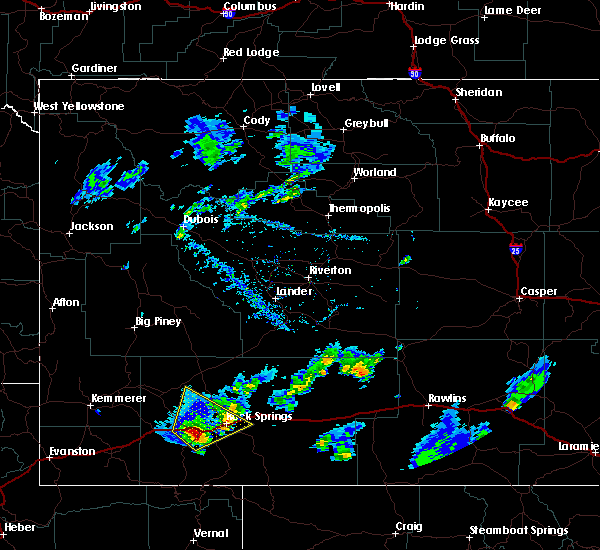
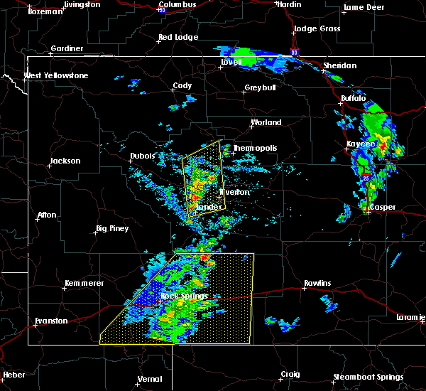
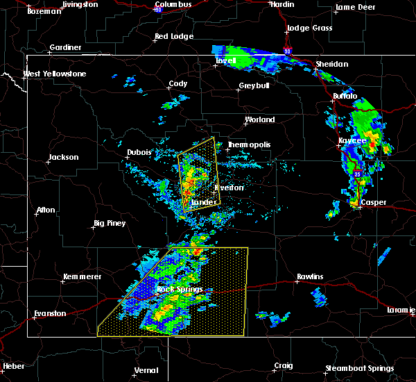
| 6/12/2016 3:15 PM MDT |
 At 313 pm mdt, a severe thunderstorm was located near rock springs, moving northeast at 30 mph (spotters reported quarter size hail so far along with a brief funnel cloud). Hazards include golf ball size hail and 60 mph wind gusts. People and animals outdoors will be injured. expect hail damage to roofs, siding, windows and vehicles. expect wind damage to roofs, siding and trees. this severe storm will be near, rock springs around 325 pm mdt. sweetwater county airport around 340 pm mdt. This includes interstate 80 between mile markers 76 and 116. At 313 pm mdt, a severe thunderstorm was located near rock springs, moving northeast at 30 mph (spotters reported quarter size hail so far along with a brief funnel cloud). Hazards include golf ball size hail and 60 mph wind gusts. People and animals outdoors will be injured. expect hail damage to roofs, siding, windows and vehicles. expect wind damage to roofs, siding and trees. this severe storm will be near, rock springs around 325 pm mdt. sweetwater county airport around 340 pm mdt. This includes interstate 80 between mile markers 76 and 116.
|
| 6/12/2016 3:07 PM MDT | Quarter sized hail reported 0.5 miles SSW of Rock Springs, WY, penny to quarter sized hail |
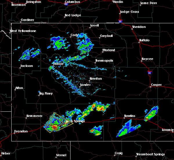
| 6/12/2016 3:04 PM MDT |
 At 303 pm mdt, a severe thunderstorm was located near green river, moving northeast at 35 mph (radar indicated). Hazards include golf ball size hail and 60 mph wind gusts. People and animals outdoors will be injured. expect hail damage to roofs, siding, windows and vehicles. expect wind damage to roofs, siding and trees. this severe storm will be near, pilot butte around 315 pm mdt. rock springs and fourteen mile rest area around 325 pm mdt. This includes interstate 80 between mile markers 76 and 116. At 303 pm mdt, a severe thunderstorm was located near green river, moving northeast at 35 mph (radar indicated). Hazards include golf ball size hail and 60 mph wind gusts. People and animals outdoors will be injured. expect hail damage to roofs, siding, windows and vehicles. expect wind damage to roofs, siding and trees. this severe storm will be near, pilot butte around 315 pm mdt. rock springs and fourteen mile rest area around 325 pm mdt. This includes interstate 80 between mile markers 76 and 116.
|
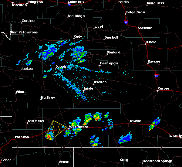
| 6/12/2016 2:53 PM MDT |
 At 252 pm mdt, a severe thunderstorm was located near green river, moving northeast at 35 mph (radar indicated). Hazards include golf ball size hail and 60 mph wind gusts. People and animals outdoors will be injured. expect hail damage to roofs, siding, windows and vehicles. expect wind damage to roofs, siding and trees. this severe thunderstorm will be near, pilot butte around 320 pm mdt. rock springs around 325 pm mdt. fourteen mile rest area around 330 pm mdt. This includes interstate 80 between mile markers 76 and 116. At 252 pm mdt, a severe thunderstorm was located near green river, moving northeast at 35 mph (radar indicated). Hazards include golf ball size hail and 60 mph wind gusts. People and animals outdoors will be injured. expect hail damage to roofs, siding, windows and vehicles. expect wind damage to roofs, siding and trees. this severe thunderstorm will be near, pilot butte around 320 pm mdt. rock springs around 325 pm mdt. fourteen mile rest area around 330 pm mdt. This includes interstate 80 between mile markers 76 and 116.
|
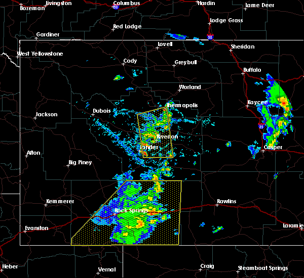
| 6/12/2016 2:20 PM MDT |
 At 220 pm mdt, a severe thunderstorm was located 13 miles south of little america, which is 17 miles southeast of granger, moving northeast at 40 mph (radar indicated). Hazards include 60 mph wind gusts and quarter size hail. Hail damage to vehicles is expected. expect wind damage to roofs, siding and trees. this severe thunderstorm will be near, green river around 250 pm mdt. other locations impacted by this severe thunderstorm include truman elementary school, monroe middle school, rolling green country club, white mountain wind teton power wind farm, washington elementary school, expedition academy in green river, general chemical corporation power plant, tex`s travel camp, green river union pacific railroad yard and harrison elementary school. This includes interstate 80 between mile markers 69 and 93. At 220 pm mdt, a severe thunderstorm was located 13 miles south of little america, which is 17 miles southeast of granger, moving northeast at 40 mph (radar indicated). Hazards include 60 mph wind gusts and quarter size hail. Hail damage to vehicles is expected. expect wind damage to roofs, siding and trees. this severe thunderstorm will be near, green river around 250 pm mdt. other locations impacted by this severe thunderstorm include truman elementary school, monroe middle school, rolling green country club, white mountain wind teton power wind farm, washington elementary school, expedition academy in green river, general chemical corporation power plant, tex`s travel camp, green river union pacific railroad yard and harrison elementary school. This includes interstate 80 between mile markers 69 and 93.
|
| 9/4/2015 6:52 PM MDT | Asos station rock springs airport /rks/ in sweetwater county WY, 8.5 miles W of Rock Springs, WY |
| 7/15/2015 3:25 PM MDT |
 The severe thunderstorm warning for sweetwater county will expire at 330 pm mdt, the storms which prompted the warning have moved out of the area. therefore the warning will be allowed to expire. however gusty winds are still possible with these thunderstorms. The severe thunderstorm warning for sweetwater county will expire at 330 pm mdt, the storms which prompted the warning have moved out of the area. therefore the warning will be allowed to expire. however gusty winds are still possible with these thunderstorms.
|
| 7/15/2015 3:21 PM MDT |
 At 320 pm mdt, severe thunderstorms were located along a line extending from 21 miles southeast of oregon buttes to 10 miles southeast of squaw hollow boat ramp on flaming gorge, moving east at 35 mph (radar indicated). Hazards include 60 mph wind gusts and penny size hail. Expect damage to roofs. siding and trees. locations impacted include, rock springs, green river, wamsutter, superior, mckinnon, bitter creek rest area, fourteen mile rest area, pilot butte, adobe town rim, oregon buttes, buckboard marina, table rock, killpecker dune field, lowe canyon, sweetwater county airport, squaw hollow boat ramp on flaming gorge, boars tusk, reliance, rock springs memorial hospital and patrick draw natural gas processing plant. those attending the national high school finals rodeo are in the path of these storms and should prepare for changing weather conditions. Seek shelter now! # this includes interstate 80 between mile markers 80 and 175. At 320 pm mdt, severe thunderstorms were located along a line extending from 21 miles southeast of oregon buttes to 10 miles southeast of squaw hollow boat ramp on flaming gorge, moving east at 35 mph (radar indicated). Hazards include 60 mph wind gusts and penny size hail. Expect damage to roofs. siding and trees. locations impacted include, rock springs, green river, wamsutter, superior, mckinnon, bitter creek rest area, fourteen mile rest area, pilot butte, adobe town rim, oregon buttes, buckboard marina, table rock, killpecker dune field, lowe canyon, sweetwater county airport, squaw hollow boat ramp on flaming gorge, boars tusk, reliance, rock springs memorial hospital and patrick draw natural gas processing plant. those attending the national high school finals rodeo are in the path of these storms and should prepare for changing weather conditions. Seek shelter now! # this includes interstate 80 between mile markers 80 and 175.
|
| 7/15/2015 2:55 PM MDT |
 At 255 pm mdt, severe thunderstorms were located along a line extending from 13 miles south of oregon buttes to 6 miles southwest of squaw hollow boat ramp on flaming gorge, moving east at 35 mph (radar indicated). Hazards include 60 mph wind gusts and penny size hail. Expect damage to roofs. siding and trees. these severe thunderstorms will remain over mainly rural areas of sweetwater county, including the following locations, truman elementary school, rock springs memorial hospital, sweetwater county fairgrounds, burntfork, rock springs koa campgorund, roosevelt learning center, washington elementary school, tipton, patrick draw natural gas processing plant and bitter creek. those attending the national high school finals rodeo are in the path of these storms and should prepare for changing weather conditions. Seek shelter now! # this includes interstate 80 between mile markers 80 and 175. At 255 pm mdt, severe thunderstorms were located along a line extending from 13 miles south of oregon buttes to 6 miles southwest of squaw hollow boat ramp on flaming gorge, moving east at 35 mph (radar indicated). Hazards include 60 mph wind gusts and penny size hail. Expect damage to roofs. siding and trees. these severe thunderstorms will remain over mainly rural areas of sweetwater county, including the following locations, truman elementary school, rock springs memorial hospital, sweetwater county fairgrounds, burntfork, rock springs koa campgorund, roosevelt learning center, washington elementary school, tipton, patrick draw natural gas processing plant and bitter creek. those attending the national high school finals rodeo are in the path of these storms and should prepare for changing weather conditions. Seek shelter now! # this includes interstate 80 between mile markers 80 and 175.
|
| 7/15/2015 2:50 PM MDT |
 At 249 pm mdt, severe thunderstorms were located along a line extending from 12 miles south of oregon buttes to 6 miles north of manila, moving east at 35 mph (radar indicated). Hazards include 60 mph wind gusts and penny size hail. Expect damage to roofs. siding and trees. these severe storms will be near, lowe canyon around 305 pm mdt. other locations impacted by these severe thunderstorms include truman elementary school, rock springs memorial hospital, sweetwater county fairgrounds, burntfork, rock springs koa campgorund, roosevelt learning center, washington elementary school, tipton, patrick draw natural gas processing plant and bitter creek. those attending the national high school finals rodeo are in the path of these storms and should prepare for changing weather conditions. Seek shelter now! # this includes interstate 80 between mile markers 80 and 175. At 249 pm mdt, severe thunderstorms were located along a line extending from 12 miles south of oregon buttes to 6 miles north of manila, moving east at 35 mph (radar indicated). Hazards include 60 mph wind gusts and penny size hail. Expect damage to roofs. siding and trees. these severe storms will be near, lowe canyon around 305 pm mdt. other locations impacted by these severe thunderstorms include truman elementary school, rock springs memorial hospital, sweetwater county fairgrounds, burntfork, rock springs koa campgorund, roosevelt learning center, washington elementary school, tipton, patrick draw natural gas processing plant and bitter creek. those attending the national high school finals rodeo are in the path of these storms and should prepare for changing weather conditions. Seek shelter now! # this includes interstate 80 between mile markers 80 and 175.
|
| 7/15/2015 2:35 PM MDT |
 At 233 pm mdt, severe thunderstorms were located along a line extending from 11 miles northeast of killpecker dune field to near mckinnon, moving east at 35 mph (radar indicated). Hazards include 60 mph wind gusts and penny size hail. Expect damage to roofs. siding and trees. severe thunderstorms will be near, squaw hollow boat ramp on flaming gorge and lowe canyon around 300 pm mdt. other locations impacted by these severe thunderstorms include truman elementary school, rock springs memorial hospital, sweetwater county fairgrounds, burntfork, rock springs koa campgorund, roosevelt learning center, washington elementary school, tipton, patrick draw natural gas processing plant and bitter creek. those attending national high school finals rodeo are in the path of these storms and should prepare for imminent dangerous weather conditions. seek shelter now. This includes interstate 80 between mile markers 80 and 175. At 233 pm mdt, severe thunderstorms were located along a line extending from 11 miles northeast of killpecker dune field to near mckinnon, moving east at 35 mph (radar indicated). Hazards include 60 mph wind gusts and penny size hail. Expect damage to roofs. siding and trees. severe thunderstorms will be near, squaw hollow boat ramp on flaming gorge and lowe canyon around 300 pm mdt. other locations impacted by these severe thunderstorms include truman elementary school, rock springs memorial hospital, sweetwater county fairgrounds, burntfork, rock springs koa campgorund, roosevelt learning center, washington elementary school, tipton, patrick draw natural gas processing plant and bitter creek. those attending national high school finals rodeo are in the path of these storms and should prepare for imminent dangerous weather conditions. seek shelter now. This includes interstate 80 between mile markers 80 and 175.
|
| 7/15/2015 2:32 PM MDT | Rock springs airport asos reported a 56 knot outflow wind gus in sweetwater county WY, 8 miles WNW of Rock Springs, WY |
| 7/20/2014 2:36 PM MDT | Storm damage reported in sweetwater county WY, 9.1 miles W of Rock Springs, WY |
| 6/13/2013 1:25 PM MDT | Recorded by wydot sensor in sweetwater county WY, 5.4 miles W of Rock Springs, WY |
Hail Maps for Rock Springs, WY
Connect with Interactive Hail Maps