

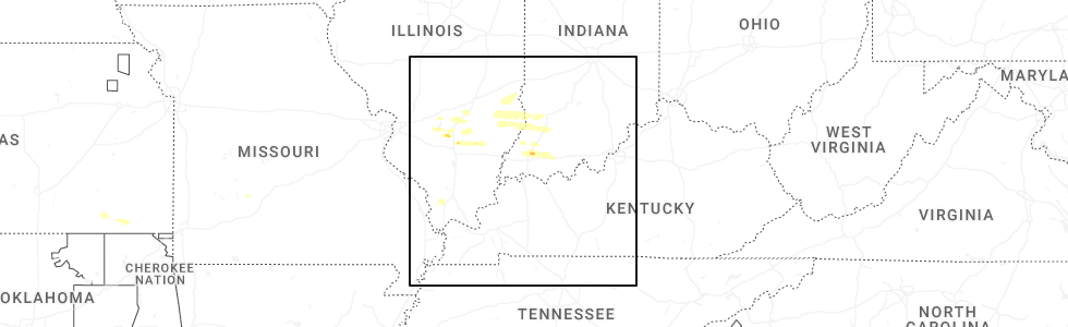
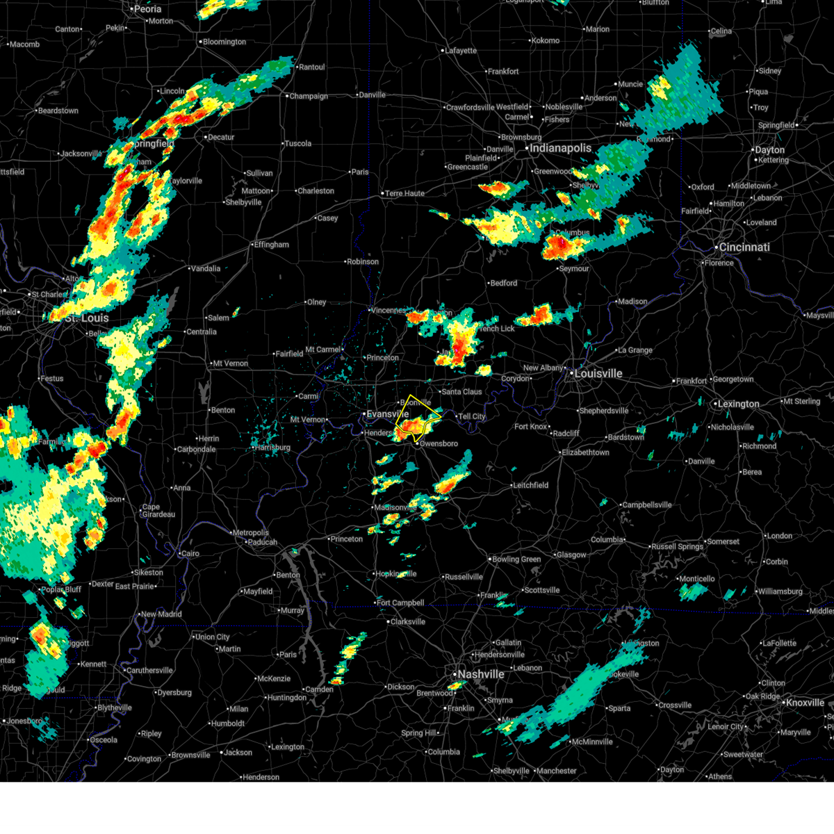
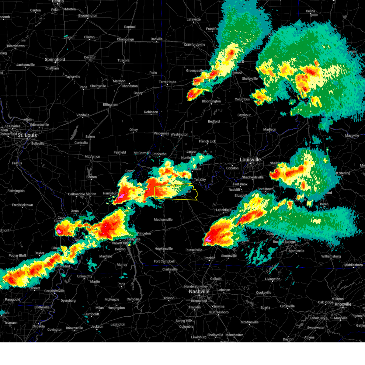
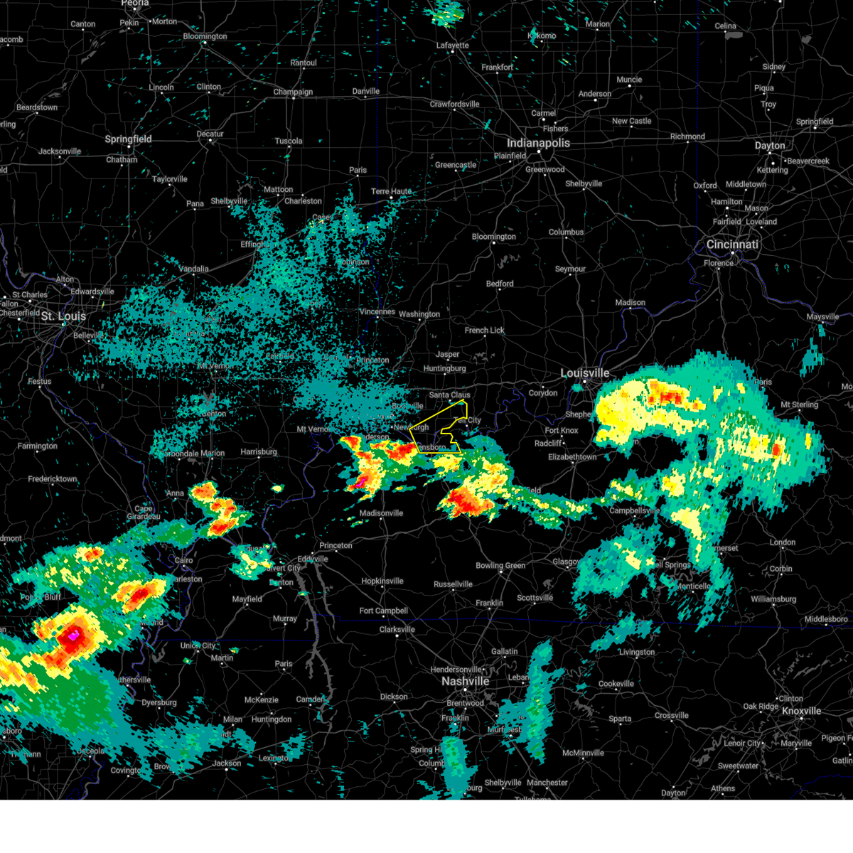
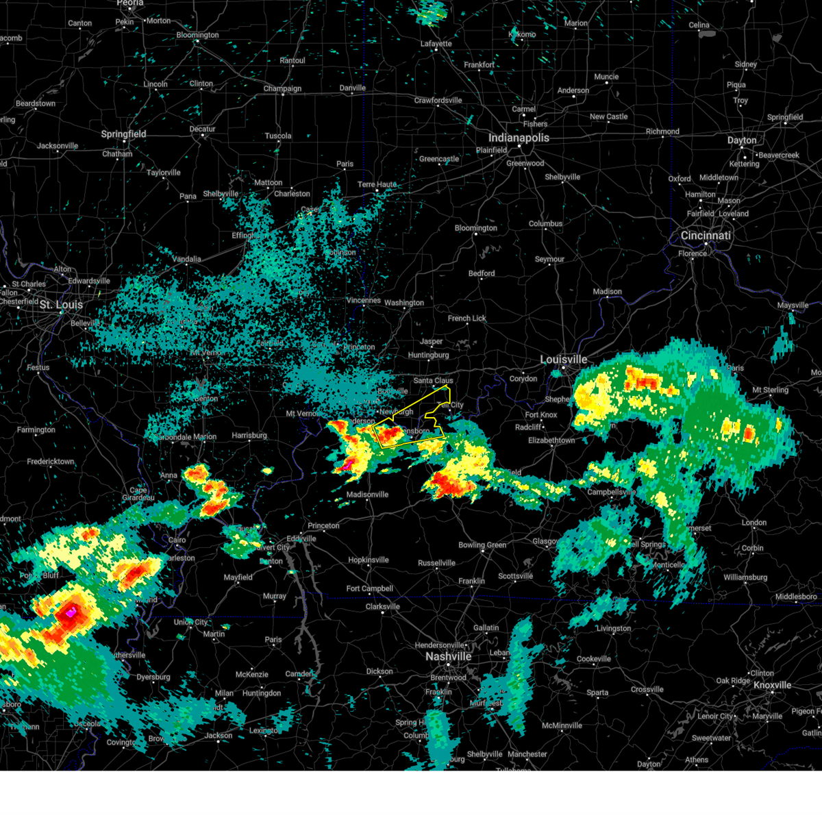
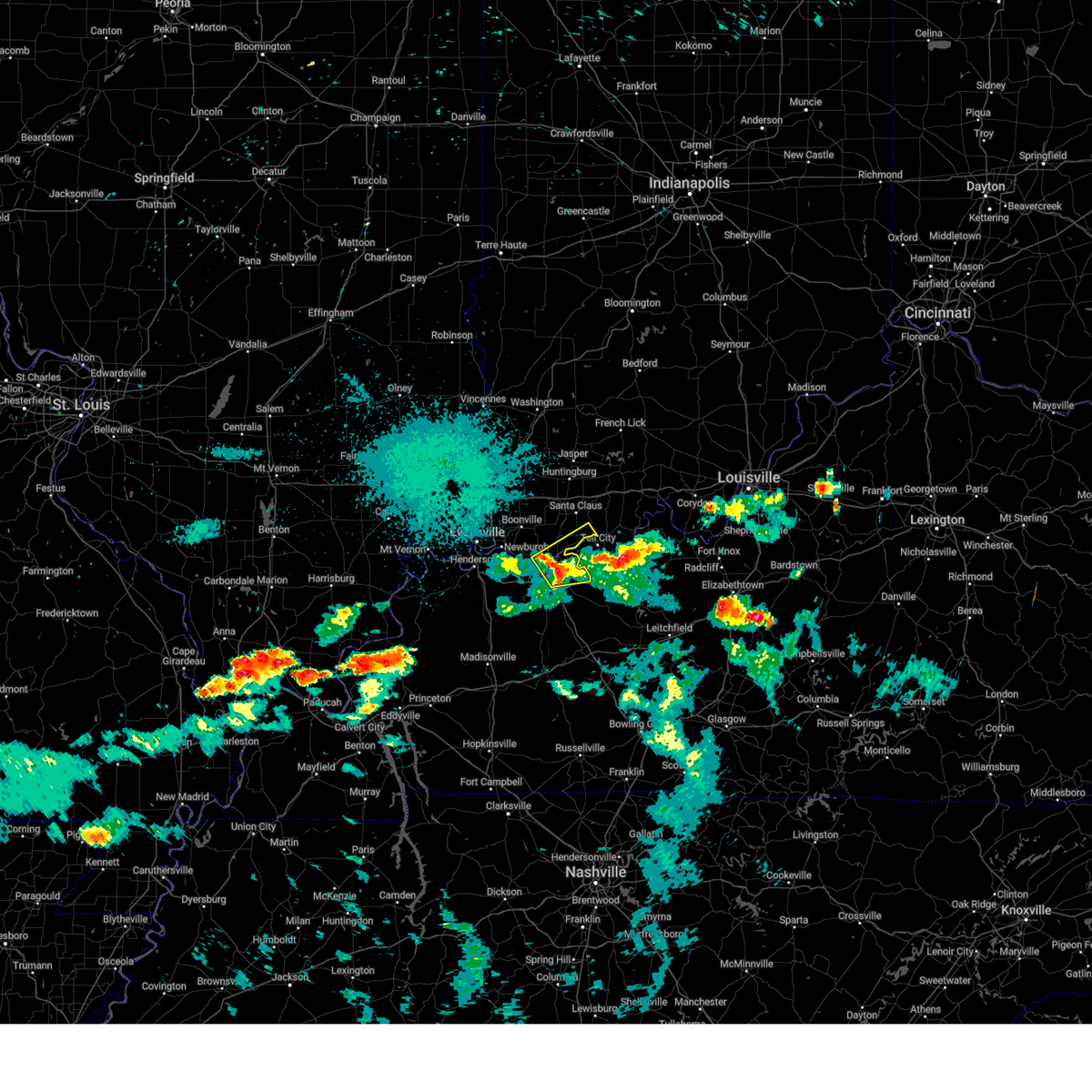
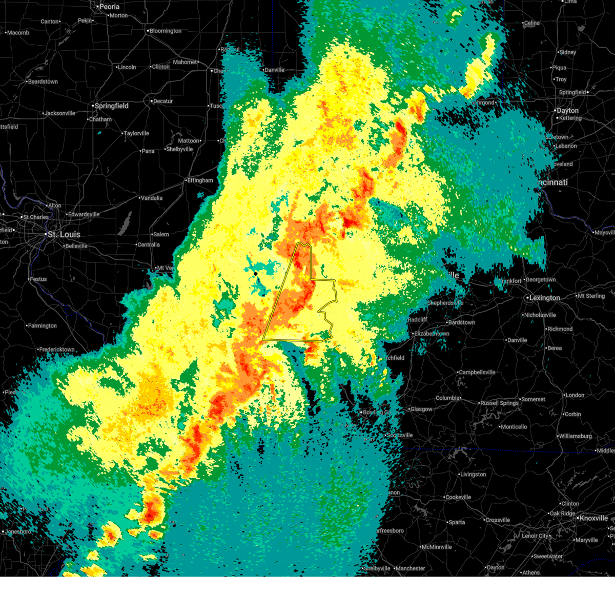
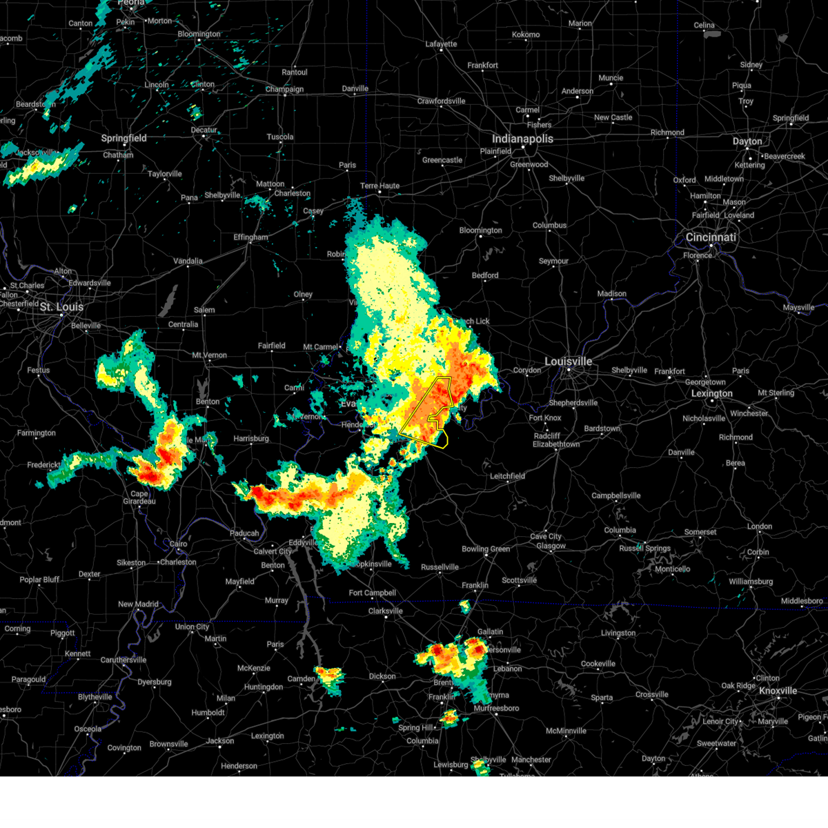
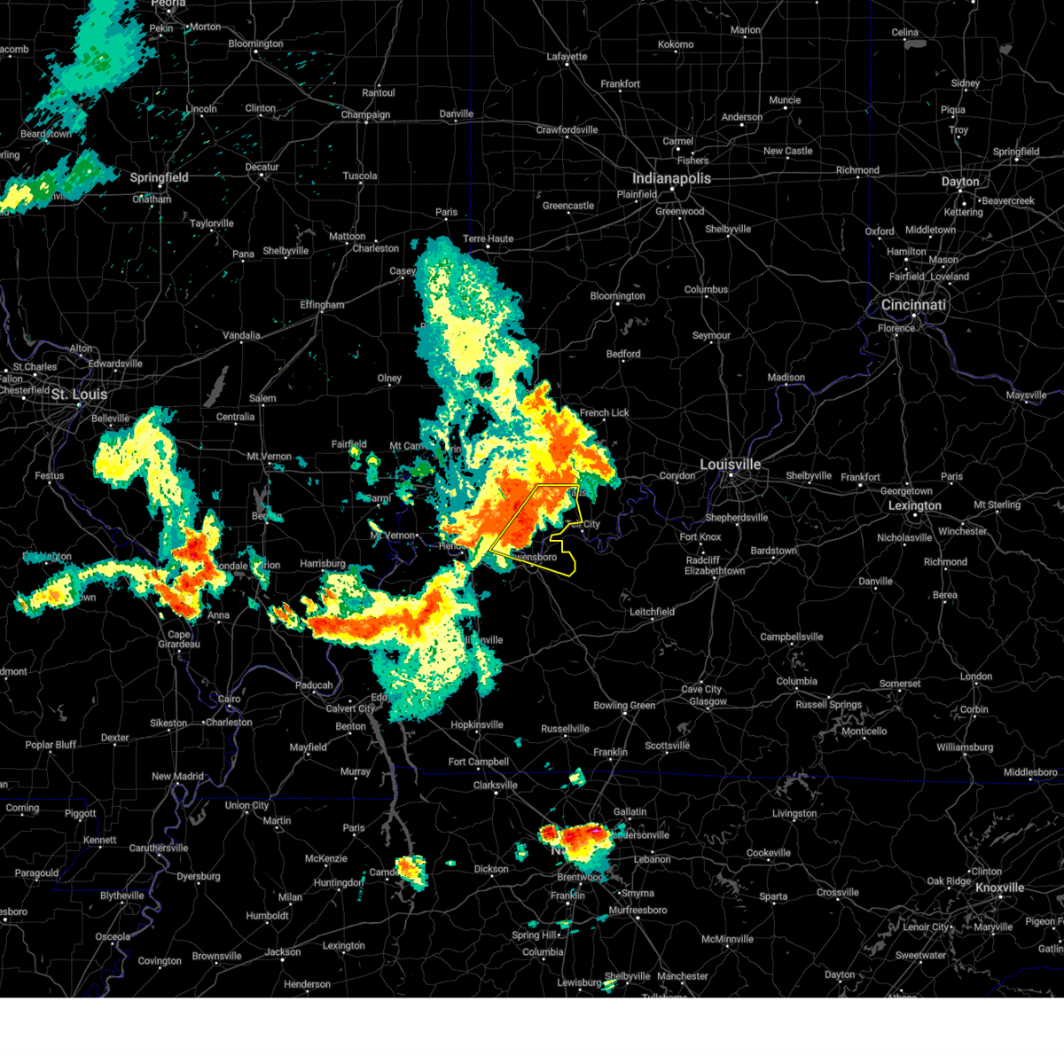
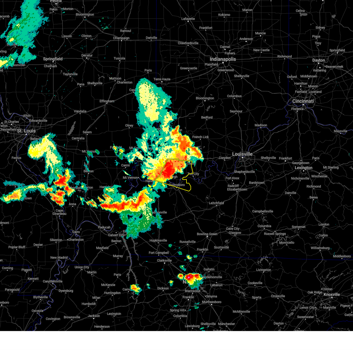
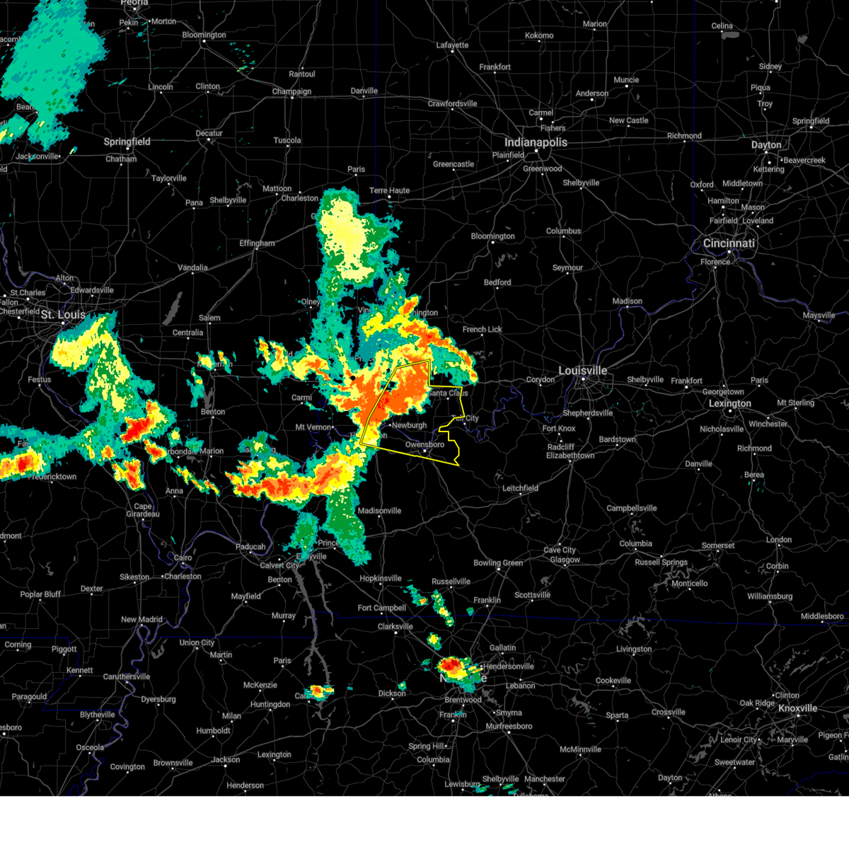
Hail Map for Rockport, IN
The Rockport, IN area has had 6 reports of on-the-ground hail by trained spotters, and has been under severe weather warnings 12 times during the past 12 months. Doppler radar has detected hail at or near Rockport, IN on 73 occasions, including 4 occasions during the past year.
| Name: | Rockport, IN |
| Where Located: | 28.5 miles ESE of Evansville, IN |
| Map: | Google Map for Rockport, IN |
| Population: | 2270 |
| Housing Units: | 1026 |
| More Info: | Search Google for Rockport, IN |
0
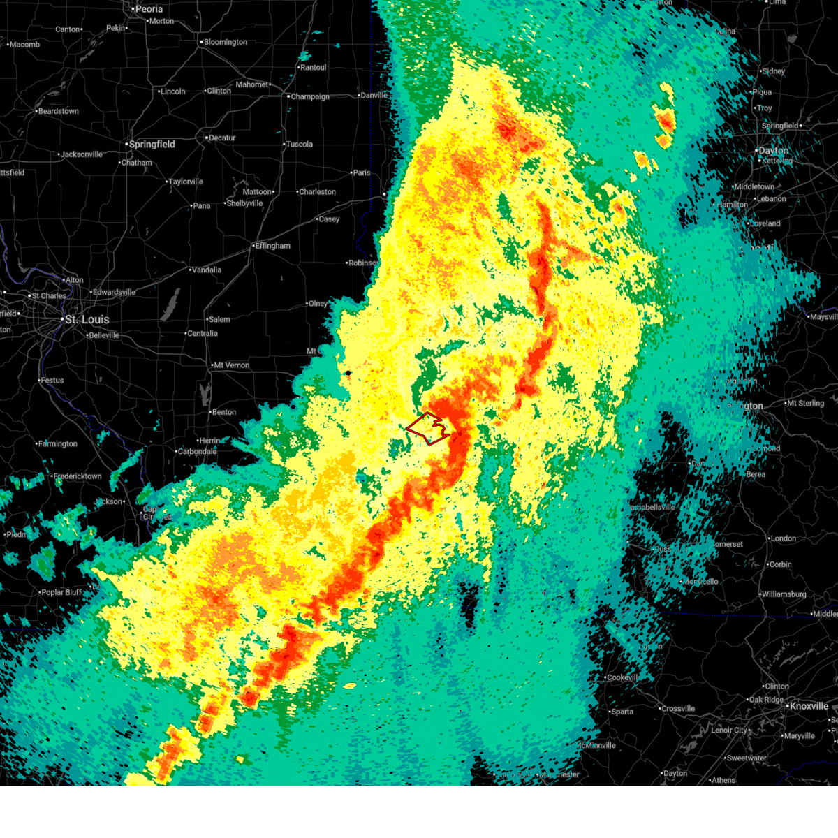
The Top Recent Hail Date for Rockport, IN is Sunday, June 21, 2026 (52nd out of 73)
Hail and Wind Damage Spotted near Rockport, IN
| Date / Time | Report Details |
|---|---|
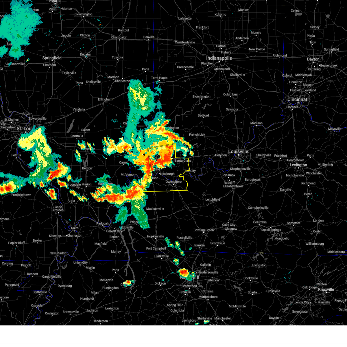
| 6/21/2026 9:50 PM CDT |
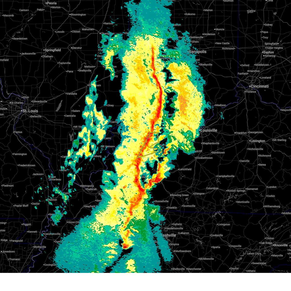
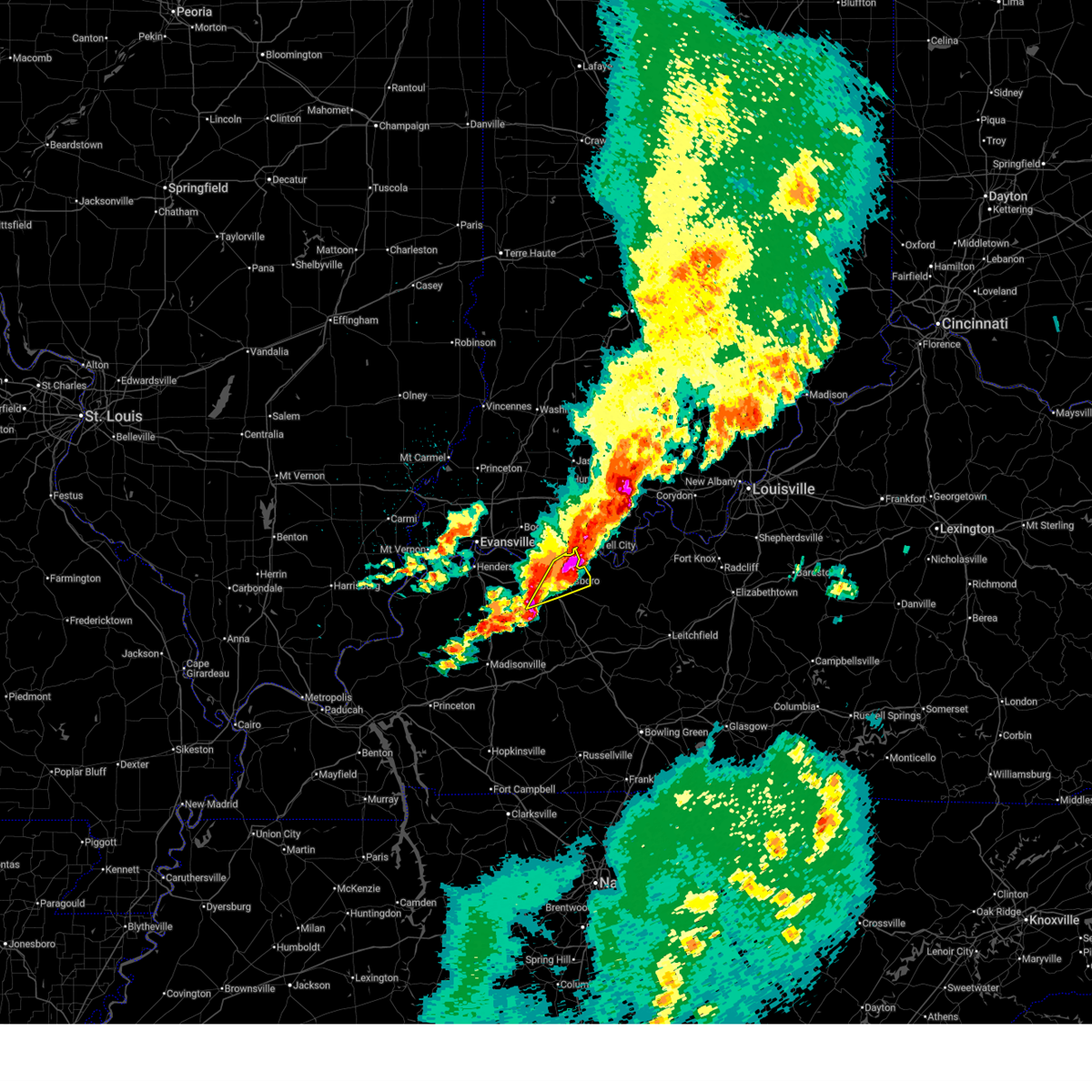
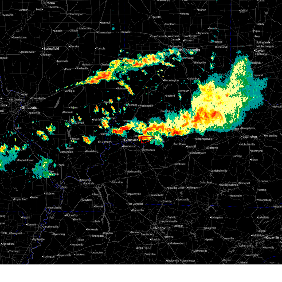 Torpah the national weather service in paducah has issued a * tornado warning for, central spencer county in southwestern indiana, * until 1030 pm cdt. * at 950 pm cdt, a severe thunderstorm capable of producing a tornado was located near grandview, or 7 miles north of rockport, moving east at 30 mph (radar indicated rotation). Hazards include tornado and quarter size hail. Flying debris will be dangerous to those caught without shelter. mobile homes will be damaged or destroyed. damage to roofs, windows, and vehicles will occur. tree damage is likely. this dangerous storm will be near, grandview around 955 pm cdt. Other locations impacted by this tornadic thunderstorm include chrisney. Torpah the national weather service in paducah has issued a * tornado warning for, central spencer county in southwestern indiana, * until 1030 pm cdt. * at 950 pm cdt, a severe thunderstorm capable of producing a tornado was located near grandview, or 7 miles north of rockport, moving east at 30 mph (radar indicated rotation). Hazards include tornado and quarter size hail. Flying debris will be dangerous to those caught without shelter. mobile homes will be damaged or destroyed. damage to roofs, windows, and vehicles will occur. tree damage is likely. this dangerous storm will be near, grandview around 955 pm cdt. Other locations impacted by this tornadic thunderstorm include chrisney.
|
| 4/27/2026 1:25 PM CDT |
 the severe thunderstorm warning has been cancelled and is no longer in effect the severe thunderstorm warning has been cancelled and is no longer in effect
|
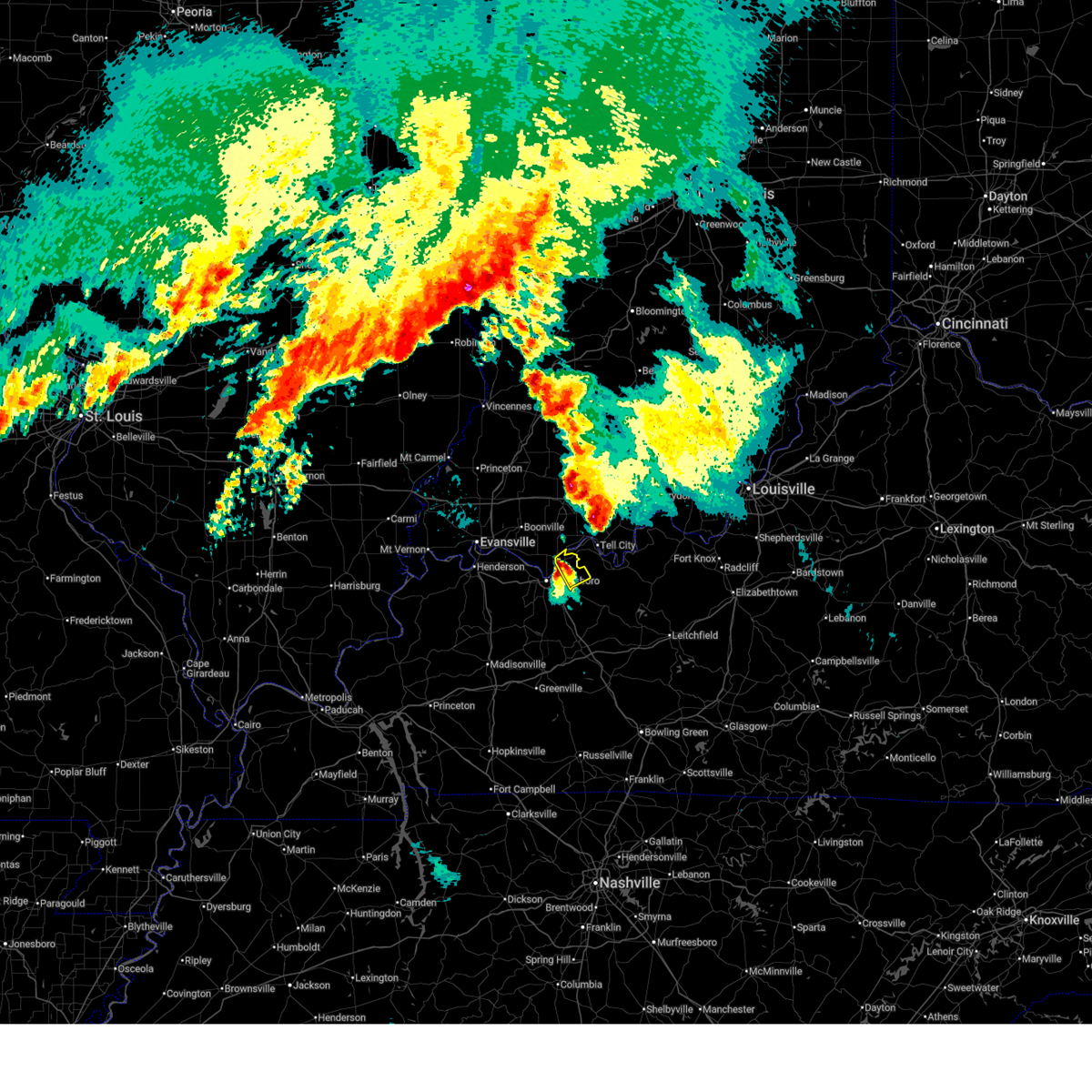
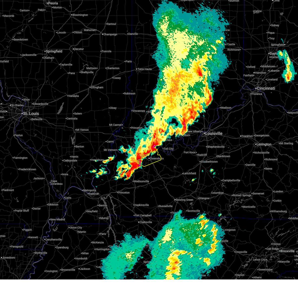
| 4/27/2026 1:10 PM CDT |
 Svrpah the national weather service in paducah has issued a * severe thunderstorm warning for, south central spencer county in southwestern indiana, eastern daviess county in northwestern kentucky, * until 200 pm cdt. * at 110 pm cdt, a severe thunderstorm was located over owensboro, moving northeast at 55 mph (emergency management). Hazards include quarter size hail. damage to vehicles is expected Svrpah the national weather service in paducah has issued a * severe thunderstorm warning for, south central spencer county in southwestern indiana, eastern daviess county in northwestern kentucky, * until 200 pm cdt. * at 110 pm cdt, a severe thunderstorm was located over owensboro, moving northeast at 55 mph (emergency management). Hazards include quarter size hail. damage to vehicles is expected
|
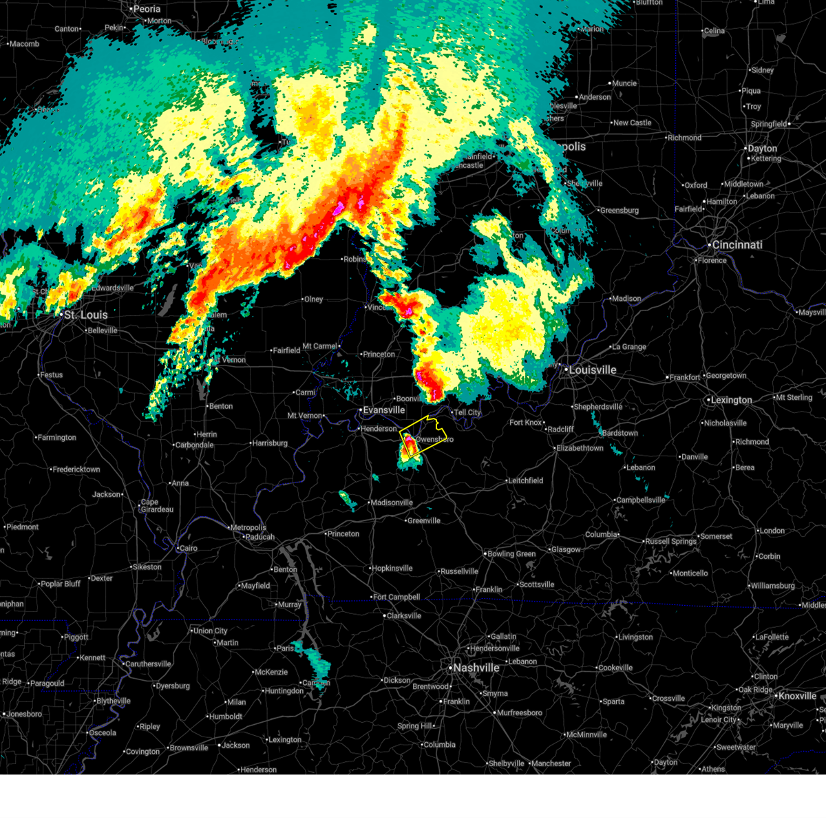
| 3/15/2026 9:56 PM CDT |
 The storms which prompted the warning have moved out of the area. therefore, the warning will be allowed to expire. a tornado watch remains in effect until 1100 pm cdt for southwestern indiana, and northwestern kentucky. The storms which prompted the warning have moved out of the area. therefore, the warning will be allowed to expire. a tornado watch remains in effect until 1100 pm cdt for southwestern indiana, and northwestern kentucky.
|
| 3/15/2026 9:39 PM CDT |
 the severe thunderstorm warning has been cancelled and is no longer in effect the severe thunderstorm warning has been cancelled and is no longer in effect
|
| 3/15/2026 9:39 PM CDT |
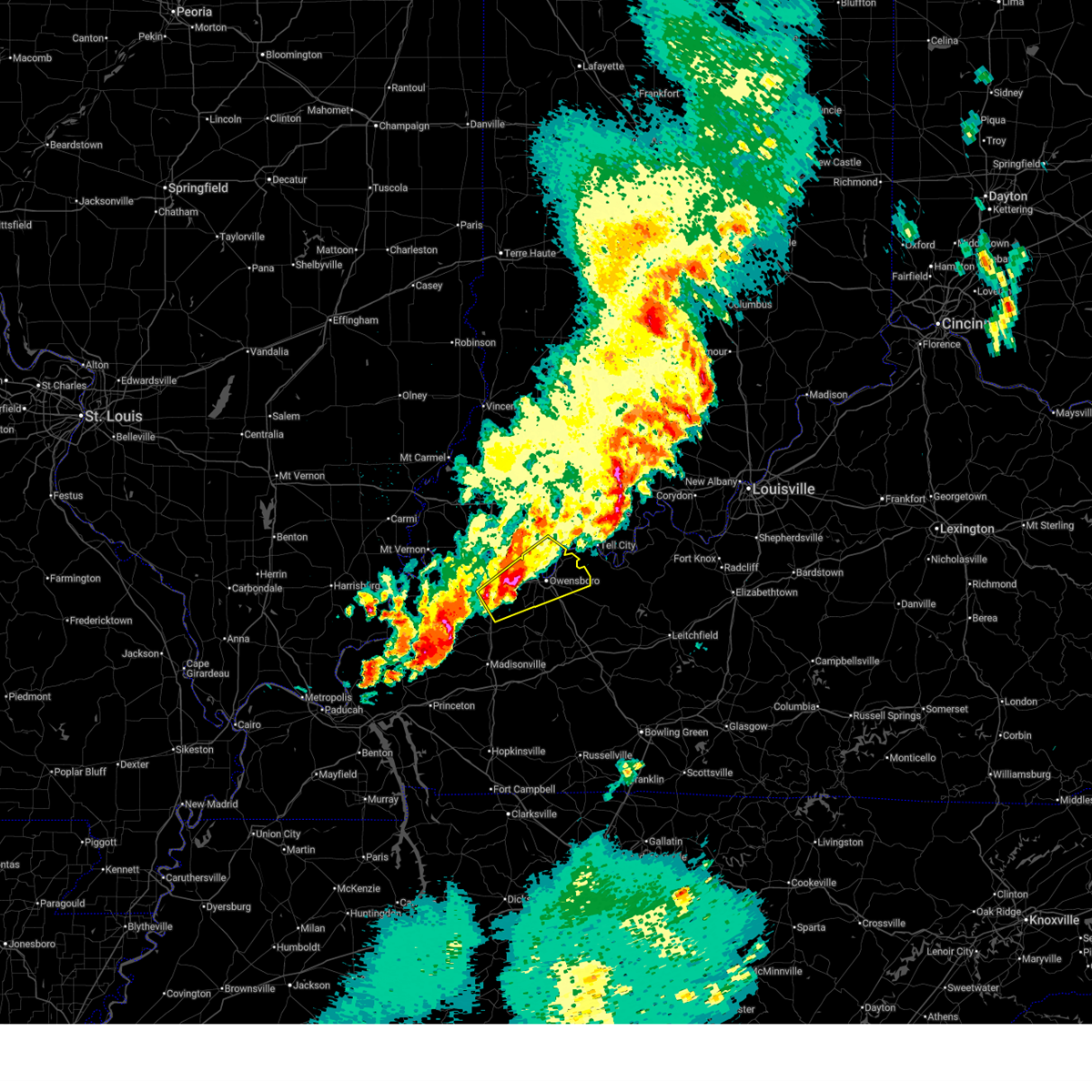
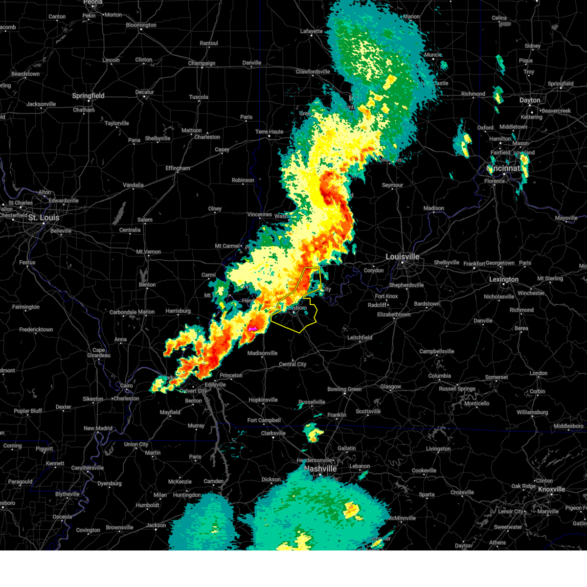
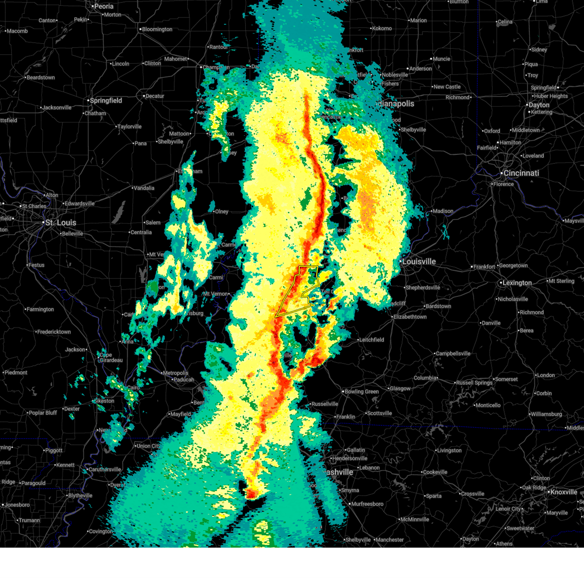 At 938 pm cdt, severe thunderstorms were located along a line extending from near dale to near owensboro, moving east at 50 mph (radar indicated). Hazards include 60 mph wind gusts. Expect damage to roofs, siding, and trees. locations impacted include, owensboro, rockport, dale, grandview, santa claus, stanley, chrisney, and gentryville. this includes the following highways, interstate 64 in indiana between mile markers 55 and 60. Audubon parkway between mile markers 18 and 23. At 938 pm cdt, severe thunderstorms were located along a line extending from near dale to near owensboro, moving east at 50 mph (radar indicated). Hazards include 60 mph wind gusts. Expect damage to roofs, siding, and trees. locations impacted include, owensboro, rockport, dale, grandview, santa claus, stanley, chrisney, and gentryville. this includes the following highways, interstate 64 in indiana between mile markers 55 and 60. Audubon parkway between mile markers 18 and 23.
|
| 3/15/2026 9:08 PM CDT |
 Svrpah the national weather service in paducah has issued a * severe thunderstorm warning for, warrick county in southwestern indiana, southeastern gibson county in southwestern indiana, east central vanderburgh county in southwestern indiana, spencer county in southwestern indiana, pike county in southwestern indiana, northern daviess county in northwestern kentucky, henderson county in northwestern kentucky, * until 1000 pm cdt/1100 pm edt/. * at 908 pm cdt/1008 pm edt/, severe thunderstorms were located along a line extending from 6 miles south of washington to 6 miles southwest of lynnville to near robards, moving northeast at 70 mph (radar indicated). Hazards include 70 mph wind gusts. Expect considerable tree damage. Damage is likely to mobile homes, roofs, and outbuildings. Svrpah the national weather service in paducah has issued a * severe thunderstorm warning for, warrick county in southwestern indiana, southeastern gibson county in southwestern indiana, east central vanderburgh county in southwestern indiana, spencer county in southwestern indiana, pike county in southwestern indiana, northern daviess county in northwestern kentucky, henderson county in northwestern kentucky, * until 1000 pm cdt/1100 pm edt/. * at 908 pm cdt/1008 pm edt/, severe thunderstorms were located along a line extending from 6 miles south of washington to 6 miles southwest of lynnville to near robards, moving northeast at 70 mph (radar indicated). Hazards include 70 mph wind gusts. Expect considerable tree damage. Damage is likely to mobile homes, roofs, and outbuildings.
|
| 8/12/2025 3:46 PM CDT |
 Svrpah the national weather service in paducah has issued a * severe thunderstorm warning for, eastern warrick county in southwestern indiana, central spencer county in southwestern indiana, * until 430 pm cdt. * at 346 pm cdt, a severe thunderstorm was located 8 miles east of boonville, moving north at 20 mph (radar indicated). Hazards include 70 mph wind gusts and ping pong ball size hail. People and animals outdoors will be injured. expect hail damage to roofs, siding, windows, and vehicles. expect considerable tree damage. Wind damage is also likely to mobile homes, roofs, and outbuildings. Svrpah the national weather service in paducah has issued a * severe thunderstorm warning for, eastern warrick county in southwestern indiana, central spencer county in southwestern indiana, * until 430 pm cdt. * at 346 pm cdt, a severe thunderstorm was located 8 miles east of boonville, moving north at 20 mph (radar indicated). Hazards include 70 mph wind gusts and ping pong ball size hail. People and animals outdoors will be injured. expect hail damage to roofs, siding, windows, and vehicles. expect considerable tree damage. Wind damage is also likely to mobile homes, roofs, and outbuildings.
|
| 8/12/2025 3:44 PM CDT |
 At 343 pm cdt, a severe thunderstorm was located near eureka, or 7 miles northwest of rockport, moving northeast at 10 mph (radar indicated). Hazards include 70 mph wind gusts and half dollar size hail. Hail damage to vehicles is expected. expect considerable tree damage. wind damage is also likely to mobile homes, roofs, and outbuildings. Locations impacted include, rockport and chrisney. At 343 pm cdt, a severe thunderstorm was located near eureka, or 7 miles northwest of rockport, moving northeast at 10 mph (radar indicated). Hazards include 70 mph wind gusts and half dollar size hail. Hail damage to vehicles is expected. expect considerable tree damage. wind damage is also likely to mobile homes, roofs, and outbuildings. Locations impacted include, rockport and chrisney.
|
| 8/12/2025 3:29 PM CDT |
 Svrpah the national weather service in paducah has issued a * severe thunderstorm warning for, southeastern warrick county in southwestern indiana, southwestern spencer county in southwestern indiana, * until 400 pm cdt. * at 329 pm cdt, a severe thunderstorm was located over eureka, or near rockport, moving northeast at 10 mph (radar indicated). Hazards include 60 mph wind gusts. expect damage to roofs, siding, and trees Svrpah the national weather service in paducah has issued a * severe thunderstorm warning for, southeastern warrick county in southwestern indiana, southwestern spencer county in southwestern indiana, * until 400 pm cdt. * at 329 pm cdt, a severe thunderstorm was located over eureka, or near rockport, moving northeast at 10 mph (radar indicated). Hazards include 60 mph wind gusts. expect damage to roofs, siding, and trees
|
| 7/28/2025 8:05 PM CDT |
 At 805 pm cdt, severe thunderstorms were located along a line extending from near owensboro to 9 miles southwest of hardinsburg, moving southeast at 35 mph (radar indicated). Hazards include 60 mph wind gusts. Expect damage to roofs, siding, and trees. locations impacted include, owensboro, rockport, whitesville, masonville, stanley, knottsville, eureka, and moseleyville. this includes the following highways, interstate 165 between mile markers 60 and 70. Audubon parkway between mile markers 15 and 23. At 805 pm cdt, severe thunderstorms were located along a line extending from near owensboro to 9 miles southwest of hardinsburg, moving southeast at 35 mph (radar indicated). Hazards include 60 mph wind gusts. Expect damage to roofs, siding, and trees. locations impacted include, owensboro, rockport, whitesville, masonville, stanley, knottsville, eureka, and moseleyville. this includes the following highways, interstate 165 between mile markers 60 and 70. Audubon parkway between mile markers 15 and 23.
|
| 7/28/2025 7:48 PM CDT |
 Svrpah the national weather service in paducah has issued a * severe thunderstorm warning for, southwestern spencer county in southwestern indiana, daviess county in northwestern kentucky, east central henderson county in northwestern kentucky, * until 830 pm cdt. * at 747 pm cdt, severe thunderstorms were located along a line extending from near eureka to 6 miles south of hawesville, moving southeast at 35 mph (radar indicated). Hazards include 60 mph wind gusts. expect damage to roofs, siding, and trees Svrpah the national weather service in paducah has issued a * severe thunderstorm warning for, southwestern spencer county in southwestern indiana, daviess county in northwestern kentucky, east central henderson county in northwestern kentucky, * until 830 pm cdt. * at 747 pm cdt, severe thunderstorms were located along a line extending from near eureka to 6 miles south of hawesville, moving southeast at 35 mph (radar indicated). Hazards include 60 mph wind gusts. expect damage to roofs, siding, and trees
|
| 5/16/2025 8:31 PM CDT |
 the severe thunderstorm warning has been cancelled and is no longer in effect the severe thunderstorm warning has been cancelled and is no longer in effect
|
| 5/16/2025 8:31 PM CDT |
 At 831 pm cdt, a severe thunderstorm was located near hawesville, or 17 miles east of rockport, moving east at 50 mph (radar indicated). Hazards include ping pong ball size hail and 60 mph wind gusts. People and animals outdoors will be injured. expect hail damage to roofs, siding, windows, and vehicles. expect wind damage to roofs, siding, and trees. locations impacted include, owensboro, rockport, whitesville, masonville, stanley, knottsville, st. joseph, and eureka. this includes the following highways, interstate 165 between mile markers 66 and 70. Audubon parkway between mile markers 15 and 23. At 831 pm cdt, a severe thunderstorm was located near hawesville, or 17 miles east of rockport, moving east at 50 mph (radar indicated). Hazards include ping pong ball size hail and 60 mph wind gusts. People and animals outdoors will be injured. expect hail damage to roofs, siding, windows, and vehicles. expect wind damage to roofs, siding, and trees. locations impacted include, owensboro, rockport, whitesville, masonville, stanley, knottsville, st. joseph, and eureka. this includes the following highways, interstate 165 between mile markers 66 and 70. Audubon parkway between mile markers 15 and 23.
|
| 5/16/2025 7:38 PM CDT |
 Svrpah the national weather service in paducah has issued a * severe thunderstorm warning for, southwestern vanderburgh county in southwestern indiana, southwestern spencer county in southwestern indiana, daviess county in northwestern kentucky, eastern henderson county in northwestern kentucky, * until 845 pm cdt. * at 737 pm cdt, a severe thunderstorm was located near henderson, moving east at 50 mph (radar indicated). Hazards include ping pong ball size hail and 60 mph wind gusts. People and animals outdoors will be injured. expect hail damage to roofs, siding, windows, and vehicles. Expect wind damage to roofs, siding, and trees. Svrpah the national weather service in paducah has issued a * severe thunderstorm warning for, southwestern vanderburgh county in southwestern indiana, southwestern spencer county in southwestern indiana, daviess county in northwestern kentucky, eastern henderson county in northwestern kentucky, * until 845 pm cdt. * at 737 pm cdt, a severe thunderstorm was located near henderson, moving east at 50 mph (radar indicated). Hazards include ping pong ball size hail and 60 mph wind gusts. People and animals outdoors will be injured. expect hail damage to roofs, siding, windows, and vehicles. Expect wind damage to roofs, siding, and trees.
|
| 5/16/2025 5:04 AM CDT |
 At 503 am cdt, a severe thunderstorm was located over rockport, moving northeast at 75 mph (radar indicated). Hazards include 60 mph wind gusts and quarter size hail. Hail damage to vehicles is expected. expect wind damage to roofs, siding, and trees. Locations impacted include, owensboro, rockport, grandview, knottsville, eureka, and chrisney. At 503 am cdt, a severe thunderstorm was located over rockport, moving northeast at 75 mph (radar indicated). Hazards include 60 mph wind gusts and quarter size hail. Hail damage to vehicles is expected. expect wind damage to roofs, siding, and trees. Locations impacted include, owensboro, rockport, grandview, knottsville, eureka, and chrisney.
|
| 5/16/2025 5:04 AM CDT |
 the severe thunderstorm warning has been cancelled and is no longer in effect the severe thunderstorm warning has been cancelled and is no longer in effect
|
| 5/16/2025 4:54 AM CDT |
 Svrpah the national weather service in paducah has issued a * severe thunderstorm warning for, spencer county in southwestern indiana, central daviess county in northwestern kentucky, east central henderson county in northwestern kentucky, * until 530 am cdt. * at 454 am cdt, a severe thunderstorm was located over stanley, or 8 miles northwest of owensboro, moving northeast at 75 mph (radar indicated). Hazards include 60 mph wind gusts and quarter size hail. Hail damage to vehicles is expected. Expect wind damage to roofs, siding, and trees. Svrpah the national weather service in paducah has issued a * severe thunderstorm warning for, spencer county in southwestern indiana, central daviess county in northwestern kentucky, east central henderson county in northwestern kentucky, * until 530 am cdt. * at 454 am cdt, a severe thunderstorm was located over stanley, or 8 miles northwest of owensboro, moving northeast at 75 mph (radar indicated). Hazards include 60 mph wind gusts and quarter size hail. Hail damage to vehicles is expected. Expect wind damage to roofs, siding, and trees.
|
| 5/16/2025 3:44 AM CDT |
 Svrpah the national weather service in paducah has issued a * severe thunderstorm warning for, southern spencer county in southwestern indiana, northeastern daviess county in northwestern kentucky, * until 415 am cdt. * at 344 am cdt, a severe thunderstorm was located near rockport, moving east at 60 mph (radar indicated). Hazards include 60 mph wind gusts and quarter size hail. Hail damage to vehicles is expected. Expect wind damage to roofs, siding, and trees. Svrpah the national weather service in paducah has issued a * severe thunderstorm warning for, southern spencer county in southwestern indiana, northeastern daviess county in northwestern kentucky, * until 415 am cdt. * at 344 am cdt, a severe thunderstorm was located near rockport, moving east at 60 mph (radar indicated). Hazards include 60 mph wind gusts and quarter size hail. Hail damage to vehicles is expected. Expect wind damage to roofs, siding, and trees.
|
| 4/10/2025 4:21 PM CDT | Svrpah the national weather service in paducah has issued a * severe thunderstorm warning for, east central warrick county in southwestern indiana, spencer county in southwestern indiana, central daviess county in northwestern kentucky, * until 500 pm cdt. * at 421 pm cdt, severe thunderstorms were located along a line extending from near dale to near owensboro, moving east at 40 mph (radar indicated). Hazards include 60 mph wind gusts. expect damage to roofs, siding, and trees |
| 4/2/2025 10:28 PM CDT |
 the tornado warning has been cancelled and is no longer in effect the tornado warning has been cancelled and is no longer in effect
|
| 4/2/2025 10:17 PM CDT |
 At 1016 pm cdt, a severe squall line capable of producing both tornadoes and extensive straight line wind damage was located along a line extending from near eureka to near rockport to near knottsville, moving northeast at 75 mph (radar indicated rotation). Hazards include tornado. Flying debris will be dangerous to those caught without shelter. mobile homes will be damaged or destroyed. damage to roofs, windows, and vehicles will occur. tree damage is likely. these dangerous storms will be near, rockport and grandview around 1020 pm cdt. Other locations impacted by these tornadic storms include waitman. At 1016 pm cdt, a severe squall line capable of producing both tornadoes and extensive straight line wind damage was located along a line extending from near eureka to near rockport to near knottsville, moving northeast at 75 mph (radar indicated rotation). Hazards include tornado. Flying debris will be dangerous to those caught without shelter. mobile homes will be damaged or destroyed. damage to roofs, windows, and vehicles will occur. tree damage is likely. these dangerous storms will be near, rockport and grandview around 1020 pm cdt. Other locations impacted by these tornadic storms include waitman.
|
| 4/2/2025 10:17 PM CDT |
 the tornado warning has been cancelled and is no longer in effect the tornado warning has been cancelled and is no longer in effect
|
| 4/2/2025 10:00 PM CDT |
 Torpah the national weather service in paducah has issued a * tornado warning for, southwestern spencer county in southwestern indiana, central daviess county in northwestern kentucky, southeastern henderson county in northwestern kentucky, north central mclean county in northwestern kentucky, * until 1045 pm cdt. * at 1000 pm cdt, severe thunderstorms capable of producing both tornadoes and extensive straight line wind damage were located along a line extending from 8 miles northeast of robards to st. joseph to 6 miles northeast of beech grove, moving northeast at 65 mph (radar indicated rotation). Hazards include tornado. Flying debris will be dangerous to those caught without shelter. mobile homes will be damaged or destroyed. damage to roofs, windows, and vehicles will occur. tree damage is likely. these dangerous storms will be near, stanley and owensboro around 1005 pm cdt. eureka around 1010 pm cdt. rockport around 1015 pm cdt. grandview around 1020 pm cdt. other locations impacted by these tornadic storms include hebbardsville and waitman. This includes audubon parkway between mile markers 9 and 23. Torpah the national weather service in paducah has issued a * tornado warning for, southwestern spencer county in southwestern indiana, central daviess county in northwestern kentucky, southeastern henderson county in northwestern kentucky, north central mclean county in northwestern kentucky, * until 1045 pm cdt. * at 1000 pm cdt, severe thunderstorms capable of producing both tornadoes and extensive straight line wind damage were located along a line extending from 8 miles northeast of robards to st. joseph to 6 miles northeast of beech grove, moving northeast at 65 mph (radar indicated rotation). Hazards include tornado. Flying debris will be dangerous to those caught without shelter. mobile homes will be damaged or destroyed. damage to roofs, windows, and vehicles will occur. tree damage is likely. these dangerous storms will be near, stanley and owensboro around 1005 pm cdt. eureka around 1010 pm cdt. rockport around 1015 pm cdt. grandview around 1020 pm cdt. other locations impacted by these tornadic storms include hebbardsville and waitman. This includes audubon parkway between mile markers 9 and 23.
|
| 4/2/2025 9:44 PM CDT |
 the severe thunderstorm warning has been cancelled and is no longer in effect the severe thunderstorm warning has been cancelled and is no longer in effect
|
| 4/2/2025 9:44 PM CDT |
 At 943 pm cdt, severe thunderstorms were located along a line extending from 11 miles southwest of shoals to near tell city to near masonville, moving east at 55 mph (radar indicated). Hazards include 70 mph wind gusts. Expect considerable tree damage. damage is likely to mobile homes, roofs, and outbuildings. locations impacted include, whitesville, santa claus, knottsville, st. joseph, gentryville, masonville, moseleyville, stanley, dale, chrisney, rockport, grandview, owensboro, eureka, tennyson, and hebbardsville. this includes the following highways, interstate 165 between mile markers 62 and 70. interstate 64 in indiana between mile markers 52 and 60. Audubon parkway between mile markers 10 and 23. At 943 pm cdt, severe thunderstorms were located along a line extending from 11 miles southwest of shoals to near tell city to near masonville, moving east at 55 mph (radar indicated). Hazards include 70 mph wind gusts. Expect considerable tree damage. damage is likely to mobile homes, roofs, and outbuildings. locations impacted include, whitesville, santa claus, knottsville, st. joseph, gentryville, masonville, moseleyville, stanley, dale, chrisney, rockport, grandview, owensboro, eureka, tennyson, and hebbardsville. this includes the following highways, interstate 165 between mile markers 62 and 70. interstate 64 in indiana between mile markers 52 and 60. Audubon parkway between mile markers 10 and 23.
|
| 4/2/2025 9:28 PM CDT |
 At 928 pm cdt/1028 pm edt/, severe thunderstorms were located along a line extending from 6 miles south of washington to 6 miles north of grandview to near calhoun, moving east at 55 mph (radar indicated). Hazards include 70 mph wind gusts. Expect considerable tree damage. damage is likely to mobile homes, roofs, and outbuildings. locations impacted include, boonville, santa claus, knottsville, st. joseph, spurgeon, masonville, moseleyville, winslow, stanley, lynnville, chandler, robards, whitesville, folsomville, gentryville, dale, chrisney, rockport, grandview, and owensboro. this includes the following highways, interstate 165 between mile markers 62 and 70. interstate 69 in kentucky between mile markers 138 and 148. interstate 69 in indiana between mile markers 3 and 10, and between mile markers 47 and 52. interstate 64 in indiana between mile markers 34 and 60. Audubon parkway between mile markers 1 and 23. At 928 pm cdt/1028 pm edt/, severe thunderstorms were located along a line extending from 6 miles south of washington to 6 miles north of grandview to near calhoun, moving east at 55 mph (radar indicated). Hazards include 70 mph wind gusts. Expect considerable tree damage. damage is likely to mobile homes, roofs, and outbuildings. locations impacted include, boonville, santa claus, knottsville, st. joseph, spurgeon, masonville, moseleyville, winslow, stanley, lynnville, chandler, robards, whitesville, folsomville, gentryville, dale, chrisney, rockport, grandview, and owensboro. this includes the following highways, interstate 165 between mile markers 62 and 70. interstate 69 in kentucky between mile markers 138 and 148. interstate 69 in indiana between mile markers 3 and 10, and between mile markers 47 and 52. interstate 64 in indiana between mile markers 34 and 60. Audubon parkway between mile markers 1 and 23.
|
| 4/2/2025 9:08 PM CDT |
 Svrpah the national weather service in paducah has issued a * severe thunderstorm warning for, warrick county in southwestern indiana, east central vanderburgh county in southwestern indiana, spencer county in southwestern indiana, east central gibson county in southwestern indiana, pike county in southwestern indiana, daviess county in northwestern kentucky, eastern henderson county in northwestern kentucky, northwestern mclean county in northwestern kentucky, * until 1000 pm cdt/1100 pm edt/. * at 908 pm cdt/1008 pm edt/, severe thunderstorms were located along a line extending from near washington to near chandler to sebree, moving east at 55 mph (radar indicated). Hazards include 60 mph wind gusts. expect damage to roofs, siding, and trees Svrpah the national weather service in paducah has issued a * severe thunderstorm warning for, warrick county in southwestern indiana, east central vanderburgh county in southwestern indiana, spencer county in southwestern indiana, east central gibson county in southwestern indiana, pike county in southwestern indiana, daviess county in northwestern kentucky, eastern henderson county in northwestern kentucky, northwestern mclean county in northwestern kentucky, * until 1000 pm cdt/1100 pm edt/. * at 908 pm cdt/1008 pm edt/, severe thunderstorms were located along a line extending from near washington to near chandler to sebree, moving east at 55 mph (radar indicated). Hazards include 60 mph wind gusts. expect damage to roofs, siding, and trees
|
| 3/30/2025 7:58 PM CDT |
 the severe thunderstorm warning has been cancelled and is no longer in effect the severe thunderstorm warning has been cancelled and is no longer in effect
|
| 3/30/2025 7:58 PM CDT |
 At 758 pm cdt, severe thunderstorms were located along a line extending from near santa claus to near grandview to near masonville, moving east at 55 mph (radar indicated). Hazards include 60 mph wind gusts and quarter size hail. Hail damage to vehicles is expected. expect wind damage to roofs, siding, and trees. locations impacted include, masonville, whitesville, santa claus, chrisney, knottsville, rockport, grandview, and owensboro. This includes interstate 165 between mile markers 60 and 70. At 758 pm cdt, severe thunderstorms were located along a line extending from near santa claus to near grandview to near masonville, moving east at 55 mph (radar indicated). Hazards include 60 mph wind gusts and quarter size hail. Hail damage to vehicles is expected. expect wind damage to roofs, siding, and trees. locations impacted include, masonville, whitesville, santa claus, chrisney, knottsville, rockport, grandview, and owensboro. This includes interstate 165 between mile markers 60 and 70.
|
| 3/30/2025 7:30 PM CDT |
 Svrpah the national weather service in paducah has issued a * severe thunderstorm warning for, central warrick county in southwestern indiana, spencer county in southwestern indiana, daviess county in northwestern kentucky, eastern henderson county in northwestern kentucky, * until 815 pm cdt. * at 729 pm cdt, a severe thunderstorm was located near stanley, or 8 miles south of newburgh, moving east at 55 mph (radar indicated). Hazards include 60 mph wind gusts and nickel size hail. expect damage to roofs, siding, and trees Svrpah the national weather service in paducah has issued a * severe thunderstorm warning for, central warrick county in southwestern indiana, spencer county in southwestern indiana, daviess county in northwestern kentucky, eastern henderson county in northwestern kentucky, * until 815 pm cdt. * at 729 pm cdt, a severe thunderstorm was located near stanley, or 8 miles south of newburgh, moving east at 55 mph (radar indicated). Hazards include 60 mph wind gusts and nickel size hail. expect damage to roofs, siding, and trees
|
| 3/19/2025 7:21 PM CDT |
 Svrpah the national weather service in paducah has issued a * severe thunderstorm warning for, southern spencer county in southwestern indiana, daviess county in northwestern kentucky, southeastern henderson county in northwestern kentucky, northern mclean county in northwestern kentucky, * until 800 pm cdt. * at 721 pm cdt, severe thunderstorms were located along a line extending from near grandview to owensboro to near st. joseph, moving northeast at 35 mph (trained weather spotters). Hazards include 60 mph wind gusts. expect damage to roofs, siding, and trees Svrpah the national weather service in paducah has issued a * severe thunderstorm warning for, southern spencer county in southwestern indiana, daviess county in northwestern kentucky, southeastern henderson county in northwestern kentucky, northern mclean county in northwestern kentucky, * until 800 pm cdt. * at 721 pm cdt, severe thunderstorms were located along a line extending from near grandview to owensboro to near st. joseph, moving northeast at 35 mph (trained weather spotters). Hazards include 60 mph wind gusts. expect damage to roofs, siding, and trees
|
| 3/15/2025 5:09 AM CDT |
 At 508 am cdt, a severe thunderstorm was located near knottsville, or 8 miles southeast of rockport, moving northeast at 45 mph (radar indicated). Hazards include two inch hail and 70 mph wind gusts. People and animals outdoors will be injured. expect hail damage to roofs, siding, windows, and vehicles. expect considerable tree damage. wind damage is also likely to mobile homes, roofs, and outbuildings. locations impacted include, knottsville, masonville, moseleyville, owensboro, rockport, and lewisport. This includes interstate 165 between mile markers 66 and 70. At 508 am cdt, a severe thunderstorm was located near knottsville, or 8 miles southeast of rockport, moving northeast at 45 mph (radar indicated). Hazards include two inch hail and 70 mph wind gusts. People and animals outdoors will be injured. expect hail damage to roofs, siding, windows, and vehicles. expect considerable tree damage. wind damage is also likely to mobile homes, roofs, and outbuildings. locations impacted include, knottsville, masonville, moseleyville, owensboro, rockport, and lewisport. This includes interstate 165 between mile markers 66 and 70.
|
| 3/15/2025 5:06 AM CDT |
 At 505 am cdt, severe thunderstorms were located near rockport to and near calhoun, moving northeast at 60 mph. numerous reports of very large hail have been recieved in owensboro with these storms (trained weather spotters). Hazards include golf ball size hail and 70 mph wind gusts. People and animals outdoors will be injured. expect hail damage to roofs, siding, windows, and vehicles. expect considerable tree damage. wind damage is also likely to mobile homes, roofs, and outbuildings. locations impacted include, masonville, moseleyville, whitesville, stanley, knottsville, rockport, st. joseph, and owensboro. this includes the following highways, interstate 165 between mile markers 62 and 70. Audubon parkway between mile markers 15 and 23. At 505 am cdt, severe thunderstorms were located near rockport to and near calhoun, moving northeast at 60 mph. numerous reports of very large hail have been recieved in owensboro with these storms (trained weather spotters). Hazards include golf ball size hail and 70 mph wind gusts. People and animals outdoors will be injured. expect hail damage to roofs, siding, windows, and vehicles. expect considerable tree damage. wind damage is also likely to mobile homes, roofs, and outbuildings. locations impacted include, masonville, moseleyville, whitesville, stanley, knottsville, rockport, st. joseph, and owensboro. this includes the following highways, interstate 165 between mile markers 62 and 70. Audubon parkway between mile markers 15 and 23.
|
| 3/15/2025 4:43 AM CDT |
 Svrpah the national weather service in paducah has issued a * severe thunderstorm warning for, south central spencer county in southwestern indiana, daviess county in northwestern kentucky, * until 515 am cdt. * at 443 am cdt, a severe thunderstorm was located near st. joseph, or 9 miles west of owensboro, moving east at 55 mph. this is a destructive storm for owensboro (radar indicated). Hazards include baseball size hail and 70 mph wind gusts. People and animals outdoors will be severely injured. Expect shattered windows, extensive damage to roofs, siding, and vehicles. Svrpah the national weather service in paducah has issued a * severe thunderstorm warning for, south central spencer county in southwestern indiana, daviess county in northwestern kentucky, * until 515 am cdt. * at 443 am cdt, a severe thunderstorm was located near st. joseph, or 9 miles west of owensboro, moving east at 55 mph. this is a destructive storm for owensboro (radar indicated). Hazards include baseball size hail and 70 mph wind gusts. People and animals outdoors will be severely injured. Expect shattered windows, extensive damage to roofs, siding, and vehicles.
|
| 3/15/2025 4:37 AM CDT |
 Svrpah the national weather service in paducah has issued a * severe thunderstorm warning for, spencer county in southwestern indiana, north central daviess county in northwestern kentucky, * until 515 am cdt. * at 437 am cdt, a severe thunderstorm was located over grandview, or 7 miles northeast of rockport, moving northeast at 55 mph (radar indicated). Hazards include 60 mph wind gusts and quarter size hail. Hail damage to vehicles is expected. Expect wind damage to roofs, siding, and trees. Svrpah the national weather service in paducah has issued a * severe thunderstorm warning for, spencer county in southwestern indiana, north central daviess county in northwestern kentucky, * until 515 am cdt. * at 437 am cdt, a severe thunderstorm was located over grandview, or 7 miles northeast of rockport, moving northeast at 55 mph (radar indicated). Hazards include 60 mph wind gusts and quarter size hail. Hail damage to vehicles is expected. Expect wind damage to roofs, siding, and trees.
|
| 3/15/2025 4:36 AM CDT |
 At 435 am cdt, a severe thunderstorm was located over st. joseph, or 10 miles northwest of calhoun, moving northeast at 60 mph (trained weather spotters). Hazards include golf ball size hail and 70 mph wind gusts. People and animals outdoors will be injured. expect hail damage to roofs, siding, windows, and vehicles. expect considerable tree damage. wind damage is also likely to mobile homes, roofs, and outbuildings. locations impacted include, masonville, moseleyville, whitesville, stanley, calhoun, knottsville, rockport, st. joseph, owensboro, beech grove, and hebbardsville. this includes the following highways, interstate 165 between mile markers 62 and 70. interstate 69 in kentucky between mile markers 138 and 143. Audubon parkway between mile markers 8 and 23. At 435 am cdt, a severe thunderstorm was located over st. joseph, or 10 miles northwest of calhoun, moving northeast at 60 mph (trained weather spotters). Hazards include golf ball size hail and 70 mph wind gusts. People and animals outdoors will be injured. expect hail damage to roofs, siding, windows, and vehicles. expect considerable tree damage. wind damage is also likely to mobile homes, roofs, and outbuildings. locations impacted include, masonville, moseleyville, whitesville, stanley, calhoun, knottsville, rockport, st. joseph, owensboro, beech grove, and hebbardsville. this includes the following highways, interstate 165 between mile markers 62 and 70. interstate 69 in kentucky between mile markers 138 and 143. Audubon parkway between mile markers 8 and 23.
|
| 3/15/2025 4:30 AM CDT | Quarter sized hail reported 3.7 miles E of Rockport, IN, hail just over quarter sized. |
| 3/15/2025 4:28 AM CDT |
 Svrpah the national weather service in paducah has issued a * severe thunderstorm warning for, southwestern spencer county in southwestern indiana, daviess county in northwestern kentucky, southeastern henderson county in northwestern kentucky, northern mclean county in northwestern kentucky, * until 515 am cdt. * at 427 am cdt, a severe thunderstorm was located over sebree, or 15 miles west of calhoun, moving northeast at 60 mph (radar indicated). Hazards include 70 mph wind gusts and half dollar size hail. Hail damage to vehicles is expected. expect considerable tree damage. Wind damage is also likely to mobile homes, roofs, and outbuildings. Svrpah the national weather service in paducah has issued a * severe thunderstorm warning for, southwestern spencer county in southwestern indiana, daviess county in northwestern kentucky, southeastern henderson county in northwestern kentucky, northern mclean county in northwestern kentucky, * until 515 am cdt. * at 427 am cdt, a severe thunderstorm was located over sebree, or 15 miles west of calhoun, moving northeast at 60 mph (radar indicated). Hazards include 70 mph wind gusts and half dollar size hail. Hail damage to vehicles is expected. expect considerable tree damage. Wind damage is also likely to mobile homes, roofs, and outbuildings.
|
| 3/15/2025 4:14 AM CDT |
 At 414 am cdt, a severe thunderstorm was located near st. joseph, or 10 miles west of owensboro, moving northeast at 60 mph (radar indicated). Hazards include golf ball size hail and 60 mph wind gusts. People and animals outdoors will be injured. expect hail damage to roofs, siding, windows, and vehicles. expect wind damage to roofs, siding, and trees. locations impacted include, knottsville, st. joseph, masonville, moseleyville, stanley, rockport, owensboro, eureka, beech grove, hebbardsville, waitman, grandview, and robards. this includes the following highways, interstate 165 between mile markers 66 and 70. interstate 69 in kentucky between mile markers 136 and 143. Audubon parkway between mile markers 7 and 23. At 414 am cdt, a severe thunderstorm was located near st. joseph, or 10 miles west of owensboro, moving northeast at 60 mph (radar indicated). Hazards include golf ball size hail and 60 mph wind gusts. People and animals outdoors will be injured. expect hail damage to roofs, siding, windows, and vehicles. expect wind damage to roofs, siding, and trees. locations impacted include, knottsville, st. joseph, masonville, moseleyville, stanley, rockport, owensboro, eureka, beech grove, hebbardsville, waitman, grandview, and robards. this includes the following highways, interstate 165 between mile markers 66 and 70. interstate 69 in kentucky between mile markers 136 and 143. Audubon parkway between mile markers 7 and 23.
|
| 3/15/2025 4:03 AM CDT |
 Svrpah the national weather service in paducah has issued a * severe thunderstorm warning for, southwestern spencer county in southwestern indiana, daviess county in northwestern kentucky, southeastern henderson county in northwestern kentucky, northwestern mclean county in northwestern kentucky, northeastern webster county in northwestern kentucky, * until 445 am cdt. * at 403 am cdt, a severe thunderstorm was located near sebree, or 14 miles south of henderson, moving northeast at 60 mph (radar indicated). Hazards include 60 mph wind gusts and half dollar size hail. Hail damage to vehicles is expected. Expect wind damage to roofs, siding, and trees. Svrpah the national weather service in paducah has issued a * severe thunderstorm warning for, southwestern spencer county in southwestern indiana, daviess county in northwestern kentucky, southeastern henderson county in northwestern kentucky, northwestern mclean county in northwestern kentucky, northeastern webster county in northwestern kentucky, * until 445 am cdt. * at 403 am cdt, a severe thunderstorm was located near sebree, or 14 miles south of henderson, moving northeast at 60 mph (radar indicated). Hazards include 60 mph wind gusts and half dollar size hail. Hail damage to vehicles is expected. Expect wind damage to roofs, siding, and trees.
|
| 3/15/2025 4:01 AM CDT |
 At 401 am cdt, severe thunderstorms were located along a line extending from 6 miles east of paoli to 11 miles southwest of english to tell city, moving northeast at 70 mph (radar indicated). Hazards include 70 mph wind gusts. Expect considerable tree damage. damage is likely to mobile homes, roofs, and outbuildings. locations impacted include, whitesville, santa claus, knottsville, st. joseph, troy, masonville, moseleyville, stanley, chrisney, rockport, grandview, owensboro, eureka, and dale. this includes the following highways, interstate 165 between mile markers 60 and 70. interstate 64 in indiana between mile markers 57 and 60. Audubon parkway between mile markers 15 and 23. At 401 am cdt, severe thunderstorms were located along a line extending from 6 miles east of paoli to 11 miles southwest of english to tell city, moving northeast at 70 mph (radar indicated). Hazards include 70 mph wind gusts. Expect considerable tree damage. damage is likely to mobile homes, roofs, and outbuildings. locations impacted include, whitesville, santa claus, knottsville, st. joseph, troy, masonville, moseleyville, stanley, chrisney, rockport, grandview, owensboro, eureka, and dale. this includes the following highways, interstate 165 between mile markers 60 and 70. interstate 64 in indiana between mile markers 57 and 60. Audubon parkway between mile markers 15 and 23.
|
| 3/15/2025 4:01 AM CDT |
 the severe thunderstorm warning has been cancelled and is no longer in effect the severe thunderstorm warning has been cancelled and is no longer in effect
|
| 3/15/2025 3:26 AM CDT |
 Svrpah the national weather service in paducah has issued a * severe thunderstorm warning for, warrick county in southwestern indiana, spencer county in southwestern indiana, southeastern pike county in southwestern indiana, daviess county in northwestern kentucky, * until 415 am cdt/515 am edt/. * at 325 am cdt/425 am edt/, severe thunderstorms were located along a line extending from 7 miles southeast of winslow to near boonville to near robards, moving northeast at 70 mph (radar indicated). Hazards include 70 mph wind gusts. Expect considerable tree damage. Damage is likely to mobile homes, roofs, and outbuildings. Svrpah the national weather service in paducah has issued a * severe thunderstorm warning for, warrick county in southwestern indiana, spencer county in southwestern indiana, southeastern pike county in southwestern indiana, daviess county in northwestern kentucky, * until 415 am cdt/515 am edt/. * at 325 am cdt/425 am edt/, severe thunderstorms were located along a line extending from 7 miles southeast of winslow to near boonville to near robards, moving northeast at 70 mph (radar indicated). Hazards include 70 mph wind gusts. Expect considerable tree damage. Damage is likely to mobile homes, roofs, and outbuildings.
|
| 7/30/2024 7:21 PM CDT |
 The storms which prompted the warning have moved out of the area. therefore, the warning will be allowed to expire. a severe thunderstorm watch remains in effect until 1000 pm cdt for southwestern indiana, and northwestern kentucky. to report severe weather, contact your nearest law enforcement agency. they will relay your report to the national weather service paducah. The storms which prompted the warning have moved out of the area. therefore, the warning will be allowed to expire. a severe thunderstorm watch remains in effect until 1000 pm cdt for southwestern indiana, and northwestern kentucky. to report severe weather, contact your nearest law enforcement agency. they will relay your report to the national weather service paducah.
|
| 7/30/2024 7:08 PM CDT |
 the severe thunderstorm warning has been cancelled and is no longer in effect the severe thunderstorm warning has been cancelled and is no longer in effect
|
| 7/30/2024 7:08 PM CDT |
 At 707 pm cdt, severe thunderstorms were located along a line extending from 7 miles northeast of santa claus to near grandview to near eureka, moving east at 55 mph. these are destructive storms (radar indicated). Hazards include 80 mph wind gusts. Flying debris will be dangerous to those caught without shelter. mobile homes will be heavily damaged. expect considerable damage to roofs, windows, and vehicles. extensive tree damage and power outages are likely. Locations impacted include, owensboro, rockport, grandview, santa claus, knottsville, chrisney, and troy. At 707 pm cdt, severe thunderstorms were located along a line extending from 7 miles northeast of santa claus to near grandview to near eureka, moving east at 55 mph. these are destructive storms (radar indicated). Hazards include 80 mph wind gusts. Flying debris will be dangerous to those caught without shelter. mobile homes will be heavily damaged. expect considerable damage to roofs, windows, and vehicles. extensive tree damage and power outages are likely. Locations impacted include, owensboro, rockport, grandview, santa claus, knottsville, chrisney, and troy.
|
| 7/30/2024 7:00 PM CDT | A few trees down near the rockport area... including along county road 50 in spencer county IN, 5.7 miles ENE of Rockport, IN |
| 7/30/2024 7:00 PM CDT |
 At 659 pm cdt, severe thunderstorms were located along a line extending from near dale to 7 miles northwest of grandview to near eureka, moving east at 55 mph. these are destructive storms! (radar indicated). Hazards include 80 mph wind gusts. Flying debris will be dangerous to those caught without shelter. mobile homes will be heavily damaged. expect considerable damage to roofs, windows, and vehicles. extensive tree damage and power outages are likely. locations impacted include, owensboro, rockport, dale, grandview, stanley, santa claus, knottsville, eureka, chrisney, troy, tennyson, and gentryville. This includes interstate 64 in indiana between mile markers 52 and 60. At 659 pm cdt, severe thunderstorms were located along a line extending from near dale to 7 miles northwest of grandview to near eureka, moving east at 55 mph. these are destructive storms! (radar indicated). Hazards include 80 mph wind gusts. Flying debris will be dangerous to those caught without shelter. mobile homes will be heavily damaged. expect considerable damage to roofs, windows, and vehicles. extensive tree damage and power outages are likely. locations impacted include, owensboro, rockport, dale, grandview, stanley, santa claus, knottsville, eureka, chrisney, troy, tennyson, and gentryville. This includes interstate 64 in indiana between mile markers 52 and 60.
|
| 7/30/2024 7:00 PM CDT |
 the severe thunderstorm warning has been cancelled and is no longer in effect the severe thunderstorm warning has been cancelled and is no longer in effect
|
| 7/30/2024 6:56 PM CDT | A few trees down in rockpor in spencer county IN, 0.3 miles NW of Rockport, IN |
| 7/30/2024 6:49 PM CDT |
 the severe thunderstorm warning has been cancelled and is no longer in effect the severe thunderstorm warning has been cancelled and is no longer in effect
|
| 7/30/2024 6:49 PM CDT |
 At 648 pm cdt, severe thunderstorms were located along a line extending from 7 miles northwest of dale to near boonville to 6 miles northeast of henderson, moving east at 60 mph. these are destructive storms! (radar indicated). Hazards include 80 mph wind gusts. Flying debris will be dangerous to those caught without shelter. mobile homes will be heavily damaged. expect considerable damage to roofs, windows, and vehicles. extensive tree damage and power outages are likely. locations impacted include, evansville, owensboro, boonville, newburgh, chandler, rockport, dale, lynnville, grandview, santa claus, knottsville, folsomville, stanley, eureka, chrisney, troy, tennyson, and gentryville. this includes the following highways, interstate 69 in indiana between mile markers 4 and 7. Interstate 64 in indiana between mile markers 38 and 60. At 648 pm cdt, severe thunderstorms were located along a line extending from 7 miles northwest of dale to near boonville to 6 miles northeast of henderson, moving east at 60 mph. these are destructive storms! (radar indicated). Hazards include 80 mph wind gusts. Flying debris will be dangerous to those caught without shelter. mobile homes will be heavily damaged. expect considerable damage to roofs, windows, and vehicles. extensive tree damage and power outages are likely. locations impacted include, evansville, owensboro, boonville, newburgh, chandler, rockport, dale, lynnville, grandview, santa claus, knottsville, folsomville, stanley, eureka, chrisney, troy, tennyson, and gentryville. this includes the following highways, interstate 69 in indiana between mile markers 4 and 7. Interstate 64 in indiana between mile markers 38 and 60.
|
| 7/30/2024 6:40 PM CDT |
 At 640 pm cdt/740 pm edt/, severe thunderstorms were located along a line extending from 7 miles north of folsomville to near melody hill to near henderson, moving east at 60 mph (trained weather spotters). Hazards include 70 mph wind gusts. Expect considerable tree damage. damage is likely to mobile homes, roofs, and outbuildings. locations impacted include, evansville, owensboro, henderson, boonville, newburgh, chandler, oakland city, rockport, melody hill, dale, lynnville, grandview, whitesville, santa claus, knottsville, stanley, folsomville, eureka, elberfeld, and chrisney. this includes the following highways, interstate 165 between mile markers 68 and 70. interstate 69 in indiana between mile markers 1 and 19. interstate 64 in indiana between mile markers 30 and 60. Audubon parkway between mile markers 1 and 5, and between mile markers 15 and 23. At 640 pm cdt/740 pm edt/, severe thunderstorms were located along a line extending from 7 miles north of folsomville to near melody hill to near henderson, moving east at 60 mph (trained weather spotters). Hazards include 70 mph wind gusts. Expect considerable tree damage. damage is likely to mobile homes, roofs, and outbuildings. locations impacted include, evansville, owensboro, henderson, boonville, newburgh, chandler, oakland city, rockport, melody hill, dale, lynnville, grandview, whitesville, santa claus, knottsville, stanley, folsomville, eureka, elberfeld, and chrisney. this includes the following highways, interstate 165 between mile markers 68 and 70. interstate 69 in indiana between mile markers 1 and 19. interstate 64 in indiana between mile markers 30 and 60. Audubon parkway between mile markers 1 and 5, and between mile markers 15 and 23.
|
| 7/30/2024 6:40 PM CDT |
 the severe thunderstorm warning has been cancelled and is no longer in effect the severe thunderstorm warning has been cancelled and is no longer in effect
|
| 7/30/2024 6:32 PM CDT |
 Svrpah the national weather service in paducah has issued a * severe thunderstorm warning for, warrick county in southwestern indiana, eastern vanderburgh county in southwestern indiana, spencer county in southwestern indiana, southeastern gibson county in southwestern indiana, southern pike county in southwestern indiana, daviess county in northwestern kentucky, henderson county in northwestern kentucky, northwestern mclean county in northwestern kentucky, * until 730 pm cdt/830 pm edt/. * at 631 pm cdt/731 pm edt/, severe thunderstorms were located along a line extending from near owensville to near evansville to near corydon, moving east at 55 mph (radar indicated). Hazards include 70 mph wind gusts. Expect considerable tree damage. Damage is likely to mobile homes, roofs, and outbuildings. Svrpah the national weather service in paducah has issued a * severe thunderstorm warning for, warrick county in southwestern indiana, eastern vanderburgh county in southwestern indiana, spencer county in southwestern indiana, southeastern gibson county in southwestern indiana, southern pike county in southwestern indiana, daviess county in northwestern kentucky, henderson county in northwestern kentucky, northwestern mclean county in northwestern kentucky, * until 730 pm cdt/830 pm edt/. * at 631 pm cdt/731 pm edt/, severe thunderstorms were located along a line extending from near owensville to near evansville to near corydon, moving east at 55 mph (radar indicated). Hazards include 70 mph wind gusts. Expect considerable tree damage. Damage is likely to mobile homes, roofs, and outbuildings.
|
| 7/30/2024 12:19 PM CDT |
 Svrpah the national weather service in paducah has issued a * severe thunderstorm warning for, southwestern spencer county in southwestern indiana, daviess county in northwestern kentucky, eastern henderson county in northwestern kentucky, * until 115 pm cdt. * at 1219 pm cdt, severe thunderstorms were located along a line extending from near knottsville to 6 miles northwest of stanley, moving southeast at 25 mph (radar indicated). Hazards include 60 mph wind gusts and nickel size hail. expect damage to roofs, siding, and trees Svrpah the national weather service in paducah has issued a * severe thunderstorm warning for, southwestern spencer county in southwestern indiana, daviess county in northwestern kentucky, eastern henderson county in northwestern kentucky, * until 115 pm cdt. * at 1219 pm cdt, severe thunderstorms were located along a line extending from near knottsville to 6 miles northwest of stanley, moving southeast at 25 mph (radar indicated). Hazards include 60 mph wind gusts and nickel size hail. expect damage to roofs, siding, and trees
|
| 7/4/2024 11:19 AM CDT |
 At 1119 am cdt, a severe thunderstorm was located over santa claus, or 16 miles northeast of rockport, moving east at 40 mph (radar indicated). Hazards include 60 mph wind gusts. Expect damage to roofs, siding, and trees. Locations impacted include, grandview and santa claus. At 1119 am cdt, a severe thunderstorm was located over santa claus, or 16 miles northeast of rockport, moving east at 40 mph (radar indicated). Hazards include 60 mph wind gusts. Expect damage to roofs, siding, and trees. Locations impacted include, grandview and santa claus.
|
| 7/4/2024 11:09 AM CDT |
 Svrpah the national weather service in paducah has issued a * severe thunderstorm warning for, northeastern spencer county in southwestern indiana, * until 1130 am cdt. * at 1109 am cdt, a severe thunderstorm was located near santa claus, or 12 miles north of rockport, moving east at 40 mph (radar indicated). Hazards include 60 mph wind gusts. expect damage to roofs, siding, and trees Svrpah the national weather service in paducah has issued a * severe thunderstorm warning for, northeastern spencer county in southwestern indiana, * until 1130 am cdt. * at 1109 am cdt, a severe thunderstorm was located near santa claus, or 12 miles north of rockport, moving east at 40 mph (radar indicated). Hazards include 60 mph wind gusts. expect damage to roofs, siding, and trees
|
| 6/17/2024 6:05 PM CDT |
 the severe thunderstorm warning has been cancelled and is no longer in effect the severe thunderstorm warning has been cancelled and is no longer in effect
|
| 6/17/2024 5:53 PM CDT |
 At 553 pm cdt, a severe thunderstorm was located over grandview, or over rockport, moving north at 20 mph (radar indicated). Hazards include 60 mph wind gusts and penny size hail. Expect damage to roofs, siding, and trees. Locations impacted include, rockport, grandview, and waitman. At 553 pm cdt, a severe thunderstorm was located over grandview, or over rockport, moving north at 20 mph (radar indicated). Hazards include 60 mph wind gusts and penny size hail. Expect damage to roofs, siding, and trees. Locations impacted include, rockport, grandview, and waitman.
|
| 6/17/2024 5:51 PM CDT |
 Svrpah the national weather service in paducah has issued a * severe thunderstorm warning for, central spencer county in southwestern indiana, north central daviess county in northwestern kentucky, * until 615 pm cdt. * at 551 pm cdt, a severe thunderstorm was located over grandview, or over rockport, moving north at 20 mph (radar indicated). Hazards include 60 mph wind gusts and penny size hail. expect damage to roofs, siding, and trees Svrpah the national weather service in paducah has issued a * severe thunderstorm warning for, central spencer county in southwestern indiana, north central daviess county in northwestern kentucky, * until 615 pm cdt. * at 551 pm cdt, a severe thunderstorm was located over grandview, or over rockport, moving north at 20 mph (radar indicated). Hazards include 60 mph wind gusts and penny size hail. expect damage to roofs, siding, and trees
|
| 6/17/2024 5:44 PM CDT |
 At 543 pm cdt, a severe thunderstorm was located near owensboro, moving north at 20 mph (radar indicated. at 5:34 pm tree damage from this storm was reported three miles west of philpot). Hazards include 60 mph wind gusts and penny size hail. Expect damage to roofs, siding, and trees. Locations impacted include, owensboro, rockport, grandview, and waitman. At 543 pm cdt, a severe thunderstorm was located near owensboro, moving north at 20 mph (radar indicated. at 5:34 pm tree damage from this storm was reported three miles west of philpot). Hazards include 60 mph wind gusts and penny size hail. Expect damage to roofs, siding, and trees. Locations impacted include, owensboro, rockport, grandview, and waitman.
|
| 6/17/2024 5:32 PM CDT |
 Svrpah the national weather service in paducah has issued a * severe thunderstorm warning for, south central spencer county in southwestern indiana, northeastern daviess county in northwestern kentucky, * until 615 pm cdt. * at 531 pm cdt, a severe thunderstorm was located near owensboro, moving north at 20 mph (radar indicated). Hazards include 60 mph wind gusts and penny size hail. expect damage to roofs, siding, and trees Svrpah the national weather service in paducah has issued a * severe thunderstorm warning for, south central spencer county in southwestern indiana, northeastern daviess county in northwestern kentucky, * until 615 pm cdt. * at 531 pm cdt, a severe thunderstorm was located near owensboro, moving north at 20 mph (radar indicated). Hazards include 60 mph wind gusts and penny size hail. expect damage to roofs, siding, and trees
|
| 5/26/2024 8:54 PM CDT |
 Svrpah the national weather service in paducah has issued a * severe thunderstorm warning for, spencer county in southwestern indiana, daviess county in northwestern kentucky, southeastern henderson county in northwestern kentucky, mclean county in northwestern kentucky, northeastern hopkins county in northwestern kentucky, central webster county in northwestern kentucky, * until 945 pm cdt. * at 854 pm cdt, severe thunderstorms were located along a line extending from near boonville to near stanley to near clay, moving east at 65 mph (radar indicated). Hazards include 60 mph wind gusts and quarter size hail. Hail damage to vehicles is expected. Expect wind damage to roofs, siding, and trees. Svrpah the national weather service in paducah has issued a * severe thunderstorm warning for, spencer county in southwestern indiana, daviess county in northwestern kentucky, southeastern henderson county in northwestern kentucky, mclean county in northwestern kentucky, northeastern hopkins county in northwestern kentucky, central webster county in northwestern kentucky, * until 945 pm cdt. * at 854 pm cdt, severe thunderstorms were located along a line extending from near boonville to near stanley to near clay, moving east at 65 mph (radar indicated). Hazards include 60 mph wind gusts and quarter size hail. Hail damage to vehicles is expected. Expect wind damage to roofs, siding, and trees.
|
| 5/26/2024 8:51 PM CDT |
 At 851 pm cdt, a severe thunderstorm was located over owensboro, moving east at 35 mph (radar indicated). Hazards include 60 mph wind gusts and half dollar size hail. Hail damage to vehicles is expected. expect wind damage to roofs, siding, and trees. locations impacted include, owensboro, rockport, and knottsville. This includes interstate 165 near mile marker 70. At 851 pm cdt, a severe thunderstorm was located over owensboro, moving east at 35 mph (radar indicated). Hazards include 60 mph wind gusts and half dollar size hail. Hail damage to vehicles is expected. expect wind damage to roofs, siding, and trees. locations impacted include, owensboro, rockport, and knottsville. This includes interstate 165 near mile marker 70.
|
| 5/26/2024 8:37 PM CDT |
 Svrpah the national weather service in paducah has issued a * severe thunderstorm warning for, southwestern spencer county in southwestern indiana, daviess county in northwestern kentucky, * until 915 pm cdt. * at 837 pm cdt, a severe thunderstorm was located near owensboro, moving east at 35 mph (radar indicated). Hazards include 60 mph wind gusts and half dollar size hail. Hail damage to vehicles is expected. Expect wind damage to roofs, siding, and trees. Svrpah the national weather service in paducah has issued a * severe thunderstorm warning for, southwestern spencer county in southwestern indiana, daviess county in northwestern kentucky, * until 915 pm cdt. * at 837 pm cdt, a severe thunderstorm was located near owensboro, moving east at 35 mph (radar indicated). Hazards include 60 mph wind gusts and half dollar size hail. Hail damage to vehicles is expected. Expect wind damage to roofs, siding, and trees.
|
| 5/8/2024 10:01 PM CDT |
 At 1000 pm cdt, a severe thunderstorm was located near owensboro, moving east at 45 mph (emergency management). Hazards include 70 mph wind gusts. power poles and trees were reported down within the city of owensboro. Expect considerable tree damage. damage is likely to mobile homes, roofs, and outbuildings. locations impacted include, owensboro, rockport, whitesville, knottsville, masonville, and moseleyville. this includes the following highways, interstate 165 between mile markers 60 and 70. Audubon parkway between mile markers 22 and 23. At 1000 pm cdt, a severe thunderstorm was located near owensboro, moving east at 45 mph (emergency management). Hazards include 70 mph wind gusts. power poles and trees were reported down within the city of owensboro. Expect considerable tree damage. damage is likely to mobile homes, roofs, and outbuildings. locations impacted include, owensboro, rockport, whitesville, knottsville, masonville, and moseleyville. this includes the following highways, interstate 165 between mile markers 60 and 70. Audubon parkway between mile markers 22 and 23.
|
| 5/8/2024 9:49 PM CDT |
 the severe thunderstorm warning has been cancelled and is no longer in effect the severe thunderstorm warning has been cancelled and is no longer in effect
|
| 5/8/2024 9:49 PM CDT |
 At 949 pm cdt, a severe thunderstorm was located near owensboro, moving east at 45 mph (radar indicated). Hazards include 60 mph wind gusts. Expect damage to roofs, siding, and trees. locations impacted include, owensboro, rockport, whitesville, masonville, stanley, knottsville, and moseleyville. this includes the following highways, interstate 165 between mile markers 60 and 70. Audubon parkway between mile markers 16 and 23. At 949 pm cdt, a severe thunderstorm was located near owensboro, moving east at 45 mph (radar indicated). Hazards include 60 mph wind gusts. Expect damage to roofs, siding, and trees. locations impacted include, owensboro, rockport, whitesville, masonville, stanley, knottsville, and moseleyville. this includes the following highways, interstate 165 between mile markers 60 and 70. Audubon parkway between mile markers 16 and 23.
|
| 5/8/2024 9:37 PM CDT |
 Svrpah the national weather service in paducah has issued a * severe thunderstorm warning for, southwestern spencer county in southwestern indiana, daviess county in northwestern kentucky, eastern henderson county in northwestern kentucky, * until 1015 pm cdt. * at 937 pm cdt, a severe thunderstorm was located near stanley, or 11 miles west of owensboro, moving east at 45 mph (radar indicated). Hazards include 60 mph wind gusts. expect damage to roofs, siding, and trees Svrpah the national weather service in paducah has issued a * severe thunderstorm warning for, southwestern spencer county in southwestern indiana, daviess county in northwestern kentucky, eastern henderson county in northwestern kentucky, * until 1015 pm cdt. * at 937 pm cdt, a severe thunderstorm was located near stanley, or 11 miles west of owensboro, moving east at 45 mph (radar indicated). Hazards include 60 mph wind gusts. expect damage to roofs, siding, and trees
|
| 4/2/2024 6:32 AM CDT |
 the severe thunderstorm warning has been cancelled and is no longer in effect the severe thunderstorm warning has been cancelled and is no longer in effect
|
| 4/2/2024 6:32 AM CDT |
 At 631 am cdt/731 am edt/, severe thunderstorms were located along a line extending from 8 miles northeast of santa claus to near grandview, moving east at 70 mph. these are destructive storms for santa claus (trained weather spotters). Hazards include 90 mph wind gusts. You are in a life-threatening situation. flying debris may be deadly to those caught without shelter. mobile homes will be heavily damaged or destroyed. homes and businesses will have substantial roof and window damage. expect extensive tree damage and power outages. locations impacted include, rockport, dale, grandview, santa claus, chrisney, tennyson, and gentryville. This includes interstate 64 in indiana between mile markers 49 and 60. At 631 am cdt/731 am edt/, severe thunderstorms were located along a line extending from 8 miles northeast of santa claus to near grandview, moving east at 70 mph. these are destructive storms for santa claus (trained weather spotters). Hazards include 90 mph wind gusts. You are in a life-threatening situation. flying debris may be deadly to those caught without shelter. mobile homes will be heavily damaged or destroyed. homes and businesses will have substantial roof and window damage. expect extensive tree damage and power outages. locations impacted include, rockport, dale, grandview, santa claus, chrisney, tennyson, and gentryville. This includes interstate 64 in indiana between mile markers 49 and 60.
|
| 4/2/2024 6:29 AM CDT |
 the tornado warning has been cancelled and is no longer in effect the tornado warning has been cancelled and is no longer in effect
|
| 4/2/2024 6:16 AM CDT |
 the tornado warning has been cancelled and is no longer in effect the tornado warning has been cancelled and is no longer in effect
|
| 4/2/2024 6:16 AM CDT |
 At 615 am cdt, a severe thunderstorm capable of producing a tornado was located 8 miles south of folsomville, or 8 miles east of boonville, moving east at 65 mph (radar indicated rotation). Hazards include tornado. Flying debris will be dangerous to those caught without shelter. mobile homes will be damaged or destroyed. damage to roofs, windows, and vehicles will occur. tree damage is likely. This tornadic thunderstorm will remain over mainly rural areas of west central spencer county, including the following locations, chrisney. At 615 am cdt, a severe thunderstorm capable of producing a tornado was located 8 miles south of folsomville, or 8 miles east of boonville, moving east at 65 mph (radar indicated rotation). Hazards include tornado. Flying debris will be dangerous to those caught without shelter. mobile homes will be damaged or destroyed. damage to roofs, windows, and vehicles will occur. tree damage is likely. This tornadic thunderstorm will remain over mainly rural areas of west central spencer county, including the following locations, chrisney.
|
| 4/2/2024 6:12 AM CDT |
 At 612 am cdt/712 am edt/, severe thunderstorms were located along a line extending from near lynnville to near newburgh, moving east at 55 mph. these are destructive storms for boonville, folsomville, chrisney (trained weather spotters). Hazards include 90 mph wind gusts. You are in a life-threatening situation. flying debris may be deadly to those caught without shelter. mobile homes will be heavily damaged or destroyed. homes and businesses will have substantial roof and window damage. expect extensive tree damage and power outages. locations impacted include, evansville, boonville, newburgh, chandler, oakland city, rockport, dale, lynnville, grandview, santa claus, folsomville, eureka, elberfeld, chrisney, somerville, tennyson, gentryville, spurgeon, and mackey. this includes the following highways, interstate 69 in indiana between mile markers 2 and 19, and between mile markers 26 and 33. Interstate 64 in indiana between mile markers 30 and 60. At 612 am cdt/712 am edt/, severe thunderstorms were located along a line extending from near lynnville to near newburgh, moving east at 55 mph. these are destructive storms for boonville, folsomville, chrisney (trained weather spotters). Hazards include 90 mph wind gusts. You are in a life-threatening situation. flying debris may be deadly to those caught without shelter. mobile homes will be heavily damaged or destroyed. homes and businesses will have substantial roof and window damage. expect extensive tree damage and power outages. locations impacted include, evansville, boonville, newburgh, chandler, oakland city, rockport, dale, lynnville, grandview, santa claus, folsomville, eureka, elberfeld, chrisney, somerville, tennyson, gentryville, spurgeon, and mackey. this includes the following highways, interstate 69 in indiana between mile markers 2 and 19, and between mile markers 26 and 33. Interstate 64 in indiana between mile markers 30 and 60.
|
| 4/2/2024 6:06 AM CDT |
 Torpah the national weather service in paducah has issued a * tornado warning for, southwestern warrick county in southwestern indiana, southwestern spencer county in southwestern indiana, northwestern daviess county in northwestern kentucky, northeastern henderson county in northwestern kentucky, * until 645 am cdt. * at 606 am cdt, a severe thunderstorm capable of producing a tornado was located near newburgh, moving east at 55 mph (radar indicated rotation). Hazards include tornado. Flying debris will be dangerous to those caught without shelter. mobile homes will be damaged or destroyed. damage to roofs, windows, and vehicles will occur. tree damage is likely. this dangerous storm will be near, newburgh and eureka around 610 am cdt. rockport around 615 am cdt. Other locations impacted by this tornadic thunderstorm include chrisney. Torpah the national weather service in paducah has issued a * tornado warning for, southwestern warrick county in southwestern indiana, southwestern spencer county in southwestern indiana, northwestern daviess county in northwestern kentucky, northeastern henderson county in northwestern kentucky, * until 645 am cdt. * at 606 am cdt, a severe thunderstorm capable of producing a tornado was located near newburgh, moving east at 55 mph (radar indicated rotation). Hazards include tornado. Flying debris will be dangerous to those caught without shelter. mobile homes will be damaged or destroyed. damage to roofs, windows, and vehicles will occur. tree damage is likely. this dangerous storm will be near, newburgh and eureka around 610 am cdt. rockport around 615 am cdt. Other locations impacted by this tornadic thunderstorm include chrisney.
|
| 4/2/2024 6:00 AM CDT |
 Svrpah the national weather service in paducah has issued a * severe thunderstorm warning for, warrick county in southwestern indiana, northeastern vanderburgh county in southwestern indiana, spencer county in southwestern indiana, southeastern gibson county in southwestern indiana, southeastern pike county in southwestern indiana, northeastern henderson county in northwestern kentucky, * until 645 am cdt/745 am edt/. * at 559 am cdt/659 am edt/, severe thunderstorms were located along a line extending from 6 miles southwest of oakland city to near melody hill, moving east at 55 mph. these are destructive storms for evansville, boonville, chrisney, lynnville (radar indicated). Hazards include 80 mph wind gusts. Flying debris will be dangerous to those caught without shelter. mobile homes will be heavily damaged. expect considerable damage to roofs, windows, and vehicles. Extensive tree damage and power outages are likely. Svrpah the national weather service in paducah has issued a * severe thunderstorm warning for, warrick county in southwestern indiana, northeastern vanderburgh county in southwestern indiana, spencer county in southwestern indiana, southeastern gibson county in southwestern indiana, southeastern pike county in southwestern indiana, northeastern henderson county in northwestern kentucky, * until 645 am cdt/745 am edt/. * at 559 am cdt/659 am edt/, severe thunderstorms were located along a line extending from 6 miles southwest of oakland city to near melody hill, moving east at 55 mph. these are destructive storms for evansville, boonville, chrisney, lynnville (radar indicated). Hazards include 80 mph wind gusts. Flying debris will be dangerous to those caught without shelter. mobile homes will be heavily damaged. expect considerable damage to roofs, windows, and vehicles. Extensive tree damage and power outages are likely.
|
| 9/27/2023 9:15 PM CDT | Quarter sized hail reported 4.8 miles E of Rockport, IN, report received via social media. |
| 9/27/2023 9:03 PM CDT |
 At 902 pm cdt, two severe thunderstorms were located near grandview, and near eureka, moving east at 25 mph (radar indicated). Hazards include half dollar size hail. Damage to vehicles is expected. locations impacted include, owensboro, rockport, grandview, eureka, chrisney, and waitman. hail threat, radar indicated max hail size, 1. 25 in wind threat, radar indicated max wind gust, <50 mph. At 902 pm cdt, two severe thunderstorms were located near grandview, and near eureka, moving east at 25 mph (radar indicated). Hazards include half dollar size hail. Damage to vehicles is expected. locations impacted include, owensboro, rockport, grandview, eureka, chrisney, and waitman. hail threat, radar indicated max hail size, 1. 25 in wind threat, radar indicated max wind gust, <50 mph.
|
| 9/27/2023 8:41 PM CDT |
 At 840 pm cdt, two severe thunderstorms were located 7 miles northwest of grandview, and near newburgh, moving east at 25 mph (radar indicated). Hazards include 60 mph wind gusts and half dollar size hail. Hail damage to vehicles is expected. Expect wind damage to roofs, siding, and trees. At 840 pm cdt, two severe thunderstorms were located 7 miles northwest of grandview, and near newburgh, moving east at 25 mph (radar indicated). Hazards include 60 mph wind gusts and half dollar size hail. Hail damage to vehicles is expected. Expect wind damage to roofs, siding, and trees.
|
| 8/26/2023 1:43 AM CDT |
 At 143 am cdt, severe thunderstorms were located along a line extending from near santa claus to chandler, moving southeast at 25 mph (radar indicated). Hazards include 60 mph wind gusts. expect damage to roofs, siding, and trees At 143 am cdt, severe thunderstorms were located along a line extending from near santa claus to chandler, moving southeast at 25 mph (radar indicated). Hazards include 60 mph wind gusts. expect damage to roofs, siding, and trees
|
| 7/2/2023 3:42 PM CDT |
 At 341 pm cdt, a severe thunderstorm was located over grandview, or over rockport, moving east at 45 mph (radar indicated). Hazards include 60 mph wind gusts. Expect damage to roofs, siding, and trees. locations impacted include, owensboro, rockport, grandview and chrisney. hail threat, radar indicated max hail size, <. 75 in wind threat, radar indicated max wind gust, 60 mph. At 341 pm cdt, a severe thunderstorm was located over grandview, or over rockport, moving east at 45 mph (radar indicated). Hazards include 60 mph wind gusts. Expect damage to roofs, siding, and trees. locations impacted include, owensboro, rockport, grandview and chrisney. hail threat, radar indicated max hail size, <. 75 in wind threat, radar indicated max wind gust, 60 mph.
|
| 7/2/2023 3:27 PM CDT |
 At 327 pm cdt, a severe thunderstorm was located near eureka, or 7 miles southeast of newburgh, moving east at 35 mph (radar indicated). Hazards include 60 mph wind gusts. expect damage to roofs, siding, and trees At 327 pm cdt, a severe thunderstorm was located near eureka, or 7 miles southeast of newburgh, moving east at 35 mph (radar indicated). Hazards include 60 mph wind gusts. expect damage to roofs, siding, and trees
|
| 7/2/2023 3:04 PM CDT |
 At 303 pm cdt, severe thunderstorms were near boonville and near kasson, moving east at 35 mph (trained weather spotters). Hazards include 60 mph wind gusts. Expect damage to roofs, siding, and trees. locations impacted include, evansville, henderson, boonville, newburgh, chandler, rockport, melody hill, eureka and tennyson. this includes interstate 69 in indiana between mile markers 1 and 13. hail threat, radar indicated max hail size, <. 75 in wind threat, radar indicated max wind gust, 60 mph. At 303 pm cdt, severe thunderstorms were near boonville and near kasson, moving east at 35 mph (trained weather spotters). Hazards include 60 mph wind gusts. Expect damage to roofs, siding, and trees. locations impacted include, evansville, henderson, boonville, newburgh, chandler, rockport, melody hill, eureka and tennyson. this includes interstate 69 in indiana between mile markers 1 and 13. hail threat, radar indicated max hail size, <. 75 in wind threat, radar indicated max wind gust, 60 mph.
|
| 7/2/2023 2:50 PM CDT |
 At 250 pm cdt, a severe thunderstorm was located near newburgh, moving east at 25 mph (trained weather spotters. 60 mph wind gusts were reported in evansville at 245 pm). Hazards include 60 mph wind gusts. Expect damage to roofs, siding, and trees. locations impacted include, evansville, henderson, boonville, newburgh, chandler, rockport, melody hill, eureka and tennyson. this includes interstate 69 in indiana between mile markers 1 and 13. hail threat, radar indicated max hail size, <. 75 in wind threat, radar indicated max wind gust, 60 mph. At 250 pm cdt, a severe thunderstorm was located near newburgh, moving east at 25 mph (trained weather spotters. 60 mph wind gusts were reported in evansville at 245 pm). Hazards include 60 mph wind gusts. Expect damage to roofs, siding, and trees. locations impacted include, evansville, henderson, boonville, newburgh, chandler, rockport, melody hill, eureka and tennyson. this includes interstate 69 in indiana between mile markers 1 and 13. hail threat, radar indicated max hail size, <. 75 in wind threat, radar indicated max wind gust, 60 mph.
|
| 7/2/2023 2:45 PM CDT |
 At 245 pm cdt, a severe thunderstorm was located near evansville, moving east at 25 mph (radar indicated). Hazards include 60 mph wind gusts. expect damage to roofs, siding, and trees At 245 pm cdt, a severe thunderstorm was located near evansville, moving east at 25 mph (radar indicated). Hazards include 60 mph wind gusts. expect damage to roofs, siding, and trees
|
| 7/1/2023 2:31 AM CDT |
 At 230 am cdt, severe thunderstorms were located along a line extending from 6 miles south of santa claus to near grandview to near rockport, moving southeast at 45 mph (radar indicated). Hazards include 70 mph wind gusts and nickel size hail. Expect considerable tree damage. damage is likely to mobile homes, roofs, and outbuildings. these severe storms will be near, knottsville around 245 am cdt. other locations impacted by these severe thunderstorms include chrisney. thunderstorm damage threat, considerable hail threat, radar indicated max hail size, 0. 88 in wind threat, radar indicated max wind gust, 70 mph. At 230 am cdt, severe thunderstorms were located along a line extending from 6 miles south of santa claus to near grandview to near rockport, moving southeast at 45 mph (radar indicated). Hazards include 70 mph wind gusts and nickel size hail. Expect considerable tree damage. damage is likely to mobile homes, roofs, and outbuildings. these severe storms will be near, knottsville around 245 am cdt. other locations impacted by these severe thunderstorms include chrisney. thunderstorm damage threat, considerable hail threat, radar indicated max hail size, 0. 88 in wind threat, radar indicated max wind gust, 70 mph.
|
| 7/1/2023 2:12 AM CDT |
 At 212 am cdt, severe thunderstorms were located along a line extending from near folsomville to 7 miles northwest of rockport to near eureka, moving southeast at 40 mph (trained weather spotters). Hazards include 70 mph wind gusts and nickel size hail. Expect considerable tree damage. damage is likely to mobile homes, roofs, and outbuildings. severe thunderstorms will be near, owensboro, rockport and grandview around 225 am cdt. knottsville around 240 am cdt. other locations impacted by these severe thunderstorms include tennyson, gentryville and chrisney. thunderstorm damage threat, considerable hail threat, radar indicated max hail size, 0. 88 in wind threat, radar indicated max wind gust, 70 mph. At 212 am cdt, severe thunderstorms were located along a line extending from near folsomville to 7 miles northwest of rockport to near eureka, moving southeast at 40 mph (trained weather spotters). Hazards include 70 mph wind gusts and nickel size hail. Expect considerable tree damage. damage is likely to mobile homes, roofs, and outbuildings. severe thunderstorms will be near, owensboro, rockport and grandview around 225 am cdt. knottsville around 240 am cdt. other locations impacted by these severe thunderstorms include tennyson, gentryville and chrisney. thunderstorm damage threat, considerable hail threat, radar indicated max hail size, 0. 88 in wind threat, radar indicated max wind gust, 70 mph.
|
| 7/1/2023 2:02 AM CDT |
 At 201 am cdt, severe thunderstorms were located along a line extending from near lynnville to near boonville to near newburgh, moving east at 40 mph (trained weather spotters. this storm has produced multiple reports of wind gusts up to 70 mph!). Hazards include 70 mph wind gusts and nickel size hail. Expect considerable tree damage. damage is likely to mobile homes, roofs, and outbuildings. these severe storms will be near, folsomville around 205 am cdt. dale around 220 am cdt. rockport and santa claus around 230 am cdt. grandview around 235 am cdt. other locations impacted by these severe thunderstorms include tennyson, gentryville and chrisney. this includes the following highways, interstate 69 in indiana near mile marker 7. interstate 64 in indiana between mile markers 40 and 55. thunderstorm damage threat, considerable hail threat, radar indicated max hail size, 0. 88 in wind threat, observed max wind gust, 70 mph. At 201 am cdt, severe thunderstorms were located along a line extending from near lynnville to near boonville to near newburgh, moving east at 40 mph (trained weather spotters. this storm has produced multiple reports of wind gusts up to 70 mph!). Hazards include 70 mph wind gusts and nickel size hail. Expect considerable tree damage. damage is likely to mobile homes, roofs, and outbuildings. these severe storms will be near, folsomville around 205 am cdt. dale around 220 am cdt. rockport and santa claus around 230 am cdt. grandview around 235 am cdt. other locations impacted by these severe thunderstorms include tennyson, gentryville and chrisney. this includes the following highways, interstate 69 in indiana near mile marker 7. interstate 64 in indiana between mile markers 40 and 55. thunderstorm damage threat, considerable hail threat, radar indicated max hail size, 0. 88 in wind threat, observed max wind gust, 70 mph.
|
| 7/1/2023 1:42 AM CDT |
 At 141 am cdt/241 am edt/, severe thunderstorms were located along a line extending from 6 miles southwest of oakland city to 6 miles northwest of chandler to melody hill, moving east at 45 mph (trained weather spotters. a 70 mph wind gust was measured in darmstadt at 1:40 am cdt). Hazards include 70 mph wind gusts and nickel size hail. Expect considerable tree damage. damage is likely to mobile homes, roofs, and outbuildings. these severe storms will be near, chandler around 150 am cdt. boonville, newburgh and lynnville around 155 am cdt. folsomville around 205 am cdt. dale around 215 am cdt. rockport, grandview and santa claus around 220 am cdt. other locations impacted by these severe thunderstorms include chrisney, mackey, elberfeld, somerville, spurgeon, tennyson and gentryville. this includes the following highways, interstate 69 in indiana between mile markers 7 and 31. interstate 64 in indiana between mile markers 24 and 56. thunderstorm damage threat, considerable hail threat, radar indicated max hail size, 0. 88 in wind threat, observed max wind gust, 70 mph. At 141 am cdt/241 am edt/, severe thunderstorms were located along a line extending from 6 miles southwest of oakland city to 6 miles northwest of chandler to melody hill, moving east at 45 mph (trained weather spotters. a 70 mph wind gust was measured in darmstadt at 1:40 am cdt). Hazards include 70 mph wind gusts and nickel size hail. Expect considerable tree damage. damage is likely to mobile homes, roofs, and outbuildings. these severe storms will be near, chandler around 150 am cdt. boonville, newburgh and lynnville around 155 am cdt. folsomville around 205 am cdt. dale around 215 am cdt. rockport, grandview and santa claus around 220 am cdt. other locations impacted by these severe thunderstorms include chrisney, mackey, elberfeld, somerville, spurgeon, tennyson and gentryville. this includes the following highways, interstate 69 in indiana between mile markers 7 and 31. interstate 64 in indiana between mile markers 24 and 56. thunderstorm damage threat, considerable hail threat, radar indicated max hail size, 0. 88 in wind threat, observed max wind gust, 70 mph.
|
| 7/1/2023 1:34 AM CDT |
 At 133 am cdt/233 am edt/, severe thunderstorms were located along a line extending from near princeton to near haubstadt to near kasson, moving east at 45 mph (radar indicated). Hazards include 60 mph wind gusts and nickel size hail. Expect damage to roofs, siding, and trees. severe thunderstorms will be near, melody hill around 140 am cdt. chandler around 150 am cdt. boonville, newburgh and lynnville around 155 am cdt. folsomville around 205 am cdt. rockport, dale, grandview and santa claus around 215 am cdt. other locations impacted by these severe thunderstorms include chrisney, mackey, elberfeld, somerville, spurgeon, tennyson and gentryville. this includes the following highways, interstate 69 in indiana between mile markers 7 and 31. interstate 64 in indiana between mile markers 21 and 56. hail threat, radar indicated max hail size, 0. 88 in wind threat, radar indicated max wind gust, 60 mph. At 133 am cdt/233 am edt/, severe thunderstorms were located along a line extending from near princeton to near haubstadt to near kasson, moving east at 45 mph (radar indicated). Hazards include 60 mph wind gusts and nickel size hail. Expect damage to roofs, siding, and trees. severe thunderstorms will be near, melody hill around 140 am cdt. chandler around 150 am cdt. boonville, newburgh and lynnville around 155 am cdt. folsomville around 205 am cdt. rockport, dale, grandview and santa claus around 215 am cdt. other locations impacted by these severe thunderstorms include chrisney, mackey, elberfeld, somerville, spurgeon, tennyson and gentryville. this includes the following highways, interstate 69 in indiana between mile markers 7 and 31. interstate 64 in indiana between mile markers 21 and 56. hail threat, radar indicated max hail size, 0. 88 in wind threat, radar indicated max wind gust, 60 mph.
|
| 6/30/2023 11:24 PM CDT |
 At 1123 pm cdt, a severe thunderstorm was located over knottsville, or 11 miles southeast of rockport, moving east at 35 mph (radar indicated). Hazards include 60 mph wind gusts and quarter size hail. Hail damage to vehicles is expected. expect wind damage to roofs, siding, and trees. locations impacted include, owensboro, rockport, whitesville, knottsville and waitman. this includes interstate 165 near mile marker 70. hail threat, radar indicated max hail size, 1. 00 in wind threat, radar indicated max wind gust, 60 mph. At 1123 pm cdt, a severe thunderstorm was located over knottsville, or 11 miles southeast of rockport, moving east at 35 mph (radar indicated). Hazards include 60 mph wind gusts and quarter size hail. Hail damage to vehicles is expected. expect wind damage to roofs, siding, and trees. locations impacted include, owensboro, rockport, whitesville, knottsville and waitman. this includes interstate 165 near mile marker 70. hail threat, radar indicated max hail size, 1. 00 in wind threat, radar indicated max wind gust, 60 mph.
|
| 6/30/2023 11:06 PM CDT |
 At 1106 pm cdt, a severe thunderstorm was located over rockport, moving east at 40 mph (radar indicated). Hazards include 60 mph wind gusts and quarter size hail. Hail damage to vehicles is expected. expect wind damage to roofs, siding, and trees. locations impacted include, owensboro, rockport, grandview, whitesville, stanley, knottsville, eureka, chrisney and waitman. this includes the following highways, interstate 165 near mile marker 70. audubon parkway near mile marker 23. hail threat, radar indicated max hail size, 1. 00 in wind threat, radar indicated max wind gust, 60 mph. At 1106 pm cdt, a severe thunderstorm was located over rockport, moving east at 40 mph (radar indicated). Hazards include 60 mph wind gusts and quarter size hail. Hail damage to vehicles is expected. expect wind damage to roofs, siding, and trees. locations impacted include, owensboro, rockport, grandview, whitesville, stanley, knottsville, eureka, chrisney and waitman. this includes the following highways, interstate 165 near mile marker 70. audubon parkway near mile marker 23. hail threat, radar indicated max hail size, 1. 00 in wind threat, radar indicated max wind gust, 60 mph.
|
| 6/30/2023 10:58 PM CDT |
 At 1057 pm cdt, a severe thunderstorm was located over rockport, moving east at 55 mph (radar indicated). Hazards include 60 mph wind gusts and quarter size hail. Hail damage to vehicles is expected. Expect wind damage to roofs, siding, and trees. At 1057 pm cdt, a severe thunderstorm was located over rockport, moving east at 55 mph (radar indicated). Hazards include 60 mph wind gusts and quarter size hail. Hail damage to vehicles is expected. Expect wind damage to roofs, siding, and trees.
|
| 6/29/2023 8:39 PM CDT | At 838 pm cdt, a severe thunderstorm was located over stanley, or 7 miles northwest of owensboro, moving southeast at 45 mph (radar indicated). Hazards include 70 mph wind gusts and quarter size hail. Hail damage to vehicles is expected. expect considerable tree damage. wind damage is also likely to mobile homes, roofs, and outbuildings. locations impacted include, owensboro, rockport, livermore, whitesville, masonville, stanley, knottsville, st. joseph, eureka, moseleyville, pleasant ridge and hebbardsville. this includes the following highways, interstate 165 between mile markers 60 and 70. audubon parkway between mile markers 5 and 23. thunderstorm damage threat, considerable hail threat, radar indicated max hail size, 1. 00 in wind threat, observed max wind gust, 70 mph. |
| 6/29/2023 8:39 PM CDT | At 838 pm cdt, a severe thunderstorm was located over stanley, or 7 miles northwest of owensboro, moving southeast at 45 mph (radar indicated). Hazards include 70 mph wind gusts and quarter size hail. Hail damage to vehicles is expected. expect considerable tree damage. wind damage is also likely to mobile homes, roofs, and outbuildings. locations impacted include, owensboro, rockport, livermore, whitesville, masonville, stanley, knottsville, st. joseph, eureka, moseleyville, pleasant ridge and hebbardsville. this includes the following highways, interstate 165 between mile markers 60 and 70. audubon parkway between mile markers 5 and 23. thunderstorm damage threat, considerable hail threat, radar indicated max hail size, 1. 00 in wind threat, observed max wind gust, 70 mph. |
| 6/29/2023 8:28 PM CDT | At 828 pm cdt, a severe thunderstorm was located near eureka, or near newburgh, moving southeast at 45 mph (radar indicated). Hazards include 70 mph wind gusts and quarter size hail. Hail damage to vehicles is expected. expect considerable tree damage. Wind damage is also likely to mobile homes, roofs, and outbuildings. |
| 6/29/2023 8:28 PM CDT | At 828 pm cdt, a severe thunderstorm was located near eureka, or near newburgh, moving southeast at 45 mph (radar indicated). Hazards include 70 mph wind gusts and quarter size hail. Hail damage to vehicles is expected. expect considerable tree damage. Wind damage is also likely to mobile homes, roofs, and outbuildings. |
| 6/29/2023 7:46 PM CDT |
 At 746 pm cdt, a severe thunderstorm was located over grandview, or near rockport, moving southeast at 40 mph (broadcast media). Hazards include 70 mph wind gusts and quarter size hail. Hail damage to vehicles is expected. expect considerable tree damage. Wind damage is also likely to mobile homes, roofs, and outbuildings. At 746 pm cdt, a severe thunderstorm was located over grandview, or near rockport, moving southeast at 40 mph (broadcast media). Hazards include 70 mph wind gusts and quarter size hail. Hail damage to vehicles is expected. expect considerable tree damage. Wind damage is also likely to mobile homes, roofs, and outbuildings.
|
| 6/29/2023 9:35 AM CDT |
 At 934 am cdt, severe thunderstorms were located along a line extending from eureka to 6 miles east of hawesville, moving southeast at 25 mph (radar indicated. emergency management reported wind damage in owensboro). Hazards include 60 mph wind gusts and quarter size hail. Hail damage to vehicles is expected. Expect wind damage to roofs, siding, and trees. At 934 am cdt, severe thunderstorms were located along a line extending from eureka to 6 miles east of hawesville, moving southeast at 25 mph (radar indicated. emergency management reported wind damage in owensboro). Hazards include 60 mph wind gusts and quarter size hail. Hail damage to vehicles is expected. Expect wind damage to roofs, siding, and trees.
|
| 6/29/2023 9:10 AM CDT | Garage roof damaged by tree falling onto it. late repor in spencer county IN, 0.3 miles NW of Rockport, IN |
| 6/29/2023 9:10 AM CDT |
 At 910 am cdt, a severe thunderstorm was located near owensboro, moving east at 40 mph (radar indicated). Hazards include golf ball size hail and 70 mph wind gusts. People and animals outdoors will be injured. expect hail damage to roofs, siding, windows, and vehicles. expect considerable tree damage. wind damage is also likely to mobile homes, roofs, and outbuildings. locations impacted include, owensboro, rockport, grandview, whitesville, masonville, knottsville, eureka and chrisney. this includes the following highways, interstate 165 between mile markers 60 and 70. audubon parkway between mile markers 21 and 23. thunderstorm damage threat, considerable hail threat, radar indicated max hail size, 1. 75 in wind threat, radar indicated max wind gust, 70 mph. At 910 am cdt, a severe thunderstorm was located near owensboro, moving east at 40 mph (radar indicated). Hazards include golf ball size hail and 70 mph wind gusts. People and animals outdoors will be injured. expect hail damage to roofs, siding, windows, and vehicles. expect considerable tree damage. wind damage is also likely to mobile homes, roofs, and outbuildings. locations impacted include, owensboro, rockport, grandview, whitesville, masonville, knottsville, eureka and chrisney. this includes the following highways, interstate 165 between mile markers 60 and 70. audubon parkway between mile markers 21 and 23. thunderstorm damage threat, considerable hail threat, radar indicated max hail size, 1. 75 in wind threat, radar indicated max wind gust, 70 mph.
|
| 6/29/2023 8:44 AM CDT | Semis blown over on us 231 in rockpor in spencer county IN, 0.3 miles NW of Rockport, IN |
| 6/29/2023 8:42 AM CDT |
 At 841 am cdt, a severe thunderstorm was located over grandview, or near rockport, moving southeast at 25 mph (radar indicated). Hazards include golf ball size hail and 70 mph wind gusts. People and animals outdoors will be injured. expect hail damage to roofs, siding, windows, and vehicles. expect considerable tree damage. Wind damage is also likely to mobile homes, roofs, and outbuildings. At 841 am cdt, a severe thunderstorm was located over grandview, or near rockport, moving southeast at 25 mph (radar indicated). Hazards include golf ball size hail and 70 mph wind gusts. People and animals outdoors will be injured. expect hail damage to roofs, siding, windows, and vehicles. expect considerable tree damage. Wind damage is also likely to mobile homes, roofs, and outbuildings.
|
| 6/25/2023 8:54 PM CDT |
 At 854 pm cdt, a severe thunderstorm was located over owensboro, moving east at 35 mph (emergency management reported 2 inch hail at the airport). Hazards include two inch hail and 60 mph wind gusts. People and animals outdoors will be injured. expect hail damage to roofs, siding, windows, and vehicles. Expect wind damage to roofs, siding, and trees. At 854 pm cdt, a severe thunderstorm was located over owensboro, moving east at 35 mph (emergency management reported 2 inch hail at the airport). Hazards include two inch hail and 60 mph wind gusts. People and animals outdoors will be injured. expect hail damage to roofs, siding, windows, and vehicles. Expect wind damage to roofs, siding, and trees.
|
| 6/25/2023 8:50 PM CDT |
 At 849 pm cdt, a severe thunderstorm was located over owensboro, moving east at 40 mph (emergency management reported 2 inch hail at the airport). Hazards include two inch hail and 60 mph wind gusts. People and animals outdoors will be injured. expect hail damage to roofs, siding, windows, and vehicles. expect wind damage to roofs, siding, and trees. locations impacted include, owensboro, rockport, whitesville, masonville, stanley, knottsville, st. joseph, eureka, moseleyville and hebbardsville. this includes the following highways, interstate 165 between mile markers 60 and 70. audubon parkway between mile markers 11 and 23. thunderstorm damage threat, considerable hail threat, observed max hail size, 2. 00 in wind threat, radar indicated max wind gust, 60 mph. At 849 pm cdt, a severe thunderstorm was located over owensboro, moving east at 40 mph (emergency management reported 2 inch hail at the airport). Hazards include two inch hail and 60 mph wind gusts. People and animals outdoors will be injured. expect hail damage to roofs, siding, windows, and vehicles. expect wind damage to roofs, siding, and trees. locations impacted include, owensboro, rockport, whitesville, masonville, stanley, knottsville, st. joseph, eureka, moseleyville and hebbardsville. this includes the following highways, interstate 165 between mile markers 60 and 70. audubon parkway between mile markers 11 and 23. thunderstorm damage threat, considerable hail threat, observed max hail size, 2. 00 in wind threat, radar indicated max wind gust, 60 mph.
|
| 6/25/2023 8:33 PM CDT |
 At 833 pm cdt, a severe thunderstorm was located near stanley, or 11 miles west of owensboro, moving east at 25 mph (emergency management reported quarter size hail). Hazards include ping pong ball size hail and 60 mph wind gusts. People and animals outdoors will be injured. expect hail damage to roofs, siding, windows, and vehicles. expect wind damage to roofs, siding, and trees. locations impacted include, owensboro, rockport, whitesville, masonville, stanley, knottsville, st. joseph, eureka, moseleyville and hebbardsville. this includes the following highways, interstate 165 between mile markers 60 and 70. audubon parkway between mile markers 11 and 23. hail threat, observed max hail size, 1. 50 in wind threat, radar indicated max wind gust, 60 mph. At 833 pm cdt, a severe thunderstorm was located near stanley, or 11 miles west of owensboro, moving east at 25 mph (emergency management reported quarter size hail). Hazards include ping pong ball size hail and 60 mph wind gusts. People and animals outdoors will be injured. expect hail damage to roofs, siding, windows, and vehicles. expect wind damage to roofs, siding, and trees. locations impacted include, owensboro, rockport, whitesville, masonville, stanley, knottsville, st. joseph, eureka, moseleyville and hebbardsville. this includes the following highways, interstate 165 between mile markers 60 and 70. audubon parkway between mile markers 11 and 23. hail threat, observed max hail size, 1. 50 in wind threat, radar indicated max wind gust, 60 mph.
|
| 6/25/2023 8:14 PM CDT |
 At 814 pm cdt, a severe thunderstorm was located near stanley, or 9 miles south of newburgh, moving east at 30 mph (radar indicated). Hazards include ping pong ball size hail and 60 mph wind gusts. People and animals outdoors will be injured. expect hail damage to roofs, siding, windows, and vehicles. Expect wind damage to roofs, siding, and trees. At 814 pm cdt, a severe thunderstorm was located near stanley, or 9 miles south of newburgh, moving east at 30 mph (radar indicated). Hazards include ping pong ball size hail and 60 mph wind gusts. People and animals outdoors will be injured. expect hail damage to roofs, siding, windows, and vehicles. Expect wind damage to roofs, siding, and trees.
|
| 6/25/2023 4:21 PM CDT |
 At 420 pm cdt, a severe thunderstorm was located near boonville, moving east at 45 mph (radar indicated). Hazards include golf ball size hail and 60 mph wind gusts. People and animals outdoors will be injured. expect hail damage to roofs, siding, windows, and vehicles. Expect wind damage to roofs, siding, and trees. At 420 pm cdt, a severe thunderstorm was located near boonville, moving east at 45 mph (radar indicated). Hazards include golf ball size hail and 60 mph wind gusts. People and animals outdoors will be injured. expect hail damage to roofs, siding, windows, and vehicles. Expect wind damage to roofs, siding, and trees.
|
| 4/5/2023 3:10 PM CDT |
 The severe thunderstorm warning for spencer and daviess counties will expire at 315 pm cdt, the storms which prompted the warning are moving out of the warned area. therefore, the warning will be allowed to expire. however gusty winds are still possible with thunderstorms. a tornado watch remains in effect until 400 pm cdt for southwestern indiana, and northwestern kentucky. The severe thunderstorm warning for spencer and daviess counties will expire at 315 pm cdt, the storms which prompted the warning are moving out of the warned area. therefore, the warning will be allowed to expire. however gusty winds are still possible with thunderstorms. a tornado watch remains in effect until 400 pm cdt for southwestern indiana, and northwestern kentucky.
|
| 4/5/2023 2:57 PM CDT |
 At 256 pm cdt, severe thunderstorms were located along a line extending from near dale to grandview to near masonville, moving east at 45 mph (trained weather spotters). Hazards include 70 mph wind gusts. Expect considerable tree damage. damage is likely to mobile homes, roofs, and outbuildings. locations impacted include, owensboro, rockport, dale, grandview, whitesville, and masonville. this includes the following highways, interstate 64 in indiana between mile markers 55 and 60. Audubon parkway between mile markers 22 and 23. At 256 pm cdt, severe thunderstorms were located along a line extending from near dale to grandview to near masonville, moving east at 45 mph (trained weather spotters). Hazards include 70 mph wind gusts. Expect considerable tree damage. damage is likely to mobile homes, roofs, and outbuildings. locations impacted include, owensboro, rockport, dale, grandview, whitesville, and masonville. this includes the following highways, interstate 64 in indiana between mile markers 55 and 60. Audubon parkway between mile markers 22 and 23.
|
| 4/5/2023 2:50 PM CDT |
 At 249 pm cdt, severe thunderstorms capable of producing both tornadoes and extensive straight line wind damage were located near chrisney, or 8 miles northeast of rockport, moving east at 50 mph (radar indicated rotation). Hazards include tornado. Flying debris will be dangerous to those caught without shelter. mobile homes will be damaged or destroyed. damage to roofs, windows, and vehicles will occur. tree damage is likely. This tornadic thunderstorm will remain over mainly rural areas of central spencer county, including the following locations, chrisney. At 249 pm cdt, severe thunderstorms capable of producing both tornadoes and extensive straight line wind damage were located near chrisney, or 8 miles northeast of rockport, moving east at 50 mph (radar indicated rotation). Hazards include tornado. Flying debris will be dangerous to those caught without shelter. mobile homes will be damaged or destroyed. damage to roofs, windows, and vehicles will occur. tree damage is likely. This tornadic thunderstorm will remain over mainly rural areas of central spencer county, including the following locations, chrisney.
|
| 4/5/2023 2:44 PM CDT |
 At 242 pm cdt, severe thunderstorms were located along a line extending from folsomville to 7 miles northeast of eureka to 6 miles east of st. joseph, moving east at 45 mph (trained weather spotters. wind gusts to around 60 mph have been measured with these storms). Hazards include 70 mph wind gusts. Expect considerable tree damage. damage is likely to mobile homes, roofs, and outbuildings. locations impacted include, owensboro, rockport, dale, grandview, whitesville, chrisney, tennyson, gentryville and moseleyville. this includes the following highways, interstate 64 in indiana between mile markers 43 and 60. Audubon parkway between mile markers 15 and 23. At 242 pm cdt, severe thunderstorms were located along a line extending from folsomville to 7 miles northeast of eureka to 6 miles east of st. joseph, moving east at 45 mph (trained weather spotters. wind gusts to around 60 mph have been measured with these storms). Hazards include 70 mph wind gusts. Expect considerable tree damage. damage is likely to mobile homes, roofs, and outbuildings. locations impacted include, owensboro, rockport, dale, grandview, whitesville, chrisney, tennyson, gentryville and moseleyville. this includes the following highways, interstate 64 in indiana between mile markers 43 and 60. Audubon parkway between mile markers 15 and 23.
|
| 4/5/2023 2:26 PM CDT |
 At 224 pm cdt, severe thunderstorms were located along a line extending from 6 miles southwest of lynnville to near newburgh to near st. joseph, moving east at 50 mph (trained weather spotters. a wind gust to 62 mph was measured at the evansville airport). Hazards include 70 mph wind gusts. Expect considerable tree damage. Damage is likely to mobile homes, roofs, and outbuildings. At 224 pm cdt, severe thunderstorms were located along a line extending from 6 miles southwest of lynnville to near newburgh to near st. joseph, moving east at 50 mph (trained weather spotters. a wind gust to 62 mph was measured at the evansville airport). Hazards include 70 mph wind gusts. Expect considerable tree damage. Damage is likely to mobile homes, roofs, and outbuildings.
|
| 3/3/2023 1:01 PM CST |
 At 101 pm cst/201 pm est/, severe thunderstorms were located along a line extending from near owensville to near folsomville to 7 miles southeast of whitesville, moving northeast at 80 mph (trained weather spotters). Hazards include 60 mph wind gusts. Expect damage to roofs, siding, and trees. locations impacted include, owensboro, princeton, fort branch, oakland city, petersburg, rockport, dale, haubstadt, owensville, lynnville, winslow, grandview, patoka, whitesville, santa claus, knottsville, folsomville, elberfeld, chrisney and francisco. this includes the following highways, interstate 165 between mile markers 60 and 64, and between mile markers 66 and 68. interstate 69 in indiana between mile markers 21 and 52. interstate 64 in indiana between mile markers 30 and 59. hail threat, radar indicated max hail size, <. 75 in wind threat, radar indicated max wind gust, 60 mph. At 101 pm cst/201 pm est/, severe thunderstorms were located along a line extending from near owensville to near folsomville to 7 miles southeast of whitesville, moving northeast at 80 mph (trained weather spotters). Hazards include 60 mph wind gusts. Expect damage to roofs, siding, and trees. locations impacted include, owensboro, princeton, fort branch, oakland city, petersburg, rockport, dale, haubstadt, owensville, lynnville, winslow, grandview, patoka, whitesville, santa claus, knottsville, folsomville, elberfeld, chrisney and francisco. this includes the following highways, interstate 165 between mile markers 60 and 64, and between mile markers 66 and 68. interstate 69 in indiana between mile markers 21 and 52. interstate 64 in indiana between mile markers 30 and 59. hail threat, radar indicated max hail size, <. 75 in wind threat, radar indicated max wind gust, 60 mph.
|
| 3/3/2023 1:01 PM CST |
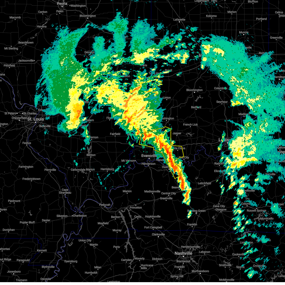 At 101 pm cst/201 pm est/, severe thunderstorms were located along a line extending from near owensville to near folsomville to 7 miles southeast of whitesville, moving northeast at 80 mph (trained weather spotters). Hazards include 60 mph wind gusts. Expect damage to roofs, siding, and trees. locations impacted include, owensboro, princeton, fort branch, oakland city, petersburg, rockport, dale, haubstadt, owensville, lynnville, winslow, grandview, patoka, whitesville, santa claus, knottsville, folsomville, elberfeld, chrisney and francisco. this includes the following highways, interstate 165 between mile markers 60 and 64, and between mile markers 66 and 68. interstate 69 in indiana between mile markers 21 and 52. interstate 64 in indiana between mile markers 30 and 59. hail threat, radar indicated max hail size, <. 75 in wind threat, radar indicated max wind gust, 60 mph. At 101 pm cst/201 pm est/, severe thunderstorms were located along a line extending from near owensville to near folsomville to 7 miles southeast of whitesville, moving northeast at 80 mph (trained weather spotters). Hazards include 60 mph wind gusts. Expect damage to roofs, siding, and trees. locations impacted include, owensboro, princeton, fort branch, oakland city, petersburg, rockport, dale, haubstadt, owensville, lynnville, winslow, grandview, patoka, whitesville, santa claus, knottsville, folsomville, elberfeld, chrisney and francisco. this includes the following highways, interstate 165 between mile markers 60 and 64, and between mile markers 66 and 68. interstate 69 in indiana between mile markers 21 and 52. interstate 64 in indiana between mile markers 30 and 59. hail threat, radar indicated max hail size, <. 75 in wind threat, radar indicated max wind gust, 60 mph.
|
| 3/3/2023 1:00 PM CST | Trees down in rockport. 3 power poles down along with trees down on hwy 161 just north of owensbor in spencer county IN, 5.3 miles NE of Rockport, IN |
| 3/3/2023 12:28 PM CST |
 At 1227 pm cst/127 pm est/, severe thunderstorms were located along a line extending from near henderson to 9 miles northeast of madisonville, moving northeast at 60 mph (trained weather spotters). Hazards include 70 mph wind gusts. Expect considerable tree damage. Damage is likely to mobile homes, roofs, and outbuildings. At 1227 pm cst/127 pm est/, severe thunderstorms were located along a line extending from near henderson to 9 miles northeast of madisonville, moving northeast at 60 mph (trained weather spotters). Hazards include 70 mph wind gusts. Expect considerable tree damage. Damage is likely to mobile homes, roofs, and outbuildings.
|
| 1/12/2023 5:13 AM CST |
 At 513 am cst, a severe thunderstorm was located over grandview, or near rockport, moving northeast at 60 mph (radar indicated). Hazards include 60 mph wind gusts and quarter size hail. Hail damage to vehicles is expected. expect wind damage to roofs, siding, and trees. this severe thunderstorm will be near, santa claus around 520 am cst. hail threat, radar indicated max hail size, 1. 00 in wind threat, radar indicated max wind gust, 60 mph. At 513 am cst, a severe thunderstorm was located over grandview, or near rockport, moving northeast at 60 mph (radar indicated). Hazards include 60 mph wind gusts and quarter size hail. Hail damage to vehicles is expected. expect wind damage to roofs, siding, and trees. this severe thunderstorm will be near, santa claus around 520 am cst. hail threat, radar indicated max hail size, 1. 00 in wind threat, radar indicated max wind gust, 60 mph.
|
| 1/12/2023 5:04 AM CST |
 At 504 am cst, a severe thunderstorm was located over rockport, moving northeast at 70 mph (radar indicated). Hazards include 60 mph wind gusts and quarter size hail. Hail damage to vehicles is expected. expect wind damage to roofs, siding, and trees. locations impacted include, owensboro, rockport, grandview, eureka, santa claus and chrisney. hail threat, radar indicated max hail size, 1. 00 in wind threat, radar indicated max wind gust, 60 mph. At 504 am cst, a severe thunderstorm was located over rockport, moving northeast at 70 mph (radar indicated). Hazards include 60 mph wind gusts and quarter size hail. Hail damage to vehicles is expected. expect wind damage to roofs, siding, and trees. locations impacted include, owensboro, rockport, grandview, eureka, santa claus and chrisney. hail threat, radar indicated max hail size, 1. 00 in wind threat, radar indicated max wind gust, 60 mph.
|
| 1/12/2023 4:53 AM CST |
 At 452 am cst, a severe thunderstorm was located over eureka, or 7 miles west of rockport, moving northeast at 45 mph (radar indicated). Hazards include 60 mph wind gusts and quarter size hail. Hail damage to vehicles is expected. expect wind damage to roofs, siding, and trees. locations impacted include, grandview and santa claus. this includes the following highways, interstate 64 in indiana near mile marker 60. audubon parkway between mile markers 15 and 21. hail threat, radar indicated max hail size, 1. 00 in wind threat, radar indicated max wind gust, 60 mph. At 452 am cst, a severe thunderstorm was located over eureka, or 7 miles west of rockport, moving northeast at 45 mph (radar indicated). Hazards include 60 mph wind gusts and quarter size hail. Hail damage to vehicles is expected. expect wind damage to roofs, siding, and trees. locations impacted include, grandview and santa claus. this includes the following highways, interstate 64 in indiana near mile marker 60. audubon parkway between mile markers 15 and 21. hail threat, radar indicated max hail size, 1. 00 in wind threat, radar indicated max wind gust, 60 mph.
|
| 1/12/2023 4:41 AM CST |
 At 440 am cst, a severe thunderstorm was located over stanley, or 11 miles northwest of owensboro, moving northeast at 45 mph (radar indicated). Hazards include 60 mph wind gusts and quarter size hail. Hail damage to vehicles is expected. expect wind damage to roofs, siding, and trees. this severe storm will be near, owensboro and eureka around 445 am cst. other locations in the path of this severe thunderstorm include rockport, grandview and santa claus. this includes audubon parkway between mile markers 15 and 21. hail threat, radar indicated max hail size, 1. 00 in wind threat, radar indicated max wind gust, 60 mph. At 440 am cst, a severe thunderstorm was located over stanley, or 11 miles northwest of owensboro, moving northeast at 45 mph (radar indicated). Hazards include 60 mph wind gusts and quarter size hail. Hail damage to vehicles is expected. expect wind damage to roofs, siding, and trees. this severe storm will be near, owensboro and eureka around 445 am cst. other locations in the path of this severe thunderstorm include rockport, grandview and santa claus. this includes audubon parkway between mile markers 15 and 21. hail threat, radar indicated max hail size, 1. 00 in wind threat, radar indicated max wind gust, 60 mph.
|
| 1/12/2023 4:28 AM CST |
 At 428 am cst, a severe thunderstorm was located near st. joseph, or 11 miles southeast of henderson, moving northeast at 50 mph (radar indicated). Hazards include 60 mph wind gusts and quarter size hail. Hail damage to vehicles is expected. expect wind damage to roofs, siding, and trees. this severe thunderstorm will be near, owensboro and stanley around 440 am cst. eureka around 445 am cst. other locations in the path of this severe thunderstorm include rockport, grandview and santa claus. this includes audubon parkway between mile markers 3 and 21. hail threat, radar indicated max hail size, 1. 00 in wind threat, radar indicated max wind gust, 60 mph. At 428 am cst, a severe thunderstorm was located near st. joseph, or 11 miles southeast of henderson, moving northeast at 50 mph (radar indicated). Hazards include 60 mph wind gusts and quarter size hail. Hail damage to vehicles is expected. expect wind damage to roofs, siding, and trees. this severe thunderstorm will be near, owensboro and stanley around 440 am cst. eureka around 445 am cst. other locations in the path of this severe thunderstorm include rockport, grandview and santa claus. this includes audubon parkway between mile markers 3 and 21. hail threat, radar indicated max hail size, 1. 00 in wind threat, radar indicated max wind gust, 60 mph.
|
| 1/12/2023 3:58 AM CST |
 At 357 am cst, a severe thunderstorm was located over owensboro, moving northeast at 60 mph (radar indicated). Hazards include quarter size hail. Damage to vehicles is expected. this severe storm will be near, rockport around 405 am cst. this includes the following highways, interstate 165 between mile markers 68 and 70. audubon parkway between mile markers 20 and 23. hail threat, radar indicated max hail size, 1. 00 in wind threat, radar indicated max wind gust, <50 mph. At 357 am cst, a severe thunderstorm was located over owensboro, moving northeast at 60 mph (radar indicated). Hazards include quarter size hail. Damage to vehicles is expected. this severe storm will be near, rockport around 405 am cst. this includes the following highways, interstate 165 between mile markers 68 and 70. audubon parkway between mile markers 20 and 23. hail threat, radar indicated max hail size, 1. 00 in wind threat, radar indicated max wind gust, <50 mph.
|
| 1/12/2023 3:50 AM CST |
 At 349 am cst, a severe thunderstorm was located 8 miles southeast of boonville, moving northeast at 55 mph (radar indicated). Hazards include quarter size hail. Damage to vehicles is expected. locations impacted include, folsomville, dale and santa claus. this includes interstate 64 in indiana between mile markers 50 and 60. hail threat, radar indicated max hail size, 1. 00 in wind threat, radar indicated max wind gust, <50 mph. At 349 am cst, a severe thunderstorm was located 8 miles southeast of boonville, moving northeast at 55 mph (radar indicated). Hazards include quarter size hail. Damage to vehicles is expected. locations impacted include, folsomville, dale and santa claus. this includes interstate 64 in indiana between mile markers 50 and 60. hail threat, radar indicated max hail size, 1. 00 in wind threat, radar indicated max wind gust, <50 mph.
|
| 1/12/2023 3:47 AM CST |
 At 347 am cst, a severe thunderstorm was located near st. joseph, or 7 miles north of calhoun, moving northeast at 60 mph (radar indicated). Hazards include quarter size hail. Damage to vehicles is expected. this severe thunderstorm will be near, owensboro and masonville around 355 am cst. rockport and knottsville around 405 am cst. this includes the following highways, interstate 165 between mile markers 62 and 70. audubon parkway between mile markers 21 and 23. hail threat, radar indicated max hail size, 1. 00 in wind threat, radar indicated max wind gust, <50 mph. At 347 am cst, a severe thunderstorm was located near st. joseph, or 7 miles north of calhoun, moving northeast at 60 mph (radar indicated). Hazards include quarter size hail. Damage to vehicles is expected. this severe thunderstorm will be near, owensboro and masonville around 355 am cst. rockport and knottsville around 405 am cst. this includes the following highways, interstate 165 between mile markers 62 and 70. audubon parkway between mile markers 21 and 23. hail threat, radar indicated max hail size, 1. 00 in wind threat, radar indicated max wind gust, <50 mph.
|
| 1/12/2023 3:31 AM CST |
 At 331 am cst, a severe thunderstorm was located near stanley, or 12 miles west of owensboro, moving northeast at 60 mph (radar indicated). Hazards include quarter size hail. Damage to vehicles is expected. this severe thunderstorm will be near, stanley around 335 am cst. owensboro and eureka around 340 am cst. other locations in the path of this severe thunderstorm include folsomville, dale and santa claus. this includes the following highways, interstate 64 in indiana between mile markers 50 and 60. audubon parkway between mile markers 5 and 22. hail threat, radar indicated max hail size, 1. 00 in wind threat, radar indicated max wind gust, <50 mph. At 331 am cst, a severe thunderstorm was located near stanley, or 12 miles west of owensboro, moving northeast at 60 mph (radar indicated). Hazards include quarter size hail. Damage to vehicles is expected. this severe thunderstorm will be near, stanley around 335 am cst. owensboro and eureka around 340 am cst. other locations in the path of this severe thunderstorm include folsomville, dale and santa claus. this includes the following highways, interstate 64 in indiana between mile markers 50 and 60. audubon parkway between mile markers 5 and 22. hail threat, radar indicated max hail size, 1. 00 in wind threat, radar indicated max wind gust, <50 mph.
|
| 8/1/2022 7:10 PM CDT |
 At 709 pm cdt, a severe thunderstorm was located near newburgh, moving southeast at 40 mph (trained spotters reported a 70 mph gust on the southeast side of evansville). Hazards include 70 mph wind gusts and half dollar size hail. Hail damage to vehicles is expected. expect considerable tree damage. wind damage is also likely to mobile homes, roofs, and outbuildings. this severe thunderstorm will be near, eureka around 730 pm cdt. stanley around 735 pm cdt. owensboro around 740 pm cdt. masonville around 755 pm cdt. other locations impacted by this severe thunderstorm include moseleyville and hebbardsville. this includes the following highways, interstate 165 between mile markers 66 and 70. interstate 69 in indiana between mile markers 1 and 13. audubon parkway between mile markers 13 and 23. thunderstorm damage threat, considerable hail threat, radar indicated max hail size, 1. 25 in wind threat, observed max wind gust, 70 mph. At 709 pm cdt, a severe thunderstorm was located near newburgh, moving southeast at 40 mph (trained spotters reported a 70 mph gust on the southeast side of evansville). Hazards include 70 mph wind gusts and half dollar size hail. Hail damage to vehicles is expected. expect considerable tree damage. wind damage is also likely to mobile homes, roofs, and outbuildings. this severe thunderstorm will be near, eureka around 730 pm cdt. stanley around 735 pm cdt. owensboro around 740 pm cdt. masonville around 755 pm cdt. other locations impacted by this severe thunderstorm include moseleyville and hebbardsville. this includes the following highways, interstate 165 between mile markers 66 and 70. interstate 69 in indiana between mile markers 1 and 13. audubon parkway between mile markers 13 and 23. thunderstorm damage threat, considerable hail threat, radar indicated max hail size, 1. 25 in wind threat, observed max wind gust, 70 mph.
|
| 6/17/2022 8:16 AM CDT |
 At 816 am cdt, severe thunderstorms were located along a line extending from near rockport to near beech grove to near creswell, moving southeast at 40 mph (radar indicated). Hazards include 60 mph wind gusts. Expect damage to roofs, siding, and trees. locations impacted include, rockport, grandview, beech grove, calhoun, knottsville, livermore and dawson springs. this includes the following highways, interstate 165 between mile markers 60 and 70. interstate 69 in kentucky between mile markers 91 and 101, and between mile markers 110 and 138. interstate 64 in indiana between mile markers 57 and 59. audubon parkway between mile markers 16 and 23. hail threat, radar indicated max hail size, <. 75 in wind threat, radar indicated max wind gust, 60 mph. At 816 am cdt, severe thunderstorms were located along a line extending from near rockport to near beech grove to near creswell, moving southeast at 40 mph (radar indicated). Hazards include 60 mph wind gusts. Expect damage to roofs, siding, and trees. locations impacted include, rockport, grandview, beech grove, calhoun, knottsville, livermore and dawson springs. this includes the following highways, interstate 165 between mile markers 60 and 70. interstate 69 in kentucky between mile markers 91 and 101, and between mile markers 110 and 138. interstate 64 in indiana between mile markers 57 and 59. audubon parkway between mile markers 16 and 23. hail threat, radar indicated max hail size, <. 75 in wind threat, radar indicated max wind gust, 60 mph.
|
| 6/17/2022 7:52 AM CDT |
 At 751 am cdt, severe thunderstorms were located along a line extending from chandler to near corydon to 8 miles northwest of marion, moving southeast at 40 mph (radar indicated). Hazards include 60 mph wind gusts. Expect damage to roofs, siding, and trees. severe thunderstorms will be near, robards around 805 am cdt. sebree around 810 am cdt. other locations in the path of these severe thunderstorms include eureka, beech grove, rockport, calhoun, grandview and olney. this includes the following highways, interstate 165 between mile markers 60 and 70. interstate 69 in kentucky between mile markers 91 and 101, and between mile markers 110 and 148. interstate 69 in indiana between mile markers 1 and 4. interstate 64 in indiana between mile markers 57 and 59. audubon parkway between mile markers 1 and 23. hail threat, radar indicated max hail size, <. 75 in wind threat, radar indicated max wind gust, 60 mph. At 751 am cdt, severe thunderstorms were located along a line extending from chandler to near corydon to 8 miles northwest of marion, moving southeast at 40 mph (radar indicated). Hazards include 60 mph wind gusts. Expect damage to roofs, siding, and trees. severe thunderstorms will be near, robards around 805 am cdt. sebree around 810 am cdt. other locations in the path of these severe thunderstorms include eureka, beech grove, rockport, calhoun, grandview and olney. this includes the following highways, interstate 165 between mile markers 60 and 70. interstate 69 in kentucky between mile markers 91 and 101, and between mile markers 110 and 148. interstate 69 in indiana between mile markers 1 and 4. interstate 64 in indiana between mile markers 57 and 59. audubon parkway between mile markers 1 and 23. hail threat, radar indicated max hail size, <. 75 in wind threat, radar indicated max wind gust, 60 mph.
|
| 5/19/2022 1:17 PM CDT |
 At 116 pm cdt, a severe thunderstorm was located near owensboro, moving northeast at 30 mph (trained weather spotters). Hazards include 60 mph wind gusts and quarter size hail. Hail damage to vehicles is expected. expect wind damage to roofs, siding, and trees. this severe thunderstorm will be near, knottsville around 125 pm cdt. grandview around 130 pm cdt. this includes interstate 165 between mile markers 67 and 70. hail threat, radar indicated max hail size, 1. 00 in wind threat, radar indicated max wind gust, 60 mph. At 116 pm cdt, a severe thunderstorm was located near owensboro, moving northeast at 30 mph (trained weather spotters). Hazards include 60 mph wind gusts and quarter size hail. Hail damage to vehicles is expected. expect wind damage to roofs, siding, and trees. this severe thunderstorm will be near, knottsville around 125 pm cdt. grandview around 130 pm cdt. this includes interstate 165 between mile markers 67 and 70. hail threat, radar indicated max hail size, 1. 00 in wind threat, radar indicated max wind gust, 60 mph.
|
| 5/14/2022 5:14 PM CDT |
 At 514 pm cdt, a severe thunderstorm was located over grandview, or near rockport, moving southeast at 5 mph (radar indicated). Hazards include ping pong ball size hail and 60 mph wind gusts. People and animals outdoors will be injured. expect hail damage to roofs, siding, windows, and vehicles. expect wind damage to roofs, siding, and trees. this severe thunderstorm will remain over mainly rural areas of central spencer and northeastern daviess counties, including the following locations, chrisney. hail threat, radar indicated max hail size, 1. 50 in wind threat, radar indicated max wind gust, 60 mph. At 514 pm cdt, a severe thunderstorm was located over grandview, or near rockport, moving southeast at 5 mph (radar indicated). Hazards include ping pong ball size hail and 60 mph wind gusts. People and animals outdoors will be injured. expect hail damage to roofs, siding, windows, and vehicles. expect wind damage to roofs, siding, and trees. this severe thunderstorm will remain over mainly rural areas of central spencer and northeastern daviess counties, including the following locations, chrisney. hail threat, radar indicated max hail size, 1. 50 in wind threat, radar indicated max wind gust, 60 mph.
|
| 4/13/2022 5:35 PM CDT |
 At 534 pm cdt, severe thunderstorms were located along a line extending from 9 miles north of jasper to near eureka, moving east at 35 mph (radar indicated). Hazards include 60 mph wind gusts and penny size hail. Expect damage to roofs, siding, and trees. locations impacted include, dale, grandview, santa claus, eureka, ferdinand, chrisney, tennyson and gentryville. this includes interstate 64 in indiana between mile markers 52 and 60. hail threat, radar indicated max hail size, 0. 75 in wind threat, radar indicated max wind gust, 60 mph. At 534 pm cdt, severe thunderstorms were located along a line extending from 9 miles north of jasper to near eureka, moving east at 35 mph (radar indicated). Hazards include 60 mph wind gusts and penny size hail. Expect damage to roofs, siding, and trees. locations impacted include, dale, grandview, santa claus, eureka, ferdinand, chrisney, tennyson and gentryville. this includes interstate 64 in indiana between mile markers 52 and 60. hail threat, radar indicated max hail size, 0. 75 in wind threat, radar indicated max wind gust, 60 mph.
|
| 4/13/2022 5:20 PM CDT |
 At 519 pm cdt, severe thunderstorms were located along a line extending from 8 miles northwest of jasper to near newburgh, moving east at 35 mph (radar indicated). Hazards include 60 mph wind gusts and penny size hail. expect damage to roofs, siding, and trees At 519 pm cdt, severe thunderstorms were located along a line extending from 8 miles northwest of jasper to near newburgh, moving east at 35 mph (radar indicated). Hazards include 60 mph wind gusts and penny size hail. expect damage to roofs, siding, and trees
|
| 3/30/2022 7:34 PM CDT |
 At 732 pm cdt, a line of severe thunderstorms was located from near whitesville to rockport, moving northeast at 30 mph. wind gusts to near 60 mph and tree damage were reported with these storms at owensboro (radar indicated). Hazards include 60 mph wind gusts. Expect damage to roofs, siding, and trees. this severe thunderstorm will remain over mainly rural areas of eastern daviess county. this includes interstate 165 between mile markers 60 and 66. hail threat, radar indicated max hail size, <. 75 in wind threat, radar indicated max wind gust, 60 mph. At 732 pm cdt, a line of severe thunderstorms was located from near whitesville to rockport, moving northeast at 30 mph. wind gusts to near 60 mph and tree damage were reported with these storms at owensboro (radar indicated). Hazards include 60 mph wind gusts. Expect damage to roofs, siding, and trees. this severe thunderstorm will remain over mainly rural areas of eastern daviess county. this includes interstate 165 between mile markers 60 and 66. hail threat, radar indicated max hail size, <. 75 in wind threat, radar indicated max wind gust, 60 mph.
|
| 3/30/2022 7:21 PM CDT |
 At 719 pm cdt, severe thunderstorms were located along a line extending from hazleton south across evansville to near henderson, moving northeast at 50 mph (trained weather spotters reported tree damage). Hazards include 70 mph wind gusts. Expect considerable tree damage. damage is likely to mobile homes, roofs, and outbuildings. locations impacted include, stanley, petersburg, eureka, boonville, dale and santa claus. this includes the following highways, interstate 69 in kentucky between mile markers 142 and 148. interstate 69 in indiana between mile markers 1 and 52. interstate 64 in indiana between mile markers 18 and 60. Audubon parkway between mile markers 1 and 12. At 719 pm cdt, severe thunderstorms were located along a line extending from hazleton south across evansville to near henderson, moving northeast at 50 mph (trained weather spotters reported tree damage). Hazards include 70 mph wind gusts. Expect considerable tree damage. damage is likely to mobile homes, roofs, and outbuildings. locations impacted include, stanley, petersburg, eureka, boonville, dale and santa claus. this includes the following highways, interstate 69 in kentucky between mile markers 142 and 148. interstate 69 in indiana between mile markers 1 and 52. interstate 64 in indiana between mile markers 18 and 60. Audubon parkway between mile markers 1 and 12.
|
| 3/30/2022 7:17 PM CDT | Tree down on power lin in spencer county IN, 0.3 miles NW of Rockport, IN |
| 3/30/2022 7:07 PM CDT |
 At 707 pm cdt, a severe thunderstorm was located near owensboro, moving northeast at 30 mph (radar indicated). Hazards include 70 mph wind gusts. Expect considerable tree damage. damage is likely to mobile homes, roofs, and outbuildings. this severe thunderstorm will be near, owensboro around 715 pm cdt. other locations in the path of this severe thunderstorm include rockport and knottsville. this includes the following highways, interstate 165 between mile markers 60 and 70. Audubon parkway between mile markers 21 and 23. At 707 pm cdt, a severe thunderstorm was located near owensboro, moving northeast at 30 mph (radar indicated). Hazards include 70 mph wind gusts. Expect considerable tree damage. damage is likely to mobile homes, roofs, and outbuildings. this severe thunderstorm will be near, owensboro around 715 pm cdt. other locations in the path of this severe thunderstorm include rockport and knottsville. this includes the following highways, interstate 165 between mile markers 60 and 70. Audubon parkway between mile markers 21 and 23.
|
| 3/30/2022 6:54 PM CDT |
 At 652 pm cdt, severe thunderstorms were located along a line extending from near mount carmel to near morganfield, moving northeast at 35 mph (trained weather spotters. winds to 70 mph have been measured along this line). Hazards include 70 mph wind gusts. Expect considerable tree damage. damage is likely to mobile homes, roofs, and outbuildings. severe thunderstorms will be near, owensville around 710 pm cdt. other locations in the path of these severe thunderstorms include fort branch, princeton, patoka, henderson, oakland city, newburgh, winslow, stanley, petersburg, boonville and eureka. this includes the following highways, interstate 69 in kentucky between mile markers 141 and 148. interstate 69 in indiana between mile markers 1 and 52. interstate 64 in indiana between mile markers 18 and 60. Audubon parkway between mile markers 1 and 14. At 652 pm cdt, severe thunderstorms were located along a line extending from near mount carmel to near morganfield, moving northeast at 35 mph (trained weather spotters. winds to 70 mph have been measured along this line). Hazards include 70 mph wind gusts. Expect considerable tree damage. damage is likely to mobile homes, roofs, and outbuildings. severe thunderstorms will be near, owensville around 710 pm cdt. other locations in the path of these severe thunderstorms include fort branch, princeton, patoka, henderson, oakland city, newburgh, winslow, stanley, petersburg, boonville and eureka. this includes the following highways, interstate 69 in kentucky between mile markers 141 and 148. interstate 69 in indiana between mile markers 1 and 52. interstate 64 in indiana between mile markers 18 and 60. Audubon parkway between mile markers 1 and 14.
|
| 12/6/2021 12:53 AM CST |
 At 1253 am cst, a severe thunderstorm was located near rockport, moving east at 55 mph (radar indicated). Hazards include 60 mph wind gusts. Expect damage to roofs, siding, and trees. this severe thunderstorm will remain over mainly rural areas of southeastern spencer and northeastern daviess counties, including the following locations, waitman. hail threat, radar indicated max hail size, <. 75 in wind threat, radar indicated max wind gust, 60 mph. At 1253 am cst, a severe thunderstorm was located near rockport, moving east at 55 mph (radar indicated). Hazards include 60 mph wind gusts. Expect damage to roofs, siding, and trees. this severe thunderstorm will remain over mainly rural areas of southeastern spencer and northeastern daviess counties, including the following locations, waitman. hail threat, radar indicated max hail size, <. 75 in wind threat, radar indicated max wind gust, 60 mph.
|
| 12/6/2021 12:40 AM CST |
 At 1240 am cst, a severe thunderstorm was located over eureka, or 9 miles northwest of owensboro, moving east at 55 mph (radar indicated). Hazards include 60 mph wind gusts. Expect damage to roofs, siding, and trees. this severe thunderstorm will be near, owensboro around 1245 am cst. rockport around 1250 am cst. grandview around 1255 am cst. hail threat, radar indicated max hail size, <. 75 in wind threat, radar indicated max wind gust, 60 mph. At 1240 am cst, a severe thunderstorm was located over eureka, or 9 miles northwest of owensboro, moving east at 55 mph (radar indicated). Hazards include 60 mph wind gusts. Expect damage to roofs, siding, and trees. this severe thunderstorm will be near, owensboro around 1245 am cst. rockport around 1250 am cst. grandview around 1255 am cst. hail threat, radar indicated max hail size, <. 75 in wind threat, radar indicated max wind gust, 60 mph.
|
| 4/25/2020 2:43 PM CDT |
 At 243 pm cdt, a severe thunderstorm was located near rockport, moving north at 20 mph (radar indicated). Hazards include quarter size hail. Damage to vehicles is expected. Locations impacted include, owensboro, rockport and grandview. At 243 pm cdt, a severe thunderstorm was located near rockport, moving north at 20 mph (radar indicated). Hazards include quarter size hail. Damage to vehicles is expected. Locations impacted include, owensboro, rockport and grandview.
|
| 4/25/2020 2:22 PM CDT |
 At 222 pm cdt, a severe thunderstorm was located over owensboro, moving north at 20 mph (radar indicated). Hazards include quarter size hail. damage to vehicles is expected At 222 pm cdt, a severe thunderstorm was located over owensboro, moving north at 20 mph (radar indicated). Hazards include quarter size hail. damage to vehicles is expected
|
| 3/28/2020 9:21 PM CDT |
 At 920 pm cdt, a severe thunderstorm was located over st. joseph, or 10 miles north of calhoun, moving northeast at 60 mph (radar indicated). Hazards include 60 mph wind gusts and penny size hail. Expect damage to roofs, siding, and trees. locations impacted include, owensboro, rockport, calhoun, whitesville, masonville, stanley, knottsville, st. Joseph, beech grove, moseleyville and pleasant ridge. At 920 pm cdt, a severe thunderstorm was located over st. joseph, or 10 miles north of calhoun, moving northeast at 60 mph (radar indicated). Hazards include 60 mph wind gusts and penny size hail. Expect damage to roofs, siding, and trees. locations impacted include, owensboro, rockport, calhoun, whitesville, masonville, stanley, knottsville, st. Joseph, beech grove, moseleyville and pleasant ridge.
|
| 3/28/2020 9:07 PM CDT |
 At 907 pm cdt, a severe thunderstorm was located over sebree, or 16 miles south of henderson, moving northeast at 65 mph (radar indicated). Hazards include 60 mph wind gusts and nickel size hail. Expect damage to roofs, siding, and trees. locations impacted include, owensboro, providence, rockport, calhoun, sebree, dixon, whitesville, robards, knottsville, st. Joseph. At 907 pm cdt, a severe thunderstorm was located over sebree, or 16 miles south of henderson, moving northeast at 65 mph (radar indicated). Hazards include 60 mph wind gusts and nickel size hail. Expect damage to roofs, siding, and trees. locations impacted include, owensboro, providence, rockport, calhoun, sebree, dixon, whitesville, robards, knottsville, st. Joseph.
|
| 3/28/2020 8:46 PM CDT |
 At 845 pm cdt, a severe thunderstorm capable of producing a tornado was located over santa claus, or 15 miles northeast of rockport, moving northeast at 55 mph (radar indicated rotation). Hazards include tornado and quarter size hail. Flying debris will be dangerous to those caught without shelter. mobile homes will be damaged or destroyed. damage to roofs, windows, and vehicles will occur. tree damage is likely. This tornadic thunderstorm will remain over mainly rural areas of eastern warrick and spencer counties, including the following locations, tennyson, gentryville and chrisney. At 845 pm cdt, a severe thunderstorm capable of producing a tornado was located over santa claus, or 15 miles northeast of rockport, moving northeast at 55 mph (radar indicated rotation). Hazards include tornado and quarter size hail. Flying debris will be dangerous to those caught without shelter. mobile homes will be damaged or destroyed. damage to roofs, windows, and vehicles will occur. tree damage is likely. This tornadic thunderstorm will remain over mainly rural areas of eastern warrick and spencer counties, including the following locations, tennyson, gentryville and chrisney.
|
| 3/28/2020 8:44 PM CDT |
 At 844 pm cdt, severe thunderstorms were located along a line extending from robards to near providence, moving northeast at 60 mph (radar indicated). Hazards include 60 mph wind gusts and nickel size hail. expect damage to roofs, siding, and trees At 844 pm cdt, severe thunderstorms were located along a line extending from robards to near providence, moving northeast at 60 mph (radar indicated). Hazards include 60 mph wind gusts and nickel size hail. expect damage to roofs, siding, and trees
|
| 3/28/2020 8:16 PM CDT |
 At 815 pm cdt, a severe thunderstorm capable of producing a tornado was located near newburgh, moving northeast at 65 mph. this storm produced 90 mph winds in henderson, take cover now! (radar indicated rotation). Hazards include tornado and quarter size hail. Flying debris will be dangerous to those caught without shelter. mobile homes will be damaged or destroyed. damage to roofs, windows, and vehicles will occur. tree damage is likely. this dangerous storm will be near, eureka around 820 pm cdt. dale and santa claus around 840 pm cdt. other locations impacted by this tornadic thunderstorm include tennyson, gentryville and chrisney. This includes interstate 64 in indiana between mile markers 46 and 60. At 815 pm cdt, a severe thunderstorm capable of producing a tornado was located near newburgh, moving northeast at 65 mph. this storm produced 90 mph winds in henderson, take cover now! (radar indicated rotation). Hazards include tornado and quarter size hail. Flying debris will be dangerous to those caught without shelter. mobile homes will be damaged or destroyed. damage to roofs, windows, and vehicles will occur. tree damage is likely. this dangerous storm will be near, eureka around 820 pm cdt. dale and santa claus around 840 pm cdt. other locations impacted by this tornadic thunderstorm include tennyson, gentryville and chrisney. This includes interstate 64 in indiana between mile markers 46 and 60.
|
| 10/26/2019 4:07 PM CDT |
 At 406 pm cdt, severe thunderstorms were located along a line extending from near blairsville to near stanley to 7 miles south of masonville, moving northeast at 50 mph (trained weather spotters. the mesonet site in henderson reported a 66 mph wind gust at 400 pm). Hazards include 70 mph wind gusts. Expect considerable tree damage. Damage is likely to mobile homes, roofs, and outbuildings. At 406 pm cdt, severe thunderstorms were located along a line extending from near blairsville to near stanley to 7 miles south of masonville, moving northeast at 50 mph (trained weather spotters. the mesonet site in henderson reported a 66 mph wind gust at 400 pm). Hazards include 70 mph wind gusts. Expect considerable tree damage. Damage is likely to mobile homes, roofs, and outbuildings.
|
| 8/22/2019 1:12 AM CDT |
 At 112 am cdt, severe thunderstorms were located along a line extending from 6 miles northeast of dale to grandview, moving east at 35 mph (radar indicated). Hazards include 60 mph wind gusts. Expect damage to roofs, siding, and trees. Locations impacted include, dale, grandview, santa claus, chrisney and gentryville. At 112 am cdt, severe thunderstorms were located along a line extending from 6 miles northeast of dale to grandview, moving east at 35 mph (radar indicated). Hazards include 60 mph wind gusts. Expect damage to roofs, siding, and trees. Locations impacted include, dale, grandview, santa claus, chrisney and gentryville.
|
| 8/22/2019 12:55 AM CDT |
 The national weather service in paducah has issued a * severe thunderstorm warning for. eastern warrick county in southwestern indiana. spencer county in southwestern indiana. until 130 am cdt. At 1255 am cdt, severe thunderstorms were located along a line. The national weather service in paducah has issued a * severe thunderstorm warning for. eastern warrick county in southwestern indiana. spencer county in southwestern indiana. until 130 am cdt. At 1255 am cdt, severe thunderstorms were located along a line.
|
| 8/20/2019 2:46 PM CDT |
 At 246 pm cdt, severe thunderstorms were located along a line extending from 8 miles east of santa claus to near eureka, moving southeast at 20 mph (trained weather spotters). Hazards include 60 mph wind gusts. Expect damage to roofs, siding, and trees. Locations impacted include, boonville, newburgh, rockport, dale, grandview, santa claus, eureka, chrisney, tennyson and gentryville. At 246 pm cdt, severe thunderstorms were located along a line extending from 8 miles east of santa claus to near eureka, moving southeast at 20 mph (trained weather spotters). Hazards include 60 mph wind gusts. Expect damage to roofs, siding, and trees. Locations impacted include, boonville, newburgh, rockport, dale, grandview, santa claus, eureka, chrisney, tennyson and gentryville.
|
| 8/20/2019 2:42 PM CDT | Tree fell on structure in patronvill in spencer county IN, 4.4 miles NE of Rockport, IN |
| 8/20/2019 2:34 PM CDT |
 At 233 pm cdt, severe thunderstorms were located along a line extending from 6 miles northeast of santa claus to near eureka, moving east, southeast up to 30 mph (radar indicated). Hazards include 60 mph wind gusts. expect damage to roofs, siding, and trees At 233 pm cdt, severe thunderstorms were located along a line extending from 6 miles northeast of santa claus to near eureka, moving east, southeast up to 30 mph (radar indicated). Hazards include 60 mph wind gusts. expect damage to roofs, siding, and trees
|
| 8/18/2019 5:23 PM CDT |
 At 514 pm cdt, severe thunderstorms were located along a line extending from near lynnville to near boonville to near newburgh, moving east at 35 mph (radar indicated). Hazards include 60 mph wind gusts and quarter size hail. Hail damage to vehicles is expected. Expect wind damage to roofs, siding, and trees. At 514 pm cdt, severe thunderstorms were located along a line extending from near lynnville to near boonville to near newburgh, moving east at 35 mph (radar indicated). Hazards include 60 mph wind gusts and quarter size hail. Hail damage to vehicles is expected. Expect wind damage to roofs, siding, and trees.
|
| 8/18/2019 5:14 PM CDT |
 The national weather service in paducah has issued a * severe thunderstorm warning for. warrick county in southwestern indiana. spencer county in southwestern indiana. until 600 pm cdt. At 514 pm cdt, severe thunderstorms were located along a line. The national weather service in paducah has issued a * severe thunderstorm warning for. warrick county in southwestern indiana. spencer county in southwestern indiana. until 600 pm cdt. At 514 pm cdt, severe thunderstorms were located along a line.
|
| 8/18/2019 4:51 PM CDT |
 The national weather service in paducah has issued a * severe thunderstorm warning for. warrick county in southwestern indiana. spencer county in southwestern indiana. until 515 pm cdt. At 451 pm cdt, a severe thunderstorm was located over chandler,. The national weather service in paducah has issued a * severe thunderstorm warning for. warrick county in southwestern indiana. spencer county in southwestern indiana. until 515 pm cdt. At 451 pm cdt, a severe thunderstorm was located over chandler,.
|
| 7/16/2019 1:26 PM CDT |
 The national weather service in paducah has issued a * tornado warning for. southwestern spencer county in southwestern indiana. north central daviess county in northwestern kentucky. until 200 pm cdt. At 126 pm cdt, a severe thunderstorm capable of producing a tornado. The national weather service in paducah has issued a * tornado warning for. southwestern spencer county in southwestern indiana. north central daviess county in northwestern kentucky. until 200 pm cdt. At 126 pm cdt, a severe thunderstorm capable of producing a tornado.
|
| 7/16/2019 1:13 PM CDT |
 The national weather service in paducah has issued a * tornado warning for. southwestern spencer county in southwestern indiana. north central daviess county in northwestern kentucky. until 145 pm cdt. At 113 pm cdt, a severe thunderstorm capable of producing a tornado. The national weather service in paducah has issued a * tornado warning for. southwestern spencer county in southwestern indiana. north central daviess county in northwestern kentucky. until 145 pm cdt. At 113 pm cdt, a severe thunderstorm capable of producing a tornado.
|
| 7/15/2019 4:54 PM CDT |
 At 454 pm cdt, a severe thunderstorm was located over eureka, or 7 miles west of rockport, moving north at 30 mph (radar indicated). Hazards include 60 mph wind gusts. Expect damage to roofs, siding, and trees. Locations impacted include, rockport and eureka. At 454 pm cdt, a severe thunderstorm was located over eureka, or 7 miles west of rockport, moving north at 30 mph (radar indicated). Hazards include 60 mph wind gusts. Expect damage to roofs, siding, and trees. Locations impacted include, rockport and eureka.
|
| 7/15/2019 4:46 PM CDT |
 At 446 pm cdt, a severe thunderstorm was located over stanley, or 7 miles northwest of owensboro, moving north at 30 mph (radar indicated). Hazards include 60 mph wind gusts. Expect damage to roofs, siding, and trees. Locations impacted include, owensboro, rockport, stanley, eureka and hebbardsville. At 446 pm cdt, a severe thunderstorm was located over stanley, or 7 miles northwest of owensboro, moving north at 30 mph (radar indicated). Hazards include 60 mph wind gusts. Expect damage to roofs, siding, and trees. Locations impacted include, owensboro, rockport, stanley, eureka and hebbardsville.
|
| 7/15/2019 4:35 PM CDT |
 At 435 pm cdt, a severe thunderstorm was located near stanley, or 7 miles west of owensboro, moving north at 30 mph (radar indicated). Hazards include 60 mph wind gusts. expect damage to roofs, siding, and trees At 435 pm cdt, a severe thunderstorm was located near stanley, or 7 miles west of owensboro, moving north at 30 mph (radar indicated). Hazards include 60 mph wind gusts. expect damage to roofs, siding, and trees
|
| 7/3/2019 1:45 PM CDT | In the town of reo indiana...behind the high school starting at the intersection of 450w/400. approximately 1 1/2 mile damage path with many trees and 5 powerpoles snap in spencer county IN, 3.1 miles E of Rockport, IN |
| 6/30/2019 7:42 PM CDT |
 At 740 pm cdt, severe winds out ahead of approaching thunderstorms were located along a line extending from near mount vernon to near evansville to near eureka to hawesville, moving southeast at 50 mph. there have been reports of 50 to 60 mph winds with this line (trained weather spotters). Hazards include 60 mph wind gusts. expect damage to roofs, siding, and trees At 740 pm cdt, severe winds out ahead of approaching thunderstorms were located along a line extending from near mount vernon to near evansville to near eureka to hawesville, moving southeast at 50 mph. there have been reports of 50 to 60 mph winds with this line (trained weather spotters). Hazards include 60 mph wind gusts. expect damage to roofs, siding, and trees
|
| 6/23/2019 6:40 PM CDT |
 The national weather service in paducah has issued a * severe thunderstorm warning for. southeastern spencer county in southwestern indiana. eastern daviess county in northwestern kentucky. until 700 pm cdt. At 640 pm cdt, severe thunderstorms were located along a line. The national weather service in paducah has issued a * severe thunderstorm warning for. southeastern spencer county in southwestern indiana. eastern daviess county in northwestern kentucky. until 700 pm cdt. At 640 pm cdt, severe thunderstorms were located along a line.
|
| 6/23/2019 6:40 PM CDT |
 At 640 pm cdt, severe thunderstorms were located along a line extending from near owensboro to near knottsville to whitesville, moving northeast at 60 mph (radar indicated). Hazards include 60 mph wind gusts and penny size hail. expect damage to roofs, siding, and trees At 640 pm cdt, severe thunderstorms were located along a line extending from near owensboro to near knottsville to whitesville, moving northeast at 60 mph (radar indicated). Hazards include 60 mph wind gusts and penny size hail. expect damage to roofs, siding, and trees
|
| 6/23/2019 6:35 PM CDT |
 At 635 pm cdt, severe thunderstorms were located along a line extending from near stanley to near owensboro to near masonville to near hartford to near hopkinsville, moving northeast at 65 mph (radar indicated). Hazards include 70 mph wind gusts and quarter size hail. Hail damage to vehicles is expected. expect considerable tree damage. wind damage is also likely to mobile homes, roofs, and outbuildings. Locations impacted include, owensboro, central city, rockport, greenville, powderly, whitesville, knottsville, masonville, stanley, central city--greenville, weir, dunmor, drakesboro and south carrollton. At 635 pm cdt, severe thunderstorms were located along a line extending from near stanley to near owensboro to near masonville to near hartford to near hopkinsville, moving northeast at 65 mph (radar indicated). Hazards include 70 mph wind gusts and quarter size hail. Hail damage to vehicles is expected. expect considerable tree damage. wind damage is also likely to mobile homes, roofs, and outbuildings. Locations impacted include, owensboro, central city, rockport, greenville, powderly, whitesville, knottsville, masonville, stanley, central city--greenville, weir, dunmor, drakesboro and south carrollton.
|
| 6/23/2019 6:23 PM CDT |
 A severe thunderstorm warning remains in effect until 645 pm cdt for southwestern spencer. southeastern henderson. daviess. muhlenberg. mclean and northeastern hopkins counties. At 622 pm cdt, severe thunderstorms were located along a line extending from near beech grove to near calhoun to 8 miles southwest of masonville to near livermore to 7 miles southwest of hopkinsville,. A severe thunderstorm warning remains in effect until 645 pm cdt for southwestern spencer. southeastern henderson. daviess. muhlenberg. mclean and northeastern hopkins counties. At 622 pm cdt, severe thunderstorms were located along a line extending from near beech grove to near calhoun to 8 miles southwest of masonville to near livermore to 7 miles southwest of hopkinsville,.
|
| 6/23/2019 5:53 PM CDT |
 At 552 pm cdt, severe thunderstorms were located along a line extending from 6 miles southeast of shawneetown to near clay to near dixon to 7 miles southeast of providence to 9 miles west of big rock, moving northeast at 65 mph (radar indicated). Hazards include 70 mph wind gusts and quarter size hail. Hail damage to vehicles is expected. expect considerable tree damage. Wind damage is also likely to mobile homes, roofs, and outbuildings. At 552 pm cdt, severe thunderstorms were located along a line extending from 6 miles southeast of shawneetown to near clay to near dixon to 7 miles southeast of providence to 9 miles west of big rock, moving northeast at 65 mph (radar indicated). Hazards include 70 mph wind gusts and quarter size hail. Hail damage to vehicles is expected. expect considerable tree damage. Wind damage is also likely to mobile homes, roofs, and outbuildings.
|
| 6/23/2019 2:40 PM CDT |
 The severe thunderstorm warning for southwestern spencer and daviess counties will expire at 245 pm cdt, the severe thunderstorm which prompted the warning has moved out of the warned area. therefore, the warning will be allowed to expire. The severe thunderstorm warning for southwestern spencer and daviess counties will expire at 245 pm cdt, the severe thunderstorm which prompted the warning has moved out of the warned area. therefore, the warning will be allowed to expire.
|
| 6/23/2019 2:40 PM CDT |
 At 216 pm cdt, a severe thunderstorm was located near knottsville, or near owensboro, moving northeast at 55 mph (spotter reported nickle to quarter size hail 3 miles west northwest of owensboro kentucky). Hazards include 60 mph wind gusts and quarter size hail. Hail damage to vehicles is expected. expect wind damage to roofs, siding, and trees. Locations impacted include, owensboro, rockport, whitesville, knottsville, masonville and moseleyville. At 216 pm cdt, a severe thunderstorm was located near knottsville, or near owensboro, moving northeast at 55 mph (spotter reported nickle to quarter size hail 3 miles west northwest of owensboro kentucky). Hazards include 60 mph wind gusts and quarter size hail. Hail damage to vehicles is expected. expect wind damage to roofs, siding, and trees. Locations impacted include, owensboro, rockport, whitesville, knottsville, masonville and moseleyville.
|
| 6/23/2019 2:28 PM CDT |
 The severe thunderstorm warning for northeastern spencer county will expire at 230 pm cdt, the storm which prompted the warning has weakened below severe limits, and no longer poses an immediate threat to life or property. therefore, the warning will be allowed to expire. The severe thunderstorm warning for northeastern spencer county will expire at 230 pm cdt, the storm which prompted the warning has weakened below severe limits, and no longer poses an immediate threat to life or property. therefore, the warning will be allowed to expire.
|
| 6/23/2019 2:20 PM CDT |
 At 220 pm cdt, a severe thunderstorm was located near santa claus, or 14 miles northeast of rockport, moving northeast at 20 mph (radar indicated). Hazards include 60 mph wind gusts and quarter size hail. Hail damage to vehicles is expected. expect wind damage to roofs, siding, and trees. Locations impacted include, grandview and santa claus. At 220 pm cdt, a severe thunderstorm was located near santa claus, or 14 miles northeast of rockport, moving northeast at 20 mph (radar indicated). Hazards include 60 mph wind gusts and quarter size hail. Hail damage to vehicles is expected. expect wind damage to roofs, siding, and trees. Locations impacted include, grandview and santa claus.
|
| 6/23/2019 2:18 PM CDT |
 At 216 pm cdt, a severe thunderstorm was located near knottsville, or near owensboro, moving northeast at 55 mph (spotter reported nickle to quarter size hail 3 miles west northwest of owensboro kentucky). Hazards include 60 mph wind gusts and quarter size hail. Hail damage to vehicles is expected. expect wind damage to roofs, siding, and trees. Locations impacted include, owensboro, rockport, whitesville, knottsville, masonville and moseleyville. At 216 pm cdt, a severe thunderstorm was located near knottsville, or near owensboro, moving northeast at 55 mph (spotter reported nickle to quarter size hail 3 miles west northwest of owensboro kentucky). Hazards include 60 mph wind gusts and quarter size hail. Hail damage to vehicles is expected. expect wind damage to roofs, siding, and trees. Locations impacted include, owensboro, rockport, whitesville, knottsville, masonville and moseleyville.
|
| 6/23/2019 2:13 PM CDT |
 At 213 pm cdt, a severe thunderstorm was located near owensboro, moving northeast at 55 mph (radar indicated). Hazards include 60 mph wind gusts. expect damage to roofs, siding, and trees At 213 pm cdt, a severe thunderstorm was located near owensboro, moving northeast at 55 mph (radar indicated). Hazards include 60 mph wind gusts. expect damage to roofs, siding, and trees
|
| 6/23/2019 1:32 PM CDT |
 At 131 pm cdt, a severe thunderstorm was located over eureka, or 7 miles west of rockport, moving northeast at 20 mph (radar indicated). Hazards include 60 mph wind gusts and quarter size hail. Hail damage to vehicles is expected. Expect wind damage to roofs, siding, and trees. At 131 pm cdt, a severe thunderstorm was located over eureka, or 7 miles west of rockport, moving northeast at 20 mph (radar indicated). Hazards include 60 mph wind gusts and quarter size hail. Hail damage to vehicles is expected. Expect wind damage to roofs, siding, and trees.
|
| 6/21/2019 5:31 PM CDT |
 At 531 pm cdt, a severe thunderstorm was located near owensboro, moving southeast at 50 mph (trained weather spotters). Hazards include 70 mph wind gusts and quarter size hail. Hail damage to vehicles is expected. expect considerable tree damage. Wind damage is also likely to mobile homes, roofs, and outbuildings. At 531 pm cdt, a severe thunderstorm was located near owensboro, moving southeast at 50 mph (trained weather spotters). Hazards include 70 mph wind gusts and quarter size hail. Hail damage to vehicles is expected. expect considerable tree damage. Wind damage is also likely to mobile homes, roofs, and outbuildings.
|
| 6/21/2019 5:30 PM CDT | Trees and power lines down. time estimate in spencer county IN, 0.3 miles NW of Rockport, IN |
| 6/21/2019 5:19 PM CDT |
 At 453 pm cdt, a severe thunderstorm was located over newburgh, moving east at 45 mph (trained weather spotters). Hazards include 60 mph wind gusts and nickel size hail. a trained spotter reported 50-60 mph wind gusts in angel mounds in vanderburgh county. expect damage to roofs, siding, and trees At 453 pm cdt, a severe thunderstorm was located over newburgh, moving east at 45 mph (trained weather spotters). Hazards include 60 mph wind gusts and nickel size hail. a trained spotter reported 50-60 mph wind gusts in angel mounds in vanderburgh county. expect damage to roofs, siding, and trees
|
| 6/21/2019 5:19 PM CDT |
 At 518 pm cdt, a severe thunderstorm was located near st. joseph, or 8 miles southwest of owensboro, moving southeast at 40 mph (trained weather spotters). Hazards include 60 mph wind gusts and quarter size hail. Hail damage to vehicles is expected. expect wind damage to roofs, siding, and trees. locations impacted include, owensboro, rockport, grandview, whitesville, masonville, stanley, knottsville, st. Joseph, eureka, chrisney and moseleyville. At 518 pm cdt, a severe thunderstorm was located near st. joseph, or 8 miles southwest of owensboro, moving southeast at 40 mph (trained weather spotters). Hazards include 60 mph wind gusts and quarter size hail. Hail damage to vehicles is expected. expect wind damage to roofs, siding, and trees. locations impacted include, owensboro, rockport, grandview, whitesville, masonville, stanley, knottsville, st. Joseph, eureka, chrisney and moseleyville.
|
| 6/21/2019 4:54 PM CDT |
 The national weather service in paducah has issued a * severe thunderstorm warning for. southwestern warrick county in southwestern indiana. southwestern spencer county in southwestern indiana. east central vanderburgh county in southwestern indiana. Eastern henderson county in northwestern kentucky. The national weather service in paducah has issued a * severe thunderstorm warning for. southwestern warrick county in southwestern indiana. southwestern spencer county in southwestern indiana. east central vanderburgh county in southwestern indiana. Eastern henderson county in northwestern kentucky.
|
| 6/21/2019 4:54 PM CDT |
 At 453 pm cdt, a severe thunderstorm was located over newburgh, moving east at 45 mph (trained weather spotters). Hazards include 60 mph wind gusts and nickel size hail. a trained spotter reported 50-60 mph wind gusts in angel mounds in vanderburgh county. expect damage to roofs, siding, and trees At 453 pm cdt, a severe thunderstorm was located over newburgh, moving east at 45 mph (trained weather spotters). Hazards include 60 mph wind gusts and nickel size hail. a trained spotter reported 50-60 mph wind gusts in angel mounds in vanderburgh county. expect damage to roofs, siding, and trees
|
| 6/16/2019 7:40 PM CDT |
 At 739 pm cdt, severe thunderstorms were located along a line extending from near dale to near santa claus to near grandview, moving east at 45 mph (radar indicated). Hazards include 60 mph wind gusts. Expect damage to roofs, siding, and trees. Locations impacted include, dale, grandview, santa claus, chrisney and gentryville. At 739 pm cdt, severe thunderstorms were located along a line extending from near dale to near santa claus to near grandview, moving east at 45 mph (radar indicated). Hazards include 60 mph wind gusts. Expect damage to roofs, siding, and trees. Locations impacted include, dale, grandview, santa claus, chrisney and gentryville.
|
| 6/16/2019 7:17 PM CDT |
 At 717 pm cdt, severe thunderstorms were located along a line extending from near lynnville to near boonville to near newburgh, moving east at 45 mph (radar indicated). Hazards include 60 mph wind gusts and nickel size hail. expect damage to roofs, siding, and trees At 717 pm cdt, severe thunderstorms were located along a line extending from near lynnville to near boonville to near newburgh, moving east at 45 mph (radar indicated). Hazards include 60 mph wind gusts and nickel size hail. expect damage to roofs, siding, and trees
|
| 5/26/2019 3:32 PM CDT |
 At 332 pm cdt, severe thunderstorms were located along a line extending from near rockport to near owensboro to near st. joseph, moving east at 50 mph (radar indicated). Hazards include 60 mph wind gusts. expect damage to roofs, siding, and trees At 332 pm cdt, severe thunderstorms were located along a line extending from near rockport to near owensboro to near st. joseph, moving east at 50 mph (radar indicated). Hazards include 60 mph wind gusts. expect damage to roofs, siding, and trees
|
| 3/14/2019 1:32 PM CDT |
 At 132 pm cdt, a severe thunderstorm was located near st. joseph, or 8 miles southwest of owensboro, moving northeast at 70 mph (radar indicated). Hazards include 60 mph wind gusts and quarter size hail. Hail damage to vehicles is expected. Expect wind damage to roofs, siding, and trees. At 132 pm cdt, a severe thunderstorm was located near st. joseph, or 8 miles southwest of owensboro, moving northeast at 70 mph (radar indicated). Hazards include 60 mph wind gusts and quarter size hail. Hail damage to vehicles is expected. Expect wind damage to roofs, siding, and trees.
|
| 3/14/2019 1:04 PM CDT |
 At 104 pm cdt, a severe thunderstorm was located near stanley, or near owensboro, moving northeast at 55 mph (radar indicated). Hazards include 70 mph wind gusts. Expect considerable tree damage. Damage is likely to mobile homes, roofs, and outbuildings. At 104 pm cdt, a severe thunderstorm was located near stanley, or near owensboro, moving northeast at 55 mph (radar indicated). Hazards include 70 mph wind gusts. Expect considerable tree damage. Damage is likely to mobile homes, roofs, and outbuildings.
|
| 3/14/2019 12:56 PM CDT |
 At 1255 pm cdt, a severe thunderstorm capable of producing a tornado was located 7 miles northwest of grandview, or 9 miles north of rockport, moving northeast at 65 mph (radar indicated rotation. this rotation has intensified over the past few minutes). Hazards include tornado. Flying debris will be dangerous to those caught without shelter. mobile homes will be damaged or destroyed. damage to roofs, windows, and vehicles will occur. tree damage is likely. this dangerous storm will be near, holiday world around 105 pm cdt. Other locations impacted by this tornadic thunderstorm include chrisney. At 1255 pm cdt, a severe thunderstorm capable of producing a tornado was located 7 miles northwest of grandview, or 9 miles north of rockport, moving northeast at 65 mph (radar indicated rotation. this rotation has intensified over the past few minutes). Hazards include tornado. Flying debris will be dangerous to those caught without shelter. mobile homes will be damaged or destroyed. damage to roofs, windows, and vehicles will occur. tree damage is likely. this dangerous storm will be near, holiday world around 105 pm cdt. Other locations impacted by this tornadic thunderstorm include chrisney.
|
| 3/14/2019 12:39 PM CDT |
 At 1239 pm cdt, a severe thunderstorm capable of producing a tornado was located near eureka, or 8 miles southeast of newburgh, moving northeast at 70 mph (radar indicated rotation). Hazards include tornado. Flying debris will be dangerous to those caught without shelter. mobile homes will be damaged or destroyed. damage to roofs, windows, and vehicles will occur. tree damage is likely. this dangerous storm will be near, rockport around 1250 pm cdt. grandview around 1255 pm cdt. holiday world around 100 pm cdt. Other locations impacted by this tornadic thunderstorm include chrisney. At 1239 pm cdt, a severe thunderstorm capable of producing a tornado was located near eureka, or 8 miles southeast of newburgh, moving northeast at 70 mph (radar indicated rotation). Hazards include tornado. Flying debris will be dangerous to those caught without shelter. mobile homes will be damaged or destroyed. damage to roofs, windows, and vehicles will occur. tree damage is likely. this dangerous storm will be near, rockport around 1250 pm cdt. grandview around 1255 pm cdt. holiday world around 100 pm cdt. Other locations impacted by this tornadic thunderstorm include chrisney.
|
| 9/8/2018 4:23 PM CDT |
 At 413 pm cdt, a tornadic thunderstorm was located near rockport, moving northeast at 30 mph. a tornado touchdown was reported near stanley kentucky, where trees and power lines were blown down. a couple of other possible tornadic circulations were located just north and south of the primary circulation (weather spotters confirmed tornado). Hazards include damaging tornado. Flying debris will be dangerous to those caught without shelter. mobile homes will be damaged or destroyed. damage to roofs, windows, and vehicles will occur. Tree damage is likely. At 413 pm cdt, a tornadic thunderstorm was located near rockport, moving northeast at 30 mph. a tornado touchdown was reported near stanley kentucky, where trees and power lines were blown down. a couple of other possible tornadic circulations were located just north and south of the primary circulation (weather spotters confirmed tornado). Hazards include damaging tornado. Flying debris will be dangerous to those caught without shelter. mobile homes will be damaged or destroyed. damage to roofs, windows, and vehicles will occur. Tree damage is likely.
|
| 9/8/2018 4:15 PM CDT |
 At 413 pm cdt, a tornadic thunderstorm was located near rockport, moving northeast at 30 mph. a tornado touchdown was reported near stanley kentucky, where trees and power lines were blown down. a couple of other possible tornadic circulations were located just north and south of the primary circulation (weather spotters confirmed tornado). Hazards include damaging tornado. Flying debris will be dangerous to those caught without shelter. mobile homes will be damaged or destroyed. damage to roofs, windows, and vehicles will occur. Tree damage is likely. At 413 pm cdt, a tornadic thunderstorm was located near rockport, moving northeast at 30 mph. a tornado touchdown was reported near stanley kentucky, where trees and power lines were blown down. a couple of other possible tornadic circulations were located just north and south of the primary circulation (weather spotters confirmed tornado). Hazards include damaging tornado. Flying debris will be dangerous to those caught without shelter. mobile homes will be damaged or destroyed. damage to roofs, windows, and vehicles will occur. Tree damage is likely.
|
| 9/8/2018 3:56 PM CDT |
 At 354 pm cdt, a severe thunderstorm capable of producing a tornado was located over stanley, or 7 miles west of owensboro, moving east at 25 mph. this tornadic storm will pass just northwest of owensboro into extreme southern spencer county (radar indicated rotation). Hazards include tornado. Flying debris will be dangerous to those caught without shelter. mobile homes will be damaged or destroyed. damage to roofs, windows, and vehicles will occur. tree damage is likely. this dangerous storm will be near, just northwest of owensboro around 405 pm cdt. Approaching rockport around 415 pm cdt. At 354 pm cdt, a severe thunderstorm capable of producing a tornado was located over stanley, or 7 miles west of owensboro, moving east at 25 mph. this tornadic storm will pass just northwest of owensboro into extreme southern spencer county (radar indicated rotation). Hazards include tornado. Flying debris will be dangerous to those caught without shelter. mobile homes will be damaged or destroyed. damage to roofs, windows, and vehicles will occur. tree damage is likely. this dangerous storm will be near, just northwest of owensboro around 405 pm cdt. Approaching rockport around 415 pm cdt.
|
| 9/8/2018 3:43 PM CDT |
 At 342 pm cdt, a severe thunderstorm capable of producing a tornado was located near stanley, or 11 miles west of owensboro, moving east at 20 mph (radar indicated rotation). Hazards include tornado. Flying debris will be dangerous to those caught without shelter. mobile homes will be damaged or destroyed. damage to roofs, windows, and vehicles will occur. tree damage is likely. this dangerous storm will be near, stanley around 350 pm cdt. northwest owensboro and eureka around 405 pm cdt. Approaching rockport around 415 pm cdt. At 342 pm cdt, a severe thunderstorm capable of producing a tornado was located near stanley, or 11 miles west of owensboro, moving east at 20 mph (radar indicated rotation). Hazards include tornado. Flying debris will be dangerous to those caught without shelter. mobile homes will be damaged or destroyed. damage to roofs, windows, and vehicles will occur. tree damage is likely. this dangerous storm will be near, stanley around 350 pm cdt. northwest owensboro and eureka around 405 pm cdt. Approaching rockport around 415 pm cdt.
|
| 8/15/2018 5:06 PM CDT |
 At 506 pm cdt, severe thunderstorms were located along a line extending from near folsomville to near owensboro, moving east at 35 mph (radar indicated). Hazards include 60 mph wind gusts and penny size hail. Expect damage to roofs, siding, and trees. Locations impacted include, owensboro, rockport, dale, grandview, stanley, knottsville, holiday world, eureka, folsomville, chrisney, tennyson and gentryville. At 506 pm cdt, severe thunderstorms were located along a line extending from near folsomville to near owensboro, moving east at 35 mph (radar indicated). Hazards include 60 mph wind gusts and penny size hail. Expect damage to roofs, siding, and trees. Locations impacted include, owensboro, rockport, dale, grandview, stanley, knottsville, holiday world, eureka, folsomville, chrisney, tennyson and gentryville.
|
| 8/15/2018 4:47 PM CDT |
 At 447 pm cdt, severe thunderstorms were located along a line extending from near lynnville to stanley, moving east at 35 mph (radar indicated). Hazards include 60 mph wind gusts and penny size hail. expect damage to roofs, siding, and trees At 447 pm cdt, severe thunderstorms were located along a line extending from near lynnville to stanley, moving east at 35 mph (radar indicated). Hazards include 60 mph wind gusts and penny size hail. expect damage to roofs, siding, and trees
|
| 7/20/2018 9:25 PM CDT |
 At 925 pm cdt, severe thunderstorms were located along a line extending from 6 miles northwest of tell city to near eureka, moving southeast at 15 mph (radar indicated). Hazards include 60 mph wind gusts and quarter size hail. Hail damage to vehicles is expected. expect wind damage to roofs, siding, and trees. locations impacted include, rockport, grandview, eureka and chrisney. A tornado watch remains in effect until 200 am cdt for southwestern indiana, and northwestern kentucky. At 925 pm cdt, severe thunderstorms were located along a line extending from 6 miles northwest of tell city to near eureka, moving southeast at 15 mph (radar indicated). Hazards include 60 mph wind gusts and quarter size hail. Hail damage to vehicles is expected. expect wind damage to roofs, siding, and trees. locations impacted include, rockport, grandview, eureka and chrisney. A tornado watch remains in effect until 200 am cdt for southwestern indiana, and northwestern kentucky.
|
| 7/20/2018 9:07 PM CDT |
 At 907 pm cdt, a severe thunderstorm was located near holiday world, or 13 miles northeast of rockport, moving southeast at 20 mph (radar indicated). Hazards include 60 mph wind gusts and quarter size hail. Hail damage to vehicles is expected. Expect wind damage to roofs, siding, and trees. At 907 pm cdt, a severe thunderstorm was located near holiday world, or 13 miles northeast of rockport, moving southeast at 20 mph (radar indicated). Hazards include 60 mph wind gusts and quarter size hail. Hail damage to vehicles is expected. Expect wind damage to roofs, siding, and trees.
|
| 6/26/2018 7:25 PM CDT |
 The national weather service in paducah has issued a * severe thunderstorm warning for. warrick county in southwestern indiana. spencer county in southwestern indiana. northeastern vanderburgh county in southwestern indiana. Eastern daviess county in northwestern kentucky. The national weather service in paducah has issued a * severe thunderstorm warning for. warrick county in southwestern indiana. spencer county in southwestern indiana. northeastern vanderburgh county in southwestern indiana. Eastern daviess county in northwestern kentucky.
|
| 6/26/2018 7:25 PM CDT |
 At 724 pm cdt, severe thunderstorms were located along a line extending from 7 miles northwest of chandler to near eureka to near masonville, moving northeast at 30 mph (radar indicated). Hazards include 60 mph wind gusts and nickel size hail. expect damage to roofs, siding, and trees At 724 pm cdt, severe thunderstorms were located along a line extending from 7 miles northwest of chandler to near eureka to near masonville, moving northeast at 30 mph (radar indicated). Hazards include 60 mph wind gusts and nickel size hail. expect damage to roofs, siding, and trees
|
| 6/26/2018 10:53 AM CDT |
 At 1052 am cdt, a severe thunderstorm was located near newburgh, moving northeast at 45 mph. these storms have a history of wind damage (radar indicated). Hazards include 70 mph wind gusts. Expect considerable tree damage. Damage is likely to mobile homes, roofs, and outbuildings. At 1052 am cdt, a severe thunderstorm was located near newburgh, moving northeast at 45 mph. these storms have a history of wind damage (radar indicated). Hazards include 70 mph wind gusts. Expect considerable tree damage. Damage is likely to mobile homes, roofs, and outbuildings.
|
| 5/31/2018 12:45 PM CDT |
 At 1244 pm cdt, a severe thunderstorm was located near knottsville, or 7 miles southeast of rockport, moving northeast at 40 mph (radar indicated). Hazards include 60 mph wind gusts. expect damage to roofs, siding, and trees At 1244 pm cdt, a severe thunderstorm was located near knottsville, or 7 miles southeast of rockport, moving northeast at 40 mph (radar indicated). Hazards include 60 mph wind gusts. expect damage to roofs, siding, and trees
|
| 5/31/2018 12:12 PM CDT | Storm damage reported in spencer county IN, 0.9 miles NNW of Rockport, IN |
| 5/31/2018 12:10 PM CDT |
 At 1210 pm cdt, a severe thunderstorm capable of producing a tornado was located near rockport, moving northeast at 45 mph (radar indicated rotation). Hazards include tornado. Flying debris will be dangerous to those caught without shelter. mobile homes will be damaged or destroyed. damage to roofs, windows, and vehicles will occur. tree damage is likely. this dangerous storm will be near, grandview around 1225 pm cdt. Other locations impacted by this tornadic thunderstorm include chrisney and waitman. At 1210 pm cdt, a severe thunderstorm capable of producing a tornado was located near rockport, moving northeast at 45 mph (radar indicated rotation). Hazards include tornado. Flying debris will be dangerous to those caught without shelter. mobile homes will be damaged or destroyed. damage to roofs, windows, and vehicles will occur. tree damage is likely. this dangerous storm will be near, grandview around 1225 pm cdt. Other locations impacted by this tornadic thunderstorm include chrisney and waitman.
|
| 5/31/2018 12:10 PM CDT |
 The national weather service in paducah has issued a * tornado warning for. central spencer county in southwestern indiana. northeastern daviess county in northwestern kentucky. until 100 pm cdt. At 1210 pm cdt, a severe thunderstorm capable of producing a. The national weather service in paducah has issued a * tornado warning for. central spencer county in southwestern indiana. northeastern daviess county in northwestern kentucky. until 100 pm cdt. At 1210 pm cdt, a severe thunderstorm capable of producing a.
|
| 5/31/2018 11:36 AM CDT |
 At 1135 am cdt, severe thunderstorms were located along a line extending from near patoka to near lynnville to near newburgh to near robards, moving east at 45 mph. these storms have a history of producing 40 to 60 mph wind gusts and due to the wet grounds, this is downing trees and power lines (radar indicated). Hazards include 60 mph wind gusts. expect damage to roofs, siding, and trees At 1135 am cdt, severe thunderstorms were located along a line extending from near patoka to near lynnville to near newburgh to near robards, moving east at 45 mph. these storms have a history of producing 40 to 60 mph wind gusts and due to the wet grounds, this is downing trees and power lines (radar indicated). Hazards include 60 mph wind gusts. expect damage to roofs, siding, and trees
|
| 11/18/2017 2:58 PM CST |
 At 255 pm cst, a severe thunderstorm was located near tell city, or 17 miles northeast of rockport, moving east at 60 mph (radar indicated). Hazards include 60 mph wind gusts. Expect damage to roofs, siding, and trees. locations impacted include, owensboro, rockport, santa claus, dale, grandview, stanley, knottsville, st. Joseph, eureka, chrisney, troy and gentryville. At 255 pm cst, a severe thunderstorm was located near tell city, or 17 miles northeast of rockport, moving east at 60 mph (radar indicated). Hazards include 60 mph wind gusts. Expect damage to roofs, siding, and trees. locations impacted include, owensboro, rockport, santa claus, dale, grandview, stanley, knottsville, st. Joseph, eureka, chrisney, troy and gentryville.
|
| 11/18/2017 2:49 PM CST | Roof shingles and trees down near in the community of rio... just west of rockpor in spencer county IN, 0.9 miles NNW of Rockport, IN |
| 11/18/2017 2:49 PM CST | Roof shingles and trees down near in the community of rio... just west of rockpor in spencer county IN, 0.9 miles NNW of Rockport, IN |
| 11/18/2017 2:49 PM CST | Roof shingles blown off and trees down near the community of reo. additional reports of a barn blown down and multiple trees snapped or uprooted northeast of re in spencer county IN, 3.8 miles ESE of Rockport, IN |
| 11/18/2017 2:39 PM CST |
 At 238 pm cst, a severe thunderstorm was located near rockport, moving east at 60 mph (radar indicated). Hazards include 60 mph wind gusts. expect damage to roofs, siding, and trees At 238 pm cst, a severe thunderstorm was located near rockport, moving east at 60 mph (radar indicated). Hazards include 60 mph wind gusts. expect damage to roofs, siding, and trees
|
| 7/13/2016 6:40 PM CDT |
 At 634 pm, spotters reported 65 mph winds on the southeast side of evansville near angel mounds. at 638 pm cdt, severe thunderstorms were located along a line extending from near petersburg to near lynnville to newburgh, moving east at 55 mph (trained weather spotters). Hazards include 60 to 70 mph wind gusts and penny size hail. Expect considerable tree damage. Damage is likely to mobile homes, roofs, and outbuildings. At 634 pm, spotters reported 65 mph winds on the southeast side of evansville near angel mounds. at 638 pm cdt, severe thunderstorms were located along a line extending from near petersburg to near lynnville to newburgh, moving east at 55 mph (trained weather spotters). Hazards include 60 to 70 mph wind gusts and penny size hail. Expect considerable tree damage. Damage is likely to mobile homes, roofs, and outbuildings.
|
| 7/8/2016 8:44 AM CDT |
 At 843 am cdt, a severe thunderstorm was located over grandview, or just north of rockport, moving east at 55 mph (radar indicated). Hazards include 60 mph wind gusts and nickel size hail. Expect damage to roofs. siding. And trees. At 843 am cdt, a severe thunderstorm was located over grandview, or just north of rockport, moving east at 55 mph (radar indicated). Hazards include 60 mph wind gusts and nickel size hail. Expect damage to roofs. siding. And trees.
|
| 7/8/2016 8:06 AM CDT |
 At 805 am cdt, a severe thunderstorm was located over owensboro, moving northeast at 55 mph (trained weather spotters. a wind gust to 61 mph was measured at the owensboro airport). Hazards include 60 mph wind gusts and nickel size hail. Expect damage to roofs. siding. And trees. At 805 am cdt, a severe thunderstorm was located over owensboro, moving northeast at 55 mph (trained weather spotters. a wind gust to 61 mph was measured at the owensboro airport). Hazards include 60 mph wind gusts and nickel size hail. Expect damage to roofs. siding. And trees.
|
| 7/7/2016 2:25 PM CDT |
 At 224 pm cdt, severe thunderstorms were located along a line extending from near dale to near knottsville to near central city, moving east at 50 mph (trained weather spotters). Hazards include 70 mph wind gusts. Expect considerable tree damage. damage is likely to mobile homes, roofs, and outbuildings. Locations impacted include, owensboro, rockport, santa claus, dale, grandview, whitesville, knottsville, masonville, chrisney, troy and gentryville. At 224 pm cdt, severe thunderstorms were located along a line extending from near dale to near knottsville to near central city, moving east at 50 mph (trained weather spotters). Hazards include 70 mph wind gusts. Expect considerable tree damage. damage is likely to mobile homes, roofs, and outbuildings. Locations impacted include, owensboro, rockport, santa claus, dale, grandview, whitesville, knottsville, masonville, chrisney, troy and gentryville.
|
| 7/7/2016 2:12 PM CDT | Trees down countywide. tree down across the richland post offic in spencer county IN, 0.9 miles NNW of Rockport, IN |
| 7/7/2016 2:12 PM CDT | Downed trees. roof and siding damage to homes. large playhouse turned on its side. damage occurred on sr 6 in spencer county IN, 2.2 miles ENE of Rockport, IN |
| 7/7/2016 2:11 PM CDT |
 At 210 pm cdt/310 pm edt/, severe thunderstorms were located along a line extending from near folsomville to near eureka to 6 miles northwest of graham, moving east at 50 mph (trained weather spotters). Hazards include 70 mph wind gusts. Expect considerable tree damage. Damage is likely to mobile homes, roofs, and outbuildings. At 210 pm cdt/310 pm edt/, severe thunderstorms were located along a line extending from near folsomville to near eureka to 6 miles northwest of graham, moving east at 50 mph (trained weather spotters). Hazards include 70 mph wind gusts. Expect considerable tree damage. Damage is likely to mobile homes, roofs, and outbuildings.
|
| 7/7/2016 1:57 PM CDT |
 At 156 pm cdt, severe thunderstorms were located along a line extending from near chandler to near st. joseph, moving east at 60 mph (trained weather spotters). Hazards include 70 mph wind gusts. Expect considerable tree damage. damage is likely to mobile homes, roofs, and outbuildings. Locations impacted include, evansville, owensboro, henderson, boonville, newburgh, chandler, rockport, melody hill, santa claus, grandview, eureka, folsomville, stanley, masonville, chrisney, tennyson, gentryville and hebbardsville. At 156 pm cdt, severe thunderstorms were located along a line extending from near chandler to near st. joseph, moving east at 60 mph (trained weather spotters). Hazards include 70 mph wind gusts. Expect considerable tree damage. damage is likely to mobile homes, roofs, and outbuildings. Locations impacted include, evansville, owensboro, henderson, boonville, newburgh, chandler, rockport, melody hill, santa claus, grandview, eureka, folsomville, stanley, masonville, chrisney, tennyson, gentryville and hebbardsville.
|
| 7/7/2016 1:46 PM CDT |
 At 145 pm cdt, severe thunderstorms were located along a line extending from near darmstadt to near robards, moving east at 60 mph (trained weather spotters). Hazards include 60 mph wind gusts. Expect damage to roofs. siding. And trees. At 145 pm cdt, severe thunderstorms were located along a line extending from near darmstadt to near robards, moving east at 60 mph (trained weather spotters). Hazards include 60 mph wind gusts. Expect damage to roofs. siding. And trees.
|
| 5/11/2016 6:36 PM CDT |
 At 636 pm cdt, severe thunderstorms were located along a line extending from 11 miles southwest of paoli to near tell city, moving east at 35 mph (radar indicated). Hazards include 60 mph wind gusts and quarter size hail. Hail damage to vehicles is expected. expect wind damage to roofs, siding, and trees. Locations impacted include, boonville, rockport, santa claus, dale, grandview, eureka, chrisney, tennyson and gentryville. At 636 pm cdt, severe thunderstorms were located along a line extending from 11 miles southwest of paoli to near tell city, moving east at 35 mph (radar indicated). Hazards include 60 mph wind gusts and quarter size hail. Hail damage to vehicles is expected. expect wind damage to roofs, siding, and trees. Locations impacted include, boonville, rockport, santa claus, dale, grandview, eureka, chrisney, tennyson and gentryville.
|
| 5/11/2016 6:12 PM CDT |
 At 612 pm cdt, a severe thunderstorm was located over stanley, or 9 miles northwest of owensboro, moving east at 30 mph (radar indicated). Hazards include 60 mph wind gusts and quarter size hail. Hail damage to vehicles is expected. Expect wind damage to roofs, siding, and trees. At 612 pm cdt, a severe thunderstorm was located over stanley, or 9 miles northwest of owensboro, moving east at 30 mph (radar indicated). Hazards include 60 mph wind gusts and quarter size hail. Hail damage to vehicles is expected. Expect wind damage to roofs, siding, and trees.
|
| 5/11/2016 5:42 PM CDT |
 At 542 pm cdt/642 pm edt/, severe thunderstorms were located along a line extending from near petersburg to newburgh, moving east at 35 mph. these storms just produced 50 to 60 mph winds near angel mounds (radar indicated). Hazards include ping pong ball size hail and 60 mph wind gusts. People and animals outdoors will be injured. expect hail damage to roofs, siding, windows, and vehicles. Expect wind damage to roofs, siding, and trees. At 542 pm cdt/642 pm edt/, severe thunderstorms were located along a line extending from near petersburg to newburgh, moving east at 35 mph. these storms just produced 50 to 60 mph winds near angel mounds (radar indicated). Hazards include ping pong ball size hail and 60 mph wind gusts. People and animals outdoors will be injured. expect hail damage to roofs, siding, windows, and vehicles. Expect wind damage to roofs, siding, and trees.
|
| 5/10/2016 1:08 PM CDT |
 At 106 pm cdt, a severe thunderstorm was located near knottsville, or near rockport, moving northeast at 55 mph. there have been numerous reports in and around owensboro of 1 to 2 inch hail (radar indicated). Hazards include two inch hail and 60 mph wind gusts. People and animals outdoors will be injured. expect hail damage to roofs, siding, windows, and vehicles. expect wind damage to roofs, siding, and trees. Locations impacted include, owensboro, rockport, whitesville, masonville, knottsville, lewisport and moseleyville. At 106 pm cdt, a severe thunderstorm was located near knottsville, or near rockport, moving northeast at 55 mph. there have been numerous reports in and around owensboro of 1 to 2 inch hail (radar indicated). Hazards include two inch hail and 60 mph wind gusts. People and animals outdoors will be injured. expect hail damage to roofs, siding, windows, and vehicles. expect wind damage to roofs, siding, and trees. Locations impacted include, owensboro, rockport, whitesville, masonville, knottsville, lewisport and moseleyville.
|
| 5/10/2016 12:56 PM CDT |
 At 1254 pm cdt, a severe thunderstorm was located near owensboro, moving northeast at 55 mph (radar indicated). Hazards include two inch hail and 60 mph wind gusts. People and animals outdoors will be injured. expect hail damage to roofs, siding, windows, and vehicles. Expect wind damage to roofs, siding, and trees. At 1254 pm cdt, a severe thunderstorm was located near owensboro, moving northeast at 55 mph (radar indicated). Hazards include two inch hail and 60 mph wind gusts. People and animals outdoors will be injured. expect hail damage to roofs, siding, windows, and vehicles. Expect wind damage to roofs, siding, and trees.
|
| 5/10/2016 12:06 PM CDT |
 At 1205 pm cdt, a severe thunderstorm was located near st. joseph, or 12 miles west of owensboro, moving east at 40 mph (radar indicated). Hazards include 60 mph wind gusts and quarter size hail. Hail damage to vehicles is expected. Expect wind damage to roofs, siding, and trees. At 1205 pm cdt, a severe thunderstorm was located near st. joseph, or 12 miles west of owensboro, moving east at 40 mph (radar indicated). Hazards include 60 mph wind gusts and quarter size hail. Hail damage to vehicles is expected. Expect wind damage to roofs, siding, and trees.
|
| 5/7/2016 8:23 PM CDT |
 The severe thunderstorm warning for spencer, pike, warrick, southeastern henderson and daviess counties will expire at 830 pm cdt/930 pm edt/, the storms which prompted the warning have moved out of the area. therefore the warning will be allowed to expire. a severe thunderstorm watch remains in effect until 100 am cdt/200 am edt/ for southwestern indiana, and northwestern kentucky. The severe thunderstorm warning for spencer, pike, warrick, southeastern henderson and daviess counties will expire at 830 pm cdt/930 pm edt/, the storms which prompted the warning have moved out of the area. therefore the warning will be allowed to expire. a severe thunderstorm watch remains in effect until 100 am cdt/200 am edt/ for southwestern indiana, and northwestern kentucky.
|
| 5/7/2016 8:23 PM CDT |
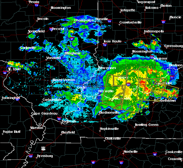 The severe thunderstorm warning for spencer, pike, warrick, southeastern henderson and daviess counties will expire at 830 pm cdt/930 pm edt/, the storms which prompted the warning have moved out of the area. therefore the warning will be allowed to expire. a severe thunderstorm watch remains in effect until 100 am cdt/200 am edt/ for southwestern indiana, and northwestern kentucky. The severe thunderstorm warning for spencer, pike, warrick, southeastern henderson and daviess counties will expire at 830 pm cdt/930 pm edt/, the storms which prompted the warning have moved out of the area. therefore the warning will be allowed to expire. a severe thunderstorm watch remains in effect until 100 am cdt/200 am edt/ for southwestern indiana, and northwestern kentucky.
|
| 5/7/2016 7:45 PM CDT |
 At 744 pm cdt/844 pm edt/, severe thunderstorms were located along a line extending from 7 miles northeast of jasper to 7 miles north of tell city to 7 miles east of st. joseph, moving southeast at 55 mph (radar indicated). Hazards include 60 mph wind gusts. Expect damage to roofs. siding. And trees. At 744 pm cdt/844 pm edt/, severe thunderstorms were located along a line extending from 7 miles northeast of jasper to 7 miles north of tell city to 7 miles east of st. joseph, moving southeast at 55 mph (radar indicated). Hazards include 60 mph wind gusts. Expect damage to roofs. siding. And trees.
|
| 5/7/2016 7:34 PM CDT |
 At 733 pm cdt, severe thunderstorms were located along a line extending from jasper to 6 miles northwest of grandview to near robards, moving east at 60 mph. these storms have a history of producing widespread wind damage with winds in excess of 60 mph (radar indicated). Hazards include 60 mph wind gusts. Expect damage to roofs. siding. and trees. locations impacted include, evansville, owensboro, henderson, newburgh, rockport, santa claus, dale, grandview, corydon, whitesville, robards, masonville, eureka, knottsville, st. Joseph, stanley, lewisport, chrisney, troy and gentryville. At 733 pm cdt, severe thunderstorms were located along a line extending from jasper to 6 miles northwest of grandview to near robards, moving east at 60 mph. these storms have a history of producing widespread wind damage with winds in excess of 60 mph (radar indicated). Hazards include 60 mph wind gusts. Expect damage to roofs. siding. and trees. locations impacted include, evansville, owensboro, henderson, newburgh, rockport, santa claus, dale, grandview, corydon, whitesville, robards, masonville, eureka, knottsville, st. Joseph, stanley, lewisport, chrisney, troy and gentryville.
|
| 5/7/2016 7:10 PM CDT |
 At 708 pm cdt, severe thunderstorms were located along a line extending from near petersburg to near boonville to near uniontown, moving east at 60 mph. this line of storms snapped power poles and tree limbs as it moved across carmi illinois, and winds were measured at 66 mph as they moved across the mount carmel airport in southern illinois (radar indicated). Hazards include 60 mph wind gusts. Expect damage to roofs. siding. And trees. At 708 pm cdt, severe thunderstorms were located along a line extending from near petersburg to near boonville to near uniontown, moving east at 60 mph. this line of storms snapped power poles and tree limbs as it moved across carmi illinois, and winds were measured at 66 mph as they moved across the mount carmel airport in southern illinois (radar indicated). Hazards include 60 mph wind gusts. Expect damage to roofs. siding. And trees.
|
| 5/1/2016 6:36 PM CDT | Quarter sized hail reported 0.9 miles NNW of Rockport, IN, quarter size hail with moderate pea to dime size hail as well. |
| 4/26/2016 6:30 PM CDT |
 At 630 pm cdt, a severe thunderstorm was located over rockport, moving east at 45 mph (radar indicated). Hazards include 60 mph wind gusts and quarter size hail. Hail damage to vehicles is expected. Expect wind damage to roofs, siding, and trees. At 630 pm cdt, a severe thunderstorm was located over rockport, moving east at 45 mph (radar indicated). Hazards include 60 mph wind gusts and quarter size hail. Hail damage to vehicles is expected. Expect wind damage to roofs, siding, and trees.
|
| 12/23/2015 4:28 PM CST | At 428 pm cst, a severe thunderstorm was located near st. joseph, or 7 miles north of calhoun, moving northeast at 50 mph (radar indicated). Hazards include 60 mph wind gusts and quarter size hail. Hail damage to vehicles is expected. Expect wind damage to roofs, siding and trees. |
| 12/23/2015 3:44 PM CST | At 344 pm cst, a confirmed tornado was located over rockport, moving northeast at 60 mph (radar confirmed tornado). Hazards include damaging tornado and half dollar size hail. Flying debris will be dangerous to those caught without shelter. mobile homes will be damaged or destroyed. damage to roofs, windows and vehicles will occur. tree damage is likely. this tornado will be near, grandview around 350 pm cst. Other locations impacted by this tornadic thunderstorm include chrisney. |
| 12/23/2015 3:44 PM CST | At 344 pm cst, a confirmed tornado was located over rockport, moving northeast at 60 mph (radar confirmed tornado). Hazards include damaging tornado and half dollar size hail. Flying debris will be dangerous to those caught without shelter. mobile homes will be damaged or destroyed. damage to roofs, windows and vehicles will occur. tree damage is likely. this tornado will be near, grandview around 350 pm cst. Other locations impacted by this tornadic thunderstorm include chrisney. |
| 12/23/2015 3:36 PM CST | At 335 pm cst, a severe thunderstorm capable of producing a tornado was located near stanley, or near owensboro, moving northeast at 70 mph (radar indicated rotation). Hazards include tornado and quarter size hail. Flying debris will be dangerous to those caught without shelter. mobile homes will be damaged or destroyed. damage to roofs, windows and vehicles will occur. tree damage is likely. this dangerous storm will be near, rockport around 345 pm cst. grandview around 350 pm cst. santa claus around 355 pm cst. Other locations impacted by this tornadic thunderstorm include chrisney. |
| 12/23/2015 3:36 PM CST | At 335 pm cst, a severe thunderstorm capable of producing a tornado was located near stanley, or near owensboro, moving northeast at 70 mph (radar indicated rotation). Hazards include tornado and quarter size hail. Flying debris will be dangerous to those caught without shelter. mobile homes will be damaged or destroyed. damage to roofs, windows and vehicles will occur. tree damage is likely. this dangerous storm will be near, rockport around 345 pm cst. grandview around 350 pm cst. santa claus around 355 pm cst. Other locations impacted by this tornadic thunderstorm include chrisney. |
| 12/23/2015 2:14 PM CST | At 213 pm cst, severe thunderstorms were located along a line extending from 7 miles northeast of santa claus to near rockport, moving east at 50 mph (radar indicated). Hazards include 60 mph wind gusts and penny size hail. Expect damage to roofs. siding and trees. locations impacted include, rockport, santa claus, grandview, eureka, ferdinand and chrisney. A tornado watch remains in effect until 800 pm cst for southwestern indiana and northwestern kentucky. |
| 12/23/2015 1:53 PM CST | At 152 pm cst, severe thunderstorms were located along a line extending from near folsomville to near newburgh, moving east at 50 mph (radar indicated). Hazards include 60 mph wind gusts and penny size hail. Expect damage to roofs. Siding and trees. |
| 8/4/2015 4:30 PM CDT |
 At 429 pm cdt, a severe thunderstorm was located near eureka, or about 5 miles southeast of boonville, moving northeast at 15 mph (radar indicated). Hazards include 60 mph wind gusts and quarter size hail. Hail damage to vehicles is expected. expect wind damage to roofs, siding and trees. Locations impacted include, rockport and eureka. At 429 pm cdt, a severe thunderstorm was located near eureka, or about 5 miles southeast of boonville, moving northeast at 15 mph (radar indicated). Hazards include 60 mph wind gusts and quarter size hail. Hail damage to vehicles is expected. expect wind damage to roofs, siding and trees. Locations impacted include, rockport and eureka.
|
| 8/4/2015 4:19 PM CDT |
 At 419 pm cdt, a severe thunderstorm was located over eureka, or 8 miles south of boonville, moving southeast at 5 mph (radar indicated). Hazards include 60 mph wind gusts and half dollar size hail. Hail damage to vehicles is expected. Expect wind damage to roofs, siding and trees. At 419 pm cdt, a severe thunderstorm was located over eureka, or 8 miles south of boonville, moving southeast at 5 mph (radar indicated). Hazards include 60 mph wind gusts and half dollar size hail. Hail damage to vehicles is expected. Expect wind damage to roofs, siding and trees.
|
| 6/21/2015 8:17 PM CDT |
 At 815 pm cdt, a severe thunderstorm was located a few miles southwest of owensboro, moving southeast at 35 mph. another severe storm was located near baskett in northern henderson county, also moving southeast (radar indicated). Hazards include 60 mph wind gusts and quarter size hail. Hail damage to vehicles is expected. expect wind damage to roofs, siding and trees. locations impacted include, owensboro, rockport, robards, st. Joseph, stanley, eureka, masonville, hebbardsville and moseleyville. At 815 pm cdt, a severe thunderstorm was located a few miles southwest of owensboro, moving southeast at 35 mph. another severe storm was located near baskett in northern henderson county, also moving southeast (radar indicated). Hazards include 60 mph wind gusts and quarter size hail. Hail damage to vehicles is expected. expect wind damage to roofs, siding and trees. locations impacted include, owensboro, rockport, robards, st. Joseph, stanley, eureka, masonville, hebbardsville and moseleyville.
|
| 6/21/2015 7:55 PM CDT |
 At 753 pm cdt, a severe thunderstorm was located near reed in extreme northeast henderson county, moving south at 15 mph. another severe storm was located just west of rockport in spencer county indiana (radar indicated). Hazards include 60 mph wind gusts and quarter size hail. Hail damage to vehicles is expected. Expect wind damage to roofs, siding and trees. At 753 pm cdt, a severe thunderstorm was located near reed in extreme northeast henderson county, moving south at 15 mph. another severe storm was located just west of rockport in spencer county indiana (radar indicated). Hazards include 60 mph wind gusts and quarter size hail. Hail damage to vehicles is expected. Expect wind damage to roofs, siding and trees.
|
| 6/19/2015 5:57 PM CDT |
 At 556 pm cdt, a severe thunderstorm capable of producing a tornado was located near rockport, moving northeast at 25 mph (radar indicated rotation). Hazards include tornado. Flying debris will be dangerous to those caught without shelter. mobile homes will be damaged or destroyed. damage to roofs, windows and vehicles will occur. Tree damage is likely. At 556 pm cdt, a severe thunderstorm capable of producing a tornado was located near rockport, moving northeast at 25 mph (radar indicated rotation). Hazards include tornado. Flying debris will be dangerous to those caught without shelter. mobile homes will be damaged or destroyed. damage to roofs, windows and vehicles will occur. Tree damage is likely.
|
| 12/21/2013 6:40 PM CST | With torrential rain near downtown rockpor in spencer county IN, 0.9 miles NNW of Rockport, IN |
| 10/31/2013 10:35 PM CDT | Storm damage reported in spencer county IN, 0.9 miles NNW of Rockport, IN |
| 10/31/2013 9:35 PM CDT | Storm damage reported in spencer county IN, 0.9 miles NNW of Rockport, IN |
| 6/26/2013 8:38 PM CDT | Transformers arcing in spencer county IN, 0.9 miles NNW of Rockport, IN |
| 1/30/2013 1:04 AM CST | Concrete garage destroye in spencer county IN, 2.2 miles ENE of Rockport, IN |
| 1/30/2013 12:30 AM CST | Roof on concrete garage destroye in spencer county IN, 2.2 miles ENE of Rockport, IN |
| 9/7/2012 9:40 PM CDT | Tree limbs and branches...some large...dow in spencer county IN, 0.9 miles NNW of Rockport, IN |
| 8/16/2012 7:08 PM CDT | Numerous tree limbs and branches down in rockport...many gusts over 58 mp in spencer county IN, 0.9 miles NNW of Rockport, IN |
| 5/31/2012 4:00 PM CDT | Quarter sized hail reported 0.9 miles NNW of Rockport, IN |
| 5/31/2012 3:54 PM CDT | Quarter sized hail reported 0.9 miles NNW of Rockport, IN |
| 5/31/2012 3:52 PM CDT | Storm damage reported in spencer county IN, 0.9 miles NNW of Rockport, IN |
| 1/1/0001 12:00 AM | Downed trees and power lines reported in the communit in spencer county IN, 0.9 miles NNW of Rockport, IN |
| 3/2/2012 2:24 PM CST | Quarter sized hail reported 0.9 miles NNW of Rockport, IN |
| 1/1/0001 12:00 AM | Storm damage reported in spencer county IN, 0.9 miles NNW of Rockport, IN |
| 1/1/0001 12:00 AM | Very brief gust associated with outflow boundary. other sustained gusts of 40-45 mph. no damag in spencer county IN, 0.9 miles NNW of Rockport, IN |
| 1/1/0001 12:00 AM | Storm damage reported in spencer county IN, 0.9 miles NNW of Rockport, IN |
Hail Maps for Rockport, IN
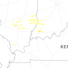
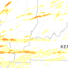
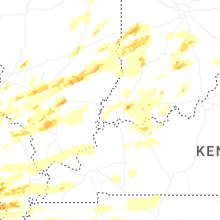


Connect with Interactive Hail Maps