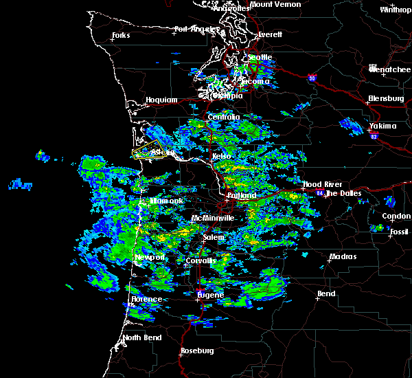
| 11/14/2017 6:30 AM PST |
 At 630 am pst, a severe thunderstorm was located near cannon beach, moving northeast at 40 mph (radar indicated). Hazards include 60 mph wind gusts and quarter size hail. Hail damage to vehicles is expected. Expect wind damage to roofs, siding, and trees. At 630 am pst, a severe thunderstorm was located near cannon beach, moving northeast at 40 mph (radar indicated). Hazards include 60 mph wind gusts and quarter size hail. Hail damage to vehicles is expected. Expect wind damage to roofs, siding, and trees.
|
| 9/18/2017 5:41 PM PDT |
 The severe thunderstorm warning for east central pacific and northern wahkiakum counties will expire at 545 pm pdt, the storm which prompted the warning has weakened below severe limits, and no longer poses an immediate threat to life or property. therefore the warning will be allowed to expire. however small hail and gusty winds are still possible with this thunderstorm. to report severe weather, contact your nearest law enforcement agency. they will relay your report to the national weather service portland. The severe thunderstorm warning for east central pacific and northern wahkiakum counties will expire at 545 pm pdt, the storm which prompted the warning has weakened below severe limits, and no longer poses an immediate threat to life or property. therefore the warning will be allowed to expire. however small hail and gusty winds are still possible with this thunderstorm. to report severe weather, contact your nearest law enforcement agency. they will relay your report to the national weather service portland.
|
| 9/18/2017 5:32 PM PDT |
 At 532 pm pdt, a severe thunderstorm was located over rosburg, or near grays river, moving east at 20 mph (radar indicated). Hazards include 60 mph wind gusts and quarter size hail. Hail damage to vehicles is expected. expect wind damage to roofs, siding, and trees. locations impacted include, pillar rock. In washington this includes state route 4 between mile markers 20 and 28. At 532 pm pdt, a severe thunderstorm was located over rosburg, or near grays river, moving east at 20 mph (radar indicated). Hazards include 60 mph wind gusts and quarter size hail. Hail damage to vehicles is expected. expect wind damage to roofs, siding, and trees. locations impacted include, pillar rock. In washington this includes state route 4 between mile markers 20 and 28.
|
| 9/18/2017 5:13 PM PDT |
 At 513 pm pdt, a severe thunderstorm was located over rosburg, or over grays river, moving east at 20 mph (radar indicated). Hazards include 60 mph wind gusts and quarter size hail. Hail damage to vehicles is expected. Expect wind damage to roofs, siding, and trees. At 513 pm pdt, a severe thunderstorm was located over rosburg, or over grays river, moving east at 20 mph (radar indicated). Hazards include 60 mph wind gusts and quarter size hail. Hail damage to vehicles is expected. Expect wind damage to roofs, siding, and trees.
|
| 9/18/2017 5:05 PM PDT |
Quarter sized hail reported 1.6 miles SSW of Rosburg, WA, a resident near rosburg reported quarter size hail.
|
| 9/18/2017 5:03 PM PDT |
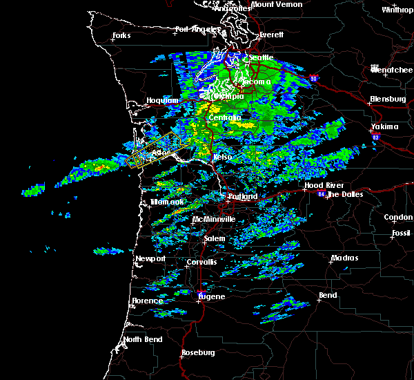
 At 502 pm pdt, a severe thunderstorm capable of producing a tornado was located over rosburg, or near grays river, moving northeast at 25 mph (radar indicated rotation). Hazards include tornado and quarter size hail. Flying debris will be dangerous to those caught without shelter. mobile homes will be damaged or destroyed. damage to roofs, windows, and vehicles will occur. tree damage is likely. this dangerous storm will be near, grays river around 510 pm pdt. other locations impacted by this tornadic thunderstorm include deep river and altoona. In washington this includes state route 4 between mile markers 9 and 26. At 502 pm pdt, a severe thunderstorm capable of producing a tornado was located over rosburg, or near grays river, moving northeast at 25 mph (radar indicated rotation). Hazards include tornado and quarter size hail. Flying debris will be dangerous to those caught without shelter. mobile homes will be damaged or destroyed. damage to roofs, windows, and vehicles will occur. tree damage is likely. this dangerous storm will be near, grays river around 510 pm pdt. other locations impacted by this tornadic thunderstorm include deep river and altoona. In washington this includes state route 4 between mile markers 9 and 26.
|
| 9/18/2017 4:46 PM PDT |
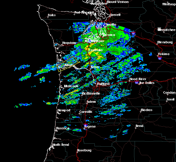
 At 445 pm pdt, a severe thunderstorm capable of producing a tornado was located near naselle, or near astoria, moving northeast at 25 mph (radar indicated rotation). Hazards include tornado and quarter size hail. Flying debris will be dangerous to those caught without shelter. mobile homes will be damaged or destroyed. damage to roofs, windows, and vehicles will occur. tree damage is likely. this dangerous storm will be near, rosburg around 505 pm pdt. grays river around 510 pm pdt. other locations impacted by this tornadic thunderstorm include deep river, knappton and altoona. In washington this includes state route 4 between mile markers 7 and 26. At 445 pm pdt, a severe thunderstorm capable of producing a tornado was located near naselle, or near astoria, moving northeast at 25 mph (radar indicated rotation). Hazards include tornado and quarter size hail. Flying debris will be dangerous to those caught without shelter. mobile homes will be damaged or destroyed. damage to roofs, windows, and vehicles will occur. tree damage is likely. this dangerous storm will be near, rosburg around 505 pm pdt. grays river around 510 pm pdt. other locations impacted by this tornadic thunderstorm include deep river, knappton and altoona. In washington this includes state route 4 between mile markers 7 and 26.
|
| 9/18/2017 4:35 PM PDT |
 At 433 pm pdt, a severe thunderstorm was located near hammond town, or near warrenton, moving northeast at 20 mph (radar indicated). Hazards include 60 mph wind gusts and quarter size hail. Hail damage to vehicles is expected. expect wind damage to roofs, siding, and trees. locations impacted include, astoria, warrenton, hammond town, hammond, chinook, megler and knappton. this includes the following highways in washington, u. s. highway 101 between mile markers 1 and 5. state route 4 near mile marker 7. in oregon this includes u. s. Highway 101 between mile markers 1 and 3. At 433 pm pdt, a severe thunderstorm was located near hammond town, or near warrenton, moving northeast at 20 mph (radar indicated). Hazards include 60 mph wind gusts and quarter size hail. Hail damage to vehicles is expected. expect wind damage to roofs, siding, and trees. locations impacted include, astoria, warrenton, hammond town, hammond, chinook, megler and knappton. this includes the following highways in washington, u. s. highway 101 between mile markers 1 and 5. state route 4 near mile marker 7. in oregon this includes u. s. Highway 101 between mile markers 1 and 3.
|
| 9/18/2017 4:15 PM PDT |
 At 414 pm pdt, a severe thunderstorm was located near hammond town, or near warrenton, moving northeast at 20 mph (radar indicated). Hazards include 60 mph wind gusts and quarter size hail. Hail damage to vehicles is expected. Expect wind damage to roofs, siding, and trees. At 414 pm pdt, a severe thunderstorm was located near hammond town, or near warrenton, moving northeast at 20 mph (radar indicated). Hazards include 60 mph wind gusts and quarter size hail. Hail damage to vehicles is expected. Expect wind damage to roofs, siding, and trees.
|
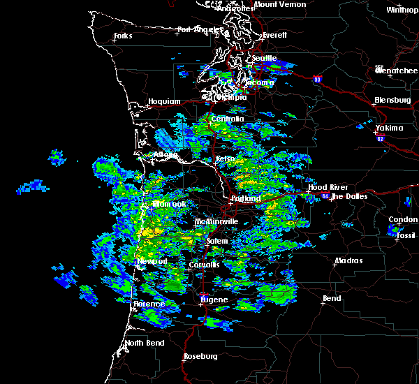
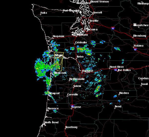
| 5/4/2017 3:29 PM PDT |
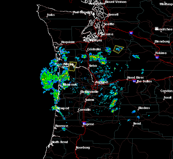 At 327 pm pdt, doppler radar indicated a severe thunderstorm capable of producing quarter size hail. this storm was located over skamokawa, or 7 miles southeast of grays river, moving north at 30 mph. locations impacted include, cathlamet, skamokawa, east cathlamet, knappa and puget island. in washington this includes state route 4 between mile markers 24 and 37. in oregon this includes u.s. highway 30 west of portland between mile markers 71 and 82. At 327 pm pdt, doppler radar indicated a severe thunderstorm capable of producing quarter size hail. this storm was located over skamokawa, or 7 miles southeast of grays river, moving north at 30 mph. locations impacted include, cathlamet, skamokawa, east cathlamet, knappa and puget island. in washington this includes state route 4 between mile markers 24 and 37. in oregon this includes u.s. highway 30 west of portland between mile markers 71 and 82.
|
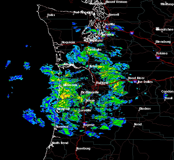
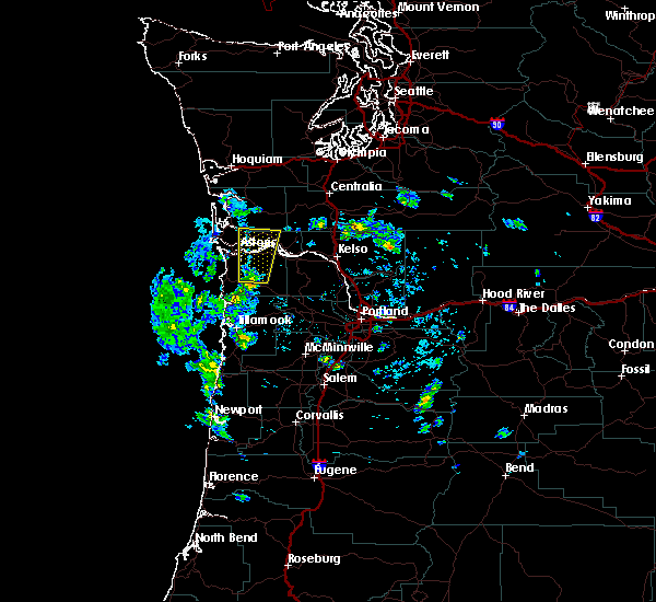
| 5/4/2017 3:04 PM PDT |
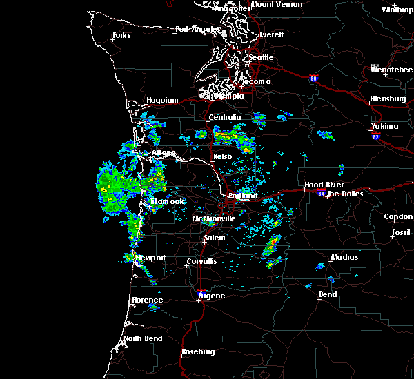 At 303 pm pdt, doppler radar indicated a severe thunderstorm capable of producing quarter size hail. this storm was located near knappa, or 7 miles southwest of cathlamet, and moving north at 30 mph. At 303 pm pdt, doppler radar indicated a severe thunderstorm capable of producing quarter size hail. this storm was located near knappa, or 7 miles southwest of cathlamet, and moving north at 30 mph.
|
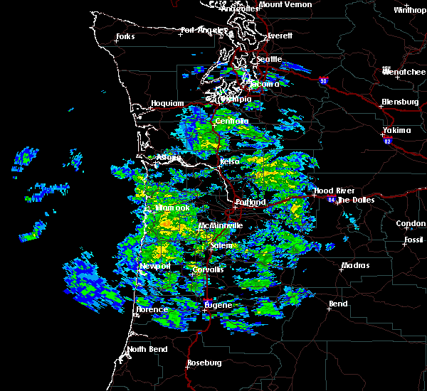
| 5/4/2017 2:35 PM PDT |
 At 234 pm pdt, doppler radar indicated a severe thunderstorm capable of producing quarter size hail. this storm was located near knappa, or 7 miles south of grays river, moving north at 35 mph. locations impacted include, astoria, grays river, skamokawa, knappa, rosburg, naselle, svenson, klaskanine summit, olney, altoona, necanicum, pillar rock, deep river and saddle mountain. in washington this includes state route 4 between mile markers 5 and 29. this includes the following highways in oregon, u.s. highway 26 west of portland between mile markers 8 and 16. u.s. highway 30 west of portland between mile markers 77 and 96. At 234 pm pdt, doppler radar indicated a severe thunderstorm capable of producing quarter size hail. this storm was located near knappa, or 7 miles south of grays river, moving north at 35 mph. locations impacted include, astoria, grays river, skamokawa, knappa, rosburg, naselle, svenson, klaskanine summit, olney, altoona, necanicum, pillar rock, deep river and saddle mountain. in washington this includes state route 4 between mile markers 5 and 29. this includes the following highways in oregon, u.s. highway 26 west of portland between mile markers 8 and 16. u.s. highway 30 west of portland between mile markers 77 and 96.
|
| 5/4/2017 2:04 PM PDT |
 At 203 pm pdt, doppler radar indicated a severe thunderstorm capable of producing quarter size hail. this storm was located 8 miles north of elsie, or 8 miles west of jewell, and moving north at 35 mph. At 203 pm pdt, doppler radar indicated a severe thunderstorm capable of producing quarter size hail. this storm was located 8 miles north of elsie, or 8 miles west of jewell, and moving north at 35 mph.
|
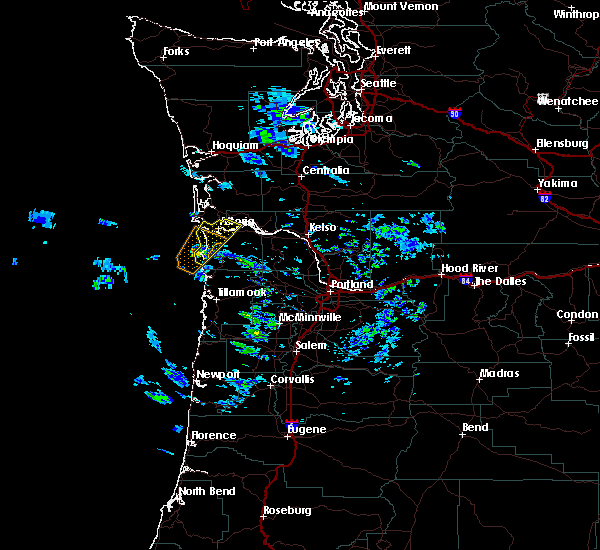
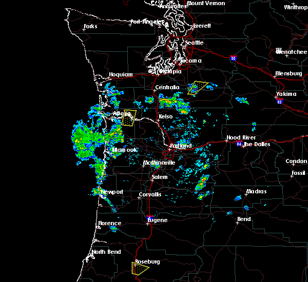
| 10/14/2016 12:09 PM PDT |
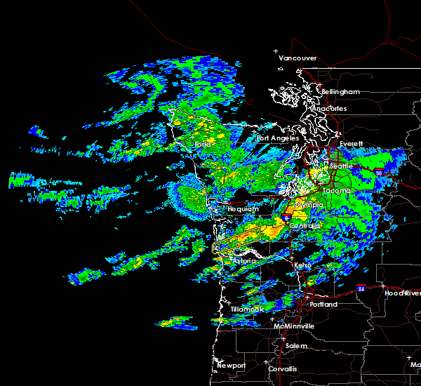 At 1209 pm pdt, doppler radar indicated severe thunderstorms capable of producing destructive winds in excess of 70 mph. these storms were located along a line extending from near chehalis to 6 miles northwest of grays river, moving east at 50 mph. locations impacted include, frances, grays river, naselle, rosburg and deep river. this includes the following highways in washington, state route 4 between mile markers 2 and 19. state route 6 between mile markers 16 and 24. At 1209 pm pdt, doppler radar indicated severe thunderstorms capable of producing destructive winds in excess of 70 mph. these storms were located along a line extending from near chehalis to 6 miles northwest of grays river, moving east at 50 mph. locations impacted include, frances, grays river, naselle, rosburg and deep river. this includes the following highways in washington, state route 4 between mile markers 2 and 19. state route 6 between mile markers 16 and 24.
|
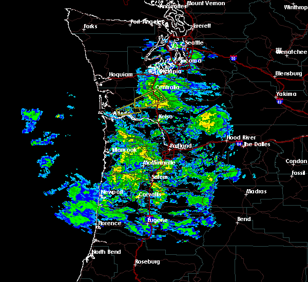
| 10/14/2016 11:47 AM PDT |
 At 1147 am pdt, doppler radar indicated a line of severe thunderstorms capable of producing destructive winds in excess of 70 mph. these storms were located along a line extending from 7 miles southeast of frances to ilwaco, and moving northeast at 50 mph. At 1147 am pdt, doppler radar indicated a line of severe thunderstorms capable of producing destructive winds in excess of 70 mph. these storms were located along a line extending from 7 miles southeast of frances to ilwaco, and moving northeast at 50 mph.
|
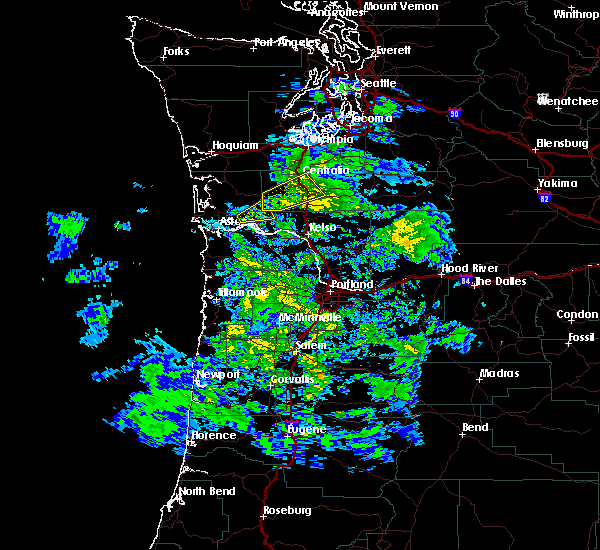
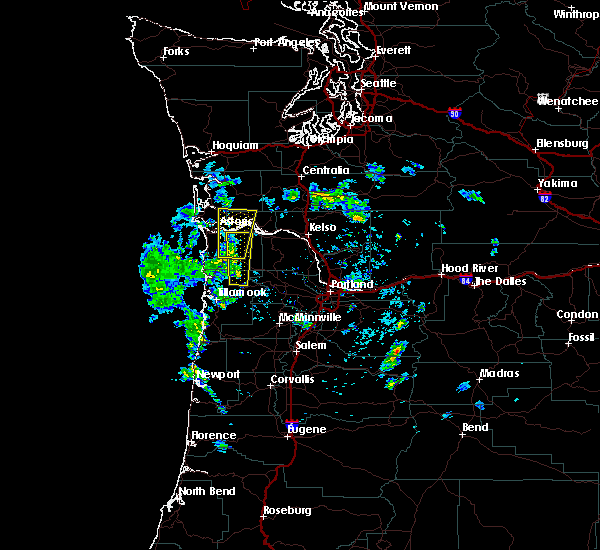
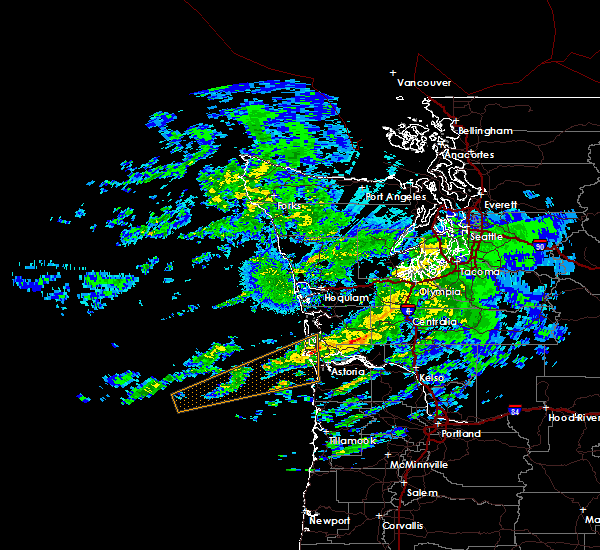
| 10/14/2016 11:36 AM PDT |
 At 1136 am pdt, doppler radar indicated a severe thunderstorm capable of producing destructive winds in excess of 70 mph. this storm was located near grays river, moving northeast at 65 mph. penny size hail may also accompany the damaging winds. locations impacted include, astoria, warrenton, grays river, frances, naselle, hammond town, rosburg, lebam, deep river, megler, pillar rock, altoona, knappton, hammond and chinook. this includes the following highways in washington, u. s. highway 101 between mile markers 1 and 7. state route 4 between mile markers 4 and 28. state route 6 between mile markers 15 and 20. this includes the following highways in oregon, u.s. highway 30 west of portland between mile markers 89 and 99. u.s. highway 101 between mile markers 1 and 15. At 1136 am pdt, doppler radar indicated a severe thunderstorm capable of producing destructive winds in excess of 70 mph. this storm was located near grays river, moving northeast at 65 mph. penny size hail may also accompany the damaging winds. locations impacted include, astoria, warrenton, grays river, frances, naselle, hammond town, rosburg, lebam, deep river, megler, pillar rock, altoona, knappton, hammond and chinook. this includes the following highways in washington, u. s. highway 101 between mile markers 1 and 7. state route 4 between mile markers 4 and 28. state route 6 between mile markers 15 and 20. this includes the following highways in oregon, u.s. highway 30 west of portland between mile markers 89 and 99. u.s. highway 101 between mile markers 1 and 15.
|
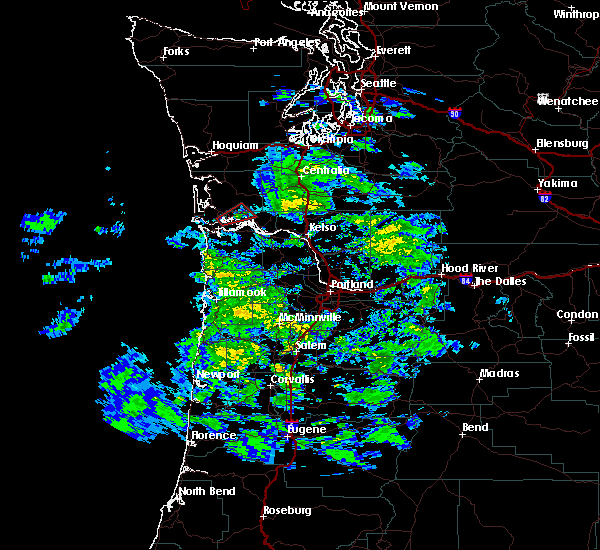
| 10/14/2016 11:11 AM PDT |
 At 1110 am pdt, doppler radar indicated a severe thunderstorm capable of producing destructive winds in excess of 70 mph. a tornado is also possible wit this storm. this storm was located near warrenton, and moving northeast at 65 mph. penny size hail may also accompany the damaging winds. At 1110 am pdt, doppler radar indicated a severe thunderstorm capable of producing destructive winds in excess of 70 mph. a tornado is also possible wit this storm. this storm was located near warrenton, and moving northeast at 65 mph. penny size hail may also accompany the damaging winds.
|
|
|


Connect with Interactive Hail Maps