

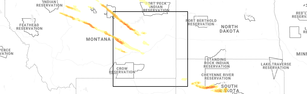
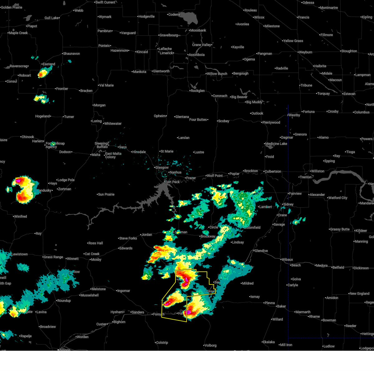
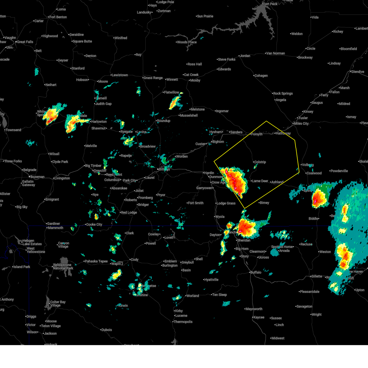
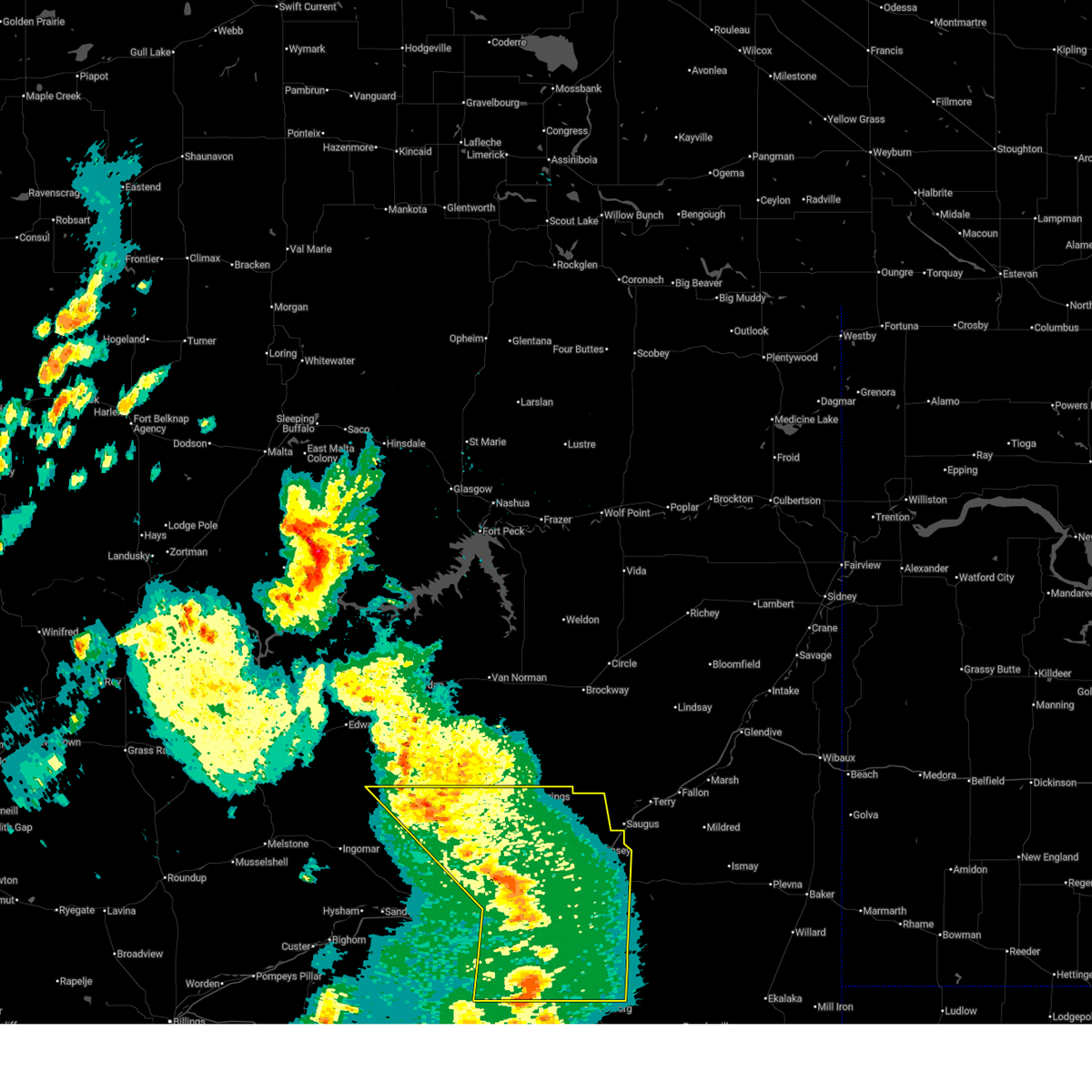
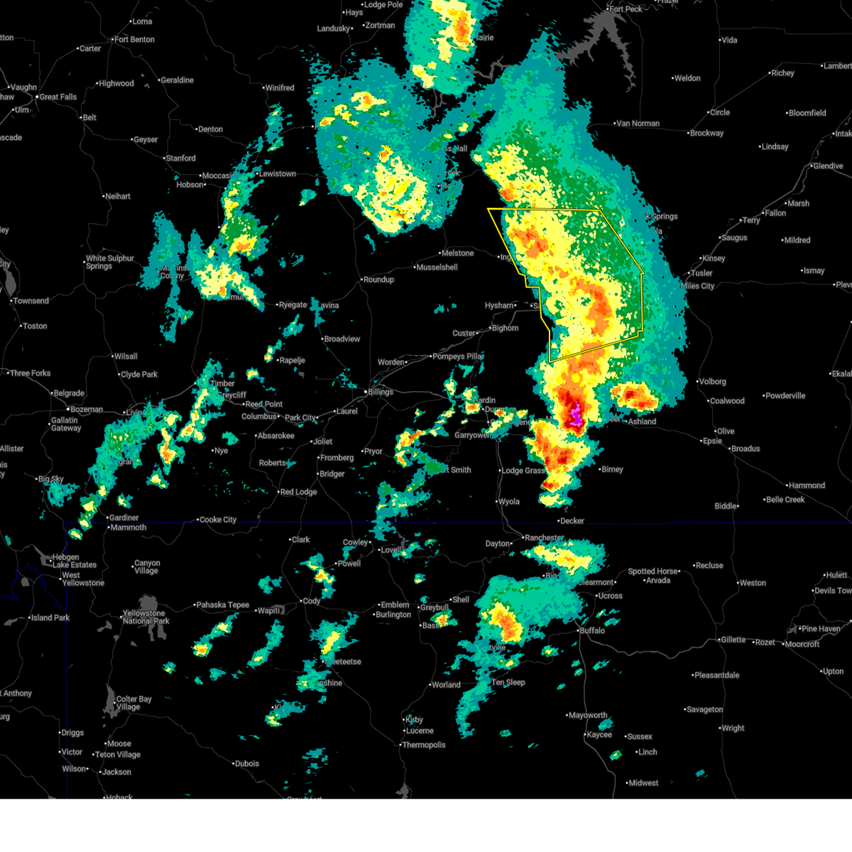
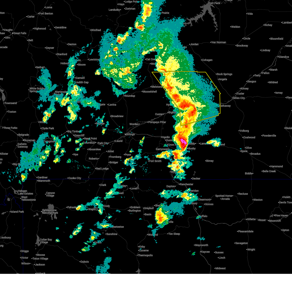
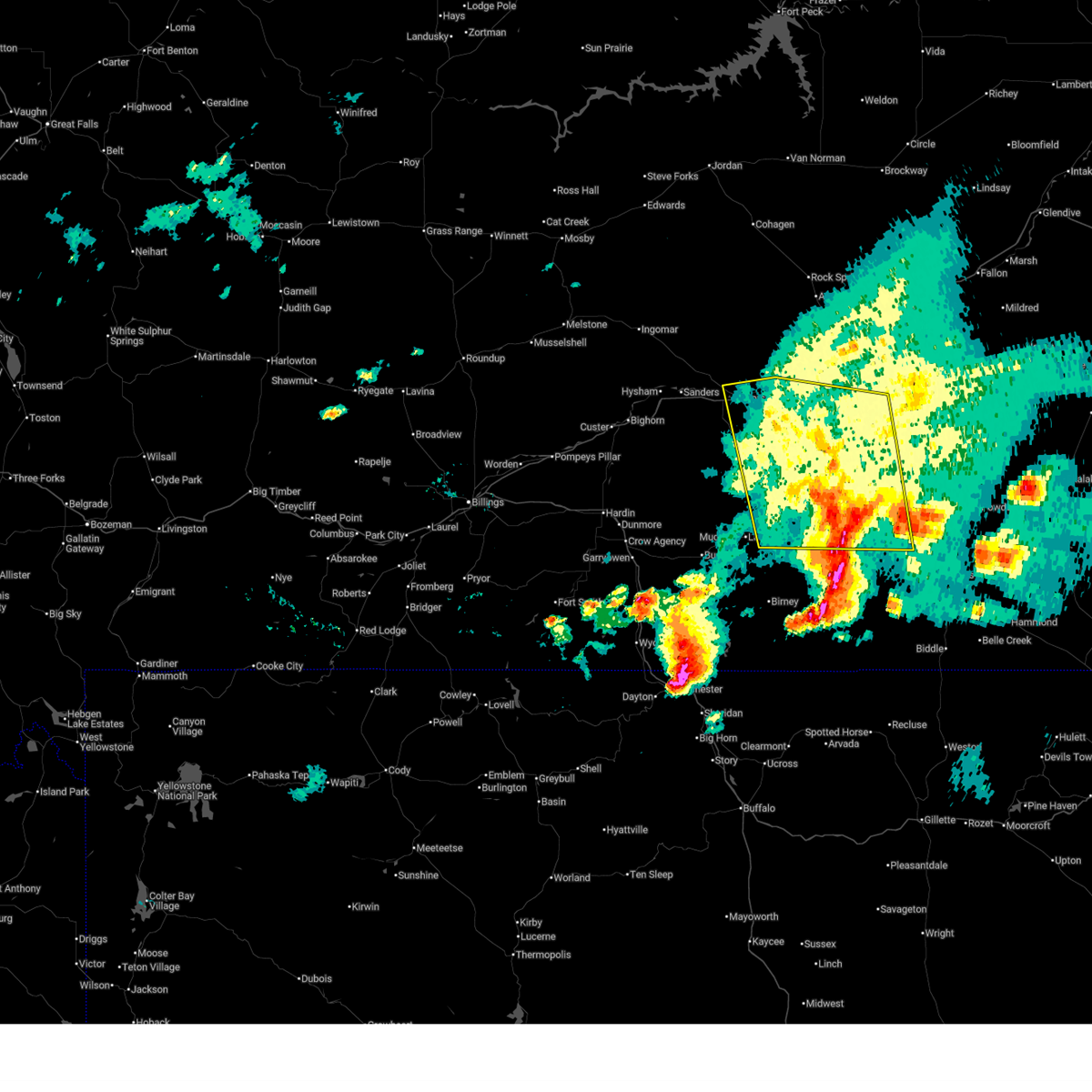
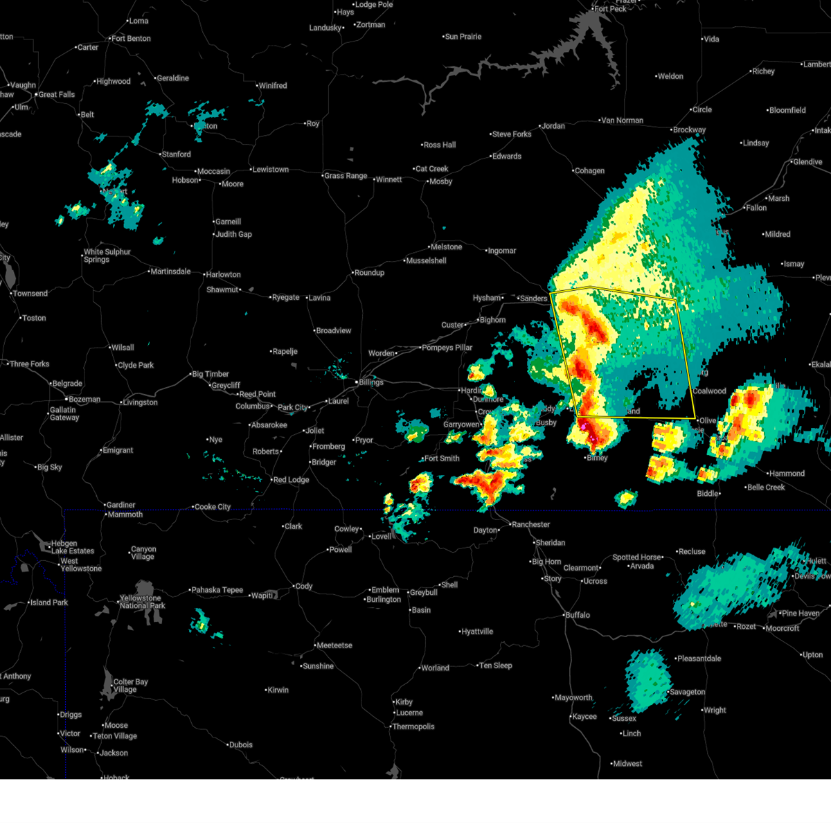
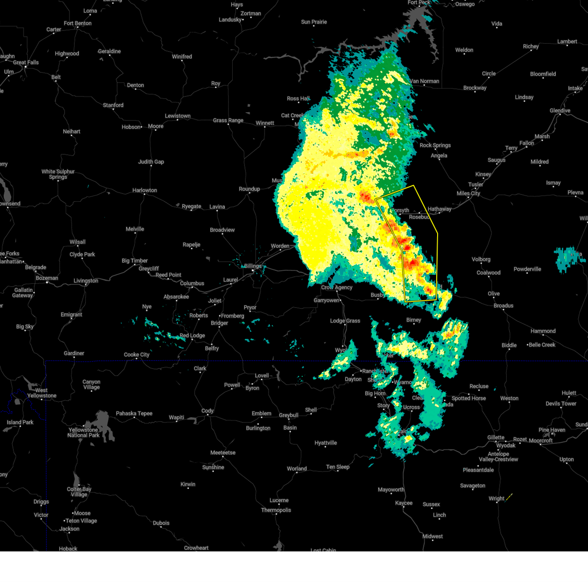
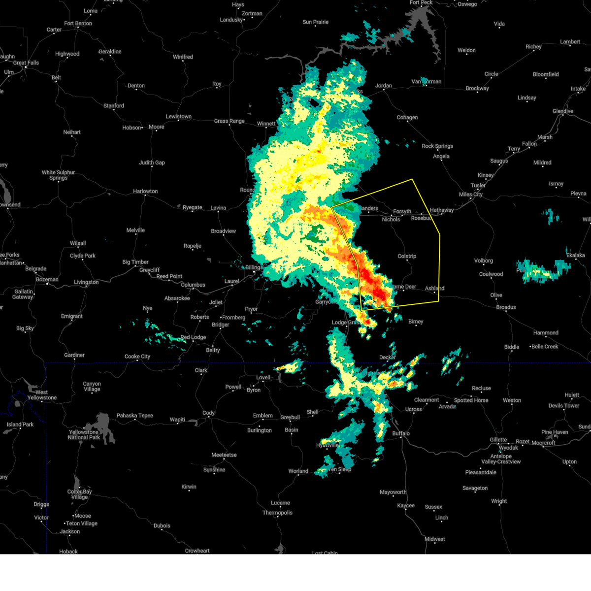
Hail Map for Rosebud, MT
The Rosebud, MT area has had 7 reports of on-the-ground hail by trained spotters, and has been under severe weather warnings 23 times during the past 12 months. Doppler radar has detected hail at or near Rosebud, MT on 28 occasions, including 2 occasions during the past year.
| Name: | Rosebud, MT |
| Where Located: | 29.9 miles WSW of Miles City, MT |
| Map: | Google Map for Rosebud, MT |
| Population: | 111 |
| Housing Units: | 51 |
| More Info: | Search Google for Rosebud, MT |
1
The Top Recent Hail Date for Rosebud, MT is Thursday, July 17, 2025 (8th out of 28)
Hail and Wind Damage Spotted near Rosebud, MT
| Date / Time | Report Details |
|---|---|
| 8/7/2025 7:55 PM MDT |
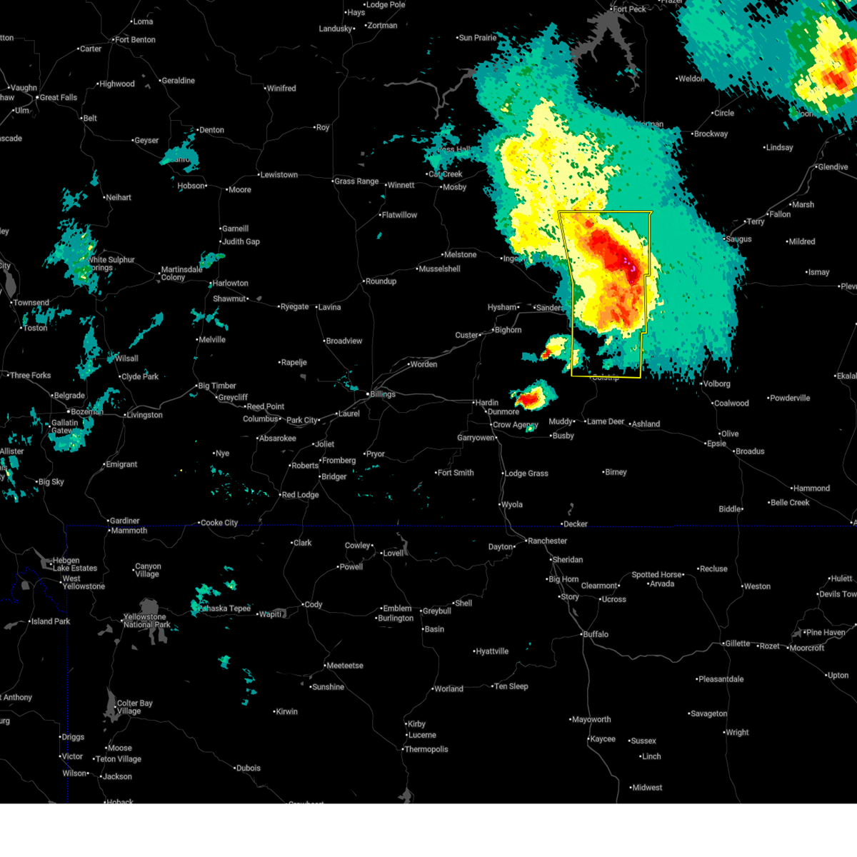 the severe thunderstorm warning has been cancelled and is no longer in effect the severe thunderstorm warning has been cancelled and is no longer in effect
|
| 8/7/2025 7:54 PM MDT |
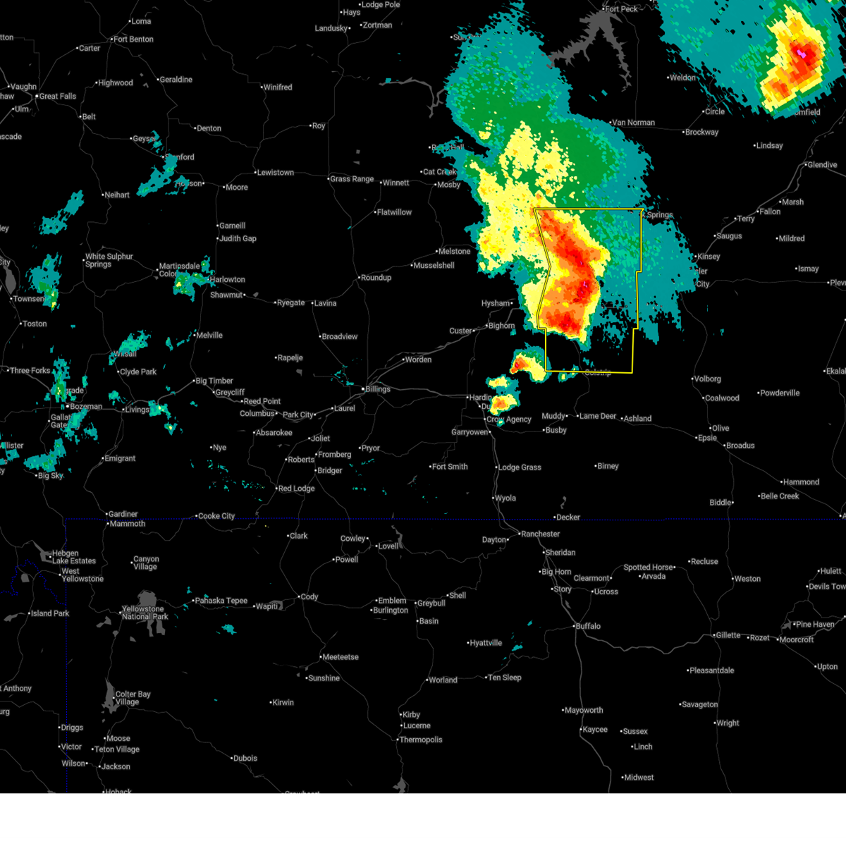
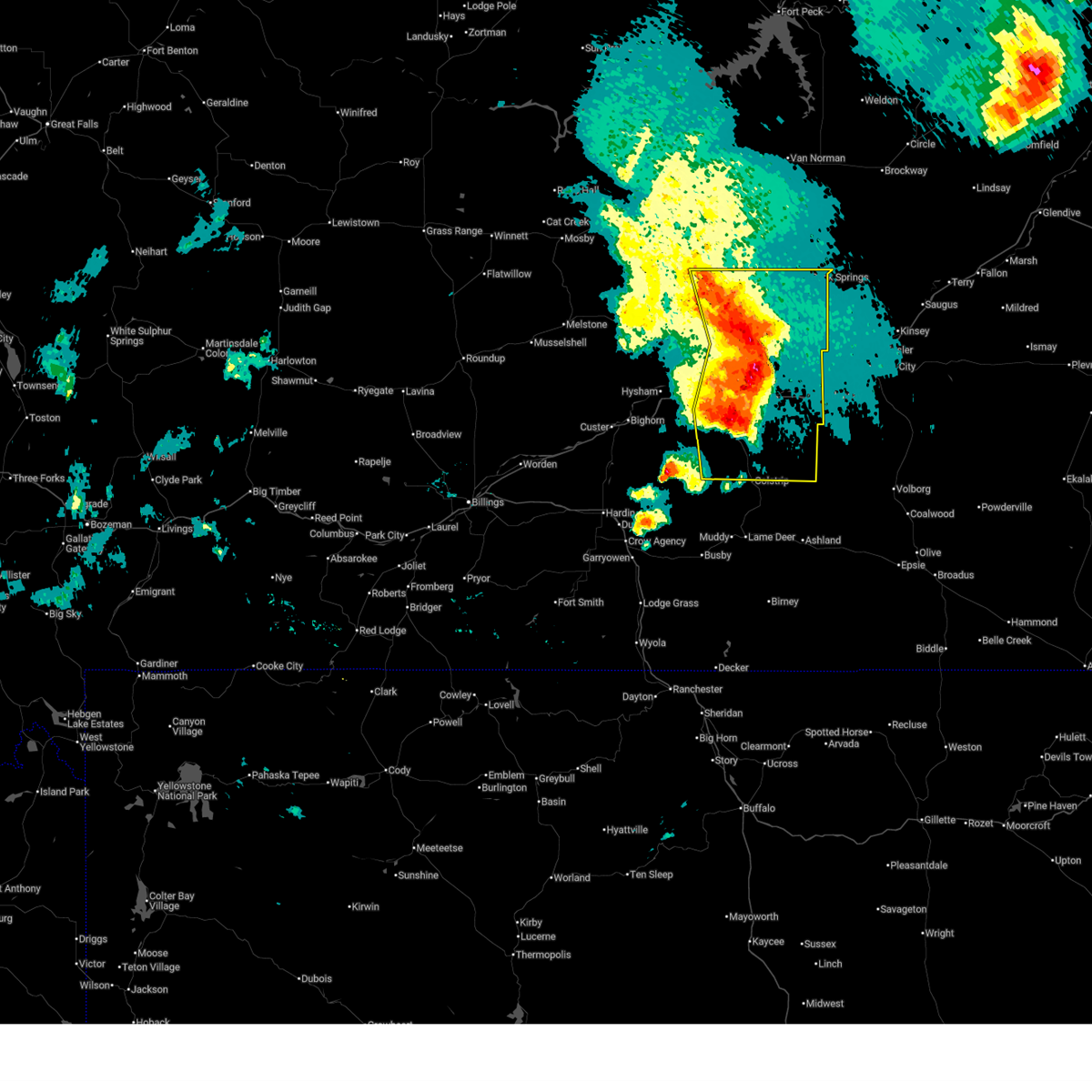
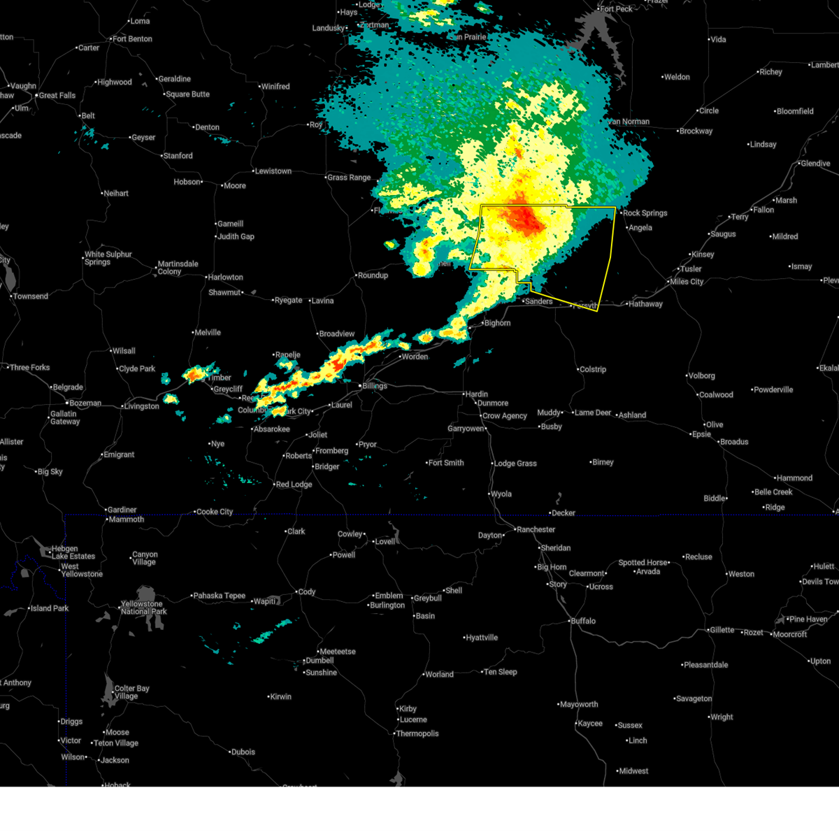
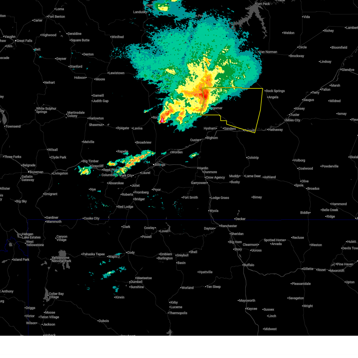
 Svrbyz the national weather service in billings has issued a * severe thunderstorm warning for, custer county in southeastern montana, northern rosebud county in southeastern montana, * until 915 pm mdt. * at 754 pm mdt, severe thunderstorms were located along a line from 43 miles north of forsyth to 20 miles east of forsyth, moving east at 60 mph (at 745 pm, sweeney creek mt dot station recorded a 69 mph wind gust). Hazards include 70 mph wind gusts and half dollar size hail. Hail damage to vehicles is expected. expect considerable tree damage. Wind damage is also likely to mobile homes, roofs, and outbuildings. Svrbyz the national weather service in billings has issued a * severe thunderstorm warning for, custer county in southeastern montana, northern rosebud county in southeastern montana, * until 915 pm mdt. * at 754 pm mdt, severe thunderstorms were located along a line from 43 miles north of forsyth to 20 miles east of forsyth, moving east at 60 mph (at 745 pm, sweeney creek mt dot station recorded a 69 mph wind gust). Hazards include 70 mph wind gusts and half dollar size hail. Hail damage to vehicles is expected. expect considerable tree damage. Wind damage is also likely to mobile homes, roofs, and outbuildings.
|
| 8/7/2025 7:48 PM MDT |
 At 748 pm mdt, severe thunderstorms were located along a line from 31 miles northeast of forsyth to 15 miles northeast of colstrip, moving east at 60 mph (sweeney creek mt dot station recorded a 69 mph wind gust at 745 pm). Hazards include 70 mph wind gusts and half dollar size hail. Hail damage to vehicles is expected. expect considerable tree damage. wind damage is also likely to mobile homes, roofs, and outbuildings. Locations impacted include, colstrip, forsyth, rosebud, cartersville, hathaway, angela and rock springs. At 748 pm mdt, severe thunderstorms were located along a line from 31 miles northeast of forsyth to 15 miles northeast of colstrip, moving east at 60 mph (sweeney creek mt dot station recorded a 69 mph wind gust at 745 pm). Hazards include 70 mph wind gusts and half dollar size hail. Hail damage to vehicles is expected. expect considerable tree damage. wind damage is also likely to mobile homes, roofs, and outbuildings. Locations impacted include, colstrip, forsyth, rosebud, cartersville, hathaway, angela and rock springs.
|
| 8/7/2025 7:45 PM MDT | Storm damage reported in rosebud county MT, 6.3 miles W of Rosebud, MT |
| 8/7/2025 7:40 PM MDT |
 At 740 pm mdt, severe thunderstorms were located along a line from 29 miles north of forsyth to 10 miles north of colstrip, moving east at 60 mph (public reported). Hazards include 70 mph wind gusts and half dollar size hail. Hail damage to vehicles is expected. expect considerable tree damage. wind damage is also likely to mobile homes, roofs, and outbuildings. Locations impacted include, colstrip, forsyth, rosebud, cartersville, hathaway, angela and rock springs. At 740 pm mdt, severe thunderstorms were located along a line from 29 miles north of forsyth to 10 miles north of colstrip, moving east at 60 mph (public reported). Hazards include 70 mph wind gusts and half dollar size hail. Hail damage to vehicles is expected. expect considerable tree damage. wind damage is also likely to mobile homes, roofs, and outbuildings. Locations impacted include, colstrip, forsyth, rosebud, cartersville, hathaway, angela and rock springs.
|
| 8/7/2025 7:40 PM MDT |
 the severe thunderstorm warning has been cancelled and is no longer in effect the severe thunderstorm warning has been cancelled and is no longer in effect
|
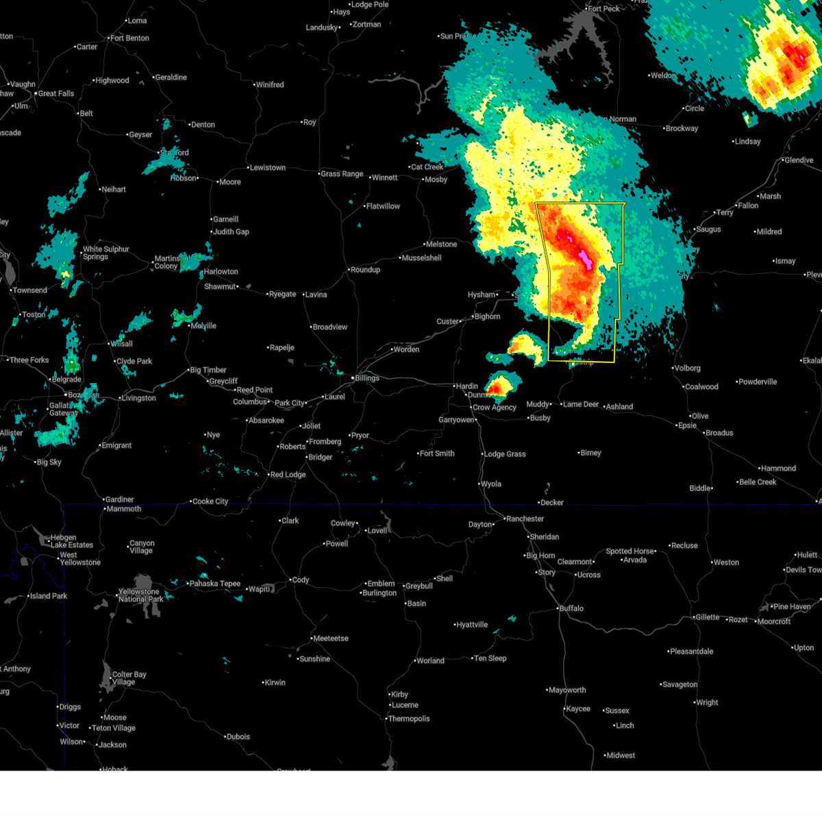
| 8/7/2025 7:39 PM MDT |
 At 739 pm mdt, severe thunderstorms were located along a line from 28 miles north of forsyth to 10 miles north of colstrip, moving east at 60 mph (mesonet station south of hysham recorded a 64 mph wind gust at 610 pm). Hazards include 70 mph wind gusts and half dollar size hail. Hail damage to vehicles is expected. expect considerable tree damage. wind damage is also likely to mobile homes, roofs, and outbuildings. Locations impacted include, colstrip, forsyth, rosebud, cartersville, hathaway, angela and rock springs. At 739 pm mdt, severe thunderstorms were located along a line from 28 miles north of forsyth to 10 miles north of colstrip, moving east at 60 mph (mesonet station south of hysham recorded a 64 mph wind gust at 610 pm). Hazards include 70 mph wind gusts and half dollar size hail. Hail damage to vehicles is expected. expect considerable tree damage. wind damage is also likely to mobile homes, roofs, and outbuildings. Locations impacted include, colstrip, forsyth, rosebud, cartersville, hathaway, angela and rock springs.
|
| 8/7/2025 7:21 PM MDT |
 At 721 pm mdt, severe thunderstorms were located along a line from 26 miles north of hysham to 20 miles southeast of hysham, moving east at 40 mph (mesonet station south of hysham recorded a 64 mph wind gust at 610 pm). Hazards include 70 mph wind gusts and half dollar size hail. Hail damage to vehicles is expected. expect considerable tree damage. wind damage is also likely to mobile homes, roofs, and outbuildings. Locations impacted include, colstrip, forsyth, hysham, rosebud, vananda, cartersville, ingomar, hathaway, bighorn, angela and rock springs. At 721 pm mdt, severe thunderstorms were located along a line from 26 miles north of hysham to 20 miles southeast of hysham, moving east at 40 mph (mesonet station south of hysham recorded a 64 mph wind gust at 610 pm). Hazards include 70 mph wind gusts and half dollar size hail. Hail damage to vehicles is expected. expect considerable tree damage. wind damage is also likely to mobile homes, roofs, and outbuildings. Locations impacted include, colstrip, forsyth, hysham, rosebud, vananda, cartersville, ingomar, hathaway, bighorn, angela and rock springs.
|
| 8/7/2025 7:08 PM MDT |
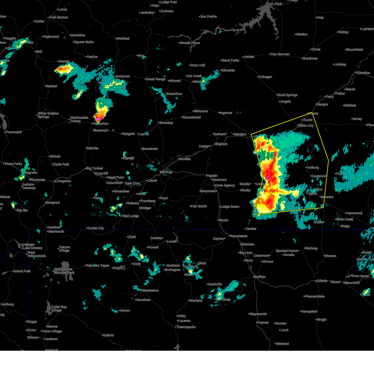
 Svrbyz the national weather service in billings has issued a * severe thunderstorm warning for, rosebud county in southeastern montana, treasure county in southeastern montana, * until 845 pm mdt. * at 708 pm mdt, severe thunderstorms were located along a line from 25 miles north of hysham to 19 miles south of hysham, moving east at 40 mph (radar indicated). Hazards include 70 mph wind gusts and half dollar size hail. Hail damage to vehicles is expected. expect considerable tree damage. Wind damage is also likely to mobile homes, roofs, and outbuildings. Svrbyz the national weather service in billings has issued a * severe thunderstorm warning for, rosebud county in southeastern montana, treasure county in southeastern montana, * until 845 pm mdt. * at 708 pm mdt, severe thunderstorms were located along a line from 25 miles north of hysham to 19 miles south of hysham, moving east at 40 mph (radar indicated). Hazards include 70 mph wind gusts and half dollar size hail. Hail damage to vehicles is expected. expect considerable tree damage. Wind damage is also likely to mobile homes, roofs, and outbuildings.
|
| 7/29/2025 4:34 PM MDT |
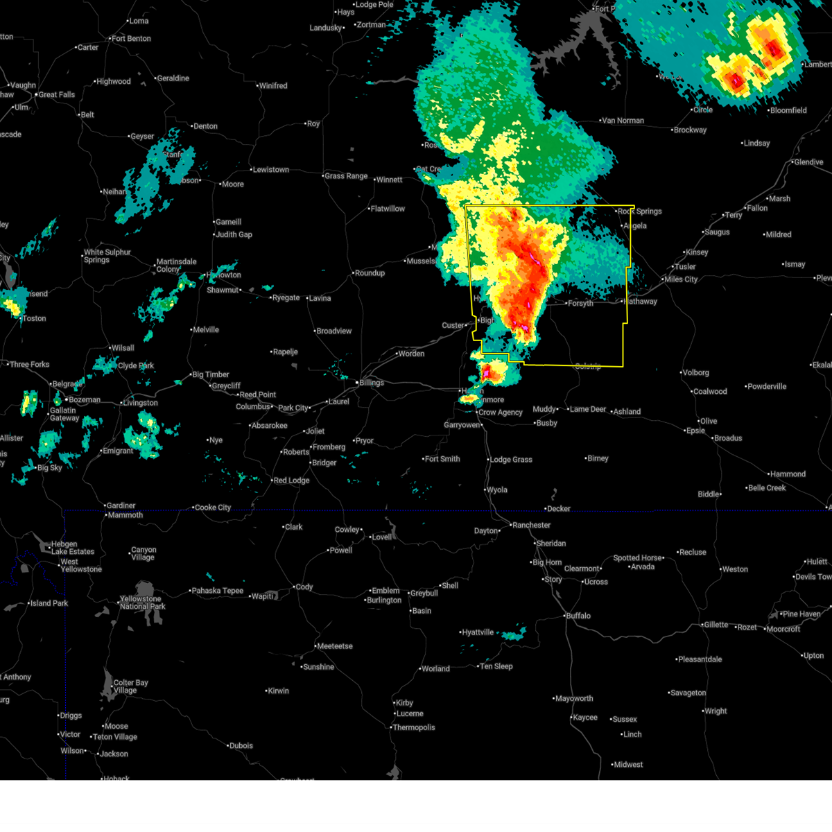
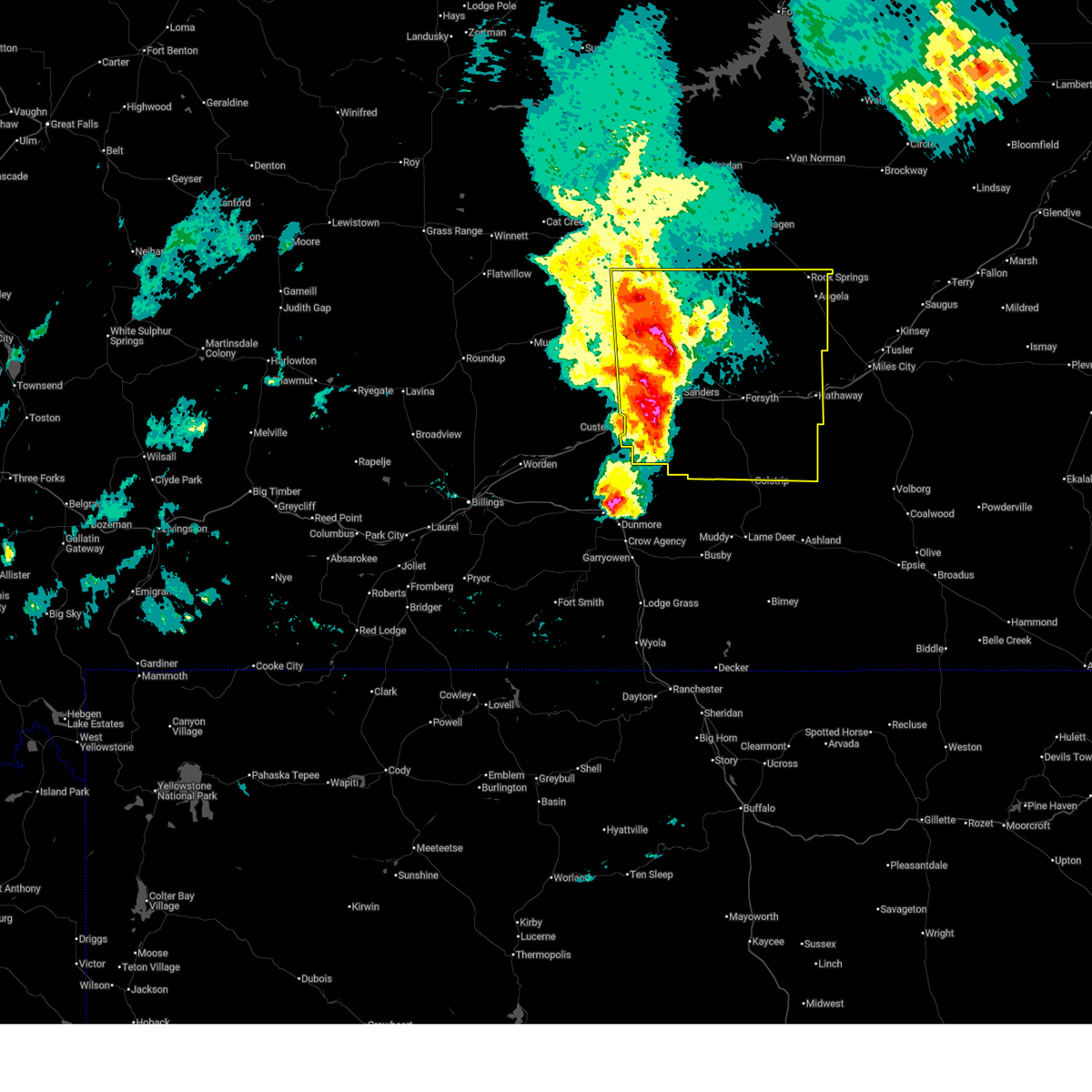
 Svrbyz the national weather service in billings has issued a * severe thunderstorm warning for, northwestern custer county in southeastern montana, northern rosebud county in southeastern montana, * until 515 pm mdt. * at 434 pm mdt, severe thunderstorms were located 17 miles northeast of forsyth and near angela, moving east at 15 mph (radar indicated). Hazards include 60 mph wind gusts and half dollar size hail. Hail damage to vehicles is expected. Expect wind damage to roofs, siding, and trees. Svrbyz the national weather service in billings has issued a * severe thunderstorm warning for, northwestern custer county in southeastern montana, northern rosebud county in southeastern montana, * until 515 pm mdt. * at 434 pm mdt, severe thunderstorms were located 17 miles northeast of forsyth and near angela, moving east at 15 mph (radar indicated). Hazards include 60 mph wind gusts and half dollar size hail. Hail damage to vehicles is expected. Expect wind damage to roofs, siding, and trees.
|
| 7/29/2025 3:26 PM MDT |
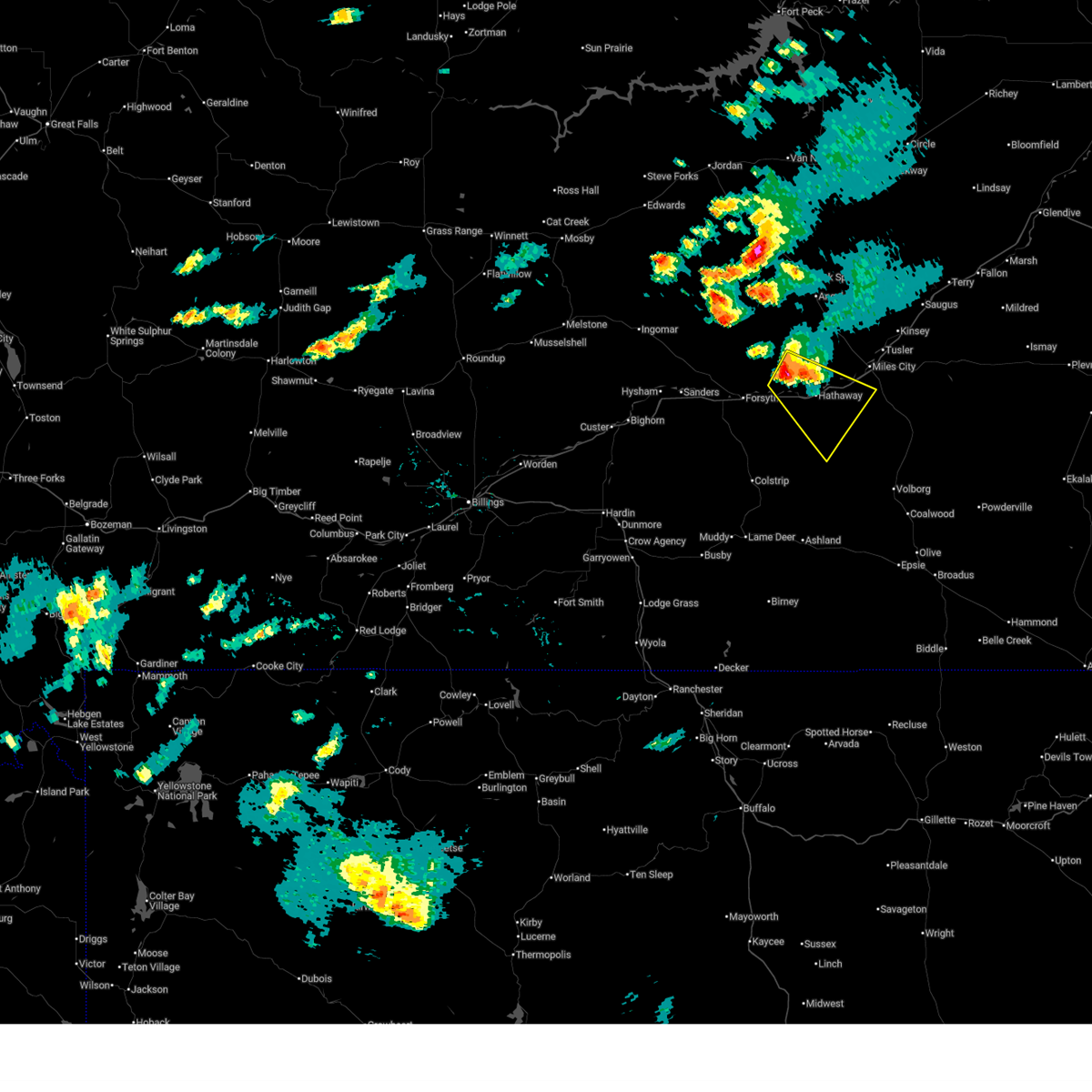 At 326 pm mdt, a severe thunderstorm was located 16 miles northeast of forsyth, moving east at 30 mph (radar indicated). Hazards include quarter size hail. Damage to vehicles is expected. Locations impacted include, rosebud, hathaway, moon creek ranch and cartersville. At 326 pm mdt, a severe thunderstorm was located 16 miles northeast of forsyth, moving east at 30 mph (radar indicated). Hazards include quarter size hail. Damage to vehicles is expected. Locations impacted include, rosebud, hathaway, moon creek ranch and cartersville.
|
| 7/29/2025 3:08 PM MDT |
 Svrbyz the national weather service in billings has issued a * severe thunderstorm warning for, west central custer county in southeastern montana, northern rosebud county in southeastern montana, * until 415 pm mdt. * at 308 pm mdt, a severe thunderstorm was located 10 miles northeast of forsyth, moving southeast at 30 mph (radar indicated). Hazards include half dollar size hail. damage to vehicles is expected Svrbyz the national weather service in billings has issued a * severe thunderstorm warning for, west central custer county in southeastern montana, northern rosebud county in southeastern montana, * until 415 pm mdt. * at 308 pm mdt, a severe thunderstorm was located 10 miles northeast of forsyth, moving southeast at 30 mph (radar indicated). Hazards include half dollar size hail. damage to vehicles is expected
|
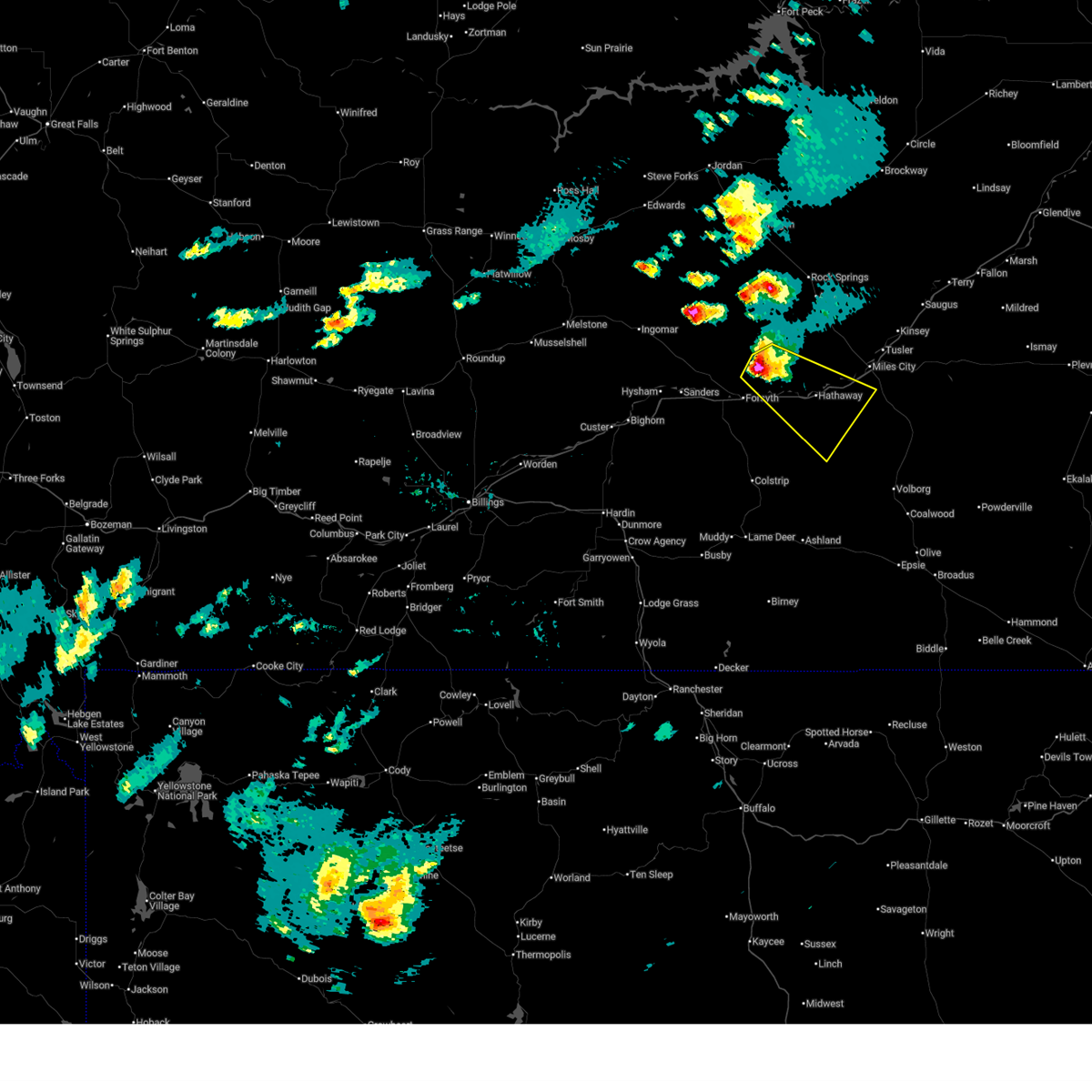
| 7/28/2025 8:58 PM MDT |
 The storms which prompted the warning have moved out of the area. therefore, the warning will be allowed to expire. however, small hail, gusty winds, and heavy rain are still possible with these thunderstorms. The storms which prompted the warning have moved out of the area. therefore, the warning will be allowed to expire. however, small hail, gusty winds, and heavy rain are still possible with these thunderstorms.
|
| 7/28/2025 8:40 PM MDT |
 At 840 pm mdt, severe thunderstorms were located along a line from 34 miles north of forsyth to 17 miles northwest of forsyth, moving east at 55 mph (radar indicated). Hazards include 60 mph wind gusts and quarter size hail. Hail damage to vehicles is expected. expect wind damage to roofs, siding, and trees. Locations impacted include, forsyth, rosebud, vananda, ingomar and cartersville. At 840 pm mdt, severe thunderstorms were located along a line from 34 miles north of forsyth to 17 miles northwest of forsyth, moving east at 55 mph (radar indicated). Hazards include 60 mph wind gusts and quarter size hail. Hail damage to vehicles is expected. expect wind damage to roofs, siding, and trees. Locations impacted include, forsyth, rosebud, vananda, ingomar and cartersville.
|
| 7/28/2025 8:22 PM MDT |
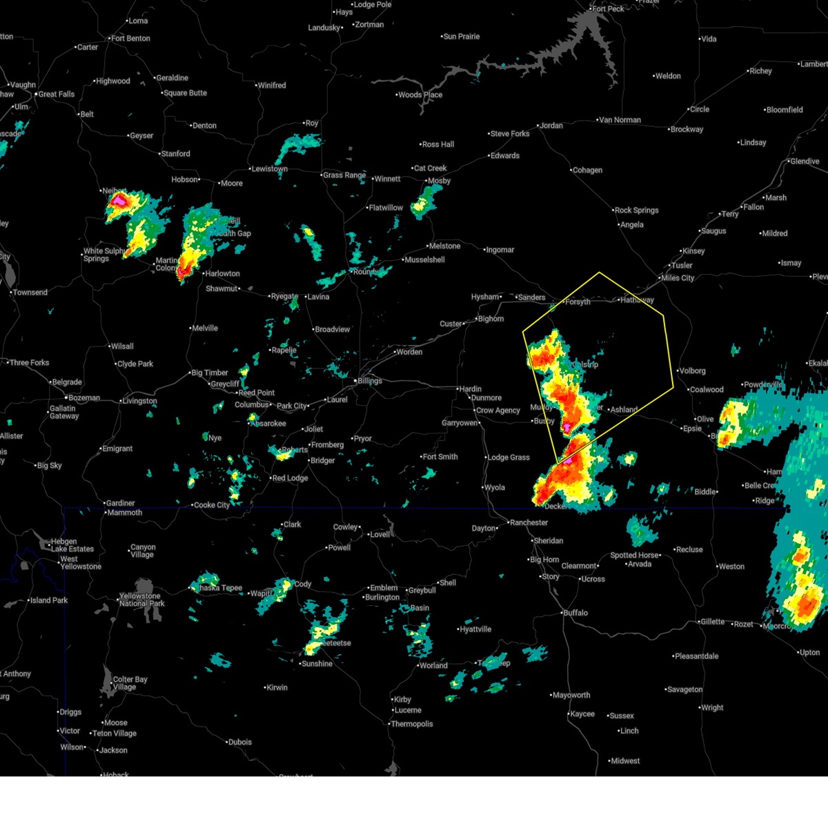
 At 822 pm mdt, severe thunderstorms were located along a line from 34 miles north of hysham to 15 miles north of hysham, moving east at 55 mph (mesonet in ingomar gusted to 64mph). Hazards include 60 to 70 mph wind gusts and quarter size hail. Hail damage to vehicles is expected. expect wind damage to roofs, siding, and trees. Locations impacted include, forsyth, rosebud, vananda, ingomar and cartersville. At 822 pm mdt, severe thunderstorms were located along a line from 34 miles north of hysham to 15 miles north of hysham, moving east at 55 mph (mesonet in ingomar gusted to 64mph). Hazards include 60 to 70 mph wind gusts and quarter size hail. Hail damage to vehicles is expected. expect wind damage to roofs, siding, and trees. Locations impacted include, forsyth, rosebud, vananda, ingomar and cartersville.
|
| 7/28/2025 8:14 PM MDT |
 Svrbyz the national weather service in billings has issued a * severe thunderstorm warning for, northern rosebud county in southeastern montana, * until 900 pm mdt. * at 814 pm mdt, severe thunderstorms were located along a line from 36 miles north of hysham to 18 miles northwest of hysham, moving east at 55 mph (radar indicated). Hazards include 60 mph wind gusts and quarter size hail. Hail damage to vehicles is expected. Expect wind damage to roofs, siding, and trees. Svrbyz the national weather service in billings has issued a * severe thunderstorm warning for, northern rosebud county in southeastern montana, * until 900 pm mdt. * at 814 pm mdt, severe thunderstorms were located along a line from 36 miles north of hysham to 18 miles northwest of hysham, moving east at 55 mph (radar indicated). Hazards include 60 mph wind gusts and quarter size hail. Hail damage to vehicles is expected. Expect wind damage to roofs, siding, and trees.
|
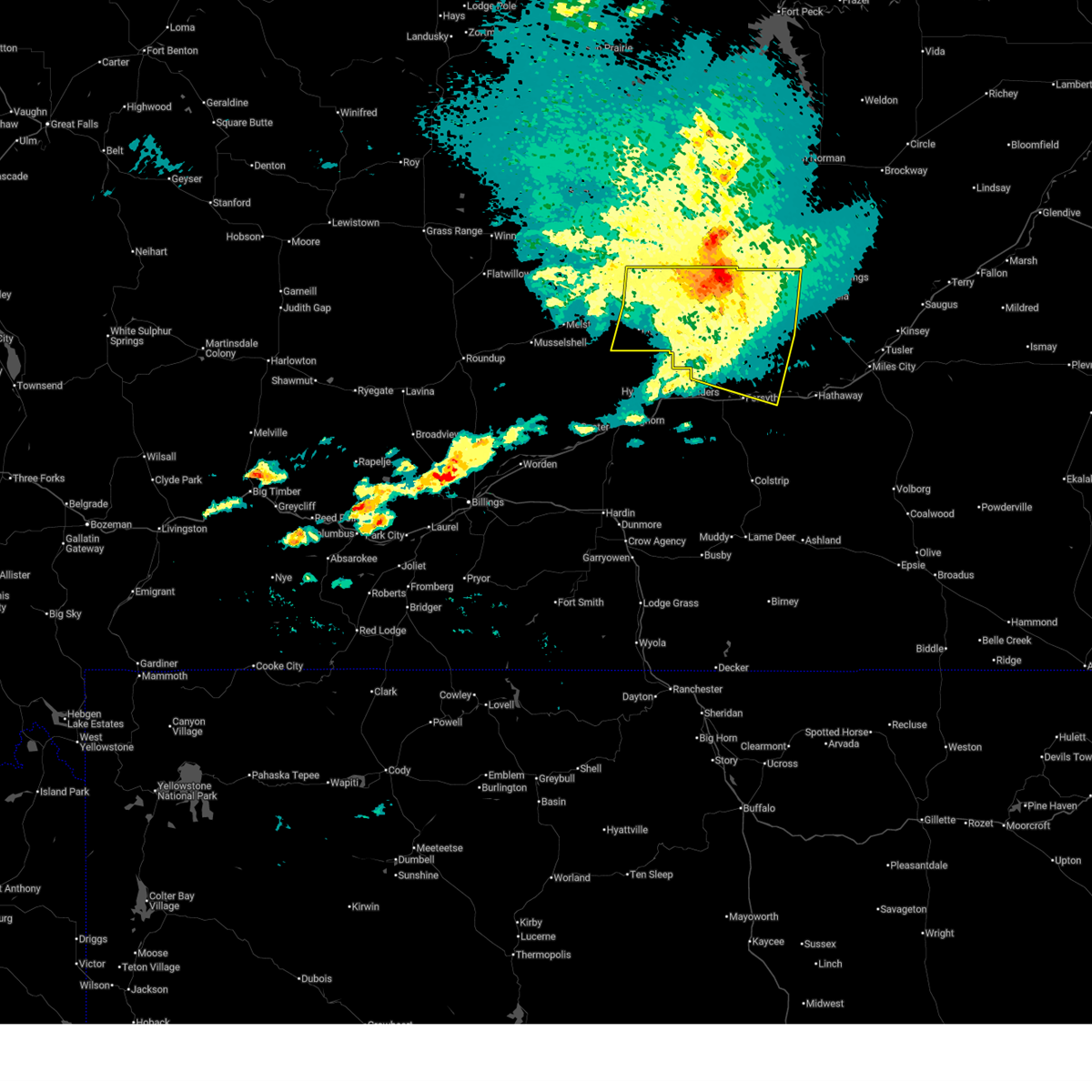
| 7/21/2025 6:00 PM MDT | Mesonet station mtswc 5.2 w hathaway (mt dot in rosebud county MT, 6.3 miles W of Rosebud, MT |
| 7/21/2025 5:29 PM MDT |
 The severe thunderstorm warning that was previously in effect has been reissued for custer, rosebud, and powder river counties and is in effect until 630 pm mdt. please refer to that bulletin for the latest severe weather information. a severe thunderstorm watch remains in effect until 1100 pm mdt monday for portions of south central and southeast montana. The severe thunderstorm warning that was previously in effect has been reissued for custer, rosebud, and powder river counties and is in effect until 630 pm mdt. please refer to that bulletin for the latest severe weather information. a severe thunderstorm watch remains in effect until 1100 pm mdt monday for portions of south central and southeast montana.
|
| 7/21/2025 5:28 PM MDT |
 Svrbyz the national weather service in billings has issued a * severe thunderstorm warning for, southwestern custer county in southeastern montana, northwestern powder river county in southeastern montana, southern rosebud county in southeastern montana, * until 630 pm mdt. * at 528 pm mdt, severe thunderstorms were located along a line from 14 miles east of forsyth to 26 miles south of ashland, or along a line from 14 miles east of forsyth to 44 miles west of broadus, moving east at 35 mph (radar indicated). Hazards include ping pong ball size hail and 60 mph wind gusts. People and animals outdoors will be injured. expect hail damage to roofs, siding, windows, and vehicles. Expect wind damage to roofs, siding, and trees. Svrbyz the national weather service in billings has issued a * severe thunderstorm warning for, southwestern custer county in southeastern montana, northwestern powder river county in southeastern montana, southern rosebud county in southeastern montana, * until 630 pm mdt. * at 528 pm mdt, severe thunderstorms were located along a line from 14 miles east of forsyth to 26 miles south of ashland, or along a line from 14 miles east of forsyth to 44 miles west of broadus, moving east at 35 mph (radar indicated). Hazards include ping pong ball size hail and 60 mph wind gusts. People and animals outdoors will be injured. expect hail damage to roofs, siding, windows, and vehicles. Expect wind damage to roofs, siding, and trees.
|
| 7/21/2025 5:06 PM MDT |
 At 506 pm mdt, severe thunderstorms were located along a line from 11 miles south of forsyth to near ashland, or along a line from 11 miles south of forsyth to 24 miles southeast of colstrip, moving northeast at 50 mph (radar indicated). Hazards include 70 mph wind gusts and ping pong ball size hail. People and animals outdoors will be injured. expect hail damage to roofs, siding, windows, and vehicles. expect considerable tree damage. wind damage is also likely to mobile homes, roofs, and outbuildings. Locations impacted include, colstrip, forsyth, ashland, lame deer, rosebud, brandenberg, cartersville, hathaway, moon creek ranch, birney village, garland, muddy cluster and northern cheyenne indian reservation. At 506 pm mdt, severe thunderstorms were located along a line from 11 miles south of forsyth to near ashland, or along a line from 11 miles south of forsyth to 24 miles southeast of colstrip, moving northeast at 50 mph (radar indicated). Hazards include 70 mph wind gusts and ping pong ball size hail. People and animals outdoors will be injured. expect hail damage to roofs, siding, windows, and vehicles. expect considerable tree damage. wind damage is also likely to mobile homes, roofs, and outbuildings. Locations impacted include, colstrip, forsyth, ashland, lame deer, rosebud, brandenberg, cartersville, hathaway, moon creek ranch, birney village, garland, muddy cluster and northern cheyenne indian reservation.
|
| 7/21/2025 4:32 PM MDT |
 Svrbyz the national weather service in billings has issued a * severe thunderstorm warning for, northeastern big horn county in south central montana, southwestern custer county in southeastern montana, northwestern powder river county in southeastern montana, southern rosebud county in southeastern montana, southeastern treasure county in southeastern montana, * until 530 pm mdt. * at 432 pm mdt, severe thunderstorms were located along a line from 23 miles northeast of crow agency to 12 miles southeast of busby, or along a line from 22 miles northeast of hardin to 34 miles south of colstrip, moving northeast at 50 mph. this replaces the previous warning for this area (radar indicated). Hazards include 70 mph wind gusts and ping pong ball size hail. People and animals outdoors will be injured. expect hail damage to roofs, siding, windows, and vehicles. expect considerable tree damage. Wind damage is also likely to mobile homes, roofs, and outbuildings. Svrbyz the national weather service in billings has issued a * severe thunderstorm warning for, northeastern big horn county in south central montana, southwestern custer county in southeastern montana, northwestern powder river county in southeastern montana, southern rosebud county in southeastern montana, southeastern treasure county in southeastern montana, * until 530 pm mdt. * at 432 pm mdt, severe thunderstorms were located along a line from 23 miles northeast of crow agency to 12 miles southeast of busby, or along a line from 22 miles northeast of hardin to 34 miles south of colstrip, moving northeast at 50 mph. this replaces the previous warning for this area (radar indicated). Hazards include 70 mph wind gusts and ping pong ball size hail. People and animals outdoors will be injured. expect hail damage to roofs, siding, windows, and vehicles. expect considerable tree damage. Wind damage is also likely to mobile homes, roofs, and outbuildings.
|
| 7/5/2025 4:15 PM MDT |
 Svrbyz the national weather service in billings has issued a * severe thunderstorm warning for, western custer county in southeastern montana, northern rosebud county in southeastern montana, * until 515 pm mdt. * at 415 pm mdt, severe thunderstorms were located along a line from 42 miles north of hysham to 21 miles northeast of colstrip, moving northeast at 40 mph (radar indicated). Hazards include 60 mph wind gusts and small hail. expect damage to roofs, siding, and trees Svrbyz the national weather service in billings has issued a * severe thunderstorm warning for, western custer county in southeastern montana, northern rosebud county in southeastern montana, * until 515 pm mdt. * at 415 pm mdt, severe thunderstorms were located along a line from 42 miles north of hysham to 21 miles northeast of colstrip, moving northeast at 40 mph (radar indicated). Hazards include 60 mph wind gusts and small hail. expect damage to roofs, siding, and trees
|
| 7/5/2025 3:57 PM MDT |
 the severe thunderstorm warning has been cancelled and is no longer in effect the severe thunderstorm warning has been cancelled and is no longer in effect
|
| 7/5/2025 3:57 PM MDT |
 At 357 pm mdt, severe thunderstorms were located along a line from 31 miles north of hysham to 18 miles southeast of forsyth, moving northeast at 40 mph (radar indicated). Hazards include 60 to 70 mph wind gusts and small hail. Expect considerable tree damage. damage is likely to mobile homes, roofs, and outbuildings. locations impacted include, forsyth, rosebud, vananda, cartersville and hathaway. Radar indicates the strongest winds are occurring along and near interstate 94. At 357 pm mdt, severe thunderstorms were located along a line from 31 miles north of hysham to 18 miles southeast of forsyth, moving northeast at 40 mph (radar indicated). Hazards include 60 to 70 mph wind gusts and small hail. Expect considerable tree damage. damage is likely to mobile homes, roofs, and outbuildings. locations impacted include, forsyth, rosebud, vananda, cartersville and hathaway. Radar indicates the strongest winds are occurring along and near interstate 94.
|
| 7/5/2025 3:30 PM MDT |
 Svrbyz the national weather service in billings has issued a * severe thunderstorm warning for, northern rosebud county in southeastern montana, eastern treasure county in southeastern montana, * until 415 pm mdt. * at 330 pm mdt, severe thunderstorms were located along a line from 22 miles north of hysham to 10 miles north of colstrip, moving northeast at 40 mph (radar indicated). Hazards include 60 to 70 mph wind gusts and quarter size hail. Hail damage to vehicles is expected. expect considerable tree damage. Wind damage is also likely to mobile homes, roofs, and outbuildings. Svrbyz the national weather service in billings has issued a * severe thunderstorm warning for, northern rosebud county in southeastern montana, eastern treasure county in southeastern montana, * until 415 pm mdt. * at 330 pm mdt, severe thunderstorms were located along a line from 22 miles north of hysham to 10 miles north of colstrip, moving northeast at 40 mph (radar indicated). Hazards include 60 to 70 mph wind gusts and quarter size hail. Hail damage to vehicles is expected. expect considerable tree damage. Wind damage is also likely to mobile homes, roofs, and outbuildings.
|
| 6/13/2025 9:29 PM MDT |
 the severe thunderstorm warning has been cancelled and is no longer in effect the severe thunderstorm warning has been cancelled and is no longer in effect
|
| 6/13/2025 8:57 PM MDT |
 Svrbyz the national weather service in billings has issued a * severe thunderstorm warning for, southwestern custer county in southeastern montana, northwestern powder river county in southeastern montana, central rosebud county in southeastern montana, * until 1000 pm mdt. * at 857 pm mdt, a severe thunderstorm was located 14 miles north of ashland, or 13 miles southeast of colstrip, moving east at 45 mph (radar indicated). Hazards include 60 mph wind gusts and quarter size hail. Hail damage to vehicles is expected. Expect wind damage to roofs, siding, and trees. Svrbyz the national weather service in billings has issued a * severe thunderstorm warning for, southwestern custer county in southeastern montana, northwestern powder river county in southeastern montana, central rosebud county in southeastern montana, * until 1000 pm mdt. * at 857 pm mdt, a severe thunderstorm was located 14 miles north of ashland, or 13 miles southeast of colstrip, moving east at 45 mph (radar indicated). Hazards include 60 mph wind gusts and quarter size hail. Hail damage to vehicles is expected. Expect wind damage to roofs, siding, and trees.
|
| 8/4/2024 10:33 PM MDT |
 The storms which prompted the warning have moved out of the area. therefore, the warning has been allowed to expire. however, gusty winds and heavy rain are still possible with these thunderstorms. The storms which prompted the warning have moved out of the area. therefore, the warning has been allowed to expire. however, gusty winds and heavy rain are still possible with these thunderstorms.
|
| 8/4/2024 10:15 PM MDT |
 At 1013 pm mdt, severe thunderstorms were located along a line extending from 7 miles north of forsyth to 12 miles northeast of colstrip to near ashland, moving east at 40 mph (weather station reported wind gust of 60 mph, 6 ene of lame deer at 1001 pm mdt). Hazards include 60 mph wind gusts. Expect damage to roofs, siding, and trees. Locations impacted include, colstrip, forsyth, ashland, rosebud, brandenberg, cartersville, and northern cheyenne indian reservation. At 1013 pm mdt, severe thunderstorms were located along a line extending from 7 miles north of forsyth to 12 miles northeast of colstrip to near ashland, moving east at 40 mph (weather station reported wind gust of 60 mph, 6 ene of lame deer at 1001 pm mdt). Hazards include 60 mph wind gusts. Expect damage to roofs, siding, and trees. Locations impacted include, colstrip, forsyth, ashland, rosebud, brandenberg, cartersville, and northern cheyenne indian reservation.
|
| 8/4/2024 10:15 PM MDT |
 the severe thunderstorm warning has been cancelled and is no longer in effect the severe thunderstorm warning has been cancelled and is no longer in effect
|
| 8/4/2024 9:27 PM MDT |
 Svrbyz the national weather service in billings has issued a * severe thunderstorm warning for, northeastern big horn county in south central montana, rosebud county in southeastern montana, treasure county in southeastern montana, * until 1030 pm mdt. * at 926 pm mdt, severe thunderstorms were located along a line extending from near hysham to 17 miles west of colstrip to busby, moving east at 40 mph (radar indicated). Hazards include 60 mph wind gusts. expect damage to roofs, siding, and trees Svrbyz the national weather service in billings has issued a * severe thunderstorm warning for, northeastern big horn county in south central montana, rosebud county in southeastern montana, treasure county in southeastern montana, * until 1030 pm mdt. * at 926 pm mdt, severe thunderstorms were located along a line extending from near hysham to 17 miles west of colstrip to busby, moving east at 40 mph (radar indicated). Hazards include 60 mph wind gusts. expect damage to roofs, siding, and trees
|
| 7/13/2024 7:13 PM MDT |
 At 711 pm mdt, a severe thunderstorm was located near miles city, and is nearly stationary (trained weather spotters. 72 mph wind gust measured in miles city at 7:10 pm mdt). Hazards include golf ball size hail and 70 mph wind gusts. People and animals outdoors will be injured. expect hail damage to roofs, siding, windows, and vehicles. expect considerable tree damage. wind damage is also likely to mobile homes, roofs, and outbuildings. Locations impacted include, miles city, rosebud, locate, angela, cartersville, strawberry hill recreation area, matthews recreation area, hathaway, twelve mile dam, brandenberg, rock springs, garland, moon creek ranch, mizpah, and knowlton. At 711 pm mdt, a severe thunderstorm was located near miles city, and is nearly stationary (trained weather spotters. 72 mph wind gust measured in miles city at 7:10 pm mdt). Hazards include golf ball size hail and 70 mph wind gusts. People and animals outdoors will be injured. expect hail damage to roofs, siding, windows, and vehicles. expect considerable tree damage. wind damage is also likely to mobile homes, roofs, and outbuildings. Locations impacted include, miles city, rosebud, locate, angela, cartersville, strawberry hill recreation area, matthews recreation area, hathaway, twelve mile dam, brandenberg, rock springs, garland, moon creek ranch, mizpah, and knowlton.
|
| 7/13/2024 6:55 PM MDT |
 Svrbyz the national weather service in billings has issued a * severe thunderstorm warning for, custer county in southeastern montana, northern rosebud county in southeastern montana, * until 800 pm mdt. * at 653 pm mdt, a severe thunderstorm was located 14 miles northwest of miles city, moving southeast at 50 mph (radar indicated). Hazards include ping pong ball size hail and 60 mph wind gusts. People and animals outdoors will be injured. expect hail damage to roofs, siding, windows, and vehicles. Expect wind damage to roofs, siding, and trees. Svrbyz the national weather service in billings has issued a * severe thunderstorm warning for, custer county in southeastern montana, northern rosebud county in southeastern montana, * until 800 pm mdt. * at 653 pm mdt, a severe thunderstorm was located 14 miles northwest of miles city, moving southeast at 50 mph (radar indicated). Hazards include ping pong ball size hail and 60 mph wind gusts. People and animals outdoors will be injured. expect hail damage to roofs, siding, windows, and vehicles. Expect wind damage to roofs, siding, and trees.
|
| 6/30/2024 9:29 PM MDT |
 the severe thunderstorm warning has been cancelled and is no longer in effect the severe thunderstorm warning has been cancelled and is no longer in effect
|
| 6/30/2024 9:19 PM MDT |
 Svrbyz the national weather service in billings has issued a * severe thunderstorm warning for, rosebud county in southeastern montana, * until 945 pm mdt. * at 918 pm mdt, a severe thunderstorm was just south of forsyth, moving east at 25 mph (radar indicated). Hazards include 60 mph wind gusts and quarter size hail. Hail damage to vehicles is expected. Expect wind damage to roofs, siding, and trees. Svrbyz the national weather service in billings has issued a * severe thunderstorm warning for, rosebud county in southeastern montana, * until 945 pm mdt. * at 918 pm mdt, a severe thunderstorm was just south of forsyth, moving east at 25 mph (radar indicated). Hazards include 60 mph wind gusts and quarter size hail. Hail damage to vehicles is expected. Expect wind damage to roofs, siding, and trees.
|
| 6/27/2024 3:35 PM MDT | Ping Pong Ball sized hail reported 28.9 miles SSW of Rosebud, MT |
| 6/27/2024 3:09 PM MDT |
 Svrbyz the national weather service in billings has issued a * severe thunderstorm warning for, southwestern custer county in southeastern montana, central rosebud county in southeastern montana, * until 415 pm mdt. * at 309 pm mdt, a severe thunderstorm was located 7 miles south of forsyth, moving east at 50 mph (radar indicated). Hazards include 70 mph wind gusts and quarter size hail. Hail damage to vehicles is expected. expect considerable tree damage. Wind damage is also likely to mobile homes, roofs, and outbuildings. Svrbyz the national weather service in billings has issued a * severe thunderstorm warning for, southwestern custer county in southeastern montana, central rosebud county in southeastern montana, * until 415 pm mdt. * at 309 pm mdt, a severe thunderstorm was located 7 miles south of forsyth, moving east at 50 mph (radar indicated). Hazards include 70 mph wind gusts and quarter size hail. Hail damage to vehicles is expected. expect considerable tree damage. Wind damage is also likely to mobile homes, roofs, and outbuildings.
|
| 6/20/2024 9:23 PM MDT |
 the severe thunderstorm warning has been cancelled and is no longer in effect the severe thunderstorm warning has been cancelled and is no longer in effect
|
| 6/20/2024 8:58 PM MDT |
 Svrbyz the national weather service in billings has issued a * severe thunderstorm warning for, northern rosebud county in southeastern montana, * until 945 pm mdt. * at 857 pm mdt, a severe thunderstorm was located 11 miles north of forsyth, moving southeast at 30 mph (radar indicated). Hazards include 60 mph wind gusts and quarter size hail. Hail damage to vehicles is expected. Expect wind damage to roofs, siding, and trees. Svrbyz the national weather service in billings has issued a * severe thunderstorm warning for, northern rosebud county in southeastern montana, * until 945 pm mdt. * at 857 pm mdt, a severe thunderstorm was located 11 miles north of forsyth, moving southeast at 30 mph (radar indicated). Hazards include 60 mph wind gusts and quarter size hail. Hail damage to vehicles is expected. Expect wind damage to roofs, siding, and trees.
|
| 8/30/2023 6:20 PM MDT | Storm damage reported in rosebud county MT, 6.3 miles W of Rosebud, MT |
| 6/20/2023 12:43 AM MDT |
 At 1241 am mdt, a severe thunderstorm was located 11 miles west of miles city, moving northeast at 55 mph (radar indicated). Hazards include golf ball size hail and 60 mph wind gusts. People and animals outdoors will be injured. expect hail damage to roofs, siding, windows, and vehicles. expect wind damage to roofs, siding, and trees. locations impacted include, miles city, hathaway, moon creek ranch, twelve mile dam, strawberry hill recreation area and matthews recreation area. a second severe storm was located 8 miles south of hathaway, moving northeast at 45 mph. this storm has weakened over the past 20 minutes, but may still produce quarter size hail and wind gusts to 60 mph. thunderstorm damage threat, considerable hail threat, radar indicated max hail size, 1. 75 in wind threat, radar indicated max wind gust, 60 mph. At 1241 am mdt, a severe thunderstorm was located 11 miles west of miles city, moving northeast at 55 mph (radar indicated). Hazards include golf ball size hail and 60 mph wind gusts. People and animals outdoors will be injured. expect hail damage to roofs, siding, windows, and vehicles. expect wind damage to roofs, siding, and trees. locations impacted include, miles city, hathaway, moon creek ranch, twelve mile dam, strawberry hill recreation area and matthews recreation area. a second severe storm was located 8 miles south of hathaway, moving northeast at 45 mph. this storm has weakened over the past 20 minutes, but may still produce quarter size hail and wind gusts to 60 mph. thunderstorm damage threat, considerable hail threat, radar indicated max hail size, 1. 75 in wind threat, radar indicated max wind gust, 60 mph.
|
| 6/20/2023 12:23 AM MDT |
 At 1221 am mdt, a severe thunderstorm was located 13 miles east of colstrip, moving northeast at 50 mph. a second severe storm was located near hathaway, moving northeast at 45 mph (radar indicated). Hazards include ping pong ball size hail and 60 mph wind gusts. People and animals outdoors will be injured. expect hail damage to roofs, siding, windows, and vehicles. Expect wind damage to roofs, siding, and trees. At 1221 am mdt, a severe thunderstorm was located 13 miles east of colstrip, moving northeast at 50 mph. a second severe storm was located near hathaway, moving northeast at 45 mph (radar indicated). Hazards include ping pong ball size hail and 60 mph wind gusts. People and animals outdoors will be injured. expect hail damage to roofs, siding, windows, and vehicles. Expect wind damage to roofs, siding, and trees.
|
| 5/24/2023 5:50 PM MDT | Quarter sized hail reported 12.1 miles W of Rosebud, MT |
| 7/15/2022 6:39 PM MDT |
 The severe thunderstorm warning for southeastern big horn, southwestern custer, western powder river, rosebud and central sheridan counties will expire at 645 pm mdt, the outflow which prompted the warning have weakened below severe limits, and no longer pose an immediate threat to life or property. therefore, the warning will be allowed to expire. however gusty winds up to 55 mph are still possible with this outflow. a severe thunderstorm watch remains in effect until 900 pm mdt for south central and southeastern montana. The severe thunderstorm warning for southeastern big horn, southwestern custer, western powder river, rosebud and central sheridan counties will expire at 645 pm mdt, the outflow which prompted the warning have weakened below severe limits, and no longer pose an immediate threat to life or property. therefore, the warning will be allowed to expire. however gusty winds up to 55 mph are still possible with this outflow. a severe thunderstorm watch remains in effect until 900 pm mdt for south central and southeastern montana.
|
| 7/15/2022 6:21 PM MDT |
 At 619 pm mdt, severe thunderstorms were located along a line extending from near hillside to 19 miles northwest of miles city to near ashland to 33 miles south of lame deer to 9 miles south of sheridan, moving east at 35 mph (weather station. at 601 pm there sheridan airport report a 59 mph wind gust). Hazards include 60 mph wind gusts. Expect damage to roofs, siding, and trees. locations impacted include, sheridan, ashland, big horn, rosebud, birney, banner, cartersville, birney village, hathaway, otter, brandenberg, moon creek ranch, story and northern cheyenne indian reservation. hail threat, radar indicated max hail size, <. 75 in wind threat, observed max wind gust, 60 mph. At 619 pm mdt, severe thunderstorms were located along a line extending from near hillside to 19 miles northwest of miles city to near ashland to 33 miles south of lame deer to 9 miles south of sheridan, moving east at 35 mph (weather station. at 601 pm there sheridan airport report a 59 mph wind gust). Hazards include 60 mph wind gusts. Expect damage to roofs, siding, and trees. locations impacted include, sheridan, ashland, big horn, rosebud, birney, banner, cartersville, birney village, hathaway, otter, brandenberg, moon creek ranch, story and northern cheyenne indian reservation. hail threat, radar indicated max hail size, <. 75 in wind threat, observed max wind gust, 60 mph.
|
| 7/15/2022 5:43 PM MDT |
 At 543 pm mdt, severe thunderstorms were located along a line extending from 19 miles south of sand springs to 21 miles northwest of forsyth to 6 miles northwest of lame deer to 7 miles east of busby to near ranchester, moving east at 20 mph (weather station. between 500 pm and 530 pm reports of 55 to 65 mph winds have been reported by weather station. these outflow winds have a history of damage). Hazards include 70 mph wind gusts. Expect considerable tree damage. Damage is likely to mobile homes, roofs, and outbuildings. At 543 pm mdt, severe thunderstorms were located along a line extending from 19 miles south of sand springs to 21 miles northwest of forsyth to 6 miles northwest of lame deer to 7 miles east of busby to near ranchester, moving east at 20 mph (weather station. between 500 pm and 530 pm reports of 55 to 65 mph winds have been reported by weather station. these outflow winds have a history of damage). Hazards include 70 mph wind gusts. Expect considerable tree damage. Damage is likely to mobile homes, roofs, and outbuildings.
|
| 7/15/2022 4:30 PM MDT | Storm damage reported in rosebud county MT, 20.6 miles S of Rosebud, MT |
| 7/9/2022 10:52 PM MDT |
 At 1051 pm mdt, severe thunderstorms were located along a line extending from 15 miles southeast of hillside to 22 miles west of miles city to 6 miles northeast of forsyth, moving east at 40 mph (radar indicated). Hazards include two inch hail and 60 mph wind gusts. People and animals outdoors will be injured. expect hail and wind damage to roofs, siding, windows, and vehicles. These severe thunderstorms will remain over mainly rural areas of northern rosebud county, including the following locations, rock springs, angela, hathaway, cartersville and rosebud. At 1051 pm mdt, severe thunderstorms were located along a line extending from 15 miles southeast of hillside to 22 miles west of miles city to 6 miles northeast of forsyth, moving east at 40 mph (radar indicated). Hazards include two inch hail and 60 mph wind gusts. People and animals outdoors will be injured. expect hail and wind damage to roofs, siding, windows, and vehicles. These severe thunderstorms will remain over mainly rural areas of northern rosebud county, including the following locations, rock springs, angela, hathaway, cartersville and rosebud.
|
| 7/9/2022 10:35 PM MDT |
 At 1033 pm mdt, severe thunderstorms were located across northern rosebud county north of i-90, moving east at 40 mph (radar indicated). Hazards include two inch hail and 60 mph wind gusts. People and animals outdoors will be injured. expect hail and wind damage to roofs, siding, windows, and vehicles. These severe thunderstorms will remain over mainly rural areas of northern rosebud county, including the following locations, rock springs, angela, hathaway, cartersville, vananda and rosebud. At 1033 pm mdt, severe thunderstorms were located across northern rosebud county north of i-90, moving east at 40 mph (radar indicated). Hazards include two inch hail and 60 mph wind gusts. People and animals outdoors will be injured. expect hail and wind damage to roofs, siding, windows, and vehicles. These severe thunderstorms will remain over mainly rural areas of northern rosebud county, including the following locations, rock springs, angela, hathaway, cartersville, vananda and rosebud.
|
| 7/9/2022 10:11 PM MDT |
 At 1010 pm mdt, severe thunderstorms were located across northern rosebud and northern treasure counties, moving east at 40 mph (radar indicated). Hazards include golf ball size hail and 60 mph wind gusts. People and animals outdoors will be injured. Expect hail and wind damage to roofs, siding, windows, and vehicles. At 1010 pm mdt, severe thunderstorms were located across northern rosebud and northern treasure counties, moving east at 40 mph (radar indicated). Hazards include golf ball size hail and 60 mph wind gusts. People and animals outdoors will be injured. Expect hail and wind damage to roofs, siding, windows, and vehicles.
|
| 7/5/2022 4:49 AM MDT |
 At 448 am mdt, a severe thunderstorm was located near colstrip, moving east at 25 mph (radar indicated). Hazards include tennis ball size hail and 60 mph wind gusts. People and animals outdoors will be injured. expect hail damage to roofs, siding, windows, and vehicles. expect wind damage to roofs, siding, and trees. locations impacted include, colstrip, rosebud, hathaway, cartersville and brandenberg. thunderstorm damage threat, considerable hail threat, radar indicated max hail size, 2. 50 in wind threat, radar indicated max wind gust, 60 mph. At 448 am mdt, a severe thunderstorm was located near colstrip, moving east at 25 mph (radar indicated). Hazards include tennis ball size hail and 60 mph wind gusts. People and animals outdoors will be injured. expect hail damage to roofs, siding, windows, and vehicles. expect wind damage to roofs, siding, and trees. locations impacted include, colstrip, rosebud, hathaway, cartersville and brandenberg. thunderstorm damage threat, considerable hail threat, radar indicated max hail size, 2. 50 in wind threat, radar indicated max wind gust, 60 mph.
|
| 7/5/2022 4:40 AM MDT |
 At 439 am mdt, a severe thunderstorm was located near colstrip, moving east at 35 mph (radar indicated). Hazards include 60 mph wind gusts and half dollar size hail. Hail damage to vehicles is expected. expect wind damage to roofs, siding, and trees. locations impacted include, colstrip, forsyth, rosebud, hathaway, cartersville and brandenberg. hail threat, radar indicated max hail size, 1. 25 in wind threat, radar indicated max wind gust, 60 mph. At 439 am mdt, a severe thunderstorm was located near colstrip, moving east at 35 mph (radar indicated). Hazards include 60 mph wind gusts and half dollar size hail. Hail damage to vehicles is expected. expect wind damage to roofs, siding, and trees. locations impacted include, colstrip, forsyth, rosebud, hathaway, cartersville and brandenberg. hail threat, radar indicated max hail size, 1. 25 in wind threat, radar indicated max wind gust, 60 mph.
|
| 7/5/2022 4:14 AM MDT |
 At 414 am mdt, a severe thunderstorm was located 18 miles west of colstrip, moving east at 35 mph (radar indicated). Hazards include quarter size hail. damage to vehicles is expected At 414 am mdt, a severe thunderstorm was located 18 miles west of colstrip, moving east at 35 mph (radar indicated). Hazards include quarter size hail. damage to vehicles is expected
|
| 7/7/2021 7:18 PM MDT |
 At 717 pm mdt, a severe thunderstorm was located 16 miles northeast of colstrip, moving southeast at 50 mph (radar indicated). Hazards include 60 mph wind gusts and penny size hail. Expect damage to roofs, siding, and trees. This severe thunderstorm will remain over mainly rural areas of central rosebud county. At 717 pm mdt, a severe thunderstorm was located 16 miles northeast of colstrip, moving southeast at 50 mph (radar indicated). Hazards include 60 mph wind gusts and penny size hail. Expect damage to roofs, siding, and trees. This severe thunderstorm will remain over mainly rural areas of central rosebud county.
|
| 7/7/2021 7:00 PM MDT |
 At 700 pm mdt, a severe thunderstorm was located 10 miles southeast of forsyth, moving southeast at 50 mph (radar indicated). Hazards include 60 mph wind gusts and quarter size hail. expect wind damage to roofs, siding, and trees At 700 pm mdt, a severe thunderstorm was located 10 miles southeast of forsyth, moving southeast at 50 mph (radar indicated). Hazards include 60 mph wind gusts and quarter size hail. expect wind damage to roofs, siding, and trees
|
| 6/8/2021 7:12 PM MDT |
 At 711 pm mdt, severe thunderstorms were located along a line extending from 19 miles southwest of cohagen to near forsyth, moving northeast at 40 mph (radar indicated. at 710 pm a spotter reported a possible funnel cloud north of forsyth with this storm). Hazards include golf ball size hail and 60 mph wind gusts. People and animals outdoors will be injured. expect hail damage to roofs, siding, windows, and vehicles. expect wind damage to roofs, siding, and trees. Locations impacted include, forsyth, rosebud, rock springs, angela, hathaway and cartersville. At 711 pm mdt, severe thunderstorms were located along a line extending from 19 miles southwest of cohagen to near forsyth, moving northeast at 40 mph (radar indicated. at 710 pm a spotter reported a possible funnel cloud north of forsyth with this storm). Hazards include golf ball size hail and 60 mph wind gusts. People and animals outdoors will be injured. expect hail damage to roofs, siding, windows, and vehicles. expect wind damage to roofs, siding, and trees. Locations impacted include, forsyth, rosebud, rock springs, angela, hathaway and cartersville.
|
| 6/8/2021 7:02 PM MDT |
 At 702 pm mdt, severe thunderstorms were located along a line extending from 24 miles southwest of cohagen to near forsyth, moving northeast at 40 mph (radar indicated). Hazards include 60 mph wind gusts and half dollar size hail. Hail damage to vehicles is expected. Expect wind damage to roofs, siding, and trees. At 702 pm mdt, severe thunderstorms were located along a line extending from 24 miles southwest of cohagen to near forsyth, moving northeast at 40 mph (radar indicated). Hazards include 60 mph wind gusts and half dollar size hail. Hail damage to vehicles is expected. Expect wind damage to roofs, siding, and trees.
|
| 7/7/2020 6:39 PM MDT |
 The severe thunderstorm warning for northeastern big horn, rosebud and treasure counties will expire at 645 pm mdt, the storms which prompted the warning have weakened below severe limits, and no longer pose an immediate threat to life or property. therefore, the warning will be allowed to expire. however gusty winds are still possible with these thunderstorms. a severe thunderstorm watch remains in effect until 900 pm mdt for south central and southeastern montana. The severe thunderstorm warning for northeastern big horn, rosebud and treasure counties will expire at 645 pm mdt, the storms which prompted the warning have weakened below severe limits, and no longer pose an immediate threat to life or property. therefore, the warning will be allowed to expire. however gusty winds are still possible with these thunderstorms. a severe thunderstorm watch remains in effect until 900 pm mdt for south central and southeastern montana.
|
| 7/7/2020 6:14 PM MDT |
 At 613 pm mdt, severe thunderstorms were located along a line extending from 16 miles southwest of cohagen to 13 miles northwest of busby, moving east at 40 mph (radar indicated). Hazards include 60 mph wind gusts and nickel size hail. Expect damage to roofs, siding, and trees. Locations impacted include, colstrip, forsyth, hysham, lame deer, rosebud, vananda, bighorn, rock springs, ingomar, cartersville, muddy cluster and northern cheyenne indian reservation. At 613 pm mdt, severe thunderstorms were located along a line extending from 16 miles southwest of cohagen to 13 miles northwest of busby, moving east at 40 mph (radar indicated). Hazards include 60 mph wind gusts and nickel size hail. Expect damage to roofs, siding, and trees. Locations impacted include, colstrip, forsyth, hysham, lame deer, rosebud, vananda, bighorn, rock springs, ingomar, cartersville, muddy cluster and northern cheyenne indian reservation.
|
| 7/7/2020 5:41 PM MDT |
 At 539 pm mdt, severe thunderstorms were located along a line extending from 18 miles south of edwards to hardin, moving east at 40 mph (radar indicated). Hazards include 70 mph wind gusts and quarter size hail. Hail damage to vehicles is expected. expect considerable tree damage. Wind damage is also likely to mobile homes, roofs, and outbuildings. At 539 pm mdt, severe thunderstorms were located along a line extending from 18 miles south of edwards to hardin, moving east at 40 mph (radar indicated). Hazards include 70 mph wind gusts and quarter size hail. Hail damage to vehicles is expected. expect considerable tree damage. Wind damage is also likely to mobile homes, roofs, and outbuildings.
|
| 7/6/2020 4:28 PM MDT |
 At 425 pm mdt, a severe thunderstorm was located 9 miles southeast of forsyth, moving east at 40 mph (trained weather spotters. at 403 pm mdt, golf ball sized hail was reported at 7 miles west of forsyth). Hazards include two inch hail and 60 mph wind gusts. People and animals outdoors will be injured. expect hail damage to roofs, siding, windows, and vehicles. expect wind damage to roofs, siding, and trees. Locations impacted include, forsyth, rosebud, hathaway and cartersville. At 425 pm mdt, a severe thunderstorm was located 9 miles southeast of forsyth, moving east at 40 mph (trained weather spotters. at 403 pm mdt, golf ball sized hail was reported at 7 miles west of forsyth). Hazards include two inch hail and 60 mph wind gusts. People and animals outdoors will be injured. expect hail damage to roofs, siding, windows, and vehicles. expect wind damage to roofs, siding, and trees. Locations impacted include, forsyth, rosebud, hathaway and cartersville.
|
| 7/6/2020 3:55 PM MDT |
 At 353 pm mdt, a severe thunderstorm was located 12 miles west of forsyth, moving east at 40 mph (trained weather spotters. at 350 pm mdt, 2 inch sized hail was reported 5 miles east of hysham). Hazards include two inch hail and 60 mph wind gusts. People and animals outdoors will be injured. expect hail damage to roofs, siding, windows, and vehicles. Expect wind damage to roofs, siding, and trees. At 353 pm mdt, a severe thunderstorm was located 12 miles west of forsyth, moving east at 40 mph (trained weather spotters. at 350 pm mdt, 2 inch sized hail was reported 5 miles east of hysham). Hazards include two inch hail and 60 mph wind gusts. People and animals outdoors will be injured. expect hail damage to roofs, siding, windows, and vehicles. Expect wind damage to roofs, siding, and trees.
|
| 7/4/2020 6:42 PM MDT |
 The severe thunderstorm warning for northern rosebud county will expire at 645 pm mdt, the storm which prompted the warning has weakened below severe limits, and no longer poses an immediate threat to life or property. therefore, the warning will be allowed to expire. however hail, gusty winds and heavy rain are still possible with this thunderstorm. a severe thunderstorm watch remains in effect until midnight mdt for southeastern montana. The severe thunderstorm warning for northern rosebud county will expire at 645 pm mdt, the storm which prompted the warning has weakened below severe limits, and no longer poses an immediate threat to life or property. therefore, the warning will be allowed to expire. however hail, gusty winds and heavy rain are still possible with this thunderstorm. a severe thunderstorm watch remains in effect until midnight mdt for southeastern montana.
|
| 7/4/2020 6:25 PM MDT |
 At 624 pm mdt, a severe thunderstorm was located 20 miles north of forsyth, moving northeast at 40 mph. a line of thunderstorms were also located from cartersville south to brandenberg (radar indicated). Hazards include 60 mph wind gusts and half dollar size hail. Hail damage to vehicles is expected. expect wind damage to roofs, siding, and trees. Locations impacted include, rosebud and cartersville. At 624 pm mdt, a severe thunderstorm was located 20 miles north of forsyth, moving northeast at 40 mph. a line of thunderstorms were also located from cartersville south to brandenberg (radar indicated). Hazards include 60 mph wind gusts and half dollar size hail. Hail damage to vehicles is expected. expect wind damage to roofs, siding, and trees. Locations impacted include, rosebud and cartersville.
|
| 7/4/2020 6:02 PM MDT |
 At 601 pm mdt, a severe thunderstorm was located 9 miles northwest of forsyth, moving northeast at 40 mph. a line of thunderstorms were also located between forsyth and colstrip, moving east (radar indicated). Hazards include 60 mph wind gusts and half dollar size hail. Hail damage to vehicles is expected. Expect wind damage to roofs, siding, and trees. At 601 pm mdt, a severe thunderstorm was located 9 miles northwest of forsyth, moving northeast at 40 mph. a line of thunderstorms were also located between forsyth and colstrip, moving east (radar indicated). Hazards include 60 mph wind gusts and half dollar size hail. Hail damage to vehicles is expected. Expect wind damage to roofs, siding, and trees.
|
| 5/20/2020 7:12 PM MDT |
 At 709 pm mdt, a cluster of severe thunderstorms extended from 11 miles southwest of miles city to near forsyth, moving north at 40 mph (radar indicated). Hazards include 60 mph wind gusts and quarter size hail. Hail damage to vehicles is expected. expect wind damage to roofs, siding, and trees. Locations impacted include, forsyth, rosebud, hathaway, rock springs, angela, moon creek ranch and cartersville. At 709 pm mdt, a cluster of severe thunderstorms extended from 11 miles southwest of miles city to near forsyth, moving north at 40 mph (radar indicated). Hazards include 60 mph wind gusts and quarter size hail. Hail damage to vehicles is expected. expect wind damage to roofs, siding, and trees. Locations impacted include, forsyth, rosebud, hathaway, rock springs, angela, moon creek ranch and cartersville.
|
| 5/20/2020 7:00 PM MDT | Mix of dead and live tree branches down. branches not very thic in rosebud county MT, 7.8 miles W of Rosebud, MT |
| 5/20/2020 6:54 PM MDT |
 At 651 pm mdt, a cluster of severe thunderstorms were located along a line extending from 21 miles southwest of miles city to 8 miles south of forsyth, moving north at 40 mph (radar indicated). Hazards include 60 mph wind gusts and quarter size hail. Hail damage to vehicles is expected. Expect wind damage to roofs, siding, and trees. At 651 pm mdt, a cluster of severe thunderstorms were located along a line extending from 21 miles southwest of miles city to 8 miles south of forsyth, moving north at 40 mph (radar indicated). Hazards include 60 mph wind gusts and quarter size hail. Hail damage to vehicles is expected. Expect wind damage to roofs, siding, and trees.
|
| 8/14/2019 5:10 PM MDT |
 The severe thunderstorm warning for central rosebud county will expire at 515 pm mdt, the storm which prompted the warning has weakened below severe limits, and no longer poses an immediate threat to life or property. therefore, the warning will be allowed to expire. however small hail and gusty winds are still possible with this thunderstorm. The severe thunderstorm warning for central rosebud county will expire at 515 pm mdt, the storm which prompted the warning has weakened below severe limits, and no longer poses an immediate threat to life or property. therefore, the warning will be allowed to expire. however small hail and gusty winds are still possible with this thunderstorm.
|
| 8/14/2019 4:55 PM MDT |
 At 454 pm mdt, a severe thunderstorm was located near forsyth, moving southeast at 35 mph (radar indicated). Hazards include 60 mph wind gusts and quarter size hail. Hail damage to vehicles is expected. expect wind damage to roofs, siding, and trees. Locations impacted include, rosebud, hathaway and cartersville. At 454 pm mdt, a severe thunderstorm was located near forsyth, moving southeast at 35 mph (radar indicated). Hazards include 60 mph wind gusts and quarter size hail. Hail damage to vehicles is expected. expect wind damage to roofs, siding, and trees. Locations impacted include, rosebud, hathaway and cartersville.
|
| 8/14/2019 4:37 PM MDT |
 At 437 pm mdt, a severe thunderstorm was located 7 miles north of forsyth, moving southeast at 35 mph (radar indicated). Hazards include 60 mph wind gusts and quarter size hail. Hail damage to vehicles is expected. Expect wind damage to roofs, siding, and trees. At 437 pm mdt, a severe thunderstorm was located 7 miles north of forsyth, moving southeast at 35 mph (radar indicated). Hazards include 60 mph wind gusts and quarter size hail. Hail damage to vehicles is expected. Expect wind damage to roofs, siding, and trees.
|
| 8/11/2019 9:30 PM MDT | Storm damage reported in rosebud county MT, 6.3 miles W of Rosebud, MT |
| 8/11/2019 9:30 PM MDT |
 At 928 pm mdt, severe thunderstorms were located along a line extending from 18 miles east of hillside to 15 miles west of miles city to 22 miles east of colstrip, moving east at 50 mph (radar indicated). Hazards include 60 mph wind gusts and quarter size hail. areas of rotation on the leading edge of this line of severe storms could produce a brief tornado. Hail damage to vehicles is expected. expect wind damage to roofs, siding, and trees. Locations impacted include, miles city, rosebud, hathaway, twelve mile dam, brandenberg, rock springs, angela, garland, moon creek ranch, cartersville, matthews recreation area and strawberry hill recreation area. At 928 pm mdt, severe thunderstorms were located along a line extending from 18 miles east of hillside to 15 miles west of miles city to 22 miles east of colstrip, moving east at 50 mph (radar indicated). Hazards include 60 mph wind gusts and quarter size hail. areas of rotation on the leading edge of this line of severe storms could produce a brief tornado. Hail damage to vehicles is expected. expect wind damage to roofs, siding, and trees. Locations impacted include, miles city, rosebud, hathaway, twelve mile dam, brandenberg, rock springs, angela, garland, moon creek ranch, cartersville, matthews recreation area and strawberry hill recreation area.
|
| 8/11/2019 9:11 PM MDT |
 At 909 pm mdt, severe thunderstorms were located along a line extending from 9 miles southeast of hillside to 12 miles east of forsyth to near colstrip, moving east at 50 mph (radar indicated). Hazards include 60 mph wind gusts and half dollar size hail. there is some rotation on the leading edge of this line of severe storms which may produce a brief tornado. Hail damage to vehicles is expected. expect wind damage to roofs, siding, and trees. Locations impacted include, miles city, colstrip, forsyth, rosebud, angela, cartersville, matthews recreation area, strawberry hill recreation area, hathaway, twelve mile dam, brandenberg, rock springs, garland and moon creek ranch. At 909 pm mdt, severe thunderstorms were located along a line extending from 9 miles southeast of hillside to 12 miles east of forsyth to near colstrip, moving east at 50 mph (radar indicated). Hazards include 60 mph wind gusts and half dollar size hail. there is some rotation on the leading edge of this line of severe storms which may produce a brief tornado. Hail damage to vehicles is expected. expect wind damage to roofs, siding, and trees. Locations impacted include, miles city, colstrip, forsyth, rosebud, angela, cartersville, matthews recreation area, strawberry hill recreation area, hathaway, twelve mile dam, brandenberg, rock springs, garland and moon creek ranch.
|
| 8/11/2019 8:53 PM MDT |
 At 852 pm mdt, severe thunderstorms were located along a line extending from 9 miles southwest of hillside to 16 miles west of colstrip, moving east at 35 mph (radar indicated). Hazards include 60 mph wind gusts and half dollar size hail. Hail damage to vehicles is expected. Expect wind damage to roofs, siding, and trees. At 852 pm mdt, severe thunderstorms were located along a line extending from 9 miles southwest of hillside to 16 miles west of colstrip, moving east at 35 mph (radar indicated). Hazards include 60 mph wind gusts and half dollar size hail. Hail damage to vehicles is expected. Expect wind damage to roofs, siding, and trees.
|
| 8/11/2019 8:39 PM MDT |
 At 836 pm mdt, severe thunderstorms were located along a line extending from 12 miles southwest of hillside to 6 miles south of crow agency, moving east at 30 mph. another severe thunderstorm was located 5 miles east of muddy moving northeast at 20 mph (radar indicated). Hazards include ping pong ball size hail and 60 mph wind gusts. People and animals outdoors will be injured. expect hail damage to roofs, siding, windows, and vehicles. expect wind damage to roofs, siding, and trees. Locations impacted include, hardin, colstrip, forsyth, hysham, lame deer, busby, crow agency, rosebud, cartersville, birney village, vananda, muddy cluster, northern cheyenne indian reservation and crow indian reservation. At 836 pm mdt, severe thunderstorms were located along a line extending from 12 miles southwest of hillside to 6 miles south of crow agency, moving east at 30 mph. another severe thunderstorm was located 5 miles east of muddy moving northeast at 20 mph (radar indicated). Hazards include ping pong ball size hail and 60 mph wind gusts. People and animals outdoors will be injured. expect hail damage to roofs, siding, windows, and vehicles. expect wind damage to roofs, siding, and trees. Locations impacted include, hardin, colstrip, forsyth, hysham, lame deer, busby, crow agency, rosebud, cartersville, birney village, vananda, muddy cluster, northern cheyenne indian reservation and crow indian reservation.
|
| 8/11/2019 8:16 PM MDT |
 At 814 pm mdt, severe thunderstorms were located along a line extending from 17 miles southwest of cohagen to 11 miles west of crow agency, moving east at 30 mph. another severe thunderstorm was located 5 miles east of busby, moving east at 20 mph (radar indicated. these storms have a history of producing large hail and damaging winds). Hazards include 70 mph wind gusts and ping pong ball size hail. People and animals outdoors will be injured. expect hail damage to roofs, siding, windows, and vehicles. expect considerable tree damage. wind damage is also likely to mobile homes, roofs, and outbuildings. Locations impacted include, hardin, colstrip, forsyth, hysham, custer, lame deer, busby, crow agency, rosebud, bighorn, ingomar, cartersville, birney village, vananda, muddy cluster, northern cheyenne indian reservation and crow indian reservation. At 814 pm mdt, severe thunderstorms were located along a line extending from 17 miles southwest of cohagen to 11 miles west of crow agency, moving east at 30 mph. another severe thunderstorm was located 5 miles east of busby, moving east at 20 mph (radar indicated. these storms have a history of producing large hail and damaging winds). Hazards include 70 mph wind gusts and ping pong ball size hail. People and animals outdoors will be injured. expect hail damage to roofs, siding, windows, and vehicles. expect considerable tree damage. wind damage is also likely to mobile homes, roofs, and outbuildings. Locations impacted include, hardin, colstrip, forsyth, hysham, custer, lame deer, busby, crow agency, rosebud, bighorn, ingomar, cartersville, birney village, vananda, muddy cluster, northern cheyenne indian reservation and crow indian reservation.
|
| 8/11/2019 8:02 PM MDT |
 At 801 pm mdt, severe thunderstorms were located along a line extending from 20 miles southwest of cohagen to 13 miles southwest of hardin, moving east at 30 mph. another severe thunderstorm was located near busby, moving north at 25 mph (radar indicated). Hazards include golf ball size hail and 70 mph wind gusts. People and animals outdoors will be injured. expect hail damage to roofs, siding, windows, and vehicles. expect considerable tree damage. Wind damage is also likely to mobile homes, roofs, and outbuildings. At 801 pm mdt, severe thunderstorms were located along a line extending from 20 miles southwest of cohagen to 13 miles southwest of hardin, moving east at 30 mph. another severe thunderstorm was located near busby, moving north at 25 mph (radar indicated). Hazards include golf ball size hail and 70 mph wind gusts. People and animals outdoors will be injured. expect hail damage to roofs, siding, windows, and vehicles. expect considerable tree damage. Wind damage is also likely to mobile homes, roofs, and outbuildings.
|
| 7/8/2019 7:05 PM MDT |
 At 704 pm mdt, a severe thunderstorm was located 17 miles southeast of forsyth, moving north at 30 mph (radar indicated). Hazards include 60 mph wind gusts and half dollar size hail. Hail damage to vehicles is expected. expect wind damage to roofs, siding, and trees. Locations impacted include, rosebud and cartersville. At 704 pm mdt, a severe thunderstorm was located 17 miles southeast of forsyth, moving north at 30 mph (radar indicated). Hazards include 60 mph wind gusts and half dollar size hail. Hail damage to vehicles is expected. expect wind damage to roofs, siding, and trees. Locations impacted include, rosebud and cartersville.
|
| 7/8/2019 6:54 PM MDT |
 At 653 pm mdt, a severe thunderstorm was located 15 miles southeast of forsyth, moving north at 35 mph. another severe thunderstorm was located north of lame deer (radar indicated). Hazards include 60 mph wind gusts and half dollar size hail. Hail damage to vehicles is expected. expect wind damage to roofs, siding, and trees. Locations impacted include, colstrip, forsyth, lame deer, rosebud, cartersville and northern cheyenne indian reservation. At 653 pm mdt, a severe thunderstorm was located 15 miles southeast of forsyth, moving north at 35 mph. another severe thunderstorm was located north of lame deer (radar indicated). Hazards include 60 mph wind gusts and half dollar size hail. Hail damage to vehicles is expected. expect wind damage to roofs, siding, and trees. Locations impacted include, colstrip, forsyth, lame deer, rosebud, cartersville and northern cheyenne indian reservation.
|
| 7/8/2019 6:23 PM MDT |
 At 622 pm mdt, severe thunderstorms were located near busby and colstrip, moving northeast at 25 mph (radar indicated). Hazards include 60 mph wind gusts and half dollar size hail. Hail damage to vehicles is expected. Expect wind damage to roofs, siding, and trees. At 622 pm mdt, severe thunderstorms were located near busby and colstrip, moving northeast at 25 mph (radar indicated). Hazards include 60 mph wind gusts and half dollar size hail. Hail damage to vehicles is expected. Expect wind damage to roofs, siding, and trees.
|
| 7/7/2019 7:17 PM MDT |
 A severe thunderstorm warning remains in effect until 745 pm mdt for southwestern custer and northern rosebud counties. at 716 pm mdt, a severe thunderstorm was located 23 miles east of forsyth, moving north at 30 mph. hazard. 60 mph wind gusts and quarter size hail. source. Radar indicated. A severe thunderstorm warning remains in effect until 745 pm mdt for southwestern custer and northern rosebud counties. at 716 pm mdt, a severe thunderstorm was located 23 miles east of forsyth, moving north at 30 mph. hazard. 60 mph wind gusts and quarter size hail. source. Radar indicated.
|
| 7/7/2019 6:51 PM MDT |
 At 650 pm mdt, a severe thunderstorm was located 17 miles northeast of colstrip, moving north at 35 mph (radar indicated). Hazards include 60 mph wind gusts and quarter size hail. Hail damage to vehicles is expected. Expect wind damage to roofs, siding, and trees. At 650 pm mdt, a severe thunderstorm was located 17 miles northeast of colstrip, moving north at 35 mph (radar indicated). Hazards include 60 mph wind gusts and quarter size hail. Hail damage to vehicles is expected. Expect wind damage to roofs, siding, and trees.
|
| 7/1/2019 8:12 PM MDT |
 At 812 pm mdt, a severe thunderstorm was located 7 miles east of forsyth, moving east at 35 mph (radar indicated). Hazards include 60 mph wind gusts and quarter size hail. Hail damage to vehicles is expected. expect wind damage to roofs, siding, and trees. Locations impacted include, forsyth, rosebud, hathaway and cartersville. At 812 pm mdt, a severe thunderstorm was located 7 miles east of forsyth, moving east at 35 mph (radar indicated). Hazards include 60 mph wind gusts and quarter size hail. Hail damage to vehicles is expected. expect wind damage to roofs, siding, and trees. Locations impacted include, forsyth, rosebud, hathaway and cartersville.
|
| 7/1/2019 7:43 PM MDT |
 At 743 pm mdt, a severe thunderstorm was located 12 miles northwest of forsyth, moving east at 35 mph (radar indicated). Hazards include 60 mph wind gusts and quarter size hail. Hail damage to vehicles is expected. Expect wind damage to roofs, siding, and trees. At 743 pm mdt, a severe thunderstorm was located 12 miles northwest of forsyth, moving east at 35 mph (radar indicated). Hazards include 60 mph wind gusts and quarter size hail. Hail damage to vehicles is expected. Expect wind damage to roofs, siding, and trees.
|
| 7/2/2018 10:00 PM MDT | Storm damage reported in rosebud county MT, 6.3 miles W of Rosebud, MT |
| 7/2/2018 9:17 PM MDT |
 At 916 pm mdt, a severe thunderstorm was located near forsyth, moving east at 45 mph (trained weather spotters). Hazards include 70 mph wind gusts and half dollar size hail. Hail damage to vehicles is expected. expect considerable tree damage. wind damage is also likely to mobile homes, roofs, and outbuildings. Locations impacted include, forsyth, rosebud, hathaway, cartersville and vananda. At 916 pm mdt, a severe thunderstorm was located near forsyth, moving east at 45 mph (trained weather spotters). Hazards include 70 mph wind gusts and half dollar size hail. Hail damage to vehicles is expected. expect considerable tree damage. wind damage is also likely to mobile homes, roofs, and outbuildings. Locations impacted include, forsyth, rosebud, hathaway, cartersville and vananda.
|
| 7/2/2018 8:49 PM MDT |
 At 848 pm mdt, a severe thunderstorm was located 9 miles east of hysham, moving east at 45 mph (trained weather spotters). Hazards include 70 mph wind gusts and half dollar size hail. Hail damage to vehicles is expected. expect considerable tree damage. Wind damage is also likely to mobile homes, roofs, and outbuildings. At 848 pm mdt, a severe thunderstorm was located 9 miles east of hysham, moving east at 45 mph (trained weather spotters). Hazards include 70 mph wind gusts and half dollar size hail. Hail damage to vehicles is expected. expect considerable tree damage. Wind damage is also likely to mobile homes, roofs, and outbuildings.
|
| 6/7/2018 6:33 PM MDT |
 At 632 pm mdt, a severe thunderstorm was located near forsyth, moving northeast at 25 mph (radar indicated). Hazards include 60 mph wind gusts and quarter size hail. Hail damage to vehicles is expected. Locations impacted include, colstrip, forsyth, rosebud, hathaway, cartersville and brandenberg. At 632 pm mdt, a severe thunderstorm was located near forsyth, moving northeast at 25 mph (radar indicated). Hazards include 60 mph wind gusts and quarter size hail. Hail damage to vehicles is expected. Locations impacted include, colstrip, forsyth, rosebud, hathaway, cartersville and brandenberg.
|
| 6/7/2018 6:25 PM MDT | Broken highway signs on i94 reported by storm chaser in rosebud county MT, 0.4 miles ENE of Rosebud, MT |
| 6/7/2018 5:54 PM MDT |
 At 554 pm mdt, severe thunderstorms were located from near colstrip to south of hysham moving east at 25 mph (radar indicated). Hazards include 60 mph wind gusts and half dollar size hail. Hail damage to vehicles is expected. Expect wind damage to roofs, siding, and trees. At 554 pm mdt, severe thunderstorms were located from near colstrip to south of hysham moving east at 25 mph (radar indicated). Hazards include 60 mph wind gusts and half dollar size hail. Hail damage to vehicles is expected. Expect wind damage to roofs, siding, and trees.
|
| 6/1/2018 12:19 PM MDT |
 At 1218 pm mdt, a severe thunderstorm was located near forsyth, moving northeast at 35 mph (trained weather spotters). Hazards include ping pong ball size hail and 60 mph wind gusts. People and animals outdoors will be injured. expect hail damage to roofs, siding, windows, and vehicles. expect wind damage to roofs, siding, and trees. Locations impacted include, forsyth, rosebud and cartersville. At 1218 pm mdt, a severe thunderstorm was located near forsyth, moving northeast at 35 mph (trained weather spotters). Hazards include ping pong ball size hail and 60 mph wind gusts. People and animals outdoors will be injured. expect hail damage to roofs, siding, windows, and vehicles. expect wind damage to roofs, siding, and trees. Locations impacted include, forsyth, rosebud and cartersville.
|
| 6/1/2018 12:08 PM MDT |
 At 1208 pm mdt, a severe thunderstorm was located 7 miles west of forsyth, moving northeast at 35 mph (radar indicated). Hazards include 60 mph wind gusts and quarter size hail. Hail damage to vehicles is expected. Expect wind damage to roofs, siding, and trees. At 1208 pm mdt, a severe thunderstorm was located 7 miles west of forsyth, moving northeast at 35 mph (radar indicated). Hazards include 60 mph wind gusts and quarter size hail. Hail damage to vehicles is expected. Expect wind damage to roofs, siding, and trees.
|
| 5/23/2018 4:22 PM MDT |
 At 421 pm mdt, a severe thunderstorm was located 22 miles northeast of forsyth, moving northeast at 20 mph (radar indicated). Hazards include 60 mph wind gusts and half dollar size hail. Hail damage to vehicles is expected. expect wind damage to roofs, siding, and trees. Locations impacted include, rosebud, rock springs, angela, hathaway and cartersville. At 421 pm mdt, a severe thunderstorm was located 22 miles northeast of forsyth, moving northeast at 20 mph (radar indicated). Hazards include 60 mph wind gusts and half dollar size hail. Hail damage to vehicles is expected. expect wind damage to roofs, siding, and trees. Locations impacted include, rosebud, rock springs, angela, hathaway and cartersville.
|
| 5/23/2018 3:45 PM MDT |
 At 344 pm mdt, a severe thunderstorm was located 9 miles northeast of forsyth, moving northeast at 20 mph (radar indicated). Hazards include 60 mph wind gusts and half dollar size hail. Hail damage to vehicles is expected. expect wind damage to roofs, siding, and trees. This severe thunderstorm will remain over mainly rural areas of northern rosebud county, including the following locations, rock springs, angela, hathaway, cartersville and rosebud. At 344 pm mdt, a severe thunderstorm was located 9 miles northeast of forsyth, moving northeast at 20 mph (radar indicated). Hazards include 60 mph wind gusts and half dollar size hail. Hail damage to vehicles is expected. expect wind damage to roofs, siding, and trees. This severe thunderstorm will remain over mainly rural areas of northern rosebud county, including the following locations, rock springs, angela, hathaway, cartersville and rosebud.
|
| 7/10/2017 5:05 PM MDT |
 At 505 pm mdt, severe thunderstorms were located along a line extending from 11 miles northeast of hillside to near colstrip, moving east at 50 mph (trained weather spotters). Hazards include 60 mph wind gusts. Expect damage to roofs, siding, and trees. Locations impacted include, colstrip, forsyth, rosebud, hathaway, rock springs, angela, cartersville and moon creek ranch. At 505 pm mdt, severe thunderstorms were located along a line extending from 11 miles northeast of hillside to near colstrip, moving east at 50 mph (trained weather spotters). Hazards include 60 mph wind gusts. Expect damage to roofs, siding, and trees. Locations impacted include, colstrip, forsyth, rosebud, hathaway, rock springs, angela, cartersville and moon creek ranch.
|
| 7/10/2017 4:52 PM MDT |
 At 451 pm mdt, severe thunderstorms were located along a line extending from 8 miles east of cohagen to 15 miles west of colstrip, moving east at 45 mph (radar indicated). Hazards include 60 mph wind gusts. expect damage to roofs, siding, and trees At 451 pm mdt, severe thunderstorms were located along a line extending from 8 miles east of cohagen to 15 miles west of colstrip, moving east at 45 mph (radar indicated). Hazards include 60 mph wind gusts. expect damage to roofs, siding, and trees
|
| 6/20/2017 9:50 PM MDT |
 At 949 pm mdt, a severe thunderstorm was located 18 miles southeast of forsyth, moving east at 50 mph (radar indicated). Hazards include 60 mph wind gusts and quarter size hail. Hail damage to vehicles is expected. Expect wind damage to roofs, siding, and trees. At 949 pm mdt, a severe thunderstorm was located 18 miles southeast of forsyth, moving east at 50 mph (radar indicated). Hazards include 60 mph wind gusts and quarter size hail. Hail damage to vehicles is expected. Expect wind damage to roofs, siding, and trees.
|
| 7/27/2016 7:04 PM MDT |
 At 703 pm mdt, a severe thunderstorm was located near forsyth, moving southeast at 45 mph (radar indicated). Hazards include 60 mph wind gusts and half dollar size hail. Hail damage to vehicles is expected. expect wind damage to roofs, siding, and trees. Locations impacted include, forsyth, rosebud and cartersville. At 703 pm mdt, a severe thunderstorm was located near forsyth, moving southeast at 45 mph (radar indicated). Hazards include 60 mph wind gusts and half dollar size hail. Hail damage to vehicles is expected. expect wind damage to roofs, siding, and trees. Locations impacted include, forsyth, rosebud and cartersville.
|
| 7/27/2016 6:41 PM MDT |
 At 641 pm mdt, a severe thunderstorm was located 10 miles west of forsyth, moving southeast at 40 mph (radar indicated). Hazards include 60 mph wind gusts and half dollar size hail. Hail damage to vehicles is expected. Expect wind damage to roofs, siding, and trees. At 641 pm mdt, a severe thunderstorm was located 10 miles west of forsyth, moving southeast at 40 mph (radar indicated). Hazards include 60 mph wind gusts and half dollar size hail. Hail damage to vehicles is expected. Expect wind damage to roofs, siding, and trees.
|
| 6/11/2016 8:22 PM MDT |
 At 821 pm mdt, a line of severe thunderstorms from stacey to hathaway to forsyth, moving northeast at 30 mph (trained weather spotters). Hazards include 60 mph wind gusts and quarter size hail. Hail damage to vehicles is expected. expect wind damage to roofs, siding, and trees. Locations impacted include, miles city, forsyth, volborg, rosebud, hathaway, garland, cartersville, moon creek ranch, strawberry hill recreation area and twelve mile dam. At 821 pm mdt, a line of severe thunderstorms from stacey to hathaway to forsyth, moving northeast at 30 mph (trained weather spotters). Hazards include 60 mph wind gusts and quarter size hail. Hail damage to vehicles is expected. expect wind damage to roofs, siding, and trees. Locations impacted include, miles city, forsyth, volborg, rosebud, hathaway, garland, cartersville, moon creek ranch, strawberry hill recreation area and twelve mile dam.
|
| 6/11/2016 8:08 PM MDT |
 At 806 pm mdt, an line of thunderstorms extended from stacey to colstrip to forsyth, moving northeast at 30 mph (trained weather spotters). Hazards include 60 mph wind gusts and quarter size hail. Hail damage to vehicles is expected. expect wind damage to roofs, siding, and trees. Locations impacted include, miles city, forsyth, volborg, rosebud, hathaway, garland, cartersville, moon creek ranch, strawberry hill recreation area and twelve mile dam. At 806 pm mdt, an line of thunderstorms extended from stacey to colstrip to forsyth, moving northeast at 30 mph (trained weather spotters). Hazards include 60 mph wind gusts and quarter size hail. Hail damage to vehicles is expected. expect wind damage to roofs, siding, and trees. Locations impacted include, miles city, forsyth, volborg, rosebud, hathaway, garland, cartersville, moon creek ranch, strawberry hill recreation area and twelve mile dam.
|
| 6/11/2016 7:55 PM MDT |
 At 754 pm mdt, a severe thunderstorm was located 19 miles northeast of colstrip, moving northeast at 30 mph. another severe storm was located near stacey and moving north at 30 mph (radar indicated). Hazards include 60 mph wind gusts and quarter size hail. Hail damage to vehicles is expected. Expect wind damage to roofs, siding, and trees. At 754 pm mdt, a severe thunderstorm was located 19 miles northeast of colstrip, moving northeast at 30 mph. another severe storm was located near stacey and moving north at 30 mph (radar indicated). Hazards include 60 mph wind gusts and quarter size hail. Hail damage to vehicles is expected. Expect wind damage to roofs, siding, and trees.
|
| 6/9/2016 7:41 PM MDT |
 At 739 pm mdt, a severe thunderstorm was located 13 miles northeast of hysham, moving east at 35 mph (radar indicated). Hazards include 60 mph wind gusts and quarter size hail. Hail damage to vehicles is expected. Expect wind damage to roofs, siding, and trees. At 739 pm mdt, a severe thunderstorm was located 13 miles northeast of hysham, moving east at 35 mph (radar indicated). Hazards include 60 mph wind gusts and quarter size hail. Hail damage to vehicles is expected. Expect wind damage to roofs, siding, and trees.
|
| 6/21/2015 7:58 PM MDT |
 At 757 pm mdt, severe thunderstorms were located along a line extending from 9 miles north of miles city to 18 miles northwest of volborg, moving east at 30 mph (trained weather spotters. at 735 pm mdt...60 mph wind gusts were reported in forsyth). Hazards include 60 mph wind gusts and quarter size hail. Hail damage to vehicles is expected. expect wind damage to roofs, siding and trees. locations impacted include, miles city, rosebud, moon creek ranch, matthews recreation area, hathaway, stawberry hill recreation are, twelve mile dam, garland and cartersville. A tornado watch remains in effect until 1000 pm mdt for southeastern montana. At 757 pm mdt, severe thunderstorms were located along a line extending from 9 miles north of miles city to 18 miles northwest of volborg, moving east at 30 mph (trained weather spotters. at 735 pm mdt...60 mph wind gusts were reported in forsyth). Hazards include 60 mph wind gusts and quarter size hail. Hail damage to vehicles is expected. expect wind damage to roofs, siding and trees. locations impacted include, miles city, rosebud, moon creek ranch, matthews recreation area, hathaway, stawberry hill recreation are, twelve mile dam, garland and cartersville. A tornado watch remains in effect until 1000 pm mdt for southeastern montana.
|
| 6/21/2015 7:36 PM MDT |
 At 735 pm mdt, severe thunderstorms were located along a line extending from 11 miles south of hillside to 14 miles northeast of colstrip, moving east at 25 mph (trained weather spotters. at 735 pm...60 mph wind gusts were reported in forsyth). Hazards include 60 mph wind gusts and quarter size hail. Hail damage to vehicles is expected. Expect wind damage to roofs, siding and trees. At 735 pm mdt, severe thunderstorms were located along a line extending from 11 miles south of hillside to 14 miles northeast of colstrip, moving east at 25 mph (trained weather spotters. at 735 pm...60 mph wind gusts were reported in forsyth). Hazards include 60 mph wind gusts and quarter size hail. Hail damage to vehicles is expected. Expect wind damage to roofs, siding and trees.
|
| 9/5/2013 7:17 PM MDT | Portion of barn roof blown off. cattle trailer tipped ove in rosebud county MT, 9 miles SSE of Rosebud, MT |
| 8/3/2013 7:30 PM MDT | Quarter sized hail reported 27.4 miles SSW of Rosebud, MT |
| 7/8/2013 6:30 PM MDT | Cow creek raws - time estimated from rada in custer county MT, 20.6 miles NW of Rosebud, MT |
| 6/14/2013 12:10 AM MDT | Cow creek raws in custer county MT, 20.6 miles NW of Rosebud, MT |
| 5/25/2013 6:30 PM MDT | Golf Ball sized hail reported 11.6 miles W of Rosebud, MT, relayed report from law enforcement |
| 1/1/0001 12:00 AM | Golf Ball sized hail reported 27.3 miles NE of Rosebud, MT |
| 1/1/0001 12:00 AM | Golf Ball sized hail reported 28.4 miles NNE of Rosebud, MT |
| 1/1/0001 12:00 AM | Cow creek raws in custer county MT, 20.6 miles NW of Rosebud, MT |
| 1/1/0001 12:00 AM | Sweeney creek dot in rosebud county MT, 6.3 miles W of Rosebud, MT |
| 1/1/0001 12:00 AM | Quarter sized hail reported 34.3 miles NNW of Rosebud, MT |
Hail Maps for Rosebud, MT
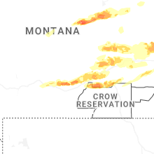
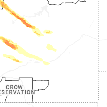


Connect with Interactive Hail Maps