

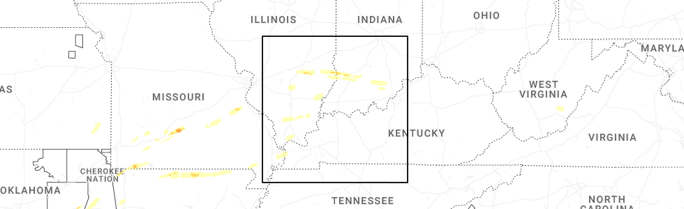
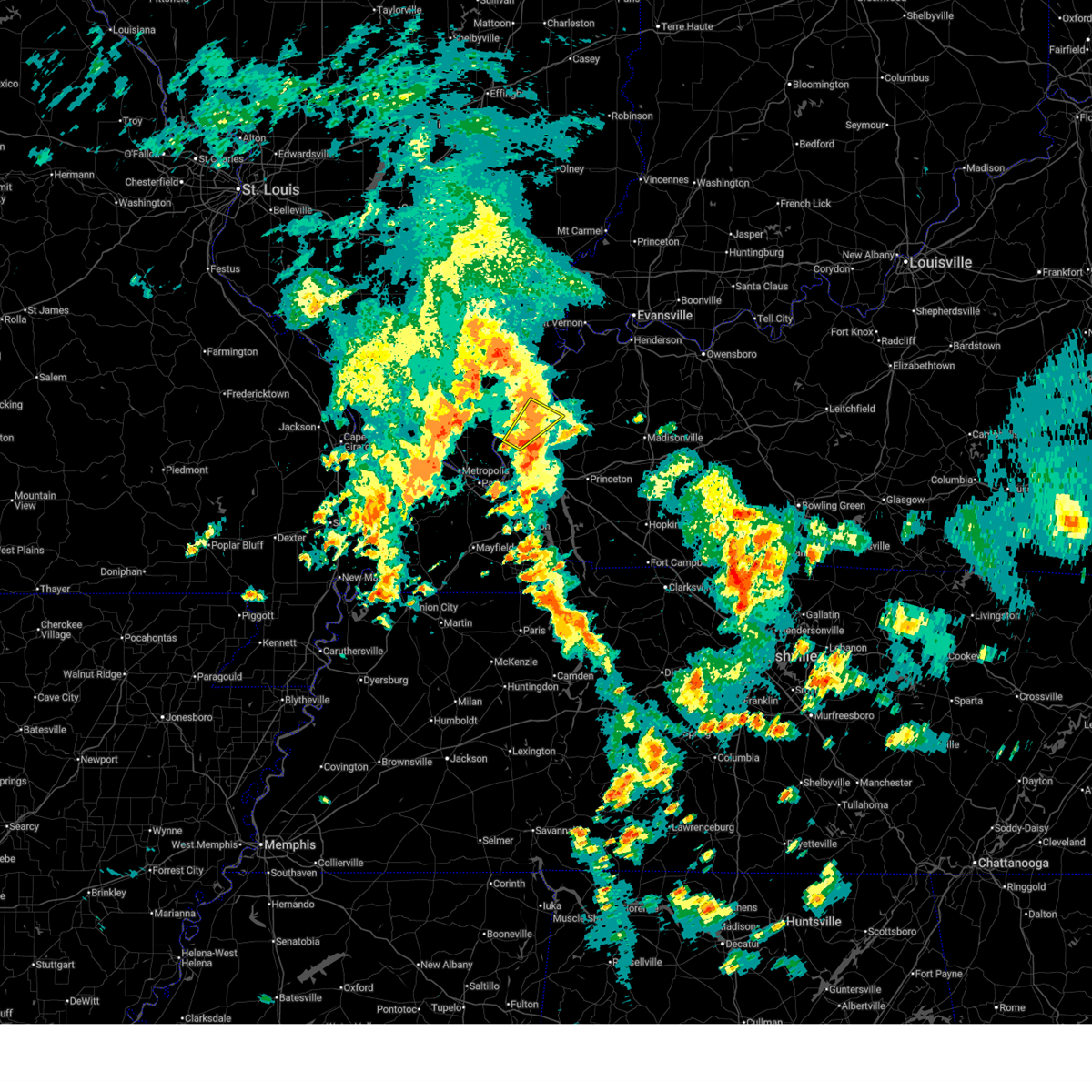
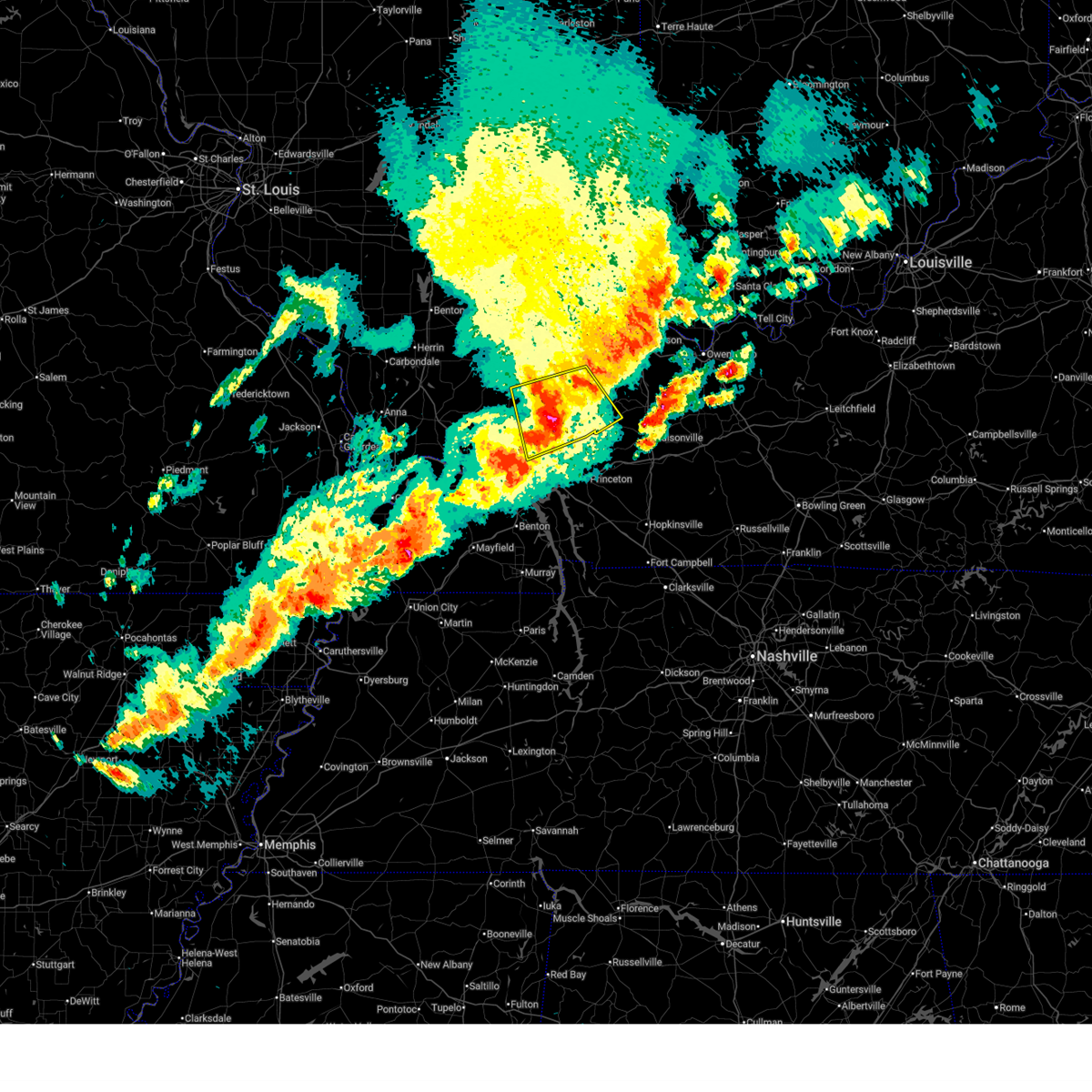
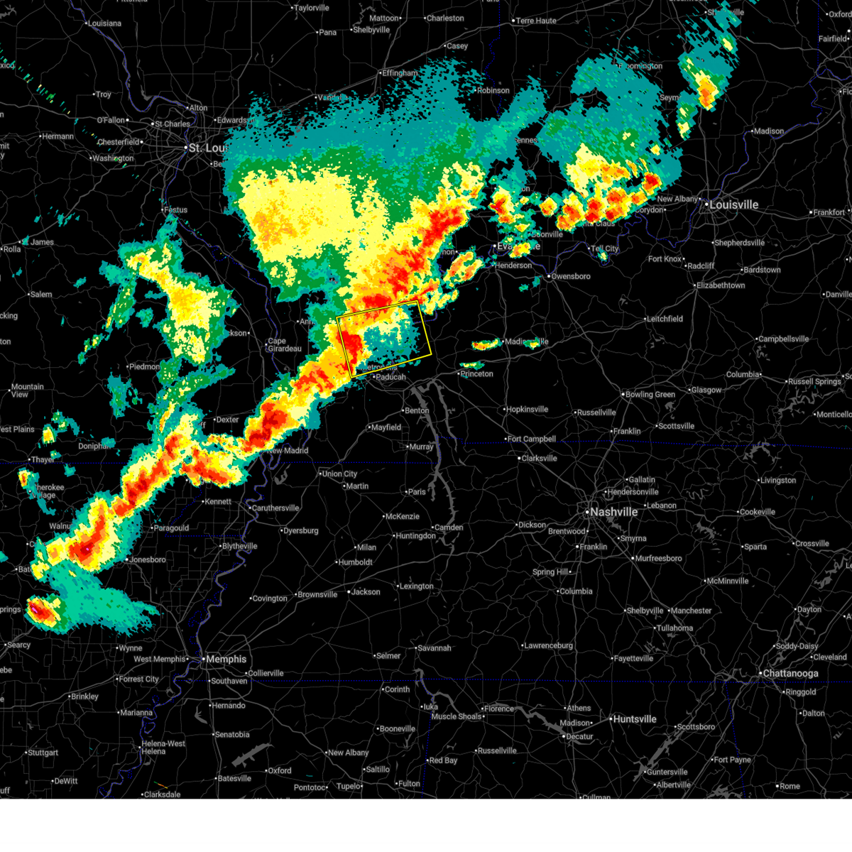
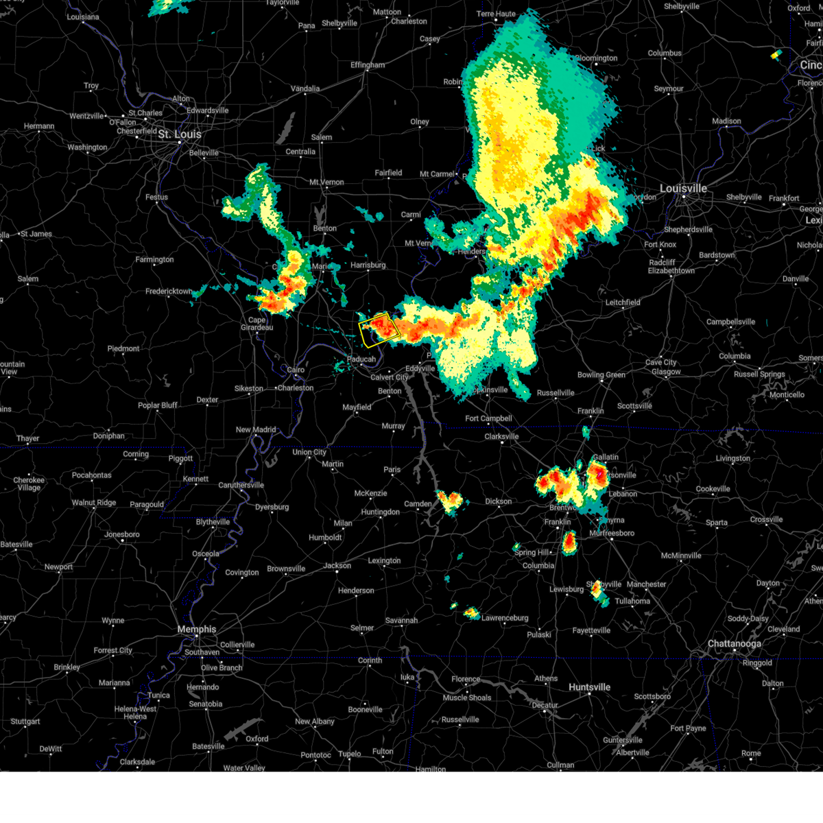
Hail Map for Rosiclare, IL
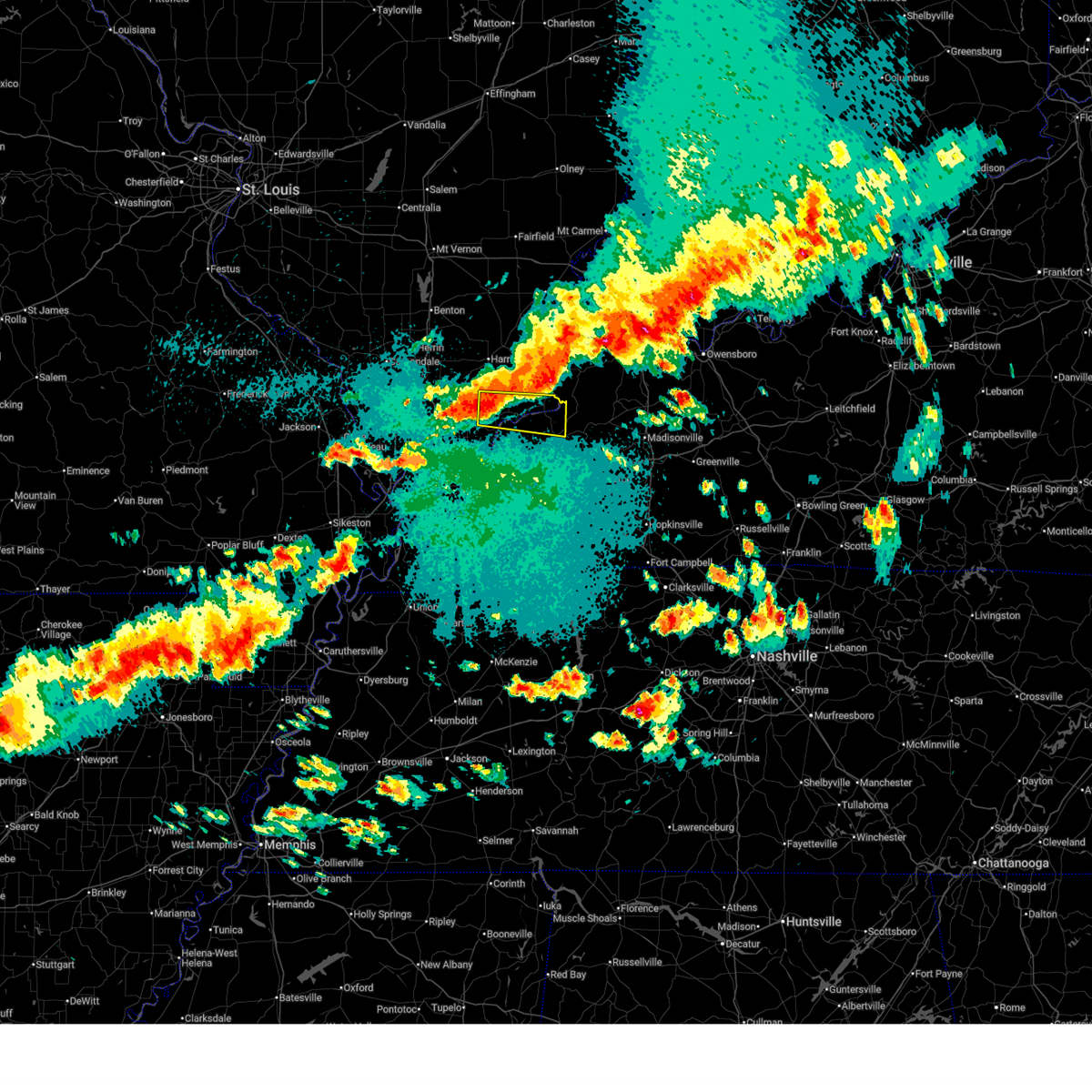
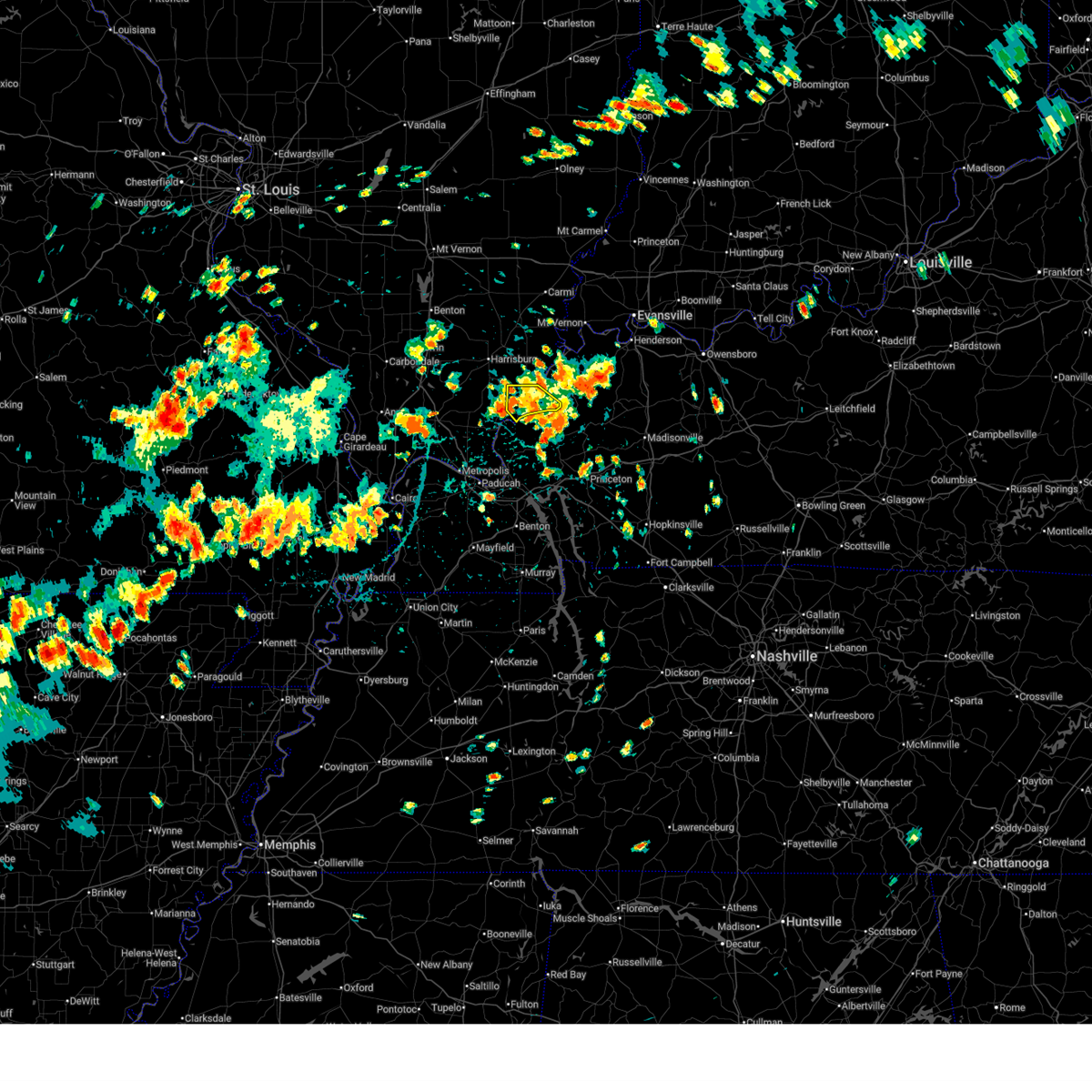
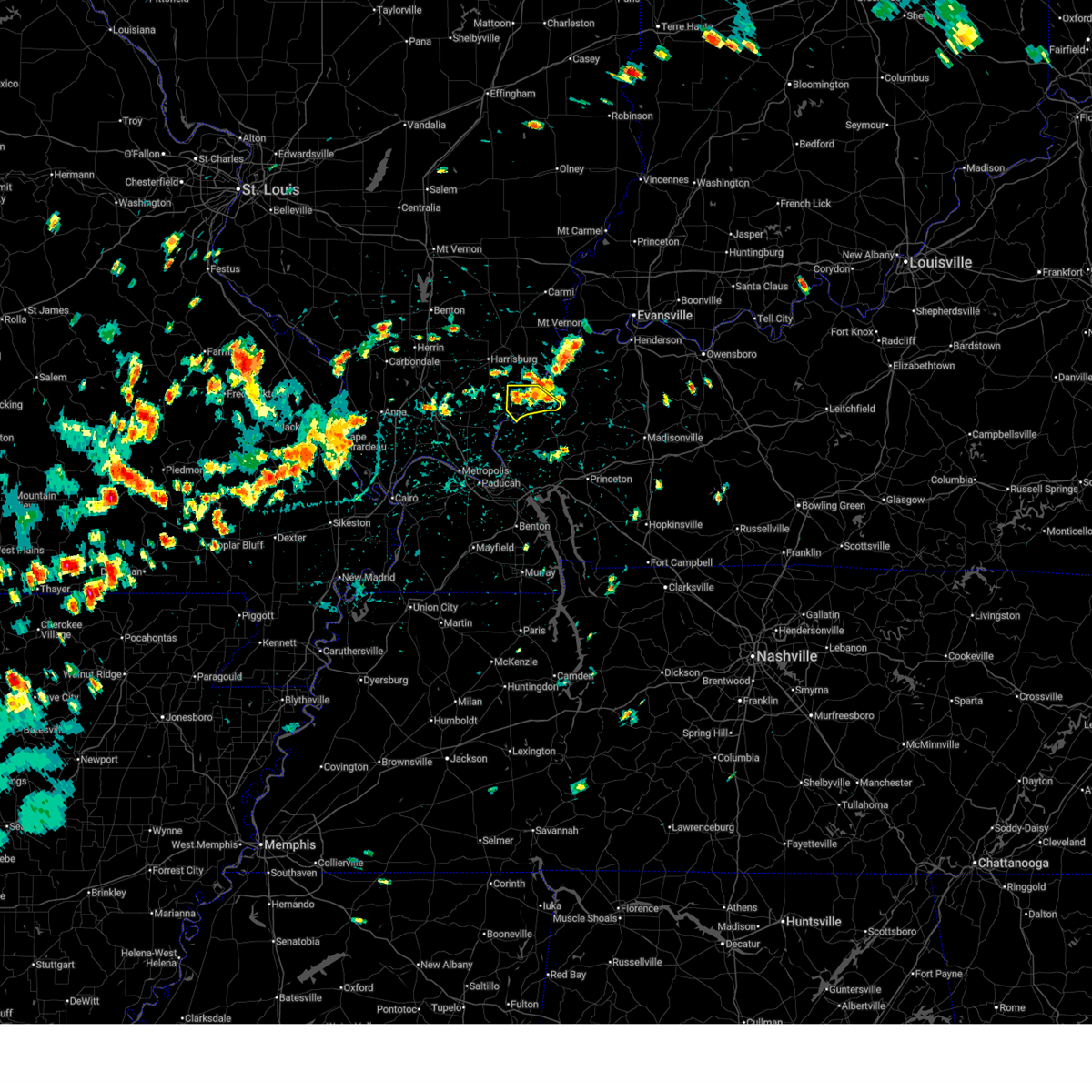
The Rosiclare, IL area has had 0 reports of on-the-ground hail by trained spotters, and has been under severe weather warnings 3 times during the past 12 months. Doppler radar has detected hail at or near Rosiclare, IL on 59 occasions, including 4 occasions during the past year.
| Name: | Rosiclare, IL |
| Where Located: | 57.5 miles SW of Evansville, IN |
| Map: | Google Map for Rosiclare, IL |
| Population: | 1160 |
| Housing Units: | 584 |
| More Info: | Search Google for Rosiclare, IL |
2
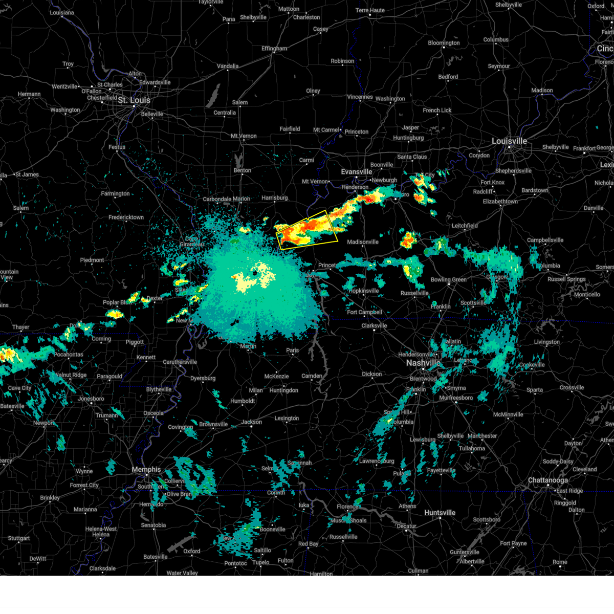
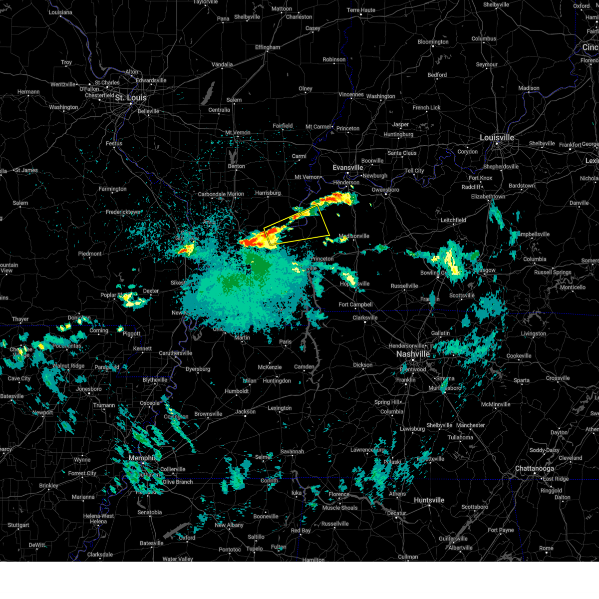
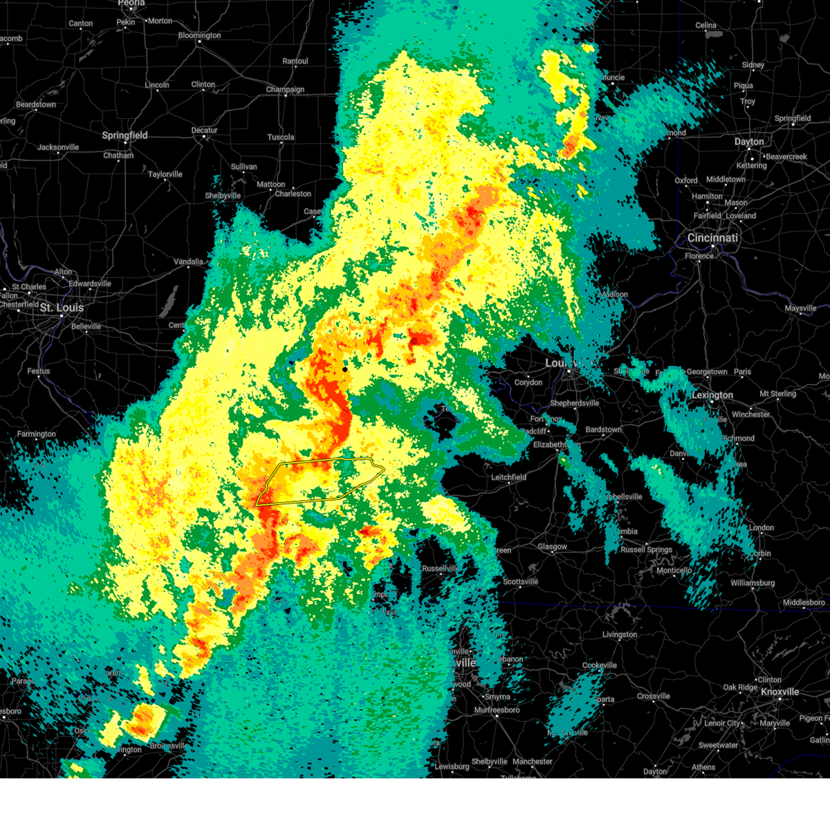
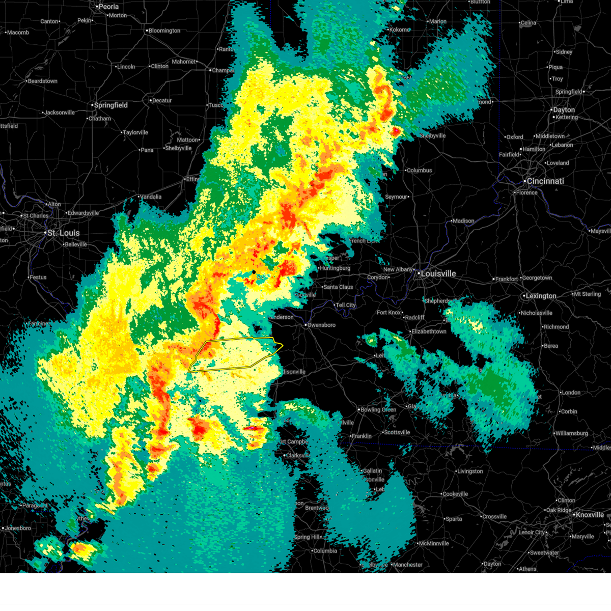
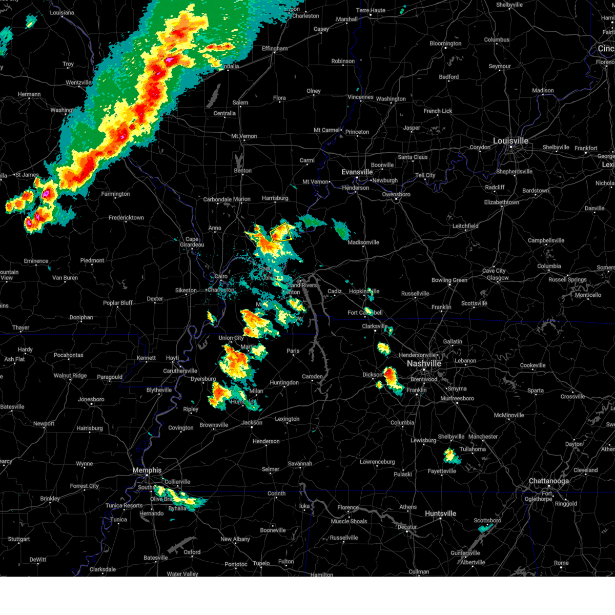
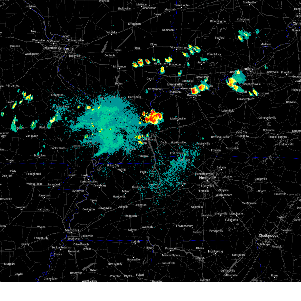
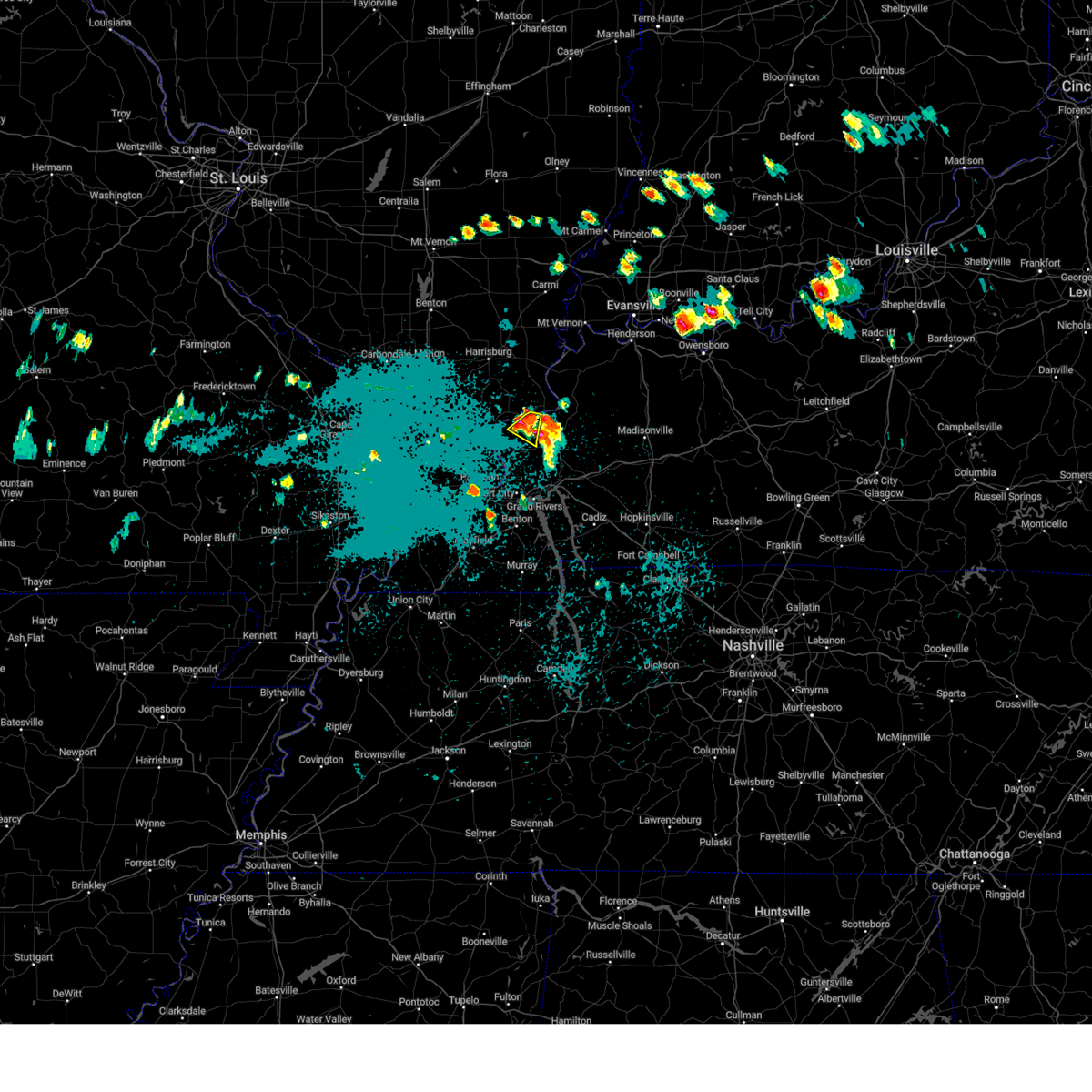
The Top Recent Hail Date for Rosiclare, IL is Wednesday, March 4, 2026 (14th out of 59)
Hail and Wind Damage Spotted near Rosiclare, IL
| Date / Time | Report Details |
|---|---|
| 4/27/2026 11:19 PM CDT |
 Svrpah the national weather service in paducah has issued a * severe thunderstorm warning for, hardin county in southern illinois, northeastern pope county in southern illinois, northwestern crittenden county in western kentucky, north central livingston county in western kentucky, * until midnight cdt. * at 1119 pm cdt, a severe thunderstorm was located 8 miles north of golconda, or 17 miles south of harrisburg, moving east at 35 mph (radar indicated). Hazards include 60 mph wind gusts and quarter size hail. Hail damage to vehicles is expected. Expect wind damage to roofs, siding, and trees. Svrpah the national weather service in paducah has issued a * severe thunderstorm warning for, hardin county in southern illinois, northeastern pope county in southern illinois, northwestern crittenden county in western kentucky, north central livingston county in western kentucky, * until midnight cdt. * at 1119 pm cdt, a severe thunderstorm was located 8 miles north of golconda, or 17 miles south of harrisburg, moving east at 35 mph (radar indicated). Hazards include 60 mph wind gusts and quarter size hail. Hail damage to vehicles is expected. Expect wind damage to roofs, siding, and trees.
|
| 8/19/2025 3:41 PM CDT |
 The storm which prompted the warning has weakened below severe limits, and no longer poses an immediate threat to life or property. therefore, the warning will be allowed to expire. however, heavy rain is still possible with this thunderstorm. The storm which prompted the warning has weakened below severe limits, and no longer poses an immediate threat to life or property. therefore, the warning will be allowed to expire. however, heavy rain is still possible with this thunderstorm.
|
| 8/19/2025 2:59 PM CDT |
 Svrpah the national weather service in paducah has issued a * severe thunderstorm warning for, hardin county in southern illinois, * until 345 pm cdt. * at 259 pm cdt, a severe thunderstorm was located 9 miles north of rosiclare, or 13 miles southwest of shawneetown, moving southeast at 20 mph (radar indicated). Hazards include 60 mph wind gusts. expect damage to roofs, siding, and trees Svrpah the national weather service in paducah has issued a * severe thunderstorm warning for, hardin county in southern illinois, * until 345 pm cdt. * at 259 pm cdt, a severe thunderstorm was located 9 miles north of rosiclare, or 13 miles southwest of shawneetown, moving southeast at 20 mph (radar indicated). Hazards include 60 mph wind gusts. expect damage to roofs, siding, and trees
|
| 6/6/2025 2:46 PM CDT |
 the severe thunderstorm warning has been cancelled and is no longer in effect the severe thunderstorm warning has been cancelled and is no longer in effect
|
| 6/6/2025 2:27 PM CDT |
 At 227 pm cdt, a severe thunderstorm was located near joy, or 13 miles west of marion, moving northeast at 25 mph (radar indicated). Hazards include 60 mph wind gusts and quarter size hail. Hail damage to vehicles is expected. expect wind damage to roofs, siding, and trees. Locations impacted include, rosiclare, joy, cave-in-rock, and elizabethtown. At 227 pm cdt, a severe thunderstorm was located near joy, or 13 miles west of marion, moving northeast at 25 mph (radar indicated). Hazards include 60 mph wind gusts and quarter size hail. Hail damage to vehicles is expected. expect wind damage to roofs, siding, and trees. Locations impacted include, rosiclare, joy, cave-in-rock, and elizabethtown.
|
| 6/6/2025 2:27 PM CDT |
 the severe thunderstorm warning has been cancelled and is no longer in effect the severe thunderstorm warning has been cancelled and is no longer in effect
|
| 6/6/2025 2:08 PM CDT |
 Svrpah the national weather service in paducah has issued a * severe thunderstorm warning for, southwestern hardin county in southern illinois, northeastern pope county in southern illinois, northwestern crittenden county in western kentucky, northern livingston county in western kentucky, * until 300 pm cdt. * at 208 pm cdt, a severe thunderstorm was located near burna, or 18 miles west of marion, moving northeast at 20 mph (radar indicated). Hazards include 60 mph wind gusts and quarter size hail. Hail damage to vehicles is expected. Expect wind damage to roofs, siding, and trees. Svrpah the national weather service in paducah has issued a * severe thunderstorm warning for, southwestern hardin county in southern illinois, northeastern pope county in southern illinois, northwestern crittenden county in western kentucky, northern livingston county in western kentucky, * until 300 pm cdt. * at 208 pm cdt, a severe thunderstorm was located near burna, or 18 miles west of marion, moving northeast at 20 mph (radar indicated). Hazards include 60 mph wind gusts and quarter size hail. Hail damage to vehicles is expected. Expect wind damage to roofs, siding, and trees.
|
| 5/16/2025 2:51 AM CDT |
 At 251 am cdt, a severe thunderstorm was located near sturgis, moving east at 55 mph (radar indicated). Hazards include 60 mph wind gusts and quarter size hail. Hail damage to vehicles is expected. expect wind damage to roofs, siding, and trees. Locations impacted include, marion, sturgis, rosiclare, golconda, joy, cave-in-rock, elizabethtown, wheatcroft, carrsville, and gross. At 251 am cdt, a severe thunderstorm was located near sturgis, moving east at 55 mph (radar indicated). Hazards include 60 mph wind gusts and quarter size hail. Hail damage to vehicles is expected. expect wind damage to roofs, siding, and trees. Locations impacted include, marion, sturgis, rosiclare, golconda, joy, cave-in-rock, elizabethtown, wheatcroft, carrsville, and gross.
|
| 5/16/2025 2:28 AM CDT |
 Svrpah the national weather service in paducah has issued a * severe thunderstorm warning for, hardin county in southern illinois, east central pope county in southern illinois, crittenden county in western kentucky, northern livingston county in western kentucky, southwestern union county in northwestern kentucky, southwestern webster county in northwestern kentucky, * until 315 am cdt. * at 227 am cdt, a severe thunderstorm was located near golconda, or 20 miles west of marion, moving east at 60 mph (radar indicated). Hazards include 60 mph wind gusts and quarter size hail. Hail damage to vehicles is expected. Expect wind damage to roofs, siding, and trees. Svrpah the national weather service in paducah has issued a * severe thunderstorm warning for, hardin county in southern illinois, east central pope county in southern illinois, crittenden county in western kentucky, northern livingston county in western kentucky, southwestern union county in northwestern kentucky, southwestern webster county in northwestern kentucky, * until 315 am cdt. * at 227 am cdt, a severe thunderstorm was located near golconda, or 20 miles west of marion, moving east at 60 mph (radar indicated). Hazards include 60 mph wind gusts and quarter size hail. Hail damage to vehicles is expected. Expect wind damage to roofs, siding, and trees.
|
| 4/2/2025 8:52 PM CDT |
 At 852 pm cdt, severe thunderstorms were located along a line extending from near breckinridge center to near marion, moving east at 45 mph (radar indicated). Hazards include 70 mph wind gusts. Expect considerable tree damage. damage is likely to mobile homes, roofs, and outbuildings. locations impacted include, clay, providence, slaughters, sturgis, cave-in-rock, rosiclare, joy, wheatcroft, gross, elizabethtown, carrsville, dixon, sebree, and golconda. This includes interstate 69 in kentucky between mile markers 128 and 137. At 852 pm cdt, severe thunderstorms were located along a line extending from near breckinridge center to near marion, moving east at 45 mph (radar indicated). Hazards include 70 mph wind gusts. Expect considerable tree damage. damage is likely to mobile homes, roofs, and outbuildings. locations impacted include, clay, providence, slaughters, sturgis, cave-in-rock, rosiclare, joy, wheatcroft, gross, elizabethtown, carrsville, dixon, sebree, and golconda. This includes interstate 69 in kentucky between mile markers 128 and 137.
|
| 4/2/2025 8:28 PM CDT |
 Svrpah the national weather service in paducah has issued a * severe thunderstorm warning for, hardin county in southern illinois, south central gallatin county in southern illinois, northern crittenden county in western kentucky, northwestern livingston county in western kentucky, southern union county in northwestern kentucky, webster county in northwestern kentucky, * until 930 pm cdt. * at 826 pm cdt, severe thunderstorms were located along a line extending from 6 miles southwest of old shawneetown to joy, moving east at 45 mph (radar indicated). Hazards include 70 mph wind gusts and quarter size hail. Hail damage to vehicles is expected. expect considerable tree damage. Wind damage is also likely to mobile homes, roofs, and outbuildings. Svrpah the national weather service in paducah has issued a * severe thunderstorm warning for, hardin county in southern illinois, south central gallatin county in southern illinois, northern crittenden county in western kentucky, northwestern livingston county in western kentucky, southern union county in northwestern kentucky, webster county in northwestern kentucky, * until 930 pm cdt. * at 826 pm cdt, severe thunderstorms were located along a line extending from 6 miles southwest of old shawneetown to joy, moving east at 45 mph (radar indicated). Hazards include 70 mph wind gusts and quarter size hail. Hail damage to vehicles is expected. expect considerable tree damage. Wind damage is also likely to mobile homes, roofs, and outbuildings.
|
| 3/30/2025 7:23 PM CDT |
 At 723 pm cdt, severe thunderstorms were located along a line extending from 9 miles northeast of rosiclare to near marion, moving east at 55 mph (radar indicated). Hazards include 60 mph wind gusts. Expect damage to roofs, siding, and trees. Locations impacted include, clay, karbers ridge, morganfield, providence, sturgis, cave-in-rock, wheatcroft, salem, gross, elizabethtown, marion, rosiclare, breckinridge center, and dixon. At 723 pm cdt, severe thunderstorms were located along a line extending from 9 miles northeast of rosiclare to near marion, moving east at 55 mph (radar indicated). Hazards include 60 mph wind gusts. Expect damage to roofs, siding, and trees. Locations impacted include, clay, karbers ridge, morganfield, providence, sturgis, cave-in-rock, wheatcroft, salem, gross, elizabethtown, marion, rosiclare, breckinridge center, and dixon.
|
| 3/30/2025 7:13 PM CDT |
 At 713 pm cdt, severe thunderstorms were located along a line extending from near rosiclare to burna, moving east at 60 mph (emergency management). Hazards include 60 mph wind gusts. Expect damage to roofs, siding, and trees. Locations impacted include, golconda, karbers ridge, rosiclare, joy, salem, gross, elizabethtown, burna, and carrsville. At 713 pm cdt, severe thunderstorms were located along a line extending from near rosiclare to burna, moving east at 60 mph (emergency management). Hazards include 60 mph wind gusts. Expect damage to roofs, siding, and trees. Locations impacted include, golconda, karbers ridge, rosiclare, joy, salem, gross, elizabethtown, burna, and carrsville.
|
| 3/30/2025 7:13 PM CDT |
 the severe thunderstorm warning has been cancelled and is no longer in effect the severe thunderstorm warning has been cancelled and is no longer in effect
|
| 3/30/2025 7:12 PM CDT |
 Svrpah the national weather service in paducah has issued a * severe thunderstorm warning for, hardin county in southern illinois, southwestern gallatin county in southern illinois, crittenden county in western kentucky, northeastern livingston county in western kentucky, southern union county in northwestern kentucky, western webster county in northwestern kentucky, * until 800 pm cdt. * at 712 pm cdt, severe thunderstorms were located along a line extending from near rosiclare to near joy, moving east at 50 mph (radar indicated). Hazards include 60 mph wind gusts. expect damage to roofs, siding, and trees Svrpah the national weather service in paducah has issued a * severe thunderstorm warning for, hardin county in southern illinois, southwestern gallatin county in southern illinois, crittenden county in western kentucky, northeastern livingston county in western kentucky, southern union county in northwestern kentucky, western webster county in northwestern kentucky, * until 800 pm cdt. * at 712 pm cdt, severe thunderstorms were located along a line extending from near rosiclare to near joy, moving east at 50 mph (radar indicated). Hazards include 60 mph wind gusts. expect damage to roofs, siding, and trees
|
| 3/30/2025 7:03 PM CDT |
 At 702 pm cdt, severe thunderstorms were located along a line extending from 7 miles northeast of dixon springs to 7 miles west of burna, moving east at 50 mph (radar indicated). Hazards include 60 mph wind gusts. Expect damage to roofs, siding, and trees. Locations impacted include, golconda, karbers ridge, rosiclare, joy, dixon springs, salem, gross, elizabethtown, burna, brookport, carrsville, and eddyville. At 702 pm cdt, severe thunderstorms were located along a line extending from 7 miles northeast of dixon springs to 7 miles west of burna, moving east at 50 mph (radar indicated). Hazards include 60 mph wind gusts. Expect damage to roofs, siding, and trees. Locations impacted include, golconda, karbers ridge, rosiclare, joy, dixon springs, salem, gross, elizabethtown, burna, brookport, carrsville, and eddyville.
|
| 3/30/2025 7:03 PM CDT |
 the severe thunderstorm warning has been cancelled and is no longer in effect the severe thunderstorm warning has been cancelled and is no longer in effect
|
| 3/30/2025 6:48 PM CDT |
 Svrpah the national weather service in paducah has issued a * severe thunderstorm warning for, hardin county in southern illinois, massac county in southern illinois, pope county in southern illinois, southeastern johnson county in southern illinois, western crittenden county in western kentucky, northern livingston county in western kentucky, central mccracken county in western kentucky, * until 730 pm cdt. * at 648 pm cdt, severe thunderstorms were located along a line extending from near vienna to near metropolis, moving east at 60 mph (radar indicated). Hazards include 60 mph wind gusts. expect damage to roofs, siding, and trees Svrpah the national weather service in paducah has issued a * severe thunderstorm warning for, hardin county in southern illinois, massac county in southern illinois, pope county in southern illinois, southeastern johnson county in southern illinois, western crittenden county in western kentucky, northern livingston county in western kentucky, central mccracken county in western kentucky, * until 730 pm cdt. * at 648 pm cdt, severe thunderstorms were located along a line extending from near vienna to near metropolis, moving east at 60 mph (radar indicated). Hazards include 60 mph wind gusts. expect damage to roofs, siding, and trees
|
| 3/15/2025 2:36 AM CDT |
 Svrpah the national weather service in paducah has issued a * severe thunderstorm warning for, hardin county in southern illinois, southeastern massac county in southern illinois, eastern pope county in southern illinois, south central gallatin county in southern illinois, crittenden county in western kentucky, livingston county in western kentucky, southwestern union county in northwestern kentucky, * until 315 am cdt. * at 236 am cdt, severe thunderstorms were located along a line extending from near golconda to near brookport, moving northeast at 70 mph (trained weather spotters). Hazards include 70 mph wind gusts. Expect considerable tree damage. Damage is likely to mobile homes, roofs, and outbuildings. Svrpah the national weather service in paducah has issued a * severe thunderstorm warning for, hardin county in southern illinois, southeastern massac county in southern illinois, eastern pope county in southern illinois, south central gallatin county in southern illinois, crittenden county in western kentucky, livingston county in western kentucky, southwestern union county in northwestern kentucky, * until 315 am cdt. * at 236 am cdt, severe thunderstorms were located along a line extending from near golconda to near brookport, moving northeast at 70 mph (trained weather spotters). Hazards include 70 mph wind gusts. Expect considerable tree damage. Damage is likely to mobile homes, roofs, and outbuildings.
|
| 3/15/2025 2:32 AM CDT |
 At 232 am cdt, severe thunderstorms were located along a line extending from 10 miles northeast of rosiclare to near brookport, moving northeast at 45 mph (trained weather spotters). Hazards include 70 mph wind gusts. Expect considerable tree damage. damage is likely to mobile homes, roofs, and outbuildings. locations impacted include, golconda, karbers ridge, dixon springs, burna, metropolis, cave-in-rock, rosiclare, joy, salem, gross, elizabethtown, marion, carrsville, eddyville, new columbia, and sturgis. This includes interstate 24 in illinois between mile markers 25 and 36. At 232 am cdt, severe thunderstorms were located along a line extending from 10 miles northeast of rosiclare to near brookport, moving northeast at 45 mph (trained weather spotters). Hazards include 70 mph wind gusts. Expect considerable tree damage. damage is likely to mobile homes, roofs, and outbuildings. locations impacted include, golconda, karbers ridge, dixon springs, burna, metropolis, cave-in-rock, rosiclare, joy, salem, gross, elizabethtown, marion, carrsville, eddyville, new columbia, and sturgis. This includes interstate 24 in illinois between mile markers 25 and 36.
|
| 3/15/2025 2:05 AM CDT |
 Svrpah the national weather service in paducah has issued a * severe thunderstorm warning for, hardin county in southern illinois, central massac county in southern illinois, pope county in southern illinois, southeastern johnson county in southern illinois, southwestern gallatin county in southern illinois, crittenden county in western kentucky, northern livingston county in western kentucky, north central mccracken county in western kentucky, * until 245 am cdt. * at 205 am cdt, severe thunderstorms were located along a line extending from near dixon springs to near metropolis, moving east at 55 mph (radar indicated). Hazards include 70 mph wind gusts. Expect considerable tree damage. Damage is likely to mobile homes, roofs, and outbuildings. Svrpah the national weather service in paducah has issued a * severe thunderstorm warning for, hardin county in southern illinois, central massac county in southern illinois, pope county in southern illinois, southeastern johnson county in southern illinois, southwestern gallatin county in southern illinois, crittenden county in western kentucky, northern livingston county in western kentucky, north central mccracken county in western kentucky, * until 245 am cdt. * at 205 am cdt, severe thunderstorms were located along a line extending from near dixon springs to near metropolis, moving east at 55 mph (radar indicated). Hazards include 70 mph wind gusts. Expect considerable tree damage. Damage is likely to mobile homes, roofs, and outbuildings.
|
| 7/30/2024 7:21 PM CDT |
 At 720 pm cdt, a severe thunderstorm was located near burna, or 18 miles northeast of metropolis, moving southeast at 20 mph (radar indicated). Hazards include 60 mph wind gusts and quarter size hail. Hail damage to vehicles is expected. expect wind damage to roofs, siding, and trees. Locations impacted include, rosiclare, golconda, burna, joy, and carrsville. At 720 pm cdt, a severe thunderstorm was located near burna, or 18 miles northeast of metropolis, moving southeast at 20 mph (radar indicated). Hazards include 60 mph wind gusts and quarter size hail. Hail damage to vehicles is expected. expect wind damage to roofs, siding, and trees. Locations impacted include, rosiclare, golconda, burna, joy, and carrsville.
|
| 7/30/2024 7:02 PM CDT |
 At 702 pm cdt, a severe thunderstorm was located over golconda, or 19 miles northeast of metropolis, moving southeast at 20 mph (radar indicated). Hazards include 60 mph wind gusts and quarter size hail. Hail damage to vehicles is expected. expect wind damage to roofs, siding, and trees. Locations impacted include, rosiclare, golconda, burna, joy, and carrsville. At 702 pm cdt, a severe thunderstorm was located over golconda, or 19 miles northeast of metropolis, moving southeast at 20 mph (radar indicated). Hazards include 60 mph wind gusts and quarter size hail. Hail damage to vehicles is expected. expect wind damage to roofs, siding, and trees. Locations impacted include, rosiclare, golconda, burna, joy, and carrsville.
|
| 7/30/2024 6:52 PM CDT |
 Svrpah the national weather service in paducah has issued a * severe thunderstorm warning for, southwestern hardin county in southern illinois, central pope county in southern illinois, northern livingston county in western kentucky, * until 745 pm cdt. * at 652 pm cdt, a severe thunderstorm was located near golconda, or 19 miles east of vienna, moving southeast at 20 mph (radar indicated). Hazards include 60 mph wind gusts and nickel size hail. expect damage to roofs, siding, and trees Svrpah the national weather service in paducah has issued a * severe thunderstorm warning for, southwestern hardin county in southern illinois, central pope county in southern illinois, northern livingston county in western kentucky, * until 745 pm cdt. * at 652 pm cdt, a severe thunderstorm was located near golconda, or 19 miles east of vienna, moving southeast at 20 mph (radar indicated). Hazards include 60 mph wind gusts and nickel size hail. expect damage to roofs, siding, and trees
|
| 5/26/2024 9:18 PM CDT |
 the severe thunderstorm warning has been cancelled and is no longer in effect the severe thunderstorm warning has been cancelled and is no longer in effect
|
| 5/26/2024 8:29 PM CDT |
 Svrpah the national weather service in paducah has issued a * severe thunderstorm warning for, hardin county in southern illinois, east central pulaski county in southern illinois, massac county in southern illinois, pope county in southern illinois, eastern johnson county in southern illinois, saline county in southern illinois, gallatin county in southern illinois, * until 930 pm cdt. * at 828 pm cdt, severe thunderstorms were located along a line extending from near galatia to near carrier mills to near vienna to 6 miles east of tamms, moving east at 65 mph (radar indicated). Hazards include 60 mph wind gusts and quarter size hail. Hail damage to vehicles is expected. Expect wind damage to roofs, siding, and trees. Svrpah the national weather service in paducah has issued a * severe thunderstorm warning for, hardin county in southern illinois, east central pulaski county in southern illinois, massac county in southern illinois, pope county in southern illinois, eastern johnson county in southern illinois, saline county in southern illinois, gallatin county in southern illinois, * until 930 pm cdt. * at 828 pm cdt, severe thunderstorms were located along a line extending from near galatia to near carrier mills to near vienna to 6 miles east of tamms, moving east at 65 mph (radar indicated). Hazards include 60 mph wind gusts and quarter size hail. Hail damage to vehicles is expected. Expect wind damage to roofs, siding, and trees.
|
| 5/26/2024 9:05 AM CDT |
 The storm which prompted the warning has weakened below severe limits, and no longer poses an immediate threat to life or property. therefore, the warning will be allowed to expire. a tornado watch remains in effect until 1000 am cdt for southern illinois, and western kentucky. a tornado watch also remains in effect until 300 pm cdt for northwestern kentucky. The storm which prompted the warning has weakened below severe limits, and no longer poses an immediate threat to life or property. therefore, the warning will be allowed to expire. a tornado watch remains in effect until 1000 am cdt for southern illinois, and western kentucky. a tornado watch also remains in effect until 300 pm cdt for northwestern kentucky.
|
| 5/26/2024 8:42 AM CDT |
 the severe thunderstorm warning has been cancelled and is no longer in effect the severe thunderstorm warning has been cancelled and is no longer in effect
|
| 5/26/2024 8:42 AM CDT |
 At 841 am cdt, a severe thunderstorm was located 8 miles northeast of dixon springs, or 17 miles south of harrisburg, moving east at 60 mph (radar indicated). Hazards include 60 mph wind gusts. Expect damage to roofs, siding, and trees. Locations impacted include, shawneetown, rosiclare, ridgway, golconda, equality, cave-in-rock, elizabethtown, old shawneetown, junction, eddyville, carrsville, karbers ridge, and gross. At 841 am cdt, a severe thunderstorm was located 8 miles northeast of dixon springs, or 17 miles south of harrisburg, moving east at 60 mph (radar indicated). Hazards include 60 mph wind gusts. Expect damage to roofs, siding, and trees. Locations impacted include, shawneetown, rosiclare, ridgway, golconda, equality, cave-in-rock, elizabethtown, old shawneetown, junction, eddyville, carrsville, karbers ridge, and gross.
|
| 5/26/2024 8:28 AM CDT |
 Svrpah the national weather service in paducah has issued a * severe thunderstorm warning for, hardin county in southern illinois, northwestern massac county in southern illinois, pope county in southern illinois, eastern johnson county in southern illinois, southeastern williamson county in southern illinois, southern saline county in southern illinois, southwestern gallatin county in southern illinois, northwestern crittenden county in western kentucky, north central livingston county in western kentucky, southwestern union county in northwestern kentucky, * until 915 am cdt. * at 827 am cdt, a severe thunderstorm was located near vienna, moving northeast at 55 mph (radar indicated). Hazards include 60 mph wind gusts. expect damage to roofs, siding, and trees Svrpah the national weather service in paducah has issued a * severe thunderstorm warning for, hardin county in southern illinois, northwestern massac county in southern illinois, pope county in southern illinois, eastern johnson county in southern illinois, southeastern williamson county in southern illinois, southern saline county in southern illinois, southwestern gallatin county in southern illinois, northwestern crittenden county in western kentucky, north central livingston county in western kentucky, southwestern union county in northwestern kentucky, * until 915 am cdt. * at 827 am cdt, a severe thunderstorm was located near vienna, moving northeast at 55 mph (radar indicated). Hazards include 60 mph wind gusts. expect damage to roofs, siding, and trees
|
| 5/26/2024 8:20 AM CDT |
 Svrpah the national weather service in paducah has issued a * severe thunderstorm warning for, eastern massac county in southern illinois, southern pope county in southern illinois, calloway county in western kentucky, crittenden county in western kentucky, livingston county in western kentucky, caldwell county in western kentucky, marshall county in western kentucky, trigg county in western kentucky, southeastern mccracken county in western kentucky, graves county in western kentucky, lyon county in western kentucky, * until 900 am cdt. * at 819 am cdt, severe thunderstorms were located along a line extending from 8 miles southwest of golconda to near reidland to near latham, moving east at 70 mph (radar indicated). Hazards include 70 mph wind gusts. Expect considerable tree damage. Damage is likely to mobile homes, roofs, and outbuildings. Svrpah the national weather service in paducah has issued a * severe thunderstorm warning for, eastern massac county in southern illinois, southern pope county in southern illinois, calloway county in western kentucky, crittenden county in western kentucky, livingston county in western kentucky, caldwell county in western kentucky, marshall county in western kentucky, trigg county in western kentucky, southeastern mccracken county in western kentucky, graves county in western kentucky, lyon county in western kentucky, * until 900 am cdt. * at 819 am cdt, severe thunderstorms were located along a line extending from 8 miles southwest of golconda to near reidland to near latham, moving east at 70 mph (radar indicated). Hazards include 70 mph wind gusts. Expect considerable tree damage. Damage is likely to mobile homes, roofs, and outbuildings.
|
| 5/8/2024 5:49 PM CDT |
 At 548 pm cdt, severe thunderstorms were located along a line extending from 8 miles southwest of sturgis to near burna, moving east at 30 mph (radar indicated). Hazards include 60 mph wind gusts and quarter size hail. Hail damage to vehicles is expected. expect wind damage to roofs, siding, and trees. Locations impacted include, marion, sturgis, rosiclare, salem, joy, burna, cave-in-rock, elizabethtown, and carrsville. At 548 pm cdt, severe thunderstorms were located along a line extending from 8 miles southwest of sturgis to near burna, moving east at 30 mph (radar indicated). Hazards include 60 mph wind gusts and quarter size hail. Hail damage to vehicles is expected. expect wind damage to roofs, siding, and trees. Locations impacted include, marion, sturgis, rosiclare, salem, joy, burna, cave-in-rock, elizabethtown, and carrsville.
|
| 5/8/2024 5:49 PM CDT |
 the severe thunderstorm warning has been cancelled and is no longer in effect the severe thunderstorm warning has been cancelled and is no longer in effect
|
| 5/8/2024 5:22 PM CDT |
 Svrpah the national weather service in paducah has issued a * severe thunderstorm warning for, hardin county in southern illinois, northeastern pope county in southern illinois, crittenden county in western kentucky, northern livingston county in western kentucky, southern union county in northwestern kentucky, * until 615 pm cdt. * at 522 pm cdt, severe thunderstorms were located along a line extending from 6 miles northwest of rosiclare to near golconda, moving east at 40 mph (radar indicated). Hazards include 60 mph wind gusts and quarter size hail. Hail damage to vehicles is expected. Expect wind damage to roofs, siding, and trees. Svrpah the national weather service in paducah has issued a * severe thunderstorm warning for, hardin county in southern illinois, northeastern pope county in southern illinois, crittenden county in western kentucky, northern livingston county in western kentucky, southern union county in northwestern kentucky, * until 615 pm cdt. * at 522 pm cdt, severe thunderstorms were located along a line extending from 6 miles northwest of rosiclare to near golconda, moving east at 40 mph (radar indicated). Hazards include 60 mph wind gusts and quarter size hail. Hail damage to vehicles is expected. Expect wind damage to roofs, siding, and trees.
|
| 5/8/2024 4:18 PM CDT |
 Torpah the national weather service in paducah has issued a * tornado warning for, hardin county in southern illinois, northwestern crittenden county in western kentucky, southwestern union county in northwestern kentucky, * until 445 pm cdt. * at 418 pm cdt, a severe thunderstorm capable of producing a tornado was located near rosiclare, or 17 miles southwest of shawneetown, moving east at 40 mph (radar indicated rotation). Hazards include tornado. Flying debris will be dangerous to those caught without shelter. mobile homes will be damaged or destroyed. damage to roofs, windows, and vehicles will occur. tree damage is likely. This tornadic thunderstorm will remain over mainly rural areas of hardin, northwestern crittenden and southwestern union counties, including the following locations, karbers ridge, gross, elizabethtown, and cave-in-rock. Torpah the national weather service in paducah has issued a * tornado warning for, hardin county in southern illinois, northwestern crittenden county in western kentucky, southwestern union county in northwestern kentucky, * until 445 pm cdt. * at 418 pm cdt, a severe thunderstorm capable of producing a tornado was located near rosiclare, or 17 miles southwest of shawneetown, moving east at 40 mph (radar indicated rotation). Hazards include tornado. Flying debris will be dangerous to those caught without shelter. mobile homes will be damaged or destroyed. damage to roofs, windows, and vehicles will occur. tree damage is likely. This tornadic thunderstorm will remain over mainly rural areas of hardin, northwestern crittenden and southwestern union counties, including the following locations, karbers ridge, gross, elizabethtown, and cave-in-rock.
|
| 4/18/2024 6:36 PM CDT |
 The storm which prompted the warning has weakened below severe limits, and no longer poses an immediate threat to life or property. therefore, the warning will be allowed to expire. however, gusty winds are still possible with this thunderstorm. a severe thunderstorm watch remains in effect until 200 am cdt for southern illinois and western kentucky. The storm which prompted the warning has weakened below severe limits, and no longer poses an immediate threat to life or property. therefore, the warning will be allowed to expire. however, gusty winds are still possible with this thunderstorm. a severe thunderstorm watch remains in effect until 200 am cdt for southern illinois and western kentucky.
|
| 4/18/2024 6:25 PM CDT |
 At 625 pm cdt, a severe thunderstorm was located near rosiclare, or 19 miles south of harrisburg, moving northeast at 15 mph (radar indicated). Hazards include 60 mph wind gusts and quarter size hail. Hail damage to vehicles is expected. expect wind damage to roofs, siding, and trees. Locations impacted include, rosiclare and carrsville. At 625 pm cdt, a severe thunderstorm was located near rosiclare, or 19 miles south of harrisburg, moving northeast at 15 mph (radar indicated). Hazards include 60 mph wind gusts and quarter size hail. Hail damage to vehicles is expected. expect wind damage to roofs, siding, and trees. Locations impacted include, rosiclare and carrsville.
|
| 4/18/2024 6:14 PM CDT |
 Svrpah the national weather service in paducah has issued a * severe thunderstorm warning for, southwestern hardin county in southern illinois, northeastern pope county in southern illinois, north central livingston county in western kentucky, * until 645 pm cdt. * at 614 pm cdt, a severe thunderstorm was located near golconda, or 20 miles south of harrisburg, moving northeast at 15 mph (radar indicated). Hazards include 60 mph wind gusts and quarter size hail. Hail damage to vehicles is expected. Expect wind damage to roofs, siding, and trees. Svrpah the national weather service in paducah has issued a * severe thunderstorm warning for, southwestern hardin county in southern illinois, northeastern pope county in southern illinois, north central livingston county in western kentucky, * until 645 pm cdt. * at 614 pm cdt, a severe thunderstorm was located near golconda, or 20 miles south of harrisburg, moving northeast at 15 mph (radar indicated). Hazards include 60 mph wind gusts and quarter size hail. Hail damage to vehicles is expected. Expect wind damage to roofs, siding, and trees.
|
| 4/2/2024 5:28 AM CDT |
 the severe thunderstorm warning has been cancelled and is no longer in effect the severe thunderstorm warning has been cancelled and is no longer in effect
|
| 4/2/2024 5:28 AM CDT |
 At 528 am cdt, severe thunderstorms were located along a line extending from near ridgway to 7 miles north of ledbetter, moving east at 65 mph (radar indicated). Hazards include 70 mph wind gusts. Expect considerable tree damage. damage is likely to mobile homes, roofs, and outbuildings. locations impacted include, evansville, henderson, paducah, mount vernon, princeton, morganfield, providence, marion, dawson springs, calvert city, eddyville, sturgis, shawneetown, breckinridge center, reidland, sebree, clay, rosiclare, uniontown, and ridgway. this includes the following highways, interstate 24 in kentucky between mile markers 10 and 46. interstate 69 in kentucky between mile markers 68 and 95, and between mile markers 129 and 148. Audubon parkway between mile markers 1 and 11. At 528 am cdt, severe thunderstorms were located along a line extending from near ridgway to 7 miles north of ledbetter, moving east at 65 mph (radar indicated). Hazards include 70 mph wind gusts. Expect considerable tree damage. damage is likely to mobile homes, roofs, and outbuildings. locations impacted include, evansville, henderson, paducah, mount vernon, princeton, morganfield, providence, marion, dawson springs, calvert city, eddyville, sturgis, shawneetown, breckinridge center, reidland, sebree, clay, rosiclare, uniontown, and ridgway. this includes the following highways, interstate 24 in kentucky between mile markers 10 and 46. interstate 69 in kentucky between mile markers 68 and 95, and between mile markers 129 and 148. Audubon parkway between mile markers 1 and 11.
|
| 4/2/2024 5:11 AM CDT |
 Svrpah the national weather service in paducah has issued a * severe thunderstorm warning for, east central johnson county in southern illinois, southwestern white county in southeastern illinois, massac county in southern illinois, southeastern hamilton county in south central illinois, gallatin county in southern illinois, pope county in southern illinois, saline county in southern illinois, hardin county in southern illinois, southern vanderburgh county in southwestern indiana, southwestern posey county in southwestern indiana, henderson county in northwestern kentucky, western hopkins county in northwestern kentucky, northern lyon county in western kentucky, livingston county in western kentucky, northwestern christian county in south central kentucky, northwestern mclean county in northwestern kentucky, northwestern graves county in western kentucky, caldwell county in western kentucky, northwestern marshall county in western kentucky, southeastern ballard county in western kentucky, mccracken county in western kentucky, crittenden county in western kentucky, northeastern carlisle county in western kentucky, union county in northwestern kentucky, webster county in northwestern kentucky, * until 615 am cdt. * at 511 am cdt, severe thunderstorms were located along a line extending from near harrisburg to near west paducah, moving east at 65 mph (radar indicated). Hazards include 70 mph wind gusts. Expect considerable tree damage. Damage is likely to mobile homes, roofs, and outbuildings. Svrpah the national weather service in paducah has issued a * severe thunderstorm warning for, east central johnson county in southern illinois, southwestern white county in southeastern illinois, massac county in southern illinois, southeastern hamilton county in south central illinois, gallatin county in southern illinois, pope county in southern illinois, saline county in southern illinois, hardin county in southern illinois, southern vanderburgh county in southwestern indiana, southwestern posey county in southwestern indiana, henderson county in northwestern kentucky, western hopkins county in northwestern kentucky, northern lyon county in western kentucky, livingston county in western kentucky, northwestern christian county in south central kentucky, northwestern mclean county in northwestern kentucky, northwestern graves county in western kentucky, caldwell county in western kentucky, northwestern marshall county in western kentucky, southeastern ballard county in western kentucky, mccracken county in western kentucky, crittenden county in western kentucky, northeastern carlisle county in western kentucky, union county in northwestern kentucky, webster county in northwestern kentucky, * until 615 am cdt. * at 511 am cdt, severe thunderstorms were located along a line extending from near harrisburg to near west paducah, moving east at 65 mph (radar indicated). Hazards include 70 mph wind gusts. Expect considerable tree damage. Damage is likely to mobile homes, roofs, and outbuildings.
|
| 3/6/2024 9:05 AM CST |
 Torpah the national weather service in paducah has issued a * this is a test message. tornado warning for, henderson county in northwestern kentucky, caldwell county in western kentucky, marshall county in western kentucky, trigg county in western kentucky, ballard county in western kentucky, mccracken county in western kentucky, hopkins county in northwestern kentucky, lyon county in western kentucky, fulton county in western kentucky, calloway county in western kentucky, daviess county in northwestern kentucky, muhlenberg county in south central kentucky, crittenden county in western kentucky, livingston county in western kentucky, christian county in south central kentucky, carlisle county in western kentucky, hickman county in western kentucky, mclean county in northwestern kentucky, todd county in south central kentucky, union county in northwestern kentucky, webster county in northwestern kentucky, graves county in western kentucky, * this is a test message. until 915 am cst. * this is a test message. this is a test tornado warning message. there is no severe weather occurring at this time. this test warning message is part of the annual kentucky tornado drill. if this were an actual severe weather event, you would be given information about the hazard. the national weather service, kentucky emergency management agency and the kentucky weather preparedness committee encourages the use of this time to activate and review your severe weather safety plans. repeating, this has been a test tornado warning message for the 2024 kentucky tornado drill. this concludes the test (test radar indicated rotation). Hazards include test tornado. There are no impacts. this is a test tornado warning. this is a test message. Locations include, all counties in western kentucky. Torpah the national weather service in paducah has issued a * this is a test message. tornado warning for, henderson county in northwestern kentucky, caldwell county in western kentucky, marshall county in western kentucky, trigg county in western kentucky, ballard county in western kentucky, mccracken county in western kentucky, hopkins county in northwestern kentucky, lyon county in western kentucky, fulton county in western kentucky, calloway county in western kentucky, daviess county in northwestern kentucky, muhlenberg county in south central kentucky, crittenden county in western kentucky, livingston county in western kentucky, christian county in south central kentucky, carlisle county in western kentucky, hickman county in western kentucky, mclean county in northwestern kentucky, todd county in south central kentucky, union county in northwestern kentucky, webster county in northwestern kentucky, graves county in western kentucky, * this is a test message. until 915 am cst. * this is a test message. this is a test tornado warning message. there is no severe weather occurring at this time. this test warning message is part of the annual kentucky tornado drill. if this were an actual severe weather event, you would be given information about the hazard. the national weather service, kentucky emergency management agency and the kentucky weather preparedness committee encourages the use of this time to activate and review your severe weather safety plans. repeating, this has been a test tornado warning message for the 2024 kentucky tornado drill. this concludes the test (test radar indicated rotation). Hazards include test tornado. There are no impacts. this is a test tornado warning. this is a test message. Locations include, all counties in western kentucky.
|
| 9/27/2023 9:13 PM CDT |
 The severe thunderstorm warning for west central crittenden and northeastern livingston counties will expire at 915 pm cdt, the storm which prompted the warning has moved out of the area. therefore, the warning will be allowed to expire. The severe thunderstorm warning for west central crittenden and northeastern livingston counties will expire at 915 pm cdt, the storm which prompted the warning has moved out of the area. therefore, the warning will be allowed to expire.
|
| 9/27/2023 8:55 PM CDT |
 At 854 pm cdt, a severe thunderstorm was located just southeast of rosiclare, or 13 miles west of marion, moving east at 20 mph (radar indicated). Hazards include quarter size hail. Damage to vehicles is expected. this severe thunderstorm will remain over mainly rural areas of west central crittenden and northeastern livingston counties. hail threat, radar indicated max hail size, 1. 00 in wind threat, radar indicated max wind gust, <50 mph. At 854 pm cdt, a severe thunderstorm was located just southeast of rosiclare, or 13 miles west of marion, moving east at 20 mph (radar indicated). Hazards include quarter size hail. Damage to vehicles is expected. this severe thunderstorm will remain over mainly rural areas of west central crittenden and northeastern livingston counties. hail threat, radar indicated max hail size, 1. 00 in wind threat, radar indicated max wind gust, <50 mph.
|
| 9/27/2023 8:38 PM CDT |
 At 837 pm cdt, two severe thunderstorms were located near rosiclare, illinois, and near salem, kentucky, moving east at 25 mph (radar indicated). Hazards include half dollar size hail. Damage to vehicles is expected. locations impacted include, rosiclare, salem, golconda, joy, elizabethtown, and carrsville. hail threat, radar indicated max hail size, 1. 25 in wind threat, radar indicated max wind gust, <50 mph. At 837 pm cdt, two severe thunderstorms were located near rosiclare, illinois, and near salem, kentucky, moving east at 25 mph (radar indicated). Hazards include half dollar size hail. Damage to vehicles is expected. locations impacted include, rosiclare, salem, golconda, joy, elizabethtown, and carrsville. hail threat, radar indicated max hail size, 1. 25 in wind threat, radar indicated max wind gust, <50 mph.
|
| 9/27/2023 8:25 PM CDT |
 At 824 pm cdt, a severe thunderstorm was located near golconda, or 20 miles northeast of metropolis, moving east at 20 mph (radar indicated). Hazards include half dollar size hail. damage to vehicles is expected At 824 pm cdt, a severe thunderstorm was located near golconda, or 20 miles northeast of metropolis, moving east at 20 mph (radar indicated). Hazards include half dollar size hail. damage to vehicles is expected
|
| 7/29/2023 6:28 PM CDT |
 At 627 pm cdt, severe thunderstorms were located along a line extending from near carrier mills to near vienna to olive branch, moving southeast at 35 mph (radar indicated). Hazards include 60 mph wind gusts. expect damage to roofs, siding, and trees At 627 pm cdt, severe thunderstorms were located along a line extending from near carrier mills to near vienna to olive branch, moving southeast at 35 mph (radar indicated). Hazards include 60 mph wind gusts. expect damage to roofs, siding, and trees
|
| 7/18/2023 1:39 PM CDT |
 At 139 pm cdt, severe thunderstorms were located along a line extending from near rosiclare to 7 miles northeast of calvert city to 7 miles north of murray to near latham, moving east at 50 mph (radar indicated). Hazards include 60 mph wind gusts. Expect damage to roofs, siding, and trees. locations impacted include, murray, benton, marion, calvert city, eddyville, hillman ferry campground, energy lake campground, woodlands nature station, turkey bay, demumbers bay campground, cravens bay campground, golden pond visitors center, birmingham ferry recreation area, land between the lakes area, rosiclare, salem, burna, joy, ledbetter and rockcastle. this includes the following highways, interstate 24 in kentucky between mile markers 18 and 48. interstate 69 in kentucky between mile markers 34 and 73. hail threat, radar indicated max hail size, <. 75 in wind threat, radar indicated max wind gust, 60 mph. At 139 pm cdt, severe thunderstorms were located along a line extending from near rosiclare to 7 miles northeast of calvert city to 7 miles north of murray to near latham, moving east at 50 mph (radar indicated). Hazards include 60 mph wind gusts. Expect damage to roofs, siding, and trees. locations impacted include, murray, benton, marion, calvert city, eddyville, hillman ferry campground, energy lake campground, woodlands nature station, turkey bay, demumbers bay campground, cravens bay campground, golden pond visitors center, birmingham ferry recreation area, land between the lakes area, rosiclare, salem, burna, joy, ledbetter and rockcastle. this includes the following highways, interstate 24 in kentucky between mile markers 18 and 48. interstate 69 in kentucky between mile markers 34 and 73. hail threat, radar indicated max hail size, <. 75 in wind threat, radar indicated max wind gust, 60 mph.
|
| 7/18/2023 1:17 PM CDT |
 At 116 pm cdt, severe thunderstorms were located along a line extending from 7 miles southeast of creal springs to near lone oak to 7 miles west of mayfield to near clayton, moving east at 50 mph (radar indicated). Hazards include 60 mph wind gusts. expect damage to roofs, siding, and trees At 116 pm cdt, severe thunderstorms were located along a line extending from 7 miles southeast of creal springs to near lone oak to 7 miles west of mayfield to near clayton, moving east at 50 mph (radar indicated). Hazards include 60 mph wind gusts. expect damage to roofs, siding, and trees
|
| 7/16/2023 6:51 PM CDT |
 At 650 pm cdt, a severe thunderstorm was located near rosiclare, or 18 miles southwest of shawneetown, moving southeast at 35 mph (radar indicated). Hazards include 60 mph wind gusts and penny size hail. Expect damage to roofs, siding, and trees. locations impacted include, rosiclare, golconda, joy, elizabethtown, carrsville, karbers ridge and gross. hail threat, radar indicated max hail size, 0. 75 in wind threat, observed max wind gust, 60 mph. At 650 pm cdt, a severe thunderstorm was located near rosiclare, or 18 miles southwest of shawneetown, moving southeast at 35 mph (radar indicated). Hazards include 60 mph wind gusts and penny size hail. Expect damage to roofs, siding, and trees. locations impacted include, rosiclare, golconda, joy, elizabethtown, carrsville, karbers ridge and gross. hail threat, radar indicated max hail size, 0. 75 in wind threat, observed max wind gust, 60 mph.
|
| 7/16/2023 6:28 PM CDT |
 At 628 pm cdt, a severe thunderstorm was located near carrier mills, or 7 miles south of harrisburg, moving southeast at 30 mph (law enforcement reported numerous trees down). Hazards include 60 mph wind gusts and penny size hail. expect damage to roofs, siding, and trees At 628 pm cdt, a severe thunderstorm was located near carrier mills, or 7 miles south of harrisburg, moving southeast at 30 mph (law enforcement reported numerous trees down). Hazards include 60 mph wind gusts and penny size hail. expect damage to roofs, siding, and trees
|
| 7/2/2023 4:08 PM CDT |
 At 408 pm cdt, severe thunderstorms were located along a line extending from 8 miles northeast of rosiclare to joy, moving northeast at 65 mph (radar indicated). Hazards include 60 mph wind gusts. Expect damage to roofs, siding, and trees. locations impacted include, rosiclare, salem, golconda, joy, cave-in-rock, elizabethtown and carrsville. hail threat, radar indicated max hail size, <. 75 in wind threat, radar indicated max wind gust, 60 mph. At 408 pm cdt, severe thunderstorms were located along a line extending from 8 miles northeast of rosiclare to joy, moving northeast at 65 mph (radar indicated). Hazards include 60 mph wind gusts. Expect damage to roofs, siding, and trees. locations impacted include, rosiclare, salem, golconda, joy, cave-in-rock, elizabethtown and carrsville. hail threat, radar indicated max hail size, <. 75 in wind threat, radar indicated max wind gust, 60 mph.
|
| 7/2/2023 3:55 PM CDT |
 At 355 pm cdt, severe thunderstorms were located along a line extending from near rosiclare to near brookport, moving east at 45 mph (trained weather spotters). Hazards include 60 mph wind gusts. Expect damage to roofs, siding, and trees. locations impacted include, rosiclare, brookport, salem, golconda, joy, burna, cave-in-rock, smithland, elizabethtown, carrsville and hamletsburg. hail threat, radar indicated max hail size, <. 75 in wind threat, radar indicated max wind gust, 60 mph. At 355 pm cdt, severe thunderstorms were located along a line extending from near rosiclare to near brookport, moving east at 45 mph (trained weather spotters). Hazards include 60 mph wind gusts. Expect damage to roofs, siding, and trees. locations impacted include, rosiclare, brookport, salem, golconda, joy, burna, cave-in-rock, smithland, elizabethtown, carrsville and hamletsburg. hail threat, radar indicated max hail size, <. 75 in wind threat, radar indicated max wind gust, 60 mph.
|
| 7/2/2023 3:38 PM CDT |
 At 338 pm cdt, severe thunderstorms were located along a line extending from near dixon springs to near metropolis, moving east at 45 mph (trained weather spotters). Hazards include 70 mph wind gusts. Expect considerable tree damage. Damage is likely to mobile homes, roofs, and outbuildings. At 338 pm cdt, severe thunderstorms were located along a line extending from near dixon springs to near metropolis, moving east at 45 mph (trained weather spotters). Hazards include 70 mph wind gusts. Expect considerable tree damage. Damage is likely to mobile homes, roofs, and outbuildings.
|
| 5/7/2023 3:08 PM CDT |
 At 308 pm cdt, severe thunderstorms were located along a line extending from near mcleansboro to near marion, moving east at 30 mph (radar indicated). Hazards include 60 mph wind gusts and quarter size hail. Hail damage to vehicles is expected. Expect wind damage to roofs, siding, and trees. At 308 pm cdt, severe thunderstorms were located along a line extending from near mcleansboro to near marion, moving east at 30 mph (radar indicated). Hazards include 60 mph wind gusts and quarter size hail. Hail damage to vehicles is expected. Expect wind damage to roofs, siding, and trees.
|
| 5/7/2023 2:55 PM CDT |
 At 255 pm cdt, severe thunderstorms were located along a line extending from 8 miles north of golconda to 8 miles northeast of brookport, moving northeast at 35 mph (radar indicated). Hazards include 60 mph wind gusts and quarter size hail. Hail damage to vehicles is expected. expect wind damage to roofs, siding, and trees. locations impacted include, rosiclare, brookport, golconda, joy, dixon springs, burna, smithland, eddyville, carrsville and hamletsburg. hail threat, radar indicated max hail size, 1. 00 in wind threat, radar indicated max wind gust, 60 mph. At 255 pm cdt, severe thunderstorms were located along a line extending from 8 miles north of golconda to 8 miles northeast of brookport, moving northeast at 35 mph (radar indicated). Hazards include 60 mph wind gusts and quarter size hail. Hail damage to vehicles is expected. expect wind damage to roofs, siding, and trees. locations impacted include, rosiclare, brookport, golconda, joy, dixon springs, burna, smithland, eddyville, carrsville and hamletsburg. hail threat, radar indicated max hail size, 1. 00 in wind threat, radar indicated max wind gust, 60 mph.
|
| 5/7/2023 2:27 PM CDT |
 At 227 pm cdt, severe thunderstorms were located along a line extending from 7 miles northeast of vienna to near metropolis, moving northeast at 35 mph (radar indicated). Hazards include 60 mph wind gusts and quarter size hail. Hail damage to vehicles is expected. Expect wind damage to roofs, siding, and trees. At 227 pm cdt, severe thunderstorms were located along a line extending from 7 miles northeast of vienna to near metropolis, moving northeast at 35 mph (radar indicated). Hazards include 60 mph wind gusts and quarter size hail. Hail damage to vehicles is expected. Expect wind damage to roofs, siding, and trees.
|
| 5/7/2023 2:09 PM CDT |
 At 209 pm cdt, a severe thunderstorm was located over joy, or 16 miles west of marion, moving east at 30 mph (radar indicated). Hazards include 60 mph wind gusts and quarter size hail. Hail damage to vehicles is expected. expect wind damage to roofs, siding, and trees. locations impacted include, marion, sturgis, rosiclare, salem, joy, burna, cave-in-rock, elizabethtown and carrsville. hail threat, radar indicated max hail size, 1. 00 in wind threat, radar indicated max wind gust, 60 mph. At 209 pm cdt, a severe thunderstorm was located over joy, or 16 miles west of marion, moving east at 30 mph (radar indicated). Hazards include 60 mph wind gusts and quarter size hail. Hail damage to vehicles is expected. expect wind damage to roofs, siding, and trees. locations impacted include, marion, sturgis, rosiclare, salem, joy, burna, cave-in-rock, elizabethtown and carrsville. hail threat, radar indicated max hail size, 1. 00 in wind threat, radar indicated max wind gust, 60 mph.
|
| 5/7/2023 1:58 PM CDT |
 At 158 pm cdt, a severe thunderstorm was located over joy, or 19 miles west of marion, moving east at 35 mph (radar indicated). Hazards include 60 mph wind gusts and quarter size hail. Hail damage to vehicles is expected. Expect wind damage to roofs, siding, and trees. At 158 pm cdt, a severe thunderstorm was located over joy, or 19 miles west of marion, moving east at 35 mph (radar indicated). Hazards include 60 mph wind gusts and quarter size hail. Hail damage to vehicles is expected. Expect wind damage to roofs, siding, and trees.
|
| 3/3/2023 11:48 AM CST |
 At 1148 am cst, severe thunderstorms were located along a line extending from near equality to 7 miles northwest of marion, moving northeast at 70 mph (trained weather spotters. these storms have a history of wind damage). Hazards include 70 mph wind gusts. Expect considerable tree damage. damage is likely to mobile homes, roofs, and outbuildings. locations impacted include, harrisburg, eldorado, sturgis, shawneetown, rosiclare, ridgway, equality, new haven, cave-in-rock, elizabethtown, omaha, old shawneetown, junction, karbers ridge and gross. thunderstorm damage threat, considerable hail threat, radar indicated max hail size, <. 75 in wind threat, radar indicated max wind gust, 70 mph. At 1148 am cst, severe thunderstorms were located along a line extending from near equality to 7 miles northwest of marion, moving northeast at 70 mph (trained weather spotters. these storms have a history of wind damage). Hazards include 70 mph wind gusts. Expect considerable tree damage. damage is likely to mobile homes, roofs, and outbuildings. locations impacted include, harrisburg, eldorado, sturgis, shawneetown, rosiclare, ridgway, equality, new haven, cave-in-rock, elizabethtown, omaha, old shawneetown, junction, karbers ridge and gross. thunderstorm damage threat, considerable hail threat, radar indicated max hail size, <. 75 in wind threat, radar indicated max wind gust, 70 mph.
|
| 3/3/2023 11:29 AM CST |
 At 1129 am cst, severe thunderstorms were located along a line extending from 7 miles north of dixon springs to near burna, moving northeast at 70 mph (radar indicated). Hazards include 70 mph wind gusts. Expect considerable tree damage. Damage is likely to mobile homes, roofs, and outbuildings. At 1129 am cst, severe thunderstorms were located along a line extending from 7 miles north of dixon springs to near burna, moving northeast at 70 mph (radar indicated). Hazards include 70 mph wind gusts. Expect considerable tree damage. Damage is likely to mobile homes, roofs, and outbuildings.
|
| 1/12/2023 2:45 AM CST |
 At 245 am cst, a severe thunderstorm was located near rosiclare, or 12 miles northwest of marion, moving northeast at 45 mph (radar indicated). Hazards include 60 mph wind gusts and quarter size hail. Hail damage to vehicles is expected. Expect wind damage to roofs, siding, and trees. At 245 am cst, a severe thunderstorm was located near rosiclare, or 12 miles northwest of marion, moving northeast at 45 mph (radar indicated). Hazards include 60 mph wind gusts and quarter size hail. Hail damage to vehicles is expected. Expect wind damage to roofs, siding, and trees.
|
| 1/12/2023 2:40 AM CST |
 The severe thunderstorm warning for southwestern hardin and northern pope counties will expire at 245 am cst, the storm which prompted the warning has weakened below severe limits, and no longer poses an immediate threat to life or property. therefore, the warning will be allowed to expire. a severe thunderstorm watch remains in effect until 500 am cst for southern illinois, and western kentucky. The severe thunderstorm warning for southwestern hardin and northern pope counties will expire at 245 am cst, the storm which prompted the warning has weakened below severe limits, and no longer poses an immediate threat to life or property. therefore, the warning will be allowed to expire. a severe thunderstorm watch remains in effect until 500 am cst for southern illinois, and western kentucky.
|
| 1/12/2023 2:31 AM CST |
 At 231 am cst, a severe thunderstorm was located near golconda, or 19 miles east of vienna, moving northeast at 70 mph (radar indicated). Hazards include 60 mph wind gusts and quarter size hail. Hail damage to vehicles is expected. expect wind damage to roofs, siding, and trees. locations impacted include, rosiclare. hail threat, radar indicated max hail size, 1. 00 in wind threat, radar indicated max wind gust, 60 mph. At 231 am cst, a severe thunderstorm was located near golconda, or 19 miles east of vienna, moving northeast at 70 mph (radar indicated). Hazards include 60 mph wind gusts and quarter size hail. Hail damage to vehicles is expected. expect wind damage to roofs, siding, and trees. locations impacted include, rosiclare. hail threat, radar indicated max hail size, 1. 00 in wind threat, radar indicated max wind gust, 60 mph.
|
| 1/12/2023 2:17 AM CST |
 At 217 am cst, a severe thunderstorm was located over new columbia, or 10 miles southeast of vienna, moving northeast at 70 mph (radar indicated). Hazards include 60 mph wind gusts and quarter size hail. Hail damage to vehicles is expected. expect wind damage to roofs, siding, and trees. this severe thunderstorm will be near, golconda around 230 am cst. rosiclare around 235 am cst. this includes interstate 24 in illinois between mile markers 19 and 30. hail threat, radar indicated max hail size, 1. 00 in wind threat, radar indicated max wind gust, 60 mph. At 217 am cst, a severe thunderstorm was located over new columbia, or 10 miles southeast of vienna, moving northeast at 70 mph (radar indicated). Hazards include 60 mph wind gusts and quarter size hail. Hail damage to vehicles is expected. expect wind damage to roofs, siding, and trees. this severe thunderstorm will be near, golconda around 230 am cst. rosiclare around 235 am cst. this includes interstate 24 in illinois between mile markers 19 and 30. hail threat, radar indicated max hail size, 1. 00 in wind threat, radar indicated max wind gust, 60 mph.
|
| 6/17/2022 7:49 AM CDT |
 At 749 am cdt, severe thunderstorms were located along a line extending from near sturgis to golconda to near mound city, moving southeast at 40 mph (radar indicated). Hazards include 60 mph wind gusts. Expect damage to roofs, siding, and trees. severe thunderstorms will be near, joy around 755 am cdt. wickliffe and burna around 800 am cdt. other locations in the path of these severe thunderstorms include salem, lovelaceville and eddyville. this includes interstate 24 in kentucky between mile markers 1 and 24, and between mile markers 27 and 41. hail threat, radar indicated max hail size, <. 75 in wind threat, radar indicated max wind gust, 60 mph. At 749 am cdt, severe thunderstorms were located along a line extending from near sturgis to golconda to near mound city, moving southeast at 40 mph (radar indicated). Hazards include 60 mph wind gusts. Expect damage to roofs, siding, and trees. severe thunderstorms will be near, joy around 755 am cdt. wickliffe and burna around 800 am cdt. other locations in the path of these severe thunderstorms include salem, lovelaceville and eddyville. this includes interstate 24 in kentucky between mile markers 1 and 24, and between mile markers 27 and 41. hail threat, radar indicated max hail size, <. 75 in wind threat, radar indicated max wind gust, 60 mph.
|
| 6/17/2022 7:32 AM CDT |
 At 731 am cdt, severe thunderstorms were located along a line extending from equality to 8 miles north of dixon springs to near karnak, moving southeast at 50 mph (radar indicated). Hazards include 60 mph wind gusts and penny size hail. Expect damage to roofs, siding, and trees. severe thunderstorms will be near, ridgway and equality around 735 am cdt. shawneetown around 740 am cdt. golconda and new columbia around 750 am cdt. other locations in the path of these severe thunderstorms include metropolis, rosiclare and brookport. this includes interstate 24 in illinois between mile markers 12 and 38. hail threat, radar indicated max hail size, 0. 75 in wind threat, radar indicated max wind gust, 60 mph. At 731 am cdt, severe thunderstorms were located along a line extending from equality to 8 miles north of dixon springs to near karnak, moving southeast at 50 mph (radar indicated). Hazards include 60 mph wind gusts and penny size hail. Expect damage to roofs, siding, and trees. severe thunderstorms will be near, ridgway and equality around 735 am cdt. shawneetown around 740 am cdt. golconda and new columbia around 750 am cdt. other locations in the path of these severe thunderstorms include metropolis, rosiclare and brookport. this includes interstate 24 in illinois between mile markers 12 and 38. hail threat, radar indicated max hail size, 0. 75 in wind threat, radar indicated max wind gust, 60 mph.
|
| 5/21/2022 2:11 PM CDT |
 At 210 pm cdt, a severe thunderstorm was located near brookport, or 9 miles northeast of paducah, moving northeast at 30 mph. other strong storms extended back to west paducah (radar indicated). Hazards include quarter size hail. Damage to vehicles is expected. locations impacted include, burna and joy. this includes the following highways, interstate 24 in kentucky between mile markers 1 and 12. interstate 24 in illinois between mile markers 34 and 38. hail threat, radar indicated max hail size, 1. 00 in wind threat, radar indicated max wind gust, <50 mph. At 210 pm cdt, a severe thunderstorm was located near brookport, or 9 miles northeast of paducah, moving northeast at 30 mph. other strong storms extended back to west paducah (radar indicated). Hazards include quarter size hail. Damage to vehicles is expected. locations impacted include, burna and joy. this includes the following highways, interstate 24 in kentucky between mile markers 1 and 12. interstate 24 in illinois between mile markers 34 and 38. hail threat, radar indicated max hail size, 1. 00 in wind threat, radar indicated max wind gust, <50 mph.
|
| 5/21/2022 1:56 PM CDT |
 At 155 pm cdt, a severe thunderstorm was located over brookport, or near paducah, moving northeast at 30 mph (radar indicated). Hazards include quarter size hail. Damage to vehicles is expected. this severe thunderstorm will be near, brookport around 205 pm cdt. other locations in the path of this severe thunderstorm include burna and joy. this includes the following highways, interstate 24 in kentucky between mile markers 1 and 12. interstate 24 in illinois between mile markers 34 and 38. hail threat, radar indicated max hail size, 1. 00 in wind threat, radar indicated max wind gust, <50 mph. At 155 pm cdt, a severe thunderstorm was located over brookport, or near paducah, moving northeast at 30 mph (radar indicated). Hazards include quarter size hail. Damage to vehicles is expected. this severe thunderstorm will be near, brookport around 205 pm cdt. other locations in the path of this severe thunderstorm include burna and joy. this includes the following highways, interstate 24 in kentucky between mile markers 1 and 12. interstate 24 in illinois between mile markers 34 and 38. hail threat, radar indicated max hail size, 1. 00 in wind threat, radar indicated max wind gust, <50 mph.
|
| 3/30/2022 5:30 PM CDT |
 At 530 pm cdt, severe thunderstorms were located along a line extending from near dixon springs to 8 miles southwest of reidland to near lynnville, moving northeast at 55 mph (radar indicated). Hazards include 60 mph wind gusts. Expect damage to roofs, siding, and trees. severe thunderstorms will be near, reidland around 540 pm cdt. calvert city and ledbetter around 545 pm cdt. murray around 550 pm cdt. other locations in the path of these severe thunderstorms include benton and salem. this includes the following highways, interstate 24 in kentucky between mile markers 13 and 33. Interstate 69 in kentucky between mile markers 24 and 51. At 530 pm cdt, severe thunderstorms were located along a line extending from near dixon springs to 8 miles southwest of reidland to near lynnville, moving northeast at 55 mph (radar indicated). Hazards include 60 mph wind gusts. Expect damage to roofs, siding, and trees. severe thunderstorms will be near, reidland around 540 pm cdt. calvert city and ledbetter around 545 pm cdt. murray around 550 pm cdt. other locations in the path of these severe thunderstorms include benton and salem. this includes the following highways, interstate 24 in kentucky between mile markers 13 and 33. Interstate 69 in kentucky between mile markers 24 and 51.
|
| 3/30/2022 5:26 PM CDT |
 At 526 pm cdt, severe thunderstorms were located along a line extending from near rosiclare to 7 miles south of salem to 10 miles southeast of calvert city, moving northeast at 70 mph (radar indicated). Hazards include 60 mph wind gusts. Expect damage to roofs, siding, and trees. severe thunderstorms will be near, marion around 535 pm cdt. other locations in the path of these severe thunderstorms include creswell. this includes the following highways, interstate 24 in kentucky between mile markers 33 and 44. Interstate 69 in kentucky between mile markers 68 and 74. At 526 pm cdt, severe thunderstorms were located along a line extending from near rosiclare to 7 miles south of salem to 10 miles southeast of calvert city, moving northeast at 70 mph (radar indicated). Hazards include 60 mph wind gusts. Expect damage to roofs, siding, and trees. severe thunderstorms will be near, marion around 535 pm cdt. other locations in the path of these severe thunderstorms include creswell. this includes the following highways, interstate 24 in kentucky between mile markers 33 and 44. Interstate 69 in kentucky between mile markers 68 and 74.
|
| 3/30/2022 4:48 PM CDT |
 At 447 pm cdt, severe thunderstorms were located along a line extending from 8 miles north of mayfield to near palmersville, moving northeast at 60 mph (radar indicated). Hazards include 70 mph wind gusts. Expect considerable tree damage. damage is likely to mobile homes, roofs, and outbuildings. severe thunderstorms will be near, paducah around 455 pm cdt. reidland around 500 pm cdt. ledbetter around 505 pm cdt. other locations in the path of these severe thunderstorms include murray, salem, burna, benton and joy. this includes the following highways, interstate 24 in kentucky between mile markers 13 and 33. Interstate 69 in kentucky between mile markers 24 and 51. At 447 pm cdt, severe thunderstorms were located along a line extending from 8 miles north of mayfield to near palmersville, moving northeast at 60 mph (radar indicated). Hazards include 70 mph wind gusts. Expect considerable tree damage. damage is likely to mobile homes, roofs, and outbuildings. severe thunderstorms will be near, paducah around 455 pm cdt. reidland around 500 pm cdt. ledbetter around 505 pm cdt. other locations in the path of these severe thunderstorms include murray, salem, burna, benton and joy. this includes the following highways, interstate 24 in kentucky between mile markers 13 and 33. Interstate 69 in kentucky between mile markers 24 and 51.
|
| 6/12/2021 11:00 PM CDT |
 At 1059 pm cdt, a severe thunderstorm was located over rosiclare, or 16 miles northwest of marion kentucky, moving southwest at 25 mph (radar indicated). Hazards include 60 mph wind gusts and quarter size hail. Hail damage to vehicles is expected. expect wind damage to roofs, siding, and trees. Locations impacted include, rosiclare, golconda, joy, elizabethtown and carrsville. At 1059 pm cdt, a severe thunderstorm was located over rosiclare, or 16 miles northwest of marion kentucky, moving southwest at 25 mph (radar indicated). Hazards include 60 mph wind gusts and quarter size hail. Hail damage to vehicles is expected. expect wind damage to roofs, siding, and trees. Locations impacted include, rosiclare, golconda, joy, elizabethtown and carrsville.
|
| 6/12/2021 10:43 PM CDT |
 At 1042 pm cdt, a severe thunderstorm was located 9 miles northeast of rosiclare, or 12 miles southwest of shawneetown, moving south at 20 mph (radar indicated). Hazards include 60 mph wind gusts and half dollar size hail. Hail damage to vehicles is expected. Expect wind damage to roofs, siding, and trees. At 1042 pm cdt, a severe thunderstorm was located 9 miles northeast of rosiclare, or 12 miles southwest of shawneetown, moving south at 20 mph (radar indicated). Hazards include 60 mph wind gusts and half dollar size hail. Hail damage to vehicles is expected. Expect wind damage to roofs, siding, and trees.
|
| 7/20/2020 3:08 PM CDT |
 At 308 pm cdt, a severe thunderstorm was located over golconda, or 19 miles northeast of metropolis, moving east at 40 mph (radar indicated). Hazards include 60 mph wind gusts and nickel size hail. expect damage to roofs, siding, and trees At 308 pm cdt, a severe thunderstorm was located over golconda, or 19 miles northeast of metropolis, moving east at 40 mph (radar indicated). Hazards include 60 mph wind gusts and nickel size hail. expect damage to roofs, siding, and trees
|
| 3/28/2020 7:27 PM CDT |
 At 727 pm cdt, a severe thunderstorm capable of producing a tornado was located over rosiclare, or 14 miles northwest of marion, moving northeast at 55 mph (radar indicated rotation). Hazards include tornado and quarter size hail. Flying debris will be dangerous to those caught without shelter. mobile homes will be damaged or destroyed. damage to roofs, windows, and vehicles will occur. tree damage is likely. Locations impacted include, rosiclare, joy, cave-in-rock, elizabethtown, carrsville and gross. At 727 pm cdt, a severe thunderstorm capable of producing a tornado was located over rosiclare, or 14 miles northwest of marion, moving northeast at 55 mph (radar indicated rotation). Hazards include tornado and quarter size hail. Flying debris will be dangerous to those caught without shelter. mobile homes will be damaged or destroyed. damage to roofs, windows, and vehicles will occur. tree damage is likely. Locations impacted include, rosiclare, joy, cave-in-rock, elizabethtown, carrsville and gross.
|
| 3/28/2020 7:10 PM CDT |
 At 710 pm cdt, a severe thunderstorm capable of producing a tornado was located 7 miles southeast of dixon springs, or 11 miles northeast of metropolis, moving northeast at 45 mph (radar indicated rotation). Hazards include tornado and quarter size hail. Flying debris will be dangerous to those caught without shelter. mobile homes will be damaged or destroyed. damage to roofs, windows, and vehicles will occur. Tree damage is likely. At 710 pm cdt, a severe thunderstorm capable of producing a tornado was located 7 miles southeast of dixon springs, or 11 miles northeast of metropolis, moving northeast at 45 mph (radar indicated rotation). Hazards include tornado and quarter size hail. Flying debris will be dangerous to those caught without shelter. mobile homes will be damaged or destroyed. damage to roofs, windows, and vehicles will occur. Tree damage is likely.
|
| 3/28/2020 7:00 PM CDT |
 At 700 pm cdt, a severe thunderstorm was located near new columbia, or 8 miles north of metropolis, moving northeast at 60 mph (radar indicated). Hazards include 60 mph wind gusts and quarter size hail. Hail damage to vehicles is expected. Expect wind damage to roofs, siding, and trees. At 700 pm cdt, a severe thunderstorm was located near new columbia, or 8 miles north of metropolis, moving northeast at 60 mph (radar indicated). Hazards include 60 mph wind gusts and quarter size hail. Hail damage to vehicles is expected. Expect wind damage to roofs, siding, and trees.
|
| 3/12/2020 3:29 PM CDT |
 At 329 pm cdt, a severe thunderstorm was located near sturgis, moving southeast at 45 mph (radar indicated). Hazards include 60 mph wind gusts and quarter size hail. Hail damage to vehicles is expected. expect wind damage to roofs, siding, and trees. Locations impacted include, cave-in-rock, elizabethtown, karbers ridge and gross. At 329 pm cdt, a severe thunderstorm was located near sturgis, moving southeast at 45 mph (radar indicated). Hazards include 60 mph wind gusts and quarter size hail. Hail damage to vehicles is expected. expect wind damage to roofs, siding, and trees. Locations impacted include, cave-in-rock, elizabethtown, karbers ridge and gross.
|
| 3/12/2020 3:23 PM CDT |
 At 322 pm cdt, a severe thunderstorm was located 7 miles west of sturgis, moving southeast at 45 mph (radar indicated). Hazards include 60 mph wind gusts and quarter size hail. Hail damage to vehicles is expected. expect wind damage to roofs, siding, and trees. Locations impacted include, cave-in-rock, elizabethtown, karbers ridge and gross. At 322 pm cdt, a severe thunderstorm was located 7 miles west of sturgis, moving southeast at 45 mph (radar indicated). Hazards include 60 mph wind gusts and quarter size hail. Hail damage to vehicles is expected. expect wind damage to roofs, siding, and trees. Locations impacted include, cave-in-rock, elizabethtown, karbers ridge and gross.
|
| 3/12/2020 3:14 PM CDT |
 At 313 pm cdt, a severe thunderstorm was located 11 miles south of shawneetown, moving southeast at 45 mph (radar indicated. other severe storms were along the saline and pope county border). Hazards include 60 mph wind gusts and quarter size hail. Hail damage to vehicles is expected. expect wind damage to roofs, siding, and trees. Locations impacted include, shawneetown, cave-in-rock, elizabethtown, junction, karbers ridge and gross. At 313 pm cdt, a severe thunderstorm was located 11 miles south of shawneetown, moving southeast at 45 mph (radar indicated. other severe storms were along the saline and pope county border). Hazards include 60 mph wind gusts and quarter size hail. Hail damage to vehicles is expected. expect wind damage to roofs, siding, and trees. Locations impacted include, shawneetown, cave-in-rock, elizabethtown, junction, karbers ridge and gross.
|
| 3/12/2020 2:57 PM CDT |
 At 255 pm cdt, a severe thunderstorm was located 7 miles southeast of harrisburg, moving southeast at 45 mph (trained weather spotters. quarter size hail was reported with this storm in carrier mills and harrisburg). Hazards include 60 mph wind gusts and quarter size hail. Hail damage to vehicles is expected. Expect wind damage to roofs, siding, and trees. At 255 pm cdt, a severe thunderstorm was located 7 miles southeast of harrisburg, moving southeast at 45 mph (trained weather spotters. quarter size hail was reported with this storm in carrier mills and harrisburg). Hazards include 60 mph wind gusts and quarter size hail. Hail damage to vehicles is expected. Expect wind damage to roofs, siding, and trees.
|
| 10/21/2019 6:00 AM CDT |
 At 600 am cdt, a severe thunderstorm was located near rosiclare, or 10 miles northwest of marion, moving northeast at 55 mph (radar indicated). Hazards include 60 mph wind gusts and quarter size hail. Hail damage to vehicles is expected. expect wind damage to roofs, siding, and trees. Locations impacted include, rosiclare, cave-in-rock and elizabethtown. At 600 am cdt, a severe thunderstorm was located near rosiclare, or 10 miles northwest of marion, moving northeast at 55 mph (radar indicated). Hazards include 60 mph wind gusts and quarter size hail. Hail damage to vehicles is expected. expect wind damage to roofs, siding, and trees. Locations impacted include, rosiclare, cave-in-rock and elizabethtown.
|
| 10/21/2019 5:52 AM CDT |
 At 552 am cdt, a severe thunderstorm was located near joy, or 13 miles west of marion, moving northeast at 55 mph (radar indicated). Hazards include 60 mph wind gusts and quarter size hail. Hail damage to vehicles is expected. Expect wind damage to roofs, siding, and trees. At 552 am cdt, a severe thunderstorm was located near joy, or 13 miles west of marion, moving northeast at 55 mph (radar indicated). Hazards include 60 mph wind gusts and quarter size hail. Hail damage to vehicles is expected. Expect wind damage to roofs, siding, and trees.
|
| 8/6/2019 6:12 PM CDT |
 The severe thunderstorm warning for southwestern hardin, northeastern livingston, crittenden, caldwell and northern lyon counties will expire at 615 pm cdt, the storm which prompted the warning has weakened below severe limits, and no longer poses an immediate threat to life or property. therefore, the warning will be allowed to expire. however gusty winds are still possible with this thunderstorm. a severe thunderstorm watch remains in effect until 900 pm cdt for southern illinois, and western and northwestern kentucky. The severe thunderstorm warning for southwestern hardin, northeastern livingston, crittenden, caldwell and northern lyon counties will expire at 615 pm cdt, the storm which prompted the warning has weakened below severe limits, and no longer poses an immediate threat to life or property. therefore, the warning will be allowed to expire. however gusty winds are still possible with this thunderstorm. a severe thunderstorm watch remains in effect until 900 pm cdt for southern illinois, and western and northwestern kentucky.
|
| 8/6/2019 5:40 PM CDT |
 At 539 pm cdt, a severe thunderstorm was located 8 miles northwest of marion, moving southeast at 55 mph (radar indicated). Hazards include 60 mph wind gusts and quarter size hail. Hail damage to vehicles is expected. Expect wind damage to roofs, siding, and trees. At 539 pm cdt, a severe thunderstorm was located 8 miles northwest of marion, moving southeast at 55 mph (radar indicated). Hazards include 60 mph wind gusts and quarter size hail. Hail damage to vehicles is expected. Expect wind damage to roofs, siding, and trees.
|
| 6/26/2019 6:46 PM CDT |
 At 644 pm cdt, an outflow boundary ahead of approaching thunderstorms is producing winds up to 60 mph. this boundary extended from 9 miles north of rosiclare to near barkley regional airport, moving east at 50 mph (radar indicated). Hazards include 60 mph wind gusts. Expect damage to roofs, siding, and trees. severe thunderstorms will be near, reidland around 700 pm cdt. ledbetter around 705 pm cdt. burna around 715 pm cdt. Other locations impacted by these severe thunderstorms include carrsville, smithland and hamletsburg. At 644 pm cdt, an outflow boundary ahead of approaching thunderstorms is producing winds up to 60 mph. this boundary extended from 9 miles north of rosiclare to near barkley regional airport, moving east at 50 mph (radar indicated). Hazards include 60 mph wind gusts. Expect damage to roofs, siding, and trees. severe thunderstorms will be near, reidland around 700 pm cdt. ledbetter around 705 pm cdt. burna around 715 pm cdt. Other locations impacted by these severe thunderstorms include carrsville, smithland and hamletsburg.
|
| 6/23/2019 5:19 PM CDT |
 At 518 pm cdt, severe thunderstorms were located along a line extending from 7 miles northwest of rosiclare to near burna to near calvert city to near benton to 6 miles west of murray, moving east at 40 mph (radar indicated). Hazards include 70 mph wind gusts and quarter size hail. Hail damage to vehicles is expected. expect considerable tree damage. wind damage is also likely to mobile homes, roofs, and outbuildings. Locations impacted include, murray, calvert city, rosiclare, salem, burna, joy, kuttawa, hardin, grand rivers, cave-in-rock, smithland, elizabethtown, carrsville, new concord, aurora, dycusburg and gross. At 518 pm cdt, severe thunderstorms were located along a line extending from 7 miles northwest of rosiclare to near burna to near calvert city to near benton to 6 miles west of murray, moving east at 40 mph (radar indicated). Hazards include 70 mph wind gusts and quarter size hail. Hail damage to vehicles is expected. expect considerable tree damage. wind damage is also likely to mobile homes, roofs, and outbuildings. Locations impacted include, murray, calvert city, rosiclare, salem, burna, joy, kuttawa, hardin, grand rivers, cave-in-rock, smithland, elizabethtown, carrsville, new concord, aurora, dycusburg and gross.
|
| 6/23/2019 4:51 PM CDT |
 At 450 pm cdt, severe thunderstorms were located along a line extending from 6 miles northeast of vienna to near metropolis to near lone oak to near mayfield to near fulgham, moving east at 40 mph (radar indicated). Hazards include 70 mph wind gusts and quarter size hail. Hail damage to vehicles is expected. expect considerable tree damage. wind damage is also likely to mobile homes, roofs, and outbuildings. Locations impacted include, paducah, murray, mayfield, metropolis, benton, calvert city, vienna, reidland, lone oak, rosiclare, brookport, salem, golconda, barkley regional airport, burna, ledbetter, sedalia, new columbia, dixon springs and joy. At 450 pm cdt, severe thunderstorms were located along a line extending from 6 miles northeast of vienna to near metropolis to near lone oak to near mayfield to near fulgham, moving east at 40 mph (radar indicated). Hazards include 70 mph wind gusts and quarter size hail. Hail damage to vehicles is expected. expect considerable tree damage. wind damage is also likely to mobile homes, roofs, and outbuildings. Locations impacted include, paducah, murray, mayfield, metropolis, benton, calvert city, vienna, reidland, lone oak, rosiclare, brookport, salem, golconda, barkley regional airport, burna, ledbetter, sedalia, new columbia, dixon springs and joy.
|
| 6/23/2019 4:37 PM CDT |
 At 436 pm cdt, severe thunderstorms were located along a line extending from near vienna to 7 miles west of metropolis to near lovelaceville to near fulgham, moving east at 40 mph (radar indicated). Hazards include 60 mph wind gusts and half dollar size hail. Hail damage to vehicles is expected. Expect wind damage to roofs, siding, and trees. At 436 pm cdt, severe thunderstorms were located along a line extending from near vienna to 7 miles west of metropolis to near lovelaceville to near fulgham, moving east at 40 mph (radar indicated). Hazards include 60 mph wind gusts and half dollar size hail. Hail damage to vehicles is expected. Expect wind damage to roofs, siding, and trees.
|
| 6/21/2019 5:11 PM CDT |
 At 509 pm cdt, severe thunderstorms were located along a line extending from near thompsonville to 9 miles southeast of carrier mills to west paducah, moving east at 50 mph (trained weather spotters). Hazards include 70 mph wind gusts and penny size hail. numerous reports of trees down and reports of damaging winds. Expect considerable tree damage. damage is likely to mobile homes, roofs, and outbuildings. Locations impacted include, harrisburg, eldorado, shawneetown, rosiclare, brookport, galatia, ridgway, salem, golconda, equality, burna, ledbetter, dixon springs, carrier mills, joy, new haven, grand rivers, raleigh, cave-in-rock and smithland. At 509 pm cdt, severe thunderstorms were located along a line extending from near thompsonville to 9 miles southeast of carrier mills to west paducah, moving east at 50 mph (trained weather spotters). Hazards include 70 mph wind gusts and penny size hail. numerous reports of trees down and reports of damaging winds. Expect considerable tree damage. damage is likely to mobile homes, roofs, and outbuildings. Locations impacted include, harrisburg, eldorado, shawneetown, rosiclare, brookport, galatia, ridgway, salem, golconda, equality, burna, ledbetter, dixon springs, carrier mills, joy, new haven, grand rivers, raleigh, cave-in-rock and smithland.
|
| 6/21/2019 5:04 PM CDT |
 At 504 pm cdt, severe thunderstorms were located along a line extending from near thompsonville to 8 miles southeast of carrier mills to near west paducah, moving east at 50 mph (radar indicated). Hazards include 60 mph wind gusts and penny size hail. expect damage to roofs, siding, and trees At 504 pm cdt, severe thunderstorms were located along a line extending from near thompsonville to 8 miles southeast of carrier mills to near west paducah, moving east at 50 mph (radar indicated). Hazards include 60 mph wind gusts and penny size hail. expect damage to roofs, siding, and trees
|
| 6/21/2019 5:04 PM CDT |
 The national weather service in paducah has issued a * severe thunderstorm warning for. hardin county in southern illinois. eastern massac county in southern illinois. pope county in southern illinois. Saline county in southern illinois. The national weather service in paducah has issued a * severe thunderstorm warning for. hardin county in southern illinois. eastern massac county in southern illinois. pope county in southern illinois. Saline county in southern illinois.
|
| 6/21/2019 4:35 PM CDT |
 At 435 pm cdt, a severe thunderstorm was located 10 miles northeast of rosiclare, or 12 miles south of shawneetown, moving east at 35 mph (radar indicated). Hazards include 60 mph wind gusts and quarter size hail. Hail damage to vehicles is expected. Expect wind damage to roofs, siding, and trees. At 435 pm cdt, a severe thunderstorm was located 10 miles northeast of rosiclare, or 12 miles south of shawneetown, moving east at 35 mph (radar indicated). Hazards include 60 mph wind gusts and quarter size hail. Hail damage to vehicles is expected. Expect wind damage to roofs, siding, and trees.
|
| 6/19/2019 3:50 PM CDT |
 At 348 pm cdt, a severe thunderstorm was located near rosiclare, or 12 miles west of marion, moving northeast at 25 mph (radar indicated). Hazards include 60 mph wind gusts and nickel size hail. strong winds appear to be heading toward salem in livingston county. Expect damage to roofs, siding, and trees. Locations impacted include, rosiclare, salem, joy, burna, elizabethtown, carrsville and gross. At 348 pm cdt, a severe thunderstorm was located near rosiclare, or 12 miles west of marion, moving northeast at 25 mph (radar indicated). Hazards include 60 mph wind gusts and nickel size hail. strong winds appear to be heading toward salem in livingston county. Expect damage to roofs, siding, and trees. Locations impacted include, rosiclare, salem, joy, burna, elizabethtown, carrsville and gross.
|
| 6/19/2019 3:40 PM CDT |
 At 340 pm cdt, a severe thunderstorm was located over joy, or 15 miles west of marion, moving northeast at 25 mph (radar indicated). Hazards include 60 mph wind gusts and nickel size hail. Expect damage to roofs, siding, and trees. Locations impacted include, rosiclare, salem, joy, burna, elizabethtown, carrsville and gross. At 340 pm cdt, a severe thunderstorm was located over joy, or 15 miles west of marion, moving northeast at 25 mph (radar indicated). Hazards include 60 mph wind gusts and nickel size hail. Expect damage to roofs, siding, and trees. Locations impacted include, rosiclare, salem, joy, burna, elizabethtown, carrsville and gross.
|
| 6/19/2019 3:25 PM CDT |
 At 323 pm cdt, a severe thunderstorm was located near golconda, or 17 miles northeast of metropolis, moving northeast at 25 mph (radar indicated). Hazards include 60 mph wind gusts and nickel size hail. trained spotters reported winds greater than 60 mph with trees down in massac county as this storm moved through. expect damage to roofs, siding, and trees At 323 pm cdt, a severe thunderstorm was located near golconda, or 17 miles northeast of metropolis, moving northeast at 25 mph (radar indicated). Hazards include 60 mph wind gusts and nickel size hail. trained spotters reported winds greater than 60 mph with trees down in massac county as this storm moved through. expect damage to roofs, siding, and trees
|
| 3/14/2019 10:45 AM CDT |
 At 1045 am cdt, a severe thunderstorm was located near brookport, or 9 miles east of metropolis, moving northeast at 70 mph (radar indicated). Hazards include 70 mph wind gusts and half dollar size hail. Hail damage to vehicles is expected. expect considerable tree damage. Wind damage is also likely to mobile homes, roofs, and outbuildings. At 1045 am cdt, a severe thunderstorm was located near brookport, or 9 miles east of metropolis, moving northeast at 70 mph (radar indicated). Hazards include 70 mph wind gusts and half dollar size hail. Hail damage to vehicles is expected. expect considerable tree damage. Wind damage is also likely to mobile homes, roofs, and outbuildings.
|
| 3/14/2019 10:32 AM CDT |
 At 1031 am cdt, a severe thunderstorm capable of producing a tornado was located over joy, or 18 miles west of marion, moving northeast at 65 mph (radar indicated rotation). Hazards include tornado. Flying debris will be dangerous to those caught without shelter. mobile homes will be damaged or destroyed. damage to roofs, windows, and vehicles will occur. tree damage is likely. this dangerous storm will be near, rosiclare around 1035 am cdt. Other locations impacted by this tornadic thunderstorm include carrsville and elizabethtown. At 1031 am cdt, a severe thunderstorm capable of producing a tornado was located over joy, or 18 miles west of marion, moving northeast at 65 mph (radar indicated rotation). Hazards include tornado. Flying debris will be dangerous to those caught without shelter. mobile homes will be damaged or destroyed. damage to roofs, windows, and vehicles will occur. tree damage is likely. this dangerous storm will be near, rosiclare around 1035 am cdt. Other locations impacted by this tornadic thunderstorm include carrsville and elizabethtown.
|
| 3/14/2019 10:32 AM CDT |
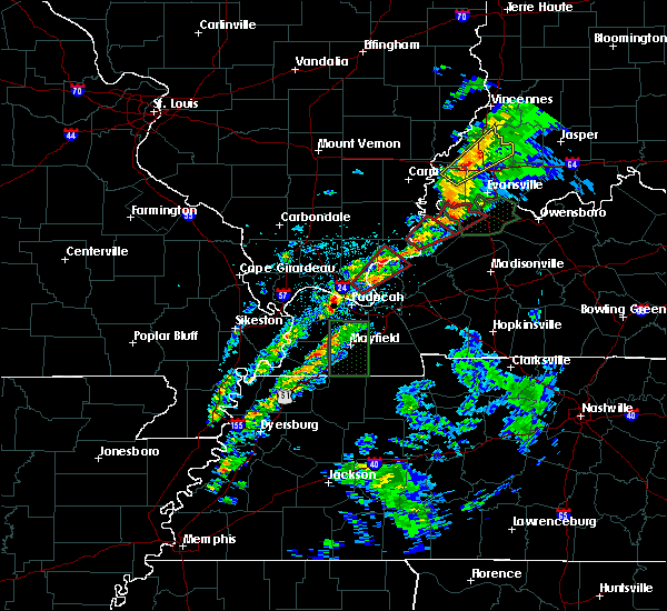 At 1031 am cdt, a severe thunderstorm capable of producing a tornado was located over joy, or 18 miles west of marion, moving northeast at 65 mph (radar indicated rotation). Hazards include tornado. Flying debris will be dangerous to those caught without shelter. mobile homes will be damaged or destroyed. damage to roofs, windows, and vehicles will occur. tree damage is likely. this dangerous storm will be near, rosiclare around 1035 am cdt. Other locations impacted by this tornadic thunderstorm include carrsville and elizabethtown. At 1031 am cdt, a severe thunderstorm capable of producing a tornado was located over joy, or 18 miles west of marion, moving northeast at 65 mph (radar indicated rotation). Hazards include tornado. Flying debris will be dangerous to those caught without shelter. mobile homes will be damaged or destroyed. damage to roofs, windows, and vehicles will occur. tree damage is likely. this dangerous storm will be near, rosiclare around 1035 am cdt. Other locations impacted by this tornadic thunderstorm include carrsville and elizabethtown.
|
| 3/14/2019 10:23 AM CDT |
 At 1023 am cdt, a severe thunderstorm capable of producing a tornado was located 7 miles south of golconda, or 12 miles northeast of metropolis, moving northeast at 65 mph (radar indicated rotation). Hazards include tornado. Flying debris will be dangerous to those caught without shelter. mobile homes will be damaged or destroyed. damage to roofs, windows, and vehicles will occur. tree damage is likely. this dangerous storm will be near, joy around 1035 am cdt. rosiclare around 1040 am cdt. Other locations impacted by this tornadic thunderstorm include carrsville and elizabethtown. At 1023 am cdt, a severe thunderstorm capable of producing a tornado was located 7 miles south of golconda, or 12 miles northeast of metropolis, moving northeast at 65 mph (radar indicated rotation). Hazards include tornado. Flying debris will be dangerous to those caught without shelter. mobile homes will be damaged or destroyed. damage to roofs, windows, and vehicles will occur. tree damage is likely. this dangerous storm will be near, joy around 1035 am cdt. rosiclare around 1040 am cdt. Other locations impacted by this tornadic thunderstorm include carrsville and elizabethtown.
|
| 3/14/2019 9:44 AM CDT |
 At 944 am cdt, a severe thunderstorm capable of producing a tornado was located 8 miles southwest of burna, or 11 miles east of metropolis, moving northeast at 60 mph (radar indicated rotation). Hazards include tornado. Flying debris will be dangerous to those caught without shelter. mobile homes will be damaged or destroyed. damage to roofs, windows, and vehicles will occur. tree damage is likely. this dangerous storm will be near, burna around 950 am cdt. joy around 955 am cdt. rosiclare around 1000 am cdt. Other locations impacted by this tornadic thunderstorm include carrsville and elizabethtown. At 944 am cdt, a severe thunderstorm capable of producing a tornado was located 8 miles southwest of burna, or 11 miles east of metropolis, moving northeast at 60 mph (radar indicated rotation). Hazards include tornado. Flying debris will be dangerous to those caught without shelter. mobile homes will be damaged or destroyed. damage to roofs, windows, and vehicles will occur. tree damage is likely. this dangerous storm will be near, burna around 950 am cdt. joy around 955 am cdt. rosiclare around 1000 am cdt. Other locations impacted by this tornadic thunderstorm include carrsville and elizabethtown.
|
| 3/14/2019 8:57 AM CDT |
 At 857 am cdt, a severe thunderstorm was located over golconda, or 20 miles west of marion, moving northeast at 70 mph (radar indicated). Hazards include 60 mph wind gusts and nickel size hail. expect damage to roofs, siding, and trees At 857 am cdt, a severe thunderstorm was located over golconda, or 20 miles west of marion, moving northeast at 70 mph (radar indicated). Hazards include 60 mph wind gusts and nickel size hail. expect damage to roofs, siding, and trees
|
| 2/7/2019 10:50 AM CST |
 At 1050 am cst, a severe thunderstorm was located near burna, or 13 miles northeast of metropolis, moving northeast at 85 mph (radar indicated). Hazards include 60 mph wind gusts. expect damage to roofs, siding, and trees At 1050 am cst, a severe thunderstorm was located near burna, or 13 miles northeast of metropolis, moving northeast at 85 mph (radar indicated). Hazards include 60 mph wind gusts. expect damage to roofs, siding, and trees
|
| 8/15/2018 3:02 PM CDT |
 At 302 pm cdt, a severe thunderstorm was located near rosiclare, or 17 miles northwest of marion, moving northeast at 35 mph (radar indicated). Hazards include 60 mph wind gusts and penny size hail. expect damage to roofs, siding, and trees At 302 pm cdt, a severe thunderstorm was located near rosiclare, or 17 miles northwest of marion, moving northeast at 35 mph (radar indicated). Hazards include 60 mph wind gusts and penny size hail. expect damage to roofs, siding, and trees
|
| 6/28/2018 7:35 PM CDT |
 At 734 pm cdt, severe thunderstorms were located along a line extending from near equality to 10 miles north of dixon springs to near goreville to near cobden, moving southeast at 70 mph (trained weather spotters). Hazards include 70 mph wind gusts and quarter size hail. Hail damage to vehicles is expected. expect considerable tree damage. Wind damage is also likely to mobile homes, roofs, and outbuildings. At 734 pm cdt, severe thunderstorms were located along a line extending from near equality to 10 miles north of dixon springs to near goreville to near cobden, moving southeast at 70 mph (trained weather spotters). Hazards include 70 mph wind gusts and quarter size hail. Hail damage to vehicles is expected. expect considerable tree damage. Wind damage is also likely to mobile homes, roofs, and outbuildings.
|
| 6/26/2018 5:53 PM CDT |
 At 552 pm cdt, a severe thunderstorm was located near rosiclare, or 12 miles west of marion, moving east at 25 mph (radar indicated). Hazards include 60 mph wind gusts and quarter size hail. Hail damage to vehicles is expected. Expect wind damage to roofs, siding, and trees. At 552 pm cdt, a severe thunderstorm was located near rosiclare, or 12 miles west of marion, moving east at 25 mph (radar indicated). Hazards include 60 mph wind gusts and quarter size hail. Hail damage to vehicles is expected. Expect wind damage to roofs, siding, and trees.
|
| 6/26/2018 9:52 AM CDT |
 At 951 am cdt, severe thunderstorms were located along a line extending from 7 miles northeast of shawneetown to near burna, moving east at 50 mph. isolated damage to trees and power poles has been reported with this line (trained weather spotters). Hazards include 60 mph wind gusts and penny size hail. Expect damage to roofs, siding, and trees. Locations impacted include, shawneetown, rosiclare, ridgway, salem, equality, burna, joy, new haven, cave-in-rock, elizabethtown, omaha, old shawneetown, junction, carrsville, karbers ridge and gross. At 951 am cdt, severe thunderstorms were located along a line extending from 7 miles northeast of shawneetown to near burna, moving east at 50 mph. isolated damage to trees and power poles has been reported with this line (trained weather spotters). Hazards include 60 mph wind gusts and penny size hail. Expect damage to roofs, siding, and trees. Locations impacted include, shawneetown, rosiclare, ridgway, salem, equality, burna, joy, new haven, cave-in-rock, elizabethtown, omaha, old shawneetown, junction, carrsville, karbers ridge and gross.
|
| 6/26/2018 9:33 AM CDT |
 At 931 am cdt, severe thunderstorms were located along a line extending from near eldorado to near dixon springs, moving east at 30 mph. trained spotters reported trees down with this line of storms near creal springs and harrisburg (trained weather spotters). Hazards include 60 mph wind gusts and quarter size hail. Hail damage to vehicles is expected. Expect wind damage to roofs, siding, and trees. At 931 am cdt, severe thunderstorms were located along a line extending from near eldorado to near dixon springs, moving east at 30 mph. trained spotters reported trees down with this line of storms near creal springs and harrisburg (trained weather spotters). Hazards include 60 mph wind gusts and quarter size hail. Hail damage to vehicles is expected. Expect wind damage to roofs, siding, and trees.
|
| 5/27/2017 6:40 PM CDT |
 At 638 pm cdt, severe thunderstorms were located along a line extending from 9 miles north of golconda to joy to near calvert city to near mayfield, moving east at 70 mph (radar indicated. these storms downed trees in mccracken county). Hazards include 70 mph wind gusts. Expect considerable tree damage. Damage is likely to mobile homes, roofs, and outbuildings. At 638 pm cdt, severe thunderstorms were located along a line extending from 9 miles north of golconda to joy to near calvert city to near mayfield, moving east at 70 mph (radar indicated. these storms downed trees in mccracken county). Hazards include 70 mph wind gusts. Expect considerable tree damage. Damage is likely to mobile homes, roofs, and outbuildings.
|
| 5/27/2017 6:10 PM CDT |
 At 608 pm cdt, severe thunderstorms were located along a line extending from goreville to near barlow to near east prairie, moving east at 65 mph. these are very dangerous storms (law enforcement. structural damage has been reported in stoddard county with 80 mph winds reported near sikeston missouri). Hazards include 80 mph wind gusts and nickel size hail. Flying debris will be dangerous to those caught without shelter. mobile homes will be heavily damaged. expect considerable damage to roofs, windows, and vehicles. Extensive tree damage and power outages are likely. At 608 pm cdt, severe thunderstorms were located along a line extending from goreville to near barlow to near east prairie, moving east at 65 mph. these are very dangerous storms (law enforcement. structural damage has been reported in stoddard county with 80 mph winds reported near sikeston missouri). Hazards include 80 mph wind gusts and nickel size hail. Flying debris will be dangerous to those caught without shelter. mobile homes will be heavily damaged. expect considerable damage to roofs, windows, and vehicles. Extensive tree damage and power outages are likely.
|
| 5/27/2017 4:36 PM CDT |
 At 435 pm cdt, a severe thunderstorm was located over golconda, or 17 miles northeast of metropolis, moving east at 50 mph (law enforcement. trees were reported down across johnson county illinois as these storms moved through). Hazards include 60 mph wind gusts and quarter size hail. Hail damage to vehicles is expected. Expect wind damage to roofs, siding, and trees. At 435 pm cdt, a severe thunderstorm was located over golconda, or 17 miles northeast of metropolis, moving east at 50 mph (law enforcement. trees were reported down across johnson county illinois as these storms moved through). Hazards include 60 mph wind gusts and quarter size hail. Hail damage to vehicles is expected. Expect wind damage to roofs, siding, and trees.
|
| 3/1/2017 5:06 AM CST |
 At 506 am cst, severe thunderstorms were located along a line extending from near dongola to near wickliffe, moving east at 110 mph. these are very dangerous storms (radar indicated). Hazards include 80 mph wind gusts and penny size hail. Flying debris will be dangerous to those caught without shelter. mobile homes will be heavily damaged. expect considerable damage to roofs, windows, and vehicles. Extensive tree damage and power outages are likely. At 506 am cst, severe thunderstorms were located along a line extending from near dongola to near wickliffe, moving east at 110 mph. these are very dangerous storms (radar indicated). Hazards include 80 mph wind gusts and penny size hail. Flying debris will be dangerous to those caught without shelter. mobile homes will be heavily damaged. expect considerable damage to roofs, windows, and vehicles. Extensive tree damage and power outages are likely.
|
| 4/25/2015 6:01 PM CDT | At 600 pm cdt, a severe thunderstorm was located over rosiclare, or 15 miles northwest of marion, moving east at 35 mph (radar indicated). Hazards include 60 mph wind gusts and quarter size hail. Hail damage to vehicles is expected. expect wind damage to roofs, siding and trees. locations impacted include, marion, rosiclare, salem, joy, elizabethtown, carrsville and dycusburg. a tornado watch remains in effect until 800 pm cdt for southern illinois and western kentucky. 1. 00in. |
| 4/25/2015 6:01 PM CDT | At 600 pm cdt, a severe thunderstorm was located over rosiclare, or 15 miles northwest of marion, moving east at 35 mph (radar indicated). Hazards include 60 mph wind gusts and quarter size hail. Hail damage to vehicles is expected. expect wind damage to roofs, siding and trees. locations impacted include, marion, rosiclare, salem, joy, elizabethtown, carrsville and dycusburg. a tornado watch remains in effect until 800 pm cdt for southern illinois and western kentucky. 1. 00in. |
| 4/25/2015 5:43 PM CDT | At 542 pm cdt, a severe thunderstorm was located near golconda, or 19 miles south of harrisburg, moving east at 35 mph (radar indicated). Hazards include ping pong ball size hail and 60 mph wind gusts. People and animals outdoors will be injured. expect hail damage to roofs, siding, windows and vehicles. Expect wind damage to roofs, siding and trees. |
| 4/25/2015 5:43 PM CDT | At 542 pm cdt, a severe thunderstorm was located near golconda, or 19 miles south of harrisburg, moving east at 35 mph (radar indicated). Hazards include ping pong ball size hail and 60 mph wind gusts. People and animals outdoors will be injured. expect hail damage to roofs, siding, windows and vehicles. Expect wind damage to roofs, siding and trees. |
Hail Maps for Rosiclare, IL

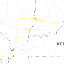
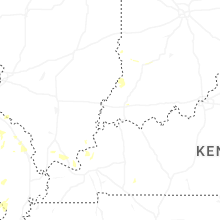


Connect with Interactive Hail Maps