

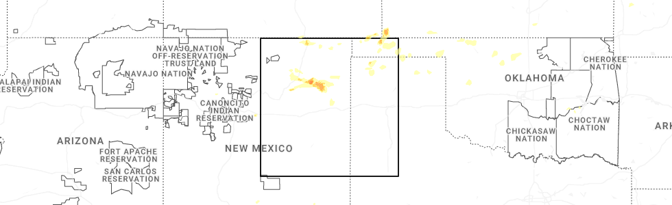
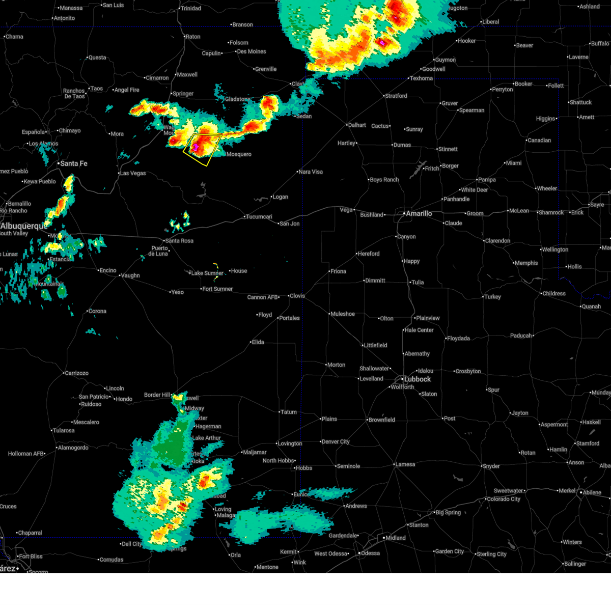
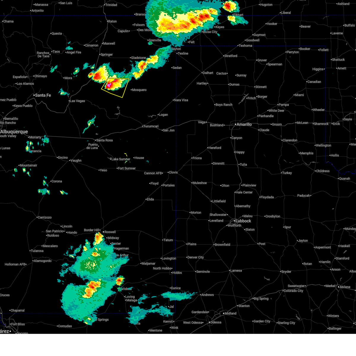
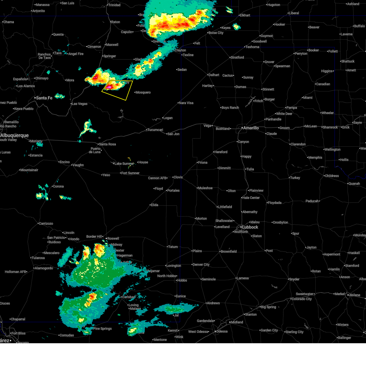
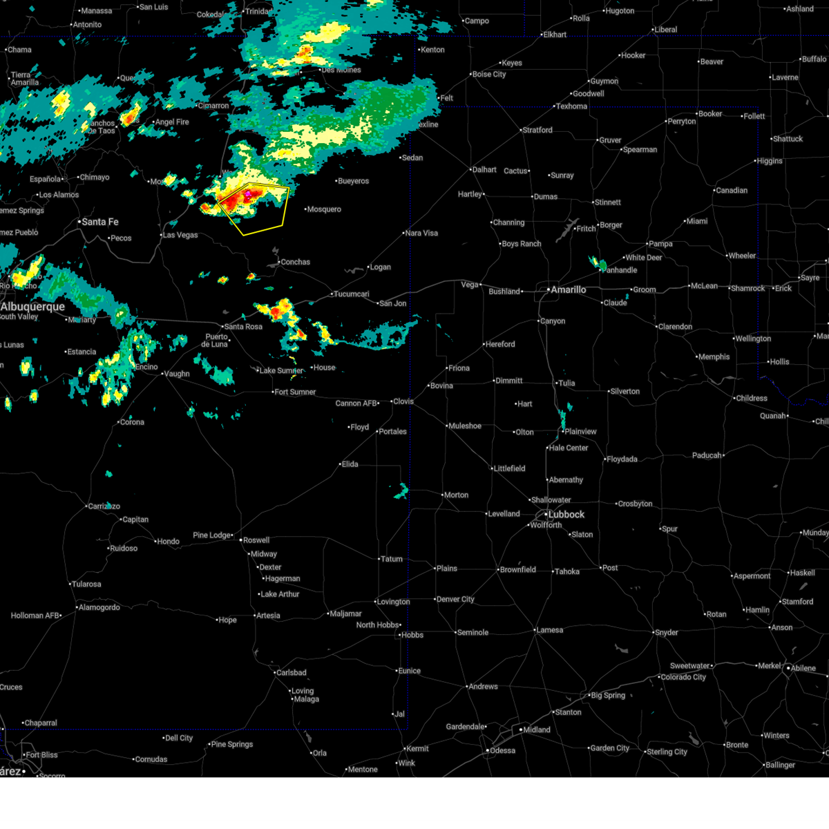
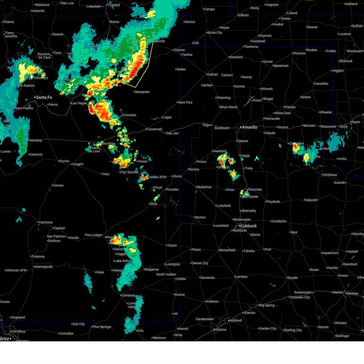
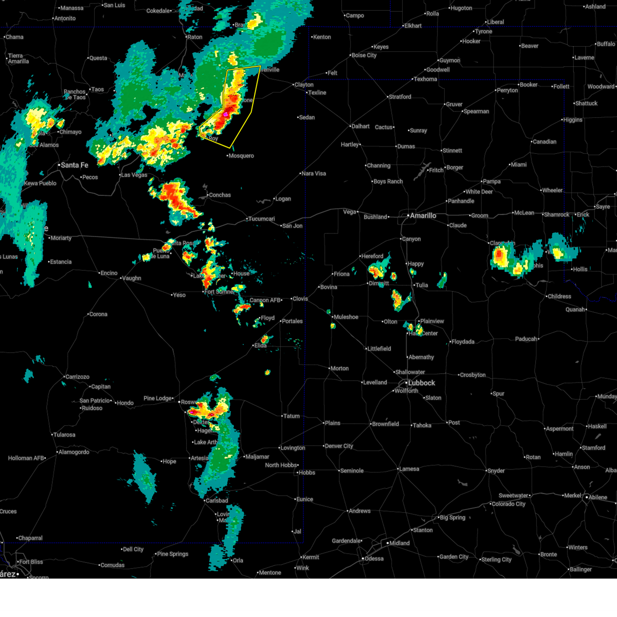
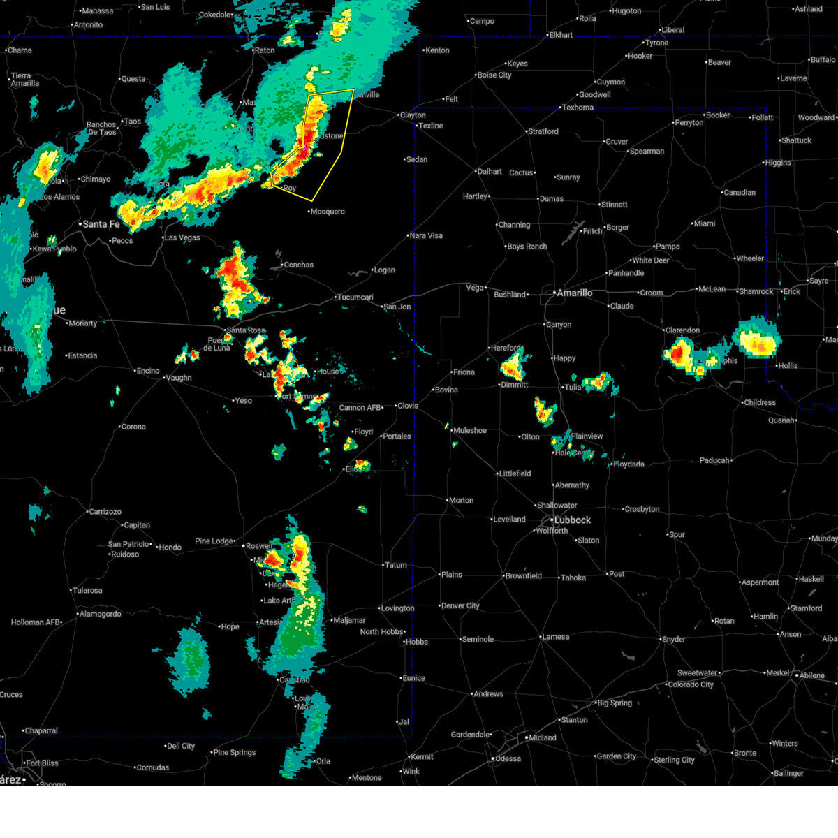
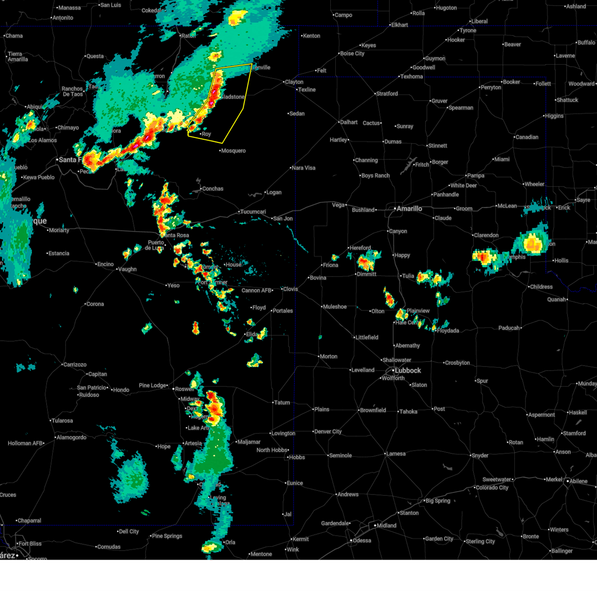
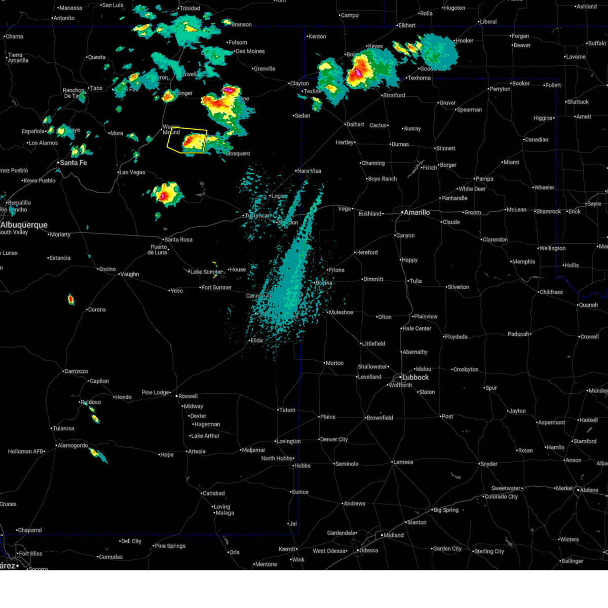
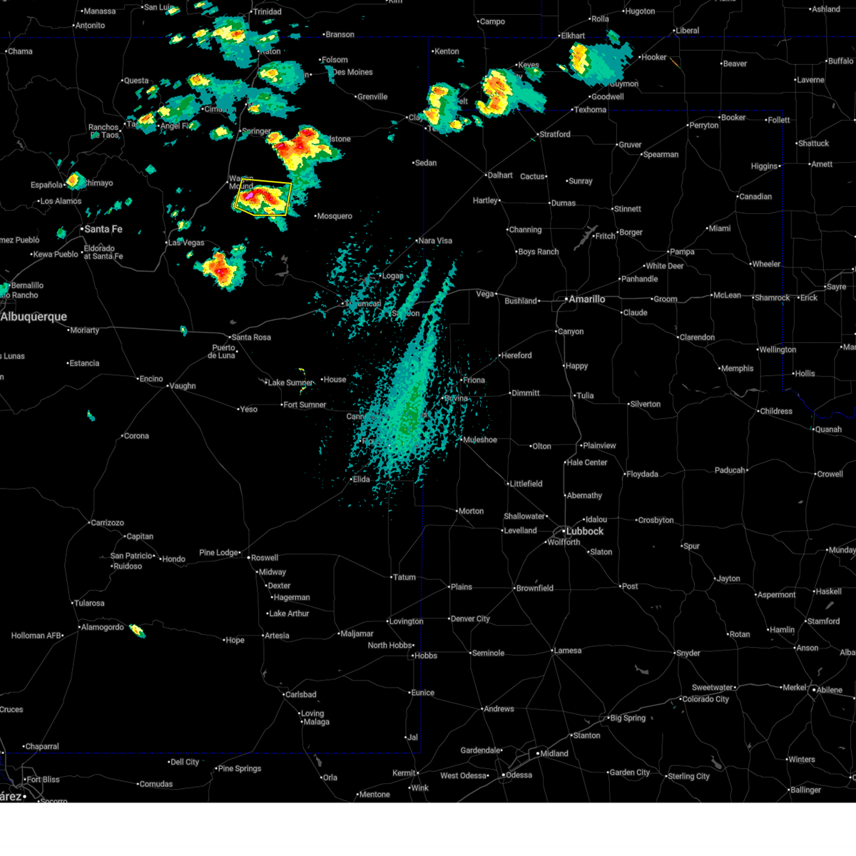
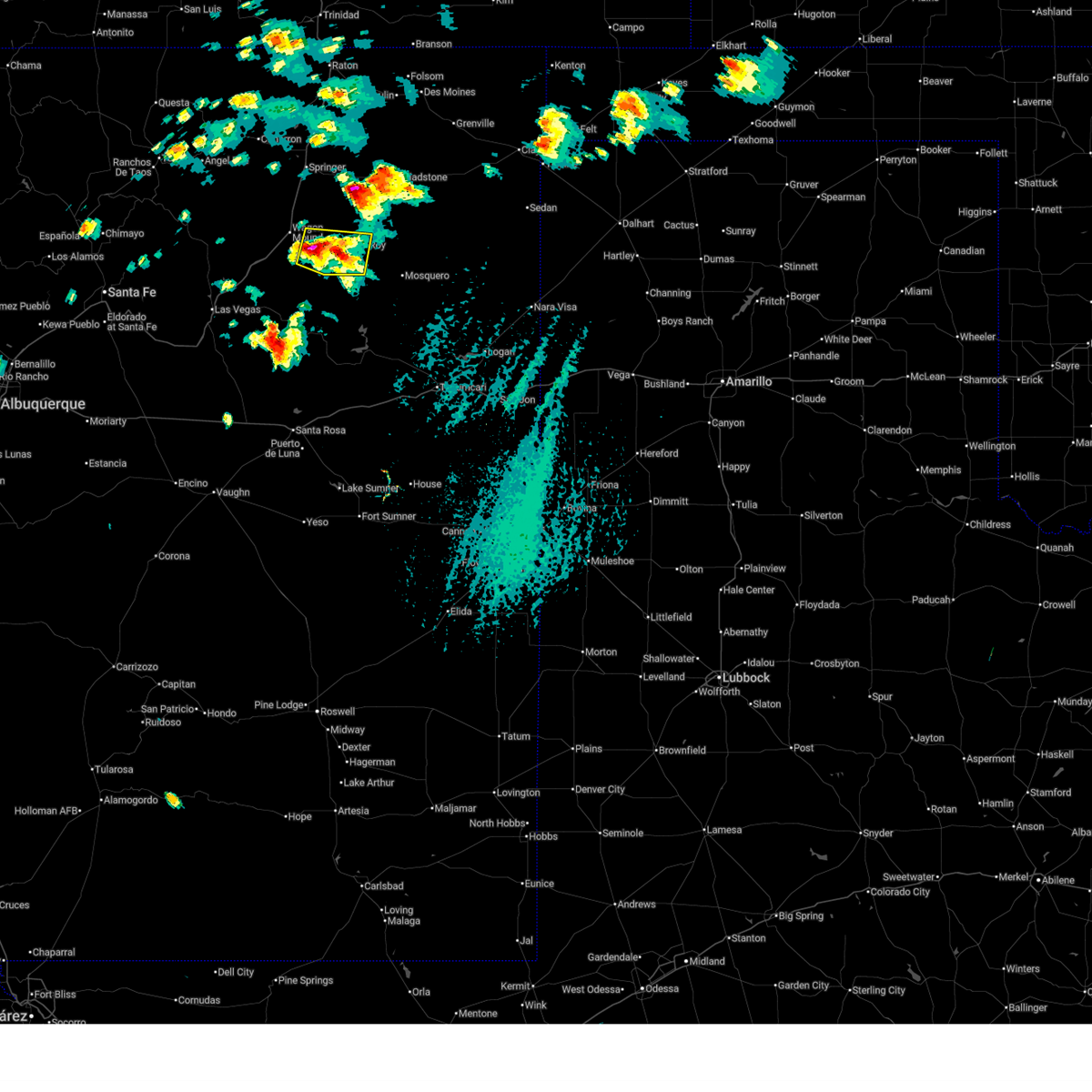
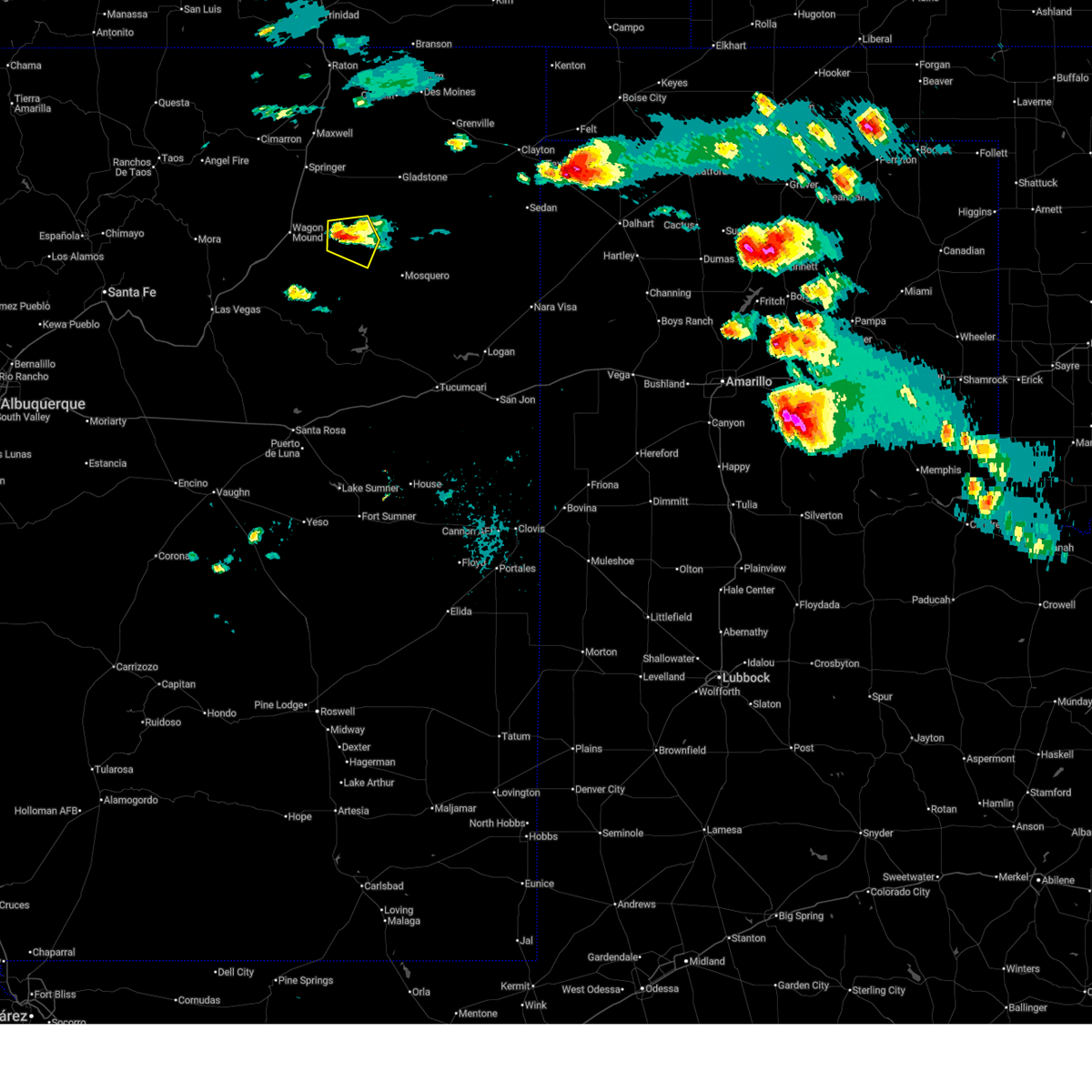
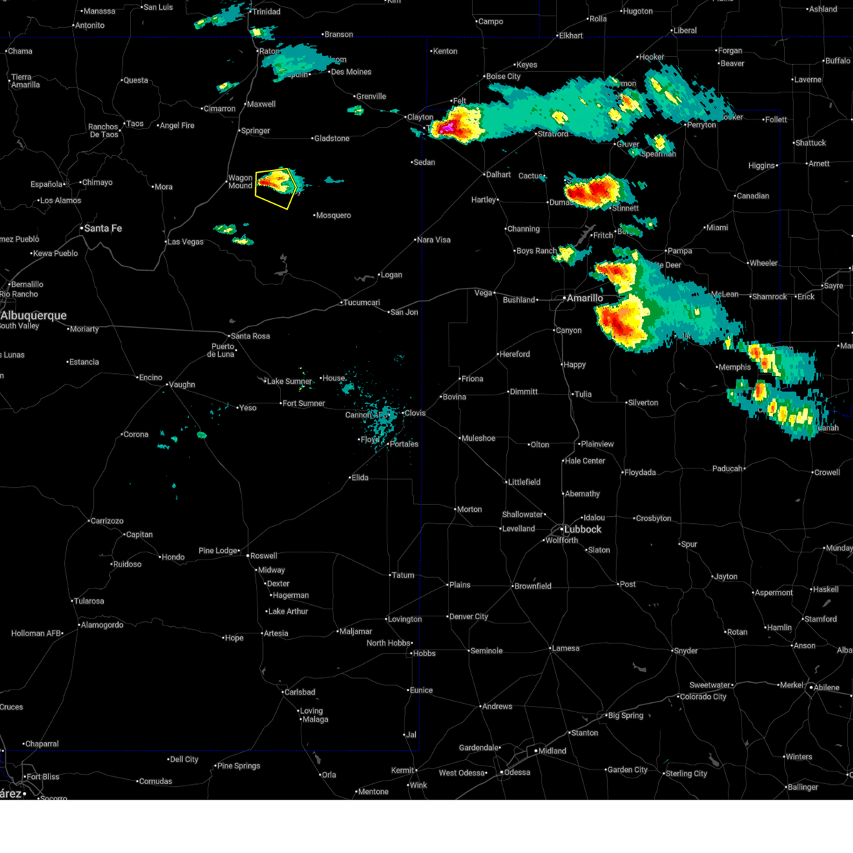
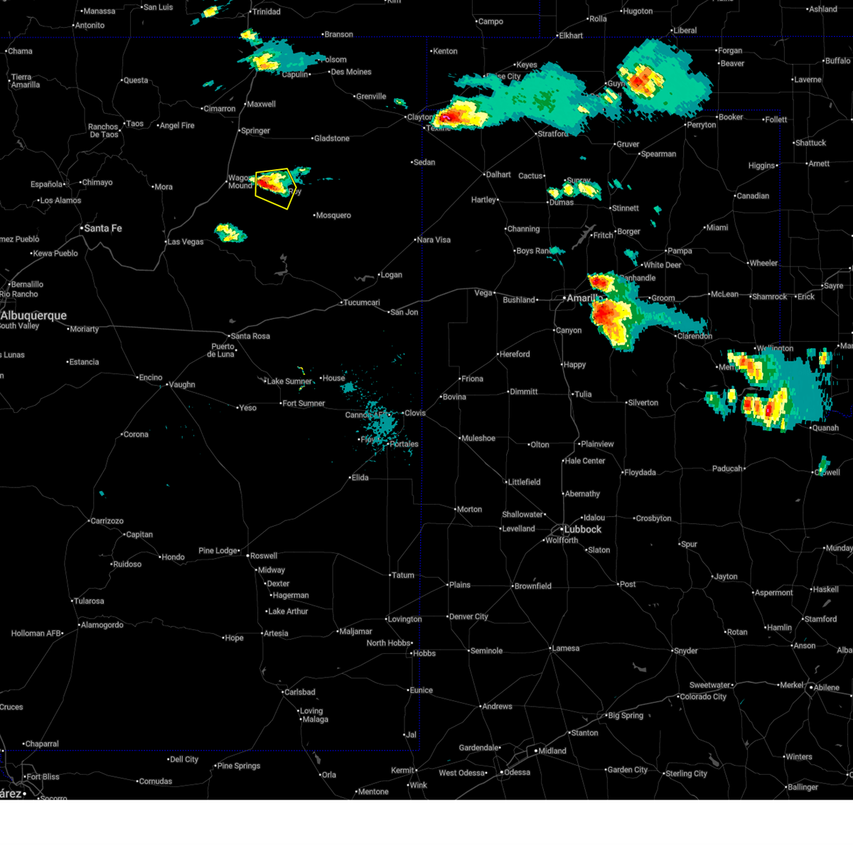
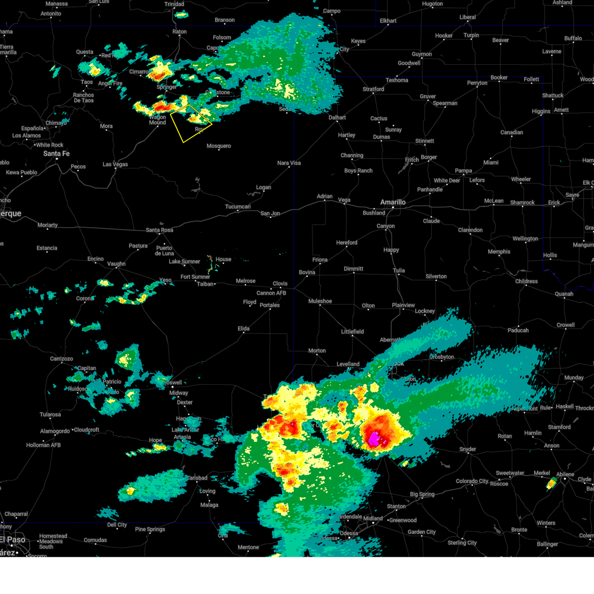
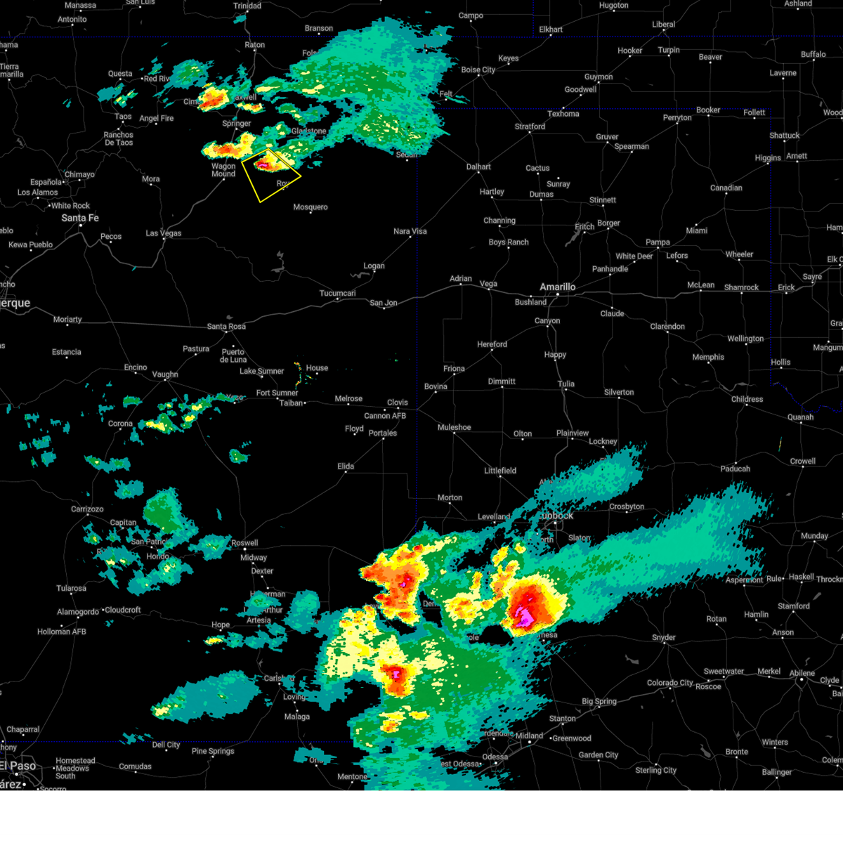
Hail Map for Roy, NM
The Roy, NM area has had 18 reports of on-the-ground hail by trained spotters, and has been under severe weather warnings 15 times during the past 12 months. Doppler radar has detected hail at or near Roy, NM on 42 occasions, including 4 occasions during the past year.
| Name: | Roy, NM |
| Where Located: | 59.1 miles NNW of Tucumcari, NM |
| Map: | Google Map for Roy, NM |
| Population: | 234 |
| Housing Units: | 191 |
| More Info: | Search Google for Roy, NM |
1
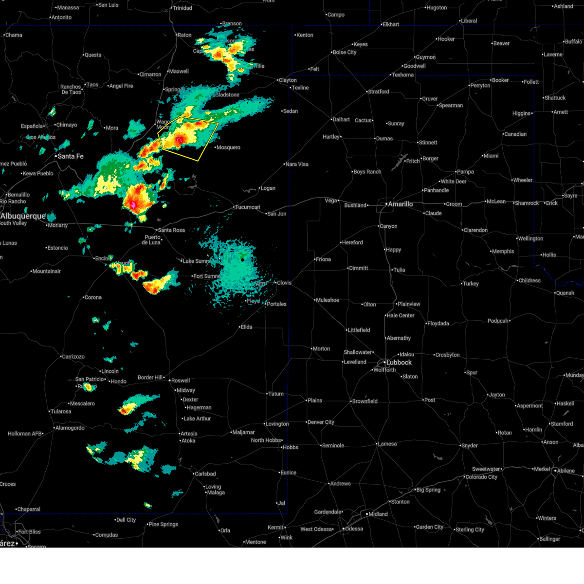
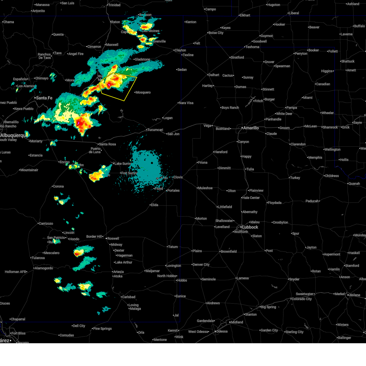
The Top Recent Hail Date for Roy, NM is Friday, June 12, 2026 (16th out of 42)
Hail and Wind Damage Spotted near Roy, NM
| Date / Time | Report Details |
|---|---|
| 6/15/2026 3:28 PM MDT |
 The storm which prompted the warning has weakened below severe limits, and no longer poses an immediate threat to life or property. therefore, the warning will be allowed to expire. however, small hail and gusty winds are still possible with this thunderstorm. The storm which prompted the warning has weakened below severe limits, and no longer poses an immediate threat to life or property. therefore, the warning will be allowed to expire. however, small hail and gusty winds are still possible with this thunderstorm.
|
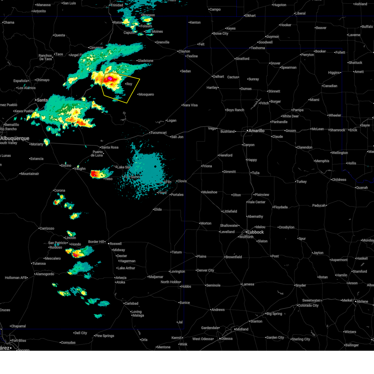
| 6/15/2026 3:09 PM MDT |
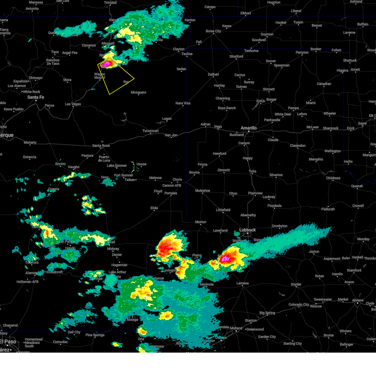
 At 309 pm mdt, a severe thunderstorm was located 14 miles west of roy, or 17 miles southeast of wagon mound, moving southeast at 25 mph (radar indicated). Hazards include 60 mph wind gusts and quarter size hail. Hail damage to vehicles is expected. expect wind damage to roofs, siding, and trees. Locations impacted include, roy, chicosa lake state park and solano. At 309 pm mdt, a severe thunderstorm was located 14 miles west of roy, or 17 miles southeast of wagon mound, moving southeast at 25 mph (radar indicated). Hazards include 60 mph wind gusts and quarter size hail. Hail damage to vehicles is expected. expect wind damage to roofs, siding, and trees. Locations impacted include, roy, chicosa lake state park and solano.
|
| 6/15/2026 2:43 PM MDT |
 Svrabq the national weather service in albuquerque has issued a * severe thunderstorm warning for, northwestern harding county in northeastern new mexico, southeastern mora county in northeastern new mexico, north central san miguel county in northeastern new mexico, * until 330 pm mdt. * at 243 pm mdt, a severe thunderstorm was located 12 miles east of wagon mound, moving southeast at 30 mph (radar indicated). Hazards include 60 mph wind gusts and quarter size hail. Hail damage to vehicles is expected. Expect wind damage to roofs, siding, and trees. Svrabq the national weather service in albuquerque has issued a * severe thunderstorm warning for, northwestern harding county in northeastern new mexico, southeastern mora county in northeastern new mexico, north central san miguel county in northeastern new mexico, * until 330 pm mdt. * at 243 pm mdt, a severe thunderstorm was located 12 miles east of wagon mound, moving southeast at 30 mph (radar indicated). Hazards include 60 mph wind gusts and quarter size hail. Hail damage to vehicles is expected. Expect wind damage to roofs, siding, and trees.
|
| 6/12/2026 7:25 PM MDT |
 The severe thunderstorm warning that was previously in effect has been reissued for san miguel and harding counties and is in effect until 815 pm mdt. please refer to that bulletin for the latest severe weather information. a severe thunderstorm watch remains in effect until 1200 am mdt saturday for a portion of northeast new mexico. The severe thunderstorm warning that was previously in effect has been reissued for san miguel and harding counties and is in effect until 815 pm mdt. please refer to that bulletin for the latest severe weather information. a severe thunderstorm watch remains in effect until 1200 am mdt saturday for a portion of northeast new mexico.
|
| 6/12/2026 7:22 PM MDT | Half Dollar sized hail reported 6.7 miles ENE of Roy, NM |
| 6/12/2026 6:51 PM MDT |
 At 651 pm mdt, a severe thunderstorm was located 14 miles southwest of roy, or 20 miles southeast of wagon mound, moving east at 20 mph (radar indicated). Hazards include 60 mph wind gusts and half dollar size hail. Hail damage to vehicles is expected. expect wind damage to roofs, siding, and trees. Locations impacted include, roy and solano. At 651 pm mdt, a severe thunderstorm was located 14 miles southwest of roy, or 20 miles southeast of wagon mound, moving east at 20 mph (radar indicated). Hazards include 60 mph wind gusts and half dollar size hail. Hail damage to vehicles is expected. expect wind damage to roofs, siding, and trees. Locations impacted include, roy and solano.
|
| 6/12/2026 6:38 PM MDT |
 Svrabq the national weather service in albuquerque has issued a * severe thunderstorm warning for, west central harding county in northeastern new mexico, southeastern mora county in northeastern new mexico, north central san miguel county in northeastern new mexico, * until 730 pm mdt. * at 638 pm mdt, a severe thunderstorm was located 14 miles northeast of maes, or 18 miles southeast of wagon mound, moving east at 25 mph (radar indicated). Hazards include 60 mph wind gusts and quarter size hail. Hail damage to vehicles is expected. Expect wind damage to roofs, siding, and trees. Svrabq the national weather service in albuquerque has issued a * severe thunderstorm warning for, west central harding county in northeastern new mexico, southeastern mora county in northeastern new mexico, north central san miguel county in northeastern new mexico, * until 730 pm mdt. * at 638 pm mdt, a severe thunderstorm was located 14 miles northeast of maes, or 18 miles southeast of wagon mound, moving east at 25 mph (radar indicated). Hazards include 60 mph wind gusts and quarter size hail. Hail damage to vehicles is expected. Expect wind damage to roofs, siding, and trees.
|
| 9/17/2025 6:29 PM MDT | the severe thunderstorm warning has been cancelled and is no longer in effect |
| 9/17/2025 6:21 PM MDT | At 621 pm mdt, a severe thunderstorm was located near roy, or 22 miles northwest of mosquero, moving southeast at 10 mph (radar indicated). Hazards include 60 mph wind gusts and small hail. Expect damage to roofs, siding, and trees. Locations impacted include, roy. |
| 9/17/2025 5:58 PM MDT | Svrabq the national weather service in albuquerque has issued a * severe thunderstorm warning for, northwestern harding county in northeastern new mexico, * until 645 pm mdt. * at 558 pm mdt, a severe thunderstorm was located 7 miles southwest of mills, or 22 miles east of wagon mound, moving southeast at 15 mph (radar indicated). Hazards include 60 mph wind gusts and quarter size hail. Hail damage to vehicles is expected. Expect wind damage to roofs, siding, and trees. |
| 8/29/2025 4:05 PM MDT | Mesonet station mlcn5 mills 4 wsw (mills canyon in harding county NM, 10.1 miles SE of Roy, NM |
| 8/25/2025 5:24 PM MDT |
 Svrabq the national weather service in albuquerque has issued a * severe thunderstorm warning for, west central harding county in northeastern new mexico, southeastern mora county in northeastern new mexico, north central san miguel county in northeastern new mexico, * until 615 pm mdt. * at 524 pm mdt, a severe thunderstorm was located 16 miles northeast of maes, or 19 miles southeast of wagon mound, moving east at 15 mph (radar indicated). Hazards include 60 mph wind gusts and half dollar size hail. Hail damage to vehicles is expected. Expect wind damage to roofs, siding, and trees. Svrabq the national weather service in albuquerque has issued a * severe thunderstorm warning for, west central harding county in northeastern new mexico, southeastern mora county in northeastern new mexico, north central san miguel county in northeastern new mexico, * until 615 pm mdt. * at 524 pm mdt, a severe thunderstorm was located 16 miles northeast of maes, or 19 miles southeast of wagon mound, moving east at 15 mph (radar indicated). Hazards include 60 mph wind gusts and half dollar size hail. Hail damage to vehicles is expected. Expect wind damage to roofs, siding, and trees.
|
| 7/17/2025 6:44 PM MDT |
 The severe thunderstorm warning that was previously in effect has been replaced with a special weather statement for union and harding counties and is in effect until 715 pm mdt. please refer to that bulletin for the latest weather information. small hail, gusty winds, and heavy rain are still possible with these thunderstorms. The severe thunderstorm warning that was previously in effect has been replaced with a special weather statement for union and harding counties and is in effect until 715 pm mdt. please refer to that bulletin for the latest weather information. small hail, gusty winds, and heavy rain are still possible with these thunderstorms.
|
| 7/17/2025 6:30 PM MDT |
 At 630 pm mdt, severe thunderstorms were located along a line from 12 miles southwest of grenville to 6 miles southeast of chicosa lake state park, moving east at 20 mph (radar indicated). Hazards include golf ball size hail and 60 mph wind gusts. People and animals outdoors will be injured. expect hail damage to roofs, siding, windows, and vehicles. expect wind damage to roofs, siding, and trees. locations impacted include, roy, grenville, gladstone, chicosa lake state park and yates. This includes highway 64 between mile markers 399 and 405. At 630 pm mdt, severe thunderstorms were located along a line from 12 miles southwest of grenville to 6 miles southeast of chicosa lake state park, moving east at 20 mph (radar indicated). Hazards include golf ball size hail and 60 mph wind gusts. People and animals outdoors will be injured. expect hail damage to roofs, siding, windows, and vehicles. expect wind damage to roofs, siding, and trees. locations impacted include, roy, grenville, gladstone, chicosa lake state park and yates. This includes highway 64 between mile markers 399 and 405.
|
| 7/17/2025 6:19 PM MDT |
 the severe thunderstorm warning has been cancelled and is no longer in effect the severe thunderstorm warning has been cancelled and is no longer in effect
|
| 7/17/2025 6:19 PM MDT |
 At 619 pm mdt, severe thunderstorms were located along a line from 14 miles northeast of gladstone to near chicosa lake state park, moving east at 20 mph (radar indicated). Hazards include 60 mph wind gusts and quarter size hail. Hail damage to vehicles is expected. expect wind damage to roofs, siding, and trees. locations impacted include, roy, grenville, gladstone, chicosa lake state park and yates. This includes highway 64 between mile markers 399 and 405. At 619 pm mdt, severe thunderstorms were located along a line from 14 miles northeast of gladstone to near chicosa lake state park, moving east at 20 mph (radar indicated). Hazards include 60 mph wind gusts and quarter size hail. Hail damage to vehicles is expected. expect wind damage to roofs, siding, and trees. locations impacted include, roy, grenville, gladstone, chicosa lake state park and yates. This includes highway 64 between mile markers 399 and 405.
|
| 7/17/2025 6:05 PM MDT |
 Svrabq the national weather service in albuquerque has issued a * severe thunderstorm warning for, southeastern colfax county in northeastern new mexico, northwestern harding county in northeastern new mexico, west central union county in northeastern new mexico, * until 645 pm mdt. * at 605 pm mdt, severe thunderstorms were located along a line from 12 miles northeast of farley to near roy, moving east at 20 mph (radar indicated). Hazards include 60 mph wind gusts and quarter size hail. Hail damage to vehicles is expected. Expect wind damage to roofs, siding, and trees. Svrabq the national weather service in albuquerque has issued a * severe thunderstorm warning for, southeastern colfax county in northeastern new mexico, northwestern harding county in northeastern new mexico, west central union county in northeastern new mexico, * until 645 pm mdt. * at 605 pm mdt, severe thunderstorms were located along a line from 12 miles northeast of farley to near roy, moving east at 20 mph (radar indicated). Hazards include 60 mph wind gusts and quarter size hail. Hail damage to vehicles is expected. Expect wind damage to roofs, siding, and trees.
|
| 7/10/2025 3:12 PM MDT |
 the severe thunderstorm warning has been cancelled and is no longer in effect the severe thunderstorm warning has been cancelled and is no longer in effect
|
| 7/10/2025 2:50 PM MDT |
 At 250 pm mdt, a severe thunderstorm was located 14 miles southeast of wagon mound, moving east at 20 mph (radar indicated). Hazards include 60 mph wind gusts and half dollar size hail. Hail damage to vehicles is expected. expect wind damage to roofs, siding, and trees. Locations impacted include, roy. At 250 pm mdt, a severe thunderstorm was located 14 miles southeast of wagon mound, moving east at 20 mph (radar indicated). Hazards include 60 mph wind gusts and half dollar size hail. Hail damage to vehicles is expected. expect wind damage to roofs, siding, and trees. Locations impacted include, roy.
|
| 7/10/2025 2:44 PM MDT |
 Svrabq the national weather service in albuquerque has issued a * severe thunderstorm warning for, west central harding county in northeastern new mexico, southeastern mora county in northeastern new mexico, * until 330 pm mdt. * at 244 pm mdt, a severe thunderstorm was located 12 miles southeast of wagon mound, moving east at 25 mph (radar indicated). Hazards include 60 mph wind gusts and quarter size hail. Hail damage to vehicles is expected. Expect wind damage to roofs, siding, and trees. Svrabq the national weather service in albuquerque has issued a * severe thunderstorm warning for, west central harding county in northeastern new mexico, southeastern mora county in northeastern new mexico, * until 330 pm mdt. * at 244 pm mdt, a severe thunderstorm was located 12 miles southeast of wagon mound, moving east at 25 mph (radar indicated). Hazards include 60 mph wind gusts and quarter size hail. Hail damage to vehicles is expected. Expect wind damage to roofs, siding, and trees.
|
| 6/8/2025 2:55 PM MDT |
 The storm which prompted the warning has weakened below severe limits, and no longer poses an immediate threat to life or property. therefore, the warning will be allowed to expire. however, small hail, gusty winds, and heavy rain are still possible with this thunderstorm. The storm which prompted the warning has weakened below severe limits, and no longer poses an immediate threat to life or property. therefore, the warning will be allowed to expire. however, small hail, gusty winds, and heavy rain are still possible with this thunderstorm.
|
| 6/8/2025 2:42 PM MDT |
 At 242 pm mdt, a severe thunderstorm was located 8 miles southwest of mills, or 21 miles east of wagon mound, moving east at 5 mph (radar indicated). Hazards include 60 mph wind gusts and quarter size hail. Hail damage to vehicles is expected. expect wind damage to roofs, siding, and trees. Locations impacted include, roy, mills and chicosa lake state park. At 242 pm mdt, a severe thunderstorm was located 8 miles southwest of mills, or 21 miles east of wagon mound, moving east at 5 mph (radar indicated). Hazards include 60 mph wind gusts and quarter size hail. Hail damage to vehicles is expected. expect wind damage to roofs, siding, and trees. Locations impacted include, roy, mills and chicosa lake state park.
|
| 6/8/2025 2:22 PM MDT |
 Svrabq the national weather service in albuquerque has issued a * severe thunderstorm warning for, northwestern harding county in northeastern new mexico, east central mora county in northeastern new mexico, * until 300 pm mdt. * at 222 pm mdt, a severe thunderstorm was located 10 miles southwest of mills, or 19 miles east of wagon mound, moving east at 5 mph (radar indicated). Hazards include 60 mph wind gusts and quarter size hail. Hail damage to vehicles is expected. Expect wind damage to roofs, siding, and trees. Svrabq the national weather service in albuquerque has issued a * severe thunderstorm warning for, northwestern harding county in northeastern new mexico, east central mora county in northeastern new mexico, * until 300 pm mdt. * at 222 pm mdt, a severe thunderstorm was located 10 miles southwest of mills, or 19 miles east of wagon mound, moving east at 5 mph (radar indicated). Hazards include 60 mph wind gusts and quarter size hail. Hail damage to vehicles is expected. Expect wind damage to roofs, siding, and trees.
|
| 5/29/2025 5:19 PM MDT |
 the severe thunderstorm warning has been cancelled and is no longer in effect the severe thunderstorm warning has been cancelled and is no longer in effect
|
| 5/29/2025 5:04 PM MDT |
 At 504 pm mdt, a severe thunderstorm was located near mills, or 22 miles east of wagon mound, moving southeast at 20 mph (radar indicated). Hazards include 60 mph wind gusts and quarter size hail. Hail damage to vehicles is expected. expect wind damage to roofs, siding, and trees. Locations impacted include, roy, mills and chicosa lake state park. At 504 pm mdt, a severe thunderstorm was located near mills, or 22 miles east of wagon mound, moving southeast at 20 mph (radar indicated). Hazards include 60 mph wind gusts and quarter size hail. Hail damage to vehicles is expected. expect wind damage to roofs, siding, and trees. Locations impacted include, roy, mills and chicosa lake state park.
|
| 5/29/2025 5:04 PM MDT |
 the severe thunderstorm warning has been cancelled and is no longer in effect the severe thunderstorm warning has been cancelled and is no longer in effect
|
| 5/29/2025 4:25 PM MDT |
 Svrabq the national weather service in albuquerque has issued a * severe thunderstorm warning for, south central colfax county in northeastern new mexico, northwestern harding county in northeastern new mexico, eastern mora county in northeastern new mexico, * until 530 pm mdt. * at 425 pm mdt, a severe thunderstorm was located 13 miles south of springer, moving southeast at 25 mph (radar indicated). Hazards include ping pong ball size hail and 60 mph wind gusts. People and animals outdoors will be injured. expect hail damage to roofs, siding, windows, and vehicles. Expect wind damage to roofs, siding, and trees. Svrabq the national weather service in albuquerque has issued a * severe thunderstorm warning for, south central colfax county in northeastern new mexico, northwestern harding county in northeastern new mexico, eastern mora county in northeastern new mexico, * until 530 pm mdt. * at 425 pm mdt, a severe thunderstorm was located 13 miles south of springer, moving southeast at 25 mph (radar indicated). Hazards include ping pong ball size hail and 60 mph wind gusts. People and animals outdoors will be injured. expect hail damage to roofs, siding, windows, and vehicles. Expect wind damage to roofs, siding, and trees.
|
| 6/14/2024 1:57 PM MDT |
 Svrabq the national weather service in albuquerque has issued a * severe thunderstorm warning for, northeastern san miguel county in northeastern new mexico, harding county in northeastern new mexico, northeastern quay county in east central new mexico, union county in northeastern new mexico, eastern colfax county in northeastern new mexico, * until 300 pm mdt. * at 156 pm mdt, severe thunderstorms were located along a line extending from near folsom to 9 miles southeast of mosquero, moving east at 30 mph (radar indicated). Hazards include 60 mph wind gusts and quarter size hail. Hail damage to vehicles is expected. Expect wind damage to roofs, siding, and trees. Svrabq the national weather service in albuquerque has issued a * severe thunderstorm warning for, northeastern san miguel county in northeastern new mexico, harding county in northeastern new mexico, northeastern quay county in east central new mexico, union county in northeastern new mexico, eastern colfax county in northeastern new mexico, * until 300 pm mdt. * at 156 pm mdt, severe thunderstorms were located along a line extending from near folsom to 9 miles southeast of mosquero, moving east at 30 mph (radar indicated). Hazards include 60 mph wind gusts and quarter size hail. Hail damage to vehicles is expected. Expect wind damage to roofs, siding, and trees.
|
| 6/7/2024 4:38 PM MDT |
 Svrabq the national weather service in albuquerque has issued a * severe thunderstorm warning for, northeastern san miguel county in northeastern new mexico, northern harding county in northeastern new mexico, south central union county in northeastern new mexico, southeastern mora county in northeastern new mexico, * until 545 pm mdt. * at 438 pm mdt, severe thunderstorms were located along a line extending from 6 miles east of solano to 8 miles east of trujillo, moving east at 25 mph (radar indicated). Hazards include 70 mph wind gusts and nickel size hail. Expect considerable tree damage. Damage is likely to mobile homes, roofs, and outbuildings. Svrabq the national weather service in albuquerque has issued a * severe thunderstorm warning for, northeastern san miguel county in northeastern new mexico, northern harding county in northeastern new mexico, south central union county in northeastern new mexico, southeastern mora county in northeastern new mexico, * until 545 pm mdt. * at 438 pm mdt, severe thunderstorms were located along a line extending from 6 miles east of solano to 8 miles east of trujillo, moving east at 25 mph (radar indicated). Hazards include 70 mph wind gusts and nickel size hail. Expect considerable tree damage. Damage is likely to mobile homes, roofs, and outbuildings.
|
| 7/22/2023 5:41 PM MDT |
 The severe thunderstorm warning for north central san miguel and west central harding counties will expire at 545 pm mdt, the storm that prompted the warning has weakened below severe limits, and no longer poses an immediate threat to life or property. therefore, the warning will be allowed to expire. The severe thunderstorm warning for north central san miguel and west central harding counties will expire at 545 pm mdt, the storm that prompted the warning has weakened below severe limits, and no longer poses an immediate threat to life or property. therefore, the warning will be allowed to expire.
|
| 7/22/2023 5:30 PM MDT |
 At 529 pm mdt, a severe thunderstorm was located near roy, or 15 miles northwest of mosquero, moving south at 20 mph (radar indicated). Hazards include 60 mph wind gusts and quarter size hail. Hail damage to vehicles is expected. expect wind damage to roofs, siding, and trees. locations impacted include, roy, mosquero and solano. hail threat, radar indicated max hail size, 1. 00 in wind threat, radar indicated max wind gust, 60 mph. At 529 pm mdt, a severe thunderstorm was located near roy, or 15 miles northwest of mosquero, moving south at 20 mph (radar indicated). Hazards include 60 mph wind gusts and quarter size hail. Hail damage to vehicles is expected. expect wind damage to roofs, siding, and trees. locations impacted include, roy, mosquero and solano. hail threat, radar indicated max hail size, 1. 00 in wind threat, radar indicated max wind gust, 60 mph.
|
| 7/22/2023 5:18 PM MDT |
 At 518 pm mdt, a severe thunderstorm was located over roy, or 18 miles northwest of mosquero, moving south at 20 mph (radar indicated). Hazards include 60 mph wind gusts and half dollar size hail. Hail damage to vehicles is expected. Expect wind damage to roofs, siding, and trees. At 518 pm mdt, a severe thunderstorm was located over roy, or 18 miles northwest of mosquero, moving south at 20 mph (radar indicated). Hazards include 60 mph wind gusts and half dollar size hail. Hail damage to vehicles is expected. Expect wind damage to roofs, siding, and trees.
|
| 7/15/2023 8:47 PM MDT |
 At 847 pm mdt, a severe thunderstorm capable of producing a tornado was located near roy, or 13 miles northwest of mosquero, moving south at 40 mph (radar indicated rotation). Hazards include tornado and three inch hail. Flying debris will be dangerous to those caught without shelter. mobile homes will be damaged or destroyed. damage to roofs, windows, and vehicles will occur. tree damage is likely. This dangerous storm will be near, solano around 855 pm mdt. At 847 pm mdt, a severe thunderstorm capable of producing a tornado was located near roy, or 13 miles northwest of mosquero, moving south at 40 mph (radar indicated rotation). Hazards include tornado and three inch hail. Flying debris will be dangerous to those caught without shelter. mobile homes will be damaged or destroyed. damage to roofs, windows, and vehicles will occur. tree damage is likely. This dangerous storm will be near, solano around 855 pm mdt.
|
| 7/15/2023 8:44 PM MDT |
 At 843 pm mdt, a severe thunderstorm was located near roy, or 15 miles northwest of mosquero, moving south at 25 mph. this is a destructive storm for roy and mosquero (radar indicated). Hazards include baseball size hail and 70 mph wind gusts. a tornado warning remains in effect with this storm until 9 pm mdt. People and animals outdoors will be severely injured. Expect shattered windows, extensive damage to roofs, siding, and vehicles. At 843 pm mdt, a severe thunderstorm was located near roy, or 15 miles northwest of mosquero, moving south at 25 mph. this is a destructive storm for roy and mosquero (radar indicated). Hazards include baseball size hail and 70 mph wind gusts. a tornado warning remains in effect with this storm until 9 pm mdt. People and animals outdoors will be severely injured. Expect shattered windows, extensive damage to roofs, siding, and vehicles.
|
| 7/15/2023 8:30 PM MDT |
 At 828 pm mdt, a severe thunderstorm was located near chicosa lake state park, or 23 miles northwest of mosquero, moving south at 25 mph (radar indicated). Hazards include golf ball size hail, 70 mph wind gusts, and a tornado. People and animals outdoors will be injured. expect hail damage to roofs, siding, windows, and vehicles. expect considerable tree damage. wind damage is also likely to mobile homes, roofs, and outbuildings. Locations impacted include, roy, mills and chicosa lake state park. At 828 pm mdt, a severe thunderstorm was located near chicosa lake state park, or 23 miles northwest of mosquero, moving south at 25 mph (radar indicated). Hazards include golf ball size hail, 70 mph wind gusts, and a tornado. People and animals outdoors will be injured. expect hail damage to roofs, siding, windows, and vehicles. expect considerable tree damage. wind damage is also likely to mobile homes, roofs, and outbuildings. Locations impacted include, roy, mills and chicosa lake state park.
|
| 7/15/2023 8:28 PM MDT | Tennis Ball sized hail reported 9.7 miles SSW of Roy, NM |
| 7/15/2023 8:18 PM MDT |
 At 817 pm mdt, a tornado producing storm was located near chicosa lake state park, or 25 miles northwest of mosquero, moving southeast at 25 mph. this storm produced a brief tornado in abbott about 750 pm mdt (radar confirmed tornado). Hazards include damaging tornado and golf ball size hail. Flying debris will be dangerous to those caught without shelter. mobile homes will be damaged or destroyed. damage to roofs, windows, and vehicles will occur. tree damage is likely. this tornadic storm will be near, roy around 835 pm mdt. Solano around 855 pm mdt. At 817 pm mdt, a tornado producing storm was located near chicosa lake state park, or 25 miles northwest of mosquero, moving southeast at 25 mph. this storm produced a brief tornado in abbott about 750 pm mdt (radar confirmed tornado). Hazards include damaging tornado and golf ball size hail. Flying debris will be dangerous to those caught without shelter. mobile homes will be damaged or destroyed. damage to roofs, windows, and vehicles will occur. tree damage is likely. this tornadic storm will be near, roy around 835 pm mdt. Solano around 855 pm mdt.
|
| 7/15/2023 7:58 PM MDT |
 At 756 pm mdt, a severe thunderstorm was located near abbott, or 22 miles east of springer, moving southeast at 25 mph. this is a destructive storm from abbott to yates and chicosa lake state park (radar indicated). Hazards include three inch hail and 70 mph wind gusts. People and animals outdoors will be severely injured. Expect shattered windows, extensive damage to roofs, siding, and vehicles. At 756 pm mdt, a severe thunderstorm was located near abbott, or 22 miles east of springer, moving southeast at 25 mph. this is a destructive storm from abbott to yates and chicosa lake state park (radar indicated). Hazards include three inch hail and 70 mph wind gusts. People and animals outdoors will be severely injured. Expect shattered windows, extensive damage to roofs, siding, and vehicles.
|
| 7/14/2023 5:47 PM MDT |
 At 546 pm mdt, a severe thunderstorm was located near mills, or 24 miles southeast of springer, and is nearly stationary (radar indicated). Hazards include golf ball size hail and 60 mph wind gusts. People and animals outdoors will be injured. expect hail damage to roofs, siding, windows, and vehicles. expect wind damage to roofs, siding, and trees. locations impacted include, mills and chicosa lake state park. thunderstorm damage threat, considerable hail threat, radar indicated max hail size, 1. 75 in wind threat, radar indicated max wind gust, 60 mph. At 546 pm mdt, a severe thunderstorm was located near mills, or 24 miles southeast of springer, and is nearly stationary (radar indicated). Hazards include golf ball size hail and 60 mph wind gusts. People and animals outdoors will be injured. expect hail damage to roofs, siding, windows, and vehicles. expect wind damage to roofs, siding, and trees. locations impacted include, mills and chicosa lake state park. thunderstorm damage threat, considerable hail threat, radar indicated max hail size, 1. 75 in wind threat, radar indicated max wind gust, 60 mph.
|
| 7/14/2023 5:31 PM MDT |
 At 530 pm mdt, a severe thunderstorm was located near mills, or 24 miles southeast of springer, moving southeast at 5 mph (radar indicated). Hazards include golf ball size hail and 60 mph wind gusts. People and animals outdoors will be injured. expect hail damage to roofs, siding, windows, and vehicles. expect wind damage to roofs, siding, and trees. locations impacted include, mills and chicosa lake state park. thunderstorm damage threat, considerable hail threat, radar indicated max hail size, 1. 75 in wind threat, radar indicated max wind gust, 60 mph. At 530 pm mdt, a severe thunderstorm was located near mills, or 24 miles southeast of springer, moving southeast at 5 mph (radar indicated). Hazards include golf ball size hail and 60 mph wind gusts. People and animals outdoors will be injured. expect hail damage to roofs, siding, windows, and vehicles. expect wind damage to roofs, siding, and trees. locations impacted include, mills and chicosa lake state park. thunderstorm damage threat, considerable hail threat, radar indicated max hail size, 1. 75 in wind threat, radar indicated max wind gust, 60 mph.
|
| 7/14/2023 5:26 PM MDT |
 At 526 pm mdt, a severe thunderstorm was located near mills, or 24 miles southeast of springer, moving southeast at 5 mph (radar indicated). Hazards include 60 mph wind gusts and quarter size hail. Hail damage to vehicles is expected. Expect wind damage to roofs, siding, and trees. At 526 pm mdt, a severe thunderstorm was located near mills, or 24 miles southeast of springer, moving southeast at 5 mph (radar indicated). Hazards include 60 mph wind gusts and quarter size hail. Hail damage to vehicles is expected. Expect wind damage to roofs, siding, and trees.
|
| 7/5/2023 6:41 PM MDT |
 At 640 pm mdt, a severe thunderstorm was located near solano, or 12 miles west of mosquero, moving southeast at 30 mph (trained weather spotters). Hazards include golf ball size hail and 60 mph wind gusts. People and animals outdoors will be injured. expect hail damage to roofs, siding, windows, and vehicles. Expect wind damage to roofs, siding, and trees. At 640 pm mdt, a severe thunderstorm was located near solano, or 12 miles west of mosquero, moving southeast at 30 mph (trained weather spotters). Hazards include golf ball size hail and 60 mph wind gusts. People and animals outdoors will be injured. expect hail damage to roofs, siding, windows, and vehicles. Expect wind damage to roofs, siding, and trees.
|
| 7/5/2023 6:15 PM MDT | Golf Ball sized hail reported 6.7 miles ENE of Roy, NM, hail started at 550pm and continued through 630pm. largest hail stones were occurring around 615pm. no significant damage noted. |
| 7/5/2023 6:11 PM MDT |
 At 611 pm mdt, a severe thunderstorm was located 7 miles southwest of roy, or 22 miles west of mosquero, moving southeast at 10 mph (radar indicated). Hazards include golf ball size hail and 60 mph wind gusts. People and animals outdoors will be injured. expect hail damage to roofs, siding, windows, and vehicles. expect wind damage to roofs, siding, and trees. Locations impacted include, roy. At 611 pm mdt, a severe thunderstorm was located 7 miles southwest of roy, or 22 miles west of mosquero, moving southeast at 10 mph (radar indicated). Hazards include golf ball size hail and 60 mph wind gusts. People and animals outdoors will be injured. expect hail damage to roofs, siding, windows, and vehicles. expect wind damage to roofs, siding, and trees. Locations impacted include, roy.
|
| 7/5/2023 6:01 PM MDT |
 At 601 pm mdt, a severe thunderstorm was located 8 miles west of roy, or 21 miles east of wagon mound, moving southeast at 10 mph (radar indicated). Hazards include golf ball size hail and 60 mph wind gusts. People and animals outdoors will be injured. expect hail damage to roofs, siding, windows, and vehicles. expect wind damage to roofs, siding, and trees. locations impacted include, roy. thunderstorm damage threat, considerable hail threat, radar indicated max hail size, 1. 75 in wind threat, radar indicated max wind gust, 60 mph. At 601 pm mdt, a severe thunderstorm was located 8 miles west of roy, or 21 miles east of wagon mound, moving southeast at 10 mph (radar indicated). Hazards include golf ball size hail and 60 mph wind gusts. People and animals outdoors will be injured. expect hail damage to roofs, siding, windows, and vehicles. expect wind damage to roofs, siding, and trees. locations impacted include, roy. thunderstorm damage threat, considerable hail threat, radar indicated max hail size, 1. 75 in wind threat, radar indicated max wind gust, 60 mph.
|
| 7/5/2023 5:50 PM MDT | Quarter sized hail reported 6.7 miles ENE of Roy, NM |
| 7/5/2023 5:38 PM MDT |
 At 538 pm mdt, severe thunderstorms were located 11 miles west of roy, or 17 miles east of wagon mound, moving southeast at 10 mph (radar indicated). Hazards include 60 mph wind gusts and half dollar size hail. Hail damage to vehicles is expected. Expect wind damage to roofs, siding, and trees. At 538 pm mdt, severe thunderstorms were located 11 miles west of roy, or 17 miles east of wagon mound, moving southeast at 10 mph (radar indicated). Hazards include 60 mph wind gusts and half dollar size hail. Hail damage to vehicles is expected. Expect wind damage to roofs, siding, and trees.
|
| 7/5/2023 5:32 PM MDT |
 At 531 pm mdt, a severe thunderstorm was located over mills, or 26 miles southeast of springer, moving southeast at 15 mph (radar indicated). Hazards include 60 mph wind gusts and half dollar size hail. Hail damage to vehicles is expected. expect wind damage to roofs, siding, and trees. Locations impacted include, roy, mills and chicosa lake state park. At 531 pm mdt, a severe thunderstorm was located over mills, or 26 miles southeast of springer, moving southeast at 15 mph (radar indicated). Hazards include 60 mph wind gusts and half dollar size hail. Hail damage to vehicles is expected. expect wind damage to roofs, siding, and trees. Locations impacted include, roy, mills and chicosa lake state park.
|
| 7/5/2023 5:15 PM MDT |
 At 514 pm mdt, a severe thunderstorm was located near mills, or 22 miles southeast of springer, moving southeast at 15 mph (radar indicated). Hazards include 60 mph wind gusts and half dollar size hail. Hail damage to vehicles is expected. Expect wind damage to roofs, siding, and trees. At 514 pm mdt, a severe thunderstorm was located near mills, or 22 miles southeast of springer, moving southeast at 15 mph (radar indicated). Hazards include 60 mph wind gusts and half dollar size hail. Hail damage to vehicles is expected. Expect wind damage to roofs, siding, and trees.
|
| 7/1/2023 6:20 PM MDT |
 At 620 pm mdt, a severe thunderstorm was located near chicosa lake state park, or 19 miles northwest of mosquero, moving east at 30 mph (radar indicated). Hazards include 60 mph wind gusts and quarter size hail. Hail damage to vehicles is expected. Expect wind damage to roofs, siding, and trees. At 620 pm mdt, a severe thunderstorm was located near chicosa lake state park, or 19 miles northwest of mosquero, moving east at 30 mph (radar indicated). Hazards include 60 mph wind gusts and quarter size hail. Hail damage to vehicles is expected. Expect wind damage to roofs, siding, and trees.
|
| 6/30/2023 8:50 PM MDT | Quarter sized hail reported 23 miles SW of Roy, NM, damage to windows and skylights. |
| 6/23/2023 1:44 AM MDT |
 At 144 am mdt, a severe thunderstorm was located 7 miles west of solano, or 13 miles west of mosquero, moving east at 20 mph (radar indicated). Hazards include two inch hail and 60 mph wind gusts. People and animals outdoors will be injured. expect hail damage to roofs, siding, windows, and vehicles. expect wind damage to roofs, siding, and trees. Locations impacted include, roy, mills, chicosa lake state park and solano. At 144 am mdt, a severe thunderstorm was located 7 miles west of solano, or 13 miles west of mosquero, moving east at 20 mph (radar indicated). Hazards include two inch hail and 60 mph wind gusts. People and animals outdoors will be injured. expect hail damage to roofs, siding, windows, and vehicles. expect wind damage to roofs, siding, and trees. Locations impacted include, roy, mills, chicosa lake state park and solano.
|
| 6/23/2023 1:08 AM MDT |
 At 107 am mdt, a severe thunderstorm was located 14 miles southwest of roy, or 23 miles west of mosquero, moving northeast at 30 mph (radar indicated). Hazards include half dollar size hail. damage to vehicles is expected At 107 am mdt, a severe thunderstorm was located 14 miles southwest of roy, or 23 miles west of mosquero, moving northeast at 30 mph (radar indicated). Hazards include half dollar size hail. damage to vehicles is expected
|
| 6/22/2023 10:08 PM MDT |
 At 1008 pm mdt, a severe thunderstorm was located 15 miles southwest of roy, or 20 miles west of mosquero, moving east at 25 mph (radar indicated). Hazards include 60 mph wind gusts and half dollar size hail. Hail damage to vehicles is expected. expect wind damage to roofs, siding, and trees. locations impacted include, roy. hail threat, radar indicated max hail size, 1. 25 in wind threat, radar indicated max wind gust, 60 mph. At 1008 pm mdt, a severe thunderstorm was located 15 miles southwest of roy, or 20 miles west of mosquero, moving east at 25 mph (radar indicated). Hazards include 60 mph wind gusts and half dollar size hail. Hail damage to vehicles is expected. expect wind damage to roofs, siding, and trees. locations impacted include, roy. hail threat, radar indicated max hail size, 1. 25 in wind threat, radar indicated max wind gust, 60 mph.
|
| 6/22/2023 9:35 PM MDT |
 At 934 pm mdt, a severe thunderstorm was located over maes, or 22 miles south of wagon mound, moving east at 25 mph (radar indicated). Hazards include 60 mph wind gusts and half dollar size hail. Hail damage to vehicles is expected. Expect wind damage to roofs, siding, and trees. At 934 pm mdt, a severe thunderstorm was located over maes, or 22 miles south of wagon mound, moving east at 25 mph (radar indicated). Hazards include 60 mph wind gusts and half dollar size hail. Hail damage to vehicles is expected. Expect wind damage to roofs, siding, and trees.
|
| 6/22/2023 6:58 PM MDT | Ping Pong Ball sized hail reported 1.8 miles N of Roy, NM, fell from 648 to 658 pm. still hailing at the time of the report. |
| 6/22/2023 6:58 PM MDT |
 At 657 pm mdt, severe thunderstorms were located along a line extending from 7 miles southeast of gladstone to 11 miles northeast of conchas dam, moving east at 20 mph (radar indicated). Hazards include golf ball size hail and 60 mph wind gusts. People and animals outdoors will be injured. expect hail damage to roofs, siding, windows, and vehicles. Expect wind damage to roofs, siding, and trees. At 657 pm mdt, severe thunderstorms were located along a line extending from 7 miles southeast of gladstone to 11 miles northeast of conchas dam, moving east at 20 mph (radar indicated). Hazards include golf ball size hail and 60 mph wind gusts. People and animals outdoors will be injured. expect hail damage to roofs, siding, windows, and vehicles. Expect wind damage to roofs, siding, and trees.
|
| 6/22/2023 6:55 PM MDT | Ping Pong Ball sized hail reported 23 miles SW of Roy, NM |
| 6/22/2023 6:54 PM MDT | Half Dollar sized hail reported 3.4 miles NNW of Roy, NM |
| 6/22/2023 6:44 PM MDT |
 At 644 pm mdt, a severe thunderstorm was located over roy, or 19 miles northwest of mosquero, moving east at 20 mph (radar indicated). Hazards include 60 mph wind gusts and half dollar size hail. Hail damage to vehicles is expected. expect wind damage to roofs, siding, and trees. locations impacted include, roy and chicosa lake state park. hail threat, radar indicated max hail size, 1. 25 in wind threat, radar indicated max wind gust, 60 mph. At 644 pm mdt, a severe thunderstorm was located over roy, or 19 miles northwest of mosquero, moving east at 20 mph (radar indicated). Hazards include 60 mph wind gusts and half dollar size hail. Hail damage to vehicles is expected. expect wind damage to roofs, siding, and trees. locations impacted include, roy and chicosa lake state park. hail threat, radar indicated max hail size, 1. 25 in wind threat, radar indicated max wind gust, 60 mph.
|
| 6/22/2023 6:30 PM MDT |
 At 630 pm mdt, a severe thunderstorm was located near roy, or 21 miles northwest of mosquero, moving east at 20 mph (radar indicated). Hazards include 60 mph wind gusts and half dollar size hail. Hail damage to vehicles is expected. Expect wind damage to roofs, siding, and trees. At 630 pm mdt, a severe thunderstorm was located near roy, or 21 miles northwest of mosquero, moving east at 20 mph (radar indicated). Hazards include 60 mph wind gusts and half dollar size hail. Hail damage to vehicles is expected. Expect wind damage to roofs, siding, and trees.
|
| 6/12/2023 3:09 PM MDT |
 The severe thunderstorm warning for northwestern harding and west central union counties will expire at 315 pm mdt, the storm which prompted the warning has weakened below severe limits, and no longer poses an immediate threat to life or property. therefore, the warning will be allowed to expire. however small hail, gusty winds and heavy rain are still possible with this thunderstorm. a severe thunderstorm watch remains in effect until 700 pm mdt for northeastern new mexico. The severe thunderstorm warning for northwestern harding and west central union counties will expire at 315 pm mdt, the storm which prompted the warning has weakened below severe limits, and no longer poses an immediate threat to life or property. therefore, the warning will be allowed to expire. however small hail, gusty winds and heavy rain are still possible with this thunderstorm. a severe thunderstorm watch remains in effect until 700 pm mdt for northeastern new mexico.
|
| 6/12/2023 2:49 PM MDT |
 At 249 pm mdt, a severe thunderstorm was located near chicosa lake state park, or 20 miles northwest of mosquero, moving east at 25 mph (radar indicated). Hazards include 60 mph wind gusts and quarter size hail. Hail damage to vehicles is expected. expect wind damage to roofs, siding, and trees. Locations impacted include, roy, mills, chicosa lake state park and yates. At 249 pm mdt, a severe thunderstorm was located near chicosa lake state park, or 20 miles northwest of mosquero, moving east at 25 mph (radar indicated). Hazards include 60 mph wind gusts and quarter size hail. Hail damage to vehicles is expected. expect wind damage to roofs, siding, and trees. Locations impacted include, roy, mills, chicosa lake state park and yates.
|
| 6/12/2023 2:48 PM MDT |
 At 248 pm mdt, a severe thunderstorm was located near chicosa lake state park, or 19 miles northwest of mosquero, moving east at 25 mph (radar indicated). Hazards include 60 mph wind gusts and quarter size hail. Hail damage to vehicles is expected. expect wind damage to roofs, siding, and trees. locations impacted include, roy, mills, chicosa lake state park and yates. hail threat, radar indicated max hail size, 1. 00 in wind threat, radar indicated max wind gust, 60 mph. At 248 pm mdt, a severe thunderstorm was located near chicosa lake state park, or 19 miles northwest of mosquero, moving east at 25 mph (radar indicated). Hazards include 60 mph wind gusts and quarter size hail. Hail damage to vehicles is expected. expect wind damage to roofs, siding, and trees. locations impacted include, roy, mills, chicosa lake state park and yates. hail threat, radar indicated max hail size, 1. 00 in wind threat, radar indicated max wind gust, 60 mph.
|
| 6/12/2023 2:30 PM MDT |
 At 230 pm mdt, a severe thunderstorm was located near mills, or 24 miles northwest of mosquero, moving east at 25 mph (radar indicated). Hazards include 60 mph wind gusts and quarter size hail. Hail damage to vehicles is expected. Expect wind damage to roofs, siding, and trees. At 230 pm mdt, a severe thunderstorm was located near mills, or 24 miles northwest of mosquero, moving east at 25 mph (radar indicated). Hazards include 60 mph wind gusts and quarter size hail. Hail damage to vehicles is expected. Expect wind damage to roofs, siding, and trees.
|
| 6/12/2023 2:30 AM MDT |
 At 230 am mdt, a severe thunderstorm was located over chicosa lake state park, or 23 miles northwest of mosquero, moving east at 25 mph (radar indicated). Hazards include 60 mph wind gusts and quarter size hail. Hail damage to vehicles is expected. Expect wind damage to roofs, siding, and trees. At 230 am mdt, a severe thunderstorm was located over chicosa lake state park, or 23 miles northwest of mosquero, moving east at 25 mph (radar indicated). Hazards include 60 mph wind gusts and quarter size hail. Hail damage to vehicles is expected. Expect wind damage to roofs, siding, and trees.
|
| 6/12/2023 1:53 AM MDT |
 At 153 am mdt, a severe thunderstorm was located 12 miles east of wagon mound, moving east at 25 mph (radar indicated). Hazards include 60 mph wind gusts and quarter size hail. Hail damage to vehicles is expected. expect wind damage to roofs, siding, and trees. locations impacted include, roy, mills and chicosa lake state park. hail threat, radar indicated max hail size, 1. 00 in wind threat, radar indicated max wind gust, 60 mph. At 153 am mdt, a severe thunderstorm was located 12 miles east of wagon mound, moving east at 25 mph (radar indicated). Hazards include 60 mph wind gusts and quarter size hail. Hail damage to vehicles is expected. expect wind damage to roofs, siding, and trees. locations impacted include, roy, mills and chicosa lake state park. hail threat, radar indicated max hail size, 1. 00 in wind threat, radar indicated max wind gust, 60 mph.
|
| 6/12/2023 1:29 AM MDT |
 At 129 am mdt, a severe thunderstorm was located near wagon mound, moving east at 25 mph (radar indicated). Hazards include 60 mph wind gusts and quarter size hail. Hail damage to vehicles is expected. Expect wind damage to roofs, siding, and trees. At 129 am mdt, a severe thunderstorm was located near wagon mound, moving east at 25 mph (radar indicated). Hazards include 60 mph wind gusts and quarter size hail. Hail damage to vehicles is expected. Expect wind damage to roofs, siding, and trees.
|
| 5/30/2023 4:29 PM MDT |
 At 428 pm mdt, a severe thunderstorm was located 14 miles northeast of maes, or 18 miles southeast of wagon mound, moving northeast at 20 mph (radar indicated). Hazards include 60 mph wind gusts and quarter size hail. Hail damage to vehicles is expected. expect wind damage to roofs, siding, and trees. locations impacted include, roy and mills. hail threat, radar indicated max hail size, 1. 00 in wind threat, radar indicated max wind gust, 60 mph. At 428 pm mdt, a severe thunderstorm was located 14 miles northeast of maes, or 18 miles southeast of wagon mound, moving northeast at 20 mph (radar indicated). Hazards include 60 mph wind gusts and quarter size hail. Hail damage to vehicles is expected. expect wind damage to roofs, siding, and trees. locations impacted include, roy and mills. hail threat, radar indicated max hail size, 1. 00 in wind threat, radar indicated max wind gust, 60 mph.
|
| 5/30/2023 4:05 PM MDT |
 At 404 pm mdt, a severe thunderstorm was located 7 miles northeast of maes, or 19 miles southeast of wagon mound, moving northeast at 30 mph (radar indicated). Hazards include 60 mph wind gusts and quarter size hail. Hail damage to vehicles is expected. Expect wind damage to roofs, siding, and trees. At 404 pm mdt, a severe thunderstorm was located 7 miles northeast of maes, or 19 miles southeast of wagon mound, moving northeast at 30 mph (radar indicated). Hazards include 60 mph wind gusts and quarter size hail. Hail damage to vehicles is expected. Expect wind damage to roofs, siding, and trees.
|
| 5/25/2023 7:41 PM MDT |
 At 741 pm mdt, a severe thunderstorm was located 13 miles west of roy, or 17 miles southeast of wagon mound, moving southeast at 15 mph (radar indicated). Hazards include 60 mph wind gusts and half dollar size hail. Hail damage to vehicles is expected. Expect wind damage to roofs, siding, and trees. At 741 pm mdt, a severe thunderstorm was located 13 miles west of roy, or 17 miles southeast of wagon mound, moving southeast at 15 mph (radar indicated). Hazards include 60 mph wind gusts and half dollar size hail. Hail damage to vehicles is expected. Expect wind damage to roofs, siding, and trees.
|
| 7/28/2022 4:54 PM MDT |
 The severe thunderstorm warning for northwestern harding county will expire at 500 pm mdt, the storm which prompted the warning has weakened below severe limits, and no longer poses an immediate threat to life or property. therefore, the warning will be allowed to expire. however heavy rain is still possible with this thunderstorm. The severe thunderstorm warning for northwestern harding county will expire at 500 pm mdt, the storm which prompted the warning has weakened below severe limits, and no longer poses an immediate threat to life or property. therefore, the warning will be allowed to expire. however heavy rain is still possible with this thunderstorm.
|
| 7/28/2022 4:48 PM MDT |
 At 448 pm mdt, a severe thunderstorm was located near roy, or 13 miles northwest of mosquero, moving northeast at 5 mph (radar indicated). Hazards include 60 mph wind gusts and quarter size hail. Hail damage to vehicles is expected. expect wind damage to roofs, siding, and trees. locations impacted include, roy. hail threat, radar indicated max hail size, 1. 00 in wind threat, radar indicated max wind gust, 60 mph. At 448 pm mdt, a severe thunderstorm was located near roy, or 13 miles northwest of mosquero, moving northeast at 5 mph (radar indicated). Hazards include 60 mph wind gusts and quarter size hail. Hail damage to vehicles is expected. expect wind damage to roofs, siding, and trees. locations impacted include, roy. hail threat, radar indicated max hail size, 1. 00 in wind threat, radar indicated max wind gust, 60 mph.
|
| 7/28/2022 4:14 PM MDT |
 At 414 pm mdt, a severe thunderstorm was located near roy, or 14 miles northwest of mosquero, moving northeast at 5 mph (radar indicated). Hazards include 60 mph wind gusts and quarter size hail. Hail damage to vehicles is expected. Expect wind damage to roofs, siding, and trees. At 414 pm mdt, a severe thunderstorm was located near roy, or 14 miles northwest of mosquero, moving northeast at 5 mph (radar indicated). Hazards include 60 mph wind gusts and quarter size hail. Hail damage to vehicles is expected. Expect wind damage to roofs, siding, and trees.
|
| 6/7/2022 6:56 PM MDT | Quarter sized hail reported 0.4 miles SE of Roy, NM |
| 6/7/2022 6:41 PM MDT |
 At 640 pm mdt, a severe thunderstorm was located near roy, or 22 miles northwest of mosquero, moving southeast at 20 mph (radar indicated). Hazards include 60 mph wind gusts and quarter size hail. Hail damage to vehicles is expected. Expect wind damage to roofs, siding, and trees. At 640 pm mdt, a severe thunderstorm was located near roy, or 22 miles northwest of mosquero, moving southeast at 20 mph (radar indicated). Hazards include 60 mph wind gusts and quarter size hail. Hail damage to vehicles is expected. Expect wind damage to roofs, siding, and trees.
|
| 6/7/2022 5:58 PM MDT |
 At 558 pm mdt, a severe thunderstorm was located 9 miles south of roy, or 17 miles west of mosquero, moving southeast at 25 mph (radar indicated). Hazards include ping pong ball size hail and 60 mph wind gusts. People and animals outdoors will be injured. expect hail damage to roofs, siding, windows, and vehicles. expect wind damage to roofs, siding, and trees. Locations impacted include, solano. At 558 pm mdt, a severe thunderstorm was located 9 miles south of roy, or 17 miles west of mosquero, moving southeast at 25 mph (radar indicated). Hazards include ping pong ball size hail and 60 mph wind gusts. People and animals outdoors will be injured. expect hail damage to roofs, siding, windows, and vehicles. expect wind damage to roofs, siding, and trees. Locations impacted include, solano.
|
| 6/7/2022 5:31 PM MDT |
 At 531 pm mdt, a severe thunderstorm was located 12 miles northeast of maes, or 20 miles southeast of wagon mound, moving southeast at 15 mph (radar indicated). Hazards include ping pong ball size hail and 60 mph wind gusts. People and animals outdoors will be injured. expect hail damage to roofs, siding, windows, and vehicles. Expect wind damage to roofs, siding, and trees. At 531 pm mdt, a severe thunderstorm was located 12 miles northeast of maes, or 20 miles southeast of wagon mound, moving southeast at 15 mph (radar indicated). Hazards include ping pong ball size hail and 60 mph wind gusts. People and animals outdoors will be injured. expect hail damage to roofs, siding, windows, and vehicles. Expect wind damage to roofs, siding, and trees.
|
| 6/7/2022 5:04 PM MDT |
 At 504 pm mdt, a severe thunderstorm was located 9 miles southeast of wagon mound, moving east at 15 mph (radar indicated). Hazards include 60 mph wind gusts and quarter size hail. Hail damage to vehicles is expected. expect wind damage to roofs, siding, and trees. locations impacted include, roy and mills. hail threat, radar indicated max hail size, 1. 00 in wind threat, radar indicated max wind gust, 60 mph. At 504 pm mdt, a severe thunderstorm was located 9 miles southeast of wagon mound, moving east at 15 mph (radar indicated). Hazards include 60 mph wind gusts and quarter size hail. Hail damage to vehicles is expected. expect wind damage to roofs, siding, and trees. locations impacted include, roy and mills. hail threat, radar indicated max hail size, 1. 00 in wind threat, radar indicated max wind gust, 60 mph.
|
| 6/7/2022 4:50 PM MDT |
 At 449 pm mdt, a severe thunderstorm was located 7 miles southeast of wagon mound, moving east at 20 mph (radar indicated). Hazards include 60 mph wind gusts and quarter size hail. Hail damage to vehicles is expected. Expect wind damage to roofs, siding, and trees. At 449 pm mdt, a severe thunderstorm was located 7 miles southeast of wagon mound, moving east at 20 mph (radar indicated). Hazards include 60 mph wind gusts and quarter size hail. Hail damage to vehicles is expected. Expect wind damage to roofs, siding, and trees.
|
| 6/7/2022 4:09 PM MDT |
 At 409 pm mdt, a severe thunderstorm was located near wagon mound, moving east at 25 mph (radar indicated). Hazards include 60 mph wind gusts and quarter size hail. Hail damage to vehicles is expected. Expect wind damage to roofs, siding, and trees. At 409 pm mdt, a severe thunderstorm was located near wagon mound, moving east at 25 mph (radar indicated). Hazards include 60 mph wind gusts and quarter size hail. Hail damage to vehicles is expected. Expect wind damage to roofs, siding, and trees.
|
| 6/3/2022 6:05 PM MDT | Mesonet station mlcn5 mills 4 wsw (mills canyon in harding county NM, 10.1 miles SE of Roy, NM |
| 9/6/2021 6:28 PM MDT |
 At 628 pm mdt, a severe thunderstorm was located 8 miles southwest of roy, or 22 miles east of wagon mound, moving south at 20 mph (radar indicated). Hazards include 60 mph wind gusts and quarter size hail. Hail damage to vehicles is expected. expect wind damage to roofs, siding, and trees. locations impacted include, roy. hail threat, radar indicated max hail size, 1. 00 in wind threat, radar indicated max wind gust, 60 mph. At 628 pm mdt, a severe thunderstorm was located 8 miles southwest of roy, or 22 miles east of wagon mound, moving south at 20 mph (radar indicated). Hazards include 60 mph wind gusts and quarter size hail. Hail damage to vehicles is expected. expect wind damage to roofs, siding, and trees. locations impacted include, roy. hail threat, radar indicated max hail size, 1. 00 in wind threat, radar indicated max wind gust, 60 mph.
|
| 9/6/2021 6:03 PM MDT |
 At 602 pm mdt, a severe thunderstorm was located near mills, or 20 miles east of wagon mound, moving southeast at 15 mph (radar indicated). Hazards include 60 mph wind gusts and quarter size hail. Hail damage to vehicles is expected. Expect wind damage to roofs, siding, and trees. At 602 pm mdt, a severe thunderstorm was located near mills, or 20 miles east of wagon mound, moving southeast at 15 mph (radar indicated). Hazards include 60 mph wind gusts and quarter size hail. Hail damage to vehicles is expected. Expect wind damage to roofs, siding, and trees.
|
| 7/11/2021 7:24 PM MDT | Quarter sized hail reported 9.8 miles SSE of Roy, NM |
| 7/11/2021 7:10 PM MDT |
 The severe thunderstorm warning for northwestern harding, west central union, east central mora and southeastern colfax counties will expire at 715 pm mdt, the storm which prompted the warning has weakened below severe limits, and no longer poses an immediate threat to life or property. therefore, the warning will be allowed to expire. however small hail is still possible with this thunderstorm. a severe thunderstorm watch remains in effect until 1000 pm mdt for northeastern new mexico. The severe thunderstorm warning for northwestern harding, west central union, east central mora and southeastern colfax counties will expire at 715 pm mdt, the storm which prompted the warning has weakened below severe limits, and no longer poses an immediate threat to life or property. therefore, the warning will be allowed to expire. however small hail is still possible with this thunderstorm. a severe thunderstorm watch remains in effect until 1000 pm mdt for northeastern new mexico.
|
| 7/11/2021 6:54 PM MDT |
 At 654 pm mdt, a severe thunderstorm was located near chicosa lake state park, or 23 miles north of mosquero, moving southwest at 20 mph (radar indicated). Hazards include 60 mph wind gusts and quarter size hail. Hail damage to vehicles is expected. expect wind damage to roofs, siding, and trees. Locations impacted include, roy, mills, chicosa lake state park and yates. At 654 pm mdt, a severe thunderstorm was located near chicosa lake state park, or 23 miles north of mosquero, moving southwest at 20 mph (radar indicated). Hazards include 60 mph wind gusts and quarter size hail. Hail damage to vehicles is expected. expect wind damage to roofs, siding, and trees. Locations impacted include, roy, mills, chicosa lake state park and yates.
|
| 7/11/2021 6:30 PM MDT |
 At 629 pm mdt, a severe thunderstorm was located near gladstone, or 30 miles north of mosquero, moving southwest at 20 mph (radar indicated). Hazards include 60 mph wind gusts and quarter size hail. Hail damage to vehicles is expected. Expect wind damage to roofs, siding, and trees. At 629 pm mdt, a severe thunderstorm was located near gladstone, or 30 miles north of mosquero, moving southwest at 20 mph (radar indicated). Hazards include 60 mph wind gusts and quarter size hail. Hail damage to vehicles is expected. Expect wind damage to roofs, siding, and trees.
|
| 7/4/2021 4:39 PM MDT |
 At 438 pm mdt, a severe thunderstorm was located 11 miles east of chicosa lake state park, or 22 miles north of mosquero, moving south at 15 mph (radar indicated). Hazards include 60 mph wind gusts and quarter size hail. Hail damage to vehicles is expected. expect wind damage to roofs, siding, and trees. Locations impacted include, roy, mills, chicosa lake state park, solano and yates. At 438 pm mdt, a severe thunderstorm was located 11 miles east of chicosa lake state park, or 22 miles north of mosquero, moving south at 15 mph (radar indicated). Hazards include 60 mph wind gusts and quarter size hail. Hail damage to vehicles is expected. expect wind damage to roofs, siding, and trees. Locations impacted include, roy, mills, chicosa lake state park, solano and yates.
|
| 7/4/2021 4:19 PM MDT |
 At 419 pm mdt, a severe thunderstorm was located 10 miles south of gladstone, or 26 miles north of mosquero, moving southwest at 15 mph (radar indicated). Hazards include 60 mph wind gusts and quarter size hail. Hail damage to vehicles is expected. Expect wind damage to roofs, siding, and trees. At 419 pm mdt, a severe thunderstorm was located 10 miles south of gladstone, or 26 miles north of mosquero, moving southwest at 15 mph (radar indicated). Hazards include 60 mph wind gusts and quarter size hail. Hail damage to vehicles is expected. Expect wind damage to roofs, siding, and trees.
|
| 5/30/2021 2:42 PM MDT |
 At 241 pm mdt, a severe thunderstorm was located 15 miles north of conchas dam, or 18 miles southwest of mosquero, moving northeast at 25 mph (radar indicated). Hazards include 60 mph wind gusts and quarter size hail. Hail damage to vehicles is expected. Expect wind damage to roofs, siding, and trees. At 241 pm mdt, a severe thunderstorm was located 15 miles north of conchas dam, or 18 miles southwest of mosquero, moving northeast at 25 mph (radar indicated). Hazards include 60 mph wind gusts and quarter size hail. Hail damage to vehicles is expected. Expect wind damage to roofs, siding, and trees.
|
| 5/29/2021 9:38 PM MDT |
 The severe thunderstorm warning for northeastern san miguel, west central harding and southeastern mora counties will expire at 945 pm mdt, the storm which prompted the warning has weakened below severe limits, and has exited the warned area. therefore, the warning will be allowed to expire. however small hail is still possible with this thunderstorm. a severe thunderstorm watch remains in effect until midnight mdt for northeastern new mexico. The severe thunderstorm warning for northeastern san miguel, west central harding and southeastern mora counties will expire at 945 pm mdt, the storm which prompted the warning has weakened below severe limits, and has exited the warned area. therefore, the warning will be allowed to expire. however small hail is still possible with this thunderstorm. a severe thunderstorm watch remains in effect until midnight mdt for northeastern new mexico.
|
| 5/29/2021 9:06 PM MDT |
 At 906 pm mdt, a severe thunderstorm was located 11 miles southwest of roy, or 19 miles west of mosquero, moving east at 15 mph (radar indicated). Hazards include 60 mph wind gusts and half dollar size hail. Hail damage to vehicles is expected. expect wind damage to roofs, siding, and trees. Locations impacted include, roy and solano. At 906 pm mdt, a severe thunderstorm was located 11 miles southwest of roy, or 19 miles west of mosquero, moving east at 15 mph (radar indicated). Hazards include 60 mph wind gusts and half dollar size hail. Hail damage to vehicles is expected. expect wind damage to roofs, siding, and trees. Locations impacted include, roy and solano.
|
| 5/29/2021 8:43 PM MDT |
 At 842 pm mdt, a severe thunderstorm was located 13 miles southwest of roy, or 22 miles southeast of wagon mound, moving east at 15 mph (radar indicated). Hazards include 60 mph wind gusts and half dollar size hail. Hail damage to vehicles is expected. Expect wind damage to roofs, siding, and trees. At 842 pm mdt, a severe thunderstorm was located 13 miles southwest of roy, or 22 miles southeast of wagon mound, moving east at 15 mph (radar indicated). Hazards include 60 mph wind gusts and half dollar size hail. Hail damage to vehicles is expected. Expect wind damage to roofs, siding, and trees.
|
| 5/29/2021 8:20 PM MDT | Quarter sized hail reported 6.7 miles ENE of Roy, NM |
| 5/29/2021 8:20 PM MDT |
 At 820 pm mdt, a severe thunderstorm was located 15 miles northeast of maes, or 17 miles southeast of wagon mound, moving east at 25 mph (radar indicated). Hazards include 60 mph wind gusts and half dollar size hail. Hail damage to vehicles is expected. Expect wind damage to roofs, siding, and trees. At 820 pm mdt, a severe thunderstorm was located 15 miles northeast of maes, or 17 miles southeast of wagon mound, moving east at 25 mph (radar indicated). Hazards include 60 mph wind gusts and half dollar size hail. Hail damage to vehicles is expected. Expect wind damage to roofs, siding, and trees.
|
| 5/29/2021 8:11 PM MDT |
 The severe thunderstorm warning for northwestern harding and east central mora counties will expire at 815 pm mdt, the storm which prompted the warning has weakened below severe limits, and has exited the warned area. therefore, the warning will be allowed to expire. however small hail is still possible with this thunderstorm. a severe thunderstorm watch remains in effect until midnight mdt for northeastern new mexico. The severe thunderstorm warning for northwestern harding and east central mora counties will expire at 815 pm mdt, the storm which prompted the warning has weakened below severe limits, and has exited the warned area. therefore, the warning will be allowed to expire. however small hail is still possible with this thunderstorm. a severe thunderstorm watch remains in effect until midnight mdt for northeastern new mexico.
|
| 5/29/2021 7:42 PM MDT |
 At 742 pm mdt, a severe thunderstorm was located 12 miles southwest of mills, or 14 miles east of wagon mound, moving northeast at 15 mph (radar indicated). Hazards include 60 mph wind gusts and half dollar size hail. Hail damage to vehicles is expected. Expect wind damage to roofs, siding, and trees. At 742 pm mdt, a severe thunderstorm was located 12 miles southwest of mills, or 14 miles east of wagon mound, moving northeast at 15 mph (radar indicated). Hazards include 60 mph wind gusts and half dollar size hail. Hail damage to vehicles is expected. Expect wind damage to roofs, siding, and trees.
|
| 5/17/2021 4:30 PM MDT |
 At 430 pm mdt, severe thunderstorms were located along a line extending from 17 miles north of conchas dam to 14 miles north of ute lake state park, moving northeast at 40 mph (radar indicated). Hazards include 60 mph wind gusts and quarter size hail. Hail damage to vehicles is expected. Expect wind damage to roofs, siding, and trees. At 430 pm mdt, severe thunderstorms were located along a line extending from 17 miles north of conchas dam to 14 miles north of ute lake state park, moving northeast at 40 mph (radar indicated). Hazards include 60 mph wind gusts and quarter size hail. Hail damage to vehicles is expected. Expect wind damage to roofs, siding, and trees.
|
| 8/29/2020 4:39 PM MDT |
 The severe thunderstorm warning for northeastern san miguel, west central harding and southeastern mora counties will expire at 445 pm mdt, the storm which prompted the warning has weakened below severe limits, and no longer poses an immediate threat to life or property. therefore, the warning will be allowed to expire. however small hail, gusty winds and heavy rain are still possible with this thunderstorm. a severe thunderstorm watch remains in effect until 900 pm mdt for northeastern new mexico. The severe thunderstorm warning for northeastern san miguel, west central harding and southeastern mora counties will expire at 445 pm mdt, the storm which prompted the warning has weakened below severe limits, and no longer poses an immediate threat to life or property. therefore, the warning will be allowed to expire. however small hail, gusty winds and heavy rain are still possible with this thunderstorm. a severe thunderstorm watch remains in effect until 900 pm mdt for northeastern new mexico.
|
| 8/29/2020 4:25 PM MDT |
 At 424 pm mdt, a severe thunderstorm was located 7 miles southwest of roy, or 18 miles west of mosquero, moving east at 30 mph (radar indicated). Hazards include 60 mph wind gusts and nickel size hail. Expect damage to roofs, siding, and trees. Locations impacted include, roy and maes. At 424 pm mdt, a severe thunderstorm was located 7 miles southwest of roy, or 18 miles west of mosquero, moving east at 30 mph (radar indicated). Hazards include 60 mph wind gusts and nickel size hail. Expect damage to roofs, siding, and trees. Locations impacted include, roy and maes.
|
| 8/29/2020 4:02 PM MDT |
 At 402 pm mdt, a severe thunderstorm was located 13 miles northeast of maes, or 16 miles southeast of wagon mound, moving east at 30 mph (radar indicated). Hazards include 60 mph wind gusts and nickel size hail. Expect damage to roofs, siding, and trees. Locations impacted include, roy and maes. At 402 pm mdt, a severe thunderstorm was located 13 miles northeast of maes, or 16 miles southeast of wagon mound, moving east at 30 mph (radar indicated). Hazards include 60 mph wind gusts and nickel size hail. Expect damage to roofs, siding, and trees. Locations impacted include, roy and maes.
|
| 8/29/2020 3:37 PM MDT |
 At 337 pm mdt, a severe thunderstorm was located 10 miles east of valmora, or 10 miles south of wagon mound, moving east at 35 mph (radar indicated). Hazards include 60 mph wind gusts and quarter size hail. Hail damage to vehicles is expected. Expect wind damage to roofs, siding, and trees. At 337 pm mdt, a severe thunderstorm was located 10 miles east of valmora, or 10 miles south of wagon mound, moving east at 35 mph (radar indicated). Hazards include 60 mph wind gusts and quarter size hail. Hail damage to vehicles is expected. Expect wind damage to roofs, siding, and trees.
|
| 7/31/2020 7:21 PM MDT |
 At 721 pm mdt, a severe thunderstorm was located over mills, or 26 miles southeast of springer, moving south at 30 mph (radar indicated). Hazards include 60 mph wind gusts and penny size hail. Expect damage to roofs, siding, and trees. Locations impacted include, roy, mills and chicosa lake state park. At 721 pm mdt, a severe thunderstorm was located over mills, or 26 miles southeast of springer, moving south at 30 mph (radar indicated). Hazards include 60 mph wind gusts and penny size hail. Expect damage to roofs, siding, and trees. Locations impacted include, roy, mills and chicosa lake state park.
|
| 7/31/2020 6:59 PM MDT |
 The national weather service in albuquerque has issued a * severe thunderstorm warning for. northwestern harding county in northeastern new mexico. eastern mora county in northeastern new mexico. southeastern colfax county in northeastern new mexico. Until 800 pm mdt. The national weather service in albuquerque has issued a * severe thunderstorm warning for. northwestern harding county in northeastern new mexico. eastern mora county in northeastern new mexico. southeastern colfax county in northeastern new mexico. Until 800 pm mdt.
|
| 7/30/2020 6:04 PM MDT |
 At 604 pm mdt, a severe thunderstorm was located 15 miles southwest of roy, or 20 miles west of mosquero, moving south at 30 mph (radar indicated). Hazards include 60 mph wind gusts and half dollar size hail. Hail damage to vehicles is expected. expect wind damage to roofs, siding, and trees. Locations impacted include, roy and bell ranch. At 604 pm mdt, a severe thunderstorm was located 15 miles southwest of roy, or 20 miles west of mosquero, moving south at 30 mph (radar indicated). Hazards include 60 mph wind gusts and half dollar size hail. Hail damage to vehicles is expected. expect wind damage to roofs, siding, and trees. Locations impacted include, roy and bell ranch.
|
| 7/30/2020 5:43 PM MDT |
 At 542 pm mdt, a severe thunderstorm was located 8 miles southwest of roy, or 22 miles east of wagon mound, moving south at 40 mph (radar indicated). Hazards include 60 mph wind gusts and quarter size hail. Hail damage to vehicles is expected. Expect wind damage to roofs, siding, and trees. At 542 pm mdt, a severe thunderstorm was located 8 miles southwest of roy, or 22 miles east of wagon mound, moving south at 40 mph (radar indicated). Hazards include 60 mph wind gusts and quarter size hail. Hail damage to vehicles is expected. Expect wind damage to roofs, siding, and trees.
|
| 7/12/2020 8:57 PM MDT |
 The severe thunderstorm warning for northwestern harding county will expire at 900 pm mdt, the storm which prompted the warning has weakened below severe limits, and no longer poses an immediate threat to life or property. therefore the warning will be allowed to expire. however gusty winds are still possible with this thunderstorm. a severe thunderstorm watch remains in effect until 900 pm mdt for northeastern new mexico. The severe thunderstorm warning for northwestern harding county will expire at 900 pm mdt, the storm which prompted the warning has weakened below severe limits, and no longer poses an immediate threat to life or property. therefore the warning will be allowed to expire. however gusty winds are still possible with this thunderstorm. a severe thunderstorm watch remains in effect until 900 pm mdt for northeastern new mexico.
|
| 7/12/2020 8:42 PM MDT |
 At 841 pm mdt, a severe thunderstorm was located near chicosa lake state park, or 20 miles northwest of mosquero, moving east at 30 mph (radar indicated). Hazards include 60 mph wind gusts and quarter size hail. Hail damage to vehicles is expected. expect wind damage to roofs, siding, and trees. Locations impacted include, roy, mills, chicosa lake state park, solano and yates. At 841 pm mdt, a severe thunderstorm was located near chicosa lake state park, or 20 miles northwest of mosquero, moving east at 30 mph (radar indicated). Hazards include 60 mph wind gusts and quarter size hail. Hail damage to vehicles is expected. expect wind damage to roofs, siding, and trees. Locations impacted include, roy, mills, chicosa lake state park, solano and yates.
|
| 7/12/2020 8:34 PM MDT | Storm damage reported in harding county NM, 11.6 miles SE of Roy, NM |
| 7/12/2020 8:33 PM MDT |
 At 832 pm mdt, a severe thunderstorm was located over chicosa lake state park, or 24 miles northwest of mosquero, moving east at 30 mph (radar indicated). Hazards include 70 mph wind gusts and ping pong ball size hail. People and animals outdoors will be injured. expect hail damage to roofs, siding, windows, and vehicles. expect considerable tree damage. wind damage is also likely to mobile homes, roofs, and outbuildings. Locations impacted include, roy, mills, chicosa lake state park, solano and yates. At 832 pm mdt, a severe thunderstorm was located over chicosa lake state park, or 24 miles northwest of mosquero, moving east at 30 mph (radar indicated). Hazards include 70 mph wind gusts and ping pong ball size hail. People and animals outdoors will be injured. expect hail damage to roofs, siding, windows, and vehicles. expect considerable tree damage. wind damage is also likely to mobile homes, roofs, and outbuildings. Locations impacted include, roy, mills, chicosa lake state park, solano and yates.
|
| 7/12/2020 8:22 PM MDT |
 At 821 pm mdt, a severe thunderstorm was located near mills, or 23 miles east of wagon mound, moving east at 30 mph (radar indicated). Hazards include ping pong ball size hail and 60 mph wind gusts. People and animals outdoors will be injured. expect hail damage to roofs, siding, windows, and vehicles. Expect wind damage to roofs, siding, and trees. At 821 pm mdt, a severe thunderstorm was located near mills, or 23 miles east of wagon mound, moving east at 30 mph (radar indicated). Hazards include ping pong ball size hail and 60 mph wind gusts. People and animals outdoors will be injured. expect hail damage to roofs, siding, windows, and vehicles. Expect wind damage to roofs, siding, and trees.
|
| 7/11/2020 5:39 PM MDT |
 The severe thunderstorm warning for northwestern harding, west central union, east central mora and southeastern colfax counties will expire at 545 pm mdt, the storms which prompted the warning have weakened below severe limits, and no longer pose an immediate threat to life or property. therefore the warning will be allowed to expire. however gusty winds are still possible with these thunderstorms. The severe thunderstorm warning for northwestern harding, west central union, east central mora and southeastern colfax counties will expire at 545 pm mdt, the storms which prompted the warning have weakened below severe limits, and no longer pose an immediate threat to life or property. therefore the warning will be allowed to expire. however gusty winds are still possible with these thunderstorms.
|
| 7/11/2020 5:16 PM MDT |
 At 516 pm mdt, severe thunderstorms were located along a line extending from near farley to near roy, moving east at 20 mph (radar indicated). Hazards include 60 mph wind gusts and quarter size hail. Hail damage to vehicles is expected. Expect wind damage to roofs, siding, and trees. At 516 pm mdt, severe thunderstorms were located along a line extending from near farley to near roy, moving east at 20 mph (radar indicated). Hazards include 60 mph wind gusts and quarter size hail. Hail damage to vehicles is expected. Expect wind damage to roofs, siding, and trees.
|
| 7/11/2020 4:51 PM MDT |
 At 450 pm mdt, a severe thunderstorm was located near mills, or 22 miles east of wagon mound, moving southeast at 20 mph (radar indicated). Hazards include 60 mph wind gusts and quarter size hail. Hail damage to vehicles is expected. expect wind damage to roofs, siding, and trees. Locations impacted include, roy, mills and chicosa lake state park. At 450 pm mdt, a severe thunderstorm was located near mills, or 22 miles east of wagon mound, moving southeast at 20 mph (radar indicated). Hazards include 60 mph wind gusts and quarter size hail. Hail damage to vehicles is expected. expect wind damage to roofs, siding, and trees. Locations impacted include, roy, mills and chicosa lake state park.
|
| 7/11/2020 4:33 PM MDT |
 At 432 pm mdt, a severe thunderstorm was located 8 miles west of mills, or 18 miles east of wagon mound, moving southeast at 20 mph (radar indicated). Hazards include 60 mph wind gusts and quarter size hail. Hail damage to vehicles is expected. Expect wind damage to roofs, siding, and trees. At 432 pm mdt, a severe thunderstorm was located 8 miles west of mills, or 18 miles east of wagon mound, moving southeast at 20 mph (radar indicated). Hazards include 60 mph wind gusts and quarter size hail. Hail damage to vehicles is expected. Expect wind damage to roofs, siding, and trees.
|
| 6/22/2020 3:10 PM MDT |
 The severe thunderstorm warning for northeastern san miguel, west central harding and southeastern mora counties will expire at 315 pm mdt, the storm which prompted the warning has weakened below severe limits, and no longer poses an immediate threat to life or property. therefore the warning will be allowed to expire. a severe thunderstorm watch remains in effect until 1000 pm mdt for northeastern new mexico. to report severe weather, contact the national weather service albuquerque at 1.888.386.7637. The severe thunderstorm warning for northeastern san miguel, west central harding and southeastern mora counties will expire at 315 pm mdt, the storm which prompted the warning has weakened below severe limits, and no longer poses an immediate threat to life or property. therefore the warning will be allowed to expire. a severe thunderstorm watch remains in effect until 1000 pm mdt for northeastern new mexico. to report severe weather, contact the national weather service albuquerque at 1.888.386.7637.
|
| 6/22/2020 2:53 PM MDT |
 At 251 pm mdt, a severe thunderstorm was located 13 miles southwest of roy, or 22 miles west of mosquero, moving east at 20 mph (radar indicated). Hazards include 60 mph wind gusts and quarter size hail. Hail damage to vehicles is expected. expect wind damage to roofs, siding, and trees. locations impacted include, mainly rural areas near and east of mills canyon. this storm will impact the farm camp wilfire area. Firefighters and other fire management officials should seek shelter now!. At 251 pm mdt, a severe thunderstorm was located 13 miles southwest of roy, or 22 miles west of mosquero, moving east at 20 mph (radar indicated). Hazards include 60 mph wind gusts and quarter size hail. Hail damage to vehicles is expected. expect wind damage to roofs, siding, and trees. locations impacted include, mainly rural areas near and east of mills canyon. this storm will impact the farm camp wilfire area. Firefighters and other fire management officials should seek shelter now!.
|
| 6/22/2020 2:34 PM MDT |
 At 234 pm mdt, a severe thunderstorm was located 13 miles northeast of maes, or 19 miles southeast of wagon mound, moving east at 20 mph (radar indicated). Hazards include 60 mph wind gusts and quarter size hail. Hail damage to vehicles is expected. Expect wind damage to roofs, siding, and trees. At 234 pm mdt, a severe thunderstorm was located 13 miles northeast of maes, or 19 miles southeast of wagon mound, moving east at 20 mph (radar indicated). Hazards include 60 mph wind gusts and quarter size hail. Hail damage to vehicles is expected. Expect wind damage to roofs, siding, and trees.
|
| 5/16/2020 8:14 PM MDT | Half Dollar sized hail reported 8.4 miles ENE of Roy, NM |
| 5/16/2020 7:45 PM MDT |
 At 745 pm mdt, a severe thunderstorm was located 8 miles west of roy, or 20 miles east of wagon mound, moving south at 15 mph (radar indicated). Hazards include ping pong ball size hail and 60 mph wind gusts. People and animals outdoors will be injured. expect hail damage to roofs, siding, windows, and vehicles. expect wind damage to roofs, siding, and trees. Locations impacted include, roy, mosquero, mills, solano and maes. At 745 pm mdt, a severe thunderstorm was located 8 miles west of roy, or 20 miles east of wagon mound, moving south at 15 mph (radar indicated). Hazards include ping pong ball size hail and 60 mph wind gusts. People and animals outdoors will be injured. expect hail damage to roofs, siding, windows, and vehicles. expect wind damage to roofs, siding, and trees. Locations impacted include, roy, mosquero, mills, solano and maes.
|
| 5/16/2020 7:28 PM MDT |
 At 727 pm mdt, a severe thunderstorm was located 7 miles southwest of mills, or 19 miles east of wagon mound, moving south at 15 mph (radar indicated). Hazards include 60 mph wind gusts and quarter size hail. Hail damage to vehicles is expected. Expect wind damage to roofs, siding, and trees. At 727 pm mdt, a severe thunderstorm was located 7 miles southwest of mills, or 19 miles east of wagon mound, moving south at 15 mph (radar indicated). Hazards include 60 mph wind gusts and quarter size hail. Hail damage to vehicles is expected. Expect wind damage to roofs, siding, and trees.
|
| 6/27/2019 2:57 PM MDT |
 The severe thunderstorm warning for northeastern san miguel, west central harding and southeastern mora counties will expire at 300 pm mdt, the storm which prompted the warning has weakened below severe limits, and no longer poses an immediate threat to life or property. therefore the warning will be allowed to expire. however small hail, gusty winds and heavy rain are still possible with this thunderstorm. The severe thunderstorm warning for northeastern san miguel, west central harding and southeastern mora counties will expire at 300 pm mdt, the storm which prompted the warning has weakened below severe limits, and no longer poses an immediate threat to life or property. therefore the warning will be allowed to expire. however small hail, gusty winds and heavy rain are still possible with this thunderstorm.
|
| 6/27/2019 2:47 PM MDT |
 At 246 pm mdt, a severe thunderstorm was located over roy, or 18 miles northwest of mosquero, moving northeast at 25 mph (radar indicated). Hazards include 60 mph wind gusts and quarter size hail. Hail damage to vehicles is expected. expect wind damage to roofs, siding, and trees. Locations impacted include, roy. At 246 pm mdt, a severe thunderstorm was located over roy, or 18 miles northwest of mosquero, moving northeast at 25 mph (radar indicated). Hazards include 60 mph wind gusts and quarter size hail. Hail damage to vehicles is expected. expect wind damage to roofs, siding, and trees. Locations impacted include, roy.
|
| 6/27/2019 2:32 PM MDT |
 At 232 pm mdt, a severe thunderstorm was located 12 miles southwest of roy, or 22 miles west of mosquero, moving east at 20 mph (radar indicated). Hazards include 60 mph wind gusts and quarter size hail. Hail damage to vehicles is expected. Expect wind damage to roofs, siding, and trees. At 232 pm mdt, a severe thunderstorm was located 12 miles southwest of roy, or 22 miles west of mosquero, moving east at 20 mph (radar indicated). Hazards include 60 mph wind gusts and quarter size hail. Hail damage to vehicles is expected. Expect wind damage to roofs, siding, and trees.
|
| 8/18/2018 4:43 PM MDT |
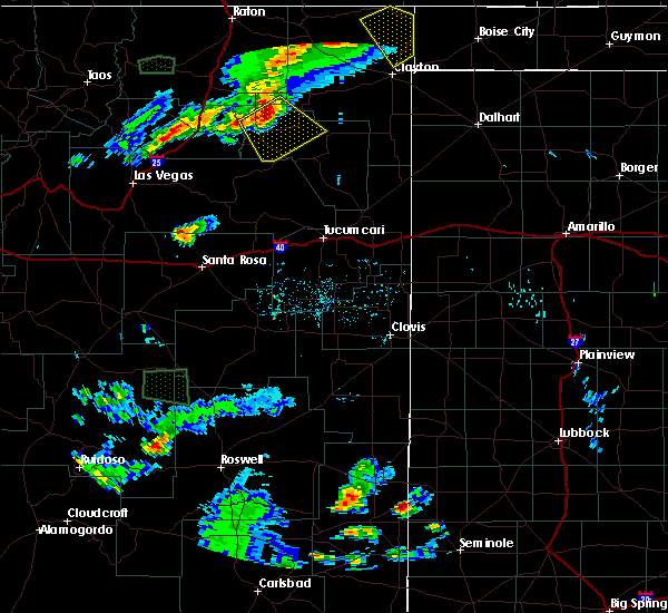 At 443 pm mdt, a severe thunderstorm was located near chicosa lake state park, or 27 miles northwest of mosquero, moving southeast at 30 mph (radar indicated). Hazards include 60 mph wind gusts and quarter size hail. Hail damage to vehicles is expected. Expect wind damage to roofs, siding, and trees. At 443 pm mdt, a severe thunderstorm was located near chicosa lake state park, or 27 miles northwest of mosquero, moving southeast at 30 mph (radar indicated). Hazards include 60 mph wind gusts and quarter size hail. Hail damage to vehicles is expected. Expect wind damage to roofs, siding, and trees.
|
| 8/8/2018 4:57 PM MDT |
 The national weather service in albuquerque has issued a * severe thunderstorm warning for. northwestern harding county in northeastern new mexico. east central mora county in northeastern new mexico. until 545 pm mdt. At 456 pm mdt, a severe thunderstorm was located 7 miles north of. The national weather service in albuquerque has issued a * severe thunderstorm warning for. northwestern harding county in northeastern new mexico. east central mora county in northeastern new mexico. until 545 pm mdt. At 456 pm mdt, a severe thunderstorm was located 7 miles north of.
|
| 8/7/2018 10:40 PM MDT | Mills canyon raw in harding county NM, 10.1 miles SE of Roy, NM |
| 8/7/2018 10:33 PM MDT |
 At 1033 pm mdt, a severe thunderstorm was located 10 miles west of roy, or 18 miles east of wagon mound, moving south at 25 mph (radar indicated). Hazards include 60 mph wind gusts and nickel size hail. Expect damage to roofs, siding, and trees. Locations impacted include, roy. At 1033 pm mdt, a severe thunderstorm was located 10 miles west of roy, or 18 miles east of wagon mound, moving south at 25 mph (radar indicated). Hazards include 60 mph wind gusts and nickel size hail. Expect damage to roofs, siding, and trees. Locations impacted include, roy.
|
| 8/7/2018 10:10 PM MDT |
 At 1010 pm mdt, a severe thunderstorm was located 10 miles west of mills, or 16 miles northeast of wagon mound, moving south at 15 mph (radar indicated). Hazards include 60 mph wind gusts and quarter size hail. Hail damage to vehicles is expected. Expect wind damage to roofs, siding, and trees. At 1010 pm mdt, a severe thunderstorm was located 10 miles west of mills, or 16 miles northeast of wagon mound, moving south at 15 mph (radar indicated). Hazards include 60 mph wind gusts and quarter size hail. Hail damage to vehicles is expected. Expect wind damage to roofs, siding, and trees.
|
| 6/24/2018 9:24 PM MDT |
 At 924 pm mdt, a severe thunderstorm was located 7 miles northwest of mills, or 19 miles southeast of springer, moving southeast at 30 mph (radar indicated). Hazards include 60 mph wind gusts and half dollar size hail. Hail damage to vehicles is expected. Expect wind damage to roofs, siding, and trees. At 924 pm mdt, a severe thunderstorm was located 7 miles northwest of mills, or 19 miles southeast of springer, moving southeast at 30 mph (radar indicated). Hazards include 60 mph wind gusts and half dollar size hail. Hail damage to vehicles is expected. Expect wind damage to roofs, siding, and trees.
|
| 5/19/2018 4:46 PM MDT |
 At 446 pm mdt, a severe thunderstorm was located 14 miles southwest of roy, or 20 miles west of mosquero, moving east at 10 mph (radar indicated). Hazards include 60 mph wind gusts and quarter size hail. Hail damage to vehicles is expected. expect wind damage to roofs, siding, and trees. Locations impacted include, roy. At 446 pm mdt, a severe thunderstorm was located 14 miles southwest of roy, or 20 miles west of mosquero, moving east at 10 mph (radar indicated). Hazards include 60 mph wind gusts and quarter size hail. Hail damage to vehicles is expected. expect wind damage to roofs, siding, and trees. Locations impacted include, roy.
|
| 5/19/2018 4:28 PM MDT |
 At 428 pm mdt, a severe thunderstorm was located 14 miles northeast of maes, or 23 miles west of mosquero, moving east at 10 mph (radar indicated). Hazards include 60 mph wind gusts and quarter size hail. Hail damage to vehicles is expected. expect wind damage to roofs, siding, and trees. Locations impacted include, roy. At 428 pm mdt, a severe thunderstorm was located 14 miles northeast of maes, or 23 miles west of mosquero, moving east at 10 mph (radar indicated). Hazards include 60 mph wind gusts and quarter size hail. Hail damage to vehicles is expected. expect wind damage to roofs, siding, and trees. Locations impacted include, roy.
|
| 5/19/2018 4:12 PM MDT |
 At 412 pm mdt, a severe thunderstorm was located 13 miles east of maes, or 23 miles west of mosquero, moving east at 10 mph (radar indicated). Hazards include 60 mph wind gusts and half dollar size hail. Hail damage to vehicles is expected. Expect wind damage to roofs, siding, and trees. At 412 pm mdt, a severe thunderstorm was located 13 miles east of maes, or 23 miles west of mosquero, moving east at 10 mph (radar indicated). Hazards include 60 mph wind gusts and half dollar size hail. Hail damage to vehicles is expected. Expect wind damage to roofs, siding, and trees.
|
| 8/28/2017 5:50 PM MDT |
 At 550 pm mdt, a severe thunderstorm was located 8 miles west of mills, or 17 miles east of wagon mound, moving east at 20 mph (radar indicated). Hazards include 60 mph wind gusts and half dollar size hail. Hail damage to vehicles is expected. Expect wind damage to roofs, siding, and trees. At 550 pm mdt, a severe thunderstorm was located 8 miles west of mills, or 17 miles east of wagon mound, moving east at 20 mph (radar indicated). Hazards include 60 mph wind gusts and half dollar size hail. Hail damage to vehicles is expected. Expect wind damage to roofs, siding, and trees.
|
| 8/10/2017 4:37 PM MDT |
 At 437 pm mdt, a severe thunderstorm was located 14 miles northeast of maes, or 15 miles southeast of wagon mound, moving east at 20 mph (radar indicated). Hazards include two inch hail and 60 mph wind gusts. People and animals outdoors will be injured. expect hail damage to roofs, siding, windows, and vehicles. expect wind damage to roofs, siding, and trees. locations impacted include, wagon mound and roy. This includes interstate 25 between mile markers 376 and 390. At 437 pm mdt, a severe thunderstorm was located 14 miles northeast of maes, or 15 miles southeast of wagon mound, moving east at 20 mph (radar indicated). Hazards include two inch hail and 60 mph wind gusts. People and animals outdoors will be injured. expect hail damage to roofs, siding, windows, and vehicles. expect wind damage to roofs, siding, and trees. locations impacted include, wagon mound and roy. This includes interstate 25 between mile markers 376 and 390.
|
| 8/10/2017 4:14 PM MDT |
 At 414 pm mdt, a severe thunderstorm was located 8 miles southeast of wagon mound, moving east at 20 mph (radar indicated). Hazards include golf ball size hail and 60 mph wind gusts. People and animals outdoors will be injured. expect hail damage to roofs, siding, windows, and vehicles. Expect wind damage to roofs, siding, and trees. At 414 pm mdt, a severe thunderstorm was located 8 miles southeast of wagon mound, moving east at 20 mph (radar indicated). Hazards include golf ball size hail and 60 mph wind gusts. People and animals outdoors will be injured. expect hail damage to roofs, siding, windows, and vehicles. Expect wind damage to roofs, siding, and trees.
|
| 8/9/2017 5:55 PM MDT |
 The severe thunderstorm warning for northeastern san miguel, west central harding and southeastern mora counties will expire at 600 pm mdt, the storm which prompted the warning has weakened below severe limits, and no longer pose an immediate threat to life or property. therefore the warning will be allowed to expire. however small hail, gusty winds and heavy rain are still possible with this thunderstorm. The severe thunderstorm warning for northeastern san miguel, west central harding and southeastern mora counties will expire at 600 pm mdt, the storm which prompted the warning has weakened below severe limits, and no longer pose an immediate threat to life or property. therefore the warning will be allowed to expire. however small hail, gusty winds and heavy rain are still possible with this thunderstorm.
|
| 8/9/2017 5:30 PM MDT |
 At 530 pm mdt, a severe thunderstorm was located near wagon mound, moving southeast at 25 mph (radar indicated). Hazards include 60 mph wind gusts and quarter size hail. Hail damage to vehicles is expected. expect wind damage to roofs, siding, and trees. locations impacted include, wagon mound and roy. This includes interstate 25 between mile markers 383 and 394. At 530 pm mdt, a severe thunderstorm was located near wagon mound, moving southeast at 25 mph (radar indicated). Hazards include 60 mph wind gusts and quarter size hail. Hail damage to vehicles is expected. expect wind damage to roofs, siding, and trees. locations impacted include, wagon mound and roy. This includes interstate 25 between mile markers 383 and 394.
|
| 8/9/2017 5:11 PM MDT |
 At 510 pm mdt, a severe thunderstorm was located near wagon mound, moving southeast at 25 mph (radar indicated). Hazards include 60 mph wind gusts and quarter size hail. Hail damage to vehicles is expected. Expect wind damage to roofs, siding, and trees. At 510 pm mdt, a severe thunderstorm was located near wagon mound, moving southeast at 25 mph (radar indicated). Hazards include 60 mph wind gusts and quarter size hail. Hail damage to vehicles is expected. Expect wind damage to roofs, siding, and trees.
|
| 8/3/2017 3:18 PM MDT |
 At 317 pm mdt, a severe thunderstorm was located 9 miles north of wagon mound, moving southeast at 25 mph (radar indicated). Hazards include 60 mph wind gusts and quarter size hail. Hail damage to vehicles is expected. expect wind damage to roofs, siding, and trees. this severe thunderstorm will be near, wagon mound around 330 pm mdt. This includes interstate 25 between mile markers 382 and 406. At 317 pm mdt, a severe thunderstorm was located 9 miles north of wagon mound, moving southeast at 25 mph (radar indicated). Hazards include 60 mph wind gusts and quarter size hail. Hail damage to vehicles is expected. expect wind damage to roofs, siding, and trees. this severe thunderstorm will be near, wagon mound around 330 pm mdt. This includes interstate 25 between mile markers 382 and 406.
|
| 6/8/2017 3:35 PM MDT | Storm damage reported in harding county NM, 1.4 miles WNW of Roy, NM |
| 6/8/2017 3:31 PM MDT |
 At 331 pm mdt, a severe thunderstorm was located over roy, or 18 miles northwest of mosquero, moving south at 25 mph (radar indicated). Hazards include 60 mph wind gusts and quarter size hail. Hail damage to vehicles is expected. Expect wind damage to roofs, siding, and trees. At 331 pm mdt, a severe thunderstorm was located over roy, or 18 miles northwest of mosquero, moving south at 25 mph (radar indicated). Hazards include 60 mph wind gusts and quarter size hail. Hail damage to vehicles is expected. Expect wind damage to roofs, siding, and trees.
|
| 6/6/2017 4:55 PM MDT |
 The severe thunderstorm warning for west central harding county will expire at 500 pm mdt, the storm which prompted the warning has moved out of the area. therefore the warning will be allowed to expire. a severe thunderstorm watch remains in effect until 1000 pm mdt for northeastern new mexico. The severe thunderstorm warning for west central harding county will expire at 500 pm mdt, the storm which prompted the warning has moved out of the area. therefore the warning will be allowed to expire. a severe thunderstorm watch remains in effect until 1000 pm mdt for northeastern new mexico.
|
| 6/6/2017 4:32 PM MDT |
 At 431 pm mdt, a severe thunderstorm was located near roy, or 13 miles northwest of mosquero, moving east at 20 mph (radar indicated). Hazards include 60 mph wind gusts and penny size hail. Expect damage to roofs, siding, and trees. Locations impacted include, roy and solano. At 431 pm mdt, a severe thunderstorm was located near roy, or 13 miles northwest of mosquero, moving east at 20 mph (radar indicated). Hazards include 60 mph wind gusts and penny size hail. Expect damage to roofs, siding, and trees. Locations impacted include, roy and solano.
|
| 6/6/2017 4:29 PM MDT | Quarter sized hail reported 1 miles ENE of Roy, NM |
| 6/6/2017 4:12 PM MDT |
 At 412 pm mdt, a severe thunderstorm was located over roy, or 18 miles northwest of mosquero, moving east at 15 mph (radar indicated). Hazards include 60 mph wind gusts and quarter size hail. Hail damage to vehicles is expected. Expect wind damage to roofs, siding, and trees. At 412 pm mdt, a severe thunderstorm was located over roy, or 18 miles northwest of mosquero, moving east at 15 mph (radar indicated). Hazards include 60 mph wind gusts and quarter size hail. Hail damage to vehicles is expected. Expect wind damage to roofs, siding, and trees.
|
| 5/9/2017 5:30 PM MDT |
 At 529 pm mdt, a severe thunderstorm was located near solano, or 10 miles northwest of mosquero, moving north at 40 mph. other strong to severe thunderstorms were located in the vicinity of mosquero extending north to chicosa lake state park (radar indicated). Hazards include 60 mph wind gusts and quarter size hail. Hail damage to vehicles is expected. Expect wind damage to roofs, siding, and trees. At 529 pm mdt, a severe thunderstorm was located near solano, or 10 miles northwest of mosquero, moving north at 40 mph. other strong to severe thunderstorms were located in the vicinity of mosquero extending north to chicosa lake state park (radar indicated). Hazards include 60 mph wind gusts and quarter size hail. Hail damage to vehicles is expected. Expect wind damage to roofs, siding, and trees.
|
| 5/8/2017 6:40 PM MDT |
 The severe thunderstorm warning for northwestern harding county will expire at 645 pm mdt, the storm which prompted the warning has weakened below severe limits, and no longer pose an immediate threat to life or property. therefore the warning will be allowed to expire. however gusty winds and heavy rain are still possible with this thunderstorm. a severe thunderstorm watch remains in effect until 1100 pm mdt for northeastern new mexico. The severe thunderstorm warning for northwestern harding county will expire at 645 pm mdt, the storm which prompted the warning has weakened below severe limits, and no longer pose an immediate threat to life or property. therefore the warning will be allowed to expire. however gusty winds and heavy rain are still possible with this thunderstorm. a severe thunderstorm watch remains in effect until 1100 pm mdt for northeastern new mexico.
|
| 5/8/2017 5:56 PM MDT |
 At 556 pm mdt, a severe thunderstorm was located near chicosa lake state park, or 20 miles northwest of mosquero, moving north at 10 mph (radar indicated). Hazards include 60 mph wind gusts and half dollar size hail. Hail damage to vehicles is expected. Expect wind damage to roofs, siding, and trees. At 556 pm mdt, a severe thunderstorm was located near chicosa lake state park, or 20 miles northwest of mosquero, moving north at 10 mph (radar indicated). Hazards include 60 mph wind gusts and half dollar size hail. Hail damage to vehicles is expected. Expect wind damage to roofs, siding, and trees.
|
| 5/8/2017 5:30 PM MDT | Half Dollar sized hail reported 1.4 miles WNW of Roy, NM |
| 5/8/2017 5:30 PM MDT | Golf Ball sized hail reported 0.5 miles NE of Roy, NM |
| 5/8/2017 5:14 PM MDT |
 At 513 pm mdt, a severe thunderstorm was located over roy, or 17 miles northwest of mosquero, moving northeast at 5 mph (radar indicated). Hazards include 60 mph wind gusts and half dollar size hail. Hail damage to vehicles is expected. Expect wind damage to roofs, siding, and trees. At 513 pm mdt, a severe thunderstorm was located over roy, or 17 miles northwest of mosquero, moving northeast at 5 mph (radar indicated). Hazards include 60 mph wind gusts and half dollar size hail. Hail damage to vehicles is expected. Expect wind damage to roofs, siding, and trees.
|
| 5/8/2017 4:18 PM MDT |
 At 418 pm mdt, a severe thunderstorm was located 13 miles southwest of roy, or 20 miles west of mosquero, moving north at 30 mph (radar indicated). Hazards include ping pong ball size hail and 60 mph wind gusts. People and animals outdoors will be injured. expect hail damage to roofs, siding, windows, and vehicles. expect wind damage to roofs, siding, and trees. Locations impacted include, roy and chicosa lake state park. At 418 pm mdt, a severe thunderstorm was located 13 miles southwest of roy, or 20 miles west of mosquero, moving north at 30 mph (radar indicated). Hazards include ping pong ball size hail and 60 mph wind gusts. People and animals outdoors will be injured. expect hail damage to roofs, siding, windows, and vehicles. expect wind damage to roofs, siding, and trees. Locations impacted include, roy and chicosa lake state park.
|
| 5/8/2017 4:05 PM MDT |
 At 405 pm mdt, a severe thunderstorm was located 15 miles east of maes, or 21 miles west of mosquero, moving north at 30 mph (radar indicated). Hazards include 60 mph wind gusts and quarter size hail. Hail damage to vehicles is expected. Expect wind damage to roofs, siding, and trees. At 405 pm mdt, a severe thunderstorm was located 15 miles east of maes, or 21 miles west of mosquero, moving north at 30 mph (radar indicated). Hazards include 60 mph wind gusts and quarter size hail. Hail damage to vehicles is expected. Expect wind damage to roofs, siding, and trees.
|
| 9/3/2016 4:53 PM MDT |
 The severe thunderstorm warning for northwestern harding county will expire at 500 pm mdt, the storm which prompted the warning has weakened below severe limits, and no longer pose an immediate threat to life or property. therefore the warning will be allowed to expire. however gusty winds are still possible with this thunderstorm. The severe thunderstorm warning for northwestern harding county will expire at 500 pm mdt, the storm which prompted the warning has weakened below severe limits, and no longer pose an immediate threat to life or property. therefore the warning will be allowed to expire. however gusty winds are still possible with this thunderstorm.
|
| 9/3/2016 4:48 PM MDT | Half Dollar sized hail reported 0.5 miles NE of Roy, NM |
| 9/3/2016 4:39 PM MDT |
 At 439 pm mdt, a severe thunderstorm was located over roy, or 17 miles northwest of mosquero, moving east at 10 mph (radar indicated). Hazards include 60 mph wind gusts and quarter size hail. Hail damage to vehicles is expected. expect wind damage to roofs, siding, and trees. Locations impacted include, roy. At 439 pm mdt, a severe thunderstorm was located over roy, or 17 miles northwest of mosquero, moving east at 10 mph (radar indicated). Hazards include 60 mph wind gusts and quarter size hail. Hail damage to vehicles is expected. expect wind damage to roofs, siding, and trees. Locations impacted include, roy.
|
| 9/3/2016 4:16 PM MDT |
 At 416 pm mdt, a severe thunderstorm was located near roy, or 19 miles northwest of mosquero, moving east at 15 mph (radar indicated). Hazards include 60 mph wind gusts and quarter size hail. Hail damage to vehicles is expected. Expect wind damage to roofs, siding, and trees. At 416 pm mdt, a severe thunderstorm was located near roy, or 19 miles northwest of mosquero, moving east at 15 mph (radar indicated). Hazards include 60 mph wind gusts and quarter size hail. Hail damage to vehicles is expected. Expect wind damage to roofs, siding, and trees.
|
| 7/8/2016 4:03 PM MDT |
 At 403 pm mdt, a severe thunderstorm capable of producing a tornado was located near abbott, or 15 miles east of springer, moving south at 60 mph (radar indicated rotation). Hazards include tornado and hail up to two inches in diameter. Flying debris will be dangerous to those caught without shelter. mobile homes will be damaged or destroyed. damage to roofs, windows, and vehicles will occur. tree damage is likely. this dangerous storm will be near, mills and chicosa lake state park around 425 pm mdt. Roy around 430 pm mdt. At 403 pm mdt, a severe thunderstorm capable of producing a tornado was located near abbott, or 15 miles east of springer, moving south at 60 mph (radar indicated rotation). Hazards include tornado and hail up to two inches in diameter. Flying debris will be dangerous to those caught without shelter. mobile homes will be damaged or destroyed. damage to roofs, windows, and vehicles will occur. tree damage is likely. this dangerous storm will be near, mills and chicosa lake state park around 425 pm mdt. Roy around 430 pm mdt.
|
| 6/13/2016 3:34 PM MDT |
 At 334 pm mdt, a severe thunderstorm was located 11 miles southwest of solano, or 16 miles west of mosquero, moving northeast at 30 mph (radar indicated). Hazards include 60 mph wind gusts and quarter size hail. Hail damage to vehicles is expected. expect wind damage to roofs, siding, and trees. locations impacted include, roy and solano. A tornado watch remains in effect until 900 pm mdt for northeastern new mexico. At 334 pm mdt, a severe thunderstorm was located 11 miles southwest of solano, or 16 miles west of mosquero, moving northeast at 30 mph (radar indicated). Hazards include 60 mph wind gusts and quarter size hail. Hail damage to vehicles is expected. expect wind damage to roofs, siding, and trees. locations impacted include, roy and solano. A tornado watch remains in effect until 900 pm mdt for northeastern new mexico.
|
| 6/13/2016 3:14 PM MDT |
 At 314 pm mdt, a severe thunderstorm was located 11 miles east of maes, or 24 miles west of mosquero, moving northeast at 30 mph (radar indicated). Hazards include quarter size hail and 60 mph wind gusts. Hail damage to vehicles is expected. Expect wind damage to roofs, siding, and trees. At 314 pm mdt, a severe thunderstorm was located 11 miles east of maes, or 24 miles west of mosquero, moving northeast at 30 mph (radar indicated). Hazards include quarter size hail and 60 mph wind gusts. Hail damage to vehicles is expected. Expect wind damage to roofs, siding, and trees.
|
| 6/13/2016 2:45 PM MDT |
 At 244 pm mdt, a severe thunderstorm was located 7 miles southwest of mills, or 19 miles east of wagon mound, moving northeast at 30 mph (radar indicated). Hazards include ping pong size hail and 60 mph wind gusts. People and animals outdoors will be injured. expect hail damage to roofs, siding, windows, and vehicles. Expect wind damage to roofs, siding, and trees. At 244 pm mdt, a severe thunderstorm was located 7 miles southwest of mills, or 19 miles east of wagon mound, moving northeast at 30 mph (radar indicated). Hazards include ping pong size hail and 60 mph wind gusts. People and animals outdoors will be injured. expect hail damage to roofs, siding, windows, and vehicles. Expect wind damage to roofs, siding, and trees.
|
| 4/23/2016 10:05 PM MDT | Mills canyon raw in harding county NM, 10.1 miles SE of Roy, NM |
| 6/17/2015 5:19 PM MDT |
 At 519 pm mdt, a severe thunderstorm was located 7 miles southwest of mills, or 20 miles east of wagon mound, moving south at 25 mph (radar indicated). Hazards include 60 mph wind gusts and quarter size hail. Hail damage to vehicles is expected. expect wind damage to roofs, siding and trees. locations impacted include, roy and mills. Other locations affected include mills canyon campground and rim campground. At 519 pm mdt, a severe thunderstorm was located 7 miles southwest of mills, or 20 miles east of wagon mound, moving south at 25 mph (radar indicated). Hazards include 60 mph wind gusts and quarter size hail. Hail damage to vehicles is expected. expect wind damage to roofs, siding and trees. locations impacted include, roy and mills. Other locations affected include mills canyon campground and rim campground.
|
| 6/17/2015 5:06 PM MDT |
 At 506 pm mdt, a severe thunderstorm was located near mills, or 21 miles east of wagon mound, moving south at 25 mph (radar indicated). Hazards include quarter size hail and 60 mph wind gusts. Hail damage to vehicles is expected. Expect wind damage to roofs, siding and trees. At 506 pm mdt, a severe thunderstorm was located near mills, or 21 miles east of wagon mound, moving south at 25 mph (radar indicated). Hazards include quarter size hail and 60 mph wind gusts. Hail damage to vehicles is expected. Expect wind damage to roofs, siding and trees.
|
| 6/6/2014 5:50 PM MDT | Hen Egg sized hail reported 11.7 miles NNW of Roy, NM |
| 9/3/2011 2:05 PM MDT | Quarter sized hail reported 11.6 miles SE of Roy, NM, pea to quarter size hail. |
Hail Maps for Roy, NM
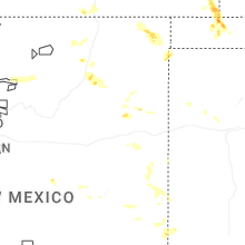
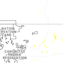


Connect with Interactive Hail Maps