

Hail Map for Sacramento, CA
The Sacramento, CA area has had 0 reports of on-the-ground hail by trained spotters, and has been under severe weather warnings 0 times during the past 12 months. Doppler radar has detected hail at or near Sacramento, CA on 1 occasion.
| Name: | Sacramento, CA |
| Where Located: | 14 miles SW of Citrus Heights, CA |
| Map: | Google Map for Sacramento, CA |
| Population: | 466488 |
| Housing Units: | 190911 |
| More Info: | Search Google for Sacramento, CA |
0
The Top Recent Hail Date for Sacramento, CA is Saturday, September 28, 2019 (1st out of 1)

Hail and Wind Damage Spotted near Sacramento, CA
| Date / Time | Report Details |
|---|---|
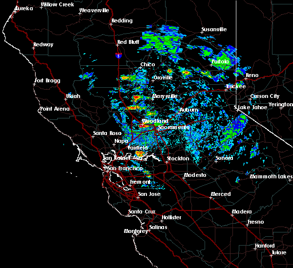
| 1/10/2023 4:10 AM PST |
 The severe thunderstorm warning for southeastern yolo, southeastern sutter, north central sacramento, northeastern solano, southwestern placer and southwestern yuba counties will expire at 415 am pst, the storm which prompted the warning has moved out of the area. therefore, the warning will be allowed to expire. The severe thunderstorm warning for southeastern yolo, southeastern sutter, north central sacramento, northeastern solano, southwestern placer and southwestern yuba counties will expire at 415 am pst, the storm which prompted the warning has moved out of the area. therefore, the warning will be allowed to expire.
|
| 1/10/2023 3:28 AM PST |
 At 327 am pst, a severe thunderstorm was located near freeport, or 9 miles southeast of davis, moving northeast at 55 mph (radar indicated). Hazards include 70 mph wind gusts. Expect considerable tree damage. damage is likely to mobile homes, roofs, and outbuildings. Torrential rain and flooding of roadways, and small hail will also accompany the storm. At 327 am pst, a severe thunderstorm was located near freeport, or 9 miles southeast of davis, moving northeast at 55 mph (radar indicated). Hazards include 70 mph wind gusts. Expect considerable tree damage. damage is likely to mobile homes, roofs, and outbuildings. Torrential rain and flooding of roadways, and small hail will also accompany the storm.
|
| 9/28/2019 6:42 PM PDT |
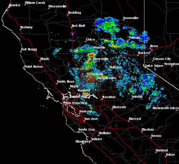 At 639 pm pdt, a severe thunderstorm was located near davis, and is moving slowly to the southeast at 10 to 15 mph towards el macero and west sacramento. this storm has also prompted the issuance of a tornado warning due to radar indicating strong circulation just north of davis and el macero (radar indicated). Hazards include hail up to nickels or quarter size. Damage to vehicles is expected. Locations impacted include, davis, woodland, west sacramento, and el macero. At 639 pm pdt, a severe thunderstorm was located near davis, and is moving slowly to the southeast at 10 to 15 mph towards el macero and west sacramento. this storm has also prompted the issuance of a tornado warning due to radar indicating strong circulation just north of davis and el macero (radar indicated). Hazards include hail up to nickels or quarter size. Damage to vehicles is expected. Locations impacted include, davis, woodland, west sacramento, and el macero.
|
| 9/28/2019 6:08 PM PDT |
 At 604 pm pdt, a severe thunderstorm was located over woodland, moving southeast at 10 to 15 mph towards davis and west sacramento (radar indicated). Hazards include nickel to quarter size hail. Damage to vehicles is expected. Hail may accumulate on roadways. At 604 pm pdt, a severe thunderstorm was located over woodland, moving southeast at 10 to 15 mph towards davis and west sacramento (radar indicated). Hazards include nickel to quarter size hail. Damage to vehicles is expected. Hail may accumulate on roadways.
|
| 4/7/2015 3:23 PM PDT | The severe thunderstorm warning for northeastern sacramento. southwestern placer and southwestern el dorado counties will expire at 330 pm pdt. this line of thunderstorms has weakened and the severe thunderstorm warning has been allowed to expire. this storm is still capable of producing heavy rain. small hail. And ponding of water on area. |
| 4/7/2015 2:57 PM PDT | A severe thunderstorm warning remains in effect until 330 pm pdt for northeastern sacramento. southwestern placer and southwestern el dorado counties. at 254 pm pdt. national weather service doppler radar continued to indicate a severe thunderstorm capable of producing quarter size hail. This line of storms was located near antelope south to. |
| 4/7/2015 2:25 PM PDT | The national weather service in sacramento has issued a * severe thunderstorm warning for. southwestern el dorado county. southwestern placer county. northern sacramento county. Extreme southeastern sutter county. |
| 4/7/2015 2:00 PM PDT | The national weather service in sacramento has issued a * severe thunderstorm warning for. extreme southwestern placer county. northwestern sacramento county. southeastern sutter county. East central yolo county. |
Hail Maps for Sacramento, CA

Connect with Interactive Hail Maps