

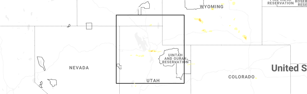
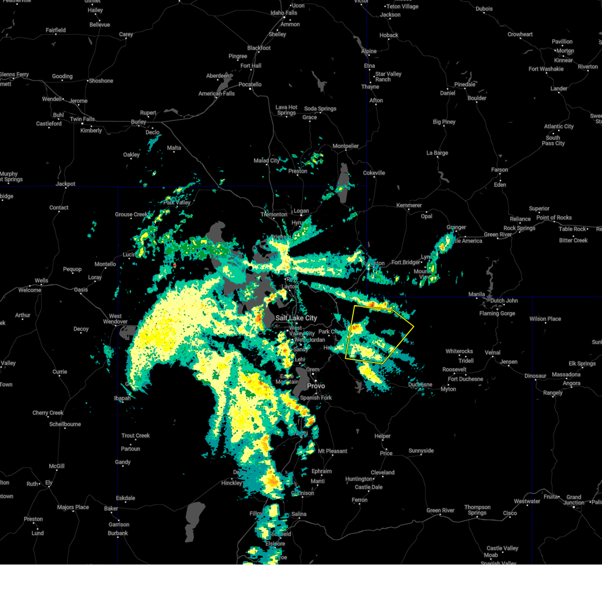
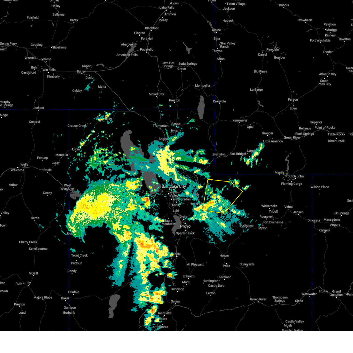
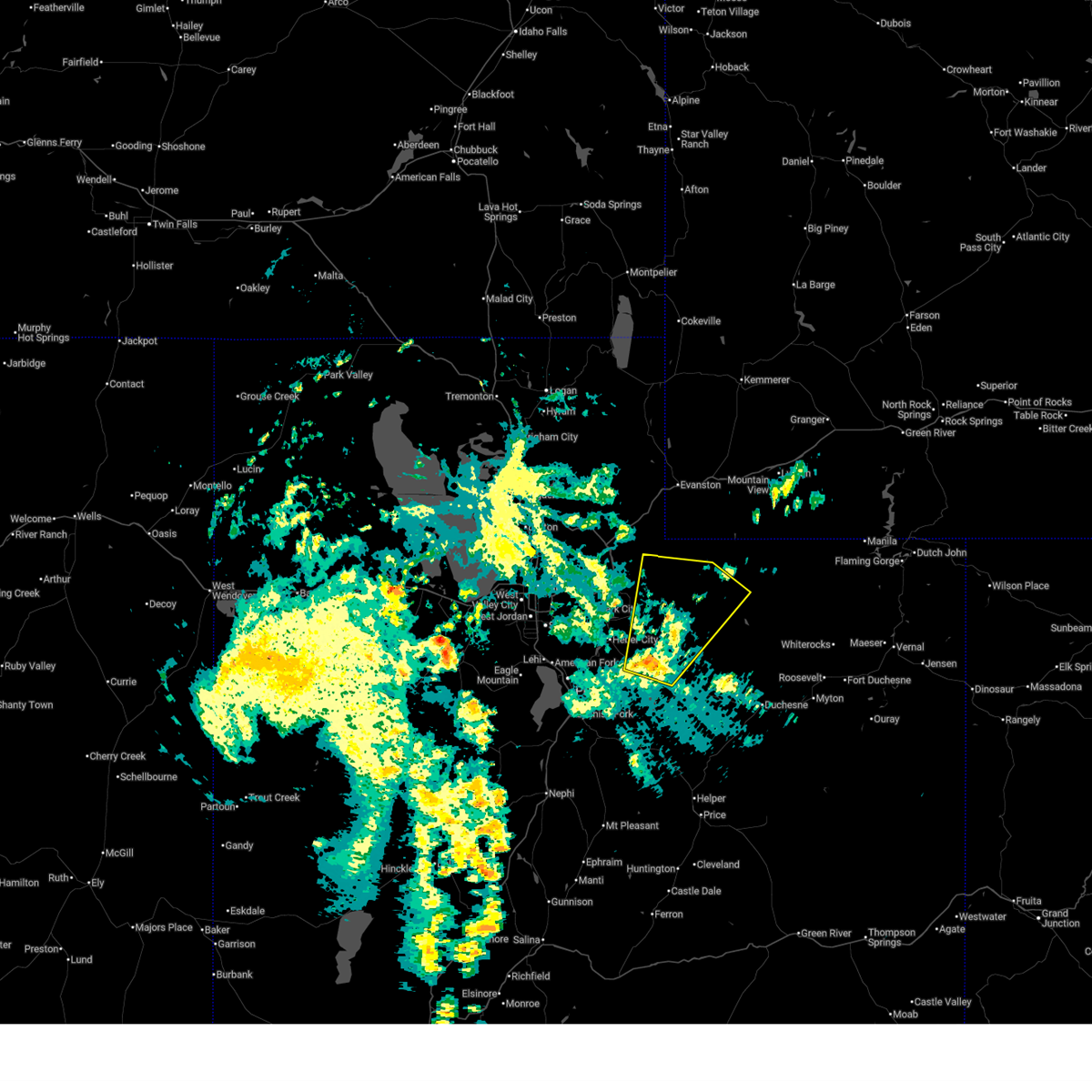
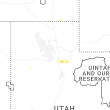
Hail Map for Samak, UT
The Samak, UT area has had 0 reports of on-the-ground hail by trained spotters, and has been under severe weather warnings 3 times during the past 12 months. Doppler radar has detected hail at or near Samak, UT on 7 occasions, including 1 occasion during the past year.
| Name: | Samak, UT |
| Where Located: | 36.8 miles ESE of Salt Lake City, UT |
| Map: | Google Map for Samak, UT |
| Population: | 287 |
| Housing Units: | 371 |
| More Info: | Search Google for Samak, UT |
5
The Top Recent Hail Date for Samak, UT is Thursday, June 25, 2026 (1st out of 7)
Hail and Wind Damage Spotted near Samak, UT
| Date / Time | Report Details |
|---|---|
| 6/25/2026 4:03 PM MDT |
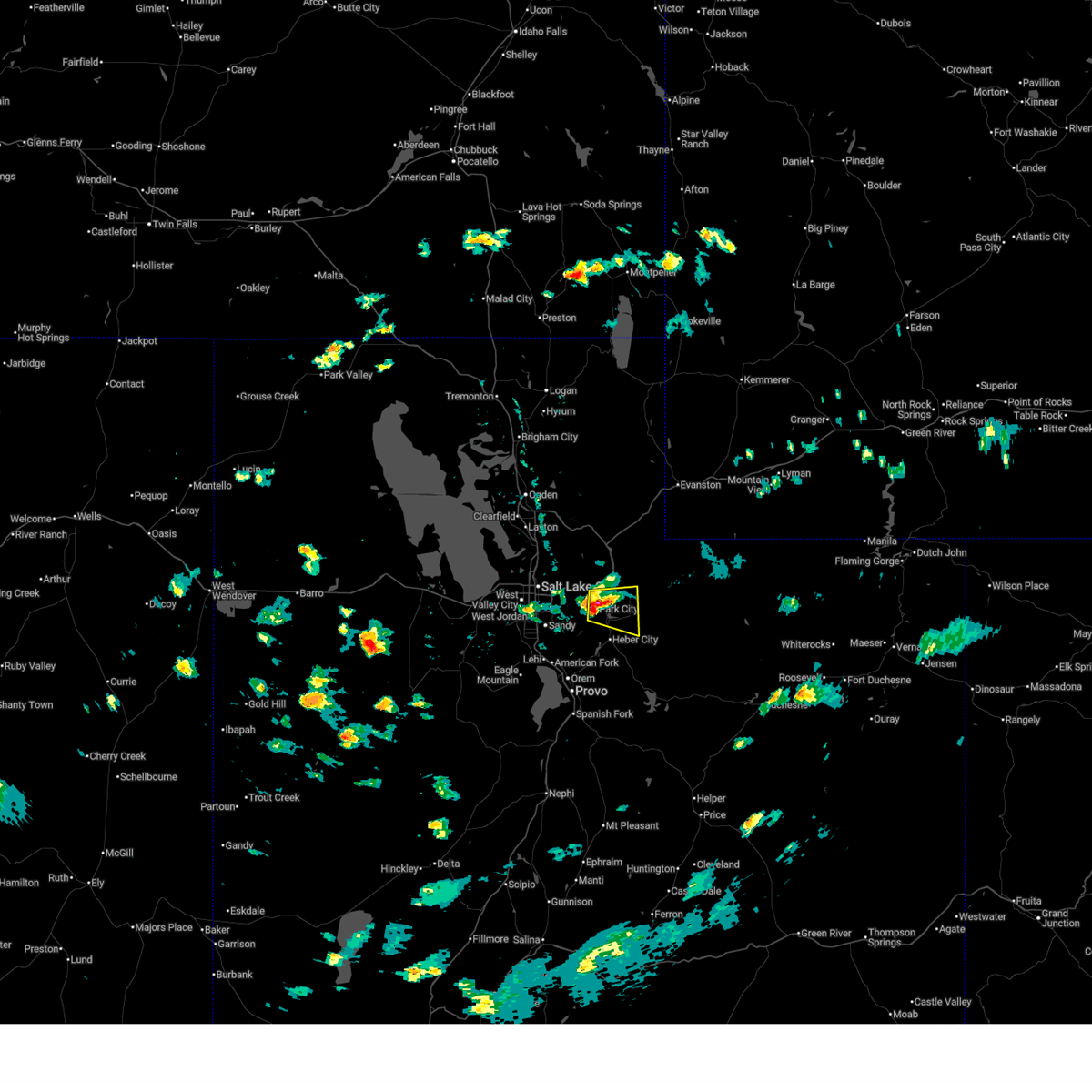 the severe thunderstorm warning has been cancelled and is no longer in effect the severe thunderstorm warning has been cancelled and is no longer in effect
|
| 6/25/2026 4:03 PM MDT |
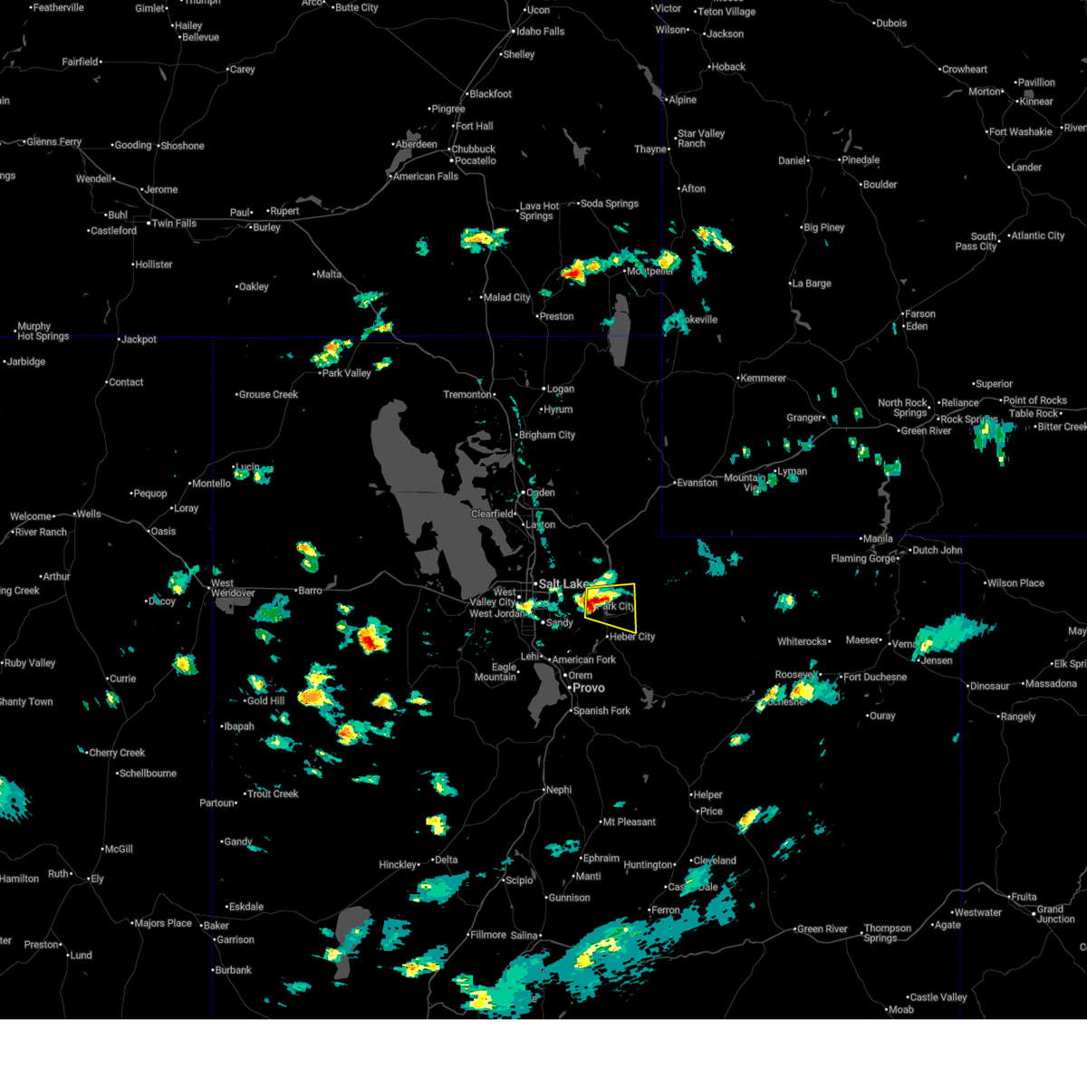 At 402 pm mdt, a severe thunderstorm was located over park city, moving east at 20 mph (radar indicated). Hazards include 60 mph wind gusts and quarter size hail. Hail damage to vehicles is expected. expect wind damage to roofs, siding, and trees. locations impacted include, park city, kamas, oakley, francis, south snyderville basin, samak, north snyderville basin, peoa, woodland, snyderville, kimball junction, marion, hailstone, jordanelle reservoir, and brighton. this includes the following highways, interstate 80 in utah between mile markers 144 and 148. us route 40 between mile markers 0 and 13. utah route 35 between mile markers 0 and 4. Mirror lake highway between mile markers 0 and 3. At 402 pm mdt, a severe thunderstorm was located over park city, moving east at 20 mph (radar indicated). Hazards include 60 mph wind gusts and quarter size hail. Hail damage to vehicles is expected. expect wind damage to roofs, siding, and trees. locations impacted include, park city, kamas, oakley, francis, south snyderville basin, samak, north snyderville basin, peoa, woodland, snyderville, kimball junction, marion, hailstone, jordanelle reservoir, and brighton. this includes the following highways, interstate 80 in utah between mile markers 144 and 148. us route 40 between mile markers 0 and 13. utah route 35 between mile markers 0 and 4. Mirror lake highway between mile markers 0 and 3.
|
| 6/25/2026 3:40 PM MDT |
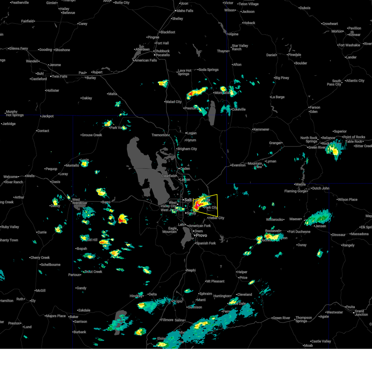 Svrslc the national weather service in salt lake city has issued a * severe thunderstorm warning for, east central salt lake county in northern utah, northwestern wasatch county in northern utah, southwestern summit county in northern utah, * until 415 pm mdt. * at 340 pm mdt, a severe thunderstorm was located near big cottonwood canyon, or 7 miles west of park city, moving east at 20 mph (radar indicated). Hazards include 60 mph wind gusts and quarter size hail. Hail damage to vehicles is expected. Expect wind damage to roofs, siding, and trees. Svrslc the national weather service in salt lake city has issued a * severe thunderstorm warning for, east central salt lake county in northern utah, northwestern wasatch county in northern utah, southwestern summit county in northern utah, * until 415 pm mdt. * at 340 pm mdt, a severe thunderstorm was located near big cottonwood canyon, or 7 miles west of park city, moving east at 20 mph (radar indicated). Hazards include 60 mph wind gusts and quarter size hail. Hail damage to vehicles is expected. Expect wind damage to roofs, siding, and trees.
|
| 8/17/2024 1:52 PM MDT |
 The storm which prompted the warning has moved out of the area. therefore, the warning will be allowed to expire. however gusty winds are still possible with this thunderstorm. a severe thunderstorm watch remains in effect until 700 pm mdt for northern utah. remember, a severe thunderstorm warning still remains in effect for northern summit county. The storm which prompted the warning has moved out of the area. therefore, the warning will be allowed to expire. however gusty winds are still possible with this thunderstorm. a severe thunderstorm watch remains in effect until 700 pm mdt for northern utah. remember, a severe thunderstorm warning still remains in effect for northern summit county.
|
| 8/17/2024 1:33 PM MDT |
 At 132 pm mdt, a severe thunderstorm was located 9 miles east of timber lakes, or 17 miles east of heber city, moving north at 30 mph (radar indicated). Hazards include 60 mph wind gusts and penny size hail. Expect damage to roofs, siding, and trees. locations impacted include, francis, mirror lake, samak, timber lakes, woodland, and trial lk. this includes the following highways, utah route 35 between mile markers 2 and 34. Mirror lake highway between mile markers 2 and 46. At 132 pm mdt, a severe thunderstorm was located 9 miles east of timber lakes, or 17 miles east of heber city, moving north at 30 mph (radar indicated). Hazards include 60 mph wind gusts and penny size hail. Expect damage to roofs, siding, and trees. locations impacted include, francis, mirror lake, samak, timber lakes, woodland, and trial lk. this includes the following highways, utah route 35 between mile markers 2 and 34. Mirror lake highway between mile markers 2 and 46.
|
| 8/17/2024 1:19 PM MDT |
 Svrslc the national weather service in salt lake city has issued a * severe thunderstorm warning for, northeastern wasatch county in northern utah, northwestern duchesne county in northern utah, south central summit county in northern utah, * until 200 pm mdt. * at 118 pm mdt, a severe thunderstorm was located 9 miles southeast of timber lakes, or 16 miles southeast of heber city, moving northeast at 30 mph (radar indicated and mesonet observed). Hazards include 60 mph wind gusts and penny size hail. expect damage to roofs, siding, and trees Svrslc the national weather service in salt lake city has issued a * severe thunderstorm warning for, northeastern wasatch county in northern utah, northwestern duchesne county in northern utah, south central summit county in northern utah, * until 200 pm mdt. * at 118 pm mdt, a severe thunderstorm was located 9 miles southeast of timber lakes, or 16 miles southeast of heber city, moving northeast at 30 mph (radar indicated and mesonet observed). Hazards include 60 mph wind gusts and penny size hail. expect damage to roofs, siding, and trees
|
| 7/3/2023 6:24 PM MDT |
 At 623 pm mdt, severe thunderstorms were located along a line extending from 15 miles northeast of morgan to 8 miles northwest of fruitland, moving east at 55 mph (radar indicated). Hazards include 60 mph wind gusts. expect damage to roofs, siding, and trees At 623 pm mdt, severe thunderstorms were located along a line extending from 15 miles northeast of morgan to 8 miles northwest of fruitland, moving east at 55 mph (radar indicated). Hazards include 60 mph wind gusts. expect damage to roofs, siding, and trees
|
| 7/3/2023 6:14 PM MDT |
 At 614 pm mdt, severe thunderstorms were located along a line extending from 8 miles north of morgan to 10 miles south of timber lakes, moving northeast at 40 mph (radar indicated). Hazards include 60 mph wind gusts. Expect damage to roofs, siding, and trees. locations impacted include, park city, morgan, coalville, heber city, heber, summit park, kamas, oakley, francis, daniel, wanship, wasatch mountain state park, south snyderville basin, samak, east canyon state park, north snyderville basin, timber lakes, emigration canyon, mill creek canyon and big cottonwood canyon. this includes the following highways, interstate 84 between mile markers 92 and 119. interstate 80 in utah between mile markers 136 and 177. us route 40 between mile markers 0 and 47. utah route 35 between mile markers 0 and 21. mirror lake highway between mile markers 0 and 14. hail threat, radar indicated max hail size, <. 75 in wind threat, observed max wind gust, 60 mph. At 614 pm mdt, severe thunderstorms were located along a line extending from 8 miles north of morgan to 10 miles south of timber lakes, moving northeast at 40 mph (radar indicated). Hazards include 60 mph wind gusts. Expect damage to roofs, siding, and trees. locations impacted include, park city, morgan, coalville, heber city, heber, summit park, kamas, oakley, francis, daniel, wanship, wasatch mountain state park, south snyderville basin, samak, east canyon state park, north snyderville basin, timber lakes, emigration canyon, mill creek canyon and big cottonwood canyon. this includes the following highways, interstate 84 between mile markers 92 and 119. interstate 80 in utah between mile markers 136 and 177. us route 40 between mile markers 0 and 47. utah route 35 between mile markers 0 and 21. mirror lake highway between mile markers 0 and 14. hail threat, radar indicated max hail size, <. 75 in wind threat, observed max wind gust, 60 mph.
|
| 7/3/2023 5:52 PM MDT |
 At 552 pm mdt, severe thunderstorms were located along a line extending from layton to 9 miles northeast of mapleton, moving northeast at 40 mph (radar indicated). Hazards include 60 mph wind gusts. expect damage to roofs, siding, and trees At 552 pm mdt, severe thunderstorms were located along a line extending from layton to 9 miles northeast of mapleton, moving northeast at 40 mph (radar indicated). Hazards include 60 mph wind gusts. expect damage to roofs, siding, and trees
|
| 7/17/2022 7:24 PM MDT |
 The severe thunderstorm warning for eastern weber, northern wasatch, northeastern salt lake, northeastern davis, morgan, western summit and north central utah counties will expire at 730 pm mdt, the storms which prompted the warning have weakened below severe limits, though wind gusts to 55 mph are still possible from mountain green to sundance and east. a special weather statement is now in effect. The severe thunderstorm warning for eastern weber, northern wasatch, northeastern salt lake, northeastern davis, morgan, western summit and north central utah counties will expire at 730 pm mdt, the storms which prompted the warning have weakened below severe limits, though wind gusts to 55 mph are still possible from mountain green to sundance and east. a special weather statement is now in effect.
|
| 7/17/2022 7:10 PM MDT |
 At 708 pm mdt, severe thunderstorms were located along a line extending from 14 miles east of weber state university to timber lakes, moving east at 35 mph (trained weather spotters). Hazards include 60 mph wind gusts. Expect damage to roofs, siding, and trees. locations impacted include, park city, morgan, coalville, heber city, heber, summit park, kamas, oakley, francis, daniel, wanship, south snyderville basin, mill creek canyon, samak, east canyon state park and emigration canyon. this includes the following highways, interstate 84 between mile markers 88 and 119. interstate 80 in utah between mile markers 131 and 179. us route 40 between mile markers 0 and 27. utah route 35 between mile markers 0 and 14. mirror lake highway between mile markers 0 and 17. hail threat, radar indicated max hail size, <. 75 in wind threat, radar indicated max wind gust, 60 mph. At 708 pm mdt, severe thunderstorms were located along a line extending from 14 miles east of weber state university to timber lakes, moving east at 35 mph (trained weather spotters). Hazards include 60 mph wind gusts. Expect damage to roofs, siding, and trees. locations impacted include, park city, morgan, coalville, heber city, heber, summit park, kamas, oakley, francis, daniel, wanship, south snyderville basin, mill creek canyon, samak, east canyon state park and emigration canyon. this includes the following highways, interstate 84 between mile markers 88 and 119. interstate 80 in utah between mile markers 131 and 179. us route 40 between mile markers 0 and 27. utah route 35 between mile markers 0 and 14. mirror lake highway between mile markers 0 and 17. hail threat, radar indicated max hail size, <. 75 in wind threat, radar indicated max wind gust, 60 mph.
|
| 7/17/2022 6:45 PM MDT |
 At 644 pm mdt, severe thunderstorms were located along a line extending from near weber state university to near daniel, moving east at 40 mph (trained weather spotters). Hazards include 60 mph wind gusts. expect damage to roofs, siding, and trees At 644 pm mdt, severe thunderstorms were located along a line extending from near weber state university to near daniel, moving east at 40 mph (trained weather spotters). Hazards include 60 mph wind gusts. expect damage to roofs, siding, and trees
|
| 8/17/2021 7:39 PM MDT |
 The severe thunderstorm warning for northwestern wasatch and southwestern summit counties will expire at 745 pm mdt, the storm which prompted the warning has weakened below severe limits, and has exited the warned area. therefore, the warning will be allowed to expire. however small hail and gusty winds are still possible with this thunderstorm. The severe thunderstorm warning for northwestern wasatch and southwestern summit counties will expire at 745 pm mdt, the storm which prompted the warning has weakened below severe limits, and has exited the warned area. therefore, the warning will be allowed to expire. however small hail and gusty winds are still possible with this thunderstorm.
|
| 8/17/2021 7:14 PM MDT |
 At 713 pm mdt, a severe thunderstorm was located near timber lakes, or near heber city, moving northeast at 40 mph (radar indicated. at 700 pm a 69 mph wind gust was reported at deer creek dam). Hazards include 60 mph wind gusts. expect damage to roofs, siding, and trees At 713 pm mdt, a severe thunderstorm was located near timber lakes, or near heber city, moving northeast at 40 mph (radar indicated. at 700 pm a 69 mph wind gust was reported at deer creek dam). Hazards include 60 mph wind gusts. expect damage to roofs, siding, and trees
|
| 12/16/2016 12:58 PM MST |
 The severe thunderstorm warning for utah, southeastern tooele, eastern salt lake, northeastern juab, south central morgan, northwestern wasatch and southwestern summit counties will expire at 100 pm mst, the storms which prompted the warning have weakened below severe limits, and no longer pose an immediate threat to life or property. therefore the warning will be allowed to expire. however gusty winds are still possible with any lingering thunderstorms. The severe thunderstorm warning for utah, southeastern tooele, eastern salt lake, northeastern juab, south central morgan, northwestern wasatch and southwestern summit counties will expire at 100 pm mst, the storms which prompted the warning have weakened below severe limits, and no longer pose an immediate threat to life or property. therefore the warning will be allowed to expire. however gusty winds are still possible with any lingering thunderstorms.
|
| 12/16/2016 12:20 PM MST |
 At 1218 pm mst, doppler radar indicated a line of severe thunderstorms capable of producing damaging winds in excess of 60 mph. these storms were located along a line extending from near summit park to 25 miles northwest of delta, and moving southeast at 35 mph. At 1218 pm mst, doppler radar indicated a line of severe thunderstorms capable of producing damaging winds in excess of 60 mph. these storms were located along a line extending from near summit park to 25 miles northwest of delta, and moving southeast at 35 mph.
|
| 8/7/2015 9:05 PM MDT |
 At 905 pm mdt, doppler radar indicated a line of severe thunderstorms capable of producing damaging winds in excess of 60 mph. these storms were located along a line extending from 13 miles northeast of evanston to 18 miles southwest of robertson to 9 miles east of samak, moving east at 35 mph. locations impacted include, evanston, lyman, kamas, oakley, francis, lonetree, samak, robertson, blacks fork natural gas processing plant, trial lk, fort bridger, altamont, leroy, woodland, millburne, carter, marion, church buttes, ragen and piedmont. At 905 pm mdt, doppler radar indicated a line of severe thunderstorms capable of producing damaging winds in excess of 60 mph. these storms were located along a line extending from 13 miles northeast of evanston to 18 miles southwest of robertson to 9 miles east of samak, moving east at 35 mph. locations impacted include, evanston, lyman, kamas, oakley, francis, lonetree, samak, robertson, blacks fork natural gas processing plant, trial lk, fort bridger, altamont, leroy, woodland, millburne, carter, marion, church buttes, ragen and piedmont.
|
| 8/7/2015 8:51 PM MDT |
 At 850 pm mdt, doppler radar indicated a line of severe thunderstorms capable of producing damaging winds in excess of 60 mph. these storms were located along a line extending from 10 miles north of evanston to 24 miles southwest of robertson to samak, moving east at 35 mph. locations impacted include, evanston, lyman, kamas, oakley, francis, lonetree, samak, robertson, blacks fork natural gas processing plant, trial lk, fort bridger, altamont, leroy, woodland, millburne, carter, marion, almy, castle rock and church buttes. At 850 pm mdt, doppler radar indicated a line of severe thunderstorms capable of producing damaging winds in excess of 60 mph. these storms were located along a line extending from 10 miles north of evanston to 24 miles southwest of robertson to samak, moving east at 35 mph. locations impacted include, evanston, lyman, kamas, oakley, francis, lonetree, samak, robertson, blacks fork natural gas processing plant, trial lk, fort bridger, altamont, leroy, woodland, millburne, carter, marion, almy, castle rock and church buttes.
|
| 8/7/2015 8:10 PM MDT |
 At 809 pm mdt, doppler radar indicated a line of severe thunderstorms capable of producing damaging winds in excess of 60 mph. these storms were located along a line extending from 19 miles southwest of woodruff to 9 miles northeast of coalville to oakley, and moving east at 35 mph. At 809 pm mdt, doppler radar indicated a line of severe thunderstorms capable of producing damaging winds in excess of 60 mph. these storms were located along a line extending from 19 miles southwest of woodruff to 9 miles northeast of coalville to oakley, and moving east at 35 mph.
|
| 8/7/2015 7:58 PM MDT |
 At 757 pm mdt, doppler radar indicated a line of severe thunderstorms capable of producing destructive winds in excess of 70 mph. these storms were located along a line extending from 13 miles east of north ogden to 10 miles north of coalville to oakley, moving east at 45 mph. at 740pm, an 80 mph gust occured at sr-65 at big mountain pass. locations impacted include, park city, morgan, coalville, north ogden, summit park, kamas, oakley, francis, south snyderville basin, wanship, samak, north snyderville basin, henefer, huntsville, croydon, pineview reservoir, peterson, liberty, mountain green and echo reservoir. At 757 pm mdt, doppler radar indicated a line of severe thunderstorms capable of producing destructive winds in excess of 70 mph. these storms were located along a line extending from 13 miles east of north ogden to 10 miles north of coalville to oakley, moving east at 45 mph. at 740pm, an 80 mph gust occured at sr-65 at big mountain pass. locations impacted include, park city, morgan, coalville, north ogden, summit park, kamas, oakley, francis, south snyderville basin, wanship, samak, north snyderville basin, henefer, huntsville, croydon, pineview reservoir, peterson, liberty, mountain green and echo reservoir.
|
| 8/7/2015 7:45 PM MDT |
 At 744 pm mdt, doppler radar indicated a line of severe thunderstorms capable of producing destructive winds in excess of 70 mph. these storms were located along a line extending from near north ogden to near morgan to near park city, moving east at 35 mph. these storms have a long history of producing 70 mph winds, copious lightning, and a brief heavy rain. locations impacted include, ogden, park city, morgan, coalville, roy, clinton, north ogden, south ogden, washington terrace, riverdale, hooper, summit park, south weber, kamas, marriott-slaterville, oakley, uintah, francis, south snyderville basin and samak. At 744 pm mdt, doppler radar indicated a line of severe thunderstorms capable of producing destructive winds in excess of 70 mph. these storms were located along a line extending from near north ogden to near morgan to near park city, moving east at 35 mph. these storms have a long history of producing 70 mph winds, copious lightning, and a brief heavy rain. locations impacted include, ogden, park city, morgan, coalville, roy, clinton, north ogden, south ogden, washington terrace, riverdale, hooper, summit park, south weber, kamas, marriott-slaterville, oakley, uintah, francis, south snyderville basin and samak.
|
| 8/7/2015 7:18 PM MDT |
 At 717 pm mdt, doppler radar indicated a line of severe thunderstorms capable of producing destructive winds in excess of 70 mph. these storms were located along a line extending from 12 miles west of willard to near farmington to holladay, and moving northeast at 35 mph. At 717 pm mdt, doppler radar indicated a line of severe thunderstorms capable of producing destructive winds in excess of 70 mph. these storms were located along a line extending from 12 miles west of willard to near farmington to holladay, and moving northeast at 35 mph.
|
Hail Maps for Samak, UT


Connect with Interactive Hail Maps