

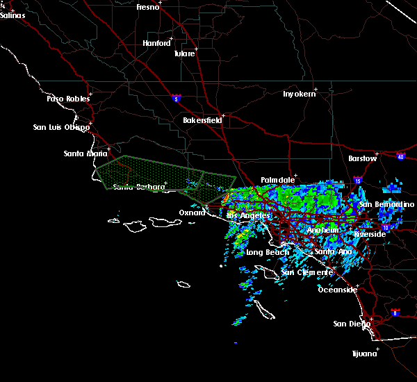
Hail Map for Santa Clarita, CA
The Santa Clarita, CA area has had 0 reports of on-the-ground hail by trained spotters, and has been under severe weather warnings 4 times during the past 12 months. Doppler radar has detected hail at or near Santa Clarita, CA on 4 occasions.
| Name: | Santa Clarita, CA |
| Where Located: | 28.3 miles NNW of Los Angeles, CA |
| Map: | Google Map for Santa Clarita, CA |
| Population: | 176320 |
| Housing Units: | 62055 |
| More Info: | Search Google for Santa Clarita, CA |
5
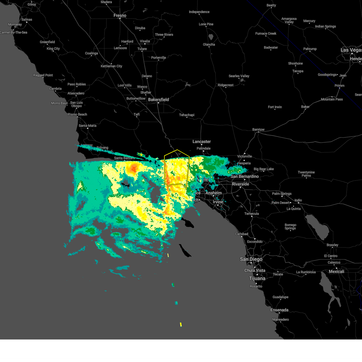
The Top Recent Hail Date for Santa Clarita, CA is Sunday, September 4, 2022 (1st out of 4)

Hail and Wind Damage Spotted near Santa Clarita, CA
| Date / Time | Report Details |
|---|---|
| 2/7/2024 8:36 PM PST |
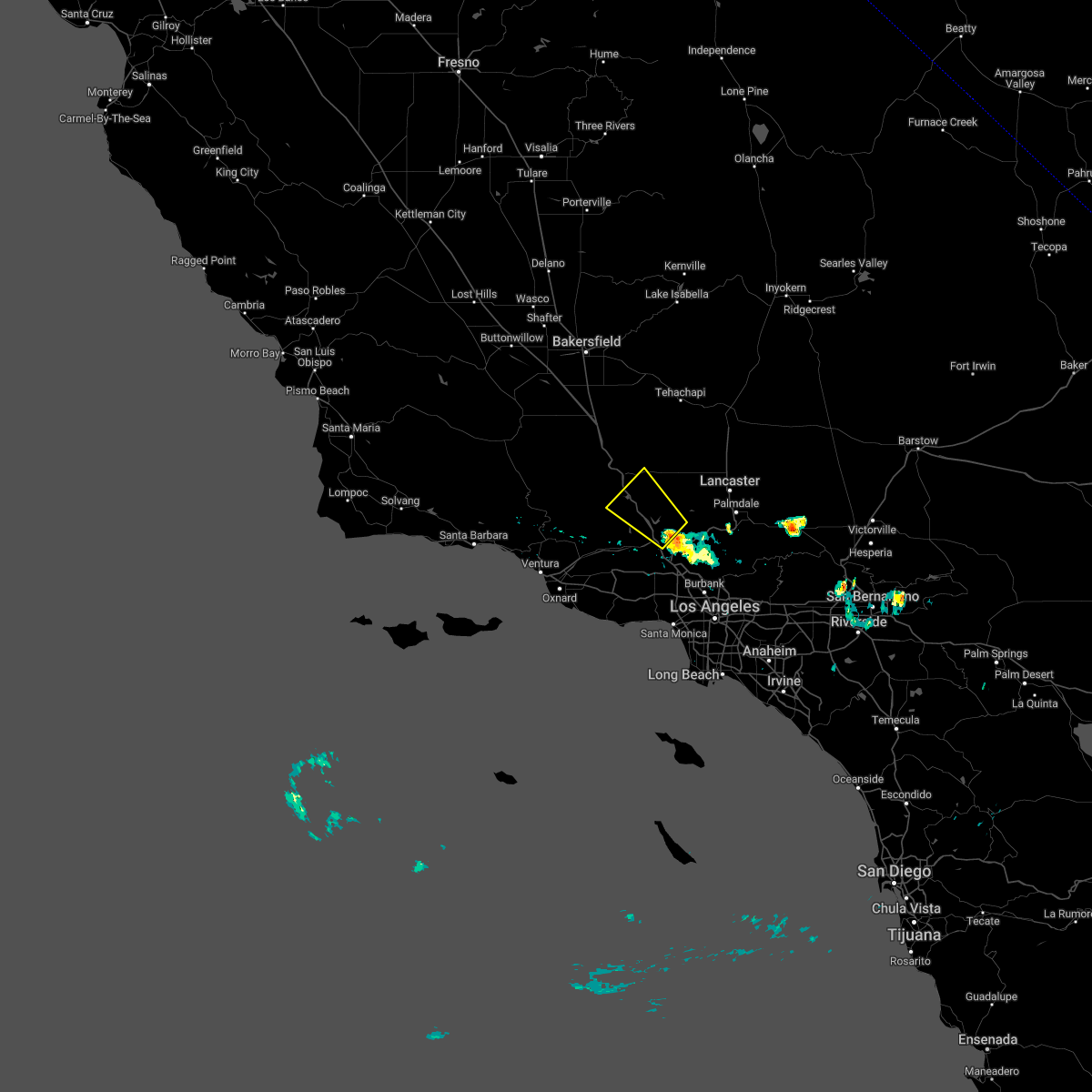
 The severe thunderstorm warning for western los angeles county will expire at 845 pm pst, the storms which prompted the warning have weakened below severe limits, and no longer pose an immediate threat to life or property. therefore, the warning will be allowed to expire. however, gusty winds are still possible with these thunderstorms. The severe thunderstorm warning for western los angeles county will expire at 845 pm pst, the storms which prompted the warning have weakened below severe limits, and no longer pose an immediate threat to life or property. therefore, the warning will be allowed to expire. however, gusty winds are still possible with these thunderstorms.
|
| 2/7/2024 7:58 PM PST |
 At 754 pm pst, bands of showers producing 60 to 70 mph wind gusts were located along a line extending from porter ranch to 9 miles south of point dume, moving east at 45 mph (automated wind sensors). Hazards include 70 mph wind gusts. Expect considerable tree damage. damage is likely to mobile homes, roofs, and outbuildings. Locations impacted include, acton, north hollywood, encino, inglewood, woodland hills, malibu, agoura hills, venice, hollywood, van nuys, culver city, chatsworth, universal city, santa clarita, burbank, beverly hills, santa monica, northridge, griffith park, and pasadena. At 754 pm pst, bands of showers producing 60 to 70 mph wind gusts were located along a line extending from porter ranch to 9 miles south of point dume, moving east at 45 mph (automated wind sensors). Hazards include 70 mph wind gusts. Expect considerable tree damage. damage is likely to mobile homes, roofs, and outbuildings. Locations impacted include, acton, north hollywood, encino, inglewood, woodland hills, malibu, agoura hills, venice, hollywood, van nuys, culver city, chatsworth, universal city, santa clarita, burbank, beverly hills, santa monica, northridge, griffith park, and pasadena.
|
| 2/7/2024 7:41 PM PST |
 At 739 pm pst, bands of showers producing 60 to 70 mph wind gusts were located along a line extending from simi valley to 15 miles southwest of point dume, moving east at 45 mph (law enforcement reported trees down from this storm). Hazards include 70 mph wind gusts. Expect considerable tree damage. damage is likely to mobile homes, roofs, and outbuildings. Locations impacted include, thousand oaks, simi valley, camarillo, fillmore, acton, north hollywood, encino, inglewood, woodland hills, malibu, agoura hills, venice, hollywood, van nuys, culver city, chatsworth, universal city, santa clarita, burbank, and beverly hills. At 739 pm pst, bands of showers producing 60 to 70 mph wind gusts were located along a line extending from simi valley to 15 miles southwest of point dume, moving east at 45 mph (law enforcement reported trees down from this storm). Hazards include 70 mph wind gusts. Expect considerable tree damage. damage is likely to mobile homes, roofs, and outbuildings. Locations impacted include, thousand oaks, simi valley, camarillo, fillmore, acton, north hollywood, encino, inglewood, woodland hills, malibu, agoura hills, venice, hollywood, van nuys, culver city, chatsworth, universal city, santa clarita, burbank, and beverly hills.
|
| 2/7/2024 7:30 PM PST | Mesonet station se678 magic mtn truck trl (sce) with inflow ahead of convective lin in los angeles county CA, 8.3 miles WNW of Santa Clarita, CA |
| 2/7/2024 7:22 PM PST |
 At 721 pm pst, bands of showers producing 60 to 70 mph wind gusts were located along a line extending from near camarillo to 17 miles southeast of anacapa island, moving east at 45 mph (automated sensors). Hazards include 70 mph wind gusts. Expect considerable tree damage. Damage is likely to mobile homes, roofs, and outbuildings. At 721 pm pst, bands of showers producing 60 to 70 mph wind gusts were located along a line extending from near camarillo to 17 miles southeast of anacapa island, moving east at 45 mph (automated sensors). Hazards include 70 mph wind gusts. Expect considerable tree damage. Damage is likely to mobile homes, roofs, and outbuildings.
|
| 2/7/2024 7:20 PM PST | Mesonet station se678 magic mtn truck trl (sce) with inflow ahead of convective lin in los angeles county CA, 8.3 miles WNW of Santa Clarita, CA |
| 2/7/2024 6:59 PM PST | Mesonet station gmtc1 grass mountain raws with inflow ahead of convective lin in los angeles county CA, 16.1 miles SSW of Santa Clarita, CA |
| 2/24/2023 9:51 PM PST |
 At 946 pm pst, a convective line of storms extended from near moorpark to near point mugu, moving east at 15 to 20 mph (radar indicated). Hazards include 60 mph wind gusts. expect damage to roofs, siding, and trees At 946 pm pst, a convective line of storms extended from near moorpark to near point mugu, moving east at 15 to 20 mph (radar indicated). Hazards include 60 mph wind gusts. expect damage to roofs, siding, and trees
|
| 9/4/2022 3:53 PM PDT |
 At 352 pm pdt, a severe thunderstorm was located 8 miles northwest of santa clarita, moving northwest at 15 mph (radar indicated). Hazards include 60 mph wind gusts and penny size hail. expect damage to roofs, siding, and trees At 352 pm pdt, a severe thunderstorm was located 8 miles northwest of santa clarita, moving northwest at 15 mph (radar indicated). Hazards include 60 mph wind gusts and penny size hail. expect damage to roofs, siding, and trees
|
| 9/4/2022 3:34 PM PDT |
 At 333 pm pdt, a severe thunderstorm was located near santa clarita, moving west at 10 mph (radar indicated). Hazards include 60 mph wind gusts. expect damage to roofs, siding, and trees At 333 pm pdt, a severe thunderstorm was located near santa clarita, moving west at 10 mph (radar indicated). Hazards include 60 mph wind gusts. expect damage to roofs, siding, and trees
|
| 10/4/2021 10:10 PM PDT | Wind gusts to 56 mph at magic mtn truck trai in los angeles county CA, 8.3 miles WNW of Santa Clarita, CA |
| 3/7/2016 6:25 AM PST |
 The severe thunderstorm warning for northwestern los angeles, northern ventura and southeastern santa barbara counties will expire at 630 am pst, the severe thunderstorm which prompted the warning has weakened and moved out of the warned area. therefore the warning will be allowed to expire. however, gusty winds up to 45 mph are still possible with line of thunderstorms. The severe thunderstorm warning for northwestern los angeles, northern ventura and southeastern santa barbara counties will expire at 630 am pst, the severe thunderstorm which prompted the warning has weakened and moved out of the warned area. therefore the warning will be allowed to expire. however, gusty winds up to 45 mph are still possible with line of thunderstorms.
|
| 3/7/2016 5:52 AM PST |
 At 546 am pst, doppler radar indicated a severe thunderstorm capable of producing destructive winds in excess of 70 mph. point mugu reported a wind of 64 mph. this leading edge of the severe thunderstorm was located around filmore to the north extending south across zuma beach. expect strong wind gusts over 60 mph to continue with this strong squall line. this storm will continue to move east at 45 mph. locations impacted include, oxnard, thousand oaks, simi valley, malibu, woodland hills, santa monica, and beverly hills. At 546 am pst, doppler radar indicated a severe thunderstorm capable of producing destructive winds in excess of 70 mph. point mugu reported a wind of 64 mph. this leading edge of the severe thunderstorm was located around filmore to the north extending south across zuma beach. expect strong wind gusts over 60 mph to continue with this strong squall line. this storm will continue to move east at 45 mph. locations impacted include, oxnard, thousand oaks, simi valley, malibu, woodland hills, santa monica, and beverly hills.
|
| 3/7/2016 5:25 AM PST |
 At 523 am pst, doppler radar indicated a severe thunderstorm capable of producing destructive winds in excess of 70 mph. this storm was located over western ventura county and will move east into western los angeles county. this line of thunderstorms was moving east at 45 mph. At 523 am pst, doppler radar indicated a severe thunderstorm capable of producing destructive winds in excess of 70 mph. this storm was located over western ventura county and will move east into western los angeles county. this line of thunderstorms was moving east at 45 mph.
|
| 1/31/2016 1:24 PM PST |
 At 119 pm pst, there were reports of trees down across portions of ventura and santa paula. doppler radar indicated the bulk of the storm has moved in the santa clarita valley. the severe thunderstorm will be allowed to expire at 130 pm, but more thunderstorms will be possible through this afternoon. locations impacted include, oxnard, thousand oaks, simi valley, eastern ventura, camarillo, fillmore, malibu, chatsworth woodland hills, agoura hills, northridge, encino, van nuys, santa clarita, santa paula, canoga park, westlake village, calabasas, and newbury park. At 119 pm pst, there were reports of trees down across portions of ventura and santa paula. doppler radar indicated the bulk of the storm has moved in the santa clarita valley. the severe thunderstorm will be allowed to expire at 130 pm, but more thunderstorms will be possible through this afternoon. locations impacted include, oxnard, thousand oaks, simi valley, eastern ventura, camarillo, fillmore, malibu, chatsworth woodland hills, agoura hills, northridge, encino, van nuys, santa clarita, santa paula, canoga park, westlake village, calabasas, and newbury park.
|
| 1/31/2016 1:08 PM PST |
 At 105 pm pst, doppler radar indicated a severe thunderstorm capable of producing damaging winds in excess of 60 mph. this storm was located near malibu in west los angeles to burbank. there will be the possibility of a small brief tornado with this squall line. At 105 pm pst, doppler radar indicated a severe thunderstorm capable of producing damaging winds in excess of 60 mph. this storm was located near malibu in west los angeles to burbank. there will be the possibility of a small brief tornado with this squall line.
|
| 1/31/2016 12:54 PM PST |
 At 1249 pm pst, doppler radar indicated a strong squall line moving northeast at 45 mph through filmore to near malibu capable of producing damaging winds in excess of 60 mph. a few trees were knocked down around santa paula with this line of storms. locations impacted include, thousand oaks, simi valley, chatsworth, woodland hills, agoura hills, northridge, encino, santa clarita, santa paula, canoga park, westlake village, calabasas, and newbury park. At 1249 pm pst, doppler radar indicated a strong squall line moving northeast at 45 mph through filmore to near malibu capable of producing damaging winds in excess of 60 mph. a few trees were knocked down around santa paula with this line of storms. locations impacted include, thousand oaks, simi valley, chatsworth, woodland hills, agoura hills, northridge, encino, santa clarita, santa paula, canoga park, westlake village, calabasas, and newbury park.
|
| 1/31/2016 12:34 PM PST |
 At 1228 pm pst, doppler radar indicated a strong squall line capable of producing damaging winds in excess of 60 mph. this storm was located near santa paula to the north and oxnard to the south. this storm will continue to move east-northeast towards eastern ventura county and western los angeles county. the squall line was moving east at 40 mph. brief weak tornadic spin ups are possible with this squall. At 1228 pm pst, doppler radar indicated a strong squall line capable of producing damaging winds in excess of 60 mph. this storm was located near santa paula to the north and oxnard to the south. this storm will continue to move east-northeast towards eastern ventura county and western los angeles county. the squall line was moving east at 40 mph. brief weak tornadic spin ups are possible with this squall.
|
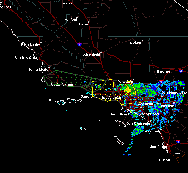
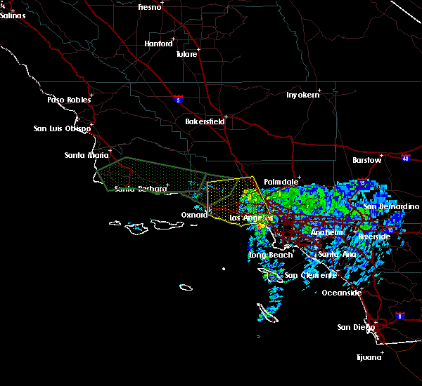
| 3/18/2015 8:07 PM PDT | A severe thunderstorm warning remains in effect until 830 pm pdt for north central los angeles county. at 800 pm pdt. national weather service doppler radar continued to indicate a severe thunderstorm capable of producing quarter size hail. this storm was located over north central los angeles county. or 16 miles southwest of lancaster. Moving west at 10 mph. |
| 3/18/2015 7:45 PM PDT | The national weather service in oxnard has issued a * severe thunderstorm warning for. north central los angeles county in southwest california. until 830 pm pdt * at 736 pm pdt. national weather service doppler radar indicated a severe thunderstorm capable of producing quarter size hail. This. |
| 3/18/2015 7:23 PM PDT | A severe thunderstorm warning remains in effect until 745 pm pdt for central los angeles county. at 718 pm pdt. national weather service doppler radar continued to indicate a severe thunderstorm capable of producing quarter size hail. this storm was located 8 miles north of acton. or 8 miles south of lancaster. Moving southwest at 20 mph. |
| 3/18/2015 7:09 PM PDT | The national weather service in oxnard has issued a * severe thunderstorm warning for. central los angeles county in southwest california. this includes the city of lancaster. until 745 pm pdt * at 700 pm pdt. National weather service doppler radar indicated. |
Hail Maps for Santa Clarita, CA


Connect with Interactive Hail Maps