

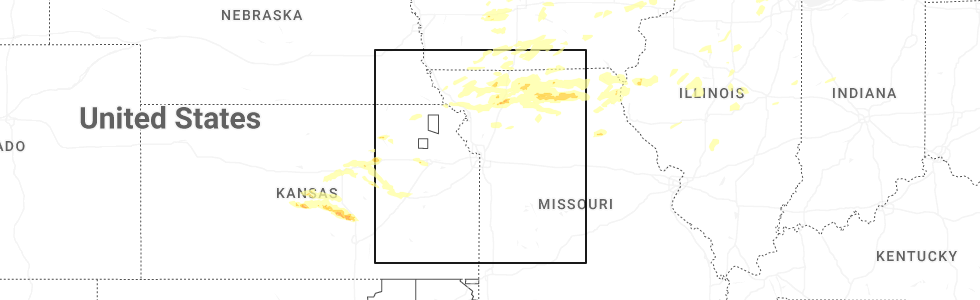
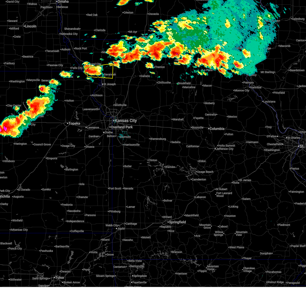
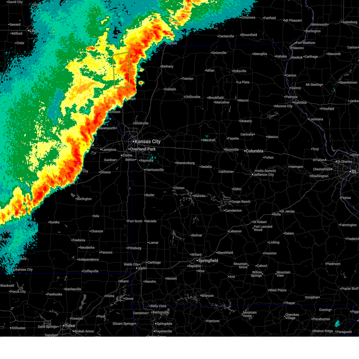
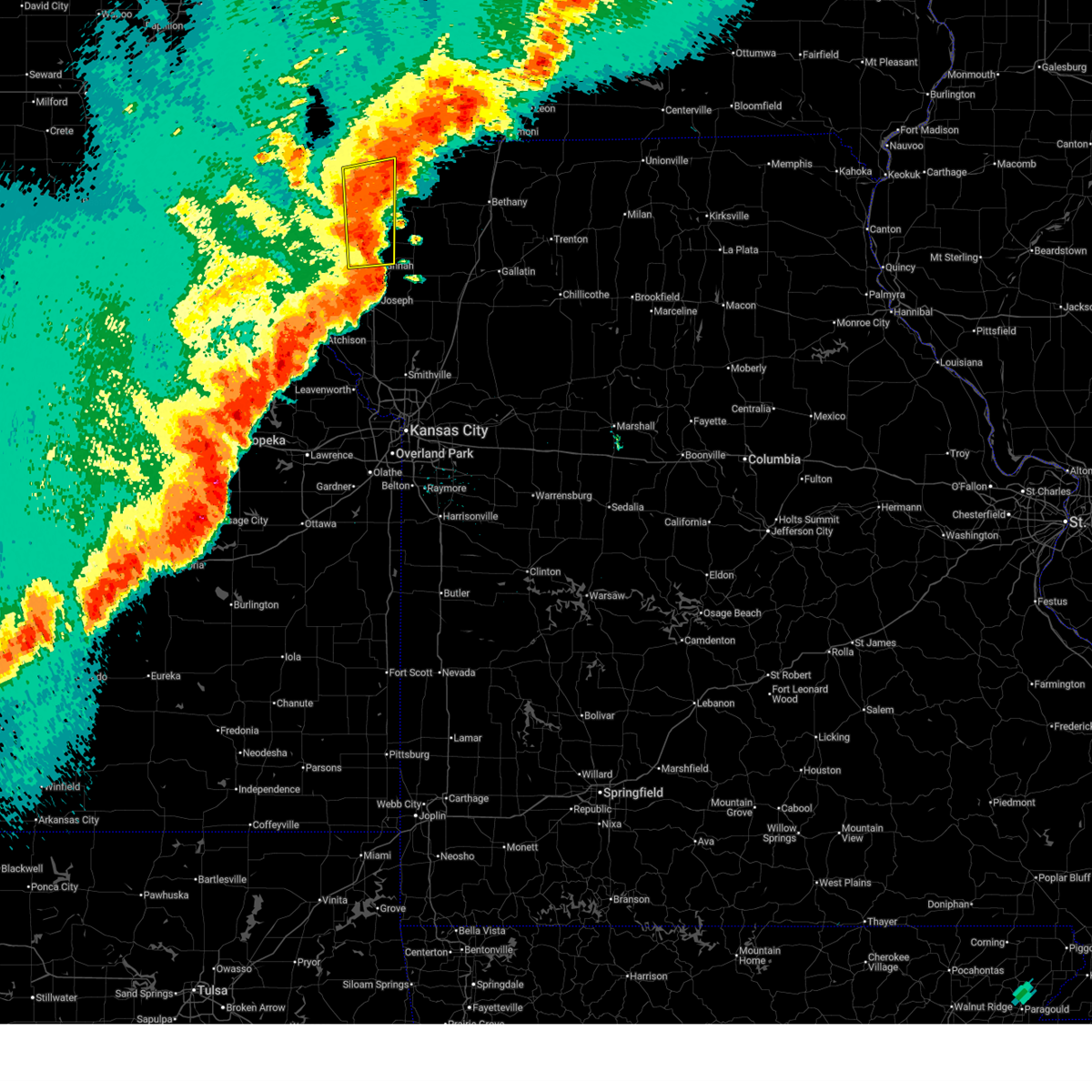
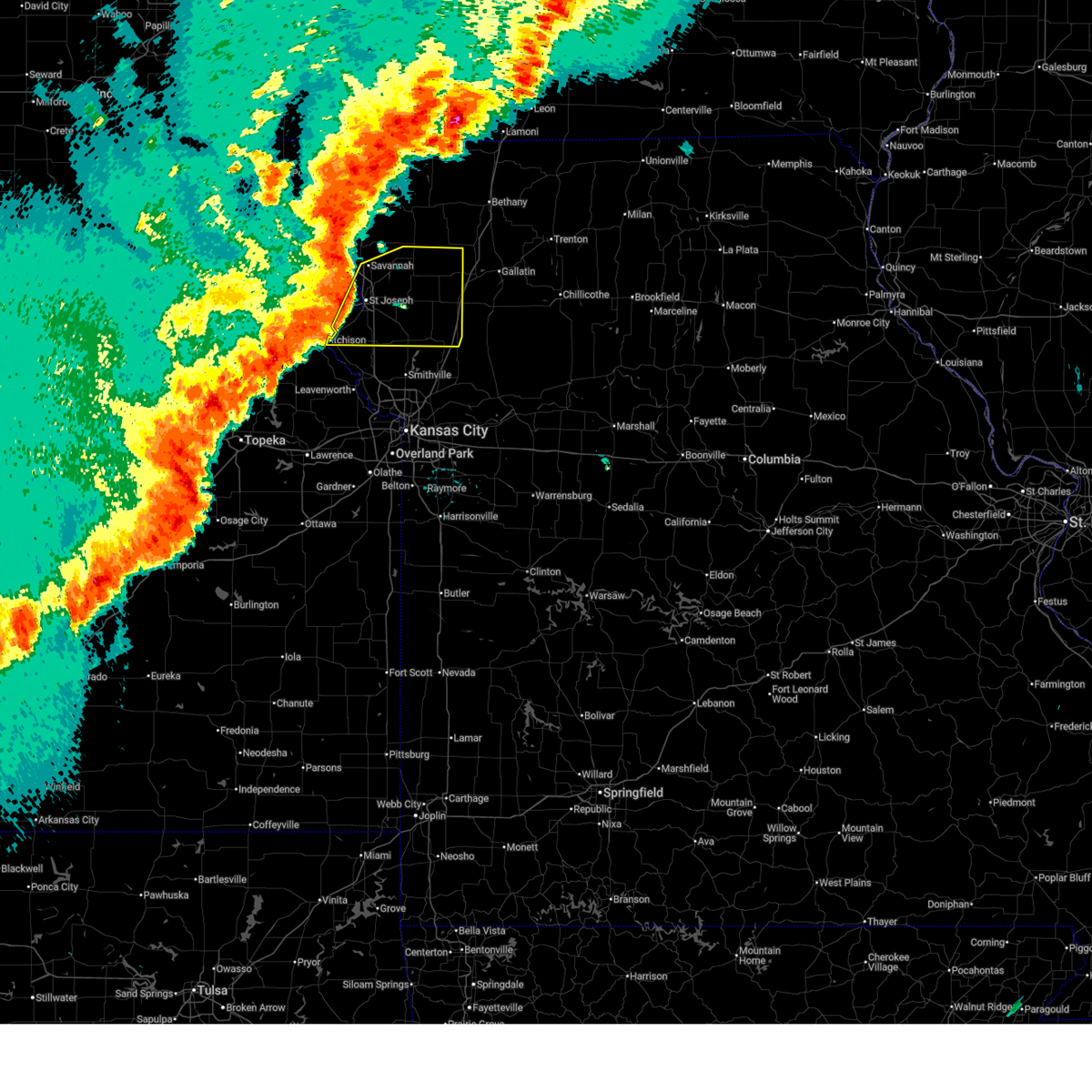
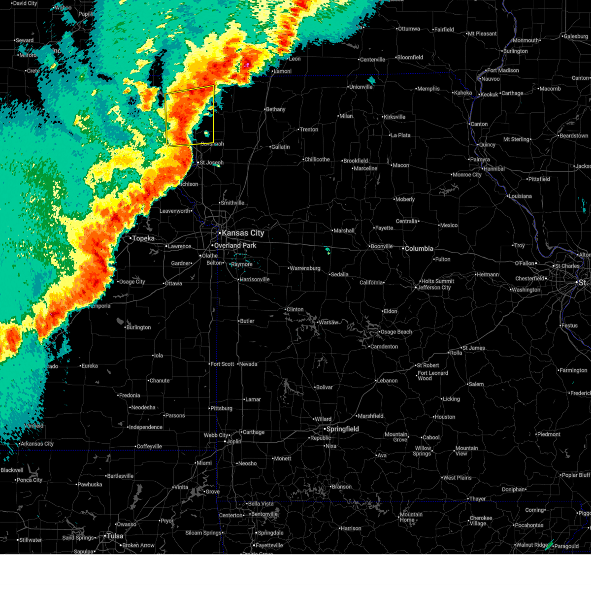
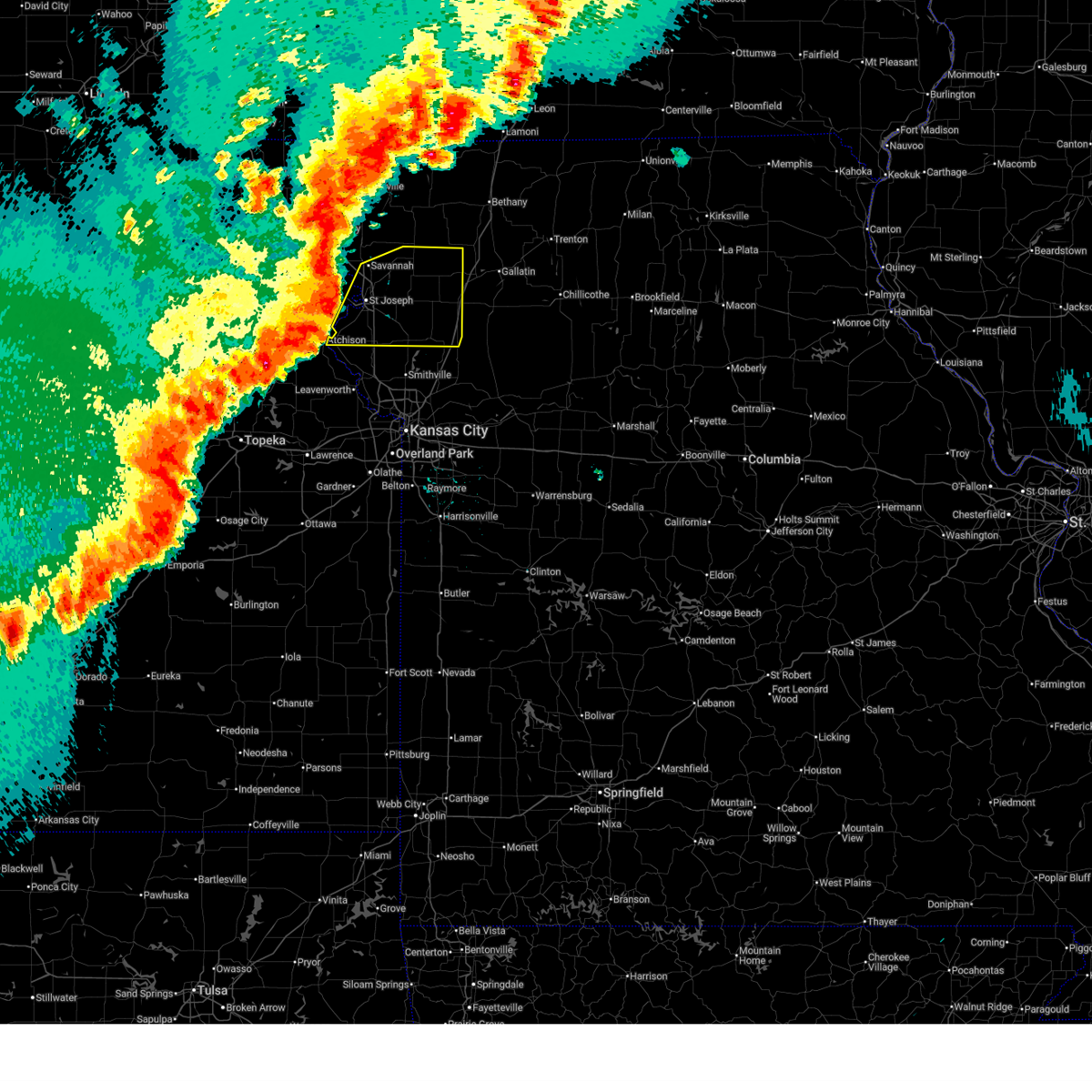
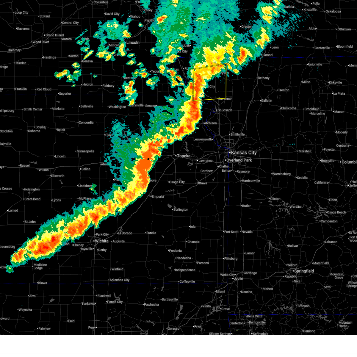
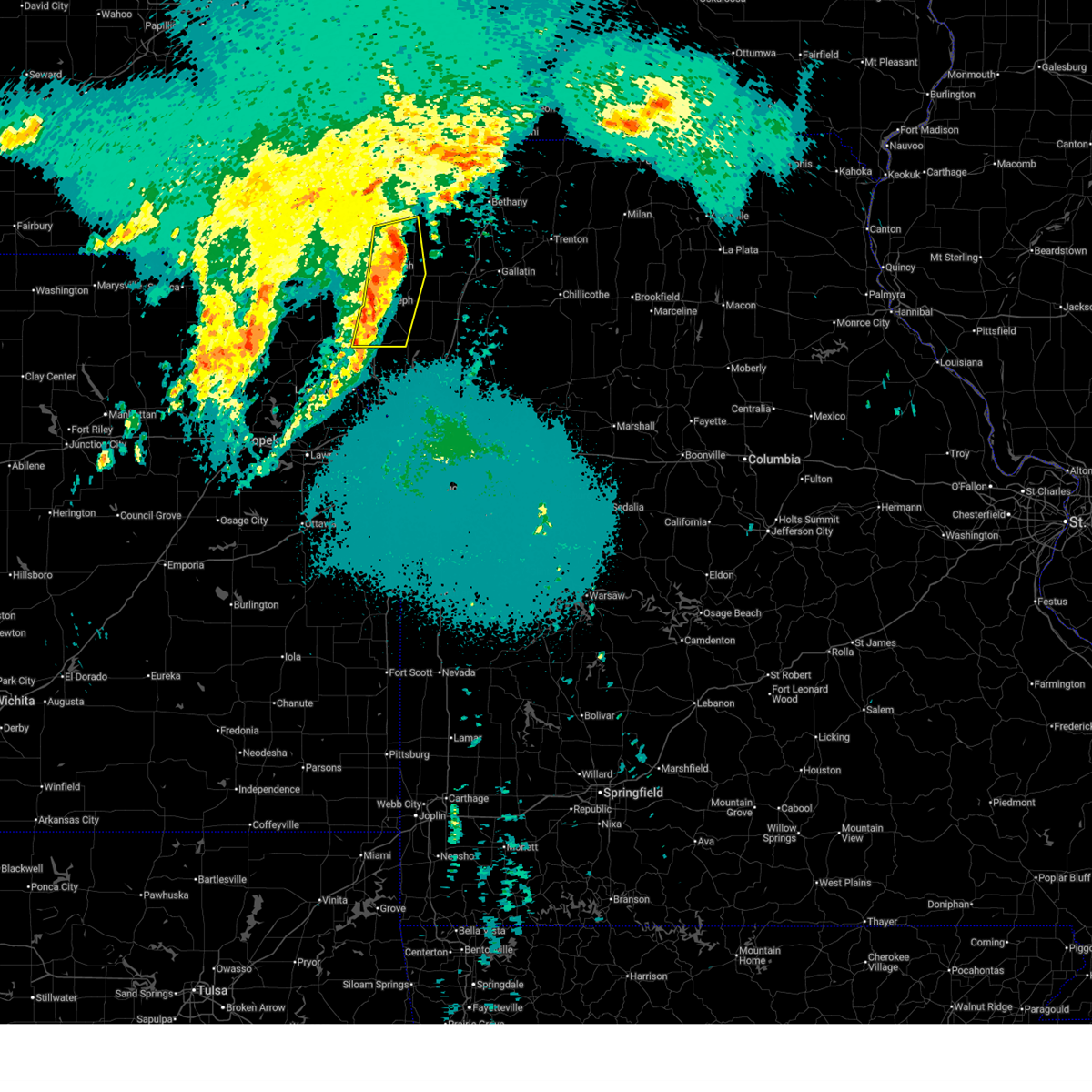
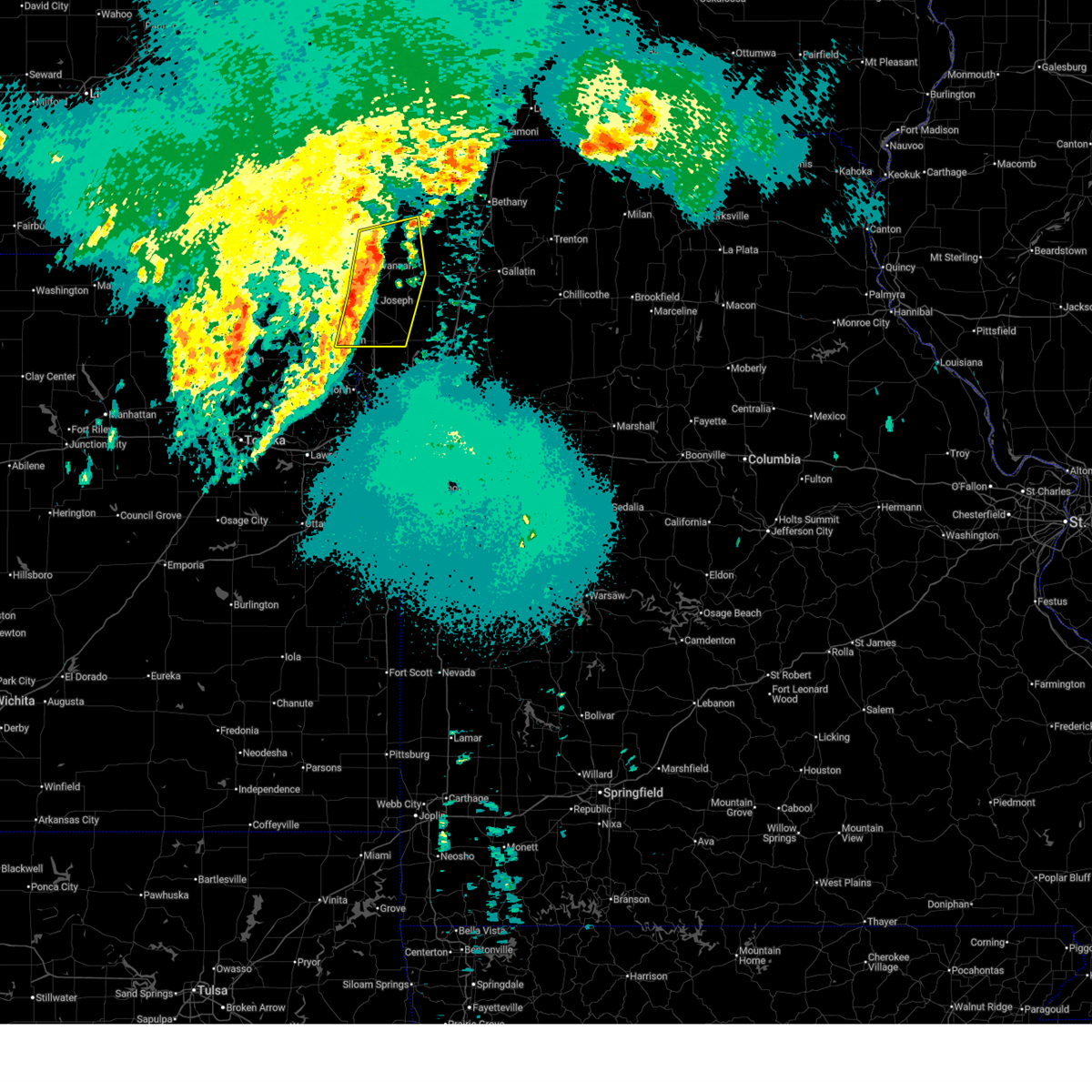
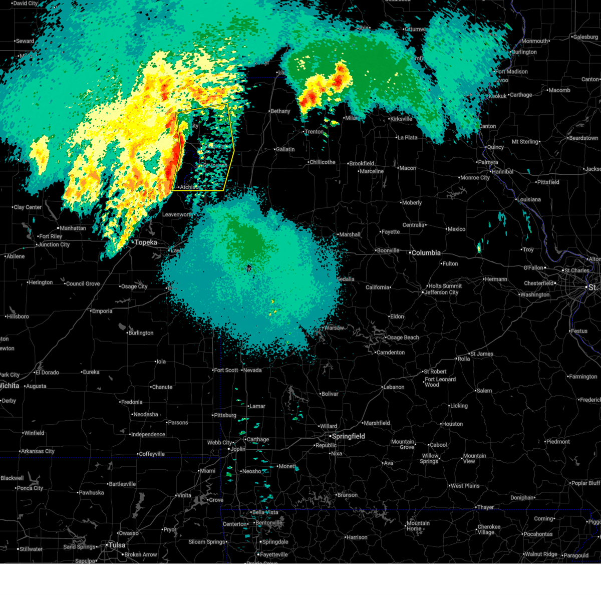
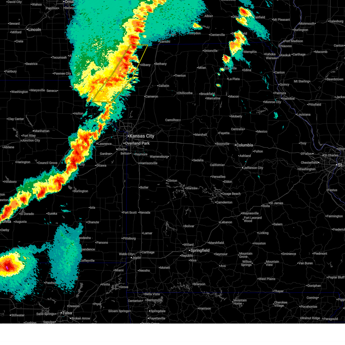
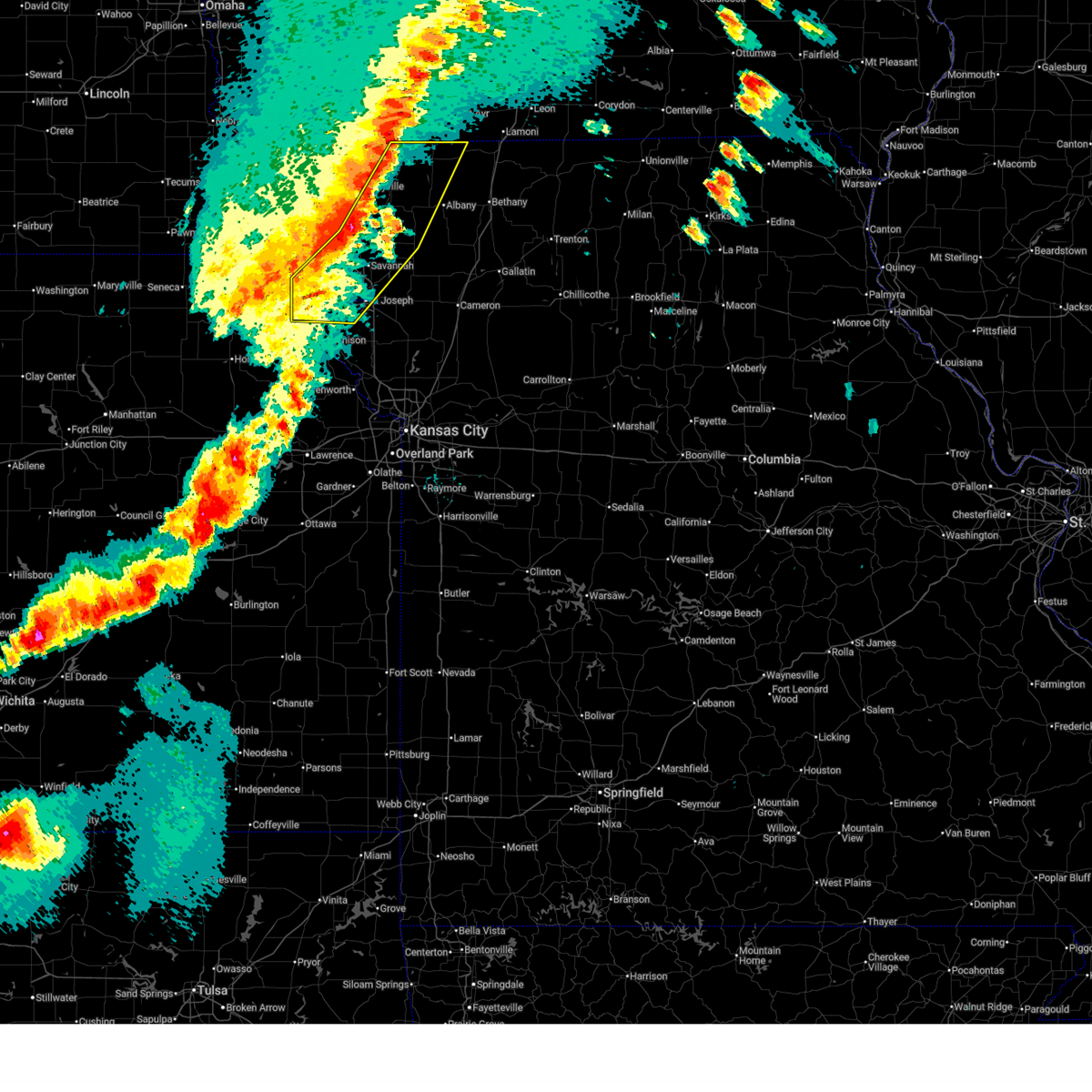
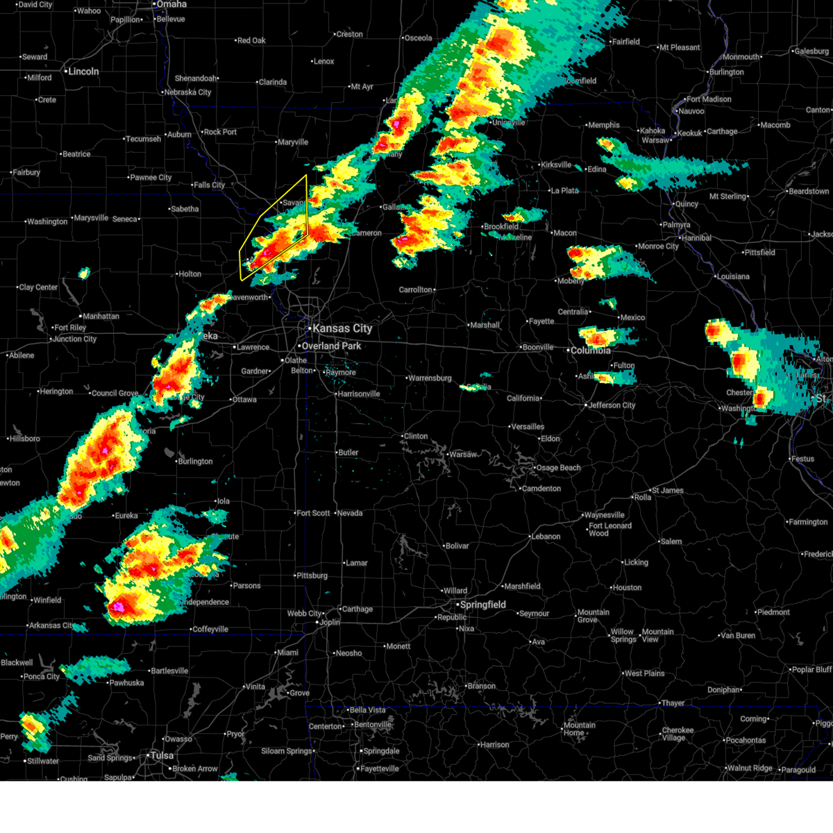
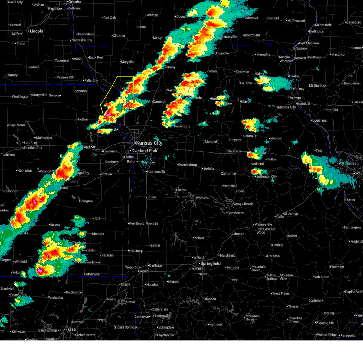
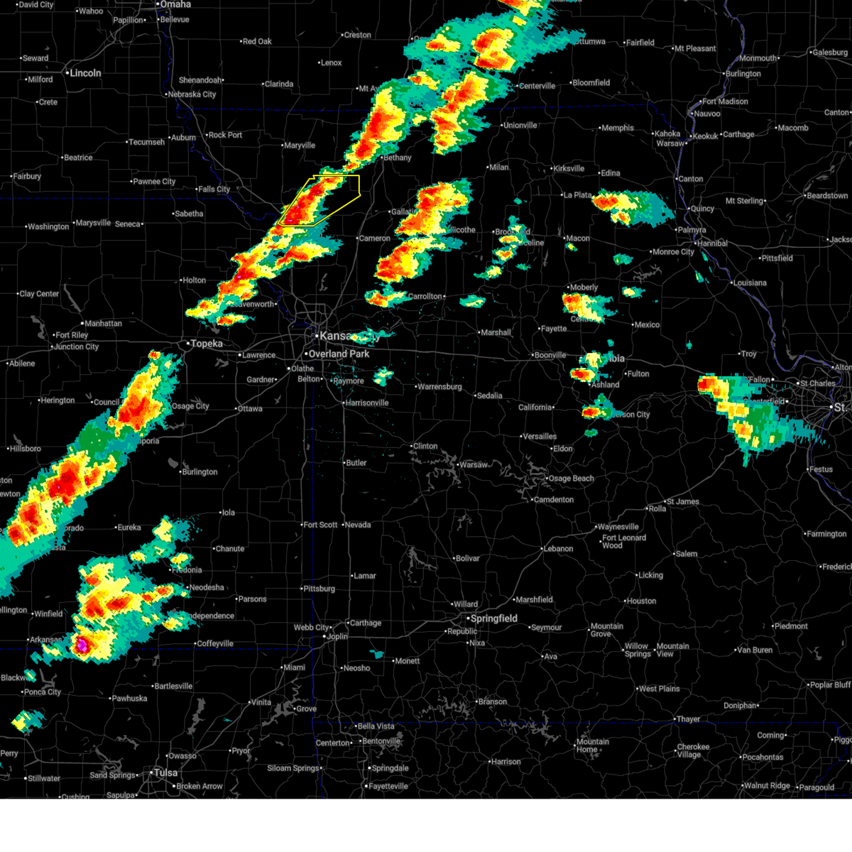
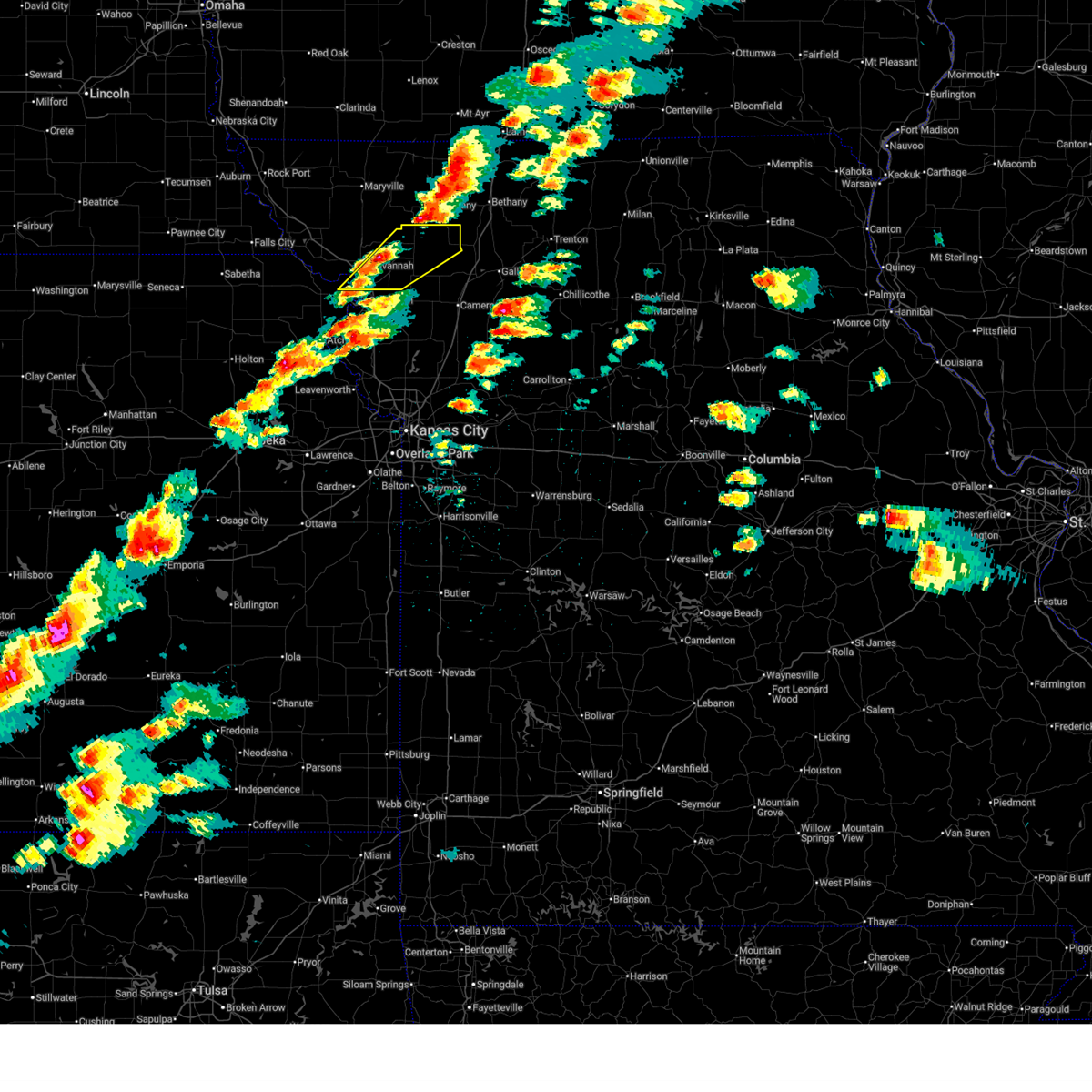
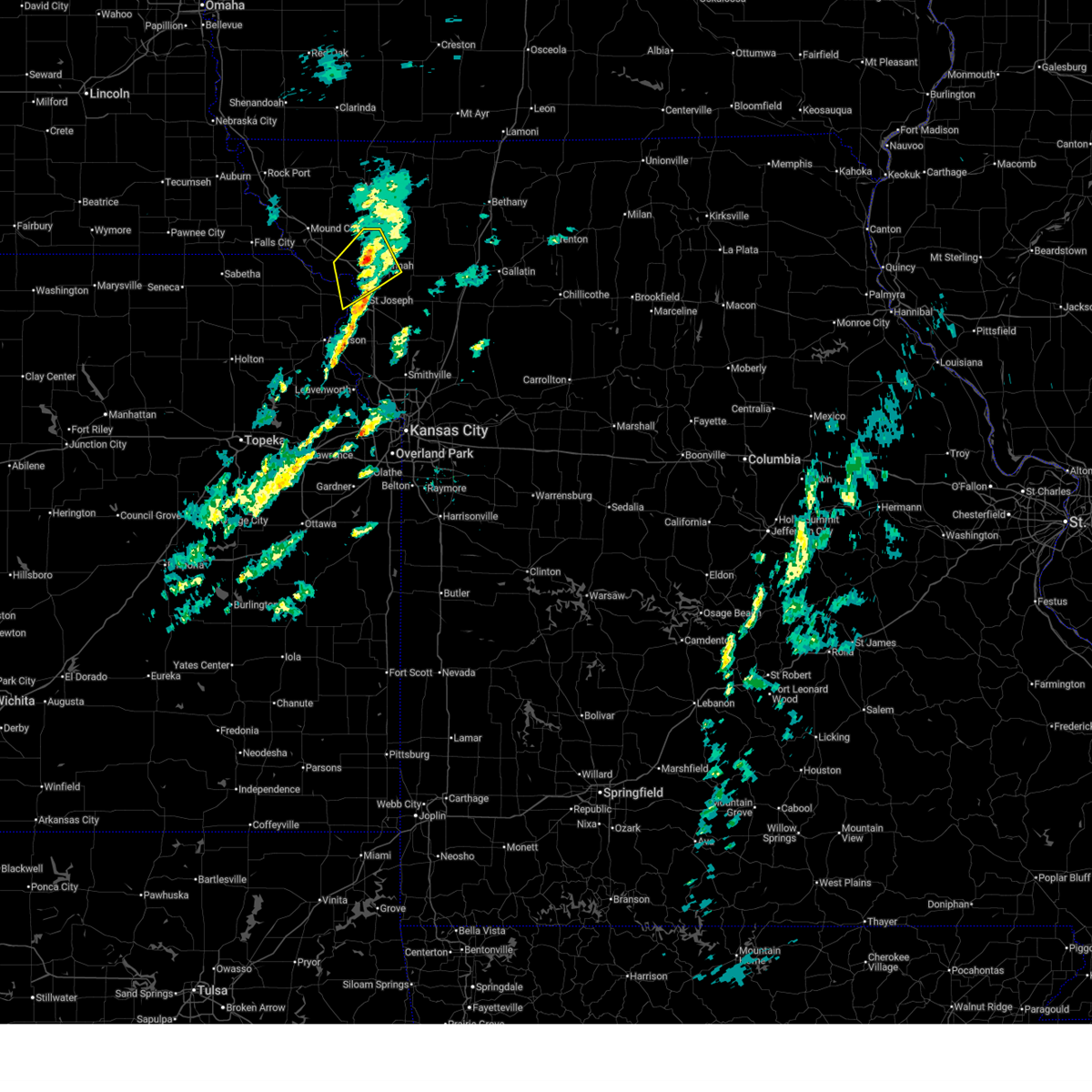
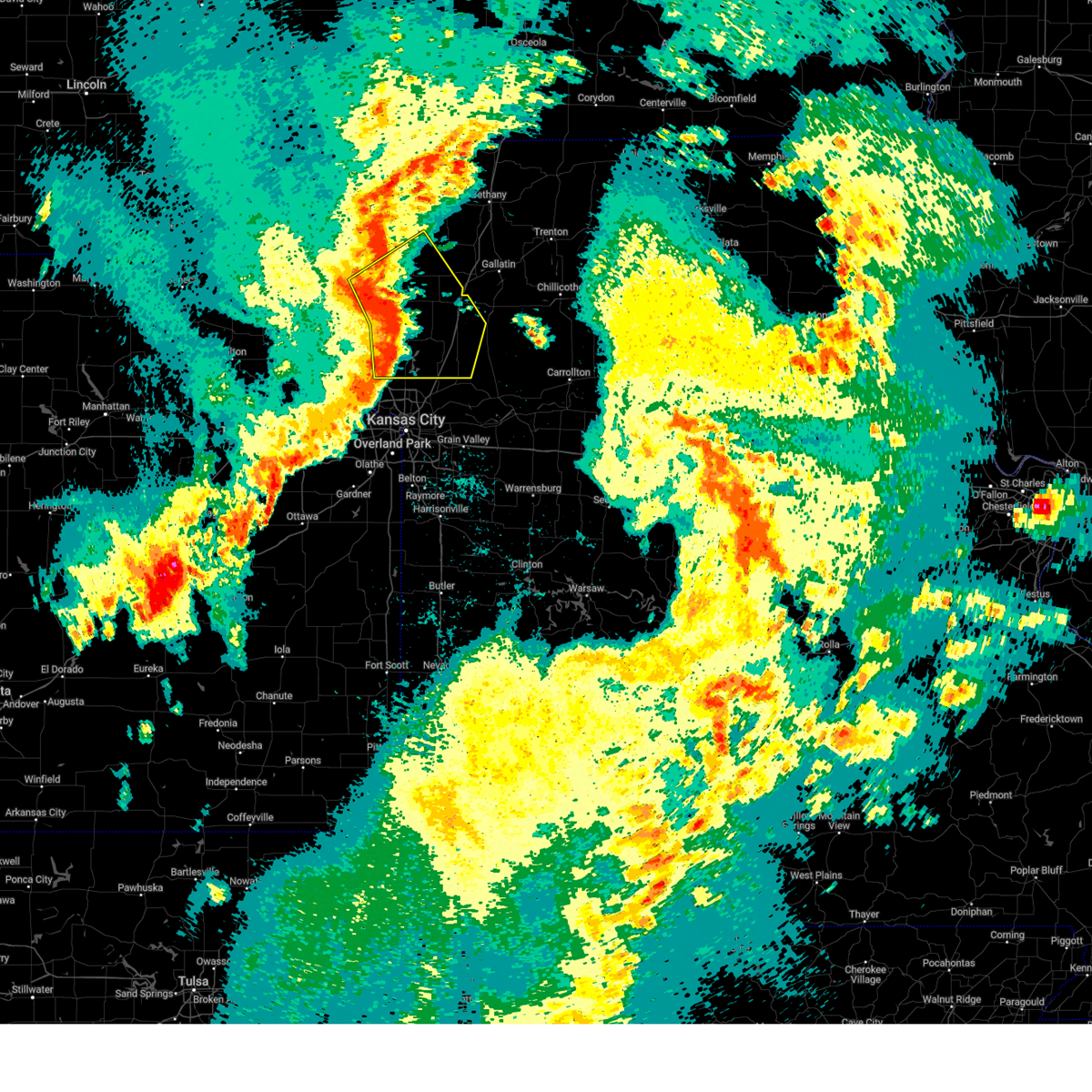
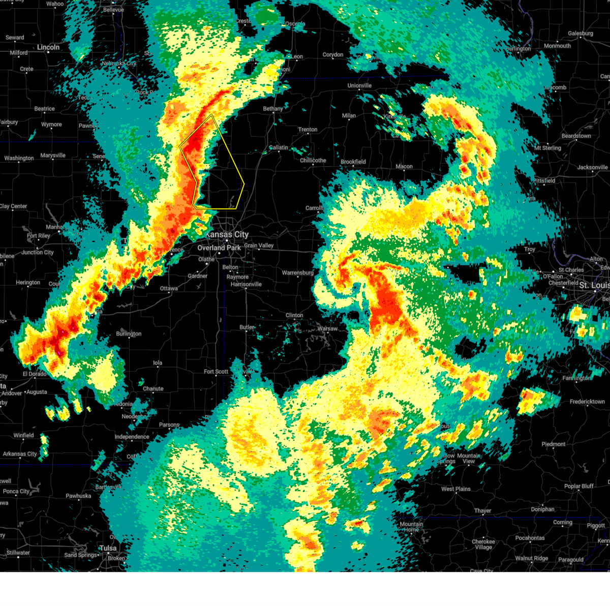
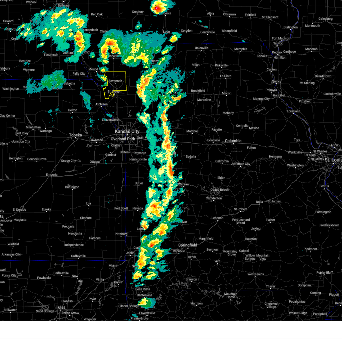
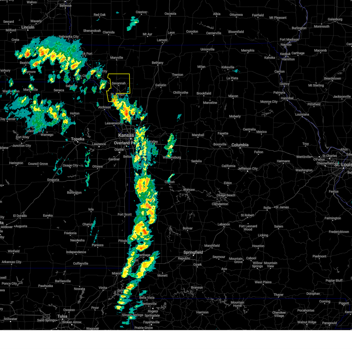
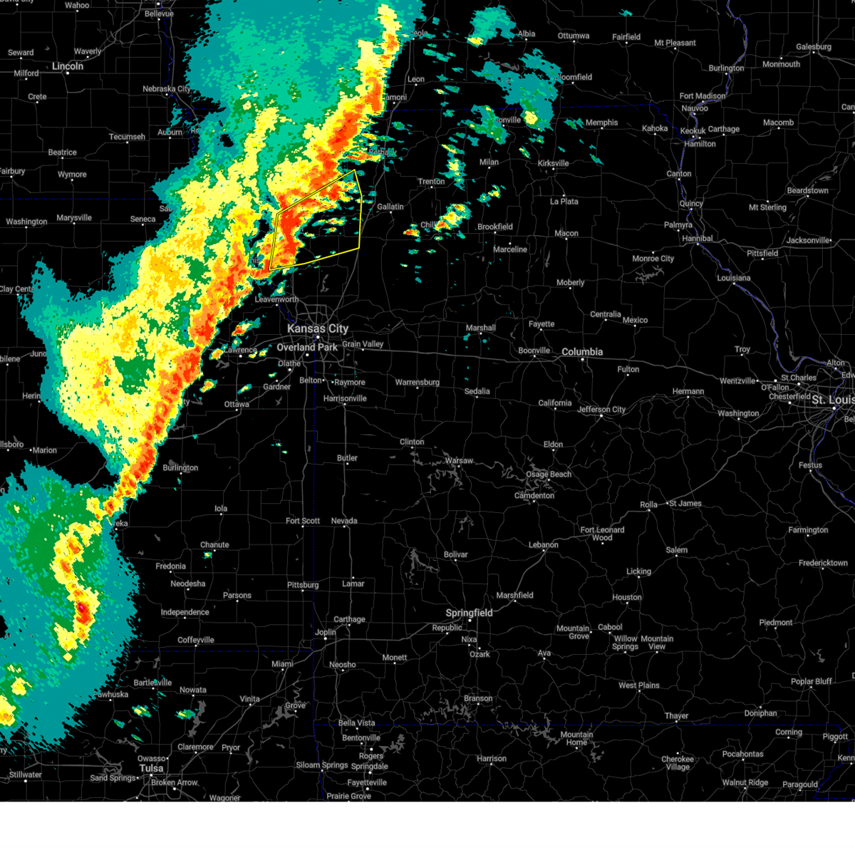
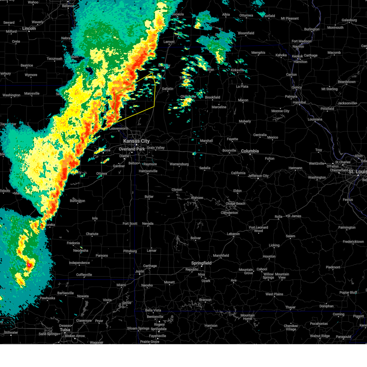
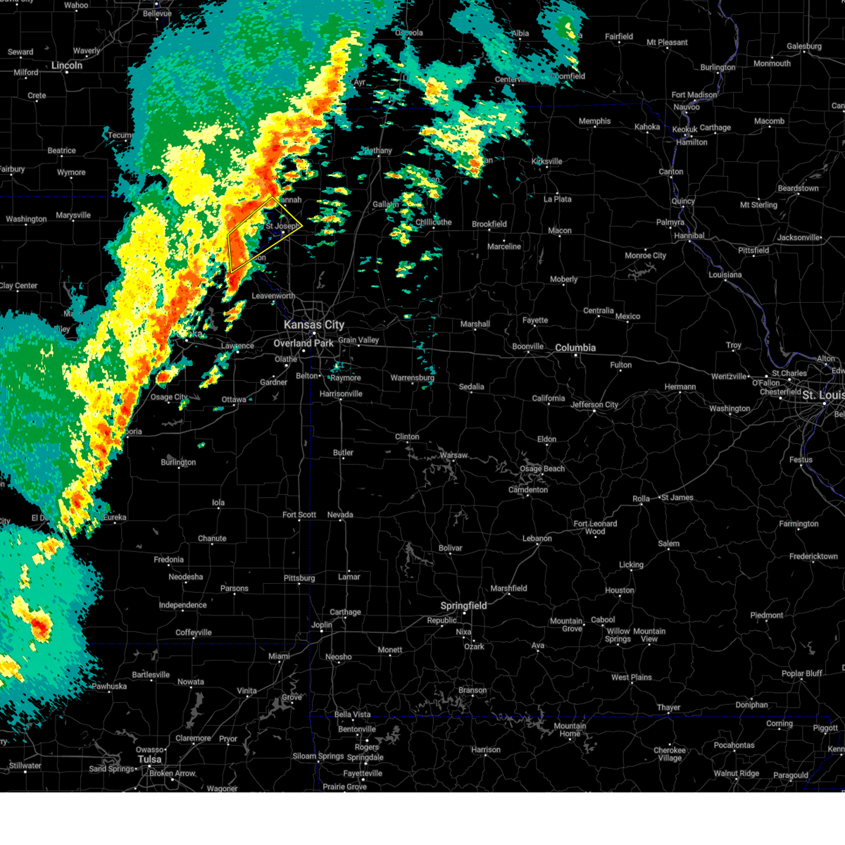
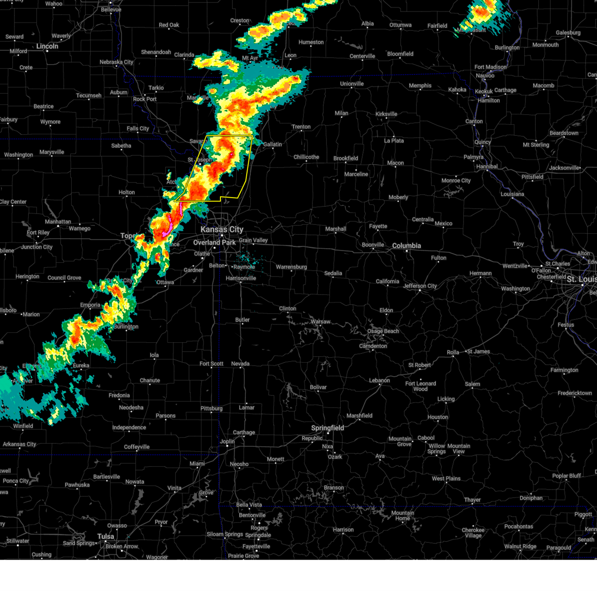
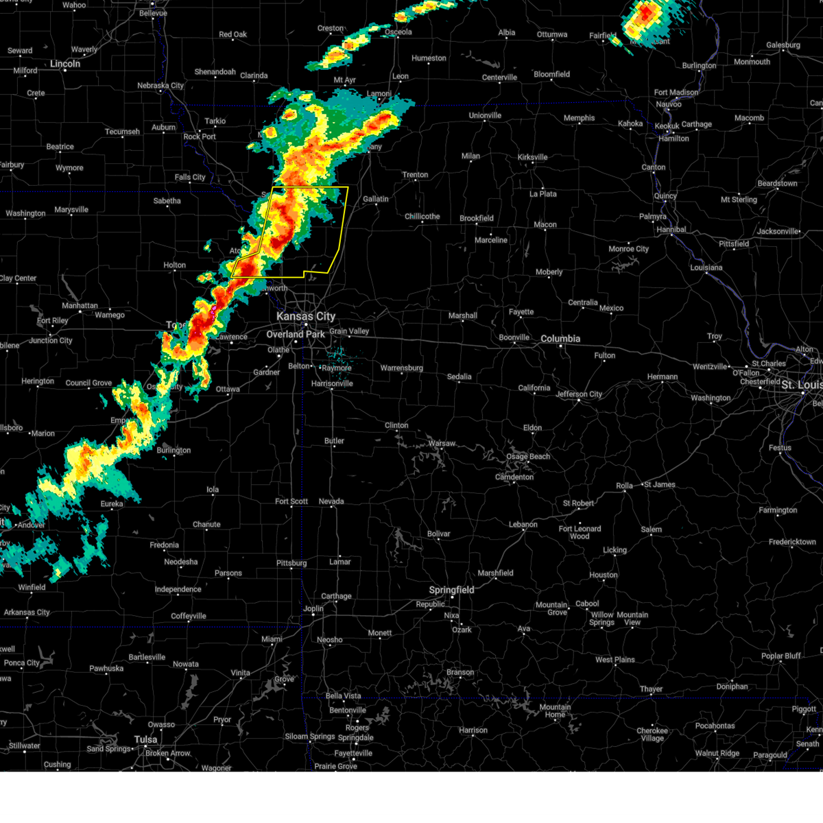
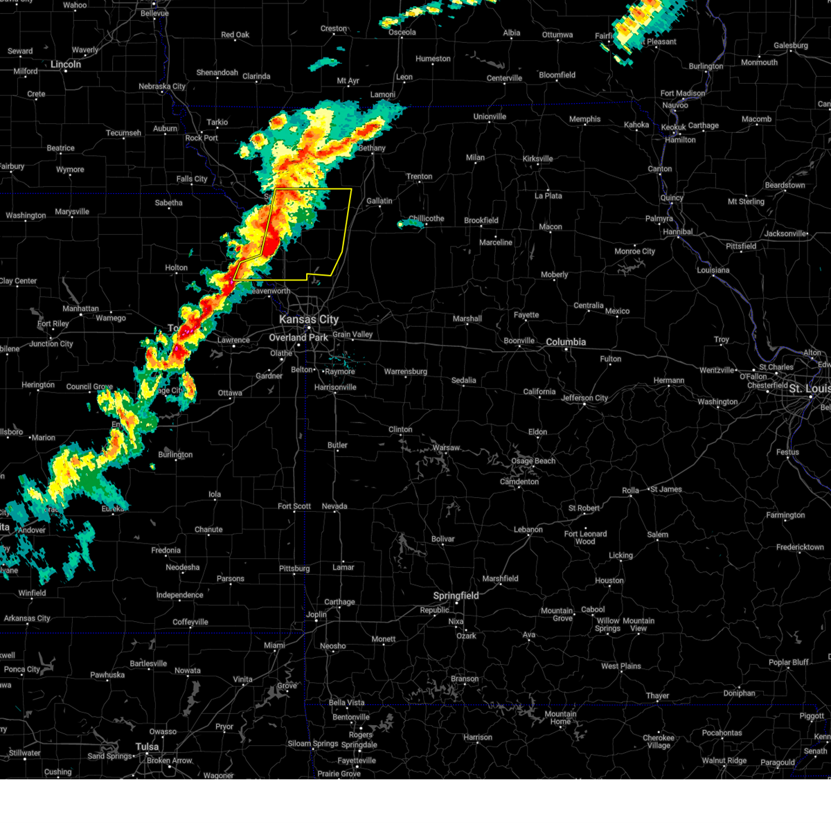
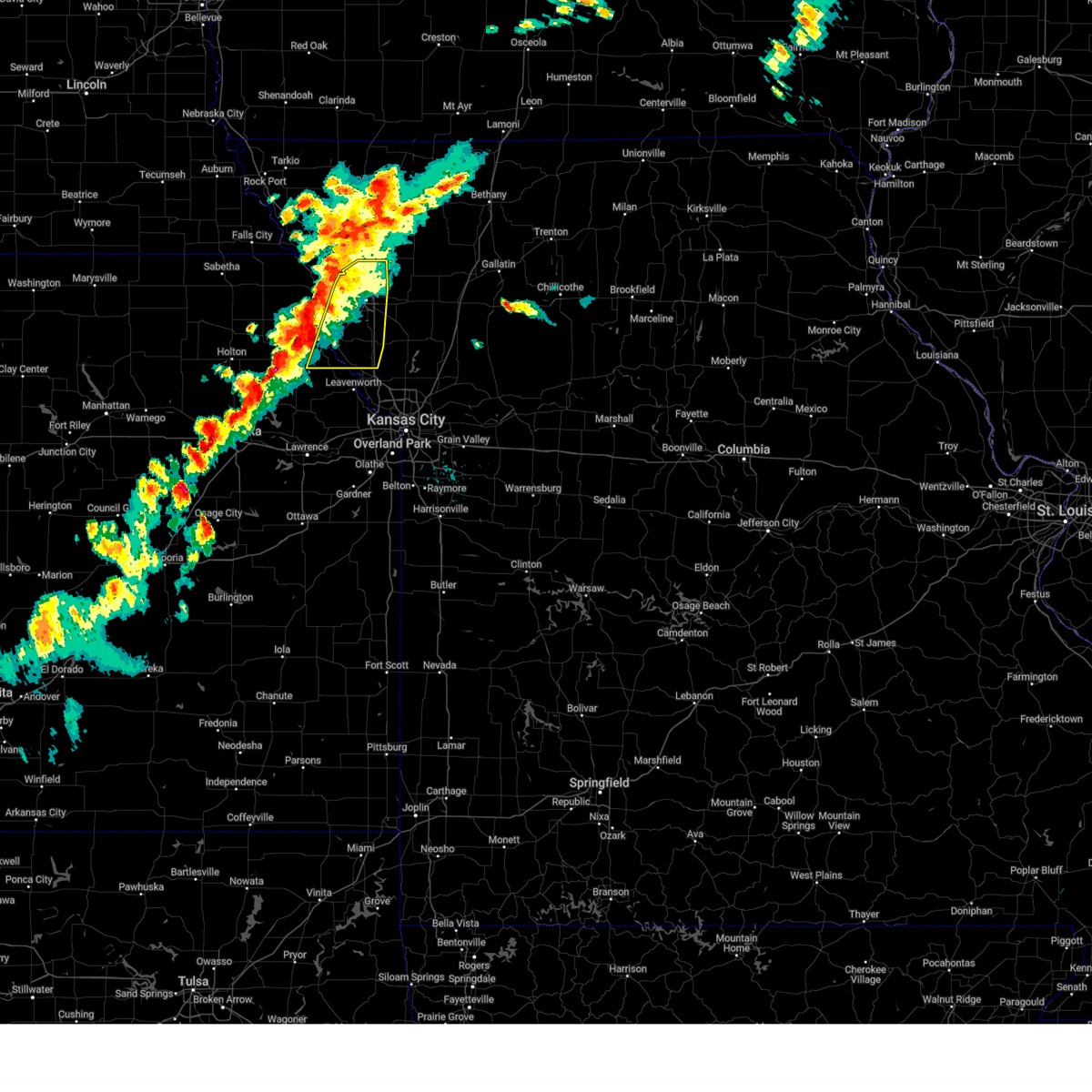
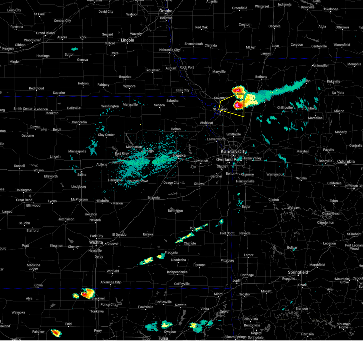
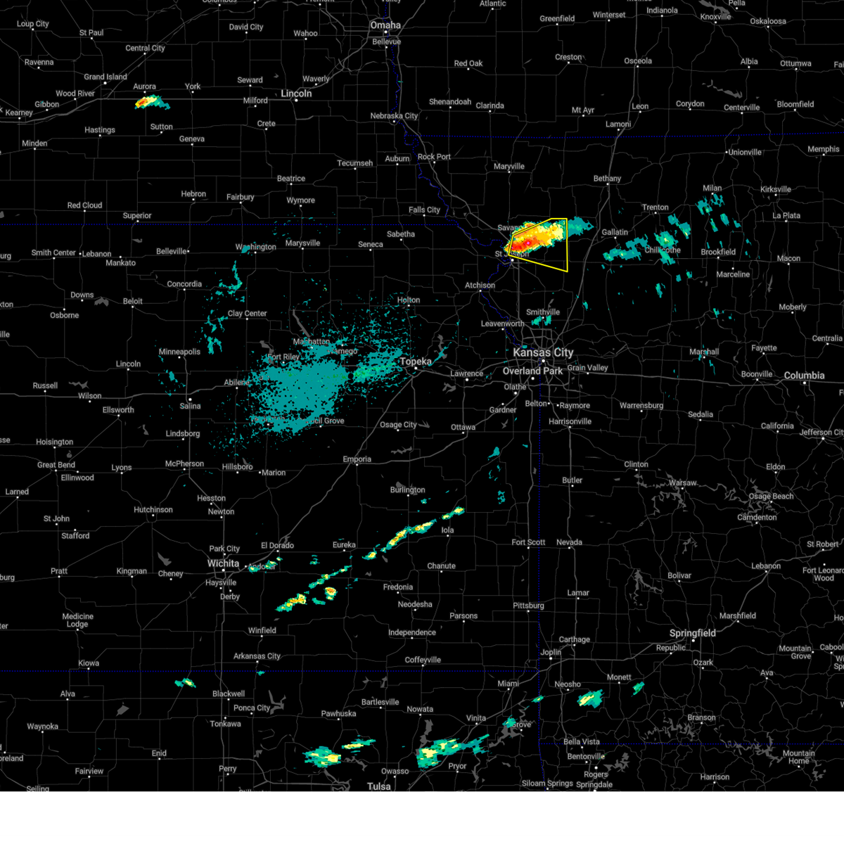
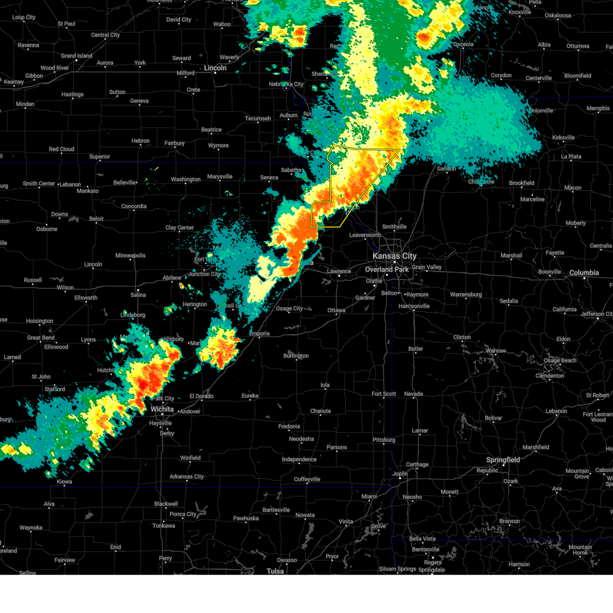
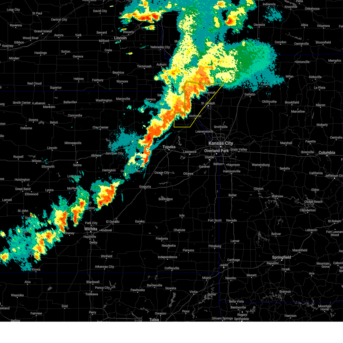
Hail Map for Savannah, MO
The Savannah, MO area has had 4 reports of on-the-ground hail by trained spotters, and has been under severe weather warnings 24 times during the past 12 months. Doppler radar has detected hail at or near Savannah, MO on 74 occasions, including 4 occasions during the past year.
| Name: | Savannah, MO |
| Where Located: | 59.4 miles NNW of Kansas City, MO |
| Map: | Google Map for Savannah, MO |
| Population: | 5057 |
| Housing Units: | 2187 |
| More Info: | Search Google for Savannah, MO |
2
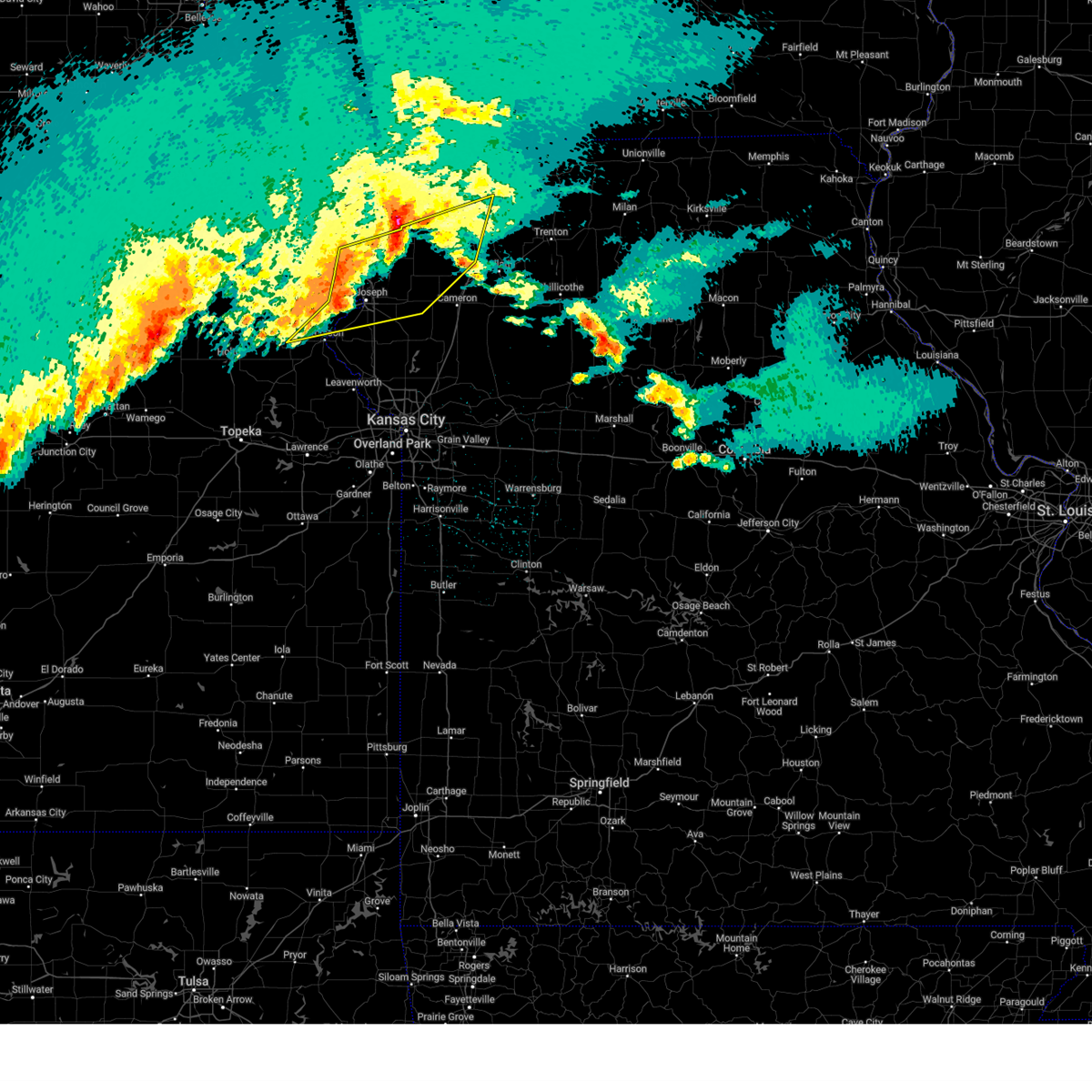
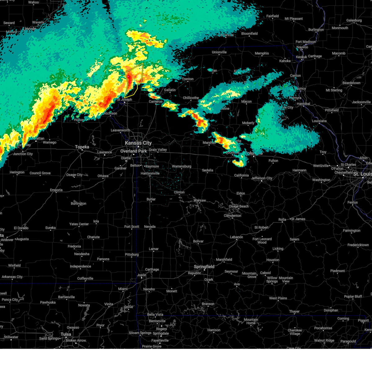
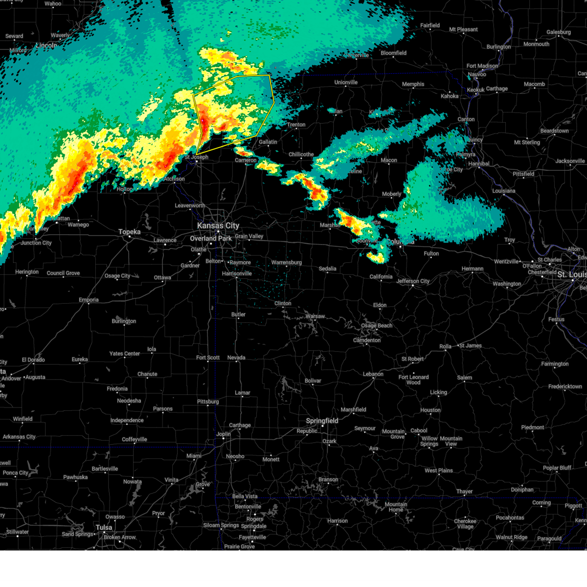
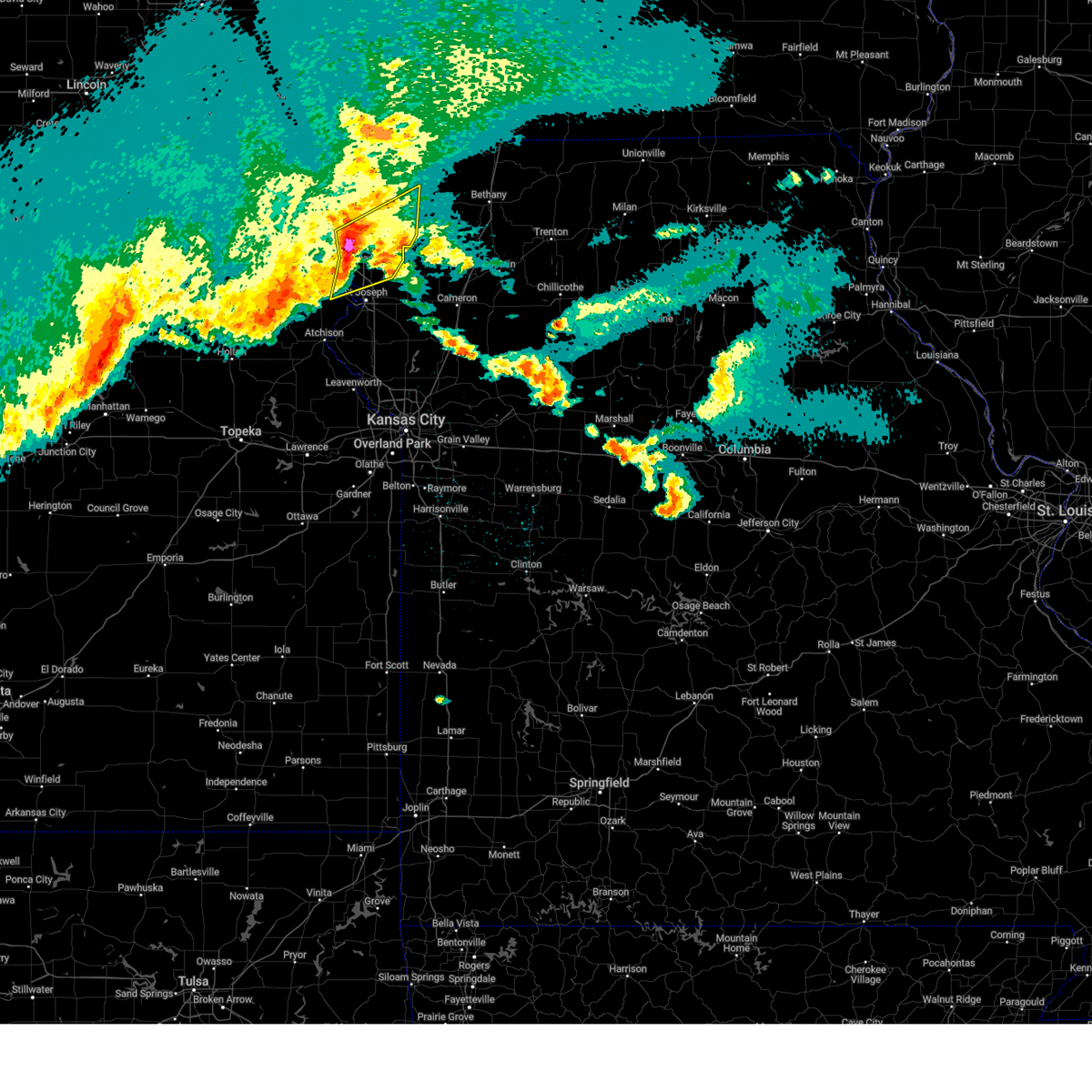
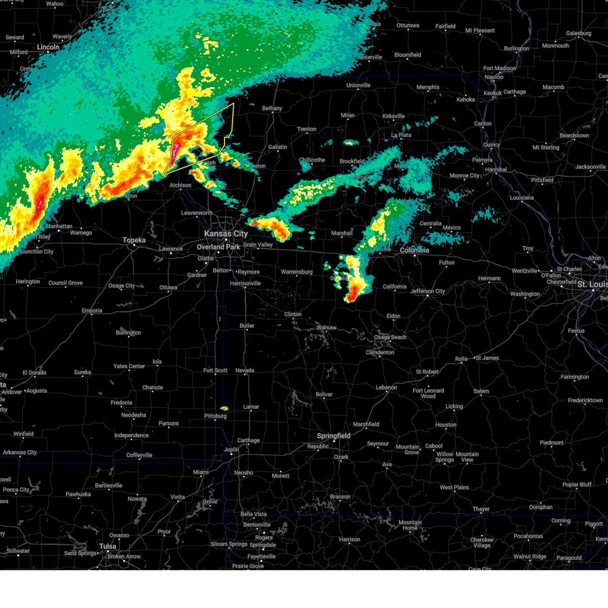
The Top Recent Hail Date for Savannah, MO is Wednesday, June 10, 2026 (16th out of 74)
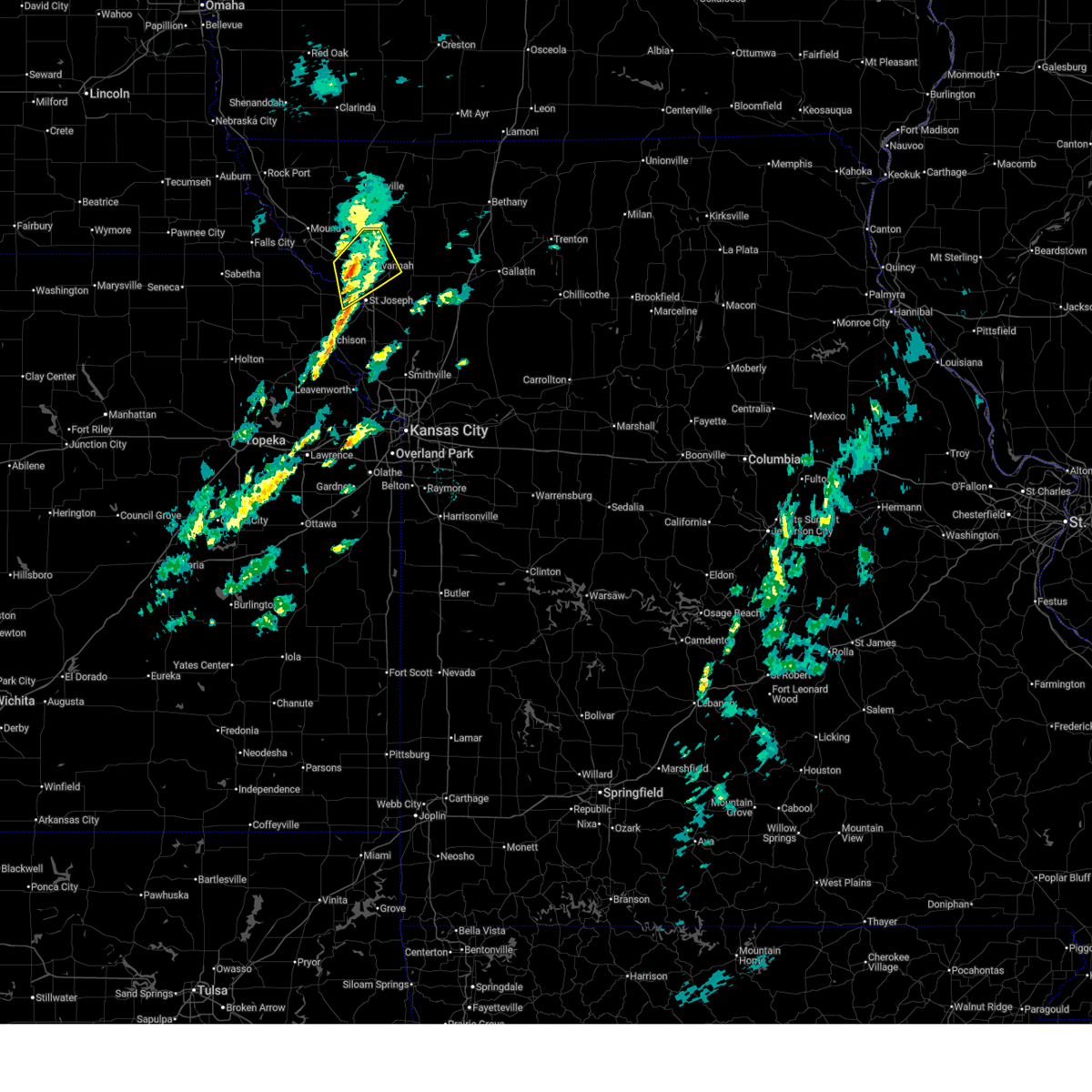
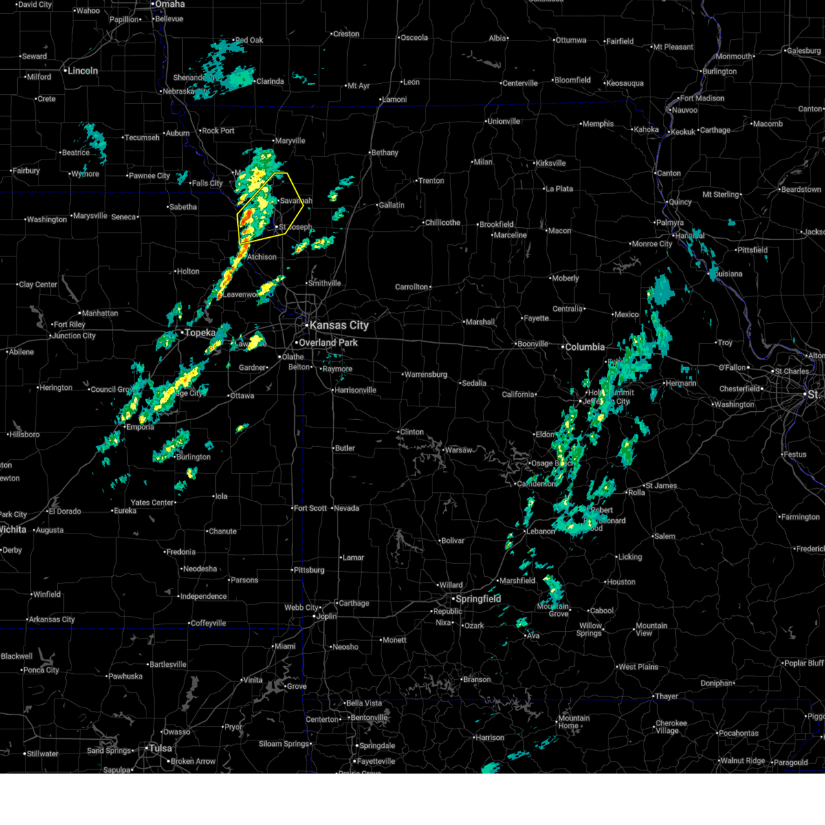
Hail and Wind Damage Spotted near Savannah, MO
| Date / Time | Report Details |
|---|---|
| 6/10/2026 7:56 PM CDT |
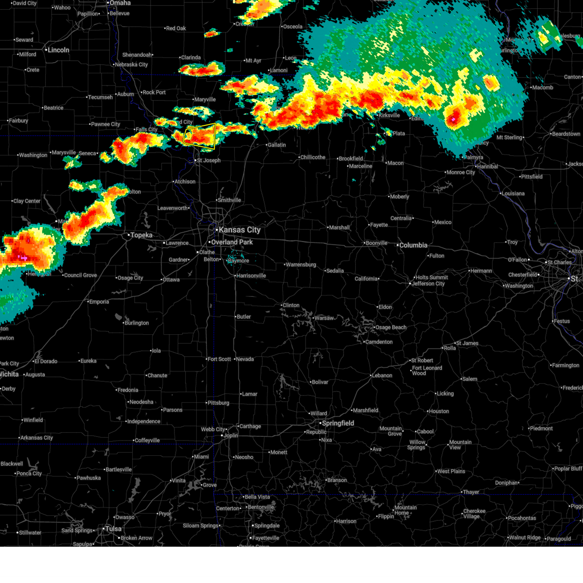 At 756 pm cdt, a severe thunderstorm was located near savannah, moving east at 30 mph (radar indicated). Hazards include 60 mph wind gusts and quarter size hail. Hail damage to vehicles is expected. expect wind damage to roofs, siding, and trees. locations impacted include, savannah, fillmore, rosendale, rea, and helena. This includes interstate 29 between mile markers 61 and 66. At 756 pm cdt, a severe thunderstorm was located near savannah, moving east at 30 mph (radar indicated). Hazards include 60 mph wind gusts and quarter size hail. Hail damage to vehicles is expected. expect wind damage to roofs, siding, and trees. locations impacted include, savannah, fillmore, rosendale, rea, and helena. This includes interstate 29 between mile markers 61 and 66.
|
| 6/10/2026 7:45 PM CDT |
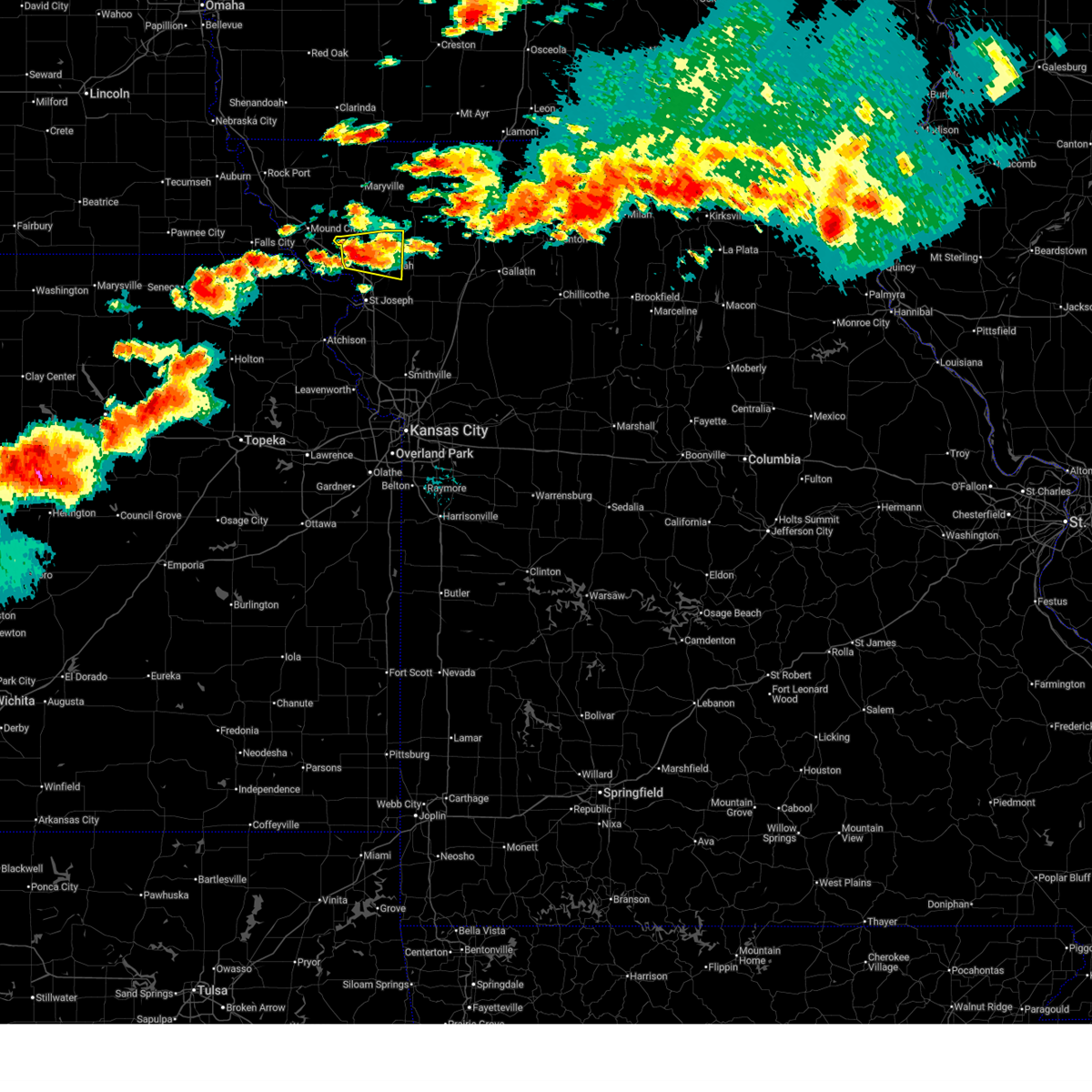 At 745 pm cdt, a severe thunderstorm was located over fillmore, or 8 miles northwest of savannah, moving east at 25 mph (radar indicated). Hazards include 60 mph wind gusts and quarter size hail. Hail damage to vehicles is expected. expect wind damage to roofs, siding, and trees. locations impacted include, savannah, fillmore, rosendale, rea, and helena. This includes interstate 29 between mile markers 61 and 66. At 745 pm cdt, a severe thunderstorm was located over fillmore, or 8 miles northwest of savannah, moving east at 25 mph (radar indicated). Hazards include 60 mph wind gusts and quarter size hail. Hail damage to vehicles is expected. expect wind damage to roofs, siding, and trees. locations impacted include, savannah, fillmore, rosendale, rea, and helena. This includes interstate 29 between mile markers 61 and 66.
|
| 6/10/2026 7:27 PM CDT |
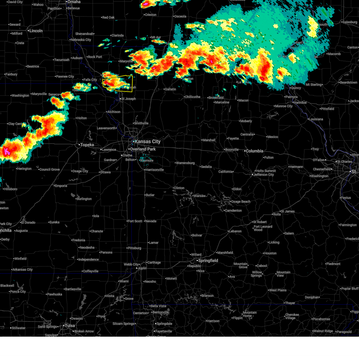 At 727 pm cdt, a severe thunderstorm was located near oregon, or 12 miles southeast of mound city, moving east at 25 mph (radar indicated). Hazards include 60 mph wind gusts and quarter size hail. Hail damage to vehicles is expected. expect wind damage to roofs, siding, and trees. locations impacted include, savannah, oregon, amazonia, forest city, fillmore, bolckow, rosendale, rea, and helena. This includes interstate 29 between mile markers 57 and 77. At 727 pm cdt, a severe thunderstorm was located near oregon, or 12 miles southeast of mound city, moving east at 25 mph (radar indicated). Hazards include 60 mph wind gusts and quarter size hail. Hail damage to vehicles is expected. expect wind damage to roofs, siding, and trees. locations impacted include, savannah, oregon, amazonia, forest city, fillmore, bolckow, rosendale, rea, and helena. This includes interstate 29 between mile markers 57 and 77.
|
| 6/10/2026 7:10 PM CDT |
 Svreax the national weather service in pleasant hill has issued a * severe thunderstorm warning for, southeastern holt county in northwestern missouri, andrew county in northwestern missouri, * until 815 pm cdt. * at 709 pm cdt, a severe thunderstorm was located over oregon, or 10 miles south of mound city, moving east at 30 mph (radar indicated). Hazards include 60 mph wind gusts and quarter size hail. Hail damage to vehicles is expected. Expect wind damage to roofs, siding, and trees. Svreax the national weather service in pleasant hill has issued a * severe thunderstorm warning for, southeastern holt county in northwestern missouri, andrew county in northwestern missouri, * until 815 pm cdt. * at 709 pm cdt, a severe thunderstorm was located over oregon, or 10 miles south of mound city, moving east at 30 mph (radar indicated). Hazards include 60 mph wind gusts and quarter size hail. Hail damage to vehicles is expected. Expect wind damage to roofs, siding, and trees.
|
| 5/18/2026 8:37 PM CDT |
 The storm which prompted the warning has moved out of the area. therefore, the warning will be allowed to expire. a tornado watch remains in effect until 1000 pm cdt for northwestern missouri. The storm which prompted the warning has moved out of the area. therefore, the warning will be allowed to expire. a tornado watch remains in effect until 1000 pm cdt for northwestern missouri.
|
| 5/18/2026 8:30 PM CDT |
 At 829 pm cdt, a severe thunderstorm was located 9 miles west of stanberry, moving northeast at 55 mph (radar indicated). Hazards include 60 mph wind gusts and quarter size hail. Hail damage to vehicles is expected. expect wind damage to roofs, siding, and trees. locations impacted include, maryville, savannah, ravenwood, barnard, conception junction, bolckow, pickering, rosendale, guilford, clyde, arkoe, rea, and conception. This includes interstate 29 between mile markers 62 and 64. At 829 pm cdt, a severe thunderstorm was located 9 miles west of stanberry, moving northeast at 55 mph (radar indicated). Hazards include 60 mph wind gusts and quarter size hail. Hail damage to vehicles is expected. expect wind damage to roofs, siding, and trees. locations impacted include, maryville, savannah, ravenwood, barnard, conception junction, bolckow, pickering, rosendale, guilford, clyde, arkoe, rea, and conception. This includes interstate 29 between mile markers 62 and 64.
|
| 5/18/2026 8:22 PM CDT | Several reports of downed trees and wires and property damage on county road 191. time estimated from rada in andrew county MO, 1.4 miles WSW of Savannah, MO |
| 5/18/2026 8:17 PM CDT |
 At 816 pm cdt, severe thunderstorms were located along a line extending from near savannah to elwood to rushville, moving east at 65 mph (automated weather station. at 813 pm, the st. joseph airport reported a 61 mph wind gust). Hazards include 70 mph wind gusts and quarter size hail. Hail damage to vehicles is expected. expect considerable tree damage. wind damage is also likely to mobile homes, roofs, and outbuildings. locations impacted include, st. joseph, cameron, savannah, plattsburg, lathrop, gower, wathena, elwood, maysville, country club villa, country club, stewartsville, agency, union star, osborn, amazonia, rushville, clarksdale, lewis and clark village, and easton. this includes the following highways, interstate 35 in missouri between mile markers 39 and 56. interstate 29 between mile markers 32 and 59. Interstate 229 between mile markers 0 and 14. At 816 pm cdt, severe thunderstorms were located along a line extending from near savannah to elwood to rushville, moving east at 65 mph (automated weather station. at 813 pm, the st. joseph airport reported a 61 mph wind gust). Hazards include 70 mph wind gusts and quarter size hail. Hail damage to vehicles is expected. expect considerable tree damage. wind damage is also likely to mobile homes, roofs, and outbuildings. locations impacted include, st. joseph, cameron, savannah, plattsburg, lathrop, gower, wathena, elwood, maysville, country club villa, country club, stewartsville, agency, union star, osborn, amazonia, rushville, clarksdale, lewis and clark village, and easton. this includes the following highways, interstate 35 in missouri between mile markers 39 and 56. interstate 29 between mile markers 32 and 59. Interstate 229 between mile markers 0 and 14.
|
| 5/18/2026 8:10 PM CDT |
 At 810 pm cdt, a severe thunderstorm was located near skidmore, or near maryville, moving northeast at 35 mph (radar indicated). Hazards include 60 mph wind gusts and quarter size hail. Hail damage to vehicles is expected. expect wind damage to roofs, siding, and trees. locations impacted include, maryville, savannah, mound city, oregon, ravenwood, maitland, skidmore, forest city, fillmore, barnard, conception junction, bolckow, graham, pickering, rosendale, guilford, clyde, arkoe, rea, and quitman. This includes interstate 29 between mile markers 62 and 84. At 810 pm cdt, a severe thunderstorm was located near skidmore, or near maryville, moving northeast at 35 mph (radar indicated). Hazards include 60 mph wind gusts and quarter size hail. Hail damage to vehicles is expected. expect wind damage to roofs, siding, and trees. locations impacted include, maryville, savannah, mound city, oregon, ravenwood, maitland, skidmore, forest city, fillmore, barnard, conception junction, bolckow, graham, pickering, rosendale, guilford, clyde, arkoe, rea, and quitman. This includes interstate 29 between mile markers 62 and 84.
|
| 5/18/2026 8:04 PM CDT |
 Svreax the national weather service in pleasant hill has issued a * severe thunderstorm warning for, southeastern doniphan county in northeastern kansas, buchanan county in northwestern missouri, clinton county in northwestern missouri, southeastern andrew county in northwestern missouri, dekalb county in northwestern missouri, * until 845 pm cdt. * at 804 pm cdt, severe thunderstorms were located along a line extending from 6 miles southeast of oregon to 6 miles northwest of rushville to near atchison, moving east at 65 mph (radar indicated). Hazards include 70 mph wind gusts and quarter size hail. Hail damage to vehicles is expected. expect considerable tree damage. Wind damage is also likely to mobile homes, roofs, and outbuildings. Svreax the national weather service in pleasant hill has issued a * severe thunderstorm warning for, southeastern doniphan county in northeastern kansas, buchanan county in northwestern missouri, clinton county in northwestern missouri, southeastern andrew county in northwestern missouri, dekalb county in northwestern missouri, * until 845 pm cdt. * at 804 pm cdt, severe thunderstorms were located along a line extending from 6 miles southeast of oregon to 6 miles northwest of rushville to near atchison, moving east at 65 mph (radar indicated). Hazards include 70 mph wind gusts and quarter size hail. Hail damage to vehicles is expected. expect considerable tree damage. Wind damage is also likely to mobile homes, roofs, and outbuildings.
|
| 5/18/2026 8:01 PM CDT |
 Svreax the national weather service in pleasant hill has issued a * severe thunderstorm warning for, northwestern doniphan county in northeastern kansas, southeastern atchison county in northwestern missouri, holt county in northwestern missouri, nodaway county in northwestern missouri, northern andrew county in northwestern missouri, * until 845 pm cdt. * at 800 pm cdt, a severe thunderstorm was located over skidmore, or 11 miles northeast of mound city, moving northeast at 35 mph (radar indicated). Hazards include 60 mph wind gusts and quarter size hail. Hail damage to vehicles is expected. Expect wind damage to roofs, siding, and trees. Svreax the national weather service in pleasant hill has issued a * severe thunderstorm warning for, northwestern doniphan county in northeastern kansas, southeastern atchison county in northwestern missouri, holt county in northwestern missouri, nodaway county in northwestern missouri, northern andrew county in northwestern missouri, * until 845 pm cdt. * at 800 pm cdt, a severe thunderstorm was located over skidmore, or 11 miles northeast of mound city, moving northeast at 35 mph (radar indicated). Hazards include 60 mph wind gusts and quarter size hail. Hail damage to vehicles is expected. Expect wind damage to roofs, siding, and trees.
|
| 5/17/2026 2:45 AM CDT |
 At 244 am cdt, severe thunderstorms were located along a line extending from near king city to 7 miles east of st. joseph to near dearborn, moving east at 35 mph (radar indicated). Hazards include 60 mph wind gusts and penny size hail. Expect damage to roofs, siding, and trees. locations impacted include, st. joseph, savannah, gower, country club villa, country club, king city, stewartsville, agency, dearborn, union star, clarksdale, easton, de kalb, cosby, rea, faucett, and helena. this includes the following highways, interstate 29 between mile markers 31 and 55. Interstate 229 between mile markers 0 and 5. At 244 am cdt, severe thunderstorms were located along a line extending from near king city to 7 miles east of st. joseph to near dearborn, moving east at 35 mph (radar indicated). Hazards include 60 mph wind gusts and penny size hail. Expect damage to roofs, siding, and trees. locations impacted include, st. joseph, savannah, gower, country club villa, country club, king city, stewartsville, agency, dearborn, union star, clarksdale, easton, de kalb, cosby, rea, faucett, and helena. this includes the following highways, interstate 29 between mile markers 31 and 55. Interstate 229 between mile markers 0 and 5.
|
| 5/17/2026 2:35 AM CDT |
 the severe thunderstorm warning has been cancelled and is no longer in effect the severe thunderstorm warning has been cancelled and is no longer in effect
|
| 5/17/2026 2:35 AM CDT |
 At 234 am cdt, severe thunderstorms were located along a line extending from near savannah to st. joseph to near lewis and clark village, moving east at 40 mph (radar indicated). Hazards include 60 mph wind gusts and penny size hail. Expect damage to roofs, siding, and trees. locations impacted include, st. joseph, savannah, gower, wathena, elwood, country club villa, country club, king city, stewartsville, agency, dearborn, union star, amazonia, rushville, clarksdale, lewis and clark village, easton, de kalb, bolckow, and rosendale. this includes the following highways, interstate 29 between mile markers 31 and 61. Interstate 229 between mile markers 0 and 14. At 234 am cdt, severe thunderstorms were located along a line extending from near savannah to st. joseph to near lewis and clark village, moving east at 40 mph (radar indicated). Hazards include 60 mph wind gusts and penny size hail. Expect damage to roofs, siding, and trees. locations impacted include, st. joseph, savannah, gower, wathena, elwood, country club villa, country club, king city, stewartsville, agency, dearborn, union star, amazonia, rushville, clarksdale, lewis and clark village, easton, de kalb, bolckow, and rosendale. this includes the following highways, interstate 29 between mile markers 31 and 61. Interstate 229 between mile markers 0 and 14.
|
| 5/17/2026 2:24 AM CDT |
 At 224 am cdt, severe thunderstorms were located along a line extending from near savannah to elwood to near lewis and clark village, moving east at 40 mph (radar indicated). Hazards include 60 mph wind gusts and penny size hail. Expect damage to roofs, siding, and trees. locations impacted include, st. joseph, atchison, savannah, gower, wathena, elwood, troy, country club villa, country club, king city, stewartsville, agency, dearborn, union star, amazonia, rushville, clarksdale, fillmore, lewis and clark village, and doniphan. this includes the following highways, interstate 29 between mile markers 31 and 70. Interstate 229 between mile markers 0 and 14. At 224 am cdt, severe thunderstorms were located along a line extending from near savannah to elwood to near lewis and clark village, moving east at 40 mph (radar indicated). Hazards include 60 mph wind gusts and penny size hail. Expect damage to roofs, siding, and trees. locations impacted include, st. joseph, atchison, savannah, gower, wathena, elwood, troy, country club villa, country club, king city, stewartsville, agency, dearborn, union star, amazonia, rushville, clarksdale, fillmore, lewis and clark village, and doniphan. this includes the following highways, interstate 29 between mile markers 31 and 70. Interstate 229 between mile markers 0 and 14.
|
| 5/17/2026 2:10 AM CDT |
 Svreax the national weather service in pleasant hill has issued a * severe thunderstorm warning for, southeastern doniphan county in northeastern kansas, northeastern atchison county in northeastern kansas, buchanan county in northwestern missouri, northwestern clinton county in northwestern missouri, western gentry county in northwestern missouri, eastern holt county in northwestern missouri, southern nodaway county in northwestern missouri, andrew county in northwestern missouri, western dekalb county in northwestern missouri, * until 300 am cdt. * at 210 am cdt, severe thunderstorms were located along a line extending from near maitland to near troy to near atchison, moving east at 40 mph (radar indicated). Hazards include 60 mph wind gusts and penny size hail. expect damage to roofs, siding, and trees Svreax the national weather service in pleasant hill has issued a * severe thunderstorm warning for, southeastern doniphan county in northeastern kansas, northeastern atchison county in northeastern kansas, buchanan county in northwestern missouri, northwestern clinton county in northwestern missouri, western gentry county in northwestern missouri, eastern holt county in northwestern missouri, southern nodaway county in northwestern missouri, andrew county in northwestern missouri, western dekalb county in northwestern missouri, * until 300 am cdt. * at 210 am cdt, severe thunderstorms were located along a line extending from near maitland to near troy to near atchison, moving east at 40 mph (radar indicated). Hazards include 60 mph wind gusts and penny size hail. expect damage to roofs, siding, and trees
|
| 4/23/2026 8:00 PM CDT |
 At 800 pm cdt, severe thunderstorms were located along a line extending from near irena to near union star to near wathena, moving east at 45 mph (radar indicated). Hazards include 60 mph wind gusts and nickel size hail. Expect damage to roofs, siding, and trees. locations impacted include, st. joseph, savannah, wathena, elwood, stanberry, troy, country club villa, country club, king city, grant city, ravenwood, union star, amazonia, fillmore, denton, irena, barnard, conception junction, parnell, and bolckow. this includes the following highways, interstate 29 between mile markers 48 and 68. Interstate 229 between mile markers 3 and 14. At 800 pm cdt, severe thunderstorms were located along a line extending from near irena to near union star to near wathena, moving east at 45 mph (radar indicated). Hazards include 60 mph wind gusts and nickel size hail. Expect damage to roofs, siding, and trees. locations impacted include, st. joseph, savannah, wathena, elwood, stanberry, troy, country club villa, country club, king city, grant city, ravenwood, union star, amazonia, fillmore, denton, irena, barnard, conception junction, parnell, and bolckow. this includes the following highways, interstate 29 between mile markers 48 and 68. Interstate 229 between mile markers 3 and 14.
|
| 4/23/2026 7:36 PM CDT |
 Svreax the national weather service in pleasant hill has issued a * severe thunderstorm warning for, doniphan county in northeastern kansas, northwestern buchanan county in northwestern missouri, worth county in northwestern missouri, western gentry county in northwestern missouri, northwestern harrison county in north central missouri, southeastern holt county in northwestern missouri, eastern nodaway county in northwestern missouri, andrew county in northwestern missouri, northwestern dekalb county in northwestern missouri, * until 815 pm cdt. * at 735 pm cdt, severe thunderstorms were located along a line extending from near athelstan to 7 miles northeast of fillmore to near highland, moving east at 30 mph (radar indicated). Hazards include 60 mph wind gusts and quarter size hail. Hail damage to vehicles is expected. Expect wind damage to roofs, siding, and trees. Svreax the national weather service in pleasant hill has issued a * severe thunderstorm warning for, doniphan county in northeastern kansas, northwestern buchanan county in northwestern missouri, worth county in northwestern missouri, western gentry county in northwestern missouri, northwestern harrison county in north central missouri, southeastern holt county in northwestern missouri, eastern nodaway county in northwestern missouri, andrew county in northwestern missouri, northwestern dekalb county in northwestern missouri, * until 815 pm cdt. * at 735 pm cdt, severe thunderstorms were located along a line extending from near athelstan to 7 miles northeast of fillmore to near highland, moving east at 30 mph (radar indicated). Hazards include 60 mph wind gusts and quarter size hail. Hail damage to vehicles is expected. Expect wind damage to roofs, siding, and trees.
|
| 4/17/2026 3:26 PM CDT |
 At 326 pm cdt, a severe thunderstorm was located near rushville, or 9 miles south of elwood, moving northeast at 40 mph (emergency management). Hazards include ping pong ball size hail and 60 mph wind gusts. People and animals outdoors will be injured. expect hail damage to roofs, siding, windows, and vehicles. expect wind damage to roofs, siding, and trees. locations impacted include, st. joseph, atchison, savannah, wathena, elwood, country club villa, country club, agency, amazonia, rushville, lewis and clark village, doniphan, easton, de kalb, cosby, st. joseph airport, and helena. this includes the following highways, interstate 29 between mile markers 38 and 60. Interstate 229 between mile markers 0 and 14. At 326 pm cdt, a severe thunderstorm was located near rushville, or 9 miles south of elwood, moving northeast at 40 mph (emergency management). Hazards include ping pong ball size hail and 60 mph wind gusts. People and animals outdoors will be injured. expect hail damage to roofs, siding, windows, and vehicles. expect wind damage to roofs, siding, and trees. locations impacted include, st. joseph, atchison, savannah, wathena, elwood, country club villa, country club, agency, amazonia, rushville, lewis and clark village, doniphan, easton, de kalb, cosby, st. joseph airport, and helena. this includes the following highways, interstate 29 between mile markers 38 and 60. Interstate 229 between mile markers 0 and 14.
|
| 4/17/2026 3:07 PM CDT |
 Svreax the national weather service in pleasant hill has issued a * severe thunderstorm warning for, southern doniphan county in northeastern kansas, eastern atchison county in northeastern kansas, buchanan county in northwestern missouri, southeastern holt county in northwestern missouri, northwestern platte county in west central missouri, andrew county in northwestern missouri, * until 345 pm cdt. * at 307 pm cdt, severe thunderstorms were located along a line extending from 6 miles south of troy to near atchison, moving northeast at 50 mph (emergency management. quarter size hail was reported in atchison, kansas, with this storm). Hazards include golf ball size hail and 60 mph wind gusts. People and animals outdoors will be injured. expect hail damage to roofs, siding, windows, and vehicles. Expect wind damage to roofs, siding, and trees. Svreax the national weather service in pleasant hill has issued a * severe thunderstorm warning for, southern doniphan county in northeastern kansas, eastern atchison county in northeastern kansas, buchanan county in northwestern missouri, southeastern holt county in northwestern missouri, northwestern platte county in west central missouri, andrew county in northwestern missouri, * until 345 pm cdt. * at 307 pm cdt, severe thunderstorms were located along a line extending from 6 miles south of troy to near atchison, moving northeast at 50 mph (emergency management. quarter size hail was reported in atchison, kansas, with this storm). Hazards include golf ball size hail and 60 mph wind gusts. People and animals outdoors will be injured. expect hail damage to roofs, siding, windows, and vehicles. Expect wind damage to roofs, siding, and trees.
|
| 4/17/2026 3:00 PM CDT |
 At 300 pm cdt, a severe thunderstorm was located over king city, or 11 miles south of stanberry, moving northeast at 40 mph (radar indicated). Hazards include ping pong ball size hail and 60 mph wind gusts. People and animals outdoors will be injured. expect hail damage to roofs, siding, windows, and vehicles. expect wind damage to roofs, siding, and trees. locations impacted include, savannah, country club villa, country club, king city, union star, cosby, mcfall, fairport, ford city, and helena. this includes the following highways, interstate 29 between mile markers 52 and 57. Interstate 229 between mile markers 10 and 14. At 300 pm cdt, a severe thunderstorm was located over king city, or 11 miles south of stanberry, moving northeast at 40 mph (radar indicated). Hazards include ping pong ball size hail and 60 mph wind gusts. People and animals outdoors will be injured. expect hail damage to roofs, siding, windows, and vehicles. expect wind damage to roofs, siding, and trees. locations impacted include, savannah, country club villa, country club, king city, union star, cosby, mcfall, fairport, ford city, and helena. this includes the following highways, interstate 29 between mile markers 52 and 57. Interstate 229 between mile markers 10 and 14.
|
| 4/17/2026 2:47 PM CDT |
 Svreax the national weather service in pleasant hill has issued a * severe thunderstorm warning for, east central doniphan county in northeastern kansas, southern gentry county in northwestern missouri, eastern andrew county in northwestern missouri, northern dekalb county in northwestern missouri, * until 315 pm cdt. * at 246 pm cdt, a severe thunderstorm was located near union star, or 8 miles northeast of savannah, moving northeast at 45 mph (radar indicated). Hazards include 60 mph wind gusts and quarter size hail. Hail damage to vehicles is expected. Expect wind damage to roofs, siding, and trees. Svreax the national weather service in pleasant hill has issued a * severe thunderstorm warning for, east central doniphan county in northeastern kansas, southern gentry county in northwestern missouri, eastern andrew county in northwestern missouri, northern dekalb county in northwestern missouri, * until 315 pm cdt. * at 246 pm cdt, a severe thunderstorm was located near union star, or 8 miles northeast of savannah, moving northeast at 45 mph (radar indicated). Hazards include 60 mph wind gusts and quarter size hail. Hail damage to vehicles is expected. Expect wind damage to roofs, siding, and trees.
|
| 1/8/2026 3:45 PM CST |
 The storm which prompted the warning has weakened below severe limits, and no longer poses an immediate threat to life or property. therefore, the warning has been allowed to expire. The storm which prompted the warning has weakened below severe limits, and no longer poses an immediate threat to life or property. therefore, the warning has been allowed to expire.
|
| 1/8/2026 3:35 PM CST |
 At 335 pm cst, a severe thunderstorm was located over amazonia, or near savannah, moving northeast at 50 mph (radar indicated). Hazards include 60 mph wind gusts. Expect damage to roofs, siding, and trees. locations impacted include, st. joseph, savannah, wathena, country club villa, country club, amazonia, fillmore, bolckow, rosendale, rea, st. joseph airport, and helena. this includes the following highways, interstate 29 between mile markers 51 and 68. Interstate 229 between mile markers 8 and 14. At 335 pm cst, a severe thunderstorm was located over amazonia, or near savannah, moving northeast at 50 mph (radar indicated). Hazards include 60 mph wind gusts. Expect damage to roofs, siding, and trees. locations impacted include, st. joseph, savannah, wathena, country club villa, country club, amazonia, fillmore, bolckow, rosendale, rea, st. joseph airport, and helena. this includes the following highways, interstate 29 between mile markers 51 and 68. Interstate 229 between mile markers 8 and 14.
|
| 1/8/2026 3:20 PM CST |
 Svreax the national weather service in pleasant hill has issued a * severe thunderstorm warning for, central doniphan county in northeastern kansas, north central buchanan county in northwestern missouri, southeastern holt county in northwestern missouri, andrew county in northwestern missouri, * until 345 pm cst. * at 320 pm cst, a severe thunderstorm was located near troy, moving northeast at 55 mph (radar indicated). Hazards include 60 mph wind gusts. expect damage to roofs, siding, and trees Svreax the national weather service in pleasant hill has issued a * severe thunderstorm warning for, central doniphan county in northeastern kansas, north central buchanan county in northwestern missouri, southeastern holt county in northwestern missouri, andrew county in northwestern missouri, * until 345 pm cst. * at 320 pm cst, a severe thunderstorm was located near troy, moving northeast at 55 mph (radar indicated). Hazards include 60 mph wind gusts. expect damage to roofs, siding, and trees
|
| 8/9/2025 5:00 AM CDT | Private weather senso in andrew county MO, 6.4 miles SE of Savannah, MO |
| 5/19/2025 9:10 PM CDT |
 At 909 pm cdt, severe thunderstorms were located along a line extending from near clarksdale to near osborn to near smithville, moving east at 35 mph (radar indicated). Hazards include 70 mph wind gusts and nickel size hail. Expect considerable tree damage. damage is likely to mobile homes, roofs, and outbuildings. locations impacted include, st. joseph, excelsior springs, cameron, smithville, kearney, savannah, lawson, plattsburg, lathrop, gower, maysville, country club villa, country club, king city, stewartsville, agency, trimble, edgerton, camden point, and holt. this includes the following highways, interstate 35 in missouri between mile markers 26 and 56. interstate 29 between mile markers 47 and 58. Interstate 229 between mile markers 10 and 14. At 909 pm cdt, severe thunderstorms were located along a line extending from near clarksdale to near osborn to near smithville, moving east at 35 mph (radar indicated). Hazards include 70 mph wind gusts and nickel size hail. Expect considerable tree damage. damage is likely to mobile homes, roofs, and outbuildings. locations impacted include, st. joseph, excelsior springs, cameron, smithville, kearney, savannah, lawson, plattsburg, lathrop, gower, maysville, country club villa, country club, king city, stewartsville, agency, trimble, edgerton, camden point, and holt. this includes the following highways, interstate 35 in missouri between mile markers 26 and 56. interstate 29 between mile markers 47 and 58. Interstate 229 between mile markers 10 and 14.
|
| 5/19/2025 9:10 PM CDT |
 the severe thunderstorm warning has been cancelled and is no longer in effect the severe thunderstorm warning has been cancelled and is no longer in effect
|
| 5/19/2025 8:51 PM CDT |
 Svreax the national weather service in pleasant hill has issued a * severe thunderstorm warning for, east central doniphan county in northeastern kansas, buchanan county in northwestern missouri, clinton county in northwestern missouri, northern clay county in west central missouri, southwestern gentry county in northwestern missouri, northwestern ray county in west central missouri, western caldwell county in north central missouri, northeastern platte county in west central missouri, southeastern andrew county in northwestern missouri, dekalb county in northwestern missouri, * until 930 pm cdt. * at 851 pm cdt, severe thunderstorms were located along a line extending from near country club villa to near gower to near smithville, moving east at 35 mph (radar indicated). Hazards include 70 mph wind gusts and nickel size hail. Expect considerable tree damage. Damage is likely to mobile homes, roofs, and outbuildings. Svreax the national weather service in pleasant hill has issued a * severe thunderstorm warning for, east central doniphan county in northeastern kansas, buchanan county in northwestern missouri, clinton county in northwestern missouri, northern clay county in west central missouri, southwestern gentry county in northwestern missouri, northwestern ray county in west central missouri, western caldwell county in north central missouri, northeastern platte county in west central missouri, southeastern andrew county in northwestern missouri, dekalb county in northwestern missouri, * until 930 pm cdt. * at 851 pm cdt, severe thunderstorms were located along a line extending from near country club villa to near gower to near smithville, moving east at 35 mph (radar indicated). Hazards include 70 mph wind gusts and nickel size hail. Expect considerable tree damage. Damage is likely to mobile homes, roofs, and outbuildings.
|
| 5/19/2025 8:45 PM CDT |
 At 845 pm cdt, severe thunderstorms were located along a line extending from savannah to near gower to near camden point, moving east at 35 mph (radar indicated). Hazards include 70 mph wind gusts and nickel size hail. Expect considerable tree damage. damage is likely to mobile homes, roofs, and outbuildings. locations impacted include, st. joseph, smithville, savannah, plattsburg, weston, gower, wathena, elwood, country club villa, country club, stewartsville, agency, trimble, edgerton, dearborn, camden point, union star, amazonia, clarksdale, and fillmore. this includes the following highways, interstate 29 between mile markers 22 and 67. Interstate 229 between mile markers 0 and 14. At 845 pm cdt, severe thunderstorms were located along a line extending from savannah to near gower to near camden point, moving east at 35 mph (radar indicated). Hazards include 70 mph wind gusts and nickel size hail. Expect considerable tree damage. damage is likely to mobile homes, roofs, and outbuildings. locations impacted include, st. joseph, smithville, savannah, plattsburg, weston, gower, wathena, elwood, country club villa, country club, stewartsville, agency, trimble, edgerton, dearborn, camden point, union star, amazonia, clarksdale, and fillmore. this includes the following highways, interstate 29 between mile markers 22 and 67. Interstate 229 between mile markers 0 and 14.
|
| 5/19/2025 8:22 PM CDT |
 Svreax the national weather service in pleasant hill has issued a * severe thunderstorm warning for, southeastern doniphan county in northeastern kansas, buchanan county in northwestern missouri, western clinton county in northwestern missouri, northwestern clay county in west central missouri, southeastern holt county in northwestern missouri, south central nodaway county in northwestern missouri, northern platte county in west central missouri, andrew county in northwestern missouri, southwestern dekalb county in northwestern missouri, * until 900 pm cdt. * at 821 pm cdt, severe thunderstorms were located along a line extending from 7 miles southwest of fillmore to 6 miles west of agency to near weston, moving east at 35 mph (radar indicated). Hazards include 60 mph wind gusts and quarter size hail. Hail damage to vehicles is expected. Expect wind damage to roofs, siding, and trees. Svreax the national weather service in pleasant hill has issued a * severe thunderstorm warning for, southeastern doniphan county in northeastern kansas, buchanan county in northwestern missouri, western clinton county in northwestern missouri, northwestern clay county in west central missouri, southeastern holt county in northwestern missouri, south central nodaway county in northwestern missouri, northern platte county in west central missouri, andrew county in northwestern missouri, southwestern dekalb county in northwestern missouri, * until 900 pm cdt. * at 821 pm cdt, severe thunderstorms were located along a line extending from 7 miles southwest of fillmore to 6 miles west of agency to near weston, moving east at 35 mph (radar indicated). Hazards include 60 mph wind gusts and quarter size hail. Hail damage to vehicles is expected. Expect wind damage to roofs, siding, and trees.
|
| 4/2/2025 12:56 AM CDT |
 Svreax the national weather service in pleasant hill has issued a * severe thunderstorm warning for, southeastern doniphan county in northeastern kansas, northeastern atchison county in northeastern kansas, northern buchanan county in northwestern missouri, northwestern daviess county in north central missouri, northwestern clinton county in northwestern missouri, southern gentry county in northwestern missouri, southwestern harrison county in north central missouri, southeastern holt county in northwestern missouri, andrew county in northwestern missouri, dekalb county in northwestern missouri, * until 145 am cdt. * at 1255 am cdt, severe thunderstorms were located along a line extending from fillmore to near troy to near lancaster, moving east at 50 mph (radar indicated). Hazards include 60 mph wind gusts and penny size hail. expect damage to roofs, siding, and trees Svreax the national weather service in pleasant hill has issued a * severe thunderstorm warning for, southeastern doniphan county in northeastern kansas, northeastern atchison county in northeastern kansas, northern buchanan county in northwestern missouri, northwestern daviess county in north central missouri, northwestern clinton county in northwestern missouri, southern gentry county in northwestern missouri, southwestern harrison county in north central missouri, southeastern holt county in northwestern missouri, andrew county in northwestern missouri, dekalb county in northwestern missouri, * until 145 am cdt. * at 1255 am cdt, severe thunderstorms were located along a line extending from fillmore to near troy to near lancaster, moving east at 50 mph (radar indicated). Hazards include 60 mph wind gusts and penny size hail. expect damage to roofs, siding, and trees
|
| 4/2/2025 12:51 AM CDT |
 At 1251 am cdt, severe thunderstorms were located along a line extending from 7 miles west of stanberry to 6 miles west of union star to near country club villa, moving east at 50 mph (automated weather station). Hazards include 70 mph wind gusts and nickel size hail. Expect considerable tree damage. damage is likely to mobile homes, roofs, and outbuildings. locations impacted include, clyde, barnard, stanberry, helena, guilford, conception, conception junction, rea, union star, and savannah. This includes interstate 29 between mile markers 53 and 55. At 1251 am cdt, severe thunderstorms were located along a line extending from 7 miles west of stanberry to 6 miles west of union star to near country club villa, moving east at 50 mph (automated weather station). Hazards include 70 mph wind gusts and nickel size hail. Expect considerable tree damage. damage is likely to mobile homes, roofs, and outbuildings. locations impacted include, clyde, barnard, stanberry, helena, guilford, conception, conception junction, rea, union star, and savannah. This includes interstate 29 between mile markers 53 and 55.
|
| 4/2/2025 12:51 AM CDT |
 the severe thunderstorm warning has been cancelled and is no longer in effect the severe thunderstorm warning has been cancelled and is no longer in effect
|
| 4/2/2025 12:50 AM CDT |
 Svreax the national weather service in pleasant hill has issued a * severe thunderstorm warning for, worth county in northwestern missouri, northwestern daviess county in north central missouri, gentry county in northwestern missouri, harrison county in north central missouri, southeastern nodaway county in northwestern missouri, eastern andrew county in northwestern missouri, northern dekalb county in northwestern missouri, * until 130 am cdt. * at 1250 am cdt, severe thunderstorms were located along a line extending from near ravenwood to 7 miles northwest of union star to near country club villa, moving northeast at 50 mph (automated weather station). Hazards include 70 mph wind gusts and nickel size hail. Expect considerable tree damage. Damage is likely to mobile homes, roofs, and outbuildings. Svreax the national weather service in pleasant hill has issued a * severe thunderstorm warning for, worth county in northwestern missouri, northwestern daviess county in north central missouri, gentry county in northwestern missouri, harrison county in north central missouri, southeastern nodaway county in northwestern missouri, eastern andrew county in northwestern missouri, northern dekalb county in northwestern missouri, * until 130 am cdt. * at 1250 am cdt, severe thunderstorms were located along a line extending from near ravenwood to 7 miles northwest of union star to near country club villa, moving northeast at 50 mph (automated weather station). Hazards include 70 mph wind gusts and nickel size hail. Expect considerable tree damage. Damage is likely to mobile homes, roofs, and outbuildings.
|
| 4/2/2025 12:48 AM CDT | Downed wires and power outages near route e. time estimated from rada in andrew county MO, 1.4 miles WSW of Savannah, MO |
| 4/2/2025 12:38 AM CDT | Downed wires near business u.s. highway 71 near 15th terrace. time estimated from dispatch reports and rada in andrew county MO, 0.9 miles ESE of Savannah, MO |
| 4/2/2025 12:35 AM CDT |
 At 1235 am cdt, severe thunderstorms were located along a line extending from 8 miles northeast of fillmore to near amazonia to near wathena, moving east at 50 mph (radar indicated). Hazards include 70 mph wind gusts and quarter size hail. Hail damage to vehicles is expected. expect considerable tree damage. wind damage is also likely to mobile homes, roofs, and outbuildings. locations impacted include, barnard, savannah, rosendale, fillmore, conception, bolckow, rea, clyde, stanberry, helena, guilford, amazonia, conception junction, and union star. this includes the following highways, interstate 29 between mile markers 53 and 67. Interstate 229 between mile markers 11 and 14. At 1235 am cdt, severe thunderstorms were located along a line extending from 8 miles northeast of fillmore to near amazonia to near wathena, moving east at 50 mph (radar indicated). Hazards include 70 mph wind gusts and quarter size hail. Hail damage to vehicles is expected. expect considerable tree damage. wind damage is also likely to mobile homes, roofs, and outbuildings. locations impacted include, barnard, savannah, rosendale, fillmore, conception, bolckow, rea, clyde, stanberry, helena, guilford, amazonia, conception junction, and union star. this includes the following highways, interstate 29 between mile markers 53 and 67. Interstate 229 between mile markers 11 and 14.
|
| 4/2/2025 12:30 AM CDT |
 At 1229 am cdt, severe thunderstorms were located along a line extending from near fillmore to near amazonia to troy, moving east at 50 mph (radar indicated). Hazards include 60 mph wind gusts and quarter size hail. Hail damage to vehicles is expected. expect wind damage to roofs, siding, and trees. locations impacted include, barnard, savannah, rosendale, fillmore, conception, bolckow, rea, troy, clyde, stanberry, helena, guilford, amazonia, union star, and conception junction. this includes the following highways, interstate 29 between mile markers 53 and 72. Interstate 229 between mile markers 11 and 14. At 1229 am cdt, severe thunderstorms were located along a line extending from near fillmore to near amazonia to troy, moving east at 50 mph (radar indicated). Hazards include 60 mph wind gusts and quarter size hail. Hail damage to vehicles is expected. expect wind damage to roofs, siding, and trees. locations impacted include, barnard, savannah, rosendale, fillmore, conception, bolckow, rea, troy, clyde, stanberry, helena, guilford, amazonia, union star, and conception junction. this includes the following highways, interstate 29 between mile markers 53 and 72. Interstate 229 between mile markers 11 and 14.
|
| 4/2/2025 12:18 AM CDT |
 Svreax the national weather service in pleasant hill has issued a * severe thunderstorm warning for, central doniphan county in northeastern kansas, western gentry county in northwestern missouri, southeastern holt county in northwestern missouri, southeastern nodaway county in northwestern missouri, andrew county in northwestern missouri, * until 100 am cdt. * at 1217 am cdt, severe thunderstorms were located along a line extending from near oregon to 7 miles north of troy to denton, moving northeast at 50 mph (radar indicated). Hazards include 60 mph wind gusts. expect damage to roofs, siding, and trees Svreax the national weather service in pleasant hill has issued a * severe thunderstorm warning for, central doniphan county in northeastern kansas, western gentry county in northwestern missouri, southeastern holt county in northwestern missouri, southeastern nodaway county in northwestern missouri, andrew county in northwestern missouri, * until 100 am cdt. * at 1217 am cdt, severe thunderstorms were located along a line extending from near oregon to 7 miles north of troy to denton, moving northeast at 50 mph (radar indicated). Hazards include 60 mph wind gusts. expect damage to roofs, siding, and trees
|
| 3/14/2025 4:26 PM CDT |
 The storm which prompted the warning has moved out of the area. therefore, the warning will be allowed to expire. however, gusty winds are still expected. a severe thunderstorm watch remains in effect until 700 pm cdt for northeastern kansas, and northwestern missouri. The storm which prompted the warning has moved out of the area. therefore, the warning will be allowed to expire. however, gusty winds are still expected. a severe thunderstorm watch remains in effect until 700 pm cdt for northeastern kansas, and northwestern missouri.
|
| 3/14/2025 3:39 PM CDT |
 Svreax the national weather service in pleasant hill has issued a * severe thunderstorm warning for, southeastern doniphan county in northeastern kansas, andrew county in northwestern missouri, * until 430 pm cdt. * at 339 pm cdt, a severe thunderstorm was located over wathena, moving north at 70 mph (radar indicated). Hazards include 70 mph wind gusts and penny size hail. Expect considerable tree damage. Damage is likely to mobile homes, roofs, and outbuildings. Svreax the national weather service in pleasant hill has issued a * severe thunderstorm warning for, southeastern doniphan county in northeastern kansas, andrew county in northwestern missouri, * until 430 pm cdt. * at 339 pm cdt, a severe thunderstorm was located over wathena, moving north at 70 mph (radar indicated). Hazards include 70 mph wind gusts and penny size hail. Expect considerable tree damage. Damage is likely to mobile homes, roofs, and outbuildings.
|
| 10/30/2024 6:37 PM CDT |
 At 637 pm cdt, severe thunderstorms were located along a line extending from near savannah to 6 miles east of country club villa to agency, moving northeast at 45 mph (radar indicated). Hazards include 60 mph wind gusts and quarter size hail. Hail damage to vehicles is expected. expect wind damage to roofs, siding, and trees. locations impacted include, st. joseph, cameron, savannah, gower, wathena, elwood, maysville, country club villa, country club, king city, stewartsville, agency, union star, osborn, amazonia, clarksdale, easton, de kalb, cosby, and weatherby. this includes the following highways, interstate 35 in missouri near mile marker 49. interstate 29 between mile markers 34 and 59. Interstate 229 between mile markers 0 and 14. At 637 pm cdt, severe thunderstorms were located along a line extending from near savannah to 6 miles east of country club villa to agency, moving northeast at 45 mph (radar indicated). Hazards include 60 mph wind gusts and quarter size hail. Hail damage to vehicles is expected. expect wind damage to roofs, siding, and trees. locations impacted include, st. joseph, cameron, savannah, gower, wathena, elwood, maysville, country club villa, country club, king city, stewartsville, agency, union star, osborn, amazonia, clarksdale, easton, de kalb, cosby, and weatherby. this includes the following highways, interstate 35 in missouri near mile marker 49. interstate 29 between mile markers 34 and 59. Interstate 229 between mile markers 0 and 14.
|
| 10/30/2024 6:37 PM CDT |
 the severe thunderstorm warning has been cancelled and is no longer in effect the severe thunderstorm warning has been cancelled and is no longer in effect
|
| 10/30/2024 6:23 PM CDT |
 Svreax the national weather service in pleasant hill has issued a * severe thunderstorm warning for, southeastern doniphan county in northeastern kansas, buchanan county in northwestern missouri, northern clinton county in northwestern missouri, southern gentry county in northwestern missouri, north central platte county in west central missouri, southeastern andrew county in northwestern missouri, dekalb county in northwestern missouri, * until 715 pm cdt. * at 622 pm cdt, severe thunderstorms were located along a line extending from near country club to near st. joseph to near dearborn, moving northeast at 55 mph (radar indicated). Hazards include 60 mph wind gusts and quarter size hail. Hail damage to vehicles is expected. Expect wind damage to roofs, siding, and trees. Svreax the national weather service in pleasant hill has issued a * severe thunderstorm warning for, southeastern doniphan county in northeastern kansas, buchanan county in northwestern missouri, northern clinton county in northwestern missouri, southern gentry county in northwestern missouri, north central platte county in west central missouri, southeastern andrew county in northwestern missouri, dekalb county in northwestern missouri, * until 715 pm cdt. * at 622 pm cdt, severe thunderstorms were located along a line extending from near country club to near st. joseph to near dearborn, moving northeast at 55 mph (radar indicated). Hazards include 60 mph wind gusts and quarter size hail. Hail damage to vehicles is expected. Expect wind damage to roofs, siding, and trees.
|
| 10/30/2024 6:01 PM CDT |
 Svreax the national weather service in pleasant hill has issued a * severe thunderstorm warning for, doniphan county in northeastern kansas, northeastern atchison county in northeastern kansas, northwestern buchanan county in northwestern missouri, southeastern holt county in northwestern missouri, southwestern andrew county in northwestern missouri, * until 630 pm cdt. * at 601 pm cdt, a severe thunderstorm was located 7 miles south of troy, moving northeast at 50 mph (radar indicated). Hazards include 60 mph wind gusts and quarter size hail. Hail damage to vehicles is expected. Expect wind damage to roofs, siding, and trees. Svreax the national weather service in pleasant hill has issued a * severe thunderstorm warning for, doniphan county in northeastern kansas, northeastern atchison county in northeastern kansas, northwestern buchanan county in northwestern missouri, southeastern holt county in northwestern missouri, southwestern andrew county in northwestern missouri, * until 630 pm cdt. * at 601 pm cdt, a severe thunderstorm was located 7 miles south of troy, moving northeast at 50 mph (radar indicated). Hazards include 60 mph wind gusts and quarter size hail. Hail damage to vehicles is expected. Expect wind damage to roofs, siding, and trees.
|
| 10/24/2024 8:31 PM CDT |
 At 830 pm cdt, severe thunderstorms were located along a line extending from 7 miles east of king city to gower to near weston, moving east at 50 mph (radar indicated). Hazards include 70 mph wind gusts and quarter size hail. Hail damage to vehicles is expected. expect considerable tree damage. wind damage is also likely to mobile homes, roofs, and outbuildings. locations impacted include, st. joseph, savannah, plattsburg, lathrop, weston, gower, elwood, maysville, country club villa, country club, stewartsville, agency, trimble, edgerton, dearborn, camden point, union star, osborn, clarksdale, and easton. this includes the following highways, interstate 29 between mile markers 24 and 56. Interstate 229 between mile markers 0 and 12. At 830 pm cdt, severe thunderstorms were located along a line extending from 7 miles east of king city to gower to near weston, moving east at 50 mph (radar indicated). Hazards include 70 mph wind gusts and quarter size hail. Hail damage to vehicles is expected. expect considerable tree damage. wind damage is also likely to mobile homes, roofs, and outbuildings. locations impacted include, st. joseph, savannah, plattsburg, lathrop, weston, gower, elwood, maysville, country club villa, country club, stewartsville, agency, trimble, edgerton, dearborn, camden point, union star, osborn, clarksdale, and easton. this includes the following highways, interstate 29 between mile markers 24 and 56. Interstate 229 between mile markers 0 and 12.
|
| 10/24/2024 8:18 PM CDT |
 At 818 pm cdt, severe thunderstorms were located along a line extending from near king city to near gower to near weston, moving east at 45 mph (radar indicated). Hazards include 70 mph wind gusts and quarter size hail. Hail damage to vehicles is expected. expect considerable tree damage. wind damage is also likely to mobile homes, roofs, and outbuildings. locations impacted include, st. joseph, atchison, savannah, plattsburg, lathrop, weston, gower, wathena, elwood, maysville, country club villa, country club, stewartsville, agency, trimble, edgerton, dearborn, camden point, union star, and osborn. this includes the following highways, interstate 29 between mile markers 24 and 59. Interstate 229 between mile markers 0 and 14. At 818 pm cdt, severe thunderstorms were located along a line extending from near king city to near gower to near weston, moving east at 45 mph (radar indicated). Hazards include 70 mph wind gusts and quarter size hail. Hail damage to vehicles is expected. expect considerable tree damage. wind damage is also likely to mobile homes, roofs, and outbuildings. locations impacted include, st. joseph, atchison, savannah, plattsburg, lathrop, weston, gower, wathena, elwood, maysville, country club villa, country club, stewartsville, agency, trimble, edgerton, dearborn, camden point, union star, and osborn. this includes the following highways, interstate 29 between mile markers 24 and 59. Interstate 229 between mile markers 0 and 14.
|
| 10/24/2024 8:08 PM CDT |
 Svreax the national weather service in pleasant hill has issued a * severe thunderstorm warning for, east central doniphan county in northeastern kansas, southeastern atchison county in northeastern kansas, buchanan county in northwestern missouri, clinton county in northwestern missouri, northern platte county in west central missouri, southeastern andrew county in northwestern missouri, dekalb county in northwestern missouri, * until 845 pm cdt. * at 808 pm cdt, severe thunderstorms were located along a line extending from near union star to near dearborn to near easton, moving east at 45 mph (radar indicated). Hazards include 60 mph wind gusts and quarter size hail. Hail damage to vehicles is expected. Expect wind damage to roofs, siding, and trees. Svreax the national weather service in pleasant hill has issued a * severe thunderstorm warning for, east central doniphan county in northeastern kansas, southeastern atchison county in northeastern kansas, buchanan county in northwestern missouri, clinton county in northwestern missouri, northern platte county in west central missouri, southeastern andrew county in northwestern missouri, dekalb county in northwestern missouri, * until 845 pm cdt. * at 808 pm cdt, severe thunderstorms were located along a line extending from near union star to near dearborn to near easton, moving east at 45 mph (radar indicated). Hazards include 60 mph wind gusts and quarter size hail. Hail damage to vehicles is expected. Expect wind damage to roofs, siding, and trees.
|
| 10/24/2024 7:50 PM CDT |
 Svreax the national weather service in pleasant hill has issued a * severe thunderstorm warning for, southeastern doniphan county in northeastern kansas, eastern atchison county in northeastern kansas, buchanan county in northwestern missouri, northwestern platte county in west central missouri, southwestern andrew county in northwestern missouri, * until 815 pm cdt. * at 749 pm cdt, severe thunderstorms were located along a line extending from near amazonia to atchison to nortonville, moving east at 40 mph (emergency management). Hazards include 70 mph wind gusts and quarter size hail. Hail damage to vehicles is expected. expect considerable tree damage. Wind damage is also likely to mobile homes, roofs, and outbuildings. Svreax the national weather service in pleasant hill has issued a * severe thunderstorm warning for, southeastern doniphan county in northeastern kansas, eastern atchison county in northeastern kansas, buchanan county in northwestern missouri, northwestern platte county in west central missouri, southwestern andrew county in northwestern missouri, * until 815 pm cdt. * at 749 pm cdt, severe thunderstorms were located along a line extending from near amazonia to atchison to nortonville, moving east at 40 mph (emergency management). Hazards include 70 mph wind gusts and quarter size hail. Hail damage to vehicles is expected. expect considerable tree damage. Wind damage is also likely to mobile homes, roofs, and outbuildings.
|
| 8/15/2024 5:29 PM CDT |
 The storm which prompted the warning has moved out of the area. therefore, the warning will be allowed to expire. however, small hail and gusty winds are still possible with this thunderstorm. please see severe thunderstorm warning 369 in effect for dekalb county. this storm is storm can produce hail to half-dollar size in dekalb county. a severe thunderstorm watch remains in effect until 1100 pm cdt for northwestern missouri. The storm which prompted the warning has moved out of the area. therefore, the warning will be allowed to expire. however, small hail and gusty winds are still possible with this thunderstorm. please see severe thunderstorm warning 369 in effect for dekalb county. this storm is storm can produce hail to half-dollar size in dekalb county. a severe thunderstorm watch remains in effect until 1100 pm cdt for northwestern missouri.
|
| 8/15/2024 5:02 PM CDT |
 Svreax the national weather service in pleasant hill has issued a * severe thunderstorm warning for, northeastern buchanan county in northwestern missouri, northwestern clinton county in northwestern missouri, southeastern andrew county in northwestern missouri, western dekalb county in northwestern missouri, * until 530 pm cdt. * at 502 pm cdt, a severe thunderstorm was located 4 miles east of country club villa, moving east at 40 mph (radar indicated). Hazards include 60 mph wind gusts and quarter size hail. Hail damage to vehicles is expected. Expect wind damage to roofs, siding, and trees. Svreax the national weather service in pleasant hill has issued a * severe thunderstorm warning for, northeastern buchanan county in northwestern missouri, northwestern clinton county in northwestern missouri, southeastern andrew county in northwestern missouri, western dekalb county in northwestern missouri, * until 530 pm cdt. * at 502 pm cdt, a severe thunderstorm was located 4 miles east of country club villa, moving east at 40 mph (radar indicated). Hazards include 60 mph wind gusts and quarter size hail. Hail damage to vehicles is expected. Expect wind damage to roofs, siding, and trees.
|
| 8/14/2024 10:24 PM CDT |
 The storms which prompted the warning have weakened below severe limits, and no longer pose an immediate threat to life or property. therefore, the warning will be allowed to expire. however, gusty winds and heavy rain are still possible with these thunderstorms. a severe thunderstorm watch remains in effect until 100 am cdt for northeastern kansas, and northwestern missouri. The storms which prompted the warning have weakened below severe limits, and no longer pose an immediate threat to life or property. therefore, the warning will be allowed to expire. however, gusty winds and heavy rain are still possible with these thunderstorms. a severe thunderstorm watch remains in effect until 100 am cdt for northeastern kansas, and northwestern missouri.
|
| 8/14/2024 9:53 PM CDT |
 Svreax the national weather service in pleasant hill has issued a * severe thunderstorm warning for, doniphan county in northeastern kansas, atchison county in northeastern kansas, northwestern buchanan county in northwestern missouri, western gentry county in northwestern missouri, southeastern holt county in northwestern missouri, andrew county in northwestern missouri, * until 1030 pm cdt. * at 953 pm cdt, severe thunderstorms were located along a line extending from 6 miles northeast of fillmore to 6 miles east of highland to near denton to 3 miles south of potawatomi reservation, moving east at 35 mph (radar indicated). Hazards include 60 mph wind gusts. expect damage to roofs, siding, and trees Svreax the national weather service in pleasant hill has issued a * severe thunderstorm warning for, doniphan county in northeastern kansas, atchison county in northeastern kansas, northwestern buchanan county in northwestern missouri, western gentry county in northwestern missouri, southeastern holt county in northwestern missouri, andrew county in northwestern missouri, * until 1030 pm cdt. * at 953 pm cdt, severe thunderstorms were located along a line extending from 6 miles northeast of fillmore to 6 miles east of highland to near denton to 3 miles south of potawatomi reservation, moving east at 35 mph (radar indicated). Hazards include 60 mph wind gusts. expect damage to roofs, siding, and trees
|
| 7/31/2024 10:22 PM CDT |
 Svreax the national weather service in pleasant hill has issued a * severe thunderstorm warning for, leavenworth county in northeastern kansas, central atchison county in northeastern kansas, wyandotte county in northeastern kansas, northeastern miami county in east central kansas, doniphan county in northeastern kansas, johnson county in east central kansas, buchanan county in northwestern missouri, southeastern holt county in northwestern missouri, southern andrew county in northwestern missouri, western jackson county in west central missouri, northwestern cass county in west central missouri, clinton county in northwestern missouri, clay county in west central missouri, west central ray county in west central missouri, platte county in west central missouri, western dekalb county in northwestern missouri, * until 1115 pm cdt. * at 1022 pm cdt, severe thunderstorms were located along a line extending from 7 miles northwest of rushville to near lansing to near lawrence, moving east at 55 mph (radar indicated). Hazards include 70 mph wind gusts. Expect considerable tree damage. Damage is likely to mobile homes, roofs, and outbuildings. Svreax the national weather service in pleasant hill has issued a * severe thunderstorm warning for, leavenworth county in northeastern kansas, central atchison county in northeastern kansas, wyandotte county in northeastern kansas, northeastern miami county in east central kansas, doniphan county in northeastern kansas, johnson county in east central kansas, buchanan county in northwestern missouri, southeastern holt county in northwestern missouri, southern andrew county in northwestern missouri, western jackson county in west central missouri, northwestern cass county in west central missouri, clinton county in northwestern missouri, clay county in west central missouri, west central ray county in west central missouri, platte county in west central missouri, western dekalb county in northwestern missouri, * until 1115 pm cdt. * at 1022 pm cdt, severe thunderstorms were located along a line extending from 7 miles northwest of rushville to near lansing to near lawrence, moving east at 55 mph (radar indicated). Hazards include 70 mph wind gusts. Expect considerable tree damage. Damage is likely to mobile homes, roofs, and outbuildings.
|
| 6/26/2024 1:57 AM CDT |
 The storm which prompted the warning has weakened below severe limits, and no longer poses an immediate threat to life or property. therefore, the warning will be allowed to expire. however, gusty winds and heavy rain are still possible with this thunderstorm. a severe thunderstorm watch remains in effect until 700 am cdt for northeastern kansas, and northwestern missouri. The storm which prompted the warning has weakened below severe limits, and no longer poses an immediate threat to life or property. therefore, the warning will be allowed to expire. however, gusty winds and heavy rain are still possible with this thunderstorm. a severe thunderstorm watch remains in effect until 700 am cdt for northeastern kansas, and northwestern missouri.
|
| 6/26/2024 1:28 AM CDT | Trees down in savana in andrew county MO, 0.9 miles ESE of Savannah, MO |
| 6/26/2024 1:28 AM CDT |
 Svreax the national weather service in pleasant hill has issued a * severe thunderstorm warning for, southeastern doniphan county in northeastern kansas, northeastern atchison county in northeastern kansas, buchanan county in northwestern missouri, southeastern andrew county in northwestern missouri, * until 200 am cdt. * at 128 am cdt, a severe thunderstorm was located over wathena, moving southeast at 35 mph (radar indicated). Hazards include 60 mph wind gusts and penny size hail. expect damage to roofs, siding, and trees Svreax the national weather service in pleasant hill has issued a * severe thunderstorm warning for, southeastern doniphan county in northeastern kansas, northeastern atchison county in northeastern kansas, buchanan county in northwestern missouri, southeastern andrew county in northwestern missouri, * until 200 am cdt. * at 128 am cdt, a severe thunderstorm was located over wathena, moving southeast at 35 mph (radar indicated). Hazards include 60 mph wind gusts and penny size hail. expect damage to roofs, siding, and trees
|
| 6/26/2024 12:56 AM CDT |
 Svreax the national weather service in pleasant hill has issued a * severe thunderstorm warning for, central doniphan county in northeastern kansas, eastern holt county in northwestern missouri, central andrew county in northwestern missouri, * until 130 am cdt. * at 1255 am cdt, a severe thunderstorm was located near mound city, moving southeast at 45 mph (radar indicated). Hazards include 60 mph wind gusts and nickel size hail. expect damage to roofs, siding, and trees Svreax the national weather service in pleasant hill has issued a * severe thunderstorm warning for, central doniphan county in northeastern kansas, eastern holt county in northwestern missouri, central andrew county in northwestern missouri, * until 130 am cdt. * at 1255 am cdt, a severe thunderstorm was located near mound city, moving southeast at 45 mph (radar indicated). Hazards include 60 mph wind gusts and nickel size hail. expect damage to roofs, siding, and trees
|
| 6/26/2024 12:41 AM CDT |
 The storms which prompted the warning have weakened below severe limits, and no longer pose an immediate threat to life or property. therefore, the warning will be allowed to expire. however, gusty winds and heavy rain are still possible with these thunderstorms. a severe thunderstorm watch remains in effect until 700 am cdt for north central and northwestern missouri. The storms which prompted the warning have weakened below severe limits, and no longer pose an immediate threat to life or property. therefore, the warning will be allowed to expire. however, gusty winds and heavy rain are still possible with these thunderstorms. a severe thunderstorm watch remains in effect until 700 am cdt for north central and northwestern missouri.
|
| 6/26/2024 12:40 AM CDT | Trees down in savana in andrew county MO, 0.4 miles NE of Savannah, MO |
| 6/26/2024 12:06 AM CDT |
 Svreax the national weather service in pleasant hill has issued a * severe thunderstorm warning for, northeastern buchanan county in northwestern missouri, daviess county in north central missouri, southwestern gentry county in northwestern missouri, northern caldwell county in north central missouri, andrew county in northwestern missouri, dekalb county in northwestern missouri, * until 1245 am cdt. * at 1206 am cdt, severe thunderstorms were located along a line extending from 7 miles northeast of pattonsburg to 8 miles north of maysville to 9 miles northeast of fillmore, moving southeast at 25 mph (radar indicated). Hazards include 70 mph wind gusts and nickel size hail. Expect considerable tree damage. Damage is likely to mobile homes, roofs, and outbuildings. Svreax the national weather service in pleasant hill has issued a * severe thunderstorm warning for, northeastern buchanan county in northwestern missouri, daviess county in north central missouri, southwestern gentry county in northwestern missouri, northern caldwell county in north central missouri, andrew county in northwestern missouri, dekalb county in northwestern missouri, * until 1245 am cdt. * at 1206 am cdt, severe thunderstorms were located along a line extending from 7 miles northeast of pattonsburg to 8 miles north of maysville to 9 miles northeast of fillmore, moving southeast at 25 mph (radar indicated). Hazards include 70 mph wind gusts and nickel size hail. Expect considerable tree damage. Damage is likely to mobile homes, roofs, and outbuildings.
|
| 5/25/2024 11:18 PM CDT |
 Svreax the national weather service in pleasant hill has issued a * severe thunderstorm warning for, doniphan county in northeastern kansas, northern atchison county in northeastern kansas, central buchanan county in northwestern missouri, southeastern atchison county in northwestern missouri, holt county in northwestern missouri, southwestern nodaway county in northwestern missouri, andrew county in northwestern missouri, * until 1215 am cdt. * at 1117 pm cdt, severe thunderstorms were located along a line extending from 6 miles southeast of nemaha to near hiawatha to near muscotah, moving east at 50 mph (radar indicated). Hazards include 60 mph wind gusts and penny size hail. expect damage to roofs, siding, and trees Svreax the national weather service in pleasant hill has issued a * severe thunderstorm warning for, doniphan county in northeastern kansas, northern atchison county in northeastern kansas, central buchanan county in northwestern missouri, southeastern atchison county in northwestern missouri, holt county in northwestern missouri, southwestern nodaway county in northwestern missouri, andrew county in northwestern missouri, * until 1215 am cdt. * at 1117 pm cdt, severe thunderstorms were located along a line extending from 6 miles southeast of nemaha to near hiawatha to near muscotah, moving east at 50 mph (radar indicated). Hazards include 60 mph wind gusts and penny size hail. expect damage to roofs, siding, and trees
|
| 5/24/2024 5:19 AM CDT |
 the severe thunderstorm warning has been cancelled and is no longer in effect the severe thunderstorm warning has been cancelled and is no longer in effect
|
| 5/24/2024 4:59 AM CDT |
 At 459 am cdt, a severe thunderstorm was located 7 miles northwest of clarksdale, or 8 miles east of country club villa, moving east at 35 mph (radar indicated). Hazards include 60 mph wind gusts. Expect damage to roofs, siding, and trees. locations impacted include, st. joseph, cameron, savannah, elwood, maysville, country club villa, country club, stewartsville, union star, osborn, amazonia, clarksdale, easton, turney, rosendale, cosby, weatherby, amity, st. joseph airport, and fairport. this includes the following highways, interstate 35 in missouri between mile markers 45 and 55. interstate 29 between mile markers 43 and 59. Interstate 229 between mile markers 0 and 14. At 459 am cdt, a severe thunderstorm was located 7 miles northwest of clarksdale, or 8 miles east of country club villa, moving east at 35 mph (radar indicated). Hazards include 60 mph wind gusts. Expect damage to roofs, siding, and trees. locations impacted include, st. joseph, cameron, savannah, elwood, maysville, country club villa, country club, stewartsville, union star, osborn, amazonia, clarksdale, easton, turney, rosendale, cosby, weatherby, amity, st. joseph airport, and fairport. this includes the following highways, interstate 35 in missouri between mile markers 45 and 55. interstate 29 between mile markers 43 and 59. Interstate 229 between mile markers 0 and 14.
|
| 5/24/2024 4:59 AM CDT |
 the severe thunderstorm warning has been cancelled and is no longer in effect the severe thunderstorm warning has been cancelled and is no longer in effect
|
| 5/24/2024 4:48 AM CDT | Estimated 60 mph wind gusts in savanna in andrew county MO, 0.4 miles NE of Savannah, MO |
| 5/24/2024 4:42 AM CDT |
 Svreax the national weather service in pleasant hill has issued a * severe thunderstorm warning for, southeastern doniphan county in northeastern kansas, northeastern buchanan county in northwestern missouri, northern clinton county in northwestern missouri, andrew county in northwestern missouri, dekalb county in northwestern missouri, * until 530 am cdt. * at 441 am cdt, a severe thunderstorm was located over savannah, moving east at 40 mph (radar indicated). Hazards include 60 mph wind gusts. expect damage to roofs, siding, and trees Svreax the national weather service in pleasant hill has issued a * severe thunderstorm warning for, southeastern doniphan county in northeastern kansas, northeastern buchanan county in northwestern missouri, northern clinton county in northwestern missouri, andrew county in northwestern missouri, dekalb county in northwestern missouri, * until 530 am cdt. * at 441 am cdt, a severe thunderstorm was located over savannah, moving east at 40 mph (radar indicated). Hazards include 60 mph wind gusts. expect damage to roofs, siding, and trees
|
| 5/20/2024 12:04 AM CDT |
 the severe thunderstorm warning has been cancelled and is no longer in effect the severe thunderstorm warning has been cancelled and is no longer in effect
|
| 5/19/2024 11:38 PM CDT |
 Svreax the national weather service in pleasant hill has issued a * severe thunderstorm warning for, southern gentry county in northwestern missouri, andrew county in northwestern missouri, dekalb county in northwestern missouri, * until 1215 am cdt. * at 1138 pm cdt, a severe thunderstorm was located near clarksdale, or 11 miles west of maysville, moving north at 60 mph (radar indicated). Hazards include 60 mph wind gusts. expect damage to roofs, siding, and trees Svreax the national weather service in pleasant hill has issued a * severe thunderstorm warning for, southern gentry county in northwestern missouri, andrew county in northwestern missouri, dekalb county in northwestern missouri, * until 1215 am cdt. * at 1138 pm cdt, a severe thunderstorm was located near clarksdale, or 11 miles west of maysville, moving north at 60 mph (radar indicated). Hazards include 60 mph wind gusts. expect damage to roofs, siding, and trees
|
| 4/16/2024 7:49 AM CDT |
 At 749 am cdt, a severe thunderstorm was located near troy, moving north at 50 mph (radar indicated). Hazards include 60 mph wind gusts and penny size hail. Expect damage to roofs, siding, and trees. locations impacted include, savannah, wathena, highland, troy, oregon, amazonia, forest city, fillmore, denton, barnard, bolckow, rosendale, severance, guilford, rea, st. joseph airport, bendena, iowa point, and fanning. this includes the following highways, interstate 29 between mile markers 56 and 79. Interstate 229 between mile markers 11 and 14. At 749 am cdt, a severe thunderstorm was located near troy, moving north at 50 mph (radar indicated). Hazards include 60 mph wind gusts and penny size hail. Expect damage to roofs, siding, and trees. locations impacted include, savannah, wathena, highland, troy, oregon, amazonia, forest city, fillmore, denton, barnard, bolckow, rosendale, severance, guilford, rea, st. joseph airport, bendena, iowa point, and fanning. this includes the following highways, interstate 29 between mile markers 56 and 79. Interstate 229 between mile markers 11 and 14.
|
| 4/16/2024 7:49 AM CDT |
 the severe thunderstorm warning has been cancelled and is no longer in effect the severe thunderstorm warning has been cancelled and is no longer in effect
|
| 4/16/2024 7:31 AM CDT |
 Svreax the national weather service in pleasant hill has issued a * severe thunderstorm warning for, doniphan county in northeastern kansas, northeastern atchison county in northeastern kansas, western buchanan county in northwestern missouri, southwestern gentry county in northwestern missouri, eastern holt county in northwestern missouri, southeastern nodaway county in northwestern missouri, andrew county in northwestern missouri, * until 815 am cdt. * at 731 am cdt, a severe thunderstorm was located near troy, moving northeast at 55 mph (radar indicated). Hazards include 60 mph wind gusts and penny size hail. expect damage to roofs, siding, and trees Svreax the national weather service in pleasant hill has issued a * severe thunderstorm warning for, doniphan county in northeastern kansas, northeastern atchison county in northeastern kansas, western buchanan county in northwestern missouri, southwestern gentry county in northwestern missouri, eastern holt county in northwestern missouri, southeastern nodaway county in northwestern missouri, andrew county in northwestern missouri, * until 815 am cdt. * at 731 am cdt, a severe thunderstorm was located near troy, moving northeast at 55 mph (radar indicated). Hazards include 60 mph wind gusts and penny size hail. expect damage to roofs, siding, and trees
|
| 3/13/2024 9:20 PM CDT |
 At 919 pm cdt, a severe thunderstorm was located over amazonia, or near savannah, moving north at 20 mph (radar indicated). Hazards include 60 mph wind gusts and quarter size hail. Hail damage to vehicles is expected. expect wind damage to roofs, siding, and trees. locations impacted include, savannah, amazonia, fillmore, and rosendale. this includes the following highways, interstate 29 between mile markers 53 and 65. Interstate 229 between mile markers 12 and 14. At 919 pm cdt, a severe thunderstorm was located over amazonia, or near savannah, moving north at 20 mph (radar indicated). Hazards include 60 mph wind gusts and quarter size hail. Hail damage to vehicles is expected. expect wind damage to roofs, siding, and trees. locations impacted include, savannah, amazonia, fillmore, and rosendale. this includes the following highways, interstate 29 between mile markers 53 and 65. Interstate 229 between mile markers 12 and 14.
|
| 3/13/2024 9:20 PM CDT |
 the severe thunderstorm warning has been cancelled and is no longer in effect the severe thunderstorm warning has been cancelled and is no longer in effect
|
| 3/13/2024 9:10 PM CDT |
 At 910 pm cdt, a severe thunderstorm was located over amazonia, or near country club villa, moving north at 25 mph (radar indicated). Hazards include golf ball size hail and 60 mph wind gusts. People and animals outdoors will be injured. expect hail damage to roofs, siding, windows, and vehicles. expect wind damage to roofs, siding, and trees. locations impacted include, st. joseph, savannah, country club villa, country club, amazonia, fillmore, and rosendale. this includes the following highways, interstate 29 between mile markers 49 and 65. Interstate 229 between mile markers 8 and 14. At 910 pm cdt, a severe thunderstorm was located over amazonia, or near country club villa, moving north at 25 mph (radar indicated). Hazards include golf ball size hail and 60 mph wind gusts. People and animals outdoors will be injured. expect hail damage to roofs, siding, windows, and vehicles. expect wind damage to roofs, siding, and trees. locations impacted include, st. joseph, savannah, country club villa, country club, amazonia, fillmore, and rosendale. this includes the following highways, interstate 29 between mile markers 49 and 65. Interstate 229 between mile markers 8 and 14.
|
| 3/13/2024 8:53 PM CDT |
 Svreax the national weather service in pleasant hill has issued a * severe thunderstorm warning for, east central doniphan county in northeastern kansas, north central buchanan county in northwestern missouri, central andrew county in northwestern missouri, * until 930 pm cdt. * at 853 pm cdt, a severe thunderstorm was located over elwood, moving north at 30 mph (radar indicated). Hazards include golf ball size hail and 60 mph wind gusts. People and animals outdoors will be injured. expect hail damage to roofs, siding, windows, and vehicles. Expect wind damage to roofs, siding, and trees. Svreax the national weather service in pleasant hill has issued a * severe thunderstorm warning for, east central doniphan county in northeastern kansas, north central buchanan county in northwestern missouri, central andrew county in northwestern missouri, * until 930 pm cdt. * at 853 pm cdt, a severe thunderstorm was located over elwood, moving north at 30 mph (radar indicated). Hazards include golf ball size hail and 60 mph wind gusts. People and animals outdoors will be injured. expect hail damage to roofs, siding, windows, and vehicles. Expect wind damage to roofs, siding, and trees.
|
| 7/30/2023 7:20 PM CDT |
 At 719 pm cdt, a severe thunderstorm was located 7 miles southwest of wathena, moving southeast at 45 mph (law enforcement). Hazards include 60 mph wind gusts and penny size hail. Expect damage to roofs, siding, and trees. locations impacted include, st. joseph, atchison, savannah, wathena, elwood, highland, troy, country club villa, country club, oregon, effingham, amazonia, rushville, lancaster, forest city, fillmore, white cloud, muscotah, denton and lewis and clark village. this includes the following highways, interstate 29 between mile markers 40 and 72. interstate 229 between mile markers 0 and 14. hail threat, radar indicated max hail size, 0. 75 in wind threat, radar indicated max wind gust, 60 mph. At 719 pm cdt, a severe thunderstorm was located 7 miles southwest of wathena, moving southeast at 45 mph (law enforcement). Hazards include 60 mph wind gusts and penny size hail. Expect damage to roofs, siding, and trees. locations impacted include, st. joseph, atchison, savannah, wathena, elwood, highland, troy, country club villa, country club, oregon, effingham, amazonia, rushville, lancaster, forest city, fillmore, white cloud, muscotah, denton and lewis and clark village. this includes the following highways, interstate 29 between mile markers 40 and 72. interstate 229 between mile markers 0 and 14. hail threat, radar indicated max hail size, 0. 75 in wind threat, radar indicated max wind gust, 60 mph.
|
| 7/30/2023 7:10 PM CDT |
 At 709 pm cdt, a severe thunderstorm was located over troy, moving southeast at 45 mph (law enforcement reported several trees down across roads in oregon missouri). Hazards include 60 mph wind gusts and penny size hail. Expect damage to roofs, siding, and trees. locations impacted include, st. joseph, atchison, savannah, wathena, elwood, mound city, highland, troy, country club villa, country club, oregon, effingham, amazonia, rushville, lancaster, forest city, fillmore, white cloud, muscotah and denton. this includes the following highways, interstate 29 between mile markers 40 and 88. interstate 229 between mile markers 0 and 14. hail threat, radar indicated max hail size, 0. 75 in wind threat, radar indicated max wind gust, 60 mph. At 709 pm cdt, a severe thunderstorm was located over troy, moving southeast at 45 mph (law enforcement reported several trees down across roads in oregon missouri). Hazards include 60 mph wind gusts and penny size hail. Expect damage to roofs, siding, and trees. locations impacted include, st. joseph, atchison, savannah, wathena, elwood, mound city, highland, troy, country club villa, country club, oregon, effingham, amazonia, rushville, lancaster, forest city, fillmore, white cloud, muscotah and denton. this includes the following highways, interstate 29 between mile markers 40 and 88. interstate 229 between mile markers 0 and 14. hail threat, radar indicated max hail size, 0. 75 in wind threat, radar indicated max wind gust, 60 mph.
|
| 7/30/2023 6:52 PM CDT |
 At 652 pm cdt, a severe thunderstorm was located over white cloud, or near highland, moving southeast at 45 mph (radar indicated). Hazards include 60 mph wind gusts and penny size hail. expect damage to roofs, siding, and trees At 652 pm cdt, a severe thunderstorm was located over white cloud, or near highland, moving southeast at 45 mph (radar indicated). Hazards include 60 mph wind gusts and penny size hail. expect damage to roofs, siding, and trees
|
| 7/29/2023 10:36 AM CDT |
 At 1036 am cdt, severe thunderstorms were located along a line extending from near maryville to near king city to near wathena, moving east at 45 mph (radar indicated). Hazards include 60 mph wind gusts and nickel size hail. Expect damage to roofs, siding, and trees. locations impacted include, st. joseph, maryville, atchison, savannah, wathena, elwood, country club villa, country club, burlington junction, amazonia, rushville, doniphan, barnard, bolckow, rosendale, cosby, guilford, arkoe, rea and quitman. this includes the following highways, interstate 29 between mile markers 43 and 63. interstate 229 between mile markers 0 and 14. hail threat, radar indicated max hail size, 0. 88 in wind threat, radar indicated max wind gust, 60 mph. At 1036 am cdt, severe thunderstorms were located along a line extending from near maryville to near king city to near wathena, moving east at 45 mph (radar indicated). Hazards include 60 mph wind gusts and nickel size hail. Expect damage to roofs, siding, and trees. locations impacted include, st. joseph, maryville, atchison, savannah, wathena, elwood, country club villa, country club, burlington junction, amazonia, rushville, doniphan, barnard, bolckow, rosendale, cosby, guilford, arkoe, rea and quitman. this includes the following highways, interstate 29 between mile markers 43 and 63. interstate 229 between mile markers 0 and 14. hail threat, radar indicated max hail size, 0. 88 in wind threat, radar indicated max wind gust, 60 mph.
|
| 7/29/2023 10:17 AM CDT |
 At 1017 am cdt, severe thunderstorms were located along a line extending from near skidmore to 9 miles northeast of fillmore to near denton, moving east at 55 mph (radar indicated). Hazards include 60 mph wind gusts and nickel size hail. Expect damage to roofs, siding, and trees. locations impacted include, st. joseph, maryville, atchison, savannah, wathena, elwood, mound city, highland, troy, country club villa, country club, oregon, burlington junction, maitland, amazonia, rushville, skidmore, forest city, fillmore and white cloud. this includes the following highways, interstate 29 between mile markers 43 and 85. interstate 229 between mile markers 0 and 14. hail threat, radar indicated max hail size, 0. 88 in wind threat, radar indicated max wind gust, 60 mph. At 1017 am cdt, severe thunderstorms were located along a line extending from near skidmore to 9 miles northeast of fillmore to near denton, moving east at 55 mph (radar indicated). Hazards include 60 mph wind gusts and nickel size hail. Expect damage to roofs, siding, and trees. locations impacted include, st. joseph, maryville, atchison, savannah, wathena, elwood, mound city, highland, troy, country club villa, country club, oregon, burlington junction, maitland, amazonia, rushville, skidmore, forest city, fillmore and white cloud. this includes the following highways, interstate 29 between mile markers 43 and 85. interstate 229 between mile markers 0 and 14. hail threat, radar indicated max hail size, 0. 88 in wind threat, radar indicated max wind gust, 60 mph.
|
| 7/29/2023 9:56 AM CDT |
 At 955 am cdt, severe thunderstorms were located along a line extending from near tarkio to near mound city to near hiawatha, moving east at 45 mph (radar indicated). Hazards include 60 mph wind gusts and nickel size hail. expect damage to roofs, siding, and trees At 955 am cdt, severe thunderstorms were located along a line extending from near tarkio to near mound city to near hiawatha, moving east at 45 mph (radar indicated). Hazards include 60 mph wind gusts and nickel size hail. expect damage to roofs, siding, and trees
|
| 7/4/2023 11:58 PM CDT |
 At 1157 pm cdt, severe thunderstorms were located along a line extending from 6 miles northeast of savannah to near weston, moving east at 35 mph (radar indicated). Hazards include 70 mph wind gusts. Expect considerable tree damage. Damage is likely to mobile homes, roofs, and outbuildings. At 1157 pm cdt, severe thunderstorms were located along a line extending from 6 miles northeast of savannah to near weston, moving east at 35 mph (radar indicated). Hazards include 70 mph wind gusts. Expect considerable tree damage. Damage is likely to mobile homes, roofs, and outbuildings.
|
| 6/30/2023 10:05 PM CDT |
 At 1005 pm cdt, severe thunderstorms were located along a line extending from near savannah to 6 miles west of clarksdale to near gower, moving northeast at 50 mph (radar indicated). Hazards include 70 mph wind gusts. Expect considerable tree damage. damage is likely to mobile homes, roofs, and outbuildings. locations impacted include, st. joseph, cameron, savannah, plattsburg, gower, elwood, maysville, country club villa, country club, king city, stewartsville, agency, union star, osborn, amazonia, clarksdale, easton, turney, cosby and weatherby. this includes the following highways, interstate 35 in missouri between mile markers 42 and 55. interstate 29 between mile markers 44 and 58. interstate 229 between mile markers 5 and 14. thunderstorm damage threat, considerable hail threat, radar indicated max hail size, <. 75 in wind threat, observed max wind gust, 70 mph. At 1005 pm cdt, severe thunderstorms were located along a line extending from near savannah to 6 miles west of clarksdale to near gower, moving northeast at 50 mph (radar indicated). Hazards include 70 mph wind gusts. Expect considerable tree damage. damage is likely to mobile homes, roofs, and outbuildings. locations impacted include, st. joseph, cameron, savannah, plattsburg, gower, elwood, maysville, country club villa, country club, king city, stewartsville, agency, union star, osborn, amazonia, clarksdale, easton, turney, cosby and weatherby. this includes the following highways, interstate 35 in missouri between mile markers 42 and 55. interstate 29 between mile markers 44 and 58. interstate 229 between mile markers 5 and 14. thunderstorm damage threat, considerable hail threat, radar indicated max hail size, <. 75 in wind threat, observed max wind gust, 70 mph.
|
| 6/30/2023 10:00 PM CDT |
 At 959 pm cdt, severe thunderstorms were located along a line extending from amazonia to near st. joseph to near edgerton, moving northeast at 50 mph (radar indicated). Hazards include 60 mph wind gusts. expect damage to roofs, siding, and trees At 959 pm cdt, severe thunderstorms were located along a line extending from amazonia to near st. joseph to near edgerton, moving northeast at 50 mph (radar indicated). Hazards include 60 mph wind gusts. expect damage to roofs, siding, and trees
|
| 6/29/2023 8:38 AM CDT |
 At 837 am cdt, severe thunderstorms were located along a line extending from near fillmore to 6 miles east of st. joseph to dearborn, moving east at 60 mph (radar indicated). Hazards include 70 mph wind gusts. Expect considerable tree damage. Damage is likely to mobile homes, roofs, and outbuildings. At 837 am cdt, severe thunderstorms were located along a line extending from near fillmore to 6 miles east of st. joseph to dearborn, moving east at 60 mph (radar indicated). Hazards include 70 mph wind gusts. Expect considerable tree damage. Damage is likely to mobile homes, roofs, and outbuildings.
|
| 6/29/2023 8:25 AM CDT |
 At 824 am cdt, severe thunderstorms were located along a line extending from near oregon to near wathena to near atchison, moving east at 60 mph (trained weather spotters). Hazards include 70 mph wind gusts. Expect considerable tree damage. damage is likely to mobile homes, roofs, and outbuildings. locations impacted include, st. joseph, atchison, savannah, wathena, elwood, highland, troy, country club villa, country club, oregon, agency, dearborn, amazonia, rushville, forest city, fillmore, white cloud, denton, lewis and clark village and doniphan. this includes the following highways, interstate 29 between mile markers 28 and 82. interstate 229 between mile markers 0 and 14. thunderstorm damage threat, considerable hail threat, radar indicated max hail size, <. 75 in wind threat, observed max wind gust, 70 mph. At 824 am cdt, severe thunderstorms were located along a line extending from near oregon to near wathena to near atchison, moving east at 60 mph (trained weather spotters). Hazards include 70 mph wind gusts. Expect considerable tree damage. damage is likely to mobile homes, roofs, and outbuildings. locations impacted include, st. joseph, atchison, savannah, wathena, elwood, highland, troy, country club villa, country club, oregon, agency, dearborn, amazonia, rushville, forest city, fillmore, white cloud, denton, lewis and clark village and doniphan. this includes the following highways, interstate 29 between mile markers 28 and 82. interstate 229 between mile markers 0 and 14. thunderstorm damage threat, considerable hail threat, radar indicated max hail size, <. 75 in wind threat, observed max wind gust, 70 mph.
|
| 6/29/2023 8:17 AM CDT |
 At 816 am cdt, severe thunderstorms were located along a line extending from forest city to near troy to near atchison, moving east at 60 mph (trained weather spotters). Hazards include 70 mph wind gusts. Expect considerable tree damage. damage is likely to mobile homes, roofs, and outbuildings. locations impacted include, st. joseph, atchison, savannah, wathena, elwood, highland, troy, country club villa, country club, oregon, agency, dearborn, amazonia, rushville, lancaster, forest city, fillmore, white cloud, denton and lewis and clark village. this includes the following highways, interstate 29 between mile markers 28 and 82. interstate 229 between mile markers 0 and 14. thunderstorm damage threat, considerable hail threat, radar indicated max hail size, <. 75 in wind threat, observed max wind gust, 70 mph. At 816 am cdt, severe thunderstorms were located along a line extending from forest city to near troy to near atchison, moving east at 60 mph (trained weather spotters). Hazards include 70 mph wind gusts. Expect considerable tree damage. damage is likely to mobile homes, roofs, and outbuildings. locations impacted include, st. joseph, atchison, savannah, wathena, elwood, highland, troy, country club villa, country club, oregon, agency, dearborn, amazonia, rushville, lancaster, forest city, fillmore, white cloud, denton and lewis and clark village. this includes the following highways, interstate 29 between mile markers 28 and 82. interstate 229 between mile markers 0 and 14. thunderstorm damage threat, considerable hail threat, radar indicated max hail size, <. 75 in wind threat, observed max wind gust, 70 mph.
|
| 6/29/2023 7:52 AM CDT |
 At 750 am cdt, severe thunderstorms were located along a line extending from near morrill to near powhattan to near holton, moving east at 55 mph (trained weather spotters). Hazards include 70 mph wind gusts and quarter size hail. Hail damage to vehicles is expected. expect considerable tree damage. Wind damage is also likely to mobile homes, roofs, and outbuildings. At 750 am cdt, severe thunderstorms were located along a line extending from near morrill to near powhattan to near holton, moving east at 55 mph (trained weather spotters). Hazards include 70 mph wind gusts and quarter size hail. Hail damage to vehicles is expected. expect considerable tree damage. Wind damage is also likely to mobile homes, roofs, and outbuildings.
|
| 6/29/2023 7:33 AM CDT |
 At 732 am cdt, severe thunderstorms were located along a line extending from maryville to 12 miles east of maitland to near fillmore, moving east at 45 mph (trained weather spotters). Hazards include 60 mph wind gusts and nickel size hail. Expect damage to roofs, siding, and trees. locations impacted include, maryville, savannah, bethany, albany, stanberry, mound city, king city, grant city, oregon, ravenwood, union star, pattonsburg, maitland, new hampton, skidmore, forest city, fillmore, barnard, altamont and conception junction. this includes the following highways, interstate 35 in missouri between mile markers 65 and 100. interstate 29 between mile markers 66 and 89. hail threat, radar indicated max hail size, 0. 88 in wind threat, observed max wind gust, 60 mph. At 732 am cdt, severe thunderstorms were located along a line extending from maryville to 12 miles east of maitland to near fillmore, moving east at 45 mph (trained weather spotters). Hazards include 60 mph wind gusts and nickel size hail. Expect damage to roofs, siding, and trees. locations impacted include, maryville, savannah, bethany, albany, stanberry, mound city, king city, grant city, oregon, ravenwood, union star, pattonsburg, maitland, new hampton, skidmore, forest city, fillmore, barnard, altamont and conception junction. this includes the following highways, interstate 35 in missouri between mile markers 65 and 100. interstate 29 between mile markers 66 and 89. hail threat, radar indicated max hail size, 0. 88 in wind threat, observed max wind gust, 60 mph.
|
| 6/29/2023 7:31 AM CDT |
 At 731 am cdt, severe thunderstorms were located along a line extending from maryville to 11 miles southwest of ravenwood to 6 miles northeast of fillmore, moving east at 45 mph (trained weather spotters). Hazards include 60 mph wind gusts and nickel size hail. Expect damage to roofs, siding, and trees. locations impacted include, maryville, savannah, bethany, albany, stanberry, mound city, king city, grant city, oregon, ravenwood, union star, pattonsburg, maitland, new hampton, skidmore, forest city, fillmore, barnard, altamont and conception junction. this includes the following highways, interstate 35 in missouri between mile markers 65 and 100. interstate 29 between mile markers 66 and 89. hail threat, radar indicated max hail size, 0. 88 in wind threat, radar indicated max wind gust, 60 mph. At 731 am cdt, severe thunderstorms were located along a line extending from maryville to 11 miles southwest of ravenwood to 6 miles northeast of fillmore, moving east at 45 mph (trained weather spotters). Hazards include 60 mph wind gusts and nickel size hail. Expect damage to roofs, siding, and trees. locations impacted include, maryville, savannah, bethany, albany, stanberry, mound city, king city, grant city, oregon, ravenwood, union star, pattonsburg, maitland, new hampton, skidmore, forest city, fillmore, barnard, altamont and conception junction. this includes the following highways, interstate 35 in missouri between mile markers 65 and 100. interstate 29 between mile markers 66 and 89. hail threat, radar indicated max hail size, 0. 88 in wind threat, radar indicated max wind gust, 60 mph.
|
| 6/29/2023 7:29 AM CDT |
 At 729 am cdt, severe thunderstorms were located along a line extending from maryville to 11 miles southwest of ravenwood to 6 miles northeast of fillmore, moving east at 45 mph (radar indicated). Hazards include 60 mph wind gusts and nickel size hail. expect damage to roofs, siding, and trees At 729 am cdt, severe thunderstorms were located along a line extending from maryville to 11 miles southwest of ravenwood to 6 miles northeast of fillmore, moving east at 45 mph (radar indicated). Hazards include 60 mph wind gusts and nickel size hail. expect damage to roofs, siding, and trees
|
| 6/29/2023 7:21 AM CDT |
 At 720 am cdt, a severe thunderstorm was located near maitland, or 13 miles east of mound city, moving east at 40 mph (radar indicated). Hazards include 60 mph wind gusts and quarter size hail. Hail damage to vehicles is expected. expect wind damage to roofs, siding, and trees. locations impacted include, maryville, savannah, mound city, oregon, ravenwood, maitland, skidmore, forest city, craig, fillmore, white cloud, barnard, conception junction, bolckow, graham, big lake, rosendale, guilford, clyde and arkoe. this includes interstate 29 between mile markers 63 and 95. hail threat, radar indicated max hail size, 1. 00 in wind threat, radar indicated max wind gust, 60 mph. At 720 am cdt, a severe thunderstorm was located near maitland, or 13 miles east of mound city, moving east at 40 mph (radar indicated). Hazards include 60 mph wind gusts and quarter size hail. Hail damage to vehicles is expected. expect wind damage to roofs, siding, and trees. locations impacted include, maryville, savannah, mound city, oregon, ravenwood, maitland, skidmore, forest city, craig, fillmore, white cloud, barnard, conception junction, bolckow, graham, big lake, rosendale, guilford, clyde and arkoe. this includes interstate 29 between mile markers 63 and 95. hail threat, radar indicated max hail size, 1. 00 in wind threat, radar indicated max wind gust, 60 mph.
|
| 6/29/2023 7:09 AM CDT |
 At 708 am cdt, a severe thunderstorm was located near maitland, or near mound city, moving east at 45 mph (radar indicated). Hazards include 60 mph wind gusts and half dollar size hail. Hail damage to vehicles is expected. expect wind damage to roofs, siding, and trees. locations impacted include, maryville, savannah, mound city, oregon, fairfax, ravenwood, maitland, amazonia, skidmore, forest city, craig, fillmore, white cloud, barnard, conception junction, bolckow, graham, big lake, rosendale and cosby. this includes the following highways, interstate 29 between mile markers 55 and 103, and near mile marker 109. interstate 229 near mile marker 14. hail threat, radar indicated max hail size, 1. 25 in wind threat, radar indicated max wind gust, 60 mph. At 708 am cdt, a severe thunderstorm was located near maitland, or near mound city, moving east at 45 mph (radar indicated). Hazards include 60 mph wind gusts and half dollar size hail. Hail damage to vehicles is expected. expect wind damage to roofs, siding, and trees. locations impacted include, maryville, savannah, mound city, oregon, fairfax, ravenwood, maitland, amazonia, skidmore, forest city, craig, fillmore, white cloud, barnard, conception junction, bolckow, graham, big lake, rosendale and cosby. this includes the following highways, interstate 29 between mile markers 55 and 103, and near mile marker 109. interstate 229 near mile marker 14. hail threat, radar indicated max hail size, 1. 25 in wind threat, radar indicated max wind gust, 60 mph.
|
| 6/29/2023 6:45 AM CDT |
 At 645 am cdt, a severe thunderstorm was located near craig, or 10 miles northeast of falls city, moving east at 45 mph (radar indicated). Hazards include 60 mph wind gusts and half dollar size hail. Hail damage to vehicles is expected. Expect wind damage to roofs, siding, and trees. At 645 am cdt, a severe thunderstorm was located near craig, or 10 miles northeast of falls city, moving east at 45 mph (radar indicated). Hazards include 60 mph wind gusts and half dollar size hail. Hail damage to vehicles is expected. Expect wind damage to roofs, siding, and trees.
|
| 5/12/2023 9:20 PM CDT |
 At 920 pm cdt, a severe thunderstorm was located over oregon, or 10 miles northeast of highland, moving northeast at 25 mph (radar indicated). Hazards include 60 mph wind gusts and quarter size hail. Hail damage to vehicles is expected. Expect wind damage to roofs, siding, and trees. At 920 pm cdt, a severe thunderstorm was located over oregon, or 10 miles northeast of highland, moving northeast at 25 mph (radar indicated). Hazards include 60 mph wind gusts and quarter size hail. Hail damage to vehicles is expected. Expect wind damage to roofs, siding, and trees.
|
| 5/12/2023 9:20 PM CDT |
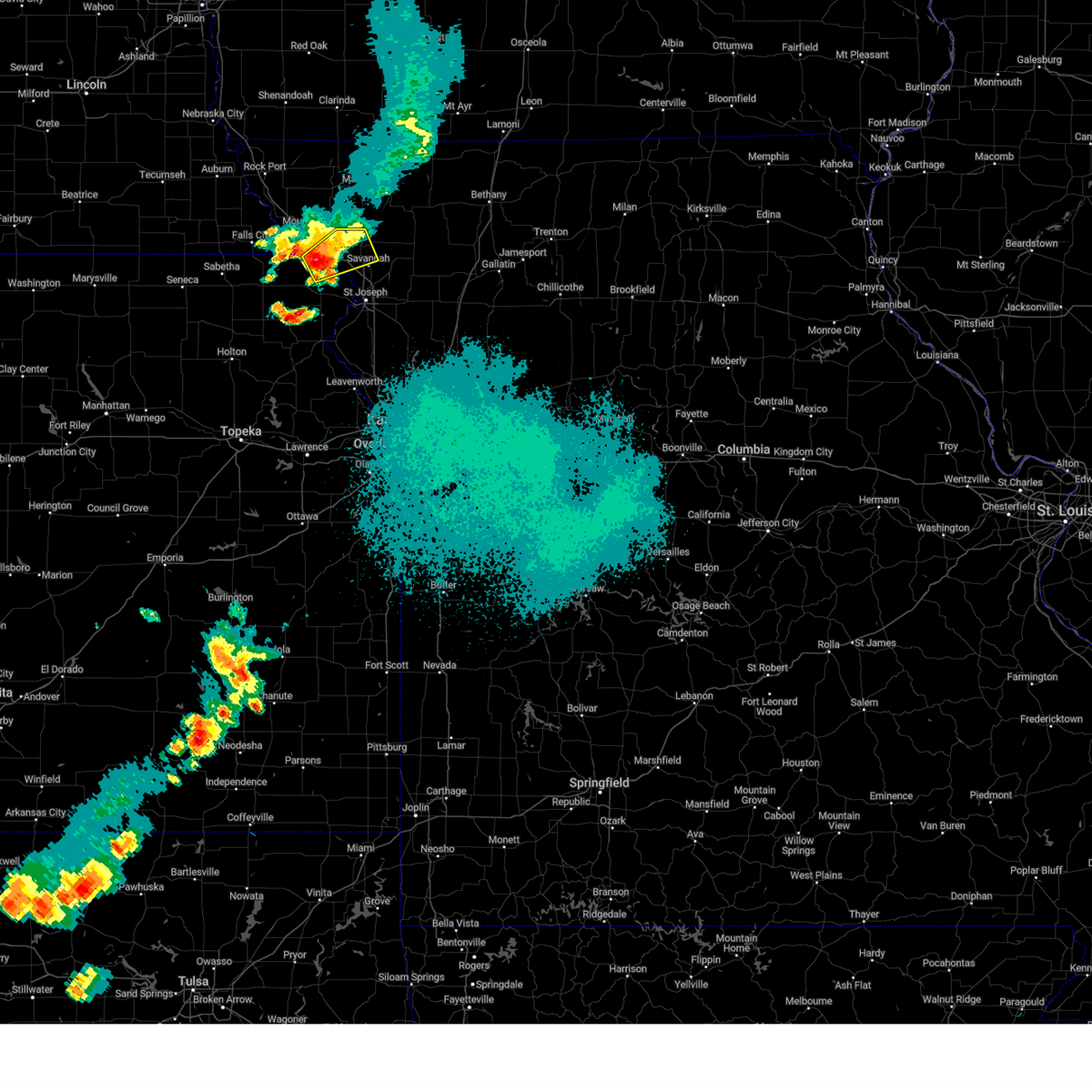 At 920 pm cdt, a severe thunderstorm was located over oregon, or 10 miles northeast of highland, moving northeast at 25 mph (radar indicated). Hazards include 60 mph wind gusts and quarter size hail. Hail damage to vehicles is expected. Expect wind damage to roofs, siding, and trees. At 920 pm cdt, a severe thunderstorm was located over oregon, or 10 miles northeast of highland, moving northeast at 25 mph (radar indicated). Hazards include 60 mph wind gusts and quarter size hail. Hail damage to vehicles is expected. Expect wind damage to roofs, siding, and trees.
|
| 5/7/2023 11:18 PM CDT |
 At 1118 pm cdt, a severe thunderstorm was located near fillmore, or near savannah, moving east at 40 mph (radar indicated). Hazards include 60 mph wind gusts and half dollar size hail. Hail damage to vehicles is expected. expect wind damage to roofs, siding, and trees. locations impacted include, maryville, savannah, oregon, ravenwood, amazonia, forest city, fillmore, barnard, conception junction, parnell, bolckow, rosendale, guilford, clyde, arkoe, rea, conception and helena. this includes interstate 29 between mile markers 58 and 78. hail threat, radar indicated max hail size, 1. 25 in wind threat, radar indicated max wind gust, 60 mph. At 1118 pm cdt, a severe thunderstorm was located near fillmore, or near savannah, moving east at 40 mph (radar indicated). Hazards include 60 mph wind gusts and half dollar size hail. Hail damage to vehicles is expected. expect wind damage to roofs, siding, and trees. locations impacted include, maryville, savannah, oregon, ravenwood, amazonia, forest city, fillmore, barnard, conception junction, parnell, bolckow, rosendale, guilford, clyde, arkoe, rea, conception and helena. this includes interstate 29 between mile markers 58 and 78. hail threat, radar indicated max hail size, 1. 25 in wind threat, radar indicated max wind gust, 60 mph.
|
| 5/7/2023 11:02 PM CDT |
 At 1101 pm cdt, a severe thunderstorm was located 11 miles southeast of maryville, moving east at 50 mph (radar indicated). Hazards include 60 mph wind gusts and half dollar size hail. Hail damage to vehicles is expected. expect wind damage to roofs, siding, and trees. locations impacted include, maryville, savannah, oregon, ravenwood, maitland, amazonia, forest city, fillmore, barnard, conception junction, parnell, bolckow, graham, rosendale, guilford, clyde, arkoe, rea, conception and helena. this includes interstate 29 between mile markers 58 and 78. hail threat, radar indicated max hail size, 1. 25 in wind threat, radar indicated max wind gust, 60 mph. At 1101 pm cdt, a severe thunderstorm was located 11 miles southeast of maryville, moving east at 50 mph (radar indicated). Hazards include 60 mph wind gusts and half dollar size hail. Hail damage to vehicles is expected. expect wind damage to roofs, siding, and trees. locations impacted include, maryville, savannah, oregon, ravenwood, maitland, amazonia, forest city, fillmore, barnard, conception junction, parnell, bolckow, graham, rosendale, guilford, clyde, arkoe, rea, conception and helena. this includes interstate 29 between mile markers 58 and 78. hail threat, radar indicated max hail size, 1. 25 in wind threat, radar indicated max wind gust, 60 mph.
|
| 5/7/2023 10:44 PM CDT |
 At 1043 pm cdt, a severe thunderstorm was located over maitland, or 9 miles east of mound city, moving east at 50 mph (radar indicated). Hazards include 70 mph wind gusts and half dollar size hail. Hail damage to vehicles is expected. expect considerable tree damage. Wind damage is also likely to mobile homes, roofs, and outbuildings. At 1043 pm cdt, a severe thunderstorm was located over maitland, or 9 miles east of mound city, moving east at 50 mph (radar indicated). Hazards include 70 mph wind gusts and half dollar size hail. Hail damage to vehicles is expected. expect considerable tree damage. Wind damage is also likely to mobile homes, roofs, and outbuildings.
|
| 4/20/2023 5:35 AM CDT |
 The severe thunderstorm warning for southeastern atchison, buchanan, clinton, gentry, northern platte, andrew and dekalb counties will expire at 545 am cdt, the storms which prompted the warning have weakened below severe limits, and no longer pose an immediate threat to life or property. therefore, the warning will be allowed to expire. however gusty winds to 50 mph are still possible with these thunderstorms. a severe thunderstorm watch remains in effect until 600 am cdt for northeastern kansas, and north central, northwestern and west central missouri. The severe thunderstorm warning for southeastern atchison, buchanan, clinton, gentry, northern platte, andrew and dekalb counties will expire at 545 am cdt, the storms which prompted the warning have weakened below severe limits, and no longer pose an immediate threat to life or property. therefore, the warning will be allowed to expire. however gusty winds to 50 mph are still possible with these thunderstorms. a severe thunderstorm watch remains in effect until 600 am cdt for northeastern kansas, and north central, northwestern and west central missouri.
|
| 4/20/2023 5:18 AM CDT |
 At 517 am cdt, severe thunderstorms were located along a line extending from near stanberry to near union star to near clarksdale to 6 miles east of rushville, moving east at 40 mph (radar indicated). Hazards include 60 mph wind gusts. Expect damage to roofs, siding, and trees. locations impacted include, st. joseph, cameron, savannah, plattsburg, lathrop, albany, gower, elwood, stanberry, maysville, country club villa, country club, king city, stewartsville, agency, trimble, edgerton, dearborn, camden point and union star. this includes the following highways, interstate 35 in missouri between mile markers 52 and 55. interstate 29 between mile markers 26 and 59. interstate 229 between mile markers 0 and 14. hail threat, radar indicated max hail size, <. 75 in wind threat, radar indicated max wind gust, 60 mph. At 517 am cdt, severe thunderstorms were located along a line extending from near stanberry to near union star to near clarksdale to 6 miles east of rushville, moving east at 40 mph (radar indicated). Hazards include 60 mph wind gusts. Expect damage to roofs, siding, and trees. locations impacted include, st. joseph, cameron, savannah, plattsburg, lathrop, albany, gower, elwood, stanberry, maysville, country club villa, country club, king city, stewartsville, agency, trimble, edgerton, dearborn, camden point and union star. this includes the following highways, interstate 35 in missouri between mile markers 52 and 55. interstate 29 between mile markers 26 and 59. interstate 229 between mile markers 0 and 14. hail threat, radar indicated max hail size, <. 75 in wind threat, radar indicated max wind gust, 60 mph.
|
| 4/20/2023 4:57 AM CDT |
 At 457 am cdt, severe thunderstorms were located along a line extending from 9 miles south of maryville to near savannah to near st. joseph to near atchison, moving east at 50 mph (radar indicated). Hazards include 60 mph wind gusts. expect damage to roofs, siding, and trees At 457 am cdt, severe thunderstorms were located along a line extending from 9 miles south of maryville to near savannah to near st. joseph to near atchison, moving east at 50 mph (radar indicated). Hazards include 60 mph wind gusts. expect damage to roofs, siding, and trees
|
| 4/20/2023 4:42 AM CDT |
 At 442 am cdt, a severe thunderstorm was located near fillmore, or 10 miles west of savannah, moving east at 45 mph (radar indicated). Hazards include 60 mph wind gusts and quarter size hail. Hail damage to vehicles is expected. expect wind damage to roofs, siding, and trees. locations impacted include, st. joseph, savannah, wathena, elwood, highland, troy, country club villa, country club, oregon, amazonia, forest city, fillmore, white cloud, rosendale, severance, rea, leona, st. joseph airport, iowa point and fanning. this includes the following highways, interstate 29 between mile markers 46 and 75. interstate 229 between mile markers 5 and 14. hail threat, radar indicated max hail size, 1. 00 in wind threat, radar indicated max wind gust, 60 mph. At 442 am cdt, a severe thunderstorm was located near fillmore, or 10 miles west of savannah, moving east at 45 mph (radar indicated). Hazards include 60 mph wind gusts and quarter size hail. Hail damage to vehicles is expected. expect wind damage to roofs, siding, and trees. locations impacted include, st. joseph, savannah, wathena, elwood, highland, troy, country club villa, country club, oregon, amazonia, forest city, fillmore, white cloud, rosendale, severance, rea, leona, st. joseph airport, iowa point and fanning. this includes the following highways, interstate 29 between mile markers 46 and 75. interstate 229 between mile markers 5 and 14. hail threat, radar indicated max hail size, 1. 00 in wind threat, radar indicated max wind gust, 60 mph.
|
| 4/20/2023 4:25 AM CDT |
 At 424 am cdt, a severe thunderstorm was located near highland, moving east at 45 mph (radar indicated). Hazards include 60 mph wind gusts and quarter size hail. Hail damage to vehicles is expected. Expect wind damage to roofs, siding, and trees. At 424 am cdt, a severe thunderstorm was located near highland, moving east at 45 mph (radar indicated). Hazards include 60 mph wind gusts and quarter size hail. Hail damage to vehicles is expected. Expect wind damage to roofs, siding, and trees.
|
| 4/20/2023 12:23 AM CDT |
 The severe thunderstorm warning for doniphan, southeastern holt and andrew counties will expire at 1230 am cdt, the storm which prompted the warning has weakened below severe limits, and no longer poses an immediate threat to life or property. therefore, the warning will be allowed to expire. however gusty winds and heavy rain are still possible with this thunderstorm. a severe thunderstorm watch remains in effect until 600 am cdt for northeastern kansas, and northwestern missouri. The severe thunderstorm warning for doniphan, southeastern holt and andrew counties will expire at 1230 am cdt, the storm which prompted the warning has weakened below severe limits, and no longer poses an immediate threat to life or property. therefore, the warning will be allowed to expire. however gusty winds and heavy rain are still possible with this thunderstorm. a severe thunderstorm watch remains in effect until 600 am cdt for northeastern kansas, and northwestern missouri.
|
| 4/20/2023 12:07 AM CDT |
 At 1206 am cdt, a severe thunderstorm was located near amazonia, or 8 miles northeast of troy, moving northeast at 55 mph (radar indicated). Hazards include 60 mph wind gusts and quarter size hail. Hail damage to vehicles is expected. Expect wind damage to roofs, siding, and trees. At 1206 am cdt, a severe thunderstorm was located near amazonia, or 8 miles northeast of troy, moving northeast at 55 mph (radar indicated). Hazards include 60 mph wind gusts and quarter size hail. Hail damage to vehicles is expected. Expect wind damage to roofs, siding, and trees.
|
| 4/4/2023 9:15 PM CDT |
 At 914 pm cdt, severe thunderstorms were located along a line extending from country club villa to near oskaloosa, moving northeast at 55 mph (emergency management). Hazards include 60 mph wind gusts and quarter size hail. Hail damage to vehicles is expected. expect wind damage to roofs, siding, and trees. locations impacted include, st. joseph, atchison, savannah, wathena, elwood, country club villa, country club, agency, union star, amazonia, rushville, easton, lewis and clark village, doniphan, de kalb, cosby, iatan, faucett, helena and lowemont. this includes the following highways, interstate 29 between mile markers 35 and 59. interstate 229 between mile markers 0 and 14. hail threat, observed max hail size, 1. 00 in wind threat, radar indicated max wind gust, 60 mph. At 914 pm cdt, severe thunderstorms were located along a line extending from country club villa to near oskaloosa, moving northeast at 55 mph (emergency management). Hazards include 60 mph wind gusts and quarter size hail. Hail damage to vehicles is expected. expect wind damage to roofs, siding, and trees. locations impacted include, st. joseph, atchison, savannah, wathena, elwood, country club villa, country club, agency, union star, amazonia, rushville, easton, lewis and clark village, doniphan, de kalb, cosby, iatan, faucett, helena and lowemont. this includes the following highways, interstate 29 between mile markers 35 and 59. interstate 229 between mile markers 0 and 14. hail threat, observed max hail size, 1. 00 in wind threat, radar indicated max wind gust, 60 mph.
|
| 4/4/2023 9:01 PM CDT |
 At 901 pm cdt, severe thunderstorms were located along a line extending from near troy to grantville, moving northeast at 45 mph (radar indicated). Hazards include 60 mph wind gusts and quarter size hail. Hail damage to vehicles is expected. Expect wind damage to roofs, siding, and trees. At 901 pm cdt, severe thunderstorms were located along a line extending from near troy to grantville, moving northeast at 45 mph (radar indicated). Hazards include 60 mph wind gusts and quarter size hail. Hail damage to vehicles is expected. Expect wind damage to roofs, siding, and trees.
|
| 4/4/2023 8:42 PM CDT |
 At 842 pm cdt, severe thunderstorms were located along a line extending from near fillmore to near ozawkie, moving northeast at 45 mph (radar indicated). Hazards include 60 mph wind gusts and quarter size hail. Hail damage to vehicles is expected. expect wind damage to roofs, siding, and trees. locations impacted include, st. joseph, atchison, savannah, wathena, elwood, highland, troy, country club villa, country club, effingham, amazonia, rushville, lancaster, denton, lewis and clark village, doniphan, de kalb, severance, farmington and huron. this includes the following highways, interstate 29 between mile markers 40 and 69. interstate 229 between mile markers 0 and 14. hail threat, radar indicated max hail size, 1. 00 in wind threat, radar indicated max wind gust, 60 mph. At 842 pm cdt, severe thunderstorms were located along a line extending from near fillmore to near ozawkie, moving northeast at 45 mph (radar indicated). Hazards include 60 mph wind gusts and quarter size hail. Hail damage to vehicles is expected. expect wind damage to roofs, siding, and trees. locations impacted include, st. joseph, atchison, savannah, wathena, elwood, highland, troy, country club villa, country club, effingham, amazonia, rushville, lancaster, denton, lewis and clark village, doniphan, de kalb, severance, farmington and huron. this includes the following highways, interstate 29 between mile markers 40 and 69. interstate 229 between mile markers 0 and 14. hail threat, radar indicated max hail size, 1. 00 in wind threat, radar indicated max wind gust, 60 mph.
|
| 4/4/2023 8:17 PM CDT |
 At 817 pm cdt, severe thunderstorms were located along a line extending from highland to near silver lake, moving east at 50 mph (radar indicated). Hazards include 60 mph wind gusts and quarter size hail. Hail damage to vehicles is expected. Expect wind damage to roofs, siding, and trees. At 817 pm cdt, severe thunderstorms were located along a line extending from highland to near silver lake, moving east at 50 mph (radar indicated). Hazards include 60 mph wind gusts and quarter size hail. Hail damage to vehicles is expected. Expect wind damage to roofs, siding, and trees.
|
| 2/27/2023 1:26 AM CST |
 At 125 am cst, severe thunderstorms were located along a line extending from near fillmore to elwood to near easton, moving northeast at 55 mph (radar indicated). Hazards include 60 mph wind gusts. Expect damage to roofs, siding, and trees. locations impacted include, st. joseph, leavenworth, savannah, platte city, weston, wathena, elwood, troy, country club villa, country club, agency, dearborn, camden point, amazonia, rushville, tracy, fillmore, lewis and clark village, de kalb and iatan. this includes the following highways, interstate 29 between mile markers 16 and 71. interstate 435 between mile markers 29 and 31. Interstate 229 between mile markers 0 and 14. At 125 am cst, severe thunderstorms were located along a line extending from near fillmore to elwood to near easton, moving northeast at 55 mph (radar indicated). Hazards include 60 mph wind gusts. Expect damage to roofs, siding, and trees. locations impacted include, st. joseph, leavenworth, savannah, platte city, weston, wathena, elwood, troy, country club villa, country club, agency, dearborn, camden point, amazonia, rushville, tracy, fillmore, lewis and clark village, de kalb and iatan. this includes the following highways, interstate 29 between mile markers 16 and 71. interstate 435 between mile markers 29 and 31. Interstate 229 between mile markers 0 and 14.
|
| 2/27/2023 1:22 AM CST |
 At 121 am cst, severe thunderstorms were located along a line extending from near fillmore to amazonia to 6 miles south of elwood, moving northeast at 70 mph (radar indicated). Hazards include 60 mph wind gusts. expect damage to roofs, siding, and trees At 121 am cst, severe thunderstorms were located along a line extending from near fillmore to amazonia to 6 miles south of elwood, moving northeast at 70 mph (radar indicated). Hazards include 60 mph wind gusts. expect damage to roofs, siding, and trees
|
| 2/27/2023 12:58 AM CST |
 At 1258 am cst, severe thunderstorms were located along a line extending from denton to near atchison to near williamstown, moving northeast at 55 mph (radar indicated). Hazards include 60 mph wind gusts. expect damage to roofs, siding, and trees At 1258 am cst, severe thunderstorms were located along a line extending from denton to near atchison to near williamstown, moving northeast at 55 mph (radar indicated). Hazards include 60 mph wind gusts. expect damage to roofs, siding, and trees
|
| 7/7/2022 11:44 PM CDT |
 At 1144 pm cdt, severe thunderstorms were located along a line extending from near amazonia to near country club to near wathena to 6 miles northwest of rushville, moving east at 30 mph (radar indicated). Hazards include 60 mph wind gusts and penny size hail. Expect damage to roofs, siding, and trees. locations impacted include, st. joseph, savannah, wathena, elwood, troy, country club villa, country club, agency, amazonia, doniphan, easton, cosby, st. joseph airport, faucett and helena. this includes the following highways, interstate 29 between mile markers 35 and 60. interstate 229 between mile markers 0 and 14. hail threat, radar indicated max hail size, 0. 75 in wind threat, radar indicated max wind gust, 60 mph. At 1144 pm cdt, severe thunderstorms were located along a line extending from near amazonia to near country club to near wathena to 6 miles northwest of rushville, moving east at 30 mph (radar indicated). Hazards include 60 mph wind gusts and penny size hail. Expect damage to roofs, siding, and trees. locations impacted include, st. joseph, savannah, wathena, elwood, troy, country club villa, country club, agency, amazonia, doniphan, easton, cosby, st. joseph airport, faucett and helena. this includes the following highways, interstate 29 between mile markers 35 and 60. interstate 229 between mile markers 0 and 14. hail threat, radar indicated max hail size, 0. 75 in wind threat, radar indicated max wind gust, 60 mph.
|
| 7/7/2022 11:25 PM CDT |
 At 1125 pm cdt, severe thunderstorms were located along a line extending from near amazonia to near troy to 8 miles southeast of highland to near denton, moving east at 25 mph (radar indicated). Hazards include 60 mph wind gusts and nickel size hail. expect damage to roofs, siding, and trees At 1125 pm cdt, severe thunderstorms were located along a line extending from near amazonia to near troy to 8 miles southeast of highland to near denton, moving east at 25 mph (radar indicated). Hazards include 60 mph wind gusts and nickel size hail. expect damage to roofs, siding, and trees
|
| 7/7/2022 11:07 PM CDT |
 The severe thunderstorm warning for central andrew county will expire at 1115 pm cdt, the storm which prompted the warning has weakened below severe limits, and no longer poses an immediate threat to life or property. therefore, the warning will be allowed to expire. however small hail and gusty winds are still possible with this thunderstorm. The severe thunderstorm warning for central andrew county will expire at 1115 pm cdt, the storm which prompted the warning has weakened below severe limits, and no longer poses an immediate threat to life or property. therefore, the warning will be allowed to expire. however small hail and gusty winds are still possible with this thunderstorm.
|
| 7/7/2022 10:57 PM CDT |
 At 1057 pm cdt, a severe thunderstorm was located near fillmore, or near savannah, moving east at 10 mph (radar indicated). Hazards include 60 mph wind gusts and quarter size hail. Hail damage to vehicles is expected. expect wind damage to roofs, siding, and trees. locations impacted include, savannah, fillmore, rosendale and rea. this includes interstate 29 between mile markers 62 and 66. hail threat, radar indicated max hail size, 1. 00 in wind threat, radar indicated max wind gust, 60 mph. At 1057 pm cdt, a severe thunderstorm was located near fillmore, or near savannah, moving east at 10 mph (radar indicated). Hazards include 60 mph wind gusts and quarter size hail. Hail damage to vehicles is expected. expect wind damage to roofs, siding, and trees. locations impacted include, savannah, fillmore, rosendale and rea. this includes interstate 29 between mile markers 62 and 66. hail threat, radar indicated max hail size, 1. 00 in wind threat, radar indicated max wind gust, 60 mph.
|
| 7/7/2022 10:40 PM CDT |
 At 1040 pm cdt, a severe thunderstorm was located over fillmore, or 7 miles northwest of savannah, moving east at 15 mph (radar indicated). Hazards include 60 mph wind gusts and quarter size hail. Hail damage to vehicles is expected. expect wind damage to roofs, siding, and trees. locations impacted include, savannah, fillmore, bolckow, rosendale and rea. this includes interstate 29 between mile markers 62 and 71. hail threat, radar indicated max hail size, 1. 00 in wind threat, radar indicated max wind gust, 60 mph. At 1040 pm cdt, a severe thunderstorm was located over fillmore, or 7 miles northwest of savannah, moving east at 15 mph (radar indicated). Hazards include 60 mph wind gusts and quarter size hail. Hail damage to vehicles is expected. expect wind damage to roofs, siding, and trees. locations impacted include, savannah, fillmore, bolckow, rosendale and rea. this includes interstate 29 between mile markers 62 and 71. hail threat, radar indicated max hail size, 1. 00 in wind threat, radar indicated max wind gust, 60 mph.
|
| 7/7/2022 10:24 PM CDT |
 At 1024 pm cdt, a severe thunderstorm was located over fillmore, or 11 miles northwest of savannah, moving east at 20 mph (radar indicated). Hazards include 60 mph wind gusts and quarter size hail. Hail damage to vehicles is expected. Expect wind damage to roofs, siding, and trees. At 1024 pm cdt, a severe thunderstorm was located over fillmore, or 11 miles northwest of savannah, moving east at 20 mph (radar indicated). Hazards include 60 mph wind gusts and quarter size hail. Hail damage to vehicles is expected. Expect wind damage to roofs, siding, and trees.
|
| 7/7/2022 2:34 AM CDT |
 At 234 am cdt, severe thunderstorms were located along a line extending from near villisca to near ravenwood to near dearborn, moving northeast at 50 mph (radar indicated). Hazards include 60 mph wind gusts and quarter size hail. Hail damage to vehicles is expected. expect wind damage to roofs, siding, and trees. locations impacted include, st. joseph, maryville, savannah, albany, wathena, elwood, stanberry, maysville, highland, troy, country club villa, country club, king city, grant city, oregon, stewartsville, burlington junction, hopkins, ravenwood and union star. this includes the following highways, interstate 29 between mile markers 44 and 79. interstate 229 between mile markers 2 and 14. hail threat, radar indicated max hail size, 1. 00 in wind threat, radar indicated max wind gust, 60 mph. At 234 am cdt, severe thunderstorms were located along a line extending from near villisca to near ravenwood to near dearborn, moving northeast at 50 mph (radar indicated). Hazards include 60 mph wind gusts and quarter size hail. Hail damage to vehicles is expected. expect wind damage to roofs, siding, and trees. locations impacted include, st. joseph, maryville, savannah, albany, wathena, elwood, stanberry, maysville, highland, troy, country club villa, country club, king city, grant city, oregon, stewartsville, burlington junction, hopkins, ravenwood and union star. this includes the following highways, interstate 29 between mile markers 44 and 79. interstate 229 between mile markers 2 and 14. hail threat, radar indicated max hail size, 1. 00 in wind threat, radar indicated max wind gust, 60 mph.
|
| 7/7/2022 2:07 AM CDT |
 At 206 am cdt, severe thunderstorms were located along a line extending from near shenandoah to near skidmore to near nortonville, moving northeast at 50 mph (radar indicated). Hazards include 60 mph wind gusts and nickel size hail. expect damage to roofs, siding, and trees At 206 am cdt, severe thunderstorms were located along a line extending from near shenandoah to near skidmore to near nortonville, moving northeast at 50 mph (radar indicated). Hazards include 60 mph wind gusts and nickel size hail. expect damage to roofs, siding, and trees
|
| 6/17/2022 12:56 AM CDT |
 The severe thunderstorm warning for central doniphan, northeastern buchanan, northwestern clinton, southern gentry, southeastern holt, andrew and dekalb counties will expire at 100 am cdt, the storms which prompted the warning have weakened below severe limits, or have exited the warned area. therefore, the warning will be allowed to expire. however gusty winds and heavy rain are still possible with these thunderstorms. a severe thunderstorm watch remains in effect until 400 am cdt for northeastern kansas, and north central and northwestern missouri. The severe thunderstorm warning for central doniphan, northeastern buchanan, northwestern clinton, southern gentry, southeastern holt, andrew and dekalb counties will expire at 100 am cdt, the storms which prompted the warning have weakened below severe limits, or have exited the warned area. therefore, the warning will be allowed to expire. however gusty winds and heavy rain are still possible with these thunderstorms. a severe thunderstorm watch remains in effect until 400 am cdt for northeastern kansas, and north central and northwestern missouri.
|
| 6/17/2022 12:21 AM CDT |
 At 1220 am cdt, severe thunderstorms were located along a line extending from 12 miles north of savannah to near fillmore to near highland, moving east at 60 mph (radar indicated). Hazards include 60 mph wind gusts and penny size hail. expect damage to roofs, siding, and trees At 1220 am cdt, severe thunderstorms were located along a line extending from 12 miles north of savannah to near fillmore to near highland, moving east at 60 mph (radar indicated). Hazards include 60 mph wind gusts and penny size hail. expect damage to roofs, siding, and trees
|
| 6/8/2022 12:11 AM CDT |
 At 1209 am cdt, severe thunderstorms were located along a line extending from near ravenwood to 9 miles southwest of stanberry to savannah, moving east at 45 mph. another severe storm was in gentry county near ford city. this storm is moving east at 20 mph (radar indicated). Hazards include 60 mph wind gusts and penny size hail. expect damage to roofs, siding, and trees At 1209 am cdt, severe thunderstorms were located along a line extending from near ravenwood to 9 miles southwest of stanberry to savannah, moving east at 45 mph. another severe storm was in gentry county near ford city. this storm is moving east at 20 mph (radar indicated). Hazards include 60 mph wind gusts and penny size hail. expect damage to roofs, siding, and trees
|
| 6/7/2022 11:55 PM CDT |
 At 1154 pm cdt, severe thunderstorms were located along a line extending from near burlington junction to near maryville to near fillmore, moving east at 35 mph (radar indicated). Hazards include 60 mph wind gusts and penny size hail. Expect damage to roofs, siding, and trees. locations impacted include, maryville, savannah, oregon, burlington junction, hopkins, ravenwood, maitland, skidmore, forest city, fillmore, barnard, conception junction, sheridan, parnell, bolckow, graham, clearmont, elmo, pickering and rosendale. this includes interstate 29 between mile markers 64 and 80. hail threat, radar indicated max hail size, 0. 75 in wind threat, radar indicated max wind gust, 60 mph. At 1154 pm cdt, severe thunderstorms were located along a line extending from near burlington junction to near maryville to near fillmore, moving east at 35 mph (radar indicated). Hazards include 60 mph wind gusts and penny size hail. Expect damage to roofs, siding, and trees. locations impacted include, maryville, savannah, oregon, burlington junction, hopkins, ravenwood, maitland, skidmore, forest city, fillmore, barnard, conception junction, sheridan, parnell, bolckow, graham, clearmont, elmo, pickering and rosendale. this includes interstate 29 between mile markers 64 and 80. hail threat, radar indicated max hail size, 0. 75 in wind threat, radar indicated max wind gust, 60 mph.
|
| 6/7/2022 11:48 PM CDT |
 At 1148 pm cdt, severe thunderstorms were located along a line extending from near fillmore to near highland, moving southeast at 35 mph (radar indicated). Hazards include 60 mph wind gusts and penny size hail. expect damage to roofs, siding, and trees At 1148 pm cdt, severe thunderstorms were located along a line extending from near fillmore to near highland, moving southeast at 35 mph (radar indicated). Hazards include 60 mph wind gusts and penny size hail. expect damage to roofs, siding, and trees
|
| 6/7/2022 11:32 PM CDT |
 At 1132 pm cdt, severe thunderstorms were located along a line extending from 6 miles southwest of blanchard to near skidmore to near mound city, moving east at 35 mph (radar indicated). Hazards include 60 mph wind gusts and penny size hail. expect damage to roofs, siding, and trees At 1132 pm cdt, severe thunderstorms were located along a line extending from 6 miles southwest of blanchard to near skidmore to near mound city, moving east at 35 mph (radar indicated). Hazards include 60 mph wind gusts and penny size hail. expect damage to roofs, siding, and trees
|
| 6/6/2022 4:41 PM CDT |
 At 440 pm cdt, a severe thunderstorm was located near savannah, moving southeast at 40 mph (radar indicated). Hazards include 60 mph wind gusts and quarter size hail. Hail damage to vehicles is expected. Expect wind damage to roofs, siding, and trees. At 440 pm cdt, a severe thunderstorm was located near savannah, moving southeast at 40 mph (radar indicated). Hazards include 60 mph wind gusts and quarter size hail. Hail damage to vehicles is expected. Expect wind damage to roofs, siding, and trees.
|
| 4/29/2022 10:08 PM CDT |
 At 1007 pm cdt, severe thunderstorms were located along a line extending from 6 miles south of ravenwood to 7 miles east of st. joseph to weston, moving east at 35 mph (radar indicated). Hazards include 60 mph wind gusts and nickel size hail. expect damage to roofs, siding, and trees At 1007 pm cdt, severe thunderstorms were located along a line extending from 6 miles south of ravenwood to 7 miles east of st. joseph to weston, moving east at 35 mph (radar indicated). Hazards include 60 mph wind gusts and nickel size hail. expect damage to roofs, siding, and trees
|
| 4/29/2022 9:24 PM CDT |
 At 923 pm cdt, severe thunderstorms were located along a line extending from near white cloud to near denton to near nortonville, moving east at 35 mph (radar indicated). Hazards include 60 mph wind gusts and quarter size hail. Hail damage to vehicles is expected. Expect wind damage to roofs, siding, and trees. At 923 pm cdt, severe thunderstorms were located along a line extending from near white cloud to near denton to near nortonville, moving east at 35 mph (radar indicated). Hazards include 60 mph wind gusts and quarter size hail. Hail damage to vehicles is expected. Expect wind damage to roofs, siding, and trees.
|
| 3/29/2022 9:00 PM CDT |
 At 859 pm cdt, severe thunderstorms were located along a line extending from 10 miles northwest of union star to near country club villa to near gower to near ferrelview to near shawnee, moving east at 55 mph (radar indicated). Hazards include 60 mph wind gusts and quarter size hail. Hail damage to vehicles is expected. expect wind damage to roofs, siding, and trees. locations impacted include, kansas city, overland park, olathe, independence, lee`s summit, st. joseph, shawnee, blue springs, lenexa, leawood, raytown, liberty, gladstone, prairie village, grain valley, lansing, excelsior springs, merriam, cameron and mission. this includes the following highways, interstate 70 in missouri between mile markers 0 and 29. interstate 70 in kansas between mile markers 410 and 423. interstate 35 in missouri between mile markers 0 and 54. interstate 35 in kansas between mile markers 220 and 235. interstate 29 between mile markers 0 and 54. interstate 635 between mile markers 0 and 12. interstate 470 between mile markers 0 and 5, and between mile markers 9 and 16. interstate 435 between mile markers 0 and 83. interstate 229 between mile markers 0 and 2. kansas turnpike between mile markers 219 and 226. hail threat, radar indicated max hail size, 1. 00 in wind threat, radar indicated max wind gust, 60 mph. At 859 pm cdt, severe thunderstorms were located along a line extending from 10 miles northwest of union star to near country club villa to near gower to near ferrelview to near shawnee, moving east at 55 mph (radar indicated). Hazards include 60 mph wind gusts and quarter size hail. Hail damage to vehicles is expected. expect wind damage to roofs, siding, and trees. locations impacted include, kansas city, overland park, olathe, independence, lee`s summit, st. joseph, shawnee, blue springs, lenexa, leawood, raytown, liberty, gladstone, prairie village, grain valley, lansing, excelsior springs, merriam, cameron and mission. this includes the following highways, interstate 70 in missouri between mile markers 0 and 29. interstate 70 in kansas between mile markers 410 and 423. interstate 35 in missouri between mile markers 0 and 54. interstate 35 in kansas between mile markers 220 and 235. interstate 29 between mile markers 0 and 54. interstate 635 between mile markers 0 and 12. interstate 470 between mile markers 0 and 5, and between mile markers 9 and 16. interstate 435 between mile markers 0 and 83. interstate 229 between mile markers 0 and 2. kansas turnpike between mile markers 219 and 226. hail threat, radar indicated max hail size, 1. 00 in wind threat, radar indicated max wind gust, 60 mph.
|
| 3/29/2022 8:47 PM CDT |
 At 847 pm cdt, severe thunderstorms were located along a line extending from 7 miles northeast of savannah to lenexa, moving east at 80 mph (radar indicated). Hazards include 60 mph wind gusts and quarter size hail. Hail damage to vehicles is expected. Expect wind damage to roofs, siding, and trees. At 847 pm cdt, severe thunderstorms were located along a line extending from 7 miles northeast of savannah to lenexa, moving east at 80 mph (radar indicated). Hazards include 60 mph wind gusts and quarter size hail. Hail damage to vehicles is expected. Expect wind damage to roofs, siding, and trees.
|
| 3/29/2022 8:21 PM CDT |
 At 821 pm cdt, severe thunderstorms were located along a line extending from oregon to near atchison, moving northeast at 35 mph (radar indicated). Hazards include 60 mph wind gusts and nickel size hail. expect damage to roofs, siding, and trees At 821 pm cdt, severe thunderstorms were located along a line extending from oregon to near atchison, moving northeast at 35 mph (radar indicated). Hazards include 60 mph wind gusts and nickel size hail. expect damage to roofs, siding, and trees
|
| 10/24/2021 2:40 PM CDT |
 At 240 pm cdt, a severe thunderstorm capable of producing a tornado was located near country club villa, moving northeast at 45 mph (radar indicated rotation). Hazards include tornado and quarter size hail. Flying debris will be dangerous to those caught without shelter. mobile homes will be damaged or destroyed. damage to roofs, windows, and vehicles will occur. tree damage is likely. locations impacted include, st. joseph, savannah, elwood, maysville, country club villa, country club, union star, amazonia, clarksdale, cosby, amity, st. joseph airport, fairport and helena. this includes the following highways, interstate 29 between mile markers 45 and 58. Interstate 229 between mile markers 2 and 14. At 240 pm cdt, a severe thunderstorm capable of producing a tornado was located near country club villa, moving northeast at 45 mph (radar indicated rotation). Hazards include tornado and quarter size hail. Flying debris will be dangerous to those caught without shelter. mobile homes will be damaged or destroyed. damage to roofs, windows, and vehicles will occur. tree damage is likely. locations impacted include, st. joseph, savannah, elwood, maysville, country club villa, country club, union star, amazonia, clarksdale, cosby, amity, st. joseph airport, fairport and helena. this includes the following highways, interstate 29 between mile markers 45 and 58. Interstate 229 between mile markers 2 and 14.
|
| 10/24/2021 2:39 PM CDT |
 At 238 pm cdt, a severe thunderstorm capable of producing a tornado was located near savannah, moving northeast at 35 mph (radar indicated rotation). Hazards include tornado and quarter size hail. Flying debris will be dangerous to those caught without shelter. mobile homes will be damaged or destroyed. damage to roofs, windows, and vehicles will occur. Tree damage is likely. At 238 pm cdt, a severe thunderstorm capable of producing a tornado was located near savannah, moving northeast at 35 mph (radar indicated rotation). Hazards include tornado and quarter size hail. Flying debris will be dangerous to those caught without shelter. mobile homes will be damaged or destroyed. damage to roofs, windows, and vehicles will occur. Tree damage is likely.
|
| 10/24/2021 2:31 PM CDT |
 At 230 pm cdt, a severe thunderstorm capable of producing a tornado was located over country club, or over country club villa, moving northeast at 40 mph (radar indicated rotation). Hazards include tornado. Flying debris will be dangerous to those caught without shelter. mobile homes will be damaged or destroyed. damage to roofs, windows, and vehicles will occur. Tree damage is likely. At 230 pm cdt, a severe thunderstorm capable of producing a tornado was located over country club, or over country club villa, moving northeast at 40 mph (radar indicated rotation). Hazards include tornado. Flying debris will be dangerous to those caught without shelter. mobile homes will be damaged or destroyed. damage to roofs, windows, and vehicles will occur. Tree damage is likely.
|
| 10/24/2021 2:05 PM CDT |
 At 204 pm cdt, a severe thunderstorm was located over troy, moving northeast at 45 mph (radar indicated). Hazards include 60 mph wind gusts and quarter size hail. Hail damage to vehicles is expected. Expect wind damage to roofs, siding, and trees. At 204 pm cdt, a severe thunderstorm was located over troy, moving northeast at 45 mph (radar indicated). Hazards include 60 mph wind gusts and quarter size hail. Hail damage to vehicles is expected. Expect wind damage to roofs, siding, and trees.
|
| 8/20/2021 9:04 PM CDT |
 At 904 pm cdt, severe thunderstorms were located along a line extending from 12 miles west of stanberry to near union star to near elwood, moving east at 55 mph (radar indicated). Hazards include 60 mph wind gusts and penny size hail. Expect damage to roofs, siding, and trees. locations impacted include, st. joseph, savannah, wathena, elwood, maysville, country club villa, country club, king city, stewartsville, agency, union star, amazonia, clarksdale, easton, cosby, amity, rea, st. joseph airport and helena. this includes the following highways, interstate 29 between mile markers 40 and 58. interstate 229 between mile markers 0 and 14. hail threat, radar indicated max hail size, 0. 75 in wind threat, radar indicated max wind gust, 60 mph. At 904 pm cdt, severe thunderstorms were located along a line extending from 12 miles west of stanberry to near union star to near elwood, moving east at 55 mph (radar indicated). Hazards include 60 mph wind gusts and penny size hail. Expect damage to roofs, siding, and trees. locations impacted include, st. joseph, savannah, wathena, elwood, maysville, country club villa, country club, king city, stewartsville, agency, union star, amazonia, clarksdale, easton, cosby, amity, rea, st. joseph airport and helena. this includes the following highways, interstate 29 between mile markers 40 and 58. interstate 229 between mile markers 0 and 14. hail threat, radar indicated max hail size, 0. 75 in wind threat, radar indicated max wind gust, 60 mph.
|
| 8/20/2021 8:52 PM CDT |
 At 852 pm cdt, severe thunderstorms were located along a line extending from 7 miles east of maitland to savannah to near troy, moving east at 55 mph (radar indicated). Hazards include 60 mph wind gusts and penny size hail. Expect damage to roofs, siding, and trees. locations impacted include, st. joseph, savannah, wathena, elwood, maysville, highland, troy, country club villa, country club, king city, oregon, stewartsville, agency, union star, maitland, amazonia, clarksdale, forest city, fillmore and easton. this includes the following highways, interstate 29 between mile markers 40 and 77. interstate 229 between mile markers 0 and 14. hail threat, radar indicated max hail size, 0. 75 in wind threat, radar indicated max wind gust, 60 mph. At 852 pm cdt, severe thunderstorms were located along a line extending from 7 miles east of maitland to savannah to near troy, moving east at 55 mph (radar indicated). Hazards include 60 mph wind gusts and penny size hail. Expect damage to roofs, siding, and trees. locations impacted include, st. joseph, savannah, wathena, elwood, maysville, highland, troy, country club villa, country club, king city, oregon, stewartsville, agency, union star, maitland, amazonia, clarksdale, forest city, fillmore and easton. this includes the following highways, interstate 29 between mile markers 40 and 77. interstate 229 between mile markers 0 and 14. hail threat, radar indicated max hail size, 0. 75 in wind threat, radar indicated max wind gust, 60 mph.
|
| 8/20/2021 8:31 PM CDT |
 At 831 pm cdt, severe thunderstorms were located along a line extending from 6 miles north of mound city to near oregon to near denton, moving east at 50 mph (radar indicated). Hazards include 60 mph wind gusts and half dollar size hail. Hail damage to vehicles is expected. Expect wind damage to roofs, siding, and trees. At 831 pm cdt, severe thunderstorms were located along a line extending from 6 miles north of mound city to near oregon to near denton, moving east at 50 mph (radar indicated). Hazards include 60 mph wind gusts and half dollar size hail. Hail damage to vehicles is expected. Expect wind damage to roofs, siding, and trees.
|
| 7/10/2021 2:05 AM CDT |
 At 205 am cdt, severe thunderstorms were located along a line extending from irena to near troy, moving southeast at 45 mph (radar indicated). Hazards include 70 mph wind gusts and penny size hail. Expect considerable tree damage. damage is likely to mobile homes, roofs, and outbuildings. Locations impacted include, maryville, savannah, albany, stanberry, mound city, maysville, country club villa, country club, king city, grant city, oregon, burlington junction, hopkins, ravenwood, union star, maitland, amazonia, skidmore, forest city and fillmore. At 205 am cdt, severe thunderstorms were located along a line extending from irena to near troy, moving southeast at 45 mph (radar indicated). Hazards include 70 mph wind gusts and penny size hail. Expect considerable tree damage. damage is likely to mobile homes, roofs, and outbuildings. Locations impacted include, maryville, savannah, albany, stanberry, mound city, maysville, country club villa, country club, king city, grant city, oregon, burlington junction, hopkins, ravenwood, union star, maitland, amazonia, skidmore, forest city and fillmore.
|
| 7/10/2021 1:40 AM CDT |
 At 139 am cdt, severe thunderstorms were located along a line extending from near athelstan to hiawatha, moving southeast at 45 mph (radar indicated). Hazards include 70 mph wind gusts and penny size hail. Expect considerable tree damage. Damage is likely to mobile homes, roofs, and outbuildings. At 139 am cdt, severe thunderstorms were located along a line extending from near athelstan to hiawatha, moving southeast at 45 mph (radar indicated). Hazards include 70 mph wind gusts and penny size hail. Expect considerable tree damage. Damage is likely to mobile homes, roofs, and outbuildings.
|
| 6/24/2021 8:37 PM CDT |
 At 837 pm cdt, severe thunderstorms were located along a line extending from near clarksdale to near st. joseph to near troy to near denton, moving southeast at 20 mph (radar indicated). Hazards include 60 mph wind gusts and penny size hail. expect damage to roofs, siding, and trees At 837 pm cdt, severe thunderstorms were located along a line extending from near clarksdale to near st. joseph to near troy to near denton, moving southeast at 20 mph (radar indicated). Hazards include 60 mph wind gusts and penny size hail. expect damage to roofs, siding, and trees
|
| 6/24/2021 7:53 PM CDT | Storm damage reported in andrew county MO, 0.4 miles NE of Savannah, MO |
| 6/24/2021 7:53 PM CDT |
 The severe thunderstorm warning for central doniphan, southeastern holt and andrew counties will expire at 800 pm cdt, the storms which prompted the warning have weakened below severe limits, and no longer pose an immediate threat to life or property. therefore, the warning will be allowed to expire. however gusty winds are still possible with these thunderstorms. a tornado watch remains in effect until 1000 pm cdt for northeastern kansas, and northwestern missouri. The severe thunderstorm warning for central doniphan, southeastern holt and andrew counties will expire at 800 pm cdt, the storms which prompted the warning have weakened below severe limits, and no longer pose an immediate threat to life or property. therefore, the warning will be allowed to expire. however gusty winds are still possible with these thunderstorms. a tornado watch remains in effect until 1000 pm cdt for northeastern kansas, and northwestern missouri.
|
| 6/24/2021 7:34 PM CDT |
 At 733 pm cdt, severe thunderstorms were located along a line extending from near fillmore to near oregon to near forest city, moving southeast at 30 mph (radar indicated). Hazards include 60 mph wind gusts and penny size hail. Expect damage to roofs, siding, and trees. locations impacted include, st. Joseph, savannah, highland, troy, country club villa, country club, oregon, amazonia, forest city, fillmore, white cloud, rosendale, rea, iowa point and fanning. At 733 pm cdt, severe thunderstorms were located along a line extending from near fillmore to near oregon to near forest city, moving southeast at 30 mph (radar indicated). Hazards include 60 mph wind gusts and penny size hail. Expect damage to roofs, siding, and trees. locations impacted include, st. Joseph, savannah, highland, troy, country club villa, country club, oregon, amazonia, forest city, fillmore, white cloud, rosendale, rea, iowa point and fanning.
|
| 6/24/2021 7:17 PM CDT |
 At 717 pm cdt, severe thunderstorms were located along a line extending from near maitland to near oregon to near white cloud, moving southeast at 30 mph (radar indicated). Hazards include 60 mph wind gusts and penny size hail. expect damage to roofs, siding, and trees At 717 pm cdt, severe thunderstorms were located along a line extending from near maitland to near oregon to near white cloud, moving southeast at 30 mph (radar indicated). Hazards include 60 mph wind gusts and penny size hail. expect damage to roofs, siding, and trees
|
| 6/20/2021 6:35 PM CDT | Golf Ball sized hail reported 6.9 miles WNW of Savannah, MO, reporrted near hwy 169 and county road 311. |
| 6/20/2021 6:24 PM CDT |
 At 624 pm cdt, a severe thunderstorm was located near country club villa, moving east at 25 mph (radar indicated). Hazards include 60 mph wind gusts and quarter size hail. Hail damage to vehicles is expected. Expect wind damage to roofs, siding, and trees. At 624 pm cdt, a severe thunderstorm was located near country club villa, moving east at 25 mph (radar indicated). Hazards include 60 mph wind gusts and quarter size hail. Hail damage to vehicles is expected. Expect wind damage to roofs, siding, and trees.
|
| 6/11/2021 3:10 PM CDT |
 The severe thunderstorm warning for east central doniphan, leavenworth, southeastern atchison, buchanan, northwestern platte, southeastern andrew and northwestern dekalb counties will expire at 315 pm cdt, the storms which prompted the warning have weakened below severe limits, and have exited the warned area. therefore, the warning will be allowed to expire. however small hail and gusty winds are still possible with these thunderstorms. a severe thunderstorm watch remains in effect until 500 pm cdt for northeastern kansas, and northwestern missouri. a severe thunderstorm watch also remains in effect until 700 pm cdt for northeastern kansas, and northwestern and west central missouri. The severe thunderstorm warning for east central doniphan, leavenworth, southeastern atchison, buchanan, northwestern platte, southeastern andrew and northwestern dekalb counties will expire at 315 pm cdt, the storms which prompted the warning have weakened below severe limits, and have exited the warned area. therefore, the warning will be allowed to expire. however small hail and gusty winds are still possible with these thunderstorms. a severe thunderstorm watch remains in effect until 500 pm cdt for northeastern kansas, and northwestern missouri. a severe thunderstorm watch also remains in effect until 700 pm cdt for northeastern kansas, and northwestern and west central missouri.
|
| 6/11/2021 2:56 PM CDT |
 At 256 pm cdt, severe thunderstorms were located along a line extending from clarksdale to camden point to near tonganoxie, moving southeast at 25 mph (radar indicated). Hazards include 70 mph wind gusts and half dollar size hail. Hail damage to vehicles is expected. expect considerable tree damage. wind damage is also likely to mobile homes, roofs, and outbuildings. locations impacted include, st. Joseph, leavenworth, lansing, savannah, tonganoxie, weston, wathena, elwood, country club villa, country club, agency, dearborn, camden point, union star, amazonia, rushville, easton, tracy, lewis and clark village and reno. At 256 pm cdt, severe thunderstorms were located along a line extending from clarksdale to camden point to near tonganoxie, moving southeast at 25 mph (radar indicated). Hazards include 70 mph wind gusts and half dollar size hail. Hail damage to vehicles is expected. expect considerable tree damage. wind damage is also likely to mobile homes, roofs, and outbuildings. locations impacted include, st. Joseph, leavenworth, lansing, savannah, tonganoxie, weston, wathena, elwood, country club villa, country club, agency, dearborn, camden point, union star, amazonia, rushville, easton, tracy, lewis and clark village and reno.
|
| 6/11/2021 2:40 PM CDT |
 At 240 pm cdt, severe thunderstorms were located along a line extending from 7 miles northwest of clarksdale to near weston to mclouth, moving east at 25 mph (trained weather spotters). Hazards include two inch hail and 70 mph wind gusts. People and animals outdoors will be injured. expect hail damage to roofs, siding, windows, and vehicles. expect considerable tree damage. wind damage is also likely to mobile homes, roofs, and outbuildings. Locations impacted include, dearborn, tracy, camden point, leavenworth and lansing. At 240 pm cdt, severe thunderstorms were located along a line extending from 7 miles northwest of clarksdale to near weston to mclouth, moving east at 25 mph (trained weather spotters). Hazards include two inch hail and 70 mph wind gusts. People and animals outdoors will be injured. expect hail damage to roofs, siding, windows, and vehicles. expect considerable tree damage. wind damage is also likely to mobile homes, roofs, and outbuildings. Locations impacted include, dearborn, tracy, camden point, leavenworth and lansing.
|
| 6/11/2021 2:12 PM CDT |
 At 212 pm cdt, severe thunderstorms were located along a line extending from near savannah to lewis and clark village to near ozawkie, moving southeast at 25 mph (radar indicated). Hazards include 70 mph wind gusts and quarter size hail. Hail damage to vehicles is expected. expect considerable tree damage. wind damage is also likely to mobile homes, roofs, and outbuildings. severe thunderstorms will be near, amazonia and rushville around 215 pm cdt. savannah and lewis and clark village around 220 pm cdt. st. joseph, country club villa and country club around 225 pm cdt. other locations in the path of these severe thunderstorms include weston, dearborn, tonganoxie, camden point and tracy. this includes the following highways, interstate 29 between mile markers 21 and 69. interstate 229 between mile markers 0 and 14. Kansas turnpike between mile markers 206 and 209. At 212 pm cdt, severe thunderstorms were located along a line extending from near savannah to lewis and clark village to near ozawkie, moving southeast at 25 mph (radar indicated). Hazards include 70 mph wind gusts and quarter size hail. Hail damage to vehicles is expected. expect considerable tree damage. wind damage is also likely to mobile homes, roofs, and outbuildings. severe thunderstorms will be near, amazonia and rushville around 215 pm cdt. savannah and lewis and clark village around 220 pm cdt. st. joseph, country club villa and country club around 225 pm cdt. other locations in the path of these severe thunderstorms include weston, dearborn, tonganoxie, camden point and tracy. this includes the following highways, interstate 29 between mile markers 21 and 69. interstate 229 between mile markers 0 and 14. Kansas turnpike between mile markers 206 and 209.
|
| 6/11/2021 1:41 PM CDT |
 At 140 pm cdt, severe thunderstorms were located along a line extending from oregon to near lancaster to near denison, moving east at 30 mph (radar indicated). Hazards include 70 mph wind gusts and quarter size hail. Hail damage to vehicles is expected. expect considerable tree damage. wind damage is also likely to mobile homes, roofs, and outbuildings. severe thunderstorms will be near, oregon, forest city and denton around 145 pm cdt. fillmore around 155 pm cdt. atchison around 200 pm cdt. other locations in the path of these severe thunderstorms include amazonia, rushville, lewis and clark village and savannah. this includes the following highways, interstate 29 between mile markers 56 and 89. Interstate 229 between mile markers 4 and 14. At 140 pm cdt, severe thunderstorms were located along a line extending from oregon to near lancaster to near denison, moving east at 30 mph (radar indicated). Hazards include 70 mph wind gusts and quarter size hail. Hail damage to vehicles is expected. expect considerable tree damage. wind damage is also likely to mobile homes, roofs, and outbuildings. severe thunderstorms will be near, oregon, forest city and denton around 145 pm cdt. fillmore around 155 pm cdt. atchison around 200 pm cdt. other locations in the path of these severe thunderstorms include amazonia, rushville, lewis and clark village and savannah. this includes the following highways, interstate 29 between mile markers 56 and 89. Interstate 229 between mile markers 4 and 14.
|
| 10/12/2020 12:08 AM CDT |
 At 1207 am cdt, severe thunderstorms were located along a line extending from 8 miles east of lenox to near fillmore, moving east at 50 mph (radar indicated). Hazards include 60 mph wind gusts. Expect damage to roofs, siding, and trees. locations impacted include, st. Joseph, maryville, savannah, wathena, elwood, stanberry, mound city, highland, troy, country club villa, country club, grant city, oregon, burlington junction, hopkins, ravenwood, maitland, amazonia, skidmore and forest city. At 1207 am cdt, severe thunderstorms were located along a line extending from 8 miles east of lenox to near fillmore, moving east at 50 mph (radar indicated). Hazards include 60 mph wind gusts. Expect damage to roofs, siding, and trees. locations impacted include, st. Joseph, maryville, savannah, wathena, elwood, stanberry, mound city, highland, troy, country club villa, country club, grant city, oregon, burlington junction, hopkins, ravenwood, maitland, amazonia, skidmore and forest city.
|
| 10/11/2020 11:36 PM CDT |
 At 1135 pm cdt, severe thunderstorms were located along a line extending from 7 miles southeast of villisca to 6 miles northeast of reserve, moving east at 50 mph (radar indicated). Hazards include 70 mph wind gusts. Expect considerable tree damage. Damage is likely to mobile homes, roofs, and outbuildings. At 1135 pm cdt, severe thunderstorms were located along a line extending from 7 miles southeast of villisca to 6 miles northeast of reserve, moving east at 50 mph (radar indicated). Hazards include 70 mph wind gusts. Expect considerable tree damage. Damage is likely to mobile homes, roofs, and outbuildings.
|
| 7/9/2020 3:06 AM CDT |
 The severe thunderstorm warning for atchison, holt, nodaway and western andrew counties will expire at 315 am cdt, the storms which prompted the warning have weakened below severe limits, and no longer pose an immediate threat to life or property. therefore, the warning will be allowed to expire. however gusty winds are still possible with these thunderstorms. a severe thunderstorm watch remains in effect until 1000 am cdt for northeastern kansas, and northwestern missouri. The severe thunderstorm warning for atchison, holt, nodaway and western andrew counties will expire at 315 am cdt, the storms which prompted the warning have weakened below severe limits, and no longer pose an immediate threat to life or property. therefore, the warning will be allowed to expire. however gusty winds are still possible with these thunderstorms. a severe thunderstorm watch remains in effect until 1000 am cdt for northeastern kansas, and northwestern missouri.
|
| 7/9/2020 2:40 AM CDT |
 At 240 am cdt, severe thunderstorms were located along a line extending from craig to near willis to near hoyt, moving east at 55 mph (radar indicated). Hazards include 60 mph wind gusts. expect damage to roofs, siding, and trees At 240 am cdt, severe thunderstorms were located along a line extending from craig to near willis to near hoyt, moving east at 55 mph (radar indicated). Hazards include 60 mph wind gusts. expect damage to roofs, siding, and trees
|
| 7/9/2020 2:09 AM CDT |
 At 209 am cdt, severe thunderstorms were located along a line extending from near auburn to near oneida to 7 miles south of onaga, moving east at 55 mph (radar indicated). Hazards include 60 mph wind gusts. expect damage to roofs, siding, and trees At 209 am cdt, severe thunderstorms were located along a line extending from near auburn to near oneida to 7 miles south of onaga, moving east at 55 mph (radar indicated). Hazards include 60 mph wind gusts. expect damage to roofs, siding, and trees
|
| 7/1/2020 4:11 AM CDT |
 At 410 am cdt, severe thunderstorms were located along a line extending from near country club to 6 miles northeast of rushville to near atchison, moving southeast at 25 mph (radar indicated). Hazards include 60 mph wind gusts and quarter size hail. Hail damage to vehicles is expected. expect wind damage to roofs, siding, and trees. locations impacted include, st. Joseph, leavenworth, atchison, savannah, weston, wathena, elwood, troy, country club villa, country club, agency, edgerton, dearborn, camden point, amazonia, rushville, denton, lewis and clark village, doniphan and easton. At 410 am cdt, severe thunderstorms were located along a line extending from near country club to 6 miles northeast of rushville to near atchison, moving southeast at 25 mph (radar indicated). Hazards include 60 mph wind gusts and quarter size hail. Hail damage to vehicles is expected. expect wind damage to roofs, siding, and trees. locations impacted include, st. Joseph, leavenworth, atchison, savannah, weston, wathena, elwood, troy, country club villa, country club, agency, edgerton, dearborn, camden point, amazonia, rushville, denton, lewis and clark village, doniphan and easton.
|
| 7/1/2020 3:54 AM CDT |
 At 353 am cdt, severe thunderstorms were located along a line extending from 6 miles west of amazonia to near troy to near denton, moving southeast at 40 mph (radar indicated). Hazards include 60 mph wind gusts and quarter size hail. Hail damage to vehicles is expected. Expect wind damage to roofs, siding, and trees. At 353 am cdt, severe thunderstorms were located along a line extending from 6 miles west of amazonia to near troy to near denton, moving southeast at 40 mph (radar indicated). Hazards include 60 mph wind gusts and quarter size hail. Hail damage to vehicles is expected. Expect wind damage to roofs, siding, and trees.
|
| 6/28/2020 4:57 AM CDT |
 At 456 am cdt, severe thunderstorms were located along a line extending from near white cloud to near highland to everest to near whiting, moving east at 40 mph (radar indicated). Hazards include 60 mph wind gusts and penny size hail. expect damage to roofs, siding, and trees At 456 am cdt, severe thunderstorms were located along a line extending from near white cloud to near highland to everest to near whiting, moving east at 40 mph (radar indicated). Hazards include 60 mph wind gusts and penny size hail. expect damage to roofs, siding, and trees
|
| 6/28/2020 4:57 AM CDT |
 The national weather service in pleasant hill has issued a * severe thunderstorm warning for. doniphan county in northeastern kansas. atchison county in northeastern kansas. buchanan county in northwestern missouri. Southeastern holt county in northwestern missouri. The national weather service in pleasant hill has issued a * severe thunderstorm warning for. doniphan county in northeastern kansas. atchison county in northeastern kansas. buchanan county in northwestern missouri. Southeastern holt county in northwestern missouri.
|
| 6/27/2020 1:15 AM CDT |
 At 115 am cdt, a severe thunderstorm was located near wathena, moving southeast at 25 mph (radar indicated). Hazards include 70 mph wind gusts and quarter size hail. Hail damage to vehicles is expected. expect considerable tree damage. wind damage is also likely to mobile homes, roofs, and outbuildings. locations impacted include, st. joseph, savannah, wathena, elwood, country club villa, country club, agency, amazonia, easton, cosby, st. Joseph airport, faucett and helena. At 115 am cdt, a severe thunderstorm was located near wathena, moving southeast at 25 mph (radar indicated). Hazards include 70 mph wind gusts and quarter size hail. Hail damage to vehicles is expected. expect considerable tree damage. wind damage is also likely to mobile homes, roofs, and outbuildings. locations impacted include, st. joseph, savannah, wathena, elwood, country club villa, country club, agency, amazonia, easton, cosby, st. Joseph airport, faucett and helena.
|
| 6/27/2020 1:07 AM CDT |
 At 107 am cdt, a severe thunderstorm was located near amazonia, or near wathena, moving southeast at 25 mph (radar indicated). Hazards include 60 mph wind gusts and quarter size hail. Hail damage to vehicles is expected. Expect wind damage to roofs, siding, and trees. At 107 am cdt, a severe thunderstorm was located near amazonia, or near wathena, moving southeast at 25 mph (radar indicated). Hazards include 60 mph wind gusts and quarter size hail. Hail damage to vehicles is expected. Expect wind damage to roofs, siding, and trees.
|
| 6/27/2020 12:53 AM CDT |
 At 1253 am cdt, a severe thunderstorm was located near oregon, or 8 miles north of troy, moving southeast at 25 mph (radar indicated). Hazards include 60 mph wind gusts and quarter size hail. Hail damage to vehicles is expected. expect wind damage to roofs, siding, and trees. locations impacted include, st. joseph, savannah, wathena, elwood, highland, troy, country club villa, country club, oregon, amazonia, forest city, fillmore, white cloud, rosendale, severance, leona, st. Joseph airport, bendena, iowa point and fanning. At 1253 am cdt, a severe thunderstorm was located near oregon, or 8 miles north of troy, moving southeast at 25 mph (radar indicated). Hazards include 60 mph wind gusts and quarter size hail. Hail damage to vehicles is expected. expect wind damage to roofs, siding, and trees. locations impacted include, st. joseph, savannah, wathena, elwood, highland, troy, country club villa, country club, oregon, amazonia, forest city, fillmore, white cloud, rosendale, severance, leona, st. Joseph airport, bendena, iowa point and fanning.
|
| 6/27/2020 12:50 AM CDT |
 At 1250 am cdt, a severe thunderstorm was located near oregon, or 7 miles northeast of highland, moving southeast at 25 mph (radar indicated). Hazards include 60 mph wind gusts. expect damage to roofs, siding, and trees At 1250 am cdt, a severe thunderstorm was located near oregon, or 7 miles northeast of highland, moving southeast at 25 mph (radar indicated). Hazards include 60 mph wind gusts. expect damage to roofs, siding, and trees
|
| 6/5/2020 3:26 AM CDT |
 The severe thunderstorm warning for southeastern doniphan, eastern atchison, buchanan, gentry, eastern andrew and northwestern dekalb counties will expire at 330 am cdt, the storms which prompted the warning have moved out of the area. therefore, the warning will be allowed to expire. however gusty winds are still possible with these thunderstorms. a severe thunderstorm watch remains in effect until 500 am cdt for northeastern kansas, and northwestern and west central missouri. remember, a severe thunderstorm warning still remains in effect for gentry, dekalb, buchanan, and atchison ks counties. The severe thunderstorm warning for southeastern doniphan, eastern atchison, buchanan, gentry, eastern andrew and northwestern dekalb counties will expire at 330 am cdt, the storms which prompted the warning have moved out of the area. therefore, the warning will be allowed to expire. however gusty winds are still possible with these thunderstorms. a severe thunderstorm watch remains in effect until 500 am cdt for northeastern kansas, and northwestern and west central missouri. remember, a severe thunderstorm warning still remains in effect for gentry, dekalb, buchanan, and atchison ks counties.
|
| 6/5/2020 3:14 AM CDT |
 At 313 am cdt, severe thunderstorms were located along a line extending from near king city to near country club villa to 6 miles northwest of rushville, moving east at 30 mph (radar indicated). Hazards include 70 mph wind gusts and quarter size hail. Hail damage to vehicles is expected. expect considerable tree damage. wind damage is also likely to mobile homes, roofs, and outbuildings. locations impacted include, st. Joseph, atchison, savannah, albany, wathena, elwood, stanberry, country club villa, country club, king city, agency, union star, rushville, clarksdale, lewis and clark village, doniphan, easton, de kalb, cosby and darlington. At 313 am cdt, severe thunderstorms were located along a line extending from near king city to near country club villa to 6 miles northwest of rushville, moving east at 30 mph (radar indicated). Hazards include 70 mph wind gusts and quarter size hail. Hail damage to vehicles is expected. expect considerable tree damage. wind damage is also likely to mobile homes, roofs, and outbuildings. locations impacted include, st. Joseph, atchison, savannah, albany, wathena, elwood, stanberry, country club villa, country club, king city, agency, union star, rushville, clarksdale, lewis and clark village, doniphan, easton, de kalb, cosby and darlington.
|
| 6/5/2020 3:00 AM CDT |
 At 259 am cdt, severe thunderstorms were located along a line extending from near stanberry to near amazonia to near denton, moving east at 30 mph (radar indicated). Hazards include 70 mph wind gusts and quarter size hail. Hail damage to vehicles is expected. expect considerable tree damage. wind damage is also likely to mobile homes, roofs, and outbuildings. locations impacted include, st. Joseph, atchison, savannah, albany, wathena, elwood, stanberry, troy, country club villa, country club, king city, agency, ravenwood, union star, amazonia, rushville, lancaster, clarksdale, fillmore and lewis and clark village. At 259 am cdt, severe thunderstorms were located along a line extending from near stanberry to near amazonia to near denton, moving east at 30 mph (radar indicated). Hazards include 70 mph wind gusts and quarter size hail. Hail damage to vehicles is expected. expect considerable tree damage. wind damage is also likely to mobile homes, roofs, and outbuildings. locations impacted include, st. Joseph, atchison, savannah, albany, wathena, elwood, stanberry, troy, country club villa, country club, king city, agency, ravenwood, union star, amazonia, rushville, lancaster, clarksdale, fillmore and lewis and clark village.
|
| 6/5/2020 2:30 AM CDT |
 At 229 am cdt, severe thunderstorms were located along a line extending from near maryville to near oregon to robinson, moving southeast at 30 mph (radar indicated). Hazards include 70 mph wind gusts and quarter size hail. Hail damage to vehicles is expected. expect considerable tree damage. Wind damage is also likely to mobile homes, roofs, and outbuildings. At 229 am cdt, severe thunderstorms were located along a line extending from near maryville to near oregon to robinson, moving southeast at 30 mph (radar indicated). Hazards include 70 mph wind gusts and quarter size hail. Hail damage to vehicles is expected. expect considerable tree damage. Wind damage is also likely to mobile homes, roofs, and outbuildings.
|
| 6/4/2020 1:54 AM CDT |
 The severe thunderstorm warning for east central doniphan, northeastern buchanan, western daviess, northern clinton, southern gentry, southeastern holt, andrew and dekalb counties will expire at 200 am cdt, the storm which prompted the warning has weakened below severe limits, and has exited the warned area. therefore, the warning will be allowed to expire. however heavy rain is still possible with this thunderstorm. a severe thunderstorm watch remains in effect until 300 am cdt for northeastern kansas, and northwestern missouri. The severe thunderstorm warning for east central doniphan, northeastern buchanan, western daviess, northern clinton, southern gentry, southeastern holt, andrew and dekalb counties will expire at 200 am cdt, the storm which prompted the warning has weakened below severe limits, and has exited the warned area. therefore, the warning will be allowed to expire. however heavy rain is still possible with this thunderstorm. a severe thunderstorm watch remains in effect until 300 am cdt for northeastern kansas, and northwestern missouri.
|
| 6/4/2020 1:26 AM CDT |
 At 126 am cdt, a severe thunderstorm was located 7 miles northwest of clarksdale, or 8 miles east of country club villa, moving east at 55 mph (radar indicated). Hazards include 60 mph wind gusts and quarter size hail. Hail damage to vehicles is expected. Expect wind damage to roofs, siding, and trees. At 126 am cdt, a severe thunderstorm was located 7 miles northwest of clarksdale, or 8 miles east of country club villa, moving east at 55 mph (radar indicated). Hazards include 60 mph wind gusts and quarter size hail. Hail damage to vehicles is expected. Expect wind damage to roofs, siding, and trees.
|
| 6/4/2020 1:06 AM CDT |
 At 106 am cdt, severe thunderstorms were located along a line extending from near mound city to near everest to near potawatomi reservation, moving east at 45 mph (radar indicated). Hazards include 60 mph wind gusts and half dollar size hail. Hail damage to vehicles is expected. expect wind damage to roofs, siding, and trees. locations impacted include, st. Joseph, atchison, savannah, wathena, elwood, mound city, highland, troy, country club villa, country club, oregon, effingham, amazonia, rushville, lancaster, forest city, fillmore, white cloud, muscotah and denton. At 106 am cdt, severe thunderstorms were located along a line extending from near mound city to near everest to near potawatomi reservation, moving east at 45 mph (radar indicated). Hazards include 60 mph wind gusts and half dollar size hail. Hail damage to vehicles is expected. expect wind damage to roofs, siding, and trees. locations impacted include, st. Joseph, atchison, savannah, wathena, elwood, mound city, highland, troy, country club villa, country club, oregon, effingham, amazonia, rushville, lancaster, forest city, fillmore, white cloud, muscotah and denton.
|
| 6/4/2020 12:46 AM CDT |
 At 1246 am cdt, severe thunderstorms were located along a line extending from near white cloud to kickapoo reservation to near onaga, moving east at 45 mph (radar indicated). Hazards include 60 mph wind gusts and quarter size hail. Hail damage to vehicles is expected. Expect wind damage to roofs, siding, and trees. At 1246 am cdt, severe thunderstorms were located along a line extending from near white cloud to kickapoo reservation to near onaga, moving east at 45 mph (radar indicated). Hazards include 60 mph wind gusts and quarter size hail. Hail damage to vehicles is expected. Expect wind damage to roofs, siding, and trees.
|
| 5/22/2020 10:11 PM CDT |
 At 1011 pm cdt, severe thunderstorms were located along a line extending from braddyville to near hopkins to near maryville to 6 miles northeast of fillmore, moving northeast at 25 mph (radar indicated). Hazards include 60 mph wind gusts and quarter size hail. Hail damage to vehicles is expected. expect wind damage to roofs, siding, and trees. Locations impacted include, savannah, amazonia, barnard, bolckow, rosendale, arkoe and rea. At 1011 pm cdt, severe thunderstorms were located along a line extending from braddyville to near hopkins to near maryville to 6 miles northeast of fillmore, moving northeast at 25 mph (radar indicated). Hazards include 60 mph wind gusts and quarter size hail. Hail damage to vehicles is expected. expect wind damage to roofs, siding, and trees. Locations impacted include, savannah, amazonia, barnard, bolckow, rosendale, arkoe and rea.
|
| 5/22/2020 10:10 PM CDT | Road sign blown down... tree leaves stripped... limbs down in the are in andrew county MO, 6.6 miles E of Savannah, MO |
| 5/22/2020 9:45 PM CDT |
 At 945 pm cdt, severe thunderstorms were located along a line extending from 6 miles southeast of blanchard to near burlington junction to 8 miles east of maitland to near fillmore, moving northeast at 25 mph (radar indicated). Hazards include 60 mph wind gusts and quarter size hail. Hail damage to vehicles is expected. Expect wind damage to roofs, siding, and trees. At 945 pm cdt, severe thunderstorms were located along a line extending from 6 miles southeast of blanchard to near burlington junction to 8 miles east of maitland to near fillmore, moving northeast at 25 mph (radar indicated). Hazards include 60 mph wind gusts and quarter size hail. Hail damage to vehicles is expected. Expect wind damage to roofs, siding, and trees.
|
| 5/22/2020 9:35 PM CDT |
 At 935 pm cdt, a severe thunderstorm was located near oregon, or 11 miles west of savannah, moving northeast at 25 mph (radar indicated). Hazards include 60 mph wind gusts and quarter size hail. Hail damage to vehicles is expected. expect wind damage to roofs, siding, and trees. Locations impacted include, savannah and fillmore. At 935 pm cdt, a severe thunderstorm was located near oregon, or 11 miles west of savannah, moving northeast at 25 mph (radar indicated). Hazards include 60 mph wind gusts and quarter size hail. Hail damage to vehicles is expected. expect wind damage to roofs, siding, and trees. Locations impacted include, savannah and fillmore.
|
| 5/22/2020 9:07 PM CDT |
 At 907 pm cdt, a severe thunderstorm was located near oregon, or 8 miles northeast of highland, moving northeast at 30 mph (radar indicated). Hazards include 60 mph wind gusts and quarter size hail. Hail damage to vehicles is expected. Expect wind damage to roofs, siding, and trees. At 907 pm cdt, a severe thunderstorm was located near oregon, or 8 miles northeast of highland, moving northeast at 30 mph (radar indicated). Hazards include 60 mph wind gusts and quarter size hail. Hail damage to vehicles is expected. Expect wind damage to roofs, siding, and trees.
|
| 5/22/2020 9:07 PM CDT |
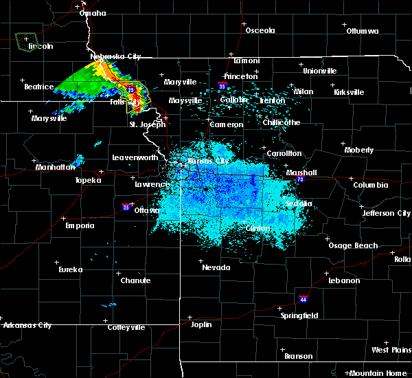 At 907 pm cdt, a severe thunderstorm was located near oregon, or 8 miles northeast of highland, moving northeast at 30 mph (radar indicated). Hazards include 60 mph wind gusts and quarter size hail. Hail damage to vehicles is expected. Expect wind damage to roofs, siding, and trees. At 907 pm cdt, a severe thunderstorm was located near oregon, or 8 miles northeast of highland, moving northeast at 30 mph (radar indicated). Hazards include 60 mph wind gusts and quarter size hail. Hail damage to vehicles is expected. Expect wind damage to roofs, siding, and trees.
|
| 4/11/2020 9:14 PM CDT |
 At 913 pm cdt, a severe thunderstorm was located near troy, moving northeast at 35 mph (radar indicated). Hazards include ping pong ball size hail. People and animals outdoors will be injured. Expect damage to roofs, siding, windows, and vehicles. At 913 pm cdt, a severe thunderstorm was located near troy, moving northeast at 35 mph (radar indicated). Hazards include ping pong ball size hail. People and animals outdoors will be injured. Expect damage to roofs, siding, windows, and vehicles.
|
| 10/20/2019 10:30 PM CDT |
 At 1029 pm cdt, severe thunderstorms were located along a line extending from near savannah to 6 miles south of wathena, moving east at 35 mph (radar indicated). Hazards include 60 mph wind gusts and quarter size hail. Hail damage to vehicles is expected. Expect wind damage to roofs, siding, and trees. At 1029 pm cdt, severe thunderstorms were located along a line extending from near savannah to 6 miles south of wathena, moving east at 35 mph (radar indicated). Hazards include 60 mph wind gusts and quarter size hail. Hail damage to vehicles is expected. Expect wind damage to roofs, siding, and trees.
|
| 8/29/2019 10:00 PM CDT | Reports of a roof collapse onto a building. fire department toned out for extricatio in andrew county MO, 0.4 miles NE of Savannah, MO |
| 8/29/2019 9:57 PM CDT |
 At 956 pm cdt, severe thunderstorms were located along a line extending from near highland to near clarksdale, moving south at 15 mph (radar indicated). Hazards include 60 mph wind gusts and quarter size hail. Hail damage to vehicles is expected. Expect wind damage to roofs, siding, and trees. At 956 pm cdt, severe thunderstorms were located along a line extending from near highland to near clarksdale, moving south at 15 mph (radar indicated). Hazards include 60 mph wind gusts and quarter size hail. Hail damage to vehicles is expected. Expect wind damage to roofs, siding, and trees.
|
| 8/29/2019 9:40 PM CDT |
 At 940 pm cdt, severe thunderstorms were located along a line extending from near maysville to white cloud, moving southeast at 20 mph (radar indicated). Hazards include 60 mph wind gusts and half dollar size hail. Hail damage to vehicles is expected. expect wind damage to roofs, siding, and trees. locations impacted include, st. Joseph, savannah, wathena, elwood, maysville, highland, troy, country club villa, country club, oregon, stewartsville, union star, osborn, amazonia, clarksdale, forest city, fillmore, white cloud, denton and easton. At 940 pm cdt, severe thunderstorms were located along a line extending from near maysville to white cloud, moving southeast at 20 mph (radar indicated). Hazards include 60 mph wind gusts and half dollar size hail. Hail damage to vehicles is expected. expect wind damage to roofs, siding, and trees. locations impacted include, st. Joseph, savannah, wathena, elwood, maysville, highland, troy, country club villa, country club, oregon, stewartsville, union star, osborn, amazonia, clarksdale, forest city, fillmore, white cloud, denton and easton.
|
| 8/29/2019 9:16 PM CDT |
 At 916 pm cdt, severe thunderstorms were located along a line extending from 6 miles northwest of maysville to white cloud, moving southeast at 30 mph (radar indicated). Hazards include 60 mph wind gusts and quarter size hail. Hail damage to vehicles is expected. Expect wind damage to roofs, siding, and trees. At 916 pm cdt, severe thunderstorms were located along a line extending from 6 miles northwest of maysville to white cloud, moving southeast at 30 mph (radar indicated). Hazards include 60 mph wind gusts and quarter size hail. Hail damage to vehicles is expected. Expect wind damage to roofs, siding, and trees.
|
| 6/22/2019 5:29 PM CDT |
 The national weather service in pleasant hill has issued a * severe thunderstorm warning for. southeastern doniphan county in northeastern kansas. central buchanan county in northwestern missouri. south central worth county in northwestern missouri. Gentry county in northwestern missouri. The national weather service in pleasant hill has issued a * severe thunderstorm warning for. southeastern doniphan county in northeastern kansas. central buchanan county in northwestern missouri. south central worth county in northwestern missouri. Gentry county in northwestern missouri.
|
| 6/22/2019 5:29 PM CDT |
 At 529 pm cdt, severe thunderstorms were located along a line extending from near albany to near rushville, moving northeast at 35 mph (radar indicated). Hazards include 60 mph wind gusts and quarter size hail. Hail damage to vehicles is expected. Expect wind damage to roofs, siding, and trees. At 529 pm cdt, severe thunderstorms were located along a line extending from near albany to near rushville, moving northeast at 35 mph (radar indicated). Hazards include 60 mph wind gusts and quarter size hail. Hail damage to vehicles is expected. Expect wind damage to roofs, siding, and trees.
|
| 6/22/2019 5:02 PM CDT |
 At 502 pm cdt, a severe thunderstorm was located over country club villa, moving northeast at 30 mph (radar indicated). Hazards include 60 mph wind gusts and quarter size hail. Hail damage to vehicles is expected. Expect wind damage to roofs, siding, and trees. At 502 pm cdt, a severe thunderstorm was located over country club villa, moving northeast at 30 mph (radar indicated). Hazards include 60 mph wind gusts and quarter size hail. Hail damage to vehicles is expected. Expect wind damage to roofs, siding, and trees.
|
| 6/21/2019 8:50 AM CDT |
 The national weather service in pleasant hill has issued a * severe thunderstorm warning for. east central doniphan county in northeastern kansas. northeastern buchanan county in northwestern missouri. gentry county in northwestern missouri. Southeastern nodaway county in northwestern missouri. The national weather service in pleasant hill has issued a * severe thunderstorm warning for. east central doniphan county in northeastern kansas. northeastern buchanan county in northwestern missouri. gentry county in northwestern missouri. Southeastern nodaway county in northwestern missouri.
|
| 6/21/2019 8:50 AM CDT |
 At 849 am cdt, a severe thunderstorm was located near fillmore, or near savannah, moving east at 50 mph (radar indicated). Hazards include 60 mph wind gusts. expect damage to roofs, siding, and trees At 849 am cdt, a severe thunderstorm was located near fillmore, or near savannah, moving east at 50 mph (radar indicated). Hazards include 60 mph wind gusts. expect damage to roofs, siding, and trees
|
| 5/28/2019 3:28 PM CDT |
 At 328 pm cdt, severe thunderstorms were located along a line extending from maitland to near fillmore to 6 miles southwest of union star, moving northeast at 60 mph (radar indicated). Hazards include 60 mph wind gusts and quarter size hail. Hail damage to vehicles is expected. Expect wind damage to roofs, siding, and trees. At 328 pm cdt, severe thunderstorms were located along a line extending from maitland to near fillmore to 6 miles southwest of union star, moving northeast at 60 mph (radar indicated). Hazards include 60 mph wind gusts and quarter size hail. Hail damage to vehicles is expected. Expect wind damage to roofs, siding, and trees.
|
| 5/28/2019 3:25 PM CDT | Half Dollar sized hail reported 0.4 miles NE of Savannah, MO |
| 5/28/2019 3:23 PM CDT |
 At 323 pm cdt, severe thunderstorms were located along a line extending from skidmore to 9 miles northeast of fillmore to near union star, moving northeast at 75 mph (radar indicated). Hazards include 60 mph wind gusts and quarter size hail. Hail damage to vehicles is expected. expect wind damage to roofs, siding, and trees. Locations impacted include, maryville, savannah, stanberry, mound city, country club villa, country club, king city, oregon, union star, maitland, amazonia, skidmore, forest city, fillmore, barnard, conception junction, bolckow, graham, big lake and rosendale. At 323 pm cdt, severe thunderstorms were located along a line extending from skidmore to 9 miles northeast of fillmore to near union star, moving northeast at 75 mph (radar indicated). Hazards include 60 mph wind gusts and quarter size hail. Hail damage to vehicles is expected. expect wind damage to roofs, siding, and trees. Locations impacted include, maryville, savannah, stanberry, mound city, country club villa, country club, king city, oregon, union star, maitland, amazonia, skidmore, forest city, fillmore, barnard, conception junction, bolckow, graham, big lake and rosendale.
|
| 5/28/2019 3:07 PM CDT |
 At 307 pm cdt, severe thunderstorms were located along a line extending from 6 miles southwest of mound city to near oregon to near wathena, moving northeast at 70 mph (radar indicated). Hazards include 60 mph wind gusts and quarter size hail. Hail damage to vehicles is expected. Expect wind damage to roofs, siding, and trees. At 307 pm cdt, severe thunderstorms were located along a line extending from 6 miles southwest of mound city to near oregon to near wathena, moving northeast at 70 mph (radar indicated). Hazards include 60 mph wind gusts and quarter size hail. Hail damage to vehicles is expected. Expect wind damage to roofs, siding, and trees.
|
| 5/25/2019 11:48 PM CDT |
 At 1147 pm cdt, a severe thunderstorm was located over king city, or 9 miles south of stanberry, moving north at 40 mph (radar indicated). Hazards include 60 mph wind gusts and nickel size hail. expect damage to roofs, siding, and trees At 1147 pm cdt, a severe thunderstorm was located over king city, or 9 miles south of stanberry, moving north at 40 mph (radar indicated). Hazards include 60 mph wind gusts and nickel size hail. expect damage to roofs, siding, and trees
|
| 10/8/2018 4:40 PM CDT |
 At 439 pm cdt, a severe thunderstorm capable of producing a tornado was located over amazonia, or over savannah, moving northeast at 35 mph (radar indicated rotation). Hazards include tornado. Flying debris will be dangerous to those caught without shelter. mobile homes will be damaged or destroyed. damage to roofs, windows, and vehicles will occur. Tree damage is likely. At 439 pm cdt, a severe thunderstorm capable of producing a tornado was located over amazonia, or over savannah, moving northeast at 35 mph (radar indicated rotation). Hazards include tornado. Flying debris will be dangerous to those caught without shelter. mobile homes will be damaged or destroyed. damage to roofs, windows, and vehicles will occur. Tree damage is likely.
|
| 6/30/2018 7:01 PM CDT |
 At 701 pm cdt, severe thunderstorms were located along a line extending from near mound city to near troy to near weston, moving east at 30 mph (radar indicated). Hazards include 60 mph wind gusts and nickel size hail. expect damage to roofs, siding, and trees At 701 pm cdt, severe thunderstorms were located along a line extending from near mound city to near troy to near weston, moving east at 30 mph (radar indicated). Hazards include 60 mph wind gusts and nickel size hail. expect damage to roofs, siding, and trees
|
| 6/11/2018 9:51 PM CDT |
 At 950 pm cdt, severe thunderstorms were located along a line extending from 6 miles north of pattonsburg to robinson, moving southeast at 30 mph (radar indicated). Hazards include 60 mph wind gusts and nickel size hail. expect damage to roofs, siding, and trees At 950 pm cdt, severe thunderstorms were located along a line extending from 6 miles north of pattonsburg to robinson, moving southeast at 30 mph (radar indicated). Hazards include 60 mph wind gusts and nickel size hail. expect damage to roofs, siding, and trees
|
| 6/11/2018 9:28 PM CDT |
 At 927 pm cdt, severe thunderstorms were located along a line extending from near stanberry to 6 miles northeast of hiawatha, moving southeast at 40 mph (radar indicated). Hazards include 60 mph wind gusts and nickel size hail. expect damage to roofs, siding, and trees At 927 pm cdt, severe thunderstorms were located along a line extending from near stanberry to 6 miles northeast of hiawatha, moving southeast at 40 mph (radar indicated). Hazards include 60 mph wind gusts and nickel size hail. expect damage to roofs, siding, and trees
|
| 6/9/2018 8:28 PM CDT |
 The severe thunderstorm warning for doniphan, north central buchanan, southeastern holt and southwestern andrew counties will expire at 830 pm cdt, the storm which prompted the warning has moved out of the area. therefore, the warning will be allowed to expire. remember, a severe thunderstorm warning still remains in effect for southeastern doniphan county, buchanan county, and south central andrew county. The severe thunderstorm warning for doniphan, north central buchanan, southeastern holt and southwestern andrew counties will expire at 830 pm cdt, the storm which prompted the warning has moved out of the area. therefore, the warning will be allowed to expire. remember, a severe thunderstorm warning still remains in effect for southeastern doniphan county, buchanan county, and south central andrew county.
|
| 6/9/2018 8:06 PM CDT |
 At 805 pm cdt, a severe thunderstorm was located near troy, moving southeast at 30 mph (radar indicated). Hazards include 70 mph wind gusts and quarter size hail. Hail damage to vehicles is expected. expect considerable tree damage. wind damage is also likely to mobile homes, roofs, and outbuildings. locations impacted include, st. joseph, savannah, wathena, elwood, highland, troy, country club villa, country club, amazonia, denton, severance, leona, st. joseph airport, bendena and fanning. those attending the rodeo in troy are in the path of this storm and should prepare for imminent dangerous weather conditions. seek shelter now! this includes the following highways, interstate 29 between mile markers 53 and 71. Interstate 229 between mile markers 7 and 14. At 805 pm cdt, a severe thunderstorm was located near troy, moving southeast at 30 mph (radar indicated). Hazards include 70 mph wind gusts and quarter size hail. Hail damage to vehicles is expected. expect considerable tree damage. wind damage is also likely to mobile homes, roofs, and outbuildings. locations impacted include, st. joseph, savannah, wathena, elwood, highland, troy, country club villa, country club, amazonia, denton, severance, leona, st. joseph airport, bendena and fanning. those attending the rodeo in troy are in the path of this storm and should prepare for imminent dangerous weather conditions. seek shelter now! this includes the following highways, interstate 29 between mile markers 53 and 71. Interstate 229 between mile markers 7 and 14.
|
| 6/9/2018 7:56 PM CDT |
 At 755 pm cdt, a severe thunderstorm was located near troy, moving southeast at 30 mph (radar indicated. at 754 pm cdt a tree and powerpole were reported down in oregon, mo). Hazards include 70 mph wind gusts and quarter size hail. Hail damage to vehicles is expected. expect considerable tree damage. Wind damage is also likely to mobile homes, roofs, and outbuildings. At 755 pm cdt, a severe thunderstorm was located near troy, moving southeast at 30 mph (radar indicated. at 754 pm cdt a tree and powerpole were reported down in oregon, mo). Hazards include 70 mph wind gusts and quarter size hail. Hail damage to vehicles is expected. expect considerable tree damage. Wind damage is also likely to mobile homes, roofs, and outbuildings.
|
| 5/2/2018 8:04 PM CDT |
 At 803 pm cdt, severe thunderstorms were located along a line extending from near maryville to 10 miles southwest of ravenwood to near weston, moving east at 45 mph. this line of storms has a history of producing winds of 60 to 70 mph (radar indicated). Hazards include 70 mph wind gusts and quarter size hail. Hail damage to vehicles is expected. expect considerable tree damage. Wind damage is also likely to mobile homes, roofs, and outbuildings. At 803 pm cdt, severe thunderstorms were located along a line extending from near maryville to 10 miles southwest of ravenwood to near weston, moving east at 45 mph. this line of storms has a history of producing winds of 60 to 70 mph (radar indicated). Hazards include 70 mph wind gusts and quarter size hail. Hail damage to vehicles is expected. expect considerable tree damage. Wind damage is also likely to mobile homes, roofs, and outbuildings.
|
| 5/2/2018 8:04 PM CDT |
 The national weather service in pleasant hill has issued a * severe thunderstorm warning for. east central doniphan county in northeastern kansas. buchanan county in northwestern missouri. worth county in northwestern missouri. Clinton county in northwestern missouri. The national weather service in pleasant hill has issued a * severe thunderstorm warning for. east central doniphan county in northeastern kansas. buchanan county in northwestern missouri. worth county in northwestern missouri. Clinton county in northwestern missouri.
|
| 5/2/2018 7:50 PM CDT |
 At 749 pm cdt, severe thunderstorms were located along a line extending from near burlington junction to near skidmore to near maitland to 6 miles south of fillmore to 7 miles north of atchison to 7 miles northeast of nortonville, moving northeast at 50 mph (trained weather spotters reported 65 mph winds west of st. joseph). Hazards include 70 mph wind gusts and quarter size hail. Hail damage to vehicles is expected. expect considerable tree damage. wind damage is also likely to mobile homes, roofs, and outbuildings. locations impacted include, st. joseph, maryville, atchison, savannah, tarkio, wathena, elwood, mound city, highland, troy, country club, oregon, fairfax, effingham, burlington junction, hopkins, maitland, amazonia, rushville and lancaster. this includes the following highways, interstate 29 between mile markers 54 and 94. interstate 229 between mile markers 5 and 14. A tornado watch remains in effect until 100 am cdt for northeastern kansas, and northwestern and west central missouri. At 749 pm cdt, severe thunderstorms were located along a line extending from near burlington junction to near skidmore to near maitland to 6 miles south of fillmore to 7 miles north of atchison to 7 miles northeast of nortonville, moving northeast at 50 mph (trained weather spotters reported 65 mph winds west of st. joseph). Hazards include 70 mph wind gusts and quarter size hail. Hail damage to vehicles is expected. expect considerable tree damage. wind damage is also likely to mobile homes, roofs, and outbuildings. locations impacted include, st. joseph, maryville, atchison, savannah, tarkio, wathena, elwood, mound city, highland, troy, country club, oregon, fairfax, effingham, burlington junction, hopkins, maitland, amazonia, rushville and lancaster. this includes the following highways, interstate 29 between mile markers 54 and 94. interstate 229 between mile markers 5 and 14. A tornado watch remains in effect until 100 am cdt for northeastern kansas, and northwestern and west central missouri.
|
| 5/2/2018 7:27 PM CDT |
 At 727 pm cdt, severe thunderstorms were located along a line extending from near fairfax to mound city to near forest city to near denton to near effingham, moving northeast at 50 mph (radar indicated). Hazards include 70 mph wind gusts and quarter size hail. Hail damage to vehicles is expected. expect considerable tree damage. Wind damage is also likely to mobile homes, roofs, and outbuildings. At 727 pm cdt, severe thunderstorms were located along a line extending from near fairfax to mound city to near forest city to near denton to near effingham, moving northeast at 50 mph (radar indicated). Hazards include 70 mph wind gusts and quarter size hail. Hail damage to vehicles is expected. expect considerable tree damage. Wind damage is also likely to mobile homes, roofs, and outbuildings.
|
| 5/2/2018 7:27 PM CDT |
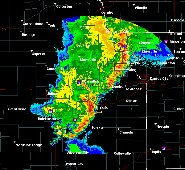 At 727 pm cdt, severe thunderstorms were located along a line extending from near fairfax to mound city to near forest city to near denton to near effingham, moving northeast at 50 mph (radar indicated). Hazards include 70 mph wind gusts and quarter size hail. Hail damage to vehicles is expected. expect considerable tree damage. Wind damage is also likely to mobile homes, roofs, and outbuildings. At 727 pm cdt, severe thunderstorms were located along a line extending from near fairfax to mound city to near forest city to near denton to near effingham, moving northeast at 50 mph (radar indicated). Hazards include 70 mph wind gusts and quarter size hail. Hail damage to vehicles is expected. expect considerable tree damage. Wind damage is also likely to mobile homes, roofs, and outbuildings.
|
| 6/16/2017 10:56 PM CDT |
 At 1056 pm cdt, severe thunderstorms were located along a line extending from near elwood to near clarksdale to 6 miles northeast of maysville, moving southeast at 70 mph. these are very dangerous storms (radar indicated). Hazards include 80 mph wind gusts. Flying debris will be dangerous to those caught without shelter. mobile homes will be heavily damaged. expect considerable damage to roofs, windows, and vehicles. Extensive tree damage and power outages are likely. At 1056 pm cdt, severe thunderstorms were located along a line extending from near elwood to near clarksdale to 6 miles northeast of maysville, moving southeast at 70 mph. these are very dangerous storms (radar indicated). Hazards include 80 mph wind gusts. Flying debris will be dangerous to those caught without shelter. mobile homes will be heavily damaged. expect considerable damage to roofs, windows, and vehicles. Extensive tree damage and power outages are likely.
|
| 6/16/2017 10:52 PM CDT |
 At 1051 pm cdt, severe thunderstorms were located along a line extending from near st. joseph to near union star, moving east at 65 mph. at 10:48 pm the st. joseph airport recorded a 76 mph wind gust. these are very dangerous storms (trained weather spotters). Hazards include 80 mph wind gusts. Flying debris will be dangerous to those caught without shelter. mobile homes will be heavily damaged. expect considerable damage to roofs, windows, and vehicles. extensive tree damage and power outages are likely. locations impacted include, st. joseph, cameron, savannah, wathena, elwood, maysville, highland, troy, country club villa, country club, king city, oregon, stewartsville, agency, union star, osborn, amazonia, clarksdale, forest city and fillmore. this includes the following highways, interstate 35 in missouri between mile markers 52 and 66. Interstate 29 between mile markers 39 and 73. At 1051 pm cdt, severe thunderstorms were located along a line extending from near st. joseph to near union star, moving east at 65 mph. at 10:48 pm the st. joseph airport recorded a 76 mph wind gust. these are very dangerous storms (trained weather spotters). Hazards include 80 mph wind gusts. Flying debris will be dangerous to those caught without shelter. mobile homes will be heavily damaged. expect considerable damage to roofs, windows, and vehicles. extensive tree damage and power outages are likely. locations impacted include, st. joseph, cameron, savannah, wathena, elwood, maysville, highland, troy, country club villa, country club, king city, oregon, stewartsville, agency, union star, osborn, amazonia, clarksdale, forest city and fillmore. this includes the following highways, interstate 35 in missouri between mile markers 52 and 66. Interstate 29 between mile markers 39 and 73.
|
| 6/16/2017 10:36 PM CDT |
 At 1036 pm cdt, severe thunderstorms were located along a line extending from 7 miles west of amazonia to near savannah, moving southeast at 65 mph. these are very dangerous storms (radar indicated). Hazards include 80 mph wind gusts. Flying debris will be dangerous to those caught without shelter. mobile homes will be heavily damaged. expect considerable damage to roofs, windows, and vehicles. extensive tree damage and power outages are likely. locations impacted include, st. joseph, cameron, savannah, wathena, elwood, maysville, highland, troy, country club villa, country club, king city, oregon, stewartsville, agency, union star, osborn, amazonia, clarksdale, forest city and fillmore. this includes the following highways, interstate 35 in missouri between mile markers 52 and 66. Interstate 29 between mile markers 39 and 76. At 1036 pm cdt, severe thunderstorms were located along a line extending from 7 miles west of amazonia to near savannah, moving southeast at 65 mph. these are very dangerous storms (radar indicated). Hazards include 80 mph wind gusts. Flying debris will be dangerous to those caught without shelter. mobile homes will be heavily damaged. expect considerable damage to roofs, windows, and vehicles. extensive tree damage and power outages are likely. locations impacted include, st. joseph, cameron, savannah, wathena, elwood, maysville, highland, troy, country club villa, country club, king city, oregon, stewartsville, agency, union star, osborn, amazonia, clarksdale, forest city and fillmore. this includes the following highways, interstate 35 in missouri between mile markers 52 and 66. Interstate 29 between mile markers 39 and 76.
|
| 6/16/2017 10:14 PM CDT |
 At 1014 pm cdt, severe thunderstorms were located along a line extending from near white cloud to 7 miles southeast of maryville, moving east at 65 mph. these are very dangerous storms (radar indicated). Hazards include 80 mph wind gusts. Flying debris will be dangerous to those caught without shelter. mobile homes will be heavily damaged. expect considerable damage to roofs, windows, and vehicles. Extensive tree damage and power outages are likely. At 1014 pm cdt, severe thunderstorms were located along a line extending from near white cloud to 7 miles southeast of maryville, moving east at 65 mph. these are very dangerous storms (radar indicated). Hazards include 80 mph wind gusts. Flying debris will be dangerous to those caught without shelter. mobile homes will be heavily damaged. expect considerable damage to roofs, windows, and vehicles. Extensive tree damage and power outages are likely.
|
| 3/6/2017 6:43 PM CST |
 At 642 pm cst, a severe thunderstorm was located near rushville, or near wathena, moving northeast at 50 mph (radar indicated). Hazards include 60 mph wind gusts and quarter size hail. Hail damage to vehicles is expected. Expect wind damage to roofs, siding, and trees. At 642 pm cst, a severe thunderstorm was located near rushville, or near wathena, moving northeast at 50 mph (radar indicated). Hazards include 60 mph wind gusts and quarter size hail. Hail damage to vehicles is expected. Expect wind damage to roofs, siding, and trees.
|
| 8/26/2016 6:26 PM CDT |
 At 625 pm cdt, a severe thunderstorm was located near savannah, moving northeast at 25 mph (radar indicated). Hazards include 60 mph wind gusts. Expect damage to roofs. siding. and trees. locations impacted include, savannah, cosby and helena. this includes interstate 29 near mile marker 53. A tornado watch remains in effect until 1000 pm cdt for northwestern missouri. At 625 pm cdt, a severe thunderstorm was located near savannah, moving northeast at 25 mph (radar indicated). Hazards include 60 mph wind gusts. Expect damage to roofs. siding. and trees. locations impacted include, savannah, cosby and helena. this includes interstate 29 near mile marker 53. A tornado watch remains in effect until 1000 pm cdt for northwestern missouri.
|
| 8/26/2016 6:13 PM CDT |
 At 613 pm cdt, a severe thunderstorm was located over country club villa, moving northeast at 25 mph (radar indicated). Hazards include 60 mph wind gusts. Expect damage to roofs. siding. And trees. At 613 pm cdt, a severe thunderstorm was located over country club villa, moving northeast at 25 mph (radar indicated). Hazards include 60 mph wind gusts. Expect damage to roofs. siding. And trees.
|
| 8/24/2016 8:26 PM CDT |
 The severe thunderstorm warning for northeastern andrew, southwestern gentry, northwestern dekalb and southeastern nodaway counties will expire at 830 pm cdt, the storm which prompted the warning has weakened below severe limits, and no longer pose an immediate threat to life or property. therefore the warning will be allowed to expire. however gusty winds and heavy rain are still possible with this thunderstorm. a severe thunderstorm watch remains in effect until 1100 pm cdt for northwestern missouri. to report severe weather, contact your nearest law enforcement agency. they will relay your report to the national weather service pleasant hill. The severe thunderstorm warning for northeastern andrew, southwestern gentry, northwestern dekalb and southeastern nodaway counties will expire at 830 pm cdt, the storm which prompted the warning has weakened below severe limits, and no longer pose an immediate threat to life or property. therefore the warning will be allowed to expire. however gusty winds and heavy rain are still possible with this thunderstorm. a severe thunderstorm watch remains in effect until 1100 pm cdt for northwestern missouri. to report severe weather, contact your nearest law enforcement agency. they will relay your report to the national weather service pleasant hill.
|
| 8/24/2016 8:00 PM CDT |
 At 800 pm cdt, a severe thunderstorm was located near savannah, moving east at 35 mph (radar indicated). Hazards include 60 mph wind gusts and quarter size hail. Hail damage to vehicles is expected. Expect wind damage to roofs, siding, and trees. At 800 pm cdt, a severe thunderstorm was located near savannah, moving east at 35 mph (radar indicated). Hazards include 60 mph wind gusts and quarter size hail. Hail damage to vehicles is expected. Expect wind damage to roofs, siding, and trees.
|
| 8/24/2016 12:56 AM CDT |
 The severe thunderstorm warning for atchison, northern andrew, northwestern gentry, western worth, nodaway and holt counties will expire at 100 am cdt, the storms which prompted the warning have weakened below severe limits, and no longer pose an immediate threat to life or property. therefore the warning will be allowed to expire. however gusty winds and heavy rain are still possible with these thunderstorms. to report severe weather, contact your nearest law enforcement agency. they will relay your report to the national weather service pleasant hill. The severe thunderstorm warning for atchison, northern andrew, northwestern gentry, western worth, nodaway and holt counties will expire at 100 am cdt, the storms which prompted the warning have weakened below severe limits, and no longer pose an immediate threat to life or property. therefore the warning will be allowed to expire. however gusty winds and heavy rain are still possible with these thunderstorms. to report severe weather, contact your nearest law enforcement agency. they will relay your report to the national weather service pleasant hill.
|
| 8/24/2016 12:15 AM CDT |
 At 1214 am cdt, severe thunderstorms were located along a line extending from 11 miles north of bedford to near tarkio to near auburn, moving south at 40 mph (radar indicated). Hazards include 60 mph wind gusts. Expect damage to roofs. siding. And trees. At 1214 am cdt, severe thunderstorms were located along a line extending from 11 miles north of bedford to near tarkio to near auburn, moving south at 40 mph (radar indicated). Hazards include 60 mph wind gusts. Expect damage to roofs. siding. And trees.
|
| 7/7/2016 4:17 AM CDT |
 At 416 am cdt, severe thunderstorms were located along a line extending from near athelstan to near ravenwood to near stanberry to near union star, moving east at 45 mph (radar indicated). Hazards include 60 mph wind gusts. Expect damage to roofs. siding. and trees. Locations impacted include, maryville, savannah, albany, stanberry, maysville, king city, grant city, hopkins, ravenwood, union star, irena, barnard, conception junction, sheridan, parnell, bolckow, rosendale, darlington, weatherby and mcfall. At 416 am cdt, severe thunderstorms were located along a line extending from near athelstan to near ravenwood to near stanberry to near union star, moving east at 45 mph (radar indicated). Hazards include 60 mph wind gusts. Expect damage to roofs. siding. and trees. Locations impacted include, maryville, savannah, albany, stanberry, maysville, king city, grant city, hopkins, ravenwood, union star, irena, barnard, conception junction, sheridan, parnell, bolckow, rosendale, darlington, weatherby and mcfall.
|
| 7/7/2016 4:10 AM CDT |
 The severe thunderstorm warning for doniphan, atchison, southwestern andrew and southeastern holt counties will expire at 415 am cdt, the storms which prompted the warning have weakened below severe limits, and no longer pose an immediate threat to life or property. therefore the warning will be allowed to expire. a severe thunderstorm watch remains in effect until 900 am cdt for northeastern kansas, and northwestern missouri. The severe thunderstorm warning for doniphan, atchison, southwestern andrew and southeastern holt counties will expire at 415 am cdt, the storms which prompted the warning have weakened below severe limits, and no longer pose an immediate threat to life or property. therefore the warning will be allowed to expire. a severe thunderstorm watch remains in effect until 900 am cdt for northeastern kansas, and northwestern missouri.
|
| 7/7/2016 3:58 AM CDT |
 At 358 am cdt, severe thunderstorms were located along a line extending from hopkins to near maryville to 12 miles east of maitland to near savannah, moving east at 50 mph (radar indicated). Hazards include 70 mph wind gusts. Expect considerable tree damage. Damage is likely to mobile homes, roofs, and outbuildings. At 358 am cdt, severe thunderstorms were located along a line extending from hopkins to near maryville to 12 miles east of maitland to near savannah, moving east at 50 mph (radar indicated). Hazards include 70 mph wind gusts. Expect considerable tree damage. Damage is likely to mobile homes, roofs, and outbuildings.
|
| 7/7/2016 3:45 AM CDT |
 At 344 am cdt, severe thunderstorms were located along a line extending from near oregon to near robinson to near netawaka, moving southeast at 55 mph (radar indicated). Hazards include 60 mph wind gusts. Expect damage to roofs. siding. and trees. locations impacted include, atchison, savannah, wathena, highland, troy, oregon, effingham, amazonia, lancaster, forest city, white cloud, muscotah, denton, doniphan, severance, farmington, huron, leona, bendena and fanning. This includes interstate 29 between mile markers 57 and 64. At 344 am cdt, severe thunderstorms were located along a line extending from near oregon to near robinson to near netawaka, moving southeast at 55 mph (radar indicated). Hazards include 60 mph wind gusts. Expect damage to roofs. siding. and trees. locations impacted include, atchison, savannah, wathena, highland, troy, oregon, effingham, amazonia, lancaster, forest city, white cloud, muscotah, denton, doniphan, severance, farmington, huron, leona, bendena and fanning. This includes interstate 29 between mile markers 57 and 64.
|
| 7/7/2016 3:44 AM CDT |
 At 343 am cdt, severe thunderstorms were located along a line extending from near burlington junction to skidmore to 6 miles north of fillmore to oregon, moving east at 60 mph. this storm has a history of producing wind damage in fairfax (radar indicated). Hazards include 70 mph wind gusts. Expect considerable tree damage. damage is likely to mobile homes, roofs, and outbuildings. locations impacted include, maryville, savannah, burlington junction, hopkins, ravenwood, maitland, skidmore, fillmore, barnard, conception junction, parnell, bolckow, graham, clearmont, elmo, pickering, rosendale, guilford, clyde and arkoe. This includes interstate 29 between mile markers 64 and 77. At 343 am cdt, severe thunderstorms were located along a line extending from near burlington junction to skidmore to 6 miles north of fillmore to oregon, moving east at 60 mph. this storm has a history of producing wind damage in fairfax (radar indicated). Hazards include 70 mph wind gusts. Expect considerable tree damage. damage is likely to mobile homes, roofs, and outbuildings. locations impacted include, maryville, savannah, burlington junction, hopkins, ravenwood, maitland, skidmore, fillmore, barnard, conception junction, parnell, bolckow, graham, clearmont, elmo, pickering, rosendale, guilford, clyde and arkoe. This includes interstate 29 between mile markers 64 and 77.
|
| 7/7/2016 3:29 AM CDT |
 At 328 am cdt, severe thunderstorms were located along a line extending from near blanchard to near fairfax to near mound city to near white cloud, moving east at 60 mph. this storm has a history of producing high winds in the rockport area (radar indicated). Hazards include 70 mph wind gusts. Expect considerable tree damage. Damage is likely to mobile homes, roofs, and outbuildings. At 328 am cdt, severe thunderstorms were located along a line extending from near blanchard to near fairfax to near mound city to near white cloud, moving east at 60 mph. this storm has a history of producing high winds in the rockport area (radar indicated). Hazards include 70 mph wind gusts. Expect considerable tree damage. Damage is likely to mobile homes, roofs, and outbuildings.
|
| 7/7/2016 3:26 AM CDT |
 At 325 am cdt, severe thunderstorms were located along a line extending from 7 miles northwest of white cloud to near hamlin to near woodlawn, moving southeast at 50 mph. a 68 mph wind gust was observed at falls city nebraska with this line of storms (radar indicated). Hazards include 70 mph wind gusts. Expect considerable tree damage. Damage is likely to mobile homes, roofs, and outbuildings. At 325 am cdt, severe thunderstorms were located along a line extending from 7 miles northwest of white cloud to near hamlin to near woodlawn, moving southeast at 50 mph. a 68 mph wind gust was observed at falls city nebraska with this line of storms (radar indicated). Hazards include 70 mph wind gusts. Expect considerable tree damage. Damage is likely to mobile homes, roofs, and outbuildings.
|
| 5/26/2016 12:13 PM CDT |
 At 1213 pm cdt, a severe thunderstorm was located near oregon, or 11 miles north of troy, moving northeast at 25 mph (radar indicated). Hazards include two inch hail and 60 mph wind gusts. People and animals outdoors will be injured. expect hail damage to roofs, siding, windows, and vehicles. Expect wind damage to roofs, siding, and trees. At 1213 pm cdt, a severe thunderstorm was located near oregon, or 11 miles north of troy, moving northeast at 25 mph (radar indicated). Hazards include two inch hail and 60 mph wind gusts. People and animals outdoors will be injured. expect hail damage to roofs, siding, windows, and vehicles. Expect wind damage to roofs, siding, and trees.
|
| 5/26/2016 11:42 AM CDT |
 At 1142 am cdt, a severe thunderstorm was located over savannah, moving northeast at 20 mph (radar indicated). Hazards include golf ball size hail and 60 mph wind gusts. People and animals outdoors will be injured. expect hail damage to roofs, siding, windows, and vehicles. expect wind damage to roofs, siding, and trees. Locations impacted include, savannah, cosby and helena. At 1142 am cdt, a severe thunderstorm was located over savannah, moving northeast at 20 mph (radar indicated). Hazards include golf ball size hail and 60 mph wind gusts. People and animals outdoors will be injured. expect hail damage to roofs, siding, windows, and vehicles. expect wind damage to roofs, siding, and trees. Locations impacted include, savannah, cosby and helena.
|
| 5/26/2016 11:24 AM CDT |
 At 1124 am cdt, a severe thunderstorm was located over amazonia, or near country club villa, moving northeast at 20 mph (radar indicated). Hazards include golf ball size hail and 60 mph wind gusts. People and animals outdoors will be injured. expect hail damage to roofs, siding, windows, and vehicles. Expect wind damage to roofs, siding, and trees. At 1124 am cdt, a severe thunderstorm was located over amazonia, or near country club villa, moving northeast at 20 mph (radar indicated). Hazards include golf ball size hail and 60 mph wind gusts. People and animals outdoors will be injured. expect hail damage to roofs, siding, windows, and vehicles. Expect wind damage to roofs, siding, and trees.
|
| 5/26/2016 12:22 AM CDT |
 At 1219 am cdt, a severe thunderstorm was located near union star, or 7 miles east of savannah, moving east at 35 mph (radar indicated. at 1210 am nickel size hail was reported in savannah). Hazards include quarter size hail. Damage to vehicles is expected. locations impacted include, savannah, union star and amazonia. This includes interstate 29 between mile markers 57 and 60. At 1219 am cdt, a severe thunderstorm was located near union star, or 7 miles east of savannah, moving east at 35 mph (radar indicated. at 1210 am nickel size hail was reported in savannah). Hazards include quarter size hail. Damage to vehicles is expected. locations impacted include, savannah, union star and amazonia. This includes interstate 29 between mile markers 57 and 60.
|
| 5/26/2016 12:08 AM CDT |
 At 1207 am cdt, a severe thunderstorm was located 7 miles northeast of savannah, moving east at 40 mph (radar indicated). Hazards include ping pong ball size hail and 60 mph wind gusts. People and animals outdoors will be injured. expect hail damage to roofs, siding, windows, and vehicles. expect wind damage to roofs, siding, and trees. locations impacted include, savannah, union star, amazonia, fillmore, barnard, conception junction, bolckow, rosendale, guilford, clyde, rea and conception. This includes interstate 29 between mile markers 57 and 66. At 1207 am cdt, a severe thunderstorm was located 7 miles northeast of savannah, moving east at 40 mph (radar indicated). Hazards include ping pong ball size hail and 60 mph wind gusts. People and animals outdoors will be injured. expect hail damage to roofs, siding, windows, and vehicles. expect wind damage to roofs, siding, and trees. locations impacted include, savannah, union star, amazonia, fillmore, barnard, conception junction, bolckow, rosendale, guilford, clyde, rea and conception. This includes interstate 29 between mile markers 57 and 66.
|
| 5/25/2016 11:42 PM CDT |
 At 1142 pm cdt, a severe thunderstorm was located near oregon, or 12 miles west of savannah, moving east at 40 mph (radar indicated). Hazards include ping pong ball size hail and 60 mph wind gusts. People and animals outdoors will be injured. expect hail damage to roofs, siding, windows, and vehicles. Expect wind damage to roofs, siding, and trees. At 1142 pm cdt, a severe thunderstorm was located near oregon, or 12 miles west of savannah, moving east at 40 mph (radar indicated). Hazards include ping pong ball size hail and 60 mph wind gusts. People and animals outdoors will be injured. expect hail damage to roofs, siding, windows, and vehicles. Expect wind damage to roofs, siding, and trees.
|
| 4/27/2016 4:10 PM CDT |
 At 410 pm cdt, a severe thunderstorm was located near savannah, moving northeast at 25 mph (radar indicated). Hazards include half dollar size hail. damage to vehicles is expected At 410 pm cdt, a severe thunderstorm was located near savannah, moving northeast at 25 mph (radar indicated). Hazards include half dollar size hail. damage to vehicles is expected
|
| 4/27/2016 3:38 PM CDT |
 At 338 pm cdt, severe thunderstorms were located along a line extending from troy to near elwood, moving north at 20 mph (radar indicated). Hazards include quarter size hail. damage to vehicles is expected At 338 pm cdt, severe thunderstorms were located along a line extending from troy to near elwood, moving north at 20 mph (radar indicated). Hazards include quarter size hail. damage to vehicles is expected
|
| 4/26/2016 8:28 AM CDT |
 At 828 am cdt, severe thunderstorms were located along a line extending from near king city to ferrelview, moving east at 60 mph (trained weather spotters). Hazards include 70 mph wind gusts and ping pong ball size hail. People and animals outdoors will be injured. expect hail damage to roofs, siding, windows, and vehicles. expect considerable tree damage. wind damage is also likely to mobile homes, roofs, and outbuildings. locations impacted include, kansas city, independence, st. joseph, leavenworth, liberty, gladstone, lansing, cameron, smithville, kearney, parkville, savannah, platte city, north kansas city, sugar creek, riverside, plattsburg, lathrop, weatherby lake and weston. this includes the following highways, interstate 35 in missouri between mile markers 6 and 67. interstate 29 between mile markers 0 and 58. interstate 635 between mile markers 10 and 12. interstate 435 between mile markers 20 and 57. Interstate 229 between mile markers 0 and 14. At 828 am cdt, severe thunderstorms were located along a line extending from near king city to ferrelview, moving east at 60 mph (trained weather spotters). Hazards include 70 mph wind gusts and ping pong ball size hail. People and animals outdoors will be injured. expect hail damage to roofs, siding, windows, and vehicles. expect considerable tree damage. wind damage is also likely to mobile homes, roofs, and outbuildings. locations impacted include, kansas city, independence, st. joseph, leavenworth, liberty, gladstone, lansing, cameron, smithville, kearney, parkville, savannah, platte city, north kansas city, sugar creek, riverside, plattsburg, lathrop, weatherby lake and weston. this includes the following highways, interstate 35 in missouri between mile markers 6 and 67. interstate 29 between mile markers 0 and 58. interstate 635 between mile markers 10 and 12. interstate 435 between mile markers 20 and 57. Interstate 229 between mile markers 0 and 14.
|
| 4/26/2016 8:17 AM CDT |
 At 816 am cdt, severe thunderstorms were located along a line extending from near union star to near leavenworth, moving east at 55 mph (trained weather spotters). Hazards include 70 mph wind gusts and ping pong ball size hail. People and animals outdoors will be injured. expect hail damage to roofs, siding, windows, and vehicles. expect considerable tree damage. wind damage is also likely to mobile homes, roofs, and outbuildings. locations impacted include, kansas city, independence, st. joseph, leavenworth, liberty, gladstone, lansing, cameron, smithville, kearney, parkville, savannah, platte city, north kansas city, sugar creek, riverside, plattsburg, lathrop, weatherby lake and weston. this includes the following highways, interstate 35 in missouri between mile markers 6 and 67. interstate 29 between mile markers 0 and 59. interstate 635 between mile markers 10 and 12. interstate 435 between mile markers 20 and 57. Interstate 229 between mile markers 0 and 14. At 816 am cdt, severe thunderstorms were located along a line extending from near union star to near leavenworth, moving east at 55 mph (trained weather spotters). Hazards include 70 mph wind gusts and ping pong ball size hail. People and animals outdoors will be injured. expect hail damage to roofs, siding, windows, and vehicles. expect considerable tree damage. wind damage is also likely to mobile homes, roofs, and outbuildings. locations impacted include, kansas city, independence, st. joseph, leavenworth, liberty, gladstone, lansing, cameron, smithville, kearney, parkville, savannah, platte city, north kansas city, sugar creek, riverside, plattsburg, lathrop, weatherby lake and weston. this includes the following highways, interstate 35 in missouri between mile markers 6 and 67. interstate 29 between mile markers 0 and 59. interstate 635 between mile markers 10 and 12. interstate 435 between mile markers 20 and 57. Interstate 229 between mile markers 0 and 14.
|
| 4/26/2016 8:06 AM CDT |
 At 806 am cdt, severe thunderstorms were located along a line extending from near savannah to near leavenworth, moving east at 55 mph (trained weather spotters). Hazards include 70 mph wind gusts and ping pong ball size hail. People and animals outdoors will be injured. expect hail damage to roofs, siding, windows, and vehicles. expect considerable tree damage. wind damage is also likely to mobile homes, roofs, and outbuildings. locations impacted include, kansas city, independence, st. joseph, leavenworth, liberty, gladstone, lansing, atchison, cameron, smithville, kearney, parkville, savannah, platte city, north kansas city, sugar creek, riverside, plattsburg, lathrop and weatherby lake. this includes the following highways, interstate 35 in missouri between mile markers 6 and 67. interstate 29 between mile markers 0 and 67. interstate 635 between mile markers 10 and 12. interstate 435 between mile markers 20 and 57. Interstate 229 between mile markers 0 and 14. At 806 am cdt, severe thunderstorms were located along a line extending from near savannah to near leavenworth, moving east at 55 mph (trained weather spotters). Hazards include 70 mph wind gusts and ping pong ball size hail. People and animals outdoors will be injured. expect hail damage to roofs, siding, windows, and vehicles. expect considerable tree damage. wind damage is also likely to mobile homes, roofs, and outbuildings. locations impacted include, kansas city, independence, st. joseph, leavenworth, liberty, gladstone, lansing, atchison, cameron, smithville, kearney, parkville, savannah, platte city, north kansas city, sugar creek, riverside, plattsburg, lathrop and weatherby lake. this includes the following highways, interstate 35 in missouri between mile markers 6 and 67. interstate 29 between mile markers 0 and 67. interstate 635 between mile markers 10 and 12. interstate 435 between mile markers 20 and 57. Interstate 229 between mile markers 0 and 14.
|
| 4/26/2016 7:51 AM CDT |
 At 750 am cdt, severe thunderstorms were located along a line extending from near fillmore to near easton, moving east at 65 mph (radar indicated). Hazards include golf ball size hail and 70 mph wind gusts. People and animals outdoors will be injured. expect hail damage to roofs, siding, windows, and vehicles. expect considerable tree damage. Wind damage is also likely to mobile homes, roofs, and outbuildings. At 750 am cdt, severe thunderstorms were located along a line extending from near fillmore to near easton, moving east at 65 mph (radar indicated). Hazards include golf ball size hail and 70 mph wind gusts. People and animals outdoors will be injured. expect hail damage to roofs, siding, windows, and vehicles. expect considerable tree damage. Wind damage is also likely to mobile homes, roofs, and outbuildings.
|
| 8/9/2015 12:24 AM CDT |
 At 1223 am cdt, a severe thunderstorm was located 8 miles northwest of union star, or 9 miles northeast of savannah, moving east at 30 mph (law enforcement. wind gusts to 60 mph and quarter size hail have been reported). Hazards include 60 mph wind gusts and quarter size hail. Hail damage to vehicles is expected. expect wind damage to roofs, siding and trees. locations impacted include, savannah, union star, fillmore, barnard, conception junction, bolckow, rosendale, guilford, clyde, arkoe, rea, conception and helena. This includes interstate 29 between mile markers 61 and 66. At 1223 am cdt, a severe thunderstorm was located 8 miles northwest of union star, or 9 miles northeast of savannah, moving east at 30 mph (law enforcement. wind gusts to 60 mph and quarter size hail have been reported). Hazards include 60 mph wind gusts and quarter size hail. Hail damage to vehicles is expected. expect wind damage to roofs, siding and trees. locations impacted include, savannah, union star, fillmore, barnard, conception junction, bolckow, rosendale, guilford, clyde, arkoe, rea, conception and helena. This includes interstate 29 between mile markers 61 and 66.
|
| 8/8/2015 11:43 PM CDT |
 At 1142 pm cdt, a severe thunderstorm was located near maitland, or 9 miles east of mound city, moving east at 30 mph (radar indicated). Hazards include 60 mph wind gusts and quarter size hail. Hail damage to vehicles is expected. Expect wind damage to roofs, siding and trees. At 1142 pm cdt, a severe thunderstorm was located near maitland, or 9 miles east of mound city, moving east at 30 mph (radar indicated). Hazards include 60 mph wind gusts and quarter size hail. Hail damage to vehicles is expected. Expect wind damage to roofs, siding and trees.
|
| 8/3/2015 11:38 AM CDT |
 At 1138 am cdt, severe thunderstorms were located along a line extending from 6 miles northwest of maysville to near union star, moving east at 35 mph (radar indicated). Hazards include 60 mph wind gusts and quarter size hail. Hail damage to vehicles is expected. Expect wind damage to roofs, siding and trees. At 1138 am cdt, severe thunderstorms were located along a line extending from 6 miles northwest of maysville to near union star, moving east at 35 mph (radar indicated). Hazards include 60 mph wind gusts and quarter size hail. Hail damage to vehicles is expected. Expect wind damage to roofs, siding and trees.
|
| 7/25/2015 8:11 PM CDT |
 At 811 pm cdt, a severe thunderstorm capable of producing a tornado was located near savannah, moving southeast at 20 mph (radar indicated rotation). Hazards include tornado and quarter size hail. Flying debris will be dangerous to those caught without shelter. mobile homes will be damaged or destroyed. damage to roofs, windows and vehicles will occur. tree damage is likely. Locations impacted include, helena. At 811 pm cdt, a severe thunderstorm capable of producing a tornado was located near savannah, moving southeast at 20 mph (radar indicated rotation). Hazards include tornado and quarter size hail. Flying debris will be dangerous to those caught without shelter. mobile homes will be damaged or destroyed. damage to roofs, windows and vehicles will occur. tree damage is likely. Locations impacted include, helena.
|
| 7/25/2015 7:57 PM CDT |
 At 756 pm cdt, a severe thunderstorm capable of producing a tornado was located near savannah, moving east at 25 mph (radar indicated rotation). Hazards include tornado and quarter size hail. Flying debris will be dangerous to those caught without shelter. mobile homes will be damaged or destroyed. damage to roofs, windows and vehicles will occur. tree damage is likely. This tornadic thunderstorm will remain over mainly rural areas of eastern andrew county, including the following locations, rosendale, rea and helena. At 756 pm cdt, a severe thunderstorm capable of producing a tornado was located near savannah, moving east at 25 mph (radar indicated rotation). Hazards include tornado and quarter size hail. Flying debris will be dangerous to those caught without shelter. mobile homes will be damaged or destroyed. damage to roofs, windows and vehicles will occur. tree damage is likely. This tornadic thunderstorm will remain over mainly rural areas of eastern andrew county, including the following locations, rosendale, rea and helena.
|
| 7/6/2015 2:55 PM CDT |
 At 254 pm cdt, a severe thunderstorm was located near country club villa, moving east at 20 mph (radar indicated). Hazards include 60 mph wind gusts and penny size hail. Expect damage to roofs. Siding and trees. At 254 pm cdt, a severe thunderstorm was located near country club villa, moving east at 20 mph (radar indicated). Hazards include 60 mph wind gusts and penny size hail. Expect damage to roofs. Siding and trees.
|
| 6/11/2015 7:17 PM CDT |
 At 714 pm cdt, a severe thunderstorm was located near savannah, and moving east at 25 mph (radar indicated). Hazards include 60 mph wind gusts and quarter size hail. Hail damage to vehicles is expected. Expect wind damage to roofs, siding and trees. At 714 pm cdt, a severe thunderstorm was located near savannah, and moving east at 25 mph (radar indicated). Hazards include 60 mph wind gusts and quarter size hail. Hail damage to vehicles is expected. Expect wind damage to roofs, siding and trees.
|
| 6/11/2015 7:06 PM CDT | Estimated 40 to 50 power poles snapped between amazonia and savannah and rosendale. multiple trees uprooted in savannah. time estimated from rada in andrew county MO, 0.4 miles NE of Savannah, MO |
| 6/4/2015 5:36 AM CDT | The severe thunderstorm warning for southwestern andrew, southeastern holt, north central buchanan and doniphan counties will expire at 545 am cdt, the storm which prompted the warning has weakened and moved out of the warned area. however, heavy rain is still possible with this thunderstorm. |
| 6/4/2015 5:36 AM CDT | The severe thunderstorm warning for southwestern andrew, southeastern holt, north central buchanan and doniphan counties will expire at 545 am cdt, the storm which prompted the warning has weakened and moved out of the warned area. however, heavy rain is still possible with this thunderstorm. |
| 6/4/2015 5:12 AM CDT | At 510 am cdt, a severe thunderstorm was located near denton, and moving east at 45 mph (radar indicated). Hazards include quarter size hail. damage to vehicles is expected |
| 6/4/2015 5:12 AM CDT | At 510 am cdt, a severe thunderstorm was located near denton, and moving east at 45 mph (radar indicated). Hazards include quarter size hail. damage to vehicles is expected |
| 4/8/2015 6:08 AM CDT | A severe thunderstorm warning remains in effect for southwestern andrew. buchanan and southeastern doniphan counties until 630 am cdt. at 603 am cdt. a severe thunderstorm was located near rushville. and moving northeast at 30 mph. hazard. Quarter size hail. |
| 4/8/2015 6:08 AM CDT | A severe thunderstorm warning remains in effect for southwestern andrew. buchanan and southeastern doniphan counties until 630 am cdt. at 603 am cdt. a severe thunderstorm was located near rushville. and moving northeast at 30 mph. hazard. Quarter size hail. |
| 4/8/2015 5:50 AM CDT | The national weather service in pleasant hill has issued a * severe thunderstorm warning for. northeastern atchison county in northeast kansas. southeastern doniphan county in northeast kansas. southwestern andrew county in northwest missouri. Buchanan county in northwest missouri. |
| 4/8/2015 5:50 AM CDT | The national weather service in pleasant hill has issued a * severe thunderstorm warning for. northeastern atchison county in northeast kansas. southeastern doniphan county in northeast kansas. southwestern andrew county in northwest missouri. Buchanan county in northwest missouri. |
| 9/9/2014 8:51 PM CDT | Half Dollar sized hail reported 1.1 miles SSE of Savannah, MO, light rain... with hail up to half dollar. earlier had pea size hail. |
| 4/27/2014 11:45 AM CDT | Quarter sized hail reported 0.4 miles NE of Savannah, MO |
| 1/1/0001 12:00 AM | Semi-tractor trailer truck jack-knifed in andrew county MO, 3.8 miles SE of Savannah, MO |
| 1/1/0001 12:00 AM | Trees and power lines dow in andrew county MO, 0.4 miles NE of Savannah, MO |
Hail Maps for Savannah, MO
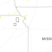
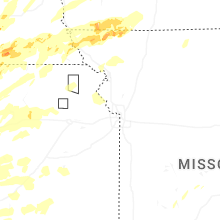

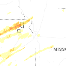


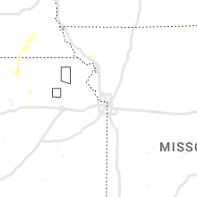


Connect with Interactive Hail Maps