

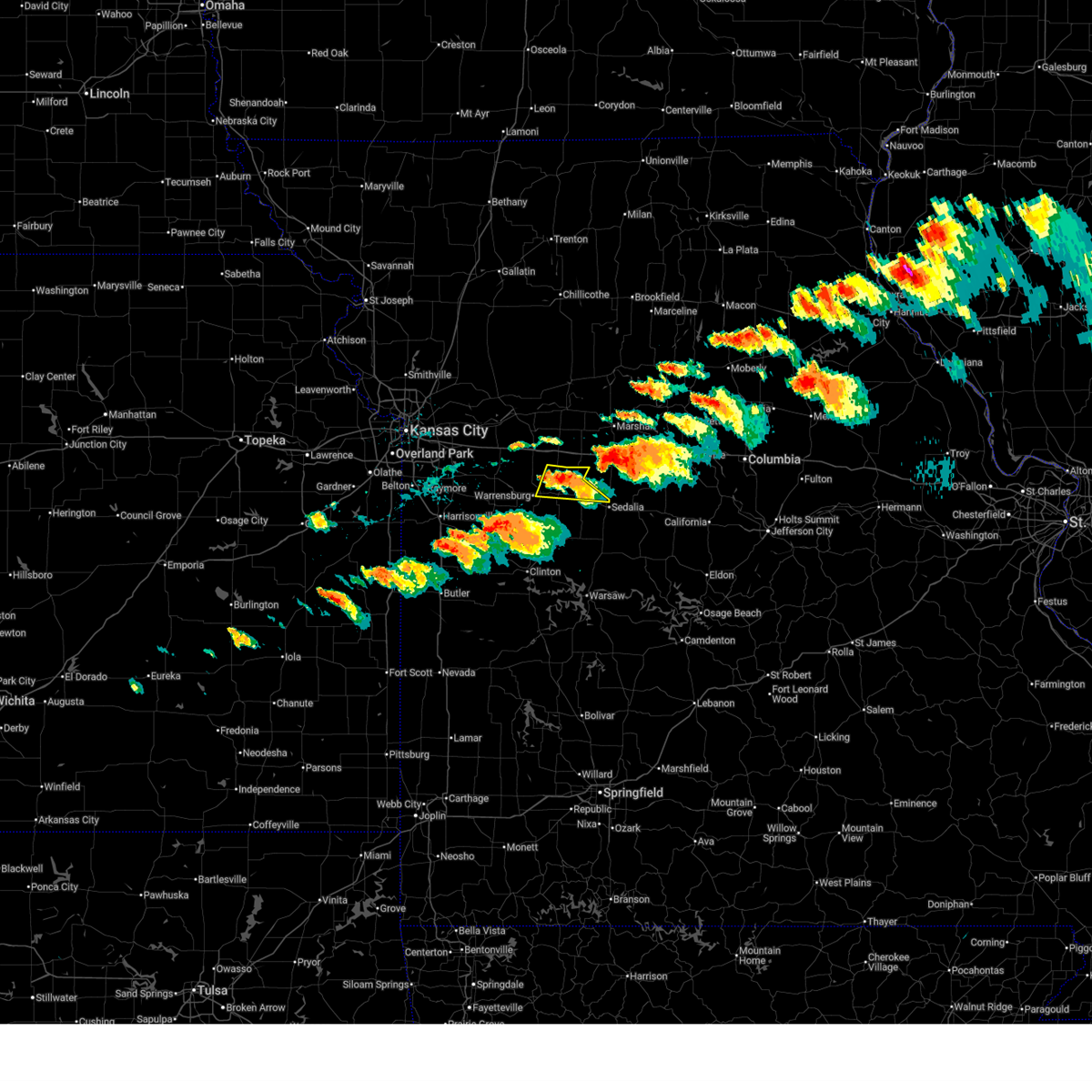
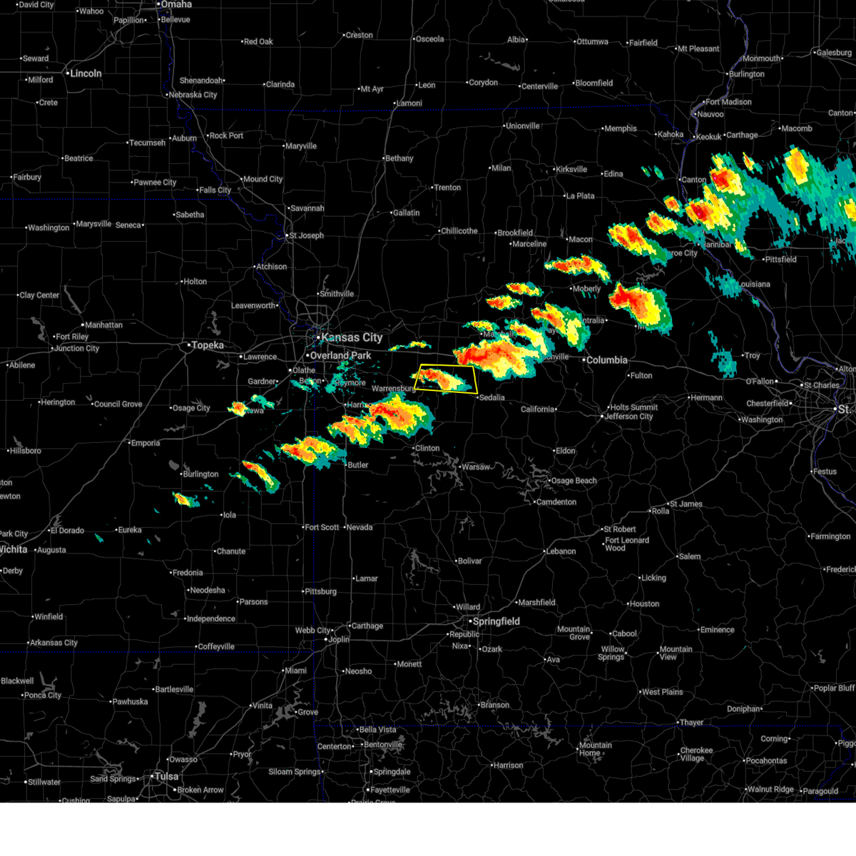
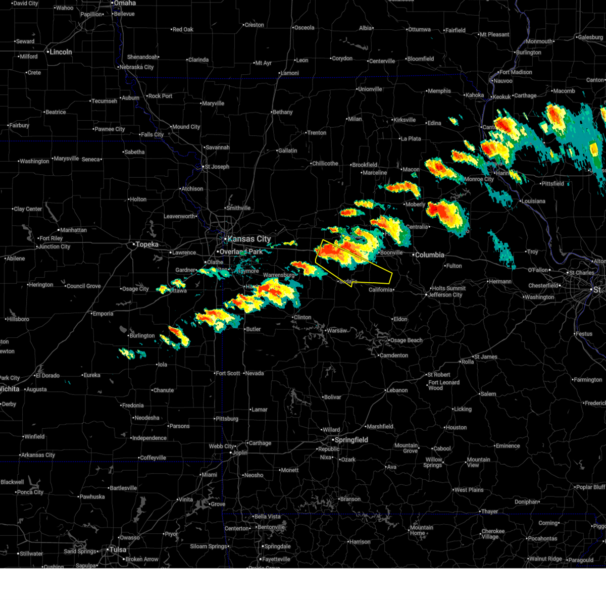
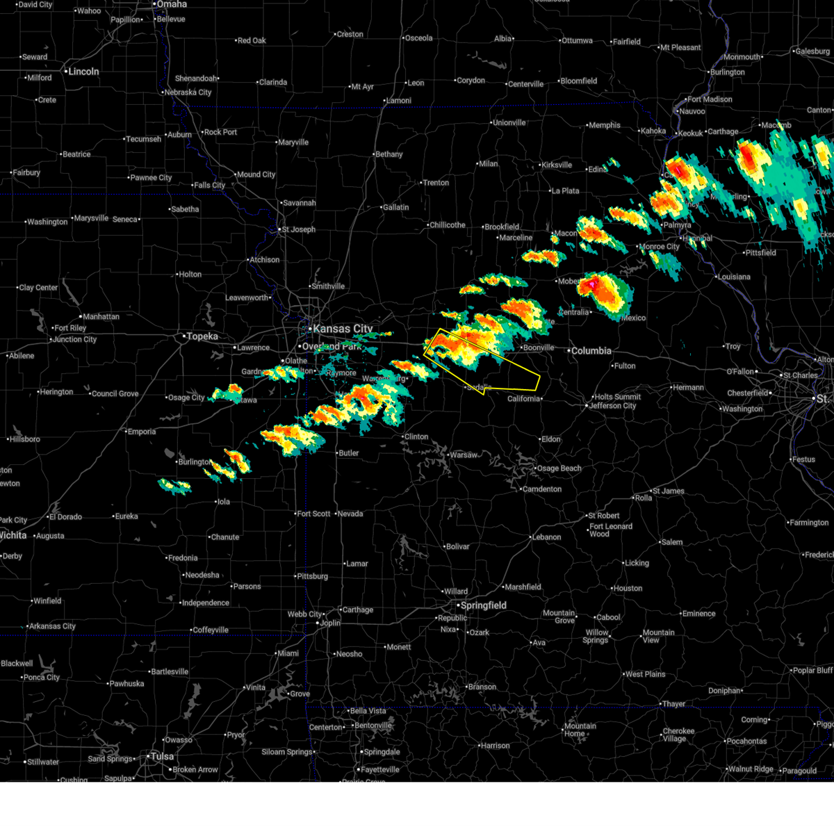
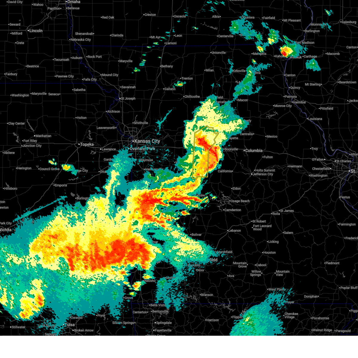
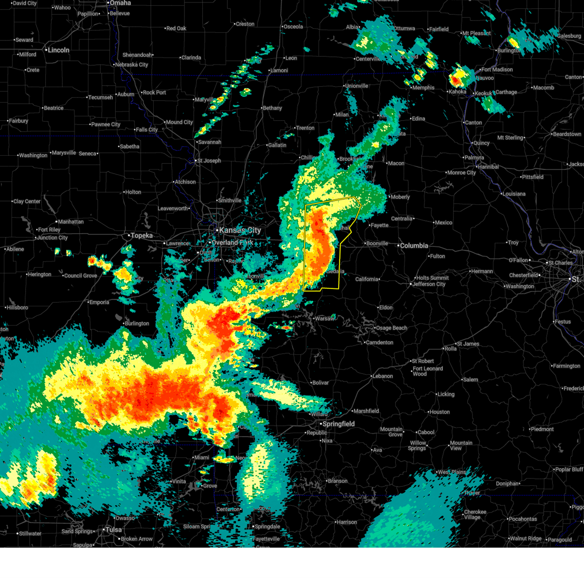
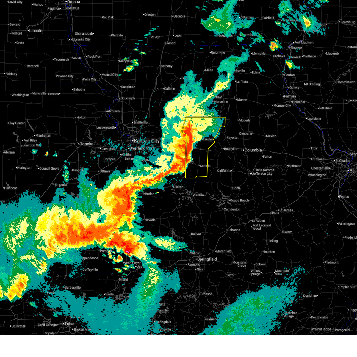
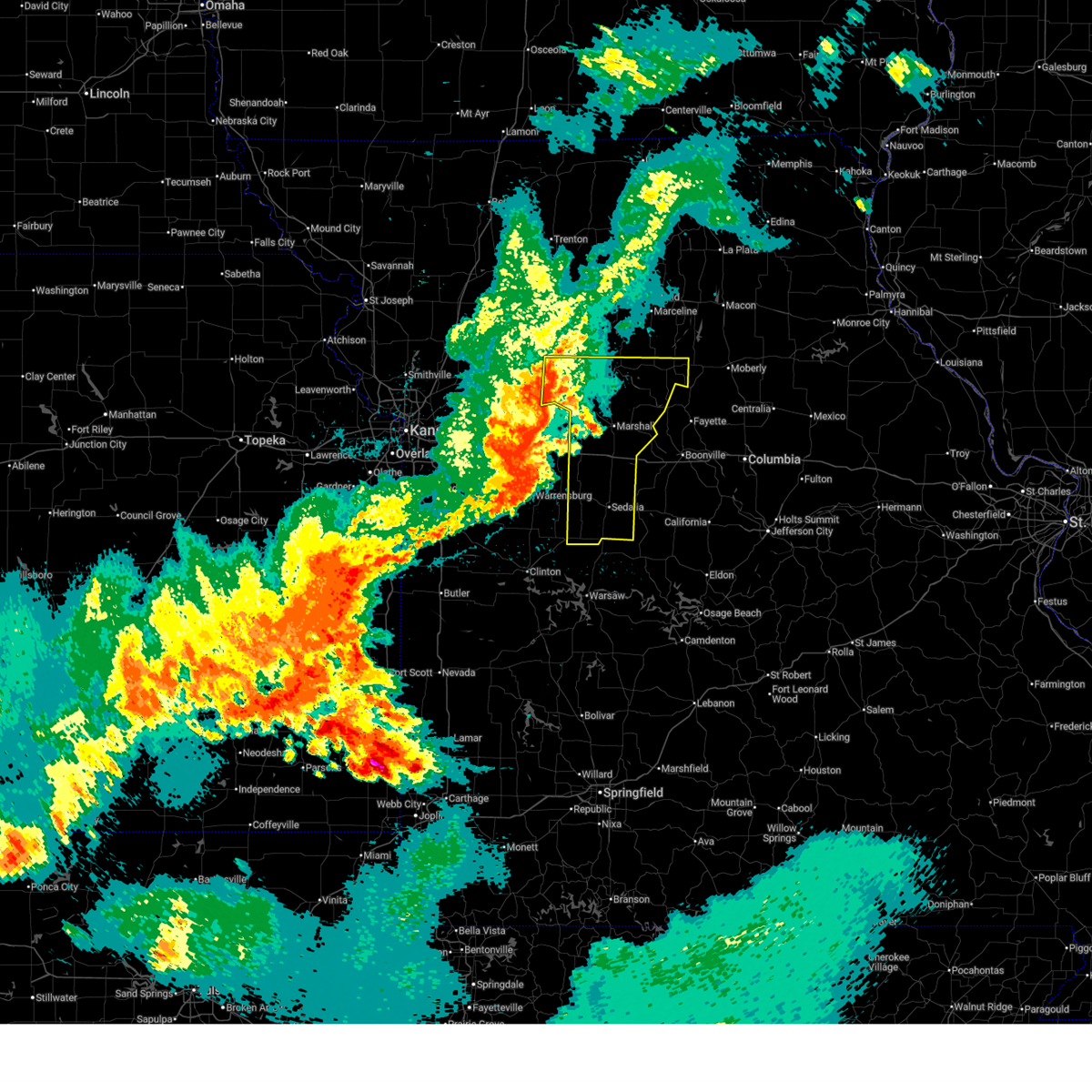
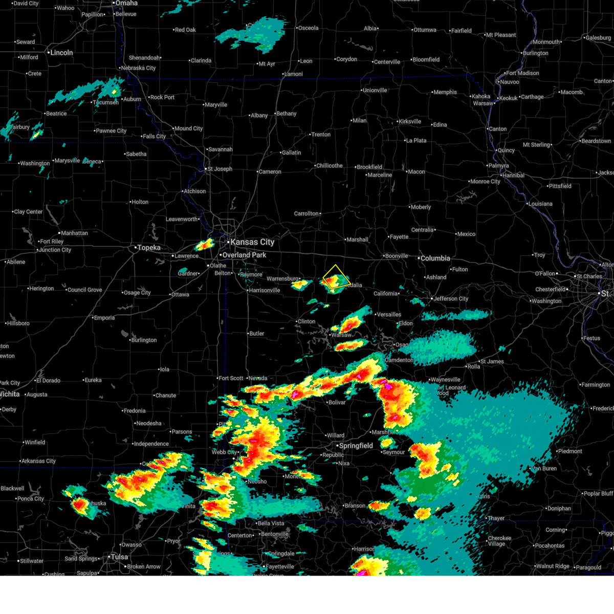
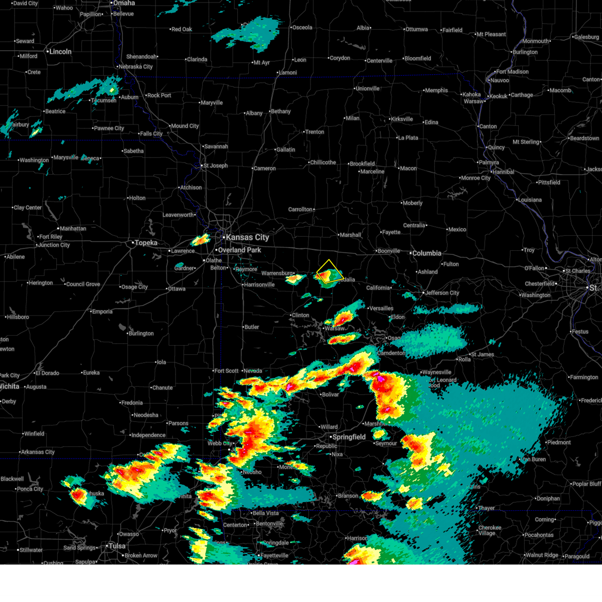
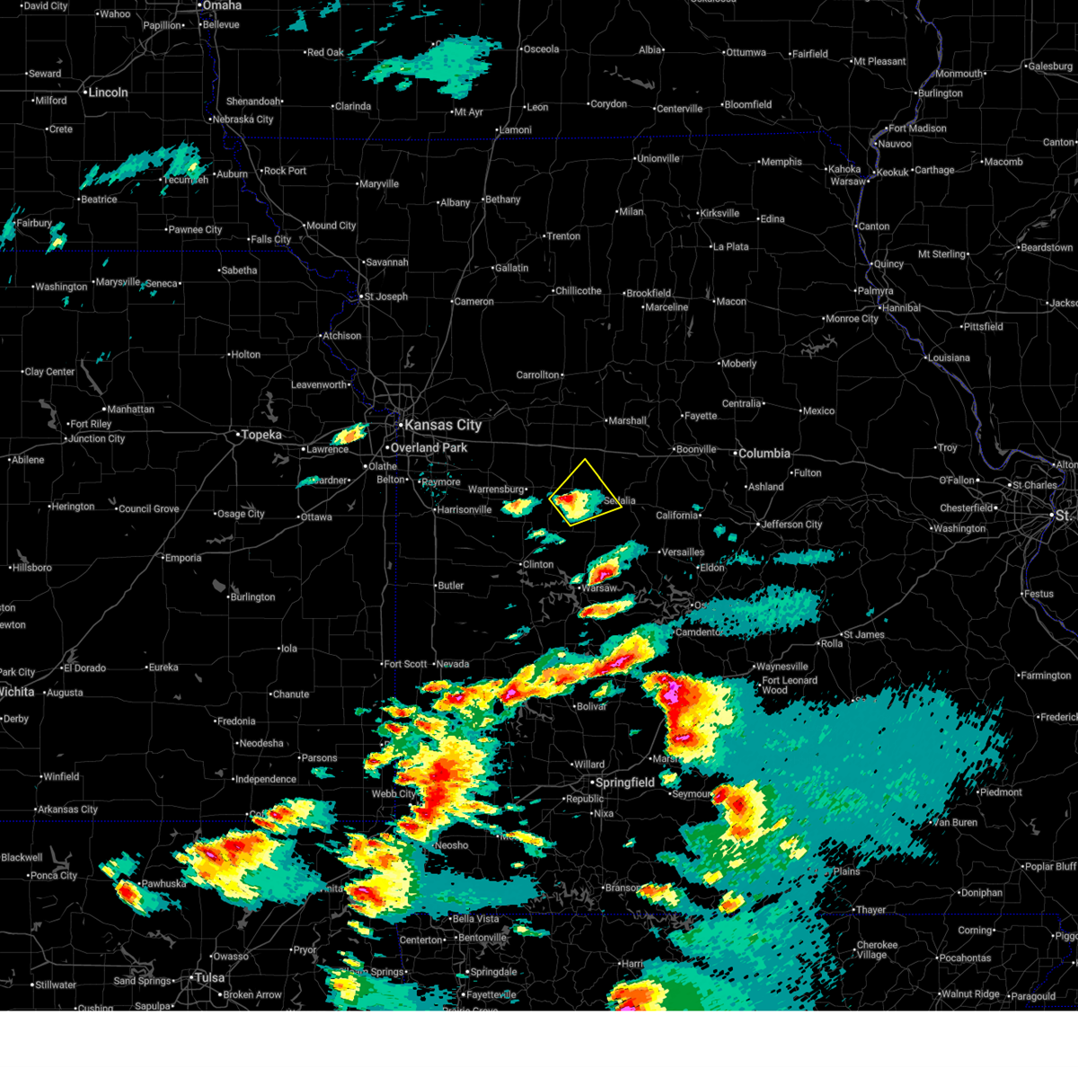
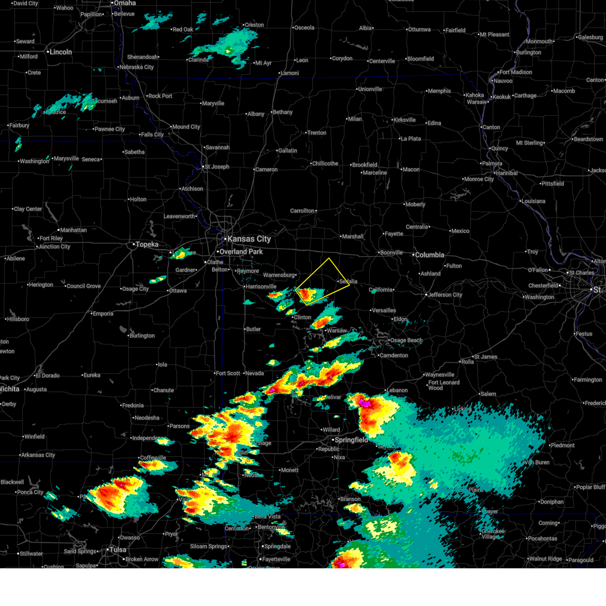
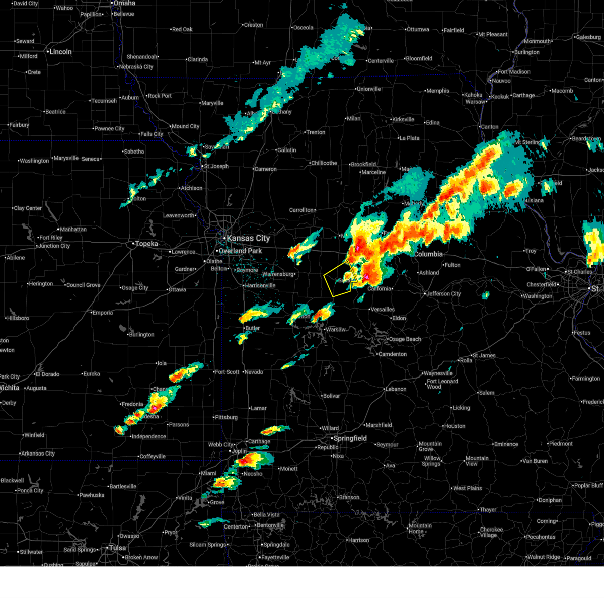
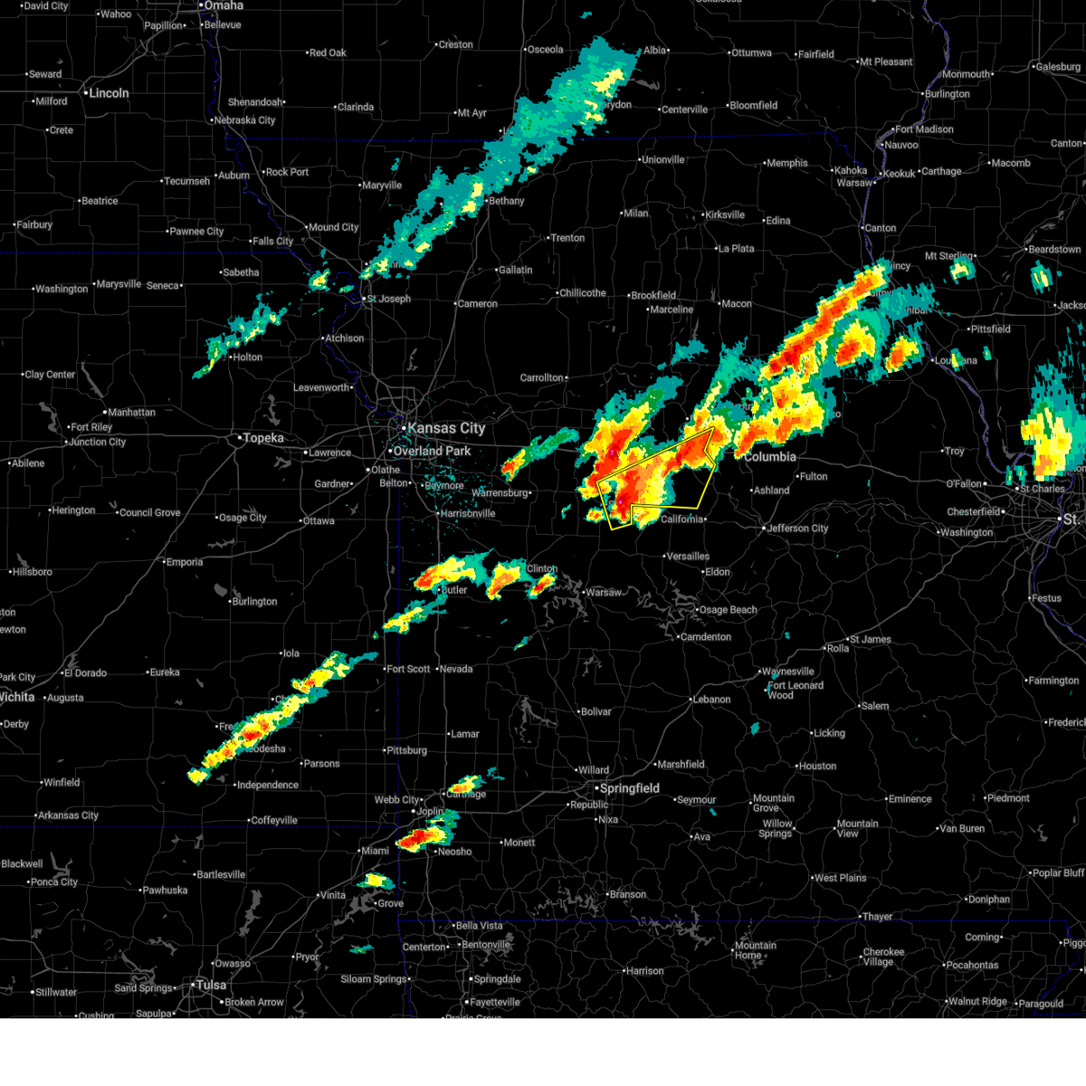
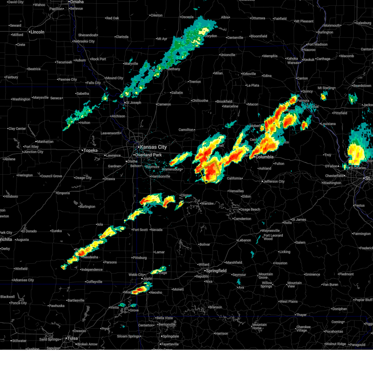
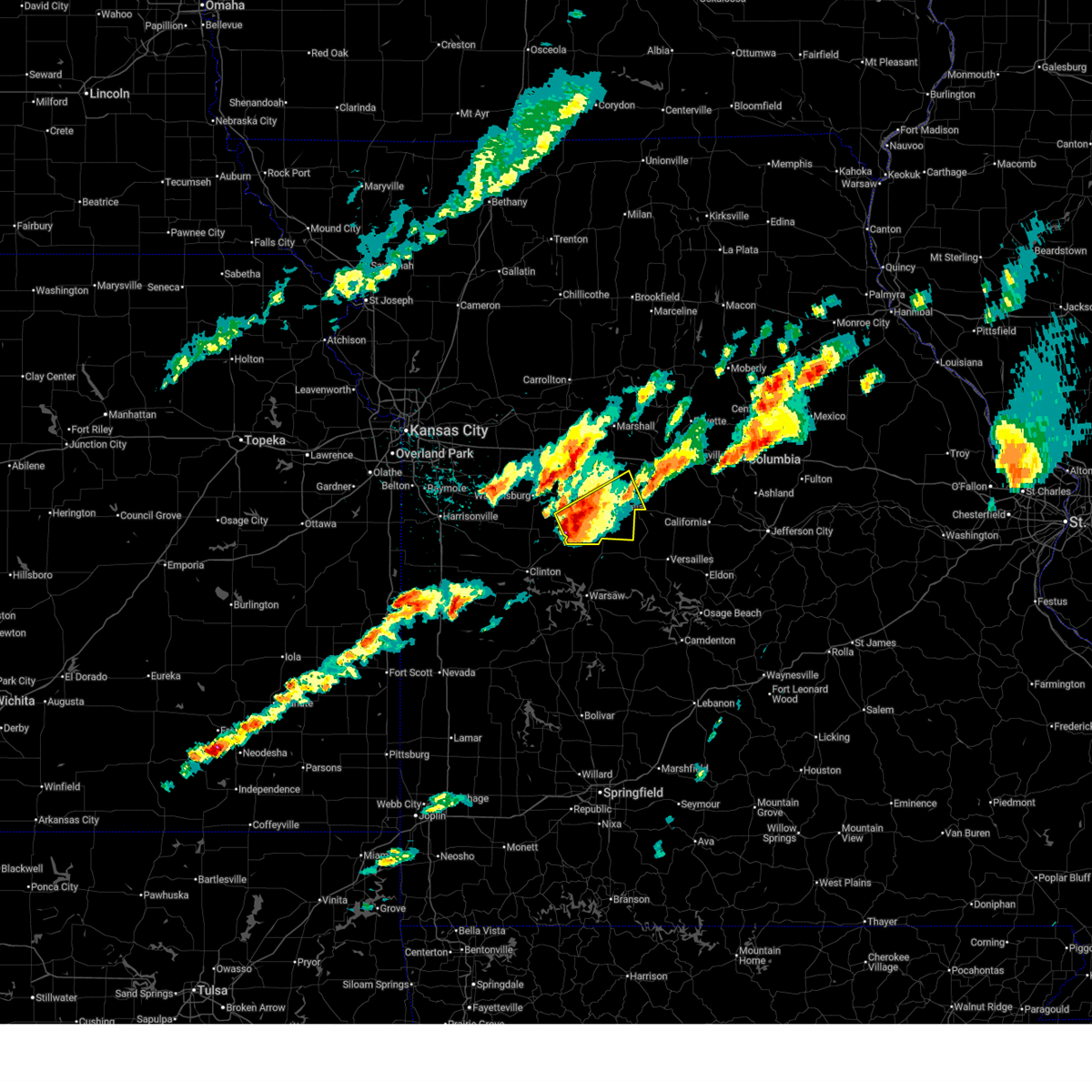
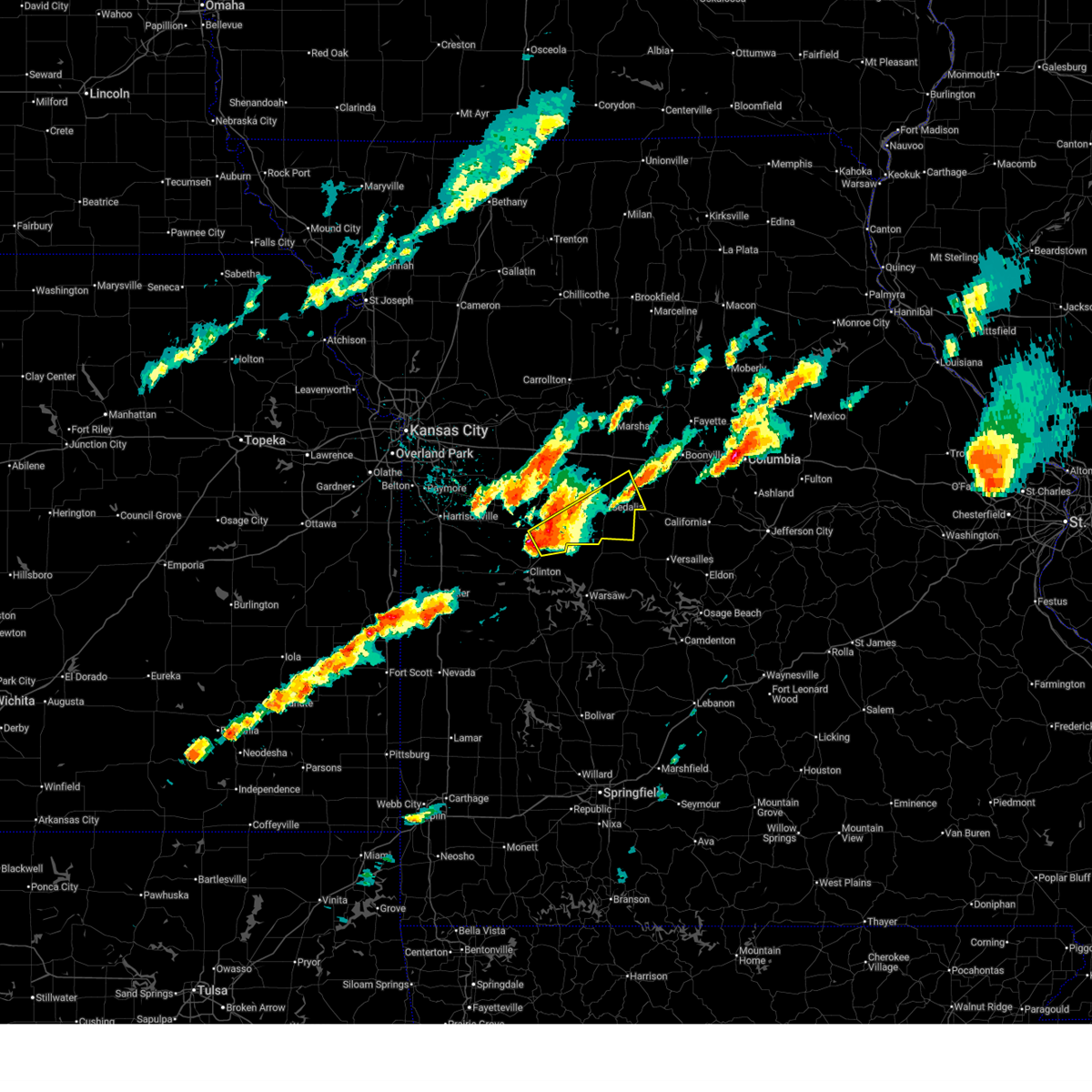
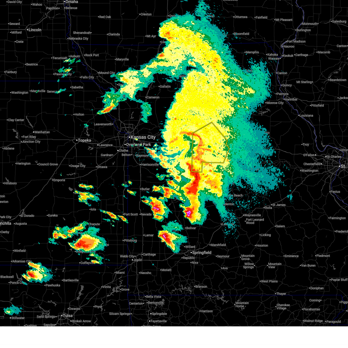
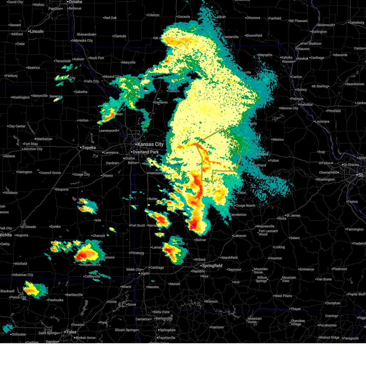
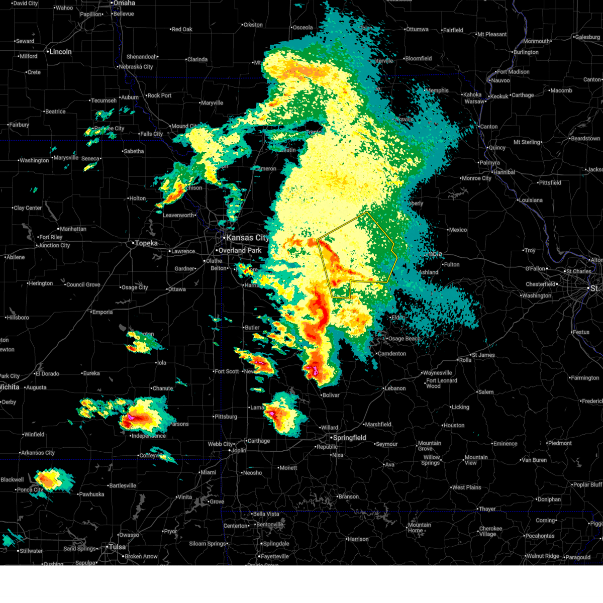
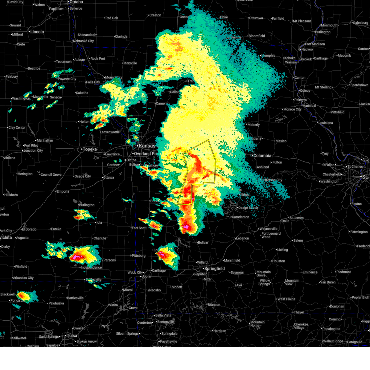
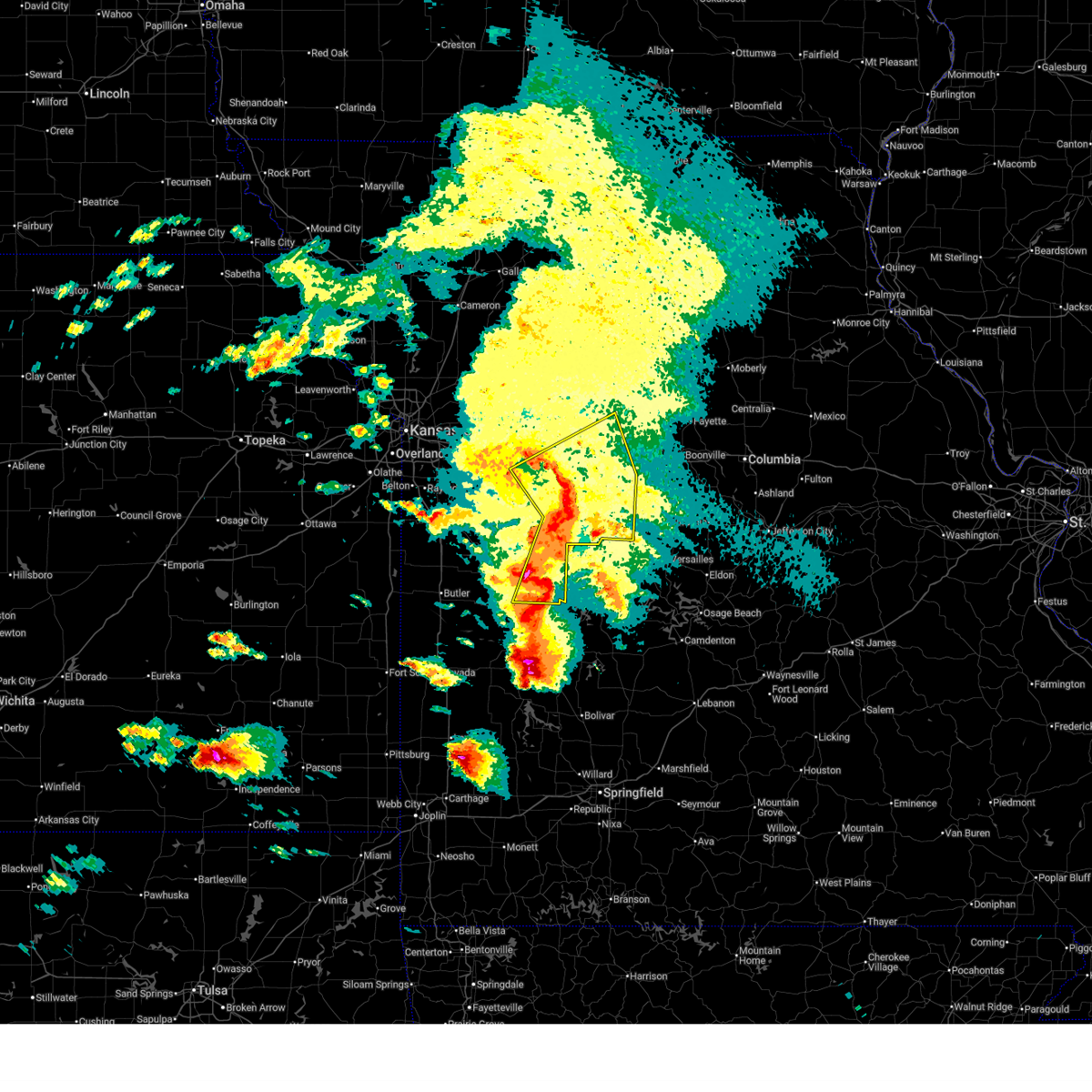
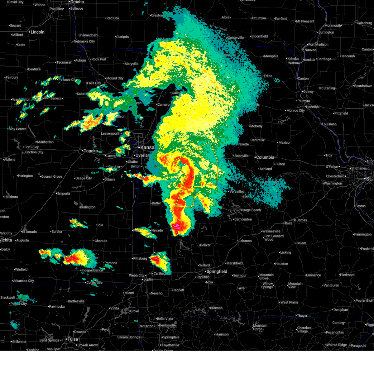
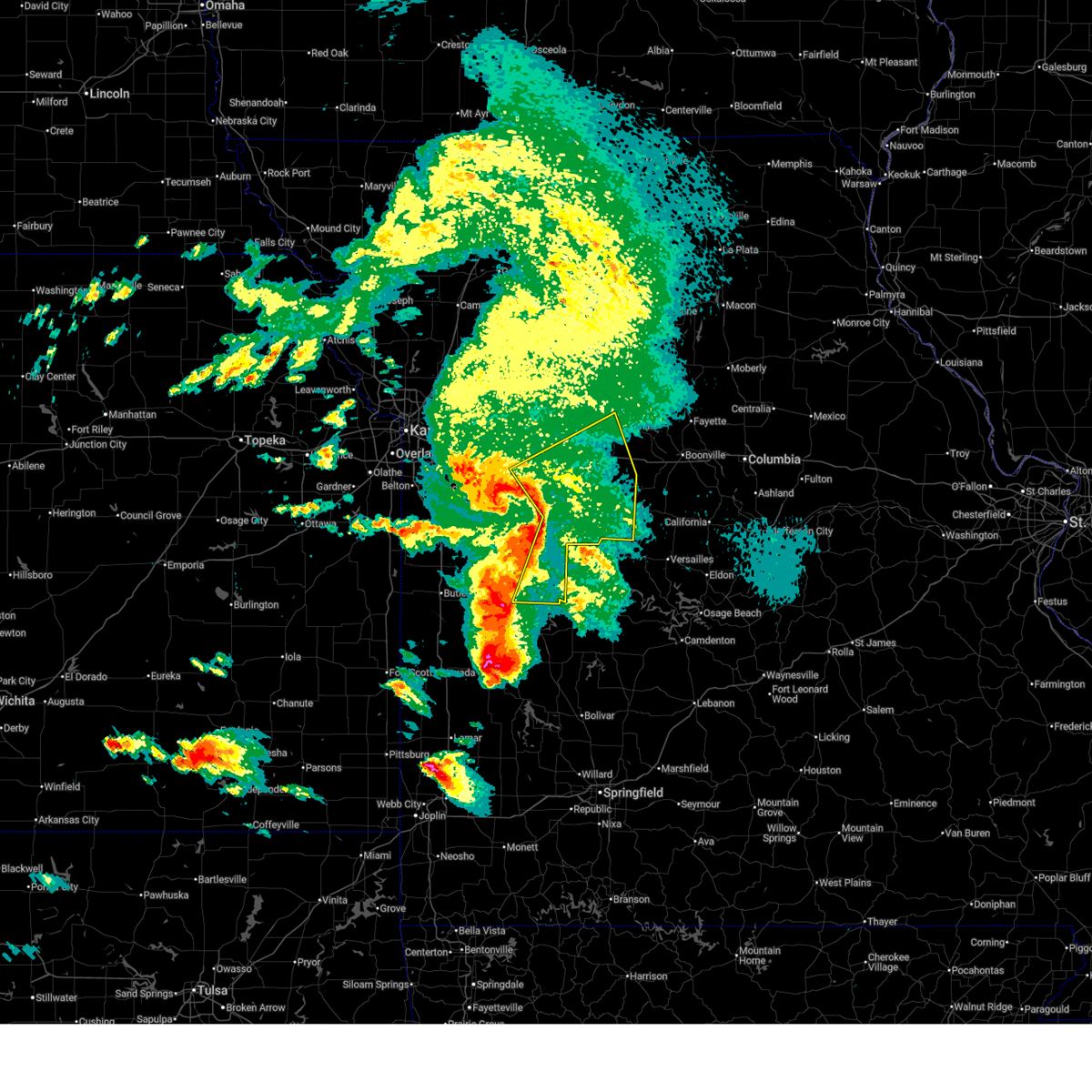
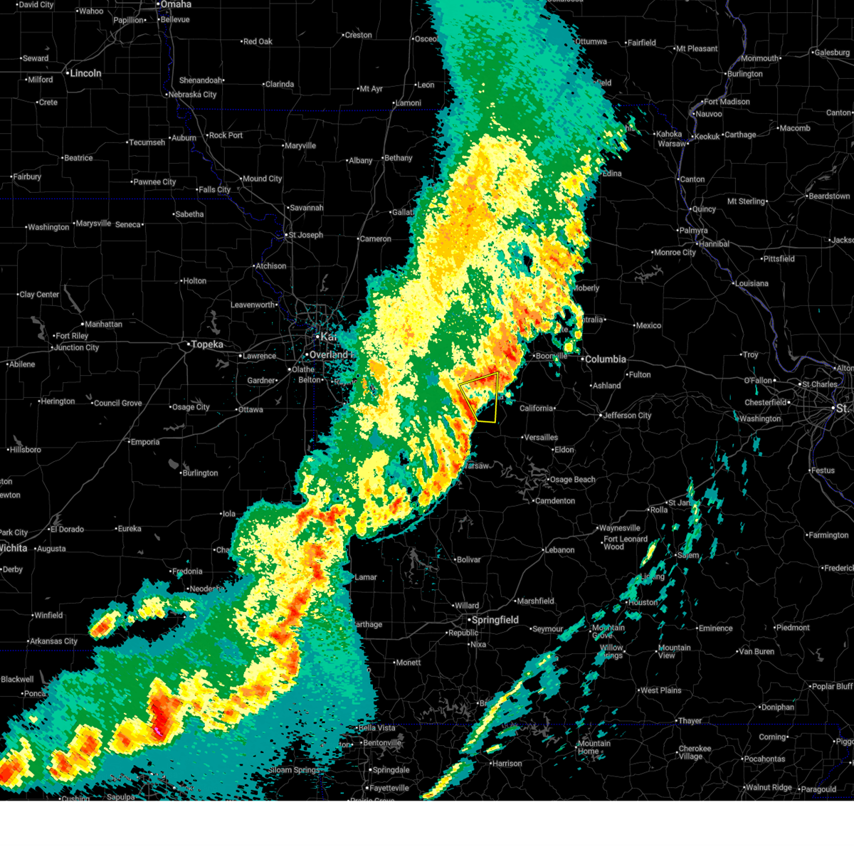
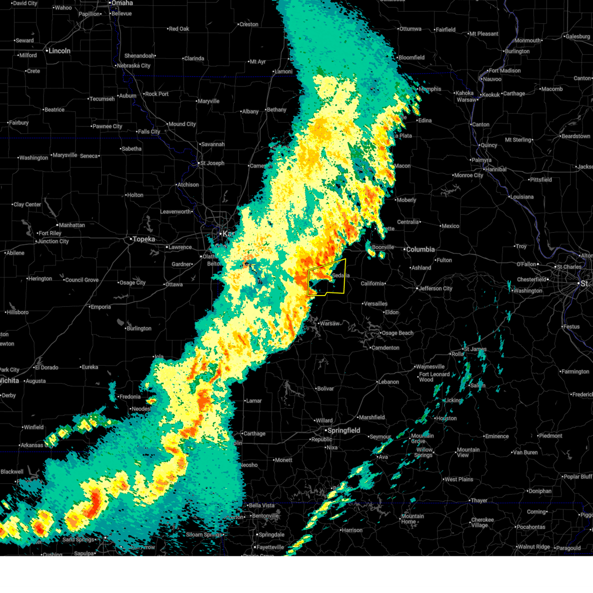
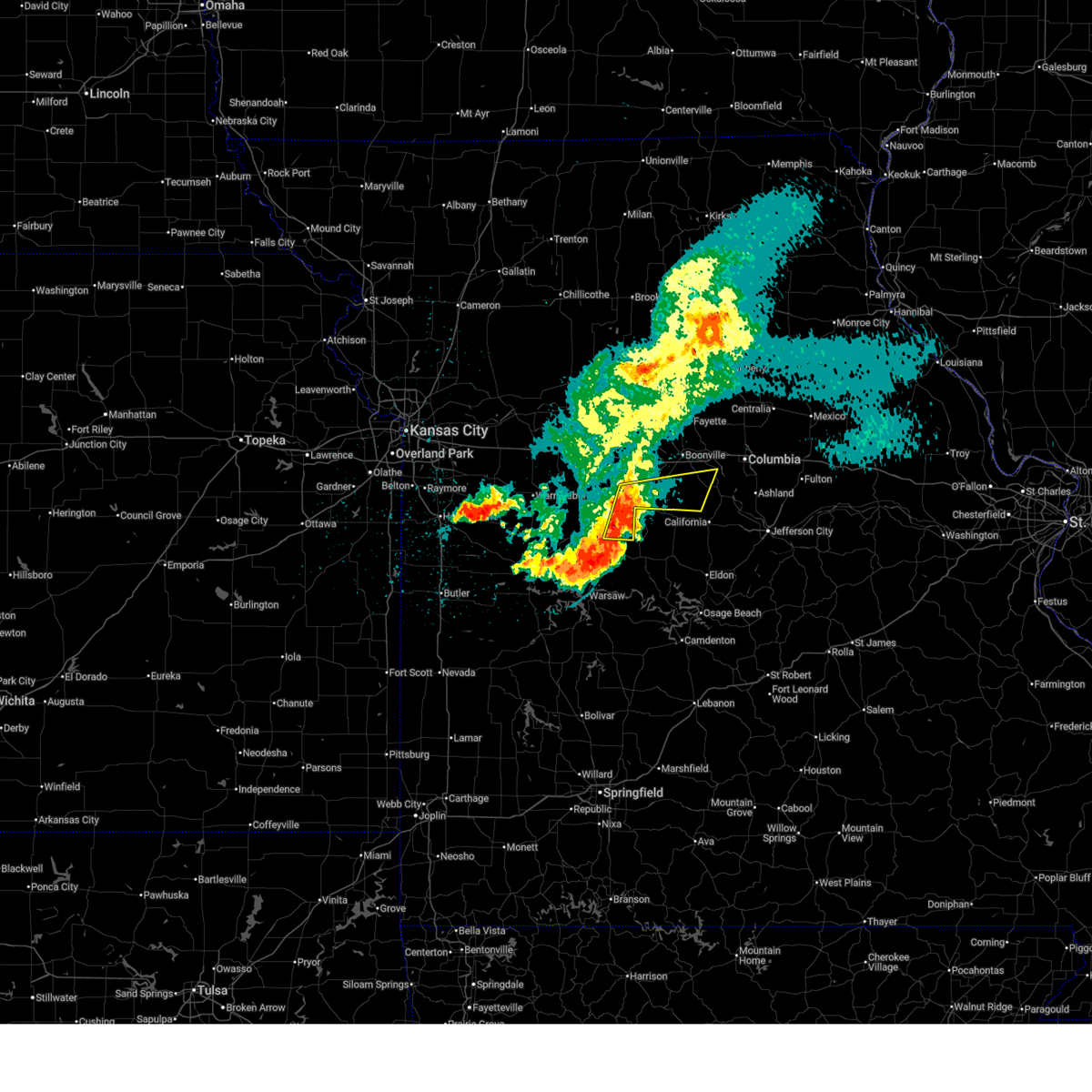
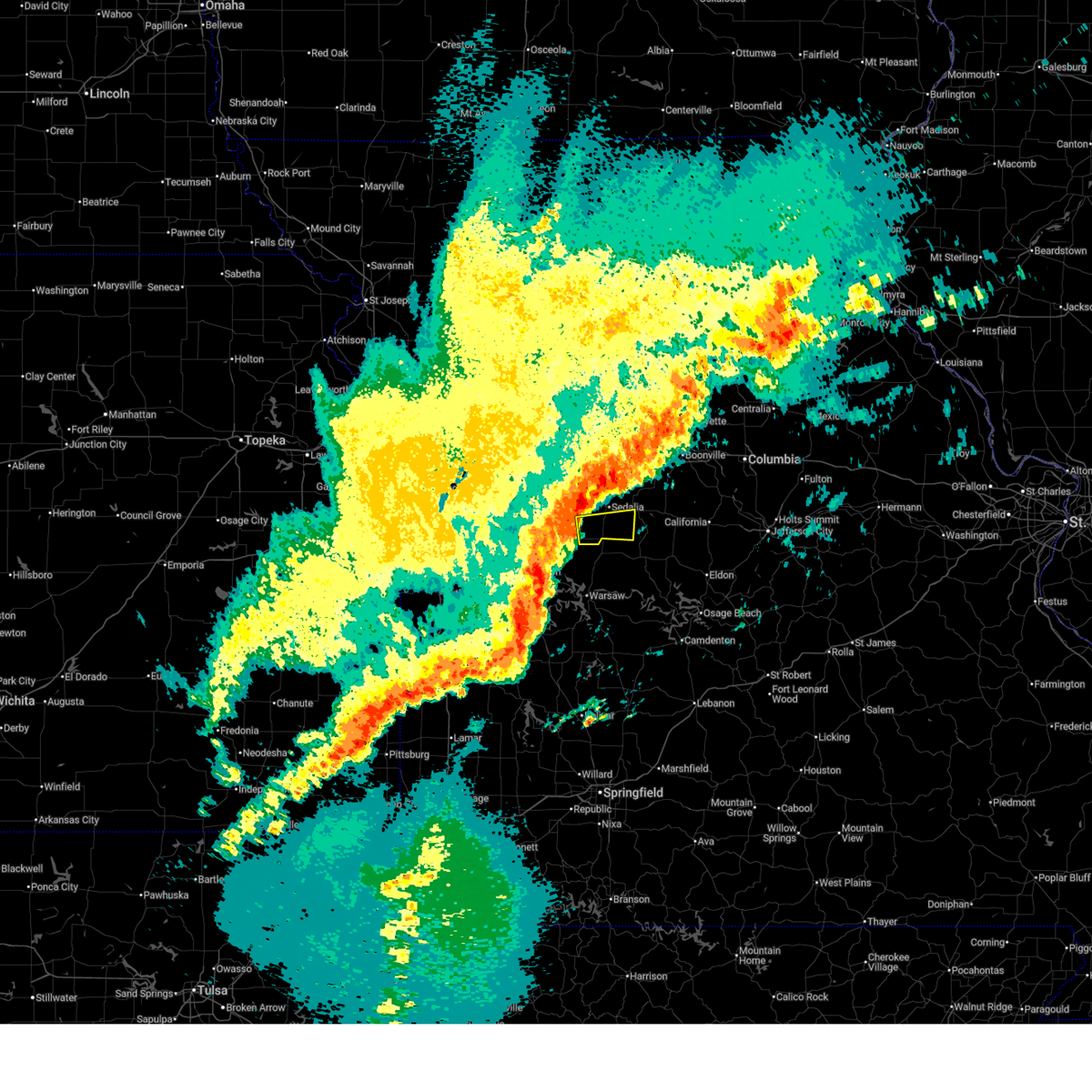
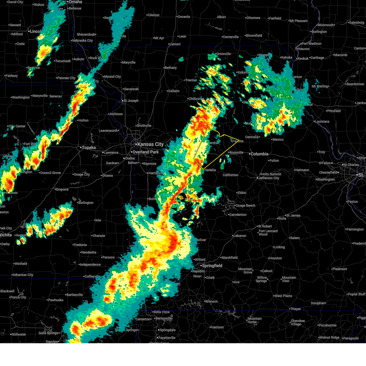
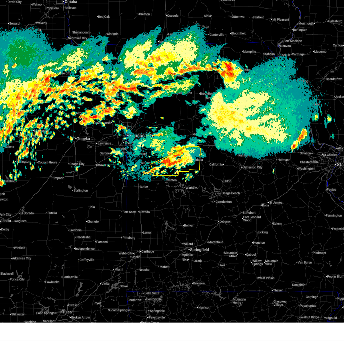
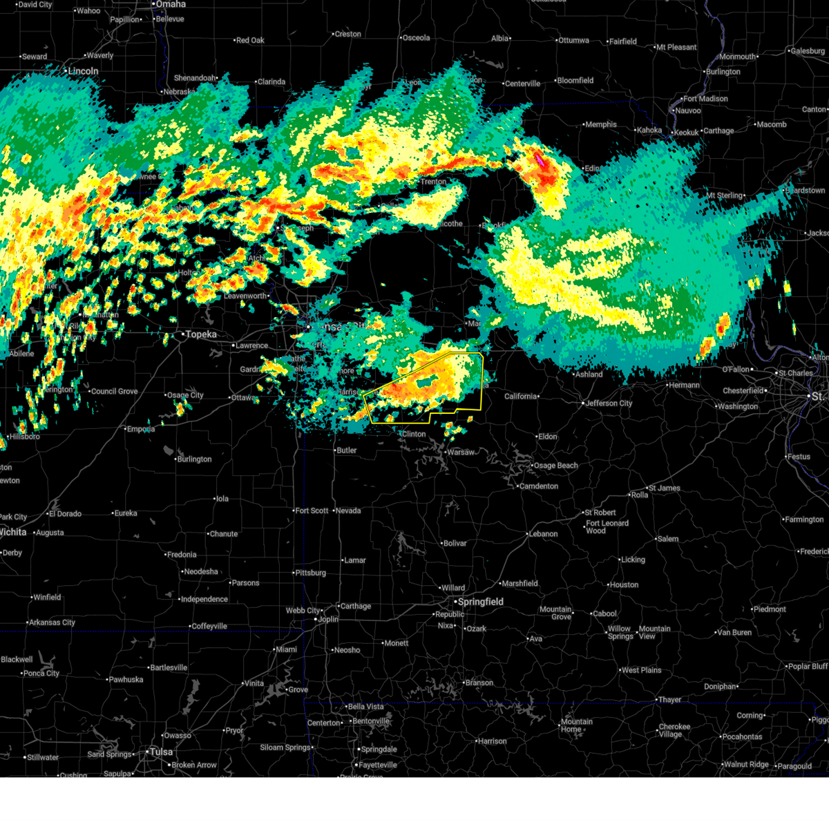
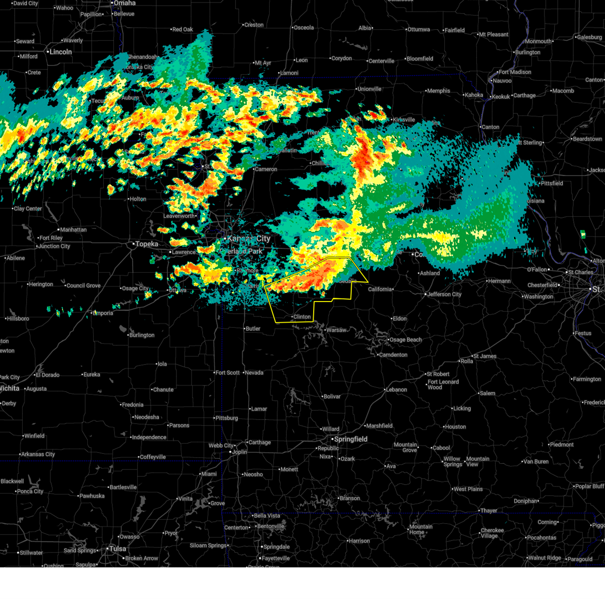
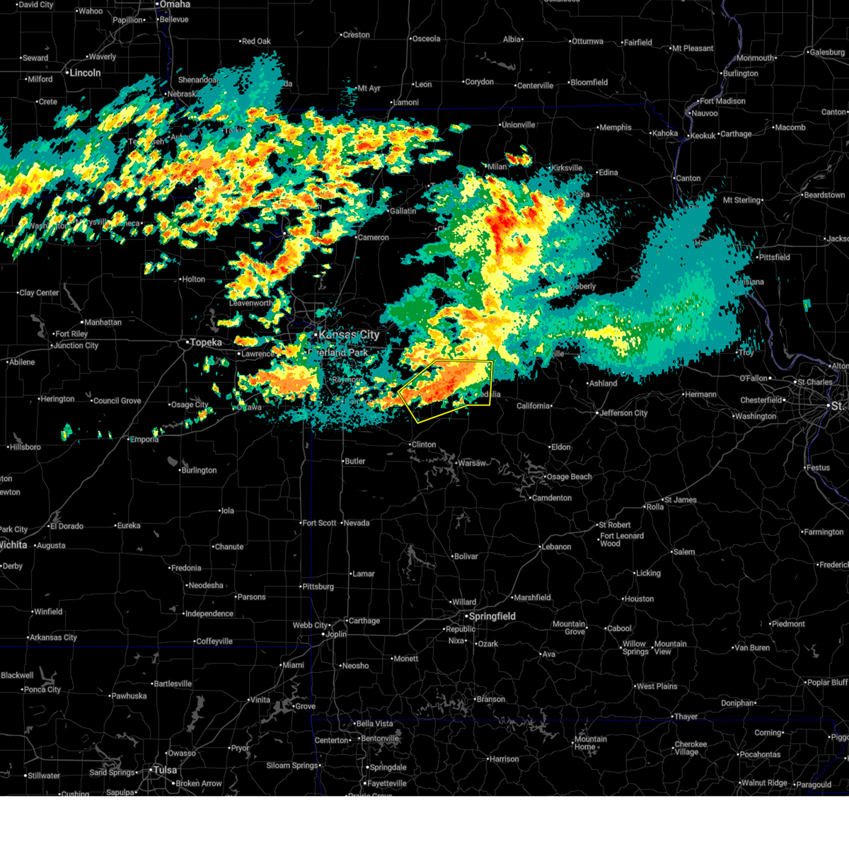
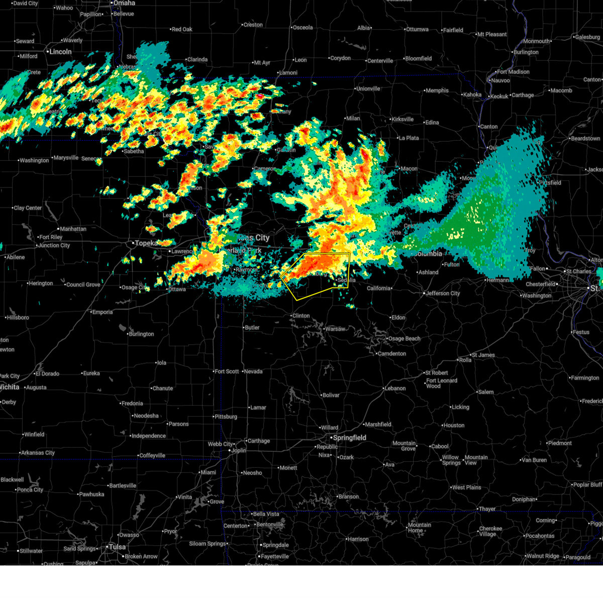
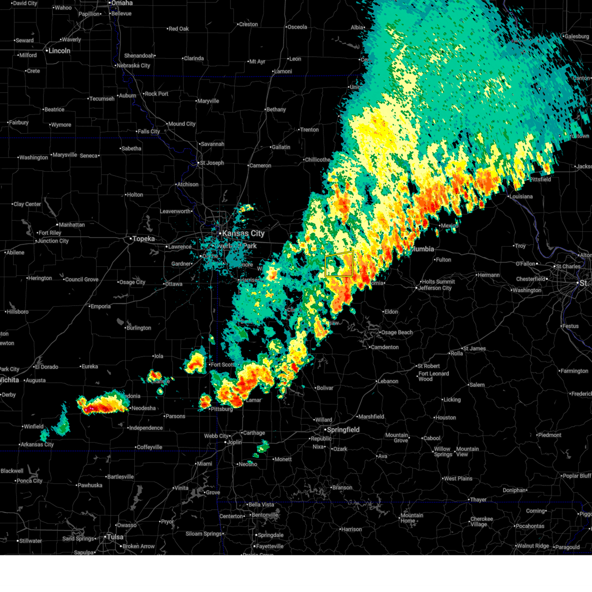
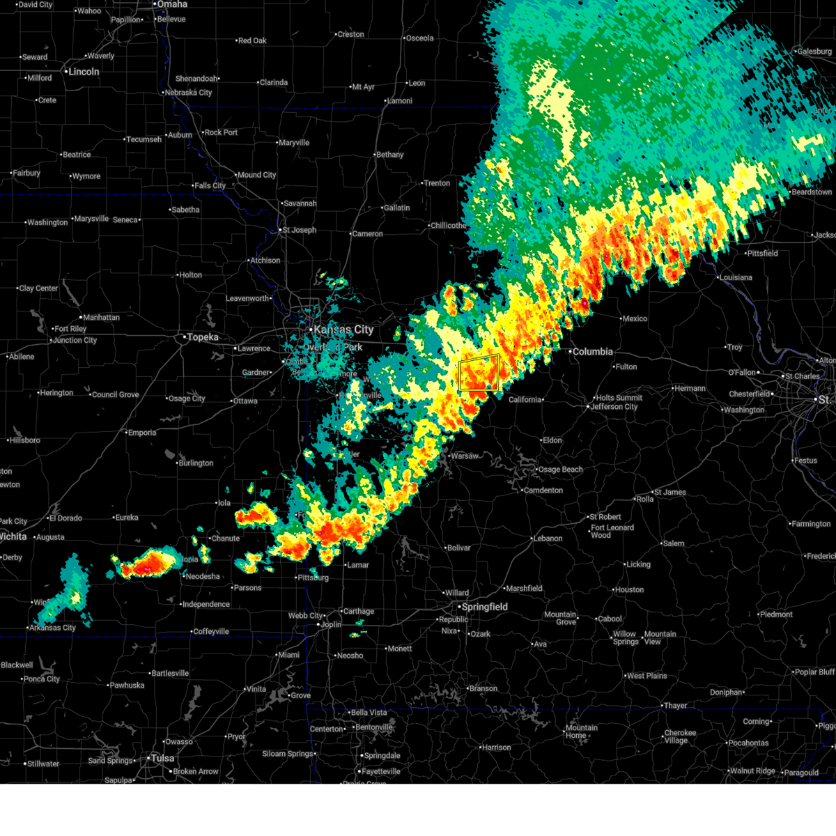
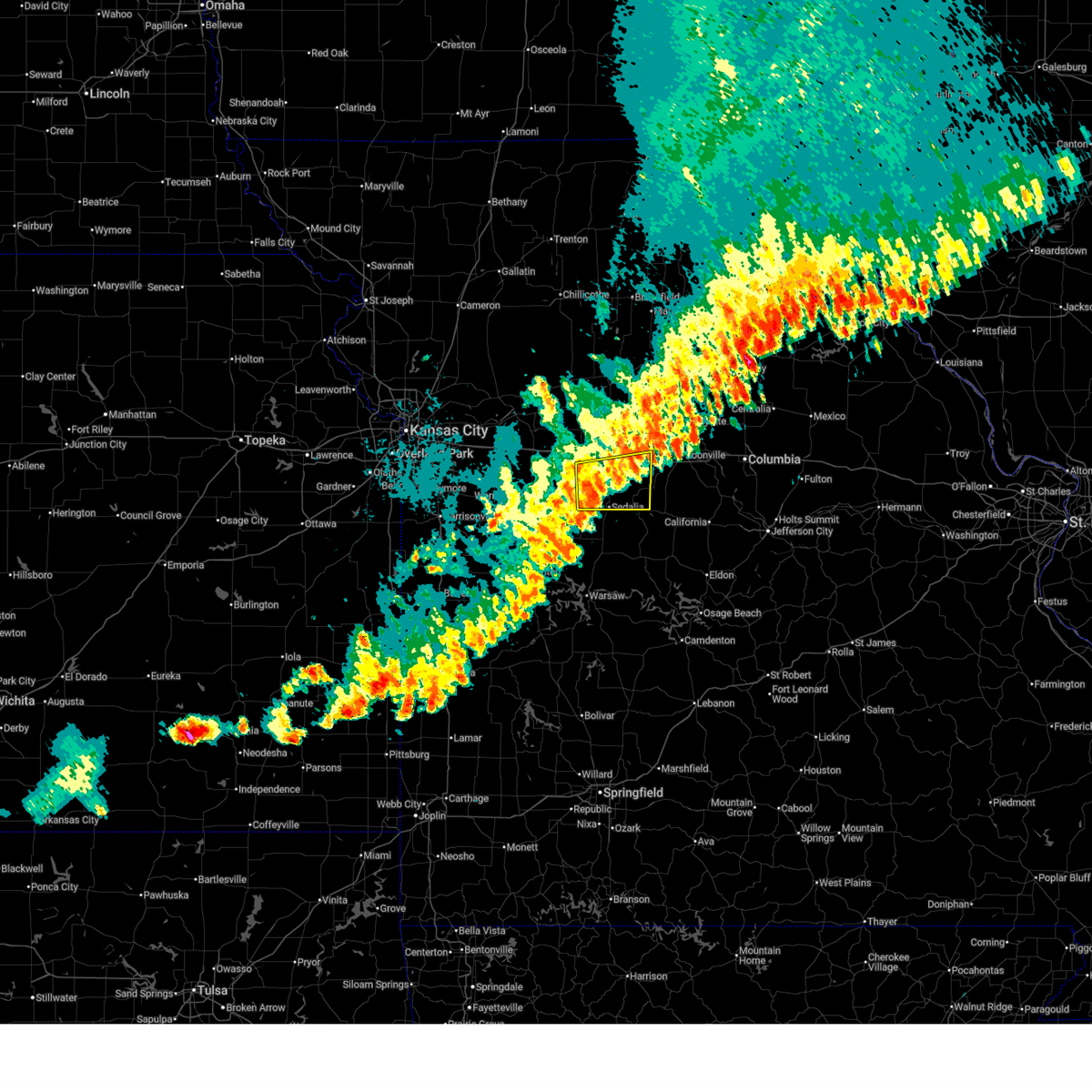
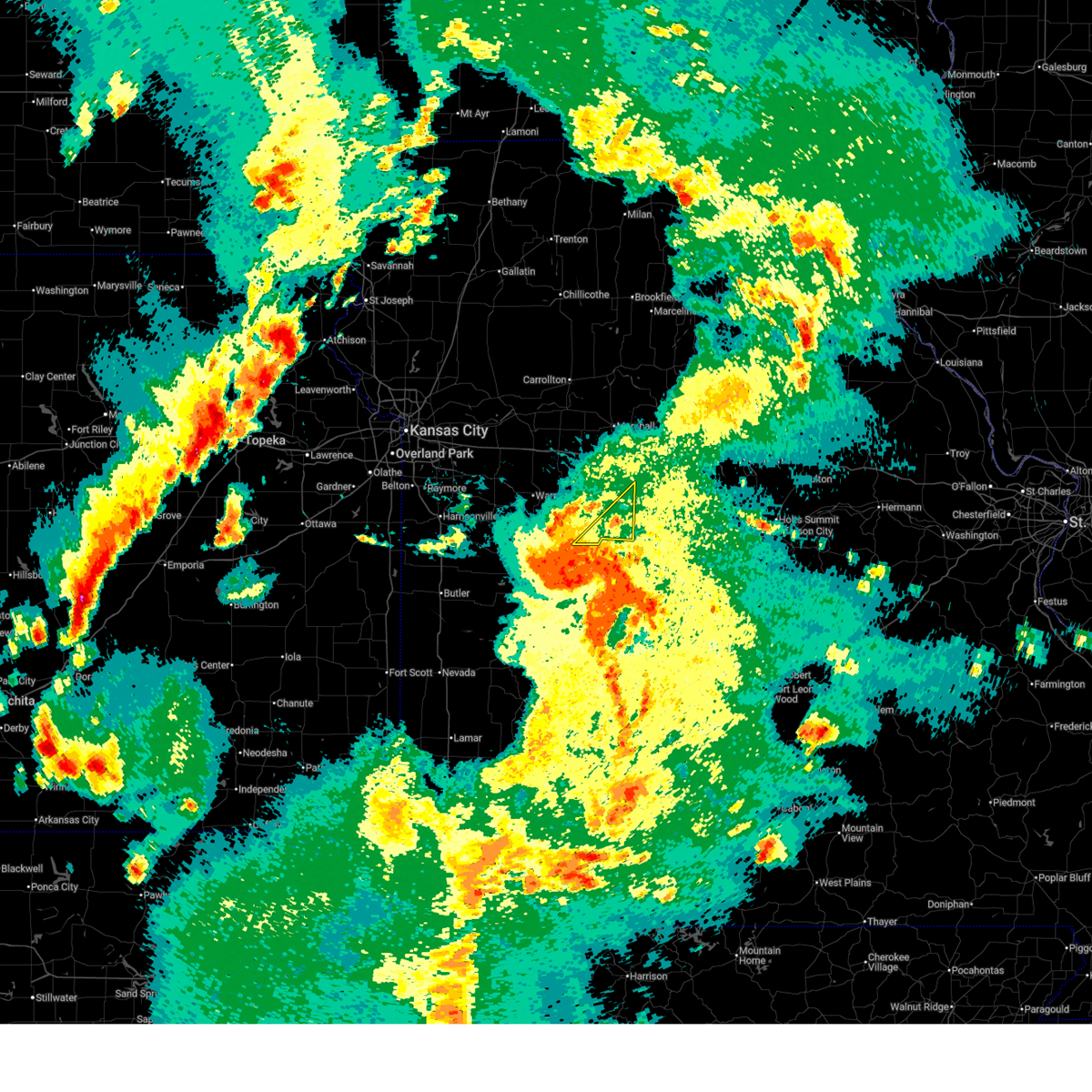
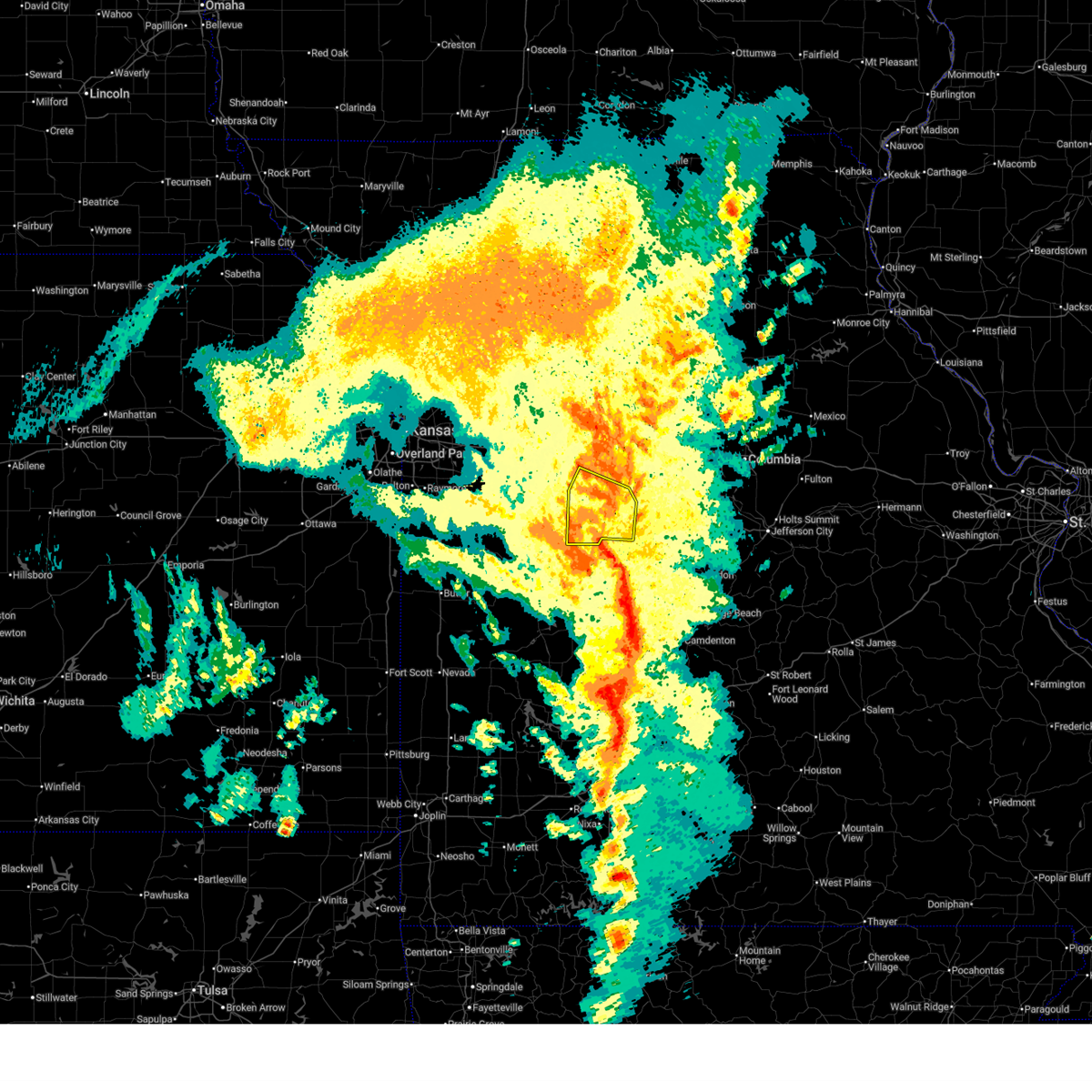
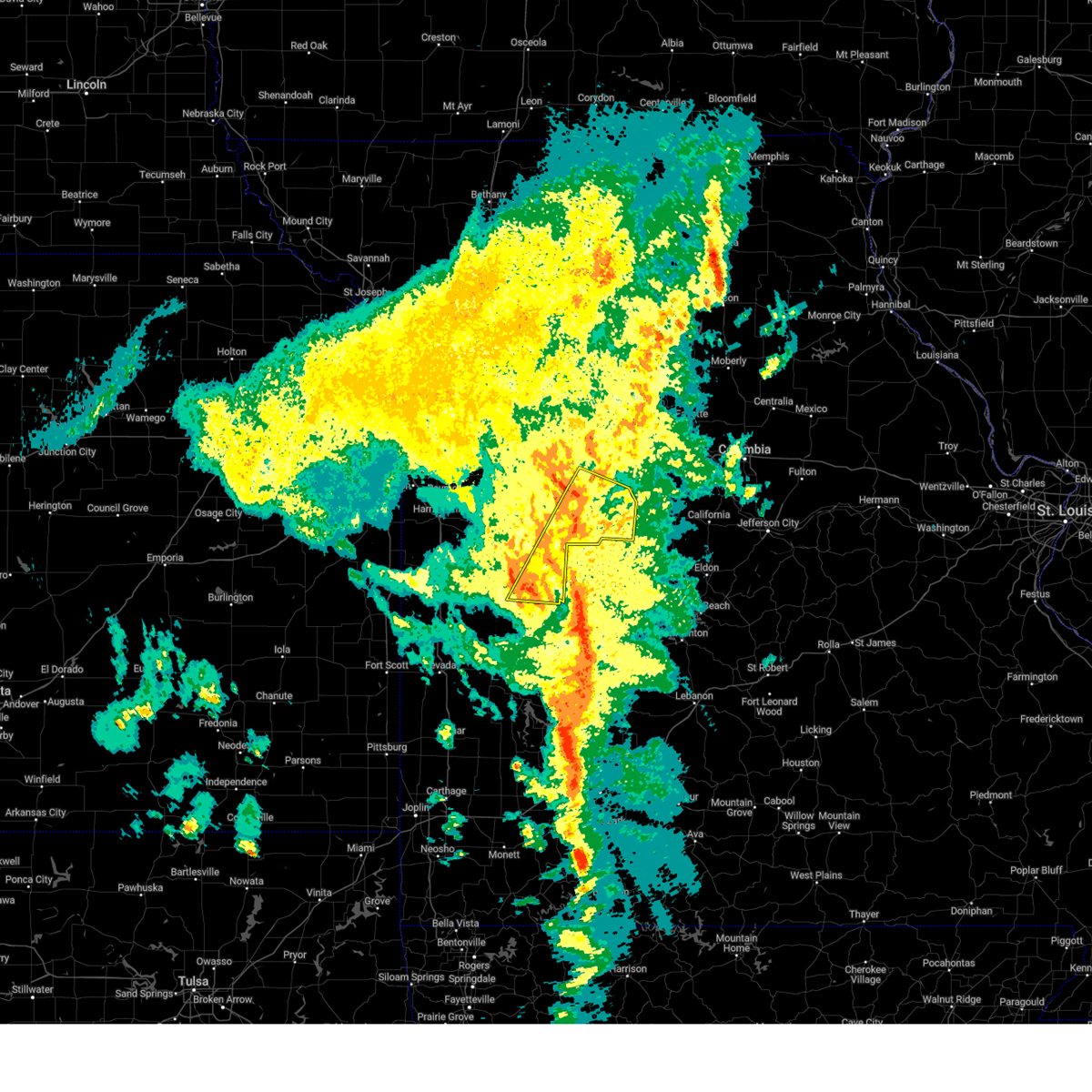
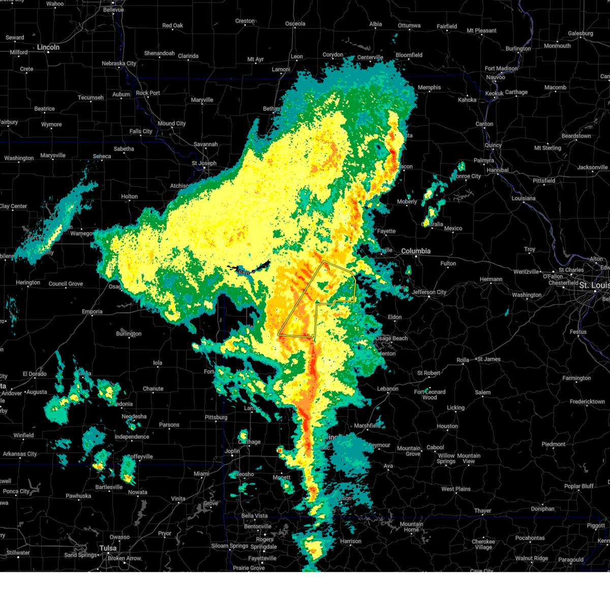
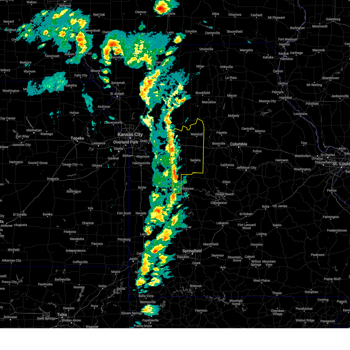
Hail Map for Sedalia, MO
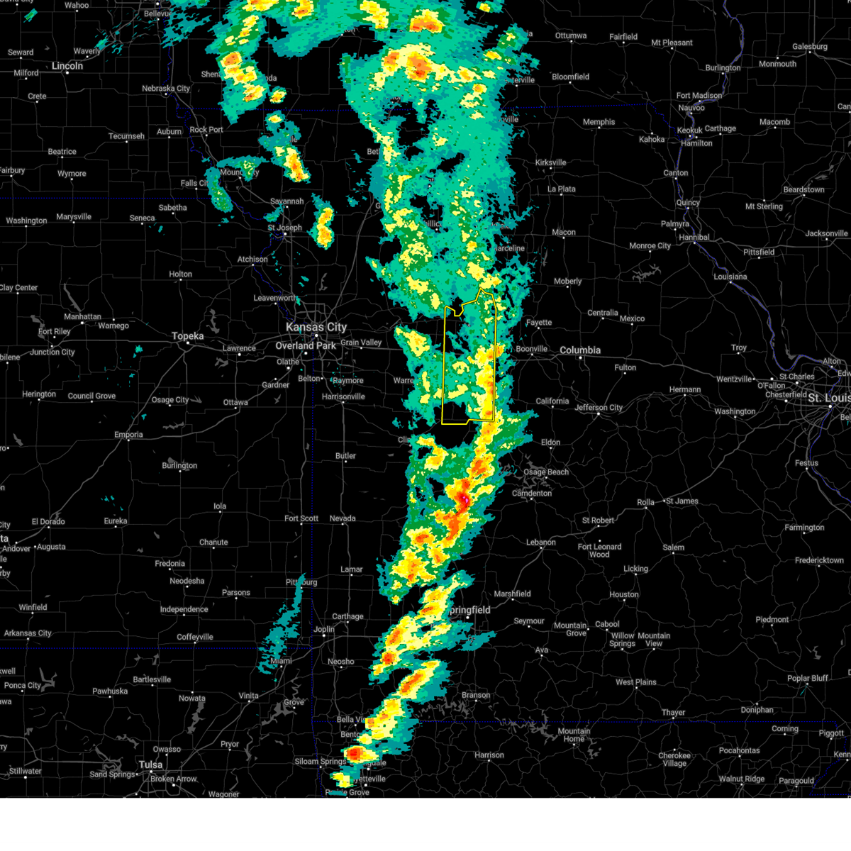
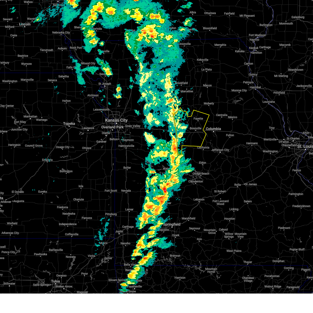
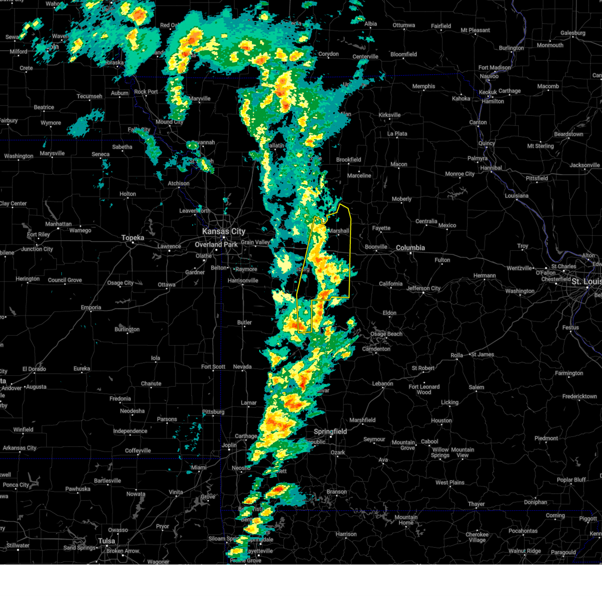
The Sedalia, MO area has had 22 reports of on-the-ground hail by trained spotters, and has been under severe weather warnings 51 times during the past 12 months. Doppler radar has detected hail at or near Sedalia, MO on 83 occasions, including 6 occasions during the past year.
| Name: | Sedalia, MO |
| Where Located: | 52 miles WSW of Columbia, MO |
| Map: | Google Map for Sedalia, MO |
| Population: | 21387 |
| Housing Units: | 9979 |
| More Info: | Search Google for Sedalia, MO |
2
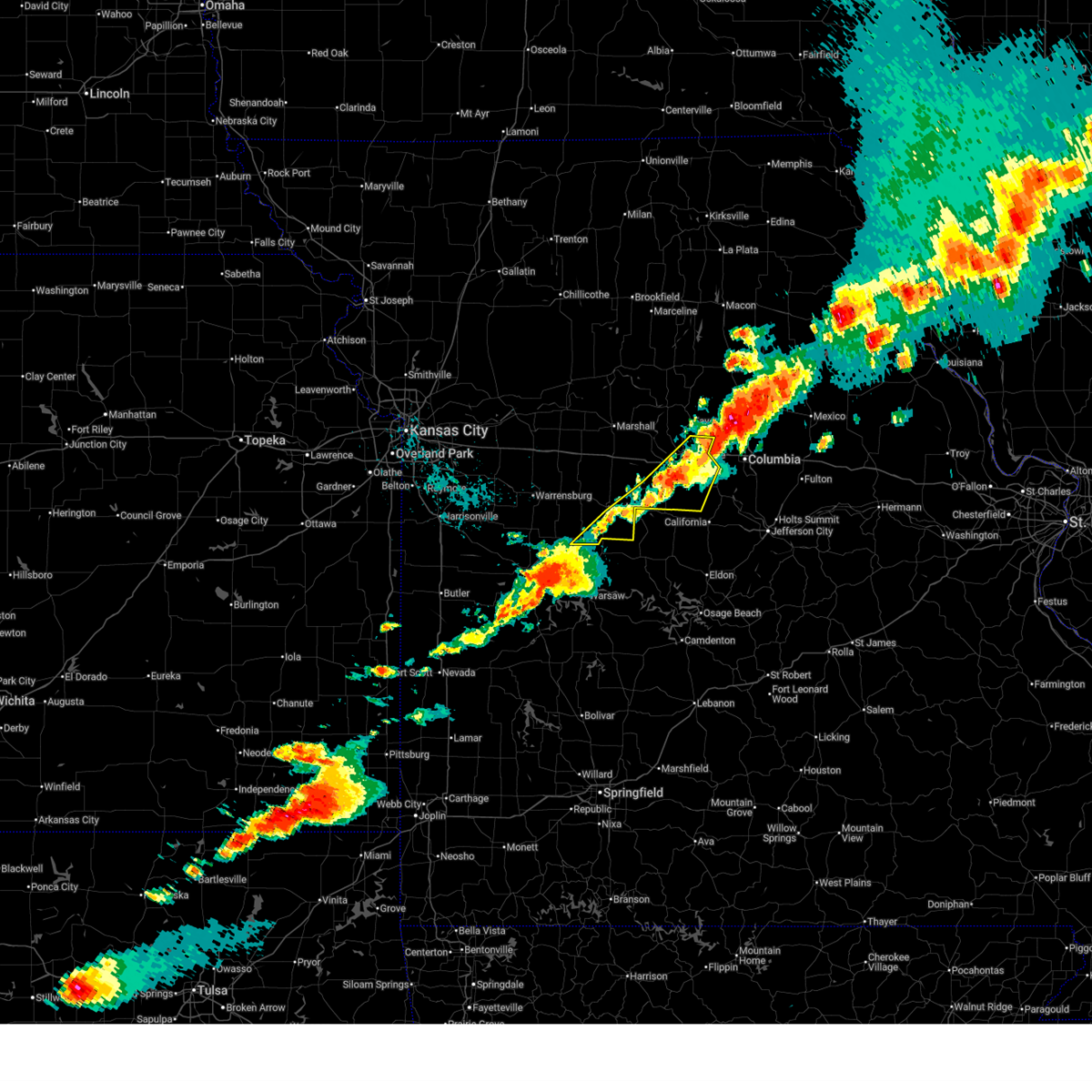
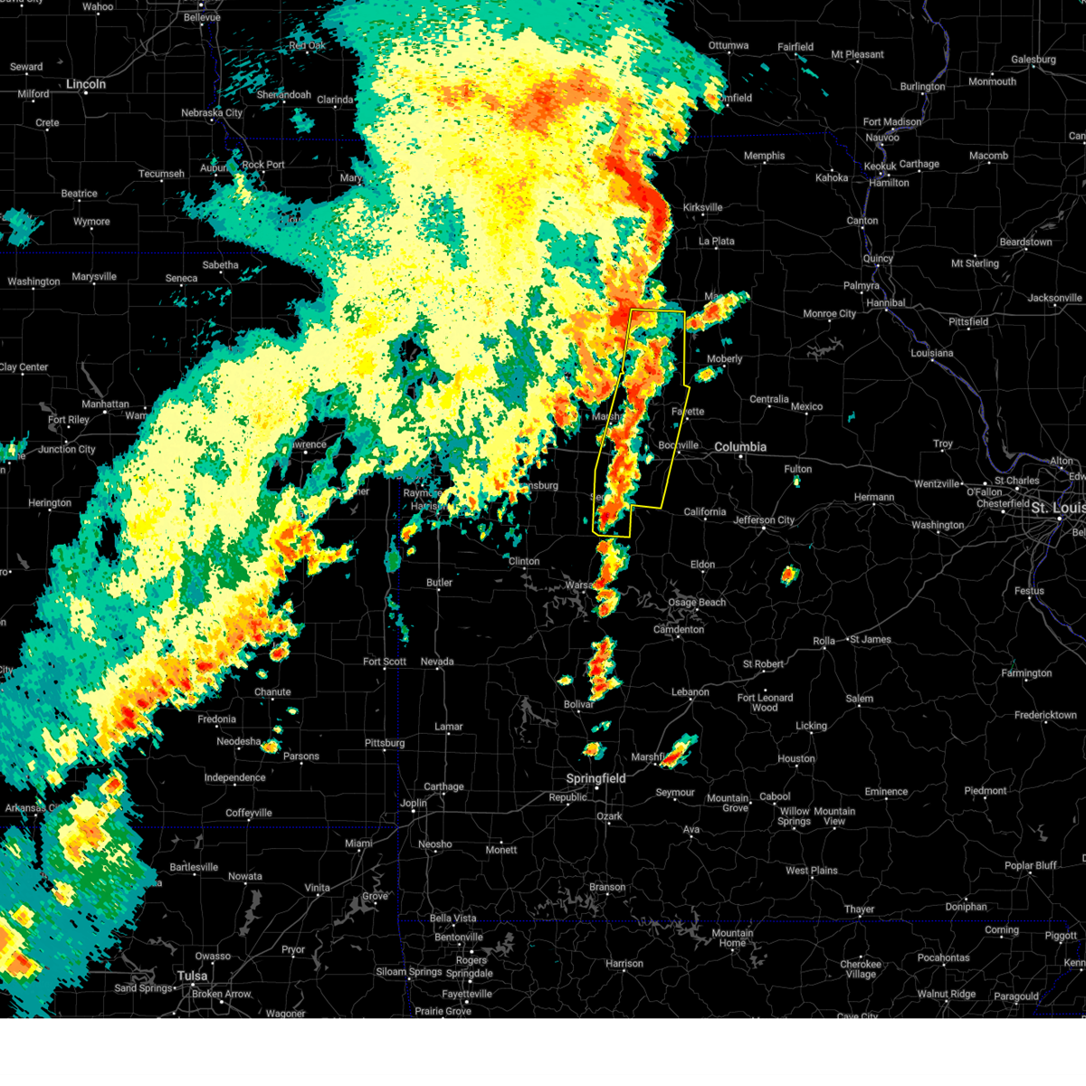
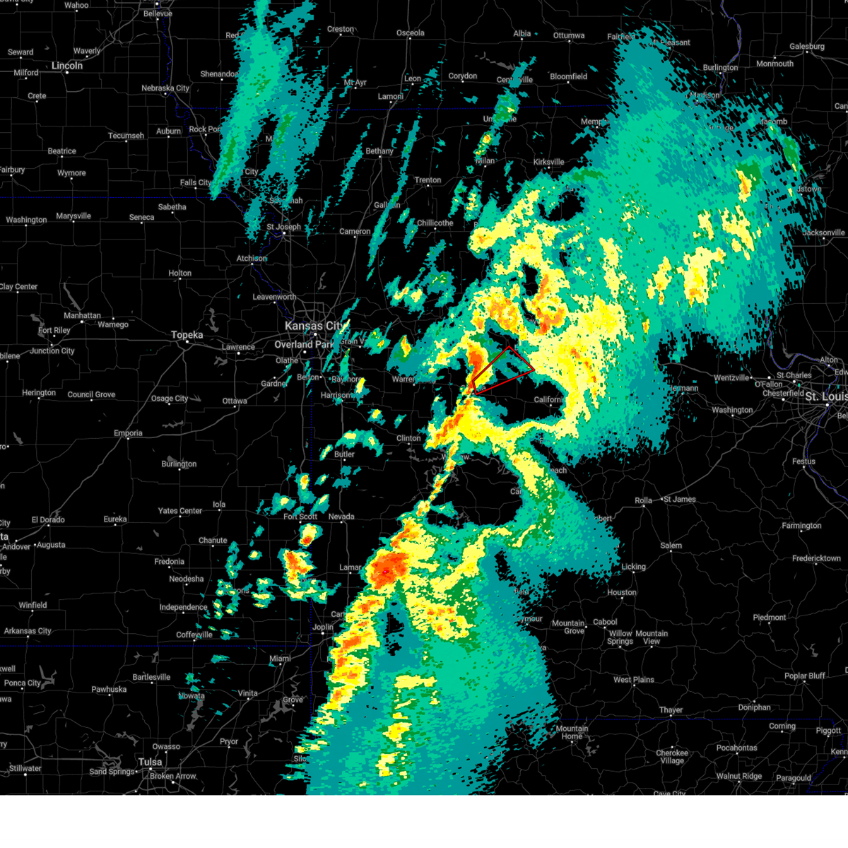
The Top Recent Hail Date for Sedalia, MO is Monday, April 27, 2026 (7th out of 83)

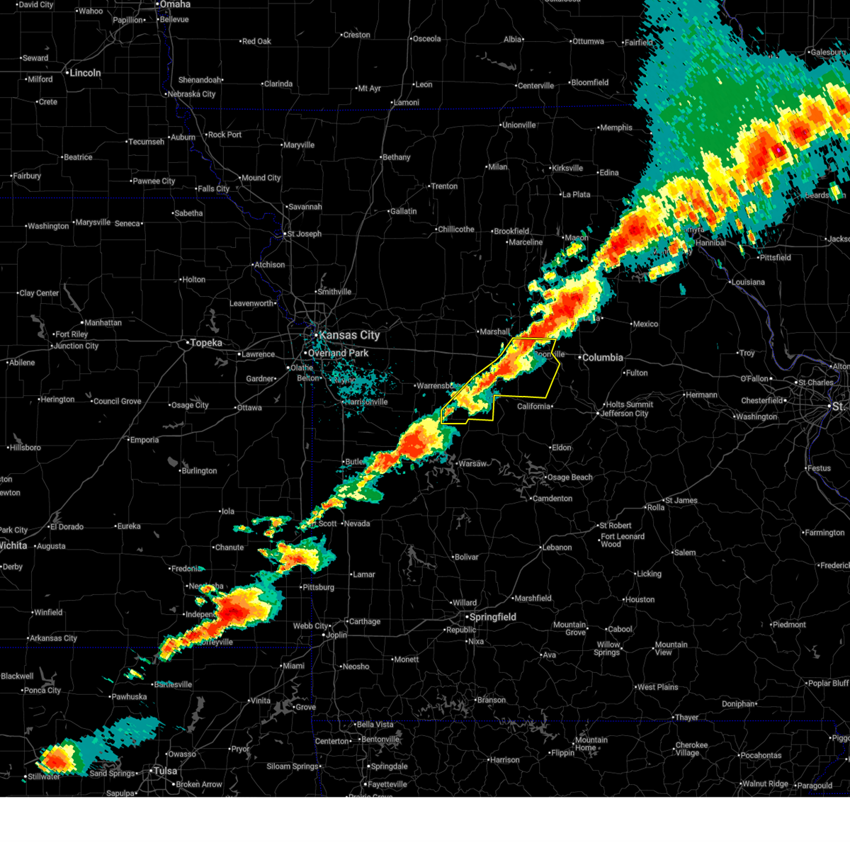
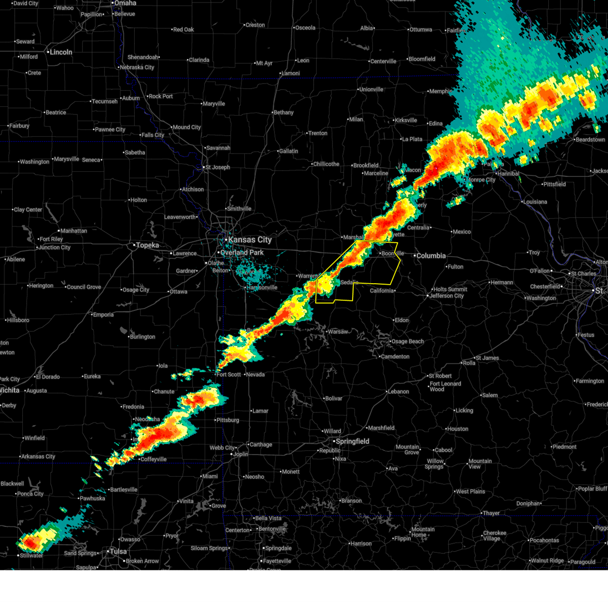
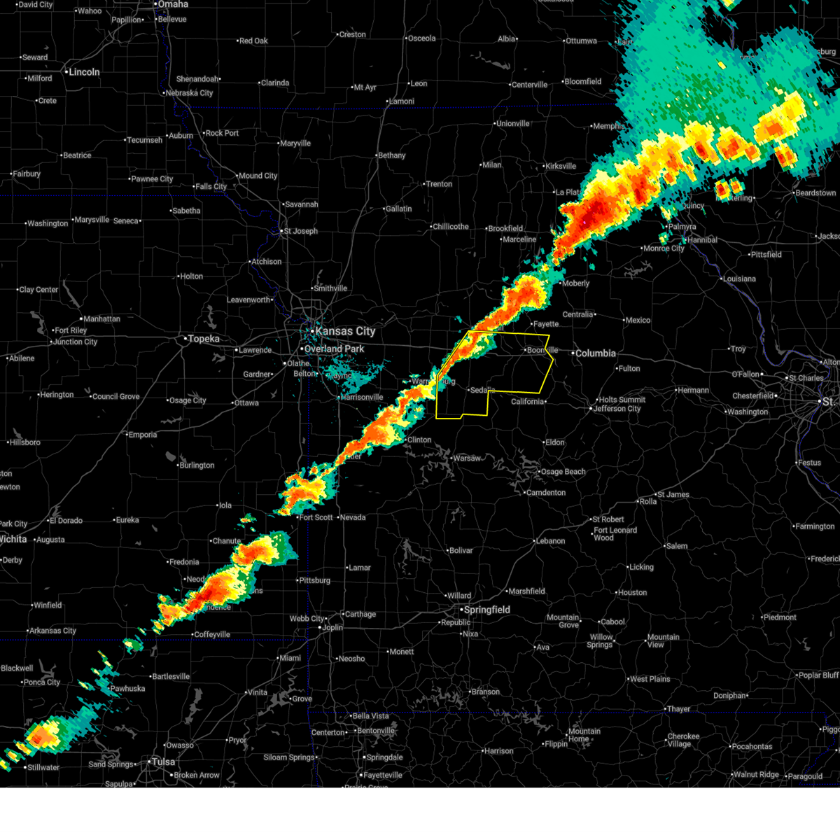
Hail and Wind Damage Spotted near Sedalia, MO
| Date / Time | Report Details |
|---|---|
| 6/17/2026 4:54 PM CDT |
 At 453 pm cdt, a severe thunderstorm was located near knob noster, moving east at 30 mph (radar indicated). Hazards include 60 mph wind gusts and quarter size hail. Hail damage to vehicles is expected. expect wind damage to roofs, siding, and trees. Locations impacted include, warrensburg, knob noster, la monte, and whiteman afb. At 453 pm cdt, a severe thunderstorm was located near knob noster, moving east at 30 mph (radar indicated). Hazards include 60 mph wind gusts and quarter size hail. Hail damage to vehicles is expected. expect wind damage to roofs, siding, and trees. Locations impacted include, warrensburg, knob noster, la monte, and whiteman afb.
|
| 6/17/2026 4:44 PM CDT |
 Svreax the national weather service in pleasant hill has issued a * severe thunderstorm warning for, northwestern pettis county in central missouri, northeastern johnson county in west central missouri, * until 530 pm cdt. * at 444 pm cdt, a severe thunderstorm was located near knob noster, moving east at 30 mph (radar indicated). Hazards include 60 mph wind gusts and half dollar size hail. Hail damage to vehicles is expected. Expect wind damage to roofs, siding, and trees. Svreax the national weather service in pleasant hill has issued a * severe thunderstorm warning for, northwestern pettis county in central missouri, northeastern johnson county in west central missouri, * until 530 pm cdt. * at 444 pm cdt, a severe thunderstorm was located near knob noster, moving east at 30 mph (radar indicated). Hazards include 60 mph wind gusts and half dollar size hail. Hail damage to vehicles is expected. Expect wind damage to roofs, siding, and trees.
|
| 6/17/2026 4:39 PM CDT |
 At 439 pm cdt, a severe thunderstorm was located over sweet springs, moving east at 45 mph (radar indicated). Hazards include 60 mph wind gusts and half dollar size hail. Hail damage to vehicles is expected. expect wind damage to roofs, siding, and trees. locations impacted include, sweet springs, pilot grove, smithton, otterville, bunceton, houstonia, hughesville, sedalia memorial arpt, and clifton city. This includes interstate 70 in missouri between mile markers 65 and 86. At 439 pm cdt, a severe thunderstorm was located over sweet springs, moving east at 45 mph (radar indicated). Hazards include 60 mph wind gusts and half dollar size hail. Hail damage to vehicles is expected. expect wind damage to roofs, siding, and trees. locations impacted include, sweet springs, pilot grove, smithton, otterville, bunceton, houstonia, hughesville, sedalia memorial arpt, and clifton city. This includes interstate 70 in missouri between mile markers 65 and 86.
|
| 6/17/2026 4:35 PM CDT |
 Svreax the national weather service in pleasant hill has issued a * severe thunderstorm warning for, northern pettis county in central missouri, southwestern saline county in central missouri, southeastern lafayette county in west central missouri, southern cooper county in central missouri, northeastern johnson county in west central missouri, * until 530 pm cdt. * at 435 pm cdt, a severe thunderstorm was located over sweet springs, moving southeast at 45 mph (radar indicated). Hazards include ping pong ball size hail and 60 mph wind gusts. People and animals outdoors will be injured. expect hail damage to roofs, siding, windows, and vehicles. Expect wind damage to roofs, siding, and trees. Svreax the national weather service in pleasant hill has issued a * severe thunderstorm warning for, northern pettis county in central missouri, southwestern saline county in central missouri, southeastern lafayette county in west central missouri, southern cooper county in central missouri, northeastern johnson county in west central missouri, * until 530 pm cdt. * at 435 pm cdt, a severe thunderstorm was located over sweet springs, moving southeast at 45 mph (radar indicated). Hazards include ping pong ball size hail and 60 mph wind gusts. People and animals outdoors will be injured. expect hail damage to roofs, siding, windows, and vehicles. Expect wind damage to roofs, siding, and trees.
|
| 6/13/2026 10:46 PM CDT |
 At 1046 pm cdt, severe thunderstorms were located along a line extending from near slater to 10 miles north of pilot grove to near smithton, moving east at 40 mph (radar indicated). Hazards include 70 mph wind gusts and quarter size hail. Hail damage to vehicles is expected. expect considerable tree damage. wind damage is also likely to mobile homes, roofs, and outbuildings. locations impacted include, sedalia, marshall, slater, smithton, gilliam, nelson, hughesville, arrow rock, and sedalia memorial arpt. This includes interstate 70 in missouri between mile markers 71 and 85. At 1046 pm cdt, severe thunderstorms were located along a line extending from near slater to 10 miles north of pilot grove to near smithton, moving east at 40 mph (radar indicated). Hazards include 70 mph wind gusts and quarter size hail. Hail damage to vehicles is expected. expect considerable tree damage. wind damage is also likely to mobile homes, roofs, and outbuildings. locations impacted include, sedalia, marshall, slater, smithton, gilliam, nelson, hughesville, arrow rock, and sedalia memorial arpt. This includes interstate 70 in missouri between mile markers 71 and 85.
|
| 6/13/2026 10:32 PM CDT | Metal roofing from a garage was lifted and blown across the street. time estimated from rada in pettis county MO, 0.9 miles WSW of Sedalia, MO |
| 6/13/2026 10:30 PM CDT |
 At 1029 pm cdt, severe thunderstorms were located along a line extending from 8 miles southwest of brunswick to 6 miles south of marshall to near green ridge, moving east at 40 mph (radar indicated). Hazards include 70 mph wind gusts and quarter size hail. Hail damage to vehicles is expected. expect considerable tree damage. wind damage is also likely to mobile homes, roofs, and outbuildings. locations impacted include, sedalia, marshall, windsor, slater, sweet springs, glasgow, la monte, smithton, green ridge, malta bend, blackburn, houstonia, wakenda, emma, gilliam, nelson, hughesville, miami, mount leonard, and grand pass. This includes interstate 70 in missouri between mile markers 63 and 85. At 1029 pm cdt, severe thunderstorms were located along a line extending from 8 miles southwest of brunswick to 6 miles south of marshall to near green ridge, moving east at 40 mph (radar indicated). Hazards include 70 mph wind gusts and quarter size hail. Hail damage to vehicles is expected. expect considerable tree damage. wind damage is also likely to mobile homes, roofs, and outbuildings. locations impacted include, sedalia, marshall, windsor, slater, sweet springs, glasgow, la monte, smithton, green ridge, malta bend, blackburn, houstonia, wakenda, emma, gilliam, nelson, hughesville, miami, mount leonard, and grand pass. This includes interstate 70 in missouri between mile markers 63 and 85.
|
| 6/13/2026 10:14 PM CDT |
 At 1013 pm cdt, severe thunderstorms were located along a line extending from near brunswick to 6 miles northeast of sweet springs to near green ridge, moving east at 40 mph (public report of winds to 70 mph in johnson county). Hazards include 70 mph wind gusts and quarter size hail. Hail damage to vehicles is expected. expect considerable tree damage. wind damage is also likely to mobile homes, roofs, and outbuildings. locations impacted include, sedalia, marshall, carrollton, windsor, slater, salisbury, sweet springs, glasgow, la monte, brunswick, waverly, smithton, green ridge, keytesville, bosworth, malta bend, blackburn, houstonia, wakenda, and emma. This includes interstate 70 in missouri between mile markers 63 and 85. At 1013 pm cdt, severe thunderstorms were located along a line extending from near brunswick to 6 miles northeast of sweet springs to near green ridge, moving east at 40 mph (public report of winds to 70 mph in johnson county). Hazards include 70 mph wind gusts and quarter size hail. Hail damage to vehicles is expected. expect considerable tree damage. wind damage is also likely to mobile homes, roofs, and outbuildings. locations impacted include, sedalia, marshall, carrollton, windsor, slater, salisbury, sweet springs, glasgow, la monte, brunswick, waverly, smithton, green ridge, keytesville, bosworth, malta bend, blackburn, houstonia, wakenda, and emma. This includes interstate 70 in missouri between mile markers 63 and 85.
|
| 6/13/2026 9:55 PM CDT |
 Svreax the national weather service in pleasant hill has issued a * severe thunderstorm warning for, southern chariton county in north central missouri, pettis county in central missouri, central carroll county in north central missouri, saline county in central missouri, northeastern lafayette county in west central missouri, * until 1100 pm cdt. * at 955 pm cdt, severe thunderstorms were located along a line extending from near bosworth to near alma to near leeton, moving east at 40 mph (radar indicated). Hazards include 60 mph wind gusts and quarter size hail. Hail damage to vehicles is expected. Expect wind damage to roofs, siding, and trees. Svreax the national weather service in pleasant hill has issued a * severe thunderstorm warning for, southern chariton county in north central missouri, pettis county in central missouri, central carroll county in north central missouri, saline county in central missouri, northeastern lafayette county in west central missouri, * until 1100 pm cdt. * at 955 pm cdt, severe thunderstorms were located along a line extending from near bosworth to near alma to near leeton, moving east at 40 mph (radar indicated). Hazards include 60 mph wind gusts and quarter size hail. Hail damage to vehicles is expected. Expect wind damage to roofs, siding, and trees.
|
| 6/11/2026 5:55 PM CDT |
 Svreax the national weather service in pleasant hill has issued a * severe thunderstorm warning for, southeastern pettis county in central missouri, southeastern howard county in central missouri, cooper county in central missouri, * until 645 pm cdt. * at 555 pm cdt, severe thunderstorms were located along a line extending from 6 miles north of rocheport to 6 miles north of otterville to 7 miles east of windsor, moving east at 40 mph (radar indicated). Hazards include 60 mph wind gusts and quarter size hail. Hail damage to vehicles is expected. Expect wind damage to roofs, siding, and trees. Svreax the national weather service in pleasant hill has issued a * severe thunderstorm warning for, southeastern pettis county in central missouri, southeastern howard county in central missouri, cooper county in central missouri, * until 645 pm cdt. * at 555 pm cdt, severe thunderstorms were located along a line extending from 6 miles north of rocheport to 6 miles north of otterville to 7 miles east of windsor, moving east at 40 mph (radar indicated). Hazards include 60 mph wind gusts and quarter size hail. Hail damage to vehicles is expected. Expect wind damage to roofs, siding, and trees.
|
| 6/11/2026 5:35 PM CDT |
 At 535 pm cdt, severe thunderstorms were located along a line extending from near new franklin to near pilot grove to sedalia, moving east at 45 mph (radar indicated). Hazards include 60 mph wind gusts and quarter size hail. Hail damage to vehicles is expected. expect wind damage to roofs, siding, and trees. locations impacted include, sedalia, boonville, windsor, new franklin, pilot grove, smithton, green ridge, otterville, bunceton, prairie home, blackwater, franklin, wooldridge, clifton city, lamine, and sedalia memorial arpt. This includes interstate 70 in missouri between mile markers 88 and 114. At 535 pm cdt, severe thunderstorms were located along a line extending from near new franklin to near pilot grove to sedalia, moving east at 45 mph (radar indicated). Hazards include 60 mph wind gusts and quarter size hail. Hail damage to vehicles is expected. expect wind damage to roofs, siding, and trees. locations impacted include, sedalia, boonville, windsor, new franklin, pilot grove, smithton, green ridge, otterville, bunceton, prairie home, blackwater, franklin, wooldridge, clifton city, lamine, and sedalia memorial arpt. This includes interstate 70 in missouri between mile markers 88 and 114.
|
| 6/11/2026 5:21 PM CDT |
 At 521 pm cdt, severe thunderstorms were located along a line extending from 10 miles west of new franklin to 10 miles west of pilot grove to near la monte, moving east at 45 mph (radar indicated). Hazards include 60 mph wind gusts and quarter size hail. Hail damage to vehicles is expected. expect wind damage to roofs, siding, and trees. locations impacted include, sedalia, boonville, windsor, la monte, new franklin, pilot grove, smithton, green ridge, otterville, bunceton, prairie home, nelson, hughesville, blackwater, franklin, wooldridge, arrow rock, clifton city, lamine, and sedalia memorial arpt. This includes interstate 70 in missouri between mile markers 79 and 114. At 521 pm cdt, severe thunderstorms were located along a line extending from 10 miles west of new franklin to 10 miles west of pilot grove to near la monte, moving east at 45 mph (radar indicated). Hazards include 60 mph wind gusts and quarter size hail. Hail damage to vehicles is expected. expect wind damage to roofs, siding, and trees. locations impacted include, sedalia, boonville, windsor, la monte, new franklin, pilot grove, smithton, green ridge, otterville, bunceton, prairie home, nelson, hughesville, blackwater, franklin, wooldridge, arrow rock, clifton city, lamine, and sedalia memorial arpt. This includes interstate 70 in missouri between mile markers 79 and 114.
|
| 6/11/2026 5:03 PM CDT |
 Svreax the national weather service in pleasant hill has issued a * severe thunderstorm warning for, pettis county in central missouri, southern howard county in central missouri, southeastern saline county in central missouri, cooper county in central missouri, * until 600 pm cdt. * at 501 pm cdt, severe thunderstorms were located along a line extending from 8 miles south of slater to 9 miles east of houstonia to near la monte, moving east at 35 mph (radar indicated). Hazards include 60 mph wind gusts and quarter size hail. Hail damage to vehicles is expected. Expect wind damage to roofs, siding, and trees. Svreax the national weather service in pleasant hill has issued a * severe thunderstorm warning for, pettis county in central missouri, southern howard county in central missouri, southeastern saline county in central missouri, cooper county in central missouri, * until 600 pm cdt. * at 501 pm cdt, severe thunderstorms were located along a line extending from 8 miles south of slater to 9 miles east of houstonia to near la monte, moving east at 35 mph (radar indicated). Hazards include 60 mph wind gusts and quarter size hail. Hail damage to vehicles is expected. Expect wind damage to roofs, siding, and trees.
|
| 4/28/2026 12:45 PM CDT |
 the severe thunderstorm warning has been cancelled and is no longer in effect the severe thunderstorm warning has been cancelled and is no longer in effect
|
| 4/28/2026 12:45 PM CDT |
 At 1244 pm cdt, a severe thunderstorm was located 7 miles north of sedalia, moving northeast at 55 mph (radar indicated). Hazards include 60 mph wind gusts and penny size hail. Expect damage to roofs, siding, and trees. Locations impacted include, sedalia, la monte, hughesville, and sedalia memorial arpt. At 1244 pm cdt, a severe thunderstorm was located 7 miles north of sedalia, moving northeast at 55 mph (radar indicated). Hazards include 60 mph wind gusts and penny size hail. Expect damage to roofs, siding, and trees. Locations impacted include, sedalia, la monte, hughesville, and sedalia memorial arpt.
|
| 4/28/2026 12:36 PM CDT |
 At 1235 pm cdt, a severe thunderstorm was located over la monte, or 7 miles east of whiteman air force base, moving northeast at 55 mph (radar indicated). Hazards include 60 mph wind gusts and quarter size hail. Hail damage to vehicles is expected. expect wind damage to roofs, siding, and trees. this storm has history of producing quarter size hail. Locations impacted include, sedalia, whiteman air force base, la monte, green ridge, houstonia, whiteman afb, hughesville, and sedalia memorial arpt. At 1235 pm cdt, a severe thunderstorm was located over la monte, or 7 miles east of whiteman air force base, moving northeast at 55 mph (radar indicated). Hazards include 60 mph wind gusts and quarter size hail. Hail damage to vehicles is expected. expect wind damage to roofs, siding, and trees. this storm has history of producing quarter size hail. Locations impacted include, sedalia, whiteman air force base, la monte, green ridge, houstonia, whiteman afb, hughesville, and sedalia memorial arpt.
|
| 4/28/2026 12:24 PM CDT |
 Svreax the national weather service in pleasant hill has issued a * severe thunderstorm warning for, northeastern henry county in west central missouri, pettis county in central missouri, southeastern johnson county in west central missouri, * until 115 pm cdt. * at 1223 pm cdt, a severe thunderstorm was located near whiteman afb, or near whiteman air force base, moving northeast at 55 mph (radar indicated). Hazards include 60 mph wind gusts and quarter size hail. Hail damage to vehicles is expected. Expect wind damage to roofs, siding, and trees. Svreax the national weather service in pleasant hill has issued a * severe thunderstorm warning for, northeastern henry county in west central missouri, pettis county in central missouri, southeastern johnson county in west central missouri, * until 115 pm cdt. * at 1223 pm cdt, a severe thunderstorm was located near whiteman afb, or near whiteman air force base, moving northeast at 55 mph (radar indicated). Hazards include 60 mph wind gusts and quarter size hail. Hail damage to vehicles is expected. Expect wind damage to roofs, siding, and trees.
|
| 4/27/2026 3:50 PM CDT |
 The storm which prompted the warning has moved out of the area. therefore, the warning will be allowed to expire. a severe thunderstorm watch remains in effect until 900 pm cdt for central missouri. The storm which prompted the warning has moved out of the area. therefore, the warning will be allowed to expire. a severe thunderstorm watch remains in effect until 900 pm cdt for central missouri.
|
| 4/27/2026 3:40 PM CDT |
 Svreax the national weather service in pleasant hill has issued a * severe thunderstorm warning for, eastern pettis county in central missouri, southeastern howard county in central missouri, cooper county in central missouri, * until 430 pm cdt. * at 339 pm cdt, a severe thunderstorm was located over smithton, or near sedalia, moving northeast at 60 mph (radar indicated). Hazards include 60 mph wind gusts and half dollar size hail. Hail damage to vehicles is expected. Expect wind damage to roofs, siding, and trees. Svreax the national weather service in pleasant hill has issued a * severe thunderstorm warning for, eastern pettis county in central missouri, southeastern howard county in central missouri, cooper county in central missouri, * until 430 pm cdt. * at 339 pm cdt, a severe thunderstorm was located over smithton, or near sedalia, moving northeast at 60 mph (radar indicated). Hazards include 60 mph wind gusts and half dollar size hail. Hail damage to vehicles is expected. Expect wind damage to roofs, siding, and trees.
|
| 4/27/2026 3:36 PM CDT | Report from aso in pettis county MO, 4.1 miles W of Sedalia, MO |
| 4/27/2026 3:34 PM CDT |
 At 334 pm cdt, a severe thunderstorm was located near green ridge, or near sedalia, moving northeast at 55 mph (law enforcement). Hazards include 60 mph wind gusts and half dollar size hail. Hail damage to vehicles is expected. expect wind damage to roofs, siding, and trees. Locations impacted include, sedalia, smithton, otterville, sedalia memorial arpt, and clifton city. At 334 pm cdt, a severe thunderstorm was located near green ridge, or near sedalia, moving northeast at 55 mph (law enforcement). Hazards include 60 mph wind gusts and half dollar size hail. Hail damage to vehicles is expected. expect wind damage to roofs, siding, and trees. Locations impacted include, sedalia, smithton, otterville, sedalia memorial arpt, and clifton city.
|
| 4/27/2026 3:32 PM CDT | Quarter sized hail reported 1.9 miles WSW of Sedalia, MO, time estimated from radar. |
| 4/27/2026 3:21 PM CDT |
 At 321 pm cdt, a severe thunderstorm was located near windsor, moving northeast at 55 mph (law enforcement). Hazards include 60 mph wind gusts and half dollar size hail. Hail damage to vehicles is expected. expect wind damage to roofs, siding, and trees. Locations impacted include, sedalia, windsor, smithton, green ridge, otterville, sedalia memorial arpt, and clifton city. At 321 pm cdt, a severe thunderstorm was located near windsor, moving northeast at 55 mph (law enforcement). Hazards include 60 mph wind gusts and half dollar size hail. Hail damage to vehicles is expected. expect wind damage to roofs, siding, and trees. Locations impacted include, sedalia, windsor, smithton, green ridge, otterville, sedalia memorial arpt, and clifton city.
|
| 4/27/2026 3:11 PM CDT |
 Svreax the national weather service in pleasant hill has issued a * severe thunderstorm warning for, northeastern henry county in west central missouri, pettis county in central missouri, southwestern cooper county in central missouri, southeastern johnson county in west central missouri, * until 400 pm cdt. * at 311 pm cdt, a severe thunderstorm was located near leeton, or 7 miles west of windsor, moving northeast at 55 mph (law enforcement). Hazards include 60 mph wind gusts and half dollar size hail. Hail damage to vehicles is expected. Expect wind damage to roofs, siding, and trees. Svreax the national weather service in pleasant hill has issued a * severe thunderstorm warning for, northeastern henry county in west central missouri, pettis county in central missouri, southwestern cooper county in central missouri, southeastern johnson county in west central missouri, * until 400 pm cdt. * at 311 pm cdt, a severe thunderstorm was located near leeton, or 7 miles west of windsor, moving northeast at 55 mph (law enforcement). Hazards include 60 mph wind gusts and half dollar size hail. Hail damage to vehicles is expected. Expect wind damage to roofs, siding, and trees.
|
| 4/26/2026 7:29 PM CDT |
 At 729 pm cdt, severe thunderstorms were located along a line extending from near marshall to 12 miles north of pilot grove to near otterville, moving northeast at 40 mph (radar indicated). Hazards include 60 mph wind gusts. Expect damage to roofs, siding, and trees. locations impacted include, sedalia, marshall, boonville, fayette, slater, glasgow, new franklin, pilot grove, smithton, otterville, bunceton, prairie home, gilliam, nelson, blackwater, franklin, wooldridge, arrow rock, clifton city, and lamine. This includes interstate 70 in missouri between mile markers 75 and 114. At 729 pm cdt, severe thunderstorms were located along a line extending from near marshall to 12 miles north of pilot grove to near otterville, moving northeast at 40 mph (radar indicated). Hazards include 60 mph wind gusts. Expect damage to roofs, siding, and trees. locations impacted include, sedalia, marshall, boonville, fayette, slater, glasgow, new franklin, pilot grove, smithton, otterville, bunceton, prairie home, gilliam, nelson, blackwater, franklin, wooldridge, arrow rock, clifton city, and lamine. This includes interstate 70 in missouri between mile markers 75 and 114.
|
| 4/26/2026 7:21 PM CDT |
 At 720 pm cdt, severe thunderstorms were located along a line extending from near marshall to 10 miles northwest of pilot grove to near smithton, moving east at 40 mph (radar indicated). Hazards include 60 mph wind gusts. Expect damage to roofs, siding, and trees. locations impacted include, sedalia, marshall, boonville, fayette, slater, glasgow, new franklin, pilot grove, smithton, otterville, bunceton, prairie home, gilliam, nelson, blackwater, franklin, wooldridge, arrow rock, clifton city, and lamine. This includes interstate 70 in missouri between mile markers 72 and 114. At 720 pm cdt, severe thunderstorms were located along a line extending from near marshall to 10 miles northwest of pilot grove to near smithton, moving east at 40 mph (radar indicated). Hazards include 60 mph wind gusts. Expect damage to roofs, siding, and trees. locations impacted include, sedalia, marshall, boonville, fayette, slater, glasgow, new franklin, pilot grove, smithton, otterville, bunceton, prairie home, gilliam, nelson, blackwater, franklin, wooldridge, arrow rock, clifton city, and lamine. This includes interstate 70 in missouri between mile markers 72 and 114.
|
| 4/26/2026 7:17 PM CDT | Quarter sized hail reported 0.9 miles WNW of Sedalia, MO, social media report. time estimated from radar. |
| 4/26/2026 7:08 PM CDT |
 Svreax the national weather service in pleasant hill has issued a * severe thunderstorm warning for, south central chariton county in north central missouri, pettis county in central missouri, western howard county in central missouri, saline county in central missouri, cooper county in central missouri, * until 815 pm cdt. * at 708 pm cdt, severe thunderstorms were located along a line extending from near sweet springs to 7 miles east of houstonia to near sedalia, moving northeast at 40 mph (radar indicated). Hazards include 60 mph wind gusts and penny size hail. expect damage to roofs, siding, and trees Svreax the national weather service in pleasant hill has issued a * severe thunderstorm warning for, south central chariton county in north central missouri, pettis county in central missouri, western howard county in central missouri, saline county in central missouri, cooper county in central missouri, * until 815 pm cdt. * at 708 pm cdt, severe thunderstorms were located along a line extending from near sweet springs to 7 miles east of houstonia to near sedalia, moving northeast at 40 mph (radar indicated). Hazards include 60 mph wind gusts and penny size hail. expect damage to roofs, siding, and trees
|
| 4/26/2026 6:58 PM CDT |
 At 658 pm cdt, severe thunderstorms were located along a line extending from near sweet springs to 7 miles northwest of sedalia to 6 miles southeast of green ridge to 7 miles west of warsaw, moving east at 45 mph (radar indicated). Hazards include 60 mph wind gusts and penny size hail. Expect damage to roofs, siding, and trees. locations impacted include, sedalia, marshall, windsor, knob noster, concordia, sweet springs, whiteman air force base, la monte, smithton, green ridge, calhoun, deepwater, houstonia, whiteman afb, coal, emma, hughesville, brownington, tightwad, and sedalia memorial arpt. This includes interstate 70 in missouri between mile markers 54 and 84. At 658 pm cdt, severe thunderstorms were located along a line extending from near sweet springs to 7 miles northwest of sedalia to 6 miles southeast of green ridge to 7 miles west of warsaw, moving east at 45 mph (radar indicated). Hazards include 60 mph wind gusts and penny size hail. Expect damage to roofs, siding, and trees. locations impacted include, sedalia, marshall, windsor, knob noster, concordia, sweet springs, whiteman air force base, la monte, smithton, green ridge, calhoun, deepwater, houstonia, whiteman afb, coal, emma, hughesville, brownington, tightwad, and sedalia memorial arpt. This includes interstate 70 in missouri between mile markers 54 and 84.
|
| 4/26/2026 6:47 PM CDT |
 At 647 pm cdt, severe thunderstorms were located along a line extending from concordia to near la monte to near windsor to 9 miles east of deepwater, moving northeast at 35 mph (radar indicated). Hazards include 60 mph wind gusts and penny size hail. Expect damage to roofs, siding, and trees. locations impacted include, sedalia, warrensburg, marshall, clinton, windsor, knob noster, concordia, sweet springs, whiteman air force base, la monte, smithton, leeton, green ridge, calhoun, deepwater, houstonia, whiteman afb, coal, emma, and hughesville. This includes interstate 70 in missouri between mile markers 54 and 84. At 647 pm cdt, severe thunderstorms were located along a line extending from concordia to near la monte to near windsor to 9 miles east of deepwater, moving northeast at 35 mph (radar indicated). Hazards include 60 mph wind gusts and penny size hail. Expect damage to roofs, siding, and trees. locations impacted include, sedalia, warrensburg, marshall, clinton, windsor, knob noster, concordia, sweet springs, whiteman air force base, la monte, smithton, leeton, green ridge, calhoun, deepwater, houstonia, whiteman afb, coal, emma, and hughesville. This includes interstate 70 in missouri between mile markers 54 and 84.
|
| 4/26/2026 6:38 PM CDT |
 At 638 pm cdt, severe thunderstorms were located along a line extending from 7 miles southwest of concordia to near whiteman air force base to windsor to near deepwater, moving northeast at 45 mph (radar indicated). Hazards include 60 mph wind gusts and penny size hail. Expect damage to roofs, siding, and trees. locations impacted include, sedalia, warrensburg, marshall, clinton, windsor, knob noster, concordia, sweet springs, whiteman air force base, la monte, smithton, leeton, green ridge, calhoun, deepwater, houstonia, whiteman afb, coal, emma, and hughesville. This includes interstate 70 in missouri between mile markers 54 and 84. At 638 pm cdt, severe thunderstorms were located along a line extending from 7 miles southwest of concordia to near whiteman air force base to windsor to near deepwater, moving northeast at 45 mph (radar indicated). Hazards include 60 mph wind gusts and penny size hail. Expect damage to roofs, siding, and trees. locations impacted include, sedalia, warrensburg, marshall, clinton, windsor, knob noster, concordia, sweet springs, whiteman air force base, la monte, smithton, leeton, green ridge, calhoun, deepwater, houstonia, whiteman afb, coal, emma, and hughesville. This includes interstate 70 in missouri between mile markers 54 and 84.
|
| 4/26/2026 6:28 PM CDT |
 Svreax the national weather service in pleasant hill has issued a * severe thunderstorm warning for, eastern henry county in west central missouri, pettis county in central missouri, southwestern saline county in central missouri, southeastern lafayette county in west central missouri, eastern johnson county in west central missouri, * until 715 pm cdt. * at 627 pm cdt, severe thunderstorms were located along a line extending from near oak grove to near whiteman afb to near calhoun, moving northeast at 40 mph (radar indicated). Hazards include 60 mph wind gusts and penny size hail. expect damage to roofs, siding, and trees Svreax the national weather service in pleasant hill has issued a * severe thunderstorm warning for, eastern henry county in west central missouri, pettis county in central missouri, southwestern saline county in central missouri, southeastern lafayette county in west central missouri, eastern johnson county in west central missouri, * until 715 pm cdt. * at 627 pm cdt, severe thunderstorms were located along a line extending from near oak grove to near whiteman afb to near calhoun, moving northeast at 40 mph (radar indicated). Hazards include 60 mph wind gusts and penny size hail. expect damage to roofs, siding, and trees
|
| 4/24/2026 12:03 AM CDT |
 At 1203 am cdt, a severe thunderstorm was located near smithton, or near sedalia, moving east at 40 mph (radar indicated). Hazards include 60 mph wind gusts and penny size hail. Expect damage to roofs, siding, and trees. Locations impacted include, sedalia, smithton, and sedalia memorial arpt. At 1203 am cdt, a severe thunderstorm was located near smithton, or near sedalia, moving east at 40 mph (radar indicated). Hazards include 60 mph wind gusts and penny size hail. Expect damage to roofs, siding, and trees. Locations impacted include, sedalia, smithton, and sedalia memorial arpt.
|
| 4/23/2026 11:37 PM CDT |
 Svreax the national weather service in pleasant hill has issued a * severe thunderstorm warning for, pettis county in central missouri, * until 1215 am cdt. * at 1137 pm cdt, a severe thunderstorm was located over green ridge, or near windsor, moving east at 50 mph (radar indicated). Hazards include 60 mph wind gusts and penny size hail. expect damage to roofs, siding, and trees Svreax the national weather service in pleasant hill has issued a * severe thunderstorm warning for, pettis county in central missouri, * until 1215 am cdt. * at 1137 pm cdt, a severe thunderstorm was located over green ridge, or near windsor, moving east at 50 mph (radar indicated). Hazards include 60 mph wind gusts and penny size hail. expect damage to roofs, siding, and trees
|
| 4/17/2026 7:04 PM CDT | Downed wires and power outages south of sedalia. time estimated from rada in pettis county MO, 4 miles NNW of Sedalia, MO |
| 4/13/2026 11:01 PM CDT |
 Svreax the national weather service in pleasant hill has issued a * severe thunderstorm warning for, southeastern pettis county in central missouri, southern cooper county in central missouri, * until 1145 pm cdt. * at 1101 pm cdt, severe thunderstorms were located along a line extending from near otterville to 8 miles southeast of smithton to 7 miles northeast of cole camp, moving east at 50 mph (radar indicated). Hazards include 60 mph wind gusts and penny size hail. expect damage to roofs, siding, and trees Svreax the national weather service in pleasant hill has issued a * severe thunderstorm warning for, southeastern pettis county in central missouri, southern cooper county in central missouri, * until 1145 pm cdt. * at 1101 pm cdt, severe thunderstorms were located along a line extending from near otterville to 8 miles southeast of smithton to 7 miles northeast of cole camp, moving east at 50 mph (radar indicated). Hazards include 60 mph wind gusts and penny size hail. expect damage to roofs, siding, and trees
|
| 3/11/2026 12:34 AM CDT |
 Svreax the national weather service in pleasant hill has issued a * severe thunderstorm warning for, southern pettis county in central missouri, * until 100 am cdt. * at 1234 am cdt, a severe thunderstorm was located near green ridge, or 9 miles east of windsor, moving east at 40 mph (radar indicated). Hazards include 60 mph wind gusts. expect damage to roofs, siding, and trees Svreax the national weather service in pleasant hill has issued a * severe thunderstorm warning for, southern pettis county in central missouri, * until 100 am cdt. * at 1234 am cdt, a severe thunderstorm was located near green ridge, or 9 miles east of windsor, moving east at 40 mph (radar indicated). Hazards include 60 mph wind gusts. expect damage to roofs, siding, and trees
|
| 3/6/2026 9:01 PM CST |
 Svreax the national weather service in pleasant hill has issued a * severe thunderstorm warning for, northeastern pettis county in central missouri, southern howard county in central missouri, saline county in central missouri, northwestern cooper county in central missouri, * until 930 pm cst. * at 900 pm cst, a severe thunderstorm was located near houstonia, or 10 miles southeast of sweet springs, moving northeast at 70 mph (radar indicated). Hazards include 60 mph wind gusts and penny size hail. expect damage to roofs, siding, and trees Svreax the national weather service in pleasant hill has issued a * severe thunderstorm warning for, northeastern pettis county in central missouri, southern howard county in central missouri, saline county in central missouri, northwestern cooper county in central missouri, * until 930 pm cst. * at 900 pm cst, a severe thunderstorm was located near houstonia, or 10 miles southeast of sweet springs, moving northeast at 70 mph (radar indicated). Hazards include 60 mph wind gusts and penny size hail. expect damage to roofs, siding, and trees
|
| 9/18/2025 6:23 PM CDT | Svreax the national weather service in pleasant hill has issued a * severe thunderstorm warning for, northeastern pettis county in central missouri, southeastern saline county in central missouri, cooper county in central missouri, * until 715 pm cdt. * at 623 pm cdt, severe thunderstorms were located along a line extending from near houstonia to near smithton to 7 miles south of otterville, moving northeast at 30 mph (radar indicated). Hazards include 60 mph wind gusts and penny size hail. expect damage to roofs, siding, and trees |
| 9/17/2025 5:05 PM CDT | The storm which prompted the warning has weakened below severe limits, and no longer poses an immediate threat to life or property. therefore, the warning will be allowed to expire. |
| 9/17/2025 4:38 PM CDT | At 437 pm cdt, a severe thunderstorm was located near sedalia, moving northeast at 15 mph (public weather station reported a 65 mph wind gust). Hazards include 60 mph wind gusts and half dollar size hail. Hail damage to vehicles is expected. expect wind damage to roofs, siding, and trees. Locations impacted include, sedalia, hughesville, and sedalia memorial arpt. |
| 9/17/2025 4:30 PM CDT | Personal weather statio in pettis county MO, 2.7 miles ESE of Sedalia, MO |
| 9/17/2025 4:25 PM CDT | Svreax the national weather service in pleasant hill has issued a * severe thunderstorm warning for, central pettis county in central missouri, * until 515 pm cdt. * at 425 pm cdt, a severe thunderstorm was located near sedalia, moving northeast at 15 mph (radar indicated). Hazards include 60 mph wind gusts and half dollar size hail. Hail damage to vehicles is expected. Expect wind damage to roofs, siding, and trees. |
| 9/17/2025 3:55 PM CDT | the severe thunderstorm warning has been cancelled and is no longer in effect |
| 9/17/2025 3:35 PM CDT | Svreax the national weather service in pleasant hill has issued a * severe thunderstorm warning for, southeastern pettis county in central missouri, * until 415 pm cdt. * at 335 pm cdt, a severe thunderstorm was located near sedalia, moving northeast at 5 mph (radar indicated). Hazards include 60 mph wind gusts and quarter size hail. Hail damage to vehicles is expected. Expect wind damage to roofs, siding, and trees. |
| 7/17/2025 12:59 AM CDT |
 The storms which prompted the warning have weakened below severe limits, and no longer pose an immediate threat to life or property. therefore, the warning will be allowed to expire. however, gusty winds and heavy rain are still possible with these thunderstorms. The storms which prompted the warning have weakened below severe limits, and no longer pose an immediate threat to life or property. therefore, the warning will be allowed to expire. however, gusty winds and heavy rain are still possible with these thunderstorms.
|
| 7/17/2025 12:45 AM CDT |
 the severe thunderstorm warning has been cancelled and is no longer in effect the severe thunderstorm warning has been cancelled and is no longer in effect
|
| 7/17/2025 12:45 AM CDT |
 At 1245 am cdt, severe thunderstorms were located along a line extending from sedalia to near windsor to near chilhowee, moving east at 15 mph (radar indicated). Hazards include 60 mph wind gusts. Expect damage to roofs, siding, and trees. Locations impacted include, sedalia, warrensburg, windsor, knob noster, whiteman air force base, la monte, smithton, leeton, urich, green ridge, calhoun, chilhowee, houstonia, whiteman afb, hughesville, blairstown, sedalia memorial arpt, post oak, and quick city. At 1245 am cdt, severe thunderstorms were located along a line extending from sedalia to near windsor to near chilhowee, moving east at 15 mph (radar indicated). Hazards include 60 mph wind gusts. Expect damage to roofs, siding, and trees. Locations impacted include, sedalia, warrensburg, windsor, knob noster, whiteman air force base, la monte, smithton, leeton, urich, green ridge, calhoun, chilhowee, houstonia, whiteman afb, hughesville, blairstown, sedalia memorial arpt, post oak, and quick city.
|
| 7/17/2025 12:29 AM CDT |
 At 1229 am cdt, severe thunderstorms were located along a line extending from 6 miles southwest of smithton to near windsor to 6 miles south of chilhowee, moving southeast at 20 mph (radar indicated). Hazards include 60 mph wind gusts. Expect damage to roofs, siding, and trees. Locations impacted include, sedalia, warrensburg, clinton, windsor, knob noster, whiteman air force base, la monte, smithton, leeton, urich, green ridge, calhoun, otterville, chilhowee, houstonia, whiteman afb, coal, hughesville, blairstown, and clifton city. At 1229 am cdt, severe thunderstorms were located along a line extending from 6 miles southwest of smithton to near windsor to 6 miles south of chilhowee, moving southeast at 20 mph (radar indicated). Hazards include 60 mph wind gusts. Expect damage to roofs, siding, and trees. Locations impacted include, sedalia, warrensburg, clinton, windsor, knob noster, whiteman air force base, la monte, smithton, leeton, urich, green ridge, calhoun, otterville, chilhowee, houstonia, whiteman afb, coal, hughesville, blairstown, and clifton city.
|
| 7/16/2025 11:56 PM CDT |
 Svreax the national weather service in pleasant hill has issued a * severe thunderstorm warning for, henry county in west central missouri, pettis county in central missouri, southwestern cooper county in central missouri, southern johnson county in west central missouri, * until 100 am cdt. * at 1156 pm cdt, severe thunderstorms were located along a line extending from near sedalia to near leeton to 7 miles southwest of holden, moving southeast at 20 mph (radar indicated). Hazards include 60 mph wind gusts. expect damage to roofs, siding, and trees Svreax the national weather service in pleasant hill has issued a * severe thunderstorm warning for, henry county in west central missouri, pettis county in central missouri, southwestern cooper county in central missouri, southern johnson county in west central missouri, * until 100 am cdt. * at 1156 pm cdt, severe thunderstorms were located along a line extending from near sedalia to near leeton to 7 miles southwest of holden, moving southeast at 20 mph (radar indicated). Hazards include 60 mph wind gusts. expect damage to roofs, siding, and trees
|
| 7/16/2025 11:45 PM CDT |
 the severe thunderstorm warning has been cancelled and is no longer in effect the severe thunderstorm warning has been cancelled and is no longer in effect
|
| 7/16/2025 11:45 PM CDT |
 At 1144 pm cdt, severe thunderstorms were located along a line extending from 6 miles north of sedalia to near green ridge to near leeton, moving southeast at 20 mph (radar indicated). Hazards include 60 mph wind gusts. Expect damage to roofs, siding, and trees. Locations impacted include, sedalia, warrensburg, knob noster, whiteman air force base, la monte, smithton, leeton, green ridge, houstonia, whiteman afb, centerview, hughesville, sedalia memorial arpt, and post oak. At 1144 pm cdt, severe thunderstorms were located along a line extending from 6 miles north of sedalia to near green ridge to near leeton, moving southeast at 20 mph (radar indicated). Hazards include 60 mph wind gusts. Expect damage to roofs, siding, and trees. Locations impacted include, sedalia, warrensburg, knob noster, whiteman air force base, la monte, smithton, leeton, green ridge, houstonia, whiteman afb, centerview, hughesville, sedalia memorial arpt, and post oak.
|
| 7/16/2025 11:16 PM CDT |
 Svreax the national weather service in pleasant hill has issued a * severe thunderstorm warning for, north central henry county in west central missouri, pettis county in central missouri, southwestern saline county in central missouri, southeastern lafayette county in west central missouri, eastern johnson county in west central missouri, * until midnight cdt. * at 1116 pm cdt, severe thunderstorms were located along a line extending from 6 miles northwest of sedalia to knob noster to 6 miles north of chilhowee, moving southeast at 15 mph (radar indicated). Hazards include 60 mph wind gusts. expect damage to roofs, siding, and trees Svreax the national weather service in pleasant hill has issued a * severe thunderstorm warning for, north central henry county in west central missouri, pettis county in central missouri, southwestern saline county in central missouri, southeastern lafayette county in west central missouri, eastern johnson county in west central missouri, * until midnight cdt. * at 1116 pm cdt, severe thunderstorms were located along a line extending from 6 miles northwest of sedalia to knob noster to 6 miles north of chilhowee, moving southeast at 15 mph (radar indicated). Hazards include 60 mph wind gusts. expect damage to roofs, siding, and trees
|
| 7/11/2025 10:29 PM CDT |
 The storm which prompted the warning has weakened below severe limits, and has exited the warned area. therefore, the warning will be allowed to expire. The storm which prompted the warning has weakened below severe limits, and has exited the warned area. therefore, the warning will be allowed to expire.
|
| 7/11/2025 10:08 PM CDT |
 At 1008 pm cdt, a severe thunderstorm was located near smithton, or 9 miles east of sedalia, moving east at 30 mph (radar indicated). Hazards include 60 mph wind gusts. Expect damage to roofs, siding, and trees. Locations impacted include, sedalia, otterville, sedalia memorial arpt, and clifton city. At 1008 pm cdt, a severe thunderstorm was located near smithton, or 9 miles east of sedalia, moving east at 30 mph (radar indicated). Hazards include 60 mph wind gusts. Expect damage to roofs, siding, and trees. Locations impacted include, sedalia, otterville, sedalia memorial arpt, and clifton city.
|
| 7/11/2025 10:08 PM CDT |
 the severe thunderstorm warning has been cancelled and is no longer in effect the severe thunderstorm warning has been cancelled and is no longer in effect
|
| 7/11/2025 10:02 PM CDT | Multiple reports of wires down and power outages in sedalia. time estimated from rada in pettis county MO, 1.3 miles NE of Sedalia, MO |
| 7/11/2025 9:46 PM CDT |
 Svreax the national weather service in pleasant hill has issued a * severe thunderstorm warning for, northern pettis county in central missouri, south central saline county in central missouri, southwestern cooper county in central missouri, * until 1030 pm cdt. * at 946 pm cdt, a severe thunderstorm was located near sedalia, moving northeast at 35 mph (radar indicated). Hazards include 60 mph wind gusts. expect damage to roofs, siding, and trees Svreax the national weather service in pleasant hill has issued a * severe thunderstorm warning for, northern pettis county in central missouri, south central saline county in central missouri, southwestern cooper county in central missouri, * until 1030 pm cdt. * at 946 pm cdt, a severe thunderstorm was located near sedalia, moving northeast at 35 mph (radar indicated). Hazards include 60 mph wind gusts. expect damage to roofs, siding, and trees
|
| 6/3/2025 4:20 PM CDT | Storm damage reported in pettis county MO, 3.5 miles W of Sedalia, MO |
| 6/3/2025 4:18 PM CDT | Several downed trees in the southgate area. photos via social media. time estimated from rada in pettis county MO, 3.4 miles WNW of Sedalia, MO |
| 6/3/2025 4:17 PM CDT | Several reports of downed tree limbs and power lines in sedalia and surrounding areas. time estimated from rada in pettis county MO, 0.9 miles WNW of Sedalia, MO |
| 6/3/2025 4:17 PM CDT | Downed tree limbs and wires near route h. time estimated from rada in pettis county MO, 2.6 miles SSW of Sedalia, MO |
| 6/3/2025 4:11 PM CDT |
 At 410 pm cdt, severe thunderstorms were located along a line extending from 10 miles southwest of marceline to slater to 6 miles southeast of green ridge, moving east at 40 mph (radar indicated). Hazards include 60 mph wind gusts and penny size hail. Expect damage to roofs, siding, and trees. locations impacted include, sedalia, marshall, boonville, marceline, slater, salisbury, glasgow, brunswick, pilot grove, smithton, keytesville, otterville, armstrong, gilliam, nelson, hughesville, blackwater, rothville, franklin, and arrow rock. This includes interstate 70 in missouri between mile markers 75 and 100. At 410 pm cdt, severe thunderstorms were located along a line extending from 10 miles southwest of marceline to slater to 6 miles southeast of green ridge, moving east at 40 mph (radar indicated). Hazards include 60 mph wind gusts and penny size hail. Expect damage to roofs, siding, and trees. locations impacted include, sedalia, marshall, boonville, marceline, slater, salisbury, glasgow, brunswick, pilot grove, smithton, keytesville, otterville, armstrong, gilliam, nelson, hughesville, blackwater, rothville, franklin, and arrow rock. This includes interstate 70 in missouri between mile markers 75 and 100.
|
| 6/3/2025 4:11 PM CDT |
 the severe thunderstorm warning has been cancelled and is no longer in effect the severe thunderstorm warning has been cancelled and is no longer in effect
|
| 6/3/2025 4:10 PM CDT | Several reports of large trees down in sedalia... including one onto a vehicle on u.s. highway 50. time estimated from rada in pettis county MO, 2.7 miles ESE of Sedalia, MO |
| 6/3/2025 3:56 PM CDT |
 Svreax the national weather service in pleasant hill has issued a * severe thunderstorm warning for, chariton county in north central missouri, pettis county in central missouri, east central carroll county in north central missouri, western howard county in central missouri, saline county in central missouri, western cooper county in central missouri, * until 445 pm cdt. * at 355 pm cdt, severe thunderstorms were located along a line extending from near brunswick to near marshall to 6 miles southeast of windsor, moving northeast at 40 mph (radar indicated). Hazards include 60 mph wind gusts and penny size hail. expect damage to roofs, siding, and trees Svreax the national weather service in pleasant hill has issued a * severe thunderstorm warning for, chariton county in north central missouri, pettis county in central missouri, east central carroll county in north central missouri, western howard county in central missouri, saline county in central missouri, western cooper county in central missouri, * until 445 pm cdt. * at 355 pm cdt, severe thunderstorms were located along a line extending from near brunswick to near marshall to 6 miles southeast of windsor, moving northeast at 40 mph (radar indicated). Hazards include 60 mph wind gusts and penny size hail. expect damage to roofs, siding, and trees
|
| 5/19/2025 7:52 PM CDT | Downed wires and power outages near muschaney road. time estimated from rada in pettis county MO, 7.2 miles WNW of Sedalia, MO |
| 5/19/2025 7:51 PM CDT |
 Toreax the national weather service in pleasant hill has issued a * tornado warning for, southeastern pettis county in central missouri, * until 815 pm cdt. * at 751 pm cdt, a severe thunderstorm capable of producing a tornado was located 8 miles northwest of cole camp, or 10 miles east of windsor, moving northeast at 30 mph (radar indicated rotation). Hazards include tornado. Flying debris will be dangerous to those caught without shelter. mobile homes will be damaged or destroyed. damage to roofs, windows, and vehicles will occur. Tree damage is likely. Toreax the national weather service in pleasant hill has issued a * tornado warning for, southeastern pettis county in central missouri, * until 815 pm cdt. * at 751 pm cdt, a severe thunderstorm capable of producing a tornado was located 8 miles northwest of cole camp, or 10 miles east of windsor, moving northeast at 30 mph (radar indicated rotation). Hazards include tornado. Flying debris will be dangerous to those caught without shelter. mobile homes will be damaged or destroyed. damage to roofs, windows, and vehicles will occur. Tree damage is likely.
|
| 5/19/2025 7:34 PM CDT |
 Svreax the national weather service in pleasant hill has issued a * severe thunderstorm warning for, southeastern pettis county in central missouri, * until 815 pm cdt. * at 733 pm cdt, a severe thunderstorm was located near lincoln, or 9 miles southeast of windsor, moving northeast at 45 mph (radar indicated). Hazards include 60 mph wind gusts and penny size hail. expect damage to roofs, siding, and trees Svreax the national weather service in pleasant hill has issued a * severe thunderstorm warning for, southeastern pettis county in central missouri, * until 815 pm cdt. * at 733 pm cdt, a severe thunderstorm was located near lincoln, or 9 miles southeast of windsor, moving northeast at 45 mph (radar indicated). Hazards include 60 mph wind gusts and penny size hail. expect damage to roofs, siding, and trees
|
| 4/20/2025 4:27 PM CDT |
 Svreax the national weather service in pleasant hill has issued a * severe thunderstorm warning for, southeastern pettis county in central missouri, cooper county in central missouri, * until 530 pm cdt. * at 426 pm cdt, severe thunderstorms were located along a line extending from near green ridge to near smithton to 7 miles north of stover to near versailles, moving east at 60 mph (radar indicated). Hazards include 70 mph wind gusts. Expect considerable tree damage. Damage is likely to mobile homes, roofs, and outbuildings. Svreax the national weather service in pleasant hill has issued a * severe thunderstorm warning for, southeastern pettis county in central missouri, cooper county in central missouri, * until 530 pm cdt. * at 426 pm cdt, severe thunderstorms were located along a line extending from near green ridge to near smithton to 7 miles north of stover to near versailles, moving east at 60 mph (radar indicated). Hazards include 70 mph wind gusts. Expect considerable tree damage. Damage is likely to mobile homes, roofs, and outbuildings.
|
| 4/20/2025 4:14 PM CDT |
 the severe thunderstorm warning has been cancelled and is no longer in effect the severe thunderstorm warning has been cancelled and is no longer in effect
|
| 4/20/2025 4:14 PM CDT |
 At 413 pm cdt, severe thunderstorms were located along a line extending from near green ridge to 9 miles south of sedalia to cole camp, moving northeast at 60 mph (radar indicated). Hazards include 70 mph wind gusts. Expect considerable tree damage. damage is likely to mobile homes, roofs, and outbuildings. Locations impacted include, la monte, sedalia, sedalia memorial arpt, smithton, green ridge, hughesville, and windsor. At 413 pm cdt, severe thunderstorms were located along a line extending from near green ridge to 9 miles south of sedalia to cole camp, moving northeast at 60 mph (radar indicated). Hazards include 70 mph wind gusts. Expect considerable tree damage. damage is likely to mobile homes, roofs, and outbuildings. Locations impacted include, la monte, sedalia, sedalia memorial arpt, smithton, green ridge, hughesville, and windsor.
|
| 4/20/2025 3:55 PM CDT |
 At 355 pm cdt, severe thunderstorms were located along a line extending from near calhoun to 6 miles west of lincoln to near warsaw, moving northeast at 65 mph (radar indicated). Hazards include 70 mph wind gusts. Expect considerable tree damage. damage is likely to mobile homes, roofs, and outbuildings. Locations impacted include, calhoun, whiteman afb, windsor, clinton, la monte, whiteman air force base, truman lake, coal, sedalia, deepwater, tightwad, sedalia memorial arpt, smithton, green ridge, brownington, and hughesville. At 355 pm cdt, severe thunderstorms were located along a line extending from near calhoun to 6 miles west of lincoln to near warsaw, moving northeast at 65 mph (radar indicated). Hazards include 70 mph wind gusts. Expect considerable tree damage. damage is likely to mobile homes, roofs, and outbuildings. Locations impacted include, calhoun, whiteman afb, windsor, clinton, la monte, whiteman air force base, truman lake, coal, sedalia, deepwater, tightwad, sedalia memorial arpt, smithton, green ridge, brownington, and hughesville.
|
| 4/20/2025 3:43 PM CDT |
 Svreax the national weather service in pleasant hill has issued a * severe thunderstorm warning for, eastern henry county in west central missouri, pettis county in central missouri, southeastern johnson county in west central missouri, * until 430 pm cdt. * at 342 pm cdt, severe thunderstorms were located along a line extending from near clinton to 12 miles east of deepwater to 8 miles southwest of warsaw, moving northeast at 65 mph (radar indicated). Hazards include 60 mph wind gusts. expect damage to roofs, siding, and trees Svreax the national weather service in pleasant hill has issued a * severe thunderstorm warning for, eastern henry county in west central missouri, pettis county in central missouri, southeastern johnson county in west central missouri, * until 430 pm cdt. * at 342 pm cdt, severe thunderstorms were located along a line extending from near clinton to 12 miles east of deepwater to 8 miles southwest of warsaw, moving northeast at 65 mph (radar indicated). Hazards include 60 mph wind gusts. expect damage to roofs, siding, and trees
|
| 4/2/2025 9:02 AM CDT |
 Toreax the national weather service in pleasant hill has issued a * tornado warning for, east central pettis county in central missouri, northwestern cooper county in central missouri, * until 930 am cdt. * at 901 am cdt, a severe thunderstorm capable of producing a tornado was located near sedalia, moving northeast at 50 mph (radar indicated rotation). Hazards include tornado. Flying debris will be dangerous to those caught without shelter. mobile homes will be damaged or destroyed. damage to roofs, windows, and vehicles will occur. Tree damage is likely. Toreax the national weather service in pleasant hill has issued a * tornado warning for, east central pettis county in central missouri, northwestern cooper county in central missouri, * until 930 am cdt. * at 901 am cdt, a severe thunderstorm capable of producing a tornado was located near sedalia, moving northeast at 50 mph (radar indicated rotation). Hazards include tornado. Flying debris will be dangerous to those caught without shelter. mobile homes will be damaged or destroyed. damage to roofs, windows, and vehicles will occur. Tree damage is likely.
|
| 3/14/2025 5:11 PM CDT |
 A new warning was issued for eastern saline and pettis counties. a tornado watch remains in effect until 1100 pm cdt for central and north central missouri. A new warning was issued for eastern saline and pettis counties. a tornado watch remains in effect until 1100 pm cdt for central and north central missouri.
|
| 3/14/2025 5:06 PM CDT | Storm damage reported in pettis county MO, 3.5 miles W of Sedalia, MO |
| 3/14/2025 5:06 PM CDT |
 Svreax the national weather service in pleasant hill has issued a * severe thunderstorm warning for, eastern pettis county in central missouri, howard county in central missouri, central saline county in central missouri, cooper county in central missouri, * until 600 pm cdt. * at 505 pm cdt, severe thunderstorms were located along a line extending from 6 miles west of slater to 9 miles southeast of marshall to smithton, moving northeast at 55 mph (radar indicated). Hazards include 70 mph wind gusts and penny size hail. Expect considerable tree damage. Damage is likely to mobile homes, roofs, and outbuildings. Svreax the national weather service in pleasant hill has issued a * severe thunderstorm warning for, eastern pettis county in central missouri, howard county in central missouri, central saline county in central missouri, cooper county in central missouri, * until 600 pm cdt. * at 505 pm cdt, severe thunderstorms were located along a line extending from 6 miles west of slater to 9 miles southeast of marshall to smithton, moving northeast at 55 mph (radar indicated). Hazards include 70 mph wind gusts and penny size hail. Expect considerable tree damage. Damage is likely to mobile homes, roofs, and outbuildings.
|
| 3/14/2025 4:56 PM CDT |
 the severe thunderstorm warning has been cancelled and is no longer in effect the severe thunderstorm warning has been cancelled and is no longer in effect
|
| 3/14/2025 4:56 PM CDT |
 At 455 pm cdt, severe thunderstorms were located along a line extending from near malta bend to near houstonia to near sedalia, moving northeast at 60 mph (radar indicated). Hazards include 70 mph wind gusts and penny size hail. Expect considerable tree damage. damage is likely to mobile homes, roofs, and outbuildings. locations impacted include, grand pass, houstonia, marshall, malta bend, blackburn, miami, la monte, sweet springs, sedalia, slater, sedalia memorial arpt, smithton, mount leonard, green ridge, hughesville, emma, and windsor. This includes interstate 70 in missouri between mile markers 63 and 85. At 455 pm cdt, severe thunderstorms were located along a line extending from near malta bend to near houstonia to near sedalia, moving northeast at 60 mph (radar indicated). Hazards include 70 mph wind gusts and penny size hail. Expect considerable tree damage. damage is likely to mobile homes, roofs, and outbuildings. locations impacted include, grand pass, houstonia, marshall, malta bend, blackburn, miami, la monte, sweet springs, sedalia, slater, sedalia memorial arpt, smithton, mount leonard, green ridge, hughesville, emma, and windsor. This includes interstate 70 in missouri between mile markers 63 and 85.
|
| 3/14/2025 4:46 PM CDT |
 At 446 pm cdt, severe thunderstorms were located along a line extending from near malta bend to houstonia to near green ridge, moving northeast at 55 mph (radar indicated). Hazards include 70 mph wind gusts and penny size hail. Expect considerable tree damage. damage is likely to mobile homes, roofs, and outbuildings. locations impacted include, grand pass, windsor, malta bend, blackburn, coal, knob noster, sedalia, tightwad, slater, sedalia memorial arpt, smithton, mount leonard, concordia, calhoun, whiteman afb, houstonia, marshall, miami, la monte, and sweet springs. This includes interstate 70 in missouri between mile markers 59 and 85. At 446 pm cdt, severe thunderstorms were located along a line extending from near malta bend to houstonia to near green ridge, moving northeast at 55 mph (radar indicated). Hazards include 70 mph wind gusts and penny size hail. Expect considerable tree damage. damage is likely to mobile homes, roofs, and outbuildings. locations impacted include, grand pass, windsor, malta bend, blackburn, coal, knob noster, sedalia, tightwad, slater, sedalia memorial arpt, smithton, mount leonard, concordia, calhoun, whiteman afb, houstonia, marshall, miami, la monte, and sweet springs. This includes interstate 70 in missouri between mile markers 59 and 85.
|
| 3/14/2025 4:24 PM CDT |
 Svreax the national weather service in pleasant hill has issued a * severe thunderstorm warning for, eastern henry county in west central missouri, pettis county in central missouri, saline county in central missouri, eastern lafayette county in west central missouri, eastern johnson county in west central missouri, * until 515 pm cdt. * at 423 pm cdt, severe thunderstorms were located along a line extending from near hardin to 7 miles northeast of warrensburg to near calhoun, moving northeast at 65 mph (radar indicated). Hazards include 70 mph wind gusts and penny size hail. Expect considerable tree damage. Damage is likely to mobile homes, roofs, and outbuildings. Svreax the national weather service in pleasant hill has issued a * severe thunderstorm warning for, eastern henry county in west central missouri, pettis county in central missouri, saline county in central missouri, eastern lafayette county in west central missouri, eastern johnson county in west central missouri, * until 515 pm cdt. * at 423 pm cdt, severe thunderstorms were located along a line extending from near hardin to 7 miles northeast of warrensburg to near calhoun, moving northeast at 65 mph (radar indicated). Hazards include 70 mph wind gusts and penny size hail. Expect considerable tree damage. Damage is likely to mobile homes, roofs, and outbuildings.
|
| 10/24/2024 11:54 PM CDT | Storm damage reported in pettis county MO, 4.1 miles W of Sedalia, MO |
| 7/2/2024 10:13 PM CDT |
 Svreax the national weather service in pleasant hill has issued a * severe thunderstorm warning for, southern chariton county in north central missouri, west central randolph county in north central missouri, northern henry county in west central missouri, pettis county in central missouri, southeastern carroll county in north central missouri, western howard county in central missouri, saline county in central missouri, southeastern lafayette county in west central missouri, northwestern cooper county in central missouri, johnson county in west central missouri, * until 1045 pm cdt. * at 1013 pm cdt, severe thunderstorms were located along a line extending from 7 miles south of marceline to near marshall to near leeton, moving east at 40 mph (radar indicated). Hazards include 60 mph wind gusts. expect damage to roofs, siding, and trees Svreax the national weather service in pleasant hill has issued a * severe thunderstorm warning for, southern chariton county in north central missouri, west central randolph county in north central missouri, northern henry county in west central missouri, pettis county in central missouri, southeastern carroll county in north central missouri, western howard county in central missouri, saline county in central missouri, southeastern lafayette county in west central missouri, northwestern cooper county in central missouri, johnson county in west central missouri, * until 1045 pm cdt. * at 1013 pm cdt, severe thunderstorms were located along a line extending from 7 miles south of marceline to near marshall to near leeton, moving east at 40 mph (radar indicated). Hazards include 60 mph wind gusts. expect damage to roofs, siding, and trees
|
| 6/13/2024 11:43 PM CDT |
 the severe thunderstorm warning has been cancelled and is no longer in effect the severe thunderstorm warning has been cancelled and is no longer in effect
|
| 6/13/2024 11:28 PM CDT |
 the severe thunderstorm warning has been cancelled and is no longer in effect the severe thunderstorm warning has been cancelled and is no longer in effect
|
| 6/13/2024 11:28 PM CDT |
 At 1128 pm cdt, severe thunderstorms were located along a line extending from near leeton to 6 miles west of laurie, moving southeast at 40 mph (radar indicated). Hazards include 60 mph wind gusts and penny size hail. Expect damage to roofs, siding, and trees. Locations impacted include, sedalia, clinton, windsor, whiteman air force base, smithton, leeton, green ridge, calhoun, otterville, chilhowee, whiteman afb, clifton city, sedalia memorial arpt, post oak, and truman lake. At 1128 pm cdt, severe thunderstorms were located along a line extending from near leeton to 6 miles west of laurie, moving southeast at 40 mph (radar indicated). Hazards include 60 mph wind gusts and penny size hail. Expect damage to roofs, siding, and trees. Locations impacted include, sedalia, clinton, windsor, whiteman air force base, smithton, leeton, green ridge, calhoun, otterville, chilhowee, whiteman afb, clifton city, sedalia memorial arpt, post oak, and truman lake.
|
| 6/13/2024 11:14 PM CDT | Downed wires and power outages near 12th street. time estimated from rada in pettis county MO, 3 miles W of Sedalia, MO |
| 6/13/2024 10:55 PM CDT |
 Svreax the national weather service in pleasant hill has issued a * severe thunderstorm warning for, northeastern henry county in west central missouri, pettis county in central missouri, southeastern lafayette county in west central missouri, southwestern cooper county in central missouri, johnson county in west central missouri, * until midnight cdt. * at 1055 pm cdt, severe thunderstorms were located along a line extending from oak grove to 7 miles northwest of stover, moving southeast at 40 mph (public). Hazards include 70 mph wind gusts and nickel size hail. Expect considerable tree damage. Damage is likely to mobile homes, roofs, and outbuildings. Svreax the national weather service in pleasant hill has issued a * severe thunderstorm warning for, northeastern henry county in west central missouri, pettis county in central missouri, southeastern lafayette county in west central missouri, southwestern cooper county in central missouri, johnson county in west central missouri, * until midnight cdt. * at 1055 pm cdt, severe thunderstorms were located along a line extending from oak grove to 7 miles northwest of stover, moving southeast at 40 mph (public). Hazards include 70 mph wind gusts and nickel size hail. Expect considerable tree damage. Damage is likely to mobile homes, roofs, and outbuildings.
|
| 5/26/2024 12:25 AM CDT | Trees down... including tree branch on a powerline. time estimated by rada in pettis county MO, 0.9 miles WNW of Sedalia, MO |
| 5/26/2024 12:20 AM CDT | Law enforcement reports flying road sign in pettis county MO, 3.8 miles NNE of Sedalia, MO |
| 5/25/2024 11:57 PM CDT |
 Svreax the national weather service in pleasant hill has issued a * severe thunderstorm warning for, southern pettis county in central missouri, * until 1245 am cdt. * at 1157 pm cdt, a severe thunderstorm was located near lincoln, or 7 miles southeast of windsor, moving northeast at 45 mph (radar indicated). Hazards include 60 mph wind gusts. expect damage to roofs, siding, and trees Svreax the national weather service in pleasant hill has issued a * severe thunderstorm warning for, southern pettis county in central missouri, * until 1245 am cdt. * at 1157 pm cdt, a severe thunderstorm was located near lincoln, or 7 miles southeast of windsor, moving northeast at 45 mph (radar indicated). Hazards include 60 mph wind gusts. expect damage to roofs, siding, and trees
|
| 5/8/2024 9:01 AM CDT |
 the severe thunderstorm warning has been cancelled and is no longer in effect the severe thunderstorm warning has been cancelled and is no longer in effect
|
| 5/8/2024 8:50 AM CDT |
 At 850 am cdt, a severe thunderstorm was located near cole camp, or 12 miles southeast of sedalia, moving east at 40 mph (radar indicated). Hazards include 60 mph wind gusts and quarter size hail. Hail damage to vehicles is expected. expect wind damage to roofs, siding, and trees. Locations impacted include, smithton and otterville. At 850 am cdt, a severe thunderstorm was located near cole camp, or 12 miles southeast of sedalia, moving east at 40 mph (radar indicated). Hazards include 60 mph wind gusts and quarter size hail. Hail damage to vehicles is expected. expect wind damage to roofs, siding, and trees. Locations impacted include, smithton and otterville.
|
| 5/8/2024 8:36 AM CDT |
 Svreax the national weather service in pleasant hill has issued a * severe thunderstorm warning for, southeastern pettis county in central missouri, southwestern cooper county in central missouri, * until 915 am cdt. * at 835 am cdt, a severe thunderstorm was located near ionia, or 6 miles east of windsor, moving east at 40 mph (radar indicated). Hazards include 60 mph wind gusts and half dollar size hail. Hail damage to vehicles is expected. Expect wind damage to roofs, siding, and trees. Svreax the national weather service in pleasant hill has issued a * severe thunderstorm warning for, southeastern pettis county in central missouri, southwestern cooper county in central missouri, * until 915 am cdt. * at 835 am cdt, a severe thunderstorm was located near ionia, or 6 miles east of windsor, moving east at 40 mph (radar indicated). Hazards include 60 mph wind gusts and half dollar size hail. Hail damage to vehicles is expected. Expect wind damage to roofs, siding, and trees.
|
| 5/8/2024 8:15 AM CDT |
 At 815 am cdt, a severe thunderstorm was located near windsor, moving east at 40 mph (radar indicated). Hazards include 60 mph wind gusts and half dollar size hail. Hail damage to vehicles is expected. expect wind damage to roofs, siding, and trees. Locations impacted include, sedalia, windsor, whiteman air force base, leeton, green ridge, calhoun, whiteman afb, sedalia memorial arpt, and truman lake. At 815 am cdt, a severe thunderstorm was located near windsor, moving east at 40 mph (radar indicated). Hazards include 60 mph wind gusts and half dollar size hail. Hail damage to vehicles is expected. expect wind damage to roofs, siding, and trees. Locations impacted include, sedalia, windsor, whiteman air force base, leeton, green ridge, calhoun, whiteman afb, sedalia memorial arpt, and truman lake.
|
| 5/8/2024 8:02 AM CDT |
 Svreax the national weather service in pleasant hill has issued a * severe thunderstorm warning for, eastern henry county in west central missouri, pettis county in central missouri, southeastern johnson county in west central missouri, * until 845 am cdt. * at 801 am cdt, severe thunderstorms were located along a line extending from 6 miles northeast of leeton to near clinton, moving east at 40 mph (radar indicated). Hazards include 60 mph wind gusts and half dollar size hail. Hail damage to vehicles is expected. Expect wind damage to roofs, siding, and trees. Svreax the national weather service in pleasant hill has issued a * severe thunderstorm warning for, eastern henry county in west central missouri, pettis county in central missouri, southeastern johnson county in west central missouri, * until 845 am cdt. * at 801 am cdt, severe thunderstorms were located along a line extending from 6 miles northeast of leeton to near clinton, moving east at 40 mph (radar indicated). Hazards include 60 mph wind gusts and half dollar size hail. Hail damage to vehicles is expected. Expect wind damage to roofs, siding, and trees.
|
| 5/7/2024 12:55 AM CDT |
 Toreax the national weather service in pleasant hill has issued a * tornado warning for, northeastern pettis county in central missouri, southwestern cooper county in central missouri, * until 130 am cdt. * at 1255 am cdt, severe thunderstorms capable of producing both tornadoes and extensive straight line wind damage were located near sedalia, moving east at 50 mph (radar indicated rotation). Hazards include tornado. Flying debris will be dangerous to those caught without shelter. mobile homes will be damaged or destroyed. damage to roofs, windows, and vehicles will occur. Tree damage is likely. Toreax the national weather service in pleasant hill has issued a * tornado warning for, northeastern pettis county in central missouri, southwestern cooper county in central missouri, * until 130 am cdt. * at 1255 am cdt, severe thunderstorms capable of producing both tornadoes and extensive straight line wind damage were located near sedalia, moving east at 50 mph (radar indicated rotation). Hazards include tornado. Flying debris will be dangerous to those caught without shelter. mobile homes will be damaged or destroyed. damage to roofs, windows, and vehicles will occur. Tree damage is likely.
|
| 5/7/2024 12:53 AM CDT | Downed power lines and power outages near route h. time estimated from rada in pettis county MO, 3.2 miles S of Sedalia, MO |
| 5/7/2024 12:53 AM CDT |
 At 1252 am cdt, severe thunderstorms were located along a line extending from 6 miles south of meadville to 7 miles south of sedalia, moving east at 45 mph (radar indicated). Hazards include 60 mph wind gusts. Expect damage to roofs, siding, and trees. locations impacted include, sedalia, marshall, carrollton, windsor, slater, sweet springs, glasgow, la monte, brunswick, pilot grove, smithton, green ridge, keytesville, otterville, hale, bunceton, bosworth, malta bend, blackburn, and houstonia. This includes interstate 70 in missouri between mile markers 63 and 99. At 1252 am cdt, severe thunderstorms were located along a line extending from 6 miles south of meadville to 7 miles south of sedalia, moving east at 45 mph (radar indicated). Hazards include 60 mph wind gusts. Expect damage to roofs, siding, and trees. locations impacted include, sedalia, marshall, carrollton, windsor, slater, sweet springs, glasgow, la monte, brunswick, pilot grove, smithton, green ridge, keytesville, otterville, hale, bunceton, bosworth, malta bend, blackburn, and houstonia. This includes interstate 70 in missouri between mile markers 63 and 99.
|
| 5/7/2024 12:53 AM CDT |
 the severe thunderstorm warning has been cancelled and is no longer in effect the severe thunderstorm warning has been cancelled and is no longer in effect
|
| 5/7/2024 12:33 AM CDT |
 Toreax the national weather service in pleasant hill has issued a * tornado warning for, central pettis county in central missouri, * until 100 am cdt. * at 1232 am cdt, severe thunderstorms capable of producing both tornadoes and extensive straight line wind damage were located near whiteman air force base, moving northeast at 45 mph (radar indicated rotation). Hazards include tornado. Flying debris will be dangerous to those caught without shelter. mobile homes will be damaged or destroyed. damage to roofs, windows, and vehicles will occur. Tree damage is likely. Toreax the national weather service in pleasant hill has issued a * tornado warning for, central pettis county in central missouri, * until 100 am cdt. * at 1232 am cdt, severe thunderstorms capable of producing both tornadoes and extensive straight line wind damage were located near whiteman air force base, moving northeast at 45 mph (radar indicated rotation). Hazards include tornado. Flying debris will be dangerous to those caught without shelter. mobile homes will be damaged or destroyed. damage to roofs, windows, and vehicles will occur. Tree damage is likely.
|
| 5/7/2024 12:25 AM CDT |
 Svreax the national weather service in pleasant hill has issued a * severe thunderstorm warning for, central chariton county in north central missouri, northeastern henry county in west central missouri, pettis county in central missouri, carroll county in north central missouri, southwestern howard county in central missouri, saline county in central missouri, eastern lafayette county in west central missouri, western cooper county in central missouri, eastern johnson county in west central missouri, southern livingston county in north central missouri, * until 130 am cdt. * at 1223 am cdt, severe thunderstorms were located along a line extending from near braymer to near windsor, moving east at 45 mph (radar indicated). Hazards include 60 mph wind gusts. expect damage to roofs, siding, and trees Svreax the national weather service in pleasant hill has issued a * severe thunderstorm warning for, central chariton county in north central missouri, northeastern henry county in west central missouri, pettis county in central missouri, carroll county in north central missouri, southwestern howard county in central missouri, saline county in central missouri, eastern lafayette county in west central missouri, western cooper county in central missouri, eastern johnson county in west central missouri, southern livingston county in north central missouri, * until 130 am cdt. * at 1223 am cdt, severe thunderstorms were located along a line extending from near braymer to near windsor, moving east at 45 mph (radar indicated). Hazards include 60 mph wind gusts. expect damage to roofs, siding, and trees
|
| 4/27/2024 10:35 PM CDT |
 At 1035 pm cdt, severe thunderstorms were located along a line extending from 6 miles east of marshall to 7 miles north of otterville to 7 miles south of smithton, moving northeast at 50 mph (radar indicated). Hazards include 60 mph wind gusts and penny size hail. Expect damage to roofs, siding, and trees. locations impacted include, sedalia, boonville, new franklin, pilot grove, smithton, otterville, bunceton, prairie home, nelson, blackwater, franklin, wooldridge, clifton city, lamine, and sedalia memorial arpt. This includes interstate 70 in missouri between mile markers 75 and 114. At 1035 pm cdt, severe thunderstorms were located along a line extending from 6 miles east of marshall to 7 miles north of otterville to 7 miles south of smithton, moving northeast at 50 mph (radar indicated). Hazards include 60 mph wind gusts and penny size hail. Expect damage to roofs, siding, and trees. locations impacted include, sedalia, boonville, new franklin, pilot grove, smithton, otterville, bunceton, prairie home, nelson, blackwater, franklin, wooldridge, clifton city, lamine, and sedalia memorial arpt. This includes interstate 70 in missouri between mile markers 75 and 114.
|
| 4/27/2024 10:23 PM CDT |
 the severe thunderstorm warning has been cancelled and is no longer in effect the severe thunderstorm warning has been cancelled and is no longer in effect
|
| 4/27/2024 10:23 PM CDT |
 At 1022 pm cdt, severe thunderstorms were located along a line extending from 6 miles east of houstonia to near sedalia to near cole camp to near warsaw, moving east at 25 mph (radar indicated). Hazards include 60 mph wind gusts and quarter size hail. Hail damage to vehicles is expected. expect wind damage to roofs, siding, and trees. Locations impacted include, sedalia, smithton, houstonia, hughesville, and sedalia memorial arpt. At 1022 pm cdt, severe thunderstorms were located along a line extending from 6 miles east of houstonia to near sedalia to near cole camp to near warsaw, moving east at 25 mph (radar indicated). Hazards include 60 mph wind gusts and quarter size hail. Hail damage to vehicles is expected. expect wind damage to roofs, siding, and trees. Locations impacted include, sedalia, smithton, houstonia, hughesville, and sedalia memorial arpt.
|
| 4/27/2024 10:12 PM CDT |
 The tornado threat has diminished and the tornado warning will be allowed to expire. however, large hail and damaging winds remain likely and a severe thunderstorm warning remains in effect for the area. a tornado watch remains in effect until midnight cdt for central missouri. The tornado threat has diminished and the tornado warning will be allowed to expire. however, large hail and damaging winds remain likely and a severe thunderstorm warning remains in effect for the area. a tornado watch remains in effect until midnight cdt for central missouri.
|
| 4/27/2024 10:10 PM CDT |
 Svreax the national weather service in pleasant hill has issued a * severe thunderstorm warning for, eastern pettis county in central missouri, southern howard county in central missouri, southeastern saline county in central missouri, cooper county in central missouri, * until 1130 pm cdt. * at 1010 pm cdt, severe thunderstorms were located along a line extending from houstonia to near green ridge to lincoln, moving northeast at 50 mph (radar indicated). Hazards include 60 mph wind gusts and penny size hail. expect damage to roofs, siding, and trees Svreax the national weather service in pleasant hill has issued a * severe thunderstorm warning for, eastern pettis county in central missouri, southern howard county in central missouri, southeastern saline county in central missouri, cooper county in central missouri, * until 1130 pm cdt. * at 1010 pm cdt, severe thunderstorms were located along a line extending from houstonia to near green ridge to lincoln, moving northeast at 50 mph (radar indicated). Hazards include 60 mph wind gusts and penny size hail. expect damage to roofs, siding, and trees
|
| 4/27/2024 10:06 PM CDT |
 At 1006 pm cdt, severe thunderstorms were located along a line extending from houstonia to near sedalia to near lincoln to 9 miles west of warsaw, moving east at 20 mph (radar indicated). Hazards include 60 mph wind gusts and quarter size hail. Hail damage to vehicles is expected. expect wind damage to roofs, siding, and trees. Locations impacted include, sedalia, windsor, la monte, smithton, green ridge, houstonia, coal, hughesville, brownington, tightwad, sedalia memorial arpt, and truman lake. At 1006 pm cdt, severe thunderstorms were located along a line extending from houstonia to near sedalia to near lincoln to 9 miles west of warsaw, moving east at 20 mph (radar indicated). Hazards include 60 mph wind gusts and quarter size hail. Hail damage to vehicles is expected. expect wind damage to roofs, siding, and trees. Locations impacted include, sedalia, windsor, la monte, smithton, green ridge, houstonia, coal, hughesville, brownington, tightwad, sedalia memorial arpt, and truman lake.
|
| 4/27/2024 10:05 PM CDT | Downed power lines and power outages near quisenberry road. time estimated from rada in pettis county MO, 3.9 miles ENE of Sedalia, MO |
| 4/27/2024 10:01 PM CDT |
 the tornado warning has been cancelled and is no longer in effect the tornado warning has been cancelled and is no longer in effect
|
| 4/27/2024 10:01 PM CDT |
 At 1000 pm cdt, a severe thunderstorm capable of producing a tornado was located near sedalia, moving northeast at 30 mph (radar indicated rotation). Hazards include tornado. Flying debris will be dangerous to those caught without shelter. mobile homes will be damaged or destroyed. damage to roofs, windows, and vehicles will occur. tree damage is likely. Locations impacted include, sedalia, la monte, smithton, hughesville, and sedalia memorial arpt. At 1000 pm cdt, a severe thunderstorm capable of producing a tornado was located near sedalia, moving northeast at 30 mph (radar indicated rotation). Hazards include tornado. Flying debris will be dangerous to those caught without shelter. mobile homes will be damaged or destroyed. damage to roofs, windows, and vehicles will occur. tree damage is likely. Locations impacted include, sedalia, la monte, smithton, hughesville, and sedalia memorial arpt.
|
| 4/27/2024 9:49 PM CDT |
 Toreax the national weather service in pleasant hill has issued a * tornado warning for, central pettis county in central missouri, east central johnson county in west central missouri, * until 1015 pm cdt. * at 948 pm cdt, a line of severe thunderstorms capable of producing a tornado was located near green ridge, or 8 miles southeast of whiteman air force base, moving northeast at 35 mph (radar indicated rotation). Hazards include tornado. Flying debris will be dangerous to those caught without shelter. mobile homes will be damaged or destroyed. damage to roofs, windows, and vehicles will occur. Tree damage is likely. Toreax the national weather service in pleasant hill has issued a * tornado warning for, central pettis county in central missouri, east central johnson county in west central missouri, * until 1015 pm cdt. * at 948 pm cdt, a line of severe thunderstorms capable of producing a tornado was located near green ridge, or 8 miles southeast of whiteman air force base, moving northeast at 35 mph (radar indicated rotation). Hazards include tornado. Flying debris will be dangerous to those caught without shelter. mobile homes will be damaged or destroyed. damage to roofs, windows, and vehicles will occur. Tree damage is likely.
|
| 4/27/2024 9:41 PM CDT |
 Svreax the national weather service in pleasant hill has issued a * severe thunderstorm warning for, eastern henry county in west central missouri, pettis county in central missouri, southeastern johnson county in west central missouri, * until 1045 pm cdt. * at 941 pm cdt, severe thunderstorms were located along a line extending from 6 miles north of knob noster to near green ridge to near windsor to 7 miles northeast of lowry city, moving east at 25 mph (radar indicated). Hazards include 60 mph wind gusts and quarter size hail. Hail damage to vehicles is expected. Expect wind damage to roofs, siding, and trees. Svreax the national weather service in pleasant hill has issued a * severe thunderstorm warning for, eastern henry county in west central missouri, pettis county in central missouri, southeastern johnson county in west central missouri, * until 1045 pm cdt. * at 941 pm cdt, severe thunderstorms were located along a line extending from 6 miles north of knob noster to near green ridge to near windsor to 7 miles northeast of lowry city, moving east at 25 mph (radar indicated). Hazards include 60 mph wind gusts and quarter size hail. Hail damage to vehicles is expected. Expect wind damage to roofs, siding, and trees.
|
| 3/14/2024 4:26 AM CDT |
 At 426 am cdt, a severe thunderstorm was located over la monte, or near whiteman air force base, moving northeast at 50 mph (radar indicated). Hazards include 60 mph wind gusts and quarter size hail. Hail damage to vehicles is expected. expect wind damage to roofs, siding, and trees. locations impacted include, sedalia, warrensburg, marshall, windsor, knob noster, concordia, sweet springs, whiteman air force base, la monte, smithton, leeton, green ridge, calhoun, otterville, blackburn, houstonia, whiteman afb, emma, hughesville, and mount leonard. This includes interstate 70 in missouri between mile markers 53 and 81. At 426 am cdt, a severe thunderstorm was located over la monte, or near whiteman air force base, moving northeast at 50 mph (radar indicated). Hazards include 60 mph wind gusts and quarter size hail. Hail damage to vehicles is expected. expect wind damage to roofs, siding, and trees. locations impacted include, sedalia, warrensburg, marshall, windsor, knob noster, concordia, sweet springs, whiteman air force base, la monte, smithton, leeton, green ridge, calhoun, otterville, blackburn, houstonia, whiteman afb, emma, hughesville, and mount leonard. This includes interstate 70 in missouri between mile markers 53 and 81.
|
| 3/14/2024 4:01 AM CDT |
 Svreax the national weather service in pleasant hill has issued a * severe thunderstorm warning for, northeastern henry county in west central missouri, pettis county in central missouri, southwestern saline county in central missouri, southeastern lafayette county in west central missouri, southwestern cooper county in central missouri, eastern johnson county in west central missouri, * until 445 am cdt. * at 401 am cdt, a severe thunderstorm was located near chilhowee, or 8 miles southwest of warrensburg, moving northeast at 60 mph (radar indicated). Hazards include 60 mph wind gusts and quarter size hail. Hail damage to vehicles is expected. Expect wind damage to roofs, siding, and trees. Svreax the national weather service in pleasant hill has issued a * severe thunderstorm warning for, northeastern henry county in west central missouri, pettis county in central missouri, southwestern saline county in central missouri, southeastern lafayette county in west central missouri, southwestern cooper county in central missouri, eastern johnson county in west central missouri, * until 445 am cdt. * at 401 am cdt, a severe thunderstorm was located near chilhowee, or 8 miles southwest of warrensburg, moving northeast at 60 mph (radar indicated). Hazards include 60 mph wind gusts and quarter size hail. Hail damage to vehicles is expected. Expect wind damage to roofs, siding, and trees.
|
| 3/12/2024 11:01 PM CDT |
 the severe thunderstorm warning has been cancelled and is no longer in effect the severe thunderstorm warning has been cancelled and is no longer in effect
|
| 3/12/2024 11:01 PM CDT |
 At 1101 pm cdt, a severe thunderstorm was located over green ridge, or 9 miles southeast of whiteman air force base, moving east at 35 mph (radar indicated). Hazards include ping pong ball size hail and 60 mph wind gusts. People and animals outdoors will be injured. expect hail damage to roofs, siding, windows, and vehicles. expect wind damage to roofs, siding, and trees. Locations impacted include, sedalia and green ridge. At 1101 pm cdt, a severe thunderstorm was located over green ridge, or 9 miles southeast of whiteman air force base, moving east at 35 mph (radar indicated). Hazards include ping pong ball size hail and 60 mph wind gusts. People and animals outdoors will be injured. expect hail damage to roofs, siding, windows, and vehicles. expect wind damage to roofs, siding, and trees. Locations impacted include, sedalia and green ridge.
|
| 3/12/2024 10:42 PM CDT |
 Svreax the national weather service in pleasant hill has issued a * severe thunderstorm warning for, western pettis county in central missouri, southeastern johnson county in west central missouri, * until 1130 pm cdt. * at 1041 pm cdt, a severe thunderstorm was located over whiteman afb, or over whiteman air force base, moving east at 25 mph (radar indicated). Hazards include 60 mph wind gusts and quarter size hail. Hail damage to vehicles is expected. Expect wind damage to roofs, siding, and trees. Svreax the national weather service in pleasant hill has issued a * severe thunderstorm warning for, western pettis county in central missouri, southeastern johnson county in west central missouri, * until 1130 pm cdt. * at 1041 pm cdt, a severe thunderstorm was located over whiteman afb, or over whiteman air force base, moving east at 25 mph (radar indicated). Hazards include 60 mph wind gusts and quarter size hail. Hail damage to vehicles is expected. Expect wind damage to roofs, siding, and trees.
|
| 9/5/2023 8:27 PM CDT |
 The severe thunderstorm warning for southern pettis county will expire at 830 pm cdt, the storm which prompted the warning has weakened below severe limits, and has exited the warned area. therefore, the warning will be allowed to expire. however gusty winds and heavy rain are still possible with this thunderstorm. a severe thunderstorm watch remains in effect until midnight cdt for central missouri. The severe thunderstorm warning for southern pettis county will expire at 830 pm cdt, the storm which prompted the warning has weakened below severe limits, and has exited the warned area. therefore, the warning will be allowed to expire. however gusty winds and heavy rain are still possible with this thunderstorm. a severe thunderstorm watch remains in effect until midnight cdt for central missouri.
|
| 9/5/2023 7:47 PM CDT |
 At 746 pm cdt, a severe thunderstorm was located over green ridge, or 8 miles northeast of windsor, moving east at 25 mph (radar indicated). Hazards include 60 mph wind gusts and quarter size hail. Hail damage to vehicles is expected. Expect wind damage to roofs, siding, and trees. At 746 pm cdt, a severe thunderstorm was located over green ridge, or 8 miles northeast of windsor, moving east at 25 mph (radar indicated). Hazards include 60 mph wind gusts and quarter size hail. Hail damage to vehicles is expected. Expect wind damage to roofs, siding, and trees.
|
| 8/1/2023 3:24 AM CDT |
 At 323 am cdt, a severe thunderstorm was located near green ridge, or 7 miles west of sedalia, moving southeast at 25 mph (radar indicated). Hazards include 60 mph wind gusts and quarter size hail. Hail damage to vehicles is expected. Expect wind damage to roofs, siding, and trees. At 323 am cdt, a severe thunderstorm was located near green ridge, or 7 miles west of sedalia, moving southeast at 25 mph (radar indicated). Hazards include 60 mph wind gusts and quarter size hail. Hail damage to vehicles is expected. Expect wind damage to roofs, siding, and trees.
|
| 7/18/2023 8:13 AM CDT |
 At 813 am cdt, a severe thunderstorm was located near cole camp, or 11 miles south of sedalia, moving east at 50 mph (radar indicated). Hazards include 60 mph wind gusts and quarter size hail. Hail damage to vehicles is expected. expect wind damage to roofs, siding, and trees. locations impacted include, sedalia, smithton and sedalia memorial arpt. hail threat, radar indicated max hail size, 1. 00 in wind threat, radar indicated max wind gust, 60 mph. At 813 am cdt, a severe thunderstorm was located near cole camp, or 11 miles south of sedalia, moving east at 50 mph (radar indicated). Hazards include 60 mph wind gusts and quarter size hail. Hail damage to vehicles is expected. expect wind damage to roofs, siding, and trees. locations impacted include, sedalia, smithton and sedalia memorial arpt. hail threat, radar indicated max hail size, 1. 00 in wind threat, radar indicated max wind gust, 60 mph.
|
| 7/18/2023 8:06 AM CDT | Storm damage reported in pettis county MO, 9.7 miles NNE of Sedalia, MO |
| 7/18/2023 7:58 AM CDT |
 At 758 am cdt, a severe thunderstorm was located over green ridge, or 8 miles southeast of whiteman air force base, moving east at 40 mph (radar indicated). Hazards include 60 mph wind gusts and quarter size hail. Hail damage to vehicles is expected. Expect wind damage to roofs, siding, and trees. At 758 am cdt, a severe thunderstorm was located over green ridge, or 8 miles southeast of whiteman air force base, moving east at 40 mph (radar indicated). Hazards include 60 mph wind gusts and quarter size hail. Hail damage to vehicles is expected. Expect wind damage to roofs, siding, and trees.
|
| 7/17/2023 9:00 PM CDT |
 At 900 pm cdt, a severe thunderstorm was located near la monte, or near sedalia, moving southeast at 35 mph (radar indicated). Hazards include 60 mph wind gusts and half dollar size hail. Hail damage to vehicles is expected. Expect wind damage to roofs, siding, and trees. At 900 pm cdt, a severe thunderstorm was located near la monte, or near sedalia, moving southeast at 35 mph (radar indicated). Hazards include 60 mph wind gusts and half dollar size hail. Hail damage to vehicles is expected. Expect wind damage to roofs, siding, and trees.
|
| 7/14/2023 6:19 PM CDT |
 At 619 pm cdt, severe thunderstorms were located along a line extending from 9 miles south of glasgow to near bunceton to 13 miles west of laurie, moving east at 40 mph (radar indicated). Hazards include 60 mph wind gusts and penny size hail. Expect damage to roofs, siding, and trees. locations impacted include, sedalia, marshall, boonville, la monte, pilot grove, smithton, green ridge, otterville, bunceton, malta bend, houstonia, nelson, hughesville, blackwater, arrow rock, clifton city, lamine and sedalia memorial arpt. this includes interstate 70 in missouri between mile markers 68 and 102. hail threat, radar indicated max hail size, 0. 75 in wind threat, radar indicated max wind gust, 60 mph. At 619 pm cdt, severe thunderstorms were located along a line extending from 9 miles south of glasgow to near bunceton to 13 miles west of laurie, moving east at 40 mph (radar indicated). Hazards include 60 mph wind gusts and penny size hail. Expect damage to roofs, siding, and trees. locations impacted include, sedalia, marshall, boonville, la monte, pilot grove, smithton, green ridge, otterville, bunceton, malta bend, houstonia, nelson, hughesville, blackwater, arrow rock, clifton city, lamine and sedalia memorial arpt. this includes interstate 70 in missouri between mile markers 68 and 102. hail threat, radar indicated max hail size, 0. 75 in wind threat, radar indicated max wind gust, 60 mph.
|
| 7/14/2023 5:39 PM CDT |
 At 539 pm cdt, severe thunderstorms were located along a line extending from near malta bend to 7 miles north of sedalia to 8 miles west of warsaw, moving east at 40 mph (radar indicated). Hazards include 60 mph wind gusts and penny size hail. expect damage to roofs, siding, and trees At 539 pm cdt, severe thunderstorms were located along a line extending from near malta bend to 7 miles north of sedalia to 8 miles west of warsaw, moving east at 40 mph (radar indicated). Hazards include 60 mph wind gusts and penny size hail. expect damage to roofs, siding, and trees
|
| 7/14/2023 5:18 PM CDT |
 At 517 pm cdt, severe thunderstorms were located along a line extending from corder to near knob noster to 6 miles north of montrose, moving east at 40 mph (radar indicated). Hazards include 60 mph wind gusts and nickel size hail. Expect damage to roofs, siding, and trees. locations impacted include, sedalia, warrensburg, odessa, higginsville, windsor, knob noster, concordia, holden, sweet springs, whiteman air force base, la monte, leeton, urich, green ridge, calhoun, corder, alma, chilhowee, blackburn and houstonia. this includes interstate 70 in missouri between mile markers 36 and 74. hail threat, radar indicated max hail size, 0. 88 in wind threat, radar indicated max wind gust, 60 mph. At 517 pm cdt, severe thunderstorms were located along a line extending from corder to near knob noster to 6 miles north of montrose, moving east at 40 mph (radar indicated). Hazards include 60 mph wind gusts and nickel size hail. Expect damage to roofs, siding, and trees. locations impacted include, sedalia, warrensburg, odessa, higginsville, windsor, knob noster, concordia, holden, sweet springs, whiteman air force base, la monte, leeton, urich, green ridge, calhoun, corder, alma, chilhowee, blackburn and houstonia. this includes interstate 70 in missouri between mile markers 36 and 74. hail threat, radar indicated max hail size, 0. 88 in wind threat, radar indicated max wind gust, 60 mph.
|
| 7/14/2023 4:58 PM CDT |
 At 458 pm cdt, severe thunderstorms were located along a line extending from near lexington to near oak grove to 6 miles east of adrian, moving east at 35 mph (radar indicated). Hazards include 60 mph wind gusts and nickel size hail. expect damage to roofs, siding, and trees At 458 pm cdt, severe thunderstorms were located along a line extending from near lexington to near oak grove to 6 miles east of adrian, moving east at 35 mph (radar indicated). Hazards include 60 mph wind gusts and nickel size hail. expect damage to roofs, siding, and trees
|
| 7/12/2023 10:24 PM CDT |
 The severe thunderstorm warning for southwestern pettis county will expire at 1030 pm cdt, the storm which prompted the warning has moved out of the area. therefore, the warning will be allowed to expire. a severe thunderstorm watch remains in effect until 300 am cdt for central and west central missouri. The severe thunderstorm warning for southwestern pettis county will expire at 1030 pm cdt, the storm which prompted the warning has moved out of the area. therefore, the warning will be allowed to expire. a severe thunderstorm watch remains in effect until 300 am cdt for central and west central missouri.
|
| 7/12/2023 10:18 PM CDT | At 1018 pm cdt, a severe thunderstorm was located near green ridge, or 9 miles east of windsor, moving southeast at 25 mph (radar indicated). Hazards include 60 mph wind gusts and nickel size hail. Expect damage to roofs, siding, and trees. locations impacted include, windsor and green ridge. hail threat, radar indicated max hail size, 0. 88 in wind threat, radar indicated max wind gust, 60 mph. |
| 7/12/2023 9:56 PM CDT |
 At 956 pm cdt, a severe thunderstorm was located near green ridge, or near whiteman air force base, moving southeast at 25 mph (radar indicated). Hazards include 70 mph wind gusts and quarter size hail. Hail damage to vehicles is expected. expect considerable tree damage. Wind damage is also likely to mobile homes, roofs, and outbuildings. At 956 pm cdt, a severe thunderstorm was located near green ridge, or near whiteman air force base, moving southeast at 25 mph (radar indicated). Hazards include 70 mph wind gusts and quarter size hail. Hail damage to vehicles is expected. expect considerable tree damage. Wind damage is also likely to mobile homes, roofs, and outbuildings.
|
| 7/12/2023 9:49 PM CDT | Storm damage reported in pettis county MO, 4.1 miles W of Sedalia, MO |
| 4/5/2023 2:42 AM CDT |
 At 241 am cdt, a severe thunderstorm was located near windsor, moving northeast at 60 mph (radar indicated). Hazards include 60 mph wind gusts and quarter size hail. Hail damage to vehicles is expected. Expect wind damage to roofs, siding, and trees. At 241 am cdt, a severe thunderstorm was located near windsor, moving northeast at 60 mph (radar indicated). Hazards include 60 mph wind gusts and quarter size hail. Hail damage to vehicles is expected. Expect wind damage to roofs, siding, and trees.
|
| 4/5/2023 2:27 AM CDT |
 The severe thunderstorm warning for northern pettis, southwestern saline and southwestern cooper counties will expire at 230 am cdt, the storm which prompted the warning has weakened below severe limits, and has exited the warned area. therefore, the warning will be allowed to expire. however small hail and gusty winds are still possible with this thunderstorm. a severe thunderstorm watch remains in effect until 500 am cdt for central missouri. remember, a severe thunderstorm warning still remains in effect for southwestern pettis county. The severe thunderstorm warning for northern pettis, southwestern saline and southwestern cooper counties will expire at 230 am cdt, the storm which prompted the warning has weakened below severe limits, and has exited the warned area. therefore, the warning will be allowed to expire. however small hail and gusty winds are still possible with this thunderstorm. a severe thunderstorm watch remains in effect until 500 am cdt for central missouri. remember, a severe thunderstorm warning still remains in effect for southwestern pettis county.
|
| 4/5/2023 2:17 AM CDT |
 At 217 am cdt, a severe thunderstorm was located 10 miles south of marshall, moving northeast at 65 mph (radar indicated). Hazards include 60 mph wind gusts and half dollar size hail. Hail damage to vehicles is expected. expect wind damage to roofs, siding, and trees. locations impacted include, sedalia, marshall, sweet springs, smithton, otterville, houstonia, emma, hughesville, sedalia memorial arpt and clifton city. this includes interstate 70 in missouri between mile markers 63 and 88. hail threat, radar indicated max hail size, 1. 25 in wind threat, radar indicated max wind gust, 60 mph. At 217 am cdt, a severe thunderstorm was located 10 miles south of marshall, moving northeast at 65 mph (radar indicated). Hazards include 60 mph wind gusts and half dollar size hail. Hail damage to vehicles is expected. expect wind damage to roofs, siding, and trees. locations impacted include, sedalia, marshall, sweet springs, smithton, otterville, houstonia, emma, hughesville, sedalia memorial arpt and clifton city. this includes interstate 70 in missouri between mile markers 63 and 88. hail threat, radar indicated max hail size, 1. 25 in wind threat, radar indicated max wind gust, 60 mph.
|
| 4/5/2023 1:57 AM CDT |
 At 157 am cdt, a severe thunderstorm was located near knob noster, moving northeast at 65 mph (radar indicated). Hazards include ping pong ball size hail and 60 mph wind gusts. People and animals outdoors will be injured. expect hail damage to roofs, siding, windows, and vehicles. Expect wind damage to roofs, siding, and trees. At 157 am cdt, a severe thunderstorm was located near knob noster, moving northeast at 65 mph (radar indicated). Hazards include ping pong ball size hail and 60 mph wind gusts. People and animals outdoors will be injured. expect hail damage to roofs, siding, windows, and vehicles. Expect wind damage to roofs, siding, and trees.
|
| 4/4/2023 2:39 PM CDT |
 At 239 pm cdt, a severe thunderstorm was located 11 miles west of pilot grove, or 12 miles northeast of sedalia, moving northeast at 60 mph (radar indicated). Hazards include ping pong ball size hail and 60 mph wind gusts. People and animals outdoors will be injured. expect hail damage to roofs, siding, windows, and vehicles. expect wind damage to roofs, siding, and trees. locations impacted include, sedalia, marshall, boonville, sweet springs, pilot grove, houstonia, nelson, hughesville, blackwater, lamine and sedalia memorial arpt. this includes interstate 70 in missouri between mile markers 68 and 102. hail threat, radar indicated max hail size, 1. 50 in wind threat, radar indicated max wind gust, 60 mph. At 239 pm cdt, a severe thunderstorm was located 11 miles west of pilot grove, or 12 miles northeast of sedalia, moving northeast at 60 mph (radar indicated). Hazards include ping pong ball size hail and 60 mph wind gusts. People and animals outdoors will be injured. expect hail damage to roofs, siding, windows, and vehicles. expect wind damage to roofs, siding, and trees. locations impacted include, sedalia, marshall, boonville, sweet springs, pilot grove, houstonia, nelson, hughesville, blackwater, lamine and sedalia memorial arpt. this includes interstate 70 in missouri between mile markers 68 and 102. hail threat, radar indicated max hail size, 1. 50 in wind threat, radar indicated max wind gust, 60 mph.
|
| 4/4/2023 2:29 PM CDT |
 At 228 pm cdt, a severe thunderstorm was located near sedalia, moving northeast at 60 mph (radar indicated). Hazards include ping pong ball size hail and 60 mph wind gusts. People and animals outdoors will be injured. expect hail damage to roofs, siding, windows, and vehicles. expect wind damage to roofs, siding, and trees. locations impacted include, sedalia, marshall, boonville, sweet springs, la monte, pilot grove, houstonia, nelson, hughesville, blackwater, lamine and sedalia memorial arpt. this includes interstate 70 in missouri between mile markers 68 and 102. hail threat, radar indicated max hail size, 1. 50 in wind threat, radar indicated max wind gust, 60 mph. At 228 pm cdt, a severe thunderstorm was located near sedalia, moving northeast at 60 mph (radar indicated). Hazards include ping pong ball size hail and 60 mph wind gusts. People and animals outdoors will be injured. expect hail damage to roofs, siding, windows, and vehicles. expect wind damage to roofs, siding, and trees. locations impacted include, sedalia, marshall, boonville, sweet springs, la monte, pilot grove, houstonia, nelson, hughesville, blackwater, lamine and sedalia memorial arpt. this includes interstate 70 in missouri between mile markers 68 and 102. hail threat, radar indicated max hail size, 1. 50 in wind threat, radar indicated max wind gust, 60 mph.
|
| 4/4/2023 2:23 PM CDT | Half Dollar sized hail reported 6 miles ESE of Sedalia, MO, elementary school in dresden reports half dollar sized hail. |
| 4/4/2023 2:17 PM CDT |
 At 217 pm cdt, a severe thunderstorm was located near la monte, or 7 miles east of whiteman air force base, moving northeast at 60 mph (radar indicated). Hazards include 60 mph wind gusts and half dollar size hail. Hail damage to vehicles is expected. Expect wind damage to roofs, siding, and trees. At 217 pm cdt, a severe thunderstorm was located near la monte, or 7 miles east of whiteman air force base, moving northeast at 60 mph (radar indicated). Hazards include 60 mph wind gusts and half dollar size hail. Hail damage to vehicles is expected. Expect wind damage to roofs, siding, and trees.
|
| 4/1/2023 2:35 PM CDT | Roof damaged on mobile home. report via social medi in pettis county MO, 3.7 miles WSW of Sedalia, MO |
| 6/8/2022 3:04 AM CDT | Storm damage reported in pettis county MO, 4.1 miles W of Sedalia, MO |
| 6/8/2022 2:56 AM CDT |
 The severe thunderstorm warning for henry, east central bates, pettis, southwestern saline and southeastern johnson counties will expire at 300 am cdt, the storms which prompted the warning have moved out of the area. therefore, the warning will be allowed to expire. a severe thunderstorm warning remains in effect for southeast pettis county. a severe thunderstorm watch remains in effect until 500 am cdt for central and west central missouri. The severe thunderstorm warning for henry, east central bates, pettis, southwestern saline and southeastern johnson counties will expire at 300 am cdt, the storms which prompted the warning have moved out of the area. therefore, the warning will be allowed to expire. a severe thunderstorm warning remains in effect for southeast pettis county. a severe thunderstorm watch remains in effect until 500 am cdt for central and west central missouri.
|
| 6/8/2022 2:46 AM CDT |
 At 246 am cdt, severe thunderstorms were located along a line extending from 7 miles southeast of houstonia to sedalia to near green ridge, moving east at 60 mph (radar indicated). Hazards include 60 mph wind gusts. expect damage to roofs, siding, and trees At 246 am cdt, severe thunderstorms were located along a line extending from 7 miles southeast of houstonia to sedalia to near green ridge, moving east at 60 mph (radar indicated). Hazards include 60 mph wind gusts. expect damage to roofs, siding, and trees
|
| 6/8/2022 2:43 AM CDT |
 At 242 am cdt, severe thunderstorms were located along a line extending from 7 miles northeast of houstonia to 6 miles north of sedalia to near green ridge to near lowry city, moving east at 55 mph (radar indicated). Hazards include 60 mph wind gusts. Expect damage to roofs, siding, and trees. locations impacted include, sedalia, clinton, windsor, knob noster, sweet springs, whiteman air force base, la monte, leeton, green ridge, calhoun, deepwater, montrose, houstonia, whiteman afb, coal, emma, hughesville, brownington, ionia and tightwad. this includes interstate 70 in missouri between mile markers 63 and 70. hail threat, radar indicated max hail size, <. 75 in wind threat, radar indicated max wind gust, 60 mph. At 242 am cdt, severe thunderstorms were located along a line extending from 7 miles northeast of houstonia to 6 miles north of sedalia to near green ridge to near lowry city, moving east at 55 mph (radar indicated). Hazards include 60 mph wind gusts. Expect damage to roofs, siding, and trees. locations impacted include, sedalia, clinton, windsor, knob noster, sweet springs, whiteman air force base, la monte, leeton, green ridge, calhoun, deepwater, montrose, houstonia, whiteman afb, coal, emma, hughesville, brownington, ionia and tightwad. this includes interstate 70 in missouri between mile markers 63 and 70. hail threat, radar indicated max hail size, <. 75 in wind threat, radar indicated max wind gust, 60 mph.
|
| 6/8/2022 2:30 AM CDT |
 At 230 am cdt, severe thunderstorms were located along a line extending from near concordia to near leeton to appleton city, moving east at 55 mph (radar indicated). Hazards include 60 mph wind gusts. Expect damage to roofs, siding, and trees. locations impacted include, sedalia, warrensburg, clinton, windsor, knob noster, concordia, sweet springs, whiteman air force base, la monte, leeton, urich, green ridge, calhoun, deepwater, montrose, chilhowee, houstonia, whiteman afb, coal and centerview. this includes interstate 70 in missouri between mile markers 51 and 71. hail threat, radar indicated max hail size, <. 75 in wind threat, radar indicated max wind gust, 60 mph. At 230 am cdt, severe thunderstorms were located along a line extending from near concordia to near leeton to appleton city, moving east at 55 mph (radar indicated). Hazards include 60 mph wind gusts. Expect damage to roofs, siding, and trees. locations impacted include, sedalia, warrensburg, clinton, windsor, knob noster, concordia, sweet springs, whiteman air force base, la monte, leeton, urich, green ridge, calhoun, deepwater, montrose, chilhowee, houstonia, whiteman afb, coal and centerview. this includes interstate 70 in missouri between mile markers 51 and 71. hail threat, radar indicated max hail size, <. 75 in wind threat, radar indicated max wind gust, 60 mph.
|
| 6/8/2022 2:16 AM CDT |
 At 215 am cdt, severe thunderstorms were located along a line extending from higginsville to 7 miles southwest of warrensburg to 7 miles east of butler, moving southeast at 45 mph (radar indicated). Hazards include 60 mph wind gusts. expect damage to roofs, siding, and trees At 215 am cdt, severe thunderstorms were located along a line extending from higginsville to 7 miles southwest of warrensburg to 7 miles east of butler, moving southeast at 45 mph (radar indicated). Hazards include 60 mph wind gusts. expect damage to roofs, siding, and trees
|
| 4/30/2022 1:11 AM CDT |
 The severe thunderstorm warning for southeastern chariton, randolph, eastern pettis, howard, southeastern saline and cooper counties will expire at 115 am cdt, the storms which prompted the warning have weakened below severe limits, and have exited the warned area. therefore, the warning will be allowed to expire. however gusty winds are still possible with these thunderstorms. The severe thunderstorm warning for southeastern chariton, randolph, eastern pettis, howard, southeastern saline and cooper counties will expire at 115 am cdt, the storms which prompted the warning have weakened below severe limits, and have exited the warned area. therefore, the warning will be allowed to expire. however gusty winds are still possible with these thunderstorms.
|
| 4/30/2022 12:49 AM CDT |
 At 1249 am cdt, severe thunderstorms were located along a line extending from near armstrong to near boonville to 8 miles south of smithton, moving east at 55 mph (radar indicated). Hazards include 60 mph wind gusts and penny size hail. Expect damage to roofs, siding, and trees. locations impacted include, sedalia, moberly, boonville, fayette, salisbury, huntsville, glasgow, new franklin, pilot grove, smithton, higbee, otterville, bunceton, clark, cairo, armstrong, prairie home, nelson, renick and blackwater. this includes interstate 70 in missouri between mile markers 77 and 114. hail threat, radar indicated max hail size, 0. 75 in wind threat, observed max wind gust, 60 mph. At 1249 am cdt, severe thunderstorms were located along a line extending from near armstrong to near boonville to 8 miles south of smithton, moving east at 55 mph (radar indicated). Hazards include 60 mph wind gusts and penny size hail. Expect damage to roofs, siding, and trees. locations impacted include, sedalia, moberly, boonville, fayette, salisbury, huntsville, glasgow, new franklin, pilot grove, smithton, higbee, otterville, bunceton, clark, cairo, armstrong, prairie home, nelson, renick and blackwater. this includes interstate 70 in missouri between mile markers 77 and 114. hail threat, radar indicated max hail size, 0. 75 in wind threat, observed max wind gust, 60 mph.
|
| 4/30/2022 12:34 AM CDT | Quarter sized hail reported 7.2 miles SSE of Sedalia, MO, 50 mph winds with the hail. |
| 4/30/2022 12:22 AM CDT |
 At 1222 am cdt, severe thunderstorms were located along a line extending from near slater to 7 miles east of houstonia to near windsor, moving east at 55 mph (radar indicated). Hazards include 60 mph wind gusts. expect damage to roofs, siding, and trees At 1222 am cdt, severe thunderstorms were located along a line extending from near slater to 7 miles east of houstonia to near windsor, moving east at 55 mph (radar indicated). Hazards include 60 mph wind gusts. expect damage to roofs, siding, and trees
|
| 4/29/2022 12:42 PM CDT |
 At 1242 pm cdt, a severe thunderstorm was located over otterville, or 11 miles east of sedalia, moving east at 35 mph (radar indicated). Hazards include 60 mph wind gusts and quarter size hail. Hail damage to vehicles is expected. expect wind damage to roofs, siding, and trees. locations impacted include, pilot grove, smithton, otterville, bunceton, prairie home and clifton city. hail threat, radar indicated max hail size, 1. 00 in wind threat, radar indicated max wind gust, 60 mph. At 1242 pm cdt, a severe thunderstorm was located over otterville, or 11 miles east of sedalia, moving east at 35 mph (radar indicated). Hazards include 60 mph wind gusts and quarter size hail. Hail damage to vehicles is expected. expect wind damage to roofs, siding, and trees. locations impacted include, pilot grove, smithton, otterville, bunceton, prairie home and clifton city. hail threat, radar indicated max hail size, 1. 00 in wind threat, radar indicated max wind gust, 60 mph.
|
| 4/29/2022 12:29 PM CDT |
 At 1228 pm cdt, a severe thunderstorm was located near smithton, or near sedalia, moving east at 40 mph (radar indicated). Hazards include 60 mph wind gusts and quarter size hail. Hail damage to vehicles is expected. Expect wind damage to roofs, siding, and trees. At 1228 pm cdt, a severe thunderstorm was located near smithton, or near sedalia, moving east at 40 mph (radar indicated). Hazards include 60 mph wind gusts and quarter size hail. Hail damage to vehicles is expected. Expect wind damage to roofs, siding, and trees.
|
| 4/29/2022 12:15 PM CDT |
 At 1214 pm cdt, a severe thunderstorm was located near la monte, or 9 miles northwest of sedalia, moving east at 35 mph (radar indicated). Hazards include 60 mph wind gusts and quarter size hail. Hail damage to vehicles is expected. expect wind damage to roofs, siding, and trees. locations impacted include, sedalia, sweet springs, la monte, green ridge, houstonia and hughesville. this includes interstate 70 in missouri between mile markers 70 and 75. hail threat, radar indicated max hail size, 1. 00 in wind threat, radar indicated max wind gust, 60 mph. At 1214 pm cdt, a severe thunderstorm was located near la monte, or 9 miles northwest of sedalia, moving east at 35 mph (radar indicated). Hazards include 60 mph wind gusts and quarter size hail. Hail damage to vehicles is expected. expect wind damage to roofs, siding, and trees. locations impacted include, sedalia, sweet springs, la monte, green ridge, houstonia and hughesville. this includes interstate 70 in missouri between mile markers 70 and 75. hail threat, radar indicated max hail size, 1. 00 in wind threat, radar indicated max wind gust, 60 mph.
|
| 4/29/2022 12:06 PM CDT |
 At 1206 pm cdt, a severe thunderstorm was located over la monte, or 7 miles northeast of knob noster, moving east at 35 mph (radar indicated). Hazards include 60 mph wind gusts and quarter size hail. Hail damage to vehicles is expected. expect wind damage to roofs, siding, and trees. locations impacted include, sedalia, knob noster, sweet springs, la monte, green ridge, houstonia, whiteman afb and hughesville. this includes interstate 70 in missouri between mile markers 70 and 75. hail threat, radar indicated max hail size, 1. 00 in wind threat, radar indicated max wind gust, 60 mph. At 1206 pm cdt, a severe thunderstorm was located over la monte, or 7 miles northeast of knob noster, moving east at 35 mph (radar indicated). Hazards include 60 mph wind gusts and quarter size hail. Hail damage to vehicles is expected. expect wind damage to roofs, siding, and trees. locations impacted include, sedalia, knob noster, sweet springs, la monte, green ridge, houstonia, whiteman afb and hughesville. this includes interstate 70 in missouri between mile markers 70 and 75. hail threat, radar indicated max hail size, 1. 00 in wind threat, radar indicated max wind gust, 60 mph.
|
| 4/29/2022 11:43 AM CDT |
 At 1143 am cdt, a severe thunderstorm was located over warrensburg, moving east at 35 mph (radar indicated). Hazards include 60 mph wind gusts and half dollar size hail. Hail damage to vehicles is expected. Expect wind damage to roofs, siding, and trees. At 1143 am cdt, a severe thunderstorm was located over warrensburg, moving east at 35 mph (radar indicated). Hazards include 60 mph wind gusts and half dollar size hail. Hail damage to vehicles is expected. Expect wind damage to roofs, siding, and trees.
|
| 3/5/2022 7:43 PM CST |
 At 743 pm cst, severe thunderstorms were located along a line extending from near sedalia to near windsor to near lowry city, moving east at 40 mph (radar indicated). Hazards include 60 mph wind gusts and quarter size hail. Hail damage to vehicles is expected. expect wind damage to roofs, siding, and trees. locations impacted include, sedalia, windsor, green ridge, deepwater, coal, hughesville, brownington, tightwad, sedalia memorial arpt and truman lake. hail threat, radar indicated max hail size, 1. 00 in wind threat, radar indicated max wind gust, 60 mph. At 743 pm cst, severe thunderstorms were located along a line extending from near sedalia to near windsor to near lowry city, moving east at 40 mph (radar indicated). Hazards include 60 mph wind gusts and quarter size hail. Hail damage to vehicles is expected. expect wind damage to roofs, siding, and trees. locations impacted include, sedalia, windsor, green ridge, deepwater, coal, hughesville, brownington, tightwad, sedalia memorial arpt and truman lake. hail threat, radar indicated max hail size, 1. 00 in wind threat, radar indicated max wind gust, 60 mph.
|
| 3/5/2022 7:35 PM CST |
 At 735 pm cst, severe thunderstorms were located along a line extending from near houstonia to near calhoun to 8 miles southeast of appleton city, moving east at 40 mph (radar indicated). Hazards include 60 mph wind gusts and quarter size hail. Hail damage to vehicles is expected. expect wind damage to roofs, siding, and trees. locations impacted include, sedalia, clinton, windsor, la monte, green ridge, calhoun, deepwater, houstonia, coal, hughesville, brownington, tightwad, sedalia memorial arpt and truman lake. hail threat, radar indicated max hail size, 1. 00 in wind threat, radar indicated max wind gust, 60 mph. At 735 pm cst, severe thunderstorms were located along a line extending from near houstonia to near calhoun to 8 miles southeast of appleton city, moving east at 40 mph (radar indicated). Hazards include 60 mph wind gusts and quarter size hail. Hail damage to vehicles is expected. expect wind damage to roofs, siding, and trees. locations impacted include, sedalia, clinton, windsor, la monte, green ridge, calhoun, deepwater, houstonia, coal, hughesville, brownington, tightwad, sedalia memorial arpt and truman lake. hail threat, radar indicated max hail size, 1. 00 in wind threat, radar indicated max wind gust, 60 mph.
|
| 3/5/2022 7:15 PM CST |
 At 715 pm cst, severe thunderstorms were located along a line extending from 7 miles northeast of knob noster to 7 miles north of clinton to 6 miles north of schell city, moving east at 40 mph (radar indicated). Hazards include 60 mph wind gusts and quarter size hail. Hail damage to vehicles is expected. Expect wind damage to roofs, siding, and trees. At 715 pm cst, severe thunderstorms were located along a line extending from 7 miles northeast of knob noster to 7 miles north of clinton to 6 miles north of schell city, moving east at 40 mph (radar indicated). Hazards include 60 mph wind gusts and quarter size hail. Hail damage to vehicles is expected. Expect wind damage to roofs, siding, and trees.
|
| 12/15/2021 8:09 PM CST | Storm damage reported in pettis county MO, 3.5 miles W of Sedalia, MO |
| 10/24/2021 5:04 PM CDT |
 At 504 pm cdt, a confirmed tornado was located over smithton, or 8 miles east of sedalia, moving east at 40 mph (nws employee confirmed tornado). Hazards include damaging tornado and half dollar size hail. Flying debris will be dangerous to those caught without shelter. mobile homes will be damaged or destroyed. damage to roofs, windows, and vehicles will occur. tree damage is likely. locations impacted include, boonville, pilot grove, smithton, otterville, bunceton, prairie home, wooldridge and clifton city. This includes interstate 70 in missouri between mile markers 103 and 114. At 504 pm cdt, a confirmed tornado was located over smithton, or 8 miles east of sedalia, moving east at 40 mph (nws employee confirmed tornado). Hazards include damaging tornado and half dollar size hail. Flying debris will be dangerous to those caught without shelter. mobile homes will be damaged or destroyed. damage to roofs, windows, and vehicles will occur. tree damage is likely. locations impacted include, boonville, pilot grove, smithton, otterville, bunceton, prairie home, wooldridge and clifton city. This includes interstate 70 in missouri between mile markers 103 and 114.
|
| 10/24/2021 5:00 PM CDT |
 At 500 pm cdt, a severe thunderstorm capable of producing a tornado was located over smithton, or near sedalia, moving east at 45 mph (radar indicated rotation). Hazards include tornado and half dollar size hail. Flying debris will be dangerous to those caught without shelter. mobile homes will be damaged or destroyed. damage to roofs, windows, and vehicles will occur. tree damage is likely. locations impacted include, sedalia, boonville, pilot grove, smithton, otterville, bunceton, prairie home, wooldridge, sedalia memorial arpt and clifton city. This includes interstate 70 in missouri between mile markers 103 and 114. At 500 pm cdt, a severe thunderstorm capable of producing a tornado was located over smithton, or near sedalia, moving east at 45 mph (radar indicated rotation). Hazards include tornado and half dollar size hail. Flying debris will be dangerous to those caught without shelter. mobile homes will be damaged or destroyed. damage to roofs, windows, and vehicles will occur. tree damage is likely. locations impacted include, sedalia, boonville, pilot grove, smithton, otterville, bunceton, prairie home, wooldridge, sedalia memorial arpt and clifton city. This includes interstate 70 in missouri between mile markers 103 and 114.
|
| 10/24/2021 4:57 PM CDT |
 At 457 pm cdt, a severe thunderstorm capable of producing a tornado was located near smithton, or near sedalia, moving east at 45 mph (radar indicated rotation). Hazards include tornado and half dollar size hail. Flying debris will be dangerous to those caught without shelter. mobile homes will be damaged or destroyed. damage to roofs, windows, and vehicles will occur. Tree damage is likely. At 457 pm cdt, a severe thunderstorm capable of producing a tornado was located near smithton, or near sedalia, moving east at 45 mph (radar indicated rotation). Hazards include tornado and half dollar size hail. Flying debris will be dangerous to those caught without shelter. mobile homes will be damaged or destroyed. damage to roofs, windows, and vehicles will occur. Tree damage is likely.
|
| 10/24/2021 4:56 PM CDT |
 At 455 pm cdt, a severe thunderstorm was located near sedalia, moving east at 45 mph (radar indicated). Hazards include 60 mph wind gusts and quarter size hail. Hail damage to vehicles is expected. Expect wind damage to roofs, siding, and trees. At 455 pm cdt, a severe thunderstorm was located near sedalia, moving east at 45 mph (radar indicated). Hazards include 60 mph wind gusts and quarter size hail. Hail damage to vehicles is expected. Expect wind damage to roofs, siding, and trees.
|
| 10/24/2021 4:51 PM CDT |
 At 451 pm cdt, a severe thunderstorm was located over sedalia, moving east at 45 mph (radar indicated). Hazards include 60 mph wind gusts and penny size hail. Expect damage to roofs, siding, and trees. locations impacted include, sedalia, smithton and sedalia memorial arpt. hail threat, radar indicated max hail size, 0. 75 in wind threat, radar indicated max wind gust, 60 mph. At 451 pm cdt, a severe thunderstorm was located over sedalia, moving east at 45 mph (radar indicated). Hazards include 60 mph wind gusts and penny size hail. Expect damage to roofs, siding, and trees. locations impacted include, sedalia, smithton and sedalia memorial arpt. hail threat, radar indicated max hail size, 0. 75 in wind threat, radar indicated max wind gust, 60 mph.
|
| 10/24/2021 4:37 PM CDT |
 At 436 pm cdt, a severe thunderstorm was located over green ridge, or 8 miles northeast of windsor, moving east at 45 mph (radar indicated). Hazards include 60 mph wind gusts and penny size hail. Expect damage to roofs, siding, and trees. locations impacted include, sedalia, windsor, la monte, smithton, green ridge, hughesville and sedalia memorial arpt. hail threat, radar indicated max hail size, 0. 75 in wind threat, radar indicated max wind gust, 60 mph. At 436 pm cdt, a severe thunderstorm was located over green ridge, or 8 miles northeast of windsor, moving east at 45 mph (radar indicated). Hazards include 60 mph wind gusts and penny size hail. Expect damage to roofs, siding, and trees. locations impacted include, sedalia, windsor, la monte, smithton, green ridge, hughesville and sedalia memorial arpt. hail threat, radar indicated max hail size, 0. 75 in wind threat, radar indicated max wind gust, 60 mph.
|
| 10/24/2021 4:29 PM CDT |
 At 428 pm cdt, a severe thunderstorm was located near windsor, moving east at 45 mph (radar indicated). Hazards include 60 mph wind gusts and nickel size hail. expect damage to roofs, siding, and trees At 428 pm cdt, a severe thunderstorm was located near windsor, moving east at 45 mph (radar indicated). Hazards include 60 mph wind gusts and nickel size hail. expect damage to roofs, siding, and trees
|
| 7/10/2021 7:48 PM CDT |
 At 748 pm cdt, a severe thunderstorm was located over warrensburg, moving southeast at 25 mph (radar indicated). Hazards include 60 mph wind gusts and quarter size hail. Hail damage to vehicles is expected. Expect wind damage to roofs, siding, and trees. At 748 pm cdt, a severe thunderstorm was located over warrensburg, moving southeast at 25 mph (radar indicated). Hazards include 60 mph wind gusts and quarter size hail. Hail damage to vehicles is expected. Expect wind damage to roofs, siding, and trees.
|
| 6/11/2021 5:34 PM CDT | Storm damage reported in pettis county MO, 4.7 miles NW of Sedalia, MO |
| 6/11/2021 5:08 PM CDT |
 At 508 pm cdt, a severe thunderstorm was located near green ridge, or near sedalia, moving southeast at 30 mph (radar indicated). Hazards include 60 mph wind gusts and quarter size hail. Hail damage to vehicles is expected. expect wind damage to roofs, siding, and trees. this severe thunderstorm will be near, sedalia around 515 pm cdt. This includes interstate 70 in missouri between mile markers 59 and 71. At 508 pm cdt, a severe thunderstorm was located near green ridge, or near sedalia, moving southeast at 30 mph (radar indicated). Hazards include 60 mph wind gusts and quarter size hail. Hail damage to vehicles is expected. expect wind damage to roofs, siding, and trees. this severe thunderstorm will be near, sedalia around 515 pm cdt. This includes interstate 70 in missouri between mile markers 59 and 71.
|
| 6/11/2021 5:04 PM CDT |
 At 503 pm cdt, severe thunderstorms and strong thunderstorm outflow were located along a line extending from near sweet springs to 6 miles south of warrensburg to near garden city, moving southeast at 35 mph (radar indicated). Hazards include 60 mph wind gusts. Expect damage to roofs, siding, and trees. Locations impacted include, leeton, windsor and green ridge. At 503 pm cdt, severe thunderstorms and strong thunderstorm outflow were located along a line extending from near sweet springs to 6 miles south of warrensburg to near garden city, moving southeast at 35 mph (radar indicated). Hazards include 60 mph wind gusts. Expect damage to roofs, siding, and trees. Locations impacted include, leeton, windsor and green ridge.
|
| 6/11/2021 4:42 PM CDT |
 At 440 pm cdt, severe thunderstorms were located along a line extending from near concordia to near holden to near harrisonville, moving southeast at 35 mph (radar indicated). Hazards include 70 mph wind gusts and nickel size hail. Expect considerable tree damage. damage is likely to mobile homes, roofs, and outbuildings. severe thunderstorms will be near, warrensburg and chilhowee around 455 pm cdt. Other locations in the path of these severe thunderstorms include leeton, creighton, windsor and urich. At 440 pm cdt, severe thunderstorms were located along a line extending from near concordia to near holden to near harrisonville, moving southeast at 35 mph (radar indicated). Hazards include 70 mph wind gusts and nickel size hail. Expect considerable tree damage. damage is likely to mobile homes, roofs, and outbuildings. severe thunderstorms will be near, warrensburg and chilhowee around 455 pm cdt. Other locations in the path of these severe thunderstorms include leeton, creighton, windsor and urich.
|
| 3/15/2021 6:55 PM CDT |
 The severe thunderstorm warning for northwestern pettis county will expire at 700 pm cdt, the storm which prompted the warning has moved out of the area. therefore, the warning will be allowed to expire. a new severe thunderstorm warning remains in effect for eastern pettis county. The severe thunderstorm warning for northwestern pettis county will expire at 700 pm cdt, the storm which prompted the warning has moved out of the area. therefore, the warning will be allowed to expire. a new severe thunderstorm warning remains in effect for eastern pettis county.
|
| 3/15/2021 6:52 PM CDT |
 At 652 pm cdt, a severe thunderstorm was located over sedalia, moving east at 30 mph (radar indicated). Hazards include 60 mph wind gusts and quarter size hail. Hail damage to vehicles is expected. Expect wind damage to roofs, siding, and trees. At 652 pm cdt, a severe thunderstorm was located over sedalia, moving east at 30 mph (radar indicated). Hazards include 60 mph wind gusts and quarter size hail. Hail damage to vehicles is expected. Expect wind damage to roofs, siding, and trees.
|
| 3/15/2021 6:51 PM CDT | Quarter sized hail reported 1.3 miles NE of Sedalia, MO |
| 3/15/2021 6:50 PM CDT |
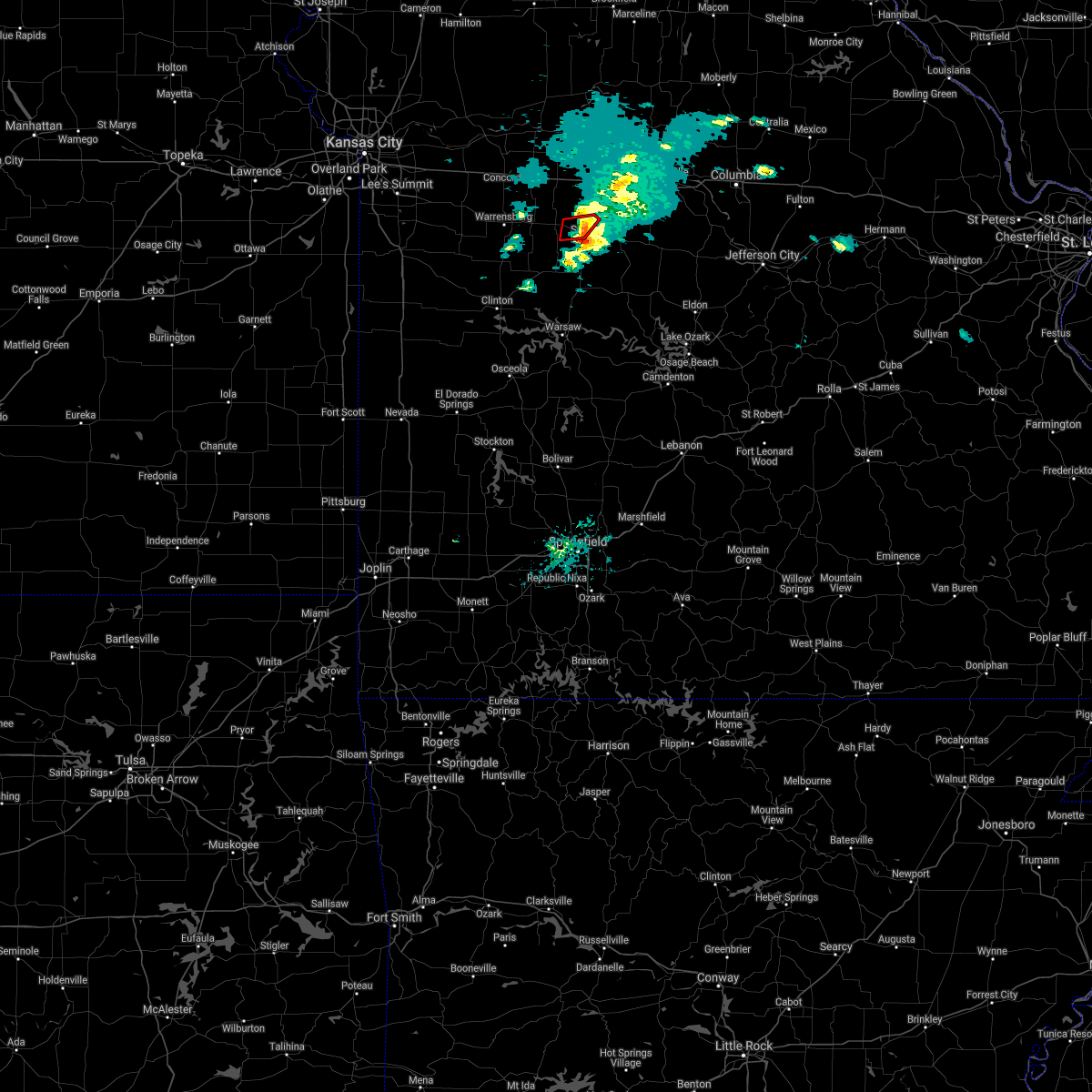 The tornado warning for central pettis county will expire at 700 pm cdt, the rotation which prompted the warning has weakened below severe limits, and no longer appears capable of producing a tornado. therefore, the warning will be allowed to expire. however small hail and gusty winds are still possible with this thunderstorm. The tornado warning for central pettis county will expire at 700 pm cdt, the rotation which prompted the warning has weakened below severe limits, and no longer appears capable of producing a tornado. therefore, the warning will be allowed to expire. however small hail and gusty winds are still possible with this thunderstorm.
|
| 3/15/2021 6:43 PM CDT |
 At 643 pm cdt, a severe thunderstorm capable of producing a tornado was located near sedalia, moving east at 25 mph (radar indicated rotation). Hazards include tornado and quarter size hail. Flying debris will be dangerous to those caught without shelter. mobile homes will be damaged or destroyed. damage to roofs, windows, and vehicles will occur. tree damage is likely. Locations impacted include, sedalia. At 643 pm cdt, a severe thunderstorm capable of producing a tornado was located near sedalia, moving east at 25 mph (radar indicated rotation). Hazards include tornado and quarter size hail. Flying debris will be dangerous to those caught without shelter. mobile homes will be damaged or destroyed. damage to roofs, windows, and vehicles will occur. tree damage is likely. Locations impacted include, sedalia.
|
| 3/15/2021 6:32 PM CDT |
 At 630 pm cdt, a severe thunderstorm was located over la monte, or near whiteman air force base, moving east at 25 mph. a tornado warning is also in effect for central pettis county (radar indicated). Hazards include 60 mph wind gusts and quarter size hail. Hail damage to vehicles is expected. expect wind damage to roofs, siding, and trees. Locations impacted include, sedalia, la monte and hughesville. At 630 pm cdt, a severe thunderstorm was located over la monte, or near whiteman air force base, moving east at 25 mph. a tornado warning is also in effect for central pettis county (radar indicated). Hazards include 60 mph wind gusts and quarter size hail. Hail damage to vehicles is expected. expect wind damage to roofs, siding, and trees. Locations impacted include, sedalia, la monte and hughesville.
|
| 3/15/2021 6:27 PM CDT |
 At 627 pm cdt, a severe thunderstorm capable of producing a tornado was located over la monte, or near whiteman air force base, moving east at 30 mph (radar indicated rotation). Hazards include tornado and quarter size hail. Flying debris will be dangerous to those caught without shelter. mobile homes will be damaged or destroyed. damage to roofs, windows, and vehicles will occur. Tree damage is likely. At 627 pm cdt, a severe thunderstorm capable of producing a tornado was located over la monte, or near whiteman air force base, moving east at 30 mph (radar indicated rotation). Hazards include tornado and quarter size hail. Flying debris will be dangerous to those caught without shelter. mobile homes will be damaged or destroyed. damage to roofs, windows, and vehicles will occur. Tree damage is likely.
|
| 3/15/2021 6:12 PM CDT |
 At 612 pm cdt, a severe thunderstorm was located over knob noster, moving east at 25 mph (radar indicated). Hazards include 60 mph wind gusts and quarter size hail. Hail damage to vehicles is expected. Expect wind damage to roofs, siding, and trees. At 612 pm cdt, a severe thunderstorm was located over knob noster, moving east at 25 mph (radar indicated). Hazards include 60 mph wind gusts and quarter size hail. Hail damage to vehicles is expected. Expect wind damage to roofs, siding, and trees.
|
| 11/14/2020 7:47 PM CST |
 At 747 pm cst, severe thunderstorms were located along a line extending from near sedalia to 10 miles northwest of warsaw, moving east at 70 mph (radar indicated). Hazards include 60 mph wind gusts and penny size hail. Expect damage to roofs, siding, and trees. Locations impacted include, sedalia, windsor and green ridge. At 747 pm cst, severe thunderstorms were located along a line extending from near sedalia to 10 miles northwest of warsaw, moving east at 70 mph (radar indicated). Hazards include 60 mph wind gusts and penny size hail. Expect damage to roofs, siding, and trees. Locations impacted include, sedalia, windsor and green ridge.
|
| 11/14/2020 7:40 PM CST |
 At 740 pm cst, severe thunderstorms were located along a line extending from near green ridge to 8 miles east of deepwater, moving east at 70 mph (radar indicated). Hazards include 60 mph wind gusts and penny size hail. Expect damage to roofs, siding, and trees. Locations impacted include, sedalia, windsor, green ridge, coal, tightwad and truman lake. At 740 pm cst, severe thunderstorms were located along a line extending from near green ridge to 8 miles east of deepwater, moving east at 70 mph (radar indicated). Hazards include 60 mph wind gusts and penny size hail. Expect damage to roofs, siding, and trees. Locations impacted include, sedalia, windsor, green ridge, coal, tightwad and truman lake.
|
| 11/14/2020 7:29 PM CST |
 At 715 pm cst, a severe thunderstorm was located 7 miles southeast of urich, or 8 miles west of clinton, moving east at 70 mph (radar indicated). Hazards include 60 mph wind gusts and quarter size hail. Hail damage to vehicles is expected. expect wind damage to roofs, siding, and trees. Locations impacted include, sedalia, clinton, windsor, leeton, urich, green ridge, calhoun, montrose, chilhowee, coal, blairstown, tightwad, post oak, hartwell, la due and truman lake. At 715 pm cst, a severe thunderstorm was located 7 miles southeast of urich, or 8 miles west of clinton, moving east at 70 mph (radar indicated). Hazards include 60 mph wind gusts and quarter size hail. Hail damage to vehicles is expected. expect wind damage to roofs, siding, and trees. Locations impacted include, sedalia, clinton, windsor, leeton, urich, green ridge, calhoun, montrose, chilhowee, coal, blairstown, tightwad, post oak, hartwell, la due and truman lake.
|
| 11/14/2020 7:16 PM CST |
 At 715 pm cst, a severe thunderstorm was located 7 miles southeast of urich, or 8 miles west of clinton, moving east at 70 mph (radar indicated). Hazards include 60 mph wind gusts and quarter size hail. Hail damage to vehicles is expected. expect wind damage to roofs, siding, and trees. Locations impacted include, sedalia, clinton, windsor, leeton, urich, green ridge, calhoun, montrose, chilhowee, coal, blairstown, tightwad, post oak, hartwell, la due and truman lake. At 715 pm cst, a severe thunderstorm was located 7 miles southeast of urich, or 8 miles west of clinton, moving east at 70 mph (radar indicated). Hazards include 60 mph wind gusts and quarter size hail. Hail damage to vehicles is expected. expect wind damage to roofs, siding, and trees. Locations impacted include, sedalia, clinton, windsor, leeton, urich, green ridge, calhoun, montrose, chilhowee, coal, blairstown, tightwad, post oak, hartwell, la due and truman lake.
|
| 11/14/2020 7:11 PM CST |
 At 711 pm cst, a severe thunderstorm was located near montrose, or 14 miles west of clinton, moving east at 70 mph (radar indicated). Hazards include 60 mph wind gusts and quarter size hail. Hail damage to vehicles is expected. Expect wind damage to roofs, siding, and trees. At 711 pm cst, a severe thunderstorm was located near montrose, or 14 miles west of clinton, moving east at 70 mph (radar indicated). Hazards include 60 mph wind gusts and quarter size hail. Hail damage to vehicles is expected. Expect wind damage to roofs, siding, and trees.
|
| 9/27/2020 2:01 PM CDT |
 At 200 pm cdt, a severe thunderstorm was located near sedalia, moving east at 35 mph (radar indicated). Hazards include 60 mph wind gusts. Expect damage to roofs, siding, and trees. Locations impacted include, sedalia, smithton, otterville, sedalia memorial arpt and clifton city. At 200 pm cdt, a severe thunderstorm was located near sedalia, moving east at 35 mph (radar indicated). Hazards include 60 mph wind gusts. Expect damage to roofs, siding, and trees. Locations impacted include, sedalia, smithton, otterville, sedalia memorial arpt and clifton city.
|
| 9/27/2020 1:51 PM CDT | Storm damage reported in pettis county MO, 1.4 miles WSW of Sedalia, MO |
| 9/27/2020 1:47 PM CDT |
 At 147 pm cdt, a severe thunderstorm was located west of sedalia, moving east at 35 mph (radar indicated). Hazards include 60 mph wind gusts. expect damage to roofs, siding, and trees At 147 pm cdt, a severe thunderstorm was located west of sedalia, moving east at 35 mph (radar indicated). Hazards include 60 mph wind gusts. expect damage to roofs, siding, and trees
|
| 8/10/2020 3:54 PM CDT |
 At 354 pm cdt, severe thunderstorms were located along a line extending from near new franklin to near boonville to near bunceton to 7 miles northwest of tipton to 6 miles south of smithton, moving east at 30 mph (radar indicated). Hazards include 60 mph wind gusts. Expect damage to roofs, siding, and trees. Locations impacted include, boonville, fayette, new franklin, pilot grove, smithton, otterville, bunceton, prairie home, blackwater, franklin, wooldridge, clifton city and lamine. At 354 pm cdt, severe thunderstorms were located along a line extending from near new franklin to near boonville to near bunceton to 7 miles northwest of tipton to 6 miles south of smithton, moving east at 30 mph (radar indicated). Hazards include 60 mph wind gusts. Expect damage to roofs, siding, and trees. Locations impacted include, boonville, fayette, new franklin, pilot grove, smithton, otterville, bunceton, prairie home, blackwater, franklin, wooldridge, clifton city and lamine.
|
| 8/10/2020 3:47 PM CDT |
 At 347 pm cdt, severe thunderstorms were located along a line extending from near slater to 8 miles south of glasgow to near new franklin to near pilot grove to near otterville, moving east at 45 mph (radar indicated). Hazards include 60 mph wind gusts. Expect damage to roofs, siding, and trees. Locations impacted include, sedalia, moberly, marshall, boonville, fayette, glasgow, new franklin, pilot grove, smithton, higbee, otterville, bunceton, clark, armstrong, prairie home, nelson, renick, blackwater, franklin and wooldridge. At 347 pm cdt, severe thunderstorms were located along a line extending from near slater to 8 miles south of glasgow to near new franklin to near pilot grove to near otterville, moving east at 45 mph (radar indicated). Hazards include 60 mph wind gusts. Expect damage to roofs, siding, and trees. Locations impacted include, sedalia, moberly, marshall, boonville, fayette, glasgow, new franklin, pilot grove, smithton, higbee, otterville, bunceton, clark, armstrong, prairie home, nelson, renick, blackwater, franklin and wooldridge.
|
| 8/10/2020 3:20 PM CDT |
 At 319 pm cdt, severe thunderstorms were located along a line extending from near blackburn to 8 miles east of sweet springs to 9 miles east of houstonia to 6 miles north of sedalia to 7 miles east of green ridge, moving east at 60 mph (trained weather spotters). Hazards include 70 mph wind gusts and nickel size hail. Expect considerable tree damage. Damage is likely to mobile homes, roofs, and outbuildings. At 319 pm cdt, severe thunderstorms were located along a line extending from near blackburn to 8 miles east of sweet springs to 9 miles east of houstonia to 6 miles north of sedalia to 7 miles east of green ridge, moving east at 60 mph (trained weather spotters). Hazards include 70 mph wind gusts and nickel size hail. Expect considerable tree damage. Damage is likely to mobile homes, roofs, and outbuildings.
|
| 8/10/2020 3:14 PM CDT |
 At 313 pm cdt, severe thunderstorms were located along a line extending from alma to near blackburn to near sweet springs to near houstonia to 9 miles northeast of la monte to near sedalia, moving east at 50 mph (trained weather spotters). Hazards include 70 mph wind gusts and nickel size hail. Expect considerable tree damage. damage is likely to mobile homes, roofs, and outbuildings. Locations impacted include, sedalia, marshall, higginsville, knob noster, concordia, sweet springs, la monte, waverly, corder, alma, malta bend, blackburn, houstonia, whiteman afb, wakenda, emma, hughesville, miami, aullville and mount leonard. At 313 pm cdt, severe thunderstorms were located along a line extending from alma to near blackburn to near sweet springs to near houstonia to 9 miles northeast of la monte to near sedalia, moving east at 50 mph (trained weather spotters). Hazards include 70 mph wind gusts and nickel size hail. Expect considerable tree damage. damage is likely to mobile homes, roofs, and outbuildings. Locations impacted include, sedalia, marshall, higginsville, knob noster, concordia, sweet springs, la monte, waverly, corder, alma, malta bend, blackburn, houstonia, whiteman afb, wakenda, emma, hughesville, miami, aullville and mount leonard.
|
| 8/10/2020 2:56 PM CDT |
 At 255 pm cdt, severe thunderstorms were located along a line extending from mayview to near higginsville to near concordia to 11 miles west of sweet springs to 10 miles north of whiteman air force base to near knob noster to near whiteman afb, moving northeast at 60 mph (trained weather spotters). Hazards include 70 mph wind gusts and nickel size hail. Expect considerable tree damage. damage is likely to mobile homes, roofs, and outbuildings. Locations impacted include, sedalia, warrensburg, marshall, odessa, higginsville, carrollton, knob noster, concordia, sweet springs, whiteman air force base, la monte, waverly, corder, alma, malta bend, blackburn, houstonia, mayview, whiteman afb and wakenda. At 255 pm cdt, severe thunderstorms were located along a line extending from mayview to near higginsville to near concordia to 11 miles west of sweet springs to 10 miles north of whiteman air force base to near knob noster to near whiteman afb, moving northeast at 60 mph (trained weather spotters). Hazards include 70 mph wind gusts and nickel size hail. Expect considerable tree damage. damage is likely to mobile homes, roofs, and outbuildings. Locations impacted include, sedalia, warrensburg, marshall, odessa, higginsville, carrollton, knob noster, concordia, sweet springs, whiteman air force base, la monte, waverly, corder, alma, malta bend, blackburn, houstonia, mayview, whiteman afb and wakenda.
|
| 8/10/2020 2:44 PM CDT |
 At 244 pm cdt, severe thunderstorms were located along a line extending from near odessa to 9 miles south of mayview to near warrensburg to 7 miles northwest of leeton, moving northeast at 55 mph (trained weather spotters). Hazards include 70 mph wind gusts. Expect considerable tree damage. damage is likely to mobile homes, roofs, and outbuildings. Locations impacted include, sedalia, warrensburg, marshall, odessa, higginsville, carrollton, knob noster, concordia, sweet springs, whiteman air force base, la monte, waverly, corder, alma, chilhowee, malta bend, blackburn, houstonia, mayview and whiteman afb. At 244 pm cdt, severe thunderstorms were located along a line extending from near odessa to 9 miles south of mayview to near warrensburg to 7 miles northwest of leeton, moving northeast at 55 mph (trained weather spotters). Hazards include 70 mph wind gusts. Expect considerable tree damage. damage is likely to mobile homes, roofs, and outbuildings. Locations impacted include, sedalia, warrensburg, marshall, odessa, higginsville, carrollton, knob noster, concordia, sweet springs, whiteman air force base, la monte, waverly, corder, alma, chilhowee, malta bend, blackburn, houstonia, mayview and whiteman afb.
|
| 8/10/2020 2:39 PM CDT |
 At 239 pm cdt, severe thunderstorms were located along a line extending from near odessa to 11 miles southwest of mayview to 9 miles northeast of holden to 6 miles west of warrensburg to 7 miles north of chilhowee, moving northeast at 50 mph (radar indicated). Hazards include 70 mph wind gusts and penny size hail. Expect considerable tree damage. Damage is likely to mobile homes, roofs, and outbuildings. At 239 pm cdt, severe thunderstorms were located along a line extending from near odessa to 11 miles southwest of mayview to 9 miles northeast of holden to 6 miles west of warrensburg to 7 miles north of chilhowee, moving northeast at 50 mph (radar indicated). Hazards include 70 mph wind gusts and penny size hail. Expect considerable tree damage. Damage is likely to mobile homes, roofs, and outbuildings.
|
| 7/21/2020 4:36 PM CDT |
 The severe thunderstorm warning for southeastern pettis county will expire at 445 pm cdt, the storm which prompted the warning has weakened below severe limits, and no longer poses an immediate threat to life or property. therefore, the warning will be allowed to expire. however gusty winds are still possible with this thunderstorm. The severe thunderstorm warning for southeastern pettis county will expire at 445 pm cdt, the storm which prompted the warning has weakened below severe limits, and no longer poses an immediate threat to life or property. therefore, the warning will be allowed to expire. however gusty winds are still possible with this thunderstorm.
|
| 7/21/2020 4:17 PM CDT |
 At 416 pm cdt, a severe thunderstorm was located near sedalia, moving northeast at 40 mph (radar indicated). Hazards include 60 mph wind gusts and penny size hail. expect damage to roofs, siding, and trees At 416 pm cdt, a severe thunderstorm was located near sedalia, moving northeast at 40 mph (radar indicated). Hazards include 60 mph wind gusts and penny size hail. expect damage to roofs, siding, and trees
|
| 6/5/2020 5:12 AM CDT |
 At 512 am cdt, severe thunderstorms were located along a line extending from 6 miles east of houstonia to 6 miles north of lincoln to near lowry city, moving east at 50 mph (radar indicated). Hazards include 60 mph wind gusts and nickel size hail. Expect damage to roofs, siding, and trees. Locations impacted include, sedalia, clinton, windsor, sweet springs, la monte, pilot grove, smithton, green ridge, calhoun, otterville, deepwater, houstonia, coal, hughesville, brownington, tightwad, clifton city, sedalia memorial arpt and truman lake. At 512 am cdt, severe thunderstorms were located along a line extending from 6 miles east of houstonia to 6 miles north of lincoln to near lowry city, moving east at 50 mph (radar indicated). Hazards include 60 mph wind gusts and nickel size hail. Expect damage to roofs, siding, and trees. Locations impacted include, sedalia, clinton, windsor, sweet springs, la monte, pilot grove, smithton, green ridge, calhoun, otterville, deepwater, houstonia, coal, hughesville, brownington, tightwad, clifton city, sedalia memorial arpt and truman lake.
|
| 6/5/2020 4:54 AM CDT |
 At 454 am cdt, severe thunderstorms were located along a line extending from near sweet springs to near calhoun to 6 miles east of appleton city, moving southeast at 55 mph (radar indicated). Hazards include 60 mph wind gusts and nickel size hail. expect damage to roofs, siding, and trees At 454 am cdt, severe thunderstorms were located along a line extending from near sweet springs to near calhoun to 6 miles east of appleton city, moving southeast at 55 mph (radar indicated). Hazards include 60 mph wind gusts and nickel size hail. expect damage to roofs, siding, and trees
|
| 6/4/2020 3:52 AM CDT | Storm damage reported in pettis county MO, 4.1 miles W of Sedalia, MO |
| 6/4/2020 3:35 AM CDT |
 At 335 am cdt, severe thunderstorms were located along a line extending from 9 miles west of pilot grove to 6 miles northwest of cole camp to 6 miles southeast of deepwater, moving southeast at 60 mph (radar indicated). Hazards include 60 mph wind gusts and nickel size hail. Expect damage to roofs, siding, and trees. Locations impacted include, sedalia, marshall, clinton, windsor, la monte, pilot grove, smithton, green ridge, calhoun, otterville, deepwater, houstonia, coal, nelson, hughesville, blackwater, brownington, tightwad, arrow rock and clifton city. At 335 am cdt, severe thunderstorms were located along a line extending from 9 miles west of pilot grove to 6 miles northwest of cole camp to 6 miles southeast of deepwater, moving southeast at 60 mph (radar indicated). Hazards include 60 mph wind gusts and nickel size hail. Expect damage to roofs, siding, and trees. Locations impacted include, sedalia, marshall, clinton, windsor, la monte, pilot grove, smithton, green ridge, calhoun, otterville, deepwater, houstonia, coal, nelson, hughesville, blackwater, brownington, tightwad, arrow rock and clifton city.
|
| 6/4/2020 3:06 AM CDT |
 At 304 am cdt, severe thunderstorms were located along a line extending from near waverly to warrensburg to near creighton, moving southeast at 60 mph (radar indicated). Hazards include 60 mph wind gusts and nickel size hail. expect damage to roofs, siding, and trees At 304 am cdt, severe thunderstorms were located along a line extending from near waverly to warrensburg to near creighton, moving southeast at 60 mph (radar indicated). Hazards include 60 mph wind gusts and nickel size hail. expect damage to roofs, siding, and trees
|
| 6/4/2020 3:04 AM CDT |
 At 303 am cdt, severe thunderstorms were located along a line extending from near waverly to near warrensburg to near creighton, moving southeast at 60 mph (radar indicated). Hazards include 60 mph wind gusts and nickel size hail. expect damage to roofs, siding, and trees At 303 am cdt, severe thunderstorms were located along a line extending from near waverly to near warrensburg to near creighton, moving southeast at 60 mph (radar indicated). Hazards include 60 mph wind gusts and nickel size hail. expect damage to roofs, siding, and trees
|
| 5/15/2020 1:18 AM CDT |
 At 118 am cdt, severe thunderstorms were located along a line extending from near higbee to near windsor, moving southeast at 45 mph (radar indicated). Hazards include 60 mph wind gusts. expect damage to roofs, siding, and trees At 118 am cdt, severe thunderstorms were located along a line extending from near higbee to near windsor, moving southeast at 45 mph (radar indicated). Hazards include 60 mph wind gusts. expect damage to roofs, siding, and trees
|
| 5/15/2020 1:00 AM CDT |
 At 1259 am cdt, severe thunderstorms were located along a line extending from near knob noster to 6 miles east of appleton city, moving east at 50 mph (radar indicated). Hazards include 70 mph wind gusts. Expect considerable tree damage. Damage is likely to mobile homes, roofs, and outbuildings. At 1259 am cdt, severe thunderstorms were located along a line extending from near knob noster to 6 miles east of appleton city, moving east at 50 mph (radar indicated). Hazards include 70 mph wind gusts. Expect considerable tree damage. Damage is likely to mobile homes, roofs, and outbuildings.
|
| 5/15/2020 12:45 AM CDT |
 At 1245 am cdt, a severe thunderstorm was located near knob noster, moving east at 55 mph (radar indicated). Hazards include 70 mph wind gusts. Expect considerable tree damage. Damage is likely to mobile homes, roofs, and outbuildings. At 1245 am cdt, a severe thunderstorm was located near knob noster, moving east at 55 mph (radar indicated). Hazards include 70 mph wind gusts. Expect considerable tree damage. Damage is likely to mobile homes, roofs, and outbuildings.
|
| 5/4/2020 1:28 PM CDT |
 The severe thunderstorm warning for pettis and southwestern cooper counties will expire at 130 pm cdt, the storms which prompted the warning have moved out of the area. therefore, the warning will be allowed to expire. a severe thunderstorm watch remains in effect until 300 pm cdt for central and west central missouri. remember, a severe thunderstorm warning still remains in effect for cooper county until 200 pm. The severe thunderstorm warning for pettis and southwestern cooper counties will expire at 130 pm cdt, the storms which prompted the warning have moved out of the area. therefore, the warning will be allowed to expire. a severe thunderstorm watch remains in effect until 300 pm cdt for central and west central missouri. remember, a severe thunderstorm warning still remains in effect for cooper county until 200 pm.
|
| 5/4/2020 1:16 PM CDT |
 At 116 pm cdt, severe thunderstorms were located along a line extending from 10 miles east of houstonia to near stover to 13 miles southeast of cole camp, moving east at 60 mph (radar indicated). Hazards include 60 mph wind gusts. Expect damage to roofs, siding, and trees. Locations impacted include, sedalia, windsor, la monte, smithton, green ridge, otterville, houstonia, hughesville, sedalia memorial arpt and clifton city. At 116 pm cdt, severe thunderstorms were located along a line extending from 10 miles east of houstonia to near stover to 13 miles southeast of cole camp, moving east at 60 mph (radar indicated). Hazards include 60 mph wind gusts. Expect damage to roofs, siding, and trees. Locations impacted include, sedalia, windsor, la monte, smithton, green ridge, otterville, houstonia, hughesville, sedalia memorial arpt and clifton city.
|
| 5/4/2020 1:02 PM CDT |
 At 101 pm cdt, severe thunderstorms were located along a line extending from near sweet springs to near cole camp to near warsaw, moving east at 60 mph. 60 mph winds have been reported at clinton airport (radar indicated). Hazards include 70 mph wind gusts. Expect considerable tree damage. damage is likely to mobile homes, roofs, and outbuildings. Locations impacted include, sedalia, warrensburg, clinton, windsor, knob noster, whiteman air force base, la monte, smithton, leeton, green ridge, calhoun, otterville, houstonia, whiteman afb, hughesville, clifton city, sedalia memorial arpt, post oak and truman lake. At 101 pm cdt, severe thunderstorms were located along a line extending from near sweet springs to near cole camp to near warsaw, moving east at 60 mph. 60 mph winds have been reported at clinton airport (radar indicated). Hazards include 70 mph wind gusts. Expect considerable tree damage. damage is likely to mobile homes, roofs, and outbuildings. Locations impacted include, sedalia, warrensburg, clinton, windsor, knob noster, whiteman air force base, la monte, smithton, leeton, green ridge, calhoun, otterville, houstonia, whiteman afb, hughesville, clifton city, sedalia memorial arpt, post oak and truman lake.
|
| 5/4/2020 12:41 PM CDT |
 At 1241 pm cdt, severe thunderstorms were located along a line extending from 7 miles southeast of mayview to calhoun to near clinton, moving east at 60 mph (radar indicated). Hazards include 70 mph wind gusts. Expect considerable tree damage. Damage is likely to mobile homes, roofs, and outbuildings. At 1241 pm cdt, severe thunderstorms were located along a line extending from 7 miles southeast of mayview to calhoun to near clinton, moving east at 60 mph (radar indicated). Hazards include 70 mph wind gusts. Expect considerable tree damage. Damage is likely to mobile homes, roofs, and outbuildings.
|
| 3/27/2020 3:02 AM CDT |
 At 302 am cdt, a severe thunderstorm was located near smithton, or 8 miles east of sedalia, moving east at 50 mph (radar indicated). Hazards include quarter size hail. Damage to vehicles is expected. Locations impacted include, sedalia, smithton, otterville, bunceton, prairie home, sedalia memorial arpt and clifton city. At 302 am cdt, a severe thunderstorm was located near smithton, or 8 miles east of sedalia, moving east at 50 mph (radar indicated). Hazards include quarter size hail. Damage to vehicles is expected. Locations impacted include, sedalia, smithton, otterville, bunceton, prairie home, sedalia memorial arpt and clifton city.
|
| 3/27/2020 3:00 AM CDT | Quarter sized hail reported 0.9 miles WNW of Sedalia, MO, pea to quarter sized hail reported at walmart and 50 highway in sedalia. |
| 3/27/2020 2:55 AM CDT |
 The severe thunderstorm warning for southwestern pettis county will expire at 300 am cdt, the storm which prompted the warning has moved out of the area. therefore, the warning will be allowed to expire. a severe thunderstorm watch remains in effect until 500 am cdt for central missouri. The severe thunderstorm warning for southwestern pettis county will expire at 300 am cdt, the storm which prompted the warning has moved out of the area. therefore, the warning will be allowed to expire. a severe thunderstorm watch remains in effect until 500 am cdt for central missouri.
|
| 3/27/2020 2:52 AM CDT |
 At 252 am cdt, a severe thunderstorm was located over sedalia, moving east at 50 mph (radar indicated). Hazards include quarter size hail. damage to vehicles is expected At 252 am cdt, a severe thunderstorm was located over sedalia, moving east at 50 mph (radar indicated). Hazards include quarter size hail. damage to vehicles is expected
|
| 3/27/2020 2:47 AM CDT |
 At 247 am cdt, a severe thunderstorm was located near sedalia, moving east at 60 mph (trained weather spotters). Hazards include quarter size hail. Damage to vehicles is expected. Locations impacted include, sedalia and la monte. At 247 am cdt, a severe thunderstorm was located near sedalia, moving east at 60 mph (trained weather spotters). Hazards include quarter size hail. Damage to vehicles is expected. Locations impacted include, sedalia and la monte.
|
| 3/27/2020 2:38 AM CDT |
 At 238 am cdt, a severe thunderstorm was located near whiteman afb, or near whiteman air force base, moving east at 60 mph (trained weather spotters). Hazards include ping pong ball size hail. People and animals outdoors will be injured. expect damage to roofs, siding, windows, and vehicles. Locations impacted include, sedalia, knob noster, whiteman air force base, la monte, green ridge and whiteman afb. At 238 am cdt, a severe thunderstorm was located near whiteman afb, or near whiteman air force base, moving east at 60 mph (trained weather spotters). Hazards include ping pong ball size hail. People and animals outdoors will be injured. expect damage to roofs, siding, windows, and vehicles. Locations impacted include, sedalia, knob noster, whiteman air force base, la monte, green ridge and whiteman afb.
|
| 3/27/2020 2:31 AM CDT |
 At 231 am cdt, a severe thunderstorm was located near whiteman afb, or near whiteman air force base, moving east at 60 mph (radar indicated). Hazards include ping pong ball size hail. People and animals outdoors will be injured. expect damage to roofs, siding, windows, and vehicles. Locations impacted include, sedalia, warrensburg, knob noster, whiteman air force base, la monte, green ridge and whiteman afb. At 231 am cdt, a severe thunderstorm was located near whiteman afb, or near whiteman air force base, moving east at 60 mph (radar indicated). Hazards include ping pong ball size hail. People and animals outdoors will be injured. expect damage to roofs, siding, windows, and vehicles. Locations impacted include, sedalia, warrensburg, knob noster, whiteman air force base, la monte, green ridge and whiteman afb.
|
| 3/27/2020 2:22 AM CDT |
 At 222 am cdt, a severe thunderstorm was located near warrensburg, moving east at 60 mph (radar indicated). Hazards include ping pong ball size hail. People and animals outdoors will be injured. Expect damage to roofs, siding, windows, and vehicles. At 222 am cdt, a severe thunderstorm was located near warrensburg, moving east at 60 mph (radar indicated). Hazards include ping pong ball size hail. People and animals outdoors will be injured. Expect damage to roofs, siding, windows, and vehicles.
|
| 3/27/2020 12:21 AM CDT |
 At 1220 am cdt, a severe thunderstorm was located 8 miles northeast of sedalia, moving east at 60 mph (radar indicated). Hazards include half dollar size hail. damage to vehicles is expected At 1220 am cdt, a severe thunderstorm was located 8 miles northeast of sedalia, moving east at 60 mph (radar indicated). Hazards include half dollar size hail. damage to vehicles is expected
|
| 3/27/2020 12:16 AM CDT |
 At 1216 am cdt, a severe thunderstorm was located 7 miles southeast of houstonia, or 8 miles north of sedalia, moving east at 60 mph (radar indicated). Hazards include quarter size hail. Damage to vehicles is expected. Locations impacted include, sedalia, la monte, houstonia, hughesville and sedalia memorial arpt. At 1216 am cdt, a severe thunderstorm was located 7 miles southeast of houstonia, or 8 miles north of sedalia, moving east at 60 mph (radar indicated). Hazards include quarter size hail. Damage to vehicles is expected. Locations impacted include, sedalia, la monte, houstonia, hughesville and sedalia memorial arpt.
|
| 3/27/2020 12:09 AM CDT |
 At 1209 am cdt, a severe thunderstorm was located near la monte, or 9 miles south of sweet springs, moving east at 55 mph (radar indicated). Hazards include quarter size hail. Damage to vehicles is expected. Locations impacted include, sedalia, knob noster, whiteman air force base, la monte, houstonia, whiteman afb, hughesville and sedalia memorial arpt. At 1209 am cdt, a severe thunderstorm was located near la monte, or 9 miles south of sweet springs, moving east at 55 mph (radar indicated). Hazards include quarter size hail. Damage to vehicles is expected. Locations impacted include, sedalia, knob noster, whiteman air force base, la monte, houstonia, whiteman afb, hughesville and sedalia memorial arpt.
|
| 3/27/2020 12:03 AM CDT |
 At 1203 am cdt, a severe thunderstorm was located near knob noster, moving east at 55 mph (radar indicated). Hazards include quarter size hail. Damage to vehicles is expected. Locations impacted include, sedalia, knob noster, whiteman air force base, la monte, houstonia, whiteman afb, hughesville and sedalia memorial arpt. At 1203 am cdt, a severe thunderstorm was located near knob noster, moving east at 55 mph (radar indicated). Hazards include quarter size hail. Damage to vehicles is expected. Locations impacted include, sedalia, knob noster, whiteman air force base, la monte, houstonia, whiteman afb, hughesville and sedalia memorial arpt.
|
| 3/26/2020 11:57 PM CDT |
 At 1157 pm cdt, a severe thunderstorm was located near knob noster, moving east at 55 mph (radar indicated). Hazards include quarter size hail. damage to vehicles is expected At 1157 pm cdt, a severe thunderstorm was located near knob noster, moving east at 55 mph (radar indicated). Hazards include quarter size hail. damage to vehicles is expected
|
| 3/26/2020 11:51 PM CDT |
 At 1151 pm cdt, a severe thunderstorm was located near knob noster, moving east at 60 mph (radar indicated). Hazards include half dollar size hail. Damage to vehicles is expected. Locations impacted include, sedalia, warrensburg, knob noster, sweet springs, whiteman air force base, la monte, houstonia, whiteman afb, centerview, hughesville and fayetteville. At 1151 pm cdt, a severe thunderstorm was located near knob noster, moving east at 60 mph (radar indicated). Hazards include half dollar size hail. Damage to vehicles is expected. Locations impacted include, sedalia, warrensburg, knob noster, sweet springs, whiteman air force base, la monte, houstonia, whiteman afb, centerview, hughesville and fayetteville.
|
| 3/26/2020 11:36 PM CDT |
 At 1135 pm cdt, a severe thunderstorm was located 7 miles west of warrensburg, moving east at 75 mph (radar indicated). Hazards include half dollar size hail. damage to vehicles is expected At 1135 pm cdt, a severe thunderstorm was located 7 miles west of warrensburg, moving east at 75 mph (radar indicated). Hazards include half dollar size hail. damage to vehicles is expected
|
| 8/26/2019 12:45 PM CDT |
 At 1245 pm cdt, a severe thunderstorm was located over cole camp, or 15 miles northeast of warsaw, moving east at 50 mph (radar indicated). Hazards include 60 mph wind gusts. Expect damage to roofs, siding, and trees. Locations impacted include, sedalia, clinton, windsor, smithton, green ridge, calhoun, coal, tightwad, sedalia memorial arpt and truman lake. At 1245 pm cdt, a severe thunderstorm was located over cole camp, or 15 miles northeast of warsaw, moving east at 50 mph (radar indicated). Hazards include 60 mph wind gusts. Expect damage to roofs, siding, and trees. Locations impacted include, sedalia, clinton, windsor, smithton, green ridge, calhoun, coal, tightwad, sedalia memorial arpt and truman lake.
|
| 8/26/2019 12:27 PM CDT |
 At 1212 pm cdt, a severe thunderstorm was located over leeton, or 12 miles west of windsor, moving east at 50 mph (radar indicated). Hazards include 60 mph wind gusts. expect damage to roofs, siding, and trees At 1212 pm cdt, a severe thunderstorm was located over leeton, or 12 miles west of windsor, moving east at 50 mph (radar indicated). Hazards include 60 mph wind gusts. expect damage to roofs, siding, and trees
|
| 8/26/2019 12:13 PM CDT |
 At 1212 pm cdt, a severe thunderstorm was located over leeton, or 12 miles west of windsor, moving east at 50 mph (radar indicated). Hazards include 60 mph wind gusts. expect damage to roofs, siding, and trees At 1212 pm cdt, a severe thunderstorm was located over leeton, or 12 miles west of windsor, moving east at 50 mph (radar indicated). Hazards include 60 mph wind gusts. expect damage to roofs, siding, and trees
|
| 8/17/2019 5:43 AM CDT | Sedalia regional airpor in pettis county MO, 3.5 miles W of Sedalia, MO |
| 8/17/2019 5:39 AM CDT | Sedalia airport measured wind gus in pettis county MO, 4.1 miles W of Sedalia, MO |
| 8/17/2019 5:36 AM CDT |
 The national weather service in pleasant hill has issued a * severe thunderstorm warning for. eastern pettis county in central missouri. cooper county in central missouri. until 630 am cdt. At 536 am cdt, a severe thunderstorm was located over smithton, or. The national weather service in pleasant hill has issued a * severe thunderstorm warning for. eastern pettis county in central missouri. cooper county in central missouri. until 630 am cdt. At 536 am cdt, a severe thunderstorm was located over smithton, or.
|
| 8/17/2019 5:17 AM CDT |
 At 516 am cdt, a severe thunderstorm was located near green ridge, or 9 miles southeast of whiteman air force base, moving east at 50 mph (measured wind speed at whiteman afb). Hazards include 75 mph wind gusts and penny size hail. Expect considerable tree damage. damage is likely to mobile homes, roofs, and outbuildings. Locations impacted include, sedalia, windsor, knob noster, whiteman air force base, la monte, smithton, green ridge, whiteman afb, hughesville, ionia and sedalia memorial arpt. At 516 am cdt, a severe thunderstorm was located near green ridge, or 9 miles southeast of whiteman air force base, moving east at 50 mph (measured wind speed at whiteman afb). Hazards include 75 mph wind gusts and penny size hail. Expect considerable tree damage. damage is likely to mobile homes, roofs, and outbuildings. Locations impacted include, sedalia, windsor, knob noster, whiteman air force base, la monte, smithton, green ridge, whiteman afb, hughesville, ionia and sedalia memorial arpt.
|
| 8/17/2019 5:00 AM CDT |
 At 500 am cdt, a severe thunderstorm was located near leeton, or 8 miles southwest of whiteman air force base, moving east at 45 mph (radar indicated). Hazards include 70 mph wind gusts and penny size hail. Expect considerable tree damage. Damage is likely to mobile homes, roofs, and outbuildings. At 500 am cdt, a severe thunderstorm was located near leeton, or 8 miles southwest of whiteman air force base, moving east at 45 mph (radar indicated). Hazards include 70 mph wind gusts and penny size hail. Expect considerable tree damage. Damage is likely to mobile homes, roofs, and outbuildings.
|
| 8/16/2019 12:26 AM CDT |
 The severe thunderstorm warning for southeastern pettis county will expire at 1230 am cdt. the storm which prompted the warning has moved out of the area. therefore, the warning will be allowed to expire. A severe thunderstorm watch remains in effect until 700 am cdt for central missouri. The severe thunderstorm warning for southeastern pettis county will expire at 1230 am cdt. the storm which prompted the warning has moved out of the area. therefore, the warning will be allowed to expire. A severe thunderstorm watch remains in effect until 700 am cdt for central missouri.
|
| 8/16/2019 12:13 AM CDT |
 The national weather service in pleasant hill has issued a * severe thunderstorm warning for. southeastern pettis county in central missouri. until 1230 am cdt. At 1212 am cdt, a severe thunderstorm was located 7 miles north of cole camp, or 9 miles south of sedalia, moving southeast at 35 mph. The national weather service in pleasant hill has issued a * severe thunderstorm warning for. southeastern pettis county in central missouri. until 1230 am cdt. At 1212 am cdt, a severe thunderstorm was located 7 miles north of cole camp, or 9 miles south of sedalia, moving southeast at 35 mph.
|
| 8/15/2019 11:57 PM CDT |
 At 1156 pm cdt, a severe thunderstorm was located near green ridge, or 8 miles southwest of sedalia, moving southeast at 40 mph. at 1140 pm a 78 mph wind gust was reported at whiteman air force base. this is a very dangerous storm (trained weather spotters). Hazards include 80 mph wind gusts and quarter size hail. Flying debris will be dangerous to those caught without shelter. mobile homes will be heavily damaged. expect considerable damage to roofs, windows, and vehicles. extensive tree damage and power outages are likely. Locations impacted include, sedalia, windsor, la monte, green ridge, hughesville and sedalia memorial arpt. At 1156 pm cdt, a severe thunderstorm was located near green ridge, or 8 miles southwest of sedalia, moving southeast at 40 mph. at 1140 pm a 78 mph wind gust was reported at whiteman air force base. this is a very dangerous storm (trained weather spotters). Hazards include 80 mph wind gusts and quarter size hail. Flying debris will be dangerous to those caught without shelter. mobile homes will be heavily damaged. expect considerable damage to roofs, windows, and vehicles. extensive tree damage and power outages are likely. Locations impacted include, sedalia, windsor, la monte, green ridge, hughesville and sedalia memorial arpt.
|
| 8/15/2019 11:35 PM CDT |
 At 1135 pm cdt, a severe thunderstorm was located over whiteman afb, or over whiteman air force base, moving southeast at 40 mph (radar indicated). Hazards include 60 mph wind gusts and quarter size hail. Hail damage to vehicles is expected. Expect wind damage to roofs, siding, and trees. At 1135 pm cdt, a severe thunderstorm was located over whiteman afb, or over whiteman air force base, moving southeast at 40 mph (radar indicated). Hazards include 60 mph wind gusts and quarter size hail. Hail damage to vehicles is expected. Expect wind damage to roofs, siding, and trees.
|
| 6/22/2019 11:50 PM CDT | 15th and engineer ave in sedali in pettis county MO, 1.9 miles W of Sedalia, MO |
| 6/22/2019 11:39 PM CDT | Tree damage in sedalia. report via mpin in pettis county MO, 2.4 miles W of Sedalia, MO |
| 6/22/2019 11:24 PM CDT |
 At 1124 pm cdt, severe thunderstorms were located along a line extending from 6 miles south of concordia to near deepwater, moving east at 45 mph (radar indicated). Hazards include 70 mph wind gusts. Expect considerable tree damage. Damage is likely to mobile homes, roofs, and outbuildings. At 1124 pm cdt, severe thunderstorms were located along a line extending from 6 miles south of concordia to near deepwater, moving east at 45 mph (radar indicated). Hazards include 70 mph wind gusts. Expect considerable tree damage. Damage is likely to mobile homes, roofs, and outbuildings.
|
| 6/21/2019 11:32 AM CDT |
 At 1132 am cdt, a severe thunderstorm was located 8 miles north of pilot grove, or 11 miles west of boonville, moving east at 80 mph (radar indicated). Hazards include 60 mph wind gusts. expect damage to roofs, siding, and trees At 1132 am cdt, a severe thunderstorm was located 8 miles north of pilot grove, or 11 miles west of boonville, moving east at 80 mph (radar indicated). Hazards include 60 mph wind gusts. expect damage to roofs, siding, and trees
|
| 6/21/2019 10:58 AM CDT |
 At 1057 am cdt, a severe thunderstorm was located near garden city, moving southeast at 40 mph (radar indicated). Hazards include 60 mph wind gusts. expect damage to roofs, siding, and trees At 1057 am cdt, a severe thunderstorm was located near garden city, moving southeast at 40 mph (radar indicated). Hazards include 60 mph wind gusts. expect damage to roofs, siding, and trees
|
| 8/16/2018 8:51 PM CDT |
 The severe thunderstorm warning for northwestern pettis county will expire at 900 pm cdt, the storm which prompted the warning has weakened below severe limits, and no longer poses an immediate threat to life or property. therefore, the warning will be allowed to expire. however gusty winds, heavy rain, and lightning are still possible with this thunderstorm. a severe thunderstorm watch remains in effect until 1100 pm cdt for central and west central missouri. The severe thunderstorm warning for northwestern pettis county will expire at 900 pm cdt, the storm which prompted the warning has weakened below severe limits, and no longer poses an immediate threat to life or property. therefore, the warning will be allowed to expire. however gusty winds, heavy rain, and lightning are still possible with this thunderstorm. a severe thunderstorm watch remains in effect until 1100 pm cdt for central and west central missouri.
|
| 8/16/2018 8:36 PM CDT |
 At 835 pm cdt, a severe thunderstorm was located over la monte, or 9 miles east of knob noster, moving southeast at 30 mph (radar indicated). Hazards include 60 mph wind gusts and penny size hail. Expect damage to roofs, siding, and trees. Locations impacted include, sedalia, la monte, houstonia and hughesville. At 835 pm cdt, a severe thunderstorm was located over la monte, or 9 miles east of knob noster, moving southeast at 30 mph (radar indicated). Hazards include 60 mph wind gusts and penny size hail. Expect damage to roofs, siding, and trees. Locations impacted include, sedalia, la monte, houstonia and hughesville.
|
| 8/16/2018 8:11 PM CDT |
 At 810 pm cdt, a severe thunderstorm was located near concordia, moving southeast at 30 mph (radar indicated). Hazards include 60 mph wind gusts and quarter size hail. Hail damage to vehicles is expected. Expect wind damage to roofs, siding, and trees. At 810 pm cdt, a severe thunderstorm was located near concordia, moving southeast at 30 mph (radar indicated). Hazards include 60 mph wind gusts and quarter size hail. Hail damage to vehicles is expected. Expect wind damage to roofs, siding, and trees.
|
| 7/19/2018 10:42 AM CDT |
 The severe thunderstorm warning for northern pettis and east central johnson counties will expire at 1045 am cdt, the storm which prompted the warning has moved out of the area. therefore, the warning will be allowed to expire. remember, a severe thunderstorm warning still remains in effect for southwestern pettis and southeastern johnson counties in missouri. The severe thunderstorm warning for northern pettis and east central johnson counties will expire at 1045 am cdt, the storm which prompted the warning has moved out of the area. therefore, the warning will be allowed to expire. remember, a severe thunderstorm warning still remains in effect for southwestern pettis and southeastern johnson counties in missouri.
|
| 7/19/2018 10:35 AM CDT |
 At 1035 am cdt, a severe thunderstorm was located near la monte, or 7 miles northwest of sedalia, moving southeast at 25 mph (trained weather spotters). Hazards include 60 mph wind gusts and quarter size hail. Hail damage to vehicles is expected. expect wind damage to roofs, siding, and trees. Locations impacted include, sedalia, knob noster, whiteman air force base, la monte, houstonia, whiteman afb and hughesville. At 1035 am cdt, a severe thunderstorm was located near la monte, or 7 miles northwest of sedalia, moving southeast at 25 mph (trained weather spotters). Hazards include 60 mph wind gusts and quarter size hail. Hail damage to vehicles is expected. expect wind damage to roofs, siding, and trees. Locations impacted include, sedalia, knob noster, whiteman air force base, la monte, houstonia, whiteman afb and hughesville.
|
| 7/19/2018 10:15 AM CDT |
 At 1013 am cdt, a severe thunderstorm was located over houstonia, or near sweet springs, moving southeast at 25 mph (trained weather spotters). Hazards include 60 mph wind gusts possible and quarter size hail. Hail damage to vehicles is expected. Expect wind damage to roofs, siding, and trees. At 1013 am cdt, a severe thunderstorm was located over houstonia, or near sweet springs, moving southeast at 25 mph (trained weather spotters). Hazards include 60 mph wind gusts possible and quarter size hail. Hail damage to vehicles is expected. Expect wind damage to roofs, siding, and trees.
|
| 6/26/2018 2:15 PM CDT | Large tree limbs down...blocking a few road in pettis county MO, 0.9 miles WNW of Sedalia, MO |
| 6/26/2018 1:57 PM CDT |
 At 157 pm cdt, a severe thunderstorm was located near houstonia, or near sweet springs, moving east at 60 mph (trained weather spotters). Hazards include 70 mph wind gusts and quarter size hail. Hail damage to vehicles is expected. expect considerable tree damage. wind damage is also likely to mobile homes, roofs, and outbuildings. locations impacted include, sedalia, marshall, sweet springs, la monte, smithton, green ridge, houstonia, emma, hughesville and sedalia memorial arpt. This includes interstate 70 in missouri between mile markers 63 and 86. At 157 pm cdt, a severe thunderstorm was located near houstonia, or near sweet springs, moving east at 60 mph (trained weather spotters). Hazards include 70 mph wind gusts and quarter size hail. Hail damage to vehicles is expected. expect considerable tree damage. wind damage is also likely to mobile homes, roofs, and outbuildings. locations impacted include, sedalia, marshall, sweet springs, la monte, smithton, green ridge, houstonia, emma, hughesville and sedalia memorial arpt. This includes interstate 70 in missouri between mile markers 63 and 86.
|
| 6/26/2018 1:50 PM CDT |
 At 149 pm cdt, a severe thunderstorm was located near concordia, moving east at 65 mph (radar indicated). Hazards include 60 mph wind gusts and quarter size hail. Hail damage to vehicles is expected. Expect wind damage to roofs, siding, and trees. At 149 pm cdt, a severe thunderstorm was located near concordia, moving east at 65 mph (radar indicated). Hazards include 60 mph wind gusts and quarter size hail. Hail damage to vehicles is expected. Expect wind damage to roofs, siding, and trees.
|
| 5/14/2018 6:29 PM CDT | Tree blown onto rissler road near sedali in pettis county MO, 4.4 miles WNW of Sedalia, MO |
| 5/14/2018 6:26 PM CDT |
 At 626 pm cdt, a severe thunderstorm was located 8 miles south of sedalia, moving east at 60 mph (radar indicated). Hazards include 60 mph wind gusts. expect damage to roofs, siding, and trees At 626 pm cdt, a severe thunderstorm was located 8 miles south of sedalia, moving east at 60 mph (radar indicated). Hazards include 60 mph wind gusts. expect damage to roofs, siding, and trees
|
| 5/2/2018 11:30 PM CDT |
 A severe thunderstorm warning remains in effect until 1145 pm cdt for southeastern pettis county. At 1130 pm cdt, severe thunderstorms were located along a line extending from keytesville to 9 miles northwest of new franklin to 7 miles north of smithton to 6 miles south of sedalia to near cole camp to near warsaw, moving east at 35 mph. A severe thunderstorm warning remains in effect until 1145 pm cdt for southeastern pettis county. At 1130 pm cdt, severe thunderstorms were located along a line extending from keytesville to 9 miles northwest of new franklin to 7 miles north of smithton to 6 miles south of sedalia to near cole camp to near warsaw, moving east at 35 mph.
|
| 5/2/2018 10:39 PM CDT |
 At 1039 pm cdt, severe thunderstorms were located along a line extending from carrollton to near sweet springs to near whiteman afb to near leeton to near clinton to near deepwater, moving east at 35 mph (radar indicated). Hazards include 60 mph wind gusts. expect damage to roofs, siding, and trees At 1039 pm cdt, severe thunderstorms were located along a line extending from carrollton to near sweet springs to near whiteman afb to near leeton to near clinton to near deepwater, moving east at 35 mph (radar indicated). Hazards include 60 mph wind gusts. expect damage to roofs, siding, and trees
|
| 10/14/2017 9:05 PM CDT |
 At 905 pm cdt, a severe thunderstorm was located over pilot grove, or 9 miles southwest of boonville, moving east at 55 mph (trained weather spotters). Hazards include 60 mph wind gusts. Expect damage to roofs, siding, and trees. locations impacted include, sedalia, pilot grove, smithton, otterville, bunceton, blackwater, lamine, sedalia memorial arpt and clifton city. this includes interstate 70 in missouri between mile markers 80 and 99. A tornado watch remains in effect until 100 am cdt for central missouri. At 905 pm cdt, a severe thunderstorm was located over pilot grove, or 9 miles southwest of boonville, moving east at 55 mph (trained weather spotters). Hazards include 60 mph wind gusts. Expect damage to roofs, siding, and trees. locations impacted include, sedalia, pilot grove, smithton, otterville, bunceton, blackwater, lamine, sedalia memorial arpt and clifton city. this includes interstate 70 in missouri between mile markers 80 and 99. A tornado watch remains in effect until 100 am cdt for central missouri.
|
| 10/14/2017 9:03 PM CDT | Storm damage reported in pettis county MO, 0.9 miles WSW of Sedalia, MO |
| 10/14/2017 8:43 PM CDT |
 At 843 pm cdt, a severe thunderstorm was located over la monte, or 9 miles east of knob noster, moving east at 55 mph (trained weather spotters). Hazards include 60 mph wind gusts. expect damage to roofs, siding, and trees At 843 pm cdt, a severe thunderstorm was located over la monte, or 9 miles east of knob noster, moving east at 55 mph (trained weather spotters). Hazards include 60 mph wind gusts. expect damage to roofs, siding, and trees
|
| 8/18/2017 10:07 PM CDT |
 At 1006 pm cdt, a severe thunderstorm was located over green ridge, or 8 miles southeast of whiteman air force base, moving southeast at 35 mph (trained weather spotters). Hazards include 60 mph wind gusts and quarter size hail. Hail damage to vehicles is expected. expect wind damage to roofs, siding, and trees. locations impacted include, sedalia, knob noster, whiteman air force base, la monte, green ridge and whiteman afb. At 958 pm a trained spotter in knob knoster reported quarter sized hail. At 1006 pm cdt, a severe thunderstorm was located over green ridge, or 8 miles southeast of whiteman air force base, moving southeast at 35 mph (trained weather spotters). Hazards include 60 mph wind gusts and quarter size hail. Hail damage to vehicles is expected. expect wind damage to roofs, siding, and trees. locations impacted include, sedalia, knob noster, whiteman air force base, la monte, green ridge and whiteman afb. At 958 pm a trained spotter in knob knoster reported quarter sized hail.
|
| 8/18/2017 9:58 PM CDT |
 At 958 pm cdt, a severe thunderstorm was located near whiteman air force base, moving southeast at 35 mph (radar indicated). Hazards include 60 mph wind gusts and half dollar size hail. Hail damage to vehicles is expected. expect wind damage to roofs, siding, and trees. Locations impacted include, sedalia, knob noster, whiteman air force base, la monte, green ridge and whiteman afb. At 958 pm cdt, a severe thunderstorm was located near whiteman air force base, moving southeast at 35 mph (radar indicated). Hazards include 60 mph wind gusts and half dollar size hail. Hail damage to vehicles is expected. expect wind damage to roofs, siding, and trees. Locations impacted include, sedalia, knob noster, whiteman air force base, la monte, green ridge and whiteman afb.
|
| 8/18/2017 9:34 PM CDT |
 At 934 pm cdt, a severe thunderstorm was located 7 miles northeast of warrensburg, moving southeast at 35 mph (radar indicated). Hazards include golf ball size hail and 60 mph wind gusts. People and animals outdoors will be injured. expect hail damage to roofs, siding, windows, and vehicles. Expect wind damage to roofs, siding, and trees. At 934 pm cdt, a severe thunderstorm was located 7 miles northeast of warrensburg, moving southeast at 35 mph (radar indicated). Hazards include golf ball size hail and 60 mph wind gusts. People and animals outdoors will be injured. expect hail damage to roofs, siding, windows, and vehicles. Expect wind damage to roofs, siding, and trees.
|
| 7/23/2017 12:15 AM CDT |
 At 1214 am cdt, a severe thunderstorm was located near glasgow, moving east at 35 mph (radar indicated). Hazards include 60 mph wind gusts. Expect damage to roofs, siding, and trees. locations impacted include, sedalia, marshall, slater, sweet springs, pilot grove, smithton, otterville, malta bend, blackburn, houstonia, wakenda, gilliam, nelson, hughesville, miami, blackwater, mount leonard, grand pass, arrow rock and clifton city. This includes interstate 70 in missouri between mile markers 65 and 96. At 1214 am cdt, a severe thunderstorm was located near glasgow, moving east at 35 mph (radar indicated). Hazards include 60 mph wind gusts. Expect damage to roofs, siding, and trees. locations impacted include, sedalia, marshall, slater, sweet springs, pilot grove, smithton, otterville, malta bend, blackburn, houstonia, wakenda, gilliam, nelson, hughesville, miami, blackwater, mount leonard, grand pass, arrow rock and clifton city. This includes interstate 70 in missouri between mile markers 65 and 96.
|
| 7/22/2017 11:59 PM CDT |
 At 1158 pm cdt, a severe thunderstorm was located near marshall, moving east at 30 mph (radar indicated). Hazards include 60 mph wind gusts. Expect damage to roofs, siding, and trees. locations impacted include, sedalia, marshall, carrollton, slater, sweet springs, la monte, waverly, pilot grove, smithton, otterville, alma, malta bend, blackburn, houstonia, wakenda, emma, gilliam, nelson, hughesville and miami. This includes interstate 70 in missouri between mile markers 61 and 96. At 1158 pm cdt, a severe thunderstorm was located near marshall, moving east at 30 mph (radar indicated). Hazards include 60 mph wind gusts. Expect damage to roofs, siding, and trees. locations impacted include, sedalia, marshall, carrollton, slater, sweet springs, la monte, waverly, pilot grove, smithton, otterville, alma, malta bend, blackburn, houstonia, wakenda, emma, gilliam, nelson, hughesville and miami. This includes interstate 70 in missouri between mile markers 61 and 96.
|
| 7/22/2017 11:37 PM CDT |
 At 1136 pm cdt, a severe thunderstorm was located near sweet springs, moving east at 30 mph (radar indicated). Hazards include 60 mph wind gusts. expect damage to roofs, siding, and trees At 1136 pm cdt, a severe thunderstorm was located near sweet springs, moving east at 30 mph (radar indicated). Hazards include 60 mph wind gusts. expect damage to roofs, siding, and trees
|
| 6/17/2017 10:38 PM CDT |
 At 1038 pm cdt, severe thunderstorms were located along a line extending from near marshall to 7 miles east of houstonia to 6 miles northwest of sedalia, moving east at 50 mph (radar indicated). Hazards include 60 mph wind gusts. expect damage to roofs, siding, and trees At 1038 pm cdt, severe thunderstorms were located along a line extending from near marshall to 7 miles east of houstonia to 6 miles northwest of sedalia, moving east at 50 mph (radar indicated). Hazards include 60 mph wind gusts. expect damage to roofs, siding, and trees
|
| 6/17/2017 2:21 AM CDT |
 At 221 am cdt, severe thunderstorms were located along a line extending from near green ridge to 9 miles west of warsaw to near schell city, moving southeast at 50 mph (radar indicated). Hazards include 60 mph wind gusts. Expect damage to roofs, siding, and trees. Locations impacted include, sedalia, windsor, smithton, green ridge, deepwater, coal, rockville, brownington, tightwad, sedalia memorial arpt and truman lake. At 221 am cdt, severe thunderstorms were located along a line extending from near green ridge to 9 miles west of warsaw to near schell city, moving southeast at 50 mph (radar indicated). Hazards include 60 mph wind gusts. Expect damage to roofs, siding, and trees. Locations impacted include, sedalia, windsor, smithton, green ridge, deepwater, coal, rockville, brownington, tightwad, sedalia memorial arpt and truman lake.
|
| 6/17/2017 2:00 AM CDT |
 At 200 am cdt, severe thunderstorms were located along a line extending from 6 miles north of leeton to near clinton to butler, moving southeast at 45 mph (radar indicated). Hazards include 60 mph wind gusts. expect damage to roofs, siding, and trees At 200 am cdt, severe thunderstorms were located along a line extending from 6 miles north of leeton to near clinton to butler, moving southeast at 45 mph (radar indicated). Hazards include 60 mph wind gusts. expect damage to roofs, siding, and trees
|
| 6/17/2017 1:00 AM CDT | 38 customers without power and a few trees down in sedalia. winds were around 8mph at the airport but ema spotter reported 54mph in la monte about 10 minutes prio in pettis county MO, 0.9 miles WNW of Sedalia, MO |
| 5/27/2017 2:00 PM CDT |
 At 200 pm cdt, severe thunderstorms were located along a line extending from 8 miles east of houstonia to near sedalia to near lincoln, moving east at 45 mph (trained weather spotters). Hazards include 60 mph wind gusts and half dollar size hail. Hail damage to vehicles is expected. expect wind damage to roofs, siding, and trees. locations impacted include, sedalia, smithton, green ridge, hughesville and sedalia memorial arpt. this includes interstate 70 in missouri between mile markers 72 and 86. A tornado watch remains in effect until 700 pm cdt for central missouri. At 200 pm cdt, severe thunderstorms were located along a line extending from 8 miles east of houstonia to near sedalia to near lincoln, moving east at 45 mph (trained weather spotters). Hazards include 60 mph wind gusts and half dollar size hail. Hail damage to vehicles is expected. expect wind damage to roofs, siding, and trees. locations impacted include, sedalia, smithton, green ridge, hughesville and sedalia memorial arpt. this includes interstate 70 in missouri between mile markers 72 and 86. A tornado watch remains in effect until 700 pm cdt for central missouri.
|
| 5/27/2017 1:50 PM CDT |
 At 149 pm cdt, severe thunderstorms were located along a line extending from sweet springs to near green ridge to 8 miles west of lincoln, moving east at 45 mph (radar indicated). Hazards include two inch hail and 60 mph wind gusts. People and animals outdoors will be injured. expect hail damage to roofs, siding, windows, and vehicles. expect wind damage to roofs, siding, and trees. locations impacted include, sedalia, windsor, sweet springs, la monte, smithton, green ridge, calhoun, houstonia, coal, hughesville, tightwad, sedalia memorial arpt and truman lake. this includes interstate 70 in missouri between mile markers 64 and 86. A tornado watch remains in effect until 700 pm cdt for central and west central missouri. At 149 pm cdt, severe thunderstorms were located along a line extending from sweet springs to near green ridge to 8 miles west of lincoln, moving east at 45 mph (radar indicated). Hazards include two inch hail and 60 mph wind gusts. People and animals outdoors will be injured. expect hail damage to roofs, siding, windows, and vehicles. expect wind damage to roofs, siding, and trees. locations impacted include, sedalia, windsor, sweet springs, la monte, smithton, green ridge, calhoun, houstonia, coal, hughesville, tightwad, sedalia memorial arpt and truman lake. this includes interstate 70 in missouri between mile markers 64 and 86. A tornado watch remains in effect until 700 pm cdt for central and west central missouri.
|
| 5/27/2017 1:36 PM CDT |
 At 136 pm cdt, severe thunderstorms were located along a line extending from concordia to near whiteman afb to near calhoun, moving east at 45 mph (radar indicated). Hazards include 60 mph wind gusts and half dollar size hail. Hail damage to vehicles is expected. Expect wind damage to roofs, siding, and trees. At 136 pm cdt, severe thunderstorms were located along a line extending from concordia to near whiteman afb to near calhoun, moving east at 45 mph (radar indicated). Hazards include 60 mph wind gusts and half dollar size hail. Hail damage to vehicles is expected. Expect wind damage to roofs, siding, and trees.
|
| 3/6/2017 9:30 PM CST | 10 inch tree limbs dow in pettis county MO, 6 miles ESE of Sedalia, MO |
| 3/6/2017 9:28 PM CST |
 At 928 pm cst, severe thunderstorms were located along a line extending from near bevier to 11 miles northeast of sedalia, moving east at 70 mph (radar indicated). Hazards include 60 mph wind gusts and nickel size hail. expect damage to roofs, siding, and trees At 928 pm cst, severe thunderstorms were located along a line extending from near bevier to 11 miles northeast of sedalia, moving east at 70 mph (radar indicated). Hazards include 60 mph wind gusts and nickel size hail. expect damage to roofs, siding, and trees
|
| 3/6/2017 9:23 PM CST |
 At 923 pm cst, a severe thunderstorm capable of producing a tornado was located near sedalia, moving east at 65 mph (radar indicated rotation). Hazards include tornado. Flying debris will be dangerous to those caught without shelter. mobile homes will be damaged or destroyed. damage to roofs, windows, and vehicles will occur. Tree damage is likely. At 923 pm cst, a severe thunderstorm capable of producing a tornado was located near sedalia, moving east at 65 mph (radar indicated rotation). Hazards include tornado. Flying debris will be dangerous to those caught without shelter. mobile homes will be damaged or destroyed. damage to roofs, windows, and vehicles will occur. Tree damage is likely.
|
| 3/6/2017 9:01 PM CST |
 At 901 pm cst, severe thunderstorms were located along a line extending from near warrensburg to 8 miles east of butler, moving southeast at 55 mph (radar indicated). Hazards include 70 mph wind gusts and nickel size hail. Expect considerable tree damage. Damage is likely to mobile homes, roofs, and outbuildings. At 901 pm cst, severe thunderstorms were located along a line extending from near warrensburg to 8 miles east of butler, moving southeast at 55 mph (radar indicated). Hazards include 70 mph wind gusts and nickel size hail. Expect considerable tree damage. Damage is likely to mobile homes, roofs, and outbuildings.
|
| 3/6/2017 8:55 PM CST |
 At 854 pm cst, severe thunderstorms were located along a line extending from 6 miles north of hale to 9 miles southeast of odessa, moving east at 50. mph (radar indicated). Hazards include 70 mph wind gusts and nickel size hail. Expect considerable tree damage. Damage is likely to mobile homes, roofs, and outbuildings. At 854 pm cst, severe thunderstorms were located along a line extending from 6 miles north of hale to 9 miles southeast of odessa, moving east at 50. mph (radar indicated). Hazards include 70 mph wind gusts and nickel size hail. Expect considerable tree damage. Damage is likely to mobile homes, roofs, and outbuildings.
|
| 2/28/2017 11:31 PM CST |
 At 1131 pm cst, severe thunderstorms were located along a line extending from near smithton to near cole camp to 8 miles northwest of warsaw, moving east at 50 mph (radar indicated). Hazards include quarter size hail. Damage to vehicles is expected. locations impacted include, sedalia, clinton, smithton, calhoun, deepwater, coal, brownington, tightwad and sedalia memorial arpt. A tornado watch remains in effect until 100 am cst for central and west central missouri. At 1131 pm cst, severe thunderstorms were located along a line extending from near smithton to near cole camp to 8 miles northwest of warsaw, moving east at 50 mph (radar indicated). Hazards include quarter size hail. Damage to vehicles is expected. locations impacted include, sedalia, clinton, smithton, calhoun, deepwater, coal, brownington, tightwad and sedalia memorial arpt. A tornado watch remains in effect until 100 am cst for central and west central missouri.
|
| 2/28/2017 11:14 PM CST |
 At 1114 pm cst, severe thunderstorms were located along a line extending from near la monte to near windsor to deepwater, moving east at 50 mph (radar indicated). Hazards include quarter size hail. damage to vehicles is expected At 1114 pm cst, severe thunderstorms were located along a line extending from near la monte to near windsor to deepwater, moving east at 50 mph (radar indicated). Hazards include quarter size hail. damage to vehicles is expected
|
| 2/28/2017 11:05 PM CST | Quarter sized hail reported 5.2 miles W of Sedalia, MO, . |
| 2/28/2017 10:35 PM CST | Quarter sized hail reported 2.6 miles SE of Sedalia, MO, quarter size hail reported via facebook. |
| 2/28/2017 9:46 PM CST |
 At 946 pm cst, a severe thunderstorm was located over knob noster, moving east at 50 mph (radar indicated). Hazards include ping pong ball size hail and 60 mph wind gusts. People and animals outdoors will be injured. expect hail damage to roofs, siding, windows, and vehicles. Expect wind damage to roofs, siding, and trees. At 946 pm cst, a severe thunderstorm was located over knob noster, moving east at 50 mph (radar indicated). Hazards include ping pong ball size hail and 60 mph wind gusts. People and animals outdoors will be injured. expect hail damage to roofs, siding, windows, and vehicles. Expect wind damage to roofs, siding, and trees.
|
| 12/25/2016 8:54 PM CST |
 At 853 pm cst, severe thunderstorms were located along a line extending from near sedalia to near green ridge, moving northeast at 65 mph (radar indicated). Hazards include 60 mph wind gusts. expect damage to roofs, siding, and trees At 853 pm cst, severe thunderstorms were located along a line extending from near sedalia to near green ridge, moving northeast at 65 mph (radar indicated). Hazards include 60 mph wind gusts. expect damage to roofs, siding, and trees
|
| 12/25/2016 8:46 PM CST |
 At 846 pm cst, severe thunderstorms were located along a line extending from green ridge to 6 miles southeast of windsor, moving northeast at 70 mph (radar indicated). Hazards include 60 mph wind gusts. Expect damage to roofs, siding, and trees. Locations impacted include, sedalia, windsor, smithton, green ridge and sedalia memorial arpt. At 846 pm cst, severe thunderstorms were located along a line extending from green ridge to 6 miles southeast of windsor, moving northeast at 70 mph (radar indicated). Hazards include 60 mph wind gusts. Expect damage to roofs, siding, and trees. Locations impacted include, sedalia, windsor, smithton, green ridge and sedalia memorial arpt.
|
| 12/25/2016 8:40 PM CST |
 At 840 pm cst, severe thunderstorms were located along a line extending from windsor to 10 miles west of warsaw, moving northeast at 65 mph (radar indicated). Hazards include 60 mph wind gusts. expect damage to roofs, siding, and trees At 840 pm cst, severe thunderstorms were located along a line extending from windsor to 10 miles west of warsaw, moving northeast at 65 mph (radar indicated). Hazards include 60 mph wind gusts. expect damage to roofs, siding, and trees
|
| 8/25/2016 10:21 PM CDT |
 At 940 pm cdt, a severe thunderstorm was located near green ridge, or near windsor, moving northeast at 35 mph (radar indicated). Hazards include 60 mph wind gusts and quarter size hail. Hail damage to vehicles is expected. Expect wind damage to roofs, siding, and trees. At 940 pm cdt, a severe thunderstorm was located near green ridge, or near windsor, moving northeast at 35 mph (radar indicated). Hazards include 60 mph wind gusts and quarter size hail. Hail damage to vehicles is expected. Expect wind damage to roofs, siding, and trees.
|
| 8/25/2016 9:40 PM CDT |
 At 940 pm cdt, a severe thunderstorm was located near green ridge, or near windsor, moving northeast at 35 mph (radar indicated). Hazards include 60 mph wind gusts and quarter size hail. Hail damage to vehicles is expected. Expect wind damage to roofs, siding, and trees. At 940 pm cdt, a severe thunderstorm was located near green ridge, or near windsor, moving northeast at 35 mph (radar indicated). Hazards include 60 mph wind gusts and quarter size hail. Hail damage to vehicles is expected. Expect wind damage to roofs, siding, and trees.
|
| 7/13/2016 11:58 AM CDT |
 At 1158 am cdt, severe thunderstorms were located along a line extending from carrollton to near houstonia to near calhoun, moving east at 45 mph (radar indicated). Hazards include 60 mph wind gusts and penny size hail. Expect damage to roofs. siding. And trees. At 1158 am cdt, severe thunderstorms were located along a line extending from carrollton to near houstonia to near calhoun, moving east at 45 mph (radar indicated). Hazards include 60 mph wind gusts and penny size hail. Expect damage to roofs. siding. And trees.
|
| 7/12/2016 4:37 AM CDT |
 At 435 am cdt, severe thunderstorms were located along a line extending from 8 miles south of marshall to near warrensburg to near lake winnebago, moving southeast at 35 mph (radar indicated). Hazards include 60 mph wind gusts. Expect damage to roofs. siding. And trees. At 435 am cdt, severe thunderstorms were located along a line extending from 8 miles south of marshall to near warrensburg to near lake winnebago, moving southeast at 35 mph (radar indicated). Hazards include 60 mph wind gusts. Expect damage to roofs. siding. And trees.
|
| 7/7/2016 6:22 AM CDT |
 At 621 am cdt, severe thunderstorms were located along a line extending from 11 miles northwest of huntsville to near armstrong to 7 miles northwest of new franklin to near pilot grove to near sedalia, moving east at 55 mph (radar indicated). Hazards include 60 mph wind gusts. Expect damage to roofs. siding. and trees. locations impacted include, sedalia, moberly, boonville, macon, fayette, marceline, salisbury, huntsville, glasgow, new franklin, pilot grove, bevier, smithton, higbee, green ridge, keytesville, bucklin, otterville, bunceton and clark. This includes interstate 70 in missouri between mile markers 81 and 113. At 621 am cdt, severe thunderstorms were located along a line extending from 11 miles northwest of huntsville to near armstrong to 7 miles northwest of new franklin to near pilot grove to near sedalia, moving east at 55 mph (radar indicated). Hazards include 60 mph wind gusts. Expect damage to roofs. siding. and trees. locations impacted include, sedalia, moberly, boonville, macon, fayette, marceline, salisbury, huntsville, glasgow, new franklin, pilot grove, bevier, smithton, higbee, green ridge, keytesville, bucklin, otterville, bunceton and clark. This includes interstate 70 in missouri between mile markers 81 and 113.
|
| 7/7/2016 6:06 AM CDT |
 At 605 am cdt, severe thunderstorms were located along a line extending from near marceline to near keytesville to near slater to 8 miles east of houstonia to near whiteman air force base, moving southeast at 50 mph (radar indicated). Hazards include 60 mph wind gusts. Expect damage to roofs. siding. and trees. locations impacted include, sedalia, moberly, marshall, boonville, macon, fayette, marceline, slater, salisbury, huntsville, glasgow, la monte, new franklin, pilot grove, bevier, smithton, higbee, green ridge, keytesville and bucklin. This includes interstate 70 in missouri between mile markers 74 and 114. At 605 am cdt, severe thunderstorms were located along a line extending from near marceline to near keytesville to near slater to 8 miles east of houstonia to near whiteman air force base, moving southeast at 50 mph (radar indicated). Hazards include 60 mph wind gusts. Expect damage to roofs. siding. and trees. locations impacted include, sedalia, moberly, marshall, boonville, macon, fayette, marceline, slater, salisbury, huntsville, glasgow, la monte, new franklin, pilot grove, bevier, smithton, higbee, green ridge, keytesville and bucklin. This includes interstate 70 in missouri between mile markers 74 and 114.
|
| 7/7/2016 5:52 AM CDT |
 At 551 am cdt, severe thunderstorms were located along a line extending from 8 miles south of laclede to near malta bend to near concordia, moving southeast at 55 mph (radar indicated). Hazards include 60 mph wind gusts. Expect damage to roofs. siding. And trees. At 551 am cdt, severe thunderstorms were located along a line extending from 8 miles south of laclede to near malta bend to near concordia, moving southeast at 55 mph (radar indicated). Hazards include 60 mph wind gusts. Expect damage to roofs. siding. And trees.
|
| 5/26/2016 5:27 PM CDT |
 At 527 pm cdt, a severe thunderstorm was located near green ridge, or near windsor, moving northeast at 25 mph (radar indicated). Hazards include 60 mph wind gusts and half dollar size hail. Hail damage to vehicles is expected. Expect wind damage to roofs, siding, and trees. At 527 pm cdt, a severe thunderstorm was located near green ridge, or near windsor, moving northeast at 25 mph (radar indicated). Hazards include 60 mph wind gusts and half dollar size hail. Hail damage to vehicles is expected. Expect wind damage to roofs, siding, and trees.
|
| 4/26/2016 11:04 AM CDT |
 At 1104 am cdt, severe thunderstorms were located along a line extending from 7 miles southwest of huntsville to 7 miles southwest of tipton, moving east at 35 mph (trained weather spotters). Hazards include 60 mph wind gusts and half dollar size hail. Hail damage to vehicles is expected. expect wind damage to roofs, siding, and trees. locations impacted include, sedalia, moberly, boonville, fayette, salisbury, huntsville, glasgow, new franklin, pilot grove, smithton, higbee, otterville, bunceton, clark, cairo, armstrong, rocheport, prairie home, nelson and renick. This includes interstate 70 in missouri between mile markers 84 and 114. At 1104 am cdt, severe thunderstorms were located along a line extending from 7 miles southwest of huntsville to 7 miles southwest of tipton, moving east at 35 mph (trained weather spotters). Hazards include 60 mph wind gusts and half dollar size hail. Hail damage to vehicles is expected. expect wind damage to roofs, siding, and trees. locations impacted include, sedalia, moberly, boonville, fayette, salisbury, huntsville, glasgow, new franklin, pilot grove, smithton, higbee, otterville, bunceton, clark, cairo, armstrong, rocheport, prairie home, nelson and renick. This includes interstate 70 in missouri between mile markers 84 and 114.
|
| 4/26/2016 10:55 AM CDT |
 At 1055 am cdt, severe thunderstorms were located along a line extending from near salisbury to 7 miles south of otterville, moving east at 35 mph (radar indicated). Hazards include 60 mph wind gusts and half dollar size hail. Hail damage to vehicles is expected. expect wind damage to roofs, siding, and trees. locations impacted include, sedalia, moberly, boonville, fayette, slater, salisbury, huntsville, glasgow, new franklin, pilot grove, smithton, higbee, keytesville, otterville, bunceton, clark, cairo, armstrong, rocheport and prairie home. This includes interstate 70 in missouri between mile markers 79 and 114. At 1055 am cdt, severe thunderstorms were located along a line extending from near salisbury to 7 miles south of otterville, moving east at 35 mph (radar indicated). Hazards include 60 mph wind gusts and half dollar size hail. Hail damage to vehicles is expected. expect wind damage to roofs, siding, and trees. locations impacted include, sedalia, moberly, boonville, fayette, slater, salisbury, huntsville, glasgow, new franklin, pilot grove, smithton, higbee, keytesville, otterville, bunceton, clark, cairo, armstrong, rocheport and prairie home. This includes interstate 70 in missouri between mile markers 79 and 114.
|
| 4/26/2016 10:40 AM CDT |
 At 1040 am cdt, severe thunderstorms were located along a line extending from near keytesville to near smithton, moving east at 35 mph (radar indicated). Hazards include 60 mph wind gusts and half dollar size hail. Hail damage to vehicles is expected. Expect wind damage to roofs, siding, and trees. At 1040 am cdt, severe thunderstorms were located along a line extending from near keytesville to near smithton, moving east at 35 mph (radar indicated). Hazards include 60 mph wind gusts and half dollar size hail. Hail damage to vehicles is expected. Expect wind damage to roofs, siding, and trees.
|
| 4/26/2016 10:32 AM CDT | Em reported 50-60 mph wind and hail to dime sized in pettis county MO, 0.4 miles NE of Sedalia, MO |
| 4/26/2016 10:30 AM CDT |
 At 1029 am cdt, severe thunderstorms were located along a line extending from near keytesville to 6 miles south of sedalia, moving east at 35 mph (radar indicated). Hazards include 60 mph wind gusts and half dollar size hail. Hail damage to vehicles is expected. expect wind damage to roofs, siding, and trees. locations impacted include, sedalia, marshall, slater, salisbury, glasgow, la monte, brunswick, pilot grove, smithton, green ridge, keytesville, otterville, houstonia, gilliam, nelson, hughesville, miami, blackwater, de witt and arrow rock. This includes interstate 70 in missouri between mile markers 69 and 96. At 1029 am cdt, severe thunderstorms were located along a line extending from near keytesville to 6 miles south of sedalia, moving east at 35 mph (radar indicated). Hazards include 60 mph wind gusts and half dollar size hail. Hail damage to vehicles is expected. expect wind damage to roofs, siding, and trees. locations impacted include, sedalia, marshall, slater, salisbury, glasgow, la monte, brunswick, pilot grove, smithton, green ridge, keytesville, otterville, houstonia, gilliam, nelson, hughesville, miami, blackwater, de witt and arrow rock. This includes interstate 70 in missouri between mile markers 69 and 96.
|
| 4/26/2016 10:28 AM CDT | Significant wind damage from the north side of sedalia to near the sedalia airport. a roof was ripped off a business on the north side of sedalia...4 power poles were s in pettis county MO, 1.3 miles SW of Sedalia, MO |
| 4/26/2016 10:06 AM CDT |
 At 1006 am cdt, severe thunderstorms were located along a line extending from 6 miles southeast of bosworth to near green ridge, moving east at 35 mph (radar indicated). Hazards include 60 mph wind gusts and half dollar size hail. Hail damage to vehicles is expected. Expect wind damage to roofs, siding, and trees. At 1006 am cdt, severe thunderstorms were located along a line extending from 6 miles southeast of bosworth to near green ridge, moving east at 35 mph (radar indicated). Hazards include 60 mph wind gusts and half dollar size hail. Hail damage to vehicles is expected. Expect wind damage to roofs, siding, and trees.
|
| 4/10/2016 6:07 PM CDT | Quarter sized hail reported 11.4 miles N of Sedalia, MO |
| 8/1/2015 2:10 PM CDT | Tin ripped off two barn roofs with an approximate 15ft gap in each roo in pettis county MO, 6.1 miles SE of Sedalia, MO |
| 7/1/2015 9:12 PM CDT |
 At 838 pm, local law enforcement reported straight line wind damage 4 miles southwest of sedalia. at 911 pm cdt, a severe thunderstorm was located 6 miles south of smithton, and moving southeast at 15 mph (radar indicated). Hazards include 60 mph wind gusts and nickel size hail. Expect damage to roofs. siding and trees. Locations impacted include, mainly rural areas of extreme southeastern pettis county. At 838 pm, local law enforcement reported straight line wind damage 4 miles southwest of sedalia. at 911 pm cdt, a severe thunderstorm was located 6 miles south of smithton, and moving southeast at 15 mph (radar indicated). Hazards include 60 mph wind gusts and nickel size hail. Expect damage to roofs. siding and trees. Locations impacted include, mainly rural areas of extreme southeastern pettis county.
|
| 7/1/2015 8:56 PM CDT |
 At 853 pm cdt, a severe thunderstorm was located 5 miles southwest of smithton, and moving southeast at 15 mph. at 824 pm, local law enforcement reported quarter size hail 6 miles west-southwest of sedalia (radar indicated). Hazards include 60 mph wind gusts and nickel size hail. Expect damage to roofs. Siding and trees. At 853 pm cdt, a severe thunderstorm was located 5 miles southwest of smithton, and moving southeast at 15 mph. at 824 pm, local law enforcement reported quarter size hail 6 miles west-southwest of sedalia (radar indicated). Hazards include 60 mph wind gusts and nickel size hail. Expect damage to roofs. Siding and trees.
|
| 7/1/2015 8:44 PM CDT |
 At 824 pm, local law enforcement reported quarter size hail 6 miles west-southwest of sedalia. at 838 pm cdt, a severe thunderstorm was located near smithton, and moving east at 20 mph (radar indicated). Hazards include 60 mph wind gusts and quarter size hail. Hail damage to vehicles is expected. expect wind damage to roofs, siding and trees. Locations impacted include, smithton. At 824 pm, local law enforcement reported quarter size hail 6 miles west-southwest of sedalia. at 838 pm cdt, a severe thunderstorm was located near smithton, and moving east at 20 mph (radar indicated). Hazards include 60 mph wind gusts and quarter size hail. Hail damage to vehicles is expected. expect wind damage to roofs, siding and trees. Locations impacted include, smithton.
|
| 7/1/2015 8:38 PM CDT | Deputy reports several utility poles down on hwy b between sacajawea and ragar rds. time estimate by rada in pettis county MO, 3.3 miles NNE of Sedalia, MO |
| 7/1/2015 8:28 PM CDT |
 At 825 pm cdt, a severe thunderstorm was located near sedalia, and moving east at 15 mph (radar indicated). Hazards include 60 mph wind gusts and quarter size hail. Hail damage to vehicles is expected. Expect wind damage to roofs, siding and trees. At 825 pm cdt, a severe thunderstorm was located near sedalia, and moving east at 15 mph (radar indicated). Hazards include 60 mph wind gusts and quarter size hail. Hail damage to vehicles is expected. Expect wind damage to roofs, siding and trees.
|
| 7/1/2015 8:24 PM CDT | Quarter sized hail reported 4.9 miles ENE of Sedalia, MO, deputy reported near the intersection of 32nd street and prairie road |
| 6/26/2015 2:57 AM CDT |
 At 254 am cdt, severe thunderstorms were located along a line extending from knob noster to 7 miles northwest of clinton to 9 miles east of butler, and moving southeast at 35 mph (radar indicated). Hazards include 60 mph wind gusts. Expect damage to roofs. siding and trees. Locations impacted include, knob noster, whiteman air force base, clinton, windsor, sedalia, leeton, montrose, la monte, calhoun, deepwater, green ridge, smithton, la due, rockville, coal, brownington, tightwad and sedalia memorial arpt. At 254 am cdt, severe thunderstorms were located along a line extending from knob noster to 7 miles northwest of clinton to 9 miles east of butler, and moving southeast at 35 mph (radar indicated). Hazards include 60 mph wind gusts. Expect damage to roofs. siding and trees. Locations impacted include, knob noster, whiteman air force base, clinton, windsor, sedalia, leeton, montrose, la monte, calhoun, deepwater, green ridge, smithton, la due, rockville, coal, brownington, tightwad and sedalia memorial arpt.
|
| 6/26/2015 2:38 AM CDT |
 At 236 am cdt, severe thunderstorms were located along a line extending from 9 miles south of mayview to 5 miles northeast of creighton to adrian, and moving southeast at 45 mph (radar indicated). Hazards include 60 mph wind gusts. Expect damage to roofs. Siding and trees. At 236 am cdt, severe thunderstorms were located along a line extending from 9 miles south of mayview to 5 miles northeast of creighton to adrian, and moving southeast at 45 mph (radar indicated). Hazards include 60 mph wind gusts. Expect damage to roofs. Siding and trees.
|
| 6/8/2015 12:57 AM CDT | At 1253 am cdt, a severe thunderstorm was located near la monte, and moving east at 45 mph (radar indicated). Hazards include 60 mph wind gusts. Expect damage to roofs. siding and trees. Locations impacted include, sedalia, smithton and sedalia memorial arpt. |
| 6/8/2015 12:46 AM CDT | At 1244 am cdt, a severe thunderstorm was located near whiteman air force base, and moving east at 45 mph (radar indicated). Hazards include 60 mph wind gusts. Expect damage to roofs. Siding and trees. |
| 5/24/2015 1:43 PM CDT | The tornado warning for central pettis county will expire at 145 pm cdt, the storm which prompted the warning has weakened below severe limits, and no longer poses an immediate threat to life or property. additional strong thunderstorms are still possible, and a tornado watch remains in effect until 8 pm cdt. |
| 5/24/2015 1:32 PM CDT | At 129 pm cdt, a severe thunderstorm capable of producing a tornado was located near green ridge, and moving northeast at 40 mph (radar indicated rotation). Hazards include tornado. Flying debris will be dangerous to those caught without shelter. mobile homes will be damaged or destroyed. damage to roofs, windows and vehicles will occur. tree damage is likely. Locations impacted include, la monte. |
| 5/24/2015 1:25 PM CDT | At 124 pm cdt, a severe thunderstorm capable of producing a tornado was located near green ridge, and moving northeast at 30 mph (radar indicated rotation). Hazards include tornado. Flying debris will be dangerous to those caught without shelter. mobile homes will be damaged or destroyed. damage to roofs, windows and vehicles will occur. tree damage is likely. Locations impacted include, green ridge and la monte. |
| 5/24/2015 1:19 PM CDT | At 116 pm cdt, a severe thunderstorm capable of producing a tornado was located near windsor, and moving northeast at 30 mph (radar indicated rotation). Hazards include tornado. Flying debris will be dangerous to those caught without shelter. mobile homes will be damaged or destroyed. damage to roofs, windows and vehicles will occur. Tree damage is likely. |
| 5/17/2015 1:47 AM CDT | At 120 am, local law enforcement reported a 60 mph wind gust in la monte. at 137 am, trained weather spotters reported a 60 mph wind gust 6 miles west of sedalia. at 144 am cdt, severe thunderstorms were located along a line extending from 7 miles southeast of slater to 5 miles north of stover, and moving east at 50 mph (radar indicated). Hazards include 60 mph wind gusts. Expect damage to roofs. siding and trees. locations impacted include, boonville, bunceton, new franklin, lamine and franklin. this will impact i-70 between mile markers 77 and 106. 75in. |
| 5/17/2015 1:37 AM CDT | Em relayed report of 50 to 60 mph gust on highway 50 with sustained winds around 25 mph in pettis county MO, 5.1 miles E of Sedalia, MO |
| 5/17/2015 1:25 AM CDT | At 122 am cdt, severe thunderstorms were located along a line extending from 10 miles east of houstonia to 10 miles north of hermitage, and moving east at 50 mph (radar indicated). Hazards include 60 mph wind gusts. Expect damage to roofs. siding and trees. locations impacted include, this will impact i-70 between mile markers 63 and 70. 75in. |
| 5/17/2015 1:23 AM CDT | At 120 am cdt, severe thunderstorms were located along a line extending from 6 miles south of malta bend to 5 miles north of lincoln, and moving east at 50 mph (radar indicated). Hazards include 60 mph wind gusts. Expect damage to roofs. Siding and trees. |
| 5/17/2015 1:20 AM CDT | At 117 am cdt, severe thunderstorms were located along a line extending from 7 miles east of sweet springs to 8 miles south of warsaw, and moving east at 50 mph (radar indicated). Hazards include 60 mph wind gusts. Expect damage to roofs. siding and trees. locations impacted include, mainly rural areas of central pettis county. this will impact i-70 between mile markers 53 and 70. 75in. |
| 5/17/2015 12:58 AM CDT | At 1255 am cdt, severe thunderstorms were located along a line extending from concordia to lowry city, and moving east at 50 mph (radar indicated). Hazards include 60 mph wind gusts. Expect damage to roofs. siding and trees. locations impacted include, concordia, knob noster, whiteman air force base, windsor, sweet springs, la monte, green ridge, houstonia, coal, tightwad, emma and hughesville. winds up to 80 mph will be possible in aullville and higginsville. this will impact i-70 between mile markers 43 and 70. 75in. |
| 5/17/2015 12:43 AM CDT | At 1239 am cdt, severe thunderstorms were located along a line extending from mayview to appleton city, and moving east at 50 mph. at 1207 am, local law enforcement reported straight line wind damage in adrian. winds up to 80 mph will be possible in holden, centerview, warrensburg, knob knoster, and whiteman air force base (radar indicated). Hazards include 60 mph wind gusts. Expect damage to roofs. Siding and trees. |
| 4/8/2015 6:03 PM CDT | A severe thunderstorm warning remains in effect for eastern pettis and southwestern cooper counties until 615 pm cdt. at 535 pm. federal employees reported a 60 mph wind gust in whiteman air force base. at 544 pm. Local emergency management reported straight line wind damage in la monte. |
| 4/8/2015 5:51 PM CDT | A severe thunderstorm warning remains in effect for pettis and southwestern cooper counties until 615 pm cdt. at 535 pm. federal employees reported a 60 mph wind gust in whiteman air force base. at 527 pm. Trained weather spotters reported a 60 mph wind gust 4 miles southeast of warrensburg. |
| 4/8/2015 5:39 PM CDT | A severe thunderstorm warning remains in effect for pettis and southwestern cooper counties in central missouri. and southeastern johnson county in west central missouri until 615 pm cdt. at 538 pm cdt. a severe thunderstorm was located near green ridge. and moving northeast at 50 mph. hazard. 60 mph wind gusts and quarter size hail. |
| 4/8/2015 5:24 PM CDT | The national weather service in pleasant hill has issued a * severe thunderstorm warning for. southwestern cooper county in central missouri. northeastern henry county in west central missouri. southern johnson county in west central missouri. Pettis county in central missouri. |
| 3/24/2015 6:16 PM CDT | A severe thunderstorm warning remains in effect for northern pettis county until 630 pm cdt. at 551 pm. local emergency management reported two inch diameter hail in leeton. at 608 pm. Trained weather spotters reported penny size hail in knob noster. |
| 3/24/2015 6:07 PM CDT | The national weather service in pleasant hill has issued a * severe thunderstorm warning for. east central johnson county in west central missouri. northern pettis county in central missouri. until 630 pm cdt * at 606 pm cdt. A severe thunderstorm was located near whiteman air. |
| 10/1/2014 3:59 PM CDT | Uprooted tree 4 ft. in diameter in pettis county MO, 1.9 miles SSW of Sedalia, MO |
| 10/1/2014 3:10 PM CDT | Power lines and trees down across roadways in north...northeast and eastern pettis co in pettis county MO, 4 miles SE of Sedalia, MO |
| 10/1/2014 3:10 PM CDT | Power lines and trees down across roadways in north...northeast and eastern pettis co in pettis county MO, 5.6 miles SW of Sedalia, MO |
| 10/1/2014 2:41 PM CDT | Measured at sedalia high school in pettis county MO, 0.9 miles WNW of Sedalia, MO |
| 7/7/2014 11:18 PM CDT | Loss of power in the area in pettis county MO, 0.9 miles WNW of Sedalia, MO |
| 7/7/2014 11:16 PM CDT | Storm damage reported in pettis county MO, 0.9 miles WNW of Sedalia, MO |
| 7/7/2014 11:12 PM CDT | Storm damage reported in pettis county MO, 0.9 miles WNW of Sedalia, MO |
| 4/3/2014 5:31 PM CDT | Ping Pong Ball sized hail reported 3.8 miles NW of Sedalia, MO |
| 4/3/2014 5:20 PM CDT | Quarter sized hail reported 10.7 miles N of Sedalia, MO |
| 3/27/2014 4:22 PM CDT | Quarter sized hail reported 3.2 miles NNW of Sedalia, MO |
| 9/1/2013 9:09 AM CDT | Storm damage reported in pettis county MO, 5.1 miles W of Sedalia, MO |
| 6/28/2013 12:44 AM CDT | Two 4 inch limbs snapped off of healthy tree in pettis county MO, 0.9 miles ESE of Sedalia, MO |
| 6/28/2013 12:26 AM CDT | At 32nd and quisenberry rd in pettis county MO, 3.9 miles ENE of Sedalia, MO |
| 6/15/2013 5:22 PM CDT | 2 foot diameter tree blown down in town in pettis county MO, 0.9 miles WNW of Sedalia, MO |
| 6/15/2013 5:22 PM CDT | Large limb down blocking the road in pettis county MO, 2.5 miles W of Sedalia, MO |
| 5/31/2013 4:53 PM CDT | 4 to 6 inch limbs dow in pettis county MO, 0.9 miles WNW of Sedalia, MO |
| 5/31/2013 4:25 PM CDT | 55 to 60 mph winds estimated in sedalia with pea sized hai in pettis county MO, 0.9 miles WNW of Sedalia, MO |
| 5/31/2013 4:25 PM CDT | 2 foot diameter tree uproote in pettis county MO, 0.9 miles WNW of Sedalia, MO |
| 5/31/2013 4:19 PM CDT | Quarter sized hail reported 3 miles E of Sedalia, MO |
| 4/17/2013 3:56 PM CDT | Quarter sized hail reported 0.9 miles WNW of Sedalia, MO |
| 4/17/2013 3:56 PM CDT | Ping Pong Ball sized hail reported 0.9 miles WNW of Sedalia, MO, photos submitted to pettis co emergency manager |
| 4/17/2013 3:51 PM CDT | Quarter sized hail reported 0.9 miles WNW of Sedalia, MO |
| 5/25/2012 11:12 AM CDT | Quarter sized hail reported 3.9 miles SSW of Sedalia, MO, quarter size hail was reported near the intersection of mt herman road and highway 65. hail was as deep as 4 inches. |
| 1/1/0001 12:00 AM | Numerous tents and power lines blown down at state fair ground in pettis county MO, 0.4 miles NE of Sedalia, MO |
| 1/1/0001 12:00 AM | Storm damage reported in pettis county MO, 1.4 miles ESE of Sedalia, MO |
| 1/1/0001 12:00 AM | Sustained winds of 45 to 55 mph. a few gusts around 60 mph were also reporte in pettis county MO, 0.9 miles WNW of Sedalia, MO |
| 1/1/0001 12:00 AM | Roof came off of one house and landed on another in pettis county MO, 0.9 miles WNW of Sedalia, MO |
| 1/1/0001 12:00 AM | Quarter sized hail reported 0.9 miles WNW of Sedalia, MO |
| 1/1/0001 12:00 AM | Hen Egg sized hail reported 5.2 miles N of Sedalia, MO |
| 1/1/0001 12:00 AM | Golf Ball sized hail reported 5.2 miles N of Sedalia, MO |
| 1/1/0001 12:00 AM | Quarter sized hail reported 3.2 miles NNW of Sedalia, MO |
Hail Maps for Sedalia, MO
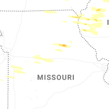

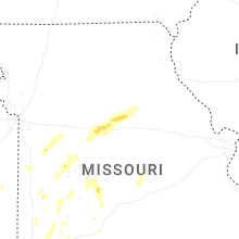

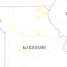


Connect with Interactive Hail Maps