

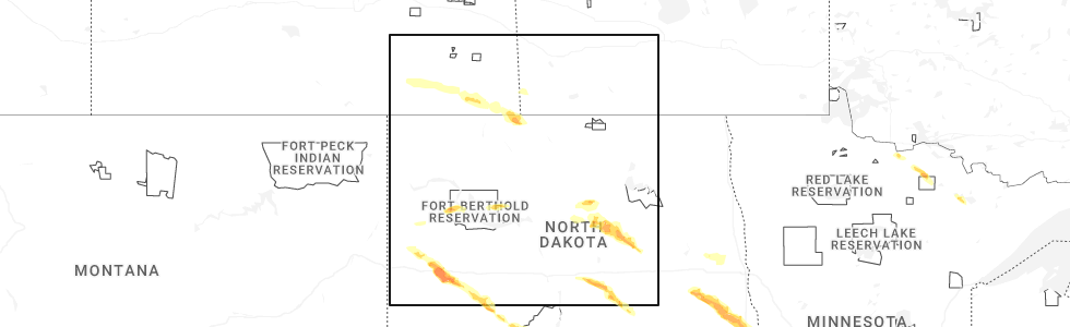
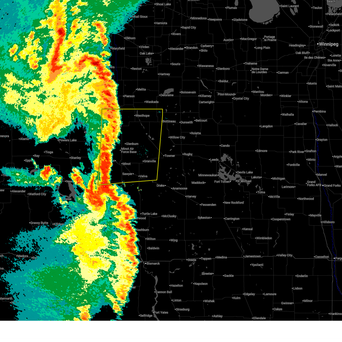
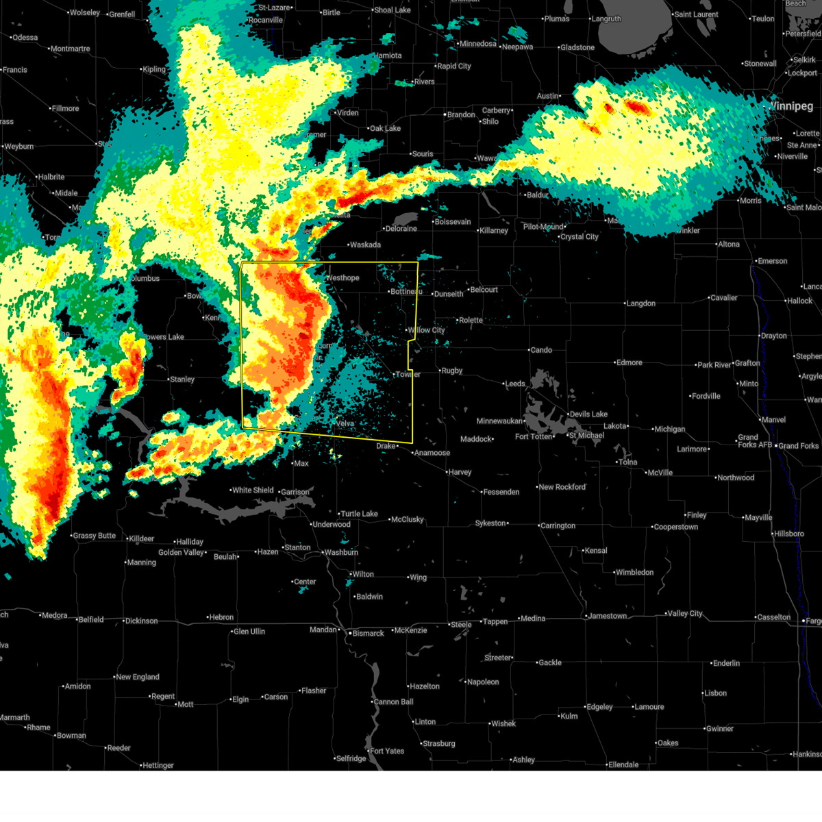
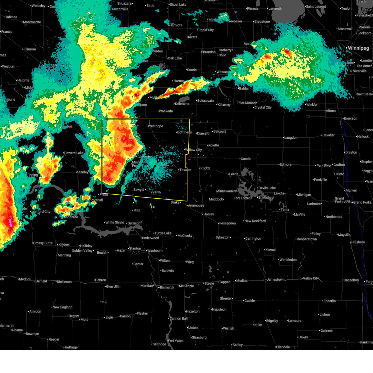
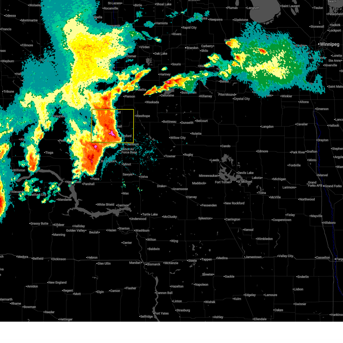
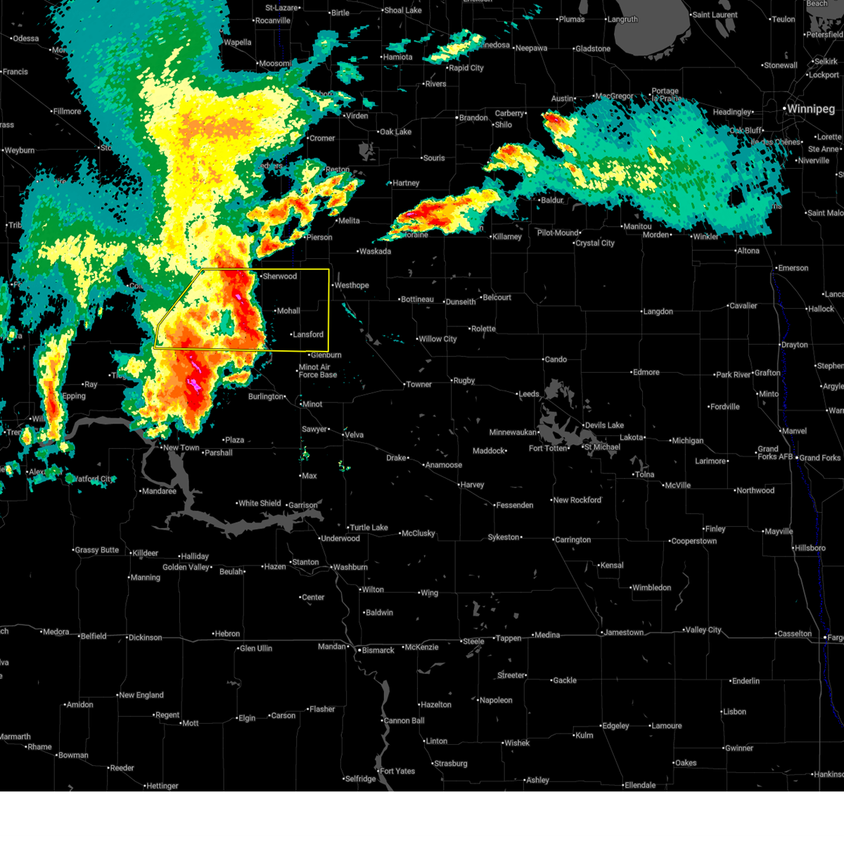
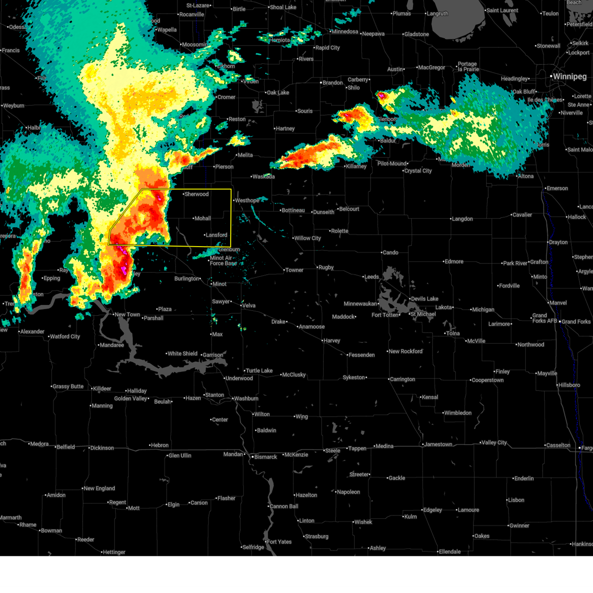
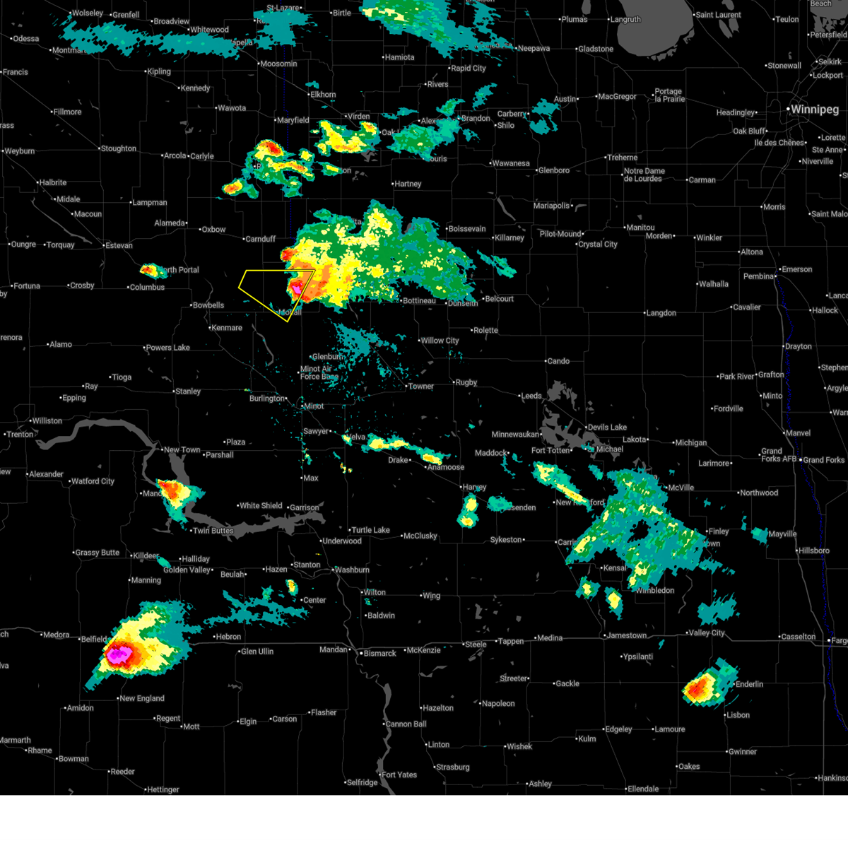
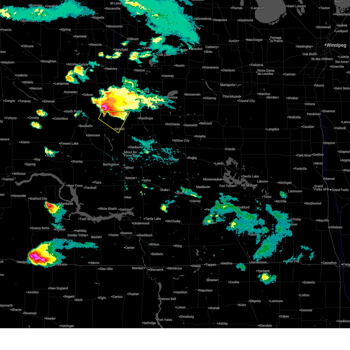
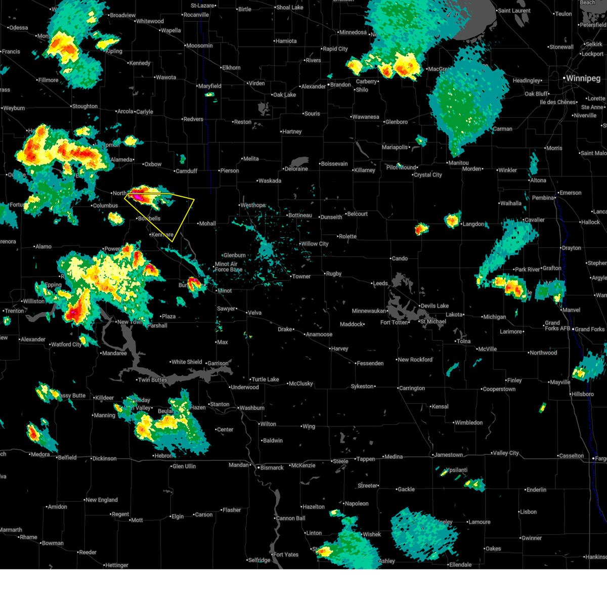
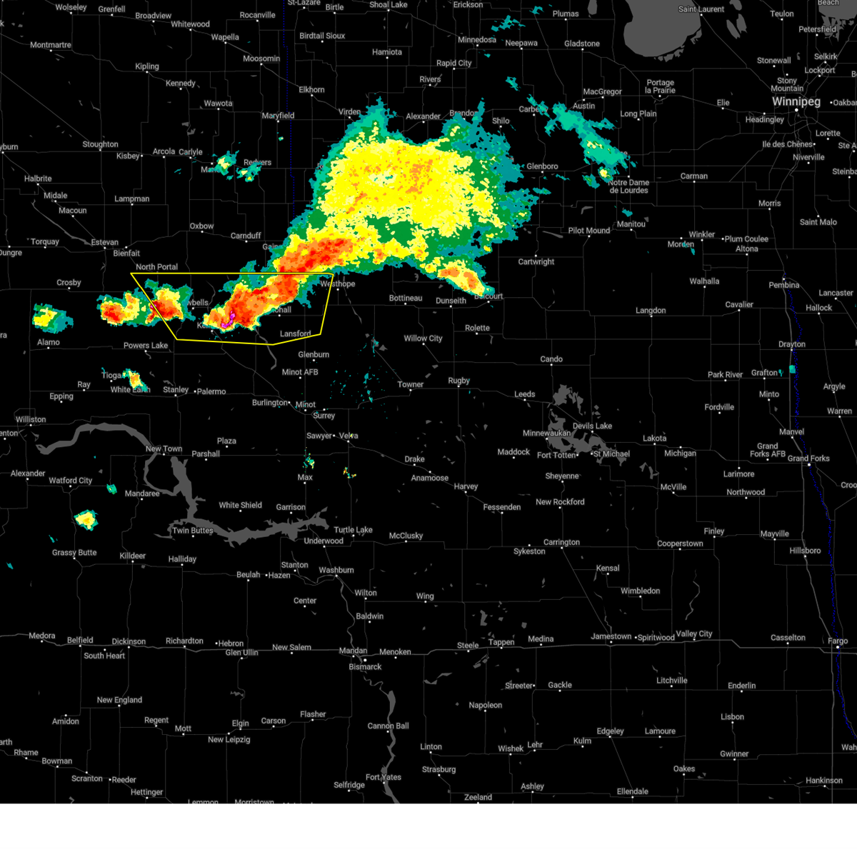
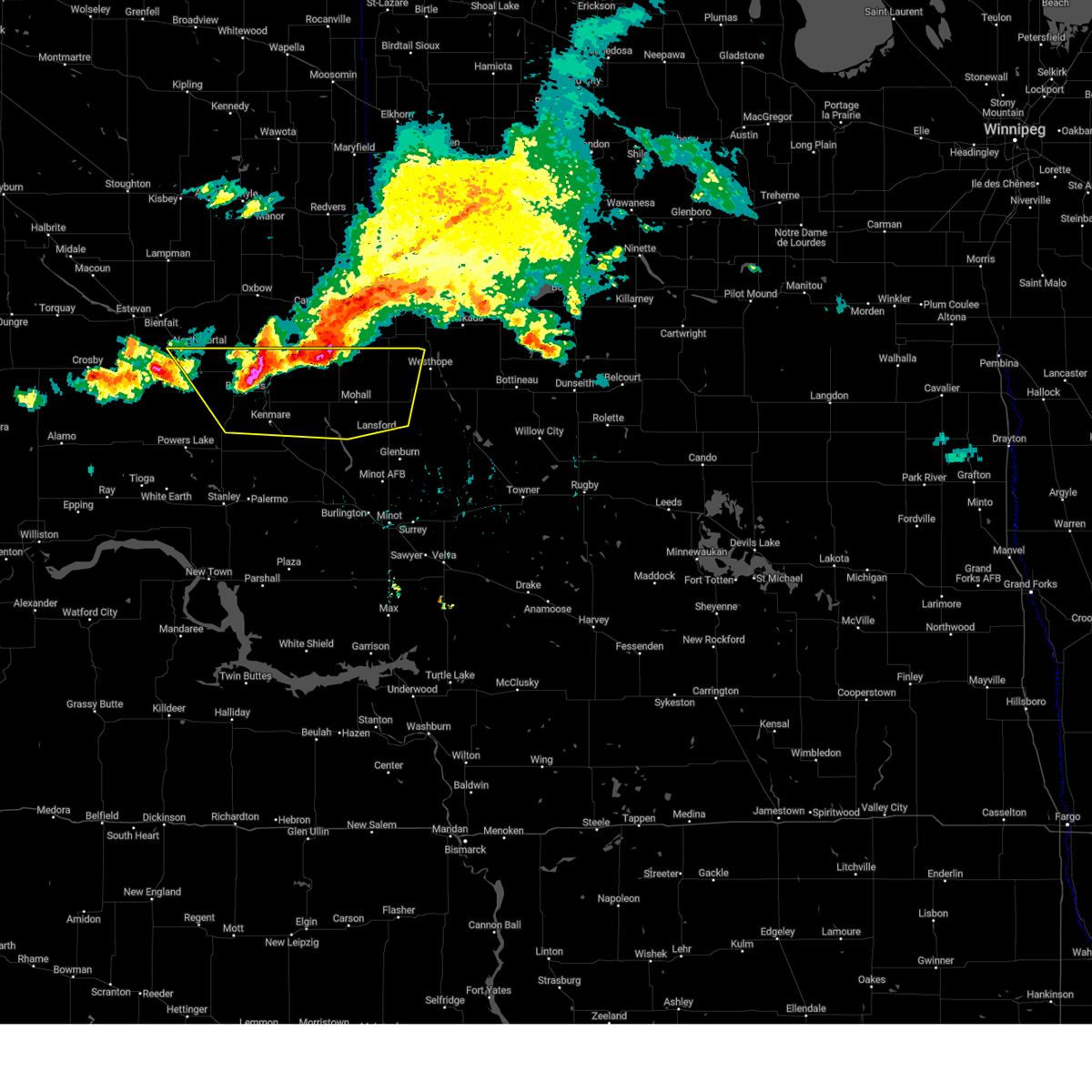
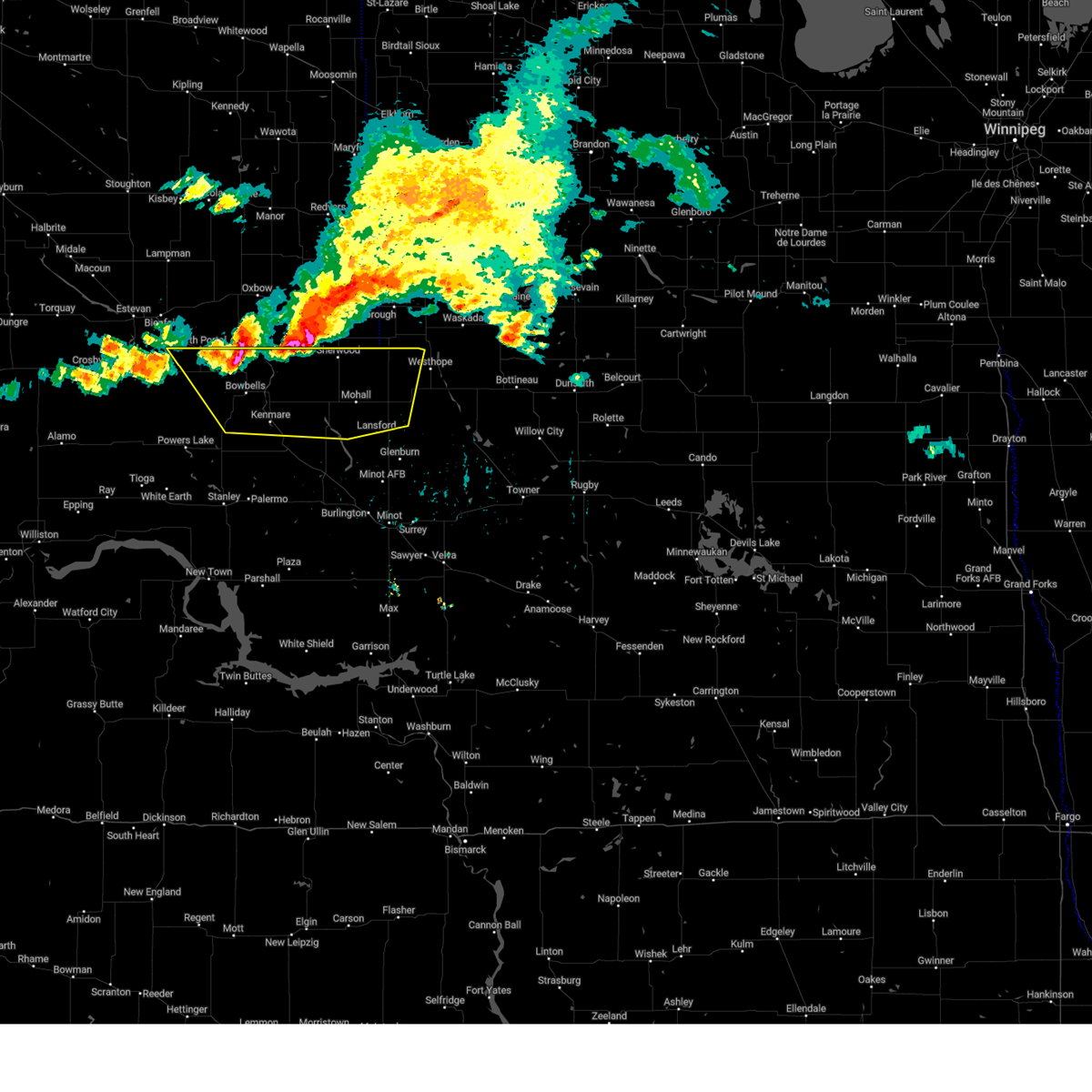
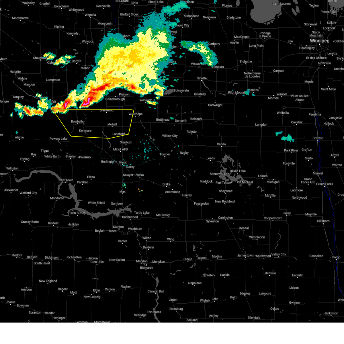
Hail Map for Sherwood, ND
The Sherwood, ND area has had 2 reports of on-the-ground hail by trained spotters, and has been under severe weather warnings 13 times during the past 12 months. Doppler radar has detected hail at or near Sherwood, ND on 32 occasions.
| Name: | Sherwood, ND |
| Where Located: | 52.5 miles NNW of Minot, ND |
| Map: | Google Map for Sherwood, ND |
| Population: | 242 |
| Housing Units: | 133 |
| More Info: | Search Google for Sherwood, ND |
3
The Top Recent Hail Date for Sherwood, ND is Thursday, June 19, 2025 (4th out of 32)
Hail and Wind Damage Spotted near Sherwood, ND
| Date / Time | Report Details |
|---|---|
| 6/27/2026 11:17 PM CDT |
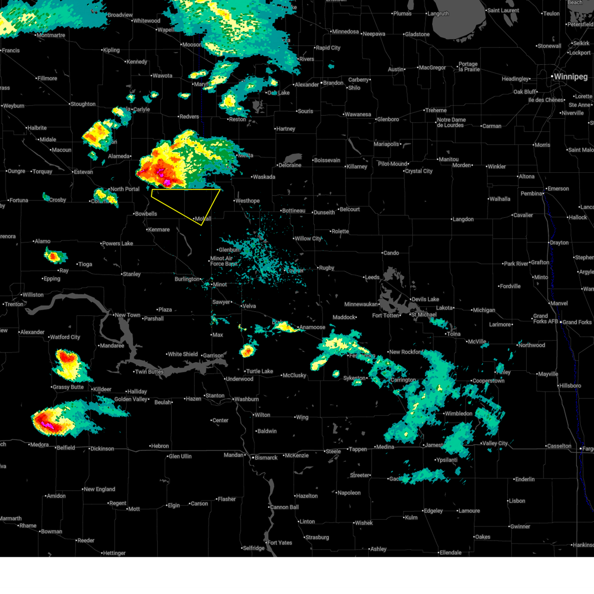
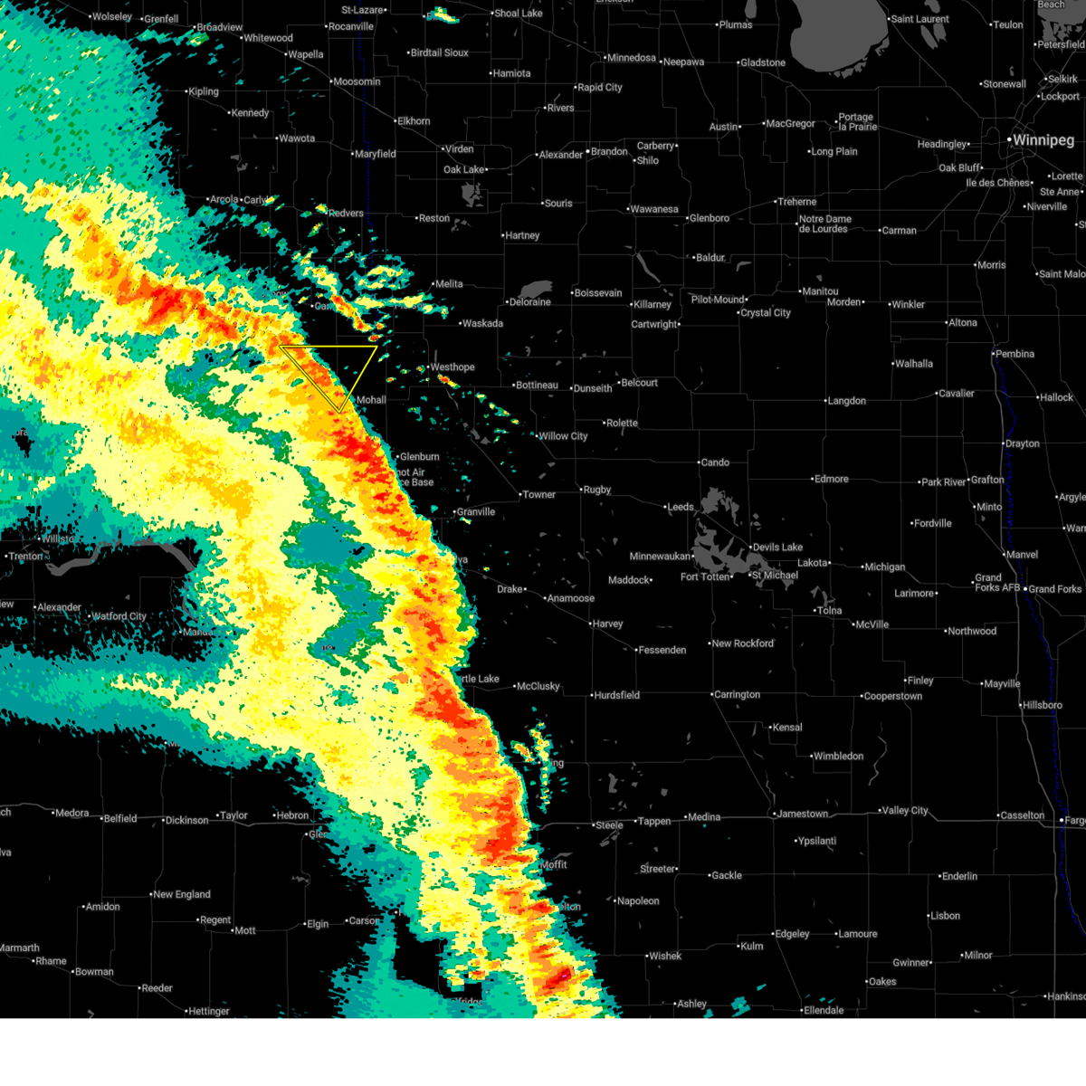 At 1116 pm cdt, severe thunderstorms were located along a line extending from 9 miles west of sherwood to near mohall, moving northeast at 40 mph (radar indicated). Hazards include 60 mph wind gusts. Expect damage to roofs, siding, and trees. Locations impacted include, sherwood and loraine. At 1116 pm cdt, severe thunderstorms were located along a line extending from 9 miles west of sherwood to near mohall, moving northeast at 40 mph (radar indicated). Hazards include 60 mph wind gusts. Expect damage to roofs, siding, and trees. Locations impacted include, sherwood and loraine.
|
| 6/27/2026 10:57 PM CDT |
 At 1057 pm cdt, severe thunderstorms were located along a line extending from 16 miles northwest of portal to near greene, moving east at 55 mph (radar indicated). Hazards include 60 mph wind gusts. Expect damage to roofs, siding, and trees. Locations impacted include, bowbells, sherwood, portal, greene, flaxton, tolley, norma, loraine, and northgate. At 1057 pm cdt, severe thunderstorms were located along a line extending from 16 miles northwest of portal to near greene, moving east at 55 mph (radar indicated). Hazards include 60 mph wind gusts. Expect damage to roofs, siding, and trees. Locations impacted include, bowbells, sherwood, portal, greene, flaxton, tolley, norma, loraine, and northgate.
|
| 6/27/2026 10:32 PM CDT |
 Svrbis the national weather service in bismarck has issued a * severe thunderstorm warning for, northwestern ward county in north central north dakota, northwestern bottineau county in north central north dakota, renville county in north central north dakota, burke county in northwestern north dakota, northeastern mountrail county in northwestern north dakota, northeastern divide county in northwestern north dakota, * until 1130 pm cdt. * at 1031 pm cdt, severe thunderstorms were located along a line extending from 7 miles north of noonan to donnybrook, moving northeast at 55 mph (radar indicated). Hazards include 60 mph wind gusts. expect damage to roofs, siding, and trees Svrbis the national weather service in bismarck has issued a * severe thunderstorm warning for, northwestern ward county in north central north dakota, northwestern bottineau county in north central north dakota, renville county in north central north dakota, burke county in northwestern north dakota, northeastern mountrail county in northwestern north dakota, northeastern divide county in northwestern north dakota, * until 1130 pm cdt. * at 1031 pm cdt, severe thunderstorms were located along a line extending from 7 miles north of noonan to donnybrook, moving northeast at 55 mph (radar indicated). Hazards include 60 mph wind gusts. expect damage to roofs, siding, and trees
|
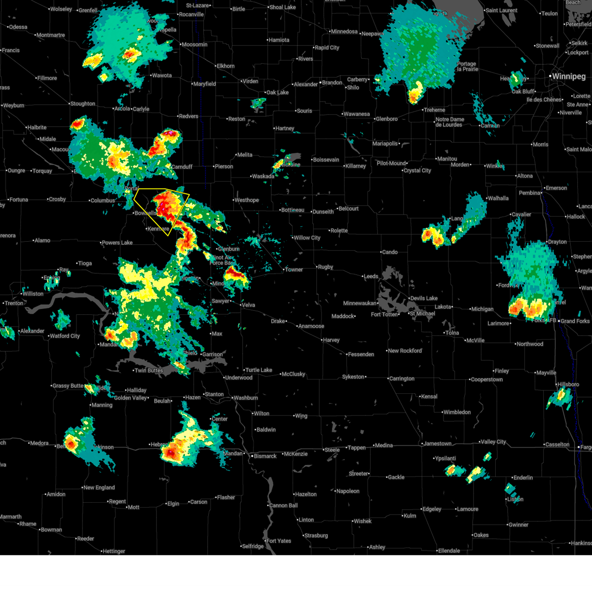
| 6/7/2026 9:52 PM CDT |
 Svrbis the national weather service in bismarck has issued a * severe thunderstorm warning for, bottineau county in north central north dakota, western mchenry county in north central north dakota, renville county in north central north dakota, southeastern ward county in north central north dakota, * until 1045 pm cdt. * at 952 pm cdt, severe thunderstorms were located along a line from near rice lake to near antler, or along a line from 18 miles southwest of minot to 40 miles west of bottineau, moving east at 45 mph (radar indicated). Hazards include 70 mph wind gusts and quarter size hail. Hail damage to vehicles is expected. expect considerable tree damage. Wind damage is also likely to mobile homes, roofs, and outbuildings. Svrbis the national weather service in bismarck has issued a * severe thunderstorm warning for, bottineau county in north central north dakota, western mchenry county in north central north dakota, renville county in north central north dakota, southeastern ward county in north central north dakota, * until 1045 pm cdt. * at 952 pm cdt, severe thunderstorms were located along a line from near rice lake to near antler, or along a line from 18 miles southwest of minot to 40 miles west of bottineau, moving east at 45 mph (radar indicated). Hazards include 70 mph wind gusts and quarter size hail. Hail damage to vehicles is expected. expect considerable tree damage. Wind damage is also likely to mobile homes, roofs, and outbuildings.
|
| 6/7/2026 9:30 PM CDT |
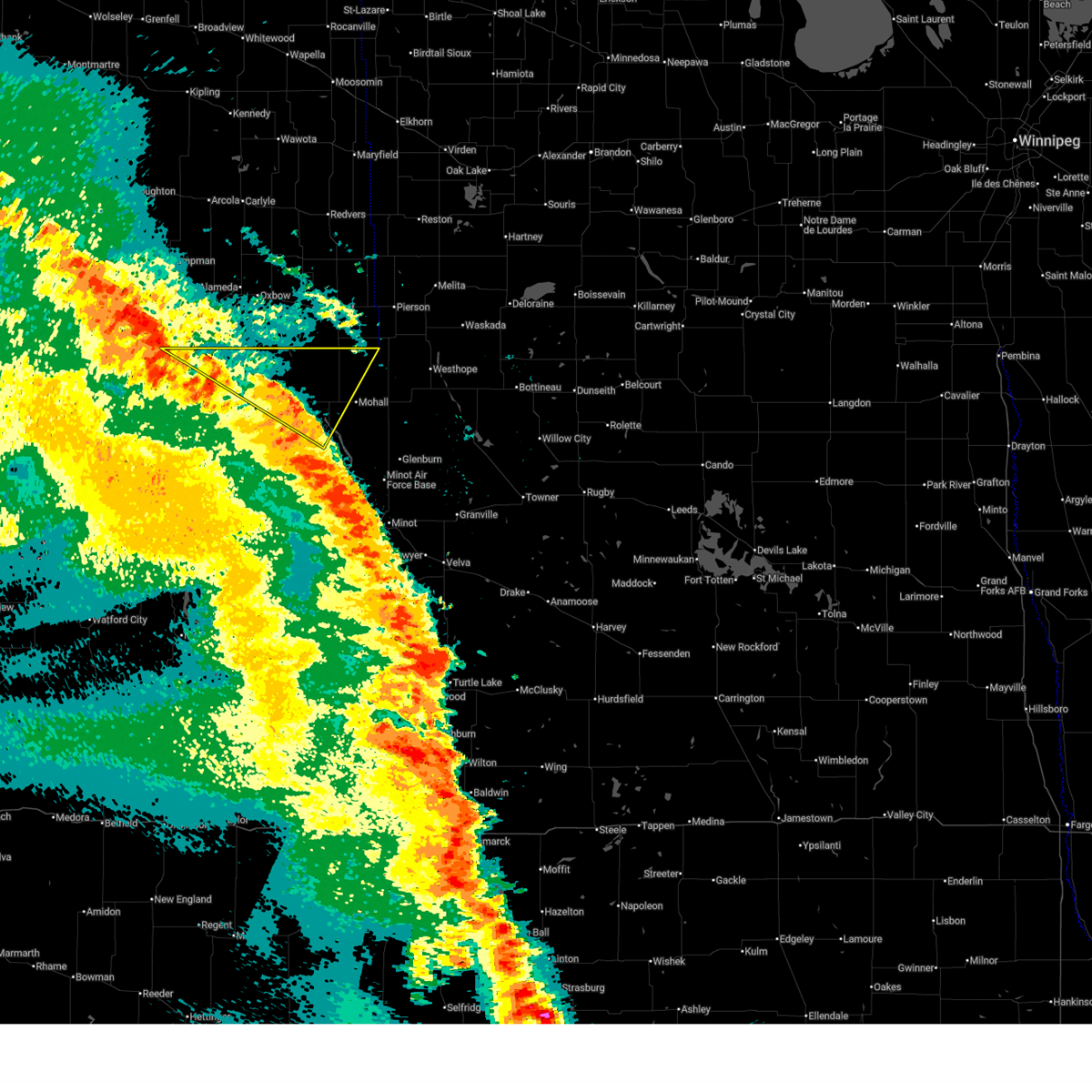
 At 930 pm cdt /830 pm mdt/, severe thunderstorms were located along a line from 8 miles northwest of sherwood to 7 miles south of hazen bay recreation area, or along a line from 60 miles northeast of stanley to 12 miles northeast of beulah, moving northeast at 35 mph (radar indicated). Hazards include 60 mph wind gusts and quarter size hail. Hail damage to vehicles is expected. expect wind damage to roofs, siding, and trees. Locations impacted include, minot, beulah, stanley, garrison, minot air force base, hazen, new town, kenmare, burlington, parshall, mohall, underwood, berthold, glenburn, stanton, bowbells, max, lansford, sherwood and zap. At 930 pm cdt /830 pm mdt/, severe thunderstorms were located along a line from 8 miles northwest of sherwood to 7 miles south of hazen bay recreation area, or along a line from 60 miles northeast of stanley to 12 miles northeast of beulah, moving northeast at 35 mph (radar indicated). Hazards include 60 mph wind gusts and quarter size hail. Hail damage to vehicles is expected. expect wind damage to roofs, siding, and trees. Locations impacted include, minot, beulah, stanley, garrison, minot air force base, hazen, new town, kenmare, burlington, parshall, mohall, underwood, berthold, glenburn, stanton, bowbells, max, lansford, sherwood and zap.
|
| 6/7/2026 9:00 PM CDT |
 Svrbis the national weather service in bismarck has issued a * severe thunderstorm warning for, western bottineau county in north central north dakota, renville county in north central north dakota, ward county in north central north dakota, eastern burke county in northwestern north dakota, mountrail county in northwestern north dakota, mclean county in south central north dakota, mercer county in south central north dakota, northeastern dunn county in southwestern north dakota, * until 1000 pm cdt /900 pm mdt/. * at 900 pm cdt /800 pm mdt/, severe thunderstorms were located along a line from 7 miles south of donnybrook to near beulah, or along a line from 22 miles east of stanley to near beulah, moving east at 35 mph (radar indicated). Hazards include 70 mph wind gusts and quarter size hail. Hail damage to vehicles is expected. expect considerable tree damage. Wind damage is also likely to mobile homes, roofs, and outbuildings. Svrbis the national weather service in bismarck has issued a * severe thunderstorm warning for, western bottineau county in north central north dakota, renville county in north central north dakota, ward county in north central north dakota, eastern burke county in northwestern north dakota, mountrail county in northwestern north dakota, mclean county in south central north dakota, mercer county in south central north dakota, northeastern dunn county in southwestern north dakota, * until 1000 pm cdt /900 pm mdt/. * at 900 pm cdt /800 pm mdt/, severe thunderstorms were located along a line from 7 miles south of donnybrook to near beulah, or along a line from 22 miles east of stanley to near beulah, moving east at 35 mph (radar indicated). Hazards include 70 mph wind gusts and quarter size hail. Hail damage to vehicles is expected. expect considerable tree damage. Wind damage is also likely to mobile homes, roofs, and outbuildings.
|
| 8/7/2025 10:23 PM CDT |
 At 1020 pm cdt, severe thunderstorms were located along a line extending from 7 miles northeast of westhope to 4 miles northwest of upham to 4 miles east of rice lake, moving east at 40 mph (a us air force weather station near maxbass reported a 71 mph wind gust, while the minot airport reported a 61 mph wind gust). Hazards include 70 mph wind gusts and ping pong ball size hail. People and animals outdoors will be injured. expect hail damage to roofs, siding, windows, and vehicles. expect considerable tree damage. wind damage is also likely to mobile homes, roofs, and outbuildings. Locations impacted include, minot, bottineau, velva, burlington, surrey, towner, westhope, glenburn, sawyer, lansford, sherwood, granville, willow city, upham, newburg, deering, maxbass, denbigh, karlsruhe, and souris. At 1020 pm cdt, severe thunderstorms were located along a line extending from 7 miles northeast of westhope to 4 miles northwest of upham to 4 miles east of rice lake, moving east at 40 mph (a us air force weather station near maxbass reported a 71 mph wind gust, while the minot airport reported a 61 mph wind gust). Hazards include 70 mph wind gusts and ping pong ball size hail. People and animals outdoors will be injured. expect hail damage to roofs, siding, windows, and vehicles. expect considerable tree damage. wind damage is also likely to mobile homes, roofs, and outbuildings. Locations impacted include, minot, bottineau, velva, burlington, surrey, towner, westhope, glenburn, sawyer, lansford, sherwood, granville, willow city, upham, newburg, deering, maxbass, denbigh, karlsruhe, and souris.
|
| 8/7/2025 10:13 PM CDT |
 At 1013 pm cdt, severe thunderstorms were located along a line extending from 6 miles north of westhope to 6 miles northwest of upham to near rice lake, moving east at 40 mph (radar indicated). Hazards include 70 mph wind gusts and ping pong ball size hail. People and animals outdoors will be injured. expect hail damage to roofs, siding, windows, and vehicles. expect considerable tree damage. wind damage is also likely to mobile homes, roofs, and outbuildings. Locations impacted include, minot, bottineau, velva, burlington, surrey, mohall, towner, berthold, westhope, glenburn, sawyer, lansford, sherwood, granville, des lacs, willow city, carpio, upham, foxholm, and newburg. At 1013 pm cdt, severe thunderstorms were located along a line extending from 6 miles north of westhope to 6 miles northwest of upham to near rice lake, moving east at 40 mph (radar indicated). Hazards include 70 mph wind gusts and ping pong ball size hail. People and animals outdoors will be injured. expect hail damage to roofs, siding, windows, and vehicles. expect considerable tree damage. wind damage is also likely to mobile homes, roofs, and outbuildings. Locations impacted include, minot, bottineau, velva, burlington, surrey, mohall, towner, berthold, westhope, glenburn, sawyer, lansford, sherwood, granville, des lacs, willow city, carpio, upham, foxholm, and newburg.
|
| 8/7/2025 9:54 PM CDT |
 Svrbis the national weather service in bismarck has issued a * severe thunderstorm warning for, ward county in north central north dakota, bottineau county in north central north dakota, renville county in north central north dakota, mchenry county in north central north dakota, * until 1100 pm cdt. * at 954 pm cdt, severe thunderstorms were located along a line extending from near antler to 7 miles south of maxbass to 4 miles northeast of makoti, moving east at 40 mph (radar indicated). Hazards include golf ball size hail and 70 mph wind gusts. People and animals outdoors will be injured. expect hail damage to roofs, siding, windows, and vehicles. expect considerable tree damage. Wind damage is also likely to mobile homes, roofs, and outbuildings. Svrbis the national weather service in bismarck has issued a * severe thunderstorm warning for, ward county in north central north dakota, bottineau county in north central north dakota, renville county in north central north dakota, mchenry county in north central north dakota, * until 1100 pm cdt. * at 954 pm cdt, severe thunderstorms were located along a line extending from near antler to 7 miles south of maxbass to 4 miles northeast of makoti, moving east at 40 mph (radar indicated). Hazards include golf ball size hail and 70 mph wind gusts. People and animals outdoors will be injured. expect hail damage to roofs, siding, windows, and vehicles. expect considerable tree damage. Wind damage is also likely to mobile homes, roofs, and outbuildings.
|
| 8/7/2025 9:39 PM CDT |
 the severe thunderstorm warning has been cancelled and is no longer in effect the severe thunderstorm warning has been cancelled and is no longer in effect
|
| 8/7/2025 9:39 PM CDT |
 At 939 pm cdt, severe thunderstorms were located along a line extending from 21 miles northeast of sherwood to 7 miles northwest of antler to 7 miles northeast of kenmare, moving east at 50 mph (radar indicated). Hazards include golf ball size hail and 70 mph wind gusts. People and animals outdoors will be injured. expect hail damage to roofs, siding, windows, and vehicles. expect considerable tree damage. wind damage is also likely to mobile homes, roofs, and outbuildings. Locations impacted include, mohall, lansford, sherwood, greene, maxbass, antler, tolley, loraine, grano, and eckman. At 939 pm cdt, severe thunderstorms were located along a line extending from 21 miles northeast of sherwood to 7 miles northwest of antler to 7 miles northeast of kenmare, moving east at 50 mph (radar indicated). Hazards include golf ball size hail and 70 mph wind gusts. People and animals outdoors will be injured. expect hail damage to roofs, siding, windows, and vehicles. expect considerable tree damage. wind damage is also likely to mobile homes, roofs, and outbuildings. Locations impacted include, mohall, lansford, sherwood, greene, maxbass, antler, tolley, loraine, grano, and eckman.
|
| 8/7/2025 9:15 PM CDT |
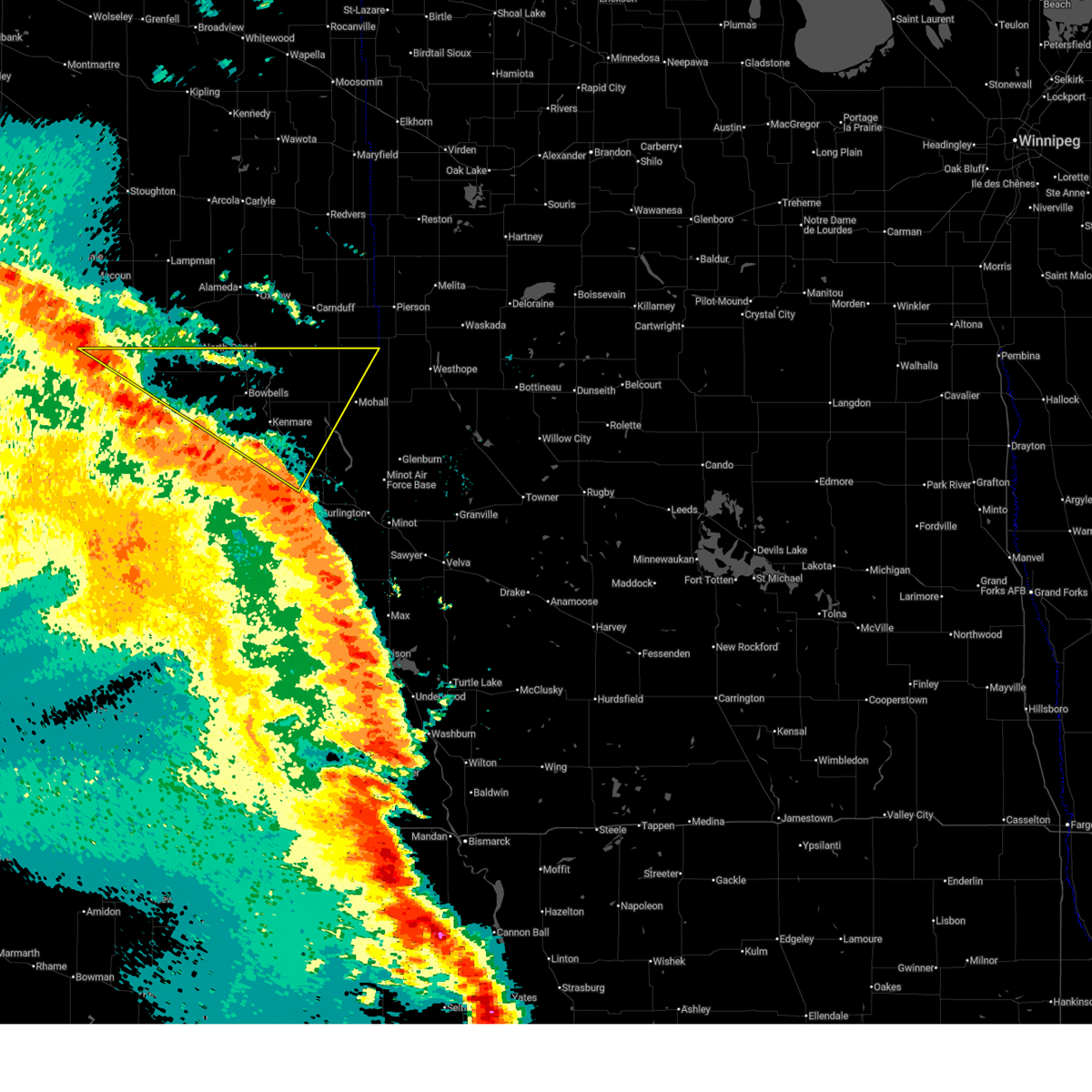
 At 914 pm cdt, severe thunderstorms were located along a line extending from 7 miles north of sherwood to 17 miles northwest of mohall to 11 miles north of lostwood, moving east at 50 mph (radar indicated). Hazards include 70 mph wind gusts and half dollar size hail. Hail damage to vehicles is expected. expect considerable tree damage. wind damage is also likely to mobile homes, roofs, and outbuildings. Locations impacted include, kenmare, mohall, bowbells, lansford, sherwood, greene, maxbass, antler, coulee, tolley, norma, loraine, grano, niobe, coteau, and eckman. At 914 pm cdt, severe thunderstorms were located along a line extending from 7 miles north of sherwood to 17 miles northwest of mohall to 11 miles north of lostwood, moving east at 50 mph (radar indicated). Hazards include 70 mph wind gusts and half dollar size hail. Hail damage to vehicles is expected. expect considerable tree damage. wind damage is also likely to mobile homes, roofs, and outbuildings. Locations impacted include, kenmare, mohall, bowbells, lansford, sherwood, greene, maxbass, antler, coulee, tolley, norma, loraine, grano, niobe, coteau, and eckman.
|
| 8/7/2025 9:00 PM CDT |
 Svrbis the national weather service in bismarck has issued a * severe thunderstorm warning for, northwestern ward county in north central north dakota, western bottineau county in north central north dakota, renville county in north central north dakota, eastern burke county in northwestern north dakota, * until 1000 pm cdt. * at 900 pm cdt, severe thunderstorms were located along a line extending from 11 miles west of sherwood to 12 miles northeast of bowbells to 5 miles east of powers lake, moving east at 50 mph (radar indicated). Hazards include 60 mph wind gusts and half dollar size hail. Hail damage to vehicles is expected. Expect wind damage to roofs, siding, and trees. Svrbis the national weather service in bismarck has issued a * severe thunderstorm warning for, northwestern ward county in north central north dakota, western bottineau county in north central north dakota, renville county in north central north dakota, eastern burke county in northwestern north dakota, * until 1000 pm cdt. * at 900 pm cdt, severe thunderstorms were located along a line extending from 11 miles west of sherwood to 12 miles northeast of bowbells to 5 miles east of powers lake, moving east at 50 mph (radar indicated). Hazards include 60 mph wind gusts and half dollar size hail. Hail damage to vehicles is expected. Expect wind damage to roofs, siding, and trees.
|
| 6/19/2025 7:30 PM CDT |
 The storm which prompted the warning has weakened below severe limits, and no longer poses an immediate threat to life or property. therefore, the warning has been allowed to expire. a severe thunderstorm watch remains in effect until 100 am cdt for north central north dakota. The storm which prompted the warning has weakened below severe limits, and no longer poses an immediate threat to life or property. therefore, the warning has been allowed to expire. a severe thunderstorm watch remains in effect until 100 am cdt for north central north dakota.
|
| 6/19/2025 6:51 PM CDT |
 At 651 pm cdt, a severe thunderstorm was located over sherwood, or 52 miles north of minot, moving southeast at 25 mph (radar indicated). Hazards include golf ball size hail and 60 mph wind gusts. People and animals outdoors will be injured. expect hail damage to roofs, siding, windows, and vehicles. expect wind damage to roofs, siding, and trees. Locations impacted include, mohall, sherwood, antler, and loraine. At 651 pm cdt, a severe thunderstorm was located over sherwood, or 52 miles north of minot, moving southeast at 25 mph (radar indicated). Hazards include golf ball size hail and 60 mph wind gusts. People and animals outdoors will be injured. expect hail damage to roofs, siding, windows, and vehicles. expect wind damage to roofs, siding, and trees. Locations impacted include, mohall, sherwood, antler, and loraine.
|
| 6/19/2025 6:28 PM CDT |
 Svrbis the national weather service in bismarck has issued a * severe thunderstorm warning for, northwestern bottineau county in north central north dakota, northwestern renville county in north central north dakota, * until 730 pm cdt. * at 627 pm cdt, a severe thunderstorm was located 7 miles northwest of sherwood, or 56 miles northeast of stanley, moving southeast at 25 mph (radar indicated). Hazards include golf ball size hail and 60 mph wind gusts. People and animals outdoors will be injured. expect hail damage to roofs, siding, windows, and vehicles. Expect wind damage to roofs, siding, and trees. Svrbis the national weather service in bismarck has issued a * severe thunderstorm warning for, northwestern bottineau county in north central north dakota, northwestern renville county in north central north dakota, * until 730 pm cdt. * at 627 pm cdt, a severe thunderstorm was located 7 miles northwest of sherwood, or 56 miles northeast of stanley, moving southeast at 25 mph (radar indicated). Hazards include golf ball size hail and 60 mph wind gusts. People and animals outdoors will be injured. expect hail damage to roofs, siding, windows, and vehicles. Expect wind damage to roofs, siding, and trees.
|
| 6/18/2025 7:43 PM CDT |
 The storm which prompted the warning has weakened below severe limits. therefore, the warning will be allowed to expire. however, the storm remains strong, and small hail is still possible with this thunderstorm. The storm which prompted the warning has weakened below severe limits. therefore, the warning will be allowed to expire. however, the storm remains strong, and small hail is still possible with this thunderstorm.
|
| 6/18/2025 7:16 PM CDT |
 At 715 pm cdt, a severe thunderstorm was located 12 miles northeast of bowbells, or 43 miles northeast of stanley, moving southeast at 30 mph (radar indicated). Hazards include 60 mph wind gusts and quarter size hail. Hail damage to vehicles is expected. expect wind damage to roofs, siding, and trees. Locations impacted include, sherwood, tolley, and norma. At 715 pm cdt, a severe thunderstorm was located 12 miles northeast of bowbells, or 43 miles northeast of stanley, moving southeast at 30 mph (radar indicated). Hazards include 60 mph wind gusts and quarter size hail. Hail damage to vehicles is expected. expect wind damage to roofs, siding, and trees. Locations impacted include, sherwood, tolley, and norma.
|
| 6/18/2025 7:06 PM CDT |
 At 705 pm cdt, a severe thunderstorm was located 11 miles northeast of bowbells, or 44 miles north of stanley, moving southeast at 25 mph (radar indicated). Hazards include two inch hail and 60 mph wind gusts. People and animals outdoors will be injured. expect hail damage to roofs, siding, windows, and vehicles. expect wind damage to roofs, siding, and trees. Locations impacted include, sherwood, tolley, and norma. At 705 pm cdt, a severe thunderstorm was located 11 miles northeast of bowbells, or 44 miles north of stanley, moving southeast at 25 mph (radar indicated). Hazards include two inch hail and 60 mph wind gusts. People and animals outdoors will be injured. expect hail damage to roofs, siding, windows, and vehicles. expect wind damage to roofs, siding, and trees. Locations impacted include, sherwood, tolley, and norma.
|
| 6/18/2025 6:49 PM CDT |
 Svrbis the national weather service in bismarck has issued a * severe thunderstorm warning for, northern ward county in north central north dakota, northwestern renville county in north central north dakota, northeastern burke county in northwestern north dakota, * until 745 pm cdt. * at 649 pm cdt, a severe thunderstorm was located 10 miles northeast of flaxton, or 46 miles north of stanley, moving southeast at 30 mph (radar indicated). Hazards include ping pong ball size hail and 60 mph wind gusts. People and animals outdoors will be injured. expect hail damage to roofs, siding, windows, and vehicles. Expect wind damage to roofs, siding, and trees. Svrbis the national weather service in bismarck has issued a * severe thunderstorm warning for, northern ward county in north central north dakota, northwestern renville county in north central north dakota, northeastern burke county in northwestern north dakota, * until 745 pm cdt. * at 649 pm cdt, a severe thunderstorm was located 10 miles northeast of flaxton, or 46 miles north of stanley, moving southeast at 30 mph (radar indicated). Hazards include ping pong ball size hail and 60 mph wind gusts. People and animals outdoors will be injured. expect hail damage to roofs, siding, windows, and vehicles. Expect wind damage to roofs, siding, and trees.
|
| 8/6/2024 7:10 PM CDT |
 At 710 pm cdt, severe thunderstorms were located along a line extending from 7 miles northeast of mohall to 6 miles northeast of kenmare to 5 miles south of lignite, moving southeast at 40 mph (radar indicated). Hazards include two inch hail and 60 mph wind gusts. People and animals outdoors will be injured. expect hail damage to roofs, siding, windows, and vehicles. expect wind damage to roofs, siding, and trees. Locations impacted include, kenmare, mohall, bowbells, lansford, sherwood, lignite, portal, greene, flaxton, antler, tolley, norma, loraine, grano, niobe, northgate, and coteau. At 710 pm cdt, severe thunderstorms were located along a line extending from 7 miles northeast of mohall to 6 miles northeast of kenmare to 5 miles south of lignite, moving southeast at 40 mph (radar indicated). Hazards include two inch hail and 60 mph wind gusts. People and animals outdoors will be injured. expect hail damage to roofs, siding, windows, and vehicles. expect wind damage to roofs, siding, and trees. Locations impacted include, kenmare, mohall, bowbells, lansford, sherwood, lignite, portal, greene, flaxton, antler, tolley, norma, loraine, grano, niobe, northgate, and coteau.
|
| 8/6/2024 6:48 PM CDT |
 At 648 pm cdt, severe thunderstorms were located along a line extending from 4 miles west of sherwood to 5 miles northeast of bowbells, moving southeast at 40 mph (radar indicated). Hazards include two inch hail and 60 mph wind gusts. People and animals outdoors will be injured. expect hail damage to roofs, siding, windows, and vehicles. expect wind damage to roofs, siding, and trees. Locations impacted include, kenmare, mohall, bowbells, lansford, sherwood, lignite, portal, greene, flaxton, antler, tolley, norma, loraine, grano, niobe, northgate, and coteau. At 648 pm cdt, severe thunderstorms were located along a line extending from 4 miles west of sherwood to 5 miles northeast of bowbells, moving southeast at 40 mph (radar indicated). Hazards include two inch hail and 60 mph wind gusts. People and animals outdoors will be injured. expect hail damage to roofs, siding, windows, and vehicles. expect wind damage to roofs, siding, and trees. Locations impacted include, kenmare, mohall, bowbells, lansford, sherwood, lignite, portal, greene, flaxton, antler, tolley, norma, loraine, grano, niobe, northgate, and coteau.
|
| 8/6/2024 6:41 PM CDT |
 At 641 pm cdt, severe thunderstorms were located along a line extending from 6 miles west of sherwood to 6 miles east of flaxton, moving southeast at 45 mph (radar indicated). Hazards include 60 mph wind gusts and half dollar size hail. Hail damage to vehicles is expected. expect wind damage to roofs, siding, and trees. Locations impacted include, kenmare, mohall, bowbells, lansford, sherwood, lignite, portal, greene, flaxton, antler, tolley, norma, loraine, grano, niobe, northgate, and coteau. At 641 pm cdt, severe thunderstorms were located along a line extending from 6 miles west of sherwood to 6 miles east of flaxton, moving southeast at 45 mph (radar indicated). Hazards include 60 mph wind gusts and half dollar size hail. Hail damage to vehicles is expected. expect wind damage to roofs, siding, and trees. Locations impacted include, kenmare, mohall, bowbells, lansford, sherwood, lignite, portal, greene, flaxton, antler, tolley, norma, loraine, grano, niobe, northgate, and coteau.
|
| 8/6/2024 6:26 PM CDT |
 Svrbis the national weather service in bismarck has issued a * severe thunderstorm warning for, northwestern ward county in north central north dakota, northwestern bottineau county in north central north dakota, renville county in north central north dakota, eastern burke county in northwestern north dakota, * until 730 pm cdt. * at 626 pm cdt, severe thunderstorms were located along a line extending from 16 miles west of sherwood to 4 miles east of portal, moving southeast at 40 mph (radar indicated). Hazards include 60 mph wind gusts and half dollar size hail. Hail damage to vehicles is expected. Expect wind damage to roofs, siding, and trees. Svrbis the national weather service in bismarck has issued a * severe thunderstorm warning for, northwestern ward county in north central north dakota, northwestern bottineau county in north central north dakota, renville county in north central north dakota, eastern burke county in northwestern north dakota, * until 730 pm cdt. * at 626 pm cdt, severe thunderstorms were located along a line extending from 16 miles west of sherwood to 4 miles east of portal, moving southeast at 40 mph (radar indicated). Hazards include 60 mph wind gusts and half dollar size hail. Hail damage to vehicles is expected. Expect wind damage to roofs, siding, and trees.
|
| 7/14/2024 5:14 PM CDT |
 Svrbis the national weather service in bismarck has issued a * severe thunderstorm warning for, northwestern bottineau county in north central north dakota, north central renville county in north central north dakota, * until 615 pm cdt. * at 514 pm cdt, a severe thunderstorm was located near sherwood, or 55 miles north of minot, moving southeast at 15 mph (radar indicated). Hazards include golf ball size hail and 60 mph wind gusts. People and animals outdoors will be injured. expect hail damage to roofs, siding, windows, and vehicles. Expect wind damage to roofs, siding, and trees. Svrbis the national weather service in bismarck has issued a * severe thunderstorm warning for, northwestern bottineau county in north central north dakota, north central renville county in north central north dakota, * until 615 pm cdt. * at 514 pm cdt, a severe thunderstorm was located near sherwood, or 55 miles north of minot, moving southeast at 15 mph (radar indicated). Hazards include golf ball size hail and 60 mph wind gusts. People and animals outdoors will be injured. expect hail damage to roofs, siding, windows, and vehicles. Expect wind damage to roofs, siding, and trees.
|
| 6/24/2024 3:55 AM CDT |
 At 354 am cdt, a severe thunderstorm was located near mohall, or 41 miles north of minot, moving east at 35 mph (radar indicated). Hazards include golf ball size hail and 60 mph wind gusts. People and animals outdoors will be injured. expect hail damage to roofs, siding, windows, and vehicles. expect wind damage to roofs, siding, and trees. this severe storm will be near, mohall around 400 am cdt. maxbass around 425 am cdt. Other locations impacted by this severe thunderstorm include loraine, tolley, grano, and lansford. At 354 am cdt, a severe thunderstorm was located near mohall, or 41 miles north of minot, moving east at 35 mph (radar indicated). Hazards include golf ball size hail and 60 mph wind gusts. People and animals outdoors will be injured. expect hail damage to roofs, siding, windows, and vehicles. expect wind damage to roofs, siding, and trees. this severe storm will be near, mohall around 400 am cdt. maxbass around 425 am cdt. Other locations impacted by this severe thunderstorm include loraine, tolley, grano, and lansford.
|
| 6/24/2024 3:40 AM CDT |
 Svrbis the national weather service in bismarck has issued a * severe thunderstorm warning for, western bottineau county in north central north dakota, renville county in north central north dakota, * until 445 am cdt. * at 339 am cdt, a severe thunderstorm was located 10 miles southwest of sherwood, or 45 miles northeast of stanley, moving southeast at 35 mph (radar indicated). Hazards include golf ball size hail and 60 mph wind gusts. People and animals outdoors will be injured. expect hail damage to roofs, siding, windows, and vehicles. expect wind damage to roofs, siding, and trees. this severe thunderstorm will be near, mohall around 350 am cdt. Other locations impacted by this severe thunderstorm include loraine, tolley, grano, lansford, and maxbass. Svrbis the national weather service in bismarck has issued a * severe thunderstorm warning for, western bottineau county in north central north dakota, renville county in north central north dakota, * until 445 am cdt. * at 339 am cdt, a severe thunderstorm was located 10 miles southwest of sherwood, or 45 miles northeast of stanley, moving southeast at 35 mph (radar indicated). Hazards include golf ball size hail and 60 mph wind gusts. People and animals outdoors will be injured. expect hail damage to roofs, siding, windows, and vehicles. expect wind damage to roofs, siding, and trees. this severe thunderstorm will be near, mohall around 350 am cdt. Other locations impacted by this severe thunderstorm include loraine, tolley, grano, lansford, and maxbass.
|
| 6/24/2024 3:22 AM CDT |
 At 322 am cdt, a severe thunderstorm was located 14 miles east of bowbells, or 43 miles northeast of stanley, moving southeast at 35 mph (radar indicated). Hazards include ping pong ball size hail and 60 mph wind gusts. People and animals outdoors will be injured. expect hail damage to roofs, siding, windows, and vehicles. expect wind damage to roofs, siding, and trees. Locations impacted include, sherwood, tolley, and norma. At 322 am cdt, a severe thunderstorm was located 14 miles east of bowbells, or 43 miles northeast of stanley, moving southeast at 35 mph (radar indicated). Hazards include ping pong ball size hail and 60 mph wind gusts. People and animals outdoors will be injured. expect hail damage to roofs, siding, windows, and vehicles. expect wind damage to roofs, siding, and trees. Locations impacted include, sherwood, tolley, and norma.
|
| 6/24/2024 3:03 AM CDT |
 At 302 am cdt, a severe thunderstorm was located 8 miles east of flaxton, or 44 miles north of stanley, moving southeast at 30 mph (radar indicated). Hazards include golf ball size hail and 60 mph wind gusts. People and animals outdoors will be injured. expect hail damage to roofs, siding, windows, and vehicles. expect wind damage to roofs, siding, and trees. Locations impacted include, bowbells, sherwood, flaxton, tolley, norma, and northgate. At 302 am cdt, a severe thunderstorm was located 8 miles east of flaxton, or 44 miles north of stanley, moving southeast at 30 mph (radar indicated). Hazards include golf ball size hail and 60 mph wind gusts. People and animals outdoors will be injured. expect hail damage to roofs, siding, windows, and vehicles. expect wind damage to roofs, siding, and trees. Locations impacted include, bowbells, sherwood, flaxton, tolley, norma, and northgate.
|
| 6/24/2024 2:43 AM CDT |
 Svrbis the national weather service in bismarck has issued a * severe thunderstorm warning for, northern ward county in north central north dakota, northwestern renville county in north central north dakota, northeastern burke county in northwestern north dakota, * until 345 am cdt. * at 243 am cdt, a severe thunderstorm was located 6 miles north of flaxton, or 42 miles east of crosby, moving southeast at 35 mph (radar indicated). Hazards include golf ball size hail and 60 mph wind gusts. People and animals outdoors will be injured. expect hail damage to roofs, siding, windows, and vehicles. Expect wind damage to roofs, siding, and trees. Svrbis the national weather service in bismarck has issued a * severe thunderstorm warning for, northern ward county in north central north dakota, northwestern renville county in north central north dakota, northeastern burke county in northwestern north dakota, * until 345 am cdt. * at 243 am cdt, a severe thunderstorm was located 6 miles north of flaxton, or 42 miles east of crosby, moving southeast at 35 mph (radar indicated). Hazards include golf ball size hail and 60 mph wind gusts. People and animals outdoors will be injured. expect hail damage to roofs, siding, windows, and vehicles. Expect wind damage to roofs, siding, and trees.
|
| 6/24/2024 2:13 AM CDT |
 Svrbis the national weather service in bismarck has issued a * severe thunderstorm warning for, western bottineau county in north central north dakota, renville county in north central north dakota, * until 300 am cdt. * at 212 am cdt, a severe thunderstorm was located near mohall, or 35 miles north of minot, moving southeast at 45 mph (radar indicated). Hazards include ping pong ball size hail and 60 mph wind gusts. People and animals outdoors will be injured. expect hail damage to roofs, siding, windows, and vehicles. Expect wind damage to roofs, siding, and trees. Svrbis the national weather service in bismarck has issued a * severe thunderstorm warning for, western bottineau county in north central north dakota, renville county in north central north dakota, * until 300 am cdt. * at 212 am cdt, a severe thunderstorm was located near mohall, or 35 miles north of minot, moving southeast at 45 mph (radar indicated). Hazards include ping pong ball size hail and 60 mph wind gusts. People and animals outdoors will be injured. expect hail damage to roofs, siding, windows, and vehicles. Expect wind damage to roofs, siding, and trees.
|
| 6/24/2024 2:01 AM CDT |
 At 200 am cdt, a severe thunderstorm was located 11 miles southwest of sherwood, or 44 miles northeast of stanley, moving east at 35 mph (radar indicated). Hazards include tennis ball size hail and 60 mph wind gusts. People and animals outdoors will be injured. expect hail damage to roofs, siding, windows, and vehicles. expect wind damage to roofs, siding, and trees. Locations impacted include, mohall, westhope, lansford, sherwood, greene, maxbass, antler, tolley, norma, loraine, grano, and eckman. At 200 am cdt, a severe thunderstorm was located 11 miles southwest of sherwood, or 44 miles northeast of stanley, moving east at 35 mph (radar indicated). Hazards include tennis ball size hail and 60 mph wind gusts. People and animals outdoors will be injured. expect hail damage to roofs, siding, windows, and vehicles. expect wind damage to roofs, siding, and trees. Locations impacted include, mohall, westhope, lansford, sherwood, greene, maxbass, antler, tolley, norma, loraine, grano, and eckman.
|
| 6/24/2024 2:01 AM CDT |
 the severe thunderstorm warning has been cancelled and is no longer in effect the severe thunderstorm warning has been cancelled and is no longer in effect
|
| 6/24/2024 1:38 AM CDT |
 At 136 am cdt, a severe thunderstorm was located 7 miles east of sherwood, or 47 miles west of bottineau, moving east at 40 mph (radar indicated). Hazards include 60 mph wind gusts and half dollar size hail. Hail damage to vehicles is expected. expect wind damage to roofs, siding, and trees. Locations impacted include, westhope, sherwood and antler. At 136 am cdt, a severe thunderstorm was located 7 miles east of sherwood, or 47 miles west of bottineau, moving east at 40 mph (radar indicated). Hazards include 60 mph wind gusts and half dollar size hail. Hail damage to vehicles is expected. expect wind damage to roofs, siding, and trees. Locations impacted include, westhope, sherwood and antler.
|
| 6/24/2024 1:08 AM CDT |
 Svrbis the national weather service in bismarck has issued a * severe thunderstorm warning for, northwestern ward county in north central north dakota, western bottineau county in north central north dakota, renville county in north central north dakota, northeastern burke county in northwestern north dakota, * until 215 am cdt. * at 108 am cdt, a severe thunderstorm was located 11 miles west of sherwood, or 49 miles northeast of stanley, moving southeast at 45 mph (radar indicated). Hazards include 70 mph wind gusts and ping pong ball size hail. People and animals outdoors will be injured. expect hail damage to roofs, siding, windows, and vehicles. expect considerable tree damage. Wind damage is also likely to mobile homes, roofs, and outbuildings. Svrbis the national weather service in bismarck has issued a * severe thunderstorm warning for, northwestern ward county in north central north dakota, western bottineau county in north central north dakota, renville county in north central north dakota, northeastern burke county in northwestern north dakota, * until 215 am cdt. * at 108 am cdt, a severe thunderstorm was located 11 miles west of sherwood, or 49 miles northeast of stanley, moving southeast at 45 mph (radar indicated). Hazards include 70 mph wind gusts and ping pong ball size hail. People and animals outdoors will be injured. expect hail damage to roofs, siding, windows, and vehicles. expect considerable tree damage. Wind damage is also likely to mobile homes, roofs, and outbuildings.
|
| 6/16/2024 12:30 AM CDT |
 At 1229 am cdt, severe thunderstorms were located along a line extending from 10 miles north of westhope to 5 miles west of upham to 6 miles northwest of benedict, moving east at 60 mph (radar indicated. at 1212 am cdt, a wind gust of 75 mph was reported at the minot airport). Hazards include 70 mph wind gusts and quarter size hail. Hail damage to vehicles is expected. expect considerable tree damage. wind damage is also likely to mobile homes, roofs, and outbuildings. Locations impacted include, minot, velva, burlington, surrey, mohall, berthold, westhope, glenburn, sawyer, lansford, sherwood, granville, des lacs, carpio, makoti, upham, foxholm, newburg, greene, and deering. At 1229 am cdt, severe thunderstorms were located along a line extending from 10 miles north of westhope to 5 miles west of upham to 6 miles northwest of benedict, moving east at 60 mph (radar indicated. at 1212 am cdt, a wind gust of 75 mph was reported at the minot airport). Hazards include 70 mph wind gusts and quarter size hail. Hail damage to vehicles is expected. expect considerable tree damage. wind damage is also likely to mobile homes, roofs, and outbuildings. Locations impacted include, minot, velva, burlington, surrey, mohall, berthold, westhope, glenburn, sawyer, lansford, sherwood, granville, des lacs, carpio, makoti, upham, foxholm, newburg, greene, and deering.
|
| 6/16/2024 12:20 AM CDT |
 At 1219 am cdt, severe thunderstorms were located along a line extending from 23 miles north of antler to 4 miles south of maxbass to 4 miles northeast of douglas, moving east at 55 mph (radar indicated). Hazards include 70 mph wind gusts and quarter size hail. Hail damage to vehicles is expected. expect considerable tree damage. wind damage is also likely to mobile homes, roofs, and outbuildings. Locations impacted include, minot, velva, burlington, surrey, mohall, berthold, westhope, glenburn, sawyer, lansford, sherwood, granville, des lacs, carpio, makoti, upham, foxholm, newburg, greene, and deering. At 1219 am cdt, severe thunderstorms were located along a line extending from 23 miles north of antler to 4 miles south of maxbass to 4 miles northeast of douglas, moving east at 55 mph (radar indicated). Hazards include 70 mph wind gusts and quarter size hail. Hail damage to vehicles is expected. expect considerable tree damage. wind damage is also likely to mobile homes, roofs, and outbuildings. Locations impacted include, minot, velva, burlington, surrey, mohall, berthold, westhope, glenburn, sawyer, lansford, sherwood, granville, des lacs, carpio, makoti, upham, foxholm, newburg, greene, and deering.
|
| 6/16/2024 12:20 AM CDT |
 the severe thunderstorm warning has been cancelled and is no longer in effect the severe thunderstorm warning has been cancelled and is no longer in effect
|
| 6/15/2024 11:56 PM CDT |
 the severe thunderstorm warning has been cancelled and is no longer in effect the severe thunderstorm warning has been cancelled and is no longer in effect
|
| 6/15/2024 11:56 PM CDT |
 At 1154 pm cdt, severe thunderstorms were located along a line extending from 23 miles northeast of portal to 4 miles northeast of greene to near plaza, moving northeast at 65 mph (radar indicated). Hazards include 70 mph wind gusts and quarter size hail. Hail damage to vehicles is expected. expect considerable tree damage. wind damage is also likely to mobile homes, roofs, and outbuildings. Locations impacted include, stanley, new town, kenmare, parshall, mohall, berthold, bowbells, sherwood, des lacs, plaza, carpio, portal, foxholm, greene, ross, palermo, flaxton, rice lake, donnybrook, and lostwood. At 1154 pm cdt, severe thunderstorms were located along a line extending from 23 miles northeast of portal to 4 miles northeast of greene to near plaza, moving northeast at 65 mph (radar indicated). Hazards include 70 mph wind gusts and quarter size hail. Hail damage to vehicles is expected. expect considerable tree damage. wind damage is also likely to mobile homes, roofs, and outbuildings. Locations impacted include, stanley, new town, kenmare, parshall, mohall, berthold, bowbells, sherwood, des lacs, plaza, carpio, portal, foxholm, greene, ross, palermo, flaxton, rice lake, donnybrook, and lostwood.
|
| 6/15/2024 11:51 PM CDT |
 Svrbis the national weather service in bismarck has issued a * severe thunderstorm warning for, ward county in north central north dakota, bottineau county in north central north dakota, renville county in north central north dakota, western mchenry county in north central north dakota, eastern mountrail county in northwestern north dakota, * until 1245 am cdt. * at 1150 pm cdt, severe thunderstorms were located along a line extending from 23 miles northeast of flaxton to 4 miles east of greene to 5 miles south of parshall, moving east at 55 mph (radar indicated). Hazards include 70 mph wind gusts and quarter size hail. Hail damage to vehicles is expected. expect considerable tree damage. Wind damage is also likely to mobile homes, roofs, and outbuildings. Svrbis the national weather service in bismarck has issued a * severe thunderstorm warning for, ward county in north central north dakota, bottineau county in north central north dakota, renville county in north central north dakota, western mchenry county in north central north dakota, eastern mountrail county in northwestern north dakota, * until 1245 am cdt. * at 1150 pm cdt, severe thunderstorms were located along a line extending from 23 miles northeast of flaxton to 4 miles east of greene to 5 miles south of parshall, moving east at 55 mph (radar indicated). Hazards include 70 mph wind gusts and quarter size hail. Hail damage to vehicles is expected. expect considerable tree damage. Wind damage is also likely to mobile homes, roofs, and outbuildings.
|
| 6/15/2024 11:30 PM CDT |
 At 1130 pm cdt, severe thunderstorms were located along a line extending from 9 miles northwest of portal to 9 miles south of kenmare to near new town, moving east at 65 mph (radar indicated). Hazards include 70 mph wind gusts and quarter size hail. Hail damage to vehicles is expected. expect considerable tree damage. wind damage is also likely to mobile homes, roofs, and outbuildings. locations impacted include, stanley, crosby, new town, tioga, kenmare, parshall, mohall, ray, berthold, bowbells, powers lake, sherwood, des lacs, plaza, carpio, lignite, columbus, portal, noonan, and foxholm. Damaging winds may persist for a considerable time after the leading edge of the severe thunderstorms have passed by. At 1130 pm cdt, severe thunderstorms were located along a line extending from 9 miles northwest of portal to 9 miles south of kenmare to near new town, moving east at 65 mph (radar indicated). Hazards include 70 mph wind gusts and quarter size hail. Hail damage to vehicles is expected. expect considerable tree damage. wind damage is also likely to mobile homes, roofs, and outbuildings. locations impacted include, stanley, crosby, new town, tioga, kenmare, parshall, mohall, ray, berthold, bowbells, powers lake, sherwood, des lacs, plaza, carpio, lignite, columbus, portal, noonan, and foxholm. Damaging winds may persist for a considerable time after the leading edge of the severe thunderstorms have passed by.
|
| 6/15/2024 11:10 PM CDT |
 Svrbis the national weather service in bismarck has issued a * severe thunderstorm warning for, western ward county in north central north dakota, renville county in north central north dakota, burke county in northwestern north dakota, northeastern mckenzie county in northwestern north dakota, williams county in northwestern north dakota, mountrail county in northwestern north dakota, divide county in northwestern north dakota, * until 1215 am cdt. * at 1109 pm cdt, severe thunderstorms were located along a line extending from 6 miles northwest of noonan to 5 miles northwest of lostwood to four bears village, moving northeast at 65 mph (radar indicated). Hazards include 70 mph wind gusts and quarter size hail. Hail damage to vehicles is expected. expect considerable tree damage. Wind damage is also likely to mobile homes, roofs, and outbuildings. Svrbis the national weather service in bismarck has issued a * severe thunderstorm warning for, western ward county in north central north dakota, renville county in north central north dakota, burke county in northwestern north dakota, northeastern mckenzie county in northwestern north dakota, williams county in northwestern north dakota, mountrail county in northwestern north dakota, divide county in northwestern north dakota, * until 1215 am cdt. * at 1109 pm cdt, severe thunderstorms were located along a line extending from 6 miles northwest of noonan to 5 miles northwest of lostwood to four bears village, moving northeast at 65 mph (radar indicated). Hazards include 70 mph wind gusts and quarter size hail. Hail damage to vehicles is expected. expect considerable tree damage. Wind damage is also likely to mobile homes, roofs, and outbuildings.
|
| 7/22/2022 8:43 PM CDT |
 At 842 pm cdt, a severe thunderstorm was located 8 miles northeast of mohall, moving east at 30 mph (radar indicated). Hazards include two inch hail and 70 mph wind gusts. People and animals outdoors will be injured. expect hail damage to roofs, siding, windows, and vehicles. expect considerable tree damage. wind damage is also likely to mobile homes, roofs, and outbuildings. locations impacted include, mohall, lansford, sherwood, antler and loraine. thunderstorm damage threat, considerable hail threat, radar indicated max hail size, 2. 00 in wind threat, radar indicated max wind gust, 70 mph. At 842 pm cdt, a severe thunderstorm was located 8 miles northeast of mohall, moving east at 30 mph (radar indicated). Hazards include two inch hail and 70 mph wind gusts. People and animals outdoors will be injured. expect hail damage to roofs, siding, windows, and vehicles. expect considerable tree damage. wind damage is also likely to mobile homes, roofs, and outbuildings. locations impacted include, mohall, lansford, sherwood, antler and loraine. thunderstorm damage threat, considerable hail threat, radar indicated max hail size, 2. 00 in wind threat, radar indicated max wind gust, 70 mph.
|
| 7/22/2022 8:30 PM CDT |
 At 828 pm cdt, a severe thunderstorm was located near sherwood, or 10 miles north of mohall, moving east at 30 mph (trained weather spotters have reported hail up to ping pong ball size and winds up to 62 mph). Hazards include golf ball size hail and 70 mph wind gusts. People and animals outdoors will be injured. expect hail damage to roofs, siding, windows, and vehicles. expect considerable tree damage. wind damage is also likely to mobile homes, roofs, and outbuildings. locations impacted include, mohall, lansford, sherwood, antler, tolley and loraine. thunderstorm damage threat, considerable hail threat, radar indicated max hail size, 1. 75 in wind threat, radar indicated max wind gust, 70 mph. At 828 pm cdt, a severe thunderstorm was located near sherwood, or 10 miles north of mohall, moving east at 30 mph (trained weather spotters have reported hail up to ping pong ball size and winds up to 62 mph). Hazards include golf ball size hail and 70 mph wind gusts. People and animals outdoors will be injured. expect hail damage to roofs, siding, windows, and vehicles. expect considerable tree damage. wind damage is also likely to mobile homes, roofs, and outbuildings. locations impacted include, mohall, lansford, sherwood, antler, tolley and loraine. thunderstorm damage threat, considerable hail threat, radar indicated max hail size, 1. 75 in wind threat, radar indicated max wind gust, 70 mph.
|
| 7/22/2022 8:11 PM CDT |
 At 811 pm cdt, a severe thunderstorm was located 6 miles west of sherwood, or 18 miles northwest of mohall, moving east at 30 mph (radar indicated). Hazards include golf ball size hail and 60 mph wind gusts. People and animals outdoors will be injured. expect hail damage to roofs, siding, windows, and vehicles. expect wind damage to roofs, siding, and trees. locations impacted include, mohall, lansford, sherwood, antler, tolley, norma and loraine. thunderstorm damage threat, considerable hail threat, radar indicated max hail size, 1. 75 in wind threat, radar indicated max wind gust, 60 mph. At 811 pm cdt, a severe thunderstorm was located 6 miles west of sherwood, or 18 miles northwest of mohall, moving east at 30 mph (radar indicated). Hazards include golf ball size hail and 60 mph wind gusts. People and animals outdoors will be injured. expect hail damage to roofs, siding, windows, and vehicles. expect wind damage to roofs, siding, and trees. locations impacted include, mohall, lansford, sherwood, antler, tolley, norma and loraine. thunderstorm damage threat, considerable hail threat, radar indicated max hail size, 1. 75 in wind threat, radar indicated max wind gust, 60 mph.
|
| 7/22/2022 7:54 PM CDT |
 At 754 pm cdt, a severe thunderstorm was located 15 miles west of sherwood, or 19 miles northeast of bowbells, moving east at 30 mph (radar indicated). Hazards include ping pong ball size hail and 60 mph wind gusts. People and animals outdoors will be injured. expect hail damage to roofs, siding, windows, and vehicles. Expect wind damage to roofs, siding, and trees. At 754 pm cdt, a severe thunderstorm was located 15 miles west of sherwood, or 19 miles northeast of bowbells, moving east at 30 mph (radar indicated). Hazards include ping pong ball size hail and 60 mph wind gusts. People and animals outdoors will be injured. expect hail damage to roofs, siding, windows, and vehicles. Expect wind damage to roofs, siding, and trees.
|
| 7/19/2022 2:14 AM CDT |
 At 214 am cdt, a severe thunderstorm was located over glenburn, or 19 miles southeast of mohall, moving northeast at 55 mph (radar indicated). Hazards include ping pong ball size hail and 60 mph wind gusts. People and animals outdoors will be injured. expect hail damage to roofs, siding, windows, and vehicles. expect wind damage to roofs, siding, and trees. locations impacted include, mohall, minot air force base, berthold, westhope, glenburn, lansford, sherwood, carpio, foxholm, newburg, greene, maxbass, donnybrook, antler, tolley, landa, norma, russell, loraine and grano. hail threat, radar indicated max hail size, 1. 50 in wind threat, radar indicated max wind gust, 60 mph. At 214 am cdt, a severe thunderstorm was located over glenburn, or 19 miles southeast of mohall, moving northeast at 55 mph (radar indicated). Hazards include ping pong ball size hail and 60 mph wind gusts. People and animals outdoors will be injured. expect hail damage to roofs, siding, windows, and vehicles. expect wind damage to roofs, siding, and trees. locations impacted include, mohall, minot air force base, berthold, westhope, glenburn, lansford, sherwood, carpio, foxholm, newburg, greene, maxbass, donnybrook, antler, tolley, landa, norma, russell, loraine and grano. hail threat, radar indicated max hail size, 1. 50 in wind threat, radar indicated max wind gust, 60 mph.
|
| 7/19/2022 2:12 AM CDT |
 At 212 am cdt, a severe thunderstorm was located near glenburn, or 18 miles southeast of mohall, moving east at 45 mph (radar indicated). Hazards include ping pong ball size hail and 60 mph wind gusts. People and animals outdoors will be injured. expect hail damage to roofs, siding, windows, and vehicles. expect wind damage to roofs, siding, and trees. locations impacted include, mohall, minot air force base, kenmare, berthold, westhope, glenburn, lansford, sherwood, carpio, foxholm, newburg, greene, maxbass, donnybrook, antler, blaisdell, coulee, tolley, landa and norma. hail threat, radar indicated max hail size, 1. 50 in wind threat, radar indicated max wind gust, 60 mph. At 212 am cdt, a severe thunderstorm was located near glenburn, or 18 miles southeast of mohall, moving east at 45 mph (radar indicated). Hazards include ping pong ball size hail and 60 mph wind gusts. People and animals outdoors will be injured. expect hail damage to roofs, siding, windows, and vehicles. expect wind damage to roofs, siding, and trees. locations impacted include, mohall, minot air force base, kenmare, berthold, westhope, glenburn, lansford, sherwood, carpio, foxholm, newburg, greene, maxbass, donnybrook, antler, blaisdell, coulee, tolley, landa and norma. hail threat, radar indicated max hail size, 1. 50 in wind threat, radar indicated max wind gust, 60 mph.
|
| 7/19/2022 2:02 AM CDT |
 At 201 am cdt, a severe thunderstorm was located over greene, or 9 miles southwest of mohall, moving northeast at 55 mph (radar indicated). Hazards include 60 mph wind gusts and quarter size hail. Hail damage to vehicles is expected. expect wind damage to roofs, siding, and trees. locations impacted include, mohall, lansford, maxbass and westhope. hail threat, radar indicated max hail size, 1. 00 in wind threat, radar indicated max wind gust, 60 mph. At 201 am cdt, a severe thunderstorm was located over greene, or 9 miles southwest of mohall, moving northeast at 55 mph (radar indicated). Hazards include 60 mph wind gusts and quarter size hail. Hail damage to vehicles is expected. expect wind damage to roofs, siding, and trees. locations impacted include, mohall, lansford, maxbass and westhope. hail threat, radar indicated max hail size, 1. 00 in wind threat, radar indicated max wind gust, 60 mph.
|
| 7/19/2022 1:45 AM CDT |
 At 144 am cdt, a severe thunderstorm was located near donnybrook, or 22 miles southeast of bowbells, moving northeast at 55 mph (radar indicated). Hazards include 60 mph wind gusts and quarter size hail. Hail damage to vehicles is expected. expect wind damage to roofs, siding, and trees. this severe thunderstorm will be near, greene around 200 am cdt. other locations in the path of this severe thunderstorm include mohall, lansford, maxbass and westhope. hail threat, radar indicated max hail size, 1. 00 in wind threat, radar indicated max wind gust, 60 mph. At 144 am cdt, a severe thunderstorm was located near donnybrook, or 22 miles southeast of bowbells, moving northeast at 55 mph (radar indicated). Hazards include 60 mph wind gusts and quarter size hail. Hail damage to vehicles is expected. expect wind damage to roofs, siding, and trees. this severe thunderstorm will be near, greene around 200 am cdt. other locations in the path of this severe thunderstorm include mohall, lansford, maxbass and westhope. hail threat, radar indicated max hail size, 1. 00 in wind threat, radar indicated max wind gust, 60 mph.
|
| 7/19/2022 1:29 AM CDT |
 At 129 am cdt, severe thunderstorms were located along a line extending from 23 miles northwest of mohall to 9 miles southwest of sherwood to donnybrook, moving northeast at 55 mph (radar indicated). Hazards include 60 mph wind gusts and half dollar size hail. Hail damage to vehicles is expected. expect wind damage to roofs, siding, and trees. these severe storms will be near, sherwood around 140 am cdt. mohall around 155 am cdt. other locations impacted by these severe thunderstorms include coulee, tagus, coteau, hartland, loraine, tolley, grano, norma, niobe and northgate. hail threat, radar indicated max hail size, 1. 25 in wind threat, radar indicated max wind gust, 60 mph. At 129 am cdt, severe thunderstorms were located along a line extending from 23 miles northwest of mohall to 9 miles southwest of sherwood to donnybrook, moving northeast at 55 mph (radar indicated). Hazards include 60 mph wind gusts and half dollar size hail. Hail damage to vehicles is expected. expect wind damage to roofs, siding, and trees. these severe storms will be near, sherwood around 140 am cdt. mohall around 155 am cdt. other locations impacted by these severe thunderstorms include coulee, tagus, coteau, hartland, loraine, tolley, grano, norma, niobe and northgate. hail threat, radar indicated max hail size, 1. 25 in wind threat, radar indicated max wind gust, 60 mph.
|
| 7/19/2022 1:12 AM CDT |
 At 111 am cdt, severe thunderstorms were located along a line extending from 12 miles northeast of flaxton to 4 miles northeast of kenmare to 6 miles north of blaisdell, moving east at 45 mph (radar indicated). Hazards include 60 mph wind gusts and half dollar size hail. Hail damage to vehicles is expected. expect wind damage to roofs, siding, and trees. these severe storms will be near, donnybrook around 125 am cdt. greene around 130 am cdt. carpio around 135 am cdt. mohall around 140 am cdt. other locations impacted by these severe thunderstorms include white earth, coulee, tagus, coteau, hartland, loraine, tolley, grano, norma and niobe. hail threat, radar indicated max hail size, 1. 25 in wind threat, radar indicated max wind gust, 60 mph. At 111 am cdt, severe thunderstorms were located along a line extending from 12 miles northeast of flaxton to 4 miles northeast of kenmare to 6 miles north of blaisdell, moving east at 45 mph (radar indicated). Hazards include 60 mph wind gusts and half dollar size hail. Hail damage to vehicles is expected. expect wind damage to roofs, siding, and trees. these severe storms will be near, donnybrook around 125 am cdt. greene around 130 am cdt. carpio around 135 am cdt. mohall around 140 am cdt. other locations impacted by these severe thunderstorms include white earth, coulee, tagus, coteau, hartland, loraine, tolley, grano, norma and niobe. hail threat, radar indicated max hail size, 1. 25 in wind threat, radar indicated max wind gust, 60 mph.
|
| 7/19/2022 12:45 AM CDT |
 At 1245 am cdt, severe thunderstorms were located along a line extending from 4 miles southeast of columbus to 6 miles northeast of powers lake to near ross, moving northeast at 55 mph (radar indicated). Hazards include 60 mph wind gusts and quarter size hail. Hail damage to vehicles is expected. expect wind damage to roofs, siding, and trees. severe thunderstorms will be near, lignite around 1255 am cdt. portal, flaxton and lostwood around 100 am cdt. bowbells and palermo around 105 am cdt. other locations in the path of these severe thunderstorms include donnybrook, sherwood, greene and mohall. hail threat, radar indicated max hail size, 1. 00 in wind threat, radar indicated max wind gust, 60 mph. At 1245 am cdt, severe thunderstorms were located along a line extending from 4 miles southeast of columbus to 6 miles northeast of powers lake to near ross, moving northeast at 55 mph (radar indicated). Hazards include 60 mph wind gusts and quarter size hail. Hail damage to vehicles is expected. expect wind damage to roofs, siding, and trees. severe thunderstorms will be near, lignite around 1255 am cdt. portal, flaxton and lostwood around 100 am cdt. bowbells and palermo around 105 am cdt. other locations in the path of these severe thunderstorms include donnybrook, sherwood, greene and mohall. hail threat, radar indicated max hail size, 1. 00 in wind threat, radar indicated max wind gust, 60 mph.
|
| 7/18/2022 11:54 PM CDT |
 At 1154 pm cdt, a severe thunderstorm was located near sherwood, or 15 miles northwest of mohall, moving northeast at 35 mph (radar indicated). Hazards include 60 mph wind gusts. Expect damage to roofs, siding, and trees. locations impacted include, sherwood, antler and loraine. hail threat, radar indicated max hail size, <. 75 in wind threat, radar indicated max wind gust, 60 mph. At 1154 pm cdt, a severe thunderstorm was located near sherwood, or 15 miles northwest of mohall, moving northeast at 35 mph (radar indicated). Hazards include 60 mph wind gusts. Expect damage to roofs, siding, and trees. locations impacted include, sherwood, antler and loraine. hail threat, radar indicated max hail size, <. 75 in wind threat, radar indicated max wind gust, 60 mph.
|
| 7/18/2022 11:44 PM CDT |
 At 1143 pm cdt, a severe thunderstorm was located 10 miles southwest of sherwood, or 17 miles northwest of mohall, moving northeast at 30 mph (radar indicated). Hazards include 70 mph wind gusts and penny size hail. Expect considerable tree damage. damage is likely to mobile homes, roofs, and outbuildings. locations impacted include, sherwood, antler and loraine. thunderstorm damage threat, considerable hail threat, radar indicated max hail size, 0. 75 in wind threat, radar indicated max wind gust, 70 mph. At 1143 pm cdt, a severe thunderstorm was located 10 miles southwest of sherwood, or 17 miles northwest of mohall, moving northeast at 30 mph (radar indicated). Hazards include 70 mph wind gusts and penny size hail. Expect considerable tree damage. damage is likely to mobile homes, roofs, and outbuildings. locations impacted include, sherwood, antler and loraine. thunderstorm damage threat, considerable hail threat, radar indicated max hail size, 0. 75 in wind threat, radar indicated max wind gust, 70 mph.
|
| 7/18/2022 11:30 PM CDT |
 At 1130 pm cdt, a severe thunderstorm was located 13 miles east of bowbells, moving northeast at 45 mph (radar indicated). Hazards include 70 mph wind gusts and penny size hail. Expect considerable tree damage. Damage is likely to mobile homes, roofs, and outbuildings. At 1130 pm cdt, a severe thunderstorm was located 13 miles east of bowbells, moving northeast at 45 mph (radar indicated). Hazards include 70 mph wind gusts and penny size hail. Expect considerable tree damage. Damage is likely to mobile homes, roofs, and outbuildings.
|
| 7/17/2021 7:52 PM CDT | Quarter sized hail reported 7.9 miles W of Sherwood, ND, ongoing at time of report. heavy rain as well. |
| 7/16/2021 6:13 AM CDT |
 The severe thunderstorm warning for northwestern renville county will expire at 615 am cdt, the storm which prompted the warning has weakened below severe limits, and no longer poses an immediate threat. therefore, the warning will be allowed to expire. however heavy rain is still possible with this thunderstorm. The severe thunderstorm warning for northwestern renville county will expire at 615 am cdt, the storm which prompted the warning has weakened below severe limits, and no longer poses an immediate threat. therefore, the warning will be allowed to expire. however heavy rain is still possible with this thunderstorm.
|
| 7/16/2021 5:58 AM CDT |
 At 557 am cdt, a severe thunderstorm was located 9 miles southwest of sherwood, or 16 miles northwest of mohall, moving northeast at 20 mph (radar indicated). Hazards include half dollar size hail. Damage to vehicles is expected. Locations impacted include, mohall, sherwood, tolley and loraine. At 557 am cdt, a severe thunderstorm was located 9 miles southwest of sherwood, or 16 miles northwest of mohall, moving northeast at 20 mph (radar indicated). Hazards include half dollar size hail. Damage to vehicles is expected. Locations impacted include, mohall, sherwood, tolley and loraine.
|
| 7/16/2021 5:40 AM CDT |
 At 539 am cdt, a severe thunderstorm was located 11 miles northwest of greene, or 13 miles west of mohall, moving northeast at 15 mph (radar indicated). Hazards include half dollar size hail. damage to vehicles is expected At 539 am cdt, a severe thunderstorm was located 11 miles northwest of greene, or 13 miles west of mohall, moving northeast at 15 mph (radar indicated). Hazards include half dollar size hail. damage to vehicles is expected
|
| 6/11/2021 2:10 AM CDT |
 At 209 am cdt, severe thunderstorms were located along a line extending from 21 miles north of westhope to near velva to 8 miles southwest of goodrich, moving east at 55 mph (radar indicated). Hazards include 60 mph wind gusts and quarter size hail. Hail damage to vehicles is expected. expect wind damage to roofs, siding, and trees. Locations impacted include, minot, bottineau, garrison, mohall, mcclusky, minot air force base, velva, burlington, surrey, underwood, dunseith, turtle lake, towner, berthold, westhope, glenburn, sawyer, max, drake and lansford. At 209 am cdt, severe thunderstorms were located along a line extending from 21 miles north of westhope to near velva to 8 miles southwest of goodrich, moving east at 55 mph (radar indicated). Hazards include 60 mph wind gusts and quarter size hail. Hail damage to vehicles is expected. expect wind damage to roofs, siding, and trees. Locations impacted include, minot, bottineau, garrison, mohall, mcclusky, minot air force base, velva, burlington, surrey, underwood, dunseith, turtle lake, towner, berthold, westhope, glenburn, sawyer, max, drake and lansford.
|
| 6/11/2021 1:48 AM CDT |
 At 148 am cdt, severe thunderstorms were located along a line extending from 17 miles north of antler to 10 miles southwest of sawyer to 9 miles southwest of mcclusky, moving east at 50 mph (radar indicated). Hazards include 70 mph wind gusts and quarter size hail. Hail damage to vehicles is expected. expect considerable tree damage. wind damage is also likely to mobile homes, roofs, and outbuildings. Locations impacted include, minot, bottineau, garrison, washburn, mohall, mcclusky, minot air force base, kenmare, velva, burlington, surrey, underwood, dunseith, wilton, turtle lake, towner, berthold, westhope, glenburn and sawyer. At 148 am cdt, severe thunderstorms were located along a line extending from 17 miles north of antler to 10 miles southwest of sawyer to 9 miles southwest of mcclusky, moving east at 50 mph (radar indicated). Hazards include 70 mph wind gusts and quarter size hail. Hail damage to vehicles is expected. expect considerable tree damage. wind damage is also likely to mobile homes, roofs, and outbuildings. Locations impacted include, minot, bottineau, garrison, washburn, mohall, mcclusky, minot air force base, kenmare, velva, burlington, surrey, underwood, dunseith, wilton, turtle lake, towner, berthold, westhope, glenburn and sawyer.
|
| 6/11/2021 1:26 AM CDT |
 At 126 am cdt, severe thunderstorms were located along a line extending from 4 miles north of sherwood to near douglas to near wilton, moving east at 55 mph (radar indicated). Hazards include 70 mph wind gusts and quarter size hail. Hail damage to vehicles is expected. expect considerable tree damage. wind damage is also likely to mobile homes, roofs, and outbuildings. severe thunderstorms will be near, wilton around 130 am cdt. max and antler around 140 am cdt. benedict around 150 am cdt. westhope around 155 am cdt. butte and souris around 210 am cdt. anamoose and lake metigoshe state park around 230 am cdt. Other locations impacted by these severe thunderstorms include krueger lake, bantry, niobe, george lake, kramer, balfour, hoffer lake, tagus, falkirk and ruso. At 126 am cdt, severe thunderstorms were located along a line extending from 4 miles north of sherwood to near douglas to near wilton, moving east at 55 mph (radar indicated). Hazards include 70 mph wind gusts and quarter size hail. Hail damage to vehicles is expected. expect considerable tree damage. wind damage is also likely to mobile homes, roofs, and outbuildings. severe thunderstorms will be near, wilton around 130 am cdt. max and antler around 140 am cdt. benedict around 150 am cdt. westhope around 155 am cdt. butte and souris around 210 am cdt. anamoose and lake metigoshe state park around 230 am cdt. Other locations impacted by these severe thunderstorms include krueger lake, bantry, niobe, george lake, kramer, balfour, hoffer lake, tagus, falkirk and ruso.
|
| 6/11/2021 12:51 AM CDT |
 At 1250 am cdt, severe thunderstorms were located along a line extending from 15 miles northeast of bowbells to 11 miles south of parshall, moving east at 45 mph (radar indicated). Hazards include 70 mph wind gusts and half dollar size hail. Hail damage to vehicles is expected. expect considerable tree damage. wind damage is also likely to mobile homes, roofs, and outbuildings. these severe storms will be near, roseglen around 110 am cdt. sherwood around 115 am cdt. ryder around 120 am cdt. douglas around 130 am cdt. antler around 140 am cdt. max around 145 am cdt. Other locations impacted by these severe thunderstorms include white earth, coulee, white earth bay recreation area, pouch point recreation area, hartland, deep water creek recreation area, larson, tolley, grano and emmet. At 1250 am cdt, severe thunderstorms were located along a line extending from 15 miles northeast of bowbells to 11 miles south of parshall, moving east at 45 mph (radar indicated). Hazards include 70 mph wind gusts and half dollar size hail. Hail damage to vehicles is expected. expect considerable tree damage. wind damage is also likely to mobile homes, roofs, and outbuildings. these severe storms will be near, roseglen around 110 am cdt. sherwood around 115 am cdt. ryder around 120 am cdt. douglas around 130 am cdt. antler around 140 am cdt. max around 145 am cdt. Other locations impacted by these severe thunderstorms include white earth, coulee, white earth bay recreation area, pouch point recreation area, hartland, deep water creek recreation area, larson, tolley, grano and emmet.
|
| 6/11/2021 12:30 AM CDT |
 At 1229 am cdt, severe thunderstorms were located along a line extending from 16 miles west of sherwood to 11 miles north of mckenzie bay recreation area, moving east at 50 mph. these are very dangerous storms (radar indicated). Hazards include 80 mph wind gusts and ping pong ball size hail. Flying debris will be dangerous to those caught without shelter. mobile homes will be heavily damaged. expect considerable damage to roofs, windows, and vehicles. extensive tree damage and power outages are likely. severe thunderstorms will be near, sherwood around 1250 am cdt. roseglen around 100 am cdt. ryder and antler around 110 am cdt. douglas around 120 am cdt. max around 130 am cdt. Other locations impacted by these severe thunderstorms include white earth, white earth bay recreation area, deep water creek recreation area, larson, niobe, white shield, tagus, coteau, falkirk and mcgregor. At 1229 am cdt, severe thunderstorms were located along a line extending from 16 miles west of sherwood to 11 miles north of mckenzie bay recreation area, moving east at 50 mph. these are very dangerous storms (radar indicated). Hazards include 80 mph wind gusts and ping pong ball size hail. Flying debris will be dangerous to those caught without shelter. mobile homes will be heavily damaged. expect considerable damage to roofs, windows, and vehicles. extensive tree damage and power outages are likely. severe thunderstorms will be near, sherwood around 1250 am cdt. roseglen around 100 am cdt. ryder and antler around 110 am cdt. douglas around 120 am cdt. max around 130 am cdt. Other locations impacted by these severe thunderstorms include white earth, white earth bay recreation area, deep water creek recreation area, larson, niobe, white shield, tagus, coteau, falkirk and mcgregor.
|
| 7/24/2020 2:13 AM CDT |
 At 212 am cdt, severe thunderstorms were located along a line extending from 5 miles northeast of sherwood to 5 miles northwest of upham, moving northeast at 45 mph (radar indicated). Hazards include 60 mph wind gusts and half dollar size hail. Hail damage to vehicles is expected. expect wind damage to roofs, siding, and trees. severe thunderstorms will be near, newburg around 215 am cdt. bottineau around 240 am cdt. lake metigoshe state park around 255 am cdt. Other locations impacted by these severe thunderstorms include carbury, russell, roth, loraine, landa, eckman and kramer. At 212 am cdt, severe thunderstorms were located along a line extending from 5 miles northeast of sherwood to 5 miles northwest of upham, moving northeast at 45 mph (radar indicated). Hazards include 60 mph wind gusts and half dollar size hail. Hail damage to vehicles is expected. expect wind damage to roofs, siding, and trees. severe thunderstorms will be near, newburg around 215 am cdt. bottineau around 240 am cdt. lake metigoshe state park around 255 am cdt. Other locations impacted by these severe thunderstorms include carbury, russell, roth, loraine, landa, eckman and kramer.
|
| 7/24/2020 1:51 AM CDT |
 At 151 am cdt, severe thunderstorms were located along a line extending from 13 miles southwest of sherwood to 5 miles north of glenburn, moving northeast at 45 mph (radar indicated). Hazards include 60 mph wind gusts and half dollar size hail. Hail damage to vehicles is expected. expect wind damage to roofs, siding, and trees. these severe storms will be near, sherwood and maxbass around 205 am cdt. westhope around 220 am cdt. Other locations impacted by these severe thunderstorms include roth, loraine, landa, tolley, grano, norma and eckman. At 151 am cdt, severe thunderstorms were located along a line extending from 13 miles southwest of sherwood to 5 miles north of glenburn, moving northeast at 45 mph (radar indicated). Hazards include 60 mph wind gusts and half dollar size hail. Hail damage to vehicles is expected. expect wind damage to roofs, siding, and trees. these severe storms will be near, sherwood and maxbass around 205 am cdt. westhope around 220 am cdt. Other locations impacted by these severe thunderstorms include roth, loraine, landa, tolley, grano, norma and eckman.
|
| 7/24/2020 1:22 AM CDT |
 At 121 am cdt, severe thunderstorms were located along a line extending from 11 miles south of kenmare to 4 miles north of burlington, moving northeast at 40 mph (radar indicated). Hazards include half dollar size hail. Damage to vehicles is expected. severe thunderstorms will be near, minot air force base around 130 am cdt. kenmare around 140 am cdt. glenburn around 145 am cdt. lansford around 150 am cdt. maxbass around 205 am cdt. westhope around 215 am cdt. Other locations impacted by these severe thunderstorms include coulee, tagus, roth, hartland, loraine, landa, tolley, grano, norma and eckman. At 121 am cdt, severe thunderstorms were located along a line extending from 11 miles south of kenmare to 4 miles north of burlington, moving northeast at 40 mph (radar indicated). Hazards include half dollar size hail. Damage to vehicles is expected. severe thunderstorms will be near, minot air force base around 130 am cdt. kenmare around 140 am cdt. glenburn around 145 am cdt. lansford around 150 am cdt. maxbass around 205 am cdt. westhope around 215 am cdt. Other locations impacted by these severe thunderstorms include coulee, tagus, roth, hartland, loraine, landa, tolley, grano, norma and eckman.
|
| 7/7/2020 11:12 PM CDT |
 At 1111 pm cdt, severe thunderstorms were located along a line extending from sherwood to 5 miles north of foxholm to near indian hills recreation area, moving east at 50 mph (radar indicated). Hazards include 70 mph wind gusts. Expect considerable tree damage. Damage is likely to mobile homes, roofs, and outbuildings. At 1111 pm cdt, severe thunderstorms were located along a line extending from sherwood to 5 miles north of foxholm to near indian hills recreation area, moving east at 50 mph (radar indicated). Hazards include 70 mph wind gusts. Expect considerable tree damage. Damage is likely to mobile homes, roofs, and outbuildings.
|
| 7/7/2020 10:49 PM CDT |
 At 1049 pm cdt, severe thunderstorms were located along a line extending from 15 miles northwest of sherwood to 5 miles south of donnybrook to parshall, moving east at 50 mph (radar indicated). Hazards include 60 mph wind gusts. Expect damage to roofs, siding, and trees. Locations impacted include, minot, stanley, mohall, bowbells, minot air force base, new town, kenmare, burlington, surrey, parshall, berthold, glenburn, sawyer, sherwood, des lacs, plaza, carpio, makoti, foxholm and greene. At 1049 pm cdt, severe thunderstorms were located along a line extending from 15 miles northwest of sherwood to 5 miles south of donnybrook to parshall, moving east at 50 mph (radar indicated). Hazards include 60 mph wind gusts. Expect damage to roofs, siding, and trees. Locations impacted include, minot, stanley, mohall, bowbells, minot air force base, new town, kenmare, burlington, surrey, parshall, berthold, glenburn, sawyer, sherwood, des lacs, plaza, carpio, makoti, foxholm and greene.
|
| 7/7/2020 10:30 PM CDT |
 At 1030 pm cdt, severe thunderstorms were located along a line extending from 8 miles northeast of flaxton to near palermo to 4 miles southwest of van hook park, moving east at 50 mph (radar indicated). Hazards include 70 mph wind gusts and penny size hail. Expect considerable tree damage. Damage is likely to mobile homes, roofs, and outbuildings. At 1030 pm cdt, severe thunderstorms were located along a line extending from 8 miles northeast of flaxton to near palermo to 4 miles southwest of van hook park, moving east at 50 mph (radar indicated). Hazards include 70 mph wind gusts and penny size hail. Expect considerable tree damage. Damage is likely to mobile homes, roofs, and outbuildings.
|
| 6/28/2020 6:50 PM CDT |
 At 649 pm cdt, a severe thunderstorm was located near sherwood, or 13 miles northwest of mohall, moving north at 25 mph (radar indicated). Hazards include 60 mph wind gusts and quarter size hail. Hail damage to vehicles is expected. expect wind damage to roofs, siding, and trees. This severe thunderstorm will remain over mainly rural areas of northwestern bottineau and north central renville counties, including the following locations, loraine. At 649 pm cdt, a severe thunderstorm was located near sherwood, or 13 miles northwest of mohall, moving north at 25 mph (radar indicated). Hazards include 60 mph wind gusts and quarter size hail. Hail damage to vehicles is expected. expect wind damage to roofs, siding, and trees. This severe thunderstorm will remain over mainly rural areas of northwestern bottineau and north central renville counties, including the following locations, loraine.
|
| 6/28/2020 6:35 PM CDT |
 At 634 pm cdt, a severe thunderstorm was located 7 miles northwest of mohall, moving north at 25 mph (radar indicated). Hazards include ping pong ball size hail and 60 mph wind gusts. People and animals outdoors will be injured. expect hail damage to roofs, siding, windows, and vehicles. expect wind damage to roofs, siding, and trees. this severe thunderstorm will be near, sherwood around 700 pm cdt. Other locations impacted by this severe thunderstorm include loraine. At 634 pm cdt, a severe thunderstorm was located 7 miles northwest of mohall, moving north at 25 mph (radar indicated). Hazards include ping pong ball size hail and 60 mph wind gusts. People and animals outdoors will be injured. expect hail damage to roofs, siding, windows, and vehicles. expect wind damage to roofs, siding, and trees. this severe thunderstorm will be near, sherwood around 700 pm cdt. Other locations impacted by this severe thunderstorm include loraine.
|
| 6/17/2020 12:49 AM CDT |
 At 1248 am cdt, severe thunderstorms were located along a line extending from 7 miles southeast of greene to 4 miles west of glenburn to near deering, moving northeast at 60 mph (trained weather spotters). Hazards include 60 mph wind gusts and penny size hail. Expect damage to roofs, siding, and trees. severe thunderstorms will be near, mohall and maxbass around 105 am cdt. newburg around 110 am cdt. westhope and antler around 120 am cdt. souris around 125 am cdt. lake metigoshe state park around 140 am cdt. Other locations impacted by these severe thunderstorms include carbury, russell, roth, loraine, landa, grano, eckman and kramer. At 1248 am cdt, severe thunderstorms were located along a line extending from 7 miles southeast of greene to 4 miles west of glenburn to near deering, moving northeast at 60 mph (trained weather spotters). Hazards include 60 mph wind gusts and penny size hail. Expect damage to roofs, siding, and trees. severe thunderstorms will be near, mohall and maxbass around 105 am cdt. newburg around 110 am cdt. westhope and antler around 120 am cdt. souris around 125 am cdt. lake metigoshe state park around 140 am cdt. Other locations impacted by these severe thunderstorms include carbury, russell, roth, loraine, landa, grano, eckman and kramer.
|
| 6/16/2020 10:56 PM CDT |
 At 1055 pm cdt, a severe thunderstorm was located 11 miles southwest of sherwood, or 12 miles west of mohall, moving northeast at 40 mph (radar indicated). Hazards include ping pong ball size hail and 60 mph wind gusts. People and animals outdoors will be injured. expect hail damage to roofs, siding, windows, and vehicles. expect wind damage to roofs, siding, and trees. this severe thunderstorm will be near, sherwood around 1115 pm cdt. Other locations impacted by this severe thunderstorm include loraine, tolley and norma. At 1055 pm cdt, a severe thunderstorm was located 11 miles southwest of sherwood, or 12 miles west of mohall, moving northeast at 40 mph (radar indicated). Hazards include ping pong ball size hail and 60 mph wind gusts. People and animals outdoors will be injured. expect hail damage to roofs, siding, windows, and vehicles. expect wind damage to roofs, siding, and trees. this severe thunderstorm will be near, sherwood around 1115 pm cdt. Other locations impacted by this severe thunderstorm include loraine, tolley and norma.
|
| 6/15/2020 2:57 AM CDT |
 At 256 am cdt, severe thunderstorms were located along a line extending from 7 miles north of sherwood to 8 miles south of antler, moving northeast at 45 mph (radar indicated). Hazards include 70 mph wind gusts and half dollar size hail. Hail damage to vehicles is expected. expect considerable tree damage. wind damage is also likely to mobile homes, roofs, and outbuildings. these severe storms will be near, antler around 305 am cdt. Other locations impacted by these severe thunderstorms include loraine. At 256 am cdt, severe thunderstorms were located along a line extending from 7 miles north of sherwood to 8 miles south of antler, moving northeast at 45 mph (radar indicated). Hazards include 70 mph wind gusts and half dollar size hail. Hail damage to vehicles is expected. expect considerable tree damage. wind damage is also likely to mobile homes, roofs, and outbuildings. these severe storms will be near, antler around 305 am cdt. Other locations impacted by these severe thunderstorms include loraine.
|
| 6/15/2020 2:43 AM CDT |
 At 243 am cdt, severe thunderstorms were located along a line extending from 11 miles northwest of sherwood to near lansford, moving northeast at 45 mph (radar indicated). Hazards include 70 mph wind gusts and half dollar size hail. Hail damage to vehicles is expected. expect considerable tree damage. wind damage is also likely to mobile homes, roofs, and outbuildings. These severe thunderstorms will remain over mainly rural areas of northwestern bottineau and northwestern renville counties, including the following locations, loraine and tolley. At 243 am cdt, severe thunderstorms were located along a line extending from 11 miles northwest of sherwood to near lansford, moving northeast at 45 mph (radar indicated). Hazards include 70 mph wind gusts and half dollar size hail. Hail damage to vehicles is expected. expect considerable tree damage. wind damage is also likely to mobile homes, roofs, and outbuildings. These severe thunderstorms will remain over mainly rural areas of northwestern bottineau and northwestern renville counties, including the following locations, loraine and tolley.
|
| 6/15/2020 2:24 AM CDT |
 At 224 am cdt, severe thunderstorms were located along a line extending from 10 miles northeast of bowbells to 12 miles northeast of kenmare to 6 miles south of greene, moving northeast at 45 mph (radar indicated). Hazards include 60 mph wind gusts and quarter size hail. Hail damage to vehicles is expected. expect wind damage to roofs, siding, and trees. severe thunderstorms will be near, mohall around 245 am cdt. sherwood around 250 am cdt. antler around 310 am cdt. Other locations impacted by these severe thunderstorms include loraine, tolley, grano and norma. At 224 am cdt, severe thunderstorms were located along a line extending from 10 miles northeast of bowbells to 12 miles northeast of kenmare to 6 miles south of greene, moving northeast at 45 mph (radar indicated). Hazards include 60 mph wind gusts and quarter size hail. Hail damage to vehicles is expected. expect wind damage to roofs, siding, and trees. severe thunderstorms will be near, mohall around 245 am cdt. sherwood around 250 am cdt. antler around 310 am cdt. Other locations impacted by these severe thunderstorms include loraine, tolley, grano and norma.
|
| 6/15/2020 2:10 AM CDT |
 At 210 am cdt, a severe thunderstorm was located near sherwood, or 16 miles north of mohall, moving northeast at 40 mph (radar indicated). Hazards include 60 mph wind gusts and quarter size hail. Hail damage to vehicles is expected. expect wind damage to roofs, siding, and trees. Locations impacted include, sherwood. At 210 am cdt, a severe thunderstorm was located near sherwood, or 16 miles north of mohall, moving northeast at 40 mph (radar indicated). Hazards include 60 mph wind gusts and quarter size hail. Hail damage to vehicles is expected. expect wind damage to roofs, siding, and trees. Locations impacted include, sherwood.
|
| 6/15/2020 2:02 AM CDT |
 At 202 am cdt, a severe thunderstorm was located over sherwood, or 11 miles north of mohall, moving northeast at 45 mph (radar indicated). Hazards include 60 mph wind gusts and quarter size hail. Hail damage to vehicles is expected. expect wind damage to roofs, siding, and trees. This severe thunderstorm will remain over mainly rural areas of northwestern bottineau and northwestern renville counties, including the following locations, loraine. At 202 am cdt, a severe thunderstorm was located over sherwood, or 11 miles north of mohall, moving northeast at 45 mph (radar indicated). Hazards include 60 mph wind gusts and quarter size hail. Hail damage to vehicles is expected. expect wind damage to roofs, siding, and trees. This severe thunderstorm will remain over mainly rural areas of northwestern bottineau and northwestern renville counties, including the following locations, loraine.
|
| 6/15/2020 1:48 AM CDT |
 At 148 am cdt, a severe thunderstorm was located 8 miles north of greene, or 10 miles west of mohall, moving northeast at 40 mph (radar indicated). Hazards include 60 mph wind gusts and quarter size hail. Hail damage to vehicles is expected. expect wind damage to roofs, siding, and trees. this severe thunderstorm will be near, sherwood around 210 am cdt. Other locations impacted by this severe thunderstorm include loraine and tolley. At 148 am cdt, a severe thunderstorm was located 8 miles north of greene, or 10 miles west of mohall, moving northeast at 40 mph (radar indicated). Hazards include 60 mph wind gusts and quarter size hail. Hail damage to vehicles is expected. expect wind damage to roofs, siding, and trees. this severe thunderstorm will be near, sherwood around 210 am cdt. Other locations impacted by this severe thunderstorm include loraine and tolley.
|
| 8/24/2019 6:40 AM CDT | Quarter sized hail reported 0.2 miles NW of Sherwood, ND |
| 7/25/2019 1:50 AM CDT |
 The severe thunderstorm warning for northwestern renville county will expire at 200 am cdt, the storm which prompted the warning has weakened below severe limits, and no longer poses an immediate threat to life or property. therefore, the warning will be allowed to expire. however gusty winds are still possible with this thunderstorm. The severe thunderstorm warning for northwestern renville county will expire at 200 am cdt, the storm which prompted the warning has weakened below severe limits, and no longer poses an immediate threat to life or property. therefore, the warning will be allowed to expire. however gusty winds are still possible with this thunderstorm.
|
| 7/25/2019 1:44 AM CDT |
 At 144 am cdt, a severe thunderstorm was located 10 miles west of sherwood, or 20 miles northeast of bowbells, moving east at 35 mph (radar indicated). Hazards include 60 mph wind gusts and quarter size hail. Hail damage to vehicles is expected. expect wind damage to roofs, siding, and trees. This severe storm will be near, sherwood around 200 am cdt. At 144 am cdt, a severe thunderstorm was located 10 miles west of sherwood, or 20 miles northeast of bowbells, moving east at 35 mph (radar indicated). Hazards include 60 mph wind gusts and quarter size hail. Hail damage to vehicles is expected. expect wind damage to roofs, siding, and trees. This severe storm will be near, sherwood around 200 am cdt.
|
| 7/25/2019 1:24 AM CDT |
 At 124 am cdt, a severe thunderstorm was located 12 miles northeast of bowbells, moving east at 35 mph (radar indicated). Hazards include 60 mph wind gusts and quarter size hail. Hail damage to vehicles is expected. expect wind damage to roofs, siding, and trees. this severe storm will be near, sherwood around 200 am cdt. Other locations impacted by this severe thunderstorm include northgate. At 124 am cdt, a severe thunderstorm was located 12 miles northeast of bowbells, moving east at 35 mph (radar indicated). Hazards include 60 mph wind gusts and quarter size hail. Hail damage to vehicles is expected. expect wind damage to roofs, siding, and trees. this severe storm will be near, sherwood around 200 am cdt. Other locations impacted by this severe thunderstorm include northgate.
|
| 7/25/2019 1:09 AM CDT |
 At 109 am cdt, a severe thunderstorm was located 6 miles northeast of flaxton, or 11 miles north of bowbells, moving east at 35 mph (radar indicated). Hazards include 60 mph wind gusts and half dollar size hail. Hail damage to vehicles is expected. expect wind damage to roofs, siding, and trees. this severe thunderstorm will be near, sherwood around 200 am cdt. Other locations impacted by this severe thunderstorm include northgate. At 109 am cdt, a severe thunderstorm was located 6 miles northeast of flaxton, or 11 miles north of bowbells, moving east at 35 mph (radar indicated). Hazards include 60 mph wind gusts and half dollar size hail. Hail damage to vehicles is expected. expect wind damage to roofs, siding, and trees. this severe thunderstorm will be near, sherwood around 200 am cdt. Other locations impacted by this severe thunderstorm include northgate.
|
| 7/13/2019 6:22 PM CDT |
 At 621 pm cdt, a severe thunderstorm was located 13 miles northeast of kenmare, or 15 miles east of bowbells, moving southeast at 15 mph. this is a very dangerous storm (radar indicated). Hazards include 80 mph wind gusts and two inch hail. Flying debris will be dangerous to those caught without shelter. mobile homes will be heavily damaged. expect considerable damage to roofs, windows, and vehicles. extensive tree damage and power outages are likely. This severe thunderstorm will remain over mainly rural areas of northern ward, northwestern renville and northeastern burke counties, including the following locations, loraine, tolley and norma. At 621 pm cdt, a severe thunderstorm was located 13 miles northeast of kenmare, or 15 miles east of bowbells, moving southeast at 15 mph. this is a very dangerous storm (radar indicated). Hazards include 80 mph wind gusts and two inch hail. Flying debris will be dangerous to those caught without shelter. mobile homes will be heavily damaged. expect considerable damage to roofs, windows, and vehicles. extensive tree damage and power outages are likely. This severe thunderstorm will remain over mainly rural areas of northern ward, northwestern renville and northeastern burke counties, including the following locations, loraine, tolley and norma.
|
| 7/13/2019 6:04 PM CDT |
 At 603 pm cdt, a severe thunderstorm was located 11 miles southwest of sherwood, or 15 miles northwest of mohall, moving southeast at 20 mph. this is a very dangerous storm (radar indicated). Hazards include 80 mph wind gusts and golf ball size hail. Flying debris will be dangerous to those caught without shelter. mobile homes will be heavily damaged. expect considerable damage to roofs, windows, and vehicles. extensive tree damage and power outages are likely. this severe storm will be near, mohall around 645 pm cdt. Other locations impacted by this severe thunderstorm include loraine, tolley and norma, as well as upper des lacs lake. At 603 pm cdt, a severe thunderstorm was located 11 miles southwest of sherwood, or 15 miles northwest of mohall, moving southeast at 20 mph. this is a very dangerous storm (radar indicated). Hazards include 80 mph wind gusts and golf ball size hail. Flying debris will be dangerous to those caught without shelter. mobile homes will be heavily damaged. expect considerable damage to roofs, windows, and vehicles. extensive tree damage and power outages are likely. this severe storm will be near, mohall around 645 pm cdt. Other locations impacted by this severe thunderstorm include loraine, tolley and norma, as well as upper des lacs lake.
|
| 7/13/2019 5:46 PM CDT |
 At 545 pm cdt, a severe thunderstorm was located 13 miles west of sherwood, or 16 miles northeast of bowbells, moving southeast at 20 mph. this is a very dangerous storm (radar indicated). Hazards include 80 mph wind gusts and golf ball size hail. Flying debris will be dangerous to those caught without shelter. mobile homes will be heavily damaged. expect considerable damage to roofs, windows, and vehicles. extensive tree damage and power outages are likely. this severe storm will be near, mohall around 640 pm cdt. Other locations impacted by this severe thunderstorm include loraine, tolley, norma, sherwood and northgate. At 545 pm cdt, a severe thunderstorm was located 13 miles west of sherwood, or 16 miles northeast of bowbells, moving southeast at 20 mph. this is a very dangerous storm (radar indicated). Hazards include 80 mph wind gusts and golf ball size hail. Flying debris will be dangerous to those caught without shelter. mobile homes will be heavily damaged. expect considerable damage to roofs, windows, and vehicles. extensive tree damage and power outages are likely. this severe storm will be near, mohall around 640 pm cdt. Other locations impacted by this severe thunderstorm include loraine, tolley, norma, sherwood and northgate.
|
| 7/13/2019 5:44 PM CDT |
 At 543 pm cdt, a severe thunderstorm was located 13 miles west of sherwood, or 16 miles northeast of bowbells, moving southeast at 20 mph. this is a very dangerous storm. a tornado was reported earlier in canada with this storm (radar indicated). Hazards include 90 mph wind gusts. Flying debris will be dangerous to those caught without shelter. mobile homes will be heavily damaged. expect considerable damage to roofs, windows, and vehicles. extensive tree damage and power outages are likely. this severe thunderstorm will be near, mohall around 645 pm cdt. Other locations impacted by this severe thunderstorm include loraine, tolley, norma and northgate, sherwood. At 543 pm cdt, a severe thunderstorm was located 13 miles west of sherwood, or 16 miles northeast of bowbells, moving southeast at 20 mph. this is a very dangerous storm. a tornado was reported earlier in canada with this storm (radar indicated). Hazards include 90 mph wind gusts. Flying debris will be dangerous to those caught without shelter. mobile homes will be heavily damaged. expect considerable damage to roofs, windows, and vehicles. extensive tree damage and power outages are likely. this severe thunderstorm will be near, mohall around 645 pm cdt. Other locations impacted by this severe thunderstorm include loraine, tolley, norma and northgate, sherwood.
|
| 9/3/2018 9:34 PM CDT |
 At 933 pm cdt, a severe thunderstorm was located 14 miles west of sherwood, or 15 miles northeast of bowbells, moving northeast at 45 mph (radar indicated). Hazards include two inch hail and 60 mph wind gusts. People and animals outdoors will be injured. expect hail damage to roofs, siding, windows, and vehicles. expect wind damage to roofs, siding, and trees. Locations impacted include, sherwood. At 933 pm cdt, a severe thunderstorm was located 14 miles west of sherwood, or 15 miles northeast of bowbells, moving northeast at 45 mph (radar indicated). Hazards include two inch hail and 60 mph wind gusts. People and animals outdoors will be injured. expect hail damage to roofs, siding, windows, and vehicles. expect wind damage to roofs, siding, and trees. Locations impacted include, sherwood.
|
| 9/3/2018 9:22 PM CDT |
 At 922 pm cdt, a severe thunderstorm was located 8 miles east of bowbells, moving northeast at 45 mph (radar indicated). Hazards include ping pong ball size hail and 60 mph wind gusts. People and animals outdoors will be injured. expect hail damage to roofs, siding, windows, and vehicles. expect wind damage to roofs, siding, and trees. This severe thunderstorm will remain over mainly rural areas of northwestern ward, northwestern renville and northeastern burke counties. At 922 pm cdt, a severe thunderstorm was located 8 miles east of bowbells, moving northeast at 45 mph (radar indicated). Hazards include ping pong ball size hail and 60 mph wind gusts. People and animals outdoors will be injured. expect hail damage to roofs, siding, windows, and vehicles. expect wind damage to roofs, siding, and trees. This severe thunderstorm will remain over mainly rural areas of northwestern ward, northwestern renville and northeastern burke counties.
|
| 7/10/2018 11:30 PM CDT |
 At 1129 pm cdt, severe thunderstorms were located along a line extending from 7 miles northeast of sherwood to 8 miles southwest of lansford, moving east at 55 mph (radar indicated). Hazards include 70 mph wind gusts. Expect considerable tree damage. damage is likely to mobile homes, roofs, and outbuildings. these severe storms will be near, lansford around 1135 pm cdt. antler around 1140 pm cdt. glenburn around 1145 pm cdt. westhope around 1155 pm cdt. Other locations impacted by these severe thunderstorms include russell, roth, loraine, landa, tolley, grano, norma and eckman. At 1129 pm cdt, severe thunderstorms were located along a line extending from 7 miles northeast of sherwood to 8 miles southwest of lansford, moving east at 55 mph (radar indicated). Hazards include 70 mph wind gusts. Expect considerable tree damage. damage is likely to mobile homes, roofs, and outbuildings. these severe storms will be near, lansford around 1135 pm cdt. antler around 1140 pm cdt. glenburn around 1145 pm cdt. westhope around 1155 pm cdt. Other locations impacted by these severe thunderstorms include russell, roth, loraine, landa, tolley, grano, norma and eckman.
|
| 7/10/2018 11:07 PM CDT |
 At 1106 pm cdt, severe thunderstorms were located along a line extending from 13 miles west of sherwood to near donnybrook, moving east at 55 mph (trained weather spotters). Hazards include 70 mph wind gusts. Expect considerable tree damage. damage is likely to mobile homes, roofs, and outbuildings. severe thunderstorms will be near, sherwood around 1120 pm cdt. lansford around 1135 pm cdt. glenburn and antler around 1140 pm cdt. westhope around 1150 pm cdt. upham around 1200 am cdt. Other locations impacted by these severe thunderstorms include russell, coulee, roth, loraine, landa, tolley, grano, norma, niobe and eckman. At 1106 pm cdt, severe thunderstorms were located along a line extending from 13 miles west of sherwood to near donnybrook, moving east at 55 mph (trained weather spotters). Hazards include 70 mph wind gusts. Expect considerable tree damage. damage is likely to mobile homes, roofs, and outbuildings. severe thunderstorms will be near, sherwood around 1120 pm cdt. lansford around 1135 pm cdt. glenburn and antler around 1140 pm cdt. westhope around 1150 pm cdt. upham around 1200 am cdt. Other locations impacted by these severe thunderstorms include russell, coulee, roth, loraine, landa, tolley, grano, norma, niobe and eckman.
|
| 6/26/2018 4:47 PM CDT |
 At 444 pm cdt, a severe thunderstorm was located 6 miles northwest of mohall, moving east at 10 mph. another severe storm was located 5 miles north of tolley, also moving east at 10 mph (radar indicated). Hazards include 60 mph wind gusts and half dollar size hail. Hail damage to vehicles is expected. expect wind damage to roofs, siding, and trees. this severe storm will be near, mohall around 500 pm cdt. Other locations impacted by this severe thunderstorm include loraine. At 444 pm cdt, a severe thunderstorm was located 6 miles northwest of mohall, moving east at 10 mph. another severe storm was located 5 miles north of tolley, also moving east at 10 mph (radar indicated). Hazards include 60 mph wind gusts and half dollar size hail. Hail damage to vehicles is expected. expect wind damage to roofs, siding, and trees. this severe storm will be near, mohall around 500 pm cdt. Other locations impacted by this severe thunderstorm include loraine.
|
| 6/26/2018 4:36 PM CDT |
 At 435 pm cdt, a severe thunderstorm was located 7 miles south of sherwood, or 7 miles northwest of mohall, moving east at 15 mph (radar indicated. a funnel cloud was reported by a trained spotter 2 miles north of tolley). Hazards include 60 mph wind gusts and quarter size hail. Hail damage to vehicles is expected. expect wind damage to roofs, siding, and trees. this severe storm will be near, mohall around 440 pm cdt. Other locations impacted by this severe thunderstorm include loraine. At 435 pm cdt, a severe thunderstorm was located 7 miles south of sherwood, or 7 miles northwest of mohall, moving east at 15 mph (radar indicated. a funnel cloud was reported by a trained spotter 2 miles north of tolley). Hazards include 60 mph wind gusts and quarter size hail. Hail damage to vehicles is expected. expect wind damage to roofs, siding, and trees. this severe storm will be near, mohall around 440 pm cdt. Other locations impacted by this severe thunderstorm include loraine.
|
| 6/26/2018 4:23 PM CDT |
 At 422 pm cdt, a severe thunderstorm was located 8 miles south of sherwood, or 9 miles northwest of mohall, moving east at 15 mph (radar indicated). Hazards include 60 mph wind gusts and quarter size hail. Hail damage to vehicles is expected. expect wind damage to roofs, siding, and trees. this severe storm will be near, sherwood around 435 pm cdt. mohall around 445 pm cdt. Other locations impacted by this severe thunderstorm include loraine. At 422 pm cdt, a severe thunderstorm was located 8 miles south of sherwood, or 9 miles northwest of mohall, moving east at 15 mph (radar indicated). Hazards include 60 mph wind gusts and quarter size hail. Hail damage to vehicles is expected. expect wind damage to roofs, siding, and trees. this severe storm will be near, sherwood around 435 pm cdt. mohall around 445 pm cdt. Other locations impacted by this severe thunderstorm include loraine.
|
| 6/26/2018 4:07 PM CDT |
 At 407 pm cdt, a severe thunderstorm was located 10 miles southwest of sherwood, or 13 miles northwest of mohall, moving east at 15 mph (radar indicated). Hazards include 60 mph wind gusts and quarter size hail. Hail damage to vehicles is expected. expect wind damage to roofs, siding, and trees. this severe thunderstorm will be near, sherwood around 440 pm cdt. Other locations impacted by this severe thunderstorm include loraine and tolley. At 407 pm cdt, a severe thunderstorm was located 10 miles southwest of sherwood, or 13 miles northwest of mohall, moving east at 15 mph (radar indicated). Hazards include 60 mph wind gusts and quarter size hail. Hail damage to vehicles is expected. expect wind damage to roofs, siding, and trees. this severe thunderstorm will be near, sherwood around 440 pm cdt. Other locations impacted by this severe thunderstorm include loraine and tolley.
|
| 6/14/2018 6:43 PM CDT |
 At 643 pm cdt, a severe thunderstorm was located 6 miles southwest of sherwood, or 14 miles northwest of mohall, moving east at 30 mph (radar indicated). Hazards include ping pong ball size hail and 60 mph wind gusts. People and animals outdoors will be injured. expect hail damage to roofs, siding, windows, and vehicles. expect wind damage to roofs, siding, and trees. this severe storm will be near, sherwood around 655 pm cdt. other locations impacted by this severe thunderstorm include loraine. A tornado watch remains in effect until 1100 pm cdt for north central north dakota. At 643 pm cdt, a severe thunderstorm was located 6 miles southwest of sherwood, or 14 miles northwest of mohall, moving east at 30 mph (radar indicated). Hazards include ping pong ball size hail and 60 mph wind gusts. People and animals outdoors will be injured. expect hail damage to roofs, siding, windows, and vehicles. expect wind damage to roofs, siding, and trees. this severe storm will be near, sherwood around 655 pm cdt. other locations impacted by this severe thunderstorm include loraine. A tornado watch remains in effect until 1100 pm cdt for north central north dakota.
|
| 6/14/2018 6:28 PM CDT |
 At 628 pm cdt, a severe thunderstorm was located 12 miles west of sherwood, or 17 miles northeast of bowbells, moving east at 30 mph (radar indicated). Hazards include 60 mph wind gusts and quarter size hail. Hail damage to vehicles is expected. expect wind damage to roofs, siding, and trees. this severe thunderstorm will be near, sherwood around 655 pm cdt. other locations impacted by this severe thunderstorm include loraine. A tornado watch remains in effect until 1100 pm cdt for north central and northwestern north dakota. At 628 pm cdt, a severe thunderstorm was located 12 miles west of sherwood, or 17 miles northeast of bowbells, moving east at 30 mph (radar indicated). Hazards include 60 mph wind gusts and quarter size hail. Hail damage to vehicles is expected. expect wind damage to roofs, siding, and trees. this severe thunderstorm will be near, sherwood around 655 pm cdt. other locations impacted by this severe thunderstorm include loraine. A tornado watch remains in effect until 1100 pm cdt for north central and northwestern north dakota.
|
| 6/14/2018 6:18 PM CDT |
 At 618 pm cdt, a severe thunderstorm was located near sherwood, or 14 miles north of mohall, moving east at 45 mph (radar indicated). Hazards include 60 mph wind gusts and half dollar size hail. Hail damage to vehicles is expected. expect wind damage to roofs, siding, and trees. this severe thunderstorm will remain over mainly rural areas of north central renville county. A tornado watch remains in effect until 1100 pm cdt for north central north dakota. At 618 pm cdt, a severe thunderstorm was located near sherwood, or 14 miles north of mohall, moving east at 45 mph (radar indicated). Hazards include 60 mph wind gusts and half dollar size hail. Hail damage to vehicles is expected. expect wind damage to roofs, siding, and trees. this severe thunderstorm will remain over mainly rural areas of north central renville county. A tornado watch remains in effect until 1100 pm cdt for north central north dakota.
|
| 6/14/2018 6:03 PM CDT |
 At 602 pm cdt, a severe thunderstorm was located 8 miles west of sherwood, or 20 miles northwest of mohall, moving east at 40 mph (radar indicated). Hazards include two inch hail and 60 mph wind gusts. People and animals outdoors will be injured. expect hail damage to roofs, siding, windows, and vehicles. expect wind damage to roofs, siding, and trees. this severe storm will be near, sherwood around 615 pm cdt. A tornado watch remains in effect until 1100 pm cdt for north central north dakota. At 602 pm cdt, a severe thunderstorm was located 8 miles west of sherwood, or 20 miles northwest of mohall, moving east at 40 mph (radar indicated). Hazards include two inch hail and 60 mph wind gusts. People and animals outdoors will be injured. expect hail damage to roofs, siding, windows, and vehicles. expect wind damage to roofs, siding, and trees. this severe storm will be near, sherwood around 615 pm cdt. A tornado watch remains in effect until 1100 pm cdt for north central north dakota.
|
| 6/14/2018 5:42 PM CDT |
 At 542 pm cdt, a severe thunderstorm was located 14 miles northeast of bowbells, moving east at 50 mph. this is a very dangerous storm (trained weather spotters). Hazards include baseball size hail and 60 mph wind gusts. People and animals outdoors will be severely injured. expect shattered windows, extensive damage to roofs, siding, and vehicles. this severe thunderstorm will be near, sherwood around 605 pm cdt. other locations impacted by this severe thunderstorm include northgate and loraine. A tornado watch remains in effect until 1100 pm cdt for north central and northwestern north dakota. At 542 pm cdt, a severe thunderstorm was located 14 miles northeast of bowbells, moving east at 50 mph. this is a very dangerous storm (trained weather spotters). Hazards include baseball size hail and 60 mph wind gusts. People and animals outdoors will be severely injured. expect shattered windows, extensive damage to roofs, siding, and vehicles. this severe thunderstorm will be near, sherwood around 605 pm cdt. other locations impacted by this severe thunderstorm include northgate and loraine. A tornado watch remains in effect until 1100 pm cdt for north central and northwestern north dakota.
|
| 6/10/2018 7:04 PM CDT |
 At 703 pm cdt, a severe thunderstorm was located 8 miles east of flaxton, or 8 miles north of bowbells, moving northeast at 15 mph (radar indicated). Hazards include 60 mph wind gusts and half dollar size hail. Hail damage to vehicles is expected. expect wind damage to roofs, siding, and trees. This severe thunderstorm will remain over mainly rural areas of northwestern ward, northwestern renville and eastern burke counties, including the following locations, tolley, norma, niobe, coulee, coteau and northgate. At 703 pm cdt, a severe thunderstorm was located 8 miles east of flaxton, or 8 miles north of bowbells, moving northeast at 15 mph (radar indicated). Hazards include 60 mph wind gusts and half dollar size hail. Hail damage to vehicles is expected. expect wind damage to roofs, siding, and trees. This severe thunderstorm will remain over mainly rural areas of northwestern ward, northwestern renville and eastern burke counties, including the following locations, tolley, norma, niobe, coulee, coteau and northgate.
|
| 6/10/2018 6:46 PM CDT |
 At 646 pm cdt, a severe thunderstorm was located 6 miles northeast of flaxton, or 11 miles north of bowbells, moving north at 45 mph (radar indicated). Hazards include golf ball size hail and 70 mph wind gusts. People and animals outdoors will be injured. expect hail damage to roofs, siding, windows, and vehicles. expect considerable tree damage. wind damage is also likely to mobile homes, roofs, and outbuildings. This severe thunderstorm will remain over mainly rural areas of northwestern ward, northwestern renville and eastern burke counties, including the following locations, tolley, norma, niobe, coulee, coteau and northgate. At 646 pm cdt, a severe thunderstorm was located 6 miles northeast of flaxton, or 11 miles north of bowbells, moving north at 45 mph (radar indicated). Hazards include golf ball size hail and 70 mph wind gusts. People and animals outdoors will be injured. expect hail damage to roofs, siding, windows, and vehicles. expect considerable tree damage. wind damage is also likely to mobile homes, roofs, and outbuildings. This severe thunderstorm will remain over mainly rural areas of northwestern ward, northwestern renville and eastern burke counties, including the following locations, tolley, norma, niobe, coulee, coteau and northgate.
|
| 6/10/2018 6:38 PM CDT |
 At 638 pm cdt, a severe thunderstorm was located near flaxton, or 6 miles northwest of bowbells, moving north at 55 mph (radar indicated). Hazards include 60 mph wind gusts and quarter size hail. Hail damage to vehicles is expected. expect wind damage to roofs, siding, and trees. This severe thunderstorm will remain over mainly rural areas of northwestern ward, northwestern renville and eastern burke counties, including the following locations, tolley, norma, niobe, coulee, coteau and northgate. At 638 pm cdt, a severe thunderstorm was located near flaxton, or 6 miles northwest of bowbells, moving north at 55 mph (radar indicated). Hazards include 60 mph wind gusts and quarter size hail. Hail damage to vehicles is expected. expect wind damage to roofs, siding, and trees. This severe thunderstorm will remain over mainly rural areas of northwestern ward, northwestern renville and eastern burke counties, including the following locations, tolley, norma, niobe, coulee, coteau and northgate.
|
| 7/21/2017 7:48 PM CDT |
 At 748 pm cdt, a severe thunderstorm was located 5 miles southwest of sherwood, or 14 miles northwest of mohall, moving east at 45 mph (public). Hazards include 60 mph wind gusts and quarter size hail. Hail damage to vehicles is expected. expect wind damage to roofs, siding, and trees. Locations impacted include, sherwood, antler and loraine. At 748 pm cdt, a severe thunderstorm was located 5 miles southwest of sherwood, or 14 miles northwest of mohall, moving east at 45 mph (public). Hazards include 60 mph wind gusts and quarter size hail. Hail damage to vehicles is expected. expect wind damage to roofs, siding, and trees. Locations impacted include, sherwood, antler and loraine.
|
| 7/21/2017 7:18 PM CDT |
 At 717 pm cdt, a severe thunderstorm was located 10 miles northeast of flaxton, or 11 miles north of bowbells, moving east at 45 mph (public). Hazards include 60 mph wind gusts and quarter size hail. Hail damage to vehicles is expected. expect wind damage to roofs, siding, and trees. this severe thunderstorm will be near, sherwood around 755 pm cdt. antler around 815 pm cdt. Other locations impacted by this severe thunderstorm include loraine and northgate. At 717 pm cdt, a severe thunderstorm was located 10 miles northeast of flaxton, or 11 miles north of bowbells, moving east at 45 mph (public). Hazards include 60 mph wind gusts and quarter size hail. Hail damage to vehicles is expected. expect wind damage to roofs, siding, and trees. this severe thunderstorm will be near, sherwood around 755 pm cdt. antler around 815 pm cdt. Other locations impacted by this severe thunderstorm include loraine and northgate.
|
| 8/17/2016 10:07 PM CDT |
 At 1006 pm cdt, severe thunderstorms were located along a line extending from near sherwood to 8 miles northeast of kenmare, moving east at 25 mph (radar indicated). Hazards include 60 mph wind gusts and quarter size hail. Hail damage to vehicles is expected. expect wind damage to roofs, siding, and trees. these severe storms will be near, sherwood around 1015 pm cdt. Other locations impacted by these severe thunderstorms include tolley and norma. At 1006 pm cdt, severe thunderstorms were located along a line extending from near sherwood to 8 miles northeast of kenmare, moving east at 25 mph (radar indicated). Hazards include 60 mph wind gusts and quarter size hail. Hail damage to vehicles is expected. expect wind damage to roofs, siding, and trees. these severe storms will be near, sherwood around 1015 pm cdt. Other locations impacted by these severe thunderstorms include tolley and norma.
|
| 8/17/2016 9:43 PM CDT |
 At 943 pm cdt, severe thunderstorms were located along a line extending from 16 miles west of sherwood to 5 miles southeast of bowbells, moving east at 25 mph (trained weather spotters. quarter size hail was reported 1 mile west of flaxton from 915 pm through 922 pm cdt). Hazards include 60 mph wind gusts and quarter size hail. Hail damage to vehicles is expected. expect wind damage to roofs, siding, and trees. these severe storms will be near, kenmare around 955 pm cdt. sherwood around 1015 pm cdt. Other locations impacted by these severe thunderstorms include norma, coteau, tolley and niobe. At 943 pm cdt, severe thunderstorms were located along a line extending from 16 miles west of sherwood to 5 miles southeast of bowbells, moving east at 25 mph (trained weather spotters. quarter size hail was reported 1 mile west of flaxton from 915 pm through 922 pm cdt). Hazards include 60 mph wind gusts and quarter size hail. Hail damage to vehicles is expected. expect wind damage to roofs, siding, and trees. these severe storms will be near, kenmare around 955 pm cdt. sherwood around 1015 pm cdt. Other locations impacted by these severe thunderstorms include norma, coteau, tolley and niobe.
|
| 8/17/2016 9:26 PM CDT |
 At 925 pm cdt, severe thunderstorms were located along a line extending from 13 miles northeast of flaxton to 9 miles southeast of lignite, moving east at 20 mph (trained weather spotters. quarter size hail was reported 1 mile west of flaxton from 915 pm through 922 pm cdt). Hazards include 60 mph wind gusts and quarter size hail. Hail damage to vehicles is expected. expect wind damage to roofs, siding, and trees. these severe storms will be near, bowbells around 950 pm cdt. kenmare around 1015 pm cdt. Other locations impacted by these severe thunderstorms include norma, coteau, northgate, tolley and niobe. At 925 pm cdt, severe thunderstorms were located along a line extending from 13 miles northeast of flaxton to 9 miles southeast of lignite, moving east at 20 mph (trained weather spotters. quarter size hail was reported 1 mile west of flaxton from 915 pm through 922 pm cdt). Hazards include 60 mph wind gusts and quarter size hail. Hail damage to vehicles is expected. expect wind damage to roofs, siding, and trees. these severe storms will be near, bowbells around 950 pm cdt. kenmare around 1015 pm cdt. Other locations impacted by these severe thunderstorms include norma, coteau, northgate, tolley and niobe.
|
| 8/17/2016 9:11 PM CDT |
 At 911 pm cdt, severe thunderstorms were located along a line extending from 9 miles northeast of flaxton to 7 miles south of lignite, moving southeast at 20 mph (radar indicated). Hazards include 60 mph wind gusts and quarter size hail. Hail damage to vehicles is expected. expect wind damage to roofs, siding, and trees. severe thunderstorms will be near, bowbells around 950 pm cdt. kenmare around 1015 pm cdt. Other locations impacted by these severe thunderstorms include norma, coteau, northgate, tolley and niobe. At 911 pm cdt, severe thunderstorms were located along a line extending from 9 miles northeast of flaxton to 7 miles south of lignite, moving southeast at 20 mph (radar indicated). Hazards include 60 mph wind gusts and quarter size hail. Hail damage to vehicles is expected. expect wind damage to roofs, siding, and trees. severe thunderstorms will be near, bowbells around 950 pm cdt. kenmare around 1015 pm cdt. Other locations impacted by these severe thunderstorms include norma, coteau, northgate, tolley and niobe.
|
| 7/7/2016 2:33 PM CDT |
 At 233 pm cdt, a severe thunderstorm capable of producing a tornado was located 8 miles southwest of sherwood, or 11 miles northwest of mohall, moving east at 35 mph (radar indicated rotation. at 229 pm cdt...spotters reported the earlier funnel cloud with this storm has dissipated. however, a tornado could still form). Hazards include tornado. Expect damage to mobile homes. roofs. and vehicles. this dangerous storm will be near, sherwood around 240 pm cdt. Other locations impacted by this tornadic thunderstorm include loraine. At 233 pm cdt, a severe thunderstorm capable of producing a tornado was located 8 miles southwest of sherwood, or 11 miles northwest of mohall, moving east at 35 mph (radar indicated rotation. at 229 pm cdt...spotters reported the earlier funnel cloud with this storm has dissipated. however, a tornado could still form). Hazards include tornado. Expect damage to mobile homes. roofs. and vehicles. this dangerous storm will be near, sherwood around 240 pm cdt. Other locations impacted by this tornadic thunderstorm include loraine.
|
| 7/7/2016 2:21 PM CDT |
 At 221 pm cdt, a severe thunderstorm capable of producing a tornado was located 10 miles southwest of sherwood, or 15 miles northwest of mohall, moving northeast at 25 mph (weather spotters reported funnel cloud). Hazards include tornado. Expect damage to mobile homes. roofs. and vehicles. this dangerous storm will be near, sherwood around 245 pm cdt. Other locations impacted by this tornadic thunderstorm include loraine. At 221 pm cdt, a severe thunderstorm capable of producing a tornado was located 10 miles southwest of sherwood, or 15 miles northwest of mohall, moving northeast at 25 mph (weather spotters reported funnel cloud). Hazards include tornado. Expect damage to mobile homes. roofs. and vehicles. this dangerous storm will be near, sherwood around 245 pm cdt. Other locations impacted by this tornadic thunderstorm include loraine.
|
| 6/25/2016 12:04 AM CDT |
 At 1204 am cdt, severe thunderstorms were located along a line extending from 11 miles north of sherwood to antler to near maxbass to 5 miles east of glenburn to near surrey to 10 miles southwest of sawyer, moving east at 60 mph (radar indicated). Hazards include 70 mph wind gusts and quarter size hail. Hail damage to vehicles is expected. expect considerable tree damage. wind damage is also likely to mobile homes, roofs, and outbuildings. these severe storms will be near, velva, westhope, granville, upham and newburg around 1215 am cdt. Other locations impacted by these severe thunderstorms include kramer, voltaire, northgate, norwich, eckman and tolley. At 1204 am cdt, severe thunderstorms were located along a line extending from 11 miles north of sherwood to antler to near maxbass to 5 miles east of glenburn to near surrey to 10 miles southwest of sawyer, moving east at 60 mph (radar indicated). Hazards include 70 mph wind gusts and quarter size hail. Hail damage to vehicles is expected. expect considerable tree damage. wind damage is also likely to mobile homes, roofs, and outbuildings. these severe storms will be near, velva, westhope, granville, upham and newburg around 1215 am cdt. Other locations impacted by these severe thunderstorms include kramer, voltaire, northgate, norwich, eckman and tolley.
|
| 6/24/2016 11:44 PM CDT |
 At 1143 pm cdt, severe thunderstorms were located along a line extending from 19 miles northeast of flaxton to near ryder, moving east at 60 mph (radar indicated). Hazards include 70 mph wind gusts and quarter size hail. Hail damage to vehicles is expected. expect considerable tree damage. wind damage is also likely to mobile homes, roofs, and outbuildings. these severe storms will be near, mohall, minot air force base and burlington around 1150 pm cdt. lansford around 1155 pm cdt. minot and glenburn around 1200 am cdt. surrey, deering and maxbass around 1205 am cdt. sawyer and antler around 1210 am cdt. velva, westhope, granville, upham and newburg around 1215 am cdt. Other locations impacted by these severe thunderstorms include kramer, voltaire, northgate, landa, logan, russell, norma, norwich, eckman and tolley. At 1143 pm cdt, severe thunderstorms were located along a line extending from 19 miles northeast of flaxton to near ryder, moving east at 60 mph (radar indicated). Hazards include 70 mph wind gusts and quarter size hail. Hail damage to vehicles is expected. expect considerable tree damage. wind damage is also likely to mobile homes, roofs, and outbuildings. these severe storms will be near, mohall, minot air force base and burlington around 1150 pm cdt. lansford around 1155 pm cdt. minot and glenburn around 1200 am cdt. surrey, deering and maxbass around 1205 am cdt. sawyer and antler around 1210 am cdt. velva, westhope, granville, upham and newburg around 1215 am cdt. Other locations impacted by these severe thunderstorms include kramer, voltaire, northgate, landa, logan, russell, norma, norwich, eckman and tolley.
|
| 6/24/2016 11:18 PM CDT |
 At 1117 pm cdt, severe thunderstorms were located along a line extending from portal to 6 miles south of parshall, moving east at 60 mph (radar indicated). Hazards include 70 mph wind gusts and quarter size hail. Hail damage to vehicles is expected. expect considerable tree damage. wind damage is also likely to mobile homes, roofs, and outbuildings. severe thunderstorms will be near, kenmare around 1125 pm cdt. berthold around 1130 pm cdt. carpio and makoti around 1135 pm cdt. foxholm, greene and ryder around 1140 pm cdt. des lacs around 1145 pm cdt. mohall, minot air force base, burlington, rice lake and douglas around 1150 pm cdt. lansford and sherwood around 1155 pm cdt. minot and glenburn around 1200 am cdt. Other locations impacted by these severe thunderstorms include kramer, voltaire, larson, northgate, landa, coteau, logan, russell, norma and parshall bay recreation area. At 1117 pm cdt, severe thunderstorms were located along a line extending from portal to 6 miles south of parshall, moving east at 60 mph (radar indicated). Hazards include 70 mph wind gusts and quarter size hail. Hail damage to vehicles is expected. expect considerable tree damage. wind damage is also likely to mobile homes, roofs, and outbuildings. severe thunderstorms will be near, kenmare around 1125 pm cdt. berthold around 1130 pm cdt. carpio and makoti around 1135 pm cdt. foxholm, greene and ryder around 1140 pm cdt. des lacs around 1145 pm cdt. mohall, minot air force base, burlington, rice lake and douglas around 1150 pm cdt. lansford and sherwood around 1155 pm cdt. minot and glenburn around 1200 am cdt. Other locations impacted by these severe thunderstorms include kramer, voltaire, larson, northgate, landa, coteau, logan, russell, norma and parshall bay recreation area.
|
| 6/9/2016 10:26 PM CDT |
 At 1026 pm cdt, severe thunderstorms were located along a line extending from 8 miles west of antler to near greene, moving east at 45 mph (radar indicated). Hazards include 70 mph wind gusts and quarter size hail. Hail damage to vehicles is expected. expect considerable tree damage. wind damage is also likely to mobile homes, roofs, and outbuildings. Locations impacted include, mohall, westhope, lansford, sherwood, greene, maxbass, antler, tolley, landa, loraine, grano and eckman. At 1026 pm cdt, severe thunderstorms were located along a line extending from 8 miles west of antler to near greene, moving east at 45 mph (radar indicated). Hazards include 70 mph wind gusts and quarter size hail. Hail damage to vehicles is expected. expect considerable tree damage. wind damage is also likely to mobile homes, roofs, and outbuildings. Locations impacted include, mohall, westhope, lansford, sherwood, greene, maxbass, antler, tolley, landa, loraine, grano and eckman.
|
| 6/9/2016 10:07 PM CDT |
 At 1006 pm cdt, severe thunderstorms were located along a line extending from 5 miles northwest of sherwood to 5 miles south of kenmare, moving east at 45 mph (radar indicated). Hazards include 70 mph wind gusts and quarter size hail. Hail damage to vehicles is expected. expect considerable tree damage. Wind damage is also likely to mobile homes, roofs, and outbuildings. At 1006 pm cdt, severe thunderstorms were located along a line extending from 5 miles northwest of sherwood to 5 miles south of kenmare, moving east at 45 mph (radar indicated). Hazards include 70 mph wind gusts and quarter size hail. Hail damage to vehicles is expected. expect considerable tree damage. Wind damage is also likely to mobile homes, roofs, and outbuildings.
|
| 6/9/2016 5:41 PM CDT |
 At 541 pm cdt, severe thunderstorms were located along a line extending from 7 miles northwest of sherwood to 5 miles south of kenmare, moving east at 35 mph (radar indicated). Hazards include 60 mph wind gusts and quarter size hail. Hail damage to vehicles is expected. expect wind damage to roofs, siding, and trees. these severe storms will be near, sherwood around 550 pm cdt. Other locations impacted by these severe thunderstorms include loraine and tolley. At 541 pm cdt, severe thunderstorms were located along a line extending from 7 miles northwest of sherwood to 5 miles south of kenmare, moving east at 35 mph (radar indicated). Hazards include 60 mph wind gusts and quarter size hail. Hail damage to vehicles is expected. expect wind damage to roofs, siding, and trees. these severe storms will be near, sherwood around 550 pm cdt. Other locations impacted by these severe thunderstorms include loraine and tolley.
|
| 6/9/2016 5:27 PM CDT |
 At 527 pm cdt, severe thunderstorms were located along a line extending from 12 miles northwest of sherwood to 7 miles southwest of kenmare, moving east at 35 mph (radar indicated). Hazards include ping pong ball size hail and 60 mph wind gusts. People and animals outdoors will be injured. expect hail damage to roofs, siding, windows, and vehicles. expect wind damage to roofs, siding, and trees. these severe storms will be near, sherwood around 545 pm cdt. greene around 600 pm cdt. Other locations impacted by these severe thunderstorms include norma, tolley, loraine, niobe and grano. At 527 pm cdt, severe thunderstorms were located along a line extending from 12 miles northwest of sherwood to 7 miles southwest of kenmare, moving east at 35 mph (radar indicated). Hazards include ping pong ball size hail and 60 mph wind gusts. People and animals outdoors will be injured. expect hail damage to roofs, siding, windows, and vehicles. expect wind damage to roofs, siding, and trees. these severe storms will be near, sherwood around 545 pm cdt. greene around 600 pm cdt. Other locations impacted by these severe thunderstorms include norma, tolley, loraine, niobe and grano.
|
| 6/9/2016 5:16 PM CDT |
 At 515 pm cdt, severe thunderstorms were located along a line extending from 17 miles northwest of sherwood to 10 miles northeast of lostwood, moving east at 35 mph (radar indicated). Hazards include 60 mph wind gusts and quarter size hail. Hail damage to vehicles is expected. expect wind damage to roofs, siding, and trees. these severe storms will be near, kenmare around 535 pm cdt. sherwood around 545 pm cdt. greene around 600 pm cdt. Other locations impacted by these severe thunderstorms include norma, northgate, tolley, coteau, loraine, niobe and grano. At 515 pm cdt, severe thunderstorms were located along a line extending from 17 miles northwest of sherwood to 10 miles northeast of lostwood, moving east at 35 mph (radar indicated). Hazards include 60 mph wind gusts and quarter size hail. Hail damage to vehicles is expected. expect wind damage to roofs, siding, and trees. these severe storms will be near, kenmare around 535 pm cdt. sherwood around 545 pm cdt. greene around 600 pm cdt. Other locations impacted by these severe thunderstorms include norma, northgate, tolley, coteau, loraine, niobe and grano.
|
| 6/9/2016 5:01 PM CDT |
 At 500 pm cdt, severe thunderstorms were located along a line extending from 16 miles northeast of flaxton to 8 miles northeast of powers lake, moving east at 35 mph (radar indicated). Hazards include 60 mph wind gusts and quarter size hail. Hail damage to vehicles is expected. expect wind damage to roofs, siding, and trees. severe thunderstorms will be near, kenmare around 530 pm cdt. sherwood around 540 pm cdt. greene around 600 pm cdt. Other locations impacted by these severe thunderstorms include norma, northgate, tolley, coteau, loraine, niobe and grano. At 500 pm cdt, severe thunderstorms were located along a line extending from 16 miles northeast of flaxton to 8 miles northeast of powers lake, moving east at 35 mph (radar indicated). Hazards include 60 mph wind gusts and quarter size hail. Hail damage to vehicles is expected. expect wind damage to roofs, siding, and trees. severe thunderstorms will be near, kenmare around 530 pm cdt. sherwood around 540 pm cdt. greene around 600 pm cdt. Other locations impacted by these severe thunderstorms include norma, northgate, tolley, coteau, loraine, niobe and grano.
|
Hail Maps for Sherwood, ND


Connect with Interactive Hail Maps