

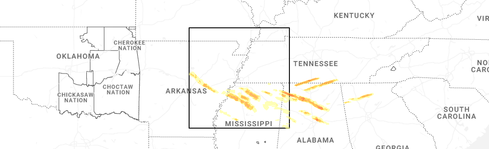
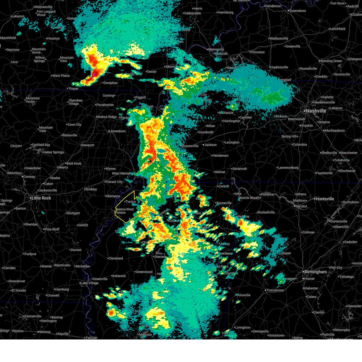
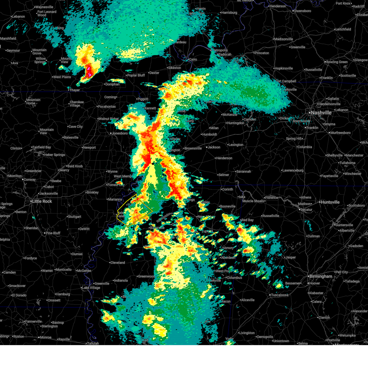
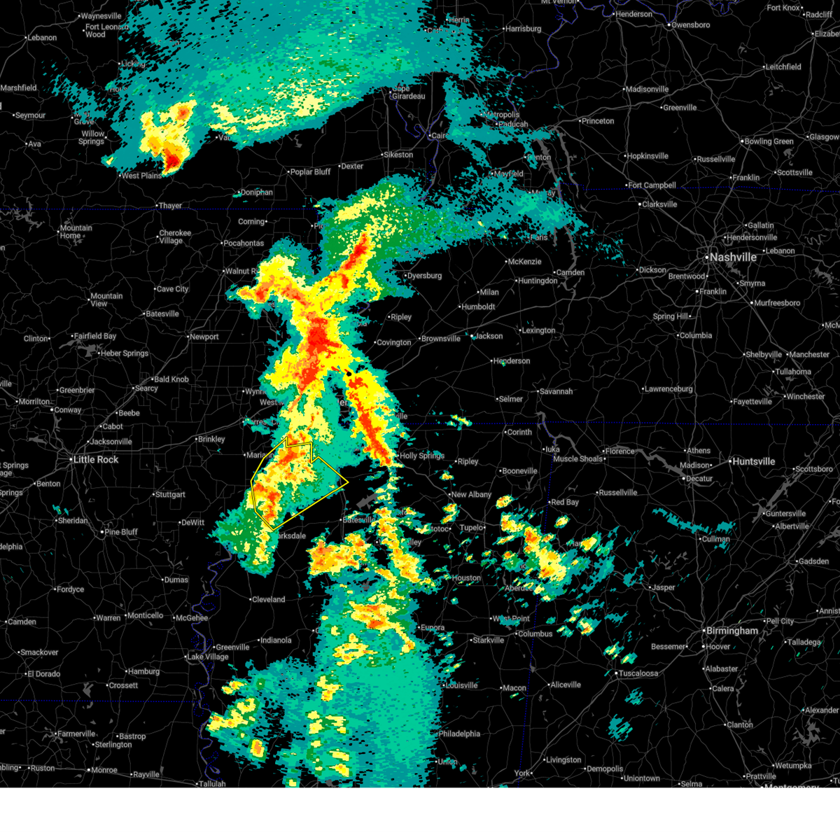
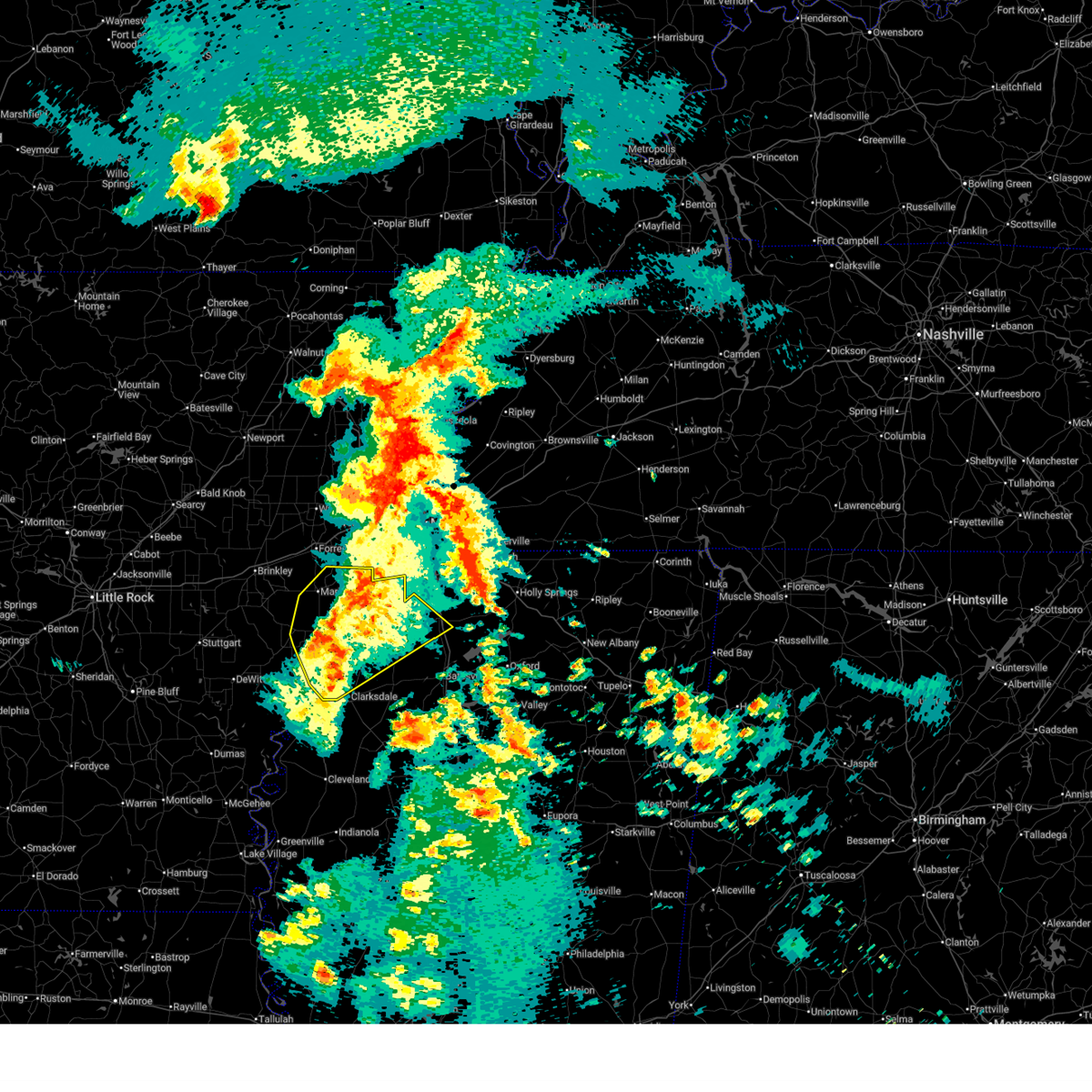
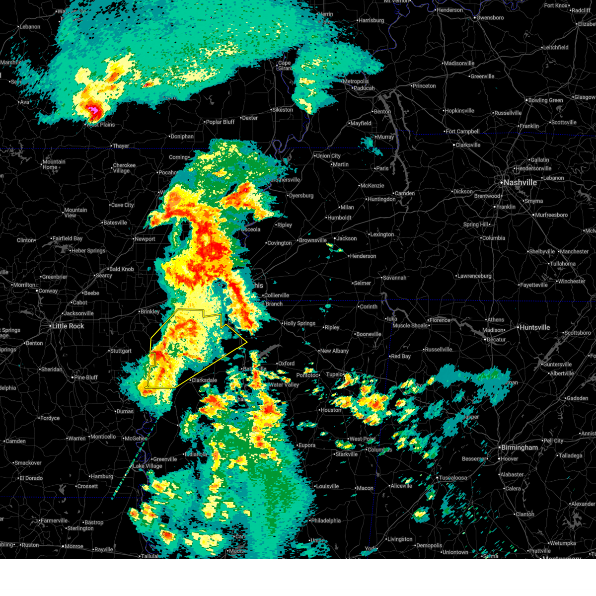
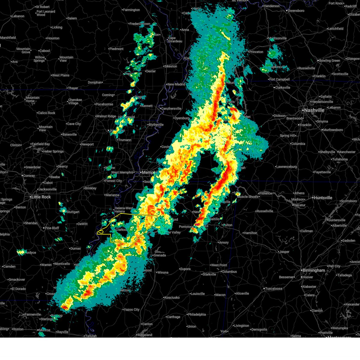
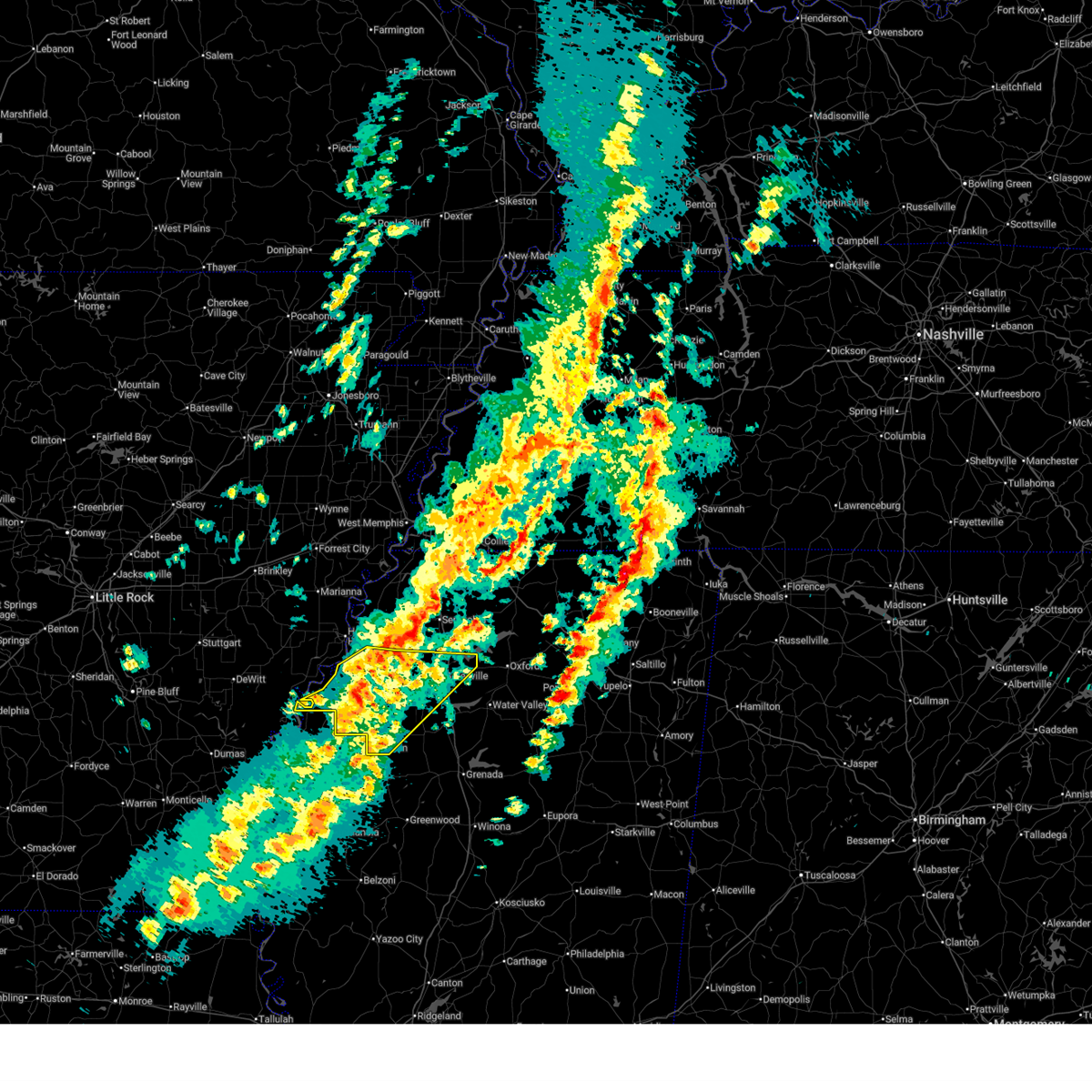
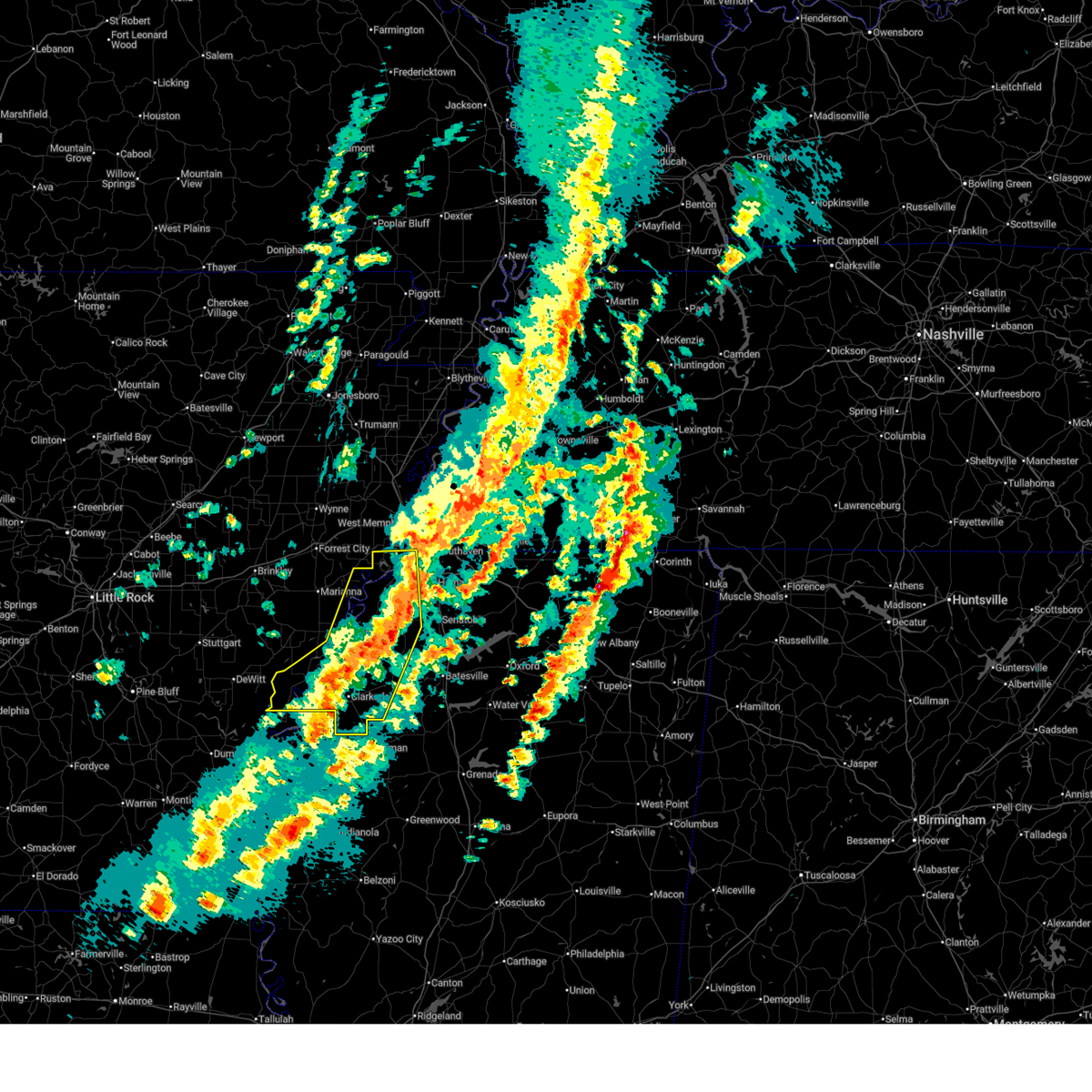
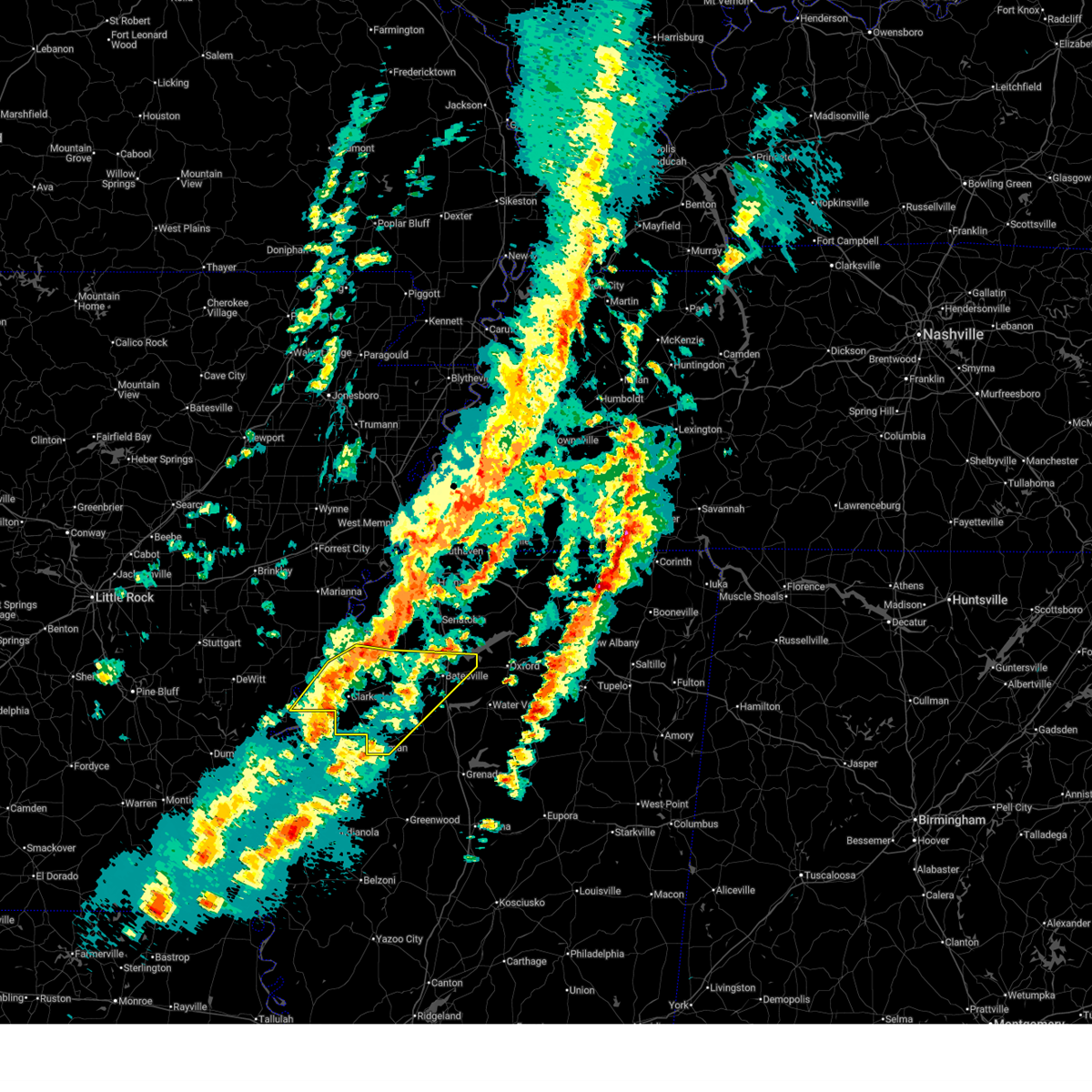
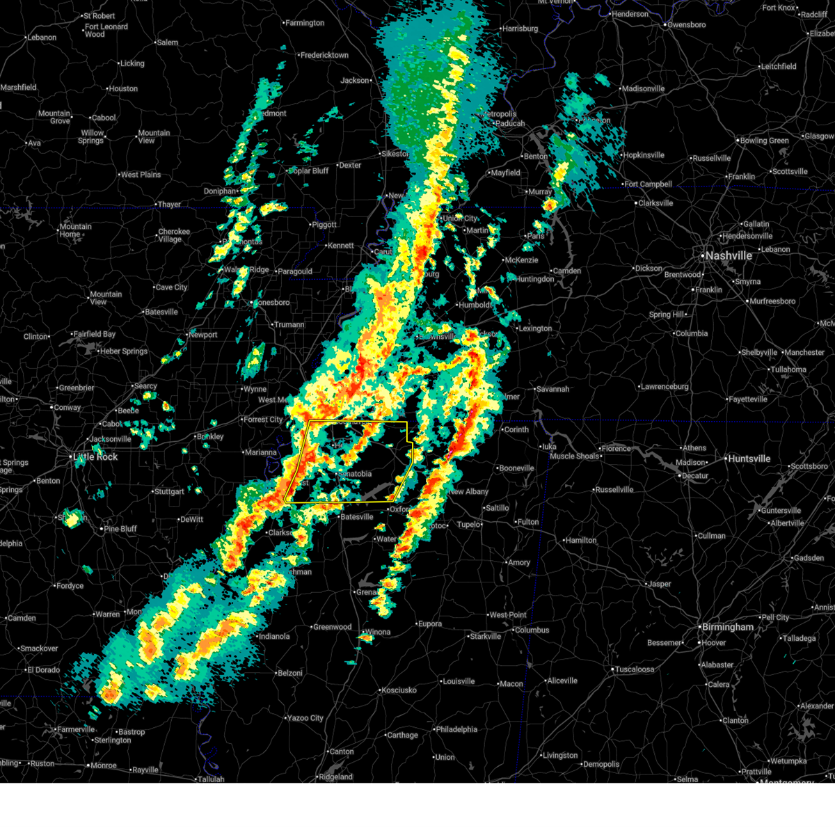
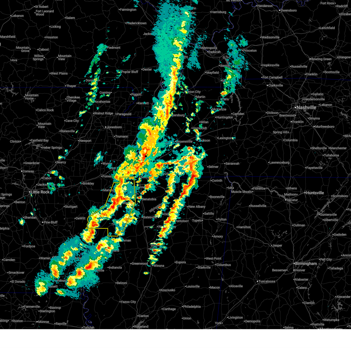
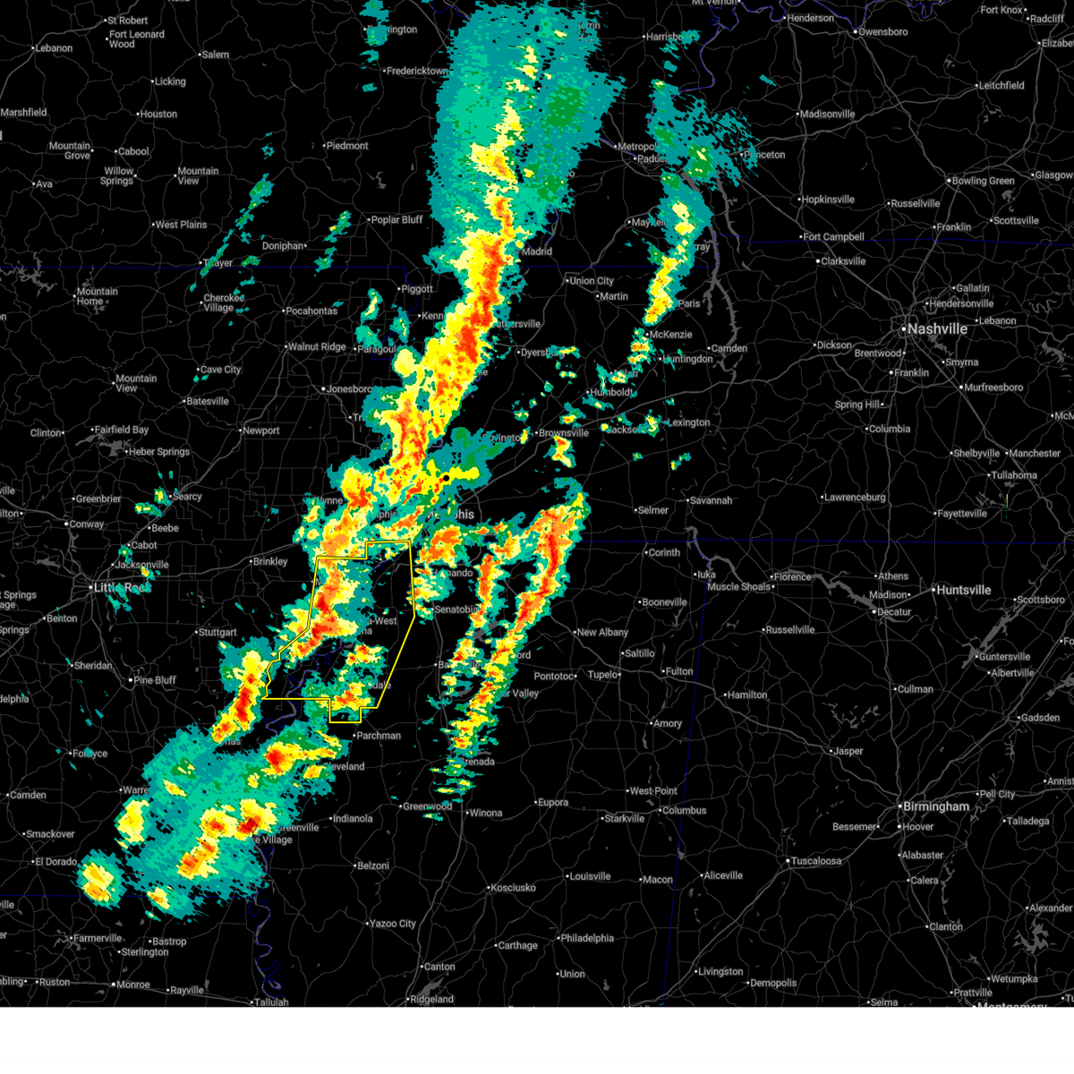
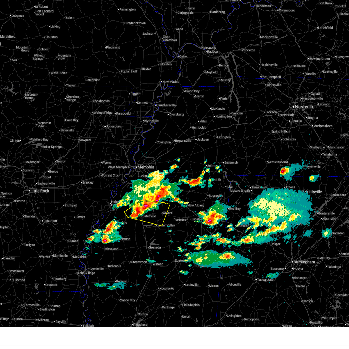
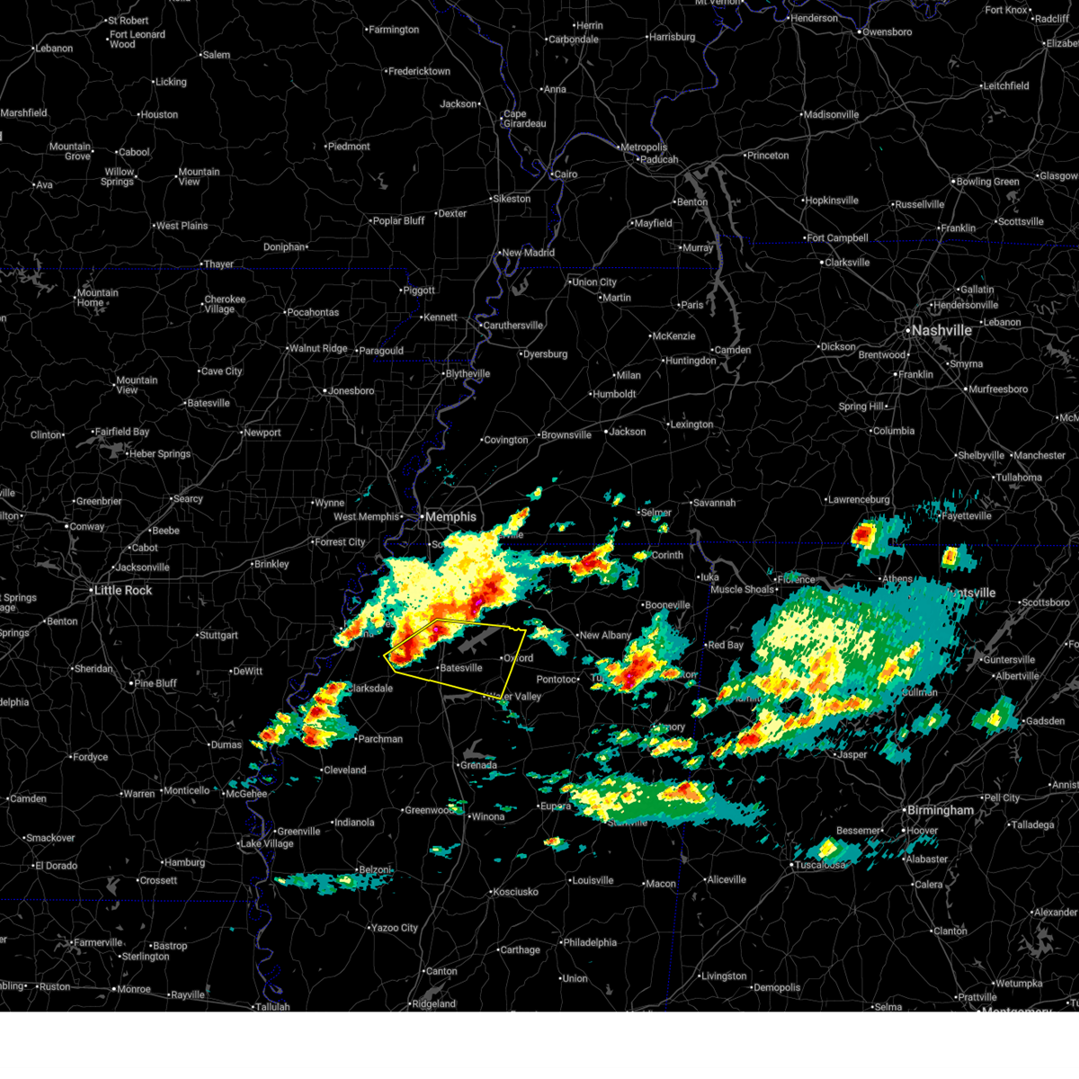
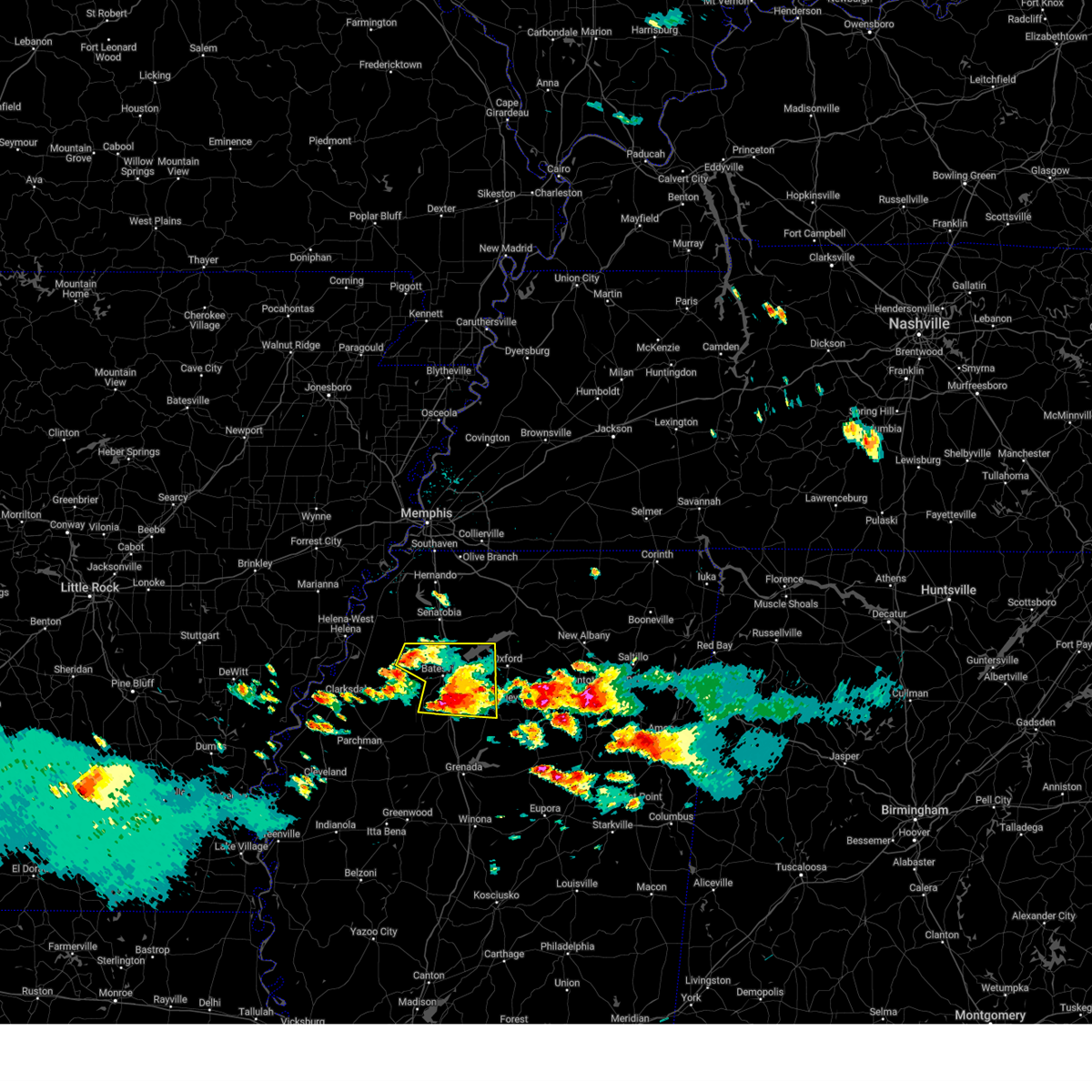
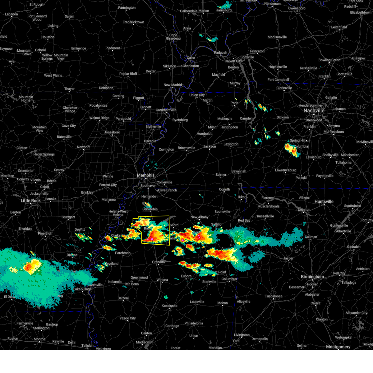
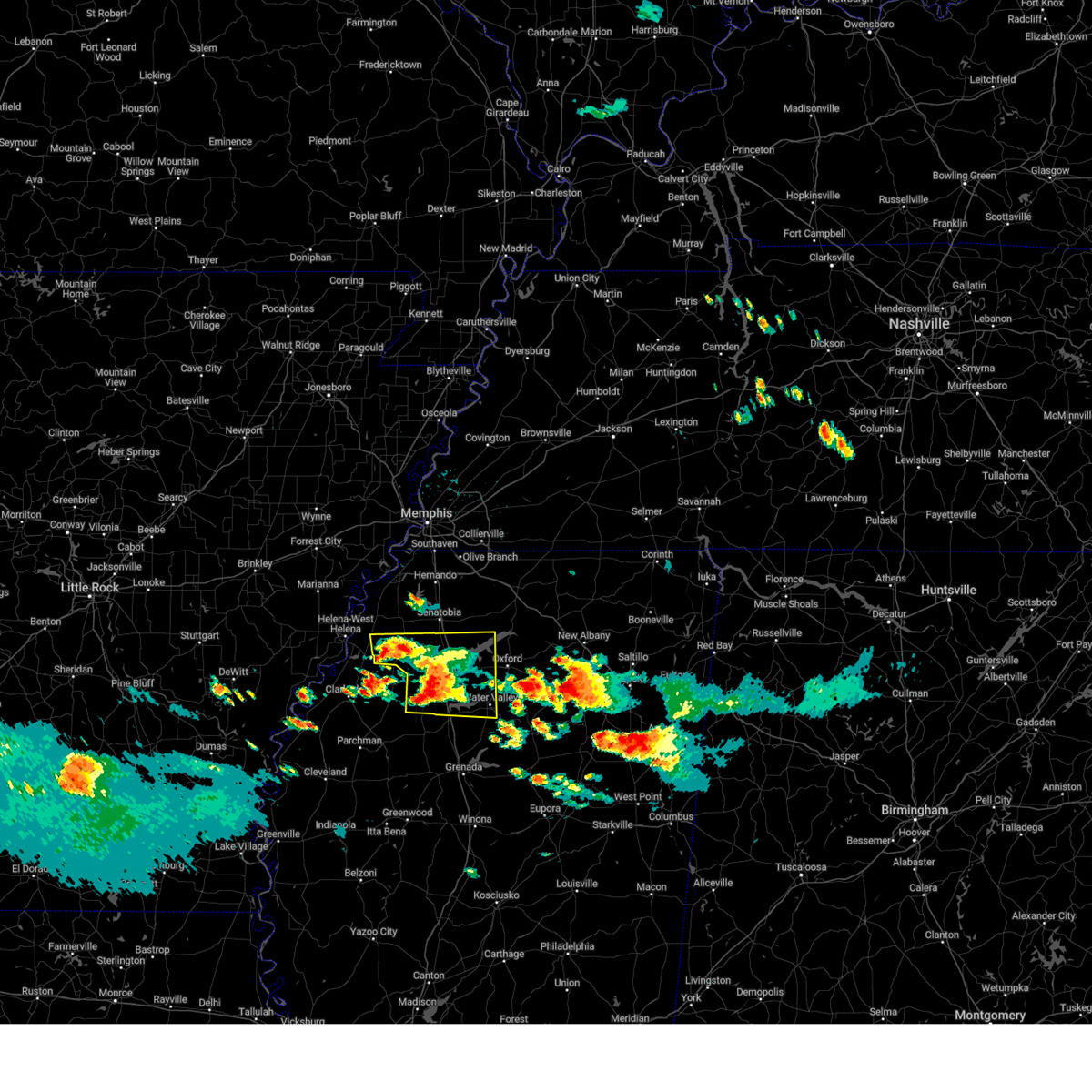
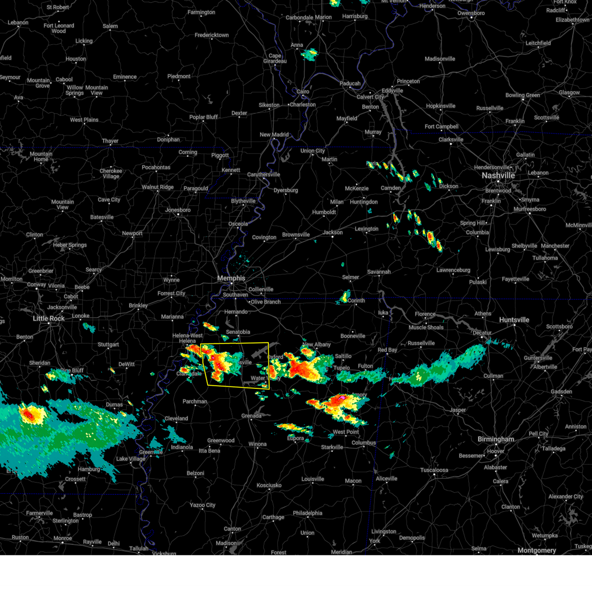
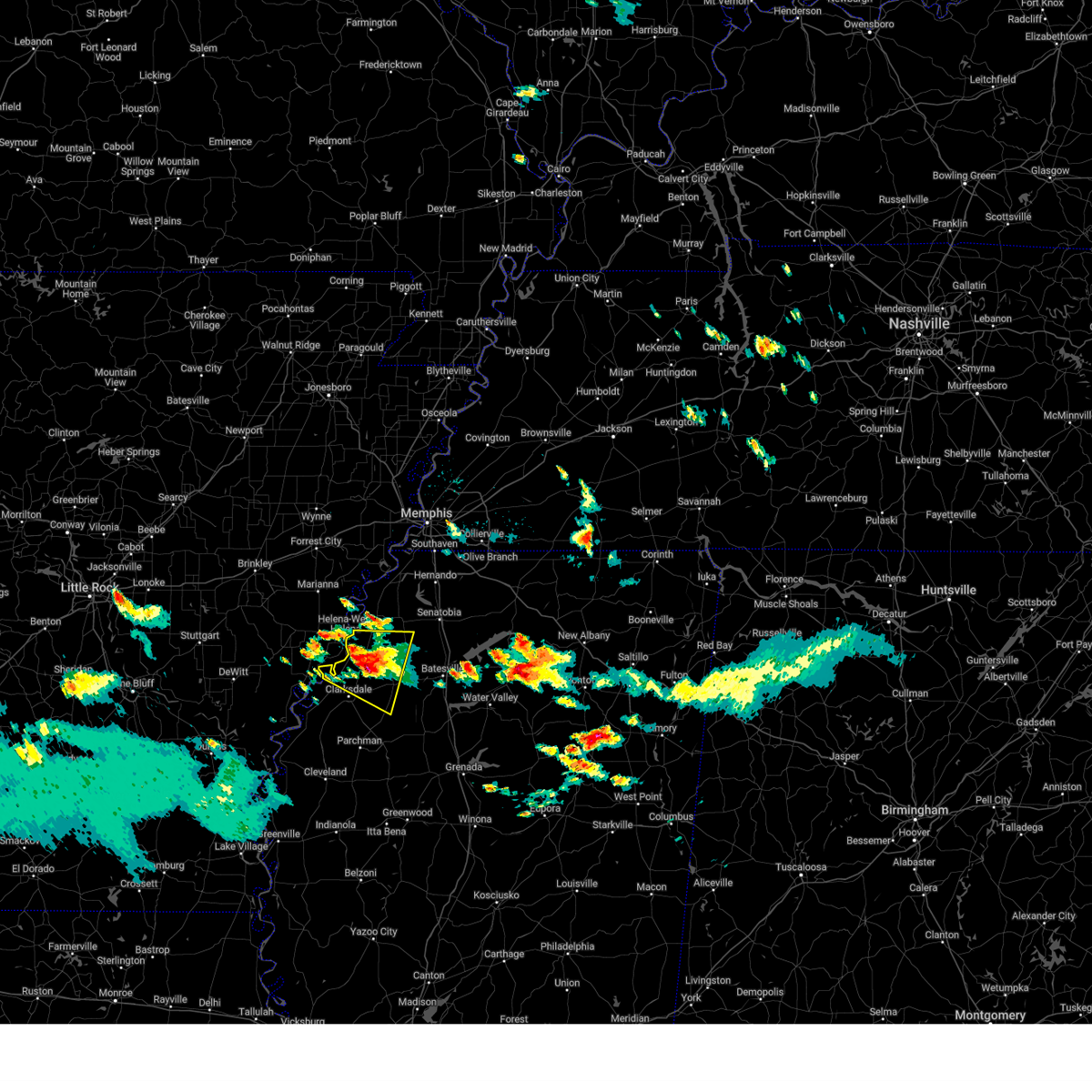
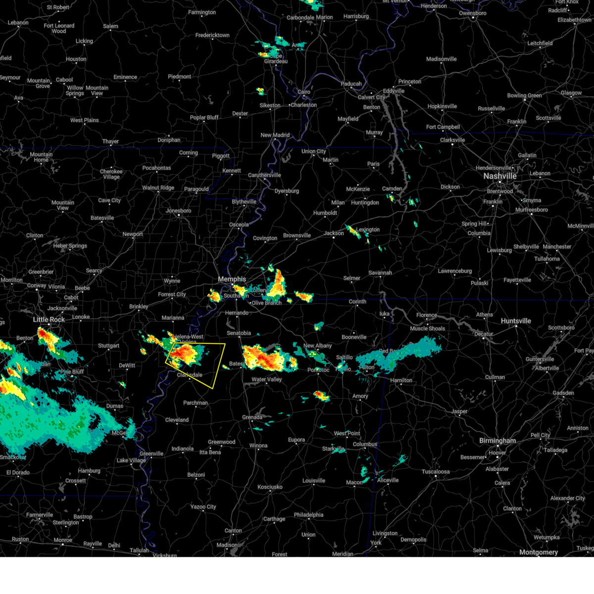
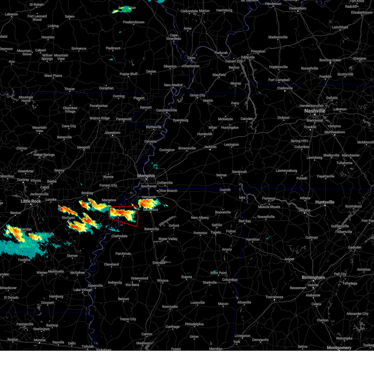
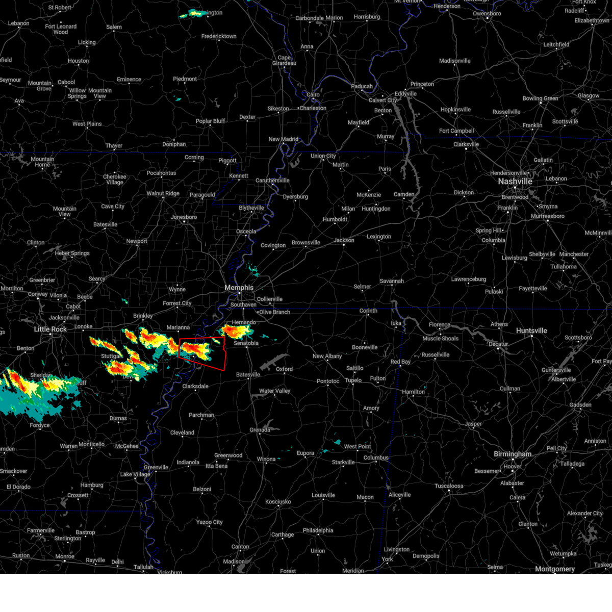
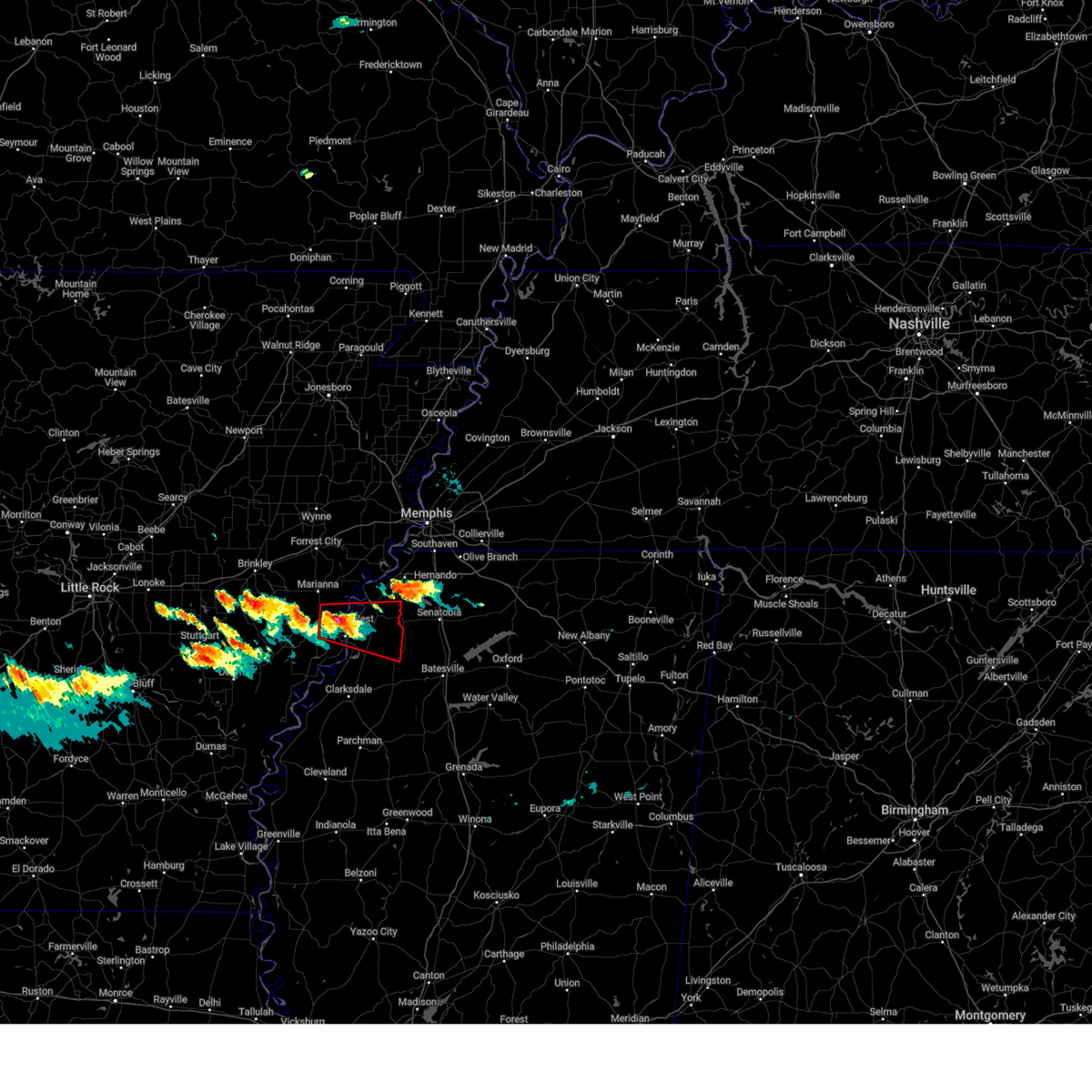
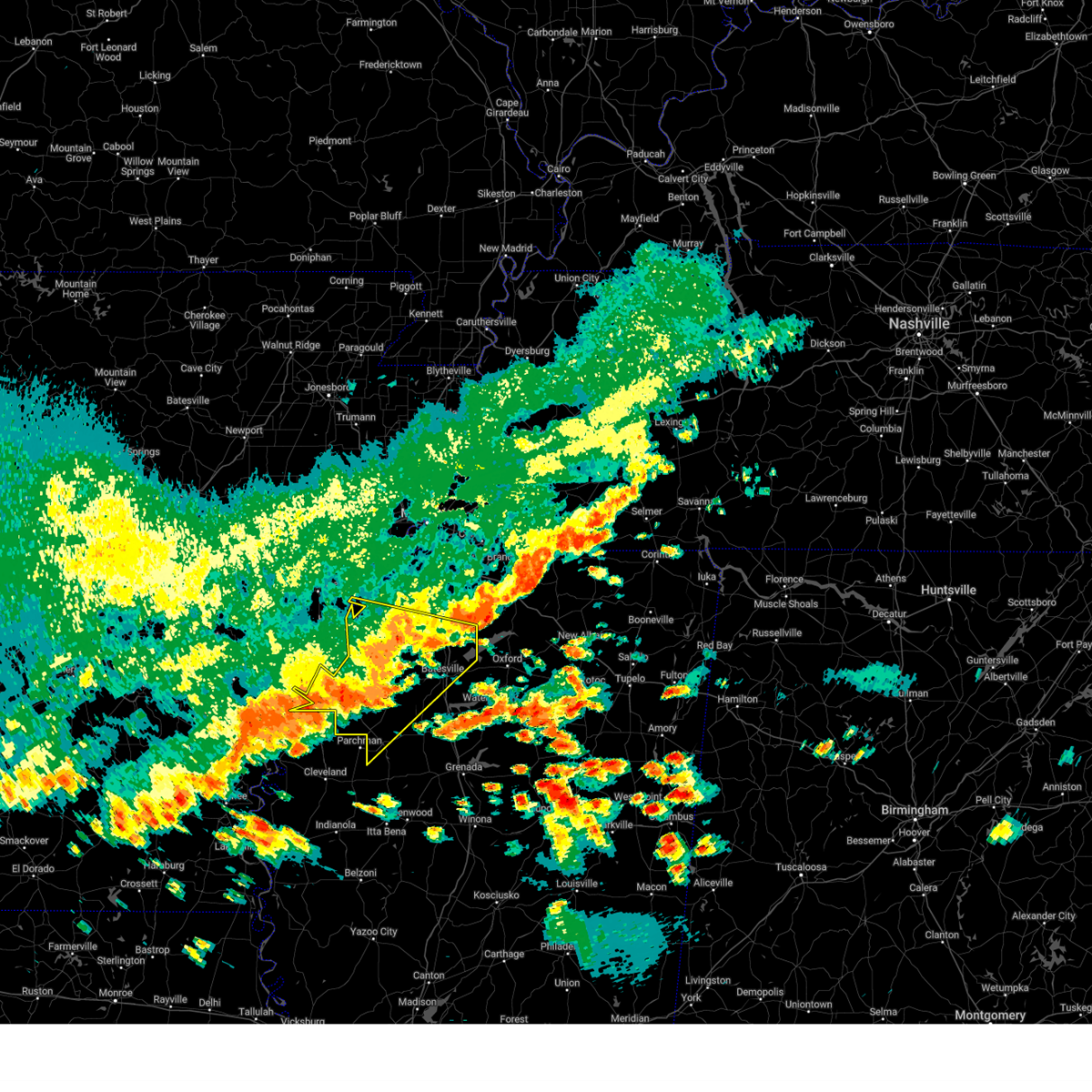
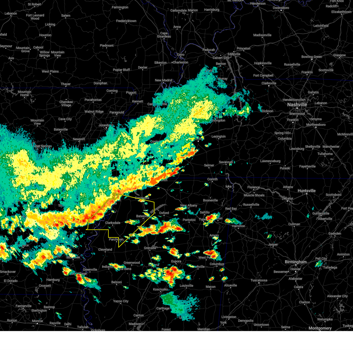
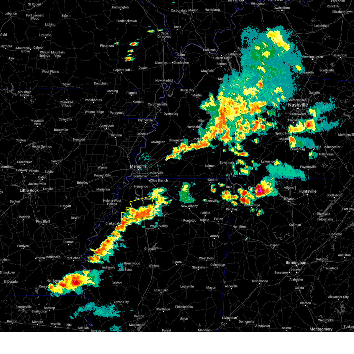
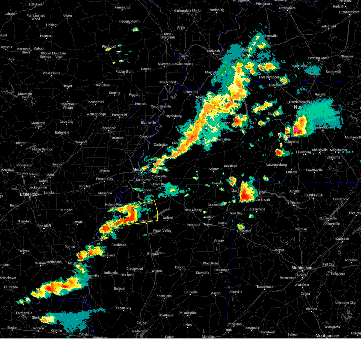
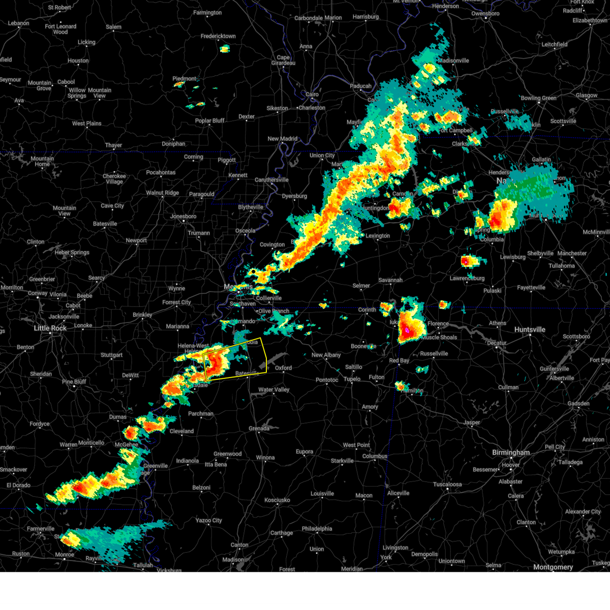
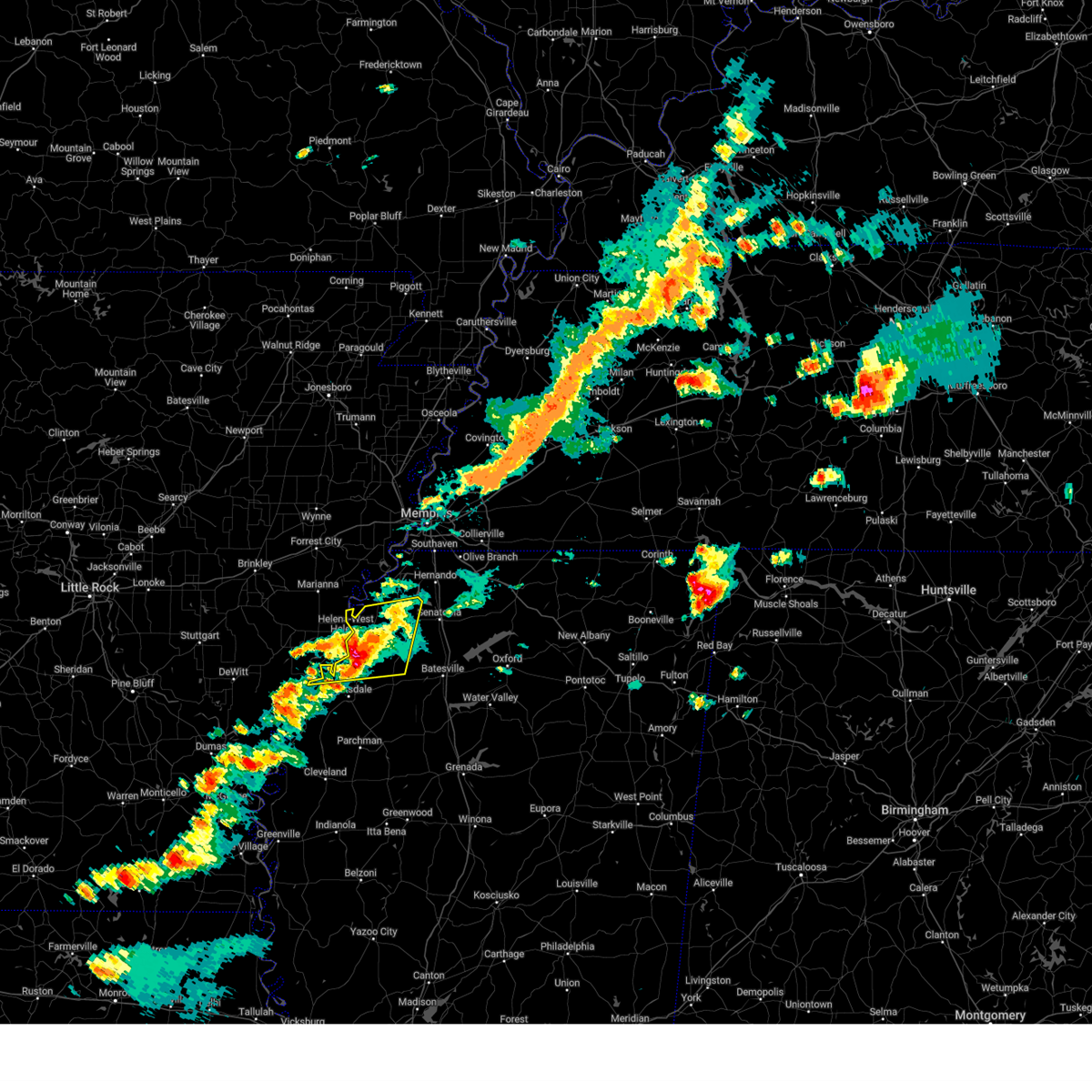
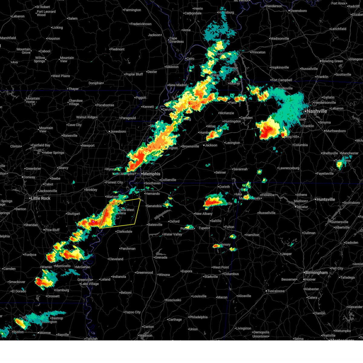
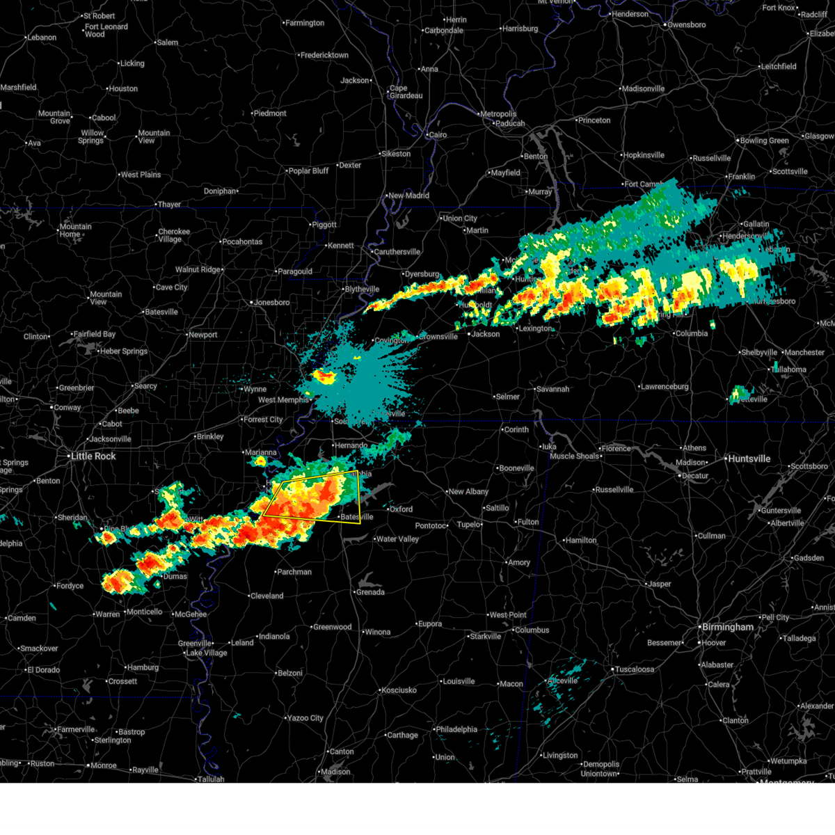
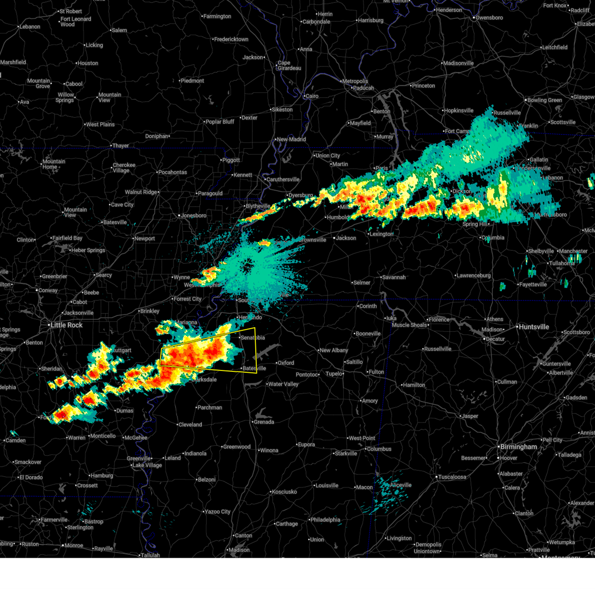
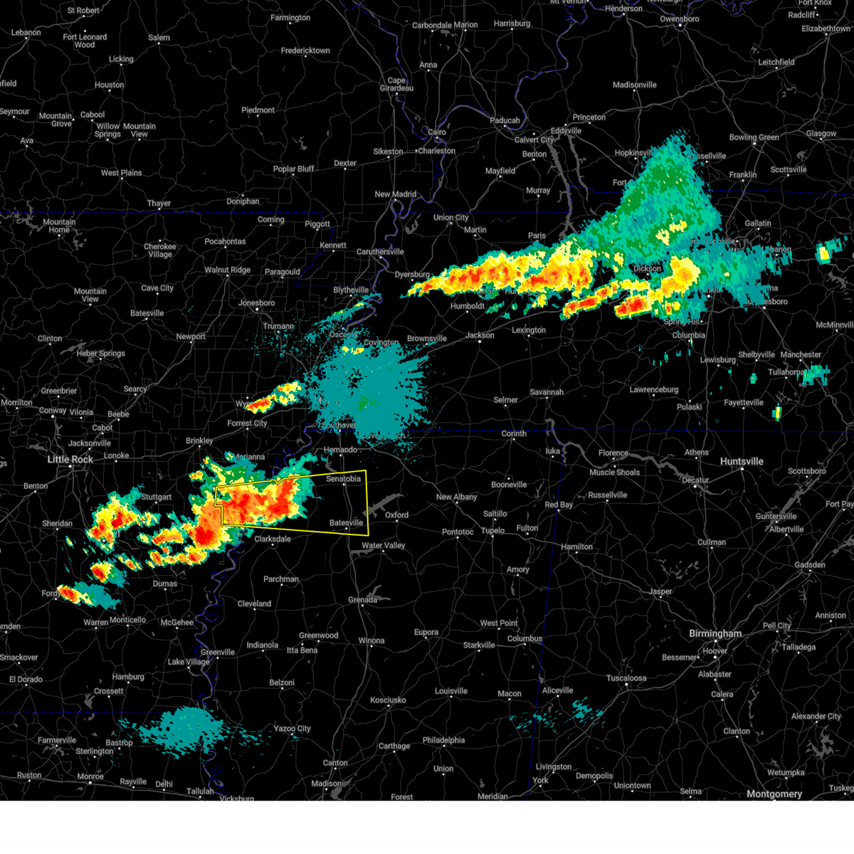
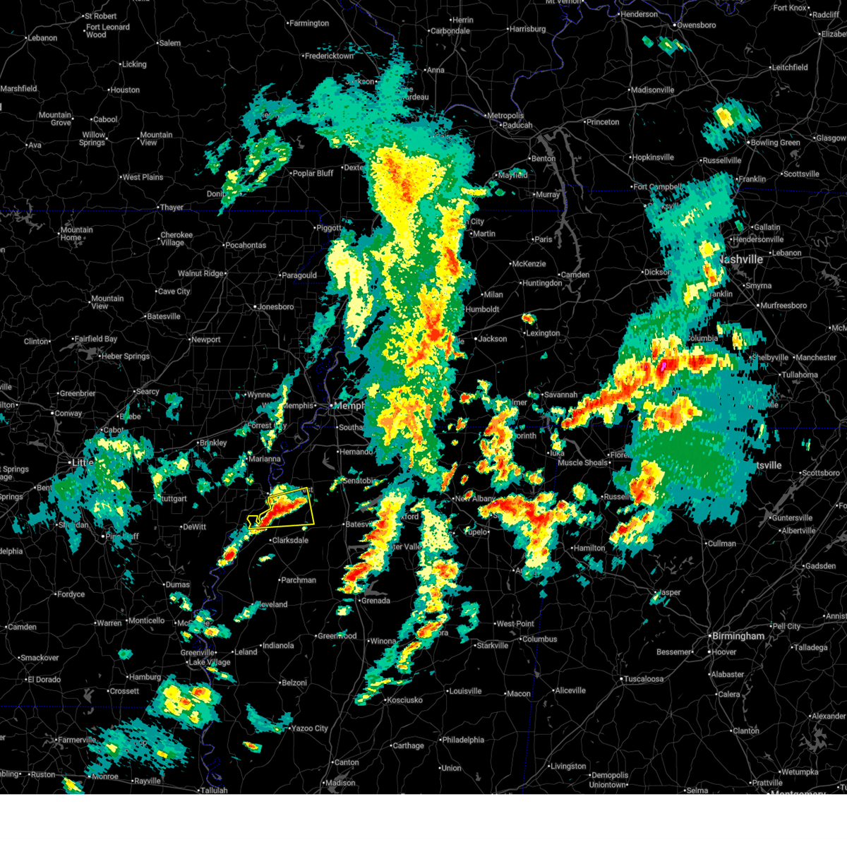
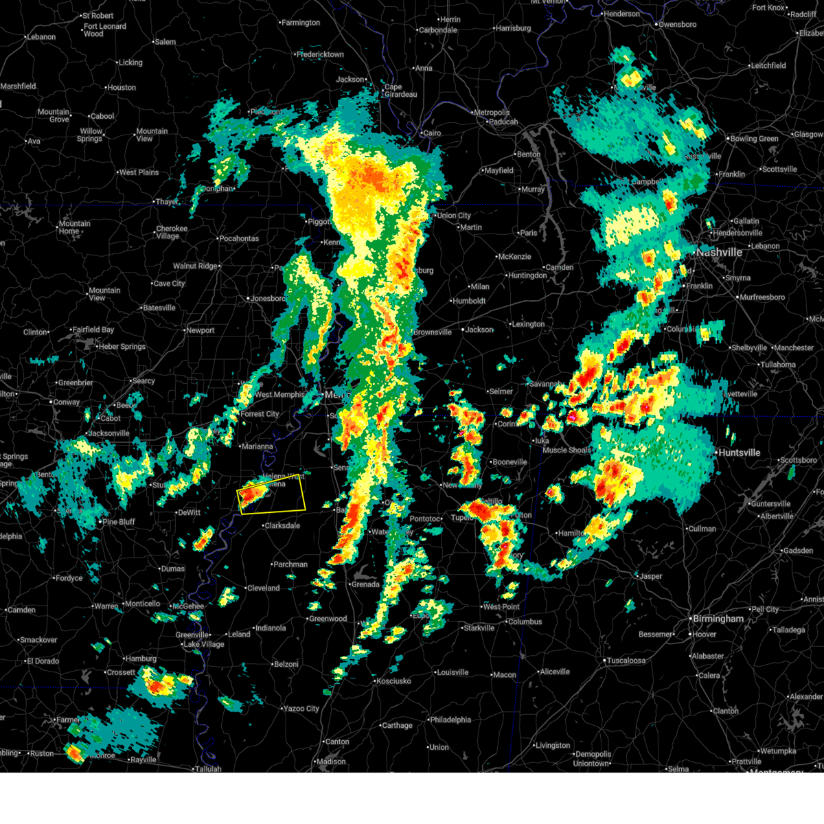
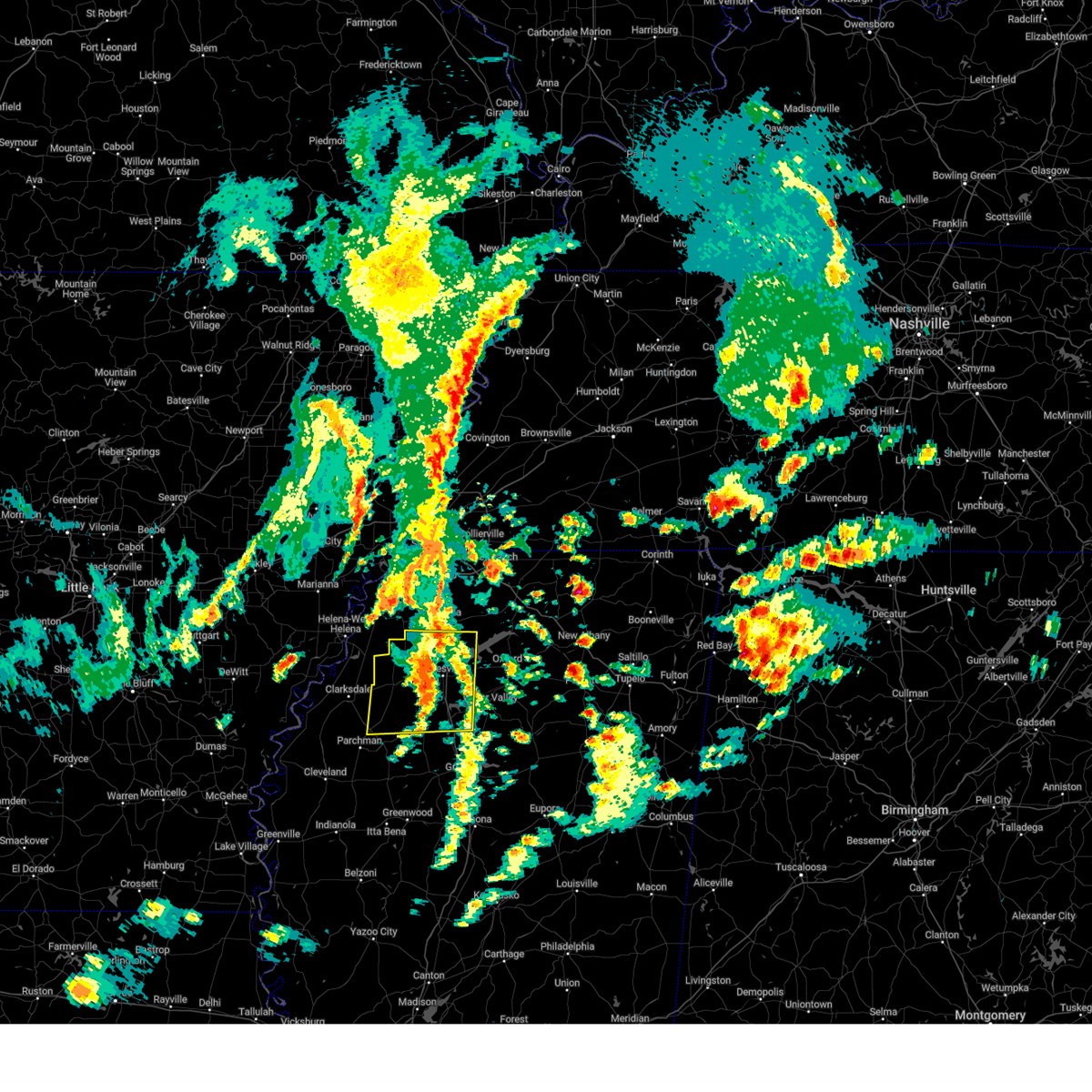
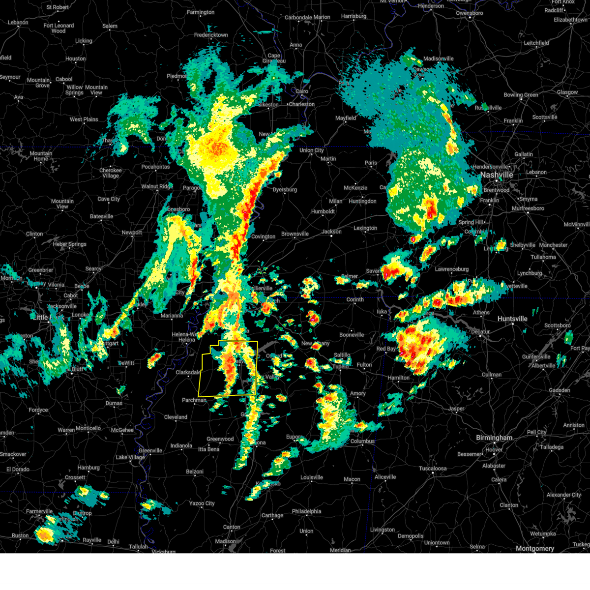
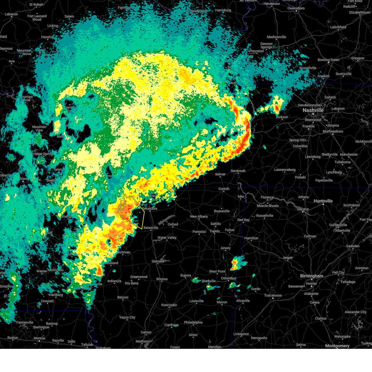
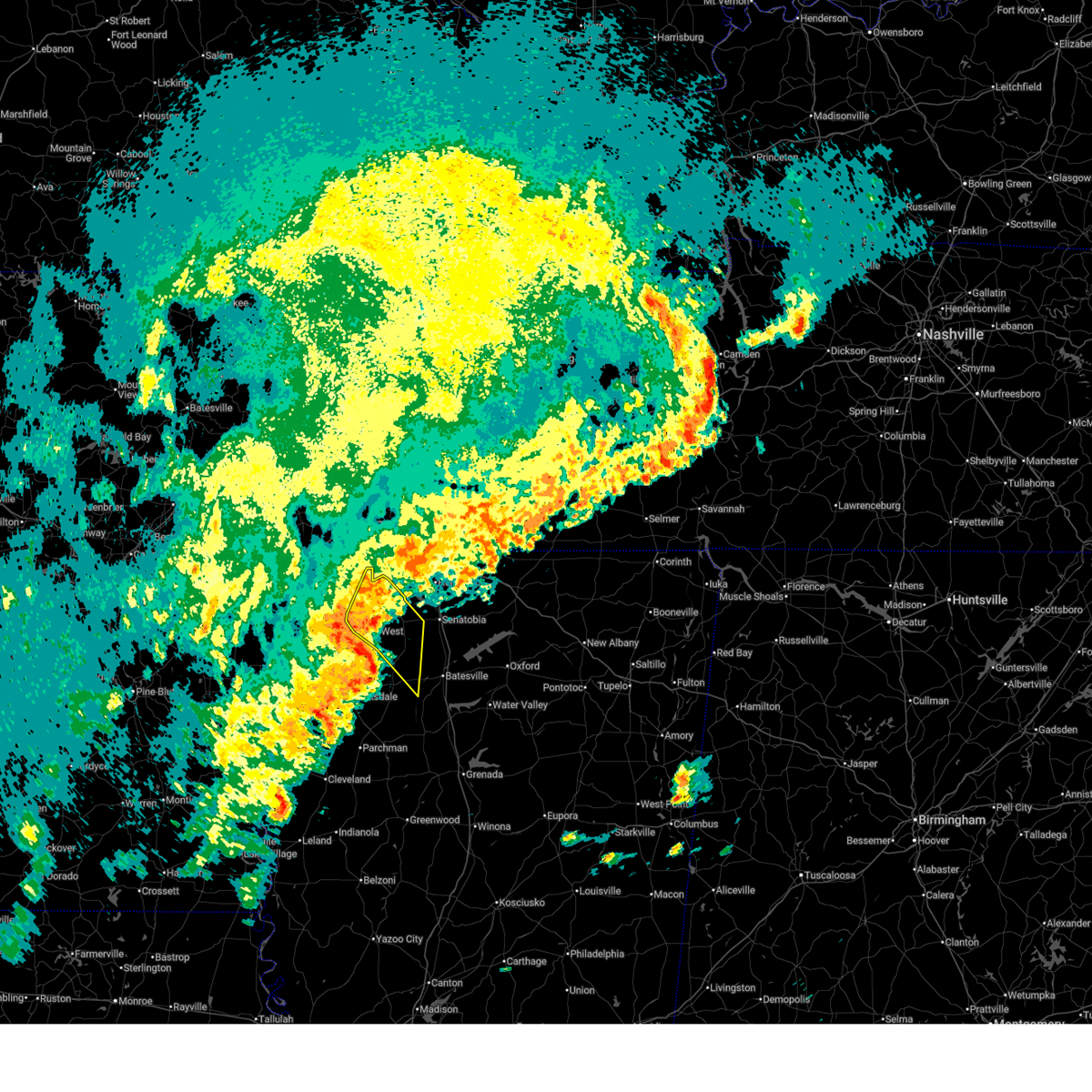
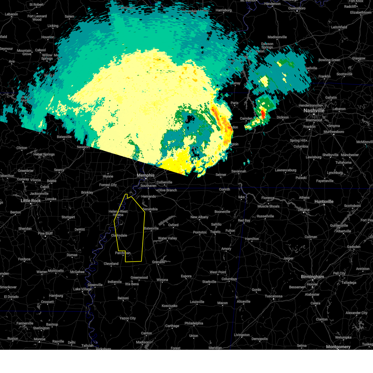
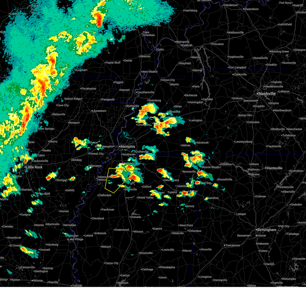
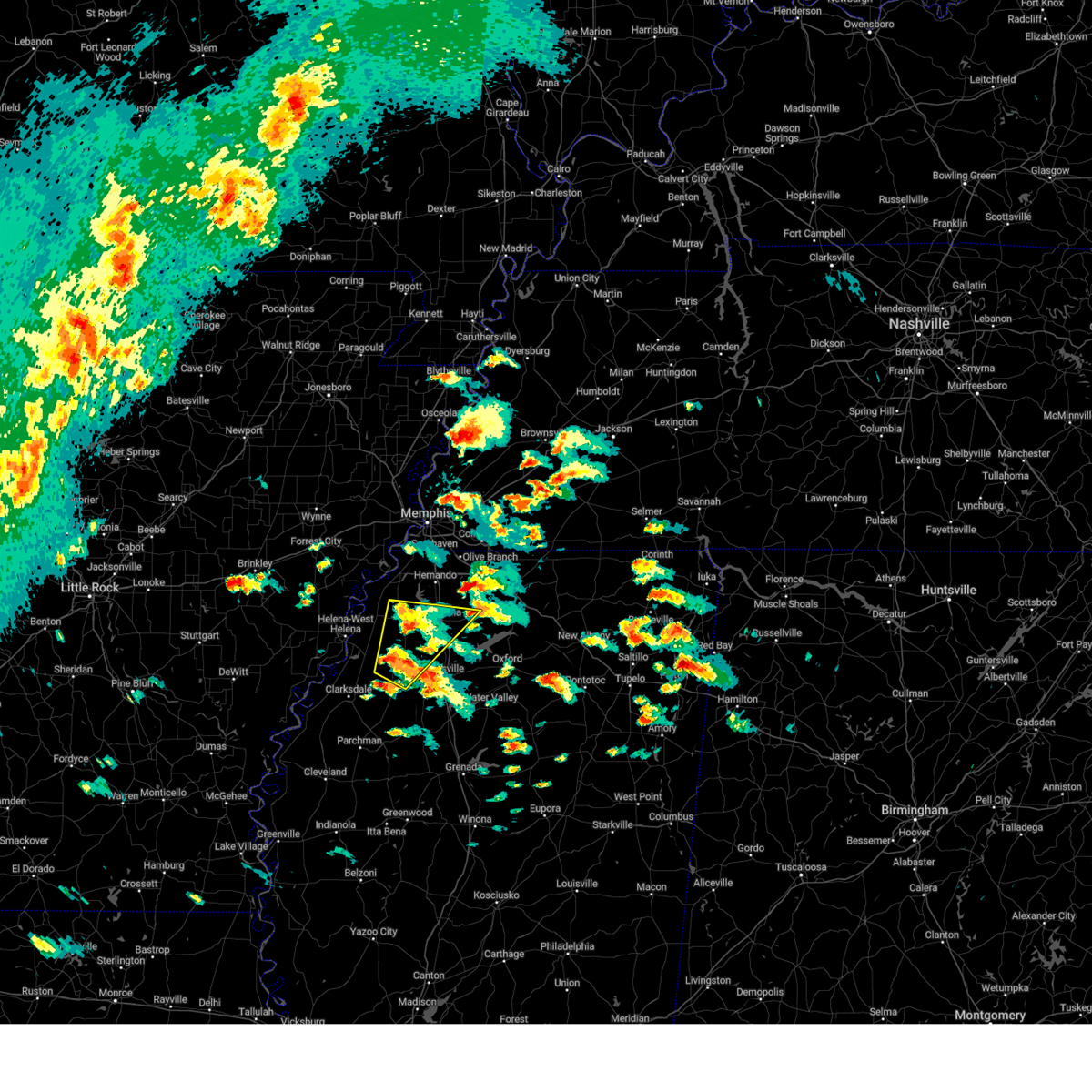
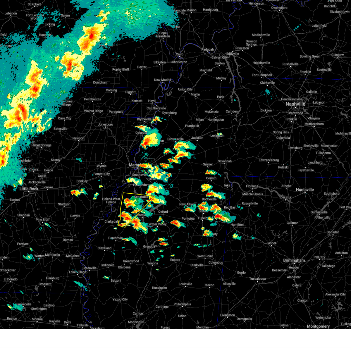
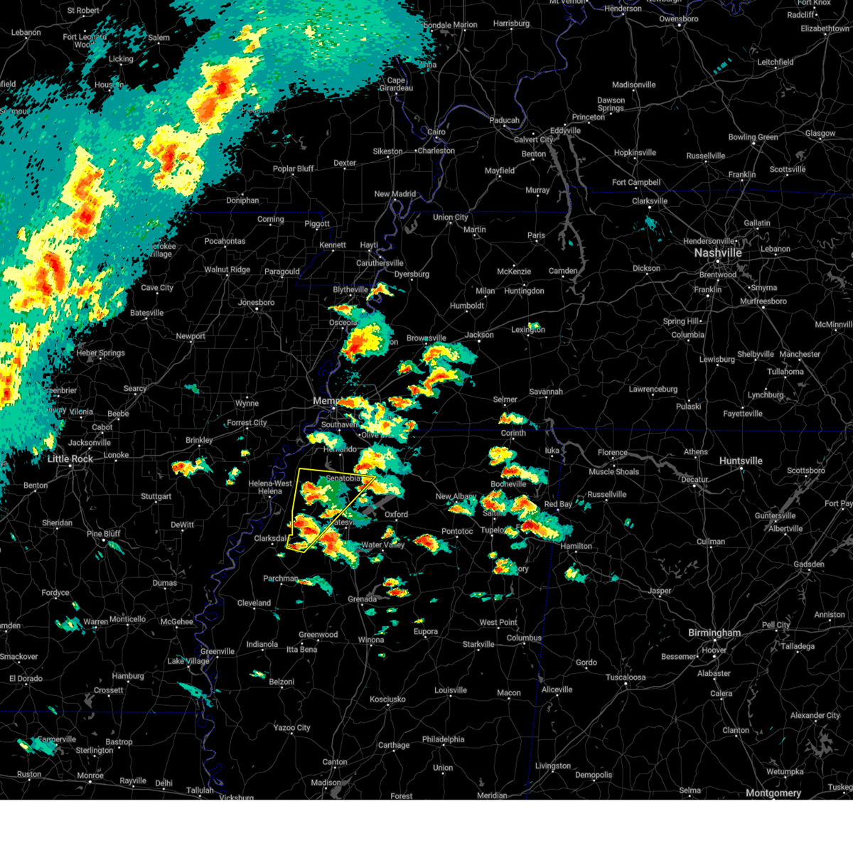
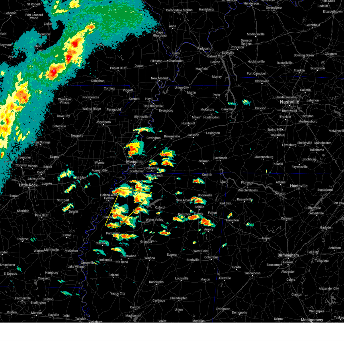
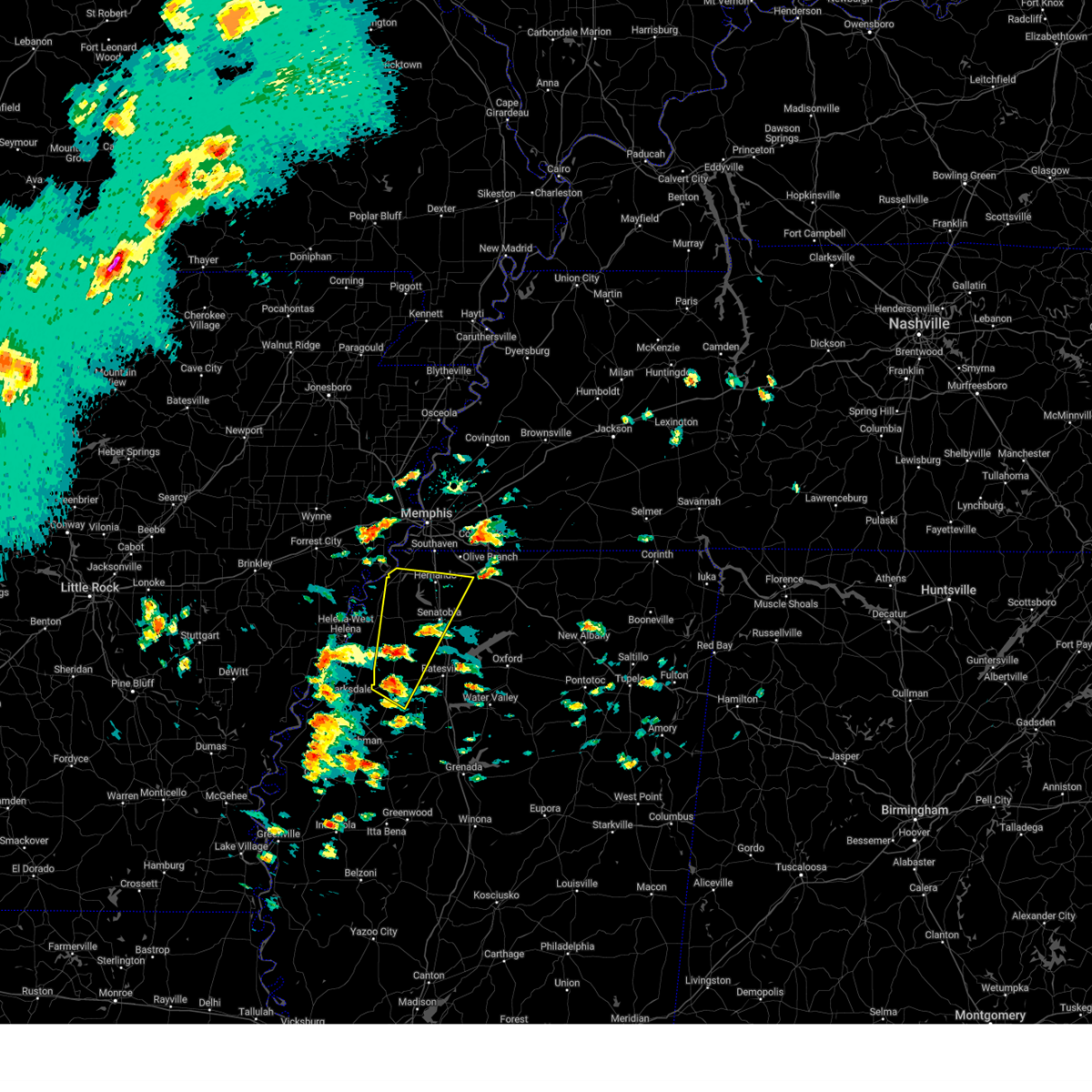
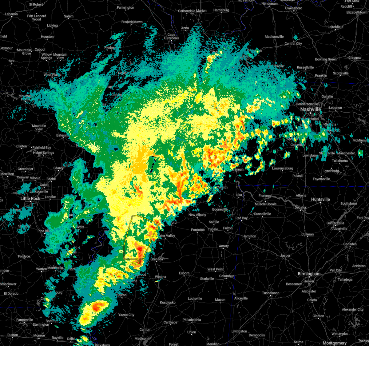
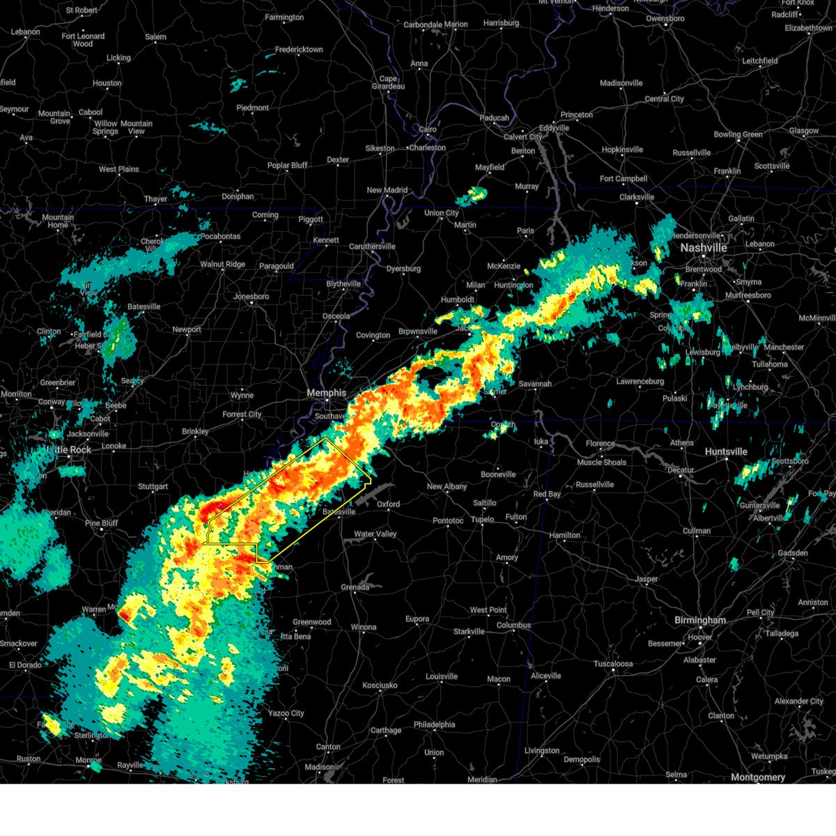
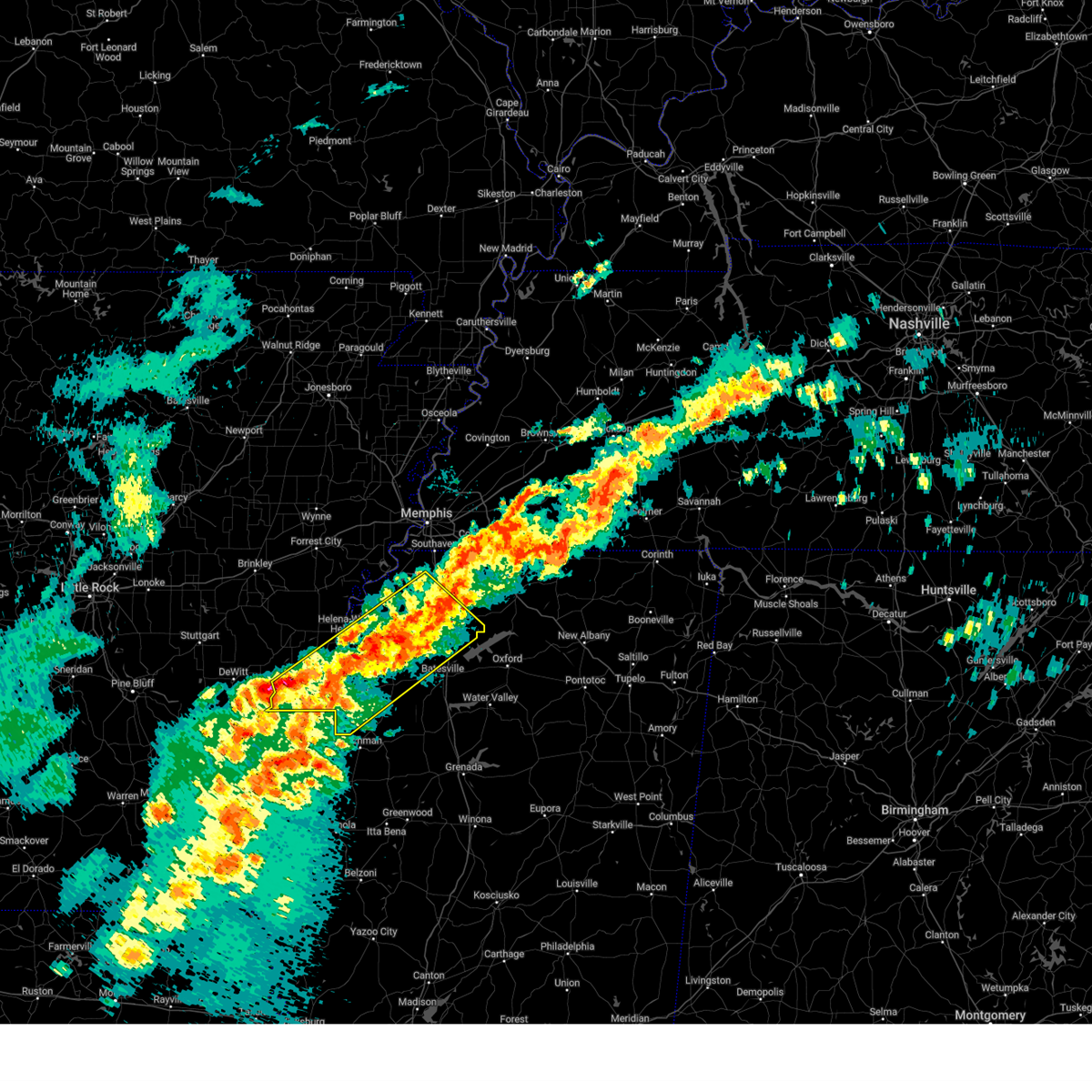
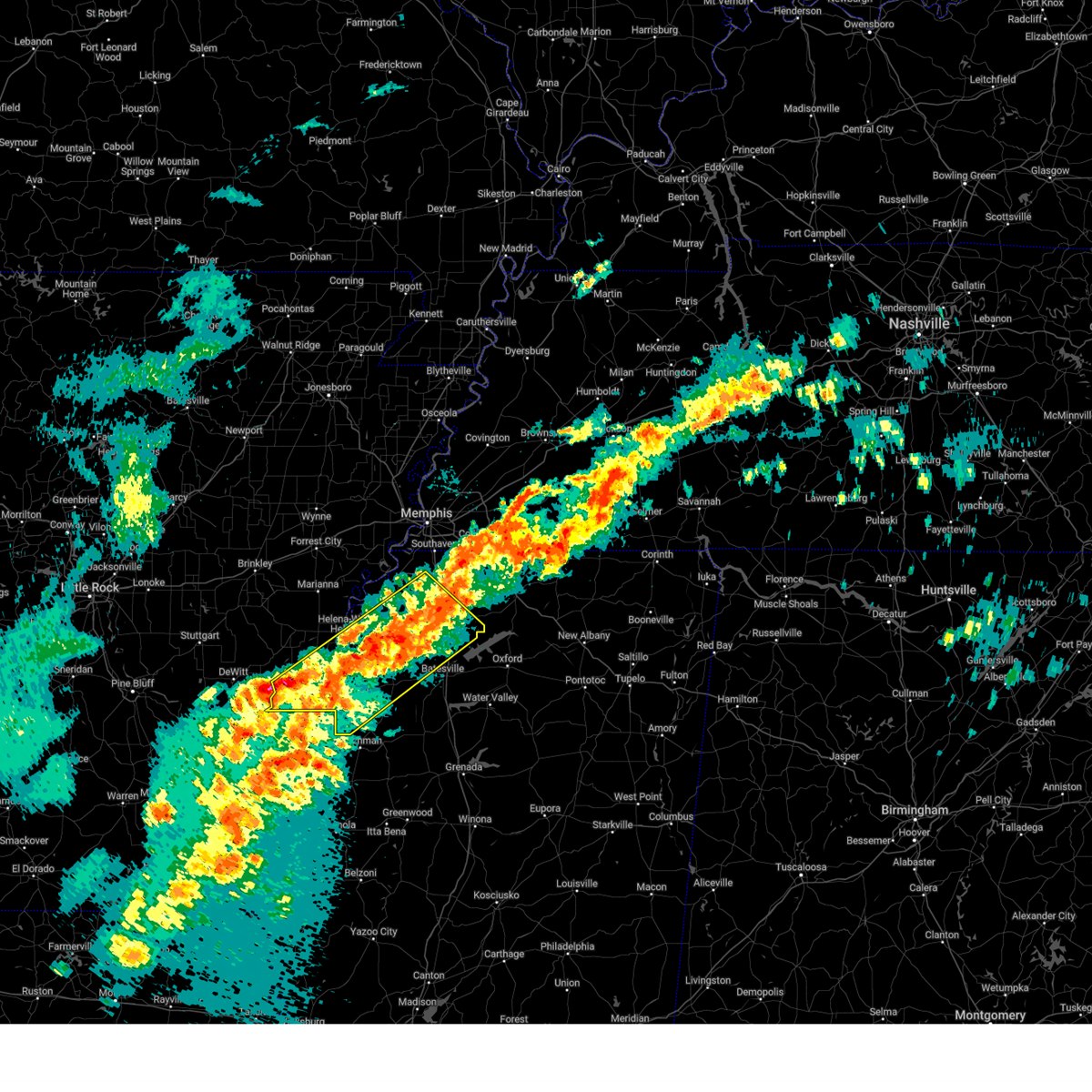
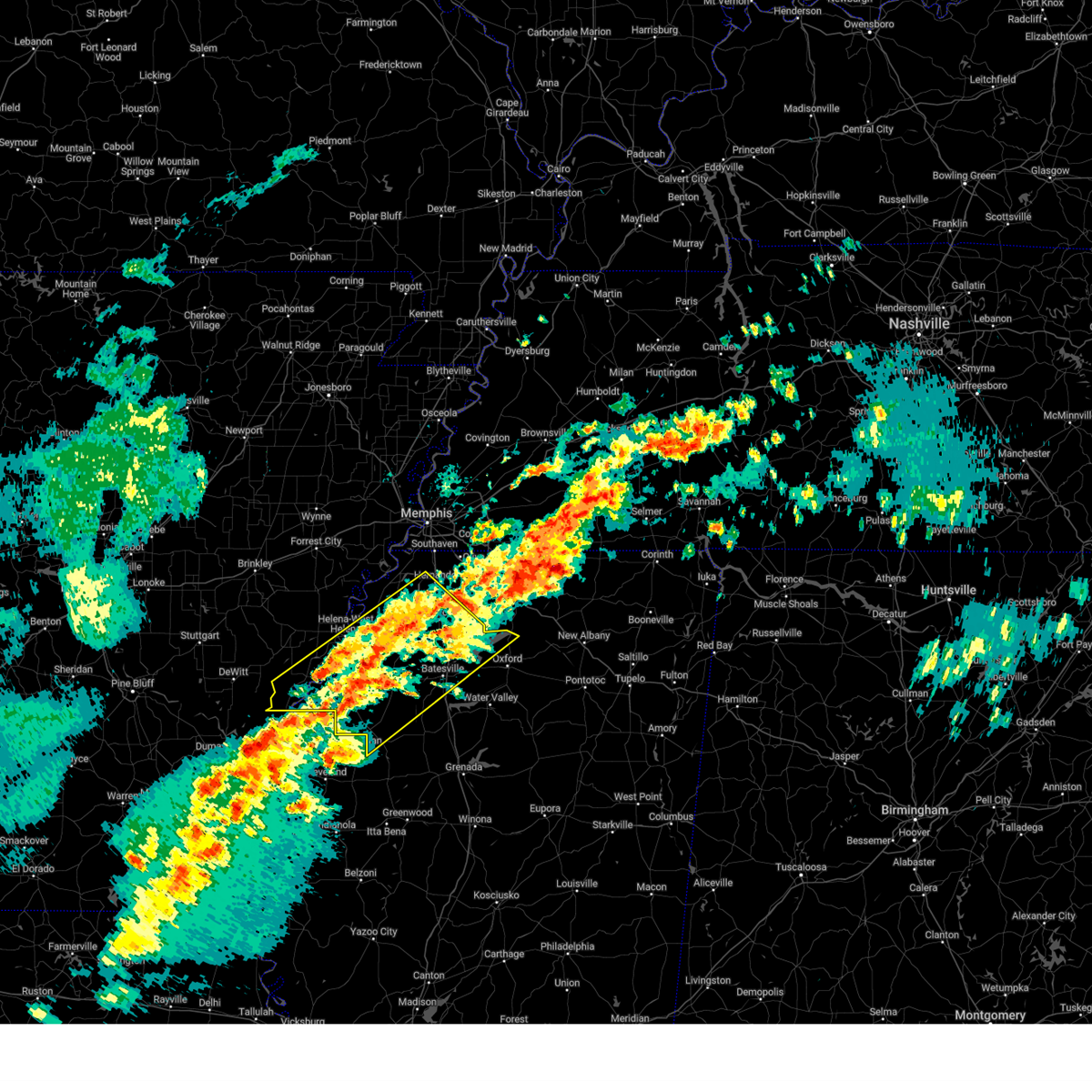
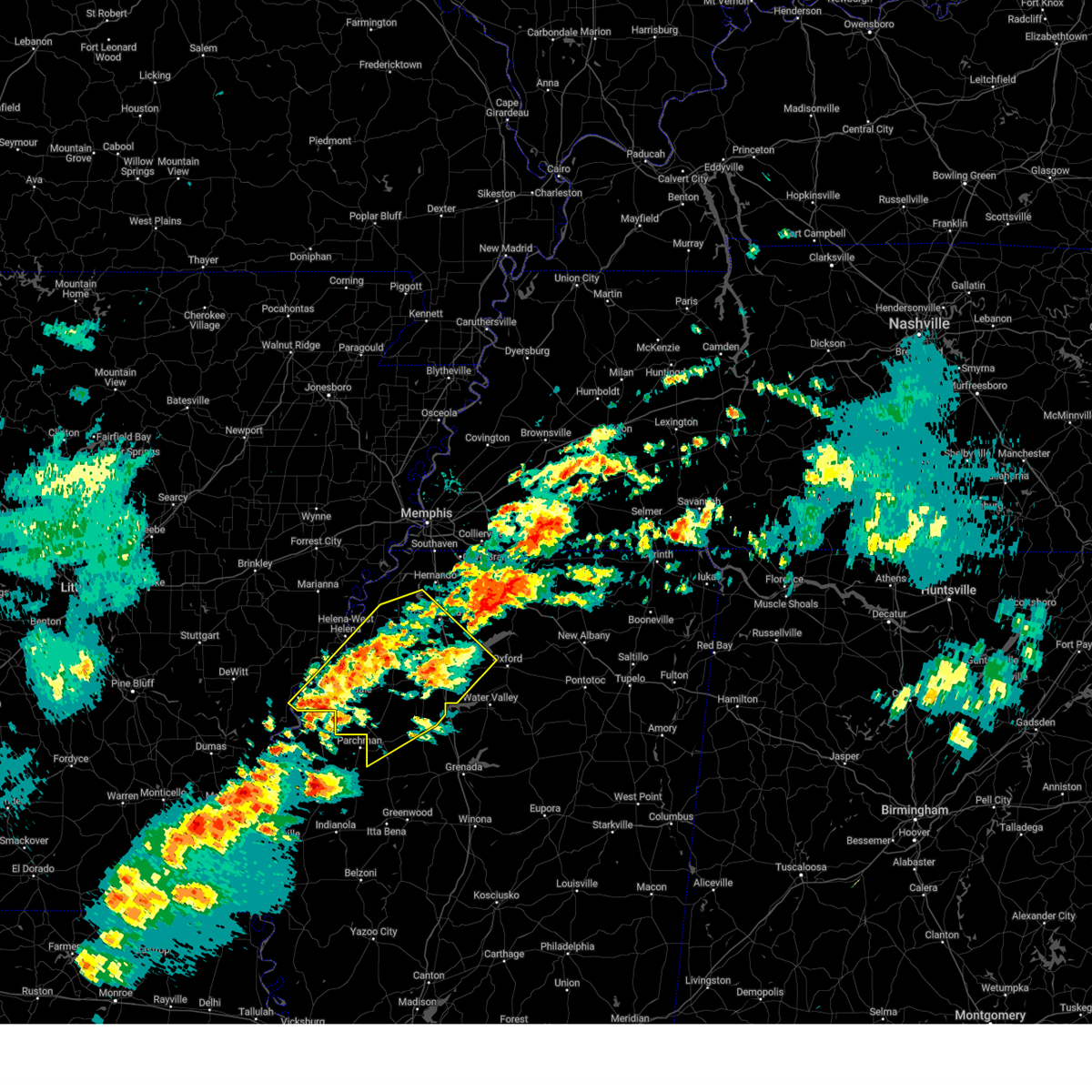
Hail Map for Sledge, MS
The Sledge, MS area has had 1 report of on-the-ground hail by trained spotters, and has been under severe weather warnings 18 times during the past 12 months. Doppler radar has detected hail at or near Sledge, MS on 56 occasions, including 4 occasions during the past year.
| Name: | Sledge, MS |
| Where Located: | 50.4 miles S of Memphis, TN |
| Map: | Google Map for Sledge, MS |
| Population: | 545 |
| Housing Units: | 197 |
| More Info: | Search Google for Sledge, MS |
2
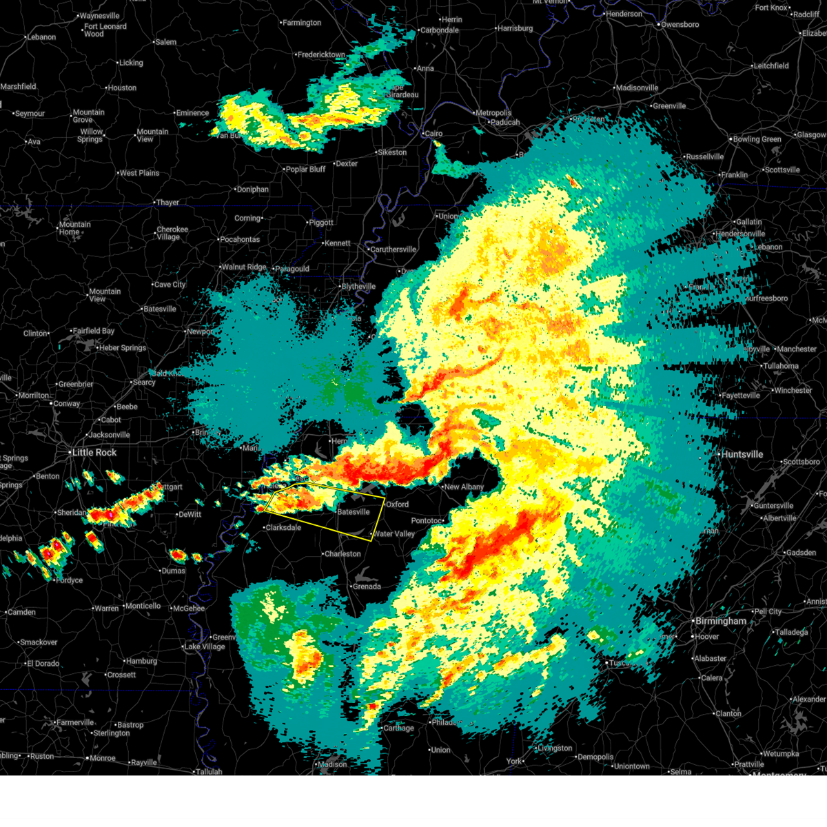
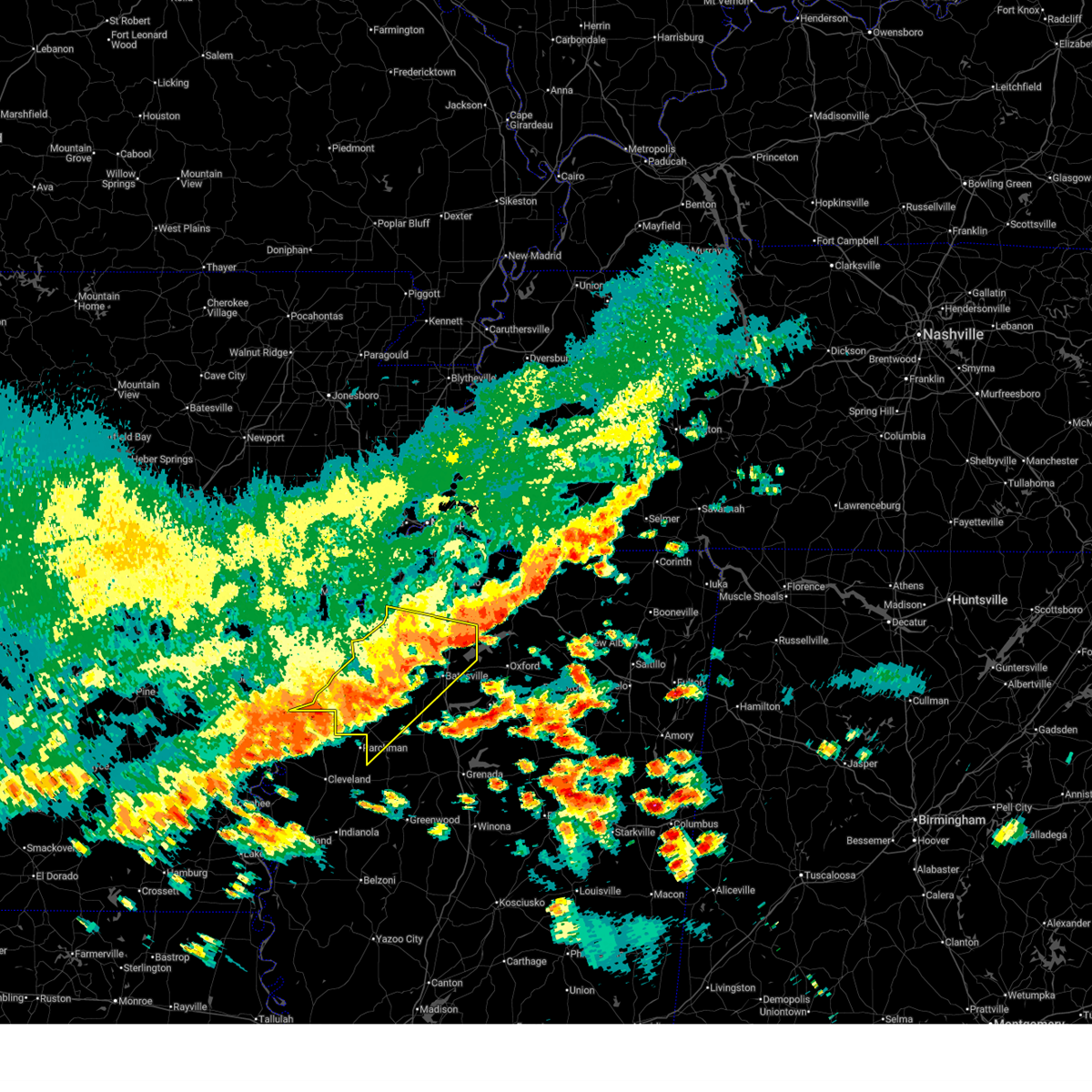
The Top Recent Hail Date for Sledge, MS is Thursday, February 26, 2026 (3rd out of 56)
Hail and Wind Damage Spotted near Sledge, MS
| Date / Time | Report Details |
|---|---|
| 4/28/2026 11:00 PM CDT |
 the severe thunderstorm warning has been cancelled and is no longer in effect the severe thunderstorm warning has been cancelled and is no longer in effect
|
| 4/28/2026 10:56 PM CDT |
 At 1056 pm cdt, a severe thunderstorm was located over darling, or 19 miles west of batesville, moving east at 35 mph (radar indicated). Hazards include 60 mph wind gusts. Expect damage to roofs, siding, and trees. locations impacted include, oxford, batesville, water valley, holly springs national forest, john w kyle state park, marks, sardis, jonestown, crenshaw, sledge, pope, darling, pleasant grove, springdale, curtis station, burgess, courtland, coahoma, taylor, and lula. This includes interstate 55 in mississippi between mile markers 234 and 255. At 1056 pm cdt, a severe thunderstorm was located over darling, or 19 miles west of batesville, moving east at 35 mph (radar indicated). Hazards include 60 mph wind gusts. Expect damage to roofs, siding, and trees. locations impacted include, oxford, batesville, water valley, holly springs national forest, john w kyle state park, marks, sardis, jonestown, crenshaw, sledge, pope, darling, pleasant grove, springdale, curtis station, burgess, courtland, coahoma, taylor, and lula. This includes interstate 55 in mississippi between mile markers 234 and 255.
|
| 4/28/2026 10:39 PM CDT |
 Svrmeg the national weather service in memphis has issued a * severe thunderstorm warning for, southwestern lafayette county in northwestern mississippi, northwestern yalobusha county in northwestern mississippi, northeastern coahoma county in northwestern mississippi, southeastern tunica county in northwestern mississippi, central quitman county in northwestern mississippi, panola county in northwestern mississippi, * until 1130 pm cdt. * at 1039 pm cdt, a severe thunderstorm was located 7 miles northwest of darling, or 16 miles southeast of helena-west helena, moving east at 50 mph (radar indicated). Hazards include 60 mph wind gusts and penny size hail. expect damage to roofs, siding, and trees Svrmeg the national weather service in memphis has issued a * severe thunderstorm warning for, southwestern lafayette county in northwestern mississippi, northwestern yalobusha county in northwestern mississippi, northeastern coahoma county in northwestern mississippi, southeastern tunica county in northwestern mississippi, central quitman county in northwestern mississippi, panola county in northwestern mississippi, * until 1130 pm cdt. * at 1039 pm cdt, a severe thunderstorm was located 7 miles northwest of darling, or 16 miles southeast of helena-west helena, moving east at 50 mph (radar indicated). Hazards include 60 mph wind gusts and penny size hail. expect damage to roofs, siding, and trees
|
| 4/28/2026 4:24 PM CDT |
 The severe thunderstorm which prompted the warning has weakened. therefore, the warning will be allowed to expire. however, gusty winds are still possible with this thunderstorm. a tornado watch remains in effect until 1000 pm cdt for eastern arkansas, and northwestern mississippi. The severe thunderstorm which prompted the warning has weakened. therefore, the warning will be allowed to expire. however, gusty winds are still possible with this thunderstorm. a tornado watch remains in effect until 1000 pm cdt for eastern arkansas, and northwestern mississippi.
|
| 4/28/2026 4:12 PM CDT |
 At 412 pm cdt, a severe thunderstorm was located over dubbs, or 16 miles east of st francis national park, moving northeast at 45 mph (radar indicated). Hazards include 60 mph wind gusts and quarter size hail. Hail damage to vehicles is expected. expect wind damage to roofs, siding, and trees. locations impacted include, senatobia, tunica, crenshaw, sledge, strayhorn, dubbs, north tunica, dundee, arkabutla, little texas, lula, falcon, askew, gerlach mill, moon, buxton, savage, austin, jeffries, and prichard. This includes interstate 55 in mississippi between mile markers 261 and 266. At 412 pm cdt, a severe thunderstorm was located over dubbs, or 16 miles east of st francis national park, moving northeast at 45 mph (radar indicated). Hazards include 60 mph wind gusts and quarter size hail. Hail damage to vehicles is expected. expect wind damage to roofs, siding, and trees. locations impacted include, senatobia, tunica, crenshaw, sledge, strayhorn, dubbs, north tunica, dundee, arkabutla, little texas, lula, falcon, askew, gerlach mill, moon, buxton, savage, austin, jeffries, and prichard. This includes interstate 55 in mississippi between mile markers 261 and 266.
|
| 4/28/2026 4:01 PM CDT |
 At 401 pm cdt, a severe thunderstorm was located near st francis national park, moving northeast at 65 mph (radar indicated). Hazards include 60 mph wind gusts and quarter size hail. Hail damage to vehicles is expected. expect wind damage to roofs, siding, and trees. locations impacted include, senatobia, helena-west helena, st francis national park, jonestown, friars point, tunica, crenshaw, sledge, strayhorn, dubbs, north tunica, dundee, arkabutla, robinsonville, little texas, kings, coahoma, lula, falcon, and clack. This includes interstate 55 in mississippi between mile markers 261 and 266. At 401 pm cdt, a severe thunderstorm was located near st francis national park, moving northeast at 65 mph (radar indicated). Hazards include 60 mph wind gusts and quarter size hail. Hail damage to vehicles is expected. expect wind damage to roofs, siding, and trees. locations impacted include, senatobia, helena-west helena, st francis national park, jonestown, friars point, tunica, crenshaw, sledge, strayhorn, dubbs, north tunica, dundee, arkabutla, robinsonville, little texas, kings, coahoma, lula, falcon, and clack. This includes interstate 55 in mississippi between mile markers 261 and 266.
|
| 4/28/2026 3:49 PM CDT |
 At 349 pm cdt, a severe thunderstorm was located near lexa, or 8 miles west of helena-west helena, moving east at 65 mph (radar indicated). Hazards include 60 mph wind gusts and quarter size hail. Hail damage to vehicles is expected. expect wind damage to roofs, siding, and trees. locations impacted include, clarksdale, senatobia, marianna, marvell, elaine, st francis national park, helena-west helena, jonestown, friars point, tunica, crenshaw, sledge, lexa, rondo, aubrey, strayhorn, dubbs, brickeys, north tunica, and dundee. This includes interstate 55 in mississippi between mile markers 261 and 266. At 349 pm cdt, a severe thunderstorm was located near lexa, or 8 miles west of helena-west helena, moving east at 65 mph (radar indicated). Hazards include 60 mph wind gusts and quarter size hail. Hail damage to vehicles is expected. expect wind damage to roofs, siding, and trees. locations impacted include, clarksdale, senatobia, marianna, marvell, elaine, st francis national park, helena-west helena, jonestown, friars point, tunica, crenshaw, sledge, lexa, rondo, aubrey, strayhorn, dubbs, brickeys, north tunica, and dundee. This includes interstate 55 in mississippi between mile markers 261 and 266.
|
| 4/28/2026 3:38 PM CDT |
 Svrmeg the national weather service in memphis has issued a * severe thunderstorm warning for, lee county in eastern arkansas, phillips county in eastern arkansas, coahoma county in northwestern mississippi, tunica county in northwestern mississippi, western tate county in northwestern mississippi, northern quitman county in northwestern mississippi, northwestern panola county in northwestern mississippi, * until 430 pm cdt. * at 338 pm cdt, a severe thunderstorm was located over watkins corner, or 8 miles southwest of marvell, moving northeast at 65 mph (radar indicated). Hazards include 60 mph wind gusts and quarter size hail. Hail damage to vehicles is expected. Expect wind damage to roofs, siding, and trees. Svrmeg the national weather service in memphis has issued a * severe thunderstorm warning for, lee county in eastern arkansas, phillips county in eastern arkansas, coahoma county in northwestern mississippi, tunica county in northwestern mississippi, western tate county in northwestern mississippi, northern quitman county in northwestern mississippi, northwestern panola county in northwestern mississippi, * until 430 pm cdt. * at 338 pm cdt, a severe thunderstorm was located over watkins corner, or 8 miles southwest of marvell, moving northeast at 65 mph (radar indicated). Hazards include 60 mph wind gusts and quarter size hail. Hail damage to vehicles is expected. Expect wind damage to roofs, siding, and trees.
|
| 3/15/2026 8:36 PM CDT |
 The storms which prompted the warning have moved out of the area. therefore, the warning will be allowed to expire. a tornado watch remains in effect until 1100 pm cdt for northwestern mississippi. remember, a severe thunderstorm warning still remains in effect for portions of quitman, tallahatchie, and panola counties in mississippi. The storms which prompted the warning have moved out of the area. therefore, the warning will be allowed to expire. a tornado watch remains in effect until 1100 pm cdt for northwestern mississippi. remember, a severe thunderstorm warning still remains in effect for portions of quitman, tallahatchie, and panola counties in mississippi.
|
| 3/15/2026 8:09 PM CDT |
 the severe thunderstorm warning has been cancelled and is no longer in effect the severe thunderstorm warning has been cancelled and is no longer in effect
|
| 3/15/2026 8:09 PM CDT |
 At 808 pm cdt, severe thunderstorms were located along a line extending from near pleasant grove to near dublin, moving east at 40 mph (radar indicated). Hazards include 60 mph wind gusts and nickel size hail. Expect damage to roofs, siding, and trees. locations impacted include, clarksdale, batesville, john w kyle state park, tutwiler, marks, sardis, lambert, jonestown, friars point, crowder, webb, sledge, sumner, pope, belen, dublin, pleasant grove, curtis station, vance, and darling. This includes interstate 55 in mississippi between mile markers 236 and 252. At 808 pm cdt, severe thunderstorms were located along a line extending from near pleasant grove to near dublin, moving east at 40 mph (radar indicated). Hazards include 60 mph wind gusts and nickel size hail. Expect damage to roofs, siding, and trees. locations impacted include, clarksdale, batesville, john w kyle state park, tutwiler, marks, sardis, lambert, jonestown, friars point, crowder, webb, sledge, sumner, pope, belen, dublin, pleasant grove, curtis station, vance, and darling. This includes interstate 55 in mississippi between mile markers 236 and 252.
|
| 3/15/2026 8:00 PM CDT |
 The storms which prompted the warning have moved out of the area. therefore, the warning will be allowed to expire. a tornado watch remains in effect until 1100 pm cdt for eastern arkansas, northwestern mississippi, and west tennessee. remember, a severe thunderstorm warning still remains in effect. The storms which prompted the warning have moved out of the area. therefore, the warning will be allowed to expire. a tornado watch remains in effect until 1100 pm cdt for eastern arkansas, northwestern mississippi, and west tennessee. remember, a severe thunderstorm warning still remains in effect.
|
| 3/15/2026 7:58 PM CDT |
 Svrmeg the national weather service in memphis has issued a * severe thunderstorm warning for, southeastern phillips county in eastern arkansas, coahoma county in northwestern mississippi, south central tunica county in northwestern mississippi, northwestern tallahatchie county in northwestern mississippi, quitman county in northwestern mississippi, central panola county in northwestern mississippi, * until 845 pm cdt. * at 756 pm cdt, severe thunderstorms were located along a line extending from near crenshaw to alligator, moving east at 40 mph (radar indicated). Hazards include 60 mph wind gusts and nickel size hail. expect damage to roofs, siding, and trees Svrmeg the national weather service in memphis has issued a * severe thunderstorm warning for, southeastern phillips county in eastern arkansas, coahoma county in northwestern mississippi, south central tunica county in northwestern mississippi, northwestern tallahatchie county in northwestern mississippi, quitman county in northwestern mississippi, central panola county in northwestern mississippi, * until 845 pm cdt. * at 756 pm cdt, severe thunderstorms were located along a line extending from near crenshaw to alligator, moving east at 40 mph (radar indicated). Hazards include 60 mph wind gusts and nickel size hail. expect damage to roofs, siding, and trees
|
| 3/15/2026 7:52 PM CDT |
 Svrmeg the national weather service in memphis has issued a * severe thunderstorm warning for, northwestern lafayette county in northwestern mississippi, desoto county in northwestern mississippi, marshall county in northwestern mississippi, eastern tunica county in northwestern mississippi, tate county in northwestern mississippi, northern quitman county in northwestern mississippi, northern panola county in northwestern mississippi, * until 830 pm cdt. * at 751 pm cdt, severe thunderstorms were located along a line extending from lynchburg to near strayhorn to 7 miles southeast of dundee, moving east at 60 mph (radar indicated). Hazards include 60 mph wind gusts and quarter size hail. Hail damage to vehicles is expected. Expect wind damage to roofs, siding, and trees. Svrmeg the national weather service in memphis has issued a * severe thunderstorm warning for, northwestern lafayette county in northwestern mississippi, desoto county in northwestern mississippi, marshall county in northwestern mississippi, eastern tunica county in northwestern mississippi, tate county in northwestern mississippi, northern quitman county in northwestern mississippi, northern panola county in northwestern mississippi, * until 830 pm cdt. * at 751 pm cdt, severe thunderstorms were located along a line extending from lynchburg to near strayhorn to 7 miles southeast of dundee, moving east at 60 mph (radar indicated). Hazards include 60 mph wind gusts and quarter size hail. Hail damage to vehicles is expected. Expect wind damage to roofs, siding, and trees.
|
| 3/15/2026 7:41 PM CDT |
 At 740 pm cdt, severe thunderstorms were located along a line extending from near pinckney to near dubbs to near crumrod, moving east at 45 mph (radar indicated). Hazards include 60 mph wind gusts and quarter size hail. Hail damage to vehicles is expected. expect wind damage to roofs, siding, and trees. Locations impacted include, clarksdale, elaine, st francis national park, helena-west helena, white river national wildlife refuge, marks, lambert, jonestown, friars point, walls, tunica, crenshaw, sledge, horseshoe lake, belen, lake cormorant, strayhorn, dubbs, north tunica, and crumrod. At 740 pm cdt, severe thunderstorms were located along a line extending from near pinckney to near dubbs to near crumrod, moving east at 45 mph (radar indicated). Hazards include 60 mph wind gusts and quarter size hail. Hail damage to vehicles is expected. expect wind damage to roofs, siding, and trees. Locations impacted include, clarksdale, elaine, st francis national park, helena-west helena, white river national wildlife refuge, marks, lambert, jonestown, friars point, walls, tunica, crenshaw, sledge, horseshoe lake, belen, lake cormorant, strayhorn, dubbs, north tunica, and crumrod.
|
| 3/15/2026 7:22 PM CDT |
 Svrmeg the national weather service in memphis has issued a * severe thunderstorm warning for, eastern lee county in eastern arkansas, phillips county in eastern arkansas, southwestern crittenden county in eastern arkansas, western desoto county in northwestern mississippi, coahoma county in northwestern mississippi, tunica county in northwestern mississippi, western tate county in northwestern mississippi, quitman county in northwestern mississippi, northwestern panola county in northwestern mississippi, * until 800 pm cdt. * at 721 pm cdt, severe thunderstorms were located along a line extending from near new home to helena-west helena to near elaine, moving east at 50 mph (radar indicated). Hazards include 60 mph wind gusts and quarter size hail. Hail damage to vehicles is expected. Expect wind damage to roofs, siding, and trees. Svrmeg the national weather service in memphis has issued a * severe thunderstorm warning for, eastern lee county in eastern arkansas, phillips county in eastern arkansas, southwestern crittenden county in eastern arkansas, western desoto county in northwestern mississippi, coahoma county in northwestern mississippi, tunica county in northwestern mississippi, western tate county in northwestern mississippi, quitman county in northwestern mississippi, northwestern panola county in northwestern mississippi, * until 800 pm cdt. * at 721 pm cdt, severe thunderstorms were located along a line extending from near new home to helena-west helena to near elaine, moving east at 50 mph (radar indicated). Hazards include 60 mph wind gusts and quarter size hail. Hail damage to vehicles is expected. Expect wind damage to roofs, siding, and trees.
|
| 2/26/2026 7:55 PM CST |
 At 755 pm cst, a severe thunderstorm was located over john w kyle state park, moving east at 40 mph (radar indicated). Hazards include 60 mph wind gusts and half dollar size hail. Hail damage to vehicles is expected. expect wind damage to roofs, siding, and trees. locations impacted include, oxford, batesville, water valley, holly springs national forest, john w kyle state park, sardis, como, sledge, darling, pleasant grove, harmontown, springdale, curtis station, burgess, courtland, abbeville, taylor, falcon, asa, and glenville. This includes interstate 55 in mississippi between mile markers 238 and 262. At 755 pm cst, a severe thunderstorm was located over john w kyle state park, moving east at 40 mph (radar indicated). Hazards include 60 mph wind gusts and half dollar size hail. Hail damage to vehicles is expected. expect wind damage to roofs, siding, and trees. locations impacted include, oxford, batesville, water valley, holly springs national forest, john w kyle state park, sardis, como, sledge, darling, pleasant grove, harmontown, springdale, curtis station, burgess, courtland, abbeville, taylor, falcon, asa, and glenville. This includes interstate 55 in mississippi between mile markers 238 and 262.
|
| 2/26/2026 7:46 PM CST |
 Svrmeg the national weather service in memphis has issued a * severe thunderstorm warning for, lafayette county in northwestern mississippi, northeastern yalobusha county in northwestern mississippi, south central tate county in northwestern mississippi, northeastern quitman county in northwestern mississippi, panola county in northwestern mississippi, * until 830 pm cst. * at 746 pm cst, a severe thunderstorm was located over sardis, or 7 miles west of john w kyle state park, moving east at 40 mph (radar indicated). Hazards include 60 mph wind gusts and quarter size hail. Hail damage to vehicles is expected. Expect wind damage to roofs, siding, and trees. Svrmeg the national weather service in memphis has issued a * severe thunderstorm warning for, lafayette county in northwestern mississippi, northeastern yalobusha county in northwestern mississippi, south central tate county in northwestern mississippi, northeastern quitman county in northwestern mississippi, panola county in northwestern mississippi, * until 830 pm cst. * at 746 pm cst, a severe thunderstorm was located over sardis, or 7 miles west of john w kyle state park, moving east at 40 mph (radar indicated). Hazards include 60 mph wind gusts and quarter size hail. Hail damage to vehicles is expected. Expect wind damage to roofs, siding, and trees.
|
| 6/7/2025 11:45 PM CDT |
 At 1145 pm cdt, a severe thunderstorm was located near george payne state park, moving east at 30 mph (radar indicated). Hazards include ping pong ball size hail and 60 mph wind gusts. People and animals outdoors will be injured. expect hail damage to roofs, siding, windows, and vehicles. expect wind damage to roofs, siding, and trees. Locations impacted include, batesville, water valley, george payne state park, john w kyle state park, sardis, sledge, pope, springdale, curtis station, burgess, enid, pleasant grove, courtland, taylor, falcon, shuford, ballentine, hayes crossing, horatio, and eureka springs. At 1145 pm cdt, a severe thunderstorm was located near george payne state park, moving east at 30 mph (radar indicated). Hazards include ping pong ball size hail and 60 mph wind gusts. People and animals outdoors will be injured. expect hail damage to roofs, siding, windows, and vehicles. expect wind damage to roofs, siding, and trees. Locations impacted include, batesville, water valley, george payne state park, john w kyle state park, sardis, sledge, pope, springdale, curtis station, burgess, enid, pleasant grove, courtland, taylor, falcon, shuford, ballentine, hayes crossing, horatio, and eureka springs.
|
| 6/7/2025 11:40 PM CDT |
 At 1140 pm cdt, a severe thunderstorm was located over george payne state park, moving east at 35 mph (radar indicated). Hazards include 60 mph wind gusts and half dollar size hail. Hail damage to vehicles is expected. expect wind damage to roofs, siding, and trees. Locations impacted include, batesville, water valley, george payne state park, john w kyle state park, sardis, como, crenshaw, crowder, sledge, pope, enid, pleasant grove, harmontown, springdale, curtis station, burgess, courtland, taylor, falcon, and askew. At 1140 pm cdt, a severe thunderstorm was located over george payne state park, moving east at 35 mph (radar indicated). Hazards include 60 mph wind gusts and half dollar size hail. Hail damage to vehicles is expected. expect wind damage to roofs, siding, and trees. Locations impacted include, batesville, water valley, george payne state park, john w kyle state park, sardis, como, crenshaw, crowder, sledge, pope, enid, pleasant grove, harmontown, springdale, curtis station, burgess, courtland, taylor, falcon, and askew.
|
| 6/7/2025 11:40 PM CDT |
 the severe thunderstorm warning has been cancelled and is no longer in effect the severe thunderstorm warning has been cancelled and is no longer in effect
|
| 6/7/2025 11:29 PM CDT |
 At 1129 pm cdt, a severe thunderstorm was located near pope, or near batesville, moving southeast at 40 mph (radar indicated). Hazards include 60 mph wind gusts and quarter size hail. Hail damage to vehicles is expected. expect wind damage to roofs, siding, and trees. Locations impacted include, batesville, water valley, george payne state park, john w kyle state park, sardis, como, crenshaw, crowder, sledge, pope, enid, pleasant grove, harmontown, springdale, curtis station, burgess, courtland, taylor, falcon, and askew. At 1129 pm cdt, a severe thunderstorm was located near pope, or near batesville, moving southeast at 40 mph (radar indicated). Hazards include 60 mph wind gusts and quarter size hail. Hail damage to vehicles is expected. expect wind damage to roofs, siding, and trees. Locations impacted include, batesville, water valley, george payne state park, john w kyle state park, sardis, como, crenshaw, crowder, sledge, pope, enid, pleasant grove, harmontown, springdale, curtis station, burgess, courtland, taylor, falcon, and askew.
|
| 6/7/2025 11:14 PM CDT |
 Svrmeg the national weather service in memphis has issued a * severe thunderstorm warning for, western lafayette county in northwestern mississippi, northern yalobusha county in northwestern mississippi, southeastern tunica county in northwestern mississippi, northeastern tallahatchie county in northwestern mississippi, quitman county in northwestern mississippi, panola county in northwestern mississippi, * until midnight cdt. * at 1114 pm cdt, a severe thunderstorm was located near curtis station, or 15 miles west of batesville, moving east at 30 mph (radar indicated). Hazards include 60 mph wind gusts and quarter size hail. Hail damage to vehicles is expected. Expect wind damage to roofs, siding, and trees. Svrmeg the national weather service in memphis has issued a * severe thunderstorm warning for, western lafayette county in northwestern mississippi, northern yalobusha county in northwestern mississippi, southeastern tunica county in northwestern mississippi, northeastern tallahatchie county in northwestern mississippi, quitman county in northwestern mississippi, panola county in northwestern mississippi, * until midnight cdt. * at 1114 pm cdt, a severe thunderstorm was located near curtis station, or 15 miles west of batesville, moving east at 30 mph (radar indicated). Hazards include 60 mph wind gusts and quarter size hail. Hail damage to vehicles is expected. Expect wind damage to roofs, siding, and trees.
|
| 6/7/2025 10:47 PM CDT |
 At 1046 pm cdt, a severe thunderstorm was located over jonestown, or 12 miles northeast of clarksdale, moving southeast at 35 mph (radar indicated). Hazards include 60 mph wind gusts and quarter size hail. Hail damage to vehicles is expected. expect wind damage to roofs, siding, and trees. Locations impacted include, clarksdale, marks, lambert, jonestown, friars point, crenshaw, sledge, belen, darling, kings, dundee, coahoma, lyon, lula, falcon, askew, gerlach mill, rudyard, moon, and barksdale. At 1046 pm cdt, a severe thunderstorm was located over jonestown, or 12 miles northeast of clarksdale, moving southeast at 35 mph (radar indicated). Hazards include 60 mph wind gusts and quarter size hail. Hail damage to vehicles is expected. expect wind damage to roofs, siding, and trees. Locations impacted include, clarksdale, marks, lambert, jonestown, friars point, crenshaw, sledge, belen, darling, kings, dundee, coahoma, lyon, lula, falcon, askew, gerlach mill, rudyard, moon, and barksdale.
|
| 6/7/2025 10:47 PM CDT |
 the severe thunderstorm warning has been cancelled and is no longer in effect the severe thunderstorm warning has been cancelled and is no longer in effect
|
| 6/7/2025 10:20 PM CDT |
 Svrmeg the national weather service in memphis has issued a * severe thunderstorm warning for, northeastern phillips county in eastern arkansas, northeastern coahoma county in northwestern mississippi, southern tunica county in northwestern mississippi, quitman county in northwestern mississippi, northwestern panola county in northwestern mississippi, * until 1100 pm cdt. * at 1020 pm cdt, a severe thunderstorm was located near friars point, or 7 miles southwest of helena-west helena, moving east at 30 mph (radar indicated). Hazards include 60 mph wind gusts and quarter size hail. Hail damage to vehicles is expected. Expect wind damage to roofs, siding, and trees. Svrmeg the national weather service in memphis has issued a * severe thunderstorm warning for, northeastern phillips county in eastern arkansas, northeastern coahoma county in northwestern mississippi, southern tunica county in northwestern mississippi, quitman county in northwestern mississippi, northwestern panola county in northwestern mississippi, * until 1100 pm cdt. * at 1020 pm cdt, a severe thunderstorm was located near friars point, or 7 miles southwest of helena-west helena, moving east at 30 mph (radar indicated). Hazards include 60 mph wind gusts and quarter size hail. Hail damage to vehicles is expected. Expect wind damage to roofs, siding, and trees.
|
| 6/7/2025 8:17 PM CDT |
 At 817 pm cdt, a severe thunderstorm capable of producing a tornado was located near st francis national park, moving east at 25 mph (radar indicated rotation). Hazards include tornado and quarter size hail. Flying debris will be dangerous to those caught without shelter. mobile homes will be damaged or destroyed. damage to roofs, windows, and vehicles will occur. tree damage is likely. Locations impacted include, helena-west helena, st francis national park, tunica, sledge, north tunica, dundee, dubbs, little texas, lula, gerlach mill, dooley, maud, fox island, austin, jeffries, clayton, tibbs, prichard, hamlin, and helena crossing. At 817 pm cdt, a severe thunderstorm capable of producing a tornado was located near st francis national park, moving east at 25 mph (radar indicated rotation). Hazards include tornado and quarter size hail. Flying debris will be dangerous to those caught without shelter. mobile homes will be damaged or destroyed. damage to roofs, windows, and vehicles will occur. tree damage is likely. Locations impacted include, helena-west helena, st francis national park, tunica, sledge, north tunica, dundee, dubbs, little texas, lula, gerlach mill, dooley, maud, fox island, austin, jeffries, clayton, tibbs, prichard, hamlin, and helena crossing.
|
| 6/7/2025 8:07 PM CDT |
 At 807 pm cdt, a severe thunderstorm capable of producing a tornado was located over st francis national park, moving east at 25 mph (radar indicated rotation). Hazards include tornado and ping pong ball size hail. Flying debris will be dangerous to those caught without shelter. mobile homes will be damaged or destroyed. damage to roofs, windows, and vehicles will occur. tree damage is likely. Locations impacted include, helena-west helena, st francis national park, tunica, sledge, lexa, dubbs, north tunica, dundee, little texas, lula, lagrange, gerlach mill, quarles, austin, jeffries, wycamp, latour, prichard, helena crossing, and huma. At 807 pm cdt, a severe thunderstorm capable of producing a tornado was located over st francis national park, moving east at 25 mph (radar indicated rotation). Hazards include tornado and ping pong ball size hail. Flying debris will be dangerous to those caught without shelter. mobile homes will be damaged or destroyed. damage to roofs, windows, and vehicles will occur. tree damage is likely. Locations impacted include, helena-west helena, st francis national park, tunica, sledge, lexa, dubbs, north tunica, dundee, little texas, lula, lagrange, gerlach mill, quarles, austin, jeffries, wycamp, latour, prichard, helena crossing, and huma.
|
| 6/7/2025 7:58 PM CDT |
 At 758 pm cdt, a severe thunderstorm capable of producing a tornado was located near st francis national park, moving east at 25 mph (radar indicated rotation). Hazards include tornado and ping pong ball size hail. Flying debris will be dangerous to those caught without shelter. mobile homes will be damaged or destroyed. damage to roofs, windows, and vehicles will occur. tree damage is likely. Locations impacted include, helena-west helena, st francis national park, tunica, sledge, lexa, dubbs, north tunica, dundee, little texas, lula, lagrange, gerlach mill, quarles, austin, jeffries, wycamp, latour, prichard, helena crossing, and huma. At 758 pm cdt, a severe thunderstorm capable of producing a tornado was located near st francis national park, moving east at 25 mph (radar indicated rotation). Hazards include tornado and ping pong ball size hail. Flying debris will be dangerous to those caught without shelter. mobile homes will be damaged or destroyed. damage to roofs, windows, and vehicles will occur. tree damage is likely. Locations impacted include, helena-west helena, st francis national park, tunica, sledge, lexa, dubbs, north tunica, dundee, little texas, lula, lagrange, gerlach mill, quarles, austin, jeffries, wycamp, latour, prichard, helena crossing, and huma.
|
| 6/7/2025 7:55 PM CDT |
 Tormeg the national weather service in memphis has issued a * tornado warning for, southeastern lee county in eastern arkansas, northeastern phillips county in eastern arkansas, northeastern coahoma county in northwestern mississippi, tunica county in northwestern mississippi, north central quitman county in northwestern mississippi, * until 845 pm cdt. * at 755 pm cdt, a severe thunderstorm capable of producing a tornado was located near lexa, or near st francis national park, moving east at 25 mph (radar indicated rotation). Hazards include tornado and quarter size hail. Flying debris will be dangerous to those caught without shelter. mobile homes will be damaged or destroyed. damage to roofs, windows, and vehicles will occur. Tree damage is likely. Tormeg the national weather service in memphis has issued a * tornado warning for, southeastern lee county in eastern arkansas, northeastern phillips county in eastern arkansas, northeastern coahoma county in northwestern mississippi, tunica county in northwestern mississippi, north central quitman county in northwestern mississippi, * until 845 pm cdt. * at 755 pm cdt, a severe thunderstorm capable of producing a tornado was located near lexa, or near st francis national park, moving east at 25 mph (radar indicated rotation). Hazards include tornado and quarter size hail. Flying debris will be dangerous to those caught without shelter. mobile homes will be damaged or destroyed. damage to roofs, windows, and vehicles will occur. Tree damage is likely.
|
| 5/25/2025 6:30 PM CDT |
 At 630 pm cdt, severe thunderstorms were located along a line extending from near como to marks to near dublin, moving east at 50 mph (radar indicated). Hazards include 60 mph wind gusts and quarter size hail. Hail damage to vehicles is expected. expect wind damage to roofs, siding, and trees. Locations impacted include, mattson, rena lara, askew, coahoma, gerlach mill, belen, rudyard, moon, buxton, savage, webb, dublin, senatobia, denton, falcon, beverly, como, glenville, clarksdale, and sabino. At 630 pm cdt, severe thunderstorms were located along a line extending from near como to marks to near dublin, moving east at 50 mph (radar indicated). Hazards include 60 mph wind gusts and quarter size hail. Hail damage to vehicles is expected. expect wind damage to roofs, siding, and trees. Locations impacted include, mattson, rena lara, askew, coahoma, gerlach mill, belen, rudyard, moon, buxton, savage, webb, dublin, senatobia, denton, falcon, beverly, como, glenville, clarksdale, and sabino.
|
| 5/25/2025 6:27 PM CDT |
 At 627 pm cdt, severe thunderstorms were located along a line extending from near como to near belen to near dublin, moving east at 50 mph (radar indicated). Hazards include 60 mph wind gusts and quarter size hail. Hail damage to vehicles is expected. expect wind damage to roofs, siding, and trees. Locations impacted include, rena lara, askew, belen, rudyard, moon, savage, senatobia, austin, falcon, como, clarksdale, strayhorn, jonestown, dubbs, lurand, dooley, north tunica, longstreet, clayton, and hinchcliff. At 627 pm cdt, severe thunderstorms were located along a line extending from near como to near belen to near dublin, moving east at 50 mph (radar indicated). Hazards include 60 mph wind gusts and quarter size hail. Hail damage to vehicles is expected. expect wind damage to roofs, siding, and trees. Locations impacted include, rena lara, askew, belen, rudyard, moon, savage, senatobia, austin, falcon, como, clarksdale, strayhorn, jonestown, dubbs, lurand, dooley, north tunica, longstreet, clayton, and hinchcliff.
|
| 5/25/2025 6:27 PM CDT |
 the severe thunderstorm warning has been cancelled and is no longer in effect the severe thunderstorm warning has been cancelled and is no longer in effect
|
| 5/25/2025 5:55 PM CDT |
 Svrmeg the national weather service in memphis has issued a * severe thunderstorm warning for, phillips county in eastern arkansas, coahoma county in northwestern mississippi, tunica county in northwestern mississippi, southern tate county in northwestern mississippi, northwestern tallahatchie county in northwestern mississippi, quitman county in northwestern mississippi, panola county in northwestern mississippi, * until 645 pm cdt. * at 554 pm cdt, severe thunderstorms were located along a line extending from near tunica to near friars point to near crumrod, moving east at 50 mph (radar indicated). Hazards include 60 mph wind gusts and quarter size hail. Hail damage to vehicles is expected. Expect wind damage to roofs, siding, and trees. Svrmeg the national weather service in memphis has issued a * severe thunderstorm warning for, phillips county in eastern arkansas, coahoma county in northwestern mississippi, tunica county in northwestern mississippi, southern tate county in northwestern mississippi, northwestern tallahatchie county in northwestern mississippi, quitman county in northwestern mississippi, panola county in northwestern mississippi, * until 645 pm cdt. * at 554 pm cdt, severe thunderstorms were located along a line extending from near tunica to near friars point to near crumrod, moving east at 50 mph (radar indicated). Hazards include 60 mph wind gusts and quarter size hail. Hail damage to vehicles is expected. Expect wind damage to roofs, siding, and trees.
|
| 5/20/2025 5:07 PM CDT |
 The severe thunderstorm which prompted the warning has weakened. therefore, the warning will be allowed to expire. however, small hail and gusty winds are still possible with this thunderstorm. a tornado watch remains in effect until 800 pm cdt for northwestern mississippi. The severe thunderstorm which prompted the warning has weakened. therefore, the warning will be allowed to expire. however, small hail and gusty winds are still possible with this thunderstorm. a tornado watch remains in effect until 800 pm cdt for northwestern mississippi.
|
| 5/20/2025 4:42 PM CDT |
 the severe thunderstorm warning has been cancelled and is no longer in effect the severe thunderstorm warning has been cancelled and is no longer in effect
|
| 5/20/2025 4:42 PM CDT |
 At 442 pm cdt, a severe thunderstorm was located near pleasant grove, or 11 miles southwest of senatobia, moving east at 50 mph (radar indicated). Hazards include 60 mph wind gusts and quarter size hail. Hail damage to vehicles is expected. expect wind damage to roofs, siding, and trees. Locations impacted include, barr, askew, buxton, crossroad, senatobia, falcon, darling, como, glenville, crenshaw, pleasant grove, sarah, poagville, hayes crossing, essex, horatio, cypress corner, bluff, curtis station, and looxahoma. At 442 pm cdt, a severe thunderstorm was located near pleasant grove, or 11 miles southwest of senatobia, moving east at 50 mph (radar indicated). Hazards include 60 mph wind gusts and quarter size hail. Hail damage to vehicles is expected. expect wind damage to roofs, siding, and trees. Locations impacted include, barr, askew, buxton, crossroad, senatobia, falcon, darling, como, glenville, crenshaw, pleasant grove, sarah, poagville, hayes crossing, essex, horatio, cypress corner, bluff, curtis station, and looxahoma.
|
| 5/20/2025 4:26 PM CDT |
 Svrmeg the national weather service in memphis has issued a * severe thunderstorm warning for, east central coahoma county in northwestern mississippi, southeastern tunica county in northwestern mississippi, southern tate county in northwestern mississippi, northern quitman county in northwestern mississippi, northern panola county in northwestern mississippi, * until 515 pm cdt. * at 426 pm cdt, a severe thunderstorm was located near sledge, or 18 miles southeast of helena-west helena, moving east at 50 mph (radar indicated). Hazards include 60 mph wind gusts and quarter size hail. Hail damage to vehicles is expected. Expect wind damage to roofs, siding, and trees. Svrmeg the national weather service in memphis has issued a * severe thunderstorm warning for, east central coahoma county in northwestern mississippi, southeastern tunica county in northwestern mississippi, southern tate county in northwestern mississippi, northern quitman county in northwestern mississippi, northern panola county in northwestern mississippi, * until 515 pm cdt. * at 426 pm cdt, a severe thunderstorm was located near sledge, or 18 miles southeast of helena-west helena, moving east at 50 mph (radar indicated). Hazards include 60 mph wind gusts and quarter size hail. Hail damage to vehicles is expected. Expect wind damage to roofs, siding, and trees.
|
| 5/20/2025 4:14 PM CDT |
 the severe thunderstorm warning has been cancelled and is no longer in effect the severe thunderstorm warning has been cancelled and is no longer in effect
|
| 5/20/2025 4:14 PM CDT |
 At 414 pm cdt, severe thunderstorms were located along a line extending from little texas to near sledge to jonestown, moving east at 45 mph (radar indicated). Hazards include 60 mph wind gusts and quarter size hail. Hail damage to vehicles is expected. expect wind damage to roofs, siding, and trees. Locations impacted include, tunica, askew, coahoma, gerlach mill, rudyard, moon, buxton, savage, austin, falcon, jeffries, darling, kings, crenshaw, strayhorn, prichard, sarah, jonestown, dubbs, and matagorda. At 414 pm cdt, severe thunderstorms were located along a line extending from little texas to near sledge to jonestown, moving east at 45 mph (radar indicated). Hazards include 60 mph wind gusts and quarter size hail. Hail damage to vehicles is expected. expect wind damage to roofs, siding, and trees. Locations impacted include, tunica, askew, coahoma, gerlach mill, rudyard, moon, buxton, savage, austin, falcon, jeffries, darling, kings, crenshaw, strayhorn, prichard, sarah, jonestown, dubbs, and matagorda.
|
| 5/20/2025 3:44 PM CDT |
 Svrmeg the national weather service in memphis has issued a * severe thunderstorm warning for, northeastern phillips county in eastern arkansas, northeastern coahoma county in northwestern mississippi, tunica county in northwestern mississippi, western tate county in northwestern mississippi, northern quitman county in northwestern mississippi, northwestern panola county in northwestern mississippi, * until 430 pm cdt. * at 344 pm cdt, severe thunderstorms were located along a line extending from st francis national park to near friars point to near elaine, moving east at 45 mph (radar indicated). Hazards include 60 mph wind gusts and quarter size hail. Hail damage to vehicles is expected. Expect wind damage to roofs, siding, and trees. Svrmeg the national weather service in memphis has issued a * severe thunderstorm warning for, northeastern phillips county in eastern arkansas, northeastern coahoma county in northwestern mississippi, tunica county in northwestern mississippi, western tate county in northwestern mississippi, northern quitman county in northwestern mississippi, northwestern panola county in northwestern mississippi, * until 430 pm cdt. * at 344 pm cdt, severe thunderstorms were located along a line extending from st francis national park to near friars point to near elaine, moving east at 45 mph (radar indicated). Hazards include 60 mph wind gusts and quarter size hail. Hail damage to vehicles is expected. Expect wind damage to roofs, siding, and trees.
|
| 5/17/2025 12:34 AM CDT |
 At 1233 am cdt, a severe thunderstorm was located near como, or 10 miles south of senatobia, moving east at 35 mph (radar indicated). Hazards include 60 mph wind gusts and quarter size hail. Hail damage to vehicles is expected. expect wind damage to roofs, siding, and trees. Locations impacted include, barr, askew, coahoma, gerlach mill, rudyard, moon, buxton, crossroad, senatobia, falcon, darling, como, crenshaw, pleasant grove, sarah, jonestown, dubbs, matagorda, rich, and essex. At 1233 am cdt, a severe thunderstorm was located near como, or 10 miles south of senatobia, moving east at 35 mph (radar indicated). Hazards include 60 mph wind gusts and quarter size hail. Hail damage to vehicles is expected. expect wind damage to roofs, siding, and trees. Locations impacted include, barr, askew, coahoma, gerlach mill, rudyard, moon, buxton, crossroad, senatobia, falcon, darling, como, crenshaw, pleasant grove, sarah, jonestown, dubbs, matagorda, rich, and essex.
|
| 5/17/2025 12:34 AM CDT |
 the severe thunderstorm warning has been cancelled and is no longer in effect the severe thunderstorm warning has been cancelled and is no longer in effect
|
| 5/17/2025 12:15 AM CDT |
 At 1215 am cdt, a severe thunderstorm was located over sledge, or 16 miles northwest of batesville, moving east at 50 mph (radar indicated). Hazards include 60 mph wind gusts and quarter size hail. Hail damage to vehicles is expected. expect wind damage to roofs, siding, and trees. Locations impacted include, askew, coahoma, gerlach mill, rudyard, moon, buxton, helena-west helena, savage, preston place, quarles, crossroad, senatobia, hoop spur, westover, falcon, como, strayhorn, pleasant grove, jonestown, and dubbs. At 1215 am cdt, a severe thunderstorm was located over sledge, or 16 miles northwest of batesville, moving east at 50 mph (radar indicated). Hazards include 60 mph wind gusts and quarter size hail. Hail damage to vehicles is expected. expect wind damage to roofs, siding, and trees. Locations impacted include, askew, coahoma, gerlach mill, rudyard, moon, buxton, helena-west helena, savage, preston place, quarles, crossroad, senatobia, hoop spur, westover, falcon, como, strayhorn, pleasant grove, jonestown, and dubbs.
|
| 5/16/2025 11:54 PM CDT |
 Svrmeg the national weather service in memphis has issued a * severe thunderstorm warning for, phillips county in eastern arkansas, northeastern coahoma county in northwestern mississippi, southern tunica county in northwestern mississippi, tate county in northwestern mississippi, northern quitman county in northwestern mississippi, panola county in northwestern mississippi, * until 100 am cdt. * at 1154 pm cdt, a severe thunderstorm was located near dundee, or 7 miles southeast of helena-west helena, moving east at 40 mph (radar indicated). Hazards include 60 mph wind gusts and quarter size hail. Hail damage to vehicles is expected. Expect wind damage to roofs, siding, and trees. Svrmeg the national weather service in memphis has issued a * severe thunderstorm warning for, phillips county in eastern arkansas, northeastern coahoma county in northwestern mississippi, southern tunica county in northwestern mississippi, tate county in northwestern mississippi, northern quitman county in northwestern mississippi, panola county in northwestern mississippi, * until 100 am cdt. * at 1154 pm cdt, a severe thunderstorm was located near dundee, or 7 miles southeast of helena-west helena, moving east at 40 mph (radar indicated). Hazards include 60 mph wind gusts and quarter size hail. Hail damage to vehicles is expected. Expect wind damage to roofs, siding, and trees.
|
| 5/2/2025 1:12 PM CDT |
 At 112 pm cdt, a severe thunderstorm was located near friars point, or 10 miles southeast of helena-west helena, moving east at 25 mph (radar indicated). Hazards include 60 mph wind gusts and quarter size hail. Hail damage to vehicles is expected. expect wind damage to roofs, siding, and trees. Locations impacted include, coahoma, gerlach mill, rudyard, moon, dundee, falcon, jeffries, darling, kings, tibbs, hinchcliff, friars point, delta, jonestown, roseacres, matagorda, lula, hamlin, rich, and essex. At 112 pm cdt, a severe thunderstorm was located near friars point, or 10 miles southeast of helena-west helena, moving east at 25 mph (radar indicated). Hazards include 60 mph wind gusts and quarter size hail. Hail damage to vehicles is expected. expect wind damage to roofs, siding, and trees. Locations impacted include, coahoma, gerlach mill, rudyard, moon, dundee, falcon, jeffries, darling, kings, tibbs, hinchcliff, friars point, delta, jonestown, roseacres, matagorda, lula, hamlin, rich, and essex.
|
| 5/2/2025 1:12 PM CDT |
 the severe thunderstorm warning has been cancelled and is no longer in effect the severe thunderstorm warning has been cancelled and is no longer in effect
|
| 5/2/2025 12:51 PM CDT |
 Svrmeg the national weather service in memphis has issued a * severe thunderstorm warning for, east central phillips county in eastern arkansas, northeastern coahoma county in northwestern mississippi, southern tunica county in northwestern mississippi, northern quitman county in northwestern mississippi, * until 130 pm cdt. * at 1250 pm cdt, a severe thunderstorm was located near friars point, or 10 miles northeast of elaine, moving east at 25 mph (radar indicated). Hazards include 60 mph wind gusts and quarter size hail. Hail damage to vehicles is expected. Expect wind damage to roofs, siding, and trees. Svrmeg the national weather service in memphis has issued a * severe thunderstorm warning for, east central phillips county in eastern arkansas, northeastern coahoma county in northwestern mississippi, southern tunica county in northwestern mississippi, northern quitman county in northwestern mississippi, * until 130 pm cdt. * at 1250 pm cdt, a severe thunderstorm was located near friars point, or 10 miles northeast of elaine, moving east at 25 mph (radar indicated). Hazards include 60 mph wind gusts and quarter size hail. Hail damage to vehicles is expected. Expect wind damage to roofs, siding, and trees.
|
| 5/2/2025 12:12 PM CDT |
 At 1212 pm cdt, severe thunderstorms were located along a line extending from near meeman shelby forest state park to near lewisburg to near enid, moving east at 55 mph (radar indicated). Hazards include 60 mph wind gusts and quarter size hail. Hail damage to vehicles is expected. expect wind damage to roofs, siding, and trees. Locations impacted include, charleston, askew, belen, enid, buxton, denton, oakland, falcon, como, glenville, sabino, pleasant grove, brazil, curtis station, george payne state park, riverview, longstreet, hinchcliff, lambert, and courtland. At 1212 pm cdt, severe thunderstorms were located along a line extending from near meeman shelby forest state park to near lewisburg to near enid, moving east at 55 mph (radar indicated). Hazards include 60 mph wind gusts and quarter size hail. Hail damage to vehicles is expected. expect wind damage to roofs, siding, and trees. Locations impacted include, charleston, askew, belen, enid, buxton, denton, oakland, falcon, como, glenville, sabino, pleasant grove, brazil, curtis station, george payne state park, riverview, longstreet, hinchcliff, lambert, and courtland.
|
| 5/2/2025 12:12 PM CDT |
 the severe thunderstorm warning has been cancelled and is no longer in effect the severe thunderstorm warning has been cancelled and is no longer in effect
|
| 5/2/2025 11:53 AM CDT |
 the severe thunderstorm warning has been cancelled and is no longer in effect the severe thunderstorm warning has been cancelled and is no longer in effect
|
| 5/2/2025 11:53 AM CDT |
 At 1153 am cdt, severe thunderstorms were located along a line extending from near joiner to hernando to near crowder, moving east at 45 mph (radar indicated). Hazards include 60 mph wind gusts and quarter size hail. Hail damage to vehicles is expected. expect wind damage to roofs, siding, and trees. Locations impacted include, three forks, charleston, horn lake, louise, austin, bright, falcon, edmondson, strayhorn, prichard, presidents island, beck, dubbs, glover, locke, arlington, elmore park, alden, dooley, and north tunica. At 1153 am cdt, severe thunderstorms were located along a line extending from near joiner to hernando to near crowder, moving east at 45 mph (radar indicated). Hazards include 60 mph wind gusts and quarter size hail. Hail damage to vehicles is expected. expect wind damage to roofs, siding, and trees. Locations impacted include, three forks, charleston, horn lake, louise, austin, bright, falcon, edmondson, strayhorn, prichard, presidents island, beck, dubbs, glover, locke, arlington, elmore park, alden, dooley, and north tunica.
|
| 5/2/2025 11:26 AM CDT |
 Svrmeg the national weather service in memphis has issued a * severe thunderstorm warning for, northeastern st. francis county in eastern arkansas, crittenden county in eastern arkansas, northeastern cross county in eastern arkansas, desoto county in northwestern mississippi, northwestern yalobusha county in northwestern mississippi, eastern coahoma county in northwestern mississippi, tunica county in northwestern mississippi, tate county in northwestern mississippi, northern tallahatchie county in northwestern mississippi, quitman county in northwestern mississippi, panola county in northwestern mississippi, shelby county in west tennessee, * until 1230 pm cdt. * at 1126 am cdt, severe thunderstorms were located along a line extending from near tyronza to robinsonville to dublin, moving east at 45 mph (radar indicated). Hazards include 60 mph wind gusts and quarter size hail. Hail damage to vehicles is expected. Expect wind damage to roofs, siding, and trees. Svrmeg the national weather service in memphis has issued a * severe thunderstorm warning for, northeastern st. francis county in eastern arkansas, crittenden county in eastern arkansas, northeastern cross county in eastern arkansas, desoto county in northwestern mississippi, northwestern yalobusha county in northwestern mississippi, eastern coahoma county in northwestern mississippi, tunica county in northwestern mississippi, tate county in northwestern mississippi, northern tallahatchie county in northwestern mississippi, quitman county in northwestern mississippi, panola county in northwestern mississippi, shelby county in west tennessee, * until 1230 pm cdt. * at 1126 am cdt, severe thunderstorms were located along a line extending from near tyronza to robinsonville to dublin, moving east at 45 mph (radar indicated). Hazards include 60 mph wind gusts and quarter size hail. Hail damage to vehicles is expected. Expect wind damage to roofs, siding, and trees.
|
| 4/5/2025 3:56 PM CDT |
 the severe thunderstorm warning has been cancelled and is no longer in effect the severe thunderstorm warning has been cancelled and is no longer in effect
|
| 4/5/2025 3:50 PM CDT |
 At 350 pm cdt, a severe thunderstorm was located near north tunica, or 19 miles northeast of st francis national park, moving northeast at 50 mph (radar indicated). Hazards include 60 mph wind gusts and nickel size hail. Expect damage to roofs, siding, and trees. Locations impacted include, tunica, askew, gerlach mill, buxton, savage, commerce, austin, crenshaw, strayhorn, prichard, sarah, dubbs, cypress corner, bowdre, dooley, maud, north tunica, fox island, dundee, and longtown. At 350 pm cdt, a severe thunderstorm was located near north tunica, or 19 miles northeast of st francis national park, moving northeast at 50 mph (radar indicated). Hazards include 60 mph wind gusts and nickel size hail. Expect damage to roofs, siding, and trees. Locations impacted include, tunica, askew, gerlach mill, buxton, savage, commerce, austin, crenshaw, strayhorn, prichard, sarah, dubbs, cypress corner, bowdre, dooley, maud, north tunica, fox island, dundee, and longtown.
|
| 4/5/2025 3:50 PM CDT |
 the severe thunderstorm warning has been cancelled and is no longer in effect the severe thunderstorm warning has been cancelled and is no longer in effect
|
| 4/5/2025 3:49 PM CDT |
 At 349 pm cdt, a severe thunderstorm was located near tunica, or 17 miles northeast of st francis national park, moving northeast at 50 mph (radar indicated). Hazards include 60 mph wind gusts and nickel size hail. Expect damage to roofs, siding, and trees. Locations impacted include, tunica, askew, gerlach mill, mims, buxton, savage, commerce, austin, falcon, darling, peters, crenshaw, strayhorn, prichard, pleasant grove, sarah, dubbs, diamond woods, cypress corner, and bowdre. At 349 pm cdt, a severe thunderstorm was located near tunica, or 17 miles northeast of st francis national park, moving northeast at 50 mph (radar indicated). Hazards include 60 mph wind gusts and nickel size hail. Expect damage to roofs, siding, and trees. Locations impacted include, tunica, askew, gerlach mill, mims, buxton, savage, commerce, austin, falcon, darling, peters, crenshaw, strayhorn, prichard, pleasant grove, sarah, dubbs, diamond woods, cypress corner, and bowdre.
|
| 4/5/2025 3:49 PM CDT |
 the severe thunderstorm warning has been cancelled and is no longer in effect the severe thunderstorm warning has been cancelled and is no longer in effect
|
| 4/5/2025 3:30 PM CDT |
 Svrmeg the national weather service in memphis has issued a * severe thunderstorm warning for, southeastern lee county in eastern arkansas, northeastern phillips county in eastern arkansas, coahoma county in northwestern mississippi, tunica county in northwestern mississippi, southwestern tate county in northwestern mississippi, northwestern tallahatchie county in northwestern mississippi, quitman county in northwestern mississippi, western panola county in northwestern mississippi, * until 430 pm cdt. * at 330 pm cdt, a severe thunderstorm was located near dundee, or 7 miles east of helena-west helena, moving northeast at 50 mph (radar indicated). Hazards include 60 mph wind gusts and quarter size hail. Hail damage to vehicles is expected. Expect wind damage to roofs, siding, and trees. Svrmeg the national weather service in memphis has issued a * severe thunderstorm warning for, southeastern lee county in eastern arkansas, northeastern phillips county in eastern arkansas, coahoma county in northwestern mississippi, tunica county in northwestern mississippi, southwestern tate county in northwestern mississippi, northwestern tallahatchie county in northwestern mississippi, quitman county in northwestern mississippi, western panola county in northwestern mississippi, * until 430 pm cdt. * at 330 pm cdt, a severe thunderstorm was located near dundee, or 7 miles east of helena-west helena, moving northeast at 50 mph (radar indicated). Hazards include 60 mph wind gusts and quarter size hail. Hail damage to vehicles is expected. Expect wind damage to roofs, siding, and trees.
|
| 4/2/2025 4:30 PM CDT |
 The severe thunderstorm which prompted the warning has weakened. therefore, the warning has been allowed to expire. a tornado watch remains in effect until midnight cdt for northwestern mississippi. to report severe weather, contact your nearest law enforcement agency. they will relay your report to the national weather service memphis. The severe thunderstorm which prompted the warning has weakened. therefore, the warning has been allowed to expire. a tornado watch remains in effect until midnight cdt for northwestern mississippi. to report severe weather, contact your nearest law enforcement agency. they will relay your report to the national weather service memphis.
|
| 4/2/2025 4:06 PM CDT |
 At 405 pm cdt, a severe thunderstorm was located over darling, or 19 miles west of batesville, moving northeast at 60 mph (radar indicated). Hazards include 60 mph wind gusts and quarter size hail. Hail damage to vehicles is expected. expect wind damage to roofs, siding, and trees. Locations impacted include, barr, askew, gerlach mill, buxton, savage, aiken, crossroad, senatobia, falcon, darling, como, crenshaw, strayhorn, prichard, pleasant grove, sarah, coldwater, poagville, essex, and horatio. At 405 pm cdt, a severe thunderstorm was located over darling, or 19 miles west of batesville, moving northeast at 60 mph (radar indicated). Hazards include 60 mph wind gusts and quarter size hail. Hail damage to vehicles is expected. expect wind damage to roofs, siding, and trees. Locations impacted include, barr, askew, gerlach mill, buxton, savage, aiken, crossroad, senatobia, falcon, darling, como, crenshaw, strayhorn, prichard, pleasant grove, sarah, coldwater, poagville, essex, and horatio.
|
| 4/2/2025 3:53 PM CDT |
 the severe thunderstorm warning has been cancelled and is no longer in effect the severe thunderstorm warning has been cancelled and is no longer in effect
|
| 4/2/2025 3:53 PM CDT |
 At 353 pm cdt, a severe thunderstorm was located near darling, or 17 miles northeast of clarksdale, moving northeast at 50 mph (radar indicated). Hazards include 60 mph wind gusts and quarter size hail. Hail damage to vehicles is expected. expect wind damage to roofs, siding, and trees. Locations impacted include, barr, askew, gerlach mill, belen, barksdale, buxton, savage, aiken, crossroad, senatobia, denton, marks, falcon, darling, como, sabino, crenshaw, strayhorn, prichard, and pleasant grove. At 353 pm cdt, a severe thunderstorm was located near darling, or 17 miles northeast of clarksdale, moving northeast at 50 mph (radar indicated). Hazards include 60 mph wind gusts and quarter size hail. Hail damage to vehicles is expected. expect wind damage to roofs, siding, and trees. Locations impacted include, barr, askew, gerlach mill, belen, barksdale, buxton, savage, aiken, crossroad, senatobia, denton, marks, falcon, darling, como, sabino, crenshaw, strayhorn, prichard, and pleasant grove.
|
| 4/2/2025 3:31 PM CDT |
 Svrmeg the national weather service in memphis has issued a * severe thunderstorm warning for, eastern coahoma county in northwestern mississippi, southeastern tunica county in northwestern mississippi, tate county in northwestern mississippi, quitman county in northwestern mississippi, northwestern panola county in northwestern mississippi, * until 430 pm cdt. * at 330 pm cdt, a severe thunderstorm was located near dublin, or near clarksdale, moving northeast at 50 mph (radar indicated). Hazards include 60 mph wind gusts and half dollar size hail. Hail damage to vehicles is expected. Expect wind damage to roofs, siding, and trees. Svrmeg the national weather service in memphis has issued a * severe thunderstorm warning for, eastern coahoma county in northwestern mississippi, southeastern tunica county in northwestern mississippi, tate county in northwestern mississippi, quitman county in northwestern mississippi, northwestern panola county in northwestern mississippi, * until 430 pm cdt. * at 330 pm cdt, a severe thunderstorm was located near dublin, or near clarksdale, moving northeast at 50 mph (radar indicated). Hazards include 60 mph wind gusts and half dollar size hail. Hail damage to vehicles is expected. Expect wind damage to roofs, siding, and trees.
|
| 4/2/2025 2:57 PM CDT |
 Svrmeg the national weather service in memphis has issued a * severe thunderstorm warning for, southern desoto county in northwestern mississippi, eastern tunica county in northwestern mississippi, tate county in northwestern mississippi, quitman county in northwestern mississippi, northwestern panola county in northwestern mississippi, * until 345 pm cdt. * at 256 pm cdt, a severe thunderstorm was located over marks, or 17 miles east of clarksdale, moving north at 60 mph (radar indicated). Hazards include 60 mph wind gusts and quarter size hail. Hail damage to vehicles is expected. Expect wind damage to roofs, siding, and trees. Svrmeg the national weather service in memphis has issued a * severe thunderstorm warning for, southern desoto county in northwestern mississippi, eastern tunica county in northwestern mississippi, tate county in northwestern mississippi, quitman county in northwestern mississippi, northwestern panola county in northwestern mississippi, * until 345 pm cdt. * at 256 pm cdt, a severe thunderstorm was located over marks, or 17 miles east of clarksdale, moving north at 60 mph (radar indicated). Hazards include 60 mph wind gusts and quarter size hail. Hail damage to vehicles is expected. Expect wind damage to roofs, siding, and trees.
|
| 3/15/2025 10:28 AM CDT |
 At 1028 am cdt, a severe thunderstorm was located over vance, or 14 miles west of charleston, moving north at 55 mph (radar indicated). Hazards include ping pong ball size hail and 60 mph wind gusts. People and animals outdoors will be injured. expect hail damage to roofs, siding, windows, and vehicles. expect wind damage to roofs, siding, and trees. Locations impacted include, charleston, glendora, belen, distall, enid, mims, webb, paynes, swan lake, denton, marks, vance, falcon, darling, asa, crenshaw, pleasant grove, sumner, brazil, and beaver dam. At 1028 am cdt, a severe thunderstorm was located over vance, or 14 miles west of charleston, moving north at 55 mph (radar indicated). Hazards include ping pong ball size hail and 60 mph wind gusts. People and animals outdoors will be injured. expect hail damage to roofs, siding, windows, and vehicles. expect wind damage to roofs, siding, and trees. Locations impacted include, charleston, glendora, belen, distall, enid, mims, webb, paynes, swan lake, denton, marks, vance, falcon, darling, asa, crenshaw, pleasant grove, sumner, brazil, and beaver dam.
|
| 3/15/2025 10:15 AM CDT |
 Svrmeg the national weather service in memphis has issued a * severe thunderstorm warning for, tallahatchie county in northwestern mississippi, quitman county in northwestern mississippi, central panola county in northwestern mississippi, * until 1100 am cdt. * at 1015 am cdt, a severe thunderstorm was located near webb, or 13 miles northeast of ruleville, moving northeast at 55 mph (radar indicated). Hazards include 60 mph wind gusts. expect damage to roofs, siding, and trees Svrmeg the national weather service in memphis has issued a * severe thunderstorm warning for, tallahatchie county in northwestern mississippi, quitman county in northwestern mississippi, central panola county in northwestern mississippi, * until 1100 am cdt. * at 1015 am cdt, a severe thunderstorm was located near webb, or 13 miles northeast of ruleville, moving northeast at 55 mph (radar indicated). Hazards include 60 mph wind gusts. expect damage to roofs, siding, and trees
|
| 3/15/2025 9:06 AM CDT |
 The storm which prompted the warning has weakened below severe limits, and has exited the warned area. therefore, the warning will be allowed to expire. however, small hail and gusty winds are still possible with this thunderstorm. a tornado watch remains in effect until 100 pm cdt for northwestern mississippi. The storm which prompted the warning has weakened below severe limits, and has exited the warned area. therefore, the warning will be allowed to expire. however, small hail and gusty winds are still possible with this thunderstorm. a tornado watch remains in effect until 100 pm cdt for northwestern mississippi.
|
| 3/15/2025 8:59 AM CDT |
 the severe thunderstorm warning has been cancelled and is no longer in effect the severe thunderstorm warning has been cancelled and is no longer in effect
|
| 3/15/2025 8:59 AM CDT |
 At 858 am cdt, a severe thunderstorm was located over phillipp, or 11 miles southwest of hernando, moving northeast at 60 mph (radar indicated). Hazards include 60 mph wind gusts and quarter size hail. Hail damage to vehicles is expected. expect wind damage to roofs, siding, and trees. Locations impacted include, askew, belen, moon, southwest memphis, savage, horn lake, senatobia, austin, bright, falcon, como, chulahoma, strayhorn, prichard, jonestown, dubbs, whitehall, alden, lurline, and dooley. At 858 am cdt, a severe thunderstorm was located over phillipp, or 11 miles southwest of hernando, moving northeast at 60 mph (radar indicated). Hazards include 60 mph wind gusts and quarter size hail. Hail damage to vehicles is expected. expect wind damage to roofs, siding, and trees. Locations impacted include, askew, belen, moon, southwest memphis, savage, horn lake, senatobia, austin, bright, falcon, como, chulahoma, strayhorn, prichard, jonestown, dubbs, whitehall, alden, lurline, and dooley.
|
| 3/15/2025 8:39 AM CDT |
 The storm which prompted the warning has moved out of the area. therefore, the warning will be allowed to expire. a tornado watch remains in effect until 100 pm cdt for northwestern mississippi. The storm which prompted the warning has moved out of the area. therefore, the warning will be allowed to expire. a tornado watch remains in effect until 100 pm cdt for northwestern mississippi.
|
| 3/15/2025 8:35 AM CDT |
 Svrmeg the national weather service in memphis has issued a * severe thunderstorm warning for, southern lee county in eastern arkansas, phillips county in eastern arkansas, desoto county in northwestern mississippi, coahoma county in northwestern mississippi, west central marshall county in northwestern mississippi, tunica county in northwestern mississippi, tate county in northwestern mississippi, northern quitman county in northwestern mississippi, northwestern panola county in northwestern mississippi, south central shelby county in west tennessee, * until 915 am cdt. * at 835 am cdt, a severe thunderstorm was located over dubbs, or 13 miles east of st francis national park, moving northeast at 40 mph (radar indicated). Hazards include 60 mph wind gusts and quarter size hail. Hail damage to vehicles is expected. Expect wind damage to roofs, siding, and trees. Svrmeg the national weather service in memphis has issued a * severe thunderstorm warning for, southern lee county in eastern arkansas, phillips county in eastern arkansas, desoto county in northwestern mississippi, coahoma county in northwestern mississippi, west central marshall county in northwestern mississippi, tunica county in northwestern mississippi, tate county in northwestern mississippi, northern quitman county in northwestern mississippi, northwestern panola county in northwestern mississippi, south central shelby county in west tennessee, * until 915 am cdt. * at 835 am cdt, a severe thunderstorm was located over dubbs, or 13 miles east of st francis national park, moving northeast at 40 mph (radar indicated). Hazards include 60 mph wind gusts and quarter size hail. Hail damage to vehicles is expected. Expect wind damage to roofs, siding, and trees.
|
| 3/15/2025 8:12 AM CDT |
 At 812 am cdt, a cluster of severe thunderstorms was located over marvell, moving north at 45 mph (radar indicated). Hazards include 60 mph wind gusts and half dollar size hail. Hail damage to vehicles is expected. expect wind damage to roofs, siding, and trees. Locations impacted include, rena lara, askew, belen, rudyard, moon, savage, haleside, commerce, senatobia, austin, hoop spur, westover, falcon, como, clarksdale, strayhorn, prichard, jonestown, dubbs, and lundell. At 812 am cdt, a cluster of severe thunderstorms was located over marvell, moving north at 45 mph (radar indicated). Hazards include 60 mph wind gusts and half dollar size hail. Hail damage to vehicles is expected. expect wind damage to roofs, siding, and trees. Locations impacted include, rena lara, askew, belen, rudyard, moon, savage, haleside, commerce, senatobia, austin, hoop spur, westover, falcon, como, clarksdale, strayhorn, prichard, jonestown, dubbs, and lundell.
|
| 3/15/2025 7:52 AM CDT |
 The storm which prompted the warning has moved out of the area. therefore, the warning will be allowed to expire. a tornado watch remains in effect until 100 pm cdt for northwestern mississippi. The storm which prompted the warning has moved out of the area. therefore, the warning will be allowed to expire. a tornado watch remains in effect until 100 pm cdt for northwestern mississippi.
|
| 3/15/2025 7:51 AM CDT |
 Svrmeg the national weather service in memphis has issued a * severe thunderstorm warning for, southern lee county in eastern arkansas, phillips county in eastern arkansas, central desoto county in northwestern mississippi, coahoma county in northwestern mississippi, tunica county in northwestern mississippi, tate county in northwestern mississippi, northern quitman county in northwestern mississippi, northwestern panola county in northwestern mississippi, * until 845 am cdt. * at 751 am cdt, a severe thunderstorm was located near dubbs, or 18 miles east of st francis national park, moving northeast at 45 mph (radar indicated). Hazards include 60 mph wind gusts and quarter size hail. Hail damage to vehicles is expected. Expect wind damage to roofs, siding, and trees. Svrmeg the national weather service in memphis has issued a * severe thunderstorm warning for, southern lee county in eastern arkansas, phillips county in eastern arkansas, central desoto county in northwestern mississippi, coahoma county in northwestern mississippi, tunica county in northwestern mississippi, tate county in northwestern mississippi, northern quitman county in northwestern mississippi, northwestern panola county in northwestern mississippi, * until 845 am cdt. * at 751 am cdt, a severe thunderstorm was located near dubbs, or 18 miles east of st francis national park, moving northeast at 45 mph (radar indicated). Hazards include 60 mph wind gusts and quarter size hail. Hail damage to vehicles is expected. Expect wind damage to roofs, siding, and trees.
|
| 3/15/2025 7:40 AM CDT |
 At 740 am cdt, a severe thunderstorm was located near coldwater, or near senatobia, moving northeast at 50 mph (radar indicated). Hazards include 60 mph wind gusts and quarter size hail. Hail damage to vehicles is expected. expect wind damage to roofs, siding, and trees. Locations impacted include, rena lara, askew, belen, rudyard, moon, savage, senatobia, austin, hoop spur, westover, falcon, como, clarksdale, strayhorn, prichard, jonestown, dubbs, lurand, lundell, and dooley. At 740 am cdt, a severe thunderstorm was located near coldwater, or near senatobia, moving northeast at 50 mph (radar indicated). Hazards include 60 mph wind gusts and quarter size hail. Hail damage to vehicles is expected. expect wind damage to roofs, siding, and trees. Locations impacted include, rena lara, askew, belen, rudyard, moon, savage, senatobia, austin, hoop spur, westover, falcon, como, clarksdale, strayhorn, prichard, jonestown, dubbs, lurand, lundell, and dooley.
|
| 3/15/2025 7:40 AM CDT |
 the severe thunderstorm warning has been cancelled and is no longer in effect the severe thunderstorm warning has been cancelled and is no longer in effect
|
| 3/15/2025 7:11 AM CDT |
 Svrmeg the national weather service in memphis has issued a * severe thunderstorm warning for, central phillips county in eastern arkansas, northwestern lafayette county in northwestern mississippi, southwestern desoto county in northwestern mississippi, coahoma county in northwestern mississippi, tunica county in northwestern mississippi, tate county in northwestern mississippi, northwestern tallahatchie county in northwestern mississippi, quitman county in northwestern mississippi, panola county in northwestern mississippi, * until 800 am cdt. * at 710 am cdt, a cluster of severe thunderstorms was located 7 miles northwest of darling, or 16 miles southeast of helena-west helena, moving northeast at 50 mph (radar indicated). Hazards include 60 mph wind gusts and quarter size hail. Hail damage to vehicles is expected. Expect wind damage to roofs, siding, and trees. Svrmeg the national weather service in memphis has issued a * severe thunderstorm warning for, central phillips county in eastern arkansas, northwestern lafayette county in northwestern mississippi, southwestern desoto county in northwestern mississippi, coahoma county in northwestern mississippi, tunica county in northwestern mississippi, tate county in northwestern mississippi, northwestern tallahatchie county in northwestern mississippi, quitman county in northwestern mississippi, panola county in northwestern mississippi, * until 800 am cdt. * at 710 am cdt, a cluster of severe thunderstorms was located 7 miles northwest of darling, or 16 miles southeast of helena-west helena, moving northeast at 50 mph (radar indicated). Hazards include 60 mph wind gusts and quarter size hail. Hail damage to vehicles is expected. Expect wind damage to roofs, siding, and trees.
|
| 3/15/2025 6:48 AM CDT |
 Svrmeg the national weather service in memphis has issued a * severe thunderstorm warning for, southeastern phillips county in eastern arkansas, west central lafayette county in northwestern mississippi, south central desoto county in northwestern mississippi, coahoma county in northwestern mississippi, southern tunica county in northwestern mississippi, western tate county in northwestern mississippi, northern tallahatchie county in northwestern mississippi, quitman county in northwestern mississippi, panola county in northwestern mississippi, * until 730 am cdt. * at 647 am cdt, a cluster of severe thunderstorms were located near batesville, moving northeast at 60 mph (radar indicated). Hazards include 60 mph wind gusts and quarter size hail. Hail damage to vehicles is expected. Expect wind damage to roofs, siding, and trees. Svrmeg the national weather service in memphis has issued a * severe thunderstorm warning for, southeastern phillips county in eastern arkansas, west central lafayette county in northwestern mississippi, south central desoto county in northwestern mississippi, coahoma county in northwestern mississippi, southern tunica county in northwestern mississippi, western tate county in northwestern mississippi, northern tallahatchie county in northwestern mississippi, quitman county in northwestern mississippi, panola county in northwestern mississippi, * until 730 am cdt. * at 647 am cdt, a cluster of severe thunderstorms were located near batesville, moving northeast at 60 mph (radar indicated). Hazards include 60 mph wind gusts and quarter size hail. Hail damage to vehicles is expected. Expect wind damage to roofs, siding, and trees.
|
| 2/15/2025 7:57 PM CST |
 the tornado warning has been cancelled and is no longer in effect the tornado warning has been cancelled and is no longer in effect
|
| 2/15/2025 7:40 PM CST |
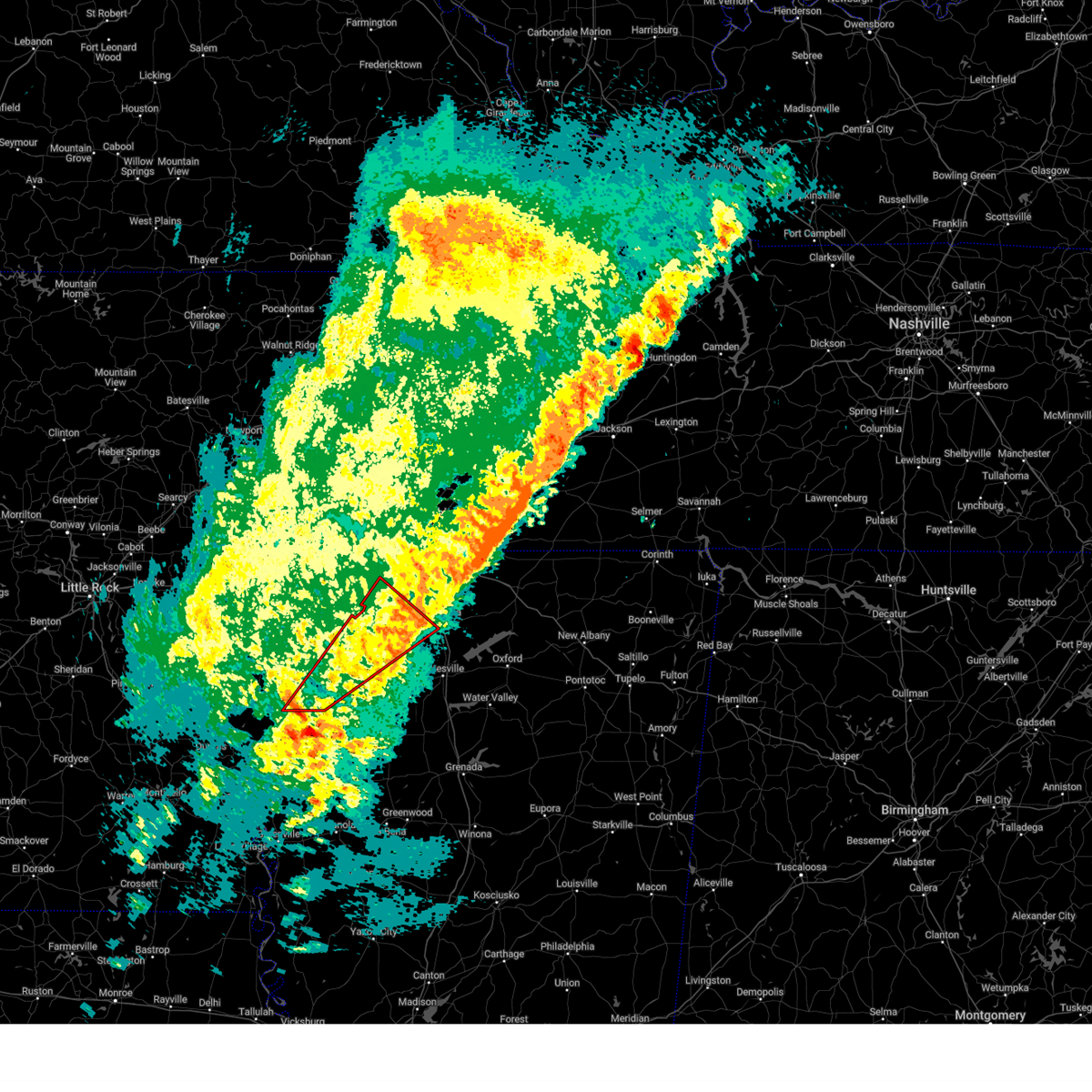 Tormeg the national weather service in memphis has issued a * tornado warning for, southeastern phillips county in eastern arkansas, coahoma county in northwestern mississippi, tunica county in northwestern mississippi, southwestern tate county in northwestern mississippi, northern quitman county in northwestern mississippi, northwestern panola county in northwestern mississippi, * until 815 pm cst. * at 740 pm cst, a severe thunderstorm capable of producing a tornado was located near sherard, or near elaine, moving northeast at 50 mph (radar indicated rotation). Hazards include tornado and quarter size hail. Flying debris will be dangerous to those caught without shelter. mobile homes will be damaged or destroyed. damage to roofs, windows, and vehicles will occur. Tree damage is likely. Tormeg the national weather service in memphis has issued a * tornado warning for, southeastern phillips county in eastern arkansas, coahoma county in northwestern mississippi, tunica county in northwestern mississippi, southwestern tate county in northwestern mississippi, northern quitman county in northwestern mississippi, northwestern panola county in northwestern mississippi, * until 815 pm cst. * at 740 pm cst, a severe thunderstorm capable of producing a tornado was located near sherard, or near elaine, moving northeast at 50 mph (radar indicated rotation). Hazards include tornado and quarter size hail. Flying debris will be dangerous to those caught without shelter. mobile homes will be damaged or destroyed. damage to roofs, windows, and vehicles will occur. Tree damage is likely.
|
| 1/5/2025 3:32 PM CST |
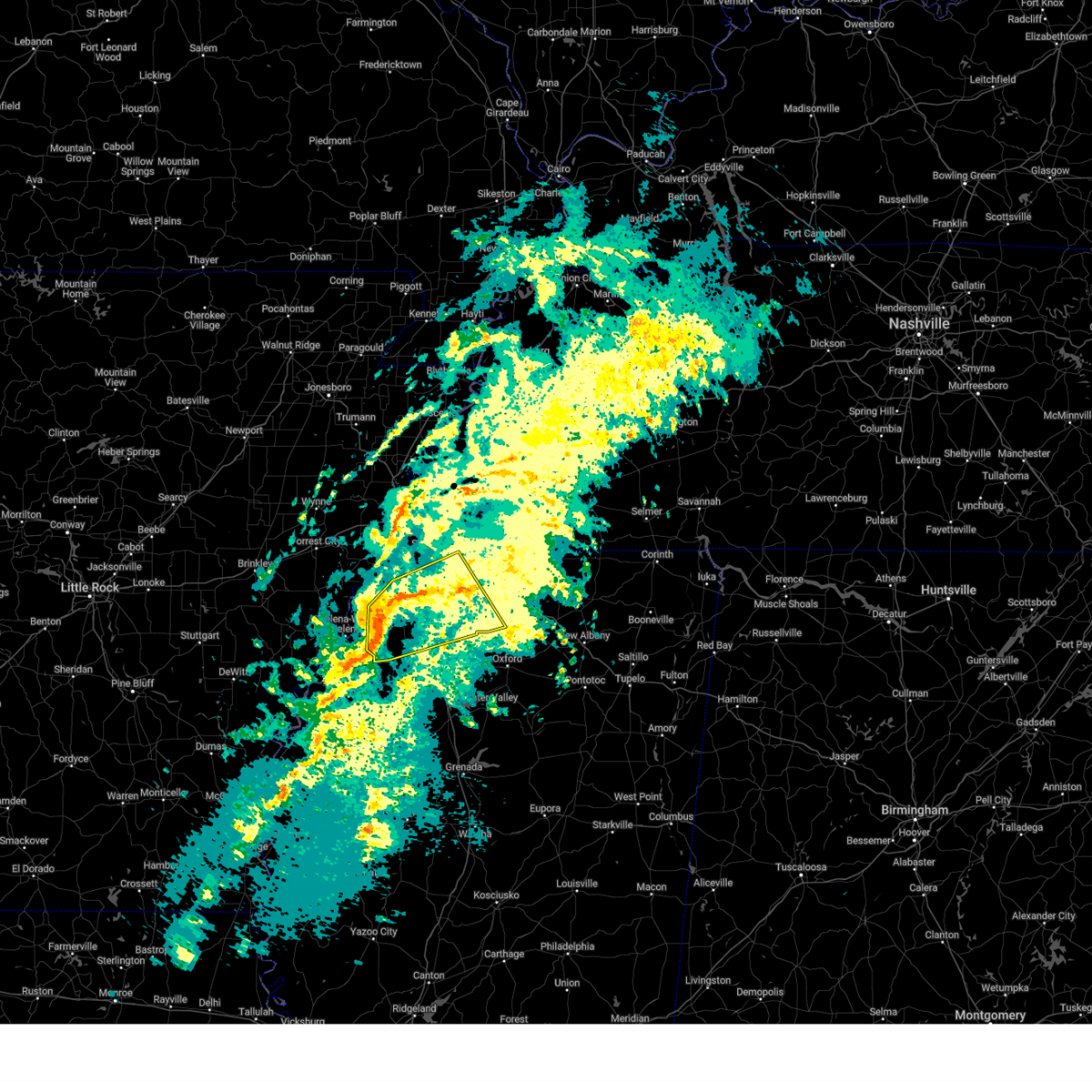 Svrmeg the national weather service in memphis has issued a * severe thunderstorm warning for, desoto county in northwestern mississippi, southwestern marshall county in northwestern mississippi, tunica county in northwestern mississippi, tate county in northwestern mississippi, northern quitman county in northwestern mississippi, northern panola county in northwestern mississippi, * until 415 pm cst. * at 332 pm cst, a severe thunderstorm was located over little texas, or 15 miles west of senatobia, moving northeast at 60 mph (radar indicated). Hazards include 60 mph wind gusts and penny size hail. expect damage to roofs, siding, and trees Svrmeg the national weather service in memphis has issued a * severe thunderstorm warning for, desoto county in northwestern mississippi, southwestern marshall county in northwestern mississippi, tunica county in northwestern mississippi, tate county in northwestern mississippi, northern quitman county in northwestern mississippi, northern panola county in northwestern mississippi, * until 415 pm cst. * at 332 pm cst, a severe thunderstorm was located over little texas, or 15 miles west of senatobia, moving northeast at 60 mph (radar indicated). Hazards include 60 mph wind gusts and penny size hail. expect damage to roofs, siding, and trees
|
| 5/22/2024 3:55 PM CDT |
 The storm which prompted the warning has weakened below severe limits, and no longer poses an immediate threat to life or property. therefore, the warning will be allowed to expire. a severe thunderstorm watch remains in effect until 700 pm cdt for eastern arkansas, and northwestern mississippi. The storm which prompted the warning has weakened below severe limits, and no longer poses an immediate threat to life or property. therefore, the warning will be allowed to expire. a severe thunderstorm watch remains in effect until 700 pm cdt for eastern arkansas, and northwestern mississippi.
|
| 5/22/2024 3:27 PM CDT |
 At 326 pm cdt, a severe thunderstorm was located 7 miles southeast of dundee, or 15 miles southeast of helena-west helena, moving east at 30 mph (radar indicated). Hazards include 60 mph wind gusts and quarter size hail. Hail damage to vehicles is expected. expect wind damage to roofs, siding, and trees. Locations impacted include, helena-west helena, friars point, crenshaw, sledge, darling, strayhorn, pleasant grove, dubbs, curtis station, dundee, little texas, coahoma, lula, falcon, askew, gerlach mill, moon, buxton, savage, and preston place. At 326 pm cdt, a severe thunderstorm was located 7 miles southeast of dundee, or 15 miles southeast of helena-west helena, moving east at 30 mph (radar indicated). Hazards include 60 mph wind gusts and quarter size hail. Hail damage to vehicles is expected. expect wind damage to roofs, siding, and trees. Locations impacted include, helena-west helena, friars point, crenshaw, sledge, darling, strayhorn, pleasant grove, dubbs, curtis station, dundee, little texas, coahoma, lula, falcon, askew, gerlach mill, moon, buxton, savage, and preston place.
|
| 5/22/2024 3:09 PM CDT |
 Svrmeg the national weather service in memphis has issued a * severe thunderstorm warning for, northeastern phillips county in eastern arkansas, northeastern coahoma county in northwestern mississippi, southern tunica county in northwestern mississippi, southwestern tate county in northwestern mississippi, northern quitman county in northwestern mississippi, northwestern panola county in northwestern mississippi, * until 400 pm cdt. * at 308 pm cdt, a severe thunderstorm was located near dundee, or near helena-west helena, moving east at 30 mph (radar indicated). Hazards include 60 mph wind gusts and quarter size hail. Hail damage to vehicles is expected. Expect wind damage to roofs, siding, and trees. Svrmeg the national weather service in memphis has issued a * severe thunderstorm warning for, northeastern phillips county in eastern arkansas, northeastern coahoma county in northwestern mississippi, southern tunica county in northwestern mississippi, southwestern tate county in northwestern mississippi, northern quitman county in northwestern mississippi, northwestern panola county in northwestern mississippi, * until 400 pm cdt. * at 308 pm cdt, a severe thunderstorm was located near dundee, or near helena-west helena, moving east at 30 mph (radar indicated). Hazards include 60 mph wind gusts and quarter size hail. Hail damage to vehicles is expected. Expect wind damage to roofs, siding, and trees.
|
| 12/9/2023 3:23 PM CST |
 The severe thunderstorm warning for northeastern coahoma, southeastern tunica, southwestern tate, quitman and panola counties will expire at 330 pm cst, the storm which prompted the warning has moved out of the area. therefore, the warning will be allowed to expire. a tornado watch remains in effect until 700 pm cst for northwestern mississippi. The severe thunderstorm warning for northeastern coahoma, southeastern tunica, southwestern tate, quitman and panola counties will expire at 330 pm cst, the storm which prompted the warning has moved out of the area. therefore, the warning will be allowed to expire. a tornado watch remains in effect until 700 pm cst for northwestern mississippi.
|
| 12/9/2023 3:04 PM CST |
 At 304 pm cst, a severe thunderstorm was located over darling, or 20 miles northeast of clarksdale, moving east at 50 mph (radar indicated). Hazards include 60 mph wind gusts and quarter size hail. Hail damage to vehicles is expected. expect wind damage to roofs, siding, and trees. locations impacted include, senatobia, batesville, marks, sardis, lambert, jonestown, como, crenshaw, sledge, belen, darling, pleasant grove, curtis station, dundee, lula, falcon, askew, gerlach mill, moon, and barksdale. hail threat, radar indicated max hail size, 1. 00 in wind threat, radar indicated max wind gust, 60 mph. At 304 pm cst, a severe thunderstorm was located over darling, or 20 miles northeast of clarksdale, moving east at 50 mph (radar indicated). Hazards include 60 mph wind gusts and quarter size hail. Hail damage to vehicles is expected. expect wind damage to roofs, siding, and trees. locations impacted include, senatobia, batesville, marks, sardis, lambert, jonestown, como, crenshaw, sledge, belen, darling, pleasant grove, curtis station, dundee, lula, falcon, askew, gerlach mill, moon, and barksdale. hail threat, radar indicated max hail size, 1. 00 in wind threat, radar indicated max wind gust, 60 mph.
|
| 12/9/2023 2:47 PM CST |
 At 247 pm cst, a severe thunderstorm was located near jonestown, or 9 miles north of clarksdale, moving east at 50 mph (radar indicated). Hazards include ping pong ball size hail and 60 mph wind gusts. People and animals outdoors will be injured. expect hail damage to roofs, siding, windows, and vehicles. Expect wind damage to roofs, siding, and trees. At 247 pm cst, a severe thunderstorm was located near jonestown, or 9 miles north of clarksdale, moving east at 50 mph (radar indicated). Hazards include ping pong ball size hail and 60 mph wind gusts. People and animals outdoors will be injured. expect hail damage to roofs, siding, windows, and vehicles. Expect wind damage to roofs, siding, and trees.
|
| 12/9/2023 2:45 PM CST |
 At 245 pm cst, a severe thunderstorm was located near jonestown, or 8 miles north of clarksdale, moving east at 50 mph (radar indicated). Hazards include 60 mph wind gusts and quarter size hail. Hail damage to vehicles is expected. Expect wind damage to roofs, siding, and trees. At 245 pm cst, a severe thunderstorm was located near jonestown, or 8 miles north of clarksdale, moving east at 50 mph (radar indicated). Hazards include 60 mph wind gusts and quarter size hail. Hail damage to vehicles is expected. Expect wind damage to roofs, siding, and trees.
|
| 9/6/2023 6:58 PM CDT |
 At 657 pm cdt, severe thunderstorms were located along a line extending from near denmark to 7 miles east of batesville to near sledge, moving southeast at 25 mph (radar indicated). Hazards include 60 mph wind gusts and quarter size hail. Hail damage to vehicles is expected. expect wind damage to roofs, siding, and trees. locations impacted include, oxford, batesville, water valley, holly springs national forest, john w kyle state park, sardis, crenshaw, crowder, sledge, pope, cambridge, pleasant grove, curtis station, darling, springdale, burgess, tula, denmark, paris and courtland. hail threat, radar indicated max hail size, 1. 00 in wind threat, radar indicated max wind gust, 60 mph. At 657 pm cdt, severe thunderstorms were located along a line extending from near denmark to 7 miles east of batesville to near sledge, moving southeast at 25 mph (radar indicated). Hazards include 60 mph wind gusts and quarter size hail. Hail damage to vehicles is expected. expect wind damage to roofs, siding, and trees. locations impacted include, oxford, batesville, water valley, holly springs national forest, john w kyle state park, sardis, crenshaw, crowder, sledge, pope, cambridge, pleasant grove, curtis station, darling, springdale, burgess, tula, denmark, paris and courtland. hail threat, radar indicated max hail size, 1. 00 in wind threat, radar indicated max wind gust, 60 mph.
|
| 9/6/2023 6:41 PM CDT |
 At 641 pm cdt, severe thunderstorms were located along a line extending from near cambridge to john w kyle state park to sledge, moving southeast at 25 mph (radar indicated). Hazards include 60 mph wind gusts and quarter size hail. Hail damage to vehicles is expected. Expect wind damage to roofs, siding, and trees. At 641 pm cdt, severe thunderstorms were located along a line extending from near cambridge to john w kyle state park to sledge, moving southeast at 25 mph (radar indicated). Hazards include 60 mph wind gusts and quarter size hail. Hail damage to vehicles is expected. Expect wind damage to roofs, siding, and trees.
|
| 6/14/2023 9:55 AM CDT |
 The severe thunderstorm warning for eastern coahoma, southeastern tunica, northern tallahatchie, quitman and panola counties will expire at 1000 am cdt, the storm which prompted the warning has moved out of the area. therefore, the warning will be allowed to expire. a severe thunderstorm watch remains in effect until 200 pm cdt for northwestern mississippi. The severe thunderstorm warning for eastern coahoma, southeastern tunica, northern tallahatchie, quitman and panola counties will expire at 1000 am cdt, the storm which prompted the warning has moved out of the area. therefore, the warning will be allowed to expire. a severe thunderstorm watch remains in effect until 200 pm cdt for northwestern mississippi.
|
| 6/14/2023 9:09 AM CDT |
 At 909 am cdt, a severe thunderstorm was located over friars point, or 10 miles east of elaine, moving east at 60 mph (radar indicated). Hazards include 60 mph wind gusts and quarter size hail. Hail damage to vehicles is expected. Expect wind damage to roofs, siding, and trees. At 909 am cdt, a severe thunderstorm was located over friars point, or 10 miles east of elaine, moving east at 60 mph (radar indicated). Hazards include 60 mph wind gusts and quarter size hail. Hail damage to vehicles is expected. Expect wind damage to roofs, siding, and trees.
|
| 6/11/2023 6:40 PM CDT |
 At 640 pm cdt, a severe thunderstorm was located over crenshaw, or 16 miles southwest of senatobia, moving east at 45 mph (radar indicated). Hazards include 60 mph wind gusts and quarter size hail. Hail damage to vehicles is expected. Expect wind damage to roofs, siding, and trees. At 640 pm cdt, a severe thunderstorm was located over crenshaw, or 16 miles southwest of senatobia, moving east at 45 mph (radar indicated). Hazards include 60 mph wind gusts and quarter size hail. Hail damage to vehicles is expected. Expect wind damage to roofs, siding, and trees.
|
| 4/27/2023 9:22 PM CDT |
 At 922 pm cdt, a severe thunderstorm was located over crenshaw, or 13 miles southwest of senatobia, moving east at 25 mph (radar indicated). Hazards include half dollar size hail. Damage to vehicles is expected. locations impacted include, senatobia, sardis, como, crenshaw, sledge, strayhorn, pleasant grove, little texas, askew, looxahoma, buxton, savage, crossroad, mcghee, longtown, sarah, horatio, new town, cypress corner and bluff. hail threat, radar indicated max hail size, 1. 25 in wind threat, radar indicated max wind gust, <50 mph. At 922 pm cdt, a severe thunderstorm was located over crenshaw, or 13 miles southwest of senatobia, moving east at 25 mph (radar indicated). Hazards include half dollar size hail. Damage to vehicles is expected. locations impacted include, senatobia, sardis, como, crenshaw, sledge, strayhorn, pleasant grove, little texas, askew, looxahoma, buxton, savage, crossroad, mcghee, longtown, sarah, horatio, new town, cypress corner and bluff. hail threat, radar indicated max hail size, 1. 25 in wind threat, radar indicated max wind gust, <50 mph.
|
| 4/27/2023 9:12 PM CDT |
 At 911 pm cdt, a severe thunderstorm was located near dubbs, or 18 miles west of senatobia, moving east at 25 mph (radar indicated). Hazards include quarter size hail. damage to vehicles is expected At 911 pm cdt, a severe thunderstorm was located near dubbs, or 18 miles west of senatobia, moving east at 25 mph (radar indicated). Hazards include quarter size hail. damage to vehicles is expected
|
| 3/1/2023 7:42 PM CST |
 At 742 pm cst, a severe thunderstorm was located over dundee, or 9 miles east of helena-west helena, moving east at 60 mph (radar indicated). Hazards include 60 mph wind gusts and quarter size hail. Hail damage to vehicles is expected. Expect wind damage to roofs, siding, and trees. At 742 pm cst, a severe thunderstorm was located over dundee, or 9 miles east of helena-west helena, moving east at 60 mph (radar indicated). Hazards include 60 mph wind gusts and quarter size hail. Hail damage to vehicles is expected. Expect wind damage to roofs, siding, and trees.
|
| 1/3/2023 5:42 AM CST |
 At 542 am cst, a severe thunderstorm was located over hernando, moving east at 45 mph (radar indicated). Hazards include 60 mph wind gusts. expect damage to roofs, siding, and trees At 542 am cst, a severe thunderstorm was located over hernando, moving east at 45 mph (radar indicated). Hazards include 60 mph wind gusts. expect damage to roofs, siding, and trees
|
| 7/18/2022 9:58 PM CDT |
 At 958 pm cdt, a severe thunderstorm was located near marks, or 15 miles west of batesville, moving north at 15 mph (radar indicated). Hazards include 60 mph wind gusts and quarter size hail. Hail damage to vehicles is expected. Expect wind damage to roofs, siding, and trees. At 958 pm cdt, a severe thunderstorm was located near marks, or 15 miles west of batesville, moving north at 15 mph (radar indicated). Hazards include 60 mph wind gusts and quarter size hail. Hail damage to vehicles is expected. Expect wind damage to roofs, siding, and trees.
|
| 5/15/2022 6:36 PM CDT |
 The severe thunderstorm warning for coahoma, northwestern tallahatchie and quitman counties will expire at 645 pm cdt, the storms which prompted the warning have weakened below severe limits, and no longer pose an immediate threat to life or property. therefore, the warning will be allowed to expire. however gusty winds are still possible with these thunderstorms. a severe thunderstorm watch remains in effect until 900 pm cdt for eastern arkansas, and northwestern mississippi. The severe thunderstorm warning for coahoma, northwestern tallahatchie and quitman counties will expire at 645 pm cdt, the storms which prompted the warning have weakened below severe limits, and no longer pose an immediate threat to life or property. therefore, the warning will be allowed to expire. however gusty winds are still possible with these thunderstorms. a severe thunderstorm watch remains in effect until 900 pm cdt for eastern arkansas, and northwestern mississippi.
|
| 5/15/2022 6:23 PM CDT |
 At 622 pm cdt, severe thunderstorms were located along a line extending from 6 miles west of sledge to 6 miles southwest of belen to 7 miles northeast of shelby, moving southeast at 35 mph (radar indicated). Hazards include 60 mph wind gusts and quarter size hail. Hail damage to vehicles is expected. expect wind damage to roofs, siding, and trees. locations impacted include, clarksdale, tutwiler, marks, lambert, jonestown, friars point, webb, sledge, sumner, belen, dublin, vance, darling, kings, sherard, coahoma, lyon, lula, falcon and mattson. hail threat, radar indicated max hail size, 1. 00 in wind threat, radar indicated max wind gust, 60 mph. At 622 pm cdt, severe thunderstorms were located along a line extending from 6 miles west of sledge to 6 miles southwest of belen to 7 miles northeast of shelby, moving southeast at 35 mph (radar indicated). Hazards include 60 mph wind gusts and quarter size hail. Hail damage to vehicles is expected. expect wind damage to roofs, siding, and trees. locations impacted include, clarksdale, tutwiler, marks, lambert, jonestown, friars point, webb, sledge, sumner, belen, dublin, vance, darling, kings, sherard, coahoma, lyon, lula, falcon and mattson. hail threat, radar indicated max hail size, 1. 00 in wind threat, radar indicated max wind gust, 60 mph.
|
| 5/15/2022 5:59 PM CDT |
 At 558 pm cdt, severe thunderstorms were located along a line extending from near helena-west helena to near kings to near crumrod, moving southeast at 50 mph (radar indicated). Hazards include 60 mph wind gusts and quarter size hail. Hail damage to vehicles is expected. expect wind damage to roofs, siding, and trees. locations impacted include, clarksdale, marvell, elaine, helena-west helena, white river national wildlife refuge, st francis national park, tutwiler, marks, lambert, jonestown, friars point, webb, sledge, sumner, lexa, belen, dublin, dubbs, dundee and watkins corner. hail threat, radar indicated max hail size, 1. 00 in wind threat, radar indicated max wind gust, 60 mph. At 558 pm cdt, severe thunderstorms were located along a line extending from near helena-west helena to near kings to near crumrod, moving southeast at 50 mph (radar indicated). Hazards include 60 mph wind gusts and quarter size hail. Hail damage to vehicles is expected. expect wind damage to roofs, siding, and trees. locations impacted include, clarksdale, marvell, elaine, helena-west helena, white river national wildlife refuge, st francis national park, tutwiler, marks, lambert, jonestown, friars point, webb, sledge, sumner, lexa, belen, dublin, dubbs, dundee and watkins corner. hail threat, radar indicated max hail size, 1. 00 in wind threat, radar indicated max wind gust, 60 mph.
|
| 5/15/2022 5:44 PM CDT |
 At 544 pm cdt, severe thunderstorms were located along a line extending from near st francis national park to 6 miles southwest of elaine, moving southeast at 45 mph (radar indicated). Hazards include 60 mph wind gusts and quarter size hail. Hail damage to vehicles is expected. Expect wind damage to roofs, siding, and trees. At 544 pm cdt, severe thunderstorms were located along a line extending from near st francis national park to 6 miles southwest of elaine, moving southeast at 45 mph (radar indicated). Hazards include 60 mph wind gusts and quarter size hail. Hail damage to vehicles is expected. Expect wind damage to roofs, siding, and trees.
|
| 5/5/2022 2:18 PM CDT |
 At 218 pm cdt, a severe thunderstorm was located 7 miles south of lexa, or 8 miles west of helena-west helena, moving east at 40 mph (radar indicated). Hazards include ping pong ball size hail and 60 mph wind gusts. People and animals outdoors will be injured. expect hail damage to roofs, siding, windows, and vehicles. Expect wind damage to roofs, siding, and trees. At 218 pm cdt, a severe thunderstorm was located 7 miles south of lexa, or 8 miles west of helena-west helena, moving east at 40 mph (radar indicated). Hazards include ping pong ball size hail and 60 mph wind gusts. People and animals outdoors will be injured. expect hail damage to roofs, siding, windows, and vehicles. Expect wind damage to roofs, siding, and trees.
|
| 4/13/2022 5:18 PM CDT |
 At 518 pm cdt, severe thunderstorms were located along a line extending from near robinsonville to near jonestown to 6 miles southwest of clarksdale, moving east at 45 mph (radar indicated). Hazards include 70 mph wind gusts. Expect considerable tree damage. damage is likely to mobile homes, roofs, and outbuildings. locations impacted include, southaven, horn lake, clarksdale, hernando, elaine, helena-west helena, st francis national park, jonestown, friars point, walls, tunica, crenshaw, belen, lake cormorant, strayhorn, eudora, dubbs, north tunica, dundee and arkabutla. thunderstorm damage threat, considerable hail threat, radar indicated max hail size, <. 75 in wind threat, radar indicated max wind gust, 70 mph. At 518 pm cdt, severe thunderstorms were located along a line extending from near robinsonville to near jonestown to 6 miles southwest of clarksdale, moving east at 45 mph (radar indicated). Hazards include 70 mph wind gusts. Expect considerable tree damage. damage is likely to mobile homes, roofs, and outbuildings. locations impacted include, southaven, horn lake, clarksdale, hernando, elaine, helena-west helena, st francis national park, jonestown, friars point, walls, tunica, crenshaw, belen, lake cormorant, strayhorn, eudora, dubbs, north tunica, dundee and arkabutla. thunderstorm damage threat, considerable hail threat, radar indicated max hail size, <. 75 in wind threat, radar indicated max wind gust, 70 mph.
|
| 4/13/2022 4:58 PM CDT |
 At 458 pm cdt, severe thunderstorms were located along a line extending from near hughes to near helena-west helena to elaine, moving east at 50 mph (radar indicated). Hazards include 70 mph wind gusts. Expect considerable tree damage. Damage is likely to mobile homes, roofs, and outbuildings. At 458 pm cdt, severe thunderstorms were located along a line extending from near hughes to near helena-west helena to elaine, moving east at 50 mph (radar indicated). Hazards include 70 mph wind gusts. Expect considerable tree damage. Damage is likely to mobile homes, roofs, and outbuildings.
|
| 3/30/2022 4:35 PM CDT |
 At 435 pm cdt, severe thunderstorms were located along a line extending from near como to near batesville to enid, moving northeast at 60 mph (radar indicated). Hazards include 70 mph wind gusts. Expect considerable tree damage. damage is likely to mobile homes, roofs, and outbuildings. Locations impacted include, batesville, charleston, george payne state park, marks, sardis, lambert, como, crowder, sledge, pope, belen, enid, paynes, darling, pleasant grove, sunnyside, curtis station, scobey, oakland and courtland. At 435 pm cdt, severe thunderstorms were located along a line extending from near como to near batesville to enid, moving northeast at 60 mph (radar indicated). Hazards include 70 mph wind gusts. Expect considerable tree damage. damage is likely to mobile homes, roofs, and outbuildings. Locations impacted include, batesville, charleston, george payne state park, marks, sardis, lambert, como, crowder, sledge, pope, belen, enid, paynes, darling, pleasant grove, sunnyside, curtis station, scobey, oakland and courtland.
|
| 3/30/2022 4:26 PM CDT |
 At 426 pm cdt, severe thunderstorms were located along a line extending from near pinckney to near phillipp to near crenshaw, moving northeast at 50 mph (radar indicated). Hazards include 70 mph wind gusts. Expect considerable tree damage. damage is likely to mobile homes, roofs, and outbuildings. locations impacted include, bartlett, southaven, collierville, germantown, olive branch, west memphis, horn lake, hernando, marion, millington, senatobia, t o fuller state park, cordova, memphis, lakeland, coldwater, como, walls, tunica and crenshaw. thunderstorm damage threat, considerable hail threat, radar indicated max hail size, <. 75 in wind threat, radar indicated max wind gust, 70 mph. At 426 pm cdt, severe thunderstorms were located along a line extending from near pinckney to near phillipp to near crenshaw, moving northeast at 50 mph (radar indicated). Hazards include 70 mph wind gusts. Expect considerable tree damage. damage is likely to mobile homes, roofs, and outbuildings. locations impacted include, bartlett, southaven, collierville, germantown, olive branch, west memphis, horn lake, hernando, marion, millington, senatobia, t o fuller state park, cordova, memphis, lakeland, coldwater, como, walls, tunica and crenshaw. thunderstorm damage threat, considerable hail threat, radar indicated max hail size, <. 75 in wind threat, radar indicated max wind gust, 70 mph.
|
| 3/30/2022 4:23 PM CDT |
 At 423 pm cdt, severe thunderstorms were located along a line extending from near curtis station to crowder to near charleston, moving northeast at 60 mph (radar indicated). Hazards include 70 mph wind gusts. Expect considerable tree damage. damage is likely to mobile homes, roofs, and outbuildings. Locations impacted include, batesville, charleston, george payne state park, tutwiler, marks, sardis, lambert, como, crowder, webb, sledge, sumner, pope, belen, enid, paynes, pleasant grove, curtis station, vance and darling. At 423 pm cdt, severe thunderstorms were located along a line extending from near curtis station to crowder to near charleston, moving northeast at 60 mph (radar indicated). Hazards include 70 mph wind gusts. Expect considerable tree damage. damage is likely to mobile homes, roofs, and outbuildings. Locations impacted include, batesville, charleston, george payne state park, tutwiler, marks, sardis, lambert, como, crowder, webb, sledge, sumner, pope, belen, enid, paynes, pleasant grove, curtis station, vance and darling.
|
| 3/30/2022 4:04 PM CDT |
 At 404 pm cdt, a severe thunderstorm was located over tunica, or 13 miles northeast of st francis national park, moving northeast at 60 mph (radar indicated). Hazards include 70 mph wind gusts. Expect considerable tree damage. Damage is likely to mobile homes, roofs, and outbuildings. At 404 pm cdt, a severe thunderstorm was located over tunica, or 13 miles northeast of st francis national park, moving northeast at 60 mph (radar indicated). Hazards include 70 mph wind gusts. Expect considerable tree damage. Damage is likely to mobile homes, roofs, and outbuildings.
|
| 3/30/2022 3:57 PM CDT |
 At 357 pm cdt, severe thunderstorms were located along a line extending from near dublin to near sumner to 6 miles east of drew, moving northeast at 60 mph (radar indicated). Hazards include 70 mph wind gusts. Expect considerable tree damage. Damage is likely to mobile homes, roofs, and outbuildings. At 357 pm cdt, severe thunderstorms were located along a line extending from near dublin to near sumner to 6 miles east of drew, moving northeast at 60 mph (radar indicated). Hazards include 70 mph wind gusts. Expect considerable tree damage. Damage is likely to mobile homes, roofs, and outbuildings.
|
| 3/30/2022 3:43 PM CDT |
 At 343 pm cdt, severe thunderstorms were located along a line extending from near friars point to near clarksdale to near rome, moving northeast at 55 mph (radar indicated). Hazards include 70 mph wind gusts. Expect considerable tree damage. damage is likely to mobile homes, roofs, and outbuildings. Locations impacted include, clarksdale, elaine, helena-west helena, st francis national park, marks, lambert, jonestown, friars point, tunica, sledge, belen, dublin, dubbs, north tunica, dundee, darling, kings, sherard, lake view and coahoma. At 343 pm cdt, severe thunderstorms were located along a line extending from near friars point to near clarksdale to near rome, moving northeast at 55 mph (radar indicated). Hazards include 70 mph wind gusts. Expect considerable tree damage. damage is likely to mobile homes, roofs, and outbuildings. Locations impacted include, clarksdale, elaine, helena-west helena, st francis national park, marks, lambert, jonestown, friars point, tunica, sledge, belen, dublin, dubbs, north tunica, dundee, darling, kings, sherard, lake view and coahoma.
|
| 3/30/2022 3:39 PM CDT |
 At 338 pm cdt, severe thunderstorms were located along a line extending from near friars point to clarksdale to 6 miles west of rome, moving northeast at 55 mph (radar indicated). Hazards include 70 mph wind gusts. Expect considerable tree damage. damage is likely to mobile homes, roofs, and outbuildings. locations impacted include, clarksdale, elaine, helena-west helena, st francis national park, marks, lambert, jonestown, friars point, tunica, sledge, belen, dublin, dubbs, north tunica, dundee, darling, kings, sherard, lake view and coahoma. thunderstorm damage threat, considerable hail threat, radar indicated max hail size, <. 75 in wind threat, radar indicated max wind gust, 70 mph. At 338 pm cdt, severe thunderstorms were located along a line extending from near friars point to clarksdale to 6 miles west of rome, moving northeast at 55 mph (radar indicated). Hazards include 70 mph wind gusts. Expect considerable tree damage. damage is likely to mobile homes, roofs, and outbuildings. locations impacted include, clarksdale, elaine, helena-west helena, st francis national park, marks, lambert, jonestown, friars point, tunica, sledge, belen, dublin, dubbs, north tunica, dundee, darling, kings, sherard, lake view and coahoma. thunderstorm damage threat, considerable hail threat, radar indicated max hail size, <. 75 in wind threat, radar indicated max wind gust, 70 mph.
|
| 3/30/2022 3:26 PM CDT |
 At 326 pm cdt, severe thunderstorms were located along a line extending from near elaine to 6 miles south of sherard to mound bayou, moving northeast at 55 mph (radar indicated). Hazards include 60 mph wind gusts. expect damage to roofs, siding, and trees At 326 pm cdt, severe thunderstorms were located along a line extending from near elaine to 6 miles south of sherard to mound bayou, moving northeast at 55 mph (radar indicated). Hazards include 60 mph wind gusts. expect damage to roofs, siding, and trees
|
| 2/22/2022 3:58 PM CST |
 At 358 pm cst, a severe thunderstorm was located near sledge, or 14 miles northwest of batesville, moving northeast at 40 mph (radar indicated). Hazards include 60 mph wind gusts. expect damage to roofs, siding, and trees At 358 pm cst, a severe thunderstorm was located near sledge, or 14 miles northwest of batesville, moving northeast at 40 mph (radar indicated). Hazards include 60 mph wind gusts. expect damage to roofs, siding, and trees
|
| 6/7/2021 7:31 PM CDT |
 At 731 pm cdt, severe thunderstorms were located along a line extending from near rondo to strayhorn to near batesville, moving northeast at 60 mph (radar indicated). Hazards include 60 mph wind gusts. Expect damage to roofs, siding, and trees. Locations impacted include, hernando, senatobia, batesville, john w kyle state park, sardis, coldwater, como, tunica, crenshaw, sledge, strayhorn, pleasant grove, eudora, dubbs, curtis station, north tunica, arkabutla, barr, phillipp and independence. At 731 pm cdt, severe thunderstorms were located along a line extending from near rondo to strayhorn to near batesville, moving northeast at 60 mph (radar indicated). Hazards include 60 mph wind gusts. Expect damage to roofs, siding, and trees. Locations impacted include, hernando, senatobia, batesville, john w kyle state park, sardis, coldwater, como, tunica, crenshaw, sledge, strayhorn, pleasant grove, eudora, dubbs, curtis station, north tunica, arkabutla, barr, phillipp and independence.
|
| 6/7/2021 7:17 PM CDT |
 At 717 pm cdt, severe thunderstorms were located along a line extending from near marvell to near crenshaw to near enid, moving northeast at 55 mph (radar indicated). Hazards include 60 mph wind gusts. Expect damage to roofs, siding, and trees. Locations impacted include, hernando, senatobia, batesville, john w kyle state park, sardis, coldwater, como, tunica, crenshaw, crowder, sledge, lake cormorant, strayhorn, pleasant grove, eudora, dubbs, curtis station, north tunica, arkabutla and barr. At 717 pm cdt, severe thunderstorms were located along a line extending from near marvell to near crenshaw to near enid, moving northeast at 55 mph (radar indicated). Hazards include 60 mph wind gusts. Expect damage to roofs, siding, and trees. Locations impacted include, hernando, senatobia, batesville, john w kyle state park, sardis, coldwater, como, tunica, crenshaw, crowder, sledge, lake cormorant, strayhorn, pleasant grove, eudora, dubbs, curtis station, north tunica, arkabutla and barr.
|
| 6/7/2021 7:02 PM CDT |
 At 701 pm cdt, severe thunderstorms were located along a line extending from near watkins corner to near darling to near charleston, moving northeast at 60 mph (radar indicated). Hazards include 60 mph wind gusts. Expect damage to roofs, siding, and trees. Locations impacted include, hernando, senatobia, batesville, john w kyle state park, sardis, coldwater, como, tunica, crenshaw, crowder, sledge, lake cormorant, strayhorn, pleasant grove, eudora, dubbs, curtis station, north tunica, arkabutla and barr. At 701 pm cdt, severe thunderstorms were located along a line extending from near watkins corner to near darling to near charleston, moving northeast at 60 mph (radar indicated). Hazards include 60 mph wind gusts. Expect damage to roofs, siding, and trees. Locations impacted include, hernando, senatobia, batesville, john w kyle state park, sardis, coldwater, como, tunica, crenshaw, crowder, sledge, lake cormorant, strayhorn, pleasant grove, eudora, dubbs, curtis station, north tunica, arkabutla and barr.
|
| 6/7/2021 6:54 PM CDT |
 At 654 pm cdt, severe thunderstorms were located along a line extending from 6 miles southeast of st. charles to near jonestown to charleston, moving northeast at 60 mph (radar indicated). Hazards include 60 mph wind gusts. expect damage to roofs, siding, and trees At 654 pm cdt, severe thunderstorms were located along a line extending from 6 miles southeast of st. charles to near jonestown to charleston, moving northeast at 60 mph (radar indicated). Hazards include 60 mph wind gusts. expect damage to roofs, siding, and trees
|
| 5/9/2021 5:39 PM CDT |
 At 539 pm cdt, a severe thunderstorm was located over little texas, or 18 miles west of senatobia, moving east at 35 mph (radar indicated). Hazards include 60 mph wind gusts and quarter size hail. Hail damage to vehicles is expected. Expect wind damage to roofs, siding, and trees. At 539 pm cdt, a severe thunderstorm was located over little texas, or 18 miles west of senatobia, moving east at 35 mph (radar indicated). Hazards include 60 mph wind gusts and quarter size hail. Hail damage to vehicles is expected. Expect wind damage to roofs, siding, and trees.
|
| 3/27/2021 10:19 PM CDT |
 At 1019 pm cdt, doppler radar indicated a severe thunderstorm producing a tornado was located over crenshaw, or 12 miles southwest of senatobia, moving east at 60 mph (radar indicated rotation). Hazards include tornado. Flying debris will be dangerous to those caught without shelter. mobile homes will be damaged or destroyed. damage to roofs, windows, and vehicles will occur. tree damage is likely. Locations impacted include, senatobia, sardis, coldwater, como, crenshaw, sledge, strayhorn, pleasant grove, little texas, askew, gerlach mill, buxton, savage, crossroad, sarah, rich, horatio, cypress corner, bluff and looxahoma. At 1019 pm cdt, doppler radar indicated a severe thunderstorm producing a tornado was located over crenshaw, or 12 miles southwest of senatobia, moving east at 60 mph (radar indicated rotation). Hazards include tornado. Flying debris will be dangerous to those caught without shelter. mobile homes will be damaged or destroyed. damage to roofs, windows, and vehicles will occur. tree damage is likely. Locations impacted include, senatobia, sardis, coldwater, como, crenshaw, sledge, strayhorn, pleasant grove, little texas, askew, gerlach mill, buxton, savage, crossroad, sarah, rich, horatio, cypress corner, bluff and looxahoma.
|
| 3/27/2021 10:05 PM CDT |
 At 1005 pm cdt, doppler radar indicated a severe thunderstorm producing a tornado was located over dundee, or 8 miles east of helena-west helena, moving east at 35 mph (radar indicated rotation). Hazards include tornado. Flying debris will be dangerous to those caught without shelter. mobile homes will be damaged or destroyed. damage to roofs, windows, and vehicles will occur. Tree damage is likely. At 1005 pm cdt, doppler radar indicated a severe thunderstorm producing a tornado was located over dundee, or 8 miles east of helena-west helena, moving east at 35 mph (radar indicated rotation). Hazards include tornado. Flying debris will be dangerous to those caught without shelter. mobile homes will be damaged or destroyed. damage to roofs, windows, and vehicles will occur. Tree damage is likely.
|
| 3/27/2021 9:37 PM CDT |
 At 937 pm cdt, doppler radar indicated a severe thunderstorm producing a tornado was located near elaine, moving east at 40 mph (radar indicated rotation). Hazards include tornado and quarter size hail. Flying debris will be dangerous to those caught without shelter. mobile homes will be damaged or destroyed. damage to roofs, windows, and vehicles will occur. Tree damage is likely. At 937 pm cdt, doppler radar indicated a severe thunderstorm producing a tornado was located near elaine, moving east at 40 mph (radar indicated rotation). Hazards include tornado and quarter size hail. Flying debris will be dangerous to those caught without shelter. mobile homes will be damaged or destroyed. damage to roofs, windows, and vehicles will occur. Tree damage is likely.
|
| 3/17/2021 7:12 AM CDT |
 The national weather service in memphis has issued a * severe thunderstorm warning for. western lafayette county in northwestern mississippi. northern yalobusha county in northwestern mississippi. southwestern marshall county in northwestern mississippi. Southeastern tate county in northwestern mississippi. The national weather service in memphis has issued a * severe thunderstorm warning for. western lafayette county in northwestern mississippi. northern yalobusha county in northwestern mississippi. southwestern marshall county in northwestern mississippi. Southeastern tate county in northwestern mississippi.
|
| 3/17/2021 7:02 AM CDT |
 At 701 am cdt, a severe thunderstorm was located near crowder, or 14 miles southwest of batesville, moving east at 50 mph (radar indicated). Hazards include 60 mph wind gusts and quarter size hail. Hail damage to vehicles is expected. expect wind damage to roofs, siding, and trees. Locations impacted include, clarksdale, batesville, charleston, tutwiler, marks, lambert, jonestown, como, crenshaw, crowder, sledge, pope, belen, enid, dublin, pleasant grove, curtis station, dundee, vance and darling. At 701 am cdt, a severe thunderstorm was located near crowder, or 14 miles southwest of batesville, moving east at 50 mph (radar indicated). Hazards include 60 mph wind gusts and quarter size hail. Hail damage to vehicles is expected. expect wind damage to roofs, siding, and trees. Locations impacted include, clarksdale, batesville, charleston, tutwiler, marks, lambert, jonestown, como, crenshaw, crowder, sledge, pope, belen, enid, dublin, pleasant grove, curtis station, dundee, vance and darling.
|
| 3/17/2021 6:51 AM CDT |
 At 651 am cdt, a severe thunderstorm was located over lambert, or 14 miles east of clarksdale, moving east at 45 mph (radar indicated). Hazards include 60 mph wind gusts and quarter size hail. Hail damage to vehicles is expected. expect wind damage to roofs, siding, and trees. Locations impacted include, clarksdale, batesville, charleston, helena-west helena, tutwiler, marks, lambert, jonestown, como, friars point, crenshaw, crowder, sledge, pope, belen, enid, dublin, pleasant grove, curtis station and dundee. At 651 am cdt, a severe thunderstorm was located over lambert, or 14 miles east of clarksdale, moving east at 45 mph (radar indicated). Hazards include 60 mph wind gusts and quarter size hail. Hail damage to vehicles is expected. expect wind damage to roofs, siding, and trees. Locations impacted include, clarksdale, batesville, charleston, helena-west helena, tutwiler, marks, lambert, jonestown, como, friars point, crenshaw, crowder, sledge, pope, belen, enid, dublin, pleasant grove, curtis station and dundee.
|
| 3/17/2021 6:35 AM CDT |
 At 635 am cdt, a severe thunderstorm was located near clarksdale, moving east at 50 mph (radar indicated). Hazards include 60 mph wind gusts and quarter size hail. Hail damage to vehicles is expected. Expect wind damage to roofs, siding, and trees. At 635 am cdt, a severe thunderstorm was located near clarksdale, moving east at 50 mph (radar indicated). Hazards include 60 mph wind gusts and quarter size hail. Hail damage to vehicles is expected. Expect wind damage to roofs, siding, and trees.
|
| 6/5/2020 3:04 PM CDT |
 At 304 pm cdt, severe thunderstorms were located along a line extending from near tula to crowder, moving southeast at 50 mph (radar indicated). Hazards include 60 mph wind gusts. Expect damage to roofs, siding, and trees. Locations impacted include, oxford, batesville, water valley, charleston, george payne state park, holly springs national forest, john w kyle state park, marks, sardis, lambert, como, crowder, sledge, pope, enid, darling, pleasant grove, springdale, curtis station and burgess. At 304 pm cdt, severe thunderstorms were located along a line extending from near tula to crowder, moving southeast at 50 mph (radar indicated). Hazards include 60 mph wind gusts. Expect damage to roofs, siding, and trees. Locations impacted include, oxford, batesville, water valley, charleston, george payne state park, holly springs national forest, john w kyle state park, marks, sardis, lambert, como, crowder, sledge, pope, enid, darling, pleasant grove, springdale, curtis station and burgess.
|
| 6/5/2020 2:47 PM CDT |
 At 246 pm cdt, severe thunderstorms were located along a line extending from near holly springs national forest to near darling, moving southeast at 50 mph (radar indicated). Hazards include 60 mph wind gusts. expect damage to roofs, siding, and trees At 246 pm cdt, severe thunderstorms were located along a line extending from near holly springs national forest to near darling, moving southeast at 50 mph (radar indicated). Hazards include 60 mph wind gusts. expect damage to roofs, siding, and trees
|
| 6/5/2020 2:21 PM CDT |
 At 221 pm cdt, severe thunderstorms were located along a line extending from near gravestown to near harmontown to near crenshaw, moving south at 35 mph (radar indicated). Hazards include 60 mph wind gusts and penny size hail. Expect damage to roofs, siding, and trees. Locations impacted include, hernando, senatobia, holly springs, wall doxey state park, john w kyle state park, lamar, sardis, coldwater, byhalia, como, tunica, crenshaw, sledge, snow lake shores, strayhorn, dubbs, bethlehem, north tunica, red banks and laws hill. At 221 pm cdt, severe thunderstorms were located along a line extending from near gravestown to near harmontown to near crenshaw, moving south at 35 mph (radar indicated). Hazards include 60 mph wind gusts and penny size hail. Expect damage to roofs, siding, and trees. Locations impacted include, hernando, senatobia, holly springs, wall doxey state park, john w kyle state park, lamar, sardis, coldwater, byhalia, como, tunica, crenshaw, sledge, snow lake shores, strayhorn, dubbs, bethlehem, north tunica, red banks and laws hill.
|
| 6/5/2020 1:54 PM CDT |
 At 154 pm cdt, severe thunderstorms were located along a line extending from near lamar to near byhalia to near north tunica, moving south at 40 mph (radar indicated). Hazards include 60 mph wind gusts. expect damage to roofs, siding, and trees At 154 pm cdt, severe thunderstorms were located along a line extending from near lamar to near byhalia to near north tunica, moving south at 40 mph (radar indicated). Hazards include 60 mph wind gusts. expect damage to roofs, siding, and trees
|
| 5/28/2020 1:15 PM CDT |
 At 115 pm cdt, a severe thunderstorm was located over crenshaw, or 15 miles southwest of senatobia, moving northeast at 30 mph (radar indicated). Hazards include 60 mph wind gusts. expect damage to roofs, siding, and trees At 115 pm cdt, a severe thunderstorm was located over crenshaw, or 15 miles southwest of senatobia, moving northeast at 30 mph (radar indicated). Hazards include 60 mph wind gusts. expect damage to roofs, siding, and trees
|
| 4/12/2020 9:52 PM CDT |
 At 952 pm cdt, severe thunderstorms were located along a line extending from widener to 7 miles north of dundee to near belen, moving northeast at 65 mph (radar indicated). Hazards include 70 mph wind gusts. Expect considerable tree damage. damage is likely to mobile homes, roofs, and outbuildings. Locations impacted include, st francis national park, marks, lambert, tunica, crenshaw, crowder, sledge, dubbs, brickeys, curtis station, north tunica, dundee, vance, darling, robinsonville, little texas, lula, falcon, glendora and cody. At 952 pm cdt, severe thunderstorms were located along a line extending from widener to 7 miles north of dundee to near belen, moving northeast at 65 mph (radar indicated). Hazards include 70 mph wind gusts. Expect considerable tree damage. damage is likely to mobile homes, roofs, and outbuildings. Locations impacted include, st francis national park, marks, lambert, tunica, crenshaw, crowder, sledge, dubbs, brickeys, curtis station, north tunica, dundee, vance, darling, robinsonville, little texas, lula, falcon, glendora and cody.
|
| 4/12/2020 9:50 PM CDT |
 At 950 pm cdt, severe thunderstorms were located along a line extending from madison to 6 miles southeast of dundee to tutwiler, moving northeast at 70 mph (radar indicated). Hazards include 70 mph wind gusts. Expect considerable tree damage. Damage is likely to mobile homes, roofs, and outbuildings. At 950 pm cdt, severe thunderstorms were located along a line extending from madison to 6 miles southeast of dundee to tutwiler, moving northeast at 70 mph (radar indicated). Hazards include 70 mph wind gusts. Expect considerable tree damage. Damage is likely to mobile homes, roofs, and outbuildings.
|
| 4/12/2020 9:47 PM CDT |
 At 947 pm cdt, severe thunderstorms were located along a line extending from near madison to near dundee to near dublin, moving northeast at 65 mph (radar indicated). Hazards include 70 mph wind gusts. Expect considerable tree damage. damage is likely to mobile homes, roofs, and outbuildings. Locations impacted include, clarksdale, marianna, elaine, st francis national park, helena-west helena, tutwiler, marks, lambert, jonestown, friars point, tunica, crenshaw, crowder, webb, sledge, sumner, lexa, rondo, haynes and belen. At 947 pm cdt, severe thunderstorms were located along a line extending from near madison to near dundee to near dublin, moving northeast at 65 mph (radar indicated). Hazards include 70 mph wind gusts. Expect considerable tree damage. damage is likely to mobile homes, roofs, and outbuildings. Locations impacted include, clarksdale, marianna, elaine, st francis national park, helena-west helena, tutwiler, marks, lambert, jonestown, friars point, tunica, crenshaw, crowder, webb, sledge, sumner, lexa, rondo, haynes and belen.
|
| 4/12/2020 9:31 PM CDT |
 At 931 pm cdt, severe thunderstorms were located along a line extending from near wheatley to near marvell to 6 miles south of sherard, moving northeast at 65 mph (radar indicated). Hazards include 70 mph wind gusts. Expect considerable tree damage. Damage is likely to mobile homes, roofs, and outbuildings. At 931 pm cdt, severe thunderstorms were located along a line extending from near wheatley to near marvell to 6 miles south of sherard, moving northeast at 65 mph (radar indicated). Hazards include 70 mph wind gusts. Expect considerable tree damage. Damage is likely to mobile homes, roofs, and outbuildings.
|
| 3/28/2020 8:00 PM CDT |
 At 800 pm cdt, severe thunderstorms were located along a line extending from near como to drew, moving east at 35 mph (radar indicated). Hazards include 60 mph wind gusts. Expect damage to roofs, siding, and trees. Locations impacted include, senatobia, batesville, charleston, john w kyle state park, tutwiler, marks, sardis, coldwater, lambert, como, crenshaw, crowder, webb, sledge, sumner, pope, belen, strayhorn, pleasant grove and curtis station. At 800 pm cdt, severe thunderstorms were located along a line extending from near como to drew, moving east at 35 mph (radar indicated). Hazards include 60 mph wind gusts. Expect damage to roofs, siding, and trees. Locations impacted include, senatobia, batesville, charleston, john w kyle state park, tutwiler, marks, sardis, coldwater, lambert, como, crenshaw, crowder, webb, sledge, sumner, pope, belen, strayhorn, pleasant grove and curtis station.
|
| 3/28/2020 7:37 PM CDT |
 At 737 pm cdt, severe thunderstorms were located along a line extending from near crenshaw to renova, moving east at 35 mph (radar indicated). Hazards include 60 mph wind gusts. expect damage to roofs, siding, and trees At 737 pm cdt, severe thunderstorms were located along a line extending from near crenshaw to renova, moving east at 35 mph (radar indicated). Hazards include 60 mph wind gusts. expect damage to roofs, siding, and trees
|
| 3/28/2020 7:16 PM CDT |
 At 716 pm cdt, severe thunderstorms were located along a line extending from robinsonville to near dubbs to near clarksdale, moving east at 35 mph (radar indicated). Hazards include 70 mph wind gusts. Expect considerable tree damage. damage is likely to mobile homes, roofs, and outbuildings. Locations impacted include, clarksdale, helena-west helena, jonestown, friars point, tunica, crenshaw, sledge, belen, strayhorn, eudora, dubbs, north tunica, dundee, arkabutla, darling, kings, phillipp, sherard, robinsonville and little texas. At 716 pm cdt, severe thunderstorms were located along a line extending from robinsonville to near dubbs to near clarksdale, moving east at 35 mph (radar indicated). Hazards include 70 mph wind gusts. Expect considerable tree damage. damage is likely to mobile homes, roofs, and outbuildings. Locations impacted include, clarksdale, helena-west helena, jonestown, friars point, tunica, crenshaw, sledge, belen, strayhorn, eudora, dubbs, north tunica, dundee, arkabutla, darling, kings, phillipp, sherard, robinsonville and little texas.
|
| 3/28/2020 7:06 PM CDT |
 At 706 pm cdt, severe thunderstorms were located along a line extending from near hughes to dundee to near sherard, moving east at 35 mph (radar indicated). Hazards include 60 mph wind gusts. Expect damage to roofs, siding, and trees. Locations impacted include, clarksdale, helena-west helena, st francis national park, jonestown, friars point, tunica, crenshaw, sledge, belen, strayhorn, eudora, dubbs, north tunica, dundee, arkabutla, darling, kings, phillipp, sherard and robinsonville. At 706 pm cdt, severe thunderstorms were located along a line extending from near hughes to dundee to near sherard, moving east at 35 mph (radar indicated). Hazards include 60 mph wind gusts. Expect damage to roofs, siding, and trees. Locations impacted include, clarksdale, helena-west helena, st francis national park, jonestown, friars point, tunica, crenshaw, sledge, belen, strayhorn, eudora, dubbs, north tunica, dundee, arkabutla, darling, kings, phillipp, sherard and robinsonville.
|
| 3/28/2020 6:57 PM CDT |
 At 657 pm cdt, severe thunderstorms were located along a line extending from near hughes to near dundee to sherard, moving east at 35 mph (radar indicated). Hazards include 60 mph wind gusts and quarter size hail. Hail damage to vehicles is expected. Expect wind damage to roofs, siding, and trees. At 657 pm cdt, severe thunderstorms were located along a line extending from near hughes to near dundee to sherard, moving east at 35 mph (radar indicated). Hazards include 60 mph wind gusts and quarter size hail. Hail damage to vehicles is expected. Expect wind damage to roofs, siding, and trees.
|
| 1/11/2020 4:51 AM CST |
 At 450 am cst, severe thunderstorms were located along a line extending from near strayhorn to near lambert, moving northeast at 30 mph (radar indicated). Hazards include 60 mph wind gusts. Expect damage to roofs, siding, and trees. Locations impacted include, senatobia, batesville, marks, sardis, coldwater, lambert, como, crenshaw, crowder, sledge, pope, vance, darling, strayhorn, pleasant grove, curtis station, arkabutla, lewisburg, courtland and falcon. At 450 am cst, severe thunderstorms were located along a line extending from near strayhorn to near lambert, moving northeast at 30 mph (radar indicated). Hazards include 60 mph wind gusts. Expect damage to roofs, siding, and trees. Locations impacted include, senatobia, batesville, marks, sardis, coldwater, lambert, como, crenshaw, crowder, sledge, pope, vance, darling, strayhorn, pleasant grove, curtis station, arkabutla, lewisburg, courtland and falcon.
|
| 1/11/2020 4:29 AM CST |
 At 428 am cst, severe thunderstorms were located along a line extending from near dubbs to near dublin, moving northeast at 30 mph (radar indicated). Hazards include 60 mph wind gusts. expect damage to roofs, siding, and trees At 428 am cst, severe thunderstorms were located along a line extending from near dubbs to near dublin, moving northeast at 30 mph (radar indicated). Hazards include 60 mph wind gusts. expect damage to roofs, siding, and trees
|
| 11/30/2019 2:00 PM CST |
 At 200 pm cst, a severe thunderstorm was located over marks, or 17 miles east of clarksdale, moving northeast at 70 mph (radar indicated). Hazards include 60 mph wind gusts and quarter size hail. Hail damage to vehicles is expected. Expect wind damage to roofs, siding, and trees. At 200 pm cst, a severe thunderstorm was located over marks, or 17 miles east of clarksdale, moving northeast at 70 mph (radar indicated). Hazards include 60 mph wind gusts and quarter size hail. Hail damage to vehicles is expected. Expect wind damage to roofs, siding, and trees.
|
| 3/13/2019 9:37 PM CDT |
 At 936 pm cdt, a severe thunderstorm was located 14 miles west of batesville, moving northeast at 40 mph (radar indicated). Hazards include 60 mph wind gusts and quarter size hail. Hail damage to vehicles is expected. Expect wind damage to roofs, siding, and trees. At 936 pm cdt, a severe thunderstorm was located 14 miles west of batesville, moving northeast at 40 mph (radar indicated). Hazards include 60 mph wind gusts and quarter size hail. Hail damage to vehicles is expected. Expect wind damage to roofs, siding, and trees.
|
| 3/13/2019 9:30 PM CDT |
 At 930 pm cdt, a severe thunderstorm was located over marks, or 17 miles east of clarksdale, moving northeast at 60 mph (radar indicated). Hazards include 70 mph wind gusts and quarter size hail. Hail damage to vehicles is expected. expect considerable tree damage. wind damage is also likely to mobile homes, roofs, and outbuildings. Locations impacted include, marks, lambert, crowder, sledge, belen, vance, darling, falcon, west marks, barksdale, denton, riverview, longstreet, hinchcliff, sabino and essex. At 930 pm cdt, a severe thunderstorm was located over marks, or 17 miles east of clarksdale, moving northeast at 60 mph (radar indicated). Hazards include 70 mph wind gusts and quarter size hail. Hail damage to vehicles is expected. expect considerable tree damage. wind damage is also likely to mobile homes, roofs, and outbuildings. Locations impacted include, marks, lambert, crowder, sledge, belen, vance, darling, falcon, west marks, barksdale, denton, riverview, longstreet, hinchcliff, sabino and essex.
|
| 3/13/2019 9:04 PM CDT |
 At 904 pm cdt, a severe thunderstorm was located 8 miles northeast of shelby, moving northeast at 60 mph (radar indicated). Hazards include 60 mph wind gusts. expect damage to roofs, siding, and trees At 904 pm cdt, a severe thunderstorm was located 8 miles northeast of shelby, moving northeast at 60 mph (radar indicated). Hazards include 60 mph wind gusts. expect damage to roofs, siding, and trees
|
| 1/19/2019 5:41 AM CST |
 At 541 am cst, a severe thunderstorm was located over horn lake, moving northeast at 70 mph (radar indicated). Hazards include 60 mph wind gusts. Expect damage to roofs, siding, and trees. Locations impacted include, southaven, olive branch, horn lake, hernando, helena-west helena, friars point, walls, tunica, crenshaw, sledge, lake cormorant, strayhorn, eudora, dubbs, north tunica, dundee, arkabutla, lynchburg, phillipp and robinsonville. At 541 am cst, a severe thunderstorm was located over horn lake, moving northeast at 70 mph (radar indicated). Hazards include 60 mph wind gusts. Expect damage to roofs, siding, and trees. Locations impacted include, southaven, olive branch, horn lake, hernando, helena-west helena, friars point, walls, tunica, crenshaw, sledge, lake cormorant, strayhorn, eudora, dubbs, north tunica, dundee, arkabutla, lynchburg, phillipp and robinsonville.
|
| 1/19/2019 5:30 AM CST |
 At 530 am cst, a severe thunderstorm was located near lake cormorant, or 13 miles southwest of horn lake, moving northeast at 55 mph (radar indicated). Hazards include 60 mph wind gusts. Expect damage to roofs, siding, and trees. Locations impacted include, southaven, olive branch, horn lake, hernando, helena-west helena, st francis national park, friars point, walls, tunica, crenshaw, sledge, horseshoe lake, lake cormorant, strayhorn, eudora, dubbs, north tunica, dundee, arkabutla and pinckney. At 530 am cst, a severe thunderstorm was located near lake cormorant, or 13 miles southwest of horn lake, moving northeast at 55 mph (radar indicated). Hazards include 60 mph wind gusts. Expect damage to roofs, siding, and trees. Locations impacted include, southaven, olive branch, horn lake, hernando, helena-west helena, st francis national park, friars point, walls, tunica, crenshaw, sledge, horseshoe lake, lake cormorant, strayhorn, eudora, dubbs, north tunica, dundee, arkabutla and pinckney.
|
| 1/19/2019 5:24 AM CST |
 At 524 am cst, a severe thunderstorm was located over robinsonville, or 12 miles southeast of hughes, moving northeast at 70 mph (radar indicated). Hazards include 60 mph wind gusts. expect damage to roofs, siding, and trees At 524 am cst, a severe thunderstorm was located over robinsonville, or 12 miles southeast of hughes, moving northeast at 70 mph (radar indicated). Hazards include 60 mph wind gusts. expect damage to roofs, siding, and trees
|
| 12/1/2018 7:49 AM CST |
 At 749 am cst, a severe thunderstorm was located near como, or near senatobia, moving northeast at 65 mph (radar indicated). Hazards include 70 mph wind gusts and ping pong ball size hail. People and animals outdoors will be injured. expect hail damage to roofs, siding, windows, and vehicles. expect considerable tree damage. wind damage is also likely to mobile homes, roofs, and outbuildings. Locations impacted include, marks, lambert, como, crenshaw, sledge, belen, darling, pleasant grove, curtis station, falcon, askew, gerlach mill, mims, buxton, asa, essex, horatio, cypress corner, west marks and riverview. At 749 am cst, a severe thunderstorm was located near como, or near senatobia, moving northeast at 65 mph (radar indicated). Hazards include 70 mph wind gusts and ping pong ball size hail. People and animals outdoors will be injured. expect hail damage to roofs, siding, windows, and vehicles. expect considerable tree damage. wind damage is also likely to mobile homes, roofs, and outbuildings. Locations impacted include, marks, lambert, como, crenshaw, sledge, belen, darling, pleasant grove, curtis station, falcon, askew, gerlach mill, mims, buxton, asa, essex, horatio, cypress corner, west marks and riverview.
|
| 12/1/2018 7:43 AM CST |
 At 743 am cst, a severe thunderstorm was located near pleasant grove, or 12 miles southwest of senatobia, moving northeast at 65 mph (radar indicated). Hazards include 70 mph wind gusts and ping pong ball size hail. People and animals outdoors will be injured. expect hail damage to roofs, siding, windows, and vehicles. expect considerable tree damage. wind damage is also likely to mobile homes, roofs, and outbuildings. Locations impacted include, marks, lambert, como, crenshaw, sledge, belen, darling, pleasant grove, curtis station, dundee, falcon, askew, gerlach mill, mims, barksdale, buxton, jeffries, asa, sabino and essex. At 743 am cst, a severe thunderstorm was located near pleasant grove, or 12 miles southwest of senatobia, moving northeast at 65 mph (radar indicated). Hazards include 70 mph wind gusts and ping pong ball size hail. People and animals outdoors will be injured. expect hail damage to roofs, siding, windows, and vehicles. expect considerable tree damage. wind damage is also likely to mobile homes, roofs, and outbuildings. Locations impacted include, marks, lambert, como, crenshaw, sledge, belen, darling, pleasant grove, curtis station, dundee, falcon, askew, gerlach mill, mims, barksdale, buxton, jeffries, asa, sabino and essex.
|
| 12/1/2018 7:22 AM CST |
 At 722 am cst, a severe thunderstorm was located over jonestown, or 10 miles northeast of clarksdale, moving northeast at 65 mph (radar indicated). Hazards include 70 mph wind gusts and ping pong ball size hail. People and animals outdoors will be injured. expect hail damage to roofs, siding, windows, and vehicles. expect considerable tree damage. wind damage is also likely to mobile homes, roofs, and outbuildings. locations impacted include, clarksdale, helena-west helena, marks, lambert, jonestown, como, friars point, crenshaw, crowder, sledge, belen, dublin, pleasant grove, curtis station, dundee, vance, darling, kings, sherard and coahoma. A tornado watch remains in effect until 800 am cst for eastern arkansas. At 722 am cst, a severe thunderstorm was located over jonestown, or 10 miles northeast of clarksdale, moving northeast at 65 mph (radar indicated). Hazards include 70 mph wind gusts and ping pong ball size hail. People and animals outdoors will be injured. expect hail damage to roofs, siding, windows, and vehicles. expect considerable tree damage. wind damage is also likely to mobile homes, roofs, and outbuildings. locations impacted include, clarksdale, helena-west helena, marks, lambert, jonestown, como, friars point, crenshaw, crowder, sledge, belen, dublin, pleasant grove, curtis station, dundee, vance, darling, kings, sherard and coahoma. A tornado watch remains in effect until 800 am cst for eastern arkansas.
|
| 12/1/2018 7:08 AM CST |
 At 707 am cst, a severe thunderstorm was located over sherard, or 7 miles west of clarksdale, moving northeast at 65 mph (radar indicated). Hazards include 70 mph wind gusts and ping pong ball size hail. People and animals outdoors will be injured. expect hail damage to roofs, siding, windows, and vehicles. expect considerable tree damage. Wind damage is also likely to mobile homes, roofs, and outbuildings. At 707 am cst, a severe thunderstorm was located over sherard, or 7 miles west of clarksdale, moving northeast at 65 mph (radar indicated). Hazards include 70 mph wind gusts and ping pong ball size hail. People and animals outdoors will be injured. expect hail damage to roofs, siding, windows, and vehicles. expect considerable tree damage. Wind damage is also likely to mobile homes, roofs, and outbuildings.
|
| 11/5/2018 8:07 PM CST |
 At 806 pm cst, doppler radar indicated a severe thunderstorm producing a tornado was located over belen, or 15 miles east of clarksdale, moving northeast at 45 mph (radar indicated rotation). Hazards include tornado. Flying debris will be dangerous to those caught without shelter. mobile homes will be damaged or destroyed. damage to roofs, windows, and vehicles will occur. tree damage is likely. Locations impacted include, batesville, marks, sardis, lambert, como, sledge, curtis station, belen, darling, pleasant grove, falcon, west marks, riverview, asa, ballentine, hinchcliff, locke station, essex and horatio. At 806 pm cst, doppler radar indicated a severe thunderstorm producing a tornado was located over belen, or 15 miles east of clarksdale, moving northeast at 45 mph (radar indicated rotation). Hazards include tornado. Flying debris will be dangerous to those caught without shelter. mobile homes will be damaged or destroyed. damage to roofs, windows, and vehicles will occur. tree damage is likely. Locations impacted include, batesville, marks, sardis, lambert, como, sledge, curtis station, belen, darling, pleasant grove, falcon, west marks, riverview, asa, ballentine, hinchcliff, locke station, essex and horatio.
|
| 11/5/2018 7:52 PM CST |
 At 751 pm cst, doppler radar indicated a severe thunderstorm producing a tornado was located near clarksdale, moving northeast at 50 mph (radar indicated rotation). Hazards include tornado. Flying debris will be dangerous to those caught without shelter. mobile homes will be damaged or destroyed. damage to roofs, windows, and vehicles will occur. Tree damage is likely. At 751 pm cst, doppler radar indicated a severe thunderstorm producing a tornado was located near clarksdale, moving northeast at 50 mph (radar indicated rotation). Hazards include tornado. Flying debris will be dangerous to those caught without shelter. mobile homes will be damaged or destroyed. damage to roofs, windows, and vehicles will occur. Tree damage is likely.
|
| 8/20/2018 4:58 PM CDT |
 At 457 pm cdt, doppler radar indicated a severe thunderstorm producing a tornado was located over darling, or 19 miles northeast of clarksdale, moving east at 30 mph (radar indicated rotation). Hazards include tornado and golf ball size hail. Flying debris will be dangerous to those caught without shelter. mobile homes will be damaged or destroyed. damage to roofs, windows, and vehicles will occur. tree damage is likely. Locations impacted include, sledge, darling, falcon, essex, riverview and hinchcliff. At 457 pm cdt, doppler radar indicated a severe thunderstorm producing a tornado was located over darling, or 19 miles northeast of clarksdale, moving east at 30 mph (radar indicated rotation). Hazards include tornado and golf ball size hail. Flying debris will be dangerous to those caught without shelter. mobile homes will be damaged or destroyed. damage to roofs, windows, and vehicles will occur. tree damage is likely. Locations impacted include, sledge, darling, falcon, essex, riverview and hinchcliff.
|
| 8/20/2018 4:50 PM CDT | Half Dollar sized hail reported 8.8 miles ENE of Sledge, MS, quarter to half dollar sized hail reported. |
| 8/20/2018 4:42 PM CDT |
 At 442 pm cdt, doppler radar indicated a severe thunderstorm producing a tornado was located near jonestown, or 15 miles southeast of helena, moving east at 25 mph (radar indicated rotation). Hazards include tornado and golf ball size hail. Flying debris will be dangerous to those caught without shelter. mobile homes will be damaged or destroyed. damage to roofs, windows, and vehicles will occur. tree damage is likely. Locations impacted include, sledge, darling, lula, falcon, moon, roseacres, matagorda, rich, essex, riverview, tibbs and hinchcliff. At 442 pm cdt, doppler radar indicated a severe thunderstorm producing a tornado was located near jonestown, or 15 miles southeast of helena, moving east at 25 mph (radar indicated rotation). Hazards include tornado and golf ball size hail. Flying debris will be dangerous to those caught without shelter. mobile homes will be damaged or destroyed. damage to roofs, windows, and vehicles will occur. tree damage is likely. Locations impacted include, sledge, darling, lula, falcon, moon, roseacres, matagorda, rich, essex, riverview, tibbs and hinchcliff.
|
| 8/20/2018 4:32 PM CDT |
 At 432 pm cdt, doppler radar indicated a severe thunderstorm producing a tornado was located near jonestown, or 12 miles southeast of helena, moving east at 35 mph (radar indicated rotation). Hazards include tornado and quarter size hail. Flying debris will be dangerous to those caught without shelter. mobile homes will be damaged or destroyed. damage to roofs, windows, and vehicles will occur. tree damage is likely. Locations impacted include, jonestown, sledge, darling, coahoma, lula, falcon, moon, riverview, tibbs, hinchcliff, roseacres, matagorda, rich and essex. At 432 pm cdt, doppler radar indicated a severe thunderstorm producing a tornado was located near jonestown, or 12 miles southeast of helena, moving east at 35 mph (radar indicated rotation). Hazards include tornado and quarter size hail. Flying debris will be dangerous to those caught without shelter. mobile homes will be damaged or destroyed. damage to roofs, windows, and vehicles will occur. tree damage is likely. Locations impacted include, jonestown, sledge, darling, coahoma, lula, falcon, moon, riverview, tibbs, hinchcliff, roseacres, matagorda, rich and essex.
|
| 8/20/2018 4:23 PM CDT |
 At 423 pm cdt, doppler radar indicated a severe thunderstorm producing a tornado was located near friars point, or 10 miles south of helena, moving east at 30 mph (radar indicated rotation). Hazards include tornado and quarter size hail. Flying debris will be dangerous to those caught without shelter. mobile homes will be damaged or destroyed. damage to roofs, windows, and vehicles will occur. Tree damage is likely. At 423 pm cdt, doppler radar indicated a severe thunderstorm producing a tornado was located near friars point, or 10 miles south of helena, moving east at 30 mph (radar indicated rotation). Hazards include tornado and quarter size hail. Flying debris will be dangerous to those caught without shelter. mobile homes will be damaged or destroyed. damage to roofs, windows, and vehicles will occur. Tree damage is likely.
|
| 8/20/2018 4:11 PM CDT |
 At 411 pm cdt, a severe thunderstorm was located near friars point, or 7 miles south of helena, moving east at 35 mph (radar indicated). Hazards include 60 mph wind gusts and quarter size hail. Hail damage to vehicles is expected. Expect wind damage to roofs, siding, and trees. At 411 pm cdt, a severe thunderstorm was located near friars point, or 7 miles south of helena, moving east at 35 mph (radar indicated). Hazards include 60 mph wind gusts and quarter size hail. Hail damage to vehicles is expected. Expect wind damage to roofs, siding, and trees.
|
| 6/23/2018 8:09 AM CDT |
 At 809 am cdt, a severe thunderstorm was located over barr, or 9 miles east of senatobia, moving east at 55 mph (radar indicated). Hazards include 60 mph wind gusts. Expect damage to roofs, siding, and trees. Locations impacted include, oxford, senatobia, holly springs, batesville, holly springs national forest, wall doxey state park, john w kyle state park, sardis, coldwater, como, crenshaw, sledge, strayhorn, pleasant grove, harmontown, curtis station, arkabutla, laws hill, barr and darling. At 809 am cdt, a severe thunderstorm was located over barr, or 9 miles east of senatobia, moving east at 55 mph (radar indicated). Hazards include 60 mph wind gusts. Expect damage to roofs, siding, and trees. Locations impacted include, oxford, senatobia, holly springs, batesville, holly springs national forest, wall doxey state park, john w kyle state park, sardis, coldwater, como, crenshaw, sledge, strayhorn, pleasant grove, harmontown, curtis station, arkabutla, laws hill, barr and darling.
|
| 6/23/2018 7:50 AM CDT |
 At 750 am cdt, a severe thunderstorm was located near crenshaw, or 9 miles southwest of senatobia, moving east at 55 mph (radar indicated). Hazards include 60 mph wind gusts. expect damage to roofs, siding, and trees At 750 am cdt, a severe thunderstorm was located near crenshaw, or 9 miles southwest of senatobia, moving east at 55 mph (radar indicated). Hazards include 60 mph wind gusts. expect damage to roofs, siding, and trees
|
| 6/23/2018 7:48 AM CDT |
 At 748 am cdt, a severe thunderstorm was located over crenshaw, or 15 miles southwest of senatobia, moving east at 50 mph (radar indicated). Hazards include 60 mph wind gusts. Expect damage to roofs, siding, and trees. Locations impacted include, senatobia, batesville, coldwater, jonestown, crenshaw, sledge, darling, phillipp, strayhorn, pleasant grove, dubbs, curtis station, dundee, arkabutla, little texas, coahoma, lula, falcon, askew and gerlach mill. At 748 am cdt, a severe thunderstorm was located over crenshaw, or 15 miles southwest of senatobia, moving east at 50 mph (radar indicated). Hazards include 60 mph wind gusts. Expect damage to roofs, siding, and trees. Locations impacted include, senatobia, batesville, coldwater, jonestown, crenshaw, sledge, darling, phillipp, strayhorn, pleasant grove, dubbs, curtis station, dundee, arkabutla, little texas, coahoma, lula, falcon, askew and gerlach mill.
|
| 6/23/2018 7:20 AM CDT |
 At 719 am cdt, a severe thunderstorm was located near helena, moving east at 50 mph (radar indicated). Hazards include 60 mph wind gusts. expect damage to roofs, siding, and trees At 719 am cdt, a severe thunderstorm was located near helena, moving east at 50 mph (radar indicated). Hazards include 60 mph wind gusts. expect damage to roofs, siding, and trees
|
| 6/3/2018 12:38 AM CDT |
 At 1237 am cdt, a severe thunderstorm was located near kings, or 9 miles northwest of clarksdale, moving southeast at 60 mph (radar indicated). Hazards include 60 mph wind gusts and quarter size hail. Hail damage to vehicles is expected. Expect wind damage to roofs, siding, and trees. At 1237 am cdt, a severe thunderstorm was located near kings, or 9 miles northwest of clarksdale, moving southeast at 60 mph (radar indicated). Hazards include 60 mph wind gusts and quarter size hail. Hail damage to vehicles is expected. Expect wind damage to roofs, siding, and trees.
|
| 3/28/2018 6:23 PM CDT |
 At 621 pm cdt, a severe thunderstorm was located near curtis station, or 9 miles west of batesville, moving northeast at 45 mph. a second severe thunderstorm is near sumner and will move towards lambert. this storm is also moving northeast at 45 mph (radar indicated). Hazards include 60 mph wind gusts and quarter size hail. Hail damage to vehicles is expected. expect wind damage to roofs, siding, and trees. Locations impacted include, batesville, john w kyle state park, tutwiler, marks, sardis, lambert, como, crowder, sledge, sumner, belen, vance, darling, pleasant grove, curtis station, falcon, mims, barksdale, denton and asa. At 621 pm cdt, a severe thunderstorm was located near curtis station, or 9 miles west of batesville, moving northeast at 45 mph. a second severe thunderstorm is near sumner and will move towards lambert. this storm is also moving northeast at 45 mph (radar indicated). Hazards include 60 mph wind gusts and quarter size hail. Hail damage to vehicles is expected. expect wind damage to roofs, siding, and trees. Locations impacted include, batesville, john w kyle state park, tutwiler, marks, sardis, lambert, como, crowder, sledge, sumner, belen, vance, darling, pleasant grove, curtis station, falcon, mims, barksdale, denton and asa.
|
| 3/28/2018 6:11 PM CDT |
 At 611 pm cdt, a severe thunderstorm was located over tutwiler, or 7 miles north of parchman, moving northeast at 55 mph (radar indicated). Hazards include 60 mph wind gusts and quarter size hail. Hail damage to vehicles is expected. Expect wind damage to roofs, siding, and trees. At 611 pm cdt, a severe thunderstorm was located over tutwiler, or 7 miles north of parchman, moving northeast at 55 mph (radar indicated). Hazards include 60 mph wind gusts and quarter size hail. Hail damage to vehicles is expected. Expect wind damage to roofs, siding, and trees.
|
| 8/31/2017 11:36 AM CDT |
 At 1136 am cdt, a severe thunderstorm producing a tornado was located over pleasant grove, or 12 miles northwest of batesville, moving northwest at 25 mph (radar indicated rotation). Hazards include tornado. Flying debris will be dangerous to those caught without shelter. mobile homes will be damaged or destroyed. damage to roofs, windows, and vehicles will occur. tree damage is likely. this dangerous storm will be near, sledge around 1145 am cdt. crenshaw around 1155 am cdt. strayhorn around 1210 pm cdt. little texas around 1215 pm cdt. Other locations impacted by this tornadic thunderstorm include prichard, askew, sarah, dooley, buxton, savage, fox island, horatio, longtown and evansville. At 1136 am cdt, a severe thunderstorm producing a tornado was located over pleasant grove, or 12 miles northwest of batesville, moving northwest at 25 mph (radar indicated rotation). Hazards include tornado. Flying debris will be dangerous to those caught without shelter. mobile homes will be damaged or destroyed. damage to roofs, windows, and vehicles will occur. tree damage is likely. this dangerous storm will be near, sledge around 1145 am cdt. crenshaw around 1155 am cdt. strayhorn around 1210 pm cdt. little texas around 1215 pm cdt. Other locations impacted by this tornadic thunderstorm include prichard, askew, sarah, dooley, buxton, savage, fox island, horatio, longtown and evansville.
|
| 5/27/2017 11:57 PM CDT |
 At 1157 pm cdt, a severe thunderstorm was located 7 miles east of wall doxey state park, moving southeast at 65 mph (radar indicated). Hazards include 60 mph wind gusts and quarter size hail. Hail damage to vehicles is expected. expect wind damage to roofs, siding, and trees. locations impacted include, southaven, olive branch, horn lake, oxford, hernando, senatobia, holly springs, wall doxey state park, john w kyle state park, lamar, sardis, coldwater, byhalia, como, walls, tunica, crenshaw, sledge, snow lake shores and horseshoe lake. A tornado watch remains in effect until 500 am cdt for eastern arkansas, and northeastern and northwestern mississippi. At 1157 pm cdt, a severe thunderstorm was located 7 miles east of wall doxey state park, moving southeast at 65 mph (radar indicated). Hazards include 60 mph wind gusts and quarter size hail. Hail damage to vehicles is expected. expect wind damage to roofs, siding, and trees. locations impacted include, southaven, olive branch, horn lake, oxford, hernando, senatobia, holly springs, wall doxey state park, john w kyle state park, lamar, sardis, coldwater, byhalia, como, walls, tunica, crenshaw, sledge, snow lake shores and horseshoe lake. A tornado watch remains in effect until 500 am cdt for eastern arkansas, and northeastern and northwestern mississippi.
|
| 5/27/2017 11:41 PM CDT |
 At 1141 pm cdt, a severe thunderstorm was located near mt pleasant, or 10 miles northwest of holly springs, moving southeast at 65 mph (radar indicated). Hazards include 70 mph wind gusts and quarter size hail. Hail damage to vehicles is expected. expect considerable tree damage. Wind damage is also likely to mobile homes, roofs, and outbuildings. At 1141 pm cdt, a severe thunderstorm was located near mt pleasant, or 10 miles northwest of holly springs, moving southeast at 65 mph (radar indicated). Hazards include 70 mph wind gusts and quarter size hail. Hail damage to vehicles is expected. expect considerable tree damage. Wind damage is also likely to mobile homes, roofs, and outbuildings.
|
| 5/27/2017 11:04 PM CDT |
 At 1104 pm cdt, a severe thunderstorm was located over southwest memphis, or over t o fuller state park, moving southeast at 50 mph. this is a very dangerous storm (radar indicated). Hazards include 80 mph wind gusts and quarter size hail. Flying debris will be dangerous to those caught without shelter. mobile homes will be heavily damaged. expect considerable damage to roofs, windows, and vehicles. Extensive tree damage and power outages are likely. At 1104 pm cdt, a severe thunderstorm was located over southwest memphis, or over t o fuller state park, moving southeast at 50 mph. this is a very dangerous storm (radar indicated). Hazards include 80 mph wind gusts and quarter size hail. Flying debris will be dangerous to those caught without shelter. mobile homes will be heavily damaged. expect considerable damage to roofs, windows, and vehicles. Extensive tree damage and power outages are likely.
|
| 4/29/2017 7:43 PM CDT |
 At 743 pm cdt, severe thunderstorms were located along a line extending from near tunica to near lambert, moving northeast at 35 mph (radar indicated). Hazards include 60 mph wind gusts. expect damage to roofs, siding, and trees At 743 pm cdt, severe thunderstorms were located along a line extending from near tunica to near lambert, moving northeast at 35 mph (radar indicated). Hazards include 60 mph wind gusts. expect damage to roofs, siding, and trees
|
| 4/2/2017 6:08 PM CDT |
 At 607 pm cdt, severe thunderstorms were located along a line extending from 6 miles southeast of dundee to 7 miles west of charleston, moving northeast at 60 mph (radar indicated). Hazards include 60 mph wind gusts and nickel size hail. Hail damage to vehicles is expected. expect wind damage to roofs, siding, and trees. Locations impacted include, batesville, charleston, george payne state park, john w kyle state park, tutwiler, marks, sardis, lambert, como, crenshaw, crowder, webb, sledge, sumner, pope, belen, enid, paynes, pleasant grove and curtis station. At 607 pm cdt, severe thunderstorms were located along a line extending from 6 miles southeast of dundee to 7 miles west of charleston, moving northeast at 60 mph (radar indicated). Hazards include 60 mph wind gusts and nickel size hail. Hail damage to vehicles is expected. expect wind damage to roofs, siding, and trees. Locations impacted include, batesville, charleston, george payne state park, john w kyle state park, tutwiler, marks, sardis, lambert, como, crenshaw, crowder, webb, sledge, sumner, pope, belen, enid, paynes, pleasant grove and curtis station.
|
| 4/2/2017 5:30 PM CDT |
 At 530 pm cdt, severe thunderstorms were located along a line extending from near crumrod to boyle, moving northeast at 70 mph (radar indicated). Hazards include 70 mph wind gusts and nickel size hail. Expect considerable tree damage. Wind damage is also likely to mobile homes, roofs, and outbuildings. At 530 pm cdt, severe thunderstorms were located along a line extending from near crumrod to boyle, moving northeast at 70 mph (radar indicated). Hazards include 70 mph wind gusts and nickel size hail. Expect considerable tree damage. Wind damage is also likely to mobile homes, roofs, and outbuildings.
|
| 1/21/2017 11:37 PM CST |
 At 1137 pm cst, severe thunderstorms were located along a line extending from near darling to near curtis station, moving north at 45 mph (radar indicated). Hazards include quarter size hail. Damage to vehicles is expected. Locations impacted include, crenshaw, sledge, pleasant grove, curtis station, falcon, askew, horatio, longtown and ballentine. At 1137 pm cst, severe thunderstorms were located along a line extending from near darling to near curtis station, moving north at 45 mph (radar indicated). Hazards include quarter size hail. Damage to vehicles is expected. Locations impacted include, crenshaw, sledge, pleasant grove, curtis station, falcon, askew, horatio, longtown and ballentine.
|
| 1/21/2017 11:09 PM CST |
 At 1108 pm cst, a severe thunderstorm was located near vance, or 12 miles northwest of charleston, moving north at 50 mph (radar indicated). Hazards include quarter size hail. damage to vehicles is expected At 1108 pm cst, a severe thunderstorm was located near vance, or 12 miles northwest of charleston, moving north at 50 mph (radar indicated). Hazards include quarter size hail. damage to vehicles is expected
|
| 12/28/2015 5:51 AM CST |
 At 551 am cst, severe thunderstorms were located along a line extending from near tunica to near minter city, moving north at 160 mph (radar indicated). Hazards include 60 mph wind gusts and penny size hail. Expect damage to roofs. Siding and trees. At 551 am cst, severe thunderstorms were located along a line extending from near tunica to near minter city, moving north at 160 mph (radar indicated). Hazards include 60 mph wind gusts and penny size hail. Expect damage to roofs. Siding and trees.
|
| 12/25/2015 1:48 AM CST |
 At 148 am cst, a severe thunderstorm was located over sledge, or 16 miles northwest of batesville, moving northeast at 35 mph (radar indicated). Hazards include 60 mph wind gusts. Expect damage to roofs. siding and trees. Locations impacted include, como, crenshaw, sledge, darling, pleasant grove, falcon, horatio, mc ghee, buxton, ballentine, longtown and askew. At 148 am cst, a severe thunderstorm was located over sledge, or 16 miles northwest of batesville, moving northeast at 35 mph (radar indicated). Hazards include 60 mph wind gusts. Expect damage to roofs. siding and trees. Locations impacted include, como, crenshaw, sledge, darling, pleasant grove, falcon, horatio, mc ghee, buxton, ballentine, longtown and askew.
|
| 12/25/2015 1:33 AM CST |
 At 132 am cst, a severe thunderstorm was located near darling, or 16 miles northeast of clarksdale, moving northeast at 35 mph (radar indicated). Hazards include 60 mph wind gusts. Expect damage to roofs. Siding and trees. At 132 am cst, a severe thunderstorm was located near darling, or 16 miles northeast of clarksdale, moving northeast at 35 mph (radar indicated). Hazards include 60 mph wind gusts. Expect damage to roofs. Siding and trees.
|
| 12/23/2015 3:26 PM CST | At 325 pm cst, a confirmed large and extremely dangerous tornado was located over belen, or 13 miles east of clarksdale, moving northeast at 60 mph. this is a particularly dangerous situation (weather spotters confirmed tornado). Hazards include damaging tornado. You are in a life threatening situation. flying debris may be deadly to those caught without shelter. mobile homes will be destroyed. considerable damage to homes, businesses and vehicles is likely and complete destruction is possible. the tornado will be near, darling around 335 pm cst. sledge around 340 pm cst. Other locations impacted by this tornadic thunderstorm include riverview, falcon, hinchcliff, west marks, barksdale and essex. |
| 12/23/2015 3:13 PM CST | The national weather service in memphis has issued a * tornado warning for. central quitman county in northwestern mississippi. southeastern coahoma county in northwestern mississippi. until 400 pm cst * at 313 pm cst. A confirmed large and extremely dangerous tornado. |
| 9/11/2015 1:03 PM CDT |
 At 103 pm cdt, a severe thunderstorm was located near sledge, or 19 miles southwest of senatobia, moving east at 15 mph (radar indicated). Hazards include 60 mph wind gusts and quarter size hail. Hail damage to vehicles is expected. Expect wind damage to roofs, siding and trees. At 103 pm cdt, a severe thunderstorm was located near sledge, or 19 miles southwest of senatobia, moving east at 15 mph (radar indicated). Hazards include 60 mph wind gusts and quarter size hail. Hail damage to vehicles is expected. Expect wind damage to roofs, siding and trees.
|
| 5/31/2015 2:08 PM CDT | At 208 pm cdt, a severe thunderstorm was located over darling, or 17 miles west of batesville, moving east at 25 mph (radar indicated). Hazards include 60 mph wind gusts. Expect damage to roofs. Siding and trees. |
| 5/24/2015 6:55 PM CDT | At 655 pm cdt, a severe thunderstorm was located near pleasant grove, or 9 miles northwest of batesville, moving north at 45 mph (radar indicated). Hazards include 60 mph wind gusts and penny size hail. Expect damage to roofs. siding and trees. locations impacted include, senatobia, batesville, john w kyle state park, marks, sardis, coldwater, como, crenshaw, sledge, curtis station, independence, strayhorn, darling, phillipp, little texas, arkabutla, barr, pleasant grove, courtland and falcon. A tornado watch remains in effect until 1000 pm cdt for northwestern mississippi. |
| 5/24/2015 6:38 PM CDT | At 637 pm cdt, a severe thunderstorm was located near crowder, or 10 miles southwest of batesville, moving north at 45 mph (radar indicated). Hazards include 60 mph wind gusts and penny size hail. Expect damage to roofs. Siding and trees. |
| 4/19/2015 9:56 PM CDT | At 956 pm cdt, a severe thunderstorm producing a tornado was located over curtis station, or 14 miles west of batesville, moving east at 25 mph (radar indicated rotation). Hazards include tornado and quarter size hail. Flying debris will be dangerous to those caught without shelter. mobile homes will be damaged or destroyed. damage to roofs, windows and vehicles will occur. tree damage is likely. this dangerous storm will be near, curtis station around 1005 pm cdt. pleasant grove around 1010 pm cdt. other locations impacted by this tornadic thunderstorm include ballentine, riverview, falcon, locke station, hinchcliff and essex. Radar indicated. |
| 4/19/2015 9:38 PM CDT | At 938 pm cdt, a severe thunderstorm producing a tornado was located over darling, or 18 miles northeast of clarksdale, moving east at 35 mph (radar indicated rotation). Hazards include tornado and quarter size hail. Flying debris will be dangerous to those caught without shelter. mobile homes will be damaged or destroyed. damage to roofs, windows and vehicles will occur. tree damage is likely. this dangerous storm will be near, sledge around 950 pm cdt. curtis station around 955 pm cdt. pleasant grove around 1000 pm cdt. other locations impacted by this tornadic thunderstorm include ballentine, riverview, falcon, locke station, hinchcliff and essex. Radar indicated. |
| 4/19/2015 9:29 PM CDT | At 903 pm cdt, a severe thunderstorm was located over friars point, or 11 miles north of clarksdale, moving east at 35 mph (radar indicated). Hazards include 60 mph wind gusts and quarter size hail. Hail damage to vehicles is expected. Expect wind damage to roofs, siding and trees. |
| 4/19/2015 9:03 PM CDT | At 903 pm cdt, a severe thunderstorm was located over friars point, or 11 miles north of clarksdale, moving east at 35 mph (radar indicated). Hazards include 60 mph wind gusts and quarter size hail. Hail damage to vehicles is expected. Expect wind damage to roofs, siding and trees. |
Hail Maps for Sledge, MS
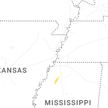
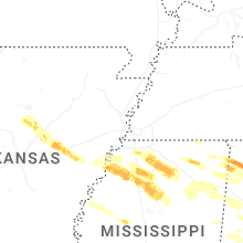
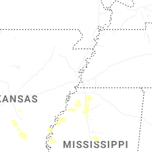
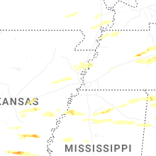


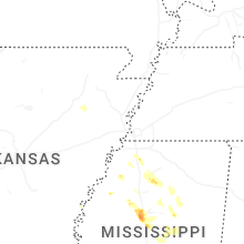
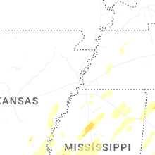


Connect with Interactive Hail Maps