

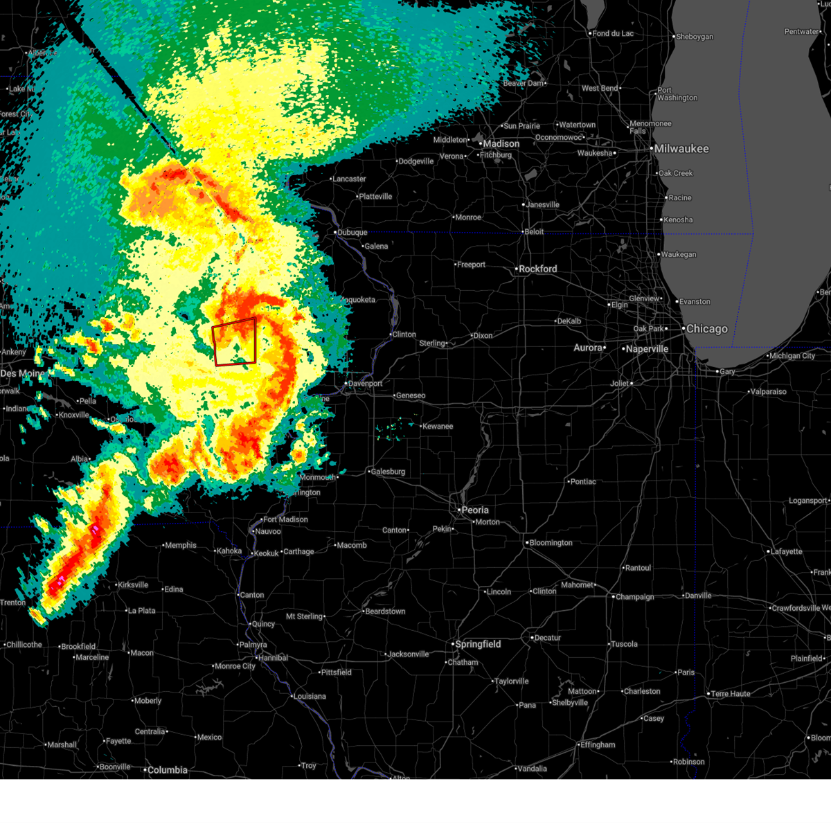
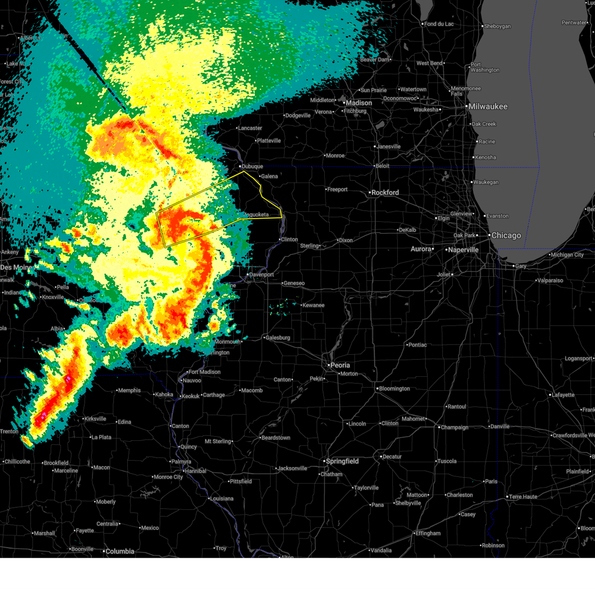
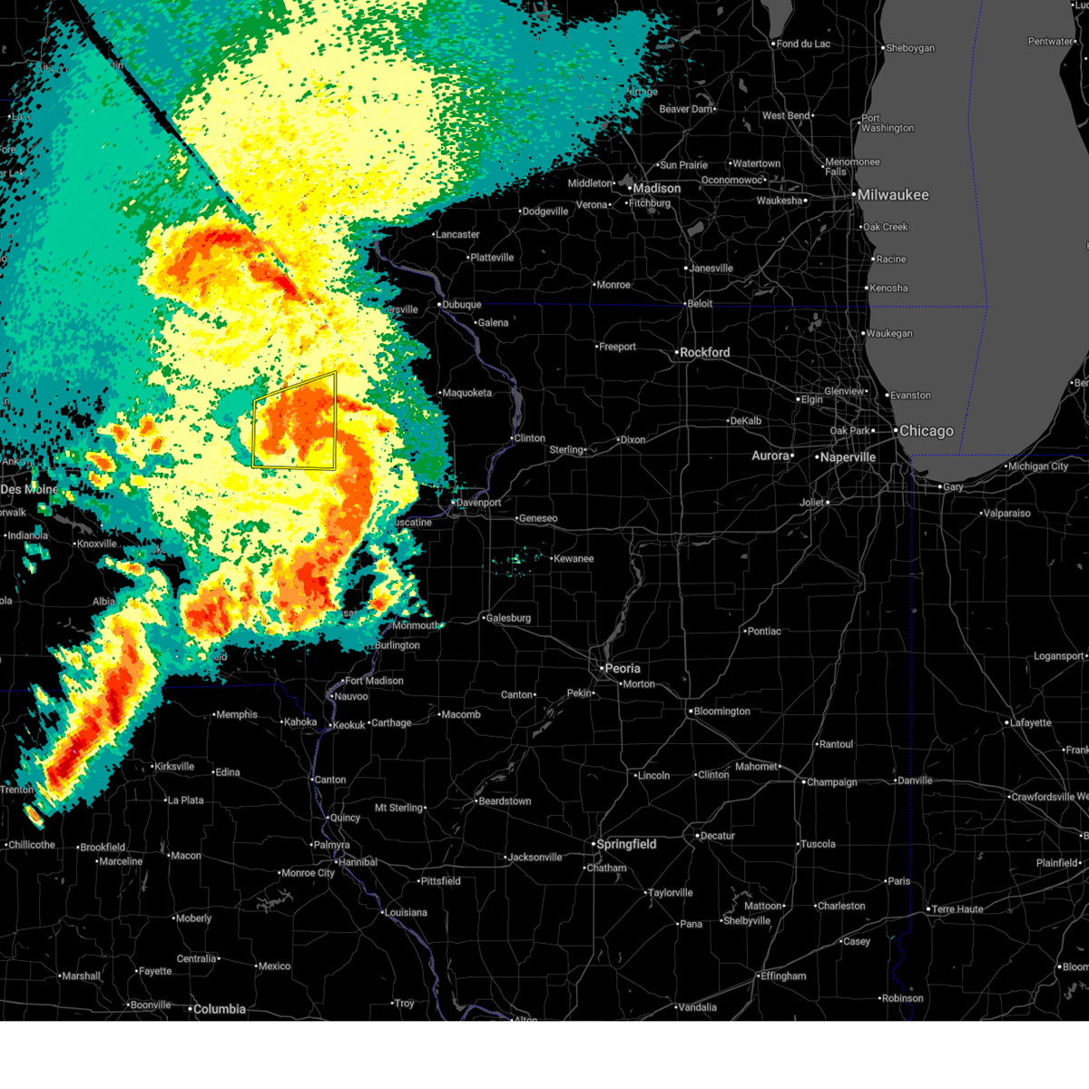
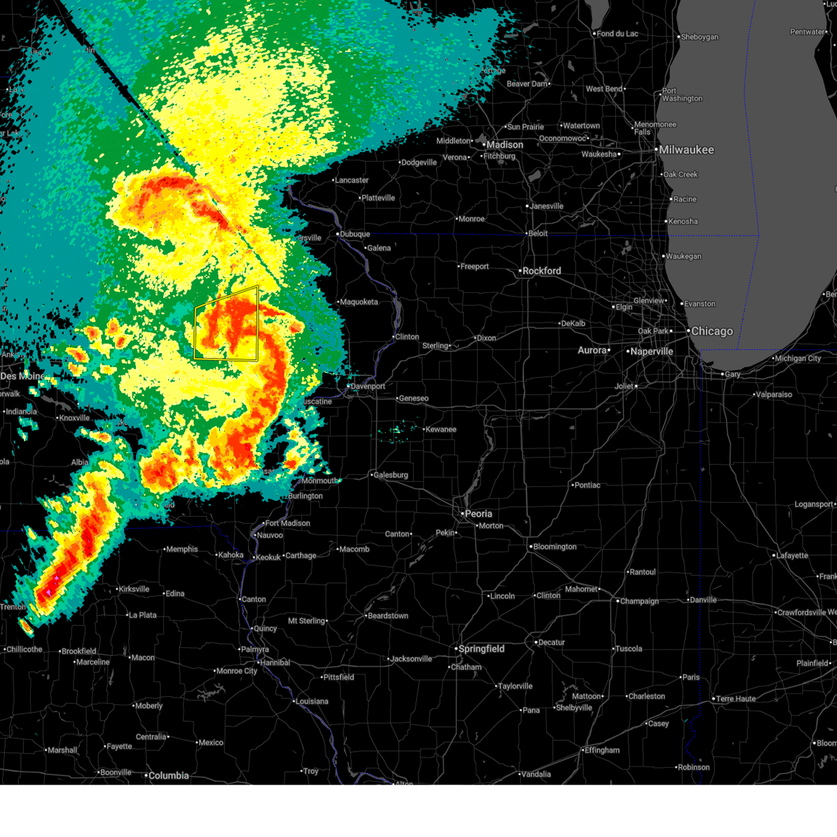
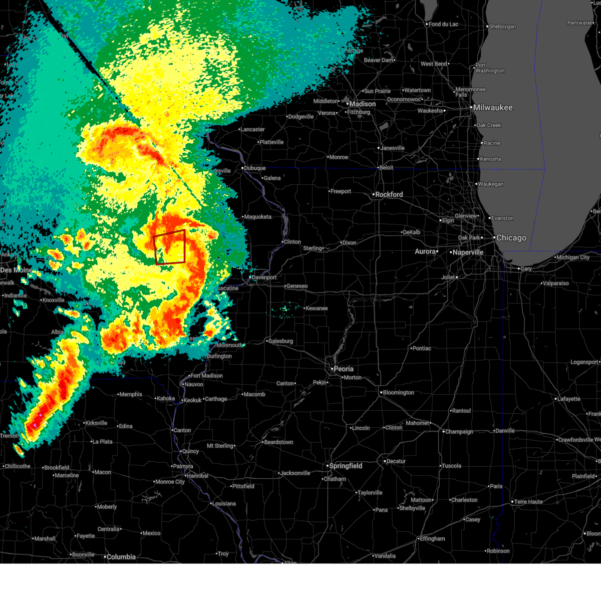
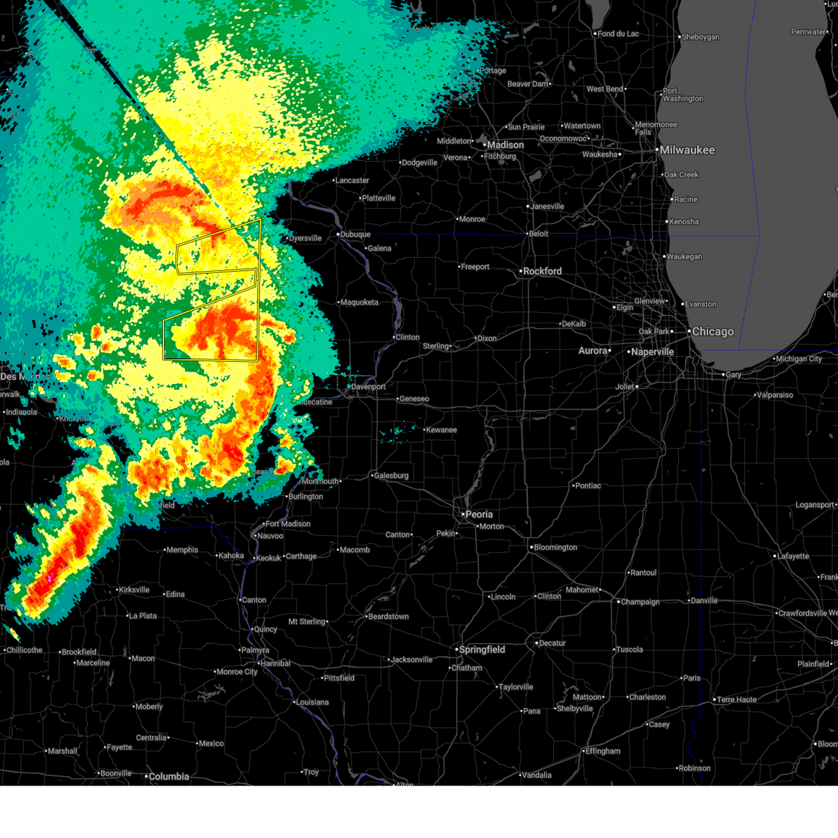
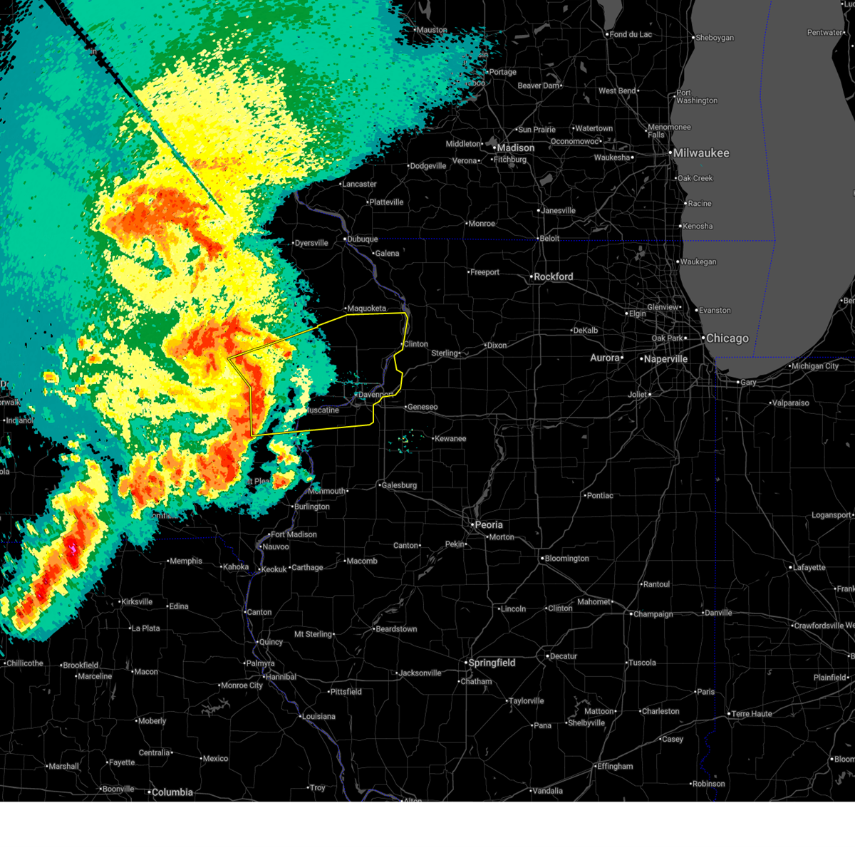
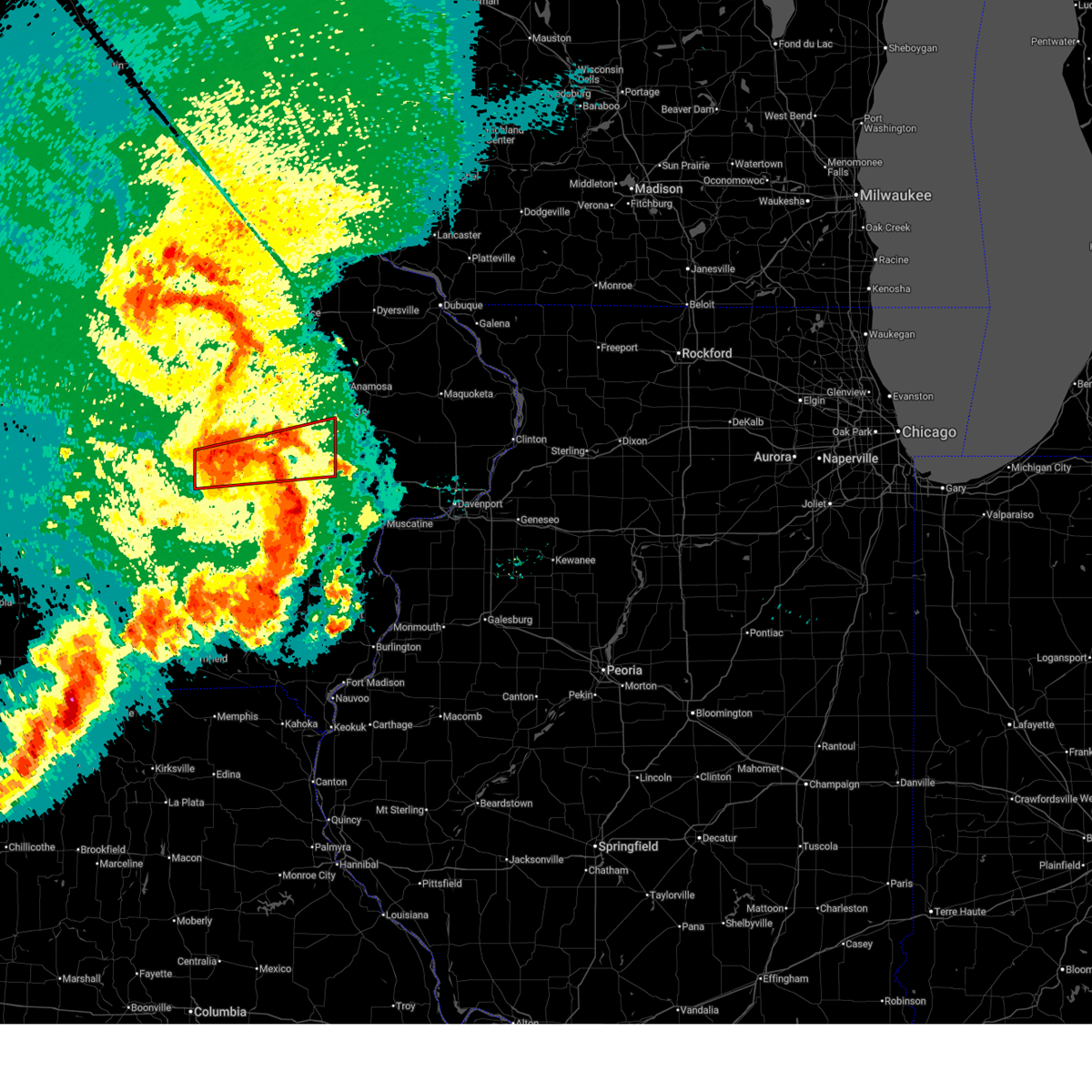
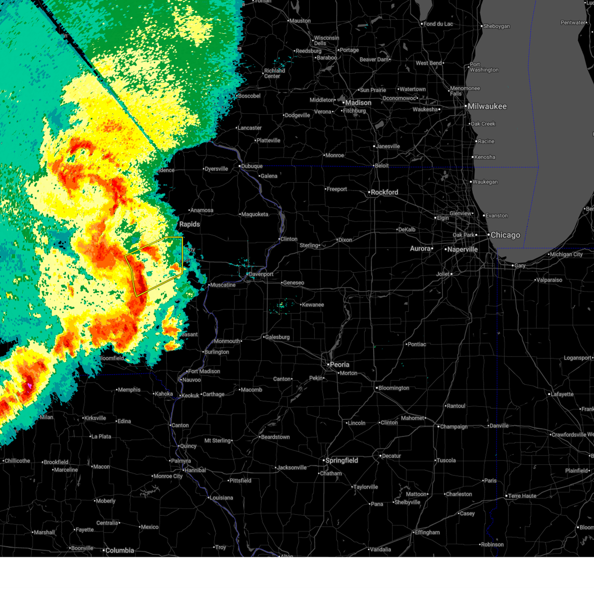
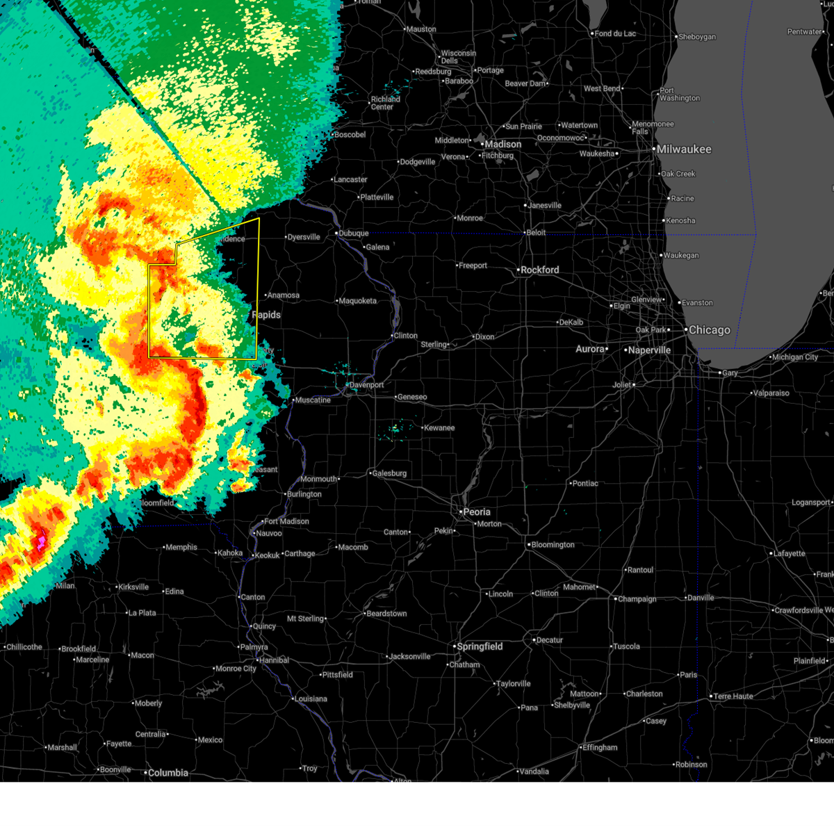
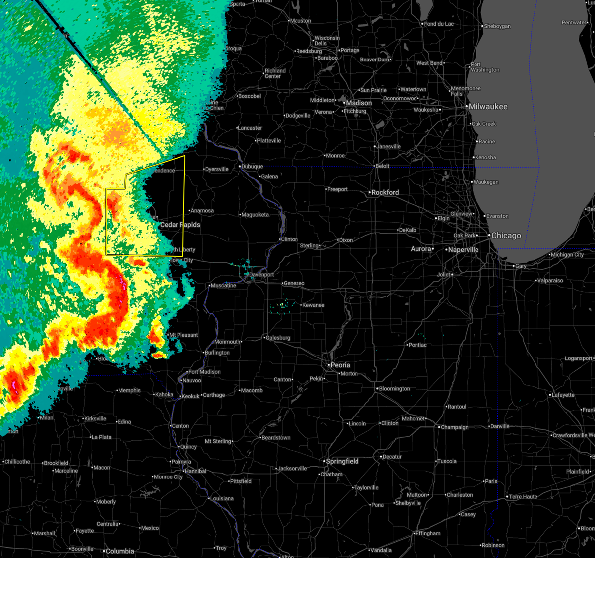
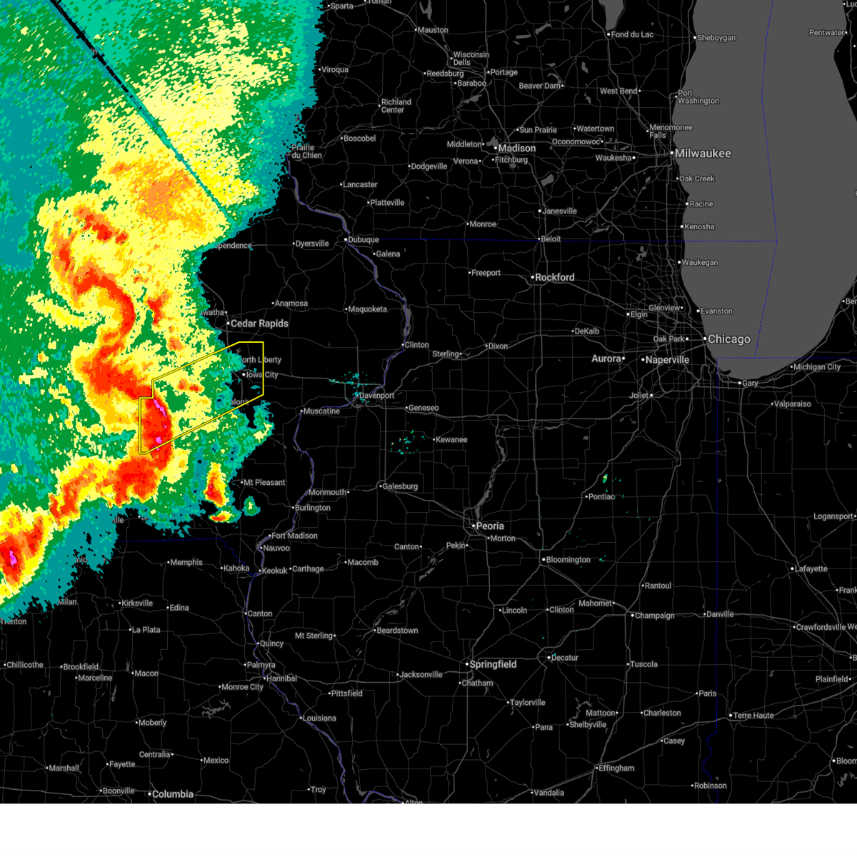
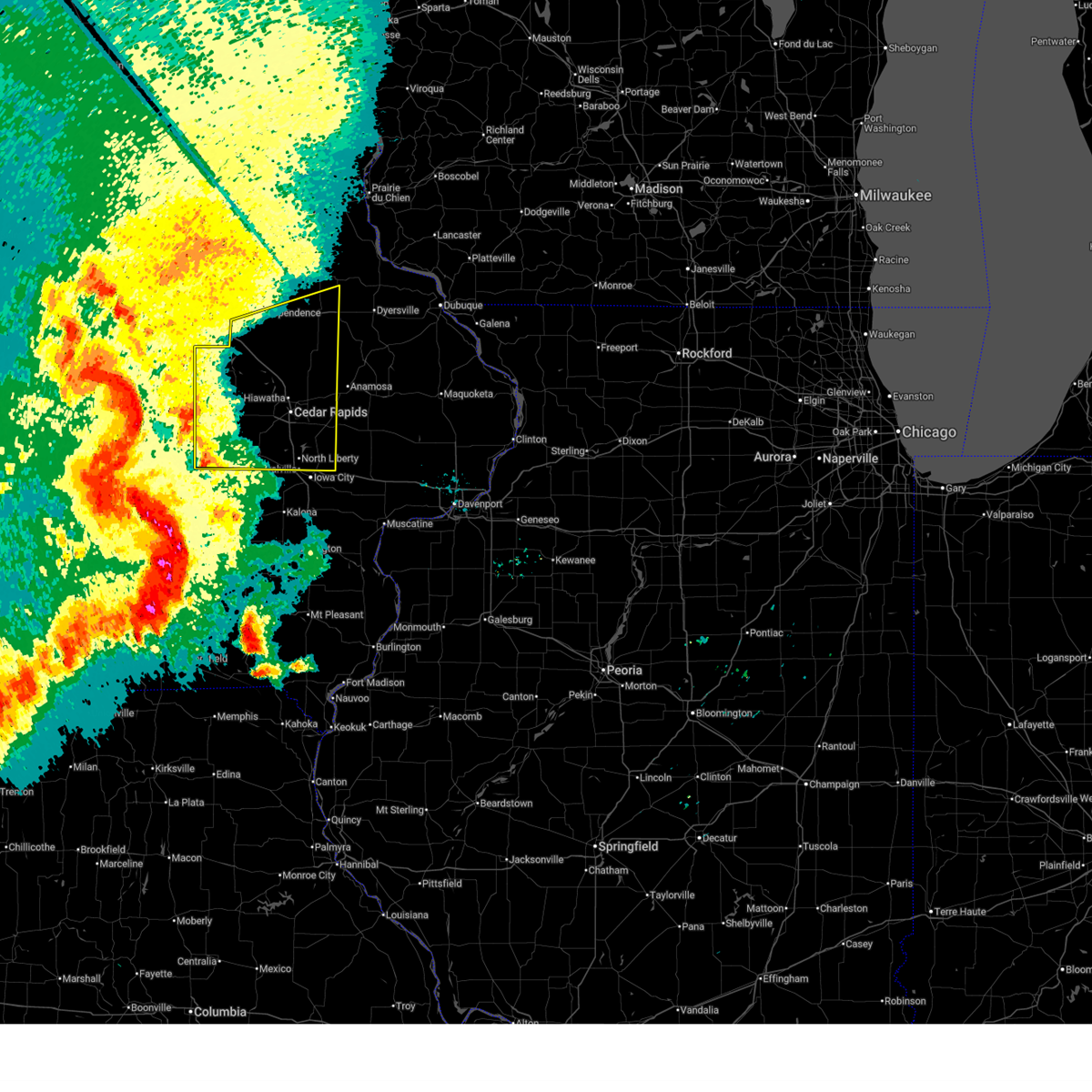
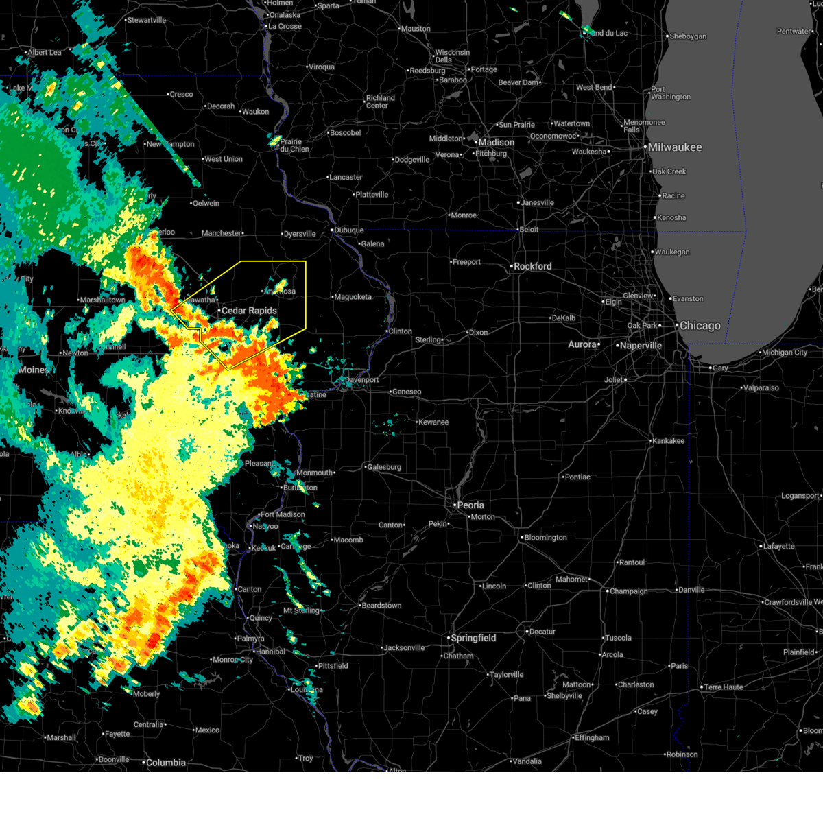
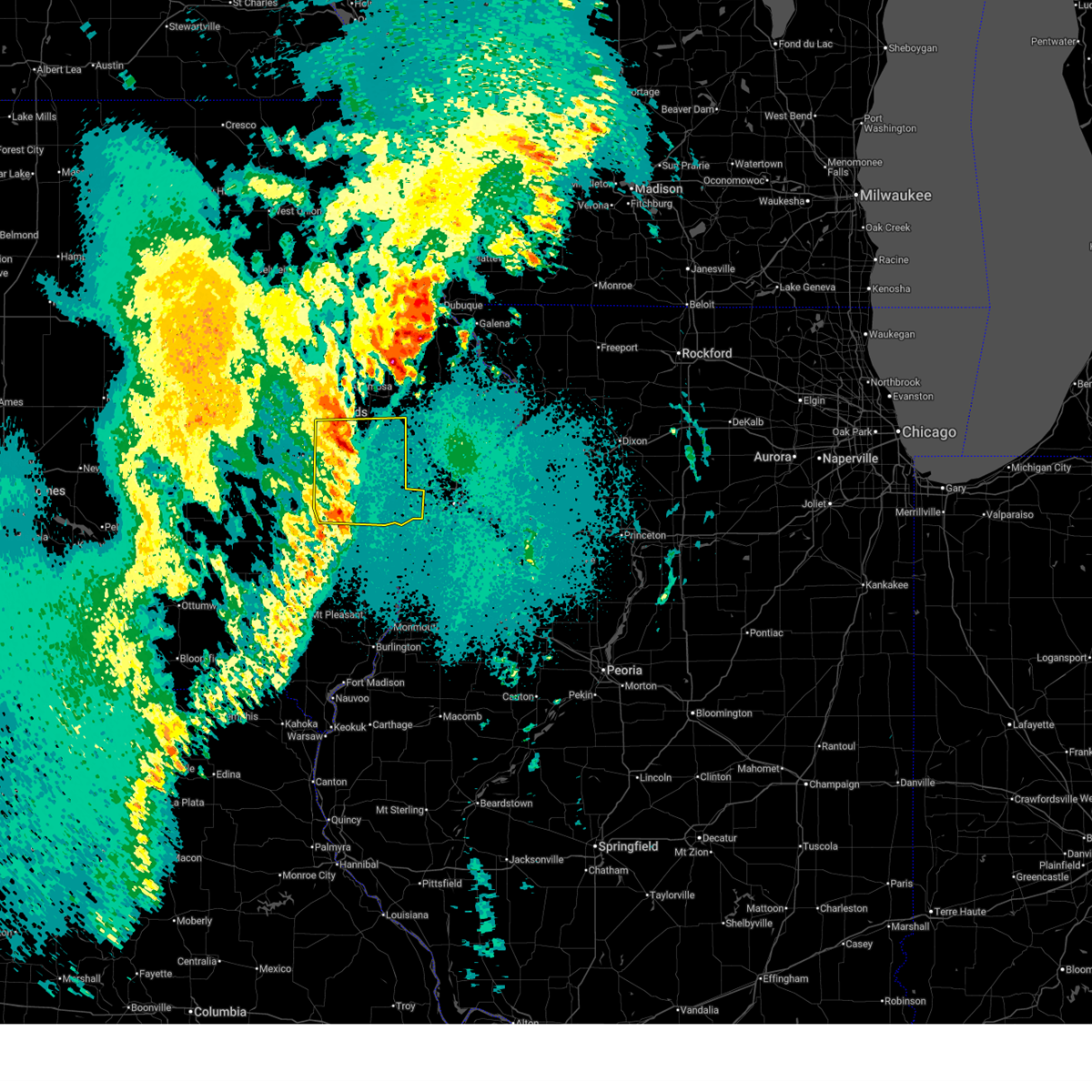
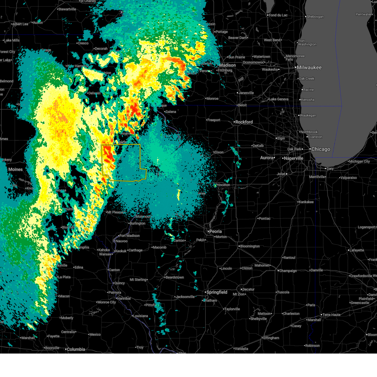
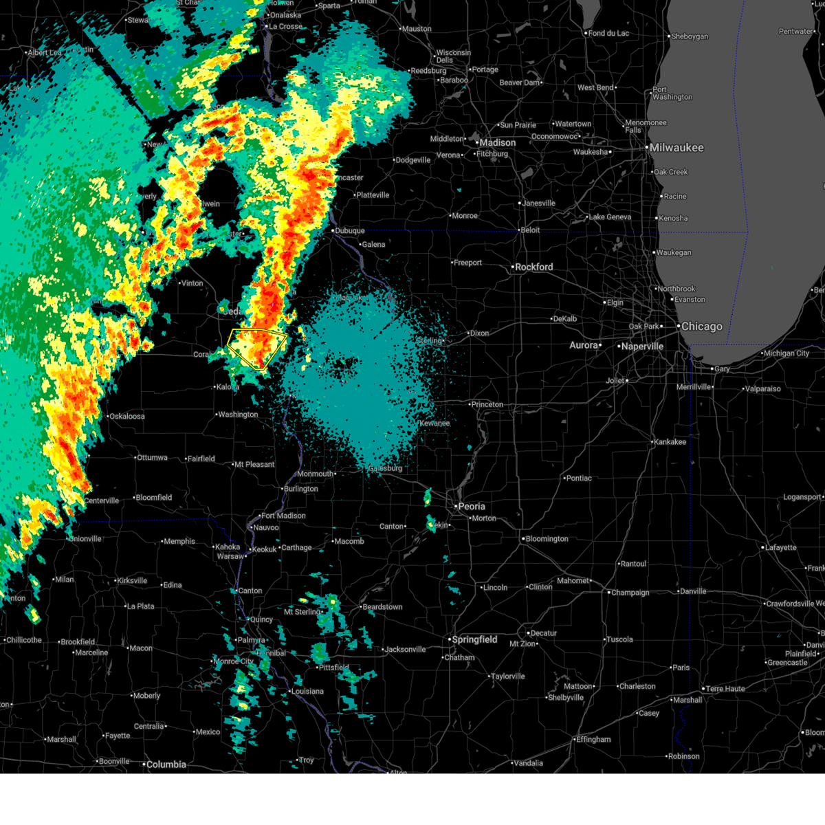
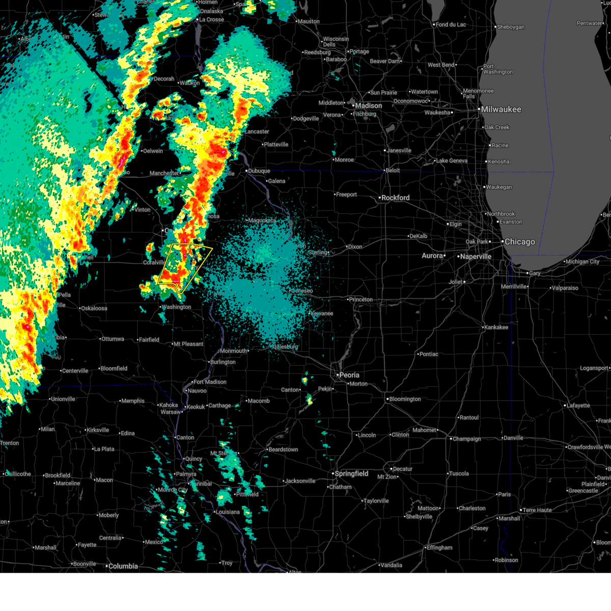
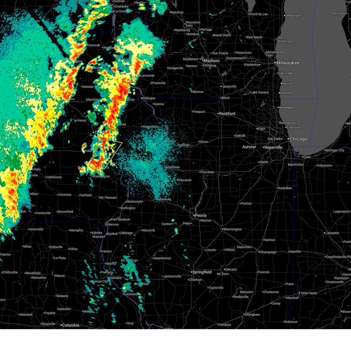
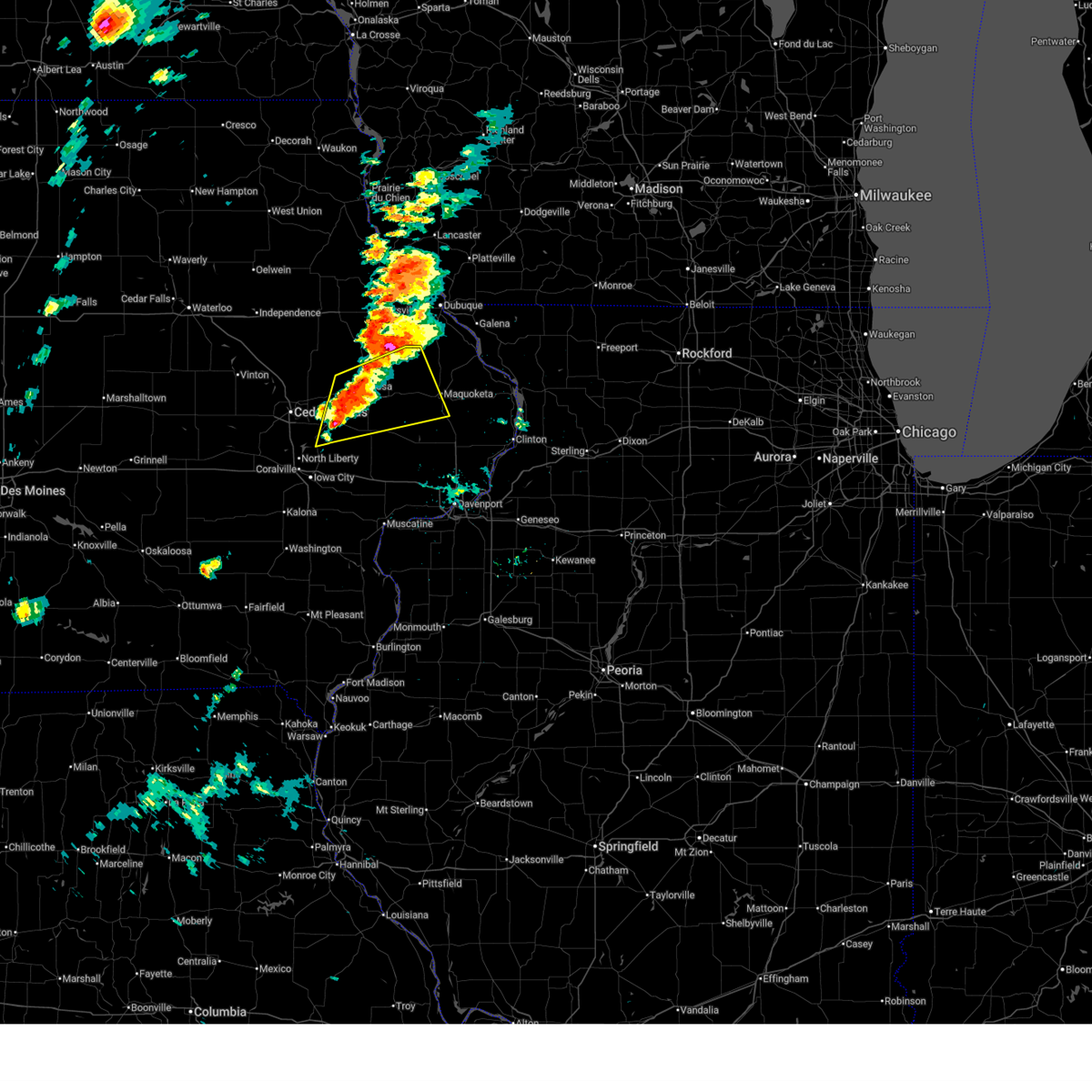
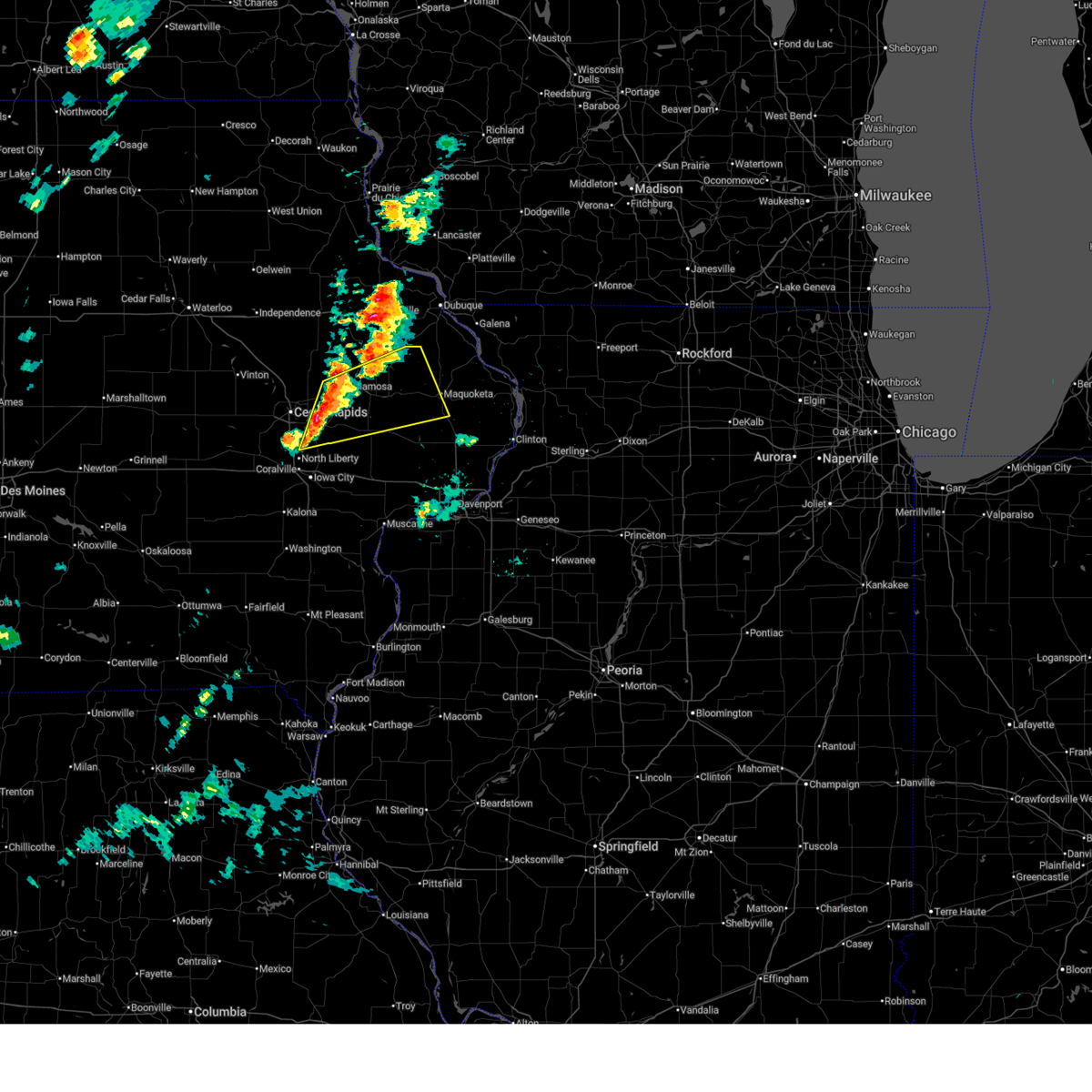
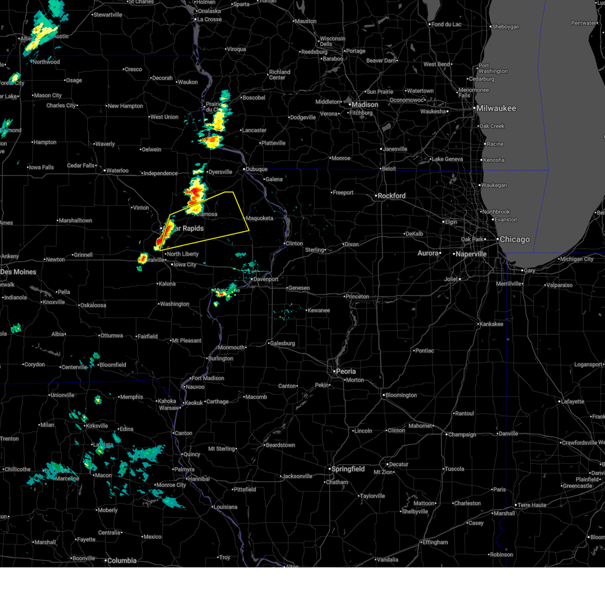
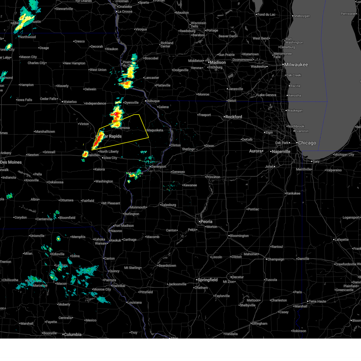
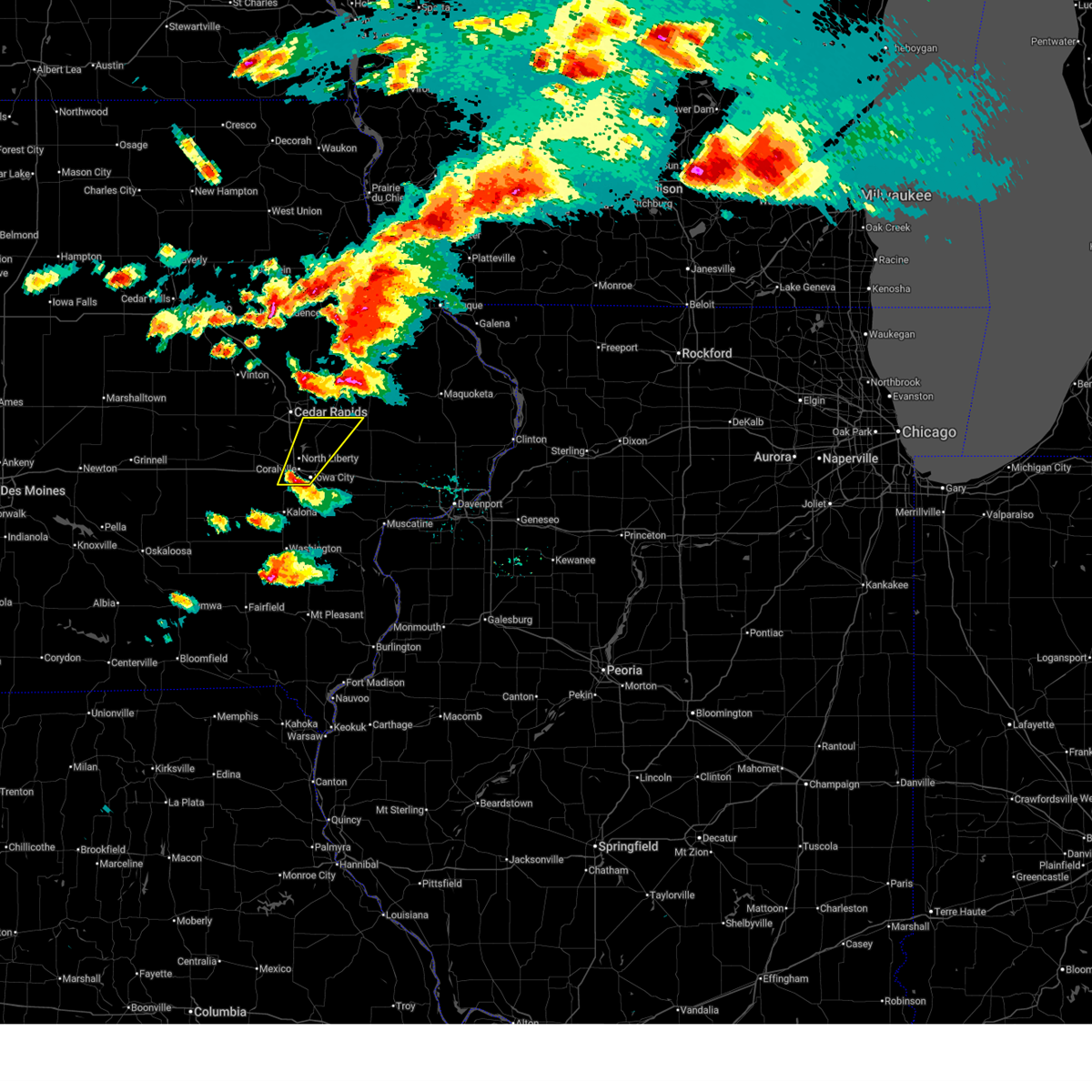
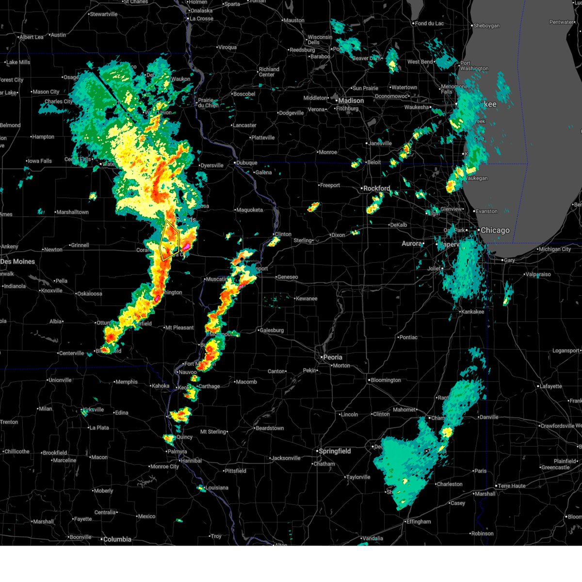
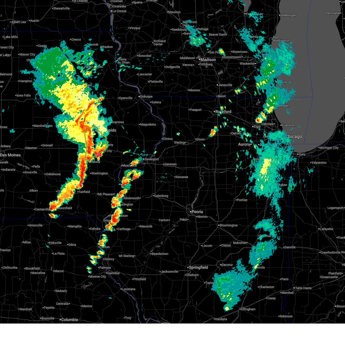
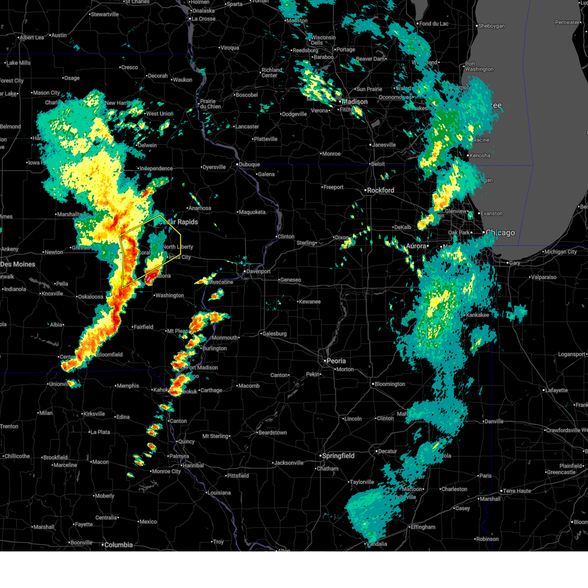
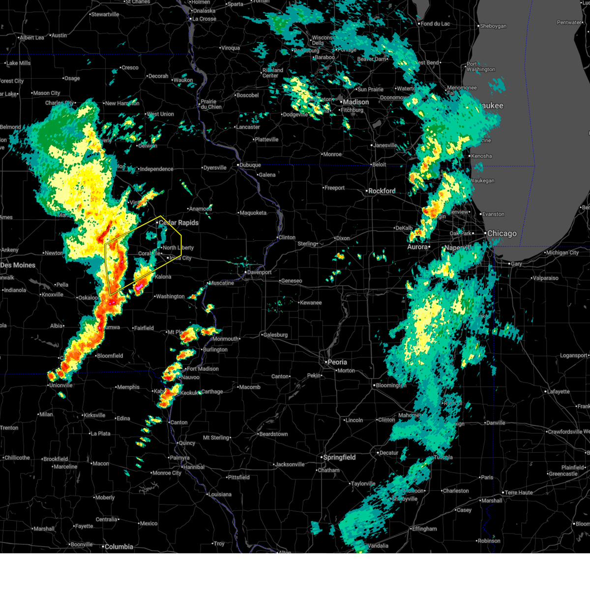
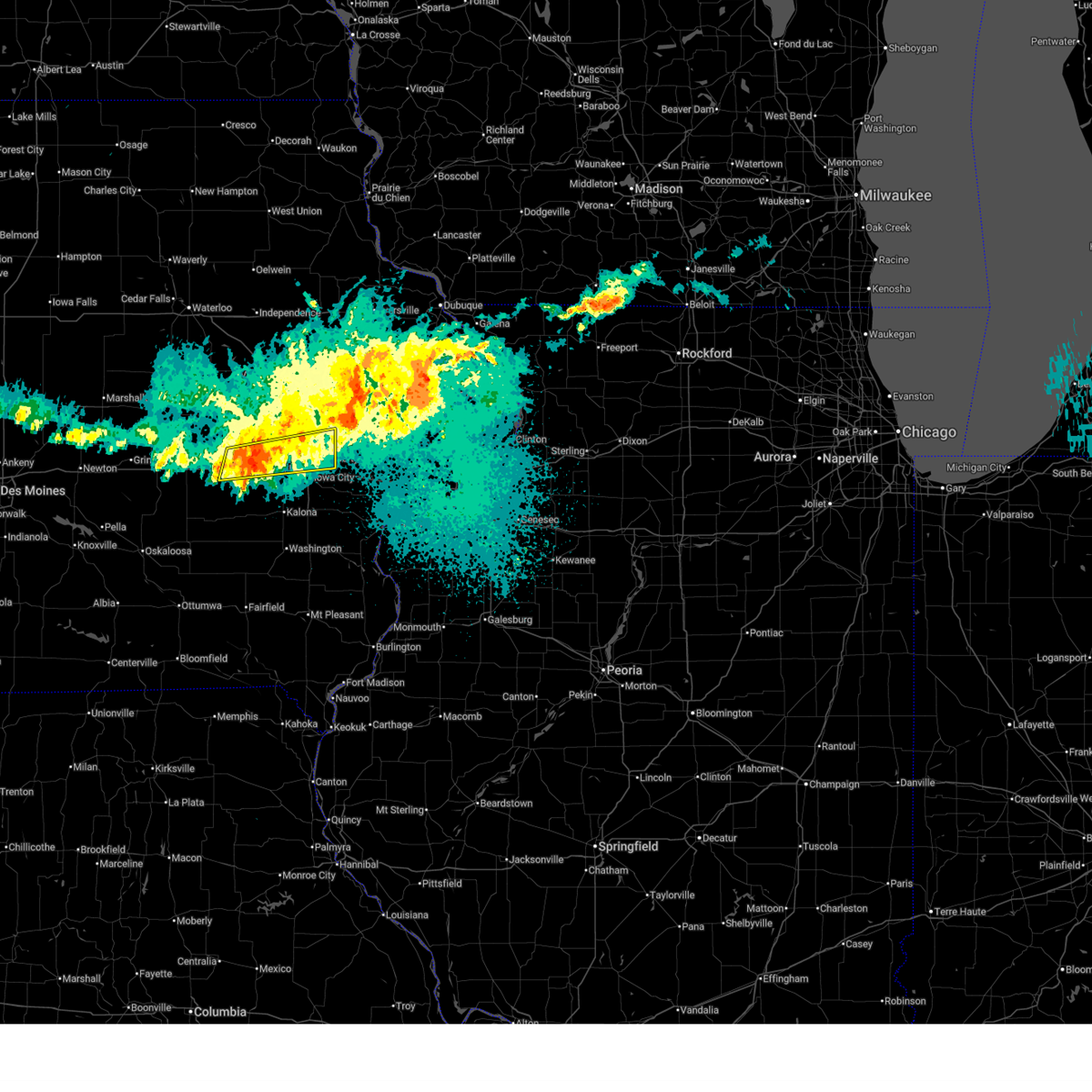
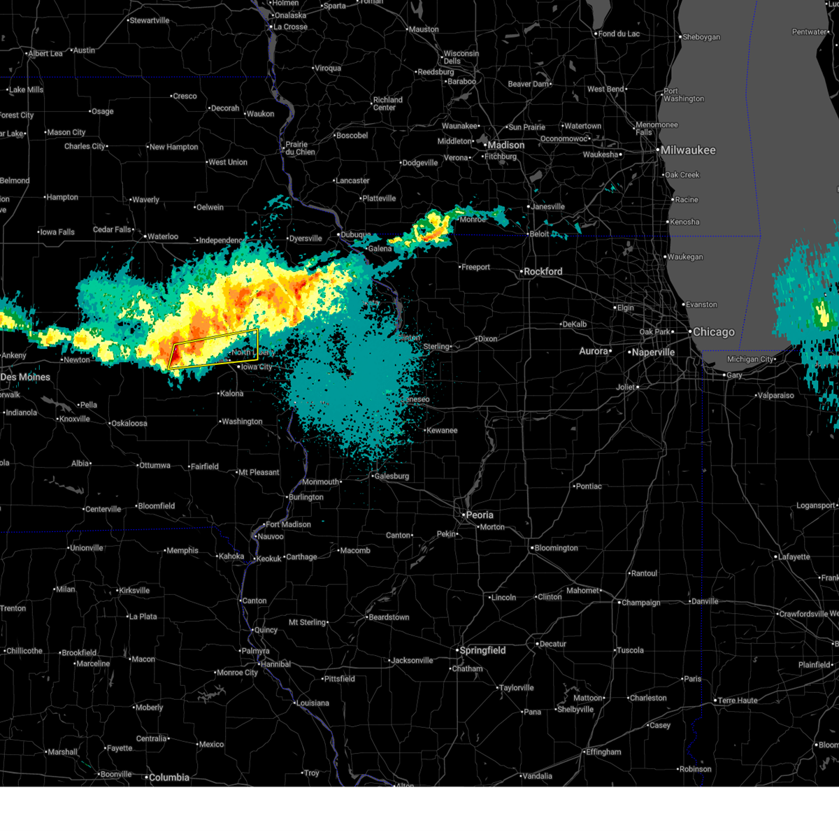
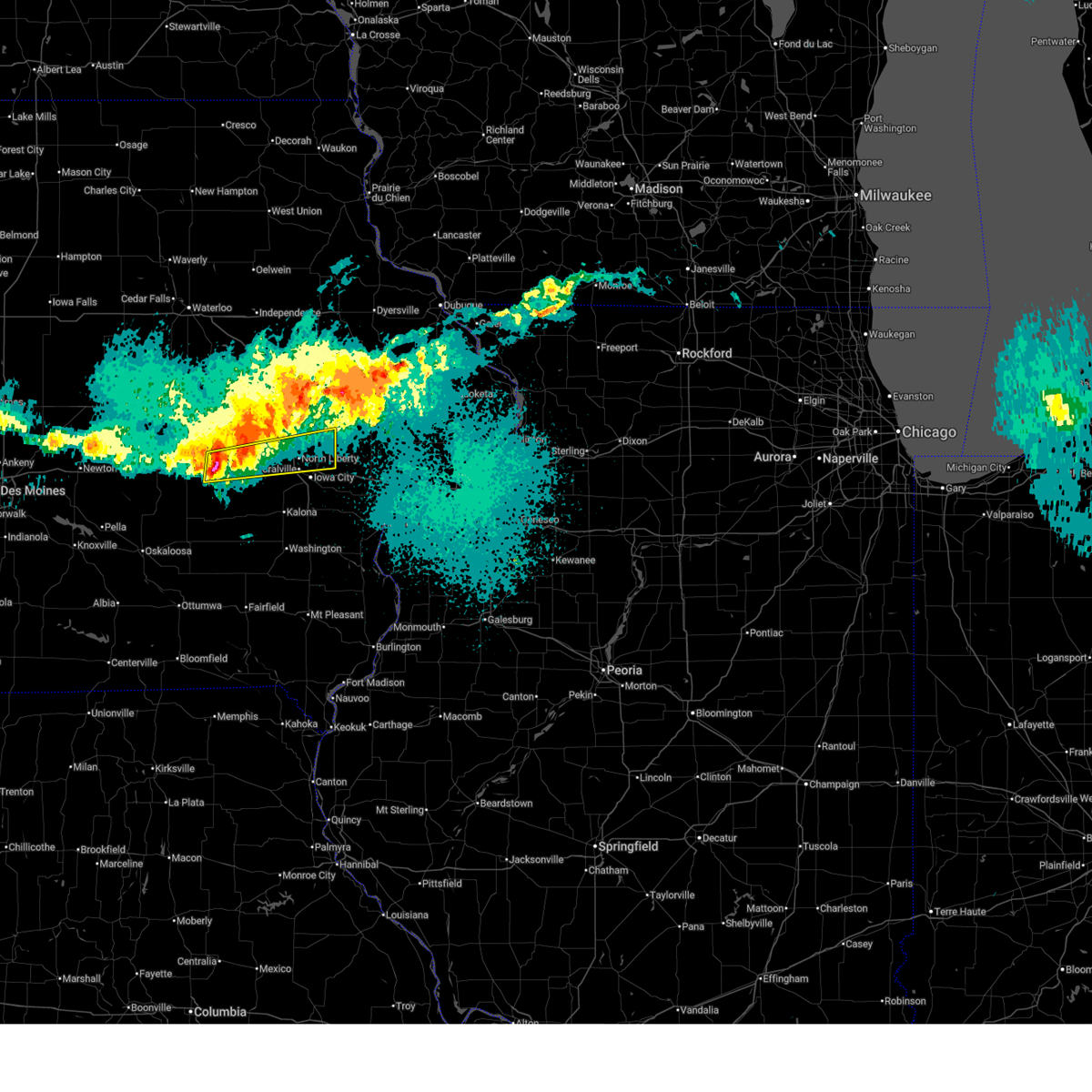
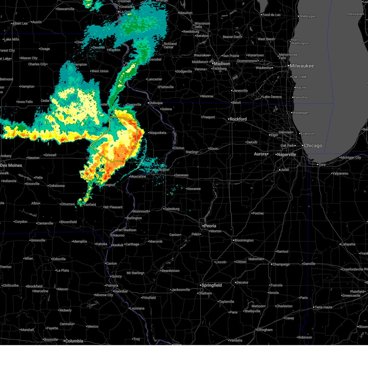
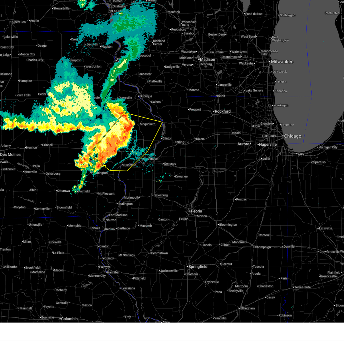
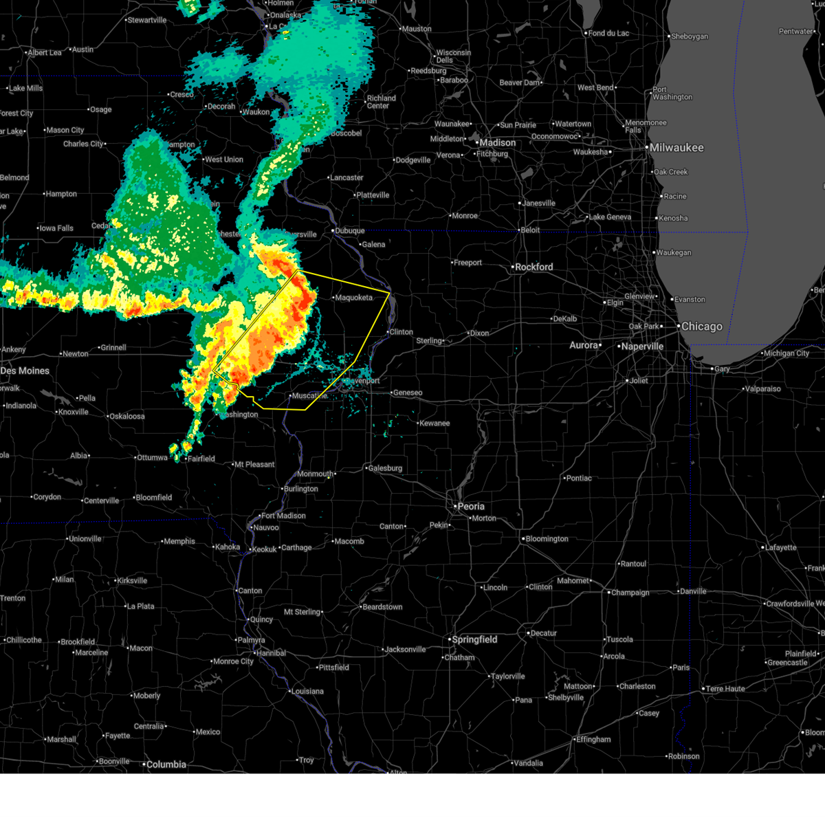
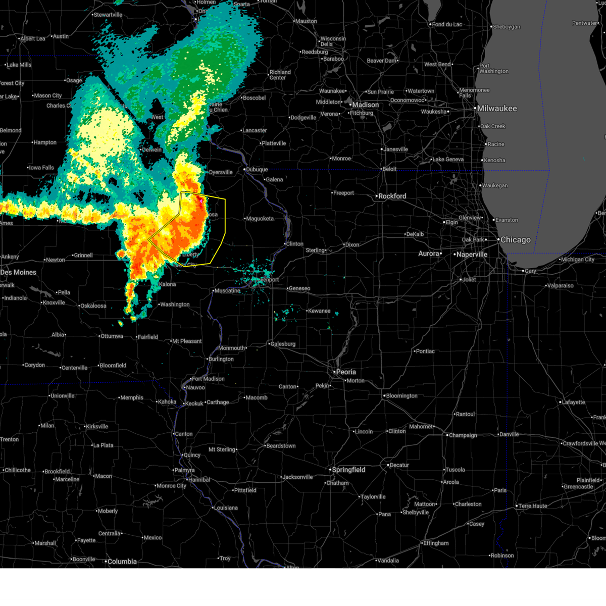
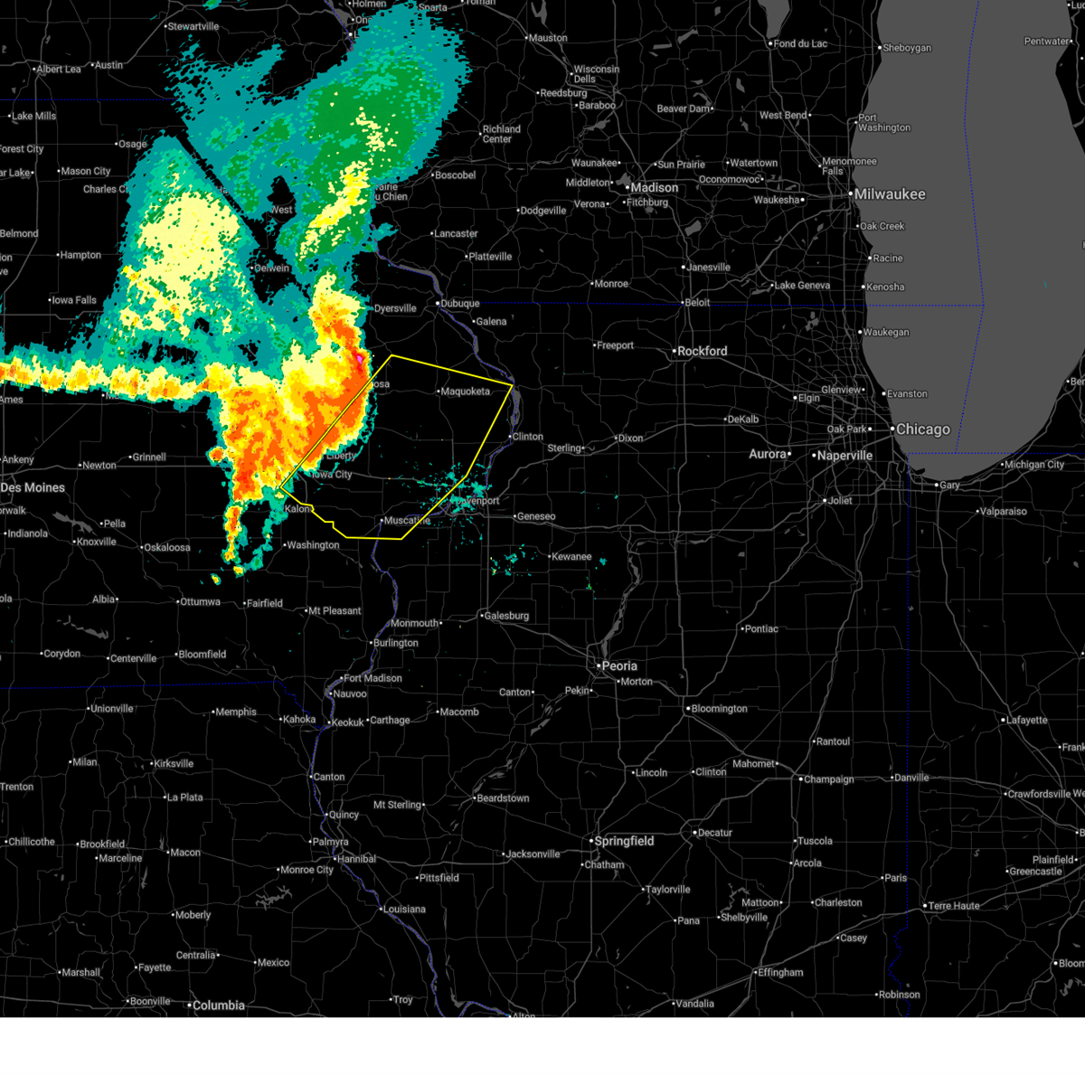
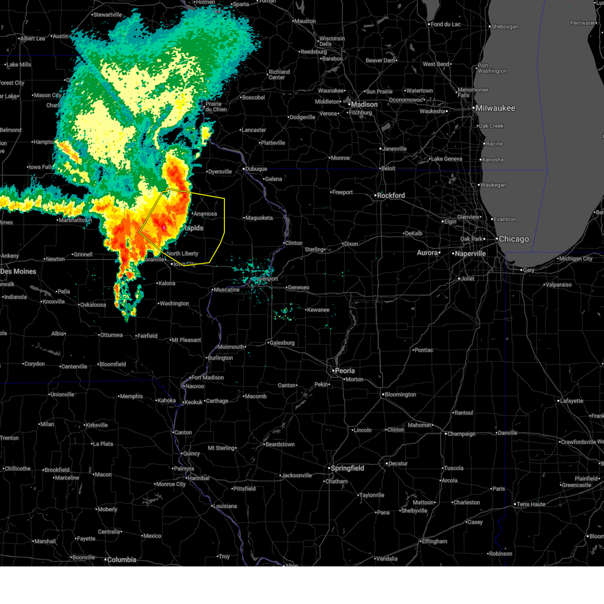
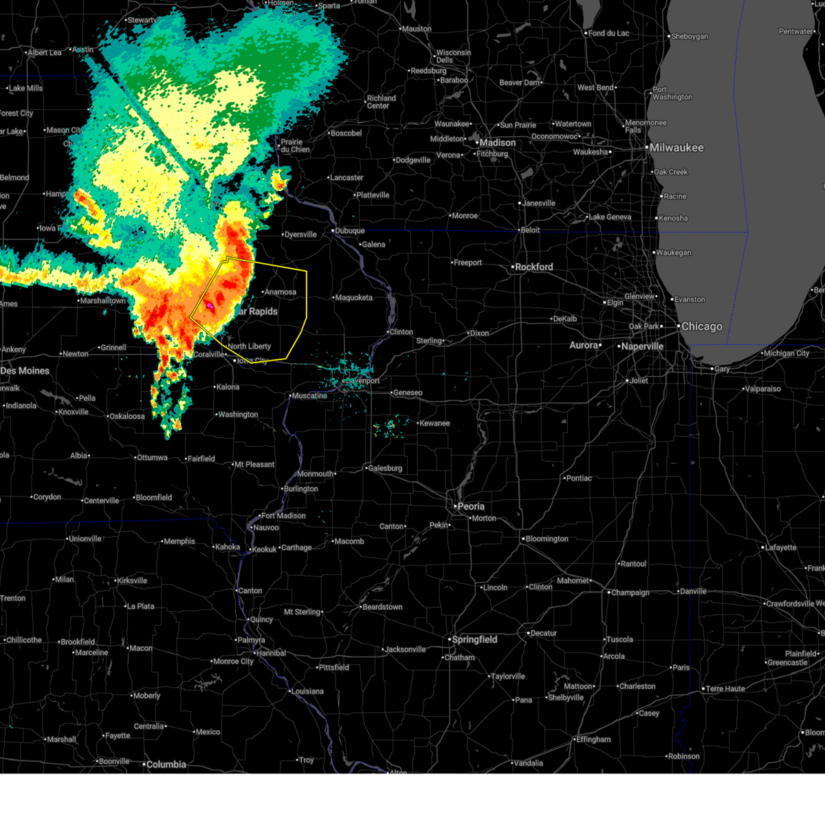
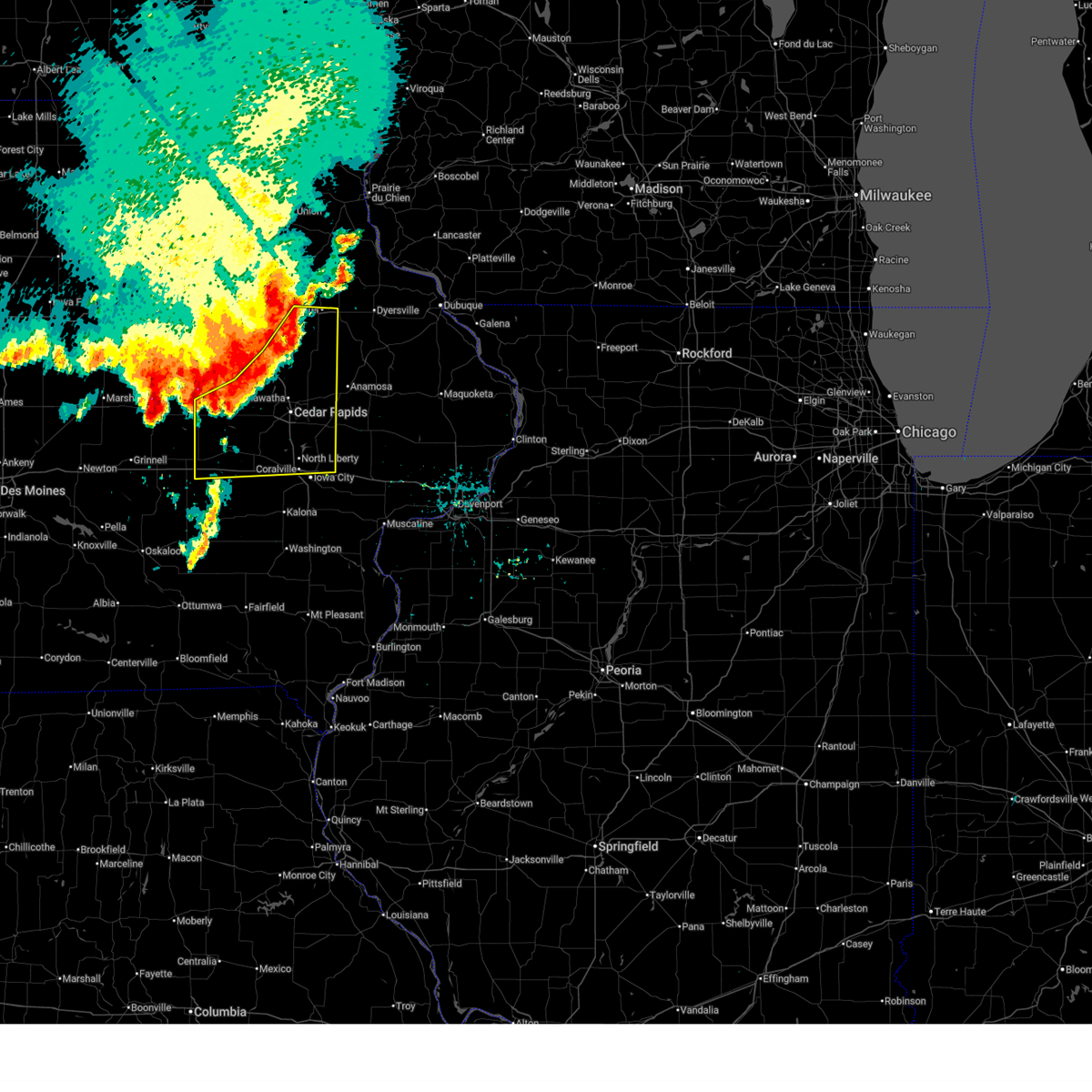
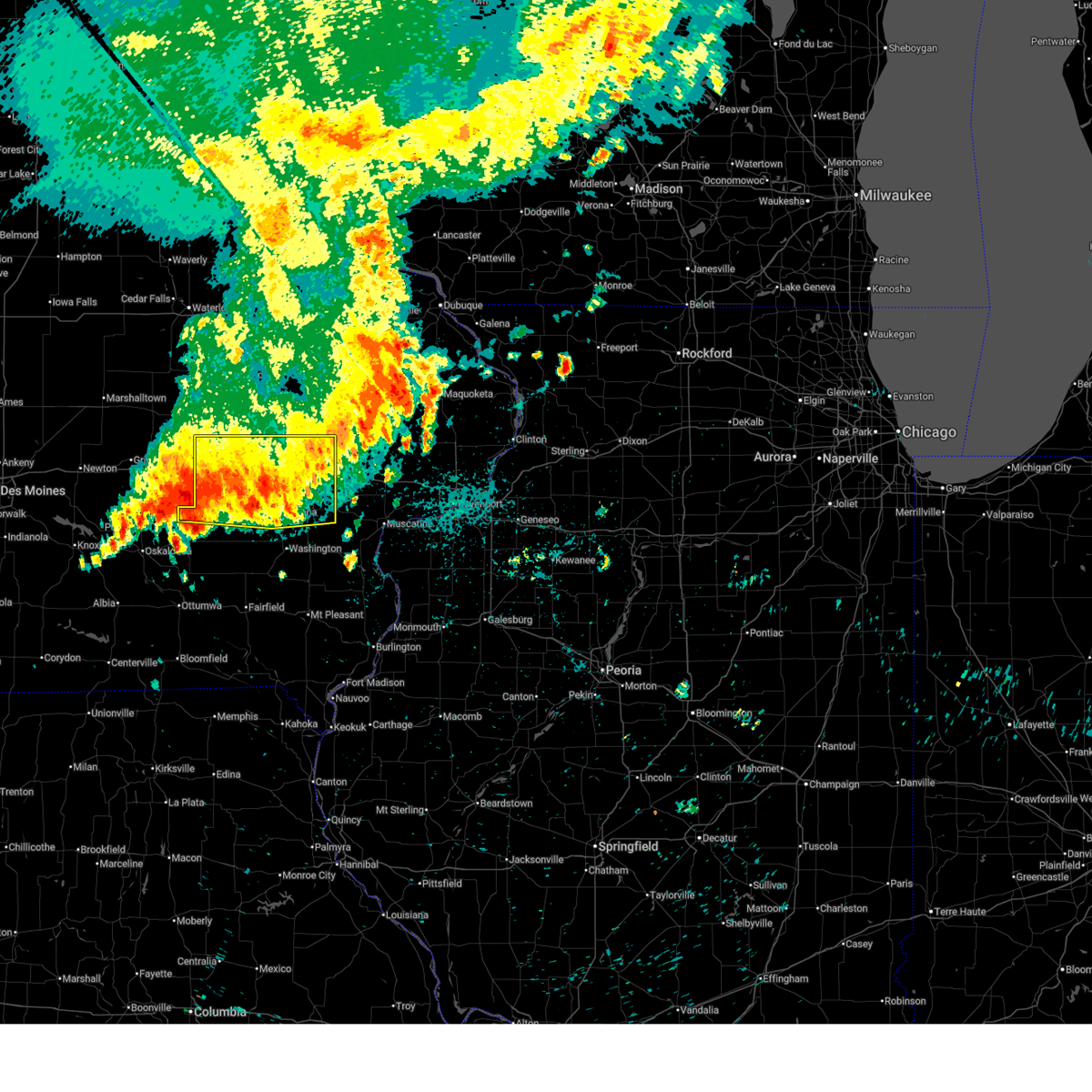
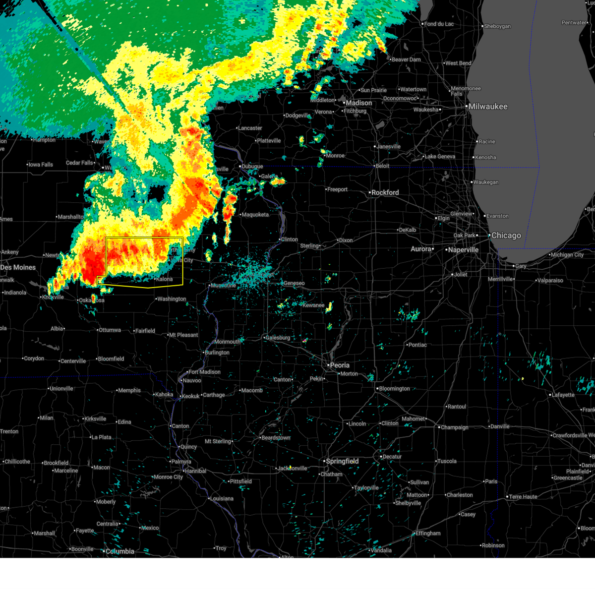
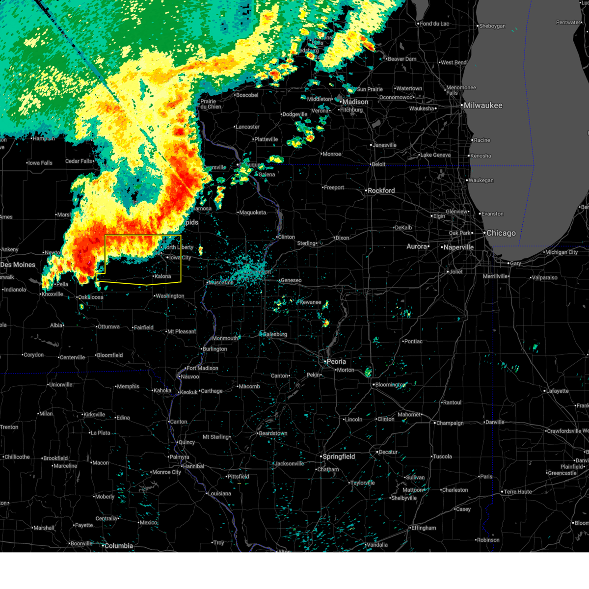
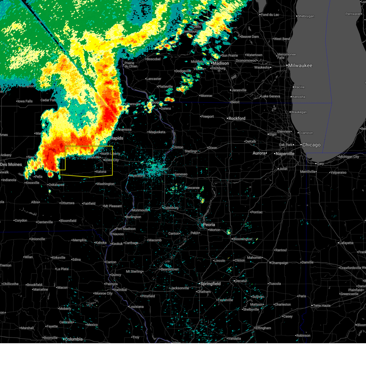
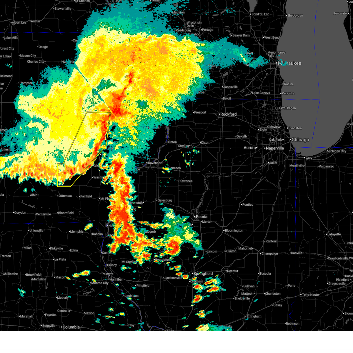
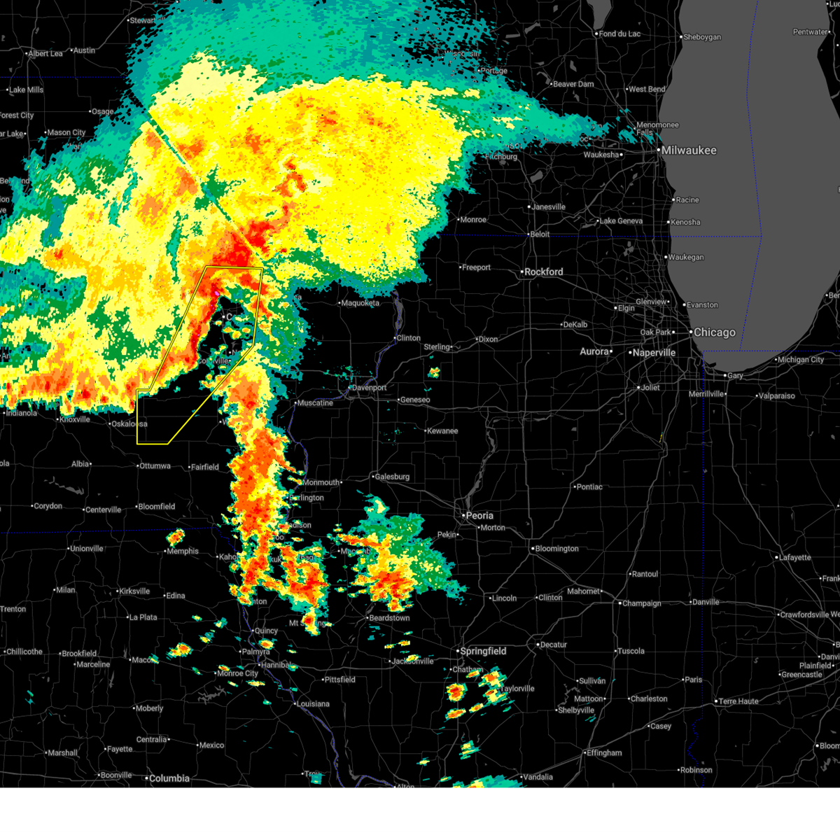
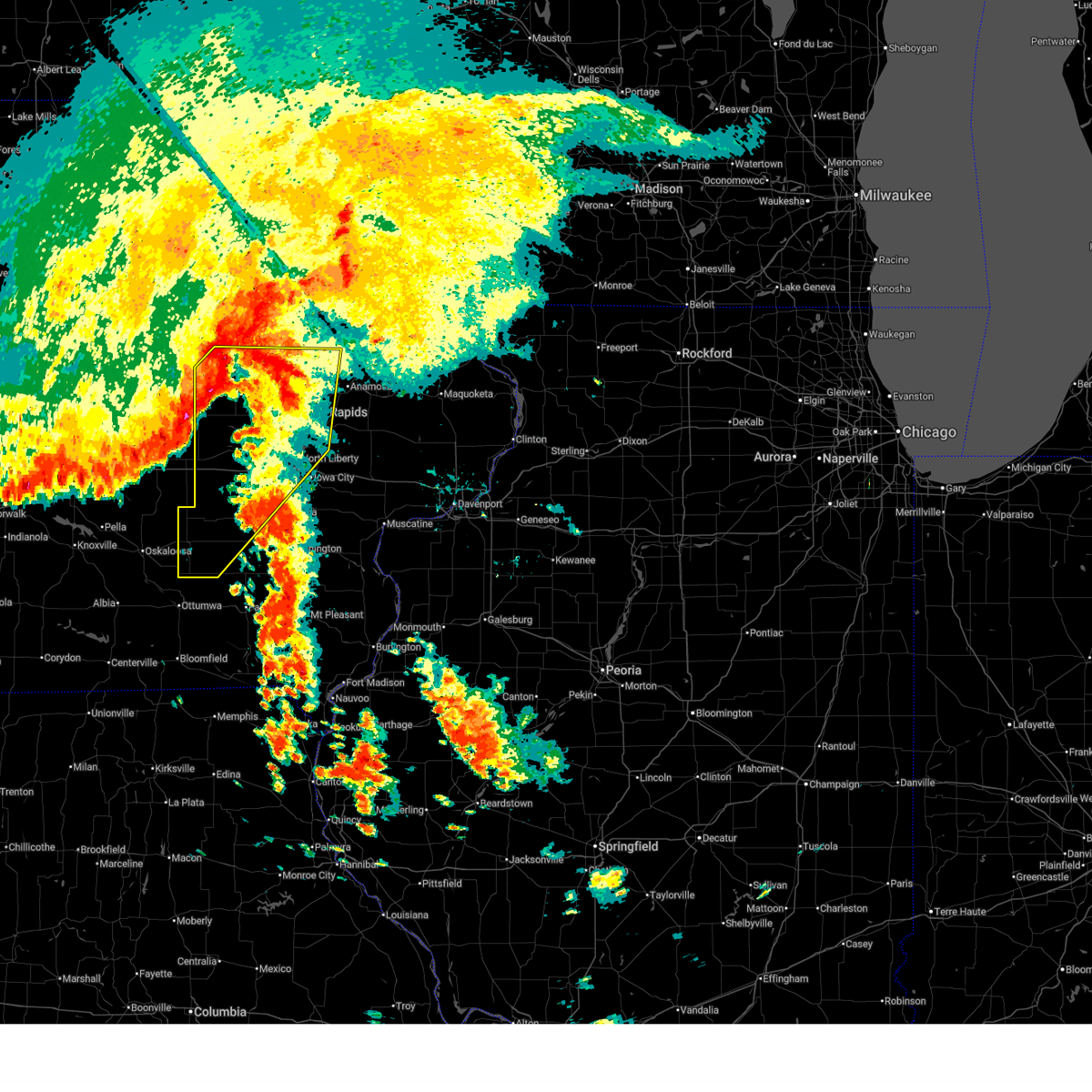
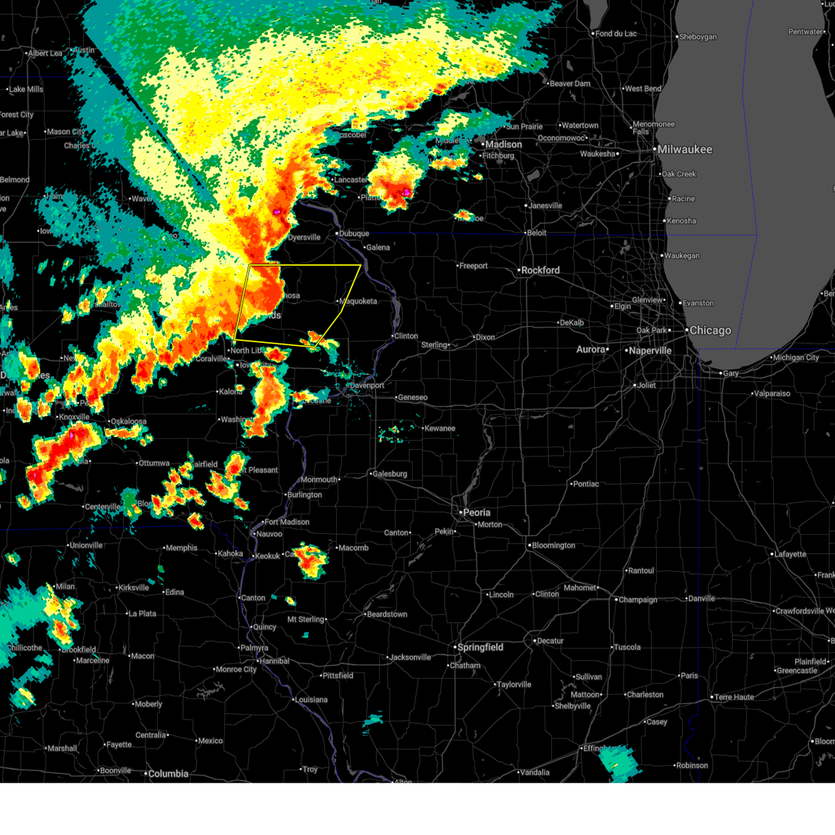
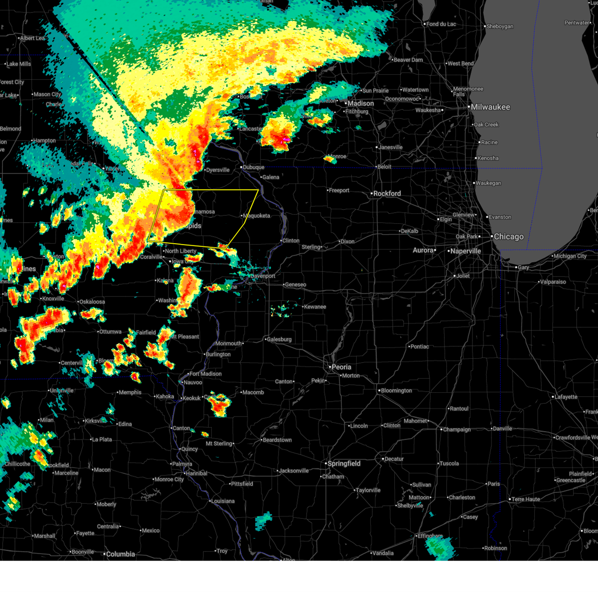
Hail Map for Solon, IA
The Solon, IA area has had 3 reports of on-the-ground hail by trained spotters, and has been under severe weather warnings 67 times during the past 12 months. Doppler radar has detected hail at or near Solon, IA on 57 occasions, including 5 occasions during the past year.
| Name: | Solon, IA |
| Where Located: | 14.6 miles SE of Cedar Rapids, IA |
| Map: | Google Map for Solon, IA |
| Population: | 2037 |
| Housing Units: | 832 |
| More Info: | Search Google for Solon, IA |
0
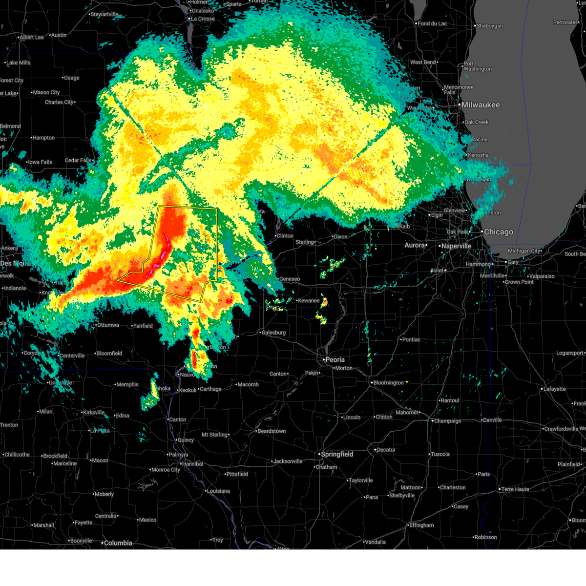
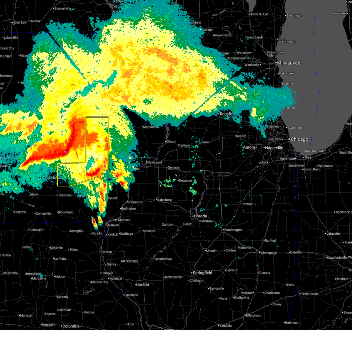
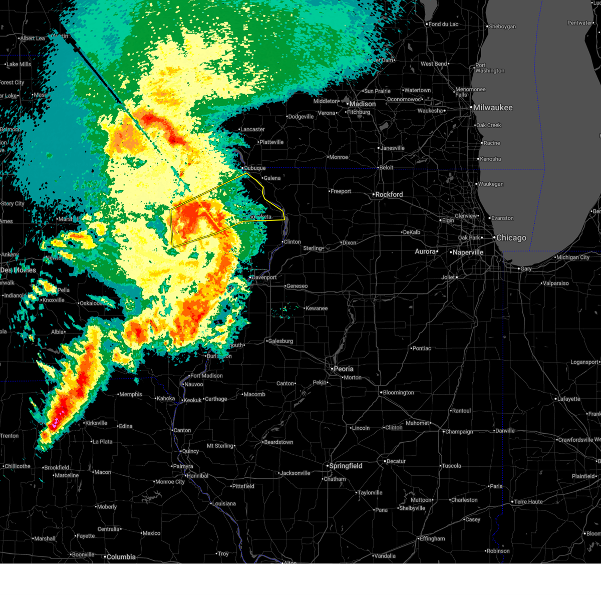
The Top Recent Hail Date for Solon, IA is Wednesday, June 17, 2026 (29th out of 57)
Hail and Wind Damage Spotted near Solon, IA
| Date / Time | Report Details |
|---|---|
| 6/17/2026 7:08 AM CDT |
 Svrdvn the national weather service in the quad cities has issued a * severe thunderstorm warning for, northwestern louisa county in southeastern iowa, northeastern keokuk county in southeastern iowa, cedar county in east central iowa, johnson county in east central iowa, northern washington county in southeastern iowa, southern jones county in east central iowa, muscatine county in east central iowa, southeastern linn county in east central iowa, * until 800 am cdt. * at 706 am cdt, severe thunderstorms were located along a line extending from whittier to near hills to near keota, moving east at 65 mph. these are destructive storms for i-80 corridor including iowa city, cedar rapids, tipton, anamosa, west branch, and muscatine (trained weather spotters. measured wind gust to 78 mph at the cedar rapids airport). Hazards include 80 mph wind gusts and quarter size hail. Flying debris will be dangerous to those caught without shelter. mobile homes will be heavily damaged. expect considerable damage to roofs, windows, and vehicles. Extensive tree damage and power outages are likely. Svrdvn the national weather service in the quad cities has issued a * severe thunderstorm warning for, northwestern louisa county in southeastern iowa, northeastern keokuk county in southeastern iowa, cedar county in east central iowa, johnson county in east central iowa, northern washington county in southeastern iowa, southern jones county in east central iowa, muscatine county in east central iowa, southeastern linn county in east central iowa, * until 800 am cdt. * at 706 am cdt, severe thunderstorms were located along a line extending from whittier to near hills to near keota, moving east at 65 mph. these are destructive storms for i-80 corridor including iowa city, cedar rapids, tipton, anamosa, west branch, and muscatine (trained weather spotters. measured wind gust to 78 mph at the cedar rapids airport). Hazards include 80 mph wind gusts and quarter size hail. Flying debris will be dangerous to those caught without shelter. mobile homes will be heavily damaged. expect considerable damage to roofs, windows, and vehicles. Extensive tree damage and power outages are likely.
|
| 6/17/2026 6:45 AM CDT |
 Svrdvn the national weather service in the quad cities has issued a * severe thunderstorm warning for, keokuk county in southeastern iowa, johnson county in east central iowa, washington county in southeastern iowa, linn county in east central iowa, * until 745 am cdt. * at 643 am cdt, severe thunderstorms were located along a line extending from near atkins to near williamsburg to near montezuma, moving east at 60 mph (trained weather spotters. several measured wind gusts between 60 to 70 mph in benton and iowa counties). Hazards include 70 mph wind gusts and quarter size hail. Hail damage to vehicles is expected. expect considerable tree damage. Wind damage is also likely to mobile homes, roofs, and outbuildings. Svrdvn the national weather service in the quad cities has issued a * severe thunderstorm warning for, keokuk county in southeastern iowa, johnson county in east central iowa, washington county in southeastern iowa, linn county in east central iowa, * until 745 am cdt. * at 643 am cdt, severe thunderstorms were located along a line extending from near atkins to near williamsburg to near montezuma, moving east at 60 mph (trained weather spotters. several measured wind gusts between 60 to 70 mph in benton and iowa counties). Hazards include 70 mph wind gusts and quarter size hail. Hail damage to vehicles is expected. expect considerable tree damage. Wind damage is also likely to mobile homes, roofs, and outbuildings.
|
| 6/11/2026 9:50 AM CDT |
 At 950 am cdt, severe thunderstorms were located along a line extending from near langworthy to near central park to near hale, moving east at 55 mph (radar indicated). Hazards include 60 mph wind gusts and penny size hail. Expect damage to roofs, siding, and trees. Locations impacted include, maquoketa, anamosa, mechanicsville, stanwood, mount vernon, monticello, bellevue, cascade, lisbon, solon, springville, preston, olin, sabula, wyoming, oxford junction, miles, andrew, la motte, and martelle. At 950 am cdt, severe thunderstorms were located along a line extending from near langworthy to near central park to near hale, moving east at 55 mph (radar indicated). Hazards include 60 mph wind gusts and penny size hail. Expect damage to roofs, siding, and trees. Locations impacted include, maquoketa, anamosa, mechanicsville, stanwood, mount vernon, monticello, bellevue, cascade, lisbon, solon, springville, preston, olin, sabula, wyoming, oxford junction, miles, andrew, la motte, and martelle.
|
| 6/11/2026 9:40 AM CDT |
 The tornado threat has diminished and the tornado warning has been cancelled. however, large hail and damaging winds remain likely and a severe thunderstorm warning remains in effect for the area. a tornado watch remains in effect until 300 pm cdt for east central iowa. remember, a severe thunderstorm warning still remains in effect for portions of linn county. The tornado threat has diminished and the tornado warning has been cancelled. however, large hail and damaging winds remain likely and a severe thunderstorm warning remains in effect for the area. a tornado watch remains in effect until 300 pm cdt for east central iowa. remember, a severe thunderstorm warning still remains in effect for portions of linn county.
|
| 6/11/2026 9:35 AM CDT |
 Svrdvn the national weather service in the quad cities has issued a * severe thunderstorm warning for, jackson county in east central iowa, northwestern cedar county in east central iowa, southeastern dubuque county in northeastern iowa, northeastern johnson county in east central iowa, jones county in east central iowa, southeastern linn county in east central iowa, northwestern clinton county in east central iowa, * until 1030 am cdt. * at 935 am cdt, severe thunderstorms were located along a line extending from whittier to near martelle to near mechanicsville, moving northeast at 55 mph (radar indicated). Hazards include 60 mph wind gusts and penny size hail. expect damage to roofs, siding, and trees Svrdvn the national weather service in the quad cities has issued a * severe thunderstorm warning for, jackson county in east central iowa, northwestern cedar county in east central iowa, southeastern dubuque county in northeastern iowa, northeastern johnson county in east central iowa, jones county in east central iowa, southeastern linn county in east central iowa, northwestern clinton county in east central iowa, * until 1030 am cdt. * at 935 am cdt, severe thunderstorms were located along a line extending from whittier to near martelle to near mechanicsville, moving northeast at 55 mph (radar indicated). Hazards include 60 mph wind gusts and penny size hail. expect damage to roofs, siding, and trees
|
| 6/11/2026 9:34 AM CDT |
 At 933 am cdt, severe thunderstorms were located along a line extending from hazleton to near monti to alburnett, moving east at 55 mph (radar indicated). Hazards include 60 mph wind gusts. Expect damage to roofs, siding, and trees. locations impacted include, cedar rapids, marion, coralville, north liberty, hiawatha, mount vernon, robins, lisbon, fairfax, solon, tiffin, ely, atkins, walford, springville, palo, swisher, oxford, shueyville, and bertram. This includes interstate 380 between mile markers 1 and 28. At 933 am cdt, severe thunderstorms were located along a line extending from hazleton to near monti to alburnett, moving east at 55 mph (radar indicated). Hazards include 60 mph wind gusts. Expect damage to roofs, siding, and trees. locations impacted include, cedar rapids, marion, coralville, north liberty, hiawatha, mount vernon, robins, lisbon, fairfax, solon, tiffin, ely, atkins, walford, springville, palo, swisher, oxford, shueyville, and bertram. This includes interstate 380 between mile markers 1 and 28.
|
| 6/11/2026 9:34 AM CDT |
 the severe thunderstorm warning has been cancelled and is no longer in effect the severe thunderstorm warning has been cancelled and is no longer in effect
|
| 6/11/2026 9:30 AM CDT |
 At 930 am cdt, severe thunderstorms were located along a line extending from near lisbon to rochester to sand springs, moving east at 60 mph (radar indicated). Hazards include 60 mph wind gusts and penny size hail. Expect damage to roofs, siding, and trees. locations impacted include, davenport, iowa city, moline, rock island, bettendorf, clinton, muscatine, east moline, tipton, west branch, columbus junction, durant, coralville, north liberty, silvis, eldridge, dewitt, milan, camanche, and le claire. this includes the following highways, interstate 74 in iowa between mile markers 1 and 5. interstate 80 in iowa between mile markers 242 and 306. interstate 380 between mile markers 3 and 4. interstate 80 in illinois between mile markers 1 and 5. interstate 74 in illinois between mile markers 1 and 7. interstate 88 between mile markers 1 and 11. Interstate 280 between mile markers 1 and 18. At 930 am cdt, severe thunderstorms were located along a line extending from near lisbon to rochester to sand springs, moving east at 60 mph (radar indicated). Hazards include 60 mph wind gusts and penny size hail. Expect damage to roofs, siding, and trees. locations impacted include, davenport, iowa city, moline, rock island, bettendorf, clinton, muscatine, east moline, tipton, west branch, columbus junction, durant, coralville, north liberty, silvis, eldridge, dewitt, milan, camanche, and le claire. this includes the following highways, interstate 74 in iowa between mile markers 1 and 5. interstate 80 in iowa between mile markers 242 and 306. interstate 380 between mile markers 3 and 4. interstate 80 in illinois between mile markers 1 and 5. interstate 74 in illinois between mile markers 1 and 7. interstate 88 between mile markers 1 and 11. Interstate 280 between mile markers 1 and 18.
|
| 6/11/2026 9:30 AM CDT |
 At 929 am cdt, a severe thunderstorm capable of producing a tornado was located over sandy beach camp ground, or 10 miles north of iowa city, moving east at 65 mph (radar indicated rotation). Hazards include tornado and quarter size hail. Flying debris will be dangerous to those caught without shelter. mobile homes will be damaged or destroyed. damage to roofs, windows, and vehicles will occur. tree damage is likely. this dangerous storm will be near, iowa city, mount vernon, lisbon, solon, palisades-kepler state park, sutliff, newport, oasis, morse, and elmira around 935 am cdt. this includes the following highways, interstate 80 in iowa between mile markers 236 and 253. Interstate 380 between mile markers 1 and 14. At 929 am cdt, a severe thunderstorm capable of producing a tornado was located over sandy beach camp ground, or 10 miles north of iowa city, moving east at 65 mph (radar indicated rotation). Hazards include tornado and quarter size hail. Flying debris will be dangerous to those caught without shelter. mobile homes will be damaged or destroyed. damage to roofs, windows, and vehicles will occur. tree damage is likely. this dangerous storm will be near, iowa city, mount vernon, lisbon, solon, palisades-kepler state park, sutliff, newport, oasis, morse, and elmira around 935 am cdt. this includes the following highways, interstate 80 in iowa between mile markers 236 and 253. Interstate 380 between mile markers 1 and 14.
|
| 6/11/2026 9:25 AM CDT |
 At 925 am cdt, severe thunderstorms were located along a line extending from near littleton to quasqueton to near pleasant creek state recreation area, moving east at 55 mph (radar indicated). Hazards include 70 mph wind gusts. Expect considerable tree damage. damage is likely to mobile homes, roofs, and outbuildings. locations impacted include, cedar rapids, independence, manchester, marengo, marion, coralville, north liberty, hiawatha, mount vernon, robins, lisbon, fairfax, solon, tiffin, ely, atkins, walford, springville, palo, and swisher. this includes the following highways, interstate 80 in iowa between mile markers 234 and 241. Interstate 380 between mile markers 1 and 28, and between mile markers 45 and 55. At 925 am cdt, severe thunderstorms were located along a line extending from near littleton to quasqueton to near pleasant creek state recreation area, moving east at 55 mph (radar indicated). Hazards include 70 mph wind gusts. Expect considerable tree damage. damage is likely to mobile homes, roofs, and outbuildings. locations impacted include, cedar rapids, independence, manchester, marengo, marion, coralville, north liberty, hiawatha, mount vernon, robins, lisbon, fairfax, solon, tiffin, ely, atkins, walford, springville, palo, and swisher. this includes the following highways, interstate 80 in iowa between mile markers 234 and 241. Interstate 380 between mile markers 1 and 28, and between mile markers 45 and 55.
|
| 6/11/2026 9:20 AM CDT |
 At 919 am cdt, a severe thunderstorm capable of producing a tornado was located over oxford, or 13 miles east of marengo, moving east at 65 mph (radar indicated rotation). Hazards include tornado and quarter size hail. Flying debris will be dangerous to those caught without shelter. mobile homes will be damaged or destroyed. damage to roofs, windows, and vehicles will occur. tree damage is likely. this dangerous storm will be near, cedar rapids, coralville, north liberty, solon, tiffin, ely, swisher, shueyville, oakdale, and lake macbride state park around 925 am cdt. other locations in the path of this tornadic thunderstorm include palisades-kepler state park, newport, west overlook, morse, coralville lake dam complex, mount vernon, lisbon and sutliff. this includes the following highways, interstate 80 in iowa between mile markers 222 and 253. Interstate 380 between mile markers 1 and 14. At 919 am cdt, a severe thunderstorm capable of producing a tornado was located over oxford, or 13 miles east of marengo, moving east at 65 mph (radar indicated rotation). Hazards include tornado and quarter size hail. Flying debris will be dangerous to those caught without shelter. mobile homes will be damaged or destroyed. damage to roofs, windows, and vehicles will occur. tree damage is likely. this dangerous storm will be near, cedar rapids, coralville, north liberty, solon, tiffin, ely, swisher, shueyville, oakdale, and lake macbride state park around 925 am cdt. other locations in the path of this tornadic thunderstorm include palisades-kepler state park, newport, west overlook, morse, coralville lake dam complex, mount vernon, lisbon and sutliff. this includes the following highways, interstate 80 in iowa between mile markers 222 and 253. Interstate 380 between mile markers 1 and 14.
|
| 6/11/2026 9:18 AM CDT |
 Svrdvn the national weather service in the quad cities has issued a * severe thunderstorm warning for, rock island county in northwestern illinois, northwestern mercer county in northwestern illinois, northwestern louisa county in southeastern iowa, southeastern jackson county in east central iowa, cedar county in east central iowa, scott county in east central iowa, eastern johnson county in east central iowa, muscatine county in east central iowa, clinton county in east central iowa, * until 1030 am cdt. * at 917 am cdt, severe thunderstorms were located along a line extending from twin view heights to near west branch to columbus junction, moving east at 55 mph (radar indicated). Hazards include 70 mph wind gusts and penny size hail. Expect considerable tree damage. Damage is likely to mobile homes, roofs, and outbuildings. Svrdvn the national weather service in the quad cities has issued a * severe thunderstorm warning for, rock island county in northwestern illinois, northwestern mercer county in northwestern illinois, northwestern louisa county in southeastern iowa, southeastern jackson county in east central iowa, cedar county in east central iowa, scott county in east central iowa, eastern johnson county in east central iowa, muscatine county in east central iowa, clinton county in east central iowa, * until 1030 am cdt. * at 917 am cdt, severe thunderstorms were located along a line extending from twin view heights to near west branch to columbus junction, moving east at 55 mph (radar indicated). Hazards include 70 mph wind gusts and penny size hail. Expect considerable tree damage. Damage is likely to mobile homes, roofs, and outbuildings.
|
| 6/11/2026 9:08 AM CDT |
 Tordvn the national weather service in the quad cities has issued a * tornado warning for, northern johnson county in east central iowa, southern linn county in east central iowa, iowa county in east central iowa, * until 945 am cdt. * at 908 am cdt, a severe thunderstorm capable of producing a tornado was located over genoa bluff, or near marengo, moving east at 65 mph (radar indicated rotation). Hazards include tornado and quarter size hail. Flying debris will be dangerous to those caught without shelter. mobile homes will be damaged or destroyed. damage to roofs, windows, and vehicles will occur. tree damage is likely. this dangerous storm will be near, marengo, williamsburg, oxford, amana, conroy, upper south amana, east amana, west amana, homestead, and high amana around 915 am cdt. cedar rapids, swisher, and f. w. kent park around 920 am cdt. north liberty, tiffin, ely, shueyville, cedar rapids municipal airport, cou falls, and sandy beach camp ground around 925 am cdt. other locations in the path of this tornadic thunderstorm include solon, lake macbride state park, palisades-kepler state park, sugar bottom camp ground, twin view heights, mount vernon and sutliff. this includes the following highways, interstate 80 in iowa between mile markers 205 and 253. Interstate 380 between mile markers 1 and 14. Tordvn the national weather service in the quad cities has issued a * tornado warning for, northern johnson county in east central iowa, southern linn county in east central iowa, iowa county in east central iowa, * until 945 am cdt. * at 908 am cdt, a severe thunderstorm capable of producing a tornado was located over genoa bluff, or near marengo, moving east at 65 mph (radar indicated rotation). Hazards include tornado and quarter size hail. Flying debris will be dangerous to those caught without shelter. mobile homes will be damaged or destroyed. damage to roofs, windows, and vehicles will occur. tree damage is likely. this dangerous storm will be near, marengo, williamsburg, oxford, amana, conroy, upper south amana, east amana, west amana, homestead, and high amana around 915 am cdt. cedar rapids, swisher, and f. w. kent park around 920 am cdt. north liberty, tiffin, ely, shueyville, cedar rapids municipal airport, cou falls, and sandy beach camp ground around 925 am cdt. other locations in the path of this tornadic thunderstorm include solon, lake macbride state park, palisades-kepler state park, sugar bottom camp ground, twin view heights, mount vernon and sutliff. this includes the following highways, interstate 80 in iowa between mile markers 205 and 253. Interstate 380 between mile markers 1 and 14.
|
| 6/11/2026 9:04 AM CDT |
 At 903 am cdt, severe thunderstorms were located along a line extending from near oxford to near richmond, moving northeast at 70 mph. these are destructive storms for amish, sharon center, cosgrove, hills and iowa city (radar indicated). Hazards include 80 mph wind gusts and quarter size hail. Flying debris will be dangerous to those caught without shelter. mobile homes will be heavily damaged. expect considerable damage to roofs, windows, and vehicles. extensive tree damage and power outages are likely. locations impacted include, iowa city, coralville, north liberty, williamsburg, kalona, solon, tiffin, wellman, university heights, riverside, oxford, hills, parnell, oakdale, lake macbride state park, richmond, keota, newport, frytown, and windham. this includes the following highways, interstate 80 in iowa between mile markers 217 and 253. Interstate 380 between mile markers 1 and 9. At 903 am cdt, severe thunderstorms were located along a line extending from near oxford to near richmond, moving northeast at 70 mph. these are destructive storms for amish, sharon center, cosgrove, hills and iowa city (radar indicated). Hazards include 80 mph wind gusts and quarter size hail. Flying debris will be dangerous to those caught without shelter. mobile homes will be heavily damaged. expect considerable damage to roofs, windows, and vehicles. extensive tree damage and power outages are likely. locations impacted include, iowa city, coralville, north liberty, williamsburg, kalona, solon, tiffin, wellman, university heights, riverside, oxford, hills, parnell, oakdale, lake macbride state park, richmond, keota, newport, frytown, and windham. this includes the following highways, interstate 80 in iowa between mile markers 217 and 253. Interstate 380 between mile markers 1 and 9.
|
| 6/11/2026 9:03 AM CDT |
 At 903 am cdt, severe thunderstorms were located along a line extending from waterloo to near mount auburn to near van horne, moving northeast at 55 mph (radar indicated). Hazards include 70 mph wind gusts. Expect considerable tree damage. damage is likely to mobile homes, roofs, and outbuildings. locations impacted include, cedar rapids, independence, vinton, manchester, marengo, marion, coralville, north liberty, hiawatha, mount vernon, robins, belle plaine, center point, lisbon, fairfax, solon, tiffin, ely, atkins, and walford. this includes the following highways, interstate 80 in iowa between mile markers 234 and 241. Interstate 380 between mile markers 1 and 55. At 903 am cdt, severe thunderstorms were located along a line extending from waterloo to near mount auburn to near van horne, moving northeast at 55 mph (radar indicated). Hazards include 70 mph wind gusts. Expect considerable tree damage. damage is likely to mobile homes, roofs, and outbuildings. locations impacted include, cedar rapids, independence, vinton, manchester, marengo, marion, coralville, north liberty, hiawatha, mount vernon, robins, belle plaine, center point, lisbon, fairfax, solon, tiffin, ely, atkins, and walford. this includes the following highways, interstate 80 in iowa between mile markers 234 and 241. Interstate 380 between mile markers 1 and 55.
|
| 6/11/2026 8:44 AM CDT |
 At 844 am cdt, severe thunderstorms were located along a line extending from morrison to near dysart to chelsea, moving east at 55 mph (radar indicated). Hazards include 70 mph wind gusts. Expect considerable tree damage. damage is likely to mobile homes, roofs, and outbuildings. locations impacted include, cedar rapids, independence, vinton, manchester, marengo, marion, coralville, north liberty, hiawatha, mount vernon, robins, belle plaine, center point, lisbon, fairfax, solon, tiffin, ely, atkins, and walford. this includes the following highways, interstate 80 in iowa between mile markers 234 and 241. Interstate 380 between mile markers 1 and 55. At 844 am cdt, severe thunderstorms were located along a line extending from morrison to near dysart to chelsea, moving east at 55 mph (radar indicated). Hazards include 70 mph wind gusts. Expect considerable tree damage. damage is likely to mobile homes, roofs, and outbuildings. locations impacted include, cedar rapids, independence, vinton, manchester, marengo, marion, coralville, north liberty, hiawatha, mount vernon, robins, belle plaine, center point, lisbon, fairfax, solon, tiffin, ely, atkins, and walford. this includes the following highways, interstate 80 in iowa between mile markers 234 and 241. Interstate 380 between mile markers 1 and 55.
|
| 6/11/2026 8:42 AM CDT |
 At 841 am cdt, severe thunderstorms were located along a line extending from near lake iowa park to near talleyrand, moving northeast at 70 mph. these are destructive storms for sigourney, north english, parnell, wellman, cosgrove and iowa city (radar indicated). Hazards include 80 mph wind gusts and quarter size hail. Flying debris will be dangerous to those caught without shelter. mobile homes will be heavily damaged. expect considerable damage to roofs, windows, and vehicles. extensive tree damage and power outages are likely. locations impacted include, iowa city, sigourney, coralville, north liberty, williamsburg, kalona, solon, tiffin, wellman, university heights, north english, riverside, oxford, hedrick, hills, what cheer, delta, keswick, south english, and parnell. this includes the following highways, interstate 80 in iowa between mile markers 216 and 253. Interstate 380 between mile markers 1 and 9. At 841 am cdt, severe thunderstorms were located along a line extending from near lake iowa park to near talleyrand, moving northeast at 70 mph. these are destructive storms for sigourney, north english, parnell, wellman, cosgrove and iowa city (radar indicated). Hazards include 80 mph wind gusts and quarter size hail. Flying debris will be dangerous to those caught without shelter. mobile homes will be heavily damaged. expect considerable damage to roofs, windows, and vehicles. extensive tree damage and power outages are likely. locations impacted include, iowa city, sigourney, coralville, north liberty, williamsburg, kalona, solon, tiffin, wellman, university heights, north english, riverside, oxford, hedrick, hills, what cheer, delta, keswick, south english, and parnell. this includes the following highways, interstate 80 in iowa between mile markers 216 and 253. Interstate 380 between mile markers 1 and 9.
|
| 6/11/2026 8:34 AM CDT |
 Svrdvn the national weather service in the quad cities has issued a * severe thunderstorm warning for, keokuk county in southeastern iowa, johnson county in east central iowa, northern washington county in southeastern iowa, southern iowa county in east central iowa, * until 930 am cdt. * at 833 am cdt, severe thunderstorms were located along a line extending from near deep river to near lancaster, moving northeast at 70 mph. these are destructive storms for what cheer to north english, kalona and iowa city (radar indicated). Hazards include 80 mph wind gusts and quarter size hail. Flying debris will be dangerous to those caught without shelter. mobile homes will be heavily damaged. expect considerable damage to roofs, windows, and vehicles. Extensive tree damage and power outages are likely. Svrdvn the national weather service in the quad cities has issued a * severe thunderstorm warning for, keokuk county in southeastern iowa, johnson county in east central iowa, northern washington county in southeastern iowa, southern iowa county in east central iowa, * until 930 am cdt. * at 833 am cdt, severe thunderstorms were located along a line extending from near deep river to near lancaster, moving northeast at 70 mph. these are destructive storms for what cheer to north english, kalona and iowa city (radar indicated). Hazards include 80 mph wind gusts and quarter size hail. Flying debris will be dangerous to those caught without shelter. mobile homes will be heavily damaged. expect considerable damage to roofs, windows, and vehicles. Extensive tree damage and power outages are likely.
|
| 6/11/2026 8:31 AM CDT |
 Svrdvn the national weather service in the quad cities has issued a * severe thunderstorm warning for, southern buchanan county in northeastern iowa, northern johnson county in east central iowa, benton county in east central iowa, western delaware county in northeastern iowa, linn county in east central iowa, northern iowa county in east central iowa, * until 945 am cdt. * at 830 am cdt, severe thunderstorms were located along a line extending from near conrad to near garwin to 6 miles south of tama, moving east at 55 mph (radar indicated). Hazards include 70 mph wind gusts. Expect considerable tree damage. Damage is likely to mobile homes, roofs, and outbuildings. Svrdvn the national weather service in the quad cities has issued a * severe thunderstorm warning for, southern buchanan county in northeastern iowa, northern johnson county in east central iowa, benton county in east central iowa, western delaware county in northeastern iowa, linn county in east central iowa, northern iowa county in east central iowa, * until 945 am cdt. * at 830 am cdt, severe thunderstorms were located along a line extending from near conrad to near garwin to 6 miles south of tama, moving east at 55 mph (radar indicated). Hazards include 70 mph wind gusts. Expect considerable tree damage. Damage is likely to mobile homes, roofs, and outbuildings.
|
| 6/10/2026 11:38 AM CDT |
 Svrdvn the national weather service in the quad cities has issued a * severe thunderstorm warning for, northern cedar county in east central iowa, northern johnson county in east central iowa, southeastern benton county in east central iowa, jones county in east central iowa, linn county in east central iowa, * until 1245 pm cdt. * at 1138 am cdt, severe thunderstorms were located along a line extending from near newhall to near university of iowa, moving northeast at 50 mph (radar indicated). Hazards include 60 mph wind gusts. expect damage to roofs, siding, and trees Svrdvn the national weather service in the quad cities has issued a * severe thunderstorm warning for, northern cedar county in east central iowa, northern johnson county in east central iowa, southeastern benton county in east central iowa, jones county in east central iowa, linn county in east central iowa, * until 1245 pm cdt. * at 1138 am cdt, severe thunderstorms were located along a line extending from near newhall to near university of iowa, moving northeast at 50 mph (radar indicated). Hazards include 60 mph wind gusts. expect damage to roofs, siding, and trees
|
| 4/23/2026 11:25 PM CDT |
 At 1125 pm cdt, severe thunderstorms were located along a line extending from buchanan to saulsbury bridge campground to near grandview, moving east at 55 mph (trained weather spotters). Hazards include 60 mph wind gusts. Expect damage to roofs, siding, and trees. locations impacted include, iowa city, muscatine, tipton, west branch, durant, mechanicsville, stanwood, mount vernon, west liberty, wilton, lisbon, solon, walcott, lone tree, lowden, bennett, nichols, atalissa, rochester, and fairport. This includes interstate 80 in iowa between mile markers 247 and 278. At 1125 pm cdt, severe thunderstorms were located along a line extending from buchanan to saulsbury bridge campground to near grandview, moving east at 55 mph (trained weather spotters). Hazards include 60 mph wind gusts. Expect damage to roofs, siding, and trees. locations impacted include, iowa city, muscatine, tipton, west branch, durant, mechanicsville, stanwood, mount vernon, west liberty, wilton, lisbon, solon, walcott, lone tree, lowden, bennett, nichols, atalissa, rochester, and fairport. This includes interstate 80 in iowa between mile markers 247 and 278.
|
| 4/23/2026 11:13 PM CDT |
 Svrdvn the national weather service in the quad cities has issued a * severe thunderstorm warning for, cedar county in east central iowa, eastern johnson county in east central iowa, southeastern jones county in east central iowa, muscatine county in east central iowa, southeastern linn county in east central iowa, * until midnight cdt. * at 1113 pm cdt, severe thunderstorms were located along a line extending from morse to near nichols to near columbus city, moving east at 55 mph (radar indicated). Hazards include 60 mph wind gusts. expect damage to roofs, siding, and trees Svrdvn the national weather service in the quad cities has issued a * severe thunderstorm warning for, cedar county in east central iowa, eastern johnson county in east central iowa, southeastern jones county in east central iowa, muscatine county in east central iowa, southeastern linn county in east central iowa, * until midnight cdt. * at 1113 pm cdt, severe thunderstorms were located along a line extending from morse to near nichols to near columbus city, moving east at 55 mph (radar indicated). Hazards include 60 mph wind gusts. expect damage to roofs, siding, and trees
|
| 4/23/2026 9:39 PM CDT |
 At 939 pm cdt, a severe thunderstorm was located over morse, or near west branch, moving northeast at 45 mph (radar indicated). Hazards include 60 mph wind gusts and penny size hail. Expect damage to roofs, siding, and trees. locations impacted include, tipton, west branch, north liberty, solon, lake macbride state park, buchanan, newport, springdale, cedar valley, sugar bottom camp ground, cedar bluff, oasis, sutliff, elmira, cedar valley park, morse, herbert hoover national historic site, tipton matthews airport, west overlook, and twin view heights. This includes interstate 80 in iowa between mile markers 248 and 261. At 939 pm cdt, a severe thunderstorm was located over morse, or near west branch, moving northeast at 45 mph (radar indicated). Hazards include 60 mph wind gusts and penny size hail. Expect damage to roofs, siding, and trees. locations impacted include, tipton, west branch, north liberty, solon, lake macbride state park, buchanan, newport, springdale, cedar valley, sugar bottom camp ground, cedar bluff, oasis, sutliff, elmira, cedar valley park, morse, herbert hoover national historic site, tipton matthews airport, west overlook, and twin view heights. This includes interstate 80 in iowa between mile markers 248 and 261.
|
| 4/23/2026 9:23 PM CDT |
 the severe thunderstorm warning has been cancelled and is no longer in effect the severe thunderstorm warning has been cancelled and is no longer in effect
|
| 4/23/2026 9:23 PM CDT |
 At 923 pm cdt, a severe thunderstorm was located over johnson county fairgrounds, or near iowa city, moving northeast at 45 mph (radar indicated). Hazards include 60 mph wind gusts and penny size hail. Expect damage to roofs, siding, and trees. locations impacted include, iowa city, tipton, west branch, coralville, north liberty, solon, lone tree, university heights, hills, oakdale, lake macbride state park, buchanan, newport, cedar valley, sugar bottom camp ground, johnson county fairgrounds, sutliff, tipton matthews airport, west overlook, and cedar county fairgrounds. This includes interstate 80 in iowa between mile markers 240 and 261. At 923 pm cdt, a severe thunderstorm was located over johnson county fairgrounds, or near iowa city, moving northeast at 45 mph (radar indicated). Hazards include 60 mph wind gusts and penny size hail. Expect damage to roofs, siding, and trees. locations impacted include, iowa city, tipton, west branch, coralville, north liberty, solon, lone tree, university heights, hills, oakdale, lake macbride state park, buchanan, newport, cedar valley, sugar bottom camp ground, johnson county fairgrounds, sutliff, tipton matthews airport, west overlook, and cedar county fairgrounds. This includes interstate 80 in iowa between mile markers 240 and 261.
|
| 4/23/2026 9:13 PM CDT |
 Svrdvn the national weather service in the quad cities has issued a * severe thunderstorm warning for, southwestern cedar county in east central iowa, eastern johnson county in east central iowa, northeastern washington county in southeastern iowa, northwestern muscatine county in east central iowa, * until 1000 pm cdt. * at 913 pm cdt, a severe thunderstorm was located over riverside, or 11 miles south of iowa city, moving northeast at 45 mph (radar indicated). Hazards include 60 mph wind gusts and penny size hail. expect damage to roofs, siding, and trees Svrdvn the national weather service in the quad cities has issued a * severe thunderstorm warning for, southwestern cedar county in east central iowa, eastern johnson county in east central iowa, northeastern washington county in southeastern iowa, northwestern muscatine county in east central iowa, * until 1000 pm cdt. * at 913 pm cdt, a severe thunderstorm was located over riverside, or 11 miles south of iowa city, moving northeast at 45 mph (radar indicated). Hazards include 60 mph wind gusts and penny size hail. expect damage to roofs, siding, and trees
|
| 4/17/2026 1:28 PM CDT |
 At 127 pm cdt, severe thunderstorms were located along a line extending from central park to near mechanicsville, moving northeast at 50 mph (radar indicated). Hazards include 60 mph wind gusts and quarter size hail. Hail damage to vehicles is expected. expect wind damage to roofs, siding, and trees. Locations impacted include, maquoketa, anamosa, mechanicsville, stanwood, mount vernon, lisbon, solon, olin, wyoming, oxford junction, lost nation, martelle, onslow, monmouth, morley, center junction, stone city, viola, nashville, and langworthy. At 127 pm cdt, severe thunderstorms were located along a line extending from central park to near mechanicsville, moving northeast at 50 mph (radar indicated). Hazards include 60 mph wind gusts and quarter size hail. Hail damage to vehicles is expected. expect wind damage to roofs, siding, and trees. Locations impacted include, maquoketa, anamosa, mechanicsville, stanwood, mount vernon, lisbon, solon, olin, wyoming, oxford junction, lost nation, martelle, onslow, monmouth, morley, center junction, stone city, viola, nashville, and langworthy.
|
| 4/17/2026 1:17 PM CDT |
 At 117 pm cdt, severe thunderstorms were located along a line extending from near anamosa to near lisbon, moving east at 50 mph (radar indicated). Hazards include 60 mph wind gusts and quarter size hail. Hail damage to vehicles is expected. expect wind damage to roofs, siding, and trees. Locations impacted include, maquoketa, anamosa, mechanicsville, stanwood, mount vernon, lisbon, solon, ely, springville, olin, wyoming, oxford junction, lost nation, bertram, martelle, onslow, monmouth, morley, center junction, and stone city. At 117 pm cdt, severe thunderstorms were located along a line extending from near anamosa to near lisbon, moving east at 50 mph (radar indicated). Hazards include 60 mph wind gusts and quarter size hail. Hail damage to vehicles is expected. expect wind damage to roofs, siding, and trees. Locations impacted include, maquoketa, anamosa, mechanicsville, stanwood, mount vernon, lisbon, solon, ely, springville, olin, wyoming, oxford junction, lost nation, bertram, martelle, onslow, monmouth, morley, center junction, and stone city.
|
| 4/17/2026 1:07 PM CDT |
 At 106 pm cdt, severe thunderstorms were located along a line extending from viola to near twin view heights, moving east at 50 mph (radar indicated). Hazards include 60 mph wind gusts and quarter size hail. Hail damage to vehicles is expected. expect wind damage to roofs, siding, and trees. locations impacted include, cedar rapids, maquoketa, anamosa, mechanicsville, stanwood, marion, mount vernon, lisbon, solon, ely, springville, olin, shueyville, wyoming, oxford junction, lost nation, bertram, martelle, onslow, and monmouth. This includes interstate 380 between mile markers 7 and 9. At 106 pm cdt, severe thunderstorms were located along a line extending from viola to near twin view heights, moving east at 50 mph (radar indicated). Hazards include 60 mph wind gusts and quarter size hail. Hail damage to vehicles is expected. expect wind damage to roofs, siding, and trees. locations impacted include, cedar rapids, maquoketa, anamosa, mechanicsville, stanwood, marion, mount vernon, lisbon, solon, ely, springville, olin, shueyville, wyoming, oxford junction, lost nation, bertram, martelle, onslow, and monmouth. This includes interstate 380 between mile markers 7 and 9.
|
| 4/17/2026 12:59 PM CDT |
 Svrdvn the national weather service in the quad cities has issued a * severe thunderstorm warning for, southwestern jackson county in east central iowa, northern cedar county in east central iowa, northern johnson county in east central iowa, jones county in east central iowa, southeastern linn county in east central iowa, northwestern clinton county in east central iowa, * until 200 pm cdt. * at 1258 pm cdt, severe thunderstorms were located along a line extending from paralta to cou falls, moving east at 50 mph (radar indicated). Hazards include 60 mph wind gusts and quarter size hail. Hail damage to vehicles is expected. Expect wind damage to roofs, siding, and trees. Svrdvn the national weather service in the quad cities has issued a * severe thunderstorm warning for, southwestern jackson county in east central iowa, northern cedar county in east central iowa, northern johnson county in east central iowa, jones county in east central iowa, southeastern linn county in east central iowa, northwestern clinton county in east central iowa, * until 200 pm cdt. * at 1258 pm cdt, severe thunderstorms were located along a line extending from paralta to cou falls, moving east at 50 mph (radar indicated). Hazards include 60 mph wind gusts and quarter size hail. Hail damage to vehicles is expected. Expect wind damage to roofs, siding, and trees.
|
| 4/14/2026 6:06 PM CDT |
 Svrdvn the national weather service in the quad cities has issued a * severe thunderstorm warning for, northwestern cedar county in east central iowa, northern johnson county in east central iowa, southeastern linn county in east central iowa, * until 645 pm cdt. * at 606 pm cdt, a severe thunderstorm was located over oakdale, or near iowa city, moving northeast at 60 mph (radar indicated). Hazards include half dollar size hail. damage to vehicles is expected Svrdvn the national weather service in the quad cities has issued a * severe thunderstorm warning for, northwestern cedar county in east central iowa, northern johnson county in east central iowa, southeastern linn county in east central iowa, * until 645 pm cdt. * at 606 pm cdt, a severe thunderstorm was located over oakdale, or near iowa city, moving northeast at 60 mph (radar indicated). Hazards include half dollar size hail. damage to vehicles is expected
|
| 4/2/2026 4:51 PM CDT |
 At 451 pm cdt, severe thunderstorms were located along a line extending from paralta to near sutliff to near iowa city, moving northeast at 45 mph (radar indicated). Hazards include 60 mph wind gusts and quarter size hail. Hail damage to vehicles is expected. expect wind damage to roofs, siding, and trees. locations impacted include, iowa city, coralville, north liberty, solon, university heights, hills, bertram, oakdale, lake macbride state park, newport, iowa city municipal airport, sugar bottom camp ground, johnson county fairgrounds, oasis, sutliff, elmira, morse, palisades-kepler state park, west overlook, and university of iowa. This includes interstate 80 in iowa between mile markers 242 and 251. At 451 pm cdt, severe thunderstorms were located along a line extending from paralta to near sutliff to near iowa city, moving northeast at 45 mph (radar indicated). Hazards include 60 mph wind gusts and quarter size hail. Hail damage to vehicles is expected. expect wind damage to roofs, siding, and trees. locations impacted include, iowa city, coralville, north liberty, solon, university heights, hills, bertram, oakdale, lake macbride state park, newport, iowa city municipal airport, sugar bottom camp ground, johnson county fairgrounds, oasis, sutliff, elmira, morse, palisades-kepler state park, west overlook, and university of iowa. This includes interstate 80 in iowa between mile markers 242 and 251.
|
| 4/2/2026 4:32 PM CDT |
 At 432 pm cdt, severe thunderstorms were located along a line extending from near cedar rapids to sandy beach camp ground to sharon center, moving east at 45 mph (radar indicated). Hazards include 60 mph wind gusts and quarter size hail. Hail damage to vehicles is expected. expect wind damage to roofs, siding, and trees. locations impacted include, cedar rapids, iowa city, marion, coralville, north liberty, fairfax, solon, tiffin, ely, university heights, swisher, hills, shueyville, bertram, oakdale, lake macbride state park, newport, frytown, windham, and sugar bottom camp ground. this includes the following highways, interstate 80 in iowa between mile markers 233 and 251. Interstate 380 between mile markers 1 and 23. At 432 pm cdt, severe thunderstorms were located along a line extending from near cedar rapids to sandy beach camp ground to sharon center, moving east at 45 mph (radar indicated). Hazards include 60 mph wind gusts and quarter size hail. Hail damage to vehicles is expected. expect wind damage to roofs, siding, and trees. locations impacted include, cedar rapids, iowa city, marion, coralville, north liberty, fairfax, solon, tiffin, ely, university heights, swisher, hills, shueyville, bertram, oakdale, lake macbride state park, newport, frytown, windham, and sugar bottom camp ground. this includes the following highways, interstate 80 in iowa between mile markers 233 and 251. Interstate 380 between mile markers 1 and 23.
|
| 4/2/2026 4:32 PM CDT |
 the severe thunderstorm warning has been cancelled and is no longer in effect the severe thunderstorm warning has been cancelled and is no longer in effect
|
| 4/2/2026 4:12 PM CDT |
 At 411 pm cdt, severe thunderstorms were located along a line extending from near norway to near oxford to near kinross, moving east at 45 mph (radar indicated). Hazards include 60 mph wind gusts and quarter size hail. Hail damage to vehicles is expected. expect wind damage to roofs, siding, and trees. locations impacted include, cedar rapids, iowa city, marengo, marion, coralville, north liberty, williamsburg, fairfax, solon, tiffin, ely, walford, wellman, university heights, north english, swisher, oxford, hills, shueyville, and norway. this includes the following highways, interstate 80 in iowa between mile markers 217 and 251. Interstate 380 between mile markers 1 and 23. At 411 pm cdt, severe thunderstorms were located along a line extending from near norway to near oxford to near kinross, moving east at 45 mph (radar indicated). Hazards include 60 mph wind gusts and quarter size hail. Hail damage to vehicles is expected. expect wind damage to roofs, siding, and trees. locations impacted include, cedar rapids, iowa city, marengo, marion, coralville, north liberty, williamsburg, fairfax, solon, tiffin, ely, walford, wellman, university heights, north english, swisher, oxford, hills, shueyville, and norway. this includes the following highways, interstate 80 in iowa between mile markers 217 and 251. Interstate 380 between mile markers 1 and 23.
|
| 4/2/2026 3:59 PM CDT |
 Svrdvn the national weather service in the quad cities has issued a * severe thunderstorm warning for, northeastern keokuk county in southeastern iowa, johnson county in east central iowa, southeastern benton county in east central iowa, northwestern washington county in southeastern iowa, southwestern linn county in east central iowa, iowa county in east central iowa, * until 500 pm cdt. * at 359 pm cdt, severe thunderstorms were located along a line extending from near genoa bluff to near parnell to near south english, moving northeast at 40 mph (radar indicated). Hazards include 60 mph wind gusts and quarter size hail. Hail damage to vehicles is expected. Expect wind damage to roofs, siding, and trees. Svrdvn the national weather service in the quad cities has issued a * severe thunderstorm warning for, northeastern keokuk county in southeastern iowa, johnson county in east central iowa, southeastern benton county in east central iowa, northwestern washington county in southeastern iowa, southwestern linn county in east central iowa, iowa county in east central iowa, * until 500 pm cdt. * at 359 pm cdt, severe thunderstorms were located along a line extending from near genoa bluff to near parnell to near south english, moving northeast at 40 mph (radar indicated). Hazards include 60 mph wind gusts and quarter size hail. Hail damage to vehicles is expected. Expect wind damage to roofs, siding, and trees.
|
| 3/31/2026 12:58 AM CDT |
 the severe thunderstorm warning has been cancelled and is no longer in effect the severe thunderstorm warning has been cancelled and is no longer in effect
|
| 3/31/2026 12:45 AM CDT |
 At 1244 am cdt, a severe thunderstorm was located over upper south amana, or near marengo, moving east at 50 mph (radar indicated). Hazards include 60 mph wind gusts and quarter size hail. Hail damage to vehicles is expected. expect wind damage to roofs, siding, and trees. locations impacted include, iowa city, marengo, coralville, north liberty, williamsburg, solon, tiffin, ely, swisher, oxford, shueyville, oakdale, amana, lake macbride state park, conroy, newport, middle amana, sugar bottom camp ground, upper south amana, and sutliff. this includes the following highways, interstate 80 in iowa between mile markers 214 and 243. Interstate 380 between mile markers 1 and 11. At 1244 am cdt, a severe thunderstorm was located over upper south amana, or near marengo, moving east at 50 mph (radar indicated). Hazards include 60 mph wind gusts and quarter size hail. Hail damage to vehicles is expected. expect wind damage to roofs, siding, and trees. locations impacted include, iowa city, marengo, coralville, north liberty, williamsburg, solon, tiffin, ely, swisher, oxford, shueyville, oakdale, amana, lake macbride state park, conroy, newport, middle amana, sugar bottom camp ground, upper south amana, and sutliff. this includes the following highways, interstate 80 in iowa between mile markers 214 and 243. Interstate 380 between mile markers 1 and 11.
|
| 3/31/2026 12:36 AM CDT |
 Svrdvn the national weather service in the quad cities has issued a * severe thunderstorm warning for, northern johnson county in east central iowa, southeastern linn county in east central iowa, central iowa county in east central iowa, * until 130 am cdt. * at 1236 am cdt, a severe thunderstorm was located over genoa bluff, or near marengo, moving east at 50 mph (radar indicated). Hazards include 60 mph wind gusts and quarter size hail. Hail damage to vehicles is expected. Expect wind damage to roofs, siding, and trees. Svrdvn the national weather service in the quad cities has issued a * severe thunderstorm warning for, northern johnson county in east central iowa, southeastern linn county in east central iowa, central iowa county in east central iowa, * until 130 am cdt. * at 1236 am cdt, a severe thunderstorm was located over genoa bluff, or near marengo, moving east at 50 mph (radar indicated). Hazards include 60 mph wind gusts and quarter size hail. Hail damage to vehicles is expected. Expect wind damage to roofs, siding, and trees.
|
| 8/15/2025 6:29 PM CDT |
 At 629 pm cdt, severe thunderstorms were located along a line extending from near temple hill to clarence to near herbert hoover national historic site, moving southeast at 30 mph (radar indicated). Hazards include 60 mph wind gusts and penny size hail. Expect damage to roofs, siding, and trees. locations impacted include, cedar rapids, iowa city, anamosa, tipton, west branch, mechanicsville, stanwood, marion, north liberty, mount vernon, monticello, lisbon, solon, ely, springville, swisher, olin, shueyville, wyoming, and oxford junction. this includes the following highways, interstate 80 in iowa between mile markers 248 and 262. Interstate 380 between mile markers 5 and 19. At 629 pm cdt, severe thunderstorms were located along a line extending from near temple hill to clarence to near herbert hoover national historic site, moving southeast at 30 mph (radar indicated). Hazards include 60 mph wind gusts and penny size hail. Expect damage to roofs, siding, and trees. locations impacted include, cedar rapids, iowa city, anamosa, tipton, west branch, mechanicsville, stanwood, marion, north liberty, mount vernon, monticello, lisbon, solon, ely, springville, swisher, olin, shueyville, wyoming, and oxford junction. this includes the following highways, interstate 80 in iowa between mile markers 248 and 262. Interstate 380 between mile markers 5 and 19.
|
| 8/15/2025 6:28 PM CDT |
 At 628 pm cdt, severe thunderstorms were located along a line extending from near oxford junction to near west liberty, moving southeast at 30 mph (radar indicated). Hazards include 60 mph wind gusts and penny size hail. Expect damage to roofs, siding, and trees. locations impacted include, davenport, iowa city, muscatine, maquoketa, tipton, west branch, durant, mechanicsville, stanwood, coralville, eldridge, dewitt, west liberty, wilton, solon, walcott, blue grass, lone tree, buffalo, and university heights. this includes the following highways, interstate 80 in iowa between mile markers 241 and 296. Interstate 280 between mile markers 1 and 6. At 628 pm cdt, severe thunderstorms were located along a line extending from near oxford junction to near west liberty, moving southeast at 30 mph (radar indicated). Hazards include 60 mph wind gusts and penny size hail. Expect damage to roofs, siding, and trees. locations impacted include, davenport, iowa city, muscatine, maquoketa, tipton, west branch, durant, mechanicsville, stanwood, coralville, eldridge, dewitt, west liberty, wilton, solon, walcott, blue grass, lone tree, buffalo, and university heights. this includes the following highways, interstate 80 in iowa between mile markers 241 and 296. Interstate 280 between mile markers 1 and 6.
|
| 8/15/2025 6:25 PM CDT |
 At 624 pm cdt, severe thunderstorms were located along a line extending from oxford junction to west liberty, moving southeast at 30 mph (trained weather spotters. a 62 mph wind gust was measured recently in iowa city). Hazards include 70 mph wind gusts and penny size hail. Expect considerable tree damage. damage is likely to mobile homes, roofs, and outbuildings. locations impacted include, davenport, iowa city, muscatine, maquoketa, tipton, west branch, durant, mechanicsville, stanwood, coralville, eldridge, dewitt, west liberty, wilton, solon, walcott, blue grass, lone tree, buffalo, and university heights. this includes the following highways, interstate 80 in iowa between mile markers 241 and 296. Interstate 280 between mile markers 1 and 6. At 624 pm cdt, severe thunderstorms were located along a line extending from oxford junction to west liberty, moving southeast at 30 mph (trained weather spotters. a 62 mph wind gust was measured recently in iowa city). Hazards include 70 mph wind gusts and penny size hail. Expect considerable tree damage. damage is likely to mobile homes, roofs, and outbuildings. locations impacted include, davenport, iowa city, muscatine, maquoketa, tipton, west branch, durant, mechanicsville, stanwood, coralville, eldridge, dewitt, west liberty, wilton, solon, walcott, blue grass, lone tree, buffalo, and university heights. this includes the following highways, interstate 80 in iowa between mile markers 241 and 296. Interstate 280 between mile markers 1 and 6.
|
| 8/15/2025 6:15 PM CDT |
 At 615 pm cdt, severe thunderstorms were located along a line extending from near pictured rocks wildlife area to near stanwood to elmira, moving east at 30 mph (trained weather spotters). Hazards include 70 mph wind gusts and quarter size hail. Hail damage to vehicles is expected. expect considerable tree damage. wind damage is also likely to mobile homes, roofs, and outbuildings. locations impacted include, cedar rapids, iowa city, anamosa, tipton, west branch, mechanicsville, stanwood, marion, north liberty, mount vernon, monticello, lisbon, solon, ely, springville, swisher, olin, shueyville, wyoming, and oxford junction. this includes the following highways, interstate 80 in iowa between mile markers 248 and 262. Interstate 380 between mile markers 5 and 19. At 615 pm cdt, severe thunderstorms were located along a line extending from near pictured rocks wildlife area to near stanwood to elmira, moving east at 30 mph (trained weather spotters). Hazards include 70 mph wind gusts and quarter size hail. Hail damage to vehicles is expected. expect considerable tree damage. wind damage is also likely to mobile homes, roofs, and outbuildings. locations impacted include, cedar rapids, iowa city, anamosa, tipton, west branch, mechanicsville, stanwood, marion, north liberty, mount vernon, monticello, lisbon, solon, ely, springville, swisher, olin, shueyville, wyoming, and oxford junction. this includes the following highways, interstate 80 in iowa between mile markers 248 and 262. Interstate 380 between mile markers 5 and 19.
|
| 8/15/2025 6:15 PM CDT |
 the severe thunderstorm warning has been cancelled and is no longer in effect the severe thunderstorm warning has been cancelled and is no longer in effect
|
| 8/15/2025 6:13 PM CDT |
 Svrdvn the national weather service in the quad cities has issued a * severe thunderstorm warning for, southwestern rock island county in northwestern illinois, southern jackson county in east central iowa, cedar county in east central iowa, scott county in east central iowa, eastern johnson county in east central iowa, eastern jones county in east central iowa, muscatine county in east central iowa, southeastern linn county in east central iowa, clinton county in east central iowa, * until 715 pm cdt. * at 613 pm cdt, severe thunderstorms were located along a line extending from wyoming to herbert hoover national historic site, moving southeast at 35 mph (radar indicated). Hazards include 70 mph wind gusts and penny size hail. Expect considerable tree damage. Damage is likely to mobile homes, roofs, and outbuildings. Svrdvn the national weather service in the quad cities has issued a * severe thunderstorm warning for, southwestern rock island county in northwestern illinois, southern jackson county in east central iowa, cedar county in east central iowa, scott county in east central iowa, eastern johnson county in east central iowa, eastern jones county in east central iowa, muscatine county in east central iowa, southeastern linn county in east central iowa, clinton county in east central iowa, * until 715 pm cdt. * at 613 pm cdt, severe thunderstorms were located along a line extending from wyoming to herbert hoover national historic site, moving southeast at 35 mph (radar indicated). Hazards include 70 mph wind gusts and penny size hail. Expect considerable tree damage. Damage is likely to mobile homes, roofs, and outbuildings.
|
| 8/15/2025 5:53 PM CDT |
 At 553 pm cdt, severe thunderstorms were located along a line extending from hopkinton to near martelle to sandy beach camp ground, moving southeast at 55 mph (trained weather spotters). Hazards include 70 mph wind gusts and quarter size hail. Hail damage to vehicles is expected. expect considerable tree damage. wind damage is also likely to mobile homes, roofs, and outbuildings. locations impacted include, cedar rapids, iowa city, anamosa, tipton, west branch, mechanicsville, stanwood, marion, north liberty, hiawatha, mount vernon, monticello, robins, lisbon, fairfax, solon, ely, atkins, walford, and central city. this includes the following highways, interstate 80 in iowa between mile markers 248 and 262. Interstate 380 between mile markers 5 and 34. At 553 pm cdt, severe thunderstorms were located along a line extending from hopkinton to near martelle to sandy beach camp ground, moving southeast at 55 mph (trained weather spotters). Hazards include 70 mph wind gusts and quarter size hail. Hail damage to vehicles is expected. expect considerable tree damage. wind damage is also likely to mobile homes, roofs, and outbuildings. locations impacted include, cedar rapids, iowa city, anamosa, tipton, west branch, mechanicsville, stanwood, marion, north liberty, hiawatha, mount vernon, monticello, robins, lisbon, fairfax, solon, ely, atkins, walford, and central city. this includes the following highways, interstate 80 in iowa between mile markers 248 and 262. Interstate 380 between mile markers 5 and 34.
|
| 8/15/2025 5:44 PM CDT |
 Svrdvn the national weather service in the quad cities has issued a * severe thunderstorm warning for, cedar county in east central iowa, northeastern johnson county in east central iowa, southeastern benton county in east central iowa, jones county in east central iowa, southwestern delaware county in northeastern iowa, linn county in east central iowa, * until 645 pm cdt. * at 544 pm cdt, severe thunderstorms were located along a line extending from near prairieburg to near ely, moving southeast at 35 mph (trained weather spotters). Hazards include 70 mph wind gusts and quarter size hail. Hail damage to vehicles is expected. expect considerable tree damage. Wind damage is also likely to mobile homes, roofs, and outbuildings. Svrdvn the national weather service in the quad cities has issued a * severe thunderstorm warning for, cedar county in east central iowa, northeastern johnson county in east central iowa, southeastern benton county in east central iowa, jones county in east central iowa, southwestern delaware county in northeastern iowa, linn county in east central iowa, * until 645 pm cdt. * at 544 pm cdt, severe thunderstorms were located along a line extending from near prairieburg to near ely, moving southeast at 35 mph (trained weather spotters). Hazards include 70 mph wind gusts and quarter size hail. Hail damage to vehicles is expected. expect considerable tree damage. Wind damage is also likely to mobile homes, roofs, and outbuildings.
|
| 8/15/2025 5:31 PM CDT |
 At 530 pm cdt, severe thunderstorms were located along a line extending from robinson to lafayette to atkins to near keystone, moving southeast at 35 mph (trained weather spotters. several personal weather stations have measured winds from 58 mph to 64 mph from near independence to vinton and newhall). Hazards include 60 mph wind gusts and penny size hail. Expect damage to roofs, siding, and trees. locations impacted include, cedar rapids, iowa city, vinton, manchester, marengo, marion, coralville, north liberty, hiawatha, mount vernon, robins, williamsburg, belle plaine, center point, lisbon, fairfax, solon, tiffin, ely, and atkins. this includes the following highways, interstate 80 in iowa between mile markers 205 and 248. Interstate 380 between mile markers 1 and 43. At 530 pm cdt, severe thunderstorms were located along a line extending from robinson to lafayette to atkins to near keystone, moving southeast at 35 mph (trained weather spotters. several personal weather stations have measured winds from 58 mph to 64 mph from near independence to vinton and newhall). Hazards include 60 mph wind gusts and penny size hail. Expect damage to roofs, siding, and trees. locations impacted include, cedar rapids, iowa city, vinton, manchester, marengo, marion, coralville, north liberty, hiawatha, mount vernon, robins, williamsburg, belle plaine, center point, lisbon, fairfax, solon, tiffin, ely, and atkins. this includes the following highways, interstate 80 in iowa between mile markers 205 and 248. Interstate 380 between mile markers 1 and 43.
|
| 8/15/2025 5:22 PM CDT |
 Svrdvn the national weather service in the quad cities has issued a * severe thunderstorm warning for, southeastern buchanan county in northeastern iowa, northern johnson county in east central iowa, benton county in east central iowa, southwestern delaware county in northeastern iowa, linn county in east central iowa, northern iowa county in east central iowa, * until 615 pm cdt. * at 522 pm cdt, severe thunderstorms were located along a line extending from near monti to center point to near newhall to near keystone, moving southeast at 35 mph (radar indicated). Hazards include 60 mph wind gusts and penny size hail. expect damage to roofs, siding, and trees Svrdvn the national weather service in the quad cities has issued a * severe thunderstorm warning for, southeastern buchanan county in northeastern iowa, northern johnson county in east central iowa, benton county in east central iowa, southwestern delaware county in northeastern iowa, linn county in east central iowa, northern iowa county in east central iowa, * until 615 pm cdt. * at 522 pm cdt, severe thunderstorms were located along a line extending from near monti to center point to near newhall to near keystone, moving southeast at 35 mph (radar indicated). Hazards include 60 mph wind gusts and penny size hail. expect damage to roofs, siding, and trees
|
| 7/29/2025 2:58 AM CDT |
 At 257 am cdt, severe thunderstorms were located along a line extending from near gladwin to west chester to yenruogis county park, moving south at 45 mph (trained weather spotters. a 63 mph wind gust was reported at iowa city municipal airport at 241 am). Hazards include 60 mph wind gusts. Expect damage to roofs, siding, and trees. locations impacted include, iowa city, marengo, coralville, north liberty, williamsburg, kalona, solon, tiffin, wellman, lone tree, university heights, north english, riverside, victor, swisher, oxford, hills, shueyville, ladora, and keswick. this includes the following highways, interstate 80 in iowa between mile markers 205 and 253. Interstate 380 between mile markers 1 and 11. At 257 am cdt, severe thunderstorms were located along a line extending from near gladwin to west chester to yenruogis county park, moving south at 45 mph (trained weather spotters. a 63 mph wind gust was reported at iowa city municipal airport at 241 am). Hazards include 60 mph wind gusts. Expect damage to roofs, siding, and trees. locations impacted include, iowa city, marengo, coralville, north liberty, williamsburg, kalona, solon, tiffin, wellman, lone tree, university heights, north english, riverside, victor, swisher, oxford, hills, shueyville, ladora, and keswick. this includes the following highways, interstate 80 in iowa between mile markers 205 and 253. Interstate 380 between mile markers 1 and 11.
|
| 7/29/2025 2:57 AM CDT |
 At 255 am cdt, severe thunderstorms were located along a line extending from near johnson county fairgrounds to amish to millersburg, moving north at 50 mph (trained weather spotters. a 63 mph wind gust was reported at iowa city municipal airport at 241 am). Hazards include 60 mph wind gusts. Expect damage to roofs, siding, and trees. locations impacted include, iowa city, marengo, coralville, north liberty, williamsburg, kalona, solon, tiffin, wellman, lone tree, university heights, north english, riverside, victor, swisher, oxford, hills, shueyville, ladora, and keswick. this includes the following highways, interstate 80 in iowa between mile markers 205 and 253. Interstate 380 between mile markers 1 and 11. At 255 am cdt, severe thunderstorms were located along a line extending from near johnson county fairgrounds to amish to millersburg, moving north at 50 mph (trained weather spotters. a 63 mph wind gust was reported at iowa city municipal airport at 241 am). Hazards include 60 mph wind gusts. Expect damage to roofs, siding, and trees. locations impacted include, iowa city, marengo, coralville, north liberty, williamsburg, kalona, solon, tiffin, wellman, lone tree, university heights, north english, riverside, victor, swisher, oxford, hills, shueyville, ladora, and keswick. this includes the following highways, interstate 80 in iowa between mile markers 205 and 253. Interstate 380 between mile markers 1 and 11.
|
| 7/29/2025 2:44 AM CDT |
 At 244 am cdt, severe thunderstorms were located along a line extending from near university of iowa to near windham to lake iowa park, moving south at 35 mph (radar indicated). Hazards include 60 mph wind gusts. Expect damage to roofs, siding, and trees. locations impacted include, iowa city, marengo, coralville, north liberty, williamsburg, kalona, solon, tiffin, wellman, lone tree, university heights, north english, riverside, victor, swisher, oxford, hills, shueyville, ladora, and keswick. this includes the following highways, interstate 80 in iowa between mile markers 205 and 253. Interstate 380 between mile markers 1 and 11. At 244 am cdt, severe thunderstorms were located along a line extending from near university of iowa to near windham to lake iowa park, moving south at 35 mph (radar indicated). Hazards include 60 mph wind gusts. Expect damage to roofs, siding, and trees. locations impacted include, iowa city, marengo, coralville, north liberty, williamsburg, kalona, solon, tiffin, wellman, lone tree, university heights, north english, riverside, victor, swisher, oxford, hills, shueyville, ladora, and keswick. this includes the following highways, interstate 80 in iowa between mile markers 205 and 253. Interstate 380 between mile markers 1 and 11.
|
| 7/29/2025 2:32 AM CDT |
 At 232 am cdt, severe thunderstorms were located along a line extending from near lake macbride state park to near homestead to near victor, moving southeast at 40 mph (radar indicated). Hazards include 60 mph wind gusts. Expect damage to roofs, siding, and trees. locations impacted include, iowa city, marengo, coralville, north liberty, williamsburg, kalona, solon, tiffin, wellman, lone tree, university heights, north english, riverside, victor, swisher, oxford, hills, shueyville, ladora, and keswick. this includes the following highways, interstate 80 in iowa between mile markers 205 and 253. Interstate 380 between mile markers 1 and 11. At 232 am cdt, severe thunderstorms were located along a line extending from near lake macbride state park to near homestead to near victor, moving southeast at 40 mph (radar indicated). Hazards include 60 mph wind gusts. Expect damage to roofs, siding, and trees. locations impacted include, iowa city, marengo, coralville, north liberty, williamsburg, kalona, solon, tiffin, wellman, lone tree, university heights, north english, riverside, victor, swisher, oxford, hills, shueyville, ladora, and keswick. this includes the following highways, interstate 80 in iowa between mile markers 205 and 253. Interstate 380 between mile markers 1 and 11.
|
| 7/29/2025 2:24 AM CDT |
 Svrdvn the national weather service in the quad cities has issued a * severe thunderstorm warning for, northern keokuk county in southeastern iowa, johnson county in east central iowa, northern washington county in southeastern iowa, iowa county in east central iowa, * until 330 am cdt. * at 224 am cdt, severe thunderstorms were located along a line extending from near ely to near watkins to near belle plaine, moving south at 35 mph (radar indicated). Hazards include 60 mph wind gusts. expect damage to roofs, siding, and trees Svrdvn the national weather service in the quad cities has issued a * severe thunderstorm warning for, northern keokuk county in southeastern iowa, johnson county in east central iowa, northern washington county in southeastern iowa, iowa county in east central iowa, * until 330 am cdt. * at 224 am cdt, severe thunderstorms were located along a line extending from near ely to near watkins to near belle plaine, moving south at 35 mph (radar indicated). Hazards include 60 mph wind gusts. expect damage to roofs, siding, and trees
|
| 7/19/2025 7:43 AM CDT |
 The storms which prompted the warning have weakened below severe limits, and no longer pose an immediate threat to life or property. therefore, the warning will be allowed to expire. however, gusty winds and heavy rain are still possible with these thunderstorms. a severe thunderstorm watch remains in effect until 1000 am cdt for southeastern, northeastern and east central iowa. The storms which prompted the warning have weakened below severe limits, and no longer pose an immediate threat to life or property. therefore, the warning will be allowed to expire. however, gusty winds and heavy rain are still possible with these thunderstorms. a severe thunderstorm watch remains in effect until 1000 am cdt for southeastern, northeastern and east central iowa.
|
| 7/19/2025 7:20 AM CDT |
 At 720 am cdt, severe thunderstorms were located along a line extending from lafayette to near homestead to keswick, moving southeast at 50 mph (radar indicated). Hazards include 60 mph wind gusts and penny size hail. Expect damage to roofs, siding, and trees. locations impacted include, cedar rapids, iowa city, marengo, sigourney, marion, coralville, north liberty, hiawatha, mount vernon, robins, williamsburg, center point, lisbon, fairfax, solon, tiffin, ely, atkins, walford, and wellman. this includes the following highways, interstate 80 in iowa between mile markers 211 and 244. Interstate 380 between mile markers 1 and 41. At 720 am cdt, severe thunderstorms were located along a line extending from lafayette to near homestead to keswick, moving southeast at 50 mph (radar indicated). Hazards include 60 mph wind gusts and penny size hail. Expect damage to roofs, siding, and trees. locations impacted include, cedar rapids, iowa city, marengo, sigourney, marion, coralville, north liberty, hiawatha, mount vernon, robins, williamsburg, center point, lisbon, fairfax, solon, tiffin, ely, atkins, walford, and wellman. this includes the following highways, interstate 80 in iowa between mile markers 211 and 244. Interstate 380 between mile markers 1 and 41.
|
| 7/19/2025 7:03 AM CDT |
 At 702 am cdt, severe thunderstorms were located along a line extending from urbana to near barnes city, moving east at 40 mph (radar indicated). Hazards include 60 mph wind gusts and penny size hail. Expect damage to roofs, siding, and trees. locations impacted include, cedar rapids, iowa city, vinton, marengo, sigourney, marion, coralville, north liberty, hiawatha, mount vernon, robins, williamsburg, belle plaine, center point, lisbon, fairfax, solon, tiffin, ely, and atkins. this includes the following highways, interstate 80 in iowa between mile markers 205 and 244. Interstate 380 between mile markers 1 and 48. At 702 am cdt, severe thunderstorms were located along a line extending from urbana to near barnes city, moving east at 40 mph (radar indicated). Hazards include 60 mph wind gusts and penny size hail. Expect damage to roofs, siding, and trees. locations impacted include, cedar rapids, iowa city, vinton, marengo, sigourney, marion, coralville, north liberty, hiawatha, mount vernon, robins, williamsburg, belle plaine, center point, lisbon, fairfax, solon, tiffin, ely, and atkins. this includes the following highways, interstate 80 in iowa between mile markers 205 and 244. Interstate 380 between mile markers 1 and 48.
|
| 7/19/2025 6:52 AM CDT |
 Svrdvn the national weather service in the quad cities has issued a * severe thunderstorm warning for, keokuk county in southeastern iowa, northern johnson county in east central iowa, benton county in east central iowa, northwestern washington county in southeastern iowa, northwestern jones county in east central iowa, linn county in east central iowa, iowa county in east central iowa, * until 745 am cdt. * at 652 am cdt, severe thunderstorms were located along a line extending from near keystone to near searsboro, moving southeast at 45 mph (radar indicated). Hazards include 60 mph wind gusts and penny size hail. expect damage to roofs, siding, and trees Svrdvn the national weather service in the quad cities has issued a * severe thunderstorm warning for, keokuk county in southeastern iowa, northern johnson county in east central iowa, benton county in east central iowa, northwestern washington county in southeastern iowa, northwestern jones county in east central iowa, linn county in east central iowa, iowa county in east central iowa, * until 745 am cdt. * at 652 am cdt, severe thunderstorms were located along a line extending from near keystone to near searsboro, moving southeast at 45 mph (radar indicated). Hazards include 60 mph wind gusts and penny size hail. expect damage to roofs, siding, and trees
|
| 7/11/2025 4:18 PM CDT |
 At 418 pm cdt, severe thunderstorms were located along a line extending from near cascade to near morley to near solon, moving east at 50 mph (trained weather spotters). Hazards include 70 mph wind gusts and penny size hail. Expect considerable tree damage. damage is likely to mobile homes, roofs, and outbuildings. Locations impacted include, maquoketa, anamosa, mechanicsville, stanwood, mount vernon, monticello, cascade, lisbon, solon, springville, lowden, wheatland, olin, wyoming, oxford junction, lost nation, andrew, la motte, martelle, and onslow. At 418 pm cdt, severe thunderstorms were located along a line extending from near cascade to near morley to near solon, moving east at 50 mph (trained weather spotters). Hazards include 70 mph wind gusts and penny size hail. Expect considerable tree damage. damage is likely to mobile homes, roofs, and outbuildings. Locations impacted include, maquoketa, anamosa, mechanicsville, stanwood, mount vernon, monticello, cascade, lisbon, solon, springville, lowden, wheatland, olin, wyoming, oxford junction, lost nation, andrew, la motte, martelle, and onslow.
|
| 7/11/2025 4:14 PM CDT |
 At 414 pm cdt, severe thunderstorms were located along a line extending from near worthington to near morley to solon, moving east at 50 mph (trained weather spotters). Hazards include 70 mph wind gusts and penny size hail. Expect considerable tree damage. damage is likely to mobile homes, roofs, and outbuildings. locations impacted include, cedar rapids, maquoketa, anamosa, mechanicsville, stanwood, marion, hiawatha, mount vernon, monticello, robins, cascade, lisbon, solon, ely, central city, springville, swisher, lowden, wheatland, and olin. This includes interstate 380 between mile markers 10 and 27. At 414 pm cdt, severe thunderstorms were located along a line extending from near worthington to near morley to solon, moving east at 50 mph (trained weather spotters). Hazards include 70 mph wind gusts and penny size hail. Expect considerable tree damage. damage is likely to mobile homes, roofs, and outbuildings. locations impacted include, cedar rapids, maquoketa, anamosa, mechanicsville, stanwood, marion, hiawatha, mount vernon, monticello, robins, cascade, lisbon, solon, ely, central city, springville, swisher, lowden, wheatland, and olin. This includes interstate 380 between mile markers 10 and 27.
|
| 7/11/2025 4:00 PM CDT |
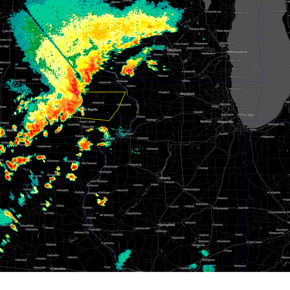 At 359 pm cdt, severe thunderstorms were located along a line extending from buck creek to springville to swisher, moving east at 50 mph (emergency management). Hazards include 70 mph wind gusts and penny size hail. Expect considerable tree damage. damage is likely to mobile homes, roofs, and outbuildings. locations impacted include, cedar rapids, maquoketa, anamosa, mechanicsville, stanwood, marion, hiawatha, mount vernon, monticello, robins, cascade, lisbon, solon, ely, central city, springville, swisher, lowden, wheatland, and olin. This includes interstate 380 between mile markers 10 and 27. At 359 pm cdt, severe thunderstorms were located along a line extending from buck creek to springville to swisher, moving east at 50 mph (emergency management). Hazards include 70 mph wind gusts and penny size hail. Expect considerable tree damage. damage is likely to mobile homes, roofs, and outbuildings. locations impacted include, cedar rapids, maquoketa, anamosa, mechanicsville, stanwood, marion, hiawatha, mount vernon, monticello, robins, cascade, lisbon, solon, ely, central city, springville, swisher, lowden, wheatland, and olin. This includes interstate 380 between mile markers 10 and 27.
|
| 7/11/2025 3:54 PM CDT |
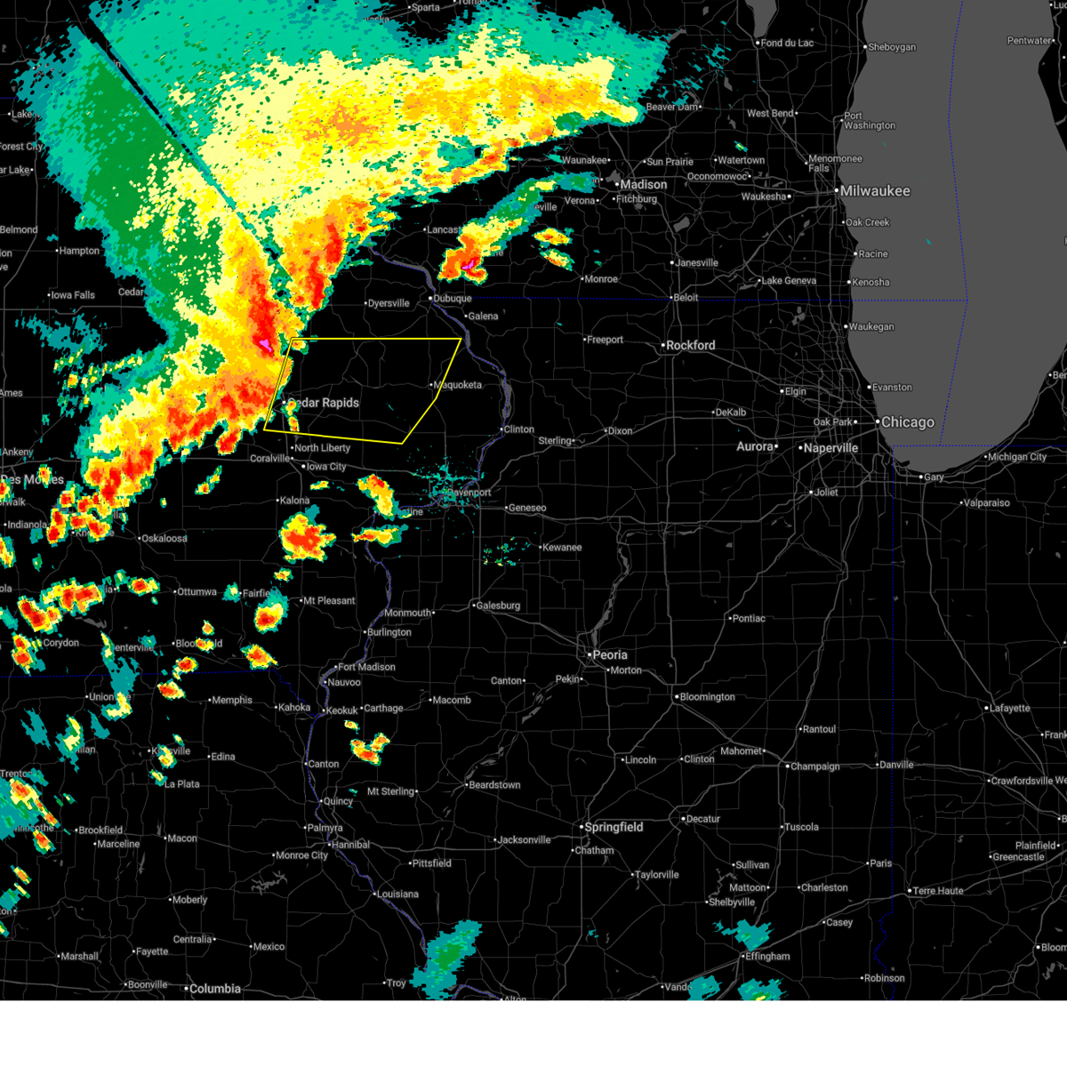 Svrdvn the national weather service in the quad cities has issued a * severe thunderstorm warning for, southwestern jackson county in east central iowa, northern cedar county in east central iowa, southwestern dubuque county in northeastern iowa, northeastern johnson county in east central iowa, jones county in east central iowa, southeastern delaware county in northeastern iowa, linn county in east central iowa, northwestern clinton county in east central iowa, * until 500 pm cdt. * at 353 pm cdt, severe thunderstorms were located along a line extending from near ryan to marion to near walford, moving east at 50 mph (emergency management). Hazards include 60 mph wind gusts and nickel size hail. expect damage to roofs, siding, and trees Svrdvn the national weather service in the quad cities has issued a * severe thunderstorm warning for, southwestern jackson county in east central iowa, northern cedar county in east central iowa, southwestern dubuque county in northeastern iowa, northeastern johnson county in east central iowa, jones county in east central iowa, southeastern delaware county in northeastern iowa, linn county in east central iowa, northwestern clinton county in east central iowa, * until 500 pm cdt. * at 353 pm cdt, severe thunderstorms were located along a line extending from near ryan to marion to near walford, moving east at 50 mph (emergency management). Hazards include 60 mph wind gusts and nickel size hail. expect damage to roofs, siding, and trees
|
| 7/11/2025 3:38 AM CDT |
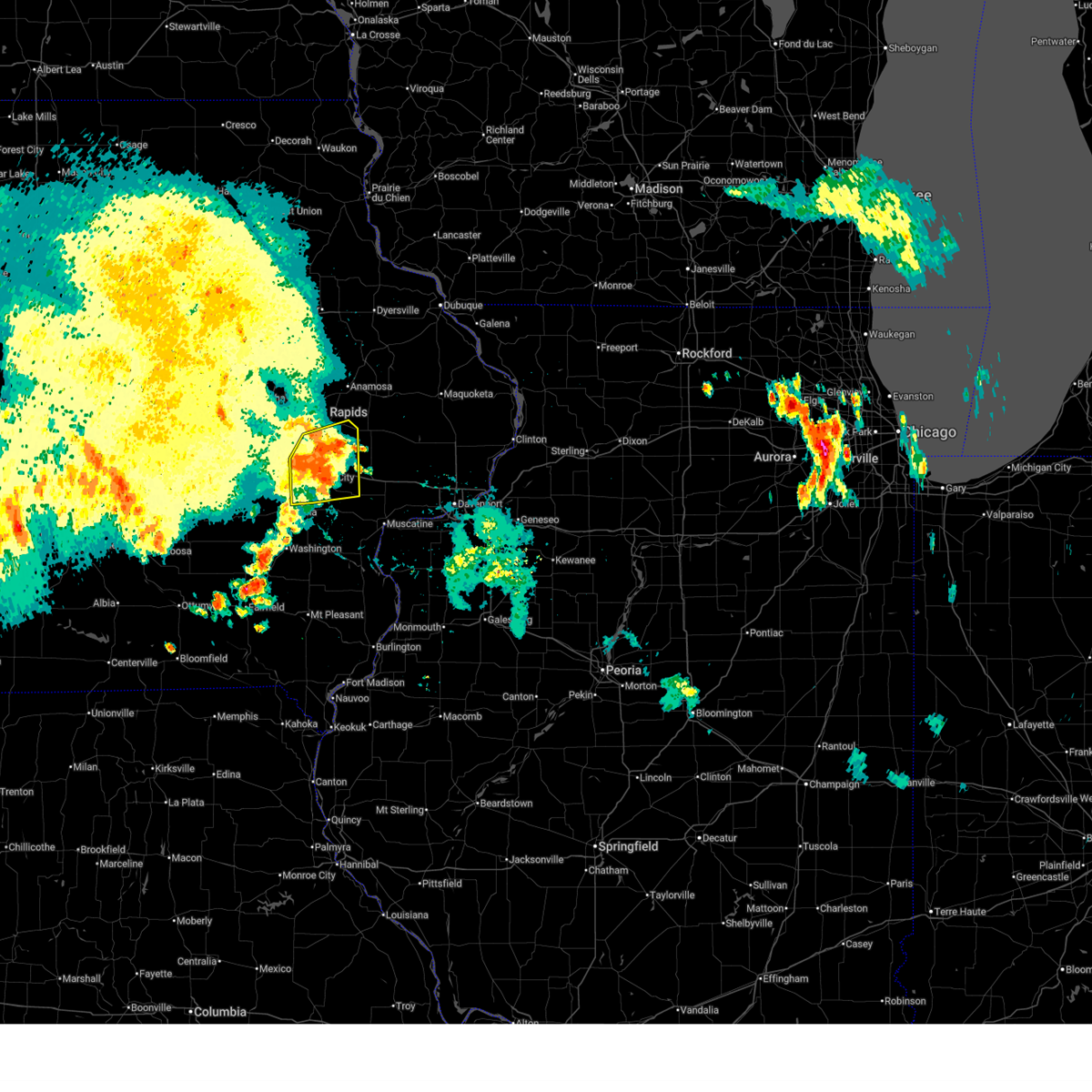 the severe thunderstorm warning has been cancelled and is no longer in effect the severe thunderstorm warning has been cancelled and is no longer in effect
|
| 7/11/2025 3:30 AM CDT |
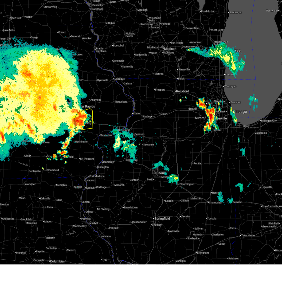 At 329 am cdt, severe thunderstorms were located along a line extending from near solon to near hills access, moving east at 50 mph (radar indicated). Hazards include 60 mph wind gusts and penny size hail. Expect damage to roofs, siding, and trees. locations impacted include, iowa city, west branch, mechanicsville, coralville, north liberty, west liberty, lisbon, solon, tiffin, ely, university heights, hills, oakdale, lake macbride state park, buchanan, newport, cedar valley, muscatine county fairgrounds, sugar bottom camp ground, and johnson county fairgrounds. this includes the following highways, interstate 80 in iowa between mile markers 238 and 261. Interstate 380 between mile markers 1 and 6. At 329 am cdt, severe thunderstorms were located along a line extending from near solon to near hills access, moving east at 50 mph (radar indicated). Hazards include 60 mph wind gusts and penny size hail. Expect damage to roofs, siding, and trees. locations impacted include, iowa city, west branch, mechanicsville, coralville, north liberty, west liberty, lisbon, solon, tiffin, ely, university heights, hills, oakdale, lake macbride state park, buchanan, newport, cedar valley, muscatine county fairgrounds, sugar bottom camp ground, and johnson county fairgrounds. this includes the following highways, interstate 80 in iowa between mile markers 238 and 261. Interstate 380 between mile markers 1 and 6.
|
| 7/11/2025 3:17 AM CDT |
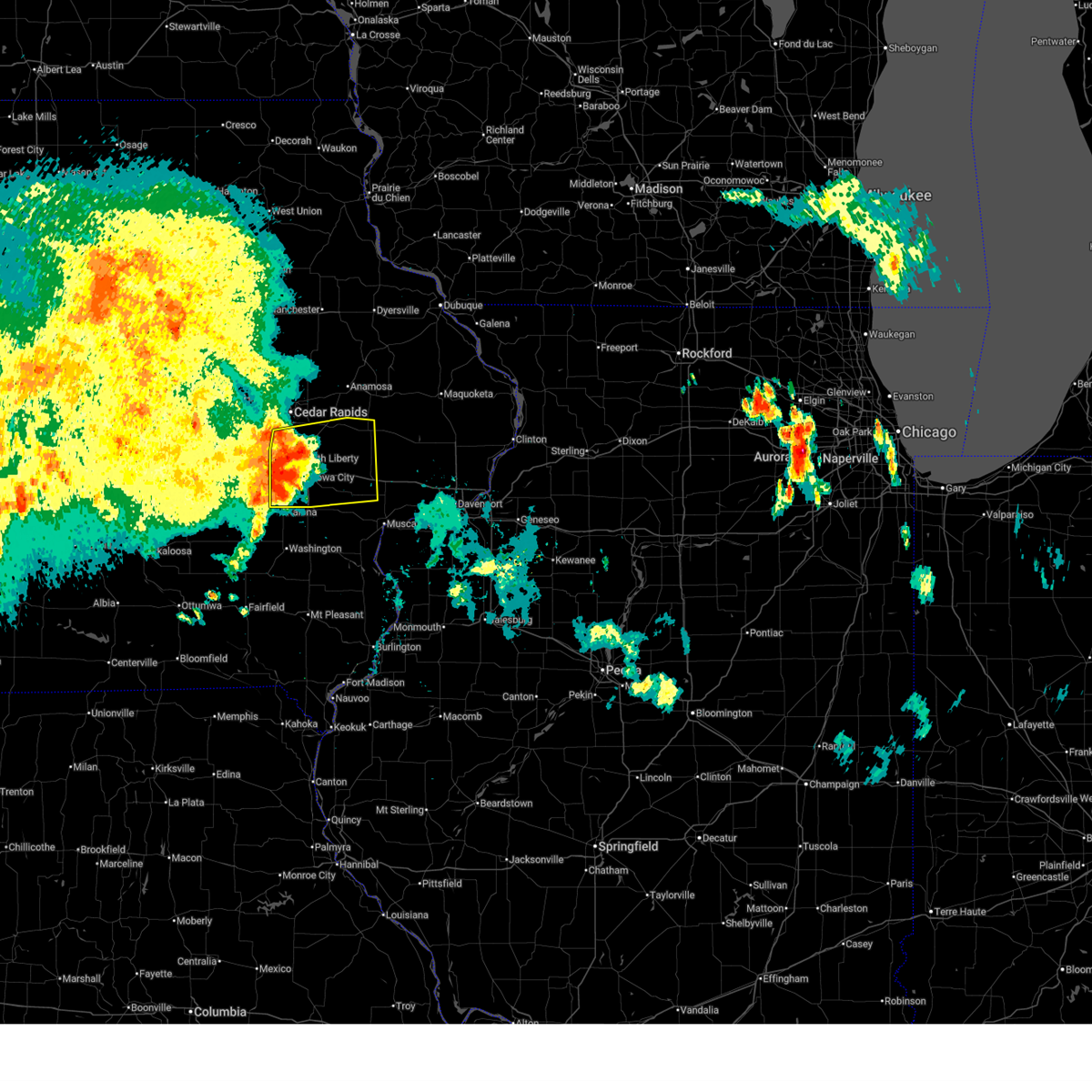 At 317 am cdt, severe thunderstorms were located along a line extending from shueyville to near sharon center, moving east at 40 mph (radar indicated). Hazards include 60 mph wind gusts and penny size hail. Expect damage to roofs, siding, and trees. locations impacted include, cedar rapids, iowa city, tipton, west branch, mechanicsville, stanwood, coralville, north liberty, mount vernon, west liberty, lisbon, solon, tiffin, ely, university heights, swisher, oxford, hills, shueyville, and atalissa. this includes the following highways, interstate 80 in iowa between mile markers 231 and 267. Interstate 380 between mile markers 1 and 14. At 317 am cdt, severe thunderstorms were located along a line extending from shueyville to near sharon center, moving east at 40 mph (radar indicated). Hazards include 60 mph wind gusts and penny size hail. Expect damage to roofs, siding, and trees. locations impacted include, cedar rapids, iowa city, tipton, west branch, mechanicsville, stanwood, coralville, north liberty, mount vernon, west liberty, lisbon, solon, tiffin, ely, university heights, swisher, oxford, hills, shueyville, and atalissa. this includes the following highways, interstate 80 in iowa between mile markers 231 and 267. Interstate 380 between mile markers 1 and 14.
|
| 7/11/2025 3:17 AM CDT |
 the severe thunderstorm warning has been cancelled and is no longer in effect the severe thunderstorm warning has been cancelled and is no longer in effect
|
| 7/11/2025 3:05 AM CDT |
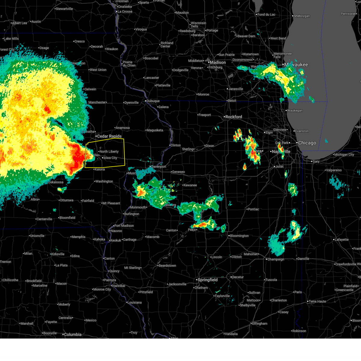 Svrdvn the national weather service in the quad cities has issued a * severe thunderstorm warning for, western cedar county in east central iowa, johnson county in east central iowa, northwestern muscatine county in east central iowa, southern linn county in east central iowa, eastern iowa county in east central iowa, * until 400 am cdt. * at 304 am cdt, severe thunderstorms were located along a line extending from near east amana to near amish, moving east at 40 mph (radar indicated). Hazards include 60 mph wind gusts and penny size hail. expect damage to roofs, siding, and trees Svrdvn the national weather service in the quad cities has issued a * severe thunderstorm warning for, western cedar county in east central iowa, johnson county in east central iowa, northwestern muscatine county in east central iowa, southern linn county in east central iowa, eastern iowa county in east central iowa, * until 400 am cdt. * at 304 am cdt, severe thunderstorms were located along a line extending from near east amana to near amish, moving east at 40 mph (radar indicated). Hazards include 60 mph wind gusts and penny size hail. expect damage to roofs, siding, and trees
|
| 3/14/2025 8:40 PM CDT |
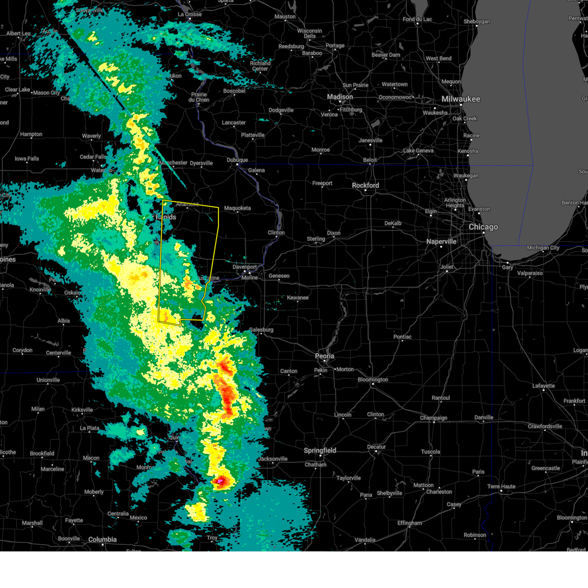 At 840 pm cdt, a severe thunderstorm was located over sutliff, or 7 miles southwest of mechanicsville, moving north at 70 mph (radar indicated). Hazards include 70 mph wind gusts. Expect considerable tree damage. damage is likely to mobile homes, roofs, and outbuildings. locations impacted include, muscatine county fairgrounds, amber, sugar bottom camp ground, ainsworth, johnson county fairgrounds, morning sun, lake macbride state park, hills, tipton matthews airport, waubeek, swedesburg, stone city, wyman, muscatine municipal airport, flaming prairie park, cotter, columbus junction, matsell bridge natural area, lisbon, and bertram. This includes interstate 80 in iowa between mile markers 241 and 274. At 840 pm cdt, a severe thunderstorm was located over sutliff, or 7 miles southwest of mechanicsville, moving north at 70 mph (radar indicated). Hazards include 70 mph wind gusts. Expect considerable tree damage. damage is likely to mobile homes, roofs, and outbuildings. locations impacted include, muscatine county fairgrounds, amber, sugar bottom camp ground, ainsworth, johnson county fairgrounds, morning sun, lake macbride state park, hills, tipton matthews airport, waubeek, swedesburg, stone city, wyman, muscatine municipal airport, flaming prairie park, cotter, columbus junction, matsell bridge natural area, lisbon, and bertram. This includes interstate 80 in iowa between mile markers 241 and 274.
|
| 3/14/2025 8:26 PM CDT |
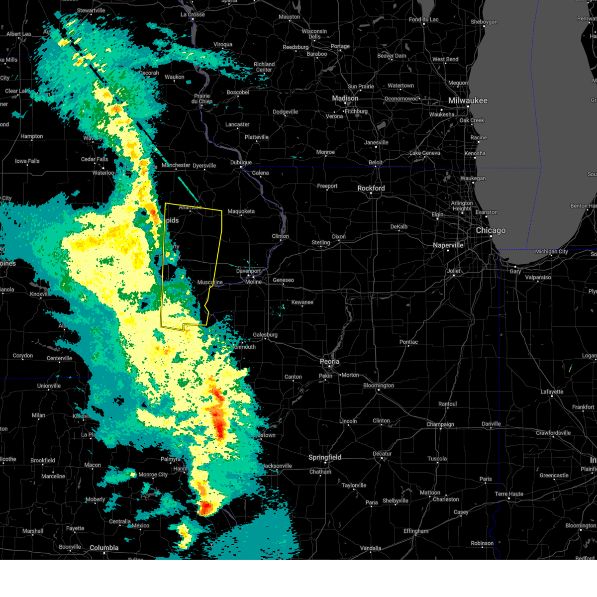 At 826 pm cdt, a severe thunderstorm was located near west branch, moving north at 70 mph (radar indicated). Hazards include 70 mph wind gusts. Expect considerable tree damage. damage is likely to mobile homes, roofs, and outbuildings. locations impacted include, cedar bluff, cedar valley, oasis, iowa city, newport, morse, elmira, springdale, cedar valley park, herbert hoover national historic site, buchanan, solon, sutliff, lisbon, mechanicsville, mount vernon, morley, martelle, paralta, viola, anamosa, wapsipinicon state park, olin, stone city, springville, central park and matsell bridge natural area. This includes interstate 80 in iowa between mile markers 241 and 274. At 826 pm cdt, a severe thunderstorm was located near west branch, moving north at 70 mph (radar indicated). Hazards include 70 mph wind gusts. Expect considerable tree damage. damage is likely to mobile homes, roofs, and outbuildings. locations impacted include, cedar bluff, cedar valley, oasis, iowa city, newport, morse, elmira, springdale, cedar valley park, herbert hoover national historic site, buchanan, solon, sutliff, lisbon, mechanicsville, mount vernon, morley, martelle, paralta, viola, anamosa, wapsipinicon state park, olin, stone city, springville, central park and matsell bridge natural area. This includes interstate 80 in iowa between mile markers 241 and 274.
|
| 3/14/2025 8:03 PM CDT |
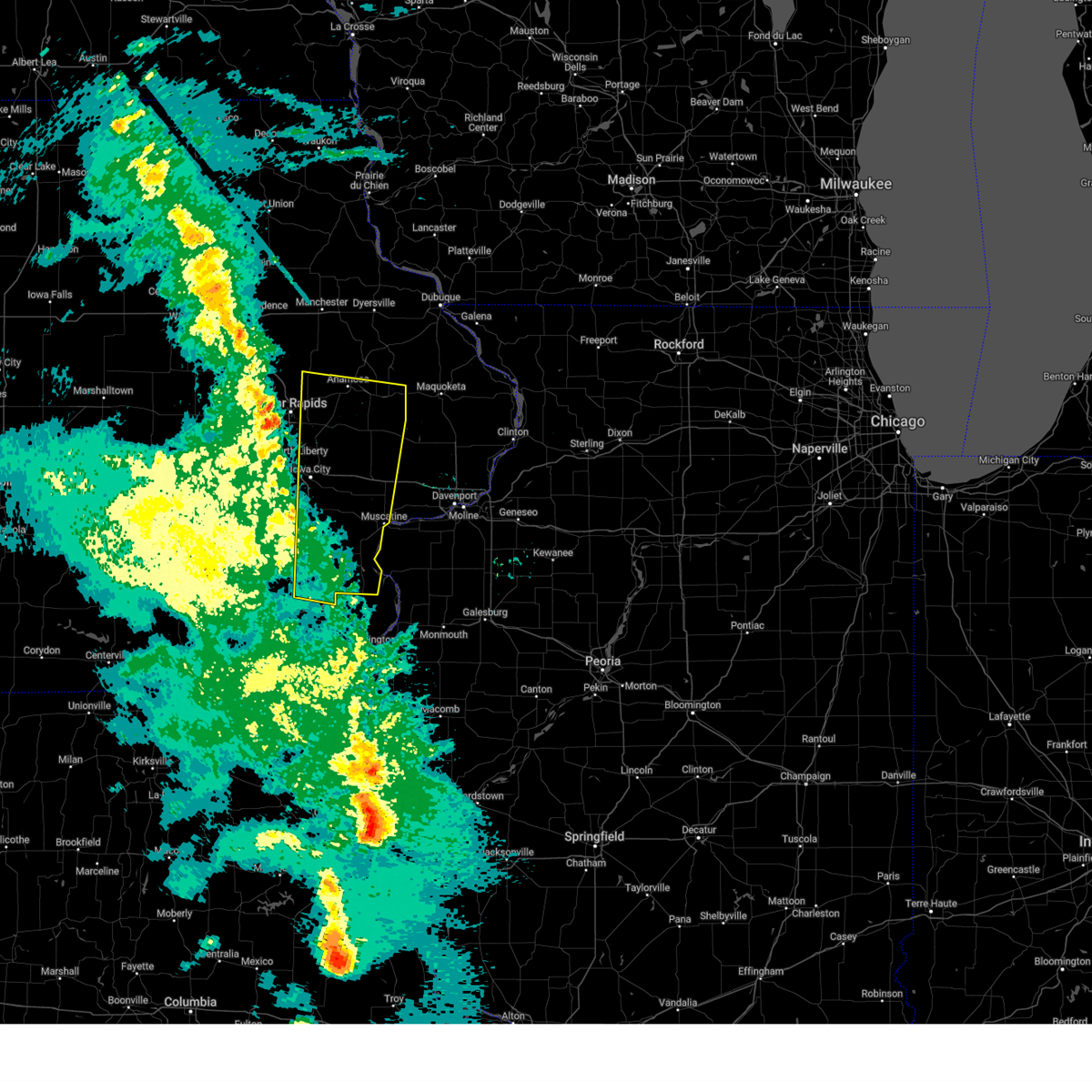 Svrdvn the national weather service in the quad cities has issued a * severe thunderstorm warning for, northeastern henry county in southeastern iowa, louisa county in southeastern iowa, cedar county in east central iowa, eastern johnson county in east central iowa, eastern washington county in southeastern iowa, southern jones county in east central iowa, muscatine county in east central iowa, southeastern linn county in east central iowa, * until 900 pm cdt. * at 801 pm cdt, a severe thunderstorm was located over wyman, or 8 miles southwest of columbus junction, moving north at 70 mph. a trained spotter reported a wind gust of 77 mph in new london iowa at 748 pm. this is a destructive storm for henry county and washington county (trained weather spotters). Hazards include 80 mph wind gusts. Flying debris will be dangerous to those caught without shelter. mobile homes will be heavily damaged. expect considerable damage to roofs, windows, and vehicles. extensive tree damage and power outages are likely. this severe thunderstorm will be near, haskins, cotter, ainsworth, cairo, wyman, columbus city, crawfordsville, gladwin, fredonia, and columbus junction around 805 pm cdt. conesville around 810 pm cdt. lone tree, river junction, riverside, and nichols around 815 pm cdt. west liberty, iowa city, hills, and hills access around 820 pm cdt. other locations in the path of this severe thunderstorm include oasis, springdale, herbert hoover national historic site, muscatine county fairgrounds, west branch, cedar bluff, cedar valley, newport, morse, elmira, cedar valley park, buchanan, solon, sutliff, lisbon, mechanicsville and mount vernon. This includes interstate 80 in iowa between mile markers 241 and 274. Svrdvn the national weather service in the quad cities has issued a * severe thunderstorm warning for, northeastern henry county in southeastern iowa, louisa county in southeastern iowa, cedar county in east central iowa, eastern johnson county in east central iowa, eastern washington county in southeastern iowa, southern jones county in east central iowa, muscatine county in east central iowa, southeastern linn county in east central iowa, * until 900 pm cdt. * at 801 pm cdt, a severe thunderstorm was located over wyman, or 8 miles southwest of columbus junction, moving north at 70 mph. a trained spotter reported a wind gust of 77 mph in new london iowa at 748 pm. this is a destructive storm for henry county and washington county (trained weather spotters). Hazards include 80 mph wind gusts. Flying debris will be dangerous to those caught without shelter. mobile homes will be heavily damaged. expect considerable damage to roofs, windows, and vehicles. extensive tree damage and power outages are likely. this severe thunderstorm will be near, haskins, cotter, ainsworth, cairo, wyman, columbus city, crawfordsville, gladwin, fredonia, and columbus junction around 805 pm cdt. conesville around 810 pm cdt. lone tree, river junction, riverside, and nichols around 815 pm cdt. west liberty, iowa city, hills, and hills access around 820 pm cdt. other locations in the path of this severe thunderstorm include oasis, springdale, herbert hoover national historic site, muscatine county fairgrounds, west branch, cedar bluff, cedar valley, newport, morse, elmira, cedar valley park, buchanan, solon, sutliff, lisbon, mechanicsville and mount vernon. This includes interstate 80 in iowa between mile markers 241 and 274.
|
| 10/24/2024 8:27 PM CDT |
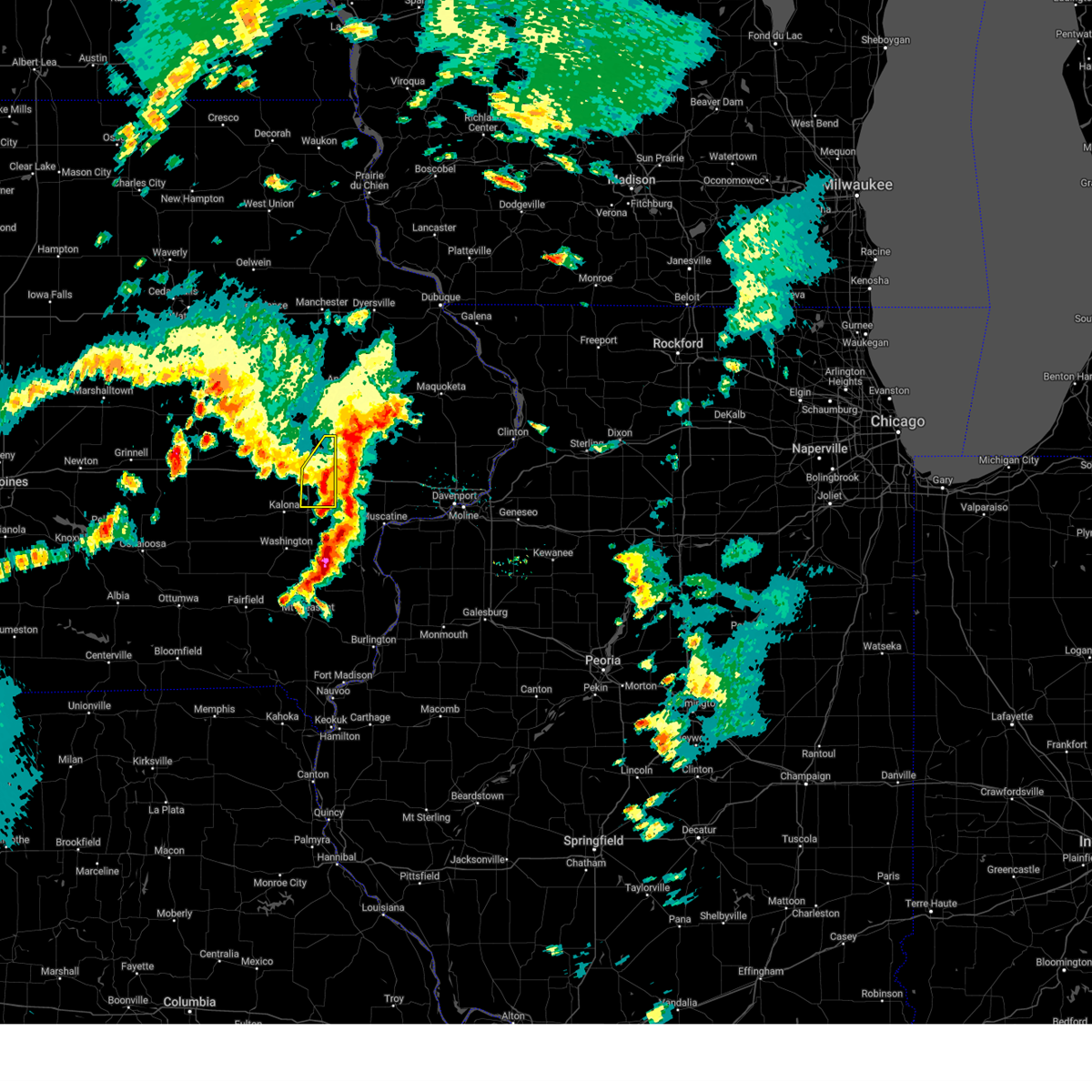 The storms which prompted the warning have moved out of the area. therefore, the warning will be allowed to expire. however, small hail and frequent lightning will still be likely with the thunderstorms through 845 pm cdt. The storms which prompted the warning have moved out of the area. therefore, the warning will be allowed to expire. however, small hail and frequent lightning will still be likely with the thunderstorms through 845 pm cdt.
|
| 10/24/2024 8:16 PM CDT |
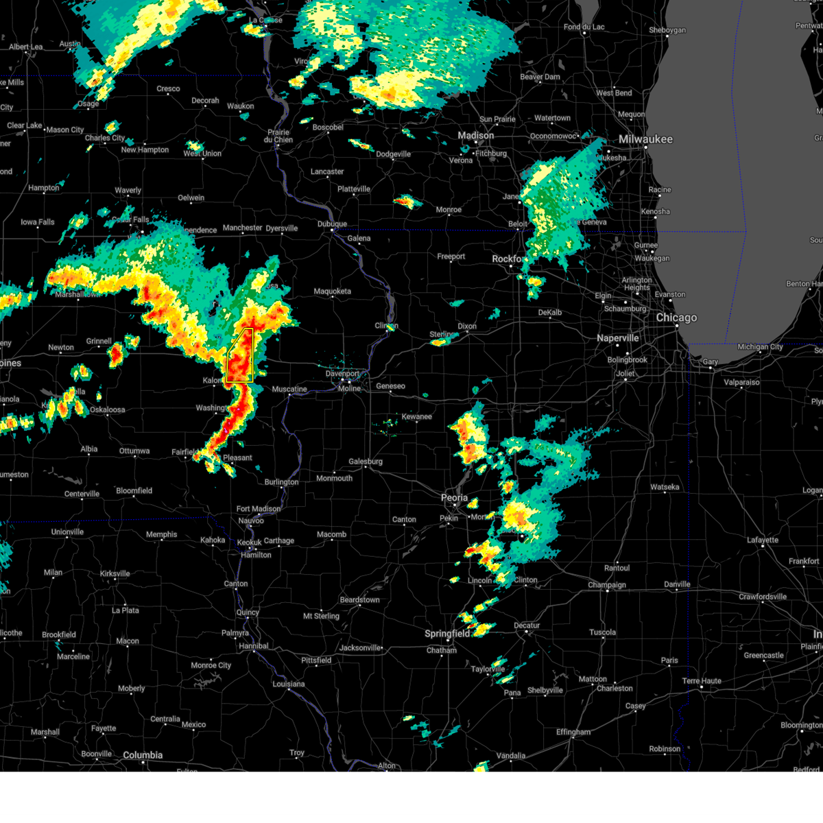 At 816 pm cdt, severe thunderstorms were located along a line extending from sutliff to hills access, moving east at 50 mph. some wind gusts to 50 mph will also be seen with these storms (radar indicated). Hazards include quarter size hail. Damage to vehicles is expected. locations impacted include, iowa city, coralville, solon, university heights, hills, newport, iowa city municipal airport, johnson county fairgrounds, hills access, oasis, sutliff, elmira, morse, west overlook, university of iowa, and coralville lake dam complex. This includes interstate 80 in iowa between mile markers 242 and 253. At 816 pm cdt, severe thunderstorms were located along a line extending from sutliff to hills access, moving east at 50 mph. some wind gusts to 50 mph will also be seen with these storms (radar indicated). Hazards include quarter size hail. Damage to vehicles is expected. locations impacted include, iowa city, coralville, solon, university heights, hills, newport, iowa city municipal airport, johnson county fairgrounds, hills access, oasis, sutliff, elmira, morse, west overlook, university of iowa, and coralville lake dam complex. This includes interstate 80 in iowa between mile markers 242 and 253.
|
| 10/24/2024 8:01 PM CDT |
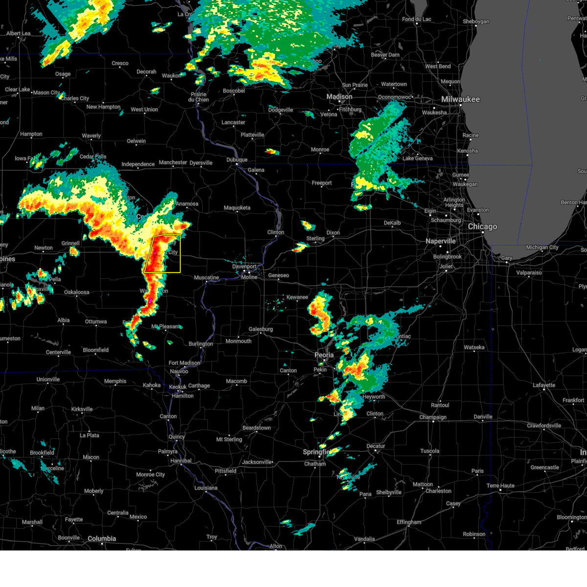 At 800 pm cdt, severe thunderstorms were located along a line extending from sandy beach camp ground to near sharon center, moving east at 50 mph (radar indicated). Hazards include quarter size hail. Damage to vehicles is expected. locations impacted include, iowa city, coralville, north liberty, solon, tiffin, university heights, swisher, hills, shueyville, oakdale, lake macbride state park, newport, frytown, windham, sugar bottom camp ground, johnson county fairgrounds, sutliff, west overlook, coralville lake dam complex, and iowa city municipal airport. this includes the following highways, interstate 80 in iowa between mile markers 234 and 253. Interstate 380 between mile markers 1 and 10. At 800 pm cdt, severe thunderstorms were located along a line extending from sandy beach camp ground to near sharon center, moving east at 50 mph (radar indicated). Hazards include quarter size hail. Damage to vehicles is expected. locations impacted include, iowa city, coralville, north liberty, solon, tiffin, university heights, swisher, hills, shueyville, oakdale, lake macbride state park, newport, frytown, windham, sugar bottom camp ground, johnson county fairgrounds, sutliff, west overlook, coralville lake dam complex, and iowa city municipal airport. this includes the following highways, interstate 80 in iowa between mile markers 234 and 253. Interstate 380 between mile markers 1 and 10.
|
| 10/24/2024 7:45 PM CDT |
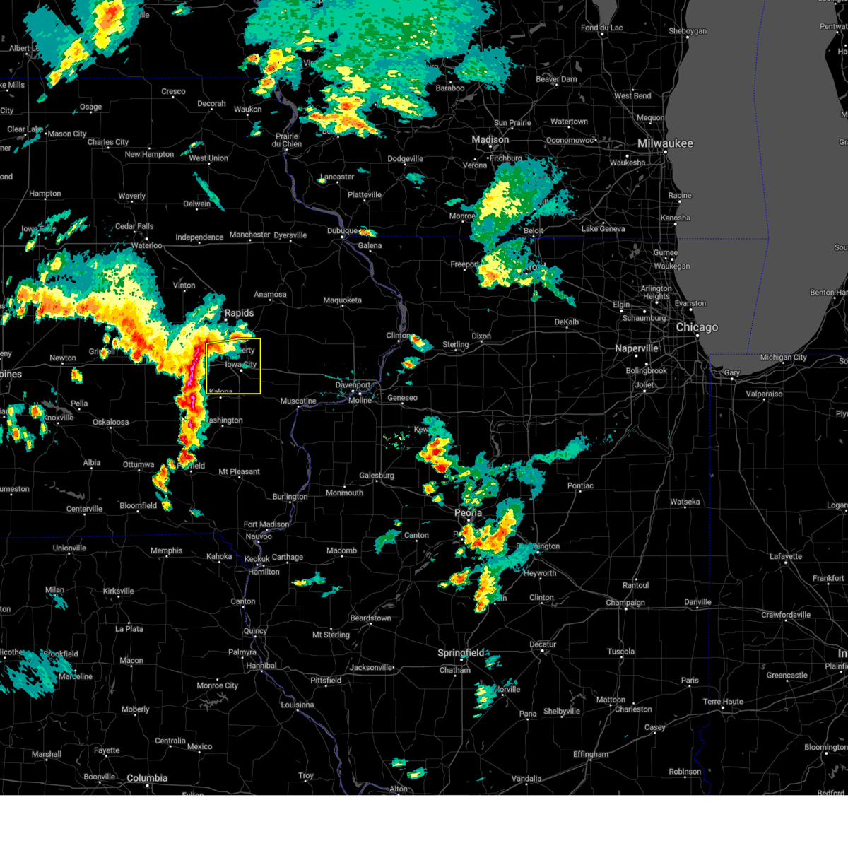 Svrdvn the national weather service in the quad cities has issued a * severe thunderstorm warning for, johnson county in east central iowa, * until 830 pm cdt. * at 745 pm cdt, severe thunderstorms were located along a line extending from near homestead to wellman, moving east at 50 mph (radar indicated). Hazards include quarter size hail. damage to vehicles is expected Svrdvn the national weather service in the quad cities has issued a * severe thunderstorm warning for, johnson county in east central iowa, * until 830 pm cdt. * at 745 pm cdt, severe thunderstorms were located along a line extending from near homestead to wellman, moving east at 50 mph (radar indicated). Hazards include quarter size hail. damage to vehicles is expected
|
| 7/15/2024 7:14 PM CDT |
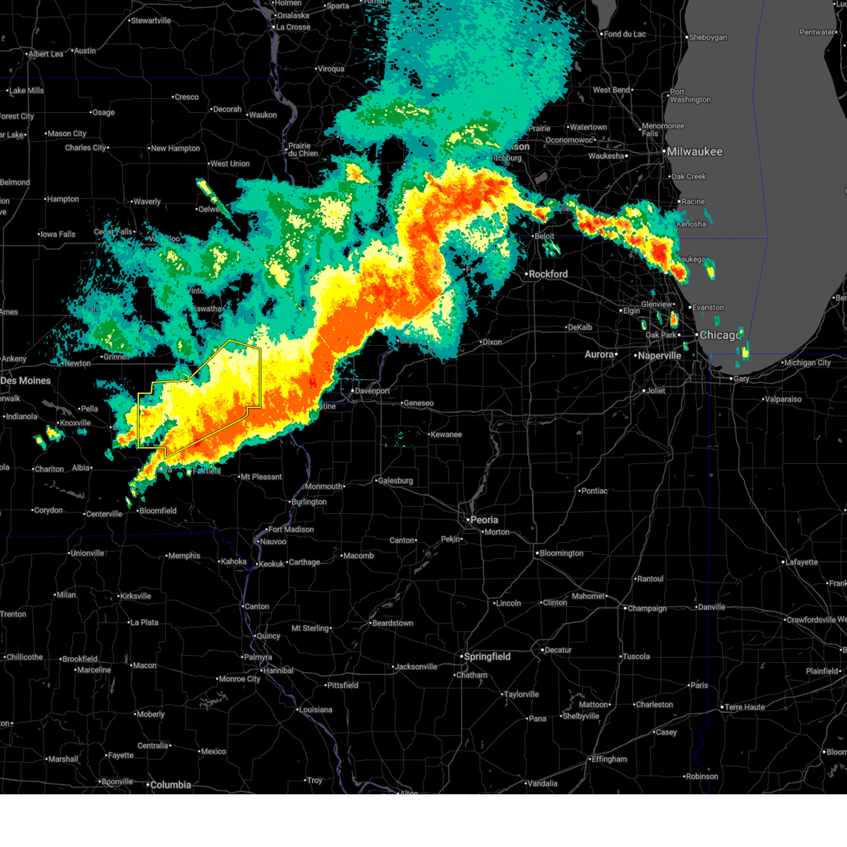 The storms which prompted the warning have moved out of the area. therefore, the warning will be allowed to expire. however, gusty winds and heavy rain are still possible with these thunderstorms. a severe thunderstorm watch remains in effect until 1100 pm cdt for southeastern and east central iowa. The storms which prompted the warning have moved out of the area. therefore, the warning will be allowed to expire. however, gusty winds and heavy rain are still possible with these thunderstorms. a severe thunderstorm watch remains in effect until 1100 pm cdt for southeastern and east central iowa.
|
| 7/15/2024 6:59 PM CDT |
 At 659 pm cdt, severe thunderstorms were located along a line extending from near haskins to packwood, moving southeast at 45 mph (radar indicated). Hazards include 70 mph wind gusts and penny size hail. Expect considerable tree damage. damage is likely to mobile homes, roofs, and outbuildings. locations impacted include, iowa city, washington, sigourney, coralville, north liberty, kalona, solon, tiffin, wellman, lone tree, university heights, north english, riverside, oxford, hedrick, hills, what cheer, richland, delta, and keswick. this includes the following highways, interstate 80 in iowa between mile markers 228 and 253. Interstate 380 between mile markers 1 and 9. At 659 pm cdt, severe thunderstorms were located along a line extending from near haskins to packwood, moving southeast at 45 mph (radar indicated). Hazards include 70 mph wind gusts and penny size hail. Expect considerable tree damage. damage is likely to mobile homes, roofs, and outbuildings. locations impacted include, iowa city, washington, sigourney, coralville, north liberty, kalona, solon, tiffin, wellman, lone tree, university heights, north english, riverside, oxford, hedrick, hills, what cheer, richland, delta, and keswick. this includes the following highways, interstate 80 in iowa between mile markers 228 and 253. Interstate 380 between mile markers 1 and 9.
|
| 7/15/2024 6:59 PM CDT |
 the severe thunderstorm warning has been cancelled and is no longer in effect the severe thunderstorm warning has been cancelled and is no longer in effect
|
| 7/15/2024 6:47 PM CDT |
 At 646 pm cdt, severe thunderstorms were located along a line extending from near richmond to near pekin, moving southeast at 65 mph (trained weather spotters. a wind gust was estimated of at least 70 mph in sigourney at 645 pm cdt). Hazards include 70 mph wind gusts and penny size hail. Expect considerable tree damage. damage is likely to mobile homes, roofs, and outbuildings. locations impacted include, iowa city, washington, marengo, sigourney, coralville, north liberty, williamsburg, kalona, solon, tiffin, walford, wellman, lone tree, university heights, north english, riverside, victor, swisher, oxford, and hedrick. this includes the following highways, interstate 80 in iowa between mile markers 206 and 253. Interstate 380 between mile markers 1 and 12. At 646 pm cdt, severe thunderstorms were located along a line extending from near richmond to near pekin, moving southeast at 65 mph (trained weather spotters. a wind gust was estimated of at least 70 mph in sigourney at 645 pm cdt). Hazards include 70 mph wind gusts and penny size hail. Expect considerable tree damage. damage is likely to mobile homes, roofs, and outbuildings. locations impacted include, iowa city, washington, marengo, sigourney, coralville, north liberty, williamsburg, kalona, solon, tiffin, walford, wellman, lone tree, university heights, north english, riverside, victor, swisher, oxford, and hedrick. this includes the following highways, interstate 80 in iowa between mile markers 206 and 253. Interstate 380 between mile markers 1 and 12.
|
| 7/15/2024 6:44 PM CDT |
 At 643 pm cdt, severe thunderstorms were located along a line extending from near amish to near hayesville, moving southeast at 45 mph (trained weather spotters. at 643 pm winds were estimated to 60 mph just north of south english). Hazards include 70 mph wind gusts and penny size hail. Expect considerable tree damage. damage is likely to mobile homes, roofs, and outbuildings. locations impacted include, iowa city, washington, marengo, sigourney, coralville, north liberty, williamsburg, kalona, solon, tiffin, walford, wellman, lone tree, university heights, north english, riverside, victor, swisher, oxford, and hedrick. this includes the following highways, interstate 80 in iowa between mile markers 206 and 253. Interstate 380 between mile markers 1 and 12. At 643 pm cdt, severe thunderstorms were located along a line extending from near amish to near hayesville, moving southeast at 45 mph (trained weather spotters. at 643 pm winds were estimated to 60 mph just north of south english). Hazards include 70 mph wind gusts and penny size hail. Expect considerable tree damage. damage is likely to mobile homes, roofs, and outbuildings. locations impacted include, iowa city, washington, marengo, sigourney, coralville, north liberty, williamsburg, kalona, solon, tiffin, walford, wellman, lone tree, university heights, north english, riverside, victor, swisher, oxford, and hedrick. this includes the following highways, interstate 80 in iowa between mile markers 206 and 253. Interstate 380 between mile markers 1 and 12.
|
| 7/15/2024 6:36 PM CDT |
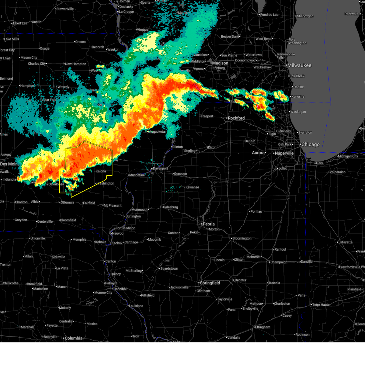 At 636 pm cdt, severe thunderstorms were located along a line extending from near amish to delta, moving southeast at 50 mph (radar indicated). Hazards include 70 mph wind gusts and penny size hail. Expect considerable tree damage. damage is likely to mobile homes, roofs, and outbuildings. locations impacted include, iowa city, washington, marengo, sigourney, coralville, north liberty, williamsburg, kalona, solon, tiffin, walford, wellman, lone tree, university heights, north english, riverside, victor, swisher, oxford, and hedrick. this includes the following highways, interstate 80 in iowa between mile markers 206 and 253. Interstate 380 between mile markers 1 and 12. At 636 pm cdt, severe thunderstorms were located along a line extending from near amish to delta, moving southeast at 50 mph (radar indicated). Hazards include 70 mph wind gusts and penny size hail. Expect considerable tree damage. damage is likely to mobile homes, roofs, and outbuildings. locations impacted include, iowa city, washington, marengo, sigourney, coralville, north liberty, williamsburg, kalona, solon, tiffin, walford, wellman, lone tree, university heights, north english, riverside, victor, swisher, oxford, and hedrick. this includes the following highways, interstate 80 in iowa between mile markers 206 and 253. Interstate 380 between mile markers 1 and 12.
|
| 7/15/2024 6:19 PM CDT |
 At 618 pm cdt, severe thunderstorms were located along a line extending from upper south amana to barnes city, moving southeast at 45 mph (trained weather spotters. at 610 pm a 70 mph wind gust was estimated in swisher). Hazards include 70 mph wind gusts and penny size hail. Expect considerable tree damage. damage is likely to mobile homes, roofs, and outbuildings. locations impacted include, iowa city, washington, marengo, sigourney, coralville, north liberty, williamsburg, kalona, solon, tiffin, walford, wellman, lone tree, university heights, north english, riverside, victor, swisher, oxford, and hedrick. this includes the following highways, interstate 80 in iowa between mile markers 205 and 253. Interstate 380 between mile markers 1 and 12. At 618 pm cdt, severe thunderstorms were located along a line extending from upper south amana to barnes city, moving southeast at 45 mph (trained weather spotters. at 610 pm a 70 mph wind gust was estimated in swisher). Hazards include 70 mph wind gusts and penny size hail. Expect considerable tree damage. damage is likely to mobile homes, roofs, and outbuildings. locations impacted include, iowa city, washington, marengo, sigourney, coralville, north liberty, williamsburg, kalona, solon, tiffin, walford, wellman, lone tree, university heights, north english, riverside, victor, swisher, oxford, and hedrick. this includes the following highways, interstate 80 in iowa between mile markers 205 and 253. Interstate 380 between mile markers 1 and 12.
|
| 7/15/2024 6:10 PM CDT |
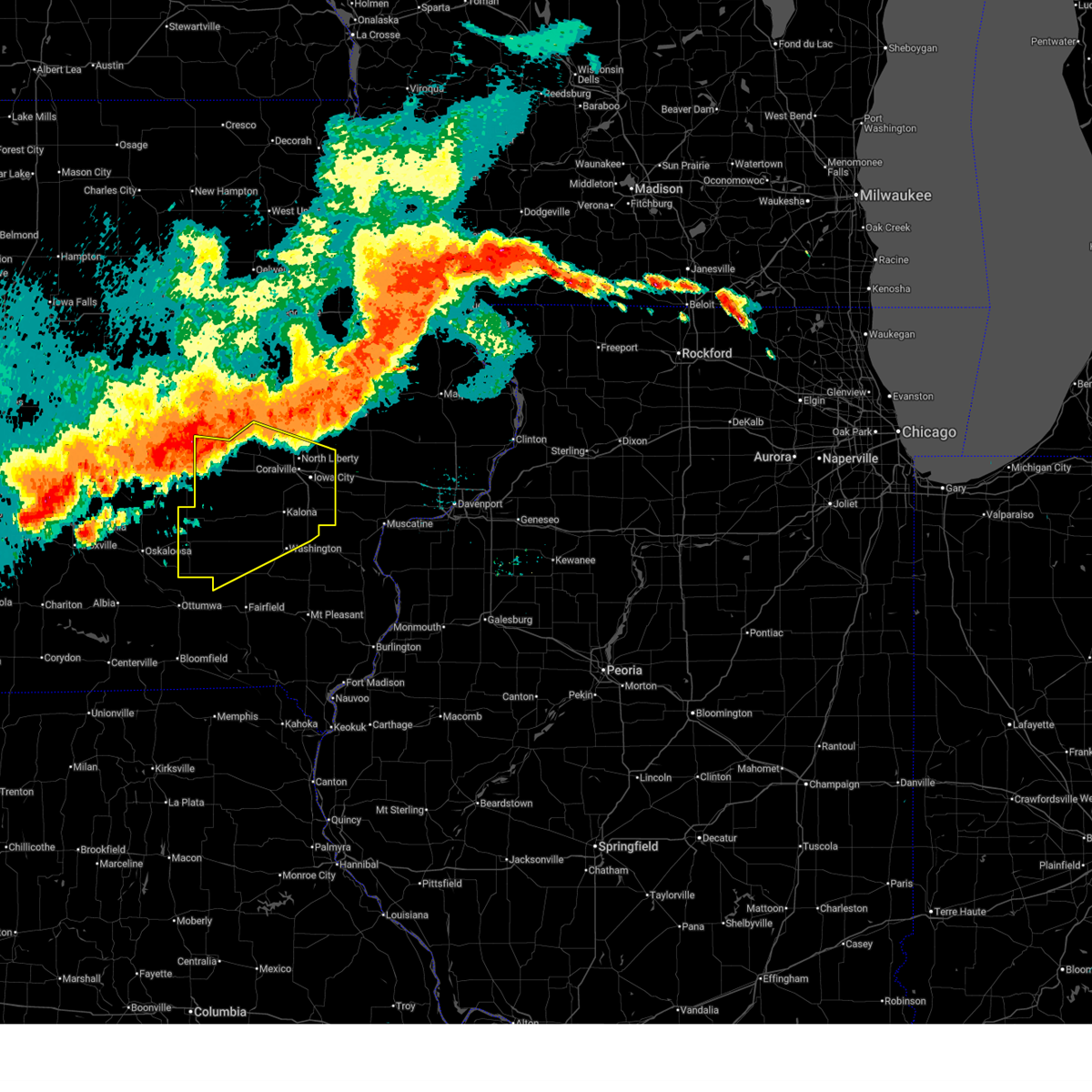 Svrdvn the national weather service in the quad cities has issued a * severe thunderstorm warning for, keokuk county in southeastern iowa, johnson county in east central iowa, washington county in southeastern iowa, southeastern benton county in east central iowa, northwestern jefferson county in southeastern iowa, southwestern linn county in east central iowa, iowa county in east central iowa, * until 715 pm cdt. * at 610 pm cdt, severe thunderstorms were located along a line extending from near iowa county fairgrounds to montezuma, moving southeast at 45 mph (radar indicated). Hazards include 70 mph wind gusts and penny size hail. Expect considerable tree damage. Damage is likely to mobile homes, roofs, and outbuildings. Svrdvn the national weather service in the quad cities has issued a * severe thunderstorm warning for, keokuk county in southeastern iowa, johnson county in east central iowa, washington county in southeastern iowa, southeastern benton county in east central iowa, northwestern jefferson county in southeastern iowa, southwestern linn county in east central iowa, iowa county in east central iowa, * until 715 pm cdt. * at 610 pm cdt, severe thunderstorms were located along a line extending from near iowa county fairgrounds to montezuma, moving southeast at 45 mph (radar indicated). Hazards include 70 mph wind gusts and penny size hail. Expect considerable tree damage. Damage is likely to mobile homes, roofs, and outbuildings.
|
| 7/15/2024 5:59 PM CDT |
 At 559 pm cdt, severe thunderstorms were located along a line extending from near luxemburg to near cedar rapids municipal airport, moving east at 25 mph (radar indicated). Hazards include 70 mph wind gusts and penny size hail. Expect considerable tree damage. damage is likely to mobile homes, roofs, and outbuildings. locations impacted include, cedar rapids, anamosa, vinton, manchester, mechanicsville, marion, hiawatha, mount vernon, dyersville, monticello, robins, belle plaine, center point, cascade, lisbon, fairfax, solon, epworth, ely, and atkins. This includes interstate 380 between mile markers 8 and 45. At 559 pm cdt, severe thunderstorms were located along a line extending from near luxemburg to near cedar rapids municipal airport, moving east at 25 mph (radar indicated). Hazards include 70 mph wind gusts and penny size hail. Expect considerable tree damage. damage is likely to mobile homes, roofs, and outbuildings. locations impacted include, cedar rapids, anamosa, vinton, manchester, mechanicsville, marion, hiawatha, mount vernon, dyersville, monticello, robins, belle plaine, center point, cascade, lisbon, fairfax, solon, epworth, ely, and atkins. This includes interstate 380 between mile markers 8 and 45.
|
| 7/15/2024 5:40 PM CDT |
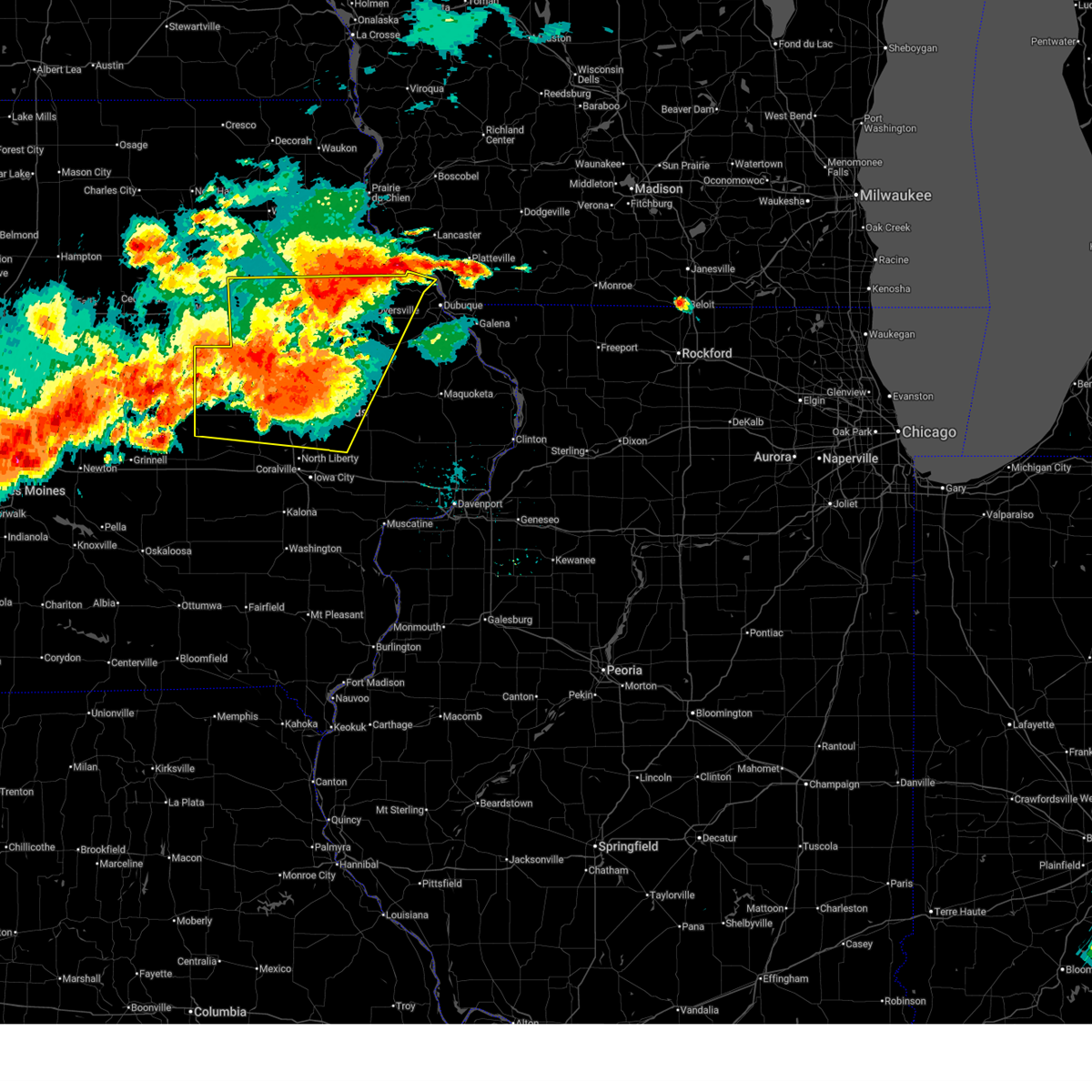 At 539 pm cdt, severe thunderstorms were located along a line extending from near twin bridges park to near fairfax, moving east at 25 mph (radar indicated). Hazards include 70 mph wind gusts and penny size hail. Expect considerable tree damage. damage is likely to mobile homes, roofs, and outbuildings. locations impacted include, cedar rapids, independence, anamosa, vinton, manchester, mechanicsville, marion, hiawatha, mount vernon, dyersville, monticello, robins, belle plaine, jesup, center point, cascade, lisbon, fairfax, solon, and epworth. This includes interstate 380 between mile markers 8 and 55. At 539 pm cdt, severe thunderstorms were located along a line extending from near twin bridges park to near fairfax, moving east at 25 mph (radar indicated). Hazards include 70 mph wind gusts and penny size hail. Expect considerable tree damage. damage is likely to mobile homes, roofs, and outbuildings. locations impacted include, cedar rapids, independence, anamosa, vinton, manchester, mechanicsville, marion, hiawatha, mount vernon, dyersville, monticello, robins, belle plaine, jesup, center point, cascade, lisbon, fairfax, solon, and epworth. This includes interstate 380 between mile markers 8 and 55.
|
| 7/15/2024 5:20 PM CDT | Svrdvn the national weather service in the quad cities has issued a * severe thunderstorm warning for, buchanan county in northeastern iowa, northwestern cedar county in east central iowa, western dubuque county in northeastern iowa, northern johnson county in east central iowa, benton county in east central iowa, jones county in east central iowa, delaware county in northeastern iowa, linn county in east central iowa, northeastern iowa county in east central iowa, * until 630 pm cdt. * at 520 pm cdt, severe thunderstorms were located along a line extending from edgewood to near norway, moving east at 25 mph (radar indicated). Hazards include 70 mph wind gusts and quarter size hail. Hail damage to vehicles is expected. expect considerable tree damage. Wind damage is also likely to mobile homes, roofs, and outbuildings. |
| 6/25/2024 7:46 PM CDT |
 the severe thunderstorm warning has been cancelled and is no longer in effect the severe thunderstorm warning has been cancelled and is no longer in effect
|
| 6/25/2024 7:30 PM CDT |
 At 730 pm cdt, severe thunderstorms were located along a line extending from near west branch to solon, moving northwest at 20 mph. these storms have a history of producing large hail and severe winds (trained weather spotters). Hazards include 70 mph wind gusts and half dollar size hail. Hail damage to vehicles is expected. expect considerable tree damage. wind damage is also likely to mobile homes, roofs, and outbuildings. locations impacted include, iowa city, tipton, west branch, durant, coralville, north liberty, solon, university heights, hills, lake macbride state park, rochester, buchanan, newport, cedar valley, sugar bottom camp ground, johnson county fairgrounds, sunbury, tipton matthews airport, west overlook, and cedar county fairgrounds. this includes the following highways, interstate 80 in iowa between mile markers 242 and 278. Interstate 380 between mile markers 7 and 8. At 730 pm cdt, severe thunderstorms were located along a line extending from near west branch to solon, moving northwest at 20 mph. these storms have a history of producing large hail and severe winds (trained weather spotters). Hazards include 70 mph wind gusts and half dollar size hail. Hail damage to vehicles is expected. expect considerable tree damage. wind damage is also likely to mobile homes, roofs, and outbuildings. locations impacted include, iowa city, tipton, west branch, durant, coralville, north liberty, solon, university heights, hills, lake macbride state park, rochester, buchanan, newport, cedar valley, sugar bottom camp ground, johnson county fairgrounds, sunbury, tipton matthews airport, west overlook, and cedar county fairgrounds. this includes the following highways, interstate 80 in iowa between mile markers 242 and 278. Interstate 380 between mile markers 7 and 8.
|
| 6/25/2024 7:25 PM CDT |
 Svrdvn the national weather service in the quad cities has issued a * severe thunderstorm warning for, southwestern cedar county in east central iowa, northeastern johnson county in east central iowa, southeastern linn county in east central iowa, * until 830 pm cdt. * at 724 pm cdt, severe thunderstorms were located along a line extending from shueyville to cou falls, moving southeast at 25 mph. a large hail producing storm is also located near the linn and johnson county border (radar indicated). Hazards include 70 mph wind gusts and half dollar size hail. Hail damage to vehicles is expected. expect considerable tree damage. Wind damage is also likely to mobile homes, roofs, and outbuildings. Svrdvn the national weather service in the quad cities has issued a * severe thunderstorm warning for, southwestern cedar county in east central iowa, northeastern johnson county in east central iowa, southeastern linn county in east central iowa, * until 830 pm cdt. * at 724 pm cdt, severe thunderstorms were located along a line extending from shueyville to cou falls, moving southeast at 25 mph. a large hail producing storm is also located near the linn and johnson county border (radar indicated). Hazards include 70 mph wind gusts and half dollar size hail. Hail damage to vehicles is expected. expect considerable tree damage. Wind damage is also likely to mobile homes, roofs, and outbuildings.
|
| 6/25/2024 7:09 PM CDT |
 At 709 pm cdt, severe thunderstorms were located along a line extending from near tiffin to cedar valley park, moving southeast at 15 mph. iowa city airport gusted to 68 mph with these storms (trained weather spotters). Hazards include 70 mph wind gusts and quarter size hail. Hail damage to vehicles is expected. expect considerable tree damage. wind damage is also likely to mobile homes, roofs, and outbuildings. locations impacted include, iowa city, tipton, west branch, durant, coralville, north liberty, solon, tiffin, university heights, hills, oakdale, lake macbride state park, rochester, buchanan, newport, cedar valley, sugar bottom camp ground, johnson county fairgrounds, sunbury, and tipton matthews airport. this includes the following highways, interstate 80 in iowa between mile markers 236 and 278. Interstate 380 between mile markers 1 and 8. At 709 pm cdt, severe thunderstorms were located along a line extending from near tiffin to cedar valley park, moving southeast at 15 mph. iowa city airport gusted to 68 mph with these storms (trained weather spotters). Hazards include 70 mph wind gusts and quarter size hail. Hail damage to vehicles is expected. expect considerable tree damage. wind damage is also likely to mobile homes, roofs, and outbuildings. locations impacted include, iowa city, tipton, west branch, durant, coralville, north liberty, solon, tiffin, university heights, hills, oakdale, lake macbride state park, rochester, buchanan, newport, cedar valley, sugar bottom camp ground, johnson county fairgrounds, sunbury, and tipton matthews airport. this includes the following highways, interstate 80 in iowa between mile markers 236 and 278. Interstate 380 between mile markers 1 and 8.
|
| 6/25/2024 6:58 PM CDT |
 At 657 pm cdt, severe thunderstorms were located along a line extending from tiffin to cedar valley, moving south at 15 mph. hail over one inch in diameter was reported with one of these storms in solon (trained weather spotters). Hazards include 60 mph wind gusts and quarter size hail. Hail damage to vehicles is expected. expect wind damage to roofs, siding, and trees. locations impacted include, iowa city, tipton, west branch, durant, coralville, north liberty, solon, tiffin, university heights, hills, oakdale, lake macbride state park, rochester, buchanan, newport, cedar valley, sugar bottom camp ground, johnson county fairgrounds, sutliff, and sunbury. this includes the following highways, interstate 80 in iowa between mile markers 236 and 278. Interstate 380 between mile markers 1 and 9. At 657 pm cdt, severe thunderstorms were located along a line extending from tiffin to cedar valley, moving south at 15 mph. hail over one inch in diameter was reported with one of these storms in solon (trained weather spotters). Hazards include 60 mph wind gusts and quarter size hail. Hail damage to vehicles is expected. expect wind damage to roofs, siding, and trees. locations impacted include, iowa city, tipton, west branch, durant, coralville, north liberty, solon, tiffin, university heights, hills, oakdale, lake macbride state park, rochester, buchanan, newport, cedar valley, sugar bottom camp ground, johnson county fairgrounds, sutliff, and sunbury. this includes the following highways, interstate 80 in iowa between mile markers 236 and 278. Interstate 380 between mile markers 1 and 9.
|
| 6/25/2024 6:41 PM CDT |
 At 640 pm cdt, severe thunderstorms were located along a line extending from sugar bottom camp ground to tipton, moving southeast at 15 mph. trained weather spotters reported quarter size hail near solon with one of these storms (trained weather spotters). Hazards include 60 mph wind gusts and quarter size hail. Hail damage to vehicles is expected. expect wind damage to roofs, siding, and trees. locations impacted include, iowa city, tipton, west branch, durant, coralville, north liberty, solon, tiffin, university heights, hills, bennett, oakdale, lake macbride state park, rochester, buchanan, newport, cedar valley, sugar bottom camp ground, johnson county fairgrounds, and sutliff. this includes the following highways, interstate 80 in iowa between mile markers 236 and 278. Interstate 380 between mile markers 1 and 9. At 640 pm cdt, severe thunderstorms were located along a line extending from sugar bottom camp ground to tipton, moving southeast at 15 mph. trained weather spotters reported quarter size hail near solon with one of these storms (trained weather spotters). Hazards include 60 mph wind gusts and quarter size hail. Hail damage to vehicles is expected. expect wind damage to roofs, siding, and trees. locations impacted include, iowa city, tipton, west branch, durant, coralville, north liberty, solon, tiffin, university heights, hills, bennett, oakdale, lake macbride state park, rochester, buchanan, newport, cedar valley, sugar bottom camp ground, johnson county fairgrounds, and sutliff. this includes the following highways, interstate 80 in iowa between mile markers 236 and 278. Interstate 380 between mile markers 1 and 9.
|
| 6/25/2024 6:35 PM CDT | Quarter sized hail reported 0.8 miles NW of Solon, IA, quarter hail and a wind gust of 40 mph. |
| 6/25/2024 6:34 PM CDT | Golf Ball sized hail reported 1.4 miles NNW of Solon, IA, time estimated from radar. |
| 6/25/2024 6:28 PM CDT |
 Svrdvn the national weather service in the quad cities has issued a * severe thunderstorm warning for, cedar county in east central iowa, northern johnson county in east central iowa, * until 745 pm cdt. * at 628 pm cdt, severe thunderstorms were located along a line extending from north liberty to near cedar county fairgrounds, moving southeast at 15 mph (radar indicated). Hazards include 60 mph wind gusts and quarter size hail. Hail damage to vehicles is expected. Expect wind damage to roofs, siding, and trees. Svrdvn the national weather service in the quad cities has issued a * severe thunderstorm warning for, cedar county in east central iowa, northern johnson county in east central iowa, * until 745 pm cdt. * at 628 pm cdt, severe thunderstorms were located along a line extending from north liberty to near cedar county fairgrounds, moving southeast at 15 mph (radar indicated). Hazards include 60 mph wind gusts and quarter size hail. Hail damage to vehicles is expected. Expect wind damage to roofs, siding, and trees.
|
| 6/25/2024 6:08 PM CDT |
 At 608 pm cdt, severe thunderstorms were located along a line extending from delmar to near sutliff, moving east at 15 mph (radar indicated). Hazards include 60 mph wind gusts and quarter size hail. Hail damage to vehicles is expected. expect wind damage to roofs, siding, and trees. locations impacted include, cedar rapids, tipton, mechanicsville, stanwood, coralville, north liberty, dewitt, mount vernon, lisbon, solon, tiffin, ely, lowden, wheatland, grand mound, shueyville, delmar, oxford junction, lost nation, and calamus. this includes the following highways, interstate 80 in iowa between mile markers 238 and 241. Interstate 380 between mile markers 1 and 13. At 608 pm cdt, severe thunderstorms were located along a line extending from delmar to near sutliff, moving east at 15 mph (radar indicated). Hazards include 60 mph wind gusts and quarter size hail. Hail damage to vehicles is expected. expect wind damage to roofs, siding, and trees. locations impacted include, cedar rapids, tipton, mechanicsville, stanwood, coralville, north liberty, dewitt, mount vernon, lisbon, solon, tiffin, ely, lowden, wheatland, grand mound, shueyville, delmar, oxford junction, lost nation, and calamus. this includes the following highways, interstate 80 in iowa between mile markers 238 and 241. Interstate 380 between mile markers 1 and 13.
|
| 6/25/2024 5:55 PM CDT |
 At 554 pm cdt, severe thunderstorms were located along a line extending from near delmar to near lisbon, moving east at 15 mph (radar indicated). Hazards include 60 mph wind gusts and quarter size hail. Hail damage to vehicles is expected. expect wind damage to roofs, siding, and trees. locations impacted include, cedar rapids, tipton, mechanicsville, stanwood, coralville, north liberty, dewitt, mount vernon, lisbon, solon, tiffin, ely, lowden, wheatland, olin, grand mound, shueyville, delmar, oxford junction, and lost nation. this includes the following highways, interstate 80 in iowa between mile markers 238 and 241. Interstate 380 between mile markers 1 and 16. At 554 pm cdt, severe thunderstorms were located along a line extending from near delmar to near lisbon, moving east at 15 mph (radar indicated). Hazards include 60 mph wind gusts and quarter size hail. Hail damage to vehicles is expected. expect wind damage to roofs, siding, and trees. locations impacted include, cedar rapids, tipton, mechanicsville, stanwood, coralville, north liberty, dewitt, mount vernon, lisbon, solon, tiffin, ely, lowden, wheatland, olin, grand mound, shueyville, delmar, oxford junction, and lost nation. this includes the following highways, interstate 80 in iowa between mile markers 238 and 241. Interstate 380 between mile markers 1 and 16.
|
| 6/25/2024 5:35 PM CDT |
 At 535 pm cdt, severe thunderstorms were located along a line extending from elwood to near palisades-kepler state park, moving east at 15 mph (radar indicated). Hazards include 60 mph wind gusts and quarter size hail. Hail damage to vehicles is expected. expect wind damage to roofs, siding, and trees. locations impacted include, cedar rapids, tipton, mechanicsville, stanwood, coralville, north liberty, dewitt, mount vernon, lisbon, solon, tiffin, ely, lowden, wheatland, olin, grand mound, shueyville, delmar, oxford junction, and lost nation. this includes the following highways, interstate 80 in iowa between mile markers 238 and 241. Interstate 380 between mile markers 1 and 16. At 535 pm cdt, severe thunderstorms were located along a line extending from elwood to near palisades-kepler state park, moving east at 15 mph (radar indicated). Hazards include 60 mph wind gusts and quarter size hail. Hail damage to vehicles is expected. expect wind damage to roofs, siding, and trees. locations impacted include, cedar rapids, tipton, mechanicsville, stanwood, coralville, north liberty, dewitt, mount vernon, lisbon, solon, tiffin, ely, lowden, wheatland, olin, grand mound, shueyville, delmar, oxford junction, and lost nation. this includes the following highways, interstate 80 in iowa between mile markers 238 and 241. Interstate 380 between mile markers 1 and 16.
|
| 6/25/2024 5:26 PM CDT |
 Svrdvn the national weather service in the quad cities has issued a * severe thunderstorm warning for, cedar county in east central iowa, northeastern johnson county in east central iowa, southern jones county in east central iowa, southeastern linn county in east central iowa, western clinton county in east central iowa, * until 630 pm cdt. * at 526 pm cdt, severe thunderstorms were located along a line extending from elwood to palisades-kepler state park, moving east at 15 mph (radar indicated). Hazards include 60 mph wind gusts and quarter size hail. Hail damage to vehicles is expected. Expect wind damage to roofs, siding, and trees. Svrdvn the national weather service in the quad cities has issued a * severe thunderstorm warning for, cedar county in east central iowa, northeastern johnson county in east central iowa, southern jones county in east central iowa, southeastern linn county in east central iowa, western clinton county in east central iowa, * until 630 pm cdt. * at 526 pm cdt, severe thunderstorms were located along a line extending from elwood to palisades-kepler state park, moving east at 15 mph (radar indicated). Hazards include 60 mph wind gusts and quarter size hail. Hail damage to vehicles is expected. Expect wind damage to roofs, siding, and trees.
|
| 5/24/2024 7:33 AM CDT |
 the severe thunderstorm warning has been cancelled and is no longer in effect the severe thunderstorm warning has been cancelled and is no longer in effect
|
| 5/24/2024 7:33 AM CDT |
 At 733 am cdt, severe thunderstorms were located along a line extending from oxford junction to near west lake park to near kossuth, moving east at 60 mph (radar indicated). Hazards include 70 mph wind gusts and penny size hail. Expect considerable tree damage. damage is likely to mobile homes, roofs, and outbuildings. locations impacted include, davenport, muscatine, mount pleasant, tipton, west branch, wapello, columbus junction, durant, west liberty, wilton, solon, new london, walcott, mediapolis, blue grass, buffalo, andalusia, winfield, fruitland, and morning sun. this includes the following highways, interstate 80 in iowa between mile markers 252 and 292. Interstate 280 between mile markers 1 and 8. At 733 am cdt, severe thunderstorms were located along a line extending from oxford junction to near west lake park to near kossuth, moving east at 60 mph (radar indicated). Hazards include 70 mph wind gusts and penny size hail. Expect considerable tree damage. damage is likely to mobile homes, roofs, and outbuildings. locations impacted include, davenport, muscatine, mount pleasant, tipton, west branch, wapello, columbus junction, durant, west liberty, wilton, solon, new london, walcott, mediapolis, blue grass, buffalo, andalusia, winfield, fruitland, and morning sun. this includes the following highways, interstate 80 in iowa between mile markers 252 and 292. Interstate 280 between mile markers 1 and 8.
|
| 5/24/2024 7:20 AM CDT |
 At 720 am cdt, severe thunderstorms were located along a line extending from near olin to near sweetland center to near mount union, moving east at 60 mph (radar indicated). Hazards include 70 mph wind gusts and penny size hail. Expect considerable tree damage. damage is likely to mobile homes, roofs, and outbuildings. locations impacted include, davenport, iowa city, muscatine, mount pleasant, tipton, west branch, wapello, columbus junction, durant, coralville, north liberty, west liberty, wilton, solon, tiffin, new london, walcott, mediapolis, blue grass, and lone tree. this includes the following highways, interstate 80 in iowa between mile markers 235 and 292. interstate 380 between mile markers 1 and 11. Interstate 280 between mile markers 1 and 8. At 720 am cdt, severe thunderstorms were located along a line extending from near olin to near sweetland center to near mount union, moving east at 60 mph (radar indicated). Hazards include 70 mph wind gusts and penny size hail. Expect considerable tree damage. damage is likely to mobile homes, roofs, and outbuildings. locations impacted include, davenport, iowa city, muscatine, mount pleasant, tipton, west branch, wapello, columbus junction, durant, coralville, north liberty, west liberty, wilton, solon, tiffin, new london, walcott, mediapolis, blue grass, and lone tree. this includes the following highways, interstate 80 in iowa between mile markers 235 and 292. interstate 380 between mile markers 1 and 11. Interstate 280 between mile markers 1 and 8.
|
| 5/24/2024 7:20 AM CDT |
 the severe thunderstorm warning has been cancelled and is no longer in effect the severe thunderstorm warning has been cancelled and is no longer in effect
|
| 5/24/2024 7:17 AM CDT |
 At 716 am cdt, a severe squall line capable of producing both tornadoes and extensive straight line wind damage was located along a line extending from near solon to near atalissa to near flaming prairie park, moving northeast at 55 mph (radar indicated rotation. no recent reports of tornadoes). Hazards include tornado and half dollar size hail. Flying debris will be dangerous to those caught without shelter. mobile homes will be damaged or destroyed. damage to roofs, windows, and vehicles will occur. tree damage is likely. these dangerous storms will be near, muscatine, mount vernon, wilton, lisbon, atalissa, rochester, buchanan, cedar bluff, sweetland center, and cedar valley around 720 am cdt. tipton, durant, mechanicsville, fairport, illinois city, new era, wildcat den state park, tipton matthews airport, shady creek campground, and fairport recreation area around 725 am cdt. other locations in the path of these tornadic storms include stanwood, bennett, montpelier, clarence, stockton, loud thunder forest preserve, pleasant prairie, midway beach, sunbury, clark's ferry recreation area, walcott, blue grass, lowden, olin and bennett park. this includes the following highways, interstate 80 in iowa between mile markers 248 and 278. Interstate 380 between mile markers 8 and 14. At 716 am cdt, a severe squall line capable of producing both tornadoes and extensive straight line wind damage was located along a line extending from near solon to near atalissa to near flaming prairie park, moving northeast at 55 mph (radar indicated rotation. no recent reports of tornadoes). Hazards include tornado and half dollar size hail. Flying debris will be dangerous to those caught without shelter. mobile homes will be damaged or destroyed. damage to roofs, windows, and vehicles will occur. tree damage is likely. these dangerous storms will be near, muscatine, mount vernon, wilton, lisbon, atalissa, rochester, buchanan, cedar bluff, sweetland center, and cedar valley around 720 am cdt. tipton, durant, mechanicsville, fairport, illinois city, new era, wildcat den state park, tipton matthews airport, shady creek campground, and fairport recreation area around 725 am cdt. other locations in the path of these tornadic storms include stanwood, bennett, montpelier, clarence, stockton, loud thunder forest preserve, pleasant prairie, midway beach, sunbury, clark's ferry recreation area, walcott, blue grass, lowden, olin and bennett park. this includes the following highways, interstate 80 in iowa between mile markers 248 and 278. Interstate 380 between mile markers 8 and 14.
|
| 5/24/2024 7:15 AM CDT | Was driving on hwy 1 north near solon ia and observed consolidated damage involving tree branches and possibly damaged power poles. possible tornado damag in johnson county IA, 2.9 miles NNW of Solon, IA |
| 5/24/2024 7:09 AM CDT |
 At 709 am cdt, severe thunderstorms were located along a line extending from near lisbon to near saulsbury bridge campground to mount pleasant, moving east at 60 mph (radar indicated). Hazards include 70 mph wind gusts and penny size hail. Expect considerable tree damage. damage is likely to mobile homes, roofs, and outbuildings. locations impacted include, davenport, iowa city, muscatine, fairfield, mount pleasant, washington, tipton, west branch, wapello, columbus junction, durant, coralville, north liberty, west liberty, wilton, kalona, solon, tiffin, new london, and walcott. this includes the following highways, interstate 80 in iowa between mile markers 231 and 292. interstate 380 between mile markers 1 and 11. Interstate 280 between mile markers 1 and 8. At 709 am cdt, severe thunderstorms were located along a line extending from near lisbon to near saulsbury bridge campground to mount pleasant, moving east at 60 mph (radar indicated). Hazards include 70 mph wind gusts and penny size hail. Expect considerable tree damage. damage is likely to mobile homes, roofs, and outbuildings. locations impacted include, davenport, iowa city, muscatine, fairfield, mount pleasant, washington, tipton, west branch, wapello, columbus junction, durant, coralville, north liberty, west liberty, wilton, kalona, solon, tiffin, new london, and walcott. this includes the following highways, interstate 80 in iowa between mile markers 231 and 292. interstate 380 between mile markers 1 and 11. Interstate 280 between mile markers 1 and 8.
|
| 5/24/2024 7:09 AM CDT |
 the severe thunderstorm warning has been cancelled and is no longer in effect the severe thunderstorm warning has been cancelled and is no longer in effect
|
| 5/24/2024 7:06 AM CDT |
 At 705 am cdt, tornado producing storms were located along a line extending from sandy beach camp ground to nichols to near grandview, moving east at 55 mph (radar confirmed tornado between lone tree and nichols, and another radar confirmed tornado southwest of west branch). Hazards include damaging tornado and half dollar size hail. Flying debris will be dangerous to those caught without shelter. mobile homes will be damaged or destroyed. damage to roofs, windows, and vehicles will occur. tree damage is likely. these tornadic storms will be near, muscatine, west branch, west liberty, solon, fruitland, atalissa, lake macbride state park, ardon, muscatine municipal airport, and oasis around 710 am cdt. wilton, lisbon, rochester, buchanan, cedar bluff, cedar valley, moscow, and cedar valley park around 715 am cdt. tipton, mechanicsville, fairport, illinois city, new era, sweetland center, tipton matthews airport, cedar county fairgrounds, and fairport recreation area around 720 am cdt. other locations in the path of these tornadic storms include durant, stanwood, montpelier, stockton, loud thunder forest preserve, wildcat den state park, pleasant prairie, midway beach, sunbury, clark's ferry recreation area, walcott, blue grass, bennett, clarence, bennett park and lowden. this includes the following highways, interstate 80 in iowa between mile markers 247 and 278. Interstate 380 between mile markers 7 and 17. At 705 am cdt, tornado producing storms were located along a line extending from sandy beach camp ground to nichols to near grandview, moving east at 55 mph (radar confirmed tornado between lone tree and nichols, and another radar confirmed tornado southwest of west branch). Hazards include damaging tornado and half dollar size hail. Flying debris will be dangerous to those caught without shelter. mobile homes will be damaged or destroyed. damage to roofs, windows, and vehicles will occur. tree damage is likely. these tornadic storms will be near, muscatine, west branch, west liberty, solon, fruitland, atalissa, lake macbride state park, ardon, muscatine municipal airport, and oasis around 710 am cdt. wilton, lisbon, rochester, buchanan, cedar bluff, cedar valley, moscow, and cedar valley park around 715 am cdt. tipton, mechanicsville, fairport, illinois city, new era, sweetland center, tipton matthews airport, cedar county fairgrounds, and fairport recreation area around 720 am cdt. other locations in the path of these tornadic storms include durant, stanwood, montpelier, stockton, loud thunder forest preserve, wildcat den state park, pleasant prairie, midway beach, sunbury, clark's ferry recreation area, walcott, blue grass, bennett, clarence, bennett park and lowden. this includes the following highways, interstate 80 in iowa between mile markers 247 and 278. Interstate 380 between mile markers 7 and 17.
|
| 5/24/2024 7:02 AM CDT | Tordvn the national weather service in the quad cities has issued a * tornado warning for, southwestern rock island county in northwestern illinois, cedar county in east central iowa, eastern johnson county in east central iowa, southwestern jones county in east central iowa, muscatine county in east central iowa, southeastern linn county in east central iowa, * until 745 am cdt. * at 701 am cdt, severe thunderstorms capable of producing both tornadoes and extensive straight line wind damage were located along a line extending from near cou falls to near hills access to near fredonia, moving east at 55 mph (radar indicated rotation). Hazards include tornado and half dollar size hail. Flying debris will be dangerous to those caught without shelter. mobile homes will be damaged or destroyed. damage to roofs, windows, and vehicles will occur. tree damage is likely. these dangerous storms will be near, iowa city, muscatine, west branch, west liberty, solon, ely, fruitland, shueyville, nichols, and lake macbride state park around 705 am cdt. atalissa, springdale, and saulsbury bridge campground around 710 am cdt. mount vernon, wilton, lisbon, rochester, buchanan, cedar bluff, cedar valley, moscow, sutliff, and cedar valley park around 715 am cdt. tipton, mechanicsville, fairport, illinois city, sweetland center, tipton matthews airport, cedar county fairgrounds, and fairport recreation area around 720 am cdt. other locations in the path of these tornadic storms include durant, stanwood, bennett, loud thunder forest preserve, new era, wildcat den state park, pleasant prairie, midway beach, sunbury, shady creek campground, walcott, blue grass, montpelier, clarence, stockton, bennett park, clark's ferry recreation area, lowden and olin. this includes the following highways, interstate 80 in iowa between mile markers 247 and 278. Interstate 380 between mile markers 7 and 17. |
| 5/24/2024 6:57 AM CDT |
 At 657 am cdt, severe thunderstorms were located along a line extending from palisades-kepler state park to nichols to near glasgow, moving east at 60 mph (radar indicated). Hazards include 70 mph wind gusts and penny size hail. Expect considerable tree damage. damage is likely to mobile homes, roofs, and outbuildings. locations impacted include, davenport, iowa city, muscatine, fairfield, mount pleasant, washington, tipton, west branch, wapello, columbus junction, durant, coralville, north liberty, west liberty, wilton, kalona, solon, tiffin, new london, and walcott. this includes the following highways, interstate 80 in iowa between mile markers 222 and 292. interstate 380 between mile markers 1 and 11. Interstate 280 between mile markers 1 and 8. At 657 am cdt, severe thunderstorms were located along a line extending from palisades-kepler state park to nichols to near glasgow, moving east at 60 mph (radar indicated). Hazards include 70 mph wind gusts and penny size hail. Expect considerable tree damage. damage is likely to mobile homes, roofs, and outbuildings. locations impacted include, davenport, iowa city, muscatine, fairfield, mount pleasant, washington, tipton, west branch, wapello, columbus junction, durant, coralville, north liberty, west liberty, wilton, kalona, solon, tiffin, new london, and walcott. this includes the following highways, interstate 80 in iowa between mile markers 222 and 292. interstate 380 between mile markers 1 and 11. Interstate 280 between mile markers 1 and 8.
|
| 5/24/2024 6:55 AM CDT |
 At 654 am cdt, tornado producing storms were located along a line extending from near walford to near oakdale to river junction, moving northeast at 55 mph (weather spotters have confirmed tornado earlier in the kalona and wellman areas). Hazards include damaging tornado and ping pong ball size hail. Flying debris will be dangerous to those caught without shelter. mobile homes will be damaged or destroyed. damage to roofs, windows, and vehicles will occur. tree damage is likely. these tornadic storms will be near, iowa city, coralville, north liberty, solon, university heights, swisher, shueyville, lake macbride state park, oakdale, and sugar bottom camp ground around 700 am cdt. oasis around 705 am cdt. other locations in the path of these tornadic storms include sutliff. this includes the following highways, interstate 80 in iowa between mile markers 233 and 253. Interstate 380 between mile markers 1 and 11. At 654 am cdt, tornado producing storms were located along a line extending from near walford to near oakdale to river junction, moving northeast at 55 mph (weather spotters have confirmed tornado earlier in the kalona and wellman areas). Hazards include damaging tornado and ping pong ball size hail. Flying debris will be dangerous to those caught without shelter. mobile homes will be damaged or destroyed. damage to roofs, windows, and vehicles will occur. tree damage is likely. these tornadic storms will be near, iowa city, coralville, north liberty, solon, university heights, swisher, shueyville, lake macbride state park, oakdale, and sugar bottom camp ground around 700 am cdt. oasis around 705 am cdt. other locations in the path of these tornadic storms include sutliff. this includes the following highways, interstate 80 in iowa between mile markers 233 and 253. Interstate 380 between mile markers 1 and 11.
|
| 5/24/2024 6:48 AM CDT |
 At 647 am cdt, tornado producing storms were located along a line extending from near west amana to frytown to near richmond, moving northeast at 50 mph (weather spotters confirmed tornado. at 645 pm, spotters reported a tornado on the ground 2 miles north of kalona). Hazards include damaging tornado and ping pong ball size hail. Flying debris will be dangerous to those caught without shelter. mobile homes will be damaged or destroyed. damage to roofs, windows, and vehicles will occur. tree damage is likely. these tornadic storms will be near, iowa city, coralville, north liberty, tiffin, riverside, oxford, hills, amana, homestead, and east amana around 650 am cdt. lone tree, university heights, swisher, oakdale, cou falls, iowa city municipal airport, university of iowa, hills access, and johnson county fairgrounds around 655 am cdt. other locations in the path of these tornadic storms include shueyville, lake macbride state park, sugar bottom camp ground, west overlook, newport, twin view heights, sandy beach camp ground, coralville lake dam complex, solon, oasis, morse, elmira and sutliff. this includes the following highways, interstate 80 in iowa between mile markers 224 and 253. Interstate 380 between mile markers 1 and 11. At 647 am cdt, tornado producing storms were located along a line extending from near west amana to frytown to near richmond, moving northeast at 50 mph (weather spotters confirmed tornado. at 645 pm, spotters reported a tornado on the ground 2 miles north of kalona). Hazards include damaging tornado and ping pong ball size hail. Flying debris will be dangerous to those caught without shelter. mobile homes will be damaged or destroyed. damage to roofs, windows, and vehicles will occur. tree damage is likely. these tornadic storms will be near, iowa city, coralville, north liberty, tiffin, riverside, oxford, hills, amana, homestead, and east amana around 650 am cdt. lone tree, university heights, swisher, oakdale, cou falls, iowa city municipal airport, university of iowa, hills access, and johnson county fairgrounds around 655 am cdt. other locations in the path of these tornadic storms include shueyville, lake macbride state park, sugar bottom camp ground, west overlook, newport, twin view heights, sandy beach camp ground, coralville lake dam complex, solon, oasis, morse, elmira and sutliff. this includes the following highways, interstate 80 in iowa between mile markers 224 and 253. Interstate 380 between mile markers 1 and 11.
|
| 5/24/2024 6:38 AM CDT |
 Svrdvn the national weather service in the quad cities has issued a * severe thunderstorm warning for, southwestern rock island county in northwestern illinois, northwestern mercer county in northwestern illinois, southeastern keokuk county in southeastern iowa, cedar county in east central iowa, washington county in southeastern iowa, muscatine county in east central iowa, jefferson county in southeastern iowa, henry county in southeastern iowa, northwestern des moines county in southeastern iowa, louisa county in southeastern iowa, western scott county in east central iowa, johnson county in east central iowa, southwestern clinton county in east central iowa, eastern iowa county in east central iowa, * until 745 am cdt. * at 638 am cdt, severe thunderstorms were located along a line extending from near walford to near richmond to near libertyville, moving east at 55 mph (radar indicated). Hazards include 70 mph wind gusts and penny size hail. Expect considerable tree damage. Damage is likely to mobile homes, roofs, and outbuildings. Svrdvn the national weather service in the quad cities has issued a * severe thunderstorm warning for, southwestern rock island county in northwestern illinois, northwestern mercer county in northwestern illinois, southeastern keokuk county in southeastern iowa, cedar county in east central iowa, washington county in southeastern iowa, muscatine county in east central iowa, jefferson county in southeastern iowa, henry county in southeastern iowa, northwestern des moines county in southeastern iowa, louisa county in southeastern iowa, western scott county in east central iowa, johnson county in east central iowa, southwestern clinton county in east central iowa, eastern iowa county in east central iowa, * until 745 am cdt. * at 638 am cdt, severe thunderstorms were located along a line extending from near walford to near richmond to near libertyville, moving east at 55 mph (radar indicated). Hazards include 70 mph wind gusts and penny size hail. Expect considerable tree damage. Damage is likely to mobile homes, roofs, and outbuildings.
|
| 5/24/2024 6:35 AM CDT |
 At 634 am cdt, tornado producing storms were located along a line extending from genoa bluff to wellman to near west chester, moving northeast at 45 mph (weather spotters confirmed tornado. at 636 am, spotters reported a tornado on the ground near wellman). Hazards include damaging tornado and ping pong ball size hail. Flying debris will be dangerous to those caught without shelter. mobile homes will be damaged or destroyed. damage to roofs, windows, and vehicles will occur. tree damage is likely. these tornadic storms will be near, marengo, williamsburg, kalona, wellman, conroy, richmond, amish, upper south amana, west amana, and frytown around 640 am cdt. oxford, amana, homestead, high amana, middle amana, sharon center, and cosgrove around 645 am cdt. other locations in the path of these tornadic storms include iowa city, tiffin, riverside, east amana, f. w. kent park, coralville, north liberty, university heights, hills, oakdale, iowa city municipal airport, university of iowa, hills access, johnson county fairgrounds, swisher, shueyville, sugar bottom camp ground, river junction, cou falls, west overlook, sandy beach camp ground, coralville lake dam complex, lake macbride state park, newport and twin view heights. this includes the following highways, interstate 80 in iowa between mile markers 216 and 253. Interstate 380 between mile markers 1 and 11. At 634 am cdt, tornado producing storms were located along a line extending from genoa bluff to wellman to near west chester, moving northeast at 45 mph (weather spotters confirmed tornado. at 636 am, spotters reported a tornado on the ground near wellman). Hazards include damaging tornado and ping pong ball size hail. Flying debris will be dangerous to those caught without shelter. mobile homes will be damaged or destroyed. damage to roofs, windows, and vehicles will occur. tree damage is likely. these tornadic storms will be near, marengo, williamsburg, kalona, wellman, conroy, richmond, amish, upper south amana, west amana, and frytown around 640 am cdt. oxford, amana, homestead, high amana, middle amana, sharon center, and cosgrove around 645 am cdt. other locations in the path of these tornadic storms include iowa city, tiffin, riverside, east amana, f. w. kent park, coralville, north liberty, university heights, hills, oakdale, iowa city municipal airport, university of iowa, hills access, johnson county fairgrounds, swisher, shueyville, sugar bottom camp ground, river junction, cou falls, west overlook, sandy beach camp ground, coralville lake dam complex, lake macbride state park, newport and twin view heights. this includes the following highways, interstate 80 in iowa between mile markers 216 and 253. Interstate 380 between mile markers 1 and 11.
|
| 5/24/2024 6:29 AM CDT |
 Tordvn the national weather service in the quad cities has issued a * tornado warning for, northwestern louisa county in southeastern iowa, johnson county in east central iowa, washington county in southeastern iowa, eastern iowa county in east central iowa, * until 715 am cdt. * at 628 am cdt, severe thunderstorms capable of producing both tornadoes and extensive straight line wind damage were located along a line extending from genoa bluff to parnell to near washington county fairgrounds, moving northeast at 55 mph (radar indicated rotation). Hazards include tornado and ping pong ball size hail. Flying debris will be dangerous to those caught without shelter. mobile homes will be damaged or destroyed. damage to roofs, windows, and vehicles will occur. tree damage is likely. these dangerous storms will be near, washington, marengo, williamsburg, kalona, wellman, conroy, richmond, west chester, amish, and upper south amana around 635 am cdt. oxford, amana, homestead, east amana, high amana, middle amana, sharon center, cosgrove, and f. w. kent park around 640 am cdt. iowa city, coralville, north liberty, tiffin, and riverside around 645 am cdt. other locations in the path of these tornadic storms include university heights, swisher, hills, shueyville, oakdale, sugar bottom camp ground, river junction, cou falls, iowa city municipal airport, sandy beach camp ground, solon, lone tree, lake macbride state park, west overlook, newport, twin view heights, coralville lake dam complex, oasis, morse, elmira and sutliff. this includes the following highways, interstate 80 in iowa between mile markers 216 and 253. Interstate 380 between mile markers 1 and 11. Tordvn the national weather service in the quad cities has issued a * tornado warning for, northwestern louisa county in southeastern iowa, johnson county in east central iowa, washington county in southeastern iowa, eastern iowa county in east central iowa, * until 715 am cdt. * at 628 am cdt, severe thunderstorms capable of producing both tornadoes and extensive straight line wind damage were located along a line extending from genoa bluff to parnell to near washington county fairgrounds, moving northeast at 55 mph (radar indicated rotation). Hazards include tornado and ping pong ball size hail. Flying debris will be dangerous to those caught without shelter. mobile homes will be damaged or destroyed. damage to roofs, windows, and vehicles will occur. tree damage is likely. these dangerous storms will be near, washington, marengo, williamsburg, kalona, wellman, conroy, richmond, west chester, amish, and upper south amana around 635 am cdt. oxford, amana, homestead, east amana, high amana, middle amana, sharon center, cosgrove, and f. w. kent park around 640 am cdt. iowa city, coralville, north liberty, tiffin, and riverside around 645 am cdt. other locations in the path of these tornadic storms include university heights, swisher, hills, shueyville, oakdale, sugar bottom camp ground, river junction, cou falls, iowa city municipal airport, sandy beach camp ground, solon, lone tree, lake macbride state park, west overlook, newport, twin view heights, coralville lake dam complex, oasis, morse, elmira and sutliff. this includes the following highways, interstate 80 in iowa between mile markers 216 and 253. Interstate 380 between mile markers 1 and 11.
|
| 5/21/2024 7:20 PM CDT |
 At 720 pm cdt, a severe thunderstorm was located near sutliff, or 8 miles west of mechanicsville, moving northeast at 55 mph (radar indicated). Hazards include 60 mph wind gusts and quarter size hail. Hail damage to vehicles is expected. expect wind damage to roofs, siding, and trees. Locations impacted include, cedar rapids, anamosa, mechanicsville, stanwood, mount vernon, monticello, cascade, lisbon, solon, ely, springville, olin, wyoming, bertram, martelle, onslow, monmouth, morley, center junction, and stone city. At 720 pm cdt, a severe thunderstorm was located near sutliff, or 8 miles west of mechanicsville, moving northeast at 55 mph (radar indicated). Hazards include 60 mph wind gusts and quarter size hail. Hail damage to vehicles is expected. expect wind damage to roofs, siding, and trees. Locations impacted include, cedar rapids, anamosa, mechanicsville, stanwood, mount vernon, monticello, cascade, lisbon, solon, ely, springville, olin, wyoming, bertram, martelle, onslow, monmouth, morley, center junction, and stone city.
|
| 5/21/2024 7:15 PM CDT | Social media report of a snapped tree limb which broke through the deck on the hous in johnson county IA, 0.8 miles NW of Solon, IA |
| 5/21/2024 7:11 PM CDT |
 Svrdvn the national weather service in the quad cities has issued a * severe thunderstorm warning for, west central jackson county in east central iowa, northwestern cedar county in east central iowa, southwestern dubuque county in northeastern iowa, northeastern johnson county in east central iowa, jones county in east central iowa, southeastern delaware county in northeastern iowa, southeastern linn county in east central iowa, * until 800 pm cdt. * at 711 pm cdt, a severe thunderstorm was located over coralville, or near iowa city, moving northeast at 55 mph (trained weather spotters). Hazards include 60 mph wind gusts and quarter size hail. Hail damage to vehicles is expected. Expect wind damage to roofs, siding, and trees. Svrdvn the national weather service in the quad cities has issued a * severe thunderstorm warning for, west central jackson county in east central iowa, northwestern cedar county in east central iowa, southwestern dubuque county in northeastern iowa, northeastern johnson county in east central iowa, jones county in east central iowa, southeastern delaware county in northeastern iowa, southeastern linn county in east central iowa, * until 800 pm cdt. * at 711 pm cdt, a severe thunderstorm was located over coralville, or near iowa city, moving northeast at 55 mph (trained weather spotters). Hazards include 60 mph wind gusts and quarter size hail. Hail damage to vehicles is expected. Expect wind damage to roofs, siding, and trees.
|
| 5/21/2024 1:12 PM CDT |
 the severe thunderstorm warning has been cancelled and is no longer in effect the severe thunderstorm warning has been cancelled and is no longer in effect
|
| 5/21/2024 1:05 PM CDT |
 At 105 pm cdt, a severe thunderstorm was located over mount vernon, or 8 miles west of mechanicsville, moving northeast at 65 mph (radar indicated). Hazards include 60 mph wind gusts and quarter size hail. Hail damage to vehicles is expected. expect wind damage to roofs, siding, and trees. This severe storm will be near, lisbon and martelle around 110 pm cdt. At 105 pm cdt, a severe thunderstorm was located over mount vernon, or 8 miles west of mechanicsville, moving northeast at 65 mph (radar indicated). Hazards include 60 mph wind gusts and quarter size hail. Hail damage to vehicles is expected. expect wind damage to roofs, siding, and trees. This severe storm will be near, lisbon and martelle around 110 pm cdt.
|
| 5/21/2024 1:05 PM CDT |
 the severe thunderstorm warning has been cancelled and is no longer in effect the severe thunderstorm warning has been cancelled and is no longer in effect
|
| 5/21/2024 12:54 PM CDT |
 the severe thunderstorm warning has been cancelled and is no longer in effect the severe thunderstorm warning has been cancelled and is no longer in effect
|
| 5/21/2024 12:54 PM CDT |
 At 1253 pm cdt, a severe thunderstorm was located over cou falls, or 10 miles south of cedar rapids, moving northeast at 50 mph (radar indicated). Hazards include 60 mph wind gusts and quarter size hail. Hail damage to vehicles is expected. expect wind damage to roofs, siding, and trees. this severe storm will be near, cedar rapids, mount vernon, solon, ely, shueyville, bertram, lake macbride state park, palisades-kepler state park, twin view heights, and sandy beach camp ground around 100 pm cdt. other locations in the path of this severe thunderstorm include lisbon, sutliff, marion, springville, martelle, paralta and squaw creek park. This includes interstate 380 between mile markers 6 and 27. At 1253 pm cdt, a severe thunderstorm was located over cou falls, or 10 miles south of cedar rapids, moving northeast at 50 mph (radar indicated). Hazards include 60 mph wind gusts and quarter size hail. Hail damage to vehicles is expected. expect wind damage to roofs, siding, and trees. this severe storm will be near, cedar rapids, mount vernon, solon, ely, shueyville, bertram, lake macbride state park, palisades-kepler state park, twin view heights, and sandy beach camp ground around 100 pm cdt. other locations in the path of this severe thunderstorm include lisbon, sutliff, marion, springville, martelle, paralta and squaw creek park. This includes interstate 380 between mile markers 6 and 27.
|
| 5/21/2024 12:43 PM CDT |
 Svrdvn the national weather service in the quad cities has issued a * severe thunderstorm warning for, northern johnson county in east central iowa, southeastern benton county in east central iowa, southern linn county in east central iowa, northeastern iowa county in east central iowa, * until 130 pm cdt. * at 1243 pm cdt, a severe thunderstorm was located over homestead, or 12 miles east of marengo, moving northeast at 50 mph (radar indicated). Hazards include 60 mph wind gusts and quarter size hail. Hail damage to vehicles is expected. expect wind damage to roofs, siding, and trees. this severe thunderstorm will be near, cedar rapids, coralville, north liberty, tiffin, ely, walford, swisher, shueyville, cou falls, and cedar rapids municipal airport around 1250 pm cdt. solon, lake macbride state park, and sugar bottom camp ground around 1255 pm cdt. mount vernon, bertram, and palisades-kepler state park around 100 pm cdt. other locations in the path of this severe thunderstorm include lisbon, sutliff, springville, martelle and paralta. this includes the following highways, interstate 80 in iowa between mile markers 225 and 239. Interstate 380 between mile markers 1 and 28. Svrdvn the national weather service in the quad cities has issued a * severe thunderstorm warning for, northern johnson county in east central iowa, southeastern benton county in east central iowa, southern linn county in east central iowa, northeastern iowa county in east central iowa, * until 130 pm cdt. * at 1243 pm cdt, a severe thunderstorm was located over homestead, or 12 miles east of marengo, moving northeast at 50 mph (radar indicated). Hazards include 60 mph wind gusts and quarter size hail. Hail damage to vehicles is expected. expect wind damage to roofs, siding, and trees. this severe thunderstorm will be near, cedar rapids, coralville, north liberty, tiffin, ely, walford, swisher, shueyville, cou falls, and cedar rapids municipal airport around 1250 pm cdt. solon, lake macbride state park, and sugar bottom camp ground around 1255 pm cdt. mount vernon, bertram, and palisades-kepler state park around 100 pm cdt. other locations in the path of this severe thunderstorm include lisbon, sutliff, springville, martelle and paralta. this includes the following highways, interstate 80 in iowa between mile markers 225 and 239. Interstate 380 between mile markers 1 and 28.
|
| 5/20/2024 1:22 AM CDT |
 At 122 am cdt, severe thunderstorms were located along a line extending from palisades-kepler state park to sutliff to near hills access, moving northeast at 35 mph (radar indicated). Hazards include 60 mph wind gusts and quarter size hail. Hail damage to vehicles is expected. expect wind damage to roofs, siding, and trees. locations impacted include, iowa city, anamosa, west branch, mechanicsville, stanwood, coralville, mount vernon, monticello, cascade, lisbon, solon, olin, wyoming, martelle, onslow, morley, center junction, stone city, viola, and langworthy. This includes interstate 80 in iowa between mile markers 244 and 254. At 122 am cdt, severe thunderstorms were located along a line extending from palisades-kepler state park to sutliff to near hills access, moving northeast at 35 mph (radar indicated). Hazards include 60 mph wind gusts and quarter size hail. Hail damage to vehicles is expected. expect wind damage to roofs, siding, and trees. locations impacted include, iowa city, anamosa, west branch, mechanicsville, stanwood, coralville, mount vernon, monticello, cascade, lisbon, solon, olin, wyoming, martelle, onslow, morley, center junction, stone city, viola, and langworthy. This includes interstate 80 in iowa between mile markers 244 and 254.
|
| 5/20/2024 1:11 AM CDT |
 Svrdvn the national weather service in the quad cities has issued a * severe thunderstorm warning for, northwestern cedar county in east central iowa, eastern johnson county in east central iowa, jones county in east central iowa, southeastern linn county in east central iowa, * until 200 am cdt. * at 111 am cdt, severe thunderstorms were located along a line extending from ely to near morse to near riverside, moving northeast at 35 mph (radar indicated). Hazards include 60 mph wind gusts and quarter size hail. Hail damage to vehicles is expected. Expect wind damage to roofs, siding, and trees. Svrdvn the national weather service in the quad cities has issued a * severe thunderstorm warning for, northwestern cedar county in east central iowa, eastern johnson county in east central iowa, jones county in east central iowa, southeastern linn county in east central iowa, * until 200 am cdt. * at 111 am cdt, severe thunderstorms were located along a line extending from ely to near morse to near riverside, moving northeast at 35 mph (radar indicated). Hazards include 60 mph wind gusts and quarter size hail. Hail damage to vehicles is expected. Expect wind damage to roofs, siding, and trees.
|
| 5/20/2024 1:05 AM CDT |
 At 104 am cdt, a severe thunderstorm was located over whittier, or 8 miles west of anamosa, moving northeast at 45 mph. another severe thunderstorm was located near solon also moving northeast (radar indicated). Hazards include 60 mph wind gusts and quarter size hail. Hail damage to vehicles is expected. expect wind damage to roofs, siding, and trees. locations impacted include, cedar rapids, marion, hiawatha, mount vernon, robins, center point, lisbon, fairfax, solon, ely, central city, springville, palo, swisher, alburnett, coggon, shueyville, bertram, prairieburg, and toddville. This includes interstate 380 between mile markers 7 and 35. At 104 am cdt, a severe thunderstorm was located over whittier, or 8 miles west of anamosa, moving northeast at 45 mph. another severe thunderstorm was located near solon also moving northeast (radar indicated). Hazards include 60 mph wind gusts and quarter size hail. Hail damage to vehicles is expected. expect wind damage to roofs, siding, and trees. locations impacted include, cedar rapids, marion, hiawatha, mount vernon, robins, center point, lisbon, fairfax, solon, ely, central city, springville, palo, swisher, alburnett, coggon, shueyville, bertram, prairieburg, and toddville. This includes interstate 380 between mile markers 7 and 35.
|
| 5/20/2024 12:55 AM CDT |
 At 1255 am cdt, a severe thunderstorm was located over marion, or near cedar rapids, moving northeast at 35 mph (radar indicated). Hazards include 60 mph wind gusts and quarter size hail. Hail damage to vehicles is expected. expect wind damage to roofs, siding, and trees. locations impacted include, cedar rapids, marion, hiawatha, mount vernon, robins, center point, lisbon, fairfax, solon, ely, central city, springville, palo, swisher, alburnett, coggon, shueyville, bertram, prairieburg, and toddville. This includes interstate 380 between mile markers 7 and 35. At 1255 am cdt, a severe thunderstorm was located over marion, or near cedar rapids, moving northeast at 35 mph (radar indicated). Hazards include 60 mph wind gusts and quarter size hail. Hail damage to vehicles is expected. expect wind damage to roofs, siding, and trees. locations impacted include, cedar rapids, marion, hiawatha, mount vernon, robins, center point, lisbon, fairfax, solon, ely, central city, springville, palo, swisher, alburnett, coggon, shueyville, bertram, prairieburg, and toddville. This includes interstate 380 between mile markers 7 and 35.
|
| 5/20/2024 12:50 AM CDT |
 Svrdvn the national weather service in the quad cities has issued a * severe thunderstorm warning for, northern johnson county in east central iowa, linn county in east central iowa, * until 130 am cdt. * at 1250 am cdt, a severe thunderstorm was located over cedar rapids, moving northeast at 35 mph (trained weather spotters). Hazards include 60 mph wind gusts and quarter size hail. Hail damage to vehicles is expected. Expect wind damage to roofs, siding, and trees. Svrdvn the national weather service in the quad cities has issued a * severe thunderstorm warning for, northern johnson county in east central iowa, linn county in east central iowa, * until 130 am cdt. * at 1250 am cdt, a severe thunderstorm was located over cedar rapids, moving northeast at 35 mph (trained weather spotters). Hazards include 60 mph wind gusts and quarter size hail. Hail damage to vehicles is expected. Expect wind damage to roofs, siding, and trees.
|
| 4/16/2024 4:39 PM CDT |
 the severe thunderstorm warning has been cancelled and is no longer in effect the severe thunderstorm warning has been cancelled and is no longer in effect
|
| 4/16/2024 4:39 PM CDT |
 At 439 pm cdt, severe thunderstorms were located along a line extending from near prairieburg to near morley to near rochester, moving east at 50 mph (radar indicated). Hazards include 60 mph wind gusts and quarter size hail. Hail damage to vehicles is expected. expect wind damage to roofs, siding, and trees. locations impacted include, iowa city, anamosa, tipton, west branch, durant, mechanicsville, stanwood, marion, mount vernon, monticello, west liberty, wilton, cascade, lisbon, solon, walcott, farley, central city, springville, and lowden. This includes interstate 80 in iowa between mile markers 246 and 285. At 439 pm cdt, severe thunderstorms were located along a line extending from near prairieburg to near morley to near rochester, moving east at 50 mph (radar indicated). Hazards include 60 mph wind gusts and quarter size hail. Hail damage to vehicles is expected. expect wind damage to roofs, siding, and trees. locations impacted include, iowa city, anamosa, tipton, west branch, durant, mechanicsville, stanwood, marion, mount vernon, monticello, west liberty, wilton, cascade, lisbon, solon, walcott, farley, central city, springville, and lowden. This includes interstate 80 in iowa between mile markers 246 and 285.
|
| 4/16/2024 4:32 PM CDT |
 At 431 pm cdt, severe thunderstorms were located along a line extending from howard h cherry scout reservation to near lisbon to springdale, moving east at 50 mph (radar indicated). Hazards include 60 mph wind gusts and quarter size hail. Hail damage to vehicles is expected. expect wind damage to roofs, siding, and trees. locations impacted include, cedar rapids, iowa city, anamosa, tipton, west branch, durant, mechanicsville, stanwood, marion, coralville, mount vernon, monticello, west liberty, wilton, cascade, lisbon, solon, walcott, farley, and central city. This includes interstate 80 in iowa between mile markers 243 and 285. At 431 pm cdt, severe thunderstorms were located along a line extending from howard h cherry scout reservation to near lisbon to springdale, moving east at 50 mph (radar indicated). Hazards include 60 mph wind gusts and quarter size hail. Hail damage to vehicles is expected. expect wind damage to roofs, siding, and trees. locations impacted include, cedar rapids, iowa city, anamosa, tipton, west branch, durant, mechanicsville, stanwood, marion, coralville, mount vernon, monticello, west liberty, wilton, cascade, lisbon, solon, walcott, farley, and central city. This includes interstate 80 in iowa between mile markers 243 and 285.
|
| 4/16/2024 4:25 PM CDT |
 At 424 pm cdt, a severe thunderstorm capable of producing a tornado was located over newport, or near iowa city, moving east at 45 mph (radar indicated rotation). Hazards include tornado. Flying debris will be dangerous to those caught without shelter. mobile homes will be damaged or destroyed. damage to roofs, windows, and vehicles will occur. tree damage is likely. This dangerous storm will be near, elmira, cedar bluff, and sutliff around 430 pm cdt. At 424 pm cdt, a severe thunderstorm capable of producing a tornado was located over newport, or near iowa city, moving east at 45 mph (radar indicated rotation). Hazards include tornado. Flying debris will be dangerous to those caught without shelter. mobile homes will be damaged or destroyed. damage to roofs, windows, and vehicles will occur. tree damage is likely. This dangerous storm will be near, elmira, cedar bluff, and sutliff around 430 pm cdt.
|
| 4/16/2024 4:23 PM CDT |
 Svrdvn the national weather service in the quad cities has issued a * severe thunderstorm warning for, southwestern jackson county in east central iowa, cedar county in east central iowa, northwestern scott county in east central iowa, southwestern dubuque county in northeastern iowa, eastern johnson county in east central iowa, northeastern washington county in southeastern iowa, jones county in east central iowa, southeastern delaware county in northeastern iowa, northern muscatine county in east central iowa, eastern linn county in east central iowa, western clinton county in east central iowa, * until 515 pm cdt. * at 423 pm cdt, severe thunderstorms were located along a line extending from alburnett to mount vernon to near west branch, moving east at 50 mph (radar indicated). Hazards include 60 mph wind gusts and quarter size hail. Hail damage to vehicles is expected. Expect wind damage to roofs, siding, and trees. Svrdvn the national weather service in the quad cities has issued a * severe thunderstorm warning for, southwestern jackson county in east central iowa, cedar county in east central iowa, northwestern scott county in east central iowa, southwestern dubuque county in northeastern iowa, eastern johnson county in east central iowa, northeastern washington county in southeastern iowa, jones county in east central iowa, southeastern delaware county in northeastern iowa, northern muscatine county in east central iowa, eastern linn county in east central iowa, western clinton county in east central iowa, * until 515 pm cdt. * at 423 pm cdt, severe thunderstorms were located along a line extending from alburnett to mount vernon to near west branch, moving east at 50 mph (radar indicated). Hazards include 60 mph wind gusts and quarter size hail. Hail damage to vehicles is expected. Expect wind damage to roofs, siding, and trees.
|
| 4/16/2024 4:19 PM CDT |
 At 419 pm cdt, severe thunderstorms were located along a line extending from marion to near oasis, moving northeast at 50 mph (trained weather spotters). Hazards include 60 mph wind gusts and quarter size hail. Hail damage to vehicles is expected. expect wind damage to roofs, siding, and trees. locations impacted include, cedar rapids, iowa city, marion, coralville, north liberty, hiawatha, mount vernon, robins, lisbon, solon, tiffin, ely, lone tree, central city, springville, university heights, palo, hills, alburnett, and shueyville. this includes the following highways, interstate 80 in iowa between mile markers 238 and 253. Interstate 380 between mile markers 1 and 31. At 419 pm cdt, severe thunderstorms were located along a line extending from marion to near oasis, moving northeast at 50 mph (trained weather spotters). Hazards include 60 mph wind gusts and quarter size hail. Hail damage to vehicles is expected. expect wind damage to roofs, siding, and trees. locations impacted include, cedar rapids, iowa city, marion, coralville, north liberty, hiawatha, mount vernon, robins, lisbon, solon, tiffin, ely, lone tree, central city, springville, university heights, palo, hills, alburnett, and shueyville. this includes the following highways, interstate 80 in iowa between mile markers 238 and 253. Interstate 380 between mile markers 1 and 31.
|
| 4/16/2024 4:19 PM CDT |
 the severe thunderstorm warning has been cancelled and is no longer in effect the severe thunderstorm warning has been cancelled and is no longer in effect
|
| 4/16/2024 4:17 PM CDT |
 Tordvn the national weather service in the quad cities has issued a * tornado warning for, northwestern cedar county in east central iowa, northeastern johnson county in east central iowa, southeastern linn county in east central iowa, * until 445 pm cdt. * at 417 pm cdt, a severe thunderstorm capable of producing a tornado was located over university of iowa, or over iowa city, moving northeast at 45 mph (radar indicated rotation). Hazards include tornado. Flying debris will be dangerous to those caught without shelter. mobile homes will be damaged or destroyed. damage to roofs, windows, and vehicles will occur. tree damage is likely. this dangerous storm will be near, iowa city, coralville, solon, elmira, west overlook, newport, morse, and coralville lake dam complex around 420 pm cdt. cedar bluff and sutliff around 425 pm cdt. mount vernon and lisbon around 430 pm cdt. This includes interstate 80 in iowa between mile markers 243 and 249. Tordvn the national weather service in the quad cities has issued a * tornado warning for, northwestern cedar county in east central iowa, northeastern johnson county in east central iowa, southeastern linn county in east central iowa, * until 445 pm cdt. * at 417 pm cdt, a severe thunderstorm capable of producing a tornado was located over university of iowa, or over iowa city, moving northeast at 45 mph (radar indicated rotation). Hazards include tornado. Flying debris will be dangerous to those caught without shelter. mobile homes will be damaged or destroyed. damage to roofs, windows, and vehicles will occur. tree damage is likely. this dangerous storm will be near, iowa city, coralville, solon, elmira, west overlook, newport, morse, and coralville lake dam complex around 420 pm cdt. cedar bluff and sutliff around 425 pm cdt. mount vernon and lisbon around 430 pm cdt. This includes interstate 80 in iowa between mile markers 243 and 249.
|
| 4/16/2024 4:08 PM CDT |
 At 407 pm cdt, severe thunderstorms were located along a line extending from morgan creek park to near sharon center, moving northeast at 50 mph (radar indicated). Hazards include 60 mph wind gusts and quarter size hail. Hail damage to vehicles is expected. expect wind damage to roofs, siding, and trees. locations impacted include, cedar rapids, iowa city, marion, coralville, north liberty, hiawatha, mount vernon, robins, lisbon, fairfax, solon, tiffin, ely, atkins, walford, lone tree, central city, springville, university heights, and palo. this includes the following highways, interstate 80 in iowa between mile markers 228 and 253. Interstate 380 between mile markers 1 and 31. At 407 pm cdt, severe thunderstorms were located along a line extending from morgan creek park to near sharon center, moving northeast at 50 mph (radar indicated). Hazards include 60 mph wind gusts and quarter size hail. Hail damage to vehicles is expected. expect wind damage to roofs, siding, and trees. locations impacted include, cedar rapids, iowa city, marion, coralville, north liberty, hiawatha, mount vernon, robins, lisbon, fairfax, solon, tiffin, ely, atkins, walford, lone tree, central city, springville, university heights, and palo. this includes the following highways, interstate 80 in iowa between mile markers 228 and 253. Interstate 380 between mile markers 1 and 31.
|
| 4/16/2024 4:01 PM CDT |
 the severe thunderstorm warning has been cancelled and is no longer in effect the severe thunderstorm warning has been cancelled and is no longer in effect
|
| 4/16/2024 4:01 PM CDT |
 At 400 pm cdt, severe thunderstorms were located along a line extending from near fairfax to amish, moving east at 50 mph (radar indicated). Hazards include 60 mph wind gusts and quarter size hail. Hail damage to vehicles is expected. expect wind damage to roofs, siding, and trees. locations impacted include, cedar rapids, iowa city, marengo, marion, coralville, north liberty, hiawatha, mount vernon, robins, williamsburg, kalona, lisbon, fairfax, solon, tiffin, ely, atkins, walford, lone tree, and central city. this includes the following highways, interstate 80 in iowa between mile markers 219 and 253. Interstate 380 between mile markers 1 and 31. At 400 pm cdt, severe thunderstorms were located along a line extending from near fairfax to amish, moving east at 50 mph (radar indicated). Hazards include 60 mph wind gusts and quarter size hail. Hail damage to vehicles is expected. expect wind damage to roofs, siding, and trees. locations impacted include, cedar rapids, iowa city, marengo, marion, coralville, north liberty, hiawatha, mount vernon, robins, williamsburg, kalona, lisbon, fairfax, solon, tiffin, ely, atkins, walford, lone tree, and central city. this includes the following highways, interstate 80 in iowa between mile markers 219 and 253. Interstate 380 between mile markers 1 and 31.
|
| 4/16/2024 3:47 PM CDT |
 Svrdvn the national weather service in the quad cities has issued a * severe thunderstorm warning for, northeastern keokuk county in southeastern iowa, johnson county in east central iowa, southeastern benton county in east central iowa, northern washington county in southeastern iowa, linn county in east central iowa, iowa county in east central iowa, * until 430 pm cdt. * at 347 pm cdt, severe thunderstorms were located along a line extending from watkins to near kinross, moving northeast at 50 mph (radar indicated). Hazards include 60 mph wind gusts and quarter size hail. Hail damage to vehicles is expected. Expect wind damage to roofs, siding, and trees. Svrdvn the national weather service in the quad cities has issued a * severe thunderstorm warning for, northeastern keokuk county in southeastern iowa, johnson county in east central iowa, southeastern benton county in east central iowa, northern washington county in southeastern iowa, linn county in east central iowa, iowa county in east central iowa, * until 430 pm cdt. * at 347 pm cdt, severe thunderstorms were located along a line extending from watkins to near kinross, moving northeast at 50 mph (radar indicated). Hazards include 60 mph wind gusts and quarter size hail. Hail damage to vehicles is expected. Expect wind damage to roofs, siding, and trees.
|
| 4/16/2024 3:11 PM CDT |
 At 311 pm cdt, severe thunderstorms were located along a line extending from near mount vernon to near herbert hoover national historic site, moving northeast at 50 mph (radar indicated). Hazards include 60 mph wind gusts. Expect damage to roofs, siding, and trees. locations impacted include, anamosa, tipton, west branch, mechanicsville, stanwood, mount vernon, monticello, lisbon, solon, olin, martelle, morley, center junction, stone city, viola, langworthy, buchanan, clarence, cedar valley, and sutliff. This includes interstate 80 in iowa between mile markers 251 and 259. At 311 pm cdt, severe thunderstorms were located along a line extending from near mount vernon to near herbert hoover national historic site, moving northeast at 50 mph (radar indicated). Hazards include 60 mph wind gusts. Expect damage to roofs, siding, and trees. locations impacted include, anamosa, tipton, west branch, mechanicsville, stanwood, mount vernon, monticello, lisbon, solon, olin, martelle, morley, center junction, stone city, viola, langworthy, buchanan, clarence, cedar valley, and sutliff. This includes interstate 80 in iowa between mile markers 251 and 259.
|
| 4/16/2024 2:58 PM CDT |
 Svrdvn the national weather service in the quad cities has issued a * severe thunderstorm warning for, northwestern cedar county in east central iowa, northeastern johnson county in east central iowa, western jones county in east central iowa, southeastern linn county in east central iowa, * until 345 pm cdt. * at 258 pm cdt, severe thunderstorms were located along a line extending from twin view heights to near hills access, moving northeast at 50 mph (radar indicated). Hazards include 60 mph wind gusts. expect damage to roofs, siding, and trees Svrdvn the national weather service in the quad cities has issued a * severe thunderstorm warning for, northwestern cedar county in east central iowa, northeastern johnson county in east central iowa, western jones county in east central iowa, southeastern linn county in east central iowa, * until 345 pm cdt. * at 258 pm cdt, severe thunderstorms were located along a line extending from twin view heights to near hills access, moving northeast at 50 mph (radar indicated). Hazards include 60 mph wind gusts. expect damage to roofs, siding, and trees
|
| 10/11/2023 5:09 PM CDT |
 At 509 pm cdt, a severe thunderstorm was located over shueyville, or 7 miles south of cedar rapids, moving east at 35 mph (radar indicated). Hazards include quarter size hail. damage to vehicles is expected At 509 pm cdt, a severe thunderstorm was located over shueyville, or 7 miles south of cedar rapids, moving east at 35 mph (radar indicated). Hazards include quarter size hail. damage to vehicles is expected
|
| 7/28/2023 8:14 PM CDT |
 At 813 pm cdt, severe thunderstorms were located along a line extending from swisher to conroy, moving east at 40 mph (radar indicated). Hazards include 70 mph wind gusts. Expect considerable tree damage. Damage is likely to mobile homes, roofs, and outbuildings. At 813 pm cdt, severe thunderstorms were located along a line extending from swisher to conroy, moving east at 40 mph (radar indicated). Hazards include 70 mph wind gusts. Expect considerable tree damage. Damage is likely to mobile homes, roofs, and outbuildings.
|
| 7/12/2023 9:01 AM CDT |
 At 901 am cdt, severe thunderstorms were located along a line extending from lisbon to near oasis to river junction, moving east at 50 mph (radar indicated). Hazards include 60 mph wind gusts. Expect damage to roofs, siding, and trees. locations impacted include, iowa city, muscatine, tipton, west branch, durant, mechanicsville, stanwood, coralville, west liberty, wilton, lisbon, solon, lone tree, university heights, riverside, fruitland, lowden, hills, conesville and bennett. hail threat, radar indicated max hail size, <. 75 in wind threat, radar indicated max wind gust, 60 mph. At 901 am cdt, severe thunderstorms were located along a line extending from lisbon to near oasis to river junction, moving east at 50 mph (radar indicated). Hazards include 60 mph wind gusts. Expect damage to roofs, siding, and trees. locations impacted include, iowa city, muscatine, tipton, west branch, durant, mechanicsville, stanwood, coralville, west liberty, wilton, lisbon, solon, lone tree, university heights, riverside, fruitland, lowden, hills, conesville and bennett. hail threat, radar indicated max hail size, <. 75 in wind threat, radar indicated max wind gust, 60 mph.
|
| 7/12/2023 8:55 AM CDT |
 At 854 am cdt, severe thunderstorms were located along a line extending from near mount vernon to near elmira to near riverside, moving east at 50 mph (radar indicated). Hazards include 60 mph wind gusts. Expect damage to roofs, siding, and trees. locations impacted include, iowa city, muscatine, tipton, west branch, durant, mechanicsville, stanwood, coralville, west liberty, wilton, lisbon, solon, lone tree, university heights, riverside, fruitland, lowden, hills, conesville and bennett. hail threat, radar indicated max hail size, <. 75 in wind threat, radar indicated max wind gust, 60 mph. At 854 am cdt, severe thunderstorms were located along a line extending from near mount vernon to near elmira to near riverside, moving east at 50 mph (radar indicated). Hazards include 60 mph wind gusts. Expect damage to roofs, siding, and trees. locations impacted include, iowa city, muscatine, tipton, west branch, durant, mechanicsville, stanwood, coralville, west liberty, wilton, lisbon, solon, lone tree, university heights, riverside, fruitland, lowden, hills, conesville and bennett. hail threat, radar indicated max hail size, <. 75 in wind threat, radar indicated max wind gust, 60 mph.
|
| 7/12/2023 8:50 AM CDT | Tree branches down over 2 inches diameter. time estimated from rada in johnson county IA, 0.8 miles NW of Solon, IA |
| 7/12/2023 8:43 AM CDT |
 At 842 am cdt, severe thunderstorms were located along a line extending from near shueyville to near coralville to near wellman, moving east at 50 mph (radar indicated). Hazards include 60 mph wind gusts. expect damage to roofs, siding, and trees At 842 am cdt, severe thunderstorms were located along a line extending from near shueyville to near coralville to near wellman, moving east at 50 mph (radar indicated). Hazards include 60 mph wind gusts. expect damage to roofs, siding, and trees
|
| 5/7/2023 5:44 PM CDT |
 At 544 pm cdt, severe thunderstorms were located along a line extending from cedar bluff to muscatine county fairgrounds to nichols, moving southeast at 40 mph (trained weather spotters). Hazards include tennis ball size hail and 70 mph wind gusts. People and animals outdoors will be injured. expect hail damage to roofs, siding, windows, and vehicles. expect considerable tree damage. wind damage is also likely to mobile homes, roofs, and outbuildings. these severe storms will be near, atalissa, saulsbury bridge campground and cranston around 550 pm cdt. tipton, letts, ardon and moscow around 555 pm cdt. other locations in the path of these severe thunderstorms include fruitland, rochester, muscatine municipal airport, sand springs, muscatine and wilton. thunderstorm damage threat, considerable hail threat, radar indicated max hail size, 2. 50 in wind threat, radar indicated max wind gust, 70 mph. At 544 pm cdt, severe thunderstorms were located along a line extending from cedar bluff to muscatine county fairgrounds to nichols, moving southeast at 40 mph (trained weather spotters). Hazards include tennis ball size hail and 70 mph wind gusts. People and animals outdoors will be injured. expect hail damage to roofs, siding, windows, and vehicles. expect considerable tree damage. wind damage is also likely to mobile homes, roofs, and outbuildings. these severe storms will be near, atalissa, saulsbury bridge campground and cranston around 550 pm cdt. tipton, letts, ardon and moscow around 555 pm cdt. other locations in the path of these severe thunderstorms include fruitland, rochester, muscatine municipal airport, sand springs, muscatine and wilton. thunderstorm damage threat, considerable hail threat, radar indicated max hail size, 2. 50 in wind threat, radar indicated max wind gust, 70 mph.
|
| 5/7/2023 5:37 PM CDT |
 At 537 pm cdt, severe thunderstorms were located along a line extending from near morse to west liberty to near nichols, moving east at 45 mph (trained weather spotters). Hazards include tennis ball size hail and 70 mph wind gusts. People and animals outdoors will be injured. expect hail damage to roofs, siding, windows, and vehicles. expect considerable tree damage. wind damage is also likely to mobile homes, roofs, and outbuildings. these severe storms will be near, west liberty, conesville, nichols and muscatine county fairgrounds around 540 pm cdt. atalissa, buchanan, saulsbury bridge campground and cranston around 545 pm cdt. cedar valley park, cedar valley, cedar county fairgrounds, ardon, moscow and springdale around 550 pm cdt. other locations in the path of these severe thunderstorms include tipton, wilton, fruitland, rochester, tipton matthews airport, muscatine municipal airport and muscatine. thunderstorm damage threat, considerable hail threat, radar indicated max hail size, 2. 50 in wind threat, radar indicated max wind gust, 70 mph. At 537 pm cdt, severe thunderstorms were located along a line extending from near morse to west liberty to near nichols, moving east at 45 mph (trained weather spotters). Hazards include tennis ball size hail and 70 mph wind gusts. People and animals outdoors will be injured. expect hail damage to roofs, siding, windows, and vehicles. expect considerable tree damage. wind damage is also likely to mobile homes, roofs, and outbuildings. these severe storms will be near, west liberty, conesville, nichols and muscatine county fairgrounds around 540 pm cdt. atalissa, buchanan, saulsbury bridge campground and cranston around 545 pm cdt. cedar valley park, cedar valley, cedar county fairgrounds, ardon, moscow and springdale around 550 pm cdt. other locations in the path of these severe thunderstorms include tipton, wilton, fruitland, rochester, tipton matthews airport, muscatine municipal airport and muscatine. thunderstorm damage threat, considerable hail threat, radar indicated max hail size, 2. 50 in wind threat, radar indicated max wind gust, 70 mph.
|
| 5/7/2023 5:33 PM CDT |
 At 532 pm cdt, severe thunderstorms were located along a line extending from near solon to near west branch to near lone tree, moving east at 40 mph (trained weather spotters). Hazards include golf ball size hail and 70 mph wind gusts. People and animals outdoors will be injured. expect hail damage to roofs, siding, windows, and vehicles. expect considerable tree damage. wind damage is also likely to mobile homes, roofs, and outbuildings. these severe storms will be near, springdale around 540 pm cdt. west liberty, conesville, nichols and muscatine county fairgrounds around 545 pm cdt. other locations in the path of these severe thunderstorms include atalissa, buchanan, cedar valley, cedar valley park, cranston, tipton, rochester, tipton matthews airport, cedar county fairgrounds, moscow, saulsbury bridge campground, ardon, wilton, fruitland, muscatine municipal airport and muscatine. thunderstorm damage threat, considerable hail threat, radar indicated max hail size, 1. 75 in wind threat, radar indicated max wind gust, 70 mph. At 532 pm cdt, severe thunderstorms were located along a line extending from near solon to near west branch to near lone tree, moving east at 40 mph (trained weather spotters). Hazards include golf ball size hail and 70 mph wind gusts. People and animals outdoors will be injured. expect hail damage to roofs, siding, windows, and vehicles. expect considerable tree damage. wind damage is also likely to mobile homes, roofs, and outbuildings. these severe storms will be near, springdale around 540 pm cdt. west liberty, conesville, nichols and muscatine county fairgrounds around 545 pm cdt. other locations in the path of these severe thunderstorms include atalissa, buchanan, cedar valley, cedar valley park, cranston, tipton, rochester, tipton matthews airport, cedar county fairgrounds, moscow, saulsbury bridge campground, ardon, wilton, fruitland, muscatine municipal airport and muscatine. thunderstorm damage threat, considerable hail threat, radar indicated max hail size, 1. 75 in wind threat, radar indicated max wind gust, 70 mph.
|
| 5/7/2023 5:27 PM CDT |
 At 527 pm cdt, severe thunderstorms were located along a line extending from solon to near hills access, moving east at 40 mph (radar indicated). Hazards include golf ball size hail and 70 mph wind gusts. People and animals outdoors will be injured. expect hail damage to roofs, siding, windows, and vehicles. expect considerable tree damage. wind damage is also likely to mobile homes, roofs, and outbuildings. these severe storms will be near, river junction around 530 pm cdt. lone tree, sutliff, morse and elmira around 535 pm cdt. other locations in the path of these severe thunderstorms include west liberty, nichols, cedar bluff, oasis, muscatine county fairgrounds, west branch, conesville, buchanan, herbert hoover national historic site, cedar valley, cedar valley park, cedar county fairgrounds, saulsbury bridge campground, springdale, cranston, tipton, rochester, tipton matthews airport, ardon, muscatine municipal airport, fruitland and muscatine. thunderstorm damage threat, considerable hail threat, radar indicated max hail size, 1. 75 in wind threat, radar indicated max wind gust, 70 mph. At 527 pm cdt, severe thunderstorms were located along a line extending from solon to near hills access, moving east at 40 mph (radar indicated). Hazards include golf ball size hail and 70 mph wind gusts. People and animals outdoors will be injured. expect hail damage to roofs, siding, windows, and vehicles. expect considerable tree damage. wind damage is also likely to mobile homes, roofs, and outbuildings. these severe storms will be near, river junction around 530 pm cdt. lone tree, sutliff, morse and elmira around 535 pm cdt. other locations in the path of these severe thunderstorms include west liberty, nichols, cedar bluff, oasis, muscatine county fairgrounds, west branch, conesville, buchanan, herbert hoover national historic site, cedar valley, cedar valley park, cedar county fairgrounds, saulsbury bridge campground, springdale, cranston, tipton, rochester, tipton matthews airport, ardon, muscatine municipal airport, fruitland and muscatine. thunderstorm damage threat, considerable hail threat, radar indicated max hail size, 1. 75 in wind threat, radar indicated max wind gust, 70 mph.
|
| 5/7/2023 5:19 PM CDT |
 At 519 pm cdt, severe thunderstorms were located along a line extending from twin view heights to near hills, moving east at 45 mph (radar indicated). Hazards include golf ball size hail and 70 mph wind gusts. People and animals outdoors will be injured. expect hail damage to roofs, siding, windows, and vehicles. expect considerable tree damage. wind damage is also likely to mobile homes, roofs, and outbuildings. severe thunderstorms will be near, river junction and hills access around 525 pm cdt. lone tree, sutliff, morse and elmira around 530 pm cdt. cedar bluff and oasis around 535 pm cdt. other locations in the path of these severe thunderstorms include west branch, conesville, nichols, buchanan, cedar valley, herbert hoover national historic site, muscatine county fairgrounds, cedar valley park, cedar county fairgrounds, tipton matthews airport, cranston, springdale, tipton, letts, rochester, ardon, saulsbury bridge campground, sand springs, fruitland, muscatine municipal airport, muscatine, wilton and moscow. thunderstorm damage threat, considerable hail threat, radar indicated max hail size, 1. 75 in wind threat, radar indicated max wind gust, 70 mph. At 519 pm cdt, severe thunderstorms were located along a line extending from twin view heights to near hills, moving east at 45 mph (radar indicated). Hazards include golf ball size hail and 70 mph wind gusts. People and animals outdoors will be injured. expect hail damage to roofs, siding, windows, and vehicles. expect considerable tree damage. wind damage is also likely to mobile homes, roofs, and outbuildings. severe thunderstorms will be near, river junction and hills access around 525 pm cdt. lone tree, sutliff, morse and elmira around 530 pm cdt. cedar bluff and oasis around 535 pm cdt. other locations in the path of these severe thunderstorms include west branch, conesville, nichols, buchanan, cedar valley, herbert hoover national historic site, muscatine county fairgrounds, cedar valley park, cedar county fairgrounds, tipton matthews airport, cranston, springdale, tipton, letts, rochester, ardon, saulsbury bridge campground, sand springs, fruitland, muscatine municipal airport, muscatine, wilton and moscow. thunderstorm damage threat, considerable hail threat, radar indicated max hail size, 1. 75 in wind threat, radar indicated max wind gust, 70 mph.
|
| 5/7/2023 5:12 PM CDT |
 At 512 pm cdt, severe thunderstorms were located along a line extending from near shueyville to near cosgrove, moving east at 40 mph (radar indicated). Hazards include golf ball size hail and 70 mph wind gusts. People and animals outdoors will be injured. expect hail damage to roofs, siding, windows, and vehicles. expect considerable tree damage. wind damage is also likely to mobile homes, roofs, and outbuildings. these severe storms will be near, coralville, north liberty, ely, oakdale and sandy beach camp ground around 515 pm cdt. university heights, hills, bertram, lake macbride state park, johnson county fairgrounds, iowa city municipal airport, twin view heights, university of iowa, palisades-kepler state park and sugar bottom camp ground around 520 pm cdt. iowa city, solon and hills access around 525 pm cdt. other locations in the path of these severe thunderstorms include mount vernon, lisbon, sutliff, morse and newport. thunderstorm damage threat, considerable hail threat, radar indicated max hail size, 1. 75 in wind threat, radar indicated max wind gust, 70 mph. At 512 pm cdt, severe thunderstorms were located along a line extending from near shueyville to near cosgrove, moving east at 40 mph (radar indicated). Hazards include golf ball size hail and 70 mph wind gusts. People and animals outdoors will be injured. expect hail damage to roofs, siding, windows, and vehicles. expect considerable tree damage. wind damage is also likely to mobile homes, roofs, and outbuildings. these severe storms will be near, coralville, north liberty, ely, oakdale and sandy beach camp ground around 515 pm cdt. university heights, hills, bertram, lake macbride state park, johnson county fairgrounds, iowa city municipal airport, twin view heights, university of iowa, palisades-kepler state park and sugar bottom camp ground around 520 pm cdt. iowa city, solon and hills access around 525 pm cdt. other locations in the path of these severe thunderstorms include mount vernon, lisbon, sutliff, morse and newport. thunderstorm damage threat, considerable hail threat, radar indicated max hail size, 1. 75 in wind threat, radar indicated max wind gust, 70 mph.
|
| 5/7/2023 5:06 PM CDT |
 At 506 pm cdt, severe thunderstorms were located along a line extending from cedar rapids municipal airport to cosgrove, moving east at 40 mph (radar indicated). Hazards include golf ball size hail and 70 mph wind gusts. People and animals outdoors will be injured. expect hail damage to roofs, siding, windows, and vehicles. expect considerable tree damage. wind damage is also likely to mobile homes, roofs, and outbuildings. these severe storms will be near, shueyville and cou falls around 510 pm cdt. coralville, north liberty, tiffin and oakdale around 515 pm cdt. ely, university heights, bertram, lake macbride state park, iowa city municipal airport, palisades-kepler state park, twin view heights, sandy beach camp ground, coralville lake dam complex and west overlook around 520 pm cdt. other locations in the path of these severe thunderstorms include iowa city, solon, hills, johnson county fairgrounds, university of iowa, hills access, newport, mount vernon, lisbon, elmira, sutliff, oasis and morse. thunderstorm damage threat, considerable hail threat, radar indicated max hail size, 1. 75 in wind threat, radar indicated max wind gust, 70 mph. At 506 pm cdt, severe thunderstorms were located along a line extending from cedar rapids municipal airport to cosgrove, moving east at 40 mph (radar indicated). Hazards include golf ball size hail and 70 mph wind gusts. People and animals outdoors will be injured. expect hail damage to roofs, siding, windows, and vehicles. expect considerable tree damage. wind damage is also likely to mobile homes, roofs, and outbuildings. these severe storms will be near, shueyville and cou falls around 510 pm cdt. coralville, north liberty, tiffin and oakdale around 515 pm cdt. ely, university heights, bertram, lake macbride state park, iowa city municipal airport, palisades-kepler state park, twin view heights, sandy beach camp ground, coralville lake dam complex and west overlook around 520 pm cdt. other locations in the path of these severe thunderstorms include iowa city, solon, hills, johnson county fairgrounds, university of iowa, hills access, newport, mount vernon, lisbon, elmira, sutliff, oasis and morse. thunderstorm damage threat, considerable hail threat, radar indicated max hail size, 1. 75 in wind threat, radar indicated max wind gust, 70 mph.
|
| 5/7/2023 5:02 PM CDT |
 At 502 pm cdt, severe thunderstorms were located along a line extending from fairfax to near oxford, moving east at 40 mph (radar indicated). Hazards include golf ball size hail and 70 mph wind gusts. People and animals outdoors will be injured. expect hail damage to roofs, siding, windows, and vehicles. expect considerable tree damage. wind damage is also likely to mobile homes, roofs, and outbuildings. these severe storms will be near, cedar rapids, windham and f. w. kent park around 505 pm cdt. swisher, cosgrove and cedar rapids municipal airport around 510 pm cdt. coralville, tiffin, shueyville and cou falls around 515 pm cdt. other locations in the path of these severe thunderstorms include north liberty, ely, university heights, bertram, oakdale, twin view heights, sandy beach camp ground, iowa city, solon, hills, lake macbride state park, johnson county fairgrounds, iowa city municipal airport, university of iowa, palisades-kepler state park, west overlook, coralville lake dam complex, mount vernon, lisbon, hills access, elmira, newport, sutliff, oasis and morse. thunderstorm damage threat, considerable hail threat, radar indicated max hail size, 1. 75 in wind threat, radar indicated max wind gust, 70 mph. At 502 pm cdt, severe thunderstorms were located along a line extending from fairfax to near oxford, moving east at 40 mph (radar indicated). Hazards include golf ball size hail and 70 mph wind gusts. People and animals outdoors will be injured. expect hail damage to roofs, siding, windows, and vehicles. expect considerable tree damage. wind damage is also likely to mobile homes, roofs, and outbuildings. these severe storms will be near, cedar rapids, windham and f. w. kent park around 505 pm cdt. swisher, cosgrove and cedar rapids municipal airport around 510 pm cdt. coralville, tiffin, shueyville and cou falls around 515 pm cdt. other locations in the path of these severe thunderstorms include north liberty, ely, university heights, bertram, oakdale, twin view heights, sandy beach camp ground, iowa city, solon, hills, lake macbride state park, johnson county fairgrounds, iowa city municipal airport, university of iowa, palisades-kepler state park, west overlook, coralville lake dam complex, mount vernon, lisbon, hills access, elmira, newport, sutliff, oasis and morse. thunderstorm damage threat, considerable hail threat, radar indicated max hail size, 1. 75 in wind threat, radar indicated max wind gust, 70 mph.
|
| 5/7/2023 4:58 PM CDT |
 At 458 pm cdt, severe thunderstorms were located along a line extending from fairfax to near oxford, moving east at 40 mph (radar indicated). Hazards include golf ball size hail and 70 mph wind gusts. People and animals outdoors will be injured. expect hail damage to roofs, siding, windows, and vehicles. expect considerable tree damage. wind damage is also likely to mobile homes, roofs, and outbuildings. these severe storms will be near, cedar rapids, swisher and cosgrove around 505 pm cdt. other locations in the path of these severe thunderstorms include coralville, north liberty, tiffin, shueyville, cou falls, ely, bertram, oakdale, twin view heights, sandy beach camp ground, sugar bottom camp ground, iowa city, solon, university heights, hills, lake macbride state park, university of iowa, palisades-kepler state park, iowa city municipal airport, johnson county fairgrounds, west overlook, mount vernon, lisbon, newport, hills access, morse, sutliff, oasis and elmira. thunderstorm damage threat, considerable hail threat, radar indicated max hail size, 1. 75 in wind threat, radar indicated max wind gust, 70 mph. At 458 pm cdt, severe thunderstorms were located along a line extending from fairfax to near oxford, moving east at 40 mph (radar indicated). Hazards include golf ball size hail and 70 mph wind gusts. People and animals outdoors will be injured. expect hail damage to roofs, siding, windows, and vehicles. expect considerable tree damage. wind damage is also likely to mobile homes, roofs, and outbuildings. these severe storms will be near, cedar rapids, swisher and cosgrove around 505 pm cdt. other locations in the path of these severe thunderstorms include coralville, north liberty, tiffin, shueyville, cou falls, ely, bertram, oakdale, twin view heights, sandy beach camp ground, sugar bottom camp ground, iowa city, solon, university heights, hills, lake macbride state park, university of iowa, palisades-kepler state park, iowa city municipal airport, johnson county fairgrounds, west overlook, mount vernon, lisbon, newport, hills access, morse, sutliff, oasis and elmira. thunderstorm damage threat, considerable hail threat, radar indicated max hail size, 1. 75 in wind threat, radar indicated max wind gust, 70 mph.
|
| 5/7/2023 4:48 PM CDT |
 At 447 pm cdt, severe thunderstorms were located along a line extending from near norway to near conroy, moving east at 40 mph (radar indicated). Hazards include golf ball size hail and 70 mph wind gusts. People and animals outdoors will be injured. expect hail damage to roofs, siding, windows, and vehicles. expect considerable tree damage. wind damage is also likely to mobile homes, roofs, and outbuildings. severe thunderstorms will be near, cedar rapids, fairfax, oxford, morgan creek park and windham around 500 pm cdt. swisher, shueyville, f. w. kent park, cosgrove and cedar rapids municipal airport around 505 pm cdt. other locations in the path of these severe thunderstorms include coralville, north liberty, tiffin, cou falls, marion, ely, university heights, bertram, oakdale, lake macbride state park, sugar bottom camp ground, squaw creek park, sandy beach camp ground, twin view heights, iowa city, solon, hills, west overlook, coralville lake dam complex, palisades-kepler state park, university of iowa, iowa city municipal airport, johnson county fairgrounds, paralta, mount vernon, lisbon, elmira, newport, morse, oasis and sutliff. thunderstorm damage threat, considerable hail threat, radar indicated max hail size, 1. 75 in wind threat, radar indicated max wind gust, 70 mph. At 447 pm cdt, severe thunderstorms were located along a line extending from near norway to near conroy, moving east at 40 mph (radar indicated). Hazards include golf ball size hail and 70 mph wind gusts. People and animals outdoors will be injured. expect hail damage to roofs, siding, windows, and vehicles. expect considerable tree damage. wind damage is also likely to mobile homes, roofs, and outbuildings. severe thunderstorms will be near, cedar rapids, fairfax, oxford, morgan creek park and windham around 500 pm cdt. swisher, shueyville, f. w. kent park, cosgrove and cedar rapids municipal airport around 505 pm cdt. other locations in the path of these severe thunderstorms include coralville, north liberty, tiffin, cou falls, marion, ely, university heights, bertram, oakdale, lake macbride state park, sugar bottom camp ground, squaw creek park, sandy beach camp ground, twin view heights, iowa city, solon, hills, west overlook, coralville lake dam complex, palisades-kepler state park, university of iowa, iowa city municipal airport, johnson county fairgrounds, paralta, mount vernon, lisbon, elmira, newport, morse, oasis and sutliff. thunderstorm damage threat, considerable hail threat, radar indicated max hail size, 1. 75 in wind threat, radar indicated max wind gust, 70 mph.
|
| 11/4/2022 12:26 PM CDT |
 At 1226 pm cdt, a severe thunderstorm was located near paralta, or 11 miles northwest of mechanicsville, moving northeast at 60 mph (radar indicated). Hazards include 60 mph wind gusts and quarter size hail. Hail damage to vehicles is expected. expect wind damage to roofs, siding, and trees. locations impacted include, cedar rapids, iowa city, marion, coralville, north liberty, mount vernon, lisbon, solon, ely, springville, bertram, martelle, lake macbride state park, viola, whittier, newport, sugar bottom camp ground, sutliff, squaw creek park and marion airport. hail threat, radar indicated max hail size, 1. 00 in wind threat, radar indicated max wind gust, 60 mph. At 1226 pm cdt, a severe thunderstorm was located near paralta, or 11 miles northwest of mechanicsville, moving northeast at 60 mph (radar indicated). Hazards include 60 mph wind gusts and quarter size hail. Hail damage to vehicles is expected. expect wind damage to roofs, siding, and trees. locations impacted include, cedar rapids, iowa city, marion, coralville, north liberty, mount vernon, lisbon, solon, ely, springville, bertram, martelle, lake macbride state park, viola, whittier, newport, sugar bottom camp ground, sutliff, squaw creek park and marion airport. hail threat, radar indicated max hail size, 1. 00 in wind threat, radar indicated max wind gust, 60 mph.
|
| 11/4/2022 12:22 PM CDT |
 At 1221 pm cdt, a severe thunderstorm was located over bertram, or 8 miles east of cedar rapids, moving northeast at 60 mph (radar indicated). Hazards include 60 mph wind gusts and quarter size hail. Hail damage to vehicles is expected. expect wind damage to roofs, siding, and trees. locations impacted include, cedar rapids, iowa city, marion, coralville, north liberty, mount vernon, lisbon, solon, ely, springville, shueyville, bertram, martelle, oakdale, lake macbride state park, viola, whittier, newport, sugar bottom camp ground and sutliff. hail threat, radar indicated max hail size, 1. 00 in wind threat, radar indicated max wind gust, 60 mph. At 1221 pm cdt, a severe thunderstorm was located over bertram, or 8 miles east of cedar rapids, moving northeast at 60 mph (radar indicated). Hazards include 60 mph wind gusts and quarter size hail. Hail damage to vehicles is expected. expect wind damage to roofs, siding, and trees. locations impacted include, cedar rapids, iowa city, marion, coralville, north liberty, mount vernon, lisbon, solon, ely, springville, shueyville, bertram, martelle, oakdale, lake macbride state park, viola, whittier, newport, sugar bottom camp ground and sutliff. hail threat, radar indicated max hail size, 1. 00 in wind threat, radar indicated max wind gust, 60 mph.
|
| 11/4/2022 12:11 PM CDT |
 At 1210 pm cdt, a severe thunderstorm was located over swisher, or 7 miles south of cedar rapids, moving northeast at 55 mph (radar indicated). Hazards include 60 mph wind gusts and quarter size hail. Hail damage to vehicles is expected. Expect wind damage to roofs, siding, and trees. At 1210 pm cdt, a severe thunderstorm was located over swisher, or 7 miles south of cedar rapids, moving northeast at 55 mph (radar indicated). Hazards include 60 mph wind gusts and quarter size hail. Hail damage to vehicles is expected. Expect wind damage to roofs, siding, and trees.
|
| 10/12/2022 3:18 AM CDT |
 At 318 am cdt, a severe thunderstorm was located near oxford, or 14 miles south of cedar rapids, moving northeast at 45 mph (radar indicated). Hazards include quarter size hail. Damage to vehicles is expected. this severe thunderstorm will be near, coralville, swisher, cou falls and cedar rapids municipal airport around 325 am cdt. north liberty, shueyville, sandy beach camp ground and sugar bottom camp ground around 330 am cdt. solon, ely, lake macbride state park and twin view heights around 335 am cdt. other locations in the path of this severe thunderstorm include bertram, palisades-kepler state park and mount vernon. hail threat, radar indicated max hail size, 1. 00 in wind threat, radar indicated max wind gust, <50 mph. At 318 am cdt, a severe thunderstorm was located near oxford, or 14 miles south of cedar rapids, moving northeast at 45 mph (radar indicated). Hazards include quarter size hail. Damage to vehicles is expected. this severe thunderstorm will be near, coralville, swisher, cou falls and cedar rapids municipal airport around 325 am cdt. north liberty, shueyville, sandy beach camp ground and sugar bottom camp ground around 330 am cdt. solon, ely, lake macbride state park and twin view heights around 335 am cdt. other locations in the path of this severe thunderstorm include bertram, palisades-kepler state park and mount vernon. hail threat, radar indicated max hail size, 1. 00 in wind threat, radar indicated max wind gust, <50 mph.
|
| 7/11/2022 6:43 AM CDT |
 The severe thunderstorm warning for johnson, eastern benton, northern washington, western linn and eastern iowa counties will expire at 645 am cdt, the storms which prompted the warning have moved out of the area. therefore, the warning will be allowed to expire. however gusty winds and heavy rain are still possible with these thunderstorms. a severe thunderstorm watch remains in effect until 1100 am cdt for east central iowa. The severe thunderstorm warning for johnson, eastern benton, northern washington, western linn and eastern iowa counties will expire at 645 am cdt, the storms which prompted the warning have moved out of the area. therefore, the warning will be allowed to expire. however gusty winds and heavy rain are still possible with these thunderstorms. a severe thunderstorm watch remains in effect until 1100 am cdt for east central iowa.
|
| 7/11/2022 6:23 AM CDT |
 At 623 am cdt, severe thunderstorms were located along a line extending from near shellsburg to lone tree, moving east at 45 mph (radar indicated). Hazards include 60 mph wind gusts. Expect damage to roofs, siding, and trees. locations impacted include, cedar rapids, iowa city, vinton, marengo, marion, coralville, north liberty, hiawatha, robins, williamsburg, center point, kalona, fairfax, solon, tiffin, ely, atkins, walford, urbana and wellman. hail threat, radar indicated max hail size, <. 75 in wind threat, radar indicated max wind gust, 60 mph. At 623 am cdt, severe thunderstorms were located along a line extending from near shellsburg to lone tree, moving east at 45 mph (radar indicated). Hazards include 60 mph wind gusts. Expect damage to roofs, siding, and trees. locations impacted include, cedar rapids, iowa city, vinton, marengo, marion, coralville, north liberty, hiawatha, robins, williamsburg, center point, kalona, fairfax, solon, tiffin, ely, atkins, walford, urbana and wellman. hail threat, radar indicated max hail size, <. 75 in wind threat, radar indicated max wind gust, 60 mph.
|
| 7/11/2022 6:10 AM CDT |
 At 610 am cdt, severe thunderstorms were located along a line extending from near benton county fairgrounds to near riverside, moving east at 40 mph (radar indicated). Hazards include 60 mph wind gusts. Expect damage to roofs, siding, and trees. locations impacted include, cedar rapids, iowa city, vinton, marengo, marion, coralville, north liberty, hiawatha, robins, williamsburg, belle plaine, center point, kalona, fairfax, solon, tiffin, ely, atkins, walford and urbana. hail threat, radar indicated max hail size, <. 75 in wind threat, radar indicated max wind gust, 60 mph. At 610 am cdt, severe thunderstorms were located along a line extending from near benton county fairgrounds to near riverside, moving east at 40 mph (radar indicated). Hazards include 60 mph wind gusts. Expect damage to roofs, siding, and trees. locations impacted include, cedar rapids, iowa city, vinton, marengo, marion, coralville, north liberty, hiawatha, robins, williamsburg, belle plaine, center point, kalona, fairfax, solon, tiffin, ely, atkins, walford and urbana. hail threat, radar indicated max hail size, <. 75 in wind threat, radar indicated max wind gust, 60 mph.
|
| 7/11/2022 6:03 AM CDT |
 At 603 am cdt, severe thunderstorms were located along a line extending from garrison to near riverside, moving east at 45 mph (radar indicated). Hazards include 60 mph wind gusts and quarter size hail. Hail damage to vehicles is expected. expect wind damage to roofs, siding, and trees. locations impacted include, cedar rapids, iowa city, vinton, marengo, marion, coralville, north liberty, hiawatha, robins, williamsburg, belle plaine, center point, kalona, fairfax, solon, tiffin, ely, atkins, walford and urbana. hail threat, radar indicated max hail size, 1. 00 in wind threat, radar indicated max wind gust, 60 mph. At 603 am cdt, severe thunderstorms were located along a line extending from garrison to near riverside, moving east at 45 mph (radar indicated). Hazards include 60 mph wind gusts and quarter size hail. Hail damage to vehicles is expected. expect wind damage to roofs, siding, and trees. locations impacted include, cedar rapids, iowa city, vinton, marengo, marion, coralville, north liberty, hiawatha, robins, williamsburg, belle plaine, center point, kalona, fairfax, solon, tiffin, ely, atkins, walford and urbana. hail threat, radar indicated max hail size, 1. 00 in wind threat, radar indicated max wind gust, 60 mph.
|
| 7/11/2022 5:51 AM CDT |
 At 551 am cdt, severe thunderstorms were located along a line extending from near dysart to amish, moving east at 45 mph (radar indicated). Hazards include 60 mph wind gusts and quarter size hail. Hail damage to vehicles is expected. expect wind damage to roofs, siding, and trees. locations impacted include, cedar rapids, iowa city, vinton, marengo, marion, coralville, north liberty, hiawatha, robins, williamsburg, belle plaine, center point, kalona, fairfax, solon, tiffin, ely, atkins, walford and urbana. hail threat, radar indicated max hail size, 1. 00 in wind threat, radar indicated max wind gust, 60 mph. At 551 am cdt, severe thunderstorms were located along a line extending from near dysart to amish, moving east at 45 mph (radar indicated). Hazards include 60 mph wind gusts and quarter size hail. Hail damage to vehicles is expected. expect wind damage to roofs, siding, and trees. locations impacted include, cedar rapids, iowa city, vinton, marengo, marion, coralville, north liberty, hiawatha, robins, williamsburg, belle plaine, center point, kalona, fairfax, solon, tiffin, ely, atkins, walford and urbana. hail threat, radar indicated max hail size, 1. 00 in wind threat, radar indicated max wind gust, 60 mph.
|
| 7/11/2022 5:43 AM CDT |
 At 543 am cdt, severe thunderstorms were located along a line extending from near clutier to near holbrook, moving east at 45 mph (radar indicated). Hazards include 60 mph wind gusts and quarter size hail. Hail damage to vehicles is expected. Expect wind damage to roofs, siding, and trees. At 543 am cdt, severe thunderstorms were located along a line extending from near clutier to near holbrook, moving east at 45 mph (radar indicated). Hazards include 60 mph wind gusts and quarter size hail. Hail damage to vehicles is expected. Expect wind damage to roofs, siding, and trees.
|
| 7/5/2022 9:24 PM CDT |
 At 924 pm cdt, a severe thunderstorm was located near mount vernon, or 9 miles northwest of mechanicsville, moving southeast at 50 mph (radar indicated). Hazards include 60 mph wind gusts. expect damage to roofs, siding, and trees At 924 pm cdt, a severe thunderstorm was located near mount vernon, or 9 miles northwest of mechanicsville, moving southeast at 50 mph (radar indicated). Hazards include 60 mph wind gusts. expect damage to roofs, siding, and trees
|
| 3/5/2022 7:56 PM CST |
 At 755 pm cst, severe thunderstorms were located along a line extending from near north liberty to near wellman, moving east at 50 mph (radar indicated). Hazards include 60 mph wind gusts. Expect damage to roofs, siding, and trees. these severe storms will be near, iowa city, north liberty, solon, lake macbride state park and oakdale around 800 pm cst. Other locations in the path of these severe thunderstorms include riverside and lone tree. At 755 pm cst, severe thunderstorms were located along a line extending from near north liberty to near wellman, moving east at 50 mph (radar indicated). Hazards include 60 mph wind gusts. Expect damage to roofs, siding, and trees. these severe storms will be near, iowa city, north liberty, solon, lake macbride state park and oakdale around 800 pm cst. Other locations in the path of these severe thunderstorms include riverside and lone tree.
|
| 3/5/2022 7:49 PM CST |
 At 749 pm cst, severe thunderstorms were located along a line extending from north liberty to near kinross, moving east at 50 mph (radar indicated). Hazards include 60 mph wind gusts. Expect damage to roofs, siding, and trees. these severe storms will be near, iowa city, coralville, north liberty, tiffin, university heights, lake macbride state park and oakdale around 755 pm cst. solon around 800 pm cst. other locations in the path of these severe thunderstorms include kalona, richmond, riverside and lone tree. hail threat, radar indicated max hail size, <. 75 in wind threat, radar indicated max wind gust, 60 mph. At 749 pm cst, severe thunderstorms were located along a line extending from north liberty to near kinross, moving east at 50 mph (radar indicated). Hazards include 60 mph wind gusts. Expect damage to roofs, siding, and trees. these severe storms will be near, iowa city, coralville, north liberty, tiffin, university heights, lake macbride state park and oakdale around 755 pm cst. solon around 800 pm cst. other locations in the path of these severe thunderstorms include kalona, richmond, riverside and lone tree. hail threat, radar indicated max hail size, <. 75 in wind threat, radar indicated max wind gust, 60 mph.
|
| 3/5/2022 7:43 PM CST |
 At 743 pm cst, severe thunderstorms were located along a line extending from near tiffin to near harper, moving east at 50 mph (radar indicated). Hazards include 60 mph wind gusts. Expect damage to roofs, siding, and trees. severe thunderstorms will be near, coralville, north liberty, tiffin, university heights and oakdale around 750 pm cst. iowa city, solon and lake macbride state park around 755 pm cst. other locations in the path of these severe thunderstorms include kalona, richmond, riverside and lone tree. hail threat, radar indicated max hail size, <. 75 in wind threat, radar indicated max wind gust, 60 mph. At 743 pm cst, severe thunderstorms were located along a line extending from near tiffin to near harper, moving east at 50 mph (radar indicated). Hazards include 60 mph wind gusts. Expect damage to roofs, siding, and trees. severe thunderstorms will be near, coralville, north liberty, tiffin, university heights and oakdale around 750 pm cst. iowa city, solon and lake macbride state park around 755 pm cst. other locations in the path of these severe thunderstorms include kalona, richmond, riverside and lone tree. hail threat, radar indicated max hail size, <. 75 in wind threat, radar indicated max wind gust, 60 mph.
|
| 12/15/2021 9:05 PM CST |
 At 905 pm cst, severe thunderstorms were located along a line extending from sageville to millersburg, moving east at 65 mph (trained weather spotters). Hazards include 70 mph wind gusts. Expect considerable tree damage. damage is likely to mobile homes, roofs, and outbuildings. Locations impacted include, cedar rapids, iowa city, washington, manchester, columbus junction, marion, coralville, north liberty, hiawatha, mount vernon, robins, center point, kalona, lisbon, fairfax, solon, tiffin, ely, walford and wellman. At 905 pm cst, severe thunderstorms were located along a line extending from sageville to millersburg, moving east at 65 mph (trained weather spotters). Hazards include 70 mph wind gusts. Expect considerable tree damage. damage is likely to mobile homes, roofs, and outbuildings. Locations impacted include, cedar rapids, iowa city, washington, manchester, columbus junction, marion, coralville, north liberty, hiawatha, mount vernon, robins, center point, kalona, lisbon, fairfax, solon, tiffin, ely, walford and wellman.
|
| 12/15/2021 8:37 PM CST |
 At 836 pm cst, severe thunderstorms were located along a line extending from greeley to columbus junction, moving east at 65 mph (trained weather spotters). Hazards include 70 mph wind gusts. a wind gust of 66 mph was measured at the eastern iowa airport at 830 pm. Expect considerable tree damage. damage is likely to mobile homes, roofs, and outbuildings. Locations impacted include, cedar rapids, iowa city, washington, manchester, columbus junction, marion, coralville, north liberty, hiawatha, mount vernon, robins, center point, kalona, lisbon, fairfax, solon, tiffin, ely, walford and wellman. At 836 pm cst, severe thunderstorms were located along a line extending from greeley to columbus junction, moving east at 65 mph (trained weather spotters). Hazards include 70 mph wind gusts. a wind gust of 66 mph was measured at the eastern iowa airport at 830 pm. Expect considerable tree damage. damage is likely to mobile homes, roofs, and outbuildings. Locations impacted include, cedar rapids, iowa city, washington, manchester, columbus junction, marion, coralville, north liberty, hiawatha, mount vernon, robins, center point, kalona, lisbon, fairfax, solon, tiffin, ely, walford and wellman.
|
| 12/15/2021 8:30 PM CST |
 At 830 pm cst, severe thunderstorms were located along a line extending from near edgewood to cotter, moving east at 65 mph (radar indicated). Hazards include 70 mph wind gusts and penny size hail. Expect considerable tree damage. damage is likely to mobile homes, roofs, and outbuildings. Locations impacted include, cedar rapids, iowa city, washington, manchester, columbus junction, marion, coralville, north liberty, hiawatha, mount vernon, robins, center point, kalona, lisbon, fairfax, solon, tiffin, ely, walford and wellman. At 830 pm cst, severe thunderstorms were located along a line extending from near edgewood to cotter, moving east at 65 mph (radar indicated). Hazards include 70 mph wind gusts and penny size hail. Expect considerable tree damage. damage is likely to mobile homes, roofs, and outbuildings. Locations impacted include, cedar rapids, iowa city, washington, manchester, columbus junction, marion, coralville, north liberty, hiawatha, mount vernon, robins, center point, kalona, lisbon, fairfax, solon, tiffin, ely, walford and wellman.
|
| 12/15/2021 8:27 PM CST |
 At 826 pm cst, severe thunderstorms were located along a line extending from near dundee to ainsworth, moving east at 65 mph (trained weather spotters. a trained spotter measured 70 mph winds in norway). Hazards include 70 mph wind gusts and penny size hail. Expect considerable tree damage. damage is likely to mobile homes, roofs, and outbuildings. Locations impacted include, cedar rapids, iowa city, washington, manchester, columbus junction, marion, coralville, north liberty, hiawatha, mount vernon, robins, center point, kalona, lisbon, fairfax, solon, tiffin, ely, walford and wellman. At 826 pm cst, severe thunderstorms were located along a line extending from near dundee to ainsworth, moving east at 65 mph (trained weather spotters. a trained spotter measured 70 mph winds in norway). Hazards include 70 mph wind gusts and penny size hail. Expect considerable tree damage. damage is likely to mobile homes, roofs, and outbuildings. Locations impacted include, cedar rapids, iowa city, washington, manchester, columbus junction, marion, coralville, north liberty, hiawatha, mount vernon, robins, center point, kalona, lisbon, fairfax, solon, tiffin, ely, walford and wellman.
|
| 12/15/2021 8:08 PM CST |
 At 808 pm cst, severe thunderstorms were located along a line extending from near hazleton to 8 miles southeast of harper, moving east at 65 mph (radar indicated). Hazards include 70 mph wind gusts and penny size hail. Expect considerable tree damage. Damage is likely to mobile homes, roofs, and outbuildings. At 808 pm cst, severe thunderstorms were located along a line extending from near hazleton to 8 miles southeast of harper, moving east at 65 mph (radar indicated). Hazards include 70 mph wind gusts and penny size hail. Expect considerable tree damage. Damage is likely to mobile homes, roofs, and outbuildings.
|
| 7/14/2021 10:30 PM CDT |
 At 1030 pm cdt, severe thunderstorms were located along a line extending from near lisbon to near west branch, moving east at 40 mph (radar indicated). Hazards include 60 mph wind gusts. Expect damage to roofs, siding, and trees. Locations impacted include, mechanicsville, morley, tipton, stanwood, olin, rochester, bennett and durant. At 1030 pm cdt, severe thunderstorms were located along a line extending from near lisbon to near west branch, moving east at 40 mph (radar indicated). Hazards include 60 mph wind gusts. Expect damage to roofs, siding, and trees. Locations impacted include, mechanicsville, morley, tipton, stanwood, olin, rochester, bennett and durant.
|
| 7/14/2021 10:14 PM CDT |
 At 1013 pm cdt, severe thunderstorms were located along a line extending from near bertram to near iowa city, moving east at 40 mph (radar indicated). Hazards include 60 mph wind gusts. Expect damage to roofs, siding, and trees. severe thunderstorms will be near, west branch, mount vernon, lisbon and martelle around 1025 pm cdt. Other locations in the path of these severe thunderstorms include mechanicsville, morley, tipton, olin, rochester, stanwood, bennett and durant. At 1013 pm cdt, severe thunderstorms were located along a line extending from near bertram to near iowa city, moving east at 40 mph (radar indicated). Hazards include 60 mph wind gusts. Expect damage to roofs, siding, and trees. severe thunderstorms will be near, west branch, mount vernon, lisbon and martelle around 1025 pm cdt. Other locations in the path of these severe thunderstorms include mechanicsville, morley, tipton, olin, rochester, stanwood, bennett and durant.
|
| 8/10/2020 12:50 PM CDT |
 At 1249 pm cdt, severe thunderstorms were located along a line extending from waubeek to mechanicsville to lone tree, moving east at 70 mph. these are very dangerous storms (trained weather spotters. this line of storms has a history of producing up to 80 to 100 mph wind gusts and significant tree damage). Hazards include 90 mph wind gusts. You are in a life-threatening situation. flying debris may be deadly to those caught without shelter. mobile homes will be heavily damaged or destroyed. homes and businesses will have substantial roof and window damage. expect extensive tree damage and power outages. locations impacted include, cedar rapids, davenport, iowa city, moline, rock island, bettendorf, clinton, muscatine, east moline, maquoketa, anamosa, tipton, west branch, durant, mechanicsville, stanwood, marion, coralville, north liberty and silvis. this includes the following highways, interstate 74 in iowa between mile markers 1 and 5. interstate 80 in iowa between mile markers 235 and 306. interstate 380 between mile markers 1 and 30. interstate 80 in illinois between mile markers 1 and 4. interstate 74 in illinois between mile markers 1 and 7. interstate 88 between mile markers 1 and 13. Interstate 280 between mile markers 1 and 18. At 1249 pm cdt, severe thunderstorms were located along a line extending from waubeek to mechanicsville to lone tree, moving east at 70 mph. these are very dangerous storms (trained weather spotters. this line of storms has a history of producing up to 80 to 100 mph wind gusts and significant tree damage). Hazards include 90 mph wind gusts. You are in a life-threatening situation. flying debris may be deadly to those caught without shelter. mobile homes will be heavily damaged or destroyed. homes and businesses will have substantial roof and window damage. expect extensive tree damage and power outages. locations impacted include, cedar rapids, davenport, iowa city, moline, rock island, bettendorf, clinton, muscatine, east moline, maquoketa, anamosa, tipton, west branch, durant, mechanicsville, stanwood, marion, coralville, north liberty and silvis. this includes the following highways, interstate 74 in iowa between mile markers 1 and 5. interstate 80 in iowa between mile markers 235 and 306. interstate 380 between mile markers 1 and 30. interstate 80 in illinois between mile markers 1 and 4. interstate 74 in illinois between mile markers 1 and 7. interstate 88 between mile markers 1 and 13. Interstate 280 between mile markers 1 and 18.
|
| 8/10/2020 12:34 PM CDT |
 At 1233 pm cdt, severe thunderstorms were located along a line extending from near center point to ely to near wellman, moving east at 70 mph. these are very dangerous storms! (trained weather spotters. this line of storms has a history of producing 70 to 90 mph winds and significant tree damage). Hazards include 80 mph wind gusts. Flying debris will be dangerous to those caught without shelter. mobile homes will be heavily damaged. expect considerable damage to roofs, windows, and vehicles. Extensive tree damage and power outages are likely. At 1233 pm cdt, severe thunderstorms were located along a line extending from near center point to ely to near wellman, moving east at 70 mph. these are very dangerous storms! (trained weather spotters. this line of storms has a history of producing 70 to 90 mph winds and significant tree damage). Hazards include 80 mph wind gusts. Flying debris will be dangerous to those caught without shelter. mobile homes will be heavily damaged. expect considerable damage to roofs, windows, and vehicles. Extensive tree damage and power outages are likely.
|
| 8/10/2020 12:09 PM CDT |
 At 1208 pm cdt, severe thunderstorms were located along a line extending from near dysart to 6 miles south of ladora to near what cheer, moving east at 70 mph. these are very dangerous storms (trained weather spotters. this line of storms has a history of producing 80 to 90 mph winds and significant tree damage over parts of central iowa). Hazards include 90 mph wind gusts. You are in a life-threatening situation. flying debris may be deadly to those caught without shelter. mobile homes will be heavily damaged or destroyed. homes and businesses will have substantial roof and window damage. expect extensive tree damage and power outages. locations impacted include, cedar rapids, iowa city, vinton, marengo, west branch, sigourney, marion, coralville, north liberty, hiawatha, mount vernon, robins, williamsburg, belle plaine, center point, kalona, lisbon, fairfax, solon and tiffin. this includes the following highways, interstate 80 in iowa between mile markers 205 and 253. Interstate 380 between mile markers 1 and 40. At 1208 pm cdt, severe thunderstorms were located along a line extending from near dysart to 6 miles south of ladora to near what cheer, moving east at 70 mph. these are very dangerous storms (trained weather spotters. this line of storms has a history of producing 80 to 90 mph winds and significant tree damage over parts of central iowa). Hazards include 90 mph wind gusts. You are in a life-threatening situation. flying debris may be deadly to those caught without shelter. mobile homes will be heavily damaged or destroyed. homes and businesses will have substantial roof and window damage. expect extensive tree damage and power outages. locations impacted include, cedar rapids, iowa city, vinton, marengo, west branch, sigourney, marion, coralville, north liberty, hiawatha, mount vernon, robins, williamsburg, belle plaine, center point, kalona, lisbon, fairfax, solon and tiffin. this includes the following highways, interstate 80 in iowa between mile markers 205 and 253. Interstate 380 between mile markers 1 and 40.
|
| 8/10/2020 11:48 AM CDT |
 At 1148 am cdt, severe thunderstorms were located along a line extending from 7 miles east of conrad to near montezuma to near pella, moving east at 70 mph. these are very dangerous storms! (radar indicated). Hazards include 80 mph wind gusts. Flying debris will be dangerous to those caught without shelter. mobile homes will be heavily damaged. expect considerable damage to roofs, windows, and vehicles. Extensive tree damage and power outages are likely. At 1148 am cdt, severe thunderstorms were located along a line extending from 7 miles east of conrad to near montezuma to near pella, moving east at 70 mph. these are very dangerous storms! (radar indicated). Hazards include 80 mph wind gusts. Flying debris will be dangerous to those caught without shelter. mobile homes will be heavily damaged. expect considerable damage to roofs, windows, and vehicles. Extensive tree damage and power outages are likely.
|
| 7/11/2020 6:50 PM CDT |
 The severe thunderstorm warning for northeastern johnson county will expire at 700 pm cdt, the storm which prompted the warning has moved out of the area. therefore, the warning will be allowed to expire. however gusty winds and heavy rain are still possible with this thunderstorm. a severe thunderstorm watch remains in effect until midnight cdt for east central iowa. The severe thunderstorm warning for northeastern johnson county will expire at 700 pm cdt, the storm which prompted the warning has moved out of the area. therefore, the warning will be allowed to expire. however gusty winds and heavy rain are still possible with this thunderstorm. a severe thunderstorm watch remains in effect until midnight cdt for east central iowa.
|
| 7/11/2020 6:30 PM CDT |
 At 630 pm cdt, a severe thunderstorm was located near west branch, moving southeast at 30 mph (trained weather spotters). Hazards include golf ball size hail and 60 mph wind gusts. People and animals outdoors will be injured. expect hail damage to roofs, siding, windows, and vehicles. expect wind damage to roofs, siding, and trees. locations impacted include, iowa city, west branch, coralville, north liberty, solon, tiffin, university heights, hills, oakdale, lake macbride state park, newport, iowa city municipal airport, sugar bottom camp ground, johnson county fairgrounds, oasis, elmira, morse, west overlook, university of iowa and coralville lake dam complex. this includes the following highways, interstate 80 in iowa between mile markers 239 and 253. Interstate 380 near mile marker 1. At 630 pm cdt, a severe thunderstorm was located near west branch, moving southeast at 30 mph (trained weather spotters). Hazards include golf ball size hail and 60 mph wind gusts. People and animals outdoors will be injured. expect hail damage to roofs, siding, windows, and vehicles. expect wind damage to roofs, siding, and trees. locations impacted include, iowa city, west branch, coralville, north liberty, solon, tiffin, university heights, hills, oakdale, lake macbride state park, newport, iowa city municipal airport, sugar bottom camp ground, johnson county fairgrounds, oasis, elmira, morse, west overlook, university of iowa and coralville lake dam complex. this includes the following highways, interstate 80 in iowa between mile markers 239 and 253. Interstate 380 near mile marker 1.
|
| 7/11/2020 6:12 PM CDT |
 At 612 pm cdt, a severe thunderstorm was located over north liberty, or near iowa city, moving southeast at 30 mph (trained weather spotters). Hazards include golf ball size hail and 60 mph wind gusts. People and animals outdoors will be injured. expect hail damage to roofs, siding, windows, and vehicles. expect wind damage to roofs, siding, and trees. locations impacted include, iowa city, west branch, coralville, north liberty, solon, tiffin, university heights, oakdale, lake macbride state park, newport, iowa city municipal airport, sugar bottom camp ground, johnson county fairgrounds, oasis, elmira, morse, west overlook, university of iowa, twin view heights and sandy beach camp ground. this includes the following highways, interstate 80 in iowa between mile markers 239 and 253. Interstate 380 between mile markers 1 and 8. At 612 pm cdt, a severe thunderstorm was located over north liberty, or near iowa city, moving southeast at 30 mph (trained weather spotters). Hazards include golf ball size hail and 60 mph wind gusts. People and animals outdoors will be injured. expect hail damage to roofs, siding, windows, and vehicles. expect wind damage to roofs, siding, and trees. locations impacted include, iowa city, west branch, coralville, north liberty, solon, tiffin, university heights, oakdale, lake macbride state park, newport, iowa city municipal airport, sugar bottom camp ground, johnson county fairgrounds, oasis, elmira, morse, west overlook, university of iowa, twin view heights and sandy beach camp ground. this includes the following highways, interstate 80 in iowa between mile markers 239 and 253. Interstate 380 between mile markers 1 and 8.
|
| 7/11/2020 6:09 PM CDT |
 At 608 pm cdt, a severe thunderstorm was located over north liberty, or 7 miles northwest of iowa city, moving southeast at 30 mph (radar indicated). Hazards include ping pong ball size hail and 60 mph wind gusts. People and animals outdoors will be injured. expect hail damage to roofs, siding, windows, and vehicles. Expect wind damage to roofs, siding, and trees. At 608 pm cdt, a severe thunderstorm was located over north liberty, or 7 miles northwest of iowa city, moving southeast at 30 mph (radar indicated). Hazards include ping pong ball size hail and 60 mph wind gusts. People and animals outdoors will be injured. expect hail damage to roofs, siding, windows, and vehicles. Expect wind damage to roofs, siding, and trees.
|
| 7/11/2020 6:07 PM CDT |
 At 606 pm cdt, severe thunderstorms were located along a line extending from near stone city to near mount vernon to swisher, moving southeast at 50 mph (radar indicated). Hazards include 70 mph wind gusts. Expect considerable tree damage. Damage is likely to mobile homes, roofs, and outbuildings. At 606 pm cdt, severe thunderstorms were located along a line extending from near stone city to near mount vernon to swisher, moving southeast at 50 mph (radar indicated). Hazards include 70 mph wind gusts. Expect considerable tree damage. Damage is likely to mobile homes, roofs, and outbuildings.
|
| 7/9/2020 4:12 PM CDT |
 At 411 pm cdt, a severe thunderstorm was located near martelle, or 7 miles northwest of mechanicsville, moving northeast at 30 mph (radar indicated). Hazards include 60 mph wind gusts and quarter size hail. Hail damage to vehicles is expected. expect wind damage to roofs, siding, and trees. locations impacted include, cedar rapids, anamosa, mechanicsville, marion, mount vernon, lisbon, solon, ely, springville, olin, bertram, martelle, morley, lake macbride state park, stone city, viola, langworthy, whittier, sutliff and squaw creek park. This includes interstate 380 between mile markers 18 and 23. At 411 pm cdt, a severe thunderstorm was located near martelle, or 7 miles northwest of mechanicsville, moving northeast at 30 mph (radar indicated). Hazards include 60 mph wind gusts and quarter size hail. Hail damage to vehicles is expected. expect wind damage to roofs, siding, and trees. locations impacted include, cedar rapids, anamosa, mechanicsville, marion, mount vernon, lisbon, solon, ely, springville, olin, bertram, martelle, morley, lake macbride state park, stone city, viola, langworthy, whittier, sutliff and squaw creek park. This includes interstate 380 between mile markers 18 and 23.
|
| 7/9/2020 3:56 PM CDT |
 At 355 pm cdt, a severe thunderstorm was located near bertram, or 9 miles southeast of cedar rapids, moving northeast at 30 mph (radar indicated). Hazards include 60 mph wind gusts and quarter size hail. Hail damage to vehicles is expected. Expect wind damage to roofs, siding, and trees. At 355 pm cdt, a severe thunderstorm was located near bertram, or 9 miles southeast of cedar rapids, moving northeast at 30 mph (radar indicated). Hazards include 60 mph wind gusts and quarter size hail. Hail damage to vehicles is expected. Expect wind damage to roofs, siding, and trees.
|
| 5/26/2020 4:55 PM CDT |
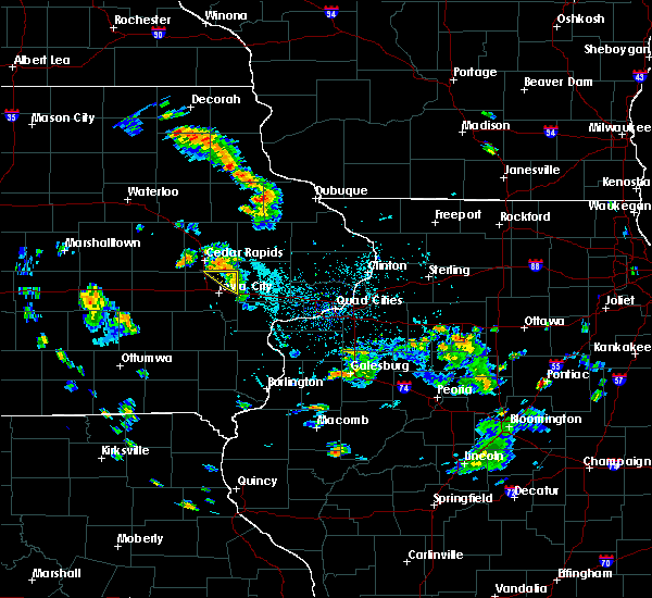 The severe thunderstorm warning for northeastern johnson county will expire at 500 pm cdt, the storm which prompted the warning has moved out of the area. therefore, the warning will be allowed to expire. to report severe weather, contact your nearest law enforcement agency. they will relay your report to the national weather service the quad cities. The severe thunderstorm warning for northeastern johnson county will expire at 500 pm cdt, the storm which prompted the warning has moved out of the area. therefore, the warning will be allowed to expire. to report severe weather, contact your nearest law enforcement agency. they will relay your report to the national weather service the quad cities.
|
| 5/26/2020 4:46 PM CDT |
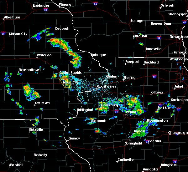 At 446 pm cdt, a severe thunderstorm was located over lake macbride state park, or 9 miles north of iowa city, moving northwest at 45 mph (radar indicated). Hazards include 60 mph wind gusts and nickel size hail. Expect damage to roofs, siding, and trees. locations impacted include, solon, shueyville, lake macbride state park, newport, elmira, morse, twin view heights, sandy beach camp ground, oasis and sutliff. This includes interstate 80 in iowa near mile marker 253. At 446 pm cdt, a severe thunderstorm was located over lake macbride state park, or 9 miles north of iowa city, moving northwest at 45 mph (radar indicated). Hazards include 60 mph wind gusts and nickel size hail. Expect damage to roofs, siding, and trees. locations impacted include, solon, shueyville, lake macbride state park, newport, elmira, morse, twin view heights, sandy beach camp ground, oasis and sutliff. This includes interstate 80 in iowa near mile marker 253.
|
| 5/26/2020 4:45 PM CDT | Spotter estimated 50-60 mph winds which blew over a flag pole cemented in the groun in johnson county IA, 0.8 miles NW of Solon, IA |
| 5/26/2020 4:43 PM CDT |
 At 442 pm cdt, a severe thunderstorm was located over solon, or 7 miles north of iowa city, moving northwest at 45 mph (radar indicated). Hazards include 60 mph wind gusts and nickel size hail. Expect damage to roofs, siding, and trees. locations impacted include, iowa city, west branch, solon, shueyville, lake macbride state park, newport, sugar bottom camp ground, oasis, sutliff, elmira, morse, west overlook, twin view heights, sandy beach camp ground and coralville lake dam complex. This includes interstate 80 in iowa between mile markers 247 and 254. At 442 pm cdt, a severe thunderstorm was located over solon, or 7 miles north of iowa city, moving northwest at 45 mph (radar indicated). Hazards include 60 mph wind gusts and nickel size hail. Expect damage to roofs, siding, and trees. locations impacted include, iowa city, west branch, solon, shueyville, lake macbride state park, newport, sugar bottom camp ground, oasis, sutliff, elmira, morse, west overlook, twin view heights, sandy beach camp ground and coralville lake dam complex. This includes interstate 80 in iowa between mile markers 247 and 254.
|
| 5/26/2020 4:42 PM CDT | Delayed report. tree on the road southwest of solon. time estimated from rada in johnson county IA, 1.2 miles ENE of Solon, IA |
| 5/26/2020 4:35 PM CDT |
 At 433 pm cdt, a severe thunderstorm was located near west branch, moving north at 35 mph (radar indicated). Hazards include 60 mph wind gusts and nickel size hail. expect damage to roofs, siding, and trees At 433 pm cdt, a severe thunderstorm was located near west branch, moving north at 35 mph (radar indicated). Hazards include 60 mph wind gusts and nickel size hail. expect damage to roofs, siding, and trees
|
| 9/12/2019 6:19 PM CDT |
 At 618 pm cdt, a severe thunderstorm was located near lisbon, or 8 miles southwest of mechanicsville, moving northeast at 50 mph (radar indicated). Hazards include 60 mph wind gusts and penny size hail. expect damage to roofs, siding, and trees At 618 pm cdt, a severe thunderstorm was located near lisbon, or 8 miles southwest of mechanicsville, moving northeast at 50 mph (radar indicated). Hazards include 60 mph wind gusts and penny size hail. expect damage to roofs, siding, and trees
|
| 8/20/2019 7:01 AM CDT |
 A severe thunderstorm warning remains in effect until 730 am cdt for northwestern cedar. northern johnson. southern benton. southwestern jones. southern linn and northern iowa counties. At 701 am cdt, severe thunderstorms were located along a line extending from 7 miles northwest of belle plaine to near victor, moving east at 35 mph. A severe thunderstorm warning remains in effect until 730 am cdt for northwestern cedar. northern johnson. southern benton. southwestern jones. southern linn and northern iowa counties. At 701 am cdt, severe thunderstorms were located along a line extending from 7 miles northwest of belle plaine to near victor, moving east at 35 mph.
|
| 8/20/2019 6:37 AM CDT |
 At 637 am cdt, severe thunderstorms were located along a line extending from near belle plaine to near victor, moving east at 45 mph (radar indicated). Hazards include 60 mph wind gusts. expect damage to roofs, siding, and trees At 637 am cdt, severe thunderstorms were located along a line extending from near belle plaine to near victor, moving east at 45 mph (radar indicated). Hazards include 60 mph wind gusts. expect damage to roofs, siding, and trees
|
| 6/30/2019 6:23 PM CDT |
 At 623 pm cdt, severe thunderstorms were located along a line extending from near sabula to near durant to near swisher, moving south at 45 mph (trained weather spotters). Hazards include 70 mph wind gusts. Expect considerable tree damage. damage is likely to mobile homes, roofs, and outbuildings. locations impacted include, cedar rapids, iowa city, clinton, maquoketa, tipton, west branch, mechanicsville, stanwood, coralville, north liberty, dewitt, mount vernon, camanche, lisbon, fairfax, solon, tiffin, ely, university heights and preston. this includes the following highways, interstate 80 in iowa between mile markers 230 and 279. Interstate 380 between mile markers 1 and 21. At 623 pm cdt, severe thunderstorms were located along a line extending from near sabula to near durant to near swisher, moving south at 45 mph (trained weather spotters). Hazards include 70 mph wind gusts. Expect considerable tree damage. damage is likely to mobile homes, roofs, and outbuildings. locations impacted include, cedar rapids, iowa city, clinton, maquoketa, tipton, west branch, mechanicsville, stanwood, coralville, north liberty, dewitt, mount vernon, camanche, lisbon, fairfax, solon, tiffin, ely, university heights and preston. this includes the following highways, interstate 80 in iowa between mile markers 230 and 279. Interstate 380 between mile markers 1 and 21.
|
| 6/30/2019 6:14 PM CDT |
 At 613 pm cdt, severe thunderstorms were located along a line extending from near sabula to near bennett to fairfax, moving southeast at 50 mph (trained weather spotters). Hazards include 70 mph wind gusts. Expect considerable tree damage. damage is likely to mobile homes, roofs, and outbuildings. locations impacted include, cedar rapids, iowa city, clinton, maquoketa, tipton, west branch, mechanicsville, stanwood, marion, coralville, north liberty, hiawatha, dewitt, mount vernon, camanche, bellevue, lisbon, fairfax, solon and tiffin. this includes the following highways, interstate 80 in iowa between mile markers 230 and 279. Interstate 380 between mile markers 1 and 25. At 613 pm cdt, severe thunderstorms were located along a line extending from near sabula to near bennett to fairfax, moving southeast at 50 mph (trained weather spotters). Hazards include 70 mph wind gusts. Expect considerable tree damage. damage is likely to mobile homes, roofs, and outbuildings. locations impacted include, cedar rapids, iowa city, clinton, maquoketa, tipton, west branch, mechanicsville, stanwood, marion, coralville, north liberty, hiawatha, dewitt, mount vernon, camanche, bellevue, lisbon, fairfax, solon and tiffin. this includes the following highways, interstate 80 in iowa between mile markers 230 and 279. Interstate 380 between mile markers 1 and 25.
|
| 6/30/2019 6:07 PM CDT |
 At 606 pm cdt, severe thunderstorms were located along a line extending from near springbrook to near tipton to near atkins, moving south at 50 mph (trained weather spotters). Hazards include 70 mph wind gusts. Expect considerable tree damage. damage is likely to mobile homes, roofs, and outbuildings. locations impacted include, cedar rapids, iowa city, clinton, maquoketa, tipton, west branch, mechanicsville, stanwood, marion, coralville, north liberty, hiawatha, dewitt, mount vernon, camanche, bellevue, lisbon, fairfax, solon and tiffin. this includes the following highways, interstate 80 in iowa between mile markers 230 and 279. Interstate 380 between mile markers 1 and 25. At 606 pm cdt, severe thunderstorms were located along a line extending from near springbrook to near tipton to near atkins, moving south at 50 mph (trained weather spotters). Hazards include 70 mph wind gusts. Expect considerable tree damage. damage is likely to mobile homes, roofs, and outbuildings. locations impacted include, cedar rapids, iowa city, clinton, maquoketa, tipton, west branch, mechanicsville, stanwood, marion, coralville, north liberty, hiawatha, dewitt, mount vernon, camanche, bellevue, lisbon, fairfax, solon and tiffin. this includes the following highways, interstate 80 in iowa between mile markers 230 and 279. Interstate 380 between mile markers 1 and 25.
|
| 6/30/2019 6:00 PM CDT |
 At 559 pm cdt, severe thunderstorms were located along a line extending from near bellevue to near stanwood to near newhall, moving south at 45 mph (trained weather spotters). Hazards include 70 mph wind gusts and quarter size hail. Hail damage to vehicles is expected. expect considerable tree damage. Wind damage is also likely to mobile homes, roofs, and outbuildings. At 559 pm cdt, severe thunderstorms were located along a line extending from near bellevue to near stanwood to near newhall, moving south at 45 mph (trained weather spotters). Hazards include 70 mph wind gusts and quarter size hail. Hail damage to vehicles is expected. expect considerable tree damage. Wind damage is also likely to mobile homes, roofs, and outbuildings.
|
| 6/15/2019 7:41 PM CDT |
 At 736 pm cdt, severe thunderstorms were located along a line extending from near alburnett to near springville to near lisbon to west branch to near lone tree, moving east at 40 mph (radar indicated). Hazards include 60 mph wind gusts. Expect damage to roofs, siding, and trees. locations impacted include, cedar rapids, iowa city, west branch, marion, coralville, north liberty, hiawatha, mount vernon, robins, lisbon, solon, ely, lone tree, springville, university heights, hills, bertram, martelle, oakdale and toddville. this includes the following highways, interstate 80 in iowa between mile markers 241 and 253. Interstate 380 between mile markers 28 and 30. At 736 pm cdt, severe thunderstorms were located along a line extending from near alburnett to near springville to near lisbon to west branch to near lone tree, moving east at 40 mph (radar indicated). Hazards include 60 mph wind gusts. Expect damage to roofs, siding, and trees. locations impacted include, cedar rapids, iowa city, west branch, marion, coralville, north liberty, hiawatha, mount vernon, robins, lisbon, solon, ely, lone tree, springville, university heights, hills, bertram, martelle, oakdale and toddville. this includes the following highways, interstate 80 in iowa between mile markers 241 and 253. Interstate 380 between mile markers 28 and 30.
|
| 6/15/2019 7:36 PM CDT |
 At 736 pm cdt, severe thunderstorms were located along a line extending from near alburnett to near springville to near lisbon to west branch to near lone tree, moving east at 40 mph (radar indicated). Hazards include 60 mph wind gusts. Expect damage to roofs, siding, and trees. locations impacted include, cedar rapids, iowa city, west branch, marion, coralville, north liberty, hiawatha, mount vernon, robins, lisbon, solon, ely, lone tree, springville, university heights, hills, bertram, martelle, oakdale and toddville. this includes the following highways, interstate 80 in iowa between mile markers 241 and 253. Interstate 380 between mile markers 28 and 30. At 736 pm cdt, severe thunderstorms were located along a line extending from near alburnett to near springville to near lisbon to west branch to near lone tree, moving east at 40 mph (radar indicated). Hazards include 60 mph wind gusts. Expect damage to roofs, siding, and trees. locations impacted include, cedar rapids, iowa city, west branch, marion, coralville, north liberty, hiawatha, mount vernon, robins, lisbon, solon, ely, lone tree, springville, university heights, hills, bertram, martelle, oakdale and toddville. this includes the following highways, interstate 80 in iowa between mile markers 241 and 253. Interstate 380 between mile markers 28 and 30.
|
| 6/15/2019 7:25 PM CDT |
 At 725 pm cdt, severe thunderstorms were located along a line extending from near toddville to near springville to near solon to near iowa city to near lone tree, moving east at 40 mph (radar indicated). Hazards include 60 mph wind gusts. Expect damage to roofs, siding, and trees. locations impacted include, cedar rapids, iowa city, west branch, marion, coralville, north liberty, hiawatha, mount vernon, robins, lisbon, solon, tiffin, ely, lone tree, springville, university heights, swisher, hills, shueyville and bertram. this includes the following highways, interstate 80 in iowa between mile markers 236 and 253. Interstate 380 between mile markers 1 and 30. At 725 pm cdt, severe thunderstorms were located along a line extending from near toddville to near springville to near solon to near iowa city to near lone tree, moving east at 40 mph (radar indicated). Hazards include 60 mph wind gusts. Expect damage to roofs, siding, and trees. locations impacted include, cedar rapids, iowa city, west branch, marion, coralville, north liberty, hiawatha, mount vernon, robins, lisbon, solon, tiffin, ely, lone tree, springville, university heights, swisher, hills, shueyville and bertram. this includes the following highways, interstate 80 in iowa between mile markers 236 and 253. Interstate 380 between mile markers 1 and 30.
|
| 6/15/2019 7:16 PM CDT |
 At 716 pm cdt, severe thunderstorms were located along a line extending from near toddville to marion to ely to university heights to riverside, moving east at 40 mph (radar indicated). Hazards include 60 mph wind gusts. Expect damage to roofs, siding, and trees. locations impacted include, cedar rapids, iowa city, west branch, marion, coralville, north liberty, hiawatha, mount vernon, robins, lisbon, fairfax, solon, tiffin, ely, lone tree, springville, university heights, palo, swisher and oxford. this includes the following highways, interstate 80 in iowa between mile markers 230 and 253. Interstate 380 between mile markers 1 and 30. At 716 pm cdt, severe thunderstorms were located along a line extending from near toddville to marion to ely to university heights to riverside, moving east at 40 mph (radar indicated). Hazards include 60 mph wind gusts. Expect damage to roofs, siding, and trees. locations impacted include, cedar rapids, iowa city, west branch, marion, coralville, north liberty, hiawatha, mount vernon, robins, lisbon, fairfax, solon, tiffin, ely, lone tree, springville, university heights, palo, swisher and oxford. this includes the following highways, interstate 80 in iowa between mile markers 230 and 253. Interstate 380 between mile markers 1 and 30.
|
| 6/15/2019 7:10 PM CDT |
 At 709 pm cdt, severe thunderstorms were located along a line extending from shellsburg to hiawatha to shueyville to near coralville to near kalona, moving east at 40 mph (radar indicated). Hazards include 60 mph wind gusts. Expect damage to roofs, siding, and trees. locations impacted include, cedar rapids, iowa city, west branch, marion, coralville, north liberty, hiawatha, mount vernon, robins, center point, lisbon, fairfax, solon, tiffin, ely, walford, lone tree, central city, springville and university heights. this includes the following highways, interstate 80 in iowa between mile markers 230 and 253. Interstate 380 between mile markers 1 and 39. At 709 pm cdt, severe thunderstorms were located along a line extending from shellsburg to hiawatha to shueyville to near coralville to near kalona, moving east at 40 mph (radar indicated). Hazards include 60 mph wind gusts. Expect damage to roofs, siding, and trees. locations impacted include, cedar rapids, iowa city, west branch, marion, coralville, north liberty, hiawatha, mount vernon, robins, center point, lisbon, fairfax, solon, tiffin, ely, walford, lone tree, central city, springville and university heights. this includes the following highways, interstate 80 in iowa between mile markers 230 and 253. Interstate 380 between mile markers 1 and 39.
|
| 6/15/2019 7:04 PM CDT |
 At 704 pm cdt, severe thunderstorms were located along a line extending from near shellsburg to near hiawatha to swisher to near tiffin to kalona, moving east at 40 mph (trained weather spotters). Hazards include 70 mph wind gusts. Expect considerable tree damage. damage is likely to mobile homes, roofs, and outbuildings. locations impacted include, cedar rapids, iowa city, west branch, marion, coralville, north liberty, hiawatha, mount vernon, robins, center point, lisbon, fairfax, solon, tiffin, ely, walford, lone tree, central city, springville and university heights. this includes the following highways, interstate 80 in iowa between mile markers 230 and 253. Interstate 380 between mile markers 1 and 39. At 704 pm cdt, severe thunderstorms were located along a line extending from near shellsburg to near hiawatha to swisher to near tiffin to kalona, moving east at 40 mph (trained weather spotters). Hazards include 70 mph wind gusts. Expect considerable tree damage. damage is likely to mobile homes, roofs, and outbuildings. locations impacted include, cedar rapids, iowa city, west branch, marion, coralville, north liberty, hiawatha, mount vernon, robins, center point, lisbon, fairfax, solon, tiffin, ely, walford, lone tree, central city, springville and university heights. this includes the following highways, interstate 80 in iowa between mile markers 230 and 253. Interstate 380 between mile markers 1 and 39.
|
| 6/15/2019 6:57 PM CDT |
 At 656 pm cdt, severe thunderstorms were located along a line extending from near vinton to near atkins to near walford to near oxford to near kinross, moving east at 40 mph (trained weather spotters. atkins fire department reported sustained winds of 50 to 60 mph with gusts to 70 mph). Hazards include 70 mph wind gusts. Expect considerable tree damage. damage is likely to mobile homes, roofs, and outbuildings. locations impacted include, cedar rapids, iowa city, west branch, marion, coralville, north liberty, hiawatha, mount vernon, robins, center point, lisbon, fairfax, solon, tiffin, ely, walford, lone tree, central city, springville and university heights. this includes the following highways, interstate 80 in iowa between mile markers 230 and 253. Interstate 380 between mile markers 1 and 39. At 656 pm cdt, severe thunderstorms were located along a line extending from near vinton to near atkins to near walford to near oxford to near kinross, moving east at 40 mph (trained weather spotters. atkins fire department reported sustained winds of 50 to 60 mph with gusts to 70 mph). Hazards include 70 mph wind gusts. Expect considerable tree damage. damage is likely to mobile homes, roofs, and outbuildings. locations impacted include, cedar rapids, iowa city, west branch, marion, coralville, north liberty, hiawatha, mount vernon, robins, center point, lisbon, fairfax, solon, tiffin, ely, walford, lone tree, central city, springville and university heights. this includes the following highways, interstate 80 in iowa between mile markers 230 and 253. Interstate 380 between mile markers 1 and 39.
|
| 6/15/2019 6:46 PM CDT |
 At 646 pm cdt, severe thunderstorms were located along a line extending from near garrison to newhall to near amana to 6 miles northeast of parnell to north english, moving east at 40 mph (radar indicated). Hazards include 60 mph wind gusts. expect damage to roofs, siding, and trees At 646 pm cdt, severe thunderstorms were located along a line extending from near garrison to newhall to near amana to 6 miles northeast of parnell to north english, moving east at 40 mph (radar indicated). Hazards include 60 mph wind gusts. expect damage to roofs, siding, and trees
|
| 5/29/2019 9:09 PM CDT |
 At 909 pm cdt, severe thunderstorms were located along a line extending from near morley to 6 miles north of west branch to hills, moving east at 25 mph (radar indicated). Hazards include 60 mph wind gusts and quarter size hail. Hail damage to vehicles is expected. expect wind damage to roofs, siding, and trees. locations impacted include, iowa city, tipton, west branch, mechanicsville, stanwood, coralville, north liberty, mount vernon, lisbon, solon, springville, university heights, lowden, hills, olin, wyoming, oxford junction, bennett, martelle and onslow. This includes interstate 80 in iowa between mile markers 241 and 276. At 909 pm cdt, severe thunderstorms were located along a line extending from near morley to 6 miles north of west branch to hills, moving east at 25 mph (radar indicated). Hazards include 60 mph wind gusts and quarter size hail. Hail damage to vehicles is expected. expect wind damage to roofs, siding, and trees. locations impacted include, iowa city, tipton, west branch, mechanicsville, stanwood, coralville, north liberty, mount vernon, lisbon, solon, springville, university heights, lowden, hills, olin, wyoming, oxford junction, bennett, martelle and onslow. This includes interstate 80 in iowa between mile markers 241 and 276.
|
| 5/29/2019 9:00 PM CDT |
 At 900 pm cdt, severe thunderstorms were located along a line extending from martelle to 6 miles north of west branch to hills, moving east at 25 mph (radar indicated). Hazards include 60 mph wind gusts and quarter size hail. Hail damage to vehicles is expected. Expect wind damage to roofs, siding, and trees. At 900 pm cdt, severe thunderstorms were located along a line extending from martelle to 6 miles north of west branch to hills, moving east at 25 mph (radar indicated). Hazards include 60 mph wind gusts and quarter size hail. Hail damage to vehicles is expected. Expect wind damage to roofs, siding, and trees.
|
| 5/29/2019 8:50 PM CDT |
 At 850 pm cdt, a severe thunderstorm capable of producing a tornado was located near solon, or 12 miles west of mechanicsville, moving east at 20 mph (radar indicated rotation). Hazards include tornado and quarter size hail. Flying debris will be dangerous to those caught without shelter. mobile homes will be damaged or destroyed. damage to roofs, windows, and vehicles will occur. tree damage is likely. this dangerous storm will be near, mount vernon and lisbon around 905 pm cdt. Other locations impacted by this tornadic thunderstorm include sutliff. At 850 pm cdt, a severe thunderstorm capable of producing a tornado was located near solon, or 12 miles west of mechanicsville, moving east at 20 mph (radar indicated rotation). Hazards include tornado and quarter size hail. Flying debris will be dangerous to those caught without shelter. mobile homes will be damaged or destroyed. damage to roofs, windows, and vehicles will occur. tree damage is likely. this dangerous storm will be near, mount vernon and lisbon around 905 pm cdt. Other locations impacted by this tornadic thunderstorm include sutliff.
|
| 5/29/2019 8:40 PM CDT |
 At 840 pm cdt, a severe thunderstorm capable of producing a tornado was located over lake macbride state park, or 11 miles southeast of cedar rapids, moving east at 20 mph (radar indicated rotation). Hazards include tornado and quarter size hail. Flying debris will be dangerous to those caught without shelter. mobile homes will be damaged or destroyed. damage to roofs, windows, and vehicles will occur. tree damage is likely. this dangerous storm will be near, solon around 845 pm cdt. mount vernon and lisbon around 905 pm cdt. Other locations impacted by this tornadic thunderstorm include sutliff, twin view heights and sandy beach camp ground. At 840 pm cdt, a severe thunderstorm capable of producing a tornado was located over lake macbride state park, or 11 miles southeast of cedar rapids, moving east at 20 mph (radar indicated rotation). Hazards include tornado and quarter size hail. Flying debris will be dangerous to those caught without shelter. mobile homes will be damaged or destroyed. damage to roofs, windows, and vehicles will occur. tree damage is likely. this dangerous storm will be near, solon around 845 pm cdt. mount vernon and lisbon around 905 pm cdt. Other locations impacted by this tornadic thunderstorm include sutliff, twin view heights and sandy beach camp ground.
|
| 5/29/2019 8:31 PM CDT |
 At 831 pm cdt, a severe thunderstorm capable of producing a tornado was located over shueyville, or 9 miles south of cedar rapids, moving east at 20 mph (radar indicated rotation). Hazards include tornado and quarter size hail. Flying debris will be dangerous to those caught without shelter. mobile homes will be damaged or destroyed. damage to roofs, windows, and vehicles will occur. tree damage is likely. this dangerous storm will be near, lake macbride state park around 835 pm cdt. ely around 840 pm cdt. solon around 845 pm cdt. mount vernon and lisbon around 905 pm cdt. other locations impacted by this tornadic thunderstorm include twin view heights, sandy beach camp ground, cou falls and sutliff. This includes interstate 380 between mile markers 8 and 12. At 831 pm cdt, a severe thunderstorm capable of producing a tornado was located over shueyville, or 9 miles south of cedar rapids, moving east at 20 mph (radar indicated rotation). Hazards include tornado and quarter size hail. Flying debris will be dangerous to those caught without shelter. mobile homes will be damaged or destroyed. damage to roofs, windows, and vehicles will occur. tree damage is likely. this dangerous storm will be near, lake macbride state park around 835 pm cdt. ely around 840 pm cdt. solon around 845 pm cdt. mount vernon and lisbon around 905 pm cdt. other locations impacted by this tornadic thunderstorm include twin view heights, sandy beach camp ground, cou falls and sutliff. This includes interstate 380 between mile markers 8 and 12.
|
| 5/16/2019 9:37 PM CDT |
 The severe thunderstorm warning for northwestern johnson, southeastern linn and east central iowa counties will expire at 945 pm cdt, the storms which prompted the warning have weakened below severe limits, and no longer pose an immediate threat to life or property. therefore, the warning will be allowed to expire. however gusty winds are still possible with these thunderstorms. a severe thunderstorm watch remains in effect until 300 am cdt for east central iowa. The severe thunderstorm warning for northwestern johnson, southeastern linn and east central iowa counties will expire at 945 pm cdt, the storms which prompted the warning have weakened below severe limits, and no longer pose an immediate threat to life or property. therefore, the warning will be allowed to expire. however gusty winds are still possible with these thunderstorms. a severe thunderstorm watch remains in effect until 300 am cdt for east central iowa.
|
| 5/16/2019 9:19 PM CDT |
 At 918 pm cdt, severe thunderstorms were located along a line extending from near bertram to near north liberty to near oxford, moving east at 45 mph (radar indicated). Hazards include 60 mph wind gusts and dime size hail. Expect damage to roofs, siding, and trees. locations impacted include, cedar rapids, north liberty, solon, ely, swisher, shueyville, lake macbride state park, homestead, sugar bottom camp ground, cou falls, palisades-kepler state park, west overlook, twin view heights, sandy beach camp ground and coralville lake dam complex. This includes interstate 380 between mile markers 3 and 14. At 918 pm cdt, severe thunderstorms were located along a line extending from near bertram to near north liberty to near oxford, moving east at 45 mph (radar indicated). Hazards include 60 mph wind gusts and dime size hail. Expect damage to roofs, siding, and trees. locations impacted include, cedar rapids, north liberty, solon, ely, swisher, shueyville, lake macbride state park, homestead, sugar bottom camp ground, cou falls, palisades-kepler state park, west overlook, twin view heights, sandy beach camp ground and coralville lake dam complex. This includes interstate 380 between mile markers 3 and 14.
|
| 5/16/2019 8:57 PM CDT |
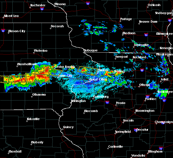 At 856 pm cdt, severe thunderstorms were located along a line extending from walford to near conroy, moving east at 30 mph (radar indicated). Hazards include 60 mph wind gusts and quarter size hail. Hail damage to vehicles is expected. Expect wind damage to roofs, siding, and trees. At 856 pm cdt, severe thunderstorms were located along a line extending from walford to near conroy, moving east at 30 mph (radar indicated). Hazards include 60 mph wind gusts and quarter size hail. Hail damage to vehicles is expected. Expect wind damage to roofs, siding, and trees.
|
| 4/22/2019 5:39 PM CDT |
 The severe thunderstorm warning for johnson county will expire at 545 pm cdt, the storms which prompted the warning have weakened below severe limits, and were beginning to exit the warned area. therefore, the warning will be allowed to expire. however small hail and gusty winds are still possible with these thunderstorms. The severe thunderstorm warning for johnson county will expire at 545 pm cdt, the storms which prompted the warning have weakened below severe limits, and were beginning to exit the warned area. therefore, the warning will be allowed to expire. however small hail and gusty winds are still possible with these thunderstorms.
|
| 4/22/2019 5:25 PM CDT |
 At 525 pm cdt, severe thunderstorms were located along a line extending from north liberty to near hills, moving east at 40 mph (radar indicated). Hazards include 60 mph wind gusts and quarter size hail. Hail damage to vehicles is expected. expect wind damage to roofs, siding, and trees. locations impacted include, iowa city, coralville, north liberty, solon, tiffin, university heights, oxford, hills, oakdale, lake macbride state park, newport, frytown, windham, sugar bottom camp ground, johnson county fairgrounds, sutliff, f. w. kent park, west overlook, coralville lake dam complex and iowa city municipal airport. this includes the following highways, interstate 80 in iowa between mile markers 230 and 253. Interstate 380 between mile markers 1 and 5. At 525 pm cdt, severe thunderstorms were located along a line extending from north liberty to near hills, moving east at 40 mph (radar indicated). Hazards include 60 mph wind gusts and quarter size hail. Hail damage to vehicles is expected. expect wind damage to roofs, siding, and trees. locations impacted include, iowa city, coralville, north liberty, solon, tiffin, university heights, oxford, hills, oakdale, lake macbride state park, newport, frytown, windham, sugar bottom camp ground, johnson county fairgrounds, sutliff, f. w. kent park, west overlook, coralville lake dam complex and iowa city municipal airport. this includes the following highways, interstate 80 in iowa between mile markers 230 and 253. Interstate 380 between mile markers 1 and 5.
|
| 4/22/2019 5:11 PM CDT |
 At 510 pm cdt, a severe thunderstorm was located near tiffin, or 8 miles west of iowa city, moving northeast at 40 mph. a second severe thunderstorm was located near holbrook also moving northeast (radar indicated). Hazards include 60 mph wind gusts and half dollar size hail. Hail damage to vehicles is expected. expect wind damage to roofs, siding, and trees. locations impacted include, iowa city, coralville, north liberty, williamsburg, solon, tiffin, university heights, north english, oxford, hills, parnell, oakdale, lake macbride state park, newport, frytown, windham, sugar bottom camp ground, johnson county fairgrounds, sutliff and f. w. kent park. this includes the following highways, interstate 80 in iowa between mile markers 223 and 253. Interstate 380 between mile markers 1 and 5. At 510 pm cdt, a severe thunderstorm was located near tiffin, or 8 miles west of iowa city, moving northeast at 40 mph. a second severe thunderstorm was located near holbrook also moving northeast (radar indicated). Hazards include 60 mph wind gusts and half dollar size hail. Hail damage to vehicles is expected. expect wind damage to roofs, siding, and trees. locations impacted include, iowa city, coralville, north liberty, williamsburg, solon, tiffin, university heights, north english, oxford, hills, parnell, oakdale, lake macbride state park, newport, frytown, windham, sugar bottom camp ground, johnson county fairgrounds, sutliff and f. w. kent park. this includes the following highways, interstate 80 in iowa between mile markers 223 and 253. Interstate 380 between mile markers 1 and 5.
|
| 4/22/2019 5:00 PM CDT |
 At 500 pm cdt, a severe thunderstorm was located 8 miles east of parnell, or 16 miles west of iowa city, moving east northeast at 40 mph (radar indicated). Hazards include 60 mph wind gusts and quarter size hail. Hail damage to vehicles is expected. Expect wind damage to roofs, siding, and trees. At 500 pm cdt, a severe thunderstorm was located 8 miles east of parnell, or 16 miles west of iowa city, moving east northeast at 40 mph (radar indicated). Hazards include 60 mph wind gusts and quarter size hail. Hail damage to vehicles is expected. Expect wind damage to roofs, siding, and trees.
|
| 9/25/2018 1:47 PM CDT |
 At 147 pm cdt, severe thunderstorms were located along a line extending from near hopkinton to near morley to near solon, moving east at 50 mph (radar indicated). Hazards include 60 mph wind gusts. Expect damage to roofs, siding, and trees. Locations impacted include, maquoketa, anamosa, tipton, mechanicsville, stanwood, coralville, north liberty, mount vernon, monticello, lisbon, solon, central city, springville, lowden, wheatland, olin, coggon, grand mound, wyoming and oxford junction. At 147 pm cdt, severe thunderstorms were located along a line extending from near hopkinton to near morley to near solon, moving east at 50 mph (radar indicated). Hazards include 60 mph wind gusts. Expect damage to roofs, siding, and trees. Locations impacted include, maquoketa, anamosa, tipton, mechanicsville, stanwood, coralville, north liberty, mount vernon, monticello, lisbon, solon, central city, springville, lowden, wheatland, olin, coggon, grand mound, wyoming and oxford junction.
|
| 9/25/2018 1:39 PM CDT |
 At 139 pm cdt, severe thunderstorms were located along a line extending from near prairieburg to near lisbon to near oakdale, moving east at 50 mph (radar indicated). Hazards include 60 mph wind gusts. Expect damage to roofs, siding, and trees. locations impacted include, cedar rapids, iowa city, maquoketa, anamosa, tipton, mechanicsville, stanwood, marion, coralville, north liberty, hiawatha, mount vernon, monticello, robins, lisbon, solon, tiffin, ely, central city and springville. this includes the following highways, interstate 80 in iowa between mile markers 236 and 241. Interstate 380 between mile markers 1 and 14, and mile marker 21 and near mile marker 23. At 139 pm cdt, severe thunderstorms were located along a line extending from near prairieburg to near lisbon to near oakdale, moving east at 50 mph (radar indicated). Hazards include 60 mph wind gusts. Expect damage to roofs, siding, and trees. locations impacted include, cedar rapids, iowa city, maquoketa, anamosa, tipton, mechanicsville, stanwood, marion, coralville, north liberty, hiawatha, mount vernon, monticello, robins, lisbon, solon, tiffin, ely, central city and springville. this includes the following highways, interstate 80 in iowa between mile markers 236 and 241. Interstate 380 between mile markers 1 and 14, and mile marker 21 and near mile marker 23.
|
| 9/25/2018 1:34 PM CDT |
 At 134 pm cdt, severe thunderstorms were located along a line extending from prairieburg to near bertram to oakdale, moving east at 50 mph (radar indicated). Hazards include 60 mph wind gusts. Expect damage to roofs, siding, and trees. locations impacted include, cedar rapids, iowa city, maquoketa, anamosa, tipton, west branch, mechanicsville, stanwood, marion, coralville, north liberty, hiawatha, mount vernon, monticello, robins, center point, lisbon, fairfax, solon and tiffin. this includes the following highways, interstate 80 in iowa between mile markers 230 and 247. Interstate 380 between mile markers 1 and 36. At 134 pm cdt, severe thunderstorms were located along a line extending from prairieburg to near bertram to oakdale, moving east at 50 mph (radar indicated). Hazards include 60 mph wind gusts. Expect damage to roofs, siding, and trees. locations impacted include, cedar rapids, iowa city, maquoketa, anamosa, tipton, west branch, mechanicsville, stanwood, marion, coralville, north liberty, hiawatha, mount vernon, monticello, robins, center point, lisbon, fairfax, solon and tiffin. this includes the following highways, interstate 80 in iowa between mile markers 230 and 247. Interstate 380 between mile markers 1 and 36.
|
| 9/25/2018 1:28 PM CDT |
 At 127 pm cdt, severe thunderstorms were located along a line extending from paris to bertram to oxford, moving east at 50 mph (trained weather spotters). Hazards include 60 mph wind gusts. expect damage to roofs, siding, and trees At 127 pm cdt, severe thunderstorms were located along a line extending from paris to bertram to oxford, moving east at 50 mph (trained weather spotters). Hazards include 60 mph wind gusts. expect damage to roofs, siding, and trees
|
| 9/25/2018 1:16 PM CDT |
 At 116 pm cdt, severe thunderstorms were located along a line extending from toddville to near fairfax to near williamsburg, moving east at 50 mph (radar indicated). Hazards include 60 mph wind gusts. Expect damage to roofs, siding, and trees. locations impacted include, cedar rapids, iowa city, marengo, marion, coralville, north liberty, hiawatha, mount vernon, robins, williamsburg, center point, lisbon, fairfax, solon, tiffin, ely, atkins, walford, central city and springville. this includes the following highways, interstate 80 in iowa between mile markers 216 and 248. Interstate 380 between mile markers 1 and 40. At 116 pm cdt, severe thunderstorms were located along a line extending from toddville to near fairfax to near williamsburg, moving east at 50 mph (radar indicated). Hazards include 60 mph wind gusts. Expect damage to roofs, siding, and trees. locations impacted include, cedar rapids, iowa city, marengo, marion, coralville, north liberty, hiawatha, mount vernon, robins, williamsburg, center point, lisbon, fairfax, solon, tiffin, ely, atkins, walford, central city and springville. this includes the following highways, interstate 80 in iowa between mile markers 216 and 248. Interstate 380 between mile markers 1 and 40.
|
| 9/25/2018 1:10 PM CDT |
 At 110 pm cdt, severe thunderstorms were located along a line extending from near center point to fairfax to near williamsburg, moving east at 50 mph (radar indicated). Hazards include 60 mph wind gusts. Expect damage to roofs, siding, and trees. locations impacted include, cedar rapids, iowa city, vinton, marengo, marion, coralville, north liberty, hiawatha, mount vernon, robins, williamsburg, center point, lisbon, fairfax, solon, tiffin, ely, atkins, walford and central city. this includes the following highways, interstate 80 in iowa between mile markers 211 and 248. Interstate 380 between mile markers 1 and 40. At 110 pm cdt, severe thunderstorms were located along a line extending from near center point to fairfax to near williamsburg, moving east at 50 mph (radar indicated). Hazards include 60 mph wind gusts. Expect damage to roofs, siding, and trees. locations impacted include, cedar rapids, iowa city, vinton, marengo, marion, coralville, north liberty, hiawatha, mount vernon, robins, williamsburg, center point, lisbon, fairfax, solon, tiffin, ely, atkins, walford and central city. this includes the following highways, interstate 80 in iowa between mile markers 211 and 248. Interstate 380 between mile markers 1 and 40.
|
| 9/25/2018 1:03 PM CDT |
 At 103 pm cdt, severe thunderstorms were located along a line extending from near shellsburg to norway to near ladora, moving east at 50 mph (radar indicated). Hazards include 60 mph wind gusts. Expect damage to roofs, siding, and trees. locations impacted include, cedar rapids, iowa city, vinton, marengo, marion, coralville, north liberty, hiawatha, mount vernon, robins, williamsburg, belle plaine, center point, lisbon, fairfax, solon, tiffin, ely, atkins and walford. this includes the following highways, interstate 80 in iowa between mile markers 205 and 248. Interstate 380 between mile markers 1 and 40. At 103 pm cdt, severe thunderstorms were located along a line extending from near shellsburg to norway to near ladora, moving east at 50 mph (radar indicated). Hazards include 60 mph wind gusts. Expect damage to roofs, siding, and trees. locations impacted include, cedar rapids, iowa city, vinton, marengo, marion, coralville, north liberty, hiawatha, mount vernon, robins, williamsburg, belle plaine, center point, lisbon, fairfax, solon, tiffin, ely, atkins and walford. this includes the following highways, interstate 80 in iowa between mile markers 205 and 248. Interstate 380 between mile markers 1 and 40.
|
| 9/25/2018 12:54 PM CDT |
 At 1254 pm cdt, severe thunderstorms were located along a line extending from near vinton to blairstown to near ladora, moving east at 50 mph (radar indicated). Hazards include 60 mph wind gusts. Expect damage to roofs, siding, and trees. locations impacted include, cedar rapids, iowa city, vinton, marengo, marion, coralville, north liberty, hiawatha, mount vernon, robins, williamsburg, belle plaine, center point, lisbon, fairfax, solon, tiffin, ely, atkins and walford. this includes the following highways, interstate 80 in iowa between mile markers 205 and 248. Interstate 380 between mile markers 1 and 40. At 1254 pm cdt, severe thunderstorms were located along a line extending from near vinton to blairstown to near ladora, moving east at 50 mph (radar indicated). Hazards include 60 mph wind gusts. Expect damage to roofs, siding, and trees. locations impacted include, cedar rapids, iowa city, vinton, marengo, marion, coralville, north liberty, hiawatha, mount vernon, robins, williamsburg, belle plaine, center point, lisbon, fairfax, solon, tiffin, ely, atkins and walford. this includes the following highways, interstate 80 in iowa between mile markers 205 and 248. Interstate 380 between mile markers 1 and 40.
|
| 9/25/2018 12:48 PM CDT |
 At 1248 pm cdt, severe thunderstorms were located along a line extending from near garrison to near luzerne to near victor, moving east at 50 mph (radar indicated). Hazards include 60 mph wind gusts. expect damage to roofs, siding, and trees At 1248 pm cdt, severe thunderstorms were located along a line extending from near garrison to near luzerne to near victor, moving east at 50 mph (radar indicated). Hazards include 60 mph wind gusts. expect damage to roofs, siding, and trees
|
| 8/28/2018 6:37 PM CDT |
 At 636 pm cdt, a severe thunderstorm was located near mount vernon, or 8 miles west of mechanicsville, moving east at 45 mph (radar indicated). Hazards include 60 mph wind gusts. expect damage to roofs, siding, and trees At 636 pm cdt, a severe thunderstorm was located near mount vernon, or 8 miles west of mechanicsville, moving east at 45 mph (radar indicated). Hazards include 60 mph wind gusts. expect damage to roofs, siding, and trees
|
| 6/9/2018 9:17 AM CDT |
 At 917 am cdt, severe thunderstorms were located along a line extending from near paris to near bertram to lake macbride state park, moving east at 10 mph (radar indicated). Hazards include quarter size hail. Damage to vehicles is expected. locations impacted include, cedar rapids, marion, mount vernon, lisbon, solon, ely, central city, springville, alburnett, coggon, shueyville, bertram, prairieburg, troy mills, lake macbride state park, waubeek, viola, whittier, paris and sutliff. This includes interstate 380 between mile markers 7 and 10. At 917 am cdt, severe thunderstorms were located along a line extending from near paris to near bertram to lake macbride state park, moving east at 10 mph (radar indicated). Hazards include quarter size hail. Damage to vehicles is expected. locations impacted include, cedar rapids, marion, mount vernon, lisbon, solon, ely, central city, springville, alburnett, coggon, shueyville, bertram, prairieburg, troy mills, lake macbride state park, waubeek, viola, whittier, paris and sutliff. This includes interstate 380 between mile markers 7 and 10.
|
| 6/9/2018 8:56 AM CDT |
 At 855 am cdt, severe thunderstorms were located along a line extending from center point to marion to near lake macbride state park, moving northeast at 15 mph (trained weather spotters reported quarter size hail in cedar rapids at 845 am). Hazards include quarter size hail. Damage to vehicles is expected. locations impacted include, cedar rapids, marion, hiawatha, mount vernon, robins, center point, lisbon, solon, ely, central city, springville, swisher, walker, alburnett, coggon, shueyville, bertram, prairieburg, toddville and troy mills. This includes interstate 380 between mile markers 7 and 39. At 855 am cdt, severe thunderstorms were located along a line extending from center point to marion to near lake macbride state park, moving northeast at 15 mph (trained weather spotters reported quarter size hail in cedar rapids at 845 am). Hazards include quarter size hail. Damage to vehicles is expected. locations impacted include, cedar rapids, marion, hiawatha, mount vernon, robins, center point, lisbon, solon, ely, central city, springville, swisher, walker, alburnett, coggon, shueyville, bertram, prairieburg, toddville and troy mills. This includes interstate 380 between mile markers 7 and 39.
|
| 6/9/2018 8:47 AM CDT |
 At 847 am cdt, severe thunderstorms were located along a line extending from center point to near marion to near lake macbride state park, moving northeast at 10 mph (trained weather spotters). Hazards include quarter size hail. damage to vehicles is expected At 847 am cdt, severe thunderstorms were located along a line extending from center point to near marion to near lake macbride state park, moving northeast at 10 mph (trained weather spotters). Hazards include quarter size hail. damage to vehicles is expected
|
| 5/26/2018 1:34 AM CDT |
 At 134 am cdt, severe thunderstorms were located along a line extending from near cedar rapids to near lake macbride state park to north liberty, moving east at 35 mph (radar indicated). Hazards include 60 mph wind gusts and quarter size hail. Hail damage to vehicles is expected. expect wind damage to roofs, siding, and trees. locations impacted include, cedar rapids, marion, coralville, north liberty, hiawatha, mount vernon, robins, lisbon, fairfax, solon, tiffin, ely, springville, swisher, shueyville, bertram, lake macbride state park, newport, sugar bottom camp ground and sutliff. This includes interstate 380 between mile markers 2 and 26. At 134 am cdt, severe thunderstorms were located along a line extending from near cedar rapids to near lake macbride state park to north liberty, moving east at 35 mph (radar indicated). Hazards include 60 mph wind gusts and quarter size hail. Hail damage to vehicles is expected. expect wind damage to roofs, siding, and trees. locations impacted include, cedar rapids, marion, coralville, north liberty, hiawatha, mount vernon, robins, lisbon, fairfax, solon, tiffin, ely, springville, swisher, shueyville, bertram, lake macbride state park, newport, sugar bottom camp ground and sutliff. This includes interstate 380 between mile markers 2 and 26.
|
| 5/26/2018 1:30 AM CDT |
 At 130 am cdt, severe thunderstorms were located along a line extending from cedar rapids to shueyville to tiffin, moving east at 40 mph (radar indicated). Hazards include 60 mph wind gusts and quarter size hail. Hail damage to vehicles is expected. expect wind damage to roofs, siding, and trees. locations impacted include, cedar rapids, marion, coralville, north liberty, hiawatha, mount vernon, robins, lisbon, fairfax, solon, tiffin, ely, springville, swisher, shueyville, bertram, lake macbride state park, newport, sugar bottom camp ground and sutliff. This includes interstate 380 between mile markers 2 and 26. At 130 am cdt, severe thunderstorms were located along a line extending from cedar rapids to shueyville to tiffin, moving east at 40 mph (radar indicated). Hazards include 60 mph wind gusts and quarter size hail. Hail damage to vehicles is expected. expect wind damage to roofs, siding, and trees. locations impacted include, cedar rapids, marion, coralville, north liberty, hiawatha, mount vernon, robins, lisbon, fairfax, solon, tiffin, ely, springville, swisher, shueyville, bertram, lake macbride state park, newport, sugar bottom camp ground and sutliff. This includes interstate 380 between mile markers 2 and 26.
|
| 5/26/2018 1:25 AM CDT |
 At 125 am cdt, severe thunderstorms were located along a line extending from near cedar rapids to swisher to oxford, moving east at 35 mph (radar indicated). Hazards include 60 mph wind gusts and quarter size hail. Hail damage to vehicles is expected. expect wind damage to roofs, siding, and trees. locations impacted include, cedar rapids, marion, coralville, north liberty, hiawatha, mount vernon, robins, lisbon, fairfax, solon, tiffin, ely, walford, springville, palo, swisher, shueyville, bertram, lake macbride state park and newport. This includes interstate 380 between mile markers 2 and 28. At 125 am cdt, severe thunderstorms were located along a line extending from near cedar rapids to swisher to oxford, moving east at 35 mph (radar indicated). Hazards include 60 mph wind gusts and quarter size hail. Hail damage to vehicles is expected. expect wind damage to roofs, siding, and trees. locations impacted include, cedar rapids, marion, coralville, north liberty, hiawatha, mount vernon, robins, lisbon, fairfax, solon, tiffin, ely, walford, springville, palo, swisher, shueyville, bertram, lake macbride state park and newport. This includes interstate 380 between mile markers 2 and 28.
|
| 5/26/2018 1:19 AM CDT |
 At 119 am cdt, severe thunderstorms were located along a line extending from near hiawatha to near swisher to near oxford, moving east at 40 mph (radar indicated). Hazards include 60 mph wind gusts and quarter size hail. Hail damage to vehicles is expected. expect wind damage to roofs, siding, and trees. locations impacted include, cedar rapids, marion, coralville, north liberty, hiawatha, mount vernon, robins, lisbon, fairfax, solon, tiffin, ely, walford, springville, palo, swisher, shueyville, bertram, amana and lake macbride state park. This includes interstate 380 between mile markers 2 and 28. At 119 am cdt, severe thunderstorms were located along a line extending from near hiawatha to near swisher to near oxford, moving east at 40 mph (radar indicated). Hazards include 60 mph wind gusts and quarter size hail. Hail damage to vehicles is expected. expect wind damage to roofs, siding, and trees. locations impacted include, cedar rapids, marion, coralville, north liberty, hiawatha, mount vernon, robins, lisbon, fairfax, solon, tiffin, ely, walford, springville, palo, swisher, shueyville, bertram, amana and lake macbride state park. This includes interstate 380 between mile markers 2 and 28.
|
| 5/26/2018 1:13 AM CDT |
 At 113 am cdt, severe thunderstorms were located along a line extending from near hiawatha to amana, moving east at 45 mph (radar indicated). Hazards include 60 mph wind gusts and quarter size hail. Hail damage to vehicles is expected. expect wind damage to roofs, siding, and trees. locations impacted include, cedar rapids, marion, coralville, north liberty, hiawatha, mount vernon, robins, lisbon, fairfax, solon, tiffin, ely, walford, springville, palo, swisher, shueyville, bertram, toddville and lake macbride state park. This includes interstate 380 between mile markers 2 and 32. At 113 am cdt, severe thunderstorms were located along a line extending from near hiawatha to amana, moving east at 45 mph (radar indicated). Hazards include 60 mph wind gusts and quarter size hail. Hail damage to vehicles is expected. expect wind damage to roofs, siding, and trees. locations impacted include, cedar rapids, marion, coralville, north liberty, hiawatha, mount vernon, robins, lisbon, fairfax, solon, tiffin, ely, walford, springville, palo, swisher, shueyville, bertram, toddville and lake macbride state park. This includes interstate 380 between mile markers 2 and 32.
|
| 5/26/2018 1:07 AM CDT |
 At 107 am cdt, severe thunderstorms were located along a line extending from palo to near amana, moving east at 40 mph (radar indicated). Hazards include 60 mph wind gusts and quarter size hail. Hail damage to vehicles is expected. Expect wind damage to roofs, siding, and trees. At 107 am cdt, severe thunderstorms were located along a line extending from palo to near amana, moving east at 40 mph (radar indicated). Hazards include 60 mph wind gusts and quarter size hail. Hail damage to vehicles is expected. Expect wind damage to roofs, siding, and trees.
|
| 7/21/2017 5:12 PM CDT |
 At 512 pm cdt, a severe thunderstorm was located near tiffin, or 9 miles west of iowa city, moving east at 15 mph (radar indicated). Hazards include two inch hail and 70 mph wind gusts. People and animals outdoors will be injured. expect hail damage to roofs, siding, windows, and vehicles. expect considerable tree damage. wind damage is also likely to mobile homes, roofs, and outbuildings. locations impacted include, iowa city, coralville, north liberty, solon, tiffin, lone tree, university heights, oxford, hills, shueyville, oakdale, lake macbride state park, newport, frytown, windham, sugar bottom camp ground, johnson county fairgrounds, sutliff, f. w. kent park and west overlook. if you are at city of solon you should seek safe shelter immediately! this includes the following highways, interstate 80 in iowa between mile markers 230 and 253. Interstate 380 between mile markers 1 and 9. At 512 pm cdt, a severe thunderstorm was located near tiffin, or 9 miles west of iowa city, moving east at 15 mph (radar indicated). Hazards include two inch hail and 70 mph wind gusts. People and animals outdoors will be injured. expect hail damage to roofs, siding, windows, and vehicles. expect considerable tree damage. wind damage is also likely to mobile homes, roofs, and outbuildings. locations impacted include, iowa city, coralville, north liberty, solon, tiffin, lone tree, university heights, oxford, hills, shueyville, oakdale, lake macbride state park, newport, frytown, windham, sugar bottom camp ground, johnson county fairgrounds, sutliff, f. w. kent park and west overlook. if you are at city of solon you should seek safe shelter immediately! this includes the following highways, interstate 80 in iowa between mile markers 230 and 253. Interstate 380 between mile markers 1 and 9.
|
| 7/21/2017 4:58 PM CDT |
 At 458 pm cdt, severe thunderstorms were located along a line extending from shueyville to near riverside, moving east at 30 mph (radar indicated). Hazards include 70 mph wind gusts and ping pong ball size hail. People and animals outdoors will be injured. expect hail damage to roofs, siding, windows, and vehicles. expect considerable tree damage. wind damage is also likely to mobile homes, roofs, and outbuildings. locations impacted include, iowa city, coralville, north liberty, solon, tiffin, lone tree, university heights, swisher, oxford, hills, shueyville, oakdale, lake macbride state park, newport, frytown, windham, sugar bottom camp ground, johnson county fairgrounds, sutliff and f. w. kent park. if you are at city of solon you should seek safe shelter immediately! this includes the following highways, interstate 80 in iowa between mile markers 230 and 253. Interstate 380 between mile markers 1 and 11. At 458 pm cdt, severe thunderstorms were located along a line extending from shueyville to near riverside, moving east at 30 mph (radar indicated). Hazards include 70 mph wind gusts and ping pong ball size hail. People and animals outdoors will be injured. expect hail damage to roofs, siding, windows, and vehicles. expect considerable tree damage. wind damage is also likely to mobile homes, roofs, and outbuildings. locations impacted include, iowa city, coralville, north liberty, solon, tiffin, lone tree, university heights, swisher, oxford, hills, shueyville, oakdale, lake macbride state park, newport, frytown, windham, sugar bottom camp ground, johnson county fairgrounds, sutliff and f. w. kent park. if you are at city of solon you should seek safe shelter immediately! this includes the following highways, interstate 80 in iowa between mile markers 230 and 253. Interstate 380 between mile markers 1 and 11.
|
| 7/21/2017 4:39 PM CDT |
 At 439 pm cdt, a severe thunderstorm was located 8 miles east of parnell, or 16 miles west of iowa city, moving east at 20 mph (radar indicated). Hazards include 70 mph wind gusts and ping pong ball size hail. People and animals outdoors will be injured. expect hail damage to roofs, siding, windows, and vehicles. expect considerable tree damage. Wind damage is also likely to mobile homes, roofs, and outbuildings. At 439 pm cdt, a severe thunderstorm was located 8 miles east of parnell, or 16 miles west of iowa city, moving east at 20 mph (radar indicated). Hazards include 70 mph wind gusts and ping pong ball size hail. People and animals outdoors will be injured. expect hail damage to roofs, siding, windows, and vehicles. expect considerable tree damage. Wind damage is also likely to mobile homes, roofs, and outbuildings.
|
| 7/21/2017 4:06 PM CDT |
 At 406 pm cdt, a severe thunderstorm was located near parnell, or 15 miles southeast of marengo, moving east at 30 mph (radar indicated). Hazards include ping pong ball size hail and 60 mph wind gusts. People and animals outdoors will be injured. expect hail damage to roofs, siding, windows, and vehicles. expect wind damage to roofs, siding, and trees. locations impacted include, iowa city, coralville, north liberty, williamsburg, kalona, solon, tiffin, lone tree, university heights, riverside, oxford, hills, parnell, oakdale, conroy, newport, frytown, windham, sugar bottom camp ground and johnson county fairgrounds. this includes the following highways, interstate 80 in iowa between mile markers 217 and 253. Interstate 380 between mile markers 1 and 6. At 406 pm cdt, a severe thunderstorm was located near parnell, or 15 miles southeast of marengo, moving east at 30 mph (radar indicated). Hazards include ping pong ball size hail and 60 mph wind gusts. People and animals outdoors will be injured. expect hail damage to roofs, siding, windows, and vehicles. expect wind damage to roofs, siding, and trees. locations impacted include, iowa city, coralville, north liberty, williamsburg, kalona, solon, tiffin, lone tree, university heights, riverside, oxford, hills, parnell, oakdale, conroy, newport, frytown, windham, sugar bottom camp ground and johnson county fairgrounds. this includes the following highways, interstate 80 in iowa between mile markers 217 and 253. Interstate 380 between mile markers 1 and 6.
|
| 7/21/2017 3:58 PM CDT |
 At 358 pm cdt, a severe thunderstorm was located over williamsburg, or 11 miles southeast of marengo, moving east at 35 mph (radar indicated). Hazards include 60 mph wind gusts and quarter size hail. Hail damage to vehicles is expected. expect wind damage to roofs, siding, and trees. locations impacted include, iowa city, coralville, north liberty, williamsburg, kalona, solon, tiffin, lone tree, university heights, riverside, oxford, hills, ladora, parnell, millersburg, oakdale, conroy, newport, frytown and windham. this includes the following highways, interstate 80 in iowa between mile markers 211 and 253. Interstate 380 between mile markers 1 and 6. At 358 pm cdt, a severe thunderstorm was located over williamsburg, or 11 miles southeast of marengo, moving east at 35 mph (radar indicated). Hazards include 60 mph wind gusts and quarter size hail. Hail damage to vehicles is expected. expect wind damage to roofs, siding, and trees. locations impacted include, iowa city, coralville, north liberty, williamsburg, kalona, solon, tiffin, lone tree, university heights, riverside, oxford, hills, ladora, parnell, millersburg, oakdale, conroy, newport, frytown and windham. this includes the following highways, interstate 80 in iowa between mile markers 211 and 253. Interstate 380 between mile markers 1 and 6.
|
| 7/21/2017 3:51 PM CDT |
 At 350 pm cdt, a severe thunderstorm was located near williamsburg, or 10 miles south of marengo, moving east at 35 mph (radar indicated). Hazards include 60 mph wind gusts and quarter size hail. Hail damage to vehicles is expected. Expect wind damage to roofs, siding, and trees. At 350 pm cdt, a severe thunderstorm was located near williamsburg, or 10 miles south of marengo, moving east at 35 mph (radar indicated). Hazards include 60 mph wind gusts and quarter size hail. Hail damage to vehicles is expected. Expect wind damage to roofs, siding, and trees.
|
| 7/12/2017 7:27 PM CDT |
 At 727 pm cdt, severe thunderstorms were located along a line extending from 6 miles southeast of lisbon to near west branch to near lone tree, moving east at 45 mph (radar indicated). Hazards include 60 mph wind gusts. expect damage to roofs, siding, and trees At 727 pm cdt, severe thunderstorms were located along a line extending from 6 miles southeast of lisbon to near west branch to near lone tree, moving east at 45 mph (radar indicated). Hazards include 60 mph wind gusts. expect damage to roofs, siding, and trees
|
| 7/11/2017 5:48 AM CDT |
 At 548 am cdt, severe thunderstorms were located along a line extending from near ladora to near harper to near hedrick, moving east at 55 mph (radar indicated). Hazards include 60 mph wind gusts. Expect damage to roofs, siding, and trees. locations impacted include, iowa city, fairfield, mount pleasant, washington, marengo, sigourney, coralville, north liberty, williamsburg, kalona, solon, tiffin, wellman, lone tree, university heights, north english, riverside, wayland, victor and swisher. this includes the following highways, interstate 80 in iowa between mile markers 205 and 252. Interstate 380 between mile markers 1 and 11. At 548 am cdt, severe thunderstorms were located along a line extending from near ladora to near harper to near hedrick, moving east at 55 mph (radar indicated). Hazards include 60 mph wind gusts. Expect damage to roofs, siding, and trees. locations impacted include, iowa city, fairfield, mount pleasant, washington, marengo, sigourney, coralville, north liberty, williamsburg, kalona, solon, tiffin, wellman, lone tree, university heights, north english, riverside, wayland, victor and swisher. this includes the following highways, interstate 80 in iowa between mile markers 205 and 252. Interstate 380 between mile markers 1 and 11.
|
| 7/11/2017 5:40 AM CDT |
 At 540 am cdt, severe thunderstorms were located along a line extending from victor to near keswick to ottumwa industrial airport, moving east at 55 mph (radar indicated). Hazards include 60 mph wind gusts. expect damage to roofs, siding, and trees At 540 am cdt, severe thunderstorms were located along a line extending from victor to near keswick to ottumwa industrial airport, moving east at 55 mph (radar indicated). Hazards include 60 mph wind gusts. expect damage to roofs, siding, and trees
|
| 6/15/2017 9:21 PM CDT |
 At 921 pm cdt, severe thunderstorms were located along a line extending from near wyoming to near stanwood to 6 miles southwest of mechanicsville, moving southeast at 50 mph (radar indicated). Hazards include 60 mph wind gusts and quarter size hail. Hail damage to vehicles is expected. expect wind damage to roofs, siding, and trees. locations impacted include, cedar rapids, anamosa, tipton, mechanicsville, stanwood, mount vernon, lisbon, ely, springville, lowden, wheatland, olin, delmar, wyoming, oxford junction, lost nation, bennett, bertram, martelle and toronto. this includes the following highways, interstate 80 in iowa between mile markers 266 and 271. Interstate 380 between mile markers 15 and 17. At 921 pm cdt, severe thunderstorms were located along a line extending from near wyoming to near stanwood to 6 miles southwest of mechanicsville, moving southeast at 50 mph (radar indicated). Hazards include 60 mph wind gusts and quarter size hail. Hail damage to vehicles is expected. expect wind damage to roofs, siding, and trees. locations impacted include, cedar rapids, anamosa, tipton, mechanicsville, stanwood, mount vernon, lisbon, ely, springville, lowden, wheatland, olin, delmar, wyoming, oxford junction, lost nation, bennett, bertram, martelle and toronto. this includes the following highways, interstate 80 in iowa between mile markers 266 and 271. Interstate 380 between mile markers 15 and 17.
|
| 6/15/2017 9:16 PM CDT |
 At 916 pm cdt, severe thunderstorms were located along a line extending from near olin to near mechanicsville to near lisbon, moving southeast at 50 mph (radar indicated). Hazards include 60 mph wind gusts and half dollar size hail. Hail damage to vehicles is expected. expect wind damage to roofs, siding, and trees. locations impacted include, cedar rapids, anamosa, tipton, mechanicsville, stanwood, marion, mount vernon, lisbon, fairfax, solon, ely, springville, lowden, wheatland, olin, delmar, wyoming, oxford junction, lost nation and bennett. this includes the following highways, interstate 80 in iowa between mile markers 266 and 271. Interstate 380 between mile markers 14 and 22. At 916 pm cdt, severe thunderstorms were located along a line extending from near olin to near mechanicsville to near lisbon, moving southeast at 50 mph (radar indicated). Hazards include 60 mph wind gusts and half dollar size hail. Hail damage to vehicles is expected. expect wind damage to roofs, siding, and trees. locations impacted include, cedar rapids, anamosa, tipton, mechanicsville, stanwood, marion, mount vernon, lisbon, fairfax, solon, ely, springville, lowden, wheatland, olin, delmar, wyoming, oxford junction, lost nation and bennett. this includes the following highways, interstate 80 in iowa between mile markers 266 and 271. Interstate 380 between mile markers 14 and 22.
|
| 6/15/2017 9:11 PM CDT |
 At 911 pm cdt, severe thunderstorms were located along a line extending from near amber to near morley to near mount vernon, moving southeast at 40 mph (radar indicated). Hazards include 60 mph wind gusts and half dollar size hail. Hail damage to vehicles is expected. expect wind damage to roofs, siding, and trees. locations impacted include, cedar rapids, anamosa, tipton, mechanicsville, stanwood, marion, mount vernon, lisbon, fairfax, solon, ely, springville, lowden, wheatland, olin, delmar, wyoming, oxford junction, lost nation and bennett. this includes the following highways, interstate 80 in iowa between mile markers 266 and 271. Interstate 380 between mile markers 14 and 22. At 911 pm cdt, severe thunderstorms were located along a line extending from near amber to near morley to near mount vernon, moving southeast at 40 mph (radar indicated). Hazards include 60 mph wind gusts and half dollar size hail. Hail damage to vehicles is expected. expect wind damage to roofs, siding, and trees. locations impacted include, cedar rapids, anamosa, tipton, mechanicsville, stanwood, marion, mount vernon, lisbon, fairfax, solon, ely, springville, lowden, wheatland, olin, delmar, wyoming, oxford junction, lost nation and bennett. this includes the following highways, interstate 80 in iowa between mile markers 266 and 271. Interstate 380 between mile markers 14 and 22.
|
| 6/15/2017 9:03 PM CDT |
 At 903 pm cdt, a severe thunderstorm was located over martelle, or 7 miles south of anamosa, moving southeast at 40 mph (radar indicated). Hazards include 60 mph wind gusts and half dollar size hail. Hail damage to vehicles is expected. Expect wind damage to roofs, siding, and trees. At 903 pm cdt, a severe thunderstorm was located over martelle, or 7 miles south of anamosa, moving southeast at 40 mph (radar indicated). Hazards include 60 mph wind gusts and half dollar size hail. Hail damage to vehicles is expected. Expect wind damage to roofs, siding, and trees.
|
| 5/17/2017 7:04 PM CDT |
 At 703 pm cdt, severe thunderstorms were located along a line extending from near volga to near colesburg to near cascade to near west liberty, moving northeast at 55 mph (trained weather spotters). Hazards include 70 mph wind gusts. Expect considerable tree damage. damage is likely to mobile homes, roofs, and outbuildings. locations impacted include, iowa city, dubuque, muscatine, anamosa, tipton, west branch, mechanicsville, stanwood, mount vernon, asbury, dyersville, monticello, west liberty, wilton, cascade, lisbon, solon, epworth, farley and peosta. this includes interstate 80 in iowa between mile markers 245 and 274. A tornado watch remains in effect until 1100 pm cdt for northwestern illinois, and southeastern, northeastern and east central iowa. At 703 pm cdt, severe thunderstorms were located along a line extending from near volga to near colesburg to near cascade to near west liberty, moving northeast at 55 mph (trained weather spotters). Hazards include 70 mph wind gusts. Expect considerable tree damage. damage is likely to mobile homes, roofs, and outbuildings. locations impacted include, iowa city, dubuque, muscatine, anamosa, tipton, west branch, mechanicsville, stanwood, mount vernon, asbury, dyersville, monticello, west liberty, wilton, cascade, lisbon, solon, epworth, farley and peosta. this includes interstate 80 in iowa between mile markers 245 and 274. A tornado watch remains in effect until 1100 pm cdt for northwestern illinois, and southeastern, northeastern and east central iowa.
|
| 5/17/2017 6:58 PM CDT |
 At 657 pm cdt, severe thunderstorms were located along a line extending from arlington to near colesburg to near cascade to near nichols, moving northeast at 55 mph (trained weather spotters). Hazards include 70 mph wind gusts. Expect considerable tree damage. damage is likely to mobile homes, roofs, and outbuildings. locations impacted include, iowa city, dubuque, muscatine, anamosa, manchester, tipton, west branch, mechanicsville, stanwood, coralville, north liberty, mount vernon, asbury, dyersville, monticello, west liberty, wilton, cascade, lisbon and solon. this includes interstate 80 in iowa between mile markers 239 and 274. A tornado watch remains in effect until 1100 pm cdt for northwestern illinois, and southeastern, northeastern and east central iowa. At 657 pm cdt, severe thunderstorms were located along a line extending from arlington to near colesburg to near cascade to near nichols, moving northeast at 55 mph (trained weather spotters). Hazards include 70 mph wind gusts. Expect considerable tree damage. damage is likely to mobile homes, roofs, and outbuildings. locations impacted include, iowa city, dubuque, muscatine, anamosa, manchester, tipton, west branch, mechanicsville, stanwood, coralville, north liberty, mount vernon, asbury, dyersville, monticello, west liberty, wilton, cascade, lisbon and solon. this includes interstate 80 in iowa between mile markers 239 and 274. A tornado watch remains in effect until 1100 pm cdt for northwestern illinois, and southeastern, northeastern and east central iowa.
|
| 5/17/2017 6:47 PM CDT |
 At 646 pm cdt, severe thunderstorms were located along a line extending from near aurora to near manchester to morley to near lone tree, moving northeast at 35 mph (trained weather spotters). Hazards include 70 mph wind gusts. Expect considerable tree damage. damage is likely to mobile homes, roofs, and outbuildings. locations impacted include, iowa city, dubuque, muscatine, anamosa, manchester, tipton, west branch, mechanicsville, stanwood, marion, coralville, north liberty, mount vernon, asbury, dyersville, monticello, west liberty, wilton, cascade and lisbon. this includes interstate 80 in iowa between mile markers 239 and 274. A tornado watch remains in effect until 1100 pm cdt for northwestern illinois, and southeastern, northeastern and east central iowa. At 646 pm cdt, severe thunderstorms were located along a line extending from near aurora to near manchester to morley to near lone tree, moving northeast at 35 mph (trained weather spotters). Hazards include 70 mph wind gusts. Expect considerable tree damage. damage is likely to mobile homes, roofs, and outbuildings. locations impacted include, iowa city, dubuque, muscatine, anamosa, manchester, tipton, west branch, mechanicsville, stanwood, marion, coralville, north liberty, mount vernon, asbury, dyersville, monticello, west liberty, wilton, cascade and lisbon. this includes interstate 80 in iowa between mile markers 239 and 274. A tornado watch remains in effect until 1100 pm cdt for northwestern illinois, and southeastern, northeastern and east central iowa.
|
| 5/17/2017 6:41 PM CDT |
 At 640 pm cdt, severe thunderstorms were located along a line extending from hazleton to masonville to near prairieburg to near riverside, moving northeast at 45 mph (trained weather spotters). Hazards include 70 mph wind gusts. Expect considerable tree damage. damage is likely to mobile homes, roofs, and outbuildings. locations impacted include, cedar rapids, iowa city, dubuque, muscatine, independence, anamosa, manchester, tipton, west branch, mechanicsville, stanwood, marion, coralville, north liberty, mount vernon, asbury, dyersville, monticello, west liberty and wilton. this includes the following highways, interstate 80 in iowa between mile markers 239 and 274. interstate 380 between mile markers 1 and 6. A tornado watch remains in effect until 1100 pm cdt for northwestern illinois, and southeastern, northeastern and east central iowa. At 640 pm cdt, severe thunderstorms were located along a line extending from hazleton to masonville to near prairieburg to near riverside, moving northeast at 45 mph (trained weather spotters). Hazards include 70 mph wind gusts. Expect considerable tree damage. damage is likely to mobile homes, roofs, and outbuildings. locations impacted include, cedar rapids, iowa city, dubuque, muscatine, independence, anamosa, manchester, tipton, west branch, mechanicsville, stanwood, marion, coralville, north liberty, mount vernon, asbury, dyersville, monticello, west liberty and wilton. this includes the following highways, interstate 80 in iowa between mile markers 239 and 274. interstate 380 between mile markers 1 and 6. A tornado watch remains in effect until 1100 pm cdt for northwestern illinois, and southeastern, northeastern and east central iowa.
|
| 5/17/2017 6:31 PM CDT |
 At 630 pm cdt, severe thunderstorms were located along a line extending from near fairbank to near quasqueton to near springville to near hills, moving northeast at 40 mph (trained weather spotters). Hazards include 70 mph wind gusts. Expect considerable tree damage. Damage is likely to mobile homes, roofs, and outbuildings. At 630 pm cdt, severe thunderstorms were located along a line extending from near fairbank to near quasqueton to near springville to near hills, moving northeast at 40 mph (trained weather spotters). Hazards include 70 mph wind gusts. Expect considerable tree damage. Damage is likely to mobile homes, roofs, and outbuildings.
|
| 5/17/2017 6:22 PM CDT |
 At 622 pm cdt, severe thunderstorms were located along a line extending from 6 miles southeast of jesup to near quasqueton to near alburnett to richmond, moving northeast at 45 mph (trained weather spotters). Hazards include 70 mph wind gusts. Expect considerable tree damage. damage is likely to mobile homes, roofs, and outbuildings. locations impacted include, cedar rapids, iowa city, independence, manchester, west branch, marion, coralville, north liberty, hiawatha, mount vernon, robins, jesup, center point, kalona, lisbon, fairfax, solon, tiffin, ely and atkins. this includes the following highways, interstate 80 in iowa between mile markers 224 and 253. interstate 380 between mile markers 1 and 55. A tornado watch remains in effect until 1100 pm cdt for southeastern, northeastern and east central iowa. At 622 pm cdt, severe thunderstorms were located along a line extending from 6 miles southeast of jesup to near quasqueton to near alburnett to richmond, moving northeast at 45 mph (trained weather spotters). Hazards include 70 mph wind gusts. Expect considerable tree damage. damage is likely to mobile homes, roofs, and outbuildings. locations impacted include, cedar rapids, iowa city, independence, manchester, west branch, marion, coralville, north liberty, hiawatha, mount vernon, robins, jesup, center point, kalona, lisbon, fairfax, solon, tiffin, ely and atkins. this includes the following highways, interstate 80 in iowa between mile markers 224 and 253. interstate 380 between mile markers 1 and 55. A tornado watch remains in effect until 1100 pm cdt for southeastern, northeastern and east central iowa.
|
| 5/17/2017 6:15 PM CDT |
 At 615 pm cdt, severe thunderstorms were located along a line extending from near brandon to near urbana to robins to near wellman, moving northeast at 55 mph (trained weather spotters). Hazards include 70 mph wind gusts and quarter size hail. Hail damage to vehicles is expected. expect considerable tree damage. wind damage is also likely to mobile homes, roofs, and outbuildings. locations impacted include, cedar rapids, iowa city, independence, vinton, manchester, west branch, marion, coralville, north liberty, hiawatha, mount vernon, robins, jesup, center point, kalona, lisbon, fairfax, solon, tiffin and ely. this includes the following highways, interstate 80 in iowa between mile markers 224 and 253. interstate 380 between mile markers 1 and 55. A tornado watch remains in effect until 1100 pm cdt for southeastern, northeastern and east central iowa. At 615 pm cdt, severe thunderstorms were located along a line extending from near brandon to near urbana to robins to near wellman, moving northeast at 55 mph (trained weather spotters). Hazards include 70 mph wind gusts and quarter size hail. Hail damage to vehicles is expected. expect considerable tree damage. wind damage is also likely to mobile homes, roofs, and outbuildings. locations impacted include, cedar rapids, iowa city, independence, vinton, manchester, west branch, marion, coralville, north liberty, hiawatha, mount vernon, robins, jesup, center point, kalona, lisbon, fairfax, solon, tiffin and ely. this includes the following highways, interstate 80 in iowa between mile markers 224 and 253. interstate 380 between mile markers 1 and 55. A tornado watch remains in effect until 1100 pm cdt for southeastern, northeastern and east central iowa.
|
| 5/17/2017 6:10 PM CDT |
 At 610 pm cdt, severe thunderstorms were located along a line extending from near mount auburn to near shellsburg to near hiawatha to near kinross, moving northeast at 55 mph (trained weather spotters). Hazards include 70 mph wind gusts and quarter size hail. Hail damage to vehicles is expected. expect considerable tree damage. wind damage is also likely to mobile homes, roofs, and outbuildings. locations impacted include, cedar rapids, iowa city, independence, vinton, manchester, west branch, marion, coralville, north liberty, hiawatha, mount vernon, robins, jesup, center point, kalona, lisbon, fairfax, solon, tiffin and ely. this includes the following highways, interstate 80 in iowa between mile markers 224 and 253. interstate 380 between mile markers 1 and 55. A tornado watch remains in effect until 1100 pm cdt for southeastern, northeastern and east central iowa. At 610 pm cdt, severe thunderstorms were located along a line extending from near mount auburn to near shellsburg to near hiawatha to near kinross, moving northeast at 55 mph (trained weather spotters). Hazards include 70 mph wind gusts and quarter size hail. Hail damage to vehicles is expected. expect considerable tree damage. wind damage is also likely to mobile homes, roofs, and outbuildings. locations impacted include, cedar rapids, iowa city, independence, vinton, manchester, west branch, marion, coralville, north liberty, hiawatha, mount vernon, robins, jesup, center point, kalona, lisbon, fairfax, solon, tiffin and ely. this includes the following highways, interstate 80 in iowa between mile markers 224 and 253. interstate 380 between mile markers 1 and 55. A tornado watch remains in effect until 1100 pm cdt for southeastern, northeastern and east central iowa.
|
| 5/17/2017 6:04 PM CDT |
 At 604 pm cdt, severe thunderstorms were located along a line extending from near la porte city to near palo to near kinross, moving northeast at 45 mph (trained weather spotters). Hazards include 70 mph wind gusts and quarter size hail. Hail damage to vehicles is expected. expect considerable tree damage. wind damage is also likely to mobile homes, roofs, and outbuildings. locations impacted include, cedar rapids, iowa city, independence, vinton, manchester, west branch, marion, coralville, north liberty, hiawatha, mount vernon, robins, jesup, center point, kalona, lisbon, fairfax, solon, tiffin and ely. this includes the following highways, interstate 80 in iowa between mile markers 224 and 253. interstate 380 between mile markers 1 and 55. A tornado watch remains in effect until 1100 pm cdt for southeastern, northeastern and east central iowa. At 604 pm cdt, severe thunderstorms were located along a line extending from near la porte city to near palo to near kinross, moving northeast at 45 mph (trained weather spotters). Hazards include 70 mph wind gusts and quarter size hail. Hail damage to vehicles is expected. expect considerable tree damage. wind damage is also likely to mobile homes, roofs, and outbuildings. locations impacted include, cedar rapids, iowa city, independence, vinton, manchester, west branch, marion, coralville, north liberty, hiawatha, mount vernon, robins, jesup, center point, kalona, lisbon, fairfax, solon, tiffin and ely. this includes the following highways, interstate 80 in iowa between mile markers 224 and 253. interstate 380 between mile markers 1 and 55. A tornado watch remains in effect until 1100 pm cdt for southeastern, northeastern and east central iowa.
|
| 5/17/2017 5:56 PM CDT |
 At 555 pm cdt, severe thunderstorms were located along a line extending from near dysart to newhall to kinross, moving northeast at 45 mph (trained weather spotters). Hazards include 70 mph wind gusts and quarter size hail. Hail damage to vehicles is expected. expect considerable tree damage. wind damage is also likely to mobile homes, roofs, and outbuildings. locations impacted include, cedar rapids, iowa city, independence, vinton, manchester, west branch, marion, coralville, north liberty, hiawatha, mount vernon, robins, jesup, center point, kalona, lisbon, fairfax, solon, tiffin and ely. this includes the following highways, interstate 80 in iowa between mile markers 224 and 253. interstate 380 between mile markers 1 and 55. A tornado watch remains in effect until 1100 pm cdt for southeastern, northeastern and east central iowa. At 555 pm cdt, severe thunderstorms were located along a line extending from near dysart to newhall to kinross, moving northeast at 45 mph (trained weather spotters). Hazards include 70 mph wind gusts and quarter size hail. Hail damage to vehicles is expected. expect considerable tree damage. wind damage is also likely to mobile homes, roofs, and outbuildings. locations impacted include, cedar rapids, iowa city, independence, vinton, manchester, west branch, marion, coralville, north liberty, hiawatha, mount vernon, robins, jesup, center point, kalona, lisbon, fairfax, solon, tiffin and ely. this includes the following highways, interstate 80 in iowa between mile markers 224 and 253. interstate 380 between mile markers 1 and 55. A tornado watch remains in effect until 1100 pm cdt for southeastern, northeastern and east central iowa.
|
| 5/17/2017 5:50 PM CDT |
 At 550 pm cdt, severe thunderstorms were located along a line extending from near dysart to near norway to near kinross, moving northeast at 40 mph (radar indicated). Hazards include 70 mph wind gusts and quarter size hail. Hail damage to vehicles is expected. expect considerable tree damage. Wind damage is also likely to mobile homes, roofs, and outbuildings. At 550 pm cdt, severe thunderstorms were located along a line extending from near dysart to near norway to near kinross, moving northeast at 40 mph (radar indicated). Hazards include 70 mph wind gusts and quarter size hail. Hail damage to vehicles is expected. expect considerable tree damage. Wind damage is also likely to mobile homes, roofs, and outbuildings.
|
| 5/17/2017 4:49 PM CDT |
 At 448 pm cdt, a severe thunderstorm was located 7 miles southwest of oxford, or 16 miles southeast of marengo, moving north at 65 mph (radar indicated). Hazards include 60 mph wind gusts and quarter size hail. Hail damage to vehicles is expected. expect wind damage to roofs, siding, and trees. locations impacted include, iowa city, coralville, north liberty, solon, tiffin, university heights, swisher, oxford, hills, shueyville, oakdale, amana, lake macbride state park, middle amana, frytown, windham, sugar bottom camp ground, johnson county fairgrounds, upper south amana and east amana. this includes the following highways, interstate 80 in iowa between mile markers 223 and 245. interstate 380 between mile markers 1 and 11. A tornado watch remains in effect until 1100 pm cdt for southeastern and east central iowa. At 448 pm cdt, a severe thunderstorm was located 7 miles southwest of oxford, or 16 miles southeast of marengo, moving north at 65 mph (radar indicated). Hazards include 60 mph wind gusts and quarter size hail. Hail damage to vehicles is expected. expect wind damage to roofs, siding, and trees. locations impacted include, iowa city, coralville, north liberty, solon, tiffin, university heights, swisher, oxford, hills, shueyville, oakdale, amana, lake macbride state park, middle amana, frytown, windham, sugar bottom camp ground, johnson county fairgrounds, upper south amana and east amana. this includes the following highways, interstate 80 in iowa between mile markers 223 and 245. interstate 380 between mile markers 1 and 11. A tornado watch remains in effect until 1100 pm cdt for southeastern and east central iowa.
|
| 5/17/2017 4:23 PM CDT |
 At 423 pm cdt, a severe thunderstorm was located near brighton, or 11 miles west of washington, moving north at 55 mph (radar indicated). Hazards include 60 mph wind gusts and quarter size hail. Hail damage to vehicles is expected. Expect wind damage to roofs, siding, and trees. At 423 pm cdt, a severe thunderstorm was located near brighton, or 11 miles west of washington, moving north at 55 mph (radar indicated). Hazards include 60 mph wind gusts and quarter size hail. Hail damage to vehicles is expected. Expect wind damage to roofs, siding, and trees.
|
| 3/6/2017 9:28 PM CST |
 At 927 pm cst, severe thunderstorms were located along a line extending from near mechanicsville to near kalona, moving east at 35 mph (trained weather spotters). Hazards include 70 mph wind gusts. Expect considerable tree damage. Damage is likely to mobile homes, roofs, and outbuildings. At 927 pm cst, severe thunderstorms were located along a line extending from near mechanicsville to near kalona, moving east at 35 mph (trained weather spotters). Hazards include 70 mph wind gusts. Expect considerable tree damage. Damage is likely to mobile homes, roofs, and outbuildings.
|
| 3/6/2017 9:23 PM CST |
 At 922 pm cst, severe thunderstorms were located along a line extending from 7 miles northwest of cassville to near guttenberg to near hopkinton to langworthy to near morley to near solon to university heights, moving east at 60 mph (trained weather spotters). Hazards include 70 mph wind gusts and quarter size hail. Hail damage to vehicles is expected. expect considerable tree damage. wind damage is also likely to mobile homes, roofs, and outbuildings. locations impacted include, cedar rapids, iowa city, manchester, west branch, marion, coralville, north liberty, mount vernon, dyersville, lisbon, solon, tiffin, ely, lone tree, central city, springville, university heights, swisher, edgewood and earlville. this includes the following highways, interstate 80 in iowa between mile markers 230 and 253. interstate 380 between mile markers 1 and 23. a tornado watch remains in effect until 1000 pm cst for southeastern, northeastern and east central iowa. A tornado watch also remains in effect until 400 am cst for southeastern, northeastern and east central iowa. At 922 pm cst, severe thunderstorms were located along a line extending from 7 miles northwest of cassville to near guttenberg to near hopkinton to langworthy to near morley to near solon to university heights, moving east at 60 mph (trained weather spotters). Hazards include 70 mph wind gusts and quarter size hail. Hail damage to vehicles is expected. expect considerable tree damage. wind damage is also likely to mobile homes, roofs, and outbuildings. locations impacted include, cedar rapids, iowa city, manchester, west branch, marion, coralville, north liberty, mount vernon, dyersville, lisbon, solon, tiffin, ely, lone tree, central city, springville, university heights, swisher, edgewood and earlville. this includes the following highways, interstate 80 in iowa between mile markers 230 and 253. interstate 380 between mile markers 1 and 23. a tornado watch remains in effect until 1000 pm cst for southeastern, northeastern and east central iowa. A tornado watch also remains in effect until 400 am cst for southeastern, northeastern and east central iowa.
|
| 3/6/2017 9:11 PM CST |
 At 910 pm cst, severe thunderstorms were located along a line extending from 9 miles south of garnavillo to 7 miles northwest of colesburg to coggon to waubeek to bertram to near north liberty to 8 miles northwest of kalona, moving east at 60 mph (trained weather spotters). Hazards include 70 mph wind gusts and quarter size hail. Hail damage to vehicles is expected. expect considerable tree damage. wind damage is also likely to mobile homes, roofs, and outbuildings. locations impacted include, cedar rapids, iowa city, manchester, west branch, marion, coralville, north liberty, hiawatha, mount vernon, dyersville, robins, center point, lisbon, fairfax, solon, tiffin, ely, walford, lone tree and central city. this includes the following highways, interstate 80 in iowa between mile markers 230 and 253. interstate 380 between mile markers 1 and 39. a tornado watch remains in effect until 1000 pm cst for southeastern, northeastern and east central iowa. A tornado watch also remains in effect until 400 am cst for southeastern, northeastern and east central iowa. At 910 pm cst, severe thunderstorms were located along a line extending from 9 miles south of garnavillo to 7 miles northwest of colesburg to coggon to waubeek to bertram to near north liberty to 8 miles northwest of kalona, moving east at 60 mph (trained weather spotters). Hazards include 70 mph wind gusts and quarter size hail. Hail damage to vehicles is expected. expect considerable tree damage. wind damage is also likely to mobile homes, roofs, and outbuildings. locations impacted include, cedar rapids, iowa city, manchester, west branch, marion, coralville, north liberty, hiawatha, mount vernon, dyersville, robins, center point, lisbon, fairfax, solon, tiffin, ely, walford, lone tree and central city. this includes the following highways, interstate 80 in iowa between mile markers 230 and 253. interstate 380 between mile markers 1 and 39. a tornado watch remains in effect until 1000 pm cst for southeastern, northeastern and east central iowa. A tornado watch also remains in effect until 400 am cst for southeastern, northeastern and east central iowa.
|
| 3/6/2017 8:55 PM CST |
 At 855 pm cst, severe thunderstorms were located along a line extending from strawberry point to near dundee to center point to toddville to near parnell, moving northeast at 70 mph (radar indicated). Hazards include 70 mph wind gusts. Expect considerable tree damage. damage is likely to mobile homes, roofs, and outbuildings. locations impacted include, cedar rapids, iowa city, manchester, west branch, marion, coralville, north liberty, hiawatha, mount vernon, dyersville, robins, center point, lisbon, fairfax, solon, tiffin, ely, walford, lone tree and central city. this includes the following highways, interstate 80 in iowa between mile markers 230 and 253. interstate 380 between mile markers 1 and 39. a tornado watch remains in effect until 1000 pm cst for southeastern, northeastern and east central iowa. A tornado watch also remains in effect until 400 am cst for southeastern, northeastern and east central iowa. At 855 pm cst, severe thunderstorms were located along a line extending from strawberry point to near dundee to center point to toddville to near parnell, moving northeast at 70 mph (radar indicated). Hazards include 70 mph wind gusts. Expect considerable tree damage. damage is likely to mobile homes, roofs, and outbuildings. locations impacted include, cedar rapids, iowa city, manchester, west branch, marion, coralville, north liberty, hiawatha, mount vernon, dyersville, robins, center point, lisbon, fairfax, solon, tiffin, ely, walford, lone tree and central city. this includes the following highways, interstate 80 in iowa between mile markers 230 and 253. interstate 380 between mile markers 1 and 39. a tornado watch remains in effect until 1000 pm cst for southeastern, northeastern and east central iowa. A tornado watch also remains in effect until 400 am cst for southeastern, northeastern and east central iowa.
|
| 3/6/2017 8:34 PM CST |
 At 832 pm cst, severe thunderstorms were located along a line extending from near arlington to near independence to near luzerne to near marengo to hayesville, moving east at 60 mph. the strongest part of this storm is located east of belle plaine heading towards cedar rapids. these are very dangerous storms! (emergency manager). Hazards include 90 mph wind gusts. You are in a life-threatening situation. flying debris may be deadly to those caught without shelter. mobile homes will be heavily damaged or destroyed. homes and businesses will have substantial roof and window damage. expect extensive tree damage and power outages. locations impacted include, cedar rapids, iowa city, manchester, west branch, marion, coralville, north liberty, hiawatha, mount vernon, dyersville, robins, center point, lisbon, fairfax, solon, tiffin, ely, walford, lone tree and central city. this includes the following highways, interstate 80 in iowa between mile markers 230 and 253. interstate 380 between mile markers 1 and 39. A tornado watch remains in effect until 1000 pm cst for southeastern, northeastern and east central iowa. At 832 pm cst, severe thunderstorms were located along a line extending from near arlington to near independence to near luzerne to near marengo to hayesville, moving east at 60 mph. the strongest part of this storm is located east of belle plaine heading towards cedar rapids. these are very dangerous storms! (emergency manager). Hazards include 90 mph wind gusts. You are in a life-threatening situation. flying debris may be deadly to those caught without shelter. mobile homes will be heavily damaged or destroyed. homes and businesses will have substantial roof and window damage. expect extensive tree damage and power outages. locations impacted include, cedar rapids, iowa city, manchester, west branch, marion, coralville, north liberty, hiawatha, mount vernon, dyersville, robins, center point, lisbon, fairfax, solon, tiffin, ely, walford, lone tree and central city. this includes the following highways, interstate 80 in iowa between mile markers 230 and 253. interstate 380 between mile markers 1 and 39. A tornado watch remains in effect until 1000 pm cst for southeastern, northeastern and east central iowa.
|
| 3/6/2017 8:29 PM CST |
 At 828 pm cst, severe thunderstorms were located along a line extending from near stanley to near brandon to near belle plaine to near ladora to near hedrick, moving east at 60 mph (radar indicated. at 826 pm cst, trained spotters reported a 70 mph wind gust at belle plaine). Hazards include 70 mph wind gusts. Expect considerable tree damage. Damage is likely to mobile homes, roofs, and outbuildings. At 828 pm cst, severe thunderstorms were located along a line extending from near stanley to near brandon to near belle plaine to near ladora to near hedrick, moving east at 60 mph (radar indicated. at 826 pm cst, trained spotters reported a 70 mph wind gust at belle plaine). Hazards include 70 mph wind gusts. Expect considerable tree damage. Damage is likely to mobile homes, roofs, and outbuildings.
|
| 2/28/2017 5:28 PM CST |
 At 528 pm cst, a severe thunderstorm was located over lake macbride state park, or 7 miles north of iowa city, moving east at 40 mph (radar indicated). Hazards include quarter size hail. damage to vehicles is expected At 528 pm cst, a severe thunderstorm was located over lake macbride state park, or 7 miles north of iowa city, moving east at 40 mph (radar indicated). Hazards include quarter size hail. damage to vehicles is expected
|
| 8/4/2016 8:19 PM CDT |
 At 819 pm cdt, severe thunderstorms were located along a line extending from near morley to near oxford to 8 miles south of victor, moving east at 55 mph (radar indicated). Hazards include 60 mph wind gusts. Expect damage to roofs. siding. And trees. At 819 pm cdt, severe thunderstorms were located along a line extending from near morley to near oxford to 8 miles south of victor, moving east at 55 mph (radar indicated). Hazards include 60 mph wind gusts. Expect damage to roofs. siding. And trees.
|
| 7/17/2016 5:58 AM CDT |
 At 558 am cdt, severe thunderstorms were located along a line extending from near toronto to near rochester to near harper, moving east at 60 mph (radar indicated). Hazards include 60 mph wind gusts. Expect damage to roofs. siding. and trees. Locations impacted include, iowa city, muscatine, tipton, west branch, durant, mechanicsville, stanwood, coralville, north liberty, dewitt, west liberty, wilton, solon, tiffin, walcott, lone tree, university heights, lowden, wheatland and hills. At 558 am cdt, severe thunderstorms were located along a line extending from near toronto to near rochester to near harper, moving east at 60 mph (radar indicated). Hazards include 60 mph wind gusts. Expect damage to roofs. siding. and trees. Locations impacted include, iowa city, muscatine, tipton, west branch, durant, mechanicsville, stanwood, coralville, north liberty, dewitt, west liberty, wilton, solon, tiffin, walcott, lone tree, university heights, lowden, wheatland and hills.
|
| 7/17/2016 5:31 AM CDT |
 At 531 am cdt, severe thunderstorms were located along a line extending from martelle to lake macbride state park to near what cheer, moving east at 65 mph (radar indicated). Hazards include 60 mph wind gusts. Expect damage to roofs. siding. And trees. At 531 am cdt, severe thunderstorms were located along a line extending from martelle to lake macbride state park to near what cheer, moving east at 65 mph (radar indicated). Hazards include 60 mph wind gusts. Expect damage to roofs. siding. And trees.
|
| 7/17/2016 5:17 AM CDT |
 At 517 am cdt, severe thunderstorms were located along a line extending from near troy mills to near norway to 7 miles north of new sharon, moving southeast at 60 mph (radar indicated). Hazards include 60 mph wind gusts. Expect damage to roofs. siding. and trees. Locations impacted include, cedar rapids, iowa city, marengo, marion, coralville, north liberty, hiawatha, mount vernon, robins, williamsburg, belle plaine, center point, lisbon, fairfax, solon, tiffin, ely, atkins, walford and central city. At 517 am cdt, severe thunderstorms were located along a line extending from near troy mills to near norway to 7 miles north of new sharon, moving southeast at 60 mph (radar indicated). Hazards include 60 mph wind gusts. Expect damage to roofs. siding. and trees. Locations impacted include, cedar rapids, iowa city, marengo, marion, coralville, north liberty, hiawatha, mount vernon, robins, williamsburg, belle plaine, center point, lisbon, fairfax, solon, tiffin, ely, atkins, walford and central city.
|
| 7/17/2016 5:03 AM CDT |
 At 502 am cdt, severe thunderstorms were located along a line extending from near quasqueton to near van horne to near iowa speedway, moving southeast at 50 mph (radar indicated). Hazards include 60 mph wind gusts. Expect damage to roofs. siding. and trees. Locations impacted include, cedar rapids, iowa city, independence, vinton, marengo, marion, coralville, north liberty, hiawatha, mount vernon, robins, williamsburg, belle plaine, jesup, center point, lisbon, fairfax, solon, tiffin and ely. At 502 am cdt, severe thunderstorms were located along a line extending from near quasqueton to near van horne to near iowa speedway, moving southeast at 50 mph (radar indicated). Hazards include 60 mph wind gusts. Expect damage to roofs. siding. and trees. Locations impacted include, cedar rapids, iowa city, independence, vinton, marengo, marion, coralville, north liberty, hiawatha, mount vernon, robins, williamsburg, belle plaine, jesup, center point, lisbon, fairfax, solon, tiffin and ely.
|
| 7/17/2016 4:37 AM CDT |
 At 436 am cdt, severe thunderstorms were located along a line extending from near waterloo to near toledo to near bondurant, moving southeast at 60 mph (radar indicated). Hazards include 60 mph wind gusts. Expect damage to roofs. siding. And trees. At 436 am cdt, severe thunderstorms were located along a line extending from near waterloo to near toledo to near bondurant, moving southeast at 60 mph (radar indicated). Hazards include 60 mph wind gusts. Expect damage to roofs. siding. And trees.
|
| 7/6/2016 3:13 AM CDT |
 At 312 am cdt, a severe thunderstorm was located near bennett, or 12 miles north of durant, moving east at 60 mph (trained weather spotters). Hazards include 70 mph wind gusts. Expect considerable tree damage. damage is likely to mobile homes, roofs, and outbuildings. locations impacted include, cedar rapids, iowa city, maquoketa, anamosa, tipton, west branch, durant, mechanicsville, stanwood, marion, coralville, north liberty, mount vernon, robins, wilton, lisbon, solon, tiffin, ely and walcott. this includes the following highways, interstate 80 in iowa between mile markers 244 and 286. interstate 380 between mile markers 2 and 23. An 80 mph wind gust was recorded 1 mile northeast of marion at 247 am. At 312 am cdt, a severe thunderstorm was located near bennett, or 12 miles north of durant, moving east at 60 mph (trained weather spotters). Hazards include 70 mph wind gusts. Expect considerable tree damage. damage is likely to mobile homes, roofs, and outbuildings. locations impacted include, cedar rapids, iowa city, maquoketa, anamosa, tipton, west branch, durant, mechanicsville, stanwood, marion, coralville, north liberty, mount vernon, robins, wilton, lisbon, solon, tiffin, ely and walcott. this includes the following highways, interstate 80 in iowa between mile markers 244 and 286. interstate 380 between mile markers 2 and 23. An 80 mph wind gust was recorded 1 mile northeast of marion at 247 am.
|
| 7/6/2016 2:51 AM CDT |
 At 250 am cdt, a severe thunderstorm was located over mechanicsville, moving east at 60 mph (trained weather spotters reported winds over 60 mph in cedar rapids around 235 am). Hazards include 70 mph wind gusts and penny size hail. Expect considerable tree damage. damage is likely to mobile homes, roofs, and outbuildings. locations impacted include, cedar rapids, iowa city, maquoketa, anamosa, tipton, west branch, durant, mechanicsville, stanwood, marion, coralville, north liberty, mount vernon, robins, wilton, lisbon, solon, tiffin, ely and walcott. this includes the following highways, interstate 80 in iowa between mile markers 244 and 286. Interstate 380 between mile markers 2 and 23. At 250 am cdt, a severe thunderstorm was located over mechanicsville, moving east at 60 mph (trained weather spotters reported winds over 60 mph in cedar rapids around 235 am). Hazards include 70 mph wind gusts and penny size hail. Expect considerable tree damage. damage is likely to mobile homes, roofs, and outbuildings. locations impacted include, cedar rapids, iowa city, maquoketa, anamosa, tipton, west branch, durant, mechanicsville, stanwood, marion, coralville, north liberty, mount vernon, robins, wilton, lisbon, solon, tiffin, ely and walcott. this includes the following highways, interstate 80 in iowa between mile markers 244 and 286. Interstate 380 between mile markers 2 and 23.
|
| 7/6/2016 2:42 AM CDT |
 At 241 am cdt, a severe thunderstorm was located over mount vernon, or 9 miles west of mechanicsville, moving east at 70 mph (radar indicated). Hazards include 70 mph wind gusts and penny size hail. Expect considerable tree damage. Damage is likely to mobile homes, roofs, and outbuildings. At 241 am cdt, a severe thunderstorm was located over mount vernon, or 9 miles west of mechanicsville, moving east at 70 mph (radar indicated). Hazards include 70 mph wind gusts and penny size hail. Expect considerable tree damage. Damage is likely to mobile homes, roofs, and outbuildings.
|
| 11/11/2015 5:32 PM CST |
 At 532 pm cst, severe thunderstorms were located along a line extending from waubeek to 6 miles west of tipton to near wapello, moving northeast at 55 mph (radar indicated). Hazards include 60 mph wind gusts. Expect damage to roofs. siding and trees. locations impacted include, iowa city, west branch, columbus junction, marion, mount vernon, lisbon, solon, lone tree, central city, winfield, springville, alburnett, coggon, columbus city, bertram, martelle, prairieburg, cotter, whittier and viola. this includes interstate 80 in iowa between mile markers 247 and 254. A tornado watch remains in effect until 900 pm cst for southeastern iowa. At 532 pm cst, severe thunderstorms were located along a line extending from waubeek to 6 miles west of tipton to near wapello, moving northeast at 55 mph (radar indicated). Hazards include 60 mph wind gusts. Expect damage to roofs. siding and trees. locations impacted include, iowa city, west branch, columbus junction, marion, mount vernon, lisbon, solon, lone tree, central city, winfield, springville, alburnett, coggon, columbus city, bertram, martelle, prairieburg, cotter, whittier and viola. this includes interstate 80 in iowa between mile markers 247 and 254. A tornado watch remains in effect until 900 pm cst for southeastern iowa.
|
| 11/11/2015 5:07 PM CST |
 At 507 pm cst, a severe thunderstorm capable of producing a tornado was located over tiffin, or 10 miles northwest of iowa city, moving northeast at 55 mph (radar indicated rotation). Hazards include tornado. Flying debris will be dangerous to those caught without shelter. mobile homes will be damaged or destroyed. damage to roofs, windows and vehicles will occur. tree damage is likely. this dangerous storm will be near, shueyville around 515 pm cst. solon, ely and lake macbride state park around 520 pm cst. mount vernon, lisbon and bertram around 530 pm cst. springville around 535 pm cst. martelle around 540 pm cst. other locations impacted by this tornadic thunderstorm include cou falls, cosgrove, sutliff, paralta, marion airport, sugar bottom camp ground, sandy beach camp ground, palisades-kepler state park, squaw creek park and twin view heights. this includes the following highways, interstate 80 in iowa between mile markers 231 and 243. Interstate 380 between mile markers 1 and 16. At 507 pm cst, a severe thunderstorm capable of producing a tornado was located over tiffin, or 10 miles northwest of iowa city, moving northeast at 55 mph (radar indicated rotation). Hazards include tornado. Flying debris will be dangerous to those caught without shelter. mobile homes will be damaged or destroyed. damage to roofs, windows and vehicles will occur. tree damage is likely. this dangerous storm will be near, shueyville around 515 pm cst. solon, ely and lake macbride state park around 520 pm cst. mount vernon, lisbon and bertram around 530 pm cst. springville around 535 pm cst. martelle around 540 pm cst. other locations impacted by this tornadic thunderstorm include cou falls, cosgrove, sutliff, paralta, marion airport, sugar bottom camp ground, sandy beach camp ground, palisades-kepler state park, squaw creek park and twin view heights. this includes the following highways, interstate 80 in iowa between mile markers 231 and 243. Interstate 380 between mile markers 1 and 16.
|
| 11/11/2015 4:44 PM CST |
 At 444 pm cst, severe thunderstorms were located along a line extending from near marengo to 6 miles south of wellman to near leando, moving northeast at 60 mph (radar indicated). Hazards include 70 mph wind gusts. Expect considerable tree damage. Damage is likely to mobile homes, roofs and outbuildings. At 444 pm cst, severe thunderstorms were located along a line extending from near marengo to 6 miles south of wellman to near leando, moving northeast at 60 mph (radar indicated). Hazards include 70 mph wind gusts. Expect considerable tree damage. Damage is likely to mobile homes, roofs and outbuildings.
|
| 5/3/2012 9:01 PM CDT | Storm damage reported in johnson county IA, 0.8 miles NW of Solon, IA |
| 5/3/2012 8:50 PM CDT | Golf Ball sized hail reported 0.5 miles W of Solon, IA |
| 1/1/0001 12:00 AM | Tree down over road. delayed repor in cedar county IA, 7.9 miles W of Solon, IA |
| 1/1/0001 12:00 AM | *** 1 fatal *** numerous trees down. 1 confirmed fatality due to tree falling on a tent at lake macbride state par in johnson county IA, 0.5 miles W of Solon, IA |
| 1/1/0001 12:00 AM | *** 1 inj *** numerous trees down. injury reported due to falling tree near lake macbrid in johnson county IA, 0.5 miles W of Solon, IA |
Hail Maps for Solon, IA


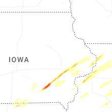
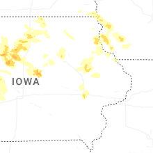


Connect with Interactive Hail Maps