

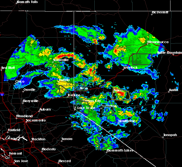
Hail Map for Spaulding, CA
The Spaulding, CA area has had 0 reports of on-the-ground hail by trained spotters, and has been under severe weather warnings 0 times during the past 12 months. Doppler radar has detected hail at or near Spaulding, CA on 5 occasions, including 1 occasion during the past year.
| Name: | Spaulding, CA |
| Where Located: | 84.6 miles E of Redding, CA |
| Map: | Google Map for Spaulding, CA |
| Population: | 178 |
| Housing Units: | 665 |
| More Info: | Search Google for Spaulding, CA |
0
The Top Recent Hail Date for Spaulding, CA is Wednesday, June 7, 2023 (2nd out of 5)

Hail and Wind Damage Spotted near Spaulding, CA
| Date / Time | Report Details |
|---|---|
| 7/31/2022 4:36 PM PDT |
 At 435 pm pdt, a severe thunderstorm was located near eagle lake, moving northwest at 20 mph (radar indicated). Hazards include quarter size hail. damage to vehicles is expected At 435 pm pdt, a severe thunderstorm was located near eagle lake, moving northwest at 20 mph (radar indicated). Hazards include quarter size hail. damage to vehicles is expected
|
| 7/8/2015 4:24 PM PDT |
 At 421 pm pdt, doppler radar indicated a line of severe thunderstorms capable of producing quarter size hail and damaging winds in excess of 60 mph. these storms were located along a line extending from 5-10 miles northeast of susanville to 10-20 miles south of ravendale, and moving northwest at 20-30 mph. * these storms will impact travelers on highway 395 south of ravendale and highway 139 north of susanville. in addition to the wind and hail risk, these storms will produce torrential rains and localized flash flooding. do not drive across roads that appear flooded. hail may accumulate on roadways resulting in slick winter- like driving conditions. be prepared for rapid changes in weather. At 421 pm pdt, doppler radar indicated a line of severe thunderstorms capable of producing quarter size hail and damaging winds in excess of 60 mph. these storms were located along a line extending from 5-10 miles northeast of susanville to 10-20 miles south of ravendale, and moving northwest at 20-30 mph. * these storms will impact travelers on highway 395 south of ravendale and highway 139 north of susanville. in addition to the wind and hail risk, these storms will produce torrential rains and localized flash flooding. do not drive across roads that appear flooded. hail may accumulate on roadways resulting in slick winter- like driving conditions. be prepared for rapid changes in weather.
|
Hail Maps for Spaulding, CA


Connect with Interactive Hail Maps