

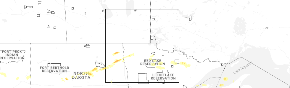
Hail Map for Strandquist, MN
The Strandquist, MN area has had 1 report of on-the-ground hail by trained spotters, and has been under severe weather warnings 8 times during the past 12 months. Doppler radar has detected hail at or near Strandquist, MN on 30 occasions, including 2 occasions during the past year.
| Name: | Strandquist, MN |
| Where Located: | 39.6 miles SW of Roseau, MN |
| Map: | Google Map for Strandquist, MN |
| Population: | 69 |
| Housing Units: | 47 |
| More Info: | Search Google for Strandquist, MN |
5
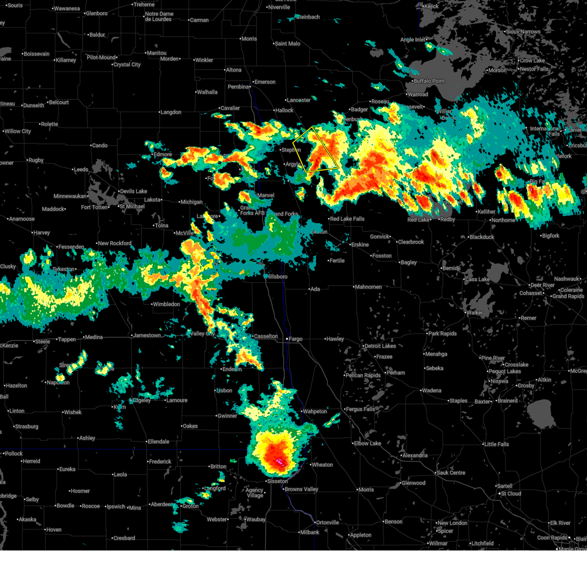
The Top Recent Hail Date for Strandquist, MN is Monday, July 14, 2025 (8th out of 30)
Hail and Wind Damage Spotted near Strandquist, MN
| Date / Time | Report Details |
|---|---|
| 8/8/2025 5:27 AM CDT |
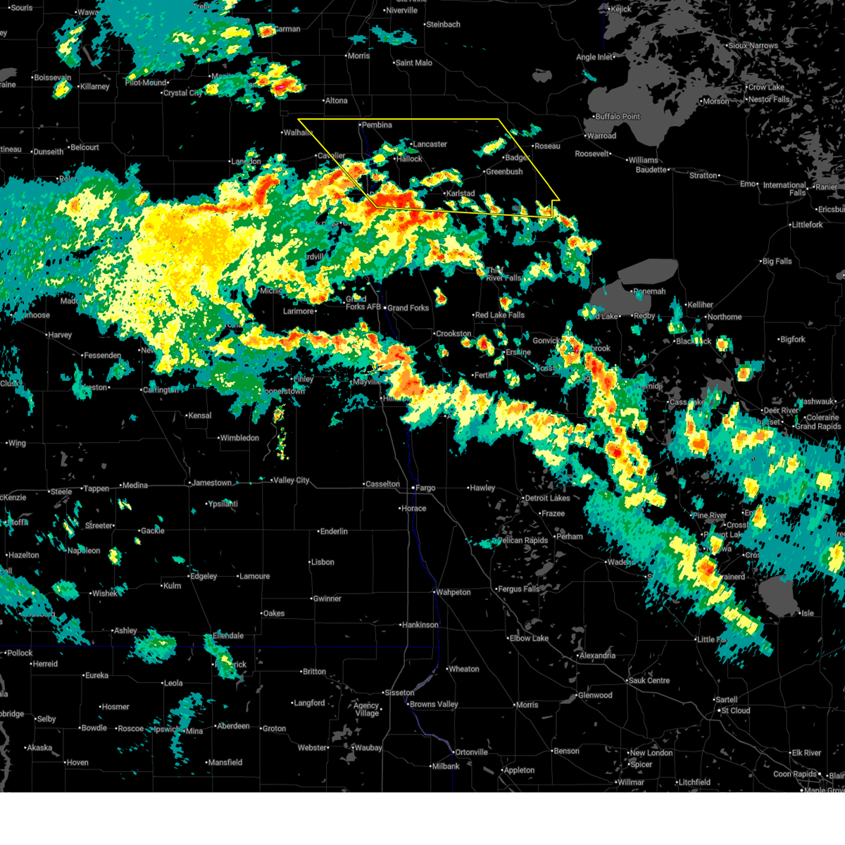
 Svrfgf the national weather service in grand forks has issued a * severe thunderstorm warning for, marshall county in northwestern minnesota, northern red lake county in northwestern minnesota, northeastern polk county in northwestern minnesota, kittson county in northwestern minnesota, roseau county in northwestern minnesota, northern beltrami county in north central minnesota, southwestern lake of the woods county in north central minnesota, pennington county in northwestern minnesota, northwestern clearwater county in northwestern minnesota, northeastern pembina county in northeastern north dakota, * until 630 am cdt. * at 526 am cdt, severe thunderstorms were located along a line extending from near orleans to near roland, moving east at 60 mph (radar indicated). Hazards include 60 mph wind gusts. expect damage to roofs, siding, and trees Svrfgf the national weather service in grand forks has issued a * severe thunderstorm warning for, marshall county in northwestern minnesota, northern red lake county in northwestern minnesota, northeastern polk county in northwestern minnesota, kittson county in northwestern minnesota, roseau county in northwestern minnesota, northern beltrami county in north central minnesota, southwestern lake of the woods county in north central minnesota, pennington county in northwestern minnesota, northwestern clearwater county in northwestern minnesota, northeastern pembina county in northeastern north dakota, * until 630 am cdt. * at 526 am cdt, severe thunderstorms were located along a line extending from near orleans to near roland, moving east at 60 mph (radar indicated). Hazards include 60 mph wind gusts. expect damage to roofs, siding, and trees
|
| 8/8/2025 4:49 AM CDT |
 Svrfgf the national weather service in grand forks has issued a * severe thunderstorm warning for, northwestern marshall county in northwestern minnesota, kittson county in northwestern minnesota, southwestern roseau county in northwestern minnesota, northeastern cavalier county in northeastern north dakota, eastern walsh county in northeastern north dakota, pembina county in northeastern north dakota, * until 545 am cdt. * at 449 am cdt, severe thunderstorms were located along a line extending from near walhalla to warsaw, moving east at 55 mph (radar indicated). Hazards include 60 mph wind gusts. expect damage to roofs, siding, and trees Svrfgf the national weather service in grand forks has issued a * severe thunderstorm warning for, northwestern marshall county in northwestern minnesota, kittson county in northwestern minnesota, southwestern roseau county in northwestern minnesota, northeastern cavalier county in northeastern north dakota, eastern walsh county in northeastern north dakota, pembina county in northeastern north dakota, * until 545 am cdt. * at 449 am cdt, severe thunderstorms were located along a line extending from near walhalla to warsaw, moving east at 55 mph (radar indicated). Hazards include 60 mph wind gusts. expect damage to roofs, siding, and trees
|
| 7/27/2025 2:35 AM CDT |
 Svrfgf the national weather service in grand forks has issued a * severe thunderstorm warning for, marshall county in northwestern minnesota, red lake county in northwestern minnesota, northwestern norman county in northwestern minnesota, polk county in northwestern minnesota, southeastern kittson county in northwestern minnesota, southwestern roseau county in northwestern minnesota, northwestern beltrami county in north central minnesota, pennington county in northwestern minnesota, northwestern clearwater county in northwestern minnesota, central grand forks county in northeastern north dakota, northeastern traill county in southeastern north dakota, southeastern walsh county in northeastern north dakota, * until 330 am cdt. * at 234 am cdt, severe thunderstorms were located along a line extending from near veseleyville to near tabor to near crookston to caledonia, moving northeast at 60 mph (radar indicated). Hazards include 70 mph wind gusts and nickel size hail. Expect considerable tree damage. Damage is likely to mobile homes, roofs, and outbuildings. Svrfgf the national weather service in grand forks has issued a * severe thunderstorm warning for, marshall county in northwestern minnesota, red lake county in northwestern minnesota, northwestern norman county in northwestern minnesota, polk county in northwestern minnesota, southeastern kittson county in northwestern minnesota, southwestern roseau county in northwestern minnesota, northwestern beltrami county in north central minnesota, pennington county in northwestern minnesota, northwestern clearwater county in northwestern minnesota, central grand forks county in northeastern north dakota, northeastern traill county in southeastern north dakota, southeastern walsh county in northeastern north dakota, * until 330 am cdt. * at 234 am cdt, severe thunderstorms were located along a line extending from near veseleyville to near tabor to near crookston to caledonia, moving northeast at 60 mph (radar indicated). Hazards include 70 mph wind gusts and nickel size hail. Expect considerable tree damage. Damage is likely to mobile homes, roofs, and outbuildings.
|
| 7/15/2025 1:35 AM CDT |
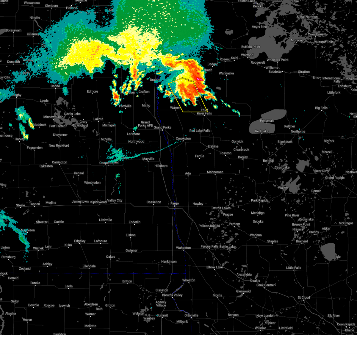
 The storm which prompted the warning has weakened below severe limits, and no longer poses an immediate threat to life or property. therefore, the warning will be allowed to expire. however, small hail is still possible with this thunderstorm. a severe thunderstorm watch remains in effect until 600 am cdt for northwestern minnesota. The storm which prompted the warning has weakened below severe limits, and no longer poses an immediate threat to life or property. therefore, the warning will be allowed to expire. however, small hail is still possible with this thunderstorm. a severe thunderstorm watch remains in effect until 600 am cdt for northwestern minnesota.
|
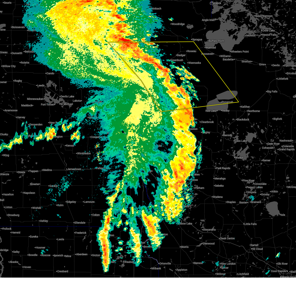
| 7/15/2025 1:24 AM CDT |
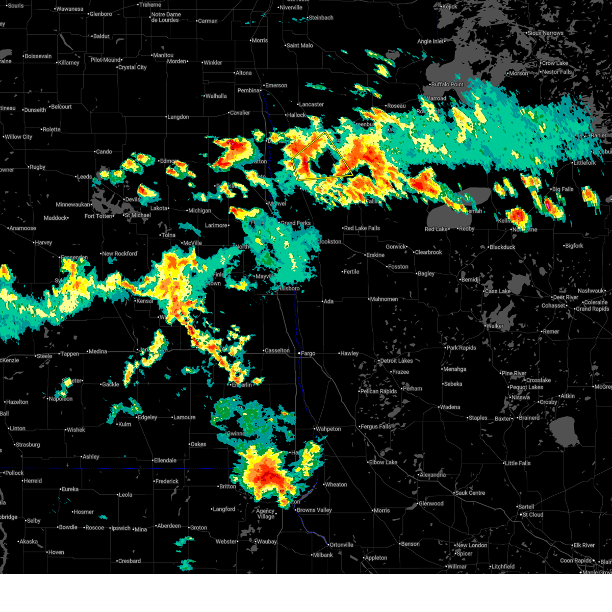
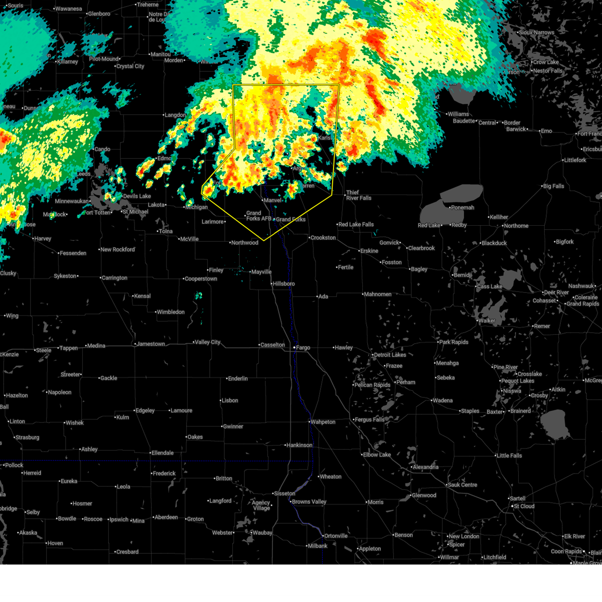
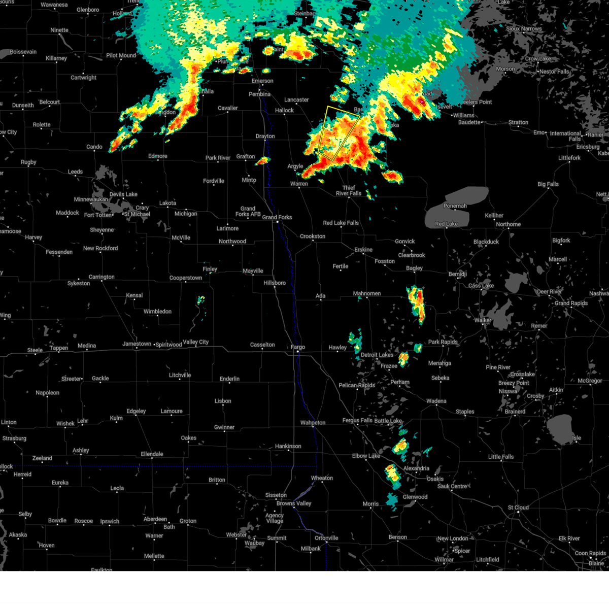
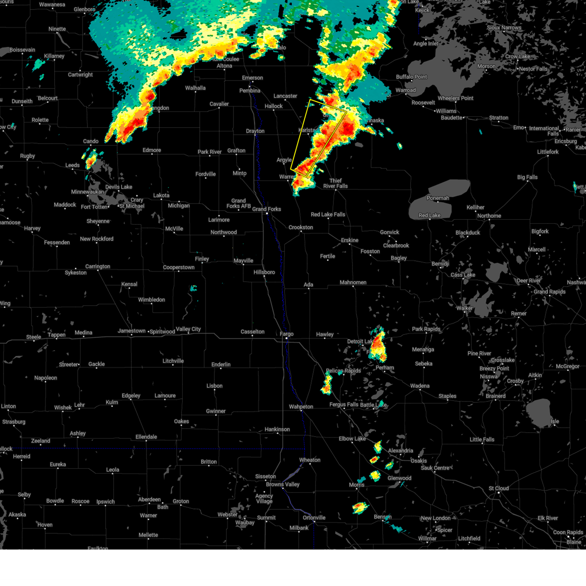
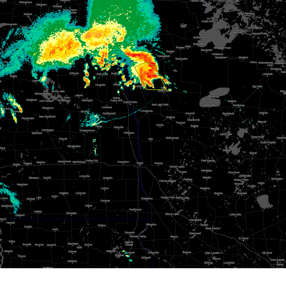
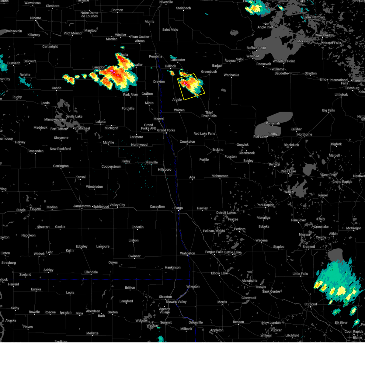
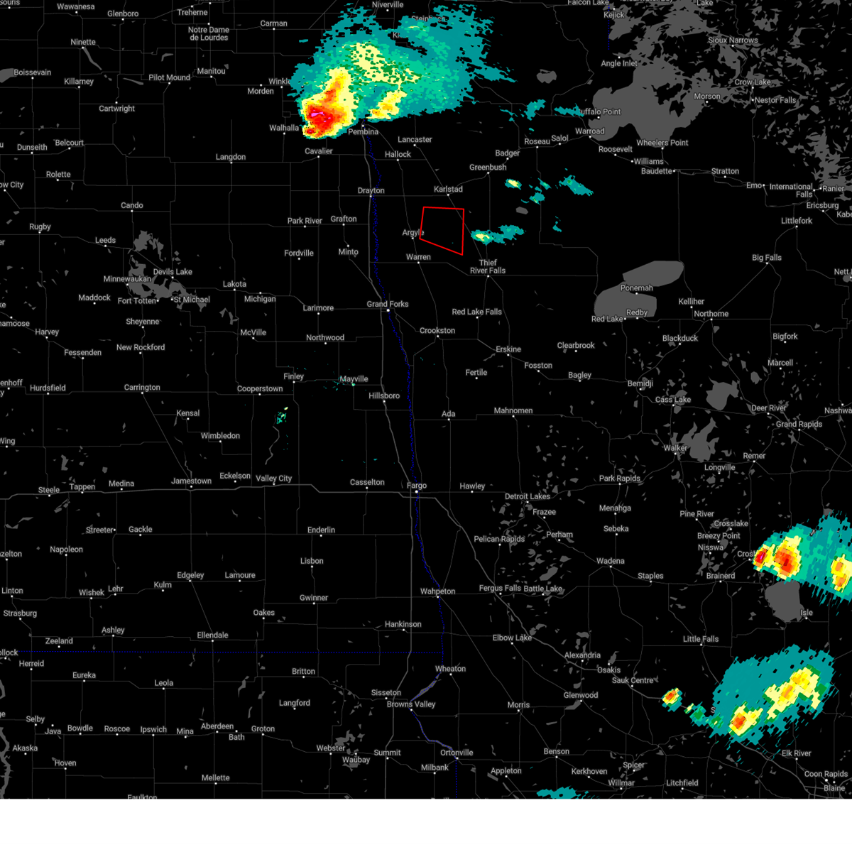
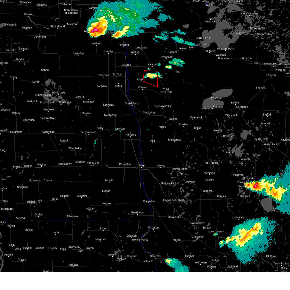
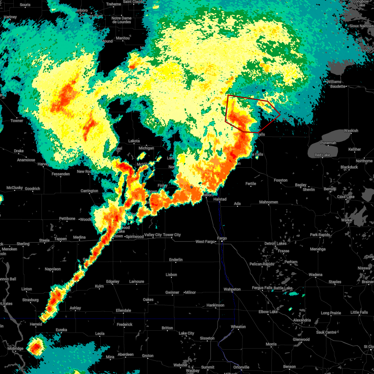
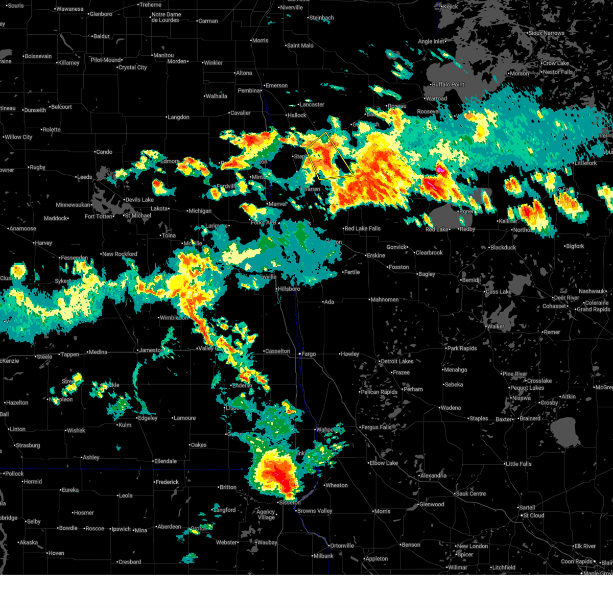 At 123 am cdt, a severe thunderstorm was located near strandquist, or 24 miles northwest of thief river falls, moving east at 55 mph (radar indicated). Hazards include quarter size hail. Damage to vehicles is expected. Locations impacted include, karlstad, newfolden, strandquist, florian, old mill state park, and englund. At 123 am cdt, a severe thunderstorm was located near strandquist, or 24 miles northwest of thief river falls, moving east at 55 mph (radar indicated). Hazards include quarter size hail. Damage to vehicles is expected. Locations impacted include, karlstad, newfolden, strandquist, florian, old mill state park, and englund.
|
| 7/15/2025 1:11 AM CDT |
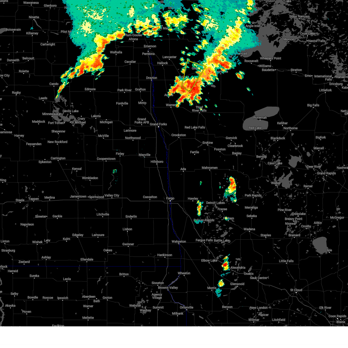
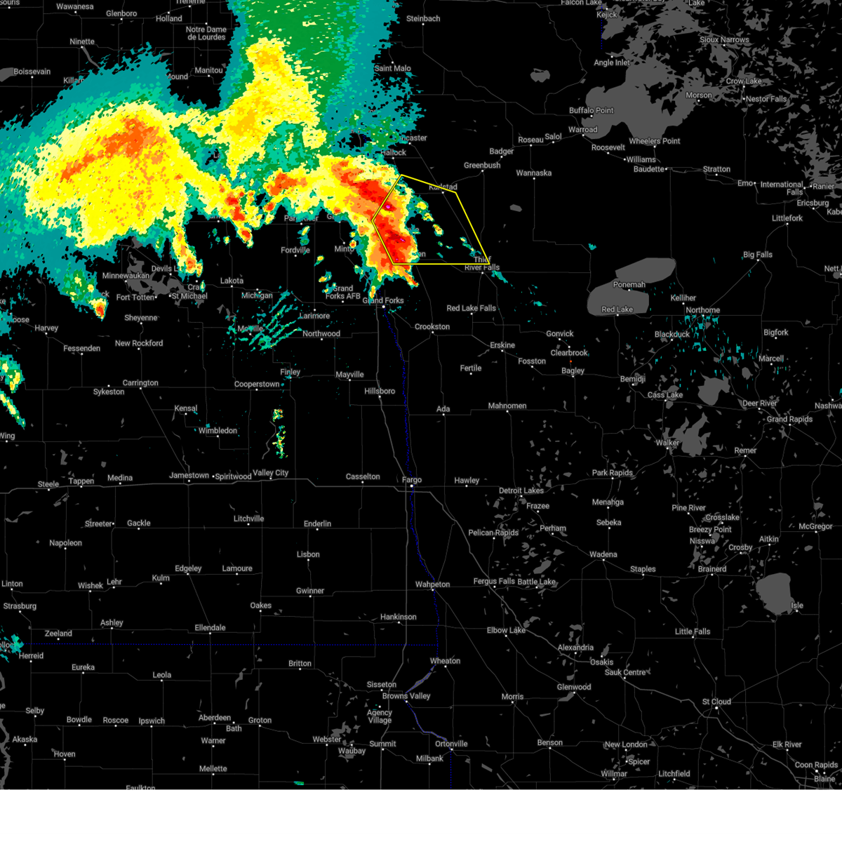
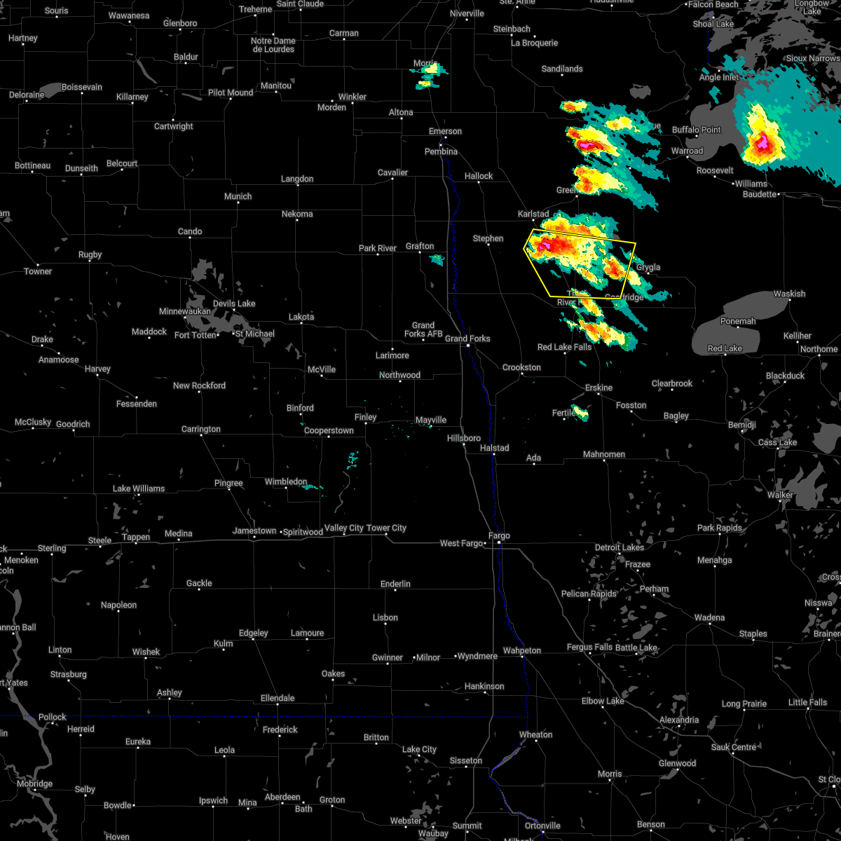
 Svrfgf the national weather service in grand forks has issued a * severe thunderstorm warning for, central marshall county in northwestern minnesota, southeastern kittson county in northwestern minnesota, * until 145 am cdt. * at 110 am cdt, a severe thunderstorm was located near florian, or 30 miles northwest of thief river falls, moving east at 40 mph (radar indicated). Hazards include half dollar size hail. damage to vehicles is expected Svrfgf the national weather service in grand forks has issued a * severe thunderstorm warning for, central marshall county in northwestern minnesota, southeastern kittson county in northwestern minnesota, * until 145 am cdt. * at 110 am cdt, a severe thunderstorm was located near florian, or 30 miles northwest of thief river falls, moving east at 40 mph (radar indicated). Hazards include half dollar size hail. damage to vehicles is expected
|
| 7/4/2025 2:51 AM CDT |
 Svrfgf the national weather service in grand forks has issued a * severe thunderstorm warning for, western marshall county in northwestern minnesota, northwestern polk county in northwestern minnesota, kittson county in northwestern minnesota, western roseau county in northwestern minnesota, northwestern pennington county in northwestern minnesota, northeastern grand forks county in northeastern north dakota, eastern walsh county in northeastern north dakota, eastern pembina county in northeastern north dakota, * until 330 am cdt. * at 249 am cdt, severe thunderstorms were located along a line extending from near orleans to near big woods to 6 miles west of orr, moving southeast at 50 mph (radar indicated). Hazards include 60 mph wind gusts. expect damage to roofs, siding, and trees Svrfgf the national weather service in grand forks has issued a * severe thunderstorm warning for, western marshall county in northwestern minnesota, northwestern polk county in northwestern minnesota, kittson county in northwestern minnesota, western roseau county in northwestern minnesota, northwestern pennington county in northwestern minnesota, northeastern grand forks county in northeastern north dakota, eastern walsh county in northeastern north dakota, eastern pembina county in northeastern north dakota, * until 330 am cdt. * at 249 am cdt, severe thunderstorms were located along a line extending from near orleans to near big woods to 6 miles west of orr, moving southeast at 50 mph (radar indicated). Hazards include 60 mph wind gusts. expect damage to roofs, siding, and trees
|
| 7/4/2025 2:51 AM CDT |
 Svrfgf the national weather service in grand forks has issued a * severe thunderstorm warning for, western marshall county in northwestern minnesota, northwestern polk county in northwestern minnesota, kittson county in northwestern minnesota, western roseau county in northwestern minnesota, northwestern pennington county in northwestern minnesota, northeastern grand forks county in northeastern north dakota, eastern walsh county in northeastern north dakota, eastern pembina county in northeastern north dakota, * until 330 am cdt. * at 251 am cdt, severe thunderstorms were located along a line extending from near orleans to near big woods to near orr, moving southeast at 50 mph (radar indicated). Hazards include 60 mph wind gusts. expect damage to roofs, siding, and trees Svrfgf the national weather service in grand forks has issued a * severe thunderstorm warning for, western marshall county in northwestern minnesota, northwestern polk county in northwestern minnesota, kittson county in northwestern minnesota, western roseau county in northwestern minnesota, northwestern pennington county in northwestern minnesota, northeastern grand forks county in northeastern north dakota, eastern walsh county in northeastern north dakota, eastern pembina county in northeastern north dakota, * until 330 am cdt. * at 251 am cdt, severe thunderstorms were located along a line extending from near orleans to near big woods to near orr, moving southeast at 50 mph (radar indicated). Hazards include 60 mph wind gusts. expect damage to roofs, siding, and trees
|
| 5/15/2025 4:44 PM CDT |
 The storms which prompted the warning have moved out of the area. therefore, the warning will be allowed to expire. however, gusty winds and heavy rain are still possible with these thunderstorms. The storms which prompted the warning have moved out of the area. therefore, the warning will be allowed to expire. however, gusty winds and heavy rain are still possible with these thunderstorms.
|
| 5/15/2025 4:43 PM CDT |
 Svrfgf the national weather service in grand forks has issued a * severe thunderstorm warning for, northern marshall county in northwestern minnesota, kittson county in northwestern minnesota, western roseau county in northwestern minnesota, eastern pembina county in northeastern north dakota, * until 545 pm cdt. * at 443 pm cdt, severe thunderstorms were located along a line extending from near robbin to 7 miles northwest of gatzke, moving northwest at 45 mph (radar indicated). Hazards include 60 mph wind gusts and penny size hail. expect damage to roofs, siding, and trees Svrfgf the national weather service in grand forks has issued a * severe thunderstorm warning for, northern marshall county in northwestern minnesota, kittson county in northwestern minnesota, western roseau county in northwestern minnesota, eastern pembina county in northeastern north dakota, * until 545 pm cdt. * at 443 pm cdt, severe thunderstorms were located along a line extending from near robbin to 7 miles northwest of gatzke, moving northwest at 45 mph (radar indicated). Hazards include 60 mph wind gusts and penny size hail. expect damage to roofs, siding, and trees
|
| 5/15/2025 4:34 PM CDT |
 At 434 pm cdt, severe thunderstorms were located along a line extending from near florian to near grygla, moving northwest at 45 mph (radar indicated). Hazards include 60 mph wind gusts and penny size hail. Expect damage to roofs, siding, and trees. Locations impacted include, karlstad, stephen, newfolden, middle river, kennedy, strandquist, and strathcona. At 434 pm cdt, severe thunderstorms were located along a line extending from near florian to near grygla, moving northwest at 45 mph (radar indicated). Hazards include 60 mph wind gusts and penny size hail. Expect damage to roofs, siding, and trees. Locations impacted include, karlstad, stephen, newfolden, middle river, kennedy, strandquist, and strathcona.
|
| 5/15/2025 4:34 PM CDT |
 the severe thunderstorm warning has been cancelled and is no longer in effect the severe thunderstorm warning has been cancelled and is no longer in effect
|
| 5/15/2025 4:04 PM CDT |
 Svrfgf the national weather service in grand forks has issued a * severe thunderstorm warning for, marshall county in northwestern minnesota, southern kittson county in northwestern minnesota, southwestern roseau county in northwestern minnesota, west central beltrami county in north central minnesota, northern pennington county in northwestern minnesota, * until 445 pm cdt. * at 404 pm cdt, severe thunderstorms were located along a line extending from near rosewood to red lake nation, moving northwest at 65 mph (radar indicated). Hazards include 70 mph wind gusts and penny size hail. Expect considerable tree damage. Damage is likely to mobile homes, roofs, and outbuildings. Svrfgf the national weather service in grand forks has issued a * severe thunderstorm warning for, marshall county in northwestern minnesota, southern kittson county in northwestern minnesota, southwestern roseau county in northwestern minnesota, west central beltrami county in north central minnesota, northern pennington county in northwestern minnesota, * until 445 pm cdt. * at 404 pm cdt, severe thunderstorms were located along a line extending from near rosewood to red lake nation, moving northwest at 65 mph (radar indicated). Hazards include 70 mph wind gusts and penny size hail. Expect considerable tree damage. Damage is likely to mobile homes, roofs, and outbuildings.
|
| 9/16/2024 6:39 PM CDT |
 The storm which prompted the warning has weakened below severe limits, and has exited the warned area. therefore, the warning will be allowed to expire. however, heavy rain is still possible with this thunderstorm. The storm which prompted the warning has weakened below severe limits, and has exited the warned area. therefore, the warning will be allowed to expire. however, heavy rain is still possible with this thunderstorm.
|
| 9/16/2024 6:13 PM CDT |
 At 612 pm cdt, a severe thunderstorm was located over strandquist, or 28 miles northwest of thief river falls, moving northeast at 30 mph (radar indicated). Hazards include quarter size hail. Damage to vehicles is expected. Locations impacted include, karlstad, greenbush, strandquist, and leo. At 612 pm cdt, a severe thunderstorm was located over strandquist, or 28 miles northwest of thief river falls, moving northeast at 30 mph (radar indicated). Hazards include quarter size hail. Damage to vehicles is expected. Locations impacted include, karlstad, greenbush, strandquist, and leo.
|
| 9/16/2024 5:43 PM CDT |
 Svrfgf the national weather service in grand forks has issued a * severe thunderstorm warning for, central marshall county in northwestern minnesota, southeastern kittson county in northwestern minnesota, southwestern roseau county in northwestern minnesota, * until 645 pm cdt. * at 543 pm cdt, a severe thunderstorm was located over old mill state park, or 25 miles northwest of thief river falls, moving northeast at 40 mph (radar indicated). Hazards include 60 mph wind gusts and quarter size hail. Hail damage to vehicles is expected. Expect wind damage to roofs, siding, and trees. Svrfgf the national weather service in grand forks has issued a * severe thunderstorm warning for, central marshall county in northwestern minnesota, southeastern kittson county in northwestern minnesota, southwestern roseau county in northwestern minnesota, * until 645 pm cdt. * at 543 pm cdt, a severe thunderstorm was located over old mill state park, or 25 miles northwest of thief river falls, moving northeast at 40 mph (radar indicated). Hazards include 60 mph wind gusts and quarter size hail. Hail damage to vehicles is expected. Expect wind damage to roofs, siding, and trees.
|
| 9/16/2024 4:48 PM CDT | Large tree down 6 to 8 inches in diameter. report via social medi in marshall county MN, 3.8 miles WNW of Strandquist, MN |
| 9/16/2024 9:13 AM CDT |
 The storm which prompted the warning has weakened below severe limits, and no longer poses an immediate threat to life or property. therefore, the warning will be allowed to expire. however, small hail, gusty winds and heavy rain are still possible with this thunderstorm. The storm which prompted the warning has weakened below severe limits, and no longer poses an immediate threat to life or property. therefore, the warning will be allowed to expire. however, small hail, gusty winds and heavy rain are still possible with this thunderstorm.
|
| 9/16/2024 8:56 AM CDT |
 At 854 am cdt, a severe thunderstorm was located over englund, or 33 miles northwest of thief river falls, moving northeast at 40 mph (public reported quarter sized hail near old mill state park around 845 am cdt). Hazards include 60 mph wind gusts and quarter size hail. Hail damage to vehicles is expected. expect wind damage to roofs, siding, and trees. Locations impacted include, karlstad, newfolden, viking, strandquist, florian, rosewood, and radium. At 854 am cdt, a severe thunderstorm was located over englund, or 33 miles northwest of thief river falls, moving northeast at 40 mph (public reported quarter sized hail near old mill state park around 845 am cdt). Hazards include 60 mph wind gusts and quarter size hail. Hail damage to vehicles is expected. expect wind damage to roofs, siding, and trees. Locations impacted include, karlstad, newfolden, viking, strandquist, florian, rosewood, and radium.
|
| 9/16/2024 8:25 AM CDT |
 Svrfgf the national weather service in grand forks has issued a * severe thunderstorm warning for, western marshall county in northwestern minnesota, southeastern kittson county in northwestern minnesota, * until 915 am cdt. * at 824 am cdt, a severe thunderstorm was located near argyle, or 26 miles east of grafton, moving northeast at 40 mph (radar indicated). Hazards include 60 mph wind gusts and quarter size hail. Hail damage to vehicles is expected. Expect wind damage to roofs, siding, and trees. Svrfgf the national weather service in grand forks has issued a * severe thunderstorm warning for, western marshall county in northwestern minnesota, southeastern kittson county in northwestern minnesota, * until 915 am cdt. * at 824 am cdt, a severe thunderstorm was located near argyle, or 26 miles east of grafton, moving northeast at 40 mph (radar indicated). Hazards include 60 mph wind gusts and quarter size hail. Hail damage to vehicles is expected. Expect wind damage to roofs, siding, and trees.
|
| 7/22/2024 4:46 PM CDT |
 The storm which prompted the warning has weakened below severe limits, and no longer poses an immediate threat to life or property. therefore, the warning has been allowed to expire. however, small hail and heavy rain are still possible with this thunderstorm. The storm which prompted the warning has weakened below severe limits, and no longer poses an immediate threat to life or property. therefore, the warning has been allowed to expire. however, small hail and heavy rain are still possible with this thunderstorm.
|
| 7/22/2024 4:22 PM CDT |
 At 422 pm cdt, a severe thunderstorm was located near englund, or 31 miles northwest of thief river falls, moving southeast at 20 mph (public). Hazards include golf ball size hail and 60 mph wind gusts. People and animals outdoors will be injured. expect hail damage to roofs, siding, windows, and vehicles. expect wind damage to roofs, siding, and trees. Locations impacted include, karlstad, strandquist, halma, florian, and englund. At 422 pm cdt, a severe thunderstorm was located near englund, or 31 miles northwest of thief river falls, moving southeast at 20 mph (public). Hazards include golf ball size hail and 60 mph wind gusts. People and animals outdoors will be injured. expect hail damage to roofs, siding, windows, and vehicles. expect wind damage to roofs, siding, and trees. Locations impacted include, karlstad, strandquist, halma, florian, and englund.
|
| 7/22/2024 4:06 PM CDT |
 Svrfgf the national weather service in grand forks has issued a * severe thunderstorm warning for, north central marshall county in northwestern minnesota, southeastern kittson county in northwestern minnesota, * until 445 pm cdt. * at 405 pm cdt, a severe thunderstorm was located near karlstad, or 37 miles northwest of thief river falls, moving southeast at 20 mph (radar indicated). Hazards include 60 mph wind gusts and half dollar size hail. Hail damage to vehicles is expected. Expect wind damage to roofs, siding, and trees. Svrfgf the national weather service in grand forks has issued a * severe thunderstorm warning for, north central marshall county in northwestern minnesota, southeastern kittson county in northwestern minnesota, * until 445 pm cdt. * at 405 pm cdt, a severe thunderstorm was located near karlstad, or 37 miles northwest of thief river falls, moving southeast at 20 mph (radar indicated). Hazards include 60 mph wind gusts and half dollar size hail. Hail damage to vehicles is expected. Expect wind damage to roofs, siding, and trees.
|
| 6/18/2024 2:42 AM CDT |
 Svrfgf the national weather service in grand forks has issued a * severe thunderstorm warning for, marshall county in northwestern minnesota, red lake county in northwestern minnesota, northern polk county in northwestern minnesota, pennington county in northwestern minnesota, * until 345 am cdt. * at 241 am cdt, severe thunderstorms were located along a line extending from near alvarado to 7 miles north of dorothy to harold, moving northeast at 30 mph (radar indicated). Hazards include 60 mph wind gusts and nickel size hail. expect damage to roofs, siding, and trees Svrfgf the national weather service in grand forks has issued a * severe thunderstorm warning for, marshall county in northwestern minnesota, red lake county in northwestern minnesota, northern polk county in northwestern minnesota, pennington county in northwestern minnesota, * until 345 am cdt. * at 241 am cdt, severe thunderstorms were located along a line extending from near alvarado to 7 miles north of dorothy to harold, moving northeast at 30 mph (radar indicated). Hazards include 60 mph wind gusts and nickel size hail. expect damage to roofs, siding, and trees
|
| 6/12/2024 9:25 PM CDT |
 The storm which prompted the warning has weakened below severe limits, and no longer poses an immediate threat to life or property. therefore, the warning will be allowed to expire. however, gusty winds are still possible with this thunderstorm. a severe thunderstorm watch remains in effect until 1000 pm cdt for northwestern minnesota. The storm which prompted the warning has weakened below severe limits, and no longer poses an immediate threat to life or property. therefore, the warning will be allowed to expire. however, gusty winds are still possible with this thunderstorm. a severe thunderstorm watch remains in effect until 1000 pm cdt for northwestern minnesota.
|
| 6/12/2024 8:58 PM CDT |
 At 858 pm cdt, a severe thunderstorm was located near florian, or 31 miles east of grafton, moving southeast at 45 mph (radar indicated). Hazards include 70 mph wind gusts and half dollar size hail. Hail damage to vehicles is expected. expect considerable tree damage. wind damage is also likely to mobile homes, roofs, and outbuildings. Locations impacted include, karlstad, stephen, argyle, newfolden, strandquist, donaldson, and florian. At 858 pm cdt, a severe thunderstorm was located near florian, or 31 miles east of grafton, moving southeast at 45 mph (radar indicated). Hazards include 70 mph wind gusts and half dollar size hail. Hail damage to vehicles is expected. expect considerable tree damage. wind damage is also likely to mobile homes, roofs, and outbuildings. Locations impacted include, karlstad, stephen, argyle, newfolden, strandquist, donaldson, and florian.
|
| 6/12/2024 8:43 PM CDT |
 Svrfgf the national weather service in grand forks has issued a * severe thunderstorm warning for, western marshall county in northwestern minnesota, southwestern kittson county in northwestern minnesota, * until 930 pm cdt. * at 843 pm cdt, a severe thunderstorm was located over donaldson, or 24 miles northeast of grafton, moving southeast at 45 mph (radar indicated). Hazards include 70 mph wind gusts and half dollar size hail. Hail damage to vehicles is expected. expect considerable tree damage. Wind damage is also likely to mobile homes, roofs, and outbuildings. Svrfgf the national weather service in grand forks has issued a * severe thunderstorm warning for, western marshall county in northwestern minnesota, southwestern kittson county in northwestern minnesota, * until 930 pm cdt. * at 843 pm cdt, a severe thunderstorm was located over donaldson, or 24 miles northeast of grafton, moving southeast at 45 mph (radar indicated). Hazards include 70 mph wind gusts and half dollar size hail. Hail damage to vehicles is expected. expect considerable tree damage. Wind damage is also likely to mobile homes, roofs, and outbuildings.
|
| 6/12/2024 7:49 PM CDT |
 the tornado warning has been cancelled and is no longer in effect the tornado warning has been cancelled and is no longer in effect
|
| 6/12/2024 7:27 PM CDT |
 Torfgf the national weather service in grand forks has issued a * tornado warning for, central marshall county in northwestern minnesota, * until 800 pm cdt. * at 726 pm cdt, a severe thunderstorm capable of producing a tornado was located over florian, or 29 miles northwest of thief river falls, moving east at 25 mph (radar indicated rotation). Hazards include tornado. Flying debris will be dangerous to those caught without shelter. mobile homes will be damaged or destroyed. damage to roofs, windows, and vehicles will occur. Tree damage is likely. Torfgf the national weather service in grand forks has issued a * tornado warning for, central marshall county in northwestern minnesota, * until 800 pm cdt. * at 726 pm cdt, a severe thunderstorm capable of producing a tornado was located over florian, or 29 miles northwest of thief river falls, moving east at 25 mph (radar indicated rotation). Hazards include tornado. Flying debris will be dangerous to those caught without shelter. mobile homes will be damaged or destroyed. damage to roofs, windows, and vehicles will occur. Tree damage is likely.
|
| 9/5/2023 1:30 AM CDT |
 At 129 am cdt, severe thunderstorms were located along a line extending from near englund to near strandquist to near holt, moving north at 40 mph. these are destructive storms for the strathcona and karlstad areas! (radar indicated). Hazards include 80 mph wind gusts. Flying debris will be dangerous to those caught without shelter. mobile homes will be heavily damaged. expect considerable damage to roofs, windows, and vehicles. extensive tree damage and power outages are likely. locations impacted include, karlstad, greenbush, stephen, badger, newfolden, middle river and lake bronson. thunderstorm damage threat, destructive hail threat, radar indicated max hail size, <. 75 in wind threat, observed max wind gust, 80 mph. At 129 am cdt, severe thunderstorms were located along a line extending from near englund to near strandquist to near holt, moving north at 40 mph. these are destructive storms for the strathcona and karlstad areas! (radar indicated). Hazards include 80 mph wind gusts. Flying debris will be dangerous to those caught without shelter. mobile homes will be heavily damaged. expect considerable damage to roofs, windows, and vehicles. extensive tree damage and power outages are likely. locations impacted include, karlstad, greenbush, stephen, badger, newfolden, middle river and lake bronson. thunderstorm damage threat, destructive hail threat, radar indicated max hail size, <. 75 in wind threat, observed max wind gust, 80 mph.
|
| 9/5/2023 1:12 AM CDT |
 At 110 am cdt, severe thunderstorms were located along a line extending from near stephen to old mill state park to near carpenters corner, moving northeast at 45 mph. 79 mile per hour wind gusts have been observed near warren. these are destructive storms for the warned area (radar indicated). Hazards include 80 mph wind gusts. Flying debris will be dangerous to those caught without shelter. mobile homes will be heavily damaged. expect considerable damage to roofs, windows, and vehicles. Extensive tree damage and power outages are likely. At 110 am cdt, severe thunderstorms were located along a line extending from near stephen to old mill state park to near carpenters corner, moving northeast at 45 mph. 79 mile per hour wind gusts have been observed near warren. these are destructive storms for the warned area (radar indicated). Hazards include 80 mph wind gusts. Flying debris will be dangerous to those caught without shelter. mobile homes will be heavily damaged. expect considerable damage to roofs, windows, and vehicles. Extensive tree damage and power outages are likely.
|
| 9/5/2023 1:06 AM CDT | At 106 am cdt, severe thunderstorms were located along a line extending from 16 miles northwest of neche to near hallock to near warren, moving east at 55 mph (radar indicated). Hazards include 60 mph wind gusts. Expect damage to roofs, siding, and trees. locations impacted include, thief river falls, grafton, warren, cavalier, hallock, drayton and karlstad. this includes interstate 29 between mile markers 161 and 217. hail threat, radar indicated max hail size, <. 75 in wind threat, observed max wind gust, 60 mph. |
| 9/5/2023 1:06 AM CDT | At 106 am cdt, severe thunderstorms were located along a line extending from 16 miles northwest of neche to near hallock to near warren, moving east at 55 mph (radar indicated). Hazards include 60 mph wind gusts. Expect damage to roofs, siding, and trees. locations impacted include, thief river falls, grafton, warren, cavalier, hallock, drayton and karlstad. this includes interstate 29 between mile markers 161 and 217. hail threat, radar indicated max hail size, <. 75 in wind threat, observed max wind gust, 60 mph. |
| 9/5/2023 12:24 AM CDT |
 At 1224 am cdt, severe thunderstorms were located along a line extending from near olga to near grafton to near thompson, moving northeast at 55 mph (radar indicated). Hazards include 60 mph wind gusts. expect damage to roofs, siding, and trees At 1224 am cdt, severe thunderstorms were located along a line extending from near olga to near grafton to near thompson, moving northeast at 55 mph (radar indicated). Hazards include 60 mph wind gusts. expect damage to roofs, siding, and trees
|
| 7/19/2022 7:07 AM CDT |
 The severe thunderstorm warning for northern marshall, kittson and roseau counties will expire at 715 am cdt, the storms which prompted the warning have weakened below severe limits, and no longer pose an immediate threat to life or property. therefore, the warning will be allowed to expire. however gusty winds are still possible with these thunderstorms. to report severe weather, contact your nearest law enforcement agency. they will relay your report to the national weather service grand forks. The severe thunderstorm warning for northern marshall, kittson and roseau counties will expire at 715 am cdt, the storms which prompted the warning have weakened below severe limits, and no longer pose an immediate threat to life or property. therefore, the warning will be allowed to expire. however gusty winds are still possible with these thunderstorms. to report severe weather, contact your nearest law enforcement agency. they will relay your report to the national weather service grand forks.
|
| 7/19/2022 6:27 AM CDT |
 At 626 am cdt, severe thunderstorms were located along a line extending from 13 miles northwest of caribou to 8 miles northeast of lake bronson to near donaldson, moving east at 55 mph (radar indicated). Hazards include 60 mph wind gusts and quarter size hail. Hail damage to vehicles is expected. expect wind damage to roofs, siding, and trees. locations impacted include, englund, florian, haug, halma, karlstad, strandquist, ross, pinecreek, fox, strathcona and greenbush. hail threat, radar indicated max hail size, 1. 00 in wind threat, observed max wind gust, 60 mph. At 626 am cdt, severe thunderstorms were located along a line extending from 13 miles northwest of caribou to 8 miles northeast of lake bronson to near donaldson, moving east at 55 mph (radar indicated). Hazards include 60 mph wind gusts and quarter size hail. Hail damage to vehicles is expected. expect wind damage to roofs, siding, and trees. locations impacted include, englund, florian, haug, halma, karlstad, strandquist, ross, pinecreek, fox, strathcona and greenbush. hail threat, radar indicated max hail size, 1. 00 in wind threat, observed max wind gust, 60 mph.
|
| 7/19/2022 6:11 AM CDT |
 At 610 am cdt, severe thunderstorms were located along a line extending from 12 miles north of orleans to near lancaster to near herrick, moving east at 55 mph (radar indicated. !** weakened). Hazards include 60 mph wind gusts and quarter size hail. Hail damage to vehicles is expected. expect wind damage to roofs, siding, and trees. severe thunderstorms will be near, lancaster around 615 am cdt. lake bronson around 620 am cdt. stephen and donaldson around 625 am cdt. other locations in the path of these severe thunderstorms include englund, florian, leo, karlstad and haug. this includes interstate 29 between mile markers 170 and 206. hail threat, radar indicated max hail size, 1. 00 in wind threat, observed max wind gust, 60 mph. At 610 am cdt, severe thunderstorms were located along a line extending from 12 miles north of orleans to near lancaster to near herrick, moving east at 55 mph (radar indicated. !** weakened). Hazards include 60 mph wind gusts and quarter size hail. Hail damage to vehicles is expected. expect wind damage to roofs, siding, and trees. severe thunderstorms will be near, lancaster around 615 am cdt. lake bronson around 620 am cdt. stephen and donaldson around 625 am cdt. other locations in the path of these severe thunderstorms include englund, florian, leo, karlstad and haug. this includes interstate 29 between mile markers 170 and 206. hail threat, radar indicated max hail size, 1. 00 in wind threat, observed max wind gust, 60 mph.
|
| 7/10/2022 8:38 AM CDT |
 At 838 am cdt, severe thunderstorms were located along a line extending from 6 miles northeast of halma to near thief river falls to near maple bay, moving east at 55 mph (radar indicated). Hazards include 60 mph wind gusts and quarter size hail. Hail damage to vehicles is expected. expect wind damage to roofs, siding, and trees. these severe storms will be near, maple bay, hazel and thief river falls around 840 am cdt. other locations in the path of these severe thunderstorms include mentor, leo, mavie, high landing, erskine, greenbush, mcintosh and badger. hail threat, radar indicated max hail size, 1. 00 in wind threat, radar indicated max wind gust, 60 mph. At 838 am cdt, severe thunderstorms were located along a line extending from 6 miles northeast of halma to near thief river falls to near maple bay, moving east at 55 mph (radar indicated). Hazards include 60 mph wind gusts and quarter size hail. Hail damage to vehicles is expected. expect wind damage to roofs, siding, and trees. these severe storms will be near, maple bay, hazel and thief river falls around 840 am cdt. other locations in the path of these severe thunderstorms include mentor, leo, mavie, high landing, erskine, greenbush, mcintosh and badger. hail threat, radar indicated max hail size, 1. 00 in wind threat, radar indicated max wind gust, 60 mph.
|
| 7/10/2022 8:22 AM CDT |
 At 822 am cdt, severe thunderstorms were located along a line extending from 6 miles west of lake bronson to near carpenters corner to greenview, moving east at 55 mph (radar indicated). Hazards include 60 mph wind gusts and quarter size hail. Hail damage to vehicles is expected. expect wind damage to roofs, siding, and trees. severe thunderstorms will be near, harold and carpenters corner around 825 am cdt. melvin and rosewood around 830 am cdt. thief river falls, st. hilaire and dakota junction around 835 am cdt. maple bay, hazel and dugdale around 840 am cdt. other locations in the path of these severe thunderstorms include mavie and mentor. hail threat, radar indicated max hail size, 1. 00 in wind threat, radar indicated max wind gust, 60 mph. At 822 am cdt, severe thunderstorms were located along a line extending from 6 miles west of lake bronson to near carpenters corner to greenview, moving east at 55 mph (radar indicated). Hazards include 60 mph wind gusts and quarter size hail. Hail damage to vehicles is expected. expect wind damage to roofs, siding, and trees. severe thunderstorms will be near, harold and carpenters corner around 825 am cdt. melvin and rosewood around 830 am cdt. thief river falls, st. hilaire and dakota junction around 835 am cdt. maple bay, hazel and dugdale around 840 am cdt. other locations in the path of these severe thunderstorms include mavie and mentor. hail threat, radar indicated max hail size, 1. 00 in wind threat, radar indicated max wind gust, 60 mph.
|
| 7/10/2022 8:07 AM CDT |
 At 806 am cdt, severe thunderstorms were located along a line extending from near donaldson to near key west to near nielsville, moving east at 55 mph (radar indicated). Hazards include 60 mph wind gusts and quarter size hail. Hail damage to vehicles is expected. expect wind damage to roofs, siding, and trees. locations impacted include, euclid, dorothy, englund, florian, wylie, beltrami, greenview, strandquist, st. hilaire, red lake falls, fertile and hazel. this includes interstate 29 between mile markers 114 and 181. hail threat, radar indicated max hail size, 1. 00 in wind threat, radar indicated max wind gust, 60 mph. At 806 am cdt, severe thunderstorms were located along a line extending from near donaldson to near key west to near nielsville, moving east at 55 mph (radar indicated). Hazards include 60 mph wind gusts and quarter size hail. Hail damage to vehicles is expected. expect wind damage to roofs, siding, and trees. locations impacted include, euclid, dorothy, englund, florian, wylie, beltrami, greenview, strandquist, st. hilaire, red lake falls, fertile and hazel. this includes interstate 29 between mile markers 114 and 181. hail threat, radar indicated max hail size, 1. 00 in wind threat, radar indicated max wind gust, 60 mph.
|
| 7/10/2022 7:35 AM CDT |
 At 734 am cdt, severe thunderstorms were located along a line extending from near mandt to near arvilla to near sherbrooke, moving east at 55 mph (radar indicated). Hazards include 60 mph wind gusts and quarter size hail. Hail damage to vehicles is expected. expect wind damage to roofs, siding, and trees. severe thunderstorms will be near, emerado, grand forks afb and mekinock around 740 am cdt. portland, mayville and grand forks around 750 am cdt. other locations in the path of these severe thunderstorms include cashel, mallory, east grand forks, bygland, davidson, cummings and hillsboro. this includes interstate 29 between mile markers 97 and 181. hail threat, radar indicated max hail size, 1. 00 in wind threat, radar indicated max wind gust, 60 mph. At 734 am cdt, severe thunderstorms were located along a line extending from near mandt to near arvilla to near sherbrooke, moving east at 55 mph (radar indicated). Hazards include 60 mph wind gusts and quarter size hail. Hail damage to vehicles is expected. expect wind damage to roofs, siding, and trees. severe thunderstorms will be near, emerado, grand forks afb and mekinock around 740 am cdt. portland, mayville and grand forks around 750 am cdt. other locations in the path of these severe thunderstorms include cashel, mallory, east grand forks, bygland, davidson, cummings and hillsboro. this includes interstate 29 between mile markers 97 and 181. hail threat, radar indicated max hail size, 1. 00 in wind threat, radar indicated max wind gust, 60 mph.
|
| 6/24/2022 8:32 PM CDT |
 At 832 pm cdt, severe thunderstorms were located along a line extending from near strathcona to near high landing to near brooks, moving east at 15 mph (radar indicated). Hazards include 70 mph wind gusts and half dollar size hail. Hail damage to vehicles is expected. expect considerable tree damage. wind damage is also likely to mobile homes, roofs, and outbuildings. Locations impacted include, mavie, oklee, high landing, goodridge, roland and trail. At 832 pm cdt, severe thunderstorms were located along a line extending from near strathcona to near high landing to near brooks, moving east at 15 mph (radar indicated). Hazards include 70 mph wind gusts and half dollar size hail. Hail damage to vehicles is expected. expect considerable tree damage. wind damage is also likely to mobile homes, roofs, and outbuildings. Locations impacted include, mavie, oklee, high landing, goodridge, roland and trail.
|
| 6/24/2022 8:11 PM CDT |
 The tornado warning for central marshall, southeastern kittson and southwestern roseau counties will expire at 815 pm cdt, the tornado threat has diminished and the tornado warning has been cancelled. however, damaging winds remain likely and a severe thunderstorm warning remains in effect for the area. a severe thunderstorm watch remains in effect until 900 pm cdt for northwestern minnesota. The tornado warning for central marshall, southeastern kittson and southwestern roseau counties will expire at 815 pm cdt, the tornado threat has diminished and the tornado warning has been cancelled. however, damaging winds remain likely and a severe thunderstorm warning remains in effect for the area. a severe thunderstorm watch remains in effect until 900 pm cdt for northwestern minnesota.
|
| 6/24/2022 7:53 PM CDT |
 At 753 pm cdt, severe thunderstorms were located along a line extending from near strandquist to hazel to near perault, moving east at 15 mph. these are destructive storms (radar indicated). Hazards include 80 mph wind gusts and half dollar size hail. Flying debris will be dangerous to those caught without shelter. mobile homes will be heavily damaged. expect considerable damage to roofs, windows, and vehicles. extensive tree damage and power outages are likely. severe thunderstorms will be near, hazel and thief river falls around 755 pm cdt. red lake falls around 805 pm cdt. Other locations in the path of these severe thunderstorms include middle river, mavie, strathcona and terrebonne. At 753 pm cdt, severe thunderstorms were located along a line extending from near strandquist to hazel to near perault, moving east at 15 mph. these are destructive storms (radar indicated). Hazards include 80 mph wind gusts and half dollar size hail. Flying debris will be dangerous to those caught without shelter. mobile homes will be heavily damaged. expect considerable damage to roofs, windows, and vehicles. extensive tree damage and power outages are likely. severe thunderstorms will be near, hazel and thief river falls around 755 pm cdt. red lake falls around 805 pm cdt. Other locations in the path of these severe thunderstorms include middle river, mavie, strathcona and terrebonne.
|
| 6/24/2022 7:50 PM CDT |
 At 750 pm cdt, a severe thunderstorm capable of producing a tornado was located over rosewood, or 8 miles northwest of thief river falls, moving northeast at 20 mph (radar indicated rotation). Hazards include tornado and quarter size hail. Flying debris will be dangerous to those caught without shelter. mobile homes will be damaged or destroyed. damage to roofs, windows, and vehicles will occur. tree damage is likely. Locations impacted include, holt. At 750 pm cdt, a severe thunderstorm capable of producing a tornado was located over rosewood, or 8 miles northwest of thief river falls, moving northeast at 20 mph (radar indicated rotation). Hazards include tornado and quarter size hail. Flying debris will be dangerous to those caught without shelter. mobile homes will be damaged or destroyed. damage to roofs, windows, and vehicles will occur. tree damage is likely. Locations impacted include, holt.
|
| 6/24/2022 7:40 PM CDT |
 At 739 pm cdt, severe thunderstorms were located along a line extending from near donaldson to dorothy, moving northeast at 25 mph. these are destructive storms (radar indicated). Hazards include 80 mph wind gusts and half dollar size hail. Flying debris will be dangerous to those caught without shelter. mobile homes will be heavily damaged. expect considerable damage to roofs, windows, and vehicles. extensive tree damage and power outages are likely. locations impacted include, dorothy, huot, donaldson, wylie, kennedy, red lake falls, st. Hilaire and hazel. At 739 pm cdt, severe thunderstorms were located along a line extending from near donaldson to dorothy, moving northeast at 25 mph. these are destructive storms (radar indicated). Hazards include 80 mph wind gusts and half dollar size hail. Flying debris will be dangerous to those caught without shelter. mobile homes will be heavily damaged. expect considerable damage to roofs, windows, and vehicles. extensive tree damage and power outages are likely. locations impacted include, dorothy, huot, donaldson, wylie, kennedy, red lake falls, st. Hilaire and hazel.
|
| 6/24/2022 7:32 PM CDT |
 At 732 pm cdt, a severe thunderstorm capable of producing a tornado was located near old mill state park, or 20 miles northwest of thief river falls, moving northeast at 25 mph (radar indicated rotation). Hazards include tornado and quarter size hail. Flying debris will be dangerous to those caught without shelter. mobile homes will be damaged or destroyed. damage to roofs, windows, and vehicles will occur. tree damage is likely. this dangerous storm will be near, newfolden around 745 pm cdt. Other locations in the path of this tornadic thunderstorm include middle river and strathcona. At 732 pm cdt, a severe thunderstorm capable of producing a tornado was located near old mill state park, or 20 miles northwest of thief river falls, moving northeast at 25 mph (radar indicated rotation). Hazards include tornado and quarter size hail. Flying debris will be dangerous to those caught without shelter. mobile homes will be damaged or destroyed. damage to roofs, windows, and vehicles will occur. tree damage is likely. this dangerous storm will be near, newfolden around 745 pm cdt. Other locations in the path of this tornadic thunderstorm include middle river and strathcona.
|
| 6/24/2022 7:19 PM CDT |
 At 719 pm cdt, severe thunderstorms were located along a line extending from near robbin to 6 miles north of crookston, moving northeast at 25 mph. these are destructive storms for thief river falls and karlstad (radar indicated). Hazards include 90 mph wind gusts and half dollar size hail. You are in a life-threatening situation. flying debris may be deadly to those caught without shelter. mobile homes will be heavily damaged or destroyed. homes and businesses will have substantial roof and window damage. expect extensive tree damage and power outages. these severe storms will be near, euclid and gentilly around 725 pm cdt. other locations in the path of these severe thunderstorms include dorothy, huot, donaldson, wylie, kennedy, red lake falls and st. hilaire. This includes interstate 29 between mile markers 168 and 184. At 719 pm cdt, severe thunderstorms were located along a line extending from near robbin to 6 miles north of crookston, moving northeast at 25 mph. these are destructive storms for thief river falls and karlstad (radar indicated). Hazards include 90 mph wind gusts and half dollar size hail. You are in a life-threatening situation. flying debris may be deadly to those caught without shelter. mobile homes will be heavily damaged or destroyed. homes and businesses will have substantial roof and window damage. expect extensive tree damage and power outages. these severe storms will be near, euclid and gentilly around 725 pm cdt. other locations in the path of these severe thunderstorms include dorothy, huot, donaldson, wylie, kennedy, red lake falls and st. hilaire. This includes interstate 29 between mile markers 168 and 184.
|
| 6/24/2022 7:07 PM CDT |
 At 706 pm cdt, severe thunderstorms were located along a line extending from herrick to near crookston, moving northeast at 25 mph. these are destructive storms for thief river falls and old mill state park (radar indicated). Hazards include 90 mph wind gusts and half dollar size hail. You are in a life-threatening situation. flying debris may be deadly to those caught without shelter. mobile homes will be heavily damaged or destroyed. homes and businesses will have substantial roof and window damage. expect extensive tree damage and power outages. severe thunderstorms will be near, crookston around 710 pm cdt. robbin and euclid around 720 pm cdt. other locations in the path of these severe thunderstorms include huot, dorothy and donaldson. this includes interstate 29 between mile markers 168 and 184. thunderstorm damage threat, destructive hail threat, radar indicated max hail size, 1. 25 in wind threat, observed max wind gust, 90 mph. At 706 pm cdt, severe thunderstorms were located along a line extending from herrick to near crookston, moving northeast at 25 mph. these are destructive storms for thief river falls and old mill state park (radar indicated). Hazards include 90 mph wind gusts and half dollar size hail. You are in a life-threatening situation. flying debris may be deadly to those caught without shelter. mobile homes will be heavily damaged or destroyed. homes and businesses will have substantial roof and window damage. expect extensive tree damage and power outages. severe thunderstorms will be near, crookston around 710 pm cdt. robbin and euclid around 720 pm cdt. other locations in the path of these severe thunderstorms include huot, dorothy and donaldson. this includes interstate 29 between mile markers 168 and 184. thunderstorm damage threat, destructive hail threat, radar indicated max hail size, 1. 25 in wind threat, observed max wind gust, 90 mph.
|
| 6/24/2022 2:13 PM CDT |
 At 212 pm cdt, a severe thunderstorm was located over strandquist, or 28 miles northwest of thief river falls, moving northeast at 10 mph (radar indicated). Hazards include quarter size hail. Damage to vehicles is expected. locations impacted include, karlstad, strandquist, florian, englund and strathcona. hail threat, radar indicated max hail size, 1. 00 in wind threat, radar indicated max wind gust, <50 mph. At 212 pm cdt, a severe thunderstorm was located over strandquist, or 28 miles northwest of thief river falls, moving northeast at 10 mph (radar indicated). Hazards include quarter size hail. Damage to vehicles is expected. locations impacted include, karlstad, strandquist, florian, englund and strathcona. hail threat, radar indicated max hail size, 1. 00 in wind threat, radar indicated max wind gust, <50 mph.
|
| 6/24/2022 1:50 PM CDT |
 At 150 pm cdt, a severe thunderstorm was located near old mill state park, or 26 miles northwest of thief river falls, moving northeast at 10 mph (radar indicated). Hazards include half dollar size hail. damage to vehicles is expected At 150 pm cdt, a severe thunderstorm was located near old mill state park, or 26 miles northwest of thief river falls, moving northeast at 10 mph (radar indicated). Hazards include half dollar size hail. damage to vehicles is expected
|
| 6/24/2022 1:23 PM CDT |
 At 123 pm cdt, a severe thunderstorm was located over old mill state park, or 26 miles northwest of thief river falls, and is nearly stationary (radar indicated). Hazards include quarter size hail. Damage to vehicles is expected. this severe storm will be near, old mill state park around 125 pm cdt. other locations in the path of this severe thunderstorm include florian, englund and strandquist. hail threat, radar indicated max hail size, 1. 00 in wind threat, radar indicated max wind gust, <50 mph. At 123 pm cdt, a severe thunderstorm was located over old mill state park, or 26 miles northwest of thief river falls, and is nearly stationary (radar indicated). Hazards include quarter size hail. Damage to vehicles is expected. this severe storm will be near, old mill state park around 125 pm cdt. other locations in the path of this severe thunderstorm include florian, englund and strandquist. hail threat, radar indicated max hail size, 1. 00 in wind threat, radar indicated max wind gust, <50 mph.
|
| 6/24/2022 1:08 PM CDT |
 At 107 pm cdt, a severe thunderstorm was located over old mill state park, or 27 miles northwest of thief river falls, and is nearly stationary (radar indicated). Hazards include quarter size hail. Damage to vehicles is expected. this severe thunderstorm will be near, old mill state park around 125 pm cdt. other locations in the path of this severe thunderstorm include florian and englund. hail threat, radar indicated max hail size, 1. 00 in wind threat, radar indicated max wind gust, <50 mph. At 107 pm cdt, a severe thunderstorm was located over old mill state park, or 27 miles northwest of thief river falls, and is nearly stationary (radar indicated). Hazards include quarter size hail. Damage to vehicles is expected. this severe thunderstorm will be near, old mill state park around 125 pm cdt. other locations in the path of this severe thunderstorm include florian and englund. hail threat, radar indicated max hail size, 1. 00 in wind threat, radar indicated max wind gust, <50 mph.
|
| 6/14/2022 8:36 AM CDT |
 At 835 am cdt, severe thunderstorms were located along a line extending from 6 miles east of noyes to 7 miles south of caribou to near greenbush, moving northeast at 50 mph (radar indicated). Hazards include 60 mph wind gusts. Expect damage to roofs, siding, and trees. locations impacted include, badger, caribou, fox, ross and roseau. this includes interstate 29 between mile markers 161 and 217. hail threat, radar indicated max hail size, <. 75 in wind threat, radar indicated max wind gust, 60 mph. At 835 am cdt, severe thunderstorms were located along a line extending from 6 miles east of noyes to 7 miles south of caribou to near greenbush, moving northeast at 50 mph (radar indicated). Hazards include 60 mph wind gusts. Expect damage to roofs, siding, and trees. locations impacted include, badger, caribou, fox, ross and roseau. this includes interstate 29 between mile markers 161 and 217. hail threat, radar indicated max hail size, <. 75 in wind threat, radar indicated max wind gust, 60 mph.
|
| 6/14/2022 8:07 AM CDT |
 At 806 am cdt, severe thunderstorms were located along a line extending from glasston to near donaldson to near old mill state park, moving northeast at 70 mph (radar indicated). Hazards include 60 mph wind gusts. Expect damage to roofs, siding, and trees. severe thunderstorms will be near, newfolden around 810 am cdt. lake bronson, halma and strandquist around 815 am cdt. middle river around 820 am cdt. strathcona, humboldt and noyes around 825 am cdt. other locations in the path of these severe thunderstorms include greenbush and caribou. this includes interstate 29 between mile markers 127 and 217. hail threat, radar indicated max hail size, <. 75 in wind threat, radar indicated max wind gust, 60 mph. At 806 am cdt, severe thunderstorms were located along a line extending from glasston to near donaldson to near old mill state park, moving northeast at 70 mph (radar indicated). Hazards include 60 mph wind gusts. Expect damage to roofs, siding, and trees. severe thunderstorms will be near, newfolden around 810 am cdt. lake bronson, halma and strandquist around 815 am cdt. middle river around 820 am cdt. strathcona, humboldt and noyes around 825 am cdt. other locations in the path of these severe thunderstorms include greenbush and caribou. this includes interstate 29 between mile markers 127 and 217. hail threat, radar indicated max hail size, <. 75 in wind threat, radar indicated max wind gust, 60 mph.
|
| 6/14/2022 7:31 AM CDT |
 At 730 am cdt, severe thunderstorms were located along a line extending from near mapes to near kempton to near portland, moving northeast at 65 mph (radar indicated). Hazards include 60 mph wind gusts. Expect damage to roofs, siding, and trees. severe thunderstorms will be near, larimore around 735 am cdt. arvilla and holmes around 740 am cdt. thompson, whitman and mekinock around 745 am cdt. merrifield, grand forks and bygland around 750 am cdt. other locations in the path of these severe thunderstorms include lankin, east grand forks and mallory. this includes interstate 29 between mile markers 127 and 207. hail threat, radar indicated max hail size, <. 75 in wind threat, radar indicated max wind gust, 60 mph. At 730 am cdt, severe thunderstorms were located along a line extending from near mapes to near kempton to near portland, moving northeast at 65 mph (radar indicated). Hazards include 60 mph wind gusts. Expect damage to roofs, siding, and trees. severe thunderstorms will be near, larimore around 735 am cdt. arvilla and holmes around 740 am cdt. thompson, whitman and mekinock around 745 am cdt. merrifield, grand forks and bygland around 750 am cdt. other locations in the path of these severe thunderstorms include lankin, east grand forks and mallory. this includes interstate 29 between mile markers 127 and 207. hail threat, radar indicated max hail size, <. 75 in wind threat, radar indicated max wind gust, 60 mph.
|
| 6/12/2022 3:28 PM CDT |
 At 328 pm cdt, a severe thunderstorm was located near newfolden, or 20 miles northwest of thief river falls, moving southeast at 30 mph (radar indicated). Hazards include 60 mph wind gusts and quarter size hail. Hail damage to vehicles is expected. expect wind damage to roofs, siding, and trees. this severe thunderstorm will be near, newfolden around 335 pm cdt. Other locations in the path of this severe thunderstorm include holt. At 328 pm cdt, a severe thunderstorm was located near newfolden, or 20 miles northwest of thief river falls, moving southeast at 30 mph (radar indicated). Hazards include 60 mph wind gusts and quarter size hail. Hail damage to vehicles is expected. expect wind damage to roofs, siding, and trees. this severe thunderstorm will be near, newfolden around 335 pm cdt. Other locations in the path of this severe thunderstorm include holt.
|
| 6/9/2021 12:54 AM CDT |
 At 1254 am cdt, a severe thunderstorm was located near old mill state park, or 21 miles northwest of thief river falls, moving north at 20 mph (radar indicated). Hazards include quarter size hail. damage to vehicles is expected At 1254 am cdt, a severe thunderstorm was located near old mill state park, or 21 miles northwest of thief river falls, moving north at 20 mph (radar indicated). Hazards include quarter size hail. damage to vehicles is expected
|
| 7/24/2020 11:17 PM CDT |
 At 1117 pm cdt, a severe thunderstorm was located over englund, or 32 miles northwest of thief river falls, moving north at 45 mph (radar indicated). Hazards include 60 mph wind gusts. expect damage to roofs, siding, and trees At 1117 pm cdt, a severe thunderstorm was located over englund, or 32 miles northwest of thief river falls, moving north at 45 mph (radar indicated). Hazards include 60 mph wind gusts. expect damage to roofs, siding, and trees
|
| 7/24/2020 11:02 PM CDT |
 At 1102 pm cdt, a severe thunderstorm was located near carpenters corner, or 9 miles west of thief river falls, moving northeast at 40 mph (radar indicated). Hazards include 60 mph wind gusts. expect damage to roofs, siding, and trees At 1102 pm cdt, a severe thunderstorm was located near carpenters corner, or 9 miles west of thief river falls, moving northeast at 40 mph (radar indicated). Hazards include 60 mph wind gusts. expect damage to roofs, siding, and trees
|
| 7/17/2020 4:37 PM CDT |
 At 436 pm cdt, severe thunderstorms were located along a line extending from near herrick to near larimore, moving east at 65 mph (radar indicated). Hazards include 70 mph wind gusts and quarter size hail. Hail damage to vehicles is expected. expect considerable tree damage. wind damage is also likely to mobile homes, roofs, and outbuildings. these severe storms will be near, stephen, emerado and grand forks afb around 445 pm cdt. argyle around 450 pm cdt. florian around 455 pm cdt. old mill state park, thompson and merrifield around 500 pm cdt. bygland and mallory around 505 pm cdt. other locations impacted by these severe thunderstorms include grand forks airport. This includes interstate 29 between mile markers 125 and 181. At 436 pm cdt, severe thunderstorms were located along a line extending from near herrick to near larimore, moving east at 65 mph (radar indicated). Hazards include 70 mph wind gusts and quarter size hail. Hail damage to vehicles is expected. expect considerable tree damage. wind damage is also likely to mobile homes, roofs, and outbuildings. these severe storms will be near, stephen, emerado and grand forks afb around 445 pm cdt. argyle around 450 pm cdt. florian around 455 pm cdt. old mill state park, thompson and merrifield around 500 pm cdt. bygland and mallory around 505 pm cdt. other locations impacted by these severe thunderstorms include grand forks airport. This includes interstate 29 between mile markers 125 and 181.
|
| 7/17/2020 4:23 PM CDT |
 At 423 pm cdt, severe thunderstorms were located along a line extending from near auburn to niagara, moving southeast at 65 mph (radar indicated). Hazards include 70 mph wind gusts and quarter size hail. Hail damage to vehicles is expected. expect considerable tree damage. wind damage is also likely to mobile homes, roofs, and outbuildings. severe thunderstorms will be near, cashel and auburn around 425 pm cdt. herrick, drayton and robbin around 430 pm cdt. larimore around 435 pm cdt. arvilla and turtle river state park around 440 pm cdt. stephen, emerado and grand forks afb around 445 pm cdt. other locations impacted by these severe thunderstorms include grand forks airport. This includes interstate 29 between mile markers 125 and 187. At 423 pm cdt, severe thunderstorms were located along a line extending from near auburn to niagara, moving southeast at 65 mph (radar indicated). Hazards include 70 mph wind gusts and quarter size hail. Hail damage to vehicles is expected. expect considerable tree damage. wind damage is also likely to mobile homes, roofs, and outbuildings. severe thunderstorms will be near, cashel and auburn around 425 pm cdt. herrick, drayton and robbin around 430 pm cdt. larimore around 435 pm cdt. arvilla and turtle river state park around 440 pm cdt. stephen, emerado and grand forks afb around 445 pm cdt. other locations impacted by these severe thunderstorms include grand forks airport. This includes interstate 29 between mile markers 125 and 187.
|
| 6/17/2020 9:55 PM CDT |
 At 954 pm cdt, severe thunderstorms were located along a line extending from near stephen to near dakota junction, moving northeast at 55 mph (radar indicated). Hazards include 70 mph wind gusts and penny size hail. Expect considerable tree damage. damage is likely to mobile homes, roofs, and outbuildings. these severe storms will be near, dakota junction, thief river falls and rosewood around 955 pm cdt. englund around 1000 pm cdt. holt around 1005 pm cdt. halma, karlstad and lake bronson around 1010 pm cdt. lake bronson state park around 1015 pm cdt. Other locations impacted by these severe thunderstorms include thief river falls airport. At 954 pm cdt, severe thunderstorms were located along a line extending from near stephen to near dakota junction, moving northeast at 55 mph (radar indicated). Hazards include 70 mph wind gusts and penny size hail. Expect considerable tree damage. damage is likely to mobile homes, roofs, and outbuildings. these severe storms will be near, dakota junction, thief river falls and rosewood around 955 pm cdt. englund around 1000 pm cdt. holt around 1005 pm cdt. halma, karlstad and lake bronson around 1010 pm cdt. lake bronson state park around 1015 pm cdt. Other locations impacted by these severe thunderstorms include thief river falls airport.
|
| 6/17/2020 9:35 PM CDT |
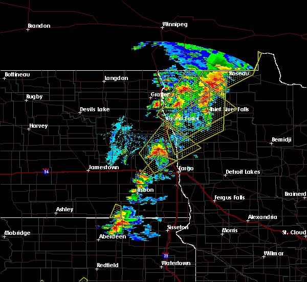 At 935 pm cdt, severe thunderstorms were located along a line extending from near haug to badger to near wannaska, moving northeast at 45 mph (radar indicated). Hazards include 70 mph wind gusts and penny size hail. Expect considerable tree damage. damage is likely to mobile homes, roofs, and outbuildings. Locations impacted include, roseau, warroad, karlstad, greenbush, badger, springsteel island and strandquist. At 935 pm cdt, severe thunderstorms were located along a line extending from near haug to badger to near wannaska, moving northeast at 45 mph (radar indicated). Hazards include 70 mph wind gusts and penny size hail. Expect considerable tree damage. damage is likely to mobile homes, roofs, and outbuildings. Locations impacted include, roseau, warroad, karlstad, greenbush, badger, springsteel island and strandquist.
|
| 6/17/2020 9:33 PM CDT |
 At 932 pm cdt, severe thunderstorms were located along a line extending from big woods to near dorothy, moving northeast at 55 mph (radar indicated). Hazards include 70 mph wind gusts and penny size hail. Expect considerable tree damage. damage is likely to mobile homes, roofs, and outbuildings. these severe storms will be near, dorothy and huot around 935 pm cdt. wylie around 940 pm cdt. stephen and argyle around 945 pm cdt. st. hilaire and carpenters corner around 950 pm cdt. dakota junction, thief river falls and rosewood around 955 pm cdt. other locations impacted by these severe thunderstorms include thief river falls airport. This includes interstate 29 between mile markers 142 and 159. At 932 pm cdt, severe thunderstorms were located along a line extending from big woods to near dorothy, moving northeast at 55 mph (radar indicated). Hazards include 70 mph wind gusts and penny size hail. Expect considerable tree damage. damage is likely to mobile homes, roofs, and outbuildings. these severe storms will be near, dorothy and huot around 935 pm cdt. wylie around 940 pm cdt. stephen and argyle around 945 pm cdt. st. hilaire and carpenters corner around 950 pm cdt. dakota junction, thief river falls and rosewood around 955 pm cdt. other locations impacted by these severe thunderstorms include thief river falls airport. This includes interstate 29 between mile markers 142 and 159.
|
| 6/17/2020 9:19 PM CDT |
 At 918 pm cdt, severe thunderstorms were located along a line extending from poland to near crookston, moving northeast at 55 mph (radar indicated). Hazards include 70 mph wind gusts and penny size hail. Expect considerable tree damage. damage is likely to mobile homes, roofs, and outbuildings. severe thunderstorms will be near, crookston around 920 pm cdt. euclid and huot around 930 pm cdt. dorothy around 935 pm cdt. wylie and argyle around 940 pm cdt. stephen, st. hilaire and carpenters corner around 945 pm cdt. other locations impacted by these severe thunderstorms include thief river falls airport. This includes interstate 29 between mile markers 142 and 159. At 918 pm cdt, severe thunderstorms were located along a line extending from poland to near crookston, moving northeast at 55 mph (radar indicated). Hazards include 70 mph wind gusts and penny size hail. Expect considerable tree damage. damage is likely to mobile homes, roofs, and outbuildings. severe thunderstorms will be near, crookston around 920 pm cdt. euclid and huot around 930 pm cdt. dorothy around 935 pm cdt. wylie and argyle around 940 pm cdt. stephen, st. hilaire and carpenters corner around 945 pm cdt. other locations impacted by these severe thunderstorms include thief river falls airport. This includes interstate 29 between mile markers 142 and 159.
|
| 6/17/2020 9:13 PM CDT |
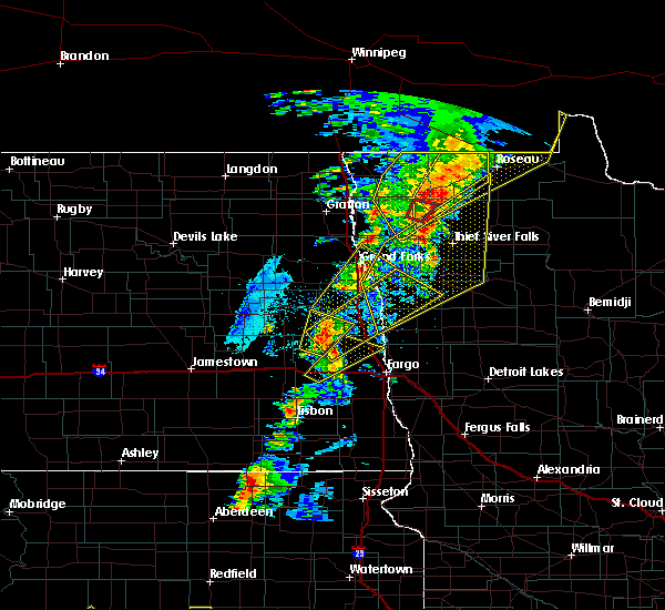 At 913 pm cdt, a severe thunderstorm capable of producing a tornado was located near middle river, or 26 miles north of thief river falls, moving northeast at 50 mph (radar indicated rotation). Hazards include tornado. expect damage to mobile homes, roofs, and vehicles At 913 pm cdt, a severe thunderstorm capable of producing a tornado was located near middle river, or 26 miles north of thief river falls, moving northeast at 50 mph (radar indicated rotation). Hazards include tornado. expect damage to mobile homes, roofs, and vehicles
|
| 6/17/2020 9:02 PM CDT |
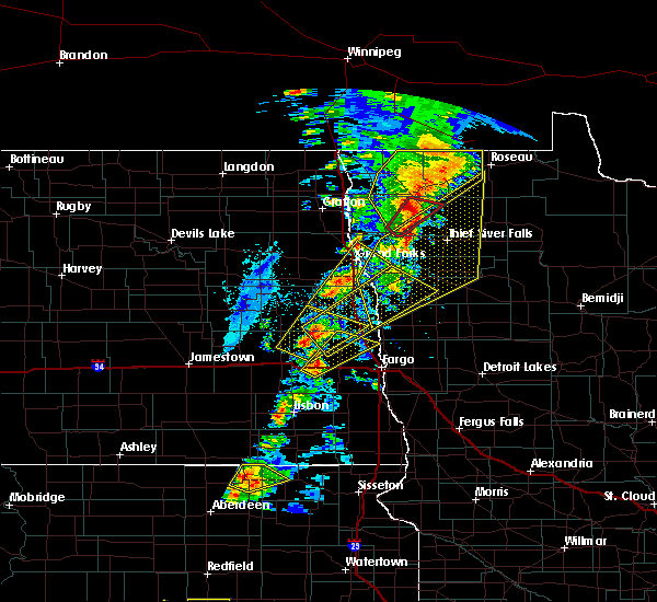 At 901 pm cdt, severe thunderstorms were located along a line extending from 15 miles north of pinecreek to ross to near middle river, moving northeast at 50 mph (radar indicated). Hazards include 70 mph wind gusts and penny size hail. Expect considerable tree damage. Damage is likely to mobile homes, roofs, and outbuildings. At 901 pm cdt, severe thunderstorms were located along a line extending from 15 miles north of pinecreek to ross to near middle river, moving northeast at 50 mph (radar indicated). Hazards include 70 mph wind gusts and penny size hail. Expect considerable tree damage. Damage is likely to mobile homes, roofs, and outbuildings.
|
| 6/17/2020 9:00 PM CDT |
 At 900 pm cdt, a severe thunderstorm capable of producing a tornado was located near florian, or 27 miles northwest of thief river falls, moving northeast at 50 mph (radar indicated rotation). Hazards include tornado. Expect damage to mobile homes, roofs, and vehicles. Locations impacted include, strandquist and old mill state park. At 900 pm cdt, a severe thunderstorm capable of producing a tornado was located near florian, or 27 miles northwest of thief river falls, moving northeast at 50 mph (radar indicated rotation). Hazards include tornado. Expect damage to mobile homes, roofs, and vehicles. Locations impacted include, strandquist and old mill state park.
|
| 6/17/2020 8:48 PM CDT |
 At 847 pm cdt, a severe thunderstorm capable of producing a tornado was located near radium, or 25 miles northwest of thief river falls, moving northeast at 40 mph (radar indicated rotation). Hazards include tornado. expect damage to mobile homes, roofs, and vehicles At 847 pm cdt, a severe thunderstorm capable of producing a tornado was located near radium, or 25 miles northwest of thief river falls, moving northeast at 40 mph (radar indicated rotation). Hazards include tornado. expect damage to mobile homes, roofs, and vehicles
|
| 6/17/2020 8:46 PM CDT |
 At 846 pm cdt, severe thunderstorms were located along a line extending from 25 miles north of caribou to 7 miles north of haug to near old mill state park, moving northeast at 40 mph (radar indicated). Hazards include 70 mph wind gusts and penny size hail. Expect considerable tree damage. damage is likely to mobile homes, roofs, and outbuildings. Locations impacted include, karlstad, greenbush, stephen, badger, lake bronson, strandquist and halma. At 846 pm cdt, severe thunderstorms were located along a line extending from 25 miles north of caribou to 7 miles north of haug to near old mill state park, moving northeast at 40 mph (radar indicated). Hazards include 70 mph wind gusts and penny size hail. Expect considerable tree damage. damage is likely to mobile homes, roofs, and outbuildings. Locations impacted include, karlstad, greenbush, stephen, badger, lake bronson, strandquist and halma.
|
| 6/17/2020 8:26 PM CDT |
 At 826 pm cdt, severe thunderstorms were located along a line extending from 14 miles north of caribou to near leo to near radium, moving northeast at 40 mph (radar indicated). Hazards include 70 mph wind gusts and penny size hail. Expect considerable tree damage. Damage is likely to mobile homes, roofs, and outbuildings. At 826 pm cdt, severe thunderstorms were located along a line extending from 14 miles north of caribou to near leo to near radium, moving northeast at 40 mph (radar indicated). Hazards include 70 mph wind gusts and penny size hail. Expect considerable tree damage. Damage is likely to mobile homes, roofs, and outbuildings.
|
| 6/17/2020 4:45 PM CDT |
 At 445 pm cdt, a severe thunderstorm was located over englund, or 31 miles northwest of thief river falls, moving northeast at 35 mph (radar indicated). Hazards include 60 mph wind gusts and quarter size hail. Hail damage to vehicles is expected. Expect wind damage to roofs, siding, and trees. At 445 pm cdt, a severe thunderstorm was located over englund, or 31 miles northwest of thief river falls, moving northeast at 35 mph (radar indicated). Hazards include 60 mph wind gusts and quarter size hail. Hail damage to vehicles is expected. Expect wind damage to roofs, siding, and trees.
|
| 6/8/2020 7:01 PM CDT |
 At 701 pm cdt, a severe thunderstorm was located near newfolden, or 22 miles north of thief river falls, moving northeast at 40 mph (radar indicated). Hazards include ping pong ball size hail and 60 mph wind gusts. People and animals outdoors will be injured. expect hail damage to roofs, siding, windows, and vehicles. expect wind damage to roofs, siding, and trees. Locations impacted include, newfolden, middle river and strandquist. At 701 pm cdt, a severe thunderstorm was located near newfolden, or 22 miles north of thief river falls, moving northeast at 40 mph (radar indicated). Hazards include ping pong ball size hail and 60 mph wind gusts. People and animals outdoors will be injured. expect hail damage to roofs, siding, windows, and vehicles. expect wind damage to roofs, siding, and trees. Locations impacted include, newfolden, middle river and strandquist.
|
| 6/8/2020 6:52 PM CDT |
 At 651 pm cdt, a severe thunderstorm was located near newfolden, or 20 miles northwest of thief river falls, moving northeast at 40 mph (radar indicated). Hazards include 60 mph wind gusts and quarter size hail. Hail damage to vehicles is expected. Expect wind damage to roofs, siding, and trees. At 651 pm cdt, a severe thunderstorm was located near newfolden, or 20 miles northwest of thief river falls, moving northeast at 40 mph (radar indicated). Hazards include 60 mph wind gusts and quarter size hail. Hail damage to vehicles is expected. Expect wind damage to roofs, siding, and trees.
|
| 6/7/2020 10:33 PM CDT |
 At 1032 pm cdt, severe thunderstorms were located along a line extending from near old mill state park to 10 miles east of holt to near high landing, moving northeast at 65 mph (radar indicated). Hazards include 60 mph wind gusts. Expect damage to roofs, siding, and trees. a wind gust of 62 mph was reported at thief river falls regional airport at 1021 pm. these severe storms will be near, gatzke around 1045 pm cdt. strathcona around 1050 pm cdt. skime and greenbush around 1055 pm cdt. badger around 1105 pm cdt. Wannaska around 1110 pm cdt. At 1032 pm cdt, severe thunderstorms were located along a line extending from near old mill state park to 10 miles east of holt to near high landing, moving northeast at 65 mph (radar indicated). Hazards include 60 mph wind gusts. Expect damage to roofs, siding, and trees. a wind gust of 62 mph was reported at thief river falls regional airport at 1021 pm. these severe storms will be near, gatzke around 1045 pm cdt. strathcona around 1050 pm cdt. skime and greenbush around 1055 pm cdt. badger around 1105 pm cdt. Wannaska around 1110 pm cdt.
|
| 6/7/2020 10:24 PM CDT |
 At 1023 pm cdt, severe thunderstorms were located along a line extending from 8 miles southwest of caribou to leo to 8 miles east of middle river, moving northeast at 75 mph (radar indicated). Hazards include 70 mph wind gusts and penny size hail. Expect considerable tree damage. damage is likely to mobile homes, roofs, and outbuildings. these severe storms will be near, leo around 1025 pm cdt. caribou, haug and badger around 1030 pm cdt. wannaska, torfin and ross around 1035 pm cdt. pinecreek, malung and pencer around 1040 pm cdt. Roseau around 1045 pm cdt. At 1023 pm cdt, severe thunderstorms were located along a line extending from 8 miles southwest of caribou to leo to 8 miles east of middle river, moving northeast at 75 mph (radar indicated). Hazards include 70 mph wind gusts and penny size hail. Expect considerable tree damage. damage is likely to mobile homes, roofs, and outbuildings. these severe storms will be near, leo around 1025 pm cdt. caribou, haug and badger around 1030 pm cdt. wannaska, torfin and ross around 1035 pm cdt. pinecreek, malung and pencer around 1040 pm cdt. Roseau around 1045 pm cdt.
|
| 6/7/2020 10:04 PM CDT |
 At 1004 pm cdt, severe thunderstorms were located along a line extending from near donaldson to near strandquist to near rosewood, moving northeast at 75 mph (radar indicated). Hazards include 70 mph wind gusts and penny size hail. Expect considerable tree damage. damage is likely to mobile homes, roofs, and outbuildings. severe thunderstorms will be near, strandquist around 1005 pm cdt. holt, halma and karlstad around 1010 pm cdt. lake bronson and lake bronson state park around 1015 pm cdt. greenbush, leo and middle river around 1020 pm cdt. haug and badger around 1025 pm cdt. other locations impacted by these severe thunderstorms include grand forks airport. This includes interstate 29 between mile markers 124 and 151. At 1004 pm cdt, severe thunderstorms were located along a line extending from near donaldson to near strandquist to near rosewood, moving northeast at 75 mph (radar indicated). Hazards include 70 mph wind gusts and penny size hail. Expect considerable tree damage. damage is likely to mobile homes, roofs, and outbuildings. severe thunderstorms will be near, strandquist around 1005 pm cdt. holt, halma and karlstad around 1010 pm cdt. lake bronson and lake bronson state park around 1015 pm cdt. greenbush, leo and middle river around 1020 pm cdt. haug and badger around 1025 pm cdt. other locations impacted by these severe thunderstorms include grand forks airport. This includes interstate 29 between mile markers 124 and 151.
|
| 6/7/2020 7:22 PM CDT |
 At 721 pm cdt, a severe thunderstorm was located near englund, or 31 miles east of grafton, moving northeast at 45 mph (trained weather spotters). Hazards include 60 mph wind gusts and half dollar size hail. Hail damage to vehicles is expected. expect wind damage to roofs, siding, and trees. Locations impacted include, karlstad, stephen, strandquist, halma, florian, old mill state park and englund. At 721 pm cdt, a severe thunderstorm was located near englund, or 31 miles east of grafton, moving northeast at 45 mph (trained weather spotters). Hazards include 60 mph wind gusts and half dollar size hail. Hail damage to vehicles is expected. expect wind damage to roofs, siding, and trees. Locations impacted include, karlstad, stephen, strandquist, halma, florian, old mill state park and englund.
|
| 6/7/2020 6:59 PM CDT |
 At 659 pm cdt, a severe thunderstorm was located near march, or 25 miles north of grand forks, moving northeast at 45 mph (radar indicated). Hazards include 60 mph wind gusts and quarter size hail. Hail damage to vehicles is expected. Expect wind damage to roofs, siding, and trees. At 659 pm cdt, a severe thunderstorm was located near march, or 25 miles north of grand forks, moving northeast at 45 mph (radar indicated). Hazards include 60 mph wind gusts and quarter size hail. Hail damage to vehicles is expected. Expect wind damage to roofs, siding, and trees.
|
| 6/7/2020 4:53 PM CDT |
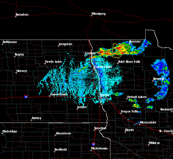 At 452 pm cdt, a severe thunderstorm was located over englund, or 31 miles northwest of thief river falls, moving north at 45 mph (radar indicated). Hazards include 60 mph wind gusts and half dollar size hail. Hail damage to vehicles is expected. Expect wind damage to roofs, siding, and trees. At 452 pm cdt, a severe thunderstorm was located over englund, or 31 miles northwest of thief river falls, moving north at 45 mph (radar indicated). Hazards include 60 mph wind gusts and half dollar size hail. Hail damage to vehicles is expected. Expect wind damage to roofs, siding, and trees.
|
| 9/20/2019 9:27 PM CDT |
 At 927 pm cdt, severe thunderstorms were located along a line extending from caribou to near strandquist, moving northeast at 45 mph (radar indicated). Hazards include 60 mph wind gusts and penny size hail. Expect damage to roofs, siding, and trees. severe thunderstorms will be near, caribou around 930 pm cdt. strathcona around 940 pm cdt. Greenbush and leo around 950 pm cdt. At 927 pm cdt, severe thunderstorms were located along a line extending from caribou to near strandquist, moving northeast at 45 mph (radar indicated). Hazards include 60 mph wind gusts and penny size hail. Expect damage to roofs, siding, and trees. severe thunderstorms will be near, caribou around 930 pm cdt. strathcona around 940 pm cdt. Greenbush and leo around 950 pm cdt.
|
| 9/20/2019 9:24 PM CDT |
 At 924 pm cdt, severe thunderstorms were located along a line extending from caribou to near strandquist, moving northeast at 35 mph (radar indicated). Hazards include 60 mph wind gusts and nickel size hail. Expect damage to roofs, siding, and trees. These severe storms will be near, caribou around 930 pm cdt. At 924 pm cdt, severe thunderstorms were located along a line extending from caribou to near strandquist, moving northeast at 35 mph (radar indicated). Hazards include 60 mph wind gusts and nickel size hail. Expect damage to roofs, siding, and trees. These severe storms will be near, caribou around 930 pm cdt.
|
| 9/20/2019 9:06 PM CDT |
 At 905 pm cdt, severe thunderstorms were located along a line extending from 9 miles southwest of caribou to near old mill state park, moving northeast at 45 mph (radar indicated). Hazards include 60 mph wind gusts and nickel size hail. Expect damage to roofs, siding, and trees. these severe storms will be near, caribou around 915 pm cdt. karlstad around 920 pm cdt. Greenbush around 930 pm cdt. At 905 pm cdt, severe thunderstorms were located along a line extending from 9 miles southwest of caribou to near old mill state park, moving northeast at 45 mph (radar indicated). Hazards include 60 mph wind gusts and nickel size hail. Expect damage to roofs, siding, and trees. these severe storms will be near, caribou around 915 pm cdt. karlstad around 920 pm cdt. Greenbush around 930 pm cdt.
|
| 9/20/2019 8:45 PM CDT |
 At 844 pm cdt, severe thunderstorms were located along a line extending from near lake bronson to near radium, moving northeast at 45 mph (radar indicated). Hazards include 70 mph wind gusts and nickel size hail. Expect considerable tree damage. damage is likely to mobile homes, roofs, and outbuildings. severe thunderstorms will be near, lake bronson and lake bronson state park around 850 pm cdt. florian and englund around 905 pm cdt. strandquist and caribou around 915 pm cdt. karlstad around 920 pm cdt. Greenbush around 930 pm cdt. At 844 pm cdt, severe thunderstorms were located along a line extending from near lake bronson to near radium, moving northeast at 45 mph (radar indicated). Hazards include 70 mph wind gusts and nickel size hail. Expect considerable tree damage. damage is likely to mobile homes, roofs, and outbuildings. severe thunderstorms will be near, lake bronson and lake bronson state park around 850 pm cdt. florian and englund around 905 pm cdt. strandquist and caribou around 915 pm cdt. karlstad around 920 pm cdt. Greenbush around 930 pm cdt.
|
| 9/20/2019 8:22 PM CDT |
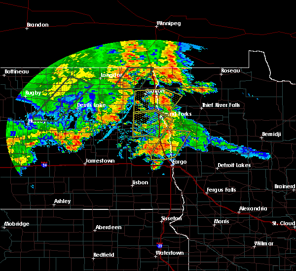 At 822 pm cdt, severe thunderstorms were located along a line extending from near joliette to karlstad, moving northeast at 25 mph (radar indicated). Hazards include 60 mph wind gusts and quarter size hail. Hail damage to vehicles is expected. expect wind damage to roofs, siding, and trees. severe thunderstorms will be near, karlstad around 825 pm cdt. northcote around 830 pm cdt. halma around 835 pm cdt. humboldt and lake bronson state park around 840 pm cdt. orleans around 845 pm cdt. This includes interstate 29 between mile markers 194 and 206. At 822 pm cdt, severe thunderstorms were located along a line extending from near joliette to karlstad, moving northeast at 25 mph (radar indicated). Hazards include 60 mph wind gusts and quarter size hail. Hail damage to vehicles is expected. expect wind damage to roofs, siding, and trees. severe thunderstorms will be near, karlstad around 825 pm cdt. northcote around 830 pm cdt. halma around 835 pm cdt. humboldt and lake bronson state park around 840 pm cdt. orleans around 845 pm cdt. This includes interstate 29 between mile markers 194 and 206.
|
| 6/29/2019 10:28 PM CDT |
 At 1028 pm cdt, a severe thunderstorm was located near stephen, or 23 miles east of grafton, moving east at 50 mph (radar indicated). Hazards include quarter size hail. Damage to vehicles is expected. this severe thunderstorm will be near, argyle around 1030 pm cdt. florian, englund and old mill state park around 1045 pm cdt. Strandquist around 1055 pm cdt. At 1028 pm cdt, a severe thunderstorm was located near stephen, or 23 miles east of grafton, moving east at 50 mph (radar indicated). Hazards include quarter size hail. Damage to vehicles is expected. this severe thunderstorm will be near, argyle around 1030 pm cdt. florian, englund and old mill state park around 1045 pm cdt. Strandquist around 1055 pm cdt.
|
| 8/26/2018 10:52 PM CDT |
 At 1051 pm cdt, severe thunderstorms were located along a line extending from near orleans to alvarado, moving east at 60 mph (radar indicated). Hazards include 70 mph wind gusts and quarter size hail. Hail damage to vehicles is expected. expect considerable tree damage. wind damage is also likely to mobile homes, roofs, and outbuildings. severe thunderstorms will be near, lancaster around 1055 pm cdt. warren around 1100 pm cdt. caribou and radium around 1110 pm cdt. viking and haug around 1120 pm cdt. Rosewood around 1125 pm cdt. At 1051 pm cdt, severe thunderstorms were located along a line extending from near orleans to alvarado, moving east at 60 mph (radar indicated). Hazards include 70 mph wind gusts and quarter size hail. Hail damage to vehicles is expected. expect considerable tree damage. wind damage is also likely to mobile homes, roofs, and outbuildings. severe thunderstorms will be near, lancaster around 1055 pm cdt. warren around 1100 pm cdt. caribou and radium around 1110 pm cdt. viking and haug around 1120 pm cdt. Rosewood around 1125 pm cdt.
|
| 7/4/2018 5:13 AM CDT |
 The severe thunderstorm warning for marshall, north central polk, kittson, roseau, northwestern beltrami and pennington counties will expire at 515 am cdt, the storms which prompted the warning have weakened below severe limits, and no longer poses an immediate threat to life or property. therefore, the warning will be allowed to expire. however gusty winds and heavy rain are still possible with these thunderstorms. a severe thunderstorm watch remains in effect until 900 am cdt for north central and northwestern minnesota, and northeastern north dakota. The severe thunderstorm warning for marshall, north central polk, kittson, roseau, northwestern beltrami and pennington counties will expire at 515 am cdt, the storms which prompted the warning have weakened below severe limits, and no longer poses an immediate threat to life or property. therefore, the warning will be allowed to expire. however gusty winds and heavy rain are still possible with these thunderstorms. a severe thunderstorm watch remains in effect until 900 am cdt for north central and northwestern minnesota, and northeastern north dakota.
|
| 7/4/2018 4:41 AM CDT |
 At 440 am cdt, severe thunderstorms were located along a line extending from 9 miles northeast of orleans to near leo to near holt, moving east at 60 mph (radar indicated). Hazards include 70 mph wind gusts and nickel size hail. Expect considerable tree damage. damage is likely to mobile homes, roofs, and outbuildings. these severe storms will be near, leo, greenbush and middle river around 445 am cdt. haug around 450 am cdt. badger around 455 am cdt. fox, gatzke and ross around 500 am cdt. roseau around 505 am cdt. Other locations impacted by these severe thunderstorms include thief river falls airport. At 440 am cdt, severe thunderstorms were located along a line extending from 9 miles northeast of orleans to near leo to near holt, moving east at 60 mph (radar indicated). Hazards include 70 mph wind gusts and nickel size hail. Expect considerable tree damage. damage is likely to mobile homes, roofs, and outbuildings. these severe storms will be near, leo, greenbush and middle river around 445 am cdt. haug around 450 am cdt. badger around 455 am cdt. fox, gatzke and ross around 500 am cdt. roseau around 505 am cdt. Other locations impacted by these severe thunderstorms include thief river falls airport.
|
| 7/4/2018 4:20 AM CDT |
 At 419 am cdt, severe thunderstorms were located along a line extending from near pembina to 6 miles southwest of halma to near radium, moving northeast at 65 mph (radar indicated). Hazards include 70 mph wind gusts and nickel size hail. Expect considerable tree damage. damage is likely to mobile homes, roofs, and outbuildings. these severe storms will be near, radium and old mill state park around 420 am cdt. halma, viking and karlstad around 425 am cdt. other locations impacted by these severe thunderstorms include american crystal sugar. This includes interstate 29 between mile markers 163 and 216. At 419 am cdt, severe thunderstorms were located along a line extending from near pembina to 6 miles southwest of halma to near radium, moving northeast at 65 mph (radar indicated). Hazards include 70 mph wind gusts and nickel size hail. Expect considerable tree damage. damage is likely to mobile homes, roofs, and outbuildings. these severe storms will be near, radium and old mill state park around 420 am cdt. halma, viking and karlstad around 425 am cdt. other locations impacted by these severe thunderstorms include american crystal sugar. This includes interstate 29 between mile markers 163 and 216.
|
| 7/4/2018 4:16 AM CDT |
 At 416 am cdt, severe thunderstorms were located along a line extending from near leroy to near kennedy to near radium, moving northeast at 60 mph (radar indicated). Hazards include 70 mph wind gusts and nickel size hail. Expect considerable tree damage. damage is likely to mobile homes, roofs, and outbuildings. severe thunderstorms will be near, radium, carpenters corner and kennedy around 420 am cdt. lake bronson, viking and halma around 425 am cdt. lake bronson state park around 430 am cdt. newfolden and holt around 435 am cdt. middle river around 445 am cdt. other locations impacted by these severe thunderstorms include thief river falls airport. This includes interstate 29 between mile markers 196 and 217. At 416 am cdt, severe thunderstorms were located along a line extending from near leroy to near kennedy to near radium, moving northeast at 60 mph (radar indicated). Hazards include 70 mph wind gusts and nickel size hail. Expect considerable tree damage. damage is likely to mobile homes, roofs, and outbuildings. severe thunderstorms will be near, radium, carpenters corner and kennedy around 420 am cdt. lake bronson, viking and halma around 425 am cdt. lake bronson state park around 430 am cdt. newfolden and holt around 435 am cdt. middle river around 445 am cdt. other locations impacted by these severe thunderstorms include thief river falls airport. This includes interstate 29 between mile markers 196 and 217.
|
| 7/4/2018 4:02 AM CDT |
 At 401 am cdt, severe thunderstorms were located along a line extending from near backoo to near robbin to march, moving northeast at 60 mph (radar indicated). Hazards include 60 mph wind gusts and nickel size hail. Expect damage to roofs, siding, and trees. these severe storms will be near, march and robbin around 405 am cdt. donaldson, warren and kennedy around 410 am cdt. radium around 415 am cdt. old mill state park around 420 am cdt. halma, pembina and st. vincent around 425 am cdt. other locations impacted by these severe thunderstorms include american crystal sugar and grand forks airport. This includes interstate 29 between mile markers 144 and 216. At 401 am cdt, severe thunderstorms were located along a line extending from near backoo to near robbin to march, moving northeast at 60 mph (radar indicated). Hazards include 60 mph wind gusts and nickel size hail. Expect damage to roofs, siding, and trees. these severe storms will be near, march and robbin around 405 am cdt. donaldson, warren and kennedy around 410 am cdt. radium around 415 am cdt. old mill state park around 420 am cdt. halma, pembina and st. vincent around 425 am cdt. other locations impacted by these severe thunderstorms include american crystal sugar and grand forks airport. This includes interstate 29 between mile markers 144 and 216.
|
| 7/4/2018 3:27 AM CDT |
 At 326 am cdt, severe thunderstorms were located along a line extending from near loma to near pisek to honeyford, moving northeast at 65 mph (radar indicated). Hazards include 60 mph wind gusts and nickel size hail. Expect damage to roofs, siding, and trees. severe thunderstorms will be near, pisek, gilby and honeyford around 330 am cdt. veseleyville, mandt and ardoch around 335 am cdt. manvel, poland and nash around 340 am cdt. grafton, olga and oslo around 345 am cdt. alvarado, oakwood and cashel around 350 am cdt. other locations impacted by these severe thunderstorms include american crystal sugar and grand forks airport. This includes interstate 29 between mile markers 144 and 216. At 326 am cdt, severe thunderstorms were located along a line extending from near loma to near pisek to honeyford, moving northeast at 65 mph (radar indicated). Hazards include 60 mph wind gusts and nickel size hail. Expect damage to roofs, siding, and trees. severe thunderstorms will be near, pisek, gilby and honeyford around 330 am cdt. veseleyville, mandt and ardoch around 335 am cdt. manvel, poland and nash around 340 am cdt. grafton, olga and oslo around 345 am cdt. alvarado, oakwood and cashel around 350 am cdt. other locations impacted by these severe thunderstorms include american crystal sugar and grand forks airport. This includes interstate 29 between mile markers 144 and 216.
|
| 6/29/2018 5:03 AM CDT |
 A severe thunderstorm warning remains in effect until 530 am cdt for marshall. red lake. southeastern polk. southwestern roseau. northwestern beltrami. pennington and northern clearwater counties. At 502 am cdt, severe thunderstorms were located along a line extending from near newfolden to near goodridge to near fosston,. A severe thunderstorm warning remains in effect until 530 am cdt for marshall. red lake. southeastern polk. southwestern roseau. northwestern beltrami. pennington and northern clearwater counties. At 502 am cdt, severe thunderstorms were located along a line extending from near newfolden to near goodridge to near fosston,.
|
| 6/29/2018 4:42 AM CDT |
 At 424 am cdt, severe thunderstorms were located along a line extending from near ardoch to near key west to 6 miles northwest of lockhart, moving east at 70 mph. these are very dangerous storms (radar indicated). Hazards include 80 mph wind gusts and quarter size hail. Flying debris will be dangerous to those caught without shelter. mobile homes will be heavily damaged. expect considerable damage to roofs, windows, and vehicles. extensive tree damage and power outages are likely. severe thunderstorms will be near, key west, sherack and angus around 425 am cdt. beltrami, euclid and greenview around 430 am cdt. big woods, melvin and dorothy around 435 am cdt. fertile and wylie around 440 am cdt. argyle, st. hilaire and maple bay around 445 am cdt. other locations impacted by these severe thunderstorms include thief river falls airport. This includes interstate 29 between mile markers 142 and 174. At 424 am cdt, severe thunderstorms were located along a line extending from near ardoch to near key west to 6 miles northwest of lockhart, moving east at 70 mph. these are very dangerous storms (radar indicated). Hazards include 80 mph wind gusts and quarter size hail. Flying debris will be dangerous to those caught without shelter. mobile homes will be heavily damaged. expect considerable damage to roofs, windows, and vehicles. extensive tree damage and power outages are likely. severe thunderstorms will be near, key west, sherack and angus around 425 am cdt. beltrami, euclid and greenview around 430 am cdt. big woods, melvin and dorothy around 435 am cdt. fertile and wylie around 440 am cdt. argyle, st. hilaire and maple bay around 445 am cdt. other locations impacted by these severe thunderstorms include thief river falls airport. This includes interstate 29 between mile markers 142 and 174.
|
| 6/29/2018 4:25 AM CDT |
 At 424 am cdt, severe thunderstorms were located along a line extending from near ardoch to near key west to 6 miles northwest of lockhart, moving east at 70 mph. these are very dangerous storms (radar indicated). Hazards include 80 mph wind gusts and quarter size hail. Flying debris will be dangerous to those caught without shelter. mobile homes will be heavily damaged. expect considerable damage to roofs, windows, and vehicles. extensive tree damage and power outages are likely. severe thunderstorms will be near, key west, sherack and angus around 425 am cdt. beltrami, euclid and greenview around 430 am cdt. big woods, melvin and dorothy around 435 am cdt. fertile and wylie around 440 am cdt. argyle, st. hilaire and maple bay around 445 am cdt. other locations impacted by these severe thunderstorms include thief river falls airport. This includes interstate 29 between mile markers 142 and 174. At 424 am cdt, severe thunderstorms were located along a line extending from near ardoch to near key west to 6 miles northwest of lockhart, moving east at 70 mph. these are very dangerous storms (radar indicated). Hazards include 80 mph wind gusts and quarter size hail. Flying debris will be dangerous to those caught without shelter. mobile homes will be heavily damaged. expect considerable damage to roofs, windows, and vehicles. extensive tree damage and power outages are likely. severe thunderstorms will be near, key west, sherack and angus around 425 am cdt. beltrami, euclid and greenview around 430 am cdt. big woods, melvin and dorothy around 435 am cdt. fertile and wylie around 440 am cdt. argyle, st. hilaire and maple bay around 445 am cdt. other locations impacted by these severe thunderstorms include thief river falls airport. This includes interstate 29 between mile markers 142 and 174.
|
| 7/4/2017 7:41 PM CDT |
 The severe thunderstorm warning for eastern marshall, southeastern kittson and southwestern roseau counties will expire at 745 pm cdt, the storm which prompted the warning has weakened below severe limits, and no longer pose an immediate threat to life or property. therefore the warning will be allowed to expire. however small hail and gusty winds are still possible with this thunderstorm. a severe thunderstorm watch remains in effect until midnight cdt for northwestern minnesota. The severe thunderstorm warning for eastern marshall, southeastern kittson and southwestern roseau counties will expire at 745 pm cdt, the storm which prompted the warning has weakened below severe limits, and no longer pose an immediate threat to life or property. therefore the warning will be allowed to expire. however small hail and gusty winds are still possible with this thunderstorm. a severe thunderstorm watch remains in effect until midnight cdt for northwestern minnesota.
|
| 7/4/2017 7:35 PM CDT |
 At 735 pm cdt, a severe thunderstorm was located near strathcona, or 26 miles north of thief river falls, moving southeast at 35 mph (radar indicated). Hazards include quarter size hail. Damage to vehicles is expected. Locations impacted include, newfolden, middle river, strandquist, strathcona, florian and karlstad. At 735 pm cdt, a severe thunderstorm was located near strathcona, or 26 miles north of thief river falls, moving southeast at 35 mph (radar indicated). Hazards include quarter size hail. Damage to vehicles is expected. Locations impacted include, newfolden, middle river, strandquist, strathcona, florian and karlstad.
|
| 7/4/2017 7:25 PM CDT | Golf Ball sized hail reported 9 miles ENE of Strandquist, MN |
| 7/4/2017 7:14 PM CDT |
 At 713 pm cdt, a severe thunderstorm was located over strandquist, or 31 miles northwest of thief river falls, moving southeast at 35 mph (radar indicated). Hazards include 60 mph wind gusts and quarter size hail. Hail damage to vehicles is expected. expect wind damage to roofs, siding, and trees. Locations impacted include, karlstad, newfolden, middle river, strandquist, strathcona, florian and englund. At 713 pm cdt, a severe thunderstorm was located over strandquist, or 31 miles northwest of thief river falls, moving southeast at 35 mph (radar indicated). Hazards include 60 mph wind gusts and quarter size hail. Hail damage to vehicles is expected. expect wind damage to roofs, siding, and trees. Locations impacted include, karlstad, newfolden, middle river, strandquist, strathcona, florian and englund.
|
| 7/4/2017 6:53 PM CDT |
 At 652 pm cdt, a severe thunderstorm was located near englund, or 31 miles east of grafton, moving southeast at 35 mph (radar indicated). Hazards include 60 mph wind gusts and quarter size hail. Hail damage to vehicles is expected. Expect wind damage to roofs, siding, and trees. At 652 pm cdt, a severe thunderstorm was located near englund, or 31 miles east of grafton, moving southeast at 35 mph (radar indicated). Hazards include 60 mph wind gusts and quarter size hail. Hail damage to vehicles is expected. Expect wind damage to roofs, siding, and trees.
|
| 6/9/2017 9:57 PM CDT |
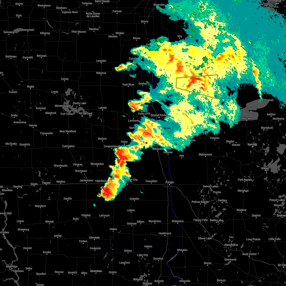 The severe thunderstorm warning for northeastern marshall and south central roseau counties will expire at 1000 pm cdt, the storm which prompted the warning has weakened below severe limits, and no longer pose an immediate threat to life or property. therefore the warning will be allowed to expire. a severe thunderstorm watch remains in effect until midnight cdt for northwestern minnesota. The severe thunderstorm warning for northeastern marshall and south central roseau counties will expire at 1000 pm cdt, the storm which prompted the warning has weakened below severe limits, and no longer pose an immediate threat to life or property. therefore the warning will be allowed to expire. a severe thunderstorm watch remains in effect until midnight cdt for northwestern minnesota.
|
| 6/9/2017 9:30 PM CDT |
 At 930 pm cdt, a severe thunderstorm was located near newfolden, or 22 miles north of thief river falls, moving east at 25 mph (radar indicated). Hazards include 60 mph wind gusts and penny size hail. Expect damage to roofs, siding, and trees. This severe storm will be near, middle river around 945 pm cdt. At 930 pm cdt, a severe thunderstorm was located near newfolden, or 22 miles north of thief river falls, moving east at 25 mph (radar indicated). Hazards include 60 mph wind gusts and penny size hail. Expect damage to roofs, siding, and trees. This severe storm will be near, middle river around 945 pm cdt.
|
| 6/9/2017 9:00 PM CDT |
 The national weather service in grand forks has issued a * severe thunderstorm warning for. eastern marshall county in northwestern minnesota. south central roseau county in northwestern minnesota. until 1000 pm cdt. At 900 pm cdt, a severe thunderstorm was located over florian, or. The national weather service in grand forks has issued a * severe thunderstorm warning for. eastern marshall county in northwestern minnesota. south central roseau county in northwestern minnesota. until 1000 pm cdt. At 900 pm cdt, a severe thunderstorm was located over florian, or.
|
| 6/9/2017 8:36 PM CDT |
 At 836 pm cdt, a severe thunderstorm was located over stephen, or 26 miles east of grafton, moving east at 35 mph (radar indicated). Hazards include 70 mph wind gusts and quarter size hail. Hail damage to vehicles is expected. expect considerable tree damage. wind damage is also likely to mobile homes, roofs, and outbuildings. this severe storm will be near, florian and englund around 850 pm cdt. Old mill state park around 900 pm cdt. At 836 pm cdt, a severe thunderstorm was located over stephen, or 26 miles east of grafton, moving east at 35 mph (radar indicated). Hazards include 70 mph wind gusts and quarter size hail. Hail damage to vehicles is expected. expect considerable tree damage. wind damage is also likely to mobile homes, roofs, and outbuildings. this severe storm will be near, florian and englund around 850 pm cdt. Old mill state park around 900 pm cdt.
|
| 6/9/2017 8:10 PM CDT |
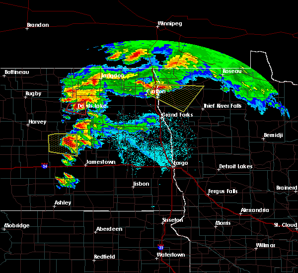 At 809 pm cdt, a severe thunderstorm was located near drayton, or 13 miles northeast of grafton, moving east at 35 mph. this is a very dangerous storm (public). Hazards include 80 mph wind gusts and ping pong ball size hail. Flying debris will be dangerous to those caught without shelter. mobile homes will be heavily damaged. expect considerable damage to roofs, windows, and vehicles. extensive tree damage and power outages are likely. this severe storm will be near, donaldson around 825 pm cdt. stephen around 830 pm cdt. argyle around 840 pm cdt. florian and englund around 850 pm cdt. old mill state park around 900 pm cdt. This includes interstate 29 between mile markers 173 and 191. At 809 pm cdt, a severe thunderstorm was located near drayton, or 13 miles northeast of grafton, moving east at 35 mph. this is a very dangerous storm (public). Hazards include 80 mph wind gusts and ping pong ball size hail. Flying debris will be dangerous to those caught without shelter. mobile homes will be heavily damaged. expect considerable damage to roofs, windows, and vehicles. extensive tree damage and power outages are likely. this severe storm will be near, donaldson around 825 pm cdt. stephen around 830 pm cdt. argyle around 840 pm cdt. florian and englund around 850 pm cdt. old mill state park around 900 pm cdt. This includes interstate 29 between mile markers 173 and 191.
|
| 6/9/2017 7:56 PM CDT |
 At 755 pm cdt, a severe thunderstorm was located near herrick, or 10 miles northeast of grafton, moving east at 40 mph. this is a very dangerous storm (public). Hazards include 90 mph wind gusts and ping pong ball size hail. You are in a life-threatening situation. flying debris may be deadly to those caught without shelter. mobile homes will be heavily damaged or destroyed. homes and businesses will have substantial roof and window damage. expect extensive tree damage and power outages. this severe thunderstorm will be near, drayton and herrick around 800 pm cdt. robbin around 805 pm cdt. donaldson around 820 pm cdt. stephen around 825 pm cdt. argyle around 835 pm cdt. This includes interstate 29 between mile markers 164 and 198. At 755 pm cdt, a severe thunderstorm was located near herrick, or 10 miles northeast of grafton, moving east at 40 mph. this is a very dangerous storm (public). Hazards include 90 mph wind gusts and ping pong ball size hail. You are in a life-threatening situation. flying debris may be deadly to those caught without shelter. mobile homes will be heavily damaged or destroyed. homes and businesses will have substantial roof and window damage. expect extensive tree damage and power outages. this severe thunderstorm will be near, drayton and herrick around 800 pm cdt. robbin around 805 pm cdt. donaldson around 820 pm cdt. stephen around 825 pm cdt. argyle around 835 pm cdt. This includes interstate 29 between mile markers 164 and 198.
|
| 7/20/2016 10:32 PM CDT |
 At 1031 pm cdt, a severe thunderstorm was located near fox, or 10 miles west of roseau, moving east at 40 mph (radar indicated). Hazards include 60 mph wind gusts and quarter size hail. Hail damage to vehicles is expected. expect wind damage to roofs, siding, and trees. this severe storm will be near, ross around 1035 pm cdt. fox around 1040 pm cdt. roseau and malung around 1050 pm cdt. Salol around 1100 pm cdt. At 1031 pm cdt, a severe thunderstorm was located near fox, or 10 miles west of roseau, moving east at 40 mph (radar indicated). Hazards include 60 mph wind gusts and quarter size hail. Hail damage to vehicles is expected. expect wind damage to roofs, siding, and trees. this severe storm will be near, ross around 1035 pm cdt. fox around 1040 pm cdt. roseau and malung around 1050 pm cdt. Salol around 1100 pm cdt.
|
| 7/20/2016 9:59 PM CDT |
 At 958 pm cdt, a severe thunderstorm was located 10 miles northwest of leo, or 31 miles west of roseau, moving east at 45 mph. wind gusts of 80 mph were reported in hallock from this storm. this is a very dangerous storm (radar indicated). Hazards include 80 mph wind gusts and quarter size hail. Flying debris will be dangerous to those caught without shelter. mobile homes will be heavily damaged. expect considerable damage to roofs, windows, and vehicles. extensive tree damage and power outages are likely. this severe thunderstorm will be near, leo around 1010 pm cdt. haug around 1015 pm cdt. badger around 1025 pm cdt. fox and ross around 1030 pm cdt. Roseau and malung around 1040 pm cdt. At 958 pm cdt, a severe thunderstorm was located 10 miles northwest of leo, or 31 miles west of roseau, moving east at 45 mph. wind gusts of 80 mph were reported in hallock from this storm. this is a very dangerous storm (radar indicated). Hazards include 80 mph wind gusts and quarter size hail. Flying debris will be dangerous to those caught without shelter. mobile homes will be heavily damaged. expect considerable damage to roofs, windows, and vehicles. extensive tree damage and power outages are likely. this severe thunderstorm will be near, leo around 1010 pm cdt. haug around 1015 pm cdt. badger around 1025 pm cdt. fox and ross around 1030 pm cdt. Roseau and malung around 1040 pm cdt.
|
| 6/19/2016 5:57 AM CDT |
 At 556 am cdt, a severe thunderstorm was located over argyle, or 29 miles east of grafton, moving east at 60 mph (radar indicated). Hazards include quarter size hail. Damage to vehicles is expected. this severe thunderstorm will be near, old mill state park, florian and englund around 605 am cdt. newfolden and strandquist around 615 am cdt. middle river and holt around 625 am cdt. Gatzke around 645 am cdt. At 556 am cdt, a severe thunderstorm was located over argyle, or 29 miles east of grafton, moving east at 60 mph (radar indicated). Hazards include quarter size hail. Damage to vehicles is expected. this severe thunderstorm will be near, old mill state park, florian and englund around 605 am cdt. newfolden and strandquist around 615 am cdt. middle river and holt around 625 am cdt. Gatzke around 645 am cdt.
|
| 6/17/2016 8:59 AM CDT |
 At 858 am cdt, severe thunderstorms were located along a line extending from near hallock to 7 miles southeast of middle river to near berner, moving northeast at 50 mph (radar indicated). Hazards include 60 mph wind gusts and quarter size hail. Hail damage to vehicles is expected. expect wind damage to roofs, siding, and trees. severe thunderstorms will be near, berner and gully around 900 am cdt. lower red lake and gatzke around 915 am cdt. skime and casperson around 925 am cdt. hayes lake state park around 930 am cdt. Ponemah around 935 am cdt. At 858 am cdt, severe thunderstorms were located along a line extending from near hallock to 7 miles southeast of middle river to near berner, moving northeast at 50 mph (radar indicated). Hazards include 60 mph wind gusts and quarter size hail. Hail damage to vehicles is expected. expect wind damage to roofs, siding, and trees. severe thunderstorms will be near, berner and gully around 900 am cdt. lower red lake and gatzke around 915 am cdt. skime and casperson around 925 am cdt. hayes lake state park around 930 am cdt. Ponemah around 935 am cdt.
|
| 6/17/2016 8:44 AM CDT |
 At 840 am cdt, a line of severe thunderstorms located along a line extending from mattson to near holt to near oklee, was moving northeast at 60 mph. these are very dangerous storms (at 834 am...winds of 63 mph were reported 10 miles east of grafton. this line of storms has a history of producing 70 to 80 mph winds). Hazards include 80 mph wind gusts and quarter size hail. Flying debris will be dangerous to those caught without shelter. mobile homes will be heavily damaged. expect considerable damage to roofs, windows, and vehicles. extensive tree damage and power outages are likely. these severe storms will be near, oklee, newfolden and holt around 845 am cdt. middle river and roland around 850 am cdt. lake bronson around 855 am cdt. Also includes interstate 29 between mile markers 168 and 196. At 840 am cdt, a line of severe thunderstorms located along a line extending from mattson to near holt to near oklee, was moving northeast at 60 mph. these are very dangerous storms (at 834 am...winds of 63 mph were reported 10 miles east of grafton. this line of storms has a history of producing 70 to 80 mph winds). Hazards include 80 mph wind gusts and quarter size hail. Flying debris will be dangerous to those caught without shelter. mobile homes will be heavily damaged. expect considerable damage to roofs, windows, and vehicles. extensive tree damage and power outages are likely. these severe storms will be near, oklee, newfolden and holt around 845 am cdt. middle river and roland around 850 am cdt. lake bronson around 855 am cdt. Also includes interstate 29 between mile markers 168 and 196.
|
| 6/17/2016 8:15 AM CDT |
 At 813 am cdt, severe thunderstorms were located along a line extending from near park river to near tabor to greenview, moving northeast at 45 mph. these are very dangerous storms (winds of 70 to 80 mph winds and have been reported). Hazards include 80 mph wind gusts and quarter size hail. Flying debris will be dangerous to those caught without shelter. mobile homes will be heavily damaged. expect considerable damage to roofs, windows, and vehicles. extensive tree damage and power outages are likely. severe thunderstorms will be near, beltrami and greenview around 815 am cdt. tabor, harold and sherack around 820 am cdt. nash and melvin around 825 am cdt. warren, auburn and angus around 830 am cdt. st. thomas, maple bay and dugdale around 835 am cdt. Also includes interstate 29 between mile markers 157 and 196. At 813 am cdt, severe thunderstorms were located along a line extending from near park river to near tabor to greenview, moving northeast at 45 mph. these are very dangerous storms (winds of 70 to 80 mph winds and have been reported). Hazards include 80 mph wind gusts and quarter size hail. Flying debris will be dangerous to those caught without shelter. mobile homes will be heavily damaged. expect considerable damage to roofs, windows, and vehicles. extensive tree damage and power outages are likely. severe thunderstorms will be near, beltrami and greenview around 815 am cdt. tabor, harold and sherack around 820 am cdt. nash and melvin around 825 am cdt. warren, auburn and angus around 830 am cdt. st. thomas, maple bay and dugdale around 835 am cdt. Also includes interstate 29 between mile markers 157 and 196.
|
| 8/12/2015 8:13 PM CDT |
 At 812 pm cdt, a severe thunderstorm was located 7 miles west of strathcona, or 31 miles southwest of roseau, moving southeast at 30 mph (radar indicated). Hazards include 60 mph wind gusts and quarter size hail. Hail damage to vehicles is expected. expect wind damage to roofs, siding and trees. this severe thunderstorm will be near, strathcona around 825 pm cdt. middle river around 835 pm cdt. Gatzke around 905 pm cdt. At 812 pm cdt, a severe thunderstorm was located 7 miles west of strathcona, or 31 miles southwest of roseau, moving southeast at 30 mph (radar indicated). Hazards include 60 mph wind gusts and quarter size hail. Hail damage to vehicles is expected. expect wind damage to roofs, siding and trees. this severe thunderstorm will be near, strathcona around 825 pm cdt. middle river around 835 pm cdt. Gatzke around 905 pm cdt.
|
| 8/12/2015 3:24 PM CDT |
 At 323 pm cdt, a severe thunderstorm was located over strathcona, or 25 miles southwest of roseau, moving east at 20 mph (radar indicated). Hazards include quarter size hail. Damage to vehicles is expected. This severe storm will be near, torfin and wannaska around 400 pm cdt. At 323 pm cdt, a severe thunderstorm was located over strathcona, or 25 miles southwest of roseau, moving east at 20 mph (radar indicated). Hazards include quarter size hail. Damage to vehicles is expected. This severe storm will be near, torfin and wannaska around 400 pm cdt.
|
| 8/12/2015 2:57 PM CDT |
 At 257 pm cdt, a severe thunderstorm was located near strathcona, or 30 miles southwest of roseau, moving east at 25 mph (radar indicated). Hazards include half dollar size hail. Damage to vehicles is expected. this severe thunderstorm will be near, greenbush around 305 pm cdt. strathcona around 310 pm cdt. torfin and wannaska around 350 pm cdt. Casperson around 355 pm cdt. At 257 pm cdt, a severe thunderstorm was located near strathcona, or 30 miles southwest of roseau, moving east at 25 mph (radar indicated). Hazards include half dollar size hail. Damage to vehicles is expected. this severe thunderstorm will be near, greenbush around 305 pm cdt. strathcona around 310 pm cdt. torfin and wannaska around 350 pm cdt. Casperson around 355 pm cdt.
|
| 7/12/2015 5:43 PM CDT |
 At 543 pm cdt, severe thunderstorms were located along a line extending from near auburn to near high landing, moving northeast at 70 mph (radar indicated). Hazards include 60 mph wind gusts and half dollar size hail. Hail damage to vehicles is expected. expect wind damage to roofs, siding and trees. severe thunderstorms will be near, goodridge and high landing around 545 pm cdt. espelie and robbin around 550 pm cdt. bowesmont and mattson around 555 pm cdt. joliette around 600 pm cdt. Northcote and humboldt around 605 pm cdt. At 543 pm cdt, severe thunderstorms were located along a line extending from near auburn to near high landing, moving northeast at 70 mph (radar indicated). Hazards include 60 mph wind gusts and half dollar size hail. Hail damage to vehicles is expected. expect wind damage to roofs, siding and trees. severe thunderstorms will be near, goodridge and high landing around 545 pm cdt. espelie and robbin around 550 pm cdt. bowesmont and mattson around 555 pm cdt. joliette around 600 pm cdt. Northcote and humboldt around 605 pm cdt.
|
| 7/12/2015 5:43 PM CDT | The national weather service in grand forks has issued a * severe thunderstorm warning for. kittson county in northwestern minnesota. marshall county in northwestern minnesota. roseau county in northwestern minnesota. Pennington county in northwestern minnesota. |
| 7/5/2015 12:08 PM CDT |
 At 1207 pm cdt, severe thunderstorms were located along a line extending from near middle river to near euclid, moving east at 40 mph (radar indicated). Hazards include 60 mph wind gusts and nickel size hail. Expect damage to roofs. siding and trees. these severe storms will be near, middle river around 1215 pm cdt. st. Hilaire, gatzke and hazel around 1230 pm cdt. At 1207 pm cdt, severe thunderstorms were located along a line extending from near middle river to near euclid, moving east at 40 mph (radar indicated). Hazards include 60 mph wind gusts and nickel size hail. Expect damage to roofs. siding and trees. these severe storms will be near, middle river around 1215 pm cdt. st. Hilaire, gatzke and hazel around 1230 pm cdt.
|
| 7/5/2015 11:49 AM CDT |
 At 1148 am cdt, severe thunderstorms were located along a line extending from near strandquist to near sherack, moving east at 55 mph. these are very dangerous storms (radar indicated). Hazards include 80 mph wind gusts and quarter size hail. Flying debris will be dangerous to those caught without shelter. mobile homes will be heavily damaged. expect considerable damage to roofs, windows and vehicles. extensive tree damage and power outages are likely. severe thunderstorms will be near, strandquist around 1150 am cdt. middle river around 1205 pm cdt. wylie around 1215 pm cdt. st. hilaire around 1220 pm cdt. Gatzke and hazel around 1225 pm cdt. At 1148 am cdt, severe thunderstorms were located along a line extending from near strandquist to near sherack, moving east at 55 mph. these are very dangerous storms (radar indicated). Hazards include 80 mph wind gusts and quarter size hail. Flying debris will be dangerous to those caught without shelter. mobile homes will be heavily damaged. expect considerable damage to roofs, windows and vehicles. extensive tree damage and power outages are likely. severe thunderstorms will be near, strandquist around 1150 am cdt. middle river around 1205 pm cdt. wylie around 1215 pm cdt. st. hilaire around 1220 pm cdt. Gatzke and hazel around 1225 pm cdt.
|
| 7/5/2015 11:42 AM CDT |
 At 1141 am cdt, severe thunderstorms were located along a line extending from near old mill state park to near tabor, moving east at 40 mph. these are very dangerous storms (radar indicated). Hazards include 80 mph wind gusts and quarter size hail. Flying debris will be dangerous to those caught without shelter. mobile homes will be heavily damaged. expect considerable damage to roofs, windows and vehicles. extensive tree damage and power outages are likely. these severe storms will be near, old mill state park and strandquist around 1145 am cdt. Angus around 1150 am cdt. At 1141 am cdt, severe thunderstorms were located along a line extending from near old mill state park to near tabor, moving east at 40 mph. these are very dangerous storms (radar indicated). Hazards include 80 mph wind gusts and quarter size hail. Flying debris will be dangerous to those caught without shelter. mobile homes will be heavily damaged. expect considerable damage to roofs, windows and vehicles. extensive tree damage and power outages are likely. these severe storms will be near, old mill state park and strandquist around 1145 am cdt. Angus around 1150 am cdt.
|
| 7/5/2015 11:08 AM CDT |
 At 1107 am cdt, severe thunderstorms were located along a line extending from 6 miles north of big woods to near manvel, moving east at 40 mph. these are very dangerous storms (radar indicated). Hazards include 80 mph wind gusts and quarter size hail. Flying debris will be dangerous to those caught without shelter. mobile homes will be heavily damaged. expect considerable damage to roofs, windows and vehicles. extensive tree damage and power outages are likely. severe thunderstorms will be near, stephen and alvarado around 1120 am cdt. argyle and march around 1125 am cdt. tabor around 1130 am cdt. sherack and florian around 1135 am cdt. Old mill state park and angus around 1140 am cdt. At 1107 am cdt, severe thunderstorms were located along a line extending from 6 miles north of big woods to near manvel, moving east at 40 mph. these are very dangerous storms (radar indicated). Hazards include 80 mph wind gusts and quarter size hail. Flying debris will be dangerous to those caught without shelter. mobile homes will be heavily damaged. expect considerable damage to roofs, windows and vehicles. extensive tree damage and power outages are likely. severe thunderstorms will be near, stephen and alvarado around 1120 am cdt. argyle and march around 1125 am cdt. tabor around 1130 am cdt. sherack and florian around 1135 am cdt. Old mill state park and angus around 1140 am cdt.
|
| 7/5/2015 9:17 AM CDT |
 At 916 am cdt, a severe thunderstorm was located near greenbush, or 26 miles southwest of roseau, moving northeast at 60 mph (trained weather spotters reported quarter sized hail south strathcona). Hazards include 60 mph wind gusts and quarter size hail. Hail damage to vehicles is expected. expect wind damage to roofs, siding and trees. This severe thunderstorm will remain over mainly rural areas of southeastern kittson, central marshall and southwestern roseau counties. At 916 am cdt, a severe thunderstorm was located near greenbush, or 26 miles southwest of roseau, moving northeast at 60 mph (trained weather spotters reported quarter sized hail south strathcona). Hazards include 60 mph wind gusts and quarter size hail. Hail damage to vehicles is expected. expect wind damage to roofs, siding and trees. This severe thunderstorm will remain over mainly rural areas of southeastern kittson, central marshall and southwestern roseau counties.
|
| 7/5/2015 8:46 AM CDT |
 At 845 am cdt, a severe thunderstorm was located near stephen, or 27 miles east of grafton, moving northeast at 35 mph (trained weather spotters reported quarter sized hail south of strathcona minnesota). Hazards include 60 mph wind gusts and quarter size hail. Hail damage to vehicles is expected. expect wind damage to roofs, siding and trees. this severe thunderstorm will be near, englund and florian around 855 am cdt. karlstad and strandquist around 905 am cdt. Strathcona around 915 am cdt. At 845 am cdt, a severe thunderstorm was located near stephen, or 27 miles east of grafton, moving northeast at 35 mph (trained weather spotters reported quarter sized hail south of strathcona minnesota). Hazards include 60 mph wind gusts and quarter size hail. Hail damage to vehicles is expected. expect wind damage to roofs, siding and trees. this severe thunderstorm will be near, englund and florian around 855 am cdt. karlstad and strandquist around 905 am cdt. Strathcona around 915 am cdt.
|
| 1/1/0001 12:00 AM | Numerous large tree branches were broken down and several large trees... both oak and poplar... were snapped off in shelter belts and groves across portions of central in marshall county MN, 0.2 miles SE of Strandquist, MN |
| 1/1/0001 12:00 AM | Large tree down in marshall county MN, 9 miles ENE of Strandquist, MN |
Hail Maps for Strandquist, MN


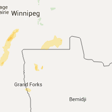

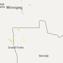


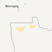
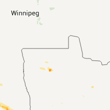


Connect with Interactive Hail Maps