

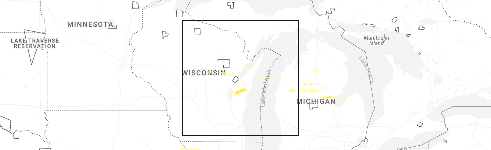
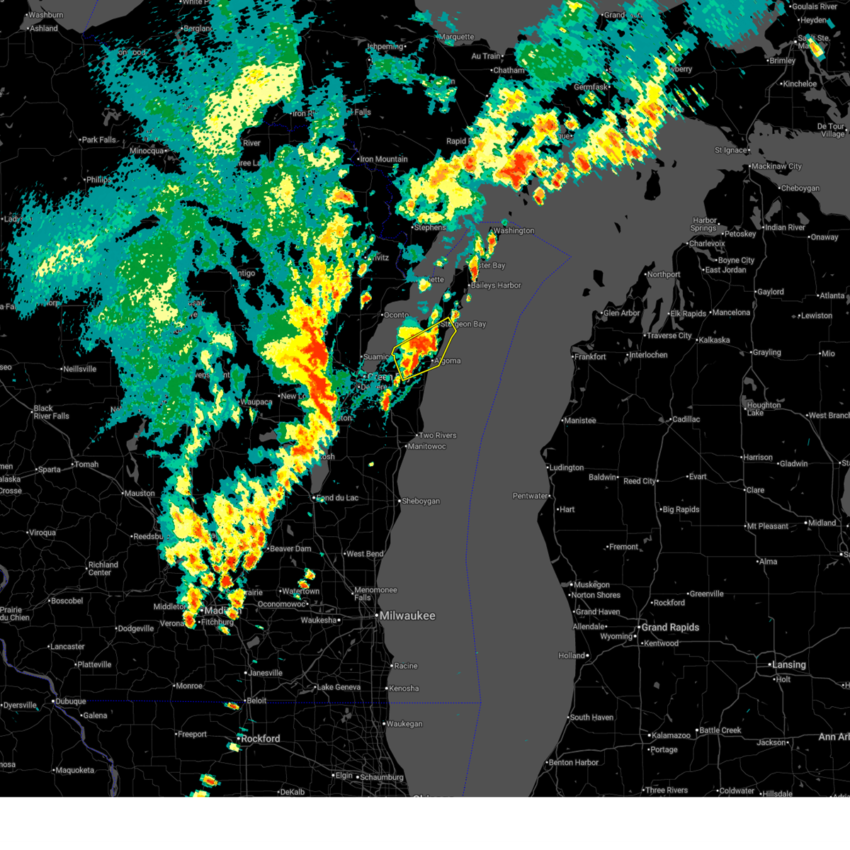
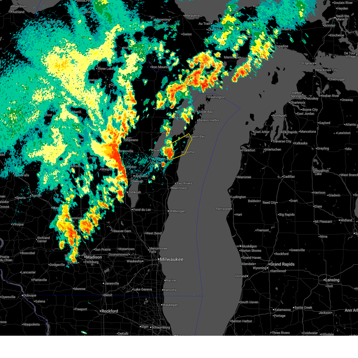
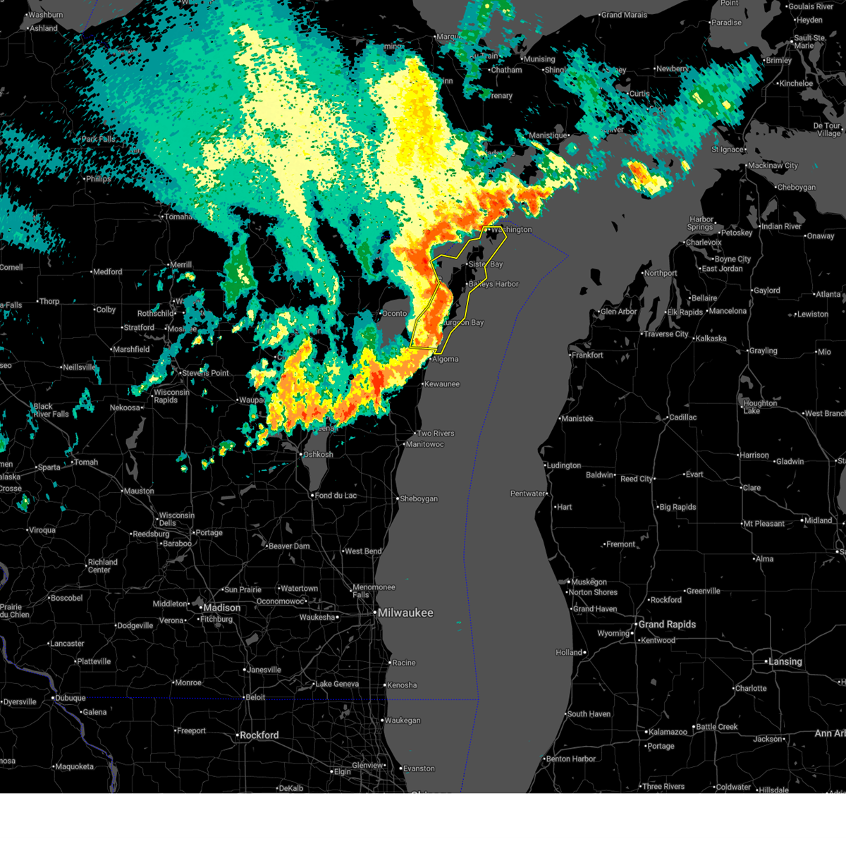
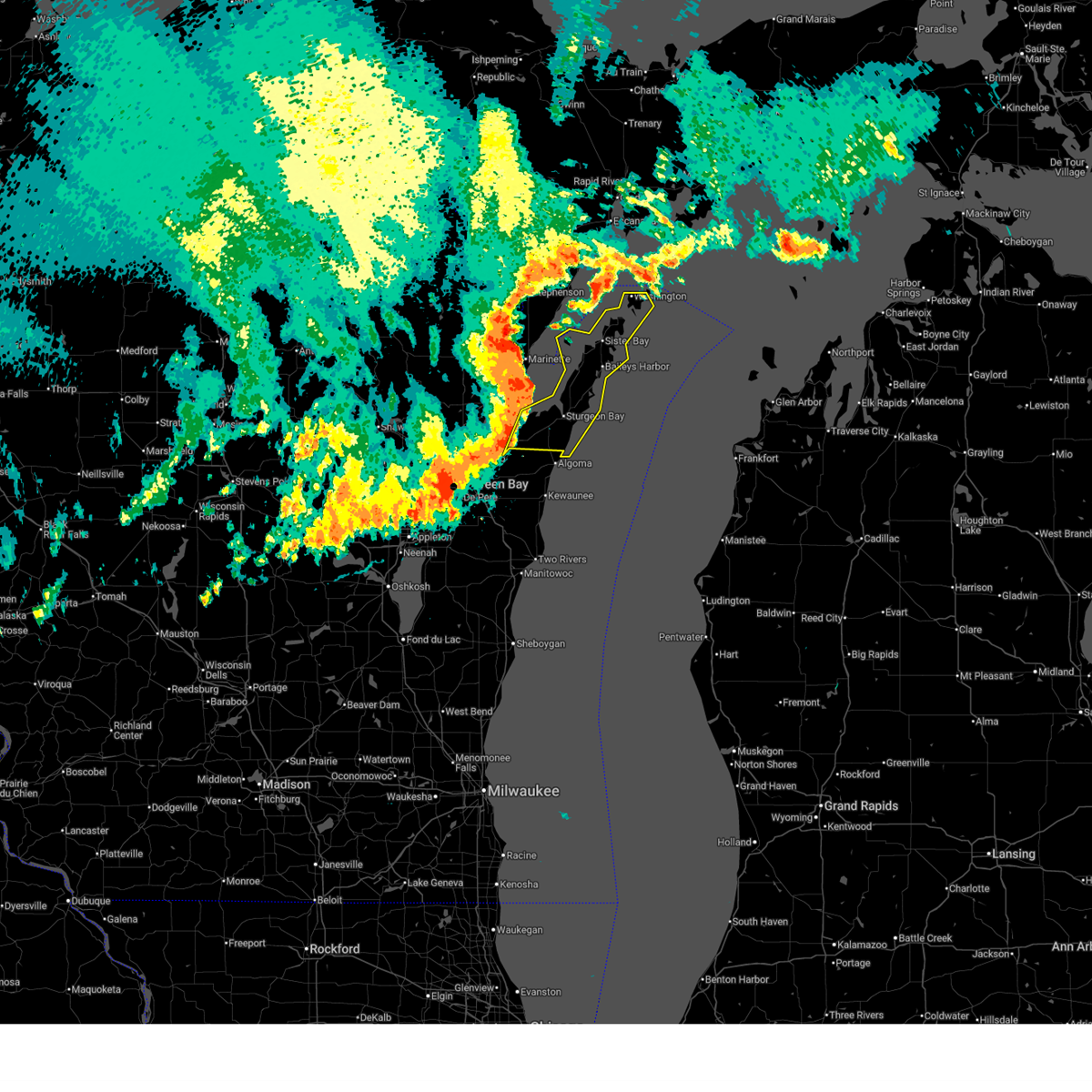
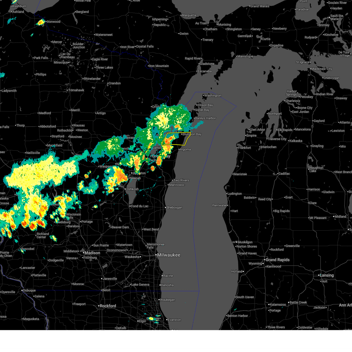
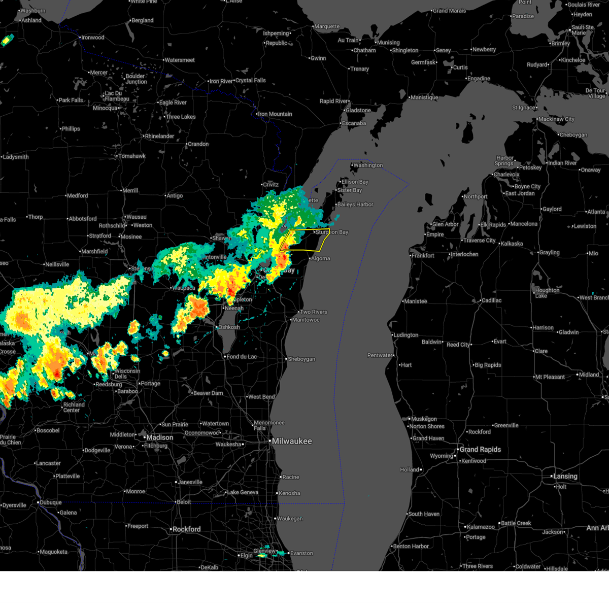
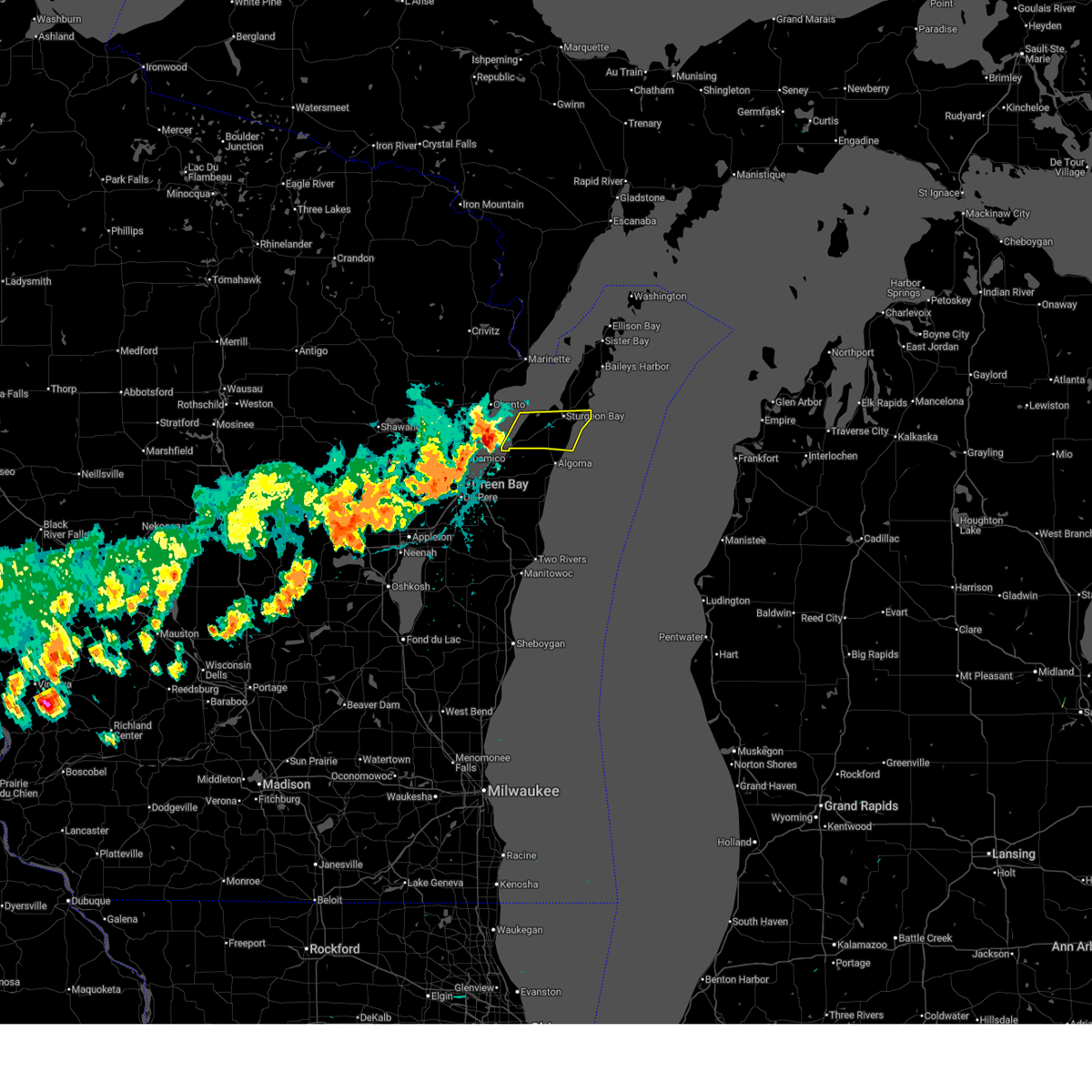
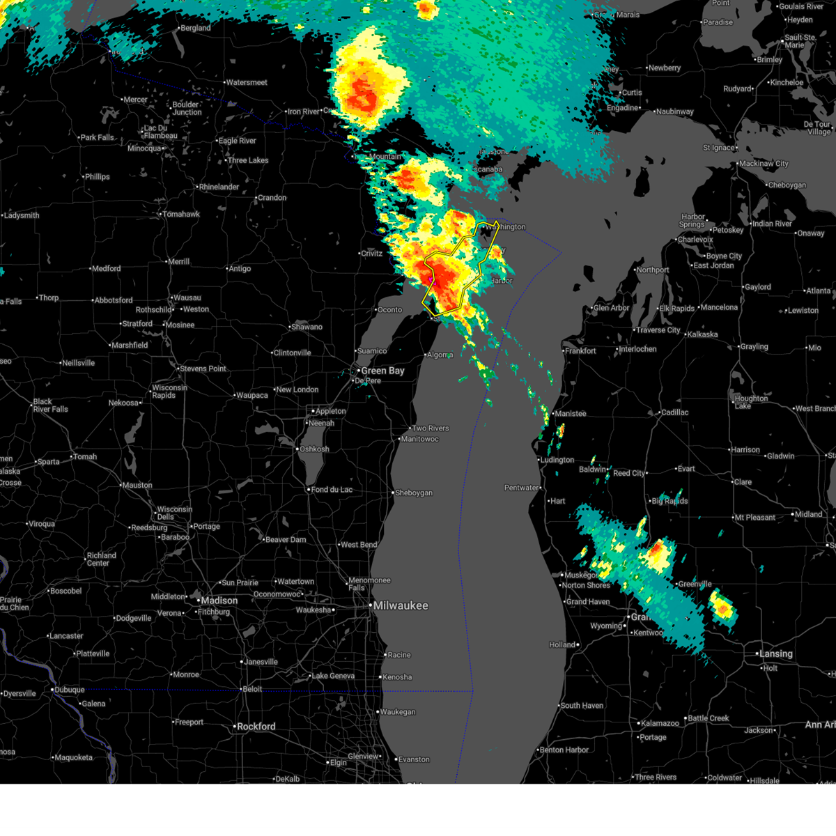
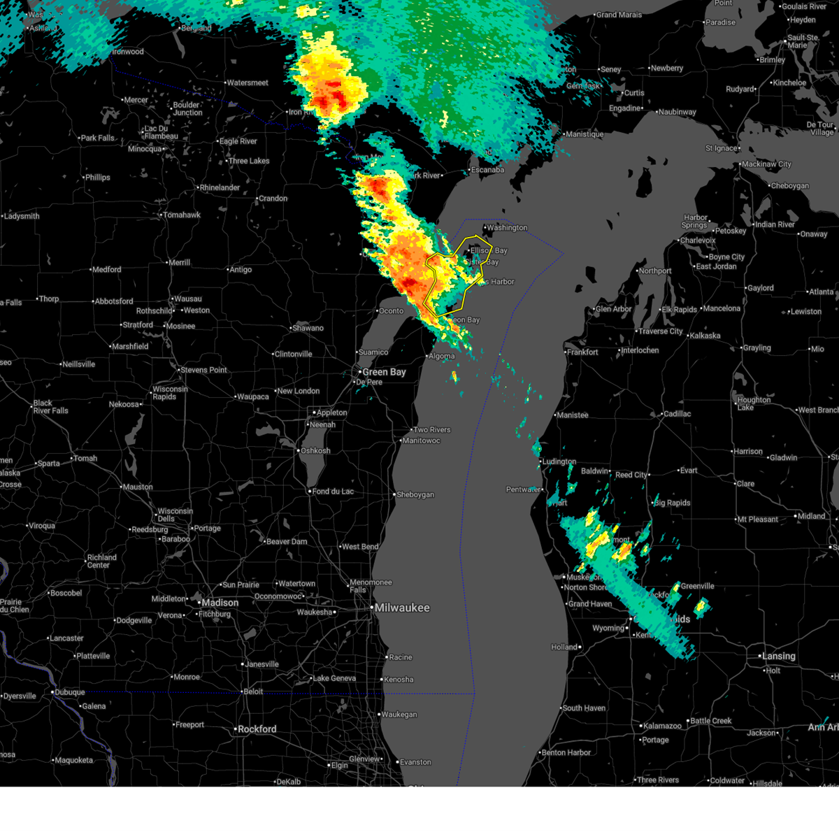
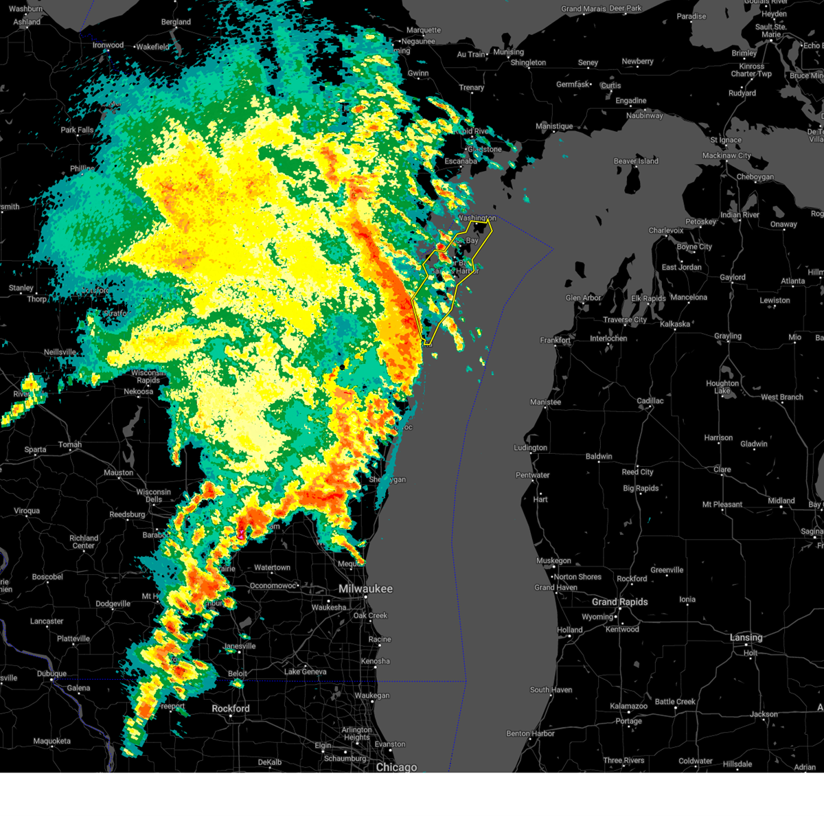
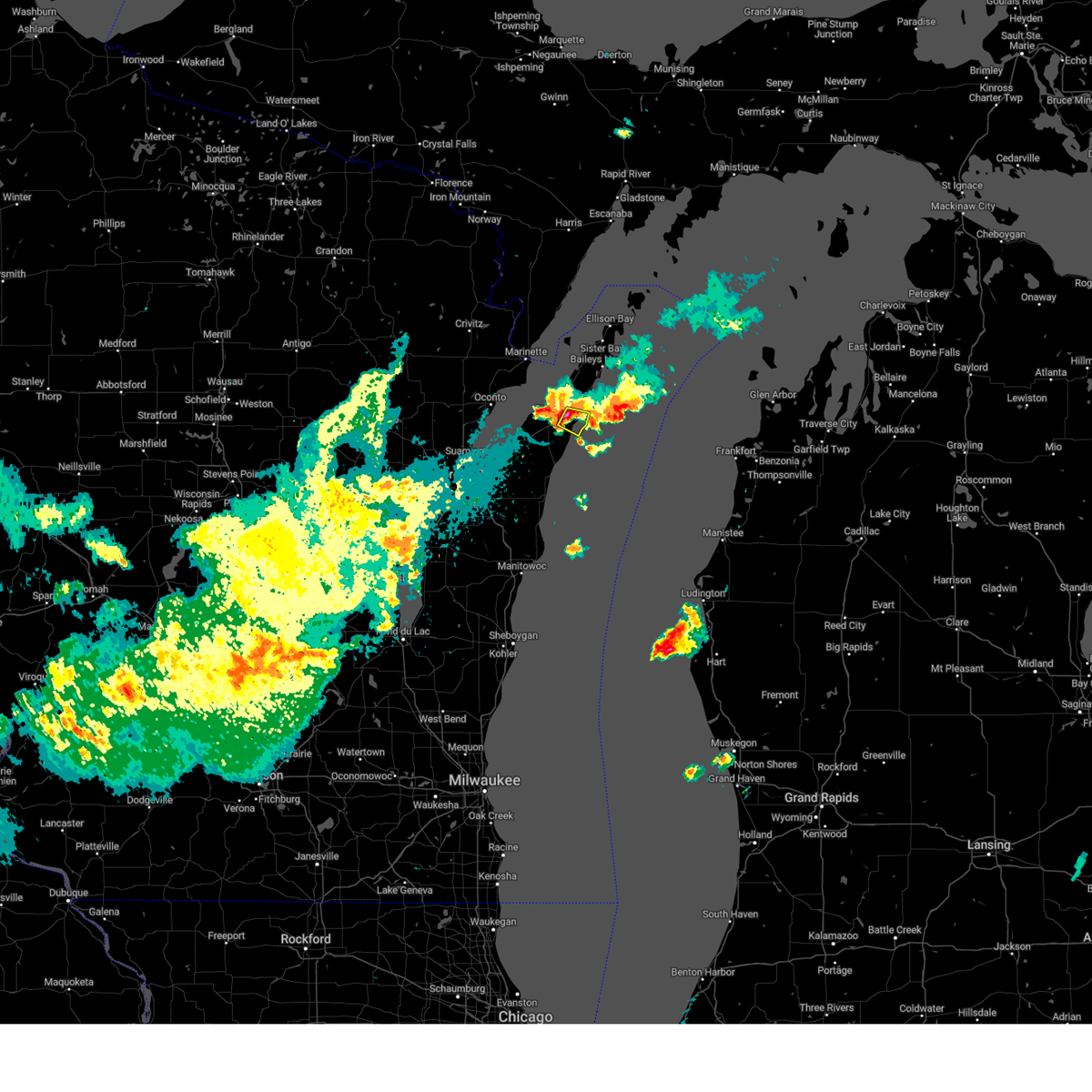
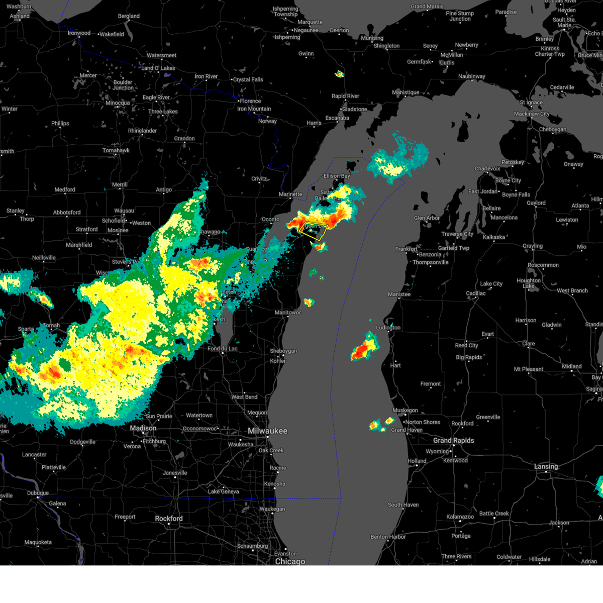
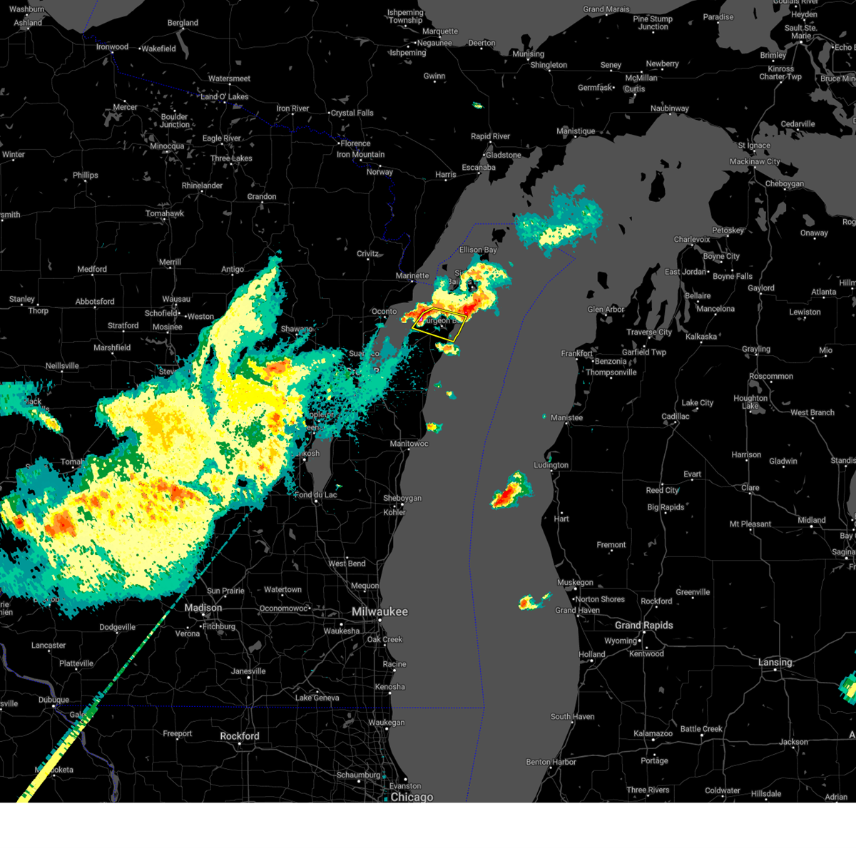
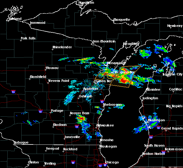
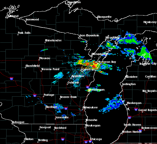
Hail Map for Sturgeon Bay, WI
The Sturgeon Bay, WI area has had 3 reports of on-the-ground hail by trained spotters, and has been under severe weather warnings 14 times during the past 12 months. Doppler radar has detected hail at or near Sturgeon Bay, WI on 36 occasions, including 2 occasions during the past year.
| Name: | Sturgeon Bay, WI |
| Where Located: | 38.2 miles NE of Green Bay, WI |
| Map: | Google Map for Sturgeon Bay, WI |
| Population: | 9144 |
| Housing Units: | 4903 |
| More Info: | Search Google for Sturgeon Bay, WI |
0
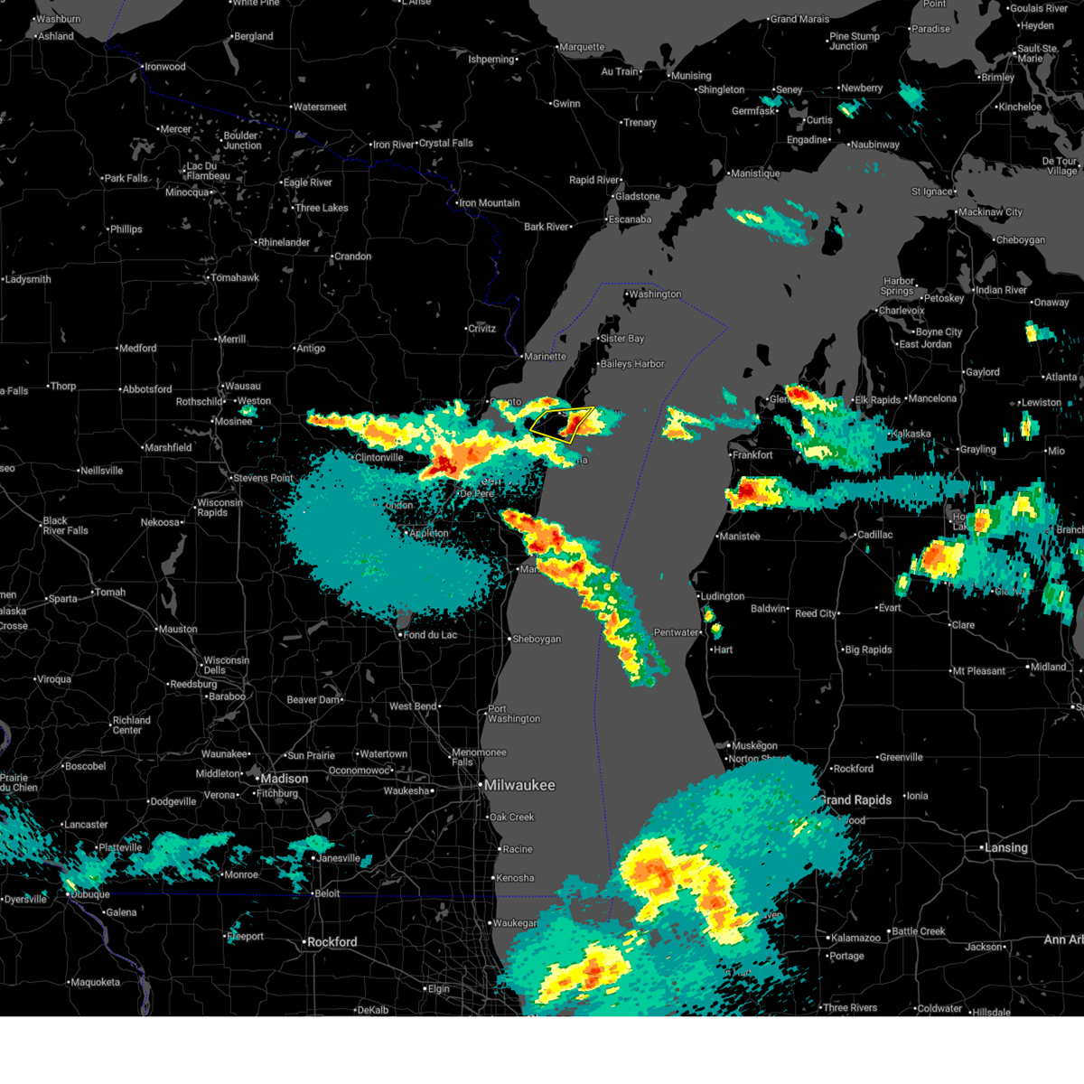
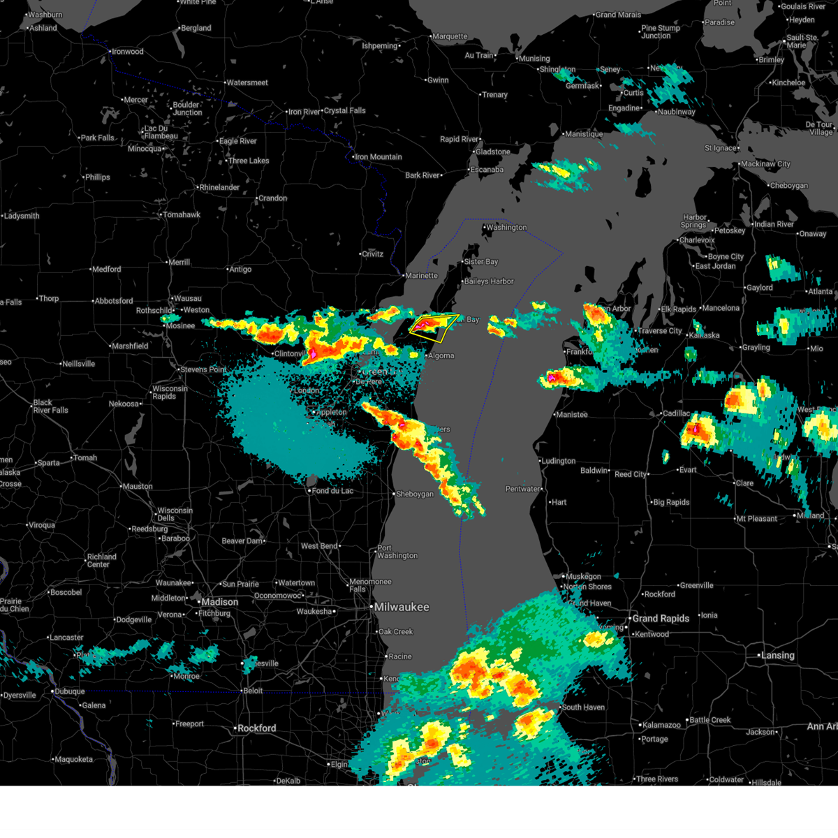
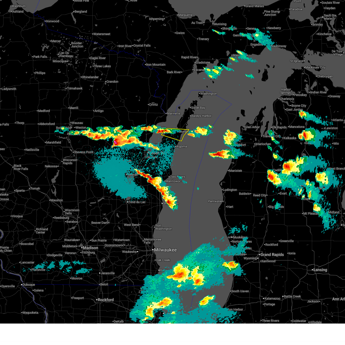
The Top Recent Hail Date for Sturgeon Bay, WI is Monday, March 30, 2026 (24th out of 36)
Hail and Wind Damage Spotted near Sturgeon Bay, WI
| Date / Time | Report Details |
|---|---|
| 3/31/2026 12:02 AM CDT |
 the severe thunderstorm warning has been cancelled and is no longer in effect the severe thunderstorm warning has been cancelled and is no longer in effect
|
| 3/30/2026 11:45 PM CDT |
 At 1145 pm cdt, a severe thunderstorm was located over sturgeon bay, moving east at 40 mph (radar indicated). Hazards include quarter size hail. Damage to vehicles is expected. Locations impacted include, sturgeon bay, clay banks, vignes, and maplewood. At 1145 pm cdt, a severe thunderstorm was located over sturgeon bay, moving east at 40 mph (radar indicated). Hazards include quarter size hail. Damage to vehicles is expected. Locations impacted include, sturgeon bay, clay banks, vignes, and maplewood.
|
| 3/30/2026 11:28 PM CDT |
 Svrgrb the national weather service in green bay has issued a * severe thunderstorm warning for, southern door county in northeastern wisconsin, * until 1215 am cdt. * at 1127 pm cdt, a severe thunderstorm was located 9 miles west of sturgeon bay, moving east at 40 mph (radar indicated). Hazards include quarter size hail. Damage to vehicles is expected. this severe thunderstorm will be near, sturgeon bay around 1135 pm cdt. Other locations impacted by this severe thunderstorm include vignes, maplewood, and clay banks. Svrgrb the national weather service in green bay has issued a * severe thunderstorm warning for, southern door county in northeastern wisconsin, * until 1215 am cdt. * at 1127 pm cdt, a severe thunderstorm was located 9 miles west of sturgeon bay, moving east at 40 mph (radar indicated). Hazards include quarter size hail. Damage to vehicles is expected. this severe thunderstorm will be near, sturgeon bay around 1135 pm cdt. Other locations impacted by this severe thunderstorm include vignes, maplewood, and clay banks.
|
| 8/9/2025 3:46 PM CDT | Tree down blocking highway 5 in door county WI, 13.3 miles SW of Sturgeon Bay, WI |
| 8/9/2025 3:45 PM CDT | Trees dow in door county WI, 13.8 miles SW of Sturgeon Bay, WI |
| 8/9/2025 2:40 PM CDT |
 The storm which prompted the warning has weakened below severe limits, and no longer poses an immediate threat to life or property. therefore, the warning will be allowed to expire. however, gusty winds are still possible with this thunderstorm. The storm which prompted the warning has weakened below severe limits, and no longer poses an immediate threat to life or property. therefore, the warning will be allowed to expire. however, gusty winds are still possible with this thunderstorm.
|
| 8/9/2025 2:21 PM CDT |
 At 221 pm cdt, a severe thunderstorm was located near algoma, or 11 miles north of kewaunee, moving northeast at 30 mph (radar indicated). Hazards include 60 mph wind gusts and quarter size hail. Hail damage to vehicles is expected. expect wind damage to roofs, siding, and trees. this severe storm will be near, algoma around 225 pm cdt. Other locations impacted by this severe thunderstorm include brussels, slovan, gregorville, rankin, euren, dyckesville, rosiere, duvall, scarboro, and rio creek. At 221 pm cdt, a severe thunderstorm was located near algoma, or 11 miles north of kewaunee, moving northeast at 30 mph (radar indicated). Hazards include 60 mph wind gusts and quarter size hail. Hail damage to vehicles is expected. expect wind damage to roofs, siding, and trees. this severe storm will be near, algoma around 225 pm cdt. Other locations impacted by this severe thunderstorm include brussels, slovan, gregorville, rankin, euren, dyckesville, rosiere, duvall, scarboro, and rio creek.
|
| 8/9/2025 2:21 PM CDT |
 the severe thunderstorm warning has been cancelled and is no longer in effect the severe thunderstorm warning has been cancelled and is no longer in effect
|
| 8/9/2025 2:06 PM CDT |
 Svrgrb the national weather service in green bay has issued a * severe thunderstorm warning for, northeastern brown county in northeastern wisconsin, northern kewaunee county in northeastern wisconsin, southern door county in northeastern wisconsin, * until 245 pm cdt. * at 206 pm cdt, a severe thunderstorm was located over luxemburg, or 7 miles southeast of bay shore park, moving northeast at 30 mph (radar indicated). Hazards include 60 mph wind gusts and quarter size hail. Hail damage to vehicles is expected. expect wind damage to roofs, siding, and trees. this severe thunderstorm will be near, algoma around 225 pm cdt. Other locations impacted by this severe thunderstorm include brussels, slovan, gregorville, rankin, euren, dyckesville, rosiere, shoemaker point, duvall, and scarboro. Svrgrb the national weather service in green bay has issued a * severe thunderstorm warning for, northeastern brown county in northeastern wisconsin, northern kewaunee county in northeastern wisconsin, southern door county in northeastern wisconsin, * until 245 pm cdt. * at 206 pm cdt, a severe thunderstorm was located over luxemburg, or 7 miles southeast of bay shore park, moving northeast at 30 mph (radar indicated). Hazards include 60 mph wind gusts and quarter size hail. Hail damage to vehicles is expected. expect wind damage to roofs, siding, and trees. this severe thunderstorm will be near, algoma around 225 pm cdt. Other locations impacted by this severe thunderstorm include brussels, slovan, gregorville, rankin, euren, dyckesville, rosiere, shoemaker point, duvall, and scarboro.
|
| 7/23/2025 6:42 PM CDT |
 At 642 pm cdt, severe thunderstorms were located along a line extending from 9 miles southwest of cedar river to near jacksonport to 6 miles northeast of algoma, moving east at 50 mph (radar indicated). Hazards include 60 mph wind gusts. Expect damage to roofs, siding, and trees. these severe storms will be near, sturgeon bay, jacksonport, ephraim, and egg harbor around 645 pm cdt. newport state park around 700 pm cdt. Other locations impacted by these severe thunderstorms include peninsula center, fish creek, peninsula state park, valmy, ellison bay, whitefish bay, carlsville, vignes, washington island, and maplewood. At 642 pm cdt, severe thunderstorms were located along a line extending from 9 miles southwest of cedar river to near jacksonport to 6 miles northeast of algoma, moving east at 50 mph (radar indicated). Hazards include 60 mph wind gusts. Expect damage to roofs, siding, and trees. these severe storms will be near, sturgeon bay, jacksonport, ephraim, and egg harbor around 645 pm cdt. newport state park around 700 pm cdt. Other locations impacted by these severe thunderstorms include peninsula center, fish creek, peninsula state park, valmy, ellison bay, whitefish bay, carlsville, vignes, washington island, and maplewood.
|
| 7/23/2025 6:40 PM CDT | Report of a tree down in the south bound lane of state highway 5 in door county WI, 3.3 miles SSW of Sturgeon Bay, WI |
| 7/23/2025 6:32 PM CDT | Tree down in the roadway. time estimated by rada in door county WI, 7.2 miles NE of Sturgeon Bay, WI |
| 7/23/2025 6:31 PM CDT | Dc dispatch reports tree down in the roadway vicinity of 7491 co rd h... sturgeon bay (maplewood church) time estimated by rada in door county WI, 7.5 miles NE of Sturgeon Bay, WI |
| 7/23/2025 6:26 PM CDT |
 Svrgrb the national weather service in green bay has issued a * severe thunderstorm warning for, door county in northeastern wisconsin, * until 730 pm cdt. * at 625 pm cdt, severe thunderstorms were located along a line extending from 11 miles northwest of menominee to 8 miles southeast of marinette to near bay shore park, moving east at 50 mph (radar indicated). Hazards include 60 mph wind gusts. Expect damage to roofs, siding, and trees. severe thunderstorms will be near, sturgeon bay and egg harbor around 635 pm cdt. jacksonport and ephraim around 645 pm cdt. newport state park around 700 pm cdt. Other locations impacted by these severe thunderstorms include brussels, peninsula center, fish creek, peninsula state park, valmy, ellison bay, whitefish bay, shoemaker point, carlsville, and namur. Svrgrb the national weather service in green bay has issued a * severe thunderstorm warning for, door county in northeastern wisconsin, * until 730 pm cdt. * at 625 pm cdt, severe thunderstorms were located along a line extending from 11 miles northwest of menominee to 8 miles southeast of marinette to near bay shore park, moving east at 50 mph (radar indicated). Hazards include 60 mph wind gusts. Expect damage to roofs, siding, and trees. severe thunderstorms will be near, sturgeon bay and egg harbor around 635 pm cdt. jacksonport and ephraim around 645 pm cdt. newport state park around 700 pm cdt. Other locations impacted by these severe thunderstorms include brussels, peninsula center, fish creek, peninsula state park, valmy, ellison bay, whitefish bay, shoemaker point, carlsville, and namur.
|
| 6/29/2025 4:13 PM CDT |
 The severe thunderstorm which prompted the warning has weakened. therefore, the warning will be allowed to expire. however, small hail, gusty winds and heavy rain are still possible with this thunderstorm. a severe thunderstorm watch remains in effect until 900 pm cdt for northeastern wisconsin. The severe thunderstorm which prompted the warning has weakened. therefore, the warning will be allowed to expire. however, small hail, gusty winds and heavy rain are still possible with this thunderstorm. a severe thunderstorm watch remains in effect until 900 pm cdt for northeastern wisconsin.
|
| 6/29/2025 4:00 PM CDT |
 At 359 pm cdt, a severe thunderstorm was located 10 miles northeast of bay shore park, moving east at 20 mph (radar indicated). Hazards include 60 mph wind gusts and half dollar size hail. Hail damage to vehicles is expected. expect wind damage to roofs, siding, and trees. this severe storm will be near, sturgeon bay around 430 pm cdt. Other locations impacted by this severe thunderstorm include vignes, maplewood, brussels, forestville, shoemaker point, kolberg, carnot, clay banks, and namur. At 359 pm cdt, a severe thunderstorm was located 10 miles northeast of bay shore park, moving east at 20 mph (radar indicated). Hazards include 60 mph wind gusts and half dollar size hail. Hail damage to vehicles is expected. expect wind damage to roofs, siding, and trees. this severe storm will be near, sturgeon bay around 430 pm cdt. Other locations impacted by this severe thunderstorm include vignes, maplewood, brussels, forestville, shoemaker point, kolberg, carnot, clay banks, and namur.
|
| 6/29/2025 3:23 PM CDT |
 Svrgrb the national weather service in green bay has issued a * severe thunderstorm warning for, southern door county in northeastern wisconsin, * until 415 pm cdt. * at 322 pm cdt, a severe thunderstorm was located near bay shore park, moving east at 30 mph (radar indicated). Hazards include 60 mph wind gusts and half dollar size hail. Hail damage to vehicles is expected. expect wind damage to roofs, siding, and trees. This severe thunderstorm will remain over mainly rural areas of southern door county, including the following locations, vignes, maplewood, brussels, forestville, shoemaker point, kolberg, carnot, clay banks, and namur. Svrgrb the national weather service in green bay has issued a * severe thunderstorm warning for, southern door county in northeastern wisconsin, * until 415 pm cdt. * at 322 pm cdt, a severe thunderstorm was located near bay shore park, moving east at 30 mph (radar indicated). Hazards include 60 mph wind gusts and half dollar size hail. Hail damage to vehicles is expected. expect wind damage to roofs, siding, and trees. This severe thunderstorm will remain over mainly rural areas of southern door county, including the following locations, vignes, maplewood, brussels, forestville, shoemaker point, kolberg, carnot, clay banks, and namur.
|
| 6/21/2025 3:44 AM CDT |
 Svrgrb the national weather service in green bay has issued a * severe thunderstorm warning for, central door county in northeastern wisconsin, * until 430 am cdt. * at 343 am cdt, a severe thunderstorm was located near egg harbor, or 14 miles east of marinette, moving northeast at 40 mph (radar indicated). Hazards include tennis ball size hail and 60 mph wind gusts. People and animals outdoors will be injured. expect hail damage to roofs, siding, windows, and vehicles. expect wind damage to roofs, siding, and trees. this severe thunderstorm will be near, ephraim around 350 am cdt. newport state park around 405 am cdt. other locations impacted by this severe thunderstorm include peninsula center, fish creek, peninsula state park, valmy, ellison bay, whitefish bay, rock island state park, carlsville, washington island, and sister bay. This warning replaces the severe thunderstorm warning already in effect for northern door county. Svrgrb the national weather service in green bay has issued a * severe thunderstorm warning for, central door county in northeastern wisconsin, * until 430 am cdt. * at 343 am cdt, a severe thunderstorm was located near egg harbor, or 14 miles east of marinette, moving northeast at 40 mph (radar indicated). Hazards include tennis ball size hail and 60 mph wind gusts. People and animals outdoors will be injured. expect hail damage to roofs, siding, windows, and vehicles. expect wind damage to roofs, siding, and trees. this severe thunderstorm will be near, ephraim around 350 am cdt. newport state park around 405 am cdt. other locations impacted by this severe thunderstorm include peninsula center, fish creek, peninsula state park, valmy, ellison bay, whitefish bay, rock island state park, carlsville, washington island, and sister bay. This warning replaces the severe thunderstorm warning already in effect for northern door county.
|
| 6/21/2025 3:20 AM CDT |
 Svrgrb the national weather service in green bay has issued a * severe thunderstorm warning for, northern door county in northeastern wisconsin, * until 415 am cdt. * at 319 am cdt, a severe thunderstorm was located 8 miles west of egg harbor, or 8 miles southeast of marinette, moving northeast at 35 mph (radar indicated). Hazards include 60 mph wind gusts and half dollar size hail. Hail damage to vehicles is expected. expect wind damage to roofs, siding, and trees. this severe thunderstorm will be near, egg harbor around 325 am cdt. ephraim around 340 am cdt. newport state park around 355 am cdt. Other locations impacted by this severe thunderstorm include peninsula center, fish creek, peninsula state park, sister bay, valmy, institute, ellison bay, whitefish bay, baileys harbor, and whitefish dunes state park. Svrgrb the national weather service in green bay has issued a * severe thunderstorm warning for, northern door county in northeastern wisconsin, * until 415 am cdt. * at 319 am cdt, a severe thunderstorm was located 8 miles west of egg harbor, or 8 miles southeast of marinette, moving northeast at 35 mph (radar indicated). Hazards include 60 mph wind gusts and half dollar size hail. Hail damage to vehicles is expected. expect wind damage to roofs, siding, and trees. this severe thunderstorm will be near, egg harbor around 325 am cdt. ephraim around 340 am cdt. newport state park around 355 am cdt. Other locations impacted by this severe thunderstorm include peninsula center, fish creek, peninsula state park, sister bay, valmy, institute, ellison bay, whitefish bay, baileys harbor, and whitefish dunes state park.
|
| 5/16/2025 6:43 PM CDT |
 The storms which prompted the warning have weakened below severe limits, and have exited the warned area. therefore, the warning will be allowed to expire. The storms which prompted the warning have weakened below severe limits, and have exited the warned area. therefore, the warning will be allowed to expire.
|
| 5/16/2025 6:28 PM CDT |
 At 627 pm cdt, severe thunderstorms were located along a line extending from near marinette to 7 miles west of sturgeon bay to near luxemburg, moving northeast at 75 mph (radar indicated). Hazards include 60 mph wind gusts. Expect damage to roofs, siding, and trees. these severe storms will be near, marinette and sturgeon bay around 635 pm cdt. Other locations impacted by these severe thunderstorms include cullen, gregorville, rankin, euren, pensaukee, vignes, maplewood, potawatomi state park, kodan, and thiry daems. At 627 pm cdt, severe thunderstorms were located along a line extending from near marinette to 7 miles west of sturgeon bay to near luxemburg, moving northeast at 75 mph (radar indicated). Hazards include 60 mph wind gusts. Expect damage to roofs, siding, and trees. these severe storms will be near, marinette and sturgeon bay around 635 pm cdt. Other locations impacted by these severe thunderstorms include cullen, gregorville, rankin, euren, pensaukee, vignes, maplewood, potawatomi state park, kodan, and thiry daems.
|
| 5/16/2025 6:28 PM CDT |
 the severe thunderstorm warning has been cancelled and is no longer in effect the severe thunderstorm warning has been cancelled and is no longer in effect
|
| 5/16/2025 6:18 PM CDT |
 At 618 pm cdt, severe thunderstorms were located along a line extending from near oconto to 8 miles east of bay shore park to denmark, moving northeast at 55 mph (radar indicated). Hazards include 60 mph wind gusts. Expect damage to roofs, siding, and trees. these severe storms will be near, kewaunee and algoma around 625 pm cdt. marinette and sturgeon bay around 630 pm cdt. Other locations impacted by these severe thunderstorms include krok, maribel, larrabee, slovan, gregorville, curran, wayside, morrison, rankin, and humboldt. At 618 pm cdt, severe thunderstorms were located along a line extending from near oconto to 8 miles east of bay shore park to denmark, moving northeast at 55 mph (radar indicated). Hazards include 60 mph wind gusts. Expect damage to roofs, siding, and trees. these severe storms will be near, kewaunee and algoma around 625 pm cdt. marinette and sturgeon bay around 630 pm cdt. Other locations impacted by these severe thunderstorms include krok, maribel, larrabee, slovan, gregorville, curran, wayside, morrison, rankin, and humboldt.
|
| 5/16/2025 6:01 PM CDT |
 Svrgrb the national weather service in green bay has issued a * severe thunderstorm warning for, eastern brown county in northeastern wisconsin, kewaunee county in northeastern wisconsin, southern marinette county in northeastern wisconsin, southern door county in northeastern wisconsin, southern oconto county in northeastern wisconsin, northern manitowoc county in east central wisconsin, * until 645 pm cdt. * at 601 pm cdt, severe thunderstorms were located along a line extending from near gillett to near green bay to 6 miles northeast of brillion, moving east at 60 mph (radar indicated). Hazards include 60 mph wind gusts. Expect damage to roofs, siding, and trees. severe thunderstorms will be near, green bay, bay shore park, denmark, and bellevue town around 605 pm cdt. oconto and luxemburg around 610 pm cdt. kewaunee, algoma, and two creeks around 620 pm cdt. marinette and sturgeon bay around 630 pm cdt. Other locations impacted by these severe thunderstorms include krok, maribel, larrabee, curran, slovan, wayside, gregorville, morrison, rankin, and humboldt. Svrgrb the national weather service in green bay has issued a * severe thunderstorm warning for, eastern brown county in northeastern wisconsin, kewaunee county in northeastern wisconsin, southern marinette county in northeastern wisconsin, southern door county in northeastern wisconsin, southern oconto county in northeastern wisconsin, northern manitowoc county in east central wisconsin, * until 645 pm cdt. * at 601 pm cdt, severe thunderstorms were located along a line extending from near gillett to near green bay to 6 miles northeast of brillion, moving east at 60 mph (radar indicated). Hazards include 60 mph wind gusts. Expect damage to roofs, siding, and trees. severe thunderstorms will be near, green bay, bay shore park, denmark, and bellevue town around 605 pm cdt. oconto and luxemburg around 610 pm cdt. kewaunee, algoma, and two creeks around 620 pm cdt. marinette and sturgeon bay around 630 pm cdt. Other locations impacted by these severe thunderstorms include krok, maribel, larrabee, curran, slovan, wayside, gregorville, morrison, rankin, and humboldt.
|
| 5/21/2024 10:08 PM CDT | Tree down in sevastopo in door county WI, 3.9 miles WSW of Sturgeon Bay, WI |
| 5/21/2024 9:59 PM CDT |
 Svrgrb the national weather service in green bay has issued a * severe thunderstorm warning for, door county in northeastern wisconsin, * until 1045 pm cdt. * at 958 pm cdt, severe thunderstorms were located along a line extending from 8 miles southwest of egg harbor to sturgeon bay to 9 miles northeast of algoma, moving northeast at 60 mph (radar indicated). Hazards include 60 mph wind gusts. expect damage to roofs, siding, and trees Svrgrb the national weather service in green bay has issued a * severe thunderstorm warning for, door county in northeastern wisconsin, * until 1045 pm cdt. * at 958 pm cdt, severe thunderstorms were located along a line extending from 8 miles southwest of egg harbor to sturgeon bay to 9 miles northeast of algoma, moving northeast at 60 mph (radar indicated). Hazards include 60 mph wind gusts. expect damage to roofs, siding, and trees
|
| 5/21/2024 9:58 PM CDT | Tree down blocking road between oregon st. and 7th ave. time based on rada in door county WI, 0.2 miles SW of Sturgeon Bay, WI |
| 5/21/2024 9:52 PM CDT |
 the severe thunderstorm warning has been cancelled and is no longer in effect the severe thunderstorm warning has been cancelled and is no longer in effect
|
| 5/21/2024 9:52 PM CDT |
 At 951 pm cdt, severe thunderstorms were located along a line extending from 9 miles south of marinette to near sturgeon bay to 8 miles southeast of kewaunee to 9 miles east of manitowoc, moving northeast at 65 mph (radar indicated). Hazards include 60 mph wind gusts. Expect damage to roofs, siding, and trees. Locations impacted include, sturgeon bay, kewaunee, algoma, jacksonport, egg harbor, whitefish bay, forestville, clay banks, kewaunee power station, and valmy. At 951 pm cdt, severe thunderstorms were located along a line extending from 9 miles south of marinette to near sturgeon bay to 8 miles southeast of kewaunee to 9 miles east of manitowoc, moving northeast at 65 mph (radar indicated). Hazards include 60 mph wind gusts. Expect damage to roofs, siding, and trees. Locations impacted include, sturgeon bay, kewaunee, algoma, jacksonport, egg harbor, whitefish bay, forestville, clay banks, kewaunee power station, and valmy.
|
| 5/21/2024 9:40 PM CDT |
 the severe thunderstorm warning has been cancelled and is no longer in effect the severe thunderstorm warning has been cancelled and is no longer in effect
|
| 5/21/2024 9:40 PM CDT |
 At 939 pm cdt, severe thunderstorms were located along a line extending from 6 miles southeast of oconto to 8 miles northeast of luxemburg to near two creeks to near cleveland, moving northeast at 65 mph (radar indicated). Hazards include 60 mph wind gusts. Expect damage to roofs, siding, and trees. Locations impacted include, manitowoc, sturgeon bay, kewaunee, algoma, luxemburg, cleveland, jacksonport, two creeks, egg harbor, and whitefish bay. At 939 pm cdt, severe thunderstorms were located along a line extending from 6 miles southeast of oconto to 8 miles northeast of luxemburg to near two creeks to near cleveland, moving northeast at 65 mph (radar indicated). Hazards include 60 mph wind gusts. Expect damage to roofs, siding, and trees. Locations impacted include, manitowoc, sturgeon bay, kewaunee, algoma, luxemburg, cleveland, jacksonport, two creeks, egg harbor, and whitefish bay.
|
| 5/21/2024 9:28 PM CDT |
 the severe thunderstorm warning has been cancelled and is no longer in effect the severe thunderstorm warning has been cancelled and is no longer in effect
|
| 5/21/2024 9:28 PM CDT |
 At 928 pm cdt, severe thunderstorms were located along a line extending from 8 miles west of bay shore park to denmark to near valders to near camp rokilio scout camp, moving northeast at 65 mph (radar indicated). Hazards include 60 mph wind gusts. Expect damage to roofs, siding, and trees. Locations impacted include, green bay, manitowoc, sturgeon bay, kewaunee, bay shore park, algoma, luxemburg, denmark, cleveland, and valders. At 928 pm cdt, severe thunderstorms were located along a line extending from 8 miles west of bay shore park to denmark to near valders to near camp rokilio scout camp, moving northeast at 65 mph (radar indicated). Hazards include 60 mph wind gusts. Expect damage to roofs, siding, and trees. Locations impacted include, green bay, manitowoc, sturgeon bay, kewaunee, bay shore park, algoma, luxemburg, denmark, cleveland, and valders.
|
| 5/21/2024 9:21 PM CDT |
 Svrgrb the national weather service in green bay has issued a * severe thunderstorm warning for, brown county in northeastern wisconsin, kewaunee county in northeastern wisconsin, door county in northeastern wisconsin, southeastern calumet county in east central wisconsin, manitowoc county in east central wisconsin, * until 1000 pm cdt. * at 920 pm cdt, severe thunderstorms were located along a line extending from 7 miles northwest of green bay to 6 miles west of denmark to near elkhart lake, moving northeast at 65 mph. gusts to 56 mph were reported at green bay, and trees have been snapped (radar indicated). Hazards include 60 mph wind gusts. expect damage to roofs, siding, and trees Svrgrb the national weather service in green bay has issued a * severe thunderstorm warning for, brown county in northeastern wisconsin, kewaunee county in northeastern wisconsin, door county in northeastern wisconsin, southeastern calumet county in east central wisconsin, manitowoc county in east central wisconsin, * until 1000 pm cdt. * at 920 pm cdt, severe thunderstorms were located along a line extending from 7 miles northwest of green bay to 6 miles west of denmark to near elkhart lake, moving northeast at 65 mph. gusts to 56 mph were reported at green bay, and trees have been snapped (radar indicated). Hazards include 60 mph wind gusts. expect damage to roofs, siding, and trees
|
| 8/11/2023 9:13 PM CDT |
 At 912 pm cdt, a severe thunderstorm was located over the east side of sturgeon bay, moving east at 30 mph (radar indicated). Hazards include 60 mph wind gusts and quarter size hail. Hail damage to vehicles is expected. expect wind damage to roofs, siding, and trees. this severe thunderstorm will remain over mainly rural areas of south central door county. hail threat, radar indicated max hail size, 1. 00 in wind threat, radar indicated max wind gust, 60 mph. At 912 pm cdt, a severe thunderstorm was located over the east side of sturgeon bay, moving east at 30 mph (radar indicated). Hazards include 60 mph wind gusts and quarter size hail. Hail damage to vehicles is expected. expect wind damage to roofs, siding, and trees. this severe thunderstorm will remain over mainly rural areas of south central door county. hail threat, radar indicated max hail size, 1. 00 in wind threat, radar indicated max wind gust, 60 mph.
|
| 8/11/2023 9:05 PM CDT |
 At 905 pm cdt, a severe thunderstorm was located over sturgeon bay, moving east at 30 mph (radar indicated). Hazards include ping pong ball size hail and 60 mph wind gusts. People and animals outdoors will be injured. expect hail damage to roofs, siding, windows, and vehicles. expect wind damage to roofs, siding, and trees. this severe thunderstorm will move across sturgeon bay and the potawatomi state park. hail threat, radar indicated max hail size, 1. 50 in wind threat, radar indicated max wind gust, 60 mph. At 905 pm cdt, a severe thunderstorm was located over sturgeon bay, moving east at 30 mph (radar indicated). Hazards include ping pong ball size hail and 60 mph wind gusts. People and animals outdoors will be injured. expect hail damage to roofs, siding, windows, and vehicles. expect wind damage to roofs, siding, and trees. this severe thunderstorm will move across sturgeon bay and the potawatomi state park. hail threat, radar indicated max hail size, 1. 50 in wind threat, radar indicated max wind gust, 60 mph.
|
| 8/11/2023 9:00 PM CDT | Trees downed. time estimated from rada in door county WI, 3.5 miles ENE of Sturgeon Bay, WI |
| 8/11/2023 8:54 PM CDT | Multiple trees and wires dow in door county WI, 6.2 miles E of Sturgeon Bay, WI |
| 8/11/2023 8:53 PM CDT |
 At 853 pm cdt, a severe thunderstorm was located near sturgeon bay, moving east at 30 mph (radar indicated). Hazards include 60 mph wind gusts and half dollar size hail. Hail damage to vehicles is expected. expect wind damage to roofs, siding, and trees. this severe thunderstorm will be near, sturgeon bay around 905 pm cdt. other locations impacted by this severe thunderstorm include valmy, institute and potawatomi state park. hail threat, radar indicated max hail size, 1. 25 in wind threat, radar indicated max wind gust, 60 mph. At 853 pm cdt, a severe thunderstorm was located near sturgeon bay, moving east at 30 mph (radar indicated). Hazards include 60 mph wind gusts and half dollar size hail. Hail damage to vehicles is expected. expect wind damage to roofs, siding, and trees. this severe thunderstorm will be near, sturgeon bay around 905 pm cdt. other locations impacted by this severe thunderstorm include valmy, institute and potawatomi state park. hail threat, radar indicated max hail size, 1. 25 in wind threat, radar indicated max wind gust, 60 mph.
|
| 8/3/2023 3:17 PM CDT | Multiple trees down just north of cit in door county WI, 0.3 miles ESE of Sturgeon Bay, WI |
| 7/22/2023 12:50 PM CDT | Half Dollar sized hail reported 2.1 miles NW of Sturgeon Bay, WI, report via social media. |
| 6/15/2022 7:15 PM CDT |
 At 714 pm cdt, severe thunderstorms were located along a line extending from 9 miles northeast of menominee to 7 miles west of ephraim to jacksonport to 8 miles southeast of sturgeon bay, moving northeast at 70 mph (trained weather spotters). Hazards include 70 mph wind gusts. Expect considerable tree damage. damage is likely to mobile homes, roofs, and outbuildings. these severe storms will be near, ephraim around 720 pm cdt. newport state park around 730 pm cdt. other locations impacted by these severe thunderstorms include peninsula center, fish creek, peninsula state park, valmy, ellison bay, whitefish bay, rock island state park, carlsville, washington island and sister bay. thunderstorm damage threat, considerable hail threat, radar indicated max hail size, <. 75 in wind threat, radar indicated max wind gust, 70 mph. At 714 pm cdt, severe thunderstorms were located along a line extending from 9 miles northeast of menominee to 7 miles west of ephraim to jacksonport to 8 miles southeast of sturgeon bay, moving northeast at 70 mph (trained weather spotters). Hazards include 70 mph wind gusts. Expect considerable tree damage. damage is likely to mobile homes, roofs, and outbuildings. these severe storms will be near, ephraim around 720 pm cdt. newport state park around 730 pm cdt. other locations impacted by these severe thunderstorms include peninsula center, fish creek, peninsula state park, valmy, ellison bay, whitefish bay, rock island state park, carlsville, washington island and sister bay. thunderstorm damage threat, considerable hail threat, radar indicated max hail size, <. 75 in wind threat, radar indicated max wind gust, 70 mph.
|
| 6/15/2022 7:02 PM CDT |
 At 701 pm cdt, severe thunderstorms were located along a line extending from 6 miles west of menominee to near marinette to near sturgeon bay to near algoma to near kewaunee, moving northeast at 70 mph (radar indicated). Hazards include 70 mph wind gusts. Expect considerable tree damage. damage is likely to mobile homes, roofs, and outbuildings. these severe storms will be near, sturgeon bay around 705 pm cdt. menominee and egg harbor around 710 pm cdt. other locations in the path of these severe thunderstorms include jacksonport, ephraim and newport state park. thunderstorm damage threat, considerable hail threat, radar indicated max hail size, <. 75 in wind threat, radar indicated max wind gust, 70 mph. At 701 pm cdt, severe thunderstorms were located along a line extending from 6 miles west of menominee to near marinette to near sturgeon bay to near algoma to near kewaunee, moving northeast at 70 mph (radar indicated). Hazards include 70 mph wind gusts. Expect considerable tree damage. damage is likely to mobile homes, roofs, and outbuildings. these severe storms will be near, sturgeon bay around 705 pm cdt. menominee and egg harbor around 710 pm cdt. other locations in the path of these severe thunderstorms include jacksonport, ephraim and newport state park. thunderstorm damage threat, considerable hail threat, radar indicated max hail size, <. 75 in wind threat, radar indicated max wind gust, 70 mph.
|
| 6/15/2022 6:59 PM CDT | Fire department report of multiple trees and power lines down near sturgeon bay and wi hwy 42. time estimated from rada in door county WI, 1.4 miles ENE of Sturgeon Bay, WI |
| 6/15/2022 6:51 PM CDT |
 At 651 pm cdt, severe thunderstorms were located along a line extending from 7 miles southeast of pound to 9 miles northeast of oconto to 12 miles west of sturgeon bay to near luxemburg to bellevue town, moving northeast at 70 mph (radar indicated). Hazards include 70 mph wind gusts. Expect considerable tree damage. damage is likely to mobile homes, roofs, and outbuildings. severe thunderstorms will be near, bay shore park, algoma and luxemburg around 700 pm cdt. marinette, sturgeon bay and menominee around 705 pm cdt. egg harbor around 710 pm cdt. other locations in the path of these severe thunderstorms include jacksonport, ephraim and newport state park. thunderstorm damage threat, considerable hail threat, radar indicated max hail size, <. 75 in wind threat, radar indicated max wind gust, 70 mph. At 651 pm cdt, severe thunderstorms were located along a line extending from 7 miles southeast of pound to 9 miles northeast of oconto to 12 miles west of sturgeon bay to near luxemburg to bellevue town, moving northeast at 70 mph (radar indicated). Hazards include 70 mph wind gusts. Expect considerable tree damage. damage is likely to mobile homes, roofs, and outbuildings. severe thunderstorms will be near, bay shore park, algoma and luxemburg around 700 pm cdt. marinette, sturgeon bay and menominee around 705 pm cdt. egg harbor around 710 pm cdt. other locations in the path of these severe thunderstorms include jacksonport, ephraim and newport state park. thunderstorm damage threat, considerable hail threat, radar indicated max hail size, <. 75 in wind threat, radar indicated max wind gust, 70 mph.
|
| 6/15/2022 6:49 PM CDT |
 At 649 pm cdt, severe thunderstorms were located along a line extending from 8 miles south of pound to near oconto to 7 miles northeast of bay shore park to luxemburg, moving northeast at 75 mph (radar indicated). Hazards include 70 mph wind gusts. Expect considerable tree damage. damage is likely to mobile homes, roofs, and outbuildings. locations impacted include, marinette, sturgeon bay, kewaunee, bay shore park, menominee, oconto, algoma, luxemburg, egg harbor and whitefish bay. thunderstorm damage threat, considerable hail threat, radar indicated max hail size, <. 75 in wind threat, radar indicated max wind gust, 70 mph. At 649 pm cdt, severe thunderstorms were located along a line extending from 8 miles south of pound to near oconto to 7 miles northeast of bay shore park to luxemburg, moving northeast at 75 mph (radar indicated). Hazards include 70 mph wind gusts. Expect considerable tree damage. damage is likely to mobile homes, roofs, and outbuildings. locations impacted include, marinette, sturgeon bay, kewaunee, bay shore park, menominee, oconto, algoma, luxemburg, egg harbor and whitefish bay. thunderstorm damage threat, considerable hail threat, radar indicated max hail size, <. 75 in wind threat, radar indicated max wind gust, 70 mph.
|
| 6/15/2022 6:34 PM CDT |
 At 633 pm cdt, severe thunderstorms were located along a line extending from near gillett to 8 miles northeast of pulaski to near green bay to near bellevue town, moving northeast at 70 mph (radar indicated). Hazards include 70 mph wind gusts. Expect considerable tree damage. damage is likely to mobile homes, roofs, and outbuildings. locations impacted include, bay shore park, oconto, luxemburg, kewaunee, algoma, marinette, sturgeon bay, menominee and egg harbor. thunderstorm damage threat, considerable hail threat, radar indicated max hail size, <. 75 in wind threat, radar indicated max wind gust, 70 mph. At 633 pm cdt, severe thunderstorms were located along a line extending from near gillett to 8 miles northeast of pulaski to near green bay to near bellevue town, moving northeast at 70 mph (radar indicated). Hazards include 70 mph wind gusts. Expect considerable tree damage. damage is likely to mobile homes, roofs, and outbuildings. locations impacted include, bay shore park, oconto, luxemburg, kewaunee, algoma, marinette, sturgeon bay, menominee and egg harbor. thunderstorm damage threat, considerable hail threat, radar indicated max hail size, <. 75 in wind threat, radar indicated max wind gust, 70 mph.
|
| 6/15/2022 6:15 PM CDT |
 At 615 pm cdt, severe thunderstorms were located along a line extending from near navarino wildlife area to 8 miles north of black creek to 9 miles north of little chute to near darboy, moving northeast at 75 mph (radar indicated). Hazards include 70 mph wind gusts. Expect considerable tree damage. damage is likely to mobile homes, roofs, and outbuildings. severe thunderstorms will be near, green bay, pulaski and bellevue town around 625 pm cdt. gillett around 630 pm cdt. bay shore park and denmark around 635 pm cdt. other locations in the path of these severe thunderstorms include oconto, luxemburg, kewaunee, algoma, marinette, sturgeon bay, menominee and egg harbor. thunderstorm damage threat, considerable hail threat, radar indicated max hail size, <. 75 in wind threat, radar indicated max wind gust, 70 mph. At 615 pm cdt, severe thunderstorms were located along a line extending from near navarino wildlife area to 8 miles north of black creek to 9 miles north of little chute to near darboy, moving northeast at 75 mph (radar indicated). Hazards include 70 mph wind gusts. Expect considerable tree damage. damage is likely to mobile homes, roofs, and outbuildings. severe thunderstorms will be near, green bay, pulaski and bellevue town around 625 pm cdt. gillett around 630 pm cdt. bay shore park and denmark around 635 pm cdt. other locations in the path of these severe thunderstorms include oconto, luxemburg, kewaunee, algoma, marinette, sturgeon bay, menominee and egg harbor. thunderstorm damage threat, considerable hail threat, radar indicated max hail size, <. 75 in wind threat, radar indicated max wind gust, 70 mph.
|
| 8/11/2021 3:20 PM CDT |
 At 320 pm cdt, severe thunderstorms were located along a line extending from near sturgeon bay to near algoma to luxemburg, moving east at 30 mph (radar indicated). Hazards include 60 mph wind gusts. Expect damage to roofs, siding, and trees. locations impacted include, sturgeon bay, algoma, luxemburg, casco, forestville, clay banks, lincoln, gregorville, rankin and euren. hail threat, radar indicated max hail size, <. 75 in wind threat, radar indicated max wind gust, 60 mph. At 320 pm cdt, severe thunderstorms were located along a line extending from near sturgeon bay to near algoma to luxemburg, moving east at 30 mph (radar indicated). Hazards include 60 mph wind gusts. Expect damage to roofs, siding, and trees. locations impacted include, sturgeon bay, algoma, luxemburg, casco, forestville, clay banks, lincoln, gregorville, rankin and euren. hail threat, radar indicated max hail size, <. 75 in wind threat, radar indicated max wind gust, 60 mph.
|
| 8/11/2021 3:03 PM CDT | Shingles blew off house and hit a car driving b in door county WI, 4.6 miles SSW of Sturgeon Bay, WI |
| 8/11/2021 2:51 PM CDT |
 At 251 pm cdt, severe thunderstorms were located along a line extending from 10 miles west of sturgeon bay to near bay shore park to 6 miles northeast of green bay, moving east at 30 mph (radar indicated). Hazards include 60 mph wind gusts. expect damage to roofs, siding, and trees At 251 pm cdt, severe thunderstorms were located along a line extending from 10 miles west of sturgeon bay to near bay shore park to 6 miles northeast of green bay, moving east at 30 mph (radar indicated). Hazards include 60 mph wind gusts. expect damage to roofs, siding, and trees
|
| 8/8/2021 7:05 PM CDT |
 At 705 pm cdt, a severe thunderstorm was located 8 miles west of sturgeon bay, moving northeast at 55 mph (radar indicated). Hazards include 60 mph wind gusts. Expect damage to roofs, siding, and trees. locations impacted include, sturgeon bay, brussels, forestville, vignes, maplewood, shoemaker point, kolberg, carnot and namur. hail threat, radar indicated max hail size, <. 75 in wind threat, radar indicated max wind gust, 60 mph. At 705 pm cdt, a severe thunderstorm was located 8 miles west of sturgeon bay, moving northeast at 55 mph (radar indicated). Hazards include 60 mph wind gusts. Expect damage to roofs, siding, and trees. locations impacted include, sturgeon bay, brussels, forestville, vignes, maplewood, shoemaker point, kolberg, carnot and namur. hail threat, radar indicated max hail size, <. 75 in wind threat, radar indicated max wind gust, 60 mph.
|
| 8/8/2021 6:55 PM CDT |
 At 655 pm cdt, a severe thunderstorm was located 8 miles east of bay shore park, moving northeast at 55 mph (radar indicated). Hazards include 60 mph wind gusts. Expect damage to roofs, siding, and trees. Locations impacted include, sturgeon bay. At 655 pm cdt, a severe thunderstorm was located 8 miles east of bay shore park, moving northeast at 55 mph (radar indicated). Hazards include 60 mph wind gusts. Expect damage to roofs, siding, and trees. Locations impacted include, sturgeon bay.
|
| 8/8/2021 6:46 PM CDT |
 At 646 pm cdt, a severe thunderstorm was located over luxemburg, or near bay shore park, moving northeast at 55 mph (radar indicated). Hazards include 60 mph wind gusts. expect damage to roofs, siding, and trees At 646 pm cdt, a severe thunderstorm was located over luxemburg, or near bay shore park, moving northeast at 55 mph (radar indicated). Hazards include 60 mph wind gusts. expect damage to roofs, siding, and trees
|
| 7/27/2021 1:35 AM CDT |
 The severe thunderstorm warning for kewaunee and door counties will expire at 145 am cdt, the storms which prompted the warning have moved out of the area. therefore, the warning will be allowed to expire. however heavy rain is still possible with these thunderstorms. The severe thunderstorm warning for kewaunee and door counties will expire at 145 am cdt, the storms which prompted the warning have moved out of the area. therefore, the warning will be allowed to expire. however heavy rain is still possible with these thunderstorms.
|
| 7/27/2021 1:26 AM CDT |
 At 126 am cdt, severe thunderstorms were located along a line extending from 12 miles east of jacksonport to 12 miles east of two creeks to near manitowoc, moving southeast at 55 mph (radar indicated). Hazards include 60 mph wind gusts. Expect damage to roofs, siding, and trees. Locations impacted include, sturgeon bay, kewaunee, algoma, jacksonport, ephraim, egg harbor, newport state park, whitefish bay, baileys harbor and sister bay. At 126 am cdt, severe thunderstorms were located along a line extending from 12 miles east of jacksonport to 12 miles east of two creeks to near manitowoc, moving southeast at 55 mph (radar indicated). Hazards include 60 mph wind gusts. Expect damage to roofs, siding, and trees. Locations impacted include, sturgeon bay, kewaunee, algoma, jacksonport, ephraim, egg harbor, newport state park, whitefish bay, baileys harbor and sister bay.
|
| 7/27/2021 1:08 AM CDT |
 At 108 am cdt, severe thunderstorms were located along a line extending from near egg harbor to near kewaunee to near brillion, moving southeast at 55 mph (radar indicated). Hazards include 60 mph wind gusts. Expect damage to roofs, siding, and trees. Locations impacted include, sturgeon bay, kewaunee, algoma, luxemburg, jacksonport, ephraim, egg harbor, newport state park, whitefish bay and brussels. At 108 am cdt, severe thunderstorms were located along a line extending from near egg harbor to near kewaunee to near brillion, moving southeast at 55 mph (radar indicated). Hazards include 60 mph wind gusts. Expect damage to roofs, siding, and trees. Locations impacted include, sturgeon bay, kewaunee, algoma, luxemburg, jacksonport, ephraim, egg harbor, newport state park, whitefish bay and brussels.
|
| 7/27/2021 12:51 AM CDT |
 At 1251 am cdt, severe thunderstorms were located along a line extending from 6 miles east of menominee to near bay shore park to kaukauna, moving southeast at 55 mph (radar indicated). Hazards include 60 mph wind gusts. Expect damage to roofs, siding, and trees. severe thunderstorms will be near, luxemburg around 100 am cdt. egg harbor around 105 am cdt. kewaunee and jacksonport around 110 am cdt. Other locations impacted by these severe thunderstorms include krok, peninsula state park, valmy, curran, slovan, gregorville, rankin, rock island state park, carlsville and vignes. At 1251 am cdt, severe thunderstorms were located along a line extending from 6 miles east of menominee to near bay shore park to kaukauna, moving southeast at 55 mph (radar indicated). Hazards include 60 mph wind gusts. Expect damage to roofs, siding, and trees. severe thunderstorms will be near, luxemburg around 100 am cdt. egg harbor around 105 am cdt. kewaunee and jacksonport around 110 am cdt. Other locations impacted by these severe thunderstorms include krok, peninsula state park, valmy, curran, slovan, gregorville, rankin, rock island state park, carlsville and vignes.
|
| 7/26/2021 4:58 PM CDT |
 At 457 pm cdt, a severe thunderstorm was located near sturgeon bay, moving southeast at 20 mph (radar indicated). Hazards include ping pong ball size hail and 60 mph wind gusts. People and animals outdoors will be injured. expect hail damage to roofs, siding, windows, and vehicles. expect wind damage to roofs, siding, and trees. Locations impacted include, sturgeon bay, brussels, forestville, clay banks, vignes, maplewood, potawatomi state park, kolberg, carnot and namur. At 457 pm cdt, a severe thunderstorm was located near sturgeon bay, moving southeast at 20 mph (radar indicated). Hazards include ping pong ball size hail and 60 mph wind gusts. People and animals outdoors will be injured. expect hail damage to roofs, siding, windows, and vehicles. expect wind damage to roofs, siding, and trees. Locations impacted include, sturgeon bay, brussels, forestville, clay banks, vignes, maplewood, potawatomi state park, kolberg, carnot and namur.
|
| 7/26/2021 4:46 PM CDT |
 At 446 pm cdt, a severe thunderstorm was located 9 miles west of sturgeon bay, moving southeast at 20 mph (radar indicated). Hazards include 60 mph wind gusts and quarter size hail. Hail damage to vehicles is expected. expect wind damage to roofs, siding, and trees. Locations impacted include, sturgeon bay, brussels, forestville, clay banks, vignes, maplewood, potawatomi state park, rosiere, kolberg and carnot. At 446 pm cdt, a severe thunderstorm was located 9 miles west of sturgeon bay, moving southeast at 20 mph (radar indicated). Hazards include 60 mph wind gusts and quarter size hail. Hail damage to vehicles is expected. expect wind damage to roofs, siding, and trees. Locations impacted include, sturgeon bay, brussels, forestville, clay banks, vignes, maplewood, potawatomi state park, rosiere, kolberg and carnot.
|
| 7/26/2021 4:32 PM CDT |
 At 431 pm cdt, a severe thunderstorm was located 10 miles east of oconto, or 12 miles south of marinette, moving southeast at 20 mph (radar indicated). Hazards include 70 mph wind gusts. Expect considerable tree damage. Damage is likely to mobile homes, roofs, and outbuildings. At 431 pm cdt, a severe thunderstorm was located 10 miles east of oconto, or 12 miles south of marinette, moving southeast at 20 mph (radar indicated). Hazards include 70 mph wind gusts. Expect considerable tree damage. Damage is likely to mobile homes, roofs, and outbuildings.
|
| 7/14/2021 4:41 PM CDT |
 At 439 pm cdt, severe thunderstorms were located along a line extending from near jacksonport to 20 miles east of manitowoc, moving east at 50 mph. a few trees were reported down in eastern manitowoc county by emergency management (radar indicated). Hazards include 60 mph wind gusts. Expect damage to roofs, siding, and trees. Locations impacted include, sturgeon bay, algoma, forestville, clay banks, vignes, maplewood, kodan and carnot. At 439 pm cdt, severe thunderstorms were located along a line extending from near jacksonport to 20 miles east of manitowoc, moving east at 50 mph. a few trees were reported down in eastern manitowoc county by emergency management (radar indicated). Hazards include 60 mph wind gusts. Expect damage to roofs, siding, and trees. Locations impacted include, sturgeon bay, algoma, forestville, clay banks, vignes, maplewood, kodan and carnot.
|
| 7/14/2021 4:29 PM CDT |
 At 429 pm cdt, severe thunderstorms were located along a line extending from 8 miles southwest of egg harbor to 13 miles east of manitowoc, moving east at 30 mph (radar indicated). Hazards include 60 mph wind gusts. Expect damage to roofs, siding, and trees. Locations impacted include, sturgeon bay, kewaunee, algoma, two creeks, two rivers, brussels, forestville, clay banks, kewaunee power station and point beach state park. At 429 pm cdt, severe thunderstorms were located along a line extending from 8 miles southwest of egg harbor to 13 miles east of manitowoc, moving east at 30 mph (radar indicated). Hazards include 60 mph wind gusts. Expect damage to roofs, siding, and trees. Locations impacted include, sturgeon bay, kewaunee, algoma, two creeks, two rivers, brussels, forestville, clay banks, kewaunee power station and point beach state park.
|
| 7/14/2021 4:16 PM CDT |
 At 414 pm cdt, severe thunderstorms were located along a line extending from 8 miles northeast of oconto to near manitowoc, moving east at 50 mph. some tree branches were reported down in the green bay metro area around 4 pm (radar indicated). Hazards include 60 mph wind gusts. Expect damage to roofs, siding, and trees. Locations impacted include, manitowoc, sturgeon bay, kewaunee, algoma, luxemburg, two creeks, two rivers, newton, mishicot and larrabee. At 414 pm cdt, severe thunderstorms were located along a line extending from 8 miles northeast of oconto to near manitowoc, moving east at 50 mph. some tree branches were reported down in the green bay metro area around 4 pm (radar indicated). Hazards include 60 mph wind gusts. Expect damage to roofs, siding, and trees. Locations impacted include, manitowoc, sturgeon bay, kewaunee, algoma, luxemburg, two creeks, two rivers, newton, mishicot and larrabee.
|
| 7/14/2021 4:09 PM CDT |
 At 409 pm cdt, severe thunderstorms were located along a line extending from 6 miles northeast of oconto to near valders, moving east at 50 mph (radar indicated). Hazards include 60 mph wind gusts. expect damage to roofs, siding, and trees At 409 pm cdt, severe thunderstorms were located along a line extending from 6 miles northeast of oconto to near valders, moving east at 50 mph (radar indicated). Hazards include 60 mph wind gusts. expect damage to roofs, siding, and trees
|
| 6/13/2021 8:15 PM CDT | Power lines down on mathey road and 3 trees down at the intersection of hwy 57 and mathey roa in door county WI, 3.9 miles SW of Sturgeon Bay, WI |
| 7/19/2020 4:20 AM CDT |
 The severe thunderstorm warning for door county will expire at 430 am cdt, the storms which prompted the warning have weakened below severe limits, and have exited the warned area. therefore, the warning will be allowed to expire. however small hail, gusty winds and heavy rain are still possible with these thunderstorms. a severe thunderstorm watch remains in effect until 500 am cdt for northeastern wisconsin. to report severe weather, contact your nearest law enforcement agency. they will relay your report to the national weather service green bay. The severe thunderstorm warning for door county will expire at 430 am cdt, the storms which prompted the warning have weakened below severe limits, and have exited the warned area. therefore, the warning will be allowed to expire. however small hail, gusty winds and heavy rain are still possible with these thunderstorms. a severe thunderstorm watch remains in effect until 500 am cdt for northeastern wisconsin. to report severe weather, contact your nearest law enforcement agency. they will relay your report to the national weather service green bay.
|
| 7/19/2020 3:46 AM CDT |
 At 346 am cdt, severe thunderstorms were located along a line extending from 6 miles northwest of egg harbor to 10 miles northwest of sturgeon bay to 12 miles east of oconto, moving east at 50 mph (radar indicated). Hazards include 60 mph wind gusts and nickel size hail. expect damage to roofs, siding, and trees At 346 am cdt, severe thunderstorms were located along a line extending from 6 miles northwest of egg harbor to 10 miles northwest of sturgeon bay to 12 miles east of oconto, moving east at 50 mph (radar indicated). Hazards include 60 mph wind gusts and nickel size hail. expect damage to roofs, siding, and trees
|
| 7/18/2020 7:13 AM CDT |
 At 712 am cdt, severe thunderstorms were located along a line extending from 11 miles east of cedar river to 7 miles northwest of ephraim to 9 miles southeast of marinette to near bay shore park, moving east at 40 mph (radar indicated). Hazards include 60 mph wind gusts. Expect damage to roofs, siding, and trees. severe thunderstorms will be near, ephraim around 720 am cdt. sturgeon bay around 725 am cdt. egg harbor and newport state park around 730 am cdt. jacksonport around 735 am cdt. algoma around 740 am cdt. Other locations impacted by these severe thunderstorms include peninsula state park, valmy, gregorville, whitefish bay, rock island state park, carlsville, vignes, maplewood, sister bay and institute. At 712 am cdt, severe thunderstorms were located along a line extending from 11 miles east of cedar river to 7 miles northwest of ephraim to 9 miles southeast of marinette to near bay shore park, moving east at 40 mph (radar indicated). Hazards include 60 mph wind gusts. Expect damage to roofs, siding, and trees. severe thunderstorms will be near, ephraim around 720 am cdt. sturgeon bay around 725 am cdt. egg harbor and newport state park around 730 am cdt. jacksonport around 735 am cdt. algoma around 740 am cdt. Other locations impacted by these severe thunderstorms include peninsula state park, valmy, gregorville, whitefish bay, rock island state park, carlsville, vignes, maplewood, sister bay and institute.
|
| 4/7/2020 3:36 PM CDT |
 At 336 pm cdt, a severe thunderstorm was located near sturgeon bay, moving east at 45 mph (radar indicated). Hazards include quarter size hail. Damage to vehicles is expected. Locations impacted include, sturgeon bay, clay banks and vignes. At 336 pm cdt, a severe thunderstorm was located near sturgeon bay, moving east at 45 mph (radar indicated). Hazards include quarter size hail. Damage to vehicles is expected. Locations impacted include, sturgeon bay, clay banks and vignes.
|
| 4/7/2020 3:27 PM CDT |
 At 326 pm cdt, a severe thunderstorm was located 8 miles southwest of sturgeon bay, moving east at 50 mph (radar indicated). Hazards include quarter size hail. damage to vehicles is expected At 326 pm cdt, a severe thunderstorm was located 8 miles southwest of sturgeon bay, moving east at 50 mph (radar indicated). Hazards include quarter size hail. damage to vehicles is expected
|
| 4/7/2020 3:21 PM CDT |
 At 320 pm cdt, a severe thunderstorm was located near sturgeon bay, moving east-northeast at 50 mph (trained weather spotters). Hazards include golf ball size hail. People and animals outdoors will be injured. expect damage to roofs, siding, windows, and vehicles. Locations impacted include, sturgeon bay, jacksonport, whitefish bay, valmy, institute, whitefish dunes state park and carlsville. At 320 pm cdt, a severe thunderstorm was located near sturgeon bay, moving east-northeast at 50 mph (trained weather spotters). Hazards include golf ball size hail. People and animals outdoors will be injured. expect damage to roofs, siding, windows, and vehicles. Locations impacted include, sturgeon bay, jacksonport, whitefish bay, valmy, institute, whitefish dunes state park and carlsville.
|
| 4/7/2020 3:19 PM CDT |
 At 318 pm cdt, a severe thunderstorm was located near algoma, or 10 miles south of sturgeon bay, moving east at 55 mph. an additional thunderstorm capable of creating large hail up to an inch in size was also crossing the bay of green bay, in the wake of the initial storm (radar indicated). Hazards include half dollar size hail. Damage to vehicles is expected. Locations impacted include, sturgeon bay, algoma, brussels, forestville, clay banks, dyckesville, rosiere, shoemaker point, duvall and namur. At 318 pm cdt, a severe thunderstorm was located near algoma, or 10 miles south of sturgeon bay, moving east at 55 mph. an additional thunderstorm capable of creating large hail up to an inch in size was also crossing the bay of green bay, in the wake of the initial storm (radar indicated). Hazards include half dollar size hail. Damage to vehicles is expected. Locations impacted include, sturgeon bay, algoma, brussels, forestville, clay banks, dyckesville, rosiere, shoemaker point, duvall and namur.
|
| 4/7/2020 3:14 PM CDT | Golf Ball sized hail reported 0.3 miles ESE of Sturgeon Bay, WI |
| 4/7/2020 3:10 PM CDT |
 At 309 pm cdt, a severe thunderstorm was located near sturgeon bay, moving east-northeast at 50 mph (radar indicated). Hazards include quarter size hail. damage to vehicles is expected At 309 pm cdt, a severe thunderstorm was located near sturgeon bay, moving east-northeast at 50 mph (radar indicated). Hazards include quarter size hail. damage to vehicles is expected
|
| 4/7/2020 2:48 PM CDT |
 At 248 pm cdt, a severe thunderstorm was located 8 miles northwest of bay shore park, moving east at 45 mph (trained weather spotters). Hazards include quarter size hail. damage to vehicles is expected At 248 pm cdt, a severe thunderstorm was located 8 miles northwest of bay shore park, moving east at 45 mph (trained weather spotters). Hazards include quarter size hail. damage to vehicles is expected
|
| 8/7/2019 6:39 PM CDT |
 The severe thunderstorm warning for east central brown, kewaunee and southern door counties will expire at 645 pm cdt, the storm which prompted the warning has weakened below severe limits, and no longer poses an immediate threat to life or property. therefore, the warning will be allowed to expire. The severe thunderstorm warning for east central brown, kewaunee and southern door counties will expire at 645 pm cdt, the storm which prompted the warning has weakened below severe limits, and no longer poses an immediate threat to life or property. therefore, the warning will be allowed to expire.
|
| 8/7/2019 6:32 PM CDT |
 At 632 pm cdt, a severe thunderstorm was located near algoma, or 7 miles northeast of kewaunee, moving east at 40 mph (radar indicated). Hazards include 60 mph wind gusts and quarter size hail. Hail damage to vehicles is expected. expect wind damage to roofs, siding, and trees. Locations impacted include, sturgeon bay, kewaunee, algoma, denmark, brussels, casco, birchwood, forestville, clay banks and curran. At 632 pm cdt, a severe thunderstorm was located near algoma, or 7 miles northeast of kewaunee, moving east at 40 mph (radar indicated). Hazards include 60 mph wind gusts and quarter size hail. Hail damage to vehicles is expected. expect wind damage to roofs, siding, and trees. Locations impacted include, sturgeon bay, kewaunee, algoma, denmark, brussels, casco, birchwood, forestville, clay banks and curran.
|
| 8/7/2019 6:20 PM CDT |
 At 620 pm cdt, a severe thunderstorm was located near kewaunee, moving east at 50 mph (radar indicated). Hazards include 60 mph wind gusts and quarter size hail. Hail damage to vehicles is expected. expect wind damage to roofs, siding, and trees. Locations impacted include, green bay, sturgeon bay, kewaunee, bay shore park, algoma, luxemburg, denmark, bellevue town, bellevue and ledgeview. At 620 pm cdt, a severe thunderstorm was located near kewaunee, moving east at 50 mph (radar indicated). Hazards include 60 mph wind gusts and quarter size hail. Hail damage to vehicles is expected. expect wind damage to roofs, siding, and trees. Locations impacted include, green bay, sturgeon bay, kewaunee, bay shore park, algoma, luxemburg, denmark, bellevue town, bellevue and ledgeview.
|
| 8/7/2019 5:59 PM CDT |
 At 559 pm cdt, a severe thunderstorm was located near bellevue town, or 9 miles southeast of green bay, moving east at 40 mph (radar indicated). Hazards include 70 mph wind gusts and quarter size hail. Hail damage to vehicles is expected. expect considerable tree damage. wind damage is also likely to mobile homes, roofs, and outbuildings. Locations impacted include, green bay, sturgeon bay, kewaunee, bay shore park, algoma, luxemburg, denmark, bellevue town, bellevue and ledgeview. At 559 pm cdt, a severe thunderstorm was located near bellevue town, or 9 miles southeast of green bay, moving east at 40 mph (radar indicated). Hazards include 70 mph wind gusts and quarter size hail. Hail damage to vehicles is expected. expect considerable tree damage. wind damage is also likely to mobile homes, roofs, and outbuildings. Locations impacted include, green bay, sturgeon bay, kewaunee, bay shore park, algoma, luxemburg, denmark, bellevue town, bellevue and ledgeview.
|
| 8/7/2019 5:54 PM CDT |
 At 553 pm cdt, a severe thunderstorm was located near bay shore park, moving east at 35 mph (radar indicated). Hazards include 60 mph wind gusts and quarter size hail. Hail damage to vehicles is expected. expect wind damage to roofs, siding, and trees. Locations impacted include, green bay, sturgeon bay, kewaunee, bay shore park, algoma, luxemburg, denmark, bellevue town, bellevue and ledgeview. At 553 pm cdt, a severe thunderstorm was located near bay shore park, moving east at 35 mph (radar indicated). Hazards include 60 mph wind gusts and quarter size hail. Hail damage to vehicles is expected. expect wind damage to roofs, siding, and trees. Locations impacted include, green bay, sturgeon bay, kewaunee, bay shore park, algoma, luxemburg, denmark, bellevue town, bellevue and ledgeview.
|
| 8/7/2019 5:48 PM CDT |
 The national weather service in green bay has issued a * severe thunderstorm warning for. northeastern brown county in northeastern wisconsin. kewaunee county in northeastern wisconsin. southern door county in northeastern wisconsin. Until 645 pm cdt. The national weather service in green bay has issued a * severe thunderstorm warning for. northeastern brown county in northeastern wisconsin. kewaunee county in northeastern wisconsin. southern door county in northeastern wisconsin. Until 645 pm cdt.
|
| 8/7/2019 4:36 PM CDT |
 At 436 pm cdt, a severe thunderstorm was located over sturgeon bay, moving southeast at 35 mph (radar indicated). Hazards include 60 mph wind gusts and quarter size hail. Hail damage to vehicles is expected. expect wind damage to roofs, siding, and trees. Locations impacted include, sturgeon bay, kewaunee, algoma, luxemburg, brussels, casco, forestville, clay banks, lincoln and slovan. At 436 pm cdt, a severe thunderstorm was located over sturgeon bay, moving southeast at 35 mph (radar indicated). Hazards include 60 mph wind gusts and quarter size hail. Hail damage to vehicles is expected. expect wind damage to roofs, siding, and trees. Locations impacted include, sturgeon bay, kewaunee, algoma, luxemburg, brussels, casco, forestville, clay banks, lincoln and slovan.
|
| 8/7/2019 4:35 PM CDT | 1 tree down. time estimated by rada in door county WI, 7.5 miles NE of Sturgeon Bay, WI |
| 8/7/2019 4:21 PM CDT | Trees down. time estimated by rada in door county WI, 9.7 miles E of Sturgeon Bay, WI |
| 8/7/2019 4:20 PM CDT |
 At 420 pm cdt, a severe thunderstorm was located near oconto, or 16 miles southwest of marinette, moving southeast at 40 mph (radar indicated). Hazards include 60 mph wind gusts and quarter size hail. Hail damage to vehicles is expected. expect wind damage to roofs, siding, and trees. Locations impacted include, sturgeon bay, kewaunee, algoma, luxemburg, brussels, casco, forestville, clay banks, lincoln and slovan. At 420 pm cdt, a severe thunderstorm was located near oconto, or 16 miles southwest of marinette, moving southeast at 40 mph (radar indicated). Hazards include 60 mph wind gusts and quarter size hail. Hail damage to vehicles is expected. expect wind damage to roofs, siding, and trees. Locations impacted include, sturgeon bay, kewaunee, algoma, luxemburg, brussels, casco, forestville, clay banks, lincoln and slovan.
|
| 8/7/2019 4:17 PM CDT |
 The national weather service in green bay has issued a * severe thunderstorm warning for. northern kewaunee county in northeastern wisconsin. southern door county in northeastern wisconsin. until 500 pm cdt. At 417 pm cdt, a severe thunderstorm was located near oconto, or 16. The national weather service in green bay has issued a * severe thunderstorm warning for. northern kewaunee county in northeastern wisconsin. southern door county in northeastern wisconsin. until 500 pm cdt. At 417 pm cdt, a severe thunderstorm was located near oconto, or 16.
|
| 7/20/2019 12:48 PM CDT |
 At 1248 pm cdt, severe thunderstorms were located along a line extending from 8 miles southwest of cedar river to 11 miles west of ephraim to near egg harbor to 25 miles east of algoma to 26 miles west of orchard beach state park, moving northeast at 50 mph (radar indicated). Hazards include 60 mph wind gusts. Expect damage to roofs, siding, and trees. these severe storms will be near, ephraim around 100 pm cdt. Other locations impacted by these severe thunderstorms include peninsula center, fish creek, peninsula state park, valmy, ellison bay, whitefish bay, carlsville, vignes, maplewood and sister bay. At 1248 pm cdt, severe thunderstorms were located along a line extending from 8 miles southwest of cedar river to 11 miles west of ephraim to near egg harbor to 25 miles east of algoma to 26 miles west of orchard beach state park, moving northeast at 50 mph (radar indicated). Hazards include 60 mph wind gusts. Expect damage to roofs, siding, and trees. these severe storms will be near, ephraim around 100 pm cdt. Other locations impacted by these severe thunderstorms include peninsula center, fish creek, peninsula state park, valmy, ellison bay, whitefish bay, carlsville, vignes, maplewood and sister bay.
|
| 7/20/2019 12:39 PM CDT | Trees down across the county. time estimate in door county WI, 7.5 miles NE of Sturgeon Bay, WI |
| 7/20/2019 12:22 PM CDT |
 At 1219 pm cdt, severe thunderstorms were located along a line extending from near pound to near oconto to 12 miles north of bay shore park to near kewaunee to 12 miles east of two creeks, moving northeast at 50 mph (radar indicated). Hazards include 60 mph wind gusts. Expect damage to roofs, siding, and trees. these severe storms will be near, egg harbor around 1255 pm cdt. ephraim around 100 pm cdt. Other locations impacted by these severe thunderstorms include brussels, peninsula center, fish creek, peninsula state park, valmy, ellison bay, whitefish bay, shoemaker point, carlsville and namur. At 1219 pm cdt, severe thunderstorms were located along a line extending from near pound to near oconto to 12 miles north of bay shore park to near kewaunee to 12 miles east of two creeks, moving northeast at 50 mph (radar indicated). Hazards include 60 mph wind gusts. Expect damage to roofs, siding, and trees. these severe storms will be near, egg harbor around 1255 pm cdt. ephraim around 100 pm cdt. Other locations impacted by these severe thunderstorms include brussels, peninsula center, fish creek, peninsula state park, valmy, ellison bay, whitefish bay, shoemaker point, carlsville and namur.
|
| 7/20/2019 11:58 AM CDT |
 At 1157 am cdt, severe thunderstorms were located along a line extending from near bear paw scout camp to near gillett to 10 miles northeast of pulaski to near denmark to 10 miles northwest of manitowoc, moving northeast at 55 mph (radar indicated). Hazards include 70 mph wind gusts. Expect considerable tree damage. damage is likely to mobile homes, roofs, and outbuildings. severe thunderstorms will be near, sturgeon bay around 1225 pm cdt. jacksonport and egg harbor around 1245 pm cdt. ephraim around 1255 pm cdt. newport state park around 100 pm cdt. other locations impacted by these severe thunderstorms include brussels, peninsula center, fish creek, peninsula state park, valmy, ellison bay, whitefish bay, shoemaker point, carlsville and namur. Additional showers and thunderstorms can be expected before the main storm producing strong winds over 60 mph. At 1157 am cdt, severe thunderstorms were located along a line extending from near bear paw scout camp to near gillett to 10 miles northeast of pulaski to near denmark to 10 miles northwest of manitowoc, moving northeast at 55 mph (radar indicated). Hazards include 70 mph wind gusts. Expect considerable tree damage. damage is likely to mobile homes, roofs, and outbuildings. severe thunderstorms will be near, sturgeon bay around 1225 pm cdt. jacksonport and egg harbor around 1245 pm cdt. ephraim around 1255 pm cdt. newport state park around 100 pm cdt. other locations impacted by these severe thunderstorms include brussels, peninsula center, fish creek, peninsula state park, valmy, ellison bay, whitefish bay, shoemaker point, carlsville and namur. Additional showers and thunderstorms can be expected before the main storm producing strong winds over 60 mph.
|
| 7/19/2019 10:01 PM CDT |
 At 959 pm cdt, severe thunderstorms were located along a line extending from 8 miles south of cedar river to near jacksonport to 11 miles southeast of sturgeon bay to near kewaunee, moving east at 55 mph (radar indicated). Hazards include 70 mph wind gusts. Expect considerable tree damage. damage is likely to mobile homes, roofs, and outbuildings. Locations impacted include, marinette, sturgeon bay, bay shore park, menominee, algoma, luxemburg, jacksonport, ephraim, egg harbor and newport state park. At 959 pm cdt, severe thunderstorms were located along a line extending from 8 miles south of cedar river to near jacksonport to 11 miles southeast of sturgeon bay to near kewaunee, moving east at 55 mph (radar indicated). Hazards include 70 mph wind gusts. Expect considerable tree damage. damage is likely to mobile homes, roofs, and outbuildings. Locations impacted include, marinette, sturgeon bay, bay shore park, menominee, algoma, luxemburg, jacksonport, ephraim, egg harbor and newport state park.
|
| 7/19/2019 9:46 PM CDT |
 At 945 pm cdt, severe thunderstorms were located along a line extending from near stephenson to 7 miles southwest of egg harbor to near sturgeon bay to luxemburg, moving east at 60 mph (radar indicated). Hazards include 70 mph wind gusts. Expect considerable tree damage. damage is likely to mobile homes, roofs, and outbuildings. Locations impacted include, marinette, sturgeon bay, bay shore park, menominee, oconto, algoma, luxemburg, crivitz, jacksonport and pound. At 945 pm cdt, severe thunderstorms were located along a line extending from near stephenson to 7 miles southwest of egg harbor to near sturgeon bay to luxemburg, moving east at 60 mph (radar indicated). Hazards include 70 mph wind gusts. Expect considerable tree damage. damage is likely to mobile homes, roofs, and outbuildings. Locations impacted include, marinette, sturgeon bay, bay shore park, menominee, oconto, algoma, luxemburg, crivitz, jacksonport and pound.
|
| 7/19/2019 9:34 PM CDT |
 At 933 pm cdt, severe thunderstorms were located along a line extending from 7 miles west of stephenson to near marinette to 10 miles northeast of bay shore park to near green bay, moving southeast at 60 mph (radar indicated). Hazards include 70 mph wind gusts. Expect considerable tree damage. damage is likely to mobile homes, roofs, and outbuildings. Locations impacted include, marinette, sturgeon bay, bay shore park, menominee, oconto, algoma, luxemburg, crivitz, jacksonport and wausaukee. At 933 pm cdt, severe thunderstorms were located along a line extending from 7 miles west of stephenson to near marinette to 10 miles northeast of bay shore park to near green bay, moving southeast at 60 mph (radar indicated). Hazards include 70 mph wind gusts. Expect considerable tree damage. damage is likely to mobile homes, roofs, and outbuildings. Locations impacted include, marinette, sturgeon bay, bay shore park, menominee, oconto, algoma, luxemburg, crivitz, jacksonport and wausaukee.
|
| 7/19/2019 9:22 PM CDT |
 At 922 pm cdt, severe thunderstorms were located along a line extending from near wausaukee to 6 miles west of menominee to near oconto to pulaski, moving east at 60 mph (radar indicated). Hazards include 70 mph wind gusts. Expect considerable tree damage. damage is likely to mobile homes, roofs, and outbuildings. locations impacted include, marinette, sturgeon bay, bay shore park, menominee, oconto, pulaski, algoma, luxemburg, crivitz and jacksonport. People at pulaski community park should seek safe shelter immediately!. At 922 pm cdt, severe thunderstorms were located along a line extending from near wausaukee to 6 miles west of menominee to near oconto to pulaski, moving east at 60 mph (radar indicated). Hazards include 70 mph wind gusts. Expect considerable tree damage. damage is likely to mobile homes, roofs, and outbuildings. locations impacted include, marinette, sturgeon bay, bay shore park, menominee, oconto, pulaski, algoma, luxemburg, crivitz and jacksonport. People at pulaski community park should seek safe shelter immediately!.
|
| 7/19/2019 9:08 PM CDT |
 At 907 pm cdt, severe thunderstorms were located along a line extending from 11 miles northwest of wausaukee to near pound to 10 miles east of gillett to near navarino wildlife area, moving east at 60 mph (radar indicated). Hazards include 70 mph wind gusts. Expect considerable tree damage. Damage is likely to mobile homes, roofs, and outbuildings. At 907 pm cdt, severe thunderstorms were located along a line extending from 11 miles northwest of wausaukee to near pound to 10 miles east of gillett to near navarino wildlife area, moving east at 60 mph (radar indicated). Hazards include 70 mph wind gusts. Expect considerable tree damage. Damage is likely to mobile homes, roofs, and outbuildings.
|
| 7/19/2019 4:12 AM CDT |
 The severe thunderstorm warning for northeastern kewaunee and southern door counties will expire at 415 am cdt, the storms which prompted the warning have moved out of the area. therefore, the warning will be allowed to expire. The severe thunderstorm warning for northeastern kewaunee and southern door counties will expire at 415 am cdt, the storms which prompted the warning have moved out of the area. therefore, the warning will be allowed to expire.
|
| 7/19/2019 4:00 AM CDT |
 At 400 am cdt, severe thunderstorms were located along a line extending from near jacksonport to near algoma, moving east at 35 mph (radar indicated). Hazards include 60 mph wind gusts. Expect damage to roofs, siding, and trees. Locations impacted include, sturgeon bay, algoma, whitefish bay, forestville, clay banks, valmy, gregorville, rankin, euren and carlsville. At 400 am cdt, severe thunderstorms were located along a line extending from near jacksonport to near algoma, moving east at 35 mph (radar indicated). Hazards include 60 mph wind gusts. Expect damage to roofs, siding, and trees. Locations impacted include, sturgeon bay, algoma, whitefish bay, forestville, clay banks, valmy, gregorville, rankin, euren and carlsville.
|
| 7/19/2019 3:44 AM CDT |
 The national weather service in green bay has issued a * severe thunderstorm warning for. northeastern kewaunee county in northeastern wisconsin. southern door county in northeastern wisconsin. until 415 am cdt. At 344 am cdt, severe thunderstorms were located along a line. The national weather service in green bay has issued a * severe thunderstorm warning for. northeastern kewaunee county in northeastern wisconsin. southern door county in northeastern wisconsin. until 415 am cdt. At 344 am cdt, severe thunderstorms were located along a line.
|
| 7/19/2019 3:44 AM CDT |
 At 344 am cdt, severe thunderstorms were located along a line extending from 7 miles north of sturgeon bay to 6 miles west of algoma, moving east at 35 mph (radar indicated). Hazards include 60 mph wind gusts and penny size hail. expect damage to roofs, siding, and trees At 344 am cdt, severe thunderstorms were located along a line extending from 7 miles north of sturgeon bay to 6 miles west of algoma, moving east at 35 mph (radar indicated). Hazards include 60 mph wind gusts and penny size hail. expect damage to roofs, siding, and trees
|
| 8/27/2018 10:59 PM CDT |
 At 1048 pm cdt, severe thunderstorms were located along a line extending from near ephraim to 7 miles southwest of sturgeon bay, moving northeast at 75 mph (radar indicated). Hazards include 60 mph wind gusts. Expect damage to roofs, siding, and trees. these severe storms will be near, ephraim and newport state park around 1055 pm cdt. Other locations impacted by these severe thunderstorms include peninsula state park, valmy, whitefish bay, rock island state park, carlsville, vignes, maplewood, sister bay, institute and potawatomi state park. At 1048 pm cdt, severe thunderstorms were located along a line extending from near ephraim to 7 miles southwest of sturgeon bay, moving northeast at 75 mph (radar indicated). Hazards include 60 mph wind gusts. Expect damage to roofs, siding, and trees. these severe storms will be near, ephraim and newport state park around 1055 pm cdt. Other locations impacted by these severe thunderstorms include peninsula state park, valmy, whitefish bay, rock island state park, carlsville, vignes, maplewood, sister bay, institute and potawatomi state park.
|
| 8/27/2018 10:49 PM CDT | Trees and powerlines down. time estimated by radar. delayed repor in door county WI, 0.3 miles ESE of Sturgeon Bay, WI |
| 8/27/2018 10:48 PM CDT |
 At 1048 pm cdt, severe thunderstorms were located along a line extending from near ephraim to 7 miles southwest of sturgeon bay, moving northeast at 75 mph (radar indicated). Hazards include 60 mph wind gusts. Expect damage to roofs, siding, and trees. these severe storms will be near, ephraim and newport state park around 1055 pm cdt. Other locations impacted by these severe thunderstorms include peninsula state park, valmy, whitefish bay, rock island state park, carlsville, vignes, maplewood, sister bay, institute and potawatomi state park. At 1048 pm cdt, severe thunderstorms were located along a line extending from near ephraim to 7 miles southwest of sturgeon bay, moving northeast at 75 mph (radar indicated). Hazards include 60 mph wind gusts. Expect damage to roofs, siding, and trees. these severe storms will be near, ephraim and newport state park around 1055 pm cdt. Other locations impacted by these severe thunderstorms include peninsula state park, valmy, whitefish bay, rock island state park, carlsville, vignes, maplewood, sister bay, institute and potawatomi state park.
|
| 8/27/2018 10:41 PM CDT |
 At 1040 pm cdt, severe thunderstorms were located along a line extending from 9 miles north of ephraim to 9 miles west of sturgeon bay, moving northeast at 85 mph (radar indicated). Hazards include 60 mph wind gusts. expect damage to roofs, siding, and trees At 1040 pm cdt, severe thunderstorms were located along a line extending from 9 miles north of ephraim to 9 miles west of sturgeon bay, moving northeast at 85 mph (radar indicated). Hazards include 60 mph wind gusts. expect damage to roofs, siding, and trees
|
| 7/1/2018 3:45 PM CDT |
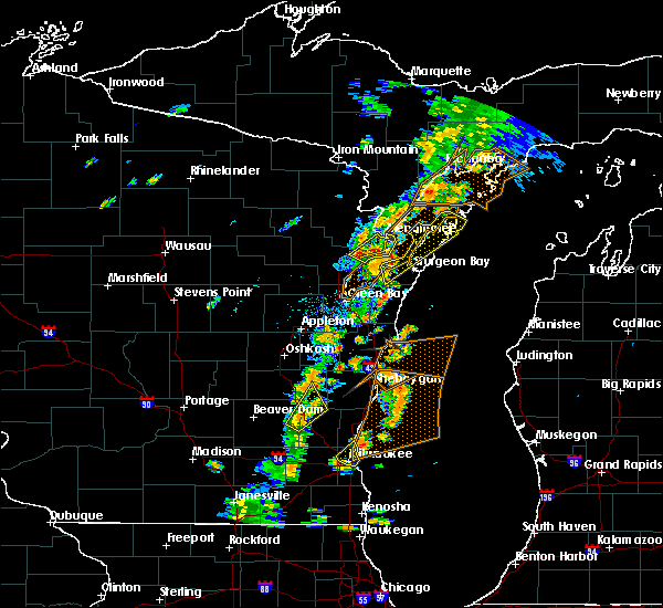 At 345 pm cdt, a severe thunderstorm was located 9 miles northwest of sturgeon bay, moving northeast at 60 mph (radar indicated). Hazards include 60 mph wind gusts. Expect damage to roofs, siding, and trees. locations impacted include, sturgeon bay, jacksonport, ephraim, egg harbor, newport state park, brussels, baileys harbor, sister bay, peninsula center and fish creek. A tornado watch remains in effect until 700 pm cdt for northeastern wisconsin. At 345 pm cdt, a severe thunderstorm was located 9 miles northwest of sturgeon bay, moving northeast at 60 mph (radar indicated). Hazards include 60 mph wind gusts. Expect damage to roofs, siding, and trees. locations impacted include, sturgeon bay, jacksonport, ephraim, egg harbor, newport state park, brussels, baileys harbor, sister bay, peninsula center and fish creek. A tornado watch remains in effect until 700 pm cdt for northeastern wisconsin.
|
| 7/1/2018 3:24 PM CDT |
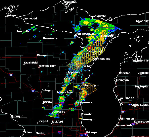 At 323 pm cdt, a severe thunderstorm was located near bay shore park, moving northeast at 60 mph (radar indicated). Hazards include 60 mph wind gusts. expect damage to roofs, siding, and trees At 323 pm cdt, a severe thunderstorm was located near bay shore park, moving northeast at 60 mph (radar indicated). Hazards include 60 mph wind gusts. expect damage to roofs, siding, and trees
|
| 7/6/2017 9:55 PM CDT |
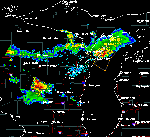 The severe thunderstorm warning for central door county will expire at 1000 pm cdt, the storms which prompted the warning have weakened below severe limits, and no longer pose an immediate threat to life or property. therefore the warning will be allowed to expire. however heavy rain is still possible with these thunderstorms. a severe thunderstorm watch remains in effect until midnight cdt for northeastern wisconsin. The severe thunderstorm warning for central door county will expire at 1000 pm cdt, the storms which prompted the warning have weakened below severe limits, and no longer pose an immediate threat to life or property. therefore the warning will be allowed to expire. however heavy rain is still possible with these thunderstorms. a severe thunderstorm watch remains in effect until midnight cdt for northeastern wisconsin.
|
| 7/6/2017 9:40 PM CDT |
 At 940 pm cdt, severe thunderstorms were located along a line extending from near newport state park to 6 miles northeast of jacksonport to 7 miles west of egg harbor, moving southeast at 65 mph (radar indicated). Hazards include 60 mph wind gusts and nickel size hail. Expect damage to roofs, siding, and trees. these severe storms will be near, jacksonport around 950 pm cdt. Other locations impacted by these severe thunderstorms include peninsula center, fish creek, peninsula state park, valmy, ellison bay, whitefish bay, rock island state park, carlsville, washington island and sister bay. At 940 pm cdt, severe thunderstorms were located along a line extending from near newport state park to 6 miles northeast of jacksonport to 7 miles west of egg harbor, moving southeast at 65 mph (radar indicated). Hazards include 60 mph wind gusts and nickel size hail. Expect damage to roofs, siding, and trees. these severe storms will be near, jacksonport around 950 pm cdt. Other locations impacted by these severe thunderstorms include peninsula center, fish creek, peninsula state park, valmy, ellison bay, whitefish bay, rock island state park, carlsville, washington island and sister bay.
|
| 7/6/2017 9:21 PM CDT |
 At 921 pm cdt, severe thunderstorms were located along a line extending from near cedar river to 12 miles northeast of menominee to 8 miles southeast of wausaukee, moving southeast at 55 mph (radar indicated). Hazards include 70 mph wind gusts and nickel size hail. Expect considerable tree damage. damage is likely to mobile homes, roofs, and outbuildings. these severe storms will be near, ephraim around 935 pm cdt. newport state park around 940 pm cdt. egg harbor around 955 pm cdt. jacksonport around 1000 pm cdt. Other locations impacted by these severe thunderstorms include peninsula center, fish creek, peninsula state park, valmy, ellison bay, whitefish bay, rock island state park, carlsville, washington island and sister bay. At 921 pm cdt, severe thunderstorms were located along a line extending from near cedar river to 12 miles northeast of menominee to 8 miles southeast of wausaukee, moving southeast at 55 mph (radar indicated). Hazards include 70 mph wind gusts and nickel size hail. Expect considerable tree damage. damage is likely to mobile homes, roofs, and outbuildings. these severe storms will be near, ephraim around 935 pm cdt. newport state park around 940 pm cdt. egg harbor around 955 pm cdt. jacksonport around 1000 pm cdt. Other locations impacted by these severe thunderstorms include peninsula center, fish creek, peninsula state park, valmy, ellison bay, whitefish bay, rock island state park, carlsville, washington island and sister bay.
|
| 7/6/2017 9:02 PM CDT |
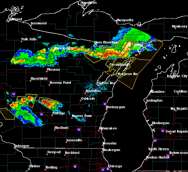 At 902 pm cdt, severe thunderstorms were located along a line extending from 11 miles southeast of escanaba to 10 miles east of cedar river to 6 miles northeast of stephenson, moving southeast at 45 mph (radar indicated). Hazards include 70 mph wind gusts and nickel size hail. Expect considerable tree damage. damage is likely to mobile homes, roofs, and outbuildings. severe thunderstorms will be near, newport state park around 920 pm cdt. ephraim around 935 pm cdt. Other locations impacted by these severe thunderstorms include peninsula center, fish creek, peninsula state park, valmy, ellison bay, whitefish bay, rock island state park, carlsville, washington island and sister bay. At 902 pm cdt, severe thunderstorms were located along a line extending from 11 miles southeast of escanaba to 10 miles east of cedar river to 6 miles northeast of stephenson, moving southeast at 45 mph (radar indicated). Hazards include 70 mph wind gusts and nickel size hail. Expect considerable tree damage. damage is likely to mobile homes, roofs, and outbuildings. severe thunderstorms will be near, newport state park around 920 pm cdt. ephraim around 935 pm cdt. Other locations impacted by these severe thunderstorms include peninsula center, fish creek, peninsula state park, valmy, ellison bay, whitefish bay, rock island state park, carlsville, washington island and sister bay.
|
| 6/16/2017 11:35 PM CDT |
 At 1135 pm cdt, a severe thunderstorm was located over jacksonport, or 11 miles northeast of sturgeon bay, moving northeast at 40 mph (radar indicated). Hazards include 60 mph wind gusts. Expect damage to roofs, siding, and trees. Locations impacted include, sturgeon bay, jacksonport, egg harbor, whitefish bay, clay banks, peninsula center, valmy, institute, potawatomi state park and whitefish dunes state park. At 1135 pm cdt, a severe thunderstorm was located over jacksonport, or 11 miles northeast of sturgeon bay, moving northeast at 40 mph (radar indicated). Hazards include 60 mph wind gusts. Expect damage to roofs, siding, and trees. Locations impacted include, sturgeon bay, jacksonport, egg harbor, whitefish bay, clay banks, peninsula center, valmy, institute, potawatomi state park and whitefish dunes state park.
|
| 6/16/2017 11:19 PM CDT |
 At 1119 pm cdt, severe thunderstorms were located along a line extending from near ephraim to near algoma to 6 miles north of kewaunee, moving east at 45 mph (radar indicated). Hazards include 60 mph wind gusts. Expect damage to roofs, siding, and trees. These severe thunderstorms will remain over mainly rural areas of door county, including the following locations: brussels, peninsula center, valmy, whitefish bay, shoemaker point, carlsville, namur, vignes, maplewood and institute. At 1119 pm cdt, severe thunderstorms were located along a line extending from near ephraim to near algoma to 6 miles north of kewaunee, moving east at 45 mph (radar indicated). Hazards include 60 mph wind gusts. Expect damage to roofs, siding, and trees. These severe thunderstorms will remain over mainly rural areas of door county, including the following locations: brussels, peninsula center, valmy, whitefish bay, shoemaker point, carlsville, namur, vignes, maplewood and institute.
|
| 6/16/2017 11:05 PM CDT |
 At 1105 pm cdt, severe thunderstorms were located along a line extending from near egg harbor to 8 miles east of bay shore park to near luxemburg, moving east at 35 mph (radar indicated). Hazards include 60 mph wind gusts. Expect damage to roofs, siding, and trees. these severe storms will be near, egg harbor around 1115 pm cdt. algoma around 1120 pm cdt. jacksonport around 1125 pm cdt. Other locations impacted by these severe thunderstorms include valmy, slovan, gregorville, rankin, euren, whitefish bay, carlsville, vignes, maplewood and institute. At 1105 pm cdt, severe thunderstorms were located along a line extending from near egg harbor to 8 miles east of bay shore park to near luxemburg, moving east at 35 mph (radar indicated). Hazards include 60 mph wind gusts. Expect damage to roofs, siding, and trees. these severe storms will be near, egg harbor around 1115 pm cdt. algoma around 1120 pm cdt. jacksonport around 1125 pm cdt. Other locations impacted by these severe thunderstorms include valmy, slovan, gregorville, rankin, euren, whitefish bay, carlsville, vignes, maplewood and institute.
|
| 6/16/2017 10:52 PM CDT |
 At 1051 pm cdt, severe thunderstorms were located along a line extending from near marinette to bay shore park to near bellevue town, moving northeast at 35 mph (radar indicated). Hazards include 60 mph wind gusts. Expect damage to roofs, siding, and trees. severe thunderstorms will be near, egg harbor around 1110 pm cdt. sturgeon bay around 1135 pm cdt. jacksonport around 1145 pm cdt. Other locations impacted by these severe thunderstorms include valmy, slovan, gregorville, rankin, euren, humboldt, whitefish bay, carlsville, vignes and maplewood. At 1051 pm cdt, severe thunderstorms were located along a line extending from near marinette to bay shore park to near bellevue town, moving northeast at 35 mph (radar indicated). Hazards include 60 mph wind gusts. Expect damage to roofs, siding, and trees. severe thunderstorms will be near, egg harbor around 1110 pm cdt. sturgeon bay around 1135 pm cdt. jacksonport around 1145 pm cdt. Other locations impacted by these severe thunderstorms include valmy, slovan, gregorville, rankin, euren, humboldt, whitefish bay, carlsville, vignes and maplewood.
|
| 6/14/2017 5:00 PM CDT | Damage reported across the count in door county WI, 0.3 miles ESE of Sturgeon Bay, WI |
| 6/14/2017 4:55 PM CDT |
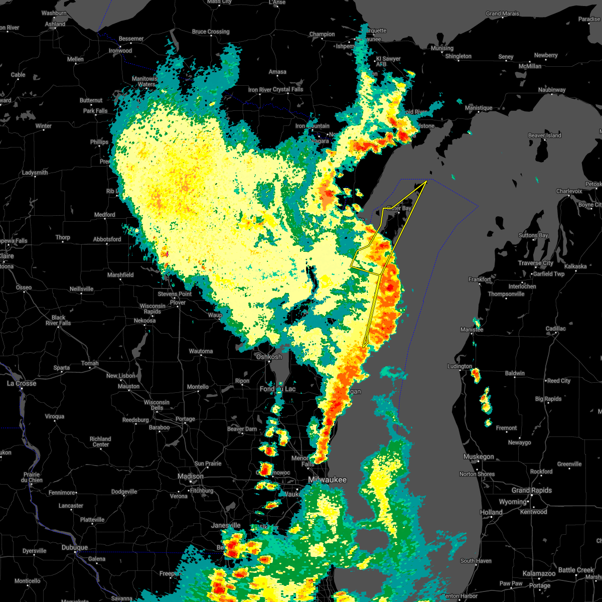 At 454 pm cdt, severe thunderstorms were located along a line extending from near egg harbor to 19 miles east of algoma to 16 miles east of manitowoc, moving northeast at 65 mph (radar indicated). Hazards include 60 mph wind gusts and penny size hail. Expect damage to roofs, siding, and trees. these severe storms will be near, ephraim and egg harbor around 500 pm cdt. Other locations impacted by these severe thunderstorms include peninsula center, fish creek, peninsula state park, valmy, ellison bay, whitefish bay, carlsville, vignes, washington island and maplewood. At 454 pm cdt, severe thunderstorms were located along a line extending from near egg harbor to 19 miles east of algoma to 16 miles east of manitowoc, moving northeast at 65 mph (radar indicated). Hazards include 60 mph wind gusts and penny size hail. Expect damage to roofs, siding, and trees. these severe storms will be near, ephraim and egg harbor around 500 pm cdt. Other locations impacted by these severe thunderstorms include peninsula center, fish creek, peninsula state park, valmy, ellison bay, whitefish bay, carlsville, vignes, washington island and maplewood.
|
| 6/14/2017 4:41 PM CDT |
 At 441 pm cdt, severe thunderstorms were located along a line extending from 6 miles south of marinette to 11 miles southeast of algoma to 9 miles east of cleveland, moving northeast at 50 mph (radar indicated). Hazards include 60 mph wind gusts and penny size hail. Expect damage to roofs, siding, and trees. these severe storms will be near, egg harbor around 500 pm cdt. Other locations impacted by these severe thunderstorms include mishicot, peninsula state park, valmy, gregorville, two rivers, rankin, whitefish bay, carlsville, vignes and maplewood. At 441 pm cdt, severe thunderstorms were located along a line extending from 6 miles south of marinette to 11 miles southeast of algoma to 9 miles east of cleveland, moving northeast at 50 mph (radar indicated). Hazards include 60 mph wind gusts and penny size hail. Expect damage to roofs, siding, and trees. these severe storms will be near, egg harbor around 500 pm cdt. Other locations impacted by these severe thunderstorms include mishicot, peninsula state park, valmy, gregorville, two rivers, rankin, whitefish bay, carlsville, vignes and maplewood.
|
| 6/14/2017 4:30 PM CDT |
 At 429 pm cdt, severe thunderstorms were located along a line extending from near oconto to near kewaunee to 7 miles south of manitowoc, moving northeast at 50 mph (radar indicated). Hazards include 70 mph wind gusts and penny size hail. Expect considerable tree damage. damage is likely to mobile homes, roofs, and outbuildings. these severe storms will be near, egg harbor around 500 pm cdt. Other locations impacted by these severe thunderstorms include krok, maribel, peninsula state park, larrabee, valmy, curran, slovan, gregorville, rankin and carlsville. At 429 pm cdt, severe thunderstorms were located along a line extending from near oconto to near kewaunee to 7 miles south of manitowoc, moving northeast at 50 mph (radar indicated). Hazards include 70 mph wind gusts and penny size hail. Expect considerable tree damage. damage is likely to mobile homes, roofs, and outbuildings. these severe storms will be near, egg harbor around 500 pm cdt. Other locations impacted by these severe thunderstorms include krok, maribel, peninsula state park, larrabee, valmy, curran, slovan, gregorville, rankin and carlsville.
|
| 6/14/2017 4:23 PM CDT |
 At 423 pm cdt, severe thunderstorms were located along a line extending from near oconto to near kewaunee to 8 miles southeast of manitowoc, moving northeast at 65 mph (radar indicated). Hazards include 70 mph wind gusts and penny size hail. Expect considerable tree damage. damage is likely to mobile homes, roofs, and outbuildings. these severe storms will be near, egg harbor around 450 pm cdt. ephraim around 455 pm cdt. newport state park around 500 pm cdt. Other locations impacted by these severe thunderstorms include krok, maribel, peninsula state park, larrabee, valmy, curran, slovan, gregorville, rankin and rock island state park. At 423 pm cdt, severe thunderstorms were located along a line extending from near oconto to near kewaunee to 8 miles southeast of manitowoc, moving northeast at 65 mph (radar indicated). Hazards include 70 mph wind gusts and penny size hail. Expect considerable tree damage. damage is likely to mobile homes, roofs, and outbuildings. these severe storms will be near, egg harbor around 450 pm cdt. ephraim around 455 pm cdt. newport state park around 500 pm cdt. Other locations impacted by these severe thunderstorms include krok, maribel, peninsula state park, larrabee, valmy, curran, slovan, gregorville, rankin and rock island state park.
|
| 6/14/2017 4:00 PM CDT |
 At 400 pm cdt, severe thunderstorms were located along a line extending from near pulaski to near denmark to near elkhart lake, moving northeast at 65 mph (radar indicated). Hazards include 70 mph wind gusts. Expect considerable tree damage. Damage is likely to mobile homes, roofs, and outbuildings. At 400 pm cdt, severe thunderstorms were located along a line extending from near pulaski to near denmark to near elkhart lake, moving northeast at 65 mph (radar indicated). Hazards include 70 mph wind gusts. Expect considerable tree damage. Damage is likely to mobile homes, roofs, and outbuildings.
|
| 6/11/2017 2:05 PM CDT |
 At 204 pm cdt, severe thunderstorms were located along a line extending from 11 miles east of cedar river to near egg harbor to near jacksonport to 6 miles south of sturgeon bay, moving east at 60 mph (radar indicated). Hazards include 60 mph wind gusts and penny size hail. Expect damage to roofs, siding, and trees. Locations impacted include, sturgeon bay, jacksonport, ephraim, egg harbor, newport state park, whitefish bay, baileys harbor, sister bay, forestville and clay banks. At 204 pm cdt, severe thunderstorms were located along a line extending from 11 miles east of cedar river to near egg harbor to near jacksonport to 6 miles south of sturgeon bay, moving east at 60 mph (radar indicated). Hazards include 60 mph wind gusts and penny size hail. Expect damage to roofs, siding, and trees. Locations impacted include, sturgeon bay, jacksonport, ephraim, egg harbor, newport state park, whitefish bay, baileys harbor, sister bay, forestville and clay banks.
|
| 6/11/2017 1:58 PM CDT |
 At 157 pm cdt, severe thunderstorms were located along a line extending from near cedar river to near egg harbor to near jacksonport to 9 miles southwest of sturgeon bay, moving east at 60 mph (radar indicated). Hazards include 60 mph wind gusts and penny size hail. Expect damage to roofs, siding, and trees. Locations impacted include, sturgeon bay, jacksonport, ephraim, egg harbor, newport state park, whitefish bay, brussels, baileys harbor, sister bay and forestville. At 157 pm cdt, severe thunderstorms were located along a line extending from near cedar river to near egg harbor to near jacksonport to 9 miles southwest of sturgeon bay, moving east at 60 mph (radar indicated). Hazards include 60 mph wind gusts and penny size hail. Expect damage to roofs, siding, and trees. Locations impacted include, sturgeon bay, jacksonport, ephraim, egg harbor, newport state park, whitefish bay, brussels, baileys harbor, sister bay and forestville.
|
| 6/11/2017 1:55 PM CDT | Trees and powerlines down in the cities of sturgeon bay... baileys harbor... fish creek... and sister bay. delayed report. time estimated for sturgeon ba in door county WI, 0.3 miles ESE of Sturgeon Bay, WI |
| 6/11/2017 1:49 PM CDT |
 At 149 pm cdt, severe thunderstorms were located along a line extending from near cedar river to near menominee to 9 miles northwest of sturgeon bay to 8 miles northeast of bay shore park, moving east at 60 mph (radar indicated). Hazards include 60 mph wind gusts and penny size hail. Expect damage to roofs, siding, and trees. Locations impacted include, sturgeon bay, jacksonport, ephraim, egg harbor, newport state park, whitefish bay, brussels, baileys harbor, sister bay and forestville. At 149 pm cdt, severe thunderstorms were located along a line extending from near cedar river to near menominee to 9 miles northwest of sturgeon bay to 8 miles northeast of bay shore park, moving east at 60 mph (radar indicated). Hazards include 60 mph wind gusts and penny size hail. Expect damage to roofs, siding, and trees. Locations impacted include, sturgeon bay, jacksonport, ephraim, egg harbor, newport state park, whitefish bay, brussels, baileys harbor, sister bay and forestville.
|
| 6/11/2017 1:38 PM CDT |
 At 137 pm cdt, severe thunderstorms were located along a line extending from near stephenson to 10 miles south of marinette to 9 miles northwest of bay shore park, moving east at 55 mph (radar indicated). Hazards include 60 mph wind gusts and penny size hail. Expect damage to roofs, siding, and trees. severe thunderstorms will be near, egg harbor around 200 pm cdt. jacksonport around 205 pm cdt. sturgeon bay around 210 pm cdt. Other locations impacted by these severe thunderstorms include brussels, peninsula center, fish creek, peninsula state park, valmy, ellison bay, whitefish bay, rock island state park, shoemaker point and carlsville. At 137 pm cdt, severe thunderstorms were located along a line extending from near stephenson to 10 miles south of marinette to 9 miles northwest of bay shore park, moving east at 55 mph (radar indicated). Hazards include 60 mph wind gusts and penny size hail. Expect damage to roofs, siding, and trees. severe thunderstorms will be near, egg harbor around 200 pm cdt. jacksonport around 205 pm cdt. sturgeon bay around 210 pm cdt. Other locations impacted by these severe thunderstorms include brussels, peninsula center, fish creek, peninsula state park, valmy, ellison bay, whitefish bay, rock island state park, shoemaker point and carlsville.
|
| 6/3/2017 7:58 PM CDT |
 At 757 pm cdt, severe thunderstorms were located along a line extending from near newport state park to jacksonport to 9 miles west of sturgeon bay, moving east at 35 mph (radar indicated). Hazards include 60 mph wind gusts and quarter size hail. Hail damage to vehicles is expected. expect wind damage to roofs, siding, and trees. Locations impacted include, marinette, sturgeon bay, menominee, jacksonport, ephraim, egg harbor, newport state park, whitefish bay, brussels and baileys harbor. At 757 pm cdt, severe thunderstorms were located along a line extending from near newport state park to jacksonport to 9 miles west of sturgeon bay, moving east at 35 mph (radar indicated). Hazards include 60 mph wind gusts and quarter size hail. Hail damage to vehicles is expected. expect wind damage to roofs, siding, and trees. Locations impacted include, marinette, sturgeon bay, menominee, jacksonport, ephraim, egg harbor, newport state park, whitefish bay, brussels and baileys harbor.
|
| 6/3/2017 7:15 PM CDT |
 At 715 pm cdt, severe thunderstorms were located along a line extending from 7 miles south of cedar river to near marinette to 10 miles southeast of pound, moving east at 45 mph (radar indicated). Hazards include 60 mph wind gusts and quarter size hail. Hail damage to vehicles is expected. expect wind damage to roofs, siding, and trees. severe thunderstorms will be near, ephraim around 730 pm cdt. egg harbor around 735 pm cdt. jacksonport and newport state park around 740 pm cdt. sturgeon bay around 750 pm cdt. Other locations impacted by these severe thunderstorms include peninsula state park, valmy, whitefish bay, rock island state park, carlsville, vignes, maplewood, sister bay, institute and potawatomi state park. At 715 pm cdt, severe thunderstorms were located along a line extending from 7 miles south of cedar river to near marinette to 10 miles southeast of pound, moving east at 45 mph (radar indicated). Hazards include 60 mph wind gusts and quarter size hail. Hail damage to vehicles is expected. expect wind damage to roofs, siding, and trees. severe thunderstorms will be near, ephraim around 730 pm cdt. egg harbor around 735 pm cdt. jacksonport and newport state park around 740 pm cdt. sturgeon bay around 750 pm cdt. Other locations impacted by these severe thunderstorms include peninsula state park, valmy, whitefish bay, rock island state park, carlsville, vignes, maplewood, sister bay, institute and potawatomi state park.
|
| 5/17/2017 11:25 PM CDT |
 The severe thunderstorm warning for northeastern kewaunee and door counties will expire at 1130 pm cdt, the storms which prompted the warning have weakened below severe limits, and no longer pose an immediate threat to life or property. therefore the warning will be allowed to expire. however gusty winds are still possible with these thunderstorms. The severe thunderstorm warning for northeastern kewaunee and door counties will expire at 1130 pm cdt, the storms which prompted the warning have weakened below severe limits, and no longer pose an immediate threat to life or property. therefore the warning will be allowed to expire. however gusty winds are still possible with these thunderstorms.
|
| 5/17/2017 11:12 PM CDT |
 At 1112 pm cdt, severe thunderstorms were located along a line extending from 8 miles southeast of marinette to near sturgeon bay to near algoma, moving northeast at 65 mph (radar indicated). Hazards include 60 mph wind gusts. Expect damage to roofs, siding, and trees. these severe storms will be near, jacksonport and egg harbor around 1125 pm cdt. ephraim around 1130 pm cdt. other locations impacted by these severe thunderstorms include peninsula state park, valmy, gregorville, whitefish bay, carlsville, vignes, maplewood, sister bay, institute and potawatomi state park. A tornado watch remains in effect until 100 am cdt for northeastern wisconsin. At 1112 pm cdt, severe thunderstorms were located along a line extending from 8 miles southeast of marinette to near sturgeon bay to near algoma, moving northeast at 65 mph (radar indicated). Hazards include 60 mph wind gusts. Expect damage to roofs, siding, and trees. these severe storms will be near, jacksonport and egg harbor around 1125 pm cdt. ephraim around 1130 pm cdt. other locations impacted by these severe thunderstorms include peninsula state park, valmy, gregorville, whitefish bay, carlsville, vignes, maplewood, sister bay, institute and potawatomi state park. A tornado watch remains in effect until 100 am cdt for northeastern wisconsin.
|
| 5/17/2017 10:48 PM CDT |
 The national weather service in green bay has issued a * severe thunderstorm warning for. northern kewaunee county in northeastern wisconsin. door county in northeastern wisconsin. until 1130 pm cdt. At 1048 pm cdt, severe thunderstorms were located along a line. The national weather service in green bay has issued a * severe thunderstorm warning for. northern kewaunee county in northeastern wisconsin. door county in northeastern wisconsin. until 1130 pm cdt. At 1048 pm cdt, severe thunderstorms were located along a line.
|
| 7/21/2016 8:56 AM CDT |
 The severe thunderstorm warning for door county will expire at 900 am cdt, the storms which prompted the warning have moved out of the area. therefore the warning will be allowed to expire. however heavy rain is still possible with these thunderstorms. a severe thunderstorm watch remains in effect until 1100 am cdt for northeastern wisconsin. The severe thunderstorm warning for door county will expire at 900 am cdt, the storms which prompted the warning have moved out of the area. therefore the warning will be allowed to expire. however heavy rain is still possible with these thunderstorms. a severe thunderstorm watch remains in effect until 1100 am cdt for northeastern wisconsin.
|
| 7/21/2016 8:43 AM CDT |
 At 843 am cdt, severe thunderstorms were located along a line extending from 14 miles southeast of newport state park to 8 miles northwest of algoma, moving east at 50 mph (radar indicated). Hazards include 70 mph wind gusts and nickel size hail. Expect considerable tree damage. damage is likely to mobile homes, roofs, and outbuildings. Locations impacted include, sturgeon bay, jacksonport, egg harbor, whitefish bay, brussels, baileys harbor, forestville, clay banks, carlsville and peninsula center. At 843 am cdt, severe thunderstorms were located along a line extending from 14 miles southeast of newport state park to 8 miles northwest of algoma, moving east at 50 mph (radar indicated). Hazards include 70 mph wind gusts and nickel size hail. Expect considerable tree damage. damage is likely to mobile homes, roofs, and outbuildings. Locations impacted include, sturgeon bay, jacksonport, egg harbor, whitefish bay, brussels, baileys harbor, forestville, clay banks, carlsville and peninsula center.
|
| 7/21/2016 8:40 AM CDT | A couple trees down just north of sturgeon bay on reynolds road and just south of sturgeon bay...near clay bank in door county WI, 0.3 miles ESE of Sturgeon Bay, WI |
| 7/21/2016 8:27 AM CDT |
 At 827 am cdt, severe thunderstorms were located along a line extending from 6 miles south of newport state park to 6 miles north of bay shore park, moving southeast at 35 mph (radar indicated). Hazards include 70 mph wind gusts and nickel size hail. Expect considerable tree damage. damage is likely to mobile homes, roofs, and outbuildings. These severe thunderstorms will remain over mainly rural areas of door county, including the following locations: carlsville, peninsula center, washington island, shoemaker point, rock island state park, rosiere, maplewood, baileys harbor, namur and valmy. At 827 am cdt, severe thunderstorms were located along a line extending from 6 miles south of newport state park to 6 miles north of bay shore park, moving southeast at 35 mph (radar indicated). Hazards include 70 mph wind gusts and nickel size hail. Expect considerable tree damage. damage is likely to mobile homes, roofs, and outbuildings. These severe thunderstorms will remain over mainly rural areas of door county, including the following locations: carlsville, peninsula center, washington island, shoemaker point, rock island state park, rosiere, maplewood, baileys harbor, namur and valmy.
|
| 7/21/2016 7:55 AM CDT |
 At 755 am cdt, severe thunderstorms were located along a line extending from 9 miles south of escanaba to 8 miles northeast of oconto, moving east at 40 mph (radar indicated). Hazards include 60 mph wind gusts and nickel size hail. Expect damage to roofs. siding. and trees. severe thunderstorms will be near, sturgeon bay around 825 am cdt. jacksonport around 835 am cdt. Other locations impacted by these severe thunderstorms include carlsville, peninsula center, washington island, shoemaker point, rock island state park, rosiere, maplewood, baileys harbor, namur and valmy. At 755 am cdt, severe thunderstorms were located along a line extending from 9 miles south of escanaba to 8 miles northeast of oconto, moving east at 40 mph (radar indicated). Hazards include 60 mph wind gusts and nickel size hail. Expect damage to roofs. siding. and trees. severe thunderstorms will be near, sturgeon bay around 825 am cdt. jacksonport around 835 am cdt. Other locations impacted by these severe thunderstorms include carlsville, peninsula center, washington island, shoemaker point, rock island state park, rosiere, maplewood, baileys harbor, namur and valmy.
|
| 8/2/2015 2:38 PM CDT |
 At 237 pm cdt, a severe thunderstorm was located near sturgeon bay, moving east at 40 mph. another severe thunderstorm was located near pensaukee (radar indicated). Hazards include 60 mph wind gusts and quarter size hail. Hail damage to vehicles is expected. expect wind damage to roofs, siding and trees. Locations impacted include, sturgeon bay, oconto, pensaukee, brussels, forestville, clay banks, carnot, maplewood, kolberg, cullen, potawatomi state park, institute, valmy, vignes and namur. At 237 pm cdt, a severe thunderstorm was located near sturgeon bay, moving east at 40 mph. another severe thunderstorm was located near pensaukee (radar indicated). Hazards include 60 mph wind gusts and quarter size hail. Hail damage to vehicles is expected. expect wind damage to roofs, siding and trees. Locations impacted include, sturgeon bay, oconto, pensaukee, brussels, forestville, clay banks, carnot, maplewood, kolberg, cullen, potawatomi state park, institute, valmy, vignes and namur.
|
| 8/2/2015 2:21 PM CDT |
 At 220 pm cdt, severe thunderstorms were located along a line extending from 9 miles east of newport state park to sturgeon bay, moving southeast at 45 mph. spotters have reported 45 to 50 mph winds and sporadic power outages (radar indicated). Hazards include 60 mph wind gusts and quarter size hail. Hail damage to vehicles is expected. expect wind damage to roofs, siding and trees. Locations impacted include, sturgeon bay, jacksonport, ephraim, egg harbor, newport state park, baileys harbor, sister bay, clay banks, carnot, carlsville, potawatomi state park, fish creek, rock island state park, institute, peninsula center, washington island, valmy, whitefish dunes state park and vignes. At 220 pm cdt, severe thunderstorms were located along a line extending from 9 miles east of newport state park to sturgeon bay, moving southeast at 45 mph. spotters have reported 45 to 50 mph winds and sporadic power outages (radar indicated). Hazards include 60 mph wind gusts and quarter size hail. Hail damage to vehicles is expected. expect wind damage to roofs, siding and trees. Locations impacted include, sturgeon bay, jacksonport, ephraim, egg harbor, newport state park, baileys harbor, sister bay, clay banks, carnot, carlsville, potawatomi state park, fish creek, rock island state park, institute, peninsula center, washington island, valmy, whitefish dunes state park and vignes.
|
| 8/2/2015 2:16 PM CDT |
 At 215 pm cdt, a severe thunderstorm was located near oconto, or 13 miles north of bay shore park, moving east at 40 mph (radar indicated). Hazards include 60 mph wind gusts and quarter size hail. Hail damage to vehicles is expected. expect wind damage to roofs, siding and trees. this severe thunderstorm will be near, sturgeon bay around 250 pm cdt. Other locations impacted by this severe thunderstorm include carnot, pensaukee, maplewood, clay banks, cullen, kolberg, potawatomi state park, institute, valmy and namur. At 215 pm cdt, a severe thunderstorm was located near oconto, or 13 miles north of bay shore park, moving east at 40 mph (radar indicated). Hazards include 60 mph wind gusts and quarter size hail. Hail damage to vehicles is expected. expect wind damage to roofs, siding and trees. this severe thunderstorm will be near, sturgeon bay around 250 pm cdt. Other locations impacted by this severe thunderstorm include carnot, pensaukee, maplewood, clay banks, cullen, kolberg, potawatomi state park, institute, valmy and namur.
|
| 8/2/2015 2:07 PM CDT |
 At 206 pm cdt, severe thunderstorms were located along a line extending from newport state park to 7 miles west of sturgeon bay, moving southeast at 55 mph (radar indicated). Hazards include 60 mph wind gusts and quarter size hail. Hail damage to vehicles is expected. expect wind damage to roofs, siding and trees. Locations impacted include, sturgeon bay, jacksonport, ephraim, egg harbor, newport state park, baileys harbor, sister bay, clay banks, carnot, carlsville, potawatomi state park, fish creek, rock island state park, institute, peninsula center, washington island, valmy, whitefish dunes state park and vignes. At 206 pm cdt, severe thunderstorms were located along a line extending from newport state park to 7 miles west of sturgeon bay, moving southeast at 55 mph (radar indicated). Hazards include 60 mph wind gusts and quarter size hail. Hail damage to vehicles is expected. expect wind damage to roofs, siding and trees. Locations impacted include, sturgeon bay, jacksonport, ephraim, egg harbor, newport state park, baileys harbor, sister bay, clay banks, carnot, carlsville, potawatomi state park, fish creek, rock island state park, institute, peninsula center, washington island, valmy, whitefish dunes state park and vignes.
|
| 8/2/2015 1:54 PM CDT |
 At 153 pm cdt, severe thunderstorms were located along a line extending from 8 miles east of cedar river to 8 miles southwest of marinette, moving southeast at 45 mph. wind gusts to 63 mph were reported at menominee michigan (radar indicated). Hazards include 60 mph wind gusts and quarter size hail. Hail damage to vehicles is expected. Expect wind damage to roofs, siding and trees. At 153 pm cdt, severe thunderstorms were located along a line extending from 8 miles east of cedar river to 8 miles southwest of marinette, moving southeast at 45 mph. wind gusts to 63 mph were reported at menominee michigan (radar indicated). Hazards include 60 mph wind gusts and quarter size hail. Hail damage to vehicles is expected. Expect wind damage to roofs, siding and trees.
|
| 7/14/2014 10:41 PM CDT | Quarter sized hail reported 4.2 miles SSW of Sturgeon Bay, WI, three to four inches of hail covered the roads. |
| 1/1/0001 12:00 AM | Trees and power lines down in sturgeon bay and across the rest of southern door county in door county WI, 0.3 miles ESE of Sturgeon Bay, WI |
Hail Maps for Sturgeon Bay, WI
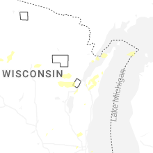


Connect with Interactive Hail Maps