

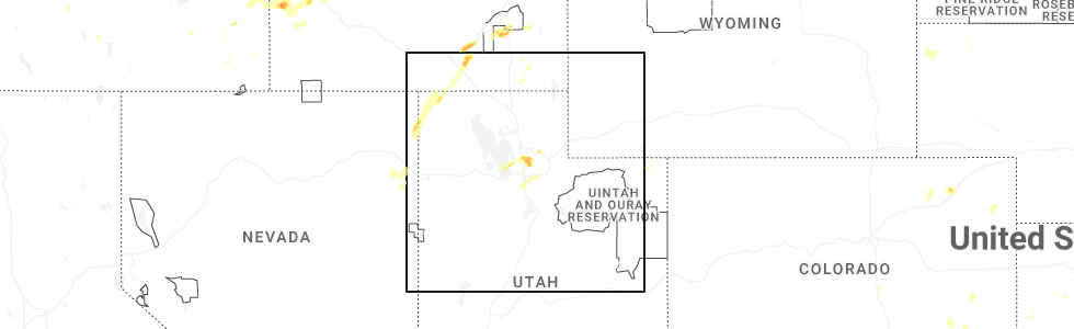
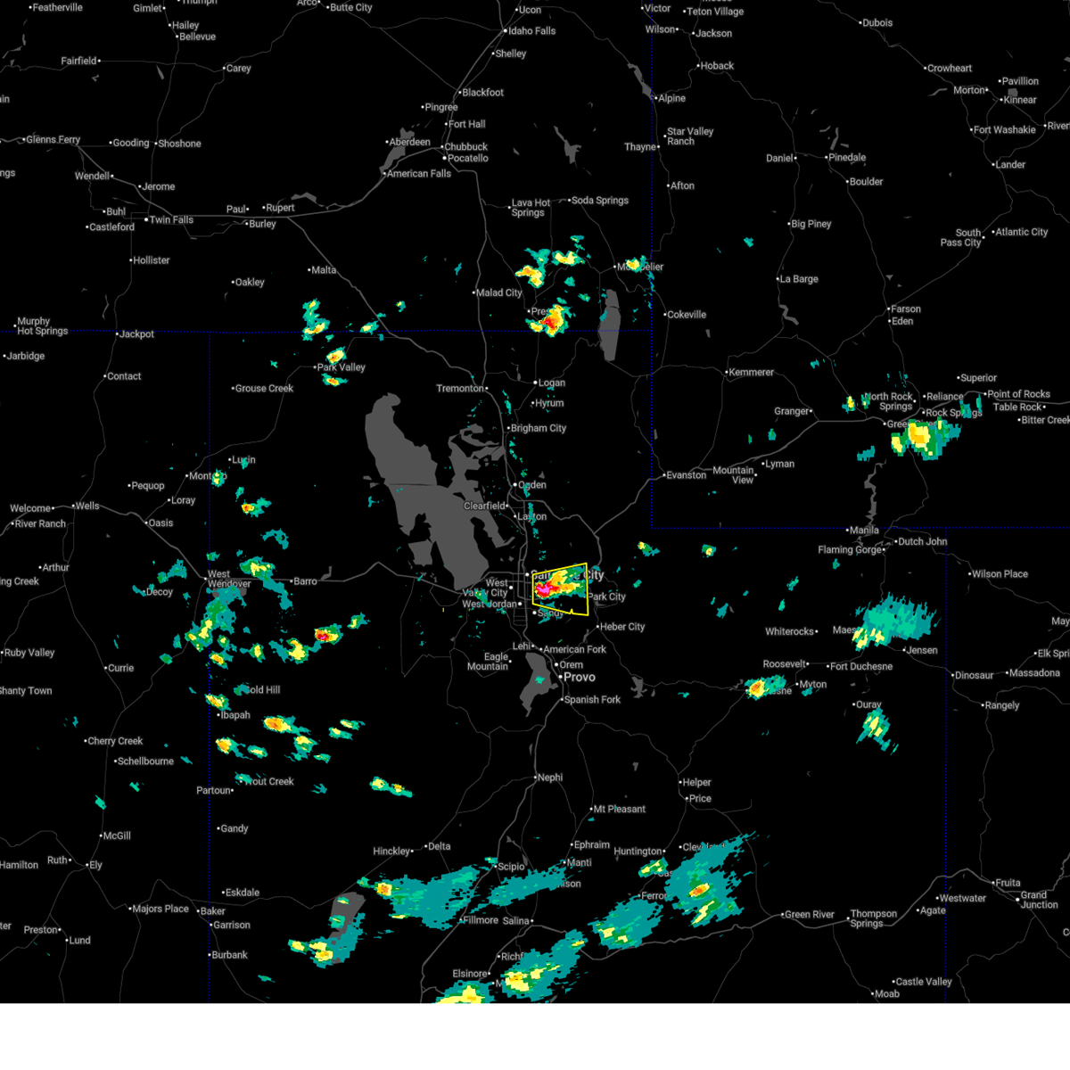
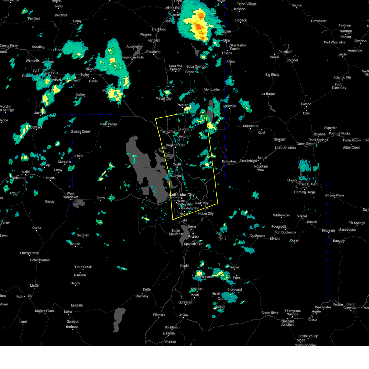
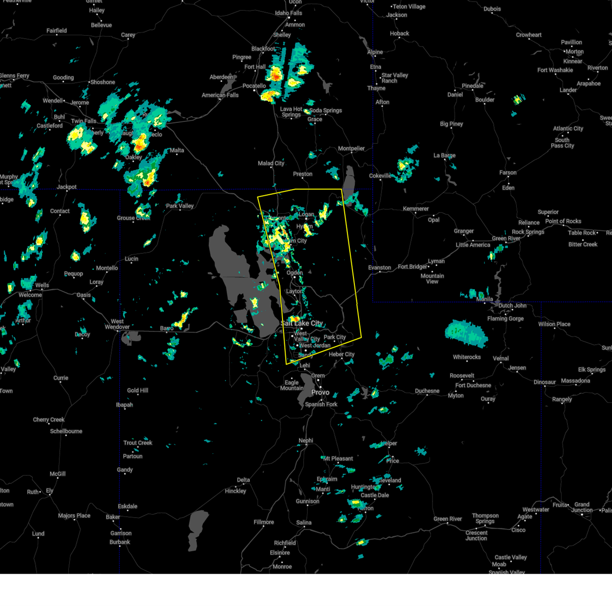
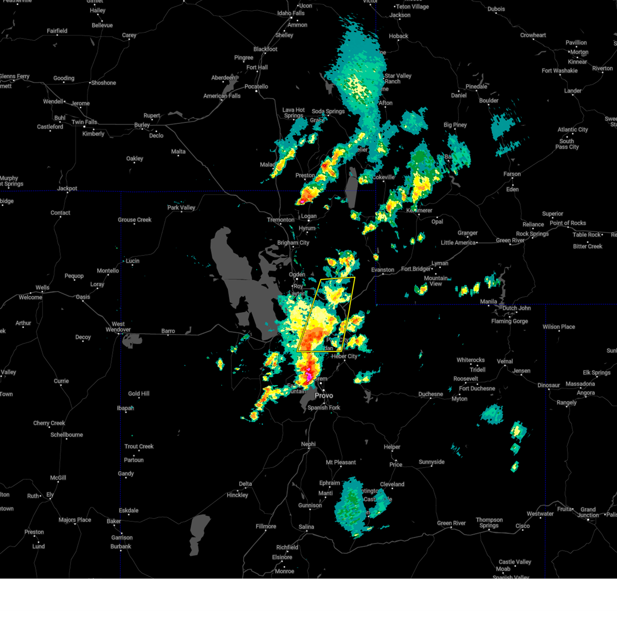
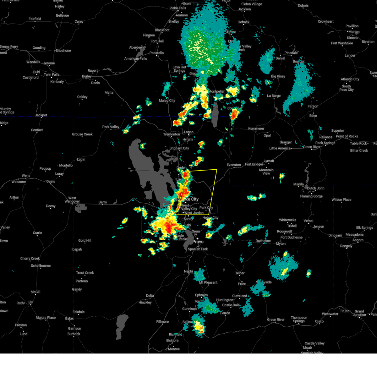
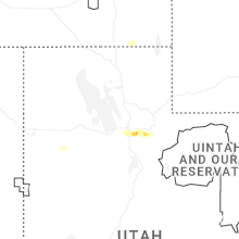
Hail Map for Summit Park, UT
The Summit Park, UT area has had 0 reports of on-the-ground hail by trained spotters, and has been under severe weather warnings 7 times during the past 12 months. Doppler radar has detected hail at or near Summit Park, UT on 7 occasions, including 2 occasions during the past year.
| Name: | Summit Park, UT |
| Where Located: | 17.1 miles E of Salt Lake City, UT |
| Map: | Google Map for Summit Park, UT |
| Population: | 7775 |
| Housing Units: | 3184 |
| More Info: | Search Google for Summit Park, UT |
5
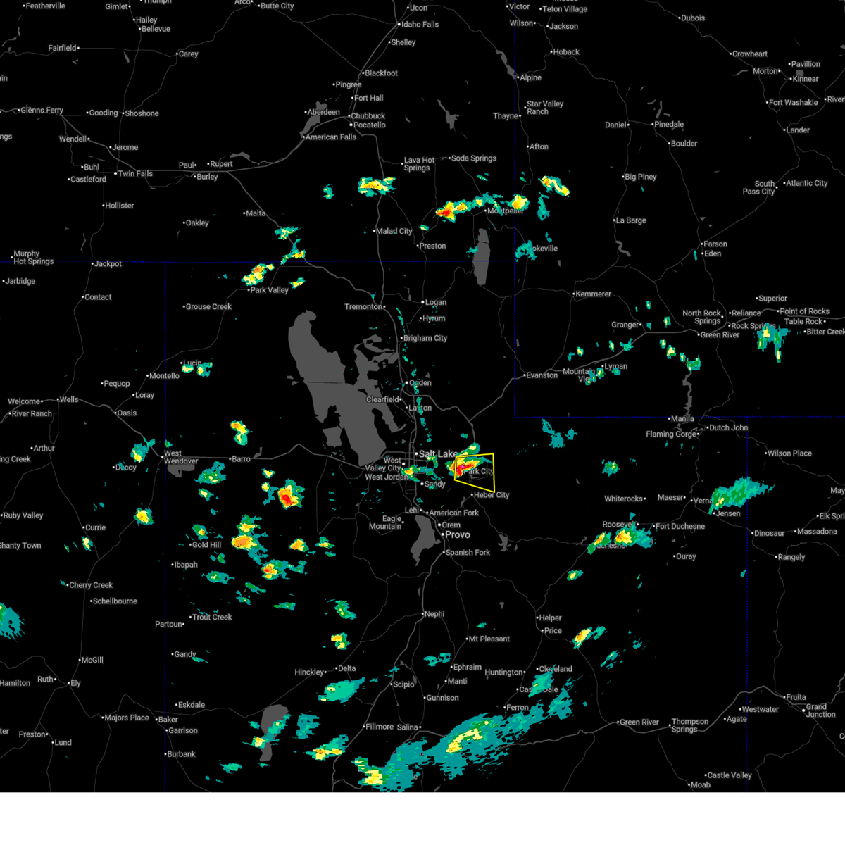
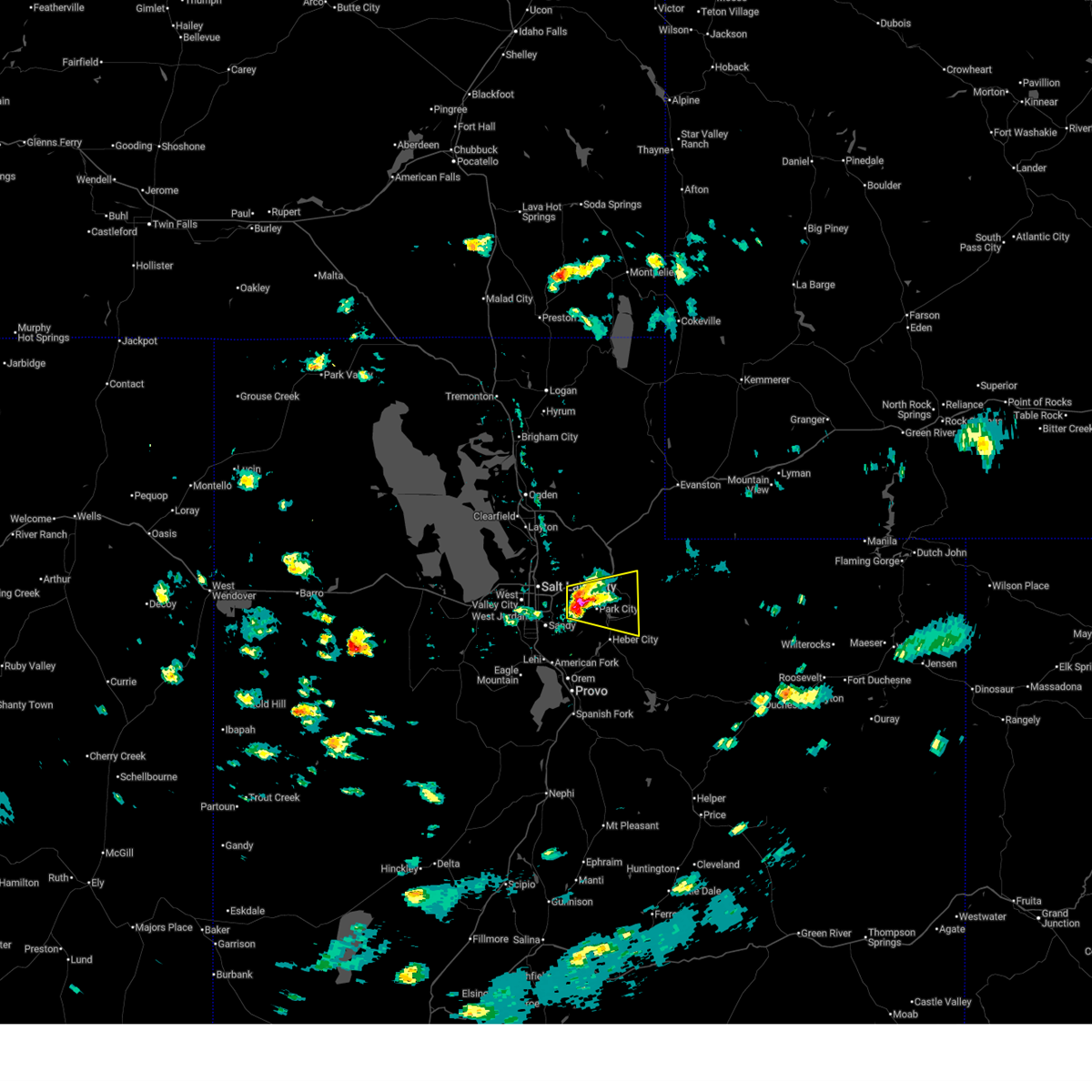
The Top Recent Hail Date for Summit Park, UT is Friday, July 4, 2025 (1st out of 7)
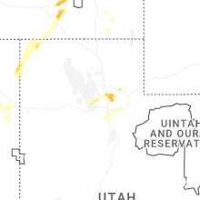
Hail and Wind Damage Spotted near Summit Park, UT
| Date / Time | Report Details |
|---|---|
| 6/25/2026 4:03 PM MDT |
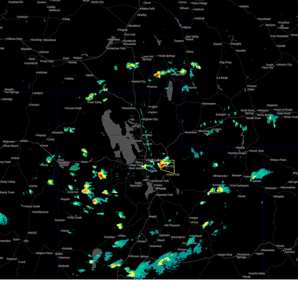 At 402 pm mdt, a severe thunderstorm was located over park city, moving east at 20 mph (radar indicated). Hazards include 60 mph wind gusts and quarter size hail. Hail damage to vehicles is expected. expect wind damage to roofs, siding, and trees. locations impacted include, park city, kamas, oakley, francis, south snyderville basin, samak, north snyderville basin, peoa, woodland, snyderville, kimball junction, marion, hailstone, jordanelle reservoir, and brighton. this includes the following highways, interstate 80 in utah between mile markers 144 and 148. us route 40 between mile markers 0 and 13. utah route 35 between mile markers 0 and 4. Mirror lake highway between mile markers 0 and 3. At 402 pm mdt, a severe thunderstorm was located over park city, moving east at 20 mph (radar indicated). Hazards include 60 mph wind gusts and quarter size hail. Hail damage to vehicles is expected. expect wind damage to roofs, siding, and trees. locations impacted include, park city, kamas, oakley, francis, south snyderville basin, samak, north snyderville basin, peoa, woodland, snyderville, kimball junction, marion, hailstone, jordanelle reservoir, and brighton. this includes the following highways, interstate 80 in utah between mile markers 144 and 148. us route 40 between mile markers 0 and 13. utah route 35 between mile markers 0 and 4. Mirror lake highway between mile markers 0 and 3.
|
| 6/25/2026 4:03 PM MDT |
 the severe thunderstorm warning has been cancelled and is no longer in effect the severe thunderstorm warning has been cancelled and is no longer in effect
|
| 6/25/2026 3:40 PM MDT |
 Svrslc the national weather service in salt lake city has issued a * severe thunderstorm warning for, east central salt lake county in northern utah, northwestern wasatch county in northern utah, southwestern summit county in northern utah, * until 415 pm mdt. * at 340 pm mdt, a severe thunderstorm was located near big cottonwood canyon, or 7 miles west of park city, moving east at 20 mph (radar indicated). Hazards include 60 mph wind gusts and quarter size hail. Hail damage to vehicles is expected. Expect wind damage to roofs, siding, and trees. Svrslc the national weather service in salt lake city has issued a * severe thunderstorm warning for, east central salt lake county in northern utah, northwestern wasatch county in northern utah, southwestern summit county in northern utah, * until 415 pm mdt. * at 340 pm mdt, a severe thunderstorm was located near big cottonwood canyon, or 7 miles west of park city, moving east at 20 mph (radar indicated). Hazards include 60 mph wind gusts and quarter size hail. Hail damage to vehicles is expected. Expect wind damage to roofs, siding, and trees.
|
| 6/25/2026 3:18 PM MDT |
 At 318 pm mdt, a severe thunderstorm was located over mill creek canyon, or 10 miles west of park city, moving east at 20 mph (radar indicated). Hazards include 60 mph wind gusts and quarter size hail. Hail damage to vehicles is expected. expect wind damage to roofs, siding, and trees. locations impacted include, salt lake city, park city, cottonwood heights, holladay, summit park, south snyderville basin, mill creek canyon, mount olympus, north snyderville basin, east millcreek, big cottonwood canyon, canyon rim, cottonwood west, little cottonwood creek valley, little cottonwood canyon, emigration canyon, millcreek, alta, parleys summit, and university of utah. this includes the following highways, interstate 80 in utah between mile markers 126 and 147. Us route 40 between mile markers 0 and 1. At 318 pm mdt, a severe thunderstorm was located over mill creek canyon, or 10 miles west of park city, moving east at 20 mph (radar indicated). Hazards include 60 mph wind gusts and quarter size hail. Hail damage to vehicles is expected. expect wind damage to roofs, siding, and trees. locations impacted include, salt lake city, park city, cottonwood heights, holladay, summit park, south snyderville basin, mill creek canyon, mount olympus, north snyderville basin, east millcreek, big cottonwood canyon, canyon rim, cottonwood west, little cottonwood creek valley, little cottonwood canyon, emigration canyon, millcreek, alta, parleys summit, and university of utah. this includes the following highways, interstate 80 in utah between mile markers 126 and 147. Us route 40 between mile markers 0 and 1.
|
| 6/25/2026 2:59 PM MDT |
 Svrslc the national weather service in salt lake city has issued a * severe thunderstorm warning for, east central salt lake county in northern utah, northwestern wasatch county in northern utah, south central morgan county in northern utah, southwestern summit county in northern utah, * until 345 pm mdt. * at 259 pm mdt, a severe thunderstorm was located over east millcreek, or near murray, moving east at 20 mph (radar indicated). Hazards include 60 mph wind gusts and quarter size hail. Hail damage to vehicles is expected. Expect wind damage to roofs, siding, and trees. Svrslc the national weather service in salt lake city has issued a * severe thunderstorm warning for, east central salt lake county in northern utah, northwestern wasatch county in northern utah, south central morgan county in northern utah, southwestern summit county in northern utah, * until 345 pm mdt. * at 259 pm mdt, a severe thunderstorm was located over east millcreek, or near murray, moving east at 20 mph (radar indicated). Hazards include 60 mph wind gusts and quarter size hail. Hail damage to vehicles is expected. Expect wind damage to roofs, siding, and trees.
|
| 5/13/2026 3:30 PM MDT |
 The storms which prompted the warning have weakened below severe limits, and no longer pose an immediate threat to life or property. therefore, the warning has been allowed to expire. however gusty winds are still possible with these thunderstorms. a severe thunderstorm watch remains in effect until 800 pm mdt for northern utah. The storms which prompted the warning have weakened below severe limits, and no longer pose an immediate threat to life or property. therefore, the warning has been allowed to expire. however gusty winds are still possible with these thunderstorms. a severe thunderstorm watch remains in effect until 800 pm mdt for northern utah.
|
| 5/13/2026 3:01 PM MDT |
 Svrslc the national weather service in salt lake city has issued a * severe thunderstorm warning for, central salt lake county in northern utah, northwestern utah county in northern utah, * until 330 pm mdt. * at 301 pm mdt, severe thunderstorms were located along a line extending from bingham canyon mine to near pleasant grove, moving northeast at 45 mph (radar indicated). Hazards include 60 mph wind gusts. expect damage to roofs, siding, and trees Svrslc the national weather service in salt lake city has issued a * severe thunderstorm warning for, central salt lake county in northern utah, northwestern utah county in northern utah, * until 330 pm mdt. * at 301 pm mdt, severe thunderstorms were located along a line extending from bingham canyon mine to near pleasant grove, moving northeast at 45 mph (radar indicated). Hazards include 60 mph wind gusts. expect damage to roofs, siding, and trees
|
| 5/11/2025 2:46 PM MDT |
 The storms which prompted the warning have moved out of the area. therefore, the warning has been allowed to expire. a severe thunderstorm watch remains in effect until 800 pm mdt for northern utah. The storms which prompted the warning have moved out of the area. therefore, the warning has been allowed to expire. a severe thunderstorm watch remains in effect until 800 pm mdt for northern utah.
|
| 5/11/2025 2:00 PM MDT |
 Svrslc the national weather service in salt lake city has issued a * severe thunderstorm warning for, weber county in northern utah, cache county in northern utah, northeastern box elder county in northern utah, western rich county in northern utah, northwestern wasatch county in northern utah, salt lake county in northern utah, eastern davis county in northern utah, morgan county in northern utah, western summit county in northern utah, northwestern utah county in northern utah, * until 245 pm mdt. * at 159 pm mdt, severe thunderstorms were located along a line extending from near riverside to near bluffdale, moving northeast at 40 mph. gusts up to 70 mph have been observed (radar indicated). Hazards include 70 mph wind gusts. Expect considerable tree damage. Damage is likely to mobile homes, roofs, and outbuildings. Svrslc the national weather service in salt lake city has issued a * severe thunderstorm warning for, weber county in northern utah, cache county in northern utah, northeastern box elder county in northern utah, western rich county in northern utah, northwestern wasatch county in northern utah, salt lake county in northern utah, eastern davis county in northern utah, morgan county in northern utah, western summit county in northern utah, northwestern utah county in northern utah, * until 245 pm mdt. * at 159 pm mdt, severe thunderstorms were located along a line extending from near riverside to near bluffdale, moving northeast at 40 mph. gusts up to 70 mph have been observed (radar indicated). Hazards include 70 mph wind gusts. Expect considerable tree damage. Damage is likely to mobile homes, roofs, and outbuildings.
|
| 8/13/2024 6:12 PM MDT |
 At 609 pm mdt, severe thunderstorms were located along a line extending from 15 miles northeast of morgan to mill creek canyon, moving east at 25 mph (public). Hazards include 60 mph wind gusts. Possible damage to roofs, siding, and trees. locations impacted include, salt lake city, sandy, murray, bountiful, park city, morgan, coalville, west jordan, taylorsville, cottonwood heights, midvale, holladay, south salt lake, summit park, millcreek, wanship, south snyderville basin, mill creek canyon, cottonwood west, and east canyon state park. this includes the following highways, interstate 15 between mile markers 296 and 305. interstate 84 between mile markers 99 and 119. interstate 80 in utah between mile markers 123 and 173. Us route 40 between mile markers 0 and 8. At 609 pm mdt, severe thunderstorms were located along a line extending from 15 miles northeast of morgan to mill creek canyon, moving east at 25 mph (public). Hazards include 60 mph wind gusts. Possible damage to roofs, siding, and trees. locations impacted include, salt lake city, sandy, murray, bountiful, park city, morgan, coalville, west jordan, taylorsville, cottonwood heights, midvale, holladay, south salt lake, summit park, millcreek, wanship, south snyderville basin, mill creek canyon, cottonwood west, and east canyon state park. this includes the following highways, interstate 15 between mile markers 296 and 305. interstate 84 between mile markers 99 and 119. interstate 80 in utah between mile markers 123 and 173. Us route 40 between mile markers 0 and 8.
|
| 8/13/2024 5:26 PM MDT |
 Svrslc the national weather service in salt lake city has issued a * severe thunderstorm warning for, southeastern weber county in northern utah, northwestern wasatch county in northern utah, eastern davis county in northern utah, central salt lake county in northern utah, morgan county in northern utah, western summit county in northern utah, * until 615 pm mdt. * at 524 pm mdt, severe thunderstorms were located along a line extending from 6 miles east of uintah to oquirrh, moving east at 30 mph (public). Hazards include 60 mph wind gusts and quarter size hail. hail damage to vehicles is possible, as well as wind damage to roofs, siding, and trees Svrslc the national weather service in salt lake city has issued a * severe thunderstorm warning for, southeastern weber county in northern utah, northwestern wasatch county in northern utah, eastern davis county in northern utah, central salt lake county in northern utah, morgan county in northern utah, western summit county in northern utah, * until 615 pm mdt. * at 524 pm mdt, severe thunderstorms were located along a line extending from 6 miles east of uintah to oquirrh, moving east at 30 mph (public). Hazards include 60 mph wind gusts and quarter size hail. hail damage to vehicles is possible, as well as wind damage to roofs, siding, and trees
|
| 8/2/2023 3:32 PM MDT |
 At 331 pm mdt, severe thunderstorms were located along a line extending from tooele to little cottonwood canyon to near daniel, moving northeast at 40 mph (radar indicated. at 320 pm a wind gust to 61 mph was observed in charleston near deer creek reservoir). Hazards include 60 mph wind gusts and penny size hail. Expect damage to roofs, siding, and trees. locations impacted include, salt lake city, west valley city, provo, sandy, murray, tooele, grantsville, park city, heber city, west jordan, orem, taylorsville, south jordan, lehi, draper, riverton, pleasant grove, cottonwood heights, midvale and holladay. this includes the following highways, interstate 15 between mile markers 273 and 309. interstate 80 in utah between mile markers 85 and 152. us route 40 between mile markers 0 and 25. hail threat, radar indicated max hail size, 0. 75 in wind threat, observed max wind gust, 60 mph. At 331 pm mdt, severe thunderstorms were located along a line extending from tooele to little cottonwood canyon to near daniel, moving northeast at 40 mph (radar indicated. at 320 pm a wind gust to 61 mph was observed in charleston near deer creek reservoir). Hazards include 60 mph wind gusts and penny size hail. Expect damage to roofs, siding, and trees. locations impacted include, salt lake city, west valley city, provo, sandy, murray, tooele, grantsville, park city, heber city, west jordan, orem, taylorsville, south jordan, lehi, draper, riverton, pleasant grove, cottonwood heights, midvale and holladay. this includes the following highways, interstate 15 between mile markers 273 and 309. interstate 80 in utah between mile markers 85 and 152. us route 40 between mile markers 0 and 25. hail threat, radar indicated max hail size, 0. 75 in wind threat, observed max wind gust, 60 mph.
|
| 8/2/2023 3:13 PM MDT |
 At 313 pm mdt, severe thunderstorms were located along a line extending from near tooele army depot south to 6 miles northeast of lindon, moving north at 40 mph (radar indicated). Hazards include 70 mph wind gusts and penny size hail. Expect considerable tree damage. damage is likely to mobile homes, roofs, and outbuildings. locations impacted include, salt lake city, west valley city, provo, sandy, murray, tooele, grantsville, park city, heber city, west jordan, orem, taylorsville, south jordan, lehi, draper, riverton, pleasant grove, cottonwood heights, midvale and holladay. this includes the following highways, interstate 15 between mile markers 263 and 309. interstate 80 in utah between mile markers 85 and 152. us route 40 between mile markers 0 and 25. mirror lake highway near mile marker 0. thunderstorm damage threat, considerable hail threat, radar indicated max hail size, 0. 75 in wind threat, observed max wind gust, 70 mph. At 313 pm mdt, severe thunderstorms were located along a line extending from near tooele army depot south to 6 miles northeast of lindon, moving north at 40 mph (radar indicated). Hazards include 70 mph wind gusts and penny size hail. Expect considerable tree damage. damage is likely to mobile homes, roofs, and outbuildings. locations impacted include, salt lake city, west valley city, provo, sandy, murray, tooele, grantsville, park city, heber city, west jordan, orem, taylorsville, south jordan, lehi, draper, riverton, pleasant grove, cottonwood heights, midvale and holladay. this includes the following highways, interstate 15 between mile markers 263 and 309. interstate 80 in utah between mile markers 85 and 152. us route 40 between mile markers 0 and 25. mirror lake highway near mile marker 0. thunderstorm damage threat, considerable hail threat, radar indicated max hail size, 0. 75 in wind threat, observed max wind gust, 70 mph.
|
| 8/2/2023 3:01 PM MDT |
 At 301 pm mdt, severe thunderstorms were located along a line extending from near tooele army depot south to near orem, moving north at 40 mph (radar indicated). Hazards include 70 mph wind gusts and penny size hail. Expect considerable tree damage. Damage is likely to mobile homes, roofs, and outbuildings. At 301 pm mdt, severe thunderstorms were located along a line extending from near tooele army depot south to near orem, moving north at 40 mph (radar indicated). Hazards include 70 mph wind gusts and penny size hail. Expect considerable tree damage. Damage is likely to mobile homes, roofs, and outbuildings.
|
| 7/26/2023 5:57 PM MDT |
 The severe thunderstorm warning for northwestern wasatch, southeastern salt lake and north central utah counties will expire at 600 pm mdt, the storms which prompted the warning have weakened below severe limits, and no longer pose an immediate threat to life or property. therefore, the warning will be allowed to expire. however gusty winds are still possible with these thunderstorms. The severe thunderstorm warning for northwestern wasatch, southeastern salt lake and north central utah counties will expire at 600 pm mdt, the storms which prompted the warning have weakened below severe limits, and no longer pose an immediate threat to life or property. therefore, the warning will be allowed to expire. however gusty winds are still possible with these thunderstorms.
|
| 7/26/2023 5:45 PM MDT |
 At 544 pm mdt, severe thunderstorms were located along a line extending from granite to 8 miles northeast of mapleton, moving east at 20 mph (automated sensors at provo airport and deer creek dam). Hazards include 60 mph wind gusts. Expect damage to roofs, siding, and trees. locations impacted include, provo, heber city, heber, summit park, daniel, little cottonwood canyon, wasatch mountain state park, mill creek canyon, big cottonwood canyon, timber lakes, midway, charleston, alta, wallsburg, brighton, deer creek state park, snowbird, sundance, hailstone and jordanelle reservoir. this includes the following highways, interstate 80 in utah between mile markers 137 and 138. us route 40 between mile markers 7 and 35. hail threat, radar indicated max hail size, <. 75 in wind threat, observed max wind gust, 60 mph. At 544 pm mdt, severe thunderstorms were located along a line extending from granite to 8 miles northeast of mapleton, moving east at 20 mph (automated sensors at provo airport and deer creek dam). Hazards include 60 mph wind gusts. Expect damage to roofs, siding, and trees. locations impacted include, provo, heber city, heber, summit park, daniel, little cottonwood canyon, wasatch mountain state park, mill creek canyon, big cottonwood canyon, timber lakes, midway, charleston, alta, wallsburg, brighton, deer creek state park, snowbird, sundance, hailstone and jordanelle reservoir. this includes the following highways, interstate 80 in utah between mile markers 137 and 138. us route 40 between mile markers 7 and 35. hail threat, radar indicated max hail size, <. 75 in wind threat, observed max wind gust, 60 mph.
|
| 7/26/2023 5:36 PM MDT |
 At 535 pm mdt, severe thunderstorms were located along a line extending from sandy to near springville, moving east at 20 mph (automated sensor at provo airport). Hazards include 60 mph wind gusts. Expect damage to roofs, siding, and trees. locations impacted include, provo, sandy, heber city, orem, lehi, draper, pleasant grove, cottonwood heights, springville, american fork, heber, lindon, alpine, mapleton, summit park, daniel, vineyard, little cottonwood canyon, brigham young university and wasatch mountain state park. this includes the following highways, interstate 15 between mile markers 262 and 265, and between mile markers 271 and 274. interstate 80 in utah between mile markers 136 and 138. us route 40 between mile markers 7 and 35. hail threat, radar indicated max hail size, <. 75 in wind threat, observed max wind gust, 60 mph. At 535 pm mdt, severe thunderstorms were located along a line extending from sandy to near springville, moving east at 20 mph (automated sensor at provo airport). Hazards include 60 mph wind gusts. Expect damage to roofs, siding, and trees. locations impacted include, provo, sandy, heber city, orem, lehi, draper, pleasant grove, cottonwood heights, springville, american fork, heber, lindon, alpine, mapleton, summit park, daniel, vineyard, little cottonwood canyon, brigham young university and wasatch mountain state park. this includes the following highways, interstate 15 between mile markers 262 and 265, and between mile markers 271 and 274. interstate 80 in utah between mile markers 136 and 138. us route 40 between mile markers 7 and 35. hail threat, radar indicated max hail size, <. 75 in wind threat, observed max wind gust, 60 mph.
|
| 7/26/2023 5:25 PM MDT |
 At 524 pm mdt, severe thunderstorms were located along a line extending from sandy to near springville, moving northeast at 20 mph. a wind gusts to 58 mph was just reported at provo airport (mesonet). Hazards include 60 mph wind gusts. expect damage to roofs, siding, and trees At 524 pm mdt, severe thunderstorms were located along a line extending from sandy to near springville, moving northeast at 20 mph. a wind gusts to 58 mph was just reported at provo airport (mesonet). Hazards include 60 mph wind gusts. expect damage to roofs, siding, and trees
|
| 7/3/2023 6:14 PM MDT |
 At 614 pm mdt, severe thunderstorms were located along a line extending from 8 miles north of morgan to 10 miles south of timber lakes, moving northeast at 40 mph (radar indicated). Hazards include 60 mph wind gusts. Expect damage to roofs, siding, and trees. locations impacted include, park city, morgan, coalville, heber city, heber, summit park, kamas, oakley, francis, daniel, wanship, wasatch mountain state park, south snyderville basin, samak, east canyon state park, north snyderville basin, timber lakes, emigration canyon, mill creek canyon and big cottonwood canyon. this includes the following highways, interstate 84 between mile markers 92 and 119. interstate 80 in utah between mile markers 136 and 177. us route 40 between mile markers 0 and 47. utah route 35 between mile markers 0 and 21. mirror lake highway between mile markers 0 and 14. hail threat, radar indicated max hail size, <. 75 in wind threat, observed max wind gust, 60 mph. At 614 pm mdt, severe thunderstorms were located along a line extending from 8 miles north of morgan to 10 miles south of timber lakes, moving northeast at 40 mph (radar indicated). Hazards include 60 mph wind gusts. Expect damage to roofs, siding, and trees. locations impacted include, park city, morgan, coalville, heber city, heber, summit park, kamas, oakley, francis, daniel, wanship, wasatch mountain state park, south snyderville basin, samak, east canyon state park, north snyderville basin, timber lakes, emigration canyon, mill creek canyon and big cottonwood canyon. this includes the following highways, interstate 84 between mile markers 92 and 119. interstate 80 in utah between mile markers 136 and 177. us route 40 between mile markers 0 and 47. utah route 35 between mile markers 0 and 21. mirror lake highway between mile markers 0 and 14. hail threat, radar indicated max hail size, <. 75 in wind threat, observed max wind gust, 60 mph.
|
| 7/3/2023 5:52 PM MDT |
 At 552 pm mdt, severe thunderstorms were located along a line extending from layton to 9 miles northeast of mapleton, moving northeast at 40 mph (radar indicated). Hazards include 60 mph wind gusts. expect damage to roofs, siding, and trees At 552 pm mdt, severe thunderstorms were located along a line extending from layton to 9 miles northeast of mapleton, moving northeast at 40 mph (radar indicated). Hazards include 60 mph wind gusts. expect damage to roofs, siding, and trees
|
| 7/3/2023 5:41 PM MDT |
 At 540 pm mdt, a severe thunderstorm was located over american fork, or 11 miles northwest of provo, moving northeast at 30 mph (radar indicated). Hazards include 60 mph wind gusts. Expect damage to roofs, siding, and trees. locations impacted include, salt lake city, west valley city, provo, sandy, murray, payson, west jordan, orem, taylorsville, south jordan, lehi, draper, riverton, spanish fork, pleasant grove, cottonwood heights, springville, midvale, holladay and american fork. this includes the following highways, interstate 15 between mile markers 249 and 307. interstate 80 in utah between mile markers 123 and 139. us route 6 between mile markers 174 and 182. hail threat, radar indicated max hail size, <. 75 in wind threat, radar indicated max wind gust, 60 mph. At 540 pm mdt, a severe thunderstorm was located over american fork, or 11 miles northwest of provo, moving northeast at 30 mph (radar indicated). Hazards include 60 mph wind gusts. Expect damage to roofs, siding, and trees. locations impacted include, salt lake city, west valley city, provo, sandy, murray, payson, west jordan, orem, taylorsville, south jordan, lehi, draper, riverton, spanish fork, pleasant grove, cottonwood heights, springville, midvale, holladay and american fork. this includes the following highways, interstate 15 between mile markers 249 and 307. interstate 80 in utah between mile markers 123 and 139. us route 6 between mile markers 174 and 182. hail threat, radar indicated max hail size, <. 75 in wind threat, radar indicated max wind gust, 60 mph.
|
| 7/3/2023 5:30 PM MDT |
 At 530 pm mdt, a severe thunderstorm was located near american fork, or 13 miles northwest of provo, moving east at 30 mph (radar indicated). Hazards include 60 mph wind gusts. expect damage to roofs, siding, and trees At 530 pm mdt, a severe thunderstorm was located near american fork, or 13 miles northwest of provo, moving east at 30 mph (radar indicated). Hazards include 60 mph wind gusts. expect damage to roofs, siding, and trees
|
| 6/3/2023 1:28 PM MDT |
 The severe thunderstorm warning for northeastern salt lake, eastern davis, southwestern morgan and western summit counties will expire at 130 pm mdt, the storm which prompted the warning has weakened below severe limits, and no longer poses an immediate threat to life or property. therefore, the warning will be allowed to expire. however small hail, gusty winds and heavy rain are still possible with this thunderstorm. The severe thunderstorm warning for northeastern salt lake, eastern davis, southwestern morgan and western summit counties will expire at 130 pm mdt, the storm which prompted the warning has weakened below severe limits, and no longer poses an immediate threat to life or property. therefore, the warning will be allowed to expire. however small hail, gusty winds and heavy rain are still possible with this thunderstorm.
|
| 6/3/2023 1:20 PM MDT |
 At 120 pm mdt, a severe thunderstorm was located near canyon rim, or 7 miles east of salt lake city, moving northeast at 15 mph (radar indicated). Hazards include quarter size hail. Damage to vehicles is expected. locations impacted include, salt lake city, south salt lake, summit park, emigration canyon, canyon rim, mill creek canyon, mount olympus, sugarhouse, parleys summit and university of utah. this includes the following highways, interstate 15 near mile marker 306, and between mile markers 309 and 310. Interstate 80 in utah between mile markers 124 and 140. At 120 pm mdt, a severe thunderstorm was located near canyon rim, or 7 miles east of salt lake city, moving northeast at 15 mph (radar indicated). Hazards include quarter size hail. Damage to vehicles is expected. locations impacted include, salt lake city, south salt lake, summit park, emigration canyon, canyon rim, mill creek canyon, mount olympus, sugarhouse, parleys summit and university of utah. this includes the following highways, interstate 15 near mile marker 306, and between mile markers 309 and 310. Interstate 80 in utah between mile markers 124 and 140.
|
| 6/3/2023 1:19 PM MDT |
 At 119 pm mdt, a severe thunderstorm was located near canyon rim, or 7 miles east of salt lake city, moving northeast at 15 mph (radar indicated). Hazards include quarter size hail. Damage to vehicles is expected. locations impacted include, salt lake city, south salt lake, summit park, emigration canyon, canyon rim, mill creek canyon, mount olympus, sugarhouse, parleys summit and university of utah. this includes the following highways, interstate 15 near mile marker 306, and between mile markers 309 and 310. Interstate 80 in utah between mile markers 124 and 140. At 119 pm mdt, a severe thunderstorm was located near canyon rim, or 7 miles east of salt lake city, moving northeast at 15 mph (radar indicated). Hazards include quarter size hail. Damage to vehicles is expected. locations impacted include, salt lake city, south salt lake, summit park, emigration canyon, canyon rim, mill creek canyon, mount olympus, sugarhouse, parleys summit and university of utah. this includes the following highways, interstate 15 near mile marker 306, and between mile markers 309 and 310. Interstate 80 in utah between mile markers 124 and 140.
|
| 6/3/2023 1:10 PM MDT |
 At 110 pm mdt, a severe thunderstorm was located over canyon rim, or near murray, moving northeast at 15 mph (radar indicated). Hazards include quarter size hail. Damage to vehicles is expected. locations impacted include, salt lake city, west valley city, taylorsville, south salt lake, summit park, emigration canyon, canyon rim, millcreek, east millcreek, mount olympus, mill creek canyon, sugarhouse, parleys summit and university of utah. this includes the following highways, interstate 15 between mile markers 303 and 310. Interstate 80 in utah between mile markers 117 and 140. At 110 pm mdt, a severe thunderstorm was located over canyon rim, or near murray, moving northeast at 15 mph (radar indicated). Hazards include quarter size hail. Damage to vehicles is expected. locations impacted include, salt lake city, west valley city, taylorsville, south salt lake, summit park, emigration canyon, canyon rim, millcreek, east millcreek, mount olympus, mill creek canyon, sugarhouse, parleys summit and university of utah. this includes the following highways, interstate 15 between mile markers 303 and 310. Interstate 80 in utah between mile markers 117 and 140.
|
| 6/3/2023 1:04 PM MDT |
 At 103 pm mdt, a severe thunderstorm was located over millcreek, or near murray, moving northeast at 15 mph (radar indicated. at 102 pm public reported quarter sized hail in murray, ut). Hazards include quarter size hail. damage to vehicles is expected At 103 pm mdt, a severe thunderstorm was located over millcreek, or near murray, moving northeast at 15 mph (radar indicated. at 102 pm public reported quarter sized hail in murray, ut). Hazards include quarter size hail. damage to vehicles is expected
|
| 6/3/2023 12:59 PM MDT |
 At 1258 pm mdt, a severe thunderstorm was located over south salt lake, or over murray, moving northeast at 15 mph (radar indicated. trained spotters report periodic lowering of a funnel cloud). Hazards include quarter size hail. damage to vehicles is expected At 1258 pm mdt, a severe thunderstorm was located over south salt lake, or over murray, moving northeast at 15 mph (radar indicated. trained spotters report periodic lowering of a funnel cloud). Hazards include quarter size hail. damage to vehicles is expected
|
| 4/18/2023 11:56 AM MDT | At 1156 am mdt, a severe thunderstorm was located over bountiful, moving northeast at 40 mph (public). Hazards include quarter size hail. Damage to vehicles is expected. locations impacted include, salt lake city, west valley city, murray, bountiful, taylorsville, south salt lake, north salt lake, centerville, woods cross, summit park, west bountiful, emigration canyon, millcreek, kearns, salt lake city international airport, magna, canyon rim, east millcreek, oquirrh and mount olympus. this includes the following highways, interstate 15 between mile markers 302 and 321. interstate 80 in utah between mile markers 107 and 138. hail threat, observed max hail size, 1. 00 in wind threat, radar indicated max wind gust, <50 mph. |
| 4/18/2023 11:41 AM MDT | At 1140 am mdt, a severe thunderstorm was located near salt lake city international airport, or near west valley city, moving northeast at 40 mph (public). Hazards include quarter size hail. damage to vehicles is expected |
| 8/11/2022 2:57 PM MDT |
 At 257 pm mdt, a severe thunderstorm was located over north snyderville basin, or 8 miles north of park city, moving north at 15 mph (radar indicated). Hazards include 60 mph wind gusts and quarter size hail. Hail damage to vehicles is expected. Expect wind damage to roofs, siding, and trees. At 257 pm mdt, a severe thunderstorm was located over north snyderville basin, or 8 miles north of park city, moving north at 15 mph (radar indicated). Hazards include 60 mph wind gusts and quarter size hail. Hail damage to vehicles is expected. Expect wind damage to roofs, siding, and trees.
|
| 7/22/2022 5:54 PM MDT |
 At 554 pm mdt, severe thunderstorms were located along a line extending from 7 miles southwest of kaysville to near american fork, moving east at 30 mph (radar indicated). Hazards include 60 mph wind gusts. Expect damage to roofs, siding, and trees. locations impacted include, salt lake city, west valley city, provo, sandy, ogden, layton, murray, bountiful, farmington, park city, morgan, hill air force base, heber city, west jordan, orem, taylorsville, south jordan, lehi, draper and riverton. this includes the following highways, interstate 15 between mile markers 257 and 336. interstate 84 between mile markers 85 and 109. interstate 80 in utah between mile markers 110 and 154. us route 40 between mile markers 0 and 22. hail threat, radar indicated max hail size, <. 75 in wind threat, observed max wind gust, 60 mph. At 554 pm mdt, severe thunderstorms were located along a line extending from 7 miles southwest of kaysville to near american fork, moving east at 30 mph (radar indicated). Hazards include 60 mph wind gusts. Expect damage to roofs, siding, and trees. locations impacted include, salt lake city, west valley city, provo, sandy, ogden, layton, murray, bountiful, farmington, park city, morgan, hill air force base, heber city, west jordan, orem, taylorsville, south jordan, lehi, draper and riverton. this includes the following highways, interstate 15 between mile markers 257 and 336. interstate 84 between mile markers 85 and 109. interstate 80 in utah between mile markers 110 and 154. us route 40 between mile markers 0 and 22. hail threat, radar indicated max hail size, <. 75 in wind threat, observed max wind gust, 60 mph.
|
| 7/22/2022 5:26 PM MDT |
 At 525 pm mdt, severe thunderstorms were located along a line extending from 8 miles southeast of great salt lake south of the causeway to near cedar fort, moving east at 30 mph (radar indicated). Hazards include 60 mph wind gusts. expect damage to roofs, siding, and trees At 525 pm mdt, severe thunderstorms were located along a line extending from 8 miles southeast of great salt lake south of the causeway to near cedar fort, moving east at 30 mph (radar indicated). Hazards include 60 mph wind gusts. expect damage to roofs, siding, and trees
|
| 7/17/2022 7:24 PM MDT |
 The severe thunderstorm warning for eastern weber, northern wasatch, northeastern salt lake, northeastern davis, morgan, western summit and north central utah counties will expire at 730 pm mdt, the storms which prompted the warning have weakened below severe limits, though wind gusts to 55 mph are still possible from mountain green to sundance and east. a special weather statement is now in effect. The severe thunderstorm warning for eastern weber, northern wasatch, northeastern salt lake, northeastern davis, morgan, western summit and north central utah counties will expire at 730 pm mdt, the storms which prompted the warning have weakened below severe limits, though wind gusts to 55 mph are still possible from mountain green to sundance and east. a special weather statement is now in effect.
|
| 7/17/2022 7:10 PM MDT |
 At 708 pm mdt, severe thunderstorms were located along a line extending from 14 miles east of weber state university to timber lakes, moving east at 35 mph (trained weather spotters). Hazards include 60 mph wind gusts. Expect damage to roofs, siding, and trees. locations impacted include, park city, morgan, coalville, heber city, heber, summit park, kamas, oakley, francis, daniel, wanship, south snyderville basin, mill creek canyon, samak, east canyon state park and emigration canyon. this includes the following highways, interstate 84 between mile markers 88 and 119. interstate 80 in utah between mile markers 131 and 179. us route 40 between mile markers 0 and 27. utah route 35 between mile markers 0 and 14. mirror lake highway between mile markers 0 and 17. hail threat, radar indicated max hail size, <. 75 in wind threat, radar indicated max wind gust, 60 mph. At 708 pm mdt, severe thunderstorms were located along a line extending from 14 miles east of weber state university to timber lakes, moving east at 35 mph (trained weather spotters). Hazards include 60 mph wind gusts. Expect damage to roofs, siding, and trees. locations impacted include, park city, morgan, coalville, heber city, heber, summit park, kamas, oakley, francis, daniel, wanship, south snyderville basin, mill creek canyon, samak, east canyon state park and emigration canyon. this includes the following highways, interstate 84 between mile markers 88 and 119. interstate 80 in utah between mile markers 131 and 179. us route 40 between mile markers 0 and 27. utah route 35 between mile markers 0 and 14. mirror lake highway between mile markers 0 and 17. hail threat, radar indicated max hail size, <. 75 in wind threat, radar indicated max wind gust, 60 mph.
|
| 7/17/2022 6:45 PM MDT |
 At 644 pm mdt, severe thunderstorms were located along a line extending from near weber state university to near daniel, moving east at 40 mph (trained weather spotters). Hazards include 60 mph wind gusts. expect damage to roofs, siding, and trees At 644 pm mdt, severe thunderstorms were located along a line extending from near weber state university to near daniel, moving east at 40 mph (trained weather spotters). Hazards include 60 mph wind gusts. expect damage to roofs, siding, and trees
|
| 7/17/2022 6:28 PM MDT |
 At 627 pm mdt, severe thunderstorms were located along a line extending from 12 miles northwest of hooper to near draper, moving northeast at 35 mph (trained weather spotters). Hazards include 60 mph wind gusts. Expect damage to roofs, siding, and trees. locations impacted include, salt lake city, west valley city, sandy, ogden, layton, murray, bountiful, farmington, brigham city, park city, morgan, hill air force base, west jordan, taylorsville, south jordan, draper, riverton, roy, cottonwood heights and clearfield. this includes the following highways, interstate 15 between mile markers 287 and 361. interstate 84 between mile markers 82 and 100. interstate 80 in utah between mile markers 107 and 146. hail threat, radar indicated max hail size, <. 75 in wind threat, radar indicated max wind gust, 60 mph. At 627 pm mdt, severe thunderstorms were located along a line extending from 12 miles northwest of hooper to near draper, moving northeast at 35 mph (trained weather spotters). Hazards include 60 mph wind gusts. Expect damage to roofs, siding, and trees. locations impacted include, salt lake city, west valley city, sandy, ogden, layton, murray, bountiful, farmington, brigham city, park city, morgan, hill air force base, west jordan, taylorsville, south jordan, draper, riverton, roy, cottonwood heights and clearfield. this includes the following highways, interstate 15 between mile markers 287 and 361. interstate 84 between mile markers 82 and 100. interstate 80 in utah between mile markers 107 and 146. hail threat, radar indicated max hail size, <. 75 in wind threat, radar indicated max wind gust, 60 mph.
|
| 7/17/2022 6:11 PM MDT |
 At 611 pm mdt, severe thunderstorms were located along a line extending from 14 miles north of great salt lake south of the causeway to near camp williams, moving northeast at 30 mph (trained weather spotters). Hazards include 60 mph wind gusts. Expect damage to roofs, siding, and trees. Blowing dust may reduce visibility to a mile or less. At 611 pm mdt, severe thunderstorms were located along a line extending from 14 miles north of great salt lake south of the causeway to near camp williams, moving northeast at 30 mph (trained weather spotters). Hazards include 60 mph wind gusts. Expect damage to roofs, siding, and trees. Blowing dust may reduce visibility to a mile or less.
|
| 5/2/2022 9:32 PM MDT |
 At 931 pm mdt, severe outflow winds from showers were located along a line extending from 6 miles east of uintah to taylorsville to near vernon, moving east at 30 mph (weather station observed). Hazards include 60 mph wind gusts. Expect damage to roofs, siding, and trees. locations impacted include, salt lake city, west valley city, sandy, layton, murray, bountiful, tooele, farmington, morgan, hill air force base, west jordan, taylorsville, south jordan, lehi, draper, riverton, roy, pleasant grove, cottonwood heights and clearfield. this includes the following highways, interstate 15 between mile markers 274 and 338. interstate 84 between mile markers 84 and 109. interstate 80 in utah between mile markers 103 and 140. hail threat, radar indicated max hail size, <. 75 in wind threat, radar indicated max wind gust, 60 mph. At 931 pm mdt, severe outflow winds from showers were located along a line extending from 6 miles east of uintah to taylorsville to near vernon, moving east at 30 mph (weather station observed). Hazards include 60 mph wind gusts. Expect damage to roofs, siding, and trees. locations impacted include, salt lake city, west valley city, sandy, layton, murray, bountiful, tooele, farmington, morgan, hill air force base, west jordan, taylorsville, south jordan, lehi, draper, riverton, roy, pleasant grove, cottonwood heights and clearfield. this includes the following highways, interstate 15 between mile markers 274 and 338. interstate 84 between mile markers 84 and 109. interstate 80 in utah between mile markers 103 and 140. hail threat, radar indicated max hail size, <. 75 in wind threat, radar indicated max wind gust, 60 mph.
|
| 5/2/2022 9:11 PM MDT |
 At 910 pm mdt, severe thunderstorms were located along a line extending from riverdale to near magna to near vernon, moving east at 30 mph (observed gusts to 67 mph at the salt lake airport). Hazards include 70 mph wind gusts. Expect considerable tree damage. Damage is likely to mobile homes, roofs, and outbuildings. At 910 pm mdt, severe thunderstorms were located along a line extending from riverdale to near magna to near vernon, moving east at 30 mph (observed gusts to 67 mph at the salt lake airport). Hazards include 70 mph wind gusts. Expect considerable tree damage. Damage is likely to mobile homes, roofs, and outbuildings.
|
| 8/21/2021 7:28 PM MDT |
 The severe thunderstorm warning for eastern weber, southern rich, salt lake, davis, morgan, northwestern summit and east central tooele counties will expire at 730 pm mdt, the storms which prompted the warning have moved out of the area. therefore, the warning will be allowed to expire. however gusty winds and heavy rain are still possible with these thunderstorms. The severe thunderstorm warning for eastern weber, southern rich, salt lake, davis, morgan, northwestern summit and east central tooele counties will expire at 730 pm mdt, the storms which prompted the warning have moved out of the area. therefore, the warning will be allowed to expire. however gusty winds and heavy rain are still possible with these thunderstorms.
|
| 8/21/2021 7:10 PM MDT |
 At 709 pm mdt, severe thunderstorms were located along a line extending from 6 miles southwest of randolph to 6 miles north of east canyon state park to near ophir, moving east at 40 mph (trained weather spotters). Hazards include 70 mph wind gusts and penny size hail. Expect considerable tree damage. damage is likely to mobile homes, roofs, and outbuildings. locations impacted include, salt lake city, west valley city, sandy, ogden, layton, murray, bountiful, tooele, farmington, park city, morgan, coalville, hill air force base, west jordan, taylorsville, south jordan, draper, riverton, roy and cottonwood heights. this includes the following highways, interstate 15 between mile markers 286 and 342. interstate 84 between mile markers 82 and 119. interstate 80 in utah between mile markers 92 and 196. us route 40 between mile markers 0 and 5. thunderstorm damage threat, considerable hail threat, radar indicated max hail size, 0. 75 in wind threat, observed max wind gust, 70 mph. At 709 pm mdt, severe thunderstorms were located along a line extending from 6 miles southwest of randolph to 6 miles north of east canyon state park to near ophir, moving east at 40 mph (trained weather spotters). Hazards include 70 mph wind gusts and penny size hail. Expect considerable tree damage. damage is likely to mobile homes, roofs, and outbuildings. locations impacted include, salt lake city, west valley city, sandy, ogden, layton, murray, bountiful, tooele, farmington, park city, morgan, coalville, hill air force base, west jordan, taylorsville, south jordan, draper, riverton, roy and cottonwood heights. this includes the following highways, interstate 15 between mile markers 286 and 342. interstate 84 between mile markers 82 and 119. interstate 80 in utah between mile markers 92 and 196. us route 40 between mile markers 0 and 5. thunderstorm damage threat, considerable hail threat, radar indicated max hail size, 0. 75 in wind threat, observed max wind gust, 70 mph.
|
| 8/21/2021 6:40 PM MDT |
 At 639 pm mdt, severe thunderstorms were located along a line extending from 12 miles east of hyrum to farmington to 7 miles southeast of skull valley, moving east at 40 mph (trained weather spotters reported wind gusts to 73 mph with widespread property damage). Hazards include 70 mph wind gusts and penny size hail. Expect considerable tree damage. Damage is likely to mobile homes, roofs, and outbuildings. At 639 pm mdt, severe thunderstorms were located along a line extending from 12 miles east of hyrum to farmington to 7 miles southeast of skull valley, moving east at 40 mph (trained weather spotters reported wind gusts to 73 mph with widespread property damage). Hazards include 70 mph wind gusts and penny size hail. Expect considerable tree damage. Damage is likely to mobile homes, roofs, and outbuildings.
|
| 7/4/2019 6:24 PM MDT |
 At 621 pm mdt, a severe thunderstorm was located near morgan, moving east at 50 mph (radar indicated). Hazards include 60 mph wind gusts. Expect damage to roofs, siding, and trees. Locations impacted include, salt lake city, west valley city, ogden, layton, bountiful, farmington, park city, morgan, coalville, roy, clearfield, kaysville, syracuse, south salt lake, clinton, north ogden, south ogden, north salt lake, centerville and woods cross. At 621 pm mdt, a severe thunderstorm was located near morgan, moving east at 50 mph (radar indicated). Hazards include 60 mph wind gusts. Expect damage to roofs, siding, and trees. Locations impacted include, salt lake city, west valley city, ogden, layton, bountiful, farmington, park city, morgan, coalville, roy, clearfield, kaysville, syracuse, south salt lake, clinton, north ogden, south ogden, north salt lake, centerville and woods cross.
|
| 7/4/2019 6:08 PM MDT |
 At 607 pm mdt, a severe thunderstorm was located over kaysville, or near layton, moving east at 50 mph (radar indicated). Hazards include 60 mph wind gusts. expect damage to roofs, siding, and trees At 607 pm mdt, a severe thunderstorm was located over kaysville, or near layton, moving east at 50 mph (radar indicated). Hazards include 60 mph wind gusts. expect damage to roofs, siding, and trees
|
| 6/18/2018 12:12 PM MDT |
 At 1211 pm mdt, a severe thunderstorm was located 7 miles northwest of summit park, or 8 miles east of salt lake city, moving northeast at 25 mph (trained weather spotters). Hazards include 60 mph wind gusts and quarter size hail. Hail damage to vehicles is expected. Expect wind damage to roofs, siding, and trees. At 1211 pm mdt, a severe thunderstorm was located 7 miles northwest of summit park, or 8 miles east of salt lake city, moving northeast at 25 mph (trained weather spotters). Hazards include 60 mph wind gusts and quarter size hail. Hail damage to vehicles is expected. Expect wind damage to roofs, siding, and trees.
|
| 6/18/2018 11:52 AM MDT |
 The severe thunderstorm warning for eastern salt lake and southwestern summit counties will expire at noon mdt, the storm which prompted the warning has weakened below severe limits, and no longer pose an immediate threat to life or property. therefore the warning will be allowed to expire. however small hail is still possible with this thunderstorm. The severe thunderstorm warning for eastern salt lake and southwestern summit counties will expire at noon mdt, the storm which prompted the warning has weakened below severe limits, and no longer pose an immediate threat to life or property. therefore the warning will be allowed to expire. however small hail is still possible with this thunderstorm.
|
| 6/18/2018 11:31 AM MDT |
 At 1130 am mdt, a severe thunderstorm was located over south snyderville basin, or near park city, moving northeast at 30 mph (radar indicated). Hazards include 60 mph wind gusts and quarter size hail. Hail damage to vehicles is expected. expect wind damage to roofs, siding, and trees. Locations impacted include, park city, coalville, summit park, kamas, oakley, wanship, south snyderville basin, north snyderville basin, peoa, hoytsville, parleys summit, snyderville, kimball junction, marion and rockport reservoir. At 1130 am mdt, a severe thunderstorm was located over south snyderville basin, or near park city, moving northeast at 30 mph (radar indicated). Hazards include 60 mph wind gusts and quarter size hail. Hail damage to vehicles is expected. expect wind damage to roofs, siding, and trees. Locations impacted include, park city, coalville, summit park, kamas, oakley, wanship, south snyderville basin, north snyderville basin, peoa, hoytsville, parleys summit, snyderville, kimball junction, marion and rockport reservoir.
|
| 6/18/2018 11:11 AM MDT |
 At 1110 am mdt, a severe thunderstorm was located near mount olympus, or 9 miles west of park city, moving northeast at 30 mph (public). Hazards include 60 mph wind gusts and half dollar size hail. Hail damage to vehicles is expected. Expect wind damage to roofs, siding, and trees. At 1110 am mdt, a severe thunderstorm was located near mount olympus, or 9 miles west of park city, moving northeast at 30 mph (public). Hazards include 60 mph wind gusts and half dollar size hail. Hail damage to vehicles is expected. Expect wind damage to roofs, siding, and trees.
|
| 7/5/2017 4:10 PM MDT |
 The severe thunderstorm warning for south central morgan and west central summit counties will expire at 415 pm mdt. the storm which prompted the warning has weakened below severe limits, and no longer pose an immediate threat to life or property. therefore the warning will be allowed to expire. However gusty winds are still possible with this thunderstorm. The severe thunderstorm warning for south central morgan and west central summit counties will expire at 415 pm mdt. the storm which prompted the warning has weakened below severe limits, and no longer pose an immediate threat to life or property. therefore the warning will be allowed to expire. However gusty winds are still possible with this thunderstorm.
|
| 7/5/2017 3:41 PM MDT |
 The national weather service in salt lake city has issued a * severe thunderstorm warning for. south central morgan county in northern utah. west central summit county in northern utah. Until 415 pm mdt * at 340 pm mdt, doppler radar indicated a severe thunderstorm. The national weather service in salt lake city has issued a * severe thunderstorm warning for. south central morgan county in northern utah. west central summit county in northern utah. Until 415 pm mdt * at 340 pm mdt, doppler radar indicated a severe thunderstorm.
|
| 12/16/2016 12:58 PM MST |
 The severe thunderstorm warning for utah, southeastern tooele, eastern salt lake, northeastern juab, south central morgan, northwestern wasatch and southwestern summit counties will expire at 100 pm mst, the storms which prompted the warning have weakened below severe limits, and no longer pose an immediate threat to life or property. therefore the warning will be allowed to expire. however gusty winds are still possible with any lingering thunderstorms. The severe thunderstorm warning for utah, southeastern tooele, eastern salt lake, northeastern juab, south central morgan, northwestern wasatch and southwestern summit counties will expire at 100 pm mst, the storms which prompted the warning have weakened below severe limits, and no longer pose an immediate threat to life or property. therefore the warning will be allowed to expire. however gusty winds are still possible with any lingering thunderstorms.
|
| 12/16/2016 12:20 PM MST |
 At 1218 pm mst, doppler radar indicated a line of severe thunderstorms capable of producing damaging winds in excess of 60 mph. these storms were located along a line extending from near summit park to 25 miles northwest of delta, and moving southeast at 35 mph. At 1218 pm mst, doppler radar indicated a line of severe thunderstorms capable of producing damaging winds in excess of 60 mph. these storms were located along a line extending from near summit park to 25 miles northwest of delta, and moving southeast at 35 mph.
|
| 12/16/2016 12:00 PM MST |
 At 1154 am mst, doppler radar indicated a line of severe thunderstorms capable of producing damaging winds in excess of 60 mph. these storms were located along a line extending from 8 mile northeast of morgan to 8 miles southwest of vernon, moving southeast at 45 mph. the strongest storms along this line will exist across salt lake, northwest utah and southeast tooele counties through 1215 pm mst. locations impacted include, salt lake city, west valley city, sandy, murray, bountiful, tooele, farmington, park city, morgan, coalville, west jordan, taylorsville, south jordan, lehi, draper, riverton, pleasant grove, cottonwood heights, midvale and kaysville. At 1154 am mst, doppler radar indicated a line of severe thunderstorms capable of producing damaging winds in excess of 60 mph. these storms were located along a line extending from 8 mile northeast of morgan to 8 miles southwest of vernon, moving southeast at 45 mph. the strongest storms along this line will exist across salt lake, northwest utah and southeast tooele counties through 1215 pm mst. locations impacted include, salt lake city, west valley city, sandy, murray, bountiful, tooele, farmington, park city, morgan, coalville, west jordan, taylorsville, south jordan, lehi, draper, riverton, pleasant grove, cottonwood heights, midvale and kaysville.
|
| 12/16/2016 11:40 AM MST |
 At 1138 am mst, doppler radar indicated a line of severe thunderstorms capable of producing damaging winds in excess of 60 mph. these storms were located along a line extending from 14 miles north of morgan to 12 miles south of dugway, and moving southeast at 45 mph. At 1138 am mst, doppler radar indicated a line of severe thunderstorms capable of producing damaging winds in excess of 60 mph. these storms were located along a line extending from 14 miles north of morgan to 12 miles south of dugway, and moving southeast at 45 mph.
|
| 10/2/2016 9:40 PM MDT |
 The severe thunderstorm warning for east central davis, morgan and northwestern summit counties will expire at 945 pm mdt, the storm which prompted the warning has weakened below severe limits, and no longer poses an immediate threat to life or property. therefore the warning will be allowed to expire. The severe thunderstorm warning for east central davis, morgan and northwestern summit counties will expire at 945 pm mdt, the storm which prompted the warning has weakened below severe limits, and no longer poses an immediate threat to life or property. therefore the warning will be allowed to expire.
|
| 10/2/2016 9:37 PM MDT |
 The severe thunderstorm warning for salt lake county will expire at 945 pm mdt, the storm which prompted the warning has weakened below severe limits, and no longer poses an immediate threat to life or property. therefore the warning will be allowed to expire. The severe thunderstorm warning for salt lake county will expire at 945 pm mdt, the storm which prompted the warning has weakened below severe limits, and no longer poses an immediate threat to life or property. therefore the warning will be allowed to expire.
|
| 10/2/2016 9:16 PM MDT |
 At 915 pm mdt, doppler radar indicated a severe thunderstorm capable of producing destructive winds in excess of 70 mph. this storm was located near centerville, or near bountiful, and moving northeast at 55 mph. another similar storm was in eastern salt lake county moving northeast. penny size hail may also accompany the damaging winds. At 915 pm mdt, doppler radar indicated a severe thunderstorm capable of producing destructive winds in excess of 70 mph. this storm was located near centerville, or near bountiful, and moving northeast at 55 mph. another similar storm was in eastern salt lake county moving northeast. penny size hail may also accompany the damaging winds.
|
| 10/2/2016 9:06 PM MDT |
 At 905 pm mdt, doppler radar indicated a severe thunderstorm capable of producing destructive winds in excess of 70 mph. this storm was located over canyon rim, or near salt lake city, moving northeast at 55 mph. penny size hail may also accompany the damaging winds. winds greater than 70 mph have been observered with these storms! locations impacted include, salt lake city, west valley city, sandy, murray, west jordan, taylorsville, south jordan, lehi, draper, riverton, cottonwood heights, midvale, holladay, south salt lake, herriman, north salt lake, bluffdale, summit park, oquirrh and kearns. At 905 pm mdt, doppler radar indicated a severe thunderstorm capable of producing destructive winds in excess of 70 mph. this storm was located over canyon rim, or near salt lake city, moving northeast at 55 mph. penny size hail may also accompany the damaging winds. winds greater than 70 mph have been observered with these storms! locations impacted include, salt lake city, west valley city, sandy, murray, west jordan, taylorsville, south jordan, lehi, draper, riverton, cottonwood heights, midvale, holladay, south salt lake, herriman, north salt lake, bluffdale, summit park, oquirrh and kearns.
|
| 10/2/2016 9:00 PM MDT |
 At 900 pm mdt, doppler radar indicated a severe thunderstorm capable of producing damaging winds in excess of 60 mph. this storm was located over millcreek, or over murray, and moving northeast at 55 mph. a second storm was near draper moving northeast at 55mph. penny size hail may also accompany the damaging winds. At 900 pm mdt, doppler radar indicated a severe thunderstorm capable of producing damaging winds in excess of 60 mph. this storm was located over millcreek, or over murray, and moving northeast at 55 mph. a second storm was near draper moving northeast at 55mph. penny size hail may also accompany the damaging winds.
|
| 8/7/2015 7:58 PM MDT |
 At 757 pm mdt, doppler radar indicated a line of severe thunderstorms capable of producing destructive winds in excess of 70 mph. these storms were located along a line extending from 13 miles east of north ogden to 10 miles north of coalville to oakley, moving east at 45 mph. at 740pm, an 80 mph gust occured at sr-65 at big mountain pass. locations impacted include, park city, morgan, coalville, north ogden, summit park, kamas, oakley, francis, south snyderville basin, wanship, samak, north snyderville basin, henefer, huntsville, croydon, pineview reservoir, peterson, liberty, mountain green and echo reservoir. At 757 pm mdt, doppler radar indicated a line of severe thunderstorms capable of producing destructive winds in excess of 70 mph. these storms were located along a line extending from 13 miles east of north ogden to 10 miles north of coalville to oakley, moving east at 45 mph. at 740pm, an 80 mph gust occured at sr-65 at big mountain pass. locations impacted include, park city, morgan, coalville, north ogden, summit park, kamas, oakley, francis, south snyderville basin, wanship, samak, north snyderville basin, henefer, huntsville, croydon, pineview reservoir, peterson, liberty, mountain green and echo reservoir.
|
| 8/7/2015 7:49 PM MDT |
 At 749 pm mdt, doppler radar indicated a severe thunderstorm capable of producing damaging winds in excess of 60 mph. this storm was located near granite, or 7 miles east of sandy, moving southeast at 25 mph. locations impacted include, salt lake city, west valley city, sandy, murray, west jordan, taylorsville, south jordan, draper, riverton, cottonwood heights, midvale, holladay, south salt lake, herriman, bluffdale, summit park, kearns, little cottonwood creek valley, granite and mount olympus. At 749 pm mdt, doppler radar indicated a severe thunderstorm capable of producing damaging winds in excess of 60 mph. this storm was located near granite, or 7 miles east of sandy, moving southeast at 25 mph. locations impacted include, salt lake city, west valley city, sandy, murray, west jordan, taylorsville, south jordan, draper, riverton, cottonwood heights, midvale, holladay, south salt lake, herriman, bluffdale, summit park, kearns, little cottonwood creek valley, granite and mount olympus.
|
| 8/7/2015 7:45 PM MDT |
 At 744 pm mdt, doppler radar indicated a line of severe thunderstorms capable of producing destructive winds in excess of 70 mph. these storms were located along a line extending from near north ogden to near morgan to near park city, moving east at 35 mph. these storms have a long history of producing 70 mph winds, copious lightning, and a brief heavy rain. locations impacted include, ogden, park city, morgan, coalville, roy, clinton, north ogden, south ogden, washington terrace, riverdale, hooper, summit park, south weber, kamas, marriott-slaterville, oakley, uintah, francis, south snyderville basin and samak. At 744 pm mdt, doppler radar indicated a line of severe thunderstorms capable of producing destructive winds in excess of 70 mph. these storms were located along a line extending from near north ogden to near morgan to near park city, moving east at 35 mph. these storms have a long history of producing 70 mph winds, copious lightning, and a brief heavy rain. locations impacted include, ogden, park city, morgan, coalville, roy, clinton, north ogden, south ogden, washington terrace, riverdale, hooper, summit park, south weber, kamas, marriott-slaterville, oakley, uintah, francis, south snyderville basin and samak.
|
| 8/7/2015 7:18 PM MDT |
 At 717 pm mdt, doppler radar indicated a line of severe thunderstorms capable of producing destructive winds in excess of 70 mph. these storms were located along a line extending from 12 miles west of willard to near farmington to holladay, and moving northeast at 35 mph. At 717 pm mdt, doppler radar indicated a line of severe thunderstorms capable of producing destructive winds in excess of 70 mph. these storms were located along a line extending from 12 miles west of willard to near farmington to holladay, and moving northeast at 35 mph.
|
| 8/7/2015 6:51 PM MDT |
 At 650 pm mdt, doppler radar indicated a severe thunderstorm capable of producing destructive winds in excess of 70 mph. this storm was located near magna, or near west valley city, moving east at 30 mph. this storm produced a 76 mph wind gust at lake point at 640 pm, in addition to copious lightning and a brief heavy rainfall. locations impacted include, salt lake city, west valley city, sandy, murray, west jordan, taylorsville, south jordan, draper, riverton, cottonwood heights, midvale, holladay, south salt lake, herriman, north salt lake, bluffdale, summit park, kearns, magna and little cottonwood creek valley. At 650 pm mdt, doppler radar indicated a severe thunderstorm capable of producing destructive winds in excess of 70 mph. this storm was located near magna, or near west valley city, moving east at 30 mph. this storm produced a 76 mph wind gust at lake point at 640 pm, in addition to copious lightning and a brief heavy rainfall. locations impacted include, salt lake city, west valley city, sandy, murray, west jordan, taylorsville, south jordan, draper, riverton, cottonwood heights, midvale, holladay, south salt lake, herriman, north salt lake, bluffdale, summit park, kearns, magna and little cottonwood creek valley.
|
| 8/7/2015 6:35 PM MDT |
 At 633 pm mdt, doppler radar indicated a severe thunderstorm capable of producing destructive winds in excess of 70 mph. this storm was located near stansbury park, or 11 miles northeast of grantsville, and moving east southeast at 30 mph. At 633 pm mdt, doppler radar indicated a severe thunderstorm capable of producing destructive winds in excess of 70 mph. this storm was located near stansbury park, or 11 miles northeast of grantsville, and moving east southeast at 30 mph.
|
| 6/3/2015 9:03 PM MDT | At 902 pm mdt, doppler radar indicated a line of showers capable of producing damaging winds in excess of 60 mph. these showers were located over salt lake city county, moving northeast at 25 mph. locations impacted include, salt lake city, west valley city, sandy, layton, murray, bountiful, farmington, west jordan, taylorsville, south jordan, draper, riverton, cottonwood heights, clearfield, midvale, kaysville, holladay, syracuse, south salt lake and north salt lake. |
| 6/3/2015 8:42 PM MDT | At 840 pm mdt, doppler radar indicated a line of severe thunderstorms capable of producing destructive winds in excess of 70 mph. these storms were located along a line extending from 9 miles west of west bountiful to cottonwood west, moving northeast at 30 mph. in addition, a sensor in west jordan reported a wind gust to 71 mph. there may be little thunder with this line. locations impacted include, salt lake city, west valley city, sandy, layton, murray, bountiful, farmington, west jordan, taylorsville, south jordan, draper, riverton, cottonwood heights, clearfield, midvale, kaysville, holladay, syracuse, south salt lake and north salt lake. |
| 6/3/2015 8:38 PM MDT | At 838 pm mdt, doppler radar indicated a line of severe thunderstorms capable of producing destructive winds in excess of 70 mph. these storms were located along a line extending from 10 miles west of north salt lake to white city, and moving northeast at 70 mph. |
Hail Maps for Summit Park, UT


Connect with Interactive Hail Maps