

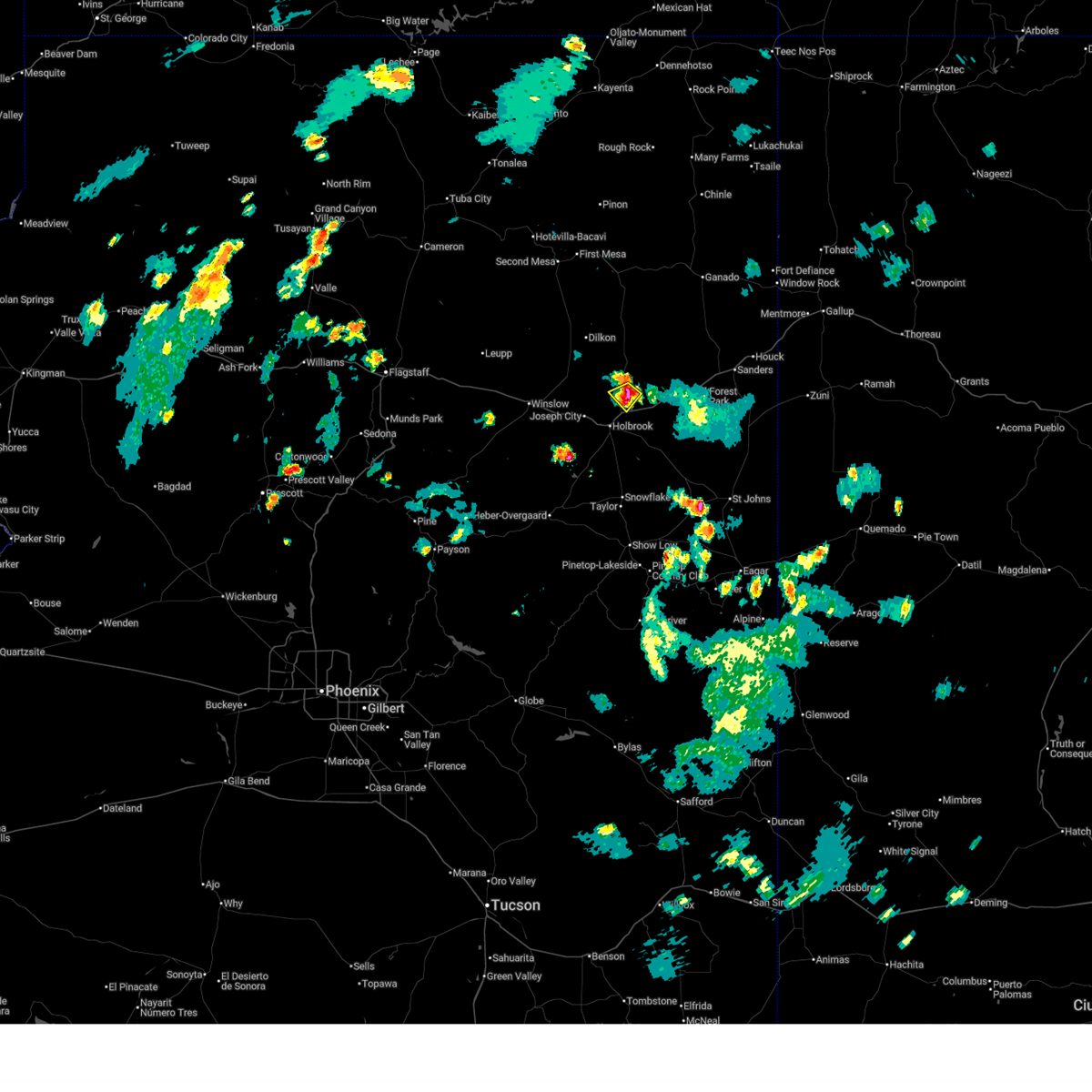
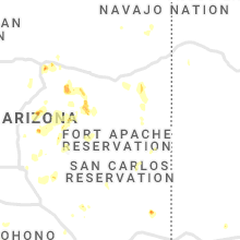
Hail Map for Sun Valley, AZ
The Sun Valley, AZ area has had 2 reports of on-the-ground hail by trained spotters, and has been under severe weather warnings 1 time during the past 12 months. Doppler radar has detected hail at or near Sun Valley, AZ on 12 occasions, including 3 occasions during the past year.
| Name: | Sun Valley, AZ |
| Where Located: | 49.4 miles N of Show Low, AZ |
| Map: | Google Map for Sun Valley, AZ |
| Population: | 316 |
| Housing Units: | 150 |
| More Info: | Search Google for Sun Valley, AZ |
1
The Top Recent Hail Date for Sun Valley, AZ is Sunday, July 19, 2026 (4th out of 12)
Hail and Wind Damage Spotted near Sun Valley, AZ
| Date / Time | Report Details |
|---|---|
| 7/19/2026 5:13 PM MST |
 Svrfgz the national weather service in flagstaff has issued a * severe thunderstorm warning for, navajo county in north central arizona, * until 545 pm mst. * at 513 pm mst, a severe thunderstorm was located 7 miles north of sun valley, or 37 miles east of winslow, moving southwest at 10 mph (radar indicated). Hazards include quarter size hail. damage to vehicles is expected Svrfgz the national weather service in flagstaff has issued a * severe thunderstorm warning for, navajo county in north central arizona, * until 545 pm mst. * at 513 pm mst, a severe thunderstorm was located 7 miles north of sun valley, or 37 miles east of winslow, moving southwest at 10 mph (radar indicated). Hazards include quarter size hail. damage to vehicles is expected
|
| 9/13/2022 11:58 AM MST |
 The severe thunderstorm warning for navajo county will expire at noon mst, the storm which prompted the warning has weakened below severe limits, and no longer poses an immediate threat to life or property. therefore, the warning will be allowed to expire. however small hail and gusty winds are still possible with this thunderstorm. The severe thunderstorm warning for navajo county will expire at noon mst, the storm which prompted the warning has weakened below severe limits, and no longer poses an immediate threat to life or property. therefore, the warning will be allowed to expire. however small hail and gusty winds are still possible with this thunderstorm.
|
| 9/13/2022 11:51 AM MST |
 At 1151 am mst, a severe thunderstorm was located near holbrook, or 34 miles east of winslow, moving northeast at 10 mph (radar indicated). Hazards include 60 mph wind gusts and quarter size hail. Hail damage to vehicles is expected. expect wind damage to roofs, siding, and trees. locations impacted include, holbrook and sun valley. this includes the following highways, business interstate 40 between mile markers 286 and 289. interstate 40 between mile markers 284 and 299. state route 377 near mile marker 33. state route 77 between mile markers 384 and 404. highway 180 between mile markers 308 and 313. hail threat, radar indicated max hail size, 1. 00 in wind threat, radar indicated max wind gust, 60 mph. At 1151 am mst, a severe thunderstorm was located near holbrook, or 34 miles east of winslow, moving northeast at 10 mph (radar indicated). Hazards include 60 mph wind gusts and quarter size hail. Hail damage to vehicles is expected. expect wind damage to roofs, siding, and trees. locations impacted include, holbrook and sun valley. this includes the following highways, business interstate 40 between mile markers 286 and 289. interstate 40 between mile markers 284 and 299. state route 377 near mile marker 33. state route 77 between mile markers 384 and 404. highway 180 between mile markers 308 and 313. hail threat, radar indicated max hail size, 1. 00 in wind threat, radar indicated max wind gust, 60 mph.
|
| 9/13/2022 11:36 AM MST |
 At 1135 am mst, a severe thunderstorm was located over holbrook, or 31 miles east of winslow, moving northeast at 10 mph (radar indicated). Hazards include 60 mph wind gusts and quarter size hail. Hail damage to vehicles is expected. Expect wind damage to roofs, siding, and trees. At 1135 am mst, a severe thunderstorm was located over holbrook, or 31 miles east of winslow, moving northeast at 10 mph (radar indicated). Hazards include 60 mph wind gusts and quarter size hail. Hail damage to vehicles is expected. Expect wind damage to roofs, siding, and trees.
|
| 7/13/2020 4:23 PM MST |
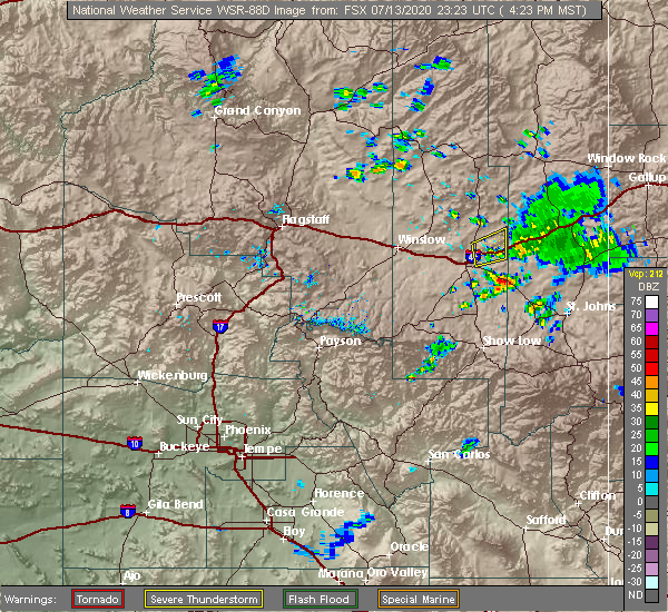 The severe thunderstorm warning for navajo county will expire at 430 pm mst, the storm near petrfied forest national park which prompted the warning has weakened below severe limits, and no longer poses an immediate threat to life or property. therefore, the warning will be allowed to expire. however, wind gusts to 40 mph are still possible with this thunderstorm. The severe thunderstorm warning for navajo county will expire at 430 pm mst, the storm near petrfied forest national park which prompted the warning has weakened below severe limits, and no longer poses an immediate threat to life or property. therefore, the warning will be allowed to expire. however, wind gusts to 40 mph are still possible with this thunderstorm.
|
| 7/13/2020 4:01 PM MST |
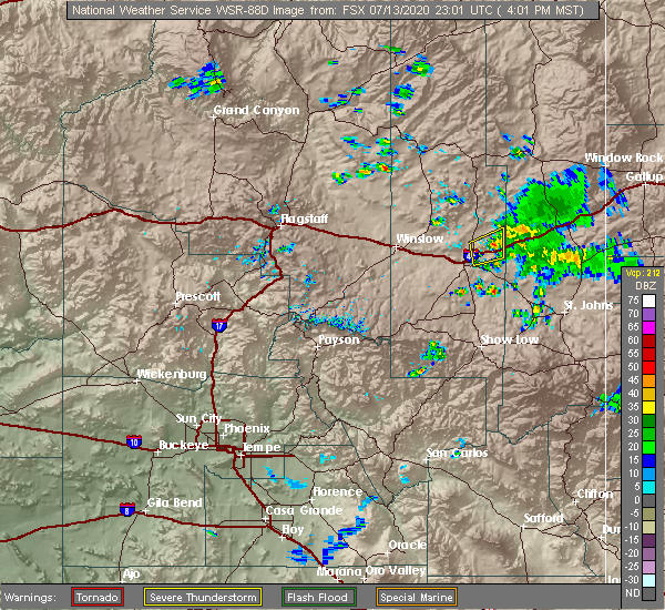 At 345 pm mst, a severe thunderstorm was located over sun valley, or 40 miles east of winslow, moving east at 25 mph (radar indicated). Hazards include 70 mph wind gusts and quarter size hail. Hail damage to vehicles is expected. expect tree damage. Wind damage is also likely to mobile homes, roofs, and outbuildings. At 345 pm mst, a severe thunderstorm was located over sun valley, or 40 miles east of winslow, moving east at 25 mph (radar indicated). Hazards include 70 mph wind gusts and quarter size hail. Hail damage to vehicles is expected. expect tree damage. Wind damage is also likely to mobile homes, roofs, and outbuildings.
|
| 7/13/2020 3:45 PM MST |
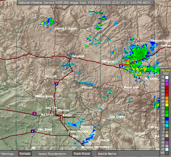 At 345 pm mst, a severe thunderstorm was located over sun valley, or 40 miles east of winslow, moving east at 25 mph (radar indicated). Hazards include 70 mph wind gusts and quarter size hail. Hail damage to vehicles is expected. expect tree damage. Wind damage is also likely to mobile homes, roofs, and outbuildings. At 345 pm mst, a severe thunderstorm was located over sun valley, or 40 miles east of winslow, moving east at 25 mph (radar indicated). Hazards include 70 mph wind gusts and quarter size hail. Hail damage to vehicles is expected. expect tree damage. Wind damage is also likely to mobile homes, roofs, and outbuildings.
|
| 7/13/2020 1:52 PM MST | Adot weather sensor on i-40 @ painted desert np hq (azt13) measured a 64 mph wind gus in apache county AZ, 16.4 miles WSW of Sun Valley, AZ |
| 9/1/2018 6:30 PM MST |
 At 630 pm mst, severe thunderstorms were located along a line extending from petrified forest national park to near woodruff, moving southeast at 35 mph. these are very dangerous storms (radar indicated). Hazards include 80 mph wind gusts and two inch hail. Flying debris will be dangerous to those caught without shelter. mobile homes will be heavily damaged. expect considerable damage to roofs, windows, and vehicles. extensive tree damage and power outages are likely. locations impacted include, holbrook, taylor, sun valley, woodruff, petrified forest national park, snowflake, petrified forest n. p. visitors center and petrified forest n. p. headquarters. this includes the following highways, business interstate 40 between mile markers 286 and 289. interstate 40 between mile markers 283 and 321. state route 277 between mile markers 331 and 336. state route 377 between mile markers 22 and 33. state route 77 between mile markers 360 and 396. Highway 180 between mile markers 308 and 333. At 630 pm mst, severe thunderstorms were located along a line extending from petrified forest national park to near woodruff, moving southeast at 35 mph. these are very dangerous storms (radar indicated). Hazards include 80 mph wind gusts and two inch hail. Flying debris will be dangerous to those caught without shelter. mobile homes will be heavily damaged. expect considerable damage to roofs, windows, and vehicles. extensive tree damage and power outages are likely. locations impacted include, holbrook, taylor, sun valley, woodruff, petrified forest national park, snowflake, petrified forest n. p. visitors center and petrified forest n. p. headquarters. this includes the following highways, business interstate 40 between mile markers 286 and 289. interstate 40 between mile markers 283 and 321. state route 277 between mile markers 331 and 336. state route 377 between mile markers 22 and 33. state route 77 between mile markers 360 and 396. Highway 180 between mile markers 308 and 333.
|
| 9/1/2018 6:14 PM MST | Golf Ball sized hail reported 1 miles SSE of Sun Valley, AZ, report relayed via social media. time and location estimated. |
| 9/1/2018 6:11 PM MST | Baseball sized hail reported 2.5 miles E of Sun Valley, AZ, the hopi travel plaza sustained significant roof damage. hail punched through the drop ceiling tiles. multiple vehicles sustained hail damage as well. |
| 9/1/2018 6:10 PM MST |
 At 609 pm mst, severe thunderstorms were located along a line extending from 10 miles northwest of petrified forest national park to 7 miles south of joseph city, moving southeast at 35 mph. these are very dangerous storms (radar indicated). Hazards include 80 mph wind gusts and two inch hail. Flying debris will be dangerous to those caught without shelter. mobile homes will be heavily damaged. expect considerable damage to roofs, windows, and vehicles. Extensive tree damage and power outages are likely. At 609 pm mst, severe thunderstorms were located along a line extending from 10 miles northwest of petrified forest national park to 7 miles south of joseph city, moving southeast at 35 mph. these are very dangerous storms (radar indicated). Hazards include 80 mph wind gusts and two inch hail. Flying debris will be dangerous to those caught without shelter. mobile homes will be heavily damaged. expect considerable damage to roofs, windows, and vehicles. Extensive tree damage and power outages are likely.
|
| 9/1/2018 6:03 PM MST |
 At 603 pm mst, severe thunderstorms were located along a line extending from 12 miles northwest of petrified forest national park to near joseph city, moving southeast at 35 mph. these are very dangerous storms (radar indicated). Hazards include 80 mph wind gusts and tennis ball size hail. Flying debris will be dangerous to those caught without shelter. mobile homes will be heavily damaged. expect considerable damage to roofs, windows, and vehicles. extensive tree damage and power outages are likely. locations impacted include, holbrook, joseph city, sun valley, petrified forest national park and dry lake. this includes the following highways, business interstate 40 between mile markers 275 and 289. interstate 40 between mile markers 261 and 301. state route 377 between mile markers 19 and 33. state route 77 between mile markers 384 and 408. Highway 180 between mile markers 308 and 312. At 603 pm mst, severe thunderstorms were located along a line extending from 12 miles northwest of petrified forest national park to near joseph city, moving southeast at 35 mph. these are very dangerous storms (radar indicated). Hazards include 80 mph wind gusts and tennis ball size hail. Flying debris will be dangerous to those caught without shelter. mobile homes will be heavily damaged. expect considerable damage to roofs, windows, and vehicles. extensive tree damage and power outages are likely. locations impacted include, holbrook, joseph city, sun valley, petrified forest national park and dry lake. this includes the following highways, business interstate 40 between mile markers 275 and 289. interstate 40 between mile markers 261 and 301. state route 377 between mile markers 19 and 33. state route 77 between mile markers 384 and 408. Highway 180 between mile markers 308 and 312.
|
| 9/1/2018 5:53 PM MST |
 At 553 pm mst, severe thunderstorms were located along a line extending from 12 miles south of indian wells to near joseph city, moving southeast at 35 mph (radar indicated). Hazards include ping pong ball size hail and 60 mph wind gusts. People and animals outdoors will be injured. expect hail damage to roofs, siding, windows, and vehicles. expect wind damage to roofs, siding, and trees. locations impacted include, holbrook, joseph city, sun valley, petrified forest national park and dry lake. this includes the following highways, business interstate 40 between mile markers 275 and 289. interstate 40 between mile markers 261 and 301. state route 377 between mile markers 19 and 33. state route 77 between mile markers 384 and 408. Highway 180 between mile markers 308 and 312. At 553 pm mst, severe thunderstorms were located along a line extending from 12 miles south of indian wells to near joseph city, moving southeast at 35 mph (radar indicated). Hazards include ping pong ball size hail and 60 mph wind gusts. People and animals outdoors will be injured. expect hail damage to roofs, siding, windows, and vehicles. expect wind damage to roofs, siding, and trees. locations impacted include, holbrook, joseph city, sun valley, petrified forest national park and dry lake. this includes the following highways, business interstate 40 between mile markers 275 and 289. interstate 40 between mile markers 261 and 301. state route 377 between mile markers 19 and 33. state route 77 between mile markers 384 and 408. Highway 180 between mile markers 308 and 312.
|
| 9/1/2018 5:31 PM MST |
 At 530 pm mst, severe thunderstorms were located along a line extending from 7 miles southwest of indian wells to 6 miles east of winslow, moving southeast at 35 mph (radar indicated). Hazards include 60 mph wind gusts and half dollar size hail. Hail damage to vehicles is expected. Expect wind damage to roofs, siding, and trees. At 530 pm mst, severe thunderstorms were located along a line extending from 7 miles southwest of indian wells to 6 miles east of winslow, moving southeast at 35 mph (radar indicated). Hazards include 60 mph wind gusts and half dollar size hail. Hail damage to vehicles is expected. Expect wind damage to roofs, siding, and trees.
|
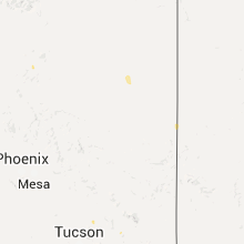
Hail Maps for Sun Valley, AZ


Connect with Interactive Hail Maps