

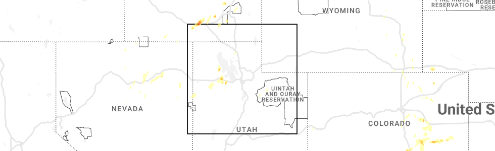
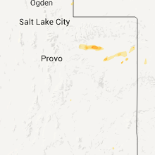
Hail Map for Tabiona, UT
The Tabiona, UT area has had 2 reports of on-the-ground hail by trained spotters, and has been under severe weather warnings 6 times during the past 12 months. Doppler radar has detected hail at or near Tabiona, UT on 7 occasions, including 1 occasion during the past year.
| Name: | Tabiona, UT |
| Where Located: | 52.3 miles N of Price, UT |
| Map: | Google Map for Tabiona, UT |
| Population: | 171 |
| Housing Units: | 79 |
| More Info: | Search Google for Tabiona, UT |
0
The Top Recent Hail Date for Tabiona, UT is Wednesday, May 24, 2023 (3rd out of 7)
Hail and Wind Damage Spotted near Tabiona, UT
| Date / Time | Report Details |
|---|---|
| 7/3/2023 6:42 PM MDT |
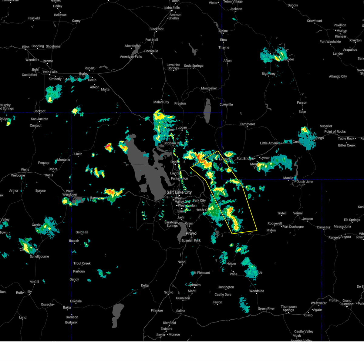
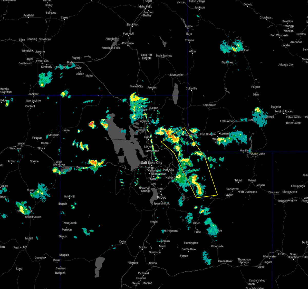 At 642 pm mdt, severe thunderstorms were located along a line extending from 10 miles west of evanston to near tabiona, moving east at 55 mph (radar indicated). Hazards include 60 mph wind gusts. Expect damage to roofs, siding, and trees. locations impacted include, evanston, tabiona, fruitland, mirror lake, starvation reservoir, talmage, moon lake, utahn, hanna, wahsatch, emory, castle rock and trial lk. this includes the following highways, interstate 80 in utah between mile markers 171 and 196. us route 40 between mile markers 61 and 70. utah route 35 between mile markers 16 and 62. mirror lake highway between mile markers 11 and 54. hail threat, radar indicated max hail size, <. 75 in wind threat, radar indicated max wind gust, 60 mph. At 642 pm mdt, severe thunderstorms were located along a line extending from 10 miles west of evanston to near tabiona, moving east at 55 mph (radar indicated). Hazards include 60 mph wind gusts. Expect damage to roofs, siding, and trees. locations impacted include, evanston, tabiona, fruitland, mirror lake, starvation reservoir, talmage, moon lake, utahn, hanna, wahsatch, emory, castle rock and trial lk. this includes the following highways, interstate 80 in utah between mile markers 171 and 196. us route 40 between mile markers 61 and 70. utah route 35 between mile markers 16 and 62. mirror lake highway between mile markers 11 and 54. hail threat, radar indicated max hail size, <. 75 in wind threat, radar indicated max wind gust, 60 mph.
|
| 7/3/2023 6:42 PM MDT |
 At 642 pm mdt, severe thunderstorms were located along a line extending from 10 miles west of evanston to near tabiona, moving east at 55 mph (radar indicated). Hazards include 60 mph wind gusts. Expect damage to roofs, siding, and trees. locations impacted include, evanston, tabiona, fruitland, mirror lake, starvation reservoir, talmage, moon lake, utahn, hanna, wahsatch, emory, castle rock and trial lk. this includes the following highways, interstate 80 in utah between mile markers 171 and 196. us route 40 between mile markers 61 and 70. utah route 35 between mile markers 16 and 62. mirror lake highway between mile markers 11 and 54. hail threat, radar indicated max hail size, <. 75 in wind threat, radar indicated max wind gust, 60 mph. At 642 pm mdt, severe thunderstorms were located along a line extending from 10 miles west of evanston to near tabiona, moving east at 55 mph (radar indicated). Hazards include 60 mph wind gusts. Expect damage to roofs, siding, and trees. locations impacted include, evanston, tabiona, fruitland, mirror lake, starvation reservoir, talmage, moon lake, utahn, hanna, wahsatch, emory, castle rock and trial lk. this includes the following highways, interstate 80 in utah between mile markers 171 and 196. us route 40 between mile markers 61 and 70. utah route 35 between mile markers 16 and 62. mirror lake highway between mile markers 11 and 54. hail threat, radar indicated max hail size, <. 75 in wind threat, radar indicated max wind gust, 60 mph.
|
| 7/3/2023 6:24 PM MDT |
 At 623 pm mdt, severe thunderstorms were located along a line extending from 15 miles northeast of morgan to 8 miles northwest of fruitland, moving east at 55 mph (radar indicated). Hazards include 60 mph wind gusts. expect damage to roofs, siding, and trees At 623 pm mdt, severe thunderstorms were located along a line extending from 15 miles northeast of morgan to 8 miles northwest of fruitland, moving east at 55 mph (radar indicated). Hazards include 60 mph wind gusts. expect damage to roofs, siding, and trees
|
| 5/24/2023 2:42 PM MDT |
 The severe thunderstorm warning for northeastern wasatch and west central duchesne counties will expire at 245 pm mdt, the storm which prompted the warning has weakened below severe limits, and no longer poses an immediate threat to life or property. therefore, the warning will be allowed to expire. The severe thunderstorm warning for northeastern wasatch and west central duchesne counties will expire at 245 pm mdt, the storm which prompted the warning has weakened below severe limits, and no longer poses an immediate threat to life or property. therefore, the warning will be allowed to expire.
|
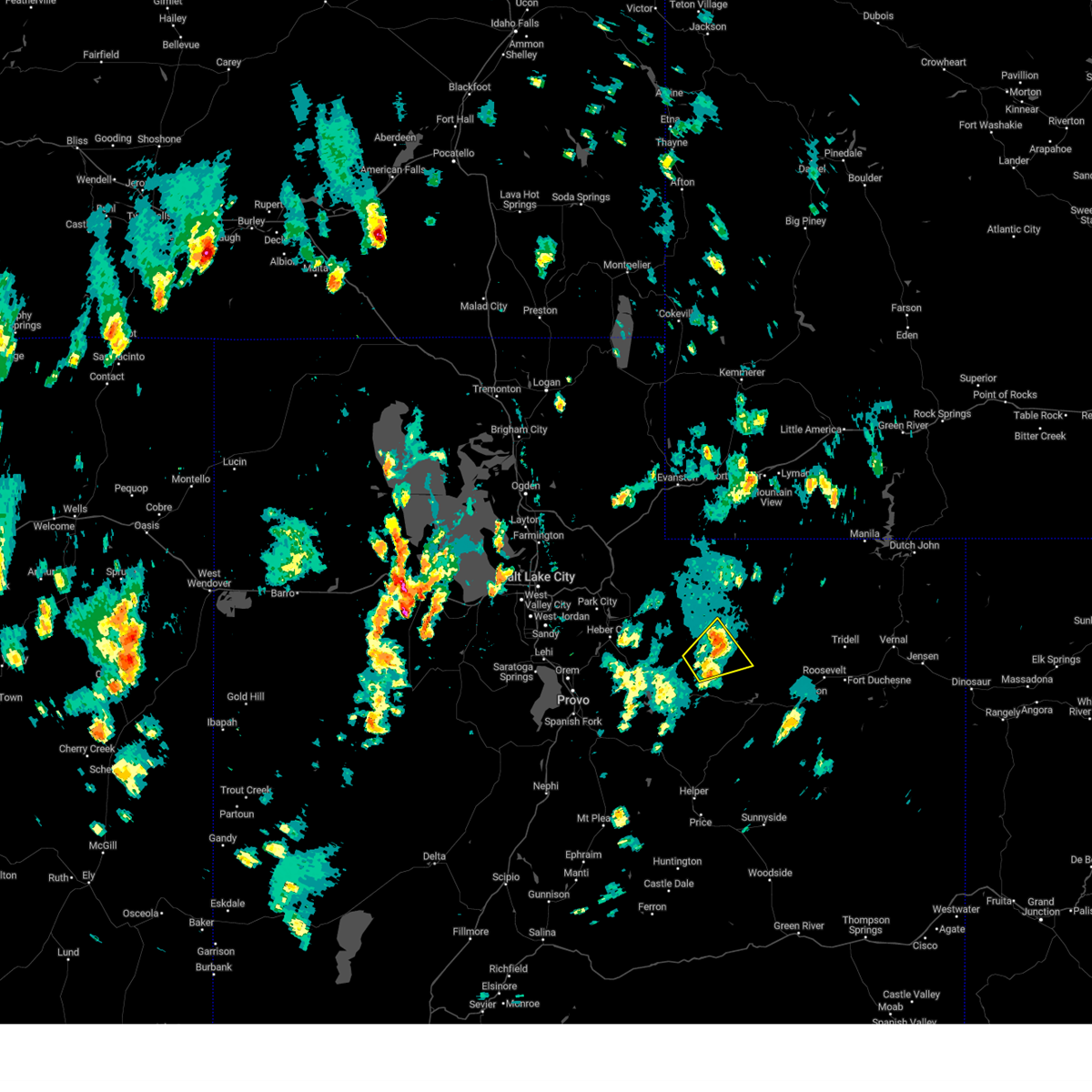
| 5/24/2023 2:20 PM MDT | Half Dollar sized hail reported 1.2 miles SSE of Tabiona, UT, public video of multiple hailstones approximately half dollar size. time estimated by radar. |
| 5/24/2023 2:05 PM MDT |
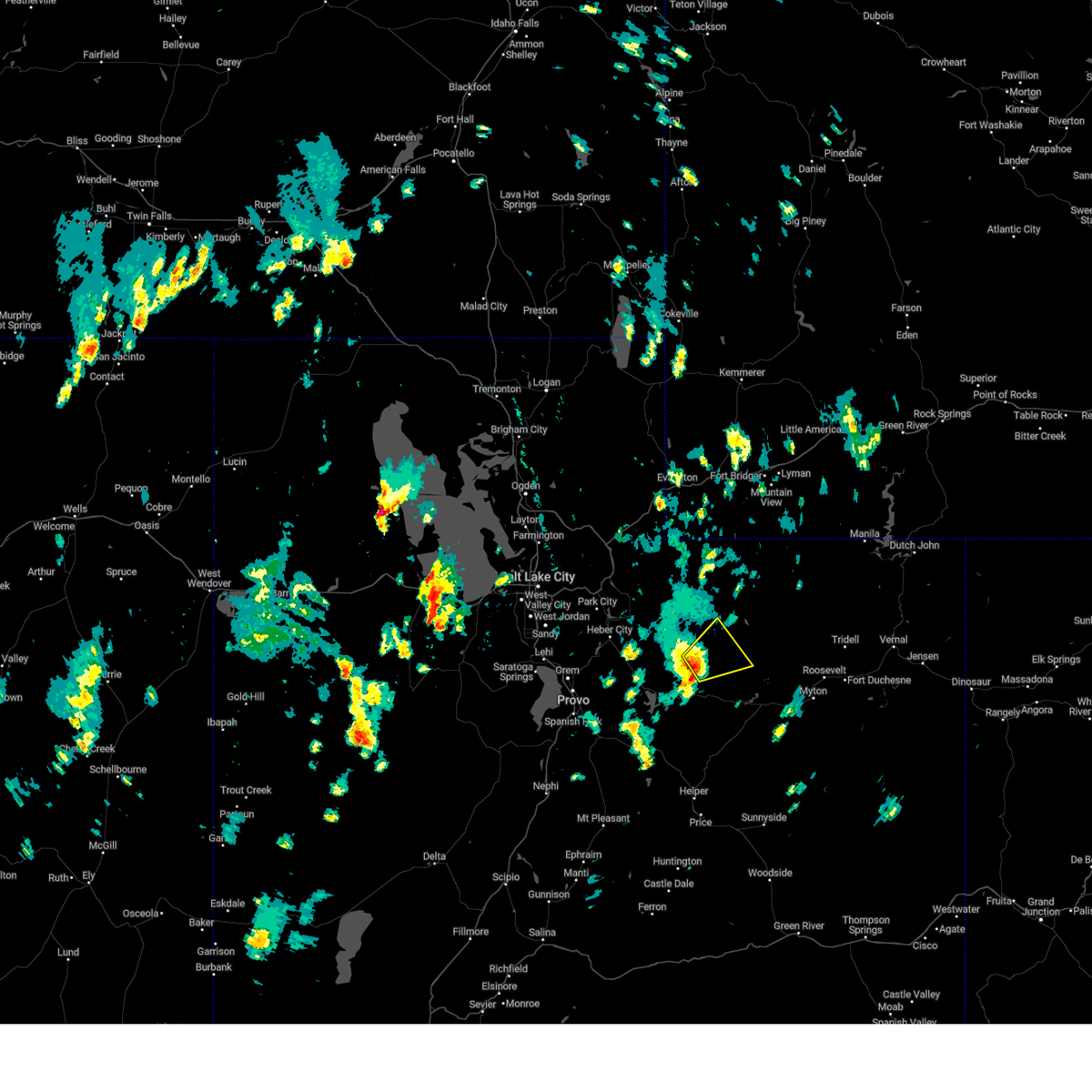 At 204 pm mdt, a severe thunderstorm was located near tabiona, or 26 miles northwest of duchesne, moving northeast at 20 mph (radar indicated). Hazards include 60 mph wind gusts and half dollar size hail. Hail damage to vehicles is expected. Expect wind damage to roofs, siding, and trees. At 204 pm mdt, a severe thunderstorm was located near tabiona, or 26 miles northwest of duchesne, moving northeast at 20 mph (radar indicated). Hazards include 60 mph wind gusts and half dollar size hail. Hail damage to vehicles is expected. Expect wind damage to roofs, siding, and trees.
|
| 1/1/0001 12:00 AM | Quarter sized hail reported 0.3 miles N of Tabiona, UT |
Hail Maps for Tabiona, UT


Connect with Interactive Hail Maps