

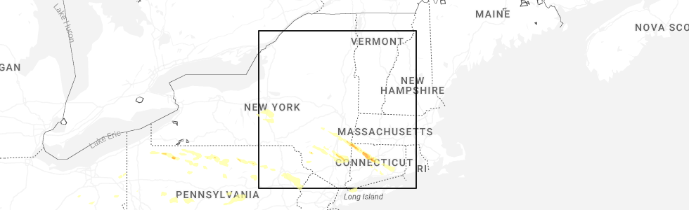
Hail Map for Tannersville, NY
The Tannersville, NY area has had 0 reports of on-the-ground hail by trained spotters, and has been under severe weather warnings 9 times during the past 12 months. Doppler radar has detected hail at or near Tannersville, NY on 11 occasions, including 1 occasion during the past year.
| Name: | Tannersville, NY |
| Where Located: | 43.8 miles SSW of Schenectady, NY |
| Map: | Google Map for Tannersville, NY |
| Population: | 539 |
| Housing Units: | 557 |
| More Info: | Search Google for Tannersville, NY |
0
The Top Recent Hail Date for Tannersville, NY is Saturday, July 4, 2026 (8th out of 11)
Hail and Wind Damage Spotted near Tannersville, NY
| Date / Time | Report Details |
|---|---|
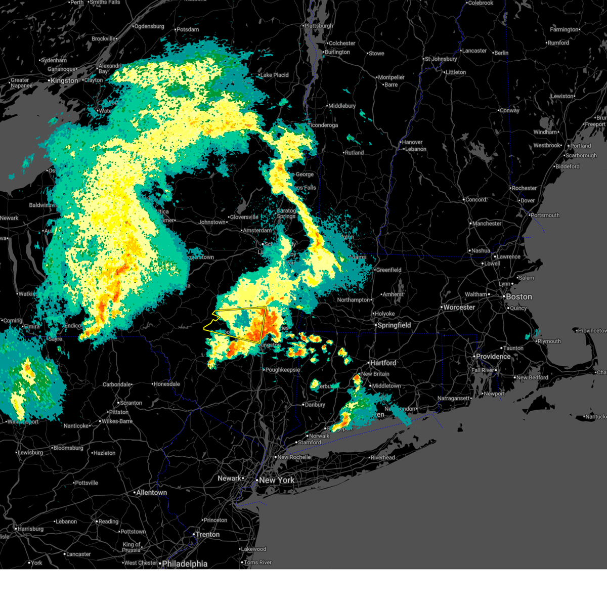
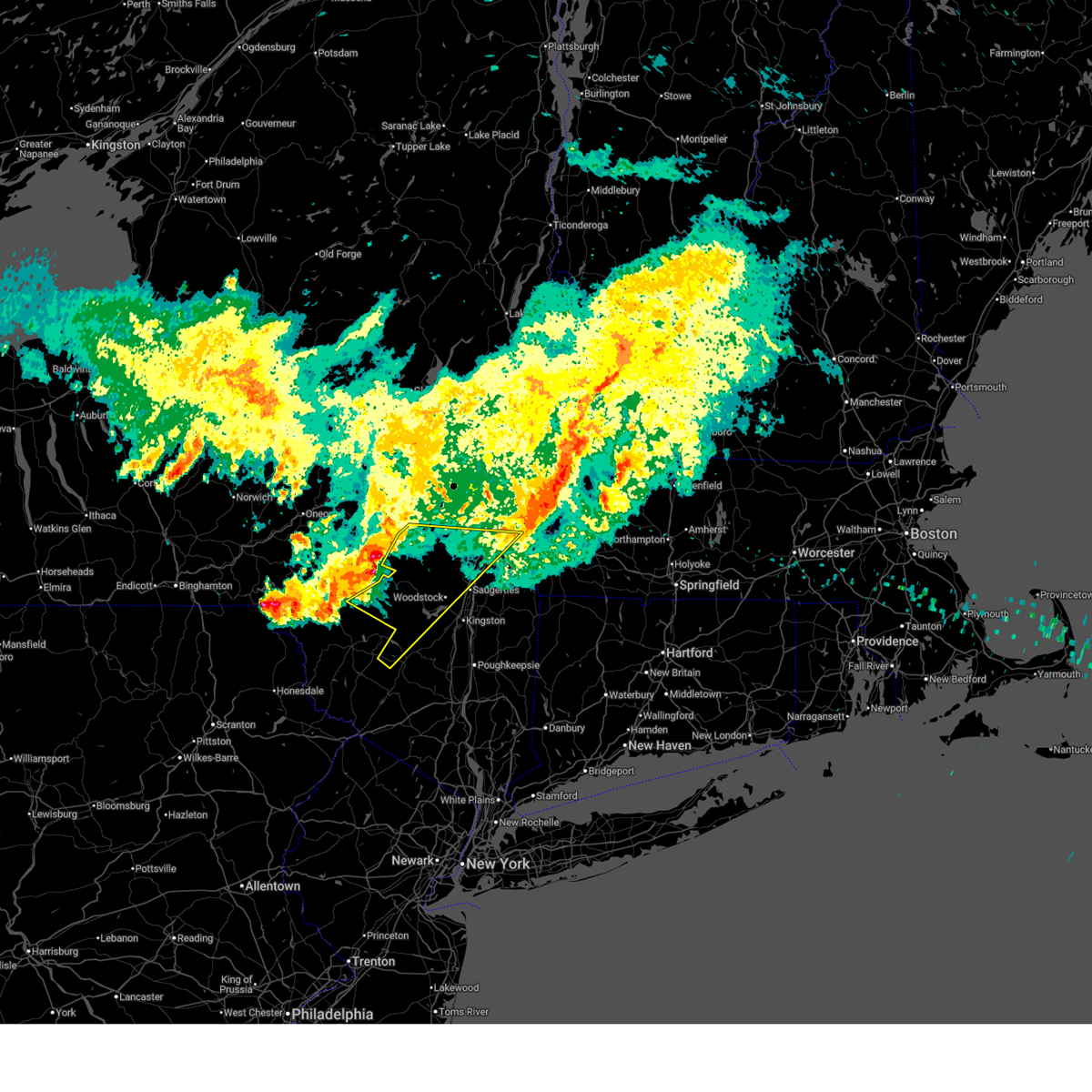
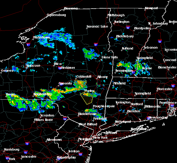
| 7/4/2026 6:48 PM EDT |
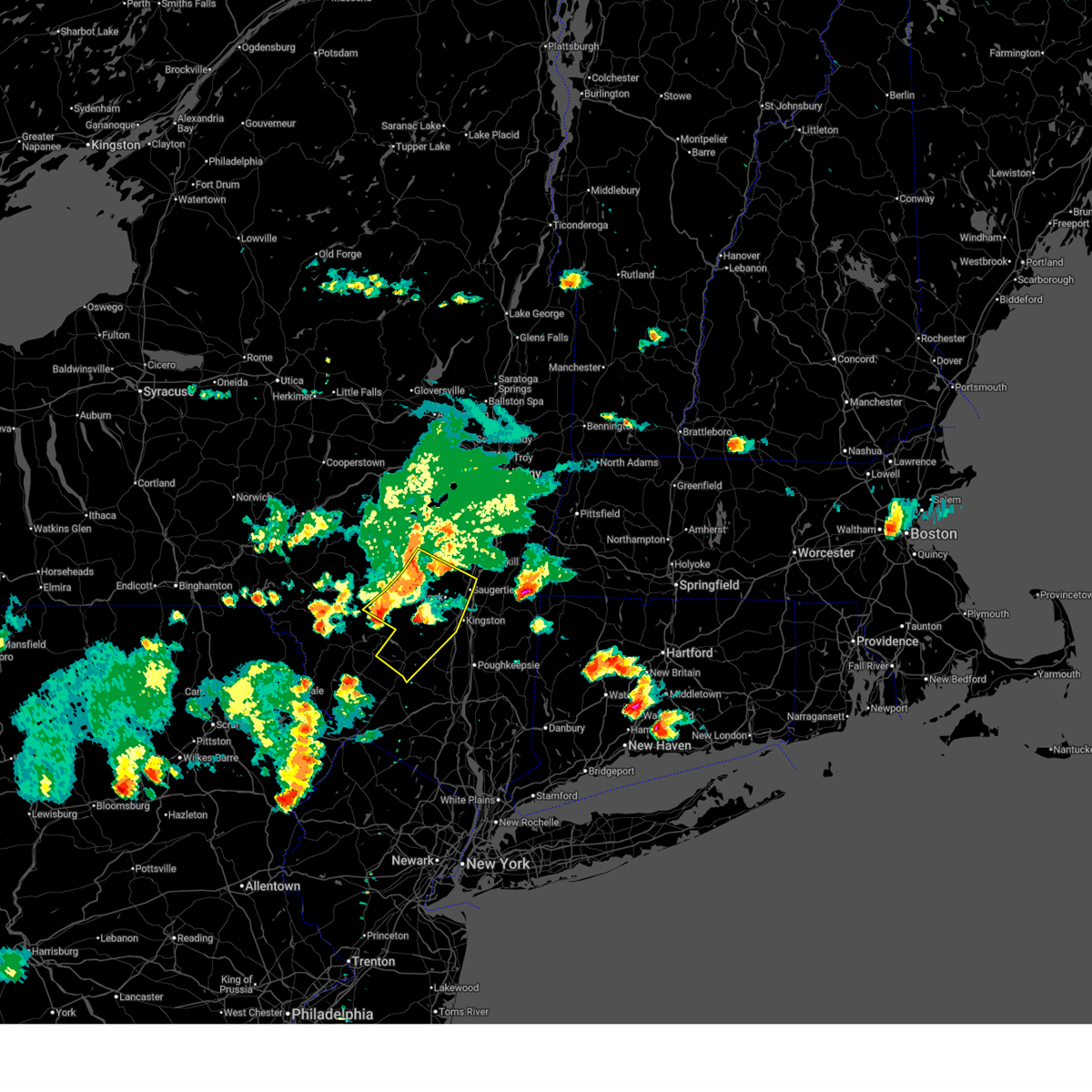 At 648 pm edt, severe thunderstorms were located along a line extending from near hunter to woodland valley campground to near grahamsville, moving southeast at 45 mph (radar indicated). Hazards include 60 mph wind gusts and half dollar size hail. Hail damage to vehicles is expected. expect wind damage to roofs, siding, and trees. Locations impacted include, kingston, ellenville, saugerties, hunter, hurley, woodstock, high falls, kerhonkson, west hurley, napanoch, saugerties south, woodland valley campground, west shokan, kenneth l wilson campground, lake katrine, phoenicia, mount tremper, lanesville, olivebridge, and wawarsing. At 648 pm edt, severe thunderstorms were located along a line extending from near hunter to woodland valley campground to near grahamsville, moving southeast at 45 mph (radar indicated). Hazards include 60 mph wind gusts and half dollar size hail. Hail damage to vehicles is expected. expect wind damage to roofs, siding, and trees. Locations impacted include, kingston, ellenville, saugerties, hunter, hurley, woodstock, high falls, kerhonkson, west hurley, napanoch, saugerties south, woodland valley campground, west shokan, kenneth l wilson campground, lake katrine, phoenicia, mount tremper, lanesville, olivebridge, and wawarsing.
|
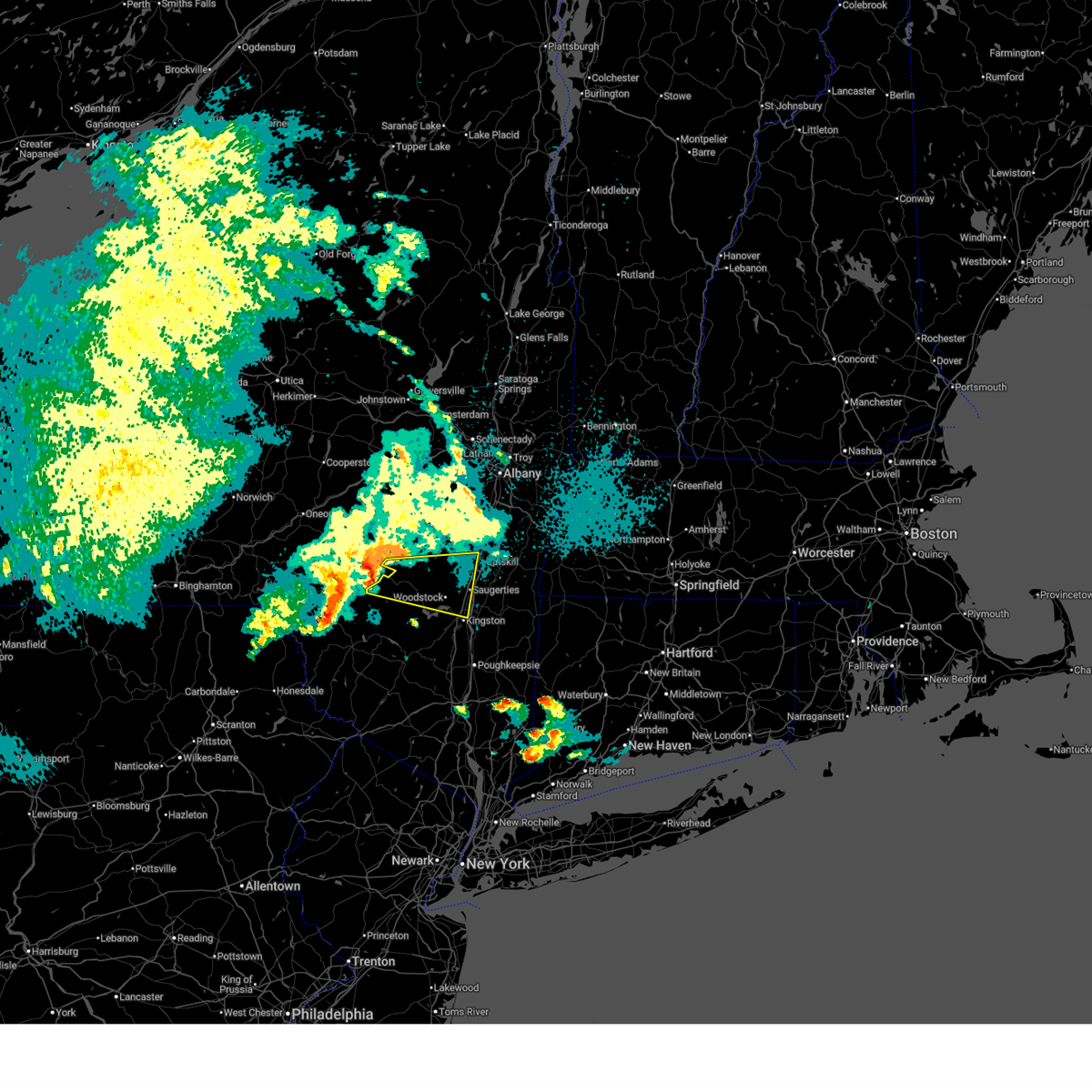
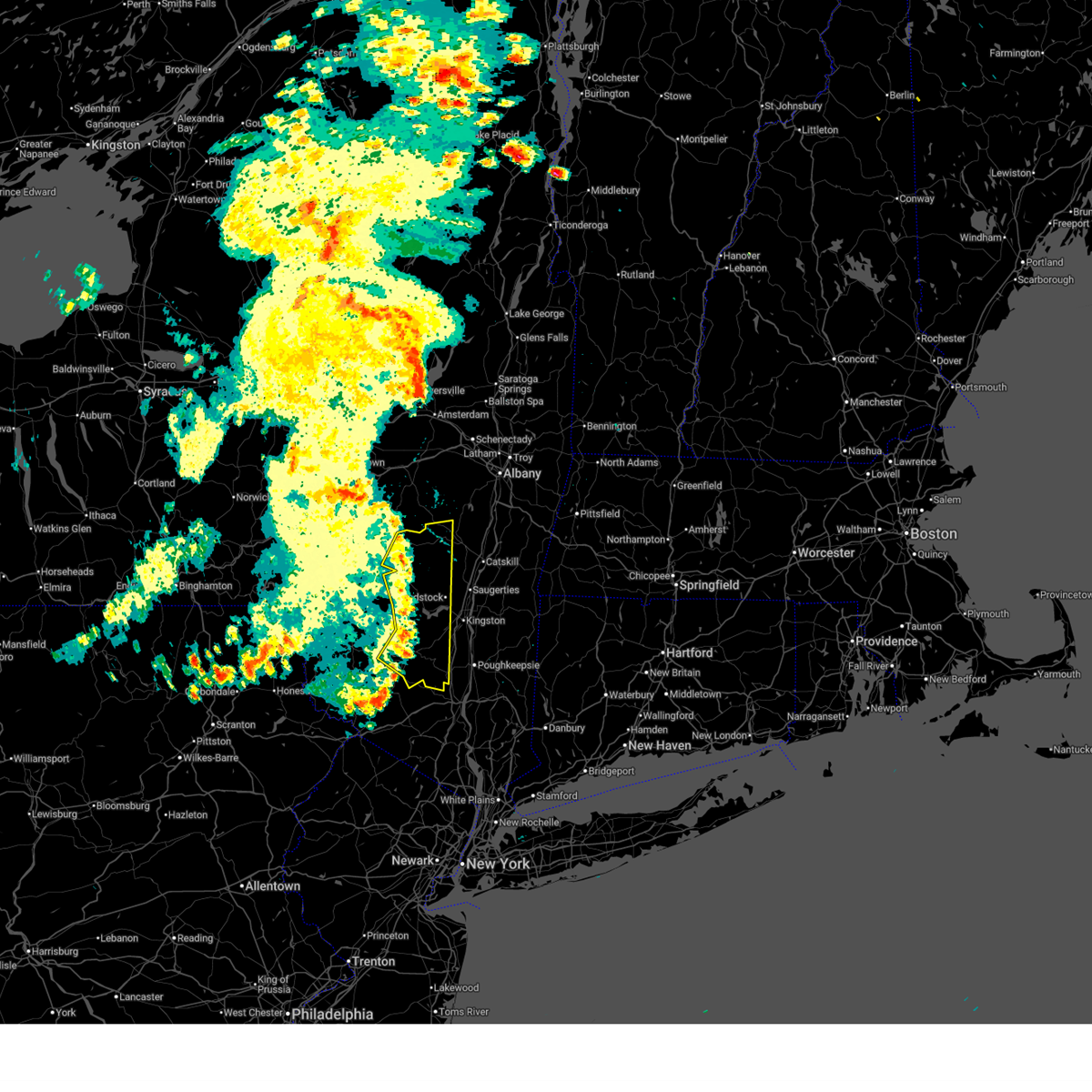
| 7/4/2026 6:22 PM EDT |
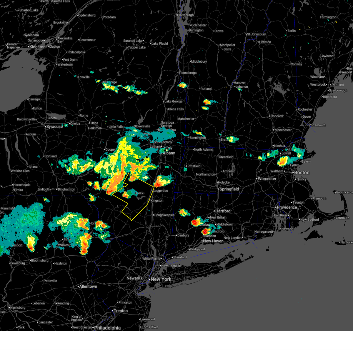 Svraly the national weather service in albany has issued a * severe thunderstorm warning for, ulster county in east central new york, southwestern greene county in east central new york, * until 715 pm edt. * at 622 pm edt, severe thunderstorms were located along a line extending from near roxbury to near arkville to 6 miles north of roscoe, moving southeast at 35 mph (radar indicated). Hazards include 60 mph wind gusts. expect damage to roofs, siding, and trees Svraly the national weather service in albany has issued a * severe thunderstorm warning for, ulster county in east central new york, southwestern greene county in east central new york, * until 715 pm edt. * at 622 pm edt, severe thunderstorms were located along a line extending from near roxbury to near arkville to 6 miles north of roscoe, moving southeast at 35 mph (radar indicated). Hazards include 60 mph wind gusts. expect damage to roofs, siding, and trees
|
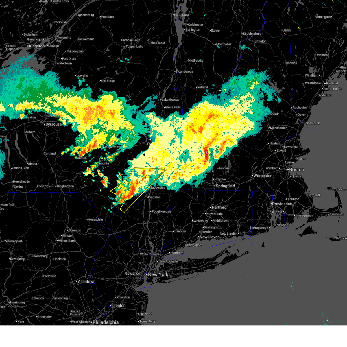
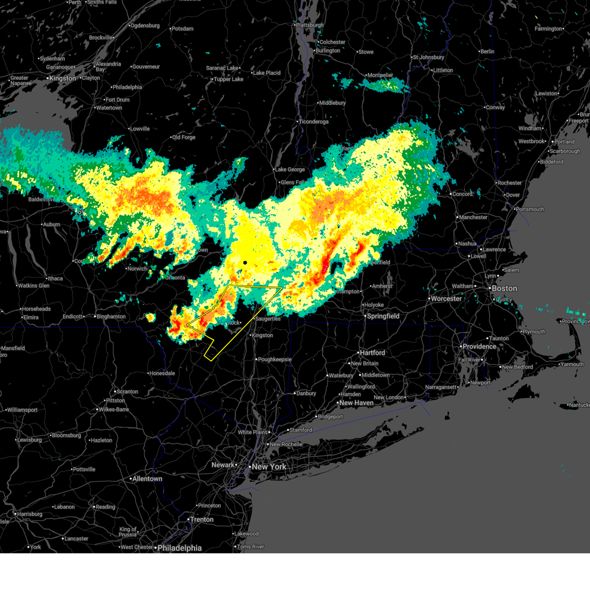
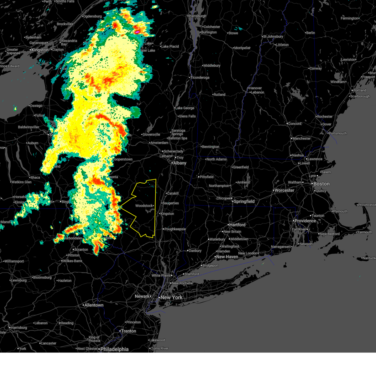
| 7/4/2026 5:50 PM EDT |
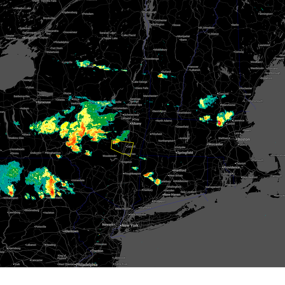 Svraly the national weather service in albany has issued a * severe thunderstorm warning for, northeastern ulster county in east central new york, southwestern columbia county in east central new york, southeastern greene county in east central new york, * until 645 pm edt. * at 550 pm edt, a severe thunderstorm was located near windham, or near hunter, moving east southeast at 25 mph (radar indicated). Hazards include 60 mph wind gusts and quarter size hail. Hail damage to vehicles is expected. Expect wind damage to roofs, siding, and trees. Svraly the national weather service in albany has issued a * severe thunderstorm warning for, northeastern ulster county in east central new york, southwestern columbia county in east central new york, southeastern greene county in east central new york, * until 645 pm edt. * at 550 pm edt, a severe thunderstorm was located near windham, or near hunter, moving east southeast at 25 mph (radar indicated). Hazards include 60 mph wind gusts and quarter size hail. Hail damage to vehicles is expected. Expect wind damage to roofs, siding, and trees.
|
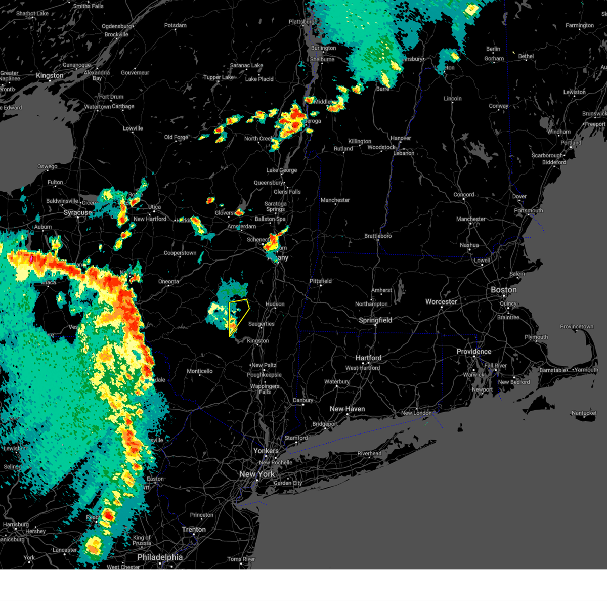
| 4/15/2026 10:51 PM EDT |
 The storm which prompted the warning has weakened below severe limits, and has exited the warned area. therefore, the warning will be allowed to expire. however, gusty winds are still possible with this thunderstorm. The storm which prompted the warning has weakened below severe limits, and has exited the warned area. therefore, the warning will be allowed to expire. however, gusty winds are still possible with this thunderstorm.
|
| 4/15/2026 9:58 PM EDT |
 Svraly the national weather service in albany has issued a * severe thunderstorm warning for, northern ulster county in east central new york, southern greene county in east central new york, * until 1100 pm edt. * at 958 pm edt, a severe thunderstorm was located over fleischmanns, or 15 miles west of hunter, moving east at 40 mph (radar indicated). Hazards include 60 mph wind gusts and penny size hail. expect damage to roofs, siding, and trees Svraly the national weather service in albany has issued a * severe thunderstorm warning for, northern ulster county in east central new york, southern greene county in east central new york, * until 1100 pm edt. * at 958 pm edt, a severe thunderstorm was located over fleischmanns, or 15 miles west of hunter, moving east at 40 mph (radar indicated). Hazards include 60 mph wind gusts and penny size hail. expect damage to roofs, siding, and trees
|
| 3/31/2026 9:07 PM EDT |
 The storms which prompted the warning have weakened below severe limits, and no longer pose an immediate threat to life or property. therefore, the warning will be allowed to expire. a severe thunderstorm watch remains in effect until 1100 pm edt for east central new york. The storms which prompted the warning have weakened below severe limits, and no longer pose an immediate threat to life or property. therefore, the warning will be allowed to expire. a severe thunderstorm watch remains in effect until 1100 pm edt for east central new york.
|
| 3/31/2026 8:42 PM EDT |
 At 842 pm edt, severe thunderstorms were located along a line extending from 8 miles east of windham to near swan lake, moving east at 35 mph (radar indicated). Hazards include 60 mph wind gusts and quarter size hail. Hail damage to vehicles is expected. expect wind damage to roofs, siding, and trees. Locations impacted include, hudson, catskill, hunter, woodstock, coxsackie, windham, athens, lorenz park, west hurley, north-south lake campground, woodland valley campground, west shokan, kenneth l wilson campground, phoenicia, mount tremper, lanesville, olivebridge, cairo, veteran, and shandaken. At 842 pm edt, severe thunderstorms were located along a line extending from 8 miles east of windham to near swan lake, moving east at 35 mph (radar indicated). Hazards include 60 mph wind gusts and quarter size hail. Hail damage to vehicles is expected. expect wind damage to roofs, siding, and trees. Locations impacted include, hudson, catskill, hunter, woodstock, coxsackie, windham, athens, lorenz park, west hurley, north-south lake campground, woodland valley campground, west shokan, kenneth l wilson campground, phoenicia, mount tremper, lanesville, olivebridge, cairo, veteran, and shandaken.
|
| 3/31/2026 8:42 PM EDT |
 the severe thunderstorm warning has been cancelled and is no longer in effect the severe thunderstorm warning has been cancelled and is no longer in effect
|
| 3/31/2026 8:18 PM EDT |
 Svraly the national weather service in albany has issued a * severe thunderstorm warning for, northwestern ulster county in east central new york, west central columbia county in east central new york, greene county in east central new york, south central schoharie county in east central new york, * until 915 pm edt. * at 817 pm edt, severe thunderstorms were located along a line extending from near gilboa to hankins, moving east at 35 mph (radar indicated). Hazards include 60 mph wind gusts and quarter size hail. Hail damage to vehicles is expected. Expect wind damage to roofs, siding, and trees. Svraly the national weather service in albany has issued a * severe thunderstorm warning for, northwestern ulster county in east central new york, west central columbia county in east central new york, greene county in east central new york, south central schoharie county in east central new york, * until 915 pm edt. * at 817 pm edt, severe thunderstorms were located along a line extending from near gilboa to hankins, moving east at 35 mph (radar indicated). Hazards include 60 mph wind gusts and quarter size hail. Hail damage to vehicles is expected. Expect wind damage to roofs, siding, and trees.
|
| 7/15/2024 9:01 PM EDT |
 At 900 pm edt, severe thunderstorms were located along a line extending from near preston-potter hollow to near montgomery, moving east at 40 mph (radar indicated). Hazards include 60 mph wind gusts. Expect damage to roofs, siding, and trees. Locations impacted include, ellenville, hunter, wallkill, woodstock, windham, prattsville, modena, high falls, kerhonkson, west hurley, napanoch, woodland valley campground, west shokan, kenneth l wilson campground, phoenicia, mount tremper, lanesville, olivebridge, wawarsing, and crawford. At 900 pm edt, severe thunderstorms were located along a line extending from near preston-potter hollow to near montgomery, moving east at 40 mph (radar indicated). Hazards include 60 mph wind gusts. Expect damage to roofs, siding, and trees. Locations impacted include, ellenville, hunter, wallkill, woodstock, windham, prattsville, modena, high falls, kerhonkson, west hurley, napanoch, woodland valley campground, west shokan, kenneth l wilson campground, phoenicia, mount tremper, lanesville, olivebridge, wawarsing, and crawford.
|
| 7/15/2024 8:18 PM EDT |
 Svraly the national weather service in albany has issued a * severe thunderstorm warning for, ulster county in east central new york, western greene county in east central new york, * until 915 pm edt. * at 818 pm edt, severe thunderstorms were located along a line extending from near east meredith to near shohola, moving east at 40 mph (radar indicated). Hazards include 60 mph wind gusts. expect damage to roofs, siding, and trees Svraly the national weather service in albany has issued a * severe thunderstorm warning for, ulster county in east central new york, western greene county in east central new york, * until 915 pm edt. * at 818 pm edt, severe thunderstorms were located along a line extending from near east meredith to near shohola, moving east at 40 mph (radar indicated). Hazards include 60 mph wind gusts. expect damage to roofs, siding, and trees
|
| 9/7/2023 8:00 PM EDT |
 At 800 pm edt, severe thunderstorms were located along a line extending from near hunter to rhinebeck to near fishkill, moving east at 35 mph (radar indicated). Hazards include 60 mph wind gusts and quarter size hail. Hail damage to vehicles is expected. Expect wind damage to roofs, siding, and trees. At 800 pm edt, severe thunderstorms were located along a line extending from near hunter to rhinebeck to near fishkill, moving east at 35 mph (radar indicated). Hazards include 60 mph wind gusts and quarter size hail. Hail damage to vehicles is expected. Expect wind damage to roofs, siding, and trees.
|
| 9/7/2023 7:54 PM EDT |
 At 754 pm edt, a severe thunderstorm was located near highland, or near poughkeepsie, moving north at 40 mph (radar indicated). Hazards include 60 mph wind gusts and quarter size hail. Hail damage to vehicles is expected. expect wind damage to roofs, siding, and trees. locations impacted include, kingston, new paltz, hudson, catskill, saugerties, rhinebeck, hunter, wallkill, hyde park, milton, plattekill, hurley, woodstock, highland, red hook, windham, athens, prattsville, high falls and tillson. hail threat, radar indicated max hail size, 1. 00 in wind threat, radar indicated max wind gust, 60 mph. At 754 pm edt, a severe thunderstorm was located near highland, or near poughkeepsie, moving north at 40 mph (radar indicated). Hazards include 60 mph wind gusts and quarter size hail. Hail damage to vehicles is expected. expect wind damage to roofs, siding, and trees. locations impacted include, kingston, new paltz, hudson, catskill, saugerties, rhinebeck, hunter, wallkill, hyde park, milton, plattekill, hurley, woodstock, highland, red hook, windham, athens, prattsville, high falls and tillson. hail threat, radar indicated max hail size, 1. 00 in wind threat, radar indicated max wind gust, 60 mph.
|
| 9/7/2023 7:21 PM EDT |
 At 721 pm edt, a severe thunderstorm was located near kerhonkson, or 7 miles northeast of ellenville, moving northeast at 50 mph (radar indicated). Hazards include 60 mph wind gusts and quarter size hail. Hail damage to vehicles is expected. Expect wind damage to roofs, siding, and trees. At 721 pm edt, a severe thunderstorm was located near kerhonkson, or 7 miles northeast of ellenville, moving northeast at 50 mph (radar indicated). Hazards include 60 mph wind gusts and quarter size hail. Hail damage to vehicles is expected. Expect wind damage to roofs, siding, and trees.
|
| 9/7/2023 5:45 PM EDT |
 At 545 pm edt, a severe thunderstorm was located over lanesville, or 8 miles south of hunter, moving northeast at 30 mph (radar indicated). Hazards include 60 mph wind gusts. Expect damage to roofs, siding, and trees. locations impacted include, hunter, windham, lanesville, phoenicia, jewett, edgewood, hensonville, jewett center, maplecrest, chichester, beecher corners, woodland, spruceton, west jewett, south jewett, brooksburg and east jewett. hail threat, radar indicated max hail size, <. 75 in wind threat, radar indicated max wind gust, 60 mph. At 545 pm edt, a severe thunderstorm was located over lanesville, or 8 miles south of hunter, moving northeast at 30 mph (radar indicated). Hazards include 60 mph wind gusts. Expect damage to roofs, siding, and trees. locations impacted include, hunter, windham, lanesville, phoenicia, jewett, edgewood, hensonville, jewett center, maplecrest, chichester, beecher corners, woodland, spruceton, west jewett, south jewett, brooksburg and east jewett. hail threat, radar indicated max hail size, <. 75 in wind threat, radar indicated max wind gust, 60 mph.
|
| 9/7/2023 5:05 PM EDT |
 At 505 pm edt, a severe thunderstorm was located 7 miles northeast of willowemoc, or 16 miles northeast of liberty, moving northeast at 30 mph (radar indicated). Hazards include 60 mph wind gusts and quarter size hail. Hail damage to vehicles is expected. Expect wind damage to roofs, siding, and trees. At 505 pm edt, a severe thunderstorm was located 7 miles northeast of willowemoc, or 16 miles northeast of liberty, moving northeast at 30 mph (radar indicated). Hazards include 60 mph wind gusts and quarter size hail. Hail damage to vehicles is expected. Expect wind damage to roofs, siding, and trees.
|
| 8/4/2023 5:25 PM EDT |
 At 525 pm edt, severe thunderstorms were located along a line extending from new baltimore to near coxsackie to near north-south lake campground, moving east at 30 mph (radar indicated). Hazards include 60 mph wind gusts and quarter size hail. Hail damage to vehicles is expected. expect wind damage to roofs, siding, and trees. locations impacted include, hudson, catskill, chatham, claverack, livingston, new baltimore, ravena, coxsackie, clermont, valatie, athens, philmont, kinderhook, lorenz park, north-south lake campground, claverack-red mills, coeymans, cairo, ghent and stockport. hail threat, radar indicated max hail size, 1. 00 in wind threat, radar indicated max wind gust, 60 mph. At 525 pm edt, severe thunderstorms were located along a line extending from new baltimore to near coxsackie to near north-south lake campground, moving east at 30 mph (radar indicated). Hazards include 60 mph wind gusts and quarter size hail. Hail damage to vehicles is expected. expect wind damage to roofs, siding, and trees. locations impacted include, hudson, catskill, chatham, claverack, livingston, new baltimore, ravena, coxsackie, clermont, valatie, athens, philmont, kinderhook, lorenz park, north-south lake campground, claverack-red mills, coeymans, cairo, ghent and stockport. hail threat, radar indicated max hail size, 1. 00 in wind threat, radar indicated max wind gust, 60 mph.
|
| 8/4/2023 4:54 PM EDT |
 At 454 pm edt, severe thunderstorms were located along a line extending from westerlo to 6 miles southeast of preston hollow to near windham, moving east at 35 mph (radar indicated). Hazards include 60 mph wind gusts and quarter size hail. Hail damage to vehicles is expected. Expect wind damage to roofs, siding, and trees. At 454 pm edt, severe thunderstorms were located along a line extending from westerlo to 6 miles southeast of preston hollow to near windham, moving east at 35 mph (radar indicated). Hazards include 60 mph wind gusts and quarter size hail. Hail damage to vehicles is expected. Expect wind damage to roofs, siding, and trees.
|
| 7/13/2023 8:06 PM EDT |
 At 806 pm edt, severe thunderstorms were located along a line extending from 9 miles east of windham to near north-south lake campground to 7 miles north of woodstock, moving east at 35 mph (radar indicated). Hazards include 60 mph wind gusts and quarter size hail. Hail damage to vehicles is expected. expect wind damage to roofs, siding, and trees. locations impacted include, hunter, woodstock, windham, lanesville, phoenicia, north-south lake campground, cairo, tannersville, maplecrest, chichester, round top, haines falls, south jewett, east jewett, edgewood, south durham, byrdcliffe, hensonville, shady and platte clove. hail threat, radar indicated max hail size, 1. 00 in wind threat, radar indicated max wind gust, 60 mph. At 806 pm edt, severe thunderstorms were located along a line extending from 9 miles east of windham to near north-south lake campground to 7 miles north of woodstock, moving east at 35 mph (radar indicated). Hazards include 60 mph wind gusts and quarter size hail. Hail damage to vehicles is expected. expect wind damage to roofs, siding, and trees. locations impacted include, hunter, woodstock, windham, lanesville, phoenicia, north-south lake campground, cairo, tannersville, maplecrest, chichester, round top, haines falls, south jewett, east jewett, edgewood, south durham, byrdcliffe, hensonville, shady and platte clove. hail threat, radar indicated max hail size, 1. 00 in wind threat, radar indicated max wind gust, 60 mph.
|
| 7/13/2023 7:28 PM EDT |
 At 728 pm edt, severe thunderstorms were located along a line extending from near prattsville to near fleischmanns to 7 miles west of woodland valley campground, moving east at 35 mph (radar indicated). Hazards include 60 mph wind gusts and quarter size hail. Hail damage to vehicles is expected. Expect wind damage to roofs, siding, and trees. At 728 pm edt, severe thunderstorms were located along a line extending from near prattsville to near fleischmanns to 7 miles west of woodland valley campground, moving east at 35 mph (radar indicated). Hazards include 60 mph wind gusts and quarter size hail. Hail damage to vehicles is expected. Expect wind damage to roofs, siding, and trees.
|
| 7/24/2022 8:11 PM EDT |
 At 810 pm edt, severe thunderstorms were located along a line extending from 7 miles north of north-south lake campground to rhinebeck to near gardnertown, moving east at 40 mph (between 7:45 and 7:50 pm, the high falls mesonet camera showed large downed tree limbs as a result of this storm). Hazards include 60 mph wind gusts. Expect damage to roofs, siding, and trees. locations impacted include, poughkeepsie, kingston, beacon, new paltz, hudson, ellenville, catskill, saugerties, rhinebeck, pawling, chatham, hunter, wallkill, hyde park, milton, plattekill, pleasant valley, hurley, claverack and woodstock. hail threat, radar indicated max hail size, <. 75 in wind threat, observed max wind gust, 60 mph. At 810 pm edt, severe thunderstorms were located along a line extending from 7 miles north of north-south lake campground to rhinebeck to near gardnertown, moving east at 40 mph (between 7:45 and 7:50 pm, the high falls mesonet camera showed large downed tree limbs as a result of this storm). Hazards include 60 mph wind gusts. Expect damage to roofs, siding, and trees. locations impacted include, poughkeepsie, kingston, beacon, new paltz, hudson, ellenville, catskill, saugerties, rhinebeck, pawling, chatham, hunter, wallkill, hyde park, milton, plattekill, pleasant valley, hurley, claverack and woodstock. hail threat, radar indicated max hail size, <. 75 in wind threat, observed max wind gust, 60 mph.
|
| 7/24/2022 7:51 PM EDT |
 At 749 pm edt, severe thunderstorms were located along a line extending from near windham to near olivebridge to near bloomingburg, moving east at 40 mph (emergency management reported trees and wires down in the towns of kerhonkson with this line of storms). Hazards include 60 mph wind gusts. expect damage to roofs, siding, and trees At 749 pm edt, severe thunderstorms were located along a line extending from near windham to near olivebridge to near bloomingburg, moving east at 40 mph (emergency management reported trees and wires down in the towns of kerhonkson with this line of storms). Hazards include 60 mph wind gusts. expect damage to roofs, siding, and trees
|
| 7/24/2022 7:41 PM EDT |
 At 741 pm edt, severe thunderstorms were located along a line extending from near prattsville to near olivebridge to near ellenville, moving east at 35 mph (emergency management reported downed trees and wires with this line of storms near ellenville). Hazards include 60 mph wind gusts. Expect damage to roofs, siding, and trees. locations impacted include, new paltz, ellenville, hunter, wallkill, hurley, woodstock, windham, prattsville, high falls, kerhonkson, tillson, west hurley, napanoch, north-south lake campground, woodland valley campground, west shokan, kenneth l wilson campground, phoenicia, mount tremper and lanesville. hail threat, radar indicated max hail size, <. 75 in wind threat, observed max wind gust, 60 mph. At 741 pm edt, severe thunderstorms were located along a line extending from near prattsville to near olivebridge to near ellenville, moving east at 35 mph (emergency management reported downed trees and wires with this line of storms near ellenville). Hazards include 60 mph wind gusts. Expect damage to roofs, siding, and trees. locations impacted include, new paltz, ellenville, hunter, wallkill, hurley, woodstock, windham, prattsville, high falls, kerhonkson, tillson, west hurley, napanoch, north-south lake campground, woodland valley campground, west shokan, kenneth l wilson campground, phoenicia, mount tremper and lanesville. hail threat, radar indicated max hail size, <. 75 in wind threat, observed max wind gust, 60 mph.
|
| 7/24/2022 7:14 PM EDT |
 At 714 pm edt, severe thunderstorms were located along a line extending from near latham to near castleton-on-hudson to 6 miles west of athens, moving east at 50 mph (radar indicated). Hazards include 60 mph wind gusts. expect damage to roofs, siding, and trees At 714 pm edt, severe thunderstorms were located along a line extending from near latham to near castleton-on-hudson to 6 miles west of athens, moving east at 50 mph (radar indicated). Hazards include 60 mph wind gusts. expect damage to roofs, siding, and trees
|
| 7/24/2022 6:58 PM EDT |
 At 657 pm edt, severe thunderstorms were located along a line extending from near downsville to near hazel to near narrowsburg, moving northeast at 50 mph (radar indicated). Hazards include 60 mph wind gusts. expect damage to roofs, siding, and trees At 657 pm edt, severe thunderstorms were located along a line extending from near downsville to near hazel to near narrowsburg, moving northeast at 50 mph (radar indicated). Hazards include 60 mph wind gusts. expect damage to roofs, siding, and trees
|
| 7/12/2022 4:56 PM EDT |
 The severe thunderstorm warning for northeastern ulster and southern greene counties will expire at 500 pm edt, the storm which prompted the warning has weakened below severe limits, and has exited the warned area. therefore, the warning will be allowed to expire. a severe thunderstorm watch remains in effect until 700 pm edt for east central new york. The severe thunderstorm warning for northeastern ulster and southern greene counties will expire at 500 pm edt, the storm which prompted the warning has weakened below severe limits, and has exited the warned area. therefore, the warning will be allowed to expire. a severe thunderstorm watch remains in effect until 700 pm edt for east central new york.
|
| 7/12/2022 4:45 PM EDT |
 At 444 pm edt, a severe thunderstorm was located over clermont, or 7 miles southeast of catskill, moving east at 40 mph (radar indicated). Hazards include 60 mph wind gusts. Expect damage to roofs, siding, and trees. locations impacted include, catskill, saugerties, woodstock, woodland valley campground, kenneth l wilson campground, lake katrine, phoenicia, west hurley, saugerties south, mount tremper, lanesville, north-south lake campground, veteran, shandaken, centerville, tannersville, quarryville, glenford, manorville and katsbaan. hail threat, radar indicated max hail size, <. 75 in wind threat, radar indicated max wind gust, 60 mph. At 444 pm edt, a severe thunderstorm was located over clermont, or 7 miles southeast of catskill, moving east at 40 mph (radar indicated). Hazards include 60 mph wind gusts. Expect damage to roofs, siding, and trees. locations impacted include, catskill, saugerties, woodstock, woodland valley campground, kenneth l wilson campground, lake katrine, phoenicia, west hurley, saugerties south, mount tremper, lanesville, north-south lake campground, veteran, shandaken, centerville, tannersville, quarryville, glenford, manorville and katsbaan. hail threat, radar indicated max hail size, <. 75 in wind threat, radar indicated max wind gust, 60 mph.
|
| 7/12/2022 4:28 PM EDT |
 At 428 pm edt, a severe thunderstorm was located near north-south lake campground, or near saugerties, moving east at 40 mph (radar indicated). Hazards include 60 mph wind gusts. Expect damage to roofs, siding, and trees. locations impacted include, catskill, saugerties, woodstock, west hurley, saugerties south, north-south lake campground, woodland valley campground, kenneth l wilson campground, lake katrine, phoenicia, mount tremper, lanesville, cairo, veteran, shandaken, centerville, tannersville, glenford, manorville and katsbaan. hail threat, radar indicated max hail size, <. 75 in wind threat, radar indicated max wind gust, 60 mph. At 428 pm edt, a severe thunderstorm was located near north-south lake campground, or near saugerties, moving east at 40 mph (radar indicated). Hazards include 60 mph wind gusts. Expect damage to roofs, siding, and trees. locations impacted include, catskill, saugerties, woodstock, west hurley, saugerties south, north-south lake campground, woodland valley campground, kenneth l wilson campground, lake katrine, phoenicia, mount tremper, lanesville, cairo, veteran, shandaken, centerville, tannersville, glenford, manorville and katsbaan. hail threat, radar indicated max hail size, <. 75 in wind threat, radar indicated max wind gust, 60 mph.
|
| 7/12/2022 3:53 PM EDT |
 At 353 pm edt, a severe thunderstorm was located near prattsville, or 11 miles west of hunter, moving east at 40 mph (radar indicated). Hazards include 60 mph wind gusts. expect damage to roofs, siding, and trees At 353 pm edt, a severe thunderstorm was located near prattsville, or 11 miles west of hunter, moving east at 40 mph (radar indicated). Hazards include 60 mph wind gusts. expect damage to roofs, siding, and trees
|
| 5/16/2022 3:13 PM EDT |
 At 313 pm edt, severe thunderstorms were located along a line extending from near east meredith to near arkville to swan lake, moving northeast at 50 mph (radar indicated). Hazards include 60 mph wind gusts and quarter size hail. Hail damage to vehicles is expected. Expect wind damage to roofs, siding, and trees. At 313 pm edt, severe thunderstorms were located along a line extending from near east meredith to near arkville to swan lake, moving northeast at 50 mph (radar indicated). Hazards include 60 mph wind gusts and quarter size hail. Hail damage to vehicles is expected. Expect wind damage to roofs, siding, and trees.
|
| 3/7/2022 8:50 PM EST |
 The severe thunderstorm warning for eastern albany and greene counties will expire at 900 pm est, the storms which prompted the warning have moved out of the area. therefore, the warning will be allowed to expire. however gusty winds are still expected for the next few hours. a severe thunderstorm watch remains in effect until 1100 pm est for east central new york. The severe thunderstorm warning for eastern albany and greene counties will expire at 900 pm est, the storms which prompted the warning have moved out of the area. therefore, the warning will be allowed to expire. however gusty winds are still expected for the next few hours. a severe thunderstorm watch remains in effect until 1100 pm est for east central new york.
|
| 3/7/2022 8:32 PM EST |
 At 832 pm est, severe thunderstorms were located along a line extending from near east greenbush to near ravena to near hunter, moving east at 65 mph (radar indicated). Hazards include 60 mph wind gusts. Expect damage to roofs, siding, and trees. these severe storms will be near, delmar, menands, new baltimore, ravena, coxsackie, selkirk and loudonville around 835 pm est. catskill and athens around 850 pm est. other locations impacted by these severe thunderstorms include coeymans hollow, shakers, bleecker stadium, maplecrest, spawn hollow, tannersville, beckers corners, round top, result and earlton. hail threat, radar indicated max hail size, <. 75 in wind threat, radar indicated max wind gust, 60 mph. At 832 pm est, severe thunderstorms were located along a line extending from near east greenbush to near ravena to near hunter, moving east at 65 mph (radar indicated). Hazards include 60 mph wind gusts. Expect damage to roofs, siding, and trees. these severe storms will be near, delmar, menands, new baltimore, ravena, coxsackie, selkirk and loudonville around 835 pm est. catskill and athens around 850 pm est. other locations impacted by these severe thunderstorms include coeymans hollow, shakers, bleecker stadium, maplecrest, spawn hollow, tannersville, beckers corners, round top, result and earlton. hail threat, radar indicated max hail size, <. 75 in wind threat, radar indicated max wind gust, 60 mph.
|
| 3/7/2022 8:07 PM EST |
 At 807 pm est, severe thunderstorms were located along a line extending from near altamont to near livingstonville to near margaretville, moving east at 65 mph (radar indicated). Hazards include 60 mph wind gusts. Expect damage to roofs, siding, and trees. severe thunderstorms will be near, duanesburg, altamont, windham, delanson and livingstonville around 810 pm est. schenectady, rotterdam, guilderland, voorheesville, preston hollow and preston-potter hollow around 815 pm est. albany, colonie, delmar and westerlo around 820 pm est. cohoes, watervliet, latham, menands, green island, loudonville and lanesville around 825 pm est. hunter, ravena and coxsackie around 830 pm est. new baltimore, north-south lake campground and selkirk around 835 pm est. catskill around 845 pm est. athens around 850 pm est. other locations impacted by these severe thunderstorms include shakers, west settlement, bleecker stadium, clarksville, east berne, shoefelt corners, north lexington, west berne, huntersland and dormansville. please report hail size, damaging winds and reports of trees down to the national weather service by email at alb. stormreport@noaa. gov, on facebook at www. facebook. com/nwsalbany or twitter @nwsalbany hail threat, radar indicated max hail size, <. 75 in wind threat, radar indicated max wind gust, 60 mph. At 807 pm est, severe thunderstorms were located along a line extending from near altamont to near livingstonville to near margaretville, moving east at 65 mph (radar indicated). Hazards include 60 mph wind gusts. Expect damage to roofs, siding, and trees. severe thunderstorms will be near, duanesburg, altamont, windham, delanson and livingstonville around 810 pm est. schenectady, rotterdam, guilderland, voorheesville, preston hollow and preston-potter hollow around 815 pm est. albany, colonie, delmar and westerlo around 820 pm est. cohoes, watervliet, latham, menands, green island, loudonville and lanesville around 825 pm est. hunter, ravena and coxsackie around 830 pm est. new baltimore, north-south lake campground and selkirk around 835 pm est. catskill around 845 pm est. athens around 850 pm est. other locations impacted by these severe thunderstorms include shakers, west settlement, bleecker stadium, clarksville, east berne, shoefelt corners, north lexington, west berne, huntersland and dormansville. please report hail size, damaging winds and reports of trees down to the national weather service by email at alb. stormreport@noaa. gov, on facebook at www. facebook. com/nwsalbany or twitter @nwsalbany hail threat, radar indicated max hail size, <. 75 in wind threat, radar indicated max wind gust, 60 mph.
|
| 10/16/2021 4:11 PM EDT |
 At 410 pm edt, severe thunderstorms were located along a line extending from 7 miles northeast of north-south lake campground to near woodstock to near high falls, moving east at 45 mph (radar indicated). Hazards include 60 mph wind gusts. Expect damage to roofs, siding, and trees. Locations impacted include, kingston, ellenville, catskill, saugerties, hunter, hurley, woodstock, coxsackie, athens, kerhonkson, west hurley, napanoch, saugerties south, north-south lake campground, west shokan, kenneth l wilson campground, lake katrine, phoenicia, mount tremper and lanesville. At 410 pm edt, severe thunderstorms were located along a line extending from 7 miles northeast of north-south lake campground to near woodstock to near high falls, moving east at 45 mph (radar indicated). Hazards include 60 mph wind gusts. Expect damage to roofs, siding, and trees. Locations impacted include, kingston, ellenville, catskill, saugerties, hunter, hurley, woodstock, coxsackie, athens, kerhonkson, west hurley, napanoch, saugerties south, north-south lake campground, west shokan, kenneth l wilson campground, lake katrine, phoenicia, mount tremper and lanesville.
|
| 10/16/2021 3:41 PM EDT |
 At 340 pm edt, severe thunderstorms were located along a line extending from near fleischmanns to 7 miles northeast of grahamsville to near phillipsport, moving northeast at 55 mph (radar indicated). Hazards include 60 mph wind gusts. expect damage to roofs, siding, and trees At 340 pm edt, severe thunderstorms were located along a line extending from near fleischmanns to 7 miles northeast of grahamsville to near phillipsport, moving northeast at 55 mph (radar indicated). Hazards include 60 mph wind gusts. expect damage to roofs, siding, and trees
|
| 9/8/2021 8:58 PM EDT |
 The severe thunderstorm warning for northeastern ulster, west central columbia and southeastern greene counties will expire at 900 pm edt, the storm which prompted the warning has weakened below severe limits, and no longer poses an immediate threat to life or property. therefore, the warning will be allowed to expire. however gusty winds and heavy rain are still possible with this thunderstorm. a severe thunderstorm watch remains in effect until midnight edt for east central new york. The severe thunderstorm warning for northeastern ulster, west central columbia and southeastern greene counties will expire at 900 pm edt, the storm which prompted the warning has weakened below severe limits, and no longer poses an immediate threat to life or property. therefore, the warning will be allowed to expire. however gusty winds and heavy rain are still possible with this thunderstorm. a severe thunderstorm watch remains in effect until midnight edt for east central new york.
|
| 9/8/2021 8:18 PM EDT |
 At 817 pm edt, a severe thunderstorm was located near north-south lake campground, or 7 miles north of saugerties, moving east at 30 mph (radar indicated). Hazards include 60 mph wind gusts. expect damage to roofs, siding, and trees At 817 pm edt, a severe thunderstorm was located near north-south lake campground, or 7 miles north of saugerties, moving east at 30 mph (radar indicated). Hazards include 60 mph wind gusts. expect damage to roofs, siding, and trees
|
| 7/8/2021 12:22 AM EDT |
 At 1221 am edt, severe thunderstorms were located along a line extending from near westerlo to near milton to near rhinebeck, moving northeast at 45 mph (radar indicated). Hazards include 60 mph wind gusts and penny size hail. Expect damage to roofs, siding, and trees. locations impacted include, kingston, east greenbush, hudson, catskill, saugerties, rhinebeck, chatham, hunter, delmar, hurley, claverack, woodstock, livingston, new baltimore, westerlo, ravena, coxsackie, berne, voorheesville and pine plains. These storms have a history of producing tree damage in ulster county. At 1221 am edt, severe thunderstorms were located along a line extending from near westerlo to near milton to near rhinebeck, moving northeast at 45 mph (radar indicated). Hazards include 60 mph wind gusts and penny size hail. Expect damage to roofs, siding, and trees. locations impacted include, kingston, east greenbush, hudson, catskill, saugerties, rhinebeck, chatham, hunter, delmar, hurley, claverack, woodstock, livingston, new baltimore, westerlo, ravena, coxsackie, berne, voorheesville and pine plains. These storms have a history of producing tree damage in ulster county.
|
| 7/8/2021 12:00 AM EDT |
 At 1159 pm edt, severe thunderstorms were located along a line extending from gilboa to west hurley to near new paltz, moving northeast at 50 mph (radar indicated). Hazards include 60 mph wind gusts and penny size hail. expect damage to roofs, siding, and trees At 1159 pm edt, severe thunderstorms were located along a line extending from gilboa to west hurley to near new paltz, moving northeast at 50 mph (radar indicated). Hazards include 60 mph wind gusts and penny size hail. expect damage to roofs, siding, and trees
|
| 7/7/2021 11:33 PM EDT |
 At 1132 pm edt, severe thunderstorms were located along a line extending from near fleischmanns to near west shokan to near ellenville, moving northeast at 25 mph (radar indicated). Hazards include 60 mph wind gusts and penny size hail. Expect damage to roofs, siding, and trees. Locations impacted include, kingston, ellenville, saugerties, hunter, hurley, woodstock, red hook, windham, prattsville, kerhonkson, west hurley, napanoch, saugerties south, north-south lake campground, woodland valley campground, west shokan, kenneth l wilson campground, lake katrine, phoenicia and mount tremper. At 1132 pm edt, severe thunderstorms were located along a line extending from near fleischmanns to near west shokan to near ellenville, moving northeast at 25 mph (radar indicated). Hazards include 60 mph wind gusts and penny size hail. Expect damage to roofs, siding, and trees. Locations impacted include, kingston, ellenville, saugerties, hunter, hurley, woodstock, red hook, windham, prattsville, kerhonkson, west hurley, napanoch, saugerties south, north-south lake campground, woodland valley campground, west shokan, kenneth l wilson campground, lake katrine, phoenicia and mount tremper.
|
| 7/7/2021 11:02 PM EDT |
 At 1102 pm edt, severe thunderstorms were located along a line extending from 8 miles southwest of margaretville to kerhonkson, moving northeast at 45 mph (radar indicated). Hazards include 60 mph wind gusts and penny size hail. expect damage to roofs, siding, and trees At 1102 pm edt, severe thunderstorms were located along a line extending from 8 miles southwest of margaretville to kerhonkson, moving northeast at 45 mph (radar indicated). Hazards include 60 mph wind gusts and penny size hail. expect damage to roofs, siding, and trees
|
| 6/21/2021 8:37 PM EDT |
 At 837 pm edt, a severe thunderstorm was located near willowemoc, or 11 miles north of liberty, moving northeast at 35 mph (radar indicated). Hazards include 60 mph wind gusts. expect damage to roofs, siding, and trees At 837 pm edt, a severe thunderstorm was located near willowemoc, or 11 miles north of liberty, moving northeast at 35 mph (radar indicated). Hazards include 60 mph wind gusts. expect damage to roofs, siding, and trees
|
| 11/15/2020 8:08 PM EST |
 The severe thunderstorm warning for ulster, northwestern dutchess and southern greene counties will expire at 815 pm est, the storms which prompted the warning have weakened below severe limits, and no longer pose an immediate threat to life or property. therefore, the warning will be allowed to expire. a severe thunderstorm watch remains in effect until 200 am est for east central new york. The severe thunderstorm warning for ulster, northwestern dutchess and southern greene counties will expire at 815 pm est, the storms which prompted the warning have weakened below severe limits, and no longer pose an immediate threat to life or property. therefore, the warning will be allowed to expire. a severe thunderstorm watch remains in effect until 200 am est for east central new york.
|
| 11/15/2020 7:51 PM EST |
 At 751 pm est, severe thunderstorms were located along a line extending from 7 miles southeast of prattsville to near bloomingburg, moving northeast at 55 mph (radar indicated). Hazards include 60 mph wind gusts. Expect damage to roofs, siding, and trees. Locations impacted include, poughkeepsie, kingston, new paltz, ellenville, saugerties, wallkill, hyde park, plattekill, hurley, woodstock, highland, high falls, tillson, napanoch, woodland valley campground, phoenicia, mount tremper, olivebridge, modena and kerhonkson. At 751 pm est, severe thunderstorms were located along a line extending from 7 miles southeast of prattsville to near bloomingburg, moving northeast at 55 mph (radar indicated). Hazards include 60 mph wind gusts. Expect damage to roofs, siding, and trees. Locations impacted include, poughkeepsie, kingston, new paltz, ellenville, saugerties, wallkill, hyde park, plattekill, hurley, woodstock, highland, high falls, tillson, napanoch, woodland valley campground, phoenicia, mount tremper, olivebridge, modena and kerhonkson.
|
| 11/15/2020 7:14 PM EST |
 At 712 pm est, severe thunderstorms were located along a line extending from near roscoe to paradise valley, moving northeast at 65 mph (radar indicated). Hazards include 60 mph wind gusts. expect damage to roofs, siding, and trees At 712 pm est, severe thunderstorms were located along a line extending from near roscoe to paradise valley, moving northeast at 65 mph (radar indicated). Hazards include 60 mph wind gusts. expect damage to roofs, siding, and trees
|
| 10/7/2020 4:27 PM EDT |
 At 426 pm edt, severe thunderstorms were located along a line extending from near townshend to wilmington to near rowe to pittsfield to near chatham to near coxsackie to 6 miles south of prattsville, moving southeast at 105 mph (radar indicated). Hazards include 70 mph wind gusts. Expect considerable tree damage. Damage is likely to mobile homes, roofs, and outbuildings. At 426 pm edt, severe thunderstorms were located along a line extending from near townshend to wilmington to near rowe to pittsfield to near chatham to near coxsackie to 6 miles south of prattsville, moving southeast at 105 mph (radar indicated). Hazards include 70 mph wind gusts. Expect considerable tree damage. Damage is likely to mobile homes, roofs, and outbuildings.
|
| 10/7/2020 4:09 PM EDT |
 At 408 pm edt, a severe thunderstorm was located near pownal, or near bennington, moving east at 70 mph. this is a very dangerous storm (radar indicated). Hazards include 80 mph wind gusts and nickel size hail. Flying debris will be dangerous to those caught without shelter. mobile homes will be heavily damaged. expect considerable damage to roofs, windows, and vehicles. extensive tree damage and power outages are likely. Locations impacted include, albany, troy, pittsfield, bennington, kingston, east greenbush, cohoes, north adams, brattleboro, watervliet, rensselaer, colonie, great barrington, new paltz, hudson, ellenville, catskill, saugerties, hoosick falls and bellows falls. At 408 pm edt, a severe thunderstorm was located near pownal, or near bennington, moving east at 70 mph. this is a very dangerous storm (radar indicated). Hazards include 80 mph wind gusts and nickel size hail. Flying debris will be dangerous to those caught without shelter. mobile homes will be heavily damaged. expect considerable damage to roofs, windows, and vehicles. extensive tree damage and power outages are likely. Locations impacted include, albany, troy, pittsfield, bennington, kingston, east greenbush, cohoes, north adams, brattleboro, watervliet, rensselaer, colonie, great barrington, new paltz, hudson, ellenville, catskill, saugerties, hoosick falls and bellows falls.
|
| 10/7/2020 3:56 PM EDT |
 At 356 pm edt, severe thunderstorms were located along a line extending from near pawlet to center brunswick to near davenport, moving southeast at 80 mph (radar indicated). Hazards include 70 mph wind gusts. Expect considerable tree damage. Damage is likely to mobile homes, roofs, and outbuildings. At 356 pm edt, severe thunderstorms were located along a line extending from near pawlet to center brunswick to near davenport, moving southeast at 80 mph (radar indicated). Hazards include 70 mph wind gusts. Expect considerable tree damage. Damage is likely to mobile homes, roofs, and outbuildings.
|
| 8/29/2020 7:01 PM EDT |
 At 701 pm edt, a severe thunderstorm was located near fleischmanns, or 13 miles west of hunter, moving east at 40 mph (radar indicated). Hazards include 60 mph wind gusts. expect damage to roofs, siding, and trees At 701 pm edt, a severe thunderstorm was located near fleischmanns, or 13 miles west of hunter, moving east at 40 mph (radar indicated). Hazards include 60 mph wind gusts. expect damage to roofs, siding, and trees
|
| 8/27/2020 2:07 PM EDT |
 At 207 pm edt, severe thunderstorms were located along a line extending from near catskill to near hobart, moving southeast at 45 mph (radar indicated). Hazards include 60 mph wind gusts and quarter size hail. Hail damage to vehicles is expected. expect wind damage to roofs, siding, and trees. Locations impacted include, catskill, saugerties, hunter, woodstock, livingston, clermont, windham, ancram, prattsville, saugerties south, north-south lake campground, phoenicia, lanesville, cairo, veteran, shandaken, germantown, ashland, jewett and centerville. At 207 pm edt, severe thunderstorms were located along a line extending from near catskill to near hobart, moving southeast at 45 mph (radar indicated). Hazards include 60 mph wind gusts and quarter size hail. Hail damage to vehicles is expected. expect wind damage to roofs, siding, and trees. Locations impacted include, catskill, saugerties, hunter, woodstock, livingston, clermont, windham, ancram, prattsville, saugerties south, north-south lake campground, phoenicia, lanesville, cairo, veteran, shandaken, germantown, ashland, jewett and centerville.
|
| 8/27/2020 1:50 PM EDT |
 At 149 pm edt, severe thunderstorms were located along a line extending from 6 miles northeast of windham to east meredith, moving southeast at 45 mph (radar indicated). Hazards include 60 mph wind gusts and quarter size hail. Hail damage to vehicles is expected. Expect wind damage to roofs, siding, and trees. At 149 pm edt, severe thunderstorms were located along a line extending from 6 miles northeast of windham to east meredith, moving southeast at 45 mph (radar indicated). Hazards include 60 mph wind gusts and quarter size hail. Hail damage to vehicles is expected. Expect wind damage to roofs, siding, and trees.
|
| 7/2/2020 6:07 PM EDT |
 At 607 pm edt, a severe thunderstorm was located 10 miles north of north-south lake campground, or 11 miles northwest of catskill, moving south at 15 mph (radar indicated). Hazards include 60 mph wind gusts. expect damage to roofs, siding, and trees At 607 pm edt, a severe thunderstorm was located 10 miles north of north-south lake campground, or 11 miles northwest of catskill, moving south at 15 mph (radar indicated). Hazards include 60 mph wind gusts. expect damage to roofs, siding, and trees
|
| 6/28/2020 3:07 PM EDT |
 At 307 pm edt, a severe thunderstorm was located over lanesville, or 7 miles south of hunter, moving east at 40 mph (radar indicated). Hazards include golf ball size hail and 60 mph wind gusts. People and animals outdoors will be injured. expect hail damage to roofs, siding, windows, and vehicles. expect wind damage to roofs, siding, and trees. Locations impacted include, saugerties, woodstock, woodland valley campground, kenneth l wilson campground, lake katrine, phoenicia, west hurley, saugerties south, mount tremper, lanesville, veteran, shandaken, centerville, tannersville, quarryville, glenford, manorville, katsbaan, shultis corners and sweet meadows. At 307 pm edt, a severe thunderstorm was located over lanesville, or 7 miles south of hunter, moving east at 40 mph (radar indicated). Hazards include golf ball size hail and 60 mph wind gusts. People and animals outdoors will be injured. expect hail damage to roofs, siding, windows, and vehicles. expect wind damage to roofs, siding, and trees. Locations impacted include, saugerties, woodstock, woodland valley campground, kenneth l wilson campground, lake katrine, phoenicia, west hurley, saugerties south, mount tremper, lanesville, veteran, shandaken, centerville, tannersville, quarryville, glenford, manorville, katsbaan, shultis corners and sweet meadows.
|
| 6/28/2020 3:04 PM EDT |
 At 304 pm edt, a severe thunderstorm was located over phoenicia, or 8 miles southwest of hunter, moving east at 40 mph (radar indicated). Hazards include 60 mph wind gusts and quarter size hail. Hail damage to vehicles is expected. Expect wind damage to roofs, siding, and trees. At 304 pm edt, a severe thunderstorm was located over phoenicia, or 8 miles southwest of hunter, moving east at 40 mph (radar indicated). Hazards include 60 mph wind gusts and quarter size hail. Hail damage to vehicles is expected. Expect wind damage to roofs, siding, and trees.
|
| 5/15/2020 6:42 PM EDT |
 At 642 pm edt, severe thunderstorms were located along a line extending from near ravena to kenneth l wilson campground, moving east at 50 mph (radar indicated). Hazards include 60 mph wind gusts and penny size hail. expect damage to roofs, siding, and trees At 642 pm edt, severe thunderstorms were located along a line extending from near ravena to kenneth l wilson campground, moving east at 50 mph (radar indicated). Hazards include 60 mph wind gusts and penny size hail. expect damage to roofs, siding, and trees
|
| 5/15/2020 6:20 PM EDT |
 At 619 pm edt, severe thunderstorms were located along a line extending from near north blenheim to near fleischmanns to 7 miles southwest of margaretville, moving east at 55 mph (radar indicated). Hazards include 60 mph wind gusts and penny size hail. expect damage to roofs, siding, and trees At 619 pm edt, severe thunderstorms were located along a line extending from near north blenheim to near fleischmanns to 7 miles southwest of margaretville, moving east at 55 mph (radar indicated). Hazards include 60 mph wind gusts and penny size hail. expect damage to roofs, siding, and trees
|
| 4/13/2020 5:27 PM EDT |
 The severe thunderstorm warning for southwestern schenectady, western albany, central greene, eastern schoharie and southeastern montgomery counties will expire at 530 pm edt, the storms which prompted the warning have weakened below severe limits, and no longer pose an immediate threat to life or property. therefore, the warning will be allowed to expire. The severe thunderstorm warning for southwestern schenectady, western albany, central greene, eastern schoharie and southeastern montgomery counties will expire at 530 pm edt, the storms which prompted the warning have weakened below severe limits, and no longer pose an immediate threat to life or property. therefore, the warning will be allowed to expire.
|
| 4/13/2020 5:15 PM EDT |
 At 515 pm edt, severe thunderstorms were located along a line extending from 7 miles northwest of delanson to 6 miles west of hunter, moving east at 50 mph (radar indicated). Hazards include 60 mph wind gusts. Expect damage to roofs, siding, and trees. Locations impacted include, schenectady, rotterdam, scotia, hunter, duanesburg, westerlo, berne, altamont, windham, middleburgh, schoharie, delanson, north-south lake campground, livingstonville, preston-potter hollow, central bridge, preston hollow, lanesville, cairo and durham. At 515 pm edt, severe thunderstorms were located along a line extending from 7 miles northwest of delanson to 6 miles west of hunter, moving east at 50 mph (radar indicated). Hazards include 60 mph wind gusts. Expect damage to roofs, siding, and trees. Locations impacted include, schenectady, rotterdam, scotia, hunter, duanesburg, westerlo, berne, altamont, windham, middleburgh, schoharie, delanson, north-south lake campground, livingstonville, preston-potter hollow, central bridge, preston hollow, lanesville, cairo and durham.
|
| 4/13/2020 4:45 PM EDT |
 At 445 pm edt, severe thunderstorms were located along a line extending from near springfield to near andes, moving east at 45 mph (radar indicated). Hazards include 60 mph wind gusts. expect damage to roofs, siding, and trees At 445 pm edt, severe thunderstorms were located along a line extending from near springfield to near andes, moving east at 45 mph (radar indicated). Hazards include 60 mph wind gusts. expect damage to roofs, siding, and trees
|
| 8/18/2019 6:14 PM EDT |
 At 613 pm edt, severe thunderstorms were located along a line extending from hobart to monticello, moving east at 30 mph (radar indicated). Hazards include 60 mph wind gusts and quarter size hail. Hail damage to vehicles is expected. Expect wind damage to roofs, siding, and trees. At 613 pm edt, severe thunderstorms were located along a line extending from hobart to monticello, moving east at 30 mph (radar indicated). Hazards include 60 mph wind gusts and quarter size hail. Hail damage to vehicles is expected. Expect wind damage to roofs, siding, and trees.
|
| 8/8/2019 5:40 PM EDT |
 The severe thunderstorm warning for ulster and eastern greene counties will expire at 545 pm edt, the storms which prompted the warning have weakened below severe limits, and no longer pose an immediate threat to life or property. therefore, the warning will be allowed to expire. however gusty winds are still possible with these thunderstorms. a severe thunderstorm watch remains in effect until 800 pm edt for east central new york. The severe thunderstorm warning for ulster and eastern greene counties will expire at 545 pm edt, the storms which prompted the warning have weakened below severe limits, and no longer pose an immediate threat to life or property. therefore, the warning will be allowed to expire. however gusty winds are still possible with these thunderstorms. a severe thunderstorm watch remains in effect until 800 pm edt for east central new york.
|
| 8/8/2019 5:23 PM EDT |
 At 523 pm edt, severe thunderstorms were located along a line extending from near new baltimore to near saugerties to 6 miles north of napanoch, moving east at 45 mph (radar indicated). Hazards include 60 mph wind gusts. Expect damage to roofs, siding, and trees. these severe storms will be near, saugerties, new baltimore, coxsackie and saugerties south around 530 pm edt. new paltz, high falls and tillson around 545 pm edt. Other locations impacted by these severe thunderstorms include cherrytown, rolling meadows, maple hill, glenford, atwood, manorville, katsbaan, shultis corners, sweet meadows and pacama. At 523 pm edt, severe thunderstorms were located along a line extending from near new baltimore to near saugerties to 6 miles north of napanoch, moving east at 45 mph (radar indicated). Hazards include 60 mph wind gusts. Expect damage to roofs, siding, and trees. these severe storms will be near, saugerties, new baltimore, coxsackie and saugerties south around 530 pm edt. new paltz, high falls and tillson around 545 pm edt. Other locations impacted by these severe thunderstorms include cherrytown, rolling meadows, maple hill, glenford, atwood, manorville, katsbaan, shultis corners, sweet meadows and pacama.
|
| 8/8/2019 4:39 PM EDT |
 The national weather service in albany has issued a * severe thunderstorm warning for. ulster county in east central new york. greene county in east central new york. until 545 pm edt. At 438 pm edt, severe thunderstorms were located along a line. The national weather service in albany has issued a * severe thunderstorm warning for. ulster county in east central new york. greene county in east central new york. until 545 pm edt. At 438 pm edt, severe thunderstorms were located along a line.
|
| 8/3/2019 4:34 PM EDT |
 At 434 pm edt, a severe thunderstorm was located over north-south lake campground, or 7 miles west of catskill, moving southeast at 30 mph (radar indicated). Hazards include 60 mph wind gusts. expect damage to roofs, siding, and trees At 434 pm edt, a severe thunderstorm was located over north-south lake campground, or 7 miles west of catskill, moving southeast at 30 mph (radar indicated). Hazards include 60 mph wind gusts. expect damage to roofs, siding, and trees
|
| 6/30/2019 1:05 PM EDT |
 At 104 pm edt, a severe thunderstorm was located near hunter, moving south at 35 mph (radar indicated). Hazards include 60 mph wind gusts. Expect damage to roofs, siding, and trees. this severe thunderstorm will be near, north-south lake campground around 110 pm edt. lanesville around 115 pm edt. saugerties and woodstock around 125 pm edt. west hurley, kenneth l wilson campground and saugerties south around 130 pm edt. lake katrine around 135 pm edt. kingston and hurley around 140 pm edt. rhinebeck, port ewen, tillson, staatsburg and high falls around 145 pm edt. Other locations impacted by this severe thunderstorm include rolling meadows, salt point, norrie heights, kerleys corners, maple hill, glenford, atwood, manorville, katsbaan and shultis corners. At 104 pm edt, a severe thunderstorm was located near hunter, moving south at 35 mph (radar indicated). Hazards include 60 mph wind gusts. Expect damage to roofs, siding, and trees. this severe thunderstorm will be near, north-south lake campground around 110 pm edt. lanesville around 115 pm edt. saugerties and woodstock around 125 pm edt. west hurley, kenneth l wilson campground and saugerties south around 130 pm edt. lake katrine around 135 pm edt. kingston and hurley around 140 pm edt. rhinebeck, port ewen, tillson, staatsburg and high falls around 145 pm edt. Other locations impacted by this severe thunderstorm include rolling meadows, salt point, norrie heights, kerleys corners, maple hill, glenford, atwood, manorville, katsbaan and shultis corners.
|
| 5/19/2019 7:46 PM EDT |
 At 746 pm edt, a severe thunderstorm was located near hunter, moving east at 30 mph (radar indicated). Hazards include 60 mph wind gusts and quarter size hail. Hail damage to vehicles is expected. Expect wind damage to roofs, siding, and trees. At 746 pm edt, a severe thunderstorm was located near hunter, moving east at 30 mph (radar indicated). Hazards include 60 mph wind gusts and quarter size hail. Hail damage to vehicles is expected. Expect wind damage to roofs, siding, and trees.
|
| 7/14/2018 7:56 PM EDT |
 The severe thunderstorm warning for northeastern ulster and south central greene counties will expire at 800 pm edt, the storm which prompted the warning has weakened below severe limits, and no longer poses an immediate threat to life or property. therefore, the warning will be allowed to expire. however gusty winds are still possible with this thunderstorm. The severe thunderstorm warning for northeastern ulster and south central greene counties will expire at 800 pm edt, the storm which prompted the warning has weakened below severe limits, and no longer poses an immediate threat to life or property. therefore, the warning will be allowed to expire. however gusty winds are still possible with this thunderstorm.
|
| 7/14/2018 7:26 PM EDT |
 At 726 pm edt, a severe thunderstorm was located over woodstock, or 7 miles west of saugerties, moving southeast at 15 mph (radar indicated). Hazards include 60 mph wind gusts and quarter size hail. Hail damage to vehicles is expected. expect wind damage to roofs, siding, and trees. this severe storm will be near, saugerties and west hurley around 730 pm edt. saugerties south around 740 pm edt. lake katrine around 745 pm edt. hurley around 755 pm edt. kingston and port ewen around 800 pm edt. Other locations impacted by this severe thunderstorm include rolling meadows, quarryville, rosendale, maple hill, glenford, atwood, manorville, shultis corners, sweet meadows and pacama. At 726 pm edt, a severe thunderstorm was located over woodstock, or 7 miles west of saugerties, moving southeast at 15 mph (radar indicated). Hazards include 60 mph wind gusts and quarter size hail. Hail damage to vehicles is expected. expect wind damage to roofs, siding, and trees. this severe storm will be near, saugerties and west hurley around 730 pm edt. saugerties south around 740 pm edt. lake katrine around 745 pm edt. hurley around 755 pm edt. kingston and port ewen around 800 pm edt. Other locations impacted by this severe thunderstorm include rolling meadows, quarryville, rosendale, maple hill, glenford, atwood, manorville, shultis corners, sweet meadows and pacama.
|
| 7/14/2018 6:55 PM EDT |
 At 655 pm edt, a severe thunderstorm was located near hunter, moving southeast at 15 mph (radar indicated). Hazards include 60 mph wind gusts and quarter size hail. Hail damage to vehicles is expected. expect wind damage to roofs, siding, and trees. this severe thunderstorm will be near, woodstock and kenneth l wilson campground around 730 pm edt. saugerties and west hurley around 740 pm edt. saugerties south around 750 pm edt. lake katrine around 755 pm edt. kingston, hurley and port ewen around 800 pm edt. Other locations impacted by this severe thunderstorm include rolling meadows, quarryville, rosendale, maple hill, glenford, atwood, manorville, shultis corners, sweet meadows and pacama. At 655 pm edt, a severe thunderstorm was located near hunter, moving southeast at 15 mph (radar indicated). Hazards include 60 mph wind gusts and quarter size hail. Hail damage to vehicles is expected. expect wind damage to roofs, siding, and trees. this severe thunderstorm will be near, woodstock and kenneth l wilson campground around 730 pm edt. saugerties and west hurley around 740 pm edt. saugerties south around 750 pm edt. lake katrine around 755 pm edt. kingston, hurley and port ewen around 800 pm edt. Other locations impacted by this severe thunderstorm include rolling meadows, quarryville, rosendale, maple hill, glenford, atwood, manorville, shultis corners, sweet meadows and pacama.
|
| 5/15/2018 2:43 PM EDT |
 At 243 pm edt, a severe thunderstorm was located over kenneth l wilson campground, or 11 miles south of hunter, moving east at 40 mph (radar indicated). Hazards include 60 mph wind gusts and quarter size hail. Hail damage to vehicles is expected. expect wind damage to roofs, siding, and trees. this severe storm will be near, woodstock and west hurley around 250 pm edt. saugerties, lake katrine and saugerties south around 300 pm edt. other locations impacted by this severe thunderstorm include quarryville, glenford, manorville, katsbaan, shultis corners, sweet meadows, tannersville, kiskatom, zena and high woods. A tornado watch remains in effect until 800 pm edt for east central new york. At 243 pm edt, a severe thunderstorm was located over kenneth l wilson campground, or 11 miles south of hunter, moving east at 40 mph (radar indicated). Hazards include 60 mph wind gusts and quarter size hail. Hail damage to vehicles is expected. expect wind damage to roofs, siding, and trees. this severe storm will be near, woodstock and west hurley around 250 pm edt. saugerties, lake katrine and saugerties south around 300 pm edt. other locations impacted by this severe thunderstorm include quarryville, glenford, manorville, katsbaan, shultis corners, sweet meadows, tannersville, kiskatom, zena and high woods. A tornado watch remains in effect until 800 pm edt for east central new york.
|
| 5/15/2018 2:20 PM EDT |
 At 220 pm edt, a severe thunderstorm was located near fleischmanns, or 19 miles southwest of hunter, moving east at 35 mph (radar indicated). Hazards include 60 mph wind gusts and quarter size hail. Hail damage to vehicles is expected. expect wind damage to roofs, siding, and trees. this severe thunderstorm will be near, woodland valley campground around 235 pm edt. phoenicia and mount tremper around 240 pm edt. lanesville around 245 pm edt. kenneth l wilson campground around 250 pm edt. woodstock and west hurley around 255 pm edt. saugerties, north-south lake campground and saugerties south around 300 pm edt. other locations impacted by this severe thunderstorm include quarryville, glenford, manorville, katsbaan, oliverea, shultis corners, sweet meadows, tannersville, kiskatom and zena. A tornado watch remains in effect until 800 pm edt for east central new york. At 220 pm edt, a severe thunderstorm was located near fleischmanns, or 19 miles southwest of hunter, moving east at 35 mph (radar indicated). Hazards include 60 mph wind gusts and quarter size hail. Hail damage to vehicles is expected. expect wind damage to roofs, siding, and trees. this severe thunderstorm will be near, woodland valley campground around 235 pm edt. phoenicia and mount tremper around 240 pm edt. lanesville around 245 pm edt. kenneth l wilson campground around 250 pm edt. woodstock and west hurley around 255 pm edt. saugerties, north-south lake campground and saugerties south around 300 pm edt. other locations impacted by this severe thunderstorm include quarryville, glenford, manorville, katsbaan, oliverea, shultis corners, sweet meadows, tannersville, kiskatom and zena. A tornado watch remains in effect until 800 pm edt for east central new york.
|
| 5/15/2018 2:13 PM EDT |
 At 212 pm edt, a severe thunderstorm was located near lanesville, or near hunter, moving east at 40 mph (radar indicated). Hazards include ping pong ball size hail and 60 mph wind gusts. People and animals outdoors will be injured. expect hail damage to roofs, siding, windows, and vehicles. expect wind damage to roofs, siding, and trees. this severe storm will be near, north-south lake campground around 225 pm edt. saugerties and saugerties south around 230 pm edt. catskill and clermont around 240 pm edt. hudson, claverack, livingston and claverack-red mills around 245 pm edt. A tornado watch remains in effect until 800 pm edt for east central new york. At 212 pm edt, a severe thunderstorm was located near lanesville, or near hunter, moving east at 40 mph (radar indicated). Hazards include ping pong ball size hail and 60 mph wind gusts. People and animals outdoors will be injured. expect hail damage to roofs, siding, windows, and vehicles. expect wind damage to roofs, siding, and trees. this severe storm will be near, north-south lake campground around 225 pm edt. saugerties and saugerties south around 230 pm edt. catskill and clermont around 240 pm edt. hudson, claverack, livingston and claverack-red mills around 245 pm edt. A tornado watch remains in effect until 800 pm edt for east central new york.
|
| 5/15/2018 1:55 PM EDT |
 At 155 pm edt, a severe thunderstorm was located near phoenicia, or 11 miles southwest of hunter, moving east at 55 mph (radar indicated). Hazards include 60 mph wind gusts and quarter size hail. Hail damage to vehicles is expected. expect wind damage to roofs, siding, and trees. this severe thunderstorm will be near, lanesville and mount tremper around 200 pm edt. hunter around 205 pm edt. woodstock around 210 pm edt. saugerties and north-south lake campground around 215 pm edt. saugerties south around 220 pm edt. catskill and clermont around 225 pm edt. hudson, claverack, livingston, athens, claverack-red mills and lorenz park around 230 pm edt. philmont around 235 pm edt. A tornado watch remains in effect until 800 pm edt for east central new york. At 155 pm edt, a severe thunderstorm was located near phoenicia, or 11 miles southwest of hunter, moving east at 55 mph (radar indicated). Hazards include 60 mph wind gusts and quarter size hail. Hail damage to vehicles is expected. expect wind damage to roofs, siding, and trees. this severe thunderstorm will be near, lanesville and mount tremper around 200 pm edt. hunter around 205 pm edt. woodstock around 210 pm edt. saugerties and north-south lake campground around 215 pm edt. saugerties south around 220 pm edt. catskill and clermont around 225 pm edt. hudson, claverack, livingston, athens, claverack-red mills and lorenz park around 230 pm edt. philmont around 235 pm edt. A tornado watch remains in effect until 800 pm edt for east central new york.
|
| 5/4/2018 9:17 PM EDT |
 At 916 pm edt, severe thunderstorms were located along a line extending from near philmont to near livingston to hurley, moving east at 50 mph (radar indicated). Hazards include 60 mph wind gusts. Expect damage to roofs, siding, and trees. these severe storms will be near, claverack, livingston, philmont and claverack-red mills around 920 pm edt. copake and ancram around 930 pm edt. Other locations impacted by these severe thunderstorms include norrie heights, maple hill, atwood, lithgow, katsbaan, shultis corners, pacama, brodhead, burden and linden acres. At 916 pm edt, severe thunderstorms were located along a line extending from near philmont to near livingston to hurley, moving east at 50 mph (radar indicated). Hazards include 60 mph wind gusts. Expect damage to roofs, siding, and trees. these severe storms will be near, claverack, livingston, philmont and claverack-red mills around 920 pm edt. copake and ancram around 930 pm edt. Other locations impacted by these severe thunderstorms include norrie heights, maple hill, atwood, lithgow, katsbaan, shultis corners, pacama, brodhead, burden and linden acres.
|
| 5/4/2018 8:34 PM EDT |
 At 833 pm edt, severe thunderstorms were located along a line extending from near windham to near fleischmanns to 6 miles northwest of willowemoc, moving east at 55 mph (radar indicated). Hazards include 60 mph wind gusts. Expect damage to roofs, siding, and trees. severe thunderstorms will be near, windham around 840 pm edt. phoenicia around 845 pm edt. hunter and lanesville around 850 pm edt. woodland valley campground around 855 pm edt. hudson, catskill, woodstock, coxsackie, athens, lorenz park, west shokan and north-south lake campground around 900 pm edt. saugerties, claverack, olivebridge, claverack-red mills and lake katrine around 905 pm edt. red hook, philmont, saugerties south and high falls around 910 pm edt. hurley, livingston, clermont and tillson around 915 pm edt. Other locations impacted by these severe thunderstorms include norrie heights, maple hill, atwood, lithgow, katsbaan, shultis corners, pacama, brodhead, burden and linden acres. At 833 pm edt, severe thunderstorms were located along a line extending from near windham to near fleischmanns to 6 miles northwest of willowemoc, moving east at 55 mph (radar indicated). Hazards include 60 mph wind gusts. Expect damage to roofs, siding, and trees. severe thunderstorms will be near, windham around 840 pm edt. phoenicia around 845 pm edt. hunter and lanesville around 850 pm edt. woodland valley campground around 855 pm edt. hudson, catskill, woodstock, coxsackie, athens, lorenz park, west shokan and north-south lake campground around 900 pm edt. saugerties, claverack, olivebridge, claverack-red mills and lake katrine around 905 pm edt. red hook, philmont, saugerties south and high falls around 910 pm edt. hurley, livingston, clermont and tillson around 915 pm edt. Other locations impacted by these severe thunderstorms include norrie heights, maple hill, atwood, lithgow, katsbaan, shultis corners, pacama, brodhead, burden and linden acres.
|
| 5/1/2017 9:25 PM EDT |
 At 925 pm edt, severe thunderstorms were located along a line extending from near galway to duanesburg to near windham to hortonville, moving east at 65 mph (radar indicated). Hazards include 70 mph wind gusts. Expect considerable tree damage. Damage is likely to mobile homes, roofs, and outbuildings. At 925 pm edt, severe thunderstorms were located along a line extending from near galway to duanesburg to near windham to hortonville, moving east at 65 mph (radar indicated). Hazards include 70 mph wind gusts. Expect considerable tree damage. Damage is likely to mobile homes, roofs, and outbuildings.
|
| 3/8/2017 1:45 PM EST |
 At 145 pm est, severe thunderstorms were located along a line extending from edinburg to near hunter, moving east at 55 mph (radar indicated). Hazards include 60 mph wind gusts. Expect damage to roofs, siding, and trees. severe thunderstorms will be near, corinth around 200 pm est. saratoga springs and catskill around 205 pm est. hudson, claverack, livingston, athens, claverack-red mills and lorenz park around 210 pm est. fort edward and philmont around 215 pm est. austerlitz around 225 pm est. salem around 230 pm est. Other locations impacted by these severe thunderstorms include deans corners, charleston, bleecker stadium, glenridge, hoffmans, west berne, huntersland, wayville, broome center and wiley corners. At 145 pm est, severe thunderstorms were located along a line extending from edinburg to near hunter, moving east at 55 mph (radar indicated). Hazards include 60 mph wind gusts. Expect damage to roofs, siding, and trees. severe thunderstorms will be near, corinth around 200 pm est. saratoga springs and catskill around 205 pm est. hudson, claverack, livingston, athens, claverack-red mills and lorenz park around 210 pm est. fort edward and philmont around 215 pm est. austerlitz around 225 pm est. salem around 230 pm est. Other locations impacted by these severe thunderstorms include deans corners, charleston, bleecker stadium, glenridge, hoffmans, west berne, huntersland, wayville, broome center and wiley corners.
|
| 8/13/2016 8:16 PM EDT |
 At 816 pm edt, severe thunderstorms were located along a line extending from catskill to tillson, moving east at 50 mph (radar indicated). Hazards include 60 mph wind gusts and quarter size hail. Hail damage to vehicles is expected. expect wind damage to roofs, siding, and trees. these severe storms will be near, hudson, catskill, livingston, athens and lorenz park around 820 pm edt. claverack and claverack-red mills around 825 pm edt. red hook around 830 pm edt. Other locations impacted by these severe thunderstorms include pataukunk, cheviot, lakes mills bridge, halihan hill, elizaville, blue mountain, hillside, fitchs wharf, netherwood and rosendale. At 816 pm edt, severe thunderstorms were located along a line extending from catskill to tillson, moving east at 50 mph (radar indicated). Hazards include 60 mph wind gusts and quarter size hail. Hail damage to vehicles is expected. expect wind damage to roofs, siding, and trees. these severe storms will be near, hudson, catskill, livingston, athens and lorenz park around 820 pm edt. claverack and claverack-red mills around 825 pm edt. red hook around 830 pm edt. Other locations impacted by these severe thunderstorms include pataukunk, cheviot, lakes mills bridge, halihan hill, elizaville, blue mountain, hillside, fitchs wharf, netherwood and rosendale.
|
| 8/13/2016 7:48 PM EDT |
 At 748 pm edt, severe thunderstorms were located along a line extending from near lanesville to near woodridge, moving east at 25 mph (radar indicated). Hazards include 60 mph wind gusts and quarter size hail. Hail damage to vehicles is expected. expect wind damage to roofs, siding, and trees. severe thunderstorms will be near, woodstock, lanesville, west hurley and kenneth l wilson campground around 755 pm edt. north- south lake campground around 805 pm edt. saugerties and kerhonkson around 815 pm edt. saugerties south around 820 pm edt. clermont around 830 pm edt. catskill around 835 pm edt. hudson, livingston and athens around 840 pm edt. new paltz, hyde park, claverack, high falls, claverack-red mills, tillson and lorenz park around 845 pm edt. Other locations impacted by these severe thunderstorms include maplecrest, pataukunk, edgewood, libertyville, ohioville, chevio t, lakes mills bridge, elizaville, shandaken and hillside. At 748 pm edt, severe thunderstorms were located along a line extending from near lanesville to near woodridge, moving east at 25 mph (radar indicated). Hazards include 60 mph wind gusts and quarter size hail. Hail damage to vehicles is expected. expect wind damage to roofs, siding, and trees. severe thunderstorms will be near, woodstock, lanesville, west hurley and kenneth l wilson campground around 755 pm edt. north- south lake campground around 805 pm edt. saugerties and kerhonkson around 815 pm edt. saugerties south around 820 pm edt. clermont around 830 pm edt. catskill around 835 pm edt. hudson, livingston and athens around 840 pm edt. new paltz, hyde park, claverack, high falls, claverack-red mills, tillson and lorenz park around 845 pm edt. Other locations impacted by these severe thunderstorms include maplecrest, pataukunk, edgewood, libertyville, ohioville, chevio t, lakes mills bridge, elizaville, shandaken and hillside.
|
| 8/13/2016 6:50 PM EDT |
 At 649 pm edt, a severe thunderstorm was located near willowemoc, or 14 miles northeast of liberty, moving east at 35 mph (radar indicated). Hazards include 60 mph wind gusts and quarter size hail. Hail damage to vehicles is expected. expect wind damage to roofs, siding, and trees. this severe thunderstorm will be near, woodland valley campground around 715 pm edt. phoenicia and mount tremper around 720 pm edt. lanesville around 725 pm edt. kenneth l wilson campground around 730 pm edt. hunter, woodstock and west hurley around 735 pm edt. Other locations impacted by this severe thunderstorm include maplecrest, edgewood, bushnellsville, halihan hill, jewett center, beecher corners, willow, shandaken, hensonville and hillside. At 649 pm edt, a severe thunderstorm was located near willowemoc, or 14 miles northeast of liberty, moving east at 35 mph (radar indicated). Hazards include 60 mph wind gusts and quarter size hail. Hail damage to vehicles is expected. expect wind damage to roofs, siding, and trees. this severe thunderstorm will be near, woodland valley campground around 715 pm edt. phoenicia and mount tremper around 720 pm edt. lanesville around 725 pm edt. kenneth l wilson campground around 730 pm edt. hunter, woodstock and west hurley around 735 pm edt. Other locations impacted by this severe thunderstorm include maplecrest, edgewood, bushnellsville, halihan hill, jewett center, beecher corners, willow, shandaken, hensonville and hillside.
|
| 6/23/2015 9:39 AM EDT |
 At 938 am edt, severe thunderstorms were located along a line extending from near westerlo to near west hurley, moving east at 40 mph (radar indicated). Hazards include 60 mph wind gusts. Expect damage to roofs. siding and trees. these severe storms will be near, saugerties, lake katrine, saugerties south and feura bush around 945 am edt. Other locations impacted by these severe thunderstorms include maplecrest, south westerlo, edgewood, lambs corner, lakes mills bridge, halihan hill, oak hill, blue mountain, hensonville and fitchs wharf. At 938 am edt, severe thunderstorms were located along a line extending from near westerlo to near west hurley, moving east at 40 mph (radar indicated). Hazards include 60 mph wind gusts. Expect damage to roofs. siding and trees. these severe storms will be near, saugerties, lake katrine, saugerties south and feura bush around 945 am edt. Other locations impacted by these severe thunderstorms include maplecrest, south westerlo, edgewood, lambs corner, lakes mills bridge, halihan hill, oak hill, blue mountain, hensonville and fitchs wharf.
|
| 6/23/2015 9:22 AM EDT |
 At 920 am edt, severe thunderstorms were located along a line extending from near breakabeen to near west shokan, moving east at 40 mph (radar indicated). Hazards include 60 mph wind gusts. Expect damage to roofs. siding and trees. severe thunderstorms will be near, livingstonville around 925 am edt. kenneth l wilson campground, olivebridge, preston-potter hollow and preston hollow around 930 am edt. woodstock, berne and west hurley around 935 am edt. saugerties, westerlo, lake katrine, saugerties south and feura bush around 945 am edt. Other locations impacted by these severe thunderstorms include maplecrest, south westerlo, edgewood, lakes mills bridge, oak hill, shandaken, huntersland, fitchs wharf, brooksburg and hawversville. At 920 am edt, severe thunderstorms were located along a line extending from near breakabeen to near west shokan, moving east at 40 mph (radar indicated). Hazards include 60 mph wind gusts. Expect damage to roofs. siding and trees. severe thunderstorms will be near, livingstonville around 925 am edt. kenneth l wilson campground, olivebridge, preston-potter hollow and preston hollow around 930 am edt. woodstock, berne and west hurley around 935 am edt. saugerties, westerlo, lake katrine, saugerties south and feura bush around 945 am edt. Other locations impacted by these severe thunderstorms include maplecrest, south westerlo, edgewood, lakes mills bridge, oak hill, shandaken, huntersland, fitchs wharf, brooksburg and hawversville.
|
| 6/12/2015 9:33 PM EDT |
 At 932 pm edt, severe thunderstorms were located along a line extending from near delmar to near athens to near lanesville, moving east at 45 mph (radar indicated). Hazards include 60 mph wind gusts and penny size hail. Expect damage to roofs. siding and trees. these severe storms will be near, rensselaer, catskill, delmar, ravena, coxsackie, castleton-on-hudson and selkirk around 935 pm edt. east greenbush, hudson, athens, lorenz park and claverack-red mills around 940 pm edt. nassau and claverack around 945 pm edt. saugerties, chatham and philmont around 950 pm edt. saugerties south around 955 pm edt. livingston and clermont around 1000 pm edt. other locations impacted by these severe thunderstorms include maplecrest, edgewood, east chatham, riders, cheviot, denault corners, lakes mills bridge, braeside, shandaken and blue mountain. A tornado watch remains in effect until 1100 pm edt for east central new york. At 932 pm edt, severe thunderstorms were located along a line extending from near delmar to near athens to near lanesville, moving east at 45 mph (radar indicated). Hazards include 60 mph wind gusts and penny size hail. Expect damage to roofs. siding and trees. these severe storms will be near, rensselaer, catskill, delmar, ravena, coxsackie, castleton-on-hudson and selkirk around 935 pm edt. east greenbush, hudson, athens, lorenz park and claverack-red mills around 940 pm edt. nassau and claverack around 945 pm edt. saugerties, chatham and philmont around 950 pm edt. saugerties south around 955 pm edt. livingston and clermont around 1000 pm edt. other locations impacted by these severe thunderstorms include maplecrest, edgewood, east chatham, riders, cheviot, denault corners, lakes mills bridge, braeside, shandaken and blue mountain. A tornado watch remains in effect until 1100 pm edt for east central new york.
|
| 6/12/2015 8:56 PM EDT |
 At 856 pm edt, severe thunderstorms were located along a line extending from schoharie to near gilboa to near arkville, moving east at 40 mph (radar indicated). Hazards include 60 mph wind gusts and penny size hail. Expect damage to roofs. siding and trees. severe thunderstorms will be near, middleburgh around 900 pm edt. berne, windham, preston hollow and preston-potter hollow around 910 pm edt. westerlo around 920 pm edt. voorheesville and lanesville around 925 pm edt. hunter and feura bush around 930 pm edt. delmar, ravena and selkirk around 935 pm edt. rensselaer, woodstock, coxsackie, castleton-on-hudson and north-south lake campground around 940 pm edt. east greenbush, hudson, catskill and athens around 945 pm edt. other locations impacted by these severe thunderstorms include maplecrest, south westerlo, edgewood, cheviot, denault corners, lakes mills bridge, oak hill, shandaken, huntersland and fitchs wharf. A tornado watch remains in effect until 1100 pm edt for east central new york. At 856 pm edt, severe thunderstorms were located along a line extending from schoharie to near gilboa to near arkville, moving east at 40 mph (radar indicated). Hazards include 60 mph wind gusts and penny size hail. Expect damage to roofs. siding and trees. severe thunderstorms will be near, middleburgh around 900 pm edt. berne, windham, preston hollow and preston-potter hollow around 910 pm edt. westerlo around 920 pm edt. voorheesville and lanesville around 925 pm edt. hunter and feura bush around 930 pm edt. delmar, ravena and selkirk around 935 pm edt. rensselaer, woodstock, coxsackie, castleton-on-hudson and north-south lake campground around 940 pm edt. east greenbush, hudson, catskill and athens around 945 pm edt. other locations impacted by these severe thunderstorms include maplecrest, south westerlo, edgewood, cheviot, denault corners, lakes mills bridge, oak hill, shandaken, huntersland and fitchs wharf. A tornado watch remains in effect until 1100 pm edt for east central new york.
|
| 5/19/2015 6:17 PM EDT | At 615 pm edt, a severe thunderstorm was located over clermont, or 7 miles east of saugerties, moving southeast at 15 mph (radar indicated). Hazards include 60 mph wind gusts and penny size hail. Expect damage to roofs. siding and trees. This severe thunderstorm will remain over mainly rural areas of southeastern greene, northeastern ulster, north central dutchess and southwestern columbia counties, including the following locations, veteran, smith landing, kerleys corners, copake lake, linlithgo, new forge, fraleighs, west taghkanic, germantown and cementon. |
| 5/19/2015 5:39 PM EDT | At 538 pm edt, a severe thunderstorm was located over north-south lake campground, or 7 miles northwest of saugerties, moving southeast at 25 mph (radar indicated). Hazards include 60 mph wind gusts and penny size hail. Expect damage to roofs. siding and trees. this severe thunderstorm will be near, catskill and saugerties around 550 pm edt. saugerties south around 555 pm edt. livingston, clermont and red hook around 605 pm edt. Other locations impacted by this severe thunderstorm include veteran, smith landing, kerleys corners, copake lake, linlithgo, new forge, fraleighs, west taghkanic, germantown and cementon. |
Hail Maps for Tannersville, NY


Connect with Interactive Hail Maps