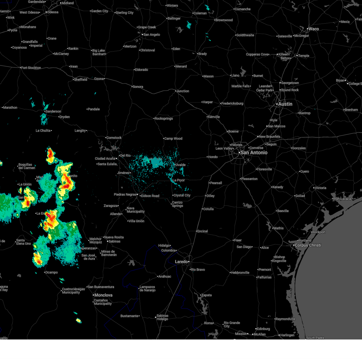
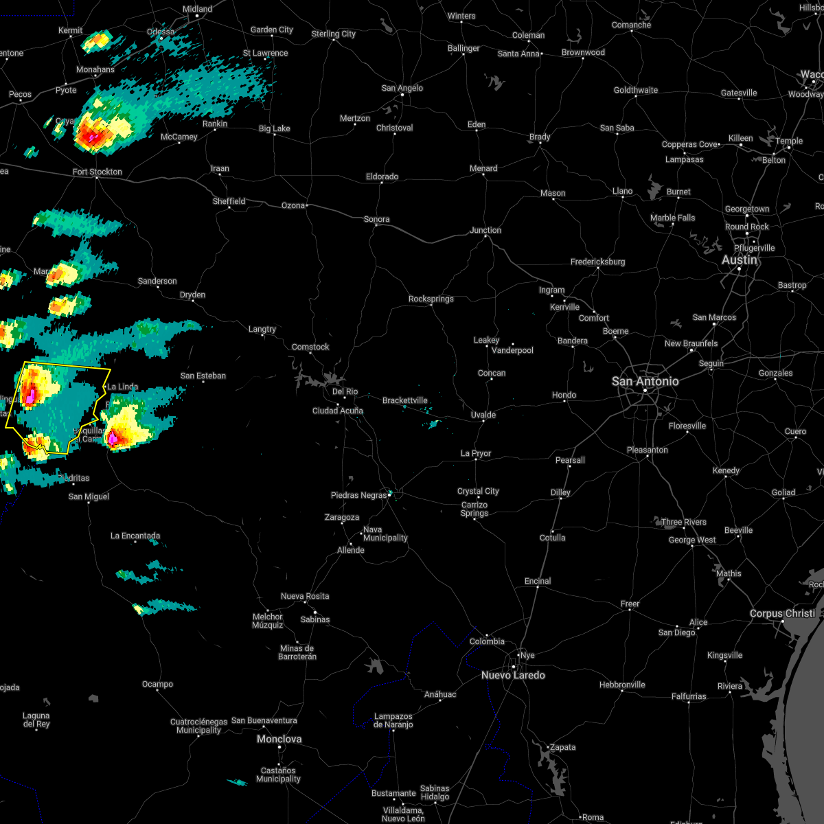
| 7/19/2026 4:36 PM CDT |
 The storm which prompted the warning has weakened below severe limits, and no longer poses an immediate threat to life or property. therefore, the warning will be allowed to expire. The storm which prompted the warning has weakened below severe limits, and no longer poses an immediate threat to life or property. therefore, the warning will be allowed to expire.
|
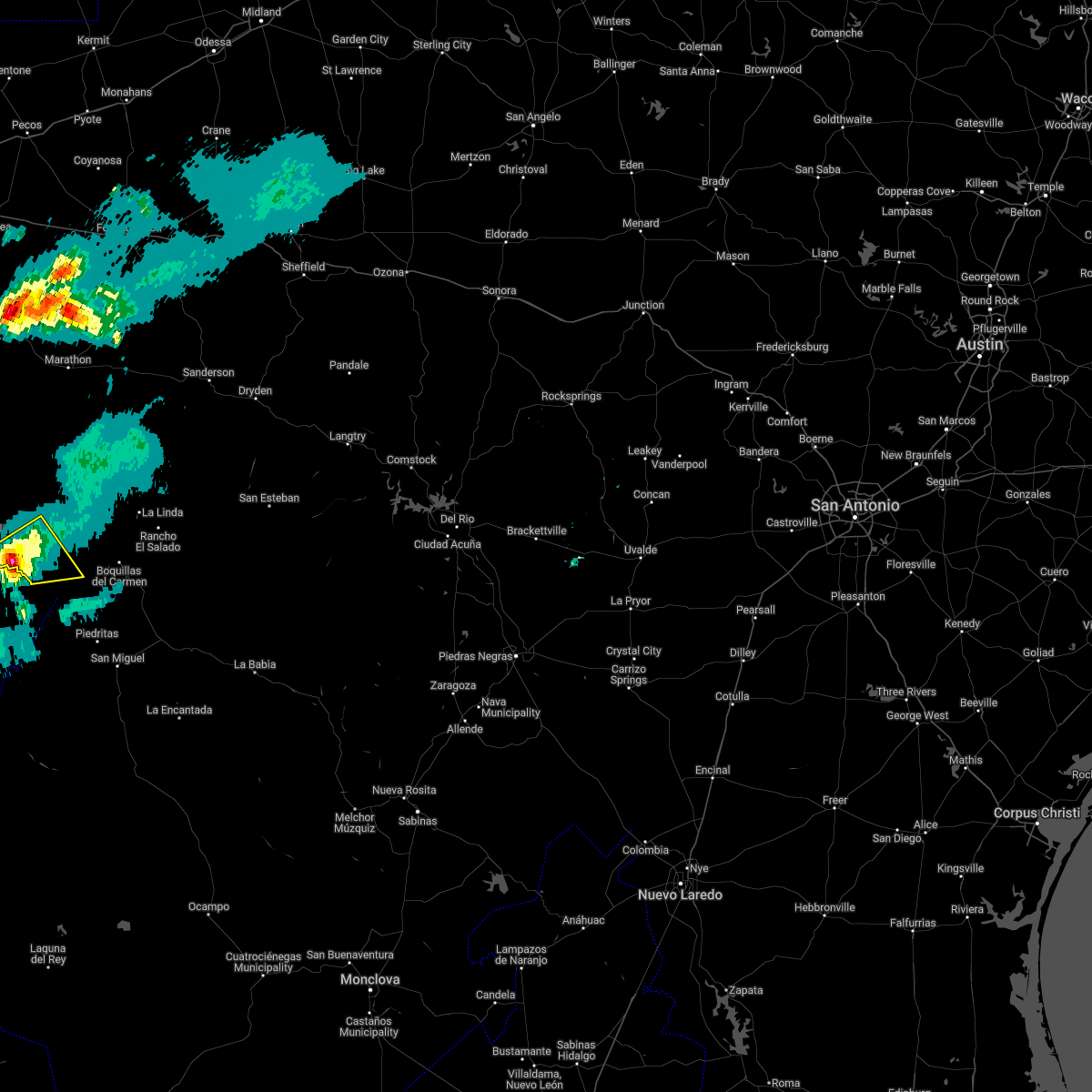
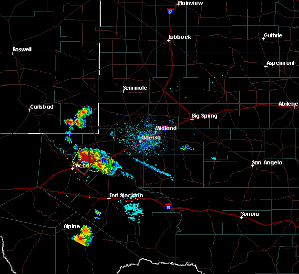
| 7/19/2026 4:23 PM CDT |
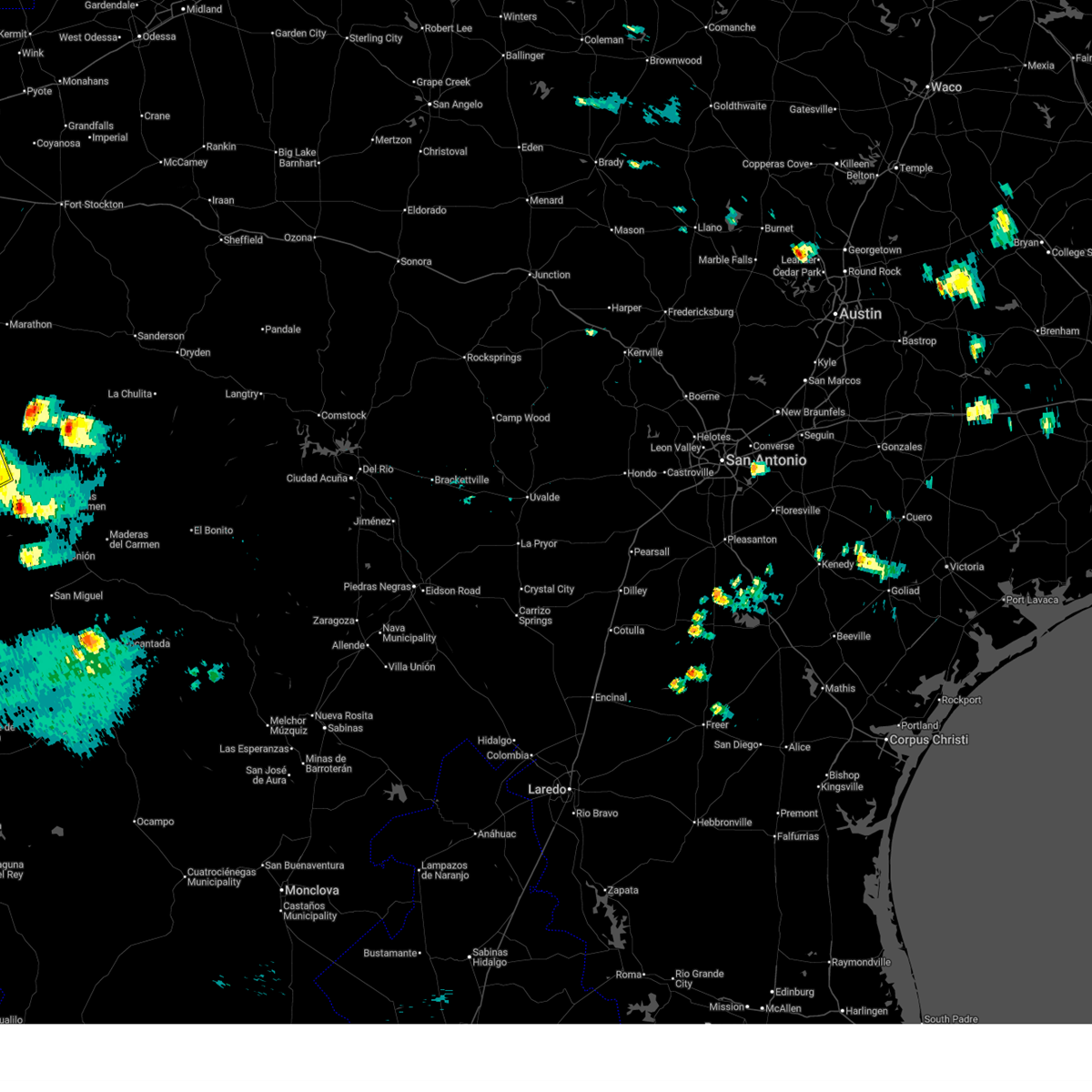
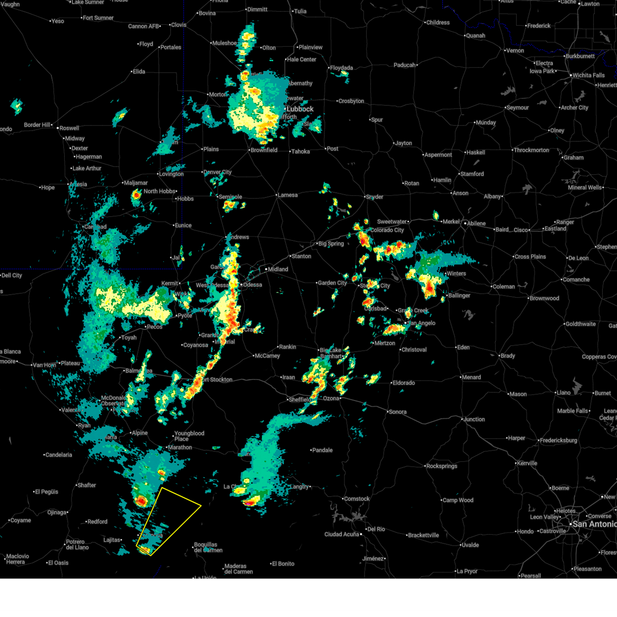
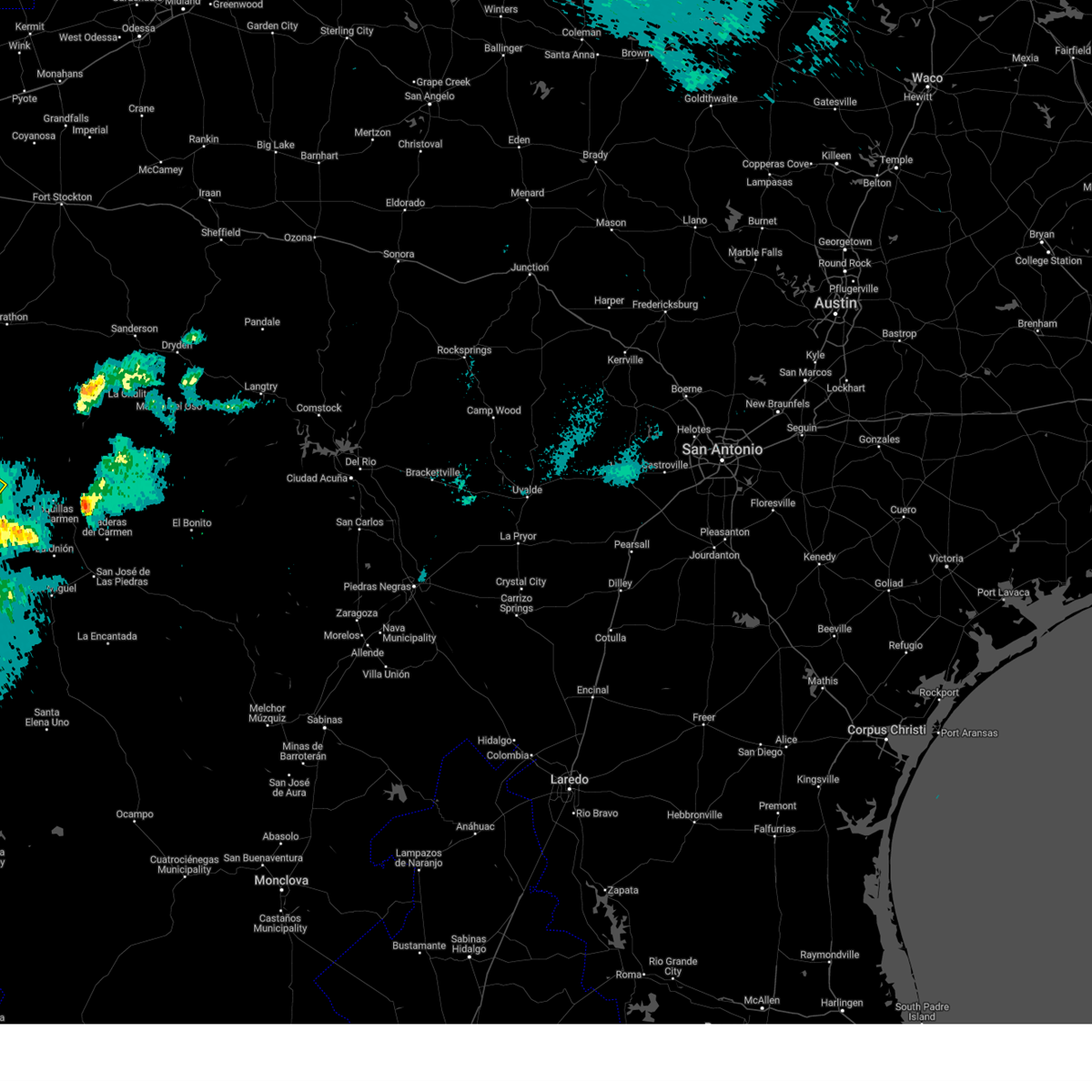
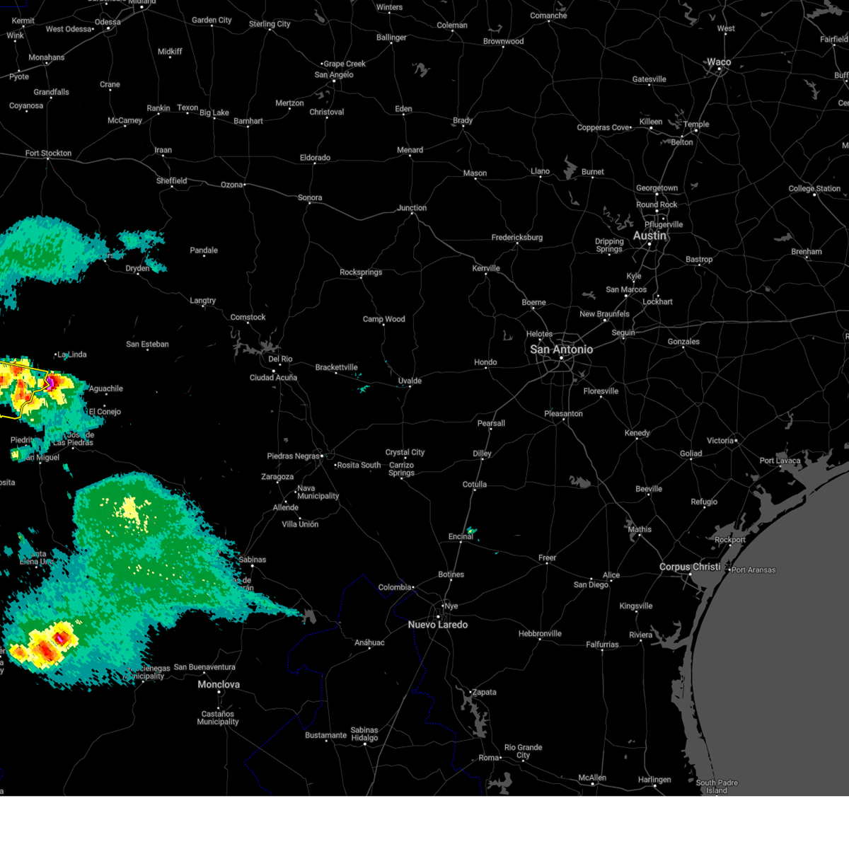
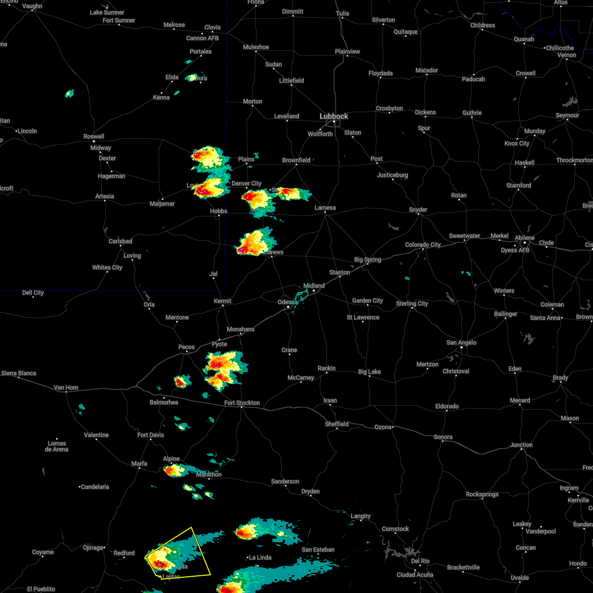
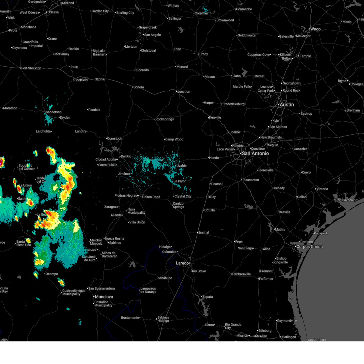 At 423 pm cdt, a severe thunderstorm was located 7 miles northwest of castolon, or 10 miles southeast of lajitas, moving north at 10 mph (radar indicated). Hazards include 60 mph wind gusts and penny size hail. Expect damage to roofs, siding, and trees. Locations impacted include, terlingua, study butte, and castolon. At 423 pm cdt, a severe thunderstorm was located 7 miles northwest of castolon, or 10 miles southeast of lajitas, moving north at 10 mph (radar indicated). Hazards include 60 mph wind gusts and penny size hail. Expect damage to roofs, siding, and trees. Locations impacted include, terlingua, study butte, and castolon.
|
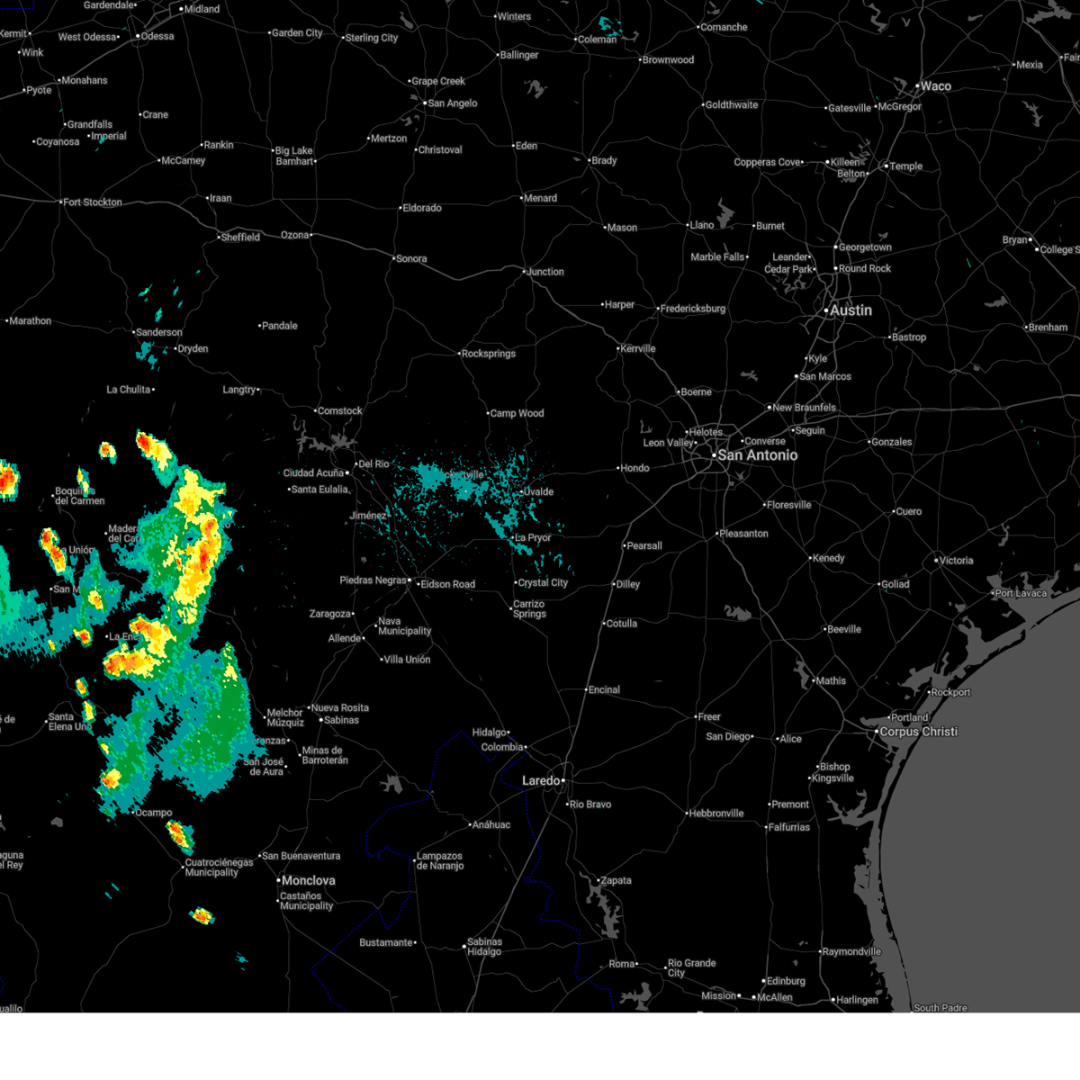
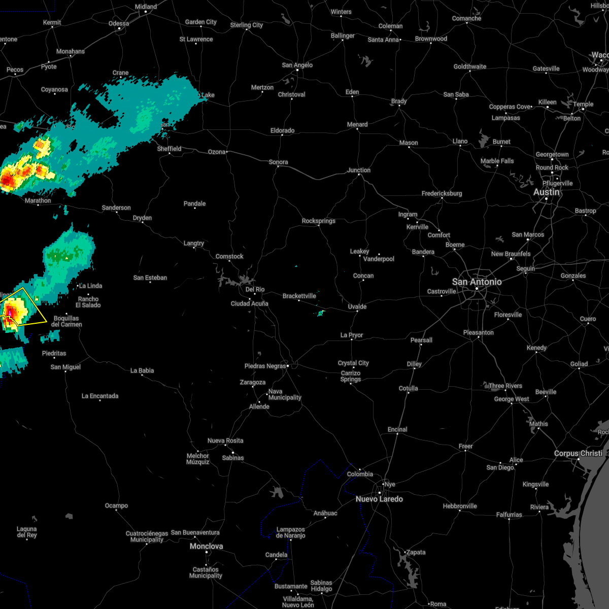
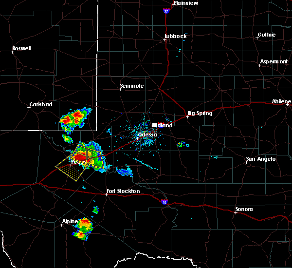
| 7/19/2026 4:03 PM CDT |
 Svrmaf the national weather service in midland has issued a * severe thunderstorm warning for, southwestern brewster county in southwestern texas, * until 445 pm cdt. * at 403 pm cdt, a severe thunderstorm was located near castolon, or 11 miles southeast of lajitas, moving north at 10 mph (radar indicated). Hazards include 60 mph wind gusts and quarter size hail. Hail damage to vehicles is expected. Expect wind damage to roofs, siding, and trees. Svrmaf the national weather service in midland has issued a * severe thunderstorm warning for, southwestern brewster county in southwestern texas, * until 445 pm cdt. * at 403 pm cdt, a severe thunderstorm was located near castolon, or 11 miles southeast of lajitas, moving north at 10 mph (radar indicated). Hazards include 60 mph wind gusts and quarter size hail. Hail damage to vehicles is expected. Expect wind damage to roofs, siding, and trees.
|
| 6/2/2026 6:59 PM CDT |
 At 659 pm cdt, a severe thunderstorm was located 14 miles northeast of study butte, or 18 miles northwest of panther junction, moving north at 10 mph (radar indicated). Hazards include 60 mph wind gusts and quarter size hail. Hail damage to vehicles is expected. expect wind damage to roofs, siding, and trees. Locations impacted include, terlingua, study butte, big bend national park, terlingua ranch airport, and terlingua ranch lodge. At 659 pm cdt, a severe thunderstorm was located 14 miles northeast of study butte, or 18 miles northwest of panther junction, moving north at 10 mph (radar indicated). Hazards include 60 mph wind gusts and quarter size hail. Hail damage to vehicles is expected. expect wind damage to roofs, siding, and trees. Locations impacted include, terlingua, study butte, big bend national park, terlingua ranch airport, and terlingua ranch lodge.
|
| 6/2/2026 6:35 PM CDT |
 Svrmaf the national weather service in midland has issued a * severe thunderstorm warning for, southwestern brewster county in southwestern texas, * until 730 pm cdt. * at 635 pm cdt, a severe thunderstorm was located 9 miles northeast of study butte, or 16 miles west of panther junction, moving northeast at 10 mph (radar indicated). Hazards include 60 mph wind gusts and quarter size hail. Hail damage to vehicles is expected. Expect wind damage to roofs, siding, and trees. Svrmaf the national weather service in midland has issued a * severe thunderstorm warning for, southwestern brewster county in southwestern texas, * until 730 pm cdt. * at 635 pm cdt, a severe thunderstorm was located 9 miles northeast of study butte, or 16 miles west of panther junction, moving northeast at 10 mph (radar indicated). Hazards include 60 mph wind gusts and quarter size hail. Hail damage to vehicles is expected. Expect wind damage to roofs, siding, and trees.
|
| 5/20/2026 4:53 PM CDT |
 The storm which prompted the warning has weakened below severe limits, and no longer poses an immediate threat to life or property. therefore, the warning will be allowed to expire. a severe thunderstorm watch remains in effect until 1000 pm cdt for southwestern texas. The storm which prompted the warning has weakened below severe limits, and no longer poses an immediate threat to life or property. therefore, the warning will be allowed to expire. a severe thunderstorm watch remains in effect until 1000 pm cdt for southwestern texas.
|
| 5/20/2026 4:45 PM CDT |
 At 445 pm cdt, a severe thunderstorm was located 7 miles northeast of terlingua, or 17 miles northeast of lajitas, moving east at 15 mph (radar indicated). Hazards include 60 mph wind gusts and quarter size hail. Hail damage to vehicles is expected. expect wind damage to roofs, siding, and trees. Locations impacted include, terlingua, study butte, big bend national park, and terlingua ranch airport. At 445 pm cdt, a severe thunderstorm was located 7 miles northeast of terlingua, or 17 miles northeast of lajitas, moving east at 15 mph (radar indicated). Hazards include 60 mph wind gusts and quarter size hail. Hail damage to vehicles is expected. expect wind damage to roofs, siding, and trees. Locations impacted include, terlingua, study butte, big bend national park, and terlingua ranch airport.
|
| 5/20/2026 4:34 PM CDT |
 Svrmaf the national weather service in midland has issued a * severe thunderstorm warning for, southwestern brewster county in southwestern texas, * until 500 pm cdt. * at 433 pm cdt, a severe thunderstorm was located 7 miles north of terlingua, or 14 miles northeast of lajitas, moving east at 10 mph (radar indicated). Hazards include 60 mph wind gusts and quarter size hail. Hail damage to vehicles is expected. Expect wind damage to roofs, siding, and trees. Svrmaf the national weather service in midland has issued a * severe thunderstorm warning for, southwestern brewster county in southwestern texas, * until 500 pm cdt. * at 433 pm cdt, a severe thunderstorm was located 7 miles north of terlingua, or 14 miles northeast of lajitas, moving east at 10 mph (radar indicated). Hazards include 60 mph wind gusts and quarter size hail. Hail damage to vehicles is expected. Expect wind damage to roofs, siding, and trees.
|
| 5/20/2026 3:43 PM CDT |
 the severe thunderstorm warning has been cancelled and is no longer in effect the severe thunderstorm warning has been cancelled and is no longer in effect
|
| 5/20/2026 3:23 PM CDT |
 Svrmaf the national weather service in midland has issued a * severe thunderstorm warning for, southwestern brewster county in southwestern texas, * until 400 pm cdt. * at 323 pm cdt, a severe thunderstorm was located 7 miles west of castolon, or 11 miles southeast of lajitas, moving northeast at 20 mph (radar indicated). Hazards include 60 mph wind gusts and quarter size hail. Hail damage to vehicles is expected. Expect wind damage to roofs, siding, and trees. Svrmaf the national weather service in midland has issued a * severe thunderstorm warning for, southwestern brewster county in southwestern texas, * until 400 pm cdt. * at 323 pm cdt, a severe thunderstorm was located 7 miles west of castolon, or 11 miles southeast of lajitas, moving northeast at 20 mph (radar indicated). Hazards include 60 mph wind gusts and quarter size hail. Hail damage to vehicles is expected. Expect wind damage to roofs, siding, and trees.
|
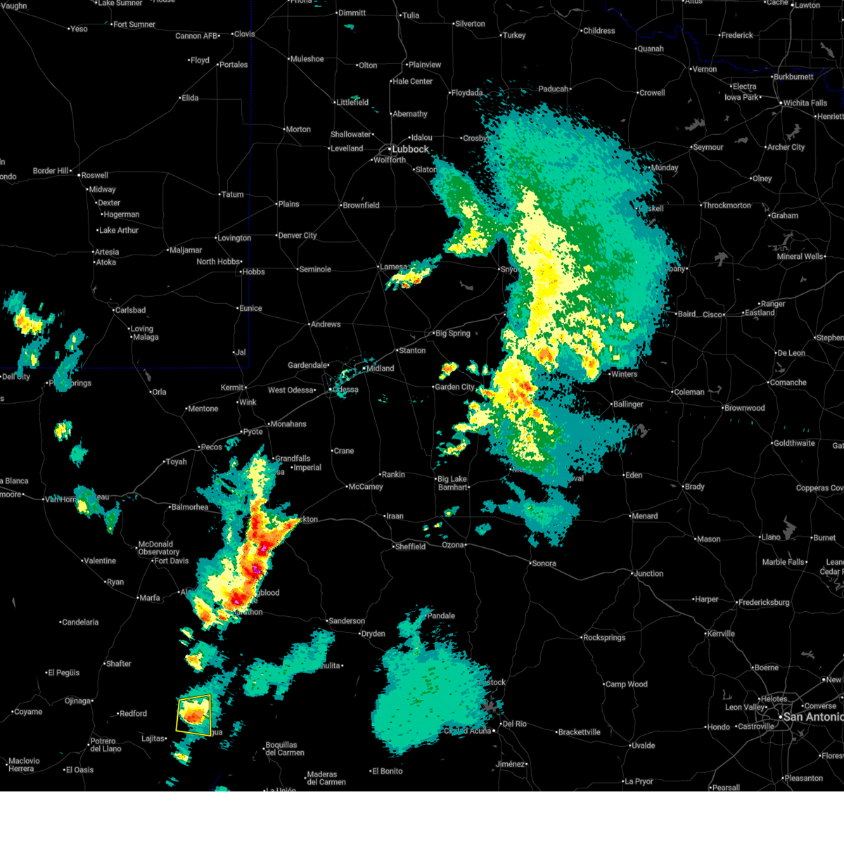
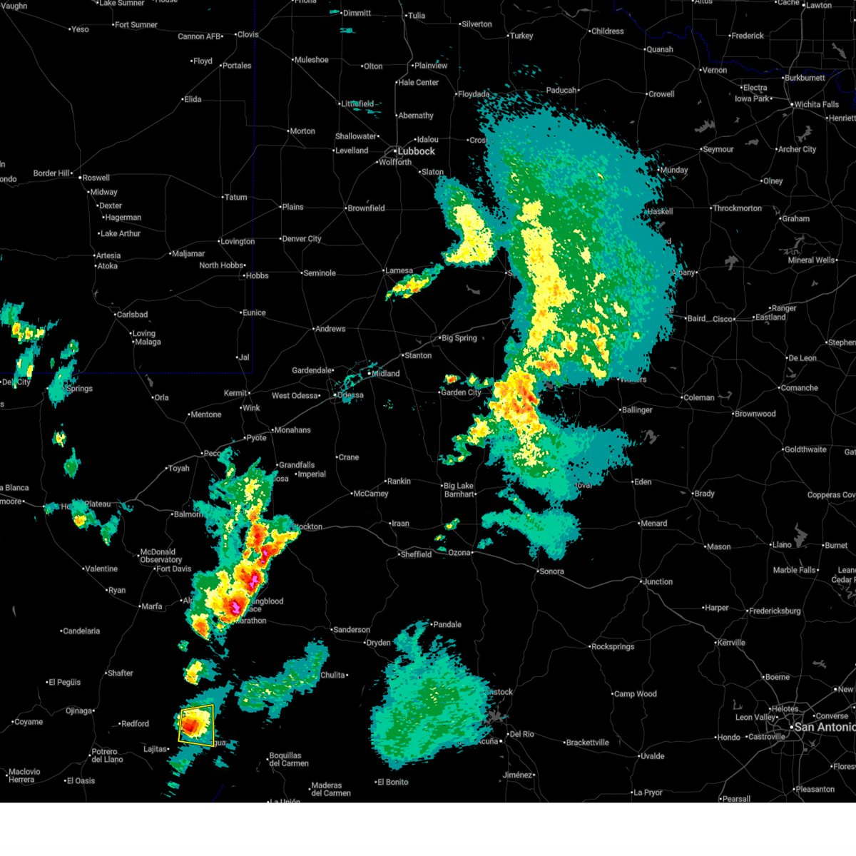
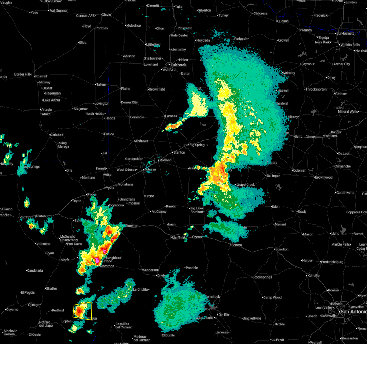
| 4/11/2026 3:54 PM CDT |
 Svrmaf the national weather service in midland has issued a * severe thunderstorm warning for, southwestern brewster county in southwestern texas, * until 500 pm cdt. * at 354 pm cdt, a severe thunderstorm was located near castolon, or 17 miles southwest of panther junction, moving northeast at 45 mph (radar indicated). Hazards include 70 mph wind gusts and half dollar size hail. Hail damage to vehicles is expected. expect considerable tree damage. Wind damage is also likely to mobile homes, roofs, and outbuildings. Svrmaf the national weather service in midland has issued a * severe thunderstorm warning for, southwestern brewster county in southwestern texas, * until 500 pm cdt. * at 354 pm cdt, a severe thunderstorm was located near castolon, or 17 miles southwest of panther junction, moving northeast at 45 mph (radar indicated). Hazards include 70 mph wind gusts and half dollar size hail. Hail damage to vehicles is expected. expect considerable tree damage. Wind damage is also likely to mobile homes, roofs, and outbuildings.
|
| 4/11/2026 3:46 PM CDT |
Mesonet station 123 1nw castolon... bbnp big bend np/brewste in brewster county TX, 10.2 miles NNW of Terlingua, TX
|
| 7/13/2025 5:02 PM CDT |
The west texas mesonet station 123 1nw castolon bbnp measured a 64 mph thunderstorm wind gus in brewster county TX, 10.2 miles NNW of Terlingua, TX
|
| 6/13/2025 8:24 PM CDT |
 Svrmaf the national weather service in midland has issued a * severe thunderstorm warning for, southwestern brewster county in southwestern texas, * until 915 pm cdt. * at 824 pm cdt, a severe thunderstorm was located over castolon, or 19 miles southeast of lajitas, moving west at 10 mph (radar indicated). Hazards include 60 mph wind gusts and quarter size hail. Hail damage to vehicles is expected. Expect wind damage to roofs, siding, and trees. Svrmaf the national weather service in midland has issued a * severe thunderstorm warning for, southwestern brewster county in southwestern texas, * until 915 pm cdt. * at 824 pm cdt, a severe thunderstorm was located over castolon, or 19 miles southeast of lajitas, moving west at 10 mph (radar indicated). Hazards include 60 mph wind gusts and quarter size hail. Hail damage to vehicles is expected. Expect wind damage to roofs, siding, and trees.
|
| 6/8/2025 9:58 PM CDT |
 the severe thunderstorm warning has been cancelled and is no longer in effect the severe thunderstorm warning has been cancelled and is no longer in effect
|
| 6/8/2025 9:43 PM CDT |
 Svrmaf the national weather service in midland has issued a * severe thunderstorm warning for, southwestern brewster county in southwestern texas, * until 1030 pm cdt. * at 943 pm cdt, a severe thunderstorm was located over castolon, or 17 miles southeast of lajitas, moving northeast at 25 mph (radar indicated). Hazards include 60 mph wind gusts and quarter size hail. Hail damage to vehicles is expected. Expect wind damage to roofs, siding, and trees. Svrmaf the national weather service in midland has issued a * severe thunderstorm warning for, southwestern brewster county in southwestern texas, * until 1030 pm cdt. * at 943 pm cdt, a severe thunderstorm was located over castolon, or 17 miles southeast of lajitas, moving northeast at 25 mph (radar indicated). Hazards include 60 mph wind gusts and quarter size hail. Hail damage to vehicles is expected. Expect wind damage to roofs, siding, and trees.
|
| 6/1/2024 5:52 PM CDT |
 At 552 pm cdt, a severe thunderstorm was located near castolon, or 17 miles southwest of panther junction, moving east at 25 mph (radar indicated). Hazards include ping pong ball size hail and 60 mph wind gusts. People and animals outdoors will be injured. expect hail damage to roofs, siding, windows, and vehicles. expect wind damage to roofs, siding, and trees. Locations impacted include, chisos basin, study butte, and big bend national park. At 552 pm cdt, a severe thunderstorm was located near castolon, or 17 miles southwest of panther junction, moving east at 25 mph (radar indicated). Hazards include ping pong ball size hail and 60 mph wind gusts. People and animals outdoors will be injured. expect hail damage to roofs, siding, windows, and vehicles. expect wind damage to roofs, siding, and trees. Locations impacted include, chisos basin, study butte, and big bend national park.
|
| 6/1/2024 5:24 PM CDT |
 Svrmaf the national weather service in midland has issued a * severe thunderstorm warning for, southwestern brewster county in southwestern texas, * until 615 pm cdt. * at 524 pm cdt, a severe thunderstorm was located 8 miles northwest of castolon, or 9 miles southeast of lajitas, moving east at 20 mph (radar indicated). Hazards include ping pong ball size hail and 60 mph wind gusts. People and animals outdoors will be injured. expect hail damage to roofs, siding, windows, and vehicles. Expect wind damage to roofs, siding, and trees. Svrmaf the national weather service in midland has issued a * severe thunderstorm warning for, southwestern brewster county in southwestern texas, * until 615 pm cdt. * at 524 pm cdt, a severe thunderstorm was located 8 miles northwest of castolon, or 9 miles southeast of lajitas, moving east at 20 mph (radar indicated). Hazards include ping pong ball size hail and 60 mph wind gusts. People and animals outdoors will be injured. expect hail damage to roofs, siding, windows, and vehicles. Expect wind damage to roofs, siding, and trees.
|
| 5/27/2023 7:52 PM CDT |
Wtm castolon 1n in brewster county TX, 10.4 miles NNW of Terlingua, TX
|
| 5/25/2023 7:31 PM CDT |
 At 731 pm cdt, a severe thunderstorm was located 8 miles east of study butte, or 13 miles west of panther junction, moving north at 15 mph (radar indicated). Hazards include 60 mph wind gusts and half dollar size hail. Hail damage to vehicles is expected. expect wind damage to roofs, siding, and trees. locations impacted include, panther junction, chisos basin, study butte, castolon, big bend national park, boquillas canyon and terlingua. hail threat, radar indicated max hail size, 1. 25 in wind threat, radar indicated max wind gust, 60 mph. At 731 pm cdt, a severe thunderstorm was located 8 miles east of study butte, or 13 miles west of panther junction, moving north at 15 mph (radar indicated). Hazards include 60 mph wind gusts and half dollar size hail. Hail damage to vehicles is expected. expect wind damage to roofs, siding, and trees. locations impacted include, panther junction, chisos basin, study butte, castolon, big bend national park, boquillas canyon and terlingua. hail threat, radar indicated max hail size, 1. 25 in wind threat, radar indicated max wind gust, 60 mph.
|
| 5/25/2023 7:07 PM CDT |
 At 706 pm cdt, a cluster of severe thunderstorms are located 7 miles southeast of study butte, or 16 miles west of panther junction, moving southeast at 10 mph (radar indicated). Hazards include 60 mph wind gusts and half dollar size hail. Hail damage to vehicles is expected. Expect wind damage to roofs, siding, and trees. At 706 pm cdt, a cluster of severe thunderstorms are located 7 miles southeast of study butte, or 16 miles west of panther junction, moving southeast at 10 mph (radar indicated). Hazards include 60 mph wind gusts and half dollar size hail. Hail damage to vehicles is expected. Expect wind damage to roofs, siding, and trees.
|
| 8/28/2022 5:02 PM CDT |
Mesonet station 123 1nw castolon... bbnp big bend np/brewste in brewster county TX, 10.2 miles NNW of Terlingua, TX
|
| 8/17/2022 6:52 PM CDT |
 At 651 pm cdt, a severe thunderstorm was located 7 miles west of castolon, or 10 miles southeast of lajitas, moving west at 15 mph (radar indicated). Hazards include 60 mph wind gusts and quarter size hail. Hail damage to vehicles is expected. expect wind damage to roofs, siding, and trees. locations impacted include, castolon and study butte. hail threat, radar indicated max hail size, 1. 00 in wind threat, radar indicated max wind gust, 60 mph. At 651 pm cdt, a severe thunderstorm was located 7 miles west of castolon, or 10 miles southeast of lajitas, moving west at 15 mph (radar indicated). Hazards include 60 mph wind gusts and quarter size hail. Hail damage to vehicles is expected. expect wind damage to roofs, siding, and trees. locations impacted include, castolon and study butte. hail threat, radar indicated max hail size, 1. 00 in wind threat, radar indicated max wind gust, 60 mph.
|
| 8/17/2022 6:25 PM CDT |
 At 625 pm cdt, a severe thunderstorm was located over castolon, or 18 miles east of lajitas, and is nearly stationary (radar indicated). Hazards include 60 mph wind gusts and quarter size hail. Hail damage to vehicles is expected. Expect wind damage to roofs, siding, and trees. At 625 pm cdt, a severe thunderstorm was located over castolon, or 18 miles east of lajitas, and is nearly stationary (radar indicated). Hazards include 60 mph wind gusts and quarter size hail. Hail damage to vehicles is expected. Expect wind damage to roofs, siding, and trees.
|
| 8/17/2022 6:24 PM CDT |
1nw castolon bbn in brewster county TX, 10.4 miles NNW of Terlingua, TX
|
|
|
| 8/17/2022 6:08 PM CDT |
Mesonet station 123 1nw castolon... bbnp big bend np/brewste in brewster county TX, 10.2 miles NNW of Terlingua, TX
|
| 5/31/2022 8:26 PM CDT |
 At 825 pm cdt, a severe thunderstorm was located near castolon, or 16 miles east of lajitas, moving east at 15 mph. this is a destructive storm for big bend national park (west texas mesonet at castolon). Hazards include 80 mph wind gusts and half dollar size hail. Flying debris will be dangerous to those caught without shelter. mobile homes will be heavily damaged. expect considerable damage to roofs, windows, and vehicles. extensive tree damage and power outages are likely. locations impacted include, chisos basin, study butte, castolon and big bend national park. thunderstorm damage threat, destructive hail threat, radar indicated max hail size, 1. 25 in wind threat, radar indicated max wind gust, 80 mph. At 825 pm cdt, a severe thunderstorm was located near castolon, or 16 miles east of lajitas, moving east at 15 mph. this is a destructive storm for big bend national park (west texas mesonet at castolon). Hazards include 80 mph wind gusts and half dollar size hail. Flying debris will be dangerous to those caught without shelter. mobile homes will be heavily damaged. expect considerable damage to roofs, windows, and vehicles. extensive tree damage and power outages are likely. locations impacted include, chisos basin, study butte, castolon and big bend national park. thunderstorm damage threat, destructive hail threat, radar indicated max hail size, 1. 25 in wind threat, radar indicated max wind gust, 80 mph.
|
| 5/31/2022 8:16 PM CDT |
Storm damage reported in brewster county TX, 11.3 miles NNW of Terlingua, TX
|
| 5/31/2022 8:11 PM CDT |
 At 811 pm cdt, a severe thunderstorm was located near castolon, or 13 miles east of lajitas, moving northeast at 15 mph (radar indicated). Hazards include 60 mph wind gusts and half dollar size hail. Hail damage to vehicles is expected. Expect wind damage to roofs, siding, and trees. At 811 pm cdt, a severe thunderstorm was located near castolon, or 13 miles east of lajitas, moving northeast at 15 mph (radar indicated). Hazards include 60 mph wind gusts and half dollar size hail. Hail damage to vehicles is expected. Expect wind damage to roofs, siding, and trees.
|
| 5/1/2022 5:10 PM CDT |
 At 510 pm cdt, a severe thunderstorm was located 8 miles northwest of chisos basin, or 9 miles west of panther junction, moving east at 40 mph (radar indicated). Hazards include 60 mph wind gusts and quarter size hail. Hail damage to vehicles is expected. Expect wind damage to roofs, siding, and trees. At 510 pm cdt, a severe thunderstorm was located 8 miles northwest of chisos basin, or 9 miles west of panther junction, moving east at 40 mph (radar indicated). Hazards include 60 mph wind gusts and quarter size hail. Hail damage to vehicles is expected. Expect wind damage to roofs, siding, and trees.
|
| 5/1/2022 4:32 PM CDT |
 At 432 pm cdt, a severe thunderstorm was located 7 miles northwest of terlingua, or 12 miles northeast of lajitas, moving east at 25 mph (radar indicated). Hazards include 60 mph wind gusts and quarter size hail. Hail damage to vehicles is expected. expect wind damage to roofs, siding, and trees. locations impacted include, lajitas, study butte, terlingua, big bend national park, terlingua ranch airport, terlingua ranch lodge and barton warnock environmental educational center. hail threat, radar indicated max hail size, 1. 00 in wind threat, radar indicated max wind gust, 60 mph. At 432 pm cdt, a severe thunderstorm was located 7 miles northwest of terlingua, or 12 miles northeast of lajitas, moving east at 25 mph (radar indicated). Hazards include 60 mph wind gusts and quarter size hail. Hail damage to vehicles is expected. expect wind damage to roofs, siding, and trees. locations impacted include, lajitas, study butte, terlingua, big bend national park, terlingua ranch airport, terlingua ranch lodge and barton warnock environmental educational center. hail threat, radar indicated max hail size, 1. 00 in wind threat, radar indicated max wind gust, 60 mph.
|
| 5/1/2022 4:19 PM CDT |
 At 419 pm cdt, a severe thunderstorm was located 9 miles north of lajitas, moving east at 25 mph (radar indicated). Hazards include 60 mph wind gusts and quarter size hail. Hail damage to vehicles is expected. Expect wind damage to roofs, siding, and trees. At 419 pm cdt, a severe thunderstorm was located 9 miles north of lajitas, moving east at 25 mph (radar indicated). Hazards include 60 mph wind gusts and quarter size hail. Hail damage to vehicles is expected. Expect wind damage to roofs, siding, and trees.
|
| 10/21/2021 8:22 PM CDT |
 At 822 pm cdt, severe thunderstorms were located over castolon, or 16 miles southeast of lajitas, and near boquillas and nearly stationary (radar indicated). Hazards include golf ball size hail and 60 mph wind gusts. People and animals outdoors will be injured. expect hail damage to roofs, siding, windows, and vehicles. expect wind damage to roofs, siding, and trees. locations impacted include, panther junction, chisos basin, terlingua, study butte, castolon and big bend national park. thunderstorm damage threat, considerable hail threat, radar indicated max hail size, 1. 75 in wind threat, radar indicated max wind gust, 60 mph. At 822 pm cdt, severe thunderstorms were located over castolon, or 16 miles southeast of lajitas, and near boquillas and nearly stationary (radar indicated). Hazards include golf ball size hail and 60 mph wind gusts. People and animals outdoors will be injured. expect hail damage to roofs, siding, windows, and vehicles. expect wind damage to roofs, siding, and trees. locations impacted include, panther junction, chisos basin, terlingua, study butte, castolon and big bend national park. thunderstorm damage threat, considerable hail threat, radar indicated max hail size, 1. 75 in wind threat, radar indicated max wind gust, 60 mph.
|
| 10/21/2021 8:18 PM CDT |
Castolon mesonet measured a 67 mph wind gus in brewster county TX, 11.3 miles NNW of Terlingua, TX
|
| 10/21/2021 8:08 PM CDT |
 At 807 pm cdt, a severe thunderstorm was located near castolon, or 14 miles southeast of lajitas, moving southeast at 15 mph (radar indicated). Hazards include golf ball size hail and 60 mph wind gusts. People and animals outdoors will be injured. expect hail damage to roofs, siding, windows, and vehicles. Expect wind damage to roofs, siding, and trees. At 807 pm cdt, a severe thunderstorm was located near castolon, or 14 miles southeast of lajitas, moving southeast at 15 mph (radar indicated). Hazards include golf ball size hail and 60 mph wind gusts. People and animals outdoors will be injured. expect hail damage to roofs, siding, windows, and vehicles. Expect wind damage to roofs, siding, and trees.
|
| 6/26/2021 5:26 PM CDT |
 At 525 pm cdt, a severe thunderstorm was located near castolon, or 13 miles east of lajitas, and is nearly stationary (67 mph wind gusts were reported by the castolon mesonet). Hazards include 70 mph wind gusts and penny size hail. Expect considerable tree damage. Damage is likely to mobile homes, roofs, and outbuildings. At 525 pm cdt, a severe thunderstorm was located near castolon, or 13 miles east of lajitas, and is nearly stationary (67 mph wind gusts were reported by the castolon mesonet). Hazards include 70 mph wind gusts and penny size hail. Expect considerable tree damage. Damage is likely to mobile homes, roofs, and outbuildings.
|
| 6/26/2021 5:17 PM CDT |
Castolon mesonet measured a wind gust of 67 mp in brewster county TX, 11.3 miles NNW of Terlingua, TX
|
| 6/26/2021 5:11 PM CDT |
Castolon mesnoet measured a wind gust of 63 mp in brewster county TX, 11.3 miles NNW of Terlingua, TX
|
| 5/11/2020 6:45 PM CDT |
 At 645 pm cdt, a severe thunderstorm was located near castolon, or 18 miles east of lajitas, moving northeast at 15 mph (radar indicated). Hazards include 70 mph wind gusts. Expect considerable tree damage. damage is likely to mobile homes, roofs, and outbuildings. Locations impacted include, panther junction, chisos basin, terlingua, study butte, castolon and big bend national park. At 645 pm cdt, a severe thunderstorm was located near castolon, or 18 miles east of lajitas, moving northeast at 15 mph (radar indicated). Hazards include 70 mph wind gusts. Expect considerable tree damage. damage is likely to mobile homes, roofs, and outbuildings. Locations impacted include, panther junction, chisos basin, terlingua, study butte, castolon and big bend national park.
|
| 5/11/2020 6:12 PM CDT |
 At 611 pm cdt, a severe thunderstorm was located over terlingua, or 11 miles northeast of lajitas, moving east at 15 mph (radar indicated). Hazards include 70 mph wind gusts. Expect considerable tree damage. Damage is likely to mobile homes, roofs, and outbuildings. At 611 pm cdt, a severe thunderstorm was located over terlingua, or 11 miles northeast of lajitas, moving east at 15 mph (radar indicated). Hazards include 70 mph wind gusts. Expect considerable tree damage. Damage is likely to mobile homes, roofs, and outbuildings.
|
| 5/11/2020 6:01 PM CDT |
Storm damage reported in brewster county TX, 11.3 miles NNW of Terlingua, TX
|
| 5/10/2020 8:48 PM CDT |
Winds gusted over 60 mph for around 10 minute in brewster county TX, 11.3 miles NNW of Terlingua, TX
|
| 3/15/2020 4:11 PM CDT |
 At 410 pm cdt, a severe thunderstorm was located 7 miles northeast of castolon, or 5 miles southwest of chisos basin, moving northeast at 30 mph. this is a very dangerous storm (radar indicated). Hazards include baseball size hail and 70 mph wind gusts. People and animals outdoors will be severely injured. expect shattered windows, extensive damage to roofs, siding, and vehicles. Locations impacted include, chisos basin, terlingua, study butte, castolon and big bend national park. At 410 pm cdt, a severe thunderstorm was located 7 miles northeast of castolon, or 5 miles southwest of chisos basin, moving northeast at 30 mph. this is a very dangerous storm (radar indicated). Hazards include baseball size hail and 70 mph wind gusts. People and animals outdoors will be severely injured. expect shattered windows, extensive damage to roofs, siding, and vehicles. Locations impacted include, chisos basin, terlingua, study butte, castolon and big bend national park.
|
| 3/15/2020 4:03 PM CDT |
 At 402 pm cdt, a severe thunderstorm was located near castolon, or 17 miles southwest of panther junction, moving northeast at 30 mph (radar indicated). Hazards include golf ball size hail and 60 mph wind gusts. People and animals outdoors will be injured. expect hail damage to roofs, siding, windows, and vehicles. expect wind damage to roofs, siding, and trees. Locations impacted include, chisos basin, terlingua, study butte, castolon and big bend national park. At 402 pm cdt, a severe thunderstorm was located near castolon, or 17 miles southwest of panther junction, moving northeast at 30 mph (radar indicated). Hazards include golf ball size hail and 60 mph wind gusts. People and animals outdoors will be injured. expect hail damage to roofs, siding, windows, and vehicles. expect wind damage to roofs, siding, and trees. Locations impacted include, chisos basin, terlingua, study butte, castolon and big bend national park.
|
| 3/15/2020 3:39 PM CDT |
 At 338 pm cdt, a severe thunderstorm was located near castolon, or 17 miles southeast of lajitas, moving northeast at 25 mph (radar indicated). Hazards include golf ball size hail and 60 mph wind gusts. People and animals outdoors will be injured. expect hail damage to roofs, siding, windows, and vehicles. Expect wind damage to roofs, siding, and trees. At 338 pm cdt, a severe thunderstorm was located near castolon, or 17 miles southeast of lajitas, moving northeast at 25 mph (radar indicated). Hazards include golf ball size hail and 60 mph wind gusts. People and animals outdoors will be injured. expect hail damage to roofs, siding, windows, and vehicles. Expect wind damage to roofs, siding, and trees.
|
| 8/27/2019 8:22 PM CDT |
 At 821 pm cdt, a severe thunderstorm was located over terlingua, or 9 miles east of lajitas, moving southwest at 10 mph (radar indicated). Hazards include 60 mph wind gusts and quarter size hail. Hail damage to vehicles is expected. expect wind damage to roofs, siding, and trees. Locations impacted include, lajitas, terlingua, study butte and barton warnock environmental educational center. At 821 pm cdt, a severe thunderstorm was located over terlingua, or 9 miles east of lajitas, moving southwest at 10 mph (radar indicated). Hazards include 60 mph wind gusts and quarter size hail. Hail damage to vehicles is expected. expect wind damage to roofs, siding, and trees. Locations impacted include, lajitas, terlingua, study butte and barton warnock environmental educational center.
|
| 8/27/2019 8:06 PM CDT |
 At 806 pm cdt, a severe thunderstorm was located over terlingua, or 11 miles east of lajitas, moving southwest at 10 mph (radar indicated). Hazards include 60 mph wind gusts and quarter size hail. Hail damage to vehicles is expected. Expect wind damage to roofs, siding, and trees. At 806 pm cdt, a severe thunderstorm was located over terlingua, or 11 miles east of lajitas, moving southwest at 10 mph (radar indicated). Hazards include 60 mph wind gusts and quarter size hail. Hail damage to vehicles is expected. Expect wind damage to roofs, siding, and trees.
|
| 7/17/2019 7:13 PM CDT |
 At 712 pm cdt, a severe thunderstorm located over castolon, or 16 miles southeast of lajitas, and is nearly stationary (mesonet weather station). Hazards include 60 mph wind gusts and nickel size hail. Expect damage to roofs, siding, and trees. Locations impacted include, castolon, study butte and big bend national park. At 712 pm cdt, a severe thunderstorm located over castolon, or 16 miles southeast of lajitas, and is nearly stationary (mesonet weather station). Hazards include 60 mph wind gusts and nickel size hail. Expect damage to roofs, siding, and trees. Locations impacted include, castolon, study butte and big bend national park.
|
| 7/17/2019 6:49 PM CDT |
 At 649 pm cdt, a severe thunderstorm was located near castolon, or 15 miles east of lajitas, and is nearly stationary (mesonet weather station). Hazards include 60 mph wind gusts and nickel size hail. expect damage to roofs, siding, and trees At 649 pm cdt, a severe thunderstorm was located near castolon, or 15 miles east of lajitas, and is nearly stationary (mesonet weather station). Hazards include 60 mph wind gusts and nickel size hail. expect damage to roofs, siding, and trees
|
| 7/17/2019 6:39 PM CDT |
Measured on west texas mesonet. also saw 0.8 inches of rain in 20 minute in brewster county TX, 11.3 miles NNW of Terlingua, TX
|
|
|
| 6/18/2019 4:25 PM CDT |
 At 425 pm cdt, a severe thunderstorm was located near study butte, or 14 miles northeast of lajitas, moving northeast at 30 mph (radar indicated). Hazards include golf ball size hail and 60 mph wind gusts. People and animals outdoors will be injured. expect hail damage to roofs, siding, windows, and vehicles. expect wind damage to roofs, siding, and trees. Locations impacted include, terlingua, study butte, terlingua ranch airport and terlingua ranch lodge. At 425 pm cdt, a severe thunderstorm was located near study butte, or 14 miles northeast of lajitas, moving northeast at 30 mph (radar indicated). Hazards include golf ball size hail and 60 mph wind gusts. People and animals outdoors will be injured. expect hail damage to roofs, siding, windows, and vehicles. expect wind damage to roofs, siding, and trees. Locations impacted include, terlingua, study butte, terlingua ranch airport and terlingua ranch lodge.
|
| 6/18/2019 4:06 PM CDT |
 At 406 pm cdt, a severe thunderstorm was located near terlingua, or 7 miles east of lajitas, moving northeast at 30 mph (radar indicated). Hazards include 60 mph wind gusts and half dollar size hail. Hail damage to vehicles is expected. Expect wind damage to roofs, siding, and trees. At 406 pm cdt, a severe thunderstorm was located near terlingua, or 7 miles east of lajitas, moving northeast at 30 mph (radar indicated). Hazards include 60 mph wind gusts and half dollar size hail. Hail damage to vehicles is expected. Expect wind damage to roofs, siding, and trees.
|
| 6/17/2019 9:25 PM CDT |
Golf Ball sized hail reported 4.1 miles SW of Terlingua, TX, hail stones ranging from quarter to golf ball size.
|
| 6/17/2019 9:24 PM CDT |
 At 923 pm cdt, a severe thunderstorm was located over study butte, or 15 miles east of lajitas, moving east at 10 mph (radar indicated). Hazards include golf ball size hail and 60 mph wind gusts. People and animals outdoors will be injured. expect hail damage to roofs, siding, windows, and vehicles. expect wind damage to roofs, siding, and trees. Locations impacted include, terlingua, study butte, big bend national park, terlingua ranch airport and terlingua ranch lodge. At 923 pm cdt, a severe thunderstorm was located over study butte, or 15 miles east of lajitas, moving east at 10 mph (radar indicated). Hazards include golf ball size hail and 60 mph wind gusts. People and animals outdoors will be injured. expect hail damage to roofs, siding, windows, and vehicles. expect wind damage to roofs, siding, and trees. Locations impacted include, terlingua, study butte, big bend national park, terlingua ranch airport and terlingua ranch lodge.
|
| 6/17/2019 9:07 PM CDT |
 At 907 pm cdt, a severe thunderstorm was located over terlingua, or 11 miles east of lajitas, moving east at 10 mph (radar indicated). Hazards include ping pong ball size hail and 60 mph wind gusts. People and animals outdoors will be injured. expect hail damage to roofs, siding, windows, and vehicles. Expect wind damage to roofs, siding, and trees. At 907 pm cdt, a severe thunderstorm was located over terlingua, or 11 miles east of lajitas, moving east at 10 mph (radar indicated). Hazards include ping pong ball size hail and 60 mph wind gusts. People and animals outdoors will be injured. expect hail damage to roofs, siding, windows, and vehicles. Expect wind damage to roofs, siding, and trees.
|
| 5/30/2019 3:10 PM CDT |
 At 309 pm cdt, a severe thunderstorm was located near terlingua, or 8 miles northeast of lajitas, moving east at 25 mph (radar indicated). Hazards include 60 mph wind gusts and quarter size hail. Hail damage to vehicles is expected. expect wind damage to roofs, siding, and trees. Locations impacted include, terlingua, study butte, big bend national park, terlingua ranch airport and terlingua ranch lodge. At 309 pm cdt, a severe thunderstorm was located near terlingua, or 8 miles northeast of lajitas, moving east at 25 mph (radar indicated). Hazards include 60 mph wind gusts and quarter size hail. Hail damage to vehicles is expected. expect wind damage to roofs, siding, and trees. Locations impacted include, terlingua, study butte, big bend national park, terlingua ranch airport and terlingua ranch lodge.
|
| 5/30/2019 2:44 PM CDT |
 At 244 pm cdt, a severe thunderstorm was located near lajitas, moving east at 25 mph (radar indicated). Hazards include 60 mph wind gusts and quarter size hail. Hail damage to vehicles is expected. Expect wind damage to roofs, siding, and trees. At 244 pm cdt, a severe thunderstorm was located near lajitas, moving east at 25 mph (radar indicated). Hazards include 60 mph wind gusts and quarter size hail. Hail damage to vehicles is expected. Expect wind damage to roofs, siding, and trees.
|
| 5/23/2018 6:28 PM CDT |
 At 628 pm cdt, a severe thunderstorm was located near terlingua, or 13 miles northeast of lajitas, moving east at 25 mph (radar indicated). Hazards include 60 mph wind gusts and half dollar size hail. Hail damage to vehicles is expected. expect wind damage to roofs, siding, and trees. Locations impacted include, terlingua, study butte, big bend national park, terlingua ranch airport and terlingua ranch lodge. At 628 pm cdt, a severe thunderstorm was located near terlingua, or 13 miles northeast of lajitas, moving east at 25 mph (radar indicated). Hazards include 60 mph wind gusts and half dollar size hail. Hail damage to vehicles is expected. expect wind damage to roofs, siding, and trees. Locations impacted include, terlingua, study butte, big bend national park, terlingua ranch airport and terlingua ranch lodge.
|
| 5/23/2018 6:08 PM CDT |
 At 608 pm cdt, a severe thunderstorm was located 8 miles northwest of terlingua, or 11 miles north of lajitas, moving east at 15 mph (radar indicated). Hazards include 60 mph wind gusts and half dollar size hail. Hail damage to vehicles is expected. Expect wind damage to roofs, siding, and trees. At 608 pm cdt, a severe thunderstorm was located 8 miles northwest of terlingua, or 11 miles north of lajitas, moving east at 15 mph (radar indicated). Hazards include 60 mph wind gusts and half dollar size hail. Hail damage to vehicles is expected. Expect wind damage to roofs, siding, and trees.
|
| 5/30/2017 8:52 PM CDT |
 At 852 pm cdt, a severe thunderstorm was located near lajitas, moving north at 15 mph (radar indicated). Hazards include 60 mph wind gusts and quarter size hail. Hail damage to vehicles is expected. expect wind damage to roofs, siding, and trees. Locations impacted include, lajitas, terlingua, study butte-terlingua and barton warnock environmental educational center. At 852 pm cdt, a severe thunderstorm was located near lajitas, moving north at 15 mph (radar indicated). Hazards include 60 mph wind gusts and quarter size hail. Hail damage to vehicles is expected. expect wind damage to roofs, siding, and trees. Locations impacted include, lajitas, terlingua, study butte-terlingua and barton warnock environmental educational center.
|
| 5/30/2017 8:23 PM CDT |
 At 822 pm cdt, a severe thunderstorm was located over lajitas, moving northeast at 25 mph (radar indicated). Hazards include 60 mph wind gusts and half dollar size hail. Hail damage to vehicles is expected. Expect wind damage to roofs, siding, and trees. At 822 pm cdt, a severe thunderstorm was located over lajitas, moving northeast at 25 mph (radar indicated). Hazards include 60 mph wind gusts and half dollar size hail. Hail damage to vehicles is expected. Expect wind damage to roofs, siding, and trees.
|
| 5/29/2017 7:26 PM CDT |
 At 724 pm cdt, the public reported dime size hail falling at terlingua, or 12 miles northeast of lajitas. this storm was moving north at 10 mph (public). Hazards include 60 mph wind gusts and hail up to quarter size possible. Expect damage to roofs, siding, and trees. Locations impacted include, terlingua, study butte-terlingua and study butte. At 724 pm cdt, the public reported dime size hail falling at terlingua, or 12 miles northeast of lajitas. this storm was moving north at 10 mph (public). Hazards include 60 mph wind gusts and hail up to quarter size possible. Expect damage to roofs, siding, and trees. Locations impacted include, terlingua, study butte-terlingua and study butte.
|
| 5/29/2017 7:15 PM CDT |
 At 715 pm cdt, a severe thunderstorm was located over study butte-terlingua, or 12 miles east of lajitas, moving north at 10 mph (radar indicated). Hazards include 60 mph wind gusts and quarter size hail. Hail damage to vehicles is expected. Expect wind damage to roofs, siding, and trees. At 715 pm cdt, a severe thunderstorm was located over study butte-terlingua, or 12 miles east of lajitas, moving north at 10 mph (radar indicated). Hazards include 60 mph wind gusts and quarter size hail. Hail damage to vehicles is expected. Expect wind damage to roofs, siding, and trees.
|
| 5/21/2017 8:35 AM CDT |
Half Dollar sized hail reported 11.3 miles NNW of Terlingua, TX
|
| 5/21/2017 8:17 AM CDT |
 At 813 am cdt, severe thunderstorms were located near study butte- terlingua, and another storm just west of castalon, moving east at 30 mph (radar indicated). Hazards include two inch hail and 60 mph wind gusts. People and animals outdoors will be injured. expect hail damage to roofs, siding, windows, and vehicles. Locations impacted include, lajitas, chisos basin, study butte-terlingua, castolon, study butte, terlingua, big bend national park, terlingua ranch lodge, terlingua ranch airport and barton warnock environmental educational center. At 813 am cdt, severe thunderstorms were located near study butte- terlingua, and another storm just west of castalon, moving east at 30 mph (radar indicated). Hazards include two inch hail and 60 mph wind gusts. People and animals outdoors will be injured. expect hail damage to roofs, siding, windows, and vehicles. Locations impacted include, lajitas, chisos basin, study butte-terlingua, castolon, study butte, terlingua, big bend national park, terlingua ranch lodge, terlingua ranch airport and barton warnock environmental educational center.
|
| 5/21/2017 7:47 AM CDT |
 At 746 am cdt, a severe thunderstorm was located near lajitas, moving east at 30 mph (radar indicated). Hazards include 60 mph wind gusts and half dollar size hail. Hail damage to vehicles is expected. Expect wind damage to roofs, siding, and trees. At 746 am cdt, a severe thunderstorm was located near lajitas, moving east at 30 mph (radar indicated). Hazards include 60 mph wind gusts and half dollar size hail. Hail damage to vehicles is expected. Expect wind damage to roofs, siding, and trees.
|
| 4/14/2017 6:38 PM CDT |
 At 638 pm cdt, a severe thunderstorm was located over lajitas, moving east at 15 mph (radar indicated). Hazards include 60 mph wind gusts and half dollar size hail. Hail damage to vehicles is expected. Expect wind damage to roofs, siding, and trees. At 638 pm cdt, a severe thunderstorm was located over lajitas, moving east at 15 mph (radar indicated). Hazards include 60 mph wind gusts and half dollar size hail. Hail damage to vehicles is expected. Expect wind damage to roofs, siding, and trees.
|
| 5/29/2016 5:46 PM CDT |
 At 543 pm cdt, a severe thunderstorm was 4 miles south of panther junction. moving northeast at 20 mph. a second severe thunderstorm was located 11 miles southeast of castolon, or 14 miles south of chisos basin, moving northeast at 20 mph (radar indicated). Hazards include 70 mph wind gusts and half dollar size hail. Hail damage to vehicles is expected. expect considerable tree damage. wind damage is also likely to mobile homes, roofs, and outbuildings. Locations impacted include, panther junction, big bend national park, chisos basin, boquillas canyon and study butte-terlingua. At 543 pm cdt, a severe thunderstorm was 4 miles south of panther junction. moving northeast at 20 mph. a second severe thunderstorm was located 11 miles southeast of castolon, or 14 miles south of chisos basin, moving northeast at 20 mph (radar indicated). Hazards include 70 mph wind gusts and half dollar size hail. Hail damage to vehicles is expected. expect considerable tree damage. wind damage is also likely to mobile homes, roofs, and outbuildings. Locations impacted include, panther junction, big bend national park, chisos basin, boquillas canyon and study butte-terlingua.
|
| 5/29/2016 5:20 PM CDT |
 At 519 pm cdt, a severe thunderstorm was located 9 miles south of chisos basin, moving north at 25 mph (radar indicated). Hazards include 60 mph wind gusts and half dollar size hail. Hail damage to vehicles is expected. Expect wind damage to roofs, siding, and trees. At 519 pm cdt, a severe thunderstorm was located 9 miles south of chisos basin, moving north at 25 mph (radar indicated). Hazards include 60 mph wind gusts and half dollar size hail. Hail damage to vehicles is expected. Expect wind damage to roofs, siding, and trees.
|
| 5/22/2015 4:30 PM CDT |
At 426 pm cdt, a severe thunderstorm was located near study butte, and moving northeast at 20 mph. this storm will impact sh 118 (radar indicated). Hazards include 60 mph wind gusts and quarter size hail. Hail damage to vehicles is expected. expect wind damage to roofs, siding and trees. Locations impacted include, terlingua ranch lodge and terlingua ranch airport.
|
| 5/22/2015 3:55 PM CDT |
At 352 pm cdt, a severe thunderstorm was located near lajitas, and moving northeast at 20 mph. this storm will impact fm 170 (radar indicated). Hazards include 60 mph wind gusts and quarter size hail. Hail damage to vehicles is expected. Expect wind damage to roofs, siding and trees.
|
| 5/11/2015 8:27 PM CDT |
At 826 pm cdt, a severe thunderstorm was located near study butte, and moving north at 25 mph (public in study butte reported wind gusts up to 60 mph at 823 pm cdt). Hazards include 60 mph wind gusts and half dollar size hail. Hail damage to vehicles is expected. expect wind damage to roofs, siding and trees. locations impacted include, terlingua ranch lodge and terlingua ranch airport. 1. 25in.
|
| 5/11/2015 8:19 PM CDT |
The national weather service in midland has issued a * severe thunderstorm warning for. west central brewster county in southwest texas. until 915 pm cdt * at 815 pm cdt. a severe thunderstorm was located near study butte-terlingua. And moving north at 25 mph.
|
| 5/28/2012 7:27 PM CDT |
Quarter sized hail reported 4.1 miles SW of Terlingua, TX, public reported quarter size hail in study butte
|
| 5/28/2012 7:07 PM CDT |
Quarter sized hail reported 4.1 miles SW of Terlingua, TX, public reported quarter size hail in study butte
|
|
|


Connect with Interactive Hail Maps