

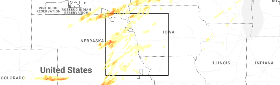
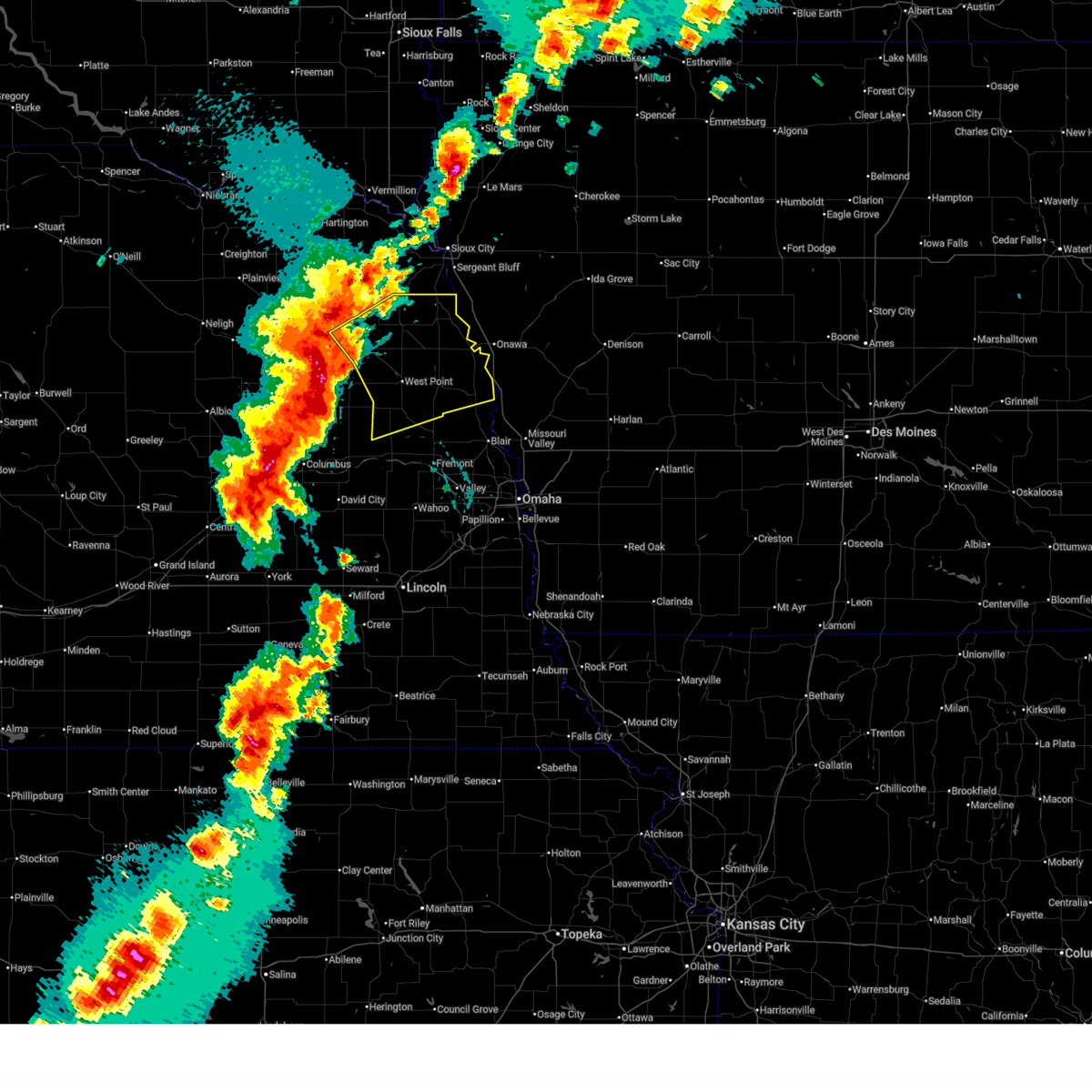
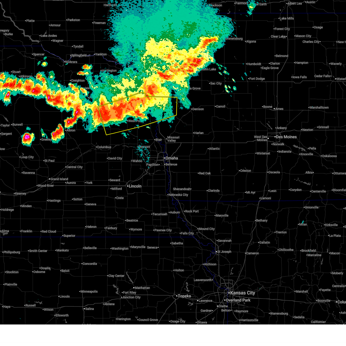
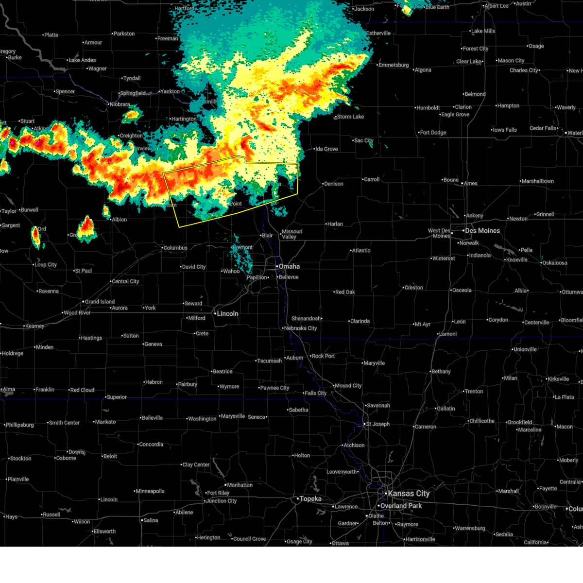
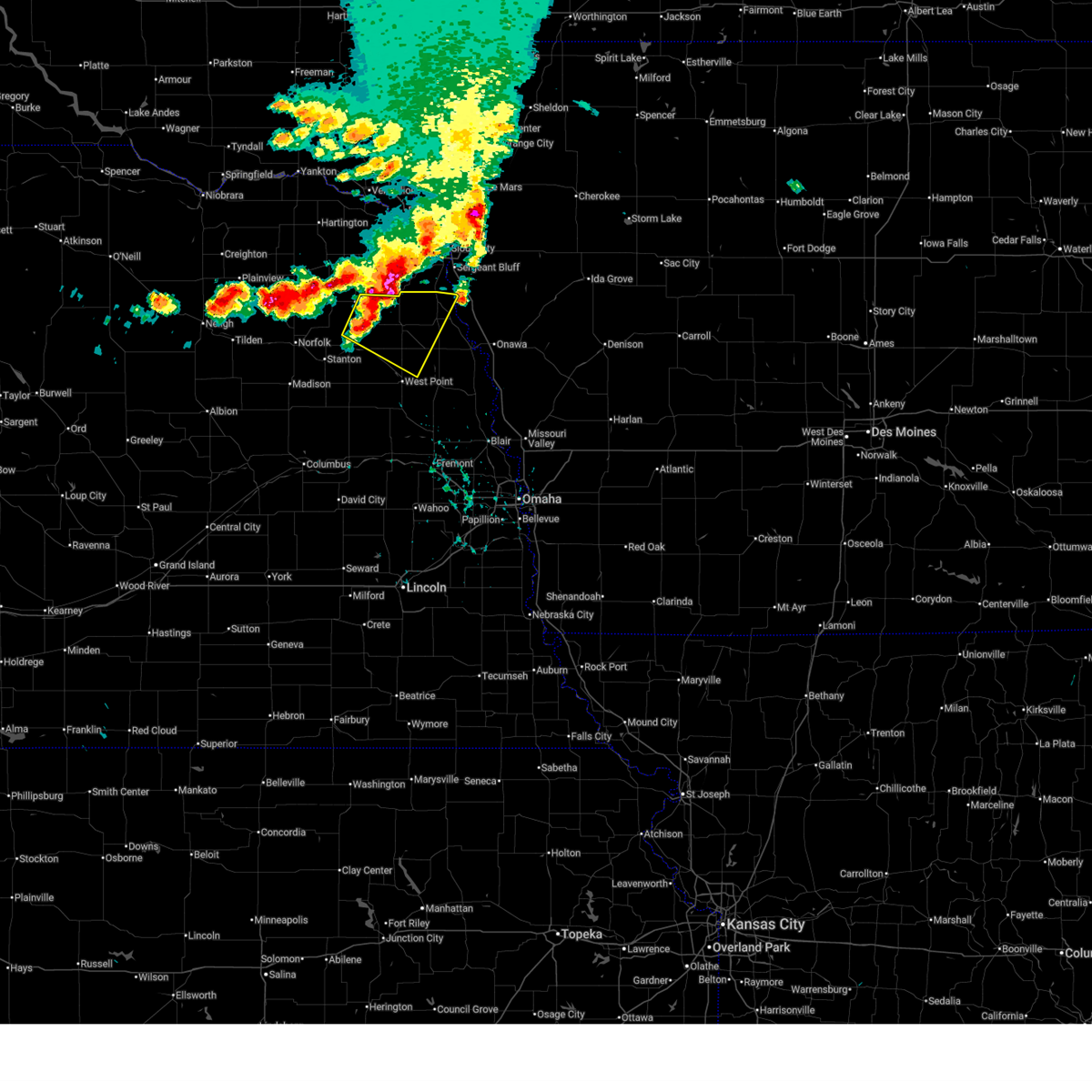
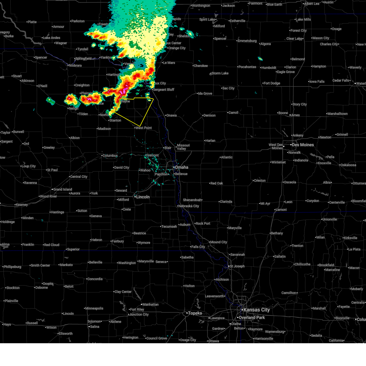
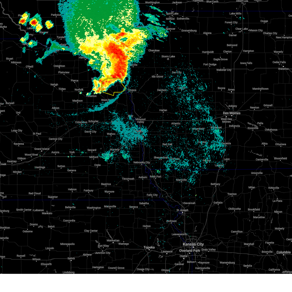
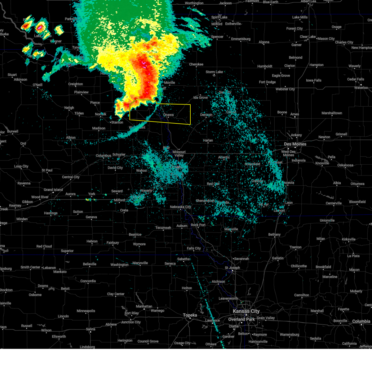
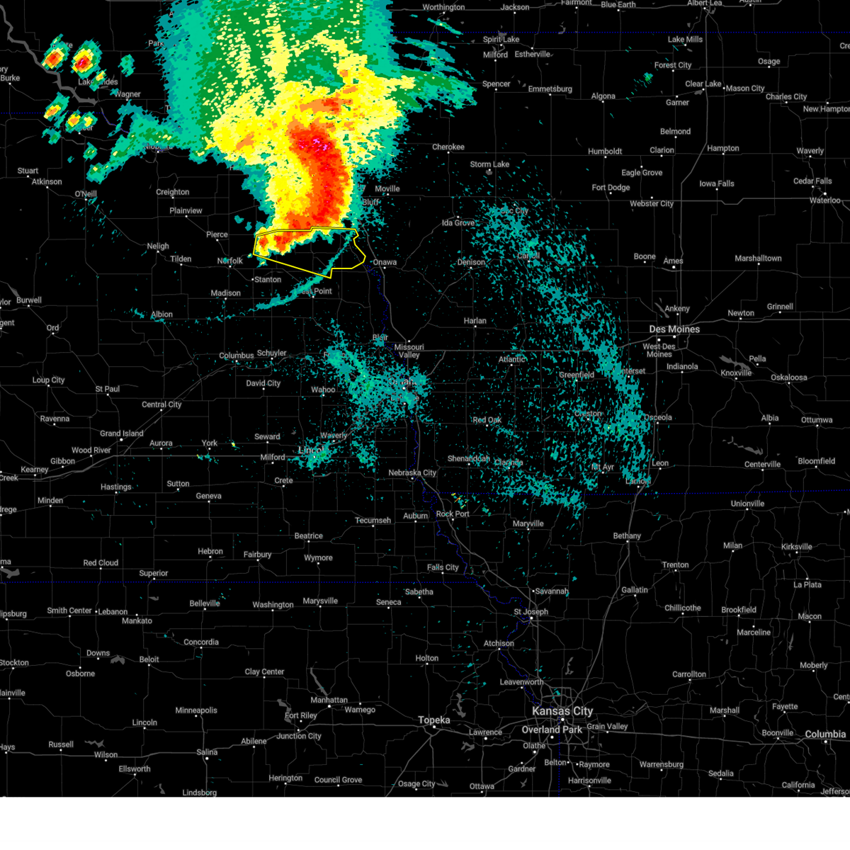
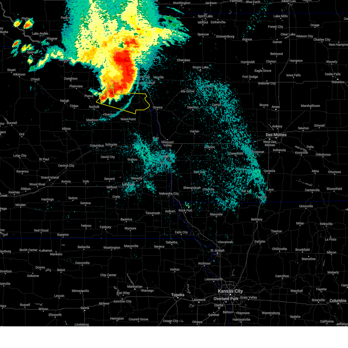
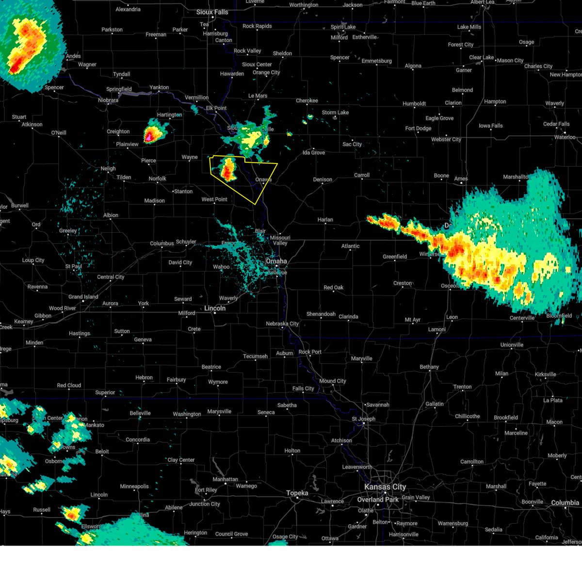
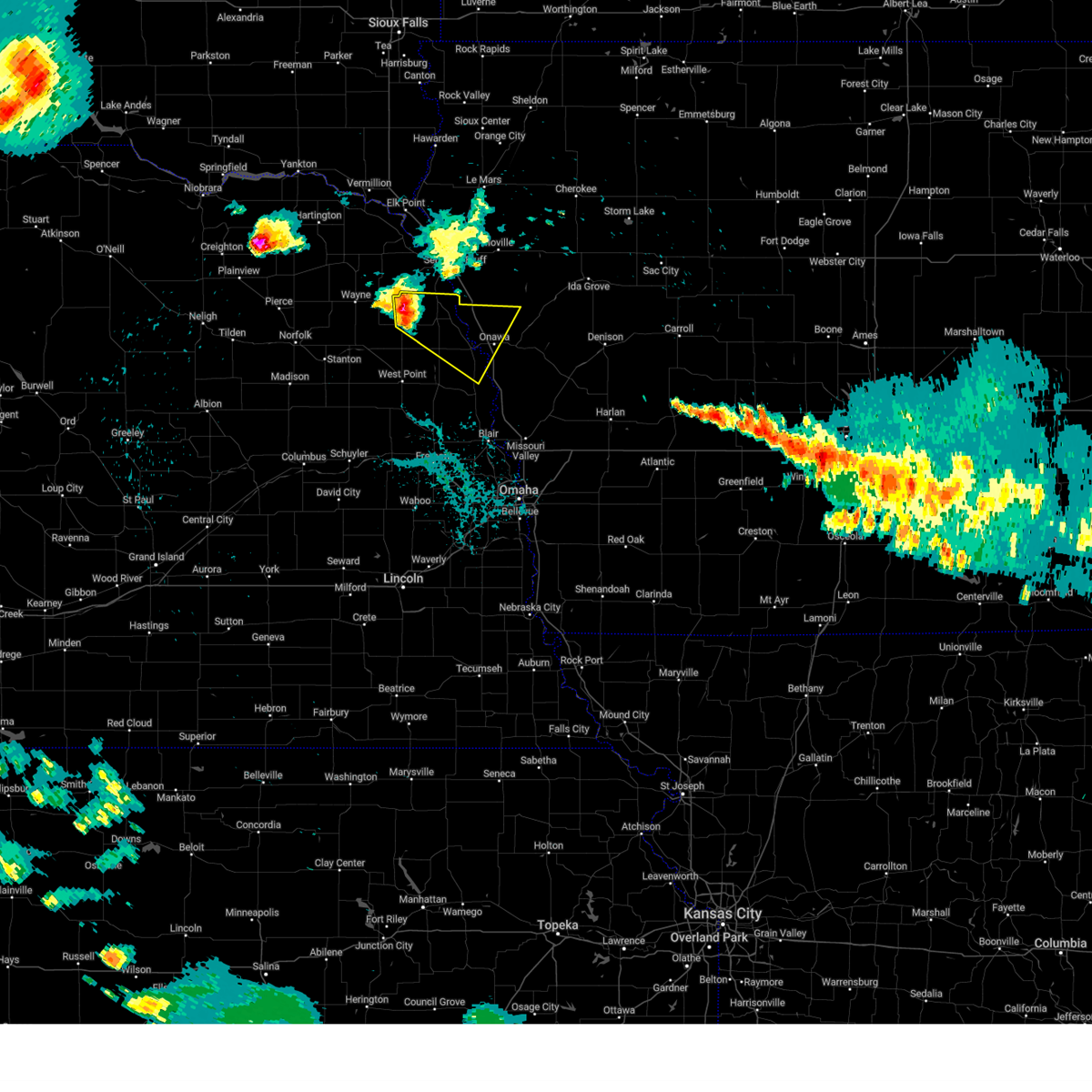
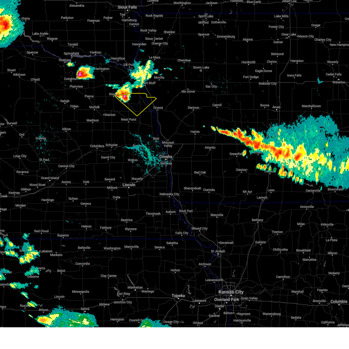
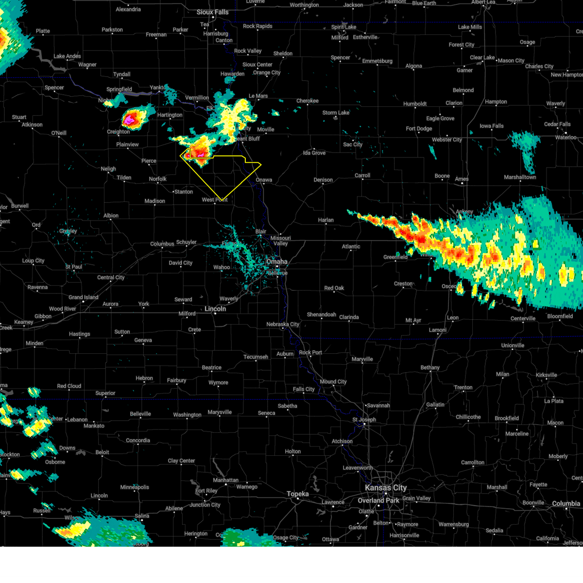
Hail Map for Thurston, NE
The Thurston, NE area has had 0 reports of on-the-ground hail by trained spotters, and has been under severe weather warnings 10 times during the past 12 months. Doppler radar has detected hail at or near Thurston, NE on 81 occasions, including 7 occasions during the past year.
| Name: | Thurston, NE |
| Where Located: | 74.4 miles NNW of Omaha, NE |
| Map: | Google Map for Thurston, NE |
| Population: | 132 |
| Housing Units: | 54 |
| More Info: | Search Google for Thurston, NE |
1
The Top Recent Hail Date for Thurston, NE is Sunday, May 17, 2026 (23rd out of 81)
Hail and Wind Damage Spotted near Thurston, NE
| Date / Time | Report Details |
|---|---|
| 5/18/2026 4:06 PM CDT |
 Svroax the national weather service in omaha has issued a * severe thunderstorm warning for, southeastern wayne county in northeastern nebraska, northwestern thurston county in northeastern nebraska, * until 430 pm cdt. * at 405 pm cdt, a severe thunderstorm was located 5 miles north of wisner, or 12 miles southeast of wayne, moving northeast at 60 mph (emergency management. this storm has a history of producing golf ball sized hail northwest of clarkson). Hazards include golf ball size hail. People and animals outdoors will be injured. expect damage to roofs, siding, windows, and vehicles. this severe thunderstorm will be near, wakefield around 415 pm cdt. Emerson around 420 pm cdt. Svroax the national weather service in omaha has issued a * severe thunderstorm warning for, southeastern wayne county in northeastern nebraska, northwestern thurston county in northeastern nebraska, * until 430 pm cdt. * at 405 pm cdt, a severe thunderstorm was located 5 miles north of wisner, or 12 miles southeast of wayne, moving northeast at 60 mph (emergency management. this storm has a history of producing golf ball sized hail northwest of clarkson). Hazards include golf ball size hail. People and animals outdoors will be injured. expect damage to roofs, siding, windows, and vehicles. this severe thunderstorm will be near, wakefield around 415 pm cdt. Emerson around 420 pm cdt.
|
| 5/17/2026 7:19 PM CDT |
 the severe thunderstorm warning has been cancelled and is no longer in effect the severe thunderstorm warning has been cancelled and is no longer in effect
|
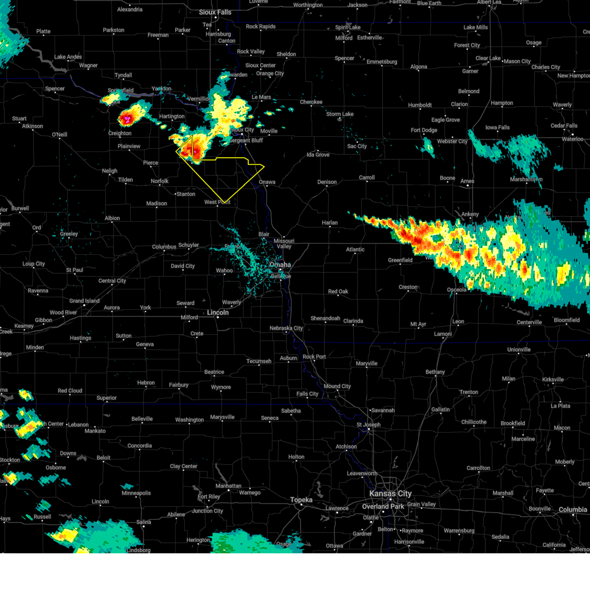
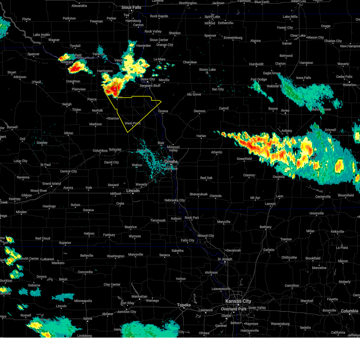
| 5/17/2026 7:19 PM CDT |
 At 717 pm cdt, severe thunderstorms were located along a line extending from near walthill to 3 miles west of lyons to scribner, moving east at 40 mph (public. at 6:59pm golf ball size hail was reported public. at 6:59pm golf ball size hail was reported). Hazards include golf ball size hail and 60 mph wind gusts. People and animals outdoors will be injured. expect hail damage to roofs, siding, windows, and vehicles. expect wind damage to roofs, siding, and trees. Locations impacted include, west point, tekamah, oakland, pender, scribner, lyons, walthill, winnebago, beemer, dodge, bancroft, decatur, snyder, uehling, craig, rosalie, thurston, macy, dead timber state recreation area, and summit lake state recreation area. At 717 pm cdt, severe thunderstorms were located along a line extending from near walthill to 3 miles west of lyons to scribner, moving east at 40 mph (public. at 6:59pm golf ball size hail was reported public. at 6:59pm golf ball size hail was reported). Hazards include golf ball size hail and 60 mph wind gusts. People and animals outdoors will be injured. expect hail damage to roofs, siding, windows, and vehicles. expect wind damage to roofs, siding, and trees. Locations impacted include, west point, tekamah, oakland, pender, scribner, lyons, walthill, winnebago, beemer, dodge, bancroft, decatur, snyder, uehling, craig, rosalie, thurston, macy, dead timber state recreation area, and summit lake state recreation area.
|
| 5/17/2026 7:05 PM CDT |
 At 703 pm cdt, severe thunderstorms were located along a line extending from 2 miles west of thurston to 7 miles southeast of wisner to beemer to 5 miles south of howells, moving northeast at 50 mph (public. at 6:59pm golf ball size hail was reported 3 miles south of wisner. this storm has a history of producing 60 to 70 mph winds). Hazards include golf ball size hail and 60 mph wind gusts. People and animals outdoors will be injured. expect hail damage to roofs, siding, windows, and vehicles. expect wind damage to roofs, siding, and trees. Locations impacted include, west point, pender, dodge, snyder, thurston, walthill, winnebago, bancroft, rosalie, lyons, macy, oakland, decatur and craig. At 703 pm cdt, severe thunderstorms were located along a line extending from 2 miles west of thurston to 7 miles southeast of wisner to beemer to 5 miles south of howells, moving northeast at 50 mph (public. at 6:59pm golf ball size hail was reported 3 miles south of wisner. this storm has a history of producing 60 to 70 mph winds). Hazards include golf ball size hail and 60 mph wind gusts. People and animals outdoors will be injured. expect hail damage to roofs, siding, windows, and vehicles. expect wind damage to roofs, siding, and trees. Locations impacted include, west point, pender, dodge, snyder, thurston, walthill, winnebago, bancroft, rosalie, lyons, macy, oakland, decatur and craig.
|
| 5/17/2026 6:39 PM CDT |
 Svroax the national weather service in omaha has issued a * severe thunderstorm warning for, burt county in east central nebraska, cuming county in northeastern nebraska, southeastern wayne county in northeastern nebraska, northern dodge county in east central nebraska, thurston county in northeastern nebraska, northeastern stanton county in northeastern nebraska, * until 745 pm cdt. * at 639 pm cdt, severe thunderstorms were located along a line extending from 3 miles west of stanton to 2 miles northwest of clarkson to 5 miles northeast of richland, moving northeast at 55 mph (weather instruments have measured 60 to 71 mph winds with these storms across platte and southern madison counties). Hazards include 70 mph wind gusts and ping pong ball size hail. People and animals outdoors will be injured. expect hail damage to roofs, siding, windows, and vehicles. expect considerable tree damage. wind damage is also likely to mobile homes, roofs, and outbuildings. severe thunderstorms will be near, pilger around 645 pm cdt. dodge around 650 pm cdt. wisner around 655 pm cdt. Other locations in the path of these severe thunderstorms include beemer, snyder, west point, scribner, pender, thurston, bancroft, uehling, oakland, lyons, walthill and rosalie. Svroax the national weather service in omaha has issued a * severe thunderstorm warning for, burt county in east central nebraska, cuming county in northeastern nebraska, southeastern wayne county in northeastern nebraska, northern dodge county in east central nebraska, thurston county in northeastern nebraska, northeastern stanton county in northeastern nebraska, * until 745 pm cdt. * at 639 pm cdt, severe thunderstorms were located along a line extending from 3 miles west of stanton to 2 miles northwest of clarkson to 5 miles northeast of richland, moving northeast at 55 mph (weather instruments have measured 60 to 71 mph winds with these storms across platte and southern madison counties). Hazards include 70 mph wind gusts and ping pong ball size hail. People and animals outdoors will be injured. expect hail damage to roofs, siding, windows, and vehicles. expect considerable tree damage. wind damage is also likely to mobile homes, roofs, and outbuildings. severe thunderstorms will be near, pilger around 645 pm cdt. dodge around 650 pm cdt. wisner around 655 pm cdt. Other locations in the path of these severe thunderstorms include beemer, snyder, west point, scribner, pender, thurston, bancroft, uehling, oakland, lyons, walthill and rosalie.
|
| 7/29/2025 10:15 PM CDT |
 At 1015 pm cdt, severe thunderstorms were located along a line extending from 4 miles south of bancroft to 5 miles south of dodge to 5 miles east of silver creek, moving southeast at 30 mph (radar indicated). Hazards include 60 mph wind gusts. Expect damage to roofs, siding, and trees. Locations impacted include, west point, madison, oakland, wisner, pender, scribner, lyons, emerson, walthill, winnebago, humphrey, beemer, clarkson, dodge, howells, bancroft, leigh, pilger, snyder, and creston. At 1015 pm cdt, severe thunderstorms were located along a line extending from 4 miles south of bancroft to 5 miles south of dodge to 5 miles east of silver creek, moving southeast at 30 mph (radar indicated). Hazards include 60 mph wind gusts. Expect damage to roofs, siding, and trees. Locations impacted include, west point, madison, oakland, wisner, pender, scribner, lyons, emerson, walthill, winnebago, humphrey, beemer, clarkson, dodge, howells, bancroft, leigh, pilger, snyder, and creston.
|
| 7/29/2025 10:00 PM CDT |
 At 1000 pm cdt, severe thunderstorms were located along a line extending from 3 miles west of bancroft to near howells to 2 miles northeast of silver creek, moving southeast at 35 mph (radar indicated). Hazards include 60 mph wind gusts. Expect damage to roofs, siding, and trees. Locations impacted include, west point, dodge, bancroft, snyder, lyons, oakland and scribner. At 1000 pm cdt, severe thunderstorms were located along a line extending from 3 miles west of bancroft to near howells to 2 miles northeast of silver creek, moving southeast at 35 mph (radar indicated). Hazards include 60 mph wind gusts. Expect damage to roofs, siding, and trees. Locations impacted include, west point, dodge, bancroft, snyder, lyons, oakland and scribner.
|
| 7/29/2025 9:43 PM CDT |
 Svroax the national weather service in omaha has issued a * severe thunderstorm warning for, northwestern monona county in west central iowa, central madison county in northeastern nebraska, northwestern burt county in east central nebraska, cuming county in northeastern nebraska, wayne county in northeastern nebraska, colfax county in northeastern nebraska, northeastern platte county in northeastern nebraska, northwestern dodge county in east central nebraska, thurston county in northeastern nebraska, stanton county in northeastern nebraska, * until 1030 pm cdt. * at 943 pm cdt, severe thunderstorms were located along a line extending from 6 miles northeast of wisner to near leigh to 6 miles southwest of genoa, moving southeast at 30 mph (radar indicated). Hazards include 60 mph wind gusts. Expect damage to roofs, siding, and trees. severe thunderstorms will be near, wisner, beemer, clarkson, and leigh around 950 pm cdt. howells around 955 pm cdt. other locations in the path of these severe thunderstorms include west point, dodge and snyder. This includes interstate 29 between mile markers 122 and 125. Svroax the national weather service in omaha has issued a * severe thunderstorm warning for, northwestern monona county in west central iowa, central madison county in northeastern nebraska, northwestern burt county in east central nebraska, cuming county in northeastern nebraska, wayne county in northeastern nebraska, colfax county in northeastern nebraska, northeastern platte county in northeastern nebraska, northwestern dodge county in east central nebraska, thurston county in northeastern nebraska, stanton county in northeastern nebraska, * until 1030 pm cdt. * at 943 pm cdt, severe thunderstorms were located along a line extending from 6 miles northeast of wisner to near leigh to 6 miles southwest of genoa, moving southeast at 30 mph (radar indicated). Hazards include 60 mph wind gusts. Expect damage to roofs, siding, and trees. severe thunderstorms will be near, wisner, beemer, clarkson, and leigh around 950 pm cdt. howells around 955 pm cdt. other locations in the path of these severe thunderstorms include west point, dodge and snyder. This includes interstate 29 between mile markers 122 and 125.
|
| 7/7/2025 8:54 PM CDT |
 At 853 pm cdt, severe thunderstorms were located along a line extending from 5 miles south of smithland to 4 miles west of lyons to 6 miles north of clarkson, moving southeast at 30 mph (radar indicated). Hazards include 60 mph wind gusts and quarter size hail. Hail damage to vehicles is expected. expect wind damage to roofs, siding, and trees. Locations impacted include, west point, onawa, oakland, lyons, clarkson, howells, decatur, castana, dodge, blencoe, snyder, craig, soldier, uehling and moorhead. At 853 pm cdt, severe thunderstorms were located along a line extending from 5 miles south of smithland to 4 miles west of lyons to 6 miles north of clarkson, moving southeast at 30 mph (radar indicated). Hazards include 60 mph wind gusts and quarter size hail. Hail damage to vehicles is expected. expect wind damage to roofs, siding, and trees. Locations impacted include, west point, onawa, oakland, lyons, clarkson, howells, decatur, castana, dodge, blencoe, snyder, craig, soldier, uehling and moorhead.
|
| 7/7/2025 8:36 PM CDT |
 Svroax the national weather service in omaha has issued a * severe thunderstorm warning for, monona county in west central iowa, northwestern harrison county in southwestern iowa, burt county in east central nebraska, cuming county in northeastern nebraska, southern wayne county in northeastern nebraska, northeastern colfax county in northeastern nebraska, northwestern dodge county in east central nebraska, thurston county in northeastern nebraska, stanton county in northeastern nebraska, * until 915 pm cdt. * at 836 pm cdt, severe thunderstorms were located along a line extending from 5 miles northwest of smithland to 4 miles southeast of pender to 3 miles west of stanton, moving southeast at 30 mph (radar indicated). Hazards include 60 mph wind gusts and quarter size hail. Hail damage to vehicles is expected. expect wind damage to roofs, siding, and trees. severe thunderstorms will be near, wisner, whiting, beemer, bancroft, rosalie, and macy around 840 pm cdt. lyons and decatur around 850 pm cdt. west point and onawa around 855 pm cdt. other locations in the path of these severe thunderstorms include clarkson, castana, oakland and howells. This includes interstate 29 between mile markers 99 and 125. Svroax the national weather service in omaha has issued a * severe thunderstorm warning for, monona county in west central iowa, northwestern harrison county in southwestern iowa, burt county in east central nebraska, cuming county in northeastern nebraska, southern wayne county in northeastern nebraska, northeastern colfax county in northeastern nebraska, northwestern dodge county in east central nebraska, thurston county in northeastern nebraska, stanton county in northeastern nebraska, * until 915 pm cdt. * at 836 pm cdt, severe thunderstorms were located along a line extending from 5 miles northwest of smithland to 4 miles southeast of pender to 3 miles west of stanton, moving southeast at 30 mph (radar indicated). Hazards include 60 mph wind gusts and quarter size hail. Hail damage to vehicles is expected. expect wind damage to roofs, siding, and trees. severe thunderstorms will be near, wisner, whiting, beemer, bancroft, rosalie, and macy around 840 pm cdt. lyons and decatur around 850 pm cdt. west point and onawa around 855 pm cdt. other locations in the path of these severe thunderstorms include clarkson, castana, oakland and howells. This includes interstate 29 between mile markers 99 and 125.
|
| 6/16/2025 5:13 PM CDT | Emergency management report of straight line winds gusting at 60-65 mp in thurston county NE, 6.2 miles W of Thurston, NE |
| 6/16/2025 5:02 PM CDT |
 At 502 pm cdt, severe thunderstorms were located along a line extending from 3 miles west of hubbard to 4 miles northwest of wisner, moving southeast at 40 mph (radar indicated). Hazards include 70 mph wind gusts and quarter size hail. Hail damage to vehicles is expected. expect considerable tree damage. wind damage is also likely to mobile homes, roofs, and outbuildings. these severe storms will be near, wisner, emerson, and thurston around 505 pm cdt. pender around 510 pm cdt. winnebago around 515 pm cdt. Other locations in the path of these severe thunderstorms include walthill, bancroft and rosalie. At 502 pm cdt, severe thunderstorms were located along a line extending from 3 miles west of hubbard to 4 miles northwest of wisner, moving southeast at 40 mph (radar indicated). Hazards include 70 mph wind gusts and quarter size hail. Hail damage to vehicles is expected. expect considerable tree damage. wind damage is also likely to mobile homes, roofs, and outbuildings. these severe storms will be near, wisner, emerson, and thurston around 505 pm cdt. pender around 510 pm cdt. winnebago around 515 pm cdt. Other locations in the path of these severe thunderstorms include walthill, bancroft and rosalie.
|
| 6/16/2025 4:57 PM CDT |
 At 456 pm cdt, severe thunderstorms were located along a line extending from 5 miles west of hubbard to 3 miles northeast of pilger, moving southeast at 40 mph (radar indicated). Hazards include 60 mph wind gusts and quarter size hail. Hail damage to vehicles is expected. expect wind damage to roofs, siding, and trees. these severe storms will be near, wisner and emerson around 500 pm cdt. pender and thurston around 505 pm cdt. Other locations in the path of these severe thunderstorms include winnebago, walthill, bancroft and rosalie. At 456 pm cdt, severe thunderstorms were located along a line extending from 5 miles west of hubbard to 3 miles northeast of pilger, moving southeast at 40 mph (radar indicated). Hazards include 60 mph wind gusts and quarter size hail. Hail damage to vehicles is expected. expect wind damage to roofs, siding, and trees. these severe storms will be near, wisner and emerson around 500 pm cdt. pender and thurston around 505 pm cdt. Other locations in the path of these severe thunderstorms include winnebago, walthill, bancroft and rosalie.
|
| 6/16/2025 4:47 PM CDT |
 Svroax the national weather service in omaha has issued a * severe thunderstorm warning for, northwestern burt county in east central nebraska, northern cuming county in northeastern nebraska, southeastern wayne county in northeastern nebraska, thurston county in northeastern nebraska, northeastern stanton county in northeastern nebraska, * until 530 pm cdt. * at 447 pm cdt, severe thunderstorms were located along a line extending from 2 miles north of allen to 6 miles southeast of winside, moving southeast at 35 mph (radar indicated). Hazards include 60 mph wind gusts and quarter size hail. Hail damage to vehicles is expected. expect wind damage to roofs, siding, and trees. severe thunderstorms will be near, wakefield around 450 pm cdt. wisner and emerson around 500 pm cdt. pender and thurston around 505 pm cdt. Other locations in the path of these severe thunderstorms include winnebago, walthill and bancroft. Svroax the national weather service in omaha has issued a * severe thunderstorm warning for, northwestern burt county in east central nebraska, northern cuming county in northeastern nebraska, southeastern wayne county in northeastern nebraska, thurston county in northeastern nebraska, northeastern stanton county in northeastern nebraska, * until 530 pm cdt. * at 447 pm cdt, severe thunderstorms were located along a line extending from 2 miles north of allen to 6 miles southeast of winside, moving southeast at 35 mph (radar indicated). Hazards include 60 mph wind gusts and quarter size hail. Hail damage to vehicles is expected. expect wind damage to roofs, siding, and trees. severe thunderstorms will be near, wakefield around 450 pm cdt. wisner and emerson around 500 pm cdt. pender and thurston around 505 pm cdt. Other locations in the path of these severe thunderstorms include winnebago, walthill and bancroft.
|
| 7/29/2024 11:47 PM CDT |
 At 1146 pm cdt, severe thunderstorms were located along a line extending from 3 miles north of sloan to near macy to 2 miles southeast of bancroft, moving east at 45 mph (radar indicated). Hazards include 60 mph wind gusts. Expect damage to roofs, siding, and trees. Locations impacted include, pender, emerson, walthill, winnebago, bancroft, rosalie, thurston, macy, the highway 9 and 51 junction, omaha reservation, and winnebago reservation. At 1146 pm cdt, severe thunderstorms were located along a line extending from 3 miles north of sloan to near macy to 2 miles southeast of bancroft, moving east at 45 mph (radar indicated). Hazards include 60 mph wind gusts. Expect damage to roofs, siding, and trees. Locations impacted include, pender, emerson, walthill, winnebago, bancroft, rosalie, thurston, macy, the highway 9 and 51 junction, omaha reservation, and winnebago reservation.
|
| 7/29/2024 11:47 PM CDT |
 the severe thunderstorm warning has been cancelled and is no longer in effect the severe thunderstorm warning has been cancelled and is no longer in effect
|
| 7/29/2024 11:45 PM CDT |
 Svroax the national weather service in omaha has issued a * severe thunderstorm warning for, monona county in west central iowa, northern burt county in east central nebraska, southeastern wayne county in northeastern nebraska, northeastern cuming county in northeastern nebraska, thurston county in northeastern nebraska, * until 1230 am cdt. * at 1145 pm cdt, severe thunderstorms were located along a line extending from 2 miles east of salix to 2 miles northwest of macy to 4 miles west of bancroft, moving east at 55 mph (radar indicated). Hazards include 60 mph wind gusts. expect damage to roofs, siding, and trees Svroax the national weather service in omaha has issued a * severe thunderstorm warning for, monona county in west central iowa, northern burt county in east central nebraska, southeastern wayne county in northeastern nebraska, northeastern cuming county in northeastern nebraska, thurston county in northeastern nebraska, * until 1230 am cdt. * at 1145 pm cdt, severe thunderstorms were located along a line extending from 2 miles east of salix to 2 miles northwest of macy to 4 miles west of bancroft, moving east at 55 mph (radar indicated). Hazards include 60 mph wind gusts. expect damage to roofs, siding, and trees
|
| 7/29/2024 11:38 PM CDT |
 the severe thunderstorm warning has been cancelled and is no longer in effect the severe thunderstorm warning has been cancelled and is no longer in effect
|
| 7/29/2024 11:38 PM CDT |
 At 1137 pm cdt, severe thunderstorms were located along a line extending from 3 miles west of salix to 2 miles east of walthill to 4 miles west of bancroft, moving east at 50 mph (emergency management). Hazards include 60 mph wind gusts. Expect damage to roofs, siding, and trees. Locations impacted include, wayne, wakefield, pender, emerson, walthill, winnebago, bancroft, winside, rosalie, thurston, macy, the highway 9 and 51 junction, omaha reservation, and winnebago reservation. At 1137 pm cdt, severe thunderstorms were located along a line extending from 3 miles west of salix to 2 miles east of walthill to 4 miles west of bancroft, moving east at 50 mph (emergency management). Hazards include 60 mph wind gusts. Expect damage to roofs, siding, and trees. Locations impacted include, wayne, wakefield, pender, emerson, walthill, winnebago, bancroft, winside, rosalie, thurston, macy, the highway 9 and 51 junction, omaha reservation, and winnebago reservation.
|
| 7/29/2024 11:26 PM CDT |
 Svroax the national weather service in omaha has issued a * severe thunderstorm warning for, wayne county in northeastern nebraska, northern cuming county in northeastern nebraska, thurston county in northeastern nebraska, southeastern cedar county in northeastern nebraska, northeastern stanton county in northeastern nebraska, * until midnight cdt. * at 1125 pm cdt, severe thunderstorms were located along a line extending from 2 miles west of hubbard to 3 miles northwest of thurston to 6 miles north of wisner, moving east at 45 mph (emergency management. at 1122 pm cdt, emergency management reported a power line and tree branches down ranging from 3 to 4 inches in the town of carroll). Hazards include 60 mph wind gusts. expect damage to roofs, siding, and trees Svroax the national weather service in omaha has issued a * severe thunderstorm warning for, wayne county in northeastern nebraska, northern cuming county in northeastern nebraska, thurston county in northeastern nebraska, southeastern cedar county in northeastern nebraska, northeastern stanton county in northeastern nebraska, * until midnight cdt. * at 1125 pm cdt, severe thunderstorms were located along a line extending from 2 miles west of hubbard to 3 miles northwest of thurston to 6 miles north of wisner, moving east at 45 mph (emergency management. at 1122 pm cdt, emergency management reported a power line and tree branches down ranging from 3 to 4 inches in the town of carroll). Hazards include 60 mph wind gusts. expect damage to roofs, siding, and trees
|
| 7/29/2024 2:22 AM CDT |
 the severe thunderstorm warning has been cancelled and is no longer in effect the severe thunderstorm warning has been cancelled and is no longer in effect
|
| 7/29/2024 2:11 AM CDT |
 The storm which prompted the warning has moved out of the area. therefore, the warning will be allowed to expire. remember, a severe thunderstorm warning still remains in effect for thurston county and northwest monona county. The storm which prompted the warning has moved out of the area. therefore, the warning will be allowed to expire. remember, a severe thunderstorm warning still remains in effect for thurston county and northwest monona county.
|
| 7/29/2024 2:10 AM CDT |
 Svroax the national weather service in omaha has issued a * severe thunderstorm warning for, western monona county in west central iowa, northern burt county in east central nebraska, northeastern cuming county in northeastern nebraska, thurston county in northeastern nebraska, * until 300 am cdt. * at 210 am cdt, a severe thunderstorm was located 4 miles west of walthill, or 21 miles north of west point, moving east at 35 mph (radar indicated). Hazards include 60 mph wind gusts and quarter size hail. Hail damage to vehicles is expected. Expect wind damage to roofs, siding, and trees. Svroax the national weather service in omaha has issued a * severe thunderstorm warning for, western monona county in west central iowa, northern burt county in east central nebraska, northeastern cuming county in northeastern nebraska, thurston county in northeastern nebraska, * until 300 am cdt. * at 210 am cdt, a severe thunderstorm was located 4 miles west of walthill, or 21 miles north of west point, moving east at 35 mph (radar indicated). Hazards include 60 mph wind gusts and quarter size hail. Hail damage to vehicles is expected. Expect wind damage to roofs, siding, and trees.
|
| 7/29/2024 2:01 AM CDT |
 At 201 am cdt, a severe thunderstorm was located 3 miles east of pender, or 17 miles north of west point, moving southeast at 40 mph (radar indicated). Hazards include 60 mph wind gusts and half dollar size hail. Hail damage to vehicles is expected. expect wind damage to roofs, siding, and trees. Locations impacted include, wakefield, pender, emerson, walthill, winnebago, bancroft, rosalie, thurston, macy, omaha reservation, and winnebago reservation. At 201 am cdt, a severe thunderstorm was located 3 miles east of pender, or 17 miles north of west point, moving southeast at 40 mph (radar indicated). Hazards include 60 mph wind gusts and half dollar size hail. Hail damage to vehicles is expected. expect wind damage to roofs, siding, and trees. Locations impacted include, wakefield, pender, emerson, walthill, winnebago, bancroft, rosalie, thurston, macy, omaha reservation, and winnebago reservation.
|
| 7/29/2024 1:49 AM CDT |
 At 148 am cdt, a severe thunderstorm was located 4 miles west of thurston, or 13 miles southeast of wayne, moving southeast at 40 mph (radar indicated). Hazards include 60 mph wind gusts and half dollar size hail. Hail damage to vehicles is expected. expect wind damage to roofs, siding, and trees. locations impacted include, wayne, wakefield, pender, emerson, walthill, winnebago, bancroft, rosalie, thurston, macy, the highway 9 and 51 junction, omaha reservation, and winnebago reservation. People attending wayne county fairgrounds should seek safe shelter immediately!. At 148 am cdt, a severe thunderstorm was located 4 miles west of thurston, or 13 miles southeast of wayne, moving southeast at 40 mph (radar indicated). Hazards include 60 mph wind gusts and half dollar size hail. Hail damage to vehicles is expected. expect wind damage to roofs, siding, and trees. locations impacted include, wayne, wakefield, pender, emerson, walthill, winnebago, bancroft, rosalie, thurston, macy, the highway 9 and 51 junction, omaha reservation, and winnebago reservation. People attending wayne county fairgrounds should seek safe shelter immediately!.
|
| 7/29/2024 1:49 AM CDT |
 the severe thunderstorm warning has been cancelled and is no longer in effect the severe thunderstorm warning has been cancelled and is no longer in effect
|
| 7/29/2024 1:37 AM CDT |
 At 137 am cdt, a severe thunderstorm was located 3 miles southwest of wakefield, or 5 miles east of wayne, moving southeast at 40 mph (radar indicated). Hazards include 60 mph wind gusts and half dollar size hail. Hail damage to vehicles is expected. expect wind damage to roofs, siding, and trees. locations impacted include, wayne, wakefield, pender, laurel, emerson, walthill, winnebago, bancroft, rosalie, thurston, macy, the highway 9 and 51 junction, omaha reservation, and winnebago reservation. People attending wayne county fairgrounds should seek safe shelter immediately!. At 137 am cdt, a severe thunderstorm was located 3 miles southwest of wakefield, or 5 miles east of wayne, moving southeast at 40 mph (radar indicated). Hazards include 60 mph wind gusts and half dollar size hail. Hail damage to vehicles is expected. expect wind damage to roofs, siding, and trees. locations impacted include, wayne, wakefield, pender, laurel, emerson, walthill, winnebago, bancroft, rosalie, thurston, macy, the highway 9 and 51 junction, omaha reservation, and winnebago reservation. People attending wayne county fairgrounds should seek safe shelter immediately!.
|
| 7/29/2024 1:31 AM CDT |
 Svroax the national weather service in omaha has issued a * severe thunderstorm warning for, northwestern monona county in west central iowa, northwestern burt county in east central nebraska, central wayne county in northeastern nebraska, cuming county in northeastern nebraska, thurston county in northeastern nebraska, southeastern cedar county in northeastern nebraska, * until 215 am cdt. * at 131 am cdt, a severe thunderstorm was located near wayne, moving southeast at 40 mph (radar indicated). Hazards include 60 mph wind gusts and half dollar size hail. Hail damage to vehicles is expected. Expect wind damage to roofs, siding, and trees. Svroax the national weather service in omaha has issued a * severe thunderstorm warning for, northwestern monona county in west central iowa, northwestern burt county in east central nebraska, central wayne county in northeastern nebraska, cuming county in northeastern nebraska, thurston county in northeastern nebraska, southeastern cedar county in northeastern nebraska, * until 215 am cdt. * at 131 am cdt, a severe thunderstorm was located near wayne, moving southeast at 40 mph (radar indicated). Hazards include 60 mph wind gusts and half dollar size hail. Hail damage to vehicles is expected. Expect wind damage to roofs, siding, and trees.
|
| 6/15/2024 7:49 PM CDT |
 the tornado warning has been cancelled and is no longer in effect the tornado warning has been cancelled and is no longer in effect
|
| 6/15/2024 7:32 PM CDT |
 the tornado warning has been cancelled and is no longer in effect the tornado warning has been cancelled and is no longer in effect
|
| 6/15/2024 7:32 PM CDT |
 At 732 pm cdt, a severe thunderstorm capable of producing a tornado was located over thurston, or 16 miles east of wayne, moving northeast at 30 mph (radar indicated rotation. this storm has a history of producing tornadoes). Hazards include tornado. Flying debris will be dangerous to those caught without shelter. mobile homes will be damaged or destroyed. damage to roofs, windows, and vehicles will occur. tree damage is likely. this dangerous storm will be near, thurston around 735 pm cdt. Other locations in the path of this tornadic thunderstorm include winnebago. At 732 pm cdt, a severe thunderstorm capable of producing a tornado was located over thurston, or 16 miles east of wayne, moving northeast at 30 mph (radar indicated rotation. this storm has a history of producing tornadoes). Hazards include tornado. Flying debris will be dangerous to those caught without shelter. mobile homes will be damaged or destroyed. damage to roofs, windows, and vehicles will occur. tree damage is likely. this dangerous storm will be near, thurston around 735 pm cdt. Other locations in the path of this tornadic thunderstorm include winnebago.
|
| 6/15/2024 7:22 PM CDT |
 Toroax the national weather service in omaha has issued a * tornado warning for, southeastern wayne county in northeastern nebraska, north central cuming county in northeastern nebraska, central thurston county in northeastern nebraska, * until 800 pm cdt. * at 722 pm cdt, a confirmed tornado was located 3 miles west of pender, or 14 miles southeast of wayne, moving northeast at 35 mph (law enforcement confirmed tornado). Hazards include damaging tornado and quarter size hail. Flying debris will be dangerous to those caught without shelter. mobile homes will be damaged or destroyed. damage to roofs, windows, and vehicles will occur. tree damage is likely. the tornado will be near, pender and thurston around 725 pm cdt. Other locations in the path of this tornadic thunderstorm include walthill and winnebago. Toroax the national weather service in omaha has issued a * tornado warning for, southeastern wayne county in northeastern nebraska, north central cuming county in northeastern nebraska, central thurston county in northeastern nebraska, * until 800 pm cdt. * at 722 pm cdt, a confirmed tornado was located 3 miles west of pender, or 14 miles southeast of wayne, moving northeast at 35 mph (law enforcement confirmed tornado). Hazards include damaging tornado and quarter size hail. Flying debris will be dangerous to those caught without shelter. mobile homes will be damaged or destroyed. damage to roofs, windows, and vehicles will occur. tree damage is likely. the tornado will be near, pender and thurston around 725 pm cdt. Other locations in the path of this tornadic thunderstorm include walthill and winnebago.
|
| 5/24/2024 2:11 AM CDT |
 At 211 am cdt, severe thunderstorms were located along a line extending from 4 miles northwest of winnebago to 2 miles southeast of bancroft to 5 miles north of scribner, moving east at 35 mph (radar indicated). Hazards include 70 mph wind gusts and quarter size hail. Hail damage to vehicles is expected. expect considerable tree damage. wind damage is also likely to mobile homes, roofs, and outbuildings. Locations impacted include, west point, tekamah, onawa, oakland, pender, lyons, emerson, walthill, winnebago, whiting, dodge, bancroft, decatur, pisgah, uehling, blencoe, craig, little sioux, rosalie, and castana. At 211 am cdt, severe thunderstorms were located along a line extending from 4 miles northwest of winnebago to 2 miles southeast of bancroft to 5 miles north of scribner, moving east at 35 mph (radar indicated). Hazards include 70 mph wind gusts and quarter size hail. Hail damage to vehicles is expected. expect considerable tree damage. wind damage is also likely to mobile homes, roofs, and outbuildings. Locations impacted include, west point, tekamah, onawa, oakland, pender, lyons, emerson, walthill, winnebago, whiting, dodge, bancroft, decatur, pisgah, uehling, blencoe, craig, little sioux, rosalie, and castana.
|
| 5/24/2024 1:57 AM CDT |
 Svroax the national weather service in omaha has issued a * severe thunderstorm warning for, monona county in west central iowa, northwestern harrison county in southwestern iowa, burt county in east central nebraska, eastern cuming county in northeastern nebraska, northwestern dodge county in east central nebraska, thurston county in northeastern nebraska, * until 245 am cdt. * at 157 am cdt, severe thunderstorms were located along a line extending from 2 miles east of emerson to 5 miles southwest of bancroft to 3 miles northwest of snyder, moving east at 35 mph (radar indicated). Hazards include 60 mph wind gusts and quarter size hail. Hail damage to vehicles is expected. Expect wind damage to roofs, siding, and trees. Svroax the national weather service in omaha has issued a * severe thunderstorm warning for, monona county in west central iowa, northwestern harrison county in southwestern iowa, burt county in east central nebraska, eastern cuming county in northeastern nebraska, northwestern dodge county in east central nebraska, thurston county in northeastern nebraska, * until 245 am cdt. * at 157 am cdt, severe thunderstorms were located along a line extending from 2 miles east of emerson to 5 miles southwest of bancroft to 3 miles northwest of snyder, moving east at 35 mph (radar indicated). Hazards include 60 mph wind gusts and quarter size hail. Hail damage to vehicles is expected. Expect wind damage to roofs, siding, and trees.
|
| 5/24/2024 1:20 AM CDT |
 Svroax the national weather service in omaha has issued a * severe thunderstorm warning for, northwestern monona county in west central iowa, northwestern burt county in east central nebraska, southeastern wayne county in northeastern nebraska, cuming county in northeastern nebraska, thurston county in northeastern nebraska, central stanton county in northeastern nebraska, * until 200 am cdt. * at 120 am cdt, severe thunderstorms were located along a line extending from 2 miles southwest of wakefield to 4 miles southwest of pilger to 4 miles northeast of creston, moving east at 45 mph (radar indicated). Hazards include 60 mph wind gusts and quarter size hail. Hail damage to vehicles is expected. Expect wind damage to roofs, siding, and trees. Svroax the national weather service in omaha has issued a * severe thunderstorm warning for, northwestern monona county in west central iowa, northwestern burt county in east central nebraska, southeastern wayne county in northeastern nebraska, cuming county in northeastern nebraska, thurston county in northeastern nebraska, central stanton county in northeastern nebraska, * until 200 am cdt. * at 120 am cdt, severe thunderstorms were located along a line extending from 2 miles southwest of wakefield to 4 miles southwest of pilger to 4 miles northeast of creston, moving east at 45 mph (radar indicated). Hazards include 60 mph wind gusts and quarter size hail. Hail damage to vehicles is expected. Expect wind damage to roofs, siding, and trees.
|
| 5/24/2024 12:46 AM CDT |
 Svroax the national weather service in omaha has issued a * severe thunderstorm warning for, madison county in northeastern nebraska, wayne county in northeastern nebraska, northwestern cuming county in northeastern nebraska, southeastern pierce county in northeastern nebraska, northwestern thurston county in northeastern nebraska, southeastern cedar county in northeastern nebraska, stanton county in northeastern nebraska, * until 130 am cdt. * at 1246 am cdt, severe thunderstorms were located along a line extending from 2 miles northeast of belden to 3 miles east of hadar to 5 miles northeast of newman grove, moving east at 35 mph (radar indicated). Hazards include 60 mph wind gusts and quarter size hail. Hail damage to vehicles is expected. Expect wind damage to roofs, siding, and trees. Svroax the national weather service in omaha has issued a * severe thunderstorm warning for, madison county in northeastern nebraska, wayne county in northeastern nebraska, northwestern cuming county in northeastern nebraska, southeastern pierce county in northeastern nebraska, northwestern thurston county in northeastern nebraska, southeastern cedar county in northeastern nebraska, stanton county in northeastern nebraska, * until 130 am cdt. * at 1246 am cdt, severe thunderstorms were located along a line extending from 2 miles northeast of belden to 3 miles east of hadar to 5 miles northeast of newman grove, moving east at 35 mph (radar indicated). Hazards include 60 mph wind gusts and quarter size hail. Hail damage to vehicles is expected. Expect wind damage to roofs, siding, and trees.
|
| 5/21/2024 6:09 AM CDT |
 At 608 am cdt, severe thunderstorms were located along a line extending from 4 miles west of winnebago to 5 miles south of macy, moving northeast at 60 mph (radar indicated). Hazards include 60 mph wind gusts. Expect damage to roofs, siding, and trees. Locations impacted include, emerson, walthill, winnebago, bancroft, rosalie, thurston, macy, omaha reservation, and winnebago reservation. At 608 am cdt, severe thunderstorms were located along a line extending from 4 miles west of winnebago to 5 miles south of macy, moving northeast at 60 mph (radar indicated). Hazards include 60 mph wind gusts. Expect damage to roofs, siding, and trees. Locations impacted include, emerson, walthill, winnebago, bancroft, rosalie, thurston, macy, omaha reservation, and winnebago reservation.
|
| 5/21/2024 6:09 AM CDT |
 the severe thunderstorm warning has been cancelled and is no longer in effect the severe thunderstorm warning has been cancelled and is no longer in effect
|
| 5/21/2024 5:49 AM CDT |
 Svroax the national weather service in omaha has issued a * severe thunderstorm warning for, northwestern monona county in west central iowa, southeastern wayne county in northeastern nebraska, northeastern cuming county in northeastern nebraska, thurston county in northeastern nebraska, * until 630 am cdt. * at 549 am cdt, severe thunderstorms were located along a line extending from 7 miles west of pender to 5 miles north of west point, moving northeast at 60 mph (radar indicated). Hazards include 70 mph wind gusts. Expect considerable tree damage. Damage is likely to mobile homes, roofs, and outbuildings. Svroax the national weather service in omaha has issued a * severe thunderstorm warning for, northwestern monona county in west central iowa, southeastern wayne county in northeastern nebraska, northeastern cuming county in northeastern nebraska, thurston county in northeastern nebraska, * until 630 am cdt. * at 549 am cdt, severe thunderstorms were located along a line extending from 7 miles west of pender to 5 miles north of west point, moving northeast at 60 mph (radar indicated). Hazards include 70 mph wind gusts. Expect considerable tree damage. Damage is likely to mobile homes, roofs, and outbuildings.
|
| 10/3/2023 7:46 PM CDT |
 At 746 pm cdt, severe thunderstorms were located along a line extending from 4 miles northwest of winside to 7 miles south of wayne to 5 miles southwest of wisner, moving northeast at 65 mph (radar indicated). Hazards include 60 mph wind gusts. Expect damage to roofs, siding, and trees. locations impacted include, wayne, wakefield, wisner, pender, laurel, emerson, winnebago, winside, pilger, carroll, thurston, belden, winnebago reservation, and omaha reservation. hail threat, radar indicated max hail size, <. 75 in wind threat, observed max wind gust, 60 mph. At 746 pm cdt, severe thunderstorms were located along a line extending from 4 miles northwest of winside to 7 miles south of wayne to 5 miles southwest of wisner, moving northeast at 65 mph (radar indicated). Hazards include 60 mph wind gusts. Expect damage to roofs, siding, and trees. locations impacted include, wayne, wakefield, wisner, pender, laurel, emerson, winnebago, winside, pilger, carroll, thurston, belden, winnebago reservation, and omaha reservation. hail threat, radar indicated max hail size, <. 75 in wind threat, observed max wind gust, 60 mph.
|
| 10/3/2023 7:31 PM CDT |
 At 731 pm cdt, severe thunderstorms were located along a line extending from norfolk to near stanton to 4 miles northwest of clarkson, moving northeast at 65 mph (radar indicated). Hazards include 60 mph wind gusts. expect damage to roofs, siding, and trees At 731 pm cdt, severe thunderstorms were located along a line extending from norfolk to near stanton to 4 miles northwest of clarkson, moving northeast at 65 mph (radar indicated). Hazards include 60 mph wind gusts. expect damage to roofs, siding, and trees
|
| 9/23/2023 9:51 AM CDT |
 The severe thunderstorm warning for southeastern wayne and northwestern thurston counties will expire at 1000 am cdt, the storm which prompted the warning has weakened below severe limits, and has exited the warned area. therefore, the warning will be allowed to expire. The severe thunderstorm warning for southeastern wayne and northwestern thurston counties will expire at 1000 am cdt, the storm which prompted the warning has weakened below severe limits, and has exited the warned area. therefore, the warning will be allowed to expire.
|
| 9/23/2023 9:30 AM CDT |
 At 930 am cdt, a severe thunderstorm was located 5 miles south of wakefield, or 7 miles southeast of wayne, moving northeast at 40 mph (radar indicated). Hazards include 60 mph wind gusts. expect damage to roofs, siding, and trees At 930 am cdt, a severe thunderstorm was located 5 miles south of wakefield, or 7 miles southeast of wayne, moving northeast at 40 mph (radar indicated). Hazards include 60 mph wind gusts. expect damage to roofs, siding, and trees
|
| 8/2/2023 7:14 AM CDT |
 At 714 am cdt, severe thunderstorms were located along a line extending from 4 miles northeast of emerson to 3 miles southwest of walthill, moving northeast at 35 mph (radar indicated). Hazards include 60 mph wind gusts. Expect damage to roofs, siding, and trees. locations impacted include, pender, emerson, winnebago, thurston, winnebago reservation, and omaha reservation. hail threat, radar indicated max hail size, <. 75 in wind threat, radar indicated max wind gust, 60 mph. At 714 am cdt, severe thunderstorms were located along a line extending from 4 miles northeast of emerson to 3 miles southwest of walthill, moving northeast at 35 mph (radar indicated). Hazards include 60 mph wind gusts. Expect damage to roofs, siding, and trees. locations impacted include, pender, emerson, winnebago, thurston, winnebago reservation, and omaha reservation. hail threat, radar indicated max hail size, <. 75 in wind threat, radar indicated max wind gust, 60 mph.
|
| 8/2/2023 6:55 AM CDT |
 At 654 am cdt, severe thunderstorms were located along a line extending from 4 miles southeast of wakefield to near bancroft, moving northeast at 35 mph (radar indicated). Hazards include 60 mph wind gusts. expect damage to roofs, siding, and trees At 654 am cdt, severe thunderstorms were located along a line extending from 4 miles southeast of wakefield to near bancroft, moving northeast at 35 mph (radar indicated). Hazards include 60 mph wind gusts. expect damage to roofs, siding, and trees
|
| 8/2/2023 6:31 AM CDT |
 At 630 am cdt, a severe thunderstorm was located 5 miles southwest of beemer, or 8 miles west of west point, moving northeast at 40 mph (radar indicated). Hazards include 60 mph wind gusts. expect damage to roofs, siding, and trees At 630 am cdt, a severe thunderstorm was located 5 miles southwest of beemer, or 8 miles west of west point, moving northeast at 40 mph (radar indicated). Hazards include 60 mph wind gusts. expect damage to roofs, siding, and trees
|
| 7/30/2023 3:41 PM CDT |
 At 341 pm cdt, a severe thunderstorm was located over pender, or 17 miles southeast of wayne, moving southeast at 50 mph (radar indicated). Hazards include 60 mph wind gusts and quarter size hail. Hail damage to vehicles is expected. expect wind damage to roofs, siding, and trees. locations impacted include, pender, lyons, walthill, bancroft, rosalie, thurston, the highway 9 and 51 junction, omaha reservation, and winnebago reservation. hail threat, radar indicated max hail size, 1. 00 in wind threat, radar indicated max wind gust, 60 mph. At 341 pm cdt, a severe thunderstorm was located over pender, or 17 miles southeast of wayne, moving southeast at 50 mph (radar indicated). Hazards include 60 mph wind gusts and quarter size hail. Hail damage to vehicles is expected. expect wind damage to roofs, siding, and trees. locations impacted include, pender, lyons, walthill, bancroft, rosalie, thurston, the highway 9 and 51 junction, omaha reservation, and winnebago reservation. hail threat, radar indicated max hail size, 1. 00 in wind threat, radar indicated max wind gust, 60 mph.
|
| 7/30/2023 3:25 PM CDT |
 At 324 pm cdt, a severe thunderstorm was located 3 miles southeast of wakefield, or 10 miles east of wayne, moving southeast at 55 mph (radar indicated). Hazards include 60 mph wind gusts and quarter size hail. Hail damage to vehicles is expected. Expect wind damage to roofs, siding, and trees. At 324 pm cdt, a severe thunderstorm was located 3 miles southeast of wakefield, or 10 miles east of wayne, moving southeast at 55 mph (radar indicated). Hazards include 60 mph wind gusts and quarter size hail. Hail damage to vehicles is expected. Expect wind damage to roofs, siding, and trees.
|
| 7/24/2023 3:39 AM CDT |
 The severe thunderstorm warning for east central wayne and northwestern thurston counties will expire at 345 am cdt, the storm which prompted the warning has weakened below severe limits, and has exited the warned area. therefore, the warning will be allowed to expire. a severe thunderstorm watch remains in effect until 900 am cdt for northeastern nebraska. The severe thunderstorm warning for east central wayne and northwestern thurston counties will expire at 345 am cdt, the storm which prompted the warning has weakened below severe limits, and has exited the warned area. therefore, the warning will be allowed to expire. a severe thunderstorm watch remains in effect until 900 am cdt for northeastern nebraska.
|
| 7/24/2023 3:28 AM CDT |
 At 328 am cdt, a severe thunderstorm was located 3 miles southeast of wakefield, or 9 miles east of wayne, moving east at 35 mph (radar indicated). Hazards include quarter size hail. Damage to vehicles is expected. locations impacted include, wayne, wakefield, emerson, thurston, winnebago reservation and omaha reservation. hail threat, radar indicated max hail size, 1. 00 in wind threat, radar indicated max wind gust, <50 mph. At 328 am cdt, a severe thunderstorm was located 3 miles southeast of wakefield, or 9 miles east of wayne, moving east at 35 mph (radar indicated). Hazards include quarter size hail. Damage to vehicles is expected. locations impacted include, wayne, wakefield, emerson, thurston, winnebago reservation and omaha reservation. hail threat, radar indicated max hail size, 1. 00 in wind threat, radar indicated max wind gust, <50 mph.
|
| 7/24/2023 3:15 AM CDT |
 At 314 am cdt, a severe thunderstorm was located over wayne, moving east at 35 mph (radar indicated). Hazards include ping pong ball size hail. People and animals outdoors will be injured. expect damage to roofs, siding, windows, and vehicles. locations impacted include, wakefield, emerson and thurston. hail threat, radar indicated max hail size, 1. 50 in wind threat, radar indicated max wind gust, <50 mph. At 314 am cdt, a severe thunderstorm was located over wayne, moving east at 35 mph (radar indicated). Hazards include ping pong ball size hail. People and animals outdoors will be injured. expect damage to roofs, siding, windows, and vehicles. locations impacted include, wakefield, emerson and thurston. hail threat, radar indicated max hail size, 1. 50 in wind threat, radar indicated max wind gust, <50 mph.
|
| 7/24/2023 2:58 AM CDT |
 At 258 am cdt, a severe thunderstorm was located over carroll, or 9 miles west of wayne, moving east at 35 mph (radar indicated). Hazards include ping pong ball size hail. People and animals outdoors will be injured. expect damage to roofs, siding, windows, and vehicles. this severe thunderstorm will be near, wayne around 315 am cdt. other locations in the path of this severe thunderstorm include wakefield, emerson, pender and thurston. hail threat, radar indicated max hail size, 1. 50 in wind threat, radar indicated max wind gust, <50 mph. At 258 am cdt, a severe thunderstorm was located over carroll, or 9 miles west of wayne, moving east at 35 mph (radar indicated). Hazards include ping pong ball size hail. People and animals outdoors will be injured. expect damage to roofs, siding, windows, and vehicles. this severe thunderstorm will be near, wayne around 315 am cdt. other locations in the path of this severe thunderstorm include wakefield, emerson, pender and thurston. hail threat, radar indicated max hail size, 1. 50 in wind threat, radar indicated max wind gust, <50 mph.
|
| 7/12/2023 5:18 AM CDT |
 At 518 am cdt, severe thunderstorms were located along a line extending from 5 miles west of winnebago to 4 miles north of snyder to 2 miles northeast of platte center, moving southeast at 80 mph (radar indicated). Hazards include 70 mph wind gusts and penny size hail. Expect considerable tree damage. damage is likely to mobile homes, roofs, and outbuildings. severe thunderstorms will be near, scribner, snyder and macy around 525 am cdt. hooper around 530 am cdt. decatur and nickerson around 535 am cdt. other locations in the path of these severe thunderstorms include fremont, arlington, inglewood, octavia, abie, valley, kennard, blencoe, bruno, bennington, elkhorn, waterloo, pisgah, little sioux, omaha, boys town, millard, valparaiso, mondamin, weston, standing bear lake, flanagan lake, zorinsky lake, ralston, la vista, carter lake, logan, woodbine, ceresco, magnolia, davey, aksarben and midtown. people attending westfair amphitheater should seek safe shelter immediately! this includes the following highways, interstate 29 between mile markers 32 and 125. interstate 80 in iowa between mile markers 1 and 31. interstate 80 in nebraska between mile markers 409 and 454. thunderstorm damage threat, considerable hail threat, radar indicated max hail size, 0. 75 in wind threat, observed max wind gust, 70 mph. At 518 am cdt, severe thunderstorms were located along a line extending from 5 miles west of winnebago to 4 miles north of snyder to 2 miles northeast of platte center, moving southeast at 80 mph (radar indicated). Hazards include 70 mph wind gusts and penny size hail. Expect considerable tree damage. damage is likely to mobile homes, roofs, and outbuildings. severe thunderstorms will be near, scribner, snyder and macy around 525 am cdt. hooper around 530 am cdt. decatur and nickerson around 535 am cdt. other locations in the path of these severe thunderstorms include fremont, arlington, inglewood, octavia, abie, valley, kennard, blencoe, bruno, bennington, elkhorn, waterloo, pisgah, little sioux, omaha, boys town, millard, valparaiso, mondamin, weston, standing bear lake, flanagan lake, zorinsky lake, ralston, la vista, carter lake, logan, woodbine, ceresco, magnolia, davey, aksarben and midtown. people attending westfair amphitheater should seek safe shelter immediately! this includes the following highways, interstate 29 between mile markers 32 and 125. interstate 80 in iowa between mile markers 1 and 31. interstate 80 in nebraska between mile markers 409 and 454. thunderstorm damage threat, considerable hail threat, radar indicated max hail size, 0. 75 in wind threat, observed max wind gust, 70 mph.
|
| 7/12/2023 5:10 AM CDT |
 At 510 am cdt, severe thunderstorms were located along a line extending from emerson to 7 miles southwest of beemer to 4 miles south of lindsay, moving southeast at 70 mph (at 508 am, a private weather station in wisner, nebraska recorded a 66 mph wind gust). Hazards include 70 mph wind gusts and penny size hail. Expect considerable tree damage. damage is likely to mobile homes, roofs, and outbuildings. locations impacted include, dodge, thurston, west point, walthill, winnebago, snyder, scribner, duncan, rosalie, lakeview, columbus and richland. people attending madison county fairgrounds should seek safe shelter immediately! thunderstorm damage threat, considerable hail threat, radar indicated max hail size, 0. 75 in wind threat, observed max wind gust, 70 mph. At 510 am cdt, severe thunderstorms were located along a line extending from emerson to 7 miles southwest of beemer to 4 miles south of lindsay, moving southeast at 70 mph (at 508 am, a private weather station in wisner, nebraska recorded a 66 mph wind gust). Hazards include 70 mph wind gusts and penny size hail. Expect considerable tree damage. damage is likely to mobile homes, roofs, and outbuildings. locations impacted include, dodge, thurston, west point, walthill, winnebago, snyder, scribner, duncan, rosalie, lakeview, columbus and richland. people attending madison county fairgrounds should seek safe shelter immediately! thunderstorm damage threat, considerable hail threat, radar indicated max hail size, 0. 75 in wind threat, observed max wind gust, 70 mph.
|
| 7/12/2023 4:45 AM CDT |
 At 444 am cdt, severe thunderstorms were located along a line extending from near coleridge to 3 miles west of hoskins to 2 miles west of petersburg, moving southeast at 75 mph (radar indicated). Hazards include 70 mph wind gusts and penny size hail. Expect considerable tree damage. damage is likely to mobile homes, roofs, and outbuildings. severe thunderstorms will be near, stanton around 455 am cdt. newman grove and pilger around 500 am cdt. other locations in the path of these severe thunderstorms include wakefield, st. edward, lindsay, howells, thurston, pender, dodge, platte center, snyder, monroe, scribner, walthill, bancroft, duncan, rosalie, columbus and lyons. people attending madison county fairgrounds should seek safe shelter immediately! thunderstorm damage threat, considerable hail threat, radar indicated max hail size, 0. 75 in wind threat, observed max wind gust, 70 mph. At 444 am cdt, severe thunderstorms were located along a line extending from near coleridge to 3 miles west of hoskins to 2 miles west of petersburg, moving southeast at 75 mph (radar indicated). Hazards include 70 mph wind gusts and penny size hail. Expect considerable tree damage. damage is likely to mobile homes, roofs, and outbuildings. severe thunderstorms will be near, stanton around 455 am cdt. newman grove and pilger around 500 am cdt. other locations in the path of these severe thunderstorms include wakefield, st. edward, lindsay, howells, thurston, pender, dodge, platte center, snyder, monroe, scribner, walthill, bancroft, duncan, rosalie, columbus and lyons. people attending madison county fairgrounds should seek safe shelter immediately! thunderstorm damage threat, considerable hail threat, radar indicated max hail size, 0. 75 in wind threat, observed max wind gust, 70 mph.
|
| 8/18/2022 6:14 PM CDT |
 At 613 pm cdt, a severe thunderstorm was located about 3 miles outh of pender, or 16 miles north of west point, moving to the southeast at 15 mph (radar indicated). Hazards include 60 mph wind gusts and half dollar size hail. Hail damage to vehicles is expected. expect wind damage to roofs, siding, and trees. locations impacted include, bancroft, rosalie and lyons. hail threat, radar indicated max hail size, 1. 25 in wind threat, radar indicated max wind gust, 60 mph. At 613 pm cdt, a severe thunderstorm was located about 3 miles outh of pender, or 16 miles north of west point, moving to the southeast at 15 mph (radar indicated). Hazards include 60 mph wind gusts and half dollar size hail. Hail damage to vehicles is expected. expect wind damage to roofs, siding, and trees. locations impacted include, bancroft, rosalie and lyons. hail threat, radar indicated max hail size, 1. 25 in wind threat, radar indicated max wind gust, 60 mph.
|
| 8/18/2022 6:06 PM CDT |
 At 606 pm cdt, a severe thunderstorm was located over pender, or 17 miles southeast of wayne, moving southeast at 15 mph (emergency management). Hazards include 60 mph wind gusts and quarter size hail. Hail damage to vehicles is expected. expect wind damage to roofs, siding, and trees. this severe thunderstorm will be near, pender around 610 pm cdt. other locations in the path of this severe thunderstorm include bancroft and rosalie. hail threat, observed max hail size, 1. 00 in wind threat, radar indicated max wind gust, 60 mph. At 606 pm cdt, a severe thunderstorm was located over pender, or 17 miles southeast of wayne, moving southeast at 15 mph (emergency management). Hazards include 60 mph wind gusts and quarter size hail. Hail damage to vehicles is expected. expect wind damage to roofs, siding, and trees. this severe thunderstorm will be near, pender around 610 pm cdt. other locations in the path of this severe thunderstorm include bancroft and rosalie. hail threat, observed max hail size, 1. 00 in wind threat, radar indicated max wind gust, 60 mph.
|
| 8/18/2022 5:56 PM CDT |
 The severe thunderstorm warning for southeastern wayne, northeastern cuming and west central thurston counties will expire at 600 pm cdt, the storm which prompted the warning has weakened below severe limits, and no longer poses an immediate threat to life or property. therefore, the warning will be allowed to expire. however hail up to nickel size and gusty winds to 50 mph are still possible with this thunderstorm. a severe thunderstorm watch remains in effect until 900 pm cdt for northeastern nebraska. The severe thunderstorm warning for southeastern wayne, northeastern cuming and west central thurston counties will expire at 600 pm cdt, the storm which prompted the warning has weakened below severe limits, and no longer poses an immediate threat to life or property. therefore, the warning will be allowed to expire. however hail up to nickel size and gusty winds to 50 mph are still possible with this thunderstorm. a severe thunderstorm watch remains in effect until 900 pm cdt for northeastern nebraska.
|
| 8/18/2022 5:48 PM CDT |
 At 548 pm cdt, a severe thunderstorm was located 5 miles northwest of pender, or 12 miles southeast of wayne, moving southeast at 20 mph (radar indicated). Hazards include 60 mph wind gusts and quarter size hail. Hail damage to vehicles is expected. expect wind damage to roofs, siding, and trees. locations impacted include, pender, thurston, the highway 9 and 51 junction, omaha reservation and winnebago reservation. hail threat, radar indicated max hail size, 1. 00 in wind threat, radar indicated max wind gust, 60 mph. At 548 pm cdt, a severe thunderstorm was located 5 miles northwest of pender, or 12 miles southeast of wayne, moving southeast at 20 mph (radar indicated). Hazards include 60 mph wind gusts and quarter size hail. Hail damage to vehicles is expected. expect wind damage to roofs, siding, and trees. locations impacted include, pender, thurston, the highway 9 and 51 junction, omaha reservation and winnebago reservation. hail threat, radar indicated max hail size, 1. 00 in wind threat, radar indicated max wind gust, 60 mph.
|
| 8/18/2022 5:33 PM CDT |
 At 533 pm cdt, a severe thunderstorm was located 8 miles west of pender, or 10 miles southeast of wayne, moving southeast at 30 mph (radar indicated). Hazards include 60 mph wind gusts and penny size hail. Expect damage to roofs, siding, and trees. locations impacted include, wayne, wakefield, pender, beemer, thurston, the highway 9 and 51 junction, omaha reservation and winnebago reservation. hail threat, radar indicated max hail size, 0. 75 in wind threat, radar indicated max wind gust, 60 mph. At 533 pm cdt, a severe thunderstorm was located 8 miles west of pender, or 10 miles southeast of wayne, moving southeast at 30 mph (radar indicated). Hazards include 60 mph wind gusts and penny size hail. Expect damage to roofs, siding, and trees. locations impacted include, wayne, wakefield, pender, beemer, thurston, the highway 9 and 51 junction, omaha reservation and winnebago reservation. hail threat, radar indicated max hail size, 0. 75 in wind threat, radar indicated max wind gust, 60 mph.
|
| 8/18/2022 5:24 PM CDT |
 At 523 pm cdt, a severe thunderstorm was located 5 miles southeast of wayne, moving southeast at 25 mph (radar indicated). Hazards include 60 mph wind gusts and penny size hail. Expect damage to roofs, siding, and trees. locations impacted include, thurston and pender. hail threat, radar indicated max hail size, 0. 75 in wind threat, radar indicated max wind gust, 60 mph. At 523 pm cdt, a severe thunderstorm was located 5 miles southeast of wayne, moving southeast at 25 mph (radar indicated). Hazards include 60 mph wind gusts and penny size hail. Expect damage to roofs, siding, and trees. locations impacted include, thurston and pender. hail threat, radar indicated max hail size, 0. 75 in wind threat, radar indicated max wind gust, 60 mph.
|
| 8/18/2022 5:16 PM CDT |
 At 516 pm cdt, a severe thunderstorm was located near wayne, moving southeast at 30 mph (radar indicated). Hazards include 60 mph wind gusts and half dollar size hail. Hail damage to vehicles is expected. expect wind damage to roofs, siding, and trees. this severe thunderstorm will be near, wakefield around 520 pm cdt. other locations in the path of this severe thunderstorm include thurston and pender. hail threat, radar indicated max hail size, 1. 25 in wind threat, radar indicated max wind gust, 60 mph. At 516 pm cdt, a severe thunderstorm was located near wayne, moving southeast at 30 mph (radar indicated). Hazards include 60 mph wind gusts and half dollar size hail. Hail damage to vehicles is expected. expect wind damage to roofs, siding, and trees. this severe thunderstorm will be near, wakefield around 520 pm cdt. other locations in the path of this severe thunderstorm include thurston and pender. hail threat, radar indicated max hail size, 1. 25 in wind threat, radar indicated max wind gust, 60 mph.
|
| 5/17/2022 1:22 PM CDT |
 The severe thunderstorm warning for northern thurston county will expire at 130 pm cdt, the storm which prompted the warning has weakened below severe limits, and no longer poses an immediate threat to life or property. therefore, the warning will be allowed to expire. however heavy rain is still possible with this thunderstorm. The severe thunderstorm warning for northern thurston county will expire at 130 pm cdt, the storm which prompted the warning has weakened below severe limits, and no longer poses an immediate threat to life or property. therefore, the warning will be allowed to expire. however heavy rain is still possible with this thunderstorm.
|
| 5/17/2022 1:09 PM CDT |
 At 109 pm cdt, a severe thunderstorm was located 3 miles east of thurston, or 19 miles east of wayne, moving east at 30 mph (radar indicated). Hazards include quarter size hail. Damage to vehicles is expected. locations impacted include, pender, walthill, winnebago, thurston, winnebago reservation and omaha reservation. hail threat, radar indicated max hail size, 1. 00 in wind threat, radar indicated max wind gust, <50 mph. At 109 pm cdt, a severe thunderstorm was located 3 miles east of thurston, or 19 miles east of wayne, moving east at 30 mph (radar indicated). Hazards include quarter size hail. Damage to vehicles is expected. locations impacted include, pender, walthill, winnebago, thurston, winnebago reservation and omaha reservation. hail threat, radar indicated max hail size, 1. 00 in wind threat, radar indicated max wind gust, <50 mph.
|
| 5/17/2022 1:00 PM CDT |
 At 100 pm cdt, a severe thunderstorm was located over thurston, or 15 miles east of wayne, moving east at 20 mph (radar indicated). Hazards include quarter size hail. Damage to vehicles is expected. locations impacted include, thurston, walthill and winnebago. hail threat, radar indicated max hail size, 1. 00 in wind threat, radar indicated max wind gust, <50 mph. At 100 pm cdt, a severe thunderstorm was located over thurston, or 15 miles east of wayne, moving east at 20 mph (radar indicated). Hazards include quarter size hail. Damage to vehicles is expected. locations impacted include, thurston, walthill and winnebago. hail threat, radar indicated max hail size, 1. 00 in wind threat, radar indicated max wind gust, <50 mph.
|
| 5/17/2022 12:41 PM CDT |
 At 1241 pm cdt, a severe thunderstorm was located 4 miles west of thurston, or 12 miles east of wayne, moving east at 30 mph (radar indicated). Hazards include quarter size hail. Damage to vehicles is expected. this severe thunderstorm will be near, pender around 1245 pm cdt. emerson and thurston around 1250 pm cdt. other locations in the path of this severe thunderstorm include walthill and winnebago. hail threat, radar indicated max hail size, 1. 00 in wind threat, radar indicated max wind gust, <50 mph. At 1241 pm cdt, a severe thunderstorm was located 4 miles west of thurston, or 12 miles east of wayne, moving east at 30 mph (radar indicated). Hazards include quarter size hail. Damage to vehicles is expected. this severe thunderstorm will be near, pender around 1245 pm cdt. emerson and thurston around 1250 pm cdt. other locations in the path of this severe thunderstorm include walthill and winnebago. hail threat, radar indicated max hail size, 1. 00 in wind threat, radar indicated max wind gust, <50 mph.
|
| 5/17/2022 11:02 AM CDT |
 At 1101 am cdt, a severe thunderstorm was located 6 miles southeast of wayne, moving east at 25 mph (radar indicated). Hazards include quarter size hail. Damage to vehicles is expected. locations impacted include, pender, thurston, winnebago reservation and omaha reservation. hail threat, radar indicated max hail size, 1. 00 in wind threat, radar indicated max wind gust, <50 mph. At 1101 am cdt, a severe thunderstorm was located 6 miles southeast of wayne, moving east at 25 mph (radar indicated). Hazards include quarter size hail. Damage to vehicles is expected. locations impacted include, pender, thurston, winnebago reservation and omaha reservation. hail threat, radar indicated max hail size, 1. 00 in wind threat, radar indicated max wind gust, <50 mph.
|
| 5/17/2022 10:50 AM CDT |
 At 1050 am cdt, a severe thunderstorm was located 6 miles south of wayne, moving east at 25 mph (radar indicated). Hazards include quarter size hail. damage to vehicles is expected At 1050 am cdt, a severe thunderstorm was located 6 miles south of wayne, moving east at 25 mph (radar indicated). Hazards include quarter size hail. damage to vehicles is expected
|
| 5/12/2022 6:55 PM CDT |
 At 654 pm cdt, a severe thunderstorm was located 5 miles east of newcastle, or 8 miles northwest of ponca, moving north at 60 mph (radar indicated). Hazards include 60 mph wind gusts, quarter size hail, and blowing dust. Hail damage to vehicles is expected. expect wind damage to roofs, siding, and trees. locations impacted include, wakefield, pender, emerson, walthill, winnebago, bancroft, rosalie, thurston, omaha reservation and winnebago reservation. hail threat, radar indicated max hail size, 1. 00 in wind threat, radar indicated max wind gust, 60 mph. At 654 pm cdt, a severe thunderstorm was located 5 miles east of newcastle, or 8 miles northwest of ponca, moving north at 60 mph (radar indicated). Hazards include 60 mph wind gusts, quarter size hail, and blowing dust. Hail damage to vehicles is expected. expect wind damage to roofs, siding, and trees. locations impacted include, wakefield, pender, emerson, walthill, winnebago, bancroft, rosalie, thurston, omaha reservation and winnebago reservation. hail threat, radar indicated max hail size, 1. 00 in wind threat, radar indicated max wind gust, 60 mph.
|
| 5/12/2022 6:43 PM CDT |
 At 643 pm cdt, a severe thunderstorm was located over martinsburg, or 6 miles southwest of ponca, moving north at 60 mph (radar indicated). Hazards include 70 mph wind gusts and ping pong ball size hail. People and animals outdoors will be injured. expect hail damage to roofs, siding, windows, and vehicles. expect considerable tree damage. wind damage is also likely to mobile homes, roofs, and outbuildings. this severe thunderstorm will remain over mainly rural areas of northwestern burt, southeastern wayne, northern cuming and thurston counties, including the following locations, the highway 9 and 51 junction, winnebago reservation and omaha reservation. thunderstorm damage threat, considerable hail threat, radar indicated max hail size, 1. 50 in wind threat, radar indicated max wind gust, 70 mph. At 643 pm cdt, a severe thunderstorm was located over martinsburg, or 6 miles southwest of ponca, moving north at 60 mph (radar indicated). Hazards include 70 mph wind gusts and ping pong ball size hail. People and animals outdoors will be injured. expect hail damage to roofs, siding, windows, and vehicles. expect considerable tree damage. wind damage is also likely to mobile homes, roofs, and outbuildings. this severe thunderstorm will remain over mainly rural areas of northwestern burt, southeastern wayne, northern cuming and thurston counties, including the following locations, the highway 9 and 51 junction, winnebago reservation and omaha reservation. thunderstorm damage threat, considerable hail threat, radar indicated max hail size, 1. 50 in wind threat, radar indicated max wind gust, 70 mph.
|
| 5/12/2022 6:15 PM CDT |
 At 615 pm cdt, a severe thunderstorm was located 8 miles southeast of wayne, moving north at 60 mph (radar indicated). Hazards include 70 mph wind gusts, ping pong ball size hail, and blowing dust. People and animals outdoors will be injured. expect hail damage to roofs, siding, windows, and vehicles. expect considerable tree damage. wind damage is also likely to mobile homes, roofs, and outbuildings. this severe storm will be near, wayne and wakefield around 625 pm cdt. thunderstorm damage threat, considerable hail threat, radar indicated max hail size, 1. 50 in wind threat, radar indicated max wind gust, 70 mph. At 615 pm cdt, a severe thunderstorm was located 8 miles southeast of wayne, moving north at 60 mph (radar indicated). Hazards include 70 mph wind gusts, ping pong ball size hail, and blowing dust. People and animals outdoors will be injured. expect hail damage to roofs, siding, windows, and vehicles. expect considerable tree damage. wind damage is also likely to mobile homes, roofs, and outbuildings. this severe storm will be near, wayne and wakefield around 625 pm cdt. thunderstorm damage threat, considerable hail threat, radar indicated max hail size, 1. 50 in wind threat, radar indicated max wind gust, 70 mph.
|
| 5/12/2022 6:07 PM CDT |
 At 606 pm cdt, a severe thunderstorm was located 3 miles east of pilger, or 16 miles south of wayne, moving north at 60 mph (radar indicated). Hazards include 70 mph wind gusts, ping pong ball size hail, and blowing dust. People and animals outdoors will be injured. expect hail damage to roofs, siding, windows, and vehicles. expect considerable tree damage. wind damage is also likely to mobile homes, roofs, and outbuildings. this severe thunderstorm will be near, wayne and wakefield around 625 pm cdt. thunderstorm damage threat, considerable hail threat, radar indicated max hail size, 1. 50 in wind threat, radar indicated max wind gust, 70 mph. At 606 pm cdt, a severe thunderstorm was located 3 miles east of pilger, or 16 miles south of wayne, moving north at 60 mph (radar indicated). Hazards include 70 mph wind gusts, ping pong ball size hail, and blowing dust. People and animals outdoors will be injured. expect hail damage to roofs, siding, windows, and vehicles. expect considerable tree damage. wind damage is also likely to mobile homes, roofs, and outbuildings. this severe thunderstorm will be near, wayne and wakefield around 625 pm cdt. thunderstorm damage threat, considerable hail threat, radar indicated max hail size, 1. 50 in wind threat, radar indicated max wind gust, 70 mph.
|
| 5/12/2022 4:44 PM CDT |
 At 444 pm cdt, a severe thunderstorm was located 3 miles west of winside, or 12 miles west of wayne, moving north at 50 mph (radar indicated). Hazards include 70 mph wind gusts and ping pong ball size hail. People and animals outdoors will be injured. expect hail damage to roofs, siding, windows, and vehicles. expect considerable tree damage. wind damage is also likely to mobile homes, roofs, and outbuildings. locations impacted include, stanton, wakefield, wisner, pender, beemer, pilger, thurston, the highway 9 and 51 junction, winnebago reservation and omaha reservation. thunderstorm damage threat, considerable hail threat, radar indicated max hail size, 1. 50 in wind threat, radar indicated max wind gust, 70 mph. At 444 pm cdt, a severe thunderstorm was located 3 miles west of winside, or 12 miles west of wayne, moving north at 50 mph (radar indicated). Hazards include 70 mph wind gusts and ping pong ball size hail. People and animals outdoors will be injured. expect hail damage to roofs, siding, windows, and vehicles. expect considerable tree damage. wind damage is also likely to mobile homes, roofs, and outbuildings. locations impacted include, stanton, wakefield, wisner, pender, beemer, pilger, thurston, the highway 9 and 51 junction, winnebago reservation and omaha reservation. thunderstorm damage threat, considerable hail threat, radar indicated max hail size, 1. 50 in wind threat, radar indicated max wind gust, 70 mph.
|
| 5/12/2022 4:28 PM CDT |
 At 428 pm cdt, a severe thunderstorm was located 5 miles northwest of stanton, or 6 miles east of norfolk, moving north at 60 mph (radar indicated). Hazards include 70 mph wind gusts and ping pong ball size hail. People and animals outdoors will be injured. expect hail damage to roofs, siding, windows, and vehicles. expect considerable tree damage. wind damage is also likely to mobile homes, roofs, and outbuildings. this severe thunderstorm will remain over mainly rural areas of east central madison, southeastern wayne, northwestern cuming, northwestern thurston and northern stanton counties, including the following locations, winnebago reservation, lake maskenthine recreation area, the highway 9 and 51 junction and omaha reservation. thunderstorm damage threat, considerable hail threat, radar indicated max hail size, 1. 50 in wind threat, radar indicated max wind gust, 70 mph. At 428 pm cdt, a severe thunderstorm was located 5 miles northwest of stanton, or 6 miles east of norfolk, moving north at 60 mph (radar indicated). Hazards include 70 mph wind gusts and ping pong ball size hail. People and animals outdoors will be injured. expect hail damage to roofs, siding, windows, and vehicles. expect considerable tree damage. wind damage is also likely to mobile homes, roofs, and outbuildings. this severe thunderstorm will remain over mainly rural areas of east central madison, southeastern wayne, northwestern cuming, northwestern thurston and northern stanton counties, including the following locations, winnebago reservation, lake maskenthine recreation area, the highway 9 and 51 junction and omaha reservation. thunderstorm damage threat, considerable hail threat, radar indicated max hail size, 1. 50 in wind threat, radar indicated max wind gust, 70 mph.
|
| 12/15/2021 3:41 PM CST |
 At 340 pm cst, severe thunderstorms were located along a line extending from 4 miles northwest of wisner to near west point to 6 miles northeast of north bend, moving northeast at 80 mph. these are destructive storms! (trained weather spotters and emergency management have reported widespread wind damage and measured winds to 80 mph with these storms). Hazards include 80 mph wind gusts and nickel size hail. Flying debris will be dangerous to those caught without shelter. mobile homes will be heavily damaged. expect considerable damage to roofs, windows, and vehicles. extensive tree damage and power outages are likely. severe thunderstorms will be near, pender around 350 pm cst. lyons, emerson and bancroft around 355 pm cst. walthill, craig and macy around 400 pm cst. other locations in the path of these severe thunderstorms include tekamah, whiting, decatur and onawa. This includes interstate 29 between mile markers 84 and 125. At 340 pm cst, severe thunderstorms were located along a line extending from 4 miles northwest of wisner to near west point to 6 miles northeast of north bend, moving northeast at 80 mph. these are destructive storms! (trained weather spotters and emergency management have reported widespread wind damage and measured winds to 80 mph with these storms). Hazards include 80 mph wind gusts and nickel size hail. Flying debris will be dangerous to those caught without shelter. mobile homes will be heavily damaged. expect considerable damage to roofs, windows, and vehicles. extensive tree damage and power outages are likely. severe thunderstorms will be near, pender around 350 pm cst. lyons, emerson and bancroft around 355 pm cst. walthill, craig and macy around 400 pm cst. other locations in the path of these severe thunderstorms include tekamah, whiting, decatur and onawa. This includes interstate 29 between mile markers 84 and 125.
|
| 8/26/2021 6:13 AM CDT |
 At 613 am cdt, severe thunderstorms were located along a line extending from 4 miles northeast of pender to 4 miles southwest of bancroft to 4 miles northeast of snyder, moving southeast at 40 mph (radar indicated). Hazards include 60 mph wind gusts. Expect damage to roofs, siding, and trees. these severe thunderstorms will remain over mainly rural areas of western burt, southeastern wayne, cuming, western thurston and east central stanton counties, including the following locations, the highway 9 and 51 junction, 10 miles west of west point, thurston and rosalie. hail threat, radar indicated max hail size, <. 75 in wind threat, radar indicated max wind gust, 60 mph. At 613 am cdt, severe thunderstorms were located along a line extending from 4 miles northeast of pender to 4 miles southwest of bancroft to 4 miles northeast of snyder, moving southeast at 40 mph (radar indicated). Hazards include 60 mph wind gusts. Expect damage to roofs, siding, and trees. these severe thunderstorms will remain over mainly rural areas of western burt, southeastern wayne, cuming, western thurston and east central stanton counties, including the following locations, the highway 9 and 51 junction, 10 miles west of west point, thurston and rosalie. hail threat, radar indicated max hail size, <. 75 in wind threat, radar indicated max wind gust, 60 mph.
|
| 8/26/2021 5:58 AM CDT |
 At 557 am cdt, severe thunderstorms were located along a line extending from 5 miles southwest of emerson to 6 miles southwest of pender to 6 miles north of dodge, moving east at 50 mph (radar indicated). Hazards include 60 mph wind gusts. Expect damage to roofs, siding, and trees. severe thunderstorms will be near, west point around 605 am cdt. bancroft around 610 am cdt. hail threat, radar indicated max hail size, <. 75 in wind threat, radar indicated max wind gust, 60 mph. At 557 am cdt, severe thunderstorms were located along a line extending from 5 miles southwest of emerson to 6 miles southwest of pender to 6 miles north of dodge, moving east at 50 mph (radar indicated). Hazards include 60 mph wind gusts. Expect damage to roofs, siding, and trees. severe thunderstorms will be near, west point around 605 am cdt. bancroft around 610 am cdt. hail threat, radar indicated max hail size, <. 75 in wind threat, radar indicated max wind gust, 60 mph.
|
| 6/24/2021 2:06 AM CDT |
 At 204 am cdt, severe thunderstorms were located along a line extending from 4 miles northeast of bancroft to near wahoo, moving east at 65 mph. these are very dangerous storms (doppler radar. trained weather spotters recorded a gust of 71 mph in howells, ne at 1:55am). Hazards include 80 mph wind gusts. Flying debris will be dangerous to those caught without shelter. mobile homes will be heavily damaged. expect considerable damage to roofs, windows, and vehicles. extensive tree damage and power outages are likely. these severe storms will be near, macy around 210 am cdt. Other locations in the path of these severe thunderstorms include decatur, whiting and onawa. At 204 am cdt, severe thunderstorms were located along a line extending from 4 miles northeast of bancroft to near wahoo, moving east at 65 mph. these are very dangerous storms (doppler radar. trained weather spotters recorded a gust of 71 mph in howells, ne at 1:55am). Hazards include 80 mph wind gusts. Flying debris will be dangerous to those caught without shelter. mobile homes will be heavily damaged. expect considerable damage to roofs, windows, and vehicles. extensive tree damage and power outages are likely. these severe storms will be near, macy around 210 am cdt. Other locations in the path of these severe thunderstorms include decatur, whiting and onawa.
|
| 6/24/2021 1:51 AM CDT |
 At 150 am cdt, severe thunderstorms were located along a line extending from near pender to near prague, moving east at 65 mph. these are very dangerous storms (radar indicated. the columbus airport recorded a 61mph gust at 1:48am. this storm has a history of producing gusts over 80mph and uprooting large trees). Hazards include 80 mph wind gusts. Flying debris will be dangerous to those caught without shelter. mobile homes will be heavily damaged. expect considerable damage to roofs, windows, and vehicles. extensive tree damage and power outages are likely. these severe storms will be near, bancroft around 200 am cdt. Other locations in the path of these severe thunderstorms include walthill, macy, decatur, whiting and onawa. At 150 am cdt, severe thunderstorms were located along a line extending from near pender to near prague, moving east at 65 mph. these are very dangerous storms (radar indicated. the columbus airport recorded a 61mph gust at 1:48am. this storm has a history of producing gusts over 80mph and uprooting large trees). Hazards include 80 mph wind gusts. Flying debris will be dangerous to those caught without shelter. mobile homes will be heavily damaged. expect considerable damage to roofs, windows, and vehicles. extensive tree damage and power outages are likely. these severe storms will be near, bancroft around 200 am cdt. Other locations in the path of these severe thunderstorms include walthill, macy, decatur, whiting and onawa.
|
| 6/24/2021 1:43 AM CDT |
 At 142 am cdt, severe thunderstorms were located along a line extending from 7 miles north of wisner to 6 miles north of brainard, moving east at 65 mph. these are very dangerous storms (radar indicated. this storm has a history of producing 80mph gusts and uprooting large trees). Hazards include 80 mph wind gusts and penny size hail. Flying debris will be dangerous to those caught without shelter. mobile homes will be heavily damaged. expect considerable damage to roofs, windows, and vehicles. extensive tree damage and power outages are likely. severe thunderstorms will be near, pender around 150 am cdt. walthill and bancroft around 200 am cdt. other locations in the path of these severe thunderstorms include lyons, macy, decatur and onawa. This includes interstate 29 between mile markers 109 and 125. At 142 am cdt, severe thunderstorms were located along a line extending from 7 miles north of wisner to 6 miles north of brainard, moving east at 65 mph. these are very dangerous storms (radar indicated. this storm has a history of producing 80mph gusts and uprooting large trees). Hazards include 80 mph wind gusts and penny size hail. Flying debris will be dangerous to those caught without shelter. mobile homes will be heavily damaged. expect considerable damage to roofs, windows, and vehicles. extensive tree damage and power outages are likely. severe thunderstorms will be near, pender around 150 am cdt. walthill and bancroft around 200 am cdt. other locations in the path of these severe thunderstorms include lyons, macy, decatur and onawa. This includes interstate 29 between mile markers 109 and 125.
|
| 10/11/2020 7:24 PM CDT |
 The severe thunderstorm warning for northeastern cuming and thurston counties will expire at 730 pm cdt, the storm which prompted the warning has weakened below severe limits, and no longer poses an immediate threat to life or property. therefore, the warning will be allowed to expire. however gusty winds are still possible with this thunderstorm. a severe thunderstorm watch remains in effect until midnight cdt for northeastern nebraska. The severe thunderstorm warning for northeastern cuming and thurston counties will expire at 730 pm cdt, the storm which prompted the warning has weakened below severe limits, and no longer poses an immediate threat to life or property. therefore, the warning will be allowed to expire. however gusty winds are still possible with this thunderstorm. a severe thunderstorm watch remains in effect until midnight cdt for northeastern nebraska.
|
| 10/11/2020 7:09 PM CDT |
 At 708 pm cdt, a severe thunderstorm was located over walthill, or 22 miles south of sioux city, moving east at 25 mph (radar indicated). Hazards include 60 mph wind gusts and penny size hail. Expect damage to roofs, siding, and trees. Locations impacted include, walthill, winnebago, macy, rosalie and thurston. At 708 pm cdt, a severe thunderstorm was located over walthill, or 22 miles south of sioux city, moving east at 25 mph (radar indicated). Hazards include 60 mph wind gusts and penny size hail. Expect damage to roofs, siding, and trees. Locations impacted include, walthill, winnebago, macy, rosalie and thurston.
|
| 10/11/2020 6:55 PM CDT |
 At 655 pm cdt, a severe thunderstorm was located 5 miles west of walthill, or 25 miles southwest of sioux city, moving east at 30 mph (radar indicated). Hazards include 60 mph wind gusts and penny size hail. expect damage to roofs, siding, and trees At 655 pm cdt, a severe thunderstorm was located 5 miles west of walthill, or 25 miles southwest of sioux city, moving east at 30 mph (radar indicated). Hazards include 60 mph wind gusts and penny size hail. expect damage to roofs, siding, and trees
|
| 10/11/2020 6:47 PM CDT |
 At 647 pm cdt, a severe thunderstorm was located over pender, or 30 miles south of ponca, moving east at 30 mph (radar indicated). Hazards include 65 mph wind gusts and quarter size hail. Hail damage to vehicles is expected. expect wind damage to roofs, siding, and trees. Locations impacted include, pender, emerson and thurston. At 647 pm cdt, a severe thunderstorm was located over pender, or 30 miles south of ponca, moving east at 30 mph (radar indicated). Hazards include 65 mph wind gusts and quarter size hail. Hail damage to vehicles is expected. expect wind damage to roofs, siding, and trees. Locations impacted include, pender, emerson and thurston.
|
| 10/11/2020 6:35 PM CDT |
 At 635 pm cdt, a severe thunderstorm was located 7 miles north of wisner, or 27 miles east of norfolk, moving east at 25 mph (radar indicated). Hazards include 65 mph wind gusts and quarter size hail. Hail damage to vehicles is expected. Expect wind damage to roofs, siding, and trees. At 635 pm cdt, a severe thunderstorm was located 7 miles north of wisner, or 27 miles east of norfolk, moving east at 25 mph (radar indicated). Hazards include 65 mph wind gusts and quarter size hail. Hail damage to vehicles is expected. Expect wind damage to roofs, siding, and trees.
|
| 8/14/2020 4:55 PM CDT |
 At 455 pm cdt, a severe thunderstorm was located 6 miles southeast of emerson, or 22 miles southwest of sioux city, moving east at 30 mph (radar indicated). Hazards include 60 mph wind gusts and quarter size hail. Hail damage to vehicles is expected. Expect wind damage to roofs, siding, and trees. At 455 pm cdt, a severe thunderstorm was located 6 miles southeast of emerson, or 22 miles southwest of sioux city, moving east at 30 mph (radar indicated). Hazards include 60 mph wind gusts and quarter size hail. Hail damage to vehicles is expected. Expect wind damage to roofs, siding, and trees.
|
| 5/24/2020 3:47 AM CDT |
 At 346 am cdt, severe thunderstorms were located along a line extending from 6 miles southeast of wayne to 6 miles west of west point to 4 miles south of schuyler, moving east at 40 mph (radar indicated). Hazards include 70 mph wind gusts. Expect considerable tree damage. Damage is likely to mobile homes, roofs, and outbuildings. At 346 am cdt, severe thunderstorms were located along a line extending from 6 miles southeast of wayne to 6 miles west of west point to 4 miles south of schuyler, moving east at 40 mph (radar indicated). Hazards include 70 mph wind gusts. Expect considerable tree damage. Damage is likely to mobile homes, roofs, and outbuildings.
|
| 7/13/2019 3:45 AM CDT |
 At 345 am cdt, a severe thunderstorm was located over bancroft, or 33 miles south of sioux city, moving east at 30 mph (radar indicated). Hazards include 60 mph wind gusts and quarter size hail. Hail damage to vehicles is expected. Expect wind damage to roofs, siding, and trees. At 345 am cdt, a severe thunderstorm was located over bancroft, or 33 miles south of sioux city, moving east at 30 mph (radar indicated). Hazards include 60 mph wind gusts and quarter size hail. Hail damage to vehicles is expected. Expect wind damage to roofs, siding, and trees.
|
| 6/5/2019 1:08 AM CDT |
 The severe thunderstorm warning for northwestern monona, north central burt and thurston counties will expire at 115 am cdt, the storm which prompted the warning has weakened below severe limits, and no longer poses an immediate threat to life or property. therefore, the warning will be allowed to expire. however heavy rain is still possible with this thunderstorm. to report severe weather, contact your nearest law enforcement agency. they will relay your report to the national weather service omaha. The severe thunderstorm warning for northwestern monona, north central burt and thurston counties will expire at 115 am cdt, the storm which prompted the warning has weakened below severe limits, and no longer poses an immediate threat to life or property. therefore, the warning will be allowed to expire. however heavy rain is still possible with this thunderstorm. to report severe weather, contact your nearest law enforcement agency. they will relay your report to the national weather service omaha.
|
| 6/5/2019 12:39 AM CDT |
 At 1238 am cdt, a severe thunderstorm was located 5 miles northeast of pender, or 26 miles southwest of sioux city, moving southeast at 30 mph (radar indicated). Hazards include quarter size hail. Damage to vehicles is expected. locations impacted include, emerson, walthill, winnebago, macy, rosalie and thurston. This includes interstate 29 between mile markers 122 and 125. At 1238 am cdt, a severe thunderstorm was located 5 miles northeast of pender, or 26 miles southwest of sioux city, moving southeast at 30 mph (radar indicated). Hazards include quarter size hail. Damage to vehicles is expected. locations impacted include, emerson, walthill, winnebago, macy, rosalie and thurston. This includes interstate 29 between mile markers 122 and 125.
|
| 6/5/2019 12:25 AM CDT |
 At 1225 am cdt, a severe thunderstorm was located 5 miles south of emerson, or 24 miles south of ponca, moving southeast at 30 mph (radar indicated). Hazards include quarter size hail. damage to vehicles is expected At 1225 am cdt, a severe thunderstorm was located 5 miles south of emerson, or 24 miles south of ponca, moving southeast at 30 mph (radar indicated). Hazards include quarter size hail. damage to vehicles is expected
|
| 8/26/2018 8:10 AM CDT |
 At 809 am cdt, a severe thunderstorm was located 5 miles south of wayne, or 23 miles east of norfolk, moving northeast at 30 mph (radar indicated). Hazards include quarter size hail. Damage to vehicles is expected. Locations impacted include, wayne, wakefield, winside and 8 miles south of wayne. At 809 am cdt, a severe thunderstorm was located 5 miles south of wayne, or 23 miles east of norfolk, moving northeast at 30 mph (radar indicated). Hazards include quarter size hail. Damage to vehicles is expected. Locations impacted include, wayne, wakefield, winside and 8 miles south of wayne.
|
| 8/26/2018 7:58 AM CDT |
 At 758 am cdt, a severe thunderstorm was located 4 miles southeast of winside, or 16 miles east of norfolk, moving northeast at 30 mph (radar indicated). Hazards include quarter size hail. damage to vehicles is expected At 758 am cdt, a severe thunderstorm was located 4 miles southeast of winside, or 16 miles east of norfolk, moving northeast at 30 mph (radar indicated). Hazards include quarter size hail. damage to vehicles is expected
|
| 6/28/2018 8:33 AM CDT |
 At 830 am cdt, severe thunderstorms were located along a line extending from 4 miles southwest of wayne to 5 miles south of pilger, moving east at 50 mph (the norfolk airport measured a 57 mph winds. stronger winds are likely occurring in this storm). Hazards include 70 mph wind gusts and quarter size hail. Hail damage to vehicles is expected. expect considerable tree damage. wind damage is also likely to mobile homes, roofs, and outbuildings. Locations impacted include, wayne, stanton, wakefield, wisner, pender, emerson, beemer, winside, pilger, hoskins, thurston and 8 miles south of wayne. At 830 am cdt, severe thunderstorms were located along a line extending from 4 miles southwest of wayne to 5 miles south of pilger, moving east at 50 mph (the norfolk airport measured a 57 mph winds. stronger winds are likely occurring in this storm). Hazards include 70 mph wind gusts and quarter size hail. Hail damage to vehicles is expected. expect considerable tree damage. wind damage is also likely to mobile homes, roofs, and outbuildings. Locations impacted include, wayne, stanton, wakefield, wisner, pender, emerson, beemer, winside, pilger, hoskins, thurston and 8 miles south of wayne.
|
| 6/28/2018 8:20 AM CDT |
 At 819 am cdt, a severe thunderstorm was located near hoskins, or 9 miles northeast of norfolk, moving east at 45 mph (radar indicated). Hazards include 70 mph wind gusts and quarter size hail. Hail damage to vehicles is expected. expect considerable tree damage. Wind damage is also likely to mobile homes, roofs, and outbuildings. At 819 am cdt, a severe thunderstorm was located near hoskins, or 9 miles northeast of norfolk, moving east at 45 mph (radar indicated). Hazards include 70 mph wind gusts and quarter size hail. Hail damage to vehicles is expected. expect considerable tree damage. Wind damage is also likely to mobile homes, roofs, and outbuildings.
|
| 8/24/2017 1:08 PM CDT |
 The severe thunderstorm warning for southeastern wayne, northeastern cuming and west central thurston counties will expire at 115 pm cdt, the storm which prompted the warning has weakened below severe limits, and has exited the warned area. therefore, the warning will be allowed to expire. however heavy rain is still possible with this thunderstorm. The severe thunderstorm warning for southeastern wayne, northeastern cuming and west central thurston counties will expire at 115 pm cdt, the storm which prompted the warning has weakened below severe limits, and has exited the warned area. therefore, the warning will be allowed to expire. however heavy rain is still possible with this thunderstorm.
|
| 8/24/2017 12:55 PM CDT |
 At 1255 pm cdt, a severe thunderstorm was located near pender, or 31 miles south of ponca, moving southeast at 20 mph (radar indicated). Hazards include 60 mph wind gusts and quarter size hail. Hail damage to vehicles is expected. expect wind damage to roofs, siding, and trees. locations impacted include, pender, thurston, omaha reservation and winnebago reservation. This includes highway 77 in nebraska near mile marker 162. At 1255 pm cdt, a severe thunderstorm was located near pender, or 31 miles south of ponca, moving southeast at 20 mph (radar indicated). Hazards include 60 mph wind gusts and quarter size hail. Hail damage to vehicles is expected. expect wind damage to roofs, siding, and trees. locations impacted include, pender, thurston, omaha reservation and winnebago reservation. This includes highway 77 in nebraska near mile marker 162.
|
| 8/24/2017 12:29 PM CDT |
 At 1229 pm cdt, a severe thunderstorm was located 6 miles south of wakefield, or 26 miles south of ponca, moving southeast at 20 mph (radar indicated). Hazards include 60 mph wind gusts and quarter size hail. Hail damage to vehicles is expected. Expect wind damage to roofs, siding, and trees. At 1229 pm cdt, a severe thunderstorm was located 6 miles south of wakefield, or 26 miles south of ponca, moving southeast at 20 mph (radar indicated). Hazards include 60 mph wind gusts and quarter size hail. Hail damage to vehicles is expected. Expect wind damage to roofs, siding, and trees.
|
| 8/24/2017 12:22 PM CDT |
 At 1222 pm cdt, a severe thunderstorm was located 6 miles south of wakefield, or 27 miles south of ponca, moving southeast at 20 mph (radar indicated). Hazards include 60 mph wind gusts and quarter size hail. Hail damage to vehicles is expected. expect wind damage to roofs, siding, and trees. Locations impacted include, pender, thurston, winnebago reservation and omaha reservation. At 1222 pm cdt, a severe thunderstorm was located 6 miles south of wakefield, or 27 miles south of ponca, moving southeast at 20 mph (radar indicated). Hazards include 60 mph wind gusts and quarter size hail. Hail damage to vehicles is expected. expect wind damage to roofs, siding, and trees. Locations impacted include, pender, thurston, winnebago reservation and omaha reservation.
|
| 8/24/2017 12:15 PM CDT |
 At 1215 pm cdt, a severe thunderstorm was located 4 miles south of wakefield, or 26 miles south of ponca, moving southeast at 20 mph (radar indicated). Hazards include 60 mph wind gusts and quarter size hail. Hail damage to vehicles is expected. expect wind damage to roofs, siding, and trees. Locations impacted include, pender, thurston, winnebago reservation and omaha reservation. At 1215 pm cdt, a severe thunderstorm was located 4 miles south of wakefield, or 26 miles south of ponca, moving southeast at 20 mph (radar indicated). Hazards include 60 mph wind gusts and quarter size hail. Hail damage to vehicles is expected. expect wind damage to roofs, siding, and trees. Locations impacted include, pender, thurston, winnebago reservation and omaha reservation.
|
| 8/24/2017 12:02 PM CDT |
 At 1201 pm cdt, a severe thunderstorm was located over wayne, or 24 miles northeast of norfolk, moving southeast at 20 mph (radar indicated). Hazards include 60 mph wind gusts and quarter size hail. Hail damage to vehicles is expected. Expect wind damage to roofs, siding, and trees. At 1201 pm cdt, a severe thunderstorm was located over wayne, or 24 miles northeast of norfolk, moving southeast at 20 mph (radar indicated). Hazards include 60 mph wind gusts and quarter size hail. Hail damage to vehicles is expected. Expect wind damage to roofs, siding, and trees.
|
| 6/29/2017 12:29 PM CDT |
 At 528 pm cdt, a severe thunderstorm was located 6 miles northwest of walthill, or 24 miles southwest of sioux city, moving east at 35 mph (radar indicated). Hazards include 60 mph wind gusts and quarter size hail. Hail damage to vehicles is expected. expect wind damage to roofs, siding, and trees. locations impacted include, emerson, walthill, winnebago, thurston, winnebago reservation and omaha reservation. this includes the following highways, highway 75 in nebraska between mile markers 168 and 171. Highway 77 in nebraska between mile markers 162 and 169. At 528 pm cdt, a severe thunderstorm was located 6 miles northwest of walthill, or 24 miles southwest of sioux city, moving east at 35 mph (radar indicated). Hazards include 60 mph wind gusts and quarter size hail. Hail damage to vehicles is expected. expect wind damage to roofs, siding, and trees. locations impacted include, emerson, walthill, winnebago, thurston, winnebago reservation and omaha reservation. this includes the following highways, highway 75 in nebraska between mile markers 168 and 171. Highway 77 in nebraska between mile markers 162 and 169.
|
| 6/29/2017 12:10 PM CDT |
 At 509 pm cdt, a severe thunderstorm was located 6 miles south of wakefield, or 27 miles south of ponca, moving east at 35 mph (radar indicated). Hazards include 60 mph wind gusts and quarter size hail. Hail damage to vehicles is expected. Expect wind damage to roofs, siding, and trees. At 509 pm cdt, a severe thunderstorm was located 6 miles south of wakefield, or 27 miles south of ponca, moving east at 35 mph (radar indicated). Hazards include 60 mph wind gusts and quarter size hail. Hail damage to vehicles is expected. Expect wind damage to roofs, siding, and trees.
|
| 6/16/2017 6:18 PM CDT |
 At 618 pm cdt, a severe thunderstorm was located 7 miles west of winnebago, or 22 miles southwest of sioux city, moving southeast at 35 mph (radar indicated). Hazards include 60 mph wind gusts and half dollar size hail. Hail damage to vehicles is expected. Expect wind damage to roofs, siding, and trees. At 618 pm cdt, a severe thunderstorm was located 7 miles west of winnebago, or 22 miles southwest of sioux city, moving southeast at 35 mph (radar indicated). Hazards include 60 mph wind gusts and half dollar size hail. Hail damage to vehicles is expected. Expect wind damage to roofs, siding, and trees.
|
| 6/13/2017 9:13 PM CDT |
 At 912 pm cdt, severe thunderstorms were located along a line extending from 3 miles southwest of dakota city to 3 miles northwest of macy to 3 miles west of uehling, moving east at 45 mph (radar indicated). Hazards include 60 mph wind gusts. Expect damage to roofs, siding, and trees. locations impacted include, west point, onawa, tekamah, pender, scribner, lyons, walthill, winnebago, whiting, beemer, dodge, bancroft, decatur, snyder, uehling, craig, macy, oakland, herman and blencoe. this includes the following highways, highway 275 in nebraska between mile markers 109 and 132. highway 75 in nebraska between mile markers 123 and 171. highway 77 in nebraska between mile markers 129 and 169. Interstate 29 between mile markers 89 and 125. At 912 pm cdt, severe thunderstorms were located along a line extending from 3 miles southwest of dakota city to 3 miles northwest of macy to 3 miles west of uehling, moving east at 45 mph (radar indicated). Hazards include 60 mph wind gusts. Expect damage to roofs, siding, and trees. locations impacted include, west point, onawa, tekamah, pender, scribner, lyons, walthill, winnebago, whiting, beemer, dodge, bancroft, decatur, snyder, uehling, craig, macy, oakland, herman and blencoe. this includes the following highways, highway 275 in nebraska between mile markers 109 and 132. highway 75 in nebraska between mile markers 123 and 171. highway 77 in nebraska between mile markers 129 and 169. Interstate 29 between mile markers 89 and 125.
|
| 6/13/2017 8:58 PM CDT |
 At 857 pm cdt, severe thunderstorms were located along a line extending from 5 miles south of hubbard to 4 miles north of bancroft to near hooper, moving east at 45 mph (radar indicated). Hazards include 60 mph wind gusts. expect damage to roofs, siding, and trees At 857 pm cdt, severe thunderstorms were located along a line extending from 5 miles south of hubbard to 4 miles north of bancroft to near hooper, moving east at 45 mph (radar indicated). Hazards include 60 mph wind gusts. expect damage to roofs, siding, and trees
|
| 6/13/2017 8:49 PM CDT |
 At 848 pm cdt, severe thunderstorms were located along a line extending from near emerson to 6 miles south of pender to 4 miles north of snyder, moving northeast at 45 mph (radar indicated). Hazards include 70 mph wind gusts. Expect considerable tree damage. damage is likely to mobile homes, roofs, and outbuildings. locations impacted include, wayne, west point, wakefield, wisner, pender, walthill, winnebago, beemer, bancroft, pilger, rosalie, thurston, the highway 15 and 32 junction, 10 miles west of west point, the highway 9 and 51 junction, omaha reservation, 8 miles south of wayne and winnebago reservation. this includes the following highways, highway 275 in nebraska between mile markers 93 and 123. highway 75 in nebraska near mile marker 171. Highway 77 in nebraska between mile markers 164 and 172. At 848 pm cdt, severe thunderstorms were located along a line extending from near emerson to 6 miles south of pender to 4 miles north of snyder, moving northeast at 45 mph (radar indicated). Hazards include 70 mph wind gusts. Expect considerable tree damage. damage is likely to mobile homes, roofs, and outbuildings. locations impacted include, wayne, west point, wakefield, wisner, pender, walthill, winnebago, beemer, bancroft, pilger, rosalie, thurston, the highway 15 and 32 junction, 10 miles west of west point, the highway 9 and 51 junction, omaha reservation, 8 miles south of wayne and winnebago reservation. this includes the following highways, highway 275 in nebraska between mile markers 93 and 123. highway 75 in nebraska near mile marker 171. Highway 77 in nebraska between mile markers 164 and 172.
|
| 6/13/2017 8:33 PM CDT |
 At 833 pm cdt, severe thunderstorms were located along a line extending from near wayne to near wisner to near howells, moving northeast at 40 mph (radar indicated). Hazards include 60 mph wind gusts. Expect damage to roofs, siding, and trees. locations impacted include, wayne, west point, wakefield, wisner, pender, walthill, winnebago, beemer, bancroft, pilger, rosalie, thurston, the highway 15 and 32 junction, 10 miles west of west point, the highway 9 and 51 junction, omaha reservation, 8 miles south of wayne and winnebago reservation. this includes the following highways, highway 275 in nebraska between mile markers 93 and 123. highway 75 in nebraska near mile marker 171. Highway 77 in nebraska between mile markers 164 and 172. At 833 pm cdt, severe thunderstorms were located along a line extending from near wayne to near wisner to near howells, moving northeast at 40 mph (radar indicated). Hazards include 60 mph wind gusts. Expect damage to roofs, siding, and trees. locations impacted include, wayne, west point, wakefield, wisner, pender, walthill, winnebago, beemer, bancroft, pilger, rosalie, thurston, the highway 15 and 32 junction, 10 miles west of west point, the highway 9 and 51 junction, omaha reservation, 8 miles south of wayne and winnebago reservation. this includes the following highways, highway 275 in nebraska between mile markers 93 and 123. highway 75 in nebraska near mile marker 171. Highway 77 in nebraska between mile markers 164 and 172.
|
| 6/13/2017 8:23 PM CDT |
 At 823 pm cdt, severe thunderstorms were located along a line extending from near wayne to 3 miles southeast of pilger to near clarkson, moving northeast at 45 mph (radar indicated). Hazards include 60 mph wind gusts. expect damage to roofs, siding, and trees At 823 pm cdt, severe thunderstorms were located along a line extending from near wayne to 3 miles southeast of pilger to near clarkson, moving northeast at 45 mph (radar indicated). Hazards include 60 mph wind gusts. expect damage to roofs, siding, and trees
|
| 8/11/2016 6:12 PM CDT |
 At 611 pm cdt, severe thunderstorms were located along a line extending from near winnebago to near west point, moving east at 20 mph. the main area of storms has moved east, but strong outflow winds are possible in the warned area (radar indicated). Hazards include 60 mph wind gusts and nickel size hail. Expect damage to roofs. siding. and trees. locations impacted include, west point, pender, emerson, walthill, winnebago, beemer, bancroft, rosalie, thurston and the highway 9 and 51 junction. this includes the following highways, highway 275 in nebraska between mile markers 109 and 117. highway 75 in nebraska between mile markers 165 and 171. Highway 77 in nebraska between milemarkers 154 and 172. At 611 pm cdt, severe thunderstorms were located along a line extending from near winnebago to near west point, moving east at 20 mph. the main area of storms has moved east, but strong outflow winds are possible in the warned area (radar indicated). Hazards include 60 mph wind gusts and nickel size hail. Expect damage to roofs. siding. and trees. locations impacted include, west point, pender, emerson, walthill, winnebago, beemer, bancroft, rosalie, thurston and the highway 9 and 51 junction. this includes the following highways, highway 275 in nebraska between mile markers 109 and 117. highway 75 in nebraska between mile markers 165 and 171. Highway 77 in nebraska between milemarkers 154 and 172.
|
| 8/11/2016 6:03 PM CDT |
 At 602 pm cdt, severe thunderstorms were located along a line extending from 4 miles southwest of salix to 6 miles east of west point, moving east at 45 mph. outflow winds were occurring farther west than where the leading edge of the storms was located (radar indicated). Hazards include 60 mph wind gusts and nickel size hail. Expect damage to roofs. siding. and trees. locations impacted include, west point, pender, emerson, walthill, winnebago, beemer, bancroft, rosalie, thurston and the highway 9 and 51 junction. this includes the following highways, highway 275 in nebraska between mile markers 109 and 117. highway 75 in nebraska between mile markers 165 and 171. Highway 77 in nebraska between milemarkers 154 and 172. At 602 pm cdt, severe thunderstorms were located along a line extending from 4 miles southwest of salix to 6 miles east of west point, moving east at 45 mph. outflow winds were occurring farther west than where the leading edge of the storms was located (radar indicated). Hazards include 60 mph wind gusts and nickel size hail. Expect damage to roofs. siding. and trees. locations impacted include, west point, pender, emerson, walthill, winnebago, beemer, bancroft, rosalie, thurston and the highway 9 and 51 junction. this includes the following highways, highway 275 in nebraska between mile markers 109 and 117. highway 75 in nebraska between mile markers 165 and 171. Highway 77 in nebraska between milemarkers 154 and 172.
|
| 8/11/2016 5:52 PM CDT |
 At 552 pm cdt, severe thunderstorms were located along a line extending from near winnebago to west point, moving east at 45 mph (radar indicated). Hazards include 60 mph wind gusts and nickel size hail. Expect damage to roofs. siding. and trees. locations impacted include, west point, wisner, pender, emerson, walthill, winnebago, beemer, bancroft, rosalie, thurston and the highway 9 and 51 junction. this includes the following highways, highway 275 in nebraska between mile markers 103 and 117. highway 75 in nebraska between mile markers 165 and 171. Highway 77 in nebraska between milemarkers 154 and 172. At 552 pm cdt, severe thunderstorms were located along a line extending from near winnebago to west point, moving east at 45 mph (radar indicated). Hazards include 60 mph wind gusts and nickel size hail. Expect damage to roofs. siding. and trees. locations impacted include, west point, wisner, pender, emerson, walthill, winnebago, beemer, bancroft, rosalie, thurston and the highway 9 and 51 junction. this includes the following highways, highway 275 in nebraska between mile markers 103 and 117. highway 75 in nebraska between mile markers 165 and 171. Highway 77 in nebraska between milemarkers 154 and 172.
|
| 8/11/2016 5:47 PM CDT |
 At 547 pm cdt, severe thunderstorms were located along a line extending from 3 miles northwest of winnebago to 4 miles west of west point, moving east at 45 mph (radar indicated). Hazards include 60 mph wind gusts and nickel size hail. Expect damage to roofs. siding. and trees. locations impacted include, west point, wisner, pender, emerson, walthill, winnebago, beemer, bancroft, rosalie, thurston and the highway 9 and 51 junction. this includes the following highways, highway 275 in nebraska between mile markers 97 and 117. highway 75 in nebraska between mile markers 165 and 171. Highway 77 in nebraska between milemarkers 154 and 172. At 547 pm cdt, severe thunderstorms were located along a line extending from 3 miles northwest of winnebago to 4 miles west of west point, moving east at 45 mph (radar indicated). Hazards include 60 mph wind gusts and nickel size hail. Expect damage to roofs. siding. and trees. locations impacted include, west point, wisner, pender, emerson, walthill, winnebago, beemer, bancroft, rosalie, thurston and the highway 9 and 51 junction. this includes the following highways, highway 275 in nebraska between mile markers 97 and 117. highway 75 in nebraska between mile markers 165 and 171. Highway 77 in nebraska between milemarkers 154 and 172.
|
| 8/11/2016 5:42 PM CDT |
 At 541 pm cdt, severe thunderstorms were located along a line extending from 6 miles east of emerson to 3 miles west of beemer, moving east at 45 mph (radar indicated). Hazards include 60 mph wind gusts and quarter size hail. Hail damage to vehicles is expected. Expect wind damage to roofs, siding, and trees. At 541 pm cdt, severe thunderstorms were located along a line extending from 6 miles east of emerson to 3 miles west of beemer, moving east at 45 mph (radar indicated). Hazards include 60 mph wind gusts and quarter size hail. Hail damage to vehicles is expected. Expect wind damage to roofs, siding, and trees.
|
| 7/6/2016 11:32 PM CDT |
 At 1132 pm cdt, severe thunderstorms were located along a line extending from near winnebago to 3 miles northwest of wisner, moving east at 45 mph (radar indicated). Hazards include 60 mph wind gusts and penny size hail. Expect damage to roofs. siding and trees. Locations impacted include, pender, emerson, walthill and thurston. At 1132 pm cdt, severe thunderstorms were located along a line extending from near winnebago to 3 miles northwest of wisner, moving east at 45 mph (radar indicated). Hazards include 60 mph wind gusts and penny size hail. Expect damage to roofs. siding and trees. Locations impacted include, pender, emerson, walthill and thurston.
|
| 7/6/2016 11:21 PM CDT |
 At 1121 pm cdt, severe thunderstorms were located along a line extending from 6 miles west of winnebago to 3 miles northwest of pilger, moving east at 40 mph (radar indicated). Hazards include 60 mph wind gusts and penny size hail. Expect damage to roofs. siding and trees. Locations impacted include, wayne, wakefield, pender, emerson, walthill, winside, pilger, hoskins, thurston and 8 miles south of wayne. At 1121 pm cdt, severe thunderstorms were located along a line extending from 6 miles west of winnebago to 3 miles northwest of pilger, moving east at 40 mph (radar indicated). Hazards include 60 mph wind gusts and penny size hail. Expect damage to roofs. siding and trees. Locations impacted include, wayne, wakefield, pender, emerson, walthill, winside, pilger, hoskins, thurston and 8 miles south of wayne.
|
| 7/6/2016 11:14 PM CDT |
 At 1113 pm cdt, severe thunderstorms were located along a line extending from emerson to 4 miles north of stanton, moving east at 35 mph (radar indicated). Hazards include 60 mph wind gusts and quarter size hail. Hail damage to vehicles is expected. expect wind damage to roofs, siding and trees. Locations impacted include, wayne, stanton, wakefield, wisner, pender, emerson, walthill, winside, pilger, hoskins, carroll, thurston and 8 miles south of wayne. At 1113 pm cdt, severe thunderstorms were located along a line extending from emerson to 4 miles north of stanton, moving east at 35 mph (radar indicated). Hazards include 60 mph wind gusts and quarter size hail. Hail damage to vehicles is expected. expect wind damage to roofs, siding and trees. Locations impacted include, wayne, stanton, wakefield, wisner, pender, emerson, walthill, winside, pilger, hoskins, carroll, thurston and 8 miles south of wayne.
|
| 7/6/2016 11:04 PM CDT |
 At 1103 pm cdt, severe thunderstorms were located along a line extending from wakefield to 3 miles east of norfolk, moving southeast at 35 mph. these storms may produce winds of 60 to 70 mph (radar indicated). Hazards include 70 mph wind gusts and nickel size hail. Expect considerable tree damage. damage is likely to mobile homes, roofs and outbuildings. Locations impacted include, wayne, stanton, wakefield, wisner, pender, emerson, walthill, winside, pilger, hoskins, carroll, thurston and 8 miles south of wayne. At 1103 pm cdt, severe thunderstorms were located along a line extending from wakefield to 3 miles east of norfolk, moving southeast at 35 mph. these storms may produce winds of 60 to 70 mph (radar indicated). Hazards include 70 mph wind gusts and nickel size hail. Expect considerable tree damage. damage is likely to mobile homes, roofs and outbuildings. Locations impacted include, wayne, stanton, wakefield, wisner, pender, emerson, walthill, winside, pilger, hoskins, carroll, thurston and 8 miles south of wayne.
|
| 7/6/2016 10:56 PM CDT |
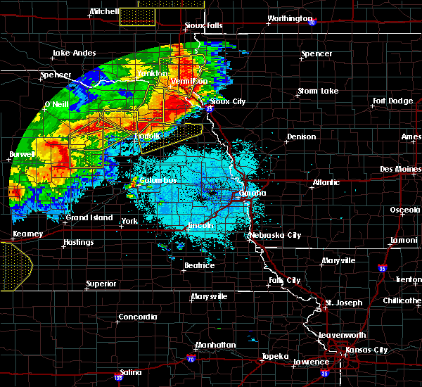 At 1056 pm cdt, severe thunderstorms were located along a line extending from 4 miles southeast of concord to near hadar, moving east at 45 mph (radar indicated). Hazards include 60 mph wind gusts and nickel size hail. Expect damage to roofs. Siding and trees. At 1056 pm cdt, severe thunderstorms were located along a line extending from 4 miles southeast of concord to near hadar, moving east at 45 mph (radar indicated). Hazards include 60 mph wind gusts and nickel size hail. Expect damage to roofs. Siding and trees.
|
| 6/17/2016 11:28 PM CDT |
 At 1128 pm cdt, severe thunderstorms were located along a line extending from 5 miles east of hoskins to 4 miles northeast of macy, moving southeast at 25 mph (radar indicated). Hazards include 60 mph wind gusts. Expect damage to roofs. Siding and trees. At 1128 pm cdt, severe thunderstorms were located along a line extending from 5 miles east of hoskins to 4 miles northeast of macy, moving southeast at 25 mph (radar indicated). Hazards include 60 mph wind gusts. Expect damage to roofs. Siding and trees.
|
| 6/17/2016 11:02 PM CDT |
 At 1102 pm cdt, severe thunderstorms were located along a line extending from 4 miles west of wayne to 4 miles east of winnebago, moving south at 20 mph (radar indicated). Hazards include 60 mph wind gusts. Expect damage to roofs. Siding and trees. At 1102 pm cdt, severe thunderstorms were located along a line extending from 4 miles west of wayne to 4 miles east of winnebago, moving south at 20 mph (radar indicated). Hazards include 60 mph wind gusts. Expect damage to roofs. Siding and trees.
|
| 6/17/2016 10:15 PM CDT |
 At 1015 pm cdt, a severe thunderstorm was located 5 miles north of emerson, or 15 miles south of ponca, moving south at 25 mph (radar indicated). Hazards include 60 mph wind gusts and quarter size hail. Hail damage to vehicles is expected. Expect wind damage to roofs, siding and trees. At 1015 pm cdt, a severe thunderstorm was located 5 miles north of emerson, or 15 miles south of ponca, moving south at 25 mph (radar indicated). Hazards include 60 mph wind gusts and quarter size hail. Hail damage to vehicles is expected. Expect wind damage to roofs, siding and trees.
|
| 5/3/2015 8:09 PM CDT | At 809 pm cdt, a severe thunderstorm was located over walthill, or 27 miles south of sioux city, moving east at 20 mph (radar indicated). Hazards include half dollar size hail. Damage to vehicles is expected. locations impacted include, pender, walthill and thurston. this includes the following highways, highway 75 in nebraska between mile markers 165 and 168. highway 77 in nebraska between milemarkers 159 and 169. 1. 25in. |
| 5/3/2015 7:55 PM CDT | At 755 pm cdt, a severe thunderstorm was located near pender, or 30 miles southwest of sioux city, moving northeast at 20 mph (radar indicated). Hazards include half dollar size hail. damage to vehicles is expected |
| 9/1/2013 12:53 AM CDT | Trees down blocking u.s. 77. also trees down along k ave. shingles off homes in thursto in thurston county NE, 0.3 miles S of Thurston, NE |
| 1/1/0001 12:00 AM | Small branches blown down in thurston county NE, 0.3 miles S of Thurston, NE |
Hail Maps for Thurston, NE


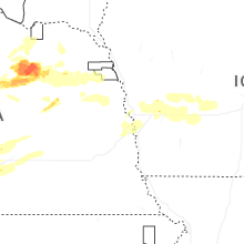
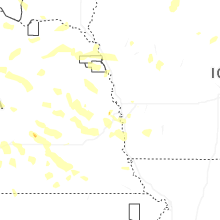
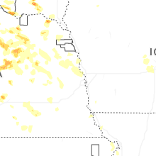


Connect with Interactive Hail Maps