

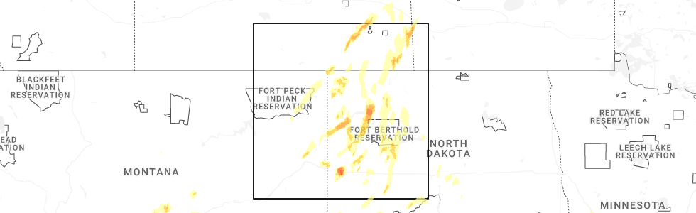
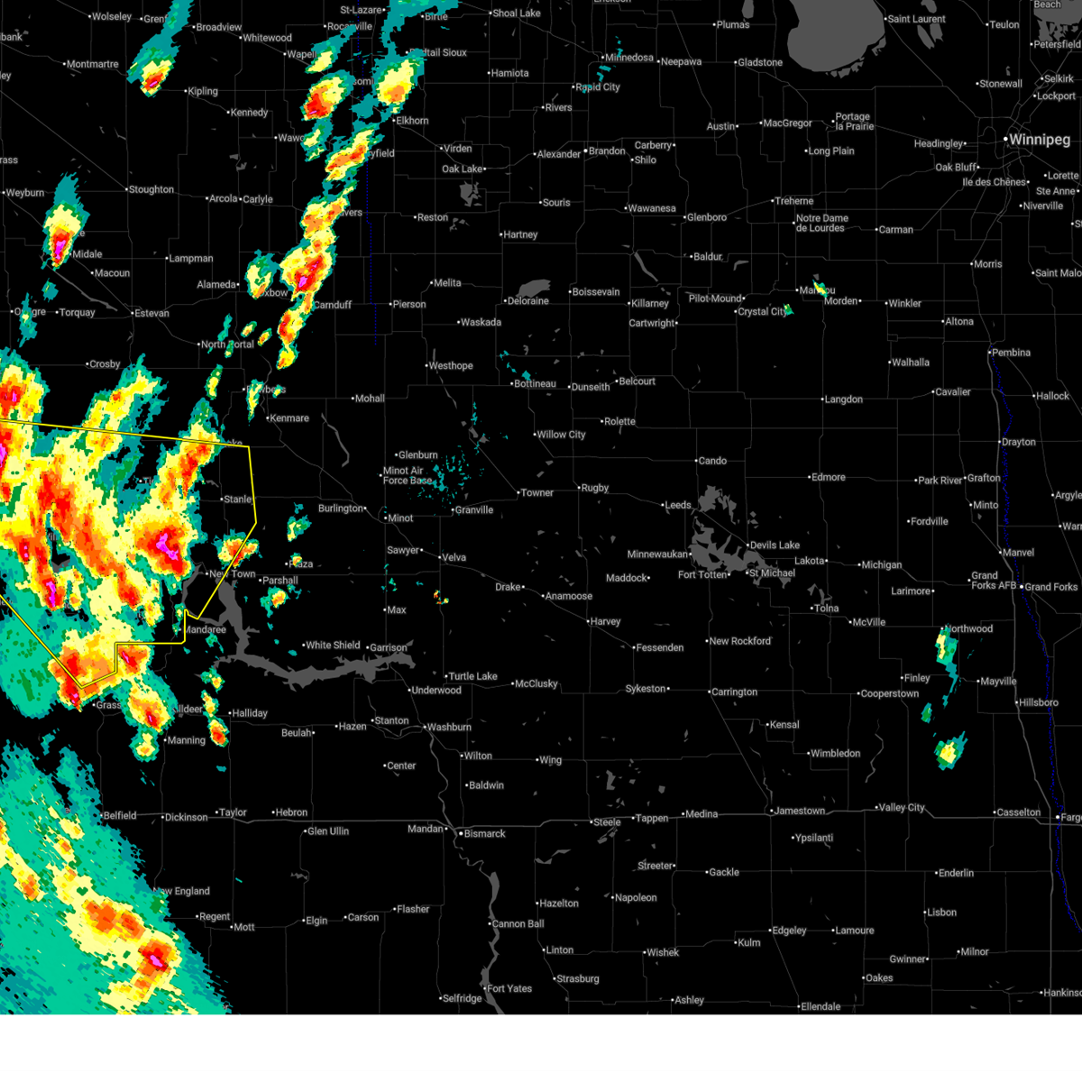
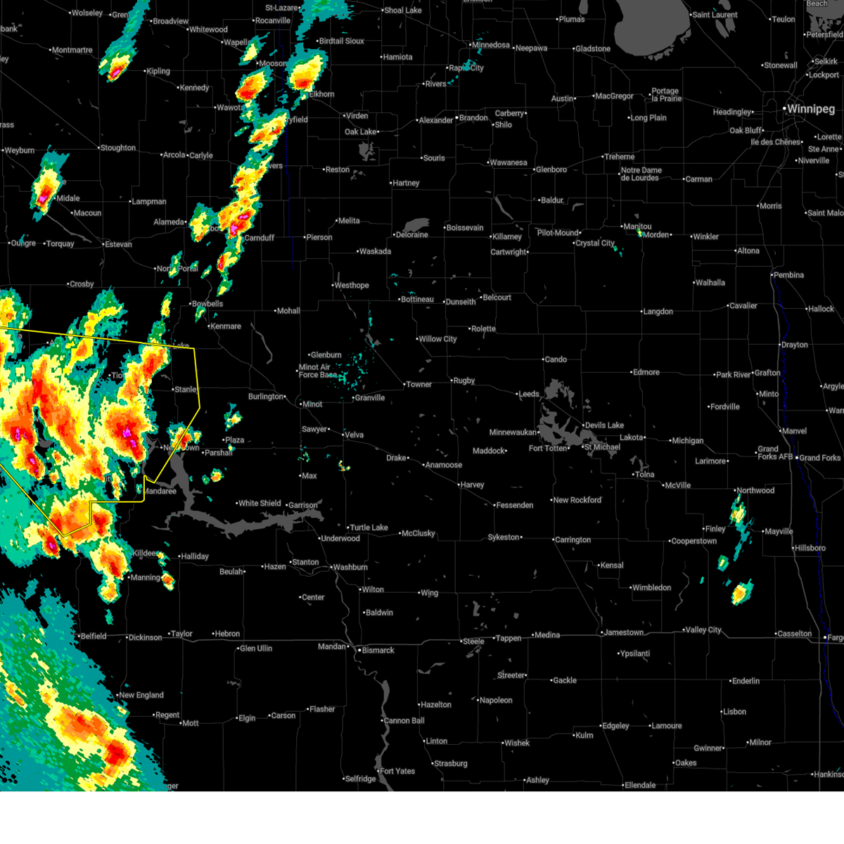
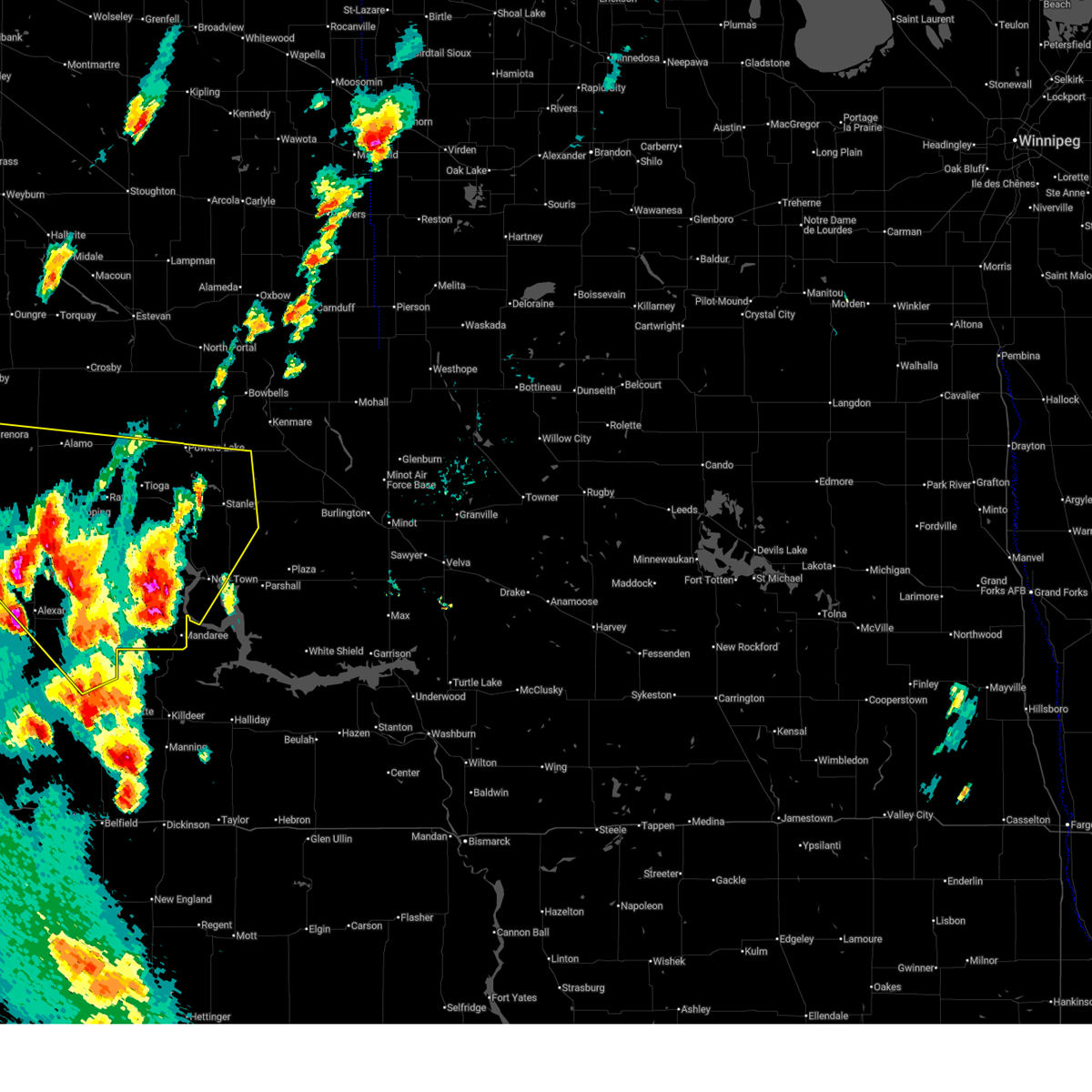
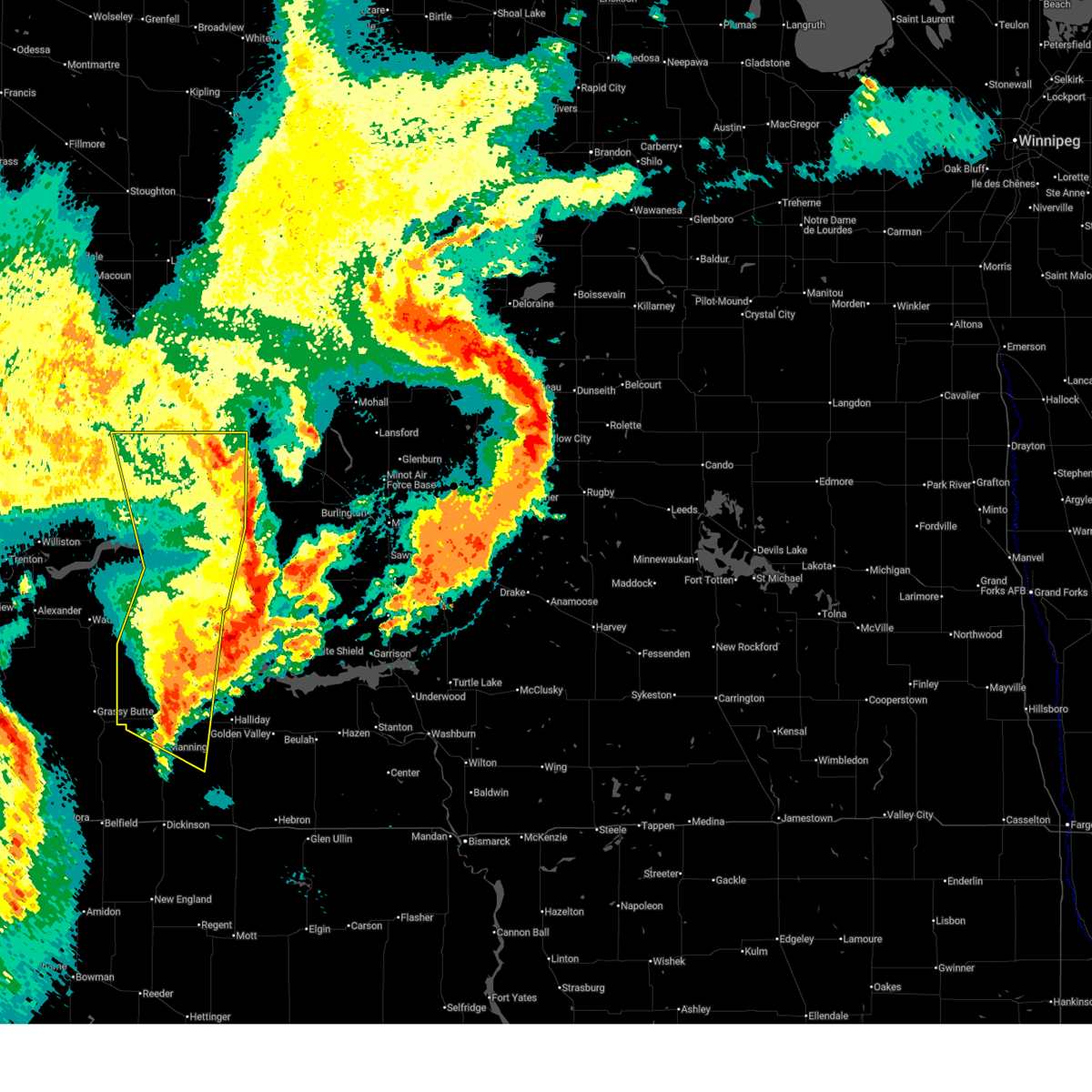
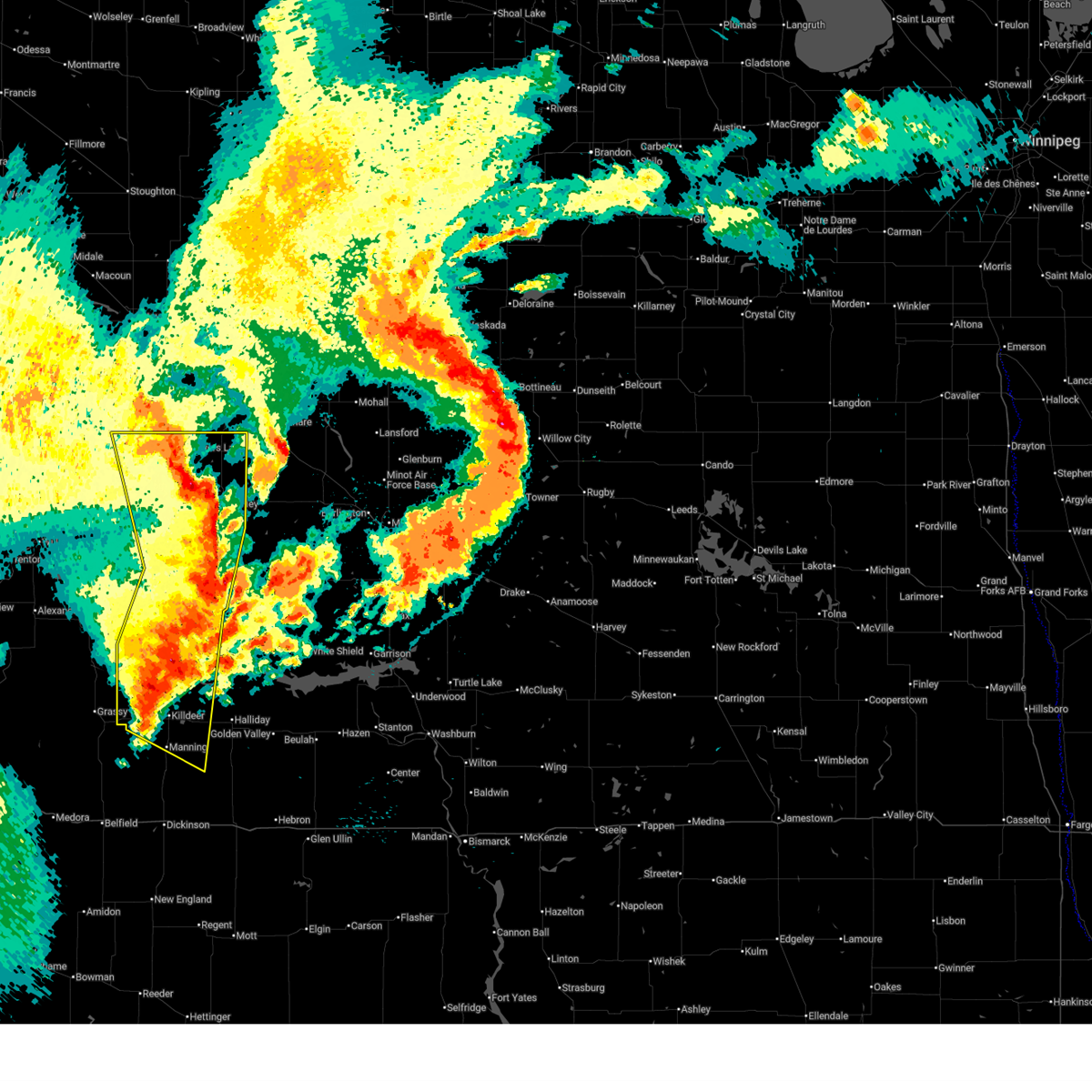
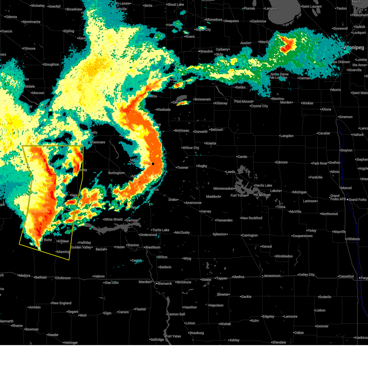
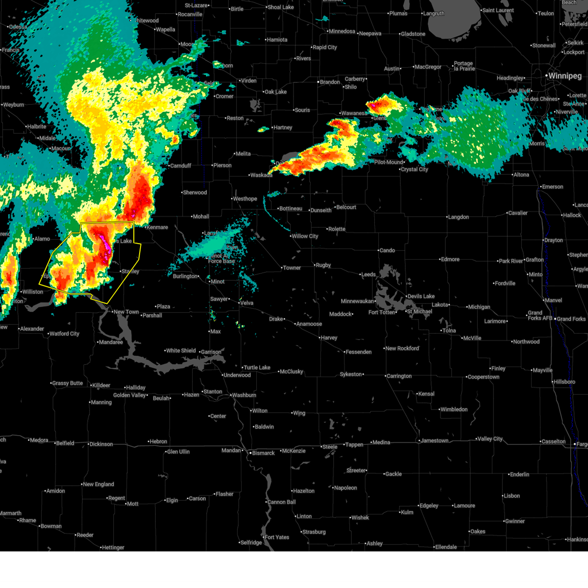
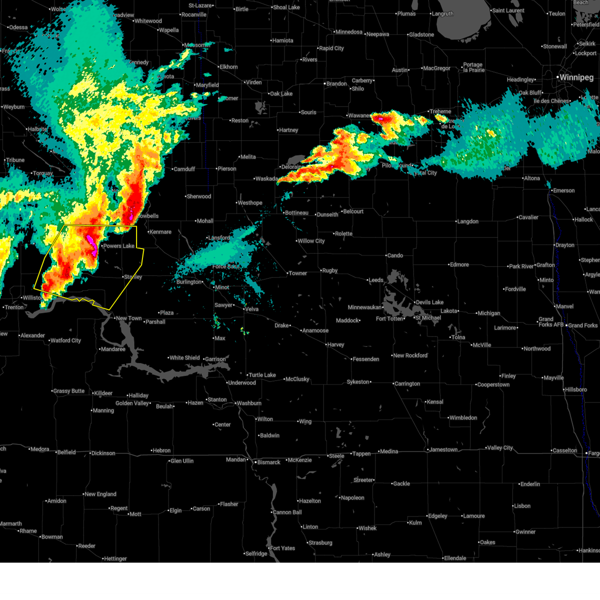
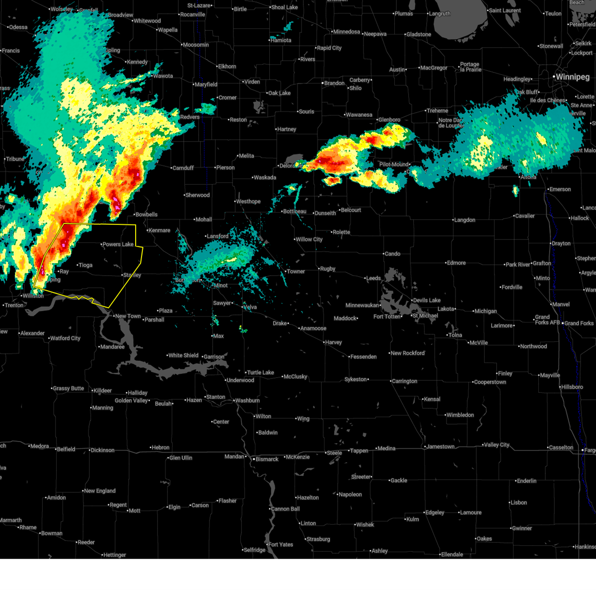
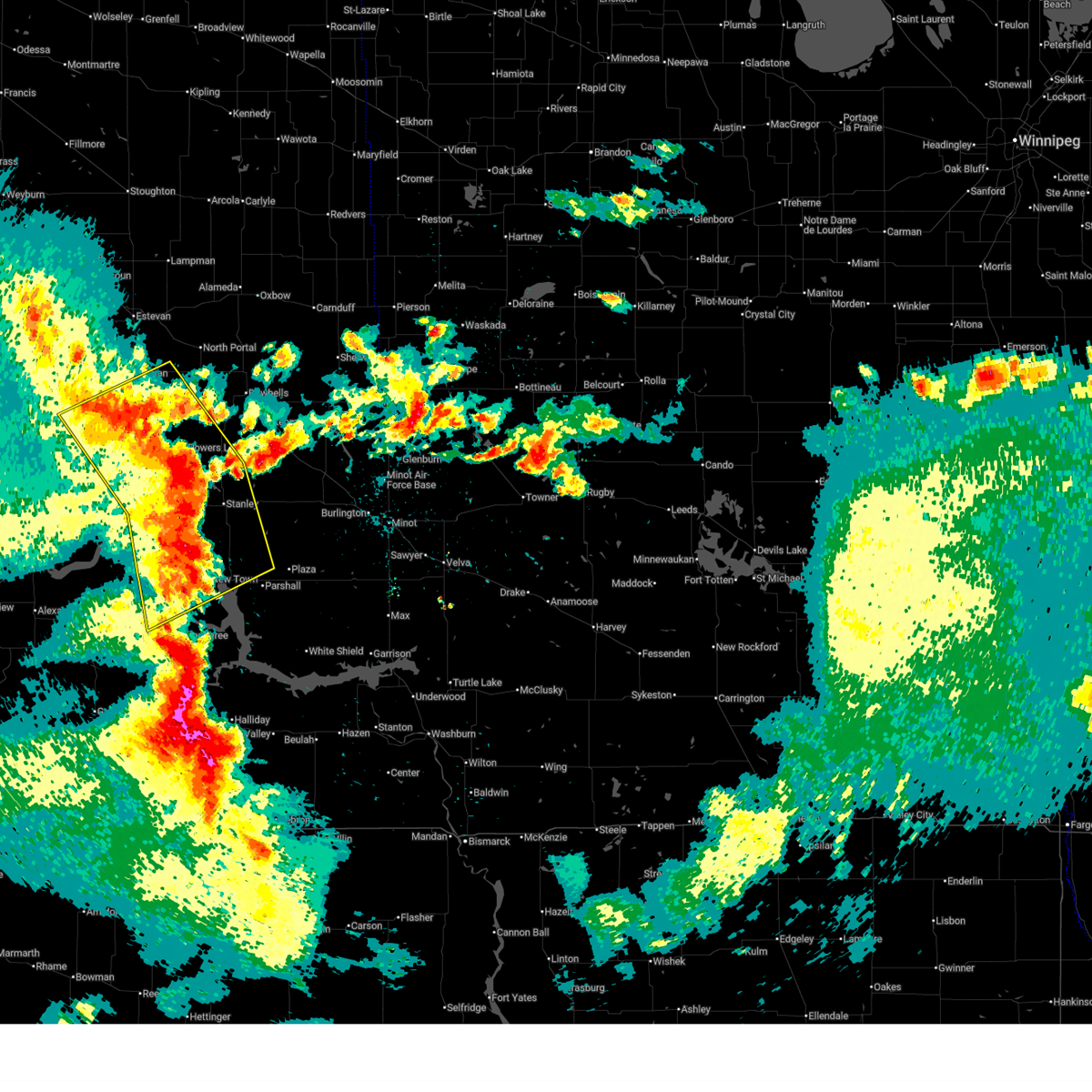
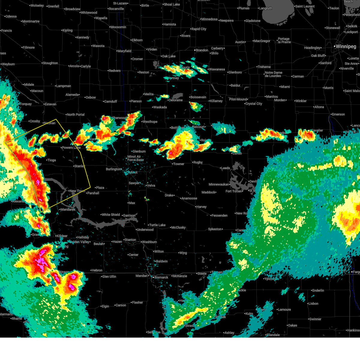
Hail Map for Tioga, ND
The Tioga, ND area has had 12 reports of on-the-ground hail by trained spotters, and has been under severe weather warnings 18 times during the past 12 months. Doppler radar has detected hail at or near Tioga, ND on 38 occasions, including 3 occasions during the past year.
| Name: | Tioga, ND |
| Where Located: | 36.2 miles ENE of Williston, ND |
| Map: | Google Map for Tioga, ND |
| Population: | 1230 |
| Housing Units: | 619 |
| More Info: | Search Google for Tioga, ND |
0
The Top Recent Hail Date for Tioga, ND is Sunday, June 7, 2026 (26th out of 38)
Hail and Wind Damage Spotted near Tioga, ND
| Date / Time | Report Details |
|---|---|
| 6/7/2026 9:44 PM CDT |
 At 944 pm cdt /844 pm mdt/, severe thunderstorms were located along a line from near alkabo to 11 miles north of flaxton, or along a line from 30 miles west of crosby to 44 miles east of crosby, moving north at 55 mph (radar indicated). Hazards include 60 mph wind gusts and small hail. Expect damage to roofs, siding, and trees. Locations impacted include, watford city, crosby, tioga, ray, powers lake, lignite, dunn center, columbus, portal, noonan, wildrose, epping, ross, battleview, four bears village, 4 bears lodge, mandaree, white earth, wheelock and hamlet. At 944 pm cdt /844 pm mdt/, severe thunderstorms were located along a line from near alkabo to 11 miles north of flaxton, or along a line from 30 miles west of crosby to 44 miles east of crosby, moving north at 55 mph (radar indicated). Hazards include 60 mph wind gusts and small hail. Expect damage to roofs, siding, and trees. Locations impacted include, watford city, crosby, tioga, ray, powers lake, lignite, dunn center, columbus, portal, noonan, wildrose, epping, ross, battleview, four bears village, 4 bears lodge, mandaree, white earth, wheelock and hamlet.
|
| 6/7/2026 9:17 PM CDT |
 Svrbis the national weather service in bismarck has issued a * severe thunderstorm warning for, western burke county in northwestern north dakota, divide county in northwestern north dakota, northeastern mckenzie county in northwestern north dakota, western mountrail county in northwestern north dakota, williams county in northwestern north dakota, central dunn county in southwestern north dakota, * until 1015 pm cdt /915 pm mdt/. * at 917 pm cdt /817 pm mdt/, severe thunderstorms were located along a line from near hanks city to 7 miles south of bowbells, or along a line from 29 miles northwest of williston to 27 miles north of stanley, moving north at 55 mph (radar indicated). Hazards include 70 mph wind gusts and quarter size hail. Hail damage to vehicles is expected. expect considerable tree damage. Wind damage is also likely to mobile homes, roofs, and outbuildings. Svrbis the national weather service in bismarck has issued a * severe thunderstorm warning for, western burke county in northwestern north dakota, divide county in northwestern north dakota, northeastern mckenzie county in northwestern north dakota, western mountrail county in northwestern north dakota, williams county in northwestern north dakota, central dunn county in southwestern north dakota, * until 1015 pm cdt /915 pm mdt/. * at 917 pm cdt /817 pm mdt/, severe thunderstorms were located along a line from near hanks city to 7 miles south of bowbells, or along a line from 29 miles northwest of williston to 27 miles north of stanley, moving north at 55 mph (radar indicated). Hazards include 70 mph wind gusts and quarter size hail. Hail damage to vehicles is expected. expect considerable tree damage. Wind damage is also likely to mobile homes, roofs, and outbuildings.
|
| 6/7/2026 8:19 PM CDT |
 Svrbis the national weather service in bismarck has issued a * severe thunderstorm warning for, northwestern ward county in north central north dakota, burke county in northwestern north dakota, eastern divide county in northwestern north dakota, northeastern mckenzie county in northwestern north dakota, mountrail county in northwestern north dakota, williams county in northwestern north dakota, * until 915 pm cdt /815 pm mdt/. * at 819 pm cdt /719 pm mdt/, severe thunderstorms were located along a line from near hanks city to 5 miles south of belden, or along a line from 28 miles southwest of crosby to 16 miles south of stanley, moving northeast at 25 mph (radar indicated). Hazards include golf ball size hail and 70 mph wind gusts. People and animals outdoors will be injured. expect hail damage to roofs, siding, windows, and vehicles. expect considerable tree damage. Wind damage is also likely to mobile homes, roofs, and outbuildings. Svrbis the national weather service in bismarck has issued a * severe thunderstorm warning for, northwestern ward county in north central north dakota, burke county in northwestern north dakota, eastern divide county in northwestern north dakota, northeastern mckenzie county in northwestern north dakota, mountrail county in northwestern north dakota, williams county in northwestern north dakota, * until 915 pm cdt /815 pm mdt/. * at 819 pm cdt /719 pm mdt/, severe thunderstorms were located along a line from near hanks city to 5 miles south of belden, or along a line from 28 miles southwest of crosby to 16 miles south of stanley, moving northeast at 25 mph (radar indicated). Hazards include golf ball size hail and 70 mph wind gusts. People and animals outdoors will be injured. expect hail damage to roofs, siding, windows, and vehicles. expect considerable tree damage. Wind damage is also likely to mobile homes, roofs, and outbuildings.
|
| 6/7/2026 7:54 PM CDT |
 At 754 pm cdt /654 pm mdt/, severe thunderstorms were located along a line from over bonetrail to 7 miles northwest of four bears village, or along a line from 18 miles northwest of williston to 21 miles southwest of stanley, moving north at 40 mph (radar indicated). Hazards include two inch hail and 70 mph wind gusts. People and animals outdoors will be injured. expect hail damage to roofs, siding, windows, and vehicles. expect considerable tree damage. wind damage is also likely to mobile homes, roofs, and outbuildings. Locations impacted include, williston, watford city, stanley, new town, tioga, ray, powers lake, grenora, alexander, arnegard, epping, ross, battleview, palermo, alamo, lostwood, theodore roosevelt national park north unit, four bears village, 4 bears lodge and mandaree. At 754 pm cdt /654 pm mdt/, severe thunderstorms were located along a line from over bonetrail to 7 miles northwest of four bears village, or along a line from 18 miles northwest of williston to 21 miles southwest of stanley, moving north at 40 mph (radar indicated). Hazards include two inch hail and 70 mph wind gusts. People and animals outdoors will be injured. expect hail damage to roofs, siding, windows, and vehicles. expect considerable tree damage. wind damage is also likely to mobile homes, roofs, and outbuildings. Locations impacted include, williston, watford city, stanley, new town, tioga, ray, powers lake, grenora, alexander, arnegard, epping, ross, battleview, palermo, alamo, lostwood, theodore roosevelt national park north unit, four bears village, 4 bears lodge and mandaree.
|
| 6/7/2026 7:42 PM CDT |
 At 742 pm cdt /642 pm mdt/, severe thunderstorms were located along a line from 8 miles south of bonetrail to 5 miles west of four bears village, or along a line from 13 miles northwest of williston to 28 miles southwest of stanley, moving north at 40 mph (radar indicated). Hazards include golf ball size hail and 70 mph wind gusts. People and animals outdoors will be injured. expect hail damage to roofs, siding, windows, and vehicles. expect considerable tree damage. wind damage is also likely to mobile homes, roofs, and outbuildings. Locations impacted include, williston, watford city, stanley, new town, tioga, ray, powers lake, grenora, alexander, arnegard, epping, ross, battleview, palermo, alamo, lostwood, theodore roosevelt national park north unit, four bears village, 4 bears lodge and mandaree. At 742 pm cdt /642 pm mdt/, severe thunderstorms were located along a line from 8 miles south of bonetrail to 5 miles west of four bears village, or along a line from 13 miles northwest of williston to 28 miles southwest of stanley, moving north at 40 mph (radar indicated). Hazards include golf ball size hail and 70 mph wind gusts. People and animals outdoors will be injured. expect hail damage to roofs, siding, windows, and vehicles. expect considerable tree damage. wind damage is also likely to mobile homes, roofs, and outbuildings. Locations impacted include, williston, watford city, stanley, new town, tioga, ray, powers lake, grenora, alexander, arnegard, epping, ross, battleview, palermo, alamo, lostwood, theodore roosevelt national park north unit, four bears village, 4 bears lodge and mandaree.
|
| 6/7/2026 7:25 PM CDT |
 Svrbis the national weather service in bismarck has issued a * severe thunderstorm warning for, southwestern burke county in northwestern north dakota, southwestern divide county in northwestern north dakota, mckenzie county in northwestern north dakota, western mountrail county in northwestern north dakota, williams county in northwestern north dakota, * until 830 pm cdt /730 pm mdt/. * at 725 pm cdt /625 pm mdt/, severe thunderstorms were located along a line from 10 miles west of williston to 6 miles north of mandaree, or along a line from 10 miles west of williston to 25 miles east of watford city, moving northeast at 45 mph (radar indicated). Hazards include golf ball size hail and 70 mph wind gusts. People and animals outdoors will be injured. expect hail damage to roofs, siding, windows, and vehicles. expect considerable tree damage. Wind damage is also likely to mobile homes, roofs, and outbuildings. Svrbis the national weather service in bismarck has issued a * severe thunderstorm warning for, southwestern burke county in northwestern north dakota, southwestern divide county in northwestern north dakota, mckenzie county in northwestern north dakota, western mountrail county in northwestern north dakota, williams county in northwestern north dakota, * until 830 pm cdt /730 pm mdt/. * at 725 pm cdt /625 pm mdt/, severe thunderstorms were located along a line from 10 miles west of williston to 6 miles north of mandaree, or along a line from 10 miles west of williston to 25 miles east of watford city, moving northeast at 45 mph (radar indicated). Hazards include golf ball size hail and 70 mph wind gusts. People and animals outdoors will be injured. expect hail damage to roofs, siding, windows, and vehicles. expect considerable tree damage. Wind damage is also likely to mobile homes, roofs, and outbuildings.
|
| 9/12/2025 12:59 PM CDT | Torbis the national weather service in bismarck has issued a * tornado warning for, northeastern williams county in northwestern north dakota, * until 130 pm cdt. * at 1259 pm cdt, a confirmed tornado was located over ray, or 24 miles northeast of williston, moving northeast at 5 mph (weather spotters confirmed tornado). Hazards include damaging tornado. Flying debris will be dangerous to those caught without shelter. mobile homes will be damaged or destroyed. damage to roofs, windows, and vehicles will occur. tree damage is likely. the tornado will be near, ray around 105 pm cdt. Other locations impacted by this tornadic thunderstorm include wheelock. |
| 8/7/2025 11:09 PM CDT |
 The storms which prompted the warning have weakened below severe limits, and no longer pose an immediate threat to life or property. therefore, the warning will be allowed to expire. however, gusty winds are still possible with these thunderstorms. a severe thunderstorm watch remains in effect until 300 am cdt for south central, southwestern and northwestern north dakota. The storms which prompted the warning have weakened below severe limits, and no longer pose an immediate threat to life or property. therefore, the warning will be allowed to expire. however, gusty winds are still possible with these thunderstorms. a severe thunderstorm watch remains in effect until 300 am cdt for south central, southwestern and northwestern north dakota.
|
| 8/7/2025 10:55 PM CDT |
 the severe thunderstorm warning has been cancelled and is no longer in effect the severe thunderstorm warning has been cancelled and is no longer in effect
|
| 8/7/2025 10:55 PM CDT |
 At 1054 pm cdt, severe thunderstorms were located along a line extending from powers lake to near ross to new town to 7 miles southwest of killdeer, moving east at 55 mph (trained weather spotters). Hazards include 70 mph wind gusts. Expect considerable tree damage. damage is likely to mobile homes, roofs, and outbuildings. Locations impacted include, stanley, new town, tioga, killdeer, powers lake, dunn center, ross, battleview, manning, lostwood, van hook park, four bears village, mandaree, belden, 4 bears lodge, white earth, hamlet, keene, white earth bay recreation area, and oakdale. At 1054 pm cdt, severe thunderstorms were located along a line extending from powers lake to near ross to new town to 7 miles southwest of killdeer, moving east at 55 mph (trained weather spotters). Hazards include 70 mph wind gusts. Expect considerable tree damage. damage is likely to mobile homes, roofs, and outbuildings. Locations impacted include, stanley, new town, tioga, killdeer, powers lake, dunn center, ross, battleview, manning, lostwood, van hook park, four bears village, mandaree, belden, 4 bears lodge, white earth, hamlet, keene, white earth bay recreation area, and oakdale.
|
| 8/7/2025 10:40 PM CDT | Emergency manager relays image of a camper-trailer flipped on highway 2... at the williams county... mountrail county line. at 10:20 pm ct... the line of storms was pro in williams county ND, 6.5 miles NW of Tioga, ND |
| 8/7/2025 10:36 PM CDT |
 At 1035 pm cdt/935 pm mdt/, severe thunderstorms were located along a line extending from 6 miles northwest of tioga to 13 miles west of ross to 11 miles northwest of mandaree to 10 miles northeast of grassy butte, moving east at 55 mph (trained weather spotters. at 1023 pm cdt, a 66 mph wind gust was reported 4 miles north of ray). Hazards include 70 mph wind gusts. Expect considerable tree damage. damage is likely to mobile homes, roofs, and outbuildings. Locations impacted include, watford city, stanley, new town, tioga, killdeer, ray, powers lake, dunn center, wildrose, ross, battleview, manning, lostwood, grassy butte, van hook park, four bears village, mandaree, belden, 4 bears lodge, and theodore roosevelt national park north unit. At 1035 pm cdt/935 pm mdt/, severe thunderstorms were located along a line extending from 6 miles northwest of tioga to 13 miles west of ross to 11 miles northwest of mandaree to 10 miles northeast of grassy butte, moving east at 55 mph (trained weather spotters. at 1023 pm cdt, a 66 mph wind gust was reported 4 miles north of ray). Hazards include 70 mph wind gusts. Expect considerable tree damage. damage is likely to mobile homes, roofs, and outbuildings. Locations impacted include, watford city, stanley, new town, tioga, killdeer, ray, powers lake, dunn center, wildrose, ross, battleview, manning, lostwood, grassy butte, van hook park, four bears village, mandaree, belden, 4 bears lodge, and theodore roosevelt national park north unit.
|
| 8/7/2025 10:14 PM CDT |
 Svrbis the national weather service in bismarck has issued a * severe thunderstorm warning for, western dunn county in southwestern north dakota, northern billings county in southwestern north dakota, southern burke county in northwestern north dakota, central mckenzie county in northwestern north dakota, eastern williams county in northwestern north dakota, western mountrail county in northwestern north dakota, * until 1115 pm cdt/1015 pm mdt/. * at 1014 pm cdt/914 pm mdt/, severe thunderstorms were located along a line extending from 7 miles north of epping to 11 miles south of ray to 5 miles east of watford city to 7 miles west of grassy butte, moving east at 50 mph (radar indicated). Hazards include 70 mph wind gusts and nickel size hail. Expect considerable tree damage. Damage is likely to mobile homes, roofs, and outbuildings. Svrbis the national weather service in bismarck has issued a * severe thunderstorm warning for, western dunn county in southwestern north dakota, northern billings county in southwestern north dakota, southern burke county in northwestern north dakota, central mckenzie county in northwestern north dakota, eastern williams county in northwestern north dakota, western mountrail county in northwestern north dakota, * until 1115 pm cdt/1015 pm mdt/. * at 1014 pm cdt/914 pm mdt/, severe thunderstorms were located along a line extending from 7 miles north of epping to 11 miles south of ray to 5 miles east of watford city to 7 miles west of grassy butte, moving east at 50 mph (radar indicated). Hazards include 70 mph wind gusts and nickel size hail. Expect considerable tree damage. Damage is likely to mobile homes, roofs, and outbuildings.
|
| 8/7/2025 8:37 PM CDT |
 At 836 pm cdt, severe thunderstorms were located along a line extending from 7 miles northeast of powers lake to 5 miles southwest of lostwood to 12 miles southeast of ray, moving east at 35 mph (radar indicated). Hazards include golf ball size hail and 60 mph wind gusts. People and animals outdoors will be injured. expect hail damage to roofs, siding, windows, and vehicles. expect wind damage to roofs, siding, and trees. Locations impacted include, stanley, tioga, ray, powers lake, epping, ross, battleview, palermo, lostwood, white earth, wheelock, white earth bay recreation area, white tail bay recreation area, and mcgregor. At 836 pm cdt, severe thunderstorms were located along a line extending from 7 miles northeast of powers lake to 5 miles southwest of lostwood to 12 miles southeast of ray, moving east at 35 mph (radar indicated). Hazards include golf ball size hail and 60 mph wind gusts. People and animals outdoors will be injured. expect hail damage to roofs, siding, windows, and vehicles. expect wind damage to roofs, siding, and trees. Locations impacted include, stanley, tioga, ray, powers lake, epping, ross, battleview, palermo, lostwood, white earth, wheelock, white earth bay recreation area, white tail bay recreation area, and mcgregor.
|
| 8/7/2025 8:37 PM CDT |
 the severe thunderstorm warning has been cancelled and is no longer in effect the severe thunderstorm warning has been cancelled and is no longer in effect
|
| 8/7/2025 8:21 PM CDT |
 At 820 pm cdt, severe thunderstorms were located along a line extending from near powers lake to 9 miles northwest of ross to 9 miles southeast of epping, moving east at 30 mph (radar indicated). Hazards include ping pong ball size hail and 60 mph wind gusts. People and animals outdoors will be injured. expect hail damage to roofs, siding, windows, and vehicles. expect wind damage to roofs, siding, and trees. Locations impacted include, stanley, tioga, ray, powers lake, wildrose, epping, palermo, lostwood, white earth bay recreation area, white tail bay recreation area, and mcgregor. At 820 pm cdt, severe thunderstorms were located along a line extending from near powers lake to 9 miles northwest of ross to 9 miles southeast of epping, moving east at 30 mph (radar indicated). Hazards include ping pong ball size hail and 60 mph wind gusts. People and animals outdoors will be injured. expect hail damage to roofs, siding, windows, and vehicles. expect wind damage to roofs, siding, and trees. Locations impacted include, stanley, tioga, ray, powers lake, wildrose, epping, palermo, lostwood, white earth bay recreation area, white tail bay recreation area, and mcgregor.
|
| 8/7/2025 8:18 PM CDT | Ndawn station dry fork 1se. report at 10 meters... 55 mph at the surfac in williams county ND, 11.4 miles N of Tioga, ND |
| 8/7/2025 8:15 PM CDT | Storm damage reported in williams county ND, 2.3 miles NW of Tioga, ND |
| 8/7/2025 7:57 PM CDT |
 Svrbis the national weather service in bismarck has issued a * severe thunderstorm warning for, southwestern burke county in northwestern north dakota, northeastern williams county in northwestern north dakota, northwestern mountrail county in northwestern north dakota, southeastern divide county in northwestern north dakota, * until 900 pm cdt. * at 756 pm cdt, severe thunderstorms were located along a line extending from 5 miles northwest of battleview to near tioga to 5 miles southwest of ray, moving east at 35 mph (radar indicated). Hazards include 60 mph wind gusts and half dollar size hail. Hail damage to vehicles is expected. Expect wind damage to roofs, siding, and trees. Svrbis the national weather service in bismarck has issued a * severe thunderstorm warning for, southwestern burke county in northwestern north dakota, northeastern williams county in northwestern north dakota, northwestern mountrail county in northwestern north dakota, southeastern divide county in northwestern north dakota, * until 900 pm cdt. * at 756 pm cdt, severe thunderstorms were located along a line extending from 5 miles northwest of battleview to near tioga to 5 miles southwest of ray, moving east at 35 mph (radar indicated). Hazards include 60 mph wind gusts and half dollar size hail. Hail damage to vehicles is expected. Expect wind damage to roofs, siding, and trees.
|
| 7/27/2025 3:33 AM CDT |
 At 332 am cdt, severe thunderstorms were located along a line extending from 8 miles northeast of wildrose to 8 miles northwest of ross to 5 miles northeast of four bears village, moving northeast at 40 mph (radar indicated). Hazards include 60 mph wind gusts and nickel size hail. Expect damage to roofs, siding, and trees. Locations impacted include, stanley, new town, tioga, powers lake, columbus, wildrose, ross, battleview, palermo, lostwood, belden, van hook park, 4 bears lodge, four bears village, white earth, hamlet, keene, white earth bay recreation area, larson, and charlson. At 332 am cdt, severe thunderstorms were located along a line extending from 8 miles northeast of wildrose to 8 miles northwest of ross to 5 miles northeast of four bears village, moving northeast at 40 mph (radar indicated). Hazards include 60 mph wind gusts and nickel size hail. Expect damage to roofs, siding, and trees. Locations impacted include, stanley, new town, tioga, powers lake, columbus, wildrose, ross, battleview, palermo, lostwood, belden, van hook park, 4 bears lodge, four bears village, white earth, hamlet, keene, white earth bay recreation area, larson, and charlson.
|
| 7/27/2025 2:55 AM CDT |
 Svrbis the national weather service in bismarck has issued a * severe thunderstorm warning for, western burke county in northwestern north dakota, northeastern mckenzie county in northwestern north dakota, eastern williams county in northwestern north dakota, mountrail county in northwestern north dakota, southeastern divide county in northwestern north dakota, * until 400 am cdt. * at 255 am cdt, severe thunderstorms were located along a line extending from alamo to 6 miles south of ray to 16 miles northeast of watford city, moving northeast at 35 mph (radar indicated). Hazards include 60 mph wind gusts and nickel size hail. expect damage to roofs, siding, and trees Svrbis the national weather service in bismarck has issued a * severe thunderstorm warning for, western burke county in northwestern north dakota, northeastern mckenzie county in northwestern north dakota, eastern williams county in northwestern north dakota, mountrail county in northwestern north dakota, southeastern divide county in northwestern north dakota, * until 400 am cdt. * at 255 am cdt, severe thunderstorms were located along a line extending from alamo to 6 miles south of ray to 16 miles northeast of watford city, moving northeast at 35 mph (radar indicated). Hazards include 60 mph wind gusts and nickel size hail. expect damage to roofs, siding, and trees
|
| 7/25/2025 7:39 PM CDT | Ndawn dry fork 1se. recorded at 10 meters... peak 63 mph at the surfac in williams county ND, 11.4 miles N of Tioga, ND |
| 7/14/2024 8:48 PM CDT |
 Svrbis the national weather service in bismarck has issued a * severe thunderstorm warning for, southeastern williams county in northwestern north dakota, western mountrail county in northwestern north dakota, * until 945 pm cdt. * at 847 pm cdt, a severe thunderstorm was located near ray, or 24 miles northeast of williston, moving east at 30 mph (radar indicated). Hazards include golf ball size hail and 60 mph wind gusts. People and animals outdoors will be injured. expect hail damage to roofs, siding, windows, and vehicles. Expect wind damage to roofs, siding, and trees. Svrbis the national weather service in bismarck has issued a * severe thunderstorm warning for, southeastern williams county in northwestern north dakota, western mountrail county in northwestern north dakota, * until 945 pm cdt. * at 847 pm cdt, a severe thunderstorm was located near ray, or 24 miles northeast of williston, moving east at 30 mph (radar indicated). Hazards include golf ball size hail and 60 mph wind gusts. People and animals outdoors will be injured. expect hail damage to roofs, siding, windows, and vehicles. Expect wind damage to roofs, siding, and trees.
|
| 7/12/2024 4:57 PM CDT |
 At 457 pm cdt, a severe thunderstorm was located 9 miles east of tioga, or 16 miles west of stanley, moving southeast at 25 mph (radar indicated). Hazards include tennis ball size hail and 60 mph wind gusts. People and animals outdoors will be injured. expect hail damage to roofs, siding, windows, and vehicles. expect wind damage to roofs, siding, and trees. Locations impacted include, stanley, tioga, powers lake, ross, battleview, lostwood, and white earth. At 457 pm cdt, a severe thunderstorm was located 9 miles east of tioga, or 16 miles west of stanley, moving southeast at 25 mph (radar indicated). Hazards include tennis ball size hail and 60 mph wind gusts. People and animals outdoors will be injured. expect hail damage to roofs, siding, windows, and vehicles. expect wind damage to roofs, siding, and trees. Locations impacted include, stanley, tioga, powers lake, ross, battleview, lostwood, and white earth.
|
| 7/12/2024 4:51 PM CDT |
 Svrbis the national weather service in bismarck has issued a * severe thunderstorm warning for, southwestern burke county in northwestern north dakota, northeastern williams county in northwestern north dakota, northwestern mountrail county in northwestern north dakota, * until 545 pm cdt. * at 450 pm cdt, a severe thunderstorm was located 6 miles east of tioga, or 19 miles west of stanley, moving southeast at 25 mph (radar indicated). Hazards include ping pong ball size hail and 60 mph wind gusts. People and animals outdoors will be injured. expect hail damage to roofs, siding, windows, and vehicles. Expect wind damage to roofs, siding, and trees. Svrbis the national weather service in bismarck has issued a * severe thunderstorm warning for, southwestern burke county in northwestern north dakota, northeastern williams county in northwestern north dakota, northwestern mountrail county in northwestern north dakota, * until 545 pm cdt. * at 450 pm cdt, a severe thunderstorm was located 6 miles east of tioga, or 19 miles west of stanley, moving southeast at 25 mph (radar indicated). Hazards include ping pong ball size hail and 60 mph wind gusts. People and animals outdoors will be injured. expect hail damage to roofs, siding, windows, and vehicles. Expect wind damage to roofs, siding, and trees.
|
| 7/12/2024 4:41 PM CDT |
 At 440 pm cdt, a severe thunderstorm was located 6 miles northeast of tioga, or 23 miles northwest of stanley, moving east at 25 mph (radar indicated). Hazards include 60 mph wind gusts and quarter size hail. Hail damage to vehicles is expected. expect wind damage to roofs, siding, and trees. Locations impacted include, tioga, battleview, white earth, hamlet, and mcgregor. At 440 pm cdt, a severe thunderstorm was located 6 miles northeast of tioga, or 23 miles northwest of stanley, moving east at 25 mph (radar indicated). Hazards include 60 mph wind gusts and quarter size hail. Hail damage to vehicles is expected. expect wind damage to roofs, siding, and trees. Locations impacted include, tioga, battleview, white earth, hamlet, and mcgregor.
|
| 7/12/2024 4:41 PM CDT |
 the severe thunderstorm warning has been cancelled and is no longer in effect the severe thunderstorm warning has been cancelled and is no longer in effect
|
| 7/12/2024 4:28 PM CDT |
 At 427 pm cdt, a severe thunderstorm was located 8 miles north of tioga, or 29 miles northwest of stanley, moving east at 25 mph (radar indicated). Hazards include 60 mph wind gusts and quarter size hail. Hail damage to vehicles is expected. expect wind damage to roofs, siding, and trees. Locations impacted include, tioga, wildrose, battleview, white earth, hamlet, and mcgregor. At 427 pm cdt, a severe thunderstorm was located 8 miles north of tioga, or 29 miles northwest of stanley, moving east at 25 mph (radar indicated). Hazards include 60 mph wind gusts and quarter size hail. Hail damage to vehicles is expected. expect wind damage to roofs, siding, and trees. Locations impacted include, tioga, wildrose, battleview, white earth, hamlet, and mcgregor.
|
| 7/12/2024 4:14 PM CDT |
 At 414 pm cdt, a severe thunderstorm was located 7 miles southeast of wildrose, or 27 miles south of crosby, moving east at 25 mph (radar indicated). Hazards include 60 mph wind gusts and quarter size hail. Hail damage to vehicles is expected. expect wind damage to roofs, siding, and trees. Locations impacted include, tioga, wildrose, battleview, white earth, hamlet, mcgregor, and corinth. At 414 pm cdt, a severe thunderstorm was located 7 miles southeast of wildrose, or 27 miles south of crosby, moving east at 25 mph (radar indicated). Hazards include 60 mph wind gusts and quarter size hail. Hail damage to vehicles is expected. expect wind damage to roofs, siding, and trees. Locations impacted include, tioga, wildrose, battleview, white earth, hamlet, mcgregor, and corinth.
|
| 7/12/2024 4:02 PM CDT |
 Svrbis the national weather service in bismarck has issued a * severe thunderstorm warning for, southwestern burke county in northwestern north dakota, northeastern williams county in northwestern north dakota, northwestern mountrail county in northwestern north dakota, southeastern divide county in northwestern north dakota, * until 500 pm cdt. * at 402 pm cdt, a severe thunderstorm was located 5 miles southwest of wildrose, or 23 miles south of crosby, moving east at 25 mph (radar indicated). Hazards include 60 mph wind gusts and quarter size hail. Hail damage to vehicles is expected. Expect wind damage to roofs, siding, and trees. Svrbis the national weather service in bismarck has issued a * severe thunderstorm warning for, southwestern burke county in northwestern north dakota, northeastern williams county in northwestern north dakota, northwestern mountrail county in northwestern north dakota, southeastern divide county in northwestern north dakota, * until 500 pm cdt. * at 402 pm cdt, a severe thunderstorm was located 5 miles southwest of wildrose, or 23 miles south of crosby, moving east at 25 mph (radar indicated). Hazards include 60 mph wind gusts and quarter size hail. Hail damage to vehicles is expected. Expect wind damage to roofs, siding, and trees.
|
| 6/15/2024 11:35 PM CDT | Awos station kd60 tiog in williams county ND, 2.3 miles NW of Tioga, ND |
| 6/15/2024 11:30 PM CDT |
 At 1130 pm cdt, severe thunderstorms were located along a line extending from 9 miles northwest of portal to 9 miles south of kenmare to near new town, moving east at 65 mph (radar indicated). Hazards include 70 mph wind gusts and quarter size hail. Hail damage to vehicles is expected. expect considerable tree damage. wind damage is also likely to mobile homes, roofs, and outbuildings. locations impacted include, stanley, crosby, new town, tioga, kenmare, parshall, mohall, ray, berthold, bowbells, powers lake, sherwood, des lacs, plaza, carpio, lignite, columbus, portal, noonan, and foxholm. Damaging winds may persist for a considerable time after the leading edge of the severe thunderstorms have passed by. At 1130 pm cdt, severe thunderstorms were located along a line extending from 9 miles northwest of portal to 9 miles south of kenmare to near new town, moving east at 65 mph (radar indicated). Hazards include 70 mph wind gusts and quarter size hail. Hail damage to vehicles is expected. expect considerable tree damage. wind damage is also likely to mobile homes, roofs, and outbuildings. locations impacted include, stanley, crosby, new town, tioga, kenmare, parshall, mohall, ray, berthold, bowbells, powers lake, sherwood, des lacs, plaza, carpio, lignite, columbus, portal, noonan, and foxholm. Damaging winds may persist for a considerable time after the leading edge of the severe thunderstorms have passed by.
|
| 6/15/2024 11:27 PM CDT | Measured wind gust from private weather statio in williams county ND, 1.2 miles W of Tioga, ND |
| 6/15/2024 11:10 PM CDT |
 Svrbis the national weather service in bismarck has issued a * severe thunderstorm warning for, western ward county in north central north dakota, renville county in north central north dakota, burke county in northwestern north dakota, northeastern mckenzie county in northwestern north dakota, williams county in northwestern north dakota, mountrail county in northwestern north dakota, divide county in northwestern north dakota, * until 1215 am cdt. * at 1109 pm cdt, severe thunderstorms were located along a line extending from 6 miles northwest of noonan to 5 miles northwest of lostwood to four bears village, moving northeast at 65 mph (radar indicated). Hazards include 70 mph wind gusts and quarter size hail. Hail damage to vehicles is expected. expect considerable tree damage. Wind damage is also likely to mobile homes, roofs, and outbuildings. Svrbis the national weather service in bismarck has issued a * severe thunderstorm warning for, western ward county in north central north dakota, renville county in north central north dakota, burke county in northwestern north dakota, northeastern mckenzie county in northwestern north dakota, williams county in northwestern north dakota, mountrail county in northwestern north dakota, divide county in northwestern north dakota, * until 1215 am cdt. * at 1109 pm cdt, severe thunderstorms were located along a line extending from 6 miles northwest of noonan to 5 miles northwest of lostwood to four bears village, moving northeast at 65 mph (radar indicated). Hazards include 70 mph wind gusts and quarter size hail. Hail damage to vehicles is expected. expect considerable tree damage. Wind damage is also likely to mobile homes, roofs, and outbuildings.
|
| 6/15/2024 10:46 PM CDT |
 At 1046 pm cdt, severe thunderstorms were located along a line extending from 8 miles west of crosby to near tioga to 13 miles northeast of watford city, moving east at 50 mph (radar indicated). Hazards include 70 mph wind gusts and quarter size hail. Hail damage to vehicles is expected. expect considerable tree damage. wind damage is also likely to mobile homes, roofs, and outbuildings. Locations impacted include, crosby, tioga, ray, powers lake, lignite, columbus, noonan, wildrose, epping, ross, battleview, alamo, lostwood, fortuna, four bears village, 4 bears lodge, white earth, wheelock, hamlet, and ambrose. At 1046 pm cdt, severe thunderstorms were located along a line extending from 8 miles west of crosby to near tioga to 13 miles northeast of watford city, moving east at 50 mph (radar indicated). Hazards include 70 mph wind gusts and quarter size hail. Hail damage to vehicles is expected. expect considerable tree damage. wind damage is also likely to mobile homes, roofs, and outbuildings. Locations impacted include, crosby, tioga, ray, powers lake, lignite, columbus, noonan, wildrose, epping, ross, battleview, alamo, lostwood, fortuna, four bears village, 4 bears lodge, white earth, wheelock, hamlet, and ambrose.
|
| 6/15/2024 10:34 PM CDT |
 At 1034 pm cdt, severe thunderstorms were located along a line extending from 8 miles east of writing rock state historical site to 8 miles north of ray to 10 miles north of watford city, moving east at 45 mph (radar indicated). Hazards include 70 mph wind gusts and quarter size hail. Hail damage to vehicles is expected. expect considerable tree damage. wind damage is also likely to mobile homes, roofs, and outbuildings. Locations impacted include, williston, crosby, tioga, ray, powers lake, grenora, lignite, columbus, noonan, wildrose, epping, ross, battleview, alamo, lostwood, fortuna, writing rock state historical site, bonetrail, four bears village, and hanks city. At 1034 pm cdt, severe thunderstorms were located along a line extending from 8 miles east of writing rock state historical site to 8 miles north of ray to 10 miles north of watford city, moving east at 45 mph (radar indicated). Hazards include 70 mph wind gusts and quarter size hail. Hail damage to vehicles is expected. expect considerable tree damage. wind damage is also likely to mobile homes, roofs, and outbuildings. Locations impacted include, williston, crosby, tioga, ray, powers lake, grenora, lignite, columbus, noonan, wildrose, epping, ross, battleview, alamo, lostwood, fortuna, writing rock state historical site, bonetrail, four bears village, and hanks city.
|
| 6/15/2024 10:17 PM CDT |
 Svrbis the national weather service in bismarck has issued a * severe thunderstorm warning for, burke county in northwestern north dakota, northern mckenzie county in northwestern north dakota, williams county in northwestern north dakota, northwestern mountrail county in northwestern north dakota, divide county in northwestern north dakota, * until 1115 pm cdt. * at 1017 pm cdt, severe thunderstorms were located along a line extending from 7 miles southeast of writing rock state historical site to 9 miles south of alamo to 7 miles north of alexander, moving northeast at 55 mph (radar indicated). Hazards include 70 mph wind gusts and quarter size hail. Hail damage to vehicles is expected. expect considerable tree damage. Wind damage is also likely to mobile homes, roofs, and outbuildings. Svrbis the national weather service in bismarck has issued a * severe thunderstorm warning for, burke county in northwestern north dakota, northern mckenzie county in northwestern north dakota, williams county in northwestern north dakota, northwestern mountrail county in northwestern north dakota, divide county in northwestern north dakota, * until 1115 pm cdt. * at 1017 pm cdt, severe thunderstorms were located along a line extending from 7 miles southeast of writing rock state historical site to 9 miles south of alamo to 7 miles north of alexander, moving northeast at 55 mph (radar indicated). Hazards include 70 mph wind gusts and quarter size hail. Hail damage to vehicles is expected. expect considerable tree damage. Wind damage is also likely to mobile homes, roofs, and outbuildings.
|
| 6/14/2024 5:40 PM CDT | Ping Pong Ball sized hail reported 9.5 miles S of Tioga, ND, hail lasted for about 5 to 7 minutes. report relayed via social media video. largest estimated size was ping pong ball. |
| 8/1/2023 5:24 PM CDT | Quarter sized hail reported 15.6 miles N of Tioga, ND, hail report and image from social media. |
| 8/1/2023 5:02 PM CDT |
 At 501 pm cdt, a severe thunderstorm was located near ray, or 22 miles northeast of williston, moving southeast at 35 mph (radar indicated). Hazards include golf ball size hail and 60 mph wind gusts. People and animals outdoors will be injured. expect hail damage to roofs, siding, windows, and vehicles. expect wind damage to roofs, siding, and trees. this severe thunderstorm will remain over mainly rural areas of north central mckenzie and southeastern williams counties, including the following locations, white tail bay recreation area, tobacco garden bay recreation area, spring brook, lewis and clark state park and wheelock. thunderstorm damage threat, considerable hail threat, radar indicated max hail size, 1. 75 in wind threat, radar indicated max wind gust, 60 mph. At 501 pm cdt, a severe thunderstorm was located near ray, or 22 miles northeast of williston, moving southeast at 35 mph (radar indicated). Hazards include golf ball size hail and 60 mph wind gusts. People and animals outdoors will be injured. expect hail damage to roofs, siding, windows, and vehicles. expect wind damage to roofs, siding, and trees. this severe thunderstorm will remain over mainly rural areas of north central mckenzie and southeastern williams counties, including the following locations, white tail bay recreation area, tobacco garden bay recreation area, spring brook, lewis and clark state park and wheelock. thunderstorm damage threat, considerable hail threat, radar indicated max hail size, 1. 75 in wind threat, radar indicated max wind gust, 60 mph.
|
| 8/1/2023 4:48 PM CDT |
 At 448 pm cdt, a severe thunderstorm was located near epping, or 17 miles northeast of williston, moving southeast at 35 mph (radar indicated). Hazards include ping pong ball size hail and 60 mph wind gusts. People and animals outdoors will be injured. expect hail damage to roofs, siding, windows, and vehicles. expect wind damage to roofs, siding, and trees. this severe thunderstorm will be near, ray around 500 pm cdt. other locations impacted by this severe thunderstorm include white tail bay recreation area, tobacco garden bay recreation area, spring brook, lewis and clark state park and wheelock. hail threat, radar indicated max hail size, 1. 50 in wind threat, radar indicated max wind gust, 60 mph. At 448 pm cdt, a severe thunderstorm was located near epping, or 17 miles northeast of williston, moving southeast at 35 mph (radar indicated). Hazards include ping pong ball size hail and 60 mph wind gusts. People and animals outdoors will be injured. expect hail damage to roofs, siding, windows, and vehicles. expect wind damage to roofs, siding, and trees. this severe thunderstorm will be near, ray around 500 pm cdt. other locations impacted by this severe thunderstorm include white tail bay recreation area, tobacco garden bay recreation area, spring brook, lewis and clark state park and wheelock. hail threat, radar indicated max hail size, 1. 50 in wind threat, radar indicated max wind gust, 60 mph.
|
| 7/30/2022 8:30 PM CDT |
 At 828 pm cdt, severe thunderstorms were located along a line extending from near tioga to 16 miles southeast of ray to 7 miles northeast of watford city, moving east at 40 mph (radar indicated). Hazards include 60 mph wind gusts. Expect damage to roofs, siding, and trees. these severe storms will be near, ross around 850 pm cdt. other locations impacted by these severe thunderstorms include white tail bay recreation area, white earth, keene, lewis and clark state park, white earth bay recreation area, tobacco garden bay recreation area and johnsons corner. hail threat, radar indicated max hail size, <. 75 in wind threat, observed max wind gust, 60 mph. At 828 pm cdt, severe thunderstorms were located along a line extending from near tioga to 16 miles southeast of ray to 7 miles northeast of watford city, moving east at 40 mph (radar indicated). Hazards include 60 mph wind gusts. Expect damage to roofs, siding, and trees. these severe storms will be near, ross around 850 pm cdt. other locations impacted by these severe thunderstorms include white tail bay recreation area, white earth, keene, lewis and clark state park, white earth bay recreation area, tobacco garden bay recreation area and johnsons corner. hail threat, radar indicated max hail size, <. 75 in wind threat, observed max wind gust, 60 mph.
|
| 7/30/2022 8:10 PM CDT |
 At 808 pm cdt, severe thunderstorms were located along a line extending from 9 miles west of battleview to near ray to 13 miles southeast of williston, moving east at 45 mph (radar indicated). Hazards include 60 mph wind gusts. Expect damage to roofs, siding, and trees. these severe storms will be near, tioga around 820 pm cdt. ross around 845 pm cdt. other locations impacted by these severe thunderstorms include white tail bay recreation area, white earth, keene, lewis and clark state park, white earth bay recreation area, and tobacco garden bay recreation area. hail threat, radar indicated max hail size, <. 75 in wind threat, observed max wind gust, 60 mph. At 808 pm cdt, severe thunderstorms were located along a line extending from 9 miles west of battleview to near ray to 13 miles southeast of williston, moving east at 45 mph (radar indicated). Hazards include 60 mph wind gusts. Expect damage to roofs, siding, and trees. these severe storms will be near, tioga around 820 pm cdt. ross around 845 pm cdt. other locations impacted by these severe thunderstorms include white tail bay recreation area, white earth, keene, lewis and clark state park, white earth bay recreation area, and tobacco garden bay recreation area. hail threat, radar indicated max hail size, <. 75 in wind threat, observed max wind gust, 60 mph.
|
| 7/30/2022 7:53 PM CDT |
 At 752 pm cdt/652 pm mdt/, severe thunderstorms were located along a line extending from near wildrose to near epping to 11 miles east of fort union trading post, moving east at 45 mph (radar indicated). Hazards include 60 mph wind gusts. Expect damage to roofs, siding, and trees. severe thunderstorms will be near, epping around 755 pm cdt. ray around 800 pm cdt. tioga around 820 pm cdt. ross around 840 pm cdt. other locations impacted by these severe thunderstorms include white earth, lewis and clark state park, appam, white earth bay recreation area, charlson, spring brook, white tail bay recreation area, keene, fort buford state historical site and wheelock. hail threat, radar indicated max hail size, <. 75 in wind threat, observed max wind gust, 60 mph. At 752 pm cdt/652 pm mdt/, severe thunderstorms were located along a line extending from near wildrose to near epping to 11 miles east of fort union trading post, moving east at 45 mph (radar indicated). Hazards include 60 mph wind gusts. Expect damage to roofs, siding, and trees. severe thunderstorms will be near, epping around 755 pm cdt. ray around 800 pm cdt. tioga around 820 pm cdt. ross around 840 pm cdt. other locations impacted by these severe thunderstorms include white earth, lewis and clark state park, appam, white earth bay recreation area, charlson, spring brook, white tail bay recreation area, keene, fort buford state historical site and wheelock. hail threat, radar indicated max hail size, <. 75 in wind threat, observed max wind gust, 60 mph.
|
| 7/19/2022 12:39 AM CDT |
 At 1239 am cdt, a severe thunderstorm was located 8 miles south of powers lake, or 15 miles northwest of stanley, moving east at 50 mph (radar indicated). Hazards include 60 mph wind gusts and half dollar size hail. Hail damage to vehicles is expected. expect wind damage to roofs, siding, and trees. this severe thunderstorm will remain over mainly rural areas of southwestern burke, northeastern williams and northwestern mountrail counties, including the following locations, white earth and mcgregor. hail threat, radar indicated max hail size, 1. 25 in wind threat, radar indicated max wind gust, 60 mph. At 1239 am cdt, a severe thunderstorm was located 8 miles south of powers lake, or 15 miles northwest of stanley, moving east at 50 mph (radar indicated). Hazards include 60 mph wind gusts and half dollar size hail. Hail damage to vehicles is expected. expect wind damage to roofs, siding, and trees. this severe thunderstorm will remain over mainly rural areas of southwestern burke, northeastern williams and northwestern mountrail counties, including the following locations, white earth and mcgregor. hail threat, radar indicated max hail size, 1. 25 in wind threat, radar indicated max wind gust, 60 mph.
|
| 7/19/2022 12:18 AM CDT |
 At 1217 am cdt, a severe thunderstorm was located over tioga, or 26 miles west of stanley, moving east at 45 mph (radar indicated. at 1205 am cdt, 63 mph wind gusts were reported 4 miles north of ray). Hazards include golf ball size hail and 70 mph wind gusts. People and animals outdoors will be injured. expect hail damage to roofs, siding, windows, and vehicles. expect considerable tree damage. wind damage is also likely to mobile homes, roofs, and outbuildings. this severe storm will be near, powers lake around 1240 am cdt. other locations impacted by this severe thunderstorm include white tail bay recreation area, white earth, mcgregor, lewis and clark state park and wheelock. thunderstorm damage threat, considerable hail threat, radar indicated max hail size, 1. 75 in wind threat, radar indicated max wind gust, 70 mph. At 1217 am cdt, a severe thunderstorm was located over tioga, or 26 miles west of stanley, moving east at 45 mph (radar indicated. at 1205 am cdt, 63 mph wind gusts were reported 4 miles north of ray). Hazards include golf ball size hail and 70 mph wind gusts. People and animals outdoors will be injured. expect hail damage to roofs, siding, windows, and vehicles. expect considerable tree damage. wind damage is also likely to mobile homes, roofs, and outbuildings. this severe storm will be near, powers lake around 1240 am cdt. other locations impacted by this severe thunderstorm include white tail bay recreation area, white earth, mcgregor, lewis and clark state park and wheelock. thunderstorm damage threat, considerable hail threat, radar indicated max hail size, 1. 75 in wind threat, radar indicated max wind gust, 70 mph.
|
| 7/18/2022 11:59 PM CDT |
 At 1158 pm cdt, a severe thunderstorm was located near epping, or 19 miles northeast of williston, moving east at 45 mph (public. this storm has a history of producing golf ball size hail in williston). Hazards include golf ball size hail and 70 mph wind gusts. People and animals outdoors will be injured. expect hail damage to roofs, siding, windows, and vehicles. expect considerable tree damage. wind damage is also likely to mobile homes, roofs, and outbuildings. this severe thunderstorm will be near, ray around 1205 am cdt. tioga around 1220 am cdt. powers lake around 1240 am cdt. other locations impacted by this severe thunderstorm include white tail bay recreation area, white earth, mcgregor, lewis and clark state park, spring brook and wheelock. thunderstorm damage threat, considerable hail threat, observed max hail size, 1. 75 in wind threat, radar indicated max wind gust, 70 mph. At 1158 pm cdt, a severe thunderstorm was located near epping, or 19 miles northeast of williston, moving east at 45 mph (public. this storm has a history of producing golf ball size hail in williston). Hazards include golf ball size hail and 70 mph wind gusts. People and animals outdoors will be injured. expect hail damage to roofs, siding, windows, and vehicles. expect considerable tree damage. wind damage is also likely to mobile homes, roofs, and outbuildings. this severe thunderstorm will be near, ray around 1205 am cdt. tioga around 1220 am cdt. powers lake around 1240 am cdt. other locations impacted by this severe thunderstorm include white tail bay recreation area, white earth, mcgregor, lewis and clark state park, spring brook and wheelock. thunderstorm damage threat, considerable hail threat, observed max hail size, 1. 75 in wind threat, radar indicated max wind gust, 70 mph.
|
| 7/9/2022 3:41 AM CDT |
 The severe thunderstorm warning for northwestern ward, burke, northeastern mckenzie, eastern williams, mountrail and eastern divide counties will expire at 345 am cdt, the storms which prompted the warning have weakened below severe limits, and no longer pose an immediate threat to life or property. therefore, the warning will be allowed to expire. however gusty winds are still possible with these thunderstorms. a severe thunderstorm watch remains in effect until 400 am cdt for northwestern north dakota. a severe thunderstorm watch also remains in effect until 800 am cdt for north central and northwestern north dakota. The severe thunderstorm warning for northwestern ward, burke, northeastern mckenzie, eastern williams, mountrail and eastern divide counties will expire at 345 am cdt, the storms which prompted the warning have weakened below severe limits, and no longer pose an immediate threat to life or property. therefore, the warning will be allowed to expire. however gusty winds are still possible with these thunderstorms. a severe thunderstorm watch remains in effect until 400 am cdt for northwestern north dakota. a severe thunderstorm watch also remains in effect until 800 am cdt for north central and northwestern north dakota.
|
| 7/9/2022 3:29 AM CDT |
 At 329 am cdt, severe thunderstorms were located along a line extending from flaxton to 6 miles north of ross to 10 miles southwest of 4 bears lodge, moving east at 55 mph (radar indicated). Hazards include 60 mph wind gusts. Expect damage to roofs, siding, and trees. these severe storms will be near, stanley, flaxton and lostwood around 335 am cdt. bowbells around 340 am cdt. new town and palermo around 345 am cdt. blaisdell around 355 am cdt. other locations impacted by these severe thunderstorms include hamlet, white earth, lewis and clark state park, coulee, white earth bay recreation area, larson, charlson, niobe, northgate and white tail bay recreation area. hail threat, radar indicated max hail size, <. 75 in wind threat, radar indicated max wind gust, 60 mph. At 329 am cdt, severe thunderstorms were located along a line extending from flaxton to 6 miles north of ross to 10 miles southwest of 4 bears lodge, moving east at 55 mph (radar indicated). Hazards include 60 mph wind gusts. Expect damage to roofs, siding, and trees. these severe storms will be near, stanley, flaxton and lostwood around 335 am cdt. bowbells around 340 am cdt. new town and palermo around 345 am cdt. blaisdell around 355 am cdt. other locations impacted by these severe thunderstorms include hamlet, white earth, lewis and clark state park, coulee, white earth bay recreation area, larson, charlson, niobe, northgate and white tail bay recreation area. hail threat, radar indicated max hail size, <. 75 in wind threat, radar indicated max wind gust, 60 mph.
|
| 7/9/2022 3:07 AM CDT |
 At 306 am cdt/206 am mdt/, severe thunderstorms were located along a line extending from columbus to 5 miles east of tioga to 11 miles northeast of watford city, moving east at 45 mph (radar indicated). Hazards include 60 mph wind gusts. Expect damage to roofs, siding, and trees. these severe storms will be near, portal around 315 am cdt. lignite around 320 am cdt. ross around 325 am cdt. flaxton and lostwood around 330 am cdt. stanley around 335 am cdt. bowbells and palermo around 340 am cdt. blaisdell around 350 am cdt. other locations impacted by these severe thunderstorms include hamlet, white earth, cartwright, charbonneau, white earth bay recreation area, larson, niobe, white tail bay recreation area, wheelock and coteau. hail threat, radar indicated max hail size, <. 75 in wind threat, radar indicated max wind gust, 60 mph. At 306 am cdt/206 am mdt/, severe thunderstorms were located along a line extending from columbus to 5 miles east of tioga to 11 miles northeast of watford city, moving east at 45 mph (radar indicated). Hazards include 60 mph wind gusts. Expect damage to roofs, siding, and trees. these severe storms will be near, portal around 315 am cdt. lignite around 320 am cdt. ross around 325 am cdt. flaxton and lostwood around 330 am cdt. stanley around 335 am cdt. bowbells and palermo around 340 am cdt. blaisdell around 350 am cdt. other locations impacted by these severe thunderstorms include hamlet, white earth, cartwright, charbonneau, white earth bay recreation area, larson, niobe, white tail bay recreation area, wheelock and coteau. hail threat, radar indicated max hail size, <. 75 in wind threat, radar indicated max wind gust, 60 mph.
|
| 7/9/2022 2:44 AM CDT |
 At 243 am cdt/143 am mdt/, severe thunderstorms were located along a line extending from 6 miles east of crosby to 7 miles north of ray to near arnegard, moving east at 55 mph (radar indicated. at 220 am cdt a 61 mph wind gust was reported at charbonneau). Hazards include 60 mph wind gusts. Expect damage to roofs, siding, and trees. severe thunderstorms will be near, noonan around 250 am cdt. tioga around 255 am cdt. columbus around 300 am cdt. other locations in the path of these severe thunderstorms include lignite, portal, ross, stanley, flaxton, lostwood, bowbells, palermo and blaisdell. hail threat, radar indicated max hail size, <. 75 in wind threat, observed max wind gust, 60 mph. At 243 am cdt/143 am mdt/, severe thunderstorms were located along a line extending from 6 miles east of crosby to 7 miles north of ray to near arnegard, moving east at 55 mph (radar indicated. at 220 am cdt a 61 mph wind gust was reported at charbonneau). Hazards include 60 mph wind gusts. Expect damage to roofs, siding, and trees. severe thunderstorms will be near, noonan around 250 am cdt. tioga around 255 am cdt. columbus around 300 am cdt. other locations in the path of these severe thunderstorms include lignite, portal, ross, stanley, flaxton, lostwood, bowbells, palermo and blaisdell. hail threat, radar indicated max hail size, <. 75 in wind threat, observed max wind gust, 60 mph.
|
| 7/9/2022 2:21 AM CDT |
 At 221 am cdt/121 am mdt/, severe thunderstorms were located along a line extending from 10 miles east of fortuna to 4 miles south of alamo to 10 miles south of sidney, moving east at 50 mph (radar indicated). Hazards include 60 mph wind gusts and penny size hail. Expect damage to roofs, siding, and trees. these severe storms will be near, alamo around 225 am cdt. crosby around 235 am cdt. tioga and noonan around 250 am cdt. other locations impacted by these severe thunderstorms include hamlet, zahl, cartwright, sather dam, lewis and clark state park, charbonneau, appam, ambrose, spring brook and white tail bay recreation area. hail threat, radar indicated max hail size, 0. 75 in wind threat, radar indicated max wind gust, 60 mph. At 221 am cdt/121 am mdt/, severe thunderstorms were located along a line extending from 10 miles east of fortuna to 4 miles south of alamo to 10 miles south of sidney, moving east at 50 mph (radar indicated). Hazards include 60 mph wind gusts and penny size hail. Expect damage to roofs, siding, and trees. these severe storms will be near, alamo around 225 am cdt. crosby around 235 am cdt. tioga and noonan around 250 am cdt. other locations impacted by these severe thunderstorms include hamlet, zahl, cartwright, sather dam, lewis and clark state park, charbonneau, appam, ambrose, spring brook and white tail bay recreation area. hail threat, radar indicated max hail size, 0. 75 in wind threat, radar indicated max wind gust, 60 mph.
|
| 7/9/2022 2:07 AM CDT |
 At 206 am cdt/106 am mdt/, severe thunderstorms were located along a line extending from near alkabo to 8 miles southeast of grenora to 10 miles north of savage, moving east at 50 mph (radar indicated). Hazards include 60 mph wind gusts and penny size hail. Expect damage to roofs, siding, and trees. these severe storms will be near, alkabo around 210 am cdt. fortuna around 215 am cdt. alamo around 225 am cdt. crosby and wildrose around 240 am cdt. noonan around 255 am cdt. arnegard around 300 am cdt. watford city around 310 am cdt. other locations impacted by these severe thunderstorms include hamlet, zahl, cartwright, sather dam, lewis and clark state park, charbonneau, appam, ambrose, spring brook and white tail bay recreation area. hail threat, radar indicated max hail size, 0. 75 in wind threat, radar indicated max wind gust, 60 mph. At 206 am cdt/106 am mdt/, severe thunderstorms were located along a line extending from near alkabo to 8 miles southeast of grenora to 10 miles north of savage, moving east at 50 mph (radar indicated). Hazards include 60 mph wind gusts and penny size hail. Expect damage to roofs, siding, and trees. these severe storms will be near, alkabo around 210 am cdt. fortuna around 215 am cdt. alamo around 225 am cdt. crosby and wildrose around 240 am cdt. noonan around 255 am cdt. arnegard around 300 am cdt. watford city around 310 am cdt. other locations impacted by these severe thunderstorms include hamlet, zahl, cartwright, sather dam, lewis and clark state park, charbonneau, appam, ambrose, spring brook and white tail bay recreation area. hail threat, radar indicated max hail size, 0. 75 in wind threat, radar indicated max wind gust, 60 mph.
|
| 7/9/2022 1:35 AM CDT |
 At 134 am cdt/1234 am mdt/, severe thunderstorms were located along a line extending from 9 miles southeast of port of raymond to 5 miles southeast of froid to 9 miles southwest of lambert, moving east at 55 mph (radar indicated). Hazards include 60 mph wind gusts and penny size hail. Expect damage to roofs, siding, and trees. severe thunderstorms will be near, westby around 1250 am mdt. alkabo around 200 am cdt. fortuna and bonetrail around 205 am cdt. epping around 225 am cdt. crosby around 230 am cdt. ray around 235 am cdt. noonan around 240 am cdt. tioga around 245 am cdt. other locations impacted by these severe thunderstorms include hamlet, zahl, cartwright, sather dam, lewis and clark state park, charbonneau, appam, ambrose, spring brook and white tail bay recreation area. hail threat, radar indicated max hail size, 0. 75 in wind threat, radar indicated max wind gust, 60 mph. At 134 am cdt/1234 am mdt/, severe thunderstorms were located along a line extending from 9 miles southeast of port of raymond to 5 miles southeast of froid to 9 miles southwest of lambert, moving east at 55 mph (radar indicated). Hazards include 60 mph wind gusts and penny size hail. Expect damage to roofs, siding, and trees. severe thunderstorms will be near, westby around 1250 am mdt. alkabo around 200 am cdt. fortuna and bonetrail around 205 am cdt. epping around 225 am cdt. crosby around 230 am cdt. ray around 235 am cdt. noonan around 240 am cdt. tioga around 245 am cdt. other locations impacted by these severe thunderstorms include hamlet, zahl, cartwright, sather dam, lewis and clark state park, charbonneau, appam, ambrose, spring brook and white tail bay recreation area. hail threat, radar indicated max hail size, 0. 75 in wind threat, radar indicated max wind gust, 60 mph.
|
| 7/2/2022 7:13 PM CDT |
 At 711 pm cdt, severe thunderstorms were located along a line extending from lostwood to 15 miles northwest of 4 bears lodge to 17 miles north of watford city, moving east at 35 mph (radar indicated). Hazards include 60 mph wind gusts and penny size hail. Expect damage to roofs, siding, and trees. locations impacted include, stanley, tioga, ray, powers lake, palermo, lostwood, white earth, lewis and clark state park, white earth bay recreation area, white tail bay recreation area and tobacco garden bay recreation area. hail threat, radar indicated max hail size, 0. 75 in wind threat, observed max wind gust, 60 mph. At 711 pm cdt, severe thunderstorms were located along a line extending from lostwood to 15 miles northwest of 4 bears lodge to 17 miles north of watford city, moving east at 35 mph (radar indicated). Hazards include 60 mph wind gusts and penny size hail. Expect damage to roofs, siding, and trees. locations impacted include, stanley, tioga, ray, powers lake, palermo, lostwood, white earth, lewis and clark state park, white earth bay recreation area, white tail bay recreation area and tobacco garden bay recreation area. hail threat, radar indicated max hail size, 0. 75 in wind threat, observed max wind gust, 60 mph.
|
| 7/2/2022 6:52 PM CDT |
 At 649 pm cdt, severe thunderstorms were located along a line extending from 5 miles south of powers lake to 10 miles south of ray to 7 miles east of williston, moving east at 35 mph (radar indicated). Hazards include 60 mph wind gusts and penny size hail. Expect damage to roofs, siding, and trees. locations impacted include, lostwood, stanley and palermo. hail threat, radar indicated max hail size, 0. 75 in wind threat, observed max wind gust, 60 mph. At 649 pm cdt, severe thunderstorms were located along a line extending from 5 miles south of powers lake to 10 miles south of ray to 7 miles east of williston, moving east at 35 mph (radar indicated). Hazards include 60 mph wind gusts and penny size hail. Expect damage to roofs, siding, and trees. locations impacted include, lostwood, stanley and palermo. hail threat, radar indicated max hail size, 0. 75 in wind threat, observed max wind gust, 60 mph.
|
| 7/2/2022 6:34 PM CDT |
 At 634 pm cdt, severe thunderstorms were located along a line extending from near battleview to 5 miles east of epping to near williston, moving east at 35 mph (radar indicated). Hazards include 60 mph wind gusts and penny size hail. Expect damage to roofs, siding, and trees. severe thunderstorms will be near, powers lake and battleview around 640 pm cdt. other locations in the path of these severe thunderstorms include lostwood, stanley and palermo. hail threat, radar indicated max hail size, 0. 75 in wind threat, radar indicated max wind gust, 60 mph. At 634 pm cdt, severe thunderstorms were located along a line extending from near battleview to 5 miles east of epping to near williston, moving east at 35 mph (radar indicated). Hazards include 60 mph wind gusts and penny size hail. Expect damage to roofs, siding, and trees. severe thunderstorms will be near, powers lake and battleview around 640 pm cdt. other locations in the path of these severe thunderstorms include lostwood, stanley and palermo. hail threat, radar indicated max hail size, 0. 75 in wind threat, radar indicated max wind gust, 60 mph.
|
| 6/11/2021 12:30 AM CDT |
 At 1229 am cdt, severe thunderstorms were located along a line extending from 16 miles west of sherwood to 11 miles north of mckenzie bay recreation area, moving east at 50 mph. these are very dangerous storms (radar indicated). Hazards include 80 mph wind gusts and ping pong ball size hail. Flying debris will be dangerous to those caught without shelter. mobile homes will be heavily damaged. expect considerable damage to roofs, windows, and vehicles. extensive tree damage and power outages are likely. severe thunderstorms will be near, sherwood around 1250 am cdt. roseglen around 100 am cdt. ryder and antler around 110 am cdt. douglas around 120 am cdt. max around 130 am cdt. Other locations impacted by these severe thunderstorms include white earth, white earth bay recreation area, deep water creek recreation area, larson, niobe, white shield, tagus, coteau, falkirk and mcgregor. At 1229 am cdt, severe thunderstorms were located along a line extending from 16 miles west of sherwood to 11 miles north of mckenzie bay recreation area, moving east at 50 mph. these are very dangerous storms (radar indicated). Hazards include 80 mph wind gusts and ping pong ball size hail. Flying debris will be dangerous to those caught without shelter. mobile homes will be heavily damaged. expect considerable damage to roofs, windows, and vehicles. extensive tree damage and power outages are likely. severe thunderstorms will be near, sherwood around 1250 am cdt. roseglen around 100 am cdt. ryder and antler around 110 am cdt. douglas around 120 am cdt. max around 130 am cdt. Other locations impacted by these severe thunderstorms include white earth, white earth bay recreation area, deep water creek recreation area, larson, niobe, white shield, tagus, coteau, falkirk and mcgregor.
|
| 6/10/2021 11:45 PM CDT |
 At 1144 pm cdt, severe thunderstorms were located along a line extending from 9 miles north of crosby to 15 miles south of tioga to 10 miles west of mandaree, moving east at 40 mph. these are very dangerous storms (radar indicated). Hazards include 80 mph wind gusts and ping pong ball size hail. Flying debris will be dangerous to those caught without shelter. mobile homes will be heavily damaged. expect considerable damage to roofs, windows, and vehicles. extensive tree damage and power outages are likely. severe thunderstorms will be near, mandaree around 1200 am cdt. ross around 1210 am cdt. stanley around 1220 am cdt. van hook park around 1225 am cdt. palermo around 1230 am cdt. Other locations impacted by these severe thunderstorms include hamlet, white earth, lewis and clark state park, white earth bay recreation area, pouch point recreation area, larson, ambrose, charlson, white tail bay recreation area and keene. At 1144 pm cdt, severe thunderstorms were located along a line extending from 9 miles north of crosby to 15 miles south of tioga to 10 miles west of mandaree, moving east at 40 mph. these are very dangerous storms (radar indicated). Hazards include 80 mph wind gusts and ping pong ball size hail. Flying debris will be dangerous to those caught without shelter. mobile homes will be heavily damaged. expect considerable damage to roofs, windows, and vehicles. extensive tree damage and power outages are likely. severe thunderstorms will be near, mandaree around 1200 am cdt. ross around 1210 am cdt. stanley around 1220 am cdt. van hook park around 1225 am cdt. palermo around 1230 am cdt. Other locations impacted by these severe thunderstorms include hamlet, white earth, lewis and clark state park, white earth bay recreation area, pouch point recreation area, larson, ambrose, charlson, white tail bay recreation area and keene.
|
| 6/10/2021 11:27 PM CDT |
 At 1126 pm cdt, severe thunderstorms were located along a line extending from 11 miles southeast of fortuna to 7 miles southeast of alamo to 7 miles east of watford city, moving northeast at 45 mph. these are very dangerous storms (radar indicated). Hazards include 80 mph wind gusts and ping pong ball size hail. Flying debris will be dangerous to those caught without shelter. mobile homes will be heavily damaged. expect considerable damage to roofs, windows, and vehicles. extensive tree damage and power outages are likely. Locations impacted include, williston, watford city, tioga, ray, grenora, wildrose, epping, alamo, fortuna, writing rock state historical site, bonetrail, wheelock, hamlet, keene, ambrose, white tail bay recreation area, corinth, blacktail lake, zahl and lewis and clark state park. At 1126 pm cdt, severe thunderstorms were located along a line extending from 11 miles southeast of fortuna to 7 miles southeast of alamo to 7 miles east of watford city, moving northeast at 45 mph. these are very dangerous storms (radar indicated). Hazards include 80 mph wind gusts and ping pong ball size hail. Flying debris will be dangerous to those caught without shelter. mobile homes will be heavily damaged. expect considerable damage to roofs, windows, and vehicles. extensive tree damage and power outages are likely. Locations impacted include, williston, watford city, tioga, ray, grenora, wildrose, epping, alamo, fortuna, writing rock state historical site, bonetrail, wheelock, hamlet, keene, ambrose, white tail bay recreation area, corinth, blacktail lake, zahl and lewis and clark state park.
|
| 6/10/2021 11:19 PM CDT |
 At 1119 pm cdt, a severe thunderstorm was located 11 miles north of battleview, or 22 miles southeast of crosby, moving northeast at 30 mph (radar indicated). Hazards include 70 mph wind gusts and quarter size hail. Hail damage to vehicles is expected. expect considerable tree damage. wind damage is also likely to mobile homes, roofs, and outbuildings. Locations impacted include, tioga, powers lake, wildrose, battleview, hamlet and mcgregor. At 1119 pm cdt, a severe thunderstorm was located 11 miles north of battleview, or 22 miles southeast of crosby, moving northeast at 30 mph (radar indicated). Hazards include 70 mph wind gusts and quarter size hail. Hail damage to vehicles is expected. expect considerable tree damage. wind damage is also likely to mobile homes, roofs, and outbuildings. Locations impacted include, tioga, powers lake, wildrose, battleview, hamlet and mcgregor.
|
| 6/10/2021 11:14 PM CDT |
 At 1113 pm cdt, severe thunderstorms were located along a line extending from 6 miles northeast of grenora to 9 miles northwest of epping to 6 miles northwest of theodore roosevelt national park north unit, moving northeast at 45 mph (radar indicated). Hazards include 70 mph wind gusts and ping pong ball size hail. People and animals outdoors will be injured. expect hail damage to roofs, siding, windows, and vehicles. expect considerable tree damage. Wind damage is also likely to mobile homes, roofs, and outbuildings. At 1113 pm cdt, severe thunderstorms were located along a line extending from 6 miles northeast of grenora to 9 miles northwest of epping to 6 miles northwest of theodore roosevelt national park north unit, moving northeast at 45 mph (radar indicated). Hazards include 70 mph wind gusts and ping pong ball size hail. People and animals outdoors will be injured. expect hail damage to roofs, siding, windows, and vehicles. expect considerable tree damage. Wind damage is also likely to mobile homes, roofs, and outbuildings.
|
| 6/10/2021 11:01 PM CDT |
 At 1100 pm cdt, a severe thunderstorm was located 8 miles east of wildrose, or 23 miles southeast of crosby, moving northeast at 30 mph (radar indicated). Hazards include 70 mph wind gusts and quarter size hail. Hail damage to vehicles is expected. expect considerable tree damage. wind damage is also likely to mobile homes, roofs, and outbuildings. Locations impacted include, tioga, ray, powers lake, wildrose, battleview, wheelock, hamlet, mcgregor and corinth. At 1100 pm cdt, a severe thunderstorm was located 8 miles east of wildrose, or 23 miles southeast of crosby, moving northeast at 30 mph (radar indicated). Hazards include 70 mph wind gusts and quarter size hail. Hail damage to vehicles is expected. expect considerable tree damage. wind damage is also likely to mobile homes, roofs, and outbuildings. Locations impacted include, tioga, ray, powers lake, wildrose, battleview, wheelock, hamlet, mcgregor and corinth.
|
| 6/10/2021 10:44 PM CDT |
 At 1044 pm cdt, a severe thunderstorm was located 7 miles southeast of wildrose, or 27 miles south of crosby, moving northeast at 30 mph (radar indicated). Hazards include 70 mph wind gusts and half dollar size hail. Hail damage to vehicles is expected. expect considerable tree damage. wind damage is also likely to mobile homes, roofs, and outbuildings. Locations impacted include, crosby, tioga, ray, powers lake, wildrose, epping, battleview, white earth, wheelock, hamlet, lewis and clark state park, mcgregor and corinth. At 1044 pm cdt, a severe thunderstorm was located 7 miles southeast of wildrose, or 27 miles south of crosby, moving northeast at 30 mph (radar indicated). Hazards include 70 mph wind gusts and half dollar size hail. Hail damage to vehicles is expected. expect considerable tree damage. wind damage is also likely to mobile homes, roofs, and outbuildings. Locations impacted include, crosby, tioga, ray, powers lake, wildrose, epping, battleview, white earth, wheelock, hamlet, lewis and clark state park, mcgregor and corinth.
|
| 6/10/2021 10:29 PM CDT |
 At 1028 pm cdt, a severe thunderstorm was located 7 miles north of ray, or 27 miles northeast of williston, moving northeast at 30 mph (radar indicated). Hazards include 70 mph wind gusts and ping pong ball size hail. People and animals outdoors will be injured. expect hail damage to roofs, siding, windows, and vehicles. expect considerable tree damage. Wind damage is also likely to mobile homes, roofs, and outbuildings. At 1028 pm cdt, a severe thunderstorm was located 7 miles north of ray, or 27 miles northeast of williston, moving northeast at 30 mph (radar indicated). Hazards include 70 mph wind gusts and ping pong ball size hail. People and animals outdoors will be injured. expect hail damage to roofs, siding, windows, and vehicles. expect considerable tree damage. Wind damage is also likely to mobile homes, roofs, and outbuildings.
|
| 6/10/2021 10:18 PM CDT |
 At 1017 pm cdt, a severe thunderstorm was located 10 miles northwest of ray, or 22 miles northeast of williston, moving northeast at 35 mph (radar indicated). Hazards include 70 mph wind gusts and ping pong ball size hail. People and animals outdoors will be injured. expect hail damage to roofs, siding, windows, and vehicles. expect considerable tree damage. wind damage is also likely to mobile homes, roofs, and outbuildings. Locations impacted include, tioga, ray, epping, alamo, wheelock, lewis and clark state park and spring brook. At 1017 pm cdt, a severe thunderstorm was located 10 miles northwest of ray, or 22 miles northeast of williston, moving northeast at 35 mph (radar indicated). Hazards include 70 mph wind gusts and ping pong ball size hail. People and animals outdoors will be injured. expect hail damage to roofs, siding, windows, and vehicles. expect considerable tree damage. wind damage is also likely to mobile homes, roofs, and outbuildings. Locations impacted include, tioga, ray, epping, alamo, wheelock, lewis and clark state park and spring brook.
|
| 6/10/2021 10:02 PM CDT |
 At 1002 pm cdt, a severe thunderstorm was located 7 miles west of epping, or 11 miles northeast of williston, moving north at 30 mph (radar indicated). Hazards include golf ball size hail and 70 mph wind gusts. People and animals outdoors will be injured. expect hail damage to roofs, siding, windows, and vehicles. expect considerable tree damage. wind damage is also likely to mobile homes, roofs, and outbuildings. Locations impacted include, williston, tioga, ray, epping, alamo, bonetrail, trenton, wheelock, zahl, lewis and clark state park, appam, spring brook, hanks and blacktail lake. At 1002 pm cdt, a severe thunderstorm was located 7 miles west of epping, or 11 miles northeast of williston, moving north at 30 mph (radar indicated). Hazards include golf ball size hail and 70 mph wind gusts. People and animals outdoors will be injured. expect hail damage to roofs, siding, windows, and vehicles. expect considerable tree damage. wind damage is also likely to mobile homes, roofs, and outbuildings. Locations impacted include, williston, tioga, ray, epping, alamo, bonetrail, trenton, wheelock, zahl, lewis and clark state park, appam, spring brook, hanks and blacktail lake.
|
| 6/10/2021 9:45 PM CDT |
 At 945 pm cdt/845 pm mdt/, a severe thunderstorm was located near williston, moving north at 20 mph. this is a very dangerous storm (radar indicated). Hazards include baseball size hail and 70 mph wind gusts. People and animals outdoors will be severely injured. expect shattered windows, extensive damage to roofs, siding, and vehicles. this severe storm will be near, epping around 1015 pm cdt. Other locations impacted by this severe thunderstorm include zahl, sather dam, cartwright, lewis and clark state park, charbonneau, appam, spring brook, fort union, fort buford state historical site and wheelock. At 945 pm cdt/845 pm mdt/, a severe thunderstorm was located near williston, moving north at 20 mph. this is a very dangerous storm (radar indicated). Hazards include baseball size hail and 70 mph wind gusts. People and animals outdoors will be severely injured. expect shattered windows, extensive damage to roofs, siding, and vehicles. this severe storm will be near, epping around 1015 pm cdt. Other locations impacted by this severe thunderstorm include zahl, sather dam, cartwright, lewis and clark state park, charbonneau, appam, spring brook, fort union, fort buford state historical site and wheelock.
|
| 6/10/2021 9:40 PM CDT |
 At 939 pm cdt/839 pm mdt/, a severe thunderstorm was located near williston, moving north at 30 mph (emergency management). Hazards include two inch hail and 70 mph wind gusts. People and animals outdoors will be injured. expect hail damage to roofs, siding, windows, and vehicles. expect considerable tree damage. wind damage is also likely to mobile homes, roofs, and outbuildings. Locations impacted include, epping and alamo. At 939 pm cdt/839 pm mdt/, a severe thunderstorm was located near williston, moving north at 30 mph (emergency management). Hazards include two inch hail and 70 mph wind gusts. People and animals outdoors will be injured. expect hail damage to roofs, siding, windows, and vehicles. expect considerable tree damage. wind damage is also likely to mobile homes, roofs, and outbuildings. Locations impacted include, epping and alamo.
|
| 6/10/2021 9:36 PM CDT |
 At 935 pm cdt/835 pm mdt/, a severe thunderstorm was located 8 miles northeast of williston, moving north at 30 mph (emergency management). Hazards include golf ball size hail and 70 mph wind gusts. People and animals outdoors will be injured. expect hail damage to roofs, siding, windows, and vehicles. expect considerable tree damage. wind damage is also likely to mobile homes, roofs, and outbuildings. this severe storm will be near, epping around 945 pm cdt. Other locations in the path of this severe thunderstorm include alamo. At 935 pm cdt/835 pm mdt/, a severe thunderstorm was located 8 miles northeast of williston, moving north at 30 mph (emergency management). Hazards include golf ball size hail and 70 mph wind gusts. People and animals outdoors will be injured. expect hail damage to roofs, siding, windows, and vehicles. expect considerable tree damage. wind damage is also likely to mobile homes, roofs, and outbuildings. this severe storm will be near, epping around 945 pm cdt. Other locations in the path of this severe thunderstorm include alamo.
|
| 6/10/2021 9:28 PM CDT |
 At 927 pm cdt/827 pm mdt/, a severe thunderstorm was located near williston, moving north at 30 mph. additional severe storms stretch to the south-southwest through trenton and cartwright, also moving north at 30 mph (radar indicated). Hazards include ping pong ball size hail and 60 mph wind gusts. People and animals outdoors will be injured. expect hail damage to roofs, siding, windows, and vehicles. expect wind damage to roofs, siding, and trees. this severe thunderstorm will be near, epping around 945 pm cdt. Other locations in the path of this severe thunderstorm include alamo. At 927 pm cdt/827 pm mdt/, a severe thunderstorm was located near williston, moving north at 30 mph. additional severe storms stretch to the south-southwest through trenton and cartwright, also moving north at 30 mph (radar indicated). Hazards include ping pong ball size hail and 60 mph wind gusts. People and animals outdoors will be injured. expect hail damage to roofs, siding, windows, and vehicles. expect wind damage to roofs, siding, and trees. this severe thunderstorm will be near, epping around 945 pm cdt. Other locations in the path of this severe thunderstorm include alamo.
|
| 6/10/2021 8:52 PM CDT |
 At 851 pm cdt, severe thunderstorms were located along a line extending from 6 miles north of flaxton to powers lake to 7 miles southeast of ray, moving east at 15 mph (radar indicated. at 840 pm cdt, 65 mph winds were recorded 7 miles northwest of tioga). Hazards include 60 mph wind gusts and quarter size hail. Hail damage to vehicles is expected. expect wind damage to roofs, siding, and trees. Locations impacted include, tioga, ray, powers lake, lignite, wildrose, epping, ross, battleview, flaxton, lostwood, white earth, wheelock, hamlet, spring brook, northgate, white tail bay recreation area, coteau and mcgregor. At 851 pm cdt, severe thunderstorms were located along a line extending from 6 miles north of flaxton to powers lake to 7 miles southeast of ray, moving east at 15 mph (radar indicated. at 840 pm cdt, 65 mph winds were recorded 7 miles northwest of tioga). Hazards include 60 mph wind gusts and quarter size hail. Hail damage to vehicles is expected. expect wind damage to roofs, siding, and trees. Locations impacted include, tioga, ray, powers lake, lignite, wildrose, epping, ross, battleview, flaxton, lostwood, white earth, wheelock, hamlet, spring brook, northgate, white tail bay recreation area, coteau and mcgregor.
|
| 6/10/2021 8:40 PM CDT | Ndawn sit in williams county ND, 8.1 miles SE of Tioga, ND |
| 6/10/2021 8:40 PM CDT |
 At 839 pm cdt, severe thunderstorms were located along a line extending from portal to 5 miles southwest of ray, moving northeast at 20 mph (radar indicated). Hazards include 60 mph wind gusts and quarter size hail. Hail damage to vehicles is expected. expect wind damage to roofs, siding, and trees. Locations impacted include, portal and tioga. At 839 pm cdt, severe thunderstorms were located along a line extending from portal to 5 miles southwest of ray, moving northeast at 20 mph (radar indicated). Hazards include 60 mph wind gusts and quarter size hail. Hail damage to vehicles is expected. expect wind damage to roofs, siding, and trees. Locations impacted include, portal and tioga.
|
| 6/10/2021 8:23 PM CDT |
 At 823 pm cdt, severe thunderstorms were located along a line extending from 6 miles west of portal to near epping, moving northeast at 15 mph (radar indicated). Hazards include 60 mph wind gusts and quarter size hail. Hail damage to vehicles is expected. expect wind damage to roofs, siding, and trees. severe thunderstorms will be near, portal around 840 pm cdt. Other locations in the path of these severe thunderstorms include tioga. At 823 pm cdt, severe thunderstorms were located along a line extending from 6 miles west of portal to near epping, moving northeast at 15 mph (radar indicated). Hazards include 60 mph wind gusts and quarter size hail. Hail damage to vehicles is expected. expect wind damage to roofs, siding, and trees. severe thunderstorms will be near, portal around 840 pm cdt. Other locations in the path of these severe thunderstorms include tioga.
|
| 8/4/2020 8:14 PM CDT |
 The tornado warning for east central williams and northwestern mountrail counties will expire at 815 pm cdt, the storms which prompted the warning have weakened below severe limits, and no longer appear capable of producing a tornado. therefore, the warning will be allowed to expire. to report severe weather, contact your nearest law enforcement agency. they will relay your report to the national weather service bismarck. The tornado warning for east central williams and northwestern mountrail counties will expire at 815 pm cdt, the storms which prompted the warning have weakened below severe limits, and no longer appear capable of producing a tornado. therefore, the warning will be allowed to expire. to report severe weather, contact your nearest law enforcement agency. they will relay your report to the national weather service bismarck.
|
| 8/4/2020 7:54 PM CDT |
 At 754 pm cdt, severe thunderstorms capable of producing tornadoes were located along a line extending from 7 miles south of powers lake to 11 miles northwest of ross to near tioga, moving southeast at 20 mph (radar indicated rotation). Hazards include tornado and half dollar size hail. Flying debris will be dangerous to those caught without shelter. mobile homes will be damaged or destroyed. damage to roofs, windows, and vehicles will occur. tree damage is likely. These tornadic storms will remain over mainly rural areas of east central williams and northwestern mountrail counties, including the following locations, white earth. At 754 pm cdt, severe thunderstorms capable of producing tornadoes were located along a line extending from 7 miles south of powers lake to 11 miles northwest of ross to near tioga, moving southeast at 20 mph (radar indicated rotation). Hazards include tornado and half dollar size hail. Flying debris will be dangerous to those caught without shelter. mobile homes will be damaged or destroyed. damage to roofs, windows, and vehicles will occur. tree damage is likely. These tornadic storms will remain over mainly rural areas of east central williams and northwestern mountrail counties, including the following locations, white earth.
|
| 8/4/2020 7:50 PM CDT | Quarter sized hail reported 0.2 miles NE of Tioga, ND |
| 8/4/2020 7:39 PM CDT |
 At 739 pm cdt, a confirmed tornado was located 6 miles northeast of tioga, or 23 miles northwest of stanley, moving southeast at 20 mph (law enforcement confirmed tornado). Hazards include damaging tornado and half dollar size hail. Flying debris will be dangerous to those caught without shelter. mobile homes will be damaged or destroyed. damage to roofs, windows, and vehicles will occur. tree damage is likely. This tornadic thunderstorm will remain over mainly rural areas of east central williams and northwestern mountrail counties, including the following locations, white earth. At 739 pm cdt, a confirmed tornado was located 6 miles northeast of tioga, or 23 miles northwest of stanley, moving southeast at 20 mph (law enforcement confirmed tornado). Hazards include damaging tornado and half dollar size hail. Flying debris will be dangerous to those caught without shelter. mobile homes will be damaged or destroyed. damage to roofs, windows, and vehicles will occur. tree damage is likely. This tornadic thunderstorm will remain over mainly rural areas of east central williams and northwestern mountrail counties, including the following locations, white earth.
|
| 7/12/2020 8:38 PM CDT | Quarter sized hail reported 8.6 miles SSE of Tioga, ND |
| 7/7/2020 10:26 PM CDT |
 At 1025 pm cdt, severe thunderstorms were located along a line extending from 4 miles northeast of portal to near van hook park, moving east at 50 mph (radar indicated). Hazards include 70 mph wind gusts and penny size hail. Expect considerable tree damage. damage is likely to mobile homes, roofs, and outbuildings. Locations impacted include, watford city, stanley, crosby, bowbells, new town, tioga, ray, powers lake, lignite, columbus, portal, noonan, wildrose, ross, battleview, palermo, flaxton, lostwood, van hook park and belden. At 1025 pm cdt, severe thunderstorms were located along a line extending from 4 miles northeast of portal to near van hook park, moving east at 50 mph (radar indicated). Hazards include 70 mph wind gusts and penny size hail. Expect considerable tree damage. damage is likely to mobile homes, roofs, and outbuildings. Locations impacted include, watford city, stanley, crosby, bowbells, new town, tioga, ray, powers lake, lignite, columbus, portal, noonan, wildrose, ross, battleview, palermo, flaxton, lostwood, van hook park and belden.
|
| 7/7/2020 10:02 PM CDT |
 At 943 pm cdt, severe thunderstorms were located along a line extending from near crosby south to near arnegard, moving east at 55 mph (radar indicated). Hazards include 70 mph wind gusts and penny size hail. Expect considerable tree damage. Damage is likely to mobile homes, roofs, and outbuildings. At 943 pm cdt, severe thunderstorms were located along a line extending from near crosby south to near arnegard, moving east at 55 mph (radar indicated). Hazards include 70 mph wind gusts and penny size hail. Expect considerable tree damage. Damage is likely to mobile homes, roofs, and outbuildings.
|
| 7/7/2020 9:44 PM CDT |
 At 943 pm cdt, severe thunderstorms were located along a line extending from near crosby south to near arnegard, moving east at 55 mph (radar indicated). Hazards include 70 mph wind gusts and penny size hail. Expect considerable tree damage. Damage is likely to mobile homes, roofs, and outbuildings. At 943 pm cdt, severe thunderstorms were located along a line extending from near crosby south to near arnegard, moving east at 55 mph (radar indicated). Hazards include 70 mph wind gusts and penny size hail. Expect considerable tree damage. Damage is likely to mobile homes, roofs, and outbuildings.
|
| 7/7/2020 9:17 PM CDT |
 At 915 pm cdt/815 pm mdt/, severe thunderstorms were located along a line extending from 10 miles northwest of fortuna, to 3 miles west of williston, 14 miles southwest of alexander, moving east at 60 mph (radar indicated). Hazards include 70 mph wind gusts and penny size hail. Expect considerable tree damage. damage is likely to mobile homes, roofs, and outbuildings. Locations impacted include, williston, watford city, crosby, tioga, ray, grenora, alexander, westby, noonan, arnegard, wildrose, epping, alamo, fortuna, writing rock state historical site, bonetrail, alkabo, fort union trading post, east fairview and trenton. At 915 pm cdt/815 pm mdt/, severe thunderstorms were located along a line extending from 10 miles northwest of fortuna, to 3 miles west of williston, 14 miles southwest of alexander, moving east at 60 mph (radar indicated). Hazards include 70 mph wind gusts and penny size hail. Expect considerable tree damage. damage is likely to mobile homes, roofs, and outbuildings. Locations impacted include, williston, watford city, crosby, tioga, ray, grenora, alexander, westby, noonan, arnegard, wildrose, epping, alamo, fortuna, writing rock state historical site, bonetrail, alkabo, fort union trading post, east fairview and trenton.
|
| 7/7/2020 8:43 PM CDT |
 At 842 pm cdt/742 pm mdt/, severe thunderstorms were located across northeastern montana, 15 miles west of the north dakota border. movement of these storms was to the east at 60 mph (radar indicated). Hazards include 70 mph wind gusts and nickel size hail. Expect considerable tree damage. Damage is likely to mobile homes, roofs, and outbuildings. At 842 pm cdt/742 pm mdt/, severe thunderstorms were located across northeastern montana, 15 miles west of the north dakota border. movement of these storms was to the east at 60 mph (radar indicated). Hazards include 70 mph wind gusts and nickel size hail. Expect considerable tree damage. Damage is likely to mobile homes, roofs, and outbuildings.
|
| 7/5/2020 1:48 AM CDT |
 At 148 am cdt, severe thunderstorms were located along a line extending from 12 miles northwest of columbus to 4 miles north of powers lake to 11 miles west of ross, moving east at 50 mph (radar indicated). Hazards include 70 mph wind gusts. Expect considerable tree damage. damage is likely to mobile homes, roofs, and outbuildings. these severe storms will be near, stanley around 210 am cdt. bowbells around 215 am cdt. kenmare and palermo around 220 am cdt. blaisdell around 225 am cdt. Other locations impacted by these severe thunderstorms include white earth, larson, mcgregor, niobe, coteau and northgate. At 148 am cdt, severe thunderstorms were located along a line extending from 12 miles northwest of columbus to 4 miles north of powers lake to 11 miles west of ross, moving east at 50 mph (radar indicated). Hazards include 70 mph wind gusts. Expect considerable tree damage. damage is likely to mobile homes, roofs, and outbuildings. these severe storms will be near, stanley around 210 am cdt. bowbells around 215 am cdt. kenmare and palermo around 220 am cdt. blaisdell around 225 am cdt. Other locations impacted by these severe thunderstorms include white earth, larson, mcgregor, niobe, coteau and northgate.
|
| 7/5/2020 1:27 AM CDT |
 At 127 am cdt, severe thunderstorms were located along a line extending from 8 miles northeast of crosby to 6 miles west of battleview to 11 miles southeast of ray, moving east at 50 mph (radar indicated). Hazards include 70 mph wind gusts. Expect considerable tree damage. damage is likely to mobile homes, roofs, and outbuildings. severe thunderstorms will be near, battleview around 135 am cdt. powers lake around 140 am cdt. ross around 155 am cdt. stanley around 205 am cdt. bowbells and palermo around 210 am cdt. kenmare around 215 am cdt. blaisdell around 220 am cdt. Other locations impacted by these severe thunderstorms include hamlet, white earth, coteau, larson, mcgregor, niobe and northgate. At 127 am cdt, severe thunderstorms were located along a line extending from 8 miles northeast of crosby to 6 miles west of battleview to 11 miles southeast of ray, moving east at 50 mph (radar indicated). Hazards include 70 mph wind gusts. Expect considerable tree damage. damage is likely to mobile homes, roofs, and outbuildings. severe thunderstorms will be near, battleview around 135 am cdt. powers lake around 140 am cdt. ross around 155 am cdt. stanley around 205 am cdt. bowbells and palermo around 210 am cdt. kenmare around 215 am cdt. blaisdell around 220 am cdt. Other locations impacted by these severe thunderstorms include hamlet, white earth, coteau, larson, mcgregor, niobe and northgate.
|
| 6/14/2020 7:21 PM CDT |
 At 720 pm cdt, a severe thunderstorm was located 14 miles south of ray, or 24 miles east of williston, moving north at 30 mph (radar indicated). Hazards include 60 mph wind gusts and half dollar size hail. Hail damage to vehicles is expected. expect wind damage to roofs, siding, and trees. this severe storm will be near, tioga around 800 pm cdt. Other locations impacted by this severe thunderstorm include white tail bay recreation area, tobacco garden bay recreation area, lewis and clark state park, charlson and wheelock. At 720 pm cdt, a severe thunderstorm was located 14 miles south of ray, or 24 miles east of williston, moving north at 30 mph (radar indicated). Hazards include 60 mph wind gusts and half dollar size hail. Hail damage to vehicles is expected. expect wind damage to roofs, siding, and trees. this severe storm will be near, tioga around 800 pm cdt. Other locations impacted by this severe thunderstorm include white tail bay recreation area, tobacco garden bay recreation area, lewis and clark state park, charlson and wheelock.
|
| 6/14/2020 6:55 PM CDT |
 At 655 pm cdt, a severe thunderstorm was located 14 miles southeast of epping, or 21 miles east of williston, moving north at 35 mph (radar indicated). Hazards include ping pong ball size hail and 60 mph wind gusts. People and animals outdoors will be injured. expect hail damage to roofs, siding, windows, and vehicles. expect wind damage to roofs, siding, and trees. this severe thunderstorm will be near, ray around 725 pm cdt. tioga around 735 pm cdt. Other locations impacted by this severe thunderstorm include white tail bay recreation area, hamlet, lewis and clark state park, wheelock, mcgregor, tobacco garden bay recreation area, charlson and corinth. At 655 pm cdt, a severe thunderstorm was located 14 miles southeast of epping, or 21 miles east of williston, moving north at 35 mph (radar indicated). Hazards include ping pong ball size hail and 60 mph wind gusts. People and animals outdoors will be injured. expect hail damage to roofs, siding, windows, and vehicles. expect wind damage to roofs, siding, and trees. this severe thunderstorm will be near, ray around 725 pm cdt. tioga around 735 pm cdt. Other locations impacted by this severe thunderstorm include white tail bay recreation area, hamlet, lewis and clark state park, wheelock, mcgregor, tobacco garden bay recreation area, charlson and corinth.
|
| 9/17/2019 10:30 PM CDT | Golf Ball sized hail reported 4.8 miles SSW of Tioga, ND, report via social media with picture. |
| 9/17/2019 10:24 PM CDT |
 At 1024 pm cdt, severe thunderstorms were located along a line extending from 9 miles west of alamo to near wildrose to 6 miles northeast of tioga, moving north at 45 mph (radar indicated). Hazards include 60 mph wind gusts and quarter size hail. Hail damage to vehicles is expected. expect wind damage to roofs, siding, and trees. severe thunderstorms will be near, wildrose around 1030 pm cdt. powers lake and battleview around 1035 pm cdt. crosby and noonan around 1050 pm cdt. lignite and columbus around 1110 pm cdt. portal around 1120 pm cdt. Other locations impacted by these severe thunderstorms include hamlet, white earth, zahl, appam, larson, mcgregor, ambrose and corinth. At 1024 pm cdt, severe thunderstorms were located along a line extending from 9 miles west of alamo to near wildrose to 6 miles northeast of tioga, moving north at 45 mph (radar indicated). Hazards include 60 mph wind gusts and quarter size hail. Hail damage to vehicles is expected. expect wind damage to roofs, siding, and trees. severe thunderstorms will be near, wildrose around 1030 pm cdt. powers lake and battleview around 1035 pm cdt. crosby and noonan around 1050 pm cdt. lignite and columbus around 1110 pm cdt. portal around 1120 pm cdt. Other locations impacted by these severe thunderstorms include hamlet, white earth, zahl, appam, larson, mcgregor, ambrose and corinth.
|
| 9/17/2019 10:20 PM CDT |
 At 1020 pm cdt, severe thunderstorms were located along a line extending from tioga to 7 miles southwest of wildrose to 6 miles southwest of alamo, moving north at 45 mph (radar indicated). Hazards include 60 mph wind gusts and quarter size hail. Hail damage to vehicles is expected. expect wind damage to roofs, siding, and trees. these severe storms will be near, wildrose around 1030 pm cdt. Other locations impacted by these severe thunderstorms include hamlet, zahl, mcgregor, corinth, blacktail lake and appam. At 1020 pm cdt, severe thunderstorms were located along a line extending from tioga to 7 miles southwest of wildrose to 6 miles southwest of alamo, moving north at 45 mph (radar indicated). Hazards include 60 mph wind gusts and quarter size hail. Hail damage to vehicles is expected. expect wind damage to roofs, siding, and trees. these severe storms will be near, wildrose around 1030 pm cdt. Other locations impacted by these severe thunderstorms include hamlet, zahl, mcgregor, corinth, blacktail lake and appam.
|
| 9/17/2019 10:11 PM CDT |
 At 1011 pm cdt, severe thunderstorms were located along a line extending from 5 miles south of tioga to 8 miles northwest of ray to 10 miles east of bonetrail, moving north at 45 mph (radar indicated). Hazards include 60 mph wind gusts and half dollar size hail. Hail damage to vehicles is expected. expect wind damage to roofs, siding, and trees. these severe storms will be near, tioga around 1020 pm cdt. wildrose and alamo around 1030 pm cdt. Other locations impacted by these severe thunderstorms include hamlet, zahl, appam, wheelock, hanks, mcgregor, spring brook, corinth and blacktail lake. At 1011 pm cdt, severe thunderstorms were located along a line extending from 5 miles south of tioga to 8 miles northwest of ray to 10 miles east of bonetrail, moving north at 45 mph (radar indicated). Hazards include 60 mph wind gusts and half dollar size hail. Hail damage to vehicles is expected. expect wind damage to roofs, siding, and trees. these severe storms will be near, tioga around 1020 pm cdt. wildrose and alamo around 1030 pm cdt. Other locations impacted by these severe thunderstorms include hamlet, zahl, appam, wheelock, hanks, mcgregor, spring brook, corinth and blacktail lake.
|
| 9/17/2019 10:01 PM CDT |
 At 944 pm cdt, severe thunderstorms were located along a line extending from 18 miles south of ray to 4 miles southwest of epping to 5 miles northwest of williston, moving north at 40 mph (radar indicated). Hazards include ping pong ball size hail and 60 mph wind gusts. People and animals outdoors will be injured. expect hail damage to roofs, siding, windows, and vehicles. expect wind damage to roofs, siding, and trees. severe thunderstorms will be near, epping around 950 pm cdt. ray around 1000 pm cdt. tioga around 1015 pm cdt. wildrose and alamo around 1025 pm cdt. Other locations impacted by these severe thunderstorms include hamlet, zahl, lewis and clark state park, appam, spring brook, white tail bay recreation area, wheelock, hanks, mcgregor and tobacco garden bay recreation area. At 944 pm cdt, severe thunderstorms were located along a line extending from 18 miles south of ray to 4 miles southwest of epping to 5 miles northwest of williston, moving north at 40 mph (radar indicated). Hazards include ping pong ball size hail and 60 mph wind gusts. People and animals outdoors will be injured. expect hail damage to roofs, siding, windows, and vehicles. expect wind damage to roofs, siding, and trees. severe thunderstorms will be near, epping around 950 pm cdt. ray around 1000 pm cdt. tioga around 1015 pm cdt. wildrose and alamo around 1025 pm cdt. Other locations impacted by these severe thunderstorms include hamlet, zahl, lewis and clark state park, appam, spring brook, white tail bay recreation area, wheelock, hanks, mcgregor and tobacco garden bay recreation area.
|
| 9/17/2019 9:44 PM CDT |
 At 944 pm cdt, severe thunderstorms were located along a line extending from 18 miles south of ray to 4 miles southwest of epping to 5 miles northwest of williston, moving north at 40 mph (radar indicated). Hazards include ping pong ball size hail and 60 mph wind gusts. People and animals outdoors will be injured. expect hail damage to roofs, siding, windows, and vehicles. expect wind damage to roofs, siding, and trees. severe thunderstorms will be near, epping around 950 pm cdt. ray around 1000 pm cdt. tioga around 1015 pm cdt. wildrose and alamo around 1025 pm cdt. Other locations impacted by these severe thunderstorms include hamlet, zahl, lewis and clark state park, appam, spring brook, white tail bay recreation area, wheelock, hanks, mcgregor and tobacco garden bay recreation area. At 944 pm cdt, severe thunderstorms were located along a line extending from 18 miles south of ray to 4 miles southwest of epping to 5 miles northwest of williston, moving north at 40 mph (radar indicated). Hazards include ping pong ball size hail and 60 mph wind gusts. People and animals outdoors will be injured. expect hail damage to roofs, siding, windows, and vehicles. expect wind damage to roofs, siding, and trees. severe thunderstorms will be near, epping around 950 pm cdt. ray around 1000 pm cdt. tioga around 1015 pm cdt. wildrose and alamo around 1025 pm cdt. Other locations impacted by these severe thunderstorms include hamlet, zahl, lewis and clark state park, appam, spring brook, white tail bay recreation area, wheelock, hanks, mcgregor and tobacco garden bay recreation area.
|
| 8/5/2019 12:08 AM CDT |
 At 1208 am cdt, severe thunderstorms were located along a line extending from 6 miles south of powers lake to near tioga, moving southeast at 35 mph (radar indicated). Hazards include ping pong ball size hail and 60 mph wind gusts. People and animals outdoors will be injured. expect hail damage to roofs, siding, windows, and vehicles. expect wind damage to roofs, siding, and trees. severe thunderstorms will be near, lostwood around 1220 am cdt. ross around 1235 am cdt. palermo around 1240 am cdt. stanley around 1245 am cdt. blaisdell and belden around 1255 am cdt. Other locations impacted by these severe thunderstorms include coulee and white earth. At 1208 am cdt, severe thunderstorms were located along a line extending from 6 miles south of powers lake to near tioga, moving southeast at 35 mph (radar indicated). Hazards include ping pong ball size hail and 60 mph wind gusts. People and animals outdoors will be injured. expect hail damage to roofs, siding, windows, and vehicles. expect wind damage to roofs, siding, and trees. severe thunderstorms will be near, lostwood around 1220 am cdt. ross around 1235 am cdt. palermo around 1240 am cdt. stanley around 1245 am cdt. blaisdell and belden around 1255 am cdt. Other locations impacted by these severe thunderstorms include coulee and white earth.
|
| 8/5/2019 12:08 AM CDT |
 The national weather service in bismarck has issued a * severe thunderstorm warning for. east central williams county in northwestern north dakota. northern mountrail county in northwestern north dakota. until 115 am cdt. At 1208 am cdt, severe thunderstorms were located along a line. The national weather service in bismarck has issued a * severe thunderstorm warning for. east central williams county in northwestern north dakota. northern mountrail county in northwestern north dakota. until 115 am cdt. At 1208 am cdt, severe thunderstorms were located along a line.
|
| 7/12/2019 8:40 PM CDT | Large 8 inch tree branch broken. time estimated via rada in williams county ND, 4.3 miles N of Tioga, ND |
| 7/12/2019 8:37 PM CDT |
 At 837 pm cdt, a severe thunderstorm was located 6 miles south of tioga, or 24 miles west of stanley, moving southeast at 35 mph (radar indicated). Hazards include 60 mph wind gusts and half dollar size hail. Hail damage to vehicles is expected. expect wind damage to roofs, siding, and trees. this severe thunderstorm will be near, 4 bears lodge around 925 pm cdt. new town around 930 pm cdt. Other locations impacted by this severe thunderstorm include white earth and white earth bay recreation area. At 837 pm cdt, a severe thunderstorm was located 6 miles south of tioga, or 24 miles west of stanley, moving southeast at 35 mph (radar indicated). Hazards include 60 mph wind gusts and half dollar size hail. Hail damage to vehicles is expected. expect wind damage to roofs, siding, and trees. this severe thunderstorm will be near, 4 bears lodge around 925 pm cdt. new town around 930 pm cdt. Other locations impacted by this severe thunderstorm include white earth and white earth bay recreation area.
|
| 7/12/2019 8:35 PM CDT | Storm damage reported in williams county ND, 2.3 miles NW of Tioga, ND |
| 6/29/2019 4:10 AM CDT |
 At 409 am cdt, a severe thunderstorm was located 8 miles south of ray, or 22 miles east of williston, moving east at 30 mph (radar indicated). Hazards include quarter size hail. Damage to vehicles is expected. Locations impacted include, tioga, white tail bay recreation area and lewis and clark state park. At 409 am cdt, a severe thunderstorm was located 8 miles south of ray, or 22 miles east of williston, moving east at 30 mph (radar indicated). Hazards include quarter size hail. Damage to vehicles is expected. Locations impacted include, tioga, white tail bay recreation area and lewis and clark state park.
|
| 6/29/2019 3:53 AM CDT |
 At 352 am cdt, a severe thunderstorm was located 7 miles southeast of epping, or 15 miles east of williston, moving east at 30 mph (radar indicated). Hazards include quarter size hail. Damage to vehicles is expected. This severe thunderstorm will remain over mainly rural areas of southeastern williams county, including the following locations, white tail bay recreation area and lewis and clark state park. At 352 am cdt, a severe thunderstorm was located 7 miles southeast of epping, or 15 miles east of williston, moving east at 30 mph (radar indicated). Hazards include quarter size hail. Damage to vehicles is expected. This severe thunderstorm will remain over mainly rural areas of southeastern williams county, including the following locations, white tail bay recreation area and lewis and clark state park.
|
| 7/21/2018 3:55 PM CDT |
 At 354 pm cdt, a severe thunderstorm was located 8 miles southeast of bonetrail, or 15 miles north of williston, moving east at 35 mph (emergency management reported near quarter size hail with this storm). Hazards include quarter size hail. Damage to vehicles is expected. this severe storm will be near, epping around 420 pm cdt. ray around 435 pm cdt. Other locations impacted by this severe thunderstorm include white tail bay recreation area, spring brook, blacktail lake and wheelock. At 354 pm cdt, a severe thunderstorm was located 8 miles southeast of bonetrail, or 15 miles north of williston, moving east at 35 mph (emergency management reported near quarter size hail with this storm). Hazards include quarter size hail. Damage to vehicles is expected. this severe storm will be near, epping around 420 pm cdt. ray around 435 pm cdt. Other locations impacted by this severe thunderstorm include white tail bay recreation area, spring brook, blacktail lake and wheelock.
|
| 7/21/2018 3:37 PM CDT |
 At 337 pm cdt, a severe thunderstorm was located near bonetrail, or 17 miles northwest of williston, moving east at 40 mph (radar indicated). Hazards include quarter size hail. Damage to vehicles is expected. this severe thunderstorm will be near, epping around 410 pm cdt. ray around 420 pm cdt. Other locations impacted by this severe thunderstorm include white tail bay recreation area, spring brook, blacktail lake, wheelock and lewis and clark state park. At 337 pm cdt, a severe thunderstorm was located near bonetrail, or 17 miles northwest of williston, moving east at 40 mph (radar indicated). Hazards include quarter size hail. Damage to vehicles is expected. this severe thunderstorm will be near, epping around 410 pm cdt. ray around 420 pm cdt. Other locations impacted by this severe thunderstorm include white tail bay recreation area, spring brook, blacktail lake, wheelock and lewis and clark state park.
|
| 7/10/2018 10:41 PM CDT |
 At 1028 pm cdt, severe thunderstorms were located along a line extending from 10 miles northwest of portal to 8 miles south of columbus to 8 miles southeast of ray, moving east at 60 mph. these are very dangerous storms (radar indicated). Hazards include 80 mph wind gusts and nickel size hail. Flying debris will be dangerous to those caught without shelter. mobile homes will be heavily damaged. expect considerable damage to roofs, windows, and vehicles. extensive tree damage and power outages are likely. Locations impacted include, stanley, crosby, bowbells, tioga, kenmare, ray, berthold, powers lake, carpio, lignite, columbus, portal, noonan, wildrose, epping, ross, battleview, palermo, flaxton and donnybrook. At 1028 pm cdt, severe thunderstorms were located along a line extending from 10 miles northwest of portal to 8 miles south of columbus to 8 miles southeast of ray, moving east at 60 mph. these are very dangerous storms (radar indicated). Hazards include 80 mph wind gusts and nickel size hail. Flying debris will be dangerous to those caught without shelter. mobile homes will be heavily damaged. expect considerable damage to roofs, windows, and vehicles. extensive tree damage and power outages are likely. Locations impacted include, stanley, crosby, bowbells, tioga, kenmare, ray, berthold, powers lake, carpio, lignite, columbus, portal, noonan, wildrose, epping, ross, battleview, palermo, flaxton and donnybrook.
|
| 7/10/2018 10:29 PM CDT |
 At 1028 pm cdt, severe thunderstorms were located along a line extending from 10 miles northwest of portal to 8 miles south of columbus to 8 miles southeast of ray, moving east at 60 mph. these are very dangerous storms (radar indicated). Hazards include 80 mph wind gusts and nickel size hail. Flying debris will be dangerous to those caught without shelter. mobile homes will be heavily damaged. expect considerable damage to roofs, windows, and vehicles. extensive tree damage and power outages are likely. Locations impacted include, stanley, crosby, bowbells, tioga, kenmare, ray, berthold, powers lake, carpio, lignite, columbus, portal, noonan, wildrose, epping, ross, battleview, palermo, flaxton and donnybrook. At 1028 pm cdt, severe thunderstorms were located along a line extending from 10 miles northwest of portal to 8 miles south of columbus to 8 miles southeast of ray, moving east at 60 mph. these are very dangerous storms (radar indicated). Hazards include 80 mph wind gusts and nickel size hail. Flying debris will be dangerous to those caught without shelter. mobile homes will be heavily damaged. expect considerable damage to roofs, windows, and vehicles. extensive tree damage and power outages are likely. Locations impacted include, stanley, crosby, bowbells, tioga, kenmare, ray, berthold, powers lake, carpio, lignite, columbus, portal, noonan, wildrose, epping, ross, battleview, palermo, flaxton and donnybrook.
|
| 7/10/2018 10:09 PM CDT |
 At 1008 pm cdt, severe thunderstorms were located along a line extending from 18 miles northeast of crosby to near noonan to epping, moving east at 65 mph. these are very dangerous storms (radar indicated). Hazards include 80 mph wind gusts and nickel size hail. Flying debris will be dangerous to those caught without shelter. mobile homes will be heavily damaged. expect considerable damage to roofs, windows, and vehicles. Extensive tree damage and power outages are likely. At 1008 pm cdt, severe thunderstorms were located along a line extending from 18 miles northeast of crosby to near noonan to epping, moving east at 65 mph. these are very dangerous storms (radar indicated). Hazards include 80 mph wind gusts and nickel size hail. Flying debris will be dangerous to those caught without shelter. mobile homes will be heavily damaged. expect considerable damage to roofs, windows, and vehicles. Extensive tree damage and power outages are likely.
|
| 7/10/2018 9:42 PM CDT |
 At 940 pm cdt, severe thunderstorms were located along a line extending from 8 miles north of fortuna to 7 miles southeast of writing rock state historical site to 5 miles west of bonetrail, moving east at 55 mph. some rotation has been observed on radar near alkabo and fortuna. another area of rotation has been observed just west of grenora. severe thunderstorms can and do produce tornadoes. these are very dangerous storms (public). Hazards include 80 mph wind gusts and nickel size hail. Flying debris will be dangerous to those caught without shelter. mobile homes will be heavily damaged. expect considerable damage to roofs, windows, and vehicles. extensive tree damage and power outages are likely. these severe storms will be near, alamo around 955 pm cdt. crosby around 1005 pm cdt. wildrose and epping around 1010 pm cdt. ray and noonan around 1015 pm cdt. Other locations impacted by these severe thunderstorms include hamlet, zahl, appam, wheelock, hanks, mcgregor, ambrose, corinth and blacktail lake. At 940 pm cdt, severe thunderstorms were located along a line extending from 8 miles north of fortuna to 7 miles southeast of writing rock state historical site to 5 miles west of bonetrail, moving east at 55 mph. some rotation has been observed on radar near alkabo and fortuna. another area of rotation has been observed just west of grenora. severe thunderstorms can and do produce tornadoes. these are very dangerous storms (public). Hazards include 80 mph wind gusts and nickel size hail. Flying debris will be dangerous to those caught without shelter. mobile homes will be heavily damaged. expect considerable damage to roofs, windows, and vehicles. extensive tree damage and power outages are likely. these severe storms will be near, alamo around 955 pm cdt. crosby around 1005 pm cdt. wildrose and epping around 1010 pm cdt. ray and noonan around 1015 pm cdt. Other locations impacted by these severe thunderstorms include hamlet, zahl, appam, wheelock, hanks, mcgregor, ambrose, corinth and blacktail lake.
|
| 7/10/2018 9:36 PM CDT |
 At 934 pm cdt, severe thunderstorms were located along a line extending from 8 miles northwest of fortuna to 5 miles northeast of grenora to 10 miles west of bonetrail, moving east at 65 mph. these are very dangerous storms (an automated weather observing site measured a 75 mph wind gust at 917 pm cdt east of plentywood, mt). Hazards include 80 mph wind gusts and nickel size hail. Flying debris will be dangerous to those caught without shelter. mobile homes will be heavily damaged. expect considerable damage to roofs, windows, and vehicles. extensive tree damage and power outages are likely. these severe storms will be near, fortuna around 940 pm cdt. alamo around 950 pm cdt. crosby around 1000 pm cdt. wildrose and epping around 1005 pm cdt. ray around 1015 pm cdt. Other locations impacted by these severe thunderstorms include hamlet, zahl, appam, wheelock, hanks, mcgregor, ambrose, corinth and blacktail lake. At 934 pm cdt, severe thunderstorms were located along a line extending from 8 miles northwest of fortuna to 5 miles northeast of grenora to 10 miles west of bonetrail, moving east at 65 mph. these are very dangerous storms (an automated weather observing site measured a 75 mph wind gust at 917 pm cdt east of plentywood, mt). Hazards include 80 mph wind gusts and nickel size hail. Flying debris will be dangerous to those caught without shelter. mobile homes will be heavily damaged. expect considerable damage to roofs, windows, and vehicles. extensive tree damage and power outages are likely. these severe storms will be near, fortuna around 940 pm cdt. alamo around 950 pm cdt. crosby around 1000 pm cdt. wildrose and epping around 1005 pm cdt. ray around 1015 pm cdt. Other locations impacted by these severe thunderstorms include hamlet, zahl, appam, wheelock, hanks, mcgregor, ambrose, corinth and blacktail lake.
|
| 7/10/2018 9:19 PM CDT |
 At 919 pm cdt, severe thunderstorms were located along a line extending from 12 miles northwest of westby to 11 miles west of grenora to 5 miles northeast of froid, moving east at 65 mph (radar indicated). Hazards include 70 mph wind gusts and nickel size hail. Expect considerable tree damage. damage is likely to mobile homes, roofs, and outbuildings. severe thunderstorms will be near, grenora around 930 pm cdt. writing rock state historical site around 935 pm cdt. fortuna around 940 pm cdt. bonetrail around 945 pm cdt. alamo around 950 pm cdt. crosby and wildrose around 1000 pm cdt. epping around 1005 pm cdt. ray and noonan around 1010 pm cdt. Other locations impacted by these severe thunderstorms include hamlet, zahl, appam, wheelock, hanks, mcgregor, ambrose, corinth and blacktail lake. At 919 pm cdt, severe thunderstorms were located along a line extending from 12 miles northwest of westby to 11 miles west of grenora to 5 miles northeast of froid, moving east at 65 mph (radar indicated). Hazards include 70 mph wind gusts and nickel size hail. Expect considerable tree damage. damage is likely to mobile homes, roofs, and outbuildings. severe thunderstorms will be near, grenora around 930 pm cdt. writing rock state historical site around 935 pm cdt. fortuna around 940 pm cdt. bonetrail around 945 pm cdt. alamo around 950 pm cdt. crosby and wildrose around 1000 pm cdt. epping around 1005 pm cdt. ray and noonan around 1010 pm cdt. Other locations impacted by these severe thunderstorms include hamlet, zahl, appam, wheelock, hanks, mcgregor, ambrose, corinth and blacktail lake.
|
| 7/10/2018 12:15 AM CDT |
 At 1214 am cdt/1114 pm mdt/, severe thunderstorms were located along a line extending from 6 miles north of watford city to near alexander, moving southeast at 30 mph (radar indicated). Hazards include golf ball size hail and 70 mph wind gusts. People and animals outdoors will be injured. expect hail damage to roofs, siding, windows, and vehicles. expect considerable tree damage. wind damage is also likely to mobile homes, roofs, and outbuildings. these severe storms will be near, watford city around 1220 am cdt. arnegard around 1235 am cdt. Other locations impacted by these severe thunderstorms include cartwright, lewis and clark state park, charbonneau, charlson, spring brook, white tail bay recreation area, keene, fort buford state historical site, wheelock and rawson. At 1214 am cdt/1114 pm mdt/, severe thunderstorms were located along a line extending from 6 miles north of watford city to near alexander, moving southeast at 30 mph (radar indicated). Hazards include golf ball size hail and 70 mph wind gusts. People and animals outdoors will be injured. expect hail damage to roofs, siding, windows, and vehicles. expect considerable tree damage. wind damage is also likely to mobile homes, roofs, and outbuildings. these severe storms will be near, watford city around 1220 am cdt. arnegard around 1235 am cdt. Other locations impacted by these severe thunderstorms include cartwright, lewis and clark state park, charbonneau, charlson, spring brook, white tail bay recreation area, keene, fort buford state historical site, wheelock and rawson.
|
| 7/9/2018 11:55 PM CDT |
 At 1155 pm cdt/1055 pm mdt/, a severe thunderstorm was located 10 miles north of arnegard, or 12 miles northwest of watford city, moving southeast at 25 mph (radar indicated). Hazards include two inch hail and 70 mph wind gusts. People and animals outdoors will be injured. expect hail damage to roofs, siding, windows, and vehicles. expect considerable tree damage. wind damage is also likely to mobile homes, roofs, and outbuildings. this severe storm will be near, watford city around 1225 am cdt. Other locations impacted by this severe thunderstorm include cartwright, lewis and clark state park, charbonneau, charlson, spring brook, white tail bay recreation area, keene, fort buford state historical site, wheelock and rawson. At 1155 pm cdt/1055 pm mdt/, a severe thunderstorm was located 10 miles north of arnegard, or 12 miles northwest of watford city, moving southeast at 25 mph (radar indicated). Hazards include two inch hail and 70 mph wind gusts. People and animals outdoors will be injured. expect hail damage to roofs, siding, windows, and vehicles. expect considerable tree damage. wind damage is also likely to mobile homes, roofs, and outbuildings. this severe storm will be near, watford city around 1225 am cdt. Other locations impacted by this severe thunderstorm include cartwright, lewis and clark state park, charbonneau, charlson, spring brook, white tail bay recreation area, keene, fort buford state historical site, wheelock and rawson.
|
| 7/9/2018 11:42 PM CDT |
 At 1141 pm cdt/1041 pm mdt/, a severe thunderstorm was located 11 miles southeast of williston, moving southeast at 25 mph (public). Hazards include tennis ball size hail and 70 mph wind gusts. People and animals outdoors will be injured. expect hail damage to roofs, siding, windows, and vehicles. expect considerable tree damage. wind damage is also likely to mobile homes, roofs, and outbuildings. this severe thunderstorm will be near, watford city around 1225 am cdt. Other locations impacted by this severe thunderstorm include cartwright, lewis and clark state park, charbonneau, charlson, spring brook, white tail bay recreation area, keene, fort buford state historical site, wheelock and rawson. At 1141 pm cdt/1041 pm mdt/, a severe thunderstorm was located 11 miles southeast of williston, moving southeast at 25 mph (public). Hazards include tennis ball size hail and 70 mph wind gusts. People and animals outdoors will be injured. expect hail damage to roofs, siding, windows, and vehicles. expect considerable tree damage. wind damage is also likely to mobile homes, roofs, and outbuildings. this severe thunderstorm will be near, watford city around 1225 am cdt. Other locations impacted by this severe thunderstorm include cartwright, lewis and clark state park, charbonneau, charlson, spring brook, white tail bay recreation area, keene, fort buford state historical site, wheelock and rawson.
|
| 7/9/2018 11:30 PM CDT |
 At 1118 pm cdt/1018 pm mdt/, a severe thunderstorm was located near williston, moving southeast at 30 mph (public. tennis ball size hail was reported 25 miles south of grenora). Hazards include tennis ball size hail and 70 mph wind gusts. People and animals outdoors will be injured. expect hail damage to roofs, siding, windows, and vehicles. expect considerable tree damage. wind damage is also likely to mobile homes, roofs, and outbuildings. This severe thunderstorm will remain over mainly rural areas of northern mckenzie and williams counties, including the following locations, hamlet, zahl, lewis and clark state park, appam, charlson, spring brook, white tail bay recreation area, keene, fort buford state historical site and wheelock. At 1118 pm cdt/1018 pm mdt/, a severe thunderstorm was located near williston, moving southeast at 30 mph (public. tennis ball size hail was reported 25 miles south of grenora). Hazards include tennis ball size hail and 70 mph wind gusts. People and animals outdoors will be injured. expect hail damage to roofs, siding, windows, and vehicles. expect considerable tree damage. wind damage is also likely to mobile homes, roofs, and outbuildings. This severe thunderstorm will remain over mainly rural areas of northern mckenzie and williams counties, including the following locations, hamlet, zahl, lewis and clark state park, appam, charlson, spring brook, white tail bay recreation area, keene, fort buford state historical site and wheelock.
|
| 7/9/2018 11:19 PM CDT |
 At 1118 pm cdt/1018 pm mdt/, a severe thunderstorm was located near williston, moving southeast at 30 mph (public. tennis ball size hail was reported 25 miles south of grenora). Hazards include tennis ball size hail and 70 mph wind gusts. People and animals outdoors will be injured. expect hail damage to roofs, siding, windows, and vehicles. expect considerable tree damage. wind damage is also likely to mobile homes, roofs, and outbuildings. This severe thunderstorm will remain over mainly rural areas of northern mckenzie and williams counties, including the following locations, hamlet, zahl, lewis and clark state park, appam, charlson, spring brook, white tail bay recreation area, keene, fort buford state historical site and wheelock. At 1118 pm cdt/1018 pm mdt/, a severe thunderstorm was located near williston, moving southeast at 30 mph (public. tennis ball size hail was reported 25 miles south of grenora). Hazards include tennis ball size hail and 70 mph wind gusts. People and animals outdoors will be injured. expect hail damage to roofs, siding, windows, and vehicles. expect considerable tree damage. wind damage is also likely to mobile homes, roofs, and outbuildings. This severe thunderstorm will remain over mainly rural areas of northern mckenzie and williams counties, including the following locations, hamlet, zahl, lewis and clark state park, appam, charlson, spring brook, white tail bay recreation area, keene, fort buford state historical site and wheelock.
|
| 7/9/2018 11:00 PM CDT |
 At 1059 pm cdt/959 pm mdt/, severe thunderstorms were located along a line extending from 9 miles east of bonetrail to 9 miles north of williston to 11 miles northeast of fort union trading post, moving southeast at 25 mph. these are very dangerous storms (radar indicated). Hazards include baseball size hail and 70 mph wind gusts. People and animals outdoors will be severely injured. expect shattered windows, extensive damage to roofs, siding, and vehicles. these severe storms will be near, williston around 1115 pm cdt. epping around 1140 pm cdt. ray around 1145 pm cdt. Other locations impacted by these severe thunderstorms include hamlet, zahl, lewis and clark state park, appam, charlson, spring brook, white tail bay recreation area, keene, fort buford state historical site and wheelock. At 1059 pm cdt/959 pm mdt/, severe thunderstorms were located along a line extending from 9 miles east of bonetrail to 9 miles north of williston to 11 miles northeast of fort union trading post, moving southeast at 25 mph. these are very dangerous storms (radar indicated). Hazards include baseball size hail and 70 mph wind gusts. People and animals outdoors will be severely injured. expect shattered windows, extensive damage to roofs, siding, and vehicles. these severe storms will be near, williston around 1115 pm cdt. epping around 1140 pm cdt. ray around 1145 pm cdt. Other locations impacted by these severe thunderstorms include hamlet, zahl, lewis and clark state park, appam, charlson, spring brook, white tail bay recreation area, keene, fort buford state historical site and wheelock.
|
| 7/9/2018 10:48 PM CDT |
 At 1048 pm cdt/948 pm mdt/, severe thunderstorms were located along a line extending from wildrose to 9 miles northwest of epping to 13 miles south of bonetrail, moving east at 40 mph. these are very dangerous storms (radar indicated). Hazards include baseball size hail and 70 mph wind gusts. People and animals outdoors will be severely injured. expect shattered windows, extensive damage to roofs, siding, and vehicles. these severe storms will be near, wildrose around 1055 pm cdt. epping around 1100 pm cdt. williston around 1105 pm cdt. ray around 1110 pm cdt. tioga around 1130 pm cdt. Other locations impacted by these severe thunderstorms include hamlet, zahl, lewis and clark state park, appam, charlson, spring brook, white tail bay recreation area, keene, fort buford state historical site and wheelock. At 1048 pm cdt/948 pm mdt/, severe thunderstorms were located along a line extending from wildrose to 9 miles northwest of epping to 13 miles south of bonetrail, moving east at 40 mph. these are very dangerous storms (radar indicated). Hazards include baseball size hail and 70 mph wind gusts. People and animals outdoors will be severely injured. expect shattered windows, extensive damage to roofs, siding, and vehicles. these severe storms will be near, wildrose around 1055 pm cdt. epping around 1100 pm cdt. williston around 1105 pm cdt. ray around 1110 pm cdt. tioga around 1130 pm cdt. Other locations impacted by these severe thunderstorms include hamlet, zahl, lewis and clark state park, appam, charlson, spring brook, white tail bay recreation area, keene, fort buford state historical site and wheelock.
|
| 7/9/2018 10:41 PM CDT |
 At 1041 pm cdt/941 pm mdt/, severe thunderstorms were located along a line extending from 4 miles southwest of wildrose to 11 miles southeast of bonetrail to 11 miles northeast of bainville, moving east at 40 mph (radar indicated). Hazards include 70 mph wind gusts and half dollar size hail. Hail damage to vehicles is expected. expect considerable tree damage. wind damage is also likely to mobile homes, roofs, and outbuildings. severe thunderstorms will be near, wildrose around 1045 pm cdt. epping around 1100 pm cdt. williston around 1105 pm cdt. ray around 1110 pm cdt. tioga around 1125 pm cdt. Other locations impacted by these severe thunderstorms include hamlet, zahl, lewis and clark state park, appam, charlson, spring brook, white tail bay recreation area, keene, fort buford state historical site and wheelock. At 1041 pm cdt/941 pm mdt/, severe thunderstorms were located along a line extending from 4 miles southwest of wildrose to 11 miles southeast of bonetrail to 11 miles northeast of bainville, moving east at 40 mph (radar indicated). Hazards include 70 mph wind gusts and half dollar size hail. Hail damage to vehicles is expected. expect considerable tree damage. wind damage is also likely to mobile homes, roofs, and outbuildings. severe thunderstorms will be near, wildrose around 1045 pm cdt. epping around 1100 pm cdt. williston around 1105 pm cdt. ray around 1110 pm cdt. tioga around 1125 pm cdt. Other locations impacted by these severe thunderstorms include hamlet, zahl, lewis and clark state park, appam, charlson, spring brook, white tail bay recreation area, keene, fort buford state historical site and wheelock.
|
| 6/28/2018 11:39 PM CDT |
 The severe thunderstorm warning for western ward, southern burke, northeastern mckenzie, northeastern williams and mountrail counties will expire at 1145 pm cdt, the storms which prompted the warning have moved out of the area. therefore, the warning will be allowed to expire. however gusty winds are still possible with these thunderstorms. a severe thunderstorm watch remains in effect until 800 am cdt for south central, north central and northwestern north dakota. The severe thunderstorm warning for western ward, southern burke, northeastern mckenzie, northeastern williams and mountrail counties will expire at 1145 pm cdt, the storms which prompted the warning have moved out of the area. therefore, the warning will be allowed to expire. however gusty winds are still possible with these thunderstorms. a severe thunderstorm watch remains in effect until 800 am cdt for south central, north central and northwestern north dakota.
|
| 6/28/2018 11:07 PM CDT |
 At 1106 pm cdt, severe thunderstorms were located along a line extending from 7 miles southwest of kenmare to 4 miles south of blaisdell to near parshall, moving east at 55 mph. these are very dangerous storms (trained weather spotters). Hazards include 80 mph wind gusts and quarter size hail. Flying debris will be dangerous to those caught without shelter. mobile homes will be heavily damaged. expect considerable damage to roofs, windows, and vehicles. extensive tree damage and power outages are likely. these severe storms will be near, blaisdell around 1110 pm cdt. kenmare and plaza around 1115 pm cdt. makoti around 1120 pm cdt. ryder around 1130 pm cdt. Other locations impacted by these severe thunderstorms include white earth, keene, coulee, white earth bay recreation area, tagus, coteau, hartland, mcgregor, charlson and niobe. At 1106 pm cdt, severe thunderstorms were located along a line extending from 7 miles southwest of kenmare to 4 miles south of blaisdell to near parshall, moving east at 55 mph. these are very dangerous storms (trained weather spotters). Hazards include 80 mph wind gusts and quarter size hail. Flying debris will be dangerous to those caught without shelter. mobile homes will be heavily damaged. expect considerable damage to roofs, windows, and vehicles. extensive tree damage and power outages are likely. these severe storms will be near, blaisdell around 1110 pm cdt. kenmare and plaza around 1115 pm cdt. makoti around 1120 pm cdt. ryder around 1130 pm cdt. Other locations impacted by these severe thunderstorms include white earth, keene, coulee, white earth bay recreation area, tagus, coteau, hartland, mcgregor, charlson and niobe.
|
| 6/28/2018 10:41 PM CDT |
 At 1040 pm cdt, severe thunderstorms were located along a line extending from near battleview to 6 miles southwest of ross to 7 miles south of 4 bears lodge, moving east at 45 mph. these are very dangerous storms (trained weather spotters). Hazards include 80 mph wind gusts and quarter size hail. Flying debris will be dangerous to those caught without shelter. mobile homes will be heavily damaged. expect considerable damage to roofs, windows, and vehicles. extensive tree damage and power outages are likely. severe thunderstorms will be near, ross around 1045 pm cdt. new town around 1050 pm cdt. stanley and belden around 1055 pm cdt. van hook park around 1100 pm cdt. palermo around 1110 pm cdt. parshall around 1115 pm cdt. blaisdell around 1120 pm cdt. kenmare and plaza around 1130 pm cdt. other locations impacted by these severe thunderstorms include white earth, keene, coulee, white earth bay recreation area, tagus, coteau, hartland, mcgregor, charlson and niobe. A tornado watch remains in effect until 1100 pm cdt for south central, north central and northwestern north dakota. At 1040 pm cdt, severe thunderstorms were located along a line extending from near battleview to 6 miles southwest of ross to 7 miles south of 4 bears lodge, moving east at 45 mph. these are very dangerous storms (trained weather spotters). Hazards include 80 mph wind gusts and quarter size hail. Flying debris will be dangerous to those caught without shelter. mobile homes will be heavily damaged. expect considerable damage to roofs, windows, and vehicles. extensive tree damage and power outages are likely. severe thunderstorms will be near, ross around 1045 pm cdt. new town around 1050 pm cdt. stanley and belden around 1055 pm cdt. van hook park around 1100 pm cdt. palermo around 1110 pm cdt. parshall around 1115 pm cdt. blaisdell around 1120 pm cdt. kenmare and plaza around 1130 pm cdt. other locations impacted by these severe thunderstorms include white earth, keene, coulee, white earth bay recreation area, tagus, coteau, hartland, mcgregor, charlson and niobe. A tornado watch remains in effect until 1100 pm cdt for south central, north central and northwestern north dakota.
|
| 6/28/2018 10:30 PM CDT | Estimated winds of 70 to 75 mph were accompanied by heavy rai in williams county ND, 0.2 miles NE of Tioga, ND |
| 6/28/2018 10:14 PM CDT |
 At 1013 pm cdt/913 pm mdt/, severe thunderstorms were located along a line extending from 8 miles northwest of battleview to 16 miles west of 4 bears lodge to near killdeer, moving east at 60 mph. these are very dangerous storms (trained weather spotters reported 80 mph winds 4 miles north of ray). Hazards include 80 mph wind gusts and quarter size hail. Flying debris will be dangerous to those caught without shelter. mobile homes will be heavily damaged. expect considerable damage to roofs, windows, and vehicles. extensive tree damage and power outages are likely. these severe storms will be near, battleview around 1020 pm cdt. 4 bears lodge around 1030 pm cdt. new town around 1035 pm cdt. belden around 1040 pm cdt. other locations impacted by these severe thunderstorms include hamlet, white earth, lewis and clark state park, white earth bay recreation area, pouch point recreation area, oakdale, charlson, spring brook, white tail bay recreation area and keene. A tornado watch remains in effect until 1100 pm cdt/1000 pm mdt/ for south central, southwestern, north central and northwestern north dakota. At 1013 pm cdt/913 pm mdt/, severe thunderstorms were located along a line extending from 8 miles northwest of battleview to 16 miles west of 4 bears lodge to near killdeer, moving east at 60 mph. these are very dangerous storms (trained weather spotters reported 80 mph winds 4 miles north of ray). Hazards include 80 mph wind gusts and quarter size hail. Flying debris will be dangerous to those caught without shelter. mobile homes will be heavily damaged. expect considerable damage to roofs, windows, and vehicles. extensive tree damage and power outages are likely. these severe storms will be near, battleview around 1020 pm cdt. 4 bears lodge around 1030 pm cdt. new town around 1035 pm cdt. belden around 1040 pm cdt. other locations impacted by these severe thunderstorms include hamlet, white earth, lewis and clark state park, white earth bay recreation area, pouch point recreation area, oakdale, charlson, spring brook, white tail bay recreation area and keene. A tornado watch remains in effect until 1100 pm cdt/1000 pm mdt/ for south central, southwestern, north central and northwestern north dakota.
|
| 6/28/2018 9:59 PM CDT |
 At 958 pm cdt/858 pm mdt/, severe thunderstorms were located along a line extending from wildrose to 17 miles north of watford city to 10 miles east of grassy butte, moving east at 65 mph (emergency management reported 68 mph winds in williston). Hazards include 70 mph wind gusts and quarter size hail. Hail damage to vehicles is expected. expect considerable tree damage. wind damage is also likely to mobile homes, roofs, and outbuildings. these severe storms will be near, battleview around 1015 pm cdt. powers lake around 1020 pm cdt. 4 bears lodge around 1025 pm cdt. new town around 1030 pm cdt. belden around 1035 pm cdt. other locations impacted by these severe thunderstorms include hamlet, white earth, lewis and clark state park, white earth bay recreation area, pouch point recreation area, oakdale, charlson, spring brook, white tail bay recreation area and keene. A tornado watch remains in effect until 1100 pm cdt/1000 pm mdt/ for south central, southwestern, north central and northwestern north dakota. At 958 pm cdt/858 pm mdt/, severe thunderstorms were located along a line extending from wildrose to 17 miles north of watford city to 10 miles east of grassy butte, moving east at 65 mph (emergency management reported 68 mph winds in williston). Hazards include 70 mph wind gusts and quarter size hail. Hail damage to vehicles is expected. expect considerable tree damage. wind damage is also likely to mobile homes, roofs, and outbuildings. these severe storms will be near, battleview around 1015 pm cdt. powers lake around 1020 pm cdt. 4 bears lodge around 1025 pm cdt. new town around 1030 pm cdt. belden around 1035 pm cdt. other locations impacted by these severe thunderstorms include hamlet, white earth, lewis and clark state park, white earth bay recreation area, pouch point recreation area, oakdale, charlson, spring brook, white tail bay recreation area and keene. A tornado watch remains in effect until 1100 pm cdt/1000 pm mdt/ for south central, southwestern, north central and northwestern north dakota.
|
| 6/28/2018 9:46 PM CDT |
 The national weather service in bismarck has issued a * severe thunderstorm warning for. northern dunn county in southwestern north dakota. southern burke county in northwestern north dakota. central mckenzie county in northwestern north dakota. Eastern williams county in northwestern north dakota. The national weather service in bismarck has issued a * severe thunderstorm warning for. northern dunn county in southwestern north dakota. southern burke county in northwestern north dakota. central mckenzie county in northwestern north dakota. Eastern williams county in northwestern north dakota.
|
| 6/28/2018 9:27 PM CDT |
 At 926 pm cdt/826 pm mdt/, severe thunderstorms were located along a line extending from 6 miles east of bonetrail to 18 miles northeast of trotters, moving east at 60 mph (emergency management reported 65 mph winds 8 miles west of williston). Hazards include 70 mph wind gusts and quarter size hail. Hail damage to vehicles is expected. expect considerable tree damage. wind damage is also likely to mobile homes, roofs, and outbuildings. these severe storms will be near, theodore roosevelt national park north unit around 945 pm cdt. other locations impacted by these severe thunderstorms include zahl, sather dam, cartwright, lewis and clark state park, charbonneau, appam, charlson, spring brook, white tail bay recreation area and keene. A tornado watch remains in effect until 1100 pm cdt/1000 pm mdt/ for southwestern and northwestern north dakota. At 926 pm cdt/826 pm mdt/, severe thunderstorms were located along a line extending from 6 miles east of bonetrail to 18 miles northeast of trotters, moving east at 60 mph (emergency management reported 65 mph winds 8 miles west of williston). Hazards include 70 mph wind gusts and quarter size hail. Hail damage to vehicles is expected. expect considerable tree damage. wind damage is also likely to mobile homes, roofs, and outbuildings. these severe storms will be near, theodore roosevelt national park north unit around 945 pm cdt. other locations impacted by these severe thunderstorms include zahl, sather dam, cartwright, lewis and clark state park, charbonneau, appam, charlson, spring brook, white tail bay recreation area and keene. A tornado watch remains in effect until 1100 pm cdt/1000 pm mdt/ for southwestern and northwestern north dakota.
|
| 6/28/2018 9:15 PM CDT |
 At 915 pm cdt/815 pm mdt/, severe thunderstorms were located along a line extending from bonetrail to 13 miles northeast of skaar, moving east at 60 mph (radar indicated). Hazards include 70 mph wind gusts and quarter size hail. Hail damage to vehicles is expected. expect considerable tree damage. wind damage is also likely to mobile homes, roofs, and outbuildings. these severe storms will be near, bonetrail around 920 pm cdt. alamo around 935 pm cdt. theodore roosevelt national park north unit around 945 pm cdt. other locations impacted by these severe thunderstorms include zahl, sather dam, cartwright, lewis and clark state park, charbonneau, appam, charlson, spring brook, white tail bay recreation area and keene. A tornado watch remains in effect until 1100 pm cdt/1000 pm mdt/ for southwestern and northwestern north dakota. At 915 pm cdt/815 pm mdt/, severe thunderstorms were located along a line extending from bonetrail to 13 miles northeast of skaar, moving east at 60 mph (radar indicated). Hazards include 70 mph wind gusts and quarter size hail. Hail damage to vehicles is expected. expect considerable tree damage. wind damage is also likely to mobile homes, roofs, and outbuildings. these severe storms will be near, bonetrail around 920 pm cdt. alamo around 935 pm cdt. theodore roosevelt national park north unit around 945 pm cdt. other locations impacted by these severe thunderstorms include zahl, sather dam, cartwright, lewis and clark state park, charbonneau, appam, charlson, spring brook, white tail bay recreation area and keene. A tornado watch remains in effect until 1100 pm cdt/1000 pm mdt/ for southwestern and northwestern north dakota.
|
| 6/28/2018 8:47 PM CDT |
 At 847 pm cdt/747 pm mdt/, severe thunderstorms were located along a line extending from near froid to 4 miles west of savage, moving east at 60 mph (radar indicated). Hazards include 70 mph wind gusts and quarter size hail. Hail damage to vehicles is expected. expect considerable tree damage. wind damage is also likely to mobile homes, roofs, and outbuildings. severe thunderstorms will be near, bonetrail around 915 pm cdt. alamo around 935 pm cdt. theodore roosevelt national park north unit around 940 pm cdt. other locations impacted by these severe thunderstorms include zahl, sather dam, cartwright, lewis and clark state park, charbonneau, appam, charlson, spring brook, white tail bay recreation area and keene. A tornado watch remains in effect until 1100 pm cdt/1000 pm mdt/ for southwestern and northwestern north dakota. At 847 pm cdt/747 pm mdt/, severe thunderstorms were located along a line extending from near froid to 4 miles west of savage, moving east at 60 mph (radar indicated). Hazards include 70 mph wind gusts and quarter size hail. Hail damage to vehicles is expected. expect considerable tree damage. wind damage is also likely to mobile homes, roofs, and outbuildings. severe thunderstorms will be near, bonetrail around 915 pm cdt. alamo around 935 pm cdt. theodore roosevelt national park north unit around 940 pm cdt. other locations impacted by these severe thunderstorms include zahl, sather dam, cartwright, lewis and clark state park, charbonneau, appam, charlson, spring brook, white tail bay recreation area and keene. A tornado watch remains in effect until 1100 pm cdt/1000 pm mdt/ for southwestern and northwestern north dakota.
|
| 6/14/2018 12:16 PM CDT |
 At 1216 pm cdt, a severe thunderstorm was located near tioga, or 37 miles southeast of crosby, moving east at 40 mph (public. at 1202 pm cdt, the public reported quarter size hail nine miles north of ray). Hazards include quarter size hail. Damage to vehicles is expected. Locations impacted include, tioga, ray, powers lake, white earth, battleview and mcgregor. At 1216 pm cdt, a severe thunderstorm was located near tioga, or 37 miles southeast of crosby, moving east at 40 mph (public. at 1202 pm cdt, the public reported quarter size hail nine miles north of ray). Hazards include quarter size hail. Damage to vehicles is expected. Locations impacted include, tioga, ray, powers lake, white earth, battleview and mcgregor.
|
| 6/14/2018 12:00 PM CDT |
 At 1200 pm cdt, a severe thunderstorm was located 8 miles northwest of tioga, or 32 miles northeast of williston, moving east at 45 mph (radar indicated). Hazards include quarter size hail. Damage to vehicles is expected. Locations impacted include, tioga, ray, powers lake, white earth, battleview, mcgregor and corinth. At 1200 pm cdt, a severe thunderstorm was located 8 miles northwest of tioga, or 32 miles northeast of williston, moving east at 45 mph (radar indicated). Hazards include quarter size hail. Damage to vehicles is expected. Locations impacted include, tioga, ray, powers lake, white earth, battleview, mcgregor and corinth.
|
| 6/14/2018 11:44 AM CDT |
 At 1144 am cdt, a severe thunderstorm was located 7 miles southeast of alamo, or 25 miles northeast of williston, moving east at 40 mph (radar indicated). Hazards include quarter size hail. damage to vehicles is expected At 1144 am cdt, a severe thunderstorm was located 7 miles southeast of alamo, or 25 miles northeast of williston, moving east at 40 mph (radar indicated). Hazards include quarter size hail. damage to vehicles is expected
|
| 6/1/2018 5:49 PM CDT |
 At 549 pm cdt, a severe thunderstorm was located over ray, or 25 miles northeast of williston, moving north at 40 mph (radar indicated). Hazards include 60 mph wind gusts and quarter size hail. Hail damage to vehicles is expected. expect wind damage to roofs, siding, and trees. locations impacted include, tioga, ray, wildrose, epping, alamo, wheelock, hamlet, white tail bay recreation area, lewis and clark state park, mcgregor, spring brook and corinth. A tornado watch remains in effect until 1100 pm cdt for northwestern north dakota. At 549 pm cdt, a severe thunderstorm was located over ray, or 25 miles northeast of williston, moving north at 40 mph (radar indicated). Hazards include 60 mph wind gusts and quarter size hail. Hail damage to vehicles is expected. expect wind damage to roofs, siding, and trees. locations impacted include, tioga, ray, wildrose, epping, alamo, wheelock, hamlet, white tail bay recreation area, lewis and clark state park, mcgregor, spring brook and corinth. A tornado watch remains in effect until 1100 pm cdt for northwestern north dakota.
|
| 6/1/2018 5:25 PM CDT |
 At 524 pm cdt, a severe thunderstorm was located 5 miles east of epping, or 19 miles northeast of williston, moving north at 50 mph (radar indicated). Hazards include 60 mph wind gusts and quarter size hail. Hail damage to vehicles is expected. Expect wind damage to roofs, siding, and trees. At 524 pm cdt, a severe thunderstorm was located 5 miles east of epping, or 19 miles northeast of williston, moving north at 50 mph (radar indicated). Hazards include 60 mph wind gusts and quarter size hail. Hail damage to vehicles is expected. Expect wind damage to roofs, siding, and trees.
|
| 6/24/2016 11:13 PM CDT |
 At 1112 pm cdt/1012 pm mdt/, severe thunderstorms were located along a line extending from 18 miles north of crosby to lignite to 5 miles north of palermo to 8 miles northwest of indian hills recreation area, moving northeast at 55 mph (radar indicated. at 1105 pm cdt...62 mph wind gusts were recorded at the stanley airport). Hazards include 70 mph wind gusts and half dollar size hail. Hail damage to vehicles is expected. expect considerable tree damage. wind damage is also likely to mobile homes, roofs, and outbuildings. these severe storms will be near, lignite and palermo around 1115 pm cdt. flaxton around 1120 pm cdt. roseglen around 1130 pm cdt. Other locations impacted by these severe thunderstorms include raub, larson, northgate, white earth, white shield, coteau, skunk creek bay recreation area, ambrose, parshall bay recreation area and tagus. At 1112 pm cdt/1012 pm mdt/, severe thunderstorms were located along a line extending from 18 miles north of crosby to lignite to 5 miles north of palermo to 8 miles northwest of indian hills recreation area, moving northeast at 55 mph (radar indicated. at 1105 pm cdt...62 mph wind gusts were recorded at the stanley airport). Hazards include 70 mph wind gusts and half dollar size hail. Hail damage to vehicles is expected. expect considerable tree damage. wind damage is also likely to mobile homes, roofs, and outbuildings. these severe storms will be near, lignite and palermo around 1115 pm cdt. flaxton around 1120 pm cdt. roseglen around 1130 pm cdt. Other locations impacted by these severe thunderstorms include raub, larson, northgate, white earth, white shield, coteau, skunk creek bay recreation area, ambrose, parshall bay recreation area and tagus.
|
| 6/24/2016 10:54 PM CDT |
 At 1052 pm cdt/952 pm mdt/, severe thunderstorms were located along a line extending from 13 miles northwest of crosby to 5 miles west of mckenzie bay recreation area, moving east at 55 mph (radar indicated). Hazards include 70 mph wind gusts and half dollar size hail. Hail damage to vehicles is expected. expect considerable tree damage. wind damage is also likely to mobile homes, roofs, and outbuildings. these severe storms will be near, ross around 1055 pm cdt. stanley and mckenzie bay recreation area around 1100 pm cdt. lignite and palermo around 1110 pm cdt. indian hills recreation area around 1115 pm cdt. flaxton and blaisdell around 1120 pm cdt. bowbells around 1125 pm cdt. roseglen around 1130 pm cdt. other locations impacted by these severe thunderstorms include raub, larson, keene, northgate, white tail bay recreation area, charlson, white earth, white shield, coteau and lewis and clark state park. Strong winds will continue for up to an hour after the line of storms reaches your area. At 1052 pm cdt/952 pm mdt/, severe thunderstorms were located along a line extending from 13 miles northwest of crosby to 5 miles west of mckenzie bay recreation area, moving east at 55 mph (radar indicated). Hazards include 70 mph wind gusts and half dollar size hail. Hail damage to vehicles is expected. expect considerable tree damage. wind damage is also likely to mobile homes, roofs, and outbuildings. these severe storms will be near, ross around 1055 pm cdt. stanley and mckenzie bay recreation area around 1100 pm cdt. lignite and palermo around 1110 pm cdt. indian hills recreation area around 1115 pm cdt. flaxton and blaisdell around 1120 pm cdt. bowbells around 1125 pm cdt. roseglen around 1130 pm cdt. other locations impacted by these severe thunderstorms include raub, larson, keene, northgate, white tail bay recreation area, charlson, white earth, white shield, coteau and lewis and clark state park. Strong winds will continue for up to an hour after the line of storms reaches your area.
|
| 6/24/2016 10:30 PM CDT |
 At 1028 pm cdt/928 pm mdt/, severe thunderstorms were located along a line extending from 10 miles northwest of fortuna to 10 miles west of little missouri state park, moving northeast at 55 mph (radar indicated). Hazards include 70 mph wind gusts and half dollar size hail. Hail damage to vehicles is expected. expect considerable tree damage. wind damage is also likely to mobile homes, roofs, and outbuildings. severe thunderstorms will be near, tioga and wildrose around 1035 pm cdt. little missouri state park around 1040 pm cdt. mandaree around 1045 pm cdt. powers lake and noonan around 1050 pm cdt. columbus and lostwood around 1100 pm cdt. lignite and portal around 1110 pm cdt. flaxton around 1115 pm cdt. roseglen around 1125 pm cdt. other locations impacted by these severe thunderstorms include raub, keene, northgate, white shield, coteau, wheelock, appam, tagus, white earth bay recreation area and coulee. the largest hail with this line of storms will impact the mandaree, white earth, and new town areas. Damaging winds are expected all along the line. At 1028 pm cdt/928 pm mdt/, severe thunderstorms were located along a line extending from 10 miles northwest of fortuna to 10 miles west of little missouri state park, moving northeast at 55 mph (radar indicated). Hazards include 70 mph wind gusts and half dollar size hail. Hail damage to vehicles is expected. expect considerable tree damage. wind damage is also likely to mobile homes, roofs, and outbuildings. severe thunderstorms will be near, tioga and wildrose around 1035 pm cdt. little missouri state park around 1040 pm cdt. mandaree around 1045 pm cdt. powers lake and noonan around 1050 pm cdt. columbus and lostwood around 1100 pm cdt. lignite and portal around 1110 pm cdt. flaxton around 1115 pm cdt. roseglen around 1125 pm cdt. other locations impacted by these severe thunderstorms include raub, keene, northgate, white shield, coteau, wheelock, appam, tagus, white earth bay recreation area and coulee. the largest hail with this line of storms will impact the mandaree, white earth, and new town areas. Damaging winds are expected all along the line.
|
| 6/24/2016 10:16 PM CDT |
 At 1015 pm cdt/915 pm mdt/, severe thunderstorms were located along a line extending from 10 miles southwest of westby to near theodore roosevelt national park north unit, moving east at 60 mph. these are very dangerous storms (public. at 1005 pm cdt...wind gusts of 60 mph were estimated in williston, breaking tree branches). Hazards include 80 mph wind gusts and quarter size hail. Flying debris will be dangerous to those caught without shelter. mobile homes will be heavily damaged. expect considerable damage to roofs, windows, and vehicles. extensive tree damage and power outages are likely. these severe storms will be near, watford city, epping and theodore roosevelt national park north unit around 1020 pm cdt. ray around 1025 pm cdt. tioga, writing rock state historical site and alkabo around 1030 pm cdt. Other locations impacted by these severe thunderstorms include keene, rawson, twin buttes, fort buford state historical site, wheelock, trenton, oakdale, appam, white earth bay recreation area and hamlet. At 1015 pm cdt/915 pm mdt/, severe thunderstorms were located along a line extending from 10 miles southwest of westby to near theodore roosevelt national park north unit, moving east at 60 mph. these are very dangerous storms (public. at 1005 pm cdt...wind gusts of 60 mph were estimated in williston, breaking tree branches). Hazards include 80 mph wind gusts and quarter size hail. Flying debris will be dangerous to those caught without shelter. mobile homes will be heavily damaged. expect considerable damage to roofs, windows, and vehicles. extensive tree damage and power outages are likely. these severe storms will be near, watford city, epping and theodore roosevelt national park north unit around 1020 pm cdt. ray around 1025 pm cdt. tioga, writing rock state historical site and alkabo around 1030 pm cdt. Other locations impacted by these severe thunderstorms include keene, rawson, twin buttes, fort buford state historical site, wheelock, trenton, oakdale, appam, white earth bay recreation area and hamlet.
|
| 6/24/2016 10:03 PM CDT |
 At 1001 pm cdt/901 pm mdt/, severe thunderstorms were located along a line extending from 43 miles north of fortuna to near theodore roosevelt national park north unit, moving northeast at 60 mph. these are very dangerous storms (radar indicated). Hazards include 80 mph wind gusts and quarter size hail. Flying debris will be dangerous to those caught without shelter. mobile homes will be heavily damaged. expect considerable damage to roofs, windows, and vehicles. extensive tree damage and power outages are likely. these severe storms will be near, tioga around 1015 pm cdt mandaree around 1030 pm cdt. Other locations impacted by these severe thunderstorms include keene, rawson, sather dam, twin buttes, fort buford state historical site, wheelock, trenton, oakdale, appam and white earth bay recreation area. At 1001 pm cdt/901 pm mdt/, severe thunderstorms were located along a line extending from 43 miles north of fortuna to near theodore roosevelt national park north unit, moving northeast at 60 mph. these are very dangerous storms (radar indicated). Hazards include 80 mph wind gusts and quarter size hail. Flying debris will be dangerous to those caught without shelter. mobile homes will be heavily damaged. expect considerable damage to roofs, windows, and vehicles. extensive tree damage and power outages are likely. these severe storms will be near, tioga around 1015 pm cdt mandaree around 1030 pm cdt. Other locations impacted by these severe thunderstorms include keene, rawson, sather dam, twin buttes, fort buford state historical site, wheelock, trenton, oakdale, appam and white earth bay recreation area.
|
| 6/24/2016 9:34 PM CDT |
 At 932 pm cdt/832 pm mdt/, severe thunderstorms were located along a line extending from 25 miles north of port of raymond to 7 miles northeast of trotters, moving northeast at 60 mph. these are very dangerous storms (radar indicated). Hazards include 80 mph wind gusts and quarter size hail. Flying debris will be dangerous to those caught without shelter. mobile homes will be heavily damaged. expect considerable damage to roofs, windows, and vehicles. extensive tree damage and power outages are likely. severe thunderstorms will be near, theodore roosevelt national park north unit around 1005 pm cdt. williston and watford city around 1000 pm cdt mandaree around 1030 pm cdt. Other locations impacted by these severe thunderstorms include keene, rawson, sather dam, twin buttes, fort buford state historical site, wheelock, trenton, oakdale, appam and white earth bay recreation area. At 932 pm cdt/832 pm mdt/, severe thunderstorms were located along a line extending from 25 miles north of port of raymond to 7 miles northeast of trotters, moving northeast at 60 mph. these are very dangerous storms (radar indicated). Hazards include 80 mph wind gusts and quarter size hail. Flying debris will be dangerous to those caught without shelter. mobile homes will be heavily damaged. expect considerable damage to roofs, windows, and vehicles. extensive tree damage and power outages are likely. severe thunderstorms will be near, theodore roosevelt national park north unit around 1005 pm cdt. williston and watford city around 1000 pm cdt mandaree around 1030 pm cdt. Other locations impacted by these severe thunderstorms include keene, rawson, sather dam, twin buttes, fort buford state historical site, wheelock, trenton, oakdale, appam and white earth bay recreation area.
|
| 6/21/2016 8:40 PM CDT |
 At 840 pm cdt, a severe thunderstorm was located 10 miles east of bonetrail, or 20 miles north of williston, moving northeast at 45 mph (radar indicated). Hazards include 60 mph wind gusts and half dollar size hail. Hail damage to vehicles is expected. expect wind damage to roofs, siding, and trees. Locations impacted include, tioga, ray, epping, bonetrail, wheelock, blacktail lake and corinth. At 840 pm cdt, a severe thunderstorm was located 10 miles east of bonetrail, or 20 miles north of williston, moving northeast at 45 mph (radar indicated). Hazards include 60 mph wind gusts and half dollar size hail. Hail damage to vehicles is expected. expect wind damage to roofs, siding, and trees. Locations impacted include, tioga, ray, epping, bonetrail, wheelock, blacktail lake and corinth.
|
| 6/21/2016 8:31 PM CDT |
 At 831 pm cdt, a severe thunderstorm was located 5 miles southeast of bonetrail, or 15 miles north of williston, moving northeast at 40 mph (radar indicated). Hazards include 60 mph wind gusts and half dollar size hail. Hail damage to vehicles is expected. expect wind damage to roofs, siding, and trees. This severe thunderstorm will remain over mainly rural areas of northern williams county, including the following locations: wheelock, blacktail lake and corinth. At 831 pm cdt, a severe thunderstorm was located 5 miles southeast of bonetrail, or 15 miles north of williston, moving northeast at 40 mph (radar indicated). Hazards include 60 mph wind gusts and half dollar size hail. Hail damage to vehicles is expected. expect wind damage to roofs, siding, and trees. This severe thunderstorm will remain over mainly rural areas of northern williams county, including the following locations: wheelock, blacktail lake and corinth.
|
| 6/19/2016 12:16 AM CDT |
 At 1215 am cdt/1115 pm mdt/, severe thunderstorms were located along a line extending from 4 miles northwest of alamo to near alexander, moving east at 55 mph (radar indicated). Hazards include golf ball size hail and 70 mph wind gusts. People and animals outdoors will be injured. expect hail damage to roofs, siding, windows, and vehicles. expect considerable tree damage. wind damage is also likely to mobile homes, roofs, and outbuildings. these severe storms will be near, williston and arnegard around 1220 am cdt. watford city and wildrose around 1230 am cdt. Other locations impacted by these severe thunderstorms include spring brook, blacktail lake, keene, rawson, white tail bay recreation area, charlson, sather dam, hanks, lewis and clark state park and zahl. At 1215 am cdt/1115 pm mdt/, severe thunderstorms were located along a line extending from 4 miles northwest of alamo to near alexander, moving east at 55 mph (radar indicated). Hazards include golf ball size hail and 70 mph wind gusts. People and animals outdoors will be injured. expect hail damage to roofs, siding, windows, and vehicles. expect considerable tree damage. wind damage is also likely to mobile homes, roofs, and outbuildings. these severe storms will be near, williston and arnegard around 1220 am cdt. watford city and wildrose around 1230 am cdt. Other locations impacted by these severe thunderstorms include spring brook, blacktail lake, keene, rawson, white tail bay recreation area, charlson, sather dam, hanks, lewis and clark state park and zahl.
|
| 6/18/2016 11:56 PM CDT |
 At 1156 pm cdt/1056 pm mdt/, severe thunderstorms were located along a line extending from 4 miles southwest of writing rock state historical site to 10 miles east of sidney, moving east at 55 mph (radar indicated). Hazards include golf ball size hail and 70 mph wind gusts. People and animals outdoors will be injured. expect hail damage to roofs, siding, windows, and vehicles. expect considerable tree damage. wind damage is also likely to mobile homes, roofs, and outbuildings. these severe storms will be near, writing rock state historical site around 1200 am cdt. williston and alexander around 1215 am cdt. arnegard around 1220 am cdt. watford city and crosby around 1230 am cdt. Other locations impacted by these severe thunderstorms include spring brook, blacktail lake, keene, rawson, white tail bay recreation area, charlson, sather dam, hanks, lewis and clark state park and ambrose. At 1156 pm cdt/1056 pm mdt/, severe thunderstorms were located along a line extending from 4 miles southwest of writing rock state historical site to 10 miles east of sidney, moving east at 55 mph (radar indicated). Hazards include golf ball size hail and 70 mph wind gusts. People and animals outdoors will be injured. expect hail damage to roofs, siding, windows, and vehicles. expect considerable tree damage. wind damage is also likely to mobile homes, roofs, and outbuildings. these severe storms will be near, writing rock state historical site around 1200 am cdt. williston and alexander around 1215 am cdt. arnegard around 1220 am cdt. watford city and crosby around 1230 am cdt. Other locations impacted by these severe thunderstorms include spring brook, blacktail lake, keene, rawson, white tail bay recreation area, charlson, sather dam, hanks, lewis and clark state park and ambrose.
|
| 6/18/2016 11:28 PM CDT |
 At 1128 pm cdt/1028 pm mdt/, severe thunderstorms were located along a line extending from 12 miles west of westby to 6 miles northwest of sidney, moving east at 55 mph (radar indicated). Hazards include golf ball size hail and 70 mph wind gusts. People and animals outdoors will be injured. expect hail damage to roofs, siding, windows, and vehicles. expect considerable tree damage. wind damage is also likely to mobile homes, roofs, and outbuildings. severe thunderstorms will be near, westby and east fairview around 1140 pm cdt. alkabo and writing rock state historical site around 1150 pm cdt. fortuna around 1155 pm cdt. williston and alexander around 1200 am cdt. arnegard around 1210 am cdt. watford city and crosby around 1220 am cdt. noonan around 1230 am cdt. Other locations impacted by these severe thunderstorms include spring brook, blacktail lake, keene, rawson, white tail bay recreation area, charlson, sather dam, hanks, lewis and clark state park and ambrose. At 1128 pm cdt/1028 pm mdt/, severe thunderstorms were located along a line extending from 12 miles west of westby to 6 miles northwest of sidney, moving east at 55 mph (radar indicated). Hazards include golf ball size hail and 70 mph wind gusts. People and animals outdoors will be injured. expect hail damage to roofs, siding, windows, and vehicles. expect considerable tree damage. wind damage is also likely to mobile homes, roofs, and outbuildings. severe thunderstorms will be near, westby and east fairview around 1140 pm cdt. alkabo and writing rock state historical site around 1150 pm cdt. fortuna around 1155 pm cdt. williston and alexander around 1200 am cdt. arnegard around 1210 am cdt. watford city and crosby around 1220 am cdt. noonan around 1230 am cdt. Other locations impacted by these severe thunderstorms include spring brook, blacktail lake, keene, rawson, white tail bay recreation area, charlson, sather dam, hanks, lewis and clark state park and ambrose.
|
| 6/9/2016 9:17 PM CDT | Quarter sized hail reported 0.2 miles NE of Tioga, ND |
| 6/9/2016 9:07 PM CDT |
 At 906 pm cdt, a severe thunderstorm was located over tioga, or 27 miles west of stanley, moving east at 40 mph (emergency management. at 855 pm cdt 60 mph winds were reported near ray north dakota). Hazards include ping pong ball size hail and 60 mph wind gusts. People and animals outdoors will be injured. expect hail damage to roofs, siding, windows, and vehicles. expect wind damage to roofs, siding, and trees. this severe thunderstorm will be near, tioga around 910 pm cdt. ross around 940 pm cdt. stanley around 950 pm cdt. palermo around 1000 pm cdt. Other locations impacted by this severe thunderstorm include coulee and white earth. At 906 pm cdt, a severe thunderstorm was located over tioga, or 27 miles west of stanley, moving east at 40 mph (emergency management. at 855 pm cdt 60 mph winds were reported near ray north dakota). Hazards include ping pong ball size hail and 60 mph wind gusts. People and animals outdoors will be injured. expect hail damage to roofs, siding, windows, and vehicles. expect wind damage to roofs, siding, and trees. this severe thunderstorm will be near, tioga around 910 pm cdt. ross around 940 pm cdt. stanley around 950 pm cdt. palermo around 1000 pm cdt. Other locations impacted by this severe thunderstorm include coulee and white earth.
|
| 6/9/2016 9:06 PM CDT | Nickel size hail accompanied estimated winds of 60 to 70 mph in williams county ND, 0.2 miles NE of Tioga, ND |
| 6/9/2016 8:57 PM CDT |
 At 857 pm cdt, a severe thunderstorm capable of producing a tornado was located near ray, or 29 miles northeast of williston, moving east at 40 mph (radar indicated rotation). Hazards include tornado and ping pong ball size hail. Flying debris will be dangerous to those caught without shelter. mobile homes will be damaged or destroyed. damage to roofs, windows, and vehicles will occur. tree damage is likely. This dangerous storm will be near, tioga around 910 pm cdt. At 857 pm cdt, a severe thunderstorm capable of producing a tornado was located near ray, or 29 miles northeast of williston, moving east at 40 mph (radar indicated rotation). Hazards include tornado and ping pong ball size hail. Flying debris will be dangerous to those caught without shelter. mobile homes will be damaged or destroyed. damage to roofs, windows, and vehicles will occur. tree damage is likely. This dangerous storm will be near, tioga around 910 pm cdt.
|
| 6/9/2016 8:49 PM CDT |
 At 846 pm cdt, a severe thunderstorm was located 6 miles northwest of ray, or 24 miles northeast of williston, moving east at 40 mph (radar indicated). Hazards include ping pong ball size hail and 60 mph wind gusts. People and animals outdoors will be injured. expect hail damage to roofs, siding, windows, and vehicles. expect wind damage to roofs, siding, and trees. locations impacted include, tioga, wildrose, alamo, hamlet, mcgregor and corinth. There is also a tornado warning in effect for northeastern williams county until 915 pm cdt. At 846 pm cdt, a severe thunderstorm was located 6 miles northwest of ray, or 24 miles northeast of williston, moving east at 40 mph (radar indicated). Hazards include ping pong ball size hail and 60 mph wind gusts. People and animals outdoors will be injured. expect hail damage to roofs, siding, windows, and vehicles. expect wind damage to roofs, siding, and trees. locations impacted include, tioga, wildrose, alamo, hamlet, mcgregor and corinth. There is also a tornado warning in effect for northeastern williams county until 915 pm cdt.
|
| 6/9/2016 8:40 PM CDT |
 At 840 pm cdt, a severe thunderstorm capable of producing a tornado was located 7 miles north of epping, or 21 miles northeast of williston, moving east at 40 mph (radar indicated rotation). Hazards include tornado and ping pong ball size hail. Flying debris will be dangerous to those caught without shelter. mobile homes will be damaged or destroyed. damage to roofs, windows, and vehicles will occur. tree damage is likely. this dangerous storm will be near, ray around 850 pm cdt. tioga around 910 pm cdt. Other locations impacted by this tornadic thunderstorm include wheelock. At 840 pm cdt, a severe thunderstorm capable of producing a tornado was located 7 miles north of epping, or 21 miles northeast of williston, moving east at 40 mph (radar indicated rotation). Hazards include tornado and ping pong ball size hail. Flying debris will be dangerous to those caught without shelter. mobile homes will be damaged or destroyed. damage to roofs, windows, and vehicles will occur. tree damage is likely. this dangerous storm will be near, ray around 850 pm cdt. tioga around 910 pm cdt. Other locations impacted by this tornadic thunderstorm include wheelock.
|
| 6/9/2016 8:28 PM CDT |
 At 827 pm cdt, a severe thunderstorm was located 6 miles southwest of alamo, or 24 miles north of williston, moving east at 40 mph (radar indicated). Hazards include golf ball size hail and 60 mph wind gusts. People and animals outdoors will be injured. expect hail damage to roofs, siding, windows, and vehicles. expect wind damage to roofs, siding, and trees. Locations impacted include, tioga, wildrose, alamo, hamlet, blacktail lake, corinth, appam, mcgregor, hanks and zahl. At 827 pm cdt, a severe thunderstorm was located 6 miles southwest of alamo, or 24 miles north of williston, moving east at 40 mph (radar indicated). Hazards include golf ball size hail and 60 mph wind gusts. People and animals outdoors will be injured. expect hail damage to roofs, siding, windows, and vehicles. expect wind damage to roofs, siding, and trees. Locations impacted include, tioga, wildrose, alamo, hamlet, blacktail lake, corinth, appam, mcgregor, hanks and zahl.
|
| 6/9/2016 8:09 PM CDT |
 At 808 pm cdt, a severe thunderstorm was located near bonetrail, or 22 miles north of williston, moving east at 40 mph (radar indicated). Hazards include ping pong ball size hail and 60 mph wind gusts. People and animals outdoors will be injured. expect hail damage to roofs, siding, windows, and vehicles. expect wind damage to roofs, siding, and trees. this severe thunderstorm will be near, alamo around 835 pm cdt. wildrose around 855 pm cdt. Other locations impacted by this severe thunderstorm include blacktail lake, corinth, appam, mcgregor, hanks, zahl and hamlet. At 808 pm cdt, a severe thunderstorm was located near bonetrail, or 22 miles north of williston, moving east at 40 mph (radar indicated). Hazards include ping pong ball size hail and 60 mph wind gusts. People and animals outdoors will be injured. expect hail damage to roofs, siding, windows, and vehicles. expect wind damage to roofs, siding, and trees. this severe thunderstorm will be near, alamo around 835 pm cdt. wildrose around 855 pm cdt. Other locations impacted by this severe thunderstorm include blacktail lake, corinth, appam, mcgregor, hanks, zahl and hamlet.
|
| 7/26/2015 3:58 PM CDT |
 At 358 pm cdt, a severe thunderstorm was located near tioga, or 21 miles west of stanley, moving northeast at 30 mph (radar indicated). Hazards include 60 mph wind gusts and half dollar size hail. Hail damage to vehicles is expected. expect wind damage to roofs, siding and trees. this severe thunderstorm will be near, battleview around 420 pm cdt. powers lake around 425 pm cdt. Other locations impacted by this severe thunderstorm include white earth and coteau. At 358 pm cdt, a severe thunderstorm was located near tioga, or 21 miles west of stanley, moving northeast at 30 mph (radar indicated). Hazards include 60 mph wind gusts and half dollar size hail. Hail damage to vehicles is expected. expect wind damage to roofs, siding and trees. this severe thunderstorm will be near, battleview around 420 pm cdt. powers lake around 425 pm cdt. Other locations impacted by this severe thunderstorm include white earth and coteau.
|
| 7/26/2015 3:49 PM CDT |
 At 348 pm cdt, a severe thunderstorm capable of producing a tornado was located 8 miles southeast of tioga, or 18 miles west of stanley, moving northeast at 35 mph (radar indicated rotation). Hazards include tornado and half dollar size hail. Flying debris will be dangerous to those caught without shelter. mobile homes will be damaged or destroyed. damage to roofs, windows and vehicles will occur. tree damage is likely. This tornadic thunderstorm will remain over mainly rural areas of east central williams and northwestern mountrail counties, including the following locations, white earth. At 348 pm cdt, a severe thunderstorm capable of producing a tornado was located 8 miles southeast of tioga, or 18 miles west of stanley, moving northeast at 35 mph (radar indicated rotation). Hazards include tornado and half dollar size hail. Flying debris will be dangerous to those caught without shelter. mobile homes will be damaged or destroyed. damage to roofs, windows and vehicles will occur. tree damage is likely. This tornadic thunderstorm will remain over mainly rural areas of east central williams and northwestern mountrail counties, including the following locations, white earth.
|
| 7/26/2015 3:43 PM CDT | Half Dollar sized hail reported 7.1 miles N of Tioga, ND |
| 7/26/2015 3:27 PM CDT |
 At 326 pm cdt, a confirmed tornado was located 13 miles southeast of ray, or 27 miles west of stanley, moving northeast at 25 mph (weather spotters confirmed tornado). Hazards include damaging tornado and half dollar size hail. Flying debris will be dangerous to those caught without shelter. mobile homes will be damaged or destroyed. damage to roofs, windows and vehicles will occur. tree damage is likely. the tornado will be near, tioga around 355 pm cdt. Other locations impacted by this tornadic thunderstorm include white earth. At 326 pm cdt, a confirmed tornado was located 13 miles southeast of ray, or 27 miles west of stanley, moving northeast at 25 mph (weather spotters confirmed tornado). Hazards include damaging tornado and half dollar size hail. Flying debris will be dangerous to those caught without shelter. mobile homes will be damaged or destroyed. damage to roofs, windows and vehicles will occur. tree damage is likely. the tornado will be near, tioga around 355 pm cdt. Other locations impacted by this tornadic thunderstorm include white earth.
|
| 7/4/2015 4:54 PM CDT |
 The severe thunderstorm warning for northeastern williams and northwestern mountrail counties will expire at 500 pm cdt, the storm which prompted the warning has moved out of the area. therefore the warning will be allowed to expire. however gusty winds and heavy rain are still possible with this thunderstorm. a severe thunderstorm watch remains in effect until 1000 pm cdt for northwestern north dakota. The severe thunderstorm warning for northeastern williams and northwestern mountrail counties will expire at 500 pm cdt, the storm which prompted the warning has moved out of the area. therefore the warning will be allowed to expire. however gusty winds and heavy rain are still possible with this thunderstorm. a severe thunderstorm watch remains in effect until 1000 pm cdt for northwestern north dakota.
|
| 7/4/2015 4:34 PM CDT |
 At 433 pm cdt, a severe thunderstorm was located 8 miles southeast of wildrose, or 28 miles southeast of crosby, moving east at 25 mph (radar indicated). Hazards include ping pong ball size hail and 60 mph wind gusts. People and animals outdoors will be injured. expect hail damage to roofs, siding, windows and vehicles. expect wind damage to roofs, siding and trees. This severe storm will be near, tioga around 445 pm cdt. At 433 pm cdt, a severe thunderstorm was located 8 miles southeast of wildrose, or 28 miles southeast of crosby, moving east at 25 mph (radar indicated). Hazards include ping pong ball size hail and 60 mph wind gusts. People and animals outdoors will be injured. expect hail damage to roofs, siding, windows and vehicles. expect wind damage to roofs, siding and trees. This severe storm will be near, tioga around 445 pm cdt.
|
| 7/4/2015 4:26 PM CDT |
 At 425 pm cdt, a severe thunderstorm was located 5 miles southeast of wildrose, or 25 miles south of crosby, moving east at 25 mph (radar indicated). Hazards include 60 mph wind gusts and quarter size hail. Hail damage to vehicles is expected. expect wind damage to roofs, siding and trees. this severe storm will be near, tioga and battleview around 455 pm cdt. Other locations impacted by this severe thunderstorm include hamlet and mcgregor. At 425 pm cdt, a severe thunderstorm was located 5 miles southeast of wildrose, or 25 miles south of crosby, moving east at 25 mph (radar indicated). Hazards include 60 mph wind gusts and quarter size hail. Hail damage to vehicles is expected. expect wind damage to roofs, siding and trees. this severe storm will be near, tioga and battleview around 455 pm cdt. Other locations impacted by this severe thunderstorm include hamlet and mcgregor.
|
| 7/4/2015 4:15 PM CDT |
 At 415 pm cdt, a severe thunderstorm was located near wildrose, or 22 miles south of crosby, moving east at 25 mph (radar indicated). Hazards include 60 mph wind gusts and quarter size hail. Hail damage to vehicles is expected. expect wind damage to roofs, siding and trees. this severe thunderstorm will be near, tioga and battleview around 455 pm cdt. Other locations impacted by this severe thunderstorm include hamlet and mcgregor. At 415 pm cdt, a severe thunderstorm was located near wildrose, or 22 miles south of crosby, moving east at 25 mph (radar indicated). Hazards include 60 mph wind gusts and quarter size hail. Hail damage to vehicles is expected. expect wind damage to roofs, siding and trees. this severe thunderstorm will be near, tioga and battleview around 455 pm cdt. Other locations impacted by this severe thunderstorm include hamlet and mcgregor.
|
| 9/3/2014 6:20 PM CDT | Quarter sized hail reported 9.5 miles SSW of Tioga, ND, dime to quarter sized hail lasted 7 minutes. wind estimated 50 mph. 1 inch of rain |
| 7/6/2014 8:00 PM CDT | Golf Ball sized hail reported 10.9 miles NNE of Tioga, ND, wind charger tower knocked over onto a car |
| 5/13/2013 11:20 PM CDT | Storm damage reported in williams county ND, 2.3 miles NW of Tioga, ND |
| 7/28/2012 7:11 PM CDT | Quarter sized hail reported 0.2 miles NE of Tioga, ND, lots of dime size hail. the largest was quarter...winds 40 to 50 mph. |
| 7/28/2012 7:01 PM CDT | Winds estimated at 65 mph with nickel to quarter sized hail. heavy rain with zero visibilit in williams county ND, 1.1 miles E of Tioga, ND |
| 7/28/2012 7:01 PM CDT | Quarter sized hail reported 1.1 miles E of Tioga, ND, winds estimated at 65 mph with nickel to quarter sized hail. heavy rain with zero visibility. |
| 7/3/2012 10:10 PM CDT | Quarter sized hail reported 18.8 miles ESE of Tioga, ND, lots of pea sized hail with a few larger stones to 1 inch. |
Hail Maps for Tioga, ND
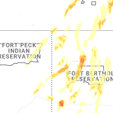
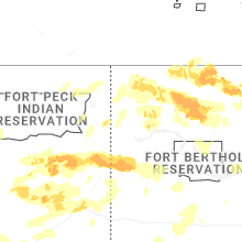
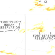


Connect with Interactive Hail Maps