

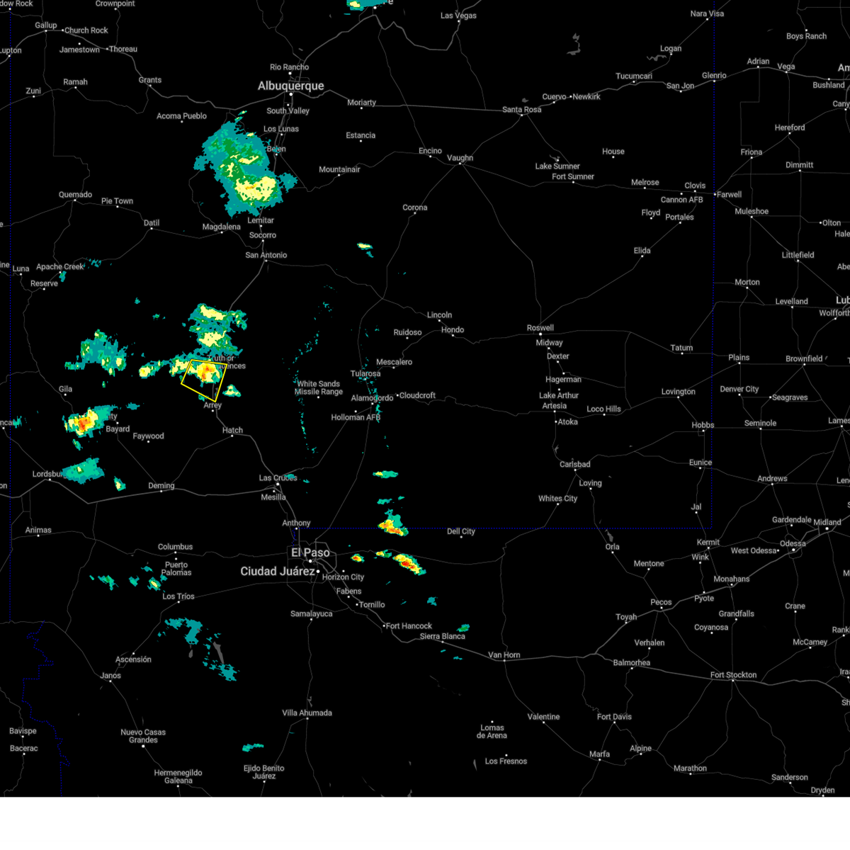
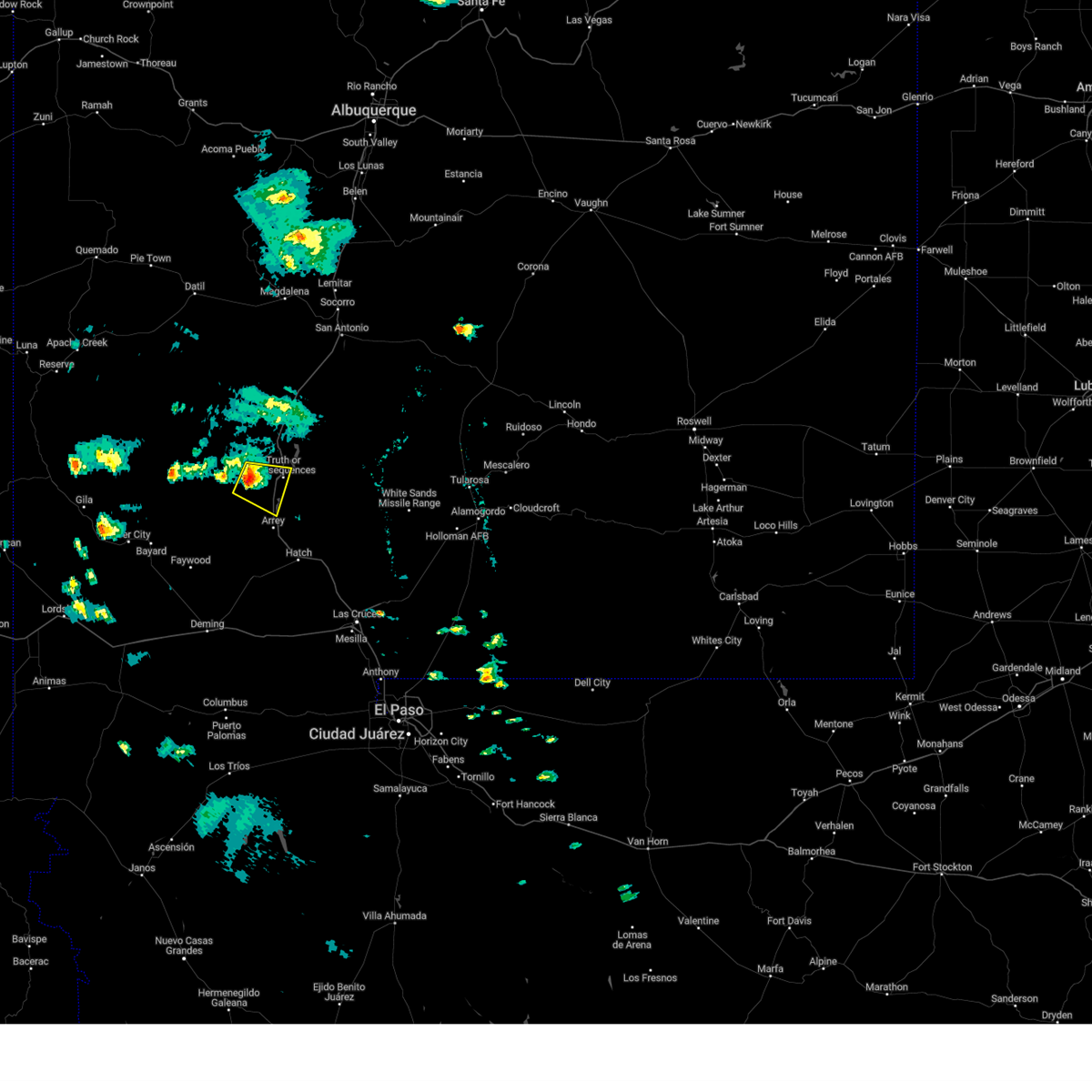
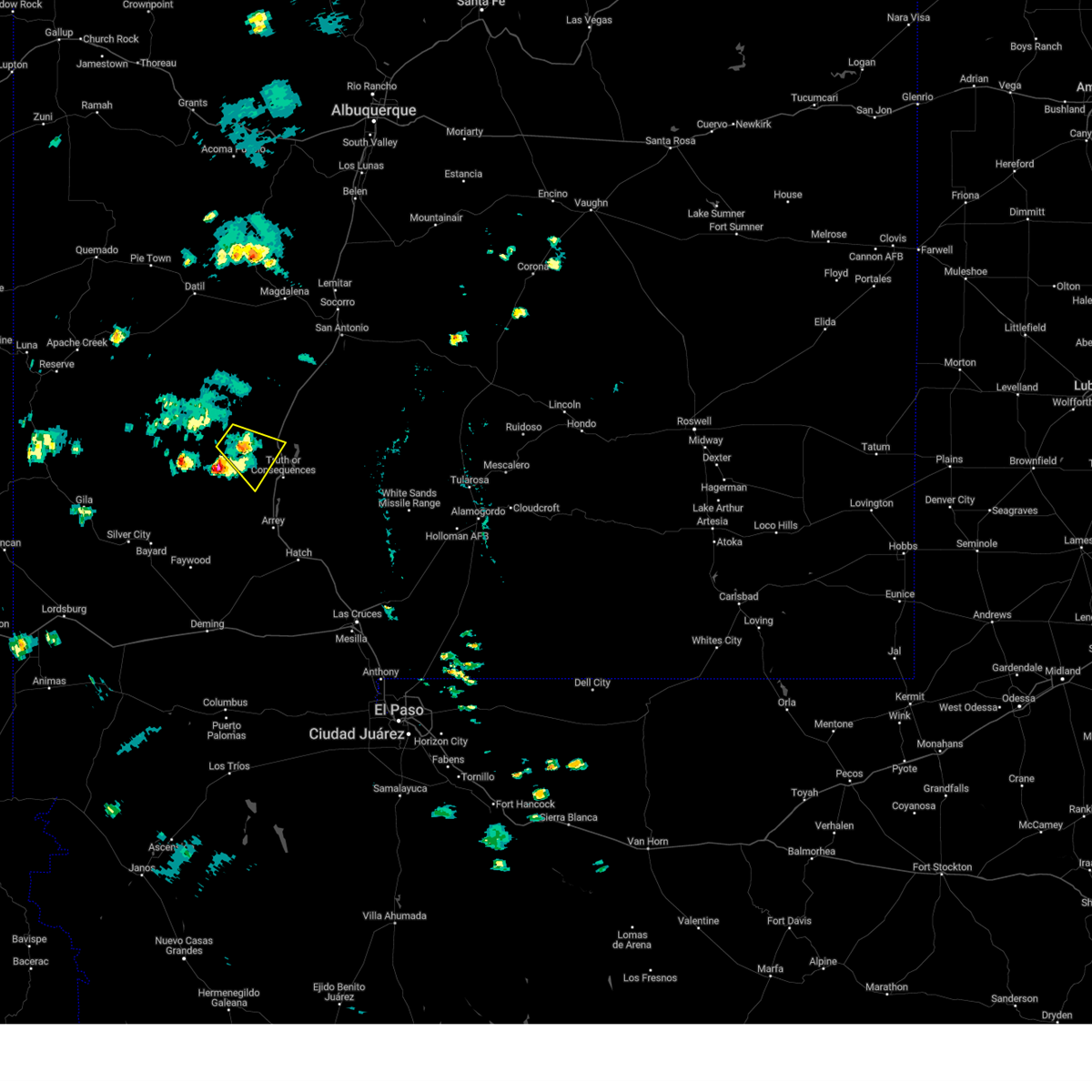
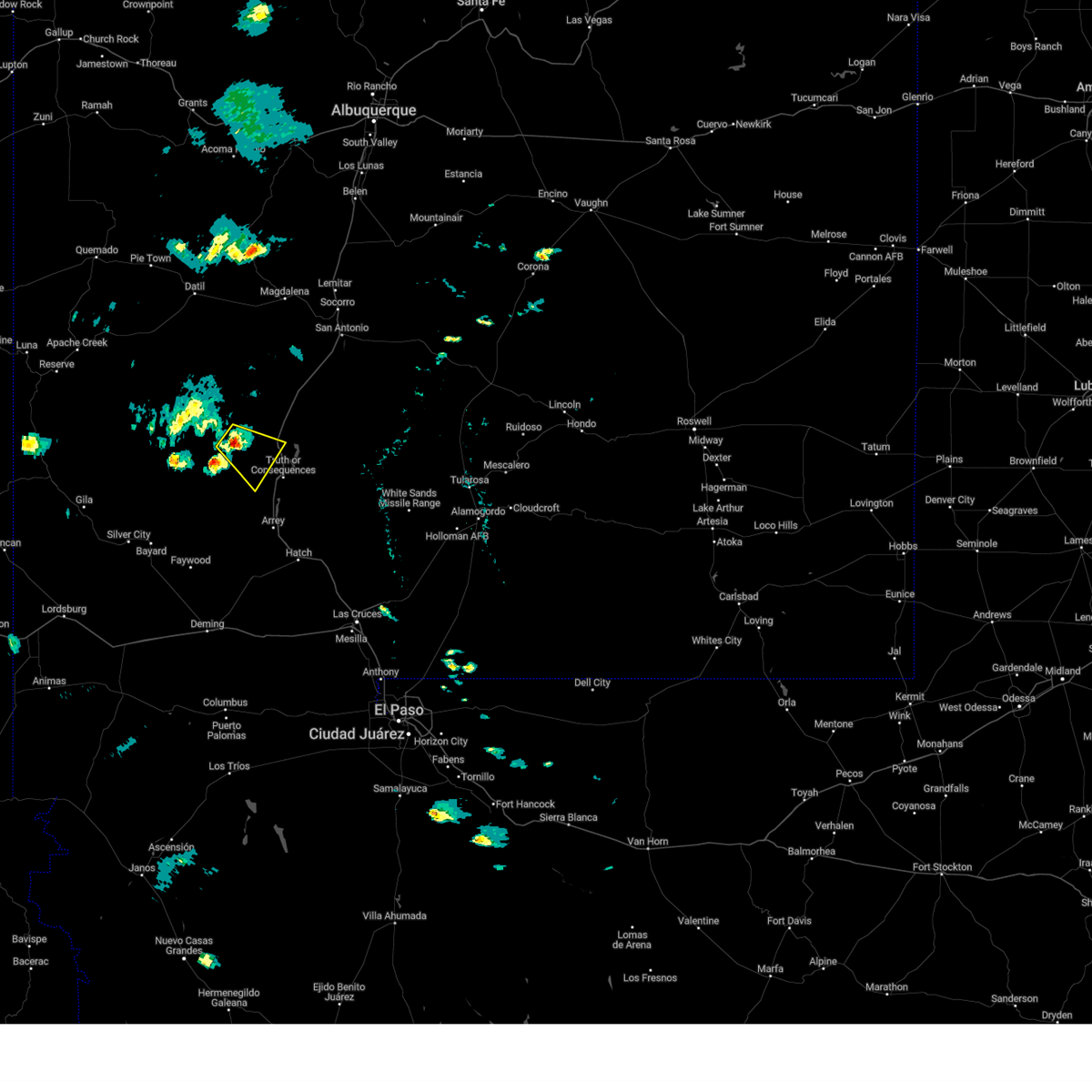
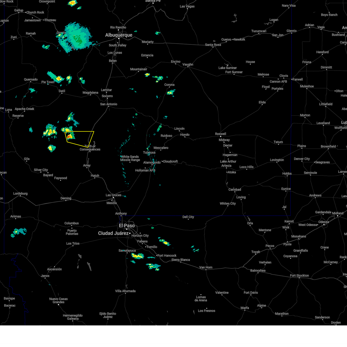
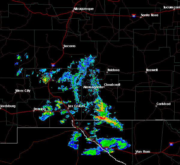
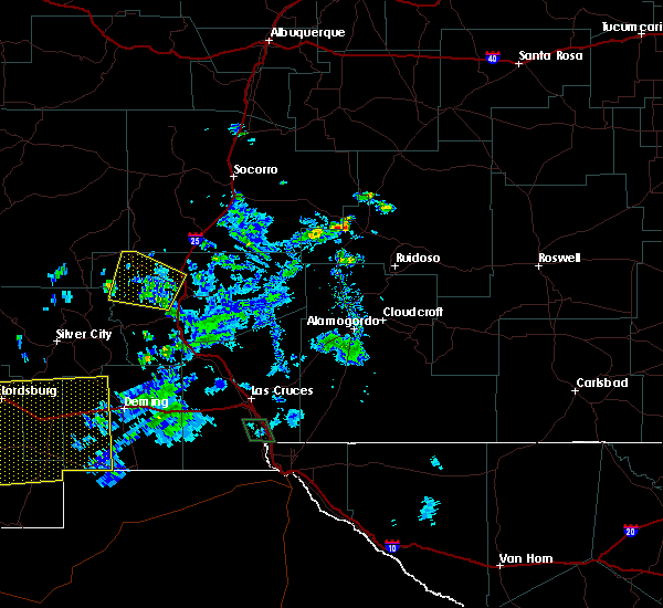
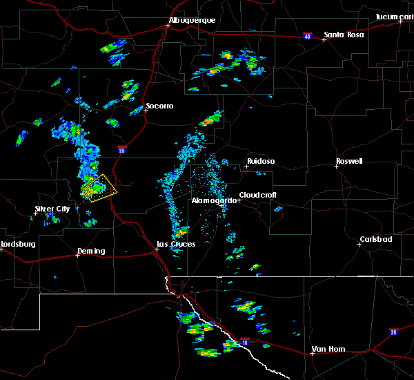
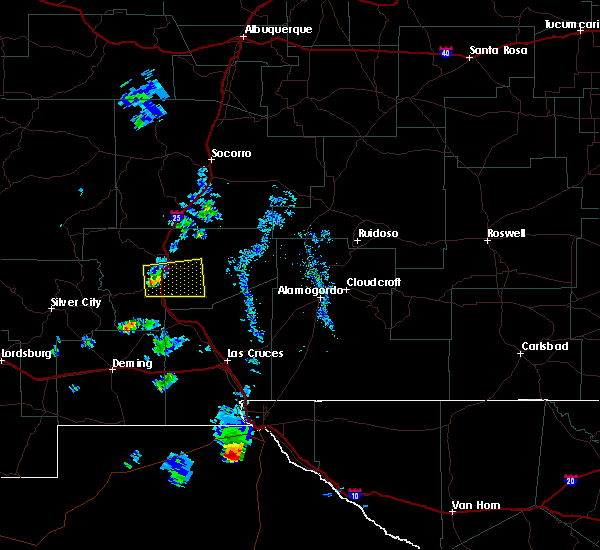
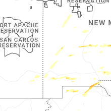
Hail Map for Truth or Consequences, NM
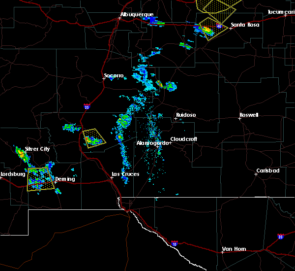
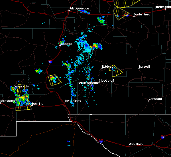
The Truth or Consequences, NM area has had 5 reports of on-the-ground hail by trained spotters, and has been under severe weather warnings 8 times during the past 12 months. Doppler radar has detected hail at or near Truth or Consequences, NM on 16 occasions, including 1 occasion during the past year.
| Name: | Truth or Consequences, NM |
| Where Located: | 64.8 miles ENE of Silver City, NM |
| Map: | Google Map for Truth or Consequences, NM |
| Population: | 6475 |
| Housing Units: | 4226 |
| More Info: | Search Google for Truth or Consequences, NM |
5
The Top Recent Hail Date for Truth or Consequences, NM is Saturday, September 13, 2025 (1st out of 16)

Hail and Wind Damage Spotted near Truth or Consequences, NM
| Date / Time | Report Details |
|---|---|
| 6/5/2026 7:35 PM MDT | Awos station k0a0 spaceport americ in sierra county NM, 21.4 miles NW of Truth or Consequences, NM |
| 9/23/2025 5:45 PM MDT | 60.2 mph gust recorded with personal weather station at lakeshore highlands... relayed via social medi in sierra county NM, 4.3 miles WSW of Truth or Consequences, NM |
| 9/23/2025 5:43 PM MDT | Svrepz the national weather service in el paso has issued a * severe thunderstorm warning for, northeastern sierra county in south central new mexico, northern dona ana county in south central new mexico, * until 645 pm mdt. * at 542 pm mdt, a severe thunderstorm was located over elephant butte lake, moving east at 30 mph (radar indicated). Hazards include 70 mph wind gusts and dime size hail. Expect considerable tree damage. Damage is likely to mobile homes, roofs, and outbuildings. |
| 9/23/2025 5:35 PM MDT | At 535 pm mdt, a severe thunderstorm was located near city of elephant butte, moving east at 30 mph (radar indicated). Hazards include 60 mph wind gusts and penny size hail. Expect damage to roofs, siding, and trees. Locations impacted include, cuchillo, truth or consequences, elephant butte lake, lost canyon, rock canyon, hot springs landing, lakeshore highlands, south monticello campground, and lions beach. |
| 9/23/2025 5:23 PM MDT | At 523 pm mdt, a severe thunderstorm was located near cuchillo, moving east at 35 mph (radar indicated). Hazards include 60 mph wind gusts and nickel size hail. Expect damage to roofs, siding, and trees. Locations impacted include, cuchillo, truth or consequences, elephant butte lake, san miguel, williamsburg, lost canyon, hot springs landing, lakeshore highlands, south monticello campground, and lions beach. |
| 9/23/2025 5:05 PM MDT | Svrepz the national weather service in el paso has issued a * severe thunderstorm warning for, northwestern sierra county in south central new mexico, * until 545 pm mdt. * at 504 pm mdt, a severe thunderstorm was located 4 miles north of san miguel, moving east at 35 mph (radar indicated). Hazards include 60 mph wind gusts and penny size hail. expect damage to roofs, siding, and trees |
| 9/13/2025 3:44 PM MDT | the severe thunderstorm warning has been cancelled and is no longer in effect |
| 9/13/2025 3:16 PM MDT | the severe thunderstorm warning has been cancelled and is no longer in effect |
| 9/13/2025 3:10 PM MDT | Svrepz the national weather service in el paso has issued a * severe thunderstorm warning for, north central sierra county in south central new mexico, * until 400 pm mdt. * at 310 pm mdt, a severe thunderstorm was located 5 miles north of city of elephant butte, moving east at 25 mph (radar indicated). Hazards include two inch hail and 70 mph wind gusts. People and animals outdoors will be injured. expect hail damage to roofs, siding, windows, and vehicles. expect considerable tree damage. Wind damage is also likely to mobile homes, roofs, and outbuildings. |
| 9/13/2025 2:46 PM MDT | Svrepz the national weather service in el paso has issued a * severe thunderstorm warning for, north central sierra county in south central new mexico, * until 330 pm mdt. * at 245 pm mdt, a severe thunderstorm was located near san miguel, moving east at 20 mph (radar indicated). Hazards include 60 mph wind gusts and quarter size hail. Hail damage to vehicles is expected. Expect wind damage to roofs, siding, and trees. |
| 6/30/2024 5:37 PM MDT |
 The storm which prompted the warning has weakened below severe limits, and has exited the warned area. therefore, the warning will be allowed to expire. however, gusty winds are still possible with this thunderstorm. The storm which prompted the warning has weakened below severe limits, and has exited the warned area. therefore, the warning will be allowed to expire. however, gusty winds are still possible with this thunderstorm.
|
| 6/30/2024 5:14 PM MDT | Asos station ktcs t-or-c aso in sierra county NM, 4.4 miles S of Truth or Consequences, NM |
| 6/30/2024 5:09 PM MDT |
 Svrepz the national weather service in el paso has issued a * severe thunderstorm warning for, north central sierra county in south central new mexico, * until 545 pm mdt. * at 508 pm mdt, a severe thunderstorm was located over city of elephant butte, moving north at 20 mph (radar indicated). Hazards include 60 mph wind gusts and penny size hail. expect damage to roofs, siding, and trees Svrepz the national weather service in el paso has issued a * severe thunderstorm warning for, north central sierra county in south central new mexico, * until 545 pm mdt. * at 508 pm mdt, a severe thunderstorm was located over city of elephant butte, moving north at 20 mph (radar indicated). Hazards include 60 mph wind gusts and penny size hail. expect damage to roofs, siding, and trees
|
| 9/17/2023 5:57 PM MDT |
 At 555 pm mdt, a severe thunderstorm was located 6 miles west of palomas, moving southeast at 10 mph (radar indicated. this storm is beginning to weaken, but still shows the ability to produce strong gusty winds and damaging hail). Hazards include ping pong ball size hail and 60 mph wind gusts are possible. People and animals outdoors could be injured. expect hail damage to roofs, siding, windows, and vehicles. expect wind damage to roofs, siding, and trees. locations impacted include, caballo, truth or consequences, san miguel, palomas, city of elephant butte, ladder ranch, williamsburg, lower animas creek, upper palomas canyon, lower palomas canyon, and caballo lake. this includes interstate 25 in new mexico between mile markers 60 and 78. hail threat, radar indicated max hail size, 1. 50 in wind threat, radar indicated max wind gust, 60 mph. At 555 pm mdt, a severe thunderstorm was located 6 miles west of palomas, moving southeast at 10 mph (radar indicated. this storm is beginning to weaken, but still shows the ability to produce strong gusty winds and damaging hail). Hazards include ping pong ball size hail and 60 mph wind gusts are possible. People and animals outdoors could be injured. expect hail damage to roofs, siding, windows, and vehicles. expect wind damage to roofs, siding, and trees. locations impacted include, caballo, truth or consequences, san miguel, palomas, city of elephant butte, ladder ranch, williamsburg, lower animas creek, upper palomas canyon, lower palomas canyon, and caballo lake. this includes interstate 25 in new mexico between mile markers 60 and 78. hail threat, radar indicated max hail size, 1. 50 in wind threat, radar indicated max wind gust, 60 mph.
|
| 9/17/2023 5:29 PM MDT |
 At 529 pm mdt, a severe thunderstorm was located 6 miles south of san miguel, moving southeast at 10 mph (radar indicated). Hazards include ping pong ball size hail and 60 mph wind gusts. People and animals outdoors will be injured. expect hail damage to roofs, siding, windows, and vehicles. Expect wind damage to roofs, siding, and trees. At 529 pm mdt, a severe thunderstorm was located 6 miles south of san miguel, moving southeast at 10 mph (radar indicated). Hazards include ping pong ball size hail and 60 mph wind gusts. People and animals outdoors will be injured. expect hail damage to roofs, siding, windows, and vehicles. Expect wind damage to roofs, siding, and trees.
|
| 9/17/2023 4:08 PM MDT |
 At 407 pm mdt, a severe thunderstorm was located 7 miles southeast of winston, and is slowly drifing southeast (public. at winston hail size was documented to be 1.0" to 1.5" with damage to automobile windshields). Hazards include half dollar size hail. Damage to vehicles is expected. locations impacted include, cuchillo, winston, san miguel, alamosa canyon, chise, upper palomas canyon, and las placitas. this includes interstate 25 in new mexico between mile markers 84 and 88. hail threat, observed max hail size, 1. 25 in wind threat, radar indicated max wind gust, <50 mph. At 407 pm mdt, a severe thunderstorm was located 7 miles southeast of winston, and is slowly drifing southeast (public. at winston hail size was documented to be 1.0" to 1.5" with damage to automobile windshields). Hazards include half dollar size hail. Damage to vehicles is expected. locations impacted include, cuchillo, winston, san miguel, alamosa canyon, chise, upper palomas canyon, and las placitas. this includes interstate 25 in new mexico between mile markers 84 and 88. hail threat, observed max hail size, 1. 25 in wind threat, radar indicated max wind gust, <50 mph.
|
| 9/17/2023 3:45 PM MDT |
 At 344 pm mdt, a severe thunderstorm was located 4 miles southeast of winston, moving southeast at 7 mph (radar indicated and public reports of large damaging hail). Hazards include ping pong ball size hail and 60 mph wind gusts. People and animals outdoors will be injured. expect hail damage to roofs, siding, windows, and vehicles. Expect wind damage to roofs, siding, and trees. At 344 pm mdt, a severe thunderstorm was located 4 miles southeast of winston, moving southeast at 7 mph (radar indicated and public reports of large damaging hail). Hazards include ping pong ball size hail and 60 mph wind gusts. People and animals outdoors will be injured. expect hail damage to roofs, siding, windows, and vehicles. Expect wind damage to roofs, siding, and trees.
|
| 9/17/2023 3:04 PM MDT |
 At 303 pm mdt, a severe thunderstorm was located near winston, moving northeast at 10 mph (radar indicated). Hazards include ping pong ball size hail and 60 mph wind gusts. People and animals outdoors will be injured. expect hail damage to roofs, siding, windows, and vehicles. Expect wind damage to roofs, siding, and trees. At 303 pm mdt, a severe thunderstorm was located near winston, moving northeast at 10 mph (radar indicated). Hazards include ping pong ball size hail and 60 mph wind gusts. People and animals outdoors will be injured. expect hail damage to roofs, siding, windows, and vehicles. Expect wind damage to roofs, siding, and trees.
|
| 9/12/2023 7:57 PM MDT |
 At 757 pm mdt, a severe thunderstorm was located 5 miles northeast of cuchillo, moving southeast at 25 mph (radar indicated). Hazards include 60 mph wind gusts and quarter size hail. Hail damage to vehicles is expected. Expect wind damage to roofs, siding, and trees. At 757 pm mdt, a severe thunderstorm was located 5 miles northeast of cuchillo, moving southeast at 25 mph (radar indicated). Hazards include 60 mph wind gusts and quarter size hail. Hail damage to vehicles is expected. Expect wind damage to roofs, siding, and trees.
|
| 5/13/2023 4:36 PM MDT |
 The severe thunderstorm warning for central sierra county will expire at 445 pm mdt, the storm which prompted the warning has weakened below severe limits, and no longer poses an immediate threat to life or property. therefore, the warning will be allowed to expire. however small hail is still possible with this thunderstorm. The severe thunderstorm warning for central sierra county will expire at 445 pm mdt, the storm which prompted the warning has weakened below severe limits, and no longer poses an immediate threat to life or property. therefore, the warning will be allowed to expire. however small hail is still possible with this thunderstorm.
|
| 5/13/2023 4:19 PM MDT |
 At 419 pm mdt, a severe thunderstorm was located over city of elephant butte, moving north at 5 mph (radar indicated). Hazards include 60 mph wind gusts and quarter size hail. Hail damage to vehicles is expected. Expect wind damage to roofs, siding, and trees. At 419 pm mdt, a severe thunderstorm was located over city of elephant butte, moving north at 5 mph (radar indicated). Hazards include 60 mph wind gusts and quarter size hail. Hail damage to vehicles is expected. Expect wind damage to roofs, siding, and trees.
|
| 6/8/2022 6:26 PM MDT | Wind gust at ktcs airpor in sierra county NM, 4.4 miles S of Truth or Consequences, NM |
| 8/4/2021 11:25 PM MDT |
 The severe thunderstorm warning for central sierra county will expire at 1130 pm mdt, the storm which prompted the warning has weakened below severe limits, and has exited the warned area. therefore, the warning will be allowed to expire. however gusty winds are still possible with this thunderstorm. The severe thunderstorm warning for central sierra county will expire at 1130 pm mdt, the storm which prompted the warning has weakened below severe limits, and has exited the warned area. therefore, the warning will be allowed to expire. however gusty winds are still possible with this thunderstorm.
|
| 8/4/2021 11:11 PM MDT |
 At 1110 pm mdt, a severe thunderstorm was located near truth or consequences, moving south at 15 mph (radar indicated). Hazards include 60 mph wind gusts and penny size hail. Expect damage to roofs, siding, and trees. locations impacted include, truth or consequences, palomas, williamsburg, ash canyon, lower palomas canyon and upper palomas canyon. this includes interstate 25 in new mexico between mile markers 66 and 76. hail threat, radar indicated max hail size, 0. 75 in wind threat, observed max wind gust, 60 mph. At 1110 pm mdt, a severe thunderstorm was located near truth or consequences, moving south at 15 mph (radar indicated). Hazards include 60 mph wind gusts and penny size hail. Expect damage to roofs, siding, and trees. locations impacted include, truth or consequences, palomas, williamsburg, ash canyon, lower palomas canyon and upper palomas canyon. this includes interstate 25 in new mexico between mile markers 66 and 76. hail threat, radar indicated max hail size, 0. 75 in wind threat, observed max wind gust, 60 mph.
|
| 8/4/2021 10:46 PM MDT |
 At 1045 pm mdt, a severe thunderstorm was located over city of elephant butte, moving south at 15 mph (radar indicated). Hazards include 60 mph wind gusts and penny size hail. expect damage to roofs, siding, and trees At 1045 pm mdt, a severe thunderstorm was located over city of elephant butte, moving south at 15 mph (radar indicated). Hazards include 60 mph wind gusts and penny size hail. expect damage to roofs, siding, and trees
|
| 7/23/2021 5:33 PM MDT |
 At 533 pm mdt, a severe thunderstorm was located 5 miles north of cuchillo, moving northeast at 5 mph (radar indicated). Hazards include 60 mph wind gusts and nickel size hail. expect damage to roofs, siding, and trees At 533 pm mdt, a severe thunderstorm was located 5 miles north of cuchillo, moving northeast at 5 mph (radar indicated). Hazards include 60 mph wind gusts and nickel size hail. expect damage to roofs, siding, and trees
|
| 6/19/2021 6:35 PM MDT | Likely caused by dry microburst. radar echoes depict weak rain shower activity. asos station ktc in sierra county NM, 4.4 miles S of Truth or Consequences, NM |
| 8/16/2020 8:36 PM MDT |
 At 835 pm mdt, severe thunderstorms were over the area moving southwest at 35 mph (radar indicated). Hazards include 60 mph wind gusts and quarter size hail. Hail damage to vehicles is expected. Expect wind damage to roofs, siding, and trees. At 835 pm mdt, severe thunderstorms were over the area moving southwest at 35 mph (radar indicated). Hazards include 60 mph wind gusts and quarter size hail. Hail damage to vehicles is expected. Expect wind damage to roofs, siding, and trees.
|
| 8/16/2020 8:34 PM MDT |
 At 833 pm mdt, severe thunderstorms were located over the area moving southwest at 35 mph (radar indicated). Hazards include 60 mph wind gusts and quarter size hail. Hail damage to vehicles is expected. Expect wind damage to roofs, siding, and trees. At 833 pm mdt, severe thunderstorms were located over the area moving southwest at 35 mph (radar indicated). Hazards include 60 mph wind gusts and quarter size hail. Hail damage to vehicles is expected. Expect wind damage to roofs, siding, and trees.
|
| 6/24/2020 4:45 PM MDT | Storm damage reported in sierra county NM, 21 miles NW of Truth or Consequences, NM |
| 6/24/2020 4:31 PM MDT |
 At 430 pm mdt, a severe thunderstorm was located near engle, moving southeast at 25 mph (radar indicated). Hazards include 60 mph wind gusts and quarter size hail. Hail damage to vehicles is expected. expect wind damage to roofs, siding, and trees. locations impacted include, upham, truth or consequences, engle, city of elephant butte, cutter, spaceport america, elephant butte lake, ash canyon, rock canyon, hot springs landing and lost canyon. This includes interstate 25 in new mexico between mile markers 75 and 80. At 430 pm mdt, a severe thunderstorm was located near engle, moving southeast at 25 mph (radar indicated). Hazards include 60 mph wind gusts and quarter size hail. Hail damage to vehicles is expected. expect wind damage to roofs, siding, and trees. locations impacted include, upham, truth or consequences, engle, city of elephant butte, cutter, spaceport america, elephant butte lake, ash canyon, rock canyon, hot springs landing and lost canyon. This includes interstate 25 in new mexico between mile markers 75 and 80.
|
| 6/24/2020 4:11 PM MDT |
 At 411 pm mdt, a severe thunderstorm was located 5 miles northwest of engle, moving southeast at 25 mph (radar indicated). Hazards include 60 mph wind gusts and quarter size hail. Hail damage to vehicles is expected. Expect wind damage to roofs, siding, and trees. At 411 pm mdt, a severe thunderstorm was located 5 miles northwest of engle, moving southeast at 25 mph (radar indicated). Hazards include 60 mph wind gusts and quarter size hail. Hail damage to vehicles is expected. Expect wind damage to roofs, siding, and trees.
|
| 5/11/2020 1:59 PM MDT |
 At 153 pm mdt, a severe thunderstorm was located 5 miles east of hillsboro, moving northeast at 25 mph (radar indicated). Hazards include 60 mph wind gusts, nickel size hail, and localized flooding of low water crossings. expect damage to roofs, siding, and trees At 153 pm mdt, a severe thunderstorm was located 5 miles east of hillsboro, moving northeast at 25 mph (radar indicated). Hazards include 60 mph wind gusts, nickel size hail, and localized flooding of low water crossings. expect damage to roofs, siding, and trees
|
| 8/31/2019 1:05 AM MDT |
 At 104 am mdt, a severe thunderstorm was located near caballo, moving south at 20 mph (radar indicated). Hazards include 60 mph wind gusts and penny size hail. expect damage to roofs, siding, and trees At 104 am mdt, a severe thunderstorm was located near caballo, moving south at 20 mph (radar indicated). Hazards include 60 mph wind gusts and penny size hail. expect damage to roofs, siding, and trees
|
| 8/31/2019 12:42 AM MDT |
 At 1242 am mdt, a severe thunderstorm was located over palomas, moving south at 20 mph (radar indicated). Hazards include 60 mph wind gusts and penny size hail. expect damage to roofs, siding, and trees At 1242 am mdt, a severe thunderstorm was located over palomas, moving south at 20 mph (radar indicated). Hazards include 60 mph wind gusts and penny size hail. expect damage to roofs, siding, and trees
|
| 6/13/2019 4:14 PM MDT | Ping Pong Ball sized hail reported 2.7 miles NNW of Truth or Consequences, NM, picture of ping pong sized hail forwared to nws by em |
| 6/13/2019 3:55 PM MDT | Half Dollar sized hail reported 2.9 miles NNW of Truth or Consequences, NM |
| 6/13/2019 3:53 PM MDT | Quarter sized hail reported 2 miles NNW of Truth or Consequences, NM |
| 6/13/2019 3:46 PM MDT |
 At 343 pm mdt, a thunderstorm, capable of producing damaging winds and hail, was located between san miguel, truth or consequences, and williamsburg. this storm is nearly stationary, but may drift east towards interstate 25 and the communities of elephant butte, truth or consequences, williamsburg, and las palomas (radar indicated). Hazards include 60 mph wind gusts and quarter size hail. Hail damage to vehicles is expected. expect wind damage to roofs, siding, and trees. Locations impacted include, caballo, cuchillo, truth or consequences, engle, cutter, city of elephant butte, palomas, spaceport america, williamsburg, upper palomas canyon, lower palomas canyon, ash canyon, hot springs landing, elephant butte lake and caballo lake. At 343 pm mdt, a thunderstorm, capable of producing damaging winds and hail, was located between san miguel, truth or consequences, and williamsburg. this storm is nearly stationary, but may drift east towards interstate 25 and the communities of elephant butte, truth or consequences, williamsburg, and las palomas (radar indicated). Hazards include 60 mph wind gusts and quarter size hail. Hail damage to vehicles is expected. expect wind damage to roofs, siding, and trees. Locations impacted include, caballo, cuchillo, truth or consequences, engle, cutter, city of elephant butte, palomas, spaceport america, williamsburg, upper palomas canyon, lower palomas canyon, ash canyon, hot springs landing, elephant butte lake and caballo lake.
|
| 6/13/2019 3:22 PM MDT |
 At 322 pm mdt, a severe thunderstorm was located 2 miles west of williamsburg, moving east at 15 mph (radar indicated). Hazards include 60 mph wind gusts and quarter size hail. Hail damage to vehicles is expected. Expect wind damage to roofs, siding, and trees. At 322 pm mdt, a severe thunderstorm was located 2 miles west of williamsburg, moving east at 15 mph (radar indicated). Hazards include 60 mph wind gusts and quarter size hail. Hail damage to vehicles is expected. Expect wind damage to roofs, siding, and trees.
|
| 8/18/2018 8:21 PM MDT |
 At 807 pm mdt, a severe thunderstorm was located over city of elephant butte, or near truth or consequences, moving southeast at 20 mph (radar indicated). Hazards include 60 mph wind gusts and quarter size hail. Hail damage to vehicles is expected. expect wind damage to roofs, siding, and trees. Locations impacted include, upper palomas canyon, san miguel, and lower palomas canyon. At 807 pm mdt, a severe thunderstorm was located over city of elephant butte, or near truth or consequences, moving southeast at 20 mph (radar indicated). Hazards include 60 mph wind gusts and quarter size hail. Hail damage to vehicles is expected. expect wind damage to roofs, siding, and trees. Locations impacted include, upper palomas canyon, san miguel, and lower palomas canyon.
|
| 8/18/2018 8:07 PM MDT |
 At 807 pm mdt, a severe thunderstorm was located over city of elephant butte, or near truth or consequences, moving southeast at 20 mph (radar indicated). Hazards include 60 mph wind gusts and quarter size hail. Hail damage to vehicles is expected. expect wind damage to roofs, siding, and trees. Locations impacted include, upper palomas canyon, san miguel, and lower palomas canyon. At 807 pm mdt, a severe thunderstorm was located over city of elephant butte, or near truth or consequences, moving southeast at 20 mph (radar indicated). Hazards include 60 mph wind gusts and quarter size hail. Hail damage to vehicles is expected. expect wind damage to roofs, siding, and trees. Locations impacted include, upper palomas canyon, san miguel, and lower palomas canyon.
|
| 8/18/2018 7:48 PM MDT |
 At 748 pm mdt, a severe thunderstorm was located 4 miles southeast of cuchillo, moving southeast at 20 mph (radar indicated). Hazards include 60 mph wind gusts and quarter size hail. Hail damage to vehicles is expected. Expect wind damage to roofs, siding, and trees. At 748 pm mdt, a severe thunderstorm was located 4 miles southeast of cuchillo, moving southeast at 20 mph (radar indicated). Hazards include 60 mph wind gusts and quarter size hail. Hail damage to vehicles is expected. Expect wind damage to roofs, siding, and trees.
|
| 8/18/2018 7:36 PM MDT |
 At 735 pm mdt, severe thunderstorms were located along a line extending from 4 miles southeast of monticello to 11 miles north of engle to 25 miles northeast of cutter, moving south at 20 mph (radar indicated). Hazards include 60 mph wind gusts. Expect damage to roofs, siding, and trees. Locations impacted include, city of elephant butte, elephant butte lake, rock house, north monticello point, ash canyon, rock canyon, south monticello campground, hot springs landing, lost canyon, lakeshore highlands, and truth or consequences. At 735 pm mdt, severe thunderstorms were located along a line extending from 4 miles southeast of monticello to 11 miles north of engle to 25 miles northeast of cutter, moving south at 20 mph (radar indicated). Hazards include 60 mph wind gusts. Expect damage to roofs, siding, and trees. Locations impacted include, city of elephant butte, elephant butte lake, rock house, north monticello point, ash canyon, rock canyon, south monticello campground, hot springs landing, lost canyon, lakeshore highlands, and truth or consequences.
|
| 8/18/2018 7:04 PM MDT |
 At 703 pm mdt, severe thunderstorms were located along a line extending from 5 miles north of monticello to 19 miles north of city of elephant butte to 20 miles south of bosque del apache refuge, moving south at 20 mph (radar indicated). Hazards include 60 mph wind gusts. expect damage to roofs, siding, and trees At 703 pm mdt, severe thunderstorms were located along a line extending from 5 miles north of monticello to 19 miles north of city of elephant butte to 20 miles south of bosque del apache refuge, moving south at 20 mph (radar indicated). Hazards include 60 mph wind gusts. expect damage to roofs, siding, and trees
|
| 6/3/2018 5:43 PM MDT |
 At 541 pm mdt, a severe thunderstorm was located 17 miles east of engle, or 29 miles east of truth or consequences, moving east northeast at 20 mph (radar indicated). Hazards include 70 mph wind gusts and half dollar size hail. Hail damage to vehicles is expected. expect considerable tree damage. wind damage is also likely to mobile homes, roofs, and outbuildings. Locations impacted include, truth or consequences, caballo, williamsburg, engle, las palomas, and caballo lake state park. At 541 pm mdt, a severe thunderstorm was located 17 miles east of engle, or 29 miles east of truth or consequences, moving east northeast at 20 mph (radar indicated). Hazards include 70 mph wind gusts and half dollar size hail. Hail damage to vehicles is expected. expect considerable tree damage. wind damage is also likely to mobile homes, roofs, and outbuildings. Locations impacted include, truth or consequences, caballo, williamsburg, engle, las palomas, and caballo lake state park.
|
| 6/3/2018 5:18 PM MDT |
 At 517 pm mdt, a severe thunderstorm was located 6 miles southeast of engle, or 16 miles east of truth or consequences, moving east northeast at 20 mph (radar indicated). Hazards include 70 mph wind gusts and half dollar size hail. Hail damage to vehicles is expected. expect considerable tree damage. Wind damage is also likely to mobile homes, roofs, and outbuildings. At 517 pm mdt, a severe thunderstorm was located 6 miles southeast of engle, or 16 miles east of truth or consequences, moving east northeast at 20 mph (radar indicated). Hazards include 70 mph wind gusts and half dollar size hail. Hail damage to vehicles is expected. expect considerable tree damage. Wind damage is also likely to mobile homes, roofs, and outbuildings.
|
| 9/26/2017 7:11 PM MDT |
 The severe thunderstorm warning for north central sierra county will expire at 715 pm mdt, the storm which prompted the warning has weakened below severe limits, and no longer pose an immediate threat to life or property. therefore, the warning will be allowed to expire. however small hail and heavy rain are still possible with this thunderstorm. The severe thunderstorm warning for north central sierra county will expire at 715 pm mdt, the storm which prompted the warning has weakened below severe limits, and no longer pose an immediate threat to life or property. therefore, the warning will be allowed to expire. however small hail and heavy rain are still possible with this thunderstorm.
|
| 9/26/2017 6:23 PM MDT |
 At 622 pm mdt, a severe thunderstorm was located 4 miles north of elephant butte, or 8 miles north of truth or consequences, moving northeast at 15 mph (radar indicated). Hazards include 60 mph wind gusts and quarter size hail. Hail damage to vehicles is expected. Expect wind damage to roofs, siding, and trees. At 622 pm mdt, a severe thunderstorm was located 4 miles north of elephant butte, or 8 miles north of truth or consequences, moving northeast at 15 mph (radar indicated). Hazards include 60 mph wind gusts and quarter size hail. Hail damage to vehicles is expected. Expect wind damage to roofs, siding, and trees.
|
| 7/19/2017 7:03 PM MDT |
 At 703 pm mdt, a severe thunderstorm was located near cuchillo, or 11 miles northwest of truth or consequences, moving west at 25 mph (radar indicated). Hazards include 60 mph wind gusts and nickel size hail. expect damage to roofs, siding, and trees At 703 pm mdt, a severe thunderstorm was located near cuchillo, or 11 miles northwest of truth or consequences, moving west at 25 mph (radar indicated). Hazards include 60 mph wind gusts and nickel size hail. expect damage to roofs, siding, and trees
|
| 7/19/2017 6:35 PM MDT | Thunderstorm outflow resulted in numerous large trees downed... two sheds blown over and roof blown off restauran in sierra county NM, 2.3 miles NW of Truth or Consequences, NM |
| 7/2/2017 5:56 PM MDT |
 The severe thunderstorm warning for central sierra county will expire at 600 pm mdt, the storm which prompted the warning has weakened below severe limits, and no longer pose an immediate threat to life or property. therefore, the warning will be allowed to expire. however gusty winds are still possible with this thunderstorm. people on or near area lakes should still exercise caution as dangerous lightning continues to be a threat from this weakening storm cell. The severe thunderstorm warning for central sierra county will expire at 600 pm mdt, the storm which prompted the warning has weakened below severe limits, and no longer pose an immediate threat to life or property. therefore, the warning will be allowed to expire. however gusty winds are still possible with this thunderstorm. people on or near area lakes should still exercise caution as dangerous lightning continues to be a threat from this weakening storm cell.
|
| 7/2/2017 5:18 PM MDT |
 At 518 pm mdt, a severe thunderstorm was located near elephant butte, or 7 miles northeast of truth or consequences, moving east at 15 mph (radar indicated). Hazards include 60 mph wind gusts. expect damage to roofs, siding, and trees At 518 pm mdt, a severe thunderstorm was located near elephant butte, or 7 miles northeast of truth or consequences, moving east at 15 mph (radar indicated). Hazards include 60 mph wind gusts. expect damage to roofs, siding, and trees
|
| 6/27/2017 9:17 AM MDT |
 At 316 pm mdt, a severe thunderstorm was located near cuchillo, or 9 miles southeast of monticello, moving east northeast at 15 mph (radar indicated). Hazards include 60 mph wind gusts and quarter size hail. Hail damage to vehicles is expected. expect wind damage to roofs, siding, and trees. Locations impacted include, cuchillo. At 316 pm mdt, a severe thunderstorm was located near cuchillo, or 9 miles southeast of monticello, moving east northeast at 15 mph (radar indicated). Hazards include 60 mph wind gusts and quarter size hail. Hail damage to vehicles is expected. expect wind damage to roofs, siding, and trees. Locations impacted include, cuchillo.
|
| 6/27/2017 8:56 AM MDT |
 At 256 pm mdt, a severe thunderstorm was located 4 miles southwest of cuchillo, or 11 miles northwest of truth or consequences, moving southeast at 20 mph (radar indicated). Hazards include 60 mph wind gusts and quarter size hail. Hail damage to vehicles is expected. Expect wind damage to roofs, siding, and trees. At 256 pm mdt, a severe thunderstorm was located 4 miles southwest of cuchillo, or 11 miles northwest of truth or consequences, moving southeast at 20 mph (radar indicated). Hazards include 60 mph wind gusts and quarter size hail. Hail damage to vehicles is expected. Expect wind damage to roofs, siding, and trees.
|
| 6/24/2017 4:41 PM MDT | Quarter sized hail reported 2 miles NNW of Truth or Consequences, NM, 1 inch hail along with very heavy rain//high winds on i 25 on the sierra--socorro county line at 1635 mdt reported by dispatched fire crew. |
| 6/21/2017 3:41 PM MDT |
 The severe thunderstorm warning for north central sierra county will expire at 345 pm mdt, the storm which prompted the warning has weakened below severe limits, and no longer pose an immediate threat to life or property. therefore, the warning will be allowed to expire. however gusty winds are still possible with this thunderstorm. The severe thunderstorm warning for north central sierra county will expire at 345 pm mdt, the storm which prompted the warning has weakened below severe limits, and no longer pose an immediate threat to life or property. therefore, the warning will be allowed to expire. however gusty winds are still possible with this thunderstorm.
|
| 6/21/2017 3:02 PM MDT |
 At 301 pm mdt, a severe thunderstorm was located 5 miles north of cuchillo, or 7 miles southeast of monticello, moving southeast at 15 mph (radar indicated). Hazards include 60 mph wind gusts and nickel size hail. expect damage to roofs, siding, and trees At 301 pm mdt, a severe thunderstorm was located 5 miles north of cuchillo, or 7 miles southeast of monticello, moving southeast at 15 mph (radar indicated). Hazards include 60 mph wind gusts and nickel size hail. expect damage to roofs, siding, and trees
|
| 6/20/2017 8:21 PM MDT |
 The severe thunderstorm warning for central sierra and north central dona ana counties will expire at 830 pm mdt, the storm which prompted the warning has weakened below severe limits, and no longer pose an immediate threat to life or property. therefore, the warning will be allowed to expire. The severe thunderstorm warning for central sierra and north central dona ana counties will expire at 830 pm mdt, the storm which prompted the warning has weakened below severe limits, and no longer pose an immediate threat to life or property. therefore, the warning will be allowed to expire.
|
| 6/20/2017 7:40 PM MDT |
 At 738 pm mdt, a severe thunderstorm was located 5 miles northwest of upham, or 14 miles east of caballo, moving south at 10 mph (radar indicated). Hazards include 60 mph wind gusts and quarter size hail. Hail damage to vehicles is expected. Expect wind damage to roofs, siding, and trees as gusty outflow winds expand out from the center of the storm. At 738 pm mdt, a severe thunderstorm was located 5 miles northwest of upham, or 14 miles east of caballo, moving south at 10 mph (radar indicated). Hazards include 60 mph wind gusts and quarter size hail. Hail damage to vehicles is expected. Expect wind damage to roofs, siding, and trees as gusty outflow winds expand out from the center of the storm.
|
| 6/6/2017 2:30 PM MDT |
 At 229 pm mdt, a severe thunderstorm was located 8 miles west of cuchillo, or 10 miles south of monticello, moving east at 25 mph (radar indicated). Hazards include 60 mph wind gusts and quarter size hail. expect damage to roofs, siding, and trees At 229 pm mdt, a severe thunderstorm was located 8 miles west of cuchillo, or 10 miles south of monticello, moving east at 25 mph (radar indicated). Hazards include 60 mph wind gusts and quarter size hail. expect damage to roofs, siding, and trees
|
| 10/9/2016 3:43 PM MDT |
 At 341 pm mdt, severe thunderstorms were located along a line extending from 3 miles west of truth or consequences to 9 miles west of caballo, moving east at 15 mph (radar indicated). Hazards include 60 mph wind gusts and quarter size hail. Hail damage to vehicles is expected. Expect wind damage to roofs, siding, and trees. At 341 pm mdt, severe thunderstorms were located along a line extending from 3 miles west of truth or consequences to 9 miles west of caballo, moving east at 15 mph (radar indicated). Hazards include 60 mph wind gusts and quarter size hail. Hail damage to vehicles is expected. Expect wind damage to roofs, siding, and trees.
|
| 9/15/2016 3:31 PM MDT |
 At 329 pm mdt, severe thunderstorms were located near and east of rock house moving east at 30 mph (radar indicated). Hazards include 60 mph wind gusts and quarter size hail. Hail damage to vehicles is expected. expect wind damage to roofs, siding, and trees. Locations impacted include, cuchillo, monticello, san miguel, city of elephant butte, las placitas, lost canyon, rock canyon, elephant butte lake, alamosa canyon, hot springs landing, rock house, north monticello point, south monticello campground, and lakeshore highlands. At 329 pm mdt, severe thunderstorms were located near and east of rock house moving east at 30 mph (radar indicated). Hazards include 60 mph wind gusts and quarter size hail. Hail damage to vehicles is expected. expect wind damage to roofs, siding, and trees. Locations impacted include, cuchillo, monticello, san miguel, city of elephant butte, las placitas, lost canyon, rock canyon, elephant butte lake, alamosa canyon, hot springs landing, rock house, north monticello point, south monticello campground, and lakeshore highlands.
|
| 9/15/2016 2:56 PM MDT |
 At 254 pm mdt, severe thunderstorms were located near monticello and rock house moving northeast at 30 mph (radar indicated). Hazards include 60 mph wind gusts and quarter size hail. Hail damage to vehicles is expected. Expect wind damage to roofs, siding, and trees. At 254 pm mdt, severe thunderstorms were located near monticello and rock house moving northeast at 30 mph (radar indicated). Hazards include 60 mph wind gusts and quarter size hail. Hail damage to vehicles is expected. Expect wind damage to roofs, siding, and trees.
|
| 9/15/2016 2:05 PM MDT |
 At 204 pm mdt, a severe thunderstorm was located near monticello, moving northeast at 35 mph (radar indicated). Hazards include 60 mph wind gusts and quarter size hail. Hail damage to vehicles is expected. Expect wind damage to roofs, siding, and trees. At 204 pm mdt, a severe thunderstorm was located near monticello, moving northeast at 35 mph (radar indicated). Hazards include 60 mph wind gusts and quarter size hail. Hail damage to vehicles is expected. Expect wind damage to roofs, siding, and trees.
|
| 8/27/2016 1:36 PM MDT |
 At 136 pm mdt, a severe thunderstorm was located 9 miles north of hillsboro, moving northeast at 10 mph (radar indicated). Hazards include 60 mph wind gusts and quarter size hail. Hail damage to vehicles is expected. Expect wind damage to roofs, siding, and trees. At 136 pm mdt, a severe thunderstorm was located 9 miles north of hillsboro, moving northeast at 10 mph (radar indicated). Hazards include 60 mph wind gusts and quarter size hail. Hail damage to vehicles is expected. Expect wind damage to roofs, siding, and trees.
|
| 8/21/2016 8:51 PM MDT |
 The severe thunderstorm warning for north central sierra county will expire at 900 pm mdt, the storm which prompted the warning has weakened below severe limits, and no longer pose an immediate threat to life or property. therefore, the warning will be allowed to expire. however heavy rain is still possible with this thunderstorm. The severe thunderstorm warning for north central sierra county will expire at 900 pm mdt, the storm which prompted the warning has weakened below severe limits, and no longer pose an immediate threat to life or property. therefore, the warning will be allowed to expire. however heavy rain is still possible with this thunderstorm.
|
| 8/21/2016 8:13 PM MDT |
 At 812 pm mdt, a severe thunderstorm was located near san miguel, or 6 miles west of cuchillo, moving east at 15 mph (radar indicated). Hazards include quarter size hail. damage to vehicles is expected At 812 pm mdt, a severe thunderstorm was located near san miguel, or 6 miles west of cuchillo, moving east at 15 mph (radar indicated). Hazards include quarter size hail. damage to vehicles is expected
|
| 7/19/2016 10:34 PM MDT | A thunderstorm outflow produced a wind gust of 61 mph at the t or c airpor in sierra county NM, 5 miles S of Truth or Consequences, NM |
| 6/5/2016 5:55 PM MDT | The severe thunderstorm warning for central sierra county will expire at 600 pm mdt, the storm which prompted the warning has weakened below severe limits, and no longer poses an immediate threat to life or property. therefore the warning will be allowed to expire. however gusty winds are still possible with this thunderstorm. |
| 6/5/2016 5:43 PM MDT |
 At 543 pm mdt, a severe thunderstorm was located 4 miles southeast of truth or consequences, moving southeast at 20 mph (radar indicated). Hazards include 60 mph wind gusts. Expect damage to roofs. siding. and trees. Locations impacted include, truth or consequences, caballo, elephant butte, williamsburg, cuchillo, las palomas, north monticello point, caballo lake state park. At 543 pm mdt, a severe thunderstorm was located 4 miles southeast of truth or consequences, moving southeast at 20 mph (radar indicated). Hazards include 60 mph wind gusts. Expect damage to roofs. siding. and trees. Locations impacted include, truth or consequences, caballo, elephant butte, williamsburg, cuchillo, las palomas, north monticello point, caballo lake state park.
|
| 6/5/2016 5:13 PM MDT |
 At 512 pm mdt, a severe thunderstorm was located 4 miles northwest of elephant butte, or 6 miles north of truth or consequences, moving southeast at 20 mph (radar indicated). Hazards include 60 mph wind gusts and quarter size hail. Hail damage to vehicles is expected. Expect wind damage to roofs, siding, and trees. At 512 pm mdt, a severe thunderstorm was located 4 miles northwest of elephant butte, or 6 miles north of truth or consequences, moving southeast at 20 mph (radar indicated). Hazards include 60 mph wind gusts and quarter size hail. Hail damage to vehicles is expected. Expect wind damage to roofs, siding, and trees.
|
| 5/18/2016 2:59 PM MDT |
 At 258 pm mdt, a severe thunderstorm was located 5 miles east of cuchillo, or 9 miles north of truth or consequences, moving northeast at 25 mph (radar indicated). Hazards include 60 mph wind gusts and quarter size hail. Hail damage to vehicles is expected. expect wind damage to roofs, siding, and trees. Locations impacted include, truth or consequences, elephant butte, rock house, alamosa canyon, north monticello point. At 258 pm mdt, a severe thunderstorm was located 5 miles east of cuchillo, or 9 miles north of truth or consequences, moving northeast at 25 mph (radar indicated). Hazards include 60 mph wind gusts and quarter size hail. Hail damage to vehicles is expected. expect wind damage to roofs, siding, and trees. Locations impacted include, truth or consequences, elephant butte, rock house, alamosa canyon, north monticello point.
|
| 5/18/2016 2:33 PM MDT |
 At 233 pm mdt, a severe thunderstorm was located 4 miles west of cuchillo, or 12 miles northwest of truth or consequences, moving northeast at 30 mph (radar indicated). Hazards include 60 mph wind gusts and quarter size hail. Hail damage to vehicles is expected. Expect wind damage to roofs, siding, and trees. At 233 pm mdt, a severe thunderstorm was located 4 miles west of cuchillo, or 12 miles northwest of truth or consequences, moving northeast at 30 mph (radar indicated). Hazards include 60 mph wind gusts and quarter size hail. Hail damage to vehicles is expected. Expect wind damage to roofs, siding, and trees.
|
| 4/8/2016 5:45 PM MDT |
 At 545 pm mdt, a severe thunderstorm was located 11 miles north of elephant butte, or 15 miles north of truth or consequences, moving northeast at 15 mph (radar indicated). Hazards include 60 mph wind gusts and quarter size hail. Hail damage to vehicles is expected. expect wind damage to roofs, siding, and trees. Locations impacted include, truth or consequences, cuchillo, rock house, alamosa canyon, north monticello point. At 545 pm mdt, a severe thunderstorm was located 11 miles north of elephant butte, or 15 miles north of truth or consequences, moving northeast at 15 mph (radar indicated). Hazards include 60 mph wind gusts and quarter size hail. Hail damage to vehicles is expected. expect wind damage to roofs, siding, and trees. Locations impacted include, truth or consequences, cuchillo, rock house, alamosa canyon, north monticello point.
|
| 4/8/2016 5:10 PM MDT |
 At 509 pm mdt, a severe thunderstorm was located 4 miles northeast of cuchillo, or 10 miles southeast of monticello, moving northeast at 15 mph (radar indicated). Hazards include 60 mph wind gusts and quarter size hail. Hail damage to vehicles is expected. Expect wind damage to roofs, siding, and trees. At 509 pm mdt, a severe thunderstorm was located 4 miles northeast of cuchillo, or 10 miles southeast of monticello, moving northeast at 15 mph (radar indicated). Hazards include 60 mph wind gusts and quarter size hail. Hail damage to vehicles is expected. Expect wind damage to roofs, siding, and trees.
|
| 4/8/2016 4:51 PM MDT |
 At 451 pm mdt, a severe thunderstorm was located 9 miles northeast of cuchillo, or 12 miles east of monticello, moving northeast at 30 mph (radar indicated). Hazards include 60 mph wind gusts and quarter size hail. Hail damage to vehicles is expected. expect wind damage to roofs, siding, and trees. Locations impacted include, truth or consequences, elephant butte, cuchillo, placitas in sierra county, alamosa canyon. At 451 pm mdt, a severe thunderstorm was located 9 miles northeast of cuchillo, or 12 miles east of monticello, moving northeast at 30 mph (radar indicated). Hazards include 60 mph wind gusts and quarter size hail. Hail damage to vehicles is expected. expect wind damage to roofs, siding, and trees. Locations impacted include, truth or consequences, elephant butte, cuchillo, placitas in sierra county, alamosa canyon.
|
| 4/8/2016 4:27 PM MDT |
 At 425 pm mdt, a severe thunderstorm was located 7 miles east of hermosa, or 13 miles south of winston, moving northeast at 25 mph (radar indicated). Hazards include 60 mph wind gusts and quarter size hail. Hail damage to vehicles is expected. Expect wind damage to roofs, siding, and trees. At 425 pm mdt, a severe thunderstorm was located 7 miles east of hermosa, or 13 miles south of winston, moving northeast at 25 mph (radar indicated). Hazards include 60 mph wind gusts and quarter size hail. Hail damage to vehicles is expected. Expect wind damage to roofs, siding, and trees.
|
| 10/20/2015 11:52 AM MDT |
 At 1151 am mdt, a severe thunderstorm was located 16 miles north of elephant butte, or 18 miles east of monticello, moving north at 25 mph (radar indicated). Hazards include 60 mph wind gusts and quarter size hail. Hail damage to vehicles is expected. expect wind damage to roofs, siding and trees. Locations impacted include, truth or consequences, elephant butte, williamsburg, cuchillo, rock house, north monticello point, alamosa canyon. At 1151 am mdt, a severe thunderstorm was located 16 miles north of elephant butte, or 18 miles east of monticello, moving north at 25 mph (radar indicated). Hazards include 60 mph wind gusts and quarter size hail. Hail damage to vehicles is expected. expect wind damage to roofs, siding and trees. Locations impacted include, truth or consequences, elephant butte, williamsburg, cuchillo, rock house, north monticello point, alamosa canyon.
|
| 10/20/2015 11:16 AM MDT |
 At 1116 am mdt, a severe thunderstorm was located near elephant butte, or 6 miles north of truth or consequences, moving north at 25 mph (radar indicated). Hazards include 60 mph wind gusts and quarter size hail. Hail damage to vehicles is expected. Expect wind damage to roofs, siding and trees. At 1116 am mdt, a severe thunderstorm was located near elephant butte, or 6 miles north of truth or consequences, moving north at 25 mph (radar indicated). Hazards include 60 mph wind gusts and quarter size hail. Hail damage to vehicles is expected. Expect wind damage to roofs, siding and trees.
|
| 10/5/2015 6:26 PM MDT |
 The severe thunderstorm warning for central sierra county will expire at 630 pm mdt, the storm which prompted the warning has weakened below severe limits, and no longer poses an immediate threat to life or property. therefore the warning will be allowed to expire. however heavy rain is still possible with this thunderstorm. The severe thunderstorm warning for central sierra county will expire at 630 pm mdt, the storm which prompted the warning has weakened below severe limits, and no longer poses an immediate threat to life or property. therefore the warning will be allowed to expire. however heavy rain is still possible with this thunderstorm.
|
| 10/5/2015 6:11 PM MDT |
 At 611 pm mdt, a severe thunderstorm was located 6 miles southwest of engle, or 10 miles east of truth or consequences, moving east at 25 mph (radar indicated). Hazards include 60 mph wind gusts and quarter size hail. Hail damage to vehicles is expected. expect wind damage to roofs, siding and trees. Locations impacted include, truth or consequences, caballo, elephant butte, williamsburg, engle, las palomas, caballo lake state park. At 611 pm mdt, a severe thunderstorm was located 6 miles southwest of engle, or 10 miles east of truth or consequences, moving east at 25 mph (radar indicated). Hazards include 60 mph wind gusts and quarter size hail. Hail damage to vehicles is expected. expect wind damage to roofs, siding and trees. Locations impacted include, truth or consequences, caballo, elephant butte, williamsburg, engle, las palomas, caballo lake state park.
|
| 10/5/2015 5:39 PM MDT |
 At 539 pm mdt, a severe thunderstorm was located near las palomas, or near caballo, moving east at 25 mph (radar indicated). Hazards include 60 mph wind gusts and quarter size hail. Hail damage to vehicles is expected. Expect wind damage to roofs, siding and trees. At 539 pm mdt, a severe thunderstorm was located near las palomas, or near caballo, moving east at 25 mph (radar indicated). Hazards include 60 mph wind gusts and quarter size hail. Hail damage to vehicles is expected. Expect wind damage to roofs, siding and trees.
|
| 8/17/2015 4:40 PM MDT |
 At 440 pm mdt, a severe thunderstorm was located 8 miles northwest of upham, or 11 miles east of caballo, moving south at 10 mph (radar indicated). Hazards include 60 mph wind gusts and quarter size hail. Hail damage to vehicles is expected. expect wind damage to roofs, siding and trees. Locations impacted include, truth or consequences, engle. At 440 pm mdt, a severe thunderstorm was located 8 miles northwest of upham, or 11 miles east of caballo, moving south at 10 mph (radar indicated). Hazards include 60 mph wind gusts and quarter size hail. Hail damage to vehicles is expected. expect wind damage to roofs, siding and trees. Locations impacted include, truth or consequences, engle.
|
| 8/17/2015 4:19 PM MDT |
 At 419 pm mdt, a severe thunderstorm was located 9 miles southeast of truth or consequences, moving south at 10 mph (radar indicated). Hazards include 60 mph wind gusts and quarter size hail. Hail damage to vehicles is expected. Expect wind damage to roofs, siding and trees. At 419 pm mdt, a severe thunderstorm was located 9 miles southeast of truth or consequences, moving south at 10 mph (radar indicated). Hazards include 60 mph wind gusts and quarter size hail. Hail damage to vehicles is expected. Expect wind damage to roofs, siding and trees.
|
| 7/10/2015 12:39 PM MDT |
 The severe thunderstorm warning for central sierra county will expire at 1245 pm mdt, the storm which prompted the warning has weakened below severe limits, and no longer poses an immediate threat to life or property. therefore the warning will be allowed to expire. however gusty winds and heavy rain are still possible with this thunderstorm. The severe thunderstorm warning for central sierra county will expire at 1245 pm mdt, the storm which prompted the warning has weakened below severe limits, and no longer poses an immediate threat to life or property. therefore the warning will be allowed to expire. however gusty winds and heavy rain are still possible with this thunderstorm.
|
| 7/10/2015 11:58 AM MDT |
 At 1157 am mdt, a severe thunderstorm was located 7 miles west of las palomas, or 8 miles northwest of caballo, moving east at 25 mph (radar indicated). Hazards include 60 mph wind gusts and quarter size hail. Hail damage to vehicles is expected. Expect wind damage to roofs, siding and trees. At 1157 am mdt, a severe thunderstorm was located 7 miles west of las palomas, or 8 miles northwest of caballo, moving east at 25 mph (radar indicated). Hazards include 60 mph wind gusts and quarter size hail. Hail damage to vehicles is expected. Expect wind damage to roofs, siding and trees.
|
| 7/7/2015 2:44 PM MDT |
 At 242 pm mdt, a severe thunderstorm was located over las palomas, or near caballo, moving southeast at 20 mph (radar indicated). Hazards include 60 mph wind gusts and quarter size hail. Hail damage to vehicles is expected. expect wind damage to roofs, siding and trees. locations impacted include, truth or consequences, caballo, williamsburg and las palomas. strong west to northwest winds will impact caballo lake. If on the lake, return to shore immediately and seek shelter. At 242 pm mdt, a severe thunderstorm was located over las palomas, or near caballo, moving southeast at 20 mph (radar indicated). Hazards include 60 mph wind gusts and quarter size hail. Hail damage to vehicles is expected. expect wind damage to roofs, siding and trees. locations impacted include, truth or consequences, caballo, williamsburg and las palomas. strong west to northwest winds will impact caballo lake. If on the lake, return to shore immediately and seek shelter.
|
| 7/7/2015 2:25 PM MDT |
 At 224 pm mdt, a severe thunderstorm was located near las palomas, or 8 miles west of truth or consequences, moving southeast at 20 mph (radar indicated). Hazards include 60 mph wind gusts and quarter size hail. Hail damage to vehicles is expected. Expect wind damage to roofs, siding and trees. At 224 pm mdt, a severe thunderstorm was located near las palomas, or 8 miles west of truth or consequences, moving southeast at 20 mph (radar indicated). Hazards include 60 mph wind gusts and quarter size hail. Hail damage to vehicles is expected. Expect wind damage to roofs, siding and trees.
|
| 6/26/2015 5:23 PM MDT | At 522 pm mdt, doppler radar indicated a severe thunderstorm capable of producing quarter size hail and damaging winds in excess of 60 mph. this storm was located 7 miles east of placitas in sierra county, or 8 miles east of monticello, and moving southwest at 25 mph. |
| 8/9/2014 7:35 PM MDT | Ktcs observation from thunderstorm outflo in sierra county NM, 4.4 miles S of Truth or Consequences, NM |
| 9/15/2011 4:57 PM MDT | Golf Ball sized hail reported 2 miles NNW of Truth or Consequences, NM |
Hail Maps for Truth or Consequences, NM


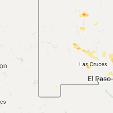


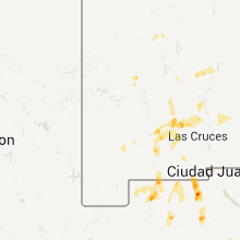


Connect with Interactive Hail Maps