

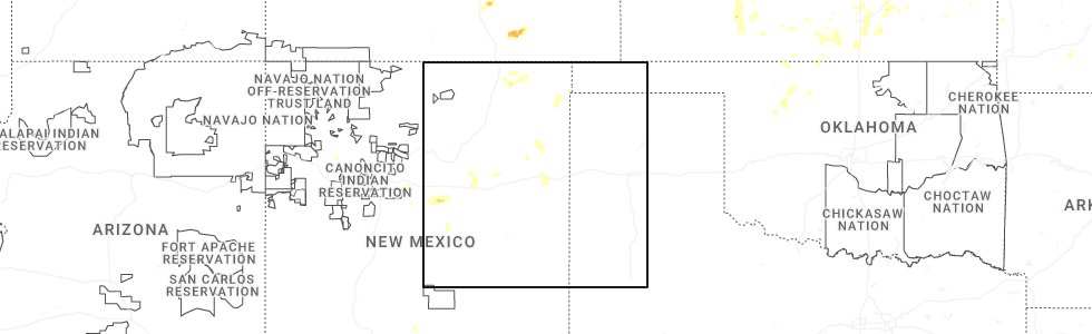
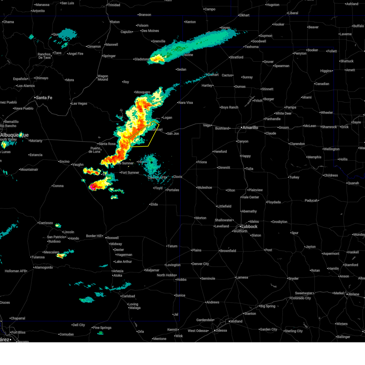
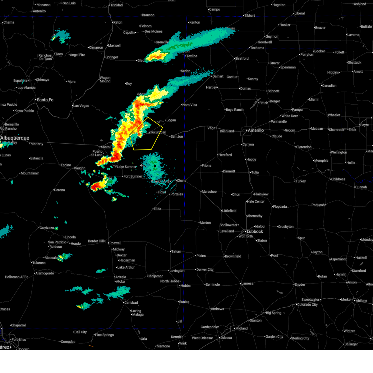
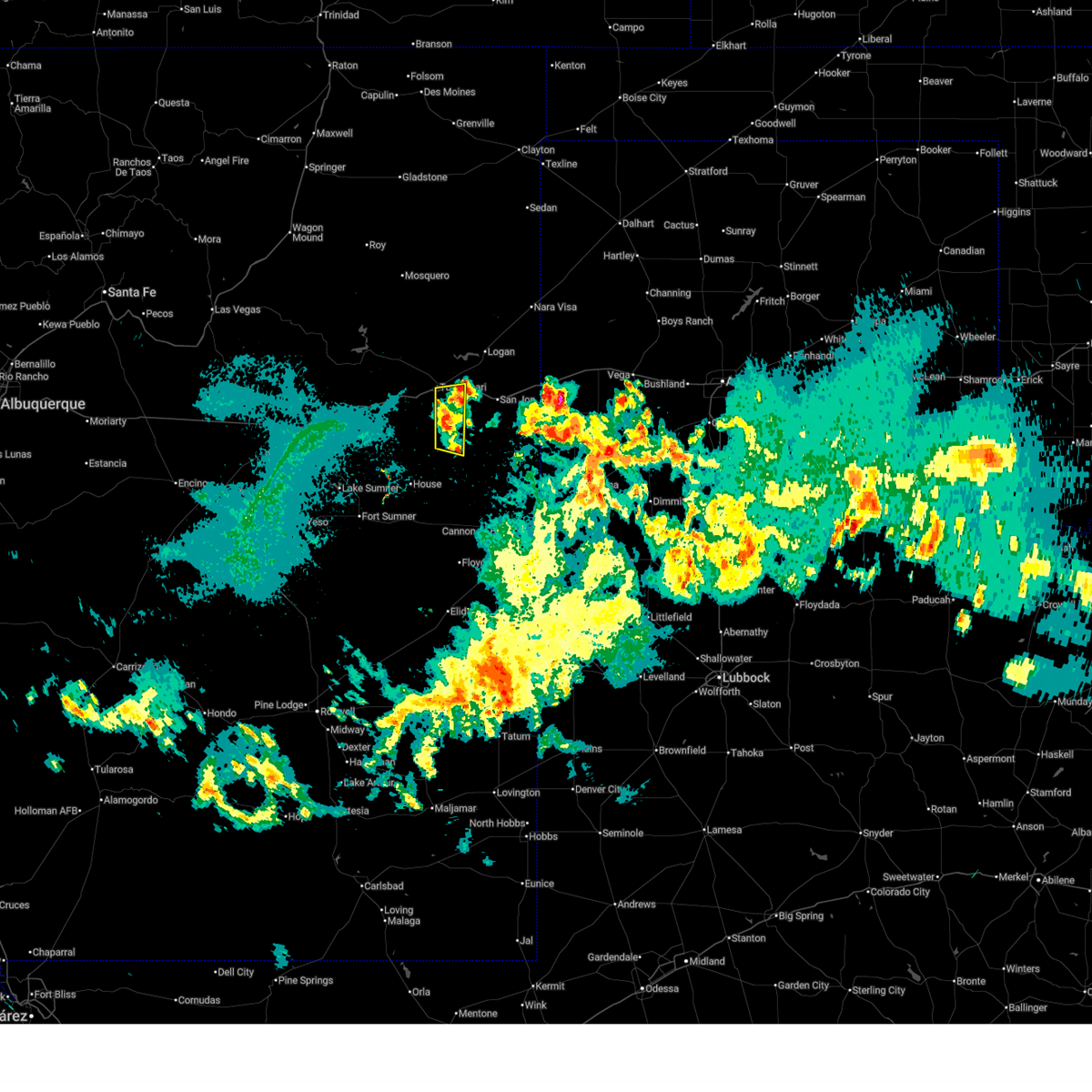
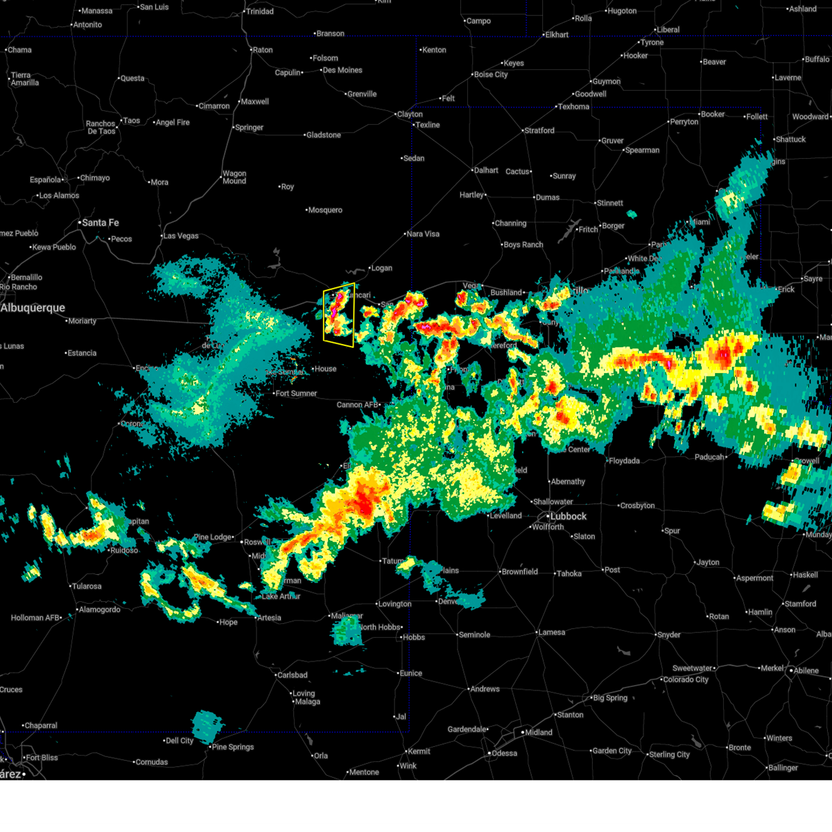
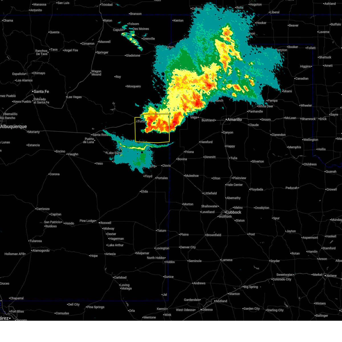
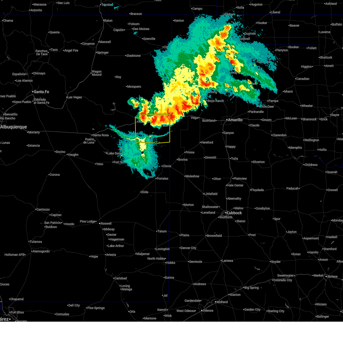
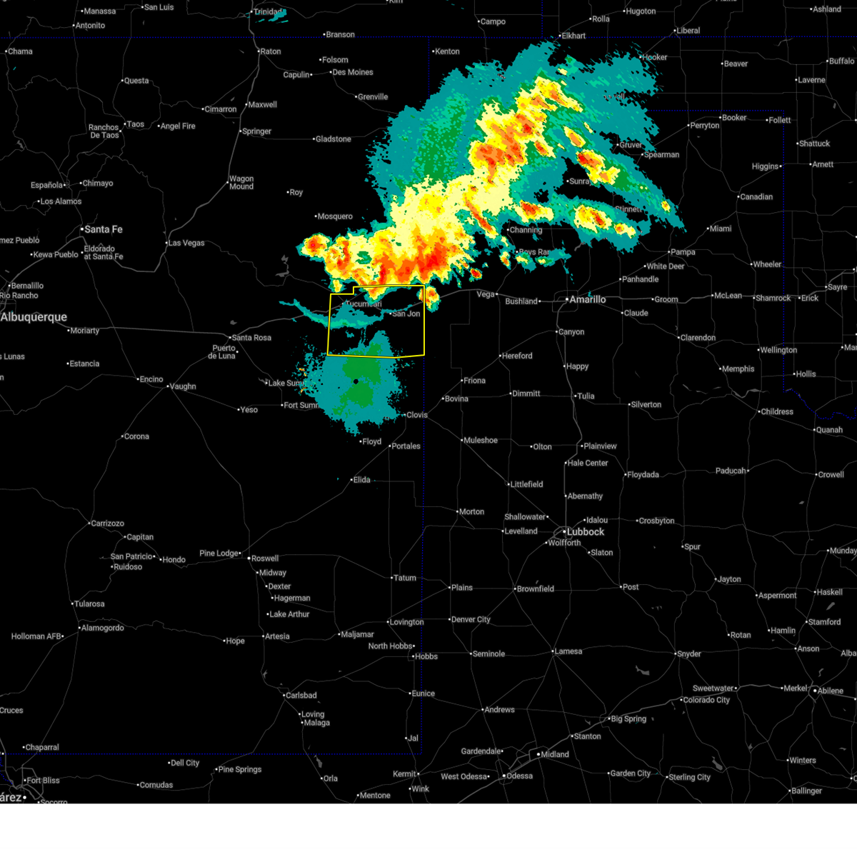
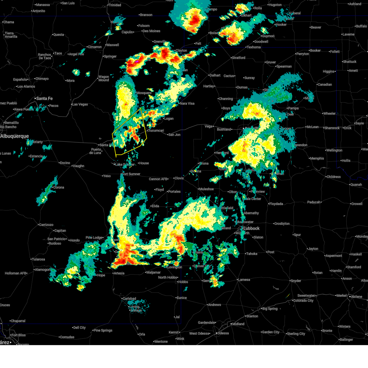
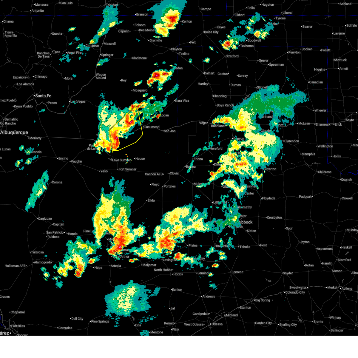
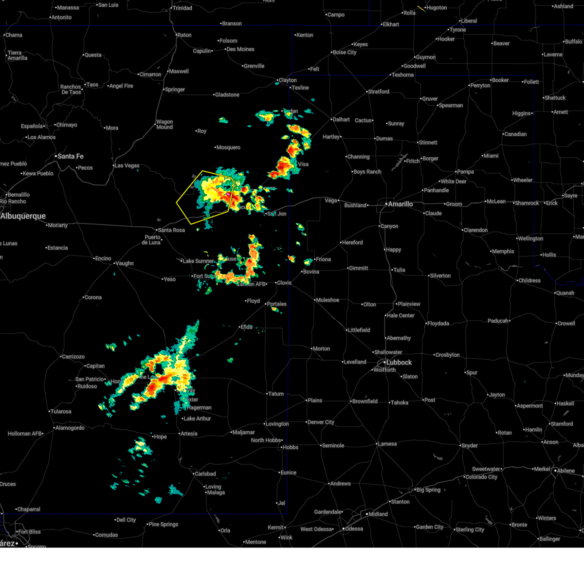
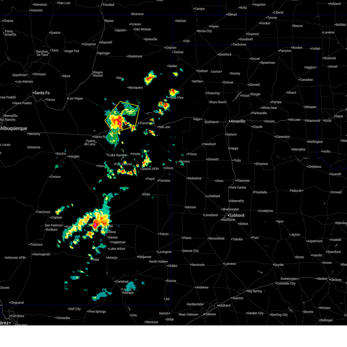
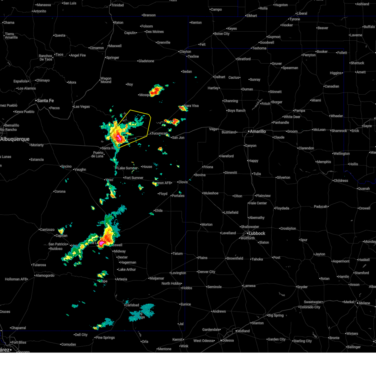
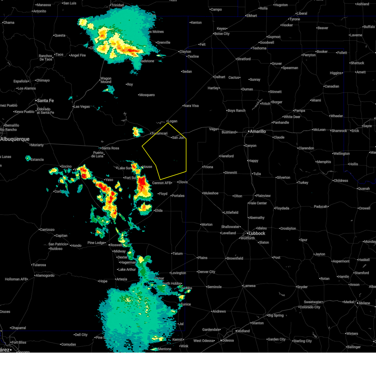
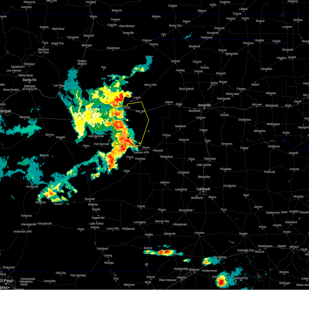
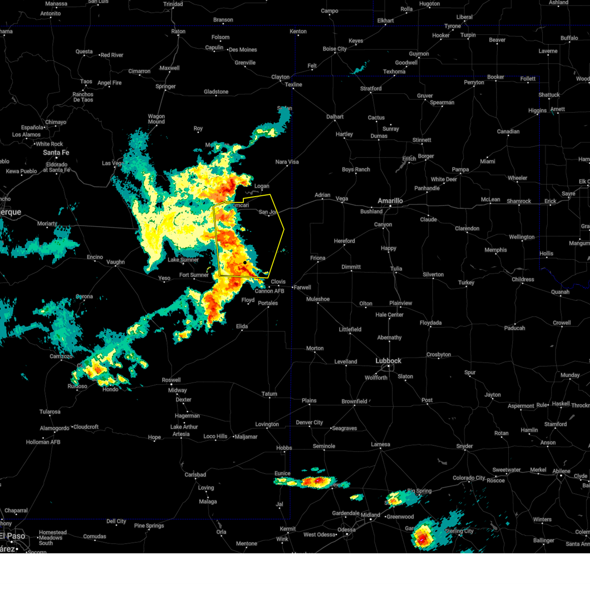
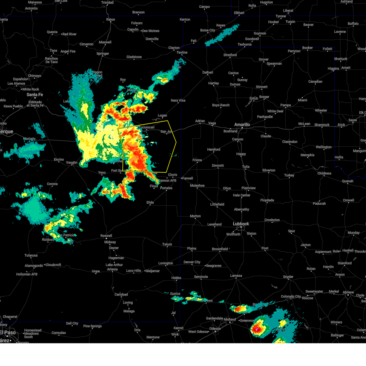
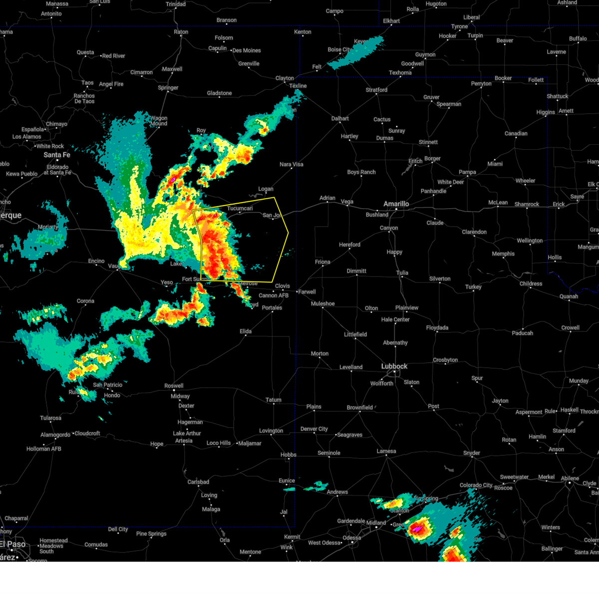
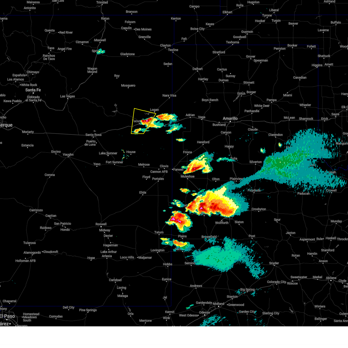
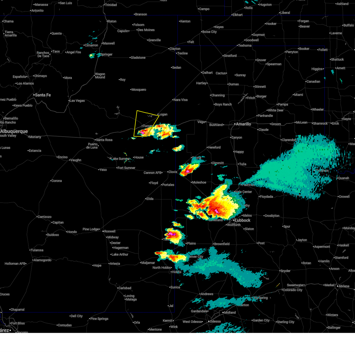
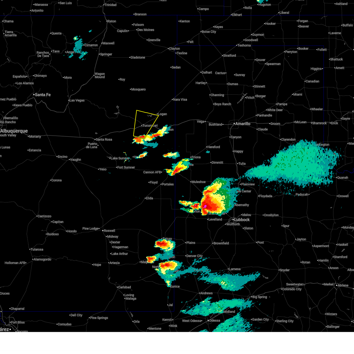
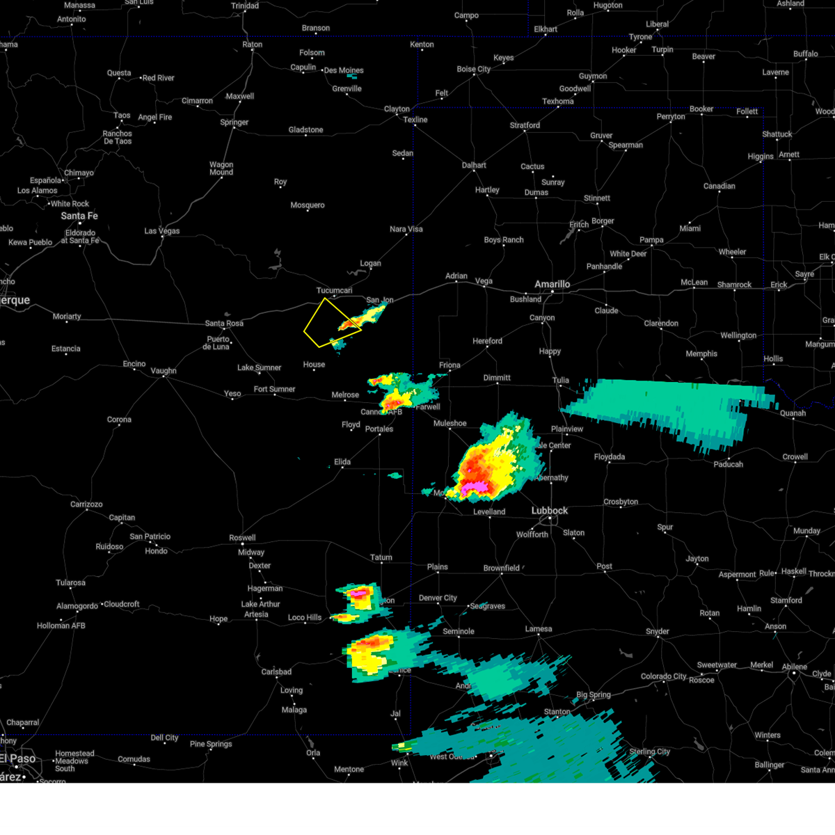
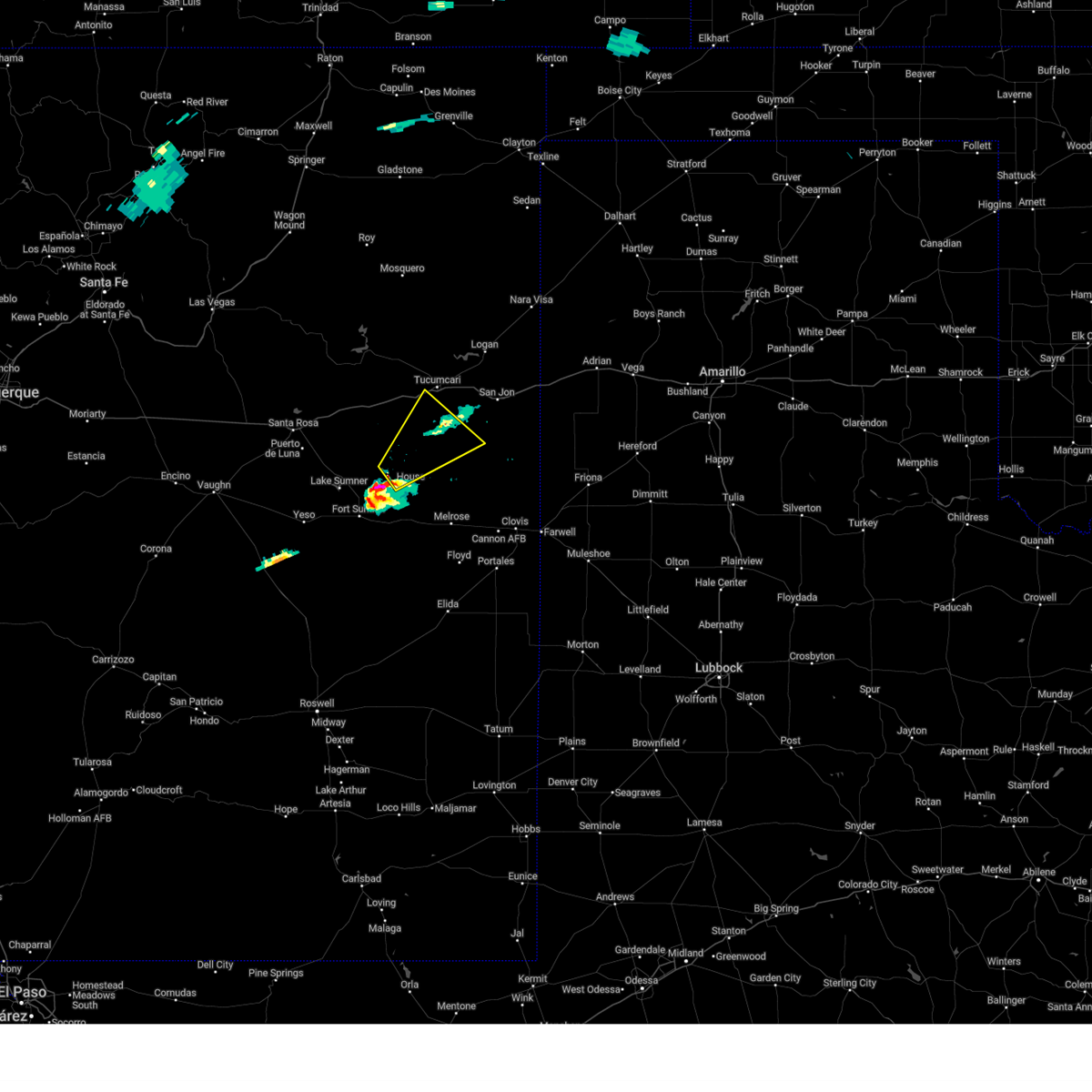
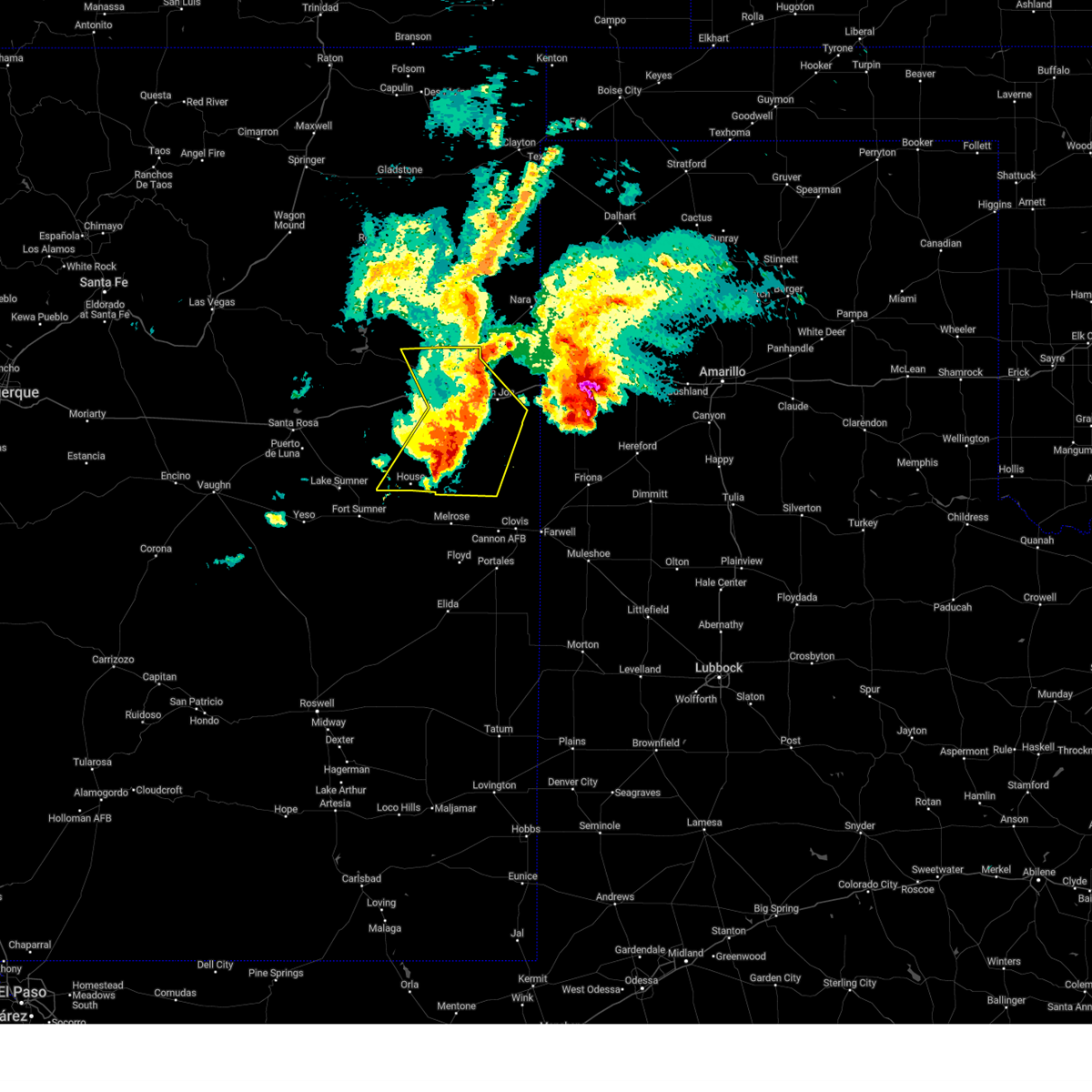
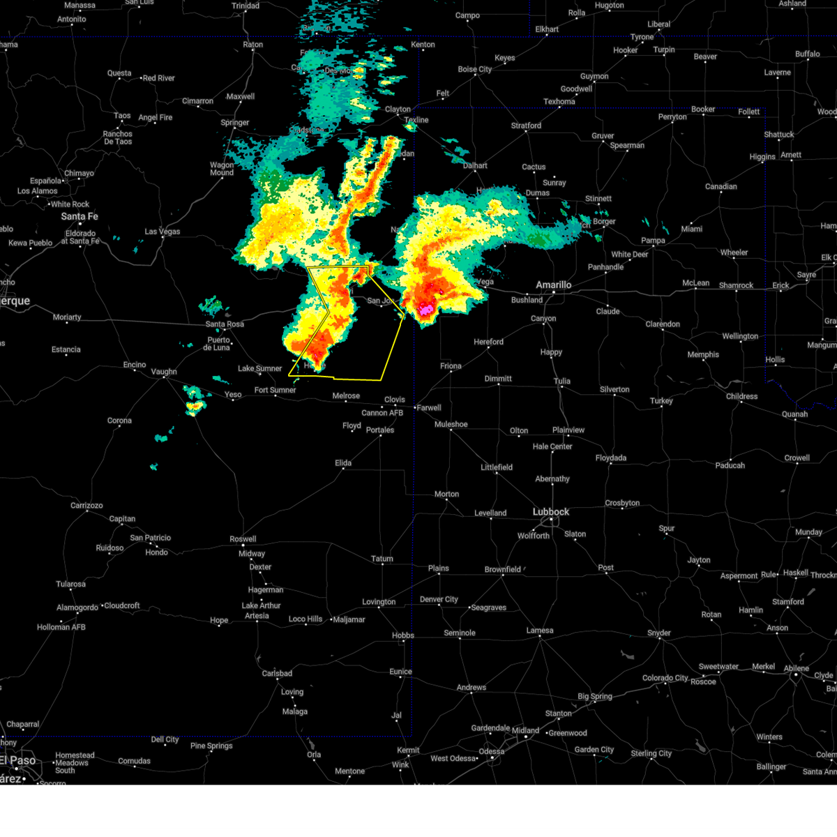
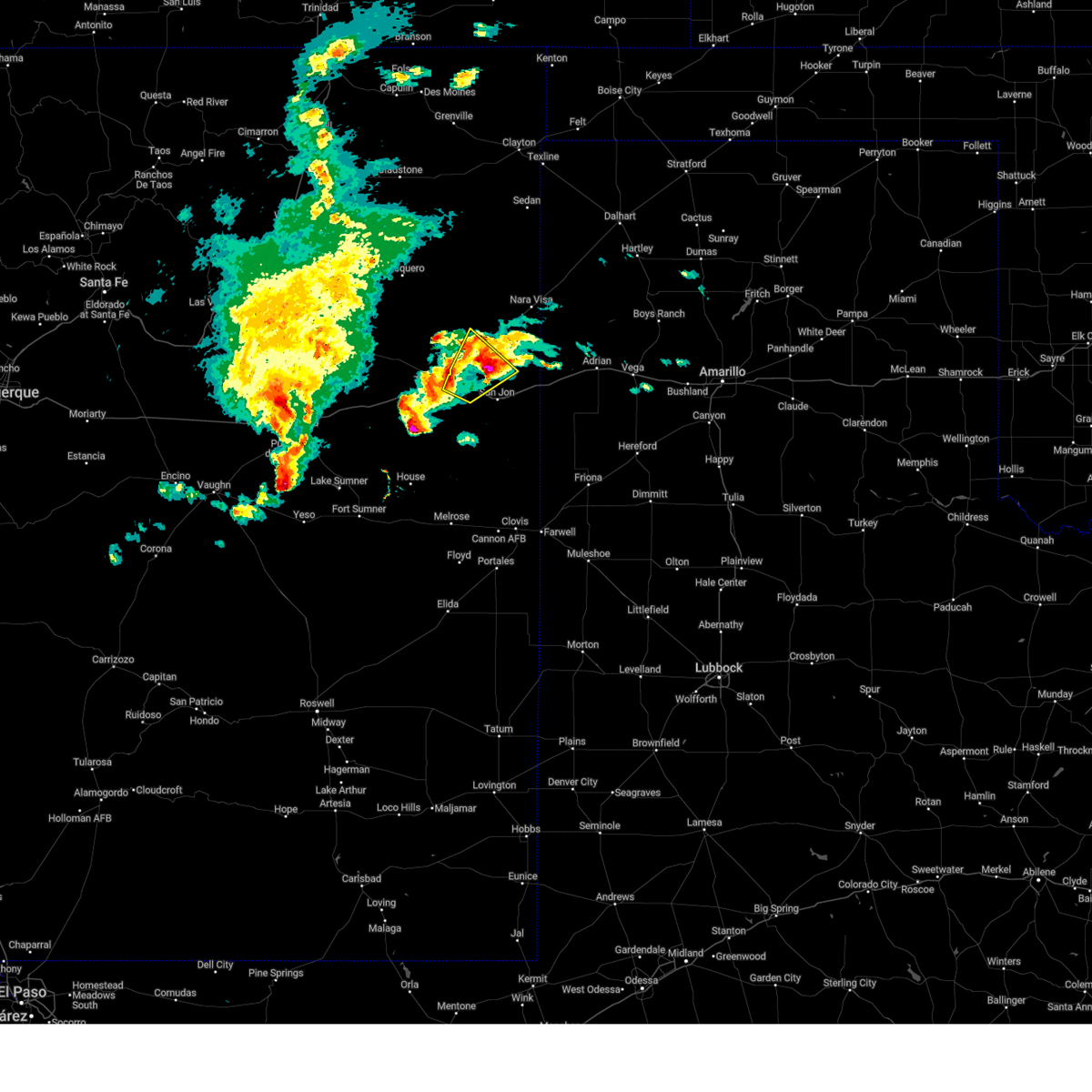
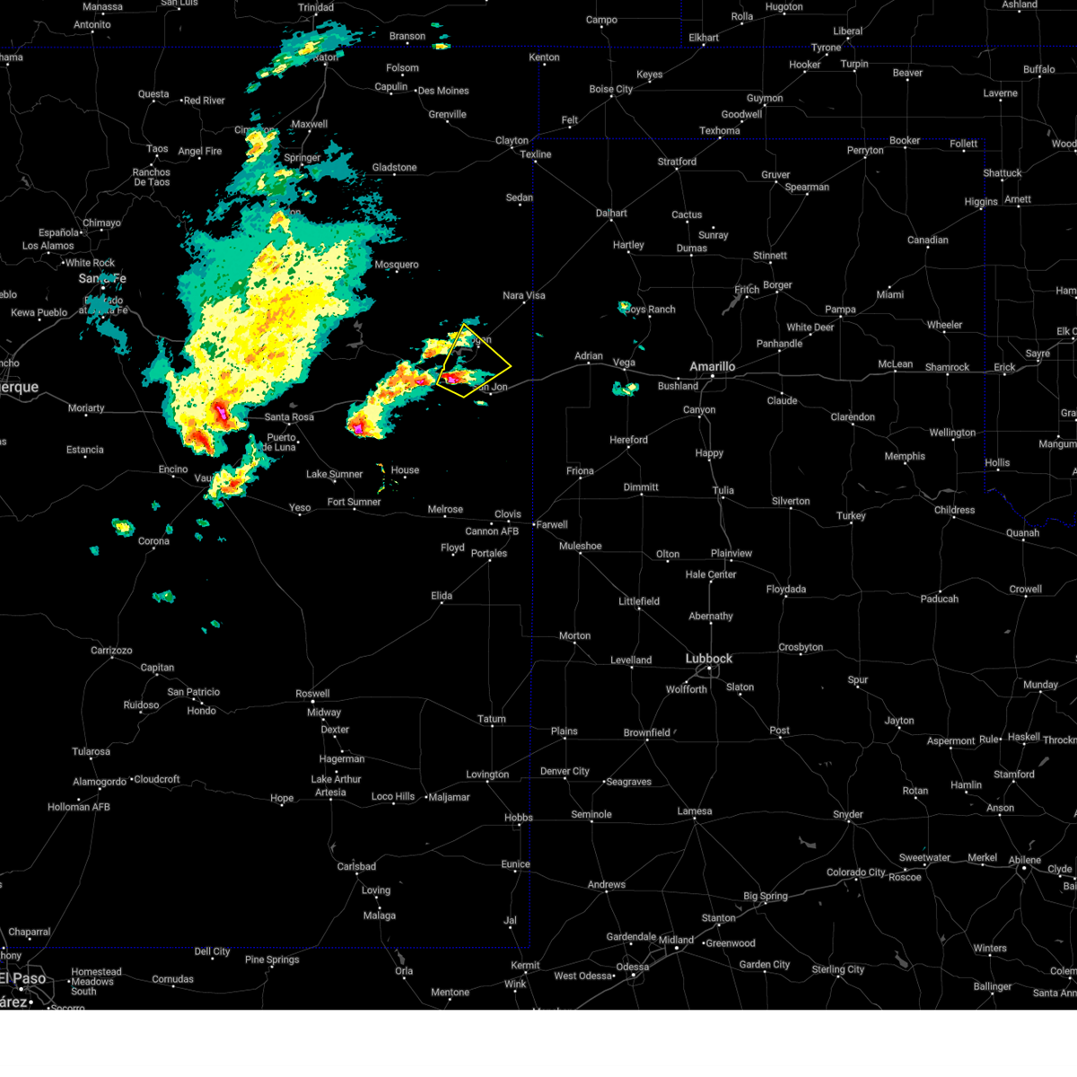
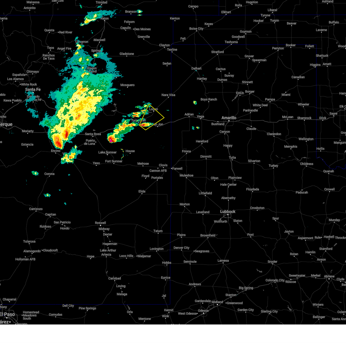
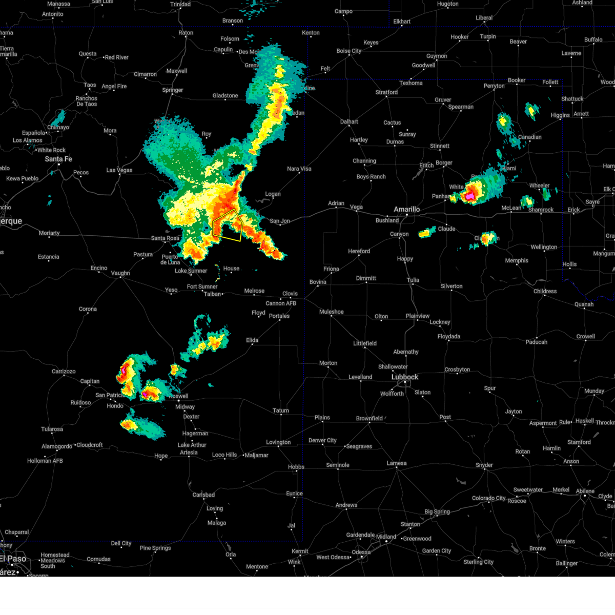
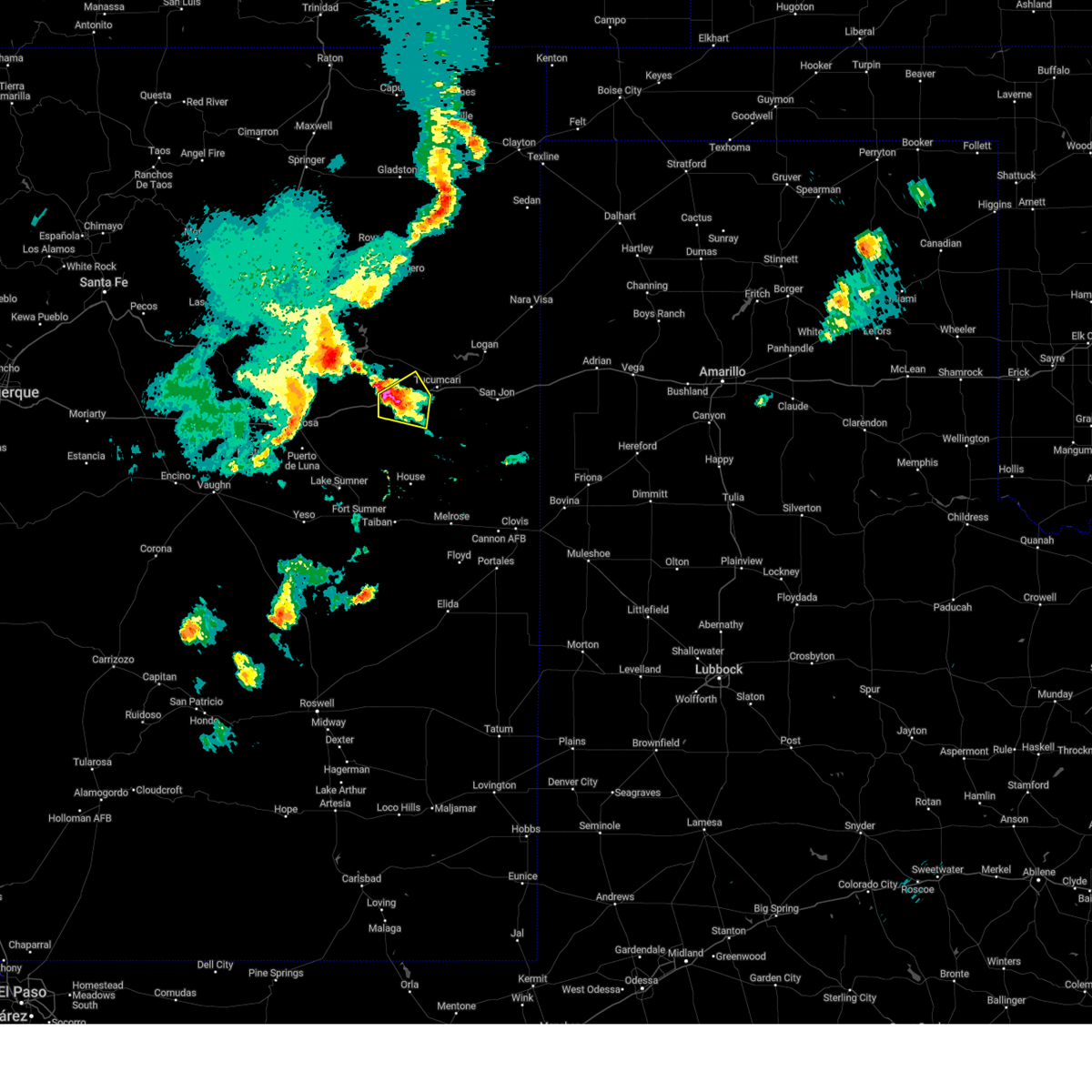
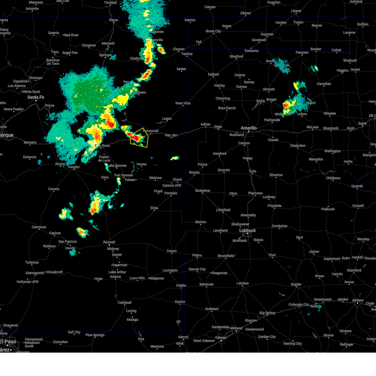
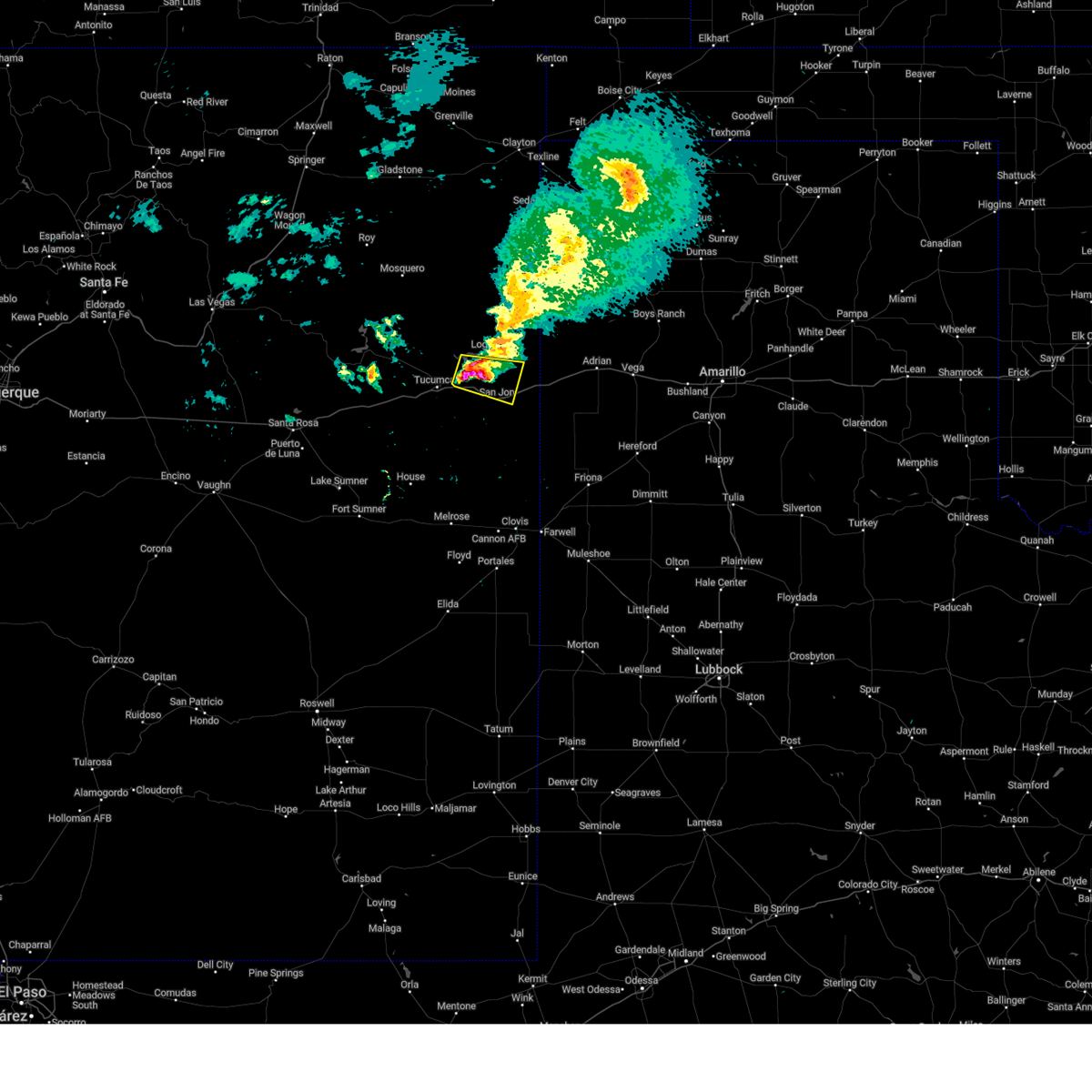
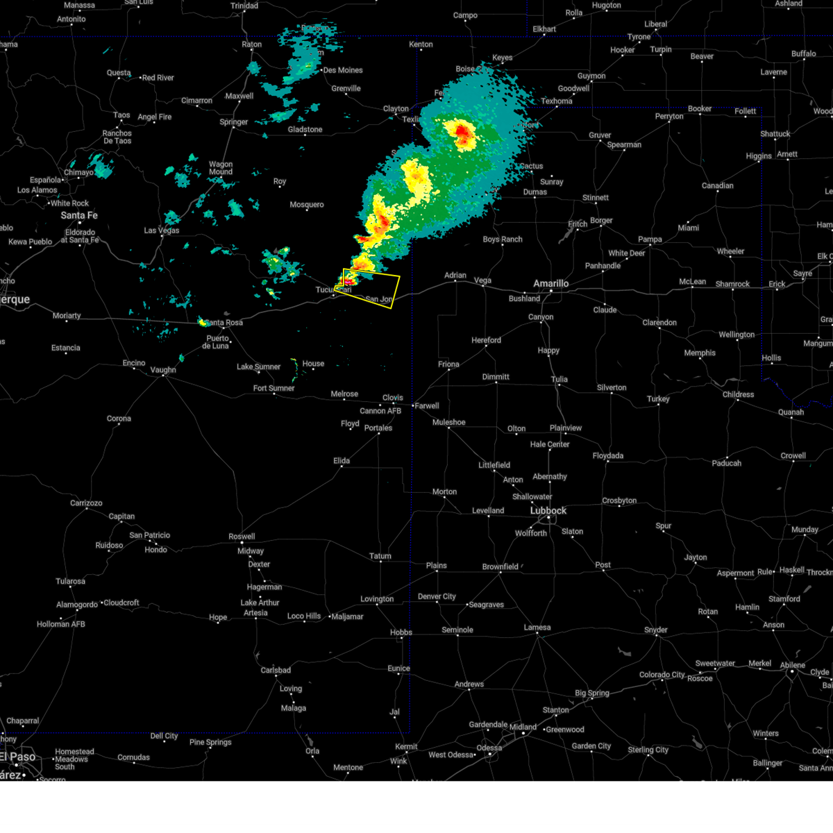
Hail Map for Tucumcari, NM
The Tucumcari, NM area has had 30 reports of on-the-ground hail by trained spotters, and has been under severe weather warnings 13 times during the past 12 months. Doppler radar has detected hail at or near Tucumcari, NM on 111 occasions, including 10 occasions during the past year.
| Name: | Tucumcari, NM |
| Where Located: | 1 miles SSE of Tucumcari, NM |
| Map: | Google Map for Tucumcari, NM |
| Population: | 5363 |
| Housing Units: | 2999 |
| More Info: | Search Google for Tucumcari, NM |
1
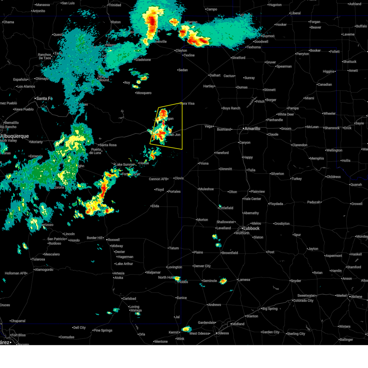
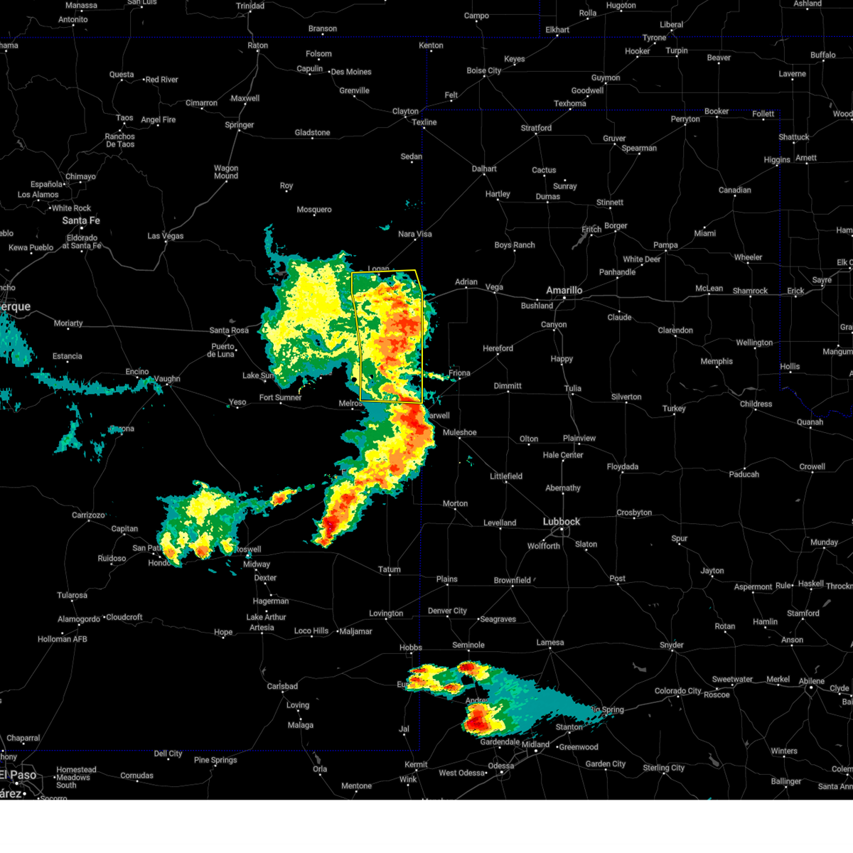
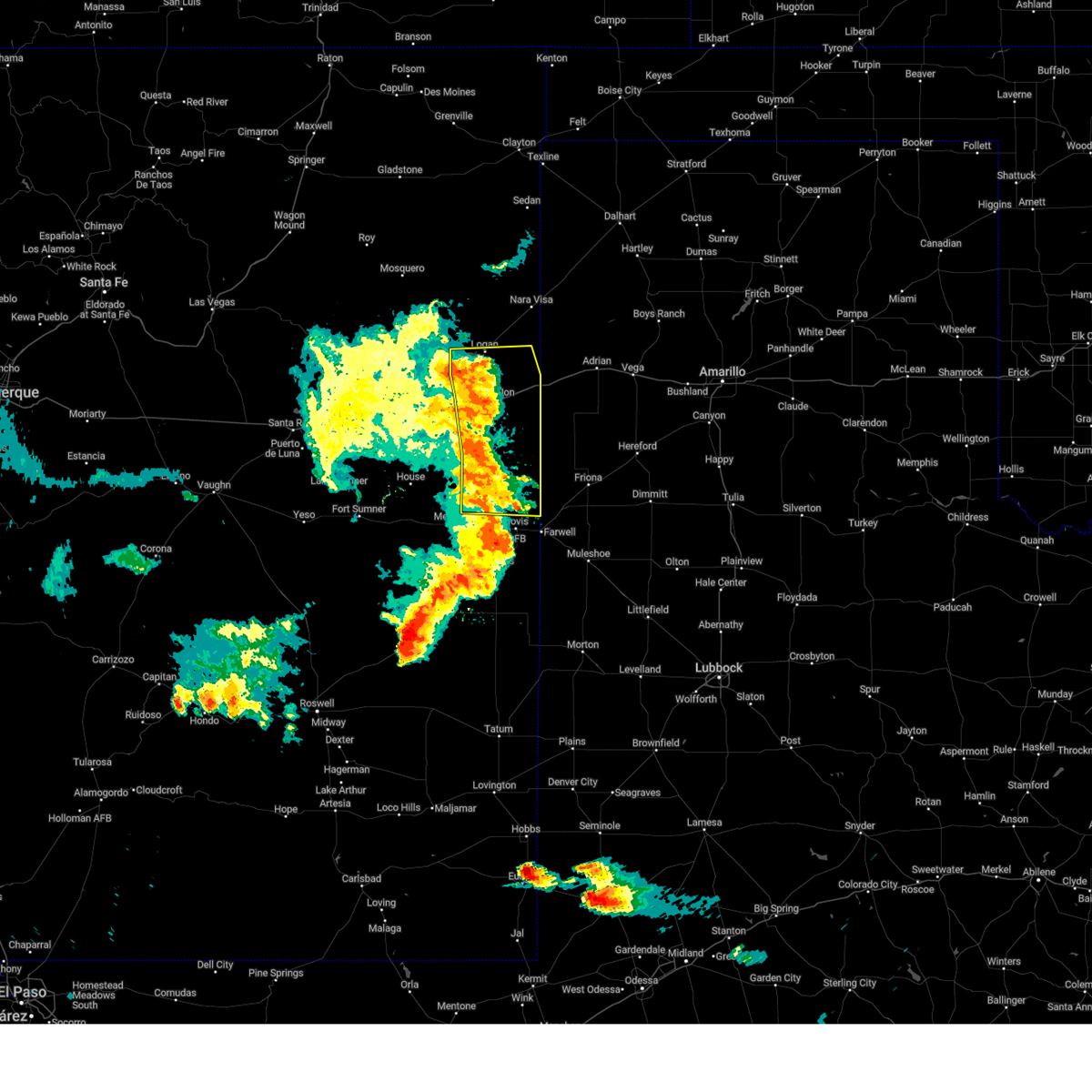
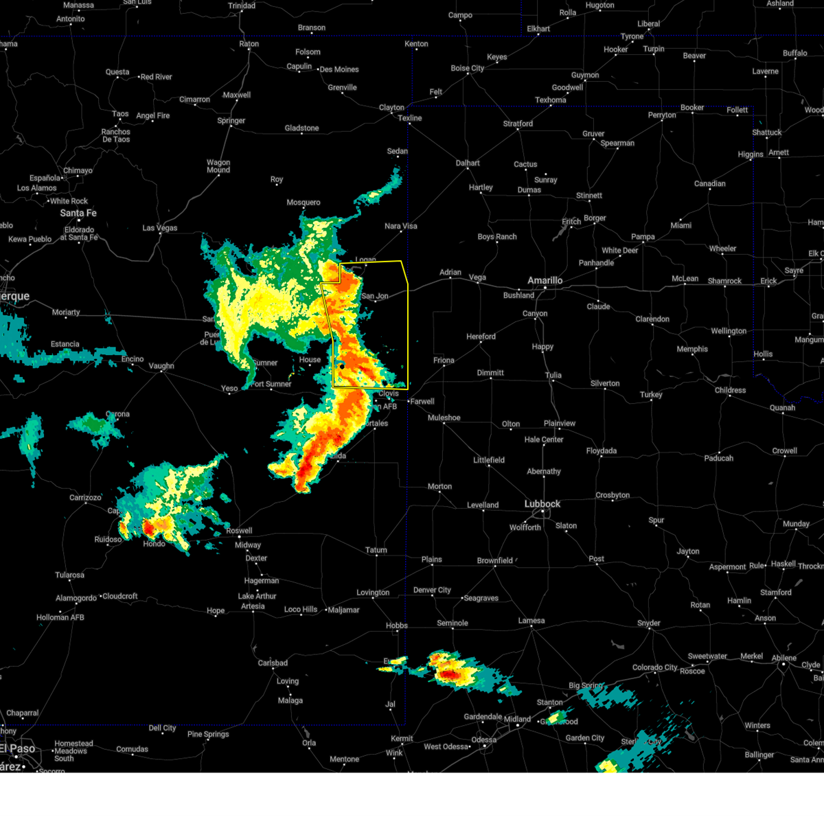
The Top Recent Hail Date for Tucumcari, NM is Sunday, July 6, 2025 (36th out of 111)
Hail and Wind Damage Spotted near Tucumcari, NM
| Date / Time | Report Details |
|---|---|
| 6/26/2026 7:02 PM MDT |
 Svrabq the national weather service in albuquerque has issued a * severe thunderstorm warning for, northeastern curry county in east central new mexico, northeastern quay county in east central new mexico, southeastern harding county in northeastern new mexico, * until 800 pm mdt. * at 702 pm mdt, severe thunderstorms were located along a line from 12 miles north of logan to 9 miles northwest of wheatland, moving east at 15 mph (surface observations). Hazards include 60 mph wind gusts. expect damage to roofs, siding, and trees Svrabq the national weather service in albuquerque has issued a * severe thunderstorm warning for, northeastern curry county in east central new mexico, northeastern quay county in east central new mexico, southeastern harding county in northeastern new mexico, * until 800 pm mdt. * at 702 pm mdt, severe thunderstorms were located along a line from 12 miles north of logan to 9 miles northwest of wheatland, moving east at 15 mph (surface observations). Hazards include 60 mph wind gusts. expect damage to roofs, siding, and trees
|
| 6/26/2026 6:53 PM MDT | Asos station ktcc tucumcari muni airpor in quay county NM, 6.7 miles W of Tucumcari, NM |
| 6/24/2026 8:41 PM MDT | Asos station ktcc tucumcari muni airpor in quay county NM, 6.7 miles W of Tucumcari, NM |
| 6/15/2026 5:27 PM MDT |
 At 527 pm mdt, severe thunderstorms were located along a line from 10 miles southeast of logan to near house, moving southeast at 40 mph (public reported). Hazards include 65 mph wind gusts and small hail. Expect damage to roofs, siding, and trees. locations impacted include, tucumcari, quay, logan, melrose, san jon, grady, house, ragland, wheatland and broadview. this includes the following highways, interstate 40 between mile markers 331 and 364. highway 60 between mile markers 354 and 365. State road 104 between mile markers 103 and 105. At 527 pm mdt, severe thunderstorms were located along a line from 10 miles southeast of logan to near house, moving southeast at 40 mph (public reported). Hazards include 65 mph wind gusts and small hail. Expect damage to roofs, siding, and trees. locations impacted include, tucumcari, quay, logan, melrose, san jon, grady, house, ragland, wheatland and broadview. this includes the following highways, interstate 40 between mile markers 331 and 364. highway 60 between mile markers 354 and 365. State road 104 between mile markers 103 and 105.
|
| 6/15/2026 5:14 PM MDT | Trained spotter estimated 50 to 65 mph wind gusts... with blowing dus in quay county NM, 16.5 miles N of Tucumcari, NM |
| 6/15/2026 5:14 PM MDT |
 Svrabq the national weather service in albuquerque has issued a * severe thunderstorm warning for, western curry county in east central new mexico, quay county in east central new mexico, northwestern roosevelt county in east central new mexico, southeastern harding county in northeastern new mexico, east central san miguel county in northeastern new mexico, * until 600 pm mdt. * at 514 pm mdt, severe thunderstorms were located along a line from over logan to near house, moving southeast at 40 mph (radar indicated). Hazards include 60 mph wind gusts and small hail. expect damage to roofs, siding, and trees Svrabq the national weather service in albuquerque has issued a * severe thunderstorm warning for, western curry county in east central new mexico, quay county in east central new mexico, northwestern roosevelt county in east central new mexico, southeastern harding county in northeastern new mexico, east central san miguel county in northeastern new mexico, * until 600 pm mdt. * at 514 pm mdt, severe thunderstorms were located along a line from over logan to near house, moving southeast at 40 mph (radar indicated). Hazards include 60 mph wind gusts and small hail. expect damage to roofs, siding, and trees
|
| 6/15/2026 5:12 PM MDT | Asos station ktcc tucumcari muni airpor in quay county NM, 6.7 miles W of Tucumcari, NM |
| 6/15/2026 5:03 PM MDT |
 At 503 pm mdt, severe thunderstorms were located along a line from 8 miles east of tucumcari to 8 miles southwest of quay, moving southeast at 40 mph (radar indicated). Hazards include 60 mph wind gusts and small hail. Expect damage to roofs, siding, and trees. locations impacted include, tucumcari and quay. this includes the following highways, interstate 40 between mile markers 322 and 344. State road 104 between mile markers 104 and 105. At 503 pm mdt, severe thunderstorms were located along a line from 8 miles east of tucumcari to 8 miles southwest of quay, moving southeast at 40 mph (radar indicated). Hazards include 60 mph wind gusts and small hail. Expect damage to roofs, siding, and trees. locations impacted include, tucumcari and quay. this includes the following highways, interstate 40 between mile markers 322 and 344. State road 104 between mile markers 104 and 105.
|
| 6/15/2026 4:38 PM MDT |
 Svrabq the national weather service in albuquerque has issued a * severe thunderstorm warning for, west central quay county in east central new mexico, southeastern san miguel county in northeastern new mexico, * until 515 pm mdt. * at 438 pm mdt, a severe thunderstorm was located 10 miles west of tucumcari, moving southeast at 25 mph (radar indicated). Hazards include 60 mph wind gusts and small hail. expect damage to roofs, siding, and trees Svrabq the national weather service in albuquerque has issued a * severe thunderstorm warning for, west central quay county in east central new mexico, southeastern san miguel county in northeastern new mexico, * until 515 pm mdt. * at 438 pm mdt, a severe thunderstorm was located 10 miles west of tucumcari, moving southeast at 25 mph (radar indicated). Hazards include 60 mph wind gusts and small hail. expect damage to roofs, siding, and trees
|
| 5/23/2026 6:18 PM MDT | Asos station ktcc tucumcari muni airpor in quay county NM, 6.7 miles W of Tucumcari, NM |
| 9/9/2025 5:53 PM MDT | the severe thunderstorm warning has been cancelled and is no longer in effect |
| 9/9/2025 5:30 PM MDT | Svrabq the national weather service in albuquerque has issued a * severe thunderstorm warning for, central quay county in east central new mexico, southeastern harding county in northeastern new mexico, east central san miguel county in northeastern new mexico, * until 615 pm mdt. * at 530 pm mdt, a severe thunderstorm was located 8 miles east of tucumcari, moving northeast at 30 mph (radar indicated). Hazards include 60 mph wind gusts. expect damage to roofs, siding, and trees |
| 9/9/2025 5:25 PM MDT | Asos station ktcc tucumcari muni airpor in quay county NM, 6.7 miles W of Tucumcari, NM |
| 8/11/2025 9:30 PM MDT |
 the severe thunderstorm warning has been cancelled and is no longer in effect the severe thunderstorm warning has been cancelled and is no longer in effect
|
| 8/11/2025 9:23 PM MDT |
 At 923 pm mdt, severe thunderstorms were located along a line from 9 miles east of tucumcari to 8 miles northeast of ragland, moving east at 10 mph (radar indicated). Hazards include 60 mph wind gusts and small hail. Expect damage to roofs, siding, and trees. locations impacted include, tucumcari. This includes interstate 40 between mile markers 332 and 343. At 923 pm mdt, severe thunderstorms were located along a line from 9 miles east of tucumcari to 8 miles northeast of ragland, moving east at 10 mph (radar indicated). Hazards include 60 mph wind gusts and small hail. Expect damage to roofs, siding, and trees. locations impacted include, tucumcari. This includes interstate 40 between mile markers 332 and 343.
|
| 8/11/2025 9:08 PM MDT |
 Svrabq the national weather service in albuquerque has issued a * severe thunderstorm warning for, south central quay county in east central new mexico, * until 945 pm mdt. * at 908 pm mdt, severe thunderstorms were located along a line from 7 miles east of tucumcari to near ragland, moving east at 10 mph (radar indicated). Hazards include 60 mph wind gusts and half dollar size hail. Hail damage to vehicles is expected. Expect wind damage to roofs, siding, and trees. Svrabq the national weather service in albuquerque has issued a * severe thunderstorm warning for, south central quay county in east central new mexico, * until 945 pm mdt. * at 908 pm mdt, severe thunderstorms were located along a line from 7 miles east of tucumcari to near ragland, moving east at 10 mph (radar indicated). Hazards include 60 mph wind gusts and half dollar size hail. Hail damage to vehicles is expected. Expect wind damage to roofs, siding, and trees.
|
| 7/11/2025 10:12 PM MDT |
 The storms which prompted the warning have weakened below severe limits, and no longer pose an immediate threat to life or property. therefore, the warning will be allowed to expire. however, small hail, gusty winds, and heavy rain are still possible with these thunderstorms. a severe thunderstorm watch remains in effect until 1200 am mdt saturday for a portion of east central new mexico. The storms which prompted the warning have weakened below severe limits, and no longer pose an immediate threat to life or property. therefore, the warning will be allowed to expire. however, small hail, gusty winds, and heavy rain are still possible with these thunderstorms. a severe thunderstorm watch remains in effect until 1200 am mdt saturday for a portion of east central new mexico.
|
| 7/11/2025 9:48 PM MDT |
 At 948 pm mdt, severe thunderstorms were located along a line from near quay to 9 miles northeast of bellview, moving south at 20 mph (public reported). Hazards include 60 mph wind gusts and small hail. Expect damage to roofs, siding, and trees. locations impacted include, tucumcari, quay, san jon, grady, wheatland, broadview, bellview, ragland and bard. this includes the following highways, interstate 40 between mile markers 330 and 373. State road 104 between mile markers 102 and 105. At 948 pm mdt, severe thunderstorms were located along a line from near quay to 9 miles northeast of bellview, moving south at 20 mph (public reported). Hazards include 60 mph wind gusts and small hail. Expect damage to roofs, siding, and trees. locations impacted include, tucumcari, quay, san jon, grady, wheatland, broadview, bellview, ragland and bard. this includes the following highways, interstate 40 between mile markers 330 and 373. State road 104 between mile markers 102 and 105.
|
| 7/11/2025 9:25 PM MDT |
 Svrabq the national weather service in albuquerque has issued a * severe thunderstorm warning for, northeastern curry county in east central new mexico, central quay county in east central new mexico, * until 1015 pm mdt. * at 925 pm mdt, severe thunderstorms were located along a line from 7 miles south of tucumcari to 17 miles north of bellview, moving south at 20 mph (public reported). Hazards include 60 mph wind gusts and small hail. expect damage to roofs, siding, and trees Svrabq the national weather service in albuquerque has issued a * severe thunderstorm warning for, northeastern curry county in east central new mexico, central quay county in east central new mexico, * until 1015 pm mdt. * at 925 pm mdt, severe thunderstorms were located along a line from 7 miles south of tucumcari to 17 miles north of bellview, moving south at 20 mph (public reported). Hazards include 60 mph wind gusts and small hail. expect damage to roofs, siding, and trees
|
| 7/11/2025 9:07 PM MDT | Asos station ktcc tucumcari muni airpor in quay county NM, 6.7 miles W of Tucumcari, NM |
| 6/23/2025 6:08 PM MDT |
 The earlier severe thunderstorms are no longer producing large hail, so the severe thunderstorm warning will be allowed to expire. however, small hail, gusty winds, and heavy rain are still possible with these thunderstorms. to report severe weather observed at your location, contact the national weather service office in albuquerque at 1.888.386.7637. The earlier severe thunderstorms are no longer producing large hail, so the severe thunderstorm warning will be allowed to expire. however, small hail, gusty winds, and heavy rain are still possible with these thunderstorms. to report severe weather observed at your location, contact the national weather service office in albuquerque at 1.888.386.7637.
|
| 6/23/2025 5:27 PM MDT |
 Svrabq the national weather service in albuquerque has issued a * severe thunderstorm warning for, northeastern guadalupe county in east central new mexico, west central quay county in east central new mexico, southeastern san miguel county in northeastern new mexico, * until 615 pm mdt. * at 527 pm mdt, severe thunderstorms were located along a line from 13 miles northeast of montoya to 7 miles southeast of cuervo, moving east at 15 mph (radar indicated). Hazards include 60 mph wind gusts and quarter size hail. Hail damage to vehicles is expected. Expect wind damage to roofs, siding, and trees. Svrabq the national weather service in albuquerque has issued a * severe thunderstorm warning for, northeastern guadalupe county in east central new mexico, west central quay county in east central new mexico, southeastern san miguel county in northeastern new mexico, * until 615 pm mdt. * at 527 pm mdt, severe thunderstorms were located along a line from 13 miles northeast of montoya to 7 miles southeast of cuervo, moving east at 15 mph (radar indicated). Hazards include 60 mph wind gusts and quarter size hail. Hail damage to vehicles is expected. Expect wind damage to roofs, siding, and trees.
|
| 6/22/2025 4:58 PM MDT |
 The severe thunderstorm warning that was previously in effect has been replaced by a special weather statement. please refer to that bulletin for the latest information on this strong thunderstorm north of the tucumcari area. The severe thunderstorm warning that was previously in effect has been replaced by a special weather statement. please refer to that bulletin for the latest information on this strong thunderstorm north of the tucumcari area.
|
| 6/22/2025 4:26 PM MDT |
 At 426 pm mdt, a severe thunderstorm was located 9 miles north of montoya, or 22 miles west of tucumcari, moving northeast at 45 mph (radar indicated). Hazards include 60 mph wind gusts and small hail. Expect damage to roofs, siding, and trees. locations impacted include, tucumcari, conchas, conchas lake state park, montoya, conchas dam, newkirk and bell ranch. this includes the following highways, interstate 40 between mile markers 298 and 328. State road 104 between mile markers 62 and 100. At 426 pm mdt, a severe thunderstorm was located 9 miles north of montoya, or 22 miles west of tucumcari, moving northeast at 45 mph (radar indicated). Hazards include 60 mph wind gusts and small hail. Expect damage to roofs, siding, and trees. locations impacted include, tucumcari, conchas, conchas lake state park, montoya, conchas dam, newkirk and bell ranch. this includes the following highways, interstate 40 between mile markers 298 and 328. State road 104 between mile markers 62 and 100.
|
| 6/22/2025 4:25 PM MDT | Lots of dust kicked u in quay county NM, 19.6 miles E of Tucumcari, NM |
| 6/22/2025 4:08 PM MDT |
 Svrabq the national weather service in albuquerque has issued a * severe thunderstorm warning for, northeastern guadalupe county in east central new mexico, west central quay county in east central new mexico, southeastern san miguel county in northeastern new mexico, * until 500 pm mdt. * at 408 pm mdt, a severe thunderstorm was located near newkirk, or 25 miles northeast of santa rosa, moving northeast at 45 mph (radar indicated). Hazards include 60 mph wind gusts and quarter size hail. Hail damage to vehicles is expected. Expect wind damage to roofs, siding, and trees. Svrabq the national weather service in albuquerque has issued a * severe thunderstorm warning for, northeastern guadalupe county in east central new mexico, west central quay county in east central new mexico, southeastern san miguel county in northeastern new mexico, * until 500 pm mdt. * at 408 pm mdt, a severe thunderstorm was located near newkirk, or 25 miles northeast of santa rosa, moving northeast at 45 mph (radar indicated). Hazards include 60 mph wind gusts and quarter size hail. Hail damage to vehicles is expected. Expect wind damage to roofs, siding, and trees.
|
| 6/15/2025 8:14 PM MDT |
 The severe thunderstorm warning that was previously in effect has been reissued for curry and quay counties and is in effect until 900 pm mdt. please refer to that bulletin for the latest severe weather information. a severe thunderstorm watch remains in effect until 1100 pm mdt for a portion of east central new mexico. The severe thunderstorm warning that was previously in effect has been reissued for curry and quay counties and is in effect until 900 pm mdt. please refer to that bulletin for the latest severe weather information. a severe thunderstorm watch remains in effect until 1100 pm mdt for a portion of east central new mexico.
|
| 6/15/2025 7:52 PM MDT |
 At 752 pm mdt, severe thunderstorms were located along a line from 12 miles southwest of san jon to 12 miles south of broadview, moving northeast at 20 mph (radar indicated). Hazards include 60 mph wind gusts and small hail. Expect damage to roofs, siding, and trees. locations impacted include, san jon, grady, wheatland, broadview, bellview, bard and forrest. This includes interstate 40 between mile markers 339 and 367. At 752 pm mdt, severe thunderstorms were located along a line from 12 miles southwest of san jon to 12 miles south of broadview, moving northeast at 20 mph (radar indicated). Hazards include 60 mph wind gusts and small hail. Expect damage to roofs, siding, and trees. locations impacted include, san jon, grady, wheatland, broadview, bellview, bard and forrest. This includes interstate 40 between mile markers 339 and 367.
|
| 6/15/2025 7:38 PM MDT |
 At 738 pm mdt, severe thunderstorms were located along a line from 11 miles northeast of quay to 9 miles north of ranchvale, moving northeast at 20 mph (radar indicated). Hazards include 60 mph wind gusts and quarter size hail. Hail damage to vehicles is expected. expect wind damage to roofs, siding, and trees. locations impacted include, clovis, quay, san jon, grady, wheatland, broadview, bellview, ragland, forrest and bard. This includes interstate 40 between mile markers 339 and 367. At 738 pm mdt, severe thunderstorms were located along a line from 11 miles northeast of quay to 9 miles north of ranchvale, moving northeast at 20 mph (radar indicated). Hazards include 60 mph wind gusts and quarter size hail. Hail damage to vehicles is expected. expect wind damage to roofs, siding, and trees. locations impacted include, clovis, quay, san jon, grady, wheatland, broadview, bellview, ragland, forrest and bard. This includes interstate 40 between mile markers 339 and 367.
|
| 6/15/2025 7:12 PM MDT |
 Svrabq the national weather service in albuquerque has issued a * severe thunderstorm warning for, central curry county in east central new mexico, southern quay county in east central new mexico, * until 815 pm mdt. * at 712 pm mdt, severe thunderstorms were located along a line from over quay to 11 miles northwest of ranchvale, moving northeast at 20 mph (radar indicated). Hazards include 60 mph wind gusts and quarter size hail. Hail damage to vehicles is expected. Expect wind damage to roofs, siding, and trees. Svrabq the national weather service in albuquerque has issued a * severe thunderstorm warning for, central curry county in east central new mexico, southern quay county in east central new mexico, * until 815 pm mdt. * at 712 pm mdt, severe thunderstorms were located along a line from over quay to 11 miles northwest of ranchvale, moving northeast at 20 mph (radar indicated). Hazards include 60 mph wind gusts and quarter size hail. Hail damage to vehicles is expected. Expect wind damage to roofs, siding, and trees.
|
| 6/9/2025 8:57 PM MDT |
 The storms which prompted the warning have weakened below severe limits, and no longer pose an immediate threat to life or property. therefore, the warning will be allowed to expire. however, small hail, gusty winds, and heavy rain are still possible with these thunderstorms. a severe thunderstorm watch remains in effect until 1000 pm mdt for a portion of east central new mexico. The storms which prompted the warning have weakened below severe limits, and no longer pose an immediate threat to life or property. therefore, the warning will be allowed to expire. however, small hail, gusty winds, and heavy rain are still possible with these thunderstorms. a severe thunderstorm watch remains in effect until 1000 pm mdt for a portion of east central new mexico.
|
| 6/9/2025 8:30 PM MDT |
 At 830 pm mdt, severe thunderstorms were located along a line from 6 miles southeast of logan to near clovis, moving east at 45 mph (trained spotters reported). Hazards include 70 mph wind gusts and quarter size hail. Hail damage to vehicles is expected. expect considerable tree damage. wind damage is also likely to mobile homes, roofs, and outbuildings. locations impacted include, clovis, logan, san jon, grady, wheatland, broadview, bellview, ranchvale, ute lake state park and bard. This includes interstate 40 between mile markers 339 and 373. At 830 pm mdt, severe thunderstorms were located along a line from 6 miles southeast of logan to near clovis, moving east at 45 mph (trained spotters reported). Hazards include 70 mph wind gusts and quarter size hail. Hail damage to vehicles is expected. expect considerable tree damage. wind damage is also likely to mobile homes, roofs, and outbuildings. locations impacted include, clovis, logan, san jon, grady, wheatland, broadview, bellview, ranchvale, ute lake state park and bard. This includes interstate 40 between mile markers 339 and 373.
|
| 6/9/2025 8:13 PM MDT |
 Svrabq the national weather service in albuquerque has issued a * severe thunderstorm warning for, curry county in east central new mexico, southeastern quay county in east central new mexico, * until 900 pm mdt. * at 813 pm mdt, severe thunderstorms were located along a line from 10 miles southwest of ute lake state park to near ranchvale, moving east at 45 mph (trained spotters reported at 7:25pm a spotter reported a 5 inch tree branch snapped near house, nm). Hazards include 70 mph wind gusts and quarter size hail. Hail damage to vehicles is expected. expect considerable tree damage. Wind damage is also likely to mobile homes, roofs, and outbuildings. Svrabq the national weather service in albuquerque has issued a * severe thunderstorm warning for, curry county in east central new mexico, southeastern quay county in east central new mexico, * until 900 pm mdt. * at 813 pm mdt, severe thunderstorms were located along a line from 10 miles southwest of ute lake state park to near ranchvale, moving east at 45 mph (trained spotters reported at 7:25pm a spotter reported a 5 inch tree branch snapped near house, nm). Hazards include 70 mph wind gusts and quarter size hail. Hail damage to vehicles is expected. expect considerable tree damage. Wind damage is also likely to mobile homes, roofs, and outbuildings.
|
| 6/9/2025 7:49 PM MDT |
 At 749 pm mdt, severe thunderstorms were located along a line from 7 miles south of tucumcari to 8 miles north of melrose, moving east at 35 mph (trained spotters reported). Hazards include 70 mph wind gusts and quarter size hail. Hail damage to vehicles is expected. expect considerable tree damage. wind damage is also likely to mobile homes, roofs, and outbuildings. locations impacted include, tucumcari, quay, san jon, grady, house, ragland, wheatland, broadview, forrest and mcalister. this includes the following highways, interstate 40 between mile markers 316 and 362. State road 104 between mile markers 99 and 105. At 749 pm mdt, severe thunderstorms were located along a line from 7 miles south of tucumcari to 8 miles north of melrose, moving east at 35 mph (trained spotters reported). Hazards include 70 mph wind gusts and quarter size hail. Hail damage to vehicles is expected. expect considerable tree damage. wind damage is also likely to mobile homes, roofs, and outbuildings. locations impacted include, tucumcari, quay, san jon, grady, house, ragland, wheatland, broadview, forrest and mcalister. this includes the following highways, interstate 40 between mile markers 316 and 362. State road 104 between mile markers 99 and 105.
|
| 6/9/2025 7:49 PM MDT |
 the severe thunderstorm warning has been cancelled and is no longer in effect the severe thunderstorm warning has been cancelled and is no longer in effect
|
| 6/9/2025 7:27 PM MDT |
 At 727 pm mdt, severe thunderstorms were located along a line from 8 miles northeast of montoya to near house, moving east at 45 mph. these are destructive storms for ragland, mcalister (trained spotters reported). Hazards include 80 mph wind gusts and quarter size hail. Flying debris will be dangerous to those caught without shelter. mobile homes will be heavily damaged. expect considerable damage to roofs, windows, and vehicles. extensive tree damage and power outages are likely. locations impacted include, tucumcari, quay, san jon, grady, house, ragland, wheatland, montoya, broadview and forrest. this includes the following highways, interstate 40 between mile markers 301 and 362. State road 104 between mile markers 98 and 105. At 727 pm mdt, severe thunderstorms were located along a line from 8 miles northeast of montoya to near house, moving east at 45 mph. these are destructive storms for ragland, mcalister (trained spotters reported). Hazards include 80 mph wind gusts and quarter size hail. Flying debris will be dangerous to those caught without shelter. mobile homes will be heavily damaged. expect considerable damage to roofs, windows, and vehicles. extensive tree damage and power outages are likely. locations impacted include, tucumcari, quay, san jon, grady, house, ragland, wheatland, montoya, broadview and forrest. this includes the following highways, interstate 40 between mile markers 301 and 362. State road 104 between mile markers 98 and 105.
|
| 6/9/2025 7:12 PM MDT |
 Svrabq the national weather service in albuquerque has issued a * severe thunderstorm warning for, central curry county in east central new mexico, northeastern de baca county in east central new mexico, northeastern guadalupe county in east central new mexico, quay county in east central new mexico, northwestern roosevelt county in east central new mexico, southeastern san miguel county in northeastern new mexico, * until 815 pm mdt. * at 712 pm mdt, severe thunderstorms were located along a line from near montoya to 8 miles southwest of house, moving east at 45 mph. these are destructive storms for house (radar indicated). Hazards include 80 mph wind gusts and quarter size hail. Flying debris will be dangerous to those caught without shelter. mobile homes will be heavily damaged. expect considerable damage to roofs, windows, and vehicles. Extensive tree damage and power outages are likely. Svrabq the national weather service in albuquerque has issued a * severe thunderstorm warning for, central curry county in east central new mexico, northeastern de baca county in east central new mexico, northeastern guadalupe county in east central new mexico, quay county in east central new mexico, northwestern roosevelt county in east central new mexico, southeastern san miguel county in northeastern new mexico, * until 815 pm mdt. * at 712 pm mdt, severe thunderstorms were located along a line from near montoya to 8 miles southwest of house, moving east at 45 mph. these are destructive storms for house (radar indicated). Hazards include 80 mph wind gusts and quarter size hail. Flying debris will be dangerous to those caught without shelter. mobile homes will be heavily damaged. expect considerable damage to roofs, windows, and vehicles. Extensive tree damage and power outages are likely.
|
| 6/5/2025 6:17 PM MDT |
 the severe thunderstorm warning has been cancelled and is no longer in effect the severe thunderstorm warning has been cancelled and is no longer in effect
|
| 6/5/2025 6:03 PM MDT |
 At 603 pm mdt, a severe thunderstorm was located 6 miles east of tucumcari, moving northeast at 25 mph (radar indicated). Hazards include golf ball size hail and 60 mph wind gusts. People and animals outdoors will be injured. expect hail damage to roofs, siding, windows, and vehicles. expect wind damage to roofs, siding, and trees. locations impacted include, tucumcari and logan. this includes the following highways, interstate 40 between mile markers 323 and 344. State road 104 between mile markers 96 and 105. At 603 pm mdt, a severe thunderstorm was located 6 miles east of tucumcari, moving northeast at 25 mph (radar indicated). Hazards include golf ball size hail and 60 mph wind gusts. People and animals outdoors will be injured. expect hail damage to roofs, siding, windows, and vehicles. expect wind damage to roofs, siding, and trees. locations impacted include, tucumcari and logan. this includes the following highways, interstate 40 between mile markers 323 and 344. State road 104 between mile markers 96 and 105.
|
| 6/5/2025 5:43 PM MDT |
 Svrabq the national weather service in albuquerque has issued a * severe thunderstorm warning for, central quay county in east central new mexico, east central san miguel county in northeastern new mexico, * until 630 pm mdt. * at 543 pm mdt, a severe thunderstorm was located near tucumcari, moving north at 25 mph (radar indicated). Hazards include 60 mph wind gusts and quarter size hail. Hail damage to vehicles is expected. Expect wind damage to roofs, siding, and trees. Svrabq the national weather service in albuquerque has issued a * severe thunderstorm warning for, central quay county in east central new mexico, east central san miguel county in northeastern new mexico, * until 630 pm mdt. * at 543 pm mdt, a severe thunderstorm was located near tucumcari, moving north at 25 mph (radar indicated). Hazards include 60 mph wind gusts and quarter size hail. Hail damage to vehicles is expected. Expect wind damage to roofs, siding, and trees.
|
| 6/5/2025 5:25 PM MDT |
 At 525 pm mdt, a severe thunderstorm was located near quay, or 16 miles south of tucumcari, moving northeast at 35 mph (radar indicated). Hazards include 60 mph wind gusts and quarter size hail. Hail damage to vehicles is expected. expect wind damage to roofs, siding, and trees. locations impacted include, tucumcari and quay. This includes interstate 40 between mile markers 327 and 328. At 525 pm mdt, a severe thunderstorm was located near quay, or 16 miles south of tucumcari, moving northeast at 35 mph (radar indicated). Hazards include 60 mph wind gusts and quarter size hail. Hail damage to vehicles is expected. expect wind damage to roofs, siding, and trees. locations impacted include, tucumcari and quay. This includes interstate 40 between mile markers 327 and 328.
|
| 6/5/2025 4:58 PM MDT |
 Svrabq the national weather service in albuquerque has issued a * severe thunderstorm warning for, southwestern quay county in east central new mexico, * until 545 pm mdt. * at 458 pm mdt, a severe thunderstorm was located 7 miles northwest of house, or 21 miles northeast of fort sumner, moving northeast at 35 mph (radar indicated). Hazards include 60 mph wind gusts and quarter size hail. Hail damage to vehicles is expected. Expect wind damage to roofs, siding, and trees. Svrabq the national weather service in albuquerque has issued a * severe thunderstorm warning for, southwestern quay county in east central new mexico, * until 545 pm mdt. * at 458 pm mdt, a severe thunderstorm was located 7 miles northwest of house, or 21 miles northeast of fort sumner, moving northeast at 35 mph (radar indicated). Hazards include 60 mph wind gusts and quarter size hail. Hail damage to vehicles is expected. Expect wind damage to roofs, siding, and trees.
|
| 6/4/2025 8:44 PM MDT |
 The severe thunderstorm warning that was previously in effect has been reissued for quay and curry counties and is in effect until 930 pm mdt. please refer to that bulletin for the latest severe weather information. however, gusty winds and heavy rain are still possible with these thunderstorms. a severe thunderstorm watch remains in effect until 1100 pm mdt for portions of east central and northeast new mexico. The severe thunderstorm warning that was previously in effect has been reissued for quay and curry counties and is in effect until 930 pm mdt. please refer to that bulletin for the latest severe weather information. however, gusty winds and heavy rain are still possible with these thunderstorms. a severe thunderstorm watch remains in effect until 1100 pm mdt for portions of east central and northeast new mexico.
|
| 6/4/2025 8:31 PM MDT |
 At 831 pm mdt, severe thunderstorms were located along a line from 6 miles west of ute lake state park to 9 miles east of house, moving east at 45 mph (radar indicated). Hazards include 60 mph wind gusts and small hail. Expect damage to roofs, siding, and trees. locations impacted include, tucumcari, quay, logan, san jon, grady, house, ragland, wheatland, ute lake state park and forrest. this includes the following highways, interstate 40 between mile markers 327 and 362. State road 104 between mile markers 93 and 105. At 831 pm mdt, severe thunderstorms were located along a line from 6 miles west of ute lake state park to 9 miles east of house, moving east at 45 mph (radar indicated). Hazards include 60 mph wind gusts and small hail. Expect damage to roofs, siding, and trees. locations impacted include, tucumcari, quay, logan, san jon, grady, house, ragland, wheatland, ute lake state park and forrest. this includes the following highways, interstate 40 between mile markers 327 and 362. State road 104 between mile markers 93 and 105.
|
| 6/4/2025 8:31 PM MDT |
 the severe thunderstorm warning has been cancelled and is no longer in effect the severe thunderstorm warning has been cancelled and is no longer in effect
|
| 6/4/2025 7:28 PM MDT | Quarter sized hail reported 12.3 miles N of Tucumcari, NM, report from mping: quarter (1.00 in.) thru 733pm. |
| 6/4/2025 7:11 PM MDT |
 The severe thunderstorm warning that was previously in effect has been reissued for harding and quay counties and is in effect until 800 pm mdt. please refer to that bulletin for the latest severe weather information. a severe thunderstorm watch remains in effect until 1100 pm mdt for portions of east central and northeast new mexico. The severe thunderstorm warning that was previously in effect has been reissued for harding and quay counties and is in effect until 800 pm mdt. please refer to that bulletin for the latest severe weather information. a severe thunderstorm watch remains in effect until 1100 pm mdt for portions of east central and northeast new mexico.
|
| 6/4/2025 6:38 PM MDT |
 At 638 pm mdt, a severe thunderstorm was located 11 miles south of ute lake state park, or 13 miles east of tucumcari, moving northeast at 20 mph (radar indicated). Hazards include ping pong ball size hail and 60 mph wind gusts. People and animals outdoors will be injured. expect hail damage to roofs, siding, windows, and vehicles. expect wind damage to roofs, siding, and trees. locations impacted include, tucumcari, logan and ute lake state park. This includes interstate 40 between mile markers 335 and 350. At 638 pm mdt, a severe thunderstorm was located 11 miles south of ute lake state park, or 13 miles east of tucumcari, moving northeast at 20 mph (radar indicated). Hazards include ping pong ball size hail and 60 mph wind gusts. People and animals outdoors will be injured. expect hail damage to roofs, siding, windows, and vehicles. expect wind damage to roofs, siding, and trees. locations impacted include, tucumcari, logan and ute lake state park. This includes interstate 40 between mile markers 335 and 350.
|
| 6/4/2025 6:29 PM MDT |
 Svrabq the national weather service in albuquerque has issued a * severe thunderstorm warning for, central quay county in east central new mexico, southeastern harding county in northeastern new mexico, * until 715 pm mdt. * at 629 pm mdt, a severe thunderstorm was located 10 miles east of tucumcari, moving northeast at 20 mph (radar indicated). Hazards include 60 mph wind gusts and quarter size hail. Hail damage to vehicles is expected. Expect wind damage to roofs, siding, and trees. Svrabq the national weather service in albuquerque has issued a * severe thunderstorm warning for, central quay county in east central new mexico, southeastern harding county in northeastern new mexico, * until 715 pm mdt. * at 629 pm mdt, a severe thunderstorm was located 10 miles east of tucumcari, moving northeast at 20 mph (radar indicated). Hazards include 60 mph wind gusts and quarter size hail. Hail damage to vehicles is expected. Expect wind damage to roofs, siding, and trees.
|
| 5/26/2025 6:01 PM MDT | Asos station ktcc tucumcari muni airpor in quay county NM, 6.7 miles W of Tucumcari, NM |
| 5/26/2025 5:40 PM MDT |
 The storm which prompted the warning has weakened below severe limits, and no longer poses an immediate threat to life or property. therefore, the warning will be allowed to expire. however, small hail, gusty winds, and heavy rain are still possible with this thunderstorm. to report severe weather, contact your nearest law enforcement agency. they will send your report to the national weather service office. a severe thunderstorm watch remains in effect until 1100 pm mdt monday for a portion of east central new mexico. The storm which prompted the warning has weakened below severe limits, and no longer poses an immediate threat to life or property. therefore, the warning will be allowed to expire. however, small hail, gusty winds, and heavy rain are still possible with this thunderstorm. to report severe weather, contact your nearest law enforcement agency. they will send your report to the national weather service office. a severe thunderstorm watch remains in effect until 1100 pm mdt monday for a portion of east central new mexico.
|
| 5/26/2025 4:56 PM MDT |
 At 456 pm mdt, a severe thunderstorm was located over montoya, or 18 miles west of tucumcari. this storm was drifting toward the east (radar indicated). Hazards include ping pong ball size hail and 60 mph wind gusts. People and animals outdoors will be injured. expect hail damage to roofs, siding, windows, and vehicles. expect wind damage to roofs, siding, and trees. locations impacted include, tucumcari and montoya. This includes interstate 40 between mile markers 309 and 328. At 456 pm mdt, a severe thunderstorm was located over montoya, or 18 miles west of tucumcari. this storm was drifting toward the east (radar indicated). Hazards include ping pong ball size hail and 60 mph wind gusts. People and animals outdoors will be injured. expect hail damage to roofs, siding, windows, and vehicles. expect wind damage to roofs, siding, and trees. locations impacted include, tucumcari and montoya. This includes interstate 40 between mile markers 309 and 328.
|
| 5/26/2025 4:55 PM MDT | Quarter sized hail reported 19.6 miles E of Tucumcari, NM |
| 5/26/2025 4:42 PM MDT |
 Svrabq the national weather service in albuquerque has issued a * severe thunderstorm warning for, west central quay county in east central new mexico, * until 545 pm mdt. * at 442 pm mdt, a severe thunderstorm was located over montoya, or 18 miles west of tucumcari. this storm was creeping slowly eastward (radar indicated). Hazards include 60 mph wind gusts and quarter size hail. Hail damage to vehicles is expected. Expect wind damage to roofs, siding, and trees. Svrabq the national weather service in albuquerque has issued a * severe thunderstorm warning for, west central quay county in east central new mexico, * until 545 pm mdt. * at 442 pm mdt, a severe thunderstorm was located over montoya, or 18 miles west of tucumcari. this storm was creeping slowly eastward (radar indicated). Hazards include 60 mph wind gusts and quarter size hail. Hail damage to vehicles is expected. Expect wind damage to roofs, siding, and trees.
|
| 5/1/2025 6:07 PM MDT |
 At 607 pm mdt, a severe thunderstorm was located 9 miles south of logan, or 16 miles east of tucumcari, moving east at 25 mph (radar indicated). Hazards include 60 mph wind gusts and half dollar size hail. Hail damage to vehicles is expected. expect wind damage to roofs, siding, and trees. locations impacted include, logan, san jon and bard. This includes interstate 40 between mile markers 341 and 353, and between mile markers 356 and 363. At 607 pm mdt, a severe thunderstorm was located 9 miles south of logan, or 16 miles east of tucumcari, moving east at 25 mph (radar indicated). Hazards include 60 mph wind gusts and half dollar size hail. Hail damage to vehicles is expected. expect wind damage to roofs, siding, and trees. locations impacted include, logan, san jon and bard. This includes interstate 40 between mile markers 341 and 353, and between mile markers 356 and 363.
|
| 5/1/2025 5:50 PM MDT |
 Svrabq the national weather service in albuquerque has issued a * severe thunderstorm warning for, east central quay county in east central new mexico, * until 630 pm mdt. * at 550 pm mdt, a severe thunderstorm was located 10 miles south of ute lake state park, or 12 miles northeast of tucumcari, moving east at 25 mph (radar indicated). Hazards include 60 mph wind gusts and quarter size hail. Hail damage to vehicles is expected. Expect wind damage to roofs, siding, and trees. Svrabq the national weather service in albuquerque has issued a * severe thunderstorm warning for, east central quay county in east central new mexico, * until 630 pm mdt. * at 550 pm mdt, a severe thunderstorm was located 10 miles south of ute lake state park, or 12 miles northeast of tucumcari, moving east at 25 mph (radar indicated). Hazards include 60 mph wind gusts and quarter size hail. Hail damage to vehicles is expected. Expect wind damage to roofs, siding, and trees.
|
| 7/19/2024 8:14 PM MDT | Storm damage reported in quay county NM, 6.1 miles W of Tucumcari, NM |
| 7/5/2024 1:29 AM MDT |
 the severe thunderstorm warning has been cancelled and is no longer in effect the severe thunderstorm warning has been cancelled and is no longer in effect
|
| 7/5/2024 1:04 AM MDT |
 Svrabq the national weather service in albuquerque has issued a * severe thunderstorm warning for, eastern san miguel county in northeastern new mexico, central quay county in east central new mexico, * until 145 am mdt. * at 104 am mdt, a severe thunderstorm was located 9 miles northeast of tucumcari, moving south at 15 mph (radar indicated). Hazards include ping pong ball size hail and 60 mph wind gusts. People and animals outdoors will be injured. expect hail damage to roofs, siding, windows, and vehicles. Expect wind damage to roofs, siding, and trees. Svrabq the national weather service in albuquerque has issued a * severe thunderstorm warning for, eastern san miguel county in northeastern new mexico, central quay county in east central new mexico, * until 145 am mdt. * at 104 am mdt, a severe thunderstorm was located 9 miles northeast of tucumcari, moving south at 15 mph (radar indicated). Hazards include ping pong ball size hail and 60 mph wind gusts. People and animals outdoors will be injured. expect hail damage to roofs, siding, windows, and vehicles. Expect wind damage to roofs, siding, and trees.
|
| 5/31/2024 6:05 PM MDT |
 Svrabq the national weather service in albuquerque has issued a * severe thunderstorm warning for, northwestern roosevelt county in east central new mexico, northeastern de baca county in east central new mexico, southern quay county in east central new mexico, northwestern curry county in east central new mexico, eastern guadalupe county in east central new mexico, * until 645 pm mdt. * at 604 pm mdt, severe thunderstorms were located along a line extending from 9 miles southeast of tucumcari to 9 miles west of house, moving southeast at 30 mph (radar indicated). Hazards include ping pong ball size hail and 60 mph wind gusts. People and animals outdoors will be injured. expect hail damage to roofs, siding, windows, and vehicles. Expect wind damage to roofs, siding, and trees. Svrabq the national weather service in albuquerque has issued a * severe thunderstorm warning for, northwestern roosevelt county in east central new mexico, northeastern de baca county in east central new mexico, southern quay county in east central new mexico, northwestern curry county in east central new mexico, eastern guadalupe county in east central new mexico, * until 645 pm mdt. * at 604 pm mdt, severe thunderstorms were located along a line extending from 9 miles southeast of tucumcari to 9 miles west of house, moving southeast at 30 mph (radar indicated). Hazards include ping pong ball size hail and 60 mph wind gusts. People and animals outdoors will be injured. expect hail damage to roofs, siding, windows, and vehicles. Expect wind damage to roofs, siding, and trees.
|
| 5/31/2024 5:42 PM MDT |
 At 542 pm mdt, a severe thunderstorm was located near tucumcari, moving southeast at 15 mph (radar indicated). Hazards include golf ball size hail and 60 mph wind gusts. People and animals outdoors will be injured. expect hail damage to roofs, siding, windows, and vehicles. expect wind damage to roofs, siding, and trees. locations impacted include, tucumcari. This includes interstate 40 near tucumcari and state road 104 between mile markers 96 and 105. At 542 pm mdt, a severe thunderstorm was located near tucumcari, moving southeast at 15 mph (radar indicated). Hazards include golf ball size hail and 60 mph wind gusts. People and animals outdoors will be injured. expect hail damage to roofs, siding, windows, and vehicles. expect wind damage to roofs, siding, and trees. locations impacted include, tucumcari. This includes interstate 40 near tucumcari and state road 104 between mile markers 96 and 105.
|
| 5/31/2024 5:21 PM MDT |
 Svrabq the national weather service in albuquerque has issued a * severe thunderstorm warning for, east central san miguel county in northeastern new mexico, west central quay county in east central new mexico, * until 615 pm mdt. * at 520 pm mdt, a severe thunderstorm was located 7 miles northwest of tucumcari, moving southeast at 15 mph (radar indicated). Hazards include half dollar size hail. damage to vehicles is expected Svrabq the national weather service in albuquerque has issued a * severe thunderstorm warning for, east central san miguel county in northeastern new mexico, west central quay county in east central new mexico, * until 615 pm mdt. * at 520 pm mdt, a severe thunderstorm was located 7 miles northwest of tucumcari, moving southeast at 15 mph (radar indicated). Hazards include half dollar size hail. damage to vehicles is expected
|
| 5/28/2024 8:20 PM MDT |
 At 818 pm mdt, severe thunderstorms were located along a line extending from near san jon to 11 miles northwest of wheatland to 6 miles northeast of quay, moving south at 25 mph (radar indicated). Hazards include golf ball size hail and 70 mph wind gusts. People and animals outdoors will be injured. expect hail damage to roofs, siding, windows, and vehicles. expect considerable tree damage. wind damage is also likely to mobile homes, roofs, and outbuildings. locations impacted include, quay, san jon, grady, ragland, broadview, wheatland, bellview, forrest, mcalister, and bard. This includes i-40 between mile markers 339 and 363. At 818 pm mdt, severe thunderstorms were located along a line extending from near san jon to 11 miles northwest of wheatland to 6 miles northeast of quay, moving south at 25 mph (radar indicated). Hazards include golf ball size hail and 70 mph wind gusts. People and animals outdoors will be injured. expect hail damage to roofs, siding, windows, and vehicles. expect considerable tree damage. wind damage is also likely to mobile homes, roofs, and outbuildings. locations impacted include, quay, san jon, grady, ragland, broadview, wheatland, bellview, forrest, mcalister, and bard. This includes i-40 between mile markers 339 and 363.
|
| 5/28/2024 8:10 PM MDT | Quarter sized hail reported 9.4 miles NW of Tucumcari, NM |
| 5/28/2024 8:01 PM MDT |
 Svrabq the national weather service in albuquerque has issued a * severe thunderstorm warning for, southern quay county in east central new mexico, northern curry county in east central new mexico, * until 900 pm mdt. * at 759 pm mdt, severe thunderstorms were located along a line extending from near glenrio to san jon to 6 miles south of tucumcari, moving south at 25 mph (radar indicated). Hazards include 70 mph wind gusts and half dollar size hail. Hail damage to vehicles is expected. expect considerable tree damage. Wind damage is also likely to mobile homes, roofs, and outbuildings. Svrabq the national weather service in albuquerque has issued a * severe thunderstorm warning for, southern quay county in east central new mexico, northern curry county in east central new mexico, * until 900 pm mdt. * at 759 pm mdt, severe thunderstorms were located along a line extending from near glenrio to san jon to 6 miles south of tucumcari, moving south at 25 mph (radar indicated). Hazards include 70 mph wind gusts and half dollar size hail. Hail damage to vehicles is expected. expect considerable tree damage. Wind damage is also likely to mobile homes, roofs, and outbuildings.
|
| 12/23/2023 1:49 PM MST |
 At 149 pm mst, severe thunderstorms were located along a line extending from near logan to dora, moving northeast at 45 mph (radar indicated). Hazards include 60 mph wind gusts and penny size hail. expect damage to roofs, siding, and trees At 149 pm mst, severe thunderstorms were located along a line extending from near logan to dora, moving northeast at 45 mph (radar indicated). Hazards include 60 mph wind gusts and penny size hail. expect damage to roofs, siding, and trees
|
| 12/23/2023 1:33 PM MST |
 At 133 pm mst, severe thunderstorms were located along a line extending from 7 miles northeast of tucumcari to 8 miles west of pep, moving northeast at 45 mph (radar indicated). Hazards include 60 mph wind gusts and penny size hail. expect damage to roofs, siding, and trees At 133 pm mst, severe thunderstorms were located along a line extending from 7 miles northeast of tucumcari to 8 miles west of pep, moving northeast at 45 mph (radar indicated). Hazards include 60 mph wind gusts and penny size hail. expect damage to roofs, siding, and trees
|
| 10/2/2023 8:54 PM MDT |
 The severe thunderstorm warning for northwestern roosevelt, southeastern san miguel, northern de baca, quay, curry and northeastern guadalupe counties will expire at 900 pm mdt, the storms which prompted the warning have weakened below severe limits, and no longer pose an immediate threat to life or property. therefore, the warning will be allowed to expire. a severe thunderstorm watch remains in effect until 100 am mdt for east central new mexico. a severe thunderstorm watch also remains in effect until 300 am mdt for east central new mexico. The severe thunderstorm warning for northwestern roosevelt, southeastern san miguel, northern de baca, quay, curry and northeastern guadalupe counties will expire at 900 pm mdt, the storms which prompted the warning have weakened below severe limits, and no longer pose an immediate threat to life or property. therefore, the warning will be allowed to expire. a severe thunderstorm watch remains in effect until 100 am mdt for east central new mexico. a severe thunderstorm watch also remains in effect until 300 am mdt for east central new mexico.
|
| 10/2/2023 8:44 PM MDT |
 At 844 pm mdt, severe thunderstorms were located along a line extending from near ute lake state park to near fort sumner, moving east at 35 mph (radar indicated). Hazards include 60 mph wind gusts. Expect damage to roofs, siding, and trees. locations impacted include, clovis, quay, tucumcari, texico, logan, fort sumner, melrose, san jon, grady, and house. this includes the following highways, interstate 40 between mile markers 293 and 373. highway 60 between mile markers 300 and 397. state road 104 between mile markers 69 and 105. hail threat, radar indicated max hail size, <. 75 in wind threat, radar indicated max wind gust, 60 mph. At 844 pm mdt, severe thunderstorms were located along a line extending from near ute lake state park to near fort sumner, moving east at 35 mph (radar indicated). Hazards include 60 mph wind gusts. Expect damage to roofs, siding, and trees. locations impacted include, clovis, quay, tucumcari, texico, logan, fort sumner, melrose, san jon, grady, and house. this includes the following highways, interstate 40 between mile markers 293 and 373. highway 60 between mile markers 300 and 397. state road 104 between mile markers 69 and 105. hail threat, radar indicated max hail size, <. 75 in wind threat, radar indicated max wind gust, 60 mph.
|
| 10/2/2023 7:59 PM MDT |
 At 759 pm mdt, severe thunderstorms were located along a line extending from 11 miles east of conchas to near yeso, moving east at 40 mph (radar indicated). Hazards include 60 mph wind gusts. expect damage to roofs, siding, and trees At 759 pm mdt, severe thunderstorms were located along a line extending from 11 miles east of conchas to near yeso, moving east at 40 mph (radar indicated). Hazards include 60 mph wind gusts. expect damage to roofs, siding, and trees
|
| 10/2/2023 7:24 PM MDT |
 At 724 pm mdt, severe thunderstorms were located along a line extending from 7 miles southwest of solano to near cuervo, moving east northeast at 40 mph (radar indicated). Hazards include 60 mph wind gusts and quarter size hail. Hail damage to vehicles is expected. expect wind damage to roofs, siding, and trees. locations impacted include, quay, tucumcari, santa rosa, mosquero, montoya, conchas, conchas lake state park, conchas dam, newkirk, and cuervo. this includes the following highways, interstate 40 between mile markers 276 and 332. state road 104 between mile markers 55 and 105. hail threat, radar indicated max hail size, 1. 00 in wind threat, radar indicated max wind gust, 60 mph. At 724 pm mdt, severe thunderstorms were located along a line extending from 7 miles southwest of solano to near cuervo, moving east northeast at 40 mph (radar indicated). Hazards include 60 mph wind gusts and quarter size hail. Hail damage to vehicles is expected. expect wind damage to roofs, siding, and trees. locations impacted include, quay, tucumcari, santa rosa, mosquero, montoya, conchas, conchas lake state park, conchas dam, newkirk, and cuervo. this includes the following highways, interstate 40 between mile markers 276 and 332. state road 104 between mile markers 55 and 105. hail threat, radar indicated max hail size, 1. 00 in wind threat, radar indicated max wind gust, 60 mph.
|
| 10/2/2023 6:54 PM MDT |
 At 654 pm mdt, severe thunderstorms were located along a line extending from 9 miles east of maes to santa rosa, moving northeast at 45 mph (radar indicated). Hazards include 70 mph wind gusts and quarter size hail. Hail damage to vehicles is expected. expect considerable tree damage. Wind damage is also likely to mobile homes, roofs, and outbuildings. At 654 pm mdt, severe thunderstorms were located along a line extending from 9 miles east of maes to santa rosa, moving northeast at 45 mph (radar indicated). Hazards include 70 mph wind gusts and quarter size hail. Hail damage to vehicles is expected. expect considerable tree damage. Wind damage is also likely to mobile homes, roofs, and outbuildings.
|
| 10/2/2023 5:10 PM MDT |
 At 508 pm mdt, severe thunderstorms were located along a line extending from near tucumcari to 9 miles northwest of san jon, moving north at 35 mph (radar indicated). Hazards include 70 mph wind gusts. Expect considerable tree damage. Damage is likely to mobile homes, roofs, and outbuildings. At 508 pm mdt, severe thunderstorms were located along a line extending from near tucumcari to 9 miles northwest of san jon, moving north at 35 mph (radar indicated). Hazards include 70 mph wind gusts. Expect considerable tree damage. Damage is likely to mobile homes, roofs, and outbuildings.
|
| 10/2/2023 5:01 PM MDT | Asos station ktcc tucumcari muni airpor in quay county NM, 6.7 miles W of Tucumcari, NM |
| 9/30/2023 11:19 PM MDT | Asos station ktcc tucumcari muni airpor in quay county NM, 6.7 miles W of Tucumcari, NM |
| 9/15/2023 8:24 PM MDT |
 The severe thunderstorm warning for eastern san miguel and central quay counties will expire at 830 pm mdt, the storm which prompted the warning has weakened below severe limits, and no longer poses an immediate threat to life or property. therefore, the warning will be allowed to expire. however, small hail, gusty winds and heavy rain are still possible with this thunderstorm. a severe thunderstorm watch remains in effect until 100 am mdt for northeastern and east central new mexico. The severe thunderstorm warning for eastern san miguel and central quay counties will expire at 830 pm mdt, the storm which prompted the warning has weakened below severe limits, and no longer poses an immediate threat to life or property. therefore, the warning will be allowed to expire. however, small hail, gusty winds and heavy rain are still possible with this thunderstorm. a severe thunderstorm watch remains in effect until 100 am mdt for northeastern and east central new mexico.
|
| 9/15/2023 8:16 PM MDT |
 At 816 pm mdt, a severe thunderstorm was located 9 miles southwest of ute lake state park, or 10 miles northeast of tucumcari, moving southeast at 30 mph (radar indicated). Hazards include 60 mph wind gusts and quarter size hail. Hail damage to vehicles is expected. expect wind damage to roofs, siding, and trees. locations impacted include, tucumcari, logan, and ute lake state park. this includes the following highways, interstate 40 between mile markers 333 and 346. state road 104 between mile markers 103 and 105. hail threat, radar indicated max hail size, 1. 00 in wind threat, radar indicated max wind gust, 60 mph. At 816 pm mdt, a severe thunderstorm was located 9 miles southwest of ute lake state park, or 10 miles northeast of tucumcari, moving southeast at 30 mph (radar indicated). Hazards include 60 mph wind gusts and quarter size hail. Hail damage to vehicles is expected. expect wind damage to roofs, siding, and trees. locations impacted include, tucumcari, logan, and ute lake state park. this includes the following highways, interstate 40 between mile markers 333 and 346. state road 104 between mile markers 103 and 105. hail threat, radar indicated max hail size, 1. 00 in wind threat, radar indicated max wind gust, 60 mph.
|
| 9/15/2023 8:04 PM MDT |
 At 803 pm mdt, a severe thunderstorm was located 9 miles northeast of tucumcari, moving southeast at 30 mph (radar indicated). Hazards include 60 mph wind gusts and quarter size hail. Hail damage to vehicles is expected. expect wind damage to roofs, siding, and trees. locations impacted include, tucumcari, logan, and ute lake state park. this includes the following highways, interstate 40 between mile markers 333 and 346. state road 104 between mile markers 97 and 105. hail threat, radar indicated max hail size, 1. 00 in wind threat, radar indicated max wind gust, 60 mph. At 803 pm mdt, a severe thunderstorm was located 9 miles northeast of tucumcari, moving southeast at 30 mph (radar indicated). Hazards include 60 mph wind gusts and quarter size hail. Hail damage to vehicles is expected. expect wind damage to roofs, siding, and trees. locations impacted include, tucumcari, logan, and ute lake state park. this includes the following highways, interstate 40 between mile markers 333 and 346. state road 104 between mile markers 97 and 105. hail threat, radar indicated max hail size, 1. 00 in wind threat, radar indicated max wind gust, 60 mph.
|
| 9/15/2023 7:42 PM MDT |
 At 742 pm mdt, a severe thunderstorm was located 16 miles north of tucumcari, moving southeast at 25 mph (radar indicated). Hazards include 60 mph wind gusts and quarter size hail. Hail damage to vehicles is expected. Expect wind damage to roofs, siding, and trees. At 742 pm mdt, a severe thunderstorm was located 16 miles north of tucumcari, moving southeast at 25 mph (radar indicated). Hazards include 60 mph wind gusts and quarter size hail. Hail damage to vehicles is expected. Expect wind damage to roofs, siding, and trees.
|
| 9/9/2023 6:35 PM MDT | Corrects previous high sust winds report from 7 e tucumcari. asos station ktcc tucumcari muni airpor in quay county NM, 6.7 miles W of Tucumcari, NM |
| 8/13/2023 4:24 PM MDT | Asos station ktcc tucumcari muni airpor in quay county NM, 6.7 miles W of Tucumcari, NM |
| 7/15/2023 9:42 PM MDT |
 At 942 pm mdt, a severe thunderstorm was located 17 miles south of mosquero, moving southeast at 30 mph (radar indicated). Hazards include tennis ball size hail and 60 mph wind gusts. People and animals outdoors will be injured. expect hail damage to roofs, siding, windows, and vehicles. Expect wind damage to roofs, siding, and trees. At 942 pm mdt, a severe thunderstorm was located 17 miles south of mosquero, moving southeast at 30 mph (radar indicated). Hazards include tennis ball size hail and 60 mph wind gusts. People and animals outdoors will be injured. expect hail damage to roofs, siding, windows, and vehicles. Expect wind damage to roofs, siding, and trees.
|
| 7/15/2023 12:25 AM MDT |
 The severe thunderstorm warning for west central quay county will expire at 1230 am mdt, the storm which prompted the warning has weakened below severe limits, and no longer poses an immediate threat to life or property. therefore, the warning will be allowed to expire. however gusty winds and heavy rain are still possible with this thunderstorm. to report severe weather, contact your local law enforcement and the national weather service in albuquerque. The severe thunderstorm warning for west central quay county will expire at 1230 am mdt, the storm which prompted the warning has weakened below severe limits, and no longer poses an immediate threat to life or property. therefore, the warning will be allowed to expire. however gusty winds and heavy rain are still possible with this thunderstorm. to report severe weather, contact your local law enforcement and the national weather service in albuquerque.
|
| 7/15/2023 12:14 AM MDT |
 At 1214 am mdt, a severe thunderstorm was located 8 miles north of quay, or 8 miles south of tucumcari, moving southeast at 15 mph (radar indicated). Hazards include 60 mph wind gusts and quarter size hail. Hail damage to vehicles is expected. expect wind damage to roofs, siding, and trees. locations impacted include, tucumcari. this includes interstate 40 between mile markers 321 and 336. hail threat, radar indicated max hail size, 1. 00 in wind threat, radar indicated max wind gust, 60 mph. At 1214 am mdt, a severe thunderstorm was located 8 miles north of quay, or 8 miles south of tucumcari, moving southeast at 15 mph (radar indicated). Hazards include 60 mph wind gusts and quarter size hail. Hail damage to vehicles is expected. expect wind damage to roofs, siding, and trees. locations impacted include, tucumcari. this includes interstate 40 between mile markers 321 and 336. hail threat, radar indicated max hail size, 1. 00 in wind threat, radar indicated max wind gust, 60 mph.
|
| 7/14/2023 11:45 PM MDT |
 At 1145 pm mdt, a severe thunderstorm was located near tucumcari, moving southeast at 15 mph (radar indicated). Hazards include 60 mph wind gusts and half dollar size hail. Hail damage to vehicles is expected. Expect wind damage to roofs, siding, and trees. At 1145 pm mdt, a severe thunderstorm was located near tucumcari, moving southeast at 15 mph (radar indicated). Hazards include 60 mph wind gusts and half dollar size hail. Hail damage to vehicles is expected. Expect wind damage to roofs, siding, and trees.
|
| 7/8/2023 3:55 PM MDT |
 At 354 pm mdt, a severe thunderstorm was located over newkirk, or 22 miles east of santa rosa, moving northeast at 35 mph (radar indicated). Hazards include ping pong ball size hail and 60 mph wind gusts. People and animals outdoors will be injured. expect hail damage to roofs, siding, windows, and vehicles. Expect wind damage to roofs, siding, and trees. At 354 pm mdt, a severe thunderstorm was located over newkirk, or 22 miles east of santa rosa, moving northeast at 35 mph (radar indicated). Hazards include ping pong ball size hail and 60 mph wind gusts. People and animals outdoors will be injured. expect hail damage to roofs, siding, windows, and vehicles. Expect wind damage to roofs, siding, and trees.
|
| 7/5/2023 9:07 PM MDT |
 At 907 pm mdt, a severe thunderstorm was located 9 miles west of wheatland, or 19 miles southeast of tucumcari, moving southeast at 25 mph (radar indicated). Hazards include 70 mph wind gusts and quarter size hail. Hail damage to vehicles is expected. expect considerable tree damage. wind damage is also likely to mobile homes, roofs, and outbuildings. locations impacted include, tucumcari, quay, grady, house, ragland, wheatland, forrest and mcalister. this includes the following highways, interstate 40 between mile markers 322 and 352. state road 104 between mile markers 101 and 105. thunderstorm damage threat, considerable hail threat, radar indicated max hail size, 1. 00 in wind threat, radar indicated max wind gust, 70 mph. At 907 pm mdt, a severe thunderstorm was located 9 miles west of wheatland, or 19 miles southeast of tucumcari, moving southeast at 25 mph (radar indicated). Hazards include 70 mph wind gusts and quarter size hail. Hail damage to vehicles is expected. expect considerable tree damage. wind damage is also likely to mobile homes, roofs, and outbuildings. locations impacted include, tucumcari, quay, grady, house, ragland, wheatland, forrest and mcalister. this includes the following highways, interstate 40 between mile markers 322 and 352. state road 104 between mile markers 101 and 105. thunderstorm damage threat, considerable hail threat, radar indicated max hail size, 1. 00 in wind threat, radar indicated max wind gust, 70 mph.
|
| 7/5/2023 8:49 PM MDT |
 At 849 pm mdt, a severe thunderstorm was located 8 miles northeast of quay, or 11 miles southeast of tucumcari, moving south at 30 mph (radar indicated). Hazards include tennis ball size hail and 70 mph wind gusts. People and animals outdoors will be injured. expect hail damage to roofs, siding, windows, and vehicles. expect considerable tree damage. wind damage is also likely to mobile homes, roofs, and outbuildings. locations impacted include, quay, tucumcari, grady, house, ragland, wheatland, forrest and mcalister. this includes the following highways, interstate 40 between mile markers 322 and 352. state road 104 between mile markers 101 and 105. thunderstorm damage threat, considerable hail threat, radar indicated max hail size, 2. 50 in wind threat, radar indicated max wind gust, 70 mph. At 849 pm mdt, a severe thunderstorm was located 8 miles northeast of quay, or 11 miles southeast of tucumcari, moving south at 30 mph (radar indicated). Hazards include tennis ball size hail and 70 mph wind gusts. People and animals outdoors will be injured. expect hail damage to roofs, siding, windows, and vehicles. expect considerable tree damage. wind damage is also likely to mobile homes, roofs, and outbuildings. locations impacted include, quay, tucumcari, grady, house, ragland, wheatland, forrest and mcalister. this includes the following highways, interstate 40 between mile markers 322 and 352. state road 104 between mile markers 101 and 105. thunderstorm damage threat, considerable hail threat, radar indicated max hail size, 2. 50 in wind threat, radar indicated max wind gust, 70 mph.
|
| 7/5/2023 8:39 PM MDT |
 At 838 pm mdt, a severe thunderstorm was located near tucumcari, moving south at 30 mph (radar indicated). Hazards include 70 mph wind gusts. Expect considerable tree damage. Damage is likely to mobile homes, roofs, and outbuildings. At 838 pm mdt, a severe thunderstorm was located near tucumcari, moving south at 30 mph (radar indicated). Hazards include 70 mph wind gusts. Expect considerable tree damage. Damage is likely to mobile homes, roofs, and outbuildings.
|
| 7/5/2023 8:35 PM MDT | Asos station ktcc tucumcari muni airpor in quay county NM, 6.7 miles W of Tucumcari, NM |
| 7/5/2023 8:31 PM MDT | Asos station ktcc tucumcari muni airpor in quay county NM, 6.7 miles W of Tucumcari, NM |
| 7/5/2023 8:27 PM MDT | Mesonet station up364 tucumcari 9 ne (upr in quay county NM, 8.3 miles SW of Tucumcari, NM |
| 7/5/2023 8:26 PM MDT |
 At 825 pm mdt, a severe thunderstorm was located 9 miles southwest of ute lake state park, or 11 miles northeast of tucumcari, moving southeast at 25 mph (radar indicated). Hazards include golf ball size hail and 60 mph wind gusts. People and animals outdoors will be injured. expect hail damage to roofs, siding, windows, and vehicles. expect wind damage to roofs, siding, and trees. locations impacted include, tucumcari, logan and ute lake state park. this includes the following highways, interstate 40 between mile markers 332 and 346. state road 104 between mile markers 97 and 105. thunderstorm damage threat, considerable hail threat, radar indicated max hail size, 1. 75 in wind threat, radar indicated max wind gust, 60 mph. At 825 pm mdt, a severe thunderstorm was located 9 miles southwest of ute lake state park, or 11 miles northeast of tucumcari, moving southeast at 25 mph (radar indicated). Hazards include golf ball size hail and 60 mph wind gusts. People and animals outdoors will be injured. expect hail damage to roofs, siding, windows, and vehicles. expect wind damage to roofs, siding, and trees. locations impacted include, tucumcari, logan and ute lake state park. this includes the following highways, interstate 40 between mile markers 332 and 346. state road 104 between mile markers 97 and 105. thunderstorm damage threat, considerable hail threat, radar indicated max hail size, 1. 75 in wind threat, radar indicated max wind gust, 60 mph.
|
| 7/5/2023 8:03 PM MDT |
 At 803 pm mdt, a severe thunderstorm was located 13 miles west of ute lake state park, or 16 miles north of tucumcari, moving southeast at 25 mph (radar indicated). Hazards include two inch hail and 60 mph wind gusts. People and animals outdoors will be injured. expect hail damage to roofs, siding, windows, and vehicles. expect wind damage to roofs, siding, and trees. locations impacted include, tucumcari, logan and ute lake state park. this includes the following highways, interstate 40 between mile markers 332 and 346. state road 104 between mile markers 98 and 105. thunderstorm damage threat, considerable hail threat, radar indicated max hail size, 2. 00 in wind threat, radar indicated max wind gust, 60 mph. At 803 pm mdt, a severe thunderstorm was located 13 miles west of ute lake state park, or 16 miles north of tucumcari, moving southeast at 25 mph (radar indicated). Hazards include two inch hail and 60 mph wind gusts. People and animals outdoors will be injured. expect hail damage to roofs, siding, windows, and vehicles. expect wind damage to roofs, siding, and trees. locations impacted include, tucumcari, logan and ute lake state park. this includes the following highways, interstate 40 between mile markers 332 and 346. state road 104 between mile markers 98 and 105. thunderstorm damage threat, considerable hail threat, radar indicated max hail size, 2. 00 in wind threat, radar indicated max wind gust, 60 mph.
|
| 7/5/2023 7:44 PM MDT |
 At 743 pm mdt, a severe thunderstorm was located 20 miles south of mosquero, moving southeast at 25 mph (radar indicated). Hazards include golf ball size hail and 60 mph wind gusts. People and animals outdoors will be injured. expect hail damage to roofs, siding, windows, and vehicles. Expect wind damage to roofs, siding, and trees. At 743 pm mdt, a severe thunderstorm was located 20 miles south of mosquero, moving southeast at 25 mph (radar indicated). Hazards include golf ball size hail and 60 mph wind gusts. People and animals outdoors will be injured. expect hail damage to roofs, siding, windows, and vehicles. Expect wind damage to roofs, siding, and trees.
|
| 6/27/2023 2:55 PM MDT | Asos station ktcc tucumcari muni airpor in quay county NM, 6.7 miles W of Tucumcari, NM |
| 6/22/2023 10:15 PM MDT |
 At 1013 pm mdt, a severe thunderstorm was located 9 miles south of conchas, or 23 miles west of tucumcari, moving east at 20 mph (radar indicated). Hazards include ping pong ball size hail and 60 mph wind gusts. People and animals outdoors will be injured. expect hail damage to roofs, siding, windows, and vehicles. Expect wind damage to roofs, siding, and trees. At 1013 pm mdt, a severe thunderstorm was located 9 miles south of conchas, or 23 miles west of tucumcari, moving east at 20 mph (radar indicated). Hazards include ping pong ball size hail and 60 mph wind gusts. People and animals outdoors will be injured. expect hail damage to roofs, siding, windows, and vehicles. Expect wind damage to roofs, siding, and trees.
|
| 6/2/2023 5:09 PM MDT |
 The severe thunderstorm warning for southeastern harding and central quay counties will expire at 515 pm mdt, the storms which prompted the warning have weakened below severe limits, and no longer pose an immediate threat to life or property. therefore, the warning will be allowed to expire. however, small hail, gusty winds and heavy rain are still possible with these thunderstorms. The severe thunderstorm warning for southeastern harding and central quay counties will expire at 515 pm mdt, the storms which prompted the warning have weakened below severe limits, and no longer pose an immediate threat to life or property. therefore, the warning will be allowed to expire. however, small hail, gusty winds and heavy rain are still possible with these thunderstorms.
|
| 6/2/2023 4:55 PM MDT |
 At 455 pm mdt, severe thunderstorms were located along a line extending from 10 miles northeast of logan to 8 miles northeast of quay, moving east at 15 mph (radar indicated). Hazards include 60 mph wind gusts and nickel size hail. Expect damage to roofs, siding, and trees. locations impacted include, logan, san jon, ute lake state park and wheatland. this includes interstate 40 between mile markers 337 and 356. hail threat, radar indicated max hail size, 0. 88 in wind threat, radar indicated max wind gust, 60 mph. At 455 pm mdt, severe thunderstorms were located along a line extending from 10 miles northeast of logan to 8 miles northeast of quay, moving east at 15 mph (radar indicated). Hazards include 60 mph wind gusts and nickel size hail. Expect damage to roofs, siding, and trees. locations impacted include, logan, san jon, ute lake state park and wheatland. this includes interstate 40 between mile markers 337 and 356. hail threat, radar indicated max hail size, 0. 88 in wind threat, radar indicated max wind gust, 60 mph.
|
| 6/2/2023 4:29 PM MDT |
 At 429 pm mdt, severe thunderstorms were located along a line extending from 8 miles west of ute lake state park to near quay, moving east at 10 mph (radar indicated). Hazards include 60 mph wind gusts and quarter size hail. Hail damage to vehicles is expected. Expect wind damage to roofs, siding, and trees. At 429 pm mdt, severe thunderstorms were located along a line extending from 8 miles west of ute lake state park to near quay, moving east at 10 mph (radar indicated). Hazards include 60 mph wind gusts and quarter size hail. Hail damage to vehicles is expected. Expect wind damage to roofs, siding, and trees.
|
| 5/30/2023 5:36 PM MDT |
 At 536 pm mdt, severe thunderstorms were located along a line extending from 17 miles east of conchas to near tucumcari, moving north at 15 mph (radar indicated). Hazards include 60 mph wind gusts and quarter size hail. Hail damage to vehicles is expected. expect wind damage to roofs, siding, and trees. locations impacted include, tucumcari, logan and ute lake state park. this includes the following highways, interstate 40 between mile markers 335 and 344. state road 104 between mile markers 93 and 105. hail threat, radar indicated max hail size, 1. 00 in wind threat, radar indicated max wind gust, 60 mph. At 536 pm mdt, severe thunderstorms were located along a line extending from 17 miles east of conchas to near tucumcari, moving north at 15 mph (radar indicated). Hazards include 60 mph wind gusts and quarter size hail. Hail damage to vehicles is expected. expect wind damage to roofs, siding, and trees. locations impacted include, tucumcari, logan and ute lake state park. this includes the following highways, interstate 40 between mile markers 335 and 344. state road 104 between mile markers 93 and 105. hail threat, radar indicated max hail size, 1. 00 in wind threat, radar indicated max wind gust, 60 mph.
|
| 5/30/2023 5:10 PM MDT |
 At 509 pm mdt, severe thunderstorms were located along a line extending from 12 miles northeast of montoya to near tucumcari, moving east at 25 mph (radar indicated). Hazards include 60 mph wind gusts and quarter size hail. Hail damage to vehicles is expected. Expect wind damage to roofs, siding, and trees. At 509 pm mdt, severe thunderstorms were located along a line extending from 12 miles northeast of montoya to near tucumcari, moving east at 25 mph (radar indicated). Hazards include 60 mph wind gusts and quarter size hail. Hail damage to vehicles is expected. Expect wind damage to roofs, siding, and trees.
|
| 5/26/2023 5:39 PM MDT |
 The severe thunderstorm warning for west central quay county will expire at 545 pm mdt, the storm that prompted the warning has moved out of west central quay county. therefore, this specific warning will be allowed to expire. a tornado watch remains in effect until 1000 pm mdt for east central new mexico. remember, a severe thunderstorm warning remains in effect for central quay county until 615 pm mdt. The severe thunderstorm warning for west central quay county will expire at 545 pm mdt, the storm that prompted the warning has moved out of west central quay county. therefore, this specific warning will be allowed to expire. a tornado watch remains in effect until 1000 pm mdt for east central new mexico. remember, a severe thunderstorm warning remains in effect for central quay county until 615 pm mdt.
|
| 5/26/2023 5:36 PM MDT |
 At 536 pm mdt, a severe thunderstorm was located 8 miles northwest of tucumcari, moving north at 30 mph (radar indicated). Hazards include 60 mph wind gusts and half dollar size hail. Hail damage to vehicles is expected. expect wind damage to roofs, siding, and trees. this severe thunderstorm will remain over mainly rural areas of east central san miguel, southeastern harding and central quay counties. this includes state road 104 between mile markers 93 and 104. hail threat, radar indicated max hail size, 1. 25 in wind threat, radar indicated max wind gust, 60 mph. At 536 pm mdt, a severe thunderstorm was located 8 miles northwest of tucumcari, moving north at 30 mph (radar indicated). Hazards include 60 mph wind gusts and half dollar size hail. Hail damage to vehicles is expected. expect wind damage to roofs, siding, and trees. this severe thunderstorm will remain over mainly rural areas of east central san miguel, southeastern harding and central quay counties. this includes state road 104 between mile markers 93 and 104. hail threat, radar indicated max hail size, 1. 25 in wind threat, radar indicated max wind gust, 60 mph.
|
| 5/26/2023 5:14 PM MDT |
 At 514 pm mdt, a severe thunderstorm was located 7 miles west of tucumcari, moving north at 30 mph (radar indicated). Hazards include ping pong ball size hail and 60 mph wind gusts. People and animals outdoors will be injured. expect hail damage to roofs, siding, windows, and vehicles. Expect wind damage to roofs, siding, and trees. At 514 pm mdt, a severe thunderstorm was located 7 miles west of tucumcari, moving north at 30 mph (radar indicated). Hazards include ping pong ball size hail and 60 mph wind gusts. People and animals outdoors will be injured. expect hail damage to roofs, siding, windows, and vehicles. Expect wind damage to roofs, siding, and trees.
|
| 5/26/2023 5:05 PM MDT |
 At 504 pm mdt, a severe thunderstorm was located 9 miles east of montoya, or 11 miles southwest of tucumcari, moving north at 25 mph (radar indicated). Hazards include 60 mph wind gusts and quarter size hail. Hail damage to vehicles is expected. expect wind damage to roofs, siding, and trees. this severe thunderstorm will remain over mainly rural areas of west central quay county. this includes interstate 40 between mile markers 321 and 327. hail threat, radar indicated max hail size, 1. 00 in wind threat, radar indicated max wind gust, 60 mph. At 504 pm mdt, a severe thunderstorm was located 9 miles east of montoya, or 11 miles southwest of tucumcari, moving north at 25 mph (radar indicated). Hazards include 60 mph wind gusts and quarter size hail. Hail damage to vehicles is expected. expect wind damage to roofs, siding, and trees. this severe thunderstorm will remain over mainly rural areas of west central quay county. this includes interstate 40 between mile markers 321 and 327. hail threat, radar indicated max hail size, 1. 00 in wind threat, radar indicated max wind gust, 60 mph.
|
| 5/26/2023 4:52 PM MDT |
 At 452 pm mdt, a severe thunderstorm was located 9 miles northwest of quay, or 15 miles southwest of tucumcari, moving northeast at 20 mph (radar indicated). Hazards include ping pong ball size hail and 60 mph wind gusts. People and animals outdoors will be injured. expect hail damage to roofs, siding, windows, and vehicles. expect wind damage to roofs, siding, and trees. locations impacted include, quay. this includes interstate 40 between mile markers 321 and 327. hail threat, radar indicated max hail size, 1. 50 in wind threat, radar indicated max wind gust, 60 mph. At 452 pm mdt, a severe thunderstorm was located 9 miles northwest of quay, or 15 miles southwest of tucumcari, moving northeast at 20 mph (radar indicated). Hazards include ping pong ball size hail and 60 mph wind gusts. People and animals outdoors will be injured. expect hail damage to roofs, siding, windows, and vehicles. expect wind damage to roofs, siding, and trees. locations impacted include, quay. this includes interstate 40 between mile markers 321 and 327. hail threat, radar indicated max hail size, 1. 50 in wind threat, radar indicated max wind gust, 60 mph.
|
| 5/26/2023 4:39 PM MDT |
 At 438 pm mdt, a severe thunderstorm was located 10 miles west of quay, or 21 miles southwest of tucumcari, moving northeast at 20 mph (radar indicated). Hazards include ping pong ball size hail and 60 mph wind gusts. People and animals outdoors will be injured. expect hail damage to roofs, siding, windows, and vehicles. Expect wind damage to roofs, siding, and trees. At 438 pm mdt, a severe thunderstorm was located 10 miles west of quay, or 21 miles southwest of tucumcari, moving northeast at 20 mph (radar indicated). Hazards include ping pong ball size hail and 60 mph wind gusts. People and animals outdoors will be injured. expect hail damage to roofs, siding, windows, and vehicles. Expect wind damage to roofs, siding, and trees.
|
| 5/26/2023 1:15 AM MDT |
 At 115 am mdt, severe thunderstorms were located along a line extending from 12 miles north of cuervo to broadview, moving south at 10 mph (radar indicated). Hazards include 60 mph wind gusts and half dollar size hail. Hail damage to vehicles is expected. expect wind damage to roofs, siding, and trees. locations impacted include, quay, tucumcari, san jon, grady, ragland, montoya, conchas lake state park, newkirk, cuervo and conchas. this includes the following highways, interstate 40 between mile markers 287 and 362. state road 104 between mile markers 46 and 105. hail threat, radar indicated max hail size, 1. 25 in wind threat, radar indicated max wind gust, 60 mph. At 115 am mdt, severe thunderstorms were located along a line extending from 12 miles north of cuervo to broadview, moving south at 10 mph (radar indicated). Hazards include 60 mph wind gusts and half dollar size hail. Hail damage to vehicles is expected. expect wind damage to roofs, siding, and trees. locations impacted include, quay, tucumcari, san jon, grady, ragland, montoya, conchas lake state park, newkirk, cuervo and conchas. this includes the following highways, interstate 40 between mile markers 287 and 362. state road 104 between mile markers 46 and 105. hail threat, radar indicated max hail size, 1. 25 in wind threat, radar indicated max wind gust, 60 mph.
|
| 5/26/2023 12:44 AM MDT |
 At 1244 am mdt, severe thunderstorms were located along a line extending from near variadero to broadview, moving southeast at 10 mph (radar indicated). Hazards include ping pong ball size hail and 60 mph wind gusts. People and animals outdoors will be injured. expect hail damage to roofs, siding, windows, and vehicles. Expect wind damage to roofs, siding, and trees. At 1244 am mdt, severe thunderstorms were located along a line extending from near variadero to broadview, moving southeast at 10 mph (radar indicated). Hazards include ping pong ball size hail and 60 mph wind gusts. People and animals outdoors will be injured. expect hail damage to roofs, siding, windows, and vehicles. Expect wind damage to roofs, siding, and trees.
|
| 5/26/2023 12:28 AM MDT |
 The severe thunderstorm warning for southeastern san miguel and west central quay counties will expire at 1230 am mdt, the storms which prompted the warning have weakened below severe limits, and no longer pose an immediate threat to life or property. therefore, the warning will be allowed to expire. however small hail, gusty winds and heavy rain are still possible with these thunderstorms. a severe thunderstorm watch remains in effect until 200 am mdt for northeastern and east central new mexico. The severe thunderstorm warning for southeastern san miguel and west central quay counties will expire at 1230 am mdt, the storms which prompted the warning have weakened below severe limits, and no longer pose an immediate threat to life or property. therefore, the warning will be allowed to expire. however small hail, gusty winds and heavy rain are still possible with these thunderstorms. a severe thunderstorm watch remains in effect until 200 am mdt for northeastern and east central new mexico.
|
| 5/26/2023 12:19 AM MDT |
 At 1219 am mdt, severe thunderstorms were located along a line extending from 8 miles northwest of conchas dam to near tucumcari, moving southeast at 10 mph (radar indicated). Hazards include ping pong ball size hail and 60 mph wind gusts. People and animals outdoors will be injured. expect hail damage to roofs, siding, windows, and vehicles. expect wind damage to roofs, siding, and trees. locations impacted include, tucumcari, conchas, variadero, conchas lake state park, conchas dam, trementina and bell ranch. this includes the following highways, interstate 40 between mile markers 314 and 340. state road 104 between mile markers 43 and 58, and between mile markers 62 and 105. hail threat, radar indicated max hail size, 1. 50 in wind threat, radar indicated max wind gust, 60 mph. At 1219 am mdt, severe thunderstorms were located along a line extending from 8 miles northwest of conchas dam to near tucumcari, moving southeast at 10 mph (radar indicated). Hazards include ping pong ball size hail and 60 mph wind gusts. People and animals outdoors will be injured. expect hail damage to roofs, siding, windows, and vehicles. expect wind damage to roofs, siding, and trees. locations impacted include, tucumcari, conchas, variadero, conchas lake state park, conchas dam, trementina and bell ranch. this includes the following highways, interstate 40 between mile markers 314 and 340. state road 104 between mile markers 43 and 58, and between mile markers 62 and 105. hail threat, radar indicated max hail size, 1. 50 in wind threat, radar indicated max wind gust, 60 mph.
|
| 5/26/2023 12:01 AM MDT |
 At 1201 am mdt, severe thunderstorms were located along a line extending from 7 miles northeast of variadero to 6 miles west of tucumcari, moving southeast at 10 mph (radar indicated). Hazards include golf ball size hail and 60 mph wind gusts. People and animals outdoors will be injured. expect hail damage to roofs, siding, windows, and vehicles. expect wind damage to roofs, siding, and trees. locations impacted include, tucumcari, montoya, conchas, variadero, conchas lake state park, conchas dam, trementina and bell ranch. this includes the following highways, interstate 40 between mile markers 309 and 340. state road 104 between mile markers 43 and 105. thunderstorm damage threat, considerable hail threat, radar indicated max hail size, 1. 75 in wind threat, radar indicated max wind gust, 60 mph. At 1201 am mdt, severe thunderstorms were located along a line extending from 7 miles northeast of variadero to 6 miles west of tucumcari, moving southeast at 10 mph (radar indicated). Hazards include golf ball size hail and 60 mph wind gusts. People and animals outdoors will be injured. expect hail damage to roofs, siding, windows, and vehicles. expect wind damage to roofs, siding, and trees. locations impacted include, tucumcari, montoya, conchas, variadero, conchas lake state park, conchas dam, trementina and bell ranch. this includes the following highways, interstate 40 between mile markers 309 and 340. state road 104 between mile markers 43 and 105. thunderstorm damage threat, considerable hail threat, radar indicated max hail size, 1. 75 in wind threat, radar indicated max wind gust, 60 mph.
|
| 5/25/2023 11:28 PM MDT |
 At 1128 pm mdt, severe thunderstorms were located along a line extending from near variadero to 12 miles east of conchas, moving southeast at 10 mph (radar indicated). Hazards include 60 mph wind gusts and half dollar size hail. Hail damage to vehicles is expected. Expect wind damage to roofs, siding, and trees. At 1128 pm mdt, severe thunderstorms were located along a line extending from near variadero to 12 miles east of conchas, moving southeast at 10 mph (radar indicated). Hazards include 60 mph wind gusts and half dollar size hail. Hail damage to vehicles is expected. Expect wind damage to roofs, siding, and trees.
|
| 5/25/2023 10:19 PM MDT |
 At 1019 pm mdt, a severe thunderstorm was located near tucumcari, moving southeast at 10 mph (radar indicated). Hazards include two inch hail and 60 mph wind gusts. People and animals outdoors will be injured. expect hail damage to roofs, siding, windows, and vehicles. expect wind damage to roofs, siding, and trees. locations impacted include, tucumcari. this includes the following highways, interstate 40 between mile markers 325 and 346. state road 104 between mile markers 99 and 105. thunderstorm damage threat, considerable hail threat, radar indicated max hail size, 2. 00 in wind threat, radar indicated max wind gust, 60 mph. At 1019 pm mdt, a severe thunderstorm was located near tucumcari, moving southeast at 10 mph (radar indicated). Hazards include two inch hail and 60 mph wind gusts. People and animals outdoors will be injured. expect hail damage to roofs, siding, windows, and vehicles. expect wind damage to roofs, siding, and trees. locations impacted include, tucumcari. this includes the following highways, interstate 40 between mile markers 325 and 346. state road 104 between mile markers 99 and 105. thunderstorm damage threat, considerable hail threat, radar indicated max hail size, 2. 00 in wind threat, radar indicated max wind gust, 60 mph.
|
| 5/25/2023 10:04 PM MDT | Golf Ball sized hail reported 0.5 miles WSW of Tucumcari, NM |
| 5/25/2023 9:58 PM MDT |
 At 957 pm mdt, a severe thunderstorm was located over tucumcari, moving east at 15 mph. this is a destructive storm for tucumcari! (radar indicated). Hazards include baseball size hail and 60 mph wind gusts. People and animals outdoors will be severely injured. Expect shattered windows, extensive damage to roofs, siding, and vehicles. At 957 pm mdt, a severe thunderstorm was located over tucumcari, moving east at 15 mph. this is a destructive storm for tucumcari! (radar indicated). Hazards include baseball size hail and 60 mph wind gusts. People and animals outdoors will be severely injured. Expect shattered windows, extensive damage to roofs, siding, and vehicles.
|
| 5/25/2023 9:56 PM MDT | Quarter sized hail reported 0.5 miles NNE of Tucumcari, NM |
| 5/25/2023 9:44 PM MDT |
 At 943 pm mdt, a severe thunderstorm was located near tucumcari, moving east at 10 mph. this is a destructive storm for tucumcari! (radar indicated). Hazards include baseball size hail and 60 mph wind gusts. People and animals outdoors will be severely injured. expect shattered windows, extensive damage to roofs, siding, and vehicles. locations impacted include, tucumcari. this includes the following highways, interstate 40 near mile marker 321, and between mile markers 324 and 339. State road 104 between mile markers 96 and 105. At 943 pm mdt, a severe thunderstorm was located near tucumcari, moving east at 10 mph. this is a destructive storm for tucumcari! (radar indicated). Hazards include baseball size hail and 60 mph wind gusts. People and animals outdoors will be severely injured. expect shattered windows, extensive damage to roofs, siding, and vehicles. locations impacted include, tucumcari. this includes the following highways, interstate 40 near mile marker 321, and between mile markers 324 and 339. State road 104 between mile markers 96 and 105.
|
| 5/25/2023 9:28 PM MDT |
 At 927 pm mdt, a severe thunderstorm was located 7 miles west of tucumcari, moving east at 10 mph. this is a destructive storm for areas between montoya and tucumcari (radar indicated). Hazards include baseball size hail and 60 mph wind gusts. People and animals outdoors will be severely injured. expect shattered windows, extensive damage to roofs, siding, and vehicles. locations impacted include, tucumcari. this includes the following highways, interstate 40 between mile markers 320 and 339. state road 104 between mile markers 93 and 105. thunderstorm damage threat, destructive hail threat, radar indicated max hail size, 2. 75 in wind threat, radar indicated max wind gust, 60 mph. At 927 pm mdt, a severe thunderstorm was located 7 miles west of tucumcari, moving east at 10 mph. this is a destructive storm for areas between montoya and tucumcari (radar indicated). Hazards include baseball size hail and 60 mph wind gusts. People and animals outdoors will be severely injured. expect shattered windows, extensive damage to roofs, siding, and vehicles. locations impacted include, tucumcari. this includes the following highways, interstate 40 between mile markers 320 and 339. state road 104 between mile markers 93 and 105. thunderstorm damage threat, destructive hail threat, radar indicated max hail size, 2. 75 in wind threat, radar indicated max wind gust, 60 mph.
|
| 5/25/2023 9:20 PM MDT |
 At 919 pm mdt, a severe thunderstorm was located 9 miles west of tucumcari, moving east at 10 mph (radar indicated). Hazards include two inch hail and 60 mph wind gusts. People and animals outdoors will be injured. expect hail damage to roofs, siding, windows, and vehicles. expect wind damage to roofs, siding, and trees. locations impacted include, tucumcari. this includes the following highways, interstate 40 between mile markers 318 and 339. state road 104 between mile markers 93 and 105. thunderstorm damage threat, considerable hail threat, radar indicated max hail size, 2. 00 in wind threat, radar indicated max wind gust, 60 mph. At 919 pm mdt, a severe thunderstorm was located 9 miles west of tucumcari, moving east at 10 mph (radar indicated). Hazards include two inch hail and 60 mph wind gusts. People and animals outdoors will be injured. expect hail damage to roofs, siding, windows, and vehicles. expect wind damage to roofs, siding, and trees. locations impacted include, tucumcari. this includes the following highways, interstate 40 between mile markers 318 and 339. state road 104 between mile markers 93 and 105. thunderstorm damage threat, considerable hail threat, radar indicated max hail size, 2. 00 in wind threat, radar indicated max wind gust, 60 mph.
|
| 5/25/2023 9:17 PM MDT | Report from mping: 1-inch tree limbs broken; shingles blown of in quay county NM, 7.6 miles NW of Tucumcari, NM |
| 5/25/2023 9:15 PM MDT |
 At 914 pm mdt, a severe thunderstorm was located 9 miles west of tucumcari, moving east at 10 mph (radar indicated). Hazards include ping pong ball size hail and 60 mph wind gusts. People and animals outdoors will be injured. expect hail damage to roofs, siding, windows, and vehicles. Expect wind damage to roofs, siding, and trees. At 914 pm mdt, a severe thunderstorm was located 9 miles west of tucumcari, moving east at 10 mph (radar indicated). Hazards include ping pong ball size hail and 60 mph wind gusts. People and animals outdoors will be injured. expect hail damage to roofs, siding, windows, and vehicles. Expect wind damage to roofs, siding, and trees.
|
| 5/25/2023 9:00 PM MDT | Asos station ktcc tucumcari muni airpor in quay county NM, 6.7 miles W of Tucumcari, NM |
| 5/25/2023 8:56 PM MDT | Wind gust to 81.5 mph measured on car roof anemometer at this location on highway 278 southeast of tucumcari. off-duty nws employee repor in quay county NM, 8.5 miles NW of Tucumcari, NM |
| 5/25/2023 8:42 PM MDT | Asos station ktcc tucumcari muni airpor in quay county NM, 6.7 miles W of Tucumcari, NM |
| 5/25/2023 8:27 PM MDT | Hen Egg sized hail reported 6.6 miles W of Tucumcari, NM |
| 5/25/2023 8:19 PM MDT |
 At 819 pm mdt, a severe thunderstorm was located 8 miles east of tucumcari, moving southeast at 5 mph (radar indicated). Hazards include two inch hail and 60 mph wind gusts. People and animals outdoors will be injured. expect hail damage to roofs, siding, windows, and vehicles. expect wind damage to roofs, siding, and trees. locations impacted include, tucumcari. This includes interstate 40 between mile markers 335 and 354. At 819 pm mdt, a severe thunderstorm was located 8 miles east of tucumcari, moving southeast at 5 mph (radar indicated). Hazards include two inch hail and 60 mph wind gusts. People and animals outdoors will be injured. expect hail damage to roofs, siding, windows, and vehicles. expect wind damage to roofs, siding, and trees. locations impacted include, tucumcari. This includes interstate 40 between mile markers 335 and 354.
|
| 5/25/2023 8:10 PM MDT |
 At 809 pm mdt, a severe thunderstorm was located 7 miles east of tucumcari, moving southeast at 5 mph (radar indicated). Hazards include golf ball size hail and 60 mph wind gusts. People and animals outdoors will be injured. expect hail damage to roofs, siding, windows, and vehicles. expect wind damage to roofs, siding, and trees. locations impacted include, tucumcari. this includes the following highways, interstate 40 between mile markers 333 and 354. State road 104 near mile marker 105. At 809 pm mdt, a severe thunderstorm was located 7 miles east of tucumcari, moving southeast at 5 mph (radar indicated). Hazards include golf ball size hail and 60 mph wind gusts. People and animals outdoors will be injured. expect hail damage to roofs, siding, windows, and vehicles. expect wind damage to roofs, siding, and trees. locations impacted include, tucumcari. this includes the following highways, interstate 40 between mile markers 333 and 354. State road 104 near mile marker 105.
|
| 5/25/2023 7:55 PM MDT | Hen Egg sized hail reported 3.5 miles SW of Tucumcari, NM |
| 5/25/2023 7:52 PM MDT | Tea Cup sized hail reported 4.8 miles SW of Tucumcari, NM, corrects previous hail report from 5 ene tucumcari. report from mping 3.50 in. |
| 5/25/2023 7:51 PM MDT | Tea Cup sized hail reported 6.2 miles SW of Tucumcari, NM, storm chaser shared photo of a measured 3 inch hailstone along highway 54 just northeast of tucumcari. |
| 5/25/2023 7:51 PM MDT |
 At 751 pm mdt, a severe thunderstorm was located near tucumcari, moving southeast at 5 mph (radar indicated). Hazards include golf ball size hail and 60 mph wind gusts. People and animals outdoors will be injured. expect hail damage to roofs, siding, windows, and vehicles. Expect wind damage to roofs, siding, and trees. At 751 pm mdt, a severe thunderstorm was located near tucumcari, moving southeast at 5 mph (radar indicated). Hazards include golf ball size hail and 60 mph wind gusts. People and animals outdoors will be injured. expect hail damage to roofs, siding, windows, and vehicles. Expect wind damage to roofs, siding, and trees.
|
| 5/25/2023 7:46 PM MDT |
 At 745 pm mdt, a severe thunderstorm was located 7 miles northeast of tucumcari, moving southeast at 10 mph (radar indicated). Hazards include golf ball size hail and 60 mph wind gusts. People and animals outdoors will be injured. expect hail damage to roofs, siding, windows, and vehicles. expect wind damage to roofs, siding, and trees. locations impacted include, tucumcari and logan. this includes the following highways, interstate 40 mile marker 331 and near mile marker 336. State road 104 between mile markers 100 and 105. At 745 pm mdt, a severe thunderstorm was located 7 miles northeast of tucumcari, moving southeast at 10 mph (radar indicated). Hazards include golf ball size hail and 60 mph wind gusts. People and animals outdoors will be injured. expect hail damage to roofs, siding, windows, and vehicles. expect wind damage to roofs, siding, and trees. locations impacted include, tucumcari and logan. this includes the following highways, interstate 40 mile marker 331 and near mile marker 336. State road 104 between mile markers 100 and 105.
|
| 5/25/2023 7:43 PM MDT | Quarter sized hail reported 5.5 miles W of Tucumcari, NM, report via spotter network. |
| 5/25/2023 7:25 PM MDT | Quarter sized hail reported 4.4 miles S of Tucumcari, NM |
| 5/25/2023 7:12 PM MDT |
 At 712 pm mdt, a severe thunderstorm was located 7 miles north of tucumcari, moving northeast at 15 mph (radar indicated). Hazards include golf ball size hail and 60 mph wind gusts. People and animals outdoors will be injured. expect hail damage to roofs, siding, windows, and vehicles. expect wind damage to roofs, siding, and trees. locations impacted include, tucumcari, logan and ute lake state park. this includes the following highways, interstate 40 mile marker 331 and near mile marker 336. state road 104 between mile markers 99 and 105. thunderstorm damage threat, considerable hail threat, radar indicated max hail size, 1. 75 in wind threat, radar indicated max wind gust, 60 mph. At 712 pm mdt, a severe thunderstorm was located 7 miles north of tucumcari, moving northeast at 15 mph (radar indicated). Hazards include golf ball size hail and 60 mph wind gusts. People and animals outdoors will be injured. expect hail damage to roofs, siding, windows, and vehicles. expect wind damage to roofs, siding, and trees. locations impacted include, tucumcari, logan and ute lake state park. this includes the following highways, interstate 40 mile marker 331 and near mile marker 336. state road 104 between mile markers 99 and 105. thunderstorm damage threat, considerable hail threat, radar indicated max hail size, 1. 75 in wind threat, radar indicated max wind gust, 60 mph.
|
| 5/25/2023 7:06 PM MDT |
 At 706 pm mdt, a severe thunderstorm was located 7 miles north of tucumcari, moving northeast at 15 mph (radar indicated). Hazards include 60 mph wind gusts and quarter size hail. Hail damage to vehicles is expected. Expect wind damage to roofs, siding, and trees. At 706 pm mdt, a severe thunderstorm was located 7 miles north of tucumcari, moving northeast at 15 mph (radar indicated). Hazards include 60 mph wind gusts and quarter size hail. Hail damage to vehicles is expected. Expect wind damage to roofs, siding, and trees.
|
| 5/24/2023 7:57 PM MDT |
 At 756 pm mdt, a severe thunderstorm was located 7 miles southeast of friona, moving east at 60 mph. this is a destructive storm for much of curry county (public). Hazards include 80 mph wind gusts and two inch hail. Flying debris will be dangerous to those caught without shelter. mobile homes will be heavily damaged. expect considerable damage to roofs, windows, and vehicles. extensive tree damage and power outages are likely. locations impacted include, clovis, melrose, san jon, grady, saint vrain, glenrio, ranchvale, cannon air force base, broadview and wheatland. this includes the following highways, interstate 40 between mile markers 339 and 373. Highway 60 between mile markers 369 and 394. At 756 pm mdt, a severe thunderstorm was located 7 miles southeast of friona, moving east at 60 mph. this is a destructive storm for much of curry county (public). Hazards include 80 mph wind gusts and two inch hail. Flying debris will be dangerous to those caught without shelter. mobile homes will be heavily damaged. expect considerable damage to roofs, windows, and vehicles. extensive tree damage and power outages are likely. locations impacted include, clovis, melrose, san jon, grady, saint vrain, glenrio, ranchvale, cannon air force base, broadview and wheatland. this includes the following highways, interstate 40 between mile markers 339 and 373. Highway 60 between mile markers 369 and 394.
|
| 5/24/2023 7:22 PM MDT |
 At 720 pm mdt, a severe thunderstorm was located 8 miles south of broadview, or 18 miles north of clovis, moving east at 60 mph. this is a destructive storm for much of curry county (public). Hazards include 90 mph wind gusts and two inch hail. You are in a life-threatening situation. flying debris may be deadly to those caught without shelter. mobile homes will be heavily damaged or destroyed. homes and businesses will have substantial roof and window damage. Expect extensive tree damage and power outages. At 720 pm mdt, a severe thunderstorm was located 8 miles south of broadview, or 18 miles north of clovis, moving east at 60 mph. this is a destructive storm for much of curry county (public). Hazards include 90 mph wind gusts and two inch hail. You are in a life-threatening situation. flying debris may be deadly to those caught without shelter. mobile homes will be heavily damaged or destroyed. homes and businesses will have substantial roof and window damage. Expect extensive tree damage and power outages.
|
| 5/24/2023 6:36 PM MDT |
 At 636 pm mdt, a severe thunderstorm was located near quay, or 12 miles south of tucumcari, moving north at 25 mph (radar indicated). Hazards include ping pong ball size hail and 60 mph wind gusts. People and animals outdoors will be injured. expect hail damage to roofs, siding, windows, and vehicles. Expect wind damage to roofs, siding, and trees. At 636 pm mdt, a severe thunderstorm was located near quay, or 12 miles south of tucumcari, moving north at 25 mph (radar indicated). Hazards include ping pong ball size hail and 60 mph wind gusts. People and animals outdoors will be injured. expect hail damage to roofs, siding, windows, and vehicles. Expect wind damage to roofs, siding, and trees.
|
| 5/24/2023 6:00 PM MDT | Multiple semi rollovers along i-40. location estimate in quay county NM, 3.8 miles W of Tucumcari, NM |
| 5/24/2023 5:42 PM MDT | Asos station ktcc tucumcari muni airpor in quay county NM, 6.7 miles W of Tucumcari, NM |
| 5/24/2023 5:38 PM MDT |
 At 538 pm mdt, a severe thunderstorm was located 12 miles northeast of quay, or 13 miles southeast of tucumcari, moving south at 20 mph (radar indicated). Hazards include golf ball size hail and 60 mph wind gusts. People and animals outdoors will be injured. expect hail damage to roofs, siding, windows, and vehicles. expect wind damage to roofs, siding, and trees. locations impacted include, tucumcari, san jon, grady, glenrio, broadview, wheatland, bellview and bard. this includes the following highways, interstate 40 between mile markers 331 and 373. State road 104 between mile markers 101 and 105. At 538 pm mdt, a severe thunderstorm was located 12 miles northeast of quay, or 13 miles southeast of tucumcari, moving south at 20 mph (radar indicated). Hazards include golf ball size hail and 60 mph wind gusts. People and animals outdoors will be injured. expect hail damage to roofs, siding, windows, and vehicles. expect wind damage to roofs, siding, and trees. locations impacted include, tucumcari, san jon, grady, glenrio, broadview, wheatland, bellview and bard. this includes the following highways, interstate 40 between mile markers 331 and 373. State road 104 between mile markers 101 and 105.
|
| 5/24/2023 5:17 PM MDT |
 At 516 pm mdt, a severe thunderstorm was located 8 miles southeast of tucumcari, moving south at 20 mph (radar indicated). Hazards include golf ball size hail and 60 mph wind gusts. People and animals outdoors will be injured. expect hail damage to roofs, siding, windows, and vehicles. Expect wind damage to roofs, siding, and trees. At 516 pm mdt, a severe thunderstorm was located 8 miles southeast of tucumcari, moving south at 20 mph (radar indicated). Hazards include golf ball size hail and 60 mph wind gusts. People and animals outdoors will be injured. expect hail damage to roofs, siding, windows, and vehicles. Expect wind damage to roofs, siding, and trees.
|
| 5/24/2023 4:34 PM MDT |
 At 434 pm mdt, severe thunderstorms were located along a line extending from 11 miles south of bueyeros to 8 miles northeast of tucumcari, moving northeast at 20 mph (radar indicated). Hazards include 60 mph wind gusts and half dollar size hail. Hail damage to vehicles is expected. Expect wind damage to roofs, siding, and trees. At 434 pm mdt, severe thunderstorms were located along a line extending from 11 miles south of bueyeros to 8 miles northeast of tucumcari, moving northeast at 20 mph (radar indicated). Hazards include 60 mph wind gusts and half dollar size hail. Hail damage to vehicles is expected. Expect wind damage to roofs, siding, and trees.
|
| 5/23/2023 2:57 PM MDT |
 At 257 pm mdt, a severe thunderstorm was located 8 miles north of quay, or 8 miles south of tucumcari, moving east at 20 mph (radar indicated). Hazards include ping pong ball size hail and 60 mph wind gusts. People and animals outdoors will be injured. expect hail damage to roofs, siding, windows, and vehicles. expect wind damage to roofs, siding, and trees. locations impacted include, tucumcari and logan. this includes the following highways, interstate 40 between mile markers 324 and 348. state road 104 between mile markers 97 and 105. hail threat, radar indicated max hail size, 1. 50 in wind threat, radar indicated max wind gust, 60 mph. At 257 pm mdt, a severe thunderstorm was located 8 miles north of quay, or 8 miles south of tucumcari, moving east at 20 mph (radar indicated). Hazards include ping pong ball size hail and 60 mph wind gusts. People and animals outdoors will be injured. expect hail damage to roofs, siding, windows, and vehicles. expect wind damage to roofs, siding, and trees. locations impacted include, tucumcari and logan. this includes the following highways, interstate 40 between mile markers 324 and 348. state road 104 between mile markers 97 and 105. hail threat, radar indicated max hail size, 1. 50 in wind threat, radar indicated max wind gust, 60 mph.
|
| 5/23/2023 2:28 PM MDT |
 At 228 pm mdt, a severe thunderstorm was located 8 miles west of tucumcari, moving east at 25 mph (radar indicated). Hazards include 60 mph wind gusts and quarter size hail. Hail damage to vehicles is expected. Expect wind damage to roofs, siding, and trees. At 228 pm mdt, a severe thunderstorm was located 8 miles west of tucumcari, moving east at 25 mph (radar indicated). Hazards include 60 mph wind gusts and quarter size hail. Hail damage to vehicles is expected. Expect wind damage to roofs, siding, and trees.
|
| 5/10/2023 4:16 PM MDT | Asos station ktcc tucumcari muni airpor in quay county NM, 6.7 miles W of Tucumcari, NM |
| 6/7/2022 9:37 PM MDT |
 At 937 pm mdt, a severe thunderstorm was located 10 miles south of ute lake state park, or 11 miles northeast of tucumcari, moving southeast at 20 mph (radar indicated). Hazards include 60 mph wind gusts and half dollar size hail. Hail damage to vehicles is expected. expect wind damage to roofs, siding, and trees. locations impacted include, logan. this includes interstate 40 between mile markers 337 and 352. hail threat, radar indicated max hail size, 1. 25 in wind threat, radar indicated max wind gust, 60 mph. At 937 pm mdt, a severe thunderstorm was located 10 miles south of ute lake state park, or 11 miles northeast of tucumcari, moving southeast at 20 mph (radar indicated). Hazards include 60 mph wind gusts and half dollar size hail. Hail damage to vehicles is expected. expect wind damage to roofs, siding, and trees. locations impacted include, logan. this includes interstate 40 between mile markers 337 and 352. hail threat, radar indicated max hail size, 1. 25 in wind threat, radar indicated max wind gust, 60 mph.
|
| 6/7/2022 9:15 PM MDT |
 At 915 pm mdt, a severe thunderstorm was located 10 miles north of tucumcari, moving southeast at 20 mph (radar indicated). Hazards include golf ball size hail and 60 mph wind gusts. People and animals outdoors will be injured. expect hail damage to roofs, siding, windows, and vehicles. expect wind damage to roofs, siding, and trees. locations impacted include, tucumcari, logan and ute lake state park. this includes the following highways, interstate 40 between mile markers 334 and 352. state road 104 between mile markers 103 and 105. thunderstorm damage threat, considerable hail threat, radar indicated max hail size, 1. 75 in wind threat, radar indicated max wind gust, 60 mph. At 915 pm mdt, a severe thunderstorm was located 10 miles north of tucumcari, moving southeast at 20 mph (radar indicated). Hazards include golf ball size hail and 60 mph wind gusts. People and animals outdoors will be injured. expect hail damage to roofs, siding, windows, and vehicles. expect wind damage to roofs, siding, and trees. locations impacted include, tucumcari, logan and ute lake state park. this includes the following highways, interstate 40 between mile markers 334 and 352. state road 104 between mile markers 103 and 105. thunderstorm damage threat, considerable hail threat, radar indicated max hail size, 1. 75 in wind threat, radar indicated max wind gust, 60 mph.
|
| 6/7/2022 9:05 PM MDT |
 At 904 pm mdt, a severe thunderstorm was located 12 miles north of tucumcari, moving southeast at 20 mph (radar indicated). Hazards include 60 mph wind gusts and quarter size hail. Hail damage to vehicles is expected. Expect wind damage to roofs, siding, and trees. At 904 pm mdt, a severe thunderstorm was located 12 miles north of tucumcari, moving southeast at 20 mph (radar indicated). Hazards include 60 mph wind gusts and quarter size hail. Hail damage to vehicles is expected. Expect wind damage to roofs, siding, and trees.
|
| 6/7/2022 8:35 PM MDT |
 At 833 pm mdt, a severe thunderstorm was located 8 miles northwest of san jon, or 17 miles east of tucumcari, moving southeast at 15 mph (radar indicated). Hazards include golf ball size hail and 60 mph wind gusts. People and animals outdoors will be injured. expect hail damage to roofs, siding, windows, and vehicles. expect wind damage to roofs, siding, and trees. locations impacted include, logan, san jon, glenrio, wheatland and bard. this includes interstate 40 between mile markers 340 and 373. thunderstorm damage threat, considerable hail threat, radar indicated max hail size, 1. 75 in wind threat, radar indicated max wind gust, 60 mph. At 833 pm mdt, a severe thunderstorm was located 8 miles northwest of san jon, or 17 miles east of tucumcari, moving southeast at 15 mph (radar indicated). Hazards include golf ball size hail and 60 mph wind gusts. People and animals outdoors will be injured. expect hail damage to roofs, siding, windows, and vehicles. expect wind damage to roofs, siding, and trees. locations impacted include, logan, san jon, glenrio, wheatland and bard. this includes interstate 40 between mile markers 340 and 373. thunderstorm damage threat, considerable hail threat, radar indicated max hail size, 1. 75 in wind threat, radar indicated max wind gust, 60 mph.
|
| 6/7/2022 8:13 PM MDT | Report from ktcc aso in quay county NM, 6.1 miles W of Tucumcari, NM |
| 6/7/2022 8:11 PM MDT |
 At 811 pm mdt, a severe thunderstorm was located 8 miles south of ute lake state park, or 13 miles northeast of tucumcari, moving southeast at 15 mph (radar indicated). Hazards include tennis ball size hail and 60 mph wind gusts. People and animals outdoors will be injured. expect hail damage to roofs, siding, windows, and vehicles. Expect wind damage to roofs, siding, and trees. At 811 pm mdt, a severe thunderstorm was located 8 miles south of ute lake state park, or 13 miles northeast of tucumcari, moving southeast at 15 mph (radar indicated). Hazards include tennis ball size hail and 60 mph wind gusts. People and animals outdoors will be injured. expect hail damage to roofs, siding, windows, and vehicles. Expect wind damage to roofs, siding, and trees.
|
| 6/7/2022 8:06 PM MDT |
 At 806 pm mdt, severe thunderstorms were located along a line extending from 12 miles northwest of logan to near ute lake state park, moving southeast at 15 mph (radar indicated). Hazards include tennis ball size hail and 60 mph wind gusts. People and animals outdoors will be injured. expect hail damage to roofs, siding, windows, and vehicles. expect wind damage to roofs, siding, and trees. locations impacted include, tucumcari, logan and ute lake state park. this includes the following highways, interstate 40 between mile markers 329 and 354. state road 104 between mile markers 93 and 105. thunderstorm damage threat, considerable hail threat, radar indicated max hail size, 2. 50 in wind threat, radar indicated max wind gust, 60 mph. At 806 pm mdt, severe thunderstorms were located along a line extending from 12 miles northwest of logan to near ute lake state park, moving southeast at 15 mph (radar indicated). Hazards include tennis ball size hail and 60 mph wind gusts. People and animals outdoors will be injured. expect hail damage to roofs, siding, windows, and vehicles. expect wind damage to roofs, siding, and trees. locations impacted include, tucumcari, logan and ute lake state park. this includes the following highways, interstate 40 between mile markers 329 and 354. state road 104 between mile markers 93 and 105. thunderstorm damage threat, considerable hail threat, radar indicated max hail size, 2. 50 in wind threat, radar indicated max wind gust, 60 mph.
|
| 6/7/2022 7:29 PM MDT |
 At 729 pm mdt, severe thunderstorms were located along a line extending from 21 miles southeast of mosquero to 12 miles west of ute lake state park, moving southeast at 15 mph (radar indicated). Hazards include two inch hail and 60 mph wind gusts. People and animals outdoors will be injured. expect hail damage to roofs, siding, windows, and vehicles. expect wind damage to roofs, siding, and trees. locations impacted include, tucumcari, logan, nara visa and ute lake state park. this includes the following highways, interstate 40 between mile markers 325 and 354. state road 104 between mile markers 89 and 105. thunderstorm damage threat, considerable hail threat, radar indicated max hail size, 2. 00 in wind threat, radar indicated max wind gust, 60 mph. At 729 pm mdt, severe thunderstorms were located along a line extending from 21 miles southeast of mosquero to 12 miles west of ute lake state park, moving southeast at 15 mph (radar indicated). Hazards include two inch hail and 60 mph wind gusts. People and animals outdoors will be injured. expect hail damage to roofs, siding, windows, and vehicles. expect wind damage to roofs, siding, and trees. locations impacted include, tucumcari, logan, nara visa and ute lake state park. this includes the following highways, interstate 40 between mile markers 325 and 354. state road 104 between mile markers 89 and 105. thunderstorm damage threat, considerable hail threat, radar indicated max hail size, 2. 00 in wind threat, radar indicated max wind gust, 60 mph.
|
| 6/7/2022 7:14 PM MDT |
 At 714 pm mdt, severe thunderstorms were located along a line extending from 17 miles southeast of mosquero to 15 miles west of ute lake state park, moving southeast at 20 mph (radar indicated). Hazards include ping pong ball size hail and 60 mph wind gusts. People and animals outdoors will be injured. expect hail damage to roofs, siding, windows, and vehicles. Expect wind damage to roofs, siding, and trees. At 714 pm mdt, severe thunderstorms were located along a line extending from 17 miles southeast of mosquero to 15 miles west of ute lake state park, moving southeast at 20 mph (radar indicated). Hazards include ping pong ball size hail and 60 mph wind gusts. People and animals outdoors will be injured. expect hail damage to roofs, siding, windows, and vehicles. Expect wind damage to roofs, siding, and trees.
|
| 10/12/2021 5:02 PM MDT | Ktcc aso in quay county NM, 6.8 miles WSW of Tucumcari, NM |
| 7/7/2021 8:00 AM MDT | Quarter sized hail reported 2.8 miles SSW of Tucumcari, NM |
| 7/6/2021 5:55 PM MDT |
 At 555 pm mdt, a severe thunderstorm was located 7 miles southwest of tucumcari, moving southwest at 20 mph (radar indicated). Hazards include 60 mph wind gusts and half dollar size hail. Hail damage to vehicles is expected. Expect wind damage to roofs, siding, and trees. At 555 pm mdt, a severe thunderstorm was located 7 miles southwest of tucumcari, moving southwest at 20 mph (radar indicated). Hazards include 60 mph wind gusts and half dollar size hail. Hail damage to vehicles is expected. Expect wind damage to roofs, siding, and trees.
|
| 7/4/2021 10:58 PM MDT |
 At 1057 pm mdt, severe thunderstorms were located along a line extending from near newkirk to near bellview, moving south at 30 mph (radar indicated). Hazards include 70 mph wind gusts and penny size hail. Expect considerable tree damage. damage is likely to mobile homes, roofs, and outbuildings. locations impacted include, quay, tucumcari, san jon, montoya, newkirk, wheatland, bellview, bard and broadview. this includes the following highways, interstate 40 between mile markers 299 and 370. State road 104 between mile markers 67 and 71, near mile marker 93, and between mile markers 95 and 105. At 1057 pm mdt, severe thunderstorms were located along a line extending from near newkirk to near bellview, moving south at 30 mph (radar indicated). Hazards include 70 mph wind gusts and penny size hail. Expect considerable tree damage. damage is likely to mobile homes, roofs, and outbuildings. locations impacted include, quay, tucumcari, san jon, montoya, newkirk, wheatland, bellview, bard and broadview. this includes the following highways, interstate 40 between mile markers 299 and 370. State road 104 between mile markers 67 and 71, near mile marker 93, and between mile markers 95 and 105.
|
| 7/4/2021 10:46 PM MDT |
 At 1045 pm mdt, severe thunderstorms were located along a line extending from 9 miles south of conchas to 10 miles south of glenrio, moving south at 30 mph. the automated weather station in tucumcari reported a 63 mph wind gust at 1033 pm mdt (radar indicated). Hazards include 70 mph wind gusts and penny size hail. Expect considerable tree damage. damage is likely to mobile homes, roofs, and outbuildings. locations impacted include, quay, tucumcari, san jon, montoya, glenrio, conchas lake state park, conchas dam, newkirk, conchas and wheatland. this includes the following highways, interstate 40 between mile markers 298 and 373. State road 104 between mile markers 65 and 105. At 1045 pm mdt, severe thunderstorms were located along a line extending from 9 miles south of conchas to 10 miles south of glenrio, moving south at 30 mph. the automated weather station in tucumcari reported a 63 mph wind gust at 1033 pm mdt (radar indicated). Hazards include 70 mph wind gusts and penny size hail. Expect considerable tree damage. damage is likely to mobile homes, roofs, and outbuildings. locations impacted include, quay, tucumcari, san jon, montoya, glenrio, conchas lake state park, conchas dam, newkirk, conchas and wheatland. this includes the following highways, interstate 40 between mile markers 298 and 373. State road 104 between mile markers 65 and 105.
|
| 7/4/2021 10:36 PM MDT |
 At 1035 pm mdt, severe thunderstorms were located along a line extending from near conchas to 6 miles south of glenrio, moving south at 30 mph (radar indicated). Hazards include 70 mph wind gusts and penny size hail. Expect considerable tree damage. damage is likely to mobile homes, roofs, and outbuildings. locations impacted include, quay, tucumcari, logan, san jon, montoya, glenrio, conchas lake state park, conchas dam, newkirk and conchas. this includes the following highways, interstate 40 between mile markers 298 and 373. State road 104 between mile markers 65 and 105. At 1035 pm mdt, severe thunderstorms were located along a line extending from near conchas to 6 miles south of glenrio, moving south at 30 mph (radar indicated). Hazards include 70 mph wind gusts and penny size hail. Expect considerable tree damage. damage is likely to mobile homes, roofs, and outbuildings. locations impacted include, quay, tucumcari, logan, san jon, montoya, glenrio, conchas lake state park, conchas dam, newkirk and conchas. this includes the following highways, interstate 40 between mile markers 298 and 373. State road 104 between mile markers 65 and 105.
|
| 7/4/2021 10:33 PM MDT | Ktcc aso in quay county NM, 6.8 miles WSW of Tucumcari, NM |
| 7/4/2021 10:23 PM MDT |
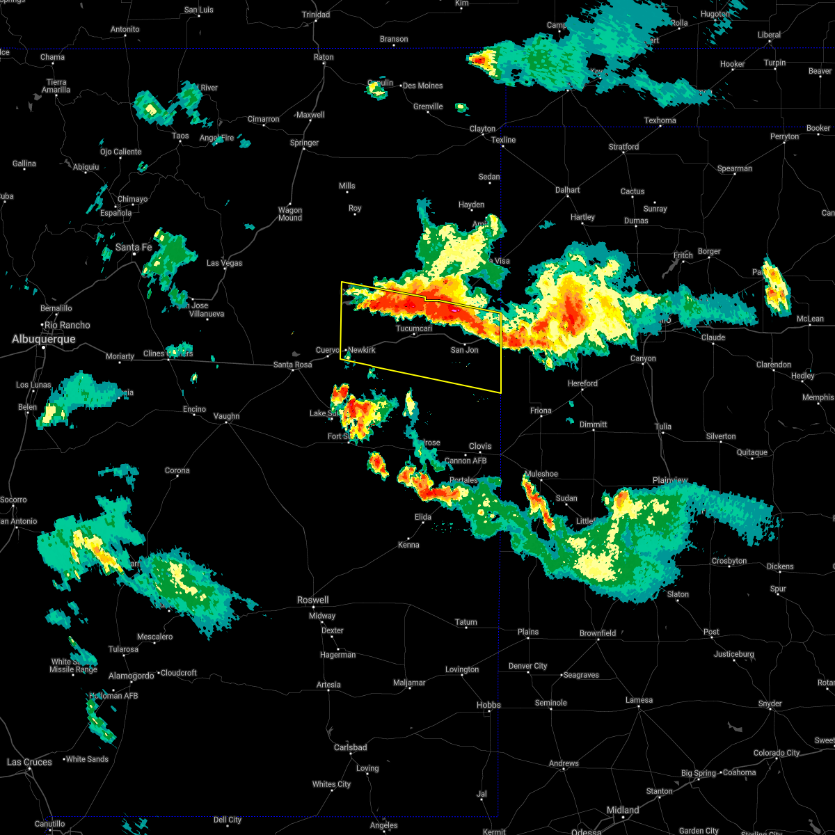 At 1022 pm mdt, severe thunderstorms were located along a line extending from conchas dam to glenrio, moving south at 30 mph (radar indicated). Hazards include 60 mph wind gusts and penny size hail. expect damage to roofs, siding, and trees At 1022 pm mdt, severe thunderstorms were located along a line extending from conchas dam to glenrio, moving south at 30 mph (radar indicated). Hazards include 60 mph wind gusts and penny size hail. expect damage to roofs, siding, and trees
|
| 7/4/2021 8:35 PM MDT |
 At 834 pm mdt, a severe thunderstorm was located 7 miles northeast of montoya, or 13 miles west of tucumcari, moving southeast at 10 mph (radar indicated). Hazards include golf ball size hail and 70 mph wind gusts. People and animals outdoors will be injured. expect hail damage to roofs, siding, windows, and vehicles. expect considerable tree damage. Wind damage is also likely to mobile homes, roofs, and outbuildings. At 834 pm mdt, a severe thunderstorm was located 7 miles northeast of montoya, or 13 miles west of tucumcari, moving southeast at 10 mph (radar indicated). Hazards include golf ball size hail and 70 mph wind gusts. People and animals outdoors will be injured. expect hail damage to roofs, siding, windows, and vehicles. expect considerable tree damage. Wind damage is also likely to mobile homes, roofs, and outbuildings.
|
| 6/26/2021 4:14 PM MDT |
 At 413 pm mdt, a severe thunderstorm was located near logan, or 21 miles northeast of tucumcari, moving southeast at 20 mph (radar indicated). Hazards include ping pong ball size hail and 60 mph wind gusts. People and animals outdoors will be injured. expect hail damage to roofs, siding, windows, and vehicles. expect wind damage to roofs, siding, and trees. locations impacted include, tucumcari and logan. This includes interstate 40 between mile markers 336 and 344. At 413 pm mdt, a severe thunderstorm was located near logan, or 21 miles northeast of tucumcari, moving southeast at 20 mph (radar indicated). Hazards include ping pong ball size hail and 60 mph wind gusts. People and animals outdoors will be injured. expect hail damage to roofs, siding, windows, and vehicles. expect wind damage to roofs, siding, and trees. locations impacted include, tucumcari and logan. This includes interstate 40 between mile markers 336 and 344.
|
| 6/26/2021 4:07 PM MDT |
 At 405 pm mdt, severe thunderstorms were located along a line extending from 7 miles west of tucumcari to 10 miles west of quay to 10 miles northwest of house, moving southeast at 30 mph. outflow winds along the gust front ahead of the storms could reach 60 mph (radar indicated). Hazards include 60 mph wind gusts. expect damage to roofs, siding, and trees At 405 pm mdt, severe thunderstorms were located along a line extending from 7 miles west of tucumcari to 10 miles west of quay to 10 miles northwest of house, moving southeast at 30 mph. outflow winds along the gust front ahead of the storms could reach 60 mph (radar indicated). Hazards include 60 mph wind gusts. expect damage to roofs, siding, and trees
|
| 6/26/2021 3:47 PM MDT |
 At 346 pm mdt, a severe thunderstorm was located over ute lake state park, or 22 miles northeast of tucumcari, moving southeast at 20 mph. logan is in the path of this storm (radar indicated). Hazards include ping pong ball size hail and 60 mph wind gusts. People and animals outdoors will be injured. expect hail damage to roofs, siding, windows, and vehicles. expect wind damage to roofs, siding, and trees. locations impacted include, tucumcari, logan and ute lake state park. This includes interstate 40 between mile markers 336 and 344. At 346 pm mdt, a severe thunderstorm was located over ute lake state park, or 22 miles northeast of tucumcari, moving southeast at 20 mph. logan is in the path of this storm (radar indicated). Hazards include ping pong ball size hail and 60 mph wind gusts. People and animals outdoors will be injured. expect hail damage to roofs, siding, windows, and vehicles. expect wind damage to roofs, siding, and trees. locations impacted include, tucumcari, logan and ute lake state park. This includes interstate 40 between mile markers 336 and 344.
|
| 6/26/2021 3:30 PM MDT |
 At 329 pm mdt, a severe thunderstorm was located near ute lake state park, or 21 miles northeast of tucumcari, moving southeast at 20 mph (radar indicated). Hazards include 60 mph wind gusts and quarter size hail. Hail damage to vehicles is expected. Expect wind damage to roofs, siding, and trees. At 329 pm mdt, a severe thunderstorm was located near ute lake state park, or 21 miles northeast of tucumcari, moving southeast at 20 mph (radar indicated). Hazards include 60 mph wind gusts and quarter size hail. Hail damage to vehicles is expected. Expect wind damage to roofs, siding, and trees.
|
| 6/25/2021 8:08 PM MDT | Ktcc aso in quay county NM, 6.8 miles WSW of Tucumcari, NM |
| 6/12/2021 8:53 PM MDT |
 The severe thunderstorm warning for northwestern roosevelt, southeastern san miguel, northeastern de baca, southwestern quay, west central curry and northeastern guadalupe counties will expire at 900 pm mdt, the storms which prompted the warning have moved out of the area. therefore, the warning will be allowed to expire. however small hail is still possible with these thunderstorms. a severe thunderstorm watch remains in effect until 1000 pm mdt for northeastern and east central new mexico. The severe thunderstorm warning for northwestern roosevelt, southeastern san miguel, northeastern de baca, southwestern quay, west central curry and northeastern guadalupe counties will expire at 900 pm mdt, the storms which prompted the warning have moved out of the area. therefore, the warning will be allowed to expire. however small hail is still possible with these thunderstorms. a severe thunderstorm watch remains in effect until 1000 pm mdt for northeastern and east central new mexico.
|
| 6/12/2021 8:31 PM MDT | Ktcc aso in quay county NM, 6.8 miles WSW of Tucumcari, NM |
| 6/12/2021 8:00 PM MDT |
 At 800 pm mdt, severe thunderstorms were located along a line extending from near montoya to 9 miles south of taiban, moving east at 15 mph (radar indicated). Hazards include 60 mph wind gusts and half dollar size hail. Hail damage to vehicles is expected. Expect wind damage to roofs, siding, and trees. At 800 pm mdt, severe thunderstorms were located along a line extending from near montoya to 9 miles south of taiban, moving east at 15 mph (radar indicated). Hazards include 60 mph wind gusts and half dollar size hail. Hail damage to vehicles is expected. Expect wind damage to roofs, siding, and trees.
|
| 6/2/2021 5:53 PM MDT | Ktcc aso in quay county NM, 6.8 miles WSW of Tucumcari, NM |
| 5/28/2021 5:01 PM MDT |
 The national weather service in albuquerque has issued a * severe thunderstorm warning for. central quay county in east central new mexico. north central curry county in east central new mexico. until 600 pm mdt. At 501 pm mdt, a severe thunderstorm was located 7 miles west of. The national weather service in albuquerque has issued a * severe thunderstorm warning for. central quay county in east central new mexico. north central curry county in east central new mexico. until 600 pm mdt. At 501 pm mdt, a severe thunderstorm was located 7 miles west of.
|
| 5/28/2021 5:00 PM MDT | Quarter sized hail reported 15.1 miles N of Tucumcari, NM, on highway 209 |
| 5/28/2021 4:38 PM MDT |
 At 438 pm mdt, a severe thunderstorm was located 8 miles east of montoya, or 12 miles southwest of tucumcari, moving southeast at 5 mph (radar indicated). Hazards include 60 mph wind gusts and quarter size hail. Hail damage to vehicles is expected. expect wind damage to roofs, siding, and trees. locations impacted include, quay and tucumcari. This includes interstate 40 between mile markers 319 and 327. At 438 pm mdt, a severe thunderstorm was located 8 miles east of montoya, or 12 miles southwest of tucumcari, moving southeast at 5 mph (radar indicated). Hazards include 60 mph wind gusts and quarter size hail. Hail damage to vehicles is expected. expect wind damage to roofs, siding, and trees. locations impacted include, quay and tucumcari. This includes interstate 40 between mile markers 319 and 327.
|
| 5/28/2021 4:22 PM MDT |
 At 422 pm mdt, a severe thunderstorm was located 8 miles east of montoya, or 11 miles southwest of tucumcari, moving southeast at 5 mph (radar indicated). Hazards include golf ball size hail and 60 mph wind gusts. People and animals outdoors will be injured. expect hail damage to roofs, siding, windows, and vehicles. expect wind damage to roofs, siding, and trees. locations impacted include, quay and tucumcari. This includes interstate 40 between mile markers 316 and 327. At 422 pm mdt, a severe thunderstorm was located 8 miles east of montoya, or 11 miles southwest of tucumcari, moving southeast at 5 mph (radar indicated). Hazards include golf ball size hail and 60 mph wind gusts. People and animals outdoors will be injured. expect hail damage to roofs, siding, windows, and vehicles. expect wind damage to roofs, siding, and trees. locations impacted include, quay and tucumcari. This includes interstate 40 between mile markers 316 and 327.
|
| 5/28/2021 4:15 PM MDT | Quarter sized hail reported 14.1 miles ENE of Tucumcari, NM, along i-40 |
| 5/28/2021 4:13 PM MDT |
 At 413 pm mdt, a severe thunderstorm was located 7 miles east of montoya, or 11 miles west of tucumcari, moving southeast at 5 mph (radar indicated). Hazards include 60 mph wind gusts and quarter size hail. Hail damage to vehicles is expected. Expect wind damage to roofs, siding, and trees. At 413 pm mdt, a severe thunderstorm was located 7 miles east of montoya, or 11 miles west of tucumcari, moving southeast at 5 mph (radar indicated). Hazards include 60 mph wind gusts and quarter size hail. Hail damage to vehicles is expected. Expect wind damage to roofs, siding, and trees.
|
| 5/22/2021 8:49 PM MDT |
 At 849 pm mdt, severe thunderstorms were located along a line extending from 9 miles north of tucumcari to 7 miles southeast of san jon, moving north at 30 mph (radar indicated). Hazards include 70 mph wind gusts. Expect considerable tree damage. Damage is likely to mobile homes, roofs, and outbuildings. At 849 pm mdt, severe thunderstorms were located along a line extending from 9 miles north of tucumcari to 7 miles southeast of san jon, moving north at 30 mph (radar indicated). Hazards include 70 mph wind gusts. Expect considerable tree damage. Damage is likely to mobile homes, roofs, and outbuildings.
|
| 5/22/2021 8:40 PM MDT | Ktcc aso in quay county NM, 6.8 miles WSW of Tucumcari, NM |
| 5/21/2021 9:20 PM MDT |
 At 919 pm mdt, a severe thunderstorm was located 8 miles east of tucumcari, moving north at 50 mph. this is a very dangerous storm (radar indicated). Hazards include 80 mph wind gusts and quarter size hail. Flying debris will be dangerous to those caught without shelter. mobile homes will be heavily damaged. expect considerable damage to roofs, windows, and vehicles. extensive tree damage and power outages are likely. locations impacted include, tucumcari, logan and ute lake state park. This includes interstate 40 between mile markers 333 and 349. At 919 pm mdt, a severe thunderstorm was located 8 miles east of tucumcari, moving north at 50 mph. this is a very dangerous storm (radar indicated). Hazards include 80 mph wind gusts and quarter size hail. Flying debris will be dangerous to those caught without shelter. mobile homes will be heavily damaged. expect considerable damage to roofs, windows, and vehicles. extensive tree damage and power outages are likely. locations impacted include, tucumcari, logan and ute lake state park. This includes interstate 40 between mile markers 333 and 349.
|
| 5/21/2021 9:16 PM MDT | Ktcc aso in quay county NM, 6.8 miles WSW of Tucumcari, NM |
| 5/21/2021 9:08 PM MDT |
 At 908 pm mdt, a severe thunderstorm was located 8 miles southeast of tucumcari, moving north at 50 mph (radar indicated). Hazards include 70 mph wind gusts and half dollar size hail. Hail damage to vehicles is expected. expect considerable tree damage. Wind damage is also likely to mobile homes, roofs, and outbuildings. At 908 pm mdt, a severe thunderstorm was located 8 miles southeast of tucumcari, moving north at 50 mph (radar indicated). Hazards include 70 mph wind gusts and half dollar size hail. Hail damage to vehicles is expected. expect considerable tree damage. Wind damage is also likely to mobile homes, roofs, and outbuildings.
|
| 5/15/2021 5:16 PM MDT |
 At 515 pm mdt, severe thunderstorms were located along a line extending from near ute lake state park to 8 miles southwest of wheatland, moving east at 20 mph (radar indicated). Hazards include 60 mph wind gusts and quarter size hail. Hail damage to vehicles is expected. expect wind damage to roofs, siding, and trees. locations impacted include, logan, san jon, grady, ute lake state park, broadview, wheatland, forrest and bard. This includes interstate 40 between mile markers 339 and 364. At 515 pm mdt, severe thunderstorms were located along a line extending from near ute lake state park to 8 miles southwest of wheatland, moving east at 20 mph (radar indicated). Hazards include 60 mph wind gusts and quarter size hail. Hail damage to vehicles is expected. expect wind damage to roofs, siding, and trees. locations impacted include, logan, san jon, grady, ute lake state park, broadview, wheatland, forrest and bard. This includes interstate 40 between mile markers 339 and 364.
|
| 5/15/2021 4:48 PM MDT |
 At 447 pm mdt, severe thunderstorms were located along a line extending from 6 miles west of ute lake state park to 7 miles east of ragland, moving east at 20 mph (radar indicated). Hazards include 60 mph wind gusts and nickel size hail. expect damage to roofs, siding, and trees At 447 pm mdt, severe thunderstorms were located along a line extending from 6 miles west of ute lake state park to 7 miles east of ragland, moving east at 20 mph (radar indicated). Hazards include 60 mph wind gusts and nickel size hail. expect damage to roofs, siding, and trees
|
| 5/15/2021 4:39 PM MDT | Ktcc aso in quay county NM, 6.8 miles WSW of Tucumcari, NM |
| 3/13/2021 11:23 AM MST |
 At 1123 am mst, a severe thunderstorm was located over tucumcari, moving north at 55 mph (radar indicated). Hazards include 70 mph wind gusts and quarter size hail. Hail damage to vehicles is expected. expect considerable tree damage. Wind damage is also likely to mobile homes, roofs, and outbuildings. At 1123 am mst, a severe thunderstorm was located over tucumcari, moving north at 55 mph (radar indicated). Hazards include 70 mph wind gusts and quarter size hail. Hail damage to vehicles is expected. expect considerable tree damage. Wind damage is also likely to mobile homes, roofs, and outbuildings.
|
| 3/13/2021 8:01 AM MST |
 At 759 am mst, a severe thunderstorm was located 13 miles north of tucumcari, moving northeast at 45 mph (radar indicated). Hazards include 70 mph wind gusts and penny size hail. Expect considerable tree damage. Damage is likely to mobile homes, roofs, and outbuildings. At 759 am mst, a severe thunderstorm was located 13 miles north of tucumcari, moving northeast at 45 mph (radar indicated). Hazards include 70 mph wind gusts and penny size hail. Expect considerable tree damage. Damage is likely to mobile homes, roofs, and outbuildings.
|
| 7/31/2020 8:58 PM MDT |
 The severe thunderstorm warning for southeastern san miguel, southeastern harding, west central quay and northeastern guadalupe counties will expire at 900 pm mdt, the storms which prompted the warning have weakened below severe limits, and no longer pose an immediate threat to life or property. therefore, the warning will be allowed to expire. however small hail, gusty winds and heavy rain are still possible with these thunderstorms. a severe thunderstorm watch remains in effect until 1000 pm mdt for northeastern and east central new mexico. The severe thunderstorm warning for southeastern san miguel, southeastern harding, west central quay and northeastern guadalupe counties will expire at 900 pm mdt, the storms which prompted the warning have weakened below severe limits, and no longer pose an immediate threat to life or property. therefore, the warning will be allowed to expire. however small hail, gusty winds and heavy rain are still possible with these thunderstorms. a severe thunderstorm watch remains in effect until 1000 pm mdt for northeastern and east central new mexico.
|
| 7/31/2020 8:30 PM MDT |
 At 830 pm mdt, severe thunderstorms were located along a line extending from 11 miles northwest of ute lake state park to near conchas, moving southeast at 40 mph (radar indicated). Hazards include 60 mph wind gusts and quarter size hail. Hail damage to vehicles is expected. expect wind damage to roofs, siding, and trees. locations impacted include, tucumcari, logan, montoya, conchas, ute lake state park, conchas lake state park, conchas dam and bell ranch. this includes the following highways, interstate 40 between mile markers 302 and 354. State road 104 between mile markers 63 and 105. At 830 pm mdt, severe thunderstorms were located along a line extending from 11 miles northwest of ute lake state park to near conchas, moving southeast at 40 mph (radar indicated). Hazards include 60 mph wind gusts and quarter size hail. Hail damage to vehicles is expected. expect wind damage to roofs, siding, and trees. locations impacted include, tucumcari, logan, montoya, conchas, ute lake state park, conchas lake state park, conchas dam and bell ranch. this includes the following highways, interstate 40 between mile markers 302 and 354. State road 104 between mile markers 63 and 105.
|
| 7/31/2020 8:08 PM MDT |
 At 808 pm mdt, severe thunderstorms were located along a line extending from 10 miles south of bueyeros to 12 miles northeast of conchas dam to 6 miles west of variadero, moving southeast at 50 mph (radar indicated). Hazards include 60 mph wind gusts and quarter size hail. Hail damage to vehicles is expected. Expect wind damage to roofs, siding, and trees. At 808 pm mdt, severe thunderstorms were located along a line extending from 10 miles south of bueyeros to 12 miles northeast of conchas dam to 6 miles west of variadero, moving southeast at 50 mph (radar indicated). Hazards include 60 mph wind gusts and quarter size hail. Hail damage to vehicles is expected. Expect wind damage to roofs, siding, and trees.
|
| 7/15/2020 7:32 PM MDT |
 At 730 pm mdt, severe thunderstorms were located along a line extending from 17 miles east of conchas dam to near san jon, moving northeast at 35 mph (automated surface weather observation system at the tucumcari airport measured a 63 mph thunderstorm wind gust). Hazards include 60 mph wind gusts and half dollar size hail. Hail damage to vehicles is expected. expect wind damage to roofs, siding, and trees. locations impacted include, logan, san jon, glenrio, ute lake state park and bard. This includes interstate 40 between mile markers 337 and 373. At 730 pm mdt, severe thunderstorms were located along a line extending from 17 miles east of conchas dam to near san jon, moving northeast at 35 mph (automated surface weather observation system at the tucumcari airport measured a 63 mph thunderstorm wind gust). Hazards include 60 mph wind gusts and half dollar size hail. Hail damage to vehicles is expected. expect wind damage to roofs, siding, and trees. locations impacted include, logan, san jon, glenrio, ute lake state park and bard. This includes interstate 40 between mile markers 337 and 373.
|
| 7/15/2020 7:14 PM MDT |
 At 714 pm mdt, severe thunderstorms were located along a line extending from 13 miles east of conchas to 8 miles southwest of san jon, moving northeast at 35 mph (radar indicated). Hazards include 60 mph wind gusts and quarter size hail. Hail damage to vehicles is expected. Expect wind damage to roofs, siding, and trees. At 714 pm mdt, severe thunderstorms were located along a line extending from 13 miles east of conchas to 8 miles southwest of san jon, moving northeast at 35 mph (radar indicated). Hazards include 60 mph wind gusts and quarter size hail. Hail damage to vehicles is expected. Expect wind damage to roofs, siding, and trees.
|
| 7/15/2020 7:11 PM MDT | Ktcc aso in quay county NM, 6.8 miles WSW of Tucumcari, NM |
| 7/11/2020 7:43 PM MDT |
 At 743 pm mdt, a severe thunderstorm was located 8 miles northeast of tucumcari, moving northeast at 15 mph (radar indicated). Hazards include 60 mph wind gusts and quarter size hail. Hail damage to vehicles is expected. expect wind damage to roofs, siding, and trees. locations impacted include, tucumcari and logan. this includes the following highways, interstate 40 between mile markers 331 and 353. State road 104 between mile markers 104 and 105. At 743 pm mdt, a severe thunderstorm was located 8 miles northeast of tucumcari, moving northeast at 15 mph (radar indicated). Hazards include 60 mph wind gusts and quarter size hail. Hail damage to vehicles is expected. expect wind damage to roofs, siding, and trees. locations impacted include, tucumcari and logan. this includes the following highways, interstate 40 between mile markers 331 and 353. State road 104 between mile markers 104 and 105.
|
| 7/11/2020 7:19 PM MDT |
 At 719 pm mdt, a severe thunderstorm was located over tucumcari, moving northeast at 20 mph (radar indicated). Hazards include 60 mph wind gusts and half dollar size hail. Hail damage to vehicles is expected. Expect wind damage to roofs, siding, and trees. At 719 pm mdt, a severe thunderstorm was located over tucumcari, moving northeast at 20 mph (radar indicated). Hazards include 60 mph wind gusts and half dollar size hail. Hail damage to vehicles is expected. Expect wind damage to roofs, siding, and trees.
|
| 6/26/2020 6:03 PM MDT | Ktcc asos. related to thunderstorm outflo in quay county NM, 6.8 miles WSW of Tucumcari, NM |
| 6/25/2020 7:28 PM MDT | Ktcc aso in quay county NM, 6.8 miles WSW of Tucumcari, NM |
| 5/10/2020 10:28 PM MDT |
 At 1028 pm mdt, severe thunderstorms were located along a line extending from 6 miles south of tucumcari to 7 miles west of quay, moving southeast at 20 mph (radar indicated). Hazards include golf ball size hail and 70 mph wind gusts. People and animals outdoors will be injured. expect hail damage to roofs, siding, windows, and vehicles. expect considerable tree damage. wind damage is also likely to mobile homes, roofs, and outbuildings. locations impacted include, quay, tucumcari, house, ragland, wheatland, forrest and mcalister. this includes the following highways, interstate 40 between mile markers 321 and 336. State road 104 between mile markers 104 and 105. At 1028 pm mdt, severe thunderstorms were located along a line extending from 6 miles south of tucumcari to 7 miles west of quay, moving southeast at 20 mph (radar indicated). Hazards include golf ball size hail and 70 mph wind gusts. People and animals outdoors will be injured. expect hail damage to roofs, siding, windows, and vehicles. expect considerable tree damage. wind damage is also likely to mobile homes, roofs, and outbuildings. locations impacted include, quay, tucumcari, house, ragland, wheatland, forrest and mcalister. this includes the following highways, interstate 40 between mile markers 321 and 336. State road 104 between mile markers 104 and 105.
|
| 5/10/2020 10:09 PM MDT |
 At 1008 pm mdt, severe thunderstorms were located along a line extending from near tucumcari to near montoya, moving southeast at 20 mph (radar indicated). Hazards include 70 mph wind gusts and quarter size hail. Hail damage to vehicles is expected. expect considerable tree damage. Wind damage is also likely to mobile homes, roofs, and outbuildings. At 1008 pm mdt, severe thunderstorms were located along a line extending from near tucumcari to near montoya, moving southeast at 20 mph (radar indicated). Hazards include 70 mph wind gusts and quarter size hail. Hail damage to vehicles is expected. expect considerable tree damage. Wind damage is also likely to mobile homes, roofs, and outbuildings.
|
| 5/10/2020 10:05 PM MDT |
 At 1004 pm mdt, severe thunderstorms were located along a line extending from near tucumcari to 7 miles southeast of montoya, moving southeast at 25 mph (radar indicated). Hazards include 70 mph wind gusts and nickel size hail. Expect considerable tree damage. damage is likely to mobile homes, roofs, and outbuildings. locations impacted include, quay and tucumcari. this includes the following highways, interstate 40 between mile markers 316 and 352. State road 104 between mile markers 94 and 105. At 1004 pm mdt, severe thunderstorms were located along a line extending from near tucumcari to 7 miles southeast of montoya, moving southeast at 25 mph (radar indicated). Hazards include 70 mph wind gusts and nickel size hail. Expect considerable tree damage. damage is likely to mobile homes, roofs, and outbuildings. locations impacted include, quay and tucumcari. this includes the following highways, interstate 40 between mile markers 316 and 352. State road 104 between mile markers 94 and 105.
|
| 5/10/2020 9:50 PM MDT |
 At 949 pm mdt, severe thunderstorms were located along a line extending from 9 miles northwest of tucumcari to near montoya, moving southeast at 15 mph (radar indicated). Hazards include 70 mph wind gusts and nickel size hail. Expect considerable tree damage. damage is likely to mobile homes, roofs, and outbuildings. locations impacted include, quay, tucumcari, logan and ute lake state park. this includes the following highways, interstate 40 between mile markers 315 and 352. State road 104 between mile markers 84 and 105. At 949 pm mdt, severe thunderstorms were located along a line extending from 9 miles northwest of tucumcari to near montoya, moving southeast at 15 mph (radar indicated). Hazards include 70 mph wind gusts and nickel size hail. Expect considerable tree damage. damage is likely to mobile homes, roofs, and outbuildings. locations impacted include, quay, tucumcari, logan and ute lake state park. this includes the following highways, interstate 40 between mile markers 315 and 352. State road 104 between mile markers 84 and 105.
|
| 5/10/2020 9:14 PM MDT |
 At 913 pm mdt, severe thunderstorms were located along a line extending from 18 miles east of conchas dam to 7 miles southeast of conchas, moving southeast at 25 mph (radar indicated). Hazards include 70 mph wind gusts and quarter size hail. Hail damage to vehicles is expected. expect considerable tree damage. Wind damage is also likely to mobile homes, roofs, and outbuildings. At 913 pm mdt, severe thunderstorms were located along a line extending from 18 miles east of conchas dam to 7 miles southeast of conchas, moving southeast at 25 mph (radar indicated). Hazards include 70 mph wind gusts and quarter size hail. Hail damage to vehicles is expected. expect considerable tree damage. Wind damage is also likely to mobile homes, roofs, and outbuildings.
|
| 8/23/2019 7:27 PM MDT |
 At 726 pm mdt, a severe thunderstorm was located near tucumcari, moving east at 30 mph (radar indicated). Hazards include 60 mph wind gusts and quarter size hail. Hail damage to vehicles is expected. expect wind damage to roofs, siding, and trees. locations impacted include, tucumcari, logan and ute lake state park. This includes interstate 40 between mile markers 320 and 351. At 726 pm mdt, a severe thunderstorm was located near tucumcari, moving east at 30 mph (radar indicated). Hazards include 60 mph wind gusts and quarter size hail. Hail damage to vehicles is expected. expect wind damage to roofs, siding, and trees. locations impacted include, tucumcari, logan and ute lake state park. This includes interstate 40 between mile markers 320 and 351.
|
| 8/23/2019 6:56 PM MDT |
 At 656 pm mdt, a severe thunderstorm was located 14 miles northwest of tucumcari, moving east at 30 mph (radar indicated). Hazards include 60 mph wind gusts and quarter size hail. Hail damage to vehicles is expected. Expect wind damage to roofs, siding, and trees. At 656 pm mdt, a severe thunderstorm was located 14 miles northwest of tucumcari, moving east at 30 mph (radar indicated). Hazards include 60 mph wind gusts and quarter size hail. Hail damage to vehicles is expected. Expect wind damage to roofs, siding, and trees.
|
| 8/14/2019 4:10 AM MDT |
 At 408 am mdt, a severe thunderstorm was located 7 miles southwest of ute lake state park, or 12 miles northeast of tucumcari, moving southeast at 10 mph (radar indicated). Hazards include 60 mph wind gusts and half dollar size hail. Hail damage to vehicles is expected. expect wind damage to roofs, siding, and trees. this severe thunderstorm will remain over mainly rural areas of central quay county. this includes interstate 40 between mile markers 341 and 352, and u. s. Highway 54 from tucumcari to logan. At 408 am mdt, a severe thunderstorm was located 7 miles southwest of ute lake state park, or 12 miles northeast of tucumcari, moving southeast at 10 mph (radar indicated). Hazards include 60 mph wind gusts and half dollar size hail. Hail damage to vehicles is expected. expect wind damage to roofs, siding, and trees. this severe thunderstorm will remain over mainly rural areas of central quay county. this includes interstate 40 between mile markers 341 and 352, and u. s. Highway 54 from tucumcari to logan.
|
| 7/10/2019 4:36 PM MDT |
 At 421 pm mdt, a severe thunderstorm was located over tucumcari, moving southwest at 15 mph (radar indicated). Hazards include 60 mph wind gusts and half dollar size hail. Hail damage to vehicles is expected. Expect wind damage to roofs, siding, and trees. At 421 pm mdt, a severe thunderstorm was located over tucumcari, moving southwest at 15 mph (radar indicated). Hazards include 60 mph wind gusts and half dollar size hail. Hail damage to vehicles is expected. Expect wind damage to roofs, siding, and trees.
|
| 7/10/2019 4:32 PM MDT |
 At 421 pm mdt, a severe thunderstorm was located over tucumcari, moving southwest at 15 mph (radar indicated). Hazards include 60 mph wind gusts and half dollar size hail. Hail damage to vehicles is expected. Expect wind damage to roofs, siding, and trees. At 421 pm mdt, a severe thunderstorm was located over tucumcari, moving southwest at 15 mph (radar indicated). Hazards include 60 mph wind gusts and half dollar size hail. Hail damage to vehicles is expected. Expect wind damage to roofs, siding, and trees.
|
| 7/10/2019 4:22 PM MDT |
 At 421 pm mdt, a severe thunderstorm was located over tucumcari, moving southwest at 15 mph (radar indicated). Hazards include 60 mph wind gusts and half dollar size hail. Hail damage to vehicles is expected. Expect wind damage to roofs, siding, and trees. At 421 pm mdt, a severe thunderstorm was located over tucumcari, moving southwest at 15 mph (radar indicated). Hazards include 60 mph wind gusts and half dollar size hail. Hail damage to vehicles is expected. Expect wind damage to roofs, siding, and trees.
|
| 5/30/2019 5:13 PM MDT | Ktcc aso in quay county NM, 6.8 miles WSW of Tucumcari, NM |
| 5/26/2019 5:54 PM MDT | Ktcc aso in quay county NM, 6.8 miles WSW of Tucumcari, NM |
| 5/26/2019 5:53 PM MDT |
 At 553 pm mdt, severe thunderstorms were located along a line extending from 10 miles south of ute lake state park to 7 miles southeast of ragland, moving east at 50 mph (radar indicated). Hazards include 70 mph wind gusts and quarter size hail. Hail damage to vehicles is expected. expect considerable tree damage. Wind damage is also likely to mobile homes, roofs, and outbuildings. At 553 pm mdt, severe thunderstorms were located along a line extending from 10 miles south of ute lake state park to 7 miles southeast of ragland, moving east at 50 mph (radar indicated). Hazards include 70 mph wind gusts and quarter size hail. Hail damage to vehicles is expected. expect considerable tree damage. Wind damage is also likely to mobile homes, roofs, and outbuildings.
|
| 5/26/2019 5:52 PM MDT | Ktcc aso in quay county NM, 6.8 miles WSW of Tucumcari, NM |
| 5/26/2019 5:30 PM MDT | Roof blown off a barn along sr-278 in quay county NM, 7.2 miles WNW of Tucumcari, NM |
| 5/26/2019 5:11 PM MDT |
 At 511 pm mdt, severe thunderstorms were located along a line extending from 15 miles east of mosquero to 7 miles south of tucumcari, moving northeast at 30 mph (radar indicated). Hazards include 70 mph wind gusts and quarter size hail. Hail damage to vehicles is expected. expect considerable tree damage. wind damage is also likely to mobile homes, roofs, and outbuildings. locations impacted include, tucumcari. this includes interstate 40 between mile markers 319 and 343. A tornado watch remains in effect until 900 pm mdt for northeastern and east central new mexico. At 511 pm mdt, severe thunderstorms were located along a line extending from 15 miles east of mosquero to 7 miles south of tucumcari, moving northeast at 30 mph (radar indicated). Hazards include 70 mph wind gusts and quarter size hail. Hail damage to vehicles is expected. expect considerable tree damage. wind damage is also likely to mobile homes, roofs, and outbuildings. locations impacted include, tucumcari. this includes interstate 40 between mile markers 319 and 343. A tornado watch remains in effect until 900 pm mdt for northeastern and east central new mexico.
|
| 5/26/2019 4:53 PM MDT |
 At 453 pm mdt, severe thunderstorms were located along a line extending from 17 miles southeast of mosquero to 11 miles south of montoya, moving northeast at 40 mph (radar indicated). Hazards include 70 mph wind gusts and quarter size hail. Hail damage to vehicles is expected. expect considerable tree damage. Wind damage is also likely to mobile homes, roofs, and outbuildings. At 453 pm mdt, severe thunderstorms were located along a line extending from 17 miles southeast of mosquero to 11 miles south of montoya, moving northeast at 40 mph (radar indicated). Hazards include 70 mph wind gusts and quarter size hail. Hail damage to vehicles is expected. expect considerable tree damage. Wind damage is also likely to mobile homes, roofs, and outbuildings.
|
| 5/20/2019 1:22 AM MDT |
 At 122 am mdt, a severe thunderstorm was located 10 miles southeast of tucumcari, moving northeast at 60 mph (radar indicated). Hazards include ping pong ball size hail and 60 mph wind gusts. People and animals outdoors will be injured. expect hail damage to roofs, siding, windows, and vehicles. Expect wind damage to roofs, siding, and trees. At 122 am mdt, a severe thunderstorm was located 10 miles southeast of tucumcari, moving northeast at 60 mph (radar indicated). Hazards include ping pong ball size hail and 60 mph wind gusts. People and animals outdoors will be injured. expect hail damage to roofs, siding, windows, and vehicles. Expect wind damage to roofs, siding, and trees.
|
| 5/20/2019 1:15 AM MDT | Golf Ball sized hail reported 11.7 miles NW of Tucumcari, NM |
| 5/8/2019 6:41 PM MDT |
 The severe thunderstorm warning for east central san miguel, southeastern harding and central quay counties will expire at 645 pm mdt, the storm which prompted the warning has weakened below severe limits, and no longer poses an immediate threat to life or property. therefore the warning will be allowed to expire. however small hail and gusty winds are still possible with this thunderstorm. to report severe weather, contact your nearest law enforcement agency. they will relay your report to the national weather service albuquerque. The severe thunderstorm warning for east central san miguel, southeastern harding and central quay counties will expire at 645 pm mdt, the storm which prompted the warning has weakened below severe limits, and no longer poses an immediate threat to life or property. therefore the warning will be allowed to expire. however small hail and gusty winds are still possible with this thunderstorm. to report severe weather, contact your nearest law enforcement agency. they will relay your report to the national weather service albuquerque.
|
| 5/8/2019 6:32 PM MDT |
 At 632 pm mdt, a severe thunderstorm was located near tucumcari, moving southeast at 25 mph (radar indicated). Hazards include 60 mph wind gusts and quarter size hail. Hail damage to vehicles is expected. expect wind damage to roofs, siding, and trees. locations impacted include, tucumcari, logan and ute lake state park. This includes interstate 40 between mile markers 331 and 342. At 632 pm mdt, a severe thunderstorm was located near tucumcari, moving southeast at 25 mph (radar indicated). Hazards include 60 mph wind gusts and quarter size hail. Hail damage to vehicles is expected. expect wind damage to roofs, siding, and trees. locations impacted include, tucumcari, logan and ute lake state park. This includes interstate 40 between mile markers 331 and 342.
|
| 5/8/2019 5:49 PM MDT |
 At 548 pm mdt, a severe thunderstorm was located 12 miles east of conchas dam, or 21 miles south of mosquero, moving southeast at 25 mph (radar indicated). Hazards include 60 mph wind gusts and quarter size hail. Hail damage to vehicles is expected. Expect wind damage to roofs, siding, and trees. At 548 pm mdt, a severe thunderstorm was located 12 miles east of conchas dam, or 21 miles south of mosquero, moving southeast at 25 mph (radar indicated). Hazards include 60 mph wind gusts and quarter size hail. Hail damage to vehicles is expected. Expect wind damage to roofs, siding, and trees.
|
| 5/5/2019 2:04 PM MDT | Quarter sized hail reported 1.6 miles SE of Tucumcari, NM |
| 3/12/2019 7:38 PM MDT |
 At 737 pm mdt, a severe thunderstorm capable of producing a tornado was located 8 miles east of tucumcari, moving north at 35 mph (radar indicated rotation). Hazards include tornado. Flying debris will be dangerous to those caught without shelter. mobile homes will be damaged or destroyed. damage to roofs, windows, and vehicles will occur. tree damage is likely. this dangerous storm will be near, ute lake state park around 805 pm mdt. This includes interstate 40 between mile markers 333 and 350. At 737 pm mdt, a severe thunderstorm capable of producing a tornado was located 8 miles east of tucumcari, moving north at 35 mph (radar indicated rotation). Hazards include tornado. Flying debris will be dangerous to those caught without shelter. mobile homes will be damaged or destroyed. damage to roofs, windows, and vehicles will occur. tree damage is likely. this dangerous storm will be near, ute lake state park around 805 pm mdt. This includes interstate 40 between mile markers 333 and 350.
|
| 3/12/2019 7:37 PM MDT | Ktcc aso in quay county NM, 6.8 miles WSW of Tucumcari, NM |
| 3/12/2019 7:27 PM MDT |
 At 726 pm mdt, a severe thunderstorm capable of producing a tornado was located 12 miles northeast of quay, or 12 miles southeast of tucumcari, moving north at 35 mph (radar indicated rotation). Hazards include tornado. Flying debris will be dangerous to those caught without shelter. mobile homes will be damaged or destroyed. damage to roofs, windows, and vehicles will occur. tree damage is likely. this dangerous storm will be near, tucumcari around 740 pm mdt. ute lake state park around 805 pm mdt. This includes interstate 40 between mile markers 333 and 350. At 726 pm mdt, a severe thunderstorm capable of producing a tornado was located 12 miles northeast of quay, or 12 miles southeast of tucumcari, moving north at 35 mph (radar indicated rotation). Hazards include tornado. Flying debris will be dangerous to those caught without shelter. mobile homes will be damaged or destroyed. damage to roofs, windows, and vehicles will occur. tree damage is likely. this dangerous storm will be near, tucumcari around 740 pm mdt. ute lake state park around 805 pm mdt. This includes interstate 40 between mile markers 333 and 350.
|
| 8/13/2018 8:11 PM MDT |
 The severe thunderstorm warning for west central quay county will expire at 815 pm mdt. the storm which prompted the warning has weakened below severe limits, and no longer poses an immediate threat to life or property. therefore the warning will be allowed to expire. However small hail, gusty winds and heavy rain are still possible with this thunderstorm. The severe thunderstorm warning for west central quay county will expire at 815 pm mdt. the storm which prompted the warning has weakened below severe limits, and no longer poses an immediate threat to life or property. therefore the warning will be allowed to expire. However small hail, gusty winds and heavy rain are still possible with this thunderstorm.
|
| 8/13/2018 7:54 PM MDT |
 At 753 pm mdt, a severe thunderstorm was located near tucumcari, moving south at 10 mph (radar indicated). Hazards include ping pong ball size hail and 60 mph wind gusts. People and animals outdoors will be injured. expect hail damage to roofs, siding, windows, and vehicles. expect wind damage to roofs, siding, and trees. locations impacted include, tucumcari. This includes interstate 40 between mile markers 321 and 334. At 753 pm mdt, a severe thunderstorm was located near tucumcari, moving south at 10 mph (radar indicated). Hazards include ping pong ball size hail and 60 mph wind gusts. People and animals outdoors will be injured. expect hail damage to roofs, siding, windows, and vehicles. expect wind damage to roofs, siding, and trees. locations impacted include, tucumcari. This includes interstate 40 between mile markers 321 and 334.
|
| 8/13/2018 7:32 PM MDT |
 At 732 pm mdt, a severe thunderstorm was located near tucumcari, moving south at 15 mph (radar indicated). Hazards include 60 mph wind gusts and quarter size hail. Hail damage to vehicles is expected. Expect wind damage to roofs, siding, and trees. At 732 pm mdt, a severe thunderstorm was located near tucumcari, moving south at 15 mph (radar indicated). Hazards include 60 mph wind gusts and quarter size hail. Hail damage to vehicles is expected. Expect wind damage to roofs, siding, and trees.
|
| 8/13/2018 7:14 PM MDT |
 At 713 pm mdt, a severe thunderstorm was located 7 miles northwest of tucumcari, moving south at 10 mph (radar indicated). Hazards include 60 mph wind gusts and quarter size hail. Hail damage to vehicles is expected. expect wind damage to roofs, siding, and trees. locations impacted include, tucumcari. This includes interstate 40 between mile markers 334 and 335. At 713 pm mdt, a severe thunderstorm was located 7 miles northwest of tucumcari, moving south at 10 mph (radar indicated). Hazards include 60 mph wind gusts and quarter size hail. Hail damage to vehicles is expected. expect wind damage to roofs, siding, and trees. locations impacted include, tucumcari. This includes interstate 40 between mile markers 334 and 335.
|
| 8/13/2018 6:50 PM MDT |
 At 650 pm mdt, a severe thunderstorm was located 11 miles northwest of tucumcari, moving south at 10 mph (radar indicated). Hazards include 60 mph wind gusts and half dollar size hail. Hail damage to vehicles is expected. Expect wind damage to roofs, siding, and trees. At 650 pm mdt, a severe thunderstorm was located 11 miles northwest of tucumcari, moving south at 10 mph (radar indicated). Hazards include 60 mph wind gusts and half dollar size hail. Hail damage to vehicles is expected. Expect wind damage to roofs, siding, and trees.
|
| 8/7/2018 9:20 PM MDT |
 At 920 pm mdt, a severe thunderstorm was located 10 miles north of tucumcari, and is nearly stationary (radar indicated). Hazards include ping pong ball size hail and 60 mph wind gusts. People and animals outdoors will be injured. expect hail damage to roofs, siding, windows, and vehicles. Expect wind damage to roofs, siding, and trees. At 920 pm mdt, a severe thunderstorm was located 10 miles north of tucumcari, and is nearly stationary (radar indicated). Hazards include ping pong ball size hail and 60 mph wind gusts. People and animals outdoors will be injured. expect hail damage to roofs, siding, windows, and vehicles. Expect wind damage to roofs, siding, and trees.
|
| 6/25/2018 12:05 AM MDT |
 At 1204 am mdt, a severe thunderstorm was located near logan, or 19 miles southwest of nara visa, moving east at 35 mph (radar indicated). Hazards include 60 mph wind gusts and quarter size hail. Hail damage to vehicles is expected. expect wind damage to roofs, siding, and trees. locations impacted include, logan, san jon, nara visa, glenrio, ute lake state park and bard. This includes interstate 40 between mile markers 337 and 373. At 1204 am mdt, a severe thunderstorm was located near logan, or 19 miles southwest of nara visa, moving east at 35 mph (radar indicated). Hazards include 60 mph wind gusts and quarter size hail. Hail damage to vehicles is expected. expect wind damage to roofs, siding, and trees. locations impacted include, logan, san jon, nara visa, glenrio, ute lake state park and bard. This includes interstate 40 between mile markers 337 and 373.
|
| 6/24/2018 11:43 PM MDT |
 At 1142 pm mdt, a severe thunderstorm was located 7 miles south of nara visa, moving east at 40 mph. another severe thunderstorm was located 10 miles north of tucumcari also moving east at 40 mph (radar indicated). Hazards include 70 mph wind gusts and ping pong ball size hail. People and animals outdoors will be injured. expect hail damage to roofs, siding, windows, and vehicles. expect considerable tree damage. Wind damage is also likely to mobile homes, roofs, and outbuildings. At 1142 pm mdt, a severe thunderstorm was located 7 miles south of nara visa, moving east at 40 mph. another severe thunderstorm was located 10 miles north of tucumcari also moving east at 40 mph (radar indicated). Hazards include 70 mph wind gusts and ping pong ball size hail. People and animals outdoors will be injured. expect hail damage to roofs, siding, windows, and vehicles. expect considerable tree damage. Wind damage is also likely to mobile homes, roofs, and outbuildings.
|
| 6/9/2018 1:16 AM MDT |
 At 115 am mdt, a severe thunderstorm was located 9 miles west of tucumcari, moving east at 10 mph (radar indicated). Hazards include 60 mph wind gusts and half dollar size hail. Hail damage to vehicles is expected. Expect wind damage to roofs, siding, and trees. At 115 am mdt, a severe thunderstorm was located 9 miles west of tucumcari, moving east at 10 mph (radar indicated). Hazards include 60 mph wind gusts and half dollar size hail. Hail damage to vehicles is expected. Expect wind damage to roofs, siding, and trees.
|
| 5/15/2018 4:52 PM MDT |
 At 451 pm mdt, a severe thunderstorm was located 9 miles northeast of quay, or 12 miles southeast of tucumcari, moving southeast at 35 mph (radar indicated). Hazards include 60 mph wind gusts and quarter size hail. Hail damage to vehicles is expected. expect wind damage to roofs, siding, and trees. locations impacted include, quay, tucumcari, san jon, wheatland and forrest. This includes interstate 40 between mile markers 331 and 361. At 451 pm mdt, a severe thunderstorm was located 9 miles northeast of quay, or 12 miles southeast of tucumcari, moving southeast at 35 mph (radar indicated). Hazards include 60 mph wind gusts and quarter size hail. Hail damage to vehicles is expected. expect wind damage to roofs, siding, and trees. locations impacted include, quay, tucumcari, san jon, wheatland and forrest. This includes interstate 40 between mile markers 331 and 361.
|
| 5/15/2018 4:25 PM MDT |
 At 425 pm mdt, a severe thunderstorm was located 9 miles west of tucumcari, moving southeast at 35 mph (radar indicated). Hazards include ping pong ball size hail and 60 mph wind gusts. People and animals outdoors will be injured. expect hail damage to roofs, siding, windows, and vehicles. Expect wind damage to roofs, siding, and trees. At 425 pm mdt, a severe thunderstorm was located 9 miles west of tucumcari, moving southeast at 35 mph (radar indicated). Hazards include ping pong ball size hail and 60 mph wind gusts. People and animals outdoors will be injured. expect hail damage to roofs, siding, windows, and vehicles. Expect wind damage to roofs, siding, and trees.
|
| 5/15/2018 4:14 PM MDT |
 At 414 pm mdt, a severe thunderstorm was located near montoya, or 14 miles west of tucumcari, moving southeast at 35 mph (radar indicated). Hazards include ping pong ball size hail and 60 mph wind gusts. People and animals outdoors will be injured. expect hail damage to roofs, siding, windows, and vehicles. expect wind damage to roofs, siding, and trees. this severe thunderstorm will remain over mainly rural areas of southeastern san miguel and west central quay counties. This includes interstate 40 between mile markers 314 and 327. At 414 pm mdt, a severe thunderstorm was located near montoya, or 14 miles west of tucumcari, moving southeast at 35 mph (radar indicated). Hazards include ping pong ball size hail and 60 mph wind gusts. People and animals outdoors will be injured. expect hail damage to roofs, siding, windows, and vehicles. expect wind damage to roofs, siding, and trees. this severe thunderstorm will remain over mainly rural areas of southeastern san miguel and west central quay counties. This includes interstate 40 between mile markers 314 and 327.
|
| 5/15/2018 3:55 PM MDT |
 At 354 pm mdt, a severe thunderstorm was located 7 miles south of conchas, or 26 miles west of tucumcari, moving southeast at 30 mph (radar indicated). Hazards include ping pong ball size hail and 60 mph wind gusts. People and animals outdoors will be injured. expect hail damage to roofs, siding, windows, and vehicles. Expect wind damage to roofs, siding, and trees. At 354 pm mdt, a severe thunderstorm was located 7 miles south of conchas, or 26 miles west of tucumcari, moving southeast at 30 mph (radar indicated). Hazards include ping pong ball size hail and 60 mph wind gusts. People and animals outdoors will be injured. expect hail damage to roofs, siding, windows, and vehicles. Expect wind damage to roofs, siding, and trees.
|
| 4/29/2018 4:21 PM MDT | Ktcc aso in quay county NM, 6.8 miles WSW of Tucumcari, NM |
| 4/29/2018 4:15 PM MDT | Storm damage reported in quay county NM, 1 miles S of Tucumcari, NM |
| 8/22/2017 12:39 PM MDT |
 At 1238 pm mdt, a severe thunderstorm was located 9 miles south of ute lake state park, or 11 miles northeast of tucumcari, moving southeast at 20 mph (radar indicated). Hazards include 60 mph wind gusts and quarter size hail. Hail damage to vehicles is expected. expect wind damage to roofs, siding, and trees. locations impacted include, logan, san jon and bard. This includes interstate 40 between mile markers 340 and 372. At 1238 pm mdt, a severe thunderstorm was located 9 miles south of ute lake state park, or 11 miles northeast of tucumcari, moving southeast at 20 mph (radar indicated). Hazards include 60 mph wind gusts and quarter size hail. Hail damage to vehicles is expected. expect wind damage to roofs, siding, and trees. locations impacted include, logan, san jon and bard. This includes interstate 40 between mile markers 340 and 372.
|
| 8/22/2017 12:19 PM MDT |
 At 1219 pm mdt, a severe thunderstorm was located 7 miles southwest of ute lake state park, or 11 miles northeast of tucumcari, moving southeast at 35 mph (radar indicated). Hazards include ping pong ball size hail and 60 mph wind gusts. People and animals outdoors will be injured. expect hail damage to roofs, siding, windows, and vehicles. Expect wind damage to roofs, siding, and trees. At 1219 pm mdt, a severe thunderstorm was located 7 miles southwest of ute lake state park, or 11 miles northeast of tucumcari, moving southeast at 35 mph (radar indicated). Hazards include ping pong ball size hail and 60 mph wind gusts. People and animals outdoors will be injured. expect hail damage to roofs, siding, windows, and vehicles. Expect wind damage to roofs, siding, and trees.
|
| 7/1/2017 8:07 PM MDT |
 At 807 pm mdt, a severe thunderstorm was located near quay, or 18 miles southwest of tucumcari, moving southeast at 30 mph (radar indicated). Hazards include 60 mph wind gusts. Expect damage to roofs, siding, and trees. locations impacted include, quay, tucumcari, san jon, house, ragland, forrest, mcalister and bard. This includes interstate 40 between mile markers 326 and 366. At 807 pm mdt, a severe thunderstorm was located near quay, or 18 miles southwest of tucumcari, moving southeast at 30 mph (radar indicated). Hazards include 60 mph wind gusts. Expect damage to roofs, siding, and trees. locations impacted include, quay, tucumcari, san jon, house, ragland, forrest, mcalister and bard. This includes interstate 40 between mile markers 326 and 366.
|
| 7/1/2017 7:44 PM MDT |
 At 743 pm mdt, a line of severe thunderstorm were located from newkirk to near montoya to north of tucumcari. this line of storms was moving southeast at 30 mph (radar indicated). Hazards include 60 mph wind gusts and quarter size hail. Hail damage to vehicles is expected. Expect wind damage to roofs, siding, and trees. At 743 pm mdt, a line of severe thunderstorm were located from newkirk to near montoya to north of tucumcari. this line of storms was moving southeast at 30 mph (radar indicated). Hazards include 60 mph wind gusts and quarter size hail. Hail damage to vehicles is expected. Expect wind damage to roofs, siding, and trees.
|
| 5/29/2017 4:43 PM MDT | Ktcc aso in quay county NM, 6.8 miles WSW of Tucumcari, NM |
| 5/9/2017 5:48 PM MDT |
 At 548 pm mdt, severe thunderstorms were located along a line extending from 6 miles west of ute lake state park to near grady, moving northeast at 45 mph (radar indicated). Hazards include 70 mph wind gusts and half dollar size hail. Hail damage to vehicles is expected. expect considerable tree damage. wind damage is also likely to mobile homes, roofs, and outbuildings. locations impacted include, san jon, grady, broadview, wheatland and bard. this includes interstate 40 between mile markers 336 and 373. A tornado watch remains in effect until 1000 pm mdt for east central new mexico. At 548 pm mdt, severe thunderstorms were located along a line extending from 6 miles west of ute lake state park to near grady, moving northeast at 45 mph (radar indicated). Hazards include 70 mph wind gusts and half dollar size hail. Hail damage to vehicles is expected. expect considerable tree damage. wind damage is also likely to mobile homes, roofs, and outbuildings. locations impacted include, san jon, grady, broadview, wheatland and bard. this includes interstate 40 between mile markers 336 and 373. A tornado watch remains in effect until 1000 pm mdt for east central new mexico.
|
| 5/9/2017 5:40 PM MDT | Half Dollar sized hail reported 1.9 miles NW of Tucumcari, NM, joseph rua. large hailstones now falling. started off as 1.25 inches but several 2 plus inch hailstones broke my windshield |
| 5/9/2017 5:40 PM MDT | Hen Egg sized hail reported 1.9 miles NW of Tucumcari, NM, joseph rua. large hailstones now falling. started off as 1.25 inches but several 2 plus inch hailstones broke my windshield |
| 5/9/2017 5:26 PM MDT |
 At 526 pm mdt, severe thunderstorms were located along a line extending from near tucumcari to 7 miles northwest of ranchvale, moving northeast at 45 mph (radar indicated). Hazards include 70 mph wind gusts and half dollar size hail. Hail damage to vehicles is expected. expect considerable tree damage. Wind damage is also likely to mobile homes, roofs, and outbuildings. At 526 pm mdt, severe thunderstorms were located along a line extending from near tucumcari to 7 miles northwest of ranchvale, moving northeast at 45 mph (radar indicated). Hazards include 70 mph wind gusts and half dollar size hail. Hail damage to vehicles is expected. expect considerable tree damage. Wind damage is also likely to mobile homes, roofs, and outbuildings.
|
| 5/8/2017 8:18 PM MDT |
 At 818 pm mdt, a severe thunderstorm was located near montoya, or 14 miles west of tucumcari, moving north at 15 mph (radar indicated). Hazards include 60 mph wind gusts and quarter size hail. Hail damage to vehicles is expected. expect wind damage to roofs, siding, and trees. locations impacted include, tucumcari and montoya. This includes interstate 40 between mile markers 312 and 327. At 818 pm mdt, a severe thunderstorm was located near montoya, or 14 miles west of tucumcari, moving north at 15 mph (radar indicated). Hazards include 60 mph wind gusts and quarter size hail. Hail damage to vehicles is expected. expect wind damage to roofs, siding, and trees. locations impacted include, tucumcari and montoya. This includes interstate 40 between mile markers 312 and 327.
|
| 5/8/2017 7:45 PM MDT |
 At 745 pm mdt, a severe thunderstorm was located 8 miles southeast of montoya, or 17 miles southwest of tucumcari, moving north at 20 mph (radar indicated). Hazards include 60 mph wind gusts and half dollar size hail. Hail damage to vehicles is expected. Expect wind damage to roofs, siding, and trees. At 745 pm mdt, a severe thunderstorm was located 8 miles southeast of montoya, or 17 miles southwest of tucumcari, moving north at 20 mph (radar indicated). Hazards include 60 mph wind gusts and half dollar size hail. Hail damage to vehicles is expected. Expect wind damage to roofs, siding, and trees.
|
| 11/21/2016 9:11 PM MST | Ktcc aso in quay county NM, 6.8 miles WSW of Tucumcari, NM |
| 8/19/2016 6:47 PM MDT | Ktcc aso in quay county NM, 6.8 miles WSW of Tucumcari, NM |
| 6/13/2016 4:27 PM MDT | The severe thunderstorm warning for southeastern san miguel and west central quay counties will expire at 430 pm mdt, the storm which prompted the warning has weakened below severe limits, and no longer pose an immediate threat to life or property. therefore the warning will be allowed to expire. however small. |
| 6/13/2016 4:19 PM MDT |
 At 418 pm mdt, a severe thunderstorm was located 7 miles northeast of montoya, or 12 miles west of tucumcari, moving northeast at 35 mph (radar indicated). Hazards include 60 mph wind gusts and quarter size hail. Hail damage to vehicles is expected. expect wind damage to roofs, siding, and trees. locations impacted include, tucumcari and montoya. this includes interstate 40 between mile markers 309 and 331. A tornado watch remains in effect until 900 pm mdt for northeastern and east central new mexico. At 418 pm mdt, a severe thunderstorm was located 7 miles northeast of montoya, or 12 miles west of tucumcari, moving northeast at 35 mph (radar indicated). Hazards include 60 mph wind gusts and quarter size hail. Hail damage to vehicles is expected. expect wind damage to roofs, siding, and trees. locations impacted include, tucumcari and montoya. this includes interstate 40 between mile markers 309 and 331. A tornado watch remains in effect until 900 pm mdt for northeastern and east central new mexico.
|
| 6/13/2016 3:56 PM MDT |
 At 355 pm mdt, a severe thunderstorm was located 6 miles south of montoya, or 23 miles southwest of tucumcari, moving northeast at 35 mph (radar indicated). Hazards include quarter size hail and 60 mph wind gusts. Hail damage to vehicles is expected. Expect wind damage to roofs, siding, and trees. At 355 pm mdt, a severe thunderstorm was located 6 miles south of montoya, or 23 miles southwest of tucumcari, moving northeast at 35 mph (radar indicated). Hazards include quarter size hail and 60 mph wind gusts. Hail damage to vehicles is expected. Expect wind damage to roofs, siding, and trees.
|
| 6/7/2016 6:34 PM MDT |
 At 633 pm mdt, a severe thunderstorm was located 8 miles southwest of tucumcari, moving southeast at 25 mph (radar indicated). Hazards include 70 mph wind gusts. Expect considerable tree damage. damage is likely to mobile homes, roofs, and outbuildings. locations impacted include, tucumcari and quay. This includes interstate 40 between mile markers 317 and 332. At 633 pm mdt, a severe thunderstorm was located 8 miles southwest of tucumcari, moving southeast at 25 mph (radar indicated). Hazards include 70 mph wind gusts. Expect considerable tree damage. damage is likely to mobile homes, roofs, and outbuildings. locations impacted include, tucumcari and quay. This includes interstate 40 between mile markers 317 and 332.
|
| 6/7/2016 6:09 PM MDT |
 At 609 pm mdt, a severe thunderstorm was located 10 miles west of tucumcari, moving southeast at 30 mph (radar indicated). Hazards include 70 mph wind gusts and nickel size hail. Expect considerable tree damage. Damage is likely to mobile homes, roofs, and outbuildings. At 609 pm mdt, a severe thunderstorm was located 10 miles west of tucumcari, moving southeast at 30 mph (radar indicated). Hazards include 70 mph wind gusts and nickel size hail. Expect considerable tree damage. Damage is likely to mobile homes, roofs, and outbuildings.
|
| 5/29/2016 2:21 PM MDT |
 At 221 pm mdt, a severe thunderstorm was located 9 miles southwest of ute lake state park, or 10 miles northeast of tucumcari, moving northeast at 15 mph (radar indicated). Hazards include quarter size hail and 60 mph wind gusts. Hail damage to vehicles is expected. Expect wind damage to roofs, siding and trees. At 221 pm mdt, a severe thunderstorm was located 9 miles southwest of ute lake state park, or 10 miles northeast of tucumcari, moving northeast at 15 mph (radar indicated). Hazards include quarter size hail and 60 mph wind gusts. Hail damage to vehicles is expected. Expect wind damage to roofs, siding and trees.
|
| 5/21/2016 10:28 PM MDT | The national weather service in albuquerque has issued a * severe thunderstorm warning for. southeastern union county in northeastern new mexico. northeastern quay county in east central new mexico. southeastern harding county in northeastern new mexico. Until 1130 pm mdt. |
| 5/21/2016 10:16 PM MDT | A severe thunderstorm warning remains in effect until 1030 pm mdt for east central san miguel. central quay and southeastern harding counties. at 1016 pm mdt. a severe thunderstorm was located 14 miles northwest of ute lake state park. or 24 miles southeast of mosquero. Moving northeast at 40 mph. |
| 5/21/2016 9:39 PM MDT |
 At 1016 pm mdt, a severe thunderstorm was located 14 miles northwest of ute lake state park, or 24 miles southeast of mosquero, moving northeast at 40 mph (radar indicated). Hazards include 60 mph wind gusts and quarter size hail. Hail damage to vehicles is expected. expect wind damage to roofs, siding and trees. Locations impacted include, tucumcari. At 1016 pm mdt, a severe thunderstorm was located 14 miles northwest of ute lake state park, or 24 miles southeast of mosquero, moving northeast at 40 mph (radar indicated). Hazards include 60 mph wind gusts and quarter size hail. Hail damage to vehicles is expected. expect wind damage to roofs, siding and trees. Locations impacted include, tucumcari.
|
| 10/21/2015 10:53 AM MDT |
 At 1052 am mdt, severe thunderstorms were located along a line extending from near ragland to 11 miles north of melrose, moving northeast at 50 mph (trained weather spotters). Hazards include golf ball size hail and 60 mph wind gusts. People and animals outdoors will be injured. expect hail damage to roofs, siding, windows and vehicles. expect wind damage to roofs, siding and trees. locations impacted include, clovis, tucumcari, quay, melrose, grady, house, broadview, saint vrain, wheatland and ranchvale. This includes interstate 40 between mile markers 329 and 339. At 1052 am mdt, severe thunderstorms were located along a line extending from near ragland to 11 miles north of melrose, moving northeast at 50 mph (trained weather spotters). Hazards include golf ball size hail and 60 mph wind gusts. People and animals outdoors will be injured. expect hail damage to roofs, siding, windows and vehicles. expect wind damage to roofs, siding and trees. locations impacted include, clovis, tucumcari, quay, melrose, grady, house, broadview, saint vrain, wheatland and ranchvale. This includes interstate 40 between mile markers 329 and 339.
|
| 10/21/2015 10:43 AM MDT |
 At 1043 am mdt, severe thunderstorms were located along a line extending from 7 miles north of house to 5 miles north of melrose, moving northeast at 50 mph (radar indicated). Hazards include golf ball size hail and 60 mph wind gusts. People and animals outdoors will be injured. expect hail damage to roofs, siding, windows and vehicles. Expect wind damage to roofs, siding and trees. At 1043 am mdt, severe thunderstorms were located along a line extending from 7 miles north of house to 5 miles north of melrose, moving northeast at 50 mph (radar indicated). Hazards include golf ball size hail and 60 mph wind gusts. People and animals outdoors will be injured. expect hail damage to roofs, siding, windows and vehicles. Expect wind damage to roofs, siding and trees.
|
| 10/19/2015 5:43 PM MDT |
 At 541 pm mdt, a severe thunderstorm was located 6 miles southeast of montoya, or 16 miles southwest of tucumcari, moving east at 20 mph. another severe thunderstorm was located along interstate 40 about 10 miles east of newkirk also moving east at 20 mph (radar indicated). Hazards include quarter size hail and 60 mph wind gusts. Hail damage to vehicles is expected. Expect wind damage to roofs, siding and trees. At 541 pm mdt, a severe thunderstorm was located 6 miles southeast of montoya, or 16 miles southwest of tucumcari, moving east at 20 mph. another severe thunderstorm was located along interstate 40 about 10 miles east of newkirk also moving east at 20 mph (radar indicated). Hazards include quarter size hail and 60 mph wind gusts. Hail damage to vehicles is expected. Expect wind damage to roofs, siding and trees.
|
| 10/19/2015 2:50 PM MDT |
 At 250 pm mdt, a severe thunderstorm was located 10 miles south of montoya, or 24 miles southwest of tucumcari, moving east at 30 mph (radar indicated). Hazards include quarter size hail and 60 mph wind gusts. Hail damage to vehicles is expected. Expect wind damage to roofs, siding and trees. At 250 pm mdt, a severe thunderstorm was located 10 miles south of montoya, or 24 miles southwest of tucumcari, moving east at 30 mph (radar indicated). Hazards include quarter size hail and 60 mph wind gusts. Hail damage to vehicles is expected. Expect wind damage to roofs, siding and trees.
|
| 9/23/2015 4:45 PM MDT | Quarter sized hail reported 11.7 miles NW of Tucumcari, NM |
| 8/1/2015 5:32 PM MDT |
 At 532 pm mdt, severe thunderstorms were located along a line extending from 8 miles southeast of conchas to 6 miles north of cuervo, moving east at 5 to 10 mph (radar indicated). Hazards include 60 mph wind gusts and penny size hail. Hail damage to vehicles is expected. expect wind damage to roofs, siding and trees. locations impacted include, tucumcari, montoya, cuervo and newkirk. This includes interstate 40 between mile markers 288 and 337. At 532 pm mdt, severe thunderstorms were located along a line extending from 8 miles southeast of conchas to 6 miles north of cuervo, moving east at 5 to 10 mph (radar indicated). Hazards include 60 mph wind gusts and penny size hail. Hail damage to vehicles is expected. expect wind damage to roofs, siding and trees. locations impacted include, tucumcari, montoya, cuervo and newkirk. This includes interstate 40 between mile markers 288 and 337.
|
| 8/1/2015 5:16 PM MDT |
 At 515 pm mdt, severe thunderstorms were located along a line extending from 5 miles southeast of conchas to just north of cuervo, moving southeast at 10 mph (radar indicated). Hazards include quarter size hail and 60 mph wind gusts. Hail damage to vehicles is expected. Expect wind damage to roofs, siding and trees. At 515 pm mdt, severe thunderstorms were located along a line extending from 5 miles southeast of conchas to just north of cuervo, moving southeast at 10 mph (radar indicated). Hazards include quarter size hail and 60 mph wind gusts. Hail damage to vehicles is expected. Expect wind damage to roofs, siding and trees.
|
| 7/20/2015 5:10 PM MDT |
 The severe thunderstorm warning for northeastern guadalupe, southeastern san miguel and west central quay counties will expire at 515 pm mdt, the storm which prompted the warning has weakened below severe limits, and no longer pose an immediate threat to life or property. therefore the warning will be allowed to expire. however small hail is still possible with this thunderstorm. The severe thunderstorm warning for northeastern guadalupe, southeastern san miguel and west central quay counties will expire at 515 pm mdt, the storm which prompted the warning has weakened below severe limits, and no longer pose an immediate threat to life or property. therefore the warning will be allowed to expire. however small hail is still possible with this thunderstorm.
|
| 7/20/2015 4:58 PM MDT |
 At 458 pm mdt, a severe thunderstorm was located 7 miles northwest of montoya, or 22 miles west of tucumcari, moving southeast at 10 mph (radar indicated). Hazards include 60 mph wind gusts and quarter size hail. Hail damage to vehicles is expected. expect wind damage to roofs, siding and trees. locations impacted include, tucumcari and montoya. This includes interstate 40 between mile markers 305 and 328. At 458 pm mdt, a severe thunderstorm was located 7 miles northwest of montoya, or 22 miles west of tucumcari, moving southeast at 10 mph (radar indicated). Hazards include 60 mph wind gusts and quarter size hail. Hail damage to vehicles is expected. expect wind damage to roofs, siding and trees. locations impacted include, tucumcari and montoya. This includes interstate 40 between mile markers 305 and 328.
|
| 7/20/2015 4:37 PM MDT |
 At 437 pm mdt, a severe thunderstorm was located 9 miles northwest of montoya, or 24 miles west of tucumcari, moving southeast at 10 mph (radar indicated). Hazards include quarter size hail and 60 mph wind gusts. Hail damage to vehicles is expected. Expect wind damage to roofs, siding and trees. At 437 pm mdt, a severe thunderstorm was located 9 miles northwest of montoya, or 24 miles west of tucumcari, moving southeast at 10 mph (radar indicated). Hazards include quarter size hail and 60 mph wind gusts. Hail damage to vehicles is expected. Expect wind damage to roofs, siding and trees.
|
| 6/13/2015 5:16 PM MDT |
 At 516 pm mdt, a severe thunderstorm was located 11 miles southeast of tucumcari, moving east at 40 mph (radar indicated). Hazards include 70 mph wind gusts and quarter size hail. Hail damage to vehicles is expected. expect considerable tree damage. wind damage is also likely to mobile homes, roofs and outbuildings. locations impacted include, tucumcari. This includes interstate 40 between mile markers 320 and 351. At 516 pm mdt, a severe thunderstorm was located 11 miles southeast of tucumcari, moving east at 40 mph (radar indicated). Hazards include 70 mph wind gusts and quarter size hail. Hail damage to vehicles is expected. expect considerable tree damage. wind damage is also likely to mobile homes, roofs and outbuildings. locations impacted include, tucumcari. This includes interstate 40 between mile markers 320 and 351.
|
| 6/13/2015 4:56 PM MDT |
 At 454 pm mdt, a severe thunderstorm was located 9 miles northwest of quay, or 12 miles southwest of tucumcari, moving east at 25 mph (radar indicated). Hazards include quarter size hail and 70 mph wind gusts. Hail damage to vehicles is expected. expect considerable tree damage. Wind damage is also likely to mobile homes, roofs and outbuildings. At 454 pm mdt, a severe thunderstorm was located 9 miles northwest of quay, or 12 miles southwest of tucumcari, moving east at 25 mph (radar indicated). Hazards include quarter size hail and 70 mph wind gusts. Hail damage to vehicles is expected. expect considerable tree damage. Wind damage is also likely to mobile homes, roofs and outbuildings.
|
| 6/1/2015 5:54 PM MDT | At 553 pm mdt, a severe thunderstorm was located 9 miles southeast of tucumcari, moving east at 25 mph (radar indicated). Hazards include quarter size hail and 60 mph wind gusts. Hail damage to vehicles is expected. Expect wind damage to roofs, siding and trees. |
| 6/1/2015 5:38 PM MDT | At 538 pm mdt, a severe thunderstorm was located 7 miles southeast of tucumcari, moving east at 30 mph (radar indicated). Hazards include 60 mph wind gusts and quarter size hail. Hail damage to vehicles is expected. expect wind damage to roofs, siding and trees. locations impacted include, tucumcari and san jon. This includes interstate 40 between mile markers 333 and 358. |
| 6/1/2015 5:17 PM MDT | At 516 pm mdt, a severe thunderstorm was located 6 miles south of tucumcari, moving east at 40 mph (radar indicated). Hazards include quarter size hail and 60 mph wind gusts. Hail damage to vehicles is expected. Expect wind damage to roofs, siding and trees. |
| 5/29/2015 5:21 PM MDT | The severe thunderstorm warning for southeastern san miguel and west central quay counties will expire at 530 pm mdt, the severe thunderstorm which prompted the warning has weakened. therefore the warning will be allowed to expire. however gusty winds are still possible with this thunderstorm. a severe thunderstorm watch remains in effect until 1000 pm mdt for northeastern new mexico. |
| 5/29/2015 5:07 PM MDT | At 506 pm mdt, a severe thunderstorm was located 9 miles west of tucumcari, moving southeast at 15 mph (radar indicated). Hazards include 60 mph wind gusts and quarter size hail. Hail damage to vehicles is expected. expect wind damage to roofs, siding and trees. locations impacted include, tucumcari. This includes interstate 40 between mile markers 314 and 329. |
| 5/29/2015 4:35 PM MDT | At 435 pm mdt, a severe thunderstorm was located 10 miles north of montoya, or 18 miles west of tucumcari, moving southeast at 15 mph (radar indicated). Hazards include quarter size hail and 60 mph wind gusts. Hail damage to vehicles is expected. Expect wind damage to roofs, siding and trees. |
| 5/29/2015 3:29 PM MDT | At 329 pm mdt, a severe thunderstorm was located 12 miles west of ute lake state park, or 16 miles north of tucumcari, moving southeast at 20 mph (radar indicated). Hazards include quarter size hail and 60 mph wind gusts. Hail damage to vehicles is expected. Expect wind damage to roofs, siding and trees. |
| 5/19/2015 2:19 AM MDT | At 219 am mdt, a severe thunderstorm was located 11 miles northwest of tucumcari, moving northeast at 25 mph (radar indicated). Hazards include quarter size hail. damage to vehicles is expected |
| 5/9/2015 3:16 AM MDT | At 312 am mdt, a severe thunderstorm was located 9 miles east of tucumcari, and moving north at 50 mph (radar indicated). Hazards include ping pong ball size hail and 60 mph wind gusts. People and animals outdoors will be injured. expect hail damage to roofs, siding, windows and vehicles. Expect wind damage to roofs, siding and trees. |
| 5/9/2015 3:00 AM MDT | At 254 am mdt, a severe thunderstorm was located 6 miles east of quay, and moving north at 35 mph (radar indicated). Hazards include 60 mph wind gusts and half dollar size hail. Hail damage to vehicles is expected. expect wind damage to roofs, siding and trees. locations impacted include, tucumcari, quay, and wheatland. this will impact interstate 40 between mile markers 329 and 364, , 1. 25in. |
| 5/9/2015 2:48 AM MDT | At 242 am mdt, a severe thunderstorm was located 7 miles southeast of ragland, and moving north at 35 mph (radar indicated). Hazards include 60 mph wind gusts and quarter size hail. Hail damage to vehicles is expected. Expect wind damage to roofs, siding and trees. |
| 5/5/2015 2:42 PM MDT | At 242 pm mdt, a severe thunderstorm was located 7 miles west of tucumcari, and moving east at 10 mph (radar indicated). Hazards include half dollar size hail. damage to vehicles is expected |
| 5/4/2015 12:31 PM MDT | At 1227 pm mdt, a severe thunderstorm was located 10 miles southwest of ute lake state park, and moving north at 20 mph (radar indicated). Hazards include 60 mph wind gusts and half dollar size hail. Hail damage to vehicles is expected. Expect wind damage to roofs, siding and trees. |
| 5/4/2015 12:00 PM MDT | Quarter sized hail reported 0.8 miles ESE of Tucumcari, NM |
| 6/13/2014 5:56 PM MDT | Ktcc aso in quay county NM, 6.8 miles WSW of Tucumcari, NM |
| 6/13/2014 5:55 PM MDT | Ktcc aso in quay county NM, 6.8 miles WSW of Tucumcari, NM |
| 6/13/2014 5:50 PM MDT | Storm damage reported in quay county NM, 0.8 miles ESE of Tucumcari, NM |
| 6/8/2014 10:58 PM MDT | Quarter sized hail reported 0.8 miles ESE of Tucumcari, NM |
| 6/8/2014 7:14 PM MDT | Quarter sized hail reported 0.8 miles ESE of Tucumcari, NM |
| 6/7/2014 7:20 PM MDT | Half Dollar sized hail reported 0.8 miles ESE of Tucumcari, NM |
| 6/7/2014 7:19 PM MDT | Quarter sized hail reported 0.5 miles WSW of Tucumcari, NM |
| 6/7/2014 7:16 PM MDT | Quarter sized hail reported 0.8 miles ESE of Tucumcari, NM |
| 6/7/2014 5:45 PM MDT | Tennis Ball sized hail reported 7.8 miles NNE of Tucumcari, NM |
| 6/6/2014 4:57 PM MDT | Ktcc aso in quay county NM, 6.8 miles WSW of Tucumcari, NM |
| 4/22/2014 10:08 PM MDT | Ktcc asos. visibility dropped to 1.75 sm in blowing dust as thunderstorm outflow crossed from the southwes in quay county NM, 6.8 miles WSW of Tucumcari, NM |
| 8/13/2013 7:23 PM MDT | Storm damage reported in quay county NM, 4.2 miles WNW of Tucumcari, NM |
| 8/13/2013 6:11 PM MDT | Quarter sized hail reported 7.2 miles W of Tucumcari, NM |
| 8/13/2013 5:46 PM MDT | Ktcc aso in quay county NM, 6.8 miles WSW of Tucumcari, NM |
| 6/27/2013 11:07 PM MDT | Ktcc aso in quay county NM, 6.8 miles WSW of Tucumcari, NM |
| 6/19/2013 4:13 PM MDT | Golf Ball sized hail reported 2.8 miles SSW of Tucumcari, NM |
| 6/19/2013 3:55 PM MDT | Baseball sized hail reported 3.8 miles SE of Tucumcari, NM |
| 6/19/2013 3:51 PM MDT | Baseball sized hail reported 4.4 miles S of Tucumcari, NM |
| 6/17/2013 7:16 PM MDT | Ktcc aso in quay county NM, 6.8 miles WSW of Tucumcari, NM |
| 6/2/2013 9:46 PM MDT | Ktcc aso in quay county NM, 6.8 miles WSW of Tucumcari, NM |
| 6/2/2012 5:30 PM MDT | House with roof damage reporte in quay county NM, 0.8 miles ESE of Tucumcari, NM |
| 6/2/2012 5:24 PM MDT | Ktcc aso in quay county NM, 6.8 miles WSW of Tucumcari, NM |
| 5/21/2012 6:40 PM MDT | Ktcc aso in quay county NM, 6.8 miles WSW of Tucumcari, NM |
| 1/1/0001 12:00 AM | Ktcc aso in quay county NM, 6.8 miles WSW of Tucumcari, NM |
| 1/1/0001 12:00 AM | Wind knocked over two vehicles on interstate 40. first was a semi at mile marker 337 and second was a trailer at mile marker 34 in quay county NM, 0.8 miles ESE of Tucumcari, NM |
| 1/1/0001 12:00 AM | Ktcc aso in quay county NM, 6.8 miles WSW of Tucumcari, NM |
| 1/1/0001 12:00 AM | Ktcc aso in quay county NM, 6.8 miles WSW of Tucumcari, NM |
| 1/1/0001 12:00 AM | Ktcc asos. occurred between 735 pm through at least 745 pm md in quay county NM, 6.8 miles WSW of Tucumcari, NM |
Hail Maps for Tucumcari, NM
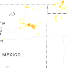
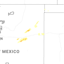
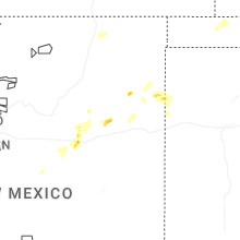
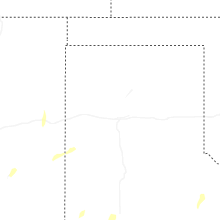
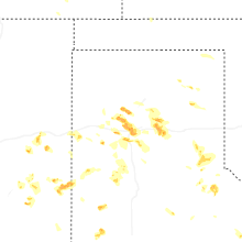
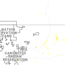
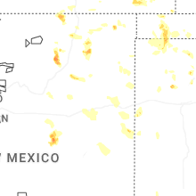
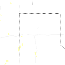
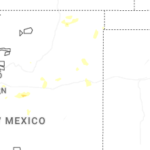
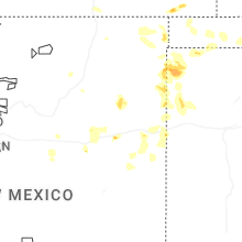
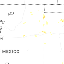
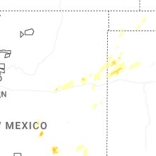

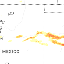
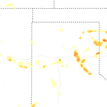
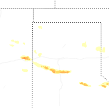
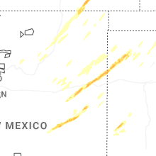


Connect with Interactive Hail Maps