

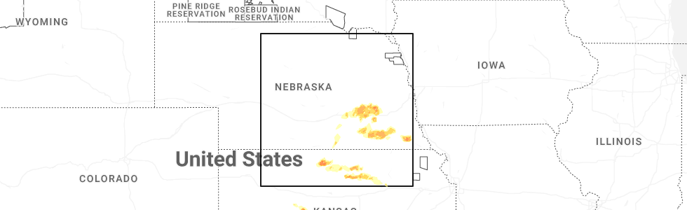
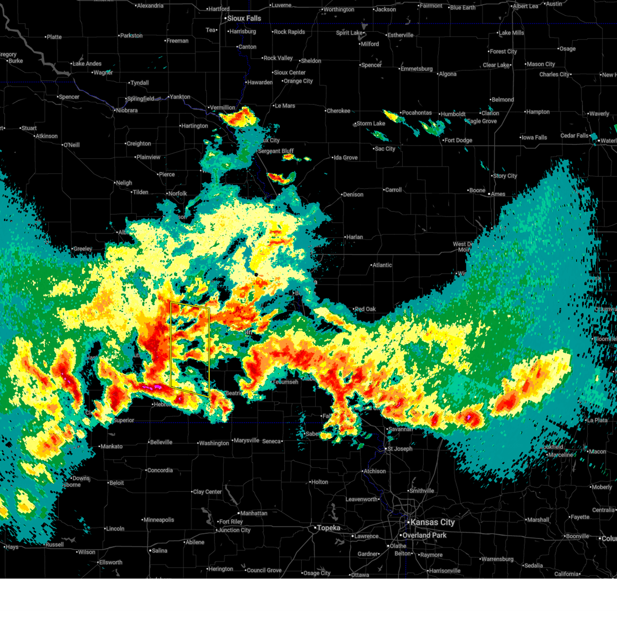
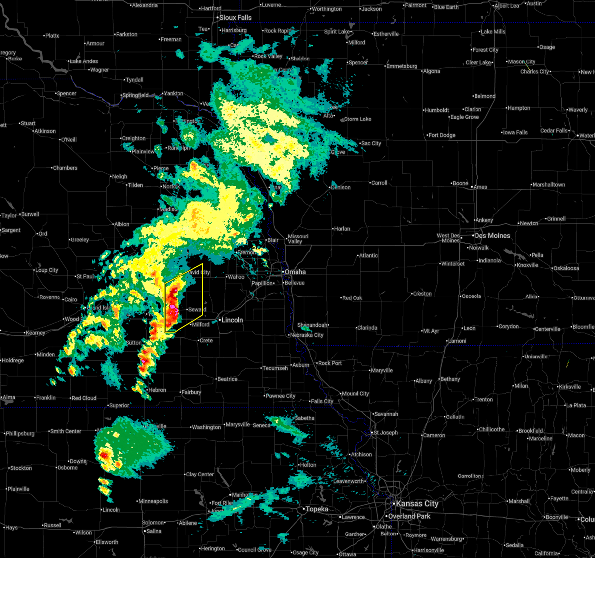
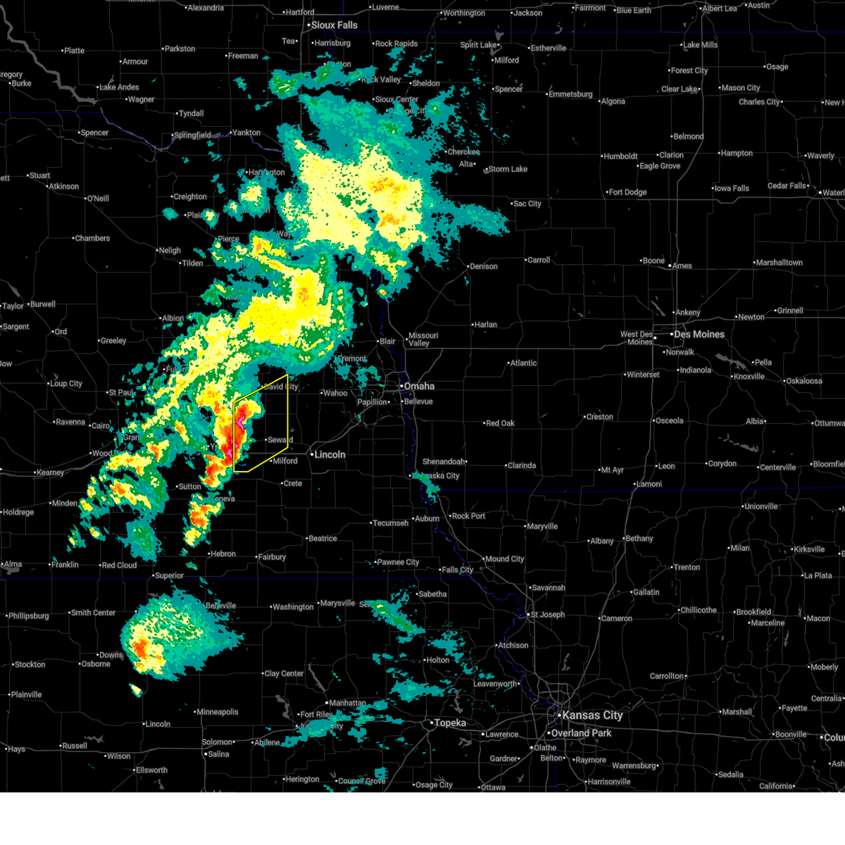
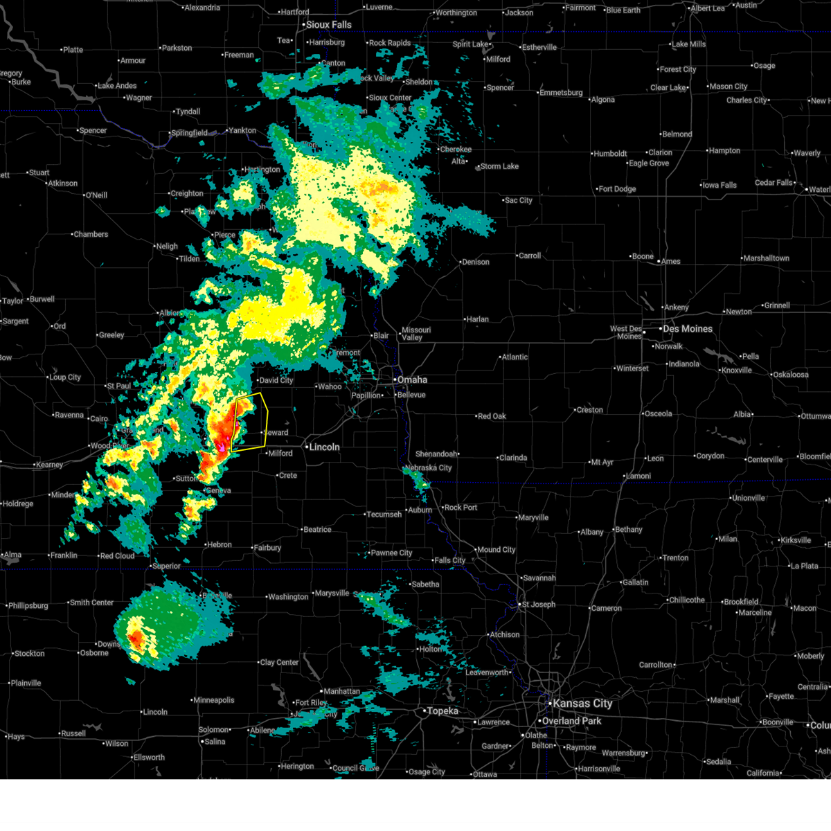
Hail Map for Utica, NE
The Utica, NE area has had 18 reports of on-the-ground hail by trained spotters, and has been under severe weather warnings 27 times during the past 12 months. Doppler radar has detected hail at or near Utica, NE on 111 occasions, including 10 occasions during the past year.
| Name: | Utica, NE |
| Where Located: | 52.1 miles E of Grand Island, NE |
| Map: | Google Map for Utica, NE |
| Population: | 861 |
| Housing Units: | 364 |
| More Info: | Search Google for Utica, NE |
1
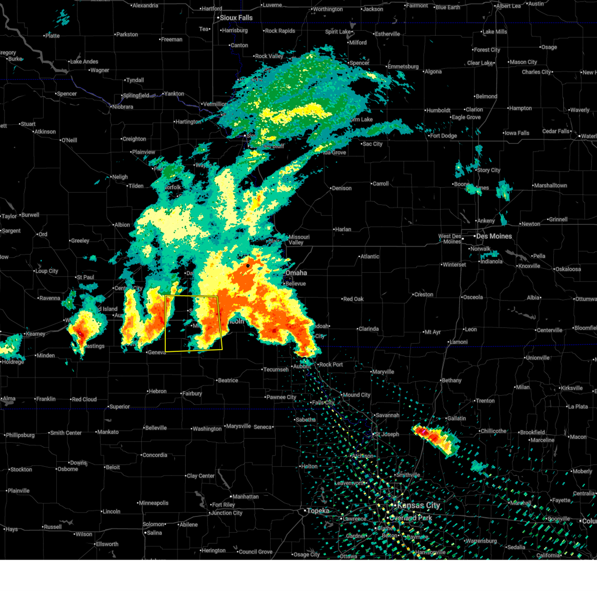
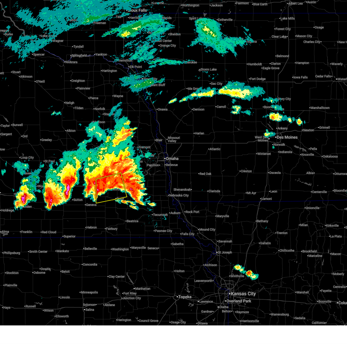
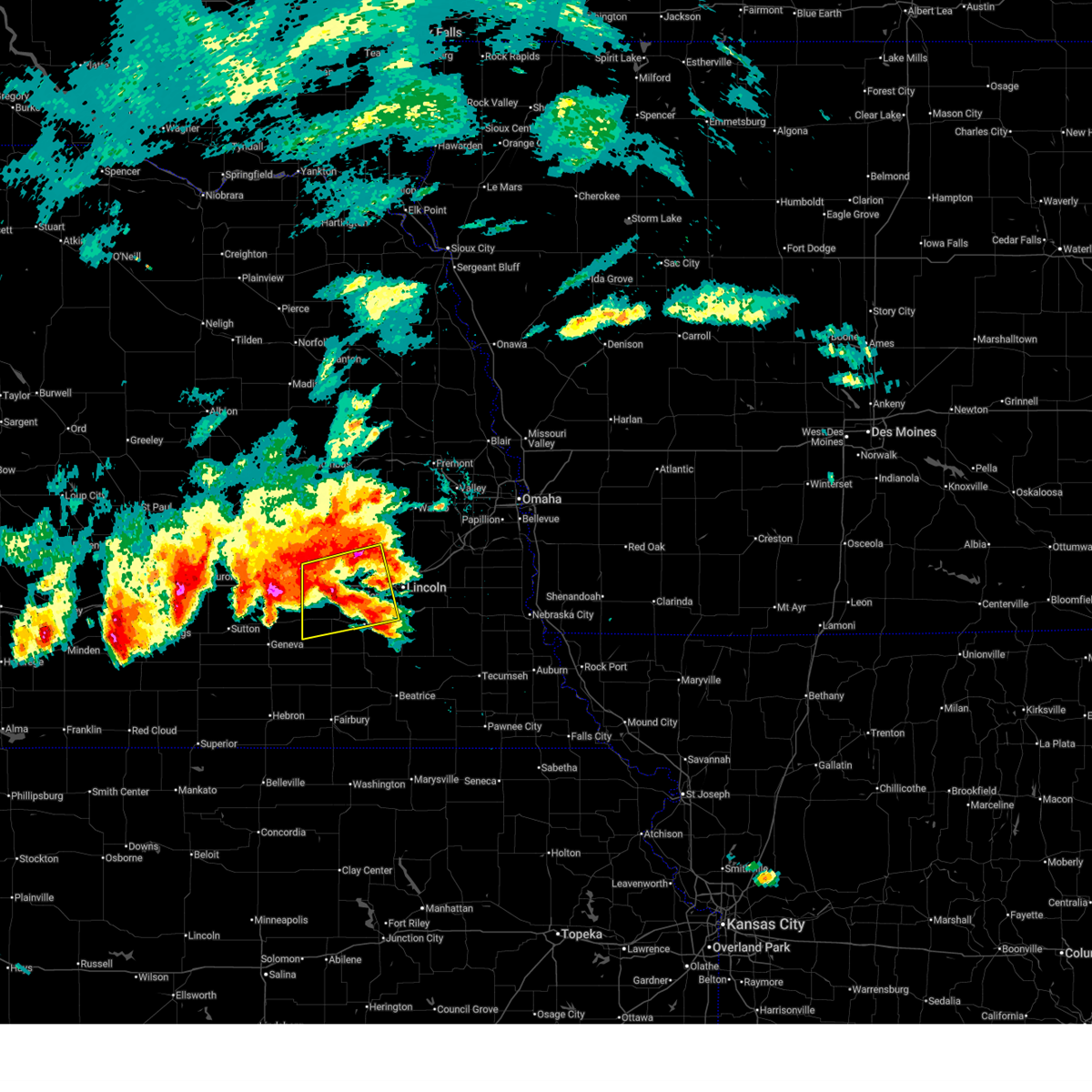
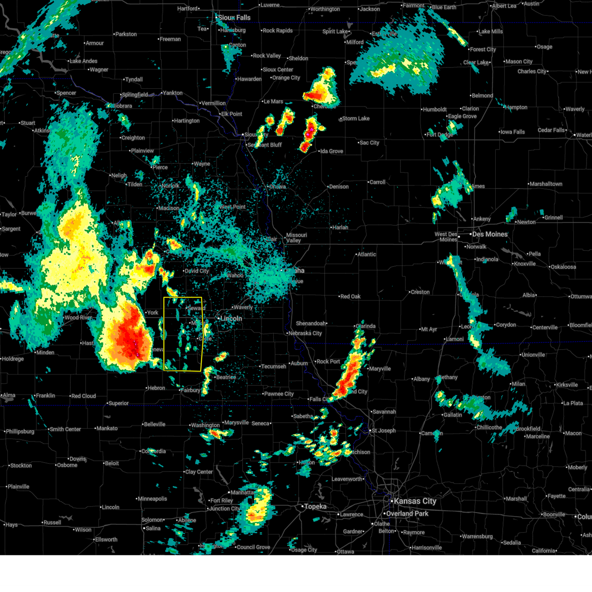
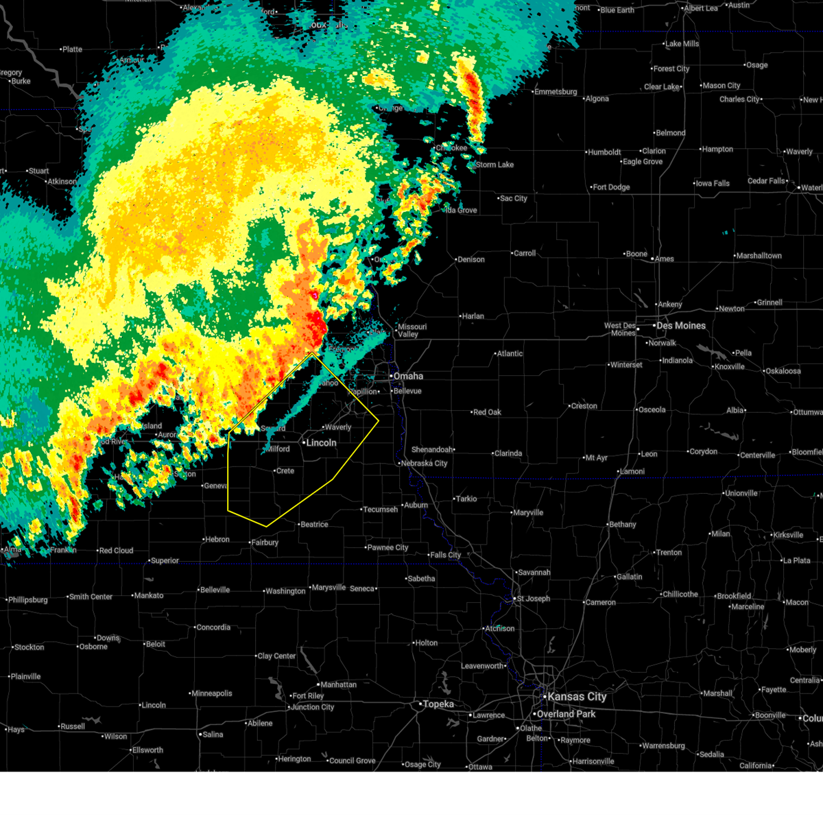
The Top Recent Hail Date for Utica, NE is Saturday, April 25, 2026 (11th out of 111)
Hail and Wind Damage Spotted near Utica, NE
| Date / Time | Report Details |
|---|---|
| 6/11/2026 4:45 AM CDT |
 Svroax the national weather service in omaha has issued a * severe thunderstorm warning for, western lancaster county in southeastern nebraska, seward county in southeastern nebraska, northern saline county in southeastern nebraska, * until 530 am cdt. * at 445 am cdt, a severe thunderstorm was located near beaver crossing, or 14 miles southwest of seward, moving east at 60 mph (radar indicated). Hazards include 60 mph wind gusts and nickel size hail. Expect damage to roofs, siding, and trees. this severe thunderstorm will be near, beaver crossing and goehner around 450 am cdt. milford around 455 am cdt. pleasant dale around 505 am cdt. other locations in the path of this severe thunderstorm include northwestern lincoln, emerald, lincoln airport and pioneers park. This includes interstate 80 in nebraska between mile markers 366 and 399. Svroax the national weather service in omaha has issued a * severe thunderstorm warning for, western lancaster county in southeastern nebraska, seward county in southeastern nebraska, northern saline county in southeastern nebraska, * until 530 am cdt. * at 445 am cdt, a severe thunderstorm was located near beaver crossing, or 14 miles southwest of seward, moving east at 60 mph (radar indicated). Hazards include 60 mph wind gusts and nickel size hail. Expect damage to roofs, siding, and trees. this severe thunderstorm will be near, beaver crossing and goehner around 450 am cdt. milford around 455 am cdt. pleasant dale around 505 am cdt. other locations in the path of this severe thunderstorm include northwestern lincoln, emerald, lincoln airport and pioneers park. This includes interstate 80 in nebraska between mile markers 366 and 399.
|
| 6/11/2026 4:11 AM CDT |
 At 410 am cdt, a severe thunderstorm was located over beaver crossing, or 12 miles southwest of seward, moving east at 35 mph (public report of a measured 70 mph wind gust in exeter, nebraska at 4:06 am). Hazards include two inch hail and 70 mph wind gusts. People and animals outdoors will be injured. expect hail damage to roofs, siding, windows, and vehicles. expect considerable tree damage. wind damage is also likely to mobile homes, roofs, and outbuildings. this severe storm will be near, goehner around 415 am cdt. other locations in the path of this severe thunderstorm include milford, pleasant dale, western lincoln, malcolm and emerald. This includes interstate 80 in nebraska between mile markers 366 and 395. At 410 am cdt, a severe thunderstorm was located over beaver crossing, or 12 miles southwest of seward, moving east at 35 mph (public report of a measured 70 mph wind gust in exeter, nebraska at 4:06 am). Hazards include two inch hail and 70 mph wind gusts. People and animals outdoors will be injured. expect hail damage to roofs, siding, windows, and vehicles. expect considerable tree damage. wind damage is also likely to mobile homes, roofs, and outbuildings. this severe storm will be near, goehner around 415 am cdt. other locations in the path of this severe thunderstorm include milford, pleasant dale, western lincoln, malcolm and emerald. This includes interstate 80 in nebraska between mile markers 366 and 395.
|
| 6/11/2026 3:59 AM CDT |
 At 359 am cdt, a severe thunderstorm was located 5 miles northwest of cordova, or 11 miles southeast of york, moving east at 35 mph (radar indicated). Hazards include golf ball size hail and 60 mph wind gusts. People and animals outdoors will be injured. expect hail damage to roofs, siding, windows, and vehicles. expect wind damage to roofs, siding, and trees. this severe storm will be near, beaver crossing around 405 am cdt. goehner around 410 am cdt. other locations in the path of this severe thunderstorm include milford and pleasant dale. This includes interstate 80 in nebraska between mile markers 366 and 395. At 359 am cdt, a severe thunderstorm was located 5 miles northwest of cordova, or 11 miles southeast of york, moving east at 35 mph (radar indicated). Hazards include golf ball size hail and 60 mph wind gusts. People and animals outdoors will be injured. expect hail damage to roofs, siding, windows, and vehicles. expect wind damage to roofs, siding, and trees. this severe storm will be near, beaver crossing around 405 am cdt. goehner around 410 am cdt. other locations in the path of this severe thunderstorm include milford and pleasant dale. This includes interstate 80 in nebraska between mile markers 366 and 395.
|
| 6/11/2026 3:54 AM CDT |
 Svroax the national weather service in omaha has issued a * severe thunderstorm warning for, western lancaster county in southeastern nebraska, seward county in southeastern nebraska, northern saline county in southeastern nebraska, * until 445 am cdt. * at 354 am cdt, a severe thunderstorm was located 6 miles east of mccool junction, or 8 miles southeast of york, moving east at 35 mph (radar indicated). Hazards include ping pong ball size hail and 60 mph wind gusts. People and animals outdoors will be injured. expect hail damage to roofs, siding, windows, and vehicles. expect wind damage to roofs, siding, and trees. this severe thunderstorm will be near, beaver crossing around 405 am cdt. goehner around 410 am cdt. other locations in the path of this severe thunderstorm include milford and pleasant dale. This includes interstate 80 in nebraska between mile markers 366 and 395. Svroax the national weather service in omaha has issued a * severe thunderstorm warning for, western lancaster county in southeastern nebraska, seward county in southeastern nebraska, northern saline county in southeastern nebraska, * until 445 am cdt. * at 354 am cdt, a severe thunderstorm was located 6 miles east of mccool junction, or 8 miles southeast of york, moving east at 35 mph (radar indicated). Hazards include ping pong ball size hail and 60 mph wind gusts. People and animals outdoors will be injured. expect hail damage to roofs, siding, windows, and vehicles. expect wind damage to roofs, siding, and trees. this severe thunderstorm will be near, beaver crossing around 405 am cdt. goehner around 410 am cdt. other locations in the path of this severe thunderstorm include milford and pleasant dale. This includes interstate 80 in nebraska between mile markers 366 and 395.
|
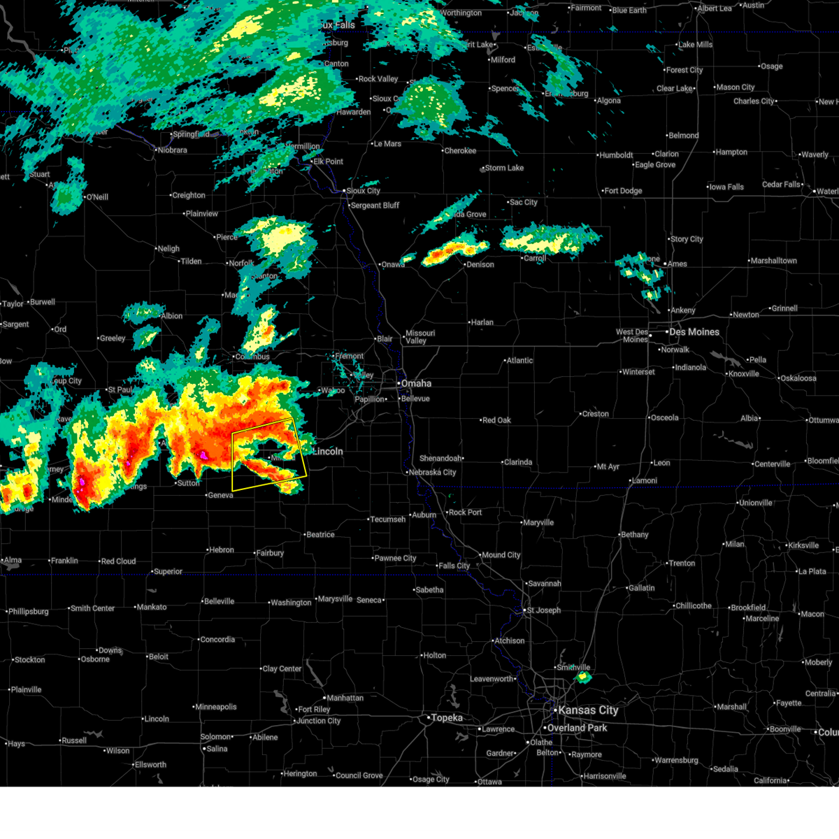
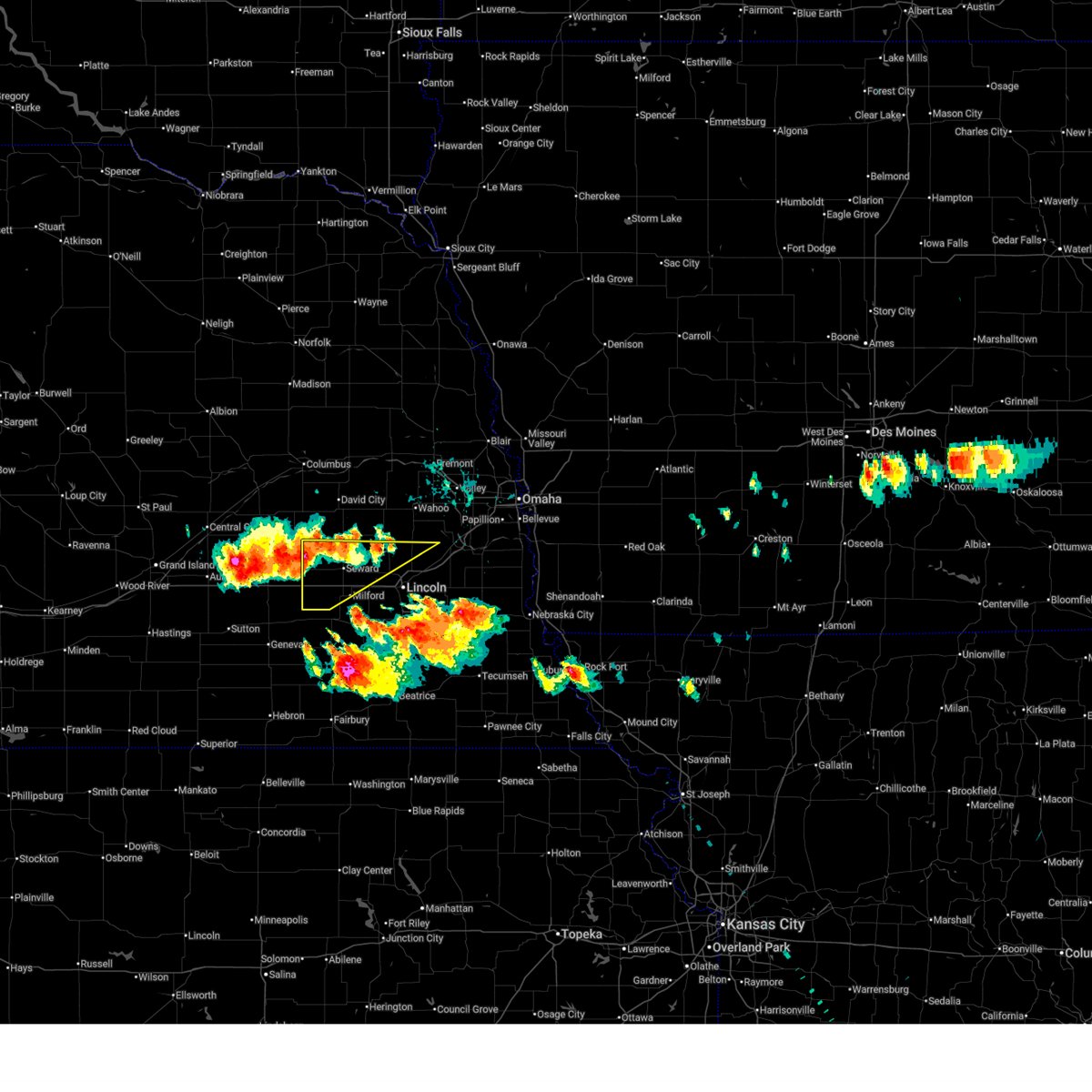
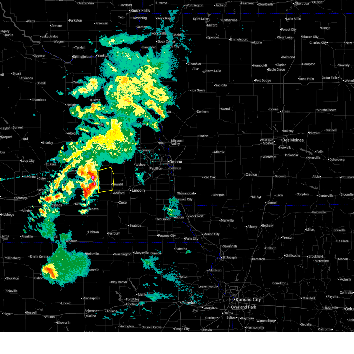
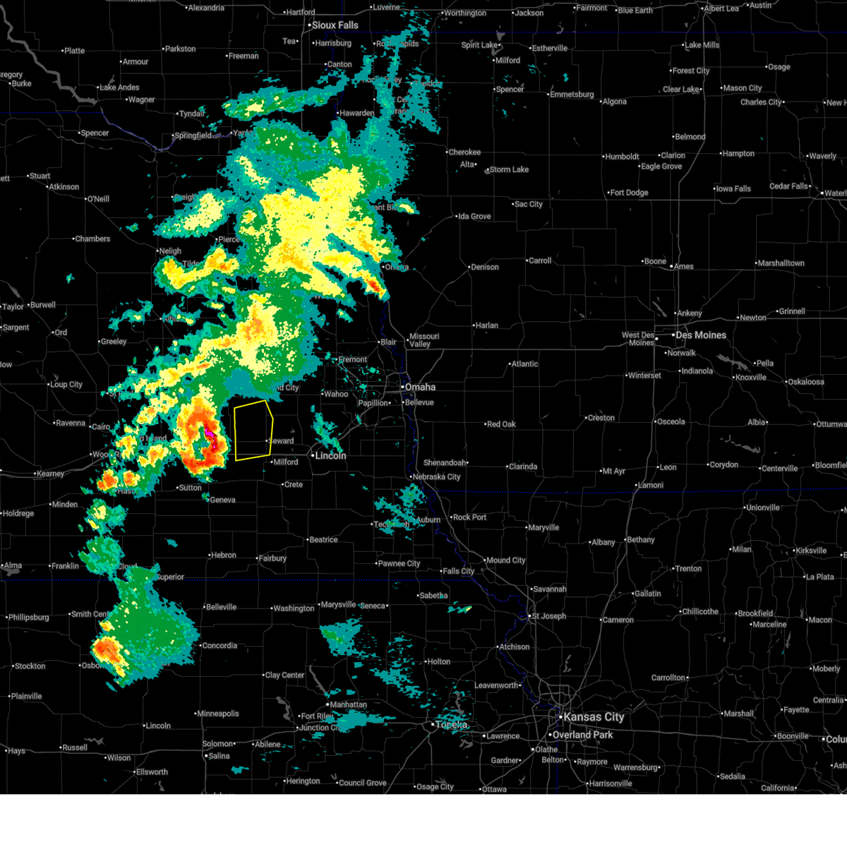
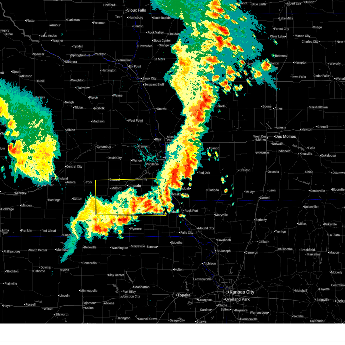
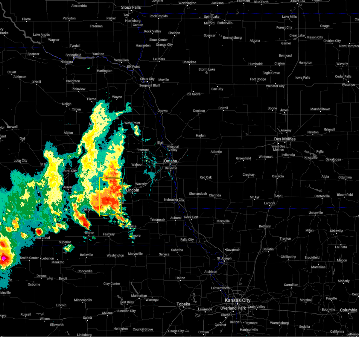
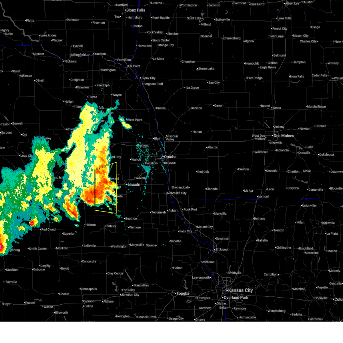
| 6/11/2026 3:35 AM CDT | Quarter sized hail reported 0.5 miles SW of Utica, NE |
| 6/11/2026 3:23 AM CDT |
 At 323 am cdt, severe thunderstorms were located along a line extending from 3 miles southwest of hampton to 3 miles east of utica, moving east at 50 mph (radar indicated). Hazards include ping pong ball size hail and 60 mph wind gusts. People and animals outdoors will be injured. expect hail damage to roofs, siding, windows, and vehicles. expect wind damage to roofs, siding, and trees. these severe storms will be near, seward, utica, and staplehurst around 330 am cdt. other locations in the path of these severe thunderstorms include garland, bee and raymond. This includes interstate 80 in nebraska between mile markers 366 and 390. At 323 am cdt, severe thunderstorms were located along a line extending from 3 miles southwest of hampton to 3 miles east of utica, moving east at 50 mph (radar indicated). Hazards include ping pong ball size hail and 60 mph wind gusts. People and animals outdoors will be injured. expect hail damage to roofs, siding, windows, and vehicles. expect wind damage to roofs, siding, and trees. these severe storms will be near, seward, utica, and staplehurst around 330 am cdt. other locations in the path of these severe thunderstorms include garland, bee and raymond. This includes interstate 80 in nebraska between mile markers 366 and 390.
|
| 6/11/2026 3:19 AM CDT | Half Dollar sized hail reported 0.5 miles SW of Utica, NE, delayed report received via social media of hail measured up to half-dollar sized. time estimated with radar. |
| 6/11/2026 3:13 AM CDT |
 Svroax the national weather service in omaha has issued a * severe thunderstorm warning for, northwestern lancaster county in southeastern nebraska, seward county in southeastern nebraska, butler county in east central nebraska, southwestern saunders county in east central nebraska, * until 400 am cdt. * at 313 am cdt, severe thunderstorms were located along a line extending from 5 miles northeast of giltner to 3 miles southeast of waco, moving northeast at 50 mph (radar indicated). Hazards include 60 mph wind gusts and half dollar size hail. Hail damage to vehicles is expected. expect wind damage to roofs, siding, and trees. severe thunderstorms will be near, utica around 320 am cdt. staplehurst around 325 am cdt. other locations in the path of these severe thunderstorms include bee, ulysses, dwight, surprise and brainard. This includes interstate 80 in nebraska between mile markers 366 and 390. Svroax the national weather service in omaha has issued a * severe thunderstorm warning for, northwestern lancaster county in southeastern nebraska, seward county in southeastern nebraska, butler county in east central nebraska, southwestern saunders county in east central nebraska, * until 400 am cdt. * at 313 am cdt, severe thunderstorms were located along a line extending from 5 miles northeast of giltner to 3 miles southeast of waco, moving northeast at 50 mph (radar indicated). Hazards include 60 mph wind gusts and half dollar size hail. Hail damage to vehicles is expected. expect wind damage to roofs, siding, and trees. severe thunderstorms will be near, utica around 320 am cdt. staplehurst around 325 am cdt. other locations in the path of these severe thunderstorms include bee, ulysses, dwight, surprise and brainard. This includes interstate 80 in nebraska between mile markers 366 and 390.
|
| 6/9/2026 9:14 PM CDT |
 Svroax the national weather service in omaha has issued a * severe thunderstorm warning for, southern colfax county in northeastern nebraska, southeastern platte county in northeastern nebraska, northern seward county in southeastern nebraska, butler county in east central nebraska, west central saunders county in east central nebraska, * until 1015 pm cdt. * at 914 pm cdt, severe thunderstorms were located along a line extending from 4 miles southeast of duncan to 3 miles south of shelby to 2 miles northeast of waco, moving northeast at 30 mph (radar indicated). Hazards include 60 mph wind gusts and penny size hail. Expect damage to roofs, siding, and trees. severe thunderstorms will be near, rising city and surprise around 920 pm cdt. bellwood, ulysses, and richland around 930 pm cdt. Other locations in the path of these severe thunderstorms include staplehurst, david city, schuyler, dwight, octavia, brainard, bruno, linwood and abie. Svroax the national weather service in omaha has issued a * severe thunderstorm warning for, southern colfax county in northeastern nebraska, southeastern platte county in northeastern nebraska, northern seward county in southeastern nebraska, butler county in east central nebraska, west central saunders county in east central nebraska, * until 1015 pm cdt. * at 914 pm cdt, severe thunderstorms were located along a line extending from 4 miles southeast of duncan to 3 miles south of shelby to 2 miles northeast of waco, moving northeast at 30 mph (radar indicated). Hazards include 60 mph wind gusts and penny size hail. Expect damage to roofs, siding, and trees. severe thunderstorms will be near, rising city and surprise around 920 pm cdt. bellwood, ulysses, and richland around 930 pm cdt. Other locations in the path of these severe thunderstorms include staplehurst, david city, schuyler, dwight, octavia, brainard, bruno, linwood and abie.
|
| 6/5/2026 8:45 PM CDT |
 Svroax the national weather service in omaha has issued a * severe thunderstorm warning for, northern lancaster county in southeastern nebraska, seward county in southeastern nebraska, * until 930 pm cdt. * at 845 pm cdt, severe thunderstorms were located along a line extending from 3 miles northwest of raymond to 3 miles west of garland to near utica, moving southeast at 20 mph (radar indicated). Hazards include 60 mph wind gusts and quarter size hail. Hail damage to vehicles is expected. expect wind damage to roofs, siding, and trees. severe thunderstorms will be near, seward, malcolm, garland, raymond, and goehner around 850 pm cdt. beaver crossing and davey around 900 pm cdt. other locations in the path of these severe thunderstorms include milford. This includes interstate 80 in nebraska between mile markers 366 and 385. Svroax the national weather service in omaha has issued a * severe thunderstorm warning for, northern lancaster county in southeastern nebraska, seward county in southeastern nebraska, * until 930 pm cdt. * at 845 pm cdt, severe thunderstorms were located along a line extending from 3 miles northwest of raymond to 3 miles west of garland to near utica, moving southeast at 20 mph (radar indicated). Hazards include 60 mph wind gusts and quarter size hail. Hail damage to vehicles is expected. expect wind damage to roofs, siding, and trees. severe thunderstorms will be near, seward, malcolm, garland, raymond, and goehner around 850 pm cdt. beaver crossing and davey around 900 pm cdt. other locations in the path of these severe thunderstorms include milford. This includes interstate 80 in nebraska between mile markers 366 and 385.
|
| 5/16/2026 11:15 PM CDT |
 Svroax the national weather service in omaha has issued a * severe thunderstorm warning for, southern seward county in southeastern nebraska, saline county in southeastern nebraska, * until 1215 am cdt. * at 1115 pm cdt, a severe thunderstorm was located 8 miles north of western, or 25 miles north of fairbury, moving east at 10 mph (radar indicated). Hazards include 60 mph wind gusts and quarter size hail. Hail damage to vehicles is expected. expect wind damage to roofs, siding, and trees. this severe thunderstorm will remain over mainly rural areas of southern seward and saline counties, including the following locations, swan creek reservoir number 2, the highway 41 and 15 south junction, swan creek wildlife management area, walnut creek recreation area, blue river state recreation area, willard meyer recreation area, and tamora. This includes interstate 80 in nebraska between mile markers 366 and 388. Svroax the national weather service in omaha has issued a * severe thunderstorm warning for, southern seward county in southeastern nebraska, saline county in southeastern nebraska, * until 1215 am cdt. * at 1115 pm cdt, a severe thunderstorm was located 8 miles north of western, or 25 miles north of fairbury, moving east at 10 mph (radar indicated). Hazards include 60 mph wind gusts and quarter size hail. Hail damage to vehicles is expected. expect wind damage to roofs, siding, and trees. this severe thunderstorm will remain over mainly rural areas of southern seward and saline counties, including the following locations, swan creek reservoir number 2, the highway 41 and 15 south junction, swan creek wildlife management area, walnut creek recreation area, blue river state recreation area, willard meyer recreation area, and tamora. This includes interstate 80 in nebraska between mile markers 366 and 388.
|
| 5/16/2026 10:32 PM CDT |
 At 1031 pm cdt, severe thunderstorms were located along a line extending from 2 miles east of utica to 2 miles northeast of tobias to 2 miles north of alexandria, moving east at 35 mph (radar indicated). Hazards include 60 mph wind gusts and quarter size hail. Hail damage to vehicles is expected. expect wind damage to roofs, siding, and trees. locations impacted include, friend, beaver crossing, western, daykin, goehner, seward, dorchester, milford and swanton. This includes interstate 80 in nebraska between mile markers 366 and 382. At 1031 pm cdt, severe thunderstorms were located along a line extending from 2 miles east of utica to 2 miles northeast of tobias to 2 miles north of alexandria, moving east at 35 mph (radar indicated). Hazards include 60 mph wind gusts and quarter size hail. Hail damage to vehicles is expected. expect wind damage to roofs, siding, and trees. locations impacted include, friend, beaver crossing, western, daykin, goehner, seward, dorchester, milford and swanton. This includes interstate 80 in nebraska between mile markers 366 and 382.
|
| 5/16/2026 10:32 PM CDT |
 the severe thunderstorm warning has been cancelled and is no longer in effect the severe thunderstorm warning has been cancelled and is no longer in effect
|
| 5/16/2026 10:12 PM CDT |
 Svroax the national weather service in omaha has issued a * severe thunderstorm warning for, northern jefferson county in southeastern nebraska, seward county in southeastern nebraska, saline county in southeastern nebraska, southwestern butler county in east central nebraska, * until 1100 pm cdt. * at 1011 pm cdt, severe thunderstorms were located along a line extending from 3 miles southeast of gresham to 2 miles northeast of milligan to 2 miles south of ohiowa, moving southeast at 45 mph (radar indicated). Hazards include 70 mph wind gusts and quarter size hail. Hail damage to vehicles is expected. expect considerable tree damage. wind damage is also likely to mobile homes, roofs, and outbuildings. severe thunderstorms will be near, friend, utica, beaver crossing, cordova, and tobias around 1015 pm cdt. western, daykin, and goehner around 1020 pm cdt. dorchester and swanton around 1030 pm cdt. other locations in the path of these severe thunderstorms include milford, plymouth, crete, wilber and de witt. This includes interstate 80 in nebraska between mile markers 366 and 388. Svroax the national weather service in omaha has issued a * severe thunderstorm warning for, northern jefferson county in southeastern nebraska, seward county in southeastern nebraska, saline county in southeastern nebraska, southwestern butler county in east central nebraska, * until 1100 pm cdt. * at 1011 pm cdt, severe thunderstorms were located along a line extending from 3 miles southeast of gresham to 2 miles northeast of milligan to 2 miles south of ohiowa, moving southeast at 45 mph (radar indicated). Hazards include 70 mph wind gusts and quarter size hail. Hail damage to vehicles is expected. expect considerable tree damage. wind damage is also likely to mobile homes, roofs, and outbuildings. severe thunderstorms will be near, friend, utica, beaver crossing, cordova, and tobias around 1015 pm cdt. western, daykin, and goehner around 1020 pm cdt. dorchester and swanton around 1030 pm cdt. other locations in the path of these severe thunderstorms include milford, plymouth, crete, wilber and de witt. This includes interstate 80 in nebraska between mile markers 366 and 388.
|
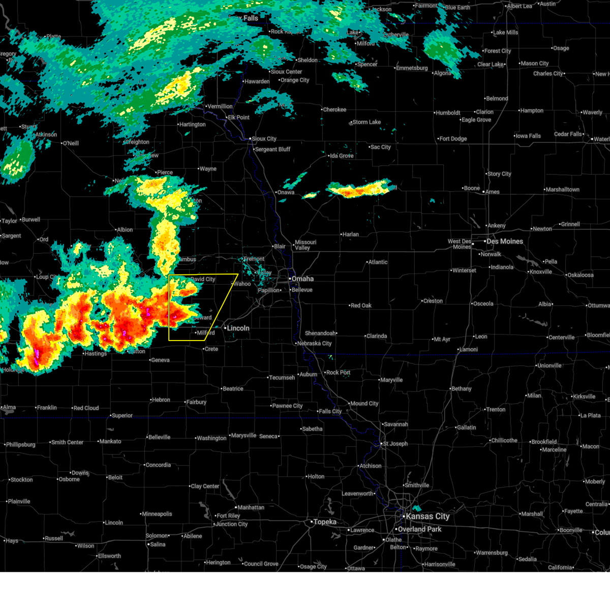
| 4/25/2026 5:43 PM CDT |
 At 542 pm cdt, severe thunderstorms were located along a line extending from 5 miles south of david city to 4 miles southwest of seward to friend, moving east at 25 mph (radar indicated). Hazards include 60 mph wind gusts and quarter size hail. Hail damage to vehicles is expected. expect wind damage to roofs, siding, and trees. locations impacted include, seward, dwight, bee, brainard, garland and bruno. This includes interstate 80 in nebraska between mile markers 366 and 382. At 542 pm cdt, severe thunderstorms were located along a line extending from 5 miles south of david city to 4 miles southwest of seward to friend, moving east at 25 mph (radar indicated). Hazards include 60 mph wind gusts and quarter size hail. Hail damage to vehicles is expected. expect wind damage to roofs, siding, and trees. locations impacted include, seward, dwight, bee, brainard, garland and bruno. This includes interstate 80 in nebraska between mile markers 366 and 382.
|
| 4/25/2026 5:28 PM CDT |
 Svroax the national weather service in omaha has issued a * severe thunderstorm warning for, seward county in southeastern nebraska, southern butler county in east central nebraska, * until 615 pm cdt. * at 527 pm cdt, severe thunderstorms were located along a line extending from 5 miles southeast of rising city to 2 miles north of beaver crossing to 3 miles east of fairmont, moving northeast at 15 mph (radar indicated). Hazards include 60 mph wind gusts and quarter size hail. Hail damage to vehicles is expected. expect wind damage to roofs, siding, and trees. severe thunderstorms will be near, beaver crossing, staplehurst, ulysses, goehner, and cordova around 535 pm cdt. seward and david city around 545 pm cdt. other locations in the path of these severe thunderstorms include bee. This includes interstate 80 in nebraska between mile markers 366 and 382. Svroax the national weather service in omaha has issued a * severe thunderstorm warning for, seward county in southeastern nebraska, southern butler county in east central nebraska, * until 615 pm cdt. * at 527 pm cdt, severe thunderstorms were located along a line extending from 5 miles southeast of rising city to 2 miles north of beaver crossing to 3 miles east of fairmont, moving northeast at 15 mph (radar indicated). Hazards include 60 mph wind gusts and quarter size hail. Hail damage to vehicles is expected. expect wind damage to roofs, siding, and trees. severe thunderstorms will be near, beaver crossing, staplehurst, ulysses, goehner, and cordova around 535 pm cdt. seward and david city around 545 pm cdt. other locations in the path of these severe thunderstorms include bee. This includes interstate 80 in nebraska between mile markers 366 and 382.
|
| 4/25/2026 5:18 PM CDT |
 At 518 pm cdt, severe thunderstorms were located along a line extending from 4 miles northeast of surprise to 4 miles northeast of utica to 2 miles northwest of cordova, moving east at 25 mph (radar indicated). Hazards include 60 mph wind gusts and quarter size hail. Hail damage to vehicles is expected. expect wind damage to roofs, siding, and trees. locations impacted include, seward, utica, staplehurst, bee, ulysses, goehner, surprise, and tamora. This includes interstate 80 in nebraska between mile markers 366 and 379. At 518 pm cdt, severe thunderstorms were located along a line extending from 4 miles northeast of surprise to 4 miles northeast of utica to 2 miles northwest of cordova, moving east at 25 mph (radar indicated). Hazards include 60 mph wind gusts and quarter size hail. Hail damage to vehicles is expected. expect wind damage to roofs, siding, and trees. locations impacted include, seward, utica, staplehurst, bee, ulysses, goehner, surprise, and tamora. This includes interstate 80 in nebraska between mile markers 366 and 379.
|
| 4/25/2026 5:04 PM CDT |
 At 504 pm cdt, severe thunderstorms were located along a line extending from 4 miles southeast of shelby to 3 miles north of utica to 4 miles north of cordova, moving east at 20 mph (radar indicated). Hazards include 60 mph wind gusts and quarter size hail. Hail damage to vehicles is expected. expect wind damage to roofs, siding, and trees. locations impacted include, surprise, staplehurst, ulysses, goehner and seward. This includes interstate 80 in nebraska between mile markers 366 and 379. At 504 pm cdt, severe thunderstorms were located along a line extending from 4 miles southeast of shelby to 3 miles north of utica to 4 miles north of cordova, moving east at 20 mph (radar indicated). Hazards include 60 mph wind gusts and quarter size hail. Hail damage to vehicles is expected. expect wind damage to roofs, siding, and trees. locations impacted include, surprise, staplehurst, ulysses, goehner and seward. This includes interstate 80 in nebraska between mile markers 366 and 379.
|
| 4/25/2026 4:42 PM CDT |
 Svroax the national weather service in omaha has issued a * severe thunderstorm warning for, northwestern seward county in southeastern nebraska, southwestern butler county in east central nebraska, * until 530 pm cdt. * at 442 pm cdt, severe thunderstorms were located along a line extending from 2 miles east of stromsburg to 2 miles northeast of waco to 5 miles north of exeter, moving east at 30 mph (radar indicated). Hazards include 60 mph wind gusts and quarter size hail. Hail damage to vehicles is expected. expect wind damage to roofs, siding, and trees. severe thunderstorms will be near, utica around 445 pm cdt. goehner and surprise around 455 pm cdt. staplehurst and ulysses around 500 pm cdt. other locations in the path of these severe thunderstorms include seward and bee. This includes interstate 80 in nebraska between mile markers 366 and 379. Svroax the national weather service in omaha has issued a * severe thunderstorm warning for, northwestern seward county in southeastern nebraska, southwestern butler county in east central nebraska, * until 530 pm cdt. * at 442 pm cdt, severe thunderstorms were located along a line extending from 2 miles east of stromsburg to 2 miles northeast of waco to 5 miles north of exeter, moving east at 30 mph (radar indicated). Hazards include 60 mph wind gusts and quarter size hail. Hail damage to vehicles is expected. expect wind damage to roofs, siding, and trees. severe thunderstorms will be near, utica around 445 pm cdt. goehner and surprise around 455 pm cdt. staplehurst and ulysses around 500 pm cdt. other locations in the path of these severe thunderstorms include seward and bee. This includes interstate 80 in nebraska between mile markers 366 and 379.
|
| 9/14/2025 3:22 PM CDT | The storm which prompted the warning has moved out of the area. therefore, the warning will be allowed to expire. however, gusty winds are still possible with this thunderstorm. |
| 9/14/2025 3:17 PM CDT | At 317 pm cdt, a severe thunderstorm was located over staplehurst, or 4 miles northwest of seward, moving east at 30 mph (public). Hazards include 60 mph wind gusts and quarter size hail. Hail damage to vehicles is expected. expect wind damage to roofs, siding, and trees. this severe storm will be near, seward and bee around 325 pm cdt. garland around 330 pm cdt. This includes interstate 80 in nebraska between mile markers 377 and 385. |
| 9/14/2025 3:16 PM CDT | Svroax the national weather service in omaha has issued a * severe thunderstorm warning for, southwestern colfax county in northeastern nebraska, southeastern platte county in northeastern nebraska, seward county in southeastern nebraska, butler county in east central nebraska, * until 345 pm cdt. * at 315 pm cdt, severe thunderstorms were located along a line extending from 2 miles northwest of gresham to 2 miles northwest of staplehurst to 4 miles southeast of seward, moving north at 55 mph (public report of a 59 mph wind gust west of dorchester at 2:50 pm). Hazards include 60 mph wind gusts and quarter size hail. Hail damage to vehicles is expected. expect wind damage to roofs, siding, and trees. severe thunderstorms will be near, seward, staplehurst, garland, bee, ulysses, and surprise around 320 pm cdt. rising city and dwight around 325 pm cdt. david city around 330 pm cdt. bellwood and brainard around 335 pm cdt. This includes interstate 80 in nebraska between mile markers 377 and 385. |
| 9/14/2025 3:11 PM CDT | the severe thunderstorm warning has been cancelled and is no longer in effect |
| 9/14/2025 3:11 PM CDT | At 311 pm cdt, a severe thunderstorm was located 4 miles southwest of staplehurst, or 5 miles west of seward, moving north at 30 mph (public report of a measured 59 mph wind gust west of dorchester at 2:50 pm). Hazards include 60 mph wind gusts and quarter size hail. Hail damage to vehicles is expected. expect wind damage to roofs, siding, and trees. this severe storm will be near, staplehurst around 315 pm cdt. This includes interstate 80 in nebraska between mile markers 366 and 385. |
| 9/14/2025 3:07 PM CDT | At 306 pm cdt, a severe thunderstorm was located 3 miles north of goehner, or 6 miles west of seward, moving north at 30 mph (public report of a measured 59 mph wind gust west of dorchester at 2:50 pm). Hazards include 60 mph wind gusts and quarter size hail. Hail damage to vehicles is expected. expect wind damage to roofs, siding, and trees. this severe storm will be near, staplehurst around 310 pm cdt. This includes interstate 80 in nebraska between mile markers 366 and 385. |
| 9/14/2025 2:58 PM CDT | Svroax the national weather service in omaha has issued a * severe thunderstorm warning for, seward county in southeastern nebraska, southwestern butler county in east central nebraska, northwestern saline county in southeastern nebraska, * until 330 pm cdt. * at 258 pm cdt, a severe thunderstorm was located near goehner, or 10 miles southwest of seward, moving north at 30 mph (radar indicated). Hazards include 60 mph wind gusts and quarter size hail. Hail damage to vehicles is expected. expect wind damage to roofs, siding, and trees. this severe thunderstorm will be near, goehner around 305 pm cdt. staplehurst around 315 pm cdt. This includes interstate 80 in nebraska between mile markers 366 and 385. |
| 8/9/2025 4:10 AM CDT |
 Svroax the national weather service in omaha has issued a * severe thunderstorm warning for, southwestern lancaster county in southeastern nebraska, seward county in southeastern nebraska, northern jefferson county in southeastern nebraska, saline county in southeastern nebraska, * until 500 am cdt. * at 409 am cdt, severe thunderstorms were located along a line extending from 5 miles southwest of york to 4 miles northeast of geneva to 2 miles east of carleton, moving east at 40 mph (radar indicated). Hazards include 70 mph wind gusts and quarter size hail. Hail damage to vehicles is expected. expect considerable tree damage. wind damage is also likely to mobile homes, roofs, and outbuildings. severe thunderstorms will be near, friend, cordova, and tobias around 425 am cdt. other locations in the path of these severe thunderstorms include utica, beaver crossing, western, dorchester, goehner, seward, crete, milford and swanton. This includes interstate 80 in nebraska between mile markers 366 and 388. Svroax the national weather service in omaha has issued a * severe thunderstorm warning for, southwestern lancaster county in southeastern nebraska, seward county in southeastern nebraska, northern jefferson county in southeastern nebraska, saline county in southeastern nebraska, * until 500 am cdt. * at 409 am cdt, severe thunderstorms were located along a line extending from 5 miles southwest of york to 4 miles northeast of geneva to 2 miles east of carleton, moving east at 40 mph (radar indicated). Hazards include 70 mph wind gusts and quarter size hail. Hail damage to vehicles is expected. expect considerable tree damage. wind damage is also likely to mobile homes, roofs, and outbuildings. severe thunderstorms will be near, friend, cordova, and tobias around 425 am cdt. other locations in the path of these severe thunderstorms include utica, beaver crossing, western, dorchester, goehner, seward, crete, milford and swanton. This includes interstate 80 in nebraska between mile markers 366 and 388.
|
| 7/15/2025 11:29 PM CDT |
 Svroax the national weather service in omaha has issued a * severe thunderstorm warning for, southwestern sarpy county in east central nebraska, lancaster county in southeastern nebraska, seward county in southeastern nebraska, northeastern jefferson county in southeastern nebraska, northwestern otoe county in southeastern nebraska, southeastern butler county in east central nebraska, saline county in southeastern nebraska, saunders county in east central nebraska, northwestern gage county in southeastern nebraska, western cass county in southeastern nebraska, * until midnight cdt. * at 1128 pm cdt, severe thunderstorms were located along a line extending from near mead to 5 miles south of friend, moving southeast at 40 mph (public). Hazards include 60 mph wind gusts. Expect damage to roofs, siding, and trees. severe thunderstorms will be near, lincoln, crete, dorchester, pleasant dale, davey, emerald, lincoln airport, and pioneers park around 1135 pm cdt. waverly and ashland around 1140 pm cdt. greenwood, western, and holmes lake park around 1145 pm cdt. other locations in the path of these severe thunderstorms include wilber, swanton and walton. This includes interstate 80 in nebraska between mile markers 366 and 432. Svroax the national weather service in omaha has issued a * severe thunderstorm warning for, southwestern sarpy county in east central nebraska, lancaster county in southeastern nebraska, seward county in southeastern nebraska, northeastern jefferson county in southeastern nebraska, northwestern otoe county in southeastern nebraska, southeastern butler county in east central nebraska, saline county in southeastern nebraska, saunders county in east central nebraska, northwestern gage county in southeastern nebraska, western cass county in southeastern nebraska, * until midnight cdt. * at 1128 pm cdt, severe thunderstorms were located along a line extending from near mead to 5 miles south of friend, moving southeast at 40 mph (public). Hazards include 60 mph wind gusts. Expect damage to roofs, siding, and trees. severe thunderstorms will be near, lincoln, crete, dorchester, pleasant dale, davey, emerald, lincoln airport, and pioneers park around 1135 pm cdt. waverly and ashland around 1140 pm cdt. greenwood, western, and holmes lake park around 1145 pm cdt. other locations in the path of these severe thunderstorms include wilber, swanton and walton. This includes interstate 80 in nebraska between mile markers 366 and 432.
|
| 7/10/2025 3:12 AM CDT |
 Svroax the national weather service in omaha has issued a * severe thunderstorm warning for, lancaster county in southeastern nebraska, johnson county in southeastern nebraska, northwestern nemaha county in southeastern nebraska, southern seward county in southeastern nebraska, otoe county in southeastern nebraska, saline county in southeastern nebraska, northern gage county in southeastern nebraska, southwestern cass county in southeastern nebraska, * until 415 am cdt. * at 310 am cdt, severe thunderstorms were located along a line extending from near dorchester to 2 miles northeast of palmyra, moving east at 35 mph (weather instrument measurement wind gust of 64 mph at 3:08 am in lincoln, ne). Hazards include 60 mph wind gusts. the strongest winds are occurring behind the heaviest precipitation. Expect damage to roofs, siding, and trees. severe thunderstorms will be near, southeastern lincoln, crete, bennet, palmyra, unadilla, roca, and sprague around 315 am cdt. syracuse and hickman around 320 am cdt. panama around 330 am cdt. other locations in the path of these severe thunderstorms include dunbar, douglas, lorton, firth and talmage. This includes interstate 80 in nebraska between mile markers 366 and 412. Svroax the national weather service in omaha has issued a * severe thunderstorm warning for, lancaster county in southeastern nebraska, johnson county in southeastern nebraska, northwestern nemaha county in southeastern nebraska, southern seward county in southeastern nebraska, otoe county in southeastern nebraska, saline county in southeastern nebraska, northern gage county in southeastern nebraska, southwestern cass county in southeastern nebraska, * until 415 am cdt. * at 310 am cdt, severe thunderstorms were located along a line extending from near dorchester to 2 miles northeast of palmyra, moving east at 35 mph (weather instrument measurement wind gust of 64 mph at 3:08 am in lincoln, ne). Hazards include 60 mph wind gusts. the strongest winds are occurring behind the heaviest precipitation. Expect damage to roofs, siding, and trees. severe thunderstorms will be near, southeastern lincoln, crete, bennet, palmyra, unadilla, roca, and sprague around 315 am cdt. syracuse and hickman around 320 am cdt. panama around 330 am cdt. other locations in the path of these severe thunderstorms include dunbar, douglas, lorton, firth and talmage. This includes interstate 80 in nebraska between mile markers 366 and 412.
|
| 4/17/2025 6:07 PM CDT |
 At 606 pm cdt, a severe thunderstorm was located 5 miles east of gresham, or 12 miles northwest of seward, moving east at 40 mph (radar indicated). Hazards include ping pong ball size hail and 60 mph wind gusts. People and animals outdoors will be injured. expect hail damage to roofs, siding, windows, and vehicles. expect wind damage to roofs, siding, and trees. this severe storm will be near, staplehurst and ulysses around 610 pm cdt. Other locations in the path of this severe thunderstorm include dwight, bee and valparaiso. At 606 pm cdt, a severe thunderstorm was located 5 miles east of gresham, or 12 miles northwest of seward, moving east at 40 mph (radar indicated). Hazards include ping pong ball size hail and 60 mph wind gusts. People and animals outdoors will be injured. expect hail damage to roofs, siding, windows, and vehicles. expect wind damage to roofs, siding, and trees. this severe storm will be near, staplehurst and ulysses around 610 pm cdt. Other locations in the path of this severe thunderstorm include dwight, bee and valparaiso.
|
| 4/17/2025 5:53 PM CDT |
 Svroax the national weather service in omaha has issued a * severe thunderstorm warning for, northwestern lancaster county in southeastern nebraska, northern seward county in southeastern nebraska, southern butler county in east central nebraska, southwestern saunders county in east central nebraska, * until 645 pm cdt. * at 553 pm cdt, a severe thunderstorm was located near gresham, or 11 miles northeast of york, moving east at 40 mph (radar indicated). Hazards include ping pong ball size hail and 60 mph wind gusts. People and animals outdoors will be injured. expect hail damage to roofs, siding, windows, and vehicles. expect wind damage to roofs, siding, and trees. this severe thunderstorm will be near, ulysses around 605 pm cdt. Other locations in the path of this severe thunderstorm include dwight and valparaiso. Svroax the national weather service in omaha has issued a * severe thunderstorm warning for, northwestern lancaster county in southeastern nebraska, northern seward county in southeastern nebraska, southern butler county in east central nebraska, southwestern saunders county in east central nebraska, * until 645 pm cdt. * at 553 pm cdt, a severe thunderstorm was located near gresham, or 11 miles northeast of york, moving east at 40 mph (radar indicated). Hazards include ping pong ball size hail and 60 mph wind gusts. People and animals outdoors will be injured. expect hail damage to roofs, siding, windows, and vehicles. expect wind damage to roofs, siding, and trees. this severe thunderstorm will be near, ulysses around 605 pm cdt. Other locations in the path of this severe thunderstorm include dwight and valparaiso.
|
| 7/31/2024 4:59 PM CDT |
 The storms which prompted the warning have moved out of the area. therefore, the warning will be allowed to expire. however, gusty winds are still possible with lingering thunderstorms in the area. a severe thunderstorm watch remains in effect until 1000 pm cdt for southeastern and east central nebraska. The storms which prompted the warning have moved out of the area. therefore, the warning will be allowed to expire. however, gusty winds are still possible with lingering thunderstorms in the area. a severe thunderstorm watch remains in effect until 1000 pm cdt for southeastern and east central nebraska.
|
| 7/31/2024 4:34 PM CDT |
 At 432 pm cdt, severe thunderstorms were located along a line extending from 2 miles east of bee to near milford to 8 miles south of dorchester, moving east at 40 mph (public. this storm has a history of producing observed wind gusts of 60 to 65 mph). Hazards include 70 mph wind gusts and quarter size hail. Hail damage to vehicles is expected. expect considerable tree damage. wind damage is also likely to mobile homes, roofs, and outbuildings. Locations impacted include, seward, crete, milford, friend, utica, dorchester, beaver crossing, staplehurst, garland, pleasant dale, bee, goehner, cordova, swan creek reservoir number 2, the highway 41 and 15 south junction, blue river state recreation area, walnut creek recreation area, and tamora. At 432 pm cdt, severe thunderstorms were located along a line extending from 2 miles east of bee to near milford to 8 miles south of dorchester, moving east at 40 mph (public. this storm has a history of producing observed wind gusts of 60 to 65 mph). Hazards include 70 mph wind gusts and quarter size hail. Hail damage to vehicles is expected. expect considerable tree damage. wind damage is also likely to mobile homes, roofs, and outbuildings. Locations impacted include, seward, crete, milford, friend, utica, dorchester, beaver crossing, staplehurst, garland, pleasant dale, bee, goehner, cordova, swan creek reservoir number 2, the highway 41 and 15 south junction, blue river state recreation area, walnut creek recreation area, and tamora.
|
| 7/31/2024 4:34 PM CDT |
 the severe thunderstorm warning has been cancelled and is no longer in effect the severe thunderstorm warning has been cancelled and is no longer in effect
|
| 7/31/2024 4:22 PM CDT |
 At 422 pm cdt, severe thunderstorms were located along a line extending from near staplehurst to 6 miles northwest of dorchester to 6 miles east of milligan, moving east at 40 mph (public. at 420 pm, a 63 mph gust was measured 6 miles south- southwest of friend). Hazards include 70 mph wind gusts and quarter size hail. Hail damage to vehicles is expected. expect considerable tree damage. wind damage is also likely to mobile homes, roofs, and outbuildings. Locations impacted include, seward, crete, milford, wilber, friend, utica, dorchester, de witt, beaver crossing, staplehurst, western, garland, pleasant dale, dwight, bee, ulysses, goehner, cordova, tobias, and swanton. At 422 pm cdt, severe thunderstorms were located along a line extending from near staplehurst to 6 miles northwest of dorchester to 6 miles east of milligan, moving east at 40 mph (public. at 420 pm, a 63 mph gust was measured 6 miles south- southwest of friend). Hazards include 70 mph wind gusts and quarter size hail. Hail damage to vehicles is expected. expect considerable tree damage. wind damage is also likely to mobile homes, roofs, and outbuildings. Locations impacted include, seward, crete, milford, wilber, friend, utica, dorchester, de witt, beaver crossing, staplehurst, western, garland, pleasant dale, dwight, bee, ulysses, goehner, cordova, tobias, and swanton.
|
| 7/31/2024 3:52 PM CDT |
 Svroax the national weather service in omaha has issued a * severe thunderstorm warning for, seward county in southeastern nebraska, saline county in southeastern nebraska, southern butler county in east central nebraska, * until 500 pm cdt. * at 351 pm cdt, severe thunderstorms were located along a line extending from 4 miles southeast of benedict to mccool junction to near geneva, moving east at 35 mph (radar indicated). Hazards include 60 mph wind gusts and half dollar size hail. Hail damage to vehicles is expected. Expect wind damage to roofs, siding, and trees. Svroax the national weather service in omaha has issued a * severe thunderstorm warning for, seward county in southeastern nebraska, saline county in southeastern nebraska, southern butler county in east central nebraska, * until 500 pm cdt. * at 351 pm cdt, severe thunderstorms were located along a line extending from 4 miles southeast of benedict to mccool junction to near geneva, moving east at 35 mph (radar indicated). Hazards include 60 mph wind gusts and half dollar size hail. Hail damage to vehicles is expected. Expect wind damage to roofs, siding, and trees.
|
| 6/26/2024 1:11 AM CDT |
 At 109 am cdt, severe thunderstorms were located along a line extending from 4 miles north of goehner to 2 miles south of fairmont, moving southeast at 65 mph (weather instrument measurement of 55 mph at the york airport. other unofficial weather instruments have measured 60 to 65 mph recently with this storm). Hazards include 60 mph wind gusts and penny size hail. Expect damage to roofs, siding, and trees. Locations impacted include, seward, crete, milford, wilber, friend, utica, firth, dorchester, de witt, cortland, plymouth, beaver crossing, western, clatonia, hallam, pleasant dale, daykin, goehner, sprague, and cordova. At 109 am cdt, severe thunderstorms were located along a line extending from 4 miles north of goehner to 2 miles south of fairmont, moving southeast at 65 mph (weather instrument measurement of 55 mph at the york airport. other unofficial weather instruments have measured 60 to 65 mph recently with this storm). Hazards include 60 mph wind gusts and penny size hail. Expect damage to roofs, siding, and trees. Locations impacted include, seward, crete, milford, wilber, friend, utica, firth, dorchester, de witt, cortland, plymouth, beaver crossing, western, clatonia, hallam, pleasant dale, daykin, goehner, sprague, and cordova.
|
| 6/26/2024 12:57 AM CDT |
 Svroax the national weather service in omaha has issued a * severe thunderstorm warning for, southwestern lancaster county in southeastern nebraska, northern jefferson county in southeastern nebraska, seward county in southeastern nebraska, saline county in southeastern nebraska, northwestern gage county in southeastern nebraska, * until 145 am cdt. * at 1256 am cdt, severe thunderstorms were located along a line extending from 3 miles southeast of gresham to 2 miles northwest of lushton, moving southeast at 65 mph (emergency management reported 60 mph wind gusts near hampton). Hazards include 60 mph wind gusts and penny size hail. expect damage to roofs, siding, and trees Svroax the national weather service in omaha has issued a * severe thunderstorm warning for, southwestern lancaster county in southeastern nebraska, northern jefferson county in southeastern nebraska, seward county in southeastern nebraska, saline county in southeastern nebraska, northwestern gage county in southeastern nebraska, * until 145 am cdt. * at 1256 am cdt, severe thunderstorms were located along a line extending from 3 miles southeast of gresham to 2 miles northwest of lushton, moving southeast at 65 mph (emergency management reported 60 mph wind gusts near hampton). Hazards include 60 mph wind gusts and penny size hail. expect damage to roofs, siding, and trees
|
| 6/18/2024 5:19 PM CDT |
 Svroax the national weather service in omaha has issued a * severe thunderstorm warning for, northwestern lancaster county in southeastern nebraska, seward county in southeastern nebraska, southern butler county in east central nebraska, southwestern saunders county in east central nebraska, * until 600 pm cdt. * at 519 pm cdt, severe thunderstorms were located along a line extending from 3 miles northeast of surprise to 5 miles southwest of ulysses to 2 miles east of utica, moving east at 35 mph (radar indicated). Hazards include 60 mph wind gusts and penny size hail. Expect damage to roofs, siding, and trees. severe thunderstorms will be near, staplehurst and ulysses around 525 pm cdt. seward and bee around 530 pm cdt. brainard and dwight around 535 pm cdt. garland around 540 pm cdt. other locations impacted by these severe thunderstorms include branched oak state recreation area, garrison, tamora, and pawnee state recreation area. This includes interstate 80 in nebraska between mile markers 366 and 392. Svroax the national weather service in omaha has issued a * severe thunderstorm warning for, northwestern lancaster county in southeastern nebraska, seward county in southeastern nebraska, southern butler county in east central nebraska, southwestern saunders county in east central nebraska, * until 600 pm cdt. * at 519 pm cdt, severe thunderstorms were located along a line extending from 3 miles northeast of surprise to 5 miles southwest of ulysses to 2 miles east of utica, moving east at 35 mph (radar indicated). Hazards include 60 mph wind gusts and penny size hail. Expect damage to roofs, siding, and trees. severe thunderstorms will be near, staplehurst and ulysses around 525 pm cdt. seward and bee around 530 pm cdt. brainard and dwight around 535 pm cdt. garland around 540 pm cdt. other locations impacted by these severe thunderstorms include branched oak state recreation area, garrison, tamora, and pawnee state recreation area. This includes interstate 80 in nebraska between mile markers 366 and 392.
|
| 6/7/2024 7:53 PM CDT |
 At 752 pm cdt, a severe thunderstorm was located near ulysses, or 10 miles northwest of seward, moving east at 45 mph (radar indicated). Hazards include 60 mph wind gusts and penny size hail. Expect damage to roofs, siding, and trees. Locations impacted include, seward, david city, milford, utica, rising city, brainard, staplehurst, garland, pleasant dale, dwight, bee, ulysses, goehner, bruno, surprise, garrison, and tamora. At 752 pm cdt, a severe thunderstorm was located near ulysses, or 10 miles northwest of seward, moving east at 45 mph (radar indicated). Hazards include 60 mph wind gusts and penny size hail. Expect damage to roofs, siding, and trees. Locations impacted include, seward, david city, milford, utica, rising city, brainard, staplehurst, garland, pleasant dale, dwight, bee, ulysses, goehner, bruno, surprise, garrison, and tamora.
|
| 6/7/2024 7:33 PM CDT |
 Svroax the national weather service in omaha has issued a * severe thunderstorm warning for, seward county in southeastern nebraska, butler county in east central nebraska, * until 815 pm cdt. * at 732 pm cdt, a severe thunderstorm was located 5 miles north of gresham, or 17 miles northeast of york, moving east at 55 mph (radar indicated). Hazards include 60 mph wind gusts and quarter size hail. Hail damage to vehicles is expected. Expect wind damage to roofs, siding, and trees. Svroax the national weather service in omaha has issued a * severe thunderstorm warning for, seward county in southeastern nebraska, butler county in east central nebraska, * until 815 pm cdt. * at 732 pm cdt, a severe thunderstorm was located 5 miles north of gresham, or 17 miles northeast of york, moving east at 55 mph (radar indicated). Hazards include 60 mph wind gusts and quarter size hail. Hail damage to vehicles is expected. Expect wind damage to roofs, siding, and trees.
|
| 5/24/2024 1:21 AM CDT |
 Svroax the national weather service in omaha has issued a * severe thunderstorm warning for, lancaster county in southeastern nebraska, jefferson county in southeastern nebraska, seward county in southeastern nebraska, saline county in southeastern nebraska, southern butler county in east central nebraska, southwestern saunders county in east central nebraska, western gage county in southeastern nebraska, * until 200 am cdt. * at 121 am cdt, severe thunderstorms were located along a line extending from 3 miles northeast of gresham to 4 miles northwest of hebron, moving east at 55 mph (radar indicated). Hazards include 70 mph wind gusts and quarter size hail. Hail damage to vehicles is expected. expect considerable tree damage. Wind damage is also likely to mobile homes, roofs, and outbuildings. Svroax the national weather service in omaha has issued a * severe thunderstorm warning for, lancaster county in southeastern nebraska, jefferson county in southeastern nebraska, seward county in southeastern nebraska, saline county in southeastern nebraska, southern butler county in east central nebraska, southwestern saunders county in east central nebraska, western gage county in southeastern nebraska, * until 200 am cdt. * at 121 am cdt, severe thunderstorms were located along a line extending from 3 miles northeast of gresham to 4 miles northwest of hebron, moving east at 55 mph (radar indicated). Hazards include 70 mph wind gusts and quarter size hail. Hail damage to vehicles is expected. expect considerable tree damage. Wind damage is also likely to mobile homes, roofs, and outbuildings.
|
| 5/24/2024 1:04 AM CDT |
 Svroax the national weather service in omaha has issued a * severe thunderstorm warning for, southwestern colfax county in northeastern nebraska, southeastern platte county in northeastern nebraska, northern seward county in southeastern nebraska, butler county in east central nebraska, northwestern saunders county in east central nebraska, * until 145 am cdt. * at 103 am cdt, severe thunderstorms were located along a line extending from near duncan to 4 miles northwest of shelby to 4 miles northeast of bradshaw, moving east at 50 mph (radar indicated). Hazards include 70 mph wind gusts and quarter size hail. Hail damage to vehicles is expected. expect considerable tree damage. Wind damage is also likely to mobile homes, roofs, and outbuildings. Svroax the national weather service in omaha has issued a * severe thunderstorm warning for, southwestern colfax county in northeastern nebraska, southeastern platte county in northeastern nebraska, northern seward county in southeastern nebraska, butler county in east central nebraska, northwestern saunders county in east central nebraska, * until 145 am cdt. * at 103 am cdt, severe thunderstorms were located along a line extending from near duncan to 4 miles northwest of shelby to 4 miles northeast of bradshaw, moving east at 50 mph (radar indicated). Hazards include 70 mph wind gusts and quarter size hail. Hail damage to vehicles is expected. expect considerable tree damage. Wind damage is also likely to mobile homes, roofs, and outbuildings.
|
| 5/21/2024 11:33 AM CDT |
 the severe thunderstorm warning has been cancelled and is no longer in effect the severe thunderstorm warning has been cancelled and is no longer in effect
|
| 5/21/2024 11:33 AM CDT |
 At 1133 am cdt, a severe thunderstorm was located near utica, or 11 miles west of seward, moving northeast at 50 mph (radar indicated). Hazards include golf ball size hail. People and animals outdoors will be injured. expect damage to roofs, siding, windows, and vehicles. this severe storm will be near, staplehurst around 1140 am cdt. ulysses around 1145 am cdt. dwight around 1150 am cdt. Other locations impacted by this severe thunderstorm include garrison and tamora. At 1133 am cdt, a severe thunderstorm was located near utica, or 11 miles west of seward, moving northeast at 50 mph (radar indicated). Hazards include golf ball size hail. People and animals outdoors will be injured. expect damage to roofs, siding, windows, and vehicles. this severe storm will be near, staplehurst around 1140 am cdt. ulysses around 1145 am cdt. dwight around 1150 am cdt. Other locations impacted by this severe thunderstorm include garrison and tamora.
|
| 5/21/2024 11:20 AM CDT |
 Svroax the national weather service in omaha has issued a * severe thunderstorm warning for, northwestern lancaster county in southeastern nebraska, northwestern seward county in southeastern nebraska, southeastern butler county in east central nebraska, * until noon cdt. * at 1120 am cdt, a severe thunderstorm was located 5 miles south of waco, or 7 miles southeast of york, moving northeast at 50 mph (radar indicated). Hazards include ping pong ball size hail. People and animals outdoors will be injured. expect damage to roofs, siding, windows, and vehicles. this severe thunderstorm will be near, utica around 1125 am cdt. staplehurst around 1140 am cdt. ulysses around 1145 am cdt. bee around 1150 am cdt. dwight around 1155 am cdt. other locations impacted by this severe thunderstorm include garrison, tamora, and branched oak state recreation area. This includes interstate 80 in nebraska between mile markers 366 and 375. Svroax the national weather service in omaha has issued a * severe thunderstorm warning for, northwestern lancaster county in southeastern nebraska, northwestern seward county in southeastern nebraska, southeastern butler county in east central nebraska, * until noon cdt. * at 1120 am cdt, a severe thunderstorm was located 5 miles south of waco, or 7 miles southeast of york, moving northeast at 50 mph (radar indicated). Hazards include ping pong ball size hail. People and animals outdoors will be injured. expect damage to roofs, siding, windows, and vehicles. this severe thunderstorm will be near, utica around 1125 am cdt. staplehurst around 1140 am cdt. ulysses around 1145 am cdt. bee around 1150 am cdt. dwight around 1155 am cdt. other locations impacted by this severe thunderstorm include garrison, tamora, and branched oak state recreation area. This includes interstate 80 in nebraska between mile markers 366 and 375.
|
| 5/21/2024 5:03 AM CDT |
 Svroax the national weather service in omaha has issued a * severe thunderstorm warning for, northwestern lancaster county in southeastern nebraska, seward county in southeastern nebraska, northern saline county in southeastern nebraska, butler county in east central nebraska, western saunders county in east central nebraska, * until 545 am cdt. * at 502 am cdt, severe thunderstorms were located along a line extending from 5 miles south of shelby to 4 miles southeast of mccool junction, moving east at 60 mph (public. at 456 am cdt, a 66 mph wind gust was reported 3 miles southwest of fairmont). Hazards include 70 mph wind gusts. Expect considerable tree damage. Damage is likely to mobile homes, roofs, and outbuildings. Svroax the national weather service in omaha has issued a * severe thunderstorm warning for, northwestern lancaster county in southeastern nebraska, seward county in southeastern nebraska, northern saline county in southeastern nebraska, butler county in east central nebraska, western saunders county in east central nebraska, * until 545 am cdt. * at 502 am cdt, severe thunderstorms were located along a line extending from 5 miles south of shelby to 4 miles southeast of mccool junction, moving east at 60 mph (public. at 456 am cdt, a 66 mph wind gust was reported 3 miles southwest of fairmont). Hazards include 70 mph wind gusts. Expect considerable tree damage. Damage is likely to mobile homes, roofs, and outbuildings.
|
| 5/6/2024 6:28 PM CDT |
 At 627 pm cdt, severe thunderstorms were located along a line extending from 5 miles northeast of rising city to near goehner, moving northeast at 35 mph (radar indicated). Hazards include 60 mph wind gusts and penny size hail. Expect damage to roofs, siding, and trees. these severe storms will be near, seward, david city, staplehurst, bee, and ulysses around 635 pm cdt. dwight and octavia around 640 pm cdt. brainard around 645 pm cdt. Other locations impacted by these severe thunderstorms include garrison and tamora. At 627 pm cdt, severe thunderstorms were located along a line extending from 5 miles northeast of rising city to near goehner, moving northeast at 35 mph (radar indicated). Hazards include 60 mph wind gusts and penny size hail. Expect damage to roofs, siding, and trees. these severe storms will be near, seward, david city, staplehurst, bee, and ulysses around 635 pm cdt. dwight and octavia around 640 pm cdt. brainard around 645 pm cdt. Other locations impacted by these severe thunderstorms include garrison and tamora.
|
| 5/6/2024 6:12 PM CDT |
 At 611 pm cdt, severe thunderstorms were located along a line extending from 2 miles west of rising city to 3 miles northwest of beaver crossing, moving northeast at 45 mph (radar indicated). Hazards include 60 mph wind gusts and penny size hail. Expect damage to roofs, siding, and trees. these severe storms will be near, utica, rising city, goehner, and surprise around 615 pm cdt. staplehurst and ulysses around 620 pm cdt. david city around 625 pm cdt. bee and octavia around 635 pm cdt. brainard and dwight around 640 pm cdt. Other locations impacted by these severe thunderstorms include garrison and tamora. At 611 pm cdt, severe thunderstorms were located along a line extending from 2 miles west of rising city to 3 miles northwest of beaver crossing, moving northeast at 45 mph (radar indicated). Hazards include 60 mph wind gusts and penny size hail. Expect damage to roofs, siding, and trees. these severe storms will be near, utica, rising city, goehner, and surprise around 615 pm cdt. staplehurst and ulysses around 620 pm cdt. david city around 625 pm cdt. bee and octavia around 635 pm cdt. brainard and dwight around 640 pm cdt. Other locations impacted by these severe thunderstorms include garrison and tamora.
|
| 5/6/2024 5:57 PM CDT |
 Svroax the national weather service in omaha has issued a * severe thunderstorm warning for, northern seward county in southeastern nebraska, butler county in east central nebraska, * until 645 pm cdt. * at 556 pm cdt, severe thunderstorms were located along a line extending from 2 miles east of benedict to 4 miles south of waco to 4 miles west of cordova, moving northeast at 45 mph (radar indicated). Hazards include 60 mph wind gusts and quarter size hail. Hail damage to vehicles is expected. expect wind damage to roofs, siding, and trees. severe thunderstorms will be near, utica around 600 pm cdt. goehner and surprise around 610 pm cdt. rising city, staplehurst, and ulysses around 615 pm cdt. seward around 625 pm cdt. david city, dwight, and bee around 630 pm cdt. brainard around 635 pm cdt. other locations impacted by these severe thunderstorms include garrison and tamora. This includes interstate 80 in nebraska between mile markers 366 and 371. Svroax the national weather service in omaha has issued a * severe thunderstorm warning for, northern seward county in southeastern nebraska, butler county in east central nebraska, * until 645 pm cdt. * at 556 pm cdt, severe thunderstorms were located along a line extending from 2 miles east of benedict to 4 miles south of waco to 4 miles west of cordova, moving northeast at 45 mph (radar indicated). Hazards include 60 mph wind gusts and quarter size hail. Hail damage to vehicles is expected. expect wind damage to roofs, siding, and trees. severe thunderstorms will be near, utica around 600 pm cdt. goehner and surprise around 610 pm cdt. rising city, staplehurst, and ulysses around 615 pm cdt. seward around 625 pm cdt. david city, dwight, and bee around 630 pm cdt. brainard around 635 pm cdt. other locations impacted by these severe thunderstorms include garrison and tamora. This includes interstate 80 in nebraska between mile markers 366 and 371.
|
| 4/26/2024 1:29 PM CDT |
 At 128 pm cdt, a severe thunderstorm was located 4 miles southeast of beaver crossing, or 14 miles southwest of seward, moving northeast at 25 mph (radar indicated). Hazards include 60 mph wind gusts and half dollar size hail. Hail damage to vehicles is expected. expect wind damage to roofs, siding, and trees. Locations impacted include, milford, friend, utica, dorchester, beaver crossing, goehner, cordova, swan creek reservoir number 2, blue river state recreation area, willard meyer recreation area, and tamora. At 128 pm cdt, a severe thunderstorm was located 4 miles southeast of beaver crossing, or 14 miles southwest of seward, moving northeast at 25 mph (radar indicated). Hazards include 60 mph wind gusts and half dollar size hail. Hail damage to vehicles is expected. expect wind damage to roofs, siding, and trees. Locations impacted include, milford, friend, utica, dorchester, beaver crossing, goehner, cordova, swan creek reservoir number 2, blue river state recreation area, willard meyer recreation area, and tamora.
|
| 4/26/2024 1:19 PM CDT |
 Svroax the national weather service in omaha has issued a * severe thunderstorm warning for, southern seward county in southeastern nebraska, western saline county in southeastern nebraska, * until 200 pm cdt. * at 118 pm cdt, a severe thunderstorm was located 5 miles northeast of milligan, or 25 miles southeast of york, moving northeast at 70 mph (radar indicated). Hazards include 60 mph wind gusts and half dollar size hail. Hail damage to vehicles is expected. Expect wind damage to roofs, siding, and trees. Svroax the national weather service in omaha has issued a * severe thunderstorm warning for, southern seward county in southeastern nebraska, western saline county in southeastern nebraska, * until 200 pm cdt. * at 118 pm cdt, a severe thunderstorm was located 5 miles northeast of milligan, or 25 miles southeast of york, moving northeast at 70 mph (radar indicated). Hazards include 60 mph wind gusts and half dollar size hail. Hail damage to vehicles is expected. Expect wind damage to roofs, siding, and trees.
|
| 4/16/2024 7:30 AM CDT |
 Svroax the national weather service in omaha has issued a * severe thunderstorm warning for, northwestern seward county in southeastern nebraska, western butler county in east central nebraska, * until 815 am cdt. * at 729 am cdt, a severe thunderstorm was located over waco, or 8 miles northeast of york, moving north at 50 mph (radar indicated). Hazards include 60 mph wind gusts and quarter size hail. Hail damage to vehicles is expected. Expect wind damage to roofs, siding, and trees. Svroax the national weather service in omaha has issued a * severe thunderstorm warning for, northwestern seward county in southeastern nebraska, western butler county in east central nebraska, * until 815 am cdt. * at 729 am cdt, a severe thunderstorm was located over waco, or 8 miles northeast of york, moving north at 50 mph (radar indicated). Hazards include 60 mph wind gusts and quarter size hail. Hail damage to vehicles is expected. Expect wind damage to roofs, siding, and trees.
|
| 4/16/2024 4:27 AM CDT |
 The storms which prompted the warning have moved out of the area. therefore, the warning will be allowed to expire. a tornado watch remains in effect until 800 am cdt for southeastern nebraska. remember, a severe thunderstorm warning still remains in effect for north-central saline, seward, northwest lancaster, southwest sanders, and butler counties until 515 am. The storms which prompted the warning have moved out of the area. therefore, the warning will be allowed to expire. a tornado watch remains in effect until 800 am cdt for southeastern nebraska. remember, a severe thunderstorm warning still remains in effect for north-central saline, seward, northwest lancaster, southwest sanders, and butler counties until 515 am.
|
| 4/16/2024 4:25 AM CDT |
 Svroax the national weather service in omaha has issued a * severe thunderstorm warning for, northwestern lancaster county in southeastern nebraska, seward county in southeastern nebraska, north central saline county in southeastern nebraska, butler county in east central nebraska, southwestern saunders county in east central nebraska, * until 515 am cdt. * at 425 am cdt, severe thunderstorms were located along a line extending from 4 miles south of gresham to 3 miles southeast of utica to 6 miles southwest of dorchester, moving northeast at 50 mph (radar indicated). Hazards include 60 mph wind gusts. expect damage to roofs, siding, and trees Svroax the national weather service in omaha has issued a * severe thunderstorm warning for, northwestern lancaster county in southeastern nebraska, seward county in southeastern nebraska, north central saline county in southeastern nebraska, butler county in east central nebraska, southwestern saunders county in east central nebraska, * until 515 am cdt. * at 425 am cdt, severe thunderstorms were located along a line extending from 4 miles south of gresham to 3 miles southeast of utica to 6 miles southwest of dorchester, moving northeast at 50 mph (radar indicated). Hazards include 60 mph wind gusts. expect damage to roofs, siding, and trees
|
| 4/16/2024 4:10 AM CDT |
 the severe thunderstorm warning has been cancelled and is no longer in effect the severe thunderstorm warning has been cancelled and is no longer in effect
|
| 4/16/2024 4:10 AM CDT |
 At 410 am cdt, severe thunderstorms were located along a line extending from 3 miles northwest of york to 2 miles north of exeter to 3 miles north of daykin, moving northeast at 30 mph (radar indicated). Hazards include 60 mph wind gusts. Expect damage to roofs, siding, and trees. Locations impacted include, friend, utica, dorchester, beaver crossing, cordova, tobias, swan creek reservoir number 2, the highway 41 and 15 south junction, blue river state recreation area, and willard meyer recreation area. At 410 am cdt, severe thunderstorms were located along a line extending from 3 miles northwest of york to 2 miles north of exeter to 3 miles north of daykin, moving northeast at 30 mph (radar indicated). Hazards include 60 mph wind gusts. Expect damage to roofs, siding, and trees. Locations impacted include, friend, utica, dorchester, beaver crossing, cordova, tobias, swan creek reservoir number 2, the highway 41 and 15 south junction, blue river state recreation area, and willard meyer recreation area.
|
| 4/16/2024 3:47 AM CDT |
 Svroax the national weather service in omaha has issued a * severe thunderstorm warning for, northwestern jefferson county in southeastern nebraska, southwestern seward county in southeastern nebraska, saline county in southeastern nebraska, * until 430 am cdt. * at 346 am cdt, severe thunderstorms were located along a line extending from near marquette to 4 miles southeast of grafton to 3 miles north of strang to 3 miles east of bruning to 3 miles southeast of belvidere to near hubbell, moving east at 30 mph (radar indicated). Hazards include 60 mph wind gusts. expect damage to roofs, siding, and trees Svroax the national weather service in omaha has issued a * severe thunderstorm warning for, northwestern jefferson county in southeastern nebraska, southwestern seward county in southeastern nebraska, saline county in southeastern nebraska, * until 430 am cdt. * at 346 am cdt, severe thunderstorms were located along a line extending from near marquette to 4 miles southeast of grafton to 3 miles north of strang to 3 miles east of bruning to 3 miles southeast of belvidere to near hubbell, moving east at 30 mph (radar indicated). Hazards include 60 mph wind gusts. expect damage to roofs, siding, and trees
|
| 4/6/2024 6:19 PM CDT |
 the severe thunderstorm warning has been cancelled and is no longer in effect the severe thunderstorm warning has been cancelled and is no longer in effect
|
| 4/6/2024 6:08 PM CDT |
 At 608 pm cdt, severe thunderstorms were located along a line extending from 4 miles northwest of beaver crossing to 2 miles northeast of swanton to 3 miles east of steele city, moving north at 50 mph (radar indicated). Hazards include 60 mph wind gusts. Expect damage to roofs, siding, and trees. Locations impacted include, seward, david city, crete, milford, wilber, friend, utica, dorchester, de witt, bellwood, plymouth, beaver crossing, rising city, brainard, odell, diller, staplehurst, western, clatonia, and garland. At 608 pm cdt, severe thunderstorms were located along a line extending from 4 miles northwest of beaver crossing to 2 miles northeast of swanton to 3 miles east of steele city, moving north at 50 mph (radar indicated). Hazards include 60 mph wind gusts. Expect damage to roofs, siding, and trees. Locations impacted include, seward, david city, crete, milford, wilber, friend, utica, dorchester, de witt, bellwood, plymouth, beaver crossing, rising city, brainard, odell, diller, staplehurst, western, clatonia, and garland.
|
| 4/6/2024 5:49 PM CDT |
 Svroax the national weather service in omaha has issued a * severe thunderstorm warning for, southwestern lancaster county in southeastern nebraska, jefferson county in southeastern nebraska, seward county in southeastern nebraska, saline county in southeastern nebraska, butler county in east central nebraska, western gage county in southeastern nebraska, * until 630 pm cdt. * at 549 pm cdt, severe thunderstorms were located along a line extending from 3 miles west of cordova to 3 miles southeast of western to 2 miles southeast of endicott, moving north at 70 mph (radar indicated). Hazards include 60 mph wind gusts. expect damage to roofs, siding, and trees Svroax the national weather service in omaha has issued a * severe thunderstorm warning for, southwestern lancaster county in southeastern nebraska, jefferson county in southeastern nebraska, seward county in southeastern nebraska, saline county in southeastern nebraska, butler county in east central nebraska, western gage county in southeastern nebraska, * until 630 pm cdt. * at 549 pm cdt, severe thunderstorms were located along a line extending from 3 miles west of cordova to 3 miles southeast of western to 2 miles southeast of endicott, moving north at 70 mph (radar indicated). Hazards include 60 mph wind gusts. expect damage to roofs, siding, and trees
|
| 10/3/2023 6:58 PM CDT |
 At 657 pm cdt, severe thunderstorms were located along a line extending from 5 miles east of benedict to 6 miles south of waco to 3 miles north of fairmont, moving northeast at 60 mph (radar indicated). Hazards include 60 mph wind gusts and penny size hail. expect damage to roofs, siding, and trees At 657 pm cdt, severe thunderstorms were located along a line extending from 5 miles east of benedict to 6 miles south of waco to 3 miles north of fairmont, moving northeast at 60 mph (radar indicated). Hazards include 60 mph wind gusts and penny size hail. expect damage to roofs, siding, and trees
|
| 7/29/2023 8:08 AM CDT |
 At 808 am cdt, severe thunderstorms were located along a line extending from near staplehurst to near clatonia to near fairbury, moving east at 40 mph (public). Hazards include 70 mph wind gusts and quarter size hail. Hail damage to vehicles is expected. expect considerable tree damage. wind damage is also likely to mobile homes, roofs, and outbuildings. locations impacted include, seward, fairbury, crete, milford, friend, utica, dorchester, plymouth, beaver crossing, staplehurst, western, garland, dwight, bee, ulysses, daykin, goehner, cordova, endicott, and jansen. thunderstorm damage threat, considerable hail threat, radar indicated max hail size, 1. 00 in wind threat, observed max wind gust, 70 mph. At 808 am cdt, severe thunderstorms were located along a line extending from near staplehurst to near clatonia to near fairbury, moving east at 40 mph (public). Hazards include 70 mph wind gusts and quarter size hail. Hail damage to vehicles is expected. expect considerable tree damage. wind damage is also likely to mobile homes, roofs, and outbuildings. locations impacted include, seward, fairbury, crete, milford, friend, utica, dorchester, plymouth, beaver crossing, staplehurst, western, garland, dwight, bee, ulysses, daykin, goehner, cordova, endicott, and jansen. thunderstorm damage threat, considerable hail threat, radar indicated max hail size, 1. 00 in wind threat, observed max wind gust, 70 mph.
|
| 7/29/2023 7:47 AM CDT |
 At 747 am cdt, severe thunderstorms were located along a line extending from near gresham to 8 miles north of western to 2 miles northeast of gilead, moving east at 40 mph (radar indicated). Hazards include 70 mph wind gusts and quarter size hail. Hail damage to vehicles is expected. expect considerable tree damage. wind damage is also likely to mobile homes, roofs, and outbuildings. locations impacted include, seward, fairbury, crete, milford, friend, utica, dorchester, plymouth, beaver crossing, staplehurst, western, garland, dwight, bee, ulysses, daykin, goehner, cordova, endicott, and jansen. thunderstorm damage threat, considerable hail threat, radar indicated max hail size, 1. 00 in wind threat, radar indicated max wind gust, 70 mph. At 747 am cdt, severe thunderstorms were located along a line extending from near gresham to 8 miles north of western to 2 miles northeast of gilead, moving east at 40 mph (radar indicated). Hazards include 70 mph wind gusts and quarter size hail. Hail damage to vehicles is expected. expect considerable tree damage. wind damage is also likely to mobile homes, roofs, and outbuildings. locations impacted include, seward, fairbury, crete, milford, friend, utica, dorchester, plymouth, beaver crossing, staplehurst, western, garland, dwight, bee, ulysses, daykin, goehner, cordova, endicott, and jansen. thunderstorm damage threat, considerable hail threat, radar indicated max hail size, 1. 00 in wind threat, radar indicated max wind gust, 70 mph.
|
| 7/29/2023 7:25 AM CDT |
 At 725 am cdt, severe thunderstorms were located along a line extending from stromsburg to near bruning, moving east at 30 mph (radar indicated). Hazards include 70 mph wind gusts and quarter size hail. Hail damage to vehicles is expected. expect considerable tree damage. Wind damage is also likely to mobile homes, roofs, and outbuildings. At 725 am cdt, severe thunderstorms were located along a line extending from stromsburg to near bruning, moving east at 30 mph (radar indicated). Hazards include 70 mph wind gusts and quarter size hail. Hail damage to vehicles is expected. expect considerable tree damage. Wind damage is also likely to mobile homes, roofs, and outbuildings.
|
| 7/12/2023 5:41 AM CDT |
 At 541 am cdt, severe thunderstorms were located along a line extending from 4 miles southwest of morse bluff to 6 miles north of shelby, moving southeast at 45 mph (radar indicated). Hazards include 60 mph wind gusts. Expect damage to roofs, siding, and trees. severe thunderstorms will be near, rising city around 550 am cdt. surprise around 600 am cdt. ulysses around 605 am cdt. staplehurst around 615 am cdt. seward around 620 am cdt. other locations impacted by these severe thunderstorms include branched oak state recreation area, garrison and tamora. people attending county fairgrounds at david city should seek safe shelter immediately! hail threat, radar indicated max hail size, <. 75 in wind threat, radar indicated max wind gust, 60 mph. At 541 am cdt, severe thunderstorms were located along a line extending from 4 miles southwest of morse bluff to 6 miles north of shelby, moving southeast at 45 mph (radar indicated). Hazards include 60 mph wind gusts. Expect damage to roofs, siding, and trees. severe thunderstorms will be near, rising city around 550 am cdt. surprise around 600 am cdt. ulysses around 605 am cdt. staplehurst around 615 am cdt. seward around 620 am cdt. other locations impacted by these severe thunderstorms include branched oak state recreation area, garrison and tamora. people attending county fairgrounds at david city should seek safe shelter immediately! hail threat, radar indicated max hail size, <. 75 in wind threat, radar indicated max wind gust, 60 mph.
|
| 7/4/2023 7:02 PM CDT |
 At 702 pm cdt, severe thunderstorms were located along a line extending from 2 miles east of wahoo to near malcolm to near beaver crossing, moving southeast at 25 mph (radar indicated). Hazards include 60 mph wind gusts and quarter size hail. Hail damage to vehicles is expected. expect wind damage to roofs, siding, and trees. locations impacted include, seward, wahoo, utica, valparaiso, malcolm, weston, prague, staplehurst, garland, dwight, bee, raymond, goehner, malmo, branched oak state recreation area, lake wanahoo recreation area, czechland lake and tamora. people attending seward should seek safe shelter immediately! hail threat, radar indicated max hail size, 1. 00 in wind threat, radar indicated max wind gust, 60 mph. At 702 pm cdt, severe thunderstorms were located along a line extending from 2 miles east of wahoo to near malcolm to near beaver crossing, moving southeast at 25 mph (radar indicated). Hazards include 60 mph wind gusts and quarter size hail. Hail damage to vehicles is expected. expect wind damage to roofs, siding, and trees. locations impacted include, seward, wahoo, utica, valparaiso, malcolm, weston, prague, staplehurst, garland, dwight, bee, raymond, goehner, malmo, branched oak state recreation area, lake wanahoo recreation area, czechland lake and tamora. people attending seward should seek safe shelter immediately! hail threat, radar indicated max hail size, 1. 00 in wind threat, radar indicated max wind gust, 60 mph.
|
| 7/4/2023 6:50 PM CDT |
 At 649 pm cdt, severe thunderstorms were located along a line extending from 2 miles south of colon to 3 miles north of malcolm to 3 miles northwest of beaver crossing, moving southeast at 25 mph (radar indicated). Hazards include 70 mph wind gusts and quarter size hail. Hail damage to vehicles is expected. expect considerable tree damage. wind damage is also likely to mobile homes, roofs, and outbuildings. locations impacted include, malcolm and raymond. people attending seward should seek safe shelter immediately! thunderstorm damage threat, considerable hail threat, radar indicated max hail size, 1. 00 in wind threat, radar indicated max wind gust, 70 mph. At 649 pm cdt, severe thunderstorms were located along a line extending from 2 miles south of colon to 3 miles north of malcolm to 3 miles northwest of beaver crossing, moving southeast at 25 mph (radar indicated). Hazards include 70 mph wind gusts and quarter size hail. Hail damage to vehicles is expected. expect considerable tree damage. wind damage is also likely to mobile homes, roofs, and outbuildings. locations impacted include, malcolm and raymond. people attending seward should seek safe shelter immediately! thunderstorm damage threat, considerable hail threat, radar indicated max hail size, 1. 00 in wind threat, radar indicated max wind gust, 70 mph.
|
| 7/4/2023 6:45 PM CDT | Quarter sized hail reported 0.5 miles SW of Utica, NE |
| 7/4/2023 6:38 PM CDT |
 At 637 pm cdt, severe thunderstorms were located along a line extending from 5 miles southeast of morse bluff to 5 miles southwest of valparaiso to utica, moving southeast at 30 mph (radar indicated). Hazards include 70 mph wind gusts and quarter size hail. Hail damage to vehicles is expected. expect considerable tree damage. wind damage is also likely to mobile homes, roofs, and outbuildings. these severe storms will be near, garland around 645 pm cdt. other locations in the path of these severe thunderstorms include malcolm, raymond, goehner, weston and wahoo. people attending seward should seek safe shelter immediately! thunderstorm damage threat, considerable hail threat, radar indicated max hail size, 1. 00 in wind threat, radar indicated max wind gust, 70 mph. At 637 pm cdt, severe thunderstorms were located along a line extending from 5 miles southeast of morse bluff to 5 miles southwest of valparaiso to utica, moving southeast at 30 mph (radar indicated). Hazards include 70 mph wind gusts and quarter size hail. Hail damage to vehicles is expected. expect considerable tree damage. wind damage is also likely to mobile homes, roofs, and outbuildings. these severe storms will be near, garland around 645 pm cdt. other locations in the path of these severe thunderstorms include malcolm, raymond, goehner, weston and wahoo. people attending seward should seek safe shelter immediately! thunderstorm damage threat, considerable hail threat, radar indicated max hail size, 1. 00 in wind threat, radar indicated max wind gust, 70 mph.
|
| 7/4/2023 6:26 PM CDT |
 At 625 pm cdt, severe thunderstorms were located along a line extending from near north bend to 4 miles southeast of brainard to 3 miles east of gresham, moving southeast at 25 mph (trained weather spotters). Hazards include 60 mph wind gusts and quarter size hail. Hail damage to vehicles is expected. expect wind damage to roofs, siding, and trees. severe thunderstorms will be near, dwight around 630 pm cdt. utica and valparaiso around 640 pm cdt. prague and staplehurst around 645 pm cdt. other locations in the path of these severe thunderstorms include garland, malmo, goehner, malcolm, raymond and wahoo. people attending the seward fourth of july celebration should seek safe shelter immediately! this includes interstate 80 in nebraska between mile markers 366 and 373. hail threat, radar indicated max hail size, 1. 00 in wind threat, radar indicated max wind gust, 60 mph. At 625 pm cdt, severe thunderstorms were located along a line extending from near north bend to 4 miles southeast of brainard to 3 miles east of gresham, moving southeast at 25 mph (trained weather spotters). Hazards include 60 mph wind gusts and quarter size hail. Hail damage to vehicles is expected. expect wind damage to roofs, siding, and trees. severe thunderstorms will be near, dwight around 630 pm cdt. utica and valparaiso around 640 pm cdt. prague and staplehurst around 645 pm cdt. other locations in the path of these severe thunderstorms include garland, malmo, goehner, malcolm, raymond and wahoo. people attending the seward fourth of july celebration should seek safe shelter immediately! this includes interstate 80 in nebraska between mile markers 366 and 373. hail threat, radar indicated max hail size, 1. 00 in wind threat, radar indicated max wind gust, 60 mph.
|
| 4/18/2023 10:49 PM CDT | Quarter sized hail reported 0.4 miles SSE of Utica, NE |
| 4/18/2023 10:46 PM CDT | Half Dollar sized hail reported 0.5 miles SW of Utica, NE, a few stones larger than quarter sized. time estimated from radar. |
| 4/18/2023 10:40 PM CDT | At 1040 pm cdt, a severe thunderstorm was located 3 miles east of utica, or 9 miles west of seward, moving northeast at 40 mph (radar indicated). Hazards include 60 mph wind gusts and half dollar size hail. Hail damage to vehicles is expected. expect wind damage to roofs, siding, and trees. locations impacted include, staplehurst, seward, ulysses, garland and bee. hail threat, radar indicated max hail size, 1. 25 in wind threat, radar indicated max wind gust, 60 mph. |
| 4/18/2023 10:26 PM CDT | At 1025 pm cdt, a severe thunderstorm was located 6 miles south of waco, or 9 miles southeast of york, moving northeast at 40 mph (radar indicated). Hazards include 60 mph wind gusts and half dollar size hail. Hail damage to vehicles is expected. expect wind damage to roofs, siding, and trees. this severe thunderstorm will be near, beaver crossing around 1035 pm cdt. utica and goehner around 1040 pm cdt. other locations in the path of this severe thunderstorm include seward, staplehurst, ulysses, garland and bee. this includes interstate 80 in nebraska between mile markers 366 and 375. hail threat, radar indicated max hail size, 1. 25 in wind threat, radar indicated max wind gust, 60 mph. |
| 10/11/2022 9:55 PM CDT |
 At 955 pm cdt, a severe thunderstorm was located 3 miles northwest of goehner, or 9 miles west of seward, moving northeast at 40 mph (radar indicated). Hazards include 60 mph wind gusts and quarter size hail. Hail damage to vehicles is expected. expect wind damage to roofs, siding, and trees. this severe thunderstorm will be near, seward and staplehurst around 1010 pm cdt. bee around 1015 pm cdt. other locations in the path of this severe thunderstorm include garland and malcolm. this includes interstate 80 in nebraska between mile markers 366 and 388. hail threat, radar indicated max hail size, 1. 00 in wind threat, radar indicated max wind gust, 60 mph. At 955 pm cdt, a severe thunderstorm was located 3 miles northwest of goehner, or 9 miles west of seward, moving northeast at 40 mph (radar indicated). Hazards include 60 mph wind gusts and quarter size hail. Hail damage to vehicles is expected. expect wind damage to roofs, siding, and trees. this severe thunderstorm will be near, seward and staplehurst around 1010 pm cdt. bee around 1015 pm cdt. other locations in the path of this severe thunderstorm include garland and malcolm. this includes interstate 80 in nebraska between mile markers 366 and 388. hail threat, radar indicated max hail size, 1. 00 in wind threat, radar indicated max wind gust, 60 mph.
|
| 8/19/2022 2:31 PM CDT |
 At 231 pm cdt, a severe thunderstorm was located 3 miles southeast of utica, or 10 miles west of seward, moving southeast at 10 mph (emergency management). Hazards include quarter size hail. damage to vehicles is expected At 231 pm cdt, a severe thunderstorm was located 3 miles southeast of utica, or 10 miles west of seward, moving southeast at 10 mph (emergency management). Hazards include quarter size hail. damage to vehicles is expected
|
| 6/16/2022 9:39 PM CDT |
 At 939 pm cdt, a severe thunderstorm was located 4 miles south of staplehurst, or 4 miles west of seward, moving east at 35 mph (radar indicated). Hazards include 60 mph wind gusts and quarter size hail. Hail damage to vehicles is expected. expect wind damage to roofs, siding, and trees. locations impacted include, seward and garland. hail threat, radar indicated max hail size, 1. 00 in wind threat, radar indicated max wind gust, 60 mph. At 939 pm cdt, a severe thunderstorm was located 4 miles south of staplehurst, or 4 miles west of seward, moving east at 35 mph (radar indicated). Hazards include 60 mph wind gusts and quarter size hail. Hail damage to vehicles is expected. expect wind damage to roofs, siding, and trees. locations impacted include, seward and garland. hail threat, radar indicated max hail size, 1. 00 in wind threat, radar indicated max wind gust, 60 mph.
|
| 6/16/2022 9:28 PM CDT |
 At 928 pm cdt, a severe thunderstorm was located near utica, or 11 miles west of seward, moving east at 35 mph (radar indicated). Hazards include 60 mph wind gusts and half dollar size hail. Hail damage to vehicles is expected. expect wind damage to roofs, siding, and trees. this severe thunderstorm will be near, goehner around 935 pm cdt. staplehurst around 940 pm cdt. other locations in the path of this severe thunderstorm include seward and garland. this includes interstate 80 in nebraska between mile markers 375 and 385. hail threat, radar indicated max hail size, 1. 25 in wind threat, radar indicated max wind gust, 60 mph. At 928 pm cdt, a severe thunderstorm was located near utica, or 11 miles west of seward, moving east at 35 mph (radar indicated). Hazards include 60 mph wind gusts and half dollar size hail. Hail damage to vehicles is expected. expect wind damage to roofs, siding, and trees. this severe thunderstorm will be near, goehner around 935 pm cdt. staplehurst around 940 pm cdt. other locations in the path of this severe thunderstorm include seward and garland. this includes interstate 80 in nebraska between mile markers 375 and 385. hail threat, radar indicated max hail size, 1. 25 in wind threat, radar indicated max wind gust, 60 mph.
|
| 6/15/2022 12:50 AM CDT | Quarter sized hail reported 0.4 miles SSE of Utica, NE |
| 6/15/2022 12:35 AM CDT |
 At 1235 am cdt, a severe thunderstorm was located 3 miles southeast of york, moving northeast at 45 mph (radar indicated). Hazards include two inch hail and 60 mph wind gusts. People and animals outdoors will be injured. expect hail damage to roofs, siding, windows, and vehicles. expect wind damage to roofs, siding, and trees. this severe thunderstorm will be near, utica around 1250 am cdt. goehner around 1255 am cdt. other locations in the path of this severe thunderstorm include staplehurst, ulysses, seward, garland, dwight and bee. this includes interstate 80 in nebraska between mile markers 366 and 392. thunderstorm damage threat, considerable hail threat, radar indicated max hail size, 2. 00 in wind threat, radar indicated max wind gust, 60 mph. At 1235 am cdt, a severe thunderstorm was located 3 miles southeast of york, moving northeast at 45 mph (radar indicated). Hazards include two inch hail and 60 mph wind gusts. People and animals outdoors will be injured. expect hail damage to roofs, siding, windows, and vehicles. expect wind damage to roofs, siding, and trees. this severe thunderstorm will be near, utica around 1250 am cdt. goehner around 1255 am cdt. other locations in the path of this severe thunderstorm include staplehurst, ulysses, seward, garland, dwight and bee. this includes interstate 80 in nebraska between mile markers 366 and 392. thunderstorm damage threat, considerable hail threat, radar indicated max hail size, 2. 00 in wind threat, radar indicated max wind gust, 60 mph.
|
| 6/14/2022 10:18 PM CDT | Quarter sized hail reported 0.5 miles SW of Utica, NE, quarter sized hail. |
| 6/14/2022 10:14 PM CDT | Ping Pong Ball sized hail reported 0.5 miles SW of Utica, NE, ping pong ball sized hail. |
| 6/14/2022 10:08 PM CDT | Golf Ball sized hail reported 0.4 miles SSE of Utica, NE, home with several windows broken. |
| 6/14/2022 10:02 PM CDT |
 At 959 pm cdt, severe thunderstorms were located along a line extending from 2 miles north of waco to 6 miles southeast of york, moving east at 30 mph (at 948 pm, trained weather spotters reported 2 in hail in york, nebraska). Hazards include tennis ball size hail and 70 mph wind gusts. People and animals outdoors will be injured. expect hail damage to roofs, siding, windows, and vehicles. expect considerable tree damage. wind damage is also likely to mobile homes, roofs, and outbuildings. these severe storms will be near, utica around 1010 pm cdt. other locations in the path of these severe thunderstorms include beaver crossing, goehner, staplehurst, milford, bee, seward, garland and pleasant dale. thunderstorm damage threat, considerable hail threat, observed max hail size, 2. 50 in wind threat, radar indicated max wind gust, 70 mph. At 959 pm cdt, severe thunderstorms were located along a line extending from 2 miles north of waco to 6 miles southeast of york, moving east at 30 mph (at 948 pm, trained weather spotters reported 2 in hail in york, nebraska). Hazards include tennis ball size hail and 70 mph wind gusts. People and animals outdoors will be injured. expect hail damage to roofs, siding, windows, and vehicles. expect considerable tree damage. wind damage is also likely to mobile homes, roofs, and outbuildings. these severe storms will be near, utica around 1010 pm cdt. other locations in the path of these severe thunderstorms include beaver crossing, goehner, staplehurst, milford, bee, seward, garland and pleasant dale. thunderstorm damage threat, considerable hail threat, observed max hail size, 2. 50 in wind threat, radar indicated max wind gust, 70 mph.
|
| 6/14/2022 9:54 PM CDT |
 At 954 pm cdt, severe thunderstorms were located along a line extending from 2 miles northwest of waco to 5 miles southeast of york, moving east at 30 mph (trained weather spotters). Hazards include two inch hail and 70 mph wind gusts. People and animals outdoors will be injured. expect hail damage to roofs, siding, windows, and vehicles. expect considerable tree damage. wind damage is also likely to mobile homes, roofs, and outbuildings. severe thunderstorms will be near, utica around 1010 pm cdt. other locations in the path of these severe thunderstorms include beaver crossing, goehner, staplehurst, seward, milford, bee, garland and pleasant dale. this includes interstate 80 in nebraska between mile markers 366 and 388. thunderstorm damage threat, considerable hail threat, observed max hail size, 2. 00 in wind threat, radar indicated max wind gust, 70 mph. At 954 pm cdt, severe thunderstorms were located along a line extending from 2 miles northwest of waco to 5 miles southeast of york, moving east at 30 mph (trained weather spotters). Hazards include two inch hail and 70 mph wind gusts. People and animals outdoors will be injured. expect hail damage to roofs, siding, windows, and vehicles. expect considerable tree damage. wind damage is also likely to mobile homes, roofs, and outbuildings. severe thunderstorms will be near, utica around 1010 pm cdt. other locations in the path of these severe thunderstorms include beaver crossing, goehner, staplehurst, seward, milford, bee, garland and pleasant dale. this includes interstate 80 in nebraska between mile markers 366 and 388. thunderstorm damage threat, considerable hail threat, observed max hail size, 2. 00 in wind threat, radar indicated max wind gust, 70 mph.
|
| 6/7/2022 8:44 PM CDT |
 At 843 pm cdt, a severe thunderstorm was located 4 miles east of mccool junction, or 8 miles southeast of york, moving southeast at 35 mph (radar indicated). Hazards include ping pong ball size hail and 60 mph wind gusts. People and animals outdoors will be injured. expect hail damage to roofs, siding, windows, and vehicles. expect wind damage to roofs, siding, and trees. this severe thunderstorm will be near, beaver crossing and cordova around 900 pm cdt. other locations in the path of this severe thunderstorm include friend, dorchester, crete and wilber. this includes interstate 80 in nebraska between mile markers 366 and 377. hail threat, radar indicated max hail size, 1. 50 in wind threat, radar indicated max wind gust, 60 mph. At 843 pm cdt, a severe thunderstorm was located 4 miles east of mccool junction, or 8 miles southeast of york, moving southeast at 35 mph (radar indicated). Hazards include ping pong ball size hail and 60 mph wind gusts. People and animals outdoors will be injured. expect hail damage to roofs, siding, windows, and vehicles. expect wind damage to roofs, siding, and trees. this severe thunderstorm will be near, beaver crossing and cordova around 900 pm cdt. other locations in the path of this severe thunderstorm include friend, dorchester, crete and wilber. this includes interstate 80 in nebraska between mile markers 366 and 377. hail threat, radar indicated max hail size, 1. 50 in wind threat, radar indicated max wind gust, 60 mph.
|
| 5/12/2022 6:12 PM CDT |
 At 612 pm cdt, severe thunderstorms were located along a line extending from 9 miles north of schuyler to octavia to 3 miles west of brainard to bee, moving northeast at 55 mph (radar indicated). Hazards include 70 mph wind gusts and blowing dust. Expect considerable tree damage. damage is likely to mobile homes, roofs, and outbuildings. severe thunderstorms will be near, linwood and abie around 620 pm cdt. thunderstorm damage threat, considerable hail threat, radar indicated max hail size, <. 75 in wind threat, radar indicated max wind gust, 70 mph. At 612 pm cdt, severe thunderstorms were located along a line extending from 9 miles north of schuyler to octavia to 3 miles west of brainard to bee, moving northeast at 55 mph (radar indicated). Hazards include 70 mph wind gusts and blowing dust. Expect considerable tree damage. damage is likely to mobile homes, roofs, and outbuildings. severe thunderstorms will be near, linwood and abie around 620 pm cdt. thunderstorm damage threat, considerable hail threat, radar indicated max hail size, <. 75 in wind threat, radar indicated max wind gust, 70 mph.
|
| 5/12/2022 5:58 PM CDT |
 At 557 pm cdt, severe thunderstorms were located along a line extending from 2 miles north of david city to 5 miles northwest of valparaiso to 2 miles northwest of raymond to near pioneers park, moving east at 65 mph. storm is leading to blowing dust and reducing visbility (radar indicated). Hazards include 70 mph wind gusts and quarter size hail. Hail damage to vehicles is expected. expect considerable tree damage. wind damage is also likely to mobile homes, roofs, and outbuildings. locations impacted include, northwestern lincoln. thunderstorm damage threat, considerable hail threat, radar indicated max hail size, 1. 00 in wind threat, radar indicated max wind gust, 70 mph. At 557 pm cdt, severe thunderstorms were located along a line extending from 2 miles north of david city to 5 miles northwest of valparaiso to 2 miles northwest of raymond to near pioneers park, moving east at 65 mph. storm is leading to blowing dust and reducing visbility (radar indicated). Hazards include 70 mph wind gusts and quarter size hail. Hail damage to vehicles is expected. expect considerable tree damage. wind damage is also likely to mobile homes, roofs, and outbuildings. locations impacted include, northwestern lincoln. thunderstorm damage threat, considerable hail threat, radar indicated max hail size, 1. 00 in wind threat, radar indicated max wind gust, 70 mph.
|
| 5/12/2022 5:40 PM CDT |
 At 540 pm cdt, severe thunderstorms were located along a line extending from 3 miles northwest of shelby to 2 miles east of surprise to 3 miles south of staplehurst to 4 miles north of dorchester, moving east at 65 mph (radar indicated). Hazards include 70 mph wind gusts and quarter size hail. Hail damage to vehicles is expected. expect considerable tree damage. wind damage is also likely to mobile homes, roofs, and outbuildings. these severe storms will be near, seward, milford and bee around 545 pm cdt. other locations in the path of these severe thunderstorms include bellwood, garland, pleasant dale, dwight, david city, malcolm, brainard, pioneers park, emerald, valparaiso, octavia, northwestern lincoln, bruno and abie. thunderstorm damage threat, considerable hail threat, radar indicated max hail size, 1. 00 in wind threat, radar indicated max wind gust, 70 mph. At 540 pm cdt, severe thunderstorms were located along a line extending from 3 miles northwest of shelby to 2 miles east of surprise to 3 miles south of staplehurst to 4 miles north of dorchester, moving east at 65 mph (radar indicated). Hazards include 70 mph wind gusts and quarter size hail. Hail damage to vehicles is expected. expect considerable tree damage. wind damage is also likely to mobile homes, roofs, and outbuildings. these severe storms will be near, seward, milford and bee around 545 pm cdt. other locations in the path of these severe thunderstorms include bellwood, garland, pleasant dale, dwight, david city, malcolm, brainard, pioneers park, emerald, valparaiso, octavia, northwestern lincoln, bruno and abie. thunderstorm damage threat, considerable hail threat, radar indicated max hail size, 1. 00 in wind threat, radar indicated max wind gust, 70 mph.
|
| 5/12/2022 5:25 PM CDT |
 At 524 pm cdt, severe thunderstorms were located along a line extending from 3 miles east of clarks to 4 miles northeast of benedict to waco to 2 miles northeast of exeter, moving east at 60 mph (radar indicated). Hazards include 70 mph wind gusts and quarter size hail. Hail damage to vehicles is expected. expect considerable tree damage. wind damage is also likely to mobile homes, roofs, and outbuildings. severe thunderstorms will be near, utica and beaver crossing around 530 pm cdt. goehner and surprise around 535 pm cdt. staplehurst and ulysses around 540 pm cdt. other locations in the path of these severe thunderstorms include seward, milford, rising city, garland, bee, bellwood, brainard, pleasant dale, dwight, david city, malcolm, pioneers park, emerald, valparaiso, octavia, northwestern lincoln, bruno and abie. this includes interstate 80 in nebraska between mile markers 366 and 395. thunderstorm damage threat, considerable hail threat, radar indicated max hail size, 1. 00 in wind threat, radar indicated max wind gust, 70 mph. At 524 pm cdt, severe thunderstorms were located along a line extending from 3 miles east of clarks to 4 miles northeast of benedict to waco to 2 miles northeast of exeter, moving east at 60 mph (radar indicated). Hazards include 70 mph wind gusts and quarter size hail. Hail damage to vehicles is expected. expect considerable tree damage. wind damage is also likely to mobile homes, roofs, and outbuildings. severe thunderstorms will be near, utica and beaver crossing around 530 pm cdt. goehner and surprise around 535 pm cdt. staplehurst and ulysses around 540 pm cdt. other locations in the path of these severe thunderstorms include seward, milford, rising city, garland, bee, bellwood, brainard, pleasant dale, dwight, david city, malcolm, pioneers park, emerald, valparaiso, octavia, northwestern lincoln, bruno and abie. this includes interstate 80 in nebraska between mile markers 366 and 395. thunderstorm damage threat, considerable hail threat, radar indicated max hail size, 1. 00 in wind threat, radar indicated max wind gust, 70 mph.
|
| 4/29/2022 7:52 PM CDT |
 At 751 pm cdt, severe thunderstorms were located along a line extending from near bellwood to near friend, moving east at 40 mph (radar indicated). Hazards include 60 mph wind gusts and nickel size hail. Expect damage to roofs, siding, and trees. locations impacted include, david city, bellwood, milford and pleasant dale. hail threat, radar indicated max hail size, 0. 88 in wind threat, radar indicated max wind gust, 60 mph. At 751 pm cdt, severe thunderstorms were located along a line extending from near bellwood to near friend, moving east at 40 mph (radar indicated). Hazards include 60 mph wind gusts and nickel size hail. Expect damage to roofs, siding, and trees. locations impacted include, david city, bellwood, milford and pleasant dale. hail threat, radar indicated max hail size, 0. 88 in wind threat, radar indicated max wind gust, 60 mph.
|
| 4/29/2022 7:47 PM CDT |
 At 747 pm cdt, severe thunderstorms capable of producing both tornadoes and extensive straight line wind damage were located over utica, or 14 miles east of york, moving east at 35 mph (radar indicated rotation). Hazards include tornado. Flying debris will be dangerous to those caught without shelter. mobile homes will be damaged or destroyed. damage to roofs, windows, and vehicles will occur. tree damage is likely. these dangerous storms will be near, staplehurst around 800 pm cdt. Other locations in the path of this tornadic thunderstorm include seward, garland and bee. At 747 pm cdt, severe thunderstorms capable of producing both tornadoes and extensive straight line wind damage were located over utica, or 14 miles east of york, moving east at 35 mph (radar indicated rotation). Hazards include tornado. Flying debris will be dangerous to those caught without shelter. mobile homes will be damaged or destroyed. damage to roofs, windows, and vehicles will occur. tree damage is likely. these dangerous storms will be near, staplehurst around 800 pm cdt. Other locations in the path of this tornadic thunderstorm include seward, garland and bee.
|
| 4/29/2022 7:31 PM CDT |
 At 751 pm cdt, severe thunderstorms were located along a line extending from near bellwood to near friend, moving east at 40 mph (radar indicated). Hazards include 60 mph wind gusts and nickel size hail. Expect damage to roofs, siding, and trees. locations impacted include, david city, bellwood, milford and pleasant dale. hail threat, radar indicated max hail size, 0. 88 in wind threat, radar indicated max wind gust, 60 mph. At 751 pm cdt, severe thunderstorms were located along a line extending from near bellwood to near friend, moving east at 40 mph (radar indicated). Hazards include 60 mph wind gusts and nickel size hail. Expect damage to roofs, siding, and trees. locations impacted include, david city, bellwood, milford and pleasant dale. hail threat, radar indicated max hail size, 0. 88 in wind threat, radar indicated max wind gust, 60 mph.
|
| 4/29/2022 7:31 PM CDT |
 At 730 pm cdt, severe thunderstorms were located along a line extending from 5 miles southeast of duncan to 4 miles west of milligan, moving east at 45 mph (radar indicated). Hazards include 60 mph wind gusts and nickel size hail. Expect damage to roofs, siding, and trees. severe thunderstorms will be near, bellwood around 745 pm cdt. david city and western around 750 pm cdt. other locations in the path of these severe thunderstorms include wilber and de witt. this includes interstate 80 in nebraska between mile markers 366 and 388. hail threat, radar indicated max hail size, 0. 88 in wind threat, radar indicated max wind gust, 60 mph. At 730 pm cdt, severe thunderstorms were located along a line extending from 5 miles southeast of duncan to 4 miles west of milligan, moving east at 45 mph (radar indicated). Hazards include 60 mph wind gusts and nickel size hail. Expect damage to roofs, siding, and trees. severe thunderstorms will be near, bellwood around 745 pm cdt. david city and western around 750 pm cdt. other locations in the path of these severe thunderstorms include wilber and de witt. this includes interstate 80 in nebraska between mile markers 366 and 388. hail threat, radar indicated max hail size, 0. 88 in wind threat, radar indicated max wind gust, 60 mph.
|
| 7/9/2021 11:43 PM CDT |
 At 1143 pm cdt, severe thunderstorms were located along a line extending from near brainard to 4 miles south of ohiowa, moving east at 50 mph (radar indicated). Hazards include 75 mph wind gusts and penny size hail. Expect considerable tree damage. damage is likely to mobile homes, roofs, and outbuildings. Locations impacted include, brainard, valparaiso, weston and de witt. At 1143 pm cdt, severe thunderstorms were located along a line extending from near brainard to 4 miles south of ohiowa, moving east at 50 mph (radar indicated). Hazards include 75 mph wind gusts and penny size hail. Expect considerable tree damage. damage is likely to mobile homes, roofs, and outbuildings. Locations impacted include, brainard, valparaiso, weston and de witt.
|
| 7/9/2021 11:26 PM CDT |
 At 1125 pm cdt, severe thunderstorms were located along a line extending from 4 miles east of rising city to near grafton, moving east at 45 mph (radar indicated). Hazards include 75 mph wind gusts. Expect considerable tree damage. damage is likely to mobile homes, roofs, and outbuildings. severe thunderstorms will be near, rising city around 1130 pm cdt. brainard around 1140 pm cdt. other locations in the path of these severe thunderstorms include valparaiso, friend, weston, dorchester, crete and wilber. This includes interstate 80 in nebraska between mile markers 366 and 395. At 1125 pm cdt, severe thunderstorms were located along a line extending from 4 miles east of rising city to near grafton, moving east at 45 mph (radar indicated). Hazards include 75 mph wind gusts. Expect considerable tree damage. damage is likely to mobile homes, roofs, and outbuildings. severe thunderstorms will be near, rising city around 1130 pm cdt. brainard around 1140 pm cdt. other locations in the path of these severe thunderstorms include valparaiso, friend, weston, dorchester, crete and wilber. This includes interstate 80 in nebraska between mile markers 366 and 395.
|
| 6/24/2021 1:55 AM CDT |
 At 155 am cdt, severe thunderstorms were located along a line extending from 7 miles southeast of schuyler to 4 miles north of gresham, moving southeast at 50 mph (radar indicated). Hazards include 65 mph wind gusts. Expect damage to roofs, siding, and trees. severe thunderstorms will be near, prague and ulysses around 205 am cdt. weston, staplehurst and bee around 215 am cdt. other locations in the path of these severe thunderstorms include seward, wahoo, mead, garland, milford and pleasant dale. This includes interstate 80 in nebraska between mile markers 366 and 388. At 155 am cdt, severe thunderstorms were located along a line extending from 7 miles southeast of schuyler to 4 miles north of gresham, moving southeast at 50 mph (radar indicated). Hazards include 65 mph wind gusts. Expect damage to roofs, siding, and trees. severe thunderstorms will be near, prague and ulysses around 205 am cdt. weston, staplehurst and bee around 215 am cdt. other locations in the path of these severe thunderstorms include seward, wahoo, mead, garland, milford and pleasant dale. This includes interstate 80 in nebraska between mile markers 366 and 388.
|
| 10/11/2020 9:15 PM CDT | Mesonet wind gust of 60 mph. reported at 40.9027 -97.331 in seward county NE, 0.9 miles WSW of Utica, NE |
| 10/11/2020 9:15 PM CDT |
 At 915 pm cdt, severe thunderstorms were located along a line extending from near staplehurst to 4 miles north of milligan to near carleton, moving east at 45 mph (radar indicated). Hazards include 65 mph wind gusts. expect damage to roofs, siding, and trees At 915 pm cdt, severe thunderstorms were located along a line extending from near staplehurst to 4 miles north of milligan to near carleton, moving east at 45 mph (radar indicated). Hazards include 65 mph wind gusts. expect damage to roofs, siding, and trees
|
| 7/9/2020 12:55 AM CDT |
 The severe thunderstorm warning for seward, jefferson and saline counties will expire at 100 am cdt, the storms which prompted the warning continue to move eastward, and new warnings have been issued for parts of saline, jefferson and seward counties. a severe thunderstorm watch remains in effect until 500 am cdt for southeastern and east central nebraska. The severe thunderstorm warning for seward, jefferson and saline counties will expire at 100 am cdt, the storms which prompted the warning continue to move eastward, and new warnings have been issued for parts of saline, jefferson and seward counties. a severe thunderstorm watch remains in effect until 500 am cdt for southeastern and east central nebraska.
|
| 7/9/2020 12:44 AM CDT |
 At 1243 am cdt, severe thunderstorms were located along a line extending from near dwight to 6 miles northwest of wilber to 7 miles east of mahaska, moving east at 50 mph (radar indicated). Hazards include 75 mph wind gusts. Expect considerable tree damage. damage is likely to mobile homes, roofs, and outbuildings. locations impacted include, seward, crete, fairbury, milford, wilber, friend, utica, dorchester, de witt, plymouth, beaver crossing, diller, staplehurst, western, garland, pleasant dale, bee, daykin, goehner and cordova. This includes interstate 80 in nebraska between mile markers 366 and 388. At 1243 am cdt, severe thunderstorms were located along a line extending from near dwight to 6 miles northwest of wilber to 7 miles east of mahaska, moving east at 50 mph (radar indicated). Hazards include 75 mph wind gusts. Expect considerable tree damage. damage is likely to mobile homes, roofs, and outbuildings. locations impacted include, seward, crete, fairbury, milford, wilber, friend, utica, dorchester, de witt, plymouth, beaver crossing, diller, staplehurst, western, garland, pleasant dale, bee, daykin, goehner and cordova. This includes interstate 80 in nebraska between mile markers 366 and 388.
|
| 7/9/2020 12:37 AM CDT |
 At 1237 am cdt, severe thunderstorms were located along a line extending from near bee to near mahaska, moving east at 50 mph (radar indicated). Hazards include 70 mph wind gusts. Expect considerable tree damage. damage is likely to mobile homes, roofs, and outbuildings. locations impacted include, seward, crete, fairbury, milford, wilber, friend, utica, dorchester, de witt, plymouth, beaver crossing, diller, staplehurst, western, garland, pleasant dale, bee, daykin, goehner and cordova. This includes interstate 80 in nebraska between mile markers 366 and 388. At 1237 am cdt, severe thunderstorms were located along a line extending from near bee to near mahaska, moving east at 50 mph (radar indicated). Hazards include 70 mph wind gusts. Expect considerable tree damage. damage is likely to mobile homes, roofs, and outbuildings. locations impacted include, seward, crete, fairbury, milford, wilber, friend, utica, dorchester, de witt, plymouth, beaver crossing, diller, staplehurst, western, garland, pleasant dale, bee, daykin, goehner and cordova. This includes interstate 80 in nebraska between mile markers 366 and 388.
|
| 7/9/2020 12:26 AM CDT |
 At 1225 am cdt, severe thunderstorms were located along a line extending from near ulysses to hubbell, moving east at 50 mph (radar indicated). Hazards include 70 mph wind gusts. Expect considerable tree damage. damage is likely to mobile homes, roofs, and outbuildings. locations impacted include, seward, crete, fairbury, milford, wilber, friend, utica, dorchester, de witt, plymouth, beaver crossing, diller, staplehurst, western, garland, pleasant dale, bee, daykin, goehner and cordova. This includes interstate 80 in nebraska between mile markers 366 and 388. At 1225 am cdt, severe thunderstorms were located along a line extending from near ulysses to hubbell, moving east at 50 mph (radar indicated). Hazards include 70 mph wind gusts. Expect considerable tree damage. damage is likely to mobile homes, roofs, and outbuildings. locations impacted include, seward, crete, fairbury, milford, wilber, friend, utica, dorchester, de witt, plymouth, beaver crossing, diller, staplehurst, western, garland, pleasant dale, bee, daykin, goehner and cordova. This includes interstate 80 in nebraska between mile markers 366 and 388.
|
| 7/9/2020 12:20 AM CDT | Storm damage reported in seward county NE, 1.4 miles SW of Utica, NE |
| 7/9/2020 12:17 AM CDT |
 At 1216 am cdt, severe thunderstorms were located along a line extending from gresham to chester, moving east at 50 mph. the strongest winds are currently expected across jefferson county but winds of 60 to 70 mph are expected for most of the warned area (radar indicated). Hazards include 70 mph wind gusts. Expect considerable tree damage. damage is likely to mobile homes, roofs, and outbuildings. locations impacted include, seward, crete, fairbury, milford, wilber, friend, utica, dorchester, de witt, plymouth, beaver crossing, diller, staplehurst, western, garland, pleasant dale, bee, daykin, goehner and cordova. This includes interstate 80 in nebraska between mile markers 366 and 388. At 1216 am cdt, severe thunderstorms were located along a line extending from gresham to chester, moving east at 50 mph. the strongest winds are currently expected across jefferson county but winds of 60 to 70 mph are expected for most of the warned area (radar indicated). Hazards include 70 mph wind gusts. Expect considerable tree damage. damage is likely to mobile homes, roofs, and outbuildings. locations impacted include, seward, crete, fairbury, milford, wilber, friend, utica, dorchester, de witt, plymouth, beaver crossing, diller, staplehurst, western, garland, pleasant dale, bee, daykin, goehner and cordova. This includes interstate 80 in nebraska between mile markers 366 and 388.
|
| 7/9/2020 12:07 AM CDT |
 At 1206 am cdt, severe thunderstorms were located along a line extending from near benedict to near byron, moving east at 50 mph (radar indicated). Hazards include 70 mph wind gusts. Expect considerable tree damage. Damage is likely to mobile homes, roofs, and outbuildings. At 1206 am cdt, severe thunderstorms were located along a line extending from near benedict to near byron, moving east at 50 mph (radar indicated). Hazards include 70 mph wind gusts. Expect considerable tree damage. Damage is likely to mobile homes, roofs, and outbuildings.
|
| 6/4/2020 11:06 PM CDT |
 At 1105 pm cdt, a severe thunderstorm was located over utica, or 13 miles east of york, moving southeast at 40 mph. a separate severe thunderstorm was also impacting northern seward county (radar indicated). Hazards include 60 mph wind gusts and quarter size hail. Hail damage to vehicles is expected. expect wind damage to roofs, siding, and trees. this severe thunderstorm will be near, beaver crossing around 1115 pm cdt. seward around 1120 pm cdt. milford around 1130 pm cdt. pleasant dale around 1140 pm cdt. other locations impacted by this severe thunderstorm include goehner, cordova, tamora and blue river state recreation area. This includes interstate 80 in nebraska between mile markers 366 and 388. At 1105 pm cdt, a severe thunderstorm was located over utica, or 13 miles east of york, moving southeast at 40 mph. a separate severe thunderstorm was also impacting northern seward county (radar indicated). Hazards include 60 mph wind gusts and quarter size hail. Hail damage to vehicles is expected. expect wind damage to roofs, siding, and trees. this severe thunderstorm will be near, beaver crossing around 1115 pm cdt. seward around 1120 pm cdt. milford around 1130 pm cdt. pleasant dale around 1140 pm cdt. other locations impacted by this severe thunderstorm include goehner, cordova, tamora and blue river state recreation area. This includes interstate 80 in nebraska between mile markers 366 and 388.
|
| 6/3/2020 10:30 PM CDT |
 At 1030 pm cdt, a severe thunderstorm was located 7 miles northwest of wilber, or 25 miles northwest of beatrice, moving southeast at 40 mph (trained weather spotters). Hazards include 65 mph wind gusts. Expect damage to roofs, siding, and trees. locations impacted include, southern lincoln, beatrice, crete, milford, wilber, hickman, friend, utica, bennet, firth, dorchester, de witt, cortland, plymouth, beaver crossing, western, clatonia, hallam, pleasant dale and pickrell. This includes interstate 80 in nebraska between mile markers 366 and 385. At 1030 pm cdt, a severe thunderstorm was located 7 miles northwest of wilber, or 25 miles northwest of beatrice, moving southeast at 40 mph (trained weather spotters). Hazards include 65 mph wind gusts. Expect damage to roofs, siding, and trees. locations impacted include, southern lincoln, beatrice, crete, milford, wilber, hickman, friend, utica, bennet, firth, dorchester, de witt, cortland, plymouth, beaver crossing, western, clatonia, hallam, pleasant dale and pickrell. This includes interstate 80 in nebraska between mile markers 366 and 385.
|
| 6/3/2020 10:19 PM CDT | Storm damage reported in seward county NE, 0.9 miles WSW of Utica, NE |
| 6/3/2020 10:13 PM CDT |
 At 1012 pm cdt, a severe thunderstorm was located near dorchester, or 28 miles southeast of york, moving southeast at 45 mph (radar indicated). Hazards include 70 mph wind gusts. Expect considerable tree damage. damage is likely to mobile homes, roofs, and outbuildings. locations impacted include, southern lincoln, beatrice, seward, crete, milford, wilber, hickman, friend, utica, bennet, firth, dorchester, de witt, cortland, plymouth, beaver crossing, staplehurst, western, clatonia and hallam. This includes interstate 80 in nebraska between mile markers 366 and 395. At 1012 pm cdt, a severe thunderstorm was located near dorchester, or 28 miles southeast of york, moving southeast at 45 mph (radar indicated). Hazards include 70 mph wind gusts. Expect considerable tree damage. damage is likely to mobile homes, roofs, and outbuildings. locations impacted include, southern lincoln, beatrice, seward, crete, milford, wilber, hickman, friend, utica, bennet, firth, dorchester, de witt, cortland, plymouth, beaver crossing, staplehurst, western, clatonia and hallam. This includes interstate 80 in nebraska between mile markers 366 and 395.
|
| 6/3/2020 9:55 PM CDT |
 At 955 pm cdt, a severe thunderstorm was located near mccool junction, or 11 miles south of york, moving southeast at 45 mph (radar indicated). Hazards include 70 mph wind gusts. Expect considerable tree damage. Damage is likely to mobile homes, roofs, and outbuildings. At 955 pm cdt, a severe thunderstorm was located near mccool junction, or 11 miles south of york, moving southeast at 45 mph (radar indicated). Hazards include 70 mph wind gusts. Expect considerable tree damage. Damage is likely to mobile homes, roofs, and outbuildings.
|
| 8/12/2019 2:08 AM CDT |
 The severe thunderstorm warning for lancaster, seward, jefferson, saline and gage counties will expire at 215 am cdt, the storms which prompted the warning have weakened below severe limits, and no longer pose an immediate threat to life or property. therefore, the warning will be allowed to expire. however gusty winds and heavy rain are still possible with these thunderstorms. a severe thunderstorm watch remains in effect until 500 am cdt for southeastern nebraska. The severe thunderstorm warning for lancaster, seward, jefferson, saline and gage counties will expire at 215 am cdt, the storms which prompted the warning have weakened below severe limits, and no longer pose an immediate threat to life or property. therefore, the warning will be allowed to expire. however gusty winds and heavy rain are still possible with these thunderstorms. a severe thunderstorm watch remains in effect until 500 am cdt for southeastern nebraska.
|
| 8/12/2019 2:03 AM CDT |
 At 202 am cdt, severe thunderstorms were located along a line extending from 4 miles northeast of beaver crossing to 4 miles northeast of wilber to near diller, moving east at 50 mph (radar indicated). Hazards include 60 mph wind gusts. Expect damage to roofs, siding, and trees. locations impacted include, lincoln, beatrice, seward, crete, fairbury, milford, wilber, hickman, wymore, friend, utica, firth, dorchester, de witt, cortland, plymouth, beaver crossing, blue springs, odell and diller. This includes interstate 80 in nebraska between mile markers 366 and 407. At 202 am cdt, severe thunderstorms were located along a line extending from 4 miles northeast of beaver crossing to 4 miles northeast of wilber to near diller, moving east at 50 mph (radar indicated). Hazards include 60 mph wind gusts. Expect damage to roofs, siding, and trees. locations impacted include, lincoln, beatrice, seward, crete, fairbury, milford, wilber, hickman, wymore, friend, utica, firth, dorchester, de witt, cortland, plymouth, beaver crossing, blue springs, odell and diller. This includes interstate 80 in nebraska between mile markers 366 and 407.
|
| 8/12/2019 1:46 AM CDT |
 At 146 am cdt, severe thunderstorms were located along a line extending from 5 miles west of beaver crossing to 6 miles north of western to 6 miles east of mahaska, moving east at 45 mph (radar indicated). Hazards include 60 mph wind gusts. Expect damage to roofs, siding, and trees. locations impacted include, lincoln, beatrice, seward, crete, fairbury, milford, wilber, hickman, wymore, friend, utica, firth, dorchester, de witt, cortland, plymouth, beaver crossing, blue springs, odell and diller. This includes interstate 80 in nebraska between mile markers 366 and 407. At 146 am cdt, severe thunderstorms were located along a line extending from 5 miles west of beaver crossing to 6 miles north of western to 6 miles east of mahaska, moving east at 45 mph (radar indicated). Hazards include 60 mph wind gusts. Expect damage to roofs, siding, and trees. locations impacted include, lincoln, beatrice, seward, crete, fairbury, milford, wilber, hickman, wymore, friend, utica, firth, dorchester, de witt, cortland, plymouth, beaver crossing, blue springs, odell and diller. This includes interstate 80 in nebraska between mile markers 366 and 407.
|
| 8/12/2019 1:19 AM CDT |
 The national weather service in omaha has issued a * severe thunderstorm warning for. lancaster county in southeastern nebraska. seward county in southeastern nebraska. jefferson county in southeastern nebraska. Saline county in southeastern nebraska. The national weather service in omaha has issued a * severe thunderstorm warning for. lancaster county in southeastern nebraska. seward county in southeastern nebraska. jefferson county in southeastern nebraska. Saline county in southeastern nebraska.
|
| 6/26/2019 5:31 AM CDT |
 At 531 am cdt, severe thunderstorms were located along a line extending from 4 miles east of utica to milford, moving east at 25 mph (radar indicated). Hazards include 60 mph wind gusts and quarter size hail. Hail damage to vehicles is expected. Expect wind damage to roofs, siding, and trees. At 531 am cdt, severe thunderstorms were located along a line extending from 4 miles east of utica to milford, moving east at 25 mph (radar indicated). Hazards include 60 mph wind gusts and quarter size hail. Hail damage to vehicles is expected. Expect wind damage to roofs, siding, and trees.
|
| 6/21/2019 2:58 AM CDT |
 At 258 am cdt, a severe thunderstorm was located near bellwood, or 8 miles east of columbus, moving northeast at 45 mph (radar indicated). Hazards include 60 mph wind gusts. Expect damage to roofs, siding, and trees. locations impacted include, columbus, david city, utica, valparaiso, bellwood, rising city, duncan, brainard, staplehurst, dwight, bee, ulysses, richland, garrison, surprise, college view trailer park, camp pawnee, shell creek elementary school, lake north babcock campground and central community college. This includes interstate 80 in nebraska near mile marker 366. At 258 am cdt, a severe thunderstorm was located near bellwood, or 8 miles east of columbus, moving northeast at 45 mph (radar indicated). Hazards include 60 mph wind gusts. Expect damage to roofs, siding, and trees. locations impacted include, columbus, david city, utica, valparaiso, bellwood, rising city, duncan, brainard, staplehurst, dwight, bee, ulysses, richland, garrison, surprise, college view trailer park, camp pawnee, shell creek elementary school, lake north babcock campground and central community college. This includes interstate 80 in nebraska near mile marker 366.
|
| 6/21/2019 2:25 AM CDT |
 At 222 am cdt, a severe thunderstorm was located near osceola, or 20 miles north of york, moving northeast at 45 mph (radar indicated). Hazards include 60 mph wind gusts. expect damage to roofs, siding, and trees At 222 am cdt, a severe thunderstorm was located near osceola, or 20 miles north of york, moving northeast at 45 mph (radar indicated). Hazards include 60 mph wind gusts. expect damage to roofs, siding, and trees
|
| 6/14/2019 9:57 PM CDT |
 The severe thunderstorm warning for seward, northwestern saline and southwestern butler counties will expire at 1000 pm cdt, the storm which prompted the warning has weakened below severe limits, and no longer poses an immediate threat to life or property. therefore, the warning will be allowed to expire. however small hail, gusty winds and heavy rain are still possible with this thunderstorm. The severe thunderstorm warning for seward, northwestern saline and southwestern butler counties will expire at 1000 pm cdt, the storm which prompted the warning has weakened below severe limits, and no longer poses an immediate threat to life or property. therefore, the warning will be allowed to expire. however small hail, gusty winds and heavy rain are still possible with this thunderstorm.
|
| 6/14/2019 9:36 PM CDT |
 At 936 pm cdt, a severe thunderstorm was located near beaver crossing, or 17 miles east of york, moving northeast at 35 mph (radar indicated). Hazards include 60 mph wind gusts and quarter size hail. Hail damage to vehicles is expected. expect wind damage to roofs, siding, and trees. locations impacted include, seward, milford, friend, utica, beaver crossing, staplehurst, garland, pleasant dale, dwight, bee, ulysses, goehner, cordova, garrison, surprise, blue river state recreation area and tamora. This includes interstate 80 in nebraska between mile markers 366 and 388. At 936 pm cdt, a severe thunderstorm was located near beaver crossing, or 17 miles east of york, moving northeast at 35 mph (radar indicated). Hazards include 60 mph wind gusts and quarter size hail. Hail damage to vehicles is expected. expect wind damage to roofs, siding, and trees. locations impacted include, seward, milford, friend, utica, beaver crossing, staplehurst, garland, pleasant dale, dwight, bee, ulysses, goehner, cordova, garrison, surprise, blue river state recreation area and tamora. This includes interstate 80 in nebraska between mile markers 366 and 388.
|
| 6/14/2019 9:18 PM CDT |
 At 917 pm cdt, a severe thunderstorm was located 6 miles south of waco, or 10 miles southeast of york, moving northeast at 30 mph (radar indicated). Hazards include 60 mph wind gusts and half dollar size hail. Hail damage to vehicles is expected. Expect wind damage to roofs, siding, and trees. At 917 pm cdt, a severe thunderstorm was located 6 miles south of waco, or 10 miles southeast of york, moving northeast at 30 mph (radar indicated). Hazards include 60 mph wind gusts and half dollar size hail. Hail damage to vehicles is expected. Expect wind damage to roofs, siding, and trees.
|
| 5/28/2019 3:58 AM CDT |
 The severe thunderstorm warning for western seward and northwestern saline counties will expire at 400 am cdt, the storm which prompted the warning has weakened below severe limits, and has exited the warned area. therefore, the warning will be allowed to expire. however gusty winds and heavy rain are still possible with this thunderstorm. a severe thunderstorm watch remains in effect until 600 am cdt for southeastern and east central nebraska. The severe thunderstorm warning for western seward and northwestern saline counties will expire at 400 am cdt, the storm which prompted the warning has weakened below severe limits, and has exited the warned area. therefore, the warning will be allowed to expire. however gusty winds and heavy rain are still possible with this thunderstorm. a severe thunderstorm watch remains in effect until 600 am cdt for southeastern and east central nebraska.
|
| 5/28/2019 3:30 AM CDT |
 At 330 am cdt, a severe thunderstorm was located over mccool junction, or 9 miles south of york, moving east at 35 mph (radar indicated). Hazards include 60 mph wind gusts and nickel size hail. expect damage to roofs, siding, and trees At 330 am cdt, a severe thunderstorm was located over mccool junction, or 9 miles south of york, moving east at 35 mph (radar indicated). Hazards include 60 mph wind gusts and nickel size hail. expect damage to roofs, siding, and trees
|
| 5/5/2019 5:18 PM CDT |
 At 518 pm cdt, a severe thunderstorm was located near seward, or 22 miles east of york, moving southeast at 30 mph (radar indicated). Hazards include 60 mph wind gusts and quarter size hail. Hail damage to vehicles is expected. expect wind damage to roofs, siding, and trees. locations impacted include, seward, utica, staplehurst, goehner and tamora. This includes interstate 80 in nebraska between mile markers 369 and 377. At 518 pm cdt, a severe thunderstorm was located near seward, or 22 miles east of york, moving southeast at 30 mph (radar indicated). Hazards include 60 mph wind gusts and quarter size hail. Hail damage to vehicles is expected. expect wind damage to roofs, siding, and trees. locations impacted include, seward, utica, staplehurst, goehner and tamora. This includes interstate 80 in nebraska between mile markers 369 and 377.
|
| 5/5/2019 5:03 PM CDT |
 At 503 pm cdt, a severe thunderstorm was located over utica, or 15 miles east of york, moving southeast at 35 mph (radar indicated). Hazards include 60 mph wind gusts and quarter size hail. Hail damage to vehicles is expected. Expect wind damage to roofs, siding, and trees. At 503 pm cdt, a severe thunderstorm was located over utica, or 15 miles east of york, moving southeast at 35 mph (radar indicated). Hazards include 60 mph wind gusts and quarter size hail. Hail damage to vehicles is expected. Expect wind damage to roofs, siding, and trees.
|
| 8/6/2018 8:32 PM CDT |
 At 832 pm cdt, a severe thunderstorm was located 6 miles northeast of beaver crossing, or 20 miles east of york, moving east at 40 mph (radar indicated). Hazards include two inch hail and 70 mph wind gusts. People and animals outdoors will be injured. expect hail damage to roofs, siding, windows, and vehicles. expect considerable tree damage. wind damage is also likely to mobile homes, roofs, and outbuildings. locations impacted include, seward, milford, utica, beaver crossing, staplehurst, garland, pleasant dale, goehner and tamora. This includes interstate 80 in nebraska between mile markers 366 and 388. At 832 pm cdt, a severe thunderstorm was located 6 miles northeast of beaver crossing, or 20 miles east of york, moving east at 40 mph (radar indicated). Hazards include two inch hail and 70 mph wind gusts. People and animals outdoors will be injured. expect hail damage to roofs, siding, windows, and vehicles. expect considerable tree damage. wind damage is also likely to mobile homes, roofs, and outbuildings. locations impacted include, seward, milford, utica, beaver crossing, staplehurst, garland, pleasant dale, goehner and tamora. This includes interstate 80 in nebraska between mile markers 366 and 388.
|
| 8/6/2018 8:25 PM CDT | Half Dollar sized hail reported 0.5 miles SW of Utica, NE |
| 8/6/2018 8:23 PM CDT | Ping Pong Ball sized hail reported 0.5 miles SW of Utica, NE, hail broke windows and put holes in siding in homes. |
| 8/6/2018 8:23 PM CDT |
 At 823 pm cdt, a severe thunderstorm was located near utica, or 15 miles east of york, moving east at 40 mph (radar indicated). Hazards include two inch hail and 70 mph wind gusts. People and animals outdoors will be injured. expect hail damage to roofs, siding, windows, and vehicles. expect considerable tree damage. Wind damage is also likely to mobile homes, roofs, and outbuildings. At 823 pm cdt, a severe thunderstorm was located near utica, or 15 miles east of york, moving east at 40 mph (radar indicated). Hazards include two inch hail and 70 mph wind gusts. People and animals outdoors will be injured. expect hail damage to roofs, siding, windows, and vehicles. expect considerable tree damage. Wind damage is also likely to mobile homes, roofs, and outbuildings.
|
| 8/6/2018 8:09 PM CDT |
 The national weather service in omaha has issued a * severe thunderstorm warning for. seward county in southeastern nebraska. until 900 pm cdt. At 809 pm cdt, a severe thunderstorm was located over waco, or 7 miles east of york, moving east at 40 mph. The national weather service in omaha has issued a * severe thunderstorm warning for. seward county in southeastern nebraska. until 900 pm cdt. At 809 pm cdt, a severe thunderstorm was located over waco, or 7 miles east of york, moving east at 40 mph.
|
| 7/1/2018 12:33 AM CDT |
 At 1232 am cdt, severe thunderstorms were located along a line extending from 5 miles northeast of bellwood to 4 miles northwest of dwight to near milford, moving northeast at 45 mph (radar indicated). Hazards include 60 mph wind gusts. Expect damage to roofs, siding, and trees. locations impacted include, columbus, seward, schuyler, david city, milford, utica, bellwood, beaver crossing, rising city, brainard, staplehurst, garland, pleasant dale, dwight, bee, ulysses, goehner, cordova, octavia and bruno. This includes interstate 80 in nebraska between mile markers 366 and 388. At 1232 am cdt, severe thunderstorms were located along a line extending from 5 miles northeast of bellwood to 4 miles northwest of dwight to near milford, moving northeast at 45 mph (radar indicated). Hazards include 60 mph wind gusts. Expect damage to roofs, siding, and trees. locations impacted include, columbus, seward, schuyler, david city, milford, utica, bellwood, beaver crossing, rising city, brainard, staplehurst, garland, pleasant dale, dwight, bee, ulysses, goehner, cordova, octavia and bruno. This includes interstate 80 in nebraska between mile markers 366 and 388.
|
| 7/1/2018 12:14 AM CDT |
 At 1213 am cdt, severe thunderstorms were located along a line extending from 5 miles southeast of duncan to 4 miles northeast of gresham to 3 miles southwest of beaver crossing, moving northeast at 40 mph (radar indicated). Hazards include 60 mph wind gusts. expect damage to roofs, siding, and trees At 1213 am cdt, severe thunderstorms were located along a line extending from 5 miles southeast of duncan to 4 miles northeast of gresham to 3 miles southwest of beaver crossing, moving northeast at 40 mph (radar indicated). Hazards include 60 mph wind gusts. expect damage to roofs, siding, and trees
|
| 6/9/2018 3:17 AM CDT |
 At 316 am cdt, severe thunderstorms were located along a line extending from 5 miles south of leigh to 4 miles north of rising city to 3 miles east of bradshaw, moving east at 25 mph (radar indicated). Hazards include 60 mph wind gusts. Expect damage to roofs, siding, and trees. locations impacted include, schuyler, david city, utica, beaver crossing, brainard, staplehurst, dwight, ulysses, cordova, octavia, bruno and tamora. This includes interstate 80 in nebraska between mile markers 366 and 371. At 316 am cdt, severe thunderstorms were located along a line extending from 5 miles south of leigh to 4 miles north of rising city to 3 miles east of bradshaw, moving east at 25 mph (radar indicated). Hazards include 60 mph wind gusts. Expect damage to roofs, siding, and trees. locations impacted include, schuyler, david city, utica, beaver crossing, brainard, staplehurst, dwight, ulysses, cordova, octavia, bruno and tamora. This includes interstate 80 in nebraska between mile markers 366 and 371.
|
| 6/9/2018 3:07 AM CDT |
 At 306 am cdt, severe thunderstorms were located along a line extending from 6 miles south of leigh to 3 miles northwest of rising city to near bradshaw, moving east at 25 mph (radar indicated). Hazards include 60 mph wind gusts and quarter size hail. Hail damage to vehicles is expected. expect wind damage to roofs, siding, and trees. locations impacted include, schuyler, david city, utica, bellwood, beaver crossing, rising city, brainard, staplehurst, dwight, ulysses, cordova, octavia, bruno, garrison, surprise and tamora. This includes interstate 80 in nebraska between mile markers 366 and 371. At 306 am cdt, severe thunderstorms were located along a line extending from 6 miles south of leigh to 3 miles northwest of rising city to near bradshaw, moving east at 25 mph (radar indicated). Hazards include 60 mph wind gusts and quarter size hail. Hail damage to vehicles is expected. expect wind damage to roofs, siding, and trees. locations impacted include, schuyler, david city, utica, bellwood, beaver crossing, rising city, brainard, staplehurst, dwight, ulysses, cordova, octavia, bruno, garrison, surprise and tamora. This includes interstate 80 in nebraska between mile markers 366 and 371.
|
| 6/9/2018 2:38 AM CDT |
 At 237 am cdt, severe thunderstorms were located along a line extending from 5 miles east of platte center to shelby to near henderson, moving east at 30 mph (radar indicated). Hazards include 60 mph wind gusts and quarter size hail. Hail damage to vehicles is expected. Expect wind damage to roofs, siding, and trees. At 237 am cdt, severe thunderstorms were located along a line extending from 5 miles east of platte center to shelby to near henderson, moving east at 30 mph (radar indicated). Hazards include 60 mph wind gusts and quarter size hail. Hail damage to vehicles is expected. Expect wind damage to roofs, siding, and trees.
|
| 5/11/2018 2:14 AM CDT |
 At 214 am cdt, severe thunderstorms were located along a line extending from 6 miles west of brainard to 4 miles east of beaver crossing to near gilead, moving east at 45 mph (radar indicated). Hazards include 60 mph wind gusts. Expect damage to roofs, siding, and trees. locations impacted include, northwestern lincoln, seward, crete, fairbury, milford, wilber, friend, utica, dorchester, valparaiso, de witt, plymouth, beaver crossing, staplehurst, western, garland, pleasant dale, dwight, bee and ulysses. this includes the following highways, highway 136 in nebraska between mile markers 144 and 162. highway 92 in nebraska near mile marker 409. Interstate 80 in nebraska between mile markers 366 and 395. At 214 am cdt, severe thunderstorms were located along a line extending from 6 miles west of brainard to 4 miles east of beaver crossing to near gilead, moving east at 45 mph (radar indicated). Hazards include 60 mph wind gusts. Expect damage to roofs, siding, and trees. locations impacted include, northwestern lincoln, seward, crete, fairbury, milford, wilber, friend, utica, dorchester, valparaiso, de witt, plymouth, beaver crossing, staplehurst, western, garland, pleasant dale, dwight, bee and ulysses. this includes the following highways, highway 136 in nebraska between mile markers 144 and 162. highway 92 in nebraska near mile marker 409. Interstate 80 in nebraska between mile markers 366 and 395.
|
| 5/11/2018 1:57 AM CDT |
 At 155 am cdt, severe thunderstorms were located along a line extending from 3 miles west of bellwood to 4 miles south of waco to near deshler, moving east at 45 mph (radar indicated. strongest winds of 60 mph have been reported with this line of storms with near zero visibility in blowing dust along the thunderstorm gust front out ahead of the thunderstorms). Hazards include 60 mph wind gusts. expect damage to roofs, siding, and trees At 155 am cdt, severe thunderstorms were located along a line extending from 3 miles west of bellwood to 4 miles south of waco to near deshler, moving east at 45 mph (radar indicated. strongest winds of 60 mph have been reported with this line of storms with near zero visibility in blowing dust along the thunderstorm gust front out ahead of the thunderstorms). Hazards include 60 mph wind gusts. expect damage to roofs, siding, and trees
|
| 7/2/2017 7:11 AM CDT |
 The severe thunderstorm warning for seward county will expire at 715 am cdt, the storm which prompted the warning has weakened below severe limits, and no longer poses an immediate threat to life or property. therefore the warning will be allowed to expire. however heavy rain is still possible with this thunderstorm. The severe thunderstorm warning for seward county will expire at 715 am cdt, the storm which prompted the warning has weakened below severe limits, and no longer poses an immediate threat to life or property. therefore the warning will be allowed to expire. however heavy rain is still possible with this thunderstorm.
|
| 7/2/2017 6:53 AM CDT |
 At 652 am cdt, a severe thunderstorm was located near seward, or 22 miles east of york, moving southeast at 25 mph (radar indicated). Hazards include quarter size hail. Damage to vehicles is expected. locations impacted include, seward, milford, utica, staplehurst, garland, pleasant dale, goehner and tamora. This includes interstate 80 in nebraska between mile markers 369 and 388. At 652 am cdt, a severe thunderstorm was located near seward, or 22 miles east of york, moving southeast at 25 mph (radar indicated). Hazards include quarter size hail. Damage to vehicles is expected. locations impacted include, seward, milford, utica, staplehurst, garland, pleasant dale, goehner and tamora. This includes interstate 80 in nebraska between mile markers 369 and 388.
|
| 7/2/2017 6:32 AM CDT |
 At 631 am cdt, a severe thunderstorm was located 4 miles north of utica, or 15 miles northeast of york, moving east at 25 mph (radar indicated). Hazards include quarter size hail. damage to vehicles is expected At 631 am cdt, a severe thunderstorm was located 4 miles north of utica, or 15 miles northeast of york, moving east at 25 mph (radar indicated). Hazards include quarter size hail. damage to vehicles is expected
|
| 6/16/2017 8:23 PM CDT |
 At 823 pm cdt, a severe thunderstorm was located over staplehurst, or 21 miles east of york, moving southeast at 40 mph (radar indicated). Hazards include 60 mph wind gusts and quarter size hail. Hail damage to vehicles is expected. Expect wind damage to roofs, siding, and trees. At 823 pm cdt, a severe thunderstorm was located over staplehurst, or 21 miles east of york, moving southeast at 40 mph (radar indicated). Hazards include 60 mph wind gusts and quarter size hail. Hail damage to vehicles is expected. Expect wind damage to roofs, siding, and trees.
|
| 6/16/2017 7:43 PM CDT |
 At 743 pm cdt, a severe thunderstorm was located 4 miles northwest of david city, or 13 miles southeast of columbus, moving southeast at 40 mph (radar indicated). Hazards include 60 mph wind gusts and quarter size hail. Hail damage to vehicles is expected. Expect wind damage to roofs, siding, and trees. At 743 pm cdt, a severe thunderstorm was located 4 miles northwest of david city, or 13 miles southeast of columbus, moving southeast at 40 mph (radar indicated). Hazards include 60 mph wind gusts and quarter size hail. Hail damage to vehicles is expected. Expect wind damage to roofs, siding, and trees.
|
| 6/16/2017 7:07 PM CDT |
 At 706 pm cdt, severe thunderstorms were located along a line extending from 4 miles northwest of pisgah to near shelby, moving southeast at 35 mph (radar indicated). Hazards include 70 mph wind gusts and quarter size hail. Hail damage to vehicles is expected. expect considerable tree damage. Wind damage is also likely to mobile homes, roofs, and outbuildings. At 706 pm cdt, severe thunderstorms were located along a line extending from 4 miles northwest of pisgah to near shelby, moving southeast at 35 mph (radar indicated). Hazards include 70 mph wind gusts and quarter size hail. Hail damage to vehicles is expected. expect considerable tree damage. Wind damage is also likely to mobile homes, roofs, and outbuildings.
|
| 6/13/2017 10:39 PM CDT |
 At 1038 pm cdt, severe thunderstorms were located along a line extending from 4 miles southeast of gresham to 6 miles west of seward to 3 miles southeast of friend, moving northeast at 45 mph (radar indicated). Hazards include 60 mph wind gusts and quarter size hail. Hail damage to vehicles is expected. expect wind damage to roofs, siding, and trees. locations impacted include, seward, crete, milford, friend, utica, dorchester, beaver crossing, staplehurst, garland, pleasant dale, bee, goehner, cordova, blue river state recreation area, walnut creek recreation area and tamora. This includes interstate 80 in nebraska between mile markers 366 and 388. At 1038 pm cdt, severe thunderstorms were located along a line extending from 4 miles southeast of gresham to 6 miles west of seward to 3 miles southeast of friend, moving northeast at 45 mph (radar indicated). Hazards include 60 mph wind gusts and quarter size hail. Hail damage to vehicles is expected. expect wind damage to roofs, siding, and trees. locations impacted include, seward, crete, milford, friend, utica, dorchester, beaver crossing, staplehurst, garland, pleasant dale, bee, goehner, cordova, blue river state recreation area, walnut creek recreation area and tamora. This includes interstate 80 in nebraska between mile markers 366 and 388.
|
| 6/13/2017 10:30 PM CDT | Report of a house damaged by winds or a possible brief tornad in seward county NE, 4.2 miles NW of Utica, NE |
| 6/13/2017 10:23 PM CDT |
 At 1022 pm cdt, a severe thunderstorm was located 4 miles northeast of exeter, or 14 miles southeast of york, moving northeast at 45 mph (radar indicated). Hazards include 60 mph wind gusts and quarter size hail. Hail damage to vehicles is expected. Expect wind damage to roofs, siding, and trees. At 1022 pm cdt, a severe thunderstorm was located 4 miles northeast of exeter, or 14 miles southeast of york, moving northeast at 45 mph (radar indicated). Hazards include 60 mph wind gusts and quarter size hail. Hail damage to vehicles is expected. Expect wind damage to roofs, siding, and trees.
|
| 6/13/2017 9:55 PM CDT |
 The severe thunderstorm warning for northwestern lancaster, seward, butler and western saunders counties will expire at 1000 pm cdt, the storms which prompted the warning have weakened below severe limits, and no longer pose an immediate threat to life or property. therefore the warning will be allowed to expire. however nickel size hail, gusty winds and heavy rain are still possible with these thunderstorms. a severe thunderstorm watch remains in effect until 100 am cdt for southeastern and east central nebraska. The severe thunderstorm warning for northwestern lancaster, seward, butler and western saunders counties will expire at 1000 pm cdt, the storms which prompted the warning have weakened below severe limits, and no longer pose an immediate threat to life or property. therefore the warning will be allowed to expire. however nickel size hail, gusty winds and heavy rain are still possible with these thunderstorms. a severe thunderstorm watch remains in effect until 100 am cdt for southeastern and east central nebraska.
|
| 6/13/2017 9:47 PM CDT |
 At 946 pm cdt, severe thunderstorms were located along a line extending from 3 miles southwest of cedar bluffs to near valparaiso to 5 miles west of milford, moving east at 25 mph (radar indicated). Hazards include 60 mph wind gusts and quarter size hail. Hail damage to vehicles is expected. expect wind damage to roofs, siding, and trees. locations impacted include, seward, david city, milford, utica, valparaiso, beaver crossing, brainard, weston, prague, staplehurst, garland, pleasant dale, dwight, bee, ulysses, malcolm, raymond, goehner, cordova and octavia. this includes the following highways, highway 92 in nebraska between mile markers 419 and 446. Interstate 80 in nebraska between mile markers 366 and 390. At 946 pm cdt, severe thunderstorms were located along a line extending from 3 miles southwest of cedar bluffs to near valparaiso to 5 miles west of milford, moving east at 25 mph (radar indicated). Hazards include 60 mph wind gusts and quarter size hail. Hail damage to vehicles is expected. expect wind damage to roofs, siding, and trees. locations impacted include, seward, david city, milford, utica, valparaiso, beaver crossing, brainard, weston, prague, staplehurst, garland, pleasant dale, dwight, bee, ulysses, malcolm, raymond, goehner, cordova and octavia. this includes the following highways, highway 92 in nebraska between mile markers 419 and 446. Interstate 80 in nebraska between mile markers 366 and 390.
|
| 6/13/2017 9:37 PM CDT |
 At 936 pm cdt, severe thunderstorms were located along a line extending from 5 miles south of north bend to near dwight to 3 miles north of beaver crossing, moving east at 25 mph (radar indicated). Hazards include 60 mph wind gusts and quarter size hail. Hail damage to vehicles is expected. expect wind damage to roofs, siding, and trees. locations impacted include, seward, david city, milford, utica, valparaiso, beaver crossing, brainard, weston, prague, staplehurst, garland, pleasant dale, dwight, bee, ulysses, malcolm, raymond, goehner, cordova and octavia. this includes the following highways, highway 92 in nebraska between mile markers 419 and 446. Interstate 80 in nebraska between mile markers 366 and 390. At 936 pm cdt, severe thunderstorms were located along a line extending from 5 miles south of north bend to near dwight to 3 miles north of beaver crossing, moving east at 25 mph (radar indicated). Hazards include 60 mph wind gusts and quarter size hail. Hail damage to vehicles is expected. expect wind damage to roofs, siding, and trees. locations impacted include, seward, david city, milford, utica, valparaiso, beaver crossing, brainard, weston, prague, staplehurst, garland, pleasant dale, dwight, bee, ulysses, malcolm, raymond, goehner, cordova and octavia. this includes the following highways, highway 92 in nebraska between mile markers 419 and 446. Interstate 80 in nebraska between mile markers 366 and 390.
|
| 6/13/2017 9:27 PM CDT |
 At 926 pm cdt, severe thunderstorms were located along a line extending from 6 miles northeast of north bend to near dwight to 4 miles south of seward, moving east at 30 mph (radar indicated). Hazards include 60 mph wind gusts and quarter size hail. Hail damage to vehicles is expected. Expect wind damage to roofs, siding, and trees. At 926 pm cdt, severe thunderstorms were located along a line extending from 6 miles northeast of north bend to near dwight to 4 miles south of seward, moving east at 30 mph (radar indicated). Hazards include 60 mph wind gusts and quarter size hail. Hail damage to vehicles is expected. Expect wind damage to roofs, siding, and trees.
|
| 6/13/2017 9:18 PM CDT |
 At 918 pm cdt, severe thunderstorms were located along a line extending from 4 miles southwest of snyder to 5 miles southwest of prague to 4 miles west of beaver crossing, moving east at 35 mph (radar indicated). Hazards include 60 mph wind gusts and half dollar size hail. Hail damage to vehicles is expected. expect wind damage to roofs, siding, and trees. locations impacted include, fremont, seward, schuyler, wahoo, david city, milford, north bend, utica, hooper, cedar bluffs, valparaiso, bellwood, beaver crossing, rising city, brainard, inglewood, weston, prague, staplehurst and garland. this includes the following highways, highway 275 in nebraska between mile markers 135 and 140. highway 30 in nebraska between mile markers 387 and 426. highway 77 in nebraska between mile markers 90 and 93, and between mile markers 108 and 126. highway 92 in nebraska between mile markers 412 and 452. Interstate 80 in nebraska between mile markers 366 and 392. At 918 pm cdt, severe thunderstorms were located along a line extending from 4 miles southwest of snyder to 5 miles southwest of prague to 4 miles west of beaver crossing, moving east at 35 mph (radar indicated). Hazards include 60 mph wind gusts and half dollar size hail. Hail damage to vehicles is expected. expect wind damage to roofs, siding, and trees. locations impacted include, fremont, seward, schuyler, wahoo, david city, milford, north bend, utica, hooper, cedar bluffs, valparaiso, bellwood, beaver crossing, rising city, brainard, inglewood, weston, prague, staplehurst and garland. this includes the following highways, highway 275 in nebraska between mile markers 135 and 140. highway 30 in nebraska between mile markers 387 and 426. highway 77 in nebraska between mile markers 90 and 93, and between mile markers 108 and 126. highway 92 in nebraska between mile markers 412 and 452. Interstate 80 in nebraska between mile markers 366 and 392.
|
| 6/13/2017 9:07 PM CDT |
 At 906 pm cdt, severe thunderstorms were located along a line extending from 6 miles south of howells to 5 miles east of david city to 3 miles southwest of beaver crossing, moving east at 40 mph (radar indicated). Hazards include 60 mph wind gusts and quarter size hail. Hail damage to vehicles is expected. Expect wind damage to roofs, siding, and trees. At 906 pm cdt, severe thunderstorms were located along a line extending from 6 miles south of howells to 5 miles east of david city to 3 miles southwest of beaver crossing, moving east at 40 mph (radar indicated). Hazards include 60 mph wind gusts and quarter size hail. Hail damage to vehicles is expected. Expect wind damage to roofs, siding, and trees.
|
| 5/17/2017 2:09 AM CDT |
 At 209 am cdt, severe thunderstorms were located along a line extending from near gresham to 5 miles northeast of beaver crossing to 7 miles east of milligan, moving east at 60 mph (radar indicated). Hazards include 60 mph wind gusts. Expect damage to roofs, siding, and trees. locations impacted include, seward, crete, david city, milford, friend, utica, dorchester, bellwood, beaver crossing, rising city, brainard, staplehurst, garland, pleasant dale, dwight, bee, ulysses, goehner, cordova and octavia. this includes the following highways, highway 92 in nebraska between mile markers 409 and 430. Interstate 80 in nebraska between mile markers 366 and 388. At 209 am cdt, severe thunderstorms were located along a line extending from near gresham to 5 miles northeast of beaver crossing to 7 miles east of milligan, moving east at 60 mph (radar indicated). Hazards include 60 mph wind gusts. Expect damage to roofs, siding, and trees. locations impacted include, seward, crete, david city, milford, friend, utica, dorchester, bellwood, beaver crossing, rising city, brainard, staplehurst, garland, pleasant dale, dwight, bee, ulysses, goehner, cordova and octavia. this includes the following highways, highway 92 in nebraska between mile markers 409 and 430. Interstate 80 in nebraska between mile markers 366 and 388.
|
| 5/17/2017 1:58 AM CDT |
 At 157 am cdt, severe thunderstorms were located along a line extending from 3 miles northeast of benedict to 4 miles south of utica to 3 miles north of milligan, moving northeast at 65 mph (radar indicated). Hazards include 60 mph wind gusts. expect damage to roofs, siding, and trees At 157 am cdt, severe thunderstorms were located along a line extending from 3 miles northeast of benedict to 4 miles south of utica to 3 miles north of milligan, moving northeast at 65 mph (radar indicated). Hazards include 60 mph wind gusts. expect damage to roofs, siding, and trees
|
| 5/16/2017 5:22 PM CDT |
 At 521 pm cdt, a severe thunderstorm was located near bee, or 21 miles northwest of lincoln, moving northeast at 40 mph. storms were part of a larger area that extended from goehner to seward and dwight. this warning may need to be extended. quarter size hail was reported in seward at 515 pm (radar indicated). Hazards include 60 mph wind gusts and half dollar size hail. Hail damage to vehicles is expected. expect wind damage to roofs, siding, and trees. locations impacted include, seward, utica, valparaiso, beaver crossing, staplehurst, garland, dwight, bee, ulysses, malcolm, raymond, goehner, cordova, branched oak state recreation area and tamora. this includes the following highways, highway 92 in nebraska near mile marker 433. Interstate 80 in nebraska between mile markers 366 and 382. At 521 pm cdt, a severe thunderstorm was located near bee, or 21 miles northwest of lincoln, moving northeast at 40 mph. storms were part of a larger area that extended from goehner to seward and dwight. this warning may need to be extended. quarter size hail was reported in seward at 515 pm (radar indicated). Hazards include 60 mph wind gusts and half dollar size hail. Hail damage to vehicles is expected. expect wind damage to roofs, siding, and trees. locations impacted include, seward, utica, valparaiso, beaver crossing, staplehurst, garland, dwight, bee, ulysses, malcolm, raymond, goehner, cordova, branched oak state recreation area and tamora. this includes the following highways, highway 92 in nebraska near mile marker 433. Interstate 80 in nebraska between mile markers 366 and 382.
|
| 5/16/2017 5:10 PM CDT |
 At 509 pm cdt, a severe thunderstorm was located near staplehurst, or 24 miles east of york, moving northeast at 25 mph. this was part of a larger area of severe storms that extended southwest toward beaver crossing and northeast toward dwight (radar indicated). Hazards include ping pong ball size hail and 60 mph wind gusts. People and animals outdoors will be injured. expect hail damage to roofs, siding, windows, and vehicles. expect wind damage to roofs, siding, and trees. locations impacted include, seward, utica, valparaiso, beaver crossing, staplehurst, garland, dwight, bee, ulysses, malcolm, raymond, goehner, cordova, branched oak state recreation area and tamora. this includes the following highways, highway 92 in nebraska near mile marker 433. Interstate 80 in nebraska between mile markers 366 and 382. At 509 pm cdt, a severe thunderstorm was located near staplehurst, or 24 miles east of york, moving northeast at 25 mph. this was part of a larger area of severe storms that extended southwest toward beaver crossing and northeast toward dwight (radar indicated). Hazards include ping pong ball size hail and 60 mph wind gusts. People and animals outdoors will be injured. expect hail damage to roofs, siding, windows, and vehicles. expect wind damage to roofs, siding, and trees. locations impacted include, seward, utica, valparaiso, beaver crossing, staplehurst, garland, dwight, bee, ulysses, malcolm, raymond, goehner, cordova, branched oak state recreation area and tamora. this includes the following highways, highway 92 in nebraska near mile marker 433. Interstate 80 in nebraska between mile markers 366 and 382.
|
| 5/16/2017 5:01 PM CDT |
 At 452 pm cdt, a severe thunderstorm was located 6 miles southwest of seward, or 19 miles east of york, moving northeast at 40 mph (radar indicated). Hazards include 60 mph wind gusts and half dollar size hail. Hail damage to vehicles is expected. Expect wind damage to roofs, siding, and trees. At 452 pm cdt, a severe thunderstorm was located 6 miles southwest of seward, or 19 miles east of york, moving northeast at 40 mph (radar indicated). Hazards include 60 mph wind gusts and half dollar size hail. Hail damage to vehicles is expected. Expect wind damage to roofs, siding, and trees.
|
| 5/16/2017 4:52 PM CDT |
 The national weather service in omaha has issued a * severe thunderstorm warning for. northwestern lancaster county in southeastern nebraska. seward county in southeastern nebraska. northwestern saline county in southeastern nebraska. Southeastern butler county in east central nebraska. The national weather service in omaha has issued a * severe thunderstorm warning for. northwestern lancaster county in southeastern nebraska. seward county in southeastern nebraska. northwestern saline county in southeastern nebraska. Southeastern butler county in east central nebraska.
|
| 5/16/2017 4:52 PM CDT |
 At 452 pm cdt, a severe thunderstorm was located 6 miles southwest of seward, or 19 miles east of york, moving northeast at 40 mph (radar indicated). Hazards include 60 mph wind gusts and half dollar size hail. Hail damage to vehicles is expected. Expect wind damage to roofs, siding, and trees. At 452 pm cdt, a severe thunderstorm was located 6 miles southwest of seward, or 19 miles east of york, moving northeast at 40 mph (radar indicated). Hazards include 60 mph wind gusts and half dollar size hail. Hail damage to vehicles is expected. Expect wind damage to roofs, siding, and trees.
|
| 11/27/2016 5:32 PM CST |
 At 532 pm cst, a severe thunderstorm was located near utica, or 14 miles east of york, moving northeast at 55 mph (radar indicated). Hazards include 60 mph wind gusts and quarter size hail. Hail damage to vehicles is expected. Expect wind damage to roofs, siding, and trees. At 532 pm cst, a severe thunderstorm was located near utica, or 14 miles east of york, moving northeast at 55 mph (radar indicated). Hazards include 60 mph wind gusts and quarter size hail. Hail damage to vehicles is expected. Expect wind damage to roofs, siding, and trees.
|
| 7/7/2016 1:34 AM CDT |
 At 134 am cdt, a severe thunderstorm was located near waco, or 8 miles east of york, moving east at 55 mph (radar indicated). Hazards include 70 mph wind gusts and quarter size hail. Hail damage to vehicles is expected. expect considerable tree damage. Wind damage is also likely to mobile homes, roofs and outbuildings. At 134 am cdt, a severe thunderstorm was located near waco, or 8 miles east of york, moving east at 55 mph (radar indicated). Hazards include 70 mph wind gusts and quarter size hail. Hail damage to vehicles is expected. expect considerable tree damage. Wind damage is also likely to mobile homes, roofs and outbuildings.
|
| 7/7/2016 1:04 AM CDT |
 At 104 am cdt, a severe thunderstorm was located 4 miles southeast of dwight, or 20 miles northwest of lincoln, moving northeast at 25 mph (radar indicated). Hazards include quarter size hail. damage to vehicles is expected At 104 am cdt, a severe thunderstorm was located 4 miles southeast of dwight, or 20 miles northwest of lincoln, moving northeast at 25 mph (radar indicated). Hazards include quarter size hail. damage to vehicles is expected
|
| 5/23/2016 10:06 PM CDT |
 At 1006 pm cdt, a severe thunderstorm was located 5 miles southwest of staplehurst, or 18 miles east of york, moving east at 30 mph (radar indicated). Hazards include ping pong ball size hail and 60 mph wind gusts. People and animals outdoors will be injured. expect hail damage to roofs, siding, windows and vehicles. expect wind damage to roofs, siding and trees. locations impacted include, seward, utica, staplehurst, garland, pleasant dale, bee, goehner and tamora. This includes interstate 80 in nebraska between mile markers 371 and 388. At 1006 pm cdt, a severe thunderstorm was located 5 miles southwest of staplehurst, or 18 miles east of york, moving east at 30 mph (radar indicated). Hazards include ping pong ball size hail and 60 mph wind gusts. People and animals outdoors will be injured. expect hail damage to roofs, siding, windows and vehicles. expect wind damage to roofs, siding and trees. locations impacted include, seward, utica, staplehurst, garland, pleasant dale, bee, goehner and tamora. This includes interstate 80 in nebraska between mile markers 371 and 388.
|
| 5/10/2016 10:27 PM CDT |
 At 1026 pm cdt, severe thunderstorms were located along a line extending from 4 miles southwest of ulysses to 6 miles southeast of beaver crossing to near western, moving east at 30 mph (radar indicated). Hazards include 60 mph wind gusts and quarter size hail. Hail damage to vehicles is expected. expect wind damage to roofs, siding and trees. locations impacted include, seward, crete, milford, wilber, friend, utica, dorchester, plymouth, beaver crossing, staplehurst, western, bee, ulysses, daykin, goehner, cordova, tobias, swanton, tamora and blue river state recreation area. This includes interstate 80 in nebraska between mile markers 366 and 385. At 1026 pm cdt, severe thunderstorms were located along a line extending from 4 miles southwest of ulysses to 6 miles southeast of beaver crossing to near western, moving east at 30 mph (radar indicated). Hazards include 60 mph wind gusts and quarter size hail. Hail damage to vehicles is expected. expect wind damage to roofs, siding and trees. locations impacted include, seward, crete, milford, wilber, friend, utica, dorchester, plymouth, beaver crossing, staplehurst, western, bee, ulysses, daykin, goehner, cordova, tobias, swanton, tamora and blue river state recreation area. This includes interstate 80 in nebraska between mile markers 366 and 385.
|
| 5/10/2016 10:02 PM CDT |
 At 1002 pm cdt, severe thunderstorms were located along a line extending from 5 miles east of benedict to 4 miles northeast of exeter to near ohiowa, moving east at 20 mph (radar indicated). Hazards include 60 mph wind gusts and quarter size hail. Hail damage to vehicles is expected. Expect wind damage to roofs, siding and trees. At 1002 pm cdt, severe thunderstorms were located along a line extending from 5 miles east of benedict to 4 miles northeast of exeter to near ohiowa, moving east at 20 mph (radar indicated). Hazards include 60 mph wind gusts and quarter size hail. Hail damage to vehicles is expected. Expect wind damage to roofs, siding and trees.
|
| 9/18/2015 10:49 AM CDT |
 At 1048 am cdt, a severe thunderstorm was located over staplehurst, or 22 miles east of york, moving east at 45 mph (radar indicated). Hazards include half dollar size hail. Damage to vehicles is expected. locations impacted include, seward, utica, staplehurst, garland, bee, ulysses, goehner and tamora. This includes interstate 80 in nebraska between mile markers 366 and 385. At 1048 am cdt, a severe thunderstorm was located over staplehurst, or 22 miles east of york, moving east at 45 mph (radar indicated). Hazards include half dollar size hail. Damage to vehicles is expected. locations impacted include, seward, utica, staplehurst, garland, bee, ulysses, goehner and tamora. This includes interstate 80 in nebraska between mile markers 366 and 385.
|
| 9/18/2015 10:39 AM CDT |
 At 1039 am cdt, a severe thunderstorm was located over utica, or 14 miles east of york, moving east at 45 mph (trained weather spotters). Hazards include ping pong ball size hail. People and animals outdoors will be injured. expect damage to roofs, siding, windows and vehicles. locations impacted include, seward, utica, staplehurst, garland, bee, ulysses, goehner and tamora. This includes interstate 80 in nebraska between mile markers 366 and 385. At 1039 am cdt, a severe thunderstorm was located over utica, or 14 miles east of york, moving east at 45 mph (trained weather spotters). Hazards include ping pong ball size hail. People and animals outdoors will be injured. expect damage to roofs, siding, windows and vehicles. locations impacted include, seward, utica, staplehurst, garland, bee, ulysses, goehner and tamora. This includes interstate 80 in nebraska between mile markers 366 and 385.
|
| 9/18/2015 9:56 AM CDT |
 At 955 am cdt, a severe thunderstorm was located near utica, or 12 miles east of york, moving northeast at 45 mph (radar indicated). Hazards include quarter size hail. damage to vehicles is expected At 955 am cdt, a severe thunderstorm was located near utica, or 12 miles east of york, moving northeast at 45 mph (radar indicated). Hazards include quarter size hail. damage to vehicles is expected
|
| 7/24/2015 11:44 PM CDT |
 At 1144 pm cdt, severe thunderstorms were located along a line extending from near ulysses to near western, moving east at 40 mph (radar indicated). Hazards include 60 mph wind gusts. Expect damage to roofs. siding and trees. Locations impacted include, seward, crete, milford, wilber, friend, utica, dorchester, valparaiso, de witt, beaver crossing, staplehurst, western, clatonia, garland, hallam, pleasant dale, dwight, bee, ulysses and malcolm. At 1144 pm cdt, severe thunderstorms were located along a line extending from near ulysses to near western, moving east at 40 mph (radar indicated). Hazards include 60 mph wind gusts. Expect damage to roofs. siding and trees. Locations impacted include, seward, crete, milford, wilber, friend, utica, dorchester, valparaiso, de witt, beaver crossing, staplehurst, western, clatonia, garland, hallam, pleasant dale, dwight, bee, ulysses and malcolm.
|
| 7/24/2015 11:28 PM CDT |
 At 1128 pm cdt, severe thunderstorms were located along a line extending from near shelby to near bruning, moving east at 40 mph (radar indicated). Hazards include 60 mph wind gusts. Expect damage to roofs. Siding and trees. At 1128 pm cdt, severe thunderstorms were located along a line extending from near shelby to near bruning, moving east at 40 mph (radar indicated). Hazards include 60 mph wind gusts. Expect damage to roofs. Siding and trees.
|
| 4/1/2015 10:09 PM CDT | The severe thunderstorm warning for seward county will expire at 1015 pm cdt. the storm which prompted the warning has weakened below severe limits. therefore the warning will be allowed to expire. However gusty winds to around 50 mph are still possible with this thunderstorm. |
| 4/1/2015 9:58 PM CDT | A severe thunderstorm warning remains in effect until 1015 pm cdt for seward county. at 957 pm cdt. a severe thunderstorm was located near utica. or 19 miles east of york. moving east at 50 mph. hazard. 60 mph wind gusts and quarter size hail. source. Radar indicated. |
| 4/1/2015 9:52 PM CDT | The national weather service in omaha has issued a * severe thunderstorm warning for. seward county in southeastern nebraska. until 1015 pm cdt * at 952 pm cdt. a severe thunderstorm was located over utica. or 14 miles east of york. Moving east at 50 mph. |
| 6/16/2014 8:26 AM CDT | Golf Ball sized hail reported 0.4 miles SSE of Utica, NE |
| 6/16/2014 8:26 AM CDT | Tennis Ball sized hail reported 0.4 miles SSE of Utica, NE, estimated golf ball to tennis ball size hail |
| 5/23/2012 6:36 PM CDT | Quarter sized hail reported 0.9 miles WSW of Utica, NE |
| 5/1/2012 10:40 PM CDT | Half Dollar sized hail reported 0.4 miles SSE of Utica, NE |
| 5/1/2012 10:37 PM CDT | Quarter sized hail reported 0.4 miles SSE of Utica, NE |
| 1/1/0001 12:00 AM | Golf Ball sized hail reported 3.4 miles NW of Utica, NE, hail up to golfball size |
| 1/1/0001 12:00 AM | Storm damage reported in seward county NE, 0.4 miles SSE of Utica, NE |
| 1/1/0001 12:00 AM | Quarter sized hail reported 4.5 miles N of Utica, NE |
| 1/1/0001 12:00 AM | Half inch als in seward county NE, 1.7 miles N of Utica, NE |
Hail Maps for Utica, NE
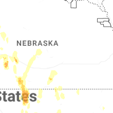
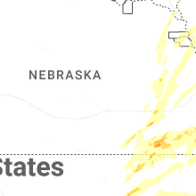
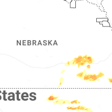

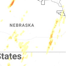
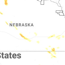
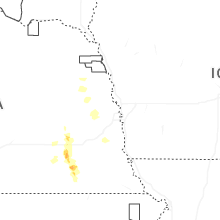
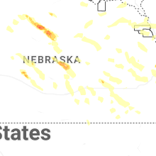


Connect with Interactive Hail Maps