

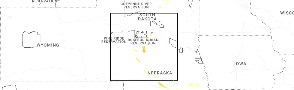
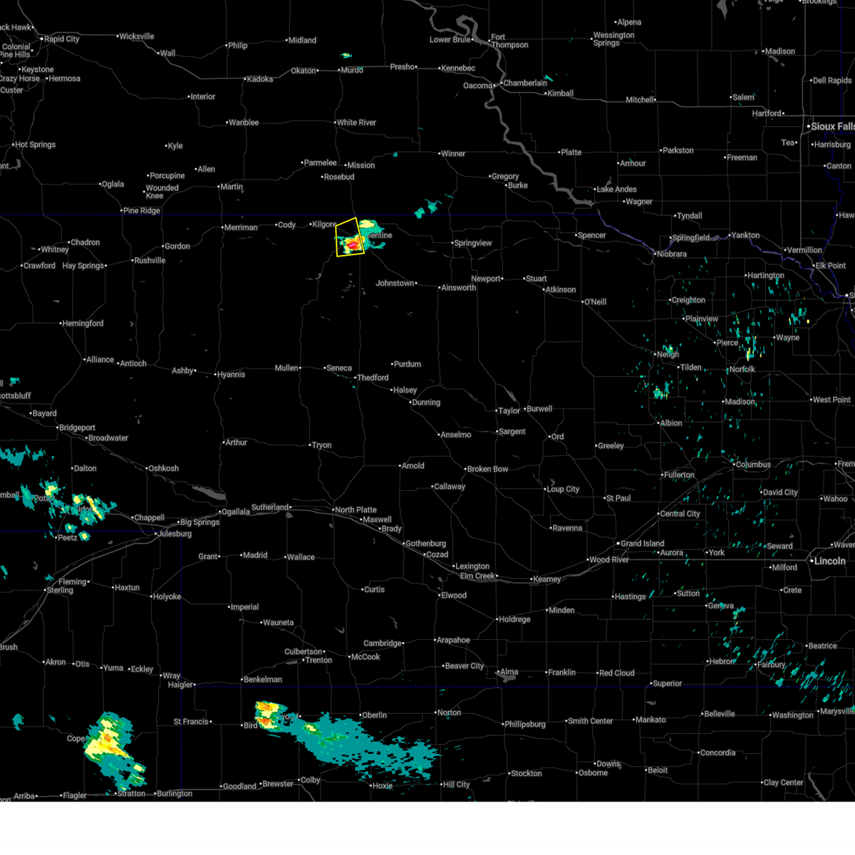
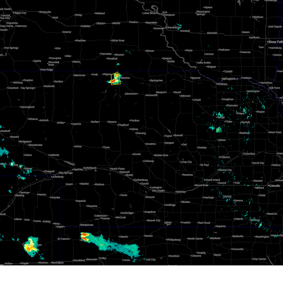
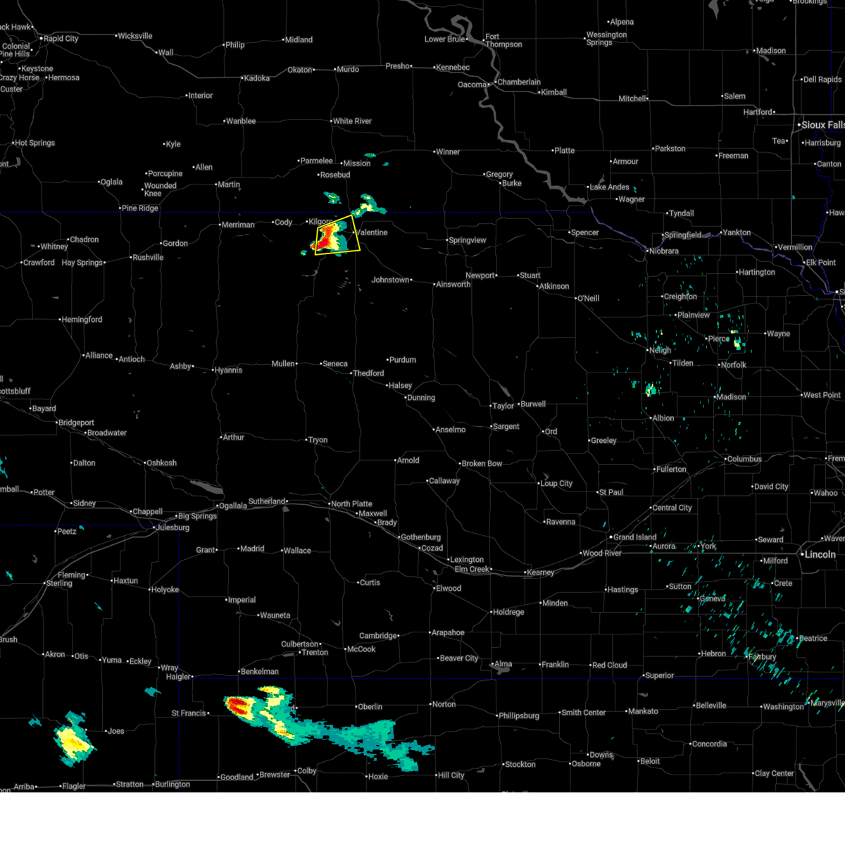
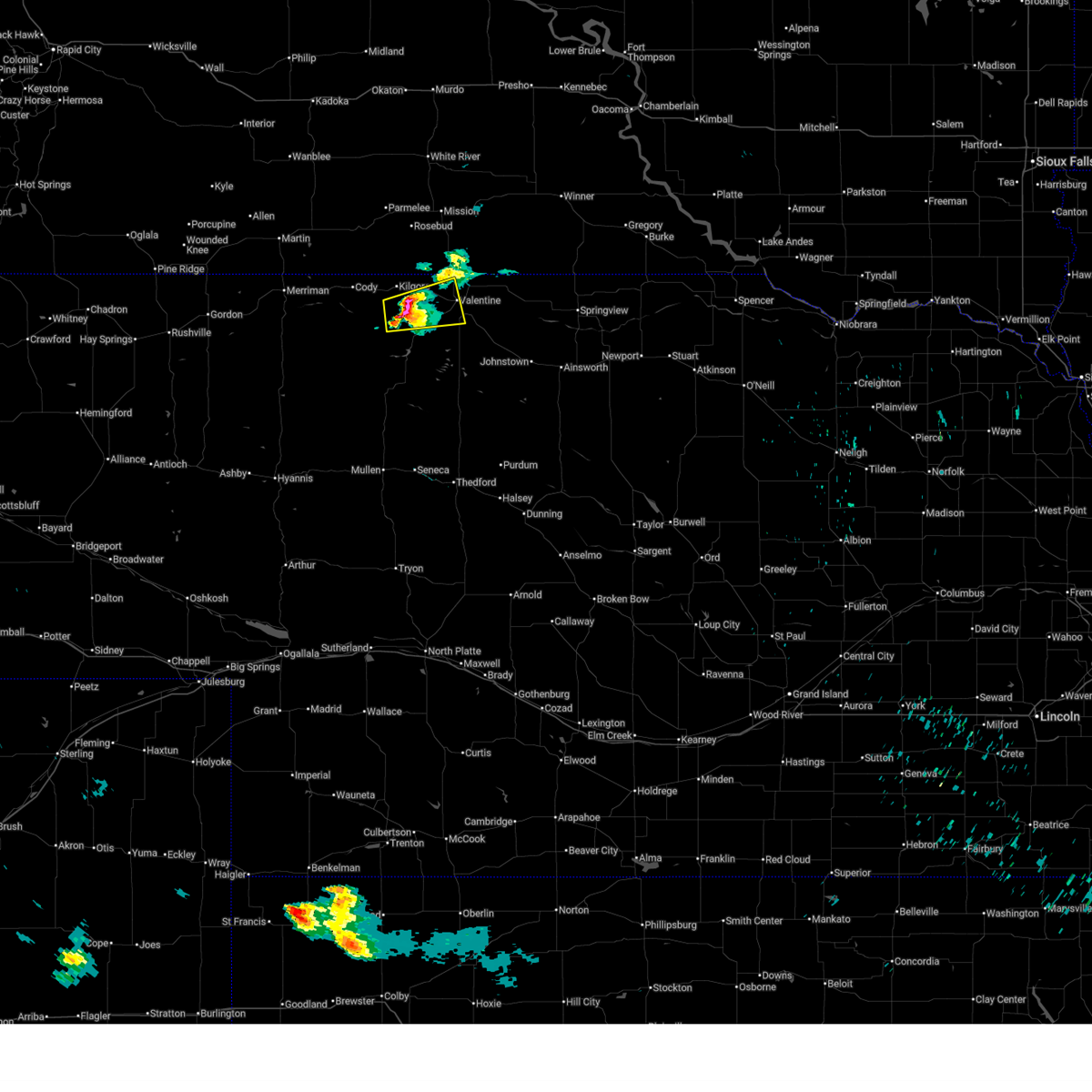
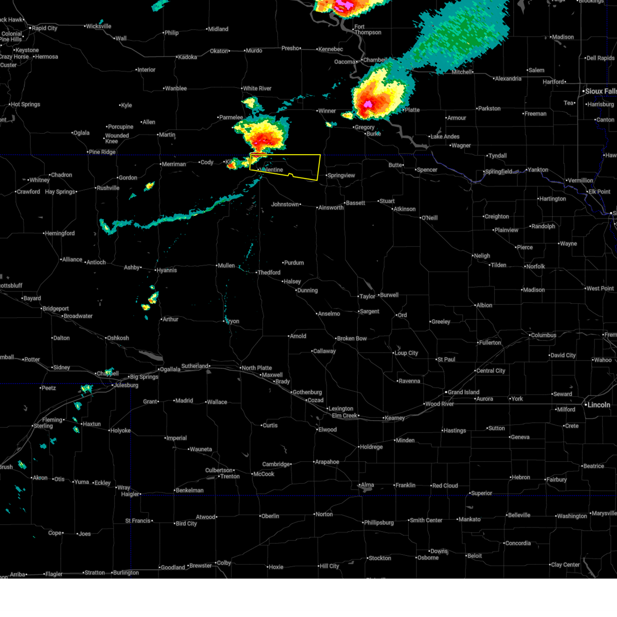
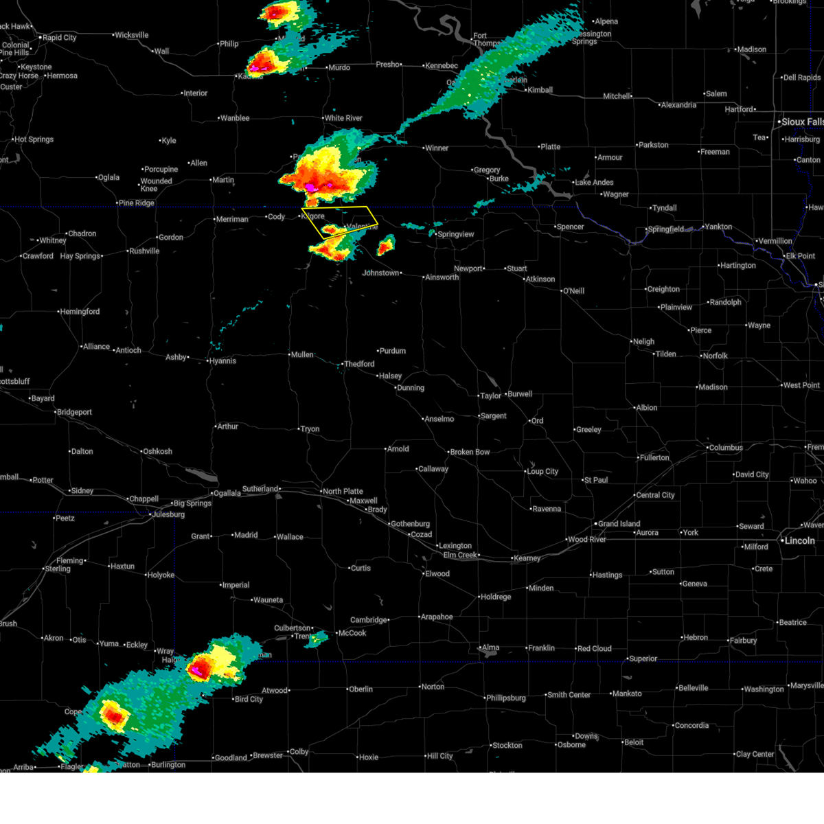
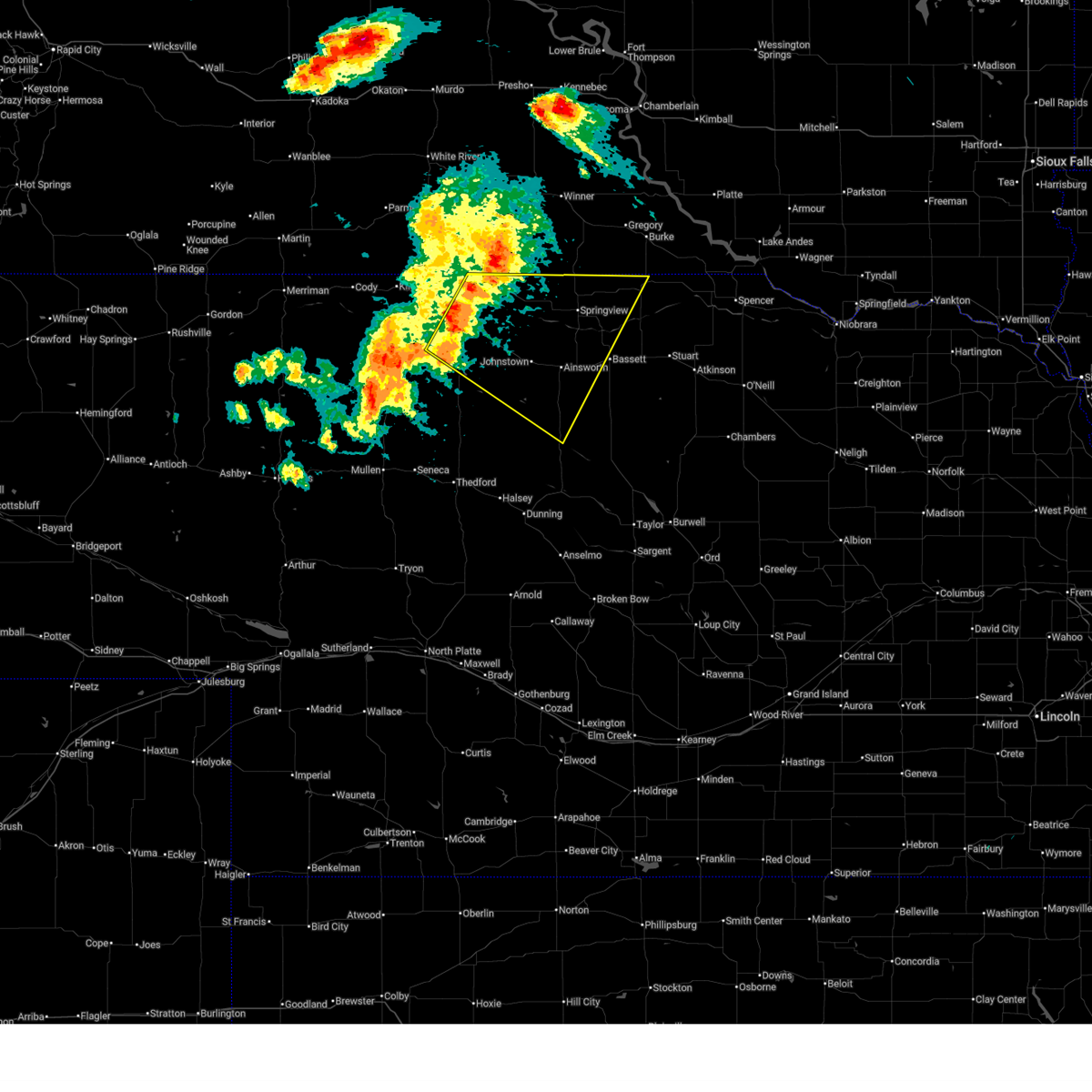
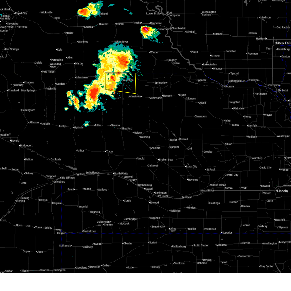
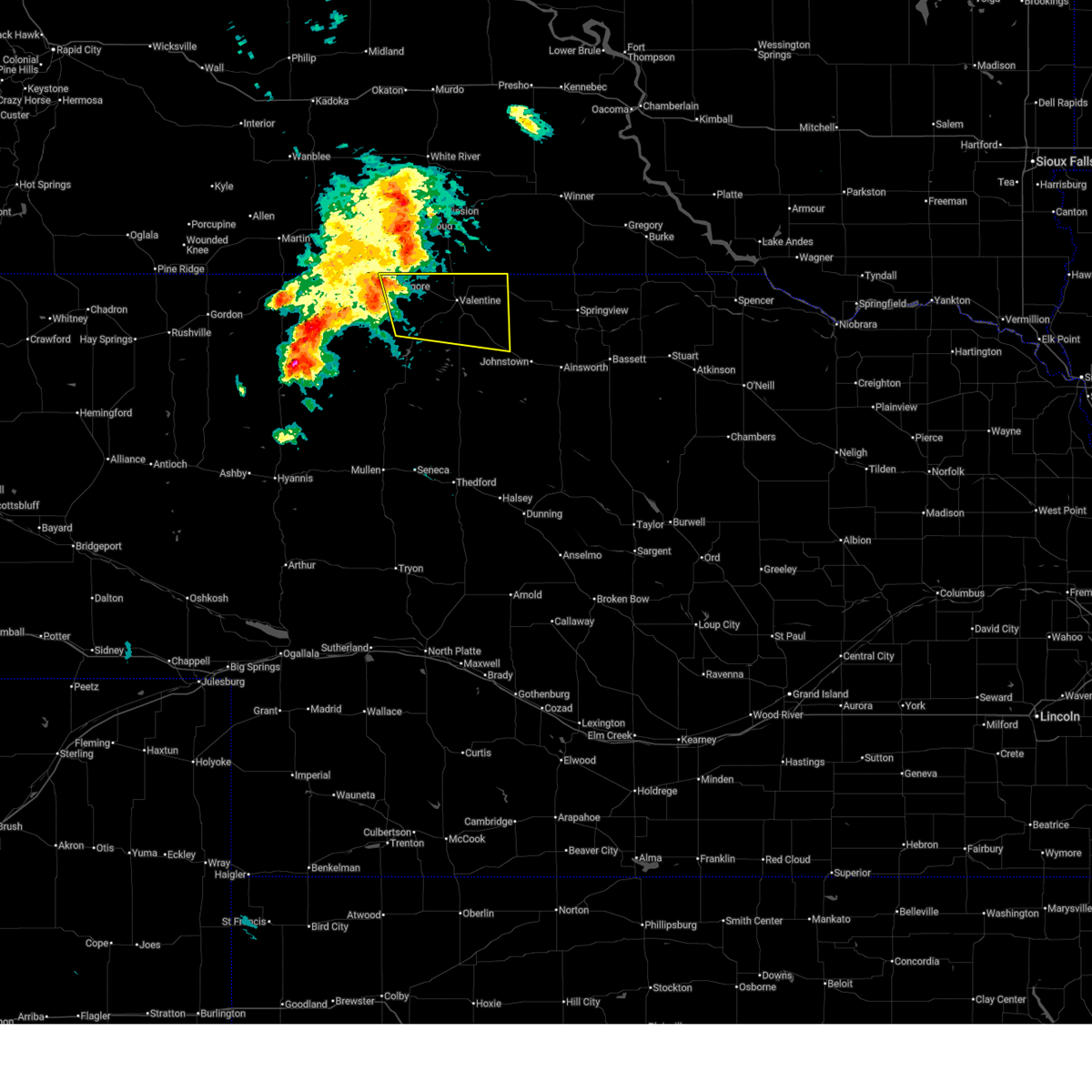
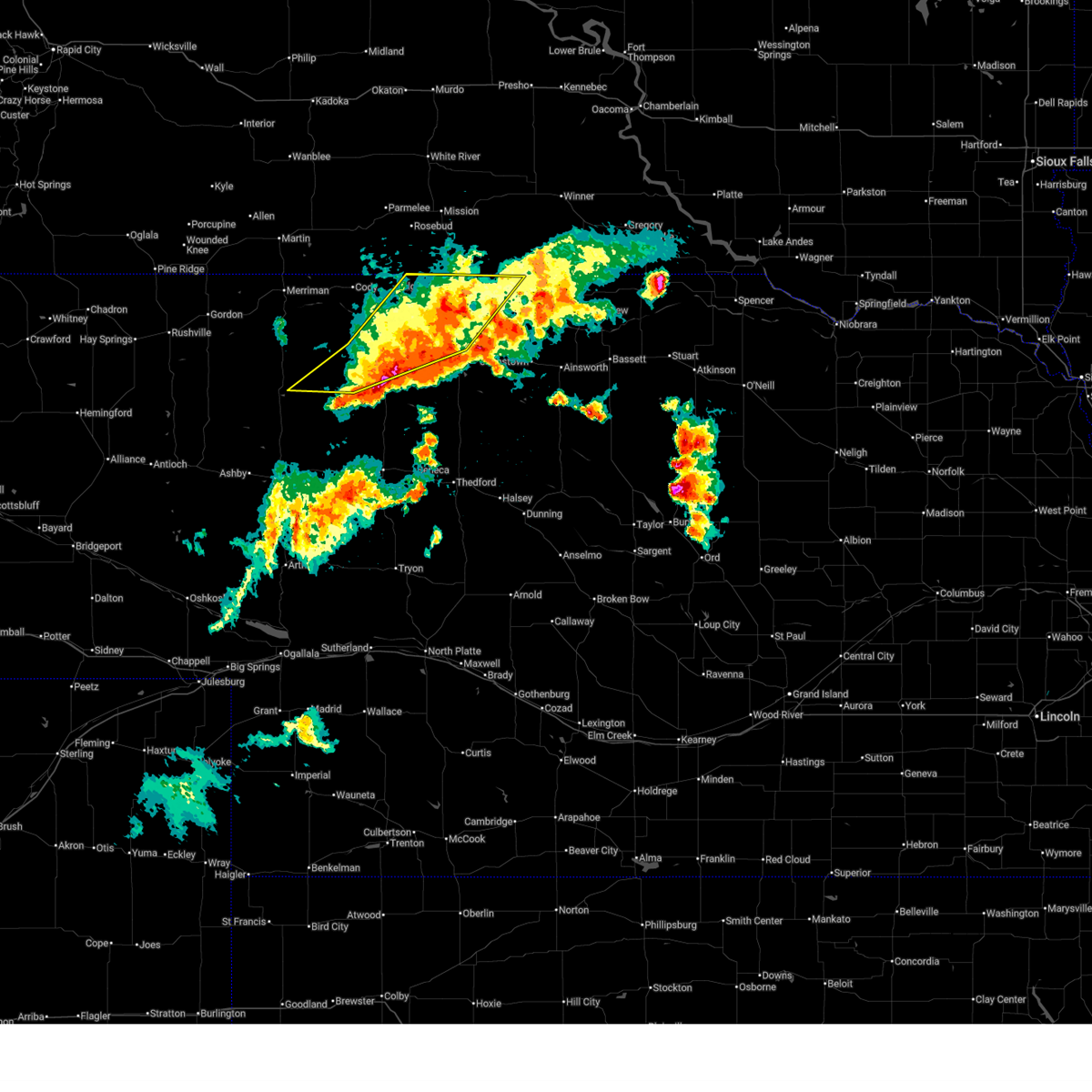
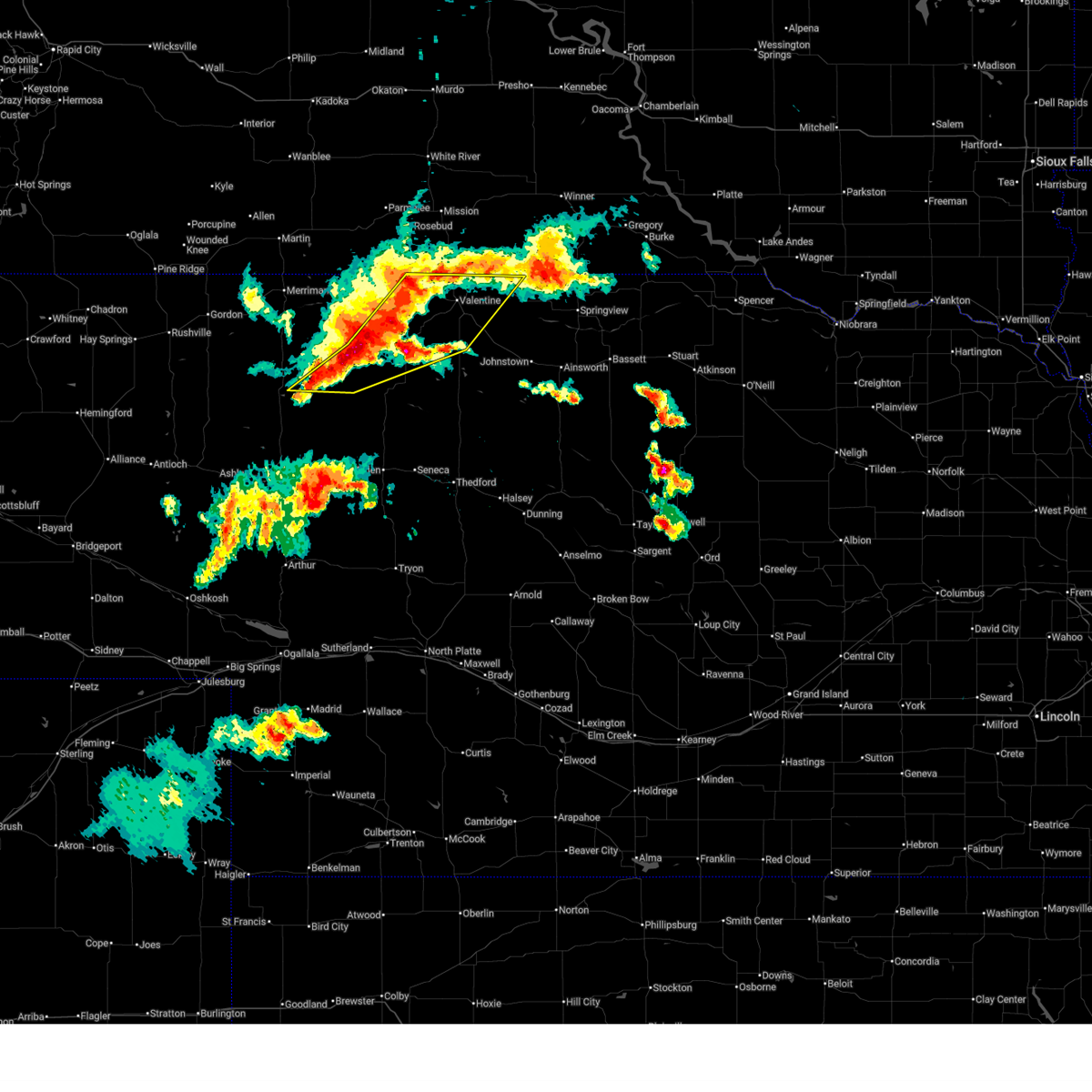
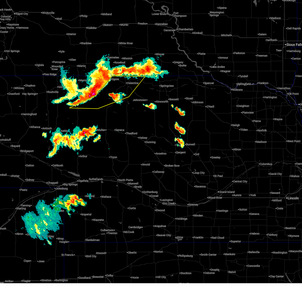
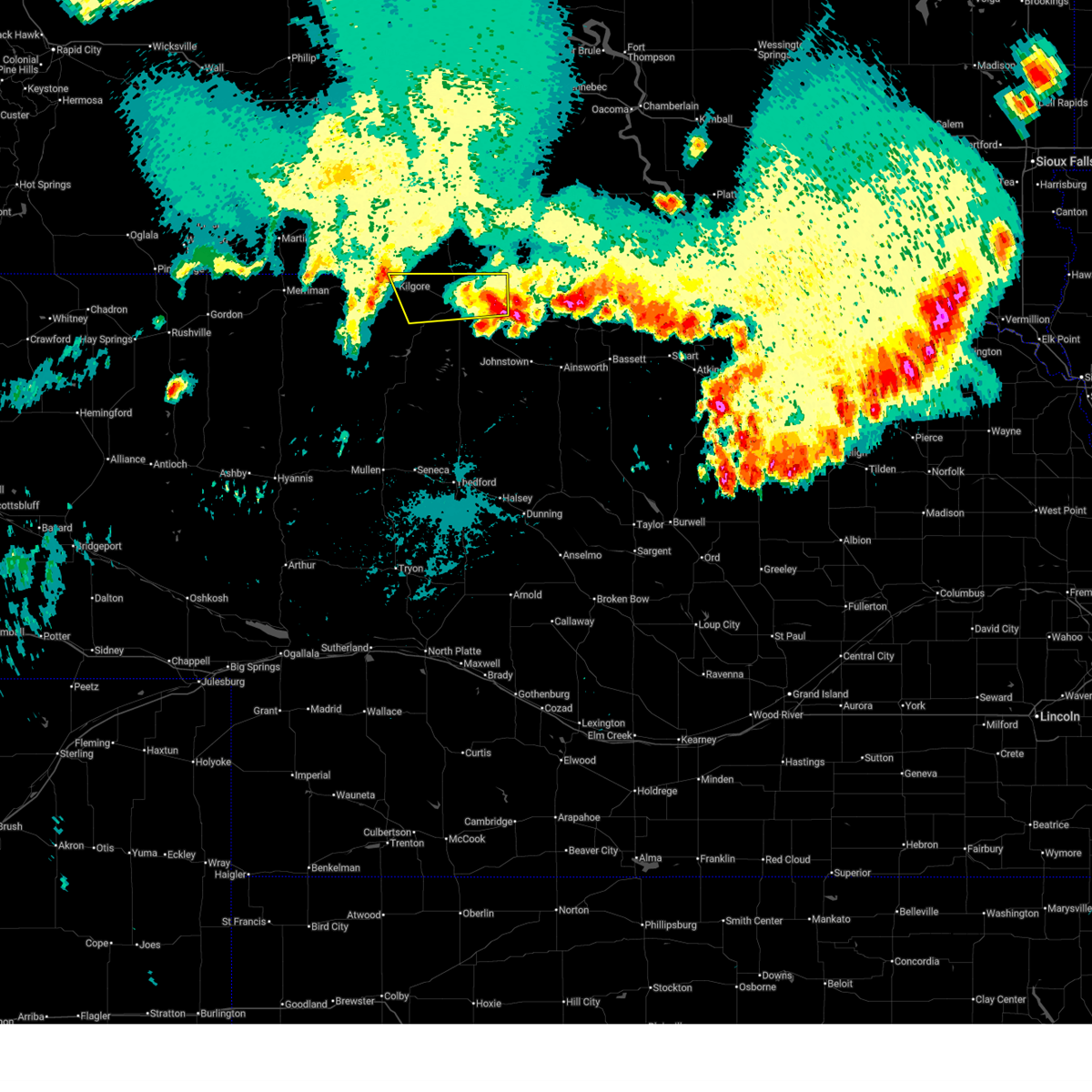
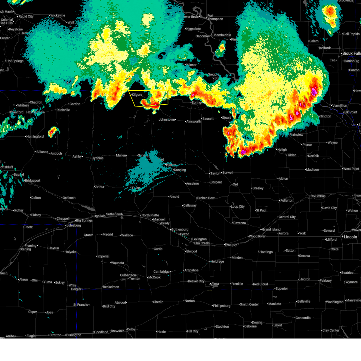
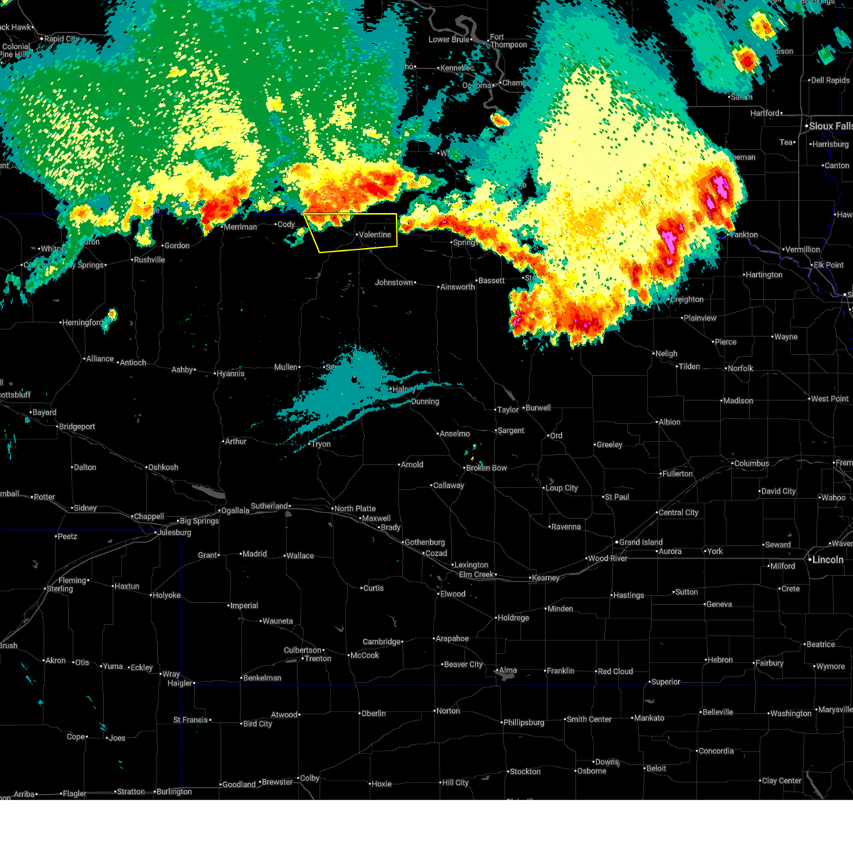
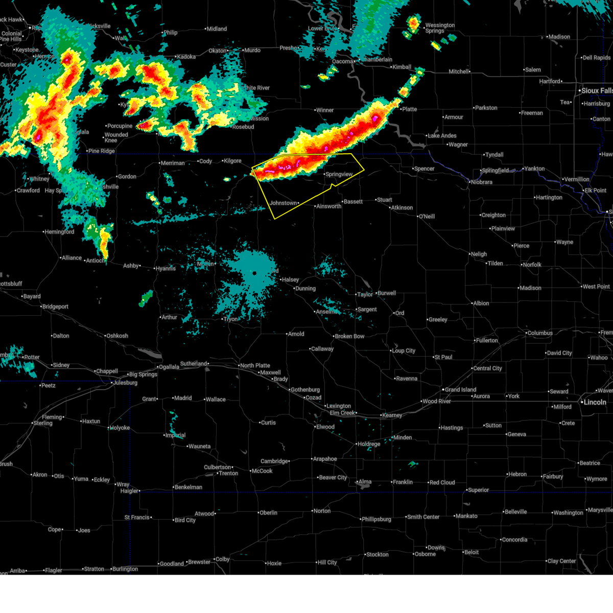
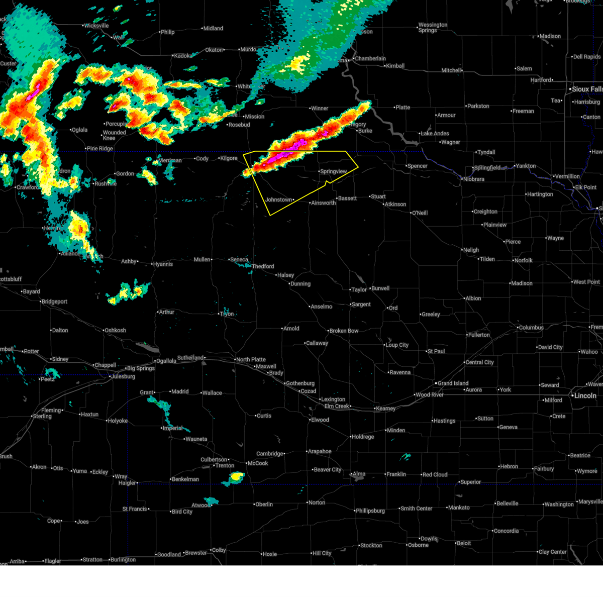
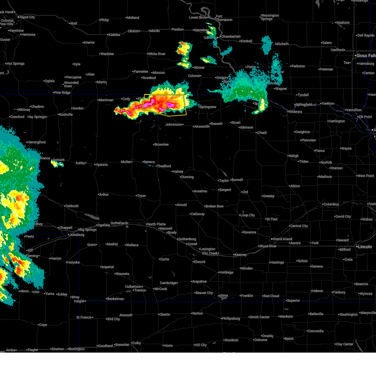
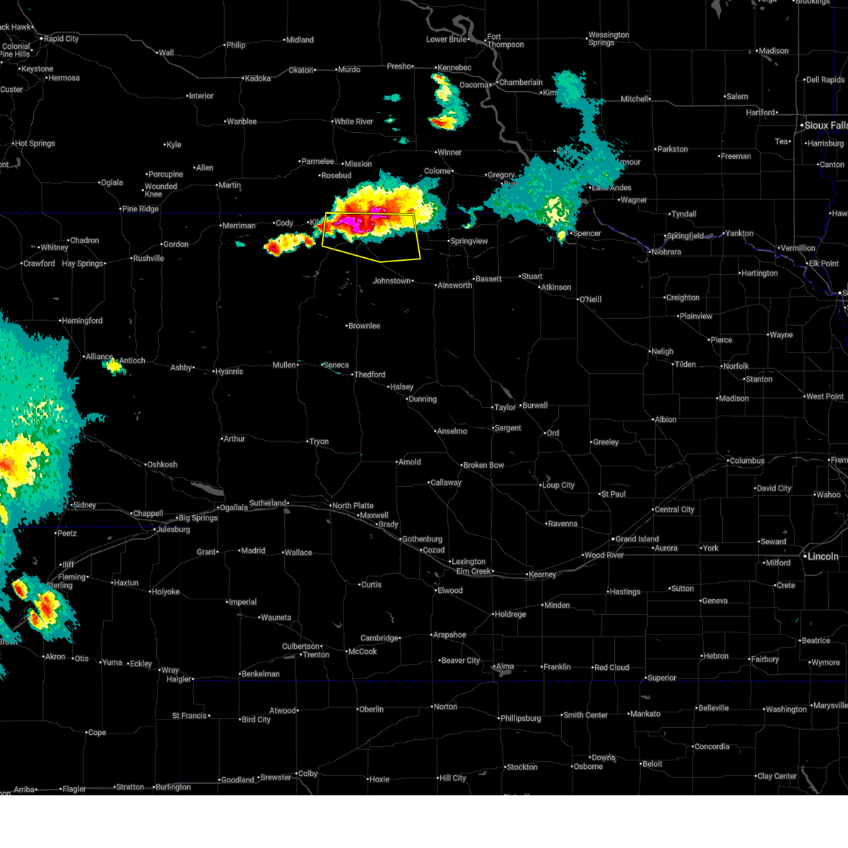
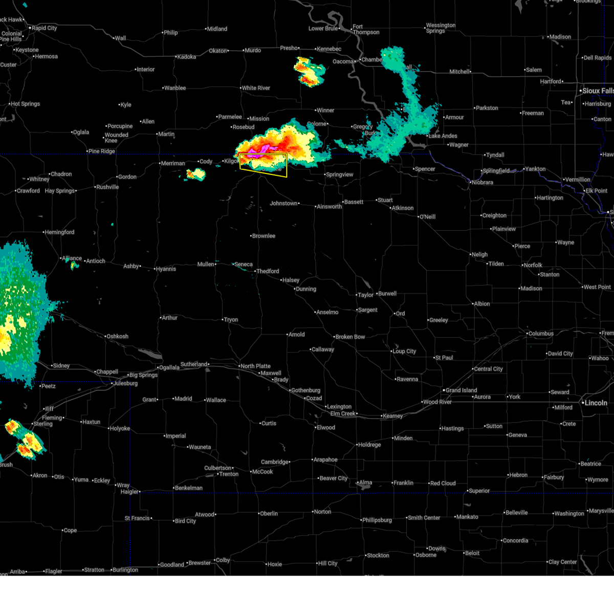
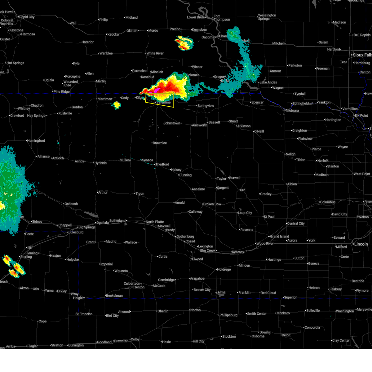
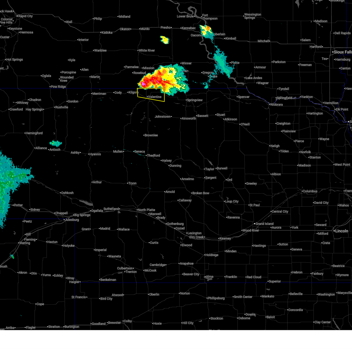
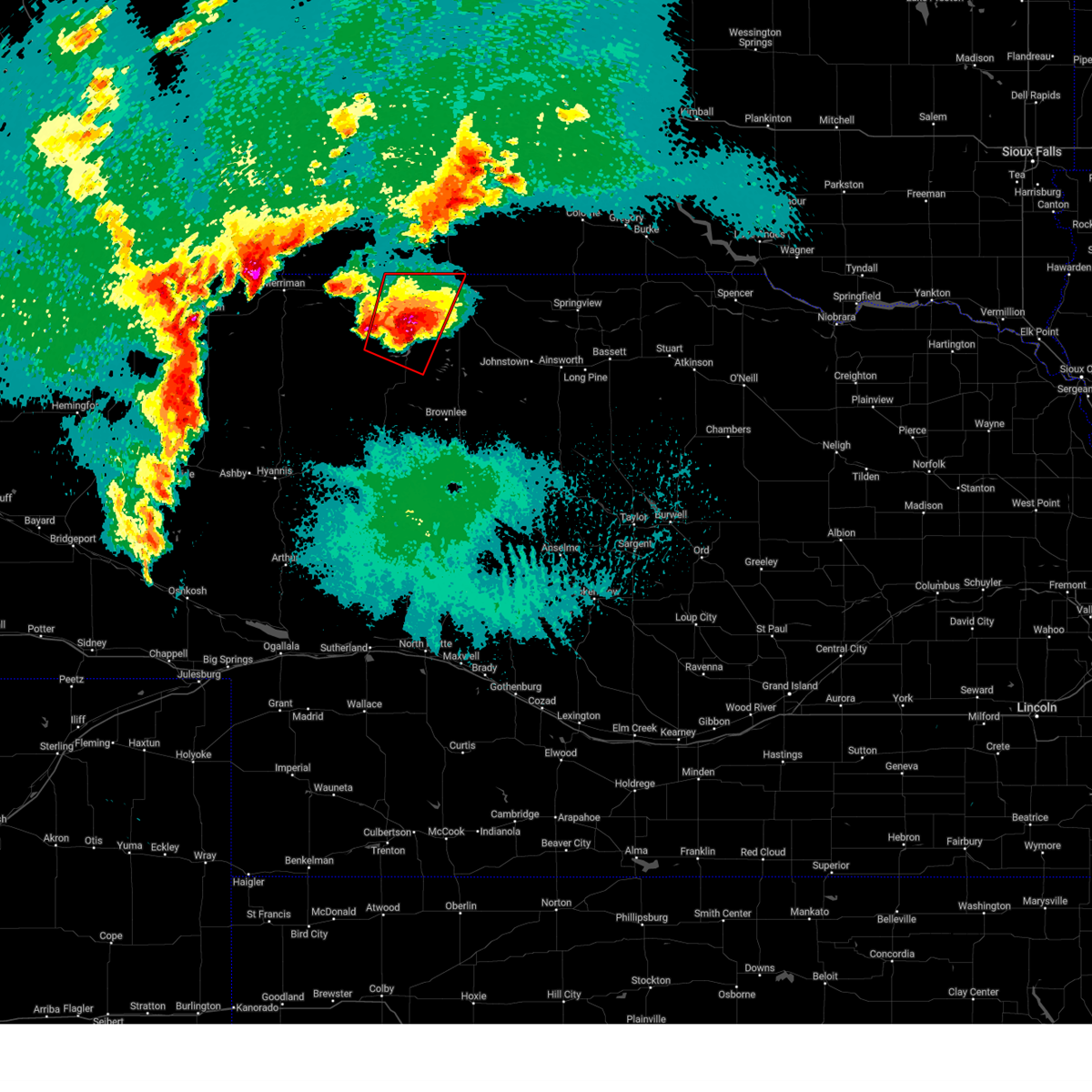
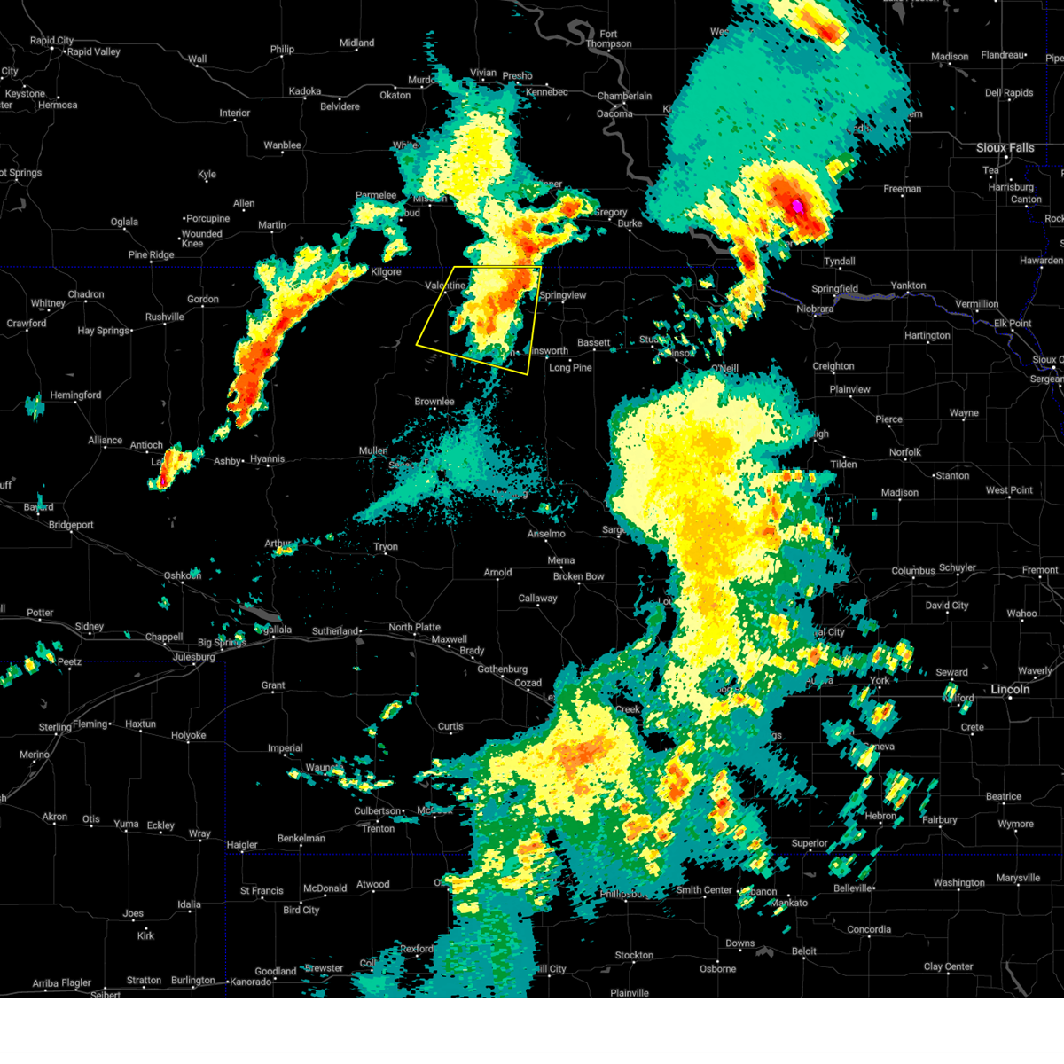
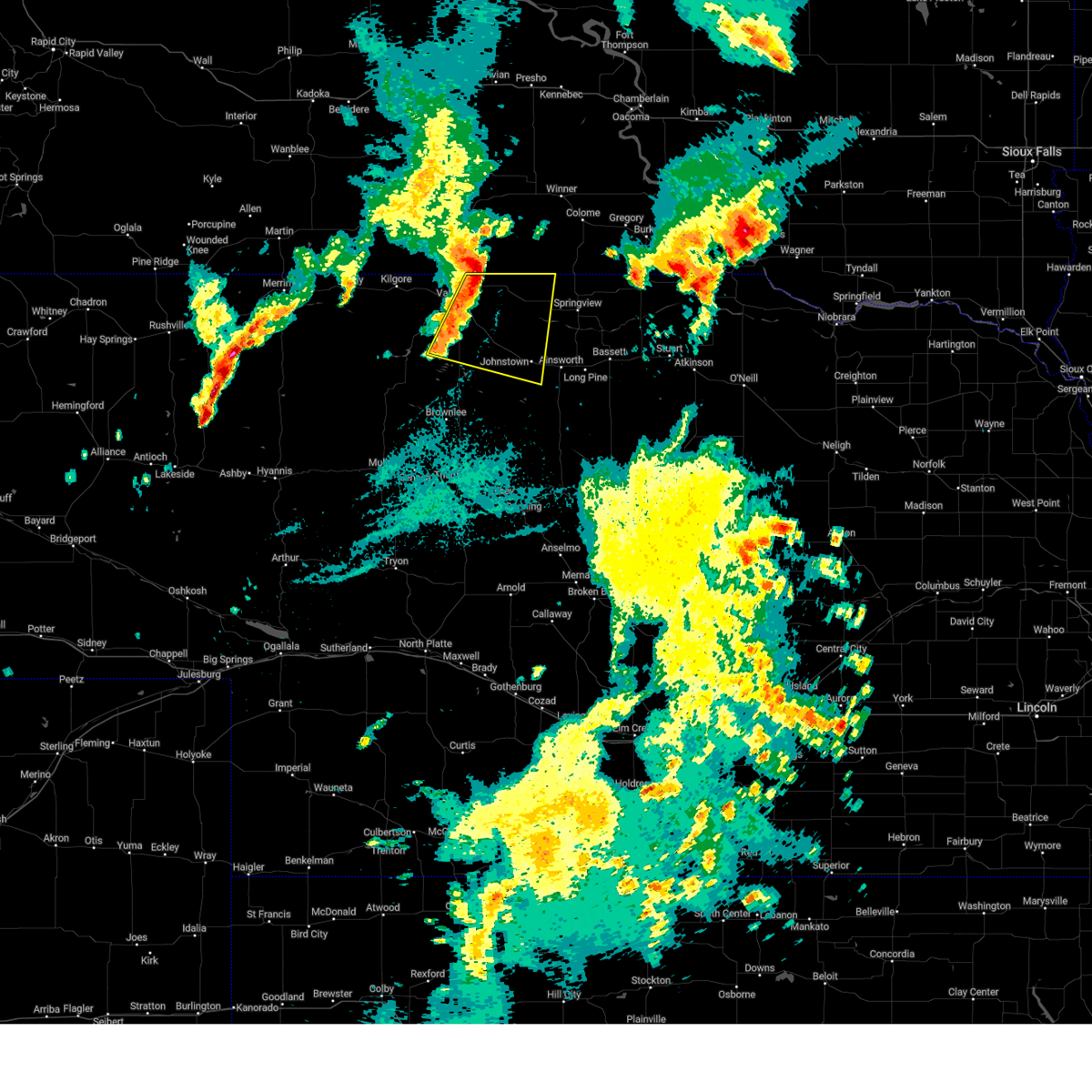
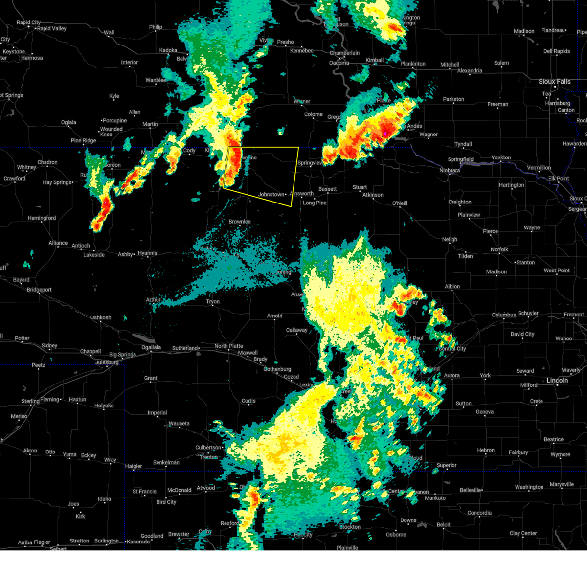
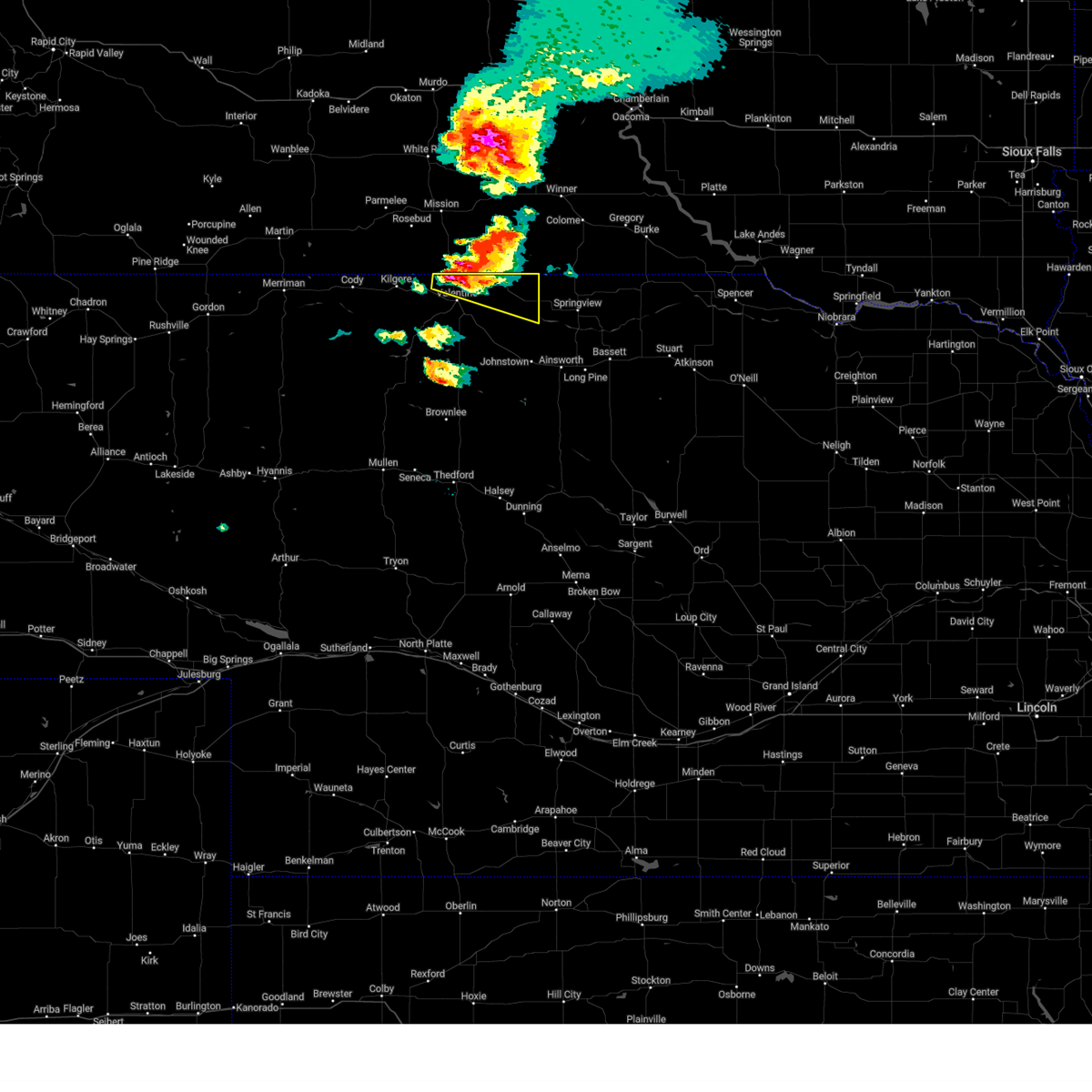
Hail Map for Valentine, NE
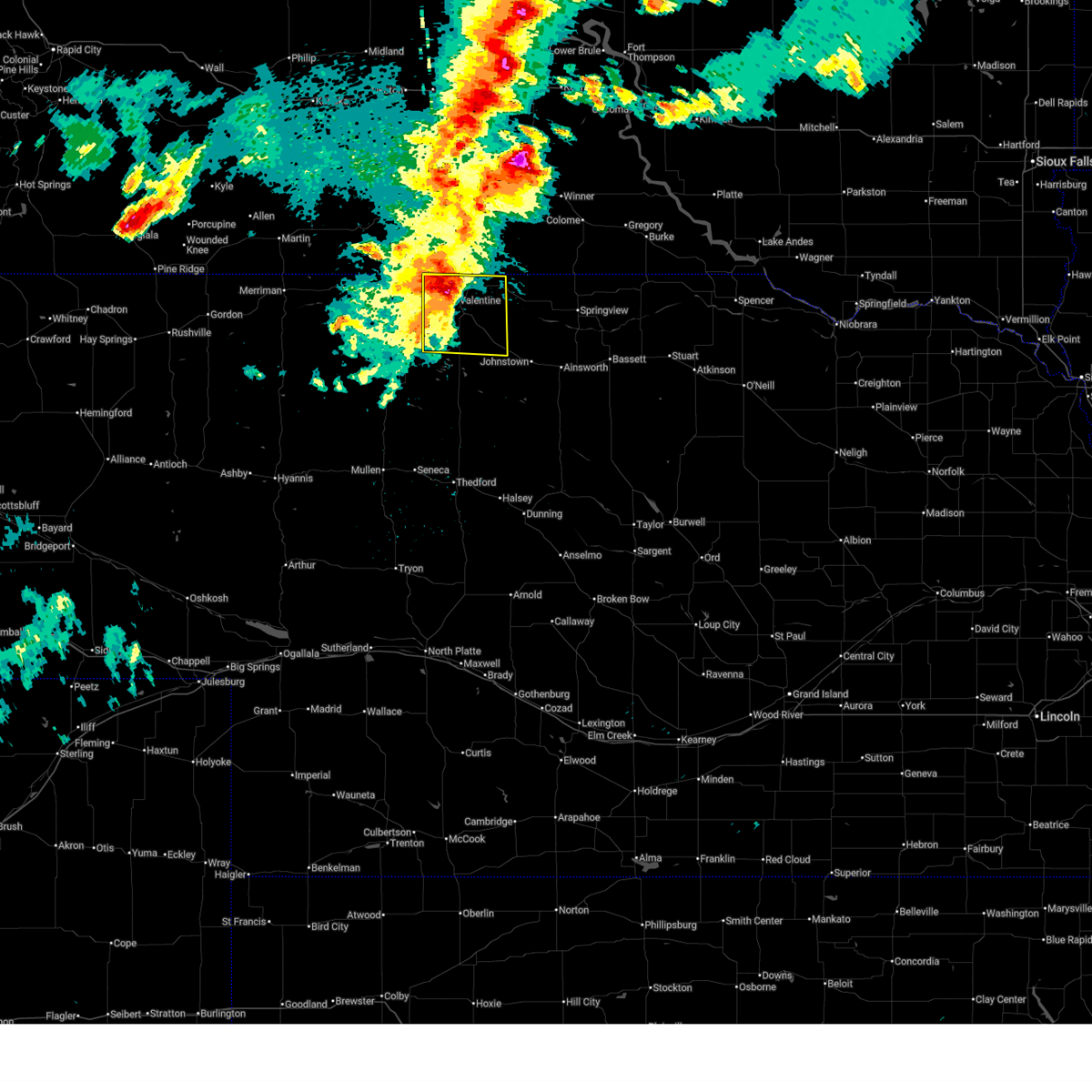
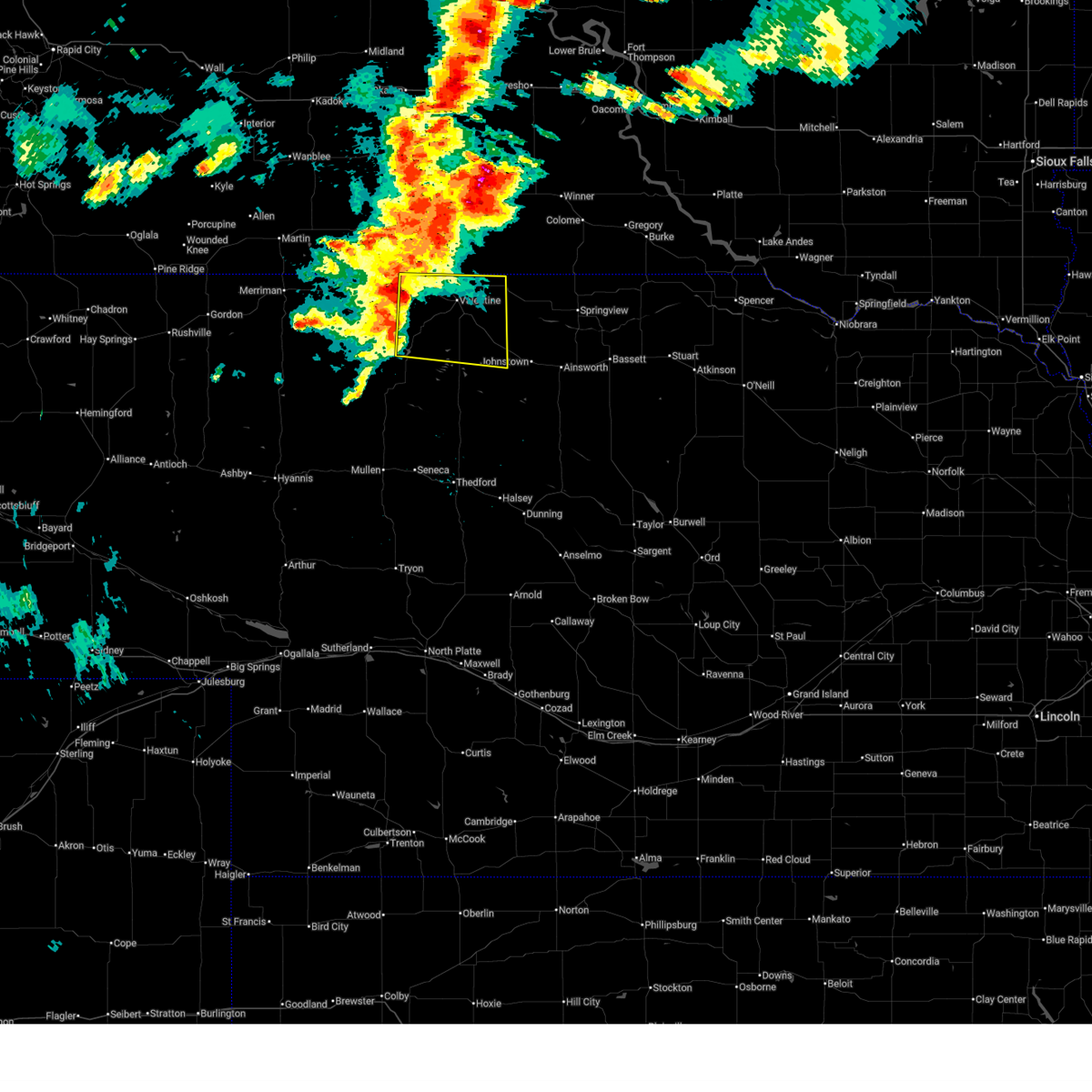
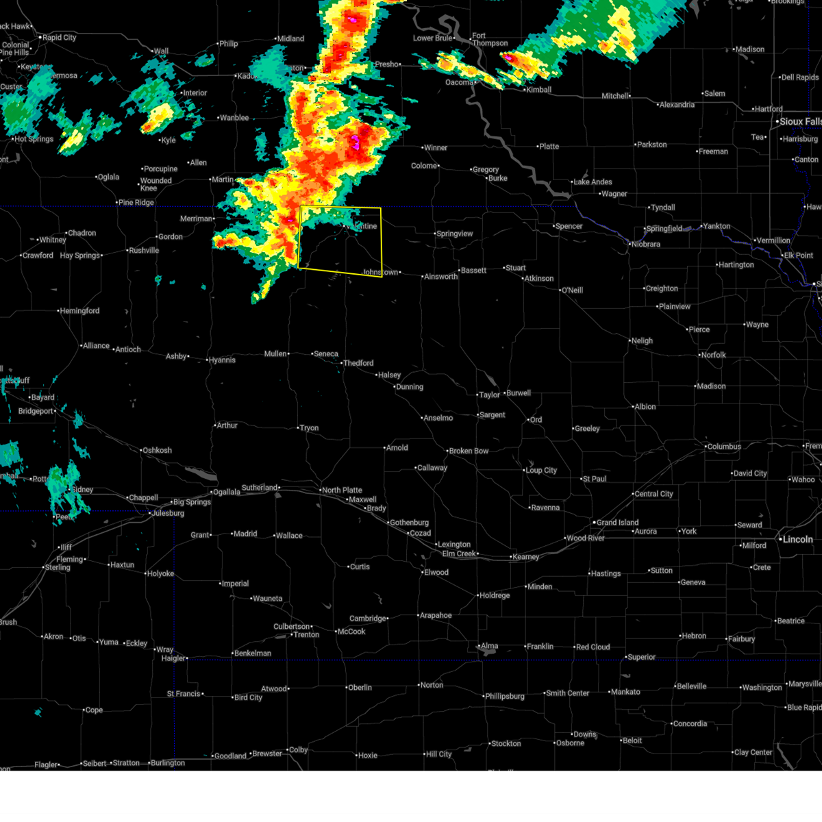
The Valentine, NE area has had 69 reports of on-the-ground hail by trained spotters, and has been under severe weather warnings 32 times during the past 12 months. Doppler radar has detected hail at or near Valentine, NE on 95 occasions, including 8 occasions during the past year.
| Name: | Valentine, NE |
| Where Located: | 0.2 miles NE of Valentine, NE |
| Map: | Google Map for Valentine, NE |
| Population: | 2737 |
| Housing Units: | 1430 |
| More Info: | Search Google for Valentine, NE |
1
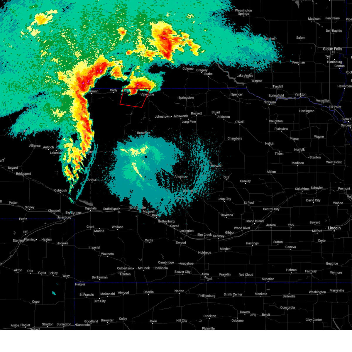
The Top Recent Hail Date for Valentine, NE is Monday, September 8, 2025 (8th out of 95)
Hail and Wind Damage Spotted near Valentine, NE
| Date / Time | Report Details |
|---|---|
| 6/4/2026 10:57 PM CDT | Storm damage reported in cherry county NE, 18.1 miles WSW of Valentine, NE |
| 6/4/2026 10:51 PM CDT | Storm damage reported in cherry county NE, 18.4 miles WSW of Valentine, NE |
| 6/4/2026 10:35 PM CDT | Storm damage reported in cherry county NE, 1.1 miles SSW of Valentine, NE |
| 6/4/2026 10:34 PM CDT |
 At 1034 pm cdt, a severe thunderstorm was located over valentine, moving east at 50 mph (radar indicated). Hazards include 70 mph wind gusts and quarter size hail. Hail damage to vehicles is expected. expect considerable tree damage. wind damage is also likely to mobile homes, roofs, and outbuildings. this severe thunderstorm will remain over mainly rural areas of northeastern cherry county, including the following locations, wood lake, smith falls state park, schlagel creek state wildlife management area, highway 97 crossing the niobrara river, crookston, big alkali lake state wildlife management area, and sparks. this includes the following highways, highway 20 between mile markers 185 and 222. highway 97 between mile markers 126 and 141. highway 83 between mile markers 194 and 222. Highway 12 between mile markers 1 and 19. At 1034 pm cdt, a severe thunderstorm was located over valentine, moving east at 50 mph (radar indicated). Hazards include 70 mph wind gusts and quarter size hail. Hail damage to vehicles is expected. expect considerable tree damage. wind damage is also likely to mobile homes, roofs, and outbuildings. this severe thunderstorm will remain over mainly rural areas of northeastern cherry county, including the following locations, wood lake, smith falls state park, schlagel creek state wildlife management area, highway 97 crossing the niobrara river, crookston, big alkali lake state wildlife management area, and sparks. this includes the following highways, highway 20 between mile markers 185 and 222. highway 97 between mile markers 126 and 141. highway 83 between mile markers 194 and 222. Highway 12 between mile markers 1 and 19.
|
| 6/4/2026 10:18 PM CDT |
 At 1017 pm cdt, severe thunderstorms were located along a line extending from 8 miles east of kilgore to 13 miles west of valentine to near merritt reservoir, moving east at 45 mph (radar indicated). Hazards include 70 mph wind gusts and quarter size hail. Hail damage to vehicles is expected. expect considerable tree damage. wind damage is also likely to mobile homes, roofs, and outbuildings. these severe storms will be near, valentine around 1030 pm cdt. other locations impacted by these severe thunderstorms include wood lake, anderson bridge state wildlife management area, smith falls state park, schlagel creek state wildlife management area, highway 97 crossing the niobrara river, crookston, big alkali lake state wildlife management area, and sparks. this includes the following highways, highway 20 between mile markers 176 and 222. highway 97 between mile markers 113 and 141. highway 83 between mile markers 191 and 222. Highway 12 between mile markers 1 and 19. At 1017 pm cdt, severe thunderstorms were located along a line extending from 8 miles east of kilgore to 13 miles west of valentine to near merritt reservoir, moving east at 45 mph (radar indicated). Hazards include 70 mph wind gusts and quarter size hail. Hail damage to vehicles is expected. expect considerable tree damage. wind damage is also likely to mobile homes, roofs, and outbuildings. these severe storms will be near, valentine around 1030 pm cdt. other locations impacted by these severe thunderstorms include wood lake, anderson bridge state wildlife management area, smith falls state park, schlagel creek state wildlife management area, highway 97 crossing the niobrara river, crookston, big alkali lake state wildlife management area, and sparks. this includes the following highways, highway 20 between mile markers 176 and 222. highway 97 between mile markers 113 and 141. highway 83 between mile markers 191 and 222. Highway 12 between mile markers 1 and 19.
|
| 6/4/2026 10:14 PM CDT |
 Svrlbf the national weather service in north platte has issued a * severe thunderstorm warning for, northeastern cherry county in north central nebraska, * until 1100 pm cdt. * at 1013 pm cdt, severe thunderstorms were located along a line extending from 7 miles northeast of kilgore to 15 miles west of valentine to merritt reservoir, moving east at 45 mph (radar indicated). Hazards include 60 mph wind gusts and quarter size hail. Hail damage to vehicles is expected. expect wind damage to roofs, siding, and trees. severe thunderstorms will be near, valentine around 1025 pm cdt. other locations impacted by these severe thunderstorms include wood lake, anderson bridge state wildlife management area, smith falls state park, schlagel creek state wildlife management area, highway 97 crossing the niobrara river, crookston, big alkali lake state wildlife management area, and sparks. this includes the following highways, highway 20 between mile markers 176 and 222. highway 97 between mile markers 113 and 141. highway 83 between mile markers 191 and 222. Highway 12 between mile markers 1 and 19. Svrlbf the national weather service in north platte has issued a * severe thunderstorm warning for, northeastern cherry county in north central nebraska, * until 1100 pm cdt. * at 1013 pm cdt, severe thunderstorms were located along a line extending from 7 miles northeast of kilgore to 15 miles west of valentine to merritt reservoir, moving east at 45 mph (radar indicated). Hazards include 60 mph wind gusts and quarter size hail. Hail damage to vehicles is expected. expect wind damage to roofs, siding, and trees. severe thunderstorms will be near, valentine around 1025 pm cdt. other locations impacted by these severe thunderstorms include wood lake, anderson bridge state wildlife management area, smith falls state park, schlagel creek state wildlife management area, highway 97 crossing the niobrara river, crookston, big alkali lake state wildlife management area, and sparks. this includes the following highways, highway 20 between mile markers 176 and 222. highway 97 between mile markers 113 and 141. highway 83 between mile markers 191 and 222. Highway 12 between mile markers 1 and 19.
|
| 9/16/2025 5:07 PM CDT | Storm damage reported in cherry county NE, 0.4 miles N of Valentine, NE |
| 9/16/2025 5:00 PM CDT | Svrlbf the national weather service in north platte has issued a * severe thunderstorm warning for, northeastern cherry county in north central nebraska, northern brown county in north central nebraska, western keya paha county in north central nebraska, * until 545 pm cdt. * at 458 pm cdt, severe thunderstorms were located along a line extending from 6 miles west of valentine to 12 miles west of norden to near johnstown, moving northeast at 40 mph (at 452 pm cdt...valentine asos recorded a wind gust to 63 mph). Hazards include 60 mph wind gusts. expect damage to roofs, siding, and trees |
| 9/16/2025 4:52 PM CDT | Asos station kvtn valentine airpor in cherry county NE, 1.1 miles N of Valentine, NE |
| 9/8/2025 7:39 PM CDT | Station vrfn in cherry county NE, 27.3 miles N of Valentine, NE |
| 9/8/2025 7:24 PM CDT | The storm which prompted the warning has moved out of the area. therefore, the warning will be allowed to expire. to report severe weather, contact your nearest law enforcement agency. they will relay your report to the national weather service north platte. |
| 9/8/2025 7:01 PM CDT | Quarter sized hail reported 0.7 miles ENE of Valentine, NE |
| 9/8/2025 7:00 PM CDT | Svrlbf the national weather service in north platte has issued a * severe thunderstorm warning for, northeastern cherry county in north central nebraska, * until 745 pm cdt. * at 659 pm cdt, a severe thunderstorm was located near valentine, moving south at 15 mph (radar indicated). Hazards include ping pong ball size hail and 60 mph wind gusts. People and animals outdoors will be injured. expect hail damage to roofs, siding, windows, and vehicles. Expect wind damage to roofs, siding, and trees. |
| 9/8/2025 6:42 PM CDT | Svrlbf the national weather service in north platte has issued a * severe thunderstorm warning for, northeastern cherry county in north central nebraska, * until 730 pm cdt. * at 641 pm cdt, a severe thunderstorm was located over valentine, moving southeast at 20 mph (public. at 632 pm cdt, half dollar size hail was reported one mile northeast of valentine). Hazards include ping pong ball size hail and 60 mph wind gusts. People and animals outdoors will be injured. expect hail damage to roofs, siding, windows, and vehicles. Expect wind damage to roofs, siding, and trees. |
| 9/8/2025 6:32 PM CDT | Half Dollar sized hail reported 0.5 miles SW of Valentine, NE, report from mping: half dollar (1.25 in.). |
| 9/8/2025 6:26 PM CDT | At 625 pm cdt, a severe thunderstorm was located over valentine, moving southeast at 25 mph (trained weather spotters. at 625 pm cdt, ping pong ball hail was reported 1 mile northeast of valentine). Hazards include golf ball size hail and 60 mph wind gusts. People and animals outdoors will be injured. expect hail damage to roofs, siding, windows, and vehicles. expect wind damage to roofs, siding, and trees. locations impacted include, valentine, sparks, and smith falls state park. this includes the following highways, highway 20 between mile markers 191 and 207. highway 97 between mile markers 140 and 141. highway 83 between mile markers 213 and 222. Highway 12 between mile markers 1 and 22. |
| 9/8/2025 6:25 PM CDT | Ping Pong Ball sized hail reported 0.5 miles SW of Valentine, NE |
| 9/8/2025 6:20 PM CDT | the severe thunderstorm warning has been cancelled and is no longer in effect |
| 9/8/2025 6:20 PM CDT | At 620 pm cdt, a severe thunderstorm was located over valentine, moving southeast at 15 mph (radar indicated). Hazards include 60 mph wind gusts and half dollar size hail. Hail damage to vehicles is expected. expect wind damage to roofs, siding, and trees. locations impacted include, valentine, sparks, and smith falls state park. this includes the following highways, highway 20 between mile markers 191 and 207. highway 97 between mile markers 140 and 141. highway 83 between mile markers 213 and 222. Highway 12 between mile markers 1 and 22. |
| 9/8/2025 5:59 PM CDT | Svrlbf the national weather service in north platte has issued a * severe thunderstorm warning for, northeastern cherry county in north central nebraska, northwestern brown county in north central nebraska, west central keya paha county in north central nebraska, * until 645 pm cdt. * at 558 pm cdt, a severe thunderstorm was located near sicangu village, or near valentine, moving southeast at 25 mph (radar indicated). Hazards include 60 mph wind gusts and quarter size hail. Hail damage to vehicles is expected. Expect wind damage to roofs, siding, and trees. |
| 8/7/2025 8:09 PM CDT |
 The storm which prompted the warning has weakened below severe limits, and no longer poses an immediate threat to life or property. therefore, the warning will be allowed to expire. The storm which prompted the warning has weakened below severe limits, and no longer poses an immediate threat to life or property. therefore, the warning will be allowed to expire.
|
| 8/7/2025 8:01 PM CDT |
 At 800 pm cdt, a severe thunderstorm was located 7 miles southwest of valentine, moving east at 30 mph (radar indicated). Hazards include 60 mph wind gusts and penny size hail. Expect damage to roofs, siding, and trees. locations impacted include, valentine and highway 97 crossing the niobrara river. this includes the following highways, highway 20 between mile markers 187 and 199. highway 97 between mile markers 130 and 141. Highway 83 between mile markers 204 and 206, and between mile markers 213 and 221. At 800 pm cdt, a severe thunderstorm was located 7 miles southwest of valentine, moving east at 30 mph (radar indicated). Hazards include 60 mph wind gusts and penny size hail. Expect damage to roofs, siding, and trees. locations impacted include, valentine and highway 97 crossing the niobrara river. this includes the following highways, highway 20 between mile markers 187 and 199. highway 97 between mile markers 130 and 141. Highway 83 between mile markers 204 and 206, and between mile markers 213 and 221.
|
| 8/7/2025 7:45 PM CDT |
 At 745 pm cdt, a severe thunderstorm was located 12 miles north of merritt reservoir, or 12 miles west of valentine, moving east at 30 mph (radar indicated). Hazards include 60 mph wind gusts and quarter size hail. Hail damage to vehicles is expected. expect wind damage to roofs, siding, and trees. locations impacted include, valentine, crookston, and highway 97 crossing the niobrara river. this includes the following highways, highway 20 between mile markers 185 and 199. highway 97 between mile markers 125 and 141. Highway 83 between mile markers 204 and 206, and between mile markers 213 and 221. At 745 pm cdt, a severe thunderstorm was located 12 miles north of merritt reservoir, or 12 miles west of valentine, moving east at 30 mph (radar indicated). Hazards include 60 mph wind gusts and quarter size hail. Hail damage to vehicles is expected. expect wind damage to roofs, siding, and trees. locations impacted include, valentine, crookston, and highway 97 crossing the niobrara river. this includes the following highways, highway 20 between mile markers 185 and 199. highway 97 between mile markers 125 and 141. Highway 83 between mile markers 204 and 206, and between mile markers 213 and 221.
|
| 8/7/2025 7:26 PM CDT |
 Svrlbf the national weather service in north platte has issued a * severe thunderstorm warning for, northeastern cherry county in north central nebraska, * until 815 pm cdt. * at 725 pm cdt, a severe thunderstorm was located 7 miles south of kilgore, or 18 miles west of valentine, moving east at 20 mph (radar indicated). Hazards include ping pong ball size hail and 60 mph wind gusts. People and animals outdoors will be injured. expect hail damage to roofs, siding, windows, and vehicles. Expect wind damage to roofs, siding, and trees. Svrlbf the national weather service in north platte has issued a * severe thunderstorm warning for, northeastern cherry county in north central nebraska, * until 815 pm cdt. * at 725 pm cdt, a severe thunderstorm was located 7 miles south of kilgore, or 18 miles west of valentine, moving east at 20 mph (radar indicated). Hazards include ping pong ball size hail and 60 mph wind gusts. People and animals outdoors will be injured. expect hail damage to roofs, siding, windows, and vehicles. Expect wind damage to roofs, siding, and trees.
|
| 7/28/2025 5:05 PM CDT |
 Svrlbf the national weather service in north platte has issued a * severe thunderstorm warning for, northeastern cherry county in north central nebraska, western keya paha county in north central nebraska, * until 545 pm cdt. * at 504 pm cdt, a severe thunderstorm was located near sicangu village, or near valentine, moving east at 35 mph. this storm produced a 62 mph wind gust at the valentine airport at 455 pm cdt (public). Hazards include 60 mph wind gusts and quarter size hail. Hail damage to vehicles is expected. Expect wind damage to roofs, siding, and trees. Svrlbf the national weather service in north platte has issued a * severe thunderstorm warning for, northeastern cherry county in north central nebraska, western keya paha county in north central nebraska, * until 545 pm cdt. * at 504 pm cdt, a severe thunderstorm was located near sicangu village, or near valentine, moving east at 35 mph. this storm produced a 62 mph wind gust at the valentine airport at 455 pm cdt (public). Hazards include 60 mph wind gusts and quarter size hail. Hail damage to vehicles is expected. Expect wind damage to roofs, siding, and trees.
|
| 7/28/2025 4:55 PM CDT | Asos station kvtn valentine airpor in cherry county NE, 1.1 miles N of Valentine, NE |
| 7/20/2025 8:35 PM CDT | Quarter sized hail reported 1.1 miles N of Valentine, NE, had 1 inch hail and 54 mph wind gust on his home weather station. |
| 7/20/2025 8:33 PM CDT | Storm damage reported in cherry county NE, 0.4 miles N of Valentine, NE |
| 7/20/2025 8:33 PM CDT | Quarter sized hail reported 0.4 miles N of Valentine, NE |
| 7/20/2025 8:30 PM CDT | Storm damage reported in cherry county NE, 3.5 miles SSE of Valentine, NE |
| 7/20/2025 8:30 PM CDT |
 Svrlbf the national weather service in north platte has issued a * severe thunderstorm warning for, northeastern cherry county in north central nebraska, northwestern brown county in north central nebraska, * until 930 pm cdt. * at 829 pm cdt, a severe thunderstorm was located over valentine, moving southeast at 15 mph. this is a destructive storm for valentine (trained weather spotters). Hazards include 80 mph wind gusts and golf ball size hail. Flying debris will be dangerous to those caught without shelter. mobile homes will be heavily damaged. expect considerable damage to roofs, windows, and vehicles. Extensive tree damage and power outages are likely. Svrlbf the national weather service in north platte has issued a * severe thunderstorm warning for, northeastern cherry county in north central nebraska, northwestern brown county in north central nebraska, * until 930 pm cdt. * at 829 pm cdt, a severe thunderstorm was located over valentine, moving southeast at 15 mph. this is a destructive storm for valentine (trained weather spotters). Hazards include 80 mph wind gusts and golf ball size hail. Flying debris will be dangerous to those caught without shelter. mobile homes will be heavily damaged. expect considerable damage to roofs, windows, and vehicles. Extensive tree damage and power outages are likely.
|
| 7/20/2025 8:29 PM CDT | Half Dollar sized hail reported 0.4 miles N of Valentine, NE, 60-70 mph winds will the hail. |
| 7/20/2025 8:25 PM CDT | Half Dollar sized hail reported 3.8 miles S of Valentine, NE |
| 7/20/2025 8:10 PM CDT |
 At 810 pm cdt, a severe thunderstorm was located near lakeview, or 13 miles northwest of valentine, moving southeast at 15 mph. this is a destructive storm for valentine (radar indicated). Hazards include baseball size hail and 70 mph wind gusts. People and animals outdoors will be severely injured. expect shattered windows, extensive damage to roofs, siding, and vehicles. locations impacted include, valentine, crookston, and smith falls state park. this includes the following highways, highway 20 between mile markers 185 and 199. highway 97 between mile markers 134 and 135, and between mile markers 137 and 141. highway 83 between mile markers 213 and 222. Highway 12 between mile markers 1 and 15. At 810 pm cdt, a severe thunderstorm was located near lakeview, or 13 miles northwest of valentine, moving southeast at 15 mph. this is a destructive storm for valentine (radar indicated). Hazards include baseball size hail and 70 mph wind gusts. People and animals outdoors will be severely injured. expect shattered windows, extensive damage to roofs, siding, and vehicles. locations impacted include, valentine, crookston, and smith falls state park. this includes the following highways, highway 20 between mile markers 185 and 199. highway 97 between mile markers 134 and 135, and between mile markers 137 and 141. highway 83 between mile markers 213 and 222. Highway 12 between mile markers 1 and 15.
|
| 7/20/2025 8:07 PM CDT |
 At 806 pm cdt, a severe thunderstorm capable of producing a tornado was located near sicangu village, or 8 miles northwest of valentine, moving southeast at 25 mph (radar indicated rotation). Hazards include tornado and baseball size hail. Flying debris will be dangerous to those caught without shelter. mobile homes will be damaged or destroyed. damage to roofs, windows, and vehicles will occur. tree damage is likely. locations impacted include, valentine and crookston. this includes the following highways, highway 20 between mile markers 185 and 199. highway 97 near mile marker 134, and between mile markers 138 and 141. highway 83 between mile markers 213 and 222. Highway 12 between mile markers 1 and 2. At 806 pm cdt, a severe thunderstorm capable of producing a tornado was located near sicangu village, or 8 miles northwest of valentine, moving southeast at 25 mph (radar indicated rotation). Hazards include tornado and baseball size hail. Flying debris will be dangerous to those caught without shelter. mobile homes will be damaged or destroyed. damage to roofs, windows, and vehicles will occur. tree damage is likely. locations impacted include, valentine and crookston. this includes the following highways, highway 20 between mile markers 185 and 199. highway 97 near mile marker 134, and between mile markers 138 and 141. highway 83 between mile markers 213 and 222. Highway 12 between mile markers 1 and 2.
|
| 7/20/2025 7:49 PM CDT |
 Torlbf the national weather service in north platte has issued a * tornado warning for, northeastern cherry county in north central nebraska, * until 830 pm cdt. * at 749 pm cdt, a severe thunderstorm capable of producing a tornado was located near lakeview, or 15 miles northwest of valentine, moving southeast at 20 mph (radar indicated rotation). Hazards include tornado and baseball size hail. Flying debris will be dangerous to those caught without shelter. mobile homes will be damaged or destroyed. damage to roofs, windows, and vehicles will occur. Tree damage is likely. Torlbf the national weather service in north platte has issued a * tornado warning for, northeastern cherry county in north central nebraska, * until 830 pm cdt. * at 749 pm cdt, a severe thunderstorm capable of producing a tornado was located near lakeview, or 15 miles northwest of valentine, moving southeast at 20 mph (radar indicated rotation). Hazards include tornado and baseball size hail. Flying debris will be dangerous to those caught without shelter. mobile homes will be damaged or destroyed. damage to roofs, windows, and vehicles will occur. Tree damage is likely.
|
| 7/20/2025 7:46 PM CDT |
 Svrlbf the national weather service in north platte has issued a * severe thunderstorm warning for, northeastern cherry county in north central nebraska, * until 845 pm cdt. * at 746 pm cdt, a severe thunderstorm was located near lakeview, or 17 miles southwest of mission, moving southeast at 15 mph. this is a destructive storm for crookston (radar indicated). Hazards include baseball size hail and 70 mph wind gusts. People and animals outdoors will be severely injured. Expect shattered windows, extensive damage to roofs, siding, and vehicles. Svrlbf the national weather service in north platte has issued a * severe thunderstorm warning for, northeastern cherry county in north central nebraska, * until 845 pm cdt. * at 746 pm cdt, a severe thunderstorm was located near lakeview, or 17 miles southwest of mission, moving southeast at 15 mph. this is a destructive storm for crookston (radar indicated). Hazards include baseball size hail and 70 mph wind gusts. People and animals outdoors will be severely injured. Expect shattered windows, extensive damage to roofs, siding, and vehicles.
|
| 7/9/2025 7:45 PM CDT |
 Svrlbf the national weather service in north platte has issued a * severe thunderstorm warning for, northeastern cherry county in north central nebraska, northwestern rock county in north central nebraska, brown county in north central nebraska, keya paha county in north central nebraska, * until 845 pm cdt. * at 744 pm cdt, severe thunderstorms were located along a line extending from 8 miles northwest of norden to 7 miles northeast of valentine national wildlife refuge, moving southeast at 50 mph (radar indicated). Hazards include 60 mph wind gusts. expect damage to roofs, siding, and trees Svrlbf the national weather service in north platte has issued a * severe thunderstorm warning for, northeastern cherry county in north central nebraska, northwestern rock county in north central nebraska, brown county in north central nebraska, keya paha county in north central nebraska, * until 845 pm cdt. * at 744 pm cdt, severe thunderstorms were located along a line extending from 8 miles northwest of norden to 7 miles northeast of valentine national wildlife refuge, moving southeast at 50 mph (radar indicated). Hazards include 60 mph wind gusts. expect damage to roofs, siding, and trees
|
| 7/9/2025 7:25 PM CDT |
 At 725 pm cdt, severe thunderstorms were located along a line extending from near littleburg to 11 miles east of merritt reservoir, moving southeast at 35 mph (radar indicated). Hazards include 60 mph wind gusts. Expect damage to roofs, siding, and trees. locations impacted include, valentine, kilgore, crookston, wood lake, anderson bridge state wildlife management area, smith falls state park, schlagel creek state wildlife management area, highway 97 crossing the niobrara river, and sparks. this includes the following highways, highway 20 between mile markers 175 and 223. highway 97 between mile markers 120 and 141. highway 83 between mile markers 197 and 222. Highway 12 between mile markers 1 and 21. At 725 pm cdt, severe thunderstorms were located along a line extending from near littleburg to 11 miles east of merritt reservoir, moving southeast at 35 mph (radar indicated). Hazards include 60 mph wind gusts. Expect damage to roofs, siding, and trees. locations impacted include, valentine, kilgore, crookston, wood lake, anderson bridge state wildlife management area, smith falls state park, schlagel creek state wildlife management area, highway 97 crossing the niobrara river, and sparks. this includes the following highways, highway 20 between mile markers 175 and 223. highway 97 between mile markers 120 and 141. highway 83 between mile markers 197 and 222. Highway 12 between mile markers 1 and 21.
|
| 7/9/2025 7:00 PM CDT |
 Svrlbf the national weather service in north platte has issued a * severe thunderstorm warning for, northeastern cherry county in north central nebraska, * until 745 pm cdt. * at 700 pm cdt, severe thunderstorms were located along a line extending from near sicangu village to 10 miles southwest of valentine, moving east at 45 mph (radar indicated). Hazards include 60 mph wind gusts. expect damage to roofs, siding, and trees Svrlbf the national weather service in north platte has issued a * severe thunderstorm warning for, northeastern cherry county in north central nebraska, * until 745 pm cdt. * at 700 pm cdt, severe thunderstorms were located along a line extending from near sicangu village to 10 miles southwest of valentine, moving east at 45 mph (radar indicated). Hazards include 60 mph wind gusts. expect damage to roofs, siding, and trees
|
| 7/1/2025 9:51 PM MDT |
 The storms which prompted the warning have weakened below severe limits, and have exited the warned area. therefore, the warning will be allowed to expire. however, gusty winds up to 50 mph are still possible with these thunderstorms. a severe thunderstorm watch remains in effect until midnight cdt for north central nebraska. to report severe weather, contact your nearest law enforcement agency. they will relay your report to the national weather service north platte. The storms which prompted the warning have weakened below severe limits, and have exited the warned area. therefore, the warning will be allowed to expire. however, gusty winds up to 50 mph are still possible with these thunderstorms. a severe thunderstorm watch remains in effect until midnight cdt for north central nebraska. to report severe weather, contact your nearest law enforcement agency. they will relay your report to the national weather service north platte.
|
| 7/1/2025 9:20 PM MDT |
 At 1019 pm cdt, severe thunderstorms were located along a line extending from near sicangu village to 8 miles west of merritt reservoir to 18 miles south of medicine lake, moving east at 35 mph (radar indicated). Hazards include 60 mph wind gusts and half dollar size hail. Hail damage to vehicles is expected. expect wind damage to roofs, siding, and trees. locations impacted include, valentine, kilgore, merritt reservoir, crookston, steer creek campground, anderson bridge state wildlife management area, round lake, smith falls state park, schlagel creek state wildlife management area, highway 97 crossing the niobrara river, sparks, and big alkali lake state wildlife management area. this includes the following highways, highway 20 between mile markers 175 and 211. highway 97 between mile markers 107 and 141. highway 83 between mile markers 194 and 222. Highway 12 between mile markers 1 and 22. At 1019 pm cdt, severe thunderstorms were located along a line extending from near sicangu village to 8 miles west of merritt reservoir to 18 miles south of medicine lake, moving east at 35 mph (radar indicated). Hazards include 60 mph wind gusts and half dollar size hail. Hail damage to vehicles is expected. expect wind damage to roofs, siding, and trees. locations impacted include, valentine, kilgore, merritt reservoir, crookston, steer creek campground, anderson bridge state wildlife management area, round lake, smith falls state park, schlagel creek state wildlife management area, highway 97 crossing the niobrara river, sparks, and big alkali lake state wildlife management area. this includes the following highways, highway 20 between mile markers 175 and 211. highway 97 between mile markers 107 and 141. highway 83 between mile markers 194 and 222. Highway 12 between mile markers 1 and 22.
|
| 7/1/2025 9:04 PM MDT |
 Svrlbf the national weather service in north platte has issued a * severe thunderstorm warning for, central cherry county in north central nebraska, west central keya paha county in north central nebraska, * until 1100 pm cdt. * at 1004 pm cdt, severe thunderstorms were located along a line extending from 6 miles east of kilgore to 13 miles southeast of medicine lake to 30 miles north of whitman, moving east at 35 mph (radar indicated). Hazards include ping pong ball size hail and 60 mph wind gusts. People and animals outdoors will be injured. expect hail damage to roofs, siding, windows, and vehicles. Expect wind damage to roofs, siding, and trees. Svrlbf the national weather service in north platte has issued a * severe thunderstorm warning for, central cherry county in north central nebraska, west central keya paha county in north central nebraska, * until 1100 pm cdt. * at 1004 pm cdt, severe thunderstorms were located along a line extending from 6 miles east of kilgore to 13 miles southeast of medicine lake to 30 miles north of whitman, moving east at 35 mph (radar indicated). Hazards include ping pong ball size hail and 60 mph wind gusts. People and animals outdoors will be injured. expect hail damage to roofs, siding, windows, and vehicles. Expect wind damage to roofs, siding, and trees.
|
| 6/29/2025 2:16 AM CDT |
 The storms which prompted the warning have weakened below severe limits, and no longer pose an immediate threat to life or property. therefore, the warning has been allowed to expire. however, gusty winds are still possible with these thunderstorms. The storms which prompted the warning have weakened below severe limits, and no longer pose an immediate threat to life or property. therefore, the warning has been allowed to expire. however, gusty winds are still possible with these thunderstorms.
|
| 6/29/2025 1:55 AM CDT |
 At 155 am cdt, severe thunderstorms were located along a line extending from 8 miles southeast of littleburg to 7 miles southeast of valentine, moving east at 45 mph (radar indicated). Hazards include 60 mph wind gusts. Expect damage to roofs, siding, and trees. locations impacted include, valentine, kilgore, crookston, highway 97 crossing the niobrara river, sparks, and smith falls state park. this includes the following highways, highway 20 between mile markers 175 and 205. highway 97 between mile markers 129 and 141. highway 83 between mile markers 205 and 222. Highway 12 between mile markers 1 and 20. At 155 am cdt, severe thunderstorms were located along a line extending from 8 miles southeast of littleburg to 7 miles southeast of valentine, moving east at 45 mph (radar indicated). Hazards include 60 mph wind gusts. Expect damage to roofs, siding, and trees. locations impacted include, valentine, kilgore, crookston, highway 97 crossing the niobrara river, sparks, and smith falls state park. this includes the following highways, highway 20 between mile markers 175 and 205. highway 97 between mile markers 129 and 141. highway 83 between mile markers 205 and 222. Highway 12 between mile markers 1 and 20.
|
| 6/29/2025 1:32 AM CDT |
 Svrlbf the national weather service in north platte has issued a * severe thunderstorm warning for, northeastern cherry county in north central nebraska, * until 215 am cdt. * at 132 am cdt, severe thunderstorms were located along a line extending from 6 miles southeast of littleburg to 7 miles southeast of kilgore, moving east at 45 mph (radar indicated). Hazards include 60 mph wind gusts. expect damage to roofs, siding, and trees Svrlbf the national weather service in north platte has issued a * severe thunderstorm warning for, northeastern cherry county in north central nebraska, * until 215 am cdt. * at 132 am cdt, severe thunderstorms were located along a line extending from 6 miles southeast of littleburg to 7 miles southeast of kilgore, moving east at 45 mph (radar indicated). Hazards include 60 mph wind gusts. expect damage to roofs, siding, and trees
|
| 6/29/2025 1:29 AM CDT | Asos station kvtn valentine airpor in cherry county NE, 1.1 miles N of Valentine, NE |
| 6/28/2025 10:37 PM CDT |
 At 1036 pm cdt, severe thunderstorms were located along a line extending from 6 miles southeast of wewela to 14 miles northwest of johnstown, moving southeast at 30 mph (trained weather spotters. peak gusts of 60 mph measured at the valentine airport). Hazards include ping pong ball size hail and 60 mph wind gusts. People and animals outdoors will be injured. expect hail damage to roofs, siding, windows, and vehicles. expect wind damage to roofs, siding, and trees. locations impacted include, valentine, springview, johnstown, norden, wood lake, burton, nets peak, bobcat state wildlife management area, meadville, north river trail, sparks, keller park state recreation area, thomas creek state wildlife management area, smith falls state park, antelope peak, and mills. this includes the following highways, highway 183 between mile markers 203 and 225. highway 20 between mile markers 195 and 234. highway 97 between mile markers 139 and 141. highway 83 between mile markers 204 and 215. Highway 12 between mile markers 1 and 5, and between mile markers 10 and 79. At 1036 pm cdt, severe thunderstorms were located along a line extending from 6 miles southeast of wewela to 14 miles northwest of johnstown, moving southeast at 30 mph (trained weather spotters. peak gusts of 60 mph measured at the valentine airport). Hazards include ping pong ball size hail and 60 mph wind gusts. People and animals outdoors will be injured. expect hail damage to roofs, siding, windows, and vehicles. expect wind damage to roofs, siding, and trees. locations impacted include, valentine, springview, johnstown, norden, wood lake, burton, nets peak, bobcat state wildlife management area, meadville, north river trail, sparks, keller park state recreation area, thomas creek state wildlife management area, smith falls state park, antelope peak, and mills. this includes the following highways, highway 183 between mile markers 203 and 225. highway 20 between mile markers 195 and 234. highway 97 between mile markers 139 and 141. highway 83 between mile markers 204 and 215. Highway 12 between mile markers 1 and 5, and between mile markers 10 and 79.
|
| 6/28/2025 10:16 PM CDT | Storm damage reported in cherry county NE, 0.4 miles N of Valentine, NE |
| 6/28/2025 10:14 PM CDT |
 Svrlbf the national weather service in north platte has issued a * severe thunderstorm warning for, northeastern cherry county in north central nebraska, northern brown county in north central nebraska, keya paha county in north central nebraska, * until 1100 pm cdt. * at 1014 pm cdt, severe thunderstorms were located along a line extending from near wewela to 8 miles southeast of valentine, moving southeast at 30 mph (radar indicated). Hazards include ping pong ball size hail and 60 mph wind gusts. People and animals outdoors will be injured. expect hail damage to roofs, siding, windows, and vehicles. Expect wind damage to roofs, siding, and trees. Svrlbf the national weather service in north platte has issued a * severe thunderstorm warning for, northeastern cherry county in north central nebraska, northern brown county in north central nebraska, keya paha county in north central nebraska, * until 1100 pm cdt. * at 1014 pm cdt, severe thunderstorms were located along a line extending from near wewela to 8 miles southeast of valentine, moving southeast at 30 mph (radar indicated). Hazards include ping pong ball size hail and 60 mph wind gusts. People and animals outdoors will be injured. expect hail damage to roofs, siding, windows, and vehicles. Expect wind damage to roofs, siding, and trees.
|
| 6/12/2025 6:37 PM CDT |
 At 636 pm cdt, severe thunderstorms were located along a line extending from 6 miles west of norden to 8 miles southeast of valentine to 11 miles northeast of merritt reservoir, moving south at 15 mph (radar indicated). Hazards include 70 mph wind gusts and quarter size hail. Hail damage to vehicles is expected. expect considerable tree damage. wind damage is also likely to mobile homes, roofs, and outbuildings. locations impacted include, valentine, norden, crookston, smith falls state park, highway 97 crossing the niobrara river, north river trail, and sparks. this includes the following highways, highway 20 between mile markers 183 and 215. highway 97 between mile markers 129 and 141. highway 83 between mile markers 202 and 222. Highway 12 between mile markers 1 and 31. At 636 pm cdt, severe thunderstorms were located along a line extending from 6 miles west of norden to 8 miles southeast of valentine to 11 miles northeast of merritt reservoir, moving south at 15 mph (radar indicated). Hazards include 70 mph wind gusts and quarter size hail. Hail damage to vehicles is expected. expect considerable tree damage. wind damage is also likely to mobile homes, roofs, and outbuildings. locations impacted include, valentine, norden, crookston, smith falls state park, highway 97 crossing the niobrara river, north river trail, and sparks. this includes the following highways, highway 20 between mile markers 183 and 215. highway 97 between mile markers 129 and 141. highway 83 between mile markers 202 and 222. Highway 12 between mile markers 1 and 31.
|
| 6/12/2025 6:21 PM CDT | Half Dollar sized hail reported 0.3 miles SSE of Valentine, NE |
| 6/12/2025 6:20 PM CDT | Golf Ball sized hail reported 0.3 miles SSE of Valentine, NE |
| 6/12/2025 6:15 PM CDT |
 Svrlbf the national weather service in north platte has issued a * severe thunderstorm warning for, northeastern cherry county in north central nebraska, northwestern brown county in north central nebraska, western keya paha county in north central nebraska, * until 700 pm cdt. * at 614 pm cdt, severe thunderstorms were located along a line extending from 7 miles northwest of norden to 7 miles east of valentine to 12 miles southwest of sicangu village, moving southeast at 35 mph (radar indicated). Hazards include 70 mph wind gusts and half dollar size hail. Hail damage to vehicles is expected. expect considerable tree damage. Wind damage is also likely to mobile homes, roofs, and outbuildings. Svrlbf the national weather service in north platte has issued a * severe thunderstorm warning for, northeastern cherry county in north central nebraska, northwestern brown county in north central nebraska, western keya paha county in north central nebraska, * until 700 pm cdt. * at 614 pm cdt, severe thunderstorms were located along a line extending from 7 miles northwest of norden to 7 miles east of valentine to 12 miles southwest of sicangu village, moving southeast at 35 mph (radar indicated). Hazards include 70 mph wind gusts and half dollar size hail. Hail damage to vehicles is expected. expect considerable tree damage. Wind damage is also likely to mobile homes, roofs, and outbuildings.
|
| 6/12/2025 6:13 PM CDT | Storm damage reported in cherry county NE, 1.1 miles N of Valentine, NE |
| 6/12/2025 6:05 PM CDT | Quarter sized hail reported 4.5 miles S of Valentine, NE |
| 6/12/2025 5:55 PM CDT |
 At 554 pm cdt, a severe thunderstorm was located near valentine, moving southeast at 30 mph (radar indicated). Hazards include tennis ball size hail and 60 mph wind gusts. People and animals outdoors will be injured. expect hail damage to roofs, siding, windows, and vehicles. expect wind damage to roofs, siding, and trees. locations impacted include, valentine, crookston, sparks, and smith falls state park. this includes the following highways, highway 20 between mile markers 186 and 198. highway 97 between mile markers 140 and 141. highway 83 between mile markers 213 and 222. Highway 12 between mile markers 1 and 22. At 554 pm cdt, a severe thunderstorm was located near valentine, moving southeast at 30 mph (radar indicated). Hazards include tennis ball size hail and 60 mph wind gusts. People and animals outdoors will be injured. expect hail damage to roofs, siding, windows, and vehicles. expect wind damage to roofs, siding, and trees. locations impacted include, valentine, crookston, sparks, and smith falls state park. this includes the following highways, highway 20 between mile markers 186 and 198. highway 97 between mile markers 140 and 141. highway 83 between mile markers 213 and 222. Highway 12 between mile markers 1 and 22.
|
| 6/12/2025 5:49 PM CDT |
 At 548 pm cdt, a severe thunderstorm was located 7 miles north of valentine, moving southeast at 25 mph (radar indicated). Hazards include two inch hail and 60 mph wind gusts. People and animals outdoors will be injured. expect hail damage to roofs, siding, windows, and vehicles. expect wind damage to roofs, siding, and trees. locations impacted include, valentine, crookston, sparks, and smith falls state park. this includes the following highways, highway 20 between mile markers 186 and 198. highway 97 between mile markers 140 and 141. highway 83 between mile markers 213 and 222. Highway 12 between mile markers 1 and 22. At 548 pm cdt, a severe thunderstorm was located 7 miles north of valentine, moving southeast at 25 mph (radar indicated). Hazards include two inch hail and 60 mph wind gusts. People and animals outdoors will be injured. expect hail damage to roofs, siding, windows, and vehicles. expect wind damage to roofs, siding, and trees. locations impacted include, valentine, crookston, sparks, and smith falls state park. this includes the following highways, highway 20 between mile markers 186 and 198. highway 97 between mile markers 140 and 141. highway 83 between mile markers 213 and 222. Highway 12 between mile markers 1 and 22.
|
| 6/12/2025 5:25 PM CDT |
 Svrlbf the national weather service in north platte has issued a * severe thunderstorm warning for, northeastern cherry county in north central nebraska, * until 615 pm cdt. * at 525 pm cdt, a severe thunderstorm was located over sicangu village, or 11 miles north of valentine, moving southeast at 30 mph (radar indicated). Hazards include ping pong ball size hail and 60 mph wind gusts. People and animals outdoors will be injured. expect hail damage to roofs, siding, windows, and vehicles. Expect wind damage to roofs, siding, and trees. Svrlbf the national weather service in north platte has issued a * severe thunderstorm warning for, northeastern cherry county in north central nebraska, * until 615 pm cdt. * at 525 pm cdt, a severe thunderstorm was located over sicangu village, or 11 miles north of valentine, moving southeast at 30 mph (radar indicated). Hazards include ping pong ball size hail and 60 mph wind gusts. People and animals outdoors will be injured. expect hail damage to roofs, siding, windows, and vehicles. Expect wind damage to roofs, siding, and trees.
|
| 5/14/2025 5:58 PM CDT | Report of an overturned semi on highway 83 mm 17 in cherry county NE, 37 miles N of Valentine, NE |
| 4/28/2025 1:05 AM CDT | Storm damage reported in cherry county NE, 1.1 miles SSW of Valentine, NE |
| 4/27/2025 11:45 PM CDT |
 The storm which prompted the warning has moved out of the area. therefore, the warning has been allowed to expire. however, small hail and gusty winds are still possible with this thunderstorm. a tornado watch remains in effect until midnight cdt for north central nebraska. to report severe weather, contact your nearest law enforcement agency. they will relay your report to the national weather service north platte. The storm which prompted the warning has moved out of the area. therefore, the warning has been allowed to expire. however, small hail and gusty winds are still possible with this thunderstorm. a tornado watch remains in effect until midnight cdt for north central nebraska. to report severe weather, contact your nearest law enforcement agency. they will relay your report to the national weather service north platte.
|
| 4/27/2025 11:27 PM CDT |
 At 1126 pm cdt, a severe thunderstorm capable of producing a tornado was located 8 miles west of valentine, moving northeast at 20 mph (radar indicated rotation). Hazards include tornado and half dollar size hail. Flying debris will be dangerous to those caught without shelter. mobile homes will be damaged or destroyed. damage to roofs, windows, and vehicles will occur. tree damage is likely. locations impacted include, kilgore, crookston, highway 97 crossing the niobrara river, and anderson bridge state wildlife management area. this includes the following highways, highway 20 between mile markers 170 and 195. highway 97 between mile markers 124 and 137. Highway 83 between mile markers 215 and 222. At 1126 pm cdt, a severe thunderstorm capable of producing a tornado was located 8 miles west of valentine, moving northeast at 20 mph (radar indicated rotation). Hazards include tornado and half dollar size hail. Flying debris will be dangerous to those caught without shelter. mobile homes will be damaged or destroyed. damage to roofs, windows, and vehicles will occur. tree damage is likely. locations impacted include, kilgore, crookston, highway 97 crossing the niobrara river, and anderson bridge state wildlife management area. this includes the following highways, highway 20 between mile markers 170 and 195. highway 97 between mile markers 124 and 137. Highway 83 between mile markers 215 and 222.
|
| 4/27/2025 11:16 PM CDT |
 At 1115 pm cdt, a severe thunderstorm capable of producing a tornado was located 11 miles northeast of merritt reservoir, or 11 miles southwest of valentine, moving northeast at 25 mph (radar indicated rotation). Hazards include tornado and two inch hail. Flying debris will be dangerous to those caught without shelter. mobile homes will be damaged or destroyed. damage to roofs, windows, and vehicles will occur. tree damage is likely. locations impacted include, kilgore, merritt reservoir, crookston, highway 97 crossing the niobrara river, and anderson bridge state wildlife management area. this includes the following highways, highway 20 between mile markers 170 and 195. highway 97 between mile markers 115 and 137. Highway 83 between mile markers 215 and 222. At 1115 pm cdt, a severe thunderstorm capable of producing a tornado was located 11 miles northeast of merritt reservoir, or 11 miles southwest of valentine, moving northeast at 25 mph (radar indicated rotation). Hazards include tornado and two inch hail. Flying debris will be dangerous to those caught without shelter. mobile homes will be damaged or destroyed. damage to roofs, windows, and vehicles will occur. tree damage is likely. locations impacted include, kilgore, merritt reservoir, crookston, highway 97 crossing the niobrara river, and anderson bridge state wildlife management area. this includes the following highways, highway 20 between mile markers 170 and 195. highway 97 between mile markers 115 and 137. Highway 83 between mile markers 215 and 222.
|
| 4/27/2025 10:57 PM CDT |
 Torlbf the national weather service in north platte has issued a * tornado warning for, north central cherry county in north central nebraska, * until 1145 pm cdt. * at 1056 pm cdt, a confirmed tornado was located near merritt reservoir, or 21 miles southwest of valentine, moving northeast at 20 mph (weather spotters confirmed tornado). Hazards include damaging tornado and hail up to two inches in diameter. Flying debris will be dangerous to those caught without shelter. mobile homes will be damaged or destroyed. damage to roofs, windows, and vehicles will occur. tree damage is likely. this tornadic thunderstorm will remain over mainly rural areas of north central cherry county, including the following locations, highway 97 crossing the niobrara river, crookston, and anderson bridge state wildlife management area. this includes the following highways, highway 20 between mile markers 170 and 195. highway 97 between mile markers 109 and 137. Highway 83 between mile markers 215 and 222. Torlbf the national weather service in north platte has issued a * tornado warning for, north central cherry county in north central nebraska, * until 1145 pm cdt. * at 1056 pm cdt, a confirmed tornado was located near merritt reservoir, or 21 miles southwest of valentine, moving northeast at 20 mph (weather spotters confirmed tornado). Hazards include damaging tornado and hail up to two inches in diameter. Flying debris will be dangerous to those caught without shelter. mobile homes will be damaged or destroyed. damage to roofs, windows, and vehicles will occur. tree damage is likely. this tornadic thunderstorm will remain over mainly rural areas of north central cherry county, including the following locations, highway 97 crossing the niobrara river, crookston, and anderson bridge state wildlife management area. this includes the following highways, highway 20 between mile markers 170 and 195. highway 97 between mile markers 109 and 137. Highway 83 between mile markers 215 and 222.
|
| 8/26/2024 11:55 PM CDT |
 The storms which prompted the warning have weakened below severe limits, and no longer pose an immediate threat to life or property. therefore, the warning will be allowed to expire. however, gusty winds are still possible with these thunderstorms. a severe thunderstorm watch remains in effect until 600 am cdt for north central nebraska. The storms which prompted the warning have weakened below severe limits, and no longer pose an immediate threat to life or property. therefore, the warning will be allowed to expire. however, gusty winds are still possible with these thunderstorms. a severe thunderstorm watch remains in effect until 600 am cdt for north central nebraska.
|
| 8/26/2024 11:27 PM CDT |
 At 1127 pm cdt, severe thunderstorms were located along a line extending from near littleburg to 7 miles north of valentine national wildlife refuge, moving east at 35 mph (radar indicated). Hazards include 60 mph wind gusts and penny size hail. Expect damage to roofs, siding, and trees. locations impacted include, valentine, johnstown, norden, wood lake, smith falls state park, schlagel creek state wildlife management area, north river trail, sparks, and big alkali lake state wildlife management area. this includes the following highways, highway 20 between mile markers 196 and 236. highway 97 between mile markers 137 and 141. highway 83 between mile markers 191 and 214. Highway 12 between mile markers 1 and 37. At 1127 pm cdt, severe thunderstorms were located along a line extending from near littleburg to 7 miles north of valentine national wildlife refuge, moving east at 35 mph (radar indicated). Hazards include 60 mph wind gusts and penny size hail. Expect damage to roofs, siding, and trees. locations impacted include, valentine, johnstown, norden, wood lake, smith falls state park, schlagel creek state wildlife management area, north river trail, sparks, and big alkali lake state wildlife management area. this includes the following highways, highway 20 between mile markers 196 and 236. highway 97 between mile markers 137 and 141. highway 83 between mile markers 191 and 214. Highway 12 between mile markers 1 and 37.
|
| 8/26/2024 11:08 PM CDT |
 Svrlbf the national weather service in north platte has issued a * severe thunderstorm warning for, northeastern cherry county in north central nebraska, northwestern brown county in north central nebraska, western keya paha county in north central nebraska, * until midnight cdt. * at 1108 pm cdt, severe thunderstorms were located along a line extending from near sicangu village to 7 miles northeast of merritt reservoir, moving east at 40 mph (radar indicated). Hazards include 60 mph wind gusts and penny size hail. expect damage to roofs, siding, and trees Svrlbf the national weather service in north platte has issued a * severe thunderstorm warning for, northeastern cherry county in north central nebraska, northwestern brown county in north central nebraska, western keya paha county in north central nebraska, * until midnight cdt. * at 1108 pm cdt, severe thunderstorms were located along a line extending from near sicangu village to 7 miles northeast of merritt reservoir, moving east at 40 mph (radar indicated). Hazards include 60 mph wind gusts and penny size hail. expect damage to roofs, siding, and trees
|
| 7/29/2024 7:22 PM CDT | Quarter sized hail reported 14.5 miles WSW of Valentine, NE, spotter reports some quarter size hail though mostly dime to nickel size. |
| 7/29/2024 6:46 PM CDT |
 Svrlbf the national weather service in north platte has issued a * severe thunderstorm warning for, northeastern cherry county in north central nebraska, northwestern brown county in north central nebraska, western keya paha county in north central nebraska, * until 730 pm cdt. * at 646 pm cdt, a severe thunderstorm was located near sicangu village, or 7 miles northwest of valentine, moving east at 30 mph (radar indicated). Hazards include 60 mph wind gusts and quarter size hail. Hail damage to vehicles is expected. Expect wind damage to roofs, siding, and trees. Svrlbf the national weather service in north platte has issued a * severe thunderstorm warning for, northeastern cherry county in north central nebraska, northwestern brown county in north central nebraska, western keya paha county in north central nebraska, * until 730 pm cdt. * at 646 pm cdt, a severe thunderstorm was located near sicangu village, or 7 miles northwest of valentine, moving east at 30 mph (radar indicated). Hazards include 60 mph wind gusts and quarter size hail. Hail damage to vehicles is expected. Expect wind damage to roofs, siding, and trees.
|
| 7/14/2024 2:38 AM CDT | Asos station kvtn valentine airpor in cherry county NE, 1.1 miles N of Valentine, NE |
| 7/3/2024 4:30 PM CDT | Half Dollar sized hail reported 15.8 miles N of Valentine, NE, report from mping: half dollar (1.25 in.). |
| 7/3/2024 3:57 PM CDT | Quarter sized hail reported 23.4 miles NE of Valentine, NE, time estimate based on radar via social media. |
| 6/16/2024 10:16 PM CDT |
 Svrlbf the national weather service in north platte has issued a * severe thunderstorm warning for, northeastern cherry county in north central nebraska, northwestern keya paha county in north central nebraska, * until 1100 pm cdt. * at 1015 pm cdt, a severe thunderstorm was located near valentine, moving northeast at 35 mph (radar indicated). Hazards include 60 mph wind gusts and quarter size hail. Hail damage to vehicles is expected. Expect wind damage to roofs, siding, and trees. Svrlbf the national weather service in north platte has issued a * severe thunderstorm warning for, northeastern cherry county in north central nebraska, northwestern keya paha county in north central nebraska, * until 1100 pm cdt. * at 1015 pm cdt, a severe thunderstorm was located near valentine, moving northeast at 35 mph (radar indicated). Hazards include 60 mph wind gusts and quarter size hail. Hail damage to vehicles is expected. Expect wind damage to roofs, siding, and trees.
|
| 4/15/2024 7:59 PM CDT |
 The storm which prompted the warning has moved out of the area. therefore, the warning will be allowed to expire. however, small hail is still possible with this thunderstorm. a severe thunderstorm watch remains in effect until midnight cdt for north central nebraska. to report severe weather, contact your nearest law enforcement agency. they will relay your report to the national weather service north platte. The storm which prompted the warning has moved out of the area. therefore, the warning will be allowed to expire. however, small hail is still possible with this thunderstorm. a severe thunderstorm watch remains in effect until midnight cdt for north central nebraska. to report severe weather, contact your nearest law enforcement agency. they will relay your report to the national weather service north platte.
|
| 4/15/2024 7:31 PM CDT |
 the severe thunderstorm warning has been cancelled and is no longer in effect the severe thunderstorm warning has been cancelled and is no longer in effect
|
| 4/15/2024 7:31 PM CDT |
 At 730 pm cdt, a severe thunderstorm was located 12 miles southeast of valentine, moving northwest at 40 mph (radar indicated. at 720 pm cdt, trained spotters reported quarter size hail in wood lake). Hazards include ping pong ball size hail and 60 mph wind gusts. People and animals outdoors will be injured. expect hail damage to roofs, siding, windows, and vehicles. expect wind damage to roofs, siding, and trees. locations impacted include, valentine, wood lake, sparks, and smith falls state park. this includes the following highways, highway 20 between mile markers 196 and 222. highway 97 near mile marker 141. highway 83 between mile markers 206 and 222. Highway 12 between mile markers 1 and 22. At 730 pm cdt, a severe thunderstorm was located 12 miles southeast of valentine, moving northwest at 40 mph (radar indicated. at 720 pm cdt, trained spotters reported quarter size hail in wood lake). Hazards include ping pong ball size hail and 60 mph wind gusts. People and animals outdoors will be injured. expect hail damage to roofs, siding, windows, and vehicles. expect wind damage to roofs, siding, and trees. locations impacted include, valentine, wood lake, sparks, and smith falls state park. this includes the following highways, highway 20 between mile markers 196 and 222. highway 97 near mile marker 141. highway 83 between mile markers 206 and 222. Highway 12 between mile markers 1 and 22.
|
| 4/15/2024 7:18 PM CDT |
 Svrlbf the national weather service in north platte has issued a * severe thunderstorm warning for, northeastern cherry county in north central nebraska, northwestern brown county in north central nebraska, * until 800 pm cdt. * at 717 pm cdt, a severe thunderstorm was located 13 miles west of johnstown, or 21 miles southeast of valentine, moving northwest at 40 mph (radar indicated). Hazards include 60 mph wind gusts and half dollar size hail. Hail damage to vehicles is expected. Expect wind damage to roofs, siding, and trees. Svrlbf the national weather service in north platte has issued a * severe thunderstorm warning for, northeastern cherry county in north central nebraska, northwestern brown county in north central nebraska, * until 800 pm cdt. * at 717 pm cdt, a severe thunderstorm was located 13 miles west of johnstown, or 21 miles southeast of valentine, moving northwest at 40 mph (radar indicated). Hazards include 60 mph wind gusts and half dollar size hail. Hail damage to vehicles is expected. Expect wind damage to roofs, siding, and trees.
|
| 9/21/2023 1:57 PM CDT |
 At 157 pm cdt, severe thunderstorms were located along a line extending from near valentine to near merritt reservoir, moving north at 30 mph (radar indicated). Hazards include 60 mph wind gusts and quarter size hail. Hail damage to vehicles is expected. expect wind damage to roofs, siding, and trees. locations impacted include, valentine, kilgore, merritt reservoir, crookston, highway 97 crossing the niobrara river, and anderson bridge state wildlife management area. this includes the following highways, highway 20 between mile markers 174 and 201. highway 97 between mile markers 115 and 141. highway 83 between mile markers 206 and 222. highway 12 between mile markers 1 and 2. hail threat, radar indicated max hail size, 1. 00 in wind threat, radar indicated max wind gust, 60 mph. At 157 pm cdt, severe thunderstorms were located along a line extending from near valentine to near merritt reservoir, moving north at 30 mph (radar indicated). Hazards include 60 mph wind gusts and quarter size hail. Hail damage to vehicles is expected. expect wind damage to roofs, siding, and trees. locations impacted include, valentine, kilgore, merritt reservoir, crookston, highway 97 crossing the niobrara river, and anderson bridge state wildlife management area. this includes the following highways, highway 20 between mile markers 174 and 201. highway 97 between mile markers 115 and 141. highway 83 between mile markers 206 and 222. highway 12 between mile markers 1 and 2. hail threat, radar indicated max hail size, 1. 00 in wind threat, radar indicated max wind gust, 60 mph.
|
| 9/21/2023 1:39 PM CDT |
 At 138 pm cdt, severe thunderstorms were located along a line extending from near valentine to near merritt reservoir, moving north at 15 mph (radar indicated). Hazards include 60 mph wind gusts and quarter size hail. Hail damage to vehicles is expected. Expect wind damage to roofs, siding, and trees. At 138 pm cdt, severe thunderstorms were located along a line extending from near valentine to near merritt reservoir, moving north at 15 mph (radar indicated). Hazards include 60 mph wind gusts and quarter size hail. Hail damage to vehicles is expected. Expect wind damage to roofs, siding, and trees.
|
| 9/4/2023 8:30 PM CDT | Storm damage reported in cherry county NE, 0.4 miles N of Valentine, NE |
| 7/29/2023 4:27 AM CDT |
 At 427 am cdt, severe thunderstorms were located along a line extending from johnstown to 7 miles south of valentine national wildlife refuge, moving southeast at 45 mph (radar indicated). Hazards include 70 mph wind gusts and quarter size hail. Hail damage to vehicles is expected. expect considerable tree damage. Wind damage is also likely to mobile homes, roofs, and outbuildings. At 427 am cdt, severe thunderstorms were located along a line extending from johnstown to 7 miles south of valentine national wildlife refuge, moving southeast at 45 mph (radar indicated). Hazards include 70 mph wind gusts and quarter size hail. Hail damage to vehicles is expected. expect considerable tree damage. Wind damage is also likely to mobile homes, roofs, and outbuildings.
|
| 7/25/2023 2:32 AM CDT | Storm damage reported in todd county SD, 8.7 miles S of Valentine, NE |
| 7/13/2023 3:30 PM CDT | Quarter sized hail reported 10.2 miles NE of Valentine, NE |
| 7/13/2023 3:12 PM CDT |
 At 312 pm cdt, a severe thunderstorm was located 10 miles southeast of kilgore, or 14 miles west of valentine, moving east at 20 mph (radar indicated). Hazards include golf ball size hail. People and animals outdoors will be injured. expect damage to roofs, siding, windows, and vehicles. locations impacted include, valentine, crookston, highway 97 crossing the niobrara river, anderson bridge state wildlife management area and schlagel creek state wildlife management area. this includes the following highways, highway 20 between mile markers 178 and 181, and between mile markers 184 and 209. highway 97 between mile markers 124 and 141. highway 83 between mile markers 199 and 218. highway 12 between mile markers 1 and 11. thunderstorm damage threat, considerable hail threat, radar indicated max hail size, 1. 75 in wind threat, radar indicated max wind gust, <50 mph. At 312 pm cdt, a severe thunderstorm was located 10 miles southeast of kilgore, or 14 miles west of valentine, moving east at 20 mph (radar indicated). Hazards include golf ball size hail. People and animals outdoors will be injured. expect damage to roofs, siding, windows, and vehicles. locations impacted include, valentine, crookston, highway 97 crossing the niobrara river, anderson bridge state wildlife management area and schlagel creek state wildlife management area. this includes the following highways, highway 20 between mile markers 178 and 181, and between mile markers 184 and 209. highway 97 between mile markers 124 and 141. highway 83 between mile markers 199 and 218. highway 12 between mile markers 1 and 11. thunderstorm damage threat, considerable hail threat, radar indicated max hail size, 1. 75 in wind threat, radar indicated max wind gust, <50 mph.
|
| 7/13/2023 2:59 PM CDT |
 At 259 pm cdt, a severe thunderstorm was located 8 miles southeast of kilgore, or 16 miles west of valentine, moving east at 20 mph (radar indicated). Hazards include golf ball size hail. People and animals outdoors will be injured. Expect damage to roofs, siding, windows, and vehicles. At 259 pm cdt, a severe thunderstorm was located 8 miles southeast of kilgore, or 16 miles west of valentine, moving east at 20 mph (radar indicated). Hazards include golf ball size hail. People and animals outdoors will be injured. Expect damage to roofs, siding, windows, and vehicles.
|
| 7/12/2023 2:28 AM CDT | Asos reports another gust of 71 mph with 0.75 mmi visibilit in cherry county NE, 1.1 miles N of Valentine, NE |
| 7/12/2023 2:23 AM CDT |
 At 223 am cdt, a severe thunderstorm was located near valentine, moving east at 50 mph (radar indicated). Hazards include 70 mph wind gusts and penny size hail. Expect considerable tree damage. Damage is likely to mobile homes, roofs, and outbuildings. At 223 am cdt, a severe thunderstorm was located near valentine, moving east at 50 mph (radar indicated). Hazards include 70 mph wind gusts and penny size hail. Expect considerable tree damage. Damage is likely to mobile homes, roofs, and outbuildings.
|
| 7/12/2023 2:19 AM CDT | Asos reports 71 mph wind gus in cherry county NE, 1.1 miles N of Valentine, NE |
| 7/12/2023 2:16 AM CDT | Asos reports 60 mph gus in cherry county NE, 1.1 miles N of Valentine, NE |
| 6/27/2023 10:22 PM CDT |
 At 1021 pm cdt, severe thunderstorms were located along a line extending from near millboro to 6 miles west of norden to near valentine, moving southeast at 60 mph (radar indicated). Hazards include 60 mph wind gusts. Expect damage to roofs, siding, and trees. locations impacted include, valentine, kilgore, norden, crookston, smith falls state park, north river trail and sparks. this includes the following highways, highway 183 between mile markers 128 and 225. highway 20 between mile markers 176 and 207. highway 97 between mile markers 138 and 141. highway 83 between mile markers 207 and 222. highway 12 between mile markers 1 and 39, between mile markers 41 and 44, and between mile markers 57 and 58. hail threat, radar indicated max hail size, <. 75 in wind threat, radar indicated max wind gust, 60 mph. At 1021 pm cdt, severe thunderstorms were located along a line extending from near millboro to 6 miles west of norden to near valentine, moving southeast at 60 mph (radar indicated). Hazards include 60 mph wind gusts. Expect damage to roofs, siding, and trees. locations impacted include, valentine, kilgore, norden, crookston, smith falls state park, north river trail and sparks. this includes the following highways, highway 183 between mile markers 128 and 225. highway 20 between mile markers 176 and 207. highway 97 between mile markers 138 and 141. highway 83 between mile markers 207 and 222. highway 12 between mile markers 1 and 39, between mile markers 41 and 44, and between mile markers 57 and 58. hail threat, radar indicated max hail size, <. 75 in wind threat, radar indicated max wind gust, 60 mph.
|
| 6/27/2023 10:19 PM CDT | Storm damage reported in cherry county NE, 1.1 miles N of Valentine, NE |
| 6/27/2023 9:54 PM CDT |
 At 953 pm cdt, severe thunderstorms were located along a line extending from 8 miles southeast of hidden timber to 8 miles east of kilgore, moving east-southeast at 40 mph (radar indicated). Hazards include 60 mph wind gusts and quarter size hail. Hail damage to vehicles is expected. Expect wind damage to roofs, siding, and trees. At 953 pm cdt, severe thunderstorms were located along a line extending from 8 miles southeast of hidden timber to 8 miles east of kilgore, moving east-southeast at 40 mph (radar indicated). Hazards include 60 mph wind gusts and quarter size hail. Hail damage to vehicles is expected. Expect wind damage to roofs, siding, and trees.
|
| 6/24/2023 12:23 AM CDT |
 The severe thunderstorm warning for eastern cherry, northwestern brown, north central thomas and southwestern keya paha counties will expire at 1230 am cdt, the storms which prompted the warning remain severe so a new warning has been issued. a tornado watch remains in effect until 100 am cdt for north central nebraska. a severe thunderstorm watch remains in effect until 600 am cdt for north central nebraska. The severe thunderstorm warning for eastern cherry, northwestern brown, north central thomas and southwestern keya paha counties will expire at 1230 am cdt, the storms which prompted the warning remain severe so a new warning has been issued. a tornado watch remains in effect until 100 am cdt for north central nebraska. a severe thunderstorm watch remains in effect until 600 am cdt for north central nebraska.
|
| 6/24/2023 12:21 AM CDT |
 At 1220 am cdt, severe thunderstorms were located along a line extending from 10 miles southeast of littleburg to 6 miles east of valentine national wildlife refuge to 7 miles north of seneca, moving east at 40 mph (radar indicated). Hazards include 70 mph wind gusts and quarter size hail. Hail damage to vehicles is expected. expect considerable tree damage. Wind damage is also likely to mobile homes, roofs, and outbuildings. At 1220 am cdt, severe thunderstorms were located along a line extending from 10 miles southeast of littleburg to 6 miles east of valentine national wildlife refuge to 7 miles north of seneca, moving east at 40 mph (radar indicated). Hazards include 70 mph wind gusts and quarter size hail. Hail damage to vehicles is expected. expect considerable tree damage. Wind damage is also likely to mobile homes, roofs, and outbuildings.
|
| 6/24/2023 12:16 AM CDT |
 At 1214 am cdt, severe thunderstorms were located along a line extending from 6 miles southeast of valentine to 8 miles north of seneca, moving east at 40 mph (radar indicated). Hazards include 70 mph wind gusts and quarter size hail. Hail damage to vehicles is expected. expect considerable tree damage. wind damage is also likely to mobile homes, roofs, and outbuildings. locations impacted include, valentine, brownlee, valentine national wildlife refuge, norden, wood lake, north river trail, highway 83 crossing the north loup river, marsh flat, schlagel creek state wildlife management area, and giant hill. this includes the following highways, highway 20 between mile markers 191 and 228. highway 2 between mile markers 213 and 216. highway 83 between mile markers 150 and 216. highway 12 between mile markers 1 and 4, and between mile markers 27 and 34. thunderstorm damage threat, considerable hail threat, radar indicated max hail size, 1. 00 in wind threat, radar indicated max wind gust, 70 mph. At 1214 am cdt, severe thunderstorms were located along a line extending from 6 miles southeast of valentine to 8 miles north of seneca, moving east at 40 mph (radar indicated). Hazards include 70 mph wind gusts and quarter size hail. Hail damage to vehicles is expected. expect considerable tree damage. wind damage is also likely to mobile homes, roofs, and outbuildings. locations impacted include, valentine, brownlee, valentine national wildlife refuge, norden, wood lake, north river trail, highway 83 crossing the north loup river, marsh flat, schlagel creek state wildlife management area, and giant hill. this includes the following highways, highway 20 between mile markers 191 and 228. highway 2 between mile markers 213 and 216. highway 83 between mile markers 150 and 216. highway 12 between mile markers 1 and 4, and between mile markers 27 and 34. thunderstorm damage threat, considerable hail threat, radar indicated max hail size, 1. 00 in wind threat, radar indicated max wind gust, 70 mph.
|
| 6/23/2023 11:51 PM CDT |
 At 1150 pm cdt, severe thunderstorms were located along a line extending from 11 miles west of valentine to 11 miles north of mullen, moving east at 40 mph (radar indicated). Hazards include 70 mph wind gusts and quarter size hail. Hail damage to vehicles is expected. expect considerable tree damage. Wind damage is also likely to mobile homes, roofs, and outbuildings. At 1150 pm cdt, severe thunderstorms were located along a line extending from 11 miles west of valentine to 11 miles north of mullen, moving east at 40 mph (radar indicated). Hazards include 70 mph wind gusts and quarter size hail. Hail damage to vehicles is expected. expect considerable tree damage. Wind damage is also likely to mobile homes, roofs, and outbuildings.
|
| 5/30/2023 9:08 PM MDT |
 The severe thunderstorm warning for central cherry county will expire at 1015 pm cdt, the storms which prompted the warning have weakened below severe limits, and no longer pose an immediate threat to life or property. therefore, the warning will be allowed to expire. however hail and gusty winds are still possible with these thunderstorms. a severe thunderstorm watch remains in effect until midnight cdt for north central nebraska. The severe thunderstorm warning for central cherry county will expire at 1015 pm cdt, the storms which prompted the warning have weakened below severe limits, and no longer pose an immediate threat to life or property. therefore, the warning will be allowed to expire. however hail and gusty winds are still possible with these thunderstorms. a severe thunderstorm watch remains in effect until midnight cdt for north central nebraska.
|
| 5/30/2023 8:53 PM MDT |
 At 952 pm cdt, severe thunderstorms were located along a line extending from 7 miles east of kilgore to 16 miles north of mullen, moving east at 30 mph (radar indicated). Hazards include 60 mph wind gusts and penny size hail. Expect damage to roofs, siding, and trees. locations impacted include, valentine, cody, kilgore, nenzel, medicine lake, merritt reservoir, crookston, speckel meir lake, eli, cody lake, marsh flat, indian hill, sevenmile hill, steer creek campground and schoolhouse lake. this includes the following highways, highway 20 between mile markers 138 and 197. highway 61 between mile markers 175 and 219. highway 97 between mile markers 75 and 141. highway 83 between mile markers 213 and 222. hail threat, radar indicated max hail size, 0. 75 in wind threat, radar indicated max wind gust, 60 mph. At 952 pm cdt, severe thunderstorms were located along a line extending from 7 miles east of kilgore to 16 miles north of mullen, moving east at 30 mph (radar indicated). Hazards include 60 mph wind gusts and penny size hail. Expect damage to roofs, siding, and trees. locations impacted include, valentine, cody, kilgore, nenzel, medicine lake, merritt reservoir, crookston, speckel meir lake, eli, cody lake, marsh flat, indian hill, sevenmile hill, steer creek campground and schoolhouse lake. this includes the following highways, highway 20 between mile markers 138 and 197. highway 61 between mile markers 175 and 219. highway 97 between mile markers 75 and 141. highway 83 between mile markers 213 and 222. hail threat, radar indicated max hail size, 0. 75 in wind threat, radar indicated max wind gust, 60 mph.
|
| 5/30/2023 8:13 PM MDT |
 At 913 pm cdt, severe thunderstorms were located along a line extending from near nenzel to 19 miles northeast of whitman, moving east at 30 mph (radar indicated). Hazards include 60 mph wind gusts and penny size hail. expect damage to roofs, siding, and trees At 913 pm cdt, severe thunderstorms were located along a line extending from near nenzel to 19 miles northeast of whitman, moving east at 30 mph (radar indicated). Hazards include 60 mph wind gusts and penny size hail. expect damage to roofs, siding, and trees
|
| 5/11/2023 5:38 PM CDT |
 At 537 pm cdt, a severe thunderstorm was located near valentine, moving northwest at 25 mph (radar indicated. at 526 pm cdt 58 mph thunderstorm wind was reported in valentine). Hazards include 60 mph wind gusts and penny size hail. Expect damage to roofs, siding, and trees. locations impacted include, valentine, crookston, sparks and smith falls state park. this includes the following highways, highway 20 between mile markers 186 and 204. highway 97 between mile markers 137 and 141. highway 83 between mile markers 206 and 222. highway 12 between mile markers 1 and 18. hail threat, radar indicated max hail size, 0. 75 in wind threat, radar indicated max wind gust, 60 mph. At 537 pm cdt, a severe thunderstorm was located near valentine, moving northwest at 25 mph (radar indicated. at 526 pm cdt 58 mph thunderstorm wind was reported in valentine). Hazards include 60 mph wind gusts and penny size hail. Expect damage to roofs, siding, and trees. locations impacted include, valentine, crookston, sparks and smith falls state park. this includes the following highways, highway 20 between mile markers 186 and 204. highway 97 between mile markers 137 and 141. highway 83 between mile markers 206 and 222. highway 12 between mile markers 1 and 18. hail threat, radar indicated max hail size, 0. 75 in wind threat, radar indicated max wind gust, 60 mph.
|
| 5/11/2023 5:26 PM CDT | Storm damage reported in cherry county NE, 1.1 miles N of Valentine, NE |
| 5/11/2023 5:24 PM CDT |
 At 524 pm cdt, a severe thunderstorm was located over valentine, moving northwest at 35 mph (radar indicated). Hazards include 60 mph wind gusts and penny size hail. expect damage to roofs, siding, and trees At 524 pm cdt, a severe thunderstorm was located over valentine, moving northwest at 35 mph (radar indicated). Hazards include 60 mph wind gusts and penny size hail. expect damage to roofs, siding, and trees
|
| 9/16/2022 6:56 PM CDT |
 The severe thunderstorm warning for northeastern cherry county will expire at 700 pm cdt, the storms which prompted the warning have weakened below severe limits, and no longer pose an immediate threat to life or property. therefore, the warning will be allowed to expire. however gusty winds are still possible with these thunderstorms. The severe thunderstorm warning for northeastern cherry county will expire at 700 pm cdt, the storms which prompted the warning have weakened below severe limits, and no longer pose an immediate threat to life or property. therefore, the warning will be allowed to expire. however gusty winds are still possible with these thunderstorms.
|
| 9/16/2022 6:33 PM CDT |
 At 633 pm cdt, severe thunderstorms were located along a line extending from 8 miles northeast of kilgore to 11 miles west of valentine to 8 miles north of merritt reservoir, moving east at 55 mph (radar indicated). Hazards include 60 mph wind gusts and nickel size hail. expect damage to roofs, siding, and trees At 633 pm cdt, severe thunderstorms were located along a line extending from 8 miles northeast of kilgore to 11 miles west of valentine to 8 miles north of merritt reservoir, moving east at 55 mph (radar indicated). Hazards include 60 mph wind gusts and nickel size hail. expect damage to roofs, siding, and trees
|
| 7/5/2022 12:53 PM MDT |
 At 152 pm cdt/1252 pm mdt/, severe thunderstorms were located along a line extending from 13 miles southwest of norden to near merritt reservoir to 7 miles west of medicine lake, moving south at 40 mph (measured at valentine airport). Hazards include 60 mph wind gusts. Expect damage to roofs, siding, and trees. locations impacted include, valentine, cody, kilgore, nenzel, medicine lake, merritt reservoir, valentine national wildlife refuge, crookston, wood lake, speckel meir lake, eli, cody lake, anderson bridge state wildlife management area, smith falls state park, highway 97 crossing the niobrara river, indian hill, sevenmile hill, highway 97 crossing the north loup river, steer creek campground and schoolhouse lake. this includes the following highways, highway 20 between mile markers 142 and 222. highway 97 between mile markers 87 and 141. highway 83 between mile markers 179 and 222. highway 12 between mile markers 1 and 21. hail threat, radar indicated max hail size, <. 75 in wind threat, observed max wind gust, 60 mph. At 152 pm cdt/1252 pm mdt/, severe thunderstorms were located along a line extending from 13 miles southwest of norden to near merritt reservoir to 7 miles west of medicine lake, moving south at 40 mph (measured at valentine airport). Hazards include 60 mph wind gusts. Expect damage to roofs, siding, and trees. locations impacted include, valentine, cody, kilgore, nenzel, medicine lake, merritt reservoir, valentine national wildlife refuge, crookston, wood lake, speckel meir lake, eli, cody lake, anderson bridge state wildlife management area, smith falls state park, highway 97 crossing the niobrara river, indian hill, sevenmile hill, highway 97 crossing the north loup river, steer creek campground and schoolhouse lake. this includes the following highways, highway 20 between mile markers 142 and 222. highway 97 between mile markers 87 and 141. highway 83 between mile markers 179 and 222. highway 12 between mile markers 1 and 21. hail threat, radar indicated max hail size, <. 75 in wind threat, observed max wind gust, 60 mph.
|
| 7/5/2022 1:48 PM CDT | Storm damage reported in cherry county NE, 0.4 miles N of Valentine, NE |
| 7/5/2022 12:23 PM MDT |
 At 122 pm cdt/1222 pm mdt/, severe thunderstorms were located along a line extending from 6 miles west of keyapaha to 8 miles south of lakeview to 11 miles west of cody, moving south at 50 mph (trained weather spotters). Hazards include 60 mph wind gusts. expect damage to roofs, siding, and trees At 122 pm cdt/1222 pm mdt/, severe thunderstorms were located along a line extending from 6 miles west of keyapaha to 8 miles south of lakeview to 11 miles west of cody, moving south at 50 mph (trained weather spotters). Hazards include 60 mph wind gusts. expect damage to roofs, siding, and trees
|
| 7/1/2022 10:25 PM CDT |
 The severe thunderstorm warning for northeastern cherry county will expire at 1030 pm cdt/930 pm mdt/, the storm which prompted the warning has weakened below severe limits, and no longer poses an immediate threat to life or property. therefore, the warning will be allowed to expire. however gusty winds are still possible with this thunderstorm. a severe thunderstorm watch remains in effect until 1100 pm cdt/1000 pm mdt/ for north central nebraska. The severe thunderstorm warning for northeastern cherry county will expire at 1030 pm cdt/930 pm mdt/, the storm which prompted the warning has weakened below severe limits, and no longer poses an immediate threat to life or property. therefore, the warning will be allowed to expire. however gusty winds are still possible with this thunderstorm. a severe thunderstorm watch remains in effect until 1100 pm cdt/1000 pm mdt/ for north central nebraska.
|
| 7/1/2022 10:08 PM CDT |
 At 1008 pm cdt/908 pm mdt/, a severe thunderstorm was located near merritt reservoir, or 25 miles southwest of valentine, moving east at 35 mph (radar indicated). Hazards include 60 mph wind gusts. Expect damage to roofs, siding, and trees. locations impacted include, valentine, kilgore, merritt reservoir, crookston, steer creek campground, anderson bridge state wildlife management area, smith falls state park, schlagel creek state wildlife management area, highway 97 crossing the niobrara river, big alkali lake state wildlife management area and sparks. this includes the following highways, highway 20 between mile markers 172 and 217. highway 97 between mile markers 115 and 141. highway 83 between mile markers 189 and 222. highway 12 between mile markers 1 and 17. hail threat, radar indicated max hail size, <. 75 in wind threat, radar indicated max wind gust, 60 mph. At 1008 pm cdt/908 pm mdt/, a severe thunderstorm was located near merritt reservoir, or 25 miles southwest of valentine, moving east at 35 mph (radar indicated). Hazards include 60 mph wind gusts. Expect damage to roofs, siding, and trees. locations impacted include, valentine, kilgore, merritt reservoir, crookston, steer creek campground, anderson bridge state wildlife management area, smith falls state park, schlagel creek state wildlife management area, highway 97 crossing the niobrara river, big alkali lake state wildlife management area and sparks. this includes the following highways, highway 20 between mile markers 172 and 217. highway 97 between mile markers 115 and 141. highway 83 between mile markers 189 and 222. highway 12 between mile markers 1 and 17. hail threat, radar indicated max hail size, <. 75 in wind threat, radar indicated max wind gust, 60 mph.
|
| 7/1/2022 9:30 PM CDT |
 At 930 pm cdt/830 pm mdt/, a severe thunderstorm was located near cody, or 32 miles southeast of martin, moving east at 35 mph (radar indicated). Hazards include 60 mph wind gusts and penny size hail. expect damage to roofs, siding, and trees At 930 pm cdt/830 pm mdt/, a severe thunderstorm was located near cody, or 32 miles southeast of martin, moving east at 35 mph (radar indicated). Hazards include 60 mph wind gusts and penny size hail. expect damage to roofs, siding, and trees
|
| 6/29/2022 6:39 PM CDT | Mesonet station ew7498 valentine 1en in cherry county NE, 1 miles WSW of Valentine, NE |
| 6/29/2022 6:33 PM CDT | Asos station kvtn valentine airport in cherry county NE, 1.1 miles N of Valentine, NE |
| 6/24/2022 8:24 PM CDT |
 At 824 pm cdt, a severe thunderstorm was located over valentine, moving northeast at 35 mph (radar indicated). Hazards include ping pong ball size hail and 60 mph wind gusts. People and animals outdoors will be injured. expect hail damage to roofs, siding, windows, and vehicles. expect wind damage to roofs, siding, and trees. locations impacted include, valentine, crookston, highway 97 crossing the niobrara river, sparks and smith falls state park. this includes the following highways, highway 20 between mile markers 186 and 205. highway 97 between mile markers 124 and 141. highway 83 between mile markers 204 and 222. highway 12 between mile markers 1 and 18. hail threat, radar indicated max hail size, 1. 50 in wind threat, radar indicated max wind gust, 60 mph. At 824 pm cdt, a severe thunderstorm was located over valentine, moving northeast at 35 mph (radar indicated). Hazards include ping pong ball size hail and 60 mph wind gusts. People and animals outdoors will be injured. expect hail damage to roofs, siding, windows, and vehicles. expect wind damage to roofs, siding, and trees. locations impacted include, valentine, crookston, highway 97 crossing the niobrara river, sparks and smith falls state park. this includes the following highways, highway 20 between mile markers 186 and 205. highway 97 between mile markers 124 and 141. highway 83 between mile markers 204 and 222. highway 12 between mile markers 1 and 18. hail threat, radar indicated max hail size, 1. 50 in wind threat, radar indicated max wind gust, 60 mph.
|
| 6/24/2022 8:02 PM CDT |
 At 802 pm cdt/702 pm mdt/, a severe thunderstorm was located 10 miles north of merritt reservoir, or 14 miles west of valentine, moving northeast at 35 mph (radar indicated). Hazards include ping pong ball size hail and 60 mph wind gusts. People and animals outdoors will be injured. expect hail damage to roofs, siding, windows, and vehicles. Expect wind damage to roofs, siding, and trees. At 802 pm cdt/702 pm mdt/, a severe thunderstorm was located 10 miles north of merritt reservoir, or 14 miles west of valentine, moving northeast at 35 mph (radar indicated). Hazards include ping pong ball size hail and 60 mph wind gusts. People and animals outdoors will be injured. expect hail damage to roofs, siding, windows, and vehicles. Expect wind damage to roofs, siding, and trees.
|
| 5/29/2022 10:08 PM CDT |
 The severe thunderstorm warning for northeastern cherry county will expire at 1015 pm cdt/915 pm mdt/, the storms which prompted the warning have weakened below severe limits, and no longer pose an immediate threat to life or property. therefore, the warning will be allowed to expire. however hail to nickel size and gusty winds over 50mph are still possible with these thunderstorms. The severe thunderstorm warning for northeastern cherry county will expire at 1015 pm cdt/915 pm mdt/, the storms which prompted the warning have weakened below severe limits, and no longer pose an immediate threat to life or property. therefore, the warning will be allowed to expire. however hail to nickel size and gusty winds over 50mph are still possible with these thunderstorms.
|
| 5/29/2022 9:57 PM CDT |
 At 957 pm cdt/857 pm mdt/, severe thunderstorms were located along a line extending from near valentine national wildlife refuge to 11 miles southwest of valentine to near merritt reservoir to 24 miles southeast of medicine lake, moving northeast at 35 mph (radar indicated). Hazards include 60 mph wind gusts and quarter size hail. Hail damage to vehicles is expected. expect wind damage to roofs, siding, and trees. locations impacted include, valentine, valentine national wildlife refuge, merritt reservoir, highway 97 crossing the niobrara river, big alkali lake state wildlife management area and schlagel creek state wildlife management area. this includes the following highways, highway 20 between mile markers 191 and 219. highway 97 between mile markers 100 and 141. highway 83 between mile markers 181 and 217. highway 12 between mile markers 1 and 12. hail threat, radar indicated max hail size, 1. 00 in wind threat, radar indicated max wind gust, 60 mph. At 957 pm cdt/857 pm mdt/, severe thunderstorms were located along a line extending from near valentine national wildlife refuge to 11 miles southwest of valentine to near merritt reservoir to 24 miles southeast of medicine lake, moving northeast at 35 mph (radar indicated). Hazards include 60 mph wind gusts and quarter size hail. Hail damage to vehicles is expected. expect wind damage to roofs, siding, and trees. locations impacted include, valentine, valentine national wildlife refuge, merritt reservoir, highway 97 crossing the niobrara river, big alkali lake state wildlife management area and schlagel creek state wildlife management area. this includes the following highways, highway 20 between mile markers 191 and 219. highway 97 between mile markers 100 and 141. highway 83 between mile markers 181 and 217. highway 12 between mile markers 1 and 12. hail threat, radar indicated max hail size, 1. 00 in wind threat, radar indicated max wind gust, 60 mph.
|
| 5/29/2022 8:36 PM MDT |
 At 935 pm cdt/835 pm mdt/, severe thunderstorms were located along a line extending from 8 miles northwest of brownlee to 6 miles southeast of merritt reservoir to 18 miles west of valentine national wildlife refuge to 22 miles northwest of mullen, moving northeast at 35 mph (radar indicated). Hazards include 60 mph wind gusts and quarter size hail. Hail damage to vehicles is expected. Expect wind damage to roofs, siding, and trees. At 935 pm cdt/835 pm mdt/, severe thunderstorms were located along a line extending from 8 miles northwest of brownlee to 6 miles southeast of merritt reservoir to 18 miles west of valentine national wildlife refuge to 22 miles northwest of mullen, moving northeast at 35 mph (radar indicated). Hazards include 60 mph wind gusts and quarter size hail. Hail damage to vehicles is expected. Expect wind damage to roofs, siding, and trees.
|
| 5/9/2022 2:31 AM CDT |
 At 230 am cdt, a severe thunderstorm was located 9 miles north of valentine national wildlife refuge, or 14 miles south of valentine, moving east at 45 mph (radar indicated). Hazards include two inch hail and 70 mph wind gusts. People and animals outdoors will be injured. expect hail damage to roofs, siding, windows, and vehicles. expect considerable tree damage. wind damage is also likely to mobile homes, roofs, and outbuildings. locations impacted include, valentine, wood lake, smith falls state park, schlagel creek state wildlife management area, highway 97 crossing the niobrara river, sparks and big alkali lake state wildlife management area. this includes the following highways, highway 20 between mile markers 192 and 223. highway 97 between mile markers 128 and 141. highway 83 between mile markers 191 and 216. highway 12 between mile markers 1 and 6, and between mile markers 10 and 21. thunderstorm damage threat, considerable hail threat, radar indicated max hail size, 2. 00 in wind threat, radar indicated max wind gust, 70 mph. At 230 am cdt, a severe thunderstorm was located 9 miles north of valentine national wildlife refuge, or 14 miles south of valentine, moving east at 45 mph (radar indicated). Hazards include two inch hail and 70 mph wind gusts. People and animals outdoors will be injured. expect hail damage to roofs, siding, windows, and vehicles. expect considerable tree damage. wind damage is also likely to mobile homes, roofs, and outbuildings. locations impacted include, valentine, wood lake, smith falls state park, schlagel creek state wildlife management area, highway 97 crossing the niobrara river, sparks and big alkali lake state wildlife management area. this includes the following highways, highway 20 between mile markers 192 and 223. highway 97 between mile markers 128 and 141. highway 83 between mile markers 191 and 216. highway 12 between mile markers 1 and 6, and between mile markers 10 and 21. thunderstorm damage threat, considerable hail threat, radar indicated max hail size, 2. 00 in wind threat, radar indicated max wind gust, 70 mph.
|
| 5/9/2022 2:28 AM CDT | Half Dollar sized hail reported 19 miles N of Valentine, NE |
| 5/9/2022 2:28 AM CDT | Large tree branches down near ballards march. report via social medi in cherry county NE, 19 miles N of Valentine, NE |
| 5/9/2022 2:17 AM CDT | Raws station vrfn1. time estimated by rada in cherry county NE, 27.3 miles N of Valentine, NE |
| 5/9/2022 2:16 AM CDT |
 At 216 am cdt/116 am mdt/, a severe thunderstorm was located near merritt reservoir, or 20 miles southwest of valentine, moving northeast at 40 mph (radar indicated). Hazards include two inch hail and 70 mph wind gusts. People and animals outdoors will be injured. expect hail damage to roofs, siding, windows, and vehicles. expect considerable tree damage. wind damage is also likely to mobile homes, roofs, and outbuildings. locations impacted include, valentine, merritt reservoir, wood lake, anderson bridge state wildlife management area, smith falls state park, schlagel creek state wildlife management area, highway 97 crossing the niobrara river, sparks and big alkali lake state wildlife management area. this includes the following highways, highway 20 between mile markers 192 and 223. highway 97 between mile markers 107 and 141. highway 83 between mile markers 191 and 216. highway 12 between mile markers 1 and 6, and between mile markers 10 and 21. thunderstorm damage threat, considerable hail threat, radar indicated max hail size, 2. 00 in wind threat, radar indicated max wind gust, 70 mph. At 216 am cdt/116 am mdt/, a severe thunderstorm was located near merritt reservoir, or 20 miles southwest of valentine, moving northeast at 40 mph (radar indicated). Hazards include two inch hail and 70 mph wind gusts. People and animals outdoors will be injured. expect hail damage to roofs, siding, windows, and vehicles. expect considerable tree damage. wind damage is also likely to mobile homes, roofs, and outbuildings. locations impacted include, valentine, merritt reservoir, wood lake, anderson bridge state wildlife management area, smith falls state park, schlagel creek state wildlife management area, highway 97 crossing the niobrara river, sparks and big alkali lake state wildlife management area. this includes the following highways, highway 20 between mile markers 192 and 223. highway 97 between mile markers 107 and 141. highway 83 between mile markers 191 and 216. highway 12 between mile markers 1 and 6, and between mile markers 10 and 21. thunderstorm damage threat, considerable hail threat, radar indicated max hail size, 2. 00 in wind threat, radar indicated max wind gust, 70 mph.
|
| 5/9/2022 1:58 AM CDT |
 At 157 am cdt/1257 am mdt/, severe thunderstorms were located along a line extending from near nenzel to 10 miles southwest of merritt reservoir, moving east at 50 mph (radar indicated). Hazards include 60 mph wind gusts and quarter size hail. Hail damage to vehicles is expected. Expect wind damage to roofs, siding, and trees. At 157 am cdt/1257 am mdt/, severe thunderstorms were located along a line extending from near nenzel to 10 miles southwest of merritt reservoir, moving east at 50 mph (radar indicated). Hazards include 60 mph wind gusts and quarter size hail. Hail damage to vehicles is expected. Expect wind damage to roofs, siding, and trees.
|
| 5/7/2022 6:26 PM CDT |
 The severe thunderstorm warning for northeastern cherry county will expire at 630 pm cdt/530 pm mdt/, the storms which prompted the warning have weakened below severe limits, and no longer pose an immediate threat to life or property. therefore, the warning will be allowed to expire. however small hail and gusty winds are still possible with these thunderstorms. a severe thunderstorm watch remains in effect until 1100 pm cdt/1000 pm mdt/ for north central nebraska. The severe thunderstorm warning for northeastern cherry county will expire at 630 pm cdt/530 pm mdt/, the storms which prompted the warning have weakened below severe limits, and no longer pose an immediate threat to life or property. therefore, the warning will be allowed to expire. however small hail and gusty winds are still possible with these thunderstorms. a severe thunderstorm watch remains in effect until 1100 pm cdt/1000 pm mdt/ for north central nebraska.
|
| 5/7/2022 6:05 PM CDT |
 At 605 pm cdt/505 pm mdt/, severe thunderstorms were located along a line extending from 6 miles southwest of littleburg to 7 miles south of merritt reservoir, moving east at 40 mph (radar indicated). Hazards include 60 mph wind gusts and half dollar size hail. Hail damage to vehicles is expected. expect wind damage to roofs, siding, and trees. locations impacted include, valentine, valentine national wildlife refuge, merritt reservoir, crookston, highway 97 crossing the north loup river, smith falls state park, schlagel creek state wildlife management area, highway 97 crossing the niobrara river, sparks and big alkali lake state wildlife management area. this includes the following highways, highway 20 between mile markers 184 and 211. highway 97 between mile markers 93 and 141. highway 83 between mile markers 180 and 222. highway 12 between mile markers 1 and 18. hail threat, radar indicated max hail size, 1. 25 in wind threat, radar indicated max wind gust, 60 mph. At 605 pm cdt/505 pm mdt/, severe thunderstorms were located along a line extending from 6 miles southwest of littleburg to 7 miles south of merritt reservoir, moving east at 40 mph (radar indicated). Hazards include 60 mph wind gusts and half dollar size hail. Hail damage to vehicles is expected. expect wind damage to roofs, siding, and trees. locations impacted include, valentine, valentine national wildlife refuge, merritt reservoir, crookston, highway 97 crossing the north loup river, smith falls state park, schlagel creek state wildlife management area, highway 97 crossing the niobrara river, sparks and big alkali lake state wildlife management area. this includes the following highways, highway 20 between mile markers 184 and 211. highway 97 between mile markers 93 and 141. highway 83 between mile markers 180 and 222. highway 12 between mile markers 1 and 18. hail threat, radar indicated max hail size, 1. 25 in wind threat, radar indicated max wind gust, 60 mph.
|
| 5/7/2022 5:38 PM CDT |
 At 537 pm cdt/437 pm mdt/, severe thunderstorms were located along a line extending from near kilgore to 14 miles southeast of medicine lake, moving east at 30 mph (radar indicated). Hazards include 60 mph wind gusts and half dollar size hail. Hail damage to vehicles is expected. Expect wind damage to roofs, siding, and trees. At 537 pm cdt/437 pm mdt/, severe thunderstorms were located along a line extending from near kilgore to 14 miles southeast of medicine lake, moving east at 30 mph (radar indicated). Hazards include 60 mph wind gusts and half dollar size hail. Hail damage to vehicles is expected. Expect wind damage to roofs, siding, and trees.
|
| 4/23/2022 1:33 AM CDT |
 At 132 am cdt/1232 am mdt/, severe thunderstorms were located along a line extending from 6 miles northwest of valentine to 13 miles northeast of valentine national wildlife refuge to 16 miles south of mullen, moving east at 35 mph (radar indicated). Hazards include 70 mph wind gusts. Expect considerable tree damage. damage is likely to mobile homes, roofs, and outbuildings. locations impacted include, valentine, mullen, thedford, seneca, brownlee, merritt reservoir, crookston, wood lake, highway 83 crossing the dismal river, marsh flat, smith falls state park, highway 97 crossing the niobrara river, kelso, shimmons lake, highway 97 crossing the north loup river, sparks, highway 83 crossing the north loup river. this includes the following highways, highway 20 between mile markers 177 and 223. highway 2 between mile markers 179 and 226. highway 97 between mile markers 46 and 141. highway 83 between mile markers 132 and 220. highway 12 between mile markers 1 and 21. thunderstorm damage threat, considerable hail threat, radar indicated max hail size, <. 75 in wind threat, radar indicated max wind gust, 70 mph. At 132 am cdt/1232 am mdt/, severe thunderstorms were located along a line extending from 6 miles northwest of valentine to 13 miles northeast of valentine national wildlife refuge to 16 miles south of mullen, moving east at 35 mph (radar indicated). Hazards include 70 mph wind gusts. Expect considerable tree damage. damage is likely to mobile homes, roofs, and outbuildings. locations impacted include, valentine, mullen, thedford, seneca, brownlee, merritt reservoir, crookston, wood lake, highway 83 crossing the dismal river, marsh flat, smith falls state park, highway 97 crossing the niobrara river, kelso, shimmons lake, highway 97 crossing the north loup river, sparks, highway 83 crossing the north loup river. this includes the following highways, highway 20 between mile markers 177 and 223. highway 2 between mile markers 179 and 226. highway 97 between mile markers 46 and 141. highway 83 between mile markers 132 and 220. highway 12 between mile markers 1 and 21. thunderstorm damage threat, considerable hail threat, radar indicated max hail size, <. 75 in wind threat, radar indicated max wind gust, 70 mph.
|
| 4/23/2022 12:54 AM CDT |
 At 1253 am cdt/1153 pm mdt/, severe thunderstorms were located along a line extending from near nenzel to 16 miles south of mullen, moving east at 30 mph (radar indicated). Hazards include 70 mph wind gusts. Expect considerable tree damage. Damage is likely to mobile homes, roofs, and outbuildings. At 1253 am cdt/1153 pm mdt/, severe thunderstorms were located along a line extending from near nenzel to 16 miles south of mullen, moving east at 30 mph (radar indicated). Hazards include 70 mph wind gusts. Expect considerable tree damage. Damage is likely to mobile homes, roofs, and outbuildings.
|
| 8/30/2021 11:11 PM CDT |
 At 1110 pm cdt, a severe thunderstorm was located 7 miles south of valentine, moving southeast at 15 mph (radar indicated). Hazards include golf ball size hail and 60 mph wind gusts. People and animals outdoors will be injured. expect hail damage to roofs, siding, windows, and vehicles. Expect wind damage to roofs, siding, and trees. At 1110 pm cdt, a severe thunderstorm was located 7 miles south of valentine, moving southeast at 15 mph (radar indicated). Hazards include golf ball size hail and 60 mph wind gusts. People and animals outdoors will be injured. expect hail damage to roofs, siding, windows, and vehicles. Expect wind damage to roofs, siding, and trees.
|
| 8/30/2021 10:50 PM CDT |
 At 1050 pm cdt, a severe thunderstorm was located near valentine, moving southeast at 15 mph (radar indicated). Hazards include golf ball size hail and 60 mph wind gusts. People and animals outdoors will be injured. expect hail damage to roofs, siding, windows, and vehicles. expect wind damage to roofs, siding, and trees. locations impacted include, valentine, crookston, highway 97 crossing the niobrara river and schlagel creek state wildlife management area. this includes the following highways, highway 20 between mile markers 185 and 205. highway 97 between mile markers 131 and 141. highway 83 between mile markers 197 and 222. Highway 12 between mile markers 1 and 13. At 1050 pm cdt, a severe thunderstorm was located near valentine, moving southeast at 15 mph (radar indicated). Hazards include golf ball size hail and 60 mph wind gusts. People and animals outdoors will be injured. expect hail damage to roofs, siding, windows, and vehicles. expect wind damage to roofs, siding, and trees. locations impacted include, valentine, crookston, highway 97 crossing the niobrara river and schlagel creek state wildlife management area. this includes the following highways, highway 20 between mile markers 185 and 205. highway 97 between mile markers 131 and 141. highway 83 between mile markers 197 and 222. Highway 12 between mile markers 1 and 13.
|
| 8/30/2021 10:29 PM CDT |
 At 1028 pm cdt, a severe thunderstorm was located 7 miles west of valentine, moving southeast at 15 mph (radar indicated). Hazards include golf ball size hail and 60 mph wind gusts. People and animals outdoors will be injured. expect hail damage to roofs, siding, windows, and vehicles. Expect wind damage to roofs, siding, and trees. At 1028 pm cdt, a severe thunderstorm was located 7 miles west of valentine, moving southeast at 15 mph (radar indicated). Hazards include golf ball size hail and 60 mph wind gusts. People and animals outdoors will be injured. expect hail damage to roofs, siding, windows, and vehicles. Expect wind damage to roofs, siding, and trees.
|
| 8/30/2021 10:08 PM CDT |
 At 1007 pm cdt, a severe thunderstorm was located 10 miles northwest of valentine, moving east at 10 mph (radar indicated). Hazards include 60 mph wind gusts and quarter size hail. Hail damage to vehicles is expected. expect wind damage to roofs, siding, and trees. locations impacted include, valentine and crookston. this includes the following highways, highway 20 between mile markers 181 and 202. highway 97 between mile markers 137 and 141. highway 83 between mile markers 213 and 222. highway 12 between mile markers 1 and 9. hail threat, radar indicated max hail size, 1. 00 in wind threat, radar indicated max wind gust, 60 mph. At 1007 pm cdt, a severe thunderstorm was located 10 miles northwest of valentine, moving east at 10 mph (radar indicated). Hazards include 60 mph wind gusts and quarter size hail. Hail damage to vehicles is expected. expect wind damage to roofs, siding, and trees. locations impacted include, valentine and crookston. this includes the following highways, highway 20 between mile markers 181 and 202. highway 97 between mile markers 137 and 141. highway 83 between mile markers 213 and 222. highway 12 between mile markers 1 and 9. hail threat, radar indicated max hail size, 1. 00 in wind threat, radar indicated max wind gust, 60 mph.
|
| 8/30/2021 9:47 PM CDT |
 At 947 pm cdt, a severe thunderstorm was located 8 miles west of valentine, moving east at 15 mph (radar indicated). Hazards include 60 mph wind gusts and quarter size hail. Hail damage to vehicles is expected. Expect wind damage to roofs, siding, and trees. At 947 pm cdt, a severe thunderstorm was located 8 miles west of valentine, moving east at 15 mph (radar indicated). Hazards include 60 mph wind gusts and quarter size hail. Hail damage to vehicles is expected. Expect wind damage to roofs, siding, and trees.
|
| 8/28/2021 3:56 AM CDT |
 The severe thunderstorm warning for northeastern cherry and northwestern keya paha counties will expire at 400 am cdt, the storm which prompted the warning has weakened below severe limits, and no longer poses an immediate threat to life or property. therefore, the warning will be allowed to expire. however gusty winds are still possible with this thunderstorm. The severe thunderstorm warning for northeastern cherry and northwestern keya paha counties will expire at 400 am cdt, the storm which prompted the warning has weakened below severe limits, and no longer poses an immediate threat to life or property. therefore, the warning will be allowed to expire. however gusty winds are still possible with this thunderstorm.
|
| 8/28/2021 3:45 AM CDT | Storm damage reported in cherry county NE, 1 miles WSW of Valentine, NE |
| 8/28/2021 3:45 AM CDT |
 At 344 am cdt, a severe thunderstorm was located near valentine, moving northeast at 45 mph (trained weather spotters). Hazards include 60 mph wind gusts and penny size hail. Expect damage to roofs, siding, and trees. locations impacted include, valentine, norden, highway 97 crossing the niobrara river, sparks, smith falls state park and schlagel creek state wildlife management area. this includes the following highways, highway 20 between mile markers 188 and 209. highway 97 between mile markers 123 and 124, and between mile markers 126 and 141. highway 83 between mile markers 200 and 222. highway 12 between mile markers 1 and 29. hail threat, radar indicated max hail size, 0. 75 in wind threat, observed max wind gust, 60 mph. At 344 am cdt, a severe thunderstorm was located near valentine, moving northeast at 45 mph (trained weather spotters). Hazards include 60 mph wind gusts and penny size hail. Expect damage to roofs, siding, and trees. locations impacted include, valentine, norden, highway 97 crossing the niobrara river, sparks, smith falls state park and schlagel creek state wildlife management area. this includes the following highways, highway 20 between mile markers 188 and 209. highway 97 between mile markers 123 and 124, and between mile markers 126 and 141. highway 83 between mile markers 200 and 222. highway 12 between mile markers 1 and 29. hail threat, radar indicated max hail size, 0. 75 in wind threat, observed max wind gust, 60 mph.
|
| 8/28/2021 3:39 AM CDT | Storm damage reported in cherry county NE, 0.4 miles N of Valentine, NE |
| 8/28/2021 3:27 AM CDT |
 At 327 am cdt/227 am mdt/, a severe thunderstorm was located near valentine, moving northeast at 55 mph (radar indicated). Hazards include 60 mph wind gusts and penny size hail. expect damage to roofs, siding, and trees At 327 am cdt/227 am mdt/, a severe thunderstorm was located near valentine, moving northeast at 55 mph (radar indicated). Hazards include 60 mph wind gusts and penny size hail. expect damage to roofs, siding, and trees
|
| 8/28/2021 2:26 AM CDT | Heat burst observed by kvtn asos. thundershowers in the vicinit in cherry county NE, 0.4 miles N of Valentine, NE |
| 8/24/2021 2:43 AM CDT | Storm damage reported in cherry county NE, 32.1 miles N of Valentine, NE |
| 8/6/2021 9:24 PM CDT | Storm damage reported in cherry county NE, 1.1 miles N of Valentine, NE |
| 6/23/2021 5:22 PM CDT |
 At 521 pm cdt, a severe thunderstorm was located near valentine, moving east at 15 mph (radar indicated). Hazards include 60 mph wind gusts and half dollar size hail. Hail damage to vehicles is expected. Expect wind damage to roofs, siding, and trees. At 521 pm cdt, a severe thunderstorm was located near valentine, moving east at 15 mph (radar indicated). Hazards include 60 mph wind gusts and half dollar size hail. Hail damage to vehicles is expected. Expect wind damage to roofs, siding, and trees.
|
| 6/11/2021 2:49 AM CDT | Storm damage reported in todd county SD, 12.9 miles S of Valentine, NE |
| 5/23/2021 9:54 PM CDT |
 The severe thunderstorm warning for eastern cherry, western brown and western keya paha counties will expire at 1000 pm cdt/900 pm mdt/, the storms which prompted the warning have weakened below severe limits, and no longer pose an immediate threat to life or property. therefore, the warning will be allowed to expire. however gusty winds are still possible with these thunderstorms. a severe thunderstorm watch remains in effect until 100 am cdt/midnight mdt/ for north central nebraska. to report severe weather, contact your nearest law enforcement agency. they will relay your report to the national weather service north platte. The severe thunderstorm warning for eastern cherry, western brown and western keya paha counties will expire at 1000 pm cdt/900 pm mdt/, the storms which prompted the warning have weakened below severe limits, and no longer pose an immediate threat to life or property. therefore, the warning will be allowed to expire. however gusty winds are still possible with these thunderstorms. a severe thunderstorm watch remains in effect until 100 am cdt/midnight mdt/ for north central nebraska. to report severe weather, contact your nearest law enforcement agency. they will relay your report to the national weather service north platte.
|
| 5/23/2021 9:11 PM CDT |
 At 910 pm cdt/810 pm mdt/, severe thunderstorms were located along a line extending from 6 miles southwest of littleburg to 10 miles north of thedford, moving east at 35 mph (radar indicated). Hazards include 60 mph wind gusts. expect damage to roofs, siding, and trees At 910 pm cdt/810 pm mdt/, severe thunderstorms were located along a line extending from 6 miles southwest of littleburg to 10 miles north of thedford, moving east at 35 mph (radar indicated). Hazards include 60 mph wind gusts. expect damage to roofs, siding, and trees
|
| 5/23/2021 9:06 PM CDT | Storm damage reported in cherry county NE, 0.4 miles N of Valentine, NE |
| 5/23/2021 9:00 PM CDT | Winds estimated 50 to 60 mph in cherry county NE, 30.1 miles N of Valentine, NE |
| 8/26/2020 9:15 PM CDT |
 At 915 pm cdt, a severe thunderstorm was located near littleburg, or 13 miles north of valentine, moving southeast at 30 mph (radar indicated). Hazards include golf ball size hail and 60 mph wind gusts. People and animals outdoors will be injured. expect hail damage to roofs, siding, windows, and vehicles. Expect wind damage to roofs, siding, and trees. At 915 pm cdt, a severe thunderstorm was located near littleburg, or 13 miles north of valentine, moving southeast at 30 mph (radar indicated). Hazards include golf ball size hail and 60 mph wind gusts. People and animals outdoors will be injured. expect hail damage to roofs, siding, windows, and vehicles. Expect wind damage to roofs, siding, and trees.
|
| 8/8/2020 10:15 PM CDT | Storm damage reported in todd county SD, 8.7 miles S of Valentine, NE |
| 8/8/2020 9:59 PM CDT | Asos reported 64mph wind gust in cherry county NE, 0.4 miles N of Valentine, NE |
| 7/10/2020 9:34 PM CDT |
 At 933 pm cdt, severe thunderstorms were located along a line extending from 10 miles west of naper to valentine, moving south at 25 mph (radar indicated). Hazards include 70 mph wind gusts and quarter size hail. Hail damage to vehicles is expected. expect considerable tree damage. wind damage is also likely to mobile homes, roofs, and outbuildings. locations impacted include, valentine, ainsworth, bassett, springview, long pine, newport, johnstown, norden, wood lake, burton, nets peak, meadville, north river trail, sparks, keller park, thomas creek, mariaville and smith falls. this includes the following highways, highway 183 between mile markers 176 and 225. highway 20 between mile markers 192 and 273. highway 97 between mile markers 137 and 141. highway 83 between mile markers 195 and 222. Highway 12 between mile markers 1 and 85. At 933 pm cdt, severe thunderstorms were located along a line extending from 10 miles west of naper to valentine, moving south at 25 mph (radar indicated). Hazards include 70 mph wind gusts and quarter size hail. Hail damage to vehicles is expected. expect considerable tree damage. wind damage is also likely to mobile homes, roofs, and outbuildings. locations impacted include, valentine, ainsworth, bassett, springview, long pine, newport, johnstown, norden, wood lake, burton, nets peak, meadville, north river trail, sparks, keller park, thomas creek, mariaville and smith falls. this includes the following highways, highway 183 between mile markers 176 and 225. highway 20 between mile markers 192 and 273. highway 97 between mile markers 137 and 141. highway 83 between mile markers 195 and 222. Highway 12 between mile markers 1 and 85.
|
| 7/10/2020 9:14 PM CDT |
 At 913 pm cdt, severe thunderstorms were located along a line extending from near herrick to 8 miles northwest of valentine, moving south at 25 mph (radar indicated). Hazards include 70 mph wind gusts and half dollar size hail. Hail damage to vehicles is expected. expect considerable tree damage. Wind damage is also likely to mobile homes, roofs, and outbuildings. At 913 pm cdt, severe thunderstorms were located along a line extending from near herrick to 8 miles northwest of valentine, moving south at 25 mph (radar indicated). Hazards include 70 mph wind gusts and half dollar size hail. Hail damage to vehicles is expected. expect considerable tree damage. Wind damage is also likely to mobile homes, roofs, and outbuildings.
|
| 7/10/2020 2:27 PM CDT | 1/3 mile visby from driving rain and high winds. pea size hail also reported in cherry county NE, 30.1 miles N of Valentine, NE |
| 7/10/2020 12:55 PM MDT | Quarter sized hail reported 28.9 miles NE of Valentine, NE, nickel to quarter size hail west of the core. very strong wind gusts of unknown speed were also reported. |
| 7/10/2020 12:03 PM CDT | Estimated 60 mph wind and pea to quarter size hai in cherry county NE, 14.5 miles WSW of Valentine, NE |
| 7/10/2020 12:00 PM CDT | Power is out in the lakeview community with several trees dow in cherry county NE, 12.7 miles WSW of Valentine, NE |
| 7/10/2020 11:55 AM CDT | Wind driven hail led to extensive corn crop damage in cherry county NE, 15 miles WSW of Valentine, NE |
| 7/10/2020 11:50 AM CDT |
 At 1150 am cdt, a severe thunderstorm was located near valentine, moving southeast at 50 mph. this is a very dangerous storm (trained weather spotters). Hazards include 80 mph wind gusts. Flying debris will be dangerous to those caught without shelter. mobile homes will be heavily damaged. expect considerable damage to roofs, windows, and vehicles. Extensive tree damage and power outages are likely. At 1150 am cdt, a severe thunderstorm was located near valentine, moving southeast at 50 mph. this is a very dangerous storm (trained weather spotters). Hazards include 80 mph wind gusts. Flying debris will be dangerous to those caught without shelter. mobile homes will be heavily damaged. expect considerable damage to roofs, windows, and vehicles. Extensive tree damage and power outages are likely.
|
| 7/10/2020 11:45 AM CDT | Half Dollar sized hail reported 12.9 miles S of Valentine, NE, several tree branches 6 to 8 inch in diameter broken and snapped from trees. |
| 7/10/2020 11:45 AM CDT | Several tree branches 6 to 8 inch in diameter broken and snapped from tree in todd county SD, 12.9 miles S of Valentine, NE |
| 7/10/2020 11:45 AM CDT | Several tree branches 6 to 8 inch in diameter broken and snapped from tree in todd county SD, 12.9 miles S of Valentine, NE |
| 7/10/2020 11:35 AM CDT | Large cottonwood and elm trees blown down and broken. heavy rain is causing floodin in todd county SD, 14.8 miles S of Valentine, NE |
| 7/10/2020 11:35 AM CDT | Ping Pong Ball sized hail reported 14.8 miles S of Valentine, NE, large cottonwood and elm trees blown down and broken. heavy rain is causing flooding. |
| 7/6/2020 7:43 PM CDT |
 The severe thunderstorm warning for central cherry county will expire at 745 pm cdt/645 pm mdt/, the storms which prompted the warning have weakened below severe limits, and no longer pose an immediate threat to life or property. therefore, the warning will be allowed to expire. however small hail and gusty winds are still possible with these thunderstorms. The severe thunderstorm warning for central cherry county will expire at 745 pm cdt/645 pm mdt/, the storms which prompted the warning have weakened below severe limits, and no longer pose an immediate threat to life or property. therefore, the warning will be allowed to expire. however small hail and gusty winds are still possible with these thunderstorms.
|
| 7/6/2020 7:33 PM CDT |
 At 732 pm cdt/632 pm mdt/, severe thunderstorms were located along a line extending from 6 miles south of valentine to 9 miles west of merritt reservoir, moving southeast at 15 mph (radar indicated). Hazards include 60 mph wind gusts and half dollar size hail. Hail damage to vehicles is expected. expect wind damage to roofs, siding, and trees. locations impacted include, valentine, merritt reservoir, steer creek campground, anderson bridge, schlagel creek, highway 97 crossing the niobrara river, schoolhouse lake and big alkali lake. this includes the following highways, highway 20 between mile markers 191 and 196, between mile markers 199 and 204, and between mile markers 206 and 219. highway 97 between mile markers 106 and 141. Highway 83 between mile markers 192 and 207. At 732 pm cdt/632 pm mdt/, severe thunderstorms were located along a line extending from 6 miles south of valentine to 9 miles west of merritt reservoir, moving southeast at 15 mph (radar indicated). Hazards include 60 mph wind gusts and half dollar size hail. Hail damage to vehicles is expected. expect wind damage to roofs, siding, and trees. locations impacted include, valentine, merritt reservoir, steer creek campground, anderson bridge, schlagel creek, highway 97 crossing the niobrara river, schoolhouse lake and big alkali lake. this includes the following highways, highway 20 between mile markers 191 and 196, between mile markers 199 and 204, and between mile markers 206 and 219. highway 97 between mile markers 106 and 141. Highway 83 between mile markers 192 and 207.
|
| 7/6/2020 7:18 PM CDT |
 At 716 pm cdt/616 pm mdt/, severe thunderstorms were located along a line extending from 7 miles southwest of valentine to 13 miles northwest of merritt reservoir, moving southeast at 20 mph (trained weather spotters). Hazards include golf ball size hail. People and animals outdoors will be injured. expect damage to roofs, siding, windows, and vehicles. locations impacted include, merritt reservoir, steer creek campground, anderson bridge, schlagel creek, schoolhouse lake and big alkali lake. this includes the following highways, highway 20 between mile markers 191 and 196, between mile markers 199 and 204, and between mile markers 206 and 219. highway 97 between mile markers 106 and 141. Highway 83 between mile markers 192 and 207. At 716 pm cdt/616 pm mdt/, severe thunderstorms were located along a line extending from 7 miles southwest of valentine to 13 miles northwest of merritt reservoir, moving southeast at 20 mph (trained weather spotters). Hazards include golf ball size hail. People and animals outdoors will be injured. expect damage to roofs, siding, windows, and vehicles. locations impacted include, merritt reservoir, steer creek campground, anderson bridge, schlagel creek, schoolhouse lake and big alkali lake. this includes the following highways, highway 20 between mile markers 191 and 196, between mile markers 199 and 204, and between mile markers 206 and 219. highway 97 between mile markers 106 and 141. Highway 83 between mile markers 192 and 207.
|
| 7/6/2020 6:05 PM MDT |
 At 701 pm cdt/601 pm mdt/, severe thunderstorms were located along a line extending from 11 miles southeast of kilgore to 10 miles east of medicine lake, moving southeast at 15 mph (public. at 7 pm cdt ping pong ball size hail was reported south of cody). Hazards include golf ball size hail and 60 mph wind gusts. People and animals outdoors will be injured. expect hail damage to roofs, siding, windows, and vehicles. expect wind damage to roofs, siding, and trees. locations impacted include, valentine, cody, kilgore, nenzel, merritt reservoir, crookston, eli, steer creek campground, schoolhouse lake, cody lake, anderson bridge and schlagel creek. this includes the following highways, highway 20 between mile markers 149 and 196, between mile markers 199 and 204, and between mile markers 206 and 219. highway 97 between mile markers 106 and 141. Highway 83 between mile markers 192 and 207. At 701 pm cdt/601 pm mdt/, severe thunderstorms were located along a line extending from 11 miles southeast of kilgore to 10 miles east of medicine lake, moving southeast at 15 mph (public. at 7 pm cdt ping pong ball size hail was reported south of cody). Hazards include golf ball size hail and 60 mph wind gusts. People and animals outdoors will be injured. expect hail damage to roofs, siding, windows, and vehicles. expect wind damage to roofs, siding, and trees. locations impacted include, valentine, cody, kilgore, nenzel, merritt reservoir, crookston, eli, steer creek campground, schoolhouse lake, cody lake, anderson bridge and schlagel creek. this includes the following highways, highway 20 between mile markers 149 and 196, between mile markers 199 and 204, and between mile markers 206 and 219. highway 97 between mile markers 106 and 141. Highway 83 between mile markers 192 and 207.
|
| 7/6/2020 5:47 PM MDT |
 At 646 pm cdt/546 pm mdt/, severe thunderstorms were located along a line extending from 6 miles southeast of kilgore to 8 miles northeast of medicine lake, moving southeast at 25 mph (radar indicated). Hazards include golf ball size hail and 60 mph wind gusts. People and animals outdoors will be injured. expect hail damage to roofs, siding, windows, and vehicles. Expect wind damage to roofs, siding, and trees. At 646 pm cdt/546 pm mdt/, severe thunderstorms were located along a line extending from 6 miles southeast of kilgore to 8 miles northeast of medicine lake, moving southeast at 25 mph (radar indicated). Hazards include golf ball size hail and 60 mph wind gusts. People and animals outdoors will be injured. expect hail damage to roofs, siding, windows, and vehicles. Expect wind damage to roofs, siding, and trees.
|
| 6/17/2020 8:20 PM CDT |
 At 819 pm cdt/719 pm mdt/, a severe thunderstorm was located 9 miles northwest of merritt reservoir, or 21 miles west of valentine, moving northeast at 25 mph. a second severe storm was located over merritt reservoir also moving northeast at 25 mph (radar indicated). Hazards include ping pong ball size hail. People and animals outdoors will be injured. expect damage to roofs, siding, windows, and vehicles. locations impacted include, valentine, kilgore, merritt reservoir, crookston, steer creek campground, anderson bridge state wildlife management area and highway 97 crossing the niobrara river. this includes the following highways, highway 20 between mile markers 173 and 199. highway 97 between mile markers 112 and 141. highway 83 between mile markers 213 and 222. Highway 12 between mile markers 1 and 12. At 819 pm cdt/719 pm mdt/, a severe thunderstorm was located 9 miles northwest of merritt reservoir, or 21 miles west of valentine, moving northeast at 25 mph. a second severe storm was located over merritt reservoir also moving northeast at 25 mph (radar indicated). Hazards include ping pong ball size hail. People and animals outdoors will be injured. expect damage to roofs, siding, windows, and vehicles. locations impacted include, valentine, kilgore, merritt reservoir, crookston, steer creek campground, anderson bridge state wildlife management area and highway 97 crossing the niobrara river. this includes the following highways, highway 20 between mile markers 173 and 199. highway 97 between mile markers 112 and 141. highway 83 between mile markers 213 and 222. Highway 12 between mile markers 1 and 12.
|
| 6/17/2020 8:07 PM CDT |
 At 807 pm cdt/707 pm mdt/, a severe thunderstorm was located 10 miles northwest of merritt reservoir, or 27 miles west of valentine, moving northeast at 25 mph (radar indicated). Hazards include quarter size hail. damage to vehicles is expected At 807 pm cdt/707 pm mdt/, a severe thunderstorm was located 10 miles northwest of merritt reservoir, or 27 miles west of valentine, moving northeast at 25 mph (radar indicated). Hazards include quarter size hail. damage to vehicles is expected
|
| 6/17/2020 7:50 PM CDT | Half Dollar sized hail reported 12.9 miles S of Valentine, NE, also estimated wind gusts around 50 mph. |
| 6/17/2020 7:50 PM CDT | Tree branches were blown dow in todd county SD, 14.8 miles S of Valentine, NE |
| 6/17/2020 7:50 PM CDT | Golf Ball sized hail reported 14.8 miles S of Valentine, NE, tree branches were blown down. |
| 6/6/2020 10:25 PM CDT |
 At 1024 pm cdt, a severe thunderstorm was located 13 miles southeast of valentine, moving north at 50 mph (radar indicated). Hazards include 60 mph wind gusts. Expect damage to roofs, siding, and trees. locations impacted include, valentine, ainsworth, springview, johnstown, valentine national wildlife refuge, norden, crookston, wood lake, bobcat state wildlife management area, meadville, north river trail, sparks, keller park state recreation area, smith falls state park, schlagel creek state wildlife management area, antelope peak, highway 97 crossing the niobrara river and big alkali lake state wildlife management area. this includes the following highways, highway 183 between mile markers 194 and 225. highway 20 between mile markers 179 and 249. highway 97 between mile markers 126 and 141. highway 83 between mile markers 181 and 222. Highway 12 between mile markers 1 and 51. At 1024 pm cdt, a severe thunderstorm was located 13 miles southeast of valentine, moving north at 50 mph (radar indicated). Hazards include 60 mph wind gusts. Expect damage to roofs, siding, and trees. locations impacted include, valentine, ainsworth, springview, johnstown, valentine national wildlife refuge, norden, crookston, wood lake, bobcat state wildlife management area, meadville, north river trail, sparks, keller park state recreation area, smith falls state park, schlagel creek state wildlife management area, antelope peak, highway 97 crossing the niobrara river and big alkali lake state wildlife management area. this includes the following highways, highway 183 between mile markers 194 and 225. highway 20 between mile markers 179 and 249. highway 97 between mile markers 126 and 141. highway 83 between mile markers 181 and 222. Highway 12 between mile markers 1 and 51.
|
| 6/6/2020 9:59 PM CDT | Storm damage reported in cherry county NE, 0.4 miles N of Valentine, NE |
| 6/6/2020 9:59 PM CDT |
 At 958 pm cdt, severe thunderstorms were located along a line extending from near littleburg to 9 miles northeast of valentine national wildlife refuge, moving northeast at 55 mph (radar indicated). Hazards include 70 mph wind gusts. Expect considerable tree damage. Damage is likely to mobile homes, roofs, and outbuildings. At 958 pm cdt, severe thunderstorms were located along a line extending from near littleburg to 9 miles northeast of valentine national wildlife refuge, moving northeast at 55 mph (radar indicated). Hazards include 70 mph wind gusts. Expect considerable tree damage. Damage is likely to mobile homes, roofs, and outbuildings.
|
| 6/6/2020 9:50 PM CDT | Asos station kvtn valentine airpor in cherry county NE, 0.4 miles N of Valentine, NE |
| 6/4/2020 11:13 PM CDT |
 At 1113 pm cdt, a severe thunderstorm was located over valentine, moving southeast at 45 mph (radar indicated). Hazards include ping pong ball size hail and 60 mph wind gusts. People and animals outdoors will be injured. expect hail damage to roofs, siding, windows, and vehicles. expect wind damage to roofs, siding, and trees. locations impacted include, valentine, crookston, highway 97 crossing the niobrara river and schlagel creek state wildlife management area. this includes the following highways, highway 20 between mile markers 185 and 206. highway 97 between mile markers 133 and 141. highway 83 between mile markers 200 and 221. Highway 12 between mile markers 1 and 17. At 1113 pm cdt, a severe thunderstorm was located over valentine, moving southeast at 45 mph (radar indicated). Hazards include ping pong ball size hail and 60 mph wind gusts. People and animals outdoors will be injured. expect hail damage to roofs, siding, windows, and vehicles. expect wind damage to roofs, siding, and trees. locations impacted include, valentine, crookston, highway 97 crossing the niobrara river and schlagel creek state wildlife management area. this includes the following highways, highway 20 between mile markers 185 and 206. highway 97 between mile markers 133 and 141. highway 83 between mile markers 200 and 221. Highway 12 between mile markers 1 and 17.
|
| 6/4/2020 10:48 PM CDT |
 At 1048 pm cdt, a severe thunderstorm was located near saint francis, or 19 miles southwest of mission, moving southeast at 45 mph (radar indicated). Hazards include ping pong ball size hail and 60 mph wind gusts. People and animals outdoors will be injured. expect hail damage to roofs, siding, windows, and vehicles. Expect wind damage to roofs, siding, and trees. At 1048 pm cdt, a severe thunderstorm was located near saint francis, or 19 miles southwest of mission, moving southeast at 45 mph (radar indicated). Hazards include ping pong ball size hail and 60 mph wind gusts. People and animals outdoors will be injured. expect hail damage to roofs, siding, windows, and vehicles. Expect wind damage to roofs, siding, and trees.
|
| 6/4/2020 6:42 PM CDT | Storm damage reported in cherry county NE, 30.1 miles N of Valentine, NE |
| 6/3/2020 5:15 PM CDT | Quarter sized hail reported 37.7 miles N of Valentine, NE, quarter sized hail. |
| 9/10/2019 7:11 PM CDT | Storm damage reported in cherry county NE, 15.6 miles WSW of Valentine, NE |
| 9/10/2019 6:47 PM CDT |
 At 646 pm cdt, severe thunderstorms were located along a line extending from 7 miles south of keyapaha to 9 miles west of norden to 14 miles northeast of valentine national wildlife refuge, moving east at 40 mph (public). Hazards include 70 mph wind gusts and half dollar size hail. Hail damage to vehicles is expected. expect considerable tree damage. wind damage is also likely to mobile homes, roofs, and outbuildings. locations impacted include, norden, wood lake, north river trail, sparks and smith falls state park. this includes the following highways, highway 20 between mile markers 200 and 226. highway 83 between mile markers 196 and 207. highway 12 between mile markers 1 and 35. A tornado watch remains in effect until 1000 pm cdt for north central nebraska. At 646 pm cdt, severe thunderstorms were located along a line extending from 7 miles south of keyapaha to 9 miles west of norden to 14 miles northeast of valentine national wildlife refuge, moving east at 40 mph (public). Hazards include 70 mph wind gusts and half dollar size hail. Hail damage to vehicles is expected. expect considerable tree damage. wind damage is also likely to mobile homes, roofs, and outbuildings. locations impacted include, norden, wood lake, north river trail, sparks and smith falls state park. this includes the following highways, highway 20 between mile markers 200 and 226. highway 83 between mile markers 196 and 207. highway 12 between mile markers 1 and 35. A tornado watch remains in effect until 1000 pm cdt for north central nebraska.
|
| 9/10/2019 6:35 PM CDT |
 At 634 pm cdt, severe thunderstorms were located along a line extending from 6 miles southeast of littleburg to 7 miles southeast of valentine to 10 miles northeast of valentine national wildlife refuge, moving east at 35 mph. these are very dangerous storms (public). Hazards include 80 mph wind gusts and half dollar size hail. Flying debris will be dangerous to those caught without shelter. mobile homes will be heavily damaged. expect considerable damage to roofs, windows, and vehicles. extensive tree damage and power outages are likely. locations impacted include, valentine, norden, wood lake, smith falls state park, schlagel creek state wildlife management area, highway 97 crossing the niobrara river, north river trail and sparks. this includes the following highways, highway 20 between mile markers 192 and 226. highway 97 between mile markers 135 and 141. highway 83 between mile markers 196 and 222. highway 12 between mile markers 1 and 35. A tornado watch remains in effect until 1000 pm cdt for north central nebraska. At 634 pm cdt, severe thunderstorms were located along a line extending from 6 miles southeast of littleburg to 7 miles southeast of valentine to 10 miles northeast of valentine national wildlife refuge, moving east at 35 mph. these are very dangerous storms (public). Hazards include 80 mph wind gusts and half dollar size hail. Flying debris will be dangerous to those caught without shelter. mobile homes will be heavily damaged. expect considerable damage to roofs, windows, and vehicles. extensive tree damage and power outages are likely. locations impacted include, valentine, norden, wood lake, smith falls state park, schlagel creek state wildlife management area, highway 97 crossing the niobrara river, north river trail and sparks. this includes the following highways, highway 20 between mile markers 192 and 226. highway 97 between mile markers 135 and 141. highway 83 between mile markers 196 and 222. highway 12 between mile markers 1 and 35. A tornado watch remains in effect until 1000 pm cdt for north central nebraska.
|
| 9/10/2019 6:27 PM CDT | Debris on the ground in cherry county NE, 2 miles W of Valentine, NE |
| 9/10/2019 6:25 PM CDT | Half Dollar sized hail reported 0.4 miles N of Valentine, NE, via social media |
| 9/10/2019 6:24 PM CDT |
 At 624 pm cdt, severe thunderstorms were located along a line extending from near littleburg to near valentine to 10 miles north of valentine national wildlife refuge, moving east at 35 mph. these are very dangerous storms (public). Hazards include 80 mph wind gusts and half dollar size hail. Flying debris will be dangerous to those caught without shelter. mobile homes will be heavily damaged. expect considerable damage to roofs, windows, and vehicles. extensive tree damage and power outages are likely. locations impacted include, valentine, norden, crookston, wood lake, smith falls state park, schlagel creek state wildlife management area, highway 97 crossing the niobrara river, north river trail and sparks. this includes the following highways, highway 20 between mile markers 185 and 226. highway 97 between mile markers 123 and 141. highway 83 between mile markers 196 and 222. highway 12 between mile markers 1 and 35. A tornado watch remains in effect until 1000 pm cdt for north central nebraska. At 624 pm cdt, severe thunderstorms were located along a line extending from near littleburg to near valentine to 10 miles north of valentine national wildlife refuge, moving east at 35 mph. these are very dangerous storms (public). Hazards include 80 mph wind gusts and half dollar size hail. Flying debris will be dangerous to those caught without shelter. mobile homes will be heavily damaged. expect considerable damage to roofs, windows, and vehicles. extensive tree damage and power outages are likely. locations impacted include, valentine, norden, crookston, wood lake, smith falls state park, schlagel creek state wildlife management area, highway 97 crossing the niobrara river, north river trail and sparks. this includes the following highways, highway 20 between mile markers 185 and 226. highway 97 between mile markers 123 and 141. highway 83 between mile markers 196 and 222. highway 12 between mile markers 1 and 35. A tornado watch remains in effect until 1000 pm cdt for north central nebraska.
|
| 9/10/2019 6:23 PM CDT | Ping Pong Ball sized hail reported 1 miles S of Valentine, NE |
| 9/10/2019 6:23 PM CDT | Peak gust in squall was 82 mph at kvt in cherry county NE, 0.4 miles N of Valentine, NE |
| 9/10/2019 6:18 PM CDT |
 At 618 pm cdt, severe thunderstorms were located along a line extending from near littleburg to valentine to 12 miles north of valentine national wildlife refuge, moving east at 25 mph (radar indicated). Hazards include 60 mph wind gusts and half dollar size hail. Hail damage to vehicles is expected. expect wind damage to roofs, siding, and trees. locations impacted include, valentine, norden, crookston, wood lake, smith falls state park, schlagel creek state wildlife management area, highway 97 crossing the niobrara river, north river trail and sparks. this includes the following highways, highway 20 between mile markers 185 and 226. highway 97 between mile markers 123 and 141. highway 83 between mile markers 196 and 222. highway 12 between mile markers 1 and 35. A tornado watch remains in effect until 1000 pm cdt for north central nebraska. At 618 pm cdt, severe thunderstorms were located along a line extending from near littleburg to valentine to 12 miles north of valentine national wildlife refuge, moving east at 25 mph (radar indicated). Hazards include 60 mph wind gusts and half dollar size hail. Hail damage to vehicles is expected. expect wind damage to roofs, siding, and trees. locations impacted include, valentine, norden, crookston, wood lake, smith falls state park, schlagel creek state wildlife management area, highway 97 crossing the niobrara river, north river trail and sparks. this includes the following highways, highway 20 between mile markers 185 and 226. highway 97 between mile markers 123 and 141. highway 83 between mile markers 196 and 222. highway 12 between mile markers 1 and 35. A tornado watch remains in effect until 1000 pm cdt for north central nebraska.
|
| 9/10/2019 5:58 PM CDT |
 At 557 pm cdt/457 pm mdt/, severe thunderstorms were located along a line extending from 8 miles south of lakeview to 8 miles west of valentine to 6 miles northeast of merritt reservoir, moving east at 40 mph (radar indicated). Hazards include 60 mph wind gusts and half dollar size hail. Hail damage to vehicles is expected. Expect wind damage to roofs, siding, and trees. At 557 pm cdt/457 pm mdt/, severe thunderstorms were located along a line extending from 8 miles south of lakeview to 8 miles west of valentine to 6 miles northeast of merritt reservoir, moving east at 40 mph (radar indicated). Hazards include 60 mph wind gusts and half dollar size hail. Hail damage to vehicles is expected. Expect wind damage to roofs, siding, and trees.
|
| 9/2/2019 4:54 AM CDT |
 At 454 am cdt, a severe thunderstorm was located near littleburg, or 8 miles northeast of valentine, moving southeast at 30 mph (radar indicated). Hazards include half dollar size hail. damage to vehicles is expected At 454 am cdt, a severe thunderstorm was located near littleburg, or 8 miles northeast of valentine, moving southeast at 30 mph (radar indicated). Hazards include half dollar size hail. damage to vehicles is expected
|
| 8/6/2019 9:44 PM CDT |
 At 943 pm cdt, a severe thunderstorm was located over valentine, moving southeast at 45 mph (radar indicated). Hazards include 60 mph wind gusts and quarter size hail. Hail damage to vehicles is expected. Expect wind damage to roofs, siding, and trees. At 943 pm cdt, a severe thunderstorm was located over valentine, moving southeast at 45 mph (radar indicated). Hazards include 60 mph wind gusts and quarter size hail. Hail damage to vehicles is expected. Expect wind damage to roofs, siding, and trees.
|
| 8/4/2019 6:42 PM CDT |
 At 628 pm cdt/528 pm mdt/, severe thunderstorms were located along a line extending from near valentine to 14 miles north of valentine national wildlife refuge to 6 miles east of merritt reservoir, moving east at 45 mph (public). Hazards include 60 mph wind gusts and penny size hail. Expect damage to roofs, siding, and trees. locations impacted include, valentine, kilgore, nenzel, merritt reservoir, crookston, wood lake, anderson bridge state wildlife management area, smith falls state park, schlagel creek state wildlife management area, highway 97 crossing the niobrara river, sparks and big alkali lake state wildlife management area. this includes the following highways, highway 20 between mile markers 166 and 222. highway 97 between mile markers 115 and 141. highway 83 between mile markers 189 and 221. Highway 12 between mile markers 1 and 20. At 628 pm cdt/528 pm mdt/, severe thunderstorms were located along a line extending from near valentine to 14 miles north of valentine national wildlife refuge to 6 miles east of merritt reservoir, moving east at 45 mph (public). Hazards include 60 mph wind gusts and penny size hail. Expect damage to roofs, siding, and trees. locations impacted include, valentine, kilgore, nenzel, merritt reservoir, crookston, wood lake, anderson bridge state wildlife management area, smith falls state park, schlagel creek state wildlife management area, highway 97 crossing the niobrara river, sparks and big alkali lake state wildlife management area. this includes the following highways, highway 20 between mile markers 166 and 222. highway 97 between mile markers 115 and 141. highway 83 between mile markers 189 and 221. Highway 12 between mile markers 1 and 20.
|
| 8/4/2019 6:29 PM CDT |
 At 628 pm cdt/528 pm mdt/, severe thunderstorms were located along a line extending from near valentine to 14 miles north of valentine national wildlife refuge to 6 miles east of merritt reservoir, moving east at 45 mph (public). Hazards include 60 mph wind gusts and penny size hail. Expect damage to roofs, siding, and trees. locations impacted include, valentine, kilgore, nenzel, merritt reservoir, crookston, wood lake, anderson bridge state wildlife management area, smith falls state park, schlagel creek state wildlife management area, highway 97 crossing the niobrara river, sparks and big alkali lake state wildlife management area. this includes the following highways, highway 20 between mile markers 166 and 222. highway 97 between mile markers 115 and 141. highway 83 between mile markers 189 and 221. Highway 12 between mile markers 1 and 20. At 628 pm cdt/528 pm mdt/, severe thunderstorms were located along a line extending from near valentine to 14 miles north of valentine national wildlife refuge to 6 miles east of merritt reservoir, moving east at 45 mph (public). Hazards include 60 mph wind gusts and penny size hail. Expect damage to roofs, siding, and trees. locations impacted include, valentine, kilgore, nenzel, merritt reservoir, crookston, wood lake, anderson bridge state wildlife management area, smith falls state park, schlagel creek state wildlife management area, highway 97 crossing the niobrara river, sparks and big alkali lake state wildlife management area. this includes the following highways, highway 20 between mile markers 166 and 222. highway 97 between mile markers 115 and 141. highway 83 between mile markers 189 and 221. Highway 12 between mile markers 1 and 20.
|
| 8/4/2019 6:06 PM CDT |
 At 606 pm cdt/506 pm mdt/, severe thunderstorms were located along a line extending from near kilgore to near merritt reservoir, moving east at 60 mph (radar indicated). Hazards include 60 mph wind gusts and penny size hail. expect damage to roofs, siding, and trees At 606 pm cdt/506 pm mdt/, severe thunderstorms were located along a line extending from near kilgore to near merritt reservoir, moving east at 60 mph (radar indicated). Hazards include 60 mph wind gusts and penny size hail. expect damage to roofs, siding, and trees
|
| 7/26/2019 6:16 PM CDT | Quarter sized hail reported 23 miles NE of Valentine, NE |
| 7/14/2019 5:58 PM CDT | Storm damage reported in todd county SD, 24.8 miles S of Valentine, NE |
| 7/14/2019 1:28 AM CDT |
 The severe thunderstorm warning for northeastern cherry county will expire at 130 am cdt. the storm which prompted the warning has weakened below severe limits, and has exited the warned area. therefore, the warning will be allowed to expire. However small hail is still possible with this thunderstorm. The severe thunderstorm warning for northeastern cherry county will expire at 130 am cdt. the storm which prompted the warning has weakened below severe limits, and has exited the warned area. therefore, the warning will be allowed to expire. However small hail is still possible with this thunderstorm.
|
| 7/14/2019 1:17 AM CDT |
 At 117 am cdt, a severe thunderstorm was located 8 miles west of valentine, moving east at 10 mph (radar indicated). Hazards include half dollar size hail. Damage to vehicles is expected. locations impacted include, valentine, crookston and highway 97 crossing the niobrara river. this includes the following highways, highway 20 between mile markers 184 and 202. highway 97 between mile markers 128 and 141. highway 83 between mile markers 213 and 220. Highway 12 near mile marker 1. At 117 am cdt, a severe thunderstorm was located 8 miles west of valentine, moving east at 10 mph (radar indicated). Hazards include half dollar size hail. Damage to vehicles is expected. locations impacted include, valentine, crookston and highway 97 crossing the niobrara river. this includes the following highways, highway 20 between mile markers 184 and 202. highway 97 between mile markers 128 and 141. highway 83 between mile markers 213 and 220. Highway 12 near mile marker 1.
|
| 7/14/2019 12:57 AM CDT |
 At 1257 am cdt, a severe thunderstorm was located 8 miles west of valentine, moving east at 10 mph (radar indicated). Hazards include half dollar size hail. damage to vehicles is expected At 1257 am cdt, a severe thunderstorm was located 8 miles west of valentine, moving east at 10 mph (radar indicated). Hazards include half dollar size hail. damage to vehicles is expected
|
| 7/9/2019 6:51 PM CDT |
 At 650 pm cdt, a severe thunderstorm was located near valentine, moving southeast at 45 mph (radar indicated). Hazards include 70 mph wind gusts and quarter size hail. Hail damage to vehicles is expected. expect considerable tree damage. wind damage is also likely to mobile homes, roofs, and outbuildings. locations impacted include, valentine, norden, sparks and smith falls state park. this includes the following highways, highway 83 between mile markers 216 and 219. Highway 12 between mile markers 1 and 29. At 650 pm cdt, a severe thunderstorm was located near valentine, moving southeast at 45 mph (radar indicated). Hazards include 70 mph wind gusts and quarter size hail. Hail damage to vehicles is expected. expect considerable tree damage. wind damage is also likely to mobile homes, roofs, and outbuildings. locations impacted include, valentine, norden, sparks and smith falls state park. this includes the following highways, highway 83 between mile markers 216 and 219. Highway 12 between mile markers 1 and 29.
|
| 7/9/2019 6:29 PM CDT |
 The national weather service in north platte has issued a * severe thunderstorm warning for. northeastern cherry county in north central nebraska. northwestern brown county in north central nebraska. northwestern keya paha county in north central nebraska. Until 715 pm cdt/615 pm mdt/. The national weather service in north platte has issued a * severe thunderstorm warning for. northeastern cherry county in north central nebraska. northwestern brown county in north central nebraska. northwestern keya paha county in north central nebraska. Until 715 pm cdt/615 pm mdt/.
|
| 7/5/2019 3:17 AM CDT |
 At 237 am cdt/137 am mdt/, severe thunderstorms were located along a line extending from 15 miles south of medicine lake to near purdum to victoria springs state recreation area, moving northeast at 50 mph (radar indicated). Hazards include 60 mph wind gusts and quarter size hail. Hail damage to vehicles is expected. Expect wind damage to roofs, siding, and trees. At 237 am cdt/137 am mdt/, severe thunderstorms were located along a line extending from 15 miles south of medicine lake to near purdum to victoria springs state recreation area, moving northeast at 50 mph (radar indicated). Hazards include 60 mph wind gusts and quarter size hail. Hail damage to vehicles is expected. Expect wind damage to roofs, siding, and trees.
|
| 7/5/2019 2:39 AM CDT |
 The national weather service in north platte has issued a * severe thunderstorm warning for. eastern cherry county in north central nebraska. rock county in north central nebraska. loup county in north central nebraska. Brown county in north central nebraska. The national weather service in north platte has issued a * severe thunderstorm warning for. eastern cherry county in north central nebraska. rock county in north central nebraska. loup county in north central nebraska. Brown county in north central nebraska.
|
| 6/21/2019 12:29 AM CDT |
 At 1229 am cdt/1129 pm mdt/, a severe thunderstorm was located 9 miles northeast of merritt reservoir, or 13 miles southwest of valentine, moving east at 30 mph (radar indicated). Hazards include 60 mph wind gusts and quarter size hail. Hail damage to vehicles is expected. expect wind damage to roofs, siding, and trees. locations impacted include, valentine, valentine national wildlife refuge, highway 97 crossing the niobrara river, big alkali lake state wildlife management area and schlagel creek state wildlife management area. this includes the following highways, highway 20 between mile markers 193 and 216. highway 97 between mile markers 123 and 141. highway 83 between mile markers 187 and 214. Highway 12 between mile markers 1 and 3. At 1229 am cdt/1129 pm mdt/, a severe thunderstorm was located 9 miles northeast of merritt reservoir, or 13 miles southwest of valentine, moving east at 30 mph (radar indicated). Hazards include 60 mph wind gusts and quarter size hail. Hail damage to vehicles is expected. expect wind damage to roofs, siding, and trees. locations impacted include, valentine, valentine national wildlife refuge, highway 97 crossing the niobrara river, big alkali lake state wildlife management area and schlagel creek state wildlife management area. this includes the following highways, highway 20 between mile markers 193 and 216. highway 97 between mile markers 123 and 141. highway 83 between mile markers 187 and 214. Highway 12 between mile markers 1 and 3.
|
| 6/21/2019 12:10 AM CDT |
 At 1210 am cdt/1110 pm mdt/, a severe thunderstorm was located near merritt reservoir, or 20 miles southwest of valentine, moving east at 40 mph (radar indicated). Hazards include 60 mph wind gusts and half dollar size hail. Hail damage to vehicles is expected. Expect wind damage to roofs, siding, and trees. At 1210 am cdt/1110 pm mdt/, a severe thunderstorm was located near merritt reservoir, or 20 miles southwest of valentine, moving east at 40 mph (radar indicated). Hazards include 60 mph wind gusts and half dollar size hail. Hail damage to vehicles is expected. Expect wind damage to roofs, siding, and trees.
|
| 6/2/2019 7:35 PM MDT |
 At 835 pm cdt/735 pm mdt/, severe thunderstorms were located along a line extending from near kilgore to near nenzel, moving southeast at 15 mph (radar indicated). Hazards include 60 mph wind gusts and quarter size hail. Hail damage to vehicles is expected. expect wind damage to roofs, siding, and trees. these severe storms will be near, kilgore around 740 pm mdt. other locations impacted by these severe thunderstorms include highway 97 crossing the niobrara river, cody lake, crookston and anderson bridge state wildlife management area. this includes the following highways, highway 20 between mile markers 159 and 200. highway 97 between mile markers 116 and 141. highway 83 between mile markers 213 and 218. Highway 12 between mile markers 1 and 4. At 835 pm cdt/735 pm mdt/, severe thunderstorms were located along a line extending from near kilgore to near nenzel, moving southeast at 15 mph (radar indicated). Hazards include 60 mph wind gusts and quarter size hail. Hail damage to vehicles is expected. expect wind damage to roofs, siding, and trees. these severe storms will be near, kilgore around 740 pm mdt. other locations impacted by these severe thunderstorms include highway 97 crossing the niobrara river, cody lake, crookston and anderson bridge state wildlife management area. this includes the following highways, highway 20 between mile markers 159 and 200. highway 97 between mile markers 116 and 141. highway 83 between mile markers 213 and 218. Highway 12 between mile markers 1 and 4.
|
| 6/2/2019 7:08 PM MDT |
 At 807 pm cdt/707 pm mdt/, a severe thunderstorm was located near nenzel, or 28 miles west of valentine, moving southeast at 35 mph (radar indicated). Hazards include 60 mph wind gusts and quarter size hail. Hail damage to vehicles is expected. expect wind damage to roofs, siding, and trees. this severe thunderstorm will be near, kilgore around 720 pm mdt. other locations impacted by this severe thunderstorm include highway 97 crossing the niobrara river, cody lake, crookston and anderson bridge state wildlife management area. this includes the following highways, highway 20 between mile markers 159 and 200. highway 97 between mile markers 116 and 141. highway 83 between mile markers 213 and 218. Highway 12 between mile markers 1 and 4. At 807 pm cdt/707 pm mdt/, a severe thunderstorm was located near nenzel, or 28 miles west of valentine, moving southeast at 35 mph (radar indicated). Hazards include 60 mph wind gusts and quarter size hail. Hail damage to vehicles is expected. expect wind damage to roofs, siding, and trees. this severe thunderstorm will be near, kilgore around 720 pm mdt. other locations impacted by this severe thunderstorm include highway 97 crossing the niobrara river, cody lake, crookston and anderson bridge state wildlife management area. this includes the following highways, highway 20 between mile markers 159 and 200. highway 97 between mile markers 116 and 141. highway 83 between mile markers 213 and 218. Highway 12 between mile markers 1 and 4.
|
| 5/17/2019 7:47 PM CDT |
 At 747 pm cdt, a severe thunderstorm was located near valentine, moving north at 55 mph (radar indicated). Hazards include golf ball size hail and 60 mph wind gusts. People and animals outdoors will be injured. expect hail damage to roofs, siding, windows, and vehicles. Expect wind damage to roofs, siding, and trees. At 747 pm cdt, a severe thunderstorm was located near valentine, moving north at 55 mph (radar indicated). Hazards include golf ball size hail and 60 mph wind gusts. People and animals outdoors will be injured. expect hail damage to roofs, siding, windows, and vehicles. Expect wind damage to roofs, siding, and trees.
|
| 7/27/2018 5:42 PM CDT |
 At 541 pm cdt/441 pm mdt/, a severe thunderstorm was located 10 miles west of valentine, moving south at 30 mph (radar indicated). Hazards include 60 mph wind gusts and half dollar size hail. Hail damage to vehicles is expected. expect wind damage to roofs, siding, and trees. locations impacted include, valentine, kilgore, crookston and highway 97 crossing the niobrara river. this includes the following highways, highway 20 between mile markers 176 and 201. highway 97 between mile markers 121 and 141. highway 83 between mile markers 213 and 221. Highway 12 between mile markers 1 and 3. At 541 pm cdt/441 pm mdt/, a severe thunderstorm was located 10 miles west of valentine, moving south at 30 mph (radar indicated). Hazards include 60 mph wind gusts and half dollar size hail. Hail damage to vehicles is expected. expect wind damage to roofs, siding, and trees. locations impacted include, valentine, kilgore, crookston and highway 97 crossing the niobrara river. this includes the following highways, highway 20 between mile markers 176 and 201. highway 97 between mile markers 121 and 141. highway 83 between mile markers 213 and 221. Highway 12 between mile markers 1 and 3.
|
| 7/27/2018 5:17 PM CDT |
 At 516 pm cdt/416 pm mdt/, a severe thunderstorm was located 7 miles south of lakeview, or 14 miles northwest of valentine, moving southeast at 30 mph (radar indicated). Hazards include 70 mph wind gusts and half dollar size hail. Hail damage to vehicles is expected. expect considerable tree damage. Wind damage is also likely to mobile homes, roofs, and outbuildings. At 516 pm cdt/416 pm mdt/, a severe thunderstorm was located 7 miles south of lakeview, or 14 miles northwest of valentine, moving southeast at 30 mph (radar indicated). Hazards include 70 mph wind gusts and half dollar size hail. Hail damage to vehicles is expected. expect considerable tree damage. Wind damage is also likely to mobile homes, roofs, and outbuildings.
|
| 7/22/2018 8:32 PM CDT | Storm damage reported in todd county SD, 8.7 miles S of Valentine, NE |
| 7/16/2018 7:15 PM CDT |
 At 715 pm cdt, a severe thunderstorm was located over valentine, moving south at 25 mph (public). Hazards include 70 mph wind gusts and quarter size hail. Hail damage to vehicles is expected. expect considerable tree damage. Wind damage is also likely to mobile homes, roofs, and outbuildings. At 715 pm cdt, a severe thunderstorm was located over valentine, moving south at 25 mph (public). Hazards include 70 mph wind gusts and quarter size hail. Hail damage to vehicles is expected. expect considerable tree damage. Wind damage is also likely to mobile homes, roofs, and outbuildings.
|
| 7/16/2018 7:07 PM CDT | Storm damage reported in cherry county NE, 0.4 miles N of Valentine, NE |
| 7/16/2018 7:05 PM CDT | Mesonet station e3958... valentine 1 in cherry county NE, 0.7 miles ESE of Valentine, NE |
| 7/16/2018 7:04 PM CDT | Quarter sized hail reported 0.4 miles N of Valentine, NE |
| 7/16/2018 7:04 PM CDT | Storm damage reported in cherry county NE, 0.4 miles N of Valentine, NE |
| 7/16/2018 7:04 PM CDT | Storm damage reported in cherry county NE, 0.4 miles N of Valentine, NE |
| 7/16/2018 6:58 PM CDT |
 At 658 pm cdt, a severe thunderstorm was located near valentine, moving southeast at 20 mph (radar indicated). Hazards include 70 mph wind gusts and nickel size hail. Expect considerable tree damage. damage is likely to mobile homes, roofs, and outbuildings. locations impacted include, valentine, sparks and smith falls state park. this includes the following highways, highway 20 between mile markers 190 and 209. highway 97 between mile markers 137 and 141. highway 83 between mile markers 201 and 222. Highway 12 between mile markers 1 and 19. At 658 pm cdt, a severe thunderstorm was located near valentine, moving southeast at 20 mph (radar indicated). Hazards include 70 mph wind gusts and nickel size hail. Expect considerable tree damage. damage is likely to mobile homes, roofs, and outbuildings. locations impacted include, valentine, sparks and smith falls state park. this includes the following highways, highway 20 between mile markers 190 and 209. highway 97 between mile markers 137 and 141. highway 83 between mile markers 201 and 222. Highway 12 between mile markers 1 and 19.
|
| 7/16/2018 6:35 PM CDT |
 At 635 pm cdt, a severe thunderstorm was located 7 miles southeast of lakeview, or 12 miles north of valentine, moving southeast at 20 mph (radar indicated). Hazards include 70 mph wind gusts and half dollar size hail. Hail damage to vehicles is expected. expect considerable tree damage. Wind damage is also likely to mobile homes, roofs, and outbuildings. At 635 pm cdt, a severe thunderstorm was located 7 miles southeast of lakeview, or 12 miles north of valentine, moving southeast at 20 mph (radar indicated). Hazards include 70 mph wind gusts and half dollar size hail. Hail damage to vehicles is expected. expect considerable tree damage. Wind damage is also likely to mobile homes, roofs, and outbuildings.
|
| 7/16/2018 1:55 PM CDT | Report of a 14 inch tree split in half. reports of power outages with downed power pole in cherry county NE, 0.4 miles N of Valentine, NE |
| 6/13/2018 11:44 AM CDT | Heavy rain in todd county SD, 14.8 miles S of Valentine, NE |
| 6/11/2018 2:33 AM CDT | Storm damage reported in cherry county NE, 0.4 miles N of Valentine, NE |
| 6/8/2018 9:50 PM CDT |
 At 950 pm cdt/850 pm mdt/, severe thunderstorms were located along a line extending from 9 miles southwest of valentine to 13 miles west of merritt reservoir, moving southeast at 20 mph (radar indicated). Hazards include 60 mph wind gusts and penny size hail. Expect damage to roofs, siding, and trees. locations impacted include, valentine, kilgore, merritt reservoir, crookston, steer creek campground, anderson bridge state wildlife management area, smith falls state park, schlagel creek state wildlife management area, highway 97 crossing the niobrara river, schoolhouse lake, sparks and big alkali lake state wildlife management area. this includes the following highways, highway 20 between mile markers 169 and 214. highway 97 between mile markers 111 and 141. highway 83 between mile markers 196 and 221. Highway 12 between mile markers 1 and 24. At 950 pm cdt/850 pm mdt/, severe thunderstorms were located along a line extending from 9 miles southwest of valentine to 13 miles west of merritt reservoir, moving southeast at 20 mph (radar indicated). Hazards include 60 mph wind gusts and penny size hail. Expect damage to roofs, siding, and trees. locations impacted include, valentine, kilgore, merritt reservoir, crookston, steer creek campground, anderson bridge state wildlife management area, smith falls state park, schlagel creek state wildlife management area, highway 97 crossing the niobrara river, schoolhouse lake, sparks and big alkali lake state wildlife management area. this includes the following highways, highway 20 between mile markers 169 and 214. highway 97 between mile markers 111 and 141. highway 83 between mile markers 196 and 221. Highway 12 between mile markers 1 and 24.
|
| 6/8/2018 9:30 PM CDT |
 At 929 pm cdt/829 pm mdt/, severe thunderstorms were located along a line extending from 9 miles southeast of littleburg to 11 miles east of medicine lake, moving south at 20 mph (radar indicated). Hazards include 60 mph wind gusts and quarter size hail. Hail damage to vehicles is expected. Expect wind damage to roofs, siding, and trees. At 929 pm cdt/829 pm mdt/, severe thunderstorms were located along a line extending from 9 miles southeast of littleburg to 11 miles east of medicine lake, moving south at 20 mph (radar indicated). Hazards include 60 mph wind gusts and quarter size hail. Hail damage to vehicles is expected. Expect wind damage to roofs, siding, and trees.
|
| 5/10/2018 10:52 PM CDT | Outflow from storms to the east in cherry county NE, 0.4 miles N of Valentine, NE |
| 5/7/2018 10:05 PM CDT |
 The severe thunderstorm warning for northeastern cherry county will expire at 1015 pm cdt/915 pm mdt/, the storms which prompted the warning have weakened below severe limits, and no longer pose an immediate threat to life or property. therefore the warning will be allowed to expire. however small hail and heavy rain are still possible with these thunderstorms. The severe thunderstorm warning for northeastern cherry county will expire at 1015 pm cdt/915 pm mdt/, the storms which prompted the warning have weakened below severe limits, and no longer pose an immediate threat to life or property. therefore the warning will be allowed to expire. however small hail and heavy rain are still possible with these thunderstorms.
|
| 5/7/2018 9:33 PM CDT |
 At 932 pm cdt/832 pm mdt/, severe thunderstorms were located along a line extending from 7 miles north of valentine to 9 miles southeast of kilgore, moving east at 25 mph (radar indicated). Hazards include 60 mph wind gusts and quarter size hail. Hail damage to vehicles is expected. expect wind damage to roofs, siding, and trees. locations impacted include, valentine, crookston, highway 97 crossing the niobrara river, big alkali lake state wildlife management area and schlagel creek state wildlife management area. this includes the following highways, highway 20 between mile markers 186 and 203. highway 97 between mile markers 124 and 141. highway 83 between mile markers 200 and 222. Highway 12 between mile markers 1 and 9. At 932 pm cdt/832 pm mdt/, severe thunderstorms were located along a line extending from 7 miles north of valentine to 9 miles southeast of kilgore, moving east at 25 mph (radar indicated). Hazards include 60 mph wind gusts and quarter size hail. Hail damage to vehicles is expected. expect wind damage to roofs, siding, and trees. locations impacted include, valentine, crookston, highway 97 crossing the niobrara river, big alkali lake state wildlife management area and schlagel creek state wildlife management area. this includes the following highways, highway 20 between mile markers 186 and 203. highway 97 between mile markers 124 and 141. highway 83 between mile markers 200 and 222. Highway 12 between mile markers 1 and 9.
|
| 5/7/2018 9:14 PM CDT |
 At 913 pm cdt/813 pm mdt/, severe thunderstorms were located along a line extending from 8 miles south of lakeview to 11 miles south of nenzel, moving east at 25 mph (radar indicated). Hazards include 60 mph wind gusts and quarter size hail. Hail damage to vehicles is expected. Expect wind damage to roofs, siding, and trees. At 913 pm cdt/813 pm mdt/, severe thunderstorms were located along a line extending from 8 miles south of lakeview to 11 miles south of nenzel, moving east at 25 mph (radar indicated). Hazards include 60 mph wind gusts and quarter size hail. Hail damage to vehicles is expected. Expect wind damage to roofs, siding, and trees.
|
| 5/15/2017 5:21 AM CDT | Storm damage reported in cherry county NE, 0.4 miles N of Valentine, NE |
| 9/8/2016 8:10 PM CDT | Storm damage reported in todd county SD, 8.7 miles S of Valentine, NE |
| 7/31/2016 1:38 AM CDT |
 At 136 am cdt/1236 am mdt/, severe thunderstorms were located along a line extending from 11 miles east of valentine to 9 miles northeast of brownlee to 12 miles north of seneca, moving southeast at 45 mph (radar indicated). Hazards include 60 mph wind gusts. Expect damage to roofs. siding. and trees. locations impacted include, valentine, johnstown, valentine national wildlife refuge, norden, brownlee, wood lake, highway 97 crossing big creek, sevenmile hill, north river trail, highway 97 crossing the north loup river, sparks, highway 97 crossing the niobrara river, smith falls state park and big alkali lake state wildlife management area. this includes the following highways, highway 183 near mile marker 225. highway 20 between mile markers 193 and 233. highway 97 between mile markers 82 and 108, and between mile markers 133 and 141. Highway 83 between mile markers 162 and 219. At 136 am cdt/1236 am mdt/, severe thunderstorms were located along a line extending from 11 miles east of valentine to 9 miles northeast of brownlee to 12 miles north of seneca, moving southeast at 45 mph (radar indicated). Hazards include 60 mph wind gusts. Expect damage to roofs. siding. and trees. locations impacted include, valentine, johnstown, valentine national wildlife refuge, norden, brownlee, wood lake, highway 97 crossing big creek, sevenmile hill, north river trail, highway 97 crossing the north loup river, sparks, highway 97 crossing the niobrara river, smith falls state park and big alkali lake state wildlife management area. this includes the following highways, highway 183 near mile marker 225. highway 20 between mile markers 193 and 233. highway 97 between mile markers 82 and 108, and between mile markers 133 and 141. Highway 83 between mile markers 162 and 219.
|
| 7/31/2016 1:12 AM CDT |
 At 111 am cdt/1211 am mdt/, severe thunderstorms were located along a line extending from near valentine to 8 miles west of valentine national wildlife refuge to 21 miles north of mullen, moving east at 50 mph (radar indicated). Hazards include 70 mph wind gusts. Expect considerable tree damage. Damage is likely to mobile homes, roofs, and outbuildings. At 111 am cdt/1211 am mdt/, severe thunderstorms were located along a line extending from near valentine to 8 miles west of valentine national wildlife refuge to 21 miles north of mullen, moving east at 50 mph (radar indicated). Hazards include 70 mph wind gusts. Expect considerable tree damage. Damage is likely to mobile homes, roofs, and outbuildings.
|
| 7/31/2016 12:09 AM MDT |
 At 108 am cdt/1208 am mdt/, severe thunderstorms were located along a line extending from near valentine to 6 miles southeast of merritt reservoir to 25 miles north of mullen, moving southeast at 45 mph (radar indicated). Hazards include 70 mph wind gusts. Expect considerable tree damage. damage is likely to mobile homes, roofs, and outbuildings. locations impacted include, valentine, cody, kilgore, nenzel, merritt reservoir, medicine lake, crookston, indian hill, steer creek campground, schoolhouse lake, schlagel creek state wildlife management area, anderson bridge state wildlife management area, highway 97 crossing the north loup river, highway 97 crossing the niobrara river and cody lake. this includes the following highways, highway 20 between mile markers 155 and 204. highway 97 between mile markers 91 and 141. Highway 83 between mile markers 202 and 222. At 108 am cdt/1208 am mdt/, severe thunderstorms were located along a line extending from near valentine to 6 miles southeast of merritt reservoir to 25 miles north of mullen, moving southeast at 45 mph (radar indicated). Hazards include 70 mph wind gusts. Expect considerable tree damage. damage is likely to mobile homes, roofs, and outbuildings. locations impacted include, valentine, cody, kilgore, nenzel, merritt reservoir, medicine lake, crookston, indian hill, steer creek campground, schoolhouse lake, schlagel creek state wildlife management area, anderson bridge state wildlife management area, highway 97 crossing the north loup river, highway 97 crossing the niobrara river and cody lake. this includes the following highways, highway 20 between mile markers 155 and 204. highway 97 between mile markers 91 and 141. Highway 83 between mile markers 202 and 222.
|
| 7/30/2016 11:39 PM MDT |
 At 1238 am cdt/1138 pm mdt/, severe thunderstorms were located along a line extending from near kilgore to 12 miles south of nenzel to 11 miles south of medicine lake, moving east at 40 mph (radar indicated). Hazards include 70 mph wind gusts. Expect considerable tree damage. Damage is likely to mobile homes, roofs, and outbuildings. At 1238 am cdt/1138 pm mdt/, severe thunderstorms were located along a line extending from near kilgore to 12 miles south of nenzel to 11 miles south of medicine lake, moving east at 40 mph (radar indicated). Hazards include 70 mph wind gusts. Expect considerable tree damage. Damage is likely to mobile homes, roofs, and outbuildings.
|
| 7/26/2016 9:25 PM CDT | Trees snapped and uproote in cherry county NE, 13.1 miles NNW of Valentine, NE |
| 7/26/2016 9:22 PM CDT | Storm damage reported in cherry county NE, 20.4 miles N of Valentine, NE |
| 7/26/2016 9:11 PM CDT | Quarter sized hail reported 0.4 miles N of Valentine, NE |
| 7/26/2016 9:09 PM CDT | Storm damage reported in cherry county NE, 1 miles WSW of Valentine, NE |
| 7/26/2016 9:05 PM CDT | Storm damage reported in cherry county NE, 0.4 miles N of Valentine, NE |
| 7/26/2016 9:03 PM CDT | Storm damage reported in cherry county NE, 0.4 miles N of Valentine, NE |
| 7/26/2016 9:00 PM CDT | Storm damage reported in cherry county NE, 1.1 miles ENE of Valentine, NE |
| 7/26/2016 8:59 PM CDT | Storm damage reported in cherry county NE, 0.4 miles N of Valentine, NE |
| 7/26/2016 8:58 PM CDT |
 At 857 pm cdt/757 pm mdt/, a severe thunderstorm was located over valentine, moving southeast at 20 mph (radar indicated). Hazards include 70 mph wind gusts and quarter size hail. Hail damage to vehicles is expected. expect considerable tree damage. wind damage is also likely to mobile homes, roofs, and outbuildings. locations impacted include, valentine, kilgore, nenzel, crookston, sparks, highway 97 crossing the niobrara river, anderson bridge state wildlife management area and smith falls state park. this includes the following highways, highway 20 between mile markers 166 and 210. highway 97 between mile markers 128 and 141. Highway 83 between mile markers 203 and 222. At 857 pm cdt/757 pm mdt/, a severe thunderstorm was located over valentine, moving southeast at 20 mph (radar indicated). Hazards include 70 mph wind gusts and quarter size hail. Hail damage to vehicles is expected. expect considerable tree damage. wind damage is also likely to mobile homes, roofs, and outbuildings. locations impacted include, valentine, kilgore, nenzel, crookston, sparks, highway 97 crossing the niobrara river, anderson bridge state wildlife management area and smith falls state park. this includes the following highways, highway 20 between mile markers 166 and 210. highway 97 between mile markers 128 and 141. Highway 83 between mile markers 203 and 222.
|
| 7/26/2016 8:55 PM CDT | Quarter sized hail reported 8.7 miles SSE of Valentine, NE |
| 7/26/2016 8:49 PM CDT |
 At 846 pm cdt/746 pm mdt/, a severe thunderstorm was located near valentine, moving south at 20 mph (radar indicated. at 838 pm 60 mph wind gusts were reported 9 miles north northeast of valentine). Hazards include 60 mph wind gusts and quarter size hail. Hail damage to vehicles is expected. Expect wind damage to roofs, siding, and trees. At 846 pm cdt/746 pm mdt/, a severe thunderstorm was located near valentine, moving south at 20 mph (radar indicated. at 838 pm 60 mph wind gusts were reported 9 miles north northeast of valentine). Hazards include 60 mph wind gusts and quarter size hail. Hail damage to vehicles is expected. Expect wind damage to roofs, siding, and trees.
|
| 7/26/2016 8:35 PM CDT | Storm damage reported in cherry county NE, 8.7 miles SSE of Valentine, NE |
| 7/26/2016 8:20 PM CDT |
 At 820 pm cdt, a severe thunderstorm was located near littleburg, or 9 miles north of valentine, moving south at 20 mph (radar indicated). Hazards include 60 mph wind gusts and half dollar size hail. Hail damage to vehicles is expected. expect wind damage to roofs, siding, and trees. locations impacted include, valentine, crookston, sparks and smith falls state park. this includes the following highways, highway 20 between mile markers 181 and 204. highway 97 between mile markers 136 and 141. Highway 83 between mile markers 207 and 222. At 820 pm cdt, a severe thunderstorm was located near littleburg, or 9 miles north of valentine, moving south at 20 mph (radar indicated). Hazards include 60 mph wind gusts and half dollar size hail. Hail damage to vehicles is expected. expect wind damage to roofs, siding, and trees. locations impacted include, valentine, crookston, sparks and smith falls state park. this includes the following highways, highway 20 between mile markers 181 and 204. highway 97 between mile markers 136 and 141. Highway 83 between mile markers 207 and 222.
|
| 7/26/2016 8:01 PM CDT |
 At 800 pm cdt, a severe thunderstorm was located near littleburg, or 15 miles south of mission, moving south at 20 mph (radar indicated). Hazards include 60 mph wind gusts and half dollar size hail. Hail damage to vehicles is expected. Expect wind damage to roofs, siding, and trees. At 800 pm cdt, a severe thunderstorm was located near littleburg, or 15 miles south of mission, moving south at 20 mph (radar indicated). Hazards include 60 mph wind gusts and half dollar size hail. Hail damage to vehicles is expected. Expect wind damage to roofs, siding, and trees.
|
| 7/6/2016 7:01 PM CDT |
 At 701 pm cdt/601 pm mdt/, severe thunderstorms were located along a line extending from 10 miles southwest of keyapaha to 12 miles southwest of norden to 13 miles west of johnstown to near valentine national wildlife refuge, moving east at 45 mph (radar indicated). Hazards include 60 mph wind gusts and quarter size hail. Hail damage to vehicles is expected. expect wind damage to roofs, siding, and trees. locations impacted include, valentine, ainsworth, springview, johnstown, valentine national wildlife refuge, norden, wood lake, bobcat state wildlife management area, north river trail, meadville, antelope peak, thomas creek state wildlife management area, sparks, keller park state recreation area, smith falls state park and big alkali lake state wildlife management area. this includes the following highways, highway 183 between mile markers 201 and 225. highway 20 between mile markers 197 and 245. highway 97 near mile marker 141. highway 83 between mile markers 180 and 213. A tornado watch remains in effect until 1000 pm cdt/900 pm mdt/ for north central nebraska. At 701 pm cdt/601 pm mdt/, severe thunderstorms were located along a line extending from 10 miles southwest of keyapaha to 12 miles southwest of norden to 13 miles west of johnstown to near valentine national wildlife refuge, moving east at 45 mph (radar indicated). Hazards include 60 mph wind gusts and quarter size hail. Hail damage to vehicles is expected. expect wind damage to roofs, siding, and trees. locations impacted include, valentine, ainsworth, springview, johnstown, valentine national wildlife refuge, norden, wood lake, bobcat state wildlife management area, north river trail, meadville, antelope peak, thomas creek state wildlife management area, sparks, keller park state recreation area, smith falls state park and big alkali lake state wildlife management area. this includes the following highways, highway 183 between mile markers 201 and 225. highway 20 between mile markers 197 and 245. highway 97 near mile marker 141. highway 83 between mile markers 180 and 213. A tornado watch remains in effect until 1000 pm cdt/900 pm mdt/ for north central nebraska.
|
| 7/6/2016 6:58 PM CDT | Storm damage reported in cherry county NE, 1.2 miles NNW of Valentine, NE |
| 7/6/2016 6:47 PM CDT |
 At 647 pm cdt/547 pm mdt/, severe thunderstorms were located along a line extending from near littleburg to 14 miles southeast of valentine to near valentine national wildlife refuge to 13 miles northwest of brownlee, moving east at 40 mph (radar indicated). Hazards include 60 mph wind gusts and quarter size hail. Hail damage to vehicles is expected. Expect wind damage to roofs, siding, and trees. At 647 pm cdt/547 pm mdt/, severe thunderstorms were located along a line extending from near littleburg to 14 miles southeast of valentine to near valentine national wildlife refuge to 13 miles northwest of brownlee, moving east at 40 mph (radar indicated). Hazards include 60 mph wind gusts and quarter size hail. Hail damage to vehicles is expected. Expect wind damage to roofs, siding, and trees.
|
| 7/6/2016 6:27 PM CDT | Storm damage reported in cherry county NE, 18.1 miles NNE of Valentine, NE |
| 7/6/2016 6:15 PM CDT |
 At 615 pm cdt/515 pm mdt/, severe thunderstorms were located along a line extending from 8 miles south of lakeview to merritt reservoir to 22 miles southeast of medicine lake, moving east at 45 mph (radar indicated). Hazards include 70 mph wind gusts and quarter size hail. Hail damage to vehicles is expected. expect considerable tree damage. wind damage is also likely to mobile homes, roofs, and outbuildings. locations impacted include, valentine, merritt reservoir, valentine national wildlife refuge, crookston, schlagel creek state wildlife management area, sparks, highway 97 crossing the niobrara river, anderson bridge state wildlife management area, smith falls state park and big alkali lake state wildlife management area. this includes the following highways, highway 20 between mile markers 176 and 220. highway 97 between mile markers 104 and 141. highway 83 between mile markers 185 and 222. A tornado watch remains in effect until 1000 pm cdt/900 pm mdt/ for north central nebraska. At 615 pm cdt/515 pm mdt/, severe thunderstorms were located along a line extending from 8 miles south of lakeview to merritt reservoir to 22 miles southeast of medicine lake, moving east at 45 mph (radar indicated). Hazards include 70 mph wind gusts and quarter size hail. Hail damage to vehicles is expected. expect considerable tree damage. wind damage is also likely to mobile homes, roofs, and outbuildings. locations impacted include, valentine, merritt reservoir, valentine national wildlife refuge, crookston, schlagel creek state wildlife management area, sparks, highway 97 crossing the niobrara river, anderson bridge state wildlife management area, smith falls state park and big alkali lake state wildlife management area. this includes the following highways, highway 20 between mile markers 176 and 220. highway 97 between mile markers 104 and 141. highway 83 between mile markers 185 and 222. A tornado watch remains in effect until 1000 pm cdt/900 pm mdt/ for north central nebraska.
|
| 7/6/2016 6:04 PM CDT |
 At 603 pm cdt/503 pm mdt/, severe thunderstorms were located along a line extending from 9 miles south of lakeview to 8 miles northwest of merritt reservoir to 14 miles southeast of medicine lake, moving east at 40 mph (radar indicated). Hazards include 70 mph wind gusts and quarter size hail. Hail damage to vehicles is expected. expect considerable tree damage. Wind damage is also likely to mobile homes, roofs, and outbuildings. At 603 pm cdt/503 pm mdt/, severe thunderstorms were located along a line extending from 9 miles south of lakeview to 8 miles northwest of merritt reservoir to 14 miles southeast of medicine lake, moving east at 40 mph (radar indicated). Hazards include 70 mph wind gusts and quarter size hail. Hail damage to vehicles is expected. expect considerable tree damage. Wind damage is also likely to mobile homes, roofs, and outbuildings.
|
| 6/29/2016 9:18 PM CDT |
 At 916 pm cdt/816 pm mdt/, severe thunderstorms were located along a line extending from 6 miles northeast of norden to 15 miles northeast of valentine national wildlife refuge to 10 miles southeast of medicine lake, moving southeast at 50 mph (radar indicated. at 856 pm...a 64 mph wind gust was reported at miller field in valentine. these winds have lasted 20 minutes or longer). Hazards include 70 mph wind gusts. Expect considerable tree damage. damage is likely to mobile homes, roofs, and outbuildings. locations impacted include, valentine, ainsworth, bassett, springview, long pine, cody, merriman, newport, kilgore, johnstown, nenzel, valentine national wildlife refuge, merritt reservoir, medicine lake, norden, brownlee, crookston, wood lake, burton and bobcat state wildlife management area. this includes the following highways, highway 183 between mile markers 178 and 225. highway 20 between mile markers 123 and 271. highway 61 between mile markers 180 and 231. highway 97 between mile markers 82 and 141. Highway 83 between mile markers 165 and 222. At 916 pm cdt/816 pm mdt/, severe thunderstorms were located along a line extending from 6 miles northeast of norden to 15 miles northeast of valentine national wildlife refuge to 10 miles southeast of medicine lake, moving southeast at 50 mph (radar indicated. at 856 pm...a 64 mph wind gust was reported at miller field in valentine. these winds have lasted 20 minutes or longer). Hazards include 70 mph wind gusts. Expect considerable tree damage. damage is likely to mobile homes, roofs, and outbuildings. locations impacted include, valentine, ainsworth, bassett, springview, long pine, cody, merriman, newport, kilgore, johnstown, nenzel, valentine national wildlife refuge, merritt reservoir, medicine lake, norden, brownlee, crookston, wood lake, burton and bobcat state wildlife management area. this includes the following highways, highway 183 between mile markers 178 and 225. highway 20 between mile markers 123 and 271. highway 61 between mile markers 180 and 231. highway 97 between mile markers 82 and 141. Highway 83 between mile markers 165 and 222.
|
| 6/29/2016 9:02 PM CDT |
 At 859 pm cdt/759 pm mdt/, severe thunderstorms were located along a line extending from 8 miles northeast of millboro to 6 miles north of merritt reservoir to 7 miles south of merriman, moving south at 45 mph (radar indicated. at 856 pm...a 64 mph wind gust was reported at miller field in valentine. these winds have lasted 5 minutes or longer). Hazards include 70 mph wind gusts. Expect considerable tree damage. damage is likely to mobile homes, roofs, and outbuildings. locations impacted include, valentine, ainsworth, bassett, springview, long pine, cody, merriman, newport, kilgore, johnstown, nenzel, valentine national wildlife refuge, merritt reservoir, medicine lake, norden, brownlee, crookston, wood lake, burton and bobcat state wildlife management area. this includes the following highways, highway 183 between mile markers 178 and 225. highway 20 between mile markers 123 and 271. highway 61 between mile markers 180 and 231. highway 97 between mile markers 82 and 141. Highway 83 between mile markers 165 and 222. At 859 pm cdt/759 pm mdt/, severe thunderstorms were located along a line extending from 8 miles northeast of millboro to 6 miles north of merritt reservoir to 7 miles south of merriman, moving south at 45 mph (radar indicated. at 856 pm...a 64 mph wind gust was reported at miller field in valentine. these winds have lasted 5 minutes or longer). Hazards include 70 mph wind gusts. Expect considerable tree damage. damage is likely to mobile homes, roofs, and outbuildings. locations impacted include, valentine, ainsworth, bassett, springview, long pine, cody, merriman, newport, kilgore, johnstown, nenzel, valentine national wildlife refuge, merritt reservoir, medicine lake, norden, brownlee, crookston, wood lake, burton and bobcat state wildlife management area. this includes the following highways, highway 183 between mile markers 178 and 225. highway 20 between mile markers 123 and 271. highway 61 between mile markers 180 and 231. highway 97 between mile markers 82 and 141. Highway 83 between mile markers 165 and 222.
|
| 6/29/2016 8:56 PM CDT | Storm damage reported in cherry county NE, 0.4 miles N of Valentine, NE |
| 6/29/2016 8:54 PM CDT | 12 inch diameter tree limb broke off across the street from a trained spotters house. vtn asos was consistently gusting to 59 mph for a duration of 10 minute in cherry county NE, 1.1 miles ENE of Valentine, NE |
| 6/29/2016 8:46 PM CDT | Storm damage reported in cherry county NE, 1 miles WSW of Valentine, NE |
| 6/29/2016 8:44 PM CDT | Storm damage reported in cherry county NE, 0.4 miles N of Valentine, NE |
| 6/29/2016 8:44 PM CDT |
 At 844 pm cdt/744 pm mdt/, severe thunderstorms were located along a line extending from near winner to near kilgore to near merriman, moving south at 40 mph (radar indicated). Hazards include 70 mph wind gusts. Expect considerable tree damage. Damage is likely to mobile homes, roofs, and outbuildings. At 844 pm cdt/744 pm mdt/, severe thunderstorms were located along a line extending from near winner to near kilgore to near merriman, moving south at 40 mph (radar indicated). Hazards include 70 mph wind gusts. Expect considerable tree damage. Damage is likely to mobile homes, roofs, and outbuildings.
|
| 6/29/2016 7:37 PM MDT |
 At 837 pm cdt/737 pm mdt/, severe thunderstorms were located along a line extending from near clearfield to kilgore to 12 miles southeast of batesland, moving south at 35 mph (radar indicated). Hazards include 70 mph wind gusts. Expect considerable tree damage. damage is likely to mobile homes, roofs, and outbuildings. locations impacted include, valentine, ainsworth, gordon, rushville, cody, merriman, kilgore, johnstown, nenzel, merritt reservoir, medicine lake, norden, valentine national wildlife refuge, crookston, wood lake, clinton, shell lake state wildlife management area, lone butte, steer creek campground and bobcat state wildlife management area. this includes the following highways, highway 183 between mile markers 194 and 203. highway 20 between mile markers 88 and 249. highway 250 between mile markers 30 and 48. highway 61 between mile markers 193 and 231. highway 97 between mile markers 100 and 141. Highway 83 between mile markers 184 and 222. At 837 pm cdt/737 pm mdt/, severe thunderstorms were located along a line extending from near clearfield to kilgore to 12 miles southeast of batesland, moving south at 35 mph (radar indicated). Hazards include 70 mph wind gusts. Expect considerable tree damage. damage is likely to mobile homes, roofs, and outbuildings. locations impacted include, valentine, ainsworth, gordon, rushville, cody, merriman, kilgore, johnstown, nenzel, merritt reservoir, medicine lake, norden, valentine national wildlife refuge, crookston, wood lake, clinton, shell lake state wildlife management area, lone butte, steer creek campground and bobcat state wildlife management area. this includes the following highways, highway 183 between mile markers 194 and 203. highway 20 between mile markers 88 and 249. highway 250 between mile markers 30 and 48. highway 61 between mile markers 193 and 231. highway 97 between mile markers 100 and 141. Highway 83 between mile markers 184 and 222.
|
| 6/29/2016 7:00 PM MDT |
 At 759 pm cdt/659 pm mdt/, severe thunderstorms were located along a line extending from near okreek to near harrington to near wounded knee, moving south at 50 mph (radar indicated). Hazards include 70 mph wind gusts. Expect considerable tree damage. Damage is likely to mobile homes, roofs, and outbuildings. At 759 pm cdt/659 pm mdt/, severe thunderstorms were located along a line extending from near okreek to near harrington to near wounded knee, moving south at 50 mph (radar indicated). Hazards include 70 mph wind gusts. Expect considerable tree damage. Damage is likely to mobile homes, roofs, and outbuildings.
|
| 6/28/2016 9:14 PM CDT | Raws site in cherry county NE, 27.3 miles N of Valentine, NE |
| 5/22/2016 7:58 PM MDT | Quarter sized hail reported 37 miles NE of Valentine, NE, residents still without power. ground is turning white from hail accumulation. |
| 5/22/2016 7:21 PM MDT | Golf Ball sized hail reported 37 miles NE of Valentine, NE, residents lost power as storm went through. |
| 5/22/2016 8:12 PM CDT | A severe thunderstorm warning remains in effect until 830 pm cdt/730 pm mdt/ for northeastern cherry county. at 812 pm cdt/712 pm mdt/. a severe thunderstorm was located 9 miles south of valentine. moving northeast at 40 mph. hazard. golf ball size hail. source. Radar indicated. |
| 5/22/2016 8:05 PM CDT | Quarter sized hail reported 19.9 miles NNE of Valentine, NE, over an inch of rain was estimated over the past 15 minutes. |
| 5/22/2016 7:50 PM CDT |
 At 750 pm cdt/650 pm mdt/, a severe thunderstorm was located 11 miles northeast of merritt reservoir, or 12 miles southwest of valentine, moving northeast at 30 mph (radar indicated). Hazards include golf ball size hail. People and animals outdoors will be injured. expect damage to roofs, siding, windows, and vehicles. locations impacted include, valentine, merritt reservoir, valentine national wildlife refuge, crookston, schlagel creek state wildlife management area, sparks, highway 97 crossing the niobrara river, smith falls state park and big alkali lake state wildlife management area. this includes the following highways, highway 20 between mile markers 185 and 214. highway 97 between mile markers 96 and 141. highway 83 between mile markers 187 and 222. A tornado watch remains in effect until 1000 pm cdt/900 pm mdt/ for north central nebraska. At 750 pm cdt/650 pm mdt/, a severe thunderstorm was located 11 miles northeast of merritt reservoir, or 12 miles southwest of valentine, moving northeast at 30 mph (radar indicated). Hazards include golf ball size hail. People and animals outdoors will be injured. expect damage to roofs, siding, windows, and vehicles. locations impacted include, valentine, merritt reservoir, valentine national wildlife refuge, crookston, schlagel creek state wildlife management area, sparks, highway 97 crossing the niobrara river, smith falls state park and big alkali lake state wildlife management area. this includes the following highways, highway 20 between mile markers 185 and 214. highway 97 between mile markers 96 and 141. highway 83 between mile markers 187 and 222. A tornado watch remains in effect until 1000 pm cdt/900 pm mdt/ for north central nebraska.
|
| 5/22/2016 7:37 PM CDT |
 At 750 pm cdt/650 pm mdt/, a severe thunderstorm was located 11 miles northeast of merritt reservoir, or 12 miles southwest of valentine, moving northeast at 30 mph (radar indicated). Hazards include golf ball size hail. People and animals outdoors will be injured. expect damage to roofs, siding, windows, and vehicles. locations impacted include, valentine, merritt reservoir, valentine national wildlife refuge, crookston, schlagel creek state wildlife management area, sparks, highway 97 crossing the niobrara river, smith falls state park and big alkali lake state wildlife management area. this includes the following highways, highway 20 between mile markers 185 and 214. highway 97 between mile markers 96 and 141. highway 83 between mile markers 187 and 222. A tornado watch remains in effect until 1000 pm cdt/900 pm mdt/ for north central nebraska. At 750 pm cdt/650 pm mdt/, a severe thunderstorm was located 11 miles northeast of merritt reservoir, or 12 miles southwest of valentine, moving northeast at 30 mph (radar indicated). Hazards include golf ball size hail. People and animals outdoors will be injured. expect damage to roofs, siding, windows, and vehicles. locations impacted include, valentine, merritt reservoir, valentine national wildlife refuge, crookston, schlagel creek state wildlife management area, sparks, highway 97 crossing the niobrara river, smith falls state park and big alkali lake state wildlife management area. this includes the following highways, highway 20 between mile markers 185 and 214. highway 97 between mile markers 96 and 141. highway 83 between mile markers 187 and 222. A tornado watch remains in effect until 1000 pm cdt/900 pm mdt/ for north central nebraska.
|
| 5/22/2016 7:20 PM CDT | Quarter sized hail reported 3.8 miles SW of Valentine, NE |
| 5/22/2016 7:04 PM CDT | The national weather service in north platte has issued a * severe thunderstorm warning for. northeastern cherry county in north central nebraska. until 745 pm cdt * at 704 pm cdt. a severe thunderstorm was located over valentine. Moving northeast at 35 mph. |
| 5/22/2016 6:46 PM CDT | A tornado warning remains in effect until 715 pm cdt for northeastern cherry county. at 644 pm cdt. a severe thunderstorm capable of producing a tornado was located near valentine. moving northeast at 30 mph. hazard. tornado and golf ball size hail. source. Radar indicated rotation. |
| 5/22/2016 6:43 PM CDT | Storm damage reported in cherry county NE, 0.4 miles N of Valentine, NE |
| 5/22/2016 6:40 PM CDT | Quarter sized hail reported 0.4 miles N of Valentine, NE |
| 5/22/2016 6:35 PM CDT | Est 60+ mph gust in cherry county NE, 8.2 miles NE of Valentine, NE |
| 5/22/2016 6:27 PM CDT | Golf Ball sized hail reported 8.2 miles NE of Valentine, NE |
| 5/22/2016 6:20 PM CDT | Quarter sized hail reported 13.5 miles S of Valentine, NE |
| 2/19/2016 1:52 AM CST | Storm damage reported in cherry county NE, 0.4 miles N of Valentine, NE |
| 8/15/2015 8:53 PM CDT |
 The severe thunderstorm warning for northeastern cherry county will expire at 900 pm cdt, the storm which prompted the warning has moved out of the area. therefore the warning will be allowed to expire. remember, a severe thunderstorm warning still remains in effect for north central cherry county until 930 pm cdt. The severe thunderstorm warning for northeastern cherry county will expire at 900 pm cdt, the storm which prompted the warning has moved out of the area. therefore the warning will be allowed to expire. remember, a severe thunderstorm warning still remains in effect for north central cherry county until 930 pm cdt.
|
| 8/15/2015 8:38 PM CDT |
 At 838 pm cdt, a severe thunderstorm was located 10 miles west of valentine, and is nearly stationary (radar indicated). Hazards include golf ball size hail and 60 mph wind gusts. People and animals outdoors will be injured. expect hail damage to roofs, siding, windows and vehicles. expect wind damage to roofs, siding and trees. this includes the following highways, highway 20 between mile markers 184 and 210. highway 97 between mile markers 131 and 141. highway 83 between mile markers 204 and 221. Locations impacted include, crookston, valentine, highway 97 crossing the niobrara river and smith falls state park. At 838 pm cdt, a severe thunderstorm was located 10 miles west of valentine, and is nearly stationary (radar indicated). Hazards include golf ball size hail and 60 mph wind gusts. People and animals outdoors will be injured. expect hail damage to roofs, siding, windows and vehicles. expect wind damage to roofs, siding and trees. this includes the following highways, highway 20 between mile markers 184 and 210. highway 97 between mile markers 131 and 141. highway 83 between mile markers 204 and 221. Locations impacted include, crookston, valentine, highway 97 crossing the niobrara river and smith falls state park.
|
| 8/15/2015 8:32 PM CDT |
 At 832 pm cdt, a severe thunderstorm was located near valentine, moving east at 10 mph (radar indicated). Hazards include golf ball size hail and 60 mph wind gusts. People and animals outdoors will be injured. expect hail damage to roofs, siding, windows and vehicles. expect wind damage to roofs, siding and trees. this includes the following highways, highway 20 between mile markers 184 and 210. highway 97 between mile markers 131 and 141. highway 83 between mile markers 204 and 221. Locations impacted include, crookston, valentine, highway 97 crossing the niobrara river and smith falls state park. At 832 pm cdt, a severe thunderstorm was located near valentine, moving east at 10 mph (radar indicated). Hazards include golf ball size hail and 60 mph wind gusts. People and animals outdoors will be injured. expect hail damage to roofs, siding, windows and vehicles. expect wind damage to roofs, siding and trees. this includes the following highways, highway 20 between mile markers 184 and 210. highway 97 between mile markers 131 and 141. highway 83 between mile markers 204 and 221. Locations impacted include, crookston, valentine, highway 97 crossing the niobrara river and smith falls state park.
|
| 8/15/2015 7:20 PM MDT | Quarter sized hail reported 28.9 miles NE of Valentine, NE |
| 8/15/2015 8:16 PM CDT |
 At 816 pm cdt, a severe thunderstorm was located 7 miles west of valentine, moving east at 15 mph (radar indicated). Hazards include 60 mph wind gusts and quarter size hail. Hail damage to vehicles is expected. Expect wind damage to roofs, siding and trees. At 816 pm cdt, a severe thunderstorm was located 7 miles west of valentine, moving east at 15 mph (radar indicated). Hazards include 60 mph wind gusts and quarter size hail. Hail damage to vehicles is expected. Expect wind damage to roofs, siding and trees.
|
| 7/26/2015 6:10 PM CDT | Quarter sized hail reported 7.9 miles S of Valentine, NE |
| 7/26/2015 6:06 PM CDT |
 At 606 pm cdt, a severe thunderstorm was located 7 miles west of littleburg, or 10 miles north of valentine, moving southeast at 10 mph (radar indicated). Hazards include 60 mph wind gusts and half dollar size hail. Hail damage to vehicles is expected. expect wind damage to roofs, siding and trees. this includes highway 83 between mile markers 214 and 222. Locations impacted include, valentine, smith falls state park and sparks. At 606 pm cdt, a severe thunderstorm was located 7 miles west of littleburg, or 10 miles north of valentine, moving southeast at 10 mph (radar indicated). Hazards include 60 mph wind gusts and half dollar size hail. Hail damage to vehicles is expected. expect wind damage to roofs, siding and trees. this includes highway 83 between mile markers 214 and 222. Locations impacted include, valentine, smith falls state park and sparks.
|
| 7/10/2015 6:45 PM CDT | Quarter sized hail reported 15.3 miles NNE of Valentine, NE |
| 7/10/2015 6:45 PM CDT | Storm damage reported in cherry county NE, 15.3 miles NNE of Valentine, NE |
| 7/5/2015 8:40 PM CDT |
 At 836 pm cdt, severe thunderstorms were located along a line extending from 5 miles northwest of sparks to 6 miles south of valentine, and moving east at 35 mph (radar indicated). Hazards include 60 mph wind gusts. Expect damage to roofs. Siding and trees. At 836 pm cdt, severe thunderstorms were located along a line extending from 5 miles northwest of sparks to 6 miles south of valentine, and moving east at 35 mph (radar indicated). Hazards include 60 mph wind gusts. Expect damage to roofs. Siding and trees.
|
| 6/21/2015 3:27 AM CDT | The severe thunderstorm warning for central cherry county will expire at 230 am mdt, the storm which prompted the warning has weakened below severe limits, and no longer poses an immediate threat to life or property. |
| 6/21/2015 3:15 AM CDT |
 At 314 am cdt, a severe thunderstorm was located near merritt reservoir dam, and moving east at 45 mph (radar indicated). Hazards include quarter size hail. Damage to vehicles is expected. locations impacted include, highway 97 crossing the niobrara river and schlagel creek state wildlife management area. this includes highway 83 between mile markers 214 and 221. this includes highway 20 between mile markers 177 and 196. This includes highway 97 between mile markers 103 and 141. At 314 am cdt, a severe thunderstorm was located near merritt reservoir dam, and moving east at 45 mph (radar indicated). Hazards include quarter size hail. Damage to vehicles is expected. locations impacted include, highway 97 crossing the niobrara river and schlagel creek state wildlife management area. this includes highway 83 between mile markers 214 and 221. this includes highway 20 between mile markers 177 and 196. This includes highway 97 between mile markers 103 and 141.
|
| 6/21/2015 1:45 AM MDT |
 At 142 am mdt, a severe thunderstorm was located 13 miles southeast of eli, and moving east at 40 mph (radar indicated). Hazards include quarter size hail. damage to vehicles is expected At 142 am mdt, a severe thunderstorm was located 13 miles southeast of eli, and moving east at 40 mph (radar indicated). Hazards include quarter size hail. damage to vehicles is expected
|
| 6/20/2015 2:15 AM CDT | Storm damage reported in cherry county NE, 0.4 miles N of Valentine, NE |
| 6/18/2015 2:41 AM MDT |
 The severe thunderstorm warning for cherry county will expire at 245 am mdt, the line of storms which prompted the warning has weakened below severe limits, and no longer poses an immediate threat to life or property. The severe thunderstorm warning for cherry county will expire at 245 am mdt, the line of storms which prompted the warning has weakened below severe limits, and no longer poses an immediate threat to life or property.
|
| 6/18/2015 2:22 AM MDT |
 At 319 am cdt/219 am mdt/, severe thunderstorms were located along a line extending from 7 miles southeast of valentine to 12 miles west of brownlee to 6 miles northwest of whitman, and moving southeast at 45 mph (radar indicated). Hazards include 60 mph wind gusts and quarter size hail. Hail damage to vehicles is expected. expect wind damage to roofs, siding and trees. locations impacted include, smith falls state park, sparks, valentine national wildlife refuge, brownlee and highway 83 crossing goose creek. this includes highway 83 between mile markers 176 and 222. this includes highway 20 between mile markers 187 and 213. this includes highway 61 between mile markers 167 and 180. This includes highway 97 between mile markers 75 and 141. At 319 am cdt/219 am mdt/, severe thunderstorms were located along a line extending from 7 miles southeast of valentine to 12 miles west of brownlee to 6 miles northwest of whitman, and moving southeast at 45 mph (radar indicated). Hazards include 60 mph wind gusts and quarter size hail. Hail damage to vehicles is expected. expect wind damage to roofs, siding and trees. locations impacted include, smith falls state park, sparks, valentine national wildlife refuge, brownlee and highway 83 crossing goose creek. this includes highway 83 between mile markers 176 and 222. this includes highway 20 between mile markers 187 and 213. this includes highway 61 between mile markers 167 and 180. This includes highway 97 between mile markers 75 and 141.
|
| 6/18/2015 2:09 AM MDT |
 At 306 am cdt/206 am mdt/, severe thunderstorms were located along a line extending from valentine to 16 miles southwest of merritt reservoir dam to 6 miles northeast of ashby, and moving southeast at 45 mph (radar indicated). Hazards include 60 mph wind gusts and quarter size hail. Hail damage to vehicles is expected. expect wind damage to roofs, siding and trees. locations impacted include, valentine, smith falls state park, sparks, valentine national wildlife refuge, brownlee, sevenmile hill, whitman road crossing the north branch of the middle loup river, highway 97 crossing big creek, schlagel creek state wildlife management area, hire, marsh flat, big alkali lake state wildlife management area and highway 83 crossing goose creek. this includes highway 83 between mile markers 176 and 222. this includes highway 20 between mile markers 175 and 213. this includes highway 61 between mile markers 167 and 192. This includes highway 97 between mile markers 75 and 141. At 306 am cdt/206 am mdt/, severe thunderstorms were located along a line extending from valentine to 16 miles southwest of merritt reservoir dam to 6 miles northeast of ashby, and moving southeast at 45 mph (radar indicated). Hazards include 60 mph wind gusts and quarter size hail. Hail damage to vehicles is expected. expect wind damage to roofs, siding and trees. locations impacted include, valentine, smith falls state park, sparks, valentine national wildlife refuge, brownlee, sevenmile hill, whitman road crossing the north branch of the middle loup river, highway 97 crossing big creek, schlagel creek state wildlife management area, hire, marsh flat, big alkali lake state wildlife management area and highway 83 crossing goose creek. this includes highway 83 between mile markers 176 and 222. this includes highway 20 between mile markers 175 and 213. this includes highway 61 between mile markers 167 and 192. This includes highway 97 between mile markers 75 and 141.
|
| 6/18/2015 1:43 AM MDT |
 At 139 am mdt, severe thunderstorms were located along a line extending from kilgore to 23 miles south of eli to 29 miles southeast of gordon, and moving southeast at 40 mph (radar indicated). Hazards include 60 mph wind gusts and quarter size hail. Hail damage to vehicles is expected. Expect wind damage to roofs, siding and trees. At 139 am mdt, severe thunderstorms were located along a line extending from kilgore to 23 miles south of eli to 29 miles southeast of gordon, and moving southeast at 40 mph (radar indicated). Hazards include 60 mph wind gusts and quarter size hail. Hail damage to vehicles is expected. Expect wind damage to roofs, siding and trees.
|
| 6/2/2015 9:36 PM CDT | Storm damage reported in cherry county NE, 0.4 miles N of Valentine, NE |
| 8/17/2014 3:00 PM MDT | Quarter sized hail reported 28.4 miles NE of Valentine, NE |
| 8/17/2014 3:01 PM CDT | Hen Egg sized hail reported 22.2 miles NE of Valentine, NE, hail was reported at merritt reservoir |
| 7/9/2014 1:20 PM CDT | Quarter sized hail reported 33.6 miles N of Valentine, NE |
| 7/9/2014 1:00 PM CDT | Half Dollar sized hail reported 29.4 miles N of Valentine, NE |
| 7/9/2014 12:33 PM CDT | Quarter sized hail reported 19.9 miles NNE of Valentine, NE, pea to quarter size hail...estimated wind gusts to 40 mph. |
| 6/27/2014 10:20 PM CDT | Peak wind gust at kvtn was 50 kt in cherry county NE, 0.4 miles N of Valentine, NE |
| 6/6/2014 3:47 PM CDT | Ping Pong Ball sized hail reported 0.4 miles N of Valentine, NE |
| 6/6/2014 3:30 PM CDT | Two hangars destroyed and 6 airplanes damaged at valentine airpor in cherry county NE, 1.1 miles N of Valentine, NE |
| 6/3/2014 11:20 AM CDT | Quarter sized hail reported 5.8 miles S of Valentine, NE |
| 8/1/2013 2:27 PM CDT | Quarter sized hail reported 0.4 miles N of Valentine, NE, torrential rain also was reported. |
| 7/30/2013 7:18 PM CDT | Golf Ball sized hail reported 5.2 miles N of Valentine, NE |
| 7/30/2013 7:17 PM CDT | Half Dollar sized hail reported 5.2 miles NW of Valentine, NE |
| 7/30/2013 7:14 PM CDT | Golf Ball sized hail reported 0.7 miles ESE of Valentine, NE |
| 7/30/2013 7:06 PM CDT | Golf Ball sized hail reported 0.4 miles N of Valentine, NE |
| 7/30/2013 7:00 PM CDT | Quarter sized hail reported 10.2 miles NE of Valentine, NE, quarter size hail with 60 mph wind gusts. |
| 7/30/2013 7:00 PM CDT | Golf Ball sized hail reported 8.1 miles ESE of Valentine, NE |
| 7/30/2013 7:00 PM CDT | Spotter reported quarter size hail to in cherry county NE, 10.2 miles NE of Valentine, NE |
| 7/30/2013 6:50 PM CDT | Storm damage reported in todd county SD, 8.7 miles S of Valentine, NE |
| 7/30/2013 6:48 PM CDT | Golf Ball sized hail reported 10.1 miles SE of Valentine, NE, golf ball size hail and winds gusting to 70 mph knocked windows out of vehicles. |
| 7/30/2013 5:25 PM CDT | Golf Ball sized hail reported 19.1 miles WSW of Valentine, NE |
| 8/11/2012 10:12 PM CDT | Kvtn asos reports 75 mph wind gust with 65 sustaine in cherry county NE, 0.4 miles N of Valentine, NE |
| 8/11/2012 10:07 PM CDT | Measured at kvtn asos with 65 mph sustaine in cherry county NE, 0.4 miles N of Valentine, NE |
| 8/11/2012 10:05 PM CDT | Report from kvtn asos at 0303 in cherry county NE, 0.4 miles N of Valentine, NE |
| 8/11/2012 10:05 PM CDT | Kvtn asos reports 75 mph wind gust with 65 sustaine in cherry county NE, 0.4 miles N of Valentine, NE |
| 8/11/2012 10:03 PM CDT | Report from kvtn asos at 0303 in cherry county NE, 0.4 miles N of Valentine, NE |
| 8/1/2012 6:05 PM CDT | Storm damage reported in cherry county NE, 0.4 miles N of Valentine, NE |
| 8/1/2012 5:58 PM CDT | Storm damage reported in cherry county NE, 0.4 miles N of Valentine, NE |
| 5/4/2012 3:02 PM MDT | Quarter sized hail reported 53 miles NNE of Valentine, NE |
| 3/18/2012 10:30 PM CDT | Storm damage reported in todd county SD, 12.1 miles S of Valentine, NE |
| 3/18/2012 10:20 PM CDT | Quarter sized hail reported 10.3 miles SSE of Valentine, NE |
| 3/18/2012 10:20 PM CDT | Baseball sized hail reported 6.5 miles S of Valentine, NE |
| 3/18/2012 10:17 PM CDT | Grapefruit sized hail reported 10.3 miles SSE of Valentine, NE |
| 3/18/2012 10:06 PM CDT | Golf Ball sized hail reported 4.1 miles E of Valentine, NE |
| 3/18/2012 8:42 PM MDT | Quarter sized hail reported 30.1 miles NE of Valentine, NE |
| 1/1/0001 12:00 AM | Storm damage reported in cherry county NE, 0.4 miles N of Valentine, NE |
| 9/3/2011 4:00 AM CDT | Quarter sized hail reported 8.7 miles S of Valentine, NE |
| 1/1/0001 12:00 AM | This appeared to be a downburst associated with a thunderstorm south of valentine. temperature went up with the gust from 72f to 82 in cherry county NE, 1.1 miles N of Valentine, NE |
| 1/1/0001 12:00 AM | This appeared to be a downburst associated with a thunderstorm south of valentine. temperature went up with the gust from 72f to 82 in cherry county NE, 1.1 miles N of Valentine, NE |
| 8/21/2011 11:10 PM CDT | Quarter sized hail reported 3.1 miles S of Valentine, NE |
| 1/1/0001 12:00 AM | Baseball sized hail reported 29.4 miles N of Valentine, NE |
| 1/1/0001 12:00 AM | Half Dollar sized hail reported 29.4 miles N of Valentine, NE |
| 1/1/0001 12:00 AM | Golf Ball sized hail reported 16.2 miles WSW of Valentine, NE, ground covered white with hail with the largest up to golf ball size. |
| 1/1/0001 12:00 AM | The very strong winds lasted about 20 min in cherry county NE, 10.1 miles NW of Valentine, NE |
| 1/1/0001 12:00 AM | Valentine asos reported a thunderstorm wind gust to 77 mp in cherry county NE, 0.4 miles N of Valentine, NE |
| 1/1/0001 12:00 AM | Valentine asos reported thunderstorm wind gust of 58 mp in cherry county NE, 0.4 miles N of Valentine, NE |
| 1/1/0001 12:00 AM | Lots of trees down over bush road in cherry county NE, 8.1 miles ENE of Valentine, NE |
| 1/1/0001 12:00 AM | Quarter sized hail reported 15.3 miles NNE of Valentine, NE |
| 1/1/0001 12:00 AM | Storm damage reported in cherry county NE, 12.7 miles WSW of Valentine, NE |
| 1/1/0001 12:00 AM | Storm damage reported in cherry county NE, 0.4 miles N of Valentine, NE |
| 1/1/0001 12:00 AM | 6 rural electric associaton power poles were blown down one half mile west of the valentine national wildlife refuge headquarters building. time of damage estimated at in cherry county NE, 21 miles NNE of Valentine, NE |
| 1/1/0001 12:00 AM | Golf Ball sized hail reported 20.4 miles NE of Valentine, NE, reported by merritt trading post at merritt dam |
| 1/1/0001 12:00 AM | Hen Egg sized hail reported 19.6 miles NE of Valentine, NE, public reported cracked windshields and plastic parts damage. |
| 1/1/0001 12:00 AM | Storm damage reported in todd county SD, 8.7 miles S of Valentine, NE |
| 1/1/0001 12:00 AM | Quarter sized hail reported 8.7 miles S of Valentine, NE |
| 1/1/0001 12:00 AM | Storm damage reported in cherry county NE, 0.4 miles N of Valentine, NE |
| 1/1/0001 12:00 AM | The thunderstorm wind gusts downed tree limb in cherry county NE, 15.8 miles WSW of Valentine, NE |
| 1/1/0001 12:00 AM | A convective cluster collapsed just south of valentine creating a downburst-like gust. it was associated with persistant sustained wind 35 to 45 mp in cherry county NE, 0.4 miles N of Valentine, NE |
| 1/1/0001 12:00 AM | Quarter sized hail reported 4.9 miles SSE of Valentine, NE |
Hail Maps for Valentine, NE


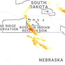
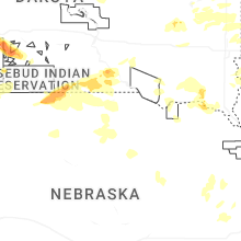
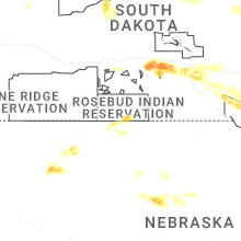
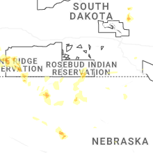
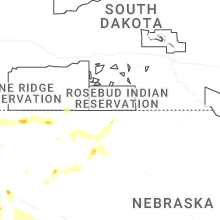
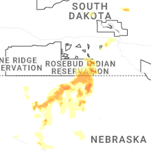
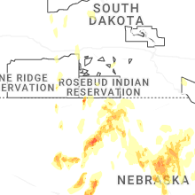
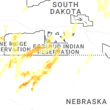


Connect with Interactive Hail Maps