

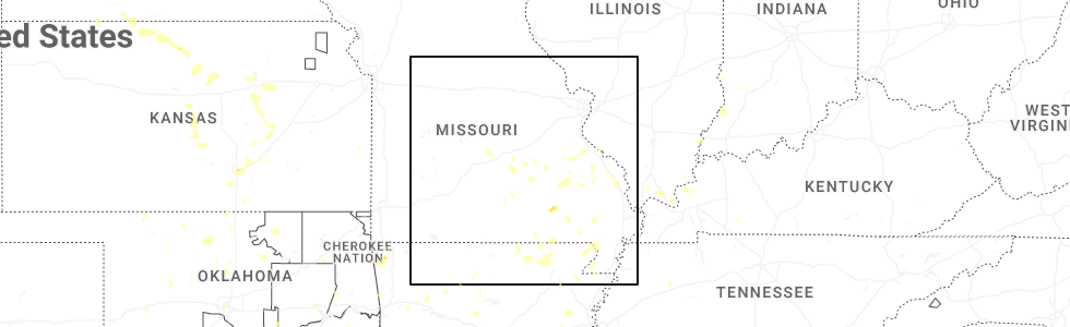
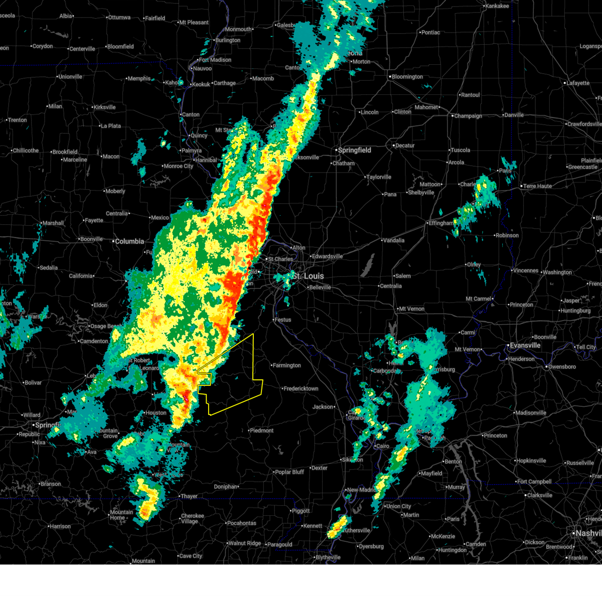
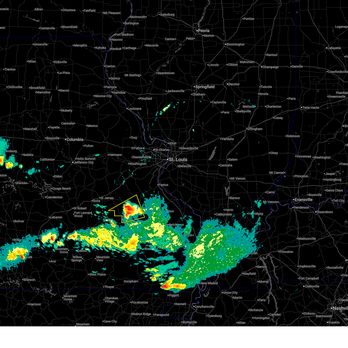
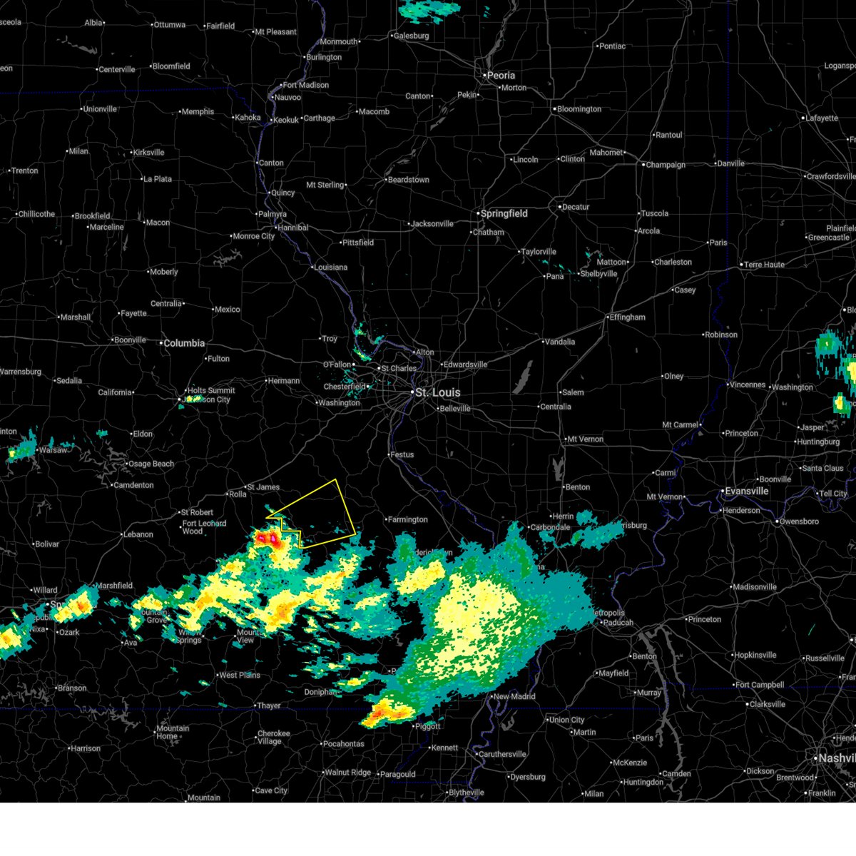
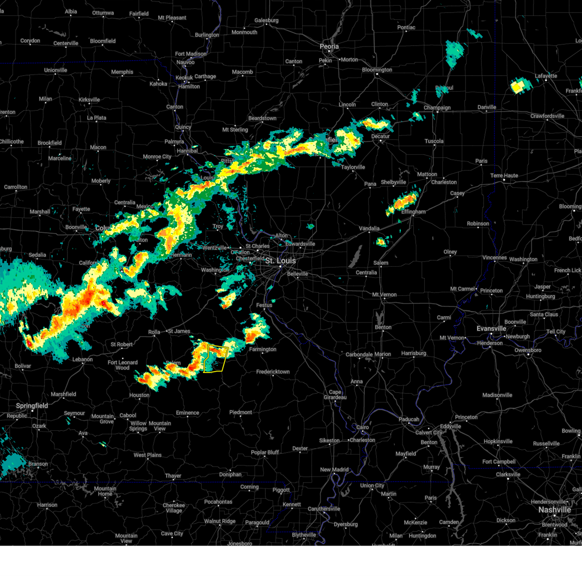
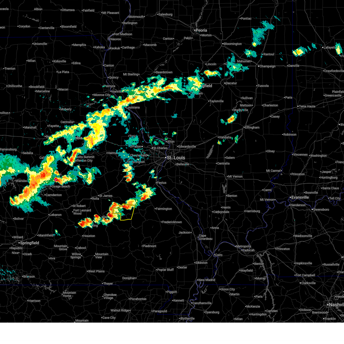
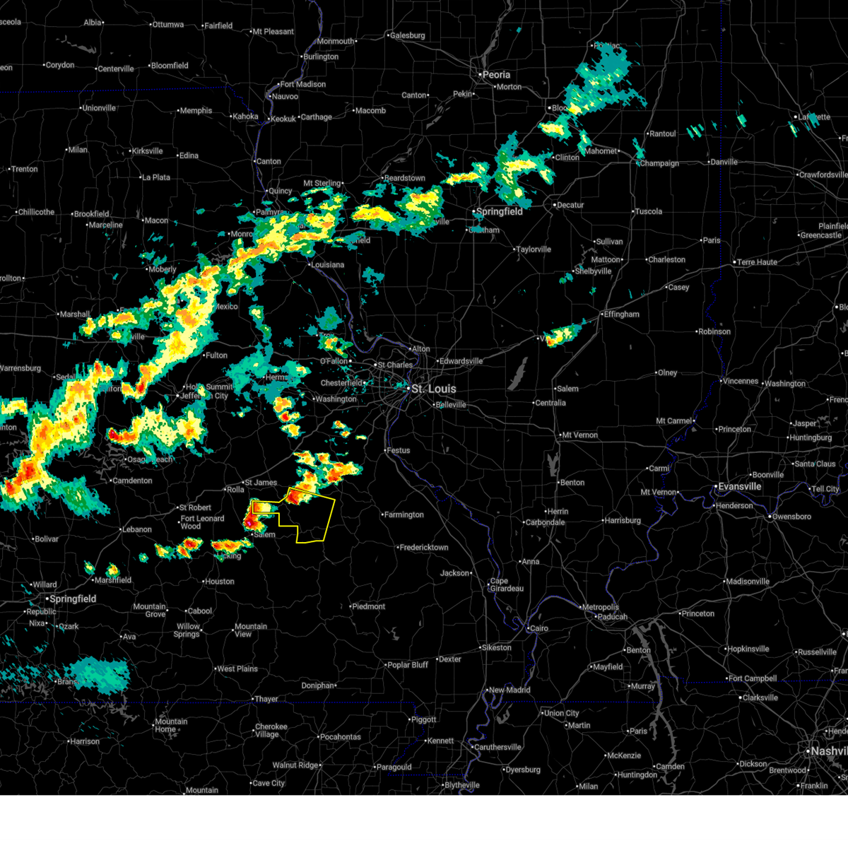
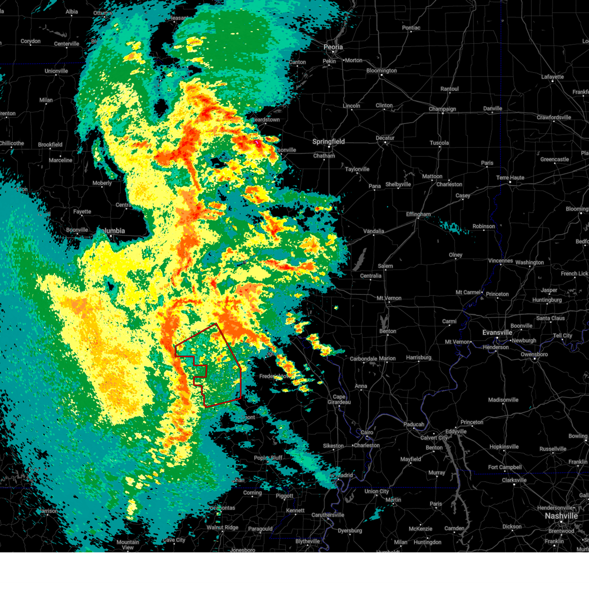
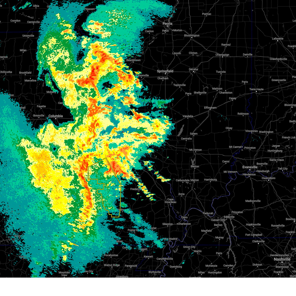
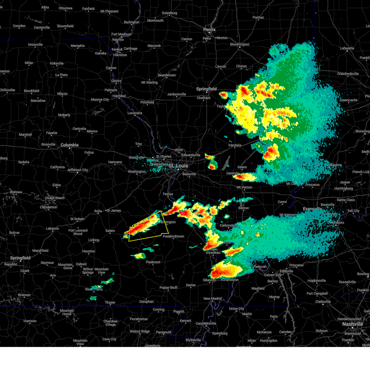
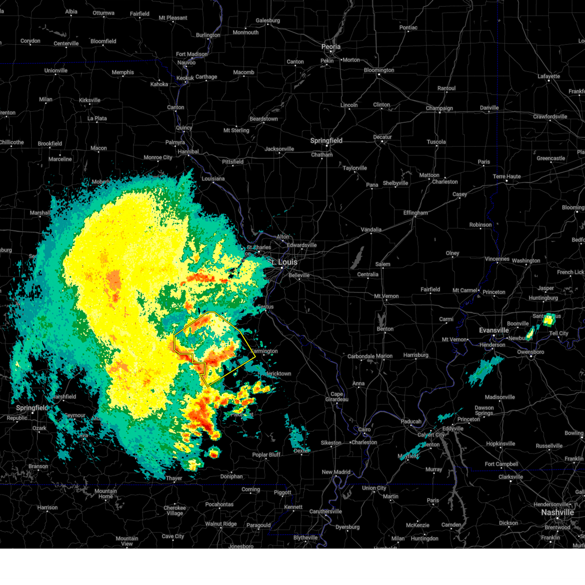
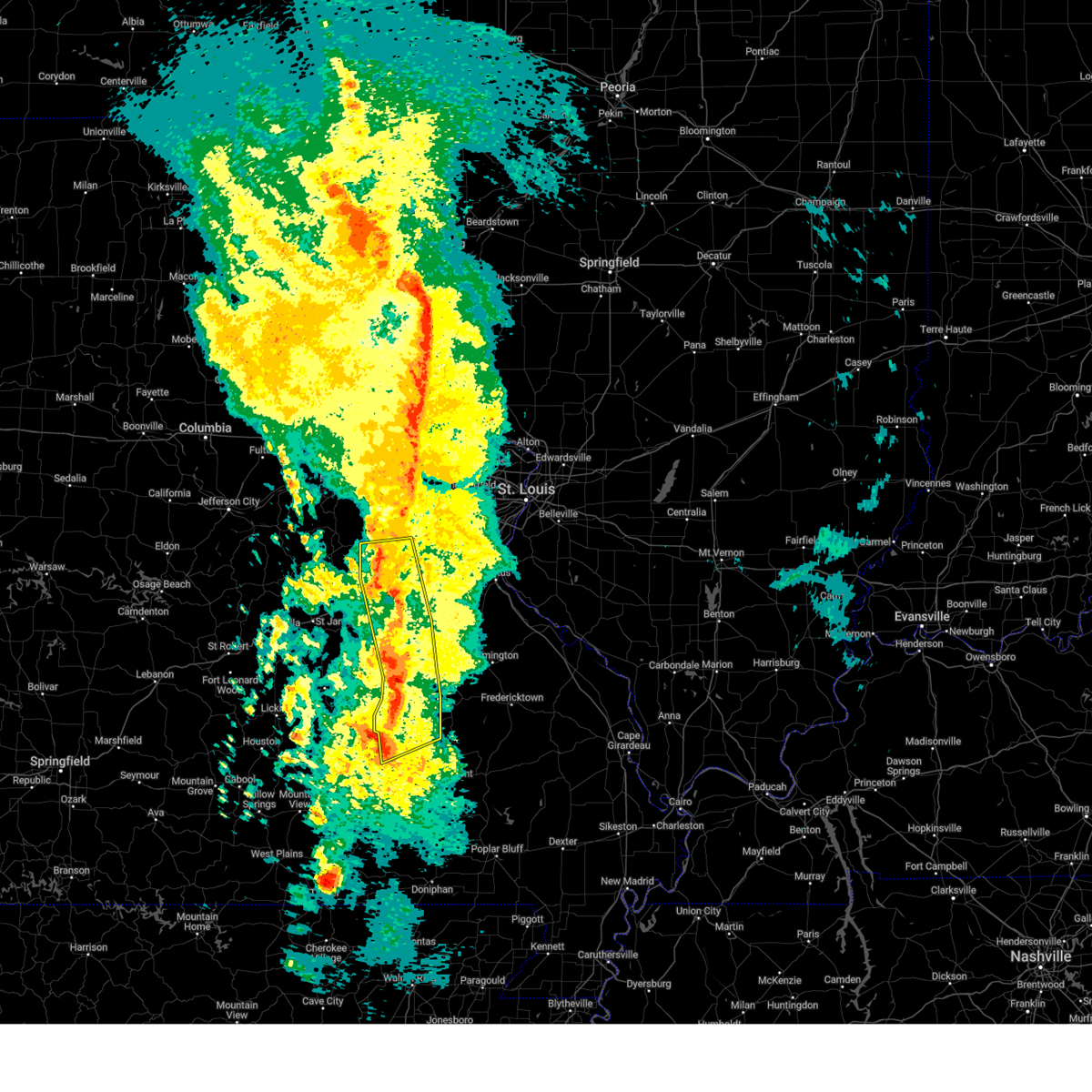
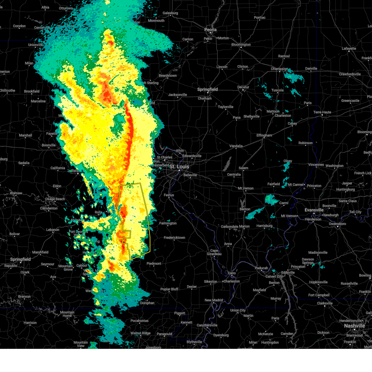
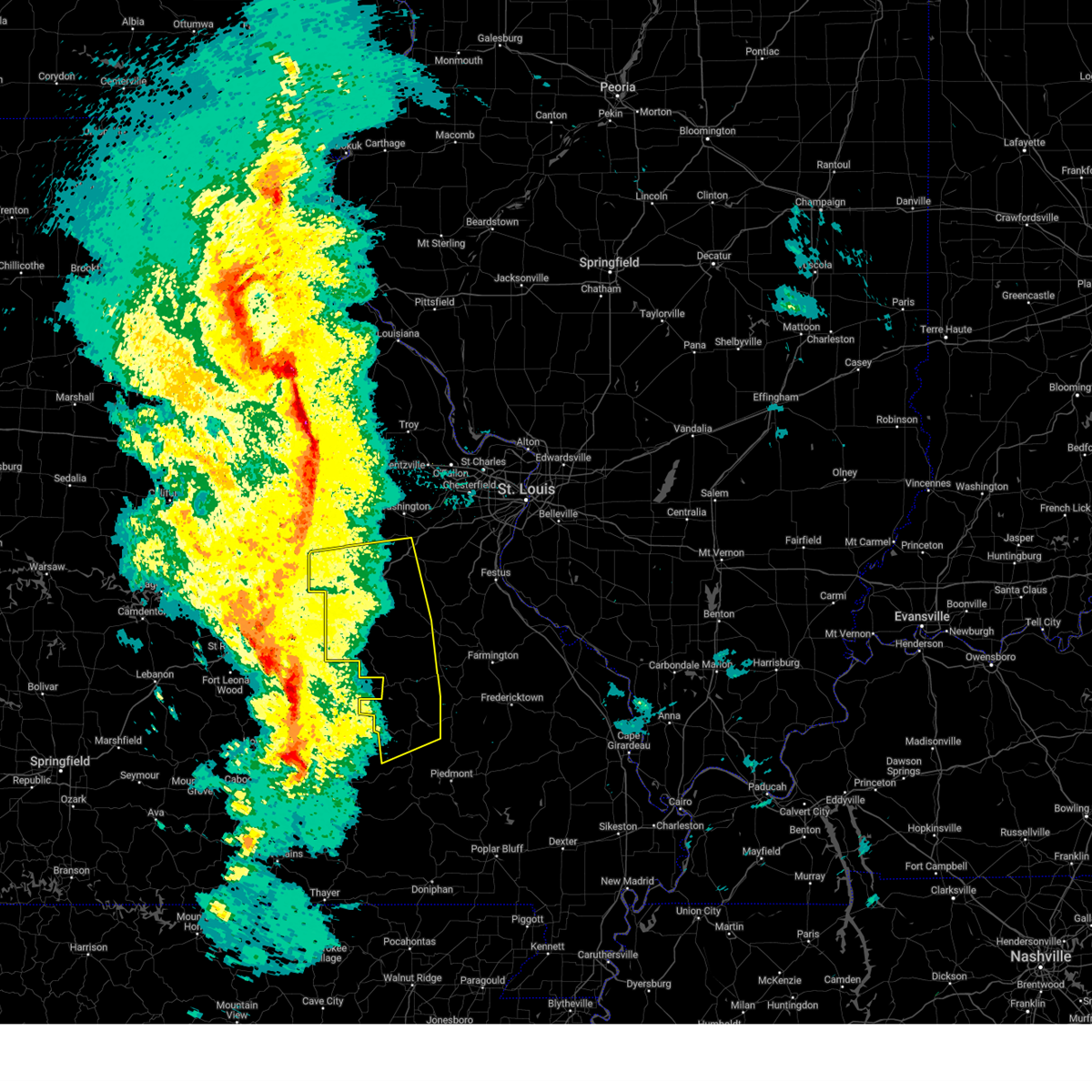
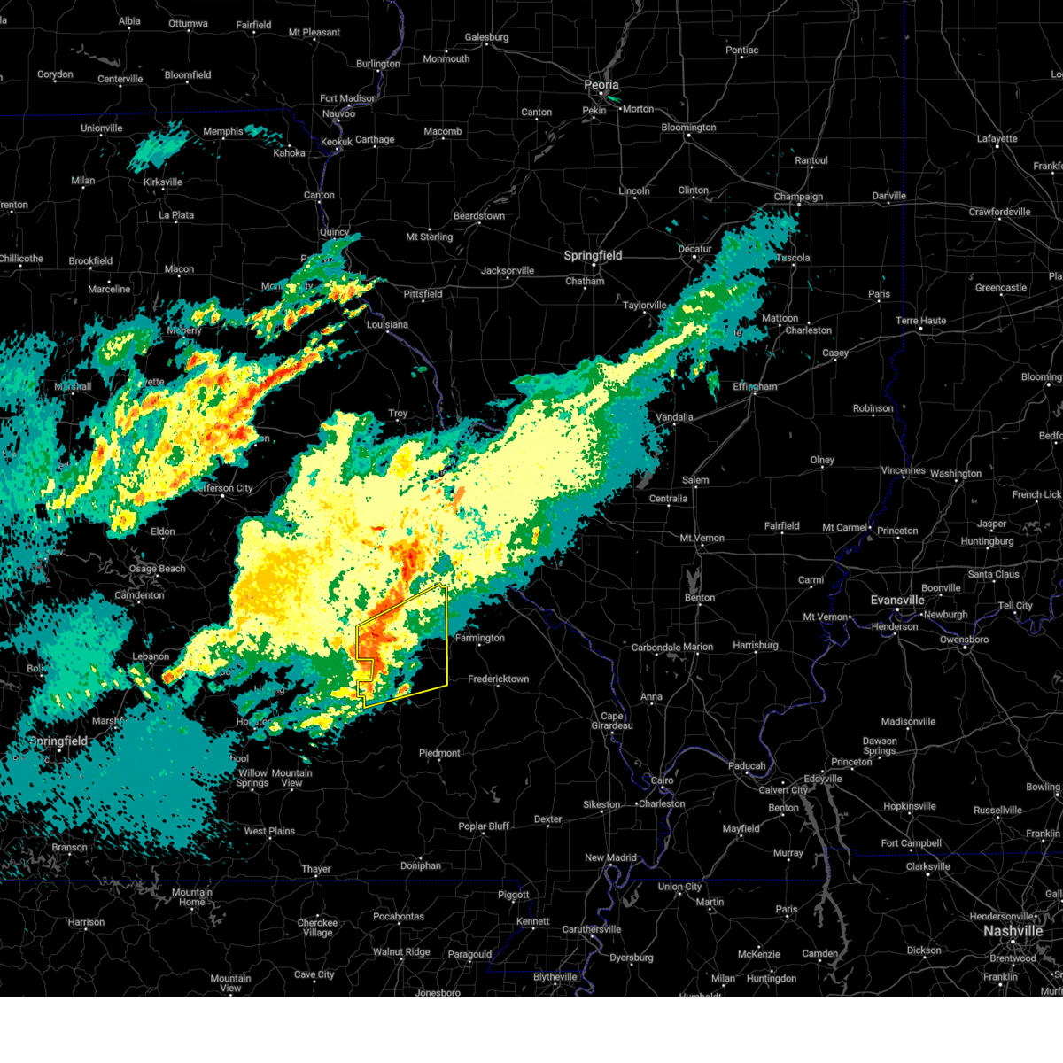
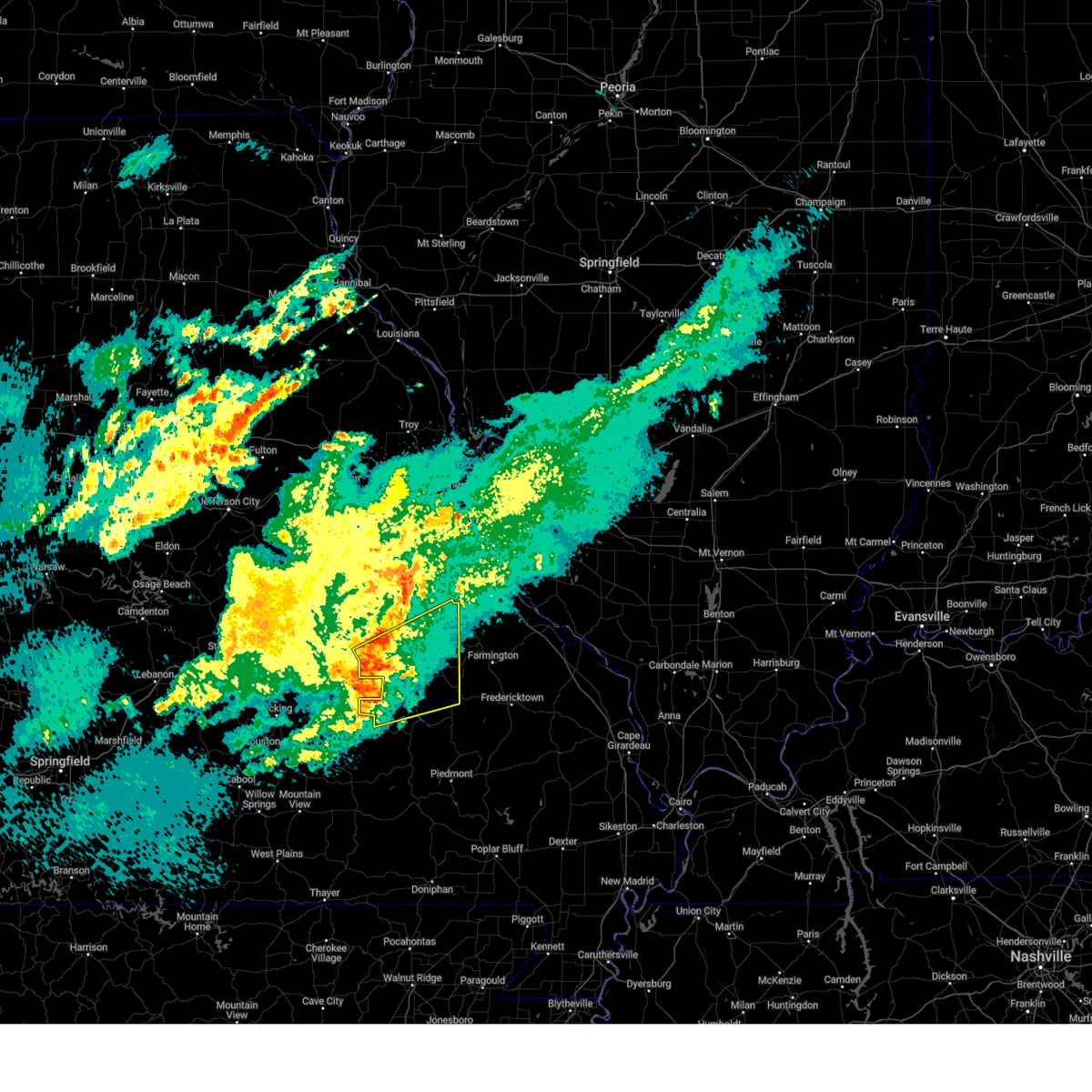
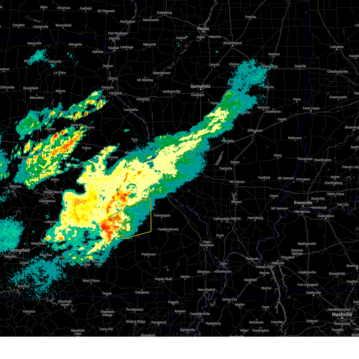
Hail Map for Viburnum, MO
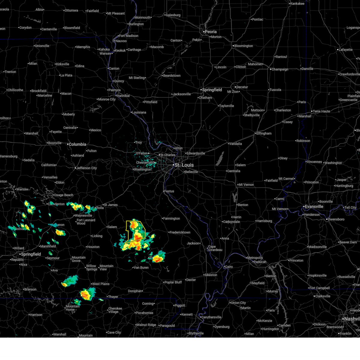
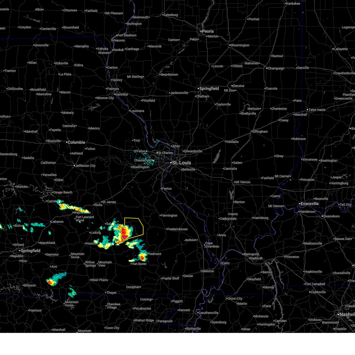
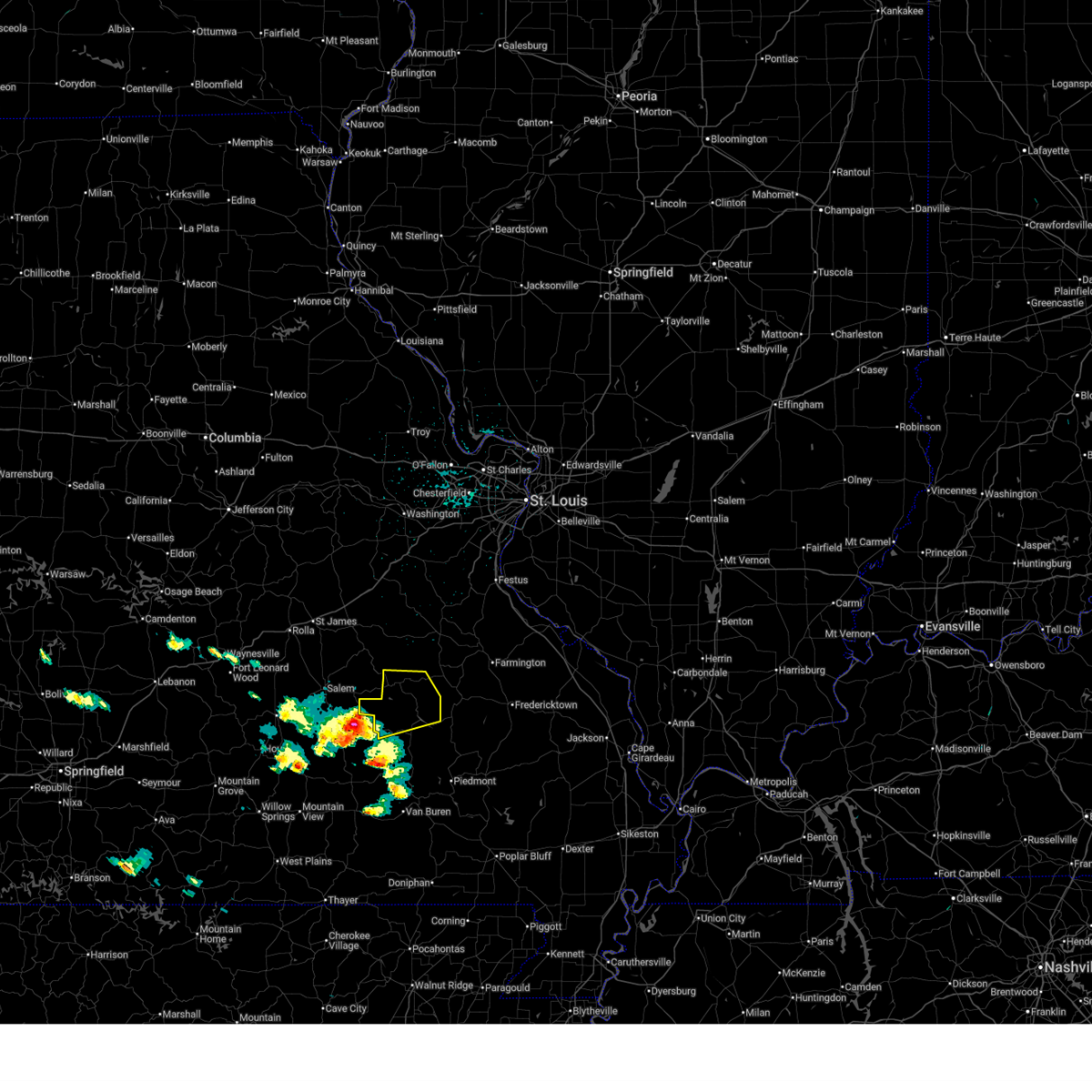
The Viburnum, MO area has had 9 reports of on-the-ground hail by trained spotters, and has been under severe weather warnings 6 times during the past 12 months. Doppler radar has detected hail at or near Viburnum, MO on 53 occasions, including 5 occasions during the past year.
| Name: | Viburnum, MO |
| Where Located: | 22.9 miles ENE of Salem, MO |
| Map: | Google Map for Viburnum, MO |
| Population: | 693 |
| Housing Units: | 328 |
| More Info: | Search Google for Viburnum, MO |
1
The Top Recent Hail Date for Viburnum, MO is Tuesday, August 19, 2025 (8th out of 53)
Hail and Wind Damage Spotted near Viburnum, MO
| Date / Time | Report Details |
|---|---|
| 5/31/2026 2:00 PM CDT | Tree down across highway 3 in dent county MO, 5.7 miles NNE of Viburnum, MO |
| 4/16/2026 1:21 PM CDT |
 The storm which prompted the warning has weakened below severe limits, and no longer poses an immediate threat to life or property. therefore, the warning will be allowed to expire. however, small hail and gusty winds are still possible with this thunderstorm. The storm which prompted the warning has weakened below severe limits, and no longer poses an immediate threat to life or property. therefore, the warning will be allowed to expire. however, small hail and gusty winds are still possible with this thunderstorm.
|
| 4/16/2026 1:01 PM CDT |
 At 101 pm cdt, a severe thunderstorm was located over reynolds, or 27 miles southwest of ironton, moving east at 35 mph (radar indicated). Hazards include 60 mph wind gusts and quarter size hail. Hail damage to vehicles is expected. expect wind damage to roofs, siding, and trees. locations impacted include, viburnum, oates, bixby, centerville and black. This includes the following state parks, johnsons shut-ins state park and taum sauk mountain state park. At 101 pm cdt, a severe thunderstorm was located over reynolds, or 27 miles southwest of ironton, moving east at 35 mph (radar indicated). Hazards include 60 mph wind gusts and quarter size hail. Hail damage to vehicles is expected. expect wind damage to roofs, siding, and trees. locations impacted include, viburnum, oates, bixby, centerville and black. This includes the following state parks, johnsons shut-ins state park and taum sauk mountain state park.
|
| 4/16/2026 12:37 PM CDT |
 Svrlsx the national weather service in st louis has issued a * severe thunderstorm warning for, northwestern iron county in southeastern missouri, northern reynolds county in southeastern missouri, * until 130 pm cdt. * at 1237 pm cdt, a severe thunderstorm was located 12 miles west of reynolds, or 36 miles south of steelville, moving east at 35 mph (radar indicated). Hazards include 60 mph wind gusts and quarter size hail. Hail damage to vehicles is expected. Expect wind damage to roofs, siding, and trees. Svrlsx the national weather service in st louis has issued a * severe thunderstorm warning for, northwestern iron county in southeastern missouri, northern reynolds county in southeastern missouri, * until 130 pm cdt. * at 1237 pm cdt, a severe thunderstorm was located 12 miles west of reynolds, or 36 miles south of steelville, moving east at 35 mph (radar indicated). Hazards include 60 mph wind gusts and quarter size hail. Hail damage to vehicles is expected. Expect wind damage to roofs, siding, and trees.
|
| 3/15/2026 4:24 PM CDT |
 Svrlsx the national weather service in st louis has issued a * severe thunderstorm warning for, southeastern crawford county in east central missouri, southern washington county in east central missouri, iron county in southeastern missouri, northern reynolds county in southeastern missouri, * until 530 pm cdt. * at 424 pm cdt, severe thunderstorms were located along a line from 19 miles south of cherryville to 18 miles southwest of reynolds, or along a line from 26 miles south of steelville to 46 miles southwest of ironton, moving northeast at 55 mph (radar indicated). Hazards include 60 mph wind gusts and quarter size hail. Hail damage to vehicles is expected. Expect wind damage to roofs, siding, and trees. Svrlsx the national weather service in st louis has issued a * severe thunderstorm warning for, southeastern crawford county in east central missouri, southern washington county in east central missouri, iron county in southeastern missouri, northern reynolds county in southeastern missouri, * until 530 pm cdt. * at 424 pm cdt, severe thunderstorms were located along a line from 19 miles south of cherryville to 18 miles southwest of reynolds, or along a line from 26 miles south of steelville to 46 miles southwest of ironton, moving northeast at 55 mph (radar indicated). Hazards include 60 mph wind gusts and quarter size hail. Hail damage to vehicles is expected. Expect wind damage to roofs, siding, and trees.
|
| 3/4/2026 6:58 PM CST |
 the severe thunderstorm warning has been cancelled and is no longer in effect the severe thunderstorm warning has been cancelled and is no longer in effect
|
| 3/4/2026 6:26 PM CST |
 Svrlsx the national weather service in st louis has issued a * severe thunderstorm warning for, southeastern crawford county in east central missouri, southwestern washington county in east central missouri, northwestern iron county in southeastern missouri, * until 715 pm cst. * at 626 pm cst, a severe thunderstorm was located 13 miles south of cherryville, or 21 miles south of steelville, moving northeast at 45 mph (radar indicated). Hazards include quarter size hail. damage to vehicles is expected Svrlsx the national weather service in st louis has issued a * severe thunderstorm warning for, southeastern crawford county in east central missouri, southwestern washington county in east central missouri, northwestern iron county in southeastern missouri, * until 715 pm cst. * at 626 pm cst, a severe thunderstorm was located 13 miles south of cherryville, or 21 miles south of steelville, moving northeast at 45 mph (radar indicated). Hazards include quarter size hail. damage to vehicles is expected
|
| 6/8/2025 8:35 PM CDT |
 The storm which prompted the warning has weakened below severe limits, and no longer poses an immediate threat to life or property. therefore, the warning will be allowed to expire. a severe thunderstorm watch remains in effect until 1000 pm cdt for portions of east central and southeast missouri. The storm which prompted the warning has weakened below severe limits, and no longer poses an immediate threat to life or property. therefore, the warning will be allowed to expire. a severe thunderstorm watch remains in effect until 1000 pm cdt for portions of east central and southeast missouri.
|
| 6/8/2025 8:27 PM CDT |
 At 827 pm cdt, a severe thunderstorm was located near courtois, or 16 miles southwest of potosi, moving southeast at 25 mph (radar indicated). Hazards include 60 mph wind gusts and quarter size hail. Hail damage to vehicles is expected. expect wind damage to roofs, siding, and trees. Locations impacted include, viburnum, courtois and bixby. At 827 pm cdt, a severe thunderstorm was located near courtois, or 16 miles southwest of potosi, moving southeast at 25 mph (radar indicated). Hazards include 60 mph wind gusts and quarter size hail. Hail damage to vehicles is expected. expect wind damage to roofs, siding, and trees. Locations impacted include, viburnum, courtois and bixby.
|
| 6/8/2025 8:27 PM CDT |
 the severe thunderstorm warning has been cancelled and is no longer in effect the severe thunderstorm warning has been cancelled and is no longer in effect
|
| 6/8/2025 8:18 PM CDT |
 At 818 pm cdt, a severe thunderstorm was located near courtois, or 17 miles southwest of potosi, moving southeast at 30 mph (radar indicated). Hazards include 60 mph wind gusts and quarter size hail. Hail damage to vehicles is expected. expect wind damage to roofs, siding, and trees. locations impacted include, viburnum, courtois, bixby and dillard. This includes the following state parks, dillard mill historic site. At 818 pm cdt, a severe thunderstorm was located near courtois, or 17 miles southwest of potosi, moving southeast at 30 mph (radar indicated). Hazards include 60 mph wind gusts and quarter size hail. Hail damage to vehicles is expected. expect wind damage to roofs, siding, and trees. locations impacted include, viburnum, courtois, bixby and dillard. This includes the following state parks, dillard mill historic site.
|
| 6/8/2025 8:01 PM CDT |
 Svrlsx the national weather service in st louis has issued a * severe thunderstorm warning for, southern crawford county in east central missouri, southwestern washington county in east central missouri, northwestern iron county in southeastern missouri, * until 845 pm cdt. * at 801 pm cdt, a severe thunderstorm was located 6 miles north of courtois, or 15 miles southeast of steelville, moving southeast at 30 mph (radar indicated). Hazards include 60 mph wind gusts and quarter size hail. Hail damage to vehicles is expected. Expect wind damage to roofs, siding, and trees. Svrlsx the national weather service in st louis has issued a * severe thunderstorm warning for, southern crawford county in east central missouri, southwestern washington county in east central missouri, northwestern iron county in southeastern missouri, * until 845 pm cdt. * at 801 pm cdt, a severe thunderstorm was located 6 miles north of courtois, or 15 miles southeast of steelville, moving southeast at 30 mph (radar indicated). Hazards include 60 mph wind gusts and quarter size hail. Hail damage to vehicles is expected. Expect wind damage to roofs, siding, and trees.
|
| 5/19/2025 10:30 PM CDT |
 Torlsx the national weather service in st louis has issued a * tornado warning for, southern crawford county in east central missouri, southwestern washington county in east central missouri, western iron county in southeastern missouri, northern reynolds county in southeastern missouri, * until 1115 pm cdt. * at 1030 pm cdt, severe thunderstorms capable of producing a tornado were located along a line from 12 miles west of cherryville to 15 miles west of reynolds, or along a line from 14 miles southwest of steelville to 42 miles southwest of ironton, moving east at 55 mph (radar indicated rotation). Hazards include tornado. Flying debris will be dangerous to those caught without shelter. mobile homes will be damaged or destroyed. damage to roofs, windows and vehicles will occur. Tree damage is likely. Torlsx the national weather service in st louis has issued a * tornado warning for, southern crawford county in east central missouri, southwestern washington county in east central missouri, western iron county in southeastern missouri, northern reynolds county in southeastern missouri, * until 1115 pm cdt. * at 1030 pm cdt, severe thunderstorms capable of producing a tornado were located along a line from 12 miles west of cherryville to 15 miles west of reynolds, or along a line from 14 miles southwest of steelville to 42 miles southwest of ironton, moving east at 55 mph (radar indicated rotation). Hazards include tornado. Flying debris will be dangerous to those caught without shelter. mobile homes will be damaged or destroyed. damage to roofs, windows and vehicles will occur. Tree damage is likely.
|
| 5/19/2025 10:26 PM CDT |
 Svrlsx the national weather service in st louis has issued a * severe thunderstorm warning for, crawford county in east central missouri, southwestern washington county in east central missouri, western iron county in southeastern missouri, reynolds county in southeastern missouri, * until 1115 pm cdt. * at 1026 pm cdt, severe thunderstorms were located along a line from 13 miles southwest of steelville to 30 miles southwest of reynolds, or along a line from 13 miles southwest of steelville to 57 miles southwest of ironton, moving east at 45 mph (radar indicated). Hazards include 60 mph wind gusts and small hail. Expect damage to roofs, siding, and trees. other locations impacted by the severe thunderstorm include cook station, dillard, davisville, corridon, centerville, black, shirley, belgrade, lesterville and redford. This includes the following state parks, onondaga cave state park, johnsons shut-ins state park, dillard mill historic site, taum sauk mountain state park and clearwater lake recreational area. Svrlsx the national weather service in st louis has issued a * severe thunderstorm warning for, crawford county in east central missouri, southwestern washington county in east central missouri, western iron county in southeastern missouri, reynolds county in southeastern missouri, * until 1115 pm cdt. * at 1026 pm cdt, severe thunderstorms were located along a line from 13 miles southwest of steelville to 30 miles southwest of reynolds, or along a line from 13 miles southwest of steelville to 57 miles southwest of ironton, moving east at 45 mph (radar indicated). Hazards include 60 mph wind gusts and small hail. Expect damage to roofs, siding, and trees. other locations impacted by the severe thunderstorm include cook station, dillard, davisville, corridon, centerville, black, shirley, belgrade, lesterville and redford. This includes the following state parks, onondaga cave state park, johnsons shut-ins state park, dillard mill historic site, taum sauk mountain state park and clearwater lake recreational area.
|
| 5/16/2025 4:14 PM CDT |
 Svrlsx the national weather service in st louis has issued a * severe thunderstorm warning for, southern washington county in east central missouri, northern iron county in southeastern missouri, north central reynolds county in southeastern missouri, southwestern saint francois county in southeastern missouri, * until 500 pm cdt. * at 414 pm cdt, a severe thunderstorm was located over bixby, or 23 miles southwest of potosi, moving east at 50 mph (radar indicated). Hazards include 60 mph wind gusts and half dollar size hail. Hail damage to vehicles is expected. Expect wind damage to roofs, siding, and trees. Svrlsx the national weather service in st louis has issued a * severe thunderstorm warning for, southern washington county in east central missouri, northern iron county in southeastern missouri, north central reynolds county in southeastern missouri, southwestern saint francois county in southeastern missouri, * until 500 pm cdt. * at 414 pm cdt, a severe thunderstorm was located over bixby, or 23 miles southwest of potosi, moving east at 50 mph (radar indicated). Hazards include 60 mph wind gusts and half dollar size hail. Hail damage to vehicles is expected. Expect wind damage to roofs, siding, and trees.
|
| 4/29/2025 12:06 PM CDT |
 Svrlsx the national weather service in st louis has issued a * severe thunderstorm warning for, crawford county in east central missouri, washington county in east central missouri, northwestern iron county in southeastern missouri, north central reynolds county in southeastern missouri, west central saint francois county in southeastern missouri, * until 100 pm cdt. * at 1206 pm cdt, severe thunderstorms were located along a line from 8 miles southwest of steelville to over oates, or along a line from 8 miles southwest of steelville to 23 miles west of ironton, moving northeast at 40 mph (radar indicated). Hazards include 60 mph wind gusts and small hail. expect damage to roofs, siding, and trees Svrlsx the national weather service in st louis has issued a * severe thunderstorm warning for, crawford county in east central missouri, washington county in east central missouri, northwestern iron county in southeastern missouri, north central reynolds county in southeastern missouri, west central saint francois county in southeastern missouri, * until 100 pm cdt. * at 1206 pm cdt, severe thunderstorms were located along a line from 8 miles southwest of steelville to over oates, or along a line from 8 miles southwest of steelville to 23 miles west of ironton, moving northeast at 40 mph (radar indicated). Hazards include 60 mph wind gusts and small hail. expect damage to roofs, siding, and trees
|
| 4/20/2025 6:50 PM CDT |
 At 650 pm cdt, severe thunderstorms were located along a line from 6 miles northwest of miramiguoa park to 5 miles south of reynolds, or along a line from 7 miles north of sullivan to 30 miles southwest of ironton, moving northeast at 50 mph (radar indicated). Hazards include 60 mph wind gusts and small hail. Expect damage to roofs, siding, and trees. locations impacted include, union, sullivan, st. clair, bourbon, anthonies mill, reynolds, viburnum, parkway, miramiguoa park, courtois, bixby, oates, centerville, st. cloud, shirley, latty, belgrade, black, stanton and lesterville. this includes the following state parks, onondaga cave state park, johnsons shut-ins state park, taum sauk mountain state park and meramec state park. This includes interstate 44 in missouri between exits 218 and 242. At 650 pm cdt, severe thunderstorms were located along a line from 6 miles northwest of miramiguoa park to 5 miles south of reynolds, or along a line from 7 miles north of sullivan to 30 miles southwest of ironton, moving northeast at 50 mph (radar indicated). Hazards include 60 mph wind gusts and small hail. Expect damage to roofs, siding, and trees. locations impacted include, union, sullivan, st. clair, bourbon, anthonies mill, reynolds, viburnum, parkway, miramiguoa park, courtois, bixby, oates, centerville, st. cloud, shirley, latty, belgrade, black, stanton and lesterville. this includes the following state parks, onondaga cave state park, johnsons shut-ins state park, taum sauk mountain state park and meramec state park. This includes interstate 44 in missouri between exits 218 and 242.
|
| 4/20/2025 6:39 PM CDT |
 At 639 pm cdt, severe thunderstorms were located along a line from 6 miles north of bourbon to 5 miles southwest of oates, or along a line from 6 miles north of bourbon to 27 miles west of ironton, moving northeast at 50 mph (radar indicated). Hazards include 60 mph wind gusts and small hail. Expect damage to roofs, siding, and trees. locations impacted include, union, sullivan, st. clair, cuba, steelville, bourbon, anthonies mill, reynolds, gerald, viburnum, parkway, leasburg, miramiguoa park, courtois, bixby, cherryville, oates, centerville, st. cloud and davisville. this includes the following state parks, onondaga cave state park, johnsons shut-ins state park, dillard mill historic site, taum sauk mountain state park and meramec state park. This includes interstate 44 in missouri between exits 208 and 242. At 639 pm cdt, severe thunderstorms were located along a line from 6 miles north of bourbon to 5 miles southwest of oates, or along a line from 6 miles north of bourbon to 27 miles west of ironton, moving northeast at 50 mph (radar indicated). Hazards include 60 mph wind gusts and small hail. Expect damage to roofs, siding, and trees. locations impacted include, union, sullivan, st. clair, cuba, steelville, bourbon, anthonies mill, reynolds, gerald, viburnum, parkway, leasburg, miramiguoa park, courtois, bixby, cherryville, oates, centerville, st. cloud and davisville. this includes the following state parks, onondaga cave state park, johnsons shut-ins state park, dillard mill historic site, taum sauk mountain state park and meramec state park. This includes interstate 44 in missouri between exits 208 and 242.
|
| 4/20/2025 6:39 PM CDT |
 the severe thunderstorm warning has been cancelled and is no longer in effect the severe thunderstorm warning has been cancelled and is no longer in effect
|
| 4/20/2025 6:07 PM CDT |
 Svrlsx the national weather service in st louis has issued a * severe thunderstorm warning for, crawford county in east central missouri, southwestern franklin county in east central missouri, southern gasconade county in east central missouri, washington county in east central missouri, northwestern iron county in southeastern missouri, northern reynolds county in southeastern missouri, * until 700 pm cdt. * at 607 pm cdt, severe thunderstorms were located along a line from 17 miles west of cuba to 24 miles west of reynolds, or along a line from 17 miles west of cuba to 48 miles south of steelville, moving northeast at 50 mph (radar indicated). Hazards include 70 mph wind gusts and small hail. Expect considerable tree damage. Damage is likely to mobile homes, roofs, and outbuildings. Svrlsx the national weather service in st louis has issued a * severe thunderstorm warning for, crawford county in east central missouri, southwestern franklin county in east central missouri, southern gasconade county in east central missouri, washington county in east central missouri, northwestern iron county in southeastern missouri, northern reynolds county in southeastern missouri, * until 700 pm cdt. * at 607 pm cdt, severe thunderstorms were located along a line from 17 miles west of cuba to 24 miles west of reynolds, or along a line from 17 miles west of cuba to 48 miles south of steelville, moving northeast at 50 mph (radar indicated). Hazards include 70 mph wind gusts and small hail. Expect considerable tree damage. Damage is likely to mobile homes, roofs, and outbuildings.
|
| 4/19/2025 12:49 AM CDT |
 At 1249 am cdt, a severe thunderstorm was located over courtois, or 22 miles southwest of potosi, moving northeast at 55 mph (radar indicated). Hazards include 60 mph wind gusts. Expect damage to roofs, siding, and trees. locations impacted include, potosi, ironton, pilot knob, viburnum, irondale, mineral point, courtois, bixby, belleview, oates, old mines, caledonia, belgrade, shirley, latty, black, davisville, granite, dillard and cadet. This includes the following state parks, washington state park, johnsons shut-ins state park, elephant rocks state park, dillard mill historic site and taum sauk mountain state park. At 1249 am cdt, a severe thunderstorm was located over courtois, or 22 miles southwest of potosi, moving northeast at 55 mph (radar indicated). Hazards include 60 mph wind gusts. Expect damage to roofs, siding, and trees. locations impacted include, potosi, ironton, pilot knob, viburnum, irondale, mineral point, courtois, bixby, belleview, oates, old mines, caledonia, belgrade, shirley, latty, black, davisville, granite, dillard and cadet. This includes the following state parks, washington state park, johnsons shut-ins state park, elephant rocks state park, dillard mill historic site and taum sauk mountain state park.
|
| 4/19/2025 12:40 AM CDT |
 At 1240 am cdt, a severe thunderstorm was located 6 miles southwest of viburnum, or 22 miles south of steelville, moving northeast at 50 mph (radar indicated). Hazards include 60 mph wind gusts. Expect damage to roofs, siding, and trees. locations impacted include, potosi, ironton, pilot knob, viburnum, irondale, mineral point, courtois, bixby, belleview, oates, old mines, cherryville, caledonia, belgrade, shirley, black, latty, davisville, dillard and granite. This includes the following state parks, washington state park, johnsons shut-ins state park, elephant rocks state park, dillard mill historic site and taum sauk mountain state park. At 1240 am cdt, a severe thunderstorm was located 6 miles southwest of viburnum, or 22 miles south of steelville, moving northeast at 50 mph (radar indicated). Hazards include 60 mph wind gusts. Expect damage to roofs, siding, and trees. locations impacted include, potosi, ironton, pilot knob, viburnum, irondale, mineral point, courtois, bixby, belleview, oates, old mines, cherryville, caledonia, belgrade, shirley, black, latty, davisville, dillard and granite. This includes the following state parks, washington state park, johnsons shut-ins state park, elephant rocks state park, dillard mill historic site and taum sauk mountain state park.
|
| 4/19/2025 12:24 AM CDT |
 Svrlsx the national weather service in st louis has issued a * severe thunderstorm warning for, southern crawford county in east central missouri, washington county in east central missouri, northern iron county in southeastern missouri, northern reynolds county in southeastern missouri, * until 130 am cdt. * at 1224 am cdt, a severe thunderstorm was located 20 miles southwest of cherryville, or 26 miles south of steelville, moving northeast at 55 mph (radar indicated). Hazards include 60 mph wind gusts. expect damage to roofs, siding, and trees Svrlsx the national weather service in st louis has issued a * severe thunderstorm warning for, southern crawford county in east central missouri, washington county in east central missouri, northern iron county in southeastern missouri, northern reynolds county in southeastern missouri, * until 130 am cdt. * at 1224 am cdt, a severe thunderstorm was located 20 miles southwest of cherryville, or 26 miles south of steelville, moving northeast at 55 mph (radar indicated). Hazards include 60 mph wind gusts. expect damage to roofs, siding, and trees
|
| 5/26/2024 6:17 PM CDT | Hen Egg sized hail reported 0.9 miles S of Viburnum, MO, report from social media. time estimate from radar. |
| 5/26/2024 6:16 PM CDT |
 Svrlsx the national weather service in st louis has issued a * severe thunderstorm warning for, north central iron county in southeastern missouri, southern washington county in east central missouri, * until 700 pm cdt. * at 616 pm cdt, a severe thunderstorm was located over courtois, moving northeast at 45 mph (radar indicated). Hazards include half dollar size hail. damage to vehicles is expected Svrlsx the national weather service in st louis has issued a * severe thunderstorm warning for, north central iron county in southeastern missouri, southern washington county in east central missouri, * until 700 pm cdt. * at 616 pm cdt, a severe thunderstorm was located over courtois, moving northeast at 45 mph (radar indicated). Hazards include half dollar size hail. damage to vehicles is expected
|
| 5/26/2024 6:12 PM CDT | Hen Egg sized hail reported 0.3 miles S of Viburnum, MO |
| 5/24/2024 11:08 PM CDT |
 At 1108 pm cdt, severe thunderstorms were located along a line extending from near belleview to 11 miles west of pilot knob to near bunker, moving east at 25 mph (radar indicated). Hazards include 60 mph wind gusts and quarter size hail. Hail damage to vehicles is expected. expect wind damage to roofs, siding, and trees. these severe storms will be near, belleview and oates around 1115 pm cdt. other locations in the path of these severe thunderstorms include ironton, pilot knob and arcadia. This also includes johnsons shut-ins state park, fort davidson historic site, elephant rocks state park, and taum sauk mountain state park. At 1108 pm cdt, severe thunderstorms were located along a line extending from near belleview to 11 miles west of pilot knob to near bunker, moving east at 25 mph (radar indicated). Hazards include 60 mph wind gusts and quarter size hail. Hail damage to vehicles is expected. expect wind damage to roofs, siding, and trees. these severe storms will be near, belleview and oates around 1115 pm cdt. other locations in the path of these severe thunderstorms include ironton, pilot knob and arcadia. This also includes johnsons shut-ins state park, fort davidson historic site, elephant rocks state park, and taum sauk mountain state park.
|
| 5/24/2024 10:59 PM CDT |
 Svrlsx the national weather service in st louis has issued a * severe thunderstorm warning for, northern iron county in southeastern missouri, northern reynolds county in southeastern missouri, * until 1130 pm cdt. * at 1059 pm cdt, severe thunderstorms were located along a line extending from near belleview to near oates to 7 miles northwest of bunker, moving southeast at 25 mph (radar indicated). Hazards include 60 mph wind gusts and quarter size hail. Hail damage to vehicles is expected. expect wind damage to roofs, siding, and trees. severe thunderstorms will be near, belleview and oates around 1105 pm cdt. bunker around 1110 pm cdt. ironton and pilot knob around 1115 pm cdt. This also includes johnsons shut-ins state park, fort davidson historic site, elephant rocks state park, and taum sauk mountain state park. Svrlsx the national weather service in st louis has issued a * severe thunderstorm warning for, northern iron county in southeastern missouri, northern reynolds county in southeastern missouri, * until 1130 pm cdt. * at 1059 pm cdt, severe thunderstorms were located along a line extending from near belleview to near oates to 7 miles northwest of bunker, moving southeast at 25 mph (radar indicated). Hazards include 60 mph wind gusts and quarter size hail. Hail damage to vehicles is expected. expect wind damage to roofs, siding, and trees. severe thunderstorms will be near, belleview and oates around 1105 pm cdt. bunker around 1110 pm cdt. ironton and pilot knob around 1115 pm cdt. This also includes johnsons shut-ins state park, fort davidson historic site, elephant rocks state park, and taum sauk mountain state park.
|
| 5/24/2024 10:42 PM CDT |
 the severe thunderstorm warning has been cancelled and is no longer in effect the severe thunderstorm warning has been cancelled and is no longer in effect
|
| 5/24/2024 10:42 PM CDT |
 At 1042 pm cdt, severe thunderstorms were located along a line extending from near mineral point to 6 miles northwest of belleview to 6 miles west of viburnum, moving east at 30 mph (radar indicated). Hazards include 60 mph wind gusts and quarter size hail. Hail damage to vehicles is expected. expect wind damage to roofs, siding, and trees. locations impacted include, bonne terre, desloge, potosi, bismarck, leadwood, park hills, iron mountain lake, viburnum, irondale, mineral point, courtois, belleview, iron mountain, bixby, caledonia, belgrade, and frankclay. This also includes missouri mines historic site. At 1042 pm cdt, severe thunderstorms were located along a line extending from near mineral point to 6 miles northwest of belleview to 6 miles west of viburnum, moving east at 30 mph (radar indicated). Hazards include 60 mph wind gusts and quarter size hail. Hail damage to vehicles is expected. expect wind damage to roofs, siding, and trees. locations impacted include, bonne terre, desloge, potosi, bismarck, leadwood, park hills, iron mountain lake, viburnum, irondale, mineral point, courtois, belleview, iron mountain, bixby, caledonia, belgrade, and frankclay. This also includes missouri mines historic site.
|
| 5/24/2024 10:30 PM CDT |
 At 1029 pm cdt, severe thunderstorms were located along a line extending from near potosi to 7 miles east of courtois to 9 miles southwest of cherryville, moving east at 30 mph (radar indicated). Hazards include 60 mph wind gusts and quarter size hail. Hail damage to vehicles is expected. expect wind damage to roofs, siding, and trees. locations impacted include, potosi, viburnum, mineral point, courtois, bixby, irondale, leadwood, belleview, bonne terre, desloge, bismarck, park hills, iron mountain and iron mountain lake. This also includes dillard mill historic site. At 1029 pm cdt, severe thunderstorms were located along a line extending from near potosi to 7 miles east of courtois to 9 miles southwest of cherryville, moving east at 30 mph (radar indicated). Hazards include 60 mph wind gusts and quarter size hail. Hail damage to vehicles is expected. expect wind damage to roofs, siding, and trees. locations impacted include, potosi, viburnum, mineral point, courtois, bixby, irondale, leadwood, belleview, bonne terre, desloge, bismarck, park hills, iron mountain and iron mountain lake. This also includes dillard mill historic site.
|
| 5/24/2024 10:14 PM CDT |
 Svrlsx the national weather service in st louis has issued a * severe thunderstorm warning for, southern crawford county in east central missouri, northwestern iron county in southeastern missouri, southern washington county in east central missouri, west central st. francois county in southeastern missouri, * until 1100 pm cdt. * at 1013 pm cdt, severe thunderstorms were located along a line extending from 9 miles southeast of anthonies mill to near courtois to 8 miles north of salem, moving east at 30 mph (radar indicated). Hazards include 60 mph wind gusts and quarter size hail. Hail damage to vehicles is expected. expect wind damage to roofs, siding, and trees. severe thunderstorms will be near, viburnum and courtois around 1020 pm cdt. potosi around 1025 pm cdt. other locations in the path of these severe thunderstorms include mineral point, bixby, irondale, leadwood and belleview. This also includes dillard mill historic site. Svrlsx the national weather service in st louis has issued a * severe thunderstorm warning for, southern crawford county in east central missouri, northwestern iron county in southeastern missouri, southern washington county in east central missouri, west central st. francois county in southeastern missouri, * until 1100 pm cdt. * at 1013 pm cdt, severe thunderstorms were located along a line extending from 9 miles southeast of anthonies mill to near courtois to 8 miles north of salem, moving east at 30 mph (radar indicated). Hazards include 60 mph wind gusts and quarter size hail. Hail damage to vehicles is expected. expect wind damage to roofs, siding, and trees. severe thunderstorms will be near, viburnum and courtois around 1020 pm cdt. potosi around 1025 pm cdt. other locations in the path of these severe thunderstorms include mineral point, bixby, irondale, leadwood and belleview. This also includes dillard mill historic site.
|
| 5/8/2024 5:34 PM CDT |
 Svrlsx the national weather service in st louis has issued a * severe thunderstorm warning for, northern iron county in southeastern missouri, northern reynolds county in southeastern missouri, * until 615 pm cdt. * at 533 pm cdt, a severe thunderstorm was located 8 miles southwest of viburnum, moving east at 45 mph (radar indicated). Hazards include ping pong ball size hail and 60 mph wind gusts. People and animals outdoors will be injured. expect hail damage to roofs, siding, windows, and vehicles. Expect wind damage to roofs, siding, and trees. Svrlsx the national weather service in st louis has issued a * severe thunderstorm warning for, northern iron county in southeastern missouri, northern reynolds county in southeastern missouri, * until 615 pm cdt. * at 533 pm cdt, a severe thunderstorm was located 8 miles southwest of viburnum, moving east at 45 mph (radar indicated). Hazards include ping pong ball size hail and 60 mph wind gusts. People and animals outdoors will be injured. expect hail damage to roofs, siding, windows, and vehicles. Expect wind damage to roofs, siding, and trees.
|
| 5/7/2024 4:00 AM CDT |
 At 359 am cdt, severe thunderstorms were located along a line extending from near richwoods to 8 miles east of bixby to 7 miles east of eminence, moving east at 55 mph (radar indicated). Hazards include 60 mph wind gusts. Expect damage to roofs, siding, and trees. locations impacted include, potosi, ellington, belleview, old mines, richwoods, irondale, mineral point, ironton, pilot knob, arcadia, annapolis, glover and roselle. This also includes washington state park, johnsons shut-ins state park, fort davidson historic site, elephant rocks state park, taum sauk mountain state park, and clearwater lake recreational area. At 359 am cdt, severe thunderstorms were located along a line extending from near richwoods to 8 miles east of bixby to 7 miles east of eminence, moving east at 55 mph (radar indicated). Hazards include 60 mph wind gusts. Expect damage to roofs, siding, and trees. locations impacted include, potosi, ellington, belleview, old mines, richwoods, irondale, mineral point, ironton, pilot knob, arcadia, annapolis, glover and roselle. This also includes washington state park, johnsons shut-ins state park, fort davidson historic site, elephant rocks state park, taum sauk mountain state park, and clearwater lake recreational area.
|
| 5/7/2024 3:27 AM CDT |
 Svrlsx the national weather service in st louis has issued a * severe thunderstorm warning for, iron county in southeastern missouri, reynolds county in southeastern missouri, washington county in east central missouri, * until 430 am cdt. * at 326 am cdt, severe thunderstorms were located along a line extending from 8 miles northwest of cuba to 6 miles east of salem to near mountain view, moving east at 45 mph (radar indicated). Hazards include 60 mph wind gusts. Expect damage to roofs, siding, and trees. severe thunderstorms will be near, viburnum around 340 am cdt. bixby around 345 am cdt. other locations in the path of these severe thunderstorms include anthonies mill, courtois, oates, reynolds, potosi, ellington, belleview, richwoods, mineral point, old mines, ironton, pilot knob, arcadia, irondale, glover and garwood. This also includes washington state park, johnsons shut-ins state park, fort davidson historic site, elephant rocks state park, taum sauk mountain state park, and clearwater lake recreational area. Svrlsx the national weather service in st louis has issued a * severe thunderstorm warning for, iron county in southeastern missouri, reynolds county in southeastern missouri, washington county in east central missouri, * until 430 am cdt. * at 326 am cdt, severe thunderstorms were located along a line extending from 8 miles northwest of cuba to 6 miles east of salem to near mountain view, moving east at 45 mph (radar indicated). Hazards include 60 mph wind gusts. Expect damage to roofs, siding, and trees. severe thunderstorms will be near, viburnum around 340 am cdt. bixby around 345 am cdt. other locations in the path of these severe thunderstorms include anthonies mill, courtois, oates, reynolds, potosi, ellington, belleview, richwoods, mineral point, old mines, ironton, pilot knob, arcadia, irondale, glover and garwood. This also includes washington state park, johnsons shut-ins state park, fort davidson historic site, elephant rocks state park, taum sauk mountain state park, and clearwater lake recreational area.
|
| 4/18/2024 6:52 PM CDT |
 the severe thunderstorm warning has been cancelled and is no longer in effect the severe thunderstorm warning has been cancelled and is no longer in effect
|
| 4/18/2024 6:52 PM CDT |
 At 651 pm cdt, severe thunderstorms were located along a line extending from near okawville to baldwin to near rocky ridge, moving east at 70 mph. a severe thunderstorm was also located north of lesterville (radar indicated). Hazards include 70 mph wind gusts and quarter size hail. Hail damage to vehicles is expected. expect considerable tree damage. wind damage is also likely to mobile homes, roofs, and outbuildings. locations impacted include, farmington, chester, bonne terre, desloge, ste. genevieve, sparta, fredericktown, red bud, nashville, bismarck, ironton, leadwood, bremen, park hills, reynolds, steeleville, new athens, marissa, ellington, and coulterville. this also includes st. joe state park, st. francois state park, johnsons shut-ins state park, hawn state park, fort davidson historic site, felix valle house state park, elephant rocks state park, taum sauk mountain state park, missouri mines historic site, and clearwater lake recreational area. this includes the following highways, interstate 64 in illinois between exits 50 and 61. Interstate 55 in missouri between exits 141 and 162. At 651 pm cdt, severe thunderstorms were located along a line extending from near okawville to baldwin to near rocky ridge, moving east at 70 mph. a severe thunderstorm was also located north of lesterville (radar indicated). Hazards include 70 mph wind gusts and quarter size hail. Hail damage to vehicles is expected. expect considerable tree damage. wind damage is also likely to mobile homes, roofs, and outbuildings. locations impacted include, farmington, chester, bonne terre, desloge, ste. genevieve, sparta, fredericktown, red bud, nashville, bismarck, ironton, leadwood, bremen, park hills, reynolds, steeleville, new athens, marissa, ellington, and coulterville. this also includes st. joe state park, st. francois state park, johnsons shut-ins state park, hawn state park, fort davidson historic site, felix valle house state park, elephant rocks state park, taum sauk mountain state park, missouri mines historic site, and clearwater lake recreational area. this includes the following highways, interstate 64 in illinois between exits 50 and 61. Interstate 55 in missouri between exits 141 and 162.
|
| 4/18/2024 6:13 PM CDT |
 Svrlsx the national weather service in st louis has issued a * severe thunderstorm warning for, monroe county in southwestern illinois, washington county in south central illinois, randolph county in southwestern illinois, southeastern st. clair county in southwestern illinois, iron county in southeastern missouri, southeastern jefferson county in east central missouri, ste. genevieve county in southeastern missouri, reynolds county in southeastern missouri, madison county in southeastern missouri, southern washington county in east central missouri, st. francois county in southeastern missouri, * until 730 pm cdt. * at 613 pm cdt, severe thunderstorms were located along a line extending from waterloo to 6 miles northwest of bonne terre to 7 miles north of bunker, moving southeast at 35 mph (radar indicated). Hazards include 60 mph wind gusts and quarter size hail. Hail damage to vehicles is expected. Expect wind damage to roofs, siding, and trees. Svrlsx the national weather service in st louis has issued a * severe thunderstorm warning for, monroe county in southwestern illinois, washington county in south central illinois, randolph county in southwestern illinois, southeastern st. clair county in southwestern illinois, iron county in southeastern missouri, southeastern jefferson county in east central missouri, ste. genevieve county in southeastern missouri, reynolds county in southeastern missouri, madison county in southeastern missouri, southern washington county in east central missouri, st. francois county in southeastern missouri, * until 730 pm cdt. * at 613 pm cdt, severe thunderstorms were located along a line extending from waterloo to 6 miles northwest of bonne terre to 7 miles north of bunker, moving southeast at 35 mph (radar indicated). Hazards include 60 mph wind gusts and quarter size hail. Hail damage to vehicles is expected. Expect wind damage to roofs, siding, and trees.
|
| 4/18/2024 5:51 PM CDT |
 At 550 pm cdt, severe thunderstorms were located along a line extending from near antonia to 7 miles east of richwoods to 9 miles southwest of cherryville, moving southeast at 30 mph (radar indicated). Hazards include 70 mph wind gusts. Expect considerable tree damage. damage is likely to mobile homes, roofs, and outbuildings. locations impacted include, festus, waterloo, de soto, pevely, crystal city, herculaneum, hillsboro, byrnes mill, potosi, steelville, anthonies mill, antonia, barnhart, cedar hill, valmeyer, olympian village, viburnum, mineral point, cedar hill lakes, and house springs. this also includes washington state park, dillard mill historic site, sandy creek covered bridge historic site, and gov. dunklin's grave historic site. This includes interstate 55 in missouri between exits 170 and 185. At 550 pm cdt, severe thunderstorms were located along a line extending from near antonia to 7 miles east of richwoods to 9 miles southwest of cherryville, moving southeast at 30 mph (radar indicated). Hazards include 70 mph wind gusts. Expect considerable tree damage. damage is likely to mobile homes, roofs, and outbuildings. locations impacted include, festus, waterloo, de soto, pevely, crystal city, herculaneum, hillsboro, byrnes mill, potosi, steelville, anthonies mill, antonia, barnhart, cedar hill, valmeyer, olympian village, viburnum, mineral point, cedar hill lakes, and house springs. this also includes washington state park, dillard mill historic site, sandy creek covered bridge historic site, and gov. dunklin's grave historic site. This includes interstate 55 in missouri between exits 170 and 185.
|
| 4/18/2024 5:37 PM CDT |
 Svrlsx the national weather service in st louis has issued a * severe thunderstorm warning for, southwestern monroe county in southwestern illinois, southern crawford county in east central missouri, northwestern iron county in southeastern missouri, jefferson county in east central missouri, washington county in east central missouri, southeastern franklin county in east central missouri, northwestern st. francois county in southeastern missouri, * until 630 pm cdt. * at 536 pm cdt, severe thunderstorms were located along a line extending from byrnes mill to near richwoods to 10 miles north of salem, moving southeast at 30 mph (radar indicated). Hazards include 70 mph wind gusts. Expect considerable tree damage. Damage is likely to mobile homes, roofs, and outbuildings. Svrlsx the national weather service in st louis has issued a * severe thunderstorm warning for, southwestern monroe county in southwestern illinois, southern crawford county in east central missouri, northwestern iron county in southeastern missouri, jefferson county in east central missouri, washington county in east central missouri, southeastern franklin county in east central missouri, northwestern st. francois county in southeastern missouri, * until 630 pm cdt. * at 536 pm cdt, severe thunderstorms were located along a line extending from byrnes mill to near richwoods to 10 miles north of salem, moving southeast at 30 mph (radar indicated). Hazards include 70 mph wind gusts. Expect considerable tree damage. Damage is likely to mobile homes, roofs, and outbuildings.
|
| 3/14/2024 6:09 PM CDT |
 At 608 pm cdt, severe thunderstorms were located along a line extending from 6 miles southeast of leasburg to 6 miles east of courtois to 9 miles northwest of glover to 6 miles west of annapolis to near garwood, moving east at 55 mph (radar indicated). Hazards include 70 mph wind gusts and penny size hail. Expect considerable tree damage. damage is likely to mobile homes, roofs, and outbuildings. locations impacted include, potosi, steelville, ironton, anthonies mill, reynolds, ellington, pilot knob, viburnum, arcadia, irondale, mineral point, annapolis, old mines, glover, bixby, cherryville, richwoods, courtois, belleview, and oates. This also includes washington state park, onondaga cave state park, johnsons shut-ins state park, fort davidson historic site, elephant rocks state park, taum sauk mountain state park, and clearwater lake recreational area. At 608 pm cdt, severe thunderstorms were located along a line extending from 6 miles southeast of leasburg to 6 miles east of courtois to 9 miles northwest of glover to 6 miles west of annapolis to near garwood, moving east at 55 mph (radar indicated). Hazards include 70 mph wind gusts and penny size hail. Expect considerable tree damage. damage is likely to mobile homes, roofs, and outbuildings. locations impacted include, potosi, steelville, ironton, anthonies mill, reynolds, ellington, pilot knob, viburnum, arcadia, irondale, mineral point, annapolis, old mines, glover, bixby, cherryville, richwoods, courtois, belleview, and oates. This also includes washington state park, onondaga cave state park, johnsons shut-ins state park, fort davidson historic site, elephant rocks state park, taum sauk mountain state park, and clearwater lake recreational area.
|
| 3/14/2024 5:27 PM CDT |
 Svrlsx the national weather service in st louis has issued a * severe thunderstorm warning for, crawford county in east central missouri, iron county in southeastern missouri, reynolds county in southeastern missouri, washington county in east central missouri, * until 645 pm cdt. * at 527 pm cdt, severe thunderstorms were located along a line extending from 6 miles south of newburg to near salem to 14 miles southwest of bunker to near eminence to 7 miles southeast of mountain view, moving east at 55 mph (radar indicated). Hazards include 70 mph wind gusts and quarter size hail. Hail damage to vehicles is expected. expect considerable tree damage. Wind damage is also likely to mobile homes, roofs, and outbuildings. Svrlsx the national weather service in st louis has issued a * severe thunderstorm warning for, crawford county in east central missouri, iron county in southeastern missouri, reynolds county in southeastern missouri, washington county in east central missouri, * until 645 pm cdt. * at 527 pm cdt, severe thunderstorms were located along a line extending from 6 miles south of newburg to near salem to 14 miles southwest of bunker to near eminence to 7 miles southeast of mountain view, moving east at 55 mph (radar indicated). Hazards include 70 mph wind gusts and quarter size hail. Hail damage to vehicles is expected. expect considerable tree damage. Wind damage is also likely to mobile homes, roofs, and outbuildings.
|
| 8/3/2023 12:03 AM CDT |
 At 1203 am cdt, a severe thunderstorm was located near bunker, moving southeast at 25 mph (radar indicated). Hazards include 60 mph wind gusts and nickel size hail. expect damage to roofs, siding, and trees At 1203 am cdt, a severe thunderstorm was located near bunker, moving southeast at 25 mph (radar indicated). Hazards include 60 mph wind gusts and nickel size hail. expect damage to roofs, siding, and trees
|
| 8/2/2023 11:00 PM CDT |
 At 1059 pm cdt, severe thunderstorms were located along a line extending from 6 miles west of rocky ridge to 6 miles west of coffman to near knob lick to iron mountain to 6 miles northeast of oates to near bixby, moving southeast at 45 mph (radar indicated). Hazards include 70 mph wind gusts and penny size hail. Expect considerable tree damage. damage is likely to mobile homes, roofs, and outbuildings. locations impacted include, farmington, bonne terre, desloge, fredericktown, bismarck, ironton, leadwood, park hills, pilot knob, iron mountain lake, viburnum, arcadia, bunker, junction city, cobalt, knob lick, iron mountain, weingarten, glover, and bixby. this also includes st. joe state park, st. francois state park, johnsons shut-ins state park, hawn state park, fort davidson historic site, elephant rocks state park, taum sauk mountain state park, and missouri mines historic site. thunderstorm damage threat, considerable hail threat, radar indicated max hail size, 0. 75 in wind threat, observed max wind gust, 70 mph. At 1059 pm cdt, severe thunderstorms were located along a line extending from 6 miles west of rocky ridge to 6 miles west of coffman to near knob lick to iron mountain to 6 miles northeast of oates to near bixby, moving southeast at 45 mph (radar indicated). Hazards include 70 mph wind gusts and penny size hail. Expect considerable tree damage. damage is likely to mobile homes, roofs, and outbuildings. locations impacted include, farmington, bonne terre, desloge, fredericktown, bismarck, ironton, leadwood, park hills, pilot knob, iron mountain lake, viburnum, arcadia, bunker, junction city, cobalt, knob lick, iron mountain, weingarten, glover, and bixby. this also includes st. joe state park, st. francois state park, johnsons shut-ins state park, hawn state park, fort davidson historic site, elephant rocks state park, taum sauk mountain state park, and missouri mines historic site. thunderstorm damage threat, considerable hail threat, radar indicated max hail size, 0. 75 in wind threat, observed max wind gust, 70 mph.
|
| 8/2/2023 10:48 PM CDT |
 At 1047 pm cdt, severe thunderstorms were located along a line extending from near bonne terre to near desloge to near park hills to 7 miles northwest of belleview to viburnum, moving southeast at 45 mph (trained weather spotters. at 1048 pm a 69 mph wind gust was reported in desloge). Hazards include 70 mph wind gusts and penny size hail. Expect considerable tree damage. damage is likely to mobile homes, roofs, and outbuildings. locations impacted include, farmington, bonne terre, desloge, fredericktown, bismarck, ironton, leadwood, park hills, pilot knob, iron mountain lake, viburnum, arcadia, bunker, junction city, cobalt, knob lick, iron mountain, weingarten, glover, and bixby. this also includes st. joe state park, st. francois state park, johnsons shut-ins state park, hawn state park, fort davidson historic site, elephant rocks state park, taum sauk mountain state park, and missouri mines historic site. thunderstorm damage threat, considerable hail threat, radar indicated max hail size, 0. 75 in wind threat, observed max wind gust, 70 mph. At 1047 pm cdt, severe thunderstorms were located along a line extending from near bonne terre to near desloge to near park hills to 7 miles northwest of belleview to viburnum, moving southeast at 45 mph (trained weather spotters. at 1048 pm a 69 mph wind gust was reported in desloge). Hazards include 70 mph wind gusts and penny size hail. Expect considerable tree damage. damage is likely to mobile homes, roofs, and outbuildings. locations impacted include, farmington, bonne terre, desloge, fredericktown, bismarck, ironton, leadwood, park hills, pilot knob, iron mountain lake, viburnum, arcadia, bunker, junction city, cobalt, knob lick, iron mountain, weingarten, glover, and bixby. this also includes st. joe state park, st. francois state park, johnsons shut-ins state park, hawn state park, fort davidson historic site, elephant rocks state park, taum sauk mountain state park, and missouri mines historic site. thunderstorm damage threat, considerable hail threat, radar indicated max hail size, 0. 75 in wind threat, observed max wind gust, 70 mph.
|
| 8/2/2023 10:39 PM CDT |
 At 1038 pm cdt, severe thunderstorms were located along a line extending from 6 miles north of bonne terre to near irondale to 10 miles east of courtois to near viburnum to 9 miles northeast of salem, moving southeast at 45 mph (radar indicated). Hazards include 70 mph wind gusts and penny size hail. Expect considerable tree damage. damage is likely to mobile homes, roofs, and outbuildings. locations impacted include, farmington, bonne terre, desloge, fredericktown, bismarck, ironton, leadwood, park hills, pilot knob, iron mountain lake, viburnum, arcadia, bunker, junction city, cobalt, knob lick, iron mountain, weingarten, glover, and bixby. this also includes st. joe state park, st. francois state park, johnsons shut-ins state park, hawn state park, fort davidson historic site, elephant rocks state park, taum sauk mountain state park, and missouri mines historic site. thunderstorm damage threat, considerable hail threat, radar indicated max hail size, 0. 75 in wind threat, observed max wind gust, 70 mph. At 1038 pm cdt, severe thunderstorms were located along a line extending from 6 miles north of bonne terre to near irondale to 10 miles east of courtois to near viburnum to 9 miles northeast of salem, moving southeast at 45 mph (radar indicated). Hazards include 70 mph wind gusts and penny size hail. Expect considerable tree damage. damage is likely to mobile homes, roofs, and outbuildings. locations impacted include, farmington, bonne terre, desloge, fredericktown, bismarck, ironton, leadwood, park hills, pilot knob, iron mountain lake, viburnum, arcadia, bunker, junction city, cobalt, knob lick, iron mountain, weingarten, glover, and bixby. this also includes st. joe state park, st. francois state park, johnsons shut-ins state park, hawn state park, fort davidson historic site, elephant rocks state park, taum sauk mountain state park, and missouri mines historic site. thunderstorm damage threat, considerable hail threat, radar indicated max hail size, 0. 75 in wind threat, observed max wind gust, 70 mph.
|
| 8/2/2023 10:29 PM CDT |
 At 1029 pm cdt, severe thunderstorms were located along a line extending from 6 miles southwest of de soto to near potosi to 9 miles northeast of courtois to near cherryville to 9 miles north of salem, moving southeast at 45 mph (radar indicated). Hazards include 60 mph wind gusts and penny size hail. expect damage to roofs, siding, and trees At 1029 pm cdt, severe thunderstorms were located along a line extending from 6 miles southwest of de soto to near potosi to 9 miles northeast of courtois to near cherryville to 9 miles north of salem, moving southeast at 45 mph (radar indicated). Hazards include 60 mph wind gusts and penny size hail. expect damage to roofs, siding, and trees
|
| 7/12/2023 9:27 PM CDT |
 The severe thunderstorm warning for southeastern crawford and northwestern iron counties will expire at 930 pm cdt, the storms which prompted the warning have moved out of the area. therefore, the warning will be allowed to expire. a severe thunderstorm watch remains in effect until 300 am cdt for southeastern and east central missouri. remember, a severe thunderstorm warning still remains in effect for portions of iron county!. The severe thunderstorm warning for southeastern crawford and northwestern iron counties will expire at 930 pm cdt, the storms which prompted the warning have moved out of the area. therefore, the warning will be allowed to expire. a severe thunderstorm watch remains in effect until 300 am cdt for southeastern and east central missouri. remember, a severe thunderstorm warning still remains in effect for portions of iron county!.
|
| 7/12/2023 9:19 PM CDT |
 At 919 pm cdt, severe thunderstorms were located along a line extending from near irondale to belleview to 8 miles east of bixby, moving southeast at 40 mph (trained weather spotters). Hazards include 60 mph wind gusts and quarter size hail. Hail damage to vehicles is expected. expect wind damage to roofs, siding, and trees. locations impacted include, bonne terre, desloge, potosi, bismarck, leadwood, park hills, iron mountain lake, viburnum, irondale, mineral point, courtois, belleview, iron mountain, bixby, caledonia, belgrade, and frankclay. this also includes elephant rocks state park. hail threat, radar indicated max hail size, 1. 00 in wind threat, observed max wind gust, 60 mph. At 919 pm cdt, severe thunderstorms were located along a line extending from near irondale to belleview to 8 miles east of bixby, moving southeast at 40 mph (trained weather spotters). Hazards include 60 mph wind gusts and quarter size hail. Hail damage to vehicles is expected. expect wind damage to roofs, siding, and trees. locations impacted include, bonne terre, desloge, potosi, bismarck, leadwood, park hills, iron mountain lake, viburnum, irondale, mineral point, courtois, belleview, iron mountain, bixby, caledonia, belgrade, and frankclay. this also includes elephant rocks state park. hail threat, radar indicated max hail size, 1. 00 in wind threat, observed max wind gust, 60 mph.
|
| 7/12/2023 9:18 PM CDT |
 At 918 pm cdt, severe thunderstorms were located along a line extending from 9 miles southeast of courtois to near bixby to 11 miles east of salem, moving southeast at 40 mph (radar indicated). Hazards include 60 mph wind gusts and quarter size hail. Hail damage to vehicles is expected. expect wind damage to roofs, siding, and trees. locations impacted include, viburnum and dillard. this also includes dillard mill historic site. hail threat, radar indicated max hail size, 1. 00 in wind threat, radar indicated max wind gust, 60 mph. At 918 pm cdt, severe thunderstorms were located along a line extending from 9 miles southeast of courtois to near bixby to 11 miles east of salem, moving southeast at 40 mph (radar indicated). Hazards include 60 mph wind gusts and quarter size hail. Hail damage to vehicles is expected. expect wind damage to roofs, siding, and trees. locations impacted include, viburnum and dillard. this also includes dillard mill historic site. hail threat, radar indicated max hail size, 1. 00 in wind threat, radar indicated max wind gust, 60 mph.
|
| 7/12/2023 9:08 PM CDT |
 At 908 pm cdt, severe thunderstorms were located along a line extending from near mineral point to 8 miles northwest of belleview to near courtois, moving south at 45 mph (trained weather spotters reported 60 mph wind gusts 4 miles north of potosi). Hazards include 60 mph wind gusts and quarter size hail. Hail damage to vehicles is expected. expect wind damage to roofs, siding, and trees. locations impacted include, bonne terre, desloge, potosi, bismarck, leadwood, park hills, iron mountain lake, viburnum, irondale, mineral point, courtois, belleview, iron mountain, old mines, bixby, caledonia, belgrade, blackwell, cadet, and frankclay. this also includes elephant rocks state park. hail threat, radar indicated max hail size, 1. 00 in wind threat, observed max wind gust, 60 mph. At 908 pm cdt, severe thunderstorms were located along a line extending from near mineral point to 8 miles northwest of belleview to near courtois, moving south at 45 mph (trained weather spotters reported 60 mph wind gusts 4 miles north of potosi). Hazards include 60 mph wind gusts and quarter size hail. Hail damage to vehicles is expected. expect wind damage to roofs, siding, and trees. locations impacted include, bonne terre, desloge, potosi, bismarck, leadwood, park hills, iron mountain lake, viburnum, irondale, mineral point, courtois, belleview, iron mountain, old mines, bixby, caledonia, belgrade, blackwell, cadet, and frankclay. this also includes elephant rocks state park. hail threat, radar indicated max hail size, 1. 00 in wind threat, observed max wind gust, 60 mph.
|
| 7/12/2023 9:07 PM CDT |
 At 906 pm cdt, severe thunderstorms were located along a line extending from near courtois to near viburnum to 9 miles northeast of salem, moving southeast at 45 mph (radar indicated). Hazards include 60 mph wind gusts and quarter size hail. Hail damage to vehicles is expected. expect wind damage to roofs, siding, and trees. locations impacted include, viburnum, davisville, and dillard. this also includes dillard mill historic site. hail threat, radar indicated max hail size, 1. 00 in wind threat, radar indicated max wind gust, 60 mph. At 906 pm cdt, severe thunderstorms were located along a line extending from near courtois to near viburnum to 9 miles northeast of salem, moving southeast at 45 mph (radar indicated). Hazards include 60 mph wind gusts and quarter size hail. Hail damage to vehicles is expected. expect wind damage to roofs, siding, and trees. locations impacted include, viburnum, davisville, and dillard. this also includes dillard mill historic site. hail threat, radar indicated max hail size, 1. 00 in wind threat, radar indicated max wind gust, 60 mph.
|
| 7/12/2023 9:01 PM CDT |
 At 901 pm cdt, severe thunderstorms were located along a line extending from near mineral point to 9 miles west of irondale to near courtois, moving south at 45 mph (trained weather spotters reported 60 mph wind gusts 4 miles north of potosi). Hazards include 60 mph wind gusts and quarter size hail. Hail damage to vehicles is expected. expect wind damage to roofs, siding, and trees. locations impacted include, bonne terre, desloge, potosi, bismarck, leadwood, park hills, iron mountain lake, viburnum, irondale, mineral point, courtois, belleview, iron mountain, old mines, bixby, caledonia, belgrade, blackwell, cadet, and frankclay. this also includes washington state park and elephant rocks state park. hail threat, radar indicated max hail size, 1. 00 in wind threat, observed max wind gust, 60 mph. At 901 pm cdt, severe thunderstorms were located along a line extending from near mineral point to 9 miles west of irondale to near courtois, moving south at 45 mph (trained weather spotters reported 60 mph wind gusts 4 miles north of potosi). Hazards include 60 mph wind gusts and quarter size hail. Hail damage to vehicles is expected. expect wind damage to roofs, siding, and trees. locations impacted include, bonne terre, desloge, potosi, bismarck, leadwood, park hills, iron mountain lake, viburnum, irondale, mineral point, courtois, belleview, iron mountain, old mines, bixby, caledonia, belgrade, blackwell, cadet, and frankclay. this also includes washington state park and elephant rocks state park. hail threat, radar indicated max hail size, 1. 00 in wind threat, observed max wind gust, 60 mph.
|
| 7/12/2023 8:48 PM CDT |
 At 847 pm cdt, severe thunderstorms were located along a line extending from 8 miles south of anthonies mill to near cherryville to 9 miles southeast of st. james, moving southeast at 45 mph (radar indicated). Hazards include 60 mph wind gusts and quarter size hail. Hail damage to vehicles is expected. Expect wind damage to roofs, siding, and trees. At 847 pm cdt, severe thunderstorms were located along a line extending from 8 miles south of anthonies mill to near cherryville to 9 miles southeast of st. james, moving southeast at 45 mph (radar indicated). Hazards include 60 mph wind gusts and quarter size hail. Hail damage to vehicles is expected. Expect wind damage to roofs, siding, and trees.
|
| 7/12/2023 8:41 PM CDT |
 At 840 pm cdt, severe thunderstorms were located along a line extending from near old mines to 9 miles northwest of potosi to 8 miles south of anthonies mill, moving south at 45 mph (radar indicated). Hazards include 60 mph wind gusts and quarter size hail. Hail damage to vehicles is expected. Expect wind damage to roofs, siding, and trees. At 840 pm cdt, severe thunderstorms were located along a line extending from near old mines to 9 miles northwest of potosi to 8 miles south of anthonies mill, moving south at 45 mph (radar indicated). Hazards include 60 mph wind gusts and quarter size hail. Hail damage to vehicles is expected. Expect wind damage to roofs, siding, and trees.
|
| 5/8/2023 7:30 PM CDT | Quarter sized hail reported 4 miles NNW of Viburnum, MO, reported via weather net. reported from bixby country store. |
| 5/8/2023 6:35 PM CDT | Hen Egg sized hail reported 7.3 miles N of Viburnum, MO, radar estimated time. occurred in buick... mo. |
| 5/8/2023 6:14 PM CDT | Golf Ball sized hail reported 5.6 miles NE of Viburnum, MO, delayed report of hail slightly larger than golf balls in boss. |
| 4/5/2023 9:09 AM CDT | Trees down over highway 49 in western iron county. time estimated from rada in iron county MO, 10.1 miles NW of Viburnum, MO |
| 4/5/2023 8:51 AM CDT |
 At 851 am cdt, a severe thunderstorm was located 7 miles west of bunker, moving east at 60 mph (radar indicated). Hazards include 60 mph wind gusts. Expect damage to roofs, siding, and trees. this severe thunderstorm will be near, bunker around 900 am cdt. reynolds around 905 am cdt. oates around 910 am cdt. other locations in the path of this severe thunderstorm include glover, ironton and arcadia. this also includes johnsons shut-ins state park, fort davidson historic site, elephant rocks state park, and taum sauk mountain state park. hail threat, radar indicated max hail size, <. 75 in wind threat, radar indicated max wind gust, 60 mph. At 851 am cdt, a severe thunderstorm was located 7 miles west of bunker, moving east at 60 mph (radar indicated). Hazards include 60 mph wind gusts. Expect damage to roofs, siding, and trees. this severe thunderstorm will be near, bunker around 900 am cdt. reynolds around 905 am cdt. oates around 910 am cdt. other locations in the path of this severe thunderstorm include glover, ironton and arcadia. this also includes johnsons shut-ins state park, fort davidson historic site, elephant rocks state park, and taum sauk mountain state park. hail threat, radar indicated max hail size, <. 75 in wind threat, radar indicated max wind gust, 60 mph.
|
| 2/22/2023 1:07 PM CST |
 The severe thunderstorm warning for eastern crawford, western washington and south central franklin counties will expire at 115 pm cst, the storms which prompted the warning have moved out of the area. therefore, the warning will be allowed to expire. a tornado watch remains in effect until 600 pm cst for southeastern and east central missouri. The severe thunderstorm warning for eastern crawford, western washington and south central franklin counties will expire at 115 pm cst, the storms which prompted the warning have moved out of the area. therefore, the warning will be allowed to expire. a tornado watch remains in effect until 600 pm cst for southeastern and east central missouri.
|
| 2/22/2023 12:51 PM CST |
 At 1251 pm cst, severe thunderstorms were located along a line extending from near st. clair to near anthonies mill to 7 miles north of courtois, moving east at 45 mph (radar indicated). Hazards include 60 mph wind gusts. Expect damage to roofs, siding, and trees. locations impacted include, union, sullivan, st. clair, anthonies mill, viburnum, parkway, miramiguoa park, courtois, stanton, dillard and davisville. this also includes dillard mill historic site and meramec state park. This includes interstate 44 in missouri between exits 225 and 240. At 1251 pm cst, severe thunderstorms were located along a line extending from near st. clair to near anthonies mill to 7 miles north of courtois, moving east at 45 mph (radar indicated). Hazards include 60 mph wind gusts. Expect damage to roofs, siding, and trees. locations impacted include, union, sullivan, st. clair, anthonies mill, viburnum, parkway, miramiguoa park, courtois, stanton, dillard and davisville. this also includes dillard mill historic site and meramec state park. This includes interstate 44 in missouri between exits 225 and 240.
|
| 2/22/2023 12:31 PM CST |
 At 1231 pm cst, severe thunderstorms were located along a line extending from 6 miles west of sullivan to near leasburg to near cherryville, moving northeast at 45 mph (radar indicated). Hazards include 60 mph wind gusts. Expect damage to roofs, siding, and trees. locations impacted include, bourbon, sullivan, anthonies mill, miramiguoa park, courtois, st. clair and parkway. this also includes onondaga cave state park, dillard mill historic site, and meramec state park. This includes interstate 44 in missouri between exits 210 and 240. At 1231 pm cst, severe thunderstorms were located along a line extending from 6 miles west of sullivan to near leasburg to near cherryville, moving northeast at 45 mph (radar indicated). Hazards include 60 mph wind gusts. Expect damage to roofs, siding, and trees. locations impacted include, bourbon, sullivan, anthonies mill, miramiguoa park, courtois, st. clair and parkway. this also includes onondaga cave state park, dillard mill historic site, and meramec state park. This includes interstate 44 in missouri between exits 210 and 240.
|
| 2/22/2023 12:08 PM CST |
 At 1208 pm cst, severe thunderstorms were located along a line extending from 10 miles west of cuba to 6 miles southeast of st. james to near salem, moving northeast at 40 mph (radar indicated). Hazards include 60 mph wind gusts. Expect damage to roofs, siding, and trees. severe thunderstorms will be near, cuba and steelville around 1225 pm cst. other locations in the path of these severe thunderstorms include leasburg, bourbon, cherryville, oak grove, sullivan, anthonies mill, miramiguoa park, st. clair, parkway and union. this includes interstate 44 in missouri between exits 203 and 240. This also includes onondaga cave state park, dillard mill historic site, and meramec state park. At 1208 pm cst, severe thunderstorms were located along a line extending from 10 miles west of cuba to 6 miles southeast of st. james to near salem, moving northeast at 40 mph (radar indicated). Hazards include 60 mph wind gusts. Expect damage to roofs, siding, and trees. severe thunderstorms will be near, cuba and steelville around 1225 pm cst. other locations in the path of these severe thunderstorms include leasburg, bourbon, cherryville, oak grove, sullivan, anthonies mill, miramiguoa park, st. clair, parkway and union. this includes interstate 44 in missouri between exits 203 and 240. This also includes onondaga cave state park, dillard mill historic site, and meramec state park.
|
| 2/16/2023 2:56 AM CST |
 The severe thunderstorm warning for eastern crawford, northwestern iron and southwestern washington counties will expire at 300 am cst, the storms which prompted the warning have weakened below severe limits, and no longer pose an immediate threat to life or property. therefore, the warning will be allowed to expire. however small hail and gusty winds are still possible with these thunderstorms. a severe thunderstorm watch remains in effect until 500 am cst for southeastern missouri. The severe thunderstorm warning for eastern crawford, northwestern iron and southwestern washington counties will expire at 300 am cst, the storms which prompted the warning have weakened below severe limits, and no longer pose an immediate threat to life or property. therefore, the warning will be allowed to expire. however small hail and gusty winds are still possible with these thunderstorms. a severe thunderstorm watch remains in effect until 500 am cst for southeastern missouri.
|
| 2/16/2023 2:47 AM CST |
 At 247 am cst, severe thunderstorms were located along a line extending from near bourbon to near courtois to near reynolds, moving east at 55 mph (radar indicated). Hazards include 60 mph wind gusts and quarter size hail. Hail damage to vehicles is expected. expect wind damage to roofs, siding, and trees. locations impacted include, anthonies mill. this also includes onondaga cave state park and dillard mill historic site. hail threat, radar indicated max hail size, 1. 00 in wind threat, radar indicated max wind gust, 60 mph. At 247 am cst, severe thunderstorms were located along a line extending from near bourbon to near courtois to near reynolds, moving east at 55 mph (radar indicated). Hazards include 60 mph wind gusts and quarter size hail. Hail damage to vehicles is expected. expect wind damage to roofs, siding, and trees. locations impacted include, anthonies mill. this also includes onondaga cave state park and dillard mill historic site. hail threat, radar indicated max hail size, 1. 00 in wind threat, radar indicated max wind gust, 60 mph.
|
| 2/16/2023 2:30 AM CST |
 At 230 am cst, severe thunderstorms were located along a line extending from 7 miles southwest of steelville to 7 miles west of viburnum to 6 miles southwest of bunker, moving east at 55 mph (trained weather spotters). Hazards include 60 mph wind gusts and quarter size hail. Hail damage to vehicles is expected. expect wind damage to roofs, siding, and trees. these severe storms will be near, viburnum, courtois, bixby and cherryville around 240 am cst. other locations in the path of these severe thunderstorms include anthonies mill. this also includes onondaga cave state park, johnsons shut-ins state park, and dillard mill historic site. hail threat, radar indicated max hail size, 1. 00 in wind threat, observed max wind gust, 60 mph. At 230 am cst, severe thunderstorms were located along a line extending from 7 miles southwest of steelville to 7 miles west of viburnum to 6 miles southwest of bunker, moving east at 55 mph (trained weather spotters). Hazards include 60 mph wind gusts and quarter size hail. Hail damage to vehicles is expected. expect wind damage to roofs, siding, and trees. these severe storms will be near, viburnum, courtois, bixby and cherryville around 240 am cst. other locations in the path of these severe thunderstorms include anthonies mill. this also includes onondaga cave state park, johnsons shut-ins state park, and dillard mill historic site. hail threat, radar indicated max hail size, 1. 00 in wind threat, observed max wind gust, 60 mph.
|
| 2/16/2023 2:20 AM CST |
 At 219 am cst, severe thunderstorms were located along a line extending from 9 miles south of st. james to 6 miles east of salem to 12 miles north of eminence, moving east at 55 mph (radar indicated). Hazards include 60 mph wind gusts and quarter size hail. Hail damage to vehicles is expected. expect wind damage to roofs, siding, and trees. severe thunderstorms will be near, steelville, viburnum, bunker and cherryville around 235 am cst. other locations in the path of these severe thunderstorms include courtois, bixby and anthonies mill. this also includes onondaga cave state park, johnsons shut-ins state park, and dillard mill historic site. hail threat, radar indicated max hail size, 1. 00 in wind threat, radar indicated max wind gust, 60 mph. At 219 am cst, severe thunderstorms were located along a line extending from 9 miles south of st. james to 6 miles east of salem to 12 miles north of eminence, moving east at 55 mph (radar indicated). Hazards include 60 mph wind gusts and quarter size hail. Hail damage to vehicles is expected. expect wind damage to roofs, siding, and trees. severe thunderstorms will be near, steelville, viburnum, bunker and cherryville around 235 am cst. other locations in the path of these severe thunderstorms include courtois, bixby and anthonies mill. this also includes onondaga cave state park, johnsons shut-ins state park, and dillard mill historic site. hail threat, radar indicated max hail size, 1. 00 in wind threat, radar indicated max wind gust, 60 mph.
|
| 5/19/2022 4:12 PM CDT |
 The severe thunderstorm warning for southern crawford, iron, reynolds and southern washington counties will expire at 415 pm cdt, the storms which prompted the warning have weakened below severe limits, and no longer pose an immediate threat to life or property. therefore, the warning will be allowed to expire. however gusty winds are still possible with these thunderstorms. a tornado watch remains in effect until 700 pm cdt for southeastern and east central missouri. The severe thunderstorm warning for southern crawford, iron, reynolds and southern washington counties will expire at 415 pm cdt, the storms which prompted the warning have weakened below severe limits, and no longer pose an immediate threat to life or property. therefore, the warning will be allowed to expire. however gusty winds are still possible with these thunderstorms. a tornado watch remains in effect until 700 pm cdt for southeastern and east central missouri.
|
| 5/19/2022 3:54 PM CDT |
 At 353 pm cdt, severe thunderstorms were located along a line extending from anthonies mill to 8 miles southwest of ellington, moving east at 50 mph (radar indicated). Hazards include 70 mph wind gusts. Expect considerable tree damage. damage is likely to mobile homes, roofs, and outbuildings. locations impacted include, ellington. This also includes johnsons shut-ins state park, fort davidson historic site, elephant rocks state park, dillard mill historic site, taum sauk mountain state park, and clearwater lake recreational area. At 353 pm cdt, severe thunderstorms were located along a line extending from anthonies mill to 8 miles southwest of ellington, moving east at 50 mph (radar indicated). Hazards include 70 mph wind gusts. Expect considerable tree damage. damage is likely to mobile homes, roofs, and outbuildings. locations impacted include, ellington. This also includes johnsons shut-ins state park, fort davidson historic site, elephant rocks state park, dillard mill historic site, taum sauk mountain state park, and clearwater lake recreational area.
|
| 5/19/2022 3:21 PM CDT |
 At 320 pm cdt, severe thunderstorms were located along a line extending from near st. james to 6 miles east of summersville, moving east at 50 mph (trained weather spotters reported wind damage to a house near duke, mo). Hazards include 70 mph wind gusts. Expect considerable tree damage. damage is likely to mobile homes, roofs, and outbuildings. severe thunderstorms will be near, steelville around 330 pm cdt. other locations in the path of these severe thunderstorms include ellington. This also includes johnsons shut-ins state park, fort davidson historic site, elephant rocks state park, dillard mill historic site, taum sauk mountain state park, and clearwater lake recreational area. At 320 pm cdt, severe thunderstorms were located along a line extending from near st. james to 6 miles east of summersville, moving east at 50 mph (trained weather spotters reported wind damage to a house near duke, mo). Hazards include 70 mph wind gusts. Expect considerable tree damage. damage is likely to mobile homes, roofs, and outbuildings. severe thunderstorms will be near, steelville around 330 pm cdt. other locations in the path of these severe thunderstorms include ellington. This also includes johnsons shut-ins state park, fort davidson historic site, elephant rocks state park, dillard mill historic site, taum sauk mountain state park, and clearwater lake recreational area.
|
| 5/14/2022 8:01 PM CDT |
 At 801 pm cdt, a severe thunderstorm was located 9 miles northwest of belleview, and is nearly stationary (trained weather spotters report hail damage to cars and campers in belgrade, mo). Hazards include 60 mph wind gusts and quarter size hail. Hail damage to vehicles is expected. expect wind damage to roofs, siding, and trees. locations impacted include, viburnum, courtois, caledonia, davisville and belgrade. hail threat, observed max hail size, 1. 00 in wind threat, radar indicated max wind gust, 60 mph. At 801 pm cdt, a severe thunderstorm was located 9 miles northwest of belleview, and is nearly stationary (trained weather spotters report hail damage to cars and campers in belgrade, mo). Hazards include 60 mph wind gusts and quarter size hail. Hail damage to vehicles is expected. expect wind damage to roofs, siding, and trees. locations impacted include, viburnum, courtois, caledonia, davisville and belgrade. hail threat, observed max hail size, 1. 00 in wind threat, radar indicated max wind gust, 60 mph.
|
| 5/14/2022 7:59 PM CDT |
 At 759 pm cdt, a severe thunderstorm was located 9 miles northwest of belleview, and is nearly stationary (radar indicated). Hazards include 60 mph wind gusts and quarter size hail. Hail damage to vehicles is expected. expect wind damage to roofs, siding, and trees. locations impacted include, viburnum, courtois, caledonia, davisville and belgrade. hail threat, radar indicated max hail size, 1. 00 in wind threat, radar indicated max wind gust, 60 mph. At 759 pm cdt, a severe thunderstorm was located 9 miles northwest of belleview, and is nearly stationary (radar indicated). Hazards include 60 mph wind gusts and quarter size hail. Hail damage to vehicles is expected. expect wind damage to roofs, siding, and trees. locations impacted include, viburnum, courtois, caledonia, davisville and belgrade. hail threat, radar indicated max hail size, 1. 00 in wind threat, radar indicated max wind gust, 60 mph.
|
| 5/14/2022 7:34 PM CDT |
 At 733 pm cdt, a severe thunderstorm was located 9 miles east of courtois, and is nearly stationary (radar indicated). Hazards include 60 mph wind gusts and quarter size hail. Hail damage to vehicles is expected. expect wind damage to roofs, siding, and trees. this severe thunderstorm will remain over mainly rural areas of southeastern crawford, northwestern iron and southwestern washington counties, including the following locations, davisville, belgrade and caledonia. hail threat, radar indicated max hail size, 1. 00 in wind threat, radar indicated max wind gust, 60 mph. At 733 pm cdt, a severe thunderstorm was located 9 miles east of courtois, and is nearly stationary (radar indicated). Hazards include 60 mph wind gusts and quarter size hail. Hail damage to vehicles is expected. expect wind damage to roofs, siding, and trees. this severe thunderstorm will remain over mainly rural areas of southeastern crawford, northwestern iron and southwestern washington counties, including the following locations, davisville, belgrade and caledonia. hail threat, radar indicated max hail size, 1. 00 in wind threat, radar indicated max wind gust, 60 mph.
|
| 10/24/2021 7:09 PM CDT |
 At 709 pm cdt, a severe thunderstorm capable of producing a tornado was located over viburnum, moving northeast at 50 mph (radar indicated rotation). Hazards include tornado. Flying debris will be dangerous to those caught without shelter. mobile homes will be damaged or destroyed. damage to roofs, windows, and vehicles will occur. tree damage is likely. This tornadic thunderstorm will remain over mainly rural areas of southeastern crawford, northwestern iron and southern washington counties, including the following locations, shirley. At 709 pm cdt, a severe thunderstorm capable of producing a tornado was located over viburnum, moving northeast at 50 mph (radar indicated rotation). Hazards include tornado. Flying debris will be dangerous to those caught without shelter. mobile homes will be damaged or destroyed. damage to roofs, windows, and vehicles will occur. tree damage is likely. This tornadic thunderstorm will remain over mainly rural areas of southeastern crawford, northwestern iron and southern washington counties, including the following locations, shirley.
|
| 5/27/2021 2:27 PM CDT |
 The severe thunderstorm warning for eastern crawford, washington and southeastern franklin counties will expire at 230 pm cdt, the storms which prompted the warning have weakened below severe limits, and no longer pose an immediate threat to life or property. therefore, the warning will be allowed to expire. however gusty winds and heavy rain are still possible with these thunderstorms. a severe thunderstorm watch remains in effect until 700 pm cdt for southeastern and east central missouri. The severe thunderstorm warning for eastern crawford, washington and southeastern franklin counties will expire at 230 pm cdt, the storms which prompted the warning have weakened below severe limits, and no longer pose an immediate threat to life or property. therefore, the warning will be allowed to expire. however gusty winds and heavy rain are still possible with these thunderstorms. a severe thunderstorm watch remains in effect until 700 pm cdt for southeastern and east central missouri.
|
| 5/27/2021 2:13 PM CDT |
 At 213 pm cdt, severe thunderstorms were located along a line extending from st. clair to 6 miles southwest of richwoods to 7 miles east of cherryville, moving east at 45 mph (radar indicated). Hazards include 60 mph wind gusts and quarter size hail. Hail damage to vehicles is expected. expect wind damage to roofs, siding, and trees. locations impacted include, lonedell, richwoods, old mines and potosi. this also includes onondaga cave state park, dillard mill historic site, robertsville state park, and meramec state park. This includes interstate 44 in missouri between exits 225 and 242. At 213 pm cdt, severe thunderstorms were located along a line extending from st. clair to 6 miles southwest of richwoods to 7 miles east of cherryville, moving east at 45 mph (radar indicated). Hazards include 60 mph wind gusts and quarter size hail. Hail damage to vehicles is expected. expect wind damage to roofs, siding, and trees. locations impacted include, lonedell, richwoods, old mines and potosi. this also includes onondaga cave state park, dillard mill historic site, robertsville state park, and meramec state park. This includes interstate 44 in missouri between exits 225 and 242.
|
| 5/27/2021 1:51 PM CDT |
 At 151 pm cdt, severe thunderstorms were located along a line extending from 6 miles southeast of gerald to near leasburg to near cherryville, moving east at 25 mph (radar indicated). Hazards include 60 mph wind gusts and quarter size hail. Hail damage to vehicles is expected. expect wind damage to roofs, siding, and trees. severe thunderstorms will be near, oak grove, sullivan and anthonies mill around 210 pm cdt. other locations in the path of these severe thunderstorms include miramiguoa park, st. clair, courtois, parkway, lonedell and richwoods. this includes interstate 44 in missouri between exits 214 and 242. This also includes onondaga cave state park, dillard mill historic site, robertsville state park, and meramec state park. At 151 pm cdt, severe thunderstorms were located along a line extending from 6 miles southeast of gerald to near leasburg to near cherryville, moving east at 25 mph (radar indicated). Hazards include 60 mph wind gusts and quarter size hail. Hail damage to vehicles is expected. expect wind damage to roofs, siding, and trees. severe thunderstorms will be near, oak grove, sullivan and anthonies mill around 210 pm cdt. other locations in the path of these severe thunderstorms include miramiguoa park, st. clair, courtois, parkway, lonedell and richwoods. this includes interstate 44 in missouri between exits 214 and 242. This also includes onondaga cave state park, dillard mill historic site, robertsville state park, and meramec state park.
|
| 11/14/2020 9:38 PM CST |
 At 938 pm cst, a severe thunderstorm was located 8 miles north of bunker, moving east at 55 mph (radar indicated). Hazards include 60 mph wind gusts and quarter size hail. Hail damage to vehicles is expected. Expect wind damage to roofs, siding, and trees. At 938 pm cst, a severe thunderstorm was located 8 miles north of bunker, moving east at 55 mph (radar indicated). Hazards include 60 mph wind gusts and quarter size hail. Hail damage to vehicles is expected. Expect wind damage to roofs, siding, and trees.
|
| 8/31/2020 12:49 PM CDT |
 At 1249 pm cdt, severe thunderstorms were located along a line extending from near richwoods to 8 miles west of potosi to courtois, moving east at 40 mph (radar indicated). Hazards include 60 mph wind gusts. Expect damage to roofs, siding, and trees. locations impacted include, potosi, anthonies mill, viburnum, mineral point, old mines, richwoods, courtois, belgrade, dillard, latty, shirley and davisville. This also includes washington state park and dillard mill historic site. At 1249 pm cdt, severe thunderstorms were located along a line extending from near richwoods to 8 miles west of potosi to courtois, moving east at 40 mph (radar indicated). Hazards include 60 mph wind gusts. Expect damage to roofs, siding, and trees. locations impacted include, potosi, anthonies mill, viburnum, mineral point, old mines, richwoods, courtois, belgrade, dillard, latty, shirley and davisville. This also includes washington state park and dillard mill historic site.
|
| 8/31/2020 12:35 PM CDT | Tree down over the roadway along highway 4 in crawford county MO, 8.5 miles SE of Viburnum, MO |
| 8/31/2020 12:34 PM CDT |
 At 1217 pm cdt, severe thunderstorms were located along a line extending from near sullivan to near steelville to 11 miles north of salem, moving east at 40 mph (radar indicated). Hazards include 60 mph wind gusts. expect damage to roofs, siding, and trees At 1217 pm cdt, severe thunderstorms were located along a line extending from near sullivan to near steelville to 11 miles north of salem, moving east at 40 mph (radar indicated). Hazards include 60 mph wind gusts. expect damage to roofs, siding, and trees
|
| 8/31/2020 12:17 PM CDT |
 At 1217 pm cdt, severe thunderstorms were located along a line extending from near sullivan to near steelville to 11 miles north of salem, moving east at 40 mph (radar indicated). Hazards include 60 mph wind gusts. expect damage to roofs, siding, and trees At 1217 pm cdt, severe thunderstorms were located along a line extending from near sullivan to near steelville to 11 miles north of salem, moving east at 40 mph (radar indicated). Hazards include 60 mph wind gusts. expect damage to roofs, siding, and trees
|
| 3/28/2020 12:03 PM CDT |
 At 1202 pm cdt, a severe thunderstorm capable of producing a tornado was located over bixby, moving northeast at 60 mph (radar indicated rotation). Hazards include tornado. Flying debris will be dangerous to those caught without shelter. mobile homes will be damaged or destroyed. damage to roofs, windows, and vehicles will occur. tree damage is likely. this dangerous storm will be near, potosi around 1225 pm cdt. irondale and mineral point around 1230 pm cdt. Other locations impacted by this tornadic thunderstorm include belgrade and caledonia. At 1202 pm cdt, a severe thunderstorm capable of producing a tornado was located over bixby, moving northeast at 60 mph (radar indicated rotation). Hazards include tornado. Flying debris will be dangerous to those caught without shelter. mobile homes will be damaged or destroyed. damage to roofs, windows, and vehicles will occur. tree damage is likely. this dangerous storm will be near, potosi around 1225 pm cdt. irondale and mineral point around 1230 pm cdt. Other locations impacted by this tornadic thunderstorm include belgrade and caledonia.
|
| 3/28/2020 11:59 AM CDT |
 At 1158 am cdt, a severe thunderstorm was located near viburnum, moving northeast at 60 mph (radar indicated). Hazards include 60 mph wind gusts and nickel size hail. expect damage to roofs, siding, and trees At 1158 am cdt, a severe thunderstorm was located near viburnum, moving northeast at 60 mph (radar indicated). Hazards include 60 mph wind gusts and nickel size hail. expect damage to roofs, siding, and trees
|
| 10/21/2019 3:08 AM CDT |
 At 307 am cdt, severe thunderstorms were located along a line extending from 11 miles north of salem to near eminence, moving northeast at 65 mph (radar indicated). Hazards include 60 mph wind gusts. expect damage to roofs, siding, and trees At 307 am cdt, severe thunderstorms were located along a line extending from 11 miles north of salem to near eminence, moving northeast at 65 mph (radar indicated). Hazards include 60 mph wind gusts. expect damage to roofs, siding, and trees
|
| 8/26/2019 3:04 PM CDT |
 At 303 pm cdt, severe thunderstorms were located along a line extending from near rosebud to near leasburg to near cherryville to 8 miles east of licking, moving east at 55 mph (radar indicated). Hazards include 60 mph wind gusts. expect damage to roofs, siding, and trees At 303 pm cdt, severe thunderstorms were located along a line extending from near rosebud to near leasburg to near cherryville to 8 miles east of licking, moving east at 55 mph (radar indicated). Hazards include 60 mph wind gusts. expect damage to roofs, siding, and trees
|
| 8/20/2019 3:04 PM CDT |
 At 303 pm cdt, a severe thunderstorm was located near cherryville, moving southeast at 25 mph (radar indicated). Hazards include 60 mph wind gusts and quarter size hail. Hail damage to vehicles is expected. Expect wind damage to roofs, siding, and trees. At 303 pm cdt, a severe thunderstorm was located near cherryville, moving southeast at 25 mph (radar indicated). Hazards include 60 mph wind gusts and quarter size hail. Hail damage to vehicles is expected. Expect wind damage to roofs, siding, and trees.
|
| 8/6/2019 5:26 PM CDT |
 The severe thunderstorm warning for southeastern crawford, northwestern iron and southwestern washington counties will expire at 530 pm cdt, the storm which prompted the warning has weakened below severe limits, and no longer poses an immediate threat to life or property. therefore, the warning will be allowed to expire. however small hail and gusty winds are still possible with this thunderstorm. a severe thunderstorm watch remains in effect until 900 pm cdt for southeastern and east central missouri. The severe thunderstorm warning for southeastern crawford, northwestern iron and southwestern washington counties will expire at 530 pm cdt, the storm which prompted the warning has weakened below severe limits, and no longer poses an immediate threat to life or property. therefore, the warning will be allowed to expire. however small hail and gusty winds are still possible with this thunderstorm. a severe thunderstorm watch remains in effect until 900 pm cdt for southeastern and east central missouri.
|
| 8/6/2019 5:13 PM CDT |
 At 513 pm cdt, a severe thunderstorm was located near cherryville, moving southeast at 20 mph (radar indicated). Hazards include 60 mph wind gusts and half dollar size hail. Hail damage to vehicles is expected. expect wind damage to roofs, siding, and trees. Locations impacted include, viburnum, courtois, bixby, davisville and dillard. At 513 pm cdt, a severe thunderstorm was located near cherryville, moving southeast at 20 mph (radar indicated). Hazards include 60 mph wind gusts and half dollar size hail. Hail damage to vehicles is expected. expect wind damage to roofs, siding, and trees. Locations impacted include, viburnum, courtois, bixby, davisville and dillard.
|
| 8/6/2019 4:43 PM CDT |
 At 443 pm cdt, a severe thunderstorm was located 7 miles east of cherryville, moving southeast at 25 mph (radar indicated). Hazards include 60 mph wind gusts and half dollar size hail. Hail damage to vehicles is expected. Expect wind damage to roofs, siding, and trees. At 443 pm cdt, a severe thunderstorm was located 7 miles east of cherryville, moving southeast at 25 mph (radar indicated). Hazards include 60 mph wind gusts and half dollar size hail. Hail damage to vehicles is expected. Expect wind damage to roofs, siding, and trees.
|
| 5/21/2019 5:06 PM CDT |
 The national weather service in st louis has issued a * severe thunderstorm warning for. western iron county in southeastern missouri. southeastern crawford county in east central missouri. reynolds county in southeastern missouri. Southwestern washington county in east central missouri. The national weather service in st louis has issued a * severe thunderstorm warning for. western iron county in southeastern missouri. southeastern crawford county in east central missouri. reynolds county in southeastern missouri. Southwestern washington county in east central missouri.
|
| 5/21/2019 12:59 PM CDT |
 The national weather service in st louis has issued a * severe thunderstorm warning for. iron county in southeastern missouri. eastern crawford county in east central missouri. jefferson county in east central missouri. west central ste. Genevieve county in southeastern missouri. The national weather service in st louis has issued a * severe thunderstorm warning for. iron county in southeastern missouri. eastern crawford county in east central missouri. jefferson county in east central missouri. west central ste. Genevieve county in southeastern missouri.
|
| 5/21/2019 12:06 PM CDT |
 The national weather service in st louis has issued a * severe thunderstorm warning for. western iron county in southeastern missouri. southeastern crawford county in east central missouri. reynolds county in southeastern missouri. Southwestern washington county in east central missouri. The national weather service in st louis has issued a * severe thunderstorm warning for. western iron county in southeastern missouri. southeastern crawford county in east central missouri. reynolds county in southeastern missouri. Southwestern washington county in east central missouri.
|
| 5/18/2019 7:08 PM CDT |
 The severe thunderstorm warning for western iron, crawford, reynolds, western washington, southwestern franklin and southern gasconade counties will expire at 715 pm cdt, the storms which prompted the warning have weakened below severe limits, and have exited the warned area. therefore, the warning will be allowed to expire. a severe thunderstorm watch remains in effect until midnight cdt for southeastern and east central missouri. The severe thunderstorm warning for western iron, crawford, reynolds, western washington, southwestern franklin and southern gasconade counties will expire at 715 pm cdt, the storms which prompted the warning have weakened below severe limits, and have exited the warned area. therefore, the warning will be allowed to expire. a severe thunderstorm watch remains in effect until midnight cdt for southeastern and east central missouri.
|
| 5/18/2019 6:46 PM CDT |
 At 646 pm cdt, severe thunderstorms were located along a line extending from 7 miles south of gerald to near leasburg to 7 miles northeast of courtois to near oates to near ellington, moving northeast at 40 mph (radar indicated). Hazards include 60 mph wind gusts. Expect damage to roofs, siding, and trees. locations impacted include, sullivan, cuba, steelville, bourbon, anthonies mill, reynolds, ellington, viburnum, bland, leasburg, bixby, cherryville, courtois, oates, garwood, centerville, st. cloud, canaan, corridon and black. this also includes onondaga cave state park, johnsons shut-ins state park, taum sauk mountain state park, meramec state park, and clearwater lake recreational area. This includes interstate 44 in missouri between exits 208 and 228. At 646 pm cdt, severe thunderstorms were located along a line extending from 7 miles south of gerald to near leasburg to 7 miles northeast of courtois to near oates to near ellington, moving northeast at 40 mph (radar indicated). Hazards include 60 mph wind gusts. Expect damage to roofs, siding, and trees. locations impacted include, sullivan, cuba, steelville, bourbon, anthonies mill, reynolds, ellington, viburnum, bland, leasburg, bixby, cherryville, courtois, oates, garwood, centerville, st. cloud, canaan, corridon and black. this also includes onondaga cave state park, johnsons shut-ins state park, taum sauk mountain state park, meramec state park, and clearwater lake recreational area. This includes interstate 44 in missouri between exits 208 and 228.
|
| 5/18/2019 6:26 PM CDT |
 At 624 pm cdt, severe thunderstorms were located along a line extending from 10 miles north of st. james to 6 miles southwest of cuba to near viburnum to bunker to near fremont, moving northeast at 60 mph (radar indicated). Hazards include 60 mph wind gusts and penny size hail. Expect damage to roofs, siding, and trees. locations impacted include, sullivan, cuba, steelville, bourbon, anthonies mill, reynolds, ellington, viburnum, bland, leasburg, bixby, cherryville, courtois, oates, garwood, centerville, st. cloud, canaan, corridon and black. this also includes onondaga cave state park, johnsons shut-ins state park, dillard mill historic site, taum sauk mountain state park, meramec state park, and clearwater lake recreational area. This includes interstate 44 in missouri between exits 203 and 228. At 624 pm cdt, severe thunderstorms were located along a line extending from 10 miles north of st. james to 6 miles southwest of cuba to near viburnum to bunker to near fremont, moving northeast at 60 mph (radar indicated). Hazards include 60 mph wind gusts and penny size hail. Expect damage to roofs, siding, and trees. locations impacted include, sullivan, cuba, steelville, bourbon, anthonies mill, reynolds, ellington, viburnum, bland, leasburg, bixby, cherryville, courtois, oates, garwood, centerville, st. cloud, canaan, corridon and black. this also includes onondaga cave state park, johnsons shut-ins state park, dillard mill historic site, taum sauk mountain state park, meramec state park, and clearwater lake recreational area. This includes interstate 44 in missouri between exits 203 and 228.
|
| 5/18/2019 6:10 PM CDT |
 At 609 pm cdt, severe thunderstorms were located along a line extending from near bland to 12 miles south of st. james to near salem to 6 miles west of bunker to 7 miles south of winona, moving east at 30 mph (radar indicated). Hazards include 60 mph wind gusts and penny size hail. expect damage to roofs, siding, and trees At 609 pm cdt, severe thunderstorms were located along a line extending from near bland to 12 miles south of st. james to near salem to 6 miles west of bunker to 7 miles south of winona, moving east at 30 mph (radar indicated). Hazards include 60 mph wind gusts and penny size hail. expect damage to roofs, siding, and trees
|
| 3/24/2019 7:18 PM CDT |
 At 717 pm cdt, a severe thunderstorm was located near courtois, moving east at 40 mph (radar indicated). Hazards include 60 mph wind gusts and quarter size hail. Hail damage to vehicles is expected. expect wind damage to roofs, siding, and trees. locations impacted include, ironton, pilot knob, viburnum, arcadia, courtois, belleview, bixby, caledonia, belgrade and granite. This also includes fort davidson historic site and elephant rocks state park. At 717 pm cdt, a severe thunderstorm was located near courtois, moving east at 40 mph (radar indicated). Hazards include 60 mph wind gusts and quarter size hail. Hail damage to vehicles is expected. expect wind damage to roofs, siding, and trees. locations impacted include, ironton, pilot knob, viburnum, arcadia, courtois, belleview, bixby, caledonia, belgrade and granite. This also includes fort davidson historic site and elephant rocks state park.
|
| 3/24/2019 6:55 PM CDT |
 At 655 pm cdt, a severe thunderstorm was located 7 miles west of viburnum, moving east at 40 mph (radar indicated). Hazards include 60 mph wind gusts and quarter size hail. Hail damage to vehicles is expected. Expect wind damage to roofs, siding, and trees. At 655 pm cdt, a severe thunderstorm was located 7 miles west of viburnum, moving east at 40 mph (radar indicated). Hazards include 60 mph wind gusts and quarter size hail. Hail damage to vehicles is expected. Expect wind damage to roofs, siding, and trees.
|
| 12/1/2018 2:57 AM CST |
 At 257 am cst, severe thunderstorms were located along a line extending from near oates to 8 miles west of annapolis to near piedmont, moving east at 65 mph (radar indicated). Hazards include 60 mph wind gusts. Expect damage to roofs, siding, and trees. locations impacted include, ironton, ellington, pilot knob, viburnum, arcadia, annapolis, belleview, glover, oates, bixby, roselle, centerville, des arc, redford, hogan, vulcan, black, granite, sabula and chloride. This also includes johnsons shut-ins state park, fort davidson historic site, elephant rocks state park, taum sauk mountain state park, and clearwater lake recreational area. At 257 am cst, severe thunderstorms were located along a line extending from near oates to 8 miles west of annapolis to near piedmont, moving east at 65 mph (radar indicated). Hazards include 60 mph wind gusts. Expect damage to roofs, siding, and trees. locations impacted include, ironton, ellington, pilot knob, viburnum, arcadia, annapolis, belleview, glover, oates, bixby, roselle, centerville, des arc, redford, hogan, vulcan, black, granite, sabula and chloride. This also includes johnsons shut-ins state park, fort davidson historic site, elephant rocks state park, taum sauk mountain state park, and clearwater lake recreational area.
|
| 12/1/2018 2:37 AM CST |
 At 236 am cst, severe thunderstorms were located along a line extending from near bunker to near van buren, moving northeast at 65 mph (radar indicated). Hazards include 60 mph wind gusts. expect damage to roofs, siding, and trees At 236 am cst, severe thunderstorms were located along a line extending from near bunker to near van buren, moving northeast at 65 mph (radar indicated). Hazards include 60 mph wind gusts. expect damage to roofs, siding, and trees
|
| 6/26/2018 2:35 PM CDT |
 At 235 pm cdt, a severe thunderstorm was located 8 miles east of bixby, moving east at 30 mph (radar indicated). Hazards include 60 mph wind gusts and quarter size hail. Hail damage to vehicles is expected. expect wind damage to roofs, siding, and trees. locations impacted include, viburnum, courtois, bixby, oates, belgrade and black. This also includes johnsons shut-ins state park. At 235 pm cdt, a severe thunderstorm was located 8 miles east of bixby, moving east at 30 mph (radar indicated). Hazards include 60 mph wind gusts and quarter size hail. Hail damage to vehicles is expected. expect wind damage to roofs, siding, and trees. locations impacted include, viburnum, courtois, bixby, oates, belgrade and black. This also includes johnsons shut-ins state park.
|
| 6/26/2018 2:21 PM CDT |
 At 203 pm cdt, a severe thunderstorm was located near viburnum, moving east at 30 mph (radar indicated). Hazards include 60 mph wind gusts and quarter size hail. Hail damage to vehicles is expected. Expect wind damage to roofs, siding, and trees. At 203 pm cdt, a severe thunderstorm was located near viburnum, moving east at 30 mph (radar indicated). Hazards include 60 mph wind gusts and quarter size hail. Hail damage to vehicles is expected. Expect wind damage to roofs, siding, and trees.
|
| 6/26/2018 2:03 PM CDT |
 At 203 pm cdt, a severe thunderstorm was located near viburnum, moving east at 30 mph (radar indicated). Hazards include 60 mph wind gusts and quarter size hail. Hail damage to vehicles is expected. Expect wind damage to roofs, siding, and trees. At 203 pm cdt, a severe thunderstorm was located near viburnum, moving east at 30 mph (radar indicated). Hazards include 60 mph wind gusts and quarter size hail. Hail damage to vehicles is expected. Expect wind damage to roofs, siding, and trees.
|
| 5/31/2018 7:53 PM CDT |
 At 753 pm cdt, a severe thunderstorm was located 9 miles northwest of belleview, moving east at 35 mph (radar indicated). Hazards include 60 mph wind gusts and quarter size hail. Hail damage to vehicles is expected. expect wind damage to roofs, siding, and trees. locations impacted include, potosi, viburnum, irondale, mineral point, courtois, belleview, bixby, caledonia, belgrade, dillard and davisville. This also includes dillard mill historic site. At 753 pm cdt, a severe thunderstorm was located 9 miles northwest of belleview, moving east at 35 mph (radar indicated). Hazards include 60 mph wind gusts and quarter size hail. Hail damage to vehicles is expected. expect wind damage to roofs, siding, and trees. locations impacted include, potosi, viburnum, irondale, mineral point, courtois, belleview, bixby, caledonia, belgrade, dillard and davisville. This also includes dillard mill historic site.
|
| 5/31/2018 7:34 PM CDT |
 At 733 pm cdt, a severe thunderstorm was located near irondale, moving east at 25 mph (trained weather spotters reported tennis ball size hail 3 miles north of caledonia). Hazards include tennis ball size hail and 60 mph wind gusts. People and animals outdoors will be injured. expect hail damage to roofs, siding, windows, and vehicles. expect wind damage to roofs, siding, and trees. locations impacted include, potosi, viburnum, irondale, mineral point, courtois, belleview, bixby, caledonia, belgrade, dillard and davisville. this also includes dillard mill historic site. A tornado watch remains in effect until 800 pm cdt for southeastern and east central missouri. At 733 pm cdt, a severe thunderstorm was located near irondale, moving east at 25 mph (trained weather spotters reported tennis ball size hail 3 miles north of caledonia). Hazards include tennis ball size hail and 60 mph wind gusts. People and animals outdoors will be injured. expect hail damage to roofs, siding, windows, and vehicles. expect wind damage to roofs, siding, and trees. locations impacted include, potosi, viburnum, irondale, mineral point, courtois, belleview, bixby, caledonia, belgrade, dillard and davisville. this also includes dillard mill historic site. A tornado watch remains in effect until 800 pm cdt for southeastern and east central missouri.
|
| 5/31/2018 7:25 PM CDT |
 At 702 pm cdt, a severe thunderstorm was located near courtois, moving east at 25 mph (radar indicated). Hazards include 60 mph wind gusts and quarter size hail. Hail damage to vehicles is expected. Expect wind damage to roofs, siding, and trees. At 702 pm cdt, a severe thunderstorm was located near courtois, moving east at 25 mph (radar indicated). Hazards include 60 mph wind gusts and quarter size hail. Hail damage to vehicles is expected. Expect wind damage to roofs, siding, and trees.
|
| 5/31/2018 7:24 PM CDT | Golf Ball sized hail reported 0.7 miles NE of Viburnum, MO |
| 5/31/2018 7:21 PM CDT | Quarter sized hail reported 0.7 miles NE of Viburnum, MO |
| 5/31/2018 7:03 PM CDT |
 The national weather service in st louis has issued a * severe thunderstorm warning for. northwestern iron county in southeastern missouri. southeastern crawford county in east central missouri. southern washington county in east central missouri. Until 800 pm cdt. The national weather service in st louis has issued a * severe thunderstorm warning for. northwestern iron county in southeastern missouri. southeastern crawford county in east central missouri. southern washington county in east central missouri. Until 800 pm cdt.
|
| 5/31/2018 7:52 AM CDT | Multiple trees down at the intersection of highway 49 and route v... some blocking the roa in crawford county MO, 7.6 miles SE of Viburnum, MO |
| 5/31/2018 7:52 AM CDT | Power lines dow in crawford county MO, 5.3 miles SE of Viburnum, MO |
| 5/20/2018 10:11 PM CDT |
 The severe thunderstorm warning for crawford, western washington, western franklin and southeastern gasconade counties will expire at 1015 pm cdt, the storms which prompted the warning have weakened below severe limits, and no longer pose an immediate threat to life or property. therefore, the warning will be allowed to expire. however small hail, gusty winds and heavy rain are still possible with these thunderstorms. The severe thunderstorm warning for crawford, western washington, western franklin and southeastern gasconade counties will expire at 1015 pm cdt, the storms which prompted the warning have weakened below severe limits, and no longer pose an immediate threat to life or property. therefore, the warning will be allowed to expire. however small hail, gusty winds and heavy rain are still possible with these thunderstorms.
|
| 5/20/2018 9:36 PM CDT |
 At 936 pm cdt, severe thunderstorms were located along a line extending from 6 miles north of st. james to near salem, moving northeast at 65 mph (radar indicated). Hazards include 60 mph wind gusts and penny size hail. expect damage to roofs, siding, and trees At 936 pm cdt, severe thunderstorms were located along a line extending from 6 miles north of st. james to near salem, moving northeast at 65 mph (radar indicated). Hazards include 60 mph wind gusts and penny size hail. expect damage to roofs, siding, and trees
|
| 5/19/2018 2:55 PM CDT |
 At 255 pm cdt, a severe thunderstorm was located over viburnum, moving east at 20 mph (radar indicated). Hazards include 60 mph wind gusts and quarter size hail. Hail damage to vehicles is expected. Expect wind damage to roofs, siding, and trees. At 255 pm cdt, a severe thunderstorm was located over viburnum, moving east at 20 mph (radar indicated). Hazards include 60 mph wind gusts and quarter size hail. Hail damage to vehicles is expected. Expect wind damage to roofs, siding, and trees.
|
| 4/3/2018 2:47 PM CDT | Quarter sized hail reported 0.3 miles S of Viburnum, MO, delayed report from social media. time estimated from radar. |
| 4/3/2018 2:37 PM CDT |
 At 236 pm cdt, a severe thunderstorm was located 9 miles southwest of viburnum, moving east at 50 mph (radar indicated). Hazards include 60 mph wind gusts and quarter size hail. Hail damage to vehicles is expected. Expect wind damage to roofs, siding, and trees. At 236 pm cdt, a severe thunderstorm was located 9 miles southwest of viburnum, moving east at 50 mph (radar indicated). Hazards include 60 mph wind gusts and quarter size hail. Hail damage to vehicles is expected. Expect wind damage to roofs, siding, and trees.
|
| 11/5/2017 5:02 PM CDT |
 At 401 pm cst, a severe thunderstorm was located 8 miles west of belleview, moving east at 25 mph (radar indicated). Hazards include 60 mph wind gusts and quarter size hail. Hail damage to vehicles is expected. expect wind damage to roofs, siding, and trees. locations impacted include, viburnum, irondale, courtois, belleview, bixby, caledonia, belgrade and granite. this also includes elephant rocks state park. A tornado watch remains in effect until 700 pm cst for southeastern and east central missouri. At 401 pm cst, a severe thunderstorm was located 8 miles west of belleview, moving east at 25 mph (radar indicated). Hazards include 60 mph wind gusts and quarter size hail. Hail damage to vehicles is expected. expect wind damage to roofs, siding, and trees. locations impacted include, viburnum, irondale, courtois, belleview, bixby, caledonia, belgrade and granite. this also includes elephant rocks state park. A tornado watch remains in effect until 700 pm cst for southeastern and east central missouri.
|
| 11/5/2017 4:38 PM CDT | Quarter sized hail reported 0.3 miles S of Viburnum, MO |
| 11/5/2017 4:35 PM CDT |
 At 335 pm cst, a severe thunderstorm was located over viburnum, moving east at 50 mph (radar indicated). Hazards include 60 mph wind gusts and quarter size hail. Hail damage to vehicles is expected. Expect wind damage to roofs, siding, and trees. At 335 pm cst, a severe thunderstorm was located over viburnum, moving east at 50 mph (radar indicated). Hazards include 60 mph wind gusts and quarter size hail. Hail damage to vehicles is expected. Expect wind damage to roofs, siding, and trees.
|
| 5/27/2017 4:36 PM CDT |
 At 436 pm cdt, a severe squall line capable of producing both tornadoes and extensive straight line wind damage with winds in excess of 75 mph was located along a line extending from near courtois to near oates, moving east at 60 mph (radar indicated rotation). Hazards include tornado. Flying debris will be dangerous to those caught without shelter. mobile homes will be damaged or destroyed. damage to roofs, windows, and vehicles will occur. tree damage is likely. these dangerous storms will be near, belleview around 450 pm cdt. ironton, pilot knob, arcadia and irondale around 455 pm cdt. other locations impacted by these tornadic storms include belgrade, hogan, dillard, shirley, davisville, black, caledonia and granite. This also includes johnsons shut-ins state park, fort davidson historic site, elephant rocks state park, and taum sauk mountain state park. At 436 pm cdt, a severe squall line capable of producing both tornadoes and extensive straight line wind damage with winds in excess of 75 mph was located along a line extending from near courtois to near oates, moving east at 60 mph (radar indicated rotation). Hazards include tornado. Flying debris will be dangerous to those caught without shelter. mobile homes will be damaged or destroyed. damage to roofs, windows, and vehicles will occur. tree damage is likely. these dangerous storms will be near, belleview around 450 pm cdt. ironton, pilot knob, arcadia and irondale around 455 pm cdt. other locations impacted by these tornadic storms include belgrade, hogan, dillard, shirley, davisville, black, caledonia and granite. This also includes johnsons shut-ins state park, fort davidson historic site, elephant rocks state park, and taum sauk mountain state park.
|
| 5/27/2017 4:25 PM CDT | Tree limbs dow in iron county MO, 0.3 miles S of Viburnum, MO |
| 5/27/2017 4:06 PM CDT |
 At 406 pm cdt, severe thunderstorms capable of producing both tornadoes and extensive straight line winds in excess of 70 mph were located along a line extending from 13 miles southwest of cherryville to 6 miles southeast of salem, moving east at 60 mph (radar indicated rotation). Hazards include tornado. Flying debris will be dangerous to those caught without shelter. mobile homes will be damaged or destroyed. damage to roofs, windows, and vehicles will occur. tree damage is likely. these dangerous storms will be near, cherryville around 420 pm cdt. viburnum around 425 pm cdt. courtois, oates and bixby around 430 pm cdt. belleview around 445 pm cdt. ironton, pilot knob, arcadia and irondale around 450 pm cdt. other locations impacted by these tornadic storms include belgrade, hogan, dillard, shirley, cook station, davisville, black, caledonia and granite. This also includes johnsons shut-ins state park, fort davidson historic site, elephant rocks state park, dillard mill historic site, and taum sauk mountain state park. At 406 pm cdt, severe thunderstorms capable of producing both tornadoes and extensive straight line winds in excess of 70 mph were located along a line extending from 13 miles southwest of cherryville to 6 miles southeast of salem, moving east at 60 mph (radar indicated rotation). Hazards include tornado. Flying debris will be dangerous to those caught without shelter. mobile homes will be damaged or destroyed. damage to roofs, windows, and vehicles will occur. tree damage is likely. these dangerous storms will be near, cherryville around 420 pm cdt. viburnum around 425 pm cdt. courtois, oates and bixby around 430 pm cdt. belleview around 445 pm cdt. ironton, pilot knob, arcadia and irondale around 450 pm cdt. other locations impacted by these tornadic storms include belgrade, hogan, dillard, shirley, cook station, davisville, black, caledonia and granite. This also includes johnsons shut-ins state park, fort davidson historic site, elephant rocks state park, dillard mill historic site, and taum sauk mountain state park.
|
| 4/29/2017 12:21 AM CDT |
 The severe thunderstorm warning for iron, northern reynolds and southern washington counties will expire at 1230 am cdt, the storm which prompted the warning has weakened below severe limits, and no longer poses an immediate threat to life or property. therefore, the warning will be allowed to expire. a severe thunderstorm watch remains in effect until 500 am cdt for southeastern missouri. The severe thunderstorm warning for iron, northern reynolds and southern washington counties will expire at 1230 am cdt, the storm which prompted the warning has weakened below severe limits, and no longer poses an immediate threat to life or property. therefore, the warning will be allowed to expire. a severe thunderstorm watch remains in effect until 500 am cdt for southeastern missouri.
|
| 4/29/2017 12:04 AM CDT |
 At 1203 am cdt, a severe thunderstorm was located over bixby, moving northeast at 50 mph (radar indicated). Hazards include ping pong ball size hail and 60 mph wind gusts. People and animals outdoors will be injured. expect hail damage to roofs, siding, windows, and vehicles. expect wind damage to roofs, siding, and trees. locations impacted include, ironton, pilot knob, viburnum, irondale, bunker, belleview, glover, oates, bixby, centerville, caledonia, belgrade, hogan, black, granite, chloride and lesterville. This also includes johnsons shut-ins state park, elephant rocks state park, and taum sauk mountain state park. At 1203 am cdt, a severe thunderstorm was located over bixby, moving northeast at 50 mph (radar indicated). Hazards include ping pong ball size hail and 60 mph wind gusts. People and animals outdoors will be injured. expect hail damage to roofs, siding, windows, and vehicles. expect wind damage to roofs, siding, and trees. locations impacted include, ironton, pilot knob, viburnum, irondale, bunker, belleview, glover, oates, bixby, centerville, caledonia, belgrade, hogan, black, granite, chloride and lesterville. This also includes johnsons shut-ins state park, elephant rocks state park, and taum sauk mountain state park.
|
| 4/28/2017 11:42 PM CDT |
 At 1142 pm cdt, a severe thunderstorm was located near bunker, moving northeast at 40 mph (radar indicated). Hazards include ping pong ball size hail and 60 mph wind gusts. People and animals outdoors will be injured. expect hail damage to roofs, siding, windows, and vehicles. Expect wind damage to roofs, siding, and trees. At 1142 pm cdt, a severe thunderstorm was located near bunker, moving northeast at 40 mph (radar indicated). Hazards include ping pong ball size hail and 60 mph wind gusts. People and animals outdoors will be injured. expect hail damage to roofs, siding, windows, and vehicles. Expect wind damage to roofs, siding, and trees.
|
| 4/28/2017 1:11 PM CDT |
 At 110 pm cdt, a severe thunderstorm was located near bunker, moving northeast at 65 mph (radar indicated). Hazards include quarter size hail. damage to vehicles is expected At 110 pm cdt, a severe thunderstorm was located near bunker, moving northeast at 65 mph (radar indicated). Hazards include quarter size hail. damage to vehicles is expected
|
| 4/4/2017 11:30 PM CDT |
 At 1129 pm cdt, severe thunderstorms were located along a line extending from near bourbon to 7 miles southwest of anthonies mill to 6 miles east of cherryville to near viburnum, moving northeast at 45 mph (radar indicated). Hazards include 60 mph wind gusts and quarter size hail. Hail damage to vehicles is expected. Expect wind damage to roofs, siding, and trees. At 1129 pm cdt, severe thunderstorms were located along a line extending from near bourbon to 7 miles southwest of anthonies mill to 6 miles east of cherryville to near viburnum, moving northeast at 45 mph (radar indicated). Hazards include 60 mph wind gusts and quarter size hail. Hail damage to vehicles is expected. Expect wind damage to roofs, siding, and trees.
|
| 2/28/2017 4:01 PM CST |
 At 400 pm cst, a severe thunderstorm was located near cherryville, moving northeast at 55 mph (radar indicated). Hazards include 60 mph wind gusts and quarter size hail. Hail damage to vehicles is expected. Expect wind damage to roofs, siding, and trees. At 400 pm cst, a severe thunderstorm was located near cherryville, moving northeast at 55 mph (radar indicated). Hazards include 60 mph wind gusts and quarter size hail. Hail damage to vehicles is expected. Expect wind damage to roofs, siding, and trees.
|
| 7/13/2016 3:15 PM CDT | Widespread trees and powerlines down in iron county MO, 0.3 miles S of Viburnum, MO |
| 7/13/2016 3:13 PM CDT |
 At 312 pm cdt, a severe thunderstorm was located 9 miles southwest of potosi, moving east at 35 mph (trained weather spotters). Hazards include 60 mph wind gusts. wind damage reported in crawford county. Expect damage to roofs. siding. And trees. At 312 pm cdt, a severe thunderstorm was located 9 miles southwest of potosi, moving east at 35 mph (trained weather spotters). Hazards include 60 mph wind gusts. wind damage reported in crawford county. Expect damage to roofs. siding. And trees.
|
| 7/6/2016 11:25 AM CDT |
 At 1125 am cdt, severe thunderstorms were located along a line extending from 10 miles south of cherryville to near bixby to 6 miles west of glover to near annapolis to near piedmont, moving east at 55 mph (radar indicated). Hazards include 60 mph wind gusts. Expect damage to roofs. siding. And trees. At 1125 am cdt, severe thunderstorms were located along a line extending from 10 miles south of cherryville to near bixby to 6 miles west of glover to near annapolis to near piedmont, moving east at 55 mph (radar indicated). Hazards include 60 mph wind gusts. Expect damage to roofs. siding. And trees.
|
| 7/6/2016 11:17 AM CDT |
 At 1116 am cdt, severe thunderstorms were located along a line extending from near salem to near viburnum to 8 miles west of annapolis to near garwood, moving east at 50 mph (radar indicated). Hazards include 60 mph wind gusts. Expect damage to roofs. siding. and trees. locations impacted include, ironton, reynolds, ellington, pilot knob, viburnum, arcadia, annapolis, bixby, garwood, glover, oates, belleview, courtois, centerville, des arc, caledonia, dillard, black, hogan and chloride. This also includes johnsons shut-ins state park, fort davidson historic site, elephant rocks state park, dillard mill historic site, taum sauk mountain state park, and clearwater lake recreational area. At 1116 am cdt, severe thunderstorms were located along a line extending from near salem to near viburnum to 8 miles west of annapolis to near garwood, moving east at 50 mph (radar indicated). Hazards include 60 mph wind gusts. Expect damage to roofs. siding. and trees. locations impacted include, ironton, reynolds, ellington, pilot knob, viburnum, arcadia, annapolis, bixby, garwood, glover, oates, belleview, courtois, centerville, des arc, caledonia, dillard, black, hogan and chloride. This also includes johnsons shut-ins state park, fort davidson historic site, elephant rocks state park, dillard mill historic site, taum sauk mountain state park, and clearwater lake recreational area.
|
| 7/6/2016 10:44 AM CDT |
 The national weather service in st louis has issued a * severe thunderstorm warning for. iron county in southeastern missouri. southeastern crawford county in east central missouri. reynolds county in southeastern missouri. Southwestern washington county in east central missouri. The national weather service in st louis has issued a * severe thunderstorm warning for. iron county in southeastern missouri. southeastern crawford county in east central missouri. reynolds county in southeastern missouri. Southwestern washington county in east central missouri.
|
| 5/11/2016 11:07 PM CDT |
 At 1106 pm cdt, severe thunderstorms were located along a line extending from 7 miles north of pinckneyville to near ava to near perryville to 6 miles west of ironton to near bunker, moving northeast at 15 mph (radar indicated). Hazards include 60 mph wind gusts and quarter size hail. Hail damage to vehicles is expected. expect wind damage to roofs, siding, and trees. locations impacted include, farmington, chester, bonne terre, desloge, ste. genevieve, fredericktown, potosi, bismarck, ironton, leadwood, bremen, park hills, pilot knob, iron mountain lake, viburnum, arcadia, bloomsdale, irondale, st. mary and mineral point. this also includes st. joe state park, st. francois state park, johnsons shut-ins state park, hawn state park, fort davidson historic site, felix valle house state park, elephant rocks state park, dillard mill historic site, taum sauk mountain state park, and missouri mines historic site. This includes interstate 55 in missouri between exits 141 and 157. At 1106 pm cdt, severe thunderstorms were located along a line extending from 7 miles north of pinckneyville to near ava to near perryville to 6 miles west of ironton to near bunker, moving northeast at 15 mph (radar indicated). Hazards include 60 mph wind gusts and quarter size hail. Hail damage to vehicles is expected. expect wind damage to roofs, siding, and trees. locations impacted include, farmington, chester, bonne terre, desloge, ste. genevieve, fredericktown, potosi, bismarck, ironton, leadwood, bremen, park hills, pilot knob, iron mountain lake, viburnum, arcadia, bloomsdale, irondale, st. mary and mineral point. this also includes st. joe state park, st. francois state park, johnsons shut-ins state park, hawn state park, fort davidson historic site, felix valle house state park, elephant rocks state park, dillard mill historic site, taum sauk mountain state park, and missouri mines historic site. This includes interstate 55 in missouri between exits 141 and 157.
|
| 5/11/2016 10:31 PM CDT |
 At 1030 pm cdt, severe thunderstorms were located along a line extending from 6 miles southeast of coulterville to 7 miles west of ava to 7 miles west of perryville to near farmington to near bunker, moving east at 15 mph (radar indicated). Hazards include 60 mph wind gusts and quarter size hail. Hail damage to vehicles is expected. Expect wind damage to roofs, siding, and trees. At 1030 pm cdt, severe thunderstorms were located along a line extending from 6 miles southeast of coulterville to 7 miles west of ava to 7 miles west of perryville to near farmington to near bunker, moving east at 15 mph (radar indicated). Hazards include 60 mph wind gusts and quarter size hail. Hail damage to vehicles is expected. Expect wind damage to roofs, siding, and trees.
|
| 5/10/2016 6:36 AM CDT |
 At 636 am cdt, severe thunderstorms were located along a line extending from near cherryville to near viburnum, moving east at 55 mph (radar indicated). Hazards include 60 mph wind gusts and quarter size hail. Hail damage to vehicles is expected. expect wind damage to roofs, siding, and trees. locations impacted include, potosi, viburnum, irondale, mineral point, old mines, cherryville, courtois, caledonia, dillard, davisville, belgrade, latty, shirley and cadet. This also includes dillard mill historic site. At 636 am cdt, severe thunderstorms were located along a line extending from near cherryville to near viburnum, moving east at 55 mph (radar indicated). Hazards include 60 mph wind gusts and quarter size hail. Hail damage to vehicles is expected. expect wind damage to roofs, siding, and trees. locations impacted include, potosi, viburnum, irondale, mineral point, old mines, cherryville, courtois, caledonia, dillard, davisville, belgrade, latty, shirley and cadet. This also includes dillard mill historic site.
|
| 5/10/2016 6:26 AM CDT |
 At 626 am cdt, a severe thunderstorm was located 8 miles southwest of cherryville, moving east at 40 mph (radar indicated). Hazards include 60 mph wind gusts and half dollar size hail. Hail damage to vehicles is expected. expect wind damage to roofs, siding, and trees. locations impacted include, potosi, viburnum, irondale, mineral point, old mines, cherryville, courtois, caledonia, dillard, cook station, davisville, belgrade, latty, shirley and cadet. This also includes dillard mill historic site. At 626 am cdt, a severe thunderstorm was located 8 miles southwest of cherryville, moving east at 40 mph (radar indicated). Hazards include 60 mph wind gusts and half dollar size hail. Hail damage to vehicles is expected. expect wind damage to roofs, siding, and trees. locations impacted include, potosi, viburnum, irondale, mineral point, old mines, cherryville, courtois, caledonia, dillard, cook station, davisville, belgrade, latty, shirley and cadet. This also includes dillard mill historic site.
|
| 5/10/2016 6:15 AM CDT |
 At 615 am cdt, a severe thunderstorm was located 8 miles northeast of salem, moving east at 45 mph (radar indicated). Hazards include 60 mph wind gusts and quarter size hail. Hail damage to vehicles is expected. Expect wind damage to roofs, siding, and trees. At 615 am cdt, a severe thunderstorm was located 8 miles northeast of salem, moving east at 45 mph (radar indicated). Hazards include 60 mph wind gusts and quarter size hail. Hail damage to vehicles is expected. Expect wind damage to roofs, siding, and trees.
|
| 4/30/2016 9:01 PM CDT |
 At 900 pm cdt, a severe thunderstorm was located near anthonies mill, moving northeast at 30 mph (radar indicated). Hazards include quarter size hail. Damage to vehicles is expected. locations impacted include, cuba, potosi, steelville, bourbon, anthonies mill, viburnum, leasburg, cherryville, courtois, dillard, cook station, davisville, latty and shirley. this also includes onondaga cave state park and dillard mill historic site. This includes interstate 44 in missouri between exits 214 and 218. At 900 pm cdt, a severe thunderstorm was located near anthonies mill, moving northeast at 30 mph (radar indicated). Hazards include quarter size hail. Damage to vehicles is expected. locations impacted include, cuba, potosi, steelville, bourbon, anthonies mill, viburnum, leasburg, cherryville, courtois, dillard, cook station, davisville, latty and shirley. this also includes onondaga cave state park and dillard mill historic site. This includes interstate 44 in missouri between exits 214 and 218.
|
| 4/30/2016 8:34 PM CDT |
 At 834 pm cdt, a severe thunderstorm was located near cherryville, moving northeast at 35 mph (radar indicated). Hazards include quarter size hail. damage to vehicles is expected At 834 pm cdt, a severe thunderstorm was located near cherryville, moving northeast at 35 mph (radar indicated). Hazards include quarter size hail. damage to vehicles is expected
|
| 4/30/2016 7:55 PM CDT |
 At 755 pm cdt, a severe thunderstorm was located near courtois, moving northeast at 20 mph (radar indicated). Hazards include quarter size hail. Damage to vehicles is expected. locations impacted include, viburnum, bixby, courtois, belleview, cherryville, caledonia, dillard, belgrade, latty, shirley and davisville. This also includes dillard mill historic site. At 755 pm cdt, a severe thunderstorm was located near courtois, moving northeast at 20 mph (radar indicated). Hazards include quarter size hail. Damage to vehicles is expected. locations impacted include, viburnum, bixby, courtois, belleview, cherryville, caledonia, dillard, belgrade, latty, shirley and davisville. This also includes dillard mill historic site.
|
| 4/30/2016 7:41 PM CDT |
 At 741 pm cdt, a severe thunderstorm was located near viburnum, moving east at 20 mph (radar indicated). Hazards include quarter size hail. damage to vehicles is expected At 741 pm cdt, a severe thunderstorm was located near viburnum, moving east at 20 mph (radar indicated). Hazards include quarter size hail. damage to vehicles is expected
|
| 4/8/2015 3:05 PM CDT | The national weather service in st louis has issued a * severe thunderstorm warning for. crawford county in east central missouri. southern franklin county in east central missouri. gasconade county in east central missouri. Iron county in southeast missouri. |
| 5/20/2013 10:39 PM CDT | 10-12 inch diameter tree across highway 49 north of viburnu in iron county MO, 0.3 miles S of Viburnum, MO |
| 1/1/0001 12:00 AM | Large oak tree down blocking hwy 49...one car ran into ditch...no injuries. time estimated from rada in crawford county MO, 1.1 miles ESE of Viburnum, MO |
Hail Maps for Viburnum, MO
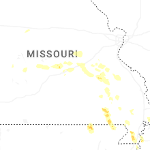


Connect with Interactive Hail Maps