

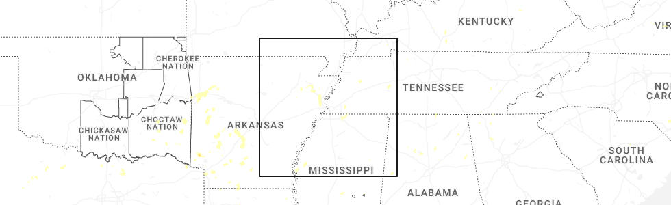
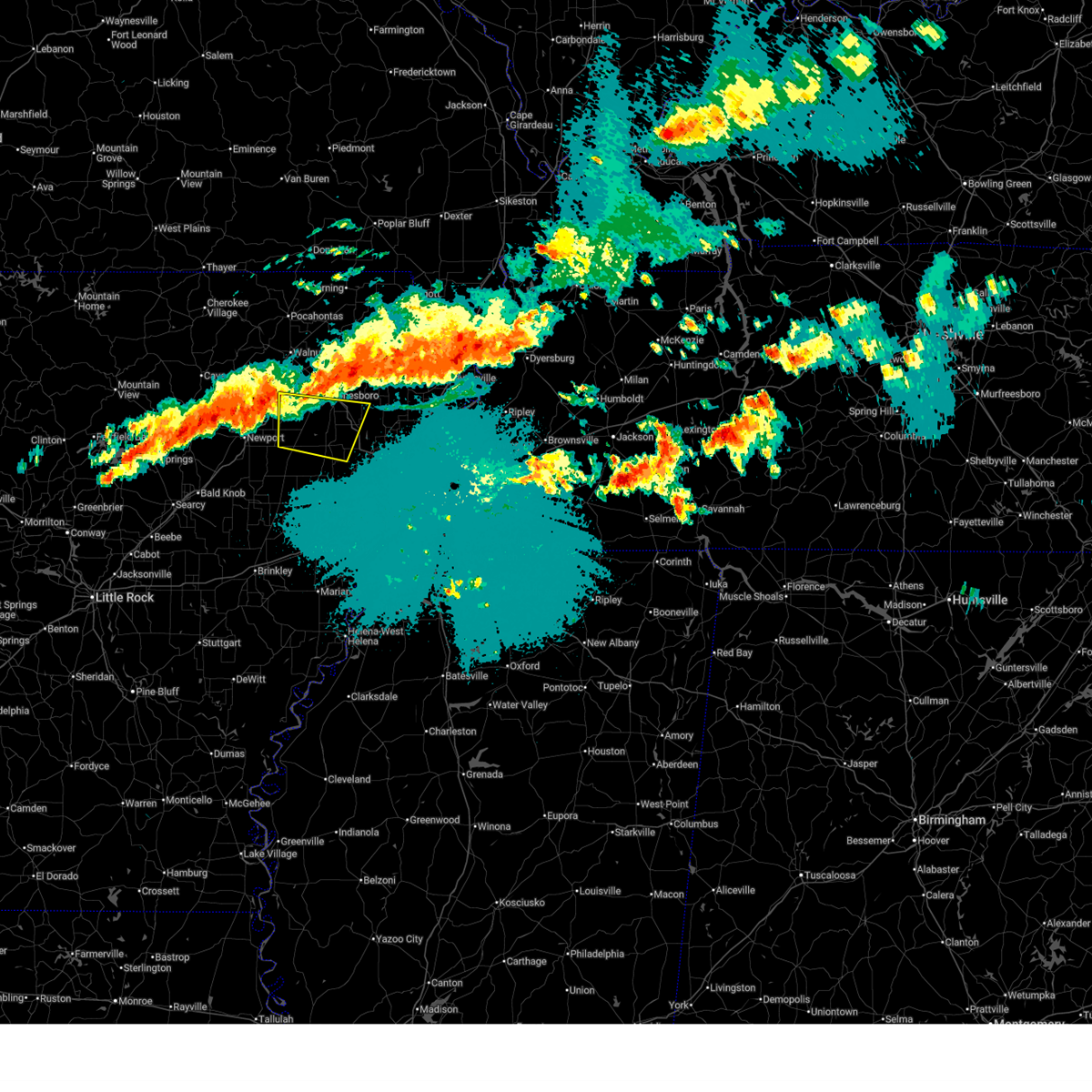
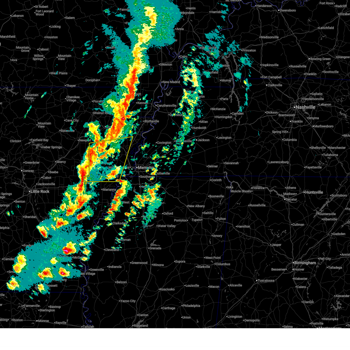
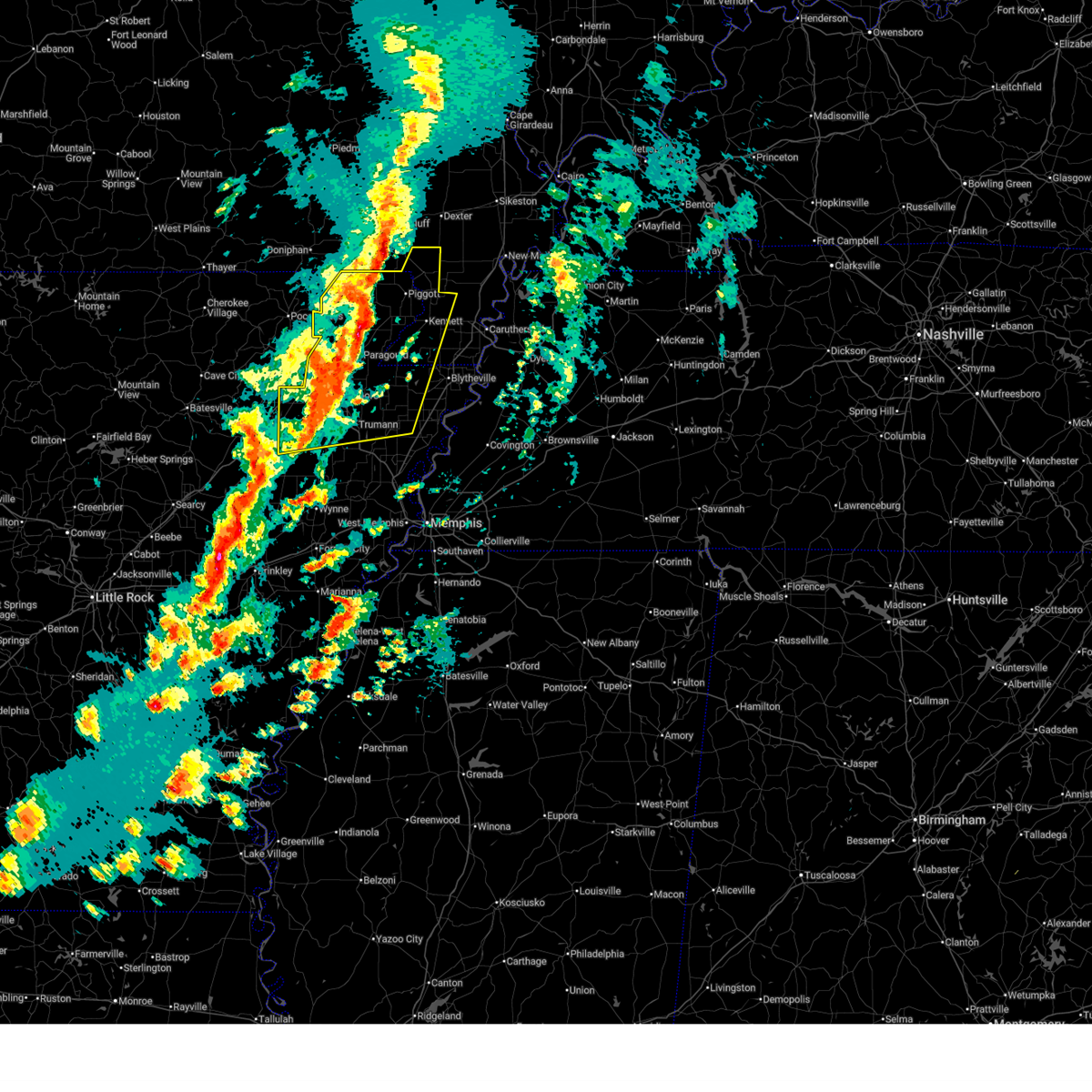
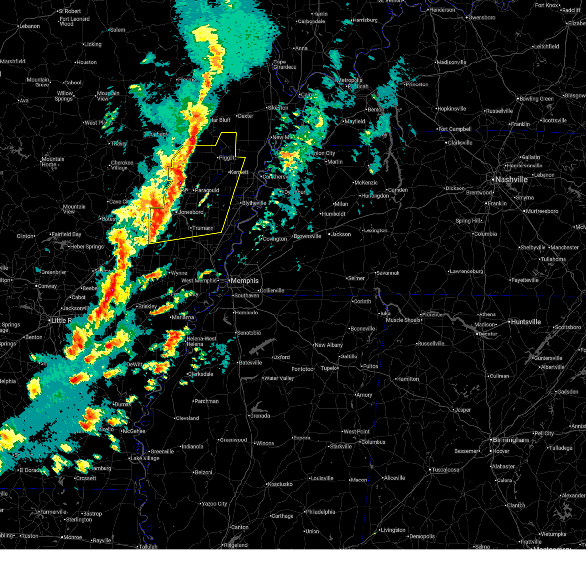
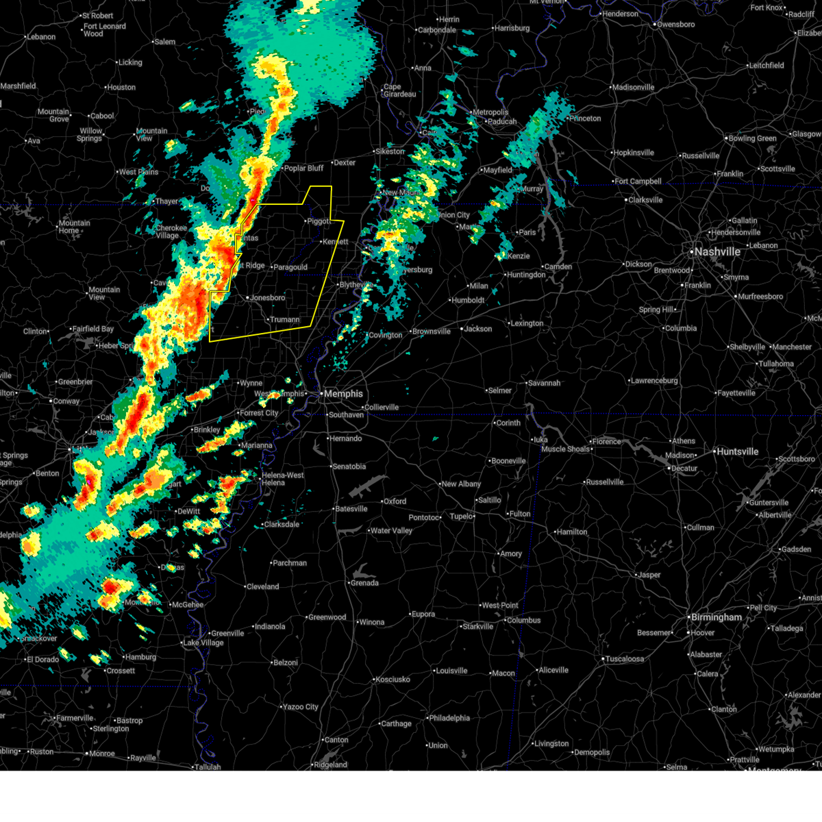
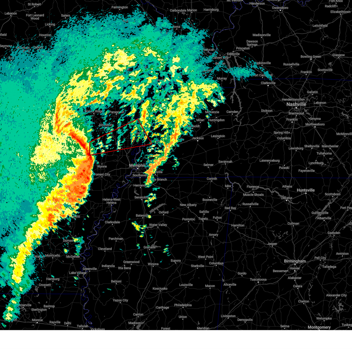
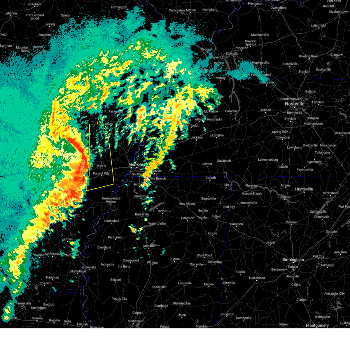
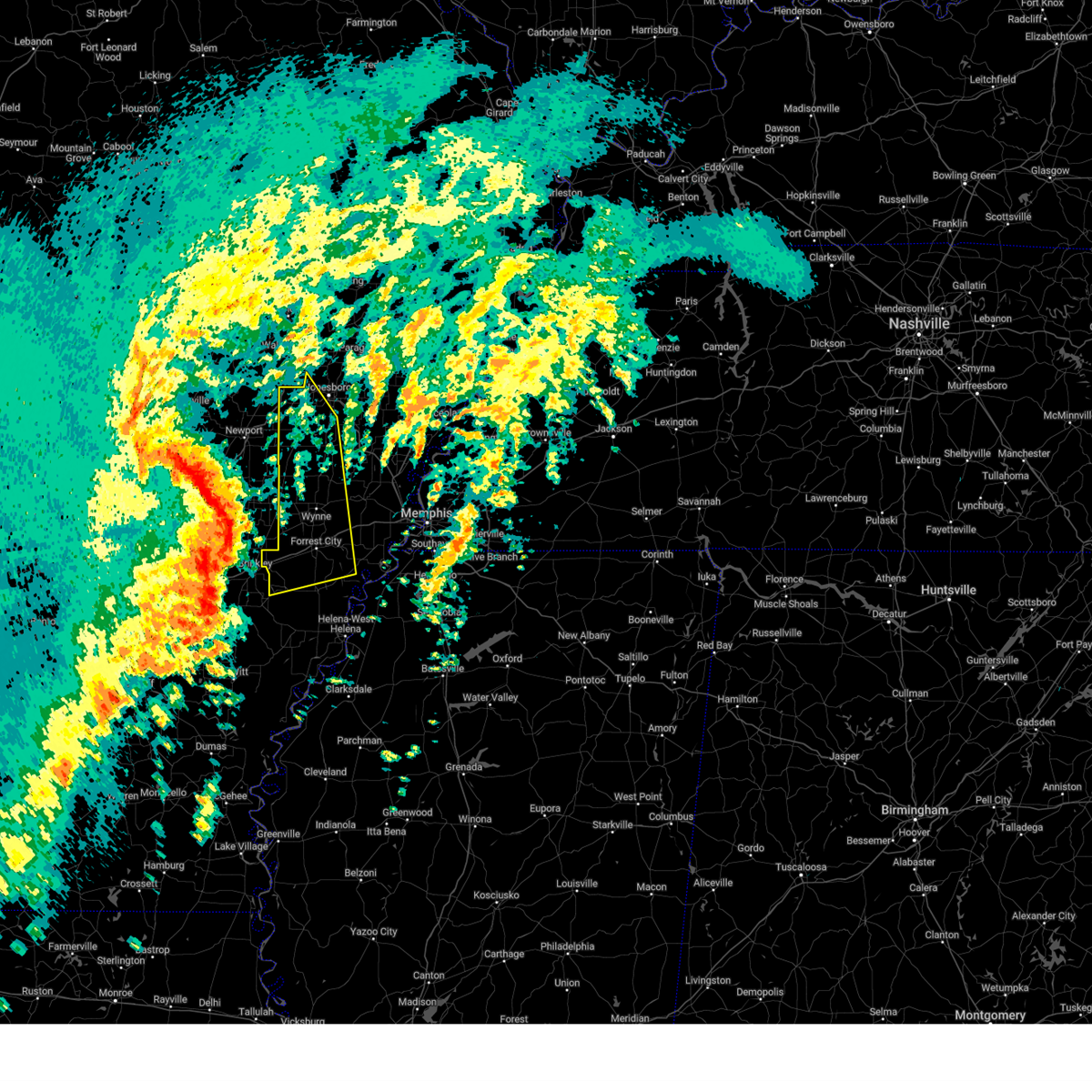
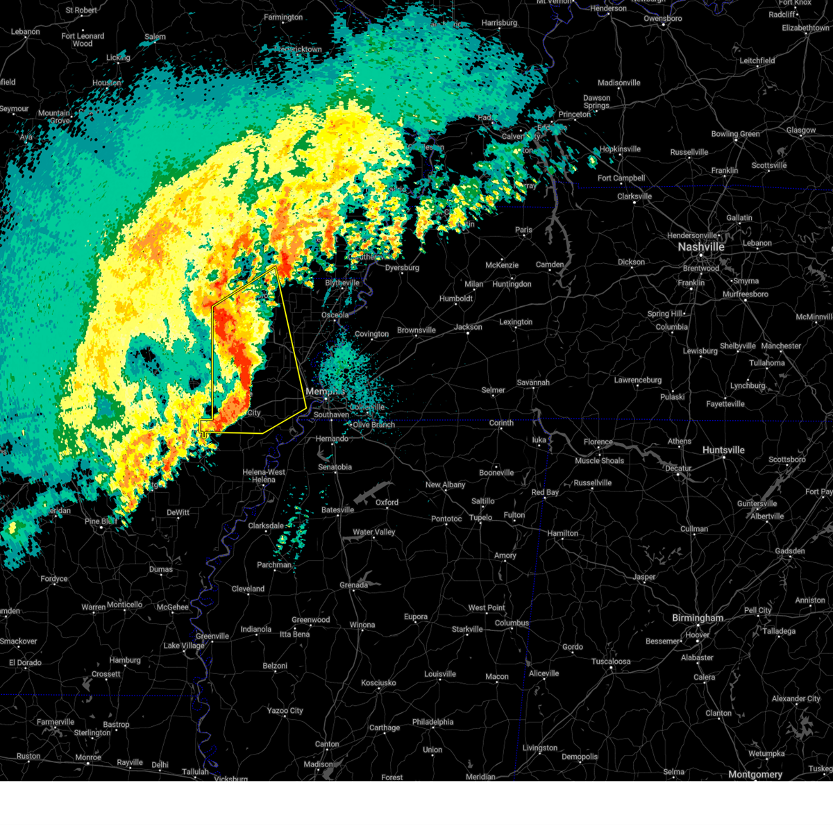
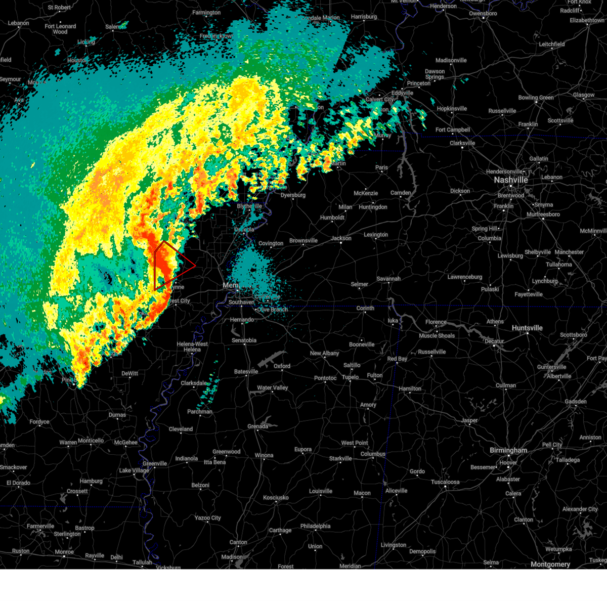
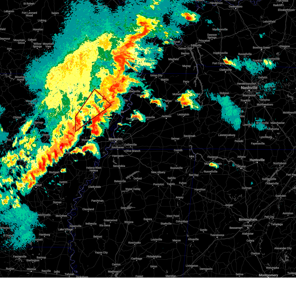
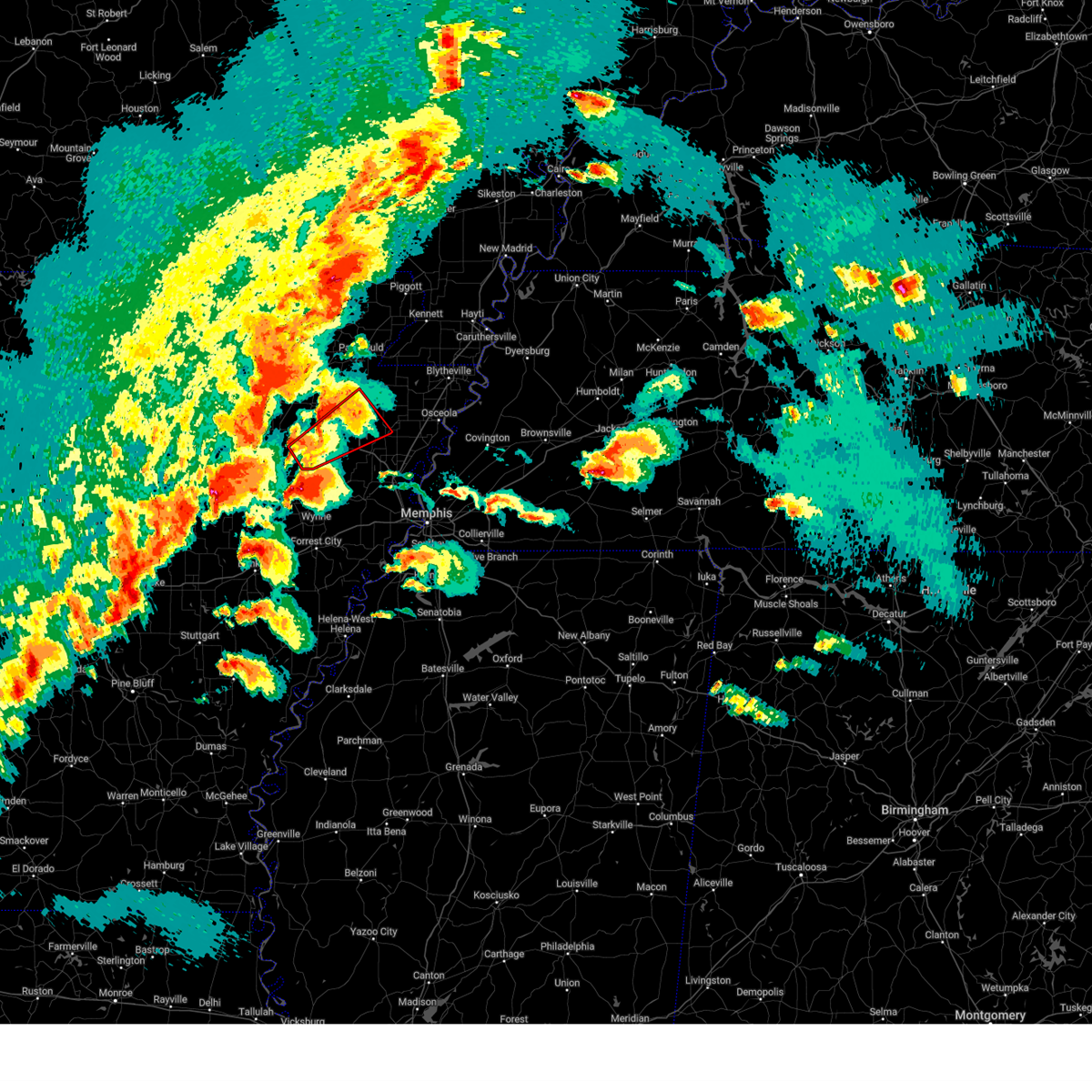
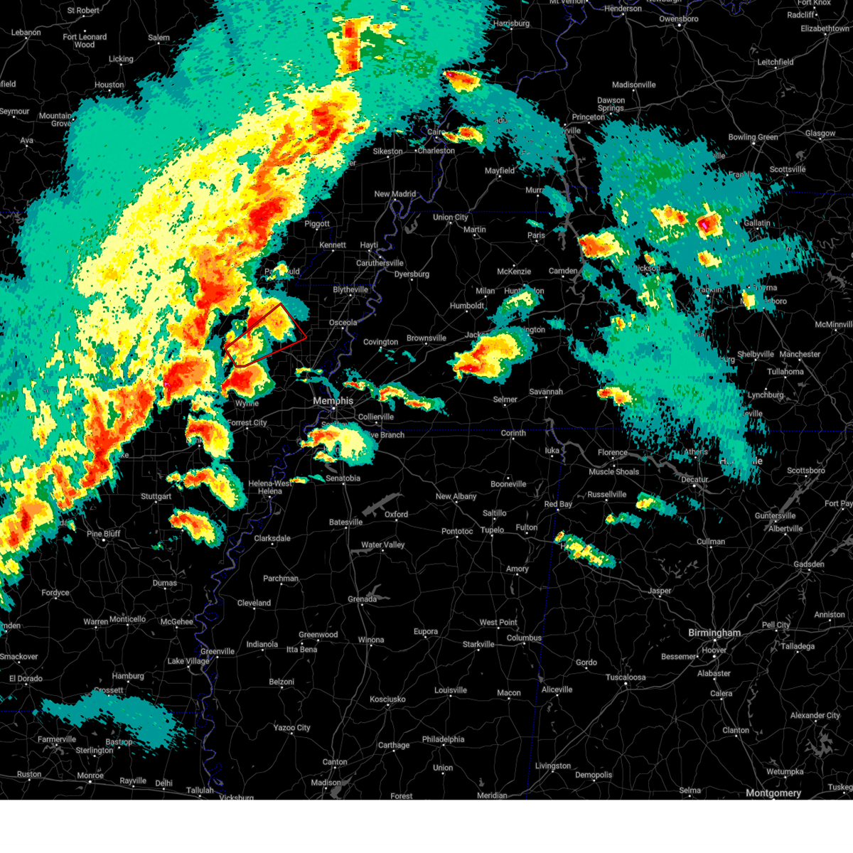
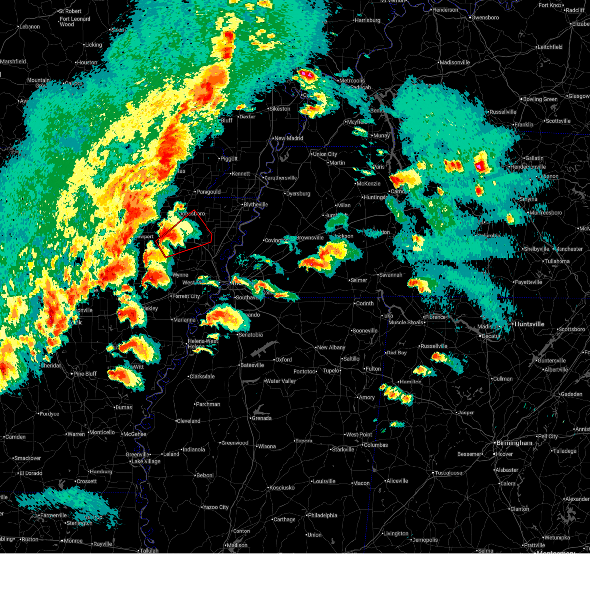
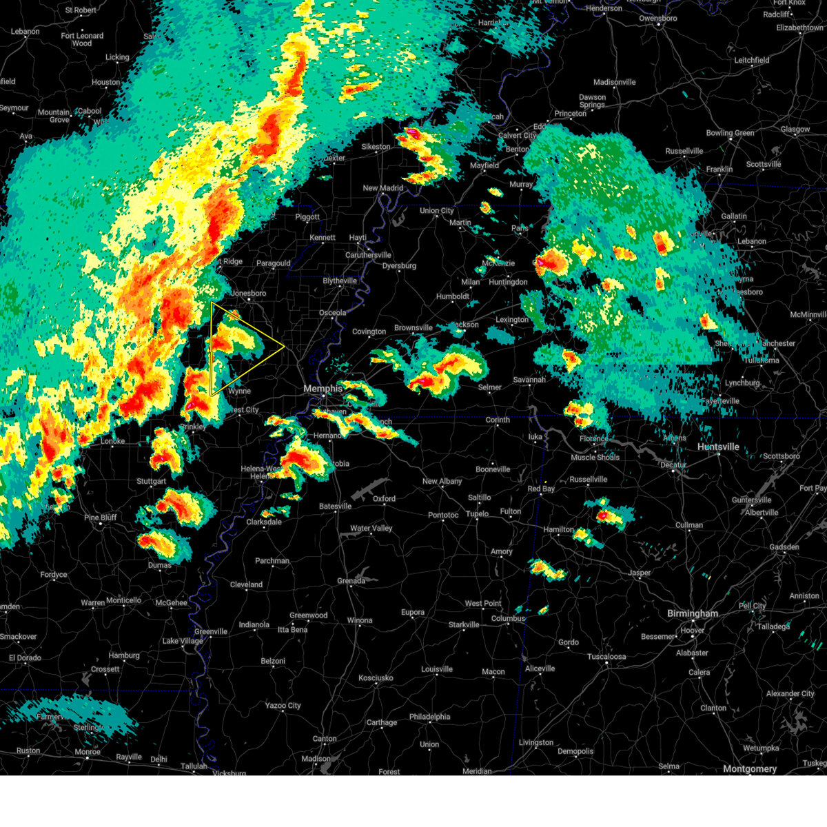
Hail Map for Waldenburg, AR
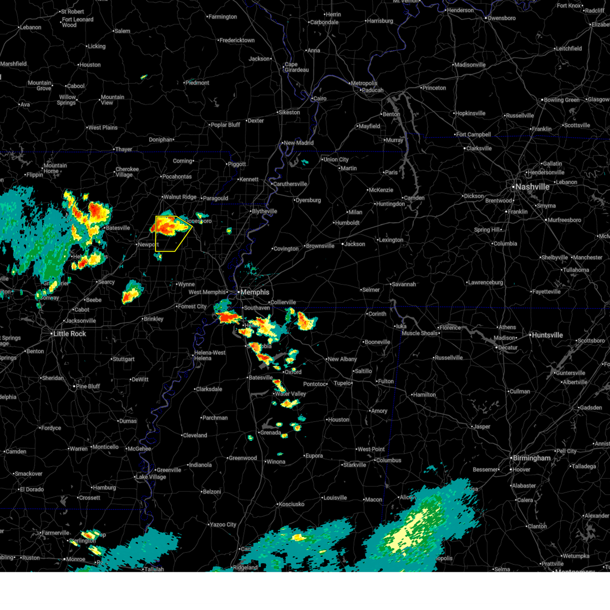
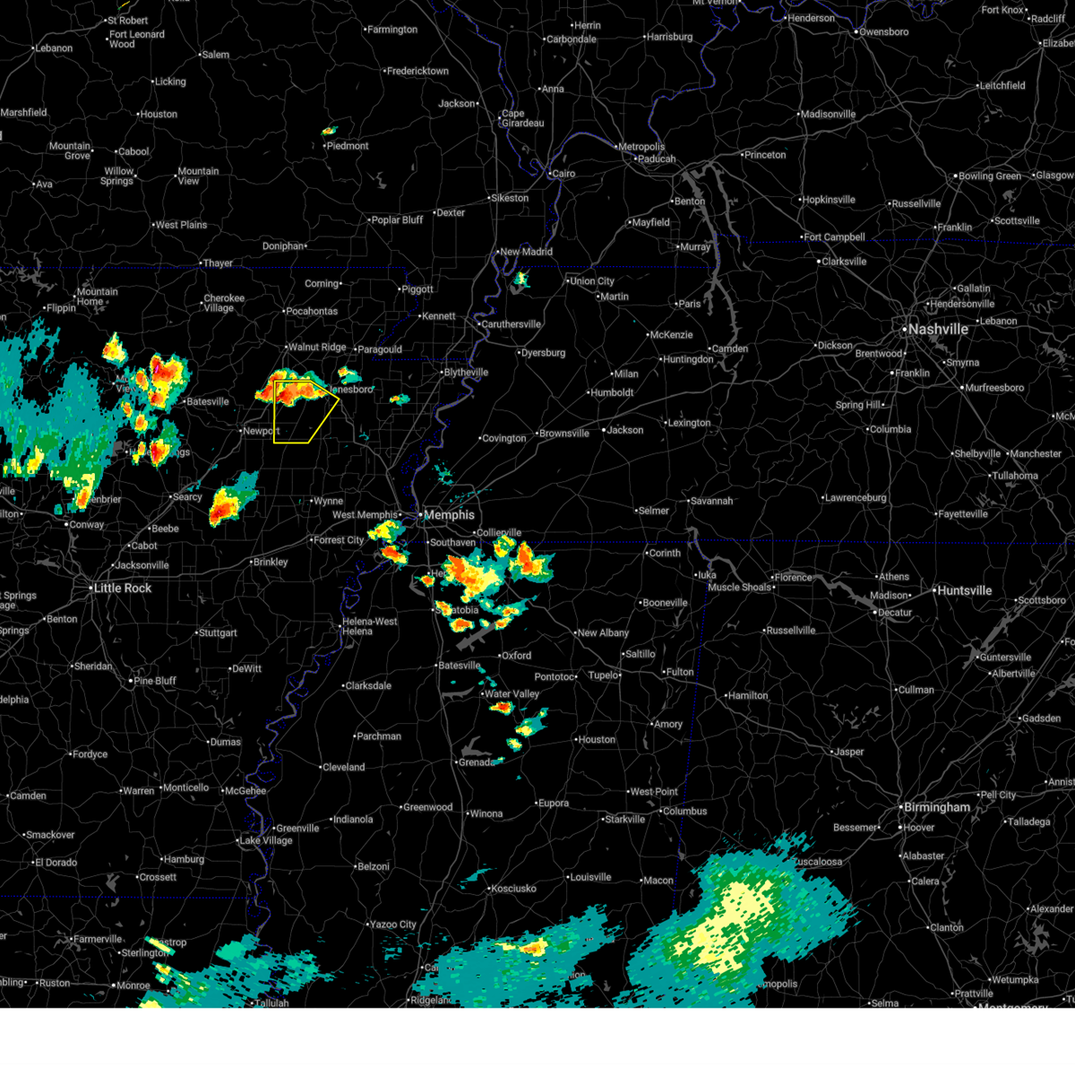
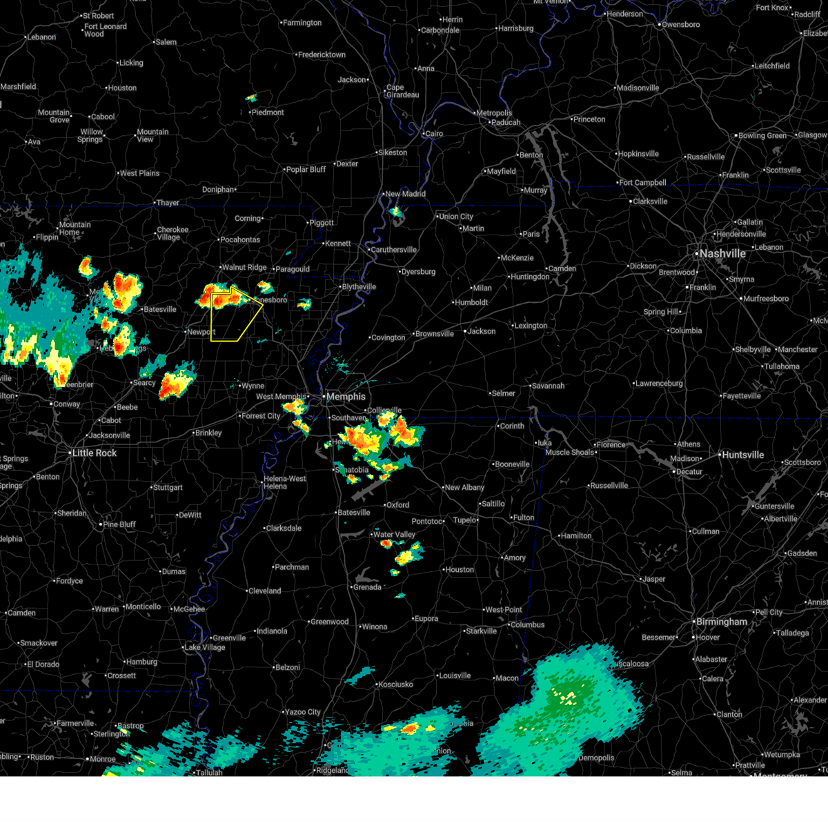
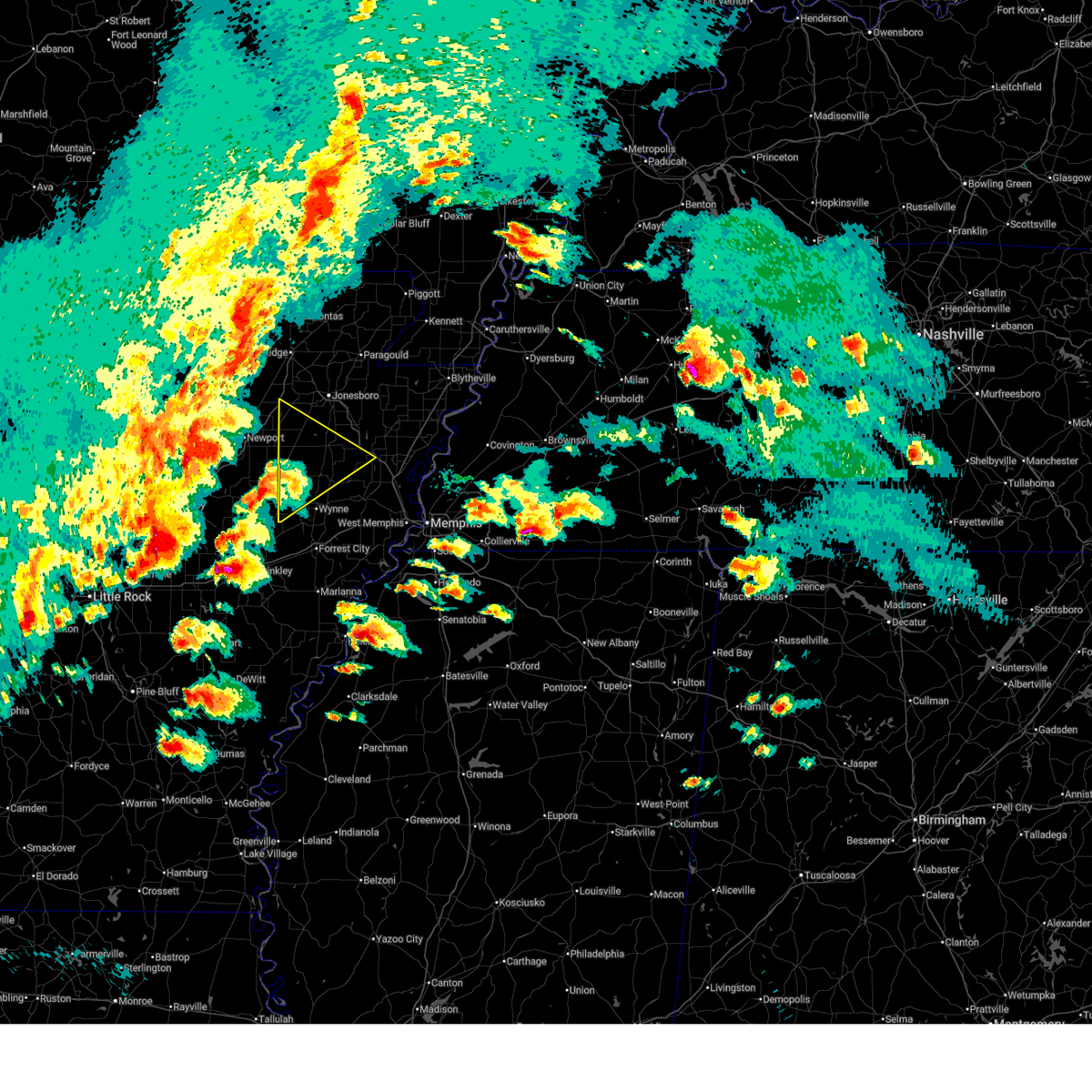
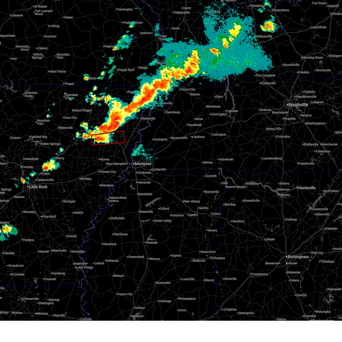
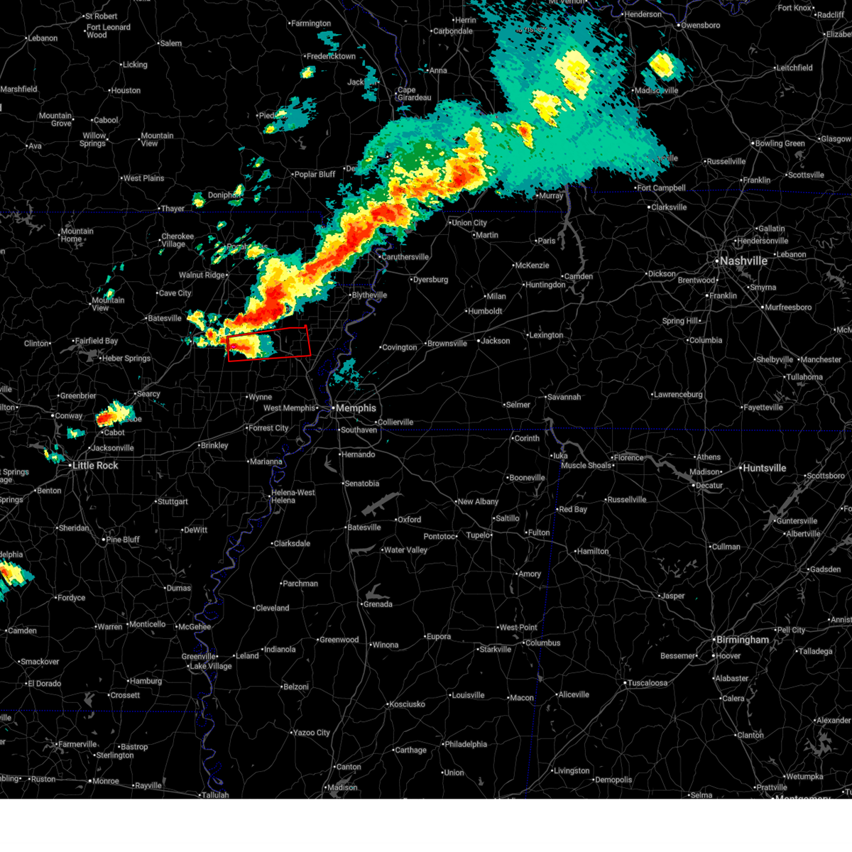
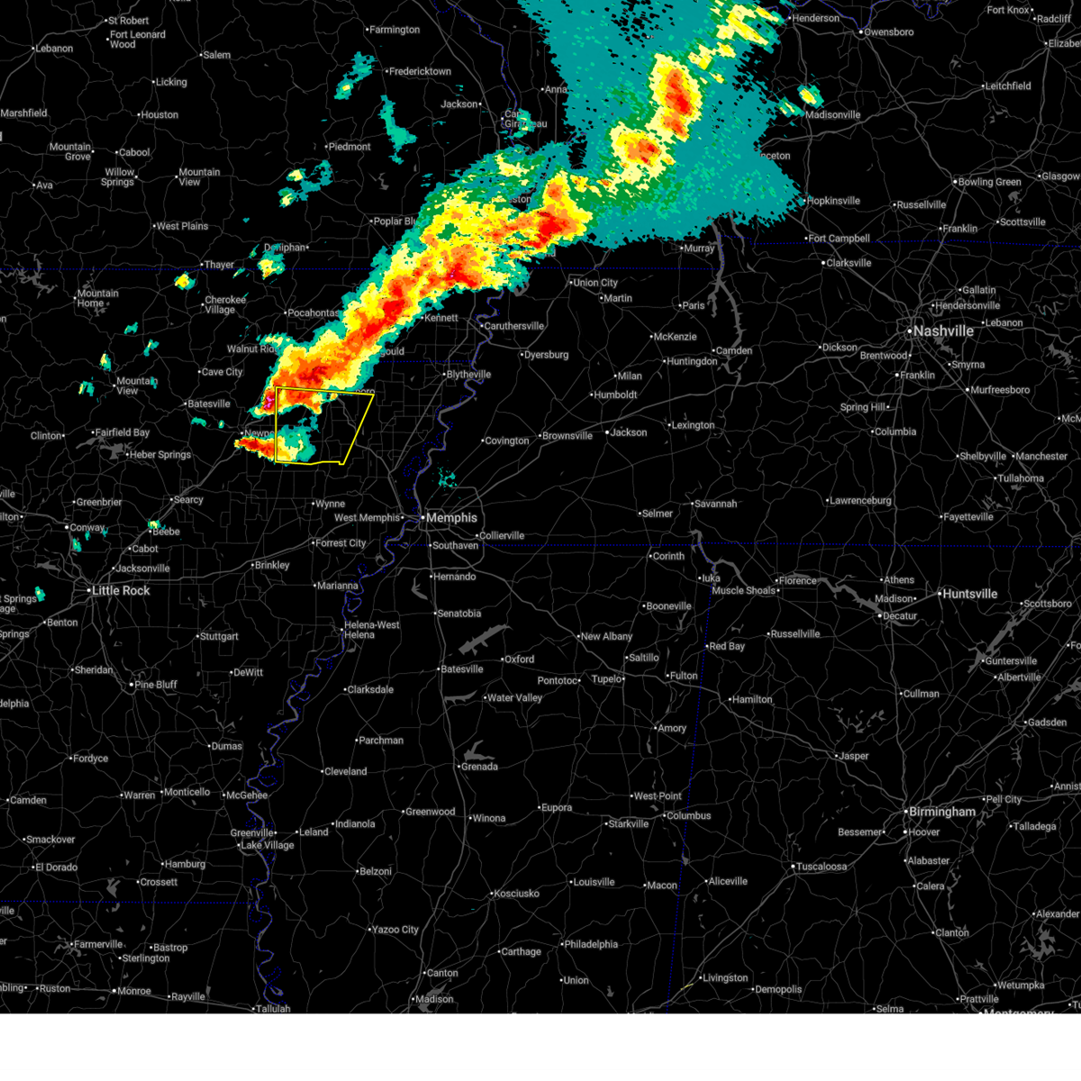
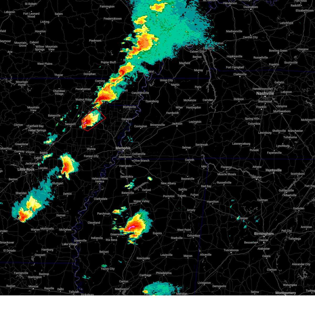
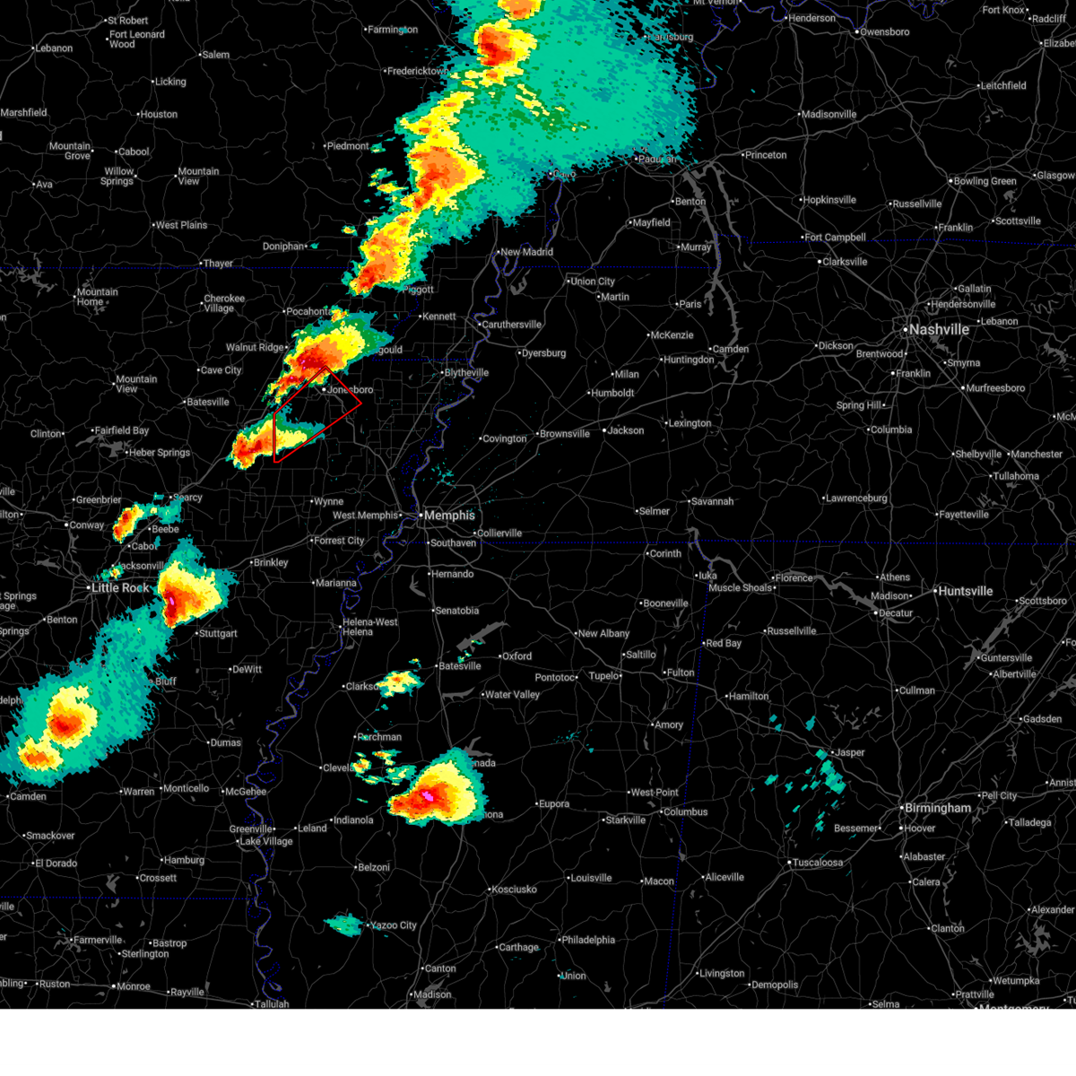
The Waldenburg, AR area has had 0 reports of on-the-ground hail by trained spotters, and has been under severe weather warnings 9 times during the past 12 months. Doppler radar has detected hail at or near Waldenburg, AR on 50 occasions, including 1 occasion during the past year.
| Name: | Waldenburg, AR |
| Where Located: | 57.6 miles WNW of Memphis, TN |
| Map: | Google Map for Waldenburg, AR |
| Population: | 61 |
| Housing Units: | 31 |
| More Info: | Search Google for Waldenburg, AR |
0
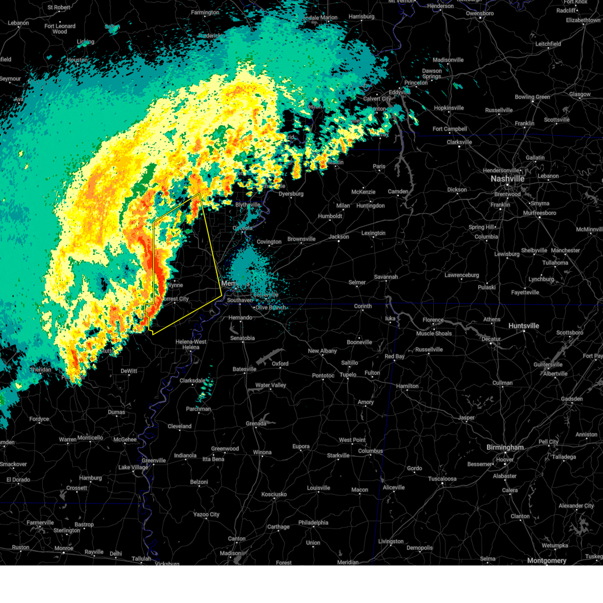
The Top Recent Hail Date for Waldenburg, AR is Thursday, July 31, 2025 (30th out of 50)
Hail and Wind Damage Spotted near Waldenburg, AR
| Date / Time | Report Details |
|---|---|
| 6/1/2026 7:38 PM CDT |
 At 738 pm cdt, a severe thunderstorm was located near cash, or 14 miles southwest of bono, moving south at 20 mph (radar indicated). Hazards include 60 mph wind gusts and quarter size hail. Hail damage to vehicles is expected. expect wind damage to roofs, siding, and trees. Locations impacted include, jonesboro, weiner, cash, egypt, waldenburg, greenfield, pitts, apt, herman, valley view, dryden, risher, winesburg, gilkerson, uno, otwell, cary, bayou de view state wildlife management area, and craighead forest park. At 738 pm cdt, a severe thunderstorm was located near cash, or 14 miles southwest of bono, moving south at 20 mph (radar indicated). Hazards include 60 mph wind gusts and quarter size hail. Hail damage to vehicles is expected. expect wind damage to roofs, siding, and trees. Locations impacted include, jonesboro, weiner, cash, egypt, waldenburg, greenfield, pitts, apt, herman, valley view, dryden, risher, winesburg, gilkerson, uno, otwell, cary, bayou de view state wildlife management area, and craighead forest park.
|
| 6/1/2026 7:26 PM CDT |
 At 726 pm cdt, a severe thunderstorm was located over cash, or 12 miles southwest of bono, moving south at 20 mph (radar indicated). Hazards include ping pong ball size hail and 60 mph wind gusts. People and animals outdoors will be injured. expect hail damage to roofs, siding, windows, and vehicles. expect wind damage to roofs, siding, and trees. Locations impacted include, jonesboro, weiner, cash, egypt, waldenburg, greenfield, pitts, apt, herman, valley view, dryden, risher, winesburg, gilkerson, uno, otwell, cary, bayou de view state wildlife management area, and craighead forest park. At 726 pm cdt, a severe thunderstorm was located over cash, or 12 miles southwest of bono, moving south at 20 mph (radar indicated). Hazards include ping pong ball size hail and 60 mph wind gusts. People and animals outdoors will be injured. expect hail damage to roofs, siding, windows, and vehicles. expect wind damage to roofs, siding, and trees. Locations impacted include, jonesboro, weiner, cash, egypt, waldenburg, greenfield, pitts, apt, herman, valley view, dryden, risher, winesburg, gilkerson, uno, otwell, cary, bayou de view state wildlife management area, and craighead forest park.
|
| 6/1/2026 7:21 PM CDT |
 Svrmeg the national weather service in memphis has issued a * severe thunderstorm warning for, western craighead county in eastern arkansas, northwestern poinsett county in eastern arkansas, * until 800 pm cdt. * at 720 pm cdt, a severe thunderstorm was located near cash, or 12 miles southwest of bono, moving south at 20 mph (radar indicated). Hazards include 60 mph wind gusts and quarter size hail. Hail damage to vehicles is expected. Expect wind damage to roofs, siding, and trees. Svrmeg the national weather service in memphis has issued a * severe thunderstorm warning for, western craighead county in eastern arkansas, northwestern poinsett county in eastern arkansas, * until 800 pm cdt. * at 720 pm cdt, a severe thunderstorm was located near cash, or 12 miles southwest of bono, moving south at 20 mph (radar indicated). Hazards include 60 mph wind gusts and quarter size hail. Hail damage to vehicles is expected. Expect wind damage to roofs, siding, and trees.
|
| 4/28/2026 12:13 AM CDT |
 Svrmeg the national weather service in memphis has issued a * severe thunderstorm warning for, southern craighead county in eastern arkansas, western poinsett county in eastern arkansas, * until 100 am cdt. * at 1213 am cdt, a severe thunderstorm was located over tuckerman, or 8 miles northeast of newport, moving east at 50 mph (radar indicated). Hazards include 60 mph wind gusts and penny size hail. expect damage to roofs, siding, and trees Svrmeg the national weather service in memphis has issued a * severe thunderstorm warning for, southern craighead county in eastern arkansas, western poinsett county in eastern arkansas, * until 100 am cdt. * at 1213 am cdt, a severe thunderstorm was located over tuckerman, or 8 miles northeast of newport, moving east at 50 mph (radar indicated). Hazards include 60 mph wind gusts and penny size hail. expect damage to roofs, siding, and trees
|
| 3/15/2026 6:42 PM CDT |
 At 642 pm cdt, severe thunderstorms were located along a line extending from near harrisburg to wheatley, moving east at 50 mph (radar indicated). Hazards include 70 mph wind gusts and quarter size hail. Hail damage to vehicles is expected. expect considerable tree damage. wind damage is also likely to mobile homes, roofs, and outbuildings. locations impacted include, forrest city, wynne, marked tree, earle, harrisburg, lepanto, hughes, parkin, madison, tyronza, palestine, village creek state park, cherry valley, caldwell, crawfordsville, dyess, colt, wheatley, widener, and hickory ridge. this includes the following highways, interstate 40 in arkansas between mile markers 219 and 269. Interstate 55 in arkansas between mile markers 19 and 29. At 642 pm cdt, severe thunderstorms were located along a line extending from near harrisburg to wheatley, moving east at 50 mph (radar indicated). Hazards include 70 mph wind gusts and quarter size hail. Hail damage to vehicles is expected. expect considerable tree damage. wind damage is also likely to mobile homes, roofs, and outbuildings. locations impacted include, forrest city, wynne, marked tree, earle, harrisburg, lepanto, hughes, parkin, madison, tyronza, palestine, village creek state park, cherry valley, caldwell, crawfordsville, dyess, colt, wheatley, widener, and hickory ridge. this includes the following highways, interstate 40 in arkansas between mile markers 219 and 269. Interstate 55 in arkansas between mile markers 19 and 29.
|
| 3/15/2026 6:21 PM CDT |
 Svrmeg the national weather service in memphis has issued a * severe thunderstorm warning for, st. francis county in eastern arkansas, poinsett county in eastern arkansas, southwestern mississippi county in eastern arkansas, western crittenden county in eastern arkansas, cross county in eastern arkansas, * until 715 pm cdt. * at 620 pm cdt, severe thunderstorms were located along a line extending from near waldenburg to near fredonia, moving east at 70 mph (radar indicated). Hazards include 60 mph wind gusts and quarter size hail. Hail damage to vehicles is expected. Expect wind damage to roofs, siding, and trees. Svrmeg the national weather service in memphis has issued a * severe thunderstorm warning for, st. francis county in eastern arkansas, poinsett county in eastern arkansas, southwestern mississippi county in eastern arkansas, western crittenden county in eastern arkansas, cross county in eastern arkansas, * until 715 pm cdt. * at 620 pm cdt, severe thunderstorms were located along a line extending from near waldenburg to near fredonia, moving east at 70 mph (radar indicated). Hazards include 60 mph wind gusts and quarter size hail. Hail damage to vehicles is expected. Expect wind damage to roofs, siding, and trees.
|
| 3/15/2026 6:21 PM CDT |
 At 621 pm cdt, severe thunderstorms were located along a line extending from 6 miles southwest of qulin to near weiner, moving east at 60 mph. these are destructive storms for jonesboro and brookland (radar indicated). Hazards include 80 mph wind gusts and quarter size hail. Flying debris will be dangerous to those caught without shelter. mobile homes will be heavily damaged. expect considerable damage to roofs, windows, and vehicles. extensive tree damage and power outages are likely. Locations impacted include, jonesboro, paragould, kennett, trumann, malden, piggott, corning, manila, harrisburg, bono, lake city, leachville, campbell, rector, lepanto, bay, senath, brookland, monette, and caraway. At 621 pm cdt, severe thunderstorms were located along a line extending from 6 miles southwest of qulin to near weiner, moving east at 60 mph. these are destructive storms for jonesboro and brookland (radar indicated). Hazards include 80 mph wind gusts and quarter size hail. Flying debris will be dangerous to those caught without shelter. mobile homes will be heavily damaged. expect considerable damage to roofs, windows, and vehicles. extensive tree damage and power outages are likely. Locations impacted include, jonesboro, paragould, kennett, trumann, malden, piggott, corning, manila, harrisburg, bono, lake city, leachville, campbell, rector, lepanto, bay, senath, brookland, monette, and caraway.
|
| 3/15/2026 6:14 PM CDT |
 At 614 pm cdt, severe thunderstorms were located along a line extending from near neelyville to weiner, moving east at 60 mph (radar indicated). Hazards include 70 mph wind gusts and quarter size hail. Hail damage to vehicles is expected. expect considerable tree damage. wind damage is also likely to mobile homes, roofs, and outbuildings. Locations impacted include, jonesboro, paragould, kennett, trumann, malden, piggott, corning, manila, harrisburg, bono, lake city, leachville, campbell, rector, lepanto, bay, senath, brookland, monette, and caraway. At 614 pm cdt, severe thunderstorms were located along a line extending from near neelyville to weiner, moving east at 60 mph (radar indicated). Hazards include 70 mph wind gusts and quarter size hail. Hail damage to vehicles is expected. expect considerable tree damage. wind damage is also likely to mobile homes, roofs, and outbuildings. Locations impacted include, jonesboro, paragould, kennett, trumann, malden, piggott, corning, manila, harrisburg, bono, lake city, leachville, campbell, rector, lepanto, bay, senath, brookland, monette, and caraway.
|
| 3/15/2026 6:05 PM CDT |
 Svrmeg the national weather service in memphis has issued a * severe thunderstorm warning for, greene county in eastern arkansas, craighead county in eastern arkansas, northern poinsett county in eastern arkansas, northwestern mississippi county in eastern arkansas, clay county in eastern arkansas, northwestern pemiscot county in southeastern missouri, dunklin county in southeastern missouri, * until 645 pm cdt. * at 605 pm cdt, severe thunderstorms were located along a line extending from near neelyville to near grubbs, moving east at 60 mph (radar indicated). Hazards include 60 mph wind gusts and quarter size hail. Hail damage to vehicles is expected. Expect wind damage to roofs, siding, and trees. Svrmeg the national weather service in memphis has issued a * severe thunderstorm warning for, greene county in eastern arkansas, craighead county in eastern arkansas, northern poinsett county in eastern arkansas, northwestern mississippi county in eastern arkansas, clay county in eastern arkansas, northwestern pemiscot county in southeastern missouri, dunklin county in southeastern missouri, * until 645 pm cdt. * at 605 pm cdt, severe thunderstorms were located along a line extending from near neelyville to near grubbs, moving east at 60 mph (radar indicated). Hazards include 60 mph wind gusts and quarter size hail. Hail damage to vehicles is expected. Expect wind damage to roofs, siding, and trees.
|
| 5/16/2025 7:18 AM CDT |
 Svrmeg the national weather service in memphis has issued a * severe thunderstorm warning for, western greene county in eastern arkansas, craighead county in eastern arkansas, poinsett county in eastern arkansas, west central mississippi county in eastern arkansas, northwestern cross county in eastern arkansas, * until 800 am cdt. * at 718 am cdt, a severe thunderstorm was located over grubbs, or 10 miles east of newport, moving northeast at 55 mph (radar indicated). Hazards include 60 mph wind gusts and quarter size hail. Hail damage to vehicles is expected. Expect wind damage to roofs, siding, and trees. Svrmeg the national weather service in memphis has issued a * severe thunderstorm warning for, western greene county in eastern arkansas, craighead county in eastern arkansas, poinsett county in eastern arkansas, west central mississippi county in eastern arkansas, northwestern cross county in eastern arkansas, * until 800 am cdt. * at 718 am cdt, a severe thunderstorm was located over grubbs, or 10 miles east of newport, moving northeast at 55 mph (radar indicated). Hazards include 60 mph wind gusts and quarter size hail. Hail damage to vehicles is expected. Expect wind damage to roofs, siding, and trees.
|
| 4/5/2025 12:58 PM CDT |
 Tormeg the national weather service in memphis has issued a * tornado warning for, southeastern craighead county in eastern arkansas, poinsett county in eastern arkansas, mississippi county in eastern arkansas, northwestern cross county in eastern arkansas, northwestern tipton county in west tennessee, southwestern lauderdale county in west tennessee, * until 145 pm cdt. * at 1258 pm cdt, a severe thunderstorm capable of producing a tornado was located near trumann, moving east at 65 mph (radar indicated rotation). Hazards include tornado. Flying debris will be dangerous to those caught without shelter. mobile homes will be damaged or destroyed. damage to roofs, windows, and vehicles will occur. Tree damage is likely. Tormeg the national weather service in memphis has issued a * tornado warning for, southeastern craighead county in eastern arkansas, poinsett county in eastern arkansas, mississippi county in eastern arkansas, northwestern cross county in eastern arkansas, northwestern tipton county in west tennessee, southwestern lauderdale county in west tennessee, * until 145 pm cdt. * at 1258 pm cdt, a severe thunderstorm capable of producing a tornado was located near trumann, moving east at 65 mph (radar indicated rotation). Hazards include tornado. Flying debris will be dangerous to those caught without shelter. mobile homes will be damaged or destroyed. damage to roofs, windows, and vehicles will occur. Tree damage is likely.
|
| 4/5/2025 12:50 PM CDT |
 At 1250 pm cdt, a severe thunderstorm capable of producing a tornado was located near harrisburg, moving east at 60 mph (radar indicated rotation). Hazards include tornado and quarter size hail. Flying debris will be dangerous to those caught without shelter. mobile homes will be damaged or destroyed. damage to roofs, windows, and vehicles will occur. tree damage is likely. this storm system is moving over areas already impacted earlier in the week. Locations impacted include, payneway, burlison, vail, etowah, weona junction, grider, gum point, hampson archaeological museum state park, whisp, osceola, promised land, alto, judd hill, bunney, lake poinsett state park, shippen, milligan ridge, victoria, delpro, and roseland. At 1250 pm cdt, a severe thunderstorm capable of producing a tornado was located near harrisburg, moving east at 60 mph (radar indicated rotation). Hazards include tornado and quarter size hail. Flying debris will be dangerous to those caught without shelter. mobile homes will be damaged or destroyed. damage to roofs, windows, and vehicles will occur. tree damage is likely. this storm system is moving over areas already impacted earlier in the week. Locations impacted include, payneway, burlison, vail, etowah, weona junction, grider, gum point, hampson archaeological museum state park, whisp, osceola, promised land, alto, judd hill, bunney, lake poinsett state park, shippen, milligan ridge, victoria, delpro, and roseland.
|
| 4/5/2025 12:40 PM CDT |
 At 1240 pm cdt, severe thunderstorms were located along a line extending from swifton to 6 miles north of cherry valley to near caldwell, moving northeast at 70 mph. this storm system is moving over areas already impacted earlier in the week (radar indicated). Hazards include 70 mph wind gusts and quarter size hail. Hail damage to vehicles is expected. expect considerable tree damage. wind damage is also likely to mobile homes, roofs, and outbuildings. Locations impacted include, garret grove, cottonwood corner, valley view, fitzgerald crossing, wheatley, new castle, brushy lake, round pond, mcelroy, craighead forest park, bay village, cherry valley, ball point, tongin, pitts, gill, lake poinsett state park, hawkins, river front, and pittinger. At 1240 pm cdt, severe thunderstorms were located along a line extending from swifton to 6 miles north of cherry valley to near caldwell, moving northeast at 70 mph. this storm system is moving over areas already impacted earlier in the week (radar indicated). Hazards include 70 mph wind gusts and quarter size hail. Hail damage to vehicles is expected. expect considerable tree damage. wind damage is also likely to mobile homes, roofs, and outbuildings. Locations impacted include, garret grove, cottonwood corner, valley view, fitzgerald crossing, wheatley, new castle, brushy lake, round pond, mcelroy, craighead forest park, bay village, cherry valley, ball point, tongin, pitts, gill, lake poinsett state park, hawkins, river front, and pittinger.
|
| 4/5/2025 12:39 PM CDT |
 At 1239 pm cdt, severe thunderstorms were located along a line extending from near strawberry to near cherry valley to near new salem, moving northeast at 70 mph. this storm system is moving over areas already impacted earlier in the week (radar indicated). Hazards include 70 mph wind gusts and quarter size hail. Hail damage to vehicles is expected. expect considerable tree damage. wind damage is also likely to mobile homes, roofs, and outbuildings. Locations impacted include, three forks, payneway, paulding, apt, stonewall, new castle, success, mounds, alto, judd hill, beech grove, gill, needham, bunney, lake poinsett state park, hawkins, milligan ridge, buck donic, dryden, and village creek state park. At 1239 pm cdt, severe thunderstorms were located along a line extending from near strawberry to near cherry valley to near new salem, moving northeast at 70 mph. this storm system is moving over areas already impacted earlier in the week (radar indicated). Hazards include 70 mph wind gusts and quarter size hail. Hail damage to vehicles is expected. expect considerable tree damage. wind damage is also likely to mobile homes, roofs, and outbuildings. Locations impacted include, three forks, payneway, paulding, apt, stonewall, new castle, success, mounds, alto, judd hill, beech grove, gill, needham, bunney, lake poinsett state park, hawkins, milligan ridge, buck donic, dryden, and village creek state park.
|
| 4/5/2025 12:33 PM CDT |
 Tormeg the national weather service in memphis has issued a * tornado warning for, southeastern craighead county in eastern arkansas, poinsett county in eastern arkansas, mississippi county in eastern arkansas, northwestern cross county in eastern arkansas, northwestern tipton county in west tennessee, southwestern lauderdale county in west tennessee, * until 115 pm cdt. * at 1233 pm cdt, a severe thunderstorm capable of producing a tornado was located near hickory ridge, or 14 miles southwest of harrisburg, moving east at 70 mph (radar indicated rotation). Hazards include tornado and quarter size hail. Flying debris will be dangerous to those caught without shelter. mobile homes will be damaged or destroyed. damage to roofs, windows, and vehicles will occur. Tree damage is likely. Tormeg the national weather service in memphis has issued a * tornado warning for, southeastern craighead county in eastern arkansas, poinsett county in eastern arkansas, mississippi county in eastern arkansas, northwestern cross county in eastern arkansas, northwestern tipton county in west tennessee, southwestern lauderdale county in west tennessee, * until 115 pm cdt. * at 1233 pm cdt, a severe thunderstorm capable of producing a tornado was located near hickory ridge, or 14 miles southwest of harrisburg, moving east at 70 mph (radar indicated rotation). Hazards include tornado and quarter size hail. Flying debris will be dangerous to those caught without shelter. mobile homes will be damaged or destroyed. damage to roofs, windows, and vehicles will occur. Tree damage is likely.
|
| 4/5/2025 12:31 PM CDT |
 Svrmeg the national weather service in memphis has issued a * severe thunderstorm warning for, greene county in eastern arkansas, northwestern lee county in eastern arkansas, craighead county in eastern arkansas, st. francis county in eastern arkansas, poinsett county in eastern arkansas, western mississippi county in eastern arkansas, crittenden county in eastern arkansas, western clay county in eastern arkansas, cross county in eastern arkansas, southwestern dunklin county in southeastern missouri, * until 130 pm cdt. * at 1230 pm cdt, severe thunderstorms were located along a line extending from 7 miles south of strawberry to near hickory ridge to near alfrey, moving northeast at 65 mph. this storm system is moving over areas already impacted earlier in the week (radar indicated). Hazards include 70 mph wind gusts and quarter size hail. Hail damage to vehicles is expected. expect considerable tree damage. Wind damage is also likely to mobile homes, roofs, and outbuildings. Svrmeg the national weather service in memphis has issued a * severe thunderstorm warning for, greene county in eastern arkansas, northwestern lee county in eastern arkansas, craighead county in eastern arkansas, st. francis county in eastern arkansas, poinsett county in eastern arkansas, western mississippi county in eastern arkansas, crittenden county in eastern arkansas, western clay county in eastern arkansas, cross county in eastern arkansas, southwestern dunklin county in southeastern missouri, * until 130 pm cdt. * at 1230 pm cdt, severe thunderstorms were located along a line extending from 7 miles south of strawberry to near hickory ridge to near alfrey, moving northeast at 65 mph. this storm system is moving over areas already impacted earlier in the week (radar indicated). Hazards include 70 mph wind gusts and quarter size hail. Hail damage to vehicles is expected. expect considerable tree damage. Wind damage is also likely to mobile homes, roofs, and outbuildings.
|
| 4/5/2025 12:21 PM CDT |
 At 1221 pm cdt, severe thunderstorms were located along a line extending from near salado to near patterson to near brinkley, moving northeast at 45 mph. this storm system is moving over areas already impacted earlier in the week (radar indicated). Hazards include 70 mph wind gusts and quarter size hail. Hail damage to vehicles is expected. expect considerable tree damage. wind damage is also likely to mobile homes, roofs, and outbuildings. Locations impacted include, garret grove, cottonwood corner, valley view, fitzgerald crossing, wheatley, new castle, brushy lake, round pond, mcelroy, craighead forest park, bay village, cherry valley, ball point, tongin, pitts, gill, lake poinsett state park, hawkins, river front, and pittinger. At 1221 pm cdt, severe thunderstorms were located along a line extending from near salado to near patterson to near brinkley, moving northeast at 45 mph. this storm system is moving over areas already impacted earlier in the week (radar indicated). Hazards include 70 mph wind gusts and quarter size hail. Hail damage to vehicles is expected. expect considerable tree damage. wind damage is also likely to mobile homes, roofs, and outbuildings. Locations impacted include, garret grove, cottonwood corner, valley view, fitzgerald crossing, wheatley, new castle, brushy lake, round pond, mcelroy, craighead forest park, bay village, cherry valley, ball point, tongin, pitts, gill, lake poinsett state park, hawkins, river front, and pittinger.
|
| 4/5/2025 12:06 PM CDT |
 Svrmeg the national weather service in memphis has issued a * severe thunderstorm warning for, northern lee county in eastern arkansas, western craighead county in eastern arkansas, st. francis county in eastern arkansas, western poinsett county in eastern arkansas, cross county in eastern arkansas, * until 100 pm cdt. * at 1206 pm cdt, severe thunderstorms were located along a line extending from near pleasant plains to near augusta to near peppers landing, moving northeast at 45 mph (radar indicated). Hazards include 70 mph wind gusts and quarter size hail. Hail damage to vehicles is expected. expect considerable tree damage. Wind damage is also likely to mobile homes, roofs, and outbuildings. Svrmeg the national weather service in memphis has issued a * severe thunderstorm warning for, northern lee county in eastern arkansas, western craighead county in eastern arkansas, st. francis county in eastern arkansas, western poinsett county in eastern arkansas, cross county in eastern arkansas, * until 100 pm cdt. * at 1206 pm cdt, severe thunderstorms were located along a line extending from near pleasant plains to near augusta to near peppers landing, moving northeast at 45 mph (radar indicated). Hazards include 70 mph wind gusts and quarter size hail. Hail damage to vehicles is expected. expect considerable tree damage. Wind damage is also likely to mobile homes, roofs, and outbuildings.
|
| 4/5/2025 1:50 AM CDT |
 the severe thunderstorm warning has been cancelled and is no longer in effect the severe thunderstorm warning has been cancelled and is no longer in effect
|
| 4/5/2025 1:50 AM CDT |
 At 149 am cdt, severe thunderstorms were located along a line extending from near weiner to near haynes, moving northeast at 55 mph (radar indicated). Hazards include 60 mph wind gusts and nickel size hail. Expect damage to roofs, siding, and trees. Locations impacted include, three forks, payneway, apt, valley view, browns, louise, weona junction, wheatley, new castle, gum point, edmondson, farrville, round pond, craighead forest park, simsboro, promised land, judd hill, herndon, needham, and lake poinsett state park. At 149 am cdt, severe thunderstorms were located along a line extending from near weiner to near haynes, moving northeast at 55 mph (radar indicated). Hazards include 60 mph wind gusts and nickel size hail. Expect damage to roofs, siding, and trees. Locations impacted include, three forks, payneway, apt, valley view, browns, louise, weona junction, wheatley, new castle, gum point, edmondson, farrville, round pond, craighead forest park, simsboro, promised land, judd hill, herndon, needham, and lake poinsett state park.
|
| 4/5/2025 1:43 AM CDT |
 the tornado warning has been cancelled and is no longer in effect the tornado warning has been cancelled and is no longer in effect
|
| 4/5/2025 1:39 AM CDT |
 At 139 am cdt, a severe thunderstorm capable of producing a tornado was located over hickory ridge, or 15 miles northwest of wynne, moving northeast at 45 mph (radar indicated rotation). Hazards include tornado. Flying debris will be dangerous to those caught without shelter. mobile homes will be damaged or destroyed. damage to roofs, windows, and vehicles will occur. tree damage is likely. Locations impacted include, hydrick, wiley crossing, birdeye, pittinger, supply, tilton, colton, fair oaks, brushy lake, vanndale, mersman, waldenburg, fisher, fair field, hickory ridge, bay village, cherry valley, hamlin, monterey, and weiner. At 139 am cdt, a severe thunderstorm capable of producing a tornado was located over hickory ridge, or 15 miles northwest of wynne, moving northeast at 45 mph (radar indicated rotation). Hazards include tornado. Flying debris will be dangerous to those caught without shelter. mobile homes will be damaged or destroyed. damage to roofs, windows, and vehicles will occur. tree damage is likely. Locations impacted include, hydrick, wiley crossing, birdeye, pittinger, supply, tilton, colton, fair oaks, brushy lake, vanndale, mersman, waldenburg, fisher, fair field, hickory ridge, bay village, cherry valley, hamlin, monterey, and weiner.
|
| 4/5/2025 1:32 AM CDT |
 Svrmeg the national weather service in memphis has issued a * severe thunderstorm warning for, south central greene county in eastern arkansas, northwestern lee county in eastern arkansas, craighead county in eastern arkansas, st. francis county in eastern arkansas, poinsett county in eastern arkansas, northwestern crittenden county in eastern arkansas, cross county in eastern arkansas, * until 215 am cdt. * at 131 am cdt, severe thunderstorms were located along a line extending from near algoa to moro, moving northeast at 55 mph (radar indicated). Hazards include 60 mph wind gusts and nickel size hail. expect damage to roofs, siding, and trees Svrmeg the national weather service in memphis has issued a * severe thunderstorm warning for, south central greene county in eastern arkansas, northwestern lee county in eastern arkansas, craighead county in eastern arkansas, st. francis county in eastern arkansas, poinsett county in eastern arkansas, northwestern crittenden county in eastern arkansas, cross county in eastern arkansas, * until 215 am cdt. * at 131 am cdt, severe thunderstorms were located along a line extending from near algoa to moro, moving northeast at 55 mph (radar indicated). Hazards include 60 mph wind gusts and nickel size hail. expect damage to roofs, siding, and trees
|
| 4/5/2025 1:12 AM CDT |
 Tormeg the national weather service in memphis has issued a * tornado warning for, southwestern poinsett county in eastern arkansas, northwestern cross county in eastern arkansas, * until 200 am cdt. * at 112 am cdt, a severe thunderstorm capable of producing a tornado was located near mccrory, or 10 miles southeast of augusta, moving northeast at 45 mph (radar indicated rotation). Hazards include tornado. Flying debris will be dangerous to those caught without shelter. mobile homes will be damaged or destroyed. damage to roofs, windows, and vehicles will occur. Tree damage is likely. Tormeg the national weather service in memphis has issued a * tornado warning for, southwestern poinsett county in eastern arkansas, northwestern cross county in eastern arkansas, * until 200 am cdt. * at 112 am cdt, a severe thunderstorm capable of producing a tornado was located near mccrory, or 10 miles southeast of augusta, moving northeast at 45 mph (radar indicated rotation). Hazards include tornado. Flying debris will be dangerous to those caught without shelter. mobile homes will be damaged or destroyed. damage to roofs, windows, and vehicles will occur. Tree damage is likely.
|
| 4/2/2025 7:31 PM CDT |
 the tornado warning has been cancelled and is no longer in effect the tornado warning has been cancelled and is no longer in effect
|
| 4/2/2025 7:29 PM CDT |
 This severe thunderstorm warning has been replaced by a new warning. a tornado watch remains in effect until midnight cdt for eastern arkansas, and southeastern missouri. remember, a severe thunderstorm warning still remains in effect. This severe thunderstorm warning has been replaced by a new warning. a tornado watch remains in effect until midnight cdt for eastern arkansas, and southeastern missouri. remember, a severe thunderstorm warning still remains in effect.
|
| 4/2/2025 7:21 PM CDT |
 At 720 pm cdt, a severe thunderstorm capable of producing a tornado was located near harrisburg, moving northeast at 50 mph (radar indicated rotation). Hazards include tornado. Flying debris will be dangerous to those caught without shelter. mobile homes will be damaged or destroyed. damage to roofs, windows, and vehicles will occur. tree damage is likely. Locations impacted include, jonesboro, jolliff store, apt, delfore, vail, valley view, carmi, gum point, whisp, farrville, lester, craighead forest park, promised land, bethel, finch, lorado, herndon, needham, lunsford, davis spur, and pittinger. At 720 pm cdt, a severe thunderstorm capable of producing a tornado was located near harrisburg, moving northeast at 50 mph (radar indicated rotation). Hazards include tornado. Flying debris will be dangerous to those caught without shelter. mobile homes will be damaged or destroyed. damage to roofs, windows, and vehicles will occur. tree damage is likely. Locations impacted include, jonesboro, jolliff store, apt, delfore, vail, valley view, carmi, gum point, whisp, farrville, lester, craighead forest park, promised land, bethel, finch, lorado, herndon, needham, lunsford, davis spur, and pittinger.
|
| 4/2/2025 7:02 PM CDT |
 Tormeg the national weather service in memphis has issued a * tornado warning for, south central greene county in eastern arkansas, craighead county in eastern arkansas, western poinsett county in eastern arkansas, northwestern mississippi county in eastern arkansas, northwestern cross county in eastern arkansas, * until 800 pm cdt. * at 702 pm cdt, a severe thunderstorm capable of producing a tornado was located near mcfadden, or 14 miles southeast of newport, moving northeast at 60 mph (radar indicated rotation). Hazards include tornado. Flying debris will be dangerous to those caught without shelter. mobile homes will be damaged or destroyed. damage to roofs, windows, and vehicles will occur. Tree damage is likely. Tormeg the national weather service in memphis has issued a * tornado warning for, south central greene county in eastern arkansas, craighead county in eastern arkansas, western poinsett county in eastern arkansas, northwestern mississippi county in eastern arkansas, northwestern cross county in eastern arkansas, * until 800 pm cdt. * at 702 pm cdt, a severe thunderstorm capable of producing a tornado was located near mcfadden, or 14 miles southeast of newport, moving northeast at 60 mph (radar indicated rotation). Hazards include tornado. Flying debris will be dangerous to those caught without shelter. mobile homes will be damaged or destroyed. damage to roofs, windows, and vehicles will occur. Tree damage is likely.
|
| 4/2/2025 6:35 PM CDT |
 The storm which prompted the warning has moved out of the area. therefore, the warning will be allowed to expire. however, small hail and gusty winds are still possible with this thunderstorm. a tornado watch remains in effect until midnight cdt for eastern arkansas. remember, a severe thunderstorm warning still remains in effect. remember, a tornado warning still remains in effect. The storm which prompted the warning has moved out of the area. therefore, the warning will be allowed to expire. however, small hail and gusty winds are still possible with this thunderstorm. a tornado watch remains in effect until midnight cdt for eastern arkansas. remember, a severe thunderstorm warning still remains in effect. remember, a tornado warning still remains in effect.
|
| 4/2/2025 6:31 PM CDT |
 Svrmeg the national weather service in memphis has issued a * severe thunderstorm warning for, greene county in eastern arkansas, craighead county in eastern arkansas, northwestern st. francis county in eastern arkansas, poinsett county in eastern arkansas, southeastern clay county in eastern arkansas, cross county in eastern arkansas, southwestern dunklin county in southeastern missouri, * until 730 pm cdt. * at 631 pm cdt, severe thunderstorms were located along a line extending from near fontaine to 6 miles south of mccrory, moving east at 40 mph (radar indicated). Hazards include ping pong ball size hail and 60 mph wind gusts. People and animals outdoors will be injured. expect hail damage to roofs, siding, windows, and vehicles. Expect wind damage to roofs, siding, and trees. Svrmeg the national weather service in memphis has issued a * severe thunderstorm warning for, greene county in eastern arkansas, craighead county in eastern arkansas, northwestern st. francis county in eastern arkansas, poinsett county in eastern arkansas, southeastern clay county in eastern arkansas, cross county in eastern arkansas, southwestern dunklin county in southeastern missouri, * until 730 pm cdt. * at 631 pm cdt, severe thunderstorms were located along a line extending from near fontaine to 6 miles south of mccrory, moving east at 40 mph (radar indicated). Hazards include ping pong ball size hail and 60 mph wind gusts. People and animals outdoors will be injured. expect hail damage to roofs, siding, windows, and vehicles. Expect wind damage to roofs, siding, and trees.
|
| 4/2/2025 6:22 PM CDT |
 the tornado warning has been cancelled and is no longer in effect the tornado warning has been cancelled and is no longer in effect
|
| 4/2/2025 6:22 PM CDT |
 At 622 pm cdt, a severe thunderstorm capable of producing a tornado was located over greenfield, or 7 miles north of harrisburg, moving northeast at 40 mph (radar indicated rotation). Hazards include tornado and quarter size hail. Flying debris will be dangerous to those caught without shelter. mobile homes will be damaged or destroyed. damage to roofs, windows, and vehicles will occur. tree damage is likely. Locations impacted include, hergett, wiley crossing, tulot, supply, weona, hatchie coon, gum point, maple grove, promised land, cary, harrisburg, judd hill, lache lake, trumann, needham, bunney, lake poinsett state park, lunsford, landers, and davis spur. At 622 pm cdt, a severe thunderstorm capable of producing a tornado was located over greenfield, or 7 miles north of harrisburg, moving northeast at 40 mph (radar indicated rotation). Hazards include tornado and quarter size hail. Flying debris will be dangerous to those caught without shelter. mobile homes will be damaged or destroyed. damage to roofs, windows, and vehicles will occur. tree damage is likely. Locations impacted include, hergett, wiley crossing, tulot, supply, weona, hatchie coon, gum point, maple grove, promised land, cary, harrisburg, judd hill, lache lake, trumann, needham, bunney, lake poinsett state park, lunsford, landers, and davis spur.
|
| 4/2/2025 6:08 PM CDT |
 At 608 pm cdt, a confirmed large and extremely dangerous tornado was located near waldenburg, or 9 miles southwest of harrisburg, moving northeast at 40 mph. this is a particularly dangerous situation. take cover now! (fire department confirmed tornado). Hazards include damaging tornado. You are in a life-threatening situation. flying debris may be deadly to those caught without shelter. mobile homes will be destroyed. considerable damage to homes, businesses, and vehicles is likely and complete destruction is possible. Locations impacted include, payneway, hergett, wiley crossing, tulot, supply, marked tree, weona junction, weona, hatchie coon, gum point, stewart, maple grove, lepanto, promised land, bay village, alto, cary, harrisburg, judd hill, and lache lake. At 608 pm cdt, a confirmed large and extremely dangerous tornado was located near waldenburg, or 9 miles southwest of harrisburg, moving northeast at 40 mph. this is a particularly dangerous situation. take cover now! (fire department confirmed tornado). Hazards include damaging tornado. You are in a life-threatening situation. flying debris may be deadly to those caught without shelter. mobile homes will be destroyed. considerable damage to homes, businesses, and vehicles is likely and complete destruction is possible. Locations impacted include, payneway, hergett, wiley crossing, tulot, supply, marked tree, weona junction, weona, hatchie coon, gum point, stewart, maple grove, lepanto, promised land, bay village, alto, cary, harrisburg, judd hill, and lache lake.
|
| 4/2/2025 6:03 PM CDT |
 At 603 pm cdt, a severe thunderstorm was located near waldenburg, or 13 miles west of harrisburg, moving northeast at 45 mph (radar indicated). Hazards include 60 mph wind gusts and quarter size hail. Hail damage to vehicles is expected. expect wind damage to roofs, siding, and trees. Locations impacted include, payneway, hydrick, wiley crossing, birdeye, supply, weona junction, weona, stewart, fair oaks, brushy lake, vanndale, mersman, fisher, hickory ridge, uno, bay village, cherry valley, harrisburg, pitts, and lake poinsett state park. At 603 pm cdt, a severe thunderstorm was located near waldenburg, or 13 miles west of harrisburg, moving northeast at 45 mph (radar indicated). Hazards include 60 mph wind gusts and quarter size hail. Hail damage to vehicles is expected. expect wind damage to roofs, siding, and trees. Locations impacted include, payneway, hydrick, wiley crossing, birdeye, supply, weona junction, weona, stewart, fair oaks, brushy lake, vanndale, mersman, fisher, hickory ridge, uno, bay village, cherry valley, harrisburg, pitts, and lake poinsett state park.
|
| 4/2/2025 6:01 PM CDT |
 Tormeg the national weather service in memphis has issued a * tornado warning for, southeastern craighead county in eastern arkansas, poinsett county in eastern arkansas, northwestern cross county in eastern arkansas, * until 700 pm cdt. * at 600 pm cdt, a severe thunderstorm capable of producing a tornado was located near hickory ridge, or 14 miles southwest of harrisburg, moving northeast at 40 mph (radar indicated rotation). Hazards include tornado. Flying debris will be dangerous to those caught without shelter. mobile homes will be damaged or destroyed. damage to roofs, windows, and vehicles will occur. Tree damage is likely. Tormeg the national weather service in memphis has issued a * tornado warning for, southeastern craighead county in eastern arkansas, poinsett county in eastern arkansas, northwestern cross county in eastern arkansas, * until 700 pm cdt. * at 600 pm cdt, a severe thunderstorm capable of producing a tornado was located near hickory ridge, or 14 miles southwest of harrisburg, moving northeast at 40 mph (radar indicated rotation). Hazards include tornado. Flying debris will be dangerous to those caught without shelter. mobile homes will be damaged or destroyed. damage to roofs, windows, and vehicles will occur. Tree damage is likely.
|
| 4/2/2025 5:38 PM CDT |
 Svrmeg the national weather service in memphis has issued a * severe thunderstorm warning for, southwestern craighead county in eastern arkansas, poinsett county in eastern arkansas, northwestern cross county in eastern arkansas, * until 645 pm cdt. * at 538 pm cdt, a severe thunderstorm was located near mccrory, or 11 miles east of augusta, moving northeast at 40 mph (radar indicated). Hazards include 60 mph wind gusts and quarter size hail. Hail damage to vehicles is expected. Expect wind damage to roofs, siding, and trees. Svrmeg the national weather service in memphis has issued a * severe thunderstorm warning for, southwestern craighead county in eastern arkansas, poinsett county in eastern arkansas, northwestern cross county in eastern arkansas, * until 645 pm cdt. * at 538 pm cdt, a severe thunderstorm was located near mccrory, or 11 miles east of augusta, moving northeast at 40 mph (radar indicated). Hazards include 60 mph wind gusts and quarter size hail. Hail damage to vehicles is expected. Expect wind damage to roofs, siding, and trees.
|
| 3/30/2025 7:43 PM CDT |
 Tormeg the national weather service in memphis has issued a * tornado warning for, poinsett county in eastern arkansas, west central mississippi county in eastern arkansas, * until 830 pm cdt. * at 742 pm cdt, a confirmed tornado was located near weiner, or 7 miles west of harrisburg, moving east at 45 mph (weather spotters confirmed tornado). Hazards include damaging tornado and ping pong ball size hail. Flying debris will be dangerous to those caught without shelter. mobile homes will be damaged or destroyed. damage to roofs, windows, and vehicles will occur. Tree damage is likely. Tormeg the national weather service in memphis has issued a * tornado warning for, poinsett county in eastern arkansas, west central mississippi county in eastern arkansas, * until 830 pm cdt. * at 742 pm cdt, a confirmed tornado was located near weiner, or 7 miles west of harrisburg, moving east at 45 mph (weather spotters confirmed tornado). Hazards include damaging tornado and ping pong ball size hail. Flying debris will be dangerous to those caught without shelter. mobile homes will be damaged or destroyed. damage to roofs, windows, and vehicles will occur. Tree damage is likely.
|
| 3/30/2025 7:41 PM CDT |
 Tormeg the national weather service in memphis has issued a * tornado warning for, poinsett county in eastern arkansas, west central mississippi county in eastern arkansas, * until 830 pm cdt. * at 741 pm cdt, a severe thunderstorm capable of producing a tornado was located near weiner, or 7 miles west of harrisburg, moving east at 45 mph (radar indicated rotation). Hazards include tornado and ping pong ball size hail. Flying debris will be dangerous to those caught without shelter. mobile homes will be damaged or destroyed. damage to roofs, windows, and vehicles will occur. Tree damage is likely. Tormeg the national weather service in memphis has issued a * tornado warning for, poinsett county in eastern arkansas, west central mississippi county in eastern arkansas, * until 830 pm cdt. * at 741 pm cdt, a severe thunderstorm capable of producing a tornado was located near weiner, or 7 miles west of harrisburg, moving east at 45 mph (radar indicated rotation). Hazards include tornado and ping pong ball size hail. Flying debris will be dangerous to those caught without shelter. mobile homes will be damaged or destroyed. damage to roofs, windows, and vehicles will occur. Tree damage is likely.
|
| 3/30/2025 7:17 PM CDT |
 Svrmeg the national weather service in memphis has issued a * severe thunderstorm warning for, southern craighead county in eastern arkansas, poinsett county in eastern arkansas, * until 800 pm cdt. * at 716 pm cdt, a severe thunderstorm was located near cash, or 15 miles southwest of bono, moving east at 45 mph. another severe thunderstorm was located near newport, moving east at 45 mph (radar indicated). Hazards include ping pong ball size hail and 60 mph wind gusts. People and animals outdoors will be injured. expect hail damage to roofs, siding, windows, and vehicles. Expect wind damage to roofs, siding, and trees. Svrmeg the national weather service in memphis has issued a * severe thunderstorm warning for, southern craighead county in eastern arkansas, poinsett county in eastern arkansas, * until 800 pm cdt. * at 716 pm cdt, a severe thunderstorm was located near cash, or 15 miles southwest of bono, moving east at 45 mph. another severe thunderstorm was located near newport, moving east at 45 mph (radar indicated). Hazards include ping pong ball size hail and 60 mph wind gusts. People and animals outdoors will be injured. expect hail damage to roofs, siding, windows, and vehicles. Expect wind damage to roofs, siding, and trees.
|
| 3/15/2025 12:30 AM CDT |
 At 1230 am cdt, a severe thunderstorm capable of producing a tornado was located near weiner, or 11 miles northwest of harrisburg, moving northeast at 55 mph (radar indicated rotation). Hazards include tornado and half dollar size hail. Flying debris will be dangerous to those caught without shelter. mobile homes will be damaged or destroyed. damage to roofs, windows, and vehicles will occur. tree damage is likely. Locations impacted include, hergett, needham, apt, herman, lunsford, valley view, davis spur, bayou de view state wildlife management area, gum point, farrville, greenfield, craighead forest park, risher, waldenburg, jonesboro, gilkerson, weiner, otwell, cary, and bay. At 1230 am cdt, a severe thunderstorm capable of producing a tornado was located near weiner, or 11 miles northwest of harrisburg, moving northeast at 55 mph (radar indicated rotation). Hazards include tornado and half dollar size hail. Flying debris will be dangerous to those caught without shelter. mobile homes will be damaged or destroyed. damage to roofs, windows, and vehicles will occur. tree damage is likely. Locations impacted include, hergett, needham, apt, herman, lunsford, valley view, davis spur, bayou de view state wildlife management area, gum point, farrville, greenfield, craighead forest park, risher, waldenburg, jonesboro, gilkerson, weiner, otwell, cary, and bay.
|
| 3/15/2025 12:08 AM CDT |
 Tormeg the national weather service in memphis has issued a * tornado warning for, western craighead county in eastern arkansas, western poinsett county in eastern arkansas, * until 100 am cdt. * at 1208 am cdt, a severe thunderstorm capable of producing a tornado was located near algoa, or 10 miles south of newport, moving northeast at 50 mph (radar indicated rotation). Hazards include tornado and half dollar size hail. Flying debris will be dangerous to those caught without shelter. mobile homes will be damaged or destroyed. damage to roofs, windows, and vehicles will occur. Tree damage is likely. Tormeg the national weather service in memphis has issued a * tornado warning for, western craighead county in eastern arkansas, western poinsett county in eastern arkansas, * until 100 am cdt. * at 1208 am cdt, a severe thunderstorm capable of producing a tornado was located near algoa, or 10 miles south of newport, moving northeast at 50 mph (radar indicated rotation). Hazards include tornado and half dollar size hail. Flying debris will be dangerous to those caught without shelter. mobile homes will be damaged or destroyed. damage to roofs, windows, and vehicles will occur. Tree damage is likely.
|
| 5/9/2024 12:19 AM CDT |
 Svrmeg the national weather service in memphis has issued a * severe thunderstorm warning for, craighead county in eastern arkansas, northern poinsett county in eastern arkansas, northwestern mississippi county in eastern arkansas, * until 100 am cdt. * at 1218 am cdt, a severe thunderstorm was located near greenfield, or 9 miles southwest of jonesboro, moving east at 55 mph (radar indicated). Hazards include 60 mph wind gusts and quarter size hail. Hail damage to vehicles is expected. Expect wind damage to roofs, siding, and trees. Svrmeg the national weather service in memphis has issued a * severe thunderstorm warning for, craighead county in eastern arkansas, northern poinsett county in eastern arkansas, northwestern mississippi county in eastern arkansas, * until 100 am cdt. * at 1218 am cdt, a severe thunderstorm was located near greenfield, or 9 miles southwest of jonesboro, moving east at 55 mph (radar indicated). Hazards include 60 mph wind gusts and quarter size hail. Hail damage to vehicles is expected. Expect wind damage to roofs, siding, and trees.
|
| 4/16/2024 5:17 PM CDT |
 the severe thunderstorm warning has been cancelled and is no longer in effect the severe thunderstorm warning has been cancelled and is no longer in effect
|
| 4/16/2024 5:02 PM CDT |
 At 502 pm cdt, a severe thunderstorm was located over greenfield, or 9 miles north of harrisburg, moving northeast at 60 mph (radar indicated). Hazards include 60 mph wind gusts and quarter size hail. Hail damage to vehicles is expected. expect wind damage to roofs, siding, and trees. Locations impacted include, jonesboro, trumann, harrisburg, lake city, bay, brookland, caraway, weiner, waldenburg, greenfield, black oak, fisher, hergett, apt, valley view, hatchie coon, gum point, farrville, lester, and maple grove. At 502 pm cdt, a severe thunderstorm was located over greenfield, or 9 miles north of harrisburg, moving northeast at 60 mph (radar indicated). Hazards include 60 mph wind gusts and quarter size hail. Hail damage to vehicles is expected. expect wind damage to roofs, siding, and trees. Locations impacted include, jonesboro, trumann, harrisburg, lake city, bay, brookland, caraway, weiner, waldenburg, greenfield, black oak, fisher, hergett, apt, valley view, hatchie coon, gum point, farrville, lester, and maple grove.
|
| 4/16/2024 4:41 PM CDT |
 Svrmeg the national weather service in memphis has issued a * severe thunderstorm warning for, southeastern craighead county in eastern arkansas, northern poinsett county in eastern arkansas, * until 530 pm cdt. * at 441 pm cdt, a severe thunderstorm was located over algoa, or 8 miles southeast of newport, moving northeast at 60 mph (radar indicated). Hazards include 60 mph wind gusts and quarter size hail. Hail damage to vehicles is expected. Expect wind damage to roofs, siding, and trees. Svrmeg the national weather service in memphis has issued a * severe thunderstorm warning for, southeastern craighead county in eastern arkansas, northern poinsett county in eastern arkansas, * until 530 pm cdt. * at 441 pm cdt, a severe thunderstorm was located over algoa, or 8 miles southeast of newport, moving northeast at 60 mph (radar indicated). Hazards include 60 mph wind gusts and quarter size hail. Hail damage to vehicles is expected. Expect wind damage to roofs, siding, and trees.
|
| 3/14/2024 8:56 PM CDT |
 the severe thunderstorm warning has been cancelled and is no longer in effect the severe thunderstorm warning has been cancelled and is no longer in effect
|
| 3/14/2024 8:43 PM CDT |
 At 843 pm cdt, a severe thunderstorm was located near greenfield, or 11 miles southwest of jonesboro, moving northeast at 35 mph (radar indicated). Hazards include 60 mph wind gusts and quarter size hail. Hail damage to vehicles is expected. expect wind damage to roofs, siding, and trees. Locations impacted include, jonesboro, trumann, bay, weiner, waldenburg, greenfield, fisher, pitts, hergett, apt, valley view, davis spur, gilkerson, uno, otwell, cary, bayou de view state wildlife management area, and craighead forest park. At 843 pm cdt, a severe thunderstorm was located near greenfield, or 11 miles southwest of jonesboro, moving northeast at 35 mph (radar indicated). Hazards include 60 mph wind gusts and quarter size hail. Hail damage to vehicles is expected. expect wind damage to roofs, siding, and trees. Locations impacted include, jonesboro, trumann, bay, weiner, waldenburg, greenfield, fisher, pitts, hergett, apt, valley view, davis spur, gilkerson, uno, otwell, cary, bayou de view state wildlife management area, and craighead forest park.
|
| 3/14/2024 8:29 PM CDT |
 Svrmeg the national weather service in memphis has issued a * severe thunderstorm warning for, southwestern craighead county in eastern arkansas, northwestern poinsett county in eastern arkansas, * until 915 pm cdt. * at 828 pm cdt, a severe thunderstorm was located over weiner, or 13 miles west of harrisburg, moving northeast at 35 mph (radar indicated). Hazards include 60 mph wind gusts and quarter size hail. Hail damage to vehicles is expected. Expect wind damage to roofs, siding, and trees. Svrmeg the national weather service in memphis has issued a * severe thunderstorm warning for, southwestern craighead county in eastern arkansas, northwestern poinsett county in eastern arkansas, * until 915 pm cdt. * at 828 pm cdt, a severe thunderstorm was located over weiner, or 13 miles west of harrisburg, moving northeast at 35 mph (radar indicated). Hazards include 60 mph wind gusts and quarter size hail. Hail damage to vehicles is expected. Expect wind damage to roofs, siding, and trees.
|
| 1/12/2024 1:19 AM CST |
 At 119 am cst, a severe thunderstorm was located near hickory ridge, or 13 miles southwest of harrisburg, moving northeast at 50 mph (radar indicated). Hazards include ping pong ball size hail and 60 mph wind gusts. People and animals outdoors will be injured. expect hail damage to roofs, siding, windows, and vehicles. expect wind damage to roofs, siding, and trees. locations impacted include, trumann, harrisburg, cherry valley, hickory ridge, waldenburg, fisher, payneway, hydrick, wiley crossing, birdeye, supply, weona junction, weona, stewart, brushy lake, maple grove, mersman, promised land, bay village, and judd hill. hail threat, radar indicated max hail size, 1. 50 in wind threat, radar indicated max wind gust, 60 mph. At 119 am cst, a severe thunderstorm was located near hickory ridge, or 13 miles southwest of harrisburg, moving northeast at 50 mph (radar indicated). Hazards include ping pong ball size hail and 60 mph wind gusts. People and animals outdoors will be injured. expect hail damage to roofs, siding, windows, and vehicles. expect wind damage to roofs, siding, and trees. locations impacted include, trumann, harrisburg, cherry valley, hickory ridge, waldenburg, fisher, payneway, hydrick, wiley crossing, birdeye, supply, weona junction, weona, stewart, brushy lake, maple grove, mersman, promised land, bay village, and judd hill. hail threat, radar indicated max hail size, 1. 50 in wind threat, radar indicated max wind gust, 60 mph.
|
| 1/12/2024 1:01 AM CST |
 At 101 am cst, a severe thunderstorm was located near tupelo, or 11 miles northeast of augusta, moving east at 50 mph (radar indicated). Hazards include golf ball size hail and 60 mph wind gusts. People and animals outdoors will be injured. expect hail damage to roofs, siding, windows, and vehicles. Expect wind damage to roofs, siding, and trees. At 101 am cst, a severe thunderstorm was located near tupelo, or 11 miles northeast of augusta, moving east at 50 mph (radar indicated). Hazards include golf ball size hail and 60 mph wind gusts. People and animals outdoors will be injured. expect hail damage to roofs, siding, windows, and vehicles. Expect wind damage to roofs, siding, and trees.
|
| 1/12/2024 12:45 AM CST |
 At 1244 am cst, a severe thunderstorm was located near greenfield, or near jonesboro, moving east at 60 mph (fire department. at 1240 am cst quarter size hail was reported in wiener). Hazards include 60 mph wind gusts and quarter size hail. Hail damage to vehicles is expected. expect wind damage to roofs, siding, and trees. locations impacted include, jonesboro, trumann, harrisburg, bono, bay, brookland, weiner, cash, egypt, waldenburg, greenfield, fisher, hergett, apt, valley view, weona, gum point, farrville, dorothy, and maple grove. hail threat, observed max hail size, 1. 00 in wind threat, radar indicated max wind gust, 60 mph. At 1244 am cst, a severe thunderstorm was located near greenfield, or near jonesboro, moving east at 60 mph (fire department. at 1240 am cst quarter size hail was reported in wiener). Hazards include 60 mph wind gusts and quarter size hail. Hail damage to vehicles is expected. expect wind damage to roofs, siding, and trees. locations impacted include, jonesboro, trumann, harrisburg, bono, bay, brookland, weiner, cash, egypt, waldenburg, greenfield, fisher, hergett, apt, valley view, weona, gum point, farrville, dorothy, and maple grove. hail threat, observed max hail size, 1. 00 in wind threat, radar indicated max wind gust, 60 mph.
|
| 1/12/2024 12:34 AM CST |
 At 1234 am cst, a severe thunderstorm was located near cash, or 15 miles east of newport, moving northeast at 55 mph (radar indicated). Hazards include 60 mph wind gusts and quarter size hail. Hail damage to vehicles is expected. expect wind damage to roofs, siding, and trees. locations impacted include, jonesboro, trumann, harrisburg, bono, bay, brookland, weiner, cash, egypt, waldenburg, greenfield, fisher, hergett, apt, valley view, weona, gum point, farrville, dorothy, and maple grove. hail threat, radar indicated max hail size, 1. 00 in wind threat, radar indicated max wind gust, 60 mph. At 1234 am cst, a severe thunderstorm was located near cash, or 15 miles east of newport, moving northeast at 55 mph (radar indicated). Hazards include 60 mph wind gusts and quarter size hail. Hail damage to vehicles is expected. expect wind damage to roofs, siding, and trees. locations impacted include, jonesboro, trumann, harrisburg, bono, bay, brookland, weiner, cash, egypt, waldenburg, greenfield, fisher, hergett, apt, valley view, weona, gum point, farrville, dorothy, and maple grove. hail threat, radar indicated max hail size, 1. 00 in wind threat, radar indicated max wind gust, 60 mph.
|
| 1/12/2024 12:14 AM CST |
 At 1214 am cst, a severe thunderstorm was located near newport, moving east at 55 mph (radar indicated). Hazards include 60 mph wind gusts and quarter size hail. Hail damage to vehicles is expected. Expect wind damage to roofs, siding, and trees. At 1214 am cst, a severe thunderstorm was located near newport, moving east at 55 mph (radar indicated). Hazards include 60 mph wind gusts and quarter size hail. Hail damage to vehicles is expected. Expect wind damage to roofs, siding, and trees.
|
| 9/4/2023 7:05 PM CDT |
 The severe thunderstorm warning for western craighead and western poinsett counties will expire at 715 pm cdt, the storm which prompted the warning has weakened below severe limits, and no longer poses an immediate threat to life or property. therefore, the warning will be allowed to expire. however gusty winds are still possible with this thunderstorm. The severe thunderstorm warning for western craighead and western poinsett counties will expire at 715 pm cdt, the storm which prompted the warning has weakened below severe limits, and no longer poses an immediate threat to life or property. therefore, the warning will be allowed to expire. however gusty winds are still possible with this thunderstorm.
|
| 9/4/2023 6:41 PM CDT |
 At 641 pm cdt, a severe thunderstorm was located over waldenburg, or 10 miles west of harrisburg, moving north at 35 mph (radar indicated). Hazards include 60 mph wind gusts and penny size hail. expect damage to roofs, siding, and trees At 641 pm cdt, a severe thunderstorm was located over waldenburg, or 10 miles west of harrisburg, moving north at 35 mph (radar indicated). Hazards include 60 mph wind gusts and penny size hail. expect damage to roofs, siding, and trees
|
| 7/21/2023 12:42 PM CDT |
 At 1241 pm cdt, severe thunderstorms were located along a line extending from egypt to near cherry valley to near haynes, moving east at 50 mph (radar indicated). Hazards include 60 mph wind gusts and penny size hail. expect damage to roofs, siding, and trees At 1241 pm cdt, severe thunderstorms were located along a line extending from egypt to near cherry valley to near haynes, moving east at 50 mph (radar indicated). Hazards include 60 mph wind gusts and penny size hail. expect damage to roofs, siding, and trees
|
| 7/21/2023 12:41 PM CDT |
 At 1241 pm cdt, a severe thunderstorm was located over weiner, or 10 miles northwest of harrisburg, moving east at 55 mph (radar indicated). Hazards include 60 mph wind gusts. Expect damage to roofs, siding, and trees. locations impacted include, jonesboro, trumann, marked tree, earle, harrisburg, lepanto, bay, caraway, tyronza, weiner, cherry valley, cash, hickory ridge, waldenburg, greenfield, fisher, three forks, payneway, apt and valley view. hail threat, radar indicated max hail size, <. 75 in wind threat, radar indicated max wind gust, 60 mph. At 1241 pm cdt, a severe thunderstorm was located over weiner, or 10 miles northwest of harrisburg, moving east at 55 mph (radar indicated). Hazards include 60 mph wind gusts. Expect damage to roofs, siding, and trees. locations impacted include, jonesboro, trumann, marked tree, earle, harrisburg, lepanto, bay, caraway, tyronza, weiner, cherry valley, cash, hickory ridge, waldenburg, greenfield, fisher, three forks, payneway, apt and valley view. hail threat, radar indicated max hail size, <. 75 in wind threat, radar indicated max wind gust, 60 mph.
|
| 7/21/2023 12:25 PM CDT |
 At 1224 pm cdt, a severe thunderstorm was located near tuckerman, or near newport, moving east at 55 mph (radar indicated). Hazards include 60 mph wind gusts and penny size hail. expect damage to roofs, siding, and trees At 1224 pm cdt, a severe thunderstorm was located near tuckerman, or near newport, moving east at 55 mph (radar indicated). Hazards include 60 mph wind gusts and penny size hail. expect damage to roofs, siding, and trees
|
| 6/25/2023 5:43 PM CDT |
 At 543 pm cdt, a severe thunderstorm was located near greenfield, or 7 miles northwest of harrisburg, moving east at 60 mph. this is a destructive storm for poinsett county (radar indicated). Hazards include 80 mph wind gusts and two inch hail. Flying debris will be dangerous to those caught without shelter. mobile homes will be heavily damaged. expect considerable damage to roofs, windows, and vehicles. Extensive tree damage and power outages are likely. At 543 pm cdt, a severe thunderstorm was located near greenfield, or 7 miles northwest of harrisburg, moving east at 60 mph. this is a destructive storm for poinsett county (radar indicated). Hazards include 80 mph wind gusts and two inch hail. Flying debris will be dangerous to those caught without shelter. mobile homes will be heavily damaged. expect considerable damage to roofs, windows, and vehicles. Extensive tree damage and power outages are likely.
|
| 6/18/2023 3:51 AM CDT |
 At 350 am cdt, severe thunderstorms were located along a line extending from near jacksonport to near algoa to near fair oaks, moving east at 50 mph (radar indicated). Hazards include 60 mph wind gusts and penny size hail. expect damage to roofs, siding, and trees At 350 am cdt, severe thunderstorms were located along a line extending from near jacksonport to near algoa to near fair oaks, moving east at 50 mph (radar indicated). Hazards include 60 mph wind gusts and penny size hail. expect damage to roofs, siding, and trees
|
| 4/15/2023 7:55 PM CDT |
 The severe thunderstorm warning for greene, craighead, poinsett and northern cross counties will expire at 800 pm cdt, the storms which prompted the warning have moved out of the warned area. therefore, the warning will be allowed to expire. a severe thunderstorm watch remains in effect until 200 am cdt for eastern arkansas, and southeastern missouri. The severe thunderstorm warning for greene, craighead, poinsett and northern cross counties will expire at 800 pm cdt, the storms which prompted the warning have moved out of the warned area. therefore, the warning will be allowed to expire. a severe thunderstorm watch remains in effect until 200 am cdt for eastern arkansas, and southeastern missouri.
|
| 4/15/2023 7:29 PM CDT |
 A severe thunderstorm warning remains in effect until 800 pm cdt for greene. craighead. poinsett and northern cross counties. at 729 pm cdt, severe thunderstorms were located along a line extending from near college city to near greenfield to tupelo, moving east at 40 mph. hazard. 60 mph wind gusts and quarter size hail. A severe thunderstorm warning remains in effect until 800 pm cdt for greene. craighead. poinsett and northern cross counties. at 729 pm cdt, severe thunderstorms were located along a line extending from near college city to near greenfield to tupelo, moving east at 40 mph. hazard. 60 mph wind gusts and quarter size hail.
|
| 4/15/2023 7:12 PM CDT |
 At 711 pm cdt, severe thunderstorms were located along a line extending from near portia to 6 miles northeast of grubbs to near russell, moving east at 40 mph (radar indicated). Hazards include 70 mph wind gusts and quarter size hail. Hail damage to vehicles is expected. expect considerable tree damage. wind damage is also likely to mobile homes, roofs, and outbuildings. locations impacted include, jonesboro, paragould, trumann, marked tree, harrisburg, bono, lake city, lepanto, bay, brookland, monette, caraway, marmaduke, crowleys ridge state park, lake frierson state park, oak grove heights, weiner, cherry valley, lafe and cash. thunderstorm damage threat, considerable hail threat, radar indicated max hail size, 1. 00 in wind threat, radar indicated max wind gust, 70 mph. At 711 pm cdt, severe thunderstorms were located along a line extending from near portia to 6 miles northeast of grubbs to near russell, moving east at 40 mph (radar indicated). Hazards include 70 mph wind gusts and quarter size hail. Hail damage to vehicles is expected. expect considerable tree damage. wind damage is also likely to mobile homes, roofs, and outbuildings. locations impacted include, jonesboro, paragould, trumann, marked tree, harrisburg, bono, lake city, lepanto, bay, brookland, monette, caraway, marmaduke, crowleys ridge state park, lake frierson state park, oak grove heights, weiner, cherry valley, lafe and cash. thunderstorm damage threat, considerable hail threat, radar indicated max hail size, 1. 00 in wind threat, radar indicated max wind gust, 70 mph.
|
| 4/15/2023 6:53 PM CDT |
 At 653 pm cdt, severe thunderstorms were located along a line extending from annieville to tuckerman to near steprock, moving east at 40 mph (radar indicated). Hazards include 60 mph wind gusts and quarter size hail. Hail damage to vehicles is expected. Expect wind damage to roofs, siding, and trees. At 653 pm cdt, severe thunderstorms were located along a line extending from annieville to tuckerman to near steprock, moving east at 40 mph (radar indicated). Hazards include 60 mph wind gusts and quarter size hail. Hail damage to vehicles is expected. Expect wind damage to roofs, siding, and trees.
|
| 4/5/2023 12:12 PM CDT |
 The severe thunderstorm warning for southwestern greene, craighead, poinsett, northwestern mississippi and southwestern dunklin counties will expire at 1215 pm cdt, the storms which prompted the warning have moved out of the area. therefore, the warning will be allowed to expire. a tornado watch remains in effect until 400 pm cdt for eastern arkansas, and southeastern missouri. remember, a severe thunderstorm warning still remains in effect for west craighead and poinsett county ar til 1215 pm. The severe thunderstorm warning for southwestern greene, craighead, poinsett, northwestern mississippi and southwestern dunklin counties will expire at 1215 pm cdt, the storms which prompted the warning have moved out of the area. therefore, the warning will be allowed to expire. a tornado watch remains in effect until 400 pm cdt for eastern arkansas, and southeastern missouri. remember, a severe thunderstorm warning still remains in effect for west craighead and poinsett county ar til 1215 pm.
|
| 4/5/2023 11:52 AM CDT |
 At 1151 am cdt, severe thunderstorms were located along a line extending from near paragould to near brookland to near greenfield to near harrisburg, moving east at 45 mph (radar indicated). Hazards include 60 mph wind gusts. Expect damage to roofs, siding, and trees. locations impacted include, jonesboro, paragould, trumann, manila, harrisburg, bono, lake city, leachville, bay, brookland, monette, caraway, lake frierson state park, weiner, cash, waldenburg, greenfield, etowah, black oak and fisher. hail threat, radar indicated max hail size, <. 75 in wind threat, radar indicated max wind gust, 60 mph. At 1151 am cdt, severe thunderstorms were located along a line extending from near paragould to near brookland to near greenfield to near harrisburg, moving east at 45 mph (radar indicated). Hazards include 60 mph wind gusts. Expect damage to roofs, siding, and trees. locations impacted include, jonesboro, paragould, trumann, manila, harrisburg, bono, lake city, leachville, bay, brookland, monette, caraway, lake frierson state park, weiner, cash, waldenburg, greenfield, etowah, black oak and fisher. hail threat, radar indicated max hail size, <. 75 in wind threat, radar indicated max wind gust, 60 mph.
|
| 4/5/2023 11:33 AM CDT |
 At 1133 am cdt, severe thunderstorms were located along a line extending from near lake frierson state park to near bono to near weiner to near waldenburg, moving east at 45 mph (radar indicated). Hazards include 60 mph wind gusts. expect damage to roofs, siding, and trees At 1133 am cdt, severe thunderstorms were located along a line extending from near lake frierson state park to near bono to near weiner to near waldenburg, moving east at 45 mph (radar indicated). Hazards include 60 mph wind gusts. expect damage to roofs, siding, and trees
|
| 3/24/2023 6:03 PM CDT |
 At 602 pm cdt, severe thunderstorms were located along a line extending from alicia to near waldenburg to near fair oaks, moving east at 55 mph (radar indicated). Hazards include 60 mph wind gusts. Expect damage to roofs, siding, and trees. locations impacted include, jonesboro, wynne, harrisburg, bono, bay, crowleys ridge state park, lake frierson state park, weiner, cherry valley, cash, hickory ridge, egypt, waldenburg, walcott, fair oaks, vanndale, fontaine, greenfield, fisher and apt. hail threat, radar indicated max hail size, <. 75 in wind threat, radar indicated max wind gust, 60 mph. At 602 pm cdt, severe thunderstorms were located along a line extending from alicia to near waldenburg to near fair oaks, moving east at 55 mph (radar indicated). Hazards include 60 mph wind gusts. Expect damage to roofs, siding, and trees. locations impacted include, jonesboro, wynne, harrisburg, bono, bay, crowleys ridge state park, lake frierson state park, weiner, cherry valley, cash, hickory ridge, egypt, waldenburg, walcott, fair oaks, vanndale, fontaine, greenfield, fisher and apt. hail threat, radar indicated max hail size, <. 75 in wind threat, radar indicated max wind gust, 60 mph.
|
| 3/24/2023 5:43 PM CDT |
 At 542 pm cdt, severe thunderstorms were located along a line extending from 8 miles northeast of newark to 8 miles south of newport to 6 miles southeast of hurricane lake wma, moving east at 55 mph (radar indicated). Hazards include 60 mph wind gusts and nickel size hail. expect damage to roofs, siding, and trees At 542 pm cdt, severe thunderstorms were located along a line extending from 8 miles northeast of newark to 8 miles south of newport to 6 miles southeast of hurricane lake wma, moving east at 55 mph (radar indicated). Hazards include 60 mph wind gusts and nickel size hail. expect damage to roofs, siding, and trees
|
| 10/15/2022 8:36 PM CDT |
 At 836 pm cdt, a severe thunderstorm was located near algoa, or 10 miles southeast of newport, moving east at 25 mph (radar indicated). Hazards include tennis ball size hail and 60 mph wind gusts. People and animals outdoors will be injured. expect hail damage to roofs, siding, windows, and vehicles. expect wind damage to roofs, siding, and trees. locations impacted include, weiner, cherry valley, hickory ridge, waldenburg, fisher, pitts, hydrick, wiley crossing, pittinger, supply, tilton, brushy lake, mersman, fair field, uno, otwell and bayou de view state wildlife management area. thunderstorm damage threat, considerable hail threat, radar indicated max hail size, 2. 50 in wind threat, radar indicated max wind gust, 60 mph. At 836 pm cdt, a severe thunderstorm was located near algoa, or 10 miles southeast of newport, moving east at 25 mph (radar indicated). Hazards include tennis ball size hail and 60 mph wind gusts. People and animals outdoors will be injured. expect hail damage to roofs, siding, windows, and vehicles. expect wind damage to roofs, siding, and trees. locations impacted include, weiner, cherry valley, hickory ridge, waldenburg, fisher, pitts, hydrick, wiley crossing, pittinger, supply, tilton, brushy lake, mersman, fair field, uno, otwell and bayou de view state wildlife management area. thunderstorm damage threat, considerable hail threat, radar indicated max hail size, 2. 50 in wind threat, radar indicated max wind gust, 60 mph.
|
| 10/15/2022 8:23 PM CDT |
 At 822 pm cdt, a severe thunderstorm was located near algoa, or 7 miles southeast of newport, moving east at 25 mph (radar indicated). Hazards include 60 mph wind gusts and half dollar size hail. Hail damage to vehicles is expected. Expect wind damage to roofs, siding, and trees. At 822 pm cdt, a severe thunderstorm was located near algoa, or 7 miles southeast of newport, moving east at 25 mph (radar indicated). Hazards include 60 mph wind gusts and half dollar size hail. Hail damage to vehicles is expected. Expect wind damage to roofs, siding, and trees.
|
| 7/17/2022 11:04 PM CDT |
 At 1102 pm cdt, a severe thunderstorm was located over jacksonport, or near newport, moving southeast at 50 mph (radar indicated). Hazards include 60 mph wind gusts. expect damage to roofs, siding, and trees At 1102 pm cdt, a severe thunderstorm was located over jacksonport, or near newport, moving southeast at 50 mph (radar indicated). Hazards include 60 mph wind gusts. expect damage to roofs, siding, and trees
|
| 6/7/2022 3:56 PM CDT |
 The severe thunderstorm warning for northwestern lee, st. francis, southwestern poinsett and cross counties will expire at 400 pm cdt, the storms which prompted the warning have moved out of the area. therefore, the warning will be allowed to expire. however gusty winds are still possible with these thunderstorms. The severe thunderstorm warning for northwestern lee, st. francis, southwestern poinsett and cross counties will expire at 400 pm cdt, the storms which prompted the warning have moved out of the area. therefore, the warning will be allowed to expire. however gusty winds are still possible with these thunderstorms.
|
| 6/7/2022 3:16 PM CDT |
 At 316 pm cdt, severe thunderstorms were located along a line extending from near tupelo to fair oaks to near hunter to near wheatley, moving east at 35 mph (radar indicated). Hazards include 60 mph wind gusts. expect damage to roofs, siding, and trees At 316 pm cdt, severe thunderstorms were located along a line extending from near tupelo to fair oaks to near hunter to near wheatley, moving east at 35 mph (radar indicated). Hazards include 60 mph wind gusts. expect damage to roofs, siding, and trees
|
| 5/24/2022 9:09 PM CDT |
 At 909 pm cdt, a severe thunderstorm was located near weiner, or 7 miles northwest of harrisburg, moving northeast at 40 mph (radar indicated). Hazards include 60 mph wind gusts. Expect damage to roofs, siding, and trees. locations impacted include, jonesboro, harrisburg, weiner, cash, waldenburg, greenfield, fisher, wiley crossing, supply, risher, gilkerson, otwell, cary, dryden, lake poinsett state park and bayou de view state wildlife management area. hail threat, radar indicated max hail size, <. 75 in wind threat, radar indicated max wind gust, 60 mph. At 909 pm cdt, a severe thunderstorm was located near weiner, or 7 miles northwest of harrisburg, moving northeast at 40 mph (radar indicated). Hazards include 60 mph wind gusts. Expect damage to roofs, siding, and trees. locations impacted include, jonesboro, harrisburg, weiner, cash, waldenburg, greenfield, fisher, wiley crossing, supply, risher, gilkerson, otwell, cary, dryden, lake poinsett state park and bayou de view state wildlife management area. hail threat, radar indicated max hail size, <. 75 in wind threat, radar indicated max wind gust, 60 mph.
|
| 5/24/2022 8:39 PM CDT |
 At 839 pm cdt, a severe thunderstorm was located over hickory ridge, or 13 miles northwest of wynne, moving northeast at 40 mph (radar indicated). Hazards include 60 mph wind gusts and nickel size hail. expect damage to roofs, siding, and trees At 839 pm cdt, a severe thunderstorm was located over hickory ridge, or 13 miles northwest of wynne, moving northeast at 40 mph (radar indicated). Hazards include 60 mph wind gusts and nickel size hail. expect damage to roofs, siding, and trees
|
| 5/21/2022 7:21 PM CDT |
 The severe thunderstorm warning for southwestern craighead and western poinsett counties will expire at 730 pm cdt. the storm which prompted the warning has moved out of the area. therefore, the warning will be allowed to expire. A severe thunderstorm watch remains in effect until 1000 pm cdt for eastern arkansas. The severe thunderstorm warning for southwestern craighead and western poinsett counties will expire at 730 pm cdt. the storm which prompted the warning has moved out of the area. therefore, the warning will be allowed to expire. A severe thunderstorm watch remains in effect until 1000 pm cdt for eastern arkansas.
|
| 5/21/2022 7:03 PM CDT |
 At 703 pm cdt, severe thunderstorms were located along a line extending from near brookland to near greenfield to 7 miles south of newport, moving southeast at 20 mph (radar indicated). Hazards include 60 mph wind gusts and quarter size hail. Hail damage to vehicles is expected. Expect wind damage to roofs, siding, and trees. At 703 pm cdt, severe thunderstorms were located along a line extending from near brookland to near greenfield to 7 miles south of newport, moving southeast at 20 mph (radar indicated). Hazards include 60 mph wind gusts and quarter size hail. Hail damage to vehicles is expected. Expect wind damage to roofs, siding, and trees.
|
| 5/21/2022 6:43 PM CDT |
 At 643 pm cdt, a severe thunderstorm was located over tuckerman, or 8 miles northeast of newport, moving east at 35 mph (radar indicated). Hazards include 60 mph wind gusts and quarter size hail. Hail damage to vehicles is expected. Expect wind damage to roofs, siding, and trees. At 643 pm cdt, a severe thunderstorm was located over tuckerman, or 8 miles northeast of newport, moving east at 35 mph (radar indicated). Hazards include 60 mph wind gusts and quarter size hail. Hail damage to vehicles is expected. Expect wind damage to roofs, siding, and trees.
|
| 3/30/2022 2:25 PM CDT |
 At 224 pm cdt, severe thunderstorms were located along a line extending from bono to 6 miles west of cherry valley, moving east at 40 mph (radar indicated). Hazards include 60 mph wind gusts. expect damage to roofs, siding, and trees At 224 pm cdt, severe thunderstorms were located along a line extending from bono to 6 miles west of cherry valley, moving east at 40 mph (radar indicated). Hazards include 60 mph wind gusts. expect damage to roofs, siding, and trees
|
| 12/10/2021 9:27 PM CST |
 The tornado warning for southeastern craighead, poinsett, northwestern crittenden and northern cross counties will expire at 930 pm cst, the tornadic thunderstorm continues across poinsett and craighead counties. a new tornado warning has been issued to replace this warning. a tornado watch remains in effect until 1100 pm cst for eastern arkansas. The tornado warning for southeastern craighead, poinsett, northwestern crittenden and northern cross counties will expire at 930 pm cst, the tornadic thunderstorm continues across poinsett and craighead counties. a new tornado warning has been issued to replace this warning. a tornado watch remains in effect until 1100 pm cst for eastern arkansas.
|
| 12/10/2021 8:59 PM CST |
 At 859 pm cst, a severe thunderstorm producing a tornado was located near hickory ridge, or 12 miles southwest of harrisburg, moving east at 60 mph (radar indicated rotation). Hazards include tornado and quarter size hail. Flying debris will be dangerous to those caught without shelter. mobile homes will be damaged or destroyed. damage to roofs, windows, and vehicles will occur. tree damage is likely. this dangerous storm will be near, cherry valley around 905 pm cst. harrisburg around 910 pm cst. marked tree around 925 pm cst. Other locations impacted by this tornadic thunderstorm include payneway, wiley crossing, birdeye, tulot, supply, weona junction, weona, hatchie coon, stewart and dub. At 859 pm cst, a severe thunderstorm producing a tornado was located near hickory ridge, or 12 miles southwest of harrisburg, moving east at 60 mph (radar indicated rotation). Hazards include tornado and quarter size hail. Flying debris will be dangerous to those caught without shelter. mobile homes will be damaged or destroyed. damage to roofs, windows, and vehicles will occur. tree damage is likely. this dangerous storm will be near, cherry valley around 905 pm cst. harrisburg around 910 pm cst. marked tree around 925 pm cst. Other locations impacted by this tornadic thunderstorm include payneway, wiley crossing, birdeye, tulot, supply, weona junction, weona, hatchie coon, stewart and dub.
|
| 12/10/2021 8:49 PM CST |
 At 849 pm cst, a severe thunderstorm producing a tornado was located near waldenburg, or 9 miles southwest of harrisburg, moving northeast at 45 mph (radar indicated rotation). Hazards include tornado and quarter size hail. Flying debris will be dangerous to those caught without shelter. mobile homes will be damaged or destroyed. damage to roofs, windows, and vehicles will occur. tree damage is likely. this dangerous storm will be near, harrisburg around 900 pm cst. Other locations impacted by this tornadic thunderstorm include pittinger, supply, wiley crossing, fisher and bay village. At 849 pm cst, a severe thunderstorm producing a tornado was located near waldenburg, or 9 miles southwest of harrisburg, moving northeast at 45 mph (radar indicated rotation). Hazards include tornado and quarter size hail. Flying debris will be dangerous to those caught without shelter. mobile homes will be damaged or destroyed. damage to roofs, windows, and vehicles will occur. tree damage is likely. this dangerous storm will be near, harrisburg around 900 pm cst. Other locations impacted by this tornadic thunderstorm include pittinger, supply, wiley crossing, fisher and bay village.
|
| 12/10/2021 8:36 PM CST |
 At 836 pm cst, a severe thunderstorm producing a tornado was located near hickory ridge, or 17 miles southeast of newport, moving northeast at 55 mph (radar indicated rotation). Hazards include tornado and quarter size hail. Flying debris will be dangerous to those caught without shelter. mobile homes will be damaged or destroyed. damage to roofs, windows, and vehicles will occur. tree damage is likely. this dangerous storm will be near, waldenburg around 845 pm cst. harrisburg around 855 pm cst. Other locations impacted by this tornadic thunderstorm include pittinger, supply, wiley crossing, fisher, bay village and bayou de view state wildlife management area. At 836 pm cst, a severe thunderstorm producing a tornado was located near hickory ridge, or 17 miles southeast of newport, moving northeast at 55 mph (radar indicated rotation). Hazards include tornado and quarter size hail. Flying debris will be dangerous to those caught without shelter. mobile homes will be damaged or destroyed. damage to roofs, windows, and vehicles will occur. tree damage is likely. this dangerous storm will be near, waldenburg around 845 pm cst. harrisburg around 855 pm cst. Other locations impacted by this tornadic thunderstorm include pittinger, supply, wiley crossing, fisher, bay village and bayou de view state wildlife management area.
|
| 12/10/2021 6:43 PM CST |
 At 642 pm cst, a confirmed tornado was located near weiner, or 11 miles northwest of harrisburg, moving northeast at 55 mph (weather spotters confirmed tornado). Hazards include damaging tornado, quarter size hail, and 60 mph wind gusts. Flying debris will be dangerous to those caught without shelter. mobile homes will be damaged or destroyed. damage to roofs, windows, and vehicles will occur. tree damage is likely. this tornado will be near, greenfield around 650 pm cst. jonesboro and brookland around 705 pm cst. lake city around 710 pm cst. monette around 720 pm cst. Other locations impacted by this tornadic thunderstorm include hergett, apt, vail, valley view, macey, schug, gum point, farrville, lester and maple grove. At 642 pm cst, a confirmed tornado was located near weiner, or 11 miles northwest of harrisburg, moving northeast at 55 mph (weather spotters confirmed tornado). Hazards include damaging tornado, quarter size hail, and 60 mph wind gusts. Flying debris will be dangerous to those caught without shelter. mobile homes will be damaged or destroyed. damage to roofs, windows, and vehicles will occur. tree damage is likely. this tornado will be near, greenfield around 650 pm cst. jonesboro and brookland around 705 pm cst. lake city around 710 pm cst. monette around 720 pm cst. Other locations impacted by this tornadic thunderstorm include hergett, apt, vail, valley view, macey, schug, gum point, farrville, lester and maple grove.
|
| 12/10/2021 6:39 PM CST |
 At 638 pm cst, a severe thunderstorm producing a tornado was located over weiner, or 13 miles northwest of harrisburg, moving northeast at 55 mph (radar indicated rotation). Hazards include tornado and quarter size hail. Flying debris will be dangerous to those caught without shelter. mobile homes will be damaged or destroyed. damage to roofs, windows, and vehicles will occur. tree damage is likely. this dangerous storm will be near, greenfield around 650 pm cst. jonesboro around 705 pm cst. lake city and brookland around 710 pm cst. monette around 720 pm cst. Other locations impacted by this tornadic thunderstorm include hergett, apt, vail, valley view, macey, schug, gum point, farrville, lester and maple grove. At 638 pm cst, a severe thunderstorm producing a tornado was located over weiner, or 13 miles northwest of harrisburg, moving northeast at 55 mph (radar indicated rotation). Hazards include tornado and quarter size hail. Flying debris will be dangerous to those caught without shelter. mobile homes will be damaged or destroyed. damage to roofs, windows, and vehicles will occur. tree damage is likely. this dangerous storm will be near, greenfield around 650 pm cst. jonesboro around 705 pm cst. lake city and brookland around 710 pm cst. monette around 720 pm cst. Other locations impacted by this tornadic thunderstorm include hergett, apt, vail, valley view, macey, schug, gum point, farrville, lester and maple grove.
|
| 12/10/2021 6:21 PM CST |
 At 620 pm cst, a severe thunderstorm producing a tornado was located near algoa, or 9 miles south of newport, moving northeast at 45 mph (radar indicated rotation). Hazards include tornado, quarter size hail, and 60 mph wind gusts. Flying debris will be dangerous to those caught without shelter. mobile homes will be damaged or destroyed. damage to roofs, windows, and vehicles will occur. tree damage is likely. this dangerous storm will be near, weiner and waldenburg around 640 pm cst. cash around 650 pm cst. greenfield around 655 pm cst. Other locations impacted by this tornadic thunderstorm include pitts, herman, valley view, landers, pittinger, dryden, dorothy, risher, winesburg and fisher. At 620 pm cst, a severe thunderstorm producing a tornado was located near algoa, or 9 miles south of newport, moving northeast at 45 mph (radar indicated rotation). Hazards include tornado, quarter size hail, and 60 mph wind gusts. Flying debris will be dangerous to those caught without shelter. mobile homes will be damaged or destroyed. damage to roofs, windows, and vehicles will occur. tree damage is likely. this dangerous storm will be near, weiner and waldenburg around 640 pm cst. cash around 650 pm cst. greenfield around 655 pm cst. Other locations impacted by this tornadic thunderstorm include pitts, herman, valley view, landers, pittinger, dryden, dorothy, risher, winesburg and fisher.
|
| 12/10/2021 6:07 PM CST |
 At 606 pm cst, a severe thunderstorm producing a tornado was located near tupelo, or 9 miles north of augusta, moving northeast at 60 mph (radar indicated rotation). Hazards include tornado. Flying debris will be dangerous to those caught without shelter. mobile homes will be damaged or destroyed. damage to roofs, windows, and vehicles will occur. tree damage is likely. this dangerous storm will be near, waldenburg around 630 pm cst. weiner around 635 pm cst. greenfield around 645 pm cst. Other locations impacted by this tornadic thunderstorm include pitts, herman, valley view, landers, pittinger, dryden, dorothy, risher, winesburg and fisher. At 606 pm cst, a severe thunderstorm producing a tornado was located near tupelo, or 9 miles north of augusta, moving northeast at 60 mph (radar indicated rotation). Hazards include tornado. Flying debris will be dangerous to those caught without shelter. mobile homes will be damaged or destroyed. damage to roofs, windows, and vehicles will occur. tree damage is likely. this dangerous storm will be near, waldenburg around 630 pm cst. weiner around 635 pm cst. greenfield around 645 pm cst. Other locations impacted by this tornadic thunderstorm include pitts, herman, valley view, landers, pittinger, dryden, dorothy, risher, winesburg and fisher.
|
| 11/21/2021 1:18 PM CST |
 At 117 pm cst, a severe thunderstorm was located near weiner, or 7 miles northwest of harrisburg, moving east at 50 mph (radar indicated). Hazards include quarter size hail. Damage to vehicles is expected. locations impacted include, trumann, marked tree, harrisburg, weiner, waldenburg, greenfield, payneway, tulot, landers, weona junction, weona, hatchie coon, stewart, boat run, cassidy, maple grove, promised land, whitaker, mccormick and northern ohio. hail threat, radar indicated max hail size, 1. 00 in wind threat, radar indicated max wind gust, <50 mph. At 117 pm cst, a severe thunderstorm was located near weiner, or 7 miles northwest of harrisburg, moving east at 50 mph (radar indicated). Hazards include quarter size hail. Damage to vehicles is expected. locations impacted include, trumann, marked tree, harrisburg, weiner, waldenburg, greenfield, payneway, tulot, landers, weona junction, weona, hatchie coon, stewart, boat run, cassidy, maple grove, promised land, whitaker, mccormick and northern ohio. hail threat, radar indicated max hail size, 1. 00 in wind threat, radar indicated max wind gust, <50 mph.
|
| 11/21/2021 12:56 PM CST |
 At 1256 pm cst, a severe thunderstorm was located near grubbs, or near newport, moving east at 45 mph (radar indicated). Hazards include quarter size hail. damage to vehicles is expected At 1256 pm cst, a severe thunderstorm was located near grubbs, or near newport, moving east at 45 mph (radar indicated). Hazards include quarter size hail. damage to vehicles is expected
|
| 5/9/2021 4:21 PM CDT |
 At 354 pm cdt, a severe thunderstorm was located near algoa, or 13 miles southeast of newport, moving east at 20 mph (radar indicated). Hazards include 60 mph wind gusts and quarter size hail. Hail damage to vehicles is expected. Expect wind damage to roofs, siding, and trees. At 354 pm cdt, a severe thunderstorm was located near algoa, or 13 miles southeast of newport, moving east at 20 mph (radar indicated). Hazards include 60 mph wind gusts and quarter size hail. Hail damage to vehicles is expected. Expect wind damage to roofs, siding, and trees.
|
| 5/9/2021 3:55 PM CDT |
 At 354 pm cdt, a severe thunderstorm was located near algoa, or 13 miles southeast of newport, moving east at 20 mph (radar indicated). Hazards include 60 mph wind gusts and quarter size hail. Hail damage to vehicles is expected. Expect wind damage to roofs, siding, and trees. At 354 pm cdt, a severe thunderstorm was located near algoa, or 13 miles southeast of newport, moving east at 20 mph (radar indicated). Hazards include 60 mph wind gusts and quarter size hail. Hail damage to vehicles is expected. Expect wind damage to roofs, siding, and trees.
|
| 5/4/2021 2:17 AM CDT |
 At 216 am cdt, severe thunderstorms were located along a line extending from near oak grove heights to near harrisburg, moving east at 60 mph (airport observation. at 204 am cdt, 61 mph winds were measured at the jonesboro regional airport). Hazards include 60 mph wind gusts and quarter size hail. Hail damage to vehicles is expected. expect wind damage to roofs, siding, and trees. Locations impacted include, jonesboro, paragould, trumann, marked tree, harrisburg, bono, lake city, lepanto, bay, brookland, monette, caraway, tyronza, crowleys ridge state park, lake frierson state park, oak grove heights, weiner, waldenburg, walcott and fontaine. At 216 am cdt, severe thunderstorms were located along a line extending from near oak grove heights to near harrisburg, moving east at 60 mph (airport observation. at 204 am cdt, 61 mph winds were measured at the jonesboro regional airport). Hazards include 60 mph wind gusts and quarter size hail. Hail damage to vehicles is expected. expect wind damage to roofs, siding, and trees. Locations impacted include, jonesboro, paragould, trumann, marked tree, harrisburg, bono, lake city, lepanto, bay, brookland, monette, caraway, tyronza, crowleys ridge state park, lake frierson state park, oak grove heights, weiner, waldenburg, walcott and fontaine.
|
| 5/4/2021 1:57 AM CDT |
 The national weather service in memphis has issued a * severe thunderstorm warning for. southwestern greene county in eastern arkansas. craighead county in eastern arkansas. poinsett county in eastern arkansas. Until 245 am cdt. The national weather service in memphis has issued a * severe thunderstorm warning for. southwestern greene county in eastern arkansas. craighead county in eastern arkansas. poinsett county in eastern arkansas. Until 245 am cdt.
|
| 9/1/2020 5:32 PM CDT |
 At 532 pm cdt, a severe thunderstorm was located near hickory ridge, or 16 miles southeast of newport, moving northeast at 45 mph (radar indicated). Hazards include 60 mph wind gusts. expect damage to roofs, siding, and trees At 532 pm cdt, a severe thunderstorm was located near hickory ridge, or 16 miles southeast of newport, moving northeast at 45 mph (radar indicated). Hazards include 60 mph wind gusts. expect damage to roofs, siding, and trees
|
| 8/27/2020 7:57 PM CDT |
 The national weather service in memphis has issued a * tornado warning for. western craighead county in eastern arkansas. northwestern poinsett county in eastern arkansas. until 845 pm cdt. At 757 pm cdt, doppler radar indicated a severe thunderstorm. The national weather service in memphis has issued a * tornado warning for. western craighead county in eastern arkansas. northwestern poinsett county in eastern arkansas. until 845 pm cdt. At 757 pm cdt, doppler radar indicated a severe thunderstorm.
|
| 4/28/2020 11:12 PM CDT |
 At 1112 pm cdt, a severe thunderstorm was located near waldenburg, or 7 miles west of harrisburg, moving east at 45 mph (radar indicated). Hazards include 60 mph wind gusts and penny size hail. Expect damage to roofs, siding, and trees. Locations impacted include, wynne, trumann, marked tree, earle, harrisburg, lepanto, parkin, tyronza, weiner, cherry valley, hickory ridge, jennette, waldenburg, fair oaks, vanndale, greenfield, fisher, three forks, payneway and weona junction. At 1112 pm cdt, a severe thunderstorm was located near waldenburg, or 7 miles west of harrisburg, moving east at 45 mph (radar indicated). Hazards include 60 mph wind gusts and penny size hail. Expect damage to roofs, siding, and trees. Locations impacted include, wynne, trumann, marked tree, earle, harrisburg, lepanto, parkin, tyronza, weiner, cherry valley, hickory ridge, jennette, waldenburg, fair oaks, vanndale, greenfield, fisher, three forks, payneway and weona junction.
|
| 4/28/2020 10:54 PM CDT |
 At 1054 pm cdt, a severe thunderstorm was located over grubbs, or 10 miles east of newport, moving east at 45 mph (radar indicated). Hazards include 60 mph wind gusts. expect damage to roofs, siding, and trees At 1054 pm cdt, a severe thunderstorm was located over grubbs, or 10 miles east of newport, moving east at 45 mph (radar indicated). Hazards include 60 mph wind gusts. expect damage to roofs, siding, and trees
|
| 4/12/2020 9:44 PM CDT |
 At 943 pm cdt, severe thunderstorms were located along a line extending from near waldenburg to near wynne to near haynes, moving east at 50 mph (radar indicated). Hazards include 60 mph wind gusts. Expect damage to roofs, siding, and trees. Locations impacted include, forrest city, wynne, harrisburg, parkin, madison, palestine, village creek state park, weiner, cherry valley, caldwell, colt, widener, hickory ridge, waldenburg, fair oaks, vanndale, greenfield, new home, fisher and cottonwood corner. At 943 pm cdt, severe thunderstorms were located along a line extending from near waldenburg to near wynne to near haynes, moving east at 50 mph (radar indicated). Hazards include 60 mph wind gusts. Expect damage to roofs, siding, and trees. Locations impacted include, forrest city, wynne, harrisburg, parkin, madison, palestine, village creek state park, weiner, cherry valley, caldwell, colt, widener, hickory ridge, waldenburg, fair oaks, vanndale, greenfield, new home, fisher and cottonwood corner.
|
| 4/12/2020 9:25 PM CDT |
 At 925 pm cdt, severe thunderstorms were located along a line extending from 7 miles west of algoa to near new salem, moving east at 50 mph (radar indicated). Hazards include 60 mph wind gusts. expect damage to roofs, siding, and trees At 925 pm cdt, severe thunderstorms were located along a line extending from 7 miles west of algoa to near new salem, moving east at 50 mph (radar indicated). Hazards include 60 mph wind gusts. expect damage to roofs, siding, and trees
|
| 3/28/2020 4:42 PM CDT |
 The tornado warning for southwestern craighead and northwestern poinsett counties will expire at 445 pm cdt, the storm which prompted the warning has weakened below severe limits, and no longer appears capable of producing a tornado. therefore, the warning will be allowed to expire. a tornado watch remains in effect until 700 pm cdt for eastern arkansas. The tornado warning for southwestern craighead and northwestern poinsett counties will expire at 445 pm cdt, the storm which prompted the warning has weakened below severe limits, and no longer appears capable of producing a tornado. therefore, the warning will be allowed to expire. a tornado watch remains in effect until 700 pm cdt for eastern arkansas.
|
| 3/28/2020 4:31 PM CDT |
 At 431 pm cdt, doppler radar indicated a severe thunderstorm producing a tornado was located near grubbs, or 12 miles east of newport, moving northeast at 40 mph (radar indicated rotation). Hazards include tornado. Flying debris will be dangerous to those caught without shelter. mobile homes will be damaged or destroyed. damage to roofs, windows, and vehicles will occur. tree damage is likely. Locations impacted include, weiner, cash, waldenburg, pitts, risher, uno, otwell and bayou de view state wildlife management area. At 431 pm cdt, doppler radar indicated a severe thunderstorm producing a tornado was located near grubbs, or 12 miles east of newport, moving northeast at 40 mph (radar indicated rotation). Hazards include tornado. Flying debris will be dangerous to those caught without shelter. mobile homes will be damaged or destroyed. damage to roofs, windows, and vehicles will occur. tree damage is likely. Locations impacted include, weiner, cash, waldenburg, pitts, risher, uno, otwell and bayou de view state wildlife management area.
|
| 3/28/2020 4:23 PM CDT |
 At 423 pm cdt, a confirmed tornado was located near algoa, or 9 miles southeast of newport, moving northeast at 40 mph (radar confirmed tornado). Hazards include damaging tornado. Flying debris will be dangerous to those caught without shelter. mobile homes will be damaged or destroyed. damage to roofs, windows, and vehicles will occur. tree damage is likely. Locations impacted include, weiner, cash, waldenburg, pitts, risher, uno, otwell and bayou de view state wildlife management area. At 423 pm cdt, a confirmed tornado was located near algoa, or 9 miles southeast of newport, moving northeast at 40 mph (radar confirmed tornado). Hazards include damaging tornado. Flying debris will be dangerous to those caught without shelter. mobile homes will be damaged or destroyed. damage to roofs, windows, and vehicles will occur. tree damage is likely. Locations impacted include, weiner, cash, waldenburg, pitts, risher, uno, otwell and bayou de view state wildlife management area.
|
| 3/28/2020 4:19 PM CDT |
 At 418 pm cdt, doppler radar indicated a severe thunderstorm producing a tornado was located over algoa, or 9 miles southeast of newport, moving northeast at 40 mph (radar indicated rotation). Hazards include tornado. Flying debris will be dangerous to those caught without shelter. mobile homes will be damaged or destroyed. damage to roofs, windows, and vehicles will occur. Tree damage is likely. At 418 pm cdt, doppler radar indicated a severe thunderstorm producing a tornado was located over algoa, or 9 miles southeast of newport, moving northeast at 40 mph (radar indicated rotation). Hazards include tornado. Flying debris will be dangerous to those caught without shelter. mobile homes will be damaged or destroyed. damage to roofs, windows, and vehicles will occur. Tree damage is likely.
|
| 10/21/2019 5:11 AM CDT |
 At 511 am cdt, severe thunderstorms were located along a line extending from 6 miles west of greenfield to near cherry valley, moving east at 55 mph (radar indicated). Hazards include 60 mph wind gusts. expect damage to roofs, siding, and trees At 511 am cdt, severe thunderstorms were located along a line extending from 6 miles west of greenfield to near cherry valley, moving east at 55 mph (radar indicated). Hazards include 60 mph wind gusts. expect damage to roofs, siding, and trees
|
| 10/21/2019 4:11 AM CDT |
 At 411 am cdt, severe thunderstorms were located along a line extending from jonesboro to near harrisburg to near colt, moving northeast at 60 mph (radar indicated). Hazards include 60 mph wind gusts. Expect damage to roofs, siding, and trees. Locations impacted include, jonesboro, forrest city, wynne, trumann, marked tree, earle, harrisburg, bono, lake city, bay, brookland, monette, parkin, madison, palestine, village creek state park, weiner, cherry valley, caldwell and colt. At 411 am cdt, severe thunderstorms were located along a line extending from jonesboro to near harrisburg to near colt, moving northeast at 60 mph (radar indicated). Hazards include 60 mph wind gusts. Expect damage to roofs, siding, and trees. Locations impacted include, jonesboro, forrest city, wynne, trumann, marked tree, earle, harrisburg, bono, lake city, bay, brookland, monette, parkin, madison, palestine, village creek state park, weiner, cherry valley, caldwell and colt.
|
| 10/21/2019 4:03 AM CDT |
 At 403 am cdt, severe thunderstorms were located along a line extending from near jonesboro to near harrisburg to 7 miles west of caldwell, moving northeast at 95 mph (radar indicated). Hazards include 60 mph wind gusts. Expect damage to roofs, siding, and trees. Locations impacted include, jonesboro, forrest city, wynne, trumann, marked tree, earle, harrisburg, bono, lake city, bay, brookland, monette, parkin, madison, palestine, village creek state park, weiner, cherry valley, caldwell and colt. At 403 am cdt, severe thunderstorms were located along a line extending from near jonesboro to near harrisburg to 7 miles west of caldwell, moving northeast at 95 mph (radar indicated). Hazards include 60 mph wind gusts. Expect damage to roofs, siding, and trees. Locations impacted include, jonesboro, forrest city, wynne, trumann, marked tree, earle, harrisburg, bono, lake city, bay, brookland, monette, parkin, madison, palestine, village creek state park, weiner, cherry valley, caldwell and colt.
|
| 10/21/2019 3:41 AM CDT |
 At 341 am cdt, severe thunderstorms were located along a line extending from near algoa to near peppers landing, moving northeast at 70 mph (radar indicated). Hazards include 60 mph wind gusts. expect damage to roofs, siding, and trees At 341 am cdt, severe thunderstorms were located along a line extending from near algoa to near peppers landing, moving northeast at 70 mph (radar indicated). Hazards include 60 mph wind gusts. expect damage to roofs, siding, and trees
|
| 8/13/2019 5:47 PM CDT |
 At 547 pm cdt, a severe thunderstorm was located near harrisburg, moving southeast at 15 mph (radar indicated). Hazards include 60 mph wind gusts and quarter size hail. Hail damage to vehicles is expected. expect wind damage to roofs, siding, and trees. Locations impacted include, harrisburg, weiner, waldenburg, pitts, wiley crossing, landers, promised land, uno, whitaker, mccormick, maple grove, weona, lake poinsett state park and bayou de view state wildlife management area. At 547 pm cdt, a severe thunderstorm was located near harrisburg, moving southeast at 15 mph (radar indicated). Hazards include 60 mph wind gusts and quarter size hail. Hail damage to vehicles is expected. expect wind damage to roofs, siding, and trees. Locations impacted include, harrisburg, weiner, waldenburg, pitts, wiley crossing, landers, promised land, uno, whitaker, mccormick, maple grove, weona, lake poinsett state park and bayou de view state wildlife management area.
|
| 8/13/2019 5:35 PM CDT |
 At 534 pm cdt, a severe thunderstorm was located near harrisburg, moving southeast at 10 mph (radar indicated). Hazards include 60 mph wind gusts and quarter size hail. Hail damage to vehicles is expected. Expect wind damage to roofs, siding, and trees. At 534 pm cdt, a severe thunderstorm was located near harrisburg, moving southeast at 10 mph (radar indicated). Hazards include 60 mph wind gusts and quarter size hail. Hail damage to vehicles is expected. Expect wind damage to roofs, siding, and trees.
|
| 6/23/2019 2:37 PM CDT |
 At 236 pm cdt, a severe thunderstorm was located 10 miles west of jonesboro, moving east at 45 mph (radar indicated). Hazards include 60 mph wind gusts. Expect damage to roofs, siding, and trees. Locations impacted include, jonesboro, harrisburg, bono, bay, brookland, weiner, cash, egypt, waldenburg, greenfield, hergett, apt, valley view, gum point, farrville, dorothy, winesburg, promised land, uno and cary. At 236 pm cdt, a severe thunderstorm was located 10 miles west of jonesboro, moving east at 45 mph (radar indicated). Hazards include 60 mph wind gusts. Expect damage to roofs, siding, and trees. Locations impacted include, jonesboro, harrisburg, bono, bay, brookland, weiner, cash, egypt, waldenburg, greenfield, hergett, apt, valley view, gum point, farrville, dorothy, winesburg, promised land, uno and cary.
|
| 6/23/2019 2:23 PM CDT |
 The national weather service in memphis has issued a * severe thunderstorm warning for. craighead county in eastern arkansas. northwestern poinsett county in eastern arkansas. until 300 pm cdt. At 223 pm cdt, a severe thunderstorm was located near cash, or 14. The national weather service in memphis has issued a * severe thunderstorm warning for. craighead county in eastern arkansas. northwestern poinsett county in eastern arkansas. until 300 pm cdt. At 223 pm cdt, a severe thunderstorm was located near cash, or 14.
|
| 6/21/2019 6:58 PM CDT |
 At 657 pm cdt, severe thunderstorms were located along a line extending from nutbush to near harrisburg, moving southeast at 70 mph (radar indicated). Hazards include 60 mph wind gusts. Expect damage to roofs, siding, and trees. Locations impacted include, jonesboro, blytheville, covington, ripley, osceola, trumann, gosnell, manila, marked tree, harrisburg, lake city, leachville, lepanto, bay, monette, caraway, luxora, wilson, tyronza and keiser. At 657 pm cdt, severe thunderstorms were located along a line extending from nutbush to near harrisburg, moving southeast at 70 mph (radar indicated). Hazards include 60 mph wind gusts. Expect damage to roofs, siding, and trees. Locations impacted include, jonesboro, blytheville, covington, ripley, osceola, trumann, gosnell, manila, marked tree, harrisburg, lake city, leachville, lepanto, bay, monette, caraway, luxora, wilson, tyronza and keiser.
|
| 6/21/2019 6:18 PM CDT |
 At 617 pm cdt, severe thunderstorms were located along a line extending from near miston to near bono, moving southeast at 60 mph (radar indicated). Hazards include 60 mph wind gusts. expect damage to roofs, siding, and trees At 617 pm cdt, severe thunderstorms were located along a line extending from near miston to near bono, moving southeast at 60 mph (radar indicated). Hazards include 60 mph wind gusts. expect damage to roofs, siding, and trees
|
| 5/15/2019 5:05 PM CDT |
 The severe thunderstorm warning for southwestern craighead and northwestern poinsett counties will expire at 515 pm cdt, the storm which prompted the warning has weakened below severe limits, and no longer poses an immediate threat to life or property. therefore, the warning will be allowed to expire. The severe thunderstorm warning for southwestern craighead and northwestern poinsett counties will expire at 515 pm cdt, the storm which prompted the warning has weakened below severe limits, and no longer poses an immediate threat to life or property. therefore, the warning will be allowed to expire.
|
| 5/15/2019 4:54 PM CDT |
 At 453 pm cdt, a severe thunderstorm was located near cash, or 12 miles southwest of jonesboro, moving south at 15 mph. quarter size hail was reported in cash at 446 pm cdt (public). Hazards include quarter size hail. Damage to vehicles is expected. Locations impacted include, jonesboro, weiner, waldenburg, greenfield, risher, gilkerson, otwell and bayou de view state wildlife management area. At 453 pm cdt, a severe thunderstorm was located near cash, or 12 miles southwest of jonesboro, moving south at 15 mph. quarter size hail was reported in cash at 446 pm cdt (public). Hazards include quarter size hail. Damage to vehicles is expected. Locations impacted include, jonesboro, weiner, waldenburg, greenfield, risher, gilkerson, otwell and bayou de view state wildlife management area.
|
| 5/15/2019 4:31 PM CDT |
 At 431 pm cdt, a severe thunderstorm was located over cash, or 9 miles southwest of bono, moving south at 15 mph (radar indicated). Hazards include quarter size hail. damage to vehicles is expected At 431 pm cdt, a severe thunderstorm was located over cash, or 9 miles southwest of bono, moving south at 15 mph (radar indicated). Hazards include quarter size hail. damage to vehicles is expected
|
| 3/14/2019 6:39 AM CDT |
 At 639 am cdt, a severe thunderstorm was located near waldenburg, or 8 miles west of harrisburg, moving northeast at 60 mph (radar indicated). Hazards include 60 mph wind gusts. Expect damage to roofs, siding, and trees. locations impacted include, wynne, trumann, harrisburg, weiner, cherry valley, hickory ridge, waldenburg, fair oaks, vanndale, greenfield, fisher, hydrick, wiley crossing, birdeye, fitzgerald crossing, supply, weona junction, weona, brushy lake and mcelroy. A tornado watch remains in effect until noon cdt for eastern arkansas. At 639 am cdt, a severe thunderstorm was located near waldenburg, or 8 miles west of harrisburg, moving northeast at 60 mph (radar indicated). Hazards include 60 mph wind gusts. Expect damage to roofs, siding, and trees. locations impacted include, wynne, trumann, harrisburg, weiner, cherry valley, hickory ridge, waldenburg, fair oaks, vanndale, greenfield, fisher, hydrick, wiley crossing, birdeye, fitzgerald crossing, supply, weona junction, weona, brushy lake and mcelroy. A tornado watch remains in effect until noon cdt for eastern arkansas.
|
| 3/14/2019 6:18 AM CDT |
 At 618 am cdt, a severe thunderstorm was located near mccrory, or 13 miles east of augusta, moving northeast at 60 mph (radar indicated). Hazards include 60 mph wind gusts. expect damage to roofs, siding, and trees At 618 am cdt, a severe thunderstorm was located near mccrory, or 13 miles east of augusta, moving northeast at 60 mph (radar indicated). Hazards include 60 mph wind gusts. expect damage to roofs, siding, and trees
|
| 7/6/2018 1:16 PM CDT |
 At 115 pm cdt, a severe thunderstorm was located near greenfield, or 7 miles southwest of jonesboro, moving south at 20 mph (trained weather spotters). Hazards include 60 mph wind gusts and quarter size hail. Hail damage to vehicles is expected. expect wind damage to roofs, siding, and trees. Locations impacted include, jonesboro, harrisburg, weiner, waldenburg, greenfield, apt, herman, valley view, gilkerson, otwell, cary, bayou de view state wildlife management area and craighead forest park. At 115 pm cdt, a severe thunderstorm was located near greenfield, or 7 miles southwest of jonesboro, moving south at 20 mph (trained weather spotters). Hazards include 60 mph wind gusts and quarter size hail. Hail damage to vehicles is expected. expect wind damage to roofs, siding, and trees. Locations impacted include, jonesboro, harrisburg, weiner, waldenburg, greenfield, apt, herman, valley view, gilkerson, otwell, cary, bayou de view state wildlife management area and craighead forest park.
|
| 7/6/2018 1:01 PM CDT |
 The national weather service in memphis has issued a * severe thunderstorm warning for. southwestern craighead county in eastern arkansas. western poinsett county in eastern arkansas. until 145 pm cdt. At 101 pm cdt, a severe thunderstorm was located near jonesboro,. The national weather service in memphis has issued a * severe thunderstorm warning for. southwestern craighead county in eastern arkansas. western poinsett county in eastern arkansas. until 145 pm cdt. At 101 pm cdt, a severe thunderstorm was located near jonesboro,.
|
| 6/29/2018 12:11 AM CDT |
 The severe thunderstorm warning for craighead, poinsett and southeastern lawrence counties will expire at 1215 am cdt, the storm which prompted the warning has weakened below severe limits, and no longer poses an immediate threat to life or property. therefore, the warning will be allowed to expire. however gusty winds are still possible with this thunderstorm. a severe thunderstorm watch remains in effect until 100 am cdt for eastern arkansas. The severe thunderstorm warning for craighead, poinsett and southeastern lawrence counties will expire at 1215 am cdt, the storm which prompted the warning has weakened below severe limits, and no longer poses an immediate threat to life or property. therefore, the warning will be allowed to expire. however gusty winds are still possible with this thunderstorm. a severe thunderstorm watch remains in effect until 100 am cdt for eastern arkansas.
|
| 6/28/2018 11:49 PM CDT |
 At 1149 pm cdt, a severe thunderstorm was located near harrisburg, moving southwest at 55 mph (radar indicated). Hazards include 60 mph wind gusts. Expect damage to roofs, siding, and trees. Locations impacted include, jonesboro, trumann, marked tree, harrisburg, bono, lake city, lepanto, bay, brookland, monette, caraway, tyronza, weiner, cash, egypt, minturn, waldenburg, greenfield, black oak and fisher. At 1149 pm cdt, a severe thunderstorm was located near harrisburg, moving southwest at 55 mph (radar indicated). Hazards include 60 mph wind gusts. Expect damage to roofs, siding, and trees. Locations impacted include, jonesboro, trumann, marked tree, harrisburg, bono, lake city, lepanto, bay, brookland, monette, caraway, tyronza, weiner, cash, egypt, minturn, waldenburg, greenfield, black oak and fisher.
|
| 6/28/2018 11:38 PM CDT |
 At 1138 pm cdt, a severe thunderstorm was located near greenfield, or near harrisburg, moving southwest at 55 mph (radar indicated). Hazards include 60 mph wind gusts. Expect damage to roofs, siding, and trees. Locations impacted include, jonesboro, paragould, trumann, walnut ridge, hoxie, marked tree, harrisburg, bono, lake city, lepanto, bay, brookland, monette, caraway, tyronza, black rock, lake charles state park, crowleys ridge state park, lake frierson state park and weiner. At 1138 pm cdt, a severe thunderstorm was located near greenfield, or near harrisburg, moving southwest at 55 mph (radar indicated). Hazards include 60 mph wind gusts. Expect damage to roofs, siding, and trees. Locations impacted include, jonesboro, paragould, trumann, walnut ridge, hoxie, marked tree, harrisburg, bono, lake city, lepanto, bay, brookland, monette, caraway, tyronza, black rock, lake charles state park, crowleys ridge state park, lake frierson state park and weiner.
|
| 6/28/2018 11:24 PM CDT |
 At 1124 pm cdt, a severe thunderstorm was located near bay, moving southwest at 55 mph (radar indicated). Hazards include 60 mph wind gusts. expect damage to roofs, siding, and trees At 1124 pm cdt, a severe thunderstorm was located near bay, moving southwest at 55 mph (radar indicated). Hazards include 60 mph wind gusts. expect damage to roofs, siding, and trees
|
| 6/2/2018 10:47 PM CDT |
 At 1046 pm cdt, a severe thunderstorm was located near cherry valley, or 12 miles southwest of harrisburg, moving south at 40 mph (radar indicated). Hazards include 60 mph wind gusts and nickel size hail. Hail damage to vehicles is expected. expect wind damage to roofs, siding, and trees. Locations impacted include, wynne, harrisburg, parkin, village creek state park, weiner, cherry valley, hickory ridge, waldenburg, fair oaks, vanndale, fisher, hydrick, wiley crossing, birdeye, fitzgerald crossing, supply, colton, mcdonald, brushy lake and mcelroy. At 1046 pm cdt, a severe thunderstorm was located near cherry valley, or 12 miles southwest of harrisburg, moving south at 40 mph (radar indicated). Hazards include 60 mph wind gusts and nickel size hail. Hail damage to vehicles is expected. expect wind damage to roofs, siding, and trees. Locations impacted include, wynne, harrisburg, parkin, village creek state park, weiner, cherry valley, hickory ridge, waldenburg, fair oaks, vanndale, fisher, hydrick, wiley crossing, birdeye, fitzgerald crossing, supply, colton, mcdonald, brushy lake and mcelroy.
|
| 6/2/2018 10:22 PM CDT |
 At 1021 pm cdt, a severe thunderstorm was located over waldenburg, or 12 miles west of harrisburg, moving south at 35 mph (radar indicated). Hazards include 60 mph wind gusts and penny size hail. Hail damage to vehicles is expected. Expect wind damage to roofs, siding, and trees. At 1021 pm cdt, a severe thunderstorm was located over waldenburg, or 12 miles west of harrisburg, moving south at 35 mph (radar indicated). Hazards include 60 mph wind gusts and penny size hail. Hail damage to vehicles is expected. Expect wind damage to roofs, siding, and trees.
|
| 6/2/2018 10:14 PM CDT |
 At 1014 pm cdt, a severe thunderstorm was located near cash, or 15 miles northeast of newport, moving southeast at 40 mph (radar indicated). Hazards include 60 mph wind gusts and dime size hail. Hail damage to vehicles is expected. expect wind damage to roofs, siding, and trees. Locations impacted include, bono, weiner, cash, egypt, waldenburg, pitts, herman, dryden, dorothy, risher, winesburg, uno, otwell and bayou de view state wildlife management area. At 1014 pm cdt, a severe thunderstorm was located near cash, or 15 miles northeast of newport, moving southeast at 40 mph (radar indicated). Hazards include 60 mph wind gusts and dime size hail. Hail damage to vehicles is expected. expect wind damage to roofs, siding, and trees. Locations impacted include, bono, weiner, cash, egypt, waldenburg, pitts, herman, dryden, dorothy, risher, winesburg, uno, otwell and bayou de view state wildlife management area.
|
| 6/2/2018 10:02 PM CDT |
 At 946 pm cdt, a severe thunderstorm was located near alicia, or 10 miles south of lake charles state park, moving east at 20 mph (radar indicated). Hazards include 60 mph wind gusts and quarter size hail. Hail damage to vehicles is expected. Expect wind damage to roofs, siding, and trees. At 946 pm cdt, a severe thunderstorm was located near alicia, or 10 miles south of lake charles state park, moving east at 20 mph (radar indicated). Hazards include 60 mph wind gusts and quarter size hail. Hail damage to vehicles is expected. Expect wind damage to roofs, siding, and trees.
|
| 6/2/2018 9:46 PM CDT |
 At 946 pm cdt, a severe thunderstorm was located near alicia, or 10 miles south of lake charles state park, moving east at 20 mph (radar indicated). Hazards include 60 mph wind gusts and quarter size hail. Hail damage to vehicles is expected. Expect wind damage to roofs, siding, and trees. At 946 pm cdt, a severe thunderstorm was located near alicia, or 10 miles south of lake charles state park, moving east at 20 mph (radar indicated). Hazards include 60 mph wind gusts and quarter size hail. Hail damage to vehicles is expected. Expect wind damage to roofs, siding, and trees.
|
| 6/1/2018 1:19 AM CDT |
 At 119 am cdt, severe thunderstorms were located along a line extending from near heloise to near weiner, moving southeast at 35 mph (radar indicated). Hazards include 70 mph wind gusts. Expect considerable tree damage. damage is likely to mobile homes, roofs, and outbuildings. Locations impacted include, jonesboro, blytheville, ripley, osceola, trumann, caruthersville, gosnell, manila, marked tree, harrisburg, steele, lake city, leachville, lepanto, bay, monette, caraway, luxora, wilson and tyronza. At 119 am cdt, severe thunderstorms were located along a line extending from near heloise to near weiner, moving southeast at 35 mph (radar indicated). Hazards include 70 mph wind gusts. Expect considerable tree damage. damage is likely to mobile homes, roofs, and outbuildings. Locations impacted include, jonesboro, blytheville, ripley, osceola, trumann, caruthersville, gosnell, manila, marked tree, harrisburg, steele, lake city, leachville, lepanto, bay, monette, caraway, luxora, wilson and tyronza.
|
| 6/1/2018 12:58 AM CDT |
 At 1258 am cdt, severe thunderstorms were located along a line extending from near cooter to 6 miles northeast of grubbs, moving southeast at 35 mph (radar indicated). Hazards include 70 mph wind gusts. Expect considerable tree damage. Damage is likely to mobile homes, roofs, and outbuildings. At 1258 am cdt, severe thunderstorms were located along a line extending from near cooter to 6 miles northeast of grubbs, moving southeast at 35 mph (radar indicated). Hazards include 70 mph wind gusts. Expect considerable tree damage. Damage is likely to mobile homes, roofs, and outbuildings.
|
| 4/3/2018 6:11 PM CDT |
 At 611 pm cdt, a severe thunderstorm was located over mcfadden, or 15 miles southeast of newport, moving east at 45 mph (radar indicated). Hazards include 60 mph wind gusts and quarter size hail. Hail damage to vehicles is expected. Expect wind damage to roofs, siding, and trees. At 611 pm cdt, a severe thunderstorm was located over mcfadden, or 15 miles southeast of newport, moving east at 45 mph (radar indicated). Hazards include 60 mph wind gusts and quarter size hail. Hail damage to vehicles is expected. Expect wind damage to roofs, siding, and trees.
|
| 4/3/2018 5:30 PM CDT |
 At 529 pm cdt, a severe thunderstorm was located over tuckerman, or near newport, moving east at 60 mph (radar indicated). Hazards include 60 mph wind gusts and quarter size hail. Hail damage to vehicles is expected. Expect wind damage to roofs, siding, and trees. At 529 pm cdt, a severe thunderstorm was located over tuckerman, or near newport, moving east at 60 mph (radar indicated). Hazards include 60 mph wind gusts and quarter size hail. Hail damage to vehicles is expected. Expect wind damage to roofs, siding, and trees.
|
| 2/24/2018 5:02 PM CST |
 At 501 pm cst, a severe thunderstorm was located near grubbs, or near newport, moving northeast at 55 mph (radar indicated). Hazards include 60 mph wind gusts. expect damage to roofs, siding, and trees At 501 pm cst, a severe thunderstorm was located near grubbs, or near newport, moving northeast at 55 mph (radar indicated). Hazards include 60 mph wind gusts. expect damage to roofs, siding, and trees
|
| 6/23/2017 5:00 PM CDT |
 At 500 pm cdt, a severe thunderstorm was located over bay, moving southeast at 35 mph (radar indicated). Hazards include 60 mph wind gusts. Expect damage to roofs, siding, and trees. Locations impacted include, jonesboro, trumann, harrisburg, lake city, bay, brookland, weiner, waldenburg, greenfield, fisher, hergett, wiley crossing, apt, valley view, supply, weona, gum point, farrville, lester and promised land. At 500 pm cdt, a severe thunderstorm was located over bay, moving southeast at 35 mph (radar indicated). Hazards include 60 mph wind gusts. Expect damage to roofs, siding, and trees. Locations impacted include, jonesboro, trumann, harrisburg, lake city, bay, brookland, weiner, waldenburg, greenfield, fisher, hergett, wiley crossing, apt, valley view, supply, weona, gum point, farrville, lester and promised land.
|
| 6/23/2017 4:37 PM CDT |
 At 436 pm cdt, a severe thunderstorm was located over bono, moving east at 20 mph (radar indicated). Hazards include 60 mph wind gusts. expect damage to roofs, siding, and trees At 436 pm cdt, a severe thunderstorm was located over bono, moving east at 20 mph (radar indicated). Hazards include 60 mph wind gusts. expect damage to roofs, siding, and trees
|
| 4/30/2017 1:15 AM CDT |
 At 115 am cdt, severe thunderstorms were located along a line extending from near cash to near brinkley, moving east at 85 mph (radar indicated). Hazards include 60 mph wind gusts. expect damage to roofs, siding, and trees At 115 am cdt, severe thunderstorms were located along a line extending from near cash to near brinkley, moving east at 85 mph (radar indicated). Hazards include 60 mph wind gusts. expect damage to roofs, siding, and trees
|
| 3/25/2017 12:55 AM CDT |
 At 1255 am cdt, a severe thunderstorm was located over cash, or 9 miles southwest of bono, moving northeast at 60 mph (radar indicated). Hazards include 60 mph wind gusts. Expect damage to roofs, siding, and trees. Locations impacted include, jonesboro, paragould, trumann, harrisburg, bono, lake city, bay, brookland, monette, caraway, crowleys ridge state park, lake frierson state park, weiner, cherry valley, cash, hickory ridge, egypt, waldenburg, walcott and fontaine. At 1255 am cdt, a severe thunderstorm was located over cash, or 9 miles southwest of bono, moving northeast at 60 mph (radar indicated). Hazards include 60 mph wind gusts. Expect damage to roofs, siding, and trees. Locations impacted include, jonesboro, paragould, trumann, harrisburg, bono, lake city, bay, brookland, monette, caraway, crowleys ridge state park, lake frierson state park, weiner, cherry valley, cash, hickory ridge, egypt, waldenburg, walcott and fontaine.
|
| 3/25/2017 12:35 AM CDT |
 At 1234 am cdt, a severe thunderstorm was located over newport, moving northeast at 60 mph (radar indicated). Hazards include 60 mph wind gusts. expect damage to roofs, siding, and trees At 1234 am cdt, a severe thunderstorm was located over newport, moving northeast at 60 mph (radar indicated). Hazards include 60 mph wind gusts. expect damage to roofs, siding, and trees
|
| 3/9/2017 10:57 PM CST |
 The severe thunderstorm warning for south central greene, craighead, poinsett, mississippi, south central lawrence, northwestern cross, southwestern pemiscot, southern dunklin, northwestern tipton and western lauderdale counties will expire at 1100 pm cst, the storms which prompted the warning have weakened below severe limits, and no longer pose an immediate threat to life or property. therefore, the warning will be allowed to expire. a severe thunderstorm watch remains in effect until midnight cst for eastern arkansas, southeastern missouri, and western tennessee. The severe thunderstorm warning for south central greene, craighead, poinsett, mississippi, south central lawrence, northwestern cross, southwestern pemiscot, southern dunklin, northwestern tipton and western lauderdale counties will expire at 1100 pm cst, the storms which prompted the warning have weakened below severe limits, and no longer pose an immediate threat to life or property. therefore, the warning will be allowed to expire. a severe thunderstorm watch remains in effect until midnight cst for eastern arkansas, southeastern missouri, and western tennessee.
|
| 3/9/2017 10:16 PM CST |
 At 1015 pm cst, severe thunderstorms were located along a line extending from blytheville to near jacksonport, moving southeast at 55 mph (radar indicated). Hazards include 60 mph wind gusts. expect damage to roofs, siding, and trees At 1015 pm cst, severe thunderstorms were located along a line extending from blytheville to near jacksonport, moving southeast at 55 mph (radar indicated). Hazards include 60 mph wind gusts. expect damage to roofs, siding, and trees
|
| 3/1/2017 3:43 AM CST |
 At 342 am cst, severe thunderstorms were located along a line extending from evening star to 7 miles southeast of waldenburg, moving east at 70 mph (radar indicated). Hazards include 75 mph wind gusts. Expect considerable tree damage. damage is likely to mobile homes, roofs, and outbuildings. this line of severe thunderstorms produced a 76 mph wind gust at walnut ridge at 335 am cst. locations impacted include, jonesboro, trumann, marked tree, harrisburg, bono, lake city, lepanto, bay, brookland, monette, caraway, tyronza, weiner, cash, egypt, waldenburg, greenfield, black oak, fisher and payneway. A tornado watch remains in effect until 800 am cst for eastern arkansas, and southeastern missouri. At 342 am cst, severe thunderstorms were located along a line extending from evening star to 7 miles southeast of waldenburg, moving east at 70 mph (radar indicated). Hazards include 75 mph wind gusts. Expect considerable tree damage. damage is likely to mobile homes, roofs, and outbuildings. this line of severe thunderstorms produced a 76 mph wind gust at walnut ridge at 335 am cst. locations impacted include, jonesboro, trumann, marked tree, harrisburg, bono, lake city, lepanto, bay, brookland, monette, caraway, tyronza, weiner, cash, egypt, waldenburg, greenfield, black oak, fisher and payneway. A tornado watch remains in effect until 800 am cst for eastern arkansas, and southeastern missouri.
|
| 3/1/2017 3:23 AM CST |
 At 322 am cst, severe thunderstorms were located along a line extending from near black rock to near tupelo, moving east at 75 mph (radar indicated). Hazards include 60 mph wind gusts. expect damage to roofs, siding, and trees At 322 am cst, severe thunderstorms were located along a line extending from near black rock to near tupelo, moving east at 75 mph (radar indicated). Hazards include 60 mph wind gusts. expect damage to roofs, siding, and trees
|
| 12/17/2016 4:39 PM CST |
 At 439 pm cst, a severe thunderstorm was located near grubbs, or 12 miles east of newport, moving northeast at 60 mph (radar indicated). Hazards include 60 mph wind gusts and quarter size hail. Hail damage to vehicles is expected. Expect wind damage to roofs, siding, and trees. At 439 pm cst, a severe thunderstorm was located near grubbs, or 12 miles east of newport, moving northeast at 60 mph (radar indicated). Hazards include 60 mph wind gusts and quarter size hail. Hail damage to vehicles is expected. Expect wind damage to roofs, siding, and trees.
|
| 5/12/2016 8:41 AM CDT |
 At 841 am cdt, severe thunderstorms were located along a line extending from waldenburg to 6 miles west of cherry valley to near colt, moving east at 50 mph (radar indicated). Hazards include 60 mph wind gusts and penny size hail. Expect damage to roofs. siding. and trees. Locations impacted include, wynne, trumann, harrisburg, parkin, village creek state park, weiner, cherry valley, hickory ridge, waldenburg, vanndale, fair oaks, greenfield, fisher, mc cormick, supply, river front, old weona, princedale, wittsburg and maple grove. At 841 am cdt, severe thunderstorms were located along a line extending from waldenburg to 6 miles west of cherry valley to near colt, moving east at 50 mph (radar indicated). Hazards include 60 mph wind gusts and penny size hail. Expect damage to roofs. siding. and trees. Locations impacted include, wynne, trumann, harrisburg, parkin, village creek state park, weiner, cherry valley, hickory ridge, waldenburg, vanndale, fair oaks, greenfield, fisher, mc cormick, supply, river front, old weona, princedale, wittsburg and maple grove.
|
| 5/12/2016 8:22 AM CDT |
 At 822 am cdt, severe thunderstorms were located along a line extending from near algoa to near mcfadden to 6 miles south of mccrory, moving east at 45 mph (radar indicated). Hazards include 60 mph wind gusts and penny size hail. Expect damage to roofs. siding. And trees. At 822 am cdt, severe thunderstorms were located along a line extending from near algoa to near mcfadden to 6 miles south of mccrory, moving east at 45 mph (radar indicated). Hazards include 60 mph wind gusts and penny size hail. Expect damage to roofs. siding. And trees.
|
| 3/31/2016 10:09 AM CDT |
 At 1008 am cdt, a severe thunderstorm was located near grubbs, or near newport, moving northeast at 60 mph (radar indicated). Hazards include 60 mph wind gusts and quarter size hail. Hail damage to vehicles is expected. Expect wind damage to roofs, siding, and trees. At 1008 am cdt, a severe thunderstorm was located near grubbs, or near newport, moving northeast at 60 mph (radar indicated). Hazards include 60 mph wind gusts and quarter size hail. Hail damage to vehicles is expected. Expect wind damage to roofs, siding, and trees.
|
| 3/13/2016 10:13 PM CDT | The severe thunderstorm warning for north central cross and western poinsett counties will expire at 1015 pm cdt, the storm which prompted the warning has moved out of the area. therefore the warning will be allowed to expire. however gusty winds are still possible with this thunderstorm. a tornado watch remains in effect until 200 am cdt for eastern arkansas. |
| 3/13/2016 9:54 PM CDT |
 At 953 pm cdt, a severe thunderstorm was located over cherry valley, or 10 miles south of harrisburg, moving east at 35 mph (radar indicated). Hazards include 60 mph wind gusts and nickel size hail. Expect damage to roofs. siding. and trees. this severe thunderstorm will remain over mainly rural areas of north central cross and western poinsett counties, including the following locations, wiley crossing, bay village, supply, birdeye, fair field and mersman. A tornado watch remains in effect until 200 am cdt for eastern arkansas. At 953 pm cdt, a severe thunderstorm was located over cherry valley, or 10 miles south of harrisburg, moving east at 35 mph (radar indicated). Hazards include 60 mph wind gusts and nickel size hail. Expect damage to roofs. siding. and trees. this severe thunderstorm will remain over mainly rural areas of north central cross and western poinsett counties, including the following locations, wiley crossing, bay village, supply, birdeye, fair field and mersman. A tornado watch remains in effect until 200 am cdt for eastern arkansas.
|
| 3/13/2016 9:42 PM CDT |
 At 942 pm cdt, a severe thunderstorm was located near hickory ridge, or 12 miles northwest of wynne, moving east at 35 mph (radar indicated). Hazards include 60 mph wind gusts and nickel size hail. Expect damage to roofs. siding. and trees. this severe thunderstorm will be near, vanndale around 950 pm cdt. cherry valley around 1000 pm cdt. other locations impacted by this severe thunderstorm include supply, river front, brushy lake, princedale, hydrick, wittsburg, levesque, hamlin, wiley crossing and bay village. A tornado watch remains in effect until 200 am cdt for eastern arkansas. At 942 pm cdt, a severe thunderstorm was located near hickory ridge, or 12 miles northwest of wynne, moving east at 35 mph (radar indicated). Hazards include 60 mph wind gusts and nickel size hail. Expect damage to roofs. siding. and trees. this severe thunderstorm will be near, vanndale around 950 pm cdt. cherry valley around 1000 pm cdt. other locations impacted by this severe thunderstorm include supply, river front, brushy lake, princedale, hydrick, wittsburg, levesque, hamlin, wiley crossing and bay village. A tornado watch remains in effect until 200 am cdt for eastern arkansas.
|
| 12/28/2015 5:14 AM CST |
 At 514 am cst, severe thunderstorms were located along a line extending from near waldenburg to 8 miles west of caldwell, moving north at 65 mph (radar indicated). Hazards include 60 mph wind gusts and penny size hail. Expect damage to roofs. Siding and trees. At 514 am cst, severe thunderstorms were located along a line extending from near waldenburg to 8 miles west of caldwell, moving north at 65 mph (radar indicated). Hazards include 60 mph wind gusts and penny size hail. Expect damage to roofs. Siding and trees.
|
| 12/23/2015 12:39 PM CST | At 1238 pm cst, a severe thunderstorm was located over mcfadden, or 15 miles southeast of newport, moving northeast at 70 mph (radar indicated). Hazards include 60 mph wind gusts and nickel size hail. Expect damage to roofs. siding and trees. this severe thunderstorm will be near, waldenburg around 1250 pm cst. weiner around 1255 pm cst. harrisburg around 100 pm cst. greenfield around 105 pm cst. other locations impacted by this severe thunderstorm include supply, pittinger, weona, whitaker, landers, fisher and otwell. a tornado watch remains in effect until 500 pm cst for eastern arkansas. A tornado watch also remains in effect until 800 pm cst for eastern arkansas. |
| 8/5/2015 3:36 PM CDT |
 At 335 pm cdt, a severe thunderstorm was located near hickory ridge, or 12 miles northwest of wynne, moving east at 50 mph (radar indicated). Hazards include 60 mph wind gusts and penny size hail. Expect damage to roofs. Siding and trees. At 335 pm cdt, a severe thunderstorm was located near hickory ridge, or 12 miles northwest of wynne, moving east at 50 mph (radar indicated). Hazards include 60 mph wind gusts and penny size hail. Expect damage to roofs. Siding and trees.
|
| 5/24/2015 6:14 PM CDT | At 614 pm cdt, a severe thunderstorm was located 7 miles northwest of waldenburg, or 18 miles west of harrisburg, moving north at 55 mph (radar indicated). Hazards include 60 mph wind gusts and penny size hail. Expect damage to roofs. Siding and trees. |
| 4/19/2015 7:36 PM CDT | At 736 pm cdt, a severe thunderstorm was located 16 miles west of hickory ridge, or 31 miles west of harrisburg, moving east at 60 mph (radar indicated). Hazards include 60 mph wind gusts and quarter size hail. Hail damage to vehicles is expected. Expect wind damage to roofs, siding and trees. |
| 4/9/2015 10:15 PM CDT | A severe thunderstorm warning remains in effect until 1030 pm cdt for craighead. southeastern greene. poinsett and southwestern dunklin counties. at 1014 pm cdt. a severe thunderstorm was located near jonesboro. moving east at 60 mph. hazard. 70 mph wind gusts and quarter size hail. |
| 4/9/2015 10:15 PM CDT | A severe thunderstorm warning remains in effect until 1030 pm cdt for craighead. southeastern greene. poinsett and southwestern dunklin counties. at 1014 pm cdt. a severe thunderstorm was located near jonesboro. moving east at 60 mph. hazard. 70 mph wind gusts and quarter size hail. |
| 4/9/2015 9:45 PM CDT | The national weather service in memphis has issued a * severe thunderstorm warning for. craighead county in eastern arkansas. southern greene county in eastern arkansas. poinsett county in eastern arkansas. Southeastern lawrence county in eastern arkansas. |
| 4/9/2015 9:45 PM CDT | The national weather service in memphis has issued a * severe thunderstorm warning for. craighead county in eastern arkansas. southern greene county in eastern arkansas. poinsett county in eastern arkansas. Southeastern lawrence county in eastern arkansas. |
| 3/31/2015 11:27 PM CDT | The national weather service in memphis has issued a * severe thunderstorm warning for. cross county in eastern arkansas. northwestern crittenden county in eastern arkansas. southwestern poinsett county in eastern arkansas. Until midnight cdt. |
| 3/31/2015 10:01 PM CDT | The national weather service in memphis has issued a * severe thunderstorm warning for. northern cross county in eastern arkansas. poinsett county in eastern arkansas. until 1045 pm cdt * at 1001 pm cdt. Doppler radar indicated a severe thunderstorm. |
| 3/31/2015 9:33 PM CDT | The national weather service in memphis has issued a * severe thunderstorm warning for. northern cross county in eastern arkansas. southwestern poinsett county in eastern arkansas. until 1015 pm cdt * at 933 pm cdt. Doppler radar indicated a severe thunderstorm. |
| 6/27/2013 5:30 PM CDT | Power poles blown over and roof blown off building in waldenburg in poinsett county AR, 0.4 miles NNW of Waldenburg, AR |
| 6/5/2013 6:40 PM CDT | Severe winds downed a powerline...several billboard...and several business sign in poinsett county AR, 0.4 miles NNW of Waldenburg, AR |
| 6/5/2013 6:40 PM CDT | Severe winds downed a powerline...several billboard...and several business signs. roofs also reported off of warehouse building in poinsett county AR, 0.4 miles NNW of Waldenburg, AR |
| 6/5/2013 6:40 PM CDT | Severe winds downed a powerline...several billboard...and several business signs. roofs also reported off of warehouse buildings. powerpoles snapped northwest and south in poinsett county AR, 0.4 miles NNW of Waldenburg, AR |
| 1/29/2013 9:15 PM CST | Downed power lines and poles. some roof damag in poinsett county AR, 4.2 miles W of Waldenburg, AR |
Hail Maps for Waldenburg, AR
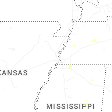


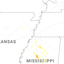


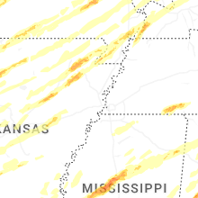


Connect with Interactive Hail Maps