

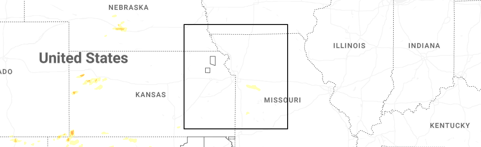
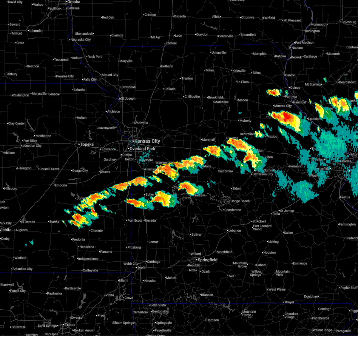
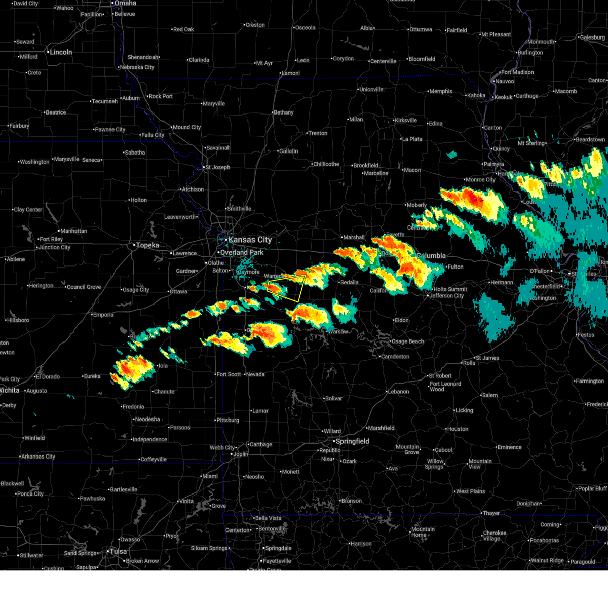
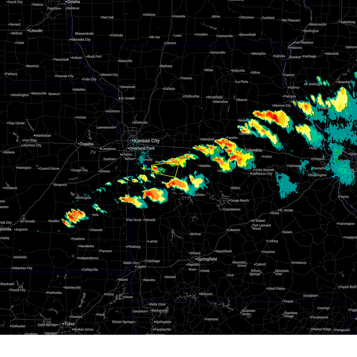
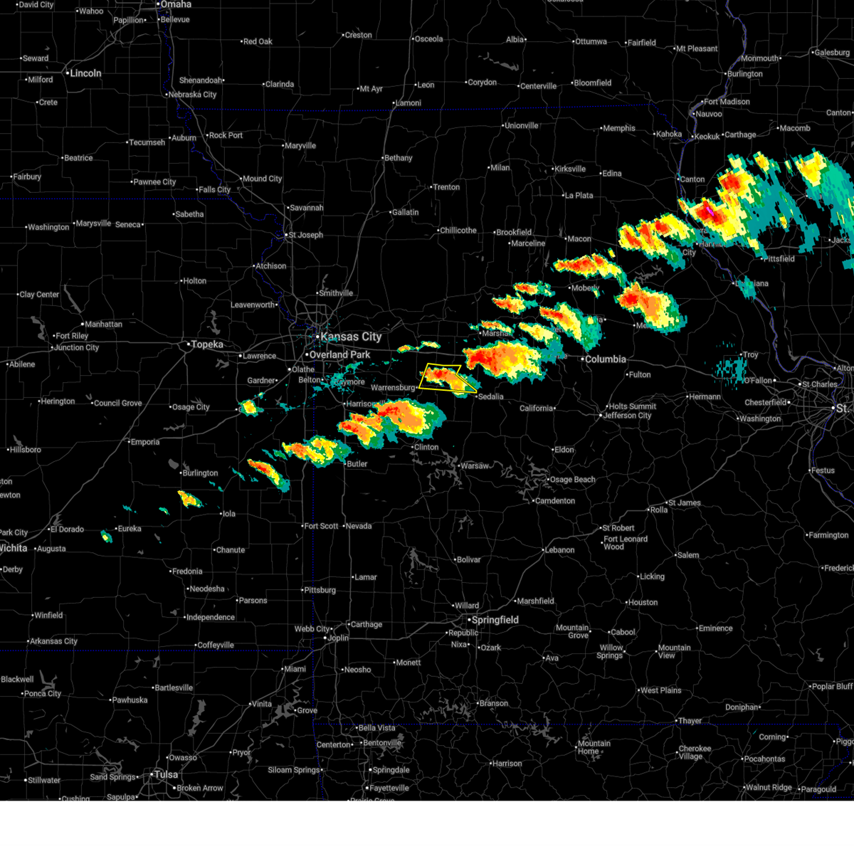
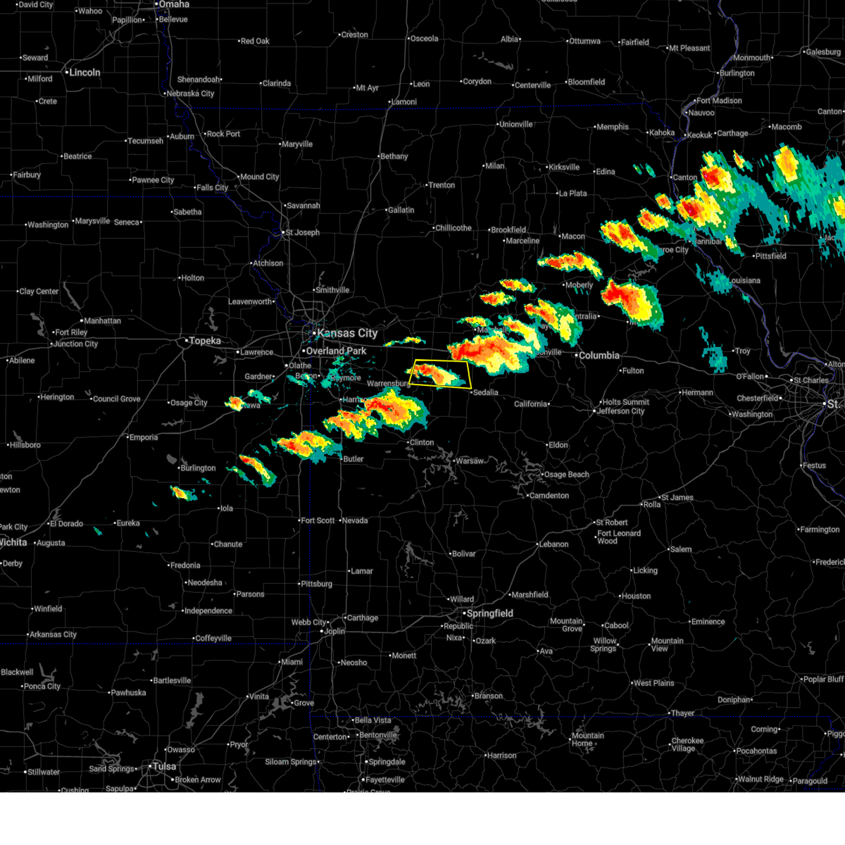
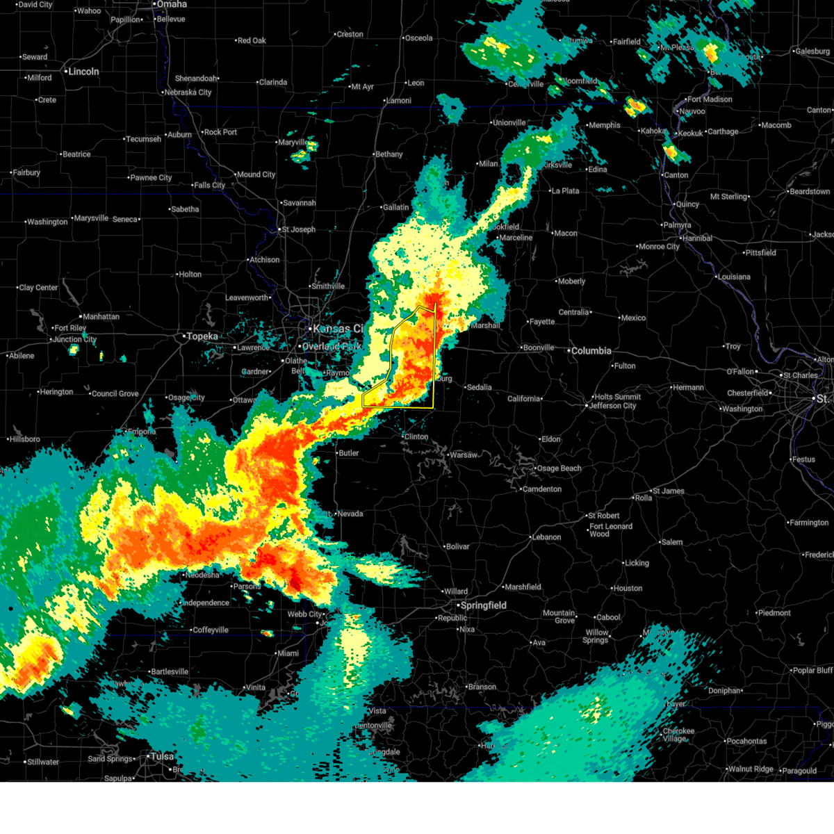
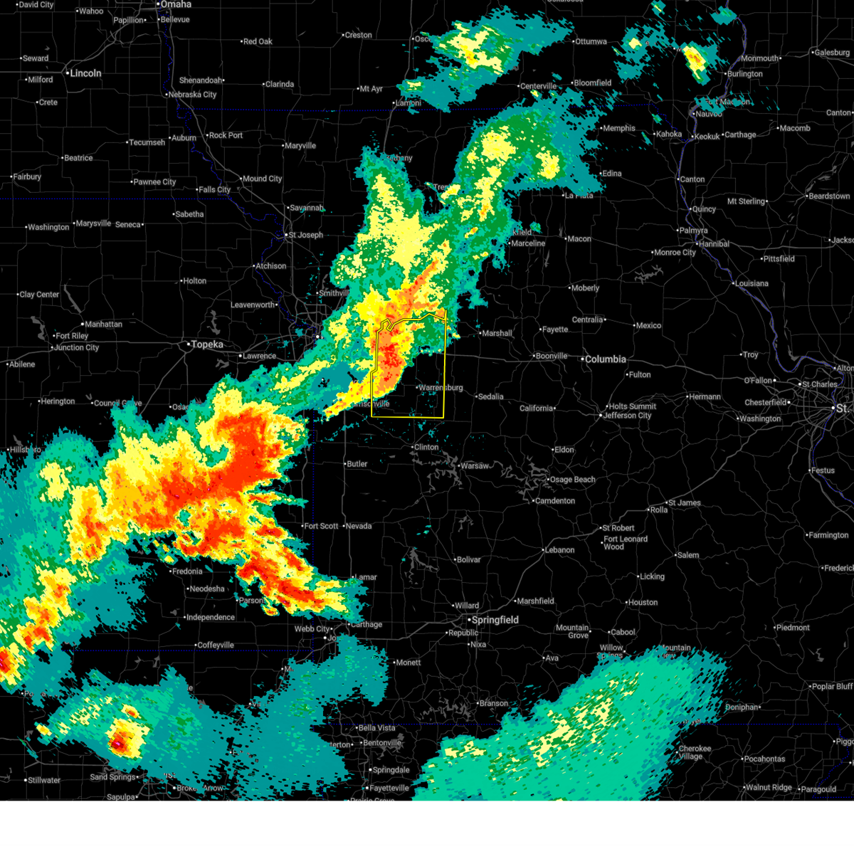
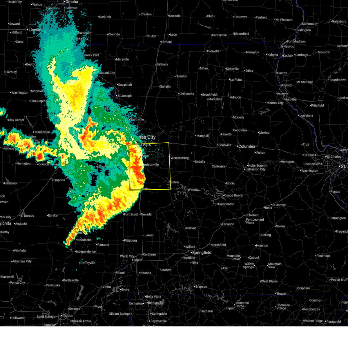
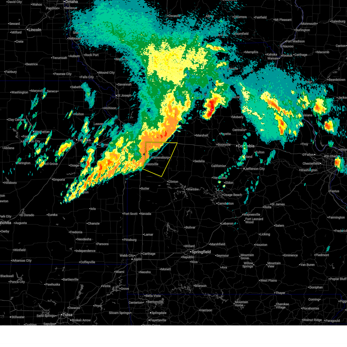
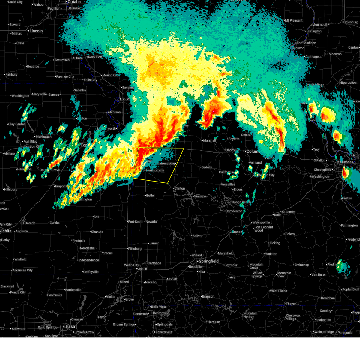
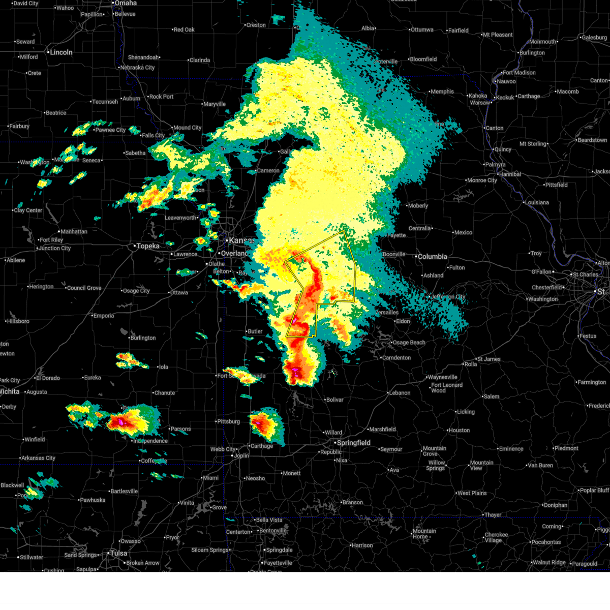
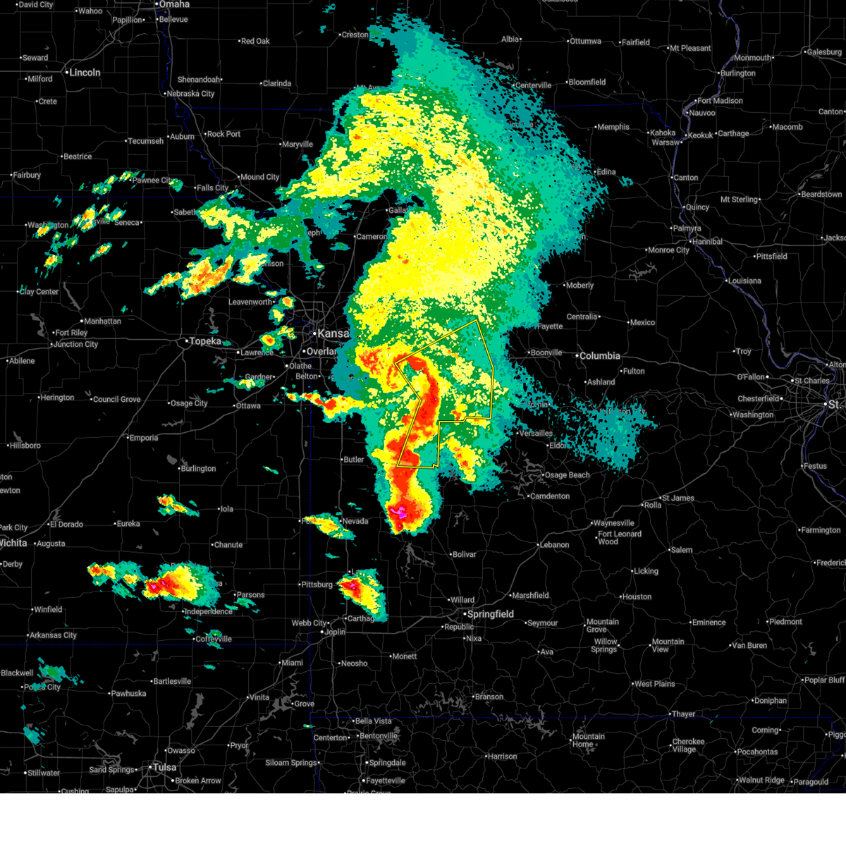
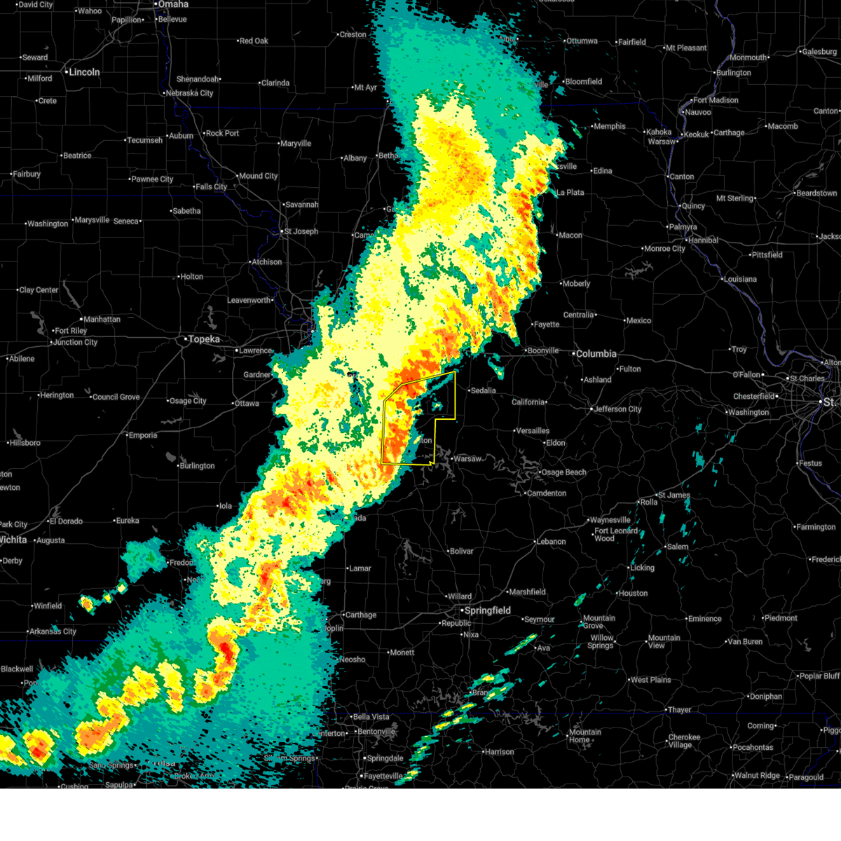
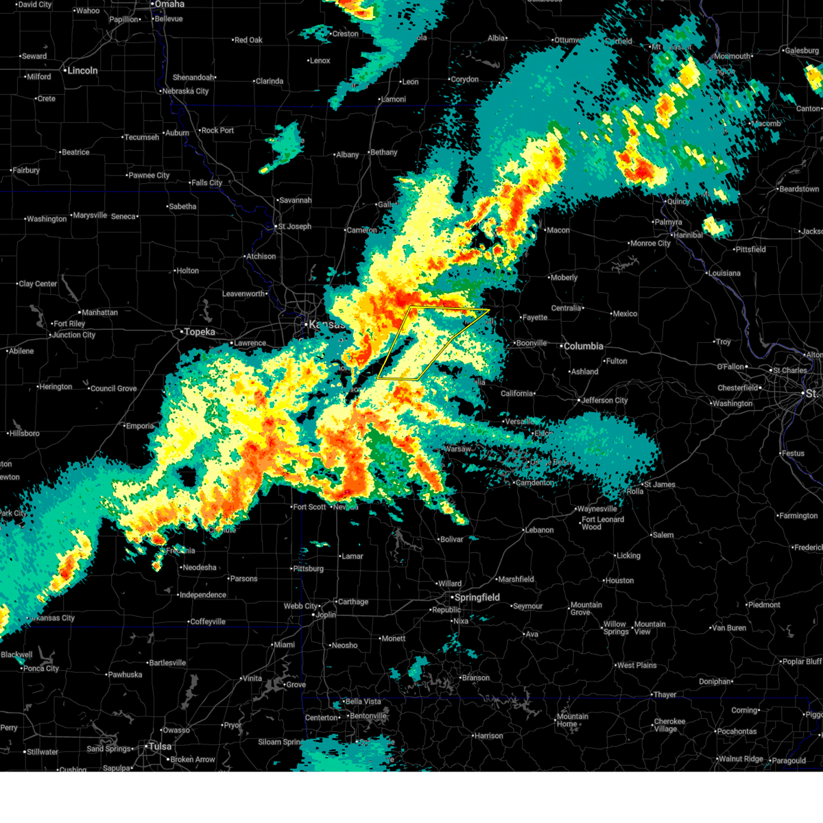
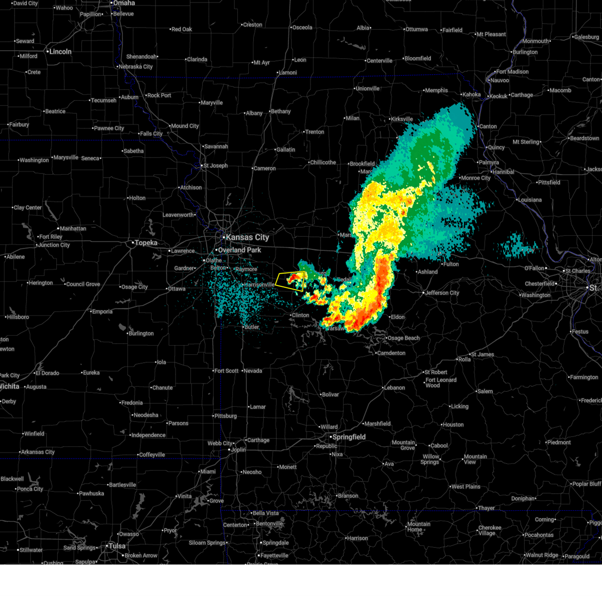
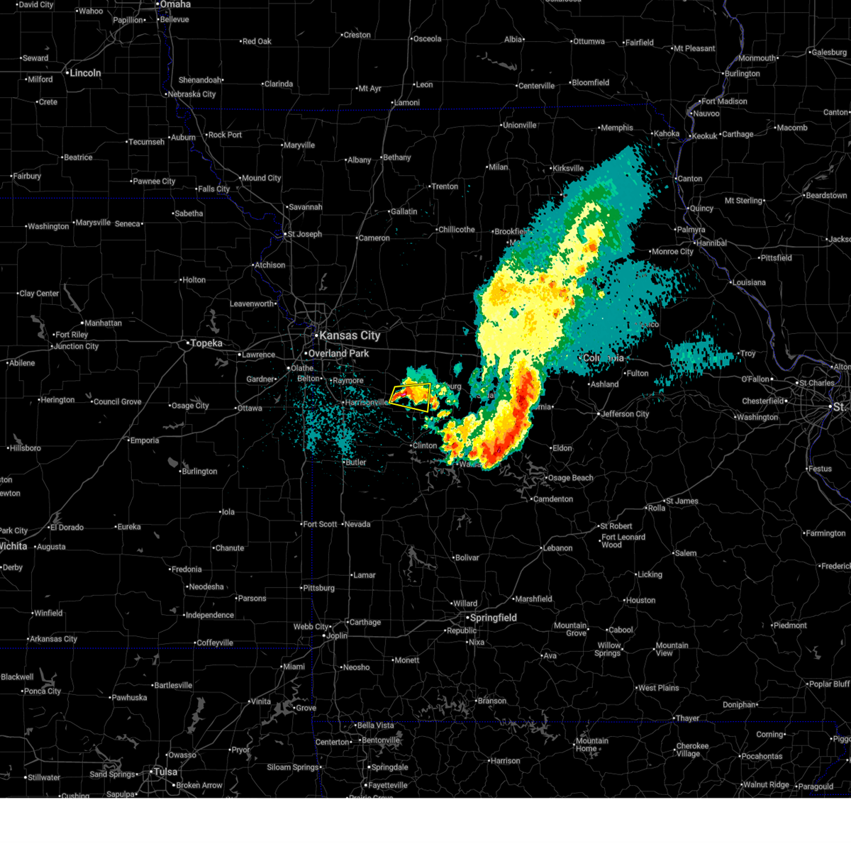
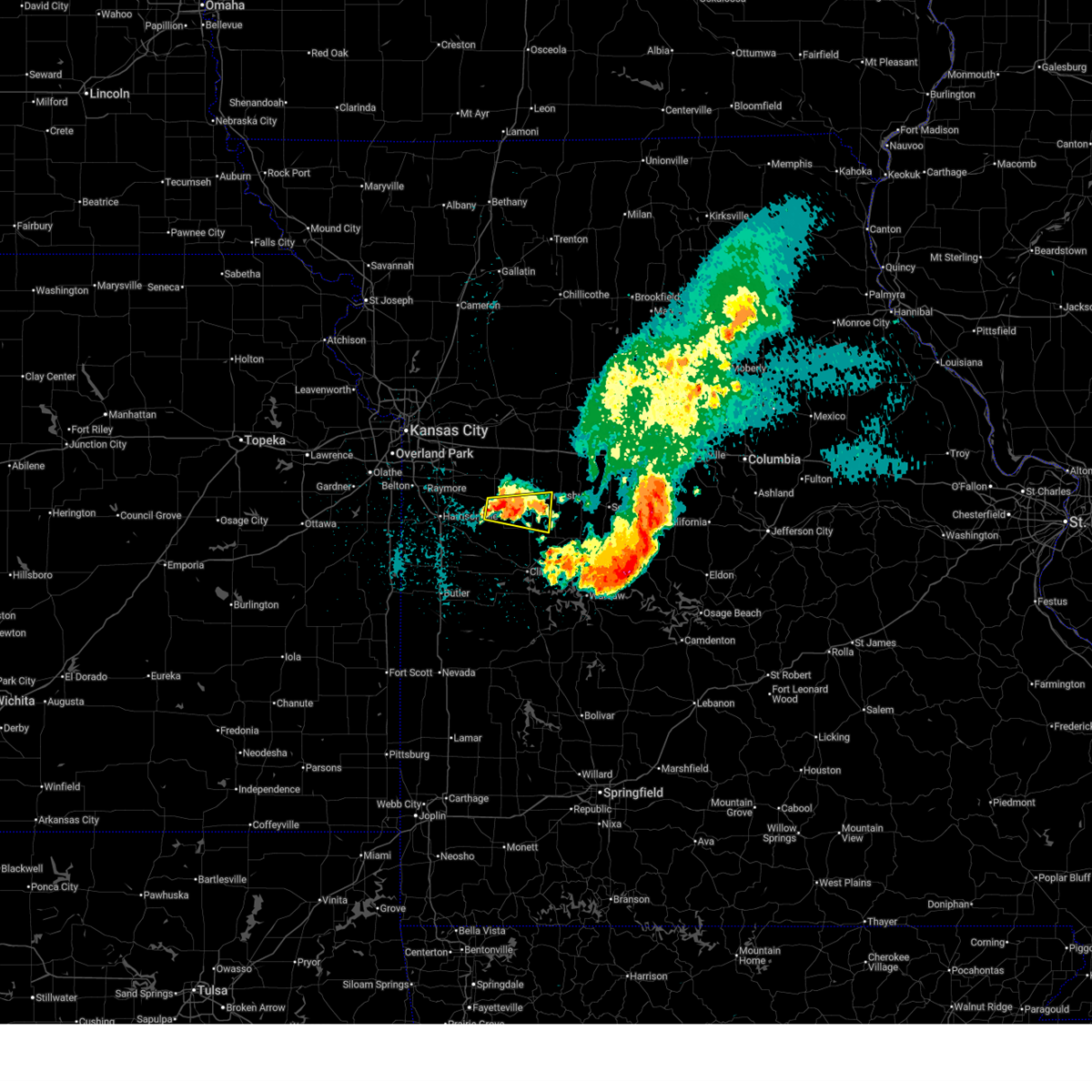
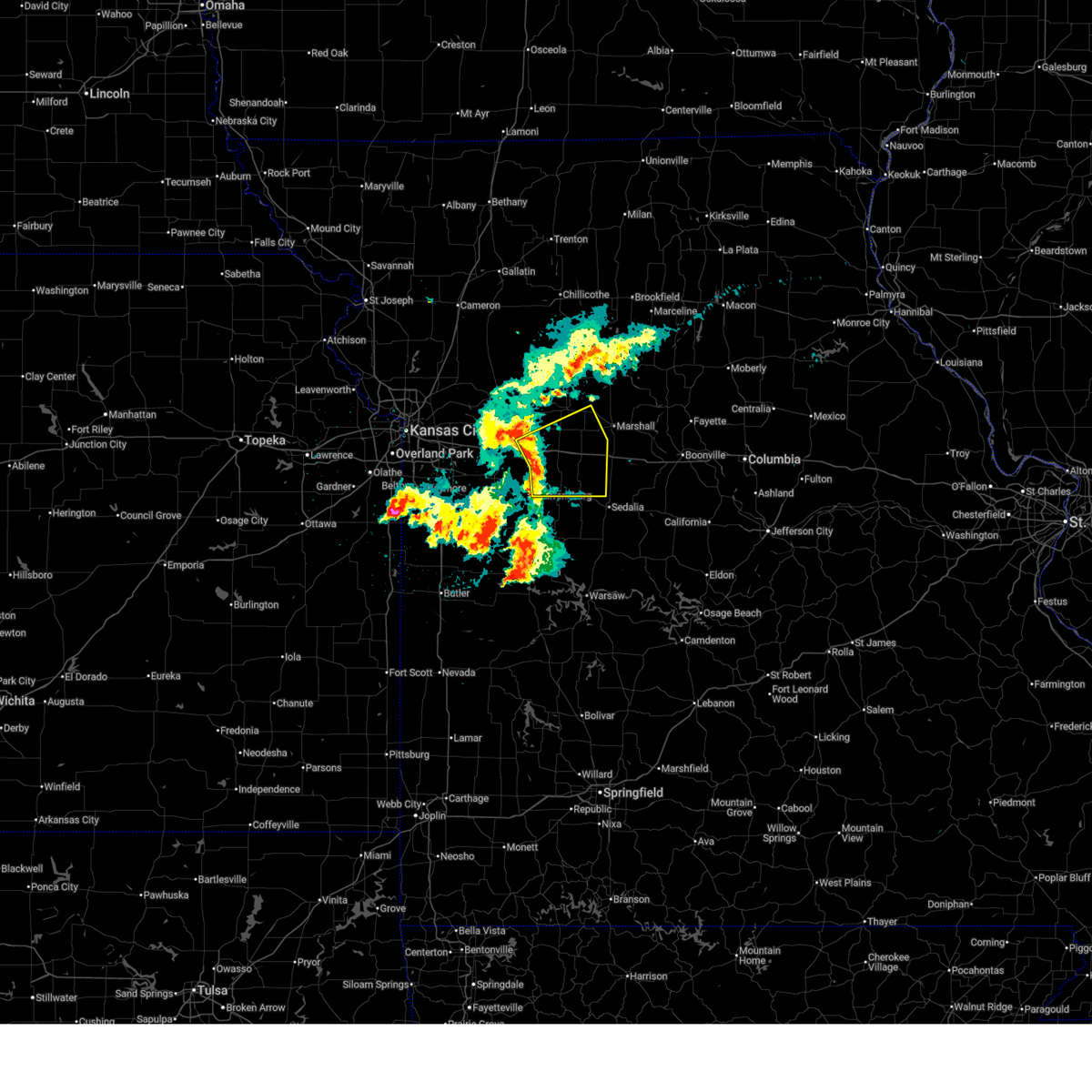
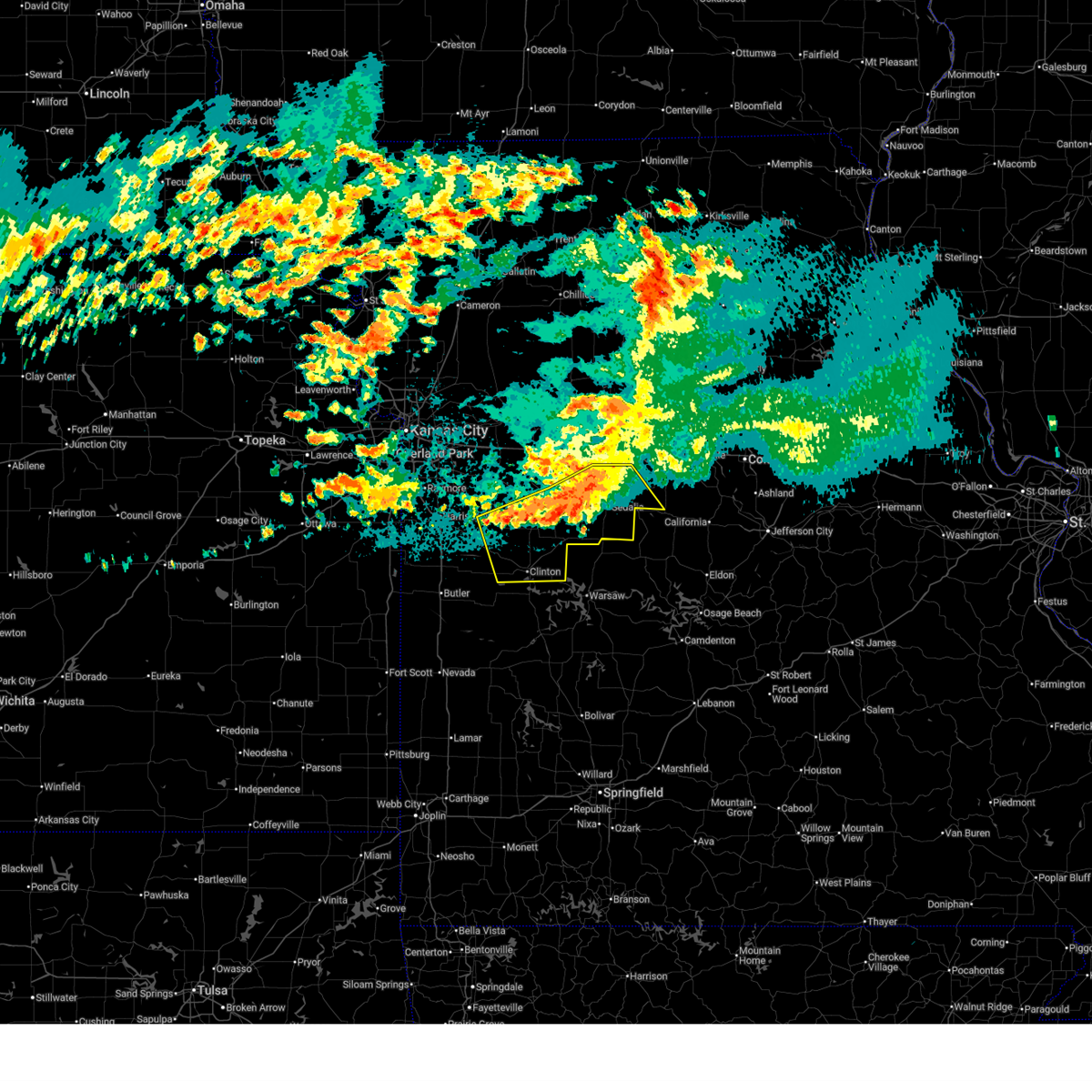
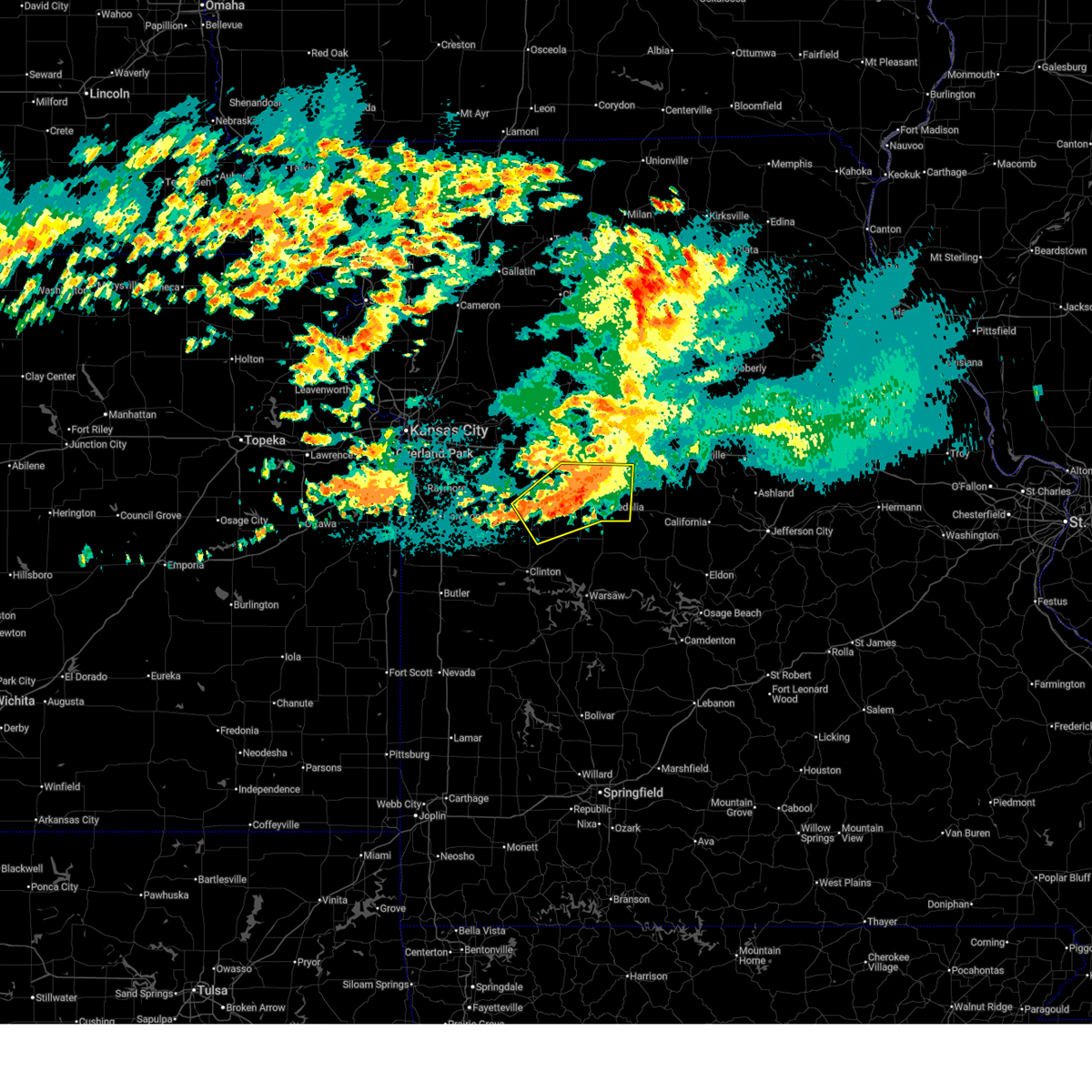
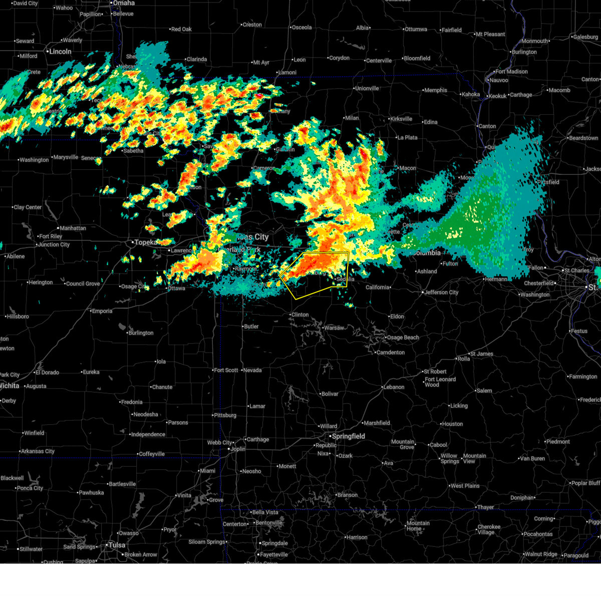
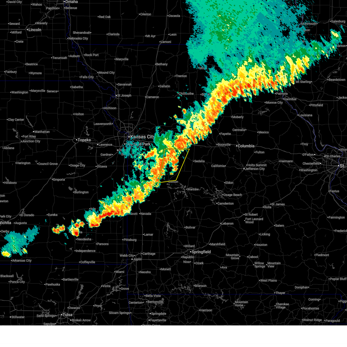
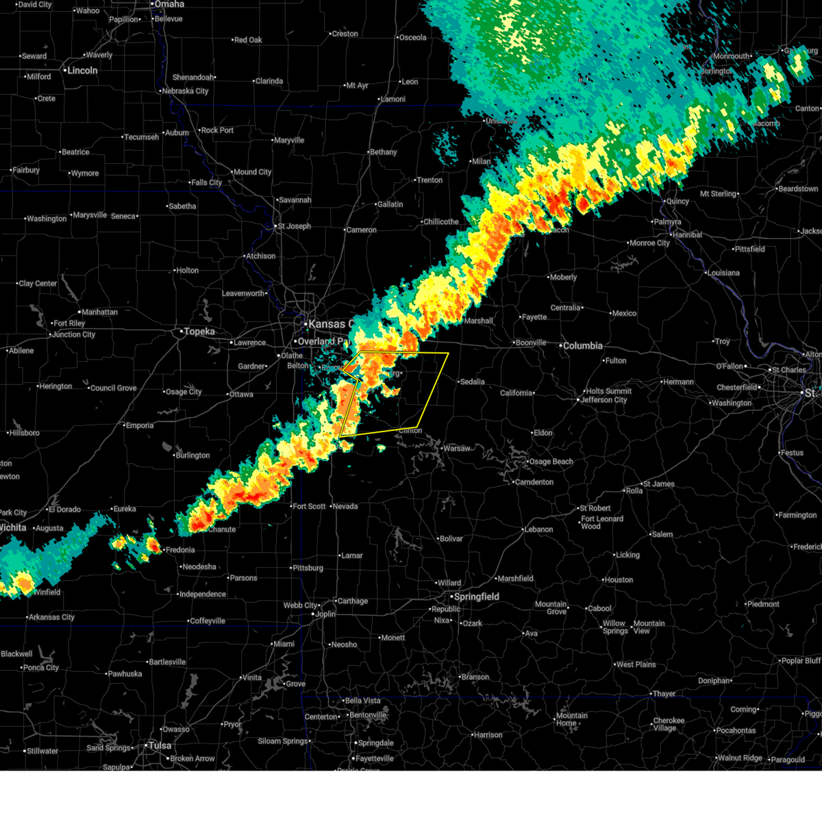
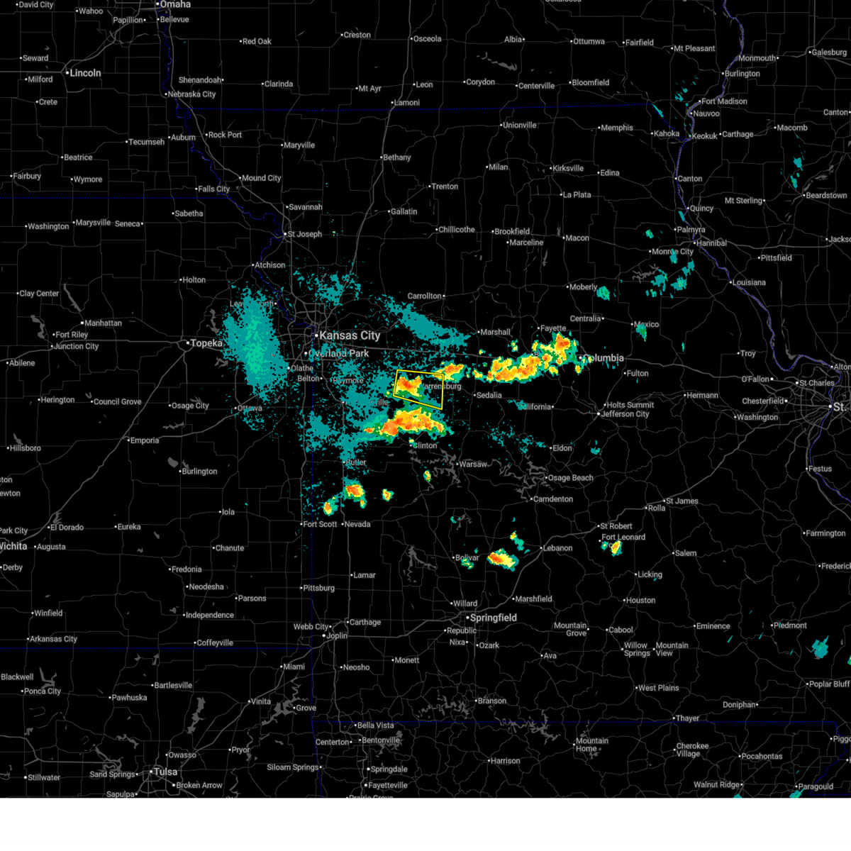
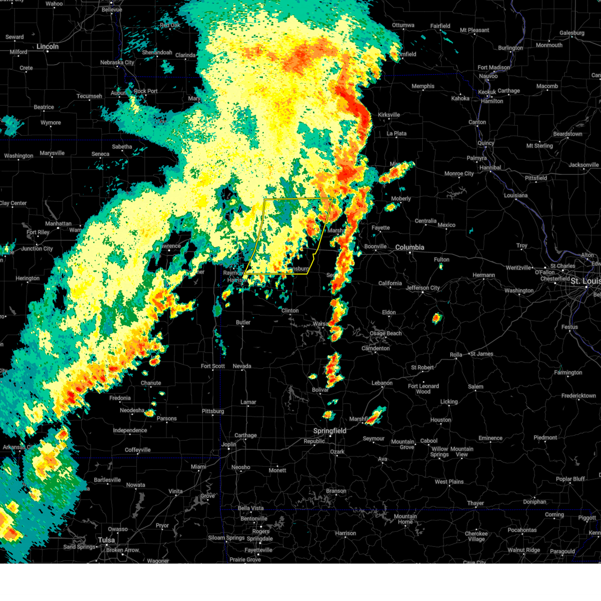
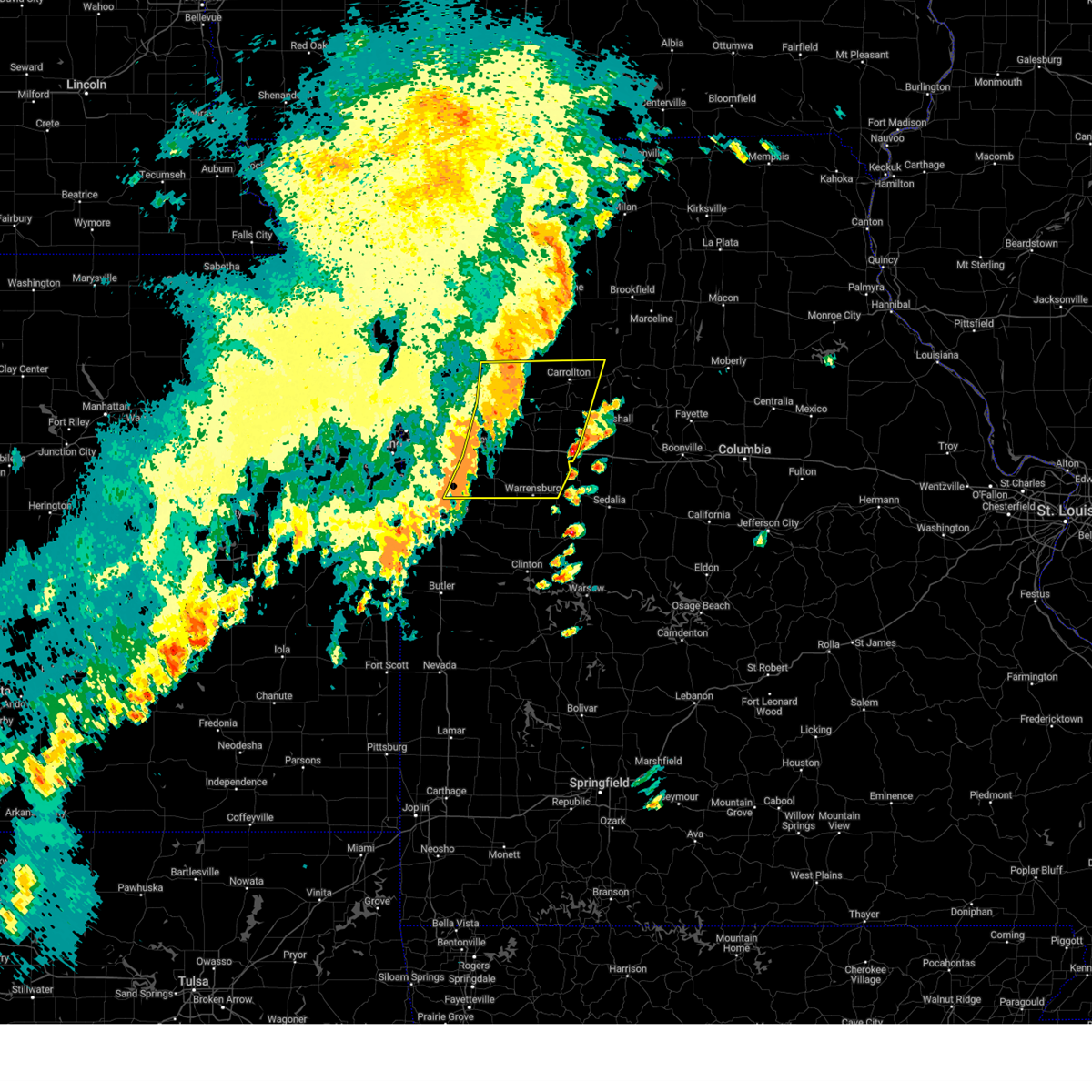
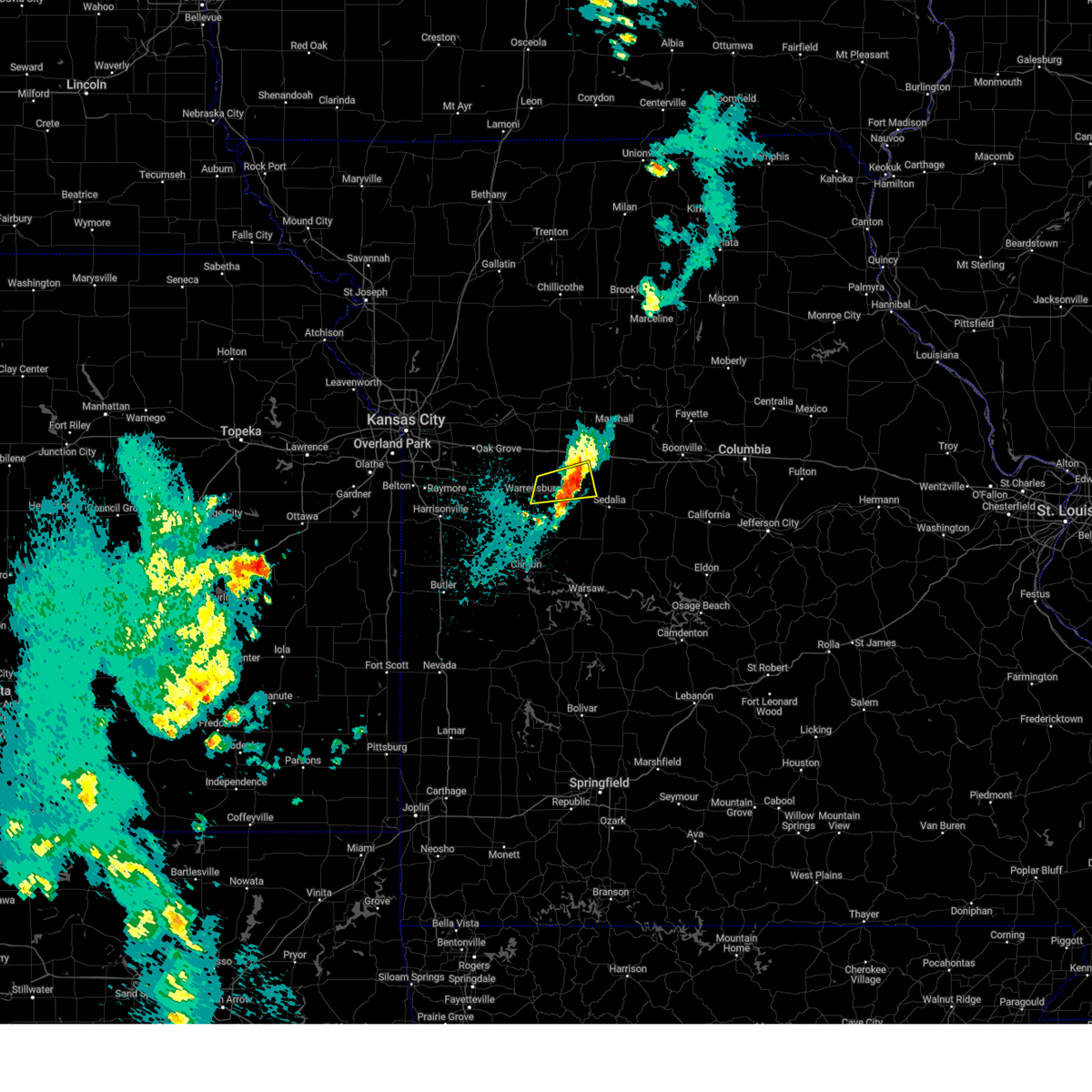
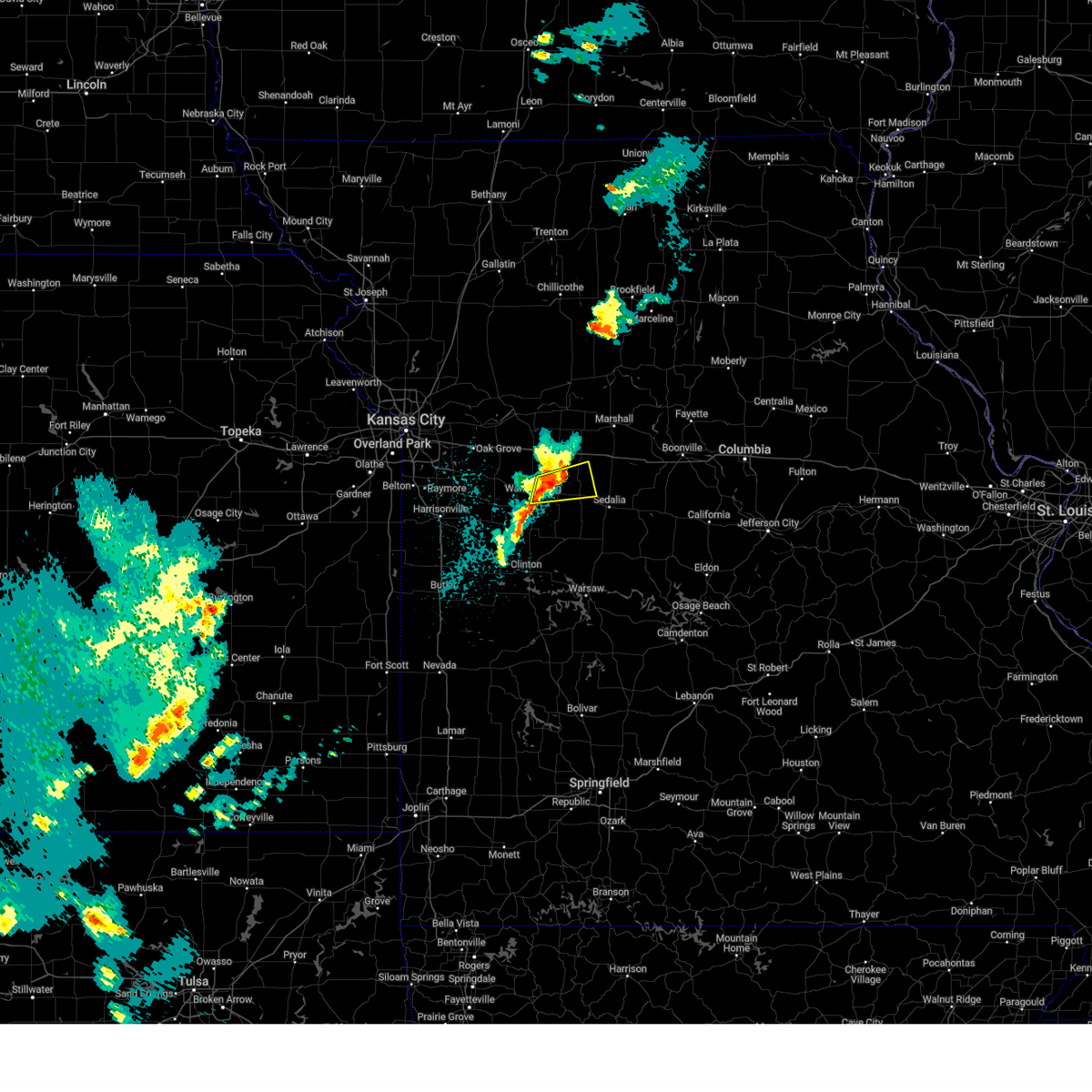
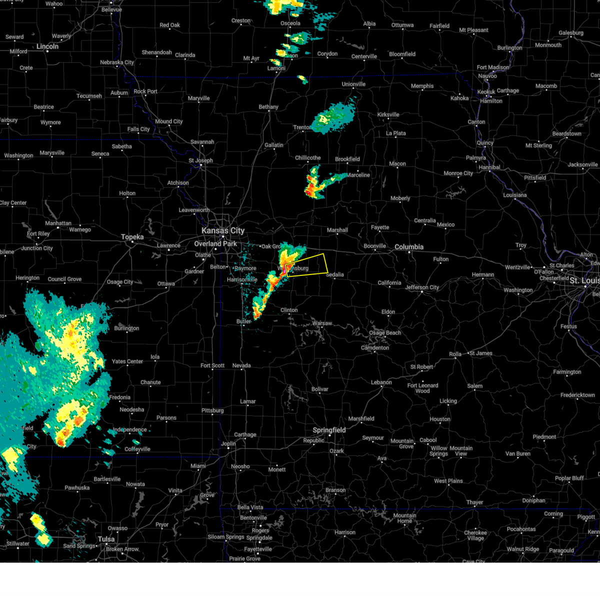
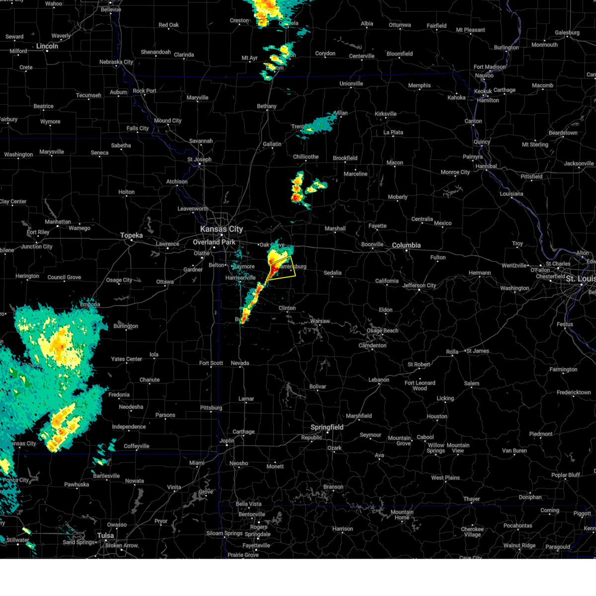
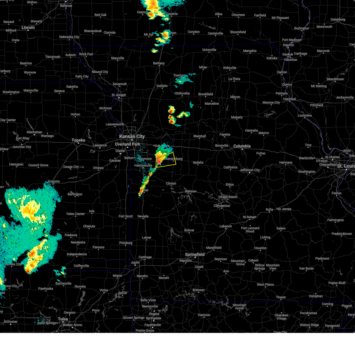
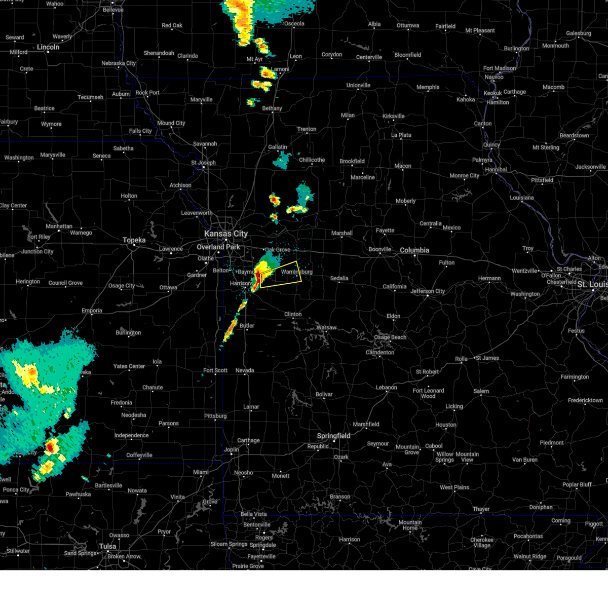
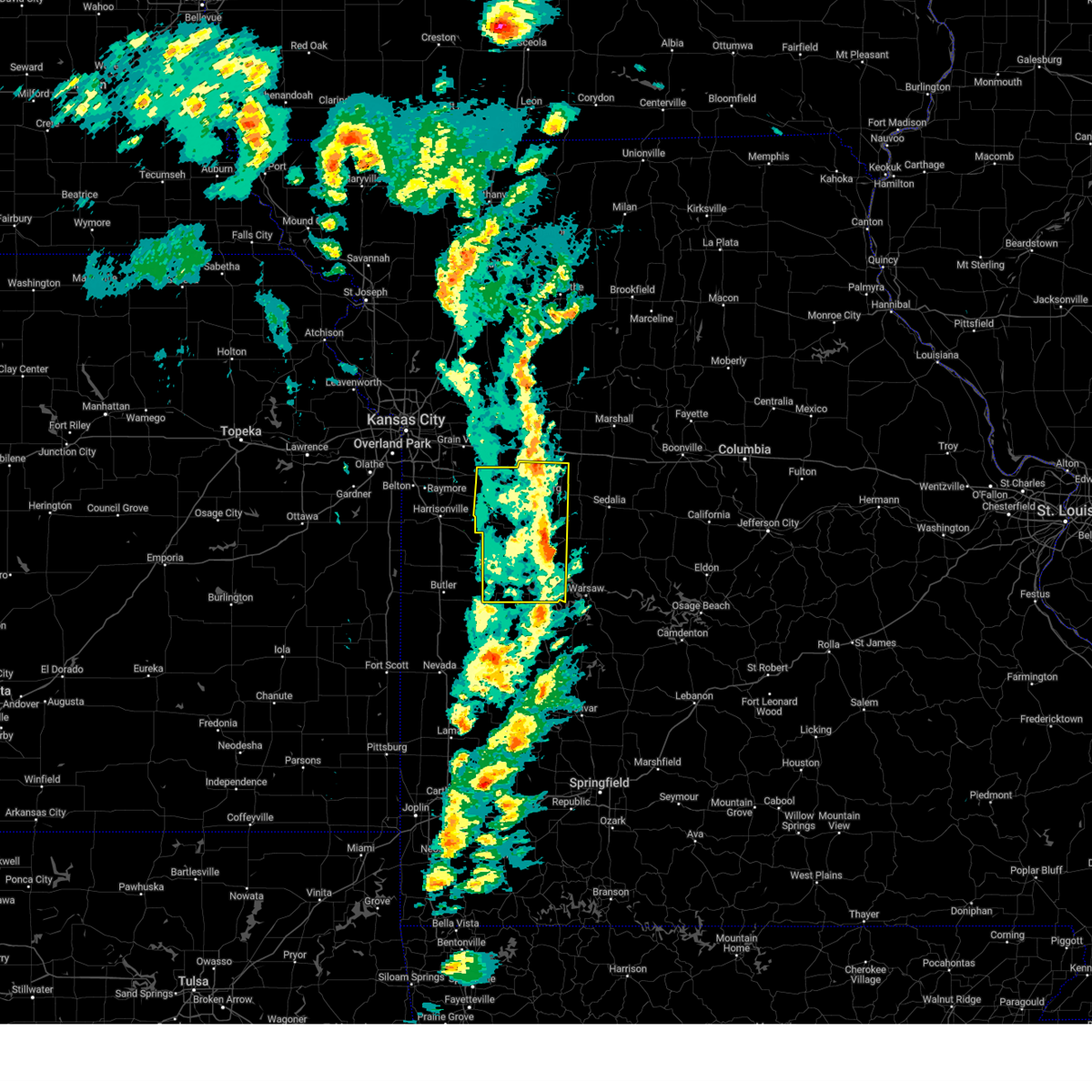
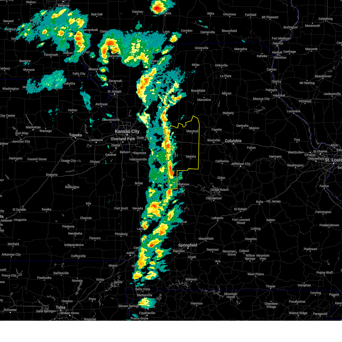
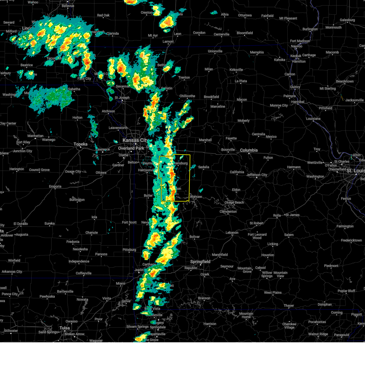
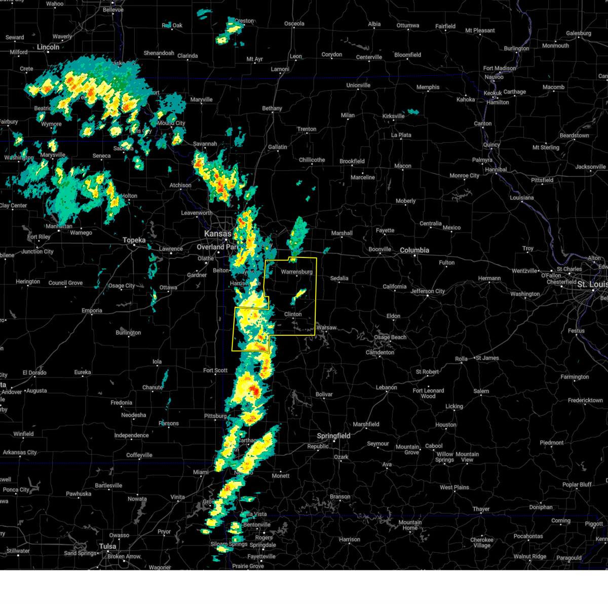
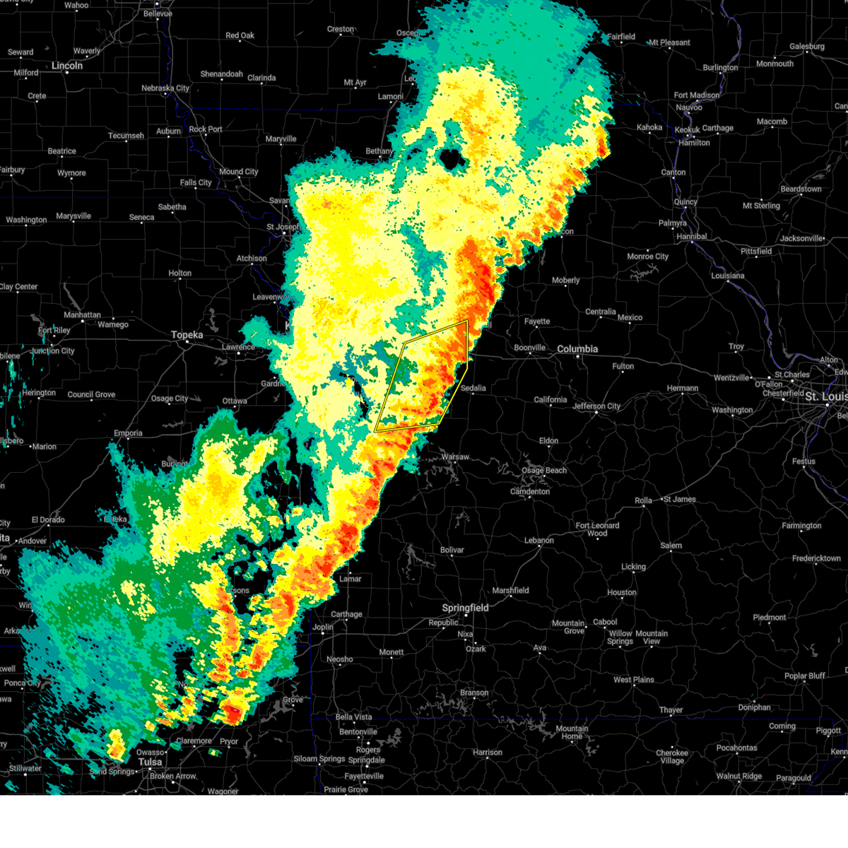
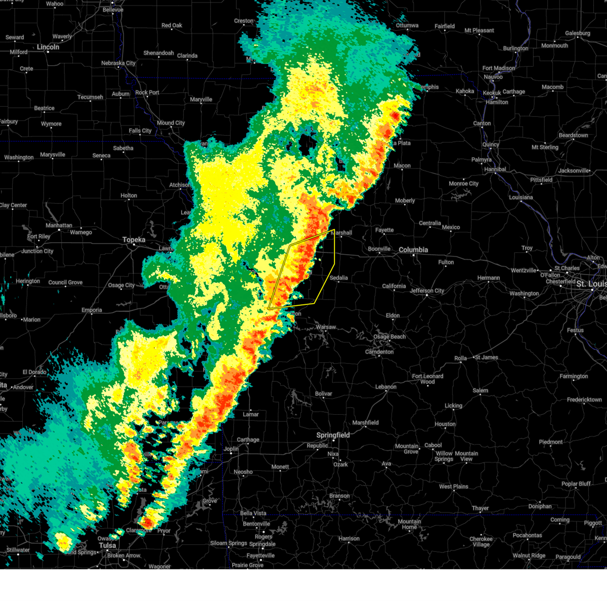
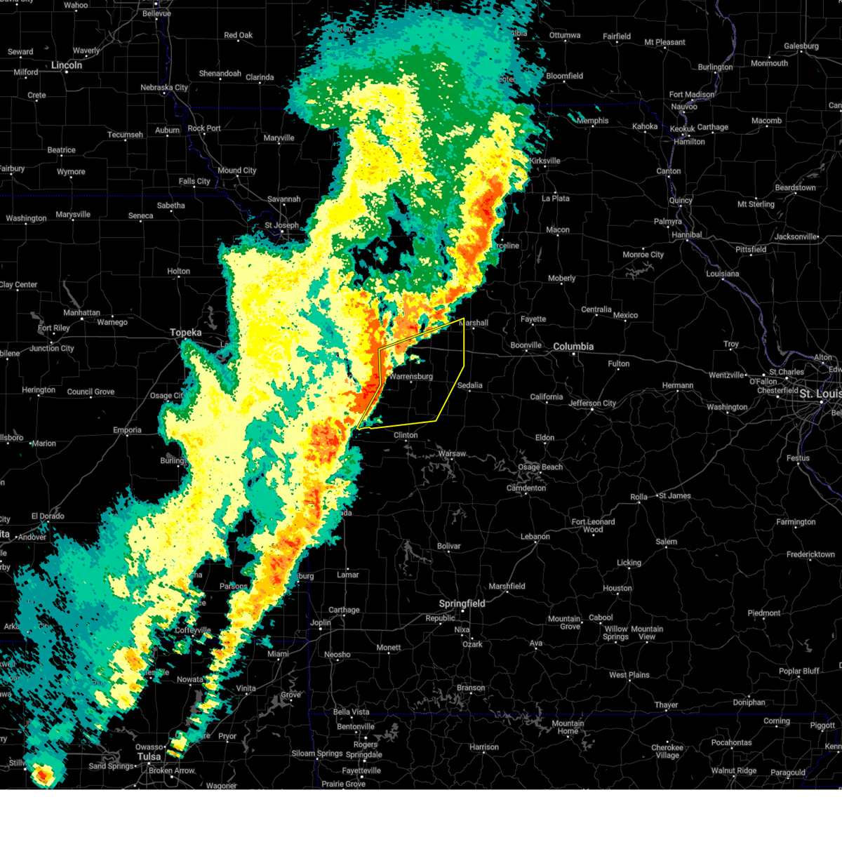
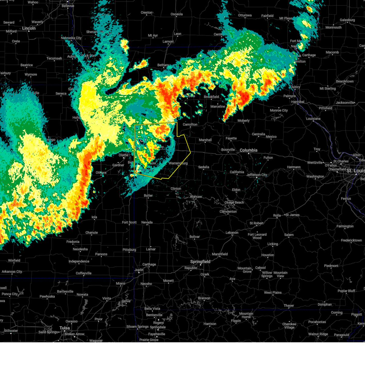
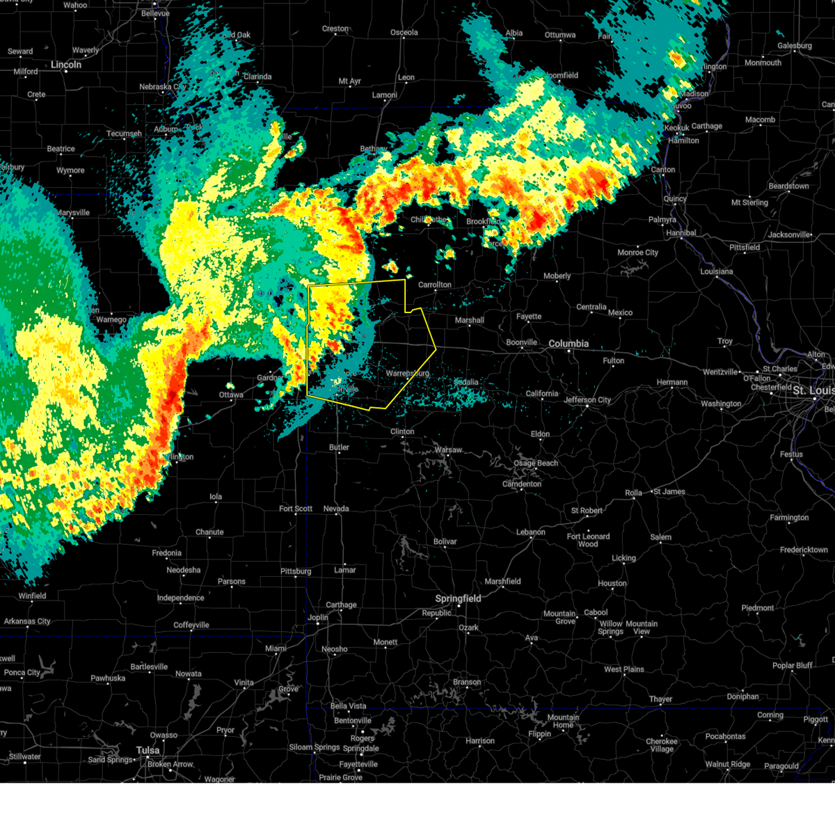
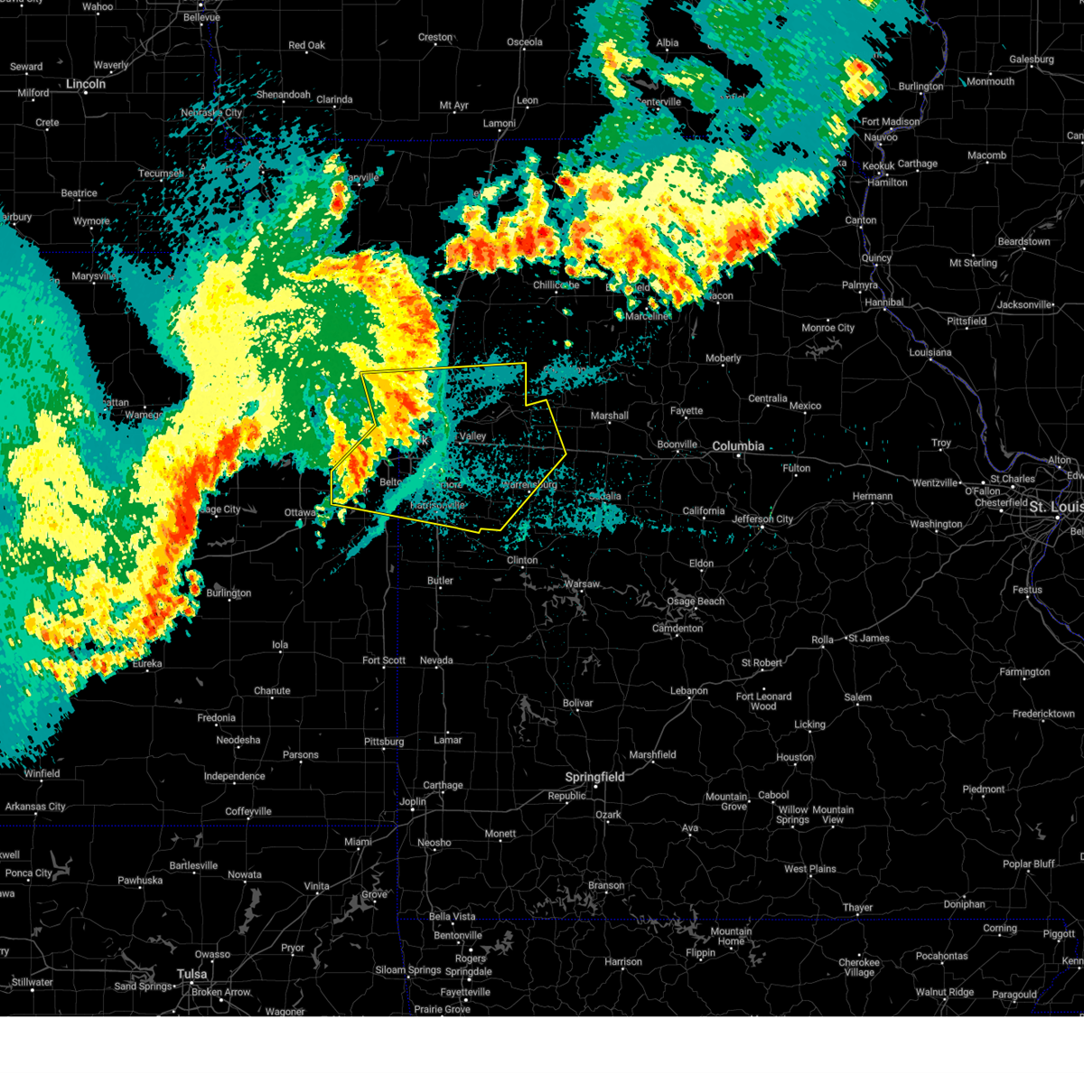
Hail Map for Warrensburg, MO
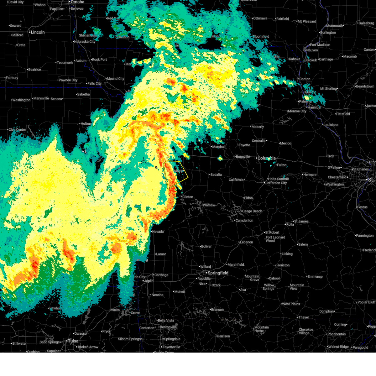
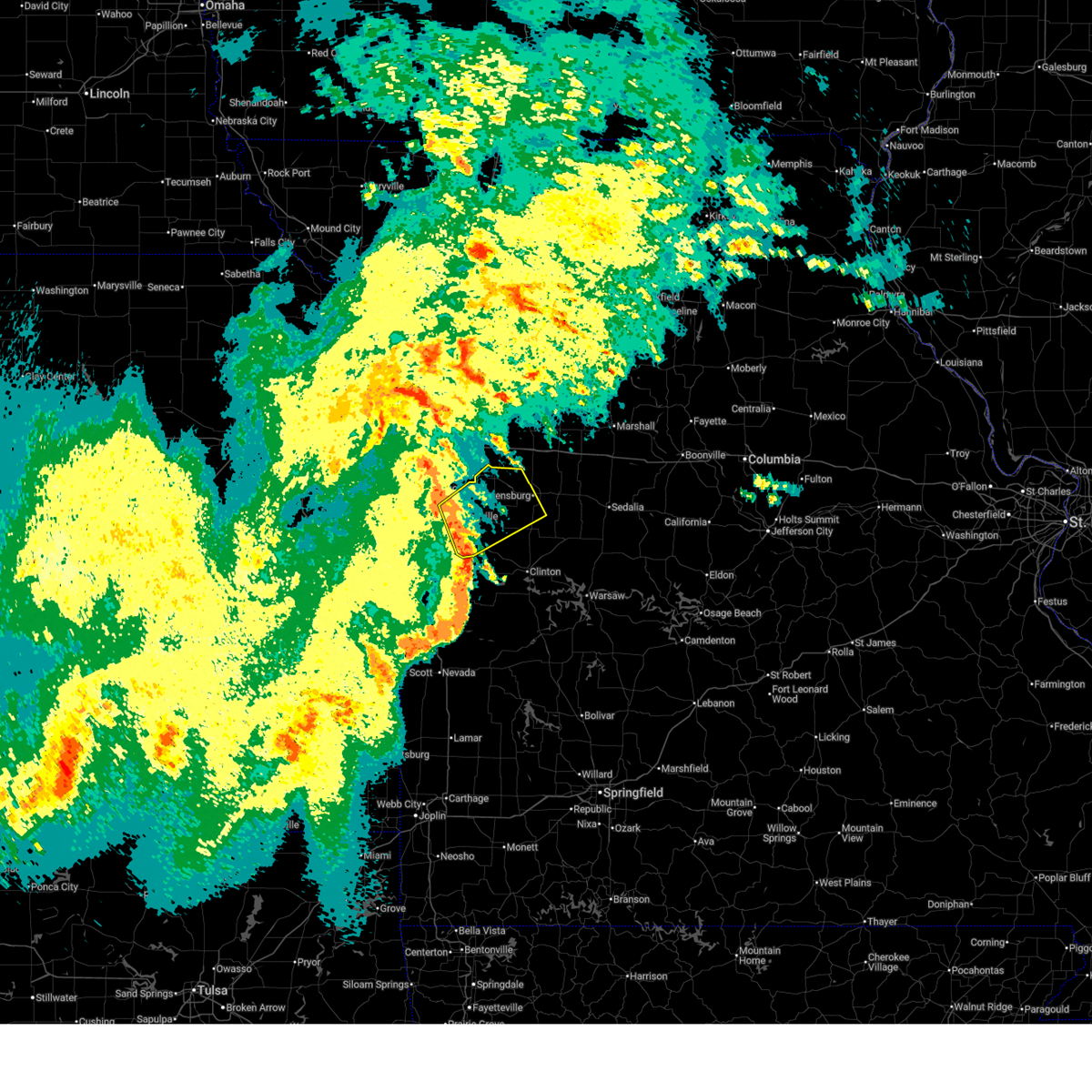
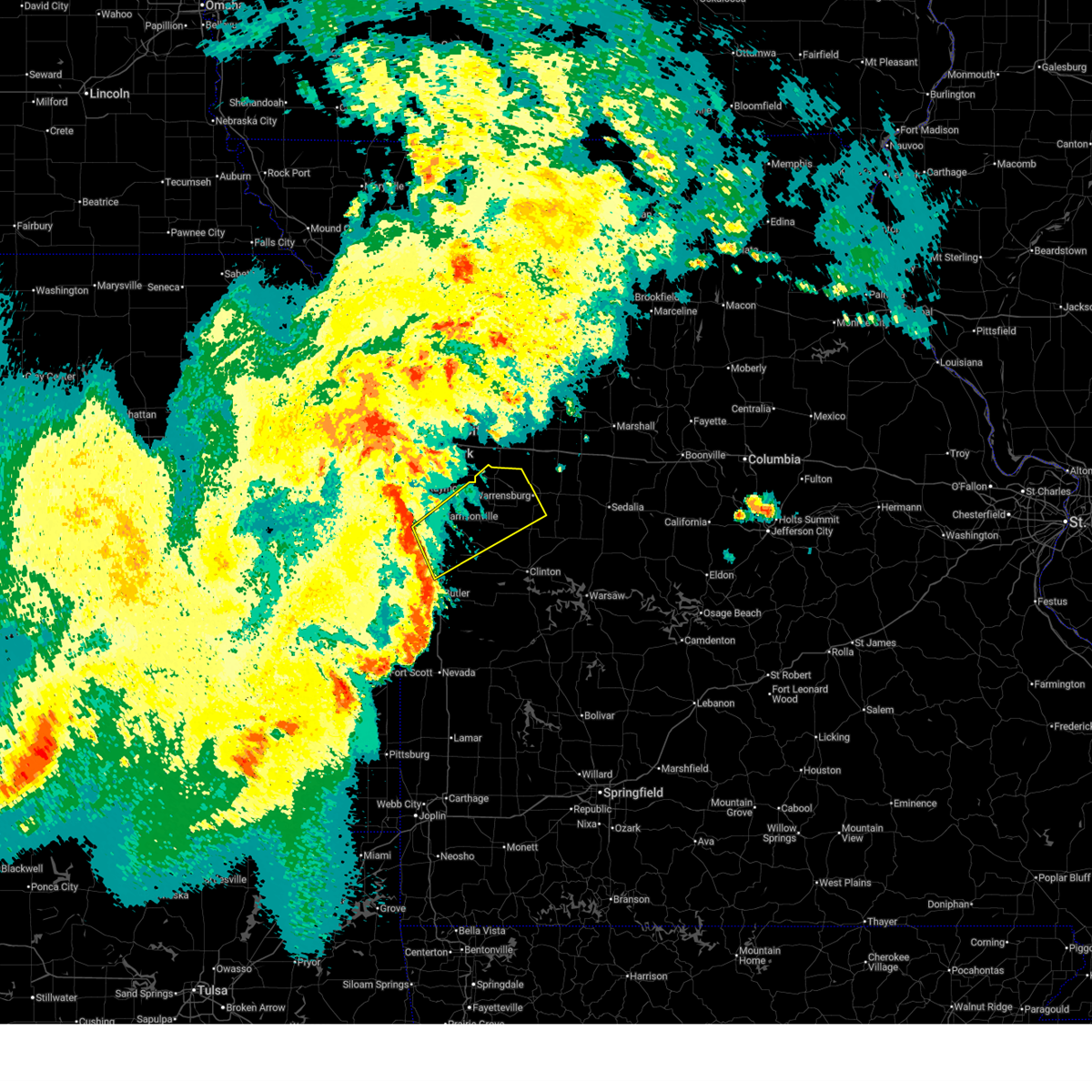
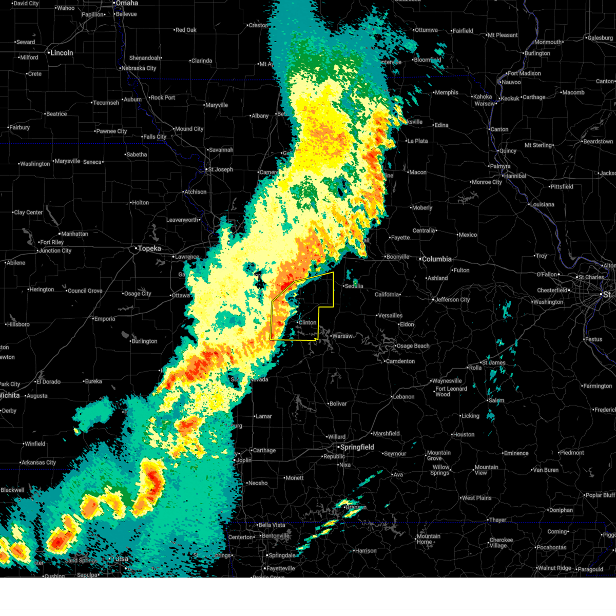
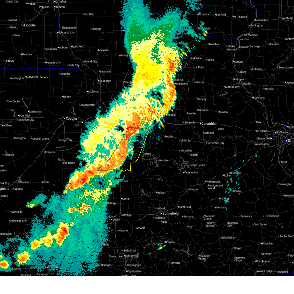
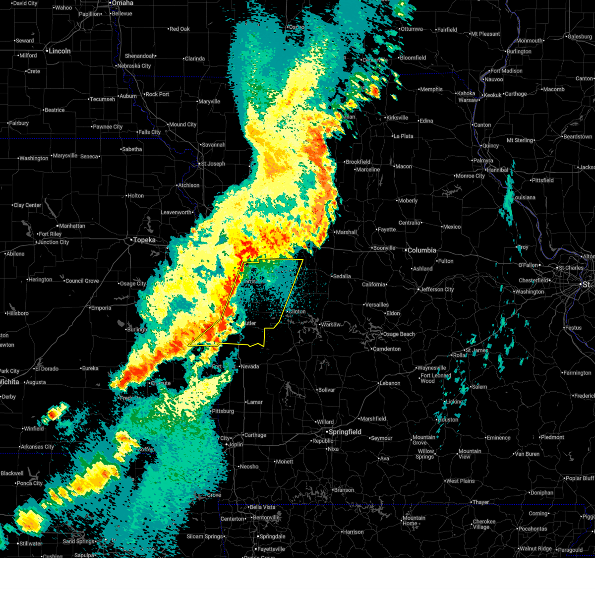
The Warrensburg, MO area has had 23 reports of on-the-ground hail by trained spotters, and has been under severe weather warnings 48 times during the past 12 months. Doppler radar has detected hail at or near Warrensburg, MO on 81 occasions, including 5 occasions during the past year.
| Name: | Warrensburg, MO |
| Where Located: | 51.7 miles ESE of Kansas City, MO |
| Map: | Google Map for Warrensburg, MO |
| Population: | 18838 |
| Housing Units: | 7450 |
| More Info: | Search Google for Warrensburg, MO |
2
The Top Recent Hail Date for Warrensburg, MO is Friday, June 12, 2026 (13th out of 81)
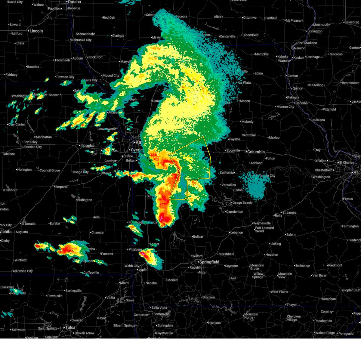
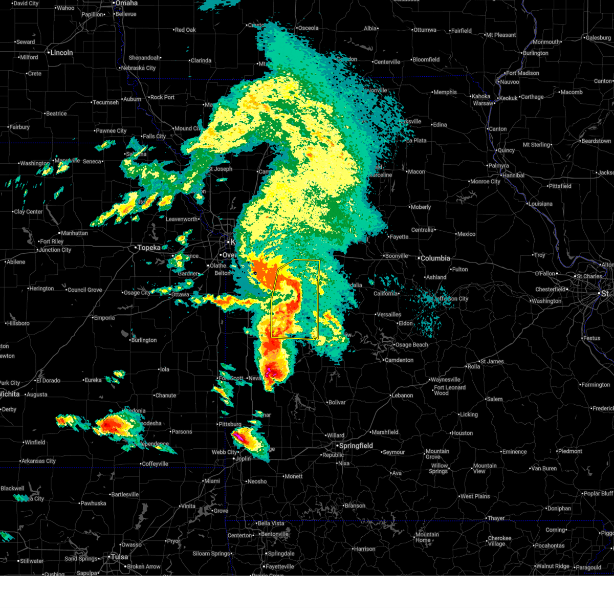
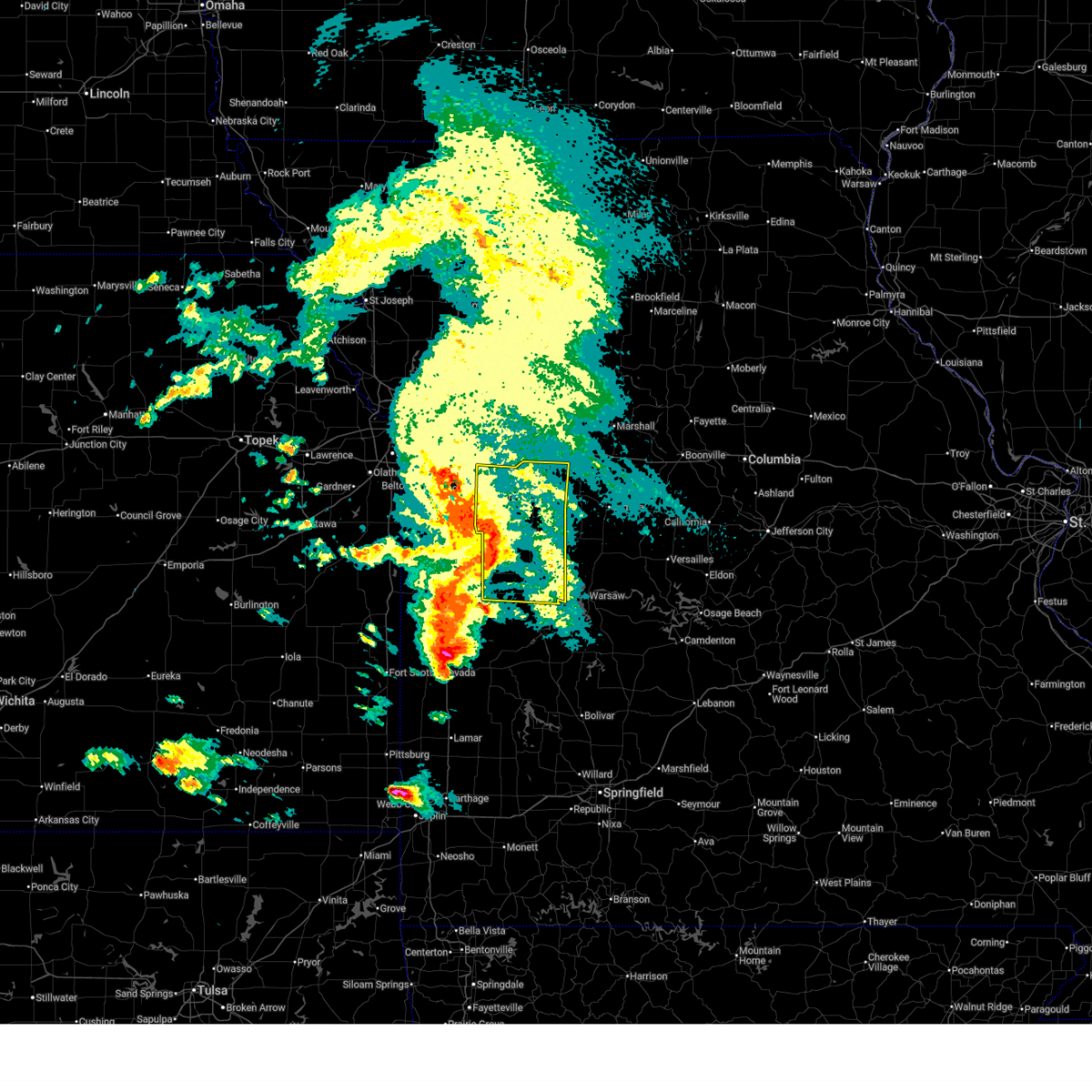
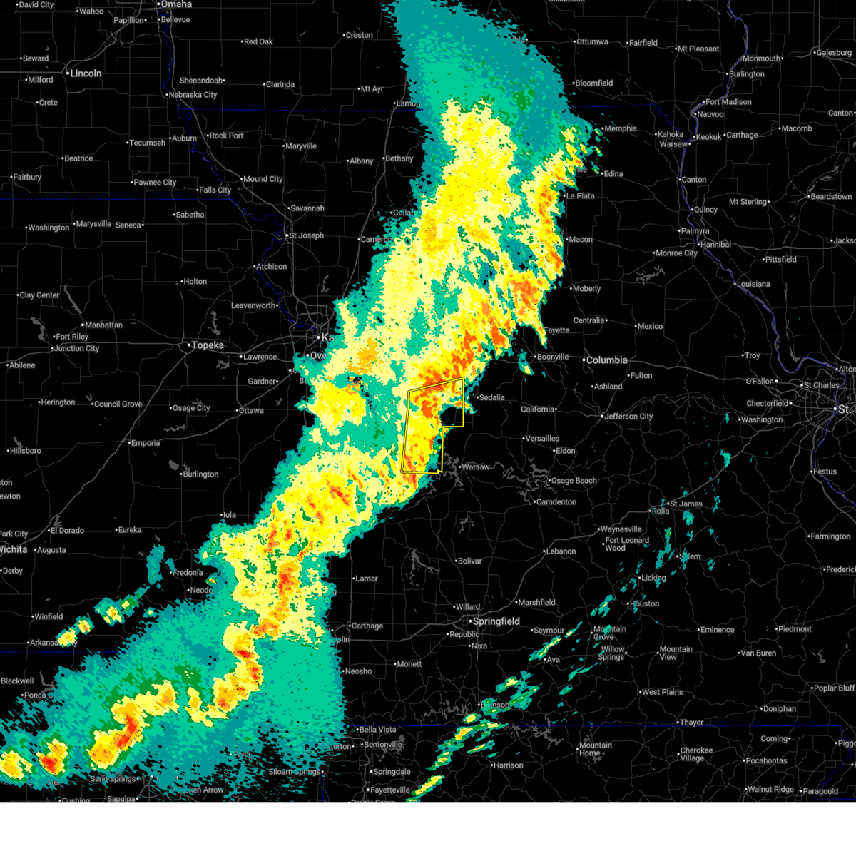
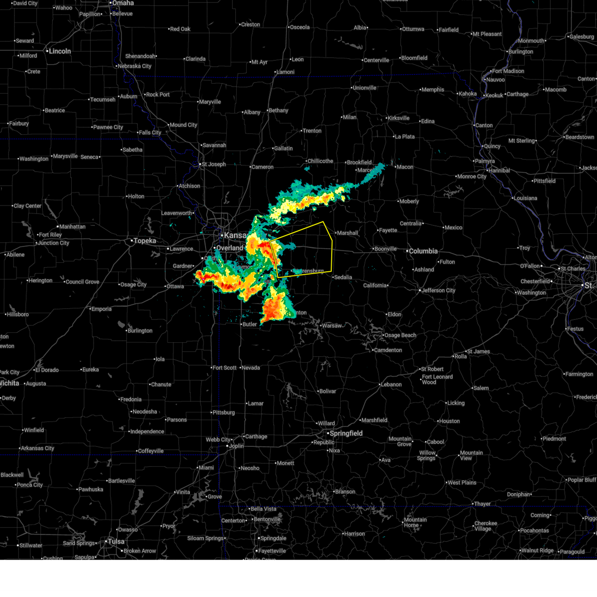
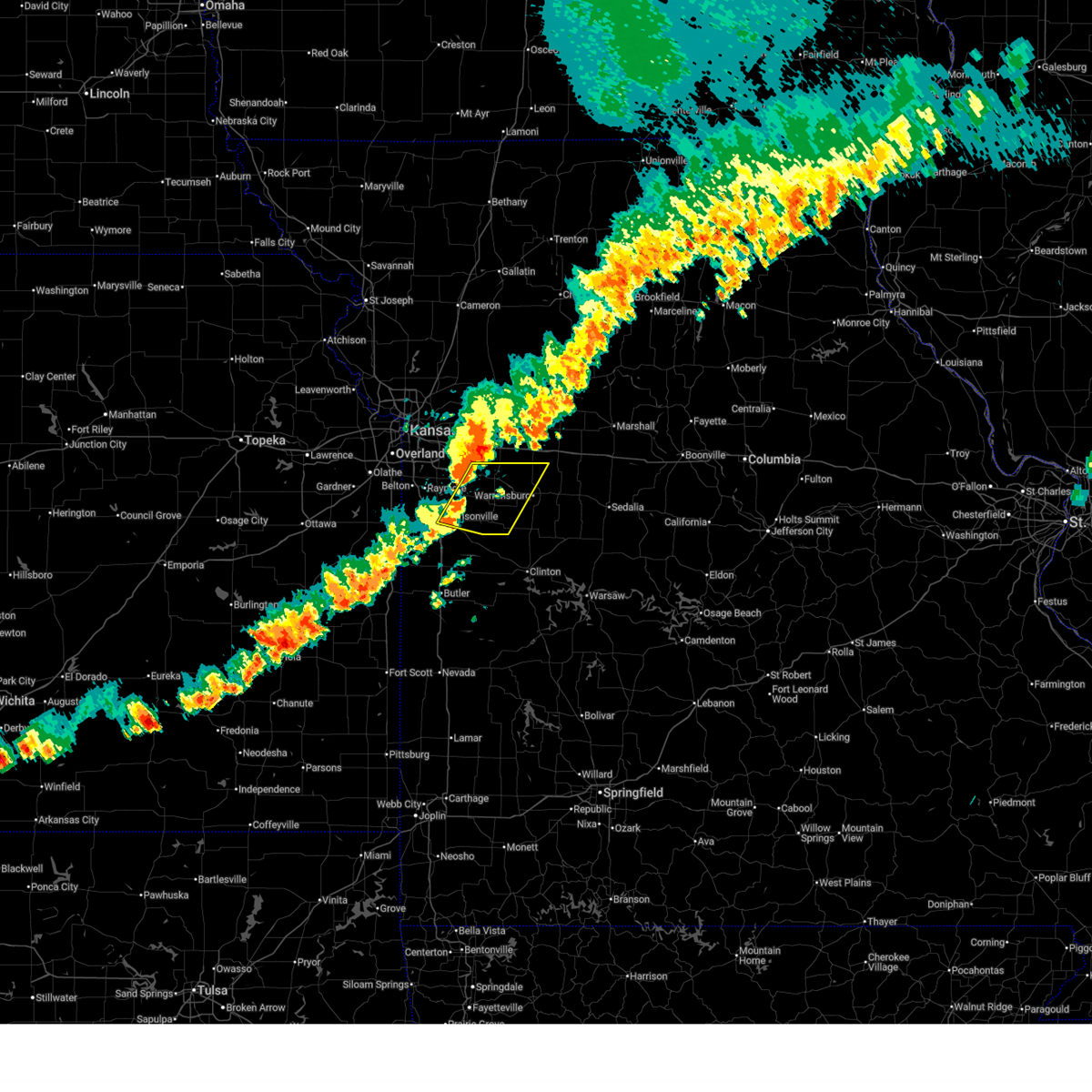
Hail and Wind Damage Spotted near Warrensburg, MO
| Date / Time | Report Details |
|---|---|
| 6/21/2026 5:38 AM CDT |
 At 538 am cdt, a severe thunderstorm was located near holden, moving northeast at 50 mph (radar indicated). Hazards include 60 mph wind gusts. Expect damage to roofs, siding, and trees. Locations impacted include, warrensburg, holden, chilhowee, kingsville, centerview, blairstown, pittsville, and quick city. At 538 am cdt, a severe thunderstorm was located near holden, moving northeast at 50 mph (radar indicated). Hazards include 60 mph wind gusts. Expect damage to roofs, siding, and trees. Locations impacted include, warrensburg, holden, chilhowee, kingsville, centerview, blairstown, pittsville, and quick city.
|
| 6/21/2026 5:22 AM CDT |
 At 522 am cdt, a severe thunderstorm was located near kingsville, or 7 miles west of holden, moving northeast at 50 mph (radar indicated). Hazards include 60 mph wind gusts. Expect damage to roofs, siding, and trees. Locations impacted include, warrensburg, harrisonville, holden, garden city, creighton, chilhowee, east lynne, kingsville, centerview, strasburg, gunn city, blairstown, la tour, pittsville, and quick city. At 522 am cdt, a severe thunderstorm was located near kingsville, or 7 miles west of holden, moving northeast at 50 mph (radar indicated). Hazards include 60 mph wind gusts. Expect damage to roofs, siding, and trees. Locations impacted include, warrensburg, harrisonville, holden, garden city, creighton, chilhowee, east lynne, kingsville, centerview, strasburg, gunn city, blairstown, la tour, pittsville, and quick city.
|
| 6/21/2026 5:09 AM CDT |
 Svreax the national weather service in pleasant hill has issued a * severe thunderstorm warning for, central cass county in west central missouri, northwestern henry county in west central missouri, north central bates county in west central missouri, western johnson county in west central missouri, * until 545 am cdt. * at 508 am cdt, a severe thunderstorm was located near harrisonville, moving northeast at 60 mph (radar indicated). Hazards include 60 mph wind gusts. expect damage to roofs, siding, and trees Svreax the national weather service in pleasant hill has issued a * severe thunderstorm warning for, central cass county in west central missouri, northwestern henry county in west central missouri, north central bates county in west central missouri, western johnson county in west central missouri, * until 545 am cdt. * at 508 am cdt, a severe thunderstorm was located near harrisonville, moving northeast at 60 mph (radar indicated). Hazards include 60 mph wind gusts. expect damage to roofs, siding, and trees
|
| 6/17/2026 6:07 PM CDT |
 At 607 pm cdt, a severe thunderstorm was located near chilhowee, or 8 miles southeast of holden, moving east at 35 mph (radar indicated). Hazards include 60 mph wind gusts and quarter size hail. Hail damage to vehicles is expected. expect wind damage to roofs, siding, and trees. Locations impacted include, warrensburg, holden, leeton, chilhowee, centerview, and post oak. At 607 pm cdt, a severe thunderstorm was located near chilhowee, or 8 miles southeast of holden, moving east at 35 mph (radar indicated). Hazards include 60 mph wind gusts and quarter size hail. Hail damage to vehicles is expected. expect wind damage to roofs, siding, and trees. Locations impacted include, warrensburg, holden, leeton, chilhowee, centerview, and post oak.
|
| 6/17/2026 5:59 PM CDT |
 At 559 pm cdt, a severe thunderstorm was located near holden, moving east at 35 mph (radar indicated). Hazards include golf ball size hail and 60 mph wind gusts. People and animals outdoors will be injured. expect hail damage to roofs, siding, windows, and vehicles. expect wind damage to roofs, siding, and trees. Locations impacted include, warrensburg, holden, leeton, chilhowee, and post oak. At 559 pm cdt, a severe thunderstorm was located near holden, moving east at 35 mph (radar indicated). Hazards include golf ball size hail and 60 mph wind gusts. People and animals outdoors will be injured. expect hail damage to roofs, siding, windows, and vehicles. expect wind damage to roofs, siding, and trees. Locations impacted include, warrensburg, holden, leeton, chilhowee, and post oak.
|
| 6/17/2026 5:44 PM CDT |
 Svreax the national weather service in pleasant hill has issued a * severe thunderstorm warning for, east central cass county in west central missouri, north central henry county in west central missouri, southern johnson county in west central missouri, * until 630 pm cdt. * at 544 pm cdt, a severe thunderstorm was located near east lynne, or 7 miles northeast of garden city, moving east at 35 mph (radar indicated). Hazards include 60 mph wind gusts and quarter size hail. Hail damage to vehicles is expected. Expect wind damage to roofs, siding, and trees. Svreax the national weather service in pleasant hill has issued a * severe thunderstorm warning for, east central cass county in west central missouri, north central henry county in west central missouri, southern johnson county in west central missouri, * until 630 pm cdt. * at 544 pm cdt, a severe thunderstorm was located near east lynne, or 7 miles northeast of garden city, moving east at 35 mph (radar indicated). Hazards include 60 mph wind gusts and quarter size hail. Hail damage to vehicles is expected. Expect wind damage to roofs, siding, and trees.
|
| 6/17/2026 4:54 PM CDT |
 At 453 pm cdt, a severe thunderstorm was located near knob noster, moving east at 30 mph (radar indicated). Hazards include 60 mph wind gusts and quarter size hail. Hail damage to vehicles is expected. expect wind damage to roofs, siding, and trees. Locations impacted include, warrensburg, knob noster, la monte, and whiteman afb. At 453 pm cdt, a severe thunderstorm was located near knob noster, moving east at 30 mph (radar indicated). Hazards include 60 mph wind gusts and quarter size hail. Hail damage to vehicles is expected. expect wind damage to roofs, siding, and trees. Locations impacted include, warrensburg, knob noster, la monte, and whiteman afb.
|
| 6/17/2026 4:44 PM CDT |
 Svreax the national weather service in pleasant hill has issued a * severe thunderstorm warning for, northwestern pettis county in central missouri, northeastern johnson county in west central missouri, * until 530 pm cdt. * at 444 pm cdt, a severe thunderstorm was located near knob noster, moving east at 30 mph (radar indicated). Hazards include 60 mph wind gusts and half dollar size hail. Hail damage to vehicles is expected. Expect wind damage to roofs, siding, and trees. Svreax the national weather service in pleasant hill has issued a * severe thunderstorm warning for, northwestern pettis county in central missouri, northeastern johnson county in west central missouri, * until 530 pm cdt. * at 444 pm cdt, a severe thunderstorm was located near knob noster, moving east at 30 mph (radar indicated). Hazards include 60 mph wind gusts and half dollar size hail. Hail damage to vehicles is expected. Expect wind damage to roofs, siding, and trees.
|
| 6/13/2026 10:05 PM CDT |
 At 1005 pm cdt, severe thunderstorms were located along a line extending from near concordia to near warrensburg to near chilhowee, moving southeast at 30 mph (radar indicated). Hazards include 60 mph wind gusts and quarter size hail. Hail damage to vehicles is expected. expect wind damage to roofs, siding, and trees. locations impacted include, warrensburg, higginsville, knob noster, concordia, holden, whiteman air force base, waverly, leeton, corder, alma, chilhowee, mayview, whiteman afb, centerview, emma, dover, aullville, fayetteville, la tour, and post oak. This includes interstate 70 in missouri between mile markers 42 and 62. At 1005 pm cdt, severe thunderstorms were located along a line extending from near concordia to near warrensburg to near chilhowee, moving southeast at 30 mph (radar indicated). Hazards include 60 mph wind gusts and quarter size hail. Hail damage to vehicles is expected. expect wind damage to roofs, siding, and trees. locations impacted include, warrensburg, higginsville, knob noster, concordia, holden, whiteman air force base, waverly, leeton, corder, alma, chilhowee, mayview, whiteman afb, centerview, emma, dover, aullville, fayetteville, la tour, and post oak. This includes interstate 70 in missouri between mile markers 42 and 62.
|
| 6/13/2026 9:52 PM CDT | Downed trees northeast of fayetteville. time estimated from rada in johnson county MO, 10.9 miles S of Warrensburg, MO |
| 6/13/2026 9:34 PM CDT |
 Svreax the national weather service in pleasant hill has issued a * severe thunderstorm warning for, lafayette county in west central missouri, johnson county in west central missouri, * until 1030 pm cdt. * at 933 pm cdt, severe thunderstorms were located along a line extending from near odessa to 7 miles north of holden to east lynne, moving southeast at 35 mph (radar indicated. line has a history of 60-65 mph winds). Hazards include 70 mph wind gusts and quarter size hail. Hail damage to vehicles is expected. expect considerable tree damage. Wind damage is also likely to mobile homes, roofs, and outbuildings. Svreax the national weather service in pleasant hill has issued a * severe thunderstorm warning for, lafayette county in west central missouri, johnson county in west central missouri, * until 1030 pm cdt. * at 933 pm cdt, severe thunderstorms were located along a line extending from near odessa to 7 miles north of holden to east lynne, moving southeast at 35 mph (radar indicated. line has a history of 60-65 mph winds). Hazards include 70 mph wind gusts and quarter size hail. Hail damage to vehicles is expected. expect considerable tree damage. Wind damage is also likely to mobile homes, roofs, and outbuildings.
|
| 6/9/2026 1:25 AM CDT |
 Svreax the national weather service in pleasant hill has issued a * severe thunderstorm warning for, cass county in west central missouri, western henry county in west central missouri, northern bates county in west central missouri, southwestern lafayette county in west central missouri, southern jackson county in west central missouri, western johnson county in west central missouri, * until 200 am cdt. * at 124 am cdt, a severe thunderstorm was located over baldwin park, or over pleasant hill, moving east at 60 mph (radar indicated). Hazards include 60 mph wind gusts. expect damage to roofs, siding, and trees Svreax the national weather service in pleasant hill has issued a * severe thunderstorm warning for, cass county in west central missouri, western henry county in west central missouri, northern bates county in west central missouri, southwestern lafayette county in west central missouri, southern jackson county in west central missouri, western johnson county in west central missouri, * until 200 am cdt. * at 124 am cdt, a severe thunderstorm was located over baldwin park, or over pleasant hill, moving east at 60 mph (radar indicated). Hazards include 60 mph wind gusts. expect damage to roofs, siding, and trees
|
| 4/27/2026 6:30 AM CDT |
 At 630 am cdt, severe thunderstorms were located along a line extending from near lone jack to near kingsville to near east lynne, moving east at 45 mph (radar indicated). Hazards include 60 mph wind gusts and quarter size hail. Hail damage to vehicles is expected. expect wind damage to roofs, siding, and trees. locations impacted include, warrensburg, grain valley, oak grove, odessa, higginsville, concordia, holden, garden city, lone jack, chilhowee, east lynne, kingsville, lake lafayette, centerview, bates city, strasburg, gunn city, blairstown, fayetteville, and la tour. This includes interstate 70 in missouri between mile markers 43 and 58. At 630 am cdt, severe thunderstorms were located along a line extending from near lone jack to near kingsville to near east lynne, moving east at 45 mph (radar indicated). Hazards include 60 mph wind gusts and quarter size hail. Hail damage to vehicles is expected. expect wind damage to roofs, siding, and trees. locations impacted include, warrensburg, grain valley, oak grove, odessa, higginsville, concordia, holden, garden city, lone jack, chilhowee, east lynne, kingsville, lake lafayette, centerview, bates city, strasburg, gunn city, blairstown, fayetteville, and la tour. This includes interstate 70 in missouri between mile markers 43 and 58.
|
| 4/27/2026 6:14 AM CDT |
 Svreax the national weather service in pleasant hill has issued a * severe thunderstorm warning for, cass county in west central missouri, northwestern henry county in west central missouri, southern lafayette county in west central missouri, southern jackson county in west central missouri, johnson county in west central missouri, * until 700 am cdt. * at 614 am cdt, severe thunderstorms were located along a line extending from near greenwood to near lake winnebago to near harrisonville, moving east at 45 mph (radar indicated). Hazards include 60 mph wind gusts and quarter size hail. Hail damage to vehicles is expected. Expect wind damage to roofs, siding, and trees. Svreax the national weather service in pleasant hill has issued a * severe thunderstorm warning for, cass county in west central missouri, northwestern henry county in west central missouri, southern lafayette county in west central missouri, southern jackson county in west central missouri, johnson county in west central missouri, * until 700 am cdt. * at 614 am cdt, severe thunderstorms were located along a line extending from near greenwood to near lake winnebago to near harrisonville, moving east at 45 mph (radar indicated). Hazards include 60 mph wind gusts and quarter size hail. Hail damage to vehicles is expected. Expect wind damage to roofs, siding, and trees.
|
| 4/26/2026 6:47 PM CDT |
 At 647 pm cdt, severe thunderstorms were located along a line extending from concordia to near la monte to near windsor to 9 miles east of deepwater, moving northeast at 35 mph (radar indicated). Hazards include 60 mph wind gusts and penny size hail. Expect damage to roofs, siding, and trees. locations impacted include, sedalia, warrensburg, marshall, clinton, windsor, knob noster, concordia, sweet springs, whiteman air force base, la monte, smithton, leeton, green ridge, calhoun, deepwater, houstonia, whiteman afb, coal, emma, and hughesville. This includes interstate 70 in missouri between mile markers 54 and 84. At 647 pm cdt, severe thunderstorms were located along a line extending from concordia to near la monte to near windsor to 9 miles east of deepwater, moving northeast at 35 mph (radar indicated). Hazards include 60 mph wind gusts and penny size hail. Expect damage to roofs, siding, and trees. locations impacted include, sedalia, warrensburg, marshall, clinton, windsor, knob noster, concordia, sweet springs, whiteman air force base, la monte, smithton, leeton, green ridge, calhoun, deepwater, houstonia, whiteman afb, coal, emma, and hughesville. This includes interstate 70 in missouri between mile markers 54 and 84.
|
| 4/26/2026 6:38 PM CDT |
 At 638 pm cdt, severe thunderstorms were located along a line extending from 7 miles southwest of concordia to near whiteman air force base to windsor to near deepwater, moving northeast at 45 mph (radar indicated). Hazards include 60 mph wind gusts and penny size hail. Expect damage to roofs, siding, and trees. locations impacted include, sedalia, warrensburg, marshall, clinton, windsor, knob noster, concordia, sweet springs, whiteman air force base, la monte, smithton, leeton, green ridge, calhoun, deepwater, houstonia, whiteman afb, coal, emma, and hughesville. This includes interstate 70 in missouri between mile markers 54 and 84. At 638 pm cdt, severe thunderstorms were located along a line extending from 7 miles southwest of concordia to near whiteman air force base to windsor to near deepwater, moving northeast at 45 mph (radar indicated). Hazards include 60 mph wind gusts and penny size hail. Expect damage to roofs, siding, and trees. locations impacted include, sedalia, warrensburg, marshall, clinton, windsor, knob noster, concordia, sweet springs, whiteman air force base, la monte, smithton, leeton, green ridge, calhoun, deepwater, houstonia, whiteman afb, coal, emma, and hughesville. This includes interstate 70 in missouri between mile markers 54 and 84.
|
| 4/26/2026 6:28 PM CDT |
 Svreax the national weather service in pleasant hill has issued a * severe thunderstorm warning for, eastern henry county in west central missouri, pettis county in central missouri, southwestern saline county in central missouri, southeastern lafayette county in west central missouri, eastern johnson county in west central missouri, * until 715 pm cdt. * at 627 pm cdt, severe thunderstorms were located along a line extending from near oak grove to near whiteman afb to near calhoun, moving northeast at 40 mph (radar indicated). Hazards include 60 mph wind gusts and penny size hail. expect damage to roofs, siding, and trees Svreax the national weather service in pleasant hill has issued a * severe thunderstorm warning for, eastern henry county in west central missouri, pettis county in central missouri, southwestern saline county in central missouri, southeastern lafayette county in west central missouri, eastern johnson county in west central missouri, * until 715 pm cdt. * at 627 pm cdt, severe thunderstorms were located along a line extending from near oak grove to near whiteman afb to near calhoun, moving northeast at 40 mph (radar indicated). Hazards include 60 mph wind gusts and penny size hail. expect damage to roofs, siding, and trees
|
| 4/26/2026 6:14 PM CDT |
 At 614 pm cdt, severe thunderstorms were located along a line extending from near holden to 6 miles south of warrensburg to near leeton to near clinton, moving northeast at 40 mph (radar indicated). Hazards include 60 mph wind gusts and penny size hail. Expect damage to roofs, siding, and trees. Locations impacted include, warrensburg, clinton, windsor, knob noster, holden, whiteman air force base, leeton, urich, calhoun, deepwater, montrose, creighton, chilhowee, whiteman afb, coal, centerview, brownington, blairstown, tightwad, and hartwell. At 614 pm cdt, severe thunderstorms were located along a line extending from near holden to 6 miles south of warrensburg to near leeton to near clinton, moving northeast at 40 mph (radar indicated). Hazards include 60 mph wind gusts and penny size hail. Expect damage to roofs, siding, and trees. Locations impacted include, warrensburg, clinton, windsor, knob noster, holden, whiteman air force base, leeton, urich, calhoun, deepwater, montrose, creighton, chilhowee, whiteman afb, coal, centerview, brownington, blairstown, tightwad, and hartwell.
|
| 4/26/2026 5:55 PM CDT |
 Svreax the national weather service in pleasant hill has issued a * severe thunderstorm warning for, henry county in west central missouri, johnson county in west central missouri, * until 700 pm cdt. * at 555 pm cdt, severe thunderstorms were located along a line extending from near kingsville to 6 miles west of chilhowee to near urich, moving northeast at 45 mph (radar indicated). Hazards include 60 mph wind gusts and penny size hail. expect damage to roofs, siding, and trees Svreax the national weather service in pleasant hill has issued a * severe thunderstorm warning for, henry county in west central missouri, johnson county in west central missouri, * until 700 pm cdt. * at 555 pm cdt, severe thunderstorms were located along a line extending from near kingsville to 6 miles west of chilhowee to near urich, moving northeast at 45 mph (radar indicated). Hazards include 60 mph wind gusts and penny size hail. expect damage to roofs, siding, and trees
|
| 4/23/2026 11:31 PM CDT |
 At 1130 pm cdt, severe thunderstorms were located along a line extending from knob noster to near leeton to near deepwater, moving east at 40 mph (radar indicated). Hazards include 60 mph wind gusts. Expect damage to roofs, siding, and trees. Locations impacted include, warrensburg, clinton, windsor, knob noster, whiteman air force base, la monte, leeton, green ridge, calhoun, deepwater, whiteman afb, coal, brownington, tightwad, post oak, and truman lake. At 1130 pm cdt, severe thunderstorms were located along a line extending from knob noster to near leeton to near deepwater, moving east at 40 mph (radar indicated). Hazards include 60 mph wind gusts. Expect damage to roofs, siding, and trees. Locations impacted include, warrensburg, clinton, windsor, knob noster, whiteman air force base, la monte, leeton, green ridge, calhoun, deepwater, whiteman afb, coal, brownington, tightwad, post oak, and truman lake.
|
| 4/23/2026 11:22 PM CDT |
 At 1122 pm cdt, severe thunderstorms were located along a line extending from near knob noster to near chilhowee to near deepwater, moving east at 40 mph (radar indicated). Hazards include 60 mph wind gusts. Expect damage to roofs, siding, and trees. Locations impacted include, warrensburg, clinton, windsor, knob noster, whiteman air force base, la monte, leeton, green ridge, calhoun, deepwater, montrose, chilhowee, whiteman afb, coal, brownington, blairstown, tightwad, post oak, hartwell, and la due. At 1122 pm cdt, severe thunderstorms were located along a line extending from near knob noster to near chilhowee to near deepwater, moving east at 40 mph (radar indicated). Hazards include 60 mph wind gusts. Expect damage to roofs, siding, and trees. Locations impacted include, warrensburg, clinton, windsor, knob noster, whiteman air force base, la monte, leeton, green ridge, calhoun, deepwater, montrose, chilhowee, whiteman afb, coal, brownington, blairstown, tightwad, post oak, hartwell, and la due.
|
| 4/23/2026 11:05 PM CDT |
 Svreax the national weather service in pleasant hill has issued a * severe thunderstorm warning for, henry county in west central missouri, east central bates county in west central missouri, southwestern pettis county in central missouri, southeastern johnson county in west central missouri, * until 1145 pm cdt. * at 1105 pm cdt, severe thunderstorms were located along a line extending from near warrensburg to 7 miles northeast of creighton to near appleton city, moving east at 40 mph (radar indicated). Hazards include 60 mph wind gusts. expect damage to roofs, siding, and trees Svreax the national weather service in pleasant hill has issued a * severe thunderstorm warning for, henry county in west central missouri, east central bates county in west central missouri, southwestern pettis county in central missouri, southeastern johnson county in west central missouri, * until 1145 pm cdt. * at 1105 pm cdt, severe thunderstorms were located along a line extending from near warrensburg to 7 miles northeast of creighton to near appleton city, moving east at 40 mph (radar indicated). Hazards include 60 mph wind gusts. expect damage to roofs, siding, and trees
|
| 4/23/2026 10:55 PM CDT |
 At 1055 pm cdt, severe thunderstorms were located along a line extending from near holden to near creighton to 10 miles east of butler to near hume, moving east at 55 mph (radar indicated). Hazards include 60 mph wind gusts and quarter size hail. Hail damage to vehicles is expected. expect wind damage to roofs, siding, and trees. locations impacted include, warrensburg, butler, holden, adrian, garden city, rich hill, pleasanton, archie, urich, montrose, creighton, hume, chilhowee, east lynne, kingsville, prescott, centerview, amoret, rockville, and strasburg. This includes interstate 49 between mile markers 118 and 151. At 1055 pm cdt, severe thunderstorms were located along a line extending from near holden to near creighton to 10 miles east of butler to near hume, moving east at 55 mph (radar indicated). Hazards include 60 mph wind gusts and quarter size hail. Hail damage to vehicles is expected. expect wind damage to roofs, siding, and trees. locations impacted include, warrensburg, butler, holden, adrian, garden city, rich hill, pleasanton, archie, urich, montrose, creighton, hume, chilhowee, east lynne, kingsville, prescott, centerview, amoret, rockville, and strasburg. This includes interstate 49 between mile markers 118 and 151.
|
| 4/23/2026 10:30 PM CDT |
 Svreax the national weather service in pleasant hill has issued a * severe thunderstorm warning for, southeastern linn county in east central kansas, cass county in west central missouri, western henry county in west central missouri, bates county in west central missouri, johnson county in west central missouri, * until 1115 pm cdt. * at 1030 pm cdt, severe thunderstorms were located along a line extending from near pleasant hill to 9 miles west of butler to near mound city, moving east at 45 mph (radar indicated). Hazards include 60 mph wind gusts and quarter size hail. Hail damage to vehicles is expected. Expect wind damage to roofs, siding, and trees. Svreax the national weather service in pleasant hill has issued a * severe thunderstorm warning for, southeastern linn county in east central kansas, cass county in west central missouri, western henry county in west central missouri, bates county in west central missouri, johnson county in west central missouri, * until 1115 pm cdt. * at 1030 pm cdt, severe thunderstorms were located along a line extending from near pleasant hill to 9 miles west of butler to near mound city, moving east at 45 mph (radar indicated). Hazards include 60 mph wind gusts and quarter size hail. Hail damage to vehicles is expected. Expect wind damage to roofs, siding, and trees.
|
| 4/17/2026 6:01 PM CDT |
 Svreax the national weather service in pleasant hill has issued a * severe thunderstorm warning for, northwestern pettis county in central missouri, southern saline county in central missouri, eastern lafayette county in west central missouri, northeastern johnson county in west central missouri, * until 645 pm cdt. * at 601 pm cdt, severe thunderstorms were located along a line extending from near waverly to near oak grove to near kingsville, moving east at 40 mph (radar indicated). Hazards include 60 mph wind gusts and nickel size hail. expect damage to roofs, siding, and trees Svreax the national weather service in pleasant hill has issued a * severe thunderstorm warning for, northwestern pettis county in central missouri, southern saline county in central missouri, eastern lafayette county in west central missouri, northeastern johnson county in west central missouri, * until 645 pm cdt. * at 601 pm cdt, severe thunderstorms were located along a line extending from near waverly to near oak grove to near kingsville, moving east at 40 mph (radar indicated). Hazards include 60 mph wind gusts and nickel size hail. expect damage to roofs, siding, and trees
|
| 4/13/2026 11:41 PM CDT |
 The storm which prompted the warning has weakened below severe limits, and no longer poses an immediate threat to life or property. therefore, the warning will be allowed to expire. The storm which prompted the warning has weakened below severe limits, and no longer poses an immediate threat to life or property. therefore, the warning will be allowed to expire.
|
| 4/13/2026 11:26 PM CDT |
 At 1126 pm cdt, a severe thunderstorm was located near warrensburg, moving east at 35 mph (radar indicated). Hazards include 60 mph wind gusts and quarter size hail. Hail damage to vehicles is expected. expect wind damage to roofs, siding, and trees. Locations impacted include, warrensburg and centerview. At 1126 pm cdt, a severe thunderstorm was located near warrensburg, moving east at 35 mph (radar indicated). Hazards include 60 mph wind gusts and quarter size hail. Hail damage to vehicles is expected. expect wind damage to roofs, siding, and trees. Locations impacted include, warrensburg and centerview.
|
| 4/13/2026 11:12 PM CDT |
 Svreax the national weather service in pleasant hill has issued a * severe thunderstorm warning for, southern johnson county in west central missouri, * until 1145 pm cdt. * at 1112 pm cdt, a severe thunderstorm was located over holden, moving east at 40 mph (radar indicated). Hazards include 60 mph wind gusts and quarter size hail. Hail damage to vehicles is expected. Expect wind damage to roofs, siding, and trees. Svreax the national weather service in pleasant hill has issued a * severe thunderstorm warning for, southern johnson county in west central missouri, * until 1145 pm cdt. * at 1112 pm cdt, a severe thunderstorm was located over holden, moving east at 40 mph (radar indicated). Hazards include 60 mph wind gusts and quarter size hail. Hail damage to vehicles is expected. Expect wind damage to roofs, siding, and trees.
|
| 4/13/2026 9:57 PM CDT |
 At 957 pm cdt, severe thunderstorms were located along a line extending from near higginsville to near concordia to near knob noster, moving east at 45 mph (radar indicated). Hazards include 60 mph wind gusts. Expect damage to roofs, siding, and trees. locations impacted include, warrensburg, higginsville, knob noster, concordia, sweet springs, la monte, corder, alma, malta bend, blackburn, houstonia, mayview, emma, hughesville, aullville, mount leonard, and fayetteville. This includes interstate 70 in missouri between mile markers 45 and 75. At 957 pm cdt, severe thunderstorms were located along a line extending from near higginsville to near concordia to near knob noster, moving east at 45 mph (radar indicated). Hazards include 60 mph wind gusts. Expect damage to roofs, siding, and trees. locations impacted include, warrensburg, higginsville, knob noster, concordia, sweet springs, la monte, corder, alma, malta bend, blackburn, houstonia, mayview, emma, hughesville, aullville, mount leonard, and fayetteville. This includes interstate 70 in missouri between mile markers 45 and 75.
|
| 4/13/2026 9:37 PM CDT |
 Svreax the national weather service in pleasant hill has issued a * severe thunderstorm warning for, northwestern pettis county in central missouri, southwestern saline county in central missouri, southern lafayette county in west central missouri, northeastern johnson county in west central missouri, * until 1030 pm cdt. * at 937 pm cdt, severe thunderstorms were located along a line extending from near odessa to near oak grove to 7 miles east of holden, moving east at 50 mph (radar indicated). Hazards include 60 mph wind gusts. expect damage to roofs, siding, and trees Svreax the national weather service in pleasant hill has issued a * severe thunderstorm warning for, northwestern pettis county in central missouri, southwestern saline county in central missouri, southern lafayette county in west central missouri, northeastern johnson county in west central missouri, * until 1030 pm cdt. * at 937 pm cdt, severe thunderstorms were located along a line extending from near odessa to near oak grove to 7 miles east of holden, moving east at 50 mph (radar indicated). Hazards include 60 mph wind gusts. expect damage to roofs, siding, and trees
|
| 9/18/2025 5:26 PM CDT | At 525 pm cdt, a severe thunderstorm was located near concordia, moving northeast at 30 mph (radar indicated). Hazards include 60 mph wind gusts and quarter size hail. Hail damage to vehicles is expected. expect wind damage to roofs, siding, and trees. locations impacted include, higginsville, knob noster, concordia, sweet springs, whiteman air force base, la monte, waverly, corder, alma, blackburn, houstonia, whiteman afb, emma, hughesville, and aullville. This includes interstate 70 in missouri between mile markers 46 and 75. |
| 9/18/2025 5:13 PM CDT | Svreax the national weather service in pleasant hill has issued a * severe thunderstorm warning for, northern pettis county in central missouri, southwestern saline county in central missouri, southeastern lafayette county in west central missouri, eastern johnson county in west central missouri, * until 600 pm cdt. * at 513 pm cdt, a severe thunderstorm was located 7 miles northeast of warrensburg, moving northeast at 30 mph (automated weather station). Hazards include 70 mph wind gusts and quarter size hail. Hail damage to vehicles is expected. expect considerable tree damage. Wind damage is also likely to mobile homes, roofs, and outbuildings. |
| 9/18/2025 5:04 PM CDT | At 504 pm cdt, a severe thunderstorm was located near concordia and warrensburg , moving northeast at 40 mph (automated weather station). Hazards include 70 mph wind gusts and half dollar size hail. Hail damage to vehicles is expected. expect considerable tree damage. wind damage is also likely to mobile homes, roofs, and outbuildings. locations impacted include, warrensburg, higginsville, knob noster, concordia, sweet springs, corder, houstonia, centerview, emma, aullville, and fayetteville. This includes interstate 70 in missouri between mile markers 46 and 66. |
| 9/18/2025 4:49 PM CDT | At 449 pm cdt, a severe thunderstorm was located 7 miles west of warrensburg, moving northeast at 25 mph (radar indicated). Hazards include 60 mph wind gusts and half dollar size hail. Hail damage to vehicles is expected. expect wind damage to roofs, siding, and trees. Locations impacted include, warrensburg, holden, and centerview. |
| 9/18/2025 4:48 PM CDT | Svreax the national weather service in pleasant hill has issued a * severe thunderstorm warning for, northwestern pettis county in central missouri, southwestern saline county in central missouri, southeastern lafayette county in west central missouri, central johnson county in west central missouri, * until 515 pm cdt. * at 448 pm cdt, a severe thunderstorm was located over warrensburg, moving northeast at 40 mph (radar indicated). Hazards include 60 mph wind gusts and half dollar size hail. Hail damage to vehicles is expected. Expect wind damage to roofs, siding, and trees. |
| 9/18/2025 4:45 PM CDT | Powerline dow in johnson county MO, 1.3 miles ESE of Warrensburg, MO |
| 9/18/2025 4:44 PM CDT | Large tree and powerline dow in johnson county MO, 2.1 miles ESE of Warrensburg, MO |
| 9/18/2025 4:43 PM CDT | Storm damage reported in johnson county MO, 4.4 miles ESE of Warrensburg, MO |
| 9/18/2025 4:36 PM CDT | At 435 pm cdt, a severe thunderstorm was located near holden, moving northeast at 25 mph (radar indicated). Hazards include 60 mph wind gusts and half dollar size hail. Hail damage to vehicles is expected. expect wind damage to roofs, siding, and trees. Locations impacted include, warrensburg, holden, kingsville, centerview, and la tour. |
| 9/18/2025 4:10 PM CDT | Svreax the national weather service in pleasant hill has issued a * severe thunderstorm warning for, western johnson county in west central missouri, * until 500 pm cdt. * at 409 pm cdt, a severe thunderstorm was located near creighton, or 7 miles east of garden city, moving northeast at 25 mph (radar indicated). Hazards include 60 mph wind gusts and quarter size hail. Hail damage to vehicles is expected. Expect wind damage to roofs, siding, and trees. |
| 7/17/2025 12:59 AM CDT |
 The storms which prompted the warning have weakened below severe limits, and no longer pose an immediate threat to life or property. therefore, the warning will be allowed to expire. however, gusty winds and heavy rain are still possible with these thunderstorms. The storms which prompted the warning have weakened below severe limits, and no longer pose an immediate threat to life or property. therefore, the warning will be allowed to expire. however, gusty winds and heavy rain are still possible with these thunderstorms.
|
| 7/17/2025 12:45 AM CDT |
 the severe thunderstorm warning has been cancelled and is no longer in effect the severe thunderstorm warning has been cancelled and is no longer in effect
|
| 7/17/2025 12:45 AM CDT |
 At 1245 am cdt, severe thunderstorms were located along a line extending from sedalia to near windsor to near chilhowee, moving east at 15 mph (radar indicated). Hazards include 60 mph wind gusts. Expect damage to roofs, siding, and trees. Locations impacted include, sedalia, warrensburg, windsor, knob noster, whiteman air force base, la monte, smithton, leeton, urich, green ridge, calhoun, chilhowee, houstonia, whiteman afb, hughesville, blairstown, sedalia memorial arpt, post oak, and quick city. At 1245 am cdt, severe thunderstorms were located along a line extending from sedalia to near windsor to near chilhowee, moving east at 15 mph (radar indicated). Hazards include 60 mph wind gusts. Expect damage to roofs, siding, and trees. Locations impacted include, sedalia, warrensburg, windsor, knob noster, whiteman air force base, la monte, smithton, leeton, urich, green ridge, calhoun, chilhowee, houstonia, whiteman afb, hughesville, blairstown, sedalia memorial arpt, post oak, and quick city.
|
| 7/17/2025 12:29 AM CDT |
 At 1229 am cdt, severe thunderstorms were located along a line extending from 6 miles southwest of smithton to near windsor to 6 miles south of chilhowee, moving southeast at 20 mph (radar indicated). Hazards include 60 mph wind gusts. Expect damage to roofs, siding, and trees. Locations impacted include, sedalia, warrensburg, clinton, windsor, knob noster, whiteman air force base, la monte, smithton, leeton, urich, green ridge, calhoun, otterville, chilhowee, houstonia, whiteman afb, coal, hughesville, blairstown, and clifton city. At 1229 am cdt, severe thunderstorms were located along a line extending from 6 miles southwest of smithton to near windsor to 6 miles south of chilhowee, moving southeast at 20 mph (radar indicated). Hazards include 60 mph wind gusts. Expect damage to roofs, siding, and trees. Locations impacted include, sedalia, warrensburg, clinton, windsor, knob noster, whiteman air force base, la monte, smithton, leeton, urich, green ridge, calhoun, otterville, chilhowee, houstonia, whiteman afb, coal, hughesville, blairstown, and clifton city.
|
| 7/16/2025 11:56 PM CDT |
 Svreax the national weather service in pleasant hill has issued a * severe thunderstorm warning for, henry county in west central missouri, pettis county in central missouri, southwestern cooper county in central missouri, southern johnson county in west central missouri, * until 100 am cdt. * at 1156 pm cdt, severe thunderstorms were located along a line extending from near sedalia to near leeton to 7 miles southwest of holden, moving southeast at 20 mph (radar indicated). Hazards include 60 mph wind gusts. expect damage to roofs, siding, and trees Svreax the national weather service in pleasant hill has issued a * severe thunderstorm warning for, henry county in west central missouri, pettis county in central missouri, southwestern cooper county in central missouri, southern johnson county in west central missouri, * until 100 am cdt. * at 1156 pm cdt, severe thunderstorms were located along a line extending from near sedalia to near leeton to 7 miles southwest of holden, moving southeast at 20 mph (radar indicated). Hazards include 60 mph wind gusts. expect damage to roofs, siding, and trees
|
| 7/16/2025 11:45 PM CDT |
 the severe thunderstorm warning has been cancelled and is no longer in effect the severe thunderstorm warning has been cancelled and is no longer in effect
|
| 7/16/2025 11:45 PM CDT |
 At 1144 pm cdt, severe thunderstorms were located along a line extending from 6 miles north of sedalia to near green ridge to near leeton, moving southeast at 20 mph (radar indicated). Hazards include 60 mph wind gusts. Expect damage to roofs, siding, and trees. Locations impacted include, sedalia, warrensburg, knob noster, whiteman air force base, la monte, smithton, leeton, green ridge, houstonia, whiteman afb, centerview, hughesville, sedalia memorial arpt, and post oak. At 1144 pm cdt, severe thunderstorms were located along a line extending from 6 miles north of sedalia to near green ridge to near leeton, moving southeast at 20 mph (radar indicated). Hazards include 60 mph wind gusts. Expect damage to roofs, siding, and trees. Locations impacted include, sedalia, warrensburg, knob noster, whiteman air force base, la monte, smithton, leeton, green ridge, houstonia, whiteman afb, centerview, hughesville, sedalia memorial arpt, and post oak.
|
| 7/16/2025 11:16 PM CDT |
 Svreax the national weather service in pleasant hill has issued a * severe thunderstorm warning for, north central henry county in west central missouri, pettis county in central missouri, southwestern saline county in central missouri, southeastern lafayette county in west central missouri, eastern johnson county in west central missouri, * until midnight cdt. * at 1116 pm cdt, severe thunderstorms were located along a line extending from 6 miles northwest of sedalia to knob noster to 6 miles north of chilhowee, moving southeast at 15 mph (radar indicated). Hazards include 60 mph wind gusts. expect damage to roofs, siding, and trees Svreax the national weather service in pleasant hill has issued a * severe thunderstorm warning for, north central henry county in west central missouri, pettis county in central missouri, southwestern saline county in central missouri, southeastern lafayette county in west central missouri, eastern johnson county in west central missouri, * until midnight cdt. * at 1116 pm cdt, severe thunderstorms were located along a line extending from 6 miles northwest of sedalia to knob noster to 6 miles north of chilhowee, moving southeast at 15 mph (radar indicated). Hazards include 60 mph wind gusts. expect damage to roofs, siding, and trees
|
| 7/11/2025 9:16 PM CDT |
 the severe thunderstorm warning has been cancelled and is no longer in effect the severe thunderstorm warning has been cancelled and is no longer in effect
|
| 7/11/2025 9:16 PM CDT |
 At 916 pm cdt, severe thunderstorms were located along a line extending from 6 miles south of concordia to near clinton, moving east at 30 mph (radar indicated). Hazards include 60 mph wind gusts. Expect damage to roofs, siding, and trees. Locations impacted include, warrensburg, clinton, windsor, knob noster, whiteman air force base, la monte, leeton, calhoun, chilhowee, houstonia, whiteman afb, centerview, fayetteville, post oak, and hartwell. At 916 pm cdt, severe thunderstorms were located along a line extending from 6 miles south of concordia to near clinton, moving east at 30 mph (radar indicated). Hazards include 60 mph wind gusts. Expect damage to roofs, siding, and trees. Locations impacted include, warrensburg, clinton, windsor, knob noster, whiteman air force base, la monte, leeton, calhoun, chilhowee, houstonia, whiteman afb, centerview, fayetteville, post oak, and hartwell.
|
| 7/11/2025 8:58 PM CDT |
 Svreax the national weather service in pleasant hill has issued a * severe thunderstorm warning for, eastern cass county in west central missouri, northern henry county in west central missouri, northeastern bates county in west central missouri, northwestern pettis county in central missouri, southeastern jackson county in west central missouri, johnson county in west central missouri, * until 945 pm cdt. * at 857 pm cdt, severe thunderstorms were located along a line extending from near oak grove to near urich, moving east at 30 mph (radar indicated). Hazards include 60 mph wind gusts. expect damage to roofs, siding, and trees Svreax the national weather service in pleasant hill has issued a * severe thunderstorm warning for, eastern cass county in west central missouri, northern henry county in west central missouri, northeastern bates county in west central missouri, northwestern pettis county in central missouri, southeastern jackson county in west central missouri, johnson county in west central missouri, * until 945 pm cdt. * at 857 pm cdt, severe thunderstorms were located along a line extending from near oak grove to near urich, moving east at 30 mph (radar indicated). Hazards include 60 mph wind gusts. expect damage to roofs, siding, and trees
|
| 7/11/2025 8:16 PM CDT |
 Svreax the national weather service in pleasant hill has issued a * severe thunderstorm warning for, northeastern cass county in west central missouri, southwestern lafayette county in west central missouri, southeastern jackson county in west central missouri, western johnson county in west central missouri, * until 900 pm cdt. * at 816 pm cdt, severe thunderstorms were located along a line extending from 6 miles northeast of lone jack to east lynne, moving southeast at 25 mph (radar indicated). Hazards include 60 mph wind gusts. expect damage to roofs, siding, and trees Svreax the national weather service in pleasant hill has issued a * severe thunderstorm warning for, northeastern cass county in west central missouri, southwestern lafayette county in west central missouri, southeastern jackson county in west central missouri, western johnson county in west central missouri, * until 900 pm cdt. * at 816 pm cdt, severe thunderstorms were located along a line extending from 6 miles northeast of lone jack to east lynne, moving southeast at 25 mph (radar indicated). Hazards include 60 mph wind gusts. expect damage to roofs, siding, and trees
|
| 6/18/2025 10:52 PM CDT |
 the severe thunderstorm warning has been cancelled and is no longer in effect the severe thunderstorm warning has been cancelled and is no longer in effect
|
| 6/18/2025 10:41 PM CDT |
 At 1041 pm cdt, a severe thunderstorm was located near knob noster, moving east at 30 mph (radar indicated). Hazards include 60 mph wind gusts and quarter size hail. Hail damage to vehicles is expected. expect wind damage to roofs, siding, and trees. Locations impacted include, warrensburg, knob noster, whiteman air force base, whiteman afb, and centerview. At 1041 pm cdt, a severe thunderstorm was located near knob noster, moving east at 30 mph (radar indicated). Hazards include 60 mph wind gusts and quarter size hail. Hail damage to vehicles is expected. expect wind damage to roofs, siding, and trees. Locations impacted include, warrensburg, knob noster, whiteman air force base, whiteman afb, and centerview.
|
| 6/18/2025 10:25 PM CDT |
 Svreax the national weather service in pleasant hill has issued a * severe thunderstorm warning for, eastern johnson county in west central missouri, * until 1115 pm cdt. * at 1025 pm cdt, a severe thunderstorm was located over warrensburg, moving east at 30 mph (radar indicated). Hazards include 60 mph wind gusts and quarter size hail. Hail damage to vehicles is expected. Expect wind damage to roofs, siding, and trees. Svreax the national weather service in pleasant hill has issued a * severe thunderstorm warning for, eastern johnson county in west central missouri, * until 1115 pm cdt. * at 1025 pm cdt, a severe thunderstorm was located over warrensburg, moving east at 30 mph (radar indicated). Hazards include 60 mph wind gusts and quarter size hail. Hail damage to vehicles is expected. Expect wind damage to roofs, siding, and trees.
|
| 6/3/2025 4:14 PM CDT |
 The storms which prompted the warning have weakened below severe limits, and no longer pose an immediate threat to life or property. therefore, the warning will be allowed to expire. a tornado watch remains in effect until 800 pm cdt for central, north central and west central missouri. to report severe weather, contact your nearest law enforcement agency. they will relay your report to the national weather service pleasant hill. The storms which prompted the warning have weakened below severe limits, and no longer pose an immediate threat to life or property. therefore, the warning will be allowed to expire. a tornado watch remains in effect until 800 pm cdt for central, north central and west central missouri. to report severe weather, contact your nearest law enforcement agency. they will relay your report to the national weather service pleasant hill.
|
| 6/3/2025 3:28 PM CDT |
 Svreax the national weather service in pleasant hill has issued a * severe thunderstorm warning for, northeastern cass county in west central missouri, western chariton county in north central missouri, northwestern pettis county in central missouri, central ray county in west central missouri, southern carroll county in north central missouri, western saline county in central missouri, lafayette county in west central missouri, southeastern jackson county in west central missouri, northern johnson county in west central missouri, * until 415 pm cdt. * at 327 pm cdt, severe thunderstorms were located along a line extending from 6 miles north of hardin to near mayview to near lone jack, moving east at 40 mph (radar indicated). Hazards include 60 mph wind gusts and penny size hail. expect damage to roofs, siding, and trees Svreax the national weather service in pleasant hill has issued a * severe thunderstorm warning for, northeastern cass county in west central missouri, western chariton county in north central missouri, northwestern pettis county in central missouri, central ray county in west central missouri, southern carroll county in north central missouri, western saline county in central missouri, lafayette county in west central missouri, southeastern jackson county in west central missouri, northern johnson county in west central missouri, * until 415 pm cdt. * at 327 pm cdt, severe thunderstorms were located along a line extending from 6 miles north of hardin to near mayview to near lone jack, moving east at 40 mph (radar indicated). Hazards include 60 mph wind gusts and penny size hail. expect damage to roofs, siding, and trees
|
| 3/30/2025 12:25 AM CDT |
 The storm which prompted the warning has weakened below severe limits, and no longer poses an immediate threat to life or property. therefore, the warning will be allowed to expire. The storm which prompted the warning has weakened below severe limits, and no longer poses an immediate threat to life or property. therefore, the warning will be allowed to expire.
|
| 3/29/2025 11:55 PM CDT |
 At 1154 pm cdt, a severe thunderstorm was located near knob noster, moving east at 30 mph (trained weather spotters have reported a recent history of 60 to 65 mph winds and quarter size hail with this storm). Hazards include 60 mph wind gusts and quarter size hail. Hail damage to vehicles is expected. expect wind damage to roofs, siding, and trees. Locations impacted include, la monte, knob noster, houstonia, warrensburg, and whiteman afb. At 1154 pm cdt, a severe thunderstorm was located near knob noster, moving east at 30 mph (trained weather spotters have reported a recent history of 60 to 65 mph winds and quarter size hail with this storm). Hazards include 60 mph wind gusts and quarter size hail. Hail damage to vehicles is expected. expect wind damage to roofs, siding, and trees. Locations impacted include, la monte, knob noster, houstonia, warrensburg, and whiteman afb.
|
| 3/29/2025 11:39 PM CDT |
 Svreax the national weather service in pleasant hill has issued a * severe thunderstorm warning for, northwestern pettis county in central missouri, northeastern johnson county in west central missouri, * until 1230 am cdt. * at 1138 pm cdt, a severe thunderstorm was located over warrensburg, moving east at 30 mph (trained weather spotters have reported a history of 60 mph winds and up to half dollar sized hail with this storm). Hazards include 60 mph wind gusts and quarter size hail. Hail damage to vehicles is expected. Expect wind damage to roofs, siding, and trees. Svreax the national weather service in pleasant hill has issued a * severe thunderstorm warning for, northwestern pettis county in central missouri, northeastern johnson county in west central missouri, * until 1230 am cdt. * at 1138 pm cdt, a severe thunderstorm was located over warrensburg, moving east at 30 mph (trained weather spotters have reported a history of 60 mph winds and up to half dollar sized hail with this storm). Hazards include 60 mph wind gusts and quarter size hail. Hail damage to vehicles is expected. Expect wind damage to roofs, siding, and trees.
|
| 3/29/2025 11:23 PM CDT |
 At 1122 pm cdt, a severe thunderstorm was located near holden, moving east at 30 mph (trained weather spotters have reported a history of 60 mph winds and up to half dollar sized hail). Hazards include ping pong ball size hail and 60 mph wind gusts. People and animals outdoors will be injured. expect hail damage to roofs, siding, windows, and vehicles. expect wind damage to roofs, siding, and trees. Locations impacted include, centerview, warrensburg, fayetteville, and holden. At 1122 pm cdt, a severe thunderstorm was located near holden, moving east at 30 mph (trained weather spotters have reported a history of 60 mph winds and up to half dollar sized hail). Hazards include ping pong ball size hail and 60 mph wind gusts. People and animals outdoors will be injured. expect hail damage to roofs, siding, windows, and vehicles. expect wind damage to roofs, siding, and trees. Locations impacted include, centerview, warrensburg, fayetteville, and holden.
|
| 3/29/2025 11:13 PM CDT |
 the severe thunderstorm warning has been cancelled and is no longer in effect the severe thunderstorm warning has been cancelled and is no longer in effect
|
| 3/29/2025 11:13 PM CDT |
 At 1112 pm cdt, a severe thunderstorm was located over holden, moving east at 30 mph (trained weather spotters have reported a history of 60 mph winds and up to half dollar sized hail). Hazards include ping pong ball size hail and 60 mph wind gusts. People and animals outdoors will be injured. expect hail damage to roofs, siding, windows, and vehicles. expect wind damage to roofs, siding, and trees. Locations impacted include, kingsville, centerview, warrensburg, fayetteville, and holden. At 1112 pm cdt, a severe thunderstorm was located over holden, moving east at 30 mph (trained weather spotters have reported a history of 60 mph winds and up to half dollar sized hail). Hazards include ping pong ball size hail and 60 mph wind gusts. People and animals outdoors will be injured. expect hail damage to roofs, siding, windows, and vehicles. expect wind damage to roofs, siding, and trees. Locations impacted include, kingsville, centerview, warrensburg, fayetteville, and holden.
|
| 3/29/2025 10:59 PM CDT |
 Svreax the national weather service in pleasant hill has issued a * severe thunderstorm warning for, east central cass county in west central missouri, northwestern johnson county in west central missouri, * until 1145 pm cdt. * at 1058 pm cdt, a severe thunderstorm was located near kingsville, or 7 miles west of holden, moving east at 30 mph (radar indicated). Hazards include 60 mph wind gusts and half dollar size hail. Hail damage to vehicles is expected. Expect wind damage to roofs, siding, and trees. Svreax the national weather service in pleasant hill has issued a * severe thunderstorm warning for, east central cass county in west central missouri, northwestern johnson county in west central missouri, * until 1145 pm cdt. * at 1058 pm cdt, a severe thunderstorm was located near kingsville, or 7 miles west of holden, moving east at 30 mph (radar indicated). Hazards include 60 mph wind gusts and half dollar size hail. Hail damage to vehicles is expected. Expect wind damage to roofs, siding, and trees.
|
| 3/14/2025 4:26 PM CDT |
 A new warning has been issued for eastern johnson and henry counties. a severe thunderstorm watch remains in effect until 700 pm cdt for west central missouri. A new warning has been issued for eastern johnson and henry counties. a severe thunderstorm watch remains in effect until 700 pm cdt for west central missouri.
|
| 3/14/2025 4:24 PM CDT |
 Svreax the national weather service in pleasant hill has issued a * severe thunderstorm warning for, eastern henry county in west central missouri, pettis county in central missouri, saline county in central missouri, eastern lafayette county in west central missouri, eastern johnson county in west central missouri, * until 515 pm cdt. * at 423 pm cdt, severe thunderstorms were located along a line extending from near hardin to 7 miles northeast of warrensburg to near calhoun, moving northeast at 65 mph (radar indicated). Hazards include 70 mph wind gusts and penny size hail. Expect considerable tree damage. Damage is likely to mobile homes, roofs, and outbuildings. Svreax the national weather service in pleasant hill has issued a * severe thunderstorm warning for, eastern henry county in west central missouri, pettis county in central missouri, saline county in central missouri, eastern lafayette county in west central missouri, eastern johnson county in west central missouri, * until 515 pm cdt. * at 423 pm cdt, severe thunderstorms were located along a line extending from near hardin to 7 miles northeast of warrensburg to near calhoun, moving northeast at 65 mph (radar indicated). Hazards include 70 mph wind gusts and penny size hail. Expect considerable tree damage. Damage is likely to mobile homes, roofs, and outbuildings.
|
| 3/14/2025 4:16 PM CDT | Reports of semis overturned on us-50 west of warrensburg. timing estimated from rada in johnson county MO, 3.6 miles ESE of Warrensburg, MO |
| 3/14/2025 4:07 PM CDT |
 the severe thunderstorm warning has been cancelled and is no longer in effect the severe thunderstorm warning has been cancelled and is no longer in effect
|
| 3/14/2025 4:07 PM CDT |
 At 404 pm cdt, severe thunderstorms were located along a line extending from 7 miles southwest of oak grove to near chilhowee to near deepwater, moving northeast at 50 mph (radar indicated). Hazards include 70 mph wind gusts and penny size hail. Expect considerable tree damage. damage is likely to mobile homes, roofs, and outbuildings. Locations impacted include, chilhowee, blairstown, windsor, leeton, montrose, kingsville, warrensburg, urich, pittsville, coal, knob noster, tightwad, hartwell, brownington, la due, quick city, fayetteville, holden, calhoun, and whiteman afb. At 404 pm cdt, severe thunderstorms were located along a line extending from 7 miles southwest of oak grove to near chilhowee to near deepwater, moving northeast at 50 mph (radar indicated). Hazards include 70 mph wind gusts and penny size hail. Expect considerable tree damage. damage is likely to mobile homes, roofs, and outbuildings. Locations impacted include, chilhowee, blairstown, windsor, leeton, montrose, kingsville, warrensburg, urich, pittsville, coal, knob noster, tightwad, hartwell, brownington, la due, quick city, fayetteville, holden, calhoun, and whiteman afb.
|
| 3/14/2025 3:43 PM CDT |
 Svreax the national weather service in pleasant hill has issued a * severe thunderstorm warning for, henry county in west central missouri, bates county in west central missouri, johnson county in west central missouri, * until 430 pm cdt. * at 343 pm cdt, a severe thunderstorm was located near garden city, moving northeast at 65 mph (radar indicated). Hazards include 70 mph wind gusts and penny size hail. Expect considerable tree damage. Damage is likely to mobile homes, roofs, and outbuildings. Svreax the national weather service in pleasant hill has issued a * severe thunderstorm warning for, henry county in west central missouri, bates county in west central missouri, johnson county in west central missouri, * until 430 pm cdt. * at 343 pm cdt, a severe thunderstorm was located near garden city, moving northeast at 65 mph (radar indicated). Hazards include 70 mph wind gusts and penny size hail. Expect considerable tree damage. Damage is likely to mobile homes, roofs, and outbuildings.
|
| 3/14/2025 3:13 PM CDT | Propane station canopy blown down. relayed via social media. timing estimated from rada in johnson county MO, 2.4 miles E of Warrensburg, MO |
| 10/30/2024 9:53 PM CDT |
 The storms which prompted the warning have weakened below severe limits, and no longer pose an immediate threat to life or property. therefore, the warning will be allowed to expire. however, gusty winds and heavy rain are still possible with these thunderstorms. a tornado watch remains in effect until 1000 pm cdt for central and west central missouri. The storms which prompted the warning have weakened below severe limits, and no longer pose an immediate threat to life or property. therefore, the warning will be allowed to expire. however, gusty winds and heavy rain are still possible with these thunderstorms. a tornado watch remains in effect until 1000 pm cdt for central and west central missouri.
|
| 10/30/2024 9:35 PM CDT |
 the severe thunderstorm warning has been cancelled and is no longer in effect the severe thunderstorm warning has been cancelled and is no longer in effect
|
| 10/30/2024 9:35 PM CDT |
 At 935 pm cdt, severe thunderstorms were located along a line extending from near blackburn to near knob noster to near leeton, moving east at 40 mph (radar indicated). Hazards include 60 mph wind gusts. Expect damage to roofs, siding, and trees. locations impacted include, warrensburg, higginsville, windsor, knob noster, concordia, sweet springs, whiteman air force base, la monte, leeton, urich, alma, chilhowee, blackburn, houstonia, whiteman afb, centerview, emma, aullville, blairstown, and mount leonard. This includes interstate 70 in missouri between mile markers 45 and 73. At 935 pm cdt, severe thunderstorms were located along a line extending from near blackburn to near knob noster to near leeton, moving east at 40 mph (radar indicated). Hazards include 60 mph wind gusts. Expect damage to roofs, siding, and trees. locations impacted include, warrensburg, higginsville, windsor, knob noster, concordia, sweet springs, whiteman air force base, la monte, leeton, urich, alma, chilhowee, blackburn, houstonia, whiteman afb, centerview, emma, aullville, blairstown, and mount leonard. This includes interstate 70 in missouri between mile markers 45 and 73.
|
| 10/30/2024 9:11 PM CDT |
 Svreax the national weather service in pleasant hill has issued a * severe thunderstorm warning for, southeastern cass county in west central missouri, northern henry county in west central missouri, northwestern pettis county in central missouri, southwestern saline county in central missouri, southern lafayette county in west central missouri, johnson county in west central missouri, * until 1000 pm cdt. * at 910 pm cdt, severe thunderstorms were located along a line extending from near odessa to near holden to creighton, moving east at 40 mph (radar indicated). Hazards include 60 mph wind gusts. expect damage to roofs, siding, and trees Svreax the national weather service in pleasant hill has issued a * severe thunderstorm warning for, southeastern cass county in west central missouri, northern henry county in west central missouri, northwestern pettis county in central missouri, southwestern saline county in central missouri, southern lafayette county in west central missouri, johnson county in west central missouri, * until 1000 pm cdt. * at 910 pm cdt, severe thunderstorms were located along a line extending from near odessa to near holden to creighton, moving east at 40 mph (radar indicated). Hazards include 60 mph wind gusts. expect damage to roofs, siding, and trees
|
| 7/31/2024 11:39 PM CDT |
 The storms which prompted the warning have weakened below severe limits, and no longer pose an immediate threat to life or property. therefore, the warning will be allowed to expire. however, gusty winds are still possible with these thunderstorms. a severe thunderstorm watch remains in effect until 300 am cdt for northeastern and east central kansas, and central, north central and west central missouri. The storms which prompted the warning have weakened below severe limits, and no longer pose an immediate threat to life or property. therefore, the warning will be allowed to expire. however, gusty winds are still possible with these thunderstorms. a severe thunderstorm watch remains in effect until 300 am cdt for northeastern and east central kansas, and central, north central and west central missouri.
|
| 7/31/2024 11:22 PM CDT |
 At 1121 pm cdt, severe thunderstorms were located along a line extending from near kingston to near wellington to lone jack, moving east at 50 mph (radar indicated). Hazards include 60 mph wind gusts. Expect damage to roofs, siding, and trees. locations impacted include, kansas city, independence, lee's summit, blue springs, leawood, raytown, liberty, gladstone, grandview, belton, prairie village, raymore, warrensburg, grain valley, excelsior springs, harrisonville, smithville, kearney, pleasant hill, and oak grove. this includes the following highways, interstate 70 in missouri between mile markers 1 and 62. interstate 35 in missouri between mile markers 0 and 28. interstate 35 in kansas near mile marker 235. interstate 29 between mile markers 0 and 2. interstate 470 between mile markers 0 and 16. Interstate 435 between mile markers 40 and 75. At 1121 pm cdt, severe thunderstorms were located along a line extending from near kingston to near wellington to lone jack, moving east at 50 mph (radar indicated). Hazards include 60 mph wind gusts. Expect damage to roofs, siding, and trees. locations impacted include, kansas city, independence, lee's summit, blue springs, leawood, raytown, liberty, gladstone, grandview, belton, prairie village, raymore, warrensburg, grain valley, excelsior springs, harrisonville, smithville, kearney, pleasant hill, and oak grove. this includes the following highways, interstate 70 in missouri between mile markers 1 and 62. interstate 35 in missouri between mile markers 0 and 28. interstate 35 in kansas near mile marker 235. interstate 29 between mile markers 0 and 2. interstate 470 between mile markers 0 and 16. Interstate 435 between mile markers 40 and 75.
|
| 7/31/2024 11:22 PM CDT |
 the severe thunderstorm warning has been cancelled and is no longer in effect the severe thunderstorm warning has been cancelled and is no longer in effect
|
| 7/31/2024 11:04 PM CDT |
 Svreax the national weather service in pleasant hill has issued a * severe thunderstorm warning for, eastern wyandotte county in northeastern kansas, northern miami county in east central kansas, johnson county in east central kansas, cass county in west central missouri, clay county in west central missouri, ray county in west central missouri, lafayette county in west central missouri, southeastern platte county in west central missouri, jackson county in west central missouri, johnson county in west central missouri, * until 1145 pm cdt. * at 1103 pm cdt, severe thunderstorms were located along a line extending from near plattsburg to near independence to near grandview, moving east at 50 mph (radar indicated). Hazards include 60 mph wind gusts. expect damage to roofs, siding, and trees Svreax the national weather service in pleasant hill has issued a * severe thunderstorm warning for, eastern wyandotte county in northeastern kansas, northern miami county in east central kansas, johnson county in east central kansas, cass county in west central missouri, clay county in west central missouri, ray county in west central missouri, lafayette county in west central missouri, southeastern platte county in west central missouri, jackson county in west central missouri, johnson county in west central missouri, * until 1145 pm cdt. * at 1103 pm cdt, severe thunderstorms were located along a line extending from near plattsburg to near independence to near grandview, moving east at 50 mph (radar indicated). Hazards include 60 mph wind gusts. expect damage to roofs, siding, and trees
|
| 7/2/2024 10:13 PM CDT |
 Svreax the national weather service in pleasant hill has issued a * severe thunderstorm warning for, southern chariton county in north central missouri, west central randolph county in north central missouri, northern henry county in west central missouri, pettis county in central missouri, southeastern carroll county in north central missouri, western howard county in central missouri, saline county in central missouri, southeastern lafayette county in west central missouri, northwestern cooper county in central missouri, johnson county in west central missouri, * until 1045 pm cdt. * at 1013 pm cdt, severe thunderstorms were located along a line extending from 7 miles south of marceline to near marshall to near leeton, moving east at 40 mph (radar indicated). Hazards include 60 mph wind gusts. expect damage to roofs, siding, and trees Svreax the national weather service in pleasant hill has issued a * severe thunderstorm warning for, southern chariton county in north central missouri, west central randolph county in north central missouri, northern henry county in west central missouri, pettis county in central missouri, southeastern carroll county in north central missouri, western howard county in central missouri, saline county in central missouri, southeastern lafayette county in west central missouri, northwestern cooper county in central missouri, johnson county in west central missouri, * until 1045 pm cdt. * at 1013 pm cdt, severe thunderstorms were located along a line extending from 7 miles south of marceline to near marshall to near leeton, moving east at 40 mph (radar indicated). Hazards include 60 mph wind gusts. expect damage to roofs, siding, and trees
|
| 7/2/2024 9:44 PM CDT |
 Svreax the national weather service in pleasant hill has issued a * severe thunderstorm warning for, eastern cass county in west central missouri, northwestern henry county in west central missouri, northern bates county in west central missouri, southern carroll county in north central missouri, western saline county in central missouri, lafayette county in west central missouri, johnson county in west central missouri, * until 1015 pm cdt. * at 944 pm cdt, severe thunderstorms were located along a line extending from near carrollton to oak grove to near adrian, moving east at 45 mph (radar indicated). Hazards include 60 mph wind gusts. expect damage to roofs, siding, and trees Svreax the national weather service in pleasant hill has issued a * severe thunderstorm warning for, eastern cass county in west central missouri, northwestern henry county in west central missouri, northern bates county in west central missouri, southern carroll county in north central missouri, western saline county in central missouri, lafayette county in west central missouri, johnson county in west central missouri, * until 1015 pm cdt. * at 944 pm cdt, severe thunderstorms were located along a line extending from near carrollton to oak grove to near adrian, moving east at 45 mph (radar indicated). Hazards include 60 mph wind gusts. expect damage to roofs, siding, and trees
|
| 7/2/2024 9:15 PM CDT |
 Svreax the national weather service in pleasant hill has issued a * severe thunderstorm warning for, northern cass county in west central missouri, southeastern ray county in west central missouri, southwestern carroll county in north central missouri, lafayette county in west central missouri, southeastern jackson county in west central missouri, northwestern johnson county in west central missouri, * until 945 pm cdt. * at 914 pm cdt, severe thunderstorms were located along a line extending from near richmond to near odessa to near peculiar, moving east at 45 mph (radar indicated). Hazards include 70 mph wind gusts. Expect considerable tree damage. Damage is likely to mobile homes, roofs, and outbuildings. Svreax the national weather service in pleasant hill has issued a * severe thunderstorm warning for, northern cass county in west central missouri, southeastern ray county in west central missouri, southwestern carroll county in north central missouri, lafayette county in west central missouri, southeastern jackson county in west central missouri, northwestern johnson county in west central missouri, * until 945 pm cdt. * at 914 pm cdt, severe thunderstorms were located along a line extending from near richmond to near odessa to near peculiar, moving east at 45 mph (radar indicated). Hazards include 70 mph wind gusts. Expect considerable tree damage. Damage is likely to mobile homes, roofs, and outbuildings.
|
| 6/28/2024 10:59 PM CDT |
 Svreax the national weather service in pleasant hill has issued a * severe thunderstorm warning for, eastern cass county in west central missouri, henry county in west central missouri, northeastern bates county in west central missouri, johnson county in west central missouri, * until midnight cdt. * at 1059 pm cdt, a severe thunderstorm was located near garden city, moving east at 30 mph (radar indicated). Hazards include 60 mph wind gusts. expect damage to roofs, siding, and trees Svreax the national weather service in pleasant hill has issued a * severe thunderstorm warning for, eastern cass county in west central missouri, henry county in west central missouri, northeastern bates county in west central missouri, johnson county in west central missouri, * until midnight cdt. * at 1059 pm cdt, a severe thunderstorm was located near garden city, moving east at 30 mph (radar indicated). Hazards include 60 mph wind gusts. expect damage to roofs, siding, and trees
|
| 6/26/2024 2:57 AM CDT |
 The storms which prompted the warning have weakened below severe limits, and no longer pose an immediate threat to life or property. therefore, the warning will be allowed to expire. however, gusty winds and heavy rain are still possible with these thunderstorms. a severe thunderstorm watch remains in effect until 700 am cdt for northeastern and east central kansas, and north central and west central missouri. The storms which prompted the warning have weakened below severe limits, and no longer pose an immediate threat to life or property. therefore, the warning will be allowed to expire. however, gusty winds and heavy rain are still possible with these thunderstorms. a severe thunderstorm watch remains in effect until 700 am cdt for northeastern and east central kansas, and north central and west central missouri.
|
| 6/26/2024 2:48 AM CDT |
 At 247 am cdt, severe thunderstorms were located along a line extending from near warrensburg to near lake winnebago to near gardner, moving south at 30 mph. there is a gust front ahead of the main area of thunderstorms and wind gusts of 50 mph have been occurring along and behind that gust front (radar indicated). Hazards include 60 mph wind gusts. Expect damage to roofs, siding, and trees. locations impacted include, kansas city, overland park, olathe, independence, lee's summit, shawnee, blue springs, lenexa, leavenworth, leawood, raytown, liberty, gladstone, grandview, belton, prairie village, raymore, gardner, warrensburg, and grain valley. this includes the following highways, interstate 70 in missouri between mile markers 0 and 49. interstate 70 in kansas between mile markers 410 and 423. interstate 35 in missouri between mile markers 0 and 16. interstate 35 in kansas between mile markers 200 and 235. interstate 29 between mile markers 0 and 10. interstate 635 between mile markers 0 and 12. interstate 470 between mile markers 0 and 16. interstate 435 between mile markers 0 and 26, and between mile markers 48 and 83. Kansas turnpike between mile markers 215 and 226. At 247 am cdt, severe thunderstorms were located along a line extending from near warrensburg to near lake winnebago to near gardner, moving south at 30 mph. there is a gust front ahead of the main area of thunderstorms and wind gusts of 50 mph have been occurring along and behind that gust front (radar indicated). Hazards include 60 mph wind gusts. Expect damage to roofs, siding, and trees. locations impacted include, kansas city, overland park, olathe, independence, lee's summit, shawnee, blue springs, lenexa, leavenworth, leawood, raytown, liberty, gladstone, grandview, belton, prairie village, raymore, gardner, warrensburg, and grain valley. this includes the following highways, interstate 70 in missouri between mile markers 0 and 49. interstate 70 in kansas between mile markers 410 and 423. interstate 35 in missouri between mile markers 0 and 16. interstate 35 in kansas between mile markers 200 and 235. interstate 29 between mile markers 0 and 10. interstate 635 between mile markers 0 and 12. interstate 470 between mile markers 0 and 16. interstate 435 between mile markers 0 and 26, and between mile markers 48 and 83. Kansas turnpike between mile markers 215 and 226.
|
| 6/26/2024 2:22 AM CDT |
 Svreax the national weather service in pleasant hill has issued a * severe thunderstorm warning for, wyandotte county in northeastern kansas, northern miami county in east central kansas, central leavenworth county in northeastern kansas, johnson county in east central kansas, cass county in west central missouri, southern clay county in west central missouri, southern ray county in west central missouri, western lafayette county in west central missouri, southeastern platte county in west central missouri, jackson county in west central missouri, johnson county in west central missouri, * until 300 am cdt. * at 221 am cdt, severe thunderstorms were located along a line extending from near mayview to near independence to near lansing, moving south at 50 mph (radar indicated). Hazards include 60 mph wind gusts. expect damage to roofs, siding, and trees Svreax the national weather service in pleasant hill has issued a * severe thunderstorm warning for, wyandotte county in northeastern kansas, northern miami county in east central kansas, central leavenworth county in northeastern kansas, johnson county in east central kansas, cass county in west central missouri, southern clay county in west central missouri, southern ray county in west central missouri, western lafayette county in west central missouri, southeastern platte county in west central missouri, jackson county in west central missouri, johnson county in west central missouri, * until 300 am cdt. * at 221 am cdt, severe thunderstorms were located along a line extending from near mayview to near independence to near lansing, moving south at 50 mph (radar indicated). Hazards include 60 mph wind gusts. expect damage to roofs, siding, and trees
|
| 6/13/2024 11:43 PM CDT |
 the severe thunderstorm warning has been cancelled and is no longer in effect the severe thunderstorm warning has been cancelled and is no longer in effect
|
| 6/13/2024 11:28 PM CDT |
 At 1128 pm cdt, severe thunderstorms were located along a line extending from near leeton to 6 miles west of laurie, moving southeast at 40 mph (radar indicated). Hazards include 60 mph wind gusts and penny size hail. Expect damage to roofs, siding, and trees. Locations impacted include, sedalia, clinton, windsor, whiteman air force base, smithton, leeton, green ridge, calhoun, otterville, chilhowee, whiteman afb, clifton city, sedalia memorial arpt, post oak, and truman lake. At 1128 pm cdt, severe thunderstorms were located along a line extending from near leeton to 6 miles west of laurie, moving southeast at 40 mph (radar indicated). Hazards include 60 mph wind gusts and penny size hail. Expect damage to roofs, siding, and trees. Locations impacted include, sedalia, clinton, windsor, whiteman air force base, smithton, leeton, green ridge, calhoun, otterville, chilhowee, whiteman afb, clifton city, sedalia memorial arpt, post oak, and truman lake.
|
| 6/13/2024 11:28 PM CDT |
 the severe thunderstorm warning has been cancelled and is no longer in effect the severe thunderstorm warning has been cancelled and is no longer in effect
|
| 6/13/2024 11:27 PM CDT |
 The storms which prompted the warning have weakened below severe limits, and have exited the warned area. therefore, the warning will be allowed to expire. a severe thunderstorm watch remains in effect until 100 am cdt for central and west central missouri. a severe thunderstorm watch also remains in effect until 100 am cdt for central and west central missouri. to report severe weather, contact your nearest law enforcement agency. they will relay your report to the national weather service pleasant hill. The storms which prompted the warning have weakened below severe limits, and have exited the warned area. therefore, the warning will be allowed to expire. a severe thunderstorm watch remains in effect until 100 am cdt for central and west central missouri. a severe thunderstorm watch also remains in effect until 100 am cdt for central and west central missouri. to report severe weather, contact your nearest law enforcement agency. they will relay your report to the national weather service pleasant hill.
|
| 6/13/2024 11:11 PM CDT | Downed power lines and power outages near 500th road. time estimated from rada in johnson county MO, 5.3 miles NNW of Warrensburg, MO |
| 6/13/2024 11:04 PM CDT | Downed tree limbs and wires near laurel drive. time estimated from rada in johnson county MO, 1.3 miles ESE of Warrensburg, MO |
| 6/13/2024 11:04 PM CDT | Downed tree limbs and wires near tyler avenue. time estimated from rada in johnson county MO, 0.5 miles NW of Warrensburg, MO |
| 6/13/2024 10:55 PM CDT |
 Svreax the national weather service in pleasant hill has issued a * severe thunderstorm warning for, northeastern henry county in west central missouri, pettis county in central missouri, southeastern lafayette county in west central missouri, southwestern cooper county in central missouri, johnson county in west central missouri, * until midnight cdt. * at 1055 pm cdt, severe thunderstorms were located along a line extending from oak grove to 7 miles northwest of stover, moving southeast at 40 mph (public). Hazards include 70 mph wind gusts and nickel size hail. Expect considerable tree damage. Damage is likely to mobile homes, roofs, and outbuildings. Svreax the national weather service in pleasant hill has issued a * severe thunderstorm warning for, northeastern henry county in west central missouri, pettis county in central missouri, southeastern lafayette county in west central missouri, southwestern cooper county in central missouri, johnson county in west central missouri, * until midnight cdt. * at 1055 pm cdt, severe thunderstorms were located along a line extending from oak grove to 7 miles northwest of stover, moving southeast at 40 mph (public). Hazards include 70 mph wind gusts and nickel size hail. Expect considerable tree damage. Damage is likely to mobile homes, roofs, and outbuildings.
|
| 6/13/2024 10:50 PM CDT | Reported at county line road and hwy 1 in johnson county MO, 11.5 miles S of Warrensburg, MO |
| 6/13/2024 10:38 PM CDT |
 Svreax the national weather service in pleasant hill has issued a * severe thunderstorm warning for, western pettis county in central missouri, lafayette county in west central missouri, johnson county in west central missouri, * until 1130 pm cdt. * at 1038 pm cdt, severe thunderstorms were located along a line extending from near concordia to near wellington, moving south at 35 mph (radar indicated). Hazards include 70 mph wind gusts and quarter size hail. Hail damage to vehicles is expected. expect considerable tree damage. Wind damage is also likely to mobile homes, roofs, and outbuildings. Svreax the national weather service in pleasant hill has issued a * severe thunderstorm warning for, western pettis county in central missouri, lafayette county in west central missouri, johnson county in west central missouri, * until 1130 pm cdt. * at 1038 pm cdt, severe thunderstorms were located along a line extending from near concordia to near wellington, moving south at 35 mph (radar indicated). Hazards include 70 mph wind gusts and quarter size hail. Hail damage to vehicles is expected. expect considerable tree damage. Wind damage is also likely to mobile homes, roofs, and outbuildings.
|
| 5/21/2024 5:01 PM CDT |
 At 501 pm cdt, severe thunderstorms were located along a line extending from near la monte to 6 miles southeast of appleton city, moving east at 70 mph (radar indicated). Hazards include 60 mph wind gusts and penny size hail. Expect damage to roofs, siding, and trees. Locations impacted include, warrensburg, clinton, butler, windsor, knob noster, holden, adrian, rich hill, whiteman air force base, leeton, urich, calhoun, deepwater, montrose, creighton, chilhowee, whiteman afb, coal, centerview, and rockville. At 501 pm cdt, severe thunderstorms were located along a line extending from near la monte to 6 miles southeast of appleton city, moving east at 70 mph (radar indicated). Hazards include 60 mph wind gusts and penny size hail. Expect damage to roofs, siding, and trees. Locations impacted include, warrensburg, clinton, butler, windsor, knob noster, holden, adrian, rich hill, whiteman air force base, leeton, urich, calhoun, deepwater, montrose, creighton, chilhowee, whiteman afb, coal, centerview, and rockville.
|
| 5/21/2024 5:01 PM CDT |
 the severe thunderstorm warning has been cancelled and is no longer in effect the severe thunderstorm warning has been cancelled and is no longer in effect
|
| 5/21/2024 4:39 PM CDT |
 Svreax the national weather service in pleasant hill has issued a * severe thunderstorm warning for, southeastern cass county in west central missouri, henry county in west central missouri, bates county in west central missouri, johnson county in west central missouri, * until 515 pm cdt. * at 439 pm cdt, severe thunderstorms were located along a line extending from near chilhowee to rich hill, moving east at 70 mph (radar indicated). Hazards include 60 mph wind gusts and nickel size hail. expect damage to roofs, siding, and trees Svreax the national weather service in pleasant hill has issued a * severe thunderstorm warning for, southeastern cass county in west central missouri, henry county in west central missouri, bates county in west central missouri, johnson county in west central missouri, * until 515 pm cdt. * at 439 pm cdt, severe thunderstorms were located along a line extending from near chilhowee to rich hill, moving east at 70 mph (radar indicated). Hazards include 60 mph wind gusts and nickel size hail. expect damage to roofs, siding, and trees
|
| 5/19/2024 11:33 PM CDT | Several reports of power lines down and power outages near warrensburg. time estimated from rada in johnson county MO, 0.8 miles ENE of Warrensburg, MO |
| 5/19/2024 11:15 PM CDT |
 Svreax the national weather service in pleasant hill has issued a * severe thunderstorm warning for, ray county in west central missouri, southwestern carroll county in north central missouri, southwestern caldwell county in north central missouri, lafayette county in west central missouri, johnson county in west central missouri, * until midnight cdt. * at 1114 pm cdt, severe thunderstorms were located along a line extending from kearney to near kingsville, moving northeast at 55 mph (radar indicated). Hazards include 60 mph wind gusts. expect damage to roofs, siding, and trees Svreax the national weather service in pleasant hill has issued a * severe thunderstorm warning for, ray county in west central missouri, southwestern carroll county in north central missouri, southwestern caldwell county in north central missouri, lafayette county in west central missouri, johnson county in west central missouri, * until midnight cdt. * at 1114 pm cdt, severe thunderstorms were located along a line extending from kearney to near kingsville, moving northeast at 55 mph (radar indicated). Hazards include 60 mph wind gusts. expect damage to roofs, siding, and trees
|
| 5/8/2024 8:02 AM CDT |
 Svreax the national weather service in pleasant hill has issued a * severe thunderstorm warning for, eastern henry county in west central missouri, pettis county in central missouri, southeastern johnson county in west central missouri, * until 845 am cdt. * at 801 am cdt, severe thunderstorms were located along a line extending from 6 miles northeast of leeton to near clinton, moving east at 40 mph (radar indicated). Hazards include 60 mph wind gusts and half dollar size hail. Hail damage to vehicles is expected. Expect wind damage to roofs, siding, and trees. Svreax the national weather service in pleasant hill has issued a * severe thunderstorm warning for, eastern henry county in west central missouri, pettis county in central missouri, southeastern johnson county in west central missouri, * until 845 am cdt. * at 801 am cdt, severe thunderstorms were located along a line extending from 6 miles northeast of leeton to near clinton, moving east at 40 mph (radar indicated). Hazards include 60 mph wind gusts and half dollar size hail. Hail damage to vehicles is expected. Expect wind damage to roofs, siding, and trees.
|
| 5/7/2024 12:36 AM CDT |
 The storm which prompted the warning has moved out of the area. therefore, the warning will be allowed to expire. however, gusty winds and heavy rain are still possible with this thunderstorm. a tornado watch remains in effect until 400 am cdt for central and west central missouri. The storm which prompted the warning has moved out of the area. therefore, the warning will be allowed to expire. however, gusty winds and heavy rain are still possible with this thunderstorm. a tornado watch remains in effect until 400 am cdt for central and west central missouri.
|
| 5/7/2024 12:25 AM CDT |
 Svreax the national weather service in pleasant hill has issued a * severe thunderstorm warning for, central chariton county in north central missouri, northeastern henry county in west central missouri, pettis county in central missouri, carroll county in north central missouri, southwestern howard county in central missouri, saline county in central missouri, eastern lafayette county in west central missouri, western cooper county in central missouri, eastern johnson county in west central missouri, southern livingston county in north central missouri, * until 130 am cdt. * at 1223 am cdt, severe thunderstorms were located along a line extending from near braymer to near windsor, moving east at 45 mph (radar indicated). Hazards include 60 mph wind gusts. expect damage to roofs, siding, and trees Svreax the national weather service in pleasant hill has issued a * severe thunderstorm warning for, central chariton county in north central missouri, northeastern henry county in west central missouri, pettis county in central missouri, carroll county in north central missouri, southwestern howard county in central missouri, saline county in central missouri, eastern lafayette county in west central missouri, western cooper county in central missouri, eastern johnson county in west central missouri, southern livingston county in north central missouri, * until 130 am cdt. * at 1223 am cdt, severe thunderstorms were located along a line extending from near braymer to near windsor, moving east at 45 mph (radar indicated). Hazards include 60 mph wind gusts. expect damage to roofs, siding, and trees
|
| 5/7/2024 12:20 AM CDT |
 At 1220 am cdt, a severe squall line capable of producing both tornadoes and extensive straight line wind damage was located near whiteman afb, or near warrensburg, moving northeast at 40 mph (radar indicated rotation). Hazards include tornado. Flying debris will be dangerous to those caught without shelter. mobile homes will be damaged or destroyed. damage to roofs, windows, and vehicles will occur. tree damage is likely. Locations impacted include, knob noster, whiteman air force base, and whiteman afb. At 1220 am cdt, a severe squall line capable of producing both tornadoes and extensive straight line wind damage was located near whiteman afb, or near warrensburg, moving northeast at 40 mph (radar indicated rotation). Hazards include tornado. Flying debris will be dangerous to those caught without shelter. mobile homes will be damaged or destroyed. damage to roofs, windows, and vehicles will occur. tree damage is likely. Locations impacted include, knob noster, whiteman air force base, and whiteman afb.
|
| 5/7/2024 12:12 AM CDT |
 The storm which prompted the warning has moved out of the area. therefore, the warning will be allowed to expire. however, gusty winds and heavy rain are still possible with this thunderstorm. a tornado watch remains in effect until 400 am cdt for west central missouri. remember, a tornado warning still remains in effect for southeastern johnson county, mo. The storm which prompted the warning has moved out of the area. therefore, the warning will be allowed to expire. however, gusty winds and heavy rain are still possible with this thunderstorm. a tornado watch remains in effect until 400 am cdt for west central missouri. remember, a tornado warning still remains in effect for southeastern johnson county, mo.
|
| 5/7/2024 12:09 AM CDT |
 Toreax the national weather service in pleasant hill has issued a * tornado warning for, southeastern johnson county in west central missouri, * until 1245 am cdt. * at 1209 am cdt, severe thunderstorms capable of producing both tornadoes and extensive straight line wind damage were located near leeton, or 9 miles south of warrensburg, moving northeast at 40 mph (radar indicated rotation). Hazards include tornado. Flying debris will be dangerous to those caught without shelter. mobile homes will be damaged or destroyed. damage to roofs, windows, and vehicles will occur. Tree damage is likely. Toreax the national weather service in pleasant hill has issued a * tornado warning for, southeastern johnson county in west central missouri, * until 1245 am cdt. * at 1209 am cdt, severe thunderstorms capable of producing both tornadoes and extensive straight line wind damage were located near leeton, or 9 miles south of warrensburg, moving northeast at 40 mph (radar indicated rotation). Hazards include tornado. Flying debris will be dangerous to those caught without shelter. mobile homes will be damaged or destroyed. damage to roofs, windows, and vehicles will occur. Tree damage is likely.
|
| 5/6/2024 11:53 PM CDT |
 At 1152 pm cdt, a severe squall line capable of producing both tornadoes and extensive straight line wind damage was located 7 miles northeast of holden, moving northeast at 40 mph (radar indicated rotation). Hazards include tornado. Flying debris will be dangerous to those caught without shelter. mobile homes will be damaged or destroyed. damage to roofs, windows, and vehicles will occur. tree damage is likely. Locations impacted include, warrensburg and fayetteville. At 1152 pm cdt, a severe squall line capable of producing both tornadoes and extensive straight line wind damage was located 7 miles northeast of holden, moving northeast at 40 mph (radar indicated rotation). Hazards include tornado. Flying debris will be dangerous to those caught without shelter. mobile homes will be damaged or destroyed. damage to roofs, windows, and vehicles will occur. tree damage is likely. Locations impacted include, warrensburg and fayetteville.
|
| 5/6/2024 11:44 PM CDT |
 Toreax the national weather service in pleasant hill has issued a * tornado warning for, northwestern johnson county in west central missouri, * until 1215 am cdt. * at 1142 pm cdt, severe thunderstorms capable of producing both tornadoes and extensive straight line wind damage were located over kingsville, or near holden, moving northeast at 40 mph (radar indicated rotation). Hazards include tornado. Flying debris will be dangerous to those caught without shelter. mobile homes will be damaged or destroyed. damage to roofs, windows, and vehicles will occur. Tree damage is likely. Toreax the national weather service in pleasant hill has issued a * tornado warning for, northwestern johnson county in west central missouri, * until 1215 am cdt. * at 1142 pm cdt, severe thunderstorms capable of producing both tornadoes and extensive straight line wind damage were located over kingsville, or near holden, moving northeast at 40 mph (radar indicated rotation). Hazards include tornado. Flying debris will be dangerous to those caught without shelter. mobile homes will be damaged or destroyed. damage to roofs, windows, and vehicles will occur. Tree damage is likely.
|
| 5/6/2024 11:36 PM CDT |
 Svreax the national weather service in pleasant hill has issued a * severe thunderstorm warning for, henry county in west central missouri, johnson county in west central missouri, * until 1245 am cdt. * at 1136 pm cdt, severe thunderstorms were located along a line extending from lone jack to 6 miles southeast of rich hill, moving northeast at 40 mph (radar indicated). Hazards include 60 mph wind gusts and penny size hail. expect damage to roofs, siding, and trees Svreax the national weather service in pleasant hill has issued a * severe thunderstorm warning for, henry county in west central missouri, johnson county in west central missouri, * until 1245 am cdt. * at 1136 pm cdt, severe thunderstorms were located along a line extending from lone jack to 6 miles southeast of rich hill, moving northeast at 40 mph (radar indicated). Hazards include 60 mph wind gusts and penny size hail. expect damage to roofs, siding, and trees
|
| 4/27/2024 9:30 PM CDT |
 At 930 pm cdt, severe thunderstorms were located along a line extending from near warrensburg to near calhoun to 9 miles southwest of windsor to 6 miles east of clinton to near deepwater, moving east at 40 mph (radar indicated). Hazards include 60 mph wind gusts and quarter size hail. Hail damage to vehicles is expected. expect wind damage to roofs, siding, and trees. Locations impacted include, warrensburg, clinton, windsor, knob noster, whiteman air force base, la monte, leeton, green ridge, calhoun, deepwater, chilhowee, houstonia, whiteman afb, coal, centerview, brownington, tightwad, post oak, hartwell, and la due. At 930 pm cdt, severe thunderstorms were located along a line extending from near warrensburg to near calhoun to 9 miles southwest of windsor to 6 miles east of clinton to near deepwater, moving east at 40 mph (radar indicated). Hazards include 60 mph wind gusts and quarter size hail. Hail damage to vehicles is expected. expect wind damage to roofs, siding, and trees. Locations impacted include, warrensburg, clinton, windsor, knob noster, whiteman air force base, la monte, leeton, green ridge, calhoun, deepwater, chilhowee, houstonia, whiteman afb, coal, centerview, brownington, tightwad, post oak, hartwell, and la due.
|
| 4/27/2024 9:20 PM CDT | Downed power lines and power outages near 251st road. time estimated from rada in johnson county MO, 6.6 miles NNW of Warrensburg, MO |
| 4/27/2024 9:07 PM CDT |
 Svreax the national weather service in pleasant hill has issued a * severe thunderstorm warning for, henry county in west central missouri, western pettis county in central missouri, johnson county in west central missouri, * until 945 pm cdt. * at 907 pm cdt, severe thunderstorms were located along a line extending from near holden to 7 miles south of chilhowee to clinton to near deepwater to 6 miles east of appleton city, moving east at 40 mph (radar indicated). Hazards include 60 mph wind gusts and quarter size hail. Hail damage to vehicles is expected. Expect wind damage to roofs, siding, and trees. Svreax the national weather service in pleasant hill has issued a * severe thunderstorm warning for, henry county in west central missouri, western pettis county in central missouri, johnson county in west central missouri, * until 945 pm cdt. * at 907 pm cdt, severe thunderstorms were located along a line extending from near holden to 7 miles south of chilhowee to clinton to near deepwater to 6 miles east of appleton city, moving east at 40 mph (radar indicated). Hazards include 60 mph wind gusts and quarter size hail. Hail damage to vehicles is expected. Expect wind damage to roofs, siding, and trees.
|
| 3/14/2024 4:26 AM CDT |
 At 426 am cdt, a severe thunderstorm was located over la monte, or near whiteman air force base, moving northeast at 50 mph (radar indicated). Hazards include 60 mph wind gusts and quarter size hail. Hail damage to vehicles is expected. expect wind damage to roofs, siding, and trees. locations impacted include, sedalia, warrensburg, marshall, windsor, knob noster, concordia, sweet springs, whiteman air force base, la monte, smithton, leeton, green ridge, calhoun, otterville, blackburn, houstonia, whiteman afb, emma, hughesville, and mount leonard. This includes interstate 70 in missouri between mile markers 53 and 81. At 426 am cdt, a severe thunderstorm was located over la monte, or near whiteman air force base, moving northeast at 50 mph (radar indicated). Hazards include 60 mph wind gusts and quarter size hail. Hail damage to vehicles is expected. expect wind damage to roofs, siding, and trees. locations impacted include, sedalia, warrensburg, marshall, windsor, knob noster, concordia, sweet springs, whiteman air force base, la monte, smithton, leeton, green ridge, calhoun, otterville, blackburn, houstonia, whiteman afb, emma, hughesville, and mount leonard. This includes interstate 70 in missouri between mile markers 53 and 81.
|
| 3/14/2024 4:01 AM CDT |
 Svreax the national weather service in pleasant hill has issued a * severe thunderstorm warning for, northeastern henry county in west central missouri, pettis county in central missouri, southwestern saline county in central missouri, southeastern lafayette county in west central missouri, southwestern cooper county in central missouri, eastern johnson county in west central missouri, * until 445 am cdt. * at 401 am cdt, a severe thunderstorm was located near chilhowee, or 8 miles southwest of warrensburg, moving northeast at 60 mph (radar indicated). Hazards include 60 mph wind gusts and quarter size hail. Hail damage to vehicles is expected. Expect wind damage to roofs, siding, and trees. Svreax the national weather service in pleasant hill has issued a * severe thunderstorm warning for, northeastern henry county in west central missouri, pettis county in central missouri, southwestern saline county in central missouri, southeastern lafayette county in west central missouri, southwestern cooper county in central missouri, eastern johnson county in west central missouri, * until 445 am cdt. * at 401 am cdt, a severe thunderstorm was located near chilhowee, or 8 miles southwest of warrensburg, moving northeast at 60 mph (radar indicated). Hazards include 60 mph wind gusts and quarter size hail. Hail damage to vehicles is expected. Expect wind damage to roofs, siding, and trees.
|
| 3/12/2024 10:11 PM CDT |
 At 1010 pm cdt, a severe thunderstorm was located over warrensburg, moving northeast at 35 mph (trained weather spotters reported quarter size hail in warrensburg). Hazards include 60 mph wind gusts and quarter size hail. Hail damage to vehicles is expected. expect wind damage to roofs, siding, and trees. Locations impacted include, warrensburg, knob noster, whiteman air force base, la monte, whiteman afb, centerview, and fayetteville. At 1010 pm cdt, a severe thunderstorm was located over warrensburg, moving northeast at 35 mph (trained weather spotters reported quarter size hail in warrensburg). Hazards include 60 mph wind gusts and quarter size hail. Hail damage to vehicles is expected. expect wind damage to roofs, siding, and trees. Locations impacted include, warrensburg, knob noster, whiteman air force base, la monte, whiteman afb, centerview, and fayetteville.
|
| 3/12/2024 10:11 PM CDT |
 the severe thunderstorm warning has been cancelled and is no longer in effect the severe thunderstorm warning has been cancelled and is no longer in effect
|
| 3/12/2024 10:06 PM CDT | Quarter sized hail reported 1.2 miles NE of Warrensburg, MO |
| 3/12/2024 9:48 PM CDT |
 Svreax the national weather service in pleasant hill has issued a * severe thunderstorm warning for, north central henry county in west central missouri, west central pettis county in central missouri, central johnson county in west central missouri, * until 1045 pm cdt. * at 947 pm cdt, a severe thunderstorm was located near chilhowee, or 7 miles east of holden, moving northeast at 30 mph (radar indicated). Hazards include 60 mph wind gusts and quarter size hail. Hail damage to vehicles is expected. Expect wind damage to roofs, siding, and trees. Svreax the national weather service in pleasant hill has issued a * severe thunderstorm warning for, north central henry county in west central missouri, west central pettis county in central missouri, central johnson county in west central missouri, * until 1045 pm cdt. * at 947 pm cdt, a severe thunderstorm was located near chilhowee, or 7 miles east of holden, moving northeast at 30 mph (radar indicated). Hazards include 60 mph wind gusts and quarter size hail. Hail damage to vehicles is expected. Expect wind damage to roofs, siding, and trees.
|
| 9/23/2023 1:29 PM CDT |
 At 129 pm cdt, a severe thunderstorm was located near holden, moving east at 35 mph (radar indicated). Hazards include 60 mph wind gusts and quarter size hail. Hail damage to vehicles is expected. Expect wind damage to roofs, siding, and trees. At 129 pm cdt, a severe thunderstorm was located near holden, moving east at 35 mph (radar indicated). Hazards include 60 mph wind gusts and quarter size hail. Hail damage to vehicles is expected. Expect wind damage to roofs, siding, and trees.
|
| 9/5/2023 6:57 PM CDT |
 At 656 pm cdt, a severe thunderstorm was located near holden, moving east at 20 mph (radar indicated). Hazards include 60 mph wind gusts and quarter size hail. Hail damage to vehicles is expected. expect wind damage to roofs, siding, and trees. locations impacted include, warrensburg, holden and centerview. hail threat, radar indicated max hail size, 1. 00 in wind threat, radar indicated max wind gust, 60 mph. At 656 pm cdt, a severe thunderstorm was located near holden, moving east at 20 mph (radar indicated). Hazards include 60 mph wind gusts and quarter size hail. Hail damage to vehicles is expected. expect wind damage to roofs, siding, and trees. locations impacted include, warrensburg, holden and centerview. hail threat, radar indicated max hail size, 1. 00 in wind threat, radar indicated max wind gust, 60 mph.
|
| 9/5/2023 6:42 PM CDT |
 At 642 pm cdt, a severe thunderstorm was located over holden, moving east at 25 mph (radar indicated). Hazards include 60 mph wind gusts and quarter size hail. Hail damage to vehicles is expected. Expect wind damage to roofs, siding, and trees. At 642 pm cdt, a severe thunderstorm was located over holden, moving east at 25 mph (radar indicated). Hazards include 60 mph wind gusts and quarter size hail. Hail damage to vehicles is expected. Expect wind damage to roofs, siding, and trees.
|
| 7/30/2023 9:09 PM CDT |
 At 909 pm cdt, severe thunderstorms were located along a line extending from 8 miles east of lone jack to near harrisonville to near louisburg, moving southeast at 45 mph (radar indicated). Hazards include 70 mph wind gusts. Expect considerable tree damage. damage is likely to mobile homes, roofs, and outbuildings. locations impacted include, warrensburg, harrisonville, pleasant hill, paola, higginsville, peculiar, louisburg, concordia, holden, garden city, archie, lone jack, drexel, cleveland, freeman, east lynne, kingsville, lake annette, baldwin park and lake lafayette. this includes interstate 70 in missouri between mile markers 41 and 58. thunderstorm damage threat, considerable hail threat, radar indicated max hail size, <. 75 in wind threat, radar indicated max wind gust, 70 mph. At 909 pm cdt, severe thunderstorms were located along a line extending from 8 miles east of lone jack to near harrisonville to near louisburg, moving southeast at 45 mph (radar indicated). Hazards include 70 mph wind gusts. Expect considerable tree damage. damage is likely to mobile homes, roofs, and outbuildings. locations impacted include, warrensburg, harrisonville, pleasant hill, paola, higginsville, peculiar, louisburg, concordia, holden, garden city, archie, lone jack, drexel, cleveland, freeman, east lynne, kingsville, lake annette, baldwin park and lake lafayette. this includes interstate 70 in missouri between mile markers 41 and 58. thunderstorm damage threat, considerable hail threat, radar indicated max hail size, <. 75 in wind threat, radar indicated max wind gust, 70 mph.
|
| 7/30/2023 8:54 PM CDT |
 At 853 pm cdt, severe thunderstorms were located along a line extending from near grain valley to raymore to 6 miles west of cleveland, moving southeast at 45 mph (radar indicated). Hazards include 70 mph wind gusts. Expect considerable tree damage. damage is likely to mobile homes, roofs, and outbuildings. locations impacted include, kansas city, overland park, olathe, independence, lee`s summit, shawnee, blue springs, lenexa, leawood, raytown, grandview, belton, prairie village, raymore, gardner, warrensburg, grain valley, merriam, harrisonville and mission. this includes the following highways, interstate 70 in missouri between mile markers 6 and 58. interstate 35 in kansas between mile markers 204 and 228. interstate 470 between mile markers 0 and 16. interstate 435 between mile markers 0 and 4, and between mile markers 60 and 83. thunderstorm damage threat, considerable hail threat, radar indicated max hail size, <. 75 in wind threat, radar indicated max wind gust, 70 mph. At 853 pm cdt, severe thunderstorms were located along a line extending from near grain valley to raymore to 6 miles west of cleveland, moving southeast at 45 mph (radar indicated). Hazards include 70 mph wind gusts. Expect considerable tree damage. damage is likely to mobile homes, roofs, and outbuildings. locations impacted include, kansas city, overland park, olathe, independence, lee`s summit, shawnee, blue springs, lenexa, leawood, raytown, grandview, belton, prairie village, raymore, gardner, warrensburg, grain valley, merriam, harrisonville and mission. this includes the following highways, interstate 70 in missouri between mile markers 6 and 58. interstate 35 in kansas between mile markers 204 and 228. interstate 470 between mile markers 0 and 16. interstate 435 between mile markers 0 and 4, and between mile markers 60 and 83. thunderstorm damage threat, considerable hail threat, radar indicated max hail size, <. 75 in wind threat, radar indicated max wind gust, 70 mph.
|
| 7/30/2023 8:50 PM CDT |
 At 849 pm cdt, severe thunderstorms were located along a line extending from near oak grove to near archie to near parker, moving southeast at 40 mph (radar indicated). Hazards include 70 mph wind gusts. Expect considerable tree damage. Damage is likely to mobile homes, roofs, and outbuildings. At 849 pm cdt, severe thunderstorms were located along a line extending from near oak grove to near archie to near parker, moving southeast at 40 mph (radar indicated). Hazards include 70 mph wind gusts. Expect considerable tree damage. Damage is likely to mobile homes, roofs, and outbuildings.
|
| 7/30/2023 8:23 PM CDT |
 At 823 pm cdt, severe thunderstorms were located along a line extending from near missouri city to near lake quivira to de soto, moving southeast at 45 mph (radar indicated). Hazards include 70 mph wind gusts. Expect considerable tree damage. Damage is likely to mobile homes, roofs, and outbuildings. At 823 pm cdt, severe thunderstorms were located along a line extending from near missouri city to near lake quivira to de soto, moving southeast at 45 mph (radar indicated). Hazards include 70 mph wind gusts. Expect considerable tree damage. Damage is likely to mobile homes, roofs, and outbuildings.
|
| 7/14/2023 5:18 PM CDT |
 At 517 pm cdt, severe thunderstorms were located along a line extending from corder to near knob noster to 6 miles north of montrose, moving east at 40 mph (radar indicated). Hazards include 60 mph wind gusts and nickel size hail. Expect damage to roofs, siding, and trees. locations impacted include, sedalia, warrensburg, odessa, higginsville, windsor, knob noster, concordia, holden, sweet springs, whiteman air force base, la monte, leeton, urich, green ridge, calhoun, corder, alma, chilhowee, blackburn and houstonia. this includes interstate 70 in missouri between mile markers 36 and 74. hail threat, radar indicated max hail size, 0. 88 in wind threat, radar indicated max wind gust, 60 mph. At 517 pm cdt, severe thunderstorms were located along a line extending from corder to near knob noster to 6 miles north of montrose, moving east at 40 mph (radar indicated). Hazards include 60 mph wind gusts and nickel size hail. Expect damage to roofs, siding, and trees. locations impacted include, sedalia, warrensburg, odessa, higginsville, windsor, knob noster, concordia, holden, sweet springs, whiteman air force base, la monte, leeton, urich, green ridge, calhoun, corder, alma, chilhowee, blackburn and houstonia. this includes interstate 70 in missouri between mile markers 36 and 74. hail threat, radar indicated max hail size, 0. 88 in wind threat, radar indicated max wind gust, 60 mph.
|
| 7/14/2023 4:58 PM CDT |
 At 458 pm cdt, severe thunderstorms were located along a line extending from near lexington to near oak grove to 6 miles east of adrian, moving east at 35 mph (radar indicated). Hazards include 60 mph wind gusts and nickel size hail. expect damage to roofs, siding, and trees At 458 pm cdt, severe thunderstorms were located along a line extending from near lexington to near oak grove to 6 miles east of adrian, moving east at 35 mph (radar indicated). Hazards include 60 mph wind gusts and nickel size hail. expect damage to roofs, siding, and trees
|
| 7/14/2023 4:31 PM CDT |
 At 431 pm cdt, severe thunderstorms were located along a line extending from sibley to near lone jack to near harrisonville, moving east at 45 mph (trained weather spotters). Hazards include 60 mph wind gusts. Expect damage to roofs, siding, and trees. locations impacted include, kansas city, independence, lee`s summit, blue springs, liberty, raymore, warrensburg, grain valley, harrisonville, pleasant hill, oak grove, odessa, greenwood, higginsville, lexington, peculiar, sugar creek, buckner, holden and lake lotawana. this includes the following highways, interstate 70 in missouri between mile markers 12 and 55. interstate 470 between mile markers 8 and 16. hail threat, radar indicated max hail size, <. 75 in wind threat, observed max wind gust, 60 mph. At 431 pm cdt, severe thunderstorms were located along a line extending from sibley to near lone jack to near harrisonville, moving east at 45 mph (trained weather spotters). Hazards include 60 mph wind gusts. Expect damage to roofs, siding, and trees. locations impacted include, kansas city, independence, lee`s summit, blue springs, liberty, raymore, warrensburg, grain valley, harrisonville, pleasant hill, oak grove, odessa, greenwood, higginsville, lexington, peculiar, sugar creek, buckner, holden and lake lotawana. this includes the following highways, interstate 70 in missouri between mile markers 12 and 55. interstate 470 between mile markers 8 and 16. hail threat, radar indicated max hail size, <. 75 in wind threat, observed max wind gust, 60 mph.
|
| 7/14/2023 4:21 PM CDT |
 At 421 pm cdt, severe thunderstorms were located along a line extending from near missouri city to near lake lotawana to near freeman, moving east at 45 mph (radar indicated). Hazards include 70 mph wind gusts. Expect considerable tree damage. Damage is likely to mobile homes, roofs, and outbuildings. At 421 pm cdt, severe thunderstorms were located along a line extending from near missouri city to near lake lotawana to near freeman, moving east at 45 mph (radar indicated). Hazards include 70 mph wind gusts. Expect considerable tree damage. Damage is likely to mobile homes, roofs, and outbuildings.
|
| 7/5/2023 1:27 AM CDT |
 At 127 am cdt, severe thunderstorms were located along a line extending from 7 miles south of polo to near garden city, moving east at 40 mph (radar indicated). Hazards include 60 mph wind gusts. expect damage to roofs, siding, and trees At 127 am cdt, severe thunderstorms were located along a line extending from 7 miles south of polo to near garden city, moving east at 40 mph (radar indicated). Hazards include 60 mph wind gusts. expect damage to roofs, siding, and trees
|
| 4/5/2023 2:42 AM CDT |
 At 241 am cdt, a severe thunderstorm was located near windsor, moving northeast at 60 mph (radar indicated). Hazards include 60 mph wind gusts and quarter size hail. Hail damage to vehicles is expected. Expect wind damage to roofs, siding, and trees. At 241 am cdt, a severe thunderstorm was located near windsor, moving northeast at 60 mph (radar indicated). Hazards include 60 mph wind gusts and quarter size hail. Hail damage to vehicles is expected. Expect wind damage to roofs, siding, and trees.
|
| 4/5/2023 2:35 AM CDT |
 At 235 am cdt, a severe thunderstorm was located near leeton, or 7 miles northwest of windsor, moving northeast at 65 mph (radar indicated). Hazards include 60 mph wind gusts and quarter size hail. Hail damage to vehicles is expected. expect wind damage to roofs, siding, and trees. locations impacted include, warrensburg, clinton, windsor, knob noster, whiteman air force base, leeton, urich, green ridge, calhoun, chilhowee, whiteman afb, centerview, blairstown, post oak, hartwell, la due and truman lake. hail threat, radar indicated max hail size, 1. 00 in wind threat, radar indicated max wind gust, 60 mph. At 235 am cdt, a severe thunderstorm was located near leeton, or 7 miles northwest of windsor, moving northeast at 65 mph (radar indicated). Hazards include 60 mph wind gusts and quarter size hail. Hail damage to vehicles is expected. expect wind damage to roofs, siding, and trees. locations impacted include, warrensburg, clinton, windsor, knob noster, whiteman air force base, leeton, urich, green ridge, calhoun, chilhowee, whiteman afb, centerview, blairstown, post oak, hartwell, la due and truman lake. hail threat, radar indicated max hail size, 1. 00 in wind threat, radar indicated max wind gust, 60 mph.
|
| 4/5/2023 2:20 AM CDT |
 At 220 am cdt, a severe thunderstorm was located near urich, or 9 miles northwest of clinton, moving northeast at 65 mph (radar indicated). Hazards include 60 mph wind gusts and quarter size hail. Hail damage to vehicles is expected. Expect wind damage to roofs, siding, and trees. At 220 am cdt, a severe thunderstorm was located near urich, or 9 miles northwest of clinton, moving northeast at 65 mph (radar indicated). Hazards include 60 mph wind gusts and quarter size hail. Hail damage to vehicles is expected. Expect wind damage to roofs, siding, and trees.
|
| 4/5/2023 1:49 AM CDT |
 At 149 am cdt, a severe thunderstorm was located near warrensburg, moving northeast at 60 mph (trained weather spotters). Hazards include 60 mph wind gusts and quarter size hail. Hail damage to vehicles is expected. expect wind damage to roofs, siding, and trees. locations impacted include, warrensburg, knob noster, concordia, whiteman air force base, la monte, leeton, green ridge, chilhowee, whiteman afb, centerview and post oak. hail threat, observed max hail size, 1. 00 in wind threat, radar indicated max wind gust, 60 mph. At 149 am cdt, a severe thunderstorm was located near warrensburg, moving northeast at 60 mph (trained weather spotters). Hazards include 60 mph wind gusts and quarter size hail. Hail damage to vehicles is expected. expect wind damage to roofs, siding, and trees. locations impacted include, warrensburg, knob noster, concordia, whiteman air force base, la monte, leeton, green ridge, chilhowee, whiteman afb, centerview and post oak. hail threat, observed max hail size, 1. 00 in wind threat, radar indicated max wind gust, 60 mph.
|
| 4/5/2023 1:48 AM CDT | Quarter sized hail reported 1.7 miles N of Warrensburg, MO, mping report. |
| 4/5/2023 1:34 AM CDT |
 At 134 am cdt, a severe thunderstorm was located near chilhowee, or 9 miles south of holden, moving northeast at 60 mph (radar indicated). Hazards include 60 mph wind gusts and quarter size hail. Hail damage to vehicles is expected. Expect wind damage to roofs, siding, and trees. At 134 am cdt, a severe thunderstorm was located near chilhowee, or 9 miles south of holden, moving northeast at 60 mph (radar indicated). Hazards include 60 mph wind gusts and quarter size hail. Hail damage to vehicles is expected. Expect wind damage to roofs, siding, and trees.
|
| 4/4/2023 2:13 PM CDT |
 At 212 pm cdt, a severe thunderstorm was located over leeton, or 11 miles south of warrensburg, moving northeast at 60 mph (radar indicated). Hazards include 60 mph wind gusts and half dollar size hail. Hail damage to vehicles is expected. expect wind damage to roofs, siding, and trees. locations impacted include, warrensburg, leeton and post oak. hail threat, radar indicated max hail size, 1. 25 in wind threat, radar indicated max wind gust, 60 mph. At 212 pm cdt, a severe thunderstorm was located over leeton, or 11 miles south of warrensburg, moving northeast at 60 mph (radar indicated). Hazards include 60 mph wind gusts and half dollar size hail. Hail damage to vehicles is expected. expect wind damage to roofs, siding, and trees. locations impacted include, warrensburg, leeton and post oak. hail threat, radar indicated max hail size, 1. 25 in wind threat, radar indicated max wind gust, 60 mph.
|
| 4/4/2023 2:07 PM CDT |
 At 207 pm cdt, a severe thunderstorm was located near chilhowee, or 12 miles north of clinton, moving northeast at 65 mph (radar indicated). Hazards include 60 mph wind gusts and half dollar size hail. Hail damage to vehicles is expected. expect wind damage to roofs, siding, and trees. locations impacted include, warrensburg, leeton, chilhowee, centerview and post oak. hail threat, radar indicated max hail size, 1. 25 in wind threat, radar indicated max wind gust, 60 mph. At 207 pm cdt, a severe thunderstorm was located near chilhowee, or 12 miles north of clinton, moving northeast at 65 mph (radar indicated). Hazards include 60 mph wind gusts and half dollar size hail. Hail damage to vehicles is expected. expect wind damage to roofs, siding, and trees. locations impacted include, warrensburg, leeton, chilhowee, centerview and post oak. hail threat, radar indicated max hail size, 1. 25 in wind threat, radar indicated max wind gust, 60 mph.
|
| 4/4/2023 2:00 PM CDT |
 At 200 pm cdt, a severe thunderstorm was located near urich, or 10 miles northwest of clinton, moving northeast at 65 mph (radar indicated). Hazards include 60 mph wind gusts and half dollar size hail. Hail damage to vehicles is expected. expect wind damage to roofs, siding, and trees. locations impacted include, warrensburg, holden, leeton, urich, chilhowee, centerview, blairstown, post oak and hartwell. hail threat, radar indicated max hail size, 1. 25 in wind threat, radar indicated max wind gust, 60 mph. At 200 pm cdt, a severe thunderstorm was located near urich, or 10 miles northwest of clinton, moving northeast at 65 mph (radar indicated). Hazards include 60 mph wind gusts and half dollar size hail. Hail damage to vehicles is expected. expect wind damage to roofs, siding, and trees. locations impacted include, warrensburg, holden, leeton, urich, chilhowee, centerview, blairstown, post oak and hartwell. hail threat, radar indicated max hail size, 1. 25 in wind threat, radar indicated max wind gust, 60 mph.
|
| 4/4/2023 1:49 PM CDT |
 At 149 pm cdt, a severe thunderstorm was located near urich, or 14 miles southeast of garden city, moving northeast at 60 mph (radar indicated). Hazards include 60 mph wind gusts and half dollar size hail. Hail damage to vehicles is expected. Expect wind damage to roofs, siding, and trees. At 149 pm cdt, a severe thunderstorm was located near urich, or 14 miles southeast of garden city, moving northeast at 60 mph (radar indicated). Hazards include 60 mph wind gusts and half dollar size hail. Hail damage to vehicles is expected. Expect wind damage to roofs, siding, and trees.
|
| 6/8/2022 2:30 AM CDT |
 At 230 am cdt, severe thunderstorms were located along a line extending from near concordia to near leeton to appleton city, moving east at 55 mph (radar indicated). Hazards include 60 mph wind gusts. Expect damage to roofs, siding, and trees. locations impacted include, sedalia, warrensburg, clinton, windsor, knob noster, concordia, sweet springs, whiteman air force base, la monte, leeton, urich, green ridge, calhoun, deepwater, montrose, chilhowee, houstonia, whiteman afb, coal and centerview. this includes interstate 70 in missouri between mile markers 51 and 71. hail threat, radar indicated max hail size, <. 75 in wind threat, radar indicated max wind gust, 60 mph. At 230 am cdt, severe thunderstorms were located along a line extending from near concordia to near leeton to appleton city, moving east at 55 mph (radar indicated). Hazards include 60 mph wind gusts. Expect damage to roofs, siding, and trees. locations impacted include, sedalia, warrensburg, clinton, windsor, knob noster, concordia, sweet springs, whiteman air force base, la monte, leeton, urich, green ridge, calhoun, deepwater, montrose, chilhowee, houstonia, whiteman afb, coal and centerview. this includes interstate 70 in missouri between mile markers 51 and 71. hail threat, radar indicated max hail size, <. 75 in wind threat, radar indicated max wind gust, 60 mph.
|
| 6/8/2022 2:16 AM CDT |
 At 215 am cdt, severe thunderstorms were located along a line extending from higginsville to 7 miles southwest of warrensburg to 7 miles east of butler, moving southeast at 45 mph (radar indicated). Hazards include 60 mph wind gusts. expect damage to roofs, siding, and trees At 215 am cdt, severe thunderstorms were located along a line extending from higginsville to 7 miles southwest of warrensburg to 7 miles east of butler, moving southeast at 45 mph (radar indicated). Hazards include 60 mph wind gusts. expect damage to roofs, siding, and trees
|
| 6/8/2022 2:03 AM CDT |
 At 203 am cdt, severe thunderstorms were located along a line extending from henrietta to kingsville to near archie, moving southeast at 50 mph (radar indicated). Hazards include 60 mph wind gusts. Expect damage to roofs, siding, and trees. locations impacted include, warrensburg, grain valley, harrisonville, pleasant hill, oak grove, richmond, odessa, higginsville, lexington, buckner, holden, garden city, lone jack, orrick, wellington, hardin, urich, corder, henrietta and sibley. this includes interstate 70 in missouri between mile markers 24 and 53. hail threat, radar indicated max hail size, <. 75 in wind threat, radar indicated max wind gust, 60 mph. At 203 am cdt, severe thunderstorms were located along a line extending from henrietta to kingsville to near archie, moving southeast at 50 mph (radar indicated). Hazards include 60 mph wind gusts. Expect damage to roofs, siding, and trees. locations impacted include, warrensburg, grain valley, harrisonville, pleasant hill, oak grove, richmond, odessa, higginsville, lexington, buckner, holden, garden city, lone jack, orrick, wellington, hardin, urich, corder, henrietta and sibley. this includes interstate 70 in missouri between mile markers 24 and 53. hail threat, radar indicated max hail size, <. 75 in wind threat, radar indicated max wind gust, 60 mph.
|
| 6/8/2022 1:46 AM CDT |
 At 146 am cdt, severe thunderstorms were located along a line extending from crystal lakes to near greenwood to near drexel, moving southeast at 45 mph (radar indicated). Hazards include 60 mph wind gusts. expect damage to roofs, siding, and trees At 146 am cdt, severe thunderstorms were located along a line extending from crystal lakes to near greenwood to near drexel, moving southeast at 45 mph (radar indicated). Hazards include 60 mph wind gusts. expect damage to roofs, siding, and trees
|
| 4/29/2022 11:43 AM CDT | Quarter sized hail reported 1.5 miles WSW of Warrensburg, MO |
| 4/29/2022 11:43 AM CDT |
 At 1143 am cdt, a severe thunderstorm was located over warrensburg, moving east at 35 mph (radar indicated). Hazards include 60 mph wind gusts and half dollar size hail. Hail damage to vehicles is expected. Expect wind damage to roofs, siding, and trees. At 1143 am cdt, a severe thunderstorm was located over warrensburg, moving east at 35 mph (radar indicated). Hazards include 60 mph wind gusts and half dollar size hail. Hail damage to vehicles is expected. Expect wind damage to roofs, siding, and trees.
|
| 4/29/2022 11:26 AM CDT |
 At 1125 am cdt, a severe thunderstorm was located near oak grove, moving northeast at 30 mph. golf ball sized hail was reported between pittsville and warrensburg along highway 50 (public). Hazards include golf ball size hail and 60 mph wind gusts. People and animals outdoors will be injured. expect hail damage to roofs, siding, windows, and vehicles. expect wind damage to roofs, siding, and trees. locations impacted include, warrensburg, higginsville, knob noster, concordia, holden, sweet springs, la monte, corder, alma, centerview, emma, aullville and fayetteville. this includes interstate 70 in missouri between mile markers 46 and 67. thunderstorm damage threat, considerable hail threat, radar indicated max hail size, 1. 75 in wind threat, radar indicated max wind gust, 60 mph. At 1125 am cdt, a severe thunderstorm was located near oak grove, moving northeast at 30 mph. golf ball sized hail was reported between pittsville and warrensburg along highway 50 (public). Hazards include golf ball size hail and 60 mph wind gusts. People and animals outdoors will be injured. expect hail damage to roofs, siding, windows, and vehicles. expect wind damage to roofs, siding, and trees. locations impacted include, warrensburg, higginsville, knob noster, concordia, holden, sweet springs, la monte, corder, alma, centerview, emma, aullville and fayetteville. this includes interstate 70 in missouri between mile markers 46 and 67. thunderstorm damage threat, considerable hail threat, radar indicated max hail size, 1. 75 in wind threat, radar indicated max wind gust, 60 mph.
|
| 4/29/2022 11:08 AM CDT |
 At 1108 am cdt, a severe thunderstorm was located near oak grove, moving east at 35 mph (radar indicated). Hazards include 60 mph wind gusts and half dollar size hail. Hail damage to vehicles is expected. Expect wind damage to roofs, siding, and trees. At 1108 am cdt, a severe thunderstorm was located near oak grove, moving east at 35 mph (radar indicated). Hazards include 60 mph wind gusts and half dollar size hail. Hail damage to vehicles is expected. Expect wind damage to roofs, siding, and trees.
|
| 3/5/2022 7:15 PM CST |
 At 715 pm cst, severe thunderstorms were located along a line extending from 7 miles northeast of knob noster to 7 miles north of clinton to 6 miles north of schell city, moving east at 40 mph (radar indicated). Hazards include 60 mph wind gusts and quarter size hail. Hail damage to vehicles is expected. Expect wind damage to roofs, siding, and trees. At 715 pm cst, severe thunderstorms were located along a line extending from 7 miles northeast of knob noster to 7 miles north of clinton to 6 miles north of schell city, moving east at 40 mph (radar indicated). Hazards include 60 mph wind gusts and quarter size hail. Hail damage to vehicles is expected. Expect wind damage to roofs, siding, and trees.
|
| 3/5/2022 6:58 PM CST |
 At 658 pm cst, severe thunderstorms were located along a line extending from near waverly to near chilhowee to near butler, moving east at 40 mph (radar indicated). Hazards include 60 mph wind gusts and quarter size hail. Hail damage to vehicles is expected. expect wind damage to roofs, siding, and trees. locations impacted include, warrensburg, higginsville, butler, knob noster, concordia, whiteman air force base, waverly, leeton, urich, corder, alma, montrose, creighton, chilhowee, whiteman afb, centerview, emma, aullville, blairstown and fayetteville. this includes interstate 70 in missouri between mile markers 49 and 62. hail threat, radar indicated max hail size, 1. 00 in wind threat, radar indicated max wind gust, 60 mph. At 658 pm cst, severe thunderstorms were located along a line extending from near waverly to near chilhowee to near butler, moving east at 40 mph (radar indicated). Hazards include 60 mph wind gusts and quarter size hail. Hail damage to vehicles is expected. expect wind damage to roofs, siding, and trees. locations impacted include, warrensburg, higginsville, butler, knob noster, concordia, whiteman air force base, waverly, leeton, urich, corder, alma, montrose, creighton, chilhowee, whiteman afb, centerview, emma, aullville, blairstown and fayetteville. this includes interstate 70 in missouri between mile markers 49 and 62. hail threat, radar indicated max hail size, 1. 00 in wind threat, radar indicated max wind gust, 60 mph.
|
| 3/5/2022 6:36 PM CST |
 At 635 pm cst, severe thunderstorms were located along a line extending from near lexington to near garden city to near hume, moving east at 40 mph (radar indicated). Hazards include 60 mph wind gusts and quarter size hail. Hail damage to vehicles is expected. Expect wind damage to roofs, siding, and trees. At 635 pm cst, severe thunderstorms were located along a line extending from near lexington to near garden city to near hume, moving east at 40 mph (radar indicated). Hazards include 60 mph wind gusts and quarter size hail. Hail damage to vehicles is expected. Expect wind damage to roofs, siding, and trees.
|
| 6/11/2021 5:08 PM CDT |
 At 508 pm cdt, a severe thunderstorm was located near green ridge, or near sedalia, moving southeast at 30 mph (radar indicated). Hazards include 60 mph wind gusts and quarter size hail. Hail damage to vehicles is expected. expect wind damage to roofs, siding, and trees. this severe thunderstorm will be near, sedalia around 515 pm cdt. This includes interstate 70 in missouri between mile markers 59 and 71. At 508 pm cdt, a severe thunderstorm was located near green ridge, or near sedalia, moving southeast at 30 mph (radar indicated). Hazards include 60 mph wind gusts and quarter size hail. Hail damage to vehicles is expected. expect wind damage to roofs, siding, and trees. this severe thunderstorm will be near, sedalia around 515 pm cdt. This includes interstate 70 in missouri between mile markers 59 and 71.
|
| 6/11/2021 5:04 PM CDT |
 At 503 pm cdt, severe thunderstorms and strong thunderstorm outflow were located along a line extending from near sweet springs to 6 miles south of warrensburg to near garden city, moving southeast at 35 mph (radar indicated). Hazards include 60 mph wind gusts. Expect damage to roofs, siding, and trees. Locations impacted include, leeton, windsor and green ridge. At 503 pm cdt, severe thunderstorms and strong thunderstorm outflow were located along a line extending from near sweet springs to 6 miles south of warrensburg to near garden city, moving southeast at 35 mph (radar indicated). Hazards include 60 mph wind gusts. Expect damage to roofs, siding, and trees. Locations impacted include, leeton, windsor and green ridge.
|
| 6/11/2021 4:42 PM CDT |
 At 440 pm cdt, severe thunderstorms were located along a line extending from near concordia to near holden to near harrisonville, moving southeast at 35 mph (radar indicated). Hazards include 70 mph wind gusts and nickel size hail. Expect considerable tree damage. damage is likely to mobile homes, roofs, and outbuildings. severe thunderstorms will be near, warrensburg and chilhowee around 455 pm cdt. Other locations in the path of these severe thunderstorms include leeton, creighton, windsor and urich. At 440 pm cdt, severe thunderstorms were located along a line extending from near concordia to near holden to near harrisonville, moving southeast at 35 mph (radar indicated). Hazards include 70 mph wind gusts and nickel size hail. Expect considerable tree damage. damage is likely to mobile homes, roofs, and outbuildings. severe thunderstorms will be near, warrensburg and chilhowee around 455 pm cdt. Other locations in the path of these severe thunderstorms include leeton, creighton, windsor and urich.
|
| 3/17/2021 4:41 AM CDT |
 The severe thunderstorm warning for south central johnson county will expire at 445 am cdt, the storm which prompted the warning has weakened below severe limits, and no longer poses an immediate threat to life or property. therefore, the warning will be allowed to expire. however heavy rain is still possible with this thunderstorm. The severe thunderstorm warning for south central johnson county will expire at 445 am cdt, the storm which prompted the warning has weakened below severe limits, and no longer poses an immediate threat to life or property. therefore, the warning will be allowed to expire. however heavy rain is still possible with this thunderstorm.
|
| 3/17/2021 4:29 AM CDT |
 At 429 am cdt, a severe thunderstorm was located near warrensburg, moving northeast at 40 mph (radar indicated). Hazards include quarter size hail. Damage to vehicles is expected. Locations impacted include, warrensburg and centerview. At 429 am cdt, a severe thunderstorm was located near warrensburg, moving northeast at 40 mph (radar indicated). Hazards include quarter size hail. Damage to vehicles is expected. Locations impacted include, warrensburg and centerview.
|
| 3/17/2021 4:18 AM CDT |
 At 417 am cdt, a severe thunderstorm was located over chilhowee, or 9 miles southeast of holden, moving northeast at 30 mph (radar indicated). Hazards include quarter size hail. Damage to vehicles is expected. Locations impacted include, warrensburg, holden, leeton, chilhowee, centerview, post oak and quick city. At 417 am cdt, a severe thunderstorm was located over chilhowee, or 9 miles southeast of holden, moving northeast at 30 mph (radar indicated). Hazards include quarter size hail. Damage to vehicles is expected. Locations impacted include, warrensburg, holden, leeton, chilhowee, centerview, post oak and quick city.
|
| 3/17/2021 4:01 AM CDT |
 At 401 am cdt, a severe thunderstorm was located near urich, or 13 miles east of garden city, moving northeast at 30 mph (radar indicated). Hazards include quarter size hail. damage to vehicles is expected At 401 am cdt, a severe thunderstorm was located near urich, or 13 miles east of garden city, moving northeast at 30 mph (radar indicated). Hazards include quarter size hail. damage to vehicles is expected
|
| 3/15/2021 5:56 PM CDT |
 At 556 pm cdt, a severe thunderstorm capable of producing a tornado was located over warrensburg, moving east at 25 mph (radar indicated rotation). Hazards include tornado and quarter size hail. Flying debris will be dangerous to those caught without shelter. mobile homes will be damaged or destroyed. damage to roofs, windows, and vehicles will occur. tree damage is likely. Locations impacted include, warrensburg and knob noster. At 556 pm cdt, a severe thunderstorm capable of producing a tornado was located over warrensburg, moving east at 25 mph (radar indicated rotation). Hazards include tornado and quarter size hail. Flying debris will be dangerous to those caught without shelter. mobile homes will be damaged or destroyed. damage to roofs, windows, and vehicles will occur. tree damage is likely. Locations impacted include, warrensburg and knob noster.
|
| 3/15/2021 5:55 PM CDT | Quarter sized hail reported 0.8 miles ENE of Warrensburg, MO |
| 3/15/2021 5:47 PM CDT |
 At 547 pm cdt, a severe thunderstorm capable of producing a tornado was located near warrensburg, moving east at 25 mph (radar indicated rotation). Hazards include tornado and quarter size hail. Flying debris will be dangerous to those caught without shelter. mobile homes will be damaged or destroyed. damage to roofs, windows, and vehicles will occur. tree damage is likely. Locations impacted include, warrensburg, knob noster and centerview. At 547 pm cdt, a severe thunderstorm capable of producing a tornado was located near warrensburg, moving east at 25 mph (radar indicated rotation). Hazards include tornado and quarter size hail. Flying debris will be dangerous to those caught without shelter. mobile homes will be damaged or destroyed. damage to roofs, windows, and vehicles will occur. tree damage is likely. Locations impacted include, warrensburg, knob noster and centerview.
|
| 3/15/2021 5:38 PM CDT |
 At 537 pm cdt, a severe thunderstorm capable of producing a tornado was located near holden, moving east at 25 mph (radar indicated rotation). Hazards include tornado and quarter size hail. Flying debris will be dangerous to those caught without shelter. mobile homes will be damaged or destroyed. damage to roofs, windows, and vehicles will occur. Tree damage is likely. At 537 pm cdt, a severe thunderstorm capable of producing a tornado was located near holden, moving east at 25 mph (radar indicated rotation). Hazards include tornado and quarter size hail. Flying debris will be dangerous to those caught without shelter. mobile homes will be damaged or destroyed. damage to roofs, windows, and vehicles will occur. Tree damage is likely.
|
| 11/14/2020 6:50 PM CST |
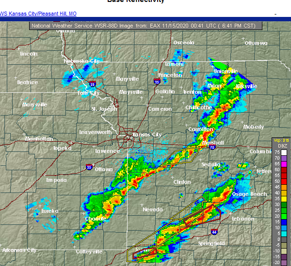 The severe thunderstorm warning for northwestern pettis and eastern johnson counties will expire at 700 pm cst, the storms which prompted the warning have weakened below severe limits, and no longer pose an immediate threat to life or property. therefore, the warning will be allowed to expire. however small hail, gusty winds and heavy rain are still possible with these thunderstorms. a tornado watch remains in effect until midnight cst for central and west central missouri. The severe thunderstorm warning for northwestern pettis and eastern johnson counties will expire at 700 pm cst, the storms which prompted the warning have weakened below severe limits, and no longer pose an immediate threat to life or property. therefore, the warning will be allowed to expire. however small hail, gusty winds and heavy rain are still possible with these thunderstorms. a tornado watch remains in effect until midnight cst for central and west central missouri.
|
| 11/14/2020 6:31 PM CST |
 At 631 pm cst, severe thunderstorms were located along a line extending from 7 miles south of concordia to near knob noster to near chilhowee, moving east at 50 mph (radar indicated). Hazards include 60 mph wind gusts. Expect damage to roofs, siding, and trees. Locations impacted include, warrensburg, knob noster, whiteman air force base, la monte, houstonia, whiteman afb and hughesville. At 631 pm cst, severe thunderstorms were located along a line extending from 7 miles south of concordia to near knob noster to near chilhowee, moving east at 50 mph (radar indicated). Hazards include 60 mph wind gusts. Expect damage to roofs, siding, and trees. Locations impacted include, warrensburg, knob noster, whiteman air force base, la monte, houstonia, whiteman afb and hughesville.
|
| 11/14/2020 6:12 PM CST |
 At 612 pm cst, severe thunderstorms were located along a line extending from 6 miles west of warrensburg to near holden to near garden city, moving east at 50 mph (radar indicated). Hazards include 60 mph wind gusts. expect damage to roofs, siding, and trees At 612 pm cst, severe thunderstorms were located along a line extending from 6 miles west of warrensburg to near holden to near garden city, moving east at 50 mph (radar indicated). Hazards include 60 mph wind gusts. expect damage to roofs, siding, and trees
|
| 9/27/2020 1:16 PM CDT |
 At 115 pm cdt, a severe thunderstorm was located southwest of whiteman air force base, moving southeast at 40 mph (radar indicated). Hazards include 70 mph wind gusts. Expect considerable tree damage. damage is likely to mobile homes, roofs, and outbuildings. Locations impacted include, warrensburg, knob noster, whiteman air force base, leeton, whiteman afb and post oak. At 115 pm cdt, a severe thunderstorm was located southwest of whiteman air force base, moving southeast at 40 mph (radar indicated). Hazards include 70 mph wind gusts. Expect considerable tree damage. damage is likely to mobile homes, roofs, and outbuildings. Locations impacted include, warrensburg, knob noster, whiteman air force base, leeton, whiteman afb and post oak.
|
| 9/27/2020 1:12 PM CDT | Heavy rainfall and strong winds... took down several branches 6-8 inches in diamete in johnson county MO, 0.8 miles ESE of Warrensburg, MO |
| 9/27/2020 1:08 PM CDT |
 At 108 pm cdt, a severe thunderstorm was located over warrensburg, moving east at 35 mph (radar indicated). Hazards include 60 mph wind gusts. expect damage to roofs, siding, and trees At 108 pm cdt, a severe thunderstorm was located over warrensburg, moving east at 35 mph (radar indicated). Hazards include 60 mph wind gusts. expect damage to roofs, siding, and trees
|
| 8/31/2020 9:27 AM CDT |
 The severe thunderstorm warning for northwestern pettis and northeastern johnson counties will expire at 930 am cdt, the storm which prompted the warning has weakened below severe limits, and has exited the warned area. therefore, the warning will be allowed to expire. a severe thunderstorm watch remains in effect until 200 pm cdt for central and west central missouri. The severe thunderstorm warning for northwestern pettis and northeastern johnson counties will expire at 930 am cdt, the storm which prompted the warning has weakened below severe limits, and has exited the warned area. therefore, the warning will be allowed to expire. a severe thunderstorm watch remains in effect until 200 pm cdt for central and west central missouri.
|
| 8/31/2020 9:15 AM CDT |
 At 914 am cdt, a severe thunderstorm was located over whiteman air force base, moving east at 30 mph (radar indicated). Hazards include 60 mph wind gusts. Expect damage to roofs, siding, and trees. Locations impacted include, warrensburg, knob noster, whiteman air force base and whiteman afb. At 914 am cdt, a severe thunderstorm was located over whiteman air force base, moving east at 30 mph (radar indicated). Hazards include 60 mph wind gusts. Expect damage to roofs, siding, and trees. Locations impacted include, warrensburg, knob noster, whiteman air force base and whiteman afb.
|
| 8/31/2020 8:44 AM CDT |
 At 844 am cdt, a severe thunderstorm was located near warrensburg, moving east at 25 mph (radar indicated). Hazards include 60 mph wind gusts and nickel size hail. expect damage to roofs, siding, and trees At 844 am cdt, a severe thunderstorm was located near warrensburg, moving east at 25 mph (radar indicated). Hazards include 60 mph wind gusts and nickel size hail. expect damage to roofs, siding, and trees
|
| 8/10/2020 2:56 PM CDT |
 At 255 pm cdt, severe thunderstorms were located along a line extending from mayview to near higginsville to near concordia to 11 miles west of sweet springs to 10 miles north of whiteman air force base to near knob noster to near whiteman afb, moving northeast at 60 mph (trained weather spotters). Hazards include 70 mph wind gusts and nickel size hail. Expect considerable tree damage. damage is likely to mobile homes, roofs, and outbuildings. Locations impacted include, sedalia, warrensburg, marshall, odessa, higginsville, carrollton, knob noster, concordia, sweet springs, whiteman air force base, la monte, waverly, corder, alma, malta bend, blackburn, houstonia, mayview, whiteman afb and wakenda. At 255 pm cdt, severe thunderstorms were located along a line extending from mayview to near higginsville to near concordia to 11 miles west of sweet springs to 10 miles north of whiteman air force base to near knob noster to near whiteman afb, moving northeast at 60 mph (trained weather spotters). Hazards include 70 mph wind gusts and nickel size hail. Expect considerable tree damage. damage is likely to mobile homes, roofs, and outbuildings. Locations impacted include, sedalia, warrensburg, marshall, odessa, higginsville, carrollton, knob noster, concordia, sweet springs, whiteman air force base, la monte, waverly, corder, alma, malta bend, blackburn, houstonia, mayview, whiteman afb and wakenda.
|
| 8/10/2020 2:45 PM CDT | Large tree limbs blown down on hous in johnson county MO, 0.5 miles NW of Warrensburg, MO |
| 8/10/2020 2:45 PM CDT | Large tree blown down along highway 13 south of hale lake rd. time estimated from rada in johnson county MO, 1.7 miles N of Warrensburg, MO |
| 8/10/2020 2:44 PM CDT |
 At 244 pm cdt, severe thunderstorms were located along a line extending from near odessa to 9 miles south of mayview to near warrensburg to 7 miles northwest of leeton, moving northeast at 55 mph (trained weather spotters). Hazards include 70 mph wind gusts. Expect considerable tree damage. damage is likely to mobile homes, roofs, and outbuildings. Locations impacted include, sedalia, warrensburg, marshall, odessa, higginsville, carrollton, knob noster, concordia, sweet springs, whiteman air force base, la monte, waverly, corder, alma, chilhowee, malta bend, blackburn, houstonia, mayview and whiteman afb. At 244 pm cdt, severe thunderstorms were located along a line extending from near odessa to 9 miles south of mayview to near warrensburg to 7 miles northwest of leeton, moving northeast at 55 mph (trained weather spotters). Hazards include 70 mph wind gusts. Expect considerable tree damage. damage is likely to mobile homes, roofs, and outbuildings. Locations impacted include, sedalia, warrensburg, marshall, odessa, higginsville, carrollton, knob noster, concordia, sweet springs, whiteman air force base, la monte, waverly, corder, alma, chilhowee, malta bend, blackburn, houstonia, mayview and whiteman afb.
|
| 8/10/2020 2:43 PM CDT |
 At 243 pm cdt, severe thunderstorms were located along a line extending from 8 miles east of lone jack to 6 miles west of warrensburg to near chilhowee, moving northeast at 35 mph (trained weather spotters). Hazards include 70 mph wind gusts. Expect considerable tree damage. damage is likely to mobile homes, roofs, and outbuildings. Locations impacted include, warrensburg, knob noster, whiteman air force base, chilhowee, whiteman afb, lake lafayette, centerview, fayetteville and pittsville. At 243 pm cdt, severe thunderstorms were located along a line extending from 8 miles east of lone jack to 6 miles west of warrensburg to near chilhowee, moving northeast at 35 mph (trained weather spotters). Hazards include 70 mph wind gusts. Expect considerable tree damage. damage is likely to mobile homes, roofs, and outbuildings. Locations impacted include, warrensburg, knob noster, whiteman air force base, chilhowee, whiteman afb, lake lafayette, centerview, fayetteville and pittsville.
|
| 8/10/2020 2:39 PM CDT |
 At 239 pm cdt, severe thunderstorms were located along a line extending from near odessa to 11 miles southwest of mayview to 9 miles northeast of holden to 6 miles west of warrensburg to 7 miles north of chilhowee, moving northeast at 50 mph (radar indicated). Hazards include 70 mph wind gusts and penny size hail. Expect considerable tree damage. Damage is likely to mobile homes, roofs, and outbuildings. At 239 pm cdt, severe thunderstorms were located along a line extending from near odessa to 11 miles southwest of mayview to 9 miles northeast of holden to 6 miles west of warrensburg to 7 miles north of chilhowee, moving northeast at 50 mph (radar indicated). Hazards include 70 mph wind gusts and penny size hail. Expect considerable tree damage. Damage is likely to mobile homes, roofs, and outbuildings.
|
| 8/10/2020 2:27 PM CDT |
 At 226 pm cdt, severe thunderstorms were located along a line extending from near lone jack to near holden to 6 miles west of chilhowee, moving east at 45 mph (radar indicated). Hazards include 70 mph wind gusts and nickel size hail. Expect considerable tree damage. damage is likely to mobile homes, roofs, and outbuildings. Locations impacted include, warrensburg, pleasant hill, oak grove, knob noster, holden, whiteman air force base, lone jack, chilhowee, kingsville, baldwin park, whiteman afb, lake lafayette, centerview, strasburg, gunn city, blairstown, fayetteville, la tour, pittsville and quick city. At 226 pm cdt, severe thunderstorms were located along a line extending from near lone jack to near holden to 6 miles west of chilhowee, moving east at 45 mph (radar indicated). Hazards include 70 mph wind gusts and nickel size hail. Expect considerable tree damage. damage is likely to mobile homes, roofs, and outbuildings. Locations impacted include, warrensburg, pleasant hill, oak grove, knob noster, holden, whiteman air force base, lone jack, chilhowee, kingsville, baldwin park, whiteman afb, lake lafayette, centerview, strasburg, gunn city, blairstown, fayetteville, la tour, pittsville and quick city.
|
| 8/10/2020 2:25 PM CDT |
 At 225 pm cdt, severe thunderstorms were located along a line extending from near lone jack to kingsville to 6 miles south of holden, moving east at 40 mph (radar indicated). Hazards include 60 mph wind gusts and nickel size hail. Expect damage to roofs, siding, and trees. Locations impacted include, warrensburg, pleasant hill, oak grove, knob noster, holden, whiteman air force base, lone jack, chilhowee, east lynne, kingsville, baldwin park, whiteman afb, lake lafayette, centerview, strasburg, gunn city, blairstown, fayetteville, la tour and pittsville. At 225 pm cdt, severe thunderstorms were located along a line extending from near lone jack to kingsville to 6 miles south of holden, moving east at 40 mph (radar indicated). Hazards include 60 mph wind gusts and nickel size hail. Expect damage to roofs, siding, and trees. Locations impacted include, warrensburg, pleasant hill, oak grove, knob noster, holden, whiteman air force base, lone jack, chilhowee, east lynne, kingsville, baldwin park, whiteman afb, lake lafayette, centerview, strasburg, gunn city, blairstown, fayetteville, la tour and pittsville.
|
| 8/10/2020 2:10 PM CDT |
 At 210 pm cdt, severe thunderstorms were located along a line extending from near harrisonville to east lynne to near garden city, moving northeast at 35 mph (radar indicated). Hazards include 60 mph wind gusts and quarter size hail. Hail damage to vehicles is expected. Expect wind damage to roofs, siding, and trees. At 210 pm cdt, severe thunderstorms were located along a line extending from near harrisonville to east lynne to near garden city, moving northeast at 35 mph (radar indicated). Hazards include 60 mph wind gusts and quarter size hail. Hail damage to vehicles is expected. Expect wind damage to roofs, siding, and trees.
|
| 7/1/2020 7:08 AM CDT |
 The severe thunderstorm warning for northern henry, west central pettis and johnson counties will expire at 715 am cdt, the storms which prompted the warning have weakened below severe limits, and no longer pose an immediate threat to life or property. therefore, the warning will be allowed to expire. however gusty winds are still possible with these thunderstorms. The severe thunderstorm warning for northern henry, west central pettis and johnson counties will expire at 715 am cdt, the storms which prompted the warning have weakened below severe limits, and no longer pose an immediate threat to life or property. therefore, the warning will be allowed to expire. however gusty winds are still possible with these thunderstorms.
|
| 7/1/2020 6:58 AM CDT |
 At 658 am cdt, severe thunderstorms were located along a line extending from 6 miles northwest of knob noster to warrensburg to 9 miles northwest of leeton to 6 miles north of chilhowee to near holden, moving southeast at 25 mph (radar indicated). Hazards include 60 mph wind gusts and quarter size hail. Hail damage to vehicles is expected. expect wind damage to roofs, siding, and trees. Locations impacted include, warrensburg, windsor, knob noster, holden, whiteman air force base, la monte, leeton, creighton, chilhowee, whiteman afb, centerview, blairstown, post oak and quick city. At 658 am cdt, severe thunderstorms were located along a line extending from 6 miles northwest of knob noster to warrensburg to 9 miles northwest of leeton to 6 miles north of chilhowee to near holden, moving southeast at 25 mph (radar indicated). Hazards include 60 mph wind gusts and quarter size hail. Hail damage to vehicles is expected. expect wind damage to roofs, siding, and trees. Locations impacted include, warrensburg, windsor, knob noster, holden, whiteman air force base, la monte, leeton, creighton, chilhowee, whiteman afb, centerview, blairstown, post oak and quick city.
|
| 7/1/2020 6:44 AM CDT |
 At 643 am cdt, severe thunderstorms were located along a line extending from 10 miles southwest of concordia to near warrensburg to 10 miles north of chilhowee to near holden to kingsville, moving southeast at 25 mph (radar indicated). Hazards include 60 mph wind gusts and quarter size hail. Hail damage to vehicles is expected. expect wind damage to roofs, siding, and trees. Locations impacted include, warrensburg, windsor, knob noster, holden, whiteman air force base, la monte, leeton, creighton, chilhowee, kingsville, whiteman afb, centerview, blairstown, fayetteville, la tour, pittsville, post oak and quick city. At 643 am cdt, severe thunderstorms were located along a line extending from 10 miles southwest of concordia to near warrensburg to 10 miles north of chilhowee to near holden to kingsville, moving southeast at 25 mph (radar indicated). Hazards include 60 mph wind gusts and quarter size hail. Hail damage to vehicles is expected. expect wind damage to roofs, siding, and trees. Locations impacted include, warrensburg, windsor, knob noster, holden, whiteman air force base, la monte, leeton, creighton, chilhowee, kingsville, whiteman afb, centerview, blairstown, fayetteville, la tour, pittsville, post oak and quick city.
|
| 7/1/2020 6:26 AM CDT |
 At 626 am cdt, severe thunderstorms were located along a line extending from 7 miles south of mayview to 9 miles south of odessa to 7 miles north of holden to near kingsville to near baldwin park, moving southeast at 25 mph (radar indicated). Hazards include 60 mph wind gusts and quarter size hail. Hail damage to vehicles is expected. expect wind damage to roofs, siding, and trees. Locations impacted include, warrensburg, oak grove, odessa, higginsville, windsor, knob noster, holden, garden city, whiteman air force base, la monte, lone jack, leeton, creighton, chilhowee, kingsville, whiteman afb, lake lafayette, centerview, bates city and strasburg. At 626 am cdt, severe thunderstorms were located along a line extending from 7 miles south of mayview to 9 miles south of odessa to 7 miles north of holden to near kingsville to near baldwin park, moving southeast at 25 mph (radar indicated). Hazards include 60 mph wind gusts and quarter size hail. Hail damage to vehicles is expected. expect wind damage to roofs, siding, and trees. Locations impacted include, warrensburg, oak grove, odessa, higginsville, windsor, knob noster, holden, garden city, whiteman air force base, la monte, lone jack, leeton, creighton, chilhowee, kingsville, whiteman afb, lake lafayette, centerview, bates city and strasburg.
|
| 7/1/2020 6:14 AM CDT |
 At 613 am cdt, severe thunderstorms were located along a line extending from near mayview to near odessa to 8 miles north of kingsville to near lone jack to baldwin park, moving southeast at 25 mph (radar indicated). Hazards include 60 mph wind gusts and quarter size hail. Hail damage to vehicles is expected. Expect wind damage to roofs, siding, and trees. At 613 am cdt, severe thunderstorms were located along a line extending from near mayview to near odessa to 8 miles north of kingsville to near lone jack to baldwin park, moving southeast at 25 mph (radar indicated). Hazards include 60 mph wind gusts and quarter size hail. Hail damage to vehicles is expected. Expect wind damage to roofs, siding, and trees.
|
| 7/1/2020 5:58 AM CDT |
 At 557 am cdt, severe thunderstorms were located along a line extending from near hardin to near wellington to near odessa to near lone jack to lee`s summit, moving southeast at 35 mph (radar indicated). Hazards include 60 mph wind gusts and quarter size hail. Hail damage to vehicles is expected. expect wind damage to roofs, siding, and trees. Locations impacted include, kansas city, independence, lee`s summit, blue springs, raytown, grandview, raymore, warrensburg, grain valley, harrisonville, pleasant hill, oak grove, richmond, odessa, greenwood, higginsville, lexington, peculiar, buckner and concordia. At 557 am cdt, severe thunderstorms were located along a line extending from near hardin to near wellington to near odessa to near lone jack to lee`s summit, moving southeast at 35 mph (radar indicated). Hazards include 60 mph wind gusts and quarter size hail. Hail damage to vehicles is expected. expect wind damage to roofs, siding, and trees. Locations impacted include, kansas city, independence, lee`s summit, blue springs, raytown, grandview, raymore, warrensburg, grain valley, harrisonville, pleasant hill, oak grove, richmond, odessa, greenwood, higginsville, lexington, peculiar, buckner and concordia.
|
| 7/1/2020 5:38 AM CDT |
 At 538 am cdt, severe thunderstorms were located along a line extending from 10 miles south of cowgill to near richmond to near buckner to blue springs to near raytown, moving southeast at 30 mph (radar indicated). Hazards include 60 mph wind gusts and quarter size hail. Hail damage to vehicles is expected. expect wind damage to roofs, siding, and trees. Locations impacted include, kansas city, independence, lee`s summit, blue springs, leawood, raytown, liberty, grandview, belton, prairie village, raymore, warrensburg, grain valley, excelsior springs, harrisonville, pleasant hill, oak grove, richmond, odessa and greenwood. At 538 am cdt, severe thunderstorms were located along a line extending from 10 miles south of cowgill to near richmond to near buckner to blue springs to near raytown, moving southeast at 30 mph (radar indicated). Hazards include 60 mph wind gusts and quarter size hail. Hail damage to vehicles is expected. expect wind damage to roofs, siding, and trees. Locations impacted include, kansas city, independence, lee`s summit, blue springs, leawood, raytown, liberty, grandview, belton, prairie village, raymore, warrensburg, grain valley, excelsior springs, harrisonville, pleasant hill, oak grove, richmond, odessa and greenwood.
|
| 7/1/2020 5:22 AM CDT |
 At 521 am cdt, severe thunderstorms were located along a line extending from near polo to near woods heights to near missouri city to near independence to near westwood, moving southeast at 30 mph (radar indicated). Hazards include 70 mph wind gusts and quarter size hail. Hail damage to vehicles is expected. expect considerable tree damage. Wind damage is also likely to mobile homes, roofs, and outbuildings. At 521 am cdt, severe thunderstorms were located along a line extending from near polo to near woods heights to near missouri city to near independence to near westwood, moving southeast at 30 mph (radar indicated). Hazards include 70 mph wind gusts and quarter size hail. Hail damage to vehicles is expected. expect considerable tree damage. Wind damage is also likely to mobile homes, roofs, and outbuildings.
|
| 6/5/2020 4:54 AM CDT |
 At 454 am cdt, severe thunderstorms were located along a line extending from near sweet springs to near calhoun to 6 miles east of appleton city, moving southeast at 55 mph (radar indicated). Hazards include 60 mph wind gusts and nickel size hail. expect damage to roofs, siding, and trees At 454 am cdt, severe thunderstorms were located along a line extending from near sweet springs to near calhoun to 6 miles east of appleton city, moving southeast at 55 mph (radar indicated). Hazards include 60 mph wind gusts and nickel size hail. expect damage to roofs, siding, and trees
|
| 6/5/2020 4:47 AM CDT |
 At 447 am cdt, severe thunderstorms were located along a line extending from near concordia to near leeton to near urich, moving southeast at 60 mph (radar indicated). Hazards include 70 mph wind gusts and nickel size hail. Expect considerable tree damage. damage is likely to mobile homes, roofs, and outbuildings. Locations impacted include, warrensburg, clinton, knob noster, concordia, holden, whiteman air force base, leeton, chilhowee, whiteman afb, centerview, emma, aullville, blairstown, fayetteville, la tour, post oak and quick city. At 447 am cdt, severe thunderstorms were located along a line extending from near concordia to near leeton to near urich, moving southeast at 60 mph (radar indicated). Hazards include 70 mph wind gusts and nickel size hail. Expect considerable tree damage. damage is likely to mobile homes, roofs, and outbuildings. Locations impacted include, warrensburg, clinton, knob noster, concordia, holden, whiteman air force base, leeton, chilhowee, whiteman afb, centerview, emma, aullville, blairstown, fayetteville, la tour, post oak and quick city.
|
| 6/5/2020 4:45 AM CDT | Storm spotter reported 67 mph wind gust with stationary truck mounted wind anemometer in warrensbur in johnson county MO, 0.8 miles ENE of Warrensburg, MO |
| 6/5/2020 4:32 AM CDT |
 At 431 am cdt, severe thunderstorms were located along a line extending from mayview to near holden to garden city, moving southeast at 65 mph (radar indicated). Hazards include 70 mph wind gusts and nickel size hail. Expect considerable tree damage. damage is likely to mobile homes, roofs, and outbuildings. Locations impacted include, warrensburg, harrisonville, clinton, pleasant hill, oak grove, odessa, higginsville, lexington, knob noster, concordia, holden, whiteman air force base, lone jack, wellington, leeton, chilhowee, east lynne, kingsville, mayview and baldwin park. At 431 am cdt, severe thunderstorms were located along a line extending from mayview to near holden to garden city, moving southeast at 65 mph (radar indicated). Hazards include 70 mph wind gusts and nickel size hail. Expect considerable tree damage. damage is likely to mobile homes, roofs, and outbuildings. Locations impacted include, warrensburg, harrisonville, clinton, pleasant hill, oak grove, odessa, higginsville, lexington, knob noster, concordia, holden, whiteman air force base, lone jack, wellington, leeton, chilhowee, east lynne, kingsville, mayview and baldwin park.
|
| 6/5/2020 4:11 AM CDT |
 At 410 am cdt, severe thunderstorms were located along a line extending from near sibley to lee`s summit to near lake annette, moving southeast at 60 mph (radar indicated). Hazards include 70 mph wind gusts and nickel size hail. Expect considerable tree damage. Damage is likely to mobile homes, roofs, and outbuildings. At 410 am cdt, severe thunderstorms were located along a line extending from near sibley to lee`s summit to near lake annette, moving southeast at 60 mph (radar indicated). Hazards include 70 mph wind gusts and nickel size hail. Expect considerable tree damage. Damage is likely to mobile homes, roofs, and outbuildings.
|
| 6/4/2020 3:11 AM CDT |
 The severe thunderstorm warning for eastern cass, northwestern henry, eastern ray, carroll, northwestern saline, lafayette, southeastern jackson and johnson counties will expire at 315 am cdt, the storms which prompted the warning have moved out of the warned area. therefore, the warning will be allowed to expire. however gusty winds are still possible with these thunderstorms. a severe thunderstorm watch remains in effect until 400 am cdt for west central missouri. a severe thunderstorm watch also remains in effect until 800 am cdt for west central missouri. remember, a severe thunderstorm warning still remains in effect for saline, lafayette, johnson, cass, and henry counties. The severe thunderstorm warning for eastern cass, northwestern henry, eastern ray, carroll, northwestern saline, lafayette, southeastern jackson and johnson counties will expire at 315 am cdt, the storms which prompted the warning have moved out of the warned area. therefore, the warning will be allowed to expire. however gusty winds are still possible with these thunderstorms. a severe thunderstorm watch remains in effect until 400 am cdt for west central missouri. a severe thunderstorm watch also remains in effect until 800 am cdt for west central missouri. remember, a severe thunderstorm warning still remains in effect for saline, lafayette, johnson, cass, and henry counties.
|
| 6/4/2020 3:06 AM CDT |
 At 304 am cdt, severe thunderstorms were located along a line extending from near waverly to warrensburg to near creighton, moving southeast at 60 mph (radar indicated). Hazards include 60 mph wind gusts and nickel size hail. expect damage to roofs, siding, and trees At 304 am cdt, severe thunderstorms were located along a line extending from near waverly to warrensburg to near creighton, moving southeast at 60 mph (radar indicated). Hazards include 60 mph wind gusts and nickel size hail. expect damage to roofs, siding, and trees
|
| 6/4/2020 3:04 AM CDT |
 At 303 am cdt, severe thunderstorms were located along a line extending from near waverly to near warrensburg to near creighton, moving southeast at 60 mph (radar indicated). Hazards include 60 mph wind gusts and nickel size hail. expect damage to roofs, siding, and trees At 303 am cdt, severe thunderstorms were located along a line extending from near waverly to near warrensburg to near creighton, moving southeast at 60 mph (radar indicated). Hazards include 60 mph wind gusts and nickel size hail. expect damage to roofs, siding, and trees
|
| 6/4/2020 2:57 AM CDT |
 At 256 am cdt, severe thunderstorms were located along a line extending from near carrollton to 7 miles south of mayview to near garden city, moving southeast at 45 mph (radar indicated). Hazards include 60 mph wind gusts and quarter size hail. Hail damage to vehicles is expected. expect wind damage to roofs, siding, and trees. Locations impacted include, warrensburg, harrisonville, pleasant hill, oak grove, odessa, higginsville, lexington, peculiar, carrollton, concordia, holden, garden city, lone jack, waverly, wellington, norborne, hardin, urich, corder and alma. At 256 am cdt, severe thunderstorms were located along a line extending from near carrollton to 7 miles south of mayview to near garden city, moving southeast at 45 mph (radar indicated). Hazards include 60 mph wind gusts and quarter size hail. Hail damage to vehicles is expected. expect wind damage to roofs, siding, and trees. Locations impacted include, warrensburg, harrisonville, pleasant hill, oak grove, odessa, higginsville, lexington, peculiar, carrollton, concordia, holden, garden city, lone jack, waverly, wellington, norborne, hardin, urich, corder and alma.
|
| 6/4/2020 2:26 AM CDT |
 At 226 am cdt, severe thunderstorms were located along a line extending from near braymer to levasy to peculiar, moving southeast at 45 mph (radar indicated). Hazards include 60 mph wind gusts and quarter size hail. Hail damage to vehicles is expected. Expect wind damage to roofs, siding, and trees. At 226 am cdt, severe thunderstorms were located along a line extending from near braymer to levasy to peculiar, moving southeast at 45 mph (radar indicated). Hazards include 60 mph wind gusts and quarter size hail. Hail damage to vehicles is expected. Expect wind damage to roofs, siding, and trees.
|
| 5/15/2020 1:00 AM CDT |
 At 1259 am cdt, severe thunderstorms were located along a line extending from near knob noster to 6 miles east of appleton city, moving east at 50 mph (radar indicated). Hazards include 70 mph wind gusts. Expect considerable tree damage. Damage is likely to mobile homes, roofs, and outbuildings. At 1259 am cdt, severe thunderstorms were located along a line extending from near knob noster to 6 miles east of appleton city, moving east at 50 mph (radar indicated). Hazards include 70 mph wind gusts. Expect considerable tree damage. Damage is likely to mobile homes, roofs, and outbuildings.
|
| 5/15/2020 12:45 AM CDT |
 At 1245 am cdt, a severe thunderstorm was located near knob noster, moving east at 55 mph (radar indicated). Hazards include 70 mph wind gusts. Expect considerable tree damage. Damage is likely to mobile homes, roofs, and outbuildings. At 1245 am cdt, a severe thunderstorm was located near knob noster, moving east at 55 mph (radar indicated). Hazards include 70 mph wind gusts. Expect considerable tree damage. Damage is likely to mobile homes, roofs, and outbuildings.
|
| 5/4/2020 1:02 PM CDT |
 At 101 pm cdt, severe thunderstorms were located along a line extending from near sweet springs to near cole camp to near warsaw, moving east at 60 mph. 60 mph winds have been reported at clinton airport (radar indicated). Hazards include 70 mph wind gusts. Expect considerable tree damage. damage is likely to mobile homes, roofs, and outbuildings. Locations impacted include, sedalia, warrensburg, clinton, windsor, knob noster, whiteman air force base, la monte, smithton, leeton, green ridge, calhoun, otterville, houstonia, whiteman afb, hughesville, clifton city, sedalia memorial arpt, post oak and truman lake. At 101 pm cdt, severe thunderstorms were located along a line extending from near sweet springs to near cole camp to near warsaw, moving east at 60 mph. 60 mph winds have been reported at clinton airport (radar indicated). Hazards include 70 mph wind gusts. Expect considerable tree damage. damage is likely to mobile homes, roofs, and outbuildings. Locations impacted include, sedalia, warrensburg, clinton, windsor, knob noster, whiteman air force base, la monte, smithton, leeton, green ridge, calhoun, otterville, houstonia, whiteman afb, hughesville, clifton city, sedalia memorial arpt, post oak and truman lake.
|
| 5/4/2020 12:41 PM CDT |
 At 1241 pm cdt, severe thunderstorms were located along a line extending from 7 miles southeast of mayview to calhoun to near clinton, moving east at 60 mph (radar indicated). Hazards include 70 mph wind gusts. Expect considerable tree damage. Damage is likely to mobile homes, roofs, and outbuildings. At 1241 pm cdt, severe thunderstorms were located along a line extending from 7 miles southeast of mayview to calhoun to near clinton, moving east at 60 mph (radar indicated). Hazards include 70 mph wind gusts. Expect considerable tree damage. Damage is likely to mobile homes, roofs, and outbuildings.
|
| 5/4/2020 12:08 PM CDT |
 At 1207 pm cdt, severe thunderstorms were located along a line extending from near raytown to near east lynne to near adrian, moving east at 65 mph (trained weather spotters). Hazards include 70 mph wind gusts and quarter size hail. Hail damage to vehicles is expected. expect considerable tree damage. Wind damage is also likely to mobile homes, roofs, and outbuildings. At 1207 pm cdt, severe thunderstorms were located along a line extending from near raytown to near east lynne to near adrian, moving east at 65 mph (trained weather spotters). Hazards include 70 mph wind gusts and quarter size hail. Hail damage to vehicles is expected. expect considerable tree damage. Wind damage is also likely to mobile homes, roofs, and outbuildings.
|
| 4/28/2020 4:12 PM CDT |
 The severe thunderstorm warning for southeastern cass, northwestern henry, northwestern pettis and southern johnson counties will expire at 415 pm cdt, the storms which prompted the warning have moved out of the area. therefore, the warning will be allowed to expire. however small hail, gusty winds and heavy rain are still possible with these thunderstorms. a severe thunderstorm watch remains in effect until 1100 pm cdt for central and west central missouri. The severe thunderstorm warning for southeastern cass, northwestern henry, northwestern pettis and southern johnson counties will expire at 415 pm cdt, the storms which prompted the warning have moved out of the area. therefore, the warning will be allowed to expire. however small hail, gusty winds and heavy rain are still possible with these thunderstorms. a severe thunderstorm watch remains in effect until 1100 pm cdt for central and west central missouri.
|
| 4/28/2020 3:40 PM CDT |
 At 339 pm cdt, severe thunderstorms were located along a line extending from near warrensburg to archie, moving east at 15 mph (radar indicated). Hazards include 60 mph wind gusts and quarter size hail. Hail damage to vehicles is expected. Expect wind damage to roofs, siding, and trees. At 339 pm cdt, severe thunderstorms were located along a line extending from near warrensburg to archie, moving east at 15 mph (radar indicated). Hazards include 60 mph wind gusts and quarter size hail. Hail damage to vehicles is expected. Expect wind damage to roofs, siding, and trees.
|
| 3/27/2020 2:31 AM CDT |
 At 231 am cdt, a severe thunderstorm was located near whiteman afb, or near whiteman air force base, moving east at 60 mph (radar indicated). Hazards include ping pong ball size hail. People and animals outdoors will be injured. expect damage to roofs, siding, windows, and vehicles. Locations impacted include, sedalia, warrensburg, knob noster, whiteman air force base, la monte, green ridge and whiteman afb. At 231 am cdt, a severe thunderstorm was located near whiteman afb, or near whiteman air force base, moving east at 60 mph (radar indicated). Hazards include ping pong ball size hail. People and animals outdoors will be injured. expect damage to roofs, siding, windows, and vehicles. Locations impacted include, sedalia, warrensburg, knob noster, whiteman air force base, la monte, green ridge and whiteman afb.
|
| 3/27/2020 2:30 AM CDT | Quarter sized hail reported 5.2 miles N of Warrensburg, MO, dimes to quarters. |
| 3/27/2020 2:28 AM CDT |
 The severe thunderstorm warning for central johnson county will expire at 230 am cdt, the storm which prompted the warning has moved out of the area. therefore, the warning will be allowed to expire. a severe thunderstorm watch remains in effect until 500 am cdt for west central missouri. The severe thunderstorm warning for central johnson county will expire at 230 am cdt, the storm which prompted the warning has moved out of the area. therefore, the warning will be allowed to expire. a severe thunderstorm watch remains in effect until 500 am cdt for west central missouri.
|
| 3/27/2020 2:24 AM CDT |
 At 224 am cdt, a severe thunderstorm was located near warrensburg, moving east at 55 mph (radar indicated). Hazards include ping pong ball size hail. People and animals outdoors will be injured. expect damage to roofs, siding, windows, and vehicles. Locations impacted include, warrensburg and centerview. At 224 am cdt, a severe thunderstorm was located near warrensburg, moving east at 55 mph (radar indicated). Hazards include ping pong ball size hail. People and animals outdoors will be injured. expect damage to roofs, siding, windows, and vehicles. Locations impacted include, warrensburg and centerview.
|
| 3/27/2020 2:22 AM CDT |
 At 222 am cdt, a severe thunderstorm was located near warrensburg, moving east at 60 mph (radar indicated). Hazards include ping pong ball size hail. People and animals outdoors will be injured. Expect damage to roofs, siding, windows, and vehicles. At 222 am cdt, a severe thunderstorm was located near warrensburg, moving east at 60 mph (radar indicated). Hazards include ping pong ball size hail. People and animals outdoors will be injured. Expect damage to roofs, siding, windows, and vehicles.
|
| 3/27/2020 2:19 AM CDT |
 At 213 am cdt, a severe thunderstorm was located over holden, moving east at 55 mph (radar indicated). Hazards include quarter size hail. Damage to vehicles is expected. Locations impacted include, warrensburg, holden, chilhowee, kingsville and centerview. At 213 am cdt, a severe thunderstorm was located over holden, moving east at 55 mph (radar indicated). Hazards include quarter size hail. Damage to vehicles is expected. Locations impacted include, warrensburg, holden, chilhowee, kingsville and centerview.
|
| 3/27/2020 2:14 AM CDT |
 At 213 am cdt, a severe thunderstorm was located over holden, moving east at 55 mph (radar indicated). Hazards include quarter size hail. Damage to vehicles is expected. Locations impacted include, warrensburg, holden, chilhowee, kingsville and centerview. At 213 am cdt, a severe thunderstorm was located over holden, moving east at 55 mph (radar indicated). Hazards include quarter size hail. Damage to vehicles is expected. Locations impacted include, warrensburg, holden, chilhowee, kingsville and centerview.
|
| 3/27/2020 2:02 AM CDT |
 At 201 am cdt, a severe thunderstorm was located near east lynne, or near pleasant hill, moving east at 55 mph (radar indicated). Hazards include quarter size hail. damage to vehicles is expected At 201 am cdt, a severe thunderstorm was located near east lynne, or near pleasant hill, moving east at 55 mph (radar indicated). Hazards include quarter size hail. damage to vehicles is expected
|
| 3/26/2020 11:57 PM CDT |
 At 1157 pm cdt, a severe thunderstorm was located near knob noster, moving east at 55 mph (radar indicated). Hazards include quarter size hail. damage to vehicles is expected At 1157 pm cdt, a severe thunderstorm was located near knob noster, moving east at 55 mph (radar indicated). Hazards include quarter size hail. damage to vehicles is expected
|
| 3/26/2020 11:51 PM CDT |
 At 1151 pm cdt, a severe thunderstorm was located near knob noster, moving east at 60 mph (radar indicated). Hazards include half dollar size hail. Damage to vehicles is expected. Locations impacted include, sedalia, warrensburg, knob noster, sweet springs, whiteman air force base, la monte, houstonia, whiteman afb, centerview, hughesville and fayetteville. At 1151 pm cdt, a severe thunderstorm was located near knob noster, moving east at 60 mph (radar indicated). Hazards include half dollar size hail. Damage to vehicles is expected. Locations impacted include, sedalia, warrensburg, knob noster, sweet springs, whiteman air force base, la monte, houstonia, whiteman afb, centerview, hughesville and fayetteville.
|
| 3/26/2020 11:36 PM CDT |
 At 1135 pm cdt, a severe thunderstorm was located 7 miles west of warrensburg, moving east at 75 mph (radar indicated). Hazards include half dollar size hail. damage to vehicles is expected At 1135 pm cdt, a severe thunderstorm was located 7 miles west of warrensburg, moving east at 75 mph (radar indicated). Hazards include half dollar size hail. damage to vehicles is expected
|
| 8/26/2019 12:13 PM CDT |
 At 1212 pm cdt, a severe thunderstorm was located over leeton, or 12 miles west of windsor, moving east at 50 mph (radar indicated). Hazards include 60 mph wind gusts. expect damage to roofs, siding, and trees At 1212 pm cdt, a severe thunderstorm was located over leeton, or 12 miles west of windsor, moving east at 50 mph (radar indicated). Hazards include 60 mph wind gusts. expect damage to roofs, siding, and trees
|
| 8/26/2019 12:04 PM CDT |
 At 1204 pm cdt, a severe thunderstorm was located over chilhowee, or 8 miles southeast of holden, moving east at 50 mph (radar indicated). Hazards include 60 mph wind gusts. Expect damage to roofs, siding, and trees. Locations impacted include, warrensburg, knob noster, holden, leeton, chilhowee, whiteman afb, centerview, blairstown, fayetteville, la tour, pittsville, post oak and quick city. At 1204 pm cdt, a severe thunderstorm was located over chilhowee, or 8 miles southeast of holden, moving east at 50 mph (radar indicated). Hazards include 60 mph wind gusts. Expect damage to roofs, siding, and trees. Locations impacted include, warrensburg, knob noster, holden, leeton, chilhowee, whiteman afb, centerview, blairstown, fayetteville, la tour, pittsville, post oak and quick city.
|
| 8/26/2019 11:51 AM CDT |
 At 1151 am cdt, a severe thunderstorm was located near kingsville, or near holden, moving southeast at 45 mph (radar indicated). Hazards include 60 mph wind gusts. expect damage to roofs, siding, and trees At 1151 am cdt, a severe thunderstorm was located near kingsville, or near holden, moving southeast at 45 mph (radar indicated). Hazards include 60 mph wind gusts. expect damage to roofs, siding, and trees
|
| 8/17/2019 5:00 AM CDT | Many large trees dow in johnson county MO, 0.8 miles ESE of Warrensburg, MO |
| 8/17/2019 5:00 AM CDT |
 At 500 am cdt, a severe thunderstorm was located near leeton, or 8 miles southwest of whiteman air force base, moving east at 45 mph (radar indicated). Hazards include 70 mph wind gusts and penny size hail. Expect considerable tree damage. Damage is likely to mobile homes, roofs, and outbuildings. At 500 am cdt, a severe thunderstorm was located near leeton, or 8 miles southwest of whiteman air force base, moving east at 45 mph (radar indicated). Hazards include 70 mph wind gusts and penny size hail. Expect considerable tree damage. Damage is likely to mobile homes, roofs, and outbuildings.
|
| 8/17/2019 4:53 AM CDT |
 At 452 am cdt, a severe thunderstorm was located near chilhowee, or 8 miles southwest of warrensburg, moving east at 45 mph (radar indicated). Hazards include 70 mph wind gusts and penny size hail. Expect considerable tree damage. damage is likely to mobile homes, roofs, and outbuildings. Locations impacted include, warrensburg, holden, leeton, chilhowee, kingsville, centerview, fayetteville, pittsville, post oak and quick city. At 452 am cdt, a severe thunderstorm was located near chilhowee, or 8 miles southwest of warrensburg, moving east at 45 mph (radar indicated). Hazards include 70 mph wind gusts and penny size hail. Expect considerable tree damage. damage is likely to mobile homes, roofs, and outbuildings. Locations impacted include, warrensburg, holden, leeton, chilhowee, kingsville, centerview, fayetteville, pittsville, post oak and quick city.
|
| 8/17/2019 4:42 AM CDT |
 At 442 am cdt, a severe thunderstorm was located over holden, moving east at 40 mph (radar indicated). Hazards include 70 mph wind gusts and penny size hail. Expect considerable tree damage. damage is likely to mobile homes, roofs, and outbuildings. Locations impacted include, warrensburg, holden, leeton, chilhowee, east lynne, kingsville, centerview, strasburg, gunn city, fayetteville, la tour, pittsville, post oak and quick city. At 442 am cdt, a severe thunderstorm was located over holden, moving east at 40 mph (radar indicated). Hazards include 70 mph wind gusts and penny size hail. Expect considerable tree damage. damage is likely to mobile homes, roofs, and outbuildings. Locations impacted include, warrensburg, holden, leeton, chilhowee, east lynne, kingsville, centerview, strasburg, gunn city, fayetteville, la tour, pittsville, post oak and quick city.
|
| 8/17/2019 4:30 AM CDT |
 The national weather service in pleasant hill has issued a * severe thunderstorm warning for. northeastern cass county in west central missouri. johnson county in west central missouri. until 515 am cdt. At 430 am cdt, a severe thunderstorm was located near kingsville,. The national weather service in pleasant hill has issued a * severe thunderstorm warning for. northeastern cass county in west central missouri. johnson county in west central missouri. until 515 am cdt. At 430 am cdt, a severe thunderstorm was located near kingsville,.
|
| 8/15/2019 11:24 PM CDT |
 A severe thunderstorm warning remains in effect until 1145 pm cdt for northwestern pettis. southeastern lafayette and northeastern johnson counties. at 1124 pm cdt, a severe thunderstorm was located near knob noster, moving southeast at 35 mph. hazard. Ping pong ball size hail and 60 mph wind gusts. A severe thunderstorm warning remains in effect until 1145 pm cdt for northwestern pettis. southeastern lafayette and northeastern johnson counties. at 1124 pm cdt, a severe thunderstorm was located near knob noster, moving southeast at 35 mph. hazard. Ping pong ball size hail and 60 mph wind gusts.
|
| 8/15/2019 11:14 PM CDT |
 A severe thunderstorm warning remains in effect until 1145 pm cdt for northwestern pettis. southeastern lafayette and eastern johnson counties. at 1114 pm cdt, a severe thunderstorm was located 7 miles north of warrensburg, moving southeast at 35 mph. hazard. Ping pong ball size hail and 60 mph wind gusts. A severe thunderstorm warning remains in effect until 1145 pm cdt for northwestern pettis. southeastern lafayette and eastern johnson counties. at 1114 pm cdt, a severe thunderstorm was located 7 miles north of warrensburg, moving southeast at 35 mph. hazard. Ping pong ball size hail and 60 mph wind gusts.
|
| 8/15/2019 10:56 PM CDT |
 The national weather service in pleasant hill has issued a * severe thunderstorm warning for. northwestern pettis county in central missouri. southeastern lafayette county in west central missouri. eastern johnson county in west central missouri. Until 1145 pm cdt. The national weather service in pleasant hill has issued a * severe thunderstorm warning for. northwestern pettis county in central missouri. southeastern lafayette county in west central missouri. eastern johnson county in west central missouri. Until 1145 pm cdt.
|
| 7/10/2019 10:11 AM CDT |
 At 1011 am cdt, severe thunderstorms were located along a line extending from henrietta to 6 miles north of warrensburg to near urich, moving east at 45 mph (radar indicated). Hazards include 60 mph wind gusts and penny size hail. Expect damage to roofs, siding, and trees. Locations impacted include, independence, lee`s summit, blue springs, raymore, warrensburg, grain valley, harrisonville, clinton, pleasant hill, oak grove, odessa, greenwood, higginsville, lexington, peculiar, buckner, knob noster, concordia, holden and lake lotawana. At 1011 am cdt, severe thunderstorms were located along a line extending from henrietta to 6 miles north of warrensburg to near urich, moving east at 45 mph (radar indicated). Hazards include 60 mph wind gusts and penny size hail. Expect damage to roofs, siding, and trees. Locations impacted include, independence, lee`s summit, blue springs, raymore, warrensburg, grain valley, harrisonville, clinton, pleasant hill, oak grove, odessa, greenwood, higginsville, lexington, peculiar, buckner, knob noster, concordia, holden and lake lotawana.
|
| 7/10/2019 9:43 AM CDT |
 At 942 am cdt, severe thunderstorms were located along a line extending from excelsior springs to near odessa to near east lynne, moving east at 45 mph (radar indicated). Hazards include 60 mph wind gusts. expect damage to roofs, siding, and trees At 942 am cdt, severe thunderstorms were located along a line extending from excelsior springs to near odessa to near east lynne, moving east at 45 mph (radar indicated). Hazards include 60 mph wind gusts. expect damage to roofs, siding, and trees
|
| 6/22/2019 11:24 PM CDT |
 At 1124 pm cdt, severe thunderstorms were located along a line extending from 6 miles south of concordia to near deepwater, moving east at 45 mph (radar indicated). Hazards include 70 mph wind gusts. Expect considerable tree damage. Damage is likely to mobile homes, roofs, and outbuildings. At 1124 pm cdt, severe thunderstorms were located along a line extending from 6 miles south of concordia to near deepwater, moving east at 45 mph (radar indicated). Hazards include 70 mph wind gusts. Expect considerable tree damage. Damage is likely to mobile homes, roofs, and outbuildings.
|
| 6/22/2019 11:09 PM CDT | Corrected for time. storm chaser in warrensburg measured 73 mph win in johnson county MO, 0.3 miles NNE of Warrensburg, MO |
| 6/22/2019 11:04 PM CDT | Storm damage reported in johnson county MO, 0.3 miles NNE of Warrensburg, MO |
| 6/22/2019 10:59 PM CDT |
 At 1058 pm cdt, severe thunderstorms were located along a line extending from near odessa to near warrensburg to near chilhowee, moving east at 40 mph (radar indicated). Hazards include 70 mph wind gusts. Expect considerable tree damage. Damage is likely to mobile homes, roofs, and outbuildings. At 1058 pm cdt, severe thunderstorms were located along a line extending from near odessa to near warrensburg to near chilhowee, moving east at 40 mph (radar indicated). Hazards include 70 mph wind gusts. Expect considerable tree damage. Damage is likely to mobile homes, roofs, and outbuildings.
|
| 6/21/2019 10:58 AM CDT |
 At 1057 am cdt, a severe thunderstorm was located near garden city, moving southeast at 40 mph (radar indicated). Hazards include 60 mph wind gusts. expect damage to roofs, siding, and trees At 1057 am cdt, a severe thunderstorm was located near garden city, moving southeast at 40 mph (radar indicated). Hazards include 60 mph wind gusts. expect damage to roofs, siding, and trees
|
| 6/21/2019 10:37 AM CDT |
 At 1037 am cdt, a severe thunderstorm was located over oak grove, moving southeast at 40 mph (radar indicated). Hazards include 70 mph wind gusts. Expect considerable tree damage. damage is likely to mobile homes, roofs, and outbuildings. Locations impacted include, independence, lee`s summit, blue springs, grandview, belton, raymore, warrensburg, grain valley, harrisonville, pleasant hill, oak grove, richmond, odessa, greenwood, higginsville, lexington, peculiar, louisburg, carrollton and buckner. At 1037 am cdt, a severe thunderstorm was located over oak grove, moving southeast at 40 mph (radar indicated). Hazards include 70 mph wind gusts. Expect considerable tree damage. damage is likely to mobile homes, roofs, and outbuildings. Locations impacted include, independence, lee`s summit, blue springs, grandview, belton, raymore, warrensburg, grain valley, harrisonville, pleasant hill, oak grove, richmond, odessa, greenwood, higginsville, lexington, peculiar, louisburg, carrollton and buckner.
|
| 6/21/2019 10:28 AM CDT |
 At 1026 am cdt, a severe thunderstorm was located over blue springs, moving southeast at 40 mph (radar indicated). Hazards include 60 mph wind gusts. expect damage to roofs, siding, and trees At 1026 am cdt, a severe thunderstorm was located over blue springs, moving southeast at 40 mph (radar indicated). Hazards include 60 mph wind gusts. expect damage to roofs, siding, and trees
|
| 6/21/2019 10:28 AM CDT |
 The national weather service in pleasant hill has issued a * severe thunderstorm warning for. eastern miami county in east central kansas. northern linn county in east central kansas. cass county in west central missouri. Northwestern bates county in west central missouri. The national weather service in pleasant hill has issued a * severe thunderstorm warning for. eastern miami county in east central kansas. northern linn county in east central kansas. cass county in west central missouri. Northwestern bates county in west central missouri.
|
| 6/21/2019 8:55 AM CDT |
 At 855 am cdt, a severe thunderstorm was located 7 miles south of odessa, moving east at 50 mph (radar indicated). Hazards include 60 mph wind gusts and quarter size hail. Hail damage to vehicles is expected. expect wind damage to roofs, siding, and trees. Locations impacted include, warrensburg, odessa, higginsville, holden, kingsville, mayview, lake lafayette, centerview, bates city, fayetteville and pittsville. At 855 am cdt, a severe thunderstorm was located 7 miles south of odessa, moving east at 50 mph (radar indicated). Hazards include 60 mph wind gusts and quarter size hail. Hail damage to vehicles is expected. expect wind damage to roofs, siding, and trees. Locations impacted include, warrensburg, odessa, higginsville, holden, kingsville, mayview, lake lafayette, centerview, bates city, fayetteville and pittsville.
|
| 6/21/2019 8:26 AM CDT |
 At 826 am cdt, a severe thunderstorm was located over lake lotawana, moving east at 25 mph (radar indicated). Hazards include 60 mph wind gusts and quarter size hail. Hail damage to vehicles is expected. Expect wind damage to roofs, siding, and trees. At 826 am cdt, a severe thunderstorm was located over lake lotawana, moving east at 25 mph (radar indicated). Hazards include 60 mph wind gusts and quarter size hail. Hail damage to vehicles is expected. Expect wind damage to roofs, siding, and trees.
|
| 6/12/2019 4:32 PM CDT | Storm damage reported in johnson county MO, 3.2 miles WSW of Warrensburg, MO |
| 6/12/2019 4:31 PM CDT |
 At 430 pm cdt, severe thunderstorms were located along a line extending from near warrensburg to near chilhowee to near east lynne to near peculiar, moving south at 45 mph (radar indicated). Hazards include 60 mph wind gusts and penny size hail. Expect damage to roofs, siding, and trees. the strongest winds with this storm will be along the gust front ahead of any thunderstorm activity. Locations impacted include, belton, raymore, warrensburg, harrisonville, clinton, peculiar, windsor, holden, adrian, garden city, archie, leeton, urich, freeman, calhoun, creighton, chilhowee, east lynne, lake annette and centerview. At 430 pm cdt, severe thunderstorms were located along a line extending from near warrensburg to near chilhowee to near east lynne to near peculiar, moving south at 45 mph (radar indicated). Hazards include 60 mph wind gusts and penny size hail. Expect damage to roofs, siding, and trees. the strongest winds with this storm will be along the gust front ahead of any thunderstorm activity. Locations impacted include, belton, raymore, warrensburg, harrisonville, clinton, peculiar, windsor, holden, adrian, garden city, archie, leeton, urich, freeman, calhoun, creighton, chilhowee, east lynne, lake annette and centerview.
|
| 6/12/2019 4:19 PM CDT |
 At 412 pm cdt, severe thunderstorms were located along a line extending from 10 miles south of mayview to 9 miles northwest of warrensburg to lone jack to grandview, moving south at 40 mph (radar indicated). Hazards include 60 mph wind gusts and nickel size hail. expect damage to roofs, siding, and trees At 412 pm cdt, severe thunderstorms were located along a line extending from 10 miles south of mayview to 9 miles northwest of warrensburg to lone jack to grandview, moving south at 40 mph (radar indicated). Hazards include 60 mph wind gusts and nickel size hail. expect damage to roofs, siding, and trees
|
| 6/12/2019 4:13 PM CDT |
 At 412 pm cdt, severe thunderstorms were located along a line extending from 10 miles south of mayview to 9 miles northwest of warrensburg to lone jack to grandview, moving south at 40 mph (radar indicated). Hazards include 60 mph wind gusts and nickel size hail. expect damage to roofs, siding, and trees At 412 pm cdt, severe thunderstorms were located along a line extending from 10 miles south of mayview to 9 miles northwest of warrensburg to lone jack to grandview, moving south at 40 mph (radar indicated). Hazards include 60 mph wind gusts and nickel size hail. expect damage to roofs, siding, and trees
|
| 5/22/2019 7:54 PM CDT |
 At 754 pm cdt, a severe thunderstorm was located near warrensburg, moving northeast at 35 mph (radar indicated. estimated 60 mph winds were reported 3 miles west of centerview). Hazards include 60 mph wind gusts and half dollar size hail. Hail damage to vehicles is expected. expect wind damage to roofs, siding, and trees. Locations impacted include, warrensburg, knob noster, whiteman air force base, whiteman afb, centerview and fayetteville. At 754 pm cdt, a severe thunderstorm was located near warrensburg, moving northeast at 35 mph (radar indicated. estimated 60 mph winds were reported 3 miles west of centerview). Hazards include 60 mph wind gusts and half dollar size hail. Hail damage to vehicles is expected. expect wind damage to roofs, siding, and trees. Locations impacted include, warrensburg, knob noster, whiteman air force base, whiteman afb, centerview and fayetteville.
|
| 5/22/2019 7:43 PM CDT |
 At 742 pm cdt, a severe thunderstorm was located near holden, moving northeast at 35 mph (radar indicated). Hazards include 60 mph wind gusts and quarter size hail. Hail damage to vehicles is expected. Expect wind damage to roofs, siding, and trees. At 742 pm cdt, a severe thunderstorm was located near holden, moving northeast at 35 mph (radar indicated). Hazards include 60 mph wind gusts and quarter size hail. Hail damage to vehicles is expected. Expect wind damage to roofs, siding, and trees.
|
| 7/19/2018 1:10 PM CDT |
 At 110 pm cdt, a severe thunderstorm was located near warrensburg, moving south at 30 mph (trained weather spotters). Hazards include golf ball size hail and 60 mph wind gusts. People and animals outdoors will be injured. expect hail damage to roofs, siding, windows, and vehicles. Expect wind damage to roofs, siding, and trees. At 110 pm cdt, a severe thunderstorm was located near warrensburg, moving south at 30 mph (trained weather spotters). Hazards include golf ball size hail and 60 mph wind gusts. People and animals outdoors will be injured. expect hail damage to roofs, siding, windows, and vehicles. Expect wind damage to roofs, siding, and trees.
|
| 7/19/2018 1:07 PM CDT | Multiple reports of tree and power line damage throughout warrensbur in johnson county MO, 0.8 miles ESE of Warrensburg, MO |
| 7/19/2018 1:03 PM CDT | Golf Ball sized hail reported 1 miles WSW of Warrensburg, MO |
| 7/19/2018 1:00 PM CDT | Golf Ball sized hail reported 4.6 miles S of Warrensburg, MO |
| 7/19/2018 12:56 PM CDT |
 At 1256 pm cdt, a severe thunderstorm was located near knob noster, moving south at 30 mph (trained weather spotters). Hazards include golf ball size hail and 60 mph wind gusts. People and animals outdoors will be injured. expect hail damage to roofs, siding, windows, and vehicles. expect wind damage to roofs, siding, and trees. Locations impacted include, warrensburg, knob noster, whiteman air force base, la monte and whiteman afb. At 1256 pm cdt, a severe thunderstorm was located near knob noster, moving south at 30 mph (trained weather spotters). Hazards include golf ball size hail and 60 mph wind gusts. People and animals outdoors will be injured. expect hail damage to roofs, siding, windows, and vehicles. expect wind damage to roofs, siding, and trees. Locations impacted include, warrensburg, knob noster, whiteman air force base, la monte and whiteman afb.
|
| 7/19/2018 12:54 PM CDT | Golf Ball sized hail reported 0.8 miles ESE of Warrensburg, MO |
| 7/19/2018 12:51 PM CDT |
 At 1251 pm cdt, a severe thunderstorm was located near knob noster, moving south at 30 mph (radar indicated). Hazards include 60 mph wind gusts and quarter size hail. Hail damage to vehicles is expected. expect wind damage to roofs, siding, and trees. Locations impacted include, warrensburg, knob noster, whiteman air force base, la monte, whiteman afb and fayetteville. At 1251 pm cdt, a severe thunderstorm was located near knob noster, moving south at 30 mph (radar indicated). Hazards include 60 mph wind gusts and quarter size hail. Hail damage to vehicles is expected. expect wind damage to roofs, siding, and trees. Locations impacted include, warrensburg, knob noster, whiteman air force base, la monte, whiteman afb and fayetteville.
|
| 7/19/2018 12:38 PM CDT |
 At 1238 pm cdt, a severe thunderstorm was located 7 miles southwest of concordia, moving south at 30 mph (radar indicated). Hazards include 60 mph wind gusts and quarter size hail. Hail damage to vehicles is expected. Expect wind damage to roofs, siding, and trees. At 1238 pm cdt, a severe thunderstorm was located 7 miles southwest of concordia, moving south at 30 mph (radar indicated). Hazards include 60 mph wind gusts and quarter size hail. Hail damage to vehicles is expected. Expect wind damage to roofs, siding, and trees.
|
| 6/26/2018 2:19 PM CDT |
 At 219 pm cdt, a severe thunderstorm was located near sedalia, moving east at 50 mph (radar indicated). Hazards include 60 mph wind gusts and quarter size hail. Hail damage to vehicles is expected. expect wind damage to roofs, siding, and trees. Locations impacted include, warrensburg, knob noster, holden, whiteman air force base, leeton, kingsville, whiteman afb and centerview. At 219 pm cdt, a severe thunderstorm was located near sedalia, moving east at 50 mph (radar indicated). Hazards include 60 mph wind gusts and quarter size hail. Hail damage to vehicles is expected. expect wind damage to roofs, siding, and trees. Locations impacted include, warrensburg, knob noster, holden, whiteman air force base, leeton, kingsville, whiteman afb and centerview.
|
| 6/26/2018 2:01 PM CDT | Golf Ball sized hail reported 0.8 miles ENE of Warrensburg, MO |
| 6/26/2018 1:57 PM CDT | Multiple reports of trees and branches down across portions of johnson county missouri... along with power outage in johnson county MO, 0.8 miles ENE of Warrensburg, MO |
| 6/26/2018 1:55 PM CDT | Quarter sized hail reported 0.8 miles ENE of Warrensburg, MO, at university of central missouri. |
| 6/26/2018 1:54 PM CDT |
 At 154 pm cdt, a severe thunderstorm was located near knob noster, moving east at 50 mph (radar indicated). Hazards include 60 mph wind gusts and quarter size hail. Hail damage to vehicles is expected. expect wind damage to roofs, siding, and trees. locations impacted include, warrensburg, higginsville, knob noster, concordia, holden, whiteman air force base, leeton, kingsville, whiteman afb, centerview, emma, aullville, fayetteville and pittsville. This includes interstate 70 in missouri between mile markers 44 and 62. At 154 pm cdt, a severe thunderstorm was located near knob noster, moving east at 50 mph (radar indicated). Hazards include 60 mph wind gusts and quarter size hail. Hail damage to vehicles is expected. expect wind damage to roofs, siding, and trees. locations impacted include, warrensburg, higginsville, knob noster, concordia, holden, whiteman air force base, leeton, kingsville, whiteman afb, centerview, emma, aullville, fayetteville and pittsville. This includes interstate 70 in missouri between mile markers 44 and 62.
|
| 6/26/2018 1:53 PM CDT | Several large trees uprooted and down north of warrensbur in johnson county MO, 1.9 miles SSE of Warrensburg, MO |
| 6/26/2018 1:47 PM CDT | Measured at the johnson county em offic in johnson county MO, 0.8 miles ENE of Warrensburg, MO |
| 6/26/2018 1:22 PM CDT |
 At 122 pm cdt, a severe thunderstorm was located over lone jack, or near lake lotawana, moving east at 50 mph (radar indicated). Hazards include 60 mph wind gusts and quarter size hail. Hail damage to vehicles is expected. Expect wind damage to roofs, siding, and trees. At 122 pm cdt, a severe thunderstorm was located over lone jack, or near lake lotawana, moving east at 50 mph (radar indicated). Hazards include 60 mph wind gusts and quarter size hail. Hail damage to vehicles is expected. Expect wind damage to roofs, siding, and trees.
|
| 6/26/2018 7:45 AM CDT |
 At 745 am cdt, a severe thunderstorm was located near holden, moving east at 45 mph (radar indicated). Hazards include 60 mph wind gusts and quarter size hail. Hail damage to vehicles is expected. Expect wind damage to roofs, siding, and trees. At 745 am cdt, a severe thunderstorm was located near holden, moving east at 45 mph (radar indicated). Hazards include 60 mph wind gusts and quarter size hail. Hail damage to vehicles is expected. Expect wind damage to roofs, siding, and trees.
|
| 5/14/2018 5:26 PM CDT |
 At 526 pm cdt, a severe thunderstorm was located near holden, moving east at 35 mph (radar indicated). Hazards include 60 mph wind gusts and quarter size hail. Hail damage to vehicles is expected. Expect wind damage to roofs, siding, and trees. At 526 pm cdt, a severe thunderstorm was located near holden, moving east at 35 mph (radar indicated). Hazards include 60 mph wind gusts and quarter size hail. Hail damage to vehicles is expected. Expect wind damage to roofs, siding, and trees.
|
| 5/14/2018 3:07 PM CDT |
 At 307 pm cdt, a severe thunderstorm was located 7 miles north of warrensburg, moving east at 20 mph (radar indicated). Hazards include 60 mph wind gusts and quarter size hail. Hail damage to vehicles is expected. Expect wind damage to roofs, siding, and trees. At 307 pm cdt, a severe thunderstorm was located 7 miles north of warrensburg, moving east at 20 mph (radar indicated). Hazards include 60 mph wind gusts and quarter size hail. Hail damage to vehicles is expected. Expect wind damage to roofs, siding, and trees.
|
| 5/14/2018 1:57 PM CDT |
 At 157 pm cdt, severe thunderstorms were located along a line extending from 7 miles southwest of odessa to kingsville, moving east at 30 mph (radar indicated). Hazards include 60 mph wind gusts and quarter size hail. Hail damage to vehicles is expected. expect wind damage to roofs, siding, and trees. Locations impacted include, holden, kingsville, centerview and pittsville. At 157 pm cdt, severe thunderstorms were located along a line extending from 7 miles southwest of odessa to kingsville, moving east at 30 mph (radar indicated). Hazards include 60 mph wind gusts and quarter size hail. Hail damage to vehicles is expected. expect wind damage to roofs, siding, and trees. Locations impacted include, holden, kingsville, centerview and pittsville.
|
| 5/14/2018 1:42 PM CDT |
 At 142 pm cdt, severe thunderstorms were located along a line extending from near lone jack to near east lynne, moving east at 30 mph (radar indicated). Hazards include 60 mph wind gusts and quarter size hail. Hail damage to vehicles is expected. Expect wind damage to roofs, siding, and trees. At 142 pm cdt, severe thunderstorms were located along a line extending from near lone jack to near east lynne, moving east at 30 mph (radar indicated). Hazards include 60 mph wind gusts and quarter size hail. Hail damage to vehicles is expected. Expect wind damage to roofs, siding, and trees.
|
| 5/2/2018 10:43 PM CDT |
 A severe thunderstorm warning remains in effect until 1100 pm cdt for henry. southwestern carroll. eastern lafayette and johnson counties. At 1043 pm cdt, severe thunderstorms were located along a line extending from near waverly to near sweet springs to near knob noster to near leeton to near calhoun to 6 miles southwest of lowry city,. A severe thunderstorm warning remains in effect until 1100 pm cdt for henry. southwestern carroll. eastern lafayette and johnson counties. At 1043 pm cdt, severe thunderstorms were located along a line extending from near waverly to near sweet springs to near knob noster to near leeton to near calhoun to 6 miles southwest of lowry city,.
|
| 5/2/2018 10:21 PM CDT |
 A severe thunderstorm warning remains in effect until 1100 pm cdt for henry. eastern bates. southeastern ray. southwestern carroll. lafayette and johnson counties. At 1020 pm cdt, severe thunderstorms were located along a line extending from near norborne to higginsville to near warrensburg to near chilhowee to 6 miles east of urich to near appleton city, moving. A severe thunderstorm warning remains in effect until 1100 pm cdt for henry. eastern bates. southeastern ray. southwestern carroll. lafayette and johnson counties. At 1020 pm cdt, severe thunderstorms were located along a line extending from near norborne to higginsville to near warrensburg to near chilhowee to 6 miles east of urich to near appleton city, moving.
|
| 5/2/2018 9:57 PM CDT |
 At 956 pm cdt, severe thunderstorms were located along a line extending from near orrick to near odessa to near kingsville to near garden city to 8 miles southwest of creighton to near rich hill, moving east at 40 mph (radar indicated). Hazards include 70 mph wind gusts. Expect considerable tree damage. Damage is likely to mobile homes, roofs, and outbuildings. At 956 pm cdt, severe thunderstorms were located along a line extending from near orrick to near odessa to near kingsville to near garden city to 8 miles southwest of creighton to near rich hill, moving east at 40 mph (radar indicated). Hazards include 70 mph wind gusts. Expect considerable tree damage. Damage is likely to mobile homes, roofs, and outbuildings.
|
| 5/2/2018 9:56 PM CDT |
 At 955 pm cdt, a severe squall line capable of producing both tornadoes and extensive straight line wind damage was located along a line extending from near wellington to near levasy to near oak grove to near lone jack, moving northeast at 55 mph (radar indicated rotation). Hazards include tornado and quarter size hail. Flying debris will be dangerous to those caught without shelter. mobile homes will be damaged or destroyed. damage to roofs, windows, and vehicles will occur. tree damage is likely. locations impacted include, warrensburg, oak grove, richmond, odessa, higginsville, lexington, concordia, wellington, norborne, hardin, corder, alma, henrietta, mayview, lake lafayette, napoleon, bates city, camden, fleming and dover. This includes interstate 70 in missouri between mile markers 30 and 58. At 955 pm cdt, a severe squall line capable of producing both tornadoes and extensive straight line wind damage was located along a line extending from near wellington to near levasy to near oak grove to near lone jack, moving northeast at 55 mph (radar indicated rotation). Hazards include tornado and quarter size hail. Flying debris will be dangerous to those caught without shelter. mobile homes will be damaged or destroyed. damage to roofs, windows, and vehicles will occur. tree damage is likely. locations impacted include, warrensburg, oak grove, richmond, odessa, higginsville, lexington, concordia, wellington, norborne, hardin, corder, alma, henrietta, mayview, lake lafayette, napoleon, bates city, camden, fleming and dover. This includes interstate 70 in missouri between mile markers 30 and 58.
|
| 5/2/2018 9:44 PM CDT |
 At 943 pm cdt, severe thunderstorms capable of producing both tornadoes and extensive straight line wind damage were located along a line extending from near buckner to near blue springs to near grain valley to baldwin park, moving northeast at 55 mph (radar indicated rotation). Hazards include tornado and quarter size hail. Flying debris will be dangerous to those caught without shelter. mobile homes will be damaged or destroyed. damage to roofs, windows, and vehicles will occur. Tree damage is likely. At 943 pm cdt, severe thunderstorms capable of producing both tornadoes and extensive straight line wind damage were located along a line extending from near buckner to near blue springs to near grain valley to baldwin park, moving northeast at 55 mph (radar indicated rotation). Hazards include tornado and quarter size hail. Flying debris will be dangerous to those caught without shelter. mobile homes will be damaged or destroyed. damage to roofs, windows, and vehicles will occur. Tree damage is likely.
|
| 3/16/2018 4:44 PM CDT |
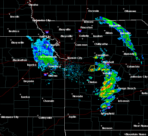 At 444 pm cdt, a severe thunderstorm was located near warrensburg, moving northeast at 35 mph (radar indicated). Hazards include quarter size hail. damage to vehicles is expected At 444 pm cdt, a severe thunderstorm was located near warrensburg, moving northeast at 35 mph (radar indicated). Hazards include quarter size hail. damage to vehicles is expected
|
| 3/16/2018 4:38 PM CDT | Quarter sized hail reported 5.8 miles N of Warrensburg, MO |
| 3/16/2018 4:36 PM CDT |
 At 436 pm cdt, a severe thunderstorm was located south of warrensburg, moving northeast at 30 mph (radar indicated). Hazards include 60 mph wind gusts and quarter size hail. Hail damage to vehicles is expected. expect wind damage to roofs, siding, and trees. Locations impacted include, warrensburg. At 436 pm cdt, a severe thunderstorm was located south of warrensburg, moving northeast at 30 mph (radar indicated). Hazards include 60 mph wind gusts and quarter size hail. Hail damage to vehicles is expected. expect wind damage to roofs, siding, and trees. Locations impacted include, warrensburg.
|
| 3/16/2018 4:24 PM CDT |
 At 423 pm cdt, a severe thunderstorm was located near chilhowee, or 12 miles south of warrensburg, moving northeast at 30 mph (radar indicated). Hazards include 60 mph wind gusts and half dollar size hail. Hail damage to vehicles is expected. expect wind damage to roofs, siding, and trees. Locations impacted include, warrensburg, leeton, chilhowee and post oak. At 423 pm cdt, a severe thunderstorm was located near chilhowee, or 12 miles south of warrensburg, moving northeast at 30 mph (radar indicated). Hazards include 60 mph wind gusts and half dollar size hail. Hail damage to vehicles is expected. expect wind damage to roofs, siding, and trees. Locations impacted include, warrensburg, leeton, chilhowee and post oak.
|
| 3/16/2018 4:15 PM CDT |
 At 415 pm cdt, a severe thunderstorm was located near chilhowee, or 11 miles north of clinton, moving northeast at 30 mph (radar indicated). Hazards include 60 mph wind gusts and quarter size hail. Hail damage to vehicles is expected. Expect wind damage to roofs, siding, and trees. At 415 pm cdt, a severe thunderstorm was located near chilhowee, or 11 miles north of clinton, moving northeast at 30 mph (radar indicated). Hazards include 60 mph wind gusts and quarter size hail. Hail damage to vehicles is expected. Expect wind damage to roofs, siding, and trees.
|
| 10/14/2017 6:59 PM CDT |
 At 659 pm cdt, a severe thunderstorm was located near concordia, moving east at 50 mph (radar indicated). Hazards include 60 mph wind gusts and quarter size hail. Hail damage to vehicles is expected. Expect wind damage to roofs, siding, and trees. At 659 pm cdt, a severe thunderstorm was located near concordia, moving east at 50 mph (radar indicated). Hazards include 60 mph wind gusts and quarter size hail. Hail damage to vehicles is expected. Expect wind damage to roofs, siding, and trees.
|
| 10/14/2017 6:51 PM CDT |
 At 650 pm cdt, severe thunderstorms were located along a line extending from near lexington to near higginsville to 7 miles northwest of warrensburg, moving northeast at 60 mph (radar indicated). Hazards include 60 mph wind gusts and nickel size hail. Expect damage to roofs, siding, and trees. locations impacted include, warrensburg, higginsville, lexington, concordia, waverly, wellington, corder, alma, mayview, dover, aullville and fayetteville. this includes interstate 70 in missouri between mile markers 39 and 60. A tornado watch remains in effect until 100 am cdt for north central and west central missouri. At 650 pm cdt, severe thunderstorms were located along a line extending from near lexington to near higginsville to 7 miles northwest of warrensburg, moving northeast at 60 mph (radar indicated). Hazards include 60 mph wind gusts and nickel size hail. Expect damage to roofs, siding, and trees. locations impacted include, warrensburg, higginsville, lexington, concordia, waverly, wellington, corder, alma, mayview, dover, aullville and fayetteville. this includes interstate 70 in missouri between mile markers 39 and 60. A tornado watch remains in effect until 100 am cdt for north central and west central missouri.
|
| 10/14/2017 6:35 PM CDT |
 At 635 pm cdt, severe thunderstorms were located along a line extending from near wellington to near odessa to near kingsville, moving northeast at 60 mph (radar indicated). Hazards include 60 mph wind gusts and nickel size hail. expect damage to roofs, siding, and trees At 635 pm cdt, severe thunderstorms were located along a line extending from near wellington to near odessa to near kingsville, moving northeast at 60 mph (radar indicated). Hazards include 60 mph wind gusts and nickel size hail. expect damage to roofs, siding, and trees
|
| 8/18/2017 9:48 PM CDT | Ping Pong Ball sized hail reported 6.7 miles S of Warrensburg, MO, reported via social media. |
| 8/18/2017 9:34 PM CDT |
 At 934 pm cdt, a severe thunderstorm was located 7 miles northeast of warrensburg, moving southeast at 35 mph (radar indicated). Hazards include golf ball size hail and 60 mph wind gusts. People and animals outdoors will be injured. expect hail damage to roofs, siding, windows, and vehicles. Expect wind damage to roofs, siding, and trees. At 934 pm cdt, a severe thunderstorm was located 7 miles northeast of warrensburg, moving southeast at 35 mph (radar indicated). Hazards include golf ball size hail and 60 mph wind gusts. People and animals outdoors will be injured. expect hail damage to roofs, siding, windows, and vehicles. Expect wind damage to roofs, siding, and trees.
|
| 8/16/2017 6:41 PM CDT |
 At 641 pm cdt, a severe thunderstorm was located over leeton, or 10 miles south of warrensburg, moving east at 30 mph (radar indicated). Hazards include 60 mph wind gusts and quarter size hail. Hail damage to vehicles is expected. Expect wind damage to roofs, siding, and trees. At 641 pm cdt, a severe thunderstorm was located over leeton, or 10 miles south of warrensburg, moving east at 30 mph (radar indicated). Hazards include 60 mph wind gusts and quarter size hail. Hail damage to vehicles is expected. Expect wind damage to roofs, siding, and trees.
|
| 8/16/2017 6:12 PM CDT |
 At 612 pm cdt, a severe thunderstorm was located near chilhowee, or 9 miles south of holden, moving east at 30 mph (radar indicated). Hazards include 60 mph wind gusts and nickel size hail. expect damage to roofs, siding, and trees At 612 pm cdt, a severe thunderstorm was located near chilhowee, or 9 miles south of holden, moving east at 30 mph (radar indicated). Hazards include 60 mph wind gusts and nickel size hail. expect damage to roofs, siding, and trees
|
| 7/22/2017 11:15 PM CDT |
 At 1115 pm cdt, a severe thunderstorm was located over corder, or near higginsville, moving east at 40 mph (radar indicated). Hazards include 70 mph wind gusts and penny size hail. Expect considerable tree damage. damage is likely to mobile homes, roofs, and outbuildings. locations impacted include, warrensburg, richmond, odessa, higginsville, lexington, knob noster, concordia, holden, sweet springs, whiteman air force base, la monte, waverly, wellington, norborne, hardin, leeton, corder, alma, henrietta and chilhowee. This includes interstate 70 in missouri between mile markers 30 and 74. At 1115 pm cdt, a severe thunderstorm was located over corder, or near higginsville, moving east at 40 mph (radar indicated). Hazards include 70 mph wind gusts and penny size hail. Expect considerable tree damage. damage is likely to mobile homes, roofs, and outbuildings. locations impacted include, warrensburg, richmond, odessa, higginsville, lexington, knob noster, concordia, holden, sweet springs, whiteman air force base, la monte, waverly, wellington, norborne, hardin, leeton, corder, alma, henrietta and chilhowee. This includes interstate 70 in missouri between mile markers 30 and 74.
|
| 7/22/2017 10:54 PM CDT |
 At 1054 pm cdt, a severe thunderstorm was located over mayview, or near odessa, moving east at 40 mph (radar indicated). Hazards include 60 mph wind gusts and penny size hail. expect damage to roofs, siding, and trees At 1054 pm cdt, a severe thunderstorm was located over mayview, or near odessa, moving east at 40 mph (radar indicated). Hazards include 60 mph wind gusts and penny size hail. expect damage to roofs, siding, and trees
|
| 5/27/2017 1:24 PM CDT | Report of tree branches at least 3 inches in diameter and larger down near college and culton streets... blocking some flow of traffic in johnson county MO, 0.8 miles ENE of Warrensburg, MO |
| 5/27/2017 1:24 PM CDT |
 At 124 pm cdt, severe thunderstorms were located along a line extending from near mayview to near warrensburg to near clinton, moving east at 40 mph (trained weather spotters). Hazards include two inch hail and 70 mph wind gusts. People and animals outdoors will be injured. expect hail damage to roofs, siding, windows, and vehicles. expect considerable tree damage. wind damage is also likely to mobile homes, roofs, and outbuildings. locations impacted include, warrensburg, clinton, higginsville, windsor, knob noster, concordia, whiteman air force base, leeton, urich, calhoun, deepwater, chilhowee, mayview, whiteman afb, coal, emma, brownington, aullville, blairstown and tightwad. this includes interstate 70 in missouri between mile markers 43 and 62. A tornado watch remains in effect until 700 pm cdt for central and west central missouri. At 124 pm cdt, severe thunderstorms were located along a line extending from near mayview to near warrensburg to near clinton, moving east at 40 mph (trained weather spotters). Hazards include two inch hail and 70 mph wind gusts. People and animals outdoors will be injured. expect hail damage to roofs, siding, windows, and vehicles. expect considerable tree damage. wind damage is also likely to mobile homes, roofs, and outbuildings. locations impacted include, warrensburg, clinton, higginsville, windsor, knob noster, concordia, whiteman air force base, leeton, urich, calhoun, deepwater, chilhowee, mayview, whiteman afb, coal, emma, brownington, aullville, blairstown and tightwad. this includes interstate 70 in missouri between mile markers 43 and 62. A tornado watch remains in effect until 700 pm cdt for central and west central missouri.
|
| 5/27/2017 1:20 PM CDT | Trees down on ucm campus in johnson county MO, 0.3 miles NNE of Warrensburg, MO |
| 5/27/2017 1:20 PM CDT | An 8 inch tree reported down approximately 1 mile nw of state hwy oo and business route 13 in johnson county MO, 5.4 miles SSE of Warrensburg, MO |
| 5/27/2017 1:04 PM CDT |
 At 103 pm cdt, severe thunderstorms were located along a line extending from near oak grove to holden to 8 miles northwest of montrose, moving east at 40 mph. these are very dangerous storms (trained weather spotters). Hazards include baseball size hail and 70 mph wind gusts. ***the most severe portion of the storm will move across henry county, where winds up to 70 mph and baseball size hail is likely***. People and animals outdoors will be severely injured. expect shattered windows, extensive damage to roofs, siding, and vehicles. locations impacted include, warrensburg, clinton, oak grove, odessa, higginsville, windsor, knob noster, concordia, holden, whiteman air force base, leeton, urich, calhoun, deepwater, creighton, chilhowee, kingsville, mayview, whiteman afb and lake lafayette. this includes interstate 70 in missouri between mile markers 30 and 62. A tornado watch remains in effect until 700 pm cdt for central and west central missouri. At 103 pm cdt, severe thunderstorms were located along a line extending from near oak grove to holden to 8 miles northwest of montrose, moving east at 40 mph. these are very dangerous storms (trained weather spotters). Hazards include baseball size hail and 70 mph wind gusts. ***the most severe portion of the storm will move across henry county, where winds up to 70 mph and baseball size hail is likely***. People and animals outdoors will be severely injured. expect shattered windows, extensive damage to roofs, siding, and vehicles. locations impacted include, warrensburg, clinton, oak grove, odessa, higginsville, windsor, knob noster, concordia, holden, whiteman air force base, leeton, urich, calhoun, deepwater, creighton, chilhowee, kingsville, mayview, whiteman afb and lake lafayette. this includes interstate 70 in missouri between mile markers 30 and 62. A tornado watch remains in effect until 700 pm cdt for central and west central missouri.
|
| 5/27/2017 12:49 PM CDT |
 At 1248 pm cdt, severe thunderstorms were located along a line extending from near blue springs to near kingsville to 7 miles east of adrian, moving east at 40 mph (trained weather spotters). Hazards include 60 mph wind gusts and quarter size hail. Hail damage to vehicles is expected. Expect wind damage to roofs, siding, and trees. At 1248 pm cdt, severe thunderstorms were located along a line extending from near blue springs to near kingsville to 7 miles east of adrian, moving east at 40 mph (trained weather spotters). Hazards include 60 mph wind gusts and quarter size hail. Hail damage to vehicles is expected. Expect wind damage to roofs, siding, and trees.
|
| 3/6/2017 9:01 PM CST |
 At 901 pm cst, severe thunderstorms were located along a line extending from near warrensburg to 8 miles east of butler, moving southeast at 55 mph (radar indicated). Hazards include 70 mph wind gusts and nickel size hail. Expect considerable tree damage. Damage is likely to mobile homes, roofs, and outbuildings. At 901 pm cst, severe thunderstorms were located along a line extending from near warrensburg to 8 miles east of butler, moving southeast at 55 mph (radar indicated). Hazards include 70 mph wind gusts and nickel size hail. Expect considerable tree damage. Damage is likely to mobile homes, roofs, and outbuildings.
|
| 3/6/2017 8:15 PM CST |
 At 815 pm cst, a severe thunderstorm was located over grain valley, moving east at 50 mph (radar indicated). Hazards include 60 mph wind gusts and quarter size hail. Hail damage to vehicles is expected. Expect wind damage to roofs, siding, and trees. At 815 pm cst, a severe thunderstorm was located over grain valley, moving east at 50 mph (radar indicated). Hazards include 60 mph wind gusts and quarter size hail. Hail damage to vehicles is expected. Expect wind damage to roofs, siding, and trees.
|
| 2/28/2017 9:35 PM CST | Ping Pong Ball sized hail reported 0.5 miles NW of Warrensburg, MO |
| 2/28/2017 9:33 PM CST |
 At 932 pm cst, a severe thunderstorm was located near warrensburg, moving east at 45 mph (radar indicated). Hazards include ping pong ball size hail and 60 mph wind gusts. People and animals outdoors will be injured. expect hail damage to roofs, siding, windows, and vehicles. expect wind damage to roofs, siding, and trees. locations impacted include, warrensburg, knob noster, whiteman air force base and whiteman afb. A tornado watch remains in effect until 100 am cst for west central missouri. At 932 pm cst, a severe thunderstorm was located near warrensburg, moving east at 45 mph (radar indicated). Hazards include ping pong ball size hail and 60 mph wind gusts. People and animals outdoors will be injured. expect hail damage to roofs, siding, windows, and vehicles. expect wind damage to roofs, siding, and trees. locations impacted include, warrensburg, knob noster, whiteman air force base and whiteman afb. A tornado watch remains in effect until 100 am cst for west central missouri.
|
| 2/28/2017 9:22 PM CST |
 At 922 pm cst, a severe thunderstorm was located near chilhowee, or near holden, moving east at 45 mph (radar indicated). Hazards include ping pong ball size hail and 60 mph wind gusts. People and animals outdoors will be injured. expect hail damage to roofs, siding, windows, and vehicles. Expect wind damage to roofs, siding, and trees. At 922 pm cst, a severe thunderstorm was located near chilhowee, or near holden, moving east at 45 mph (radar indicated). Hazards include ping pong ball size hail and 60 mph wind gusts. People and animals outdoors will be injured. expect hail damage to roofs, siding, windows, and vehicles. Expect wind damage to roofs, siding, and trees.
|
| 2/28/2017 7:52 PM CST |
 At 751 pm cst, a severe thunderstorm was located near lone jack, or 10 miles north of holden, moving east at 35 mph (radar indicated). Hazards include 60 mph wind gusts and quarter size hail. Hail damage to vehicles is expected. Expect wind damage to roofs, siding, and trees. At 751 pm cst, a severe thunderstorm was located near lone jack, or 10 miles north of holden, moving east at 35 mph (radar indicated). Hazards include 60 mph wind gusts and quarter size hail. Hail damage to vehicles is expected. Expect wind damage to roofs, siding, and trees.
|
| 8/24/2016 9:40 PM CDT |
 At 940 pm cdt, a severe thunderstorm was located over sweet springs, moving east at 30 mph (radar indicated). Hazards include 60 mph wind gusts and quarter size hail. Hail damage to vehicles is expected. Expect wind damage to roofs, siding, and trees. At 940 pm cdt, a severe thunderstorm was located over sweet springs, moving east at 30 mph (radar indicated). Hazards include 60 mph wind gusts and quarter size hail. Hail damage to vehicles is expected. Expect wind damage to roofs, siding, and trees.
|
| 8/24/2016 9:06 PM CDT |
 At 906 pm cdt, a severe thunderstorm was located 9 miles southeast of mayview, or 10 miles south of higginsville, moving east at 35 mph (radar indicated). Hazards include 60 mph wind gusts and quarter size hail. Hail damage to vehicles is expected. Expect wind damage to roofs, siding, and trees. At 906 pm cdt, a severe thunderstorm was located 9 miles southeast of mayview, or 10 miles south of higginsville, moving east at 35 mph (radar indicated). Hazards include 60 mph wind gusts and quarter size hail. Hail damage to vehicles is expected. Expect wind damage to roofs, siding, and trees.
|
| 8/24/2016 8:58 PM CDT |
 At 858 pm cdt, a severe thunderstorm was located 7 miles southeast of mayview, or 8 miles south of higginsville, moving east at 35 mph (radar indicated). Hazards include 60 mph wind gusts and quarter size hail. Hail damage to vehicles is expected. expect wind damage to roofs, siding, and trees. locations impacted include, warrensburg, grain valley, oak grove, odessa, higginsville, kingsville, mayview, lake lafayette, centerview, bates city, pittsville and fayetteville. This includes interstate 70 in missouri between mile markers 25 and 49. At 858 pm cdt, a severe thunderstorm was located 7 miles southeast of mayview, or 8 miles south of higginsville, moving east at 35 mph (radar indicated). Hazards include 60 mph wind gusts and quarter size hail. Hail damage to vehicles is expected. expect wind damage to roofs, siding, and trees. locations impacted include, warrensburg, grain valley, oak grove, odessa, higginsville, kingsville, mayview, lake lafayette, centerview, bates city, pittsville and fayetteville. This includes interstate 70 in missouri between mile markers 25 and 49.
|
| 8/24/2016 8:40 PM CDT |
 At 840 pm cdt, a severe thunderstorm was located near odessa, moving east at 35 mph (radar indicated). Hazards include 60 mph wind gusts and quarter size hail. Hail damage to vehicles is expected. Expect wind damage to roofs, siding, and trees. At 840 pm cdt, a severe thunderstorm was located near odessa, moving east at 35 mph (radar indicated). Hazards include 60 mph wind gusts and quarter size hail. Hail damage to vehicles is expected. Expect wind damage to roofs, siding, and trees.
|
| 7/13/2016 12:11 PM CDT |
 The severe thunderstorm warning for southwestern carroll, northwestern pettis, lafayette, johnson and southwestern saline counties will expire at 1215 pm cdt, the storms which prompted the warning have moved out of the area. therefore the warning will be allowed to expire. a severe thunderstorm watch remains in effect until 600 pm cdt for north central, west central and central missouri. The severe thunderstorm warning for southwestern carroll, northwestern pettis, lafayette, johnson and southwestern saline counties will expire at 1215 pm cdt, the storms which prompted the warning have moved out of the area. therefore the warning will be allowed to expire. a severe thunderstorm watch remains in effect until 600 pm cdt for north central, west central and central missouri.
|
| 7/13/2016 12:01 PM CDT |
 At 1201 pm cdt, severe thunderstorms were located along a line extending from near norborne to near concordia to near chilhowee, moving east at 45 mph (radar indicated). Hazards include 60 mph wind gusts and penny size hail. Expect damage to roofs. siding. and trees. locations impacted include, warrensburg, higginsville, knob noster, concordia, holden, waverly, corder, alma, blackburn, mayview, centerview, emma, dover, aullville, pittsville and fayetteville. This includes interstate 70 in missouri between mile markers 40 and 65. At 1201 pm cdt, severe thunderstorms were located along a line extending from near norborne to near concordia to near chilhowee, moving east at 45 mph (radar indicated). Hazards include 60 mph wind gusts and penny size hail. Expect damage to roofs. siding. and trees. locations impacted include, warrensburg, higginsville, knob noster, concordia, holden, waverly, corder, alma, blackburn, mayview, centerview, emma, dover, aullville, pittsville and fayetteville. This includes interstate 70 in missouri between mile markers 40 and 65.
|
| 7/13/2016 11:45 AM CDT |
 At 1144 am cdt, severe thunderstorms were located along a line extending from near hardin to 7 miles south of mayview to near kingsville, moving east at 45 mph (radar indicated). Hazards include 60 mph wind gusts and penny size hail. Expect damage to roofs. siding. and trees. locations impacted include, warrensburg, oak grove, richmond, odessa, higginsville, lexington, knob noster, concordia, holden, lone jack, waverly, wellington, hardin, corder, alma, henrietta, kingsville, blackburn, mayview and lake lafayette. This includes interstate 70 in missouri between mile markers 29 and 65. At 1144 am cdt, severe thunderstorms were located along a line extending from near hardin to 7 miles south of mayview to near kingsville, moving east at 45 mph (radar indicated). Hazards include 60 mph wind gusts and penny size hail. Expect damage to roofs. siding. and trees. locations impacted include, warrensburg, oak grove, richmond, odessa, higginsville, lexington, knob noster, concordia, holden, lone jack, waverly, wellington, hardin, corder, alma, henrietta, kingsville, blackburn, mayview and lake lafayette. This includes interstate 70 in missouri between mile markers 29 and 65.
|
| 7/13/2016 11:27 AM CDT |
 At 1126 am cdt, severe thunderstorms were located along a line extending from near woods heights to near odessa to near harrisonville, moving east at 45 mph (radar indicated). Hazards include 60 mph wind gusts and penny size hail. Expect damage to roofs. siding. And trees. At 1126 am cdt, severe thunderstorms were located along a line extending from near woods heights to near odessa to near harrisonville, moving east at 45 mph (radar indicated). Hazards include 60 mph wind gusts and penny size hail. Expect damage to roofs. siding. And trees.
|
| 7/12/2016 4:37 AM CDT |
 At 435 am cdt, severe thunderstorms were located along a line extending from 8 miles south of marshall to near warrensburg to near lake winnebago, moving southeast at 35 mph (radar indicated). Hazards include 60 mph wind gusts. Expect damage to roofs. siding. And trees. At 435 am cdt, severe thunderstorms were located along a line extending from 8 miles south of marshall to near warrensburg to near lake winnebago, moving southeast at 35 mph (radar indicated). Hazards include 60 mph wind gusts. Expect damage to roofs. siding. And trees.
|
| 7/12/2016 3:59 AM CDT |
 At 358 am cdt, severe thunderstorms were located along a line extending from near waverly to levasy to kansas city kansas, moving southeast at 45 mph (radar indicated). Hazards include 60 mph wind gusts. Expect damage to roofs. siding. And trees. At 358 am cdt, severe thunderstorms were located along a line extending from near waverly to levasy to kansas city kansas, moving southeast at 45 mph (radar indicated). Hazards include 60 mph wind gusts. Expect damage to roofs. siding. And trees.
|
| 7/7/2016 5:52 AM CDT |
 At 551 am cdt, severe thunderstorms were located along a line extending from 8 miles south of laclede to near malta bend to near concordia, moving southeast at 55 mph (radar indicated). Hazards include 60 mph wind gusts. Expect damage to roofs. siding. And trees. At 551 am cdt, severe thunderstorms were located along a line extending from 8 miles south of laclede to near malta bend to near concordia, moving southeast at 55 mph (radar indicated). Hazards include 60 mph wind gusts. Expect damage to roofs. siding. And trees.
|
| 7/7/2016 5:42 AM CDT |
 At 541 am cdt, severe thunderstorms were located along a line extending from 6 miles northwest of warrensburg to near garden city to archie to near osawatomie, moving southeast at 40 mph. this storm has a history of producing 60 mph winds knocking tree limbs down (radar indicated). Hazards include 60 mph wind gusts. Expect damage to roofs. siding. And trees. At 541 am cdt, severe thunderstorms were located along a line extending from 6 miles northwest of warrensburg to near garden city to archie to near osawatomie, moving southeast at 40 mph. this storm has a history of producing 60 mph winds knocking tree limbs down (radar indicated). Hazards include 60 mph wind gusts. Expect damage to roofs. siding. And trees.
|
| 7/7/2016 5:35 AM CDT |
 At 534 am cdt, severe thunderstorms were located along a line extending from near hale to near carrollton to higginsville, moving southeast at 55 mph (radar indicated). Hazards include 60 mph wind gusts. Expect damage to roofs. siding. and trees. locations impacted include, warrensburg, marshall, higginsville, brookfield, carrollton, concordia, marceline, sweet springs, brunswick, waverly, bucklin, meadville, hale, corder, alma, laclede, bosworth, wheeling, malta bend and blackburn. This includes interstate 70 in missouri between mile markers 42 and 68. At 534 am cdt, severe thunderstorms were located along a line extending from near hale to near carrollton to higginsville, moving southeast at 55 mph (radar indicated). Hazards include 60 mph wind gusts. Expect damage to roofs. siding. and trees. locations impacted include, warrensburg, marshall, higginsville, brookfield, carrollton, concordia, marceline, sweet springs, brunswick, waverly, bucklin, meadville, hale, corder, alma, laclede, bosworth, wheeling, malta bend and blackburn. This includes interstate 70 in missouri between mile markers 42 and 68.
|
| 7/7/2016 5:06 AM CDT |
 At 505 am cdt, severe thunderstorms were located along a line extending from near breckenridge to near cowgill to near orrick, moving southeast at 50 mph (radar indicated). Hazards include 60 mph wind gusts. Expect damage to roofs. siding. And trees. At 505 am cdt, severe thunderstorms were located along a line extending from near breckenridge to near cowgill to near orrick, moving southeast at 50 mph (radar indicated). Hazards include 60 mph wind gusts. Expect damage to roofs. siding. And trees.
|
| 5/26/2016 6:38 PM CDT |
 The severe thunderstorm warning for southwestern lafayette, western johnson, southern cass, north central bates and northwestern henry counties will expire at 645 pm cdt, the storms which prompted the warning have weakened below severe limits, and strong winds have exited the warned area. therefore the warning will be allowed to expire. however gusty winds and heavy rain are still possible with these thunderstorms. a tornado watch remains in effect until 1000 pm cdt for west central missouri. The severe thunderstorm warning for southwestern lafayette, western johnson, southern cass, north central bates and northwestern henry counties will expire at 645 pm cdt, the storms which prompted the warning have weakened below severe limits, and strong winds have exited the warned area. therefore the warning will be allowed to expire. however gusty winds and heavy rain are still possible with these thunderstorms. a tornado watch remains in effect until 1000 pm cdt for west central missouri.
|
| 5/26/2016 6:08 PM CDT |
 At 608 pm cdt, severe thunderstorms were located along a line extending from near wellington to near kingsville to near archie, moving southeast at 45 mph (radar indicated). Hazards include 60 mph wind gusts and penny size hail. Expect damage to roofs. siding. And trees. At 608 pm cdt, severe thunderstorms were located along a line extending from near wellington to near kingsville to near archie, moving southeast at 45 mph (radar indicated). Hazards include 60 mph wind gusts and penny size hail. Expect damage to roofs. siding. And trees.
|
| 5/26/2016 5:12 PM CDT |
 At 512 pm cdt, a confirmed tornado was located over whiteman afb, or near whiteman air force base, moving northeast at 25 mph (weather spotters confirmed tornado). Hazards include damaging tornado and golf ball size hail. Flying debris will be dangerous to those caught without shelter. mobile homes will be damaged or destroyed. damage to roofs, windows, and vehicles will occur. tree damage is likely. Locations impacted include, warrensburg, knob noster, whiteman air force base, la monte, leeton, green ridge and whiteman afb. At 512 pm cdt, a confirmed tornado was located over whiteman afb, or near whiteman air force base, moving northeast at 25 mph (weather spotters confirmed tornado). Hazards include damaging tornado and golf ball size hail. Flying debris will be dangerous to those caught without shelter. mobile homes will be damaged or destroyed. damage to roofs, windows, and vehicles will occur. tree damage is likely. Locations impacted include, warrensburg, knob noster, whiteman air force base, la monte, leeton, green ridge and whiteman afb.
|
| 5/26/2016 5:00 PM CDT |
 At 500 pm cdt, a severe thunderstorm capable of producing a tornado was located near leeton, or 8 miles southwest of whiteman air force base, moving northeast at 25 mph (radar indicated rotation). Hazards include tornado and golf ball size hail. Flying debris will be dangerous to those caught without shelter. mobile homes will be damaged or destroyed. damage to roofs, windows, and vehicles will occur. Tree damage is likely. At 500 pm cdt, a severe thunderstorm capable of producing a tornado was located near leeton, or 8 miles southwest of whiteman air force base, moving northeast at 25 mph (radar indicated rotation). Hazards include tornado and golf ball size hail. Flying debris will be dangerous to those caught without shelter. mobile homes will be damaged or destroyed. damage to roofs, windows, and vehicles will occur. Tree damage is likely.
|
| 5/26/2016 4:44 PM CDT |
 At 443 pm cdt, a severe thunderstorm was located near chilhowee, or 7 miles southwest of warrensburg, moving northeast at 25 mph (radar indicated). Hazards include golf ball size hail and 60 mph wind gusts. People and animals outdoors will be injured. expect hail damage to roofs, siding, windows, and vehicles. Expect wind damage to roofs, siding, and trees. At 443 pm cdt, a severe thunderstorm was located near chilhowee, or 7 miles southwest of warrensburg, moving northeast at 25 mph (radar indicated). Hazards include golf ball size hail and 60 mph wind gusts. People and animals outdoors will be injured. expect hail damage to roofs, siding, windows, and vehicles. Expect wind damage to roofs, siding, and trees.
|
| 5/26/2016 4:04 PM CDT |
 At 403 pm cdt, a severe thunderstorm was located near holden, moving northeast at 25 mph (radar indicated). Hazards include two inch hail and 60 mph wind gusts. People and animals outdoors will be injured. expect hail damage to roofs, siding, windows, and vehicles. Expect wind damage to roofs, siding, and trees. At 403 pm cdt, a severe thunderstorm was located near holden, moving northeast at 25 mph (radar indicated). Hazards include two inch hail and 60 mph wind gusts. People and animals outdoors will be injured. expect hail damage to roofs, siding, windows, and vehicles. Expect wind damage to roofs, siding, and trees.
|
| 4/26/2016 9:50 AM CDT |
 At 950 am cdt, severe thunderstorms were located along a line extending from 6 miles west of bosworth to warrensburg, moving east at 60 mph (radar indicated). Hazards include 60 mph wind gusts and half dollar size hail. Hail damage to vehicles is expected. expect wind damage to roofs, siding, and trees. locations impacted include, warrensburg, higginsville, carrollton, knob noster, concordia, holden, sweet springs, whiteman air force base, waverly, norborne, corder, alma, malta bend, blackburn, mayview, whiteman afb, wakenda, centerview, emma and miami. This includes interstate 70 in missouri between mile markers 40 and 69. At 950 am cdt, severe thunderstorms were located along a line extending from 6 miles west of bosworth to warrensburg, moving east at 60 mph (radar indicated). Hazards include 60 mph wind gusts and half dollar size hail. Hail damage to vehicles is expected. expect wind damage to roofs, siding, and trees. locations impacted include, warrensburg, higginsville, carrollton, knob noster, concordia, holden, sweet springs, whiteman air force base, waverly, norborne, corder, alma, malta bend, blackburn, mayview, whiteman afb, wakenda, centerview, emma and miami. This includes interstate 70 in missouri between mile markers 40 and 69.
|
| 4/26/2016 9:42 AM CDT |
 At 941 am cdt, severe thunderstorms were located along a line extending from 10 miles northwest of carrollton to 6 miles northeast of holden, moving east at 55 mph (radar indicated). Hazards include 60 mph wind gusts and half dollar size hail. Hail damage to vehicles is expected. expect wind damage to roofs, siding, and trees. locations impacted include, warrensburg, odessa, higginsville, lexington, carrollton, knob noster, concordia, holden, sweet springs, whiteman air force base, waverly, norborne, hardin, corder, alma, kingsville, malta bend, blackburn, mayview and whiteman afb. This includes interstate 70 in missouri between mile markers 35 and 69. At 941 am cdt, severe thunderstorms were located along a line extending from 10 miles northwest of carrollton to 6 miles northeast of holden, moving east at 55 mph (radar indicated). Hazards include 60 mph wind gusts and half dollar size hail. Hail damage to vehicles is expected. expect wind damage to roofs, siding, and trees. locations impacted include, warrensburg, odessa, higginsville, lexington, carrollton, knob noster, concordia, holden, sweet springs, whiteman air force base, waverly, norborne, hardin, corder, alma, kingsville, malta bend, blackburn, mayview and whiteman afb. This includes interstate 70 in missouri between mile markers 35 and 69.
|
| 4/26/2016 9:24 AM CDT |
 At 924 am cdt, severe thunderstorms were located along a line extending from 7 miles south of cowgill to near lone jack, moving east at 60 mph (radar indicated). Hazards include 60 mph wind gusts and half dollar size hail. Hail damage to vehicles is expected. Expect wind damage to roofs, siding, and trees. At 924 am cdt, severe thunderstorms were located along a line extending from 7 miles south of cowgill to near lone jack, moving east at 60 mph (radar indicated). Hazards include 60 mph wind gusts and half dollar size hail. Hail damage to vehicles is expected. Expect wind damage to roofs, siding, and trees.
|
| 11/11/2015 2:30 PM CST | Power pole down on hwy 13 north of warrensburg. time estimated by radar. report via social medi in johnson county MO, 6 miles S of Warrensburg, MO |
| 7/1/2015 1:55 AM CDT |
 At 154 am cdt, a severe thunderstorm was located near leeton, and moving southeast at 30 mph (radar indicated). Hazards include 60 mph wind gusts and half dollar size hail. Hail damage to vehicles is expected. Expect wind damage to roofs, siding and trees. At 154 am cdt, a severe thunderstorm was located near leeton, and moving southeast at 30 mph (radar indicated). Hazards include 60 mph wind gusts and half dollar size hail. Hail damage to vehicles is expected. Expect wind damage to roofs, siding and trees.
|
| 6/26/2015 2:57 AM CDT |
 At 254 am cdt, severe thunderstorms were located along a line extending from knob noster to 7 miles northwest of clinton to 9 miles east of butler, and moving southeast at 35 mph (radar indicated). Hazards include 60 mph wind gusts. Expect damage to roofs. siding and trees. Locations impacted include, knob noster, whiteman air force base, clinton, windsor, sedalia, leeton, montrose, la monte, calhoun, deepwater, green ridge, smithton, la due, rockville, coal, brownington, tightwad and sedalia memorial arpt. At 254 am cdt, severe thunderstorms were located along a line extending from knob noster to 7 miles northwest of clinton to 9 miles east of butler, and moving southeast at 35 mph (radar indicated). Hazards include 60 mph wind gusts. Expect damage to roofs. siding and trees. Locations impacted include, knob noster, whiteman air force base, clinton, windsor, sedalia, leeton, montrose, la monte, calhoun, deepwater, green ridge, smithton, la due, rockville, coal, brownington, tightwad and sedalia memorial arpt.
|
| 6/26/2015 2:38 AM CDT |
 At 236 am cdt, severe thunderstorms were located along a line extending from 9 miles south of mayview to 5 miles northeast of creighton to adrian, and moving southeast at 45 mph (radar indicated). Hazards include 60 mph wind gusts. Expect damage to roofs. Siding and trees. At 236 am cdt, severe thunderstorms were located along a line extending from 9 miles south of mayview to 5 miles northeast of creighton to adrian, and moving southeast at 45 mph (radar indicated). Hazards include 60 mph wind gusts. Expect damage to roofs. Siding and trees.
|
| 6/26/2015 2:29 AM CDT |
 At 226 am cdt, severe thunderstorms were located along a line extending from 6 miles southeast of odessa to holden to adrian, and moving southeast at 50 mph (radar indicated). Hazards include 70 mph wind gusts. Expect considerable tree damage. damage is likely to mobile homes, roofs and outbuildings. locations impacted include, adrian, concordia, warrensburg, creighton, chilhowee, urich, fayetteville, quick city, centerview, blairstown and passaic. This will impact i-70 in missouri between mile markers 32 and 61. At 226 am cdt, severe thunderstorms were located along a line extending from 6 miles southeast of odessa to holden to adrian, and moving southeast at 50 mph (radar indicated). Hazards include 70 mph wind gusts. Expect considerable tree damage. damage is likely to mobile homes, roofs and outbuildings. locations impacted include, adrian, concordia, warrensburg, creighton, chilhowee, urich, fayetteville, quick city, centerview, blairstown and passaic. This will impact i-70 in missouri between mile markers 32 and 61.
|
| 6/26/2015 2:08 AM CDT |
 At 205 am cdt, severe thunderstorms were located along a line extending from levasy to lone jack to cleveland, and moving southeast at 55 mph. * these storms have a history of producing widespread wind damage and wind gusts up to 80 mph. these are very dangerous storms! (radar indicated). Hazards include 80 mph wind gusts. Flying debris will be dangerous to those caught without shelter. mobile homes will be heavily damaged. expect considerable damage to roofs, windows and vehicles. Extensive tree damage and power outages are likely. At 205 am cdt, severe thunderstorms were located along a line extending from levasy to lone jack to cleveland, and moving southeast at 55 mph. * these storms have a history of producing widespread wind damage and wind gusts up to 80 mph. these are very dangerous storms! (radar indicated). Hazards include 80 mph wind gusts. Flying debris will be dangerous to those caught without shelter. mobile homes will be heavily damaged. expect considerable damage to roofs, windows and vehicles. Extensive tree damage and power outages are likely.
|
| 6/25/2015 8:12 PM CDT | The severe thunderstorm warning for northwestern johnson county in west central missouri will expire at 815 pm cdt, the storm which prompted the warning has weakened below severe limits, and no longer poses an immediate threat to life or property. additional strong thunderstorms are still possible, and a severe thunderstorm watch remains in effect. |
| 6/25/2015 8:06 PM CDT |
 At 801 pm cdt, a severe thunderstorm was located near warrensburg, and moving east at 20 mph (radar indicated. at 745 pm...the public reported penny size hail 3 miles southeast of lone jack. at 747 pm, the public reported penny size hail 3 miles northeast of strasburg). Hazards include 60 mph wind gusts and quarter size hail. Hail damage to vehicles is expected. expect wind damage to roofs, siding and trees. Locations impacted include, warrensburg. At 801 pm cdt, a severe thunderstorm was located near warrensburg, and moving east at 20 mph (radar indicated. at 745 pm...the public reported penny size hail 3 miles southeast of lone jack. at 747 pm, the public reported penny size hail 3 miles northeast of strasburg). Hazards include 60 mph wind gusts and quarter size hail. Hail damage to vehicles is expected. expect wind damage to roofs, siding and trees. Locations impacted include, warrensburg.
|
| 6/25/2015 7:32 PM CDT |
 At 729 pm cdt, a severe thunderstorm was located near kingsville, and moving east at 15 mph (radar indicated). Hazards include 60 mph wind gusts and quarter size hail. Hail damage to vehicles is expected. Expect wind damage to roofs, siding and trees. At 729 pm cdt, a severe thunderstorm was located near kingsville, and moving east at 15 mph (radar indicated). Hazards include 60 mph wind gusts and quarter size hail. Hail damage to vehicles is expected. Expect wind damage to roofs, siding and trees.
|
| 5/17/2015 12:58 AM CDT | At 1255 am cdt, severe thunderstorms were located along a line extending from concordia to lowry city, and moving east at 50 mph (radar indicated). Hazards include 60 mph wind gusts. Expect damage to roofs. siding and trees. locations impacted include, concordia, knob noster, whiteman air force base, windsor, sweet springs, la monte, green ridge, houstonia, coal, tightwad, emma and hughesville. winds up to 80 mph will be possible in aullville and higginsville. this will impact i-70 between mile markers 43 and 70. 75in. |
| 5/17/2015 12:43 AM CDT | At 1239 am cdt, severe thunderstorms were located along a line extending from mayview to appleton city, and moving east at 50 mph. at 1207 am, local law enforcement reported straight line wind damage in adrian. winds up to 80 mph will be possible in holden, centerview, warrensburg, knob knoster, and whiteman air force base (radar indicated). Hazards include 60 mph wind gusts. Expect damage to roofs. Siding and trees. |
| 4/8/2015 5:39 PM CDT | A severe thunderstorm warning remains in effect for pettis and southwestern cooper counties in central missouri. and southeastern johnson county in west central missouri until 615 pm cdt. at 538 pm cdt. a severe thunderstorm was located near green ridge. and moving northeast at 50 mph. hazard. 60 mph wind gusts and quarter size hail. |
| 4/8/2015 5:27 PM CDT | Storm damage reported in johnson county MO, 3.9 miles NW of Warrensburg, MO |
| 4/8/2015 5:24 PM CDT | The national weather service in pleasant hill has issued a * severe thunderstorm warning for. southwestern cooper county in central missouri. northeastern henry county in west central missouri. southern johnson county in west central missouri. Pettis county in central missouri. |
| 4/8/2015 9:01 AM CDT | A severe thunderstorm warning remains in effect for northeastern johnson county in west central missouri until 930 am cdt. at 858 am cdt. a severe thunderstorm was located near warrensburg. and moving east at 30 mph. hazard. quarter size hail. source. Radar indicated. |
| 4/8/2015 8:54 AM CDT | A severe thunderstorm warning remains in effect for eastern johnson county in west central missouri until 930 am cdt. at 849 am cdt. a severe thunderstorm was located near warrensburg. and moving east at 30 mph. hazard. ping pong ball size hail. source. trained spotters. at 829 am. A national weather service. |
| 4/8/2015 8:48 AM CDT | Quarter sized hail reported 0.8 miles ENE of Warrensburg, MO |
| 4/8/2015 8:45 AM CDT | Quarter sized hail reported 1.3 miles SSE of Warrensburg, MO |
| 4/8/2015 8:44 AM CDT | Quarter sized hail reported 0.8 miles ENE of Warrensburg, MO, pea size to quarter sized hail falling now. |
| 4/8/2015 8:35 AM CDT | The national weather service in pleasant hill has issued a * severe thunderstorm warning for. johnson county in west central missouri. until 930 am cdt * at 828 am cdt. a severe thunderstorm was located near holden. And moving east at 25 mph. |
| 3/24/2015 5:43 PM CDT | The national weather service in pleasant hill has issued a * severe thunderstorm warning for. eastern johnson county in west central missouri. northwestern pettis county in central missouri. until 615 pm cdt * at 539 pm cdt. a severe thunderstorm was located near leeton. And. |
| 3/24/2015 5:09 PM CDT | The national weather service in pleasant hill has issued a * severe thunderstorm warning for. johnson county in west central missouri. south central lafayette county in west central missouri. until 545 pm cdt * at 505 pm cdt. A severe thunderstorm was located 6 miles southwest. |
| 10/1/2014 2:41 PM CDT | Quarter sized hail reported 5.8 miles N of Warrensburg, MO |
| 9/1/2014 7:00 PM CDT | Quarter sized hail reported 2.5 miles NNE of Warrensburg, MO, mostly peas...with a few 1 inch hail stones |
| 4/27/2014 1:07 PM CDT | Quarter sized hail reported 0.3 miles NNE of Warrensburg, MO |
| 4/27/2014 12:55 PM CDT | Trees blown down in warrensburg in johnson county MO, 0.3 miles NNE of Warrensburg, MO |
| 3/27/2014 3:46 PM CDT | Half Dollar sized hail reported 0.8 miles ENE of Warrensburg, MO |
| 3/27/2014 3:45 PM CDT | Ping Pong Ball sized hail reported 0.8 miles ENE of Warrensburg, MO, estimated winds of 60-70 mph. small tree limbs down. |
| 3/27/2014 3:41 PM CDT | Quarter sized hail reported 0.3 miles NNE of Warrensburg, MO |
| 9/1/2013 8:30 AM CDT | 3 inch tree branch blown down in johnson county MO, 5.2 miles N of Warrensburg, MO |
| 9/1/2013 8:28 AM CDT | Tree down and a power pole blown down in town in johnson county MO, 0.8 miles ENE of Warrensburg, MO |
| 6/15/2013 4:45 PM CDT | Numerous power poles down in warrensburg in johnson county MO, 0.3 miles NNE of Warrensburg, MO |
| 5/20/2013 4:35 PM CDT | Half Dollar sized hail reported 1.2 miles NE of Warrensburg, MO, time estimated. |
| 1/1/0001 12:00 AM | Storm damage reported in johnson county MO, 4.4 miles ESE of Warrensburg, MO |
| 1/1/0001 12:00 AM | 18-20 inch diameter tree in johnson county MO, 0.3 miles NNE of Warrensburg, MO |
| 1/1/0001 12:00 AM | A few trees down in warrensburg in johnson county MO, 0.3 miles NNE of Warrensburg, MO |
| 1/1/0001 12:00 AM | 2 to 3 inch tree branches down. pea size hai in johnson county MO, 0.3 miles NNE of Warrensburg, MO |
| 1/1/0001 12:00 AM | 6 inch tree limbs blown down at martin warren elementary school. reported by the daily star journal. time estimated from previous report in johnson county MO, 0.8 miles ENE of Warrensburg, MO |
| 1/1/0001 12:00 AM | 100 block main street in warren in johnson county MO, 0.3 miles NNE of Warrensburg, MO |
Hail Maps for Warrensburg, MO
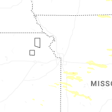
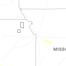
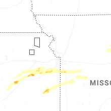
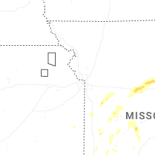
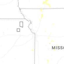
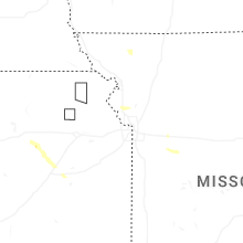
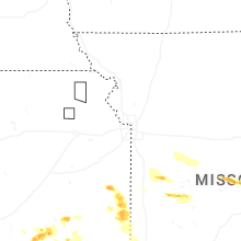
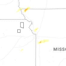


Connect with Interactive Hail Maps