

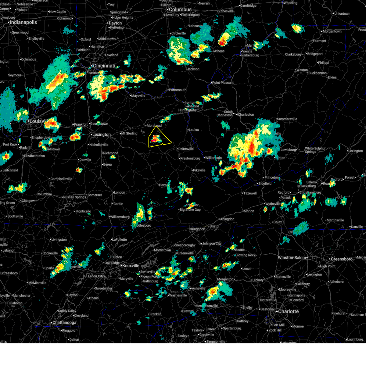
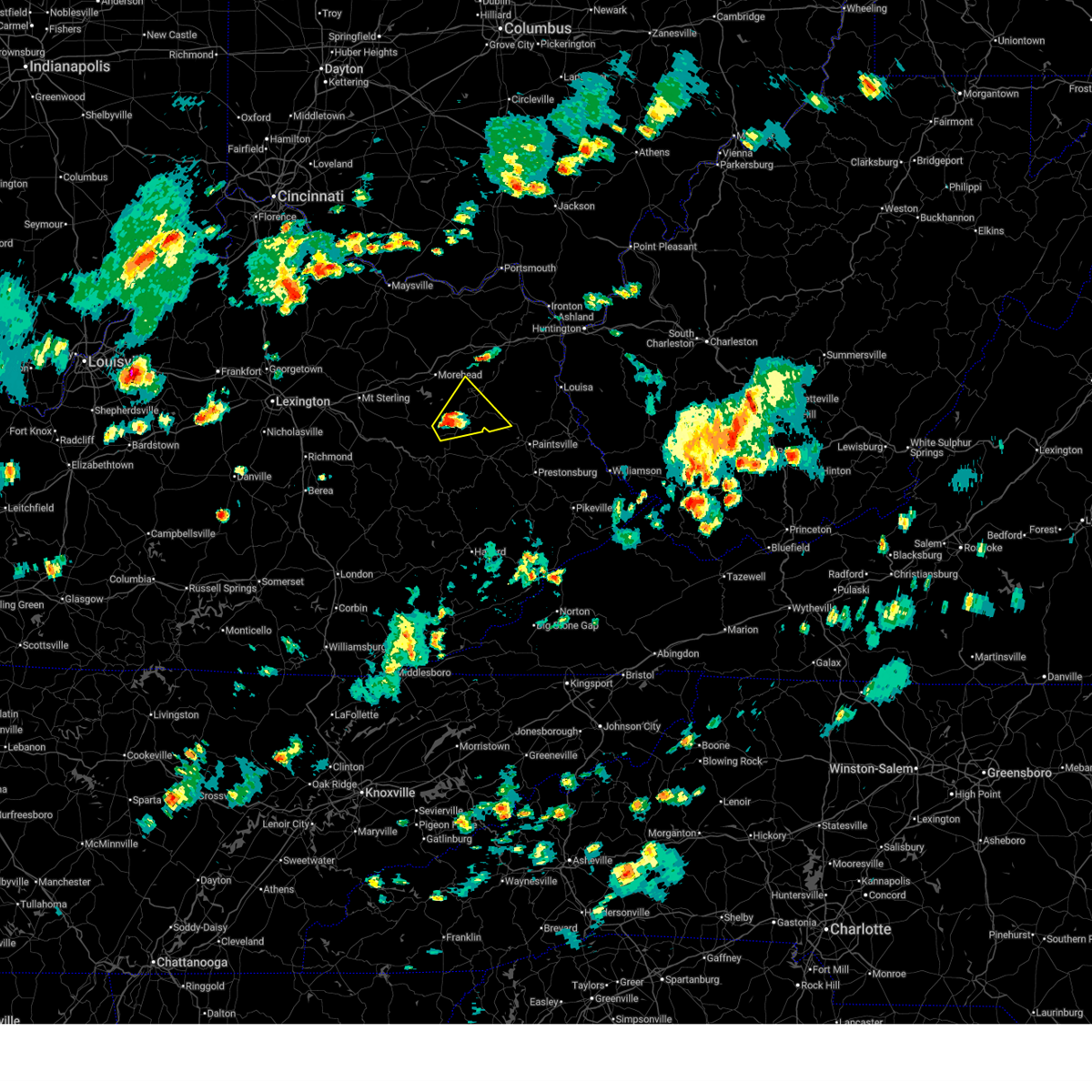
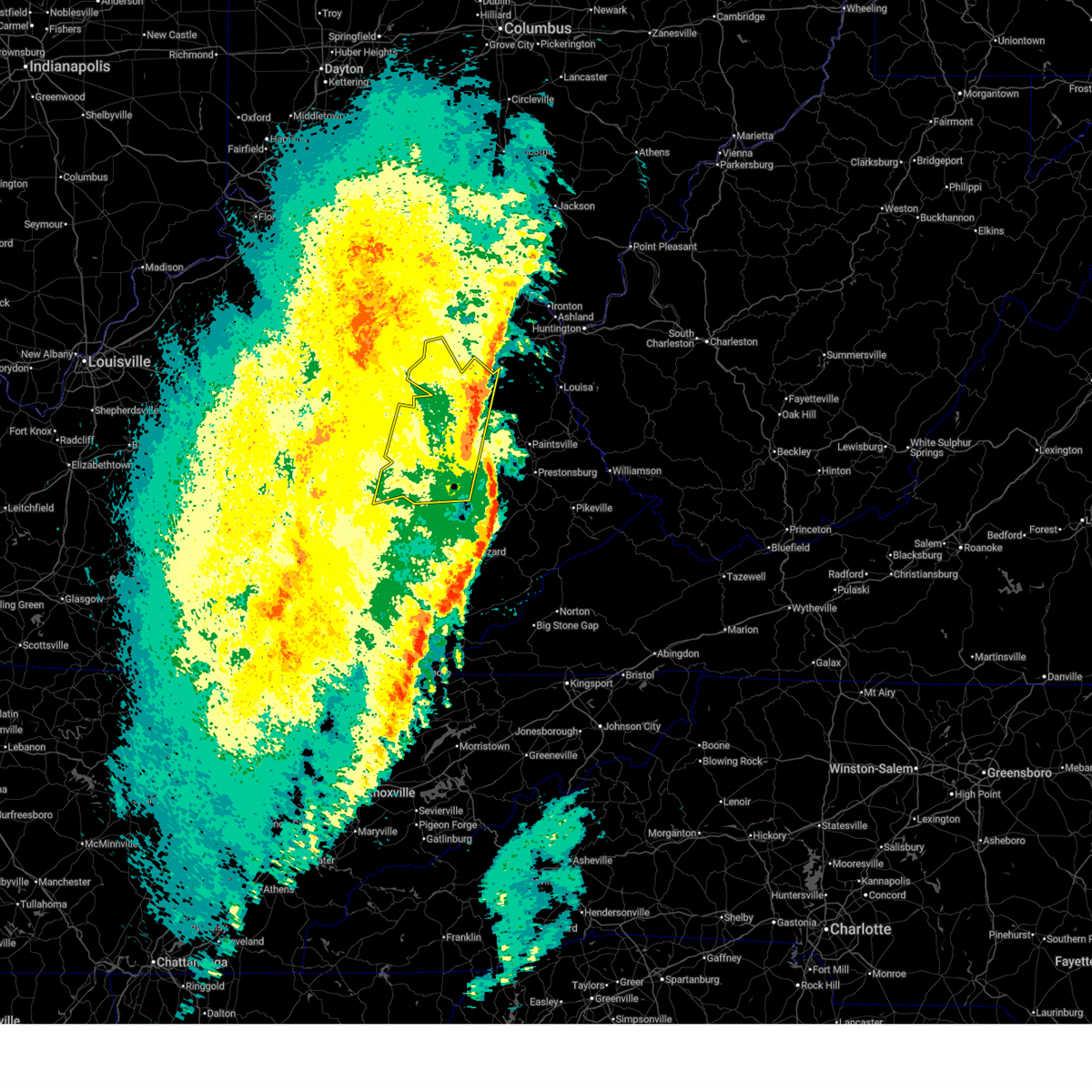
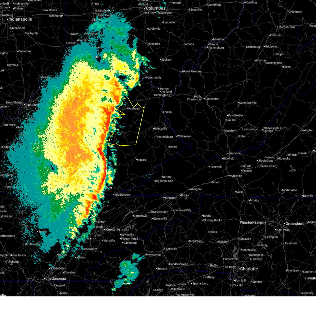
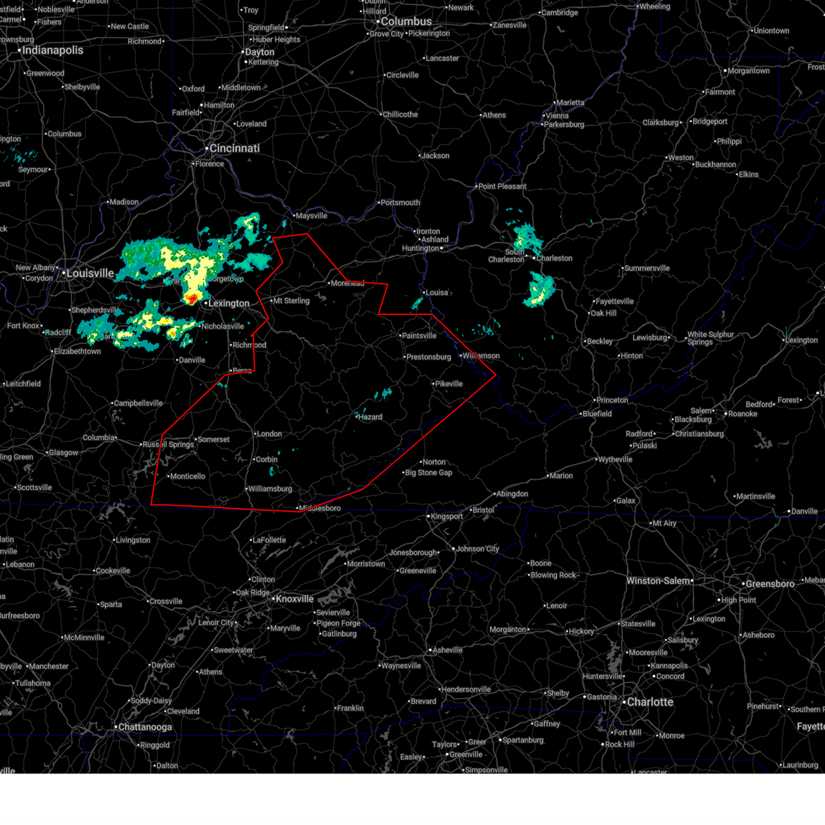
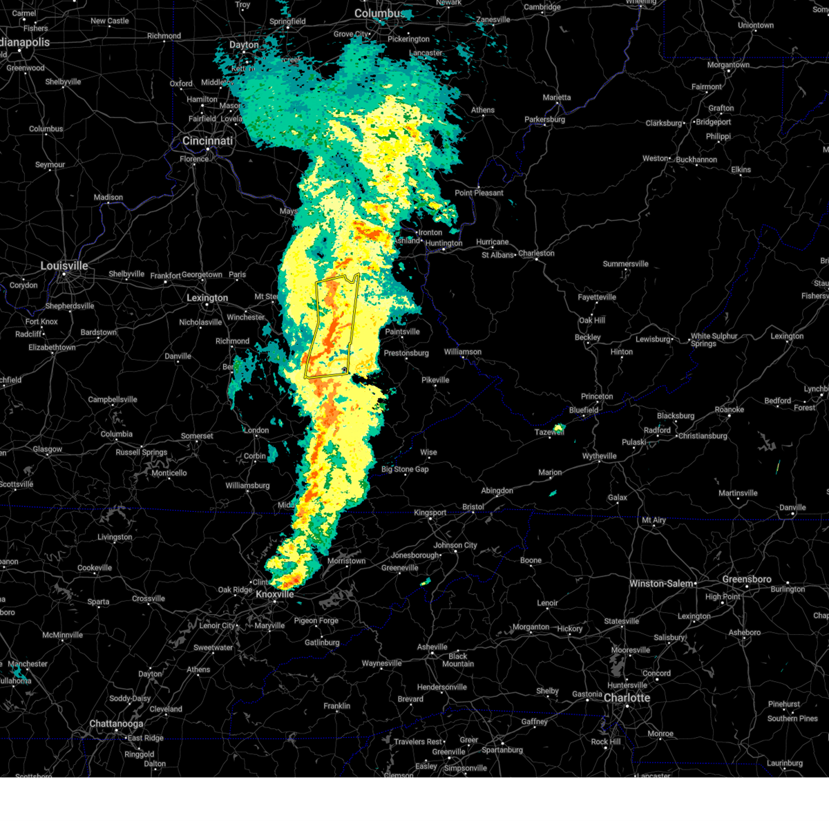
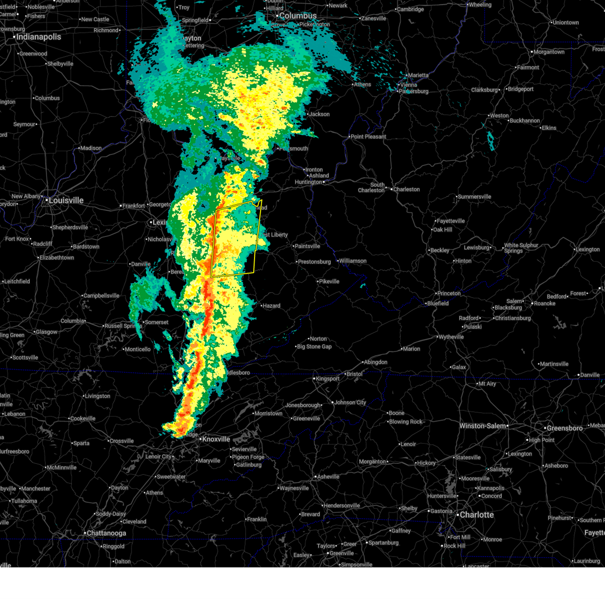
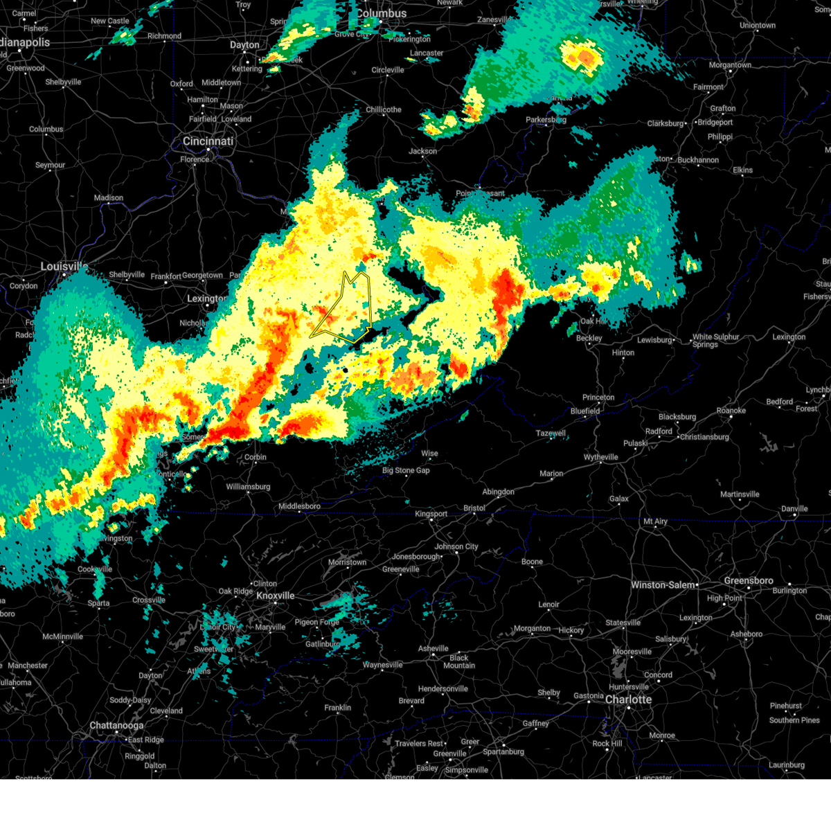
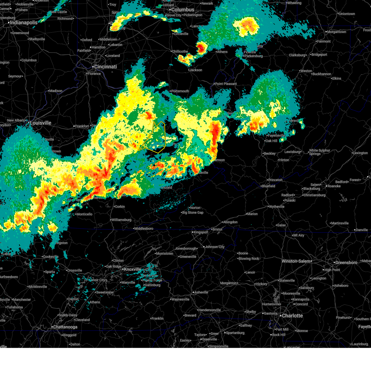
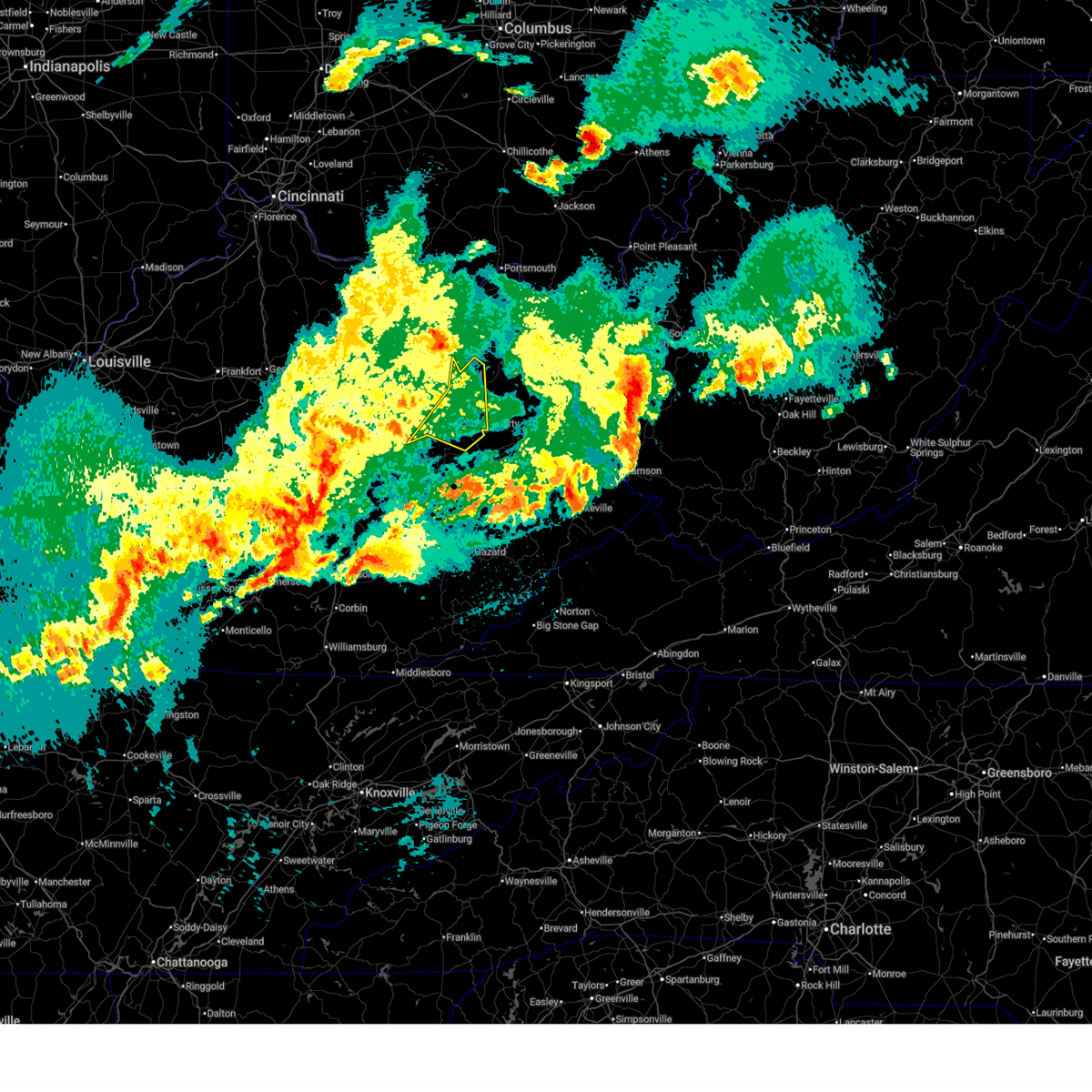
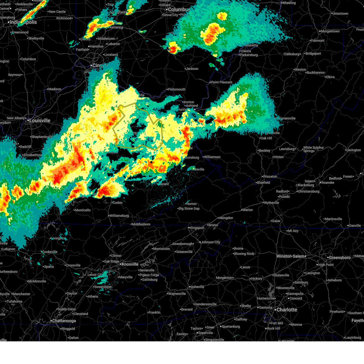
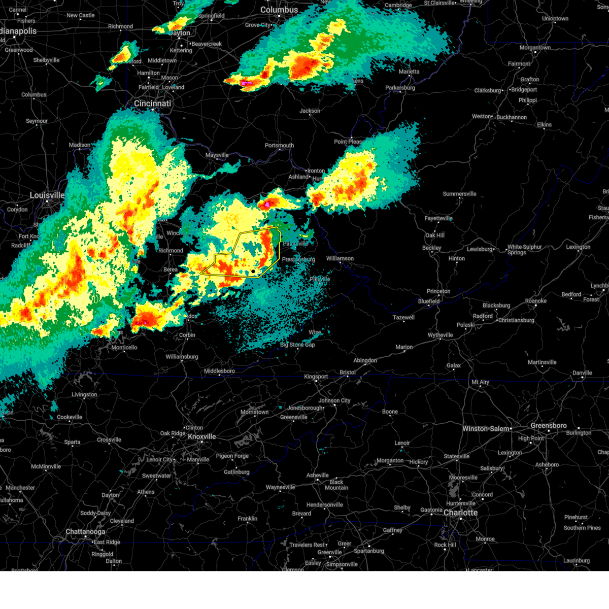
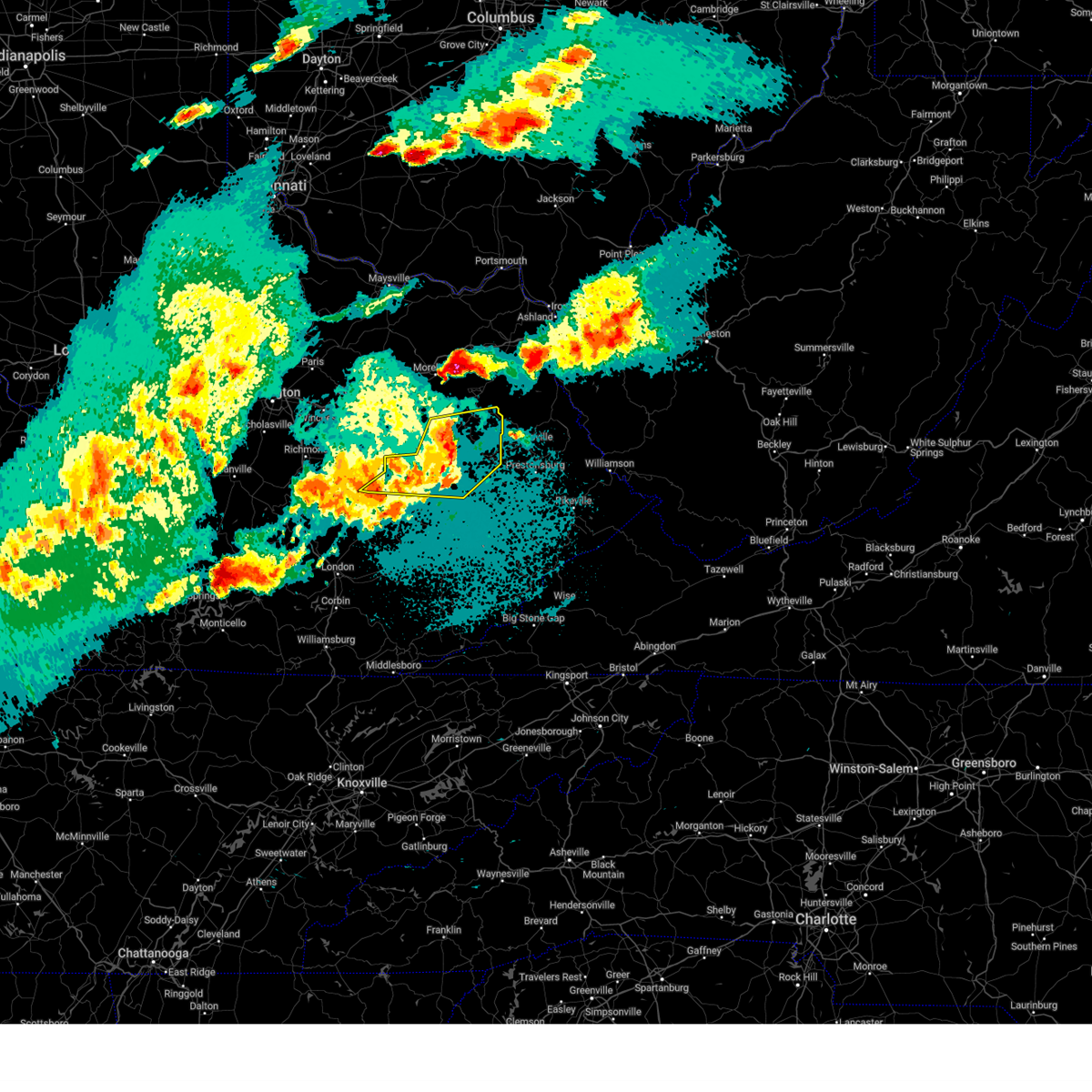
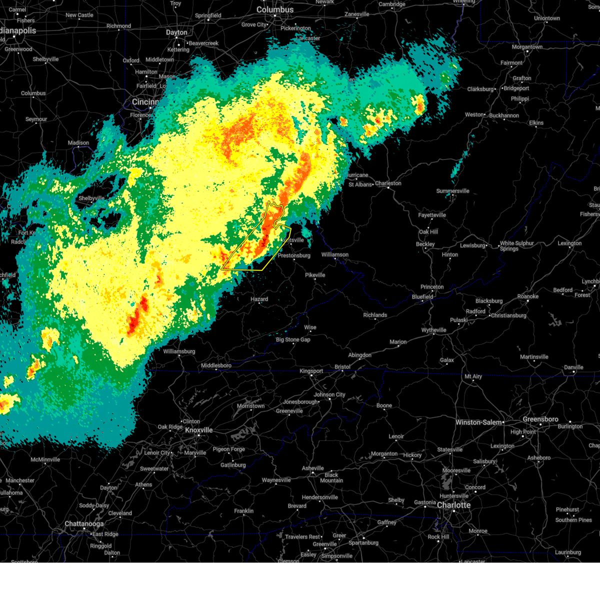
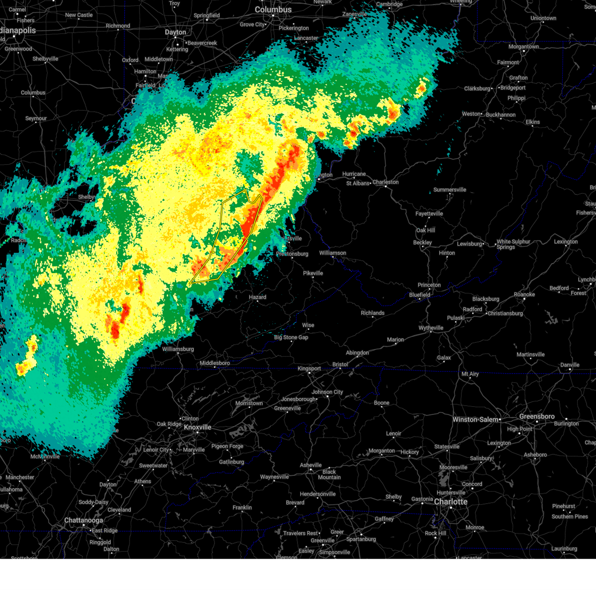
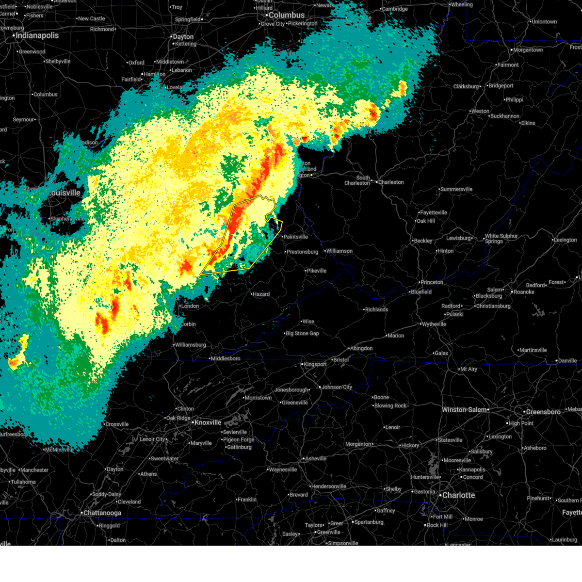
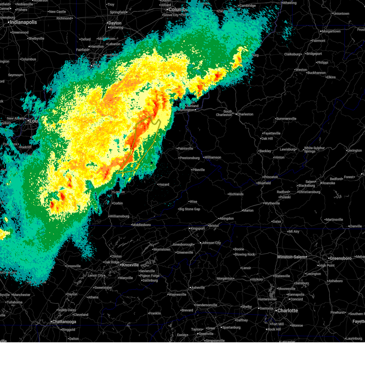
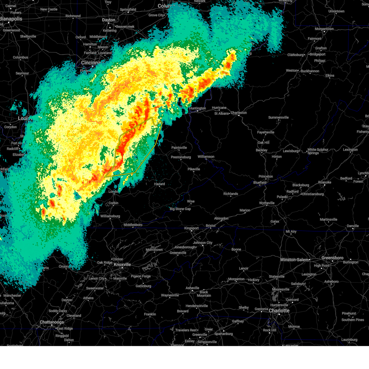
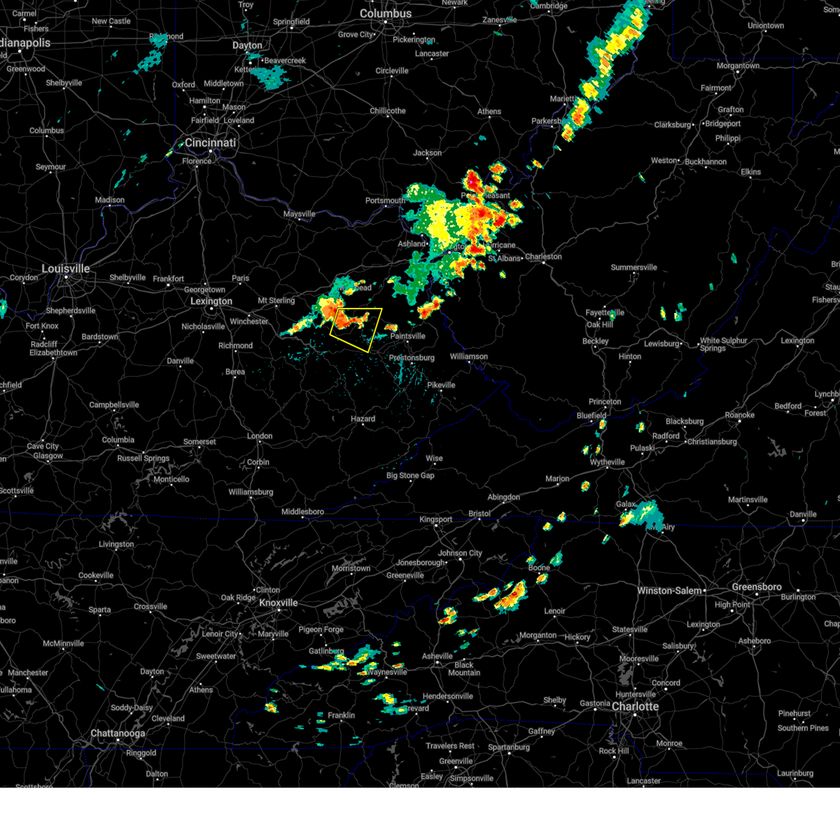
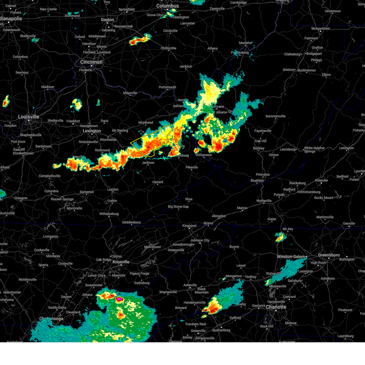
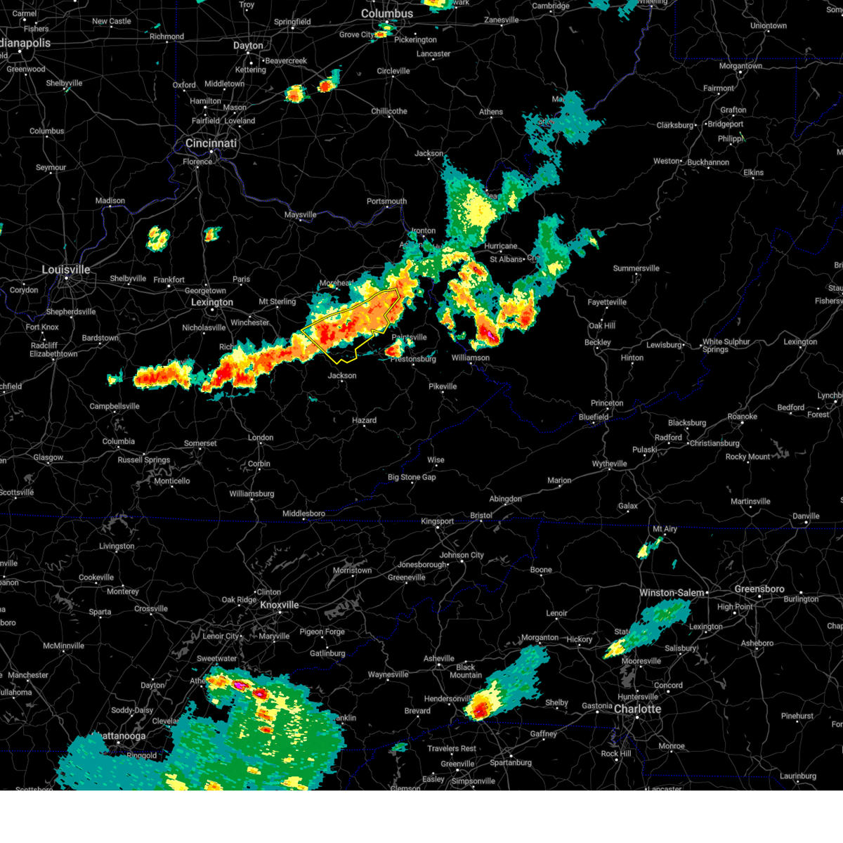
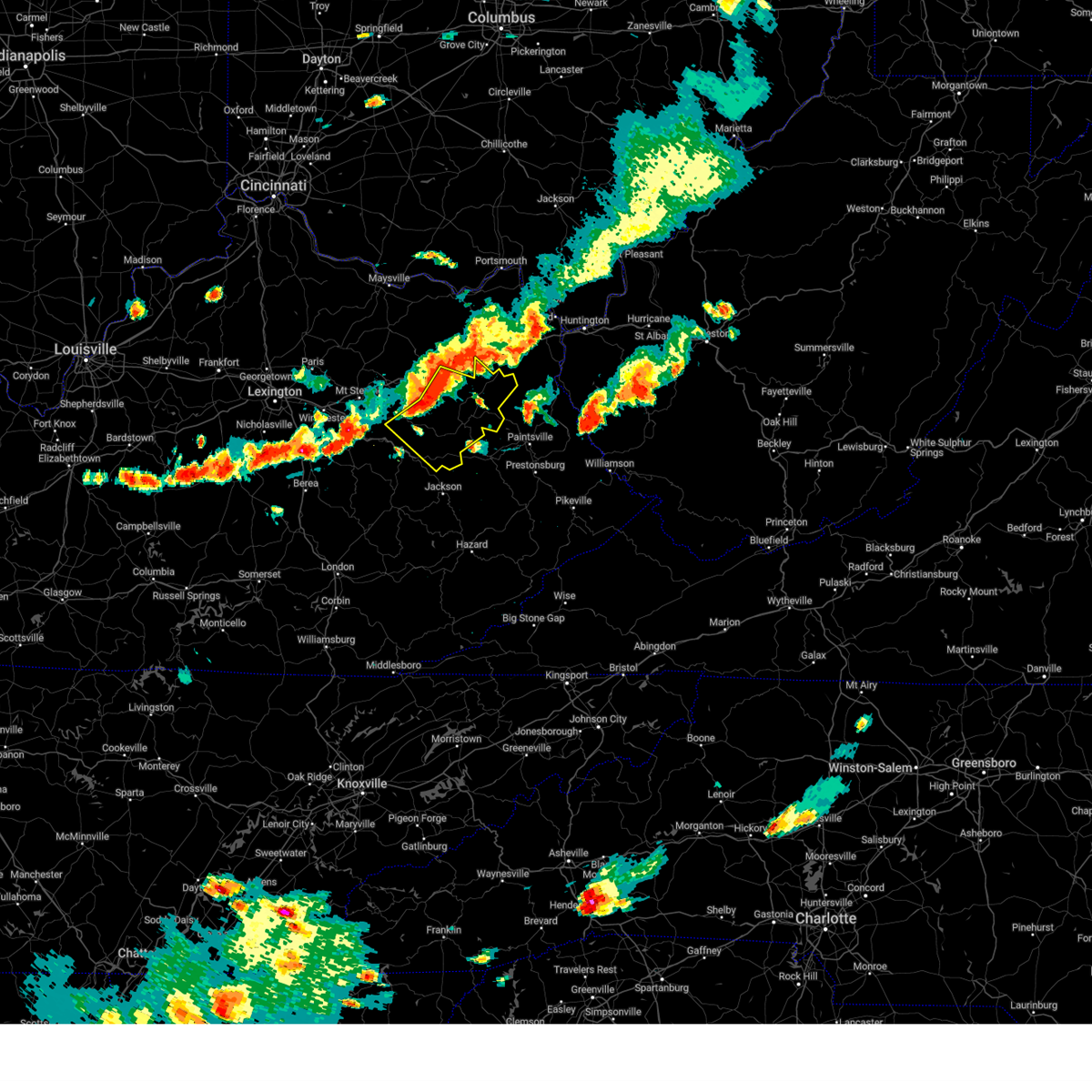
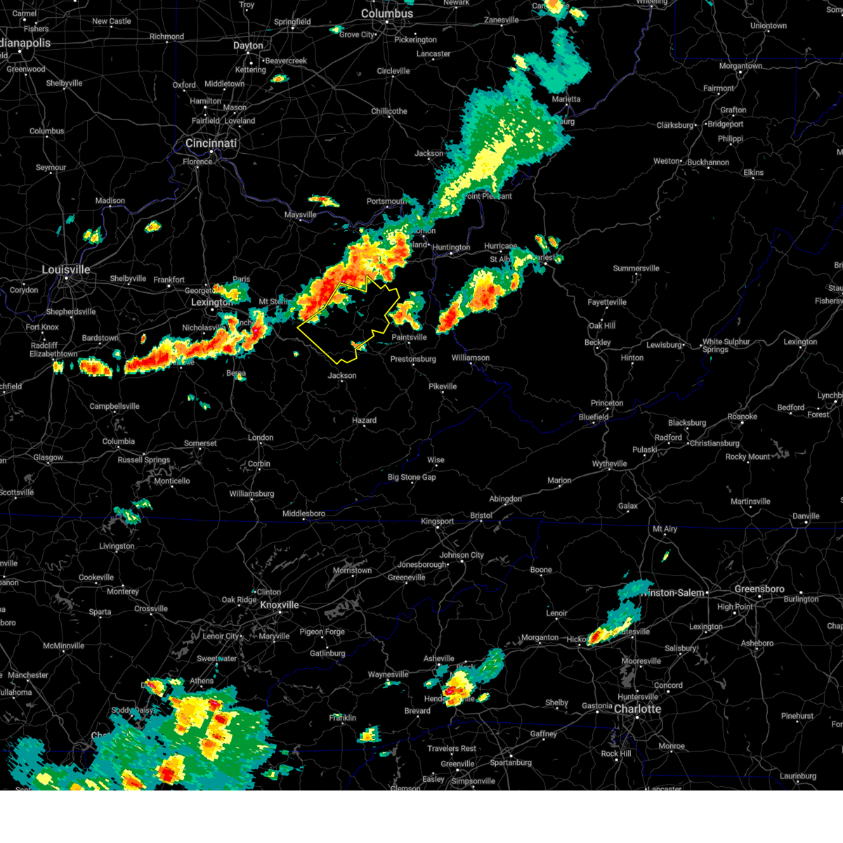
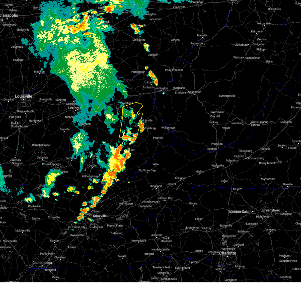
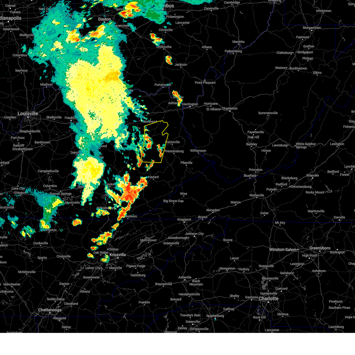
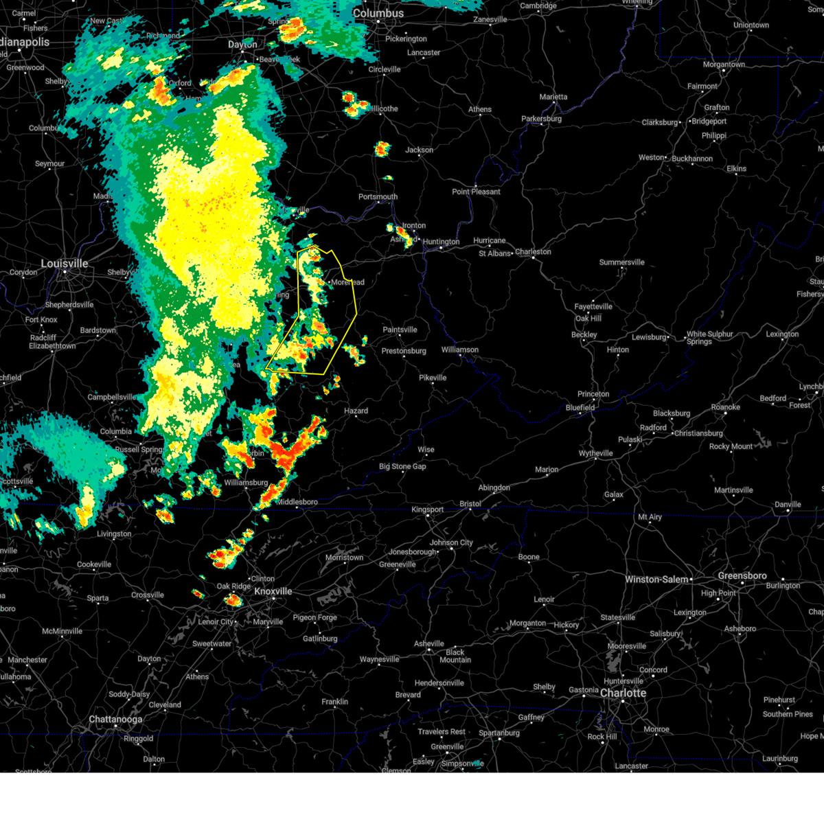
Hail Map for West Liberty, KY
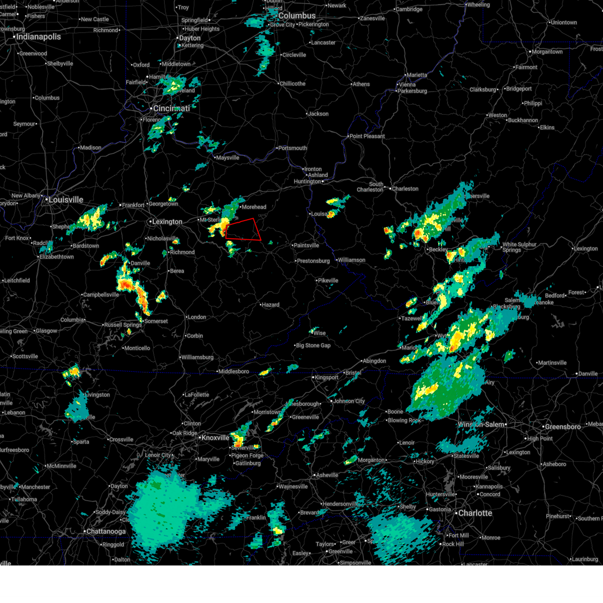
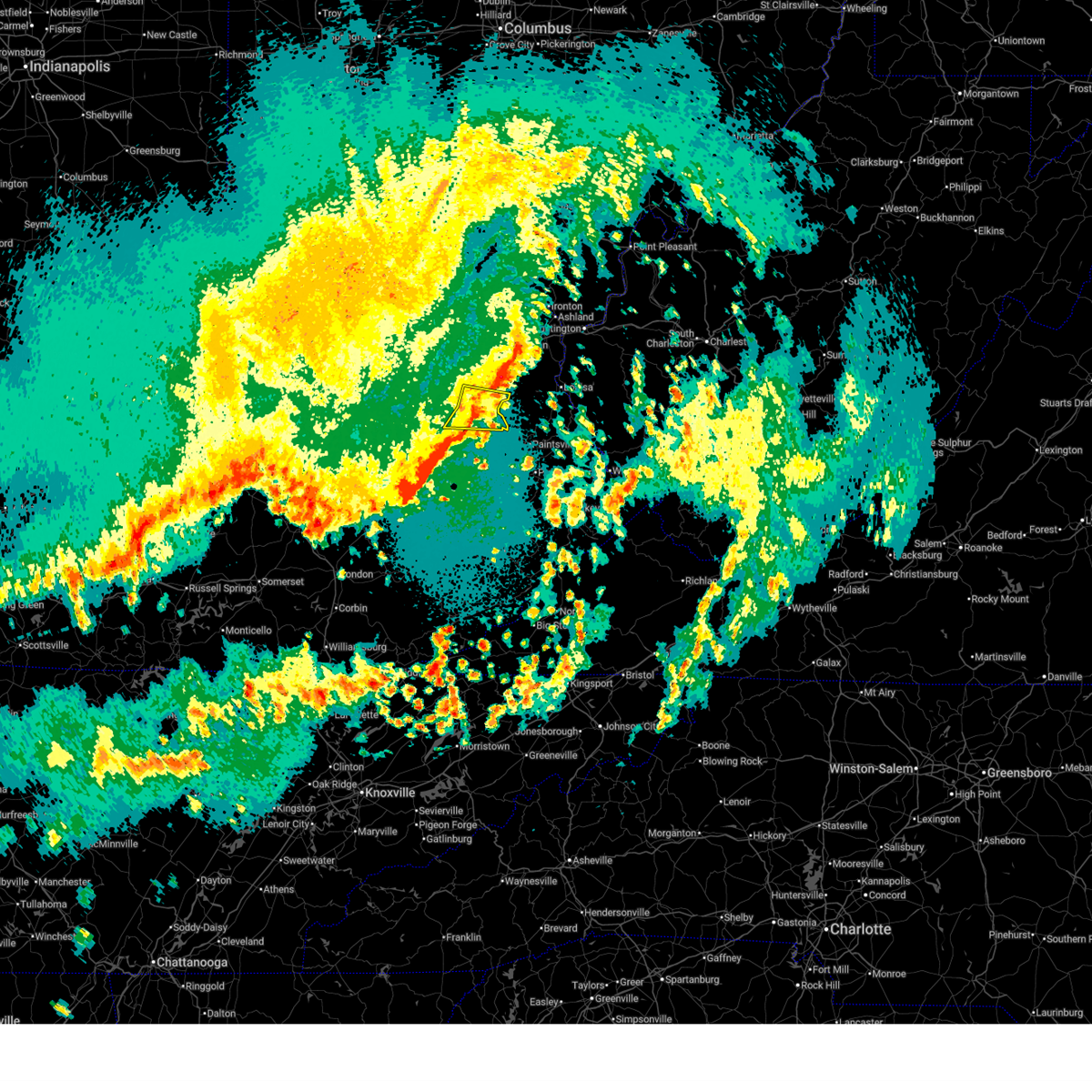
The West Liberty, KY area has had 23 reports of on-the-ground hail by trained spotters, and has been under severe weather warnings 20 times during the past 12 months. Doppler radar has detected hail at or near West Liberty, KY on 54 occasions, including 2 occasions during the past year.
| Name: | West Liberty, KY |
| Where Located: | 41.1 miles ENE of Irvine, KY |
| Map: | Google Map for West Liberty, KY |
| Population: | 3435 |
| Housing Units: | 777 |
| More Info: | Search Google for West Liberty, KY |
1
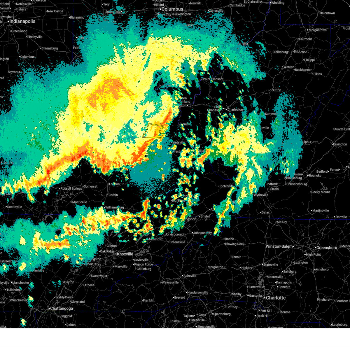
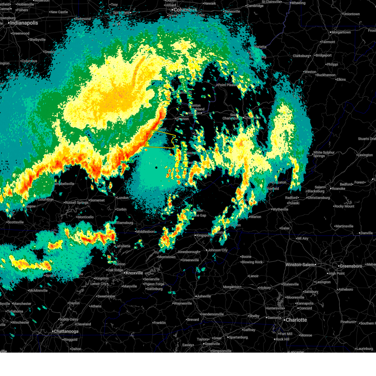
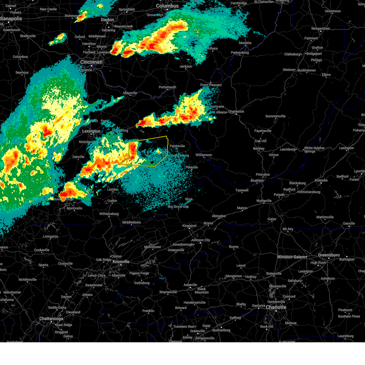
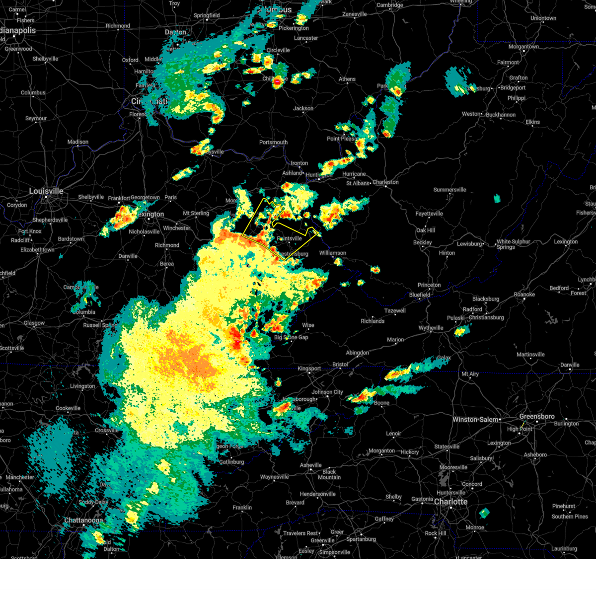
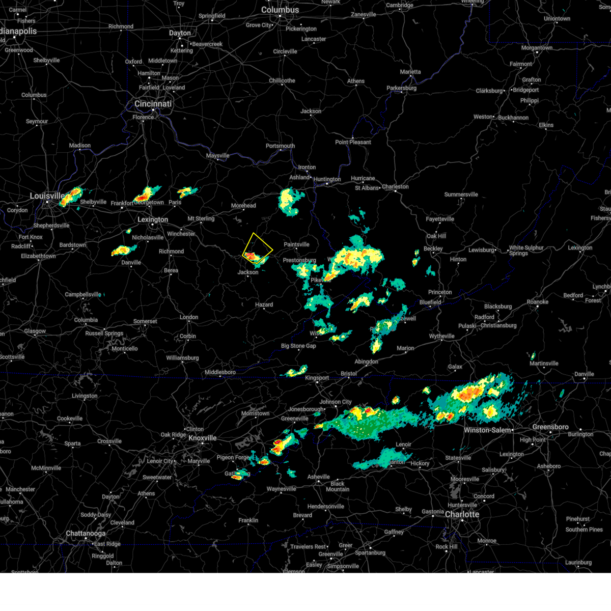
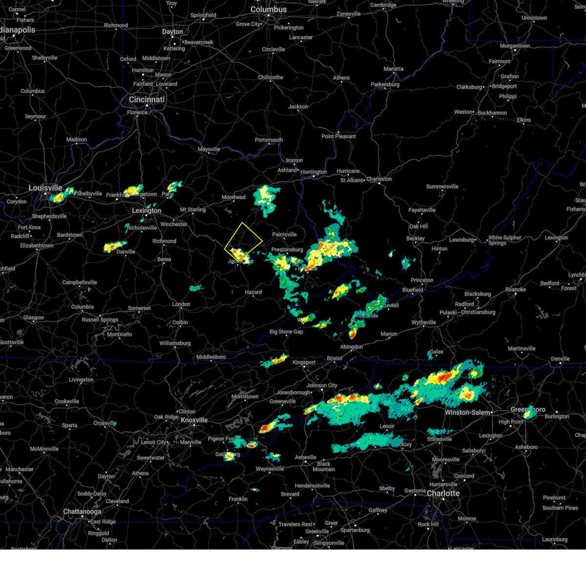
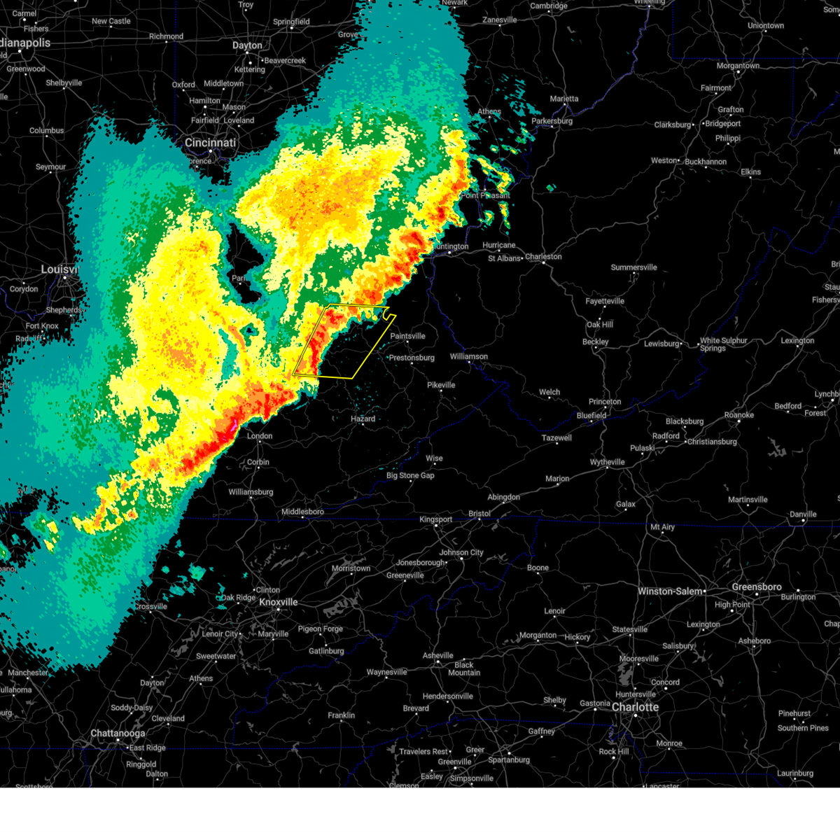
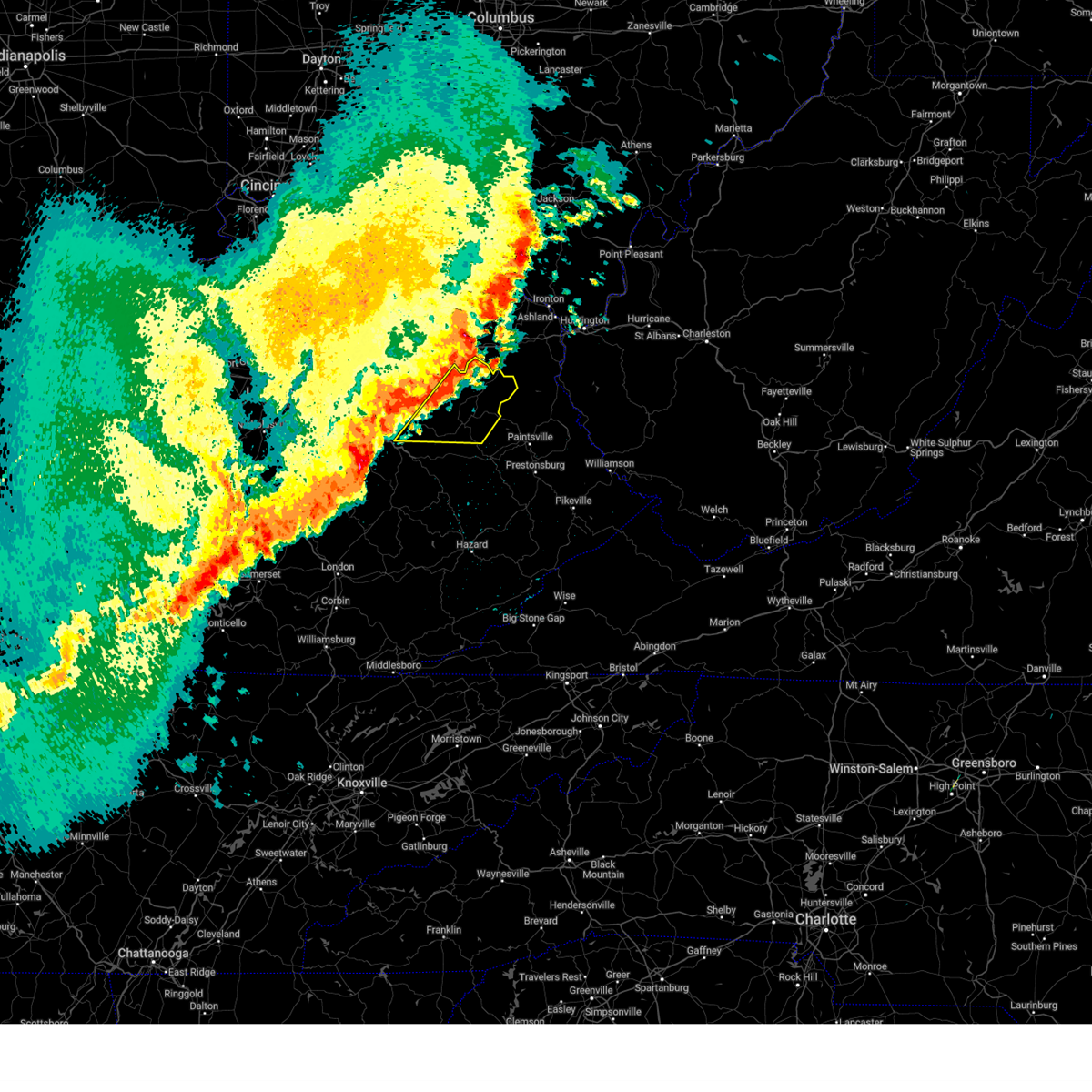
The Top Recent Hail Date for West Liberty, KY is Wednesday, April 1, 2026 (21st out of 54)
Hail and Wind Damage Spotted near West Liberty, KY
| Date / Time | Report Details |
|---|---|
| 5/26/2026 8:06 PM EDT |
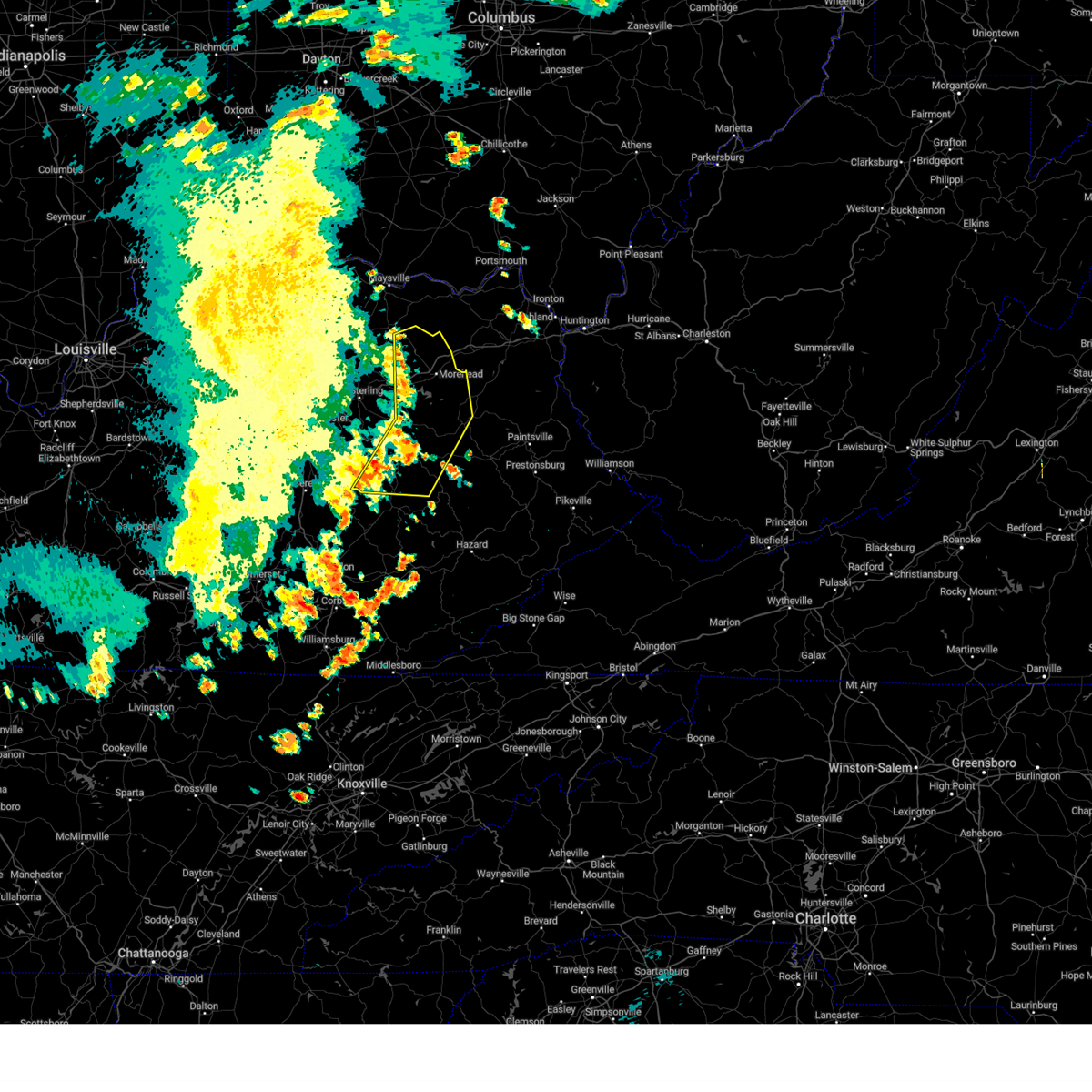
 Torjkl the national weather service in jackson ky has issued a * tornado warning for, northwestern morgan county in southeastern kentucky, northeastern menifee county in east central kentucky, * until 845 pm edt. * at 805 pm edt, a severe thunderstorm capable of producing a tornado was located over denniston, or near frenchburg, moving east at 20 mph (radar indicated rotation). Hazards include tornado. Flying debris will be dangerous to those caught without shelter. mobile homes will be damaged or destroyed. damage to roofs, windows, and vehicles will occur. tree damage is likely. this dangerous storm will be near, wellington around 810 pm edt. ezel around 815 pm edt. kellacey around 820 pm edt. twentysix around 825 pm edt. Other locations in the path of this tornadic thunderstorm include henry and new cummer. Torjkl the national weather service in jackson ky has issued a * tornado warning for, northwestern morgan county in southeastern kentucky, northeastern menifee county in east central kentucky, * until 845 pm edt. * at 805 pm edt, a severe thunderstorm capable of producing a tornado was located over denniston, or near frenchburg, moving east at 20 mph (radar indicated rotation). Hazards include tornado. Flying debris will be dangerous to those caught without shelter. mobile homes will be damaged or destroyed. damage to roofs, windows, and vehicles will occur. tree damage is likely. this dangerous storm will be near, wellington around 810 pm edt. ezel around 815 pm edt. kellacey around 820 pm edt. twentysix around 825 pm edt. Other locations in the path of this tornadic thunderstorm include henry and new cummer.
|
| 4/28/2026 3:17 AM EDT |
 The storm which prompted the warning has weakened below severe limits, and no longer poses an immediate threat to life or property. therefore, the warning has been allowed to expire. however, gusty winds are still possible with this thunderstorm. The storm which prompted the warning has weakened below severe limits, and no longer poses an immediate threat to life or property. therefore, the warning has been allowed to expire. however, gusty winds are still possible with this thunderstorm.
|
| 4/28/2026 3:08 AM EDT |
 At 307 am edt, a severe thunderstorm was located near isonville, or near sandy hook, moving east at 50 mph (radar indicated). Hazards include 60 mph wind gusts. Expect damage to roofs, siding, and trees. Locations impacted include, west liberty, sandy hook, henry, lenox, moon, lick branch, little sandy, liberty road, jeptha, wrigley, lytten, and elna. At 307 am edt, a severe thunderstorm was located near isonville, or near sandy hook, moving east at 50 mph (radar indicated). Hazards include 60 mph wind gusts. Expect damage to roofs, siding, and trees. Locations impacted include, west liberty, sandy hook, henry, lenox, moon, lick branch, little sandy, liberty road, jeptha, wrigley, lytten, and elna.
|
| 4/28/2026 2:53 AM EDT |
 the severe thunderstorm warning has been cancelled and is no longer in effect the severe thunderstorm warning has been cancelled and is no longer in effect
|
| 4/28/2026 2:53 AM EDT |
 At 252 am edt, a severe thunderstorm was located over leisure, or 9 miles northwest of west liberty, moving east at 50 mph (radar indicated). Hazards include 60 mph wind gusts and penny size hail. Expect damage to roofs, siding, and trees. Locations impacted include, little sandy, sandy hook and culver. At 252 am edt, a severe thunderstorm was located over leisure, or 9 miles northwest of west liberty, moving east at 50 mph (radar indicated). Hazards include 60 mph wind gusts and penny size hail. Expect damage to roofs, siding, and trees. Locations impacted include, little sandy, sandy hook and culver.
|
| 4/28/2026 2:36 AM EDT |
 Svrjkl the national weather service in jackson ky has issued a * severe thunderstorm warning for, morgan county in southeastern kentucky, southeastern bath county in east central kentucky, northern menifee county in east central kentucky, southern rowan county in east central kentucky, southern elliott county in east central kentucky, * until 315 am edt. * at 236 am edt, a severe thunderstorm was located over young springs, or near frenchburg, moving east at 50 mph (radar indicated). Hazards include 60 mph wind gusts and penny size hail. Expect damage to roofs, siding, and trees. this severe thunderstorm will be near, ratlitt around 240 am edt. big woods around 245 am edt. craney around 250 am edt. blairs mills around 255 am edt. Other locations in the path of this severe thunderstorm include little sandy and sandy hook. Svrjkl the national weather service in jackson ky has issued a * severe thunderstorm warning for, morgan county in southeastern kentucky, southeastern bath county in east central kentucky, northern menifee county in east central kentucky, southern rowan county in east central kentucky, southern elliott county in east central kentucky, * until 315 am edt. * at 236 am edt, a severe thunderstorm was located over young springs, or near frenchburg, moving east at 50 mph (radar indicated). Hazards include 60 mph wind gusts and penny size hail. Expect damage to roofs, siding, and trees. this severe thunderstorm will be near, ratlitt around 240 am edt. big woods around 245 am edt. craney around 250 am edt. blairs mills around 255 am edt. Other locations in the path of this severe thunderstorm include little sandy and sandy hook.
|
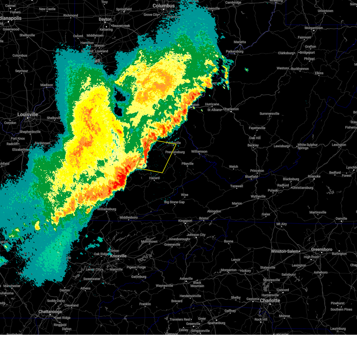
| 4/1/2026 4:50 PM EDT |
 The storm which prompted the original warning has moved out of the old warning area. therefore, that warning has been allowed to expire. a downstream severe thunderstorm warning has been issued for portions of morgan, johnson, and elliott counties until 515 pm edt. a severe thunderstorm watch remains in effect until 800 pm edt for southeastern, northeastern and east central kentucky. The storm which prompted the original warning has moved out of the old warning area. therefore, that warning has been allowed to expire. a downstream severe thunderstorm warning has been issued for portions of morgan, johnson, and elliott counties until 515 pm edt. a severe thunderstorm watch remains in effect until 800 pm edt for southeastern, northeastern and east central kentucky.
|
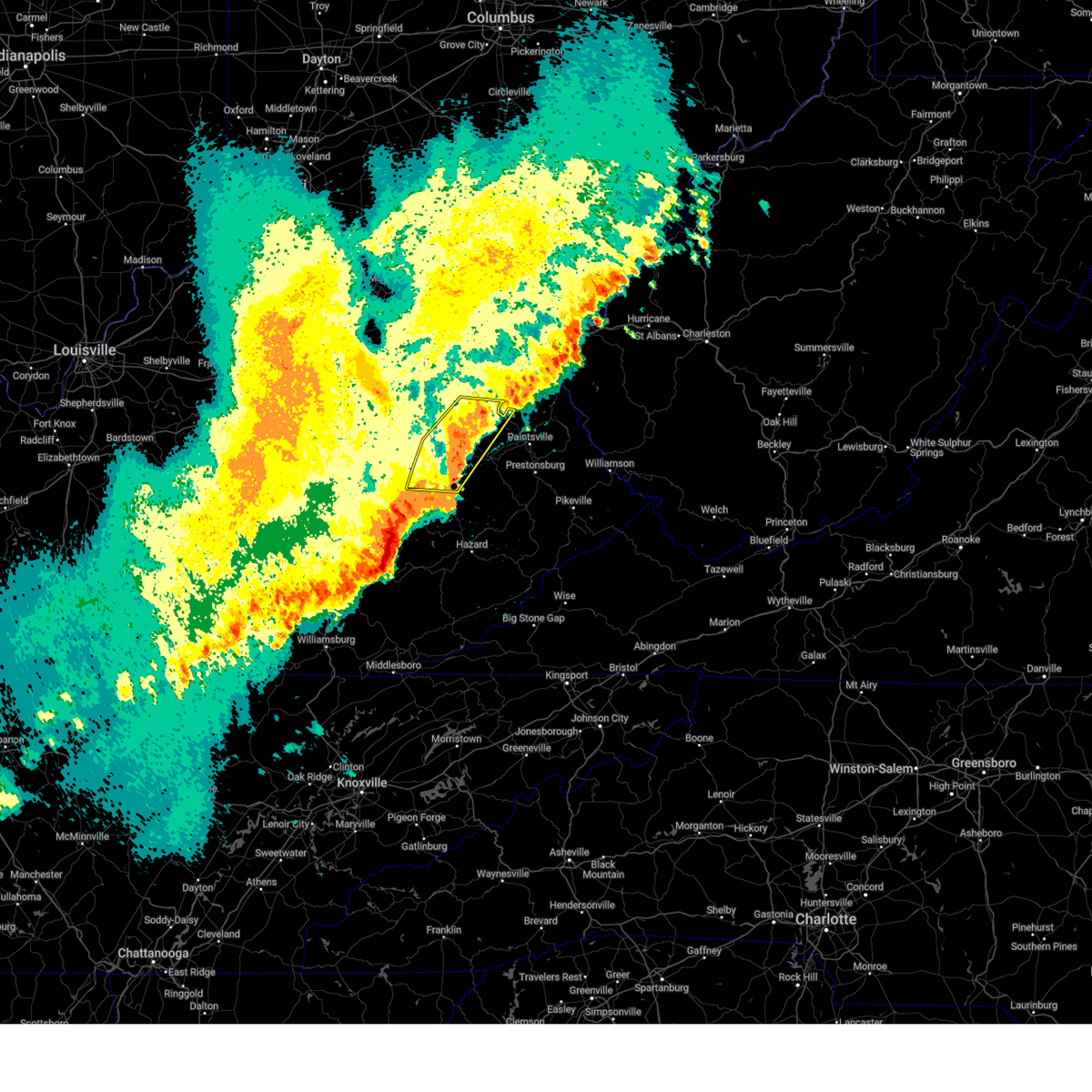
| 4/1/2026 4:49 PM EDT | Quarter sized hail reported 8.7 miles WSW of West Liberty, KY, social media video of lots of hail falling along ky-589... about 1.5 miles from its intersection with ky-172. the individual reports that the largest hail stones were q |
| 4/1/2026 4:36 PM EDT |
 the severe thunderstorm warning has been cancelled and is no longer in effect the severe thunderstorm warning has been cancelled and is no longer in effect
|
| 4/1/2026 4:36 PM EDT |
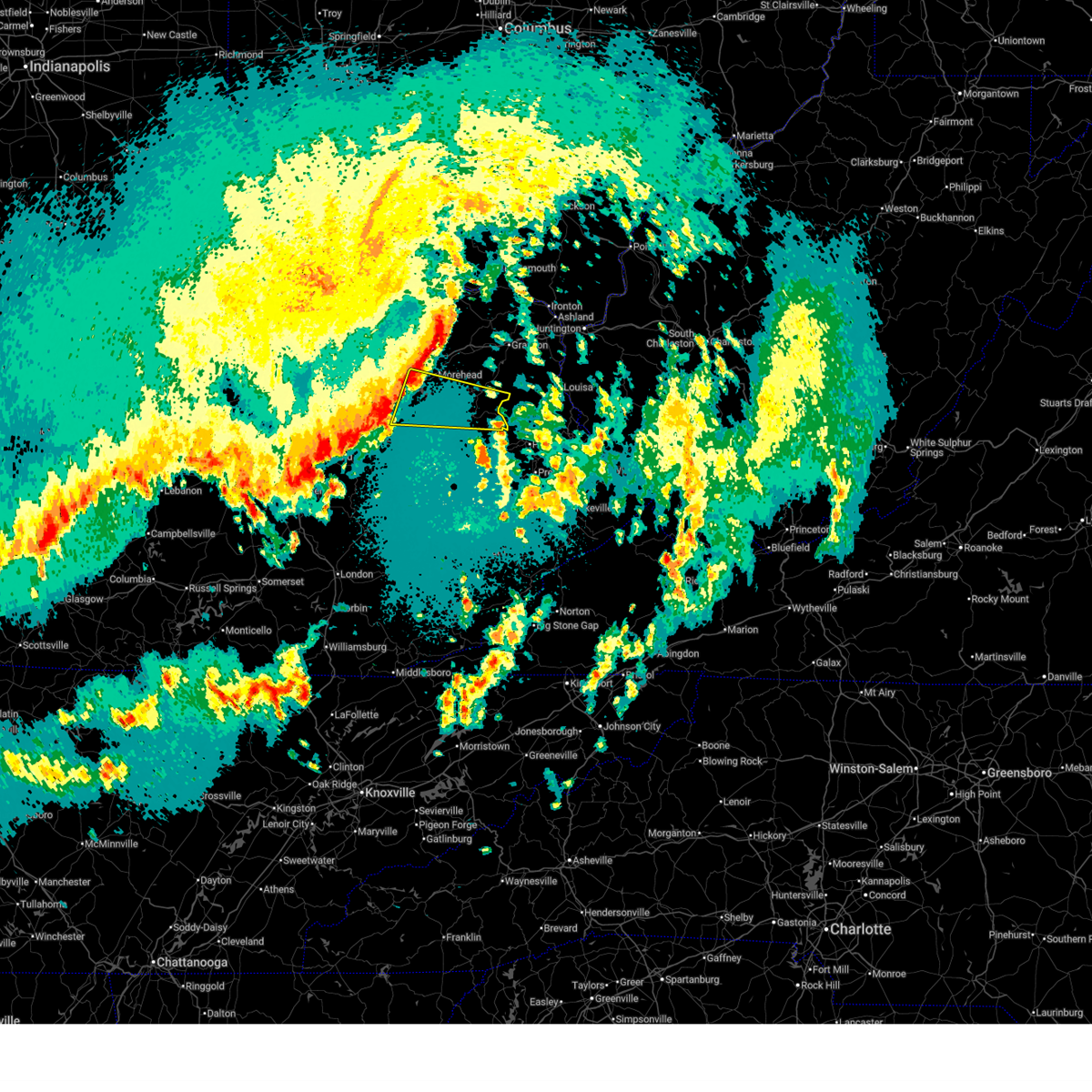
 At 436 pm edt, a severe thunderstorm was located over elamton, or near west liberty, moving east at 25 mph (radar indicated). Hazards include 60 mph wind gusts and quarter size hail. Hail damage to vehicles is expected. expect wind damage to roofs, siding, and trees. Locations impacted include, west liberty, lenox, malone, cottle, gordon ford, elamton, pomp, florress, moon, lick branch, index, and elkfork. At 436 pm edt, a severe thunderstorm was located over elamton, or near west liberty, moving east at 25 mph (radar indicated). Hazards include 60 mph wind gusts and quarter size hail. Hail damage to vehicles is expected. expect wind damage to roofs, siding, and trees. Locations impacted include, west liberty, lenox, malone, cottle, gordon ford, elamton, pomp, florress, moon, lick branch, index, and elkfork.
|
| 4/1/2026 4:29 PM EDT | Golf Ball sized hail reported 2.8 miles SSE of West Liberty, KY, social media user posted a video of hail and reported golf ball sized hailstones near the intersection of ky519 and ky7. time estimated by radar. |
| 4/1/2026 4:27 PM EDT | Ping Pong Ball sized hail reported 0.6 miles S of West Liberty, KY, social media user shared photo of hail stone and estimates ping pong size. hail was retrieved off of liberty rd near arh hospital. time estimated from radar. |
| 4/1/2026 4:27 PM EDT |
 At 427 pm edt, a severe thunderstorm was located over lick branch, or near west liberty, moving east at 25 mph (radar indicated). Hazards include golf ball size hail and 60 mph wind gusts. People and animals outdoors will be injured. expect hail damage to roofs, siding, windows, and vehicles. expect wind damage to roofs, siding, and trees. Locations impacted include, west liberty, sandy hook, henry, lenox, malone, zag, greear, mize, blairs mills, fannin valley, florress, and moon. At 427 pm edt, a severe thunderstorm was located over lick branch, or near west liberty, moving east at 25 mph (radar indicated). Hazards include golf ball size hail and 60 mph wind gusts. People and animals outdoors will be injured. expect hail damage to roofs, siding, windows, and vehicles. expect wind damage to roofs, siding, and trees. Locations impacted include, west liberty, sandy hook, henry, lenox, malone, zag, greear, mize, blairs mills, fannin valley, florress, and moon.
|
| 4/1/2026 4:20 PM EDT | Quarter sized hail reported 3 miles NE of West Liberty, KY, social media video shows pile of approximately quarter sized hail near west liberty. time estimated by radar. |
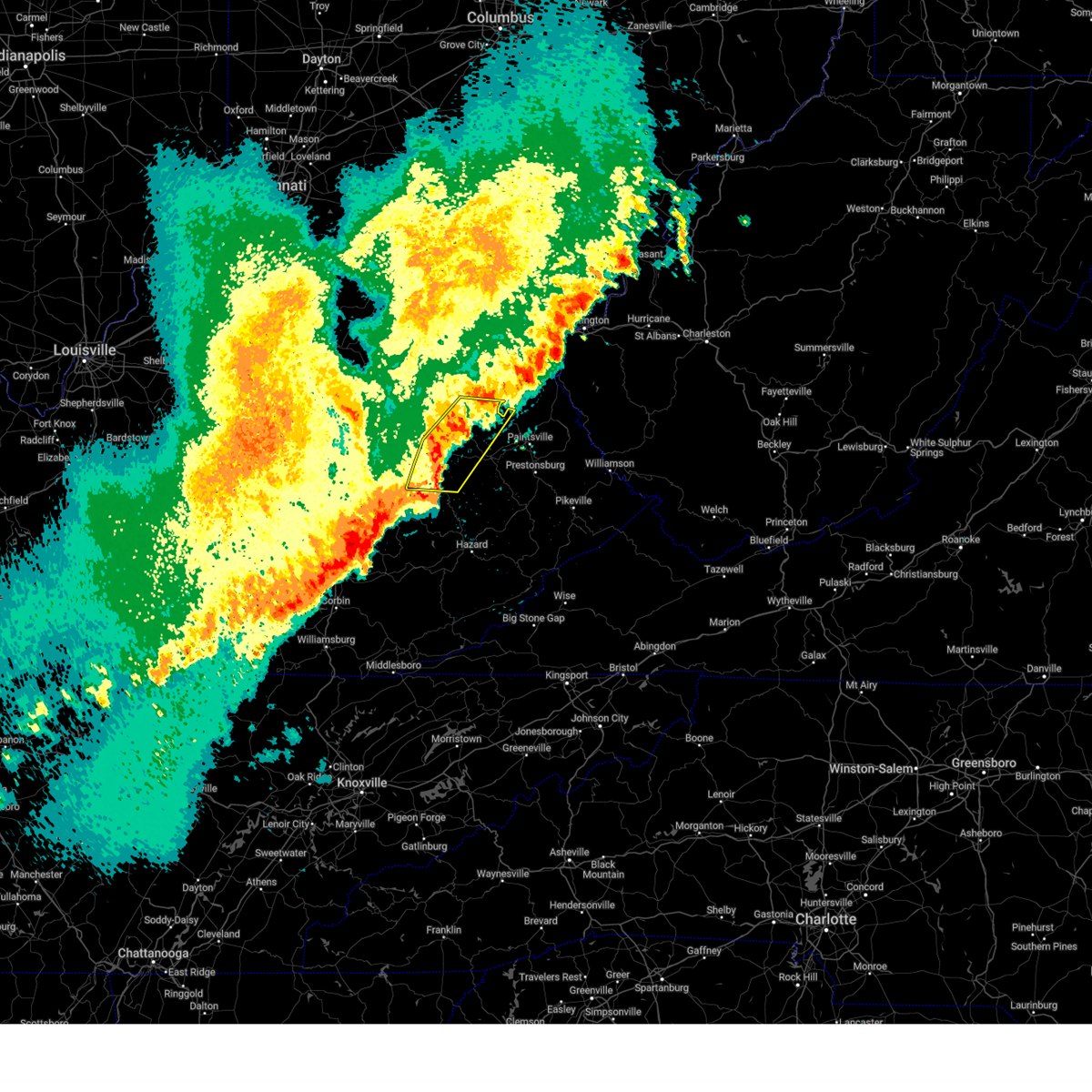
| 4/1/2026 4:15 PM EDT |
 Svrjkl the national weather service in jackson ky has issued a * severe thunderstorm warning for, morgan county in southeastern kentucky, northwestern johnson county in northeastern kentucky, southeastern rowan county in east central kentucky, southwestern elliott county in east central kentucky, * until 445 pm edt. * at 414 pm edt, a severe thunderstorm was located over pomp, or near west liberty, moving northeast at 30 mph (radar indicated). Hazards include 60 mph wind gusts and quarter size hail. Hail damage to vehicles is expected. expect wind damage to roofs, siding, and trees. this severe thunderstorm will be near, west liberty around 420 pm edt. elkfork around 430 pm edt. Other locations in the path of this severe thunderstorm include sandy hook. Svrjkl the national weather service in jackson ky has issued a * severe thunderstorm warning for, morgan county in southeastern kentucky, northwestern johnson county in northeastern kentucky, southeastern rowan county in east central kentucky, southwestern elliott county in east central kentucky, * until 445 pm edt. * at 414 pm edt, a severe thunderstorm was located over pomp, or near west liberty, moving northeast at 30 mph (radar indicated). Hazards include 60 mph wind gusts and quarter size hail. Hail damage to vehicles is expected. expect wind damage to roofs, siding, and trees. this severe thunderstorm will be near, west liberty around 420 pm edt. elkfork around 430 pm edt. Other locations in the path of this severe thunderstorm include sandy hook.
|
| 3/16/2026 3:52 AM EDT |
 The storms which prompted the warning have moved out of the area. therefore, the warning has been allowed to expire. however, gusty winds are still possible with these thunderstorms. a severe thunderstorm watch remains in effect until 700 am edt for southeastern and east central kentucky. to report severe weather, contact your nearest law enforcement agency. they will relay your report to the national weather service jackson ky. The storms which prompted the warning have moved out of the area. therefore, the warning has been allowed to expire. however, gusty winds are still possible with these thunderstorms. a severe thunderstorm watch remains in effect until 700 am edt for southeastern and east central kentucky. to report severe weather, contact your nearest law enforcement agency. they will relay your report to the national weather service jackson ky.
|
| 3/16/2026 3:00 AM EDT |
 Svrjkl the national weather service in jackson ky has issued a * severe thunderstorm warning for, southeastern powell county in east central kentucky, morgan county in southeastern kentucky, menifee county in east central kentucky, northwestern breathitt county in southeastern kentucky, northwestern magoffin county in southeastern kentucky, lee county in southeastern kentucky, rowan county in east central kentucky, wolfe county in southeastern kentucky, elliott county in east central kentucky, * until 345 am edt. * at 300 am edt, severe thunderstorms were located along a line extending from waltz to sturgeon, moving east at 60 mph (radar indicated). Hazards include 60 mph wind gusts. Expect damage to roofs, siding, and trees. severe thunderstorms will be near, morehead around 305 am edt. west liberty around 310 am edt. sandy hook around 315 am edt. Harper around 320 am edt. Svrjkl the national weather service in jackson ky has issued a * severe thunderstorm warning for, southeastern powell county in east central kentucky, morgan county in southeastern kentucky, menifee county in east central kentucky, northwestern breathitt county in southeastern kentucky, northwestern magoffin county in southeastern kentucky, lee county in southeastern kentucky, rowan county in east central kentucky, wolfe county in southeastern kentucky, elliott county in east central kentucky, * until 345 am edt. * at 300 am edt, severe thunderstorms were located along a line extending from waltz to sturgeon, moving east at 60 mph (radar indicated). Hazards include 60 mph wind gusts. Expect damage to roofs, siding, and trees. severe thunderstorms will be near, morehead around 305 am edt. west liberty around 310 am edt. sandy hook around 315 am edt. Harper around 320 am edt.
|
| 3/4/2026 10:08 AM EST |
 Torjkl the national weather service in jackson ky has issued a * tornado warning for, montgomery county in east central kentucky, mccreary county in south central kentucky, rowan county in east central kentucky, morgan county in southeastern kentucky, bath county in east central kentucky, leslie county in southeastern kentucky, estill county in east central kentucky, pulaski county in south central kentucky, rockcastle county in south central kentucky, clay county in southeastern kentucky, elliott county in east central kentucky, wayne county in south central kentucky, harlan county in southeastern kentucky, knox county in southeastern kentucky, owsley county in southeastern kentucky, jackson county in southeastern kentucky, knott county in southeastern kentucky, whitley county in south central kentucky, floyd county in southeastern kentucky, menifee county in east central kentucky, lee county in southeastern kentucky, fleming county in east central kentucky, wolfe county in southeastern kentucky, powell county in east central kentucky, laurel county in south central kentucky, martin county in northeastern kentucky, bell county in southeastern kentucky, letcher county in southeastern kentucky, johnson county in northeastern kentucky, perry county in southeastern kentucky, breathitt county in southeastern kentucky, pike county in southeastern kentucky, magoffin county in southeastern kentucky, * until 1030 am est. Torjkl the national weather service in jackson ky has issued a * tornado warning for, montgomery county in east central kentucky, mccreary county in south central kentucky, rowan county in east central kentucky, morgan county in southeastern kentucky, bath county in east central kentucky, leslie county in southeastern kentucky, estill county in east central kentucky, pulaski county in south central kentucky, rockcastle county in south central kentucky, clay county in southeastern kentucky, elliott county in east central kentucky, wayne county in south central kentucky, harlan county in southeastern kentucky, knox county in southeastern kentucky, owsley county in southeastern kentucky, jackson county in southeastern kentucky, knott county in southeastern kentucky, whitley county in south central kentucky, floyd county in southeastern kentucky, menifee county in east central kentucky, lee county in southeastern kentucky, fleming county in east central kentucky, wolfe county in southeastern kentucky, powell county in east central kentucky, laurel county in south central kentucky, martin county in northeastern kentucky, bell county in southeastern kentucky, letcher county in southeastern kentucky, johnson county in northeastern kentucky, perry county in southeastern kentucky, breathitt county in southeastern kentucky, pike county in southeastern kentucky, magoffin county in southeastern kentucky, * until 1030 am est.
|
| 9/22/2025 7:09 PM EDT | The storms which prompted the warning have weakened below severe limits, and were also exiting the warned area. therefore, the warning will be allowed to expire. however, gusty winds are still possible with these thunderstorms. |
| 9/22/2025 6:47 PM EDT | Several tree limbs and tree debris reported to have been blown down onto ky route 7 near the morgan county line. the event time is radar estimate in elliott county KY, 10 miles SSW of West Liberty, KY |
| 9/22/2025 6:35 PM EDT | the severe thunderstorm warning has been cancelled and is no longer in effect |
| 9/22/2025 6:35 PM EDT | At 633 pm edt, severe thunderstorms were located along a line extending from minor to near taulbee, moving northeast at 55 mph (radar indicated). Hazards include 60 mph wind gusts and penny size hail. Expect damage to roofs, siding, and trees. Locations impacted include, west liberty, jackson, beattyville, frenchburg, campton, booneville, simpson, henry, fincastle, wellington, turin, and zag. |
| 9/22/2025 6:31 PM EDT | Svrjkl the national weather service in jackson ky has issued a * severe thunderstorm warning for, morgan county in southeastern kentucky, western johnson county in northeastern kentucky, east central menifee county in east central kentucky, northern breathitt county in southeastern kentucky, magoffin county in southeastern kentucky, eastern wolfe county in southeastern kentucky, southern elliott county in east central kentucky, * until 715 pm edt. * at 631 pm edt, severe thunderstorms were located along a line extending from big woods to arnett, moving east at 40 mph (radar indicated). Hazards include 60 mph wind gusts. Expect damage to roofs, siding, and trees. severe thunderstorms will be near, jackson around 635 pm edt. west liberty around 640 pm edt. lewis around 645 pm edt. sandy hook around 650 pm edt. Other locations in the path of these severe thunderstorms include salyersville and mason. |
| 9/22/2025 6:09 PM EDT | At 608 pm edt, severe thunderstorms were located along a line extending from frenchburg to chestnut gap, moving northeast at 50 mph (radar indicated). Hazards include 60 mph wind gusts and penny size hail. Expect damage to roofs, siding, and trees. Locations impacted include, campton, jackson, west liberty and wrigley. |
| 9/22/2025 5:52 PM EDT | Svrjkl the national weather service in jackson ky has issued a * severe thunderstorm warning for, powell county in east central kentucky, western morgan county in southeastern kentucky, northern owsley county in southeastern kentucky, estill county in east central kentucky, jackson county in southeastern kentucky, southern menifee county in east central kentucky, northwestern breathitt county in southeastern kentucky, lee county in southeastern kentucky, wolfe county in southeastern kentucky, * until 645 pm edt. * at 551 pm edt, severe thunderstorms were located along a line extending from near stanton to herd, moving northeast at 50 mph (radar indicated). Hazards include 60 mph wind gusts and penny size hail. Expect damage to roofs, siding, and trees. severe thunderstorms will be near, stanton around 555 pm edt. frenchburg around 600 pm edt. campton around 605 pm edt. wellington around 610 pm edt. Other locations in the path of these severe thunderstorms include stillwater and jackson. |
| 5/20/2025 10:20 PM EDT |
 Svrjkl the national weather service in jackson ky has issued a * severe thunderstorm warning for, martin county in northeastern kentucky, morgan county in southeastern kentucky, johnson county in northeastern kentucky, northern perry county in southeastern kentucky, northern knott county in southeastern kentucky, floyd county in southeastern kentucky, breathitt county in southeastern kentucky, northwestern pike county in southeastern kentucky, magoffin county in southeastern kentucky, northeastern wolfe county in southeastern kentucky, * until 1115 pm edt. * at 1020 pm edt, severe thunderstorms were located along a line extending from pekin to lee city to haginsville to little, moving east at 45 mph (radar indicated). Hazards include 60 mph wind gusts. Expect damage to roofs, siding, and trees. severe thunderstorms will be near, west liberty around 1025 pm edt. salyersville around 1030 pm edt. mason around 1035 pm edt. crockett around 1040 pm edt. Other locations in the path of these severe thunderstorms include elna and paintsville. Svrjkl the national weather service in jackson ky has issued a * severe thunderstorm warning for, martin county in northeastern kentucky, morgan county in southeastern kentucky, johnson county in northeastern kentucky, northern perry county in southeastern kentucky, northern knott county in southeastern kentucky, floyd county in southeastern kentucky, breathitt county in southeastern kentucky, northwestern pike county in southeastern kentucky, magoffin county in southeastern kentucky, northeastern wolfe county in southeastern kentucky, * until 1115 pm edt. * at 1020 pm edt, severe thunderstorms were located along a line extending from pekin to lee city to haginsville to little, moving east at 45 mph (radar indicated). Hazards include 60 mph wind gusts. Expect damage to roofs, siding, and trees. severe thunderstorms will be near, west liberty around 1025 pm edt. salyersville around 1030 pm edt. mason around 1035 pm edt. crockett around 1040 pm edt. Other locations in the path of these severe thunderstorms include elna and paintsville.
|
| 5/20/2025 4:10 PM EDT |
 The storms which prompted the warning have moved out of the area. therefore, the warning will be allowed to expire. a tornado watch remains in effect until 800 pm edt for southeastern and east central kentucky. to report severe weather, contact your nearest law enforcement agency. they will relay your report to the national weather service jackson ky. The storms which prompted the warning have moved out of the area. therefore, the warning will be allowed to expire. a tornado watch remains in effect until 800 pm edt for southeastern and east central kentucky. to report severe weather, contact your nearest law enforcement agency. they will relay your report to the national weather service jackson ky.
|
| 5/20/2025 4:02 PM EDT | Large tree limbs reportedly broken off across from the ekcc entrance just south of west liberty. event time estimated from rada in morgan county KY, 0.1 miles NW of West Liberty, KY |
| 5/20/2025 4:00 PM EDT |
 Svrjkl the national weather service in jackson ky has issued a * severe thunderstorm warning for, morgan county in southeastern kentucky, western johnson county in northeastern kentucky, northwestern floyd county in southeastern kentucky, northeastern breathitt county in southeastern kentucky, magoffin county in southeastern kentucky, southeastern rowan county in east central kentucky, east central wolfe county in southeastern kentucky, elliott county in east central kentucky, * until 445 pm edt. * at 400 pm edt, severe thunderstorms were located along a line extending from vale to near keck, moving east at 30 mph (radar indicated). Hazards include 60 mph wind gusts and penny size hail. Expect damage to roofs, siding, and trees. severe thunderstorms will be near, west liberty around 405 pm edt. hendricks around 410 pm edt. salyersville around 415 pm edt. mason around 420 pm edt. Other locations in the path of these severe thunderstorms include elna and gapville. Svrjkl the national weather service in jackson ky has issued a * severe thunderstorm warning for, morgan county in southeastern kentucky, western johnson county in northeastern kentucky, northwestern floyd county in southeastern kentucky, northeastern breathitt county in southeastern kentucky, magoffin county in southeastern kentucky, southeastern rowan county in east central kentucky, east central wolfe county in southeastern kentucky, elliott county in east central kentucky, * until 445 pm edt. * at 400 pm edt, severe thunderstorms were located along a line extending from vale to near keck, moving east at 30 mph (radar indicated). Hazards include 60 mph wind gusts and penny size hail. Expect damage to roofs, siding, and trees. severe thunderstorms will be near, west liberty around 405 pm edt. hendricks around 410 pm edt. salyersville around 415 pm edt. mason around 420 pm edt. Other locations in the path of these severe thunderstorms include elna and gapville.
|
| 5/20/2025 3:48 PM EDT |
 At 347 pm edt, severe thunderstorms were located along a line extending from cranston to omer to landsaw to oakdale, moving east at 40 mph (radar indicated). Hazards include 60 mph wind gusts and penny size hail. Expect damage to roofs, siding, and trees. these severe storms will be near, west liberty around 355 pm edt. haginsville around 400 pm edt. Other locations impacted by these severe thunderstorms include lakeview heights. At 347 pm edt, severe thunderstorms were located along a line extending from cranston to omer to landsaw to oakdale, moving east at 40 mph (radar indicated). Hazards include 60 mph wind gusts and penny size hail. Expect damage to roofs, siding, and trees. these severe storms will be near, west liberty around 355 pm edt. haginsville around 400 pm edt. Other locations impacted by these severe thunderstorms include lakeview heights.
|
| 5/20/2025 3:48 PM EDT |
 the severe thunderstorm warning has been cancelled and is no longer in effect the severe thunderstorm warning has been cancelled and is no longer in effect
|
| 5/20/2025 3:24 PM EDT |
 Svrjkl the national weather service in jackson ky has issued a * severe thunderstorm warning for, eastern powell county in east central kentucky, southeastern bath county in east central kentucky, morgan county in southeastern kentucky, east central estill county in east central kentucky, menifee county in east central kentucky, northwestern breathitt county in southeastern kentucky, lee county in southeastern kentucky, southern rowan county in east central kentucky, wolfe county in southeastern kentucky, northwestern elliott county in east central kentucky, * until 415 pm edt. * at 323 pm edt, severe thunderstorms were located along a line extending from polksville to white ash, moving east at 35 mph (radar indicated). Hazards include 60 mph wind gusts and penny size hail. Expect damage to roofs, siding, and trees. severe thunderstorms will be near, morehead around 330 pm edt. wellington around 335 pm edt. murphyfork around 340 pm edt. craney around 345 pm edt. simpson around 350 pm edt. west liberty around 355 pm edt. Other locations impacted by these severe thunderstorms include lakeview heights. Svrjkl the national weather service in jackson ky has issued a * severe thunderstorm warning for, eastern powell county in east central kentucky, southeastern bath county in east central kentucky, morgan county in southeastern kentucky, east central estill county in east central kentucky, menifee county in east central kentucky, northwestern breathitt county in southeastern kentucky, lee county in southeastern kentucky, southern rowan county in east central kentucky, wolfe county in southeastern kentucky, northwestern elliott county in east central kentucky, * until 415 pm edt. * at 323 pm edt, severe thunderstorms were located along a line extending from polksville to white ash, moving east at 35 mph (radar indicated). Hazards include 60 mph wind gusts and penny size hail. Expect damage to roofs, siding, and trees. severe thunderstorms will be near, morehead around 330 pm edt. wellington around 335 pm edt. murphyfork around 340 pm edt. craney around 345 pm edt. simpson around 350 pm edt. west liberty around 355 pm edt. Other locations impacted by these severe thunderstorms include lakeview heights.
|
| 5/17/2025 12:10 AM EDT |
 The storms which prompted the warning have weakened below severe limits, and have exited the warned area. therefore, the warning will be allowed to expire. however, gusty winds are still possible with these thunderstorms. a tornado watch remains in effect until 300 am edt for southeastern and east central kentucky. to report severe weather, contact your nearest law enforcement agency. they will relay your report to the national weather service jackson ky. The storms which prompted the warning have weakened below severe limits, and have exited the warned area. therefore, the warning will be allowed to expire. however, gusty winds are still possible with these thunderstorms. a tornado watch remains in effect until 300 am edt for southeastern and east central kentucky. to report severe weather, contact your nearest law enforcement agency. they will relay your report to the national weather service jackson ky.
|
| 5/16/2025 11:59 PM EDT |
 At 1159 pm edt, severe thunderstorms were located along a line extending from 6 miles east of vanceburg to blairs mills to near valeria, moving east at 65 mph (radar indicated). Hazards include 60 mph wind gusts and nickel size hail. Expect damage to roofs, siding, and trees. Locations impacted include, west liberty and lewis. At 1159 pm edt, severe thunderstorms were located along a line extending from 6 miles east of vanceburg to blairs mills to near valeria, moving east at 65 mph (radar indicated). Hazards include 60 mph wind gusts and nickel size hail. Expect damage to roofs, siding, and trees. Locations impacted include, west liberty and lewis.
|
| 5/16/2025 11:59 PM EDT |
 the severe thunderstorm warning has been cancelled and is no longer in effect the severe thunderstorm warning has been cancelled and is no longer in effect
|
| 5/16/2025 11:25 PM EDT |
 Svrjkl the national weather service in jackson ky has issued a * severe thunderstorm warning for, northern powell county in east central kentucky, montgomery county in east central kentucky, bath county in east central kentucky, morgan county in southeastern kentucky, menifee county in east central kentucky, fleming county in east central kentucky, rowan county in east central kentucky, western elliott county in east central kentucky, * until 1215 am edt. * at 1125 pm edt, severe thunderstorms were located along a line extending from near washington to judy to 6 miles northwest of harris ferry, moving east at 65 mph (radar indicated). Hazards include 60 mph wind gusts and nickel size hail. Expect damage to roofs, siding, and trees. severe thunderstorms will be near, mount sterling around 1130 pm edt. stanton around 1135 pm edt. frenchburg around 1140 pm edt. morehead around 1145 pm edt. Other locations in the path of these severe thunderstorms include wellington and farley. Svrjkl the national weather service in jackson ky has issued a * severe thunderstorm warning for, northern powell county in east central kentucky, montgomery county in east central kentucky, bath county in east central kentucky, morgan county in southeastern kentucky, menifee county in east central kentucky, fleming county in east central kentucky, rowan county in east central kentucky, western elliott county in east central kentucky, * until 1215 am edt. * at 1125 pm edt, severe thunderstorms were located along a line extending from near washington to judy to 6 miles northwest of harris ferry, moving east at 65 mph (radar indicated). Hazards include 60 mph wind gusts and nickel size hail. Expect damage to roofs, siding, and trees. severe thunderstorms will be near, mount sterling around 1130 pm edt. stanton around 1135 pm edt. frenchburg around 1140 pm edt. morehead around 1145 pm edt. Other locations in the path of these severe thunderstorms include wellington and farley.
|
| 5/16/2025 10:54 PM EDT |
 The storms which prompted the warning have moved out of the area. therefore, the warning will be allowed to expire. a new warning was issued. a tornado watch remains in effect until 300 am edt for southeastern, northeastern and east central kentucky. The storms which prompted the warning have moved out of the area. therefore, the warning will be allowed to expire. a new warning was issued. a tornado watch remains in effect until 300 am edt for southeastern, northeastern and east central kentucky.
|
| 5/16/2025 10:40 PM EDT |
 At 1040 pm edt, severe thunderstorms were located along a line extending from licking river to shockey to canyon falls, moving east at 70 mph (radar indicated). Hazards include 70 mph wind gusts and quarter size hail. Hail damage to vehicles is expected. expect considerable tree damage. wind damage is also likely to mobile homes, roofs, and outbuildings. these severe storms will be near, west liberty around 1045 pm edt. Other locations in the path of these severe thunderstorms include salyersville and sikes. At 1040 pm edt, severe thunderstorms were located along a line extending from licking river to shockey to canyon falls, moving east at 70 mph (radar indicated). Hazards include 70 mph wind gusts and quarter size hail. Hail damage to vehicles is expected. expect considerable tree damage. wind damage is also likely to mobile homes, roofs, and outbuildings. these severe storms will be near, west liberty around 1045 pm edt. Other locations in the path of these severe thunderstorms include salyersville and sikes.
|
| 5/16/2025 10:25 PM EDT |
 Svrjkl the national weather service in jackson ky has issued a * severe thunderstorm warning for, eastern powell county in east central kentucky, morgan county in southeastern kentucky, southeastern estill county in east central kentucky, southern menifee county in east central kentucky, northwestern breathitt county in southeastern kentucky, magoffin county in southeastern kentucky, lee county in southeastern kentucky, wolfe county in southeastern kentucky, * until 1100 pm edt. * at 1025 pm edt, severe thunderstorms were located along a line extending from mariba to booth to near yellow rock, moving east at 70 mph (radar indicated). Hazards include 70 mph wind gusts and quarter size hail. Hail damage to vehicles is expected. expect considerable tree damage. wind damage is also likely to mobile homes, roofs, and outbuildings. severe thunderstorms will be near, beattyville around 1030 pm edt. west liberty around 1035 pm edt. jackson around 1040 pm edt. salyersville around 1045 pm edt. Other locations in the path of these severe thunderstorms include cyrus. Svrjkl the national weather service in jackson ky has issued a * severe thunderstorm warning for, eastern powell county in east central kentucky, morgan county in southeastern kentucky, southeastern estill county in east central kentucky, southern menifee county in east central kentucky, northwestern breathitt county in southeastern kentucky, magoffin county in southeastern kentucky, lee county in southeastern kentucky, wolfe county in southeastern kentucky, * until 1100 pm edt. * at 1025 pm edt, severe thunderstorms were located along a line extending from mariba to booth to near yellow rock, moving east at 70 mph (radar indicated). Hazards include 70 mph wind gusts and quarter size hail. Hail damage to vehicles is expected. expect considerable tree damage. wind damage is also likely to mobile homes, roofs, and outbuildings. severe thunderstorms will be near, beattyville around 1030 pm edt. west liberty around 1035 pm edt. jackson around 1040 pm edt. salyersville around 1045 pm edt. Other locations in the path of these severe thunderstorms include cyrus.
|
| 5/2/2025 7:20 PM EDT |
 At 718 pm edt, severe thunderstorms were located along a line extending from lick branch to lacey to denver, moving northeast at 35 mph (public reported uprooted trees with this line of storms). Hazards include 60 mph wind gusts and penny size hail. Expect damage to roofs, siding, and trees. these severe storms will be near, steele around 725 pm edt. Other locations in the path of these severe thunderstorms include sandy hook, culver and bruin. At 718 pm edt, severe thunderstorms were located along a line extending from lick branch to lacey to denver, moving northeast at 35 mph (public reported uprooted trees with this line of storms). Hazards include 60 mph wind gusts and penny size hail. Expect damage to roofs, siding, and trees. these severe storms will be near, steele around 725 pm edt. Other locations in the path of these severe thunderstorms include sandy hook, culver and bruin.
|
| 5/2/2025 7:08 PM EDT |
 Svrjkl the national weather service in jackson ky has issued a * severe thunderstorm warning for, northwestern martin county in northeastern kentucky, central morgan county in southeastern kentucky, johnson county in northeastern kentucky, northwestern floyd county in southeastern kentucky, northern magoffin county in southeastern kentucky, elliott county in east central kentucky, * until 745 pm edt. * at 708 pm edt, severe thunderstorms were located along a line extending from liberty road to plutarch to swamp branch, moving northeast at 35 mph (radar indicated). Hazards include 60 mph wind gusts and penny size hail. Expect damage to roofs, siding, and trees. severe thunderstorms will be near, win around 715 pm edt. stambaugh around 720 pm edt. sandy hook around 725 pm edt. Other locations in the path of these severe thunderstorms include culver. Svrjkl the national weather service in jackson ky has issued a * severe thunderstorm warning for, northwestern martin county in northeastern kentucky, central morgan county in southeastern kentucky, johnson county in northeastern kentucky, northwestern floyd county in southeastern kentucky, northern magoffin county in southeastern kentucky, elliott county in east central kentucky, * until 745 pm edt. * at 708 pm edt, severe thunderstorms were located along a line extending from liberty road to plutarch to swamp branch, moving northeast at 35 mph (radar indicated). Hazards include 60 mph wind gusts and penny size hail. Expect damage to roofs, siding, and trees. severe thunderstorms will be near, win around 715 pm edt. stambaugh around 720 pm edt. sandy hook around 725 pm edt. Other locations in the path of these severe thunderstorms include culver.
|
| 4/30/2025 6:26 PM EDT |
 The storm which prompted the warning has weakened below severe limits, and no longer poses an immediate threat to life or property. therefore, the warning will be allowed to expire. however, small hail and gusty winds are still possible with this thunderstorm. to report severe weather, contact your nearest law enforcement agency. they will relay your report to the national weather service jackson ky. The storm which prompted the warning has weakened below severe limits, and no longer poses an immediate threat to life or property. therefore, the warning will be allowed to expire. however, small hail and gusty winds are still possible with this thunderstorm. to report severe weather, contact your nearest law enforcement agency. they will relay your report to the national weather service jackson ky.
|
| 4/30/2025 6:24 PM EDT | Quarter sized hail reported 3.6 miles NE of West Liberty, KY, social media reported quarter sized hail near grassy creek... morgan county. time estimated by radar. |
| 4/30/2025 6:17 PM EDT |
 At 617 pm edt, a severe thunderstorm was located over payton, or 8 miles south of west liberty, moving northeast at 20 mph (radar indicated). Hazards include 60 mph wind gusts and penny size hail. Expect damage to roofs, siding, and trees. this severe storm will be near, caney around 625 pm edt. Other locations in the path of this severe thunderstorm include williams and liberty road. At 617 pm edt, a severe thunderstorm was located over payton, or 8 miles south of west liberty, moving northeast at 20 mph (radar indicated). Hazards include 60 mph wind gusts and penny size hail. Expect damage to roofs, siding, and trees. this severe storm will be near, caney around 625 pm edt. Other locations in the path of this severe thunderstorm include williams and liberty road.
|
| 4/30/2025 6:06 PM EDT |
 At 606 pm edt, a severe thunderstorm was located over lower gilmore, or 10 miles east of campton, moving northeast at 20 mph (radar indicated). Hazards include 60 mph wind gusts and quarter size hail. Hail damage to vehicles is expected. expect wind damage to roofs, siding, and trees. this severe storm will be near, payton around 610 pm edt. Other locations in the path of this severe thunderstorm include caney, well station, gordon ford and williams. At 606 pm edt, a severe thunderstorm was located over lower gilmore, or 10 miles east of campton, moving northeast at 20 mph (radar indicated). Hazards include 60 mph wind gusts and quarter size hail. Hail damage to vehicles is expected. expect wind damage to roofs, siding, and trees. this severe storm will be near, payton around 610 pm edt. Other locations in the path of this severe thunderstorm include caney, well station, gordon ford and williams.
|
| 4/30/2025 6:06 PM EDT |
 the severe thunderstorm warning has been cancelled and is no longer in effect the severe thunderstorm warning has been cancelled and is no longer in effect
|
| 4/30/2025 5:52 PM EDT |
 Svrjkl the national weather service in jackson ky has issued a * severe thunderstorm warning for, southwestern morgan county in southeastern kentucky, north central breathitt county in southeastern kentucky, northwestern magoffin county in southeastern kentucky, eastern wolfe county in southeastern kentucky, * until 630 pm edt. * at 552 pm edt, a severe thunderstorm was located over malaga, or 7 miles east of campton, moving northeast at 20 mph (radar indicated). Hazards include 60 mph wind gusts and quarter size hail. Hail damage to vehicles is expected. expect wind damage to roofs, siding, and trees. this severe thunderstorm will be near, helechawa around 600 pm edt. payton around 605 pm edt. rexville around 610 pm edt. Other locations in the path of this severe thunderstorm include caney. Svrjkl the national weather service in jackson ky has issued a * severe thunderstorm warning for, southwestern morgan county in southeastern kentucky, north central breathitt county in southeastern kentucky, northwestern magoffin county in southeastern kentucky, eastern wolfe county in southeastern kentucky, * until 630 pm edt. * at 552 pm edt, a severe thunderstorm was located over malaga, or 7 miles east of campton, moving northeast at 20 mph (radar indicated). Hazards include 60 mph wind gusts and quarter size hail. Hail damage to vehicles is expected. expect wind damage to roofs, siding, and trees. this severe thunderstorm will be near, helechawa around 600 pm edt. payton around 605 pm edt. rexville around 610 pm edt. Other locations in the path of this severe thunderstorm include caney.
|
| 4/3/2025 5:39 AM EDT |
 Svrjkl the national weather service in jackson ky has issued a * severe thunderstorm warning for, southwestern morgan county in southeastern kentucky, owsley county in southeastern kentucky, northwestern perry county in southeastern kentucky, northwestern knott county in southeastern kentucky, southeastern menifee county in east central kentucky, breathitt county in southeastern kentucky, southern magoffin county in southeastern kentucky, lee county in southeastern kentucky, wolfe county in southeastern kentucky, north central clay county in southeastern kentucky, * until 615 am edt. * at 539 am edt, a severe thunderstorm was located over jetts creek, or near booneville, moving northeast at 65 mph (radar indicated). Hazards include 60 mph wind gusts. Expect damage to roofs, siding, and trees. this severe thunderstorm will be near, chenowee around 545 am edt. dumont around 550 am edt. mountain valley around 555 am edt. Other locations in the path of this severe thunderstorm include hendricks and ova. Svrjkl the national weather service in jackson ky has issued a * severe thunderstorm warning for, southwestern morgan county in southeastern kentucky, owsley county in southeastern kentucky, northwestern perry county in southeastern kentucky, northwestern knott county in southeastern kentucky, southeastern menifee county in east central kentucky, breathitt county in southeastern kentucky, southern magoffin county in southeastern kentucky, lee county in southeastern kentucky, wolfe county in southeastern kentucky, north central clay county in southeastern kentucky, * until 615 am edt. * at 539 am edt, a severe thunderstorm was located over jetts creek, or near booneville, moving northeast at 65 mph (radar indicated). Hazards include 60 mph wind gusts. Expect damage to roofs, siding, and trees. this severe thunderstorm will be near, chenowee around 545 am edt. dumont around 550 am edt. mountain valley around 555 am edt. Other locations in the path of this severe thunderstorm include hendricks and ova.
|
| 4/3/2025 4:47 AM EDT |
 The storms which prompted the warning have moved out of the area. therefore, the warning has been allowed to expire. however, gusty winds and heavy rain are still possible with these thunderstorms. a tornado watch remains in effect until 700 am edt for southeastern, northeastern and east central kentucky. to report severe weather, contact your nearest law enforcement agency. they will relay your report to the national weather service jackson ky. The storms which prompted the warning have moved out of the area. therefore, the warning has been allowed to expire. however, gusty winds and heavy rain are still possible with these thunderstorms. a tornado watch remains in effect until 700 am edt for southeastern, northeastern and east central kentucky. to report severe weather, contact your nearest law enforcement agency. they will relay your report to the national weather service jackson ky.
|
| 4/3/2025 4:35 AM EDT |
 the severe thunderstorm warning has been cancelled and is no longer in effect the severe thunderstorm warning has been cancelled and is no longer in effect
|
| 4/3/2025 4:35 AM EDT |
 At 434 am edt, severe thunderstorms were located along a line extending from near webbville to wheelersburg to rousseau, moving east at 65 mph (radar indicated). Hazards include 60 mph wind gusts and nickel size hail. Expect damage to roofs, siding, and trees. Locations impacted include, win and skaggs. At 434 am edt, severe thunderstorms were located along a line extending from near webbville to wheelersburg to rousseau, moving east at 65 mph (radar indicated). Hazards include 60 mph wind gusts and nickel size hail. Expect damage to roofs, siding, and trees. Locations impacted include, win and skaggs.
|
| 4/3/2025 4:25 AM EDT | Mesonet station wlbt west liberty 2 s in morgan county KY, 0.8 miles N of West Liberty, KY |
| 4/3/2025 4:21 AM EDT |
 The storms which prompted the warning have moved out of the area. therefore, the warning will be allowed to expire. however, small hail and gusty winds are still possible with these thunderstorms. a tornado watch remains in effect until 700 am edt for southeastern and east central kentucky. The storms which prompted the warning have moved out of the area. therefore, the warning will be allowed to expire. however, small hail and gusty winds are still possible with these thunderstorms. a tornado watch remains in effect until 700 am edt for southeastern and east central kentucky.
|
| 4/3/2025 4:12 AM EDT |
 Svrjkl the national weather service in jackson ky has issued a * severe thunderstorm warning for, morgan county in southeastern kentucky, northern owsley county in southeastern kentucky, northwestern johnson county in northeastern kentucky, southeastern menifee county in east central kentucky, northwestern breathitt county in southeastern kentucky, magoffin county in southeastern kentucky, eastern lee county in southeastern kentucky, southeastern rowan county in east central kentucky, wolfe county in southeastern kentucky, elliott county in east central kentucky, * until 445 am edt. * at 412 am edt, severe thunderstorms were located along a line extending from blairs mills to lexie to stay, moving east at 65 mph (radar indicated). Hazards include 60 mph wind gusts. Expect damage to roofs, siding, and trees. severe thunderstorms will be near, tallega around 415 am edt. harper around 420 am edt. mima around 425 am edt. win around 430 am edt. Other locations in the path of these severe thunderstorms include sip. Svrjkl the national weather service in jackson ky has issued a * severe thunderstorm warning for, morgan county in southeastern kentucky, northern owsley county in southeastern kentucky, northwestern johnson county in northeastern kentucky, southeastern menifee county in east central kentucky, northwestern breathitt county in southeastern kentucky, magoffin county in southeastern kentucky, eastern lee county in southeastern kentucky, southeastern rowan county in east central kentucky, wolfe county in southeastern kentucky, elliott county in east central kentucky, * until 445 am edt. * at 412 am edt, severe thunderstorms were located along a line extending from blairs mills to lexie to stay, moving east at 65 mph (radar indicated). Hazards include 60 mph wind gusts. Expect damage to roofs, siding, and trees. severe thunderstorms will be near, tallega around 415 am edt. harper around 420 am edt. mima around 425 am edt. win around 430 am edt. Other locations in the path of these severe thunderstorms include sip.
|
| 4/3/2025 4:05 AM EDT |
 At 404 am edt, severe thunderstorms were located along a line extending from near olive hill to dan to near vada to near privett, moving east at 75 mph (radar indicated). Hazards include 60 mph wind gusts. Expect damage to roofs, siding, and trees. Locations impacted include, tallega. At 404 am edt, severe thunderstorms were located along a line extending from near olive hill to dan to near vada to near privett, moving east at 75 mph (radar indicated). Hazards include 60 mph wind gusts. Expect damage to roofs, siding, and trees. Locations impacted include, tallega.
|
| 4/3/2025 4:05 AM EDT |
 the severe thunderstorm warning has been cancelled and is no longer in effect the severe thunderstorm warning has been cancelled and is no longer in effect
|
| 4/3/2025 3:46 AM EDT |
 Svrjkl the national weather service in jackson ky has issued a * severe thunderstorm warning for, southeastern montgomery county in east central kentucky, northwestern owsley county in southeastern kentucky, northern jackson county in southeastern kentucky, menifee county in east central kentucky, lee county in southeastern kentucky, rowan county in east central kentucky, wolfe county in southeastern kentucky, powell county in east central kentucky, southeastern bath county in east central kentucky, western morgan county in southeastern kentucky, estill county in east central kentucky, east central rockcastle county in south central kentucky, western elliott county in east central kentucky, * until 430 am edt. * at 346 am edt, severe thunderstorms were located along a line extending from cranston to near means to alumbaugh to dudley station, moving northeast at 90 mph (radar indicated). Hazards include 60 mph wind gusts. Expect damage to roofs, siding, and trees. severe thunderstorms will be near, midland around 350 am edt. pomeroyton around 355 am edt. new zion around 400 am edt. pekin around 405 am edt. Other locations in the path of these severe thunderstorms include pomp and vada. Svrjkl the national weather service in jackson ky has issued a * severe thunderstorm warning for, southeastern montgomery county in east central kentucky, northwestern owsley county in southeastern kentucky, northern jackson county in southeastern kentucky, menifee county in east central kentucky, lee county in southeastern kentucky, rowan county in east central kentucky, wolfe county in southeastern kentucky, powell county in east central kentucky, southeastern bath county in east central kentucky, western morgan county in southeastern kentucky, estill county in east central kentucky, east central rockcastle county in south central kentucky, western elliott county in east central kentucky, * until 430 am edt. * at 346 am edt, severe thunderstorms were located along a line extending from cranston to near means to alumbaugh to dudley station, moving northeast at 90 mph (radar indicated). Hazards include 60 mph wind gusts. Expect damage to roofs, siding, and trees. severe thunderstorms will be near, midland around 350 am edt. pomeroyton around 355 am edt. new zion around 400 am edt. pekin around 405 am edt. Other locations in the path of these severe thunderstorms include pomp and vada.
|
| 3/31/2025 1:23 AM EDT |
 The storms which prompted the warning have moved out of the area. therefore, the warning will be allowed to expire. however, small hail and gusty winds are still possible with these thunderstorms. a severe thunderstorm watch remains in effect until 600 am edt for southeastern, northeastern and east central kentucky. The storms which prompted the warning have moved out of the area. therefore, the warning will be allowed to expire. however, small hail and gusty winds are still possible with these thunderstorms. a severe thunderstorm watch remains in effect until 600 am edt for southeastern, northeastern and east central kentucky.
|
| 3/31/2025 1:22 AM EDT |
 Svrjkl the national weather service in jackson ky has issued a * severe thunderstorm warning for, southeastern morgan county in southeastern kentucky, southwestern johnson county in northeastern kentucky, north central perry county in southeastern kentucky, northwestern knott county in southeastern kentucky, northwestern floyd county in southeastern kentucky, breathitt county in southeastern kentucky, magoffin county in southeastern kentucky, southeastern wolfe county in southeastern kentucky, * until 145 am edt. * at 122 am edt, severe thunderstorms were located along a line extending from bloomington to whick, moving east at 40 mph (radar indicated). Hazards include 60 mph wind gusts and penny size hail. Expect damage to roofs, siding, and trees. severe thunderstorms will be near, hendricks around 125 am edt. noble around 130 am edt. Buck around 135 am edt. Svrjkl the national weather service in jackson ky has issued a * severe thunderstorm warning for, southeastern morgan county in southeastern kentucky, southwestern johnson county in northeastern kentucky, north central perry county in southeastern kentucky, northwestern knott county in southeastern kentucky, northwestern floyd county in southeastern kentucky, breathitt county in southeastern kentucky, magoffin county in southeastern kentucky, southeastern wolfe county in southeastern kentucky, * until 145 am edt. * at 122 am edt, severe thunderstorms were located along a line extending from bloomington to whick, moving east at 40 mph (radar indicated). Hazards include 60 mph wind gusts and penny size hail. Expect damage to roofs, siding, and trees. severe thunderstorms will be near, hendricks around 125 am edt. noble around 130 am edt. Buck around 135 am edt.
|
| 3/31/2025 1:14 AM EDT |
 the severe thunderstorm warning has been cancelled and is no longer in effect the severe thunderstorm warning has been cancelled and is no longer in effect
|
| 3/31/2025 1:14 AM EDT |
 At 114 am edt, severe thunderstorms were located along a line extending from near isonville to licking river to lexie to elkatawa, moving east at 35 mph (radar indicated). Hazards include 60 mph wind gusts. Expect damage to roofs, siding, and trees. Locations impacted include, payton, harper and kernie. At 114 am edt, severe thunderstorms were located along a line extending from near isonville to licking river to lexie to elkatawa, moving east at 35 mph (radar indicated). Hazards include 60 mph wind gusts. Expect damage to roofs, siding, and trees. Locations impacted include, payton, harper and kernie.
|
| 3/31/2025 12:58 AM EDT |
 Svrjkl the national weather service in jackson ky has issued a * severe thunderstorm warning for, southeastern powell county in east central kentucky, morgan county in southeastern kentucky, northwestern johnson county in northeastern kentucky, eastern menifee county in east central kentucky, northwestern breathitt county in southeastern kentucky, northwestern magoffin county in southeastern kentucky, central lee county in southeastern kentucky, south central rowan county in east central kentucky, wolfe county in southeastern kentucky, southwestern elliott county in east central kentucky, * until 130 am edt. * at 1257 am edt, severe thunderstorms were located along a line extending from big woods to belle point, moving east at 35 mph (radar indicated). Hazards include 60 mph wind gusts. Expect damage to roofs, siding, and trees. severe thunderstorms will be near, stillwater around 105 am edt. daysboro around 110 am edt. Payton around 115 am edt. Svrjkl the national weather service in jackson ky has issued a * severe thunderstorm warning for, southeastern powell county in east central kentucky, morgan county in southeastern kentucky, northwestern johnson county in northeastern kentucky, eastern menifee county in east central kentucky, northwestern breathitt county in southeastern kentucky, northwestern magoffin county in southeastern kentucky, central lee county in southeastern kentucky, south central rowan county in east central kentucky, wolfe county in southeastern kentucky, southwestern elliott county in east central kentucky, * until 130 am edt. * at 1257 am edt, severe thunderstorms were located along a line extending from big woods to belle point, moving east at 35 mph (radar indicated). Hazards include 60 mph wind gusts. Expect damage to roofs, siding, and trees. severe thunderstorms will be near, stillwater around 105 am edt. daysboro around 110 am edt. Payton around 115 am edt.
|
| 3/31/2025 12:58 AM EDT |
 The storms which prompted the warning have moved out of the area. therefore, the warning will be allowed to expire. however, small hail and gusty winds are still possible with these thunderstorms. a severe thunderstorm watch remains in effect until 600 am edt for southeastern and east central kentucky. The storms which prompted the warning have moved out of the area. therefore, the warning will be allowed to expire. however, small hail and gusty winds are still possible with these thunderstorms. a severe thunderstorm watch remains in effect until 600 am edt for southeastern and east central kentucky.
|
| 3/31/2025 12:23 AM EDT |
 Svrjkl the national weather service in jackson ky has issued a * severe thunderstorm warning for, eastern powell county in east central kentucky, morgan county in southeastern kentucky, eastern menifee county in east central kentucky, northwestern magoffin county in southeastern kentucky, southeastern rowan county in east central kentucky, north central wolfe county in southeastern kentucky, elliott county in east central kentucky, * until 100 am edt. * at 1223 am edt, severe thunderstorms were located along a line extending from olive hill to haystack, moving east at 50 mph (radar indicated). Hazards include 60 mph wind gusts and penny size hail. Expect damage to roofs, siding, and trees. severe thunderstorms will be near, pomeroyton around 1230 am edt. pekin around 1235 am edt. pomp around 1240 am edt. Other locations in the path of these severe thunderstorms include steele and isonville. Svrjkl the national weather service in jackson ky has issued a * severe thunderstorm warning for, eastern powell county in east central kentucky, morgan county in southeastern kentucky, eastern menifee county in east central kentucky, northwestern magoffin county in southeastern kentucky, southeastern rowan county in east central kentucky, north central wolfe county in southeastern kentucky, elliott county in east central kentucky, * until 100 am edt. * at 1223 am edt, severe thunderstorms were located along a line extending from olive hill to haystack, moving east at 50 mph (radar indicated). Hazards include 60 mph wind gusts and penny size hail. Expect damage to roofs, siding, and trees. severe thunderstorms will be near, pomeroyton around 1230 am edt. pekin around 1235 am edt. pomp around 1240 am edt. Other locations in the path of these severe thunderstorms include steele and isonville.
|
| 8/31/2024 4:51 PM EDT | Trees down on highway 7 and 460. time estimated from rada in morgan county KY, 0.9 miles SW of West Liberty, KY |
| 8/31/2024 1:15 PM EDT |
 The storm which prompted the warning has weakened below severe limits, and no longer poses an immediate threat to life or property. therefore, the warning has been allowed to expire. The storm which prompted the warning has weakened below severe limits, and no longer poses an immediate threat to life or property. therefore, the warning has been allowed to expire.
|
| 8/31/2024 1:12 PM EDT | Trees down on highway 36 in morgan county KY, 5.5 miles WNW of West Liberty, KY |
| 8/31/2024 1:06 PM EDT |
 At 106 pm edt, a severe thunderstorm was located over gordon ford, or over west liberty, moving east at 25 mph (radar indicated). Hazards include 60 mph wind gusts and quarter size hail. Hail damage to vehicles is expected. expect wind damage to roofs, siding, and trees. this severe storm will be near, williams around 110 pm edt. Other locations in the path of this severe thunderstorm include cisco. At 106 pm edt, a severe thunderstorm was located over gordon ford, or over west liberty, moving east at 25 mph (radar indicated). Hazards include 60 mph wind gusts and quarter size hail. Hail damage to vehicles is expected. expect wind damage to roofs, siding, and trees. this severe storm will be near, williams around 110 pm edt. Other locations in the path of this severe thunderstorm include cisco.
|
| 8/31/2024 12:51 PM EDT | Corrects time of previous tstm wnd dmg report from 1 nne west liberty. trees down on highway 7 and 460. time estimated from rada in morgan county KY, 0.9 miles SW of West Liberty, KY |
| 8/31/2024 12:50 PM EDT |
 Svrjkl the national weather service in jackson ky has issued a * severe thunderstorm warning for, morgan county in southeastern kentucky, northwestern magoffin county in southeastern kentucky, southwestern elliott county in east central kentucky, * until 115 pm edt. * at 1250 pm edt, a severe thunderstorm was located over woodsbend, or near west liberty, moving east at 25 mph (radar indicated). Hazards include 60 mph wind gusts and quarter size hail. Hail damage to vehicles is expected. expect wind damage to roofs, siding, and trees. this severe thunderstorm will be near, west liberty around 1255 pm edt. lick branch around 100 pm edt. white oak around 105 pm edt. Williams around 110 pm edt. Svrjkl the national weather service in jackson ky has issued a * severe thunderstorm warning for, morgan county in southeastern kentucky, northwestern magoffin county in southeastern kentucky, southwestern elliott county in east central kentucky, * until 115 pm edt. * at 1250 pm edt, a severe thunderstorm was located over woodsbend, or near west liberty, moving east at 25 mph (radar indicated). Hazards include 60 mph wind gusts and quarter size hail. Hail damage to vehicles is expected. expect wind damage to roofs, siding, and trees. this severe thunderstorm will be near, west liberty around 1255 pm edt. lick branch around 100 pm edt. white oak around 105 pm edt. Williams around 110 pm edt.
|
| 8/31/2024 12:44 PM EDT | Tree down on highway 722. time estimated from rada in morgan county KY, 5 miles ESE of West Liberty, KY |
| 8/17/2024 5:31 PM EDT |
 The storms which prompted the warning have weakened below severe limits, and no longer pose an immediate threat to life or property. therefore, the warning has been allowed to expire. The storms which prompted the warning have weakened below severe limits, and no longer pose an immediate threat to life or property. therefore, the warning has been allowed to expire.
|
| 8/17/2024 5:21 PM EDT |
 the severe thunderstorm warning has been cancelled and is no longer in effect the severe thunderstorm warning has been cancelled and is no longer in effect
|
| 8/17/2024 5:21 PM EDT |
 At 521 pm edt, severe thunderstorms were located along a line extending from near moon to white oak to lexie, moving southeast at 30 mph (radar indicated). Hazards include 70 mph wind gusts and half dollar size hail. Hail damage to vehicles is expected. expect considerable tree damage. wind damage is also likely to mobile homes, roofs, and outbuildings. Locations impacted include, lewis. At 521 pm edt, severe thunderstorms were located along a line extending from near moon to white oak to lexie, moving southeast at 30 mph (radar indicated). Hazards include 70 mph wind gusts and half dollar size hail. Hail damage to vehicles is expected. expect considerable tree damage. wind damage is also likely to mobile homes, roofs, and outbuildings. Locations impacted include, lewis.
|
| 8/17/2024 4:43 PM EDT |
 At 443 pm edt, severe thunderstorms were located along a line extending from wagner store to big woods to campsites in the indian creek area of the daniel boone national forrest, moving southeast at 30 mph (radar indicated). Hazards include 70 mph wind gusts and half dollar size hail. Hail damage to vehicles is expected. expect considerable tree damage. wind damage is also likely to mobile homes, roofs, and outbuildings. these severe storms will be near, sandy hook around 450 pm edt. west liberty around 455 pm edt. Other locations in the path of these severe thunderstorms include steele, lewis, moon and mima. At 443 pm edt, severe thunderstorms were located along a line extending from wagner store to big woods to campsites in the indian creek area of the daniel boone national forrest, moving southeast at 30 mph (radar indicated). Hazards include 70 mph wind gusts and half dollar size hail. Hail damage to vehicles is expected. expect considerable tree damage. wind damage is also likely to mobile homes, roofs, and outbuildings. these severe storms will be near, sandy hook around 450 pm edt. west liberty around 455 pm edt. Other locations in the path of these severe thunderstorms include steele, lewis, moon and mima.
|
| 8/17/2024 4:35 PM EDT |
 Svrjkl the national weather service in jackson ky has issued a * severe thunderstorm warning for, morgan county in southeastern kentucky, southeastern bath county in east central kentucky, menifee county in east central kentucky, southeastern rowan county in east central kentucky, central wolfe county in southeastern kentucky, elliott county in east central kentucky, * until 530 pm edt. * at 434 pm edt, severe thunderstorms were located along a line extending from christy to near yale to fagan, moving southeast at 30 mph (radar indicated). Hazards include 60 mph wind gusts and quarter size hail. Hail damage to vehicles is expected. expect wind damage to roofs, siding, and trees. severe thunderstorms will be near, frenchburg around 440 pm edt. stoll around 445 pm edt. henry around 450 pm edt. Other locations in the path of these severe thunderstorms include west liberty, steele and lewis. Svrjkl the national weather service in jackson ky has issued a * severe thunderstorm warning for, morgan county in southeastern kentucky, southeastern bath county in east central kentucky, menifee county in east central kentucky, southeastern rowan county in east central kentucky, central wolfe county in southeastern kentucky, elliott county in east central kentucky, * until 530 pm edt. * at 434 pm edt, severe thunderstorms were located along a line extending from christy to near yale to fagan, moving southeast at 30 mph (radar indicated). Hazards include 60 mph wind gusts and quarter size hail. Hail damage to vehicles is expected. expect wind damage to roofs, siding, and trees. severe thunderstorms will be near, frenchburg around 440 pm edt. stoll around 445 pm edt. henry around 450 pm edt. Other locations in the path of these severe thunderstorms include west liberty, steele and lewis.
|
| 8/1/2024 8:38 PM EDT |
 The storms which prompted the warning have weakened below severe limits, and have exited the warned area. therefore, the warning will be allowed to expire. a severe thunderstorm watch remains in effect until midnight edt for southeastern, northeastern and east central kentucky. The storms which prompted the warning have weakened below severe limits, and have exited the warned area. therefore, the warning will be allowed to expire. a severe thunderstorm watch remains in effect until midnight edt for southeastern, northeastern and east central kentucky.
|
| 8/1/2024 8:26 PM EDT |
 At 826 pm edt, severe thunderstorms were located along a line extending from near stark to elkfork to haginsville, moving east at 35 mph (radar indicated). Hazards include 60 mph wind gusts. Expect damage to roofs, siding, and trees. Locations impacted include, salyersville, mason, duco and ivyton. At 826 pm edt, severe thunderstorms were located along a line extending from near stark to elkfork to haginsville, moving east at 35 mph (radar indicated). Hazards include 60 mph wind gusts. Expect damage to roofs, siding, and trees. Locations impacted include, salyersville, mason, duco and ivyton.
|
| 8/1/2024 8:26 PM EDT |
 the severe thunderstorm warning has been cancelled and is no longer in effect the severe thunderstorm warning has been cancelled and is no longer in effect
|
| 8/1/2024 8:08 PM EDT |
 The storms which prompted the warning have moved out of the area. therefore, the warning will be allowed to expire. however, a new warning has been issued. a severe thunderstorm watch remains in effect until midnight edt for southeastern and east central kentucky. The storms which prompted the warning have moved out of the area. therefore, the warning will be allowed to expire. however, a new warning has been issued. a severe thunderstorm watch remains in effect until midnight edt for southeastern and east central kentucky.
|
| 8/1/2024 8:07 PM EDT |
 Svrjkl the national weather service in jackson ky has issued a * severe thunderstorm warning for, morgan county in southeastern kentucky, southeastern bath county in east central kentucky, northwestern johnson county in northeastern kentucky, eastern menifee county in east central kentucky, northern breathitt county in southeastern kentucky, magoffin county in southeastern kentucky, southeastern lee county in southeastern kentucky, east central fleming county in east central kentucky, rowan county in east central kentucky, wolfe county in southeastern kentucky, elliott county in east central kentucky, * until 845 pm edt. * at 807 pm edt, severe thunderstorms were located along a line extending from near waltz to dehart to athol, moving east at 35 mph (radar indicated). Hazards include 60 mph wind gusts. Expect damage to roofs, siding, and trees. severe thunderstorms will be near, west liberty around 810 pm edt. lewis around 815 pm edt. sandy hook around 820 pm edt. crockett around 825 pm edt. Other locations in the path of these severe thunderstorms include moon and hendricks. Svrjkl the national weather service in jackson ky has issued a * severe thunderstorm warning for, morgan county in southeastern kentucky, southeastern bath county in east central kentucky, northwestern johnson county in northeastern kentucky, eastern menifee county in east central kentucky, northern breathitt county in southeastern kentucky, magoffin county in southeastern kentucky, southeastern lee county in southeastern kentucky, east central fleming county in east central kentucky, rowan county in east central kentucky, wolfe county in southeastern kentucky, elliott county in east central kentucky, * until 845 pm edt. * at 807 pm edt, severe thunderstorms were located along a line extending from near waltz to dehart to athol, moving east at 35 mph (radar indicated). Hazards include 60 mph wind gusts. Expect damage to roofs, siding, and trees. severe thunderstorms will be near, west liberty around 810 pm edt. lewis around 815 pm edt. sandy hook around 820 pm edt. crockett around 825 pm edt. Other locations in the path of these severe thunderstorms include moon and hendricks.
|
| 8/1/2024 7:58 PM EDT |
 At 758 pm edt, severe thunderstorms were located along a line extending from near muses mills to ebon to maloney, moving east at 50 mph (radar indicated). Hazards include 60 mph wind gusts. Expect damage to roofs, siding, and trees. Locations impacted include, west liberty and farley. At 758 pm edt, severe thunderstorms were located along a line extending from near muses mills to ebon to maloney, moving east at 50 mph (radar indicated). Hazards include 60 mph wind gusts. Expect damage to roofs, siding, and trees. Locations impacted include, west liberty and farley.
|
| 8/1/2024 7:58 PM EDT |
 the severe thunderstorm warning has been cancelled and is no longer in effect the severe thunderstorm warning has been cancelled and is no longer in effect
|
| 8/1/2024 7:39 PM EDT |
 Svrjkl the national weather service in jackson ky has issued a * severe thunderstorm warning for, powell county in east central kentucky, southeastern montgomery county in east central kentucky, western morgan county in southeastern kentucky, bath county in east central kentucky, central estill county in east central kentucky, menifee county in east central kentucky, northwestern breathitt county in southeastern kentucky, lee county in southeastern kentucky, southeastern fleming county in east central kentucky, rowan county in east central kentucky, wolfe county in southeastern kentucky, southwestern elliott county in east central kentucky, * until 815 pm edt. * at 739 pm edt, severe thunderstorms were located along a line extending from near tilton to tabor to near leighton, moving east at 50 mph (radar indicated). Hazards include 60 mph wind gusts. Expect damage to roofs, siding, and trees. severe thunderstorms will be near, morehead around 745 pm edt. campton around 750 pm edt. henry around 755 pm edt. Other locations in the path of these severe thunderstorms include west liberty and farley. Svrjkl the national weather service in jackson ky has issued a * severe thunderstorm warning for, powell county in east central kentucky, southeastern montgomery county in east central kentucky, western morgan county in southeastern kentucky, bath county in east central kentucky, central estill county in east central kentucky, menifee county in east central kentucky, northwestern breathitt county in southeastern kentucky, lee county in southeastern kentucky, southeastern fleming county in east central kentucky, rowan county in east central kentucky, wolfe county in southeastern kentucky, southwestern elliott county in east central kentucky, * until 815 pm edt. * at 739 pm edt, severe thunderstorms were located along a line extending from near tilton to tabor to near leighton, moving east at 50 mph (radar indicated). Hazards include 60 mph wind gusts. Expect damage to roofs, siding, and trees. severe thunderstorms will be near, morehead around 745 pm edt. campton around 750 pm edt. henry around 755 pm edt. Other locations in the path of these severe thunderstorms include west liberty and farley.
|
| 5/27/2024 2:31 AM EDT |
 The storms which prompted the warning have weakened below severe limits, and no longer pose an immediate threat to life or property. therefore, the warning has been allowed to expire. however, small hail and gusty winds are still possible with these thunderstorms. a tornado watch remains in effect until 600 am edt for southeastern, northeastern and east central kentucky. The storms which prompted the warning have weakened below severe limits, and no longer pose an immediate threat to life or property. therefore, the warning has been allowed to expire. however, small hail and gusty winds are still possible with these thunderstorms. a tornado watch remains in effect until 600 am edt for southeastern, northeastern and east central kentucky.
|
| 5/27/2024 2:15 AM EDT |
 the severe thunderstorm warning has been cancelled and is no longer in effect the severe thunderstorm warning has been cancelled and is no longer in effect
|
| 5/27/2024 2:15 AM EDT |
 At 215 am edt, severe thunderstorms were located along a line extending from yocum to rosefork to curt, moving east at 55 mph (radar indicated). Hazards include 60 mph wind gusts. Expect damage to roofs, siding, and trees. Locations impacted include, west liberty, salyersville, isonville and gapville. At 215 am edt, severe thunderstorms were located along a line extending from yocum to rosefork to curt, moving east at 55 mph (radar indicated). Hazards include 60 mph wind gusts. Expect damage to roofs, siding, and trees. Locations impacted include, west liberty, salyersville, isonville and gapville.
|
| 5/27/2024 1:55 AM EDT |
 Svrjkl the national weather service in jackson ky has issued a * severe thunderstorm warning for, northern owsley county in southeastern kentucky, northeastern jackson county in southeastern kentucky, menifee county in east central kentucky, lee county in southeastern kentucky, southeastern rowan county in east central kentucky, wolfe county in southeastern kentucky, eastern powell county in east central kentucky, morgan county in southeastern kentucky, southeastern bath county in east central kentucky, southeastern estill county in east central kentucky, breathitt county in southeastern kentucky, magoffin county in southeastern kentucky, elliott county in east central kentucky, * until 230 am edt. * at 155 am edt, severe thunderstorms were located along a line extending from near rothwell to whisman to levi, moving east at 55 mph (radar indicated). Hazards include 60 mph wind gusts. Expect damage to roofs, siding, and trees. severe thunderstorms will be near, frenchburg around 200 am edt. jackson around 205 am edt. west liberty around 210 am edt. lewis around 215 am edt. Other locations in the path of these severe thunderstorms include steele and jeptha. Svrjkl the national weather service in jackson ky has issued a * severe thunderstorm warning for, northern owsley county in southeastern kentucky, northeastern jackson county in southeastern kentucky, menifee county in east central kentucky, lee county in southeastern kentucky, southeastern rowan county in east central kentucky, wolfe county in southeastern kentucky, eastern powell county in east central kentucky, morgan county in southeastern kentucky, southeastern bath county in east central kentucky, southeastern estill county in east central kentucky, breathitt county in southeastern kentucky, magoffin county in southeastern kentucky, elliott county in east central kentucky, * until 230 am edt. * at 155 am edt, severe thunderstorms were located along a line extending from near rothwell to whisman to levi, moving east at 55 mph (radar indicated). Hazards include 60 mph wind gusts. Expect damage to roofs, siding, and trees. severe thunderstorms will be near, frenchburg around 200 am edt. jackson around 205 am edt. west liberty around 210 am edt. lewis around 215 am edt. Other locations in the path of these severe thunderstorms include steele and jeptha.
|
| 5/26/2024 2:58 PM EDT |
 A severe thunderstorm watch remains in effect until 800 pm edt for southeastern and east central kentucky. a severe thunderstorm watch also remains in effect until 900 pm edt for southeastern and northeastern kentucky. to report severe weather, contact your nearest law enforcement agency. they will relay your report to the national weather service jackson ky. A severe thunderstorm watch remains in effect until 800 pm edt for southeastern and east central kentucky. a severe thunderstorm watch also remains in effect until 900 pm edt for southeastern and northeastern kentucky. to report severe weather, contact your nearest law enforcement agency. they will relay your report to the national weather service jackson ky.
|
| 5/26/2024 2:39 PM EDT |
 At 238 pm edt, severe thunderstorms were located along a line extending from near head of grassy to near sandy hook to matthew to burg, moving east at 35 mph (radar indicated). Hazards include 70 mph wind gusts and nickel size hail. Expect considerable tree damage. damage is likely to mobile homes, roofs, and outbuildings. Locations impacted include, salyersville, elna, conley, paintsville, perston estates and oaklawn estates. At 238 pm edt, severe thunderstorms were located along a line extending from near head of grassy to near sandy hook to matthew to burg, moving east at 35 mph (radar indicated). Hazards include 70 mph wind gusts and nickel size hail. Expect considerable tree damage. damage is likely to mobile homes, roofs, and outbuildings. Locations impacted include, salyersville, elna, conley, paintsville, perston estates and oaklawn estates.
|
| 5/26/2024 2:29 PM EDT | A tree was blown down near 3000 liberty road. the event time is radar estimate in morgan county KY, 2.2 miles SSE of West Liberty, KY |
| 5/26/2024 2:27 PM EDT | Trees were blown down on ky 7 near wrigley. the event time is radar estimate in morgan county KY, 7.5 miles S of West Liberty, KY |
| 5/26/2024 2:14 PM EDT |
 A tornado watch remains in effect until 400 pm edt for southeastern and east central kentucky. a severe thunderstorm watch remains in effect until 800 pm edt for southeastern and east central kentucky. a severe thunderstorm watch also remains in effect until 900 pm edt for southeastern kentucky. A tornado watch remains in effect until 400 pm edt for southeastern and east central kentucky. a severe thunderstorm watch remains in effect until 800 pm edt for southeastern and east central kentucky. a severe thunderstorm watch also remains in effect until 900 pm edt for southeastern kentucky.
|
| 5/26/2024 2:08 PM EDT |
 Svrjkl the national weather service in jackson ky has issued a * severe thunderstorm warning for, morgan county in southeastern kentucky, johnson county in northeastern kentucky, northern magoffin county in southeastern kentucky, rowan county in east central kentucky, northeastern wolfe county in southeastern kentucky, elliott county in east central kentucky, * until 300 pm edt. * at 208 pm edt, severe thunderstorms were located along a line extending from near waltz to maytown, moving east at 65 mph (radar indicated). Hazards include 70 mph wind gusts and nickel size hail. Expect considerable tree damage. damage is likely to mobile homes, roofs, and outbuildings. severe thunderstorms will be near, morehead around 215 pm edt. sandy hook around 220 pm edt. crockett around 225 pm edt. Other locations in the path of these severe thunderstorms include cyrus, paintsville and perston estates. Svrjkl the national weather service in jackson ky has issued a * severe thunderstorm warning for, morgan county in southeastern kentucky, johnson county in northeastern kentucky, northern magoffin county in southeastern kentucky, rowan county in east central kentucky, northeastern wolfe county in southeastern kentucky, elliott county in east central kentucky, * until 300 pm edt. * at 208 pm edt, severe thunderstorms were located along a line extending from near waltz to maytown, moving east at 65 mph (radar indicated). Hazards include 70 mph wind gusts and nickel size hail. Expect considerable tree damage. damage is likely to mobile homes, roofs, and outbuildings. severe thunderstorms will be near, morehead around 215 pm edt. sandy hook around 220 pm edt. crockett around 225 pm edt. Other locations in the path of these severe thunderstorms include cyrus, paintsville and perston estates.
|
| 5/26/2024 1:56 PM EDT |
 At 156 pm edt, severe thunderstorms were located along a line extending from crooks to haystack to leighton, moving east at 50 mph (radar indicated). Hazards include 70 mph wind gusts and nickel size hail. Expect considerable tree damage. damage is likely to mobile homes, roofs, and outbuildings. Locations impacted include, beattyville, campton, stillwater, west liberty, payton and lewis. At 156 pm edt, severe thunderstorms were located along a line extending from crooks to haystack to leighton, moving east at 50 mph (radar indicated). Hazards include 70 mph wind gusts and nickel size hail. Expect considerable tree damage. damage is likely to mobile homes, roofs, and outbuildings. Locations impacted include, beattyville, campton, stillwater, west liberty, payton and lewis.
|
| 5/26/2024 1:56 PM EDT |
 the severe thunderstorm warning has been cancelled and is no longer in effect the severe thunderstorm warning has been cancelled and is no longer in effect
|
| 5/26/2024 1:15 PM EDT |
 Svrjkl the national weather service in jackson ky has issued a * severe thunderstorm warning for, powell county in east central kentucky, montgomery county in east central kentucky, western morgan county in southeastern kentucky, estill county in east central kentucky, north central rockcastle county in south central kentucky, menifee county in east central kentucky, west central magoffin county in southeastern kentucky, lee county in southeastern kentucky, wolfe county in southeastern kentucky, * until 215 pm edt. * at 114 pm edt, severe thunderstorms were located along a line extending from near winchester to climax, moving east at 60 mph (radar indicated). Hazards include 70 mph wind gusts and nickel size hail. Expect considerable tree damage. damage is likely to mobile homes, roofs, and outbuildings. severe thunderstorms will be near, station camp around 120 pm edt. mount sterling around 125 pm edt. stanton around 130 pm edt. Other locations in the path of these severe thunderstorms include beattyville, frenchburg and campton. Svrjkl the national weather service in jackson ky has issued a * severe thunderstorm warning for, powell county in east central kentucky, montgomery county in east central kentucky, western morgan county in southeastern kentucky, estill county in east central kentucky, north central rockcastle county in south central kentucky, menifee county in east central kentucky, west central magoffin county in southeastern kentucky, lee county in southeastern kentucky, wolfe county in southeastern kentucky, * until 215 pm edt. * at 114 pm edt, severe thunderstorms were located along a line extending from near winchester to climax, moving east at 60 mph (radar indicated). Hazards include 70 mph wind gusts and nickel size hail. Expect considerable tree damage. damage is likely to mobile homes, roofs, and outbuildings. severe thunderstorms will be near, station camp around 120 pm edt. mount sterling around 125 pm edt. stanton around 130 pm edt. Other locations in the path of these severe thunderstorms include beattyville, frenchburg and campton.
|
| 4/2/2024 10:28 AM EDT |
 The storm which prompted the warning has weakened below severe limits, and no longer appears capable of producing a tornado. therefore, the warning will be allowed to expire. however, gusty winds are still possible with this thunderstorm. a tornado watch remains in effect until noon edt for southeastern and east central kentucky. The storm which prompted the warning has weakened below severe limits, and no longer appears capable of producing a tornado. therefore, the warning will be allowed to expire. however, gusty winds are still possible with this thunderstorm. a tornado watch remains in effect until noon edt for southeastern and east central kentucky.
|
| 4/2/2024 10:27 AM EDT |
 The storm which prompted the warning has weakened below severe limits, and no longer appears capable of producing a tornado. therefore, the warning will be allowed to expire. however gusty winds are still possible with this thunderstorm. a tornado watch remains in effect until noon edt for southeastern and east central kentucky. to report severe weather, contact your nearest law enforcement agency. they will relay your report to the national weather service jackson ky. remember, a severe thunderstorm warning still remains in effect. The storm which prompted the warning has weakened below severe limits, and no longer appears capable of producing a tornado. therefore, the warning will be allowed to expire. however gusty winds are still possible with this thunderstorm. a tornado watch remains in effect until noon edt for southeastern and east central kentucky. to report severe weather, contact your nearest law enforcement agency. they will relay your report to the national weather service jackson ky. remember, a severe thunderstorm warning still remains in effect.
|
| 4/2/2024 10:24 AM EDT |
 At 1023 am edt, severe thunderstorms were located along a line extending from rush to malaga, moving east at 70 mph (radar indicated). Hazards include 60 mph wind gusts. Expect damage to roofs, siding, and trees. Locations impacted include, lewis and hendricks. At 1023 am edt, severe thunderstorms were located along a line extending from rush to malaga, moving east at 70 mph (radar indicated). Hazards include 60 mph wind gusts. Expect damage to roofs, siding, and trees. Locations impacted include, lewis and hendricks.
|
| 4/2/2024 10:24 AM EDT |
 the severe thunderstorm warning has been cancelled and is no longer in effect the severe thunderstorm warning has been cancelled and is no longer in effect
|
| 4/2/2024 10:13 AM EDT |
 the tornado warning has been cancelled and is no longer in effect the tornado warning has been cancelled and is no longer in effect
|
| 4/2/2024 10:13 AM EDT |
 At 1012 am edt, a severe thunderstorm capable of producing a tornado was located over valeria, or 7 miles north of campton, moving southeast at 50 mph (radar indicated rotation). Hazards include tornado. Flying debris will be dangerous to those caught without shelter. mobile homes will be damaged or destroyed. damage to roofs, windows, and vehicles will occur. tree damage is likely. Locations impacted include, payton, caney and burkhart. At 1012 am edt, a severe thunderstorm capable of producing a tornado was located over valeria, or 7 miles north of campton, moving southeast at 50 mph (radar indicated rotation). Hazards include tornado. Flying debris will be dangerous to those caught without shelter. mobile homes will be damaged or destroyed. damage to roofs, windows, and vehicles will occur. tree damage is likely. Locations impacted include, payton, caney and burkhart.
|
| 4/2/2024 10:06 AM EDT |
 Torjkl the national weather service in jackson ky has issued a * tornado warning for, central morgan county in southeastern kentucky, southeastern bath county in east central kentucky, johnson county in northeastern kentucky, northeastern menifee county in east central kentucky, north central magoffin county in southeastern kentucky, southeastern rowan county in east central kentucky, elliott county in east central kentucky, * until 1030 am edt. * at 1005 am edt, a severe thunderstorm capable of producing a tornado was located over craney, or 9 miles southeast of morehead, moving southeast at 100 mph (radar indicated rotation). Hazards include tornado. Flying debris will be dangerous to those caught without shelter. mobile homes will be damaged or destroyed. damage to roofs, windows, and vehicles will occur. tree damage is likely. this dangerous storm will be near, sandy hook around 1010 am edt. moon around 1015 am edt. stambaugh around 1020 am edt. Nippa around 1025 am edt. Torjkl the national weather service in jackson ky has issued a * tornado warning for, central morgan county in southeastern kentucky, southeastern bath county in east central kentucky, johnson county in northeastern kentucky, northeastern menifee county in east central kentucky, north central magoffin county in southeastern kentucky, southeastern rowan county in east central kentucky, elliott county in east central kentucky, * until 1030 am edt. * at 1005 am edt, a severe thunderstorm capable of producing a tornado was located over craney, or 9 miles southeast of morehead, moving southeast at 100 mph (radar indicated rotation). Hazards include tornado. Flying debris will be dangerous to those caught without shelter. mobile homes will be damaged or destroyed. damage to roofs, windows, and vehicles will occur. tree damage is likely. this dangerous storm will be near, sandy hook around 1010 am edt. moon around 1015 am edt. stambaugh around 1020 am edt. Nippa around 1025 am edt.
|
| 4/2/2024 10:04 AM EDT |
 Svrjkl the national weather service in jackson ky has issued a * severe thunderstorm warning for, eastern powell county in east central kentucky, morgan county in southeastern kentucky, southeastern bath county in east central kentucky, east central estill county in east central kentucky, menifee county in east central kentucky, north central breathitt county in southeastern kentucky, northwestern magoffin county in southeastern kentucky, north central lee county in southeastern kentucky, southeastern rowan county in east central kentucky, wolfe county in southeastern kentucky, elliott county in east central kentucky, * until 1045 am edt. * at 1004 am edt, severe thunderstorms were located along a line extending from near olive hill to patsey, moving east at 75 mph (radar indicated). Hazards include 70 mph wind gusts. Expect considerable tree damage. damage is likely to mobile homes, roofs, and outbuildings. severe thunderstorms will be near, west liberty around 1010 am edt. simpson around 1015 am edt. harper around 1020 am edt. Hendricks around 1025 am edt. Svrjkl the national weather service in jackson ky has issued a * severe thunderstorm warning for, eastern powell county in east central kentucky, morgan county in southeastern kentucky, southeastern bath county in east central kentucky, east central estill county in east central kentucky, menifee county in east central kentucky, north central breathitt county in southeastern kentucky, northwestern magoffin county in southeastern kentucky, north central lee county in southeastern kentucky, southeastern rowan county in east central kentucky, wolfe county in southeastern kentucky, elliott county in east central kentucky, * until 1045 am edt. * at 1004 am edt, severe thunderstorms were located along a line extending from near olive hill to patsey, moving east at 75 mph (radar indicated). Hazards include 70 mph wind gusts. Expect considerable tree damage. damage is likely to mobile homes, roofs, and outbuildings. severe thunderstorms will be near, west liberty around 1010 am edt. simpson around 1015 am edt. harper around 1020 am edt. Hendricks around 1025 am edt.
|
| 4/2/2024 9:54 AM EDT |
 Torjkl the national weather service in jackson ky has issued a * tornado warning for, northeastern powell county in east central kentucky, southeastern montgomery county in east central kentucky, southwestern morgan county in southeastern kentucky, south central bath county in east central kentucky, menifee county in east central kentucky, wolfe county in southeastern kentucky, * until 1030 am edt. * at 953 am edt, a severe thunderstorm capable of producing a tornado was located over means, or 7 miles west of frenchburg, moving southeast at 50 mph (radar indicated rotation). Hazards include tornado. Flying debris will be dangerous to those caught without shelter. mobile homes will be damaged or destroyed. damage to roofs, windows, and vehicles will occur. tree damage is likely. this dangerous storm will be near, frenchburg around 1000 am edt. pomeroyton around 1005 am edt. gosneyville around 1010 am edt. Other locations in the path of this tornadic thunderstorm include murphyfork, helechawa and payton. Torjkl the national weather service in jackson ky has issued a * tornado warning for, northeastern powell county in east central kentucky, southeastern montgomery county in east central kentucky, southwestern morgan county in southeastern kentucky, south central bath county in east central kentucky, menifee county in east central kentucky, wolfe county in southeastern kentucky, * until 1030 am edt. * at 953 am edt, a severe thunderstorm capable of producing a tornado was located over means, or 7 miles west of frenchburg, moving southeast at 50 mph (radar indicated rotation). Hazards include tornado. Flying debris will be dangerous to those caught without shelter. mobile homes will be damaged or destroyed. damage to roofs, windows, and vehicles will occur. tree damage is likely. this dangerous storm will be near, frenchburg around 1000 am edt. pomeroyton around 1005 am edt. gosneyville around 1010 am edt. Other locations in the path of this tornadic thunderstorm include murphyfork, helechawa and payton.
|
| 3/6/2024 10:07 AM EST |
 Torjkl the national weather service in jackson ky has issued a * this is a test message. tornado warning for, montgomery county in east central kentucky, mccreary county in south central kentucky, rowan county in east central kentucky, morgan county in southeastern kentucky, bath county in east central kentucky, leslie county in southeastern kentucky, estill county in east central kentucky, pulaski county in south central kentucky, rockcastle county in south central kentucky, clay county in southeastern kentucky, elliott county in east central kentucky, wayne county in south central kentucky, harlan county in southeastern kentucky, knox county in southeastern kentucky, owsley county in southeastern kentucky, jackson county in southeastern kentucky, knott county in southeastern kentucky, floyd county in southeastern kentucky, whitley county in south central kentucky, menifee county in east central kentucky, lee county in southeastern kentucky, fleming county in east central kentucky, wolfe county in southeastern kentucky, powell county in east central kentucky, laurel county in south central kentucky, martin county in northeastern kentucky, bell county in southeastern kentucky, johnson county in northeastern kentucky, letcher county in southeastern kentucky, perry county in southeastern kentucky, breathitt county in southeastern kentucky, pike county in southeastern kentucky, magoffin county in southeastern kentucky, * this is a test message. until 1030 am est. * this is a test message. repeat, this is a test tornado warning message. there is no severe weather occuring at this time. this test warning message is part of the annual kentucky tornado drill. if this were an actual severe weather event, you would be given information about the hazard. the national weather service, kentucky emergency management angency, and the kentucky weather preparedness committee, encourges the use of this time to activate and review your severe weather safety plans. repeating, this has been a test tornado warning message for the 2024 kentucky tornado drill. this concludes the test. * this is a test message. Torjkl the national weather service in jackson ky has issued a * this is a test message. tornado warning for, montgomery county in east central kentucky, mccreary county in south central kentucky, rowan county in east central kentucky, morgan county in southeastern kentucky, bath county in east central kentucky, leslie county in southeastern kentucky, estill county in east central kentucky, pulaski county in south central kentucky, rockcastle county in south central kentucky, clay county in southeastern kentucky, elliott county in east central kentucky, wayne county in south central kentucky, harlan county in southeastern kentucky, knox county in southeastern kentucky, owsley county in southeastern kentucky, jackson county in southeastern kentucky, knott county in southeastern kentucky, floyd county in southeastern kentucky, whitley county in south central kentucky, menifee county in east central kentucky, lee county in southeastern kentucky, fleming county in east central kentucky, wolfe county in southeastern kentucky, powell county in east central kentucky, laurel county in south central kentucky, martin county in northeastern kentucky, bell county in southeastern kentucky, johnson county in northeastern kentucky, letcher county in southeastern kentucky, perry county in southeastern kentucky, breathitt county in southeastern kentucky, pike county in southeastern kentucky, magoffin county in southeastern kentucky, * this is a test message. until 1030 am est. * this is a test message. repeat, this is a test tornado warning message. there is no severe weather occuring at this time. this test warning message is part of the annual kentucky tornado drill. if this were an actual severe weather event, you would be given information about the hazard. the national weather service, kentucky emergency management angency, and the kentucky weather preparedness committee, encourges the use of this time to activate and review your severe weather safety plans. repeating, this has been a test tornado warning message for the 2024 kentucky tornado drill. this concludes the test. * this is a test message.
|
| 8/25/2023 4:09 PM EDT |
 The severe thunderstorm warning for morgan, south central rowan and southwestern elliott counties will expire at 415 pm edt, the storm which prompted the warning has weakened below severe limits, and no longer poses an immediate threat to life or property. therefore, the warning will be allowed to expire. however small hail is still possible with this thunderstorm. The severe thunderstorm warning for morgan, south central rowan and southwestern elliott counties will expire at 415 pm edt, the storm which prompted the warning has weakened below severe limits, and no longer poses an immediate threat to life or property. therefore, the warning will be allowed to expire. however small hail is still possible with this thunderstorm.
|
| 8/25/2023 4:06 PM EDT |
 At 405 pm edt, a severe thunderstorm was located over lick branch, or near west liberty, moving southeast at 30 mph (radar indicated). Hazards include 60 mph wind gusts and penny size hail. Expect damage to roofs, siding, and trees. locations impacted include, lenox, elamton and jeptha. hail threat, radar indicated max hail size, 0. 75 in wind threat, radar indicated max wind gust, 60 mph. At 405 pm edt, a severe thunderstorm was located over lick branch, or near west liberty, moving southeast at 30 mph (radar indicated). Hazards include 60 mph wind gusts and penny size hail. Expect damage to roofs, siding, and trees. locations impacted include, lenox, elamton and jeptha. hail threat, radar indicated max hail size, 0. 75 in wind threat, radar indicated max wind gust, 60 mph.
|
| 8/25/2023 3:48 PM EDT |
 At 348 pm edt, a severe thunderstorm was located over blaze, or 9 miles northwest of west liberty, moving southeast at 30 mph (radar indicated). Hazards include 60 mph wind gusts and penny size hail. Expect damage to roofs, siding, and trees. this severe thunderstorm will be near, pomp around 400 pm edt. west liberty around 405 pm edt. other locations in the path of this severe thunderstorm include lenox and elamton. hail threat, radar indicated max hail size, 0. 75 in wind threat, radar indicated max wind gust, 60 mph. At 348 pm edt, a severe thunderstorm was located over blaze, or 9 miles northwest of west liberty, moving southeast at 30 mph (radar indicated). Hazards include 60 mph wind gusts and penny size hail. Expect damage to roofs, siding, and trees. this severe thunderstorm will be near, pomp around 400 pm edt. west liberty around 405 pm edt. other locations in the path of this severe thunderstorm include lenox and elamton. hail threat, radar indicated max hail size, 0. 75 in wind threat, radar indicated max wind gust, 60 mph.
|
| 8/7/2023 2:53 PM EDT |
 The severe thunderstorm warning for northern morgan, northwestern johnson, northeastern menifee, south central rowan and elliott counties will expire at 300 pm edt, the storms which prompted the warning have weakened below severe limits, and no longer pose an immediate threat to life or property. therefore, the warning will be allowed to expire. however small hail and gusty winds are still possible with these thunderstorms. a tornado watch remains in effect until 600 pm edt for southeastern, northeastern and east central kentucky. The severe thunderstorm warning for northern morgan, northwestern johnson, northeastern menifee, south central rowan and elliott counties will expire at 300 pm edt, the storms which prompted the warning have weakened below severe limits, and no longer pose an immediate threat to life or property. therefore, the warning will be allowed to expire. however small hail and gusty winds are still possible with these thunderstorms. a tornado watch remains in effect until 600 pm edt for southeastern, northeastern and east central kentucky.
|
| 8/7/2023 2:41 PM EDT |
 At 240 pm edt, severe thunderstorms were located along a line extending from near denton to near little sandy to near scranton, moving east at 35 mph (radar indicated). Hazards include 60 mph wind gusts and quarter size hail. Hail damage to vehicles is expected. expect wind damage to roofs, siding, and trees. Locations impacted include, isonville, kellacey, twentysix, west liberty, lick branch and elamton. At 240 pm edt, severe thunderstorms were located along a line extending from near denton to near little sandy to near scranton, moving east at 35 mph (radar indicated). Hazards include 60 mph wind gusts and quarter size hail. Hail damage to vehicles is expected. expect wind damage to roofs, siding, and trees. Locations impacted include, isonville, kellacey, twentysix, west liberty, lick branch and elamton.
|
| 8/7/2023 2:25 PM EDT |
 At 225 pm edt, severe thunderstorms were located along a line extending from near grayson lake state park to blairs mills to rothwell, moving east at 30 mph (radar indicated). Hazards include 60 mph wind gusts and quarter size hail. Hail damage to vehicles is expected. expect wind damage to roofs, siding, and trees. severe thunderstorms will be near, blairs mills around 230 pm edt. lytten around 235 pm edt. little sandy around 240 pm edt. sandy hook around 245 pm edt. Other locations in the path of these severe thunderstorms include dan and isonville. At 225 pm edt, severe thunderstorms were located along a line extending from near grayson lake state park to blairs mills to rothwell, moving east at 30 mph (radar indicated). Hazards include 60 mph wind gusts and quarter size hail. Hail damage to vehicles is expected. expect wind damage to roofs, siding, and trees. severe thunderstorms will be near, blairs mills around 230 pm edt. lytten around 235 pm edt. little sandy around 240 pm edt. sandy hook around 245 pm edt. Other locations in the path of these severe thunderstorms include dan and isonville.
|
| 7/29/2023 7:50 AM EDT |
 At 749 am edt, a severe thunderstorm was located over valeria, or 7 miles north of campton, moving east at 45 mph (radar indicated). Hazards include 60 mph wind gusts. Expect damage to roofs, siding, and trees. locations impacted include, murphyfork, rexville and payton. hail threat, radar indicated max hail size, <. 75 in wind threat, radar indicated max wind gust, 60 mph. At 749 am edt, a severe thunderstorm was located over valeria, or 7 miles north of campton, moving east at 45 mph (radar indicated). Hazards include 60 mph wind gusts. Expect damage to roofs, siding, and trees. locations impacted include, murphyfork, rexville and payton. hail threat, radar indicated max hail size, <. 75 in wind threat, radar indicated max wind gust, 60 mph.
|
| 7/29/2023 7:34 AM EDT |
 At 733 am edt, a severe thunderstorm was located over tabor, or near frenchburg, moving east at 30 mph (radar indicated). Hazards include 60 mph wind gusts. Expect damage to roofs, siding, and trees. this severe thunderstorm will be near, mariba around 745 am edt. wellington around 750 am edt. other locations in the path of this severe thunderstorm include maytown and murphyfork. hail threat, radar indicated max hail size, <. 75 in wind threat, radar indicated max wind gust, 60 mph. At 733 am edt, a severe thunderstorm was located over tabor, or near frenchburg, moving east at 30 mph (radar indicated). Hazards include 60 mph wind gusts. Expect damage to roofs, siding, and trees. this severe thunderstorm will be near, mariba around 745 am edt. wellington around 750 am edt. other locations in the path of this severe thunderstorm include maytown and murphyfork. hail threat, radar indicated max hail size, <. 75 in wind threat, radar indicated max wind gust, 60 mph.
|
| 7/18/2023 5:24 PM EDT |
 The severe thunderstorm warning for morgan, northwestern johnson, north central magoffin, east central rowan and elliott counties will expire at 530 pm edt, the storms which prompted the warning has moved out of the warned area. therefore, the warning will be allowed to expire. The severe thunderstorm warning for morgan, northwestern johnson, north central magoffin, east central rowan and elliott counties will expire at 530 pm edt, the storms which prompted the warning has moved out of the warned area. therefore, the warning will be allowed to expire.
|
| 7/18/2023 5:05 PM EDT |
 At 505 pm edt, severe thunderstorms were located along a line extending from near carter caves state park to stark to near wrigley to stacy fork, moving east at 35 mph (radar indicated). Hazards include 60 mph wind gusts and quarter size hail. Hail damage to vehicles is expected. expect wind damage to roofs, siding, and trees. locations impacted include, newfoundland, bruin, sandy hook, grayfox, culver and elna. hail threat, radar indicated max hail size, 1. 00 in wind threat, radar indicated max wind gust, 60 mph. At 505 pm edt, severe thunderstorms were located along a line extending from near carter caves state park to stark to near wrigley to stacy fork, moving east at 35 mph (radar indicated). Hazards include 60 mph wind gusts and quarter size hail. Hail damage to vehicles is expected. expect wind damage to roofs, siding, and trees. locations impacted include, newfoundland, bruin, sandy hook, grayfox, culver and elna. hail threat, radar indicated max hail size, 1. 00 in wind threat, radar indicated max wind gust, 60 mph.
|
| 7/18/2023 4:47 PM EDT |
 At 445 pm edt, severe thunderstorms were located along a line extending from near triplett to wagner to near ratlitt to red river gorge, moving northeast at 45 mph (radar indicated). Hazards include 60 mph wind gusts and quarter size hail. Hail damage to vehicles is expected. expect wind damage to roofs, siding, and trees. severe thunderstorms will be near, farley around 450 pm edt. maytown around 455 pm edt. pelfrey around 500 pm edt. henry around 505 pm edt. other locations in the path of these severe thunderstorms include west liberty and lenox. hail threat, radar indicated max hail size, 1. 00 in wind threat, radar indicated max wind gust, 60 mph. At 445 pm edt, severe thunderstorms were located along a line extending from near triplett to wagner to near ratlitt to red river gorge, moving northeast at 45 mph (radar indicated). Hazards include 60 mph wind gusts and quarter size hail. Hail damage to vehicles is expected. expect wind damage to roofs, siding, and trees. severe thunderstorms will be near, farley around 450 pm edt. maytown around 455 pm edt. pelfrey around 500 pm edt. henry around 505 pm edt. other locations in the path of these severe thunderstorms include west liberty and lenox. hail threat, radar indicated max hail size, 1. 00 in wind threat, radar indicated max wind gust, 60 mph.
|
| 7/2/2023 9:10 PM EDT | Tree reported down over highway 364 just prior to the intersection of trace fork rd heading eastbound. time estimated by rada in morgan county KY, 8.3 miles WNW of West Liberty, KY |
| 7/2/2023 9:05 PM EDT | Tree reported down half way along ky 1162. time estimated by rada in morgan county KY, 6.3 miles NNW of West Liberty, KY |
| 7/2/2023 8:32 PM EDT |
 At 831 pm edt, severe thunderstorms were located along a line extending from near rothwell to standing rock to shade, moving east at 40 mph (radar indicated). Hazards include 60 mph wind gusts. Expect damage to roofs, siding, and trees. severe thunderstorms will be near, frenchburg around 835 pm edt. ratlitt around 840 pm edt. campton around 845 pm edt. fincastle around 850 pm edt. other locations in the path of these severe thunderstorms include kellacey and simpson. hail threat, radar indicated max hail size, <. 75 in wind threat, radar indicated max wind gust, 60 mph. At 831 pm edt, severe thunderstorms were located along a line extending from near rothwell to standing rock to shade, moving east at 40 mph (radar indicated). Hazards include 60 mph wind gusts. Expect damage to roofs, siding, and trees. severe thunderstorms will be near, frenchburg around 835 pm edt. ratlitt around 840 pm edt. campton around 845 pm edt. fincastle around 850 pm edt. other locations in the path of these severe thunderstorms include kellacey and simpson. hail threat, radar indicated max hail size, <. 75 in wind threat, radar indicated max wind gust, 60 mph.
|
| 7/2/2023 6:28 PM EDT |
 At 627 pm edt, severe thunderstorms were located along a line extending from near crockett to mima to burning fork to guage to quicksand, moving east at 40 mph (radar indicated). Hazards include 60 mph wind gusts and penny size hail. Expect damage to roofs, siding, and trees. locations impacted include, riceville, dobson, waldo, paintsville and hueysville. hail threat, radar indicated max hail size, 0. 75 in wind threat, radar indicated max wind gust, 60 mph. At 627 pm edt, severe thunderstorms were located along a line extending from near crockett to mima to burning fork to guage to quicksand, moving east at 40 mph (radar indicated). Hazards include 60 mph wind gusts and penny size hail. Expect damage to roofs, siding, and trees. locations impacted include, riceville, dobson, waldo, paintsville and hueysville. hail threat, radar indicated max hail size, 0. 75 in wind threat, radar indicated max wind gust, 60 mph.
|
| 7/2/2023 6:12 PM EDT | 911 call center had reports of trees down at the intersection of lacy creek rd and highway 364. time estimated by rada in morgan county KY, 5.5 miles WNW of West Liberty, KY |
| 7/2/2023 6:12 PM EDT |
 The severe thunderstorm warning for menifee, northern lee, southeastern fleming, rowan, wolfe, southeastern powell, morgan, central bath, northwestern johnson, southeastern estill, northwestern breathitt, northwestern magoffin and elliott counties will expire at 615 pm edt, the storms which prompted the warning have moved out of the area. therefore, the warning will be allowed to expire. however, a new warning has been reissued. a severe thunderstorm watch remains in effect until midnight edt for southeastern, northeastern and east central kentucky. The severe thunderstorm warning for menifee, northern lee, southeastern fleming, rowan, wolfe, southeastern powell, morgan, central bath, northwestern johnson, southeastern estill, northwestern breathitt, northwestern magoffin and elliott counties will expire at 615 pm edt, the storms which prompted the warning have moved out of the area. therefore, the warning will be allowed to expire. however, a new warning has been reissued. a severe thunderstorm watch remains in effect until midnight edt for southeastern, northeastern and east central kentucky.
|
| 7/2/2023 6:11 PM EDT |
 At 610 pm edt, severe thunderstorms were located along a line extending from near blairs mills to lenox to lykins to moct to oakdale, moving east at 40 mph (radar indicated). Hazards include 60 mph wind gusts and nickel size hail. Expect damage to roofs, siding, and trees. severe thunderstorms will be near, elamton around 615 pm edt. jackson around 620 pm edt. mason around 625 pm edt. press around 630 pm edt. other locations in the path of these severe thunderstorms include keaton and waldo. hail threat, radar indicated max hail size, 0. 88 in wind threat, radar indicated max wind gust, 60 mph. At 610 pm edt, severe thunderstorms were located along a line extending from near blairs mills to lenox to lykins to moct to oakdale, moving east at 40 mph (radar indicated). Hazards include 60 mph wind gusts and nickel size hail. Expect damage to roofs, siding, and trees. severe thunderstorms will be near, elamton around 615 pm edt. jackson around 620 pm edt. mason around 625 pm edt. press around 630 pm edt. other locations in the path of these severe thunderstorms include keaton and waldo. hail threat, radar indicated max hail size, 0. 88 in wind threat, radar indicated max wind gust, 60 mph.
|
| 7/2/2023 5:53 PM EDT |
 At 552 pm edt, severe thunderstorms were located along a line extending from ramey to omer to baptist to booth to doe creek, moving east at 35 mph (radar indicated). Hazards include 70 mph wind gusts and quarter size hail. Hail damage to vehicles is expected. expect considerable tree damage. wind damage is also likely to mobile homes, roofs, and outbuildings. Locations impacted include, henry, west liberty, morehead, simpson, fincastle and williba. At 552 pm edt, severe thunderstorms were located along a line extending from ramey to omer to baptist to booth to doe creek, moving east at 35 mph (radar indicated). Hazards include 70 mph wind gusts and quarter size hail. Hail damage to vehicles is expected. expect considerable tree damage. wind damage is also likely to mobile homes, roofs, and outbuildings. Locations impacted include, henry, west liberty, morehead, simpson, fincastle and williba.
|
| 7/2/2023 5:35 PM EDT |
 At 534 pm edt, severe thunderstorms were located along a line extending from odessa to mariba to see, moving east at 45 mph (radar indicated). Hazards include 70 mph wind gusts and quarter size hail. Hail damage to vehicles is expected. expect considerable tree damage. wind damage is also likely to mobile homes, roofs, and outbuildings. severe thunderstorms will be near, wellington around 540 pm edt. ebon around 545 pm edt. campton around 550 pm edt. Other locations in the path of these severe thunderstorms include licking river, morehead and elamton. At 534 pm edt, severe thunderstorms were located along a line extending from odessa to mariba to see, moving east at 45 mph (radar indicated). Hazards include 70 mph wind gusts and quarter size hail. Hail damage to vehicles is expected. expect considerable tree damage. wind damage is also likely to mobile homes, roofs, and outbuildings. severe thunderstorms will be near, wellington around 540 pm edt. ebon around 545 pm edt. campton around 550 pm edt. Other locations in the path of these severe thunderstorms include licking river, morehead and elamton.
|
| 6/26/2023 9:13 PM EDT |
 The severe thunderstorm warning for southwestern morgan and northeastern wolfe counties will expire at 915 pm edt, the storm which prompted the warning has weakened below severe limits, and no longer poses an immediate threat to life or property. therefore, the warning will be allowed to expire. however gusty winds are still possible with this thunderstorm. The severe thunderstorm warning for southwestern morgan and northeastern wolfe counties will expire at 915 pm edt, the storm which prompted the warning has weakened below severe limits, and no longer poses an immediate threat to life or property. therefore, the warning will be allowed to expire. however gusty winds are still possible with this thunderstorm.
|
| 6/26/2023 9:08 PM EDT |
 At 908 pm edt, a severe thunderstorm was located over cannel city, or 8 miles south of west liberty, moving southeast at 25 mph (radar indicated). Hazards include 60 mph wind gusts and penny size hail. Expect damage to roofs, siding, and trees. locations impacted include, west liberty, lewis, lower gilmore, malone, greear, rexville, stacy fork, daysboro, index, williams, sellars and lee city. hail threat, radar indicated max hail size, 0. 75 in wind threat, radar indicated max wind gust, 60 mph. At 908 pm edt, a severe thunderstorm was located over cannel city, or 8 miles south of west liberty, moving southeast at 25 mph (radar indicated). Hazards include 60 mph wind gusts and penny size hail. Expect damage to roofs, siding, and trees. locations impacted include, west liberty, lewis, lower gilmore, malone, greear, rexville, stacy fork, daysboro, index, williams, sellars and lee city. hail threat, radar indicated max hail size, 0. 75 in wind threat, radar indicated max wind gust, 60 mph.
|
| 6/26/2023 8:56 PM EDT |
 At 855 pm edt, a severe thunderstorm was located over lizzielane, or 7 miles south of west liberty, moving southeast at 40 mph (radar indicated). Hazards include 60 mph wind gusts and penny size hail. Expect damage to roofs, siding, and trees. this severe storm will be near, lewis around 900 pm edt. hail threat, radar indicated max hail size, 0. 75 in wind threat, radar indicated max wind gust, 60 mph. At 855 pm edt, a severe thunderstorm was located over lizzielane, or 7 miles south of west liberty, moving southeast at 40 mph (radar indicated). Hazards include 60 mph wind gusts and penny size hail. Expect damage to roofs, siding, and trees. this severe storm will be near, lewis around 900 pm edt. hail threat, radar indicated max hail size, 0. 75 in wind threat, radar indicated max wind gust, 60 mph.
|
| 6/26/2023 8:55 PM EDT | A tree was reported to have been blown down onto us 460 approximately 7.5 miles east of the west liberty city limit in morgan county KY, 5.8 miles NW of West Liberty, KY |
| 6/26/2023 8:49 PM EDT |
 At 848 pm edt, a severe thunderstorm was located over pekin, or 8 miles southwest of west liberty, moving southeast at 40 mph (radar indicated). Hazards include 60 mph wind gusts and penny size hail. Expect damage to roofs, siding, and trees. this severe thunderstorm will be near, demund around 855 pm edt. payton around 900 pm edt. lewis around 905 pm edt. hail threat, radar indicated max hail size, 0. 75 in wind threat, radar indicated max wind gust, 60 mph. At 848 pm edt, a severe thunderstorm was located over pekin, or 8 miles southwest of west liberty, moving southeast at 40 mph (radar indicated). Hazards include 60 mph wind gusts and penny size hail. Expect damage to roofs, siding, and trees. this severe thunderstorm will be near, demund around 855 pm edt. payton around 900 pm edt. lewis around 905 pm edt. hail threat, radar indicated max hail size, 0. 75 in wind threat, radar indicated max wind gust, 60 mph.
|
| 6/26/2023 8:42 PM EDT | A tree was blown down about 2.5 miles up ky 65 in morgan county KY, 7.7 miles SW of West Liberty, KY |
| 6/26/2023 8:38 PM EDT |
 At 837 pm edt, a severe thunderstorm was located over woodsbend, or near west liberty, moving southeast at 40 mph (radar indicated). Hazards include 60 mph wind gusts and penny size hail. Expect damage to roofs, siding, and trees. this severe storm will be near, liberty road around 840 pm edt. other locations in the path of this severe thunderstorm include west liberty and cottle. hail threat, radar indicated max hail size, 0. 75 in wind threat, radar indicated max wind gust, 60 mph. At 837 pm edt, a severe thunderstorm was located over woodsbend, or near west liberty, moving southeast at 40 mph (radar indicated). Hazards include 60 mph wind gusts and penny size hail. Expect damage to roofs, siding, and trees. this severe storm will be near, liberty road around 840 pm edt. other locations in the path of this severe thunderstorm include west liberty and cottle. hail threat, radar indicated max hail size, 0. 75 in wind threat, radar indicated max wind gust, 60 mph.
|
| 6/26/2023 8:22 PM EDT |
 At 822 pm edt, a severe thunderstorm was located over big woods, or 7 miles east of frenchburg, moving southeast at 40 mph (radar indicated). Hazards include 60 mph wind gusts and penny size hail. Expect damage to roofs, siding, and trees. this severe thunderstorm will be near, dan around 825 pm edt. kellacey around 830 pm edt. henry around 835 pm edt. licking river around 840 pm edt. other locations in the path of this severe thunderstorm include west liberty. hail threat, radar indicated max hail size, 0. 75 in wind threat, radar indicated max wind gust, 60 mph. At 822 pm edt, a severe thunderstorm was located over big woods, or 7 miles east of frenchburg, moving southeast at 40 mph (radar indicated). Hazards include 60 mph wind gusts and penny size hail. Expect damage to roofs, siding, and trees. this severe thunderstorm will be near, dan around 825 pm edt. kellacey around 830 pm edt. henry around 835 pm edt. licking river around 840 pm edt. other locations in the path of this severe thunderstorm include west liberty. hail threat, radar indicated max hail size, 0. 75 in wind threat, radar indicated max wind gust, 60 mph.
|
| 3/3/2023 4:21 PM EST |
 The severe thunderstorm warning for southwestern morgan, owsley, northwestern breathitt, eastern lee and wolfe counties will expire at 430 pm est, the storms which prompted the warning have moved out of the area. therefore, the warning will be allowed to expire. however gusty winds are still possible with these thunderstorms. a tornado watch remains in effect until 500 pm est for southeastern kentucky. a tornado watch also remains in effect until 700 pm est for southeastern kentucky. The severe thunderstorm warning for southwestern morgan, owsley, northwestern breathitt, eastern lee and wolfe counties will expire at 430 pm est, the storms which prompted the warning have moved out of the area. therefore, the warning will be allowed to expire. however gusty winds are still possible with these thunderstorms. a tornado watch remains in effect until 500 pm est for southeastern kentucky. a tornado watch also remains in effect until 700 pm est for southeastern kentucky.
|
| 3/3/2023 4:20 PM EST |
 The severe thunderstorm warning for northwestern morgan, southeastern bath, eastern menifee, southeastern fleming, rowan, northwestern wolfe and western elliott counties will expire at 430 pm est, the storms which prompted the warning have moved out of the area. therefore, the warning will be allowed to expire. however gusty winds are still possible with these thunderstorms. a tornado watch remains in effect until 500 pm est for east central kentucky. a tornado watch also remains in effect until 700 pm est for southeastern and east central kentucky. The severe thunderstorm warning for northwestern morgan, southeastern bath, eastern menifee, southeastern fleming, rowan, northwestern wolfe and western elliott counties will expire at 430 pm est, the storms which prompted the warning have moved out of the area. therefore, the warning will be allowed to expire. however gusty winds are still possible with these thunderstorms. a tornado watch remains in effect until 500 pm est for east central kentucky. a tornado watch also remains in effect until 700 pm est for southeastern and east central kentucky.
|
| 3/3/2023 4:18 PM EST |
 At 417 pm est, severe thunderstorms were located along a line extending from near haldeman to stacy fork to pence, moving northeast at 75 mph (radar indicated). Hazards include 70 mph wind gusts. Expect considerable tree damage. damage is likely to mobile homes, roofs, and outbuildings. severe thunderstorms will be near, crockett around 430 pm est. lewis around 435 pm est. Other locations in the path of these severe thunderstorms include west liberty. At 417 pm est, severe thunderstorms were located along a line extending from near haldeman to stacy fork to pence, moving northeast at 75 mph (radar indicated). Hazards include 70 mph wind gusts. Expect considerable tree damage. damage is likely to mobile homes, roofs, and outbuildings. severe thunderstorms will be near, crockett around 430 pm est. lewis around 435 pm est. Other locations in the path of these severe thunderstorms include west liberty.
|
| 3/3/2023 4:06 PM EST |
 At 406 pm est, severe thunderstorms were located along a line extending from near wallingford to bluestone to maytown, moving northeast at 55 mph (radar indicated). Hazards include 70 mph wind gusts and penny size hail. Expect considerable tree damage. damage is likely to mobile homes, roofs, and outbuildings. locations impacted include, morehead, henry, west liberty and wrigley. thunderstorm damage threat, considerable hail threat, radar indicated max hail size, 0. 75 in wind threat, radar indicated max wind gust, 70 mph. At 406 pm est, severe thunderstorms were located along a line extending from near wallingford to bluestone to maytown, moving northeast at 55 mph (radar indicated). Hazards include 70 mph wind gusts and penny size hail. Expect considerable tree damage. damage is likely to mobile homes, roofs, and outbuildings. locations impacted include, morehead, henry, west liberty and wrigley. thunderstorm damage threat, considerable hail threat, radar indicated max hail size, 0. 75 in wind threat, radar indicated max wind gust, 70 mph.
|
| 3/3/2023 4:05 PM EST |
 At 404 pm est, severe thunderstorms were located along a line extending from big woods to lane to island city, moving northeast at 80 mph (radar indicated). Hazards include 70 mph wind gusts. Expect considerable tree damage. damage is likely to mobile homes, roofs, and outbuildings. locations impacted include, malaga, sellars, fillmore, hollonville, upper gilmore and payton. thunderstorm damage threat, considerable hail threat, radar indicated max hail size, <. 75 in wind threat, radar indicated max wind gust, 70 mph. At 404 pm est, severe thunderstorms were located along a line extending from big woods to lane to island city, moving northeast at 80 mph (radar indicated). Hazards include 70 mph wind gusts. Expect considerable tree damage. damage is likely to mobile homes, roofs, and outbuildings. locations impacted include, malaga, sellars, fillmore, hollonville, upper gilmore and payton. thunderstorm damage threat, considerable hail threat, radar indicated max hail size, <. 75 in wind threat, radar indicated max wind gust, 70 mph.
|
| 3/3/2023 3:48 PM EST |
 At 348 pm est, severe thunderstorms were located along a line extending from near odessa to cornwell to pilot, moving northeast at 75 mph (radar indicated). Hazards include 70 mph wind gusts and penny size hail. Expect considerable tree damage. damage is likely to mobile homes, roofs, and outbuildings. severe thunderstorms will be near, hillsboro around 355 pm est. salt lick around 400 pm est. scranton around 405 pm est. other locations in the path of these severe thunderstorms include bangor, pelfrey and vale. thunderstorm damage threat, considerable hail threat, radar indicated max hail size, 0. 75 in wind threat, radar indicated max wind gust, 70 mph. At 348 pm est, severe thunderstorms were located along a line extending from near odessa to cornwell to pilot, moving northeast at 75 mph (radar indicated). Hazards include 70 mph wind gusts and penny size hail. Expect considerable tree damage. damage is likely to mobile homes, roofs, and outbuildings. severe thunderstorms will be near, hillsboro around 355 pm est. salt lick around 400 pm est. scranton around 405 pm est. other locations in the path of these severe thunderstorms include bangor, pelfrey and vale. thunderstorm damage threat, considerable hail threat, radar indicated max hail size, 0. 75 in wind threat, radar indicated max wind gust, 70 mph.
|
| 3/3/2023 3:46 PM EST |
 At 346 pm est, severe thunderstorms were located along a line extending from pilot to elian to sublimity city, moving northeast at 50 mph (radar indicated). Hazards include 70 mph wind gusts. Expect considerable tree damage. damage is likely to mobile homes, roofs, and outbuildings. severe thunderstorms will be near, sturgeon around 350 pm est. scoville around 355 pm est. booneville around 400 pm est. lone around 405 pm est. other locations in the path of these severe thunderstorms include canyon falls and sextons creek. thunderstorm damage threat, considerable hail threat, radar indicated max hail size, <. 75 in wind threat, radar indicated max wind gust, 70 mph. At 346 pm est, severe thunderstorms were located along a line extending from pilot to elian to sublimity city, moving northeast at 50 mph (radar indicated). Hazards include 70 mph wind gusts. Expect considerable tree damage. damage is likely to mobile homes, roofs, and outbuildings. severe thunderstorms will be near, sturgeon around 350 pm est. scoville around 355 pm est. booneville around 400 pm est. lone around 405 pm est. other locations in the path of these severe thunderstorms include canyon falls and sextons creek. thunderstorm damage threat, considerable hail threat, radar indicated max hail size, <. 75 in wind threat, radar indicated max wind gust, 70 mph.
|
| 1/12/2023 10:56 AM EST |
 The severe thunderstorm warning for southwestern morgan, west central magoffin and central wolfe counties will expire at 1100 am est, the storm which prompted the warning has weakened below severe limits, and no longer poses an immediate threat to life or property. therefore, the warning will be allowed to expire. however gusty winds are still possible with this thunderstorm. a severe thunderstorm watch remains in effect until 400 pm est for southeastern and east central kentucky. to report severe weather, contact your nearest law enforcement agency. they will relay your report to the national weather service jackson ky. The severe thunderstorm warning for southwestern morgan, west central magoffin and central wolfe counties will expire at 1100 am est, the storm which prompted the warning has weakened below severe limits, and no longer poses an immediate threat to life or property. therefore, the warning will be allowed to expire. however gusty winds are still possible with this thunderstorm. a severe thunderstorm watch remains in effect until 400 pm est for southeastern and east central kentucky. to report severe weather, contact your nearest law enforcement agency. they will relay your report to the national weather service jackson ky.
|
| 1/12/2023 10:44 AM EST |
 At 1043 am est, a severe thunderstorm was located over murphyfork, or 8 miles southwest of west liberty, moving east at 55 mph (radar indicated). Hazards include 60 mph wind gusts. Expect damage to roofs, siding, and trees. this severe storm will be near, malone around 1050 am est. Other locations in the path of this severe thunderstorm include west liberty. At 1043 am est, a severe thunderstorm was located over murphyfork, or 8 miles southwest of west liberty, moving east at 55 mph (radar indicated). Hazards include 60 mph wind gusts. Expect damage to roofs, siding, and trees. this severe storm will be near, malone around 1050 am est. Other locations in the path of this severe thunderstorm include west liberty.
|
| 1/12/2023 10:31 AM EST |
 At 1031 am est, a severe thunderstorm was located over calaboose, or near campton, moving east at 55 mph (radar indicated). Hazards include 60 mph wind gusts. Expect damage to roofs, siding, and trees. this severe thunderstorm will be near, gosneyville around 1035 am est. murphyfork around 1040 am est. grassy creek around 1045 am est. west liberty around 1050 am est. other locations in the path of this severe thunderstorm include cottle. hail threat, radar indicated max hail size, <. 75 in wind threat, radar indicated max wind gust, 60 mph. At 1031 am est, a severe thunderstorm was located over calaboose, or near campton, moving east at 55 mph (radar indicated). Hazards include 60 mph wind gusts. Expect damage to roofs, siding, and trees. this severe thunderstorm will be near, gosneyville around 1035 am est. murphyfork around 1040 am est. grassy creek around 1045 am est. west liberty around 1050 am est. other locations in the path of this severe thunderstorm include cottle. hail threat, radar indicated max hail size, <. 75 in wind threat, radar indicated max wind gust, 60 mph.
|
| 7/12/2022 4:50 PM EDT |
 The severe thunderstorm warning for southwestern morgan and southeastern menifee counties will expire at 500 pm edt, the storm which prompted the warning has weakened below severe limits, and no longer poses an immediate threat to life or property. therefore, the warning will be allowed to expire. The severe thunderstorm warning for southwestern morgan and southeastern menifee counties will expire at 500 pm edt, the storm which prompted the warning has weakened below severe limits, and no longer poses an immediate threat to life or property. therefore, the warning will be allowed to expire.
|
| 7/12/2022 4:44 PM EDT |
 At 444 pm edt, a severe thunderstorm was located over omer, or 7 miles west of west liberty, moving east at 30 mph (radar indicated). Hazards include 60 mph wind gusts and quarter size hail. Hail damage to vehicles is expected. expect wind damage to roofs, siding, and trees. this severe storm will be near, henry around 450 pm edt. liberty road around 455 pm edt. other locations in the path of this severe thunderstorm include west liberty. hail threat, radar indicated max hail size, 1. 00 in wind threat, radar indicated max wind gust, 60 mph. At 444 pm edt, a severe thunderstorm was located over omer, or 7 miles west of west liberty, moving east at 30 mph (radar indicated). Hazards include 60 mph wind gusts and quarter size hail. Hail damage to vehicles is expected. expect wind damage to roofs, siding, and trees. this severe storm will be near, henry around 450 pm edt. liberty road around 455 pm edt. other locations in the path of this severe thunderstorm include west liberty. hail threat, radar indicated max hail size, 1. 00 in wind threat, radar indicated max wind gust, 60 mph.
|
| 7/12/2022 4:35 PM EDT |
 At 434 pm edt, a severe thunderstorm was located over artville, or 7 miles east of frenchburg, moving east at 30 mph (radar indicated). Hazards include 60 mph wind gusts and quarter size hail. Hail damage to vehicles is expected. expect wind damage to roofs, siding, and trees. this severe storm will be near, ebon around 440 pm edt. omer around 445 pm edt. other locations in the path of this severe thunderstorm include henry, liberty road and west liberty. hail threat, radar indicated max hail size, 1. 00 in wind threat, radar indicated max wind gust, 60 mph. At 434 pm edt, a severe thunderstorm was located over artville, or 7 miles east of frenchburg, moving east at 30 mph (radar indicated). Hazards include 60 mph wind gusts and quarter size hail. Hail damage to vehicles is expected. expect wind damage to roofs, siding, and trees. this severe storm will be near, ebon around 440 pm edt. omer around 445 pm edt. other locations in the path of this severe thunderstorm include henry, liberty road and west liberty. hail threat, radar indicated max hail size, 1. 00 in wind threat, radar indicated max wind gust, 60 mph.
|
| 7/12/2022 4:28 PM EDT |
 At 428 pm edt, a severe thunderstorm was located over mariba, or near frenchburg, moving east at 30 mph (radar indicated). Hazards include 60 mph wind gusts and quarter size hail. Hail damage to vehicles is expected. expect wind damage to roofs, siding, and trees. this severe thunderstorm will be near, wellington around 435 pm edt. artville around 440 pm edt. omer around 445 pm edt. other locations in the path of this severe thunderstorm include henry, licking river and west liberty. hail threat, radar indicated max hail size, 1. 00 in wind threat, radar indicated max wind gust, 60 mph. At 428 pm edt, a severe thunderstorm was located over mariba, or near frenchburg, moving east at 30 mph (radar indicated). Hazards include 60 mph wind gusts and quarter size hail. Hail damage to vehicles is expected. expect wind damage to roofs, siding, and trees. this severe thunderstorm will be near, wellington around 435 pm edt. artville around 440 pm edt. omer around 445 pm edt. other locations in the path of this severe thunderstorm include henry, licking river and west liberty. hail threat, radar indicated max hail size, 1. 00 in wind threat, radar indicated max wind gust, 60 mph.
|
| 7/6/2022 6:12 PM EDT |
 The severe thunderstorm warning for southeastern powell, morgan, western owsley, estill, northeastern jackson, menifee, lee, wolfe and elliott counties will expire at 615 pm edt, the storms which prompted the warning have weakened below severe limits, and no longer pose an immediate threat to life or property. therefore, the warning will be allowed to expire. a severe thunderstorm watch remains in effect until 700 pm edt for southeastern and east central kentucky. to report severe weather, contact your nearest law enforcement agency. they will relay your report to the national weather service jackson ky. remember, a severe thunderstorm warning still remains in effect for portions of southern estill, lee, northeastern jackson, and northwestern owsley county until 6:35 pm edt. The severe thunderstorm warning for southeastern powell, morgan, western owsley, estill, northeastern jackson, menifee, lee, wolfe and elliott counties will expire at 615 pm edt, the storms which prompted the warning have weakened below severe limits, and no longer pose an immediate threat to life or property. therefore, the warning will be allowed to expire. a severe thunderstorm watch remains in effect until 700 pm edt for southeastern and east central kentucky. to report severe weather, contact your nearest law enforcement agency. they will relay your report to the national weather service jackson ky. remember, a severe thunderstorm warning still remains in effect for portions of southern estill, lee, northeastern jackson, and northwestern owsley county until 6:35 pm edt.
|
| 7/6/2022 6:00 PM EDT |
 At 600 pm edt, severe thunderstorms were located along a line extending from little sandy to wind cave, moving southeast at 30 mph (radar indicated). Hazards include 60 mph wind gusts and nickel size hail. Expect damage to roofs, siding, and trees. Locations impacted include, sandy hook, wild dog and elkfork. At 600 pm edt, severe thunderstorms were located along a line extending from little sandy to wind cave, moving southeast at 30 mph (radar indicated). Hazards include 60 mph wind gusts and nickel size hail. Expect damage to roofs, siding, and trees. Locations impacted include, sandy hook, wild dog and elkfork.
|
| 7/6/2022 5:42 PM EDT |
 At 541 pm edt, severe thunderstorms were located along a line extending from elliottville to jinks, moving southeast at 30 mph (radar indicated). Hazards include 60 mph wind gusts and nickel size hail. Expect damage to roofs, siding, and trees. severe thunderstorms will be near, wagner store around 545 pm edt. fannin valley around 550 pm edt. lytten around 555 pm edt. sandy hook around 600 pm edt. Other locations in the path of these severe thunderstorms include new zion and wild dog. At 541 pm edt, severe thunderstorms were located along a line extending from elliottville to jinks, moving southeast at 30 mph (radar indicated). Hazards include 60 mph wind gusts and nickel size hail. Expect damage to roofs, siding, and trees. severe thunderstorms will be near, wagner store around 545 pm edt. fannin valley around 550 pm edt. lytten around 555 pm edt. sandy hook around 600 pm edt. Other locations in the path of these severe thunderstorms include new zion and wild dog.
|
| 7/5/2022 2:20 PM EDT |
 At 220 pm edt, severe thunderstorms were located along a line extending from near davisport to adele, moving southeast at 35 mph (radar indicated). Hazards include 60 mph wind gusts. expect damage to roofs, siding, and trees At 220 pm edt, severe thunderstorms were located along a line extending from near davisport to adele, moving southeast at 35 mph (radar indicated). Hazards include 60 mph wind gusts. expect damage to roofs, siding, and trees
|
| 7/5/2022 1:54 PM EDT |
 At 153 pm edt, severe thunderstorms were located along a line extending from near blaine to moon to near scranton, moving southeast at 35 mph (radar indicated). Hazards include 60 mph wind gusts. Expect damage to roofs, siding, and trees. locations impacted include, west liberty, sandy hook, salt lick, zag, fannin valley, moon, yale, lick branch, bangor, ratlitt, zilpo and wrigley. hail threat, radar indicated max hail size, <. 75 in wind threat, radar indicated max wind gust, 60 mph. At 153 pm edt, severe thunderstorms were located along a line extending from near blaine to moon to near scranton, moving southeast at 35 mph (radar indicated). Hazards include 60 mph wind gusts. Expect damage to roofs, siding, and trees. locations impacted include, west liberty, sandy hook, salt lick, zag, fannin valley, moon, yale, lick branch, bangor, ratlitt, zilpo and wrigley. hail threat, radar indicated max hail size, <. 75 in wind threat, radar indicated max wind gust, 60 mph.
|
| 7/5/2022 1:50 PM EDT | Tree reported down across big mandy rd at the intersection of carl fannin r in morgan county KY, 6.9 miles SW of West Liberty, KY |
| 7/5/2022 1:29 PM EDT |
 At 129 pm edt, severe thunderstorms were located along a line extending from near bruin to lytten to marshall, moving southeast at 25 mph (radar indicated). Hazards include 60 mph wind gusts. Expect damage to roofs, siding, and trees. severe thunderstorms will be near, bruin around 135 pm edt. little sandy around 140 pm edt. young springs around 145 pm edt. culver around 150 pm edt. crockett around 155 pm edt. moon around 200 pm edt. other locations impacted by these severe thunderstorms include lakeview heights. hail threat, radar indicated max hail size, <. 75 in wind threat, radar indicated max wind gust, 60 mph. At 129 pm edt, severe thunderstorms were located along a line extending from near bruin to lytten to marshall, moving southeast at 25 mph (radar indicated). Hazards include 60 mph wind gusts. Expect damage to roofs, siding, and trees. severe thunderstorms will be near, bruin around 135 pm edt. little sandy around 140 pm edt. young springs around 145 pm edt. culver around 150 pm edt. crockett around 155 pm edt. moon around 200 pm edt. other locations impacted by these severe thunderstorms include lakeview heights. hail threat, radar indicated max hail size, <. 75 in wind threat, radar indicated max wind gust, 60 mph.
|
| 6/22/2022 7:41 PM EDT |
 The severe thunderstorm warning for morgan, west central johnson, north central breathitt, magoffin and wolfe counties will expire at 745 pm edt, the storms which prompted the warning have weakened below severe limits, and no longer pose an immediate threat to life or property. therefore, the warning will be allowed to expire. a severe thunderstorm watch remains in effect until midnight edt for southeastern, northeastern and east central kentucky. The severe thunderstorm warning for morgan, west central johnson, north central breathitt, magoffin and wolfe counties will expire at 745 pm edt, the storms which prompted the warning have weakened below severe limits, and no longer pose an immediate threat to life or property. therefore, the warning will be allowed to expire. a severe thunderstorm watch remains in effect until midnight edt for southeastern, northeastern and east central kentucky.
|
| 6/22/2022 7:40 PM EDT | Tree down on hwy 100 in morgan county KY, 6.6 miles NNW of West Liberty, KY |
| 6/22/2022 7:35 PM EDT | Tree down on hwy 19 in morgan county KY, 0.9 miles NNE of West Liberty, KY |
| 6/22/2022 7:29 PM EDT |
 At 729 pm edt, severe thunderstorms were located along a line extending from dingus to gilmore, moving east at 40 mph (radar indicated). Hazards include 60 mph wind gusts. Expect damage to roofs, siding, and trees. these severe storms will be near, silverhill around 735 pm edt. win around 740 pm edt. other locations in the path of these severe thunderstorms include puncheon and foraker. hail threat, radar indicated max hail size, <. 75 in wind threat, radar indicated max wind gust, 60 mph. At 729 pm edt, severe thunderstorms were located along a line extending from dingus to gilmore, moving east at 40 mph (radar indicated). Hazards include 60 mph wind gusts. Expect damage to roofs, siding, and trees. these severe storms will be near, silverhill around 735 pm edt. win around 740 pm edt. other locations in the path of these severe thunderstorms include puncheon and foraker. hail threat, radar indicated max hail size, <. 75 in wind threat, radar indicated max wind gust, 60 mph.
|
| 6/22/2022 7:20 PM EDT |
 At 720 pm edt, severe thunderstorms were located along a line extending from lenox to trent, moving east at 40 mph (radar indicated). Hazards include 60 mph wind gusts. Expect damage to roofs, siding, and trees. severe thunderstorms will be near, elamton around 725 pm edt. silverhill around 730 pm edt. burkhart around 735 pm edt. dale around 740 pm edt. other locations in the path of these severe thunderstorms include eugene. hail threat, radar indicated max hail size, <. 75 in wind threat, radar indicated max wind gust, 60 mph. At 720 pm edt, severe thunderstorms were located along a line extending from lenox to trent, moving east at 40 mph (radar indicated). Hazards include 60 mph wind gusts. Expect damage to roofs, siding, and trees. severe thunderstorms will be near, elamton around 725 pm edt. silverhill around 730 pm edt. burkhart around 735 pm edt. dale around 740 pm edt. other locations in the path of these severe thunderstorms include eugene. hail threat, radar indicated max hail size, <. 75 in wind threat, radar indicated max wind gust, 60 mph.
|
| 6/17/2022 1:14 PM EDT | Large limbs were blown down along ky 172 in eastern morgan count in morgan county KY, 13 miles WSW of West Liberty, KY |
| 6/17/2022 1:12 PM EDT | Trees were reported down in and in the vicinity of west liberty and elsewhere throughout morgan count in morgan county KY, 0.9 miles SW of West Liberty, KY |
| 6/17/2022 1:10 PM EDT |
 The severe thunderstorm warning for northeastern powell, southeastern montgomery, western morgan, south central bath, menifee, south central rowan and northern wolfe counties will expire at 115 pm edt, the storm which prompted the warning has moved out of the area. therefore, the warning will be allowed to expire. a new warning has been issued. a severe thunderstorm watch remains in effect until 300 pm edt for southeastern and east central kentucky. The severe thunderstorm warning for northeastern powell, southeastern montgomery, western morgan, south central bath, menifee, south central rowan and northern wolfe counties will expire at 115 pm edt, the storm which prompted the warning has moved out of the area. therefore, the warning will be allowed to expire. a new warning has been issued. a severe thunderstorm watch remains in effect until 300 pm edt for southeastern and east central kentucky.
|
| 6/17/2022 1:08 PM EDT |
 At 108 pm edt, severe thunderstorms were located along a line extending from steele to portsmouth, moving southeast at 25 mph (radar indicated). Hazards include 60 mph wind gusts and penny size hail. Expect damage to roofs, siding, and trees. severe thunderstorms will be near, press around 115 pm edt. moon around 125 pm edt. other locations in the path of these severe thunderstorms include mima, buck, win and elmrock. hail threat, radar indicated max hail size, 0. 75 in wind threat, radar indicated max wind gust, 60 mph. At 108 pm edt, severe thunderstorms were located along a line extending from steele to portsmouth, moving southeast at 25 mph (radar indicated). Hazards include 60 mph wind gusts and penny size hail. Expect damage to roofs, siding, and trees. severe thunderstorms will be near, press around 115 pm edt. moon around 125 pm edt. other locations in the path of these severe thunderstorms include mima, buck, win and elmrock. hail threat, radar indicated max hail size, 0. 75 in wind threat, radar indicated max wind gust, 60 mph.
|
| 6/17/2022 12:44 PM EDT |
 At 1244 pm edt, a severe thunderstorm was located over cornwell, or near frenchburg, moving east at 40 mph (radar indicated). Hazards include 70 mph wind gusts and penny size hail. Expect considerable tree damage. damage is likely to mobile homes, roofs, and outbuildings. this severe thunderstorm will be near, frenchburg around 1250 pm edt. mariba around 1255 pm edt. wellington around 100 pm edt. other locations in the path of this severe thunderstorm include ezel, murphyfork and henry. thunderstorm damage threat, considerable hail threat, radar indicated max hail size, 0. 75 in wind threat, radar indicated max wind gust, 70 mph. At 1244 pm edt, a severe thunderstorm was located over cornwell, or near frenchburg, moving east at 40 mph (radar indicated). Hazards include 70 mph wind gusts and penny size hail. Expect considerable tree damage. damage is likely to mobile homes, roofs, and outbuildings. this severe thunderstorm will be near, frenchburg around 1250 pm edt. mariba around 1255 pm edt. wellington around 100 pm edt. other locations in the path of this severe thunderstorm include ezel, murphyfork and henry. thunderstorm damage threat, considerable hail threat, radar indicated max hail size, 0. 75 in wind threat, radar indicated max wind gust, 70 mph.
|
| 3/23/2022 2:52 PM EDT |
 At 252 pm edt, a severe thunderstorm was located over orient, or 7 miles north of salyersville, moving northeast at 45 mph (radar indicated). Hazards include 60 mph wind gusts and quarter size hail. Hail damage to vehicles is expected. expect wind damage to roofs, siding, and trees. this severe thunderstorm will be near, grayfox around 255 pm edt. mima around 300 pm edt. relief around 305 pm edt. Keaton around 310 pm edt. At 252 pm edt, a severe thunderstorm was located over orient, or 7 miles north of salyersville, moving northeast at 45 mph (radar indicated). Hazards include 60 mph wind gusts and quarter size hail. Hail damage to vehicles is expected. expect wind damage to roofs, siding, and trees. this severe thunderstorm will be near, grayfox around 255 pm edt. mima around 300 pm edt. relief around 305 pm edt. Keaton around 310 pm edt.
|
| 3/23/2022 2:42 PM EDT |
 At 241 pm edt, a severe thunderstorm was located over belknap, or 12 miles north of jackson, moving northeast at 45 mph (radar indicated). Hazards include 60 mph wind gusts and half dollar size hail. Hail damage to vehicles is expected. expect wind damage to roofs, siding, and trees. Locations impacted include, burg, lewis, williams and florress. At 241 pm edt, a severe thunderstorm was located over belknap, or 12 miles north of jackson, moving northeast at 45 mph (radar indicated). Hazards include 60 mph wind gusts and half dollar size hail. Hail damage to vehicles is expected. expect wind damage to roofs, siding, and trees. Locations impacted include, burg, lewis, williams and florress.
|
| 3/23/2022 2:22 PM EDT |
 At 221 pm edt, a severe thunderstorm was located over chenowee, or near jackson, moving northeast at 45 mph (radar indicated). Hazards include 60 mph wind gusts and half dollar size hail. Hail damage to vehicles is expected. expect wind damage to roofs, siding, and trees. this severe thunderstorm will be near, lawson around 225 pm edt. vancleve around 230 pm edt. simpson around 235 pm edt. rosefork around 240 pm edt. Other locations in the path of this severe thunderstorm include adele and lewis. At 221 pm edt, a severe thunderstorm was located over chenowee, or near jackson, moving northeast at 45 mph (radar indicated). Hazards include 60 mph wind gusts and half dollar size hail. Hail damage to vehicles is expected. expect wind damage to roofs, siding, and trees. this severe thunderstorm will be near, lawson around 225 pm edt. vancleve around 230 pm edt. simpson around 235 pm edt. rosefork around 240 pm edt. Other locations in the path of this severe thunderstorm include adele and lewis.
|
| 1/1/2022 3:13 PM EST |
 The severe thunderstorm warning for northwestern morgan, southeastern menifee and north central wolfe counties will expire at 315 pm est, the storm which prompted the warning has moved out of menifee and wolfe counties. therefore, the warning will be allowed to expire there. a new warning has been issued for central morgan county until 330 pm. please refer to that bullentin for further details. remember, a severe thunderstorm warning still remains in effect for central morgan county until 330 pm. The severe thunderstorm warning for northwestern morgan, southeastern menifee and north central wolfe counties will expire at 315 pm est, the storm which prompted the warning has moved out of menifee and wolfe counties. therefore, the warning will be allowed to expire there. a new warning has been issued for central morgan county until 330 pm. please refer to that bullentin for further details. remember, a severe thunderstorm warning still remains in effect for central morgan county until 330 pm.
|
| 1/1/2022 3:06 PM EST | Tree down along jones creek roa in morgan county KY, 3.7 miles WNW of West Liberty, KY |
| 1/1/2022 3:02 PM EST |
 At 302 pm est, a severe thunderstorm was located over steele, or near west liberty, moving east at 60 mph (radar indicated). Hazards include 60 mph wind gusts and penny size hail. expect damage to roofs, siding, and trees At 302 pm est, a severe thunderstorm was located over steele, or near west liberty, moving east at 60 mph (radar indicated). Hazards include 60 mph wind gusts and penny size hail. expect damage to roofs, siding, and trees
|
| 1/1/2022 2:55 PM EST |
 At 254 pm est, a severe thunderstorm was located over woodsbend, or near west liberty, moving east at 55 mph (radar indicated). Hazards include 60 mph wind gusts. Expect damage to roofs, siding, and trees. this severe storm will be near, lick branch around 300 pm est. lenox around 305 pm est. hail threat, radar indicated max hail size, <. 75 in wind threat, radar indicated max wind gust, 60 mph. At 254 pm est, a severe thunderstorm was located over woodsbend, or near west liberty, moving east at 55 mph (radar indicated). Hazards include 60 mph wind gusts. Expect damage to roofs, siding, and trees. this severe storm will be near, lick branch around 300 pm est. lenox around 305 pm est. hail threat, radar indicated max hail size, <. 75 in wind threat, radar indicated max wind gust, 60 mph.
|
| 1/1/2022 2:55 PM EST |
 The severe thunderstorm warning for northwestern morgan, menifee and southeastern rowan counties will expire at 300 pm est, the storm which prompted the warning has weakened below severe limits, and has exited the warned area. therefore, the warning will be allowed to expire. however gusty winds ..are still possible with this thunderstorm. The severe thunderstorm warning for northwestern morgan, menifee and southeastern rowan counties will expire at 300 pm est, the storm which prompted the warning has weakened below severe limits, and has exited the warned area. therefore, the warning will be allowed to expire. however gusty winds ..are still possible with this thunderstorm.
|
| 1/1/2022 2:40 PM EST |
 At 240 pm est, a severe thunderstorm was located over campsites in the indian creek area of the daniel boone national forrest, or near frenchburg, moving east at 50 mph (radar indicated). Hazards include 60 mph wind gusts. Expect damage to roofs, siding, and trees. this severe thunderstorm will be near, denniston around 245 pm est. wellington around 250 pm est. omer around 255 pm est. henry around 300 pm est. Other locations in the path of this severe thunderstorm include west liberty and lenox. At 240 pm est, a severe thunderstorm was located over campsites in the indian creek area of the daniel boone national forrest, or near frenchburg, moving east at 50 mph (radar indicated). Hazards include 60 mph wind gusts. Expect damage to roofs, siding, and trees. this severe thunderstorm will be near, denniston around 245 pm est. wellington around 250 pm est. omer around 255 pm est. henry around 300 pm est. Other locations in the path of this severe thunderstorm include west liberty and lenox.
|
| 1/1/2022 2:39 PM EST |
 At 238 pm est, a severe thunderstorm was located over big woods, or 9 miles east of frenchburg, moving east at 50 mph (radar indicated). Hazards include 60 mph wind gusts. Expect damage to roofs, siding, and trees. Locations impacted include, blaze and wrigley. At 238 pm est, a severe thunderstorm was located over big woods, or 9 miles east of frenchburg, moving east at 50 mph (radar indicated). Hazards include 60 mph wind gusts. Expect damage to roofs, siding, and trees. Locations impacted include, blaze and wrigley.
|
| 1/1/2022 2:23 PM EST |
 At 223 pm est, a severe thunderstorm was located over rothwell, or near frenchburg, moving east at 55 mph (radar indicated). Hazards include 60 mph wind gusts and penny size hail. Expect damage to roofs, siding, and trees. this severe thunderstorm will be near, big woods around 235 pm est. zag around 240 pm est. Other locations in the path of this severe thunderstorm include blaze. At 223 pm est, a severe thunderstorm was located over rothwell, or near frenchburg, moving east at 55 mph (radar indicated). Hazards include 60 mph wind gusts and penny size hail. Expect damage to roofs, siding, and trees. this severe thunderstorm will be near, big woods around 235 pm est. zag around 240 pm est. Other locations in the path of this severe thunderstorm include blaze.
|
| 7/10/2021 4:16 PM EDT |
 At 415 pm edt, a severe thunderstorm was located over matthew, or near west liberty, moving east at 30 mph (radar indicated). Hazards include 60 mph wind gusts and penny size hail. Expect damage to roofs, siding, and trees. this severe storm will be near, cisco around 420 pm edt. Other locations in the path of this severe thunderstorm include plutarch, flat fork and wheelersburg. At 415 pm edt, a severe thunderstorm was located over matthew, or near west liberty, moving east at 30 mph (radar indicated). Hazards include 60 mph wind gusts and penny size hail. Expect damage to roofs, siding, and trees. this severe storm will be near, cisco around 420 pm edt. Other locations in the path of this severe thunderstorm include plutarch, flat fork and wheelersburg.
|
| 7/10/2021 4:03 PM EDT |
 At 403 pm edt, a severe thunderstorm was located over panama, or near west liberty, moving east at 30 mph (radar indicated). Hazards include 60 mph wind gusts and quarter size hail. Hail damage to vehicles is expected. expect wind damage to roofs, siding, and trees. this severe thunderstorm will be near, white oak around 410 pm edt. williams around 415 pm edt. cisco around 420 pm edt. Other locations in the path of this severe thunderstorm include plutarch, coon and wheelersburg. At 403 pm edt, a severe thunderstorm was located over panama, or near west liberty, moving east at 30 mph (radar indicated). Hazards include 60 mph wind gusts and quarter size hail. Hail damage to vehicles is expected. expect wind damage to roofs, siding, and trees. this severe thunderstorm will be near, white oak around 410 pm edt. williams around 415 pm edt. cisco around 420 pm edt. Other locations in the path of this severe thunderstorm include plutarch, coon and wheelersburg.
|
| 6/26/2021 2:28 PM EDT | Morgan county 911 call center reported trees blown on mobile homes in trailer park just off highway in morgan county KY, 1.3 miles S of West Liberty, KY |
| 6/21/2021 2:35 PM EDT |
 At 234 pm edt, a severe thunderstorm was located over yocum, or near west liberty, moving northeast at 30 mph (radar indicated). Hazards include 60 mph wind gusts and nickel size hail. Expect damage to roofs, siding, and trees. This severe thunderstorm will remain over mainly rural areas of northwestern morgan, eastern menifee, south central rowan and north central wolfe counties. At 234 pm edt, a severe thunderstorm was located over yocum, or near west liberty, moving northeast at 30 mph (radar indicated). Hazards include 60 mph wind gusts and nickel size hail. Expect damage to roofs, siding, and trees. This severe thunderstorm will remain over mainly rural areas of northwestern morgan, eastern menifee, south central rowan and north central wolfe counties.
|
| 6/21/2021 2:25 PM EDT | Trees across mobile homes in a trailer park on rt. 7... trees across road at grassy creek. trees down countywid in morgan county KY, 4.7 miles NE of West Liberty, KY |
| 6/21/2021 2:08 PM EDT |
 At 208 pm edt, a severe thunderstorm was located over pomeroyton, or 7 miles southeast of frenchburg, moving northeast at 30 mph (radar indicated). Hazards include 60 mph wind gusts and nickel size hail. Expect damage to roofs, siding, and trees. this severe thunderstorm will be near, wellington around 215 pm edt. artville around 220 pm edt. ebon around 225 pm edt. Other locations in the path of this severe thunderstorm include henry, dehart and blaze. At 208 pm edt, a severe thunderstorm was located over pomeroyton, or 7 miles southeast of frenchburg, moving northeast at 30 mph (radar indicated). Hazards include 60 mph wind gusts and nickel size hail. Expect damage to roofs, siding, and trees. this severe thunderstorm will be near, wellington around 215 pm edt. artville around 220 pm edt. ebon around 225 pm edt. Other locations in the path of this severe thunderstorm include henry, dehart and blaze.
|
| 6/18/2021 11:36 PM EDT | Trees reported down at the intersection of hwy 437 and hwy 172. time estimated from rada in morgan county KY, 6.7 miles WSW of West Liberty, KY |
| 6/18/2021 11:25 PM EDT |
 At 1125 pm edt, a severe thunderstorm was located over pomp, or near west liberty, moving southeast at 55 mph (radar indicated). Hazards include 60 mph wind gusts and penny size hail. Expect damage to roofs, siding, and trees. this severe thunderstorm will be near, lenox around 1130 pm edt. florress around 1135 pm edt. cisco around 1140 pm edt. perlie around 1145 pm edt. Other locations in the path of this severe thunderstorm include salyersville and ivyton. At 1125 pm edt, a severe thunderstorm was located over pomp, or near west liberty, moving southeast at 55 mph (radar indicated). Hazards include 60 mph wind gusts and penny size hail. Expect damage to roofs, siding, and trees. this severe thunderstorm will be near, lenox around 1130 pm edt. florress around 1135 pm edt. cisco around 1140 pm edt. perlie around 1145 pm edt. Other locations in the path of this severe thunderstorm include salyersville and ivyton.
|
| 7/20/2020 4:33 PM EDT | Few trees down along frank blevins rd. near highway 51 in morgan county KY, 8.6 miles SE of West Liberty, KY |
| 7/20/2020 4:00 PM EDT | Large hardwood branch broken off tree and narrowly missed home. report received via social medi in morgan county KY, 0.6 miles W of West Liberty, KY |
| 7/20/2020 4:00 PM EDT |
 At 400 pm edt, a severe thunderstorm was located over cottle, or near west liberty, moving east at 20 mph (radar indicated). Hazards include 60 mph wind gusts. expect damage to roofs, siding, and trees At 400 pm edt, a severe thunderstorm was located over cottle, or near west liberty, moving east at 20 mph (radar indicated). Hazards include 60 mph wind gusts. expect damage to roofs, siding, and trees
|
| 7/20/2020 3:46 PM EDT |
 At 346 pm edt, a severe thunderstorm was located over west liberty, moving southeast at 25 mph (radar indicated). Hazards include 60 mph wind gusts. Expect damage to roofs, siding, and trees. Locations impacted include, west liberty, henry, lenox, malone, zag, florress, lick branch, index, liberty road, dehart, white oak and wrigley. At 346 pm edt, a severe thunderstorm was located over west liberty, moving southeast at 25 mph (radar indicated). Hazards include 60 mph wind gusts. Expect damage to roofs, siding, and trees. Locations impacted include, west liberty, henry, lenox, malone, zag, florress, lick branch, index, liberty road, dehart, white oak and wrigley.
|
| 7/20/2020 3:33 PM EDT | Corrects previous tstm wnd dmg report from 2 n zoo. few trees down along frank blevins rd. near highway 51 in morgan county KY, 8.6 miles SE of West Liberty, KY |
| 7/20/2020 3:33 PM EDT |
 At 333 pm edt, a severe thunderstorm was located over dehart, or near west liberty, moving southeast at 25 mph (radar indicated). Hazards include 60 mph wind gusts. expect damage to roofs, siding, and trees At 333 pm edt, a severe thunderstorm was located over dehart, or near west liberty, moving southeast at 25 mph (radar indicated). Hazards include 60 mph wind gusts. expect damage to roofs, siding, and trees
|
| 7/12/2020 7:00 PM EDT | Tree blown down taking down some power-lines. time estimated from rada in morgan county KY, 1.4 miles SSW of West Liberty, KY |
| 6/10/2020 7:42 PM EDT | Downed tree near intersection of ky-460 and liberty road knocked out power to west liberty ar in morgan county KY, 0.6 miles W of West Liberty, KY |
| 5/3/2020 7:17 PM EDT | 3 trees were reported down onto us 46 in morgan county KY, 4.5 miles WNW of West Liberty, KY |
| 5/3/2020 7:14 PM EDT |
 At 714 pm edt, a severe thunderstorm was located over gordon ford, or over west liberty, moving east at 35 mph (radar indicated). Hazards include 60 mph wind gusts and quarter size hail. Hail damage to vehicles is expected. Expect wind damage to roofs, siding, and trees. At 714 pm edt, a severe thunderstorm was located over gordon ford, or over west liberty, moving east at 35 mph (radar indicated). Hazards include 60 mph wind gusts and quarter size hail. Hail damage to vehicles is expected. Expect wind damage to roofs, siding, and trees.
|
| 5/3/2020 6:55 PM EDT |
 The severe thunderstorm warning for southeastern bath, northwestern morgan and menifee counties will expire at 700 pm edt, the storm which prompted the warning has moved out of the area. therefore, the warning will be allowed to expire. a new warning has been issued further ahead of the storm. a severe thunderstorm watch remains in effect until 1100 pm edt for southeastern and east central kentucky. The severe thunderstorm warning for southeastern bath, northwestern morgan and menifee counties will expire at 700 pm edt, the storm which prompted the warning has moved out of the area. therefore, the warning will be allowed to expire. a new warning has been issued further ahead of the storm. a severe thunderstorm watch remains in effect until 1100 pm edt for southeastern and east central kentucky.
|
| 5/3/2020 6:51 PM EDT |
 At 651 pm edt, a severe thunderstorm was located over wellington, or 7 miles southeast of frenchburg, moving southeast at 40 mph (radar indicated). Hazards include 60 mph wind gusts and quarter size hail. Hail damage to vehicles is expected. Expect wind damage to roofs, siding, and trees. At 651 pm edt, a severe thunderstorm was located over wellington, or 7 miles southeast of frenchburg, moving southeast at 40 mph (radar indicated). Hazards include 60 mph wind gusts and quarter size hail. Hail damage to vehicles is expected. Expect wind damage to roofs, siding, and trees.
|
| 5/3/2020 6:42 PM EDT |
 At 642 pm edt, a severe thunderstorm was located over scranton, or near frenchburg, moving east at 45 mph (radar indicated). Hazards include 60 mph wind gusts and penny size hail. Expect damage to roofs, siding, and trees. Locations impacted include, west liberty, frenchburg, henry, wellington, zag, greear, mize, stoll, rothwell, denniston, pekin and liberty road. At 642 pm edt, a severe thunderstorm was located over scranton, or near frenchburg, moving east at 45 mph (radar indicated). Hazards include 60 mph wind gusts and penny size hail. Expect damage to roofs, siding, and trees. Locations impacted include, west liberty, frenchburg, henry, wellington, zag, greear, mize, stoll, rothwell, denniston, pekin and liberty road.
|
| 5/3/2020 6:30 PM EDT |
 At 630 pm edt, a severe thunderstorm was located near hope, or near frenchburg, moving east at 45 mph (radar indicated). Hazards include 60 mph wind gusts and penny size hail. Expect damage to roofs, siding, and trees. Locations impacted include, mount sterling, west liberty, frenchburg, henry, jeffersonville, camargo, wellington, zag, clay lick, cornwell, rothwell and olympia springs. At 630 pm edt, a severe thunderstorm was located near hope, or near frenchburg, moving east at 45 mph (radar indicated). Hazards include 60 mph wind gusts and penny size hail. Expect damage to roofs, siding, and trees. Locations impacted include, mount sterling, west liberty, frenchburg, henry, jeffersonville, camargo, wellington, zag, clay lick, cornwell, rothwell and olympia springs.
|
| 5/3/2020 6:20 PM EDT |
 At 620 pm edt, a severe thunderstorm was located over lower spencer, or near mount sterling, moving east at 45 mph (radar indicated). Hazards include 60 mph wind gusts and penny size hail. Expect damage to roofs, siding, and trees. Locations impacted include, mount sterling, west liberty, owingsville, frenchburg, marshall, henry, jeffersonville, camargo, wellington, salt lick, zag and clay lick. At 620 pm edt, a severe thunderstorm was located over lower spencer, or near mount sterling, moving east at 45 mph (radar indicated). Hazards include 60 mph wind gusts and penny size hail. Expect damage to roofs, siding, and trees. Locations impacted include, mount sterling, west liberty, owingsville, frenchburg, marshall, henry, jeffersonville, camargo, wellington, salt lick, zag and clay lick.
|
| 5/3/2020 6:11 PM EDT |
 At 611 pm edt, a severe thunderstorm was located over prewitt, or over mount sterling, moving east at 40 mph (radar indicated). Hazards include 60 mph wind gusts and penny size hail. expect damage to roofs, siding, and trees At 611 pm edt, a severe thunderstorm was located over prewitt, or over mount sterling, moving east at 40 mph (radar indicated). Hazards include 60 mph wind gusts and penny size hail. expect damage to roofs, siding, and trees
|
| 4/9/2020 12:23 AM EDT |
 At 1222 am edt, severe thunderstorms were located along a line extending from near greenbo lake to near stark to oggs station, moving east at 40 mph (radar indicated). Hazards include 60 mph wind gusts and nickel size hail. Expect damage to roofs, siding, and trees. Locations impacted include, west liberty, sandy hook, frenchburg, henry, jeffersonville, camargo, wellington, campsites in the indian creek area of the daniel boone national forrest, zag, levee, moon and florress. At 1222 am edt, severe thunderstorms were located along a line extending from near greenbo lake to near stark to oggs station, moving east at 40 mph (radar indicated). Hazards include 60 mph wind gusts and nickel size hail. Expect damage to roofs, siding, and trees. Locations impacted include, west liberty, sandy hook, frenchburg, henry, jeffersonville, camargo, wellington, campsites in the indian creek area of the daniel boone national forrest, zag, levee, moon and florress.
|
| 4/9/2020 12:06 AM EDT |
 At 1206 am edt, severe thunderstorms were located along a line extending from 8 miles west of load to haldeman to mount sterling, moving southeast at 40 mph (radar indicated). Hazards include 60 mph wind gusts and nickel size hail. expect damage to roofs, siding, and trees At 1206 am edt, severe thunderstorms were located along a line extending from 8 miles west of load to haldeman to mount sterling, moving southeast at 40 mph (radar indicated). Hazards include 60 mph wind gusts and nickel size hail. expect damage to roofs, siding, and trees
|
| 7/30/2019 2:58 PM EDT |
 The national weather service in jackson ky has issued a * severe thunderstorm warning for. northeastern morgan county in southeastern kentucky. north central magoffin county in southeastern kentucky. south central elliott county in east central kentucky. Until 330 pm edt. The national weather service in jackson ky has issued a * severe thunderstorm warning for. northeastern morgan county in southeastern kentucky. north central magoffin county in southeastern kentucky. south central elliott county in east central kentucky. Until 330 pm edt.
|
| 7/3/2019 4:09 PM EDT | Trees were downed near morgan central elementary school. a power pole was also hit and downed by one of the tree in morgan county KY, 2.7 miles NE of West Liberty, KY |
| 7/3/2019 4:09 PM EDT | Trees reported dow in morgan county KY, 1.3 miles NE of West Liberty, KY |
| 7/2/2019 5:28 PM EDT |
 At 527 pm edt, severe thunderstorms were located along a line extending from steele to dingus to brownlow to royalton, moving east at 15 mph (radar indicated). Hazards include 60 mph wind gusts and penny size hail. Expect damage to roofs, siding, and trees. Locations impacted include, paintsville, west liberty, salyersville, mason, moon, florress, lick branch, falcon, wonnie, burning fork, collista and west royalton station. At 527 pm edt, severe thunderstorms were located along a line extending from steele to dingus to brownlow to royalton, moving east at 15 mph (radar indicated). Hazards include 60 mph wind gusts and penny size hail. Expect damage to roofs, siding, and trees. Locations impacted include, paintsville, west liberty, salyersville, mason, moon, florress, lick branch, falcon, wonnie, burning fork, collista and west royalton station.
|
| 7/2/2019 5:14 PM EDT |
 At 514 pm edt, severe thunderstorms were located along a line extending from lenox to dingus to stringtown to tiptop, moving east at 15 mph (radar indicated). Hazards include 60 mph wind gusts and quarter size hail. Hail damage to vehicles is expected. Expect wind damage to roofs, siding, and trees. At 514 pm edt, severe thunderstorms were located along a line extending from lenox to dingus to stringtown to tiptop, moving east at 15 mph (radar indicated). Hazards include 60 mph wind gusts and quarter size hail. Hail damage to vehicles is expected. Expect wind damage to roofs, siding, and trees.
|
| 6/5/2019 9:54 PM EDT | Numerous trees down across the county including on main street... highway 519... and highway 19 in morgan county KY, 0.1 miles NW of West Liberty, KY |
| 6/5/2019 9:53 PM EDT |
 At 952 pm edt, severe thunderstorms were located along a line extending from isonville to west liberty to valeria, moving east at 55 mph (radar indicated). Hazards include 60 mph wind gusts and penny size hail. Expect damage to roofs, siding, and trees. Locations impacted include, west liberty, sandy hook, frenchburg, henry, lewis, jeffersonville, wellington, campsites in the indian creek area of the daniel boone national forrest, zag, moon, florress and cornwell. At 952 pm edt, severe thunderstorms were located along a line extending from isonville to west liberty to valeria, moving east at 55 mph (radar indicated). Hazards include 60 mph wind gusts and penny size hail. Expect damage to roofs, siding, and trees. Locations impacted include, west liberty, sandy hook, frenchburg, henry, lewis, jeffersonville, wellington, campsites in the indian creek area of the daniel boone national forrest, zag, moon, florress and cornwell.
|
| 6/5/2019 9:29 PM EDT |
 At 929 pm edt, severe thunderstorms were located along a line extending from crix to near ratlitt to near bean, moving east at 55 mph (radar indicated). Hazards include 60 mph wind gusts and penny size hail. expect damage to roofs, siding, and trees At 929 pm edt, severe thunderstorms were located along a line extending from crix to near ratlitt to near bean, moving east at 55 mph (radar indicated). Hazards include 60 mph wind gusts and penny size hail. expect damage to roofs, siding, and trees
|
| 6/5/2019 7:39 PM EDT |
 At 713 pm edt, a severe thunderstorm was located over kellacey, or near west liberty, moving southeast at 30 mph (radar indicated). Hazards include 60 mph wind gusts and quarter size hail. Hail damage to vehicles is expected. expect wind damage to roofs, siding, and trees. Locations impacted include, west liberty, henry, lewis, lenox, malone, zag, greear, mize, florress, rexville, stacy fork and lick branch. At 713 pm edt, a severe thunderstorm was located over kellacey, or near west liberty, moving southeast at 30 mph (radar indicated). Hazards include 60 mph wind gusts and quarter size hail. Hail damage to vehicles is expected. expect wind damage to roofs, siding, and trees. Locations impacted include, west liberty, henry, lewis, lenox, malone, zag, greear, mize, florress, rexville, stacy fork and lick branch.
|
| 6/5/2019 7:15 PM EDT | Tree down about 3 miles south of highway 71 in morgan county KY, 4 miles S of West Liberty, KY |
| 6/5/2019 7:13 PM EDT |
 At 713 pm edt, a severe thunderstorm was located over kellacey, or near west liberty, moving southeast at 30 mph (radar indicated). Hazards include 60 mph wind gusts and quarter size hail. Hail damage to vehicles is expected. expect wind damage to roofs, siding, and trees. Locations impacted include, west liberty, henry, lewis, lenox, malone, zag, greear, mize, florress, rexville, stacy fork and lick branch. At 713 pm edt, a severe thunderstorm was located over kellacey, or near west liberty, moving southeast at 30 mph (radar indicated). Hazards include 60 mph wind gusts and quarter size hail. Hail damage to vehicles is expected. expect wind damage to roofs, siding, and trees. Locations impacted include, west liberty, henry, lewis, lenox, malone, zag, greear, mize, florress, rexville, stacy fork and lick branch.
|
| 6/5/2019 6:58 PM EDT |
 At 657 pm edt, a severe thunderstorm was located over big woods, or 7 miles northeast of frenchburg, moving southeast at 30 mph (radar indicated). Hazards include golf ball size hail and 60 mph wind gusts. People and animals outdoors will be injured. expect hail damage to roofs, siding, windows, and vehicles. Expect wind damage to roofs, siding, and trees. At 657 pm edt, a severe thunderstorm was located over big woods, or 7 miles northeast of frenchburg, moving southeast at 30 mph (radar indicated). Hazards include golf ball size hail and 60 mph wind gusts. People and animals outdoors will be injured. expect hail damage to roofs, siding, windows, and vehicles. Expect wind damage to roofs, siding, and trees.
|
| 5/29/2019 1:46 PM EDT |
 At 145 pm edt, severe thunderstorms were located along a line extending from orient to rock lick to chenowee, moving southeast at 30 mph (radar indicated). Hazards include 60 mph wind gusts and quarter size hail. Hail damage to vehicles is expected. expect wind damage to roofs, siding, and trees. Locations impacted include, paintsville, west liberty, jackson, salyersville, mason, simpson, lewis, oaklawn estates, florress, lick branch, falcon and noctor. At 145 pm edt, severe thunderstorms were located along a line extending from orient to rock lick to chenowee, moving southeast at 30 mph (radar indicated). Hazards include 60 mph wind gusts and quarter size hail. Hail damage to vehicles is expected. expect wind damage to roofs, siding, and trees. Locations impacted include, paintsville, west liberty, jackson, salyersville, mason, simpson, lewis, oaklawn estates, florress, lick branch, falcon and noctor.
|
| 5/29/2019 1:34 PM EDT |
 At 133 pm edt, severe thunderstorms were located along a line extending from florress to simpson to canyon falls, moving southeast at 30 mph (radar indicated). Hazards include 60 mph wind gusts and quarter size hail. Hail damage to vehicles is expected. Expect wind damage to roofs, siding, and trees. At 133 pm edt, severe thunderstorms were located along a line extending from florress to simpson to canyon falls, moving southeast at 30 mph (radar indicated). Hazards include 60 mph wind gusts and quarter size hail. Hail damage to vehicles is expected. Expect wind damage to roofs, siding, and trees.
|
| 5/29/2019 1:12 PM EDT | Tree down near the intersection of tabernacle rd. and hwy 70 in morgan county KY, 5.4 miles E of West Liberty, KY |
| 5/29/2019 1:12 PM EDT |
 The severe thunderstorm warning for northwestern morgan, northeastern menifee, south central rowan and southwestern elliott counties will expire at 115 pm edt, the storm which prompted the warning has weakened below severe limits, and no longer poses an immediate threat to life or property. therefore, the warning will be allowed to expire. The severe thunderstorm warning for northwestern morgan, northeastern menifee, south central rowan and southwestern elliott counties will expire at 115 pm edt, the storm which prompted the warning has weakened below severe limits, and no longer poses an immediate threat to life or property. therefore, the warning will be allowed to expire.
|
| 5/29/2019 12:56 PM EDT |
 At 1255 pm edt, a severe thunderstorm was located over zag, or 9 miles northwest of west liberty, moving east at 40 mph (radar indicated). Hazards include 60 mph wind gusts and quarter size hail. Hail damage to vehicles is expected. expect wind damage to roofs, siding, and trees. Locations impacted include, west liberty, zag, licking river, pomp, kellacey, lick branch, paragon, dan, bangor, dehart, leisure and blaze. At 1255 pm edt, a severe thunderstorm was located over zag, or 9 miles northwest of west liberty, moving east at 40 mph (radar indicated). Hazards include 60 mph wind gusts and quarter size hail. Hail damage to vehicles is expected. expect wind damage to roofs, siding, and trees. Locations impacted include, west liberty, zag, licking river, pomp, kellacey, lick branch, paragon, dan, bangor, dehart, leisure and blaze.
|
| 5/29/2019 12:40 PM EDT |
 At 1240 pm edt, a severe thunderstorm was located over ratlitt, or near frenchburg, moving east at 35 mph (radar indicated). Hazards include 60 mph wind gusts and quarter size hail. Hail damage to vehicles is expected. Expect wind damage to roofs, siding, and trees. At 1240 pm edt, a severe thunderstorm was located over ratlitt, or near frenchburg, moving east at 35 mph (radar indicated). Hazards include 60 mph wind gusts and quarter size hail. Hail damage to vehicles is expected. Expect wind damage to roofs, siding, and trees.
|
| 9/6/2018 8:37 PM EDT |
 At 837 pm edt, a severe thunderstorm was located over greear, or near west liberty, and is nearly stationary (radar indicated). Hazards include 60 mph wind gusts. Expect damage to roofs, siding, and trees. Locations impacted include, west liberty, henry, woodsbend, malone, greear, gordon ford, mize, licking river, rexville, stacy fork, index and pekin. At 837 pm edt, a severe thunderstorm was located over greear, or near west liberty, and is nearly stationary (radar indicated). Hazards include 60 mph wind gusts. Expect damage to roofs, siding, and trees. Locations impacted include, west liberty, henry, woodsbend, malone, greear, gordon ford, mize, licking river, rexville, stacy fork, index and pekin.
|
| 9/6/2018 8:22 PM EDT |
 At 821 pm edt, a severe thunderstorm was located over greear, or near west liberty, and is nearly stationary (radar indicated). Hazards include 60 mph wind gusts and quarter size hail. Hail damage to vehicles is expected. Expect wind damage to roofs, siding, and trees. At 821 pm edt, a severe thunderstorm was located over greear, or near west liberty, and is nearly stationary (radar indicated). Hazards include 60 mph wind gusts and quarter size hail. Hail damage to vehicles is expected. Expect wind damage to roofs, siding, and trees.
|
| 8/6/2018 6:26 PM EDT |
 The severe thunderstorm warning for northwestern morgan and east central menifee counties will expire at 630 pm edt, the storm which prompted the warning has weakened below severe limits, and no longer poses an immediate threat to life or property. therefore, the warning will be allowed to expire. however heavy rain is still possible with this thunderstorm. The severe thunderstorm warning for northwestern morgan and east central menifee counties will expire at 630 pm edt, the storm which prompted the warning has weakened below severe limits, and no longer poses an immediate threat to life or property. therefore, the warning will be allowed to expire. however heavy rain is still possible with this thunderstorm.
|
| 8/6/2018 6:15 PM EDT |
 At 614 pm edt, a severe thunderstorm was located over kellacey, or 9 miles northwest of west liberty, moving east at 30 mph (radar indicated). Hazards include 60 mph wind gusts. Expect damage to roofs, siding, and trees. Locations impacted include, west liberty, henry, wellington, malone, zag, greear, lick branch, index, denniston, pekin, liberty road and omer. At 614 pm edt, a severe thunderstorm was located over kellacey, or 9 miles northwest of west liberty, moving east at 30 mph (radar indicated). Hazards include 60 mph wind gusts. Expect damage to roofs, siding, and trees. Locations impacted include, west liberty, henry, wellington, malone, zag, greear, lick branch, index, denniston, pekin, liberty road and omer.
|
| 8/6/2018 5:56 PM EDT |
 At 555 pm edt, a severe thunderstorm was located over ratlitt, or near frenchburg, moving east at 30 mph (radar indicated). Hazards include 60 mph wind gusts. expect damage to roofs, siding, and trees At 555 pm edt, a severe thunderstorm was located over ratlitt, or near frenchburg, moving east at 30 mph (radar indicated). Hazards include 60 mph wind gusts. expect damage to roofs, siding, and trees
|
| 7/20/2018 5:29 PM EDT |
 A severe thunderstorm warning remains in effect until 545 pm edt for morgan. eastern menifee. southeastern rowan. northeastern wolfe and elliott counties. at 528 pm edt, severe thunderstorms were located along a line extending from near farley to well station, moving east at 50 mph. hazard. 60 mph wind gusts and penny size hail. A severe thunderstorm warning remains in effect until 545 pm edt for morgan. eastern menifee. southeastern rowan. northeastern wolfe and elliott counties. at 528 pm edt, severe thunderstorms were located along a line extending from near farley to well station, moving east at 50 mph. hazard. 60 mph wind gusts and penny size hail.
|
| 7/20/2018 5:23 PM EDT | Tree down on mcclain wa in morgan county KY, 0.1 miles NW of West Liberty, KY |
| 7/20/2018 5:23 PM EDT | Tree down on highway 7 about 4 miles from west libert in morgan county KY, 4 miles S of West Liberty, KY |
| 7/20/2018 5:20 PM EDT | Tree down on highway 71 in morgan county KY, 8.2 miles S of West Liberty, KY |
| 7/20/2018 5:19 PM EDT | Tree down on greasy creek r in morgan county KY, 5.9 miles SE of West Liberty, KY |
| 7/20/2018 5:18 PM EDT | Tree down on highway 77 in morgan county KY, 5.2 miles ESE of West Liberty, KY |
| 7/20/2018 4:57 PM EDT |
 At 456 pm edt, severe thunderstorms were located along a line extending from moore`s ferry to campsites in the indian creek area of the daniel boone national forrest, moving east at 55 mph (radar indicated). Hazards include 70 mph wind gusts and penny size hail. Expect considerable tree damage. Damage is likely to mobile homes, roofs, and outbuildings. At 456 pm edt, severe thunderstorms were located along a line extending from moore`s ferry to campsites in the indian creek area of the daniel boone national forrest, moving east at 55 mph (radar indicated). Hazards include 70 mph wind gusts and penny size hail. Expect considerable tree damage. Damage is likely to mobile homes, roofs, and outbuildings.
|
| 5/31/2018 5:04 PM EDT | A tree was blown down onto a powerline. the time of the event is estimated from rada in morgan county KY, 7.5 miles ESE of West Liberty, KY |
| 5/31/2018 4:44 PM EDT |
 At 444 pm edt, severe thunderstorms were located along a line extending from marshall to ratlitt to red river gorge to patsey, moving east at 45 mph (radar indicated). Hazards include 60 mph wind gusts and penny size hail. expect damage to roofs, siding, and trees At 444 pm edt, severe thunderstorms were located along a line extending from marshall to ratlitt to red river gorge to patsey, moving east at 45 mph (radar indicated). Hazards include 60 mph wind gusts and penny size hail. expect damage to roofs, siding, and trees
|
| 4/3/2018 11:14 PM EDT |
 At 1114 pm edt, severe thunderstorms were located along a line extending from blaze to daysboro, moving east at 50 mph (radar indicated). Hazards include 60 mph wind gusts. Expect damage to roofs, siding, and trees. Locations impacted include, west liberty, sandy hook, campton, henry, lewis, zag, moon, florress, leeco, lick branch, pekin, omer, pine ridge, wonnie, panama, ezel, ever, cottle, perlie and gordon ford. At 1114 pm edt, severe thunderstorms were located along a line extending from blaze to daysboro, moving east at 50 mph (radar indicated). Hazards include 60 mph wind gusts. Expect damage to roofs, siding, and trees. Locations impacted include, west liberty, sandy hook, campton, henry, lewis, zag, moon, florress, leeco, lick branch, pekin, omer, pine ridge, wonnie, panama, ezel, ever, cottle, perlie and gordon ford.
|
| 4/3/2018 10:53 PM EDT |
 At 1053 pm edt, severe thunderstorms were located along a line extending from tabor to leeco, moving east at 50 mph (radar indicated). Hazards include 60 mph wind gusts. expect damage to roofs, siding, and trees At 1053 pm edt, severe thunderstorms were located along a line extending from tabor to leeco, moving east at 50 mph (radar indicated). Hazards include 60 mph wind gusts. expect damage to roofs, siding, and trees
|
| 5/18/2017 5:41 PM EDT |
 The severe thunderstorm warning for northeastern morgan county will expire at 545 pm edt, the storm which prompted the warning has weakened below severe limits, and no longer poses an immediate threat to life or property. therefore the warning will be allowed to expire. The severe thunderstorm warning for northeastern morgan county will expire at 545 pm edt, the storm which prompted the warning has weakened below severe limits, and no longer poses an immediate threat to life or property. therefore the warning will be allowed to expire.
|
| 5/18/2017 5:33 PM EDT |
 At 533 pm edt, a severe thunderstorm was located over lenox, moving northeast at 30 mph (radar indicated). Hazards include 60 mph wind gusts. Expect damage to roofs, siding, and trees. Locations impacted include, west liberty, lenox, cottle, elamton, florress, lick branch, elkfork, steele, jeptha, mima, matthew, dingus, ophir and silverhill. At 533 pm edt, a severe thunderstorm was located over lenox, moving northeast at 30 mph (radar indicated). Hazards include 60 mph wind gusts. Expect damage to roofs, siding, and trees. Locations impacted include, west liberty, lenox, cottle, elamton, florress, lick branch, elkfork, steele, jeptha, mima, matthew, dingus, ophir and silverhill.
|
| 5/18/2017 5:15 PM EDT |
 At 515 pm edt, a severe thunderstorm was located over grassy creek, or near west liberty, moving northeast at 30 mph (radar indicated). Hazards include 60 mph wind gusts and quarter size hail. Hail damage to vehicles is expected. Expect wind damage to roofs, siding, and trees. At 515 pm edt, a severe thunderstorm was located over grassy creek, or near west liberty, moving northeast at 30 mph (radar indicated). Hazards include 60 mph wind gusts and quarter size hail. Hail damage to vehicles is expected. Expect wind damage to roofs, siding, and trees.
|
| 5/11/2017 4:30 PM EDT | Quarter sized hail reported 5.3 miles NW of West Liberty, KY, 1 inch hail 7 se of west liberty at white oak. |
| 5/11/2017 4:19 PM EDT |
 At 418 pm edt, a severe thunderstorm was located over white oak, or near west liberty, moving southeast at 40 mph (radar indicated). Hazards include 60 mph wind gusts and quarter size hail. Hail damage to vehicles is expected. Expect wind damage to roofs, siding, and trees. At 418 pm edt, a severe thunderstorm was located over white oak, or near west liberty, moving southeast at 40 mph (radar indicated). Hazards include 60 mph wind gusts and quarter size hail. Hail damage to vehicles is expected. Expect wind damage to roofs, siding, and trees.
|
| 4/5/2017 9:16 PM EDT |
 At 915 pm edt, a severe thunderstorm was located over bangor, or 10 miles northeast of frenchburg, moving northeast at 55 mph (radar indicated). Hazards include 70 mph wind gusts and quarter size hail. Hail damage to vehicles is expected. expect considerable tree damage. wind damage is also likely to mobile homes, roofs, and outbuildings. locations impacted include, west liberty, henry, wellington, zag, greear, stoll, yale, index, denniston, pekin, liberty road, omer, bangor, dehart, ratlitt, zilpo, scranton, mariba, pomeroyton and ezel. A tornado watch remains in effect until 1000 pm edt for southeastern and east central kentucky. At 915 pm edt, a severe thunderstorm was located over bangor, or 10 miles northeast of frenchburg, moving northeast at 55 mph (radar indicated). Hazards include 70 mph wind gusts and quarter size hail. Hail damage to vehicles is expected. expect considerable tree damage. wind damage is also likely to mobile homes, roofs, and outbuildings. locations impacted include, west liberty, henry, wellington, zag, greear, stoll, yale, index, denniston, pekin, liberty road, omer, bangor, dehart, ratlitt, zilpo, scranton, mariba, pomeroyton and ezel. A tornado watch remains in effect until 1000 pm edt for southeastern and east central kentucky.
|
| 4/5/2017 8:57 PM EDT |
 At 857 pm edt, a severe thunderstorm was located over campsites in the indian creek area of the daniel boone national forrest, or near frenchburg, moving northeast at 55 mph (radar indicated). Hazards include 70 mph wind gusts and quarter size hail. Hail damage to vehicles is expected. expect considerable tree damage. Wind damage is also likely to mobile homes, roofs, and outbuildings. At 857 pm edt, a severe thunderstorm was located over campsites in the indian creek area of the daniel boone national forrest, or near frenchburg, moving northeast at 55 mph (radar indicated). Hazards include 70 mph wind gusts and quarter size hail. Hail damage to vehicles is expected. expect considerable tree damage. Wind damage is also likely to mobile homes, roofs, and outbuildings.
|
| 3/26/2017 1:54 PM EDT | Quarter sized hail reported 8.1 miles SSE of West Liberty, KY, this is a public report via social media. |
| 3/1/2017 9:07 AM EST |
 At 907 am est, severe thunderstorms were located along a line extending from liberty road to gentry to olin, moving east at 55 mph. these are very dangerous storms (radar indicated). Hazards include 90 mph wind gusts. You are in a life-threatening situation. flying debris may be deadly to those caught without shelter. mobile homes will be heavily damaged or destroyed. homes and businesses will have substantial roof and window damage. expect extensive tree damage and power outages. Locations impacted include, west liberty, jackson, salyersville, beattyville, mckee, campton, booneville, mason, simpson, henry, lewis, fincastle, turin, zag, travellers rest, florress, southfork, lick branch, cowcreek and shop branch. At 907 am est, severe thunderstorms were located along a line extending from liberty road to gentry to olin, moving east at 55 mph. these are very dangerous storms (radar indicated). Hazards include 90 mph wind gusts. You are in a life-threatening situation. flying debris may be deadly to those caught without shelter. mobile homes will be heavily damaged or destroyed. homes and businesses will have substantial roof and window damage. expect extensive tree damage and power outages. Locations impacted include, west liberty, jackson, salyersville, beattyville, mckee, campton, booneville, mason, simpson, henry, lewis, fincastle, turin, zag, travellers rest, florress, southfork, lick branch, cowcreek and shop branch.
|
| 3/1/2017 9:05 AM EST | Trees were reported to have been blown down. the time of the event is estimated from radar dat in morgan county KY, 0.1 miles NW of West Liberty, KY |
| 3/1/2017 9:00 AM EST | Trees were reported to have been blown down. the time of the event was estimated from radar dat in morgan county KY, 7.5 miles S of West Liberty, KY |
| 3/1/2017 8:55 AM EST |
 At 855 am est, severe thunderstorms were located along a line extending from near bruin to near crockett to twentysix, moving southeast at 55 mph (radar indicated). Hazards include 60 mph wind gusts. Expect damage to roofs, siding, and trees. Locations impacted include, west liberty, sandy hook, zag, fannin valley, moon, elliottville, lick branch, bangor, ratlitt, wrigley, pelfrey, elna, relief, elamton, licking river, pomp, isonville, elkfork, vale and steele. At 855 am est, severe thunderstorms were located along a line extending from near bruin to near crockett to twentysix, moving southeast at 55 mph (radar indicated). Hazards include 60 mph wind gusts. Expect damage to roofs, siding, and trees. Locations impacted include, west liberty, sandy hook, zag, fannin valley, moon, elliottville, lick branch, bangor, ratlitt, wrigley, pelfrey, elna, relief, elamton, licking river, pomp, isonville, elkfork, vale and steele.
|
| 3/1/2017 8:54 AM EST |
 At 854 am est, severe thunderstorms were located along a line extending from dan to mount olive to dudley station, moving east at 60 mph (radar indicated). Hazards include 60 mph wind gusts. expect damage to roofs, siding, and trees At 854 am est, severe thunderstorms were located along a line extending from dan to mount olive to dudley station, moving east at 60 mph (radar indicated). Hazards include 60 mph wind gusts. expect damage to roofs, siding, and trees
|
| 3/1/2017 8:36 AM EST |
 At 836 am est, severe thunderstorms were located along a line extending from near haldeman to pelfrey to ratlitt, moving southeast at 55 mph (radar indicated). Hazards include 60 mph wind gusts. expect damage to roofs, siding, and trees At 836 am est, severe thunderstorms were located along a line extending from near haldeman to pelfrey to ratlitt, moving southeast at 55 mph (radar indicated). Hazards include 60 mph wind gusts. expect damage to roofs, siding, and trees
|
| 7/8/2016 1:32 PM EDT |
 At 131 pm edt, a severe thunderstorm was located over logville, or 8 miles east of west liberty, moving east at 40 mph (radar indicated). Hazards include 60 mph wind gusts. Expect damage to roofs. siding. and trees. Locations impacted include, west liberty, gordon ford, steele, orient, white oak, crockett, grayfox, elna, gillem branch, elamton, mima, quod, ever, relief, lenox, logville, barnrock, ophir, silverhill and hargis. At 131 pm edt, a severe thunderstorm was located over logville, or 8 miles east of west liberty, moving east at 40 mph (radar indicated). Hazards include 60 mph wind gusts. Expect damage to roofs. siding. and trees. Locations impacted include, west liberty, gordon ford, steele, orient, white oak, crockett, grayfox, elna, gillem branch, elamton, mima, quod, ever, relief, lenox, logville, barnrock, ophir, silverhill and hargis.
|
| 7/8/2016 1:17 PM EDT |
 At 117 pm edt, a severe thunderstorm was located over pekin, or 7 miles southwest of west liberty, moving east at 45 mph (radar indicated). Hazards include 60 mph wind gusts. Expect damage to roofs. siding. and trees. Locations impacted include, west liberty, henry, wellington, gordon ford, white oak, crockett, grayfox, elna, mima, quod, wrigley, ever, relief, lenox, liberty road, pomp, barnrock, silverhill, denniston and ezel. At 117 pm edt, a severe thunderstorm was located over pekin, or 7 miles southwest of west liberty, moving east at 45 mph (radar indicated). Hazards include 60 mph wind gusts. Expect damage to roofs. siding. and trees. Locations impacted include, west liberty, henry, wellington, gordon ford, white oak, crockett, grayfox, elna, mima, quod, wrigley, ever, relief, lenox, liberty road, pomp, barnrock, silverhill, denniston and ezel.
|
| 7/8/2016 1:01 PM EDT |
 At 100 pm edt, a severe thunderstorm was located over scranton, or near frenchburg, moving east at 65 mph (radar indicated). Hazards include 60 mph wind gusts. Expect damage to roofs. siding. And trees. At 100 pm edt, a severe thunderstorm was located over scranton, or near frenchburg, moving east at 65 mph (radar indicated). Hazards include 60 mph wind gusts. Expect damage to roofs. siding. And trees.
|
| 6/15/2016 9:56 PM EDT |
 The severe thunderstorm warning for menifee, morgan, central wolfe, northwestern magoffin, north central breathitt, elliott, rowan and southeastern bath counties will expire at 1000 pm edt, the storms which prompted the warning have weakened below severe limits, and no longer pose an immediate threat to life or property. therefore the warning will be allowed to expire. The severe thunderstorm warning for menifee, morgan, central wolfe, northwestern magoffin, north central breathitt, elliott, rowan and southeastern bath counties will expire at 1000 pm edt, the storms which prompted the warning have weakened below severe limits, and no longer pose an immediate threat to life or property. therefore the warning will be allowed to expire.
|
| 6/15/2016 9:27 PM EDT |
 At 927 pm edt, severe thunderstorms were located along a line extending from near triplett to cogswell to cornwell, moving southeast at 40 mph (radar indicated). Hazards include 60 mph wind gusts. Expect damage to roofs. siding. And trees. At 927 pm edt, severe thunderstorms were located along a line extending from near triplett to cogswell to cornwell, moving southeast at 40 mph (radar indicated). Hazards include 60 mph wind gusts. Expect damage to roofs. siding. And trees.
|
| 5/10/2016 7:36 PM EDT |
 At 736 pm edt, a severe thunderstorm was located over flat, or near campton, moving northeast at 35 mph (radar indicated). Hazards include 60 mph wind gusts and quarter size hail. Hail damage to vehicles is expected. Expect wind damage to roofs, siding, and trees. At 736 pm edt, a severe thunderstorm was located over flat, or near campton, moving northeast at 35 mph (radar indicated). Hazards include 60 mph wind gusts and quarter size hail. Hail damage to vehicles is expected. Expect wind damage to roofs, siding, and trees.
|
| 5/1/2016 6:08 PM EDT |
 At 608 pm edt, a severe thunderstorm was located over gosneyville, or near campton, moving east at 35 mph (radar indicated). Hazards include 60 mph wind gusts and quarter size hail. Hail damage to vehicles is expected. Expect wind damage to roofs, siding, and trees. At 608 pm edt, a severe thunderstorm was located over gosneyville, or near campton, moving east at 35 mph (radar indicated). Hazards include 60 mph wind gusts and quarter size hail. Hail damage to vehicles is expected. Expect wind damage to roofs, siding, and trees.
|
| 7/19/2015 5:53 PM EDT |
 At 553 pm edt, a severe thunderstorm was located over cottle, or near west liberty, moving east at 40 mph (radar indicated). Hazards include 60 mph wind gusts and penny size hail. Expect damage to roofs. siding and trees. Locations impacted include, west liberty, henry, lewis, gordon ford, williams, white oak, crockett, lytten, wrigley, little sandy, lenox, blaze, liberty road, pomp, holliday, sellars, panama, mize, blairs mills and cannel city. At 553 pm edt, a severe thunderstorm was located over cottle, or near west liberty, moving east at 40 mph (radar indicated). Hazards include 60 mph wind gusts and penny size hail. Expect damage to roofs. siding and trees. Locations impacted include, west liberty, henry, lewis, gordon ford, williams, white oak, crockett, lytten, wrigley, little sandy, lenox, blaze, liberty road, pomp, holliday, sellars, panama, mize, blairs mills and cannel city.
|
| 7/19/2015 5:36 PM EDT |
 At 535 pm edt, a severe thunderstorm was located over omer, or 8 miles west of west liberty, moving east at 30 mph (radar indicated). Hazards include 60 mph wind gusts and penny size hail. Expect damage to roofs. Siding and trees. At 535 pm edt, a severe thunderstorm was located over omer, or 8 miles west of west liberty, moving east at 30 mph (radar indicated). Hazards include 60 mph wind gusts and penny size hail. Expect damage to roofs. Siding and trees.
|
| 7/14/2015 6:27 PM EDT |
 At 626 pm edt, severe thunderstorms were located along a line extending from near blaine to near culver to near isonville to near crockett to pomp to near big woods, moving southeast at 55 mph (radar indicated). Hazards include quarter size hail and 60 mph wind gusts. Hail damage to vehicles is expected. expect wind damage to roofs, siding and trees. locations impacted include, morehead, paintsville, west liberty, prestonsburg, salyersville, sandy hook, marshall, mason, henry, lewis, salt lick, brownlow, gordon ford, kerz, bruin, lenox, ballot, elsie, plutarch and liberty road. this includes the following highways, bert t. combs mountain parkway between mile markers 61 and 76. interstate 64 in eastern kentucky between mile markers 129 and 139. kentucky highway 3 in floyd county between mile markers 3 and 4. kentucky highway 3 in johnson county u. s. Highway 23 in johnson county between mile markers 0 and 16. At 626 pm edt, severe thunderstorms were located along a line extending from near blaine to near culver to near isonville to near crockett to pomp to near big woods, moving southeast at 55 mph (radar indicated). Hazards include quarter size hail and 60 mph wind gusts. Hail damage to vehicles is expected. expect wind damage to roofs, siding and trees. locations impacted include, morehead, paintsville, west liberty, prestonsburg, salyersville, sandy hook, marshall, mason, henry, lewis, salt lick, brownlow, gordon ford, kerz, bruin, lenox, ballot, elsie, plutarch and liberty road. this includes the following highways, bert t. combs mountain parkway between mile markers 61 and 76. interstate 64 in eastern kentucky between mile markers 129 and 139. kentucky highway 3 in floyd county between mile markers 3 and 4. kentucky highway 3 in johnson county u. s. Highway 23 in johnson county between mile markers 0 and 16.
|
| 7/14/2015 5:54 PM EDT |
 At 554 pm edt, severe thunderstorms were located along a line extending from olive hill to near head of grassy to near waltz to near cranston to grange city to sherburne, moving southeast at 55 mph (radar indicated). Hazards include quarter size hail and 60 mph wind gusts. Hail damage to vehicles is expected. Expect wind damage to roofs, siding and trees. At 554 pm edt, severe thunderstorms were located along a line extending from olive hill to near head of grassy to near waltz to near cranston to grange city to sherburne, moving southeast at 55 mph (radar indicated). Hazards include quarter size hail and 60 mph wind gusts. Hail damage to vehicles is expected. Expect wind damage to roofs, siding and trees.
|
| 7/13/2015 3:42 PM EDT |
 At 341 pm edt, severe thunderstorms were located along a line extending from near blaine to dehart to stanton, moving southeast at 55 mph (radar indicated). Hazards include 70 mph wind gusts and penny size hail. Expect considerable tree damage. Damage is likely to mobile homes, roofs and outbuildings. At 341 pm edt, severe thunderstorms were located along a line extending from near blaine to dehart to stanton, moving southeast at 55 mph (radar indicated). Hazards include 70 mph wind gusts and penny size hail. Expect considerable tree damage. Damage is likely to mobile homes, roofs and outbuildings.
|
| 7/13/2015 3:41 PM EDT | Tree fell on hous in morgan county KY, 2.8 miles NW of West Liberty, KY |
| 7/13/2015 3:39 PM EDT | Tree fell on caudill road off of hwy 70 in morgan county KY, 2.9 miles NNW of West Liberty, KY |
| 7/13/2015 3:34 PM EDT |
 At 334 pm edt, severe thunderstorms were located along a line extending from near webbville to lytten to dan to clay city to near westbend, moving southeast at 55 mph (radar indicated). Hazards include 70 mph wind gusts and penny size hail. Expect considerable tree damage. damage is likely to mobile homes, roofs and outbuildings. locations impacted include, mount sterling, morehead, paintsville, west liberty, stanton, salyersville, owingsville, sandy hook, frenchburg, campton, marshall, mason, henry, lewis, jeffersonville, camargo, wellington, sharpsburg, salt lick and brownlow. this includes the following highways, bert t. combs mountain parkway between mile markers 24 and 76. interstate 64 in eastern kentucky between mile markers 105 and 148. u. s. Highway 23 in johnson county between mile markers 6 and 16. At 334 pm edt, severe thunderstorms were located along a line extending from near webbville to lytten to dan to clay city to near westbend, moving southeast at 55 mph (radar indicated). Hazards include 70 mph wind gusts and penny size hail. Expect considerable tree damage. damage is likely to mobile homes, roofs and outbuildings. locations impacted include, mount sterling, morehead, paintsville, west liberty, stanton, salyersville, owingsville, sandy hook, frenchburg, campton, marshall, mason, henry, lewis, jeffersonville, camargo, wellington, sharpsburg, salt lick and brownlow. this includes the following highways, bert t. combs mountain parkway between mile markers 24 and 76. interstate 64 in eastern kentucky between mile markers 105 and 148. u. s. Highway 23 in johnson county between mile markers 6 and 16.
|
| 7/13/2015 3:15 PM EDT |
 At 314 pm edt, severe thunderstorms were located along a line extending from olive hill to young springs to near mount sterling to grassy lick, moving southeast at 60 mph (radar indicated). Hazards include 60 mph wind gusts and penny size hail. Expect damage to roofs. Siding and trees. At 314 pm edt, severe thunderstorms were located along a line extending from olive hill to young springs to near mount sterling to grassy lick, moving southeast at 60 mph (radar indicated). Hazards include 60 mph wind gusts and penny size hail. Expect damage to roofs. Siding and trees.
|
| 7/13/2015 2:41 PM EDT | Tree fell on hous in morgan county KY, 2.8 miles NW of West Liberty, KY |
| 7/13/2015 2:39 PM EDT | Tree fell on caudill road off of hwy 70 in morgan county KY, 2.9 miles NNW of West Liberty, KY |
| 7/12/2015 7:29 PM EDT |
 At 728 pm edt, a severe thunderstorm was located over ezel, or 9 miles west of west liberty, moving southeast at 25 mph (radar indicated). Hazards include 60 mph wind gusts and penny size hail. Expect damage to roofs. siding and trees. Locations impacted include, west liberty, frenchburg, henry, lewis, wellington, dan, maytown, stoll, big woods, lizzielane, kellacey, gosneyville, stacy fork, greear, liberty road, murphyfork, denniston, panama, mize and ezel. At 728 pm edt, a severe thunderstorm was located over ezel, or 9 miles west of west liberty, moving southeast at 25 mph (radar indicated). Hazards include 60 mph wind gusts and penny size hail. Expect damage to roofs. siding and trees. Locations impacted include, west liberty, frenchburg, henry, lewis, wellington, dan, maytown, stoll, big woods, lizzielane, kellacey, gosneyville, stacy fork, greear, liberty road, murphyfork, denniston, panama, mize and ezel.
|
| 7/12/2015 7:07 PM EDT |
 At 707 pm edt, a severe thunderstorm was located over ratlitt, or near frenchburg, moving southeast at 25 mph (radar indicated). Hazards include half dollar size hail and 60 mph wind gusts. Hail damage to vehicles is expected. Expect wind damage to roofs, siding and trees. At 707 pm edt, a severe thunderstorm was located over ratlitt, or near frenchburg, moving southeast at 25 mph (radar indicated). Hazards include half dollar size hail and 60 mph wind gusts. Hail damage to vehicles is expected. Expect wind damage to roofs, siding and trees.
|
| 7/10/2015 1:54 PM EDT |
 At 153 pm edt, severe thunderstorms were located along a line extending from near stark to isonville to dingus to harper, moving east at 50 mph (radar indicated). Hazards include 70 mph wind gusts. Expect considerable tree damage. damage is likely to mobile homes, roofs and outbuildings. locations impacted include, west liberty, salyersville, sandy hook, lewis, brownlow, gordon ford, williams, cisco, white oak, crockett, grayfox, elna, perlie, bethanna, mima, quod, ever, relief, bruin and lenox. this includes bert t. Combs mountain parkway near mile marker 58, and between mile markers 68 and 69. At 153 pm edt, severe thunderstorms were located along a line extending from near stark to isonville to dingus to harper, moving east at 50 mph (radar indicated). Hazards include 70 mph wind gusts. Expect considerable tree damage. damage is likely to mobile homes, roofs and outbuildings. locations impacted include, west liberty, salyersville, sandy hook, lewis, brownlow, gordon ford, williams, cisco, white oak, crockett, grayfox, elna, perlie, bethanna, mima, quod, ever, relief, bruin and lenox. this includes bert t. Combs mountain parkway near mile marker 58, and between mile markers 68 and 69.
|
| 7/10/2015 1:41 PM EDT | Shingle damage and large limbs dow in morgan county KY, 0.1 miles NW of West Liberty, KY |
| 7/10/2015 1:27 PM EDT | Tree blocking highway 772 on carpenter branc in morgan county KY, 5.5 miles ESE of West Liberty, KY |
| 7/10/2015 1:20 PM EDT |
 At 119 pm edt, severe thunderstorms were located along a line extending from farmers to yale to denniston to slade, moving east at 45 mph (radar indicated). Hazards include 70 mph wind gusts. Expect considerable tree damage. Damage is likely to mobile homes, roofs and outbuildings. At 119 pm edt, severe thunderstorms were located along a line extending from farmers to yale to denniston to slade, moving east at 45 mph (radar indicated). Hazards include 70 mph wind gusts. Expect considerable tree damage. Damage is likely to mobile homes, roofs and outbuildings.
|
| 7/9/2015 3:38 PM EDT |
 At 337 pm edt, a severe thunderstorm was located near salyersville, moving east at 55 mph (radar indicated). Hazards include 60 mph wind gusts. Expect damage to roofs. siding and trees. locations impacted include, west liberty, salyersville, mason, lewis, cornelia, gordon ford, williams, cisco, white oak, hager, seiltz, bethanna, cutuno, elsie, plutarch, liberty road, epson, holliday, kernie and sellars. this includes bert t. Combs mountain parkway between mile markers 59 and 76. At 337 pm edt, a severe thunderstorm was located near salyersville, moving east at 55 mph (radar indicated). Hazards include 60 mph wind gusts. Expect damage to roofs. siding and trees. locations impacted include, west liberty, salyersville, mason, lewis, cornelia, gordon ford, williams, cisco, white oak, hager, seiltz, bethanna, cutuno, elsie, plutarch, liberty road, epson, holliday, kernie and sellars. this includes bert t. Combs mountain parkway between mile markers 59 and 76.
|
| 7/9/2015 3:27 PM EDT |
 At 326 pm edt, a severe thunderstorm was located 11 miles south of west liberty, moving east at 55 mph (radar indicated). Hazards include 60 mph wind gusts. Expect damage to roofs. siding and trees. locations impacted include, west liberty, salyersville, campton, mason, simpson, lewis, cornelia, sewell, gordon ford, lane, white oak, seiltz, vancleve, bethanna, cutuno, elsie, plutarch, liberty road, murphyfork and epson. this includes bert t. Combs mountain parkway between mile markers 45 and 76. At 326 pm edt, a severe thunderstorm was located 11 miles south of west liberty, moving east at 55 mph (radar indicated). Hazards include 60 mph wind gusts. Expect damage to roofs. siding and trees. locations impacted include, west liberty, salyersville, campton, mason, simpson, lewis, cornelia, sewell, gordon ford, lane, white oak, seiltz, vancleve, bethanna, cutuno, elsie, plutarch, liberty road, murphyfork and epson. this includes bert t. Combs mountain parkway between mile markers 45 and 76.
|
| 7/9/2015 3:06 PM EDT |
 At 305 pm edt, a severe thunderstorm was located over rogers, or near campton, moving east at 50 mph (radar indicated). Hazards include 60 mph wind gusts. Expect damage to roofs. Siding and trees. At 305 pm edt, a severe thunderstorm was located over rogers, or near campton, moving east at 50 mph (radar indicated). Hazards include 60 mph wind gusts. Expect damage to roofs. Siding and trees.
|
| 6/29/2015 5:56 PM EDT |
 The severe thunderstorm warning for central morgan county will expire at 600 pm edt, the storm which prompted the warning has weakened below severe limits and exited the warned area. therefore the warning will be allowed to expire. however gusty winds are still possible with this thunderstorm. a tornado watch remains in effect until 900 pm edt for southeastern kentucky. to report severe weather, contact your nearest law enforcement agency. they will relay your report to the national weather service jackson ky. The severe thunderstorm warning for central morgan county will expire at 600 pm edt, the storm which prompted the warning has weakened below severe limits and exited the warned area. therefore the warning will be allowed to expire. however gusty winds are still possible with this thunderstorm. a tornado watch remains in effect until 900 pm edt for southeastern kentucky. to report severe weather, contact your nearest law enforcement agency. they will relay your report to the national weather service jackson ky.
|
| 6/29/2015 5:42 PM EDT |
 At 542 pm edt, a severe thunderstorm was located over stacy fork, or near west liberty, moving east at 30 mph (radar indicated). Hazards include quarter size hail and 60 mph wind gusts. Hail damage to vehicles is expected. expect wind damage to roofs, siding and trees. locations impacted include, west liberty, lewis, panama, gordon ford, williams, white oak, well station, malone, cottle, matthew, index, nickell, stacy fork, demund, greear and florress. A tornado watch remains in effect until 900 pm edt for southeastern kentucky. At 542 pm edt, a severe thunderstorm was located over stacy fork, or near west liberty, moving east at 30 mph (radar indicated). Hazards include quarter size hail and 60 mph wind gusts. Hail damage to vehicles is expected. expect wind damage to roofs, siding and trees. locations impacted include, west liberty, lewis, panama, gordon ford, williams, white oak, well station, malone, cottle, matthew, index, nickell, stacy fork, demund, greear and florress. A tornado watch remains in effect until 900 pm edt for southeastern kentucky.
|
| 6/29/2015 5:36 PM EDT | 2 trees dow in morgan county KY, 2.9 miles NNW of West Liberty, KY |
| 6/29/2015 5:36 PM EDT | Limbs of more than 3 inches in diameter dow in morgan county KY, 2.9 miles NNW of West Liberty, KY |
| 6/29/2015 5:30 PM EDT |
 At 530 pm edt, a severe thunderstorm was located over grassy creek, or near west liberty, moving east at 30 mph (radar indicated). Hazards include quarter size hail and 60 mph wind gusts. Hail damage to vehicles is expected. expect wind damage to roofs, siding and trees. locations impacted include, west liberty, henry, lewis, gordon ford, williams, white oak, kellacey, elamton, stacy fork, lenox, greear, liberty road, pomp, panama, mize, well station, malone, cottle, matthew and dehart. A tornado watch remains in effect until 900 pm edt for southeastern kentucky. At 530 pm edt, a severe thunderstorm was located over grassy creek, or near west liberty, moving east at 30 mph (radar indicated). Hazards include quarter size hail and 60 mph wind gusts. Hail damage to vehicles is expected. expect wind damage to roofs, siding and trees. locations impacted include, west liberty, henry, lewis, gordon ford, williams, white oak, kellacey, elamton, stacy fork, lenox, greear, liberty road, pomp, panama, mize, well station, malone, cottle, matthew and dehart. A tornado watch remains in effect until 900 pm edt for southeastern kentucky.
|
| 6/29/2015 5:19 PM EDT |
 At 518 pm edt, a severe thunderstorm was located over ebon, or 9 miles west of west liberty, and is nearly stationary (radar indicated). Hazards include quarter size hail and 60 mph wind gusts. Hail damage to vehicles is expected. expect wind damage to roofs, siding and trees. locations impacted include, west liberty, henry, lewis, gordon ford, steele, maytown, williams, white oak, zag, kellacey, elamton, wrigley, stacy fork, lenox, blaze, greear, liberty road, pomp, panama and mize. A tornado watch remains in effect until 900 pm edt for southeastern kentucky. At 518 pm edt, a severe thunderstorm was located over ebon, or 9 miles west of west liberty, and is nearly stationary (radar indicated). Hazards include quarter size hail and 60 mph wind gusts. Hail damage to vehicles is expected. expect wind damage to roofs, siding and trees. locations impacted include, west liberty, henry, lewis, gordon ford, steele, maytown, williams, white oak, zag, kellacey, elamton, wrigley, stacy fork, lenox, blaze, greear, liberty road, pomp, panama and mize. A tornado watch remains in effect until 900 pm edt for southeastern kentucky.
|
| 6/29/2015 5:08 PM EDT |
 At 508 pm edt, a severe thunderstorm was located over korea, or near frenchburg, moving east at 30 mph (radar indicated). Hazards include quarter size hail and 60 mph wind gusts. Hail damage to vehicles is expected. Expect wind damage to roofs, siding and trees. At 508 pm edt, a severe thunderstorm was located over korea, or near frenchburg, moving east at 30 mph (radar indicated). Hazards include quarter size hail and 60 mph wind gusts. Hail damage to vehicles is expected. Expect wind damage to roofs, siding and trees.
|
| 6/25/2015 6:59 PM EDT |
 At 658 pm edt, a severe thunderstorm was located over white oak, or near west liberty, moving southeast at 35 mph (radar indicated). Hazards include half dollar size hail and 60 mph wind gusts. Hail damage to vehicles is expected. Expect wind damage to roofs, siding and trees. At 658 pm edt, a severe thunderstorm was located over white oak, or near west liberty, moving southeast at 35 mph (radar indicated). Hazards include half dollar size hail and 60 mph wind gusts. Hail damage to vehicles is expected. Expect wind damage to roofs, siding and trees.
|
| 6/8/2015 5:56 PM EDT | Large tree limb and small debris down in west liberty. relayed through social medi in morgan county KY, 0.1 miles NW of West Liberty, KY |
| 6/8/2015 5:52 PM EDT | At 552 pm edt, a severe thunderstorm was located over elamton, or near west liberty, moving east at 45 mph (radar indicated). Hazards include 60 mph wind gusts and penny size hail. Expect damage to roofs. Siding and trees. |
| 6/8/2015 5:50 PM EDT | Tree down on branch street in west libert in morgan county KY, 0.1 miles NW of West Liberty, KY |
| 6/8/2015 5:50 PM EDT | Tree and debris down on alec spencer drive in west libert in morgan county KY, 0.7 miles SE of West Liberty, KY |
| 4/8/2015 10:12 PM EDT | The severe thunderstorm warning for central morgan and northwestern magoffin counties will expire at 1015 pm edt. the storm which prompted the warning has weakened below severe limits and exited the warned area. Therefore the warning will be allowed to expire. |
| 4/8/2015 9:59 PM EDT | A severe thunderstorm warning remains in effect until 1015 pm edt for central morgan and northwestern magoffin counties. at 958 pm edt. a severe thunderstorm was located over murphyfork. or 8 miles southwest of west liberty. moving east at 30 mph. hazard. quarter size hail and 60 mph wind gusts. source. Radar indicated. |
| 4/8/2015 9:32 PM EDT | The national weather service in jackson ky has issued a * severe thunderstorm warning for. central morgan county in southeastern kentucky. northeastern wolfe county in southeastern kentucky. northwestern magoffin county in southeastern kentucky. Until 1015 pm edt. |
| 4/3/2015 5:33 PM EDT | A severe thunderstorm warning remains in effect until 545 pm edt for menifee. montgomery. northwestern morgan. southeastern bath and southeastern rowan counties. at 533 pm edt. a severe thunderstorm was located over hope. or near frenchburg. moving east at 60 mph. hazard. Quarter size hail and 60 mph wind gusts. |
| 4/3/2015 5:33 PM EDT | A severe thunderstorm warning remains in effect until 545 pm edt for menifee. montgomery. northwestern morgan. southeastern bath and southeastern rowan counties. at 533 pm edt. a severe thunderstorm was located over hope. or near frenchburg. moving east at 60 mph. hazard. Quarter size hail and 60 mph wind gusts. |
| 4/3/2015 5:33 PM EDT | A severe thunderstorm warning remains in effect until 545 pm edt for menifee. montgomery. northwestern morgan. southeastern bath and southeastern rowan counties. at 533 pm edt. a severe thunderstorm was located over hope. or near frenchburg. moving east at 60 mph. hazard. Quarter size hail and 60 mph wind gusts. |
| 4/3/2015 5:22 PM EDT | The national weather service in jackson ky has issued a * severe thunderstorm warning for. menifee county in east central kentucky. montgomery county in east central kentucky. northwestern morgan county in southeastern kentucky. Southern bath county in east central kentucky. |
| 10/7/2014 8:08 PM EDT | Quarter sized hail reported 2.9 miles ESE of West Liberty, KY |
| 10/7/2014 8:07 PM EDT | Roof blown off garage... chimney knocked off house... and several trees snapped off. damage occured in west liberty on highway 460 wes in morgan county KY, 0.1 miles NW of West Liberty, KY |
| 6/10/2014 7:12 PM EDT | Large limbs down. estimated wind speed of 60 mph. pea size hai in morgan county KY, 4.9 miles N of West Liberty, KY |
| 6/4/2014 9:59 PM EDT | Trees were reported down on ky 519 near peyton ridge in morgan county KY, 8.6 miles SSE of West Liberty, KY |
| 4/3/2014 4:35 PM EDT | 59 mph thunderstorm wind gust measured at ky mesonet site in morgan count in morgan county KY, 0.8 miles N of West Liberty, KY |
| 7/4/2013 10:07 PM EDT | One tree down on frank blevins road close to highway 519 in morgan county KY, 9 miles SE of West Liberty, KY |
| 7/4/2013 10:00 PM EDT | One tree down at the intersection of highway 705 and highway 460 in morgan county KY, 5.2 miles NE of West Liberty, KY |
| 6/9/2013 4:20 PM EDT | Three trees knocked down. estimated winds of 60+ mp in morgan county KY, 4.9 miles N of West Liberty, KY |
| 1/30/2013 7:54 AM EST | Trees down at the intersection of highways 1161 and 17 in morgan county KY, 3 miles SW of West Liberty, KY |
| 7/27/2012 8:35 PM EDT | Tops of a pine tree and sycamore tree were broken of in morgan county KY, 2.5 miles SE of West Liberty, KY |
| 7/24/2012 1:55 PM EDT | Trees down on highway 71 in morgan county KY, 7.5 miles S of West Liberty, KY |
| 7/19/2012 2:45 PM EDT | Tree down on cow branch. time estimated from rada in morgan county KY, 4.3 miles SW of West Liberty, KY |
| 7/19/2012 2:45 PM EDT | Tree down on highway in morgan county KY, 4 miles S of West Liberty, KY |
| 7/8/2012 5:30 PM EDT | Trees down along hwy 70 in morgan county KY, 3.8 miles E of West Liberty, KY |
| 7/5/2012 2:22 PM EDT | Trees down on hwy 36 in morgan county KY, 7.1 miles WNW of West Liberty, KY |
| 7/1/2012 8:30 PM EDT | Tree across hwy 1162 on vance r in morgan county KY, 6.1 miles NNW of West Liberty, KY |
| 7/1/2012 8:24 PM EDT | Several trees down along liberty road in west liberty near the davis lane intersection and some structural damage to a trailer.damage reported just west of the morgan c in morgan county KY, 0.1 miles NW of West Liberty, KY |
| 7/1/2012 7:50 PM EDT | Tree across liberty road in west libert in morgan county KY, 1 miles E of West Liberty, KY |
| 6/29/2012 7:10 PM EDT | Trees down in and around tow in morgan county KY, 0.1 miles NW of West Liberty, KY |
| 3/2/2012 6:10 PM EST | Golf Ball sized hail reported 0.1 miles NW of West Liberty, KY, event occurred between 555 pm and 610 pm. |
| 3/2/2012 6:00 PM EST | Tennis Ball sized hail reported 2.9 miles ESE of West Liberty, KY, tennis ball sized hail left indentions in the ground. |
| 1/1/0001 12:00 AM | Quarter sized hail reported 15.1 miles W of West Liberty, KY |
| 1/1/0001 12:00 AM | Trees down and structures damaged on 191 and 460 west just outside of west libert in morgan county KY, 0.1 miles NW of West Liberty, KY |
| 1/1/0001 12:00 AM | On hw in morgan county KY, 2.9 miles NNW of West Liberty, KY |
| 1/1/0001 12:00 AM | Hen Egg sized hail reported 0.1 miles NW of West Liberty, KY |
| 1/1/0001 12:00 AM | Ping Pong Ball sized hail reported 2.9 miles ESE of West Liberty, KY |
| 1/1/0001 12:00 AM | Tree blown dow in morgan county KY, 5.2 miles NE of West Liberty, KY |
| 1/1/0001 12:00 AM | Two small trees down near steel branch in morgan county KY, 6 miles SW of West Liberty, KY |
| 1/1/0001 12:00 AM | Trees down along cow branch rd off hwy172 and also hwy772 at mm6. time est from rada in morgan county KY, 3 miles SW of West Liberty, KY |
| 1/1/0001 12:00 AM | One tree down in west libert in morgan county KY, 0.1 miles NW of West Liberty, KY |
| 1/1/0001 12:00 AM | Trees down in woodsben in morgan county KY, 3.8 miles E of West Liberty, KY |
| 1/1/0001 12:00 AM | Trees down on hwy 303 in morgan county KY, 9.2 miles SE of West Liberty, KY |
| 1/1/0001 12:00 AM | Quarter sized hail reported 11.3 miles WSW of West Liberty, KY, 2 miles ese sandy hook. |
| 1/1/0001 12:00 AM | Quarter sized hail reported 10.5 miles SSE of West Liberty, KY |
| 1/1/0001 12:00 AM | Golf Ball sized hail reported 7.7 miles N of West Liberty, KY |
| 1/1/0001 12:00 AM | Quarter sized hail reported 4.9 miles N of West Liberty, KY |
| 1/1/0001 12:00 AM | Quarter sized hail reported 4.9 miles N of West Liberty, KY |
| 1/1/0001 12:00 AM | Numerous trees blown down across 844. largest was a willow tree approx 20 inches in diamete in morgan county KY, 4.9 miles N of West Liberty, KY |
| 1/1/0001 12:00 AM | Ping Pong Ball sized hail reported 11.3 miles WSW of West Liberty, KY |
| 1/1/0001 12:00 AM | Quarter sized hail reported 15.1 miles W of West Liberty, KY |
| 1/1/0001 12:00 AM | Quarter sized hail reported 9.4 miles SSE of West Liberty, KY, 5144 hwy 1022 |
| 1/1/0001 12:00 AM | Quarter sized hail reported 0.1 miles NW of West Liberty, KY |
| 1/1/0001 12:00 AM | Quarter sized hail reported 0.1 miles NW of West Liberty, KY |
| 1/1/0001 12:00 AM | A spotter reported that his lawn furniture was being blown around by thunderstorm wind gusts 3 miles south of canel city. pea size hail was also falling when the report in morgan county KY, 4.9 miles N of West Liberty, KY |
Hail Maps for West Liberty, KY
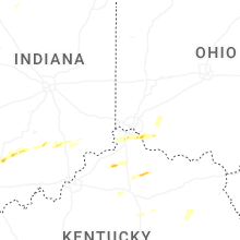


Connect with Interactive Hail Maps