

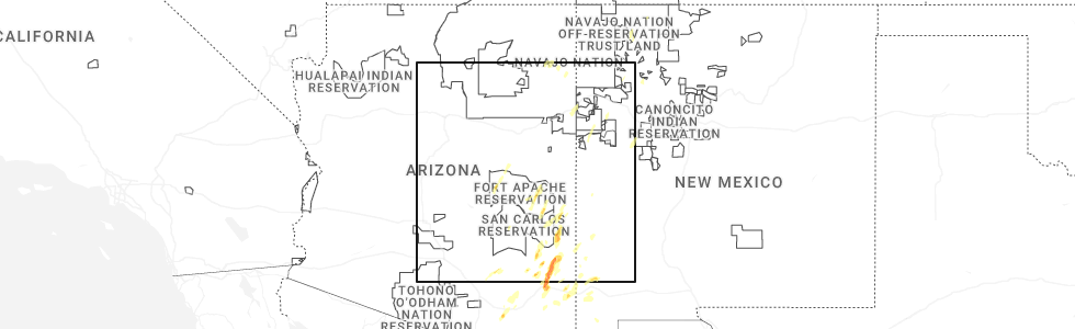
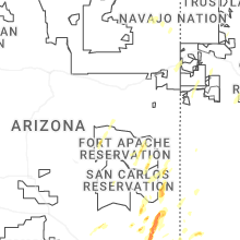
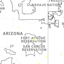
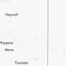
Hail Map for Whiteriver, AZ
The Whiteriver, AZ area has had 3 reports of on-the-ground hail by trained spotters, and has been under severe weather warnings 5 times during the past 12 months. Doppler radar has detected hail at or near Whiteriver, AZ on 38 occasions, including 2 occasions during the past year.
| Name: | Whiteriver, AZ |
| Where Located: | 28.8 miles S of Show Low, AZ |
| Map: | Google Map for Whiteriver, AZ |
| Population: | 4104 |
| Housing Units: | 1072 |
| More Info: | Search Google for Whiteriver, AZ |
2
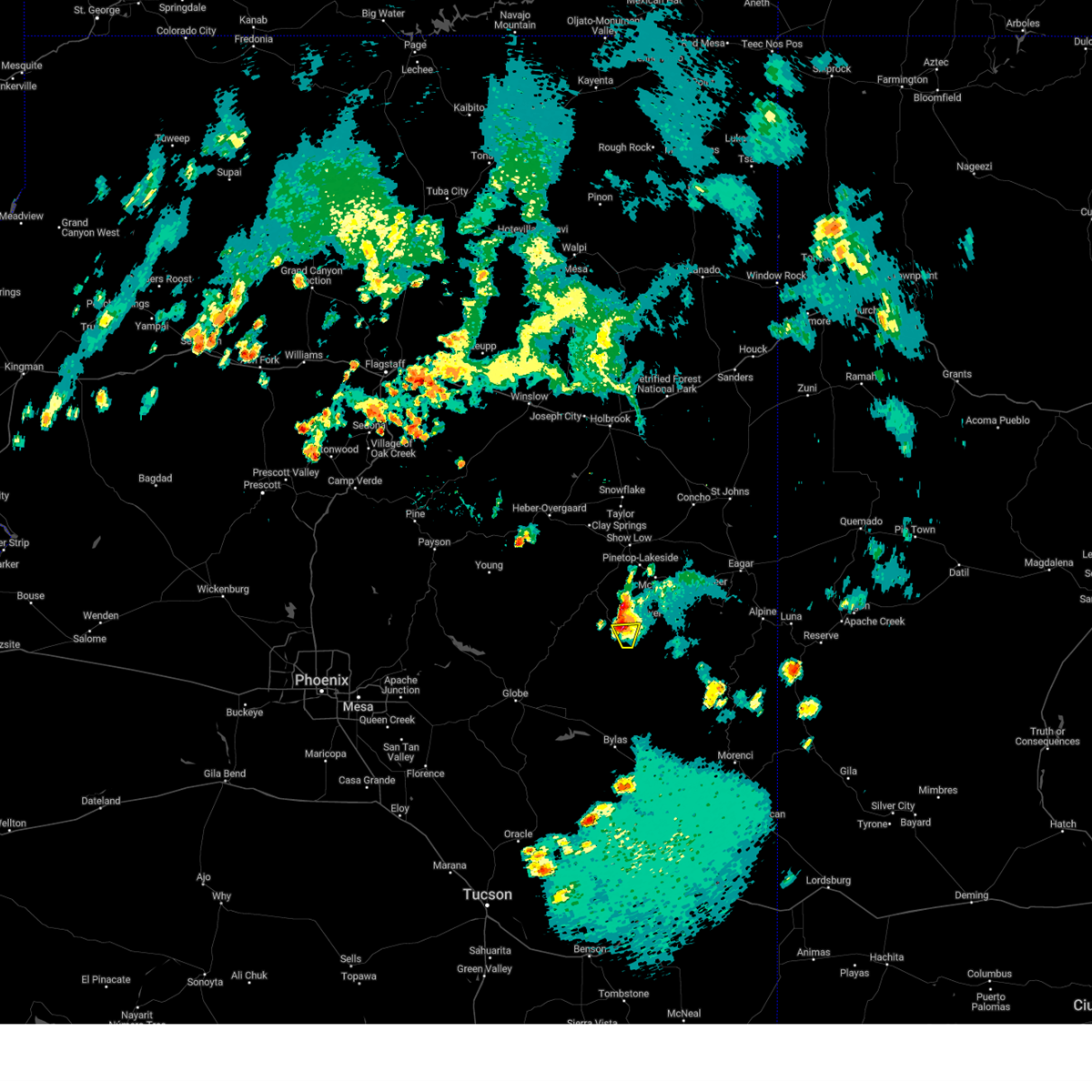
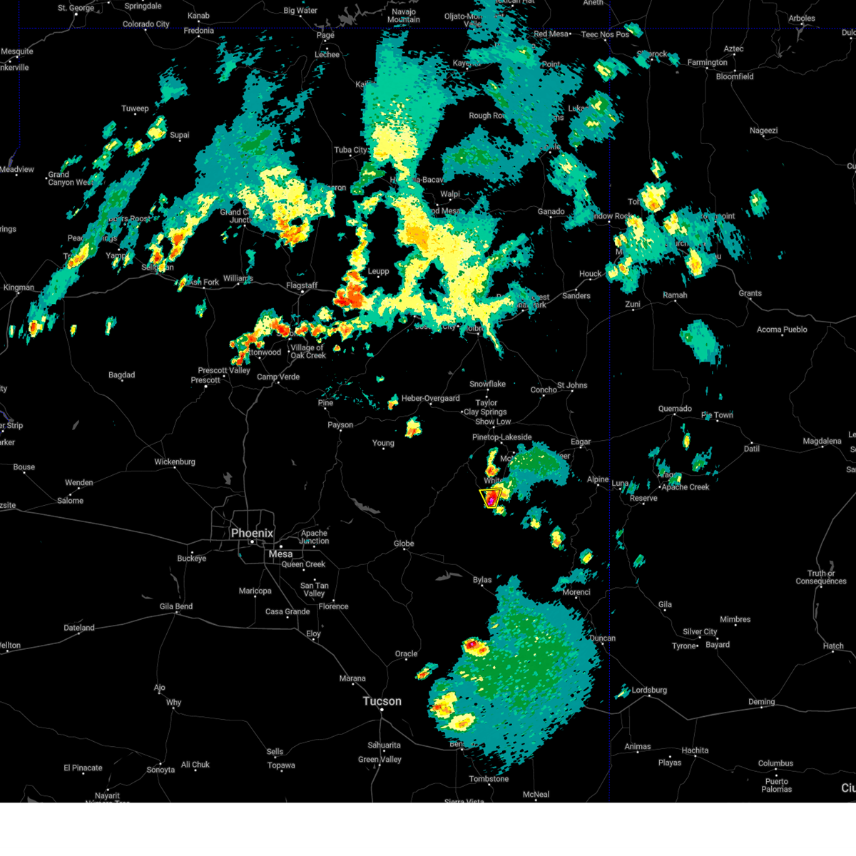
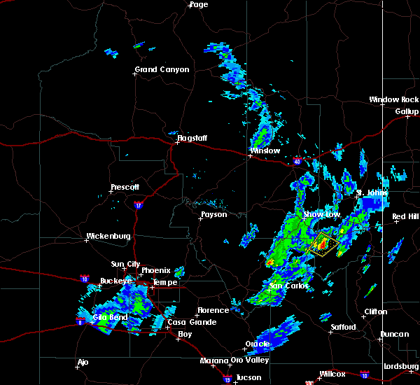
The Top Recent Hail Date for Whiteriver, AZ is Friday, September 12, 2025 (3rd out of 38)
Hail and Wind Damage Spotted near Whiteriver, AZ
| Date / Time | Report Details |
|---|---|
| 9/12/2025 8:31 PM MST | The severe thunderstorm warning that was previously in effect has been reissued for navajo and apache counties and is in effect until 9pm. please refer to that bulletin for the latest severe weather information. |
| 9/12/2025 8:14 PM MST | At 814 pm mst, a severe thunderstorm was located 6 miles east of turkey creek, or 34 miles south of show low, moving northeast at 30 mph (radar indicated). Hazards include 60 mph wind gusts and quarter size hail. Hail damage to vehicles is expected. expect wind damage to roofs, siding, and trees. locations impacted include, christmas tree lake, turkey creek, whiteriver, seven mile, rainbow city, odart mountain, whiteriver airport, fort apache, north fork, round top mountain, pacheta lake and east fork. this includes state route 73 between mile markers 336 and 355. This includes the following recreation areas and campgrounds, diamond creek campground. |
| 9/12/2025 8:00 PM MST | Svrfgz the national weather service in flagstaff has issued a * severe thunderstorm warning for, navajo county in north central arizona, apache county in northeastern arizona, * until 830 pm mst. * at 800 pm mst, a severe thunderstorm was located 7 miles southeast of seven mile, or 39 miles south of show low, moving northeast at 30 mph (radar indicated). Hazards include 60 mph wind gusts and quarter size hail. Hail damage to vehicles is expected. Expect wind damage to roofs, siding, and trees. |
| 9/12/2025 5:41 PM MST | The storm which prompted the warning has weakened below severe limits, and no longer poses an immediate threat to life or property. therefore, the warning will be allowed to expire. however, small hail and gusty winds are still possible with this thunderstorm. |
| 9/12/2025 5:19 PM MST | Svrfgz the national weather service in flagstaff has issued a * severe thunderstorm warning for, gila county in east central arizona, navajo county in north central arizona, apache county in northeastern arizona, * until 545 pm mst. * at 519 pm mst, a severe thunderstorm was located over kinishba ruins, or 30 miles south of show low, moving northeast at 35 mph (radar indicated). Hazards include 60 mph wind gusts and quarter size hail. Hail damage to vehicles is expected. Expect wind damage to roofs, siding, and trees. |
| 8/21/2024 5:16 PM MST |
 The storm 10 miles southwest of whiteriver which prompted the warning has weakened below severe limits, and no longer poses an immediate threat to life or property. therefore, the warning will be allowed to expire. The storm 10 miles southwest of whiteriver which prompted the warning has weakened below severe limits, and no longer poses an immediate threat to life or property. therefore, the warning will be allowed to expire.
|
| 8/21/2024 4:51 PM MST |
 Svrfgz the national weather service in flagstaff has issued a * severe thunderstorm warning for, gila county in east central arizona, navajo county in north central arizona, * until 515 pm mst. * at 451 pm mst, a severe thunderstorm was located near fort apache, or 34 miles south of show low, moving north at 10 mph (radar indicated). Hazards include ping pong ball size hail. People and animals outdoors will be injured. Expect damage to roofs, siding, windows, and vehicles. Svrfgz the national weather service in flagstaff has issued a * severe thunderstorm warning for, gila county in east central arizona, navajo county in north central arizona, * until 515 pm mst. * at 451 pm mst, a severe thunderstorm was located near fort apache, or 34 miles south of show low, moving north at 10 mph (radar indicated). Hazards include ping pong ball size hail. People and animals outdoors will be injured. Expect damage to roofs, siding, windows, and vehicles.
|
| 7/14/2024 3:11 PM MST |
 The storm which prompted the warning has weakened below severe limits, and no longer poses an immediate threat to life or property. therefore, the warning will be allowed to expire. however, gusty winds and heavy rain are still possible with this thunderstorm. The storm which prompted the warning has weakened below severe limits, and no longer poses an immediate threat to life or property. therefore, the warning will be allowed to expire. however, gusty winds and heavy rain are still possible with this thunderstorm.
|
| 7/14/2024 2:53 PM MST |
 Svrfgz the national weather service in flagstaff has issued a * severe thunderstorm warning for, gila county in east central arizona, apache county in northeastern arizona, navajo county in north central arizona, * until 315 pm mst. * at 253 pm mst, a severe thunderstorm was located over turkey creek, or 30 miles south of show low, moving north at 15 mph (radar indicated). Hazards include 60 mph wind gusts and quarter size hail. Hail damage to vehicles is expected. Expect wind damage to roofs, siding, and trees. Svrfgz the national weather service in flagstaff has issued a * severe thunderstorm warning for, gila county in east central arizona, apache county in northeastern arizona, navajo county in north central arizona, * until 315 pm mst. * at 253 pm mst, a severe thunderstorm was located over turkey creek, or 30 miles south of show low, moving north at 15 mph (radar indicated). Hazards include 60 mph wind gusts and quarter size hail. Hail damage to vehicles is expected. Expect wind damage to roofs, siding, and trees.
|
| 8/26/2021 3:53 PM MST |
 The severe thunderstorm warning for apache and navajo counties will expire at 400 pm mst, the storm which prompted the warning has weakened below severe limits, and no longer poses an immediate threat to life or property. therefore, the warning will be allowed to expire. however small hail and gusty winds are still possible with this thunderstorm. The severe thunderstorm warning for apache and navajo counties will expire at 400 pm mst, the storm which prompted the warning has weakened below severe limits, and no longer poses an immediate threat to life or property. therefore, the warning will be allowed to expire. however small hail and gusty winds are still possible with this thunderstorm.
|
| 8/26/2021 3:32 PM MST |
 At 331 pm mst, a severe thunderstorm was located near east fork or 7 miles northeast of turkey creek, moving northeast at 15 mph (radar indicated). Hazards include 60 mph wind gusts and quarter size hail. Hail damage to vehicles is expected. expect wind damage to roofs, siding, and trees. this severe thunderstorm will remain over mainly rural areas of apache and navajo counties. hail threat, radar indicated max hail size, 1. 00 in wind threat, radar indicated max wind gust, 60 mph. At 331 pm mst, a severe thunderstorm was located near east fork or 7 miles northeast of turkey creek, moving northeast at 15 mph (radar indicated). Hazards include 60 mph wind gusts and quarter size hail. Hail damage to vehicles is expected. expect wind damage to roofs, siding, and trees. this severe thunderstorm will remain over mainly rural areas of apache and navajo counties. hail threat, radar indicated max hail size, 1. 00 in wind threat, radar indicated max wind gust, 60 mph.
|
| 8/2/2021 2:44 PM MST |
 At 244 pm mst, a severe thunderstorm was located near turkey creek, or 33 miles south of show low, moving southeast at 15 mph (radar indicated). Hazards include 60 mph wind gusts and half dollar size hail. Hail damage to vehicles is expected. Expect wind damage to roofs, siding, and trees. At 244 pm mst, a severe thunderstorm was located near turkey creek, or 33 miles south of show low, moving southeast at 15 mph (radar indicated). Hazards include 60 mph wind gusts and half dollar size hail. Hail damage to vehicles is expected. Expect wind damage to roofs, siding, and trees.
|
| 8/2/2021 2:38 PM MST |
 At 238 pm mst, a severe thunderstorm was located near turkey creek, or 34 miles south of show low, moving southeast at 20 mph (radar indicated). Hazards include 60 mph wind gusts and half dollar size hail. Hail damage to vehicles is expected. expect wind damage to roofs, siding, and trees. Locations impacted include, whiteriver, turkey creek, seven mile and east fork. At 238 pm mst, a severe thunderstorm was located near turkey creek, or 34 miles south of show low, moving southeast at 20 mph (radar indicated). Hazards include 60 mph wind gusts and half dollar size hail. Hail damage to vehicles is expected. expect wind damage to roofs, siding, and trees. Locations impacted include, whiteriver, turkey creek, seven mile and east fork.
|
| 8/2/2021 2:23 PM MST |
 At 222 pm mst, a severe thunderstorm was located near white river moving southeast at 20 mph (radar indicated). Hazards include 60 mph wind gusts and half dollar size hail. Hail damage to vehicles is expected. Expect wind damage to roofs, siding, and trees. At 222 pm mst, a severe thunderstorm was located near white river moving southeast at 20 mph (radar indicated). Hazards include 60 mph wind gusts and half dollar size hail. Hail damage to vehicles is expected. Expect wind damage to roofs, siding, and trees.
|
| 7/10/2021 5:16 PM MST |
 At 515 pm mst, severe thunderstorms were located along a line extending from 8 miles southeast of forest lakes to near north fork, moving southwest at 15 mph (radar indicated). Hazards include 70 mph wind gusts and half dollar size hail. Hail damage to vehicles is expected. expect considerable tree damage. Wind damage is also likely to mobile homes, roofs, and outbuildings. At 515 pm mst, severe thunderstorms were located along a line extending from 8 miles southeast of forest lakes to near north fork, moving southwest at 15 mph (radar indicated). Hazards include 70 mph wind gusts and half dollar size hail. Hail damage to vehicles is expected. expect considerable tree damage. Wind damage is also likely to mobile homes, roofs, and outbuildings.
|
| 9/8/2020 7:06 PM MST |
 At 705 pm mst, a severe thunderstorm was located 9 miles southwest of fort apache, or 35 miles south of show low, moving east at 40 mph (radar indicated). Hazards include 60 mph wind gusts and quarter size hail. Hail damage to vehicles is expected. Expect wind damage to roofs, siding, and trees. At 705 pm mst, a severe thunderstorm was located 9 miles southwest of fort apache, or 35 miles south of show low, moving east at 40 mph (radar indicated). Hazards include 60 mph wind gusts and quarter size hail. Hail damage to vehicles is expected. Expect wind damage to roofs, siding, and trees.
|
| 8/20/2020 3:37 PM MST |
 The severe thunderstorm warning for gila, apache and navajo counties will expire at 345 pm mst, the storm south of white river which prompted the warning has weakened below severe limits, and no longer poses an immediate threat to life or property. therefore, the warning will be allowed to expire. The severe thunderstorm warning for gila, apache and navajo counties will expire at 345 pm mst, the storm south of white river which prompted the warning has weakened below severe limits, and no longer poses an immediate threat to life or property. therefore, the warning will be allowed to expire.
|
| 8/20/2020 3:22 PM MST |
 At 322 pm mst, a severe thunderstorm was located near fort apache, or 4 miles south of white river, moving southwest at 5 mph (radar indicated). Hazards include 50 mph wind gusts and quarter size hail. Hail damage to vehicles is expected. expect wind damage to roofs, siding, and trees. Locations impacted include, turkey creek, seven mile, fort apache, whiteriver, fort apache reservation, east fork and canyon day. At 322 pm mst, a severe thunderstorm was located near fort apache, or 4 miles south of white river, moving southwest at 5 mph (radar indicated). Hazards include 50 mph wind gusts and quarter size hail. Hail damage to vehicles is expected. expect wind damage to roofs, siding, and trees. Locations impacted include, turkey creek, seven mile, fort apache, whiteriver, fort apache reservation, east fork and canyon day.
|
| 8/20/2020 3:15 PM MST |
 At 314 pm mst, a severe thunderstorm was located over fort apache, or 3 miles south of white river, moving southwest at 5 mph (radar indicated). Hazards include 50 mph wind gusts and quarter size hail. Hail damage to vehicles is expected. Expect wind damage to roofs, siding, and trees. At 314 pm mst, a severe thunderstorm was located over fort apache, or 3 miles south of white river, moving southwest at 5 mph (radar indicated). Hazards include 50 mph wind gusts and quarter size hail. Hail damage to vehicles is expected. Expect wind damage to roofs, siding, and trees.
|
| 9/23/2019 4:54 PM MST |
 The severe thunderstorm warning for gila and navajo counties will expire at 500 pm mst, the storm which prompted the warning has weakened below severe limits, and no longer poses an immediate threat to life or property. therefore, the warning will be allowed to expire. a severe thunderstorm watch remains in effect until 800 pm mst for portions of central arizona. The severe thunderstorm warning for gila and navajo counties will expire at 500 pm mst, the storm which prompted the warning has weakened below severe limits, and no longer poses an immediate threat to life or property. therefore, the warning will be allowed to expire. a severe thunderstorm watch remains in effect until 800 pm mst for portions of central arizona.
|
| 9/23/2019 4:31 PM MST |
 At 430 pm mst, a severe thunderstorm was located near cedar creek, or 29 miles south of show low, moving northeast at 35 mph (radar indicated). Hazards include 60 mph wind gusts and quarter size hail. Hail damage to vehicles is expected. Expect wind damage to roofs, siding, and trees. At 430 pm mst, a severe thunderstorm was located near cedar creek, or 29 miles south of show low, moving northeast at 35 mph (radar indicated). Hazards include 60 mph wind gusts and quarter size hail. Hail damage to vehicles is expected. Expect wind damage to roofs, siding, and trees.
|
| 7/15/2017 1:37 PM MST |
 The severe thunderstorm warning for gila and navajo counties will expire at 145 pm mst, the storm which prompted the warning has weakened below severe limits, and no longer pose an immediate threat to life or property. therefore, the warning will be allowed to expire. however, heavy rain will still occur with this thunderstorm. The severe thunderstorm warning for gila and navajo counties will expire at 145 pm mst, the storm which prompted the warning has weakened below severe limits, and no longer pose an immediate threat to life or property. therefore, the warning will be allowed to expire. however, heavy rain will still occur with this thunderstorm.
|
| 7/15/2017 1:23 PM MST |
 At 122 pm mst, a severe thunderstorm was located 7 miles west of fort apache, or 29 miles south of show low, moving southwest at 10 mph (radar indicated). Hazards include 60 mph wind gusts and nickel size hail. Expect damage to roofs, siding, and trees. locations impacted include, fort apache, whiteriver, fort apache reservation and canyon day. This includes state route 73 between mile markers 324 and 338. At 122 pm mst, a severe thunderstorm was located 7 miles west of fort apache, or 29 miles south of show low, moving southwest at 10 mph (radar indicated). Hazards include 60 mph wind gusts and nickel size hail. Expect damage to roofs, siding, and trees. locations impacted include, fort apache, whiteriver, fort apache reservation and canyon day. This includes state route 73 between mile markers 324 and 338.
|
| 7/15/2017 1:12 PM MST |
 At 112 pm mst, a severe thunderstorm was located near fort apache, or 27 miles south of show low, moving southwest at 10 mph (radar indicated). Hazards include 60 mph wind gusts and penny size hail. Expect damage to roofs, siding, and trees. locations impacted include, whiteriver, turkey creek, seven mile, rainbow city, fort apache, fort apache reservation, east fork and canyon day. This includes state route 73 between mile markers 323 and 343. At 112 pm mst, a severe thunderstorm was located near fort apache, or 27 miles south of show low, moving southwest at 10 mph (radar indicated). Hazards include 60 mph wind gusts and penny size hail. Expect damage to roofs, siding, and trees. locations impacted include, whiteriver, turkey creek, seven mile, rainbow city, fort apache, fort apache reservation, east fork and canyon day. This includes state route 73 between mile markers 323 and 343.
|
| 7/15/2017 1:04 PM MST |
 At 103 pm mst, a severe thunderstorm was located 3 miles west of whiteriver, or 26 miles south of show low, moving southwest at 10 mph (radar indicated). Hazards include 60 mph wind gusts and quarter size hail. Hail damage to vehicles is expected. Expect wind damage to roofs, siding, and trees. At 103 pm mst, a severe thunderstorm was located 3 miles west of whiteriver, or 26 miles south of show low, moving southwest at 10 mph (radar indicated). Hazards include 60 mph wind gusts and quarter size hail. Hail damage to vehicles is expected. Expect wind damage to roofs, siding, and trees.
|
| 8/11/2016 4:27 AM MST |
 At 426 am mst, doppler radar indicated a severe thunderstorm capable of producing quarter size hail. this storm was located over fort apache reservation, or 18 miles south of show low, moving east at 15 mph. locations impacted include, carrizo, cedar creek, fort apache reservation, rainbow city and white mountain apache reservation. At 426 am mst, doppler radar indicated a severe thunderstorm capable of producing quarter size hail. this storm was located over fort apache reservation, or 18 miles south of show low, moving east at 15 mph. locations impacted include, carrizo, cedar creek, fort apache reservation, rainbow city and white mountain apache reservation.
|
| 8/11/2016 4:04 AM MST |
 At 404 am mst, doppler radar indicated a severe thunderstorm capable of producing half dollar size hail. this storm was located near carrizo, or 21 miles southwest of show low, and moving east at 15 mph. At 404 am mst, doppler radar indicated a severe thunderstorm capable of producing half dollar size hail. this storm was located near carrizo, or 21 miles southwest of show low, and moving east at 15 mph.
|
| 7/24/2016 3:55 PM MST |
 The severe thunderstorm warning for eastern gila and southern navajo counties will expire at 400 pm mst, the severe thunderstorm over white river which prompted the warning has weakened. therefore the warning will be allowed to expire. The severe thunderstorm warning for eastern gila and southern navajo counties will expire at 400 pm mst, the severe thunderstorm over white river which prompted the warning has weakened. therefore the warning will be allowed to expire.
|
| 7/24/2016 3:48 PM MST |
 At 348 pm mst, doppler radar indicated a severe thunderstorm capable of producing half dollar size hail. this storm was located near fort apache, or 28 miles south of show low, moving west at 10 mph. locations impacted include, whiteriver, fort apache and rainbow city. At 348 pm mst, doppler radar indicated a severe thunderstorm capable of producing half dollar size hail. this storm was located near fort apache, or 28 miles south of show low, moving west at 10 mph. locations impacted include, whiteriver, fort apache and rainbow city.
|
| 7/24/2016 3:45 PM MST | Quarter sized hail reported 0.2 miles ESE of Whiteriver, AZ |
| 7/24/2016 3:24 PM MST |
 At 324 pm mst, doppler radar indicated a severe thunderstorm capable of producing quarter size hail. this storm was located over fort apache, or 28 miles south of show low, and moving west at 10 mph. At 324 pm mst, doppler radar indicated a severe thunderstorm capable of producing quarter size hail. this storm was located over fort apache, or 28 miles south of show low, and moving west at 10 mph.
|
| 6/10/2016 3:01 PM MST |
 At 300 pm mst, doppler radar indicated a severe thunderstorm capable of producing quarter size hail and destructive winds in excess of 70 mph. this storm was located near whiteriver, or 24 miles south of show low, and moving northwest at 15 mph. At 300 pm mst, doppler radar indicated a severe thunderstorm capable of producing quarter size hail and destructive winds in excess of 70 mph. this storm was located near whiteriver, or 24 miles south of show low, and moving northwest at 15 mph.
|
| 10/20/2015 5:44 PM MST |
 At 543 pm mst, doppler radar indicated a severe thunderstorm capable of producing half dollar size hail and damaging winds in excess of 60 mph. this storm was located 9 miles east of rainbow city, or 26 miles southeast of show low, moving northeast at 30 mph. locations impacted include, whiteriver. At 543 pm mst, doppler radar indicated a severe thunderstorm capable of producing half dollar size hail and damaging winds in excess of 60 mph. this storm was located 9 miles east of rainbow city, or 26 miles southeast of show low, moving northeast at 30 mph. locations impacted include, whiteriver.
|
| 10/20/2015 5:27 PM MST |
 At 526 pm mst, doppler radar indicated a severe thunderstorm capable of producing half dollar size hail and damaging winds in excess of 60 mph. this storm was located over turkey creek, or 30 miles south of show low, and moving northeast at 30 mph. At 526 pm mst, doppler radar indicated a severe thunderstorm capable of producing half dollar size hail and damaging winds in excess of 60 mph. this storm was located over turkey creek, or 30 miles south of show low, and moving northeast at 30 mph.
|
| 10/20/2015 5:01 PM MST |
 At 501 pm mst, doppler radar indicated a severe thunderstorm capable of producing quarter size hail and damaging winds in excess of 60 mph. this storm was located 7 miles southwest of fort apache, or 38 miles south of show low, and moving northeast at 25 mph. At 501 pm mst, doppler radar indicated a severe thunderstorm capable of producing quarter size hail and damaging winds in excess of 60 mph. this storm was located 7 miles southwest of fort apache, or 38 miles south of show low, and moving northeast at 25 mph.
|
| 9/13/2015 2:51 PM MST |
 At 250 pm mst, doppler radar indicated a severe thunderstorm capable of producing quarter size hail and damaging winds in excess of 60 mph. this storm was located near cedar creek, or 29 miles south of show low, and moving northeast at 15 mph. * this severe thunderstorm will be near, whiteriver around 305 pm mst. rainbow city, fort apache, turkey creek and seven mile around 315 pm mst. other locations impacted by this severe thunderstorm include canyon day and east fork. this includes state route 73 between mile markers 321 and 342. At 250 pm mst, doppler radar indicated a severe thunderstorm capable of producing quarter size hail and damaging winds in excess of 60 mph. this storm was located near cedar creek, or 29 miles south of show low, and moving northeast at 15 mph. * this severe thunderstorm will be near, whiteriver around 305 pm mst. rainbow city, fort apache, turkey creek and seven mile around 315 pm mst. other locations impacted by this severe thunderstorm include canyon day and east fork. this includes state route 73 between mile markers 321 and 342.
|
| 6/30/2015 3:25 PM MST | Golf Ball sized hail reported 30.2 miles E of Whiteriver, AZ |
| 9/13/2013 7:45 PM MST | Quarter sized hail reported 2.7 miles W of Whiteriver, AZ |
Hail Maps for Whiteriver, AZ


Connect with Interactive Hail Maps