

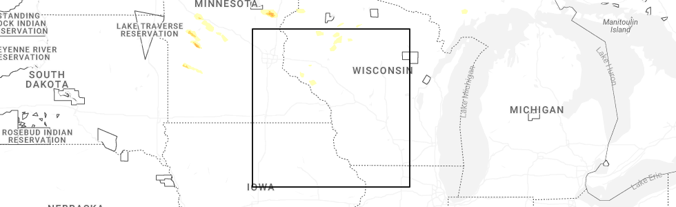
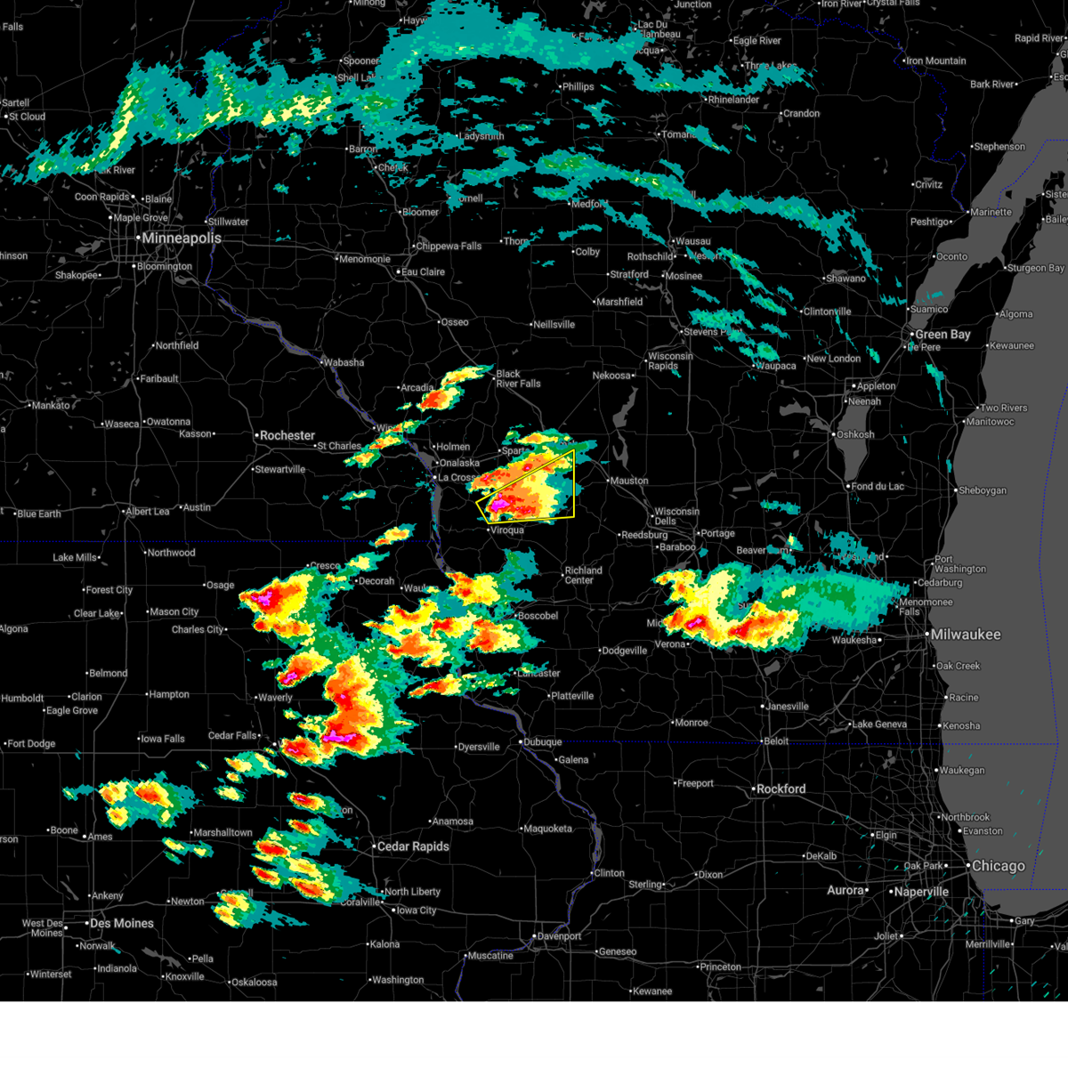
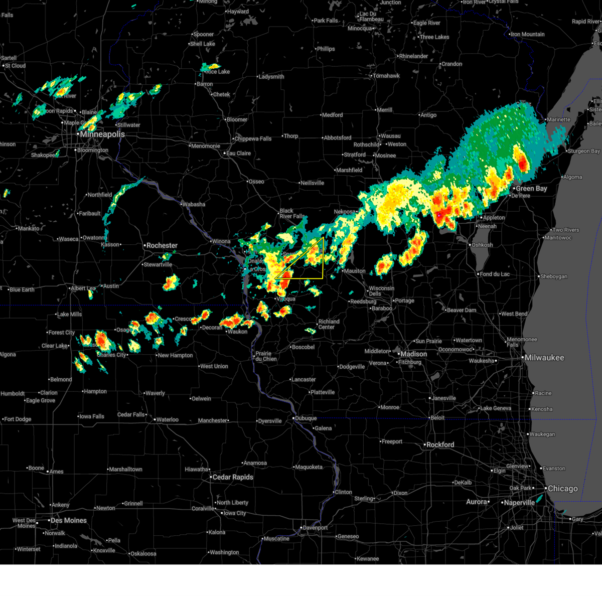
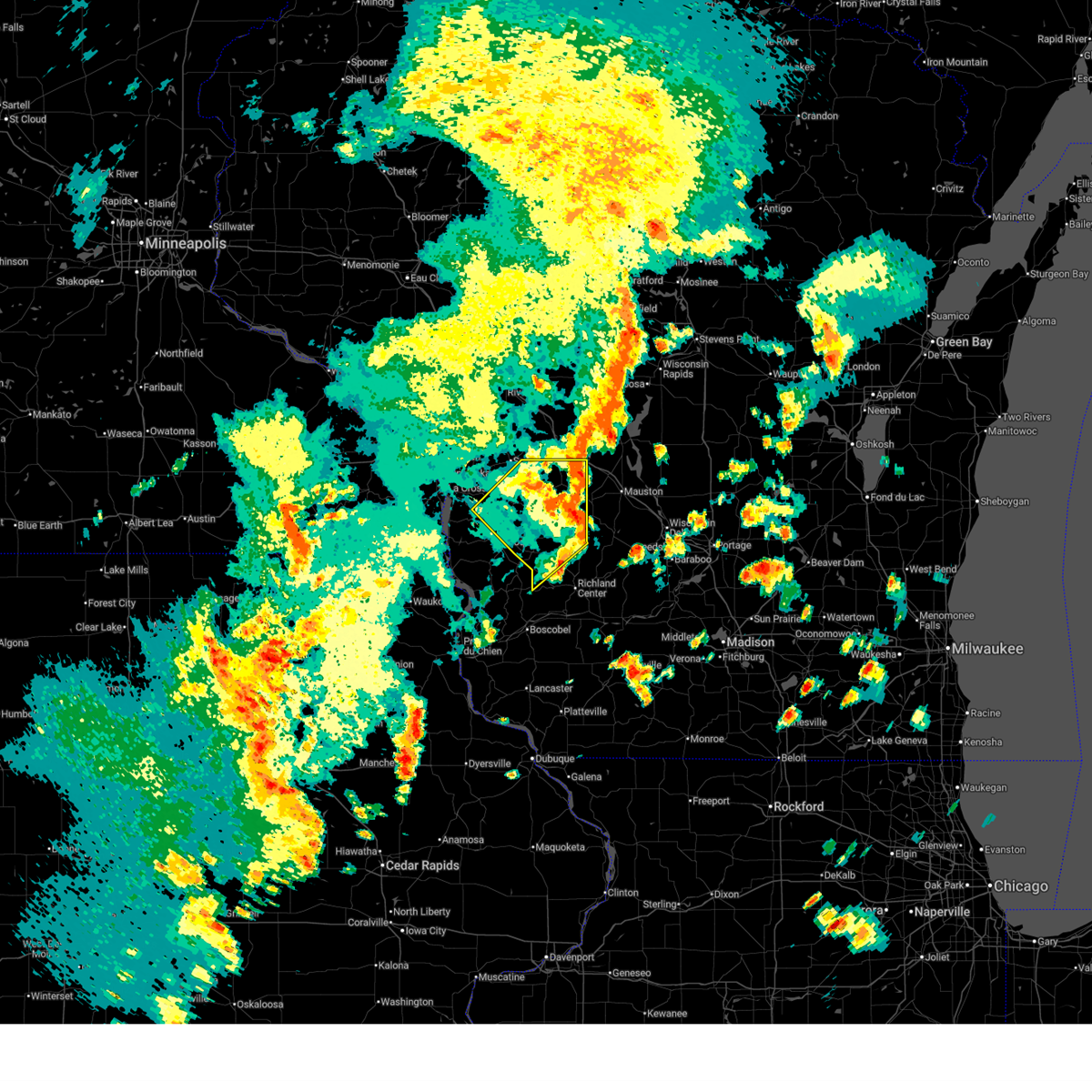
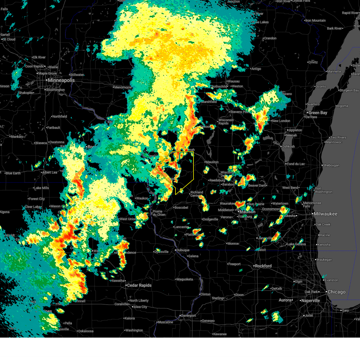
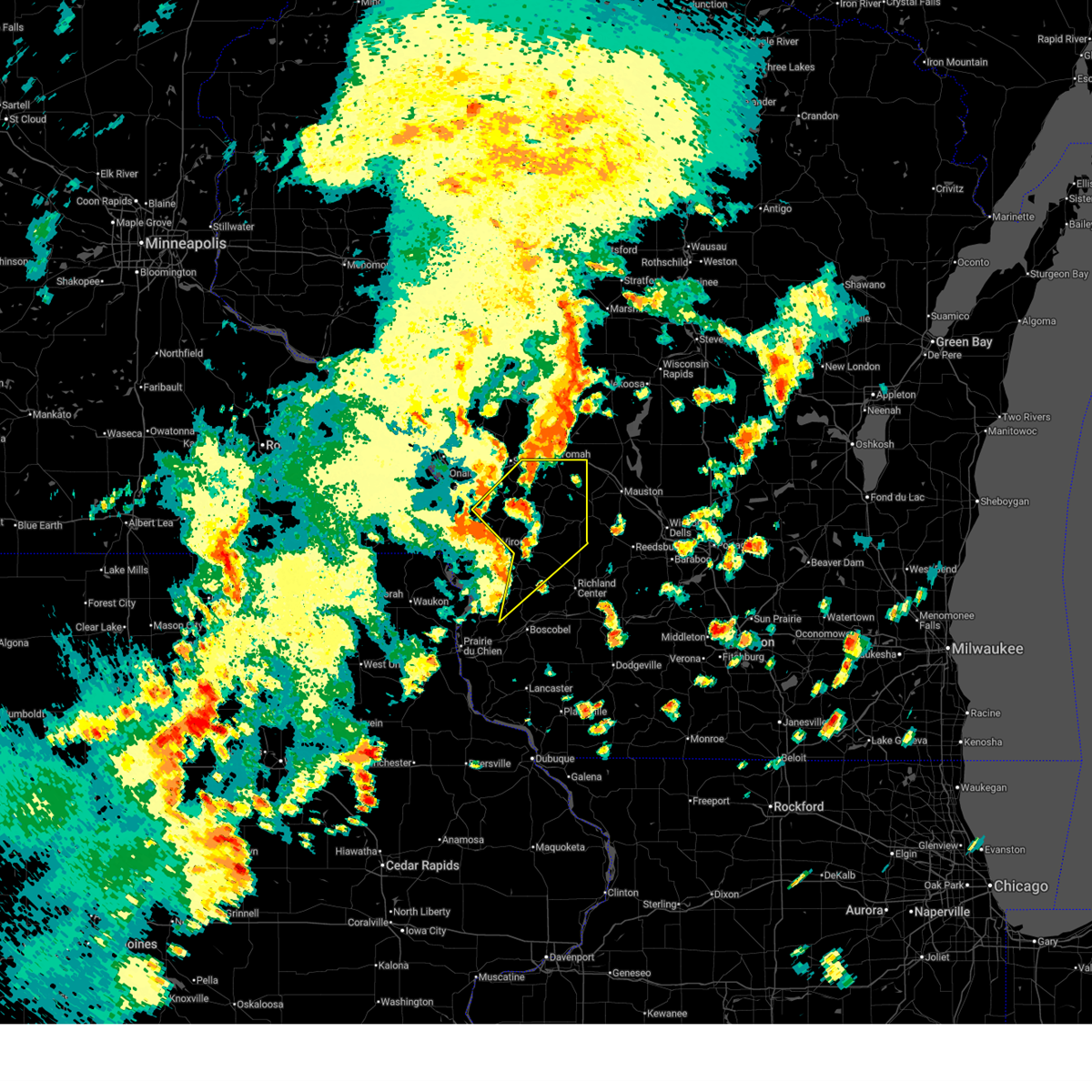
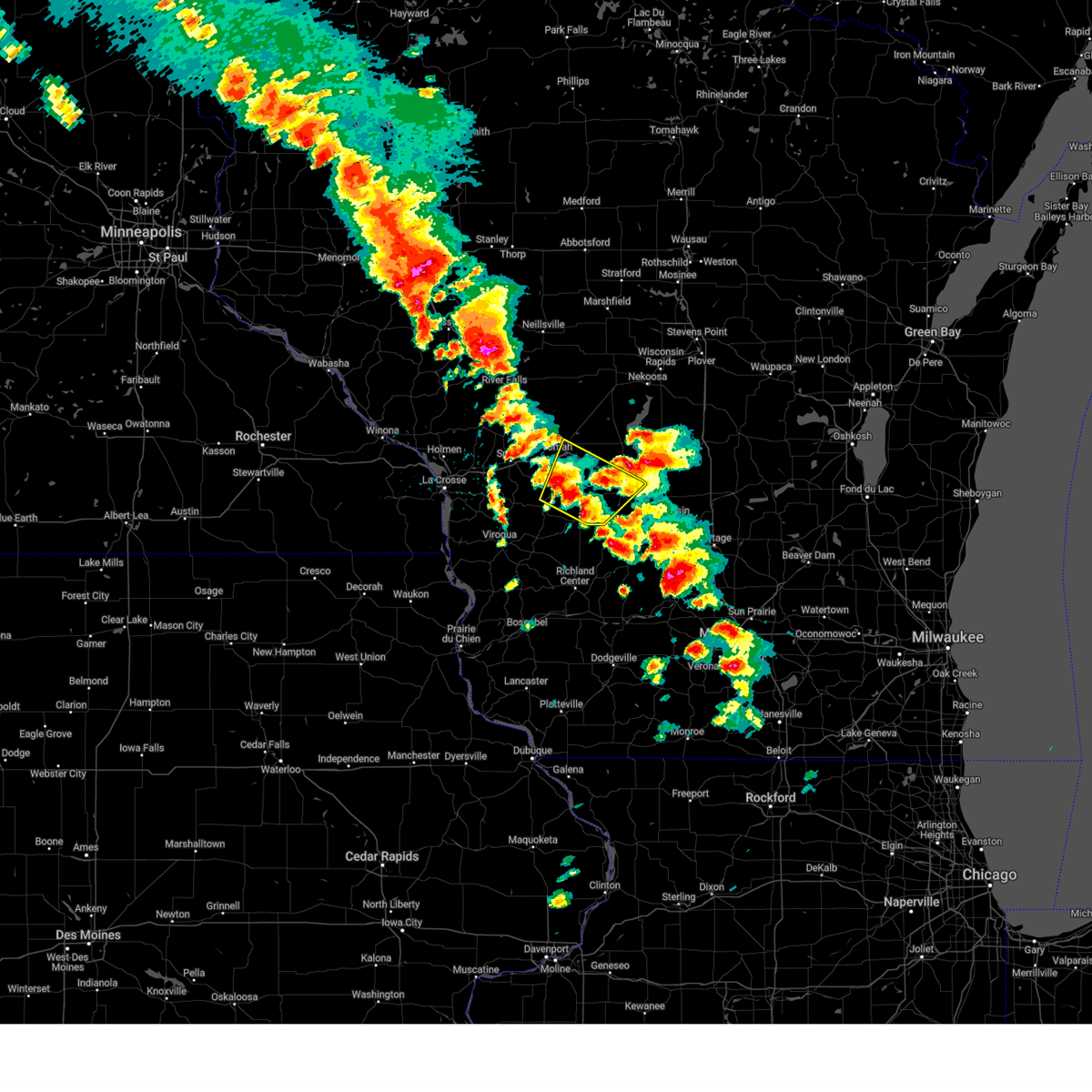
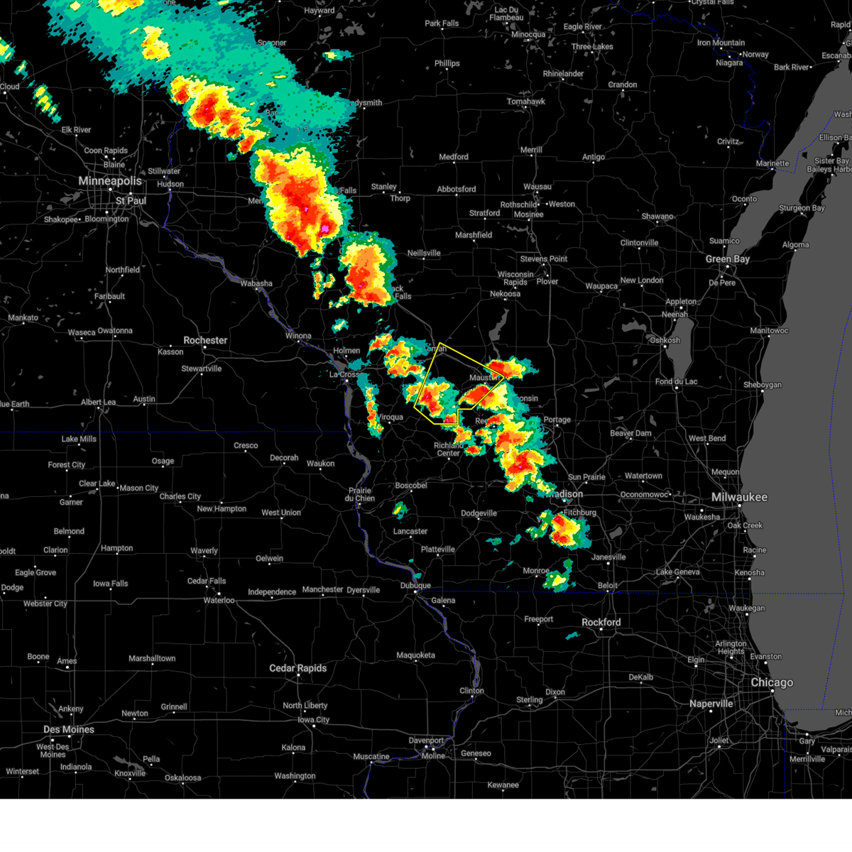
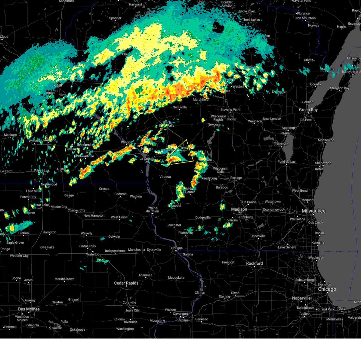
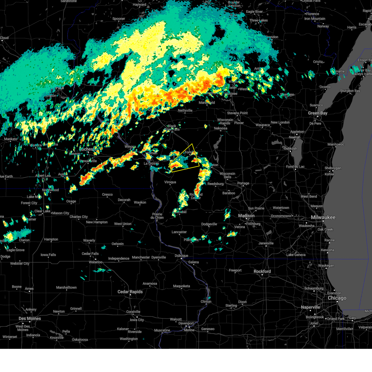
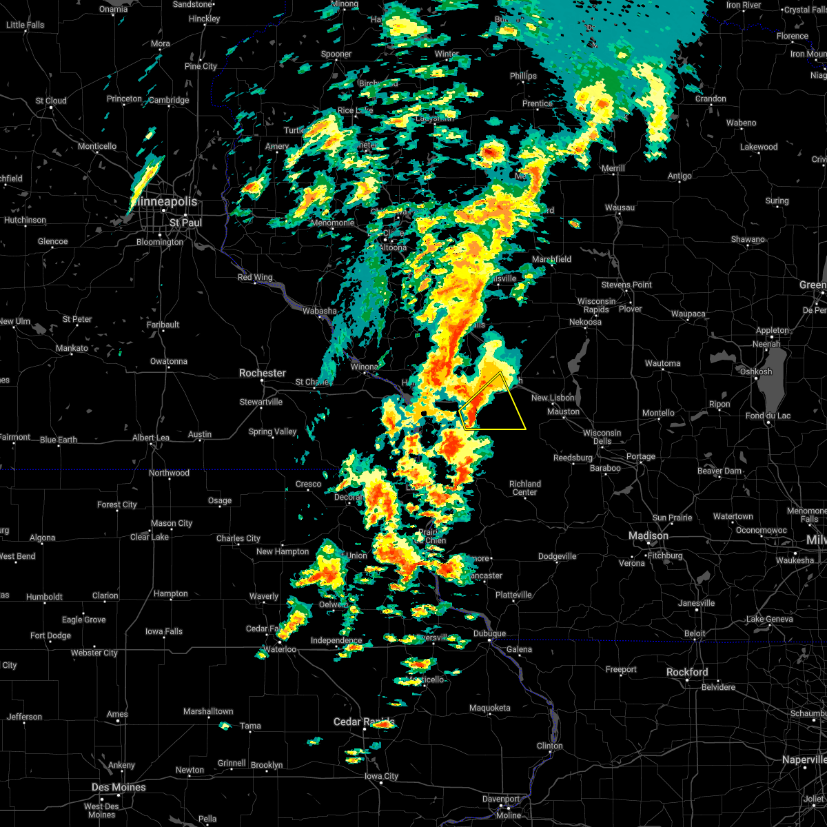
Hail Map for Wilton, WI
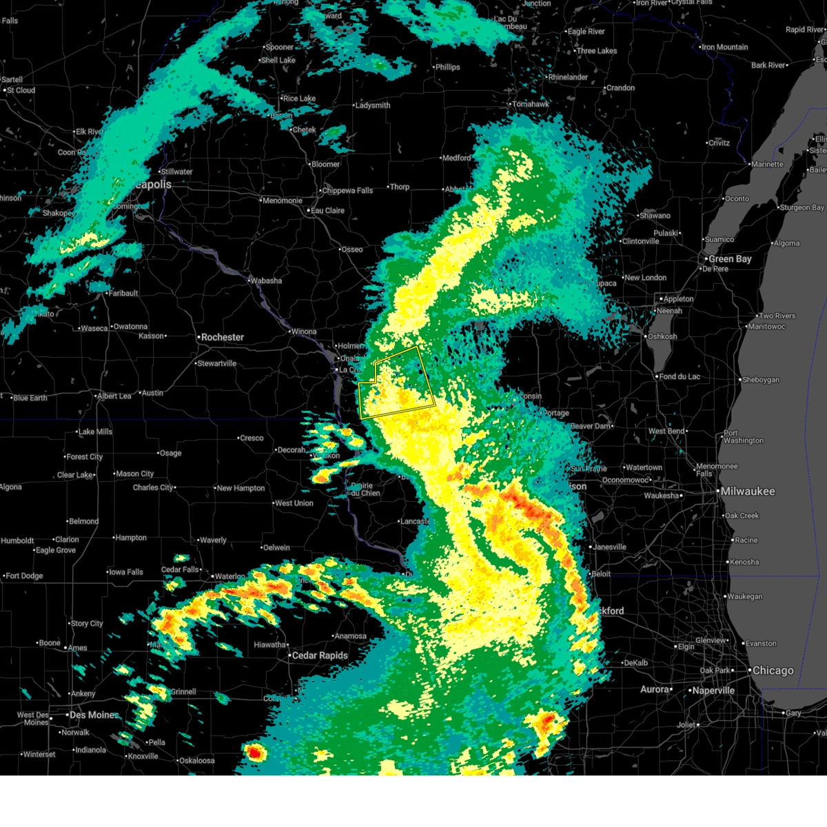
The Wilton, WI area has had 0 reports of on-the-ground hail by trained spotters, and has been under severe weather warnings 10 times during the past 12 months. Doppler radar has detected hail at or near Wilton, WI on 49 occasions, including 5 occasions during the past year.
| Name: | Wilton, WI |
| Where Located: | 36.1 miles E of La Crosse, WI |
| Map: | Google Map for Wilton, WI |
| Population: | 504 |
| Housing Units: | 233 |
| More Info: | Search Google for Wilton, WI |
0
The Top Recent Hail Date for Wilton, WI is Friday, June 5, 2026 (27th out of 49)
Hail and Wind Damage Spotted near Wilton, WI
| Date / Time | Report Details |
|---|---|
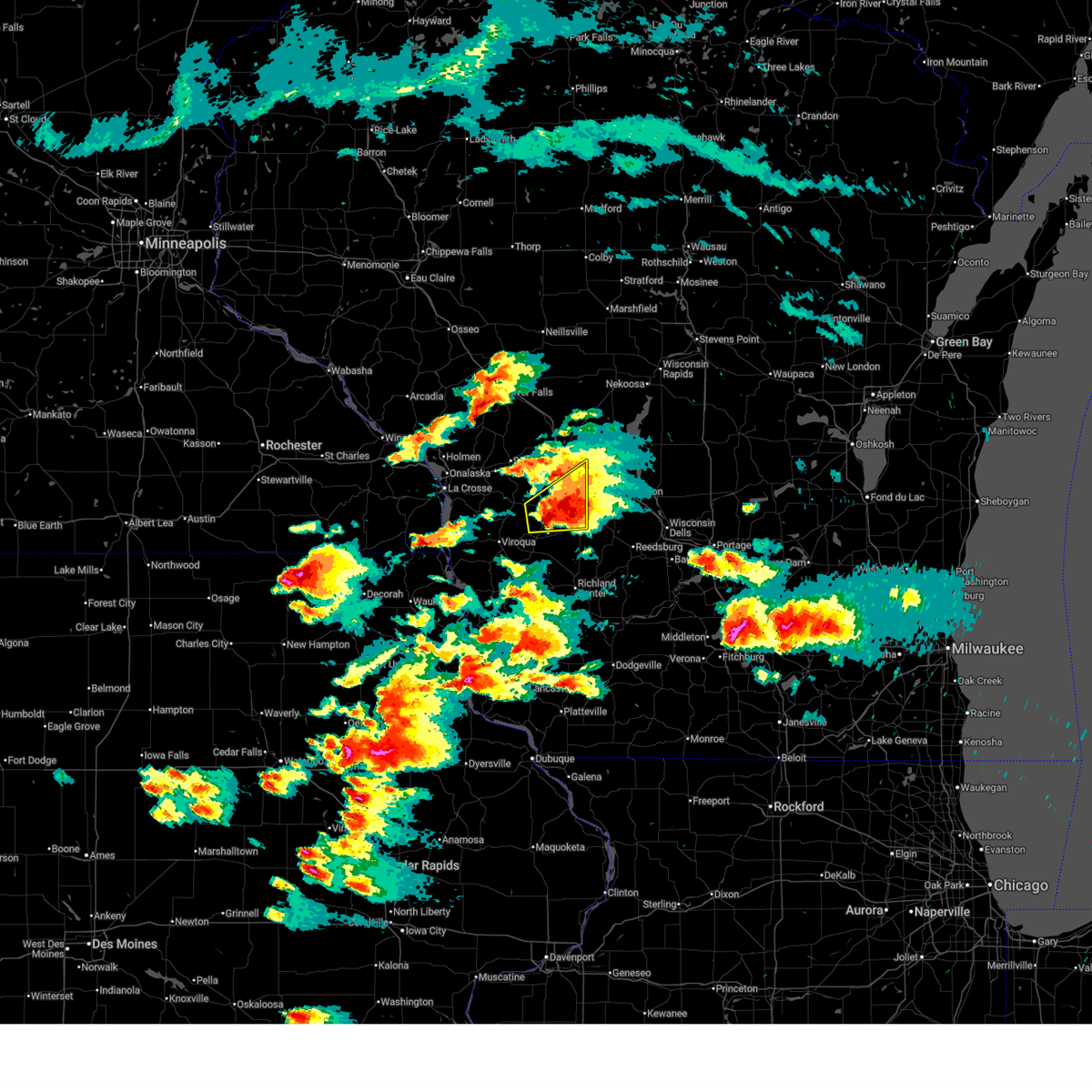
| 6/11/2026 11:32 AM CDT |
 Svrarx the national weather service in la crosse has issued a * severe thunderstorm warning for, northeastern vernon county in southwestern wisconsin, southwestern monroe county in west central wisconsin, * until noon cdt. * at 1131 am cdt, a severe thunderstorm was located over cashton, or 11 miles north of viroqua, moving east at 45 mph (radar indicated. power outages and light tree damage have been reported with these winds). Hazards include 60 mph wind gusts. expect damage to roofs, siding, and trees Svrarx the national weather service in la crosse has issued a * severe thunderstorm warning for, northeastern vernon county in southwestern wisconsin, southwestern monroe county in west central wisconsin, * until noon cdt. * at 1131 am cdt, a severe thunderstorm was located over cashton, or 11 miles north of viroqua, moving east at 45 mph (radar indicated. power outages and light tree damage have been reported with these winds). Hazards include 60 mph wind gusts. expect damage to roofs, siding, and trees
|
| 6/5/2026 8:29 PM CDT |
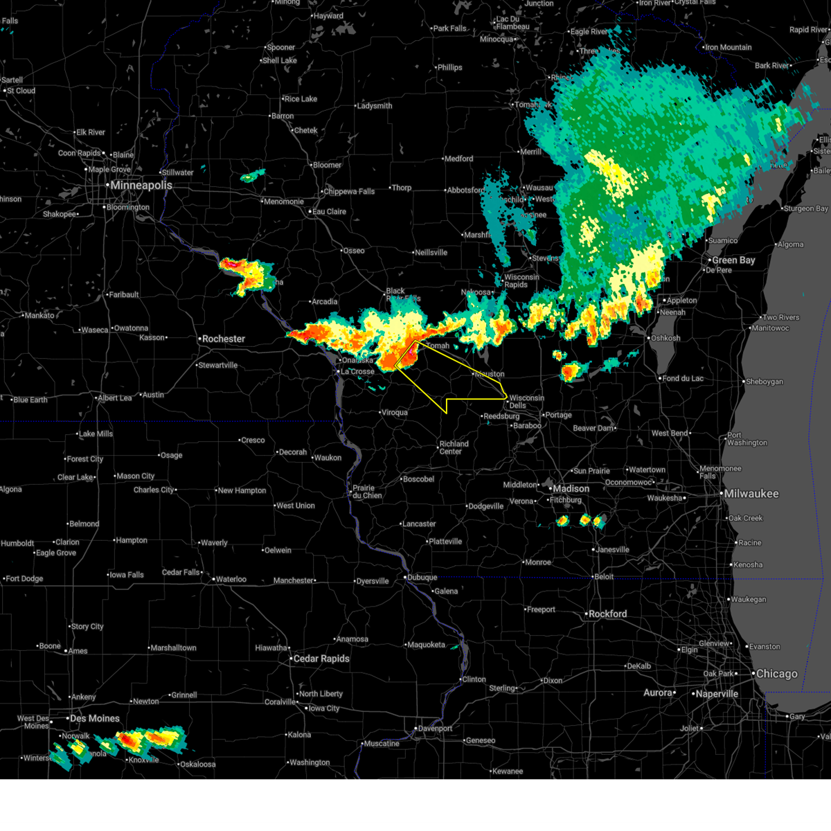 Svrarx the national weather service in la crosse has issued a * severe thunderstorm warning for, southern juneau county in central wisconsin, northeastern vernon county in southwestern wisconsin, southeastern monroe county in west central wisconsin, * until 930 pm cdt. * at 829 pm cdt, a severe thunderstorm was located near tomah, moving southeast at 35 mph (radar indicated). Hazards include 60 mph wind gusts. Expect damage to roofs, siding, and trees. this severe thunderstorm will be near, elroy around 850 pm cdt. wonewoc around 905 pm cdt. other locations impacted by this severe thunderstorm include bartons corners, dells timberland campground, johnson hill, lyndon station, stand rock campground, glendale, and benders corners. this includes the following highways, interstate 90/94 between mile markers 67 and 86. Interstate 90 in wisconsin between mile markers 34 and 43. Svrarx the national weather service in la crosse has issued a * severe thunderstorm warning for, southern juneau county in central wisconsin, northeastern vernon county in southwestern wisconsin, southeastern monroe county in west central wisconsin, * until 930 pm cdt. * at 829 pm cdt, a severe thunderstorm was located near tomah, moving southeast at 35 mph (radar indicated). Hazards include 60 mph wind gusts. Expect damage to roofs, siding, and trees. this severe thunderstorm will be near, elroy around 850 pm cdt. wonewoc around 905 pm cdt. other locations impacted by this severe thunderstorm include bartons corners, dells timberland campground, johnson hill, lyndon station, stand rock campground, glendale, and benders corners. this includes the following highways, interstate 90/94 between mile markers 67 and 86. Interstate 90 in wisconsin between mile markers 34 and 43.
|
| 4/14/2026 5:21 PM CDT |
 At 520 pm cdt, a severe thunderstorm was located near hillsboro, or 17 miles west of mauston, moving east at 30 mph (law enforcement). Hazards include ping pong ball size hail and 60 mph wind gusts. People and animals outdoors will be injured. expect hail damage to roofs, siding, windows, and vehicles. expect wind damage to roofs, siding, and trees. Locations impacted include, hillsboro, glendale, ontario, wilton, kendall, clifton, rockton, oil city, wildcat mountain state park, bartons corners, white city, trippville, mill bluff state park, hoffman corners, mount tabor, valley, irish ridge, potts corners, dilly, and tunnel trail campground. At 520 pm cdt, a severe thunderstorm was located near hillsboro, or 17 miles west of mauston, moving east at 30 mph (law enforcement). Hazards include ping pong ball size hail and 60 mph wind gusts. People and animals outdoors will be injured. expect hail damage to roofs, siding, windows, and vehicles. expect wind damage to roofs, siding, and trees. Locations impacted include, hillsboro, glendale, ontario, wilton, kendall, clifton, rockton, oil city, wildcat mountain state park, bartons corners, white city, trippville, mill bluff state park, hoffman corners, mount tabor, valley, irish ridge, potts corners, dilly, and tunnel trail campground.
|
| 4/14/2026 5:03 PM CDT |
 At 501 pm cdt, a severe thunderstorm was located near cashton, or 12 miles northeast of viroqua, moving east at 25 mph (law enforcement). Hazards include golf ball size hail and 60 mph wind gusts. People and animals outdoors will be injured. expect hail damage to roofs, siding, windows, and vehicles. expect wind damage to roofs, siding, and trees. locations impacted include, westby, hillsboro, cashton, glendale, norwalk, ontario, wilton, kendall, clifton, wildcat mountain state park, jersey valley county park, bartons corners, trippville, mill bluff state park, hoffman corners, mount tabor, county roads d and p, potts corners, dilly, and rockton. This includes interstate 90/94 near mile marker 52. At 501 pm cdt, a severe thunderstorm was located near cashton, or 12 miles northeast of viroqua, moving east at 25 mph (law enforcement). Hazards include golf ball size hail and 60 mph wind gusts. People and animals outdoors will be injured. expect hail damage to roofs, siding, windows, and vehicles. expect wind damage to roofs, siding, and trees. locations impacted include, westby, hillsboro, cashton, glendale, norwalk, ontario, wilton, kendall, clifton, wildcat mountain state park, jersey valley county park, bartons corners, trippville, mill bluff state park, hoffman corners, mount tabor, county roads d and p, potts corners, dilly, and rockton. This includes interstate 90/94 near mile marker 52.
|
| 4/14/2026 4:58 PM CDT |
 At 456 pm cdt, a severe thunderstorm was located near cashton, or 10 miles northeast of viroqua, moving east at 30 mph. this is a destructive storm for vernon and southeast monroe counties (law enforcement. at 457 pm, law enforcement reported baseball sized hail in westby). Hazards include three inch hail and 60 mph wind gusts. People and animals outdoors will be severely injured. expect shattered windows, extensive damage to roofs, siding, and vehicles. locations impacted include, westby, hillsboro, cashton, glendale, norwalk, ontario, wilton, kendall, clifton, wildcat mountain state park, jersey valley county park, bartons corners, trippville, mill bluff state park, hoffman corners, mount tabor, county roads d and p, potts corners, dilly, and rockton. This includes interstate 90/94 near mile marker 52. At 456 pm cdt, a severe thunderstorm was located near cashton, or 10 miles northeast of viroqua, moving east at 30 mph. this is a destructive storm for vernon and southeast monroe counties (law enforcement. at 457 pm, law enforcement reported baseball sized hail in westby). Hazards include three inch hail and 60 mph wind gusts. People and animals outdoors will be severely injured. expect shattered windows, extensive damage to roofs, siding, and vehicles. locations impacted include, westby, hillsboro, cashton, glendale, norwalk, ontario, wilton, kendall, clifton, wildcat mountain state park, jersey valley county park, bartons corners, trippville, mill bluff state park, hoffman corners, mount tabor, county roads d and p, potts corners, dilly, and rockton. This includes interstate 90/94 near mile marker 52.
|
| 7/29/2025 1:20 AM CDT |
 The storms which prompted the warning have weakened below severe limits, and have exited the warned area. therefore, the warning will be allowed to expire. a severe thunderstorm watch remains in effect until 400 am cdt for southwestern and west central wisconsin. The storms which prompted the warning have weakened below severe limits, and have exited the warned area. therefore, the warning will be allowed to expire. a severe thunderstorm watch remains in effect until 400 am cdt for southwestern and west central wisconsin.
|
| 7/29/2025 1:04 AM CDT |
 At 103 am cdt, severe thunderstorms were located along a line extending from 9 miles west of necedah to 9 miles northwest of elroy to near la farge, moving east at 50 mph (radar indicated). Hazards include 60 mph wind gusts. Expect damage to roofs, siding, and trees. Locations impacted include, hillsboro. At 103 am cdt, severe thunderstorms were located along a line extending from 9 miles west of necedah to 9 miles northwest of elroy to near la farge, moving east at 50 mph (radar indicated). Hazards include 60 mph wind gusts. Expect damage to roofs, siding, and trees. Locations impacted include, hillsboro.
|
| 7/29/2025 12:32 AM CDT |
 Svrarx the national weather service in la crosse has issued a * severe thunderstorm warning for, northeastern vernon county in southwestern wisconsin, monroe county in west central wisconsin, * until 130 am cdt. * at 1231 am cdt, severe thunderstorms were located along a line extending from near millston to near bangor to 7 miles east of new albin, moving east at 40 mph (radar indicated). Hazards include 60 mph wind gusts. Expect damage to roofs, siding, and trees. severe thunderstorms will be near, sparta and fort mc coy around 1235 am cdt. tomah, viroqua, and westby around 1240 am cdt. cashton around 1245 am cdt. la farge around 100 am cdt. Hillsboro around 125 am cdt. Svrarx the national weather service in la crosse has issued a * severe thunderstorm warning for, northeastern vernon county in southwestern wisconsin, monroe county in west central wisconsin, * until 130 am cdt. * at 1231 am cdt, severe thunderstorms were located along a line extending from near millston to near bangor to 7 miles east of new albin, moving east at 40 mph (radar indicated). Hazards include 60 mph wind gusts. Expect damage to roofs, siding, and trees. severe thunderstorms will be near, sparta and fort mc coy around 1235 am cdt. tomah, viroqua, and westby around 1240 am cdt. cashton around 1245 am cdt. la farge around 100 am cdt. Hillsboro around 125 am cdt.
|
| 6/29/2025 3:20 PM CDT |
 the severe thunderstorm warning has been cancelled and is no longer in effect the severe thunderstorm warning has been cancelled and is no longer in effect
|
| 6/29/2025 3:13 PM CDT |
 Svrarx the national weather service in la crosse has issued a * severe thunderstorm warning for, southeastern monroe county in west central wisconsin, * until 400 pm cdt. * at 312 pm cdt, a severe thunderstorm was located over cashton, or 14 miles south of sparta, moving northeast at 30 mph (radar indicated). Hazards include 60 mph wind gusts and quarter size hail. Hail damage to vehicles is expected. expect wind damage to roofs, siding, and trees. this severe thunderstorm will remain over mainly rural areas of southeastern monroe county, including the following locations, oil city, st marys, wilton, clifton, oakdale, highway 131 and county a, and glendale. this includes the following highways, interstate 94 near mile marker 147. interstate 90/94 between mile markers 46 and 52. Interstate 90 in wisconsin between mile markers 41 and 45. Svrarx the national weather service in la crosse has issued a * severe thunderstorm warning for, southeastern monroe county in west central wisconsin, * until 400 pm cdt. * at 312 pm cdt, a severe thunderstorm was located over cashton, or 14 miles south of sparta, moving northeast at 30 mph (radar indicated). Hazards include 60 mph wind gusts and quarter size hail. Hail damage to vehicles is expected. expect wind damage to roofs, siding, and trees. this severe thunderstorm will remain over mainly rural areas of southeastern monroe county, including the following locations, oil city, st marys, wilton, clifton, oakdale, highway 131 and county a, and glendale. this includes the following highways, interstate 94 near mile marker 147. interstate 90/94 between mile markers 46 and 52. Interstate 90 in wisconsin between mile markers 41 and 45.
|
| 6/26/2025 6:28 PM CDT |
 The storms which prompted the warning have weakened below severe limits, and have exited the warned area. therefore, the warning will be allowed to expire. a tornado watch remains in effect until 800 pm cdt for central, southwestern and west central wisconsin. The storms which prompted the warning have weakened below severe limits, and have exited the warned area. therefore, the warning will be allowed to expire. a tornado watch remains in effect until 800 pm cdt for central, southwestern and west central wisconsin.
|
| 6/26/2025 6:13 PM CDT |
 the severe thunderstorm warning has been cancelled and is no longer in effect the severe thunderstorm warning has been cancelled and is no longer in effect
|
| 6/26/2025 6:13 PM CDT |
 At 612 pm cdt, severe thunderstorms were located along a line extending from near cashton to 6 miles northeast of la farge to 11 miles west of richland center, moving east at 70 mph (radar indicated). Hazards include 60 mph wind gusts. Expect damage to roofs, siding, and trees. these severe storms will be near, hillsboro around 620 pm cdt. other locations impacted by these severe thunderstorms include wildcat mountain state park, county roads g and h, jersey valley county park, glendale, woodstock, bloom city, and trippville. this includes the following highways, interstate 90/94 near mile marker 52. Interstate 90 in wisconsin between mile markers 30 and 39. At 612 pm cdt, severe thunderstorms were located along a line extending from near cashton to 6 miles northeast of la farge to 11 miles west of richland center, moving east at 70 mph (radar indicated). Hazards include 60 mph wind gusts. Expect damage to roofs, siding, and trees. these severe storms will be near, hillsboro around 620 pm cdt. other locations impacted by these severe thunderstorms include wildcat mountain state park, county roads g and h, jersey valley county park, glendale, woodstock, bloom city, and trippville. this includes the following highways, interstate 90/94 near mile marker 52. Interstate 90 in wisconsin between mile markers 30 and 39.
|
| 6/26/2025 5:58 PM CDT |
 Svrarx the national weather service in la crosse has issued a * severe thunderstorm warning for, southeastern la crosse county in west central wisconsin, central vernon county in southwestern wisconsin, northwestern richland county in southwestern wisconsin, northeastern crawford county in southwestern wisconsin, southern monroe county in west central wisconsin, * until 630 pm cdt. * at 557 pm cdt, severe thunderstorms were located along a line extending from near coon valley to near la farge to 12 miles northwest of boscobel, moving northeast at 45 mph (radar indicated). Hazards include 60 mph wind gusts. Expect damage to roofs, siding, and trees. severe thunderstorms will be near, cashton and la farge around 605 pm cdt. other locations impacted by these severe thunderstorms include wildcat mountain state park, county roads g and h, jersey valley county park, horrigan ridge, glendale, woodstock, and bloom city. this includes the following highways, interstate 90/94 near mile marker 52. Interstate 90 in wisconsin between mile markers 30 and 39. Svrarx the national weather service in la crosse has issued a * severe thunderstorm warning for, southeastern la crosse county in west central wisconsin, central vernon county in southwestern wisconsin, northwestern richland county in southwestern wisconsin, northeastern crawford county in southwestern wisconsin, southern monroe county in west central wisconsin, * until 630 pm cdt. * at 557 pm cdt, severe thunderstorms were located along a line extending from near coon valley to near la farge to 12 miles northwest of boscobel, moving northeast at 45 mph (radar indicated). Hazards include 60 mph wind gusts. Expect damage to roofs, siding, and trees. severe thunderstorms will be near, cashton and la farge around 605 pm cdt. other locations impacted by these severe thunderstorms include wildcat mountain state park, county roads g and h, jersey valley county park, horrigan ridge, glendale, woodstock, and bloom city. this includes the following highways, interstate 90/94 near mile marker 52. Interstate 90 in wisconsin between mile markers 30 and 39.
|
| 5/15/2025 4:13 PM CDT |
 At 413 pm cdt, a severe thunderstorm was located 7 miles northwest of elroy, or 12 miles southeast of tomah, moving northeast at 60 mph (radar indicated). Hazards include 60 mph wind gusts and nickel size hail. Expect damage to roofs, siding, and trees. locations impacted include, tomah, mauston, new lisbon, elroy, hillsboro, wonewoc, glendale, lemonweir, lindina, camp douglas, wilton, kendall, clifton, oakdale, union center, hustler, johnson hill, trippville, mill bluff state park, and hoffman corners. this includes the following highways, interstate 94 between mile markers 145 and 147. interstate 90/94 between mile markers 46 and 72. Interstate 90 in wisconsin between mile markers 42 and 45. At 413 pm cdt, a severe thunderstorm was located 7 miles northwest of elroy, or 12 miles southeast of tomah, moving northeast at 60 mph (radar indicated). Hazards include 60 mph wind gusts and nickel size hail. Expect damage to roofs, siding, and trees. locations impacted include, tomah, mauston, new lisbon, elroy, hillsboro, wonewoc, glendale, lemonweir, lindina, camp douglas, wilton, kendall, clifton, oakdale, union center, hustler, johnson hill, trippville, mill bluff state park, and hoffman corners. this includes the following highways, interstate 94 between mile markers 145 and 147. interstate 90/94 between mile markers 46 and 72. Interstate 90 in wisconsin between mile markers 42 and 45.
|
| 5/15/2025 3:59 PM CDT |
 Svrarx the national weather service in la crosse has issued a * severe thunderstorm warning for, southwestern juneau county in central wisconsin, northeastern vernon county in southwestern wisconsin, southeastern monroe county in west central wisconsin, * until 445 pm cdt. * at 358 pm cdt, a severe thunderstorm was located near hillsboro, or 21 miles southwest of mauston, moving northeast at 35 mph (radar indicated). Hazards include 60 mph wind gusts and quarter size hail. Hail damage to vehicles is expected. expect wind damage to roofs, siding, and trees. this severe thunderstorm will remain over mainly rural areas of southwestern juneau, northeastern vernon and southeastern monroe counties, including the following locations, wildcat mountain state park, bartons corners, oakdale, johnson hill, glendale, benders corners, and trippville. this includes the following highways, interstate 94 between mile markers 145 and 147. interstate 90/94 between mile markers 46 and 72. Interstate 90 in wisconsin between mile markers 42 and 45. Svrarx the national weather service in la crosse has issued a * severe thunderstorm warning for, southwestern juneau county in central wisconsin, northeastern vernon county in southwestern wisconsin, southeastern monroe county in west central wisconsin, * until 445 pm cdt. * at 358 pm cdt, a severe thunderstorm was located near hillsboro, or 21 miles southwest of mauston, moving northeast at 35 mph (radar indicated). Hazards include 60 mph wind gusts and quarter size hail. Hail damage to vehicles is expected. expect wind damage to roofs, siding, and trees. this severe thunderstorm will remain over mainly rural areas of southwestern juneau, northeastern vernon and southeastern monroe counties, including the following locations, wildcat mountain state park, bartons corners, oakdale, johnson hill, glendale, benders corners, and trippville. this includes the following highways, interstate 94 between mile markers 145 and 147. interstate 90/94 between mile markers 46 and 72. Interstate 90 in wisconsin between mile markers 42 and 45.
|
| 7/14/2024 3:02 AM CDT |
 At 302 am cdt, a severe thunderstorm was located 7 miles northwest of hillsboro, or 17 miles south of tomah, moving east at 30 mph (radar indicated). Hazards include quarter size hail. Damage to vehicles is expected. Locations impacted include, hillsboro, glendale, ontario, wilton, kendall, oil city, wildcat mountain state park, bartons corners, trippville, hoffman corners, mount tabor, dilly, and tunnel trail campground. At 302 am cdt, a severe thunderstorm was located 7 miles northwest of hillsboro, or 17 miles south of tomah, moving east at 30 mph (radar indicated). Hazards include quarter size hail. Damage to vehicles is expected. Locations impacted include, hillsboro, glendale, ontario, wilton, kendall, oil city, wildcat mountain state park, bartons corners, trippville, hoffman corners, mount tabor, dilly, and tunnel trail campground.
|
| 7/14/2024 2:50 AM CDT |
 At 249 am cdt, a severe thunderstorm was located 11 miles east of cashton, or 16 miles south of tomah, moving east at 25 mph (radar indicated). Hazards include quarter size hail. Damage to vehicles is expected. Locations impacted include, hillsboro, glendale, norwalk, ontario, wilton, kendall, oil city, wildcat mountain state park, bartons corners, trippville, hoffman corners, mount tabor, dilly, and tunnel trail campground. At 249 am cdt, a severe thunderstorm was located 11 miles east of cashton, or 16 miles south of tomah, moving east at 25 mph (radar indicated). Hazards include quarter size hail. Damage to vehicles is expected. Locations impacted include, hillsboro, glendale, norwalk, ontario, wilton, kendall, oil city, wildcat mountain state park, bartons corners, trippville, hoffman corners, mount tabor, dilly, and tunnel trail campground.
|
| 7/14/2024 2:42 AM CDT |
 At 242 am cdt, a severe thunderstorm was located 10 miles east of cashton, or 15 miles south of tomah, moving east at 25 mph (radar indicated). Hazards include quarter size hail. Damage to vehicles is expected. Locations impacted include, hillsboro, glendale, norwalk, ontario, wilton, kendall, oil city, wildcat mountain state park, bartons corners, st marys, trippville, hoffman corners, mount tabor, dilly, and tunnel trail campground. At 242 am cdt, a severe thunderstorm was located 10 miles east of cashton, or 15 miles south of tomah, moving east at 25 mph (radar indicated). Hazards include quarter size hail. Damage to vehicles is expected. Locations impacted include, hillsboro, glendale, norwalk, ontario, wilton, kendall, oil city, wildcat mountain state park, bartons corners, st marys, trippville, hoffman corners, mount tabor, dilly, and tunnel trail campground.
|
| 7/14/2024 2:32 AM CDT |
 Svrarx the national weather service in la crosse has issued a * severe thunderstorm warning for, northeastern vernon county in southwestern wisconsin, southeastern monroe county in west central wisconsin, * until 315 am cdt. * at 232 am cdt, a severe thunderstorm was located 7 miles east of cashton, or 13 miles southeast of sparta, moving east at 30 mph (radar indicated). Hazards include quarter size hail. Damage to vehicles is expected. This severe thunderstorm will remain over mainly rural areas of northeastern vernon and southeastern monroe counties, including the following locations, oil city, wildcat mountain state park, bartons corners, st marys, wilton, glendale, and trippville. Svrarx the national weather service in la crosse has issued a * severe thunderstorm warning for, northeastern vernon county in southwestern wisconsin, southeastern monroe county in west central wisconsin, * until 315 am cdt. * at 232 am cdt, a severe thunderstorm was located 7 miles east of cashton, or 13 miles southeast of sparta, moving east at 30 mph (radar indicated). Hazards include quarter size hail. Damage to vehicles is expected. This severe thunderstorm will remain over mainly rural areas of northeastern vernon and southeastern monroe counties, including the following locations, oil city, wildcat mountain state park, bartons corners, st marys, wilton, glendale, and trippville.
|
| 7/13/2024 5:50 PM CDT | Branches and power lines dow in monroe county WI, 4.2 miles SW of Wilton, WI |
| 5/21/2024 7:55 PM CDT |
 The storms which prompted the warning have moved out of the area. therefore, the warning will be allowed to expire. a tornado watch remains in effect until 900 pm cdt for southwestern wisconsin. a tornado watch also remains in effect until midnight cdt for central and west central wisconsin. The storms which prompted the warning have moved out of the area. therefore, the warning will be allowed to expire. a tornado watch remains in effect until 900 pm cdt for southwestern wisconsin. a tornado watch also remains in effect until midnight cdt for central and west central wisconsin.
|
| 5/21/2024 7:48 PM CDT |
 At 747 pm cdt, severe thunderstorms were located along a line extending from rib lake to 11 miles west of rib mountain to 7 miles west of wisconsin rapids to near necedah, moving northeast at 65 mph (radar indicated). Hazards include 70 mph wind gusts. Expect considerable tree damage. damage is likely to mobile homes, roofs, and outbuildings. These severe thunderstorms will remain over mainly rural areas of eastern clark, southeastern jackson, northeastern vernon and eastern monroe counties, including the following locations, and jellystone park near warrens. At 747 pm cdt, severe thunderstorms were located along a line extending from rib lake to 11 miles west of rib mountain to 7 miles west of wisconsin rapids to near necedah, moving northeast at 65 mph (radar indicated). Hazards include 70 mph wind gusts. Expect considerable tree damage. damage is likely to mobile homes, roofs, and outbuildings. These severe thunderstorms will remain over mainly rural areas of eastern clark, southeastern jackson, northeastern vernon and eastern monroe counties, including the following locations, and jellystone park near warrens.
|
| 5/21/2024 6:55 PM CDT |
 Svrarx the national weather service in la crosse has issued a * severe thunderstorm warning for, clark county in central wisconsin, central jackson county in west central wisconsin, northeastern vernon county in southwestern wisconsin, monroe county in west central wisconsin, * until 800 pm cdt. * at 654 pm cdt, severe thunderstorms were located along a line extending from near fall creek to 8 miles south of humbird to near bangor to 8 miles east of new albin, moving northeast at 70 mph (radar indicated). Hazards include 70 mph wind gusts and penny size hail. Expect considerable tree damage. damage is likely to mobile homes, roofs, and outbuildings. severe thunderstorms will be near, sparta, black river falls, cataract, humbird, and hatfield around 700 pm cdt. neillsville, thorp, millston, and fort mc coy around 710 pm cdt. tomah, loyal, greenwood, and shortville around 715 pm cdt. owen around 720 pm cdt. Abbotsford and dorchester around 730 pm cdt. Svrarx the national weather service in la crosse has issued a * severe thunderstorm warning for, clark county in central wisconsin, central jackson county in west central wisconsin, northeastern vernon county in southwestern wisconsin, monroe county in west central wisconsin, * until 800 pm cdt. * at 654 pm cdt, severe thunderstorms were located along a line extending from near fall creek to 8 miles south of humbird to near bangor to 8 miles east of new albin, moving northeast at 70 mph (radar indicated). Hazards include 70 mph wind gusts and penny size hail. Expect considerable tree damage. damage is likely to mobile homes, roofs, and outbuildings. severe thunderstorms will be near, sparta, black river falls, cataract, humbird, and hatfield around 700 pm cdt. neillsville, thorp, millston, and fort mc coy around 710 pm cdt. tomah, loyal, greenwood, and shortville around 715 pm cdt. owen around 720 pm cdt. Abbotsford and dorchester around 730 pm cdt.
|
| 10/24/2023 5:02 PM CDT |
 At 502 pm cdt, a severe thunderstorm was located 7 miles southeast of sparta, moving northeast at 35 mph (radar indicated). Hazards include quarter size hail. Damage to vehicles is expected. this severe storm will be near, tomah around 515 pm cdt. other locations impacted by this severe thunderstorm include st marys, jackson pass, wilton, clifton, tunnel city, highway 131 and county a, and norwalk. this includes the following highways, interstate 94 between mile markers 139 and 147. interstate 90/94 between mile markers 46 and 48. interstate 90 in wisconsin between mile markers 30 and 45. hail threat, radar indicated max hail size, 1. 00 in wind threat, radar indicated max wind gust, <50 mph. At 502 pm cdt, a severe thunderstorm was located 7 miles southeast of sparta, moving northeast at 35 mph (radar indicated). Hazards include quarter size hail. Damage to vehicles is expected. this severe storm will be near, tomah around 515 pm cdt. other locations impacted by this severe thunderstorm include st marys, jackson pass, wilton, clifton, tunnel city, highway 131 and county a, and norwalk. this includes the following highways, interstate 94 between mile markers 139 and 147. interstate 90/94 between mile markers 46 and 48. interstate 90 in wisconsin between mile markers 30 and 45. hail threat, radar indicated max hail size, 1. 00 in wind threat, radar indicated max wind gust, <50 mph.
|
| 10/24/2023 4:53 PM CDT |
 At 453 pm cdt, a severe thunderstorm was located near cashton, or 7 miles south of sparta, moving northeast at 35 mph (radar indicated). Hazards include quarter size hail. Damage to vehicles is expected. this severe thunderstorm will be near, tomah around 515 pm cdt. other locations impacted by this severe thunderstorm include st marys, portland, jackson pass, wilton, clifton, tunnel city, and highway 131 and county a. this includes the following highways, interstate 94 between mile markers 139 and 147. interstate 90/94 between mile markers 46 and 48. interstate 90 in wisconsin between mile markers 30 and 45. hail threat, radar indicated max hail size, 1. 00 in wind threat, radar indicated max wind gust, <50 mph. At 453 pm cdt, a severe thunderstorm was located near cashton, or 7 miles south of sparta, moving northeast at 35 mph (radar indicated). Hazards include quarter size hail. Damage to vehicles is expected. this severe thunderstorm will be near, tomah around 515 pm cdt. other locations impacted by this severe thunderstorm include st marys, portland, jackson pass, wilton, clifton, tunnel city, and highway 131 and county a. this includes the following highways, interstate 94 between mile markers 139 and 147. interstate 90/94 between mile markers 46 and 48. interstate 90 in wisconsin between mile markers 30 and 45. hail threat, radar indicated max hail size, 1. 00 in wind threat, radar indicated max wind gust, <50 mph.
|
| 8/11/2023 8:11 PM CDT |
 At 809 pm cdt, severe thunderstorms were located along a line extending from 6 miles south of black river falls to near brownsville, moving southeast at 45 mph (automated observation stations. a 60 mph wind gust was measured at the la crosse airport). Hazards include 60 mph wind gusts. Expect damage to roofs, siding, and trees. these severe storms will be near, sparta and fort mc coy around 815 pm cdt. cashton and millston around 820 pm cdt. tomah and westby around 835 pm cdt. other locations impacted by these severe thunderstorms include county roads g and h, brinkman ridge, jersey valley county park, shamrock, irish hill, north side of la crosse and south side of la crosse. this includes the following highways, interstate 94 between mile markers 117 and 145. interstate 90 in wisconsin between mile markers 8 and 9, and between mile markers 12 and 43. hail threat, radar indicated max hail size, <. 75 in wind threat, observed max wind gust, 60 mph. At 809 pm cdt, severe thunderstorms were located along a line extending from 6 miles south of black river falls to near brownsville, moving southeast at 45 mph (automated observation stations. a 60 mph wind gust was measured at the la crosse airport). Hazards include 60 mph wind gusts. Expect damage to roofs, siding, and trees. these severe storms will be near, sparta and fort mc coy around 815 pm cdt. cashton and millston around 820 pm cdt. tomah and westby around 835 pm cdt. other locations impacted by these severe thunderstorms include county roads g and h, brinkman ridge, jersey valley county park, shamrock, irish hill, north side of la crosse and south side of la crosse. this includes the following highways, interstate 94 between mile markers 117 and 145. interstate 90 in wisconsin between mile markers 8 and 9, and between mile markers 12 and 43. hail threat, radar indicated max hail size, <. 75 in wind threat, observed max wind gust, 60 mph.
|
| 8/11/2023 7:54 PM CDT |
 At 753 pm cdt, severe thunderstorms were located along a line extending from 9 miles west of black river falls to near west salem to 6 miles southwest of dakota, moving southeast at 45 mph (radar indicated). Hazards include 60 mph wind gusts. Expect damage to roofs, siding, and trees. severe thunderstorms will be near, west salem and bangor around 800 pm cdt. black river falls and cataract around 805 pm cdt. sparta around 810 pm cdt. fort mc coy around 815 pm cdt. cashton, coon valley and millston around 820 pm cdt. tomah and westby around 835 pm cdt. other locations impacted by these severe thunderstorms include county roads g and h, brinkman ridge, jersey valley county park, shamrock, irish hill, north side of la crosse and south side of la crosse. this includes the following highways, interstate 94 between mile markers 113 and 145. interstate 90 in wisconsin between mile markers 1 and 43. hail threat, radar indicated max hail size, <. 75 in wind threat, radar indicated max wind gust, 60 mph. At 753 pm cdt, severe thunderstorms were located along a line extending from 9 miles west of black river falls to near west salem to 6 miles southwest of dakota, moving southeast at 45 mph (radar indicated). Hazards include 60 mph wind gusts. Expect damage to roofs, siding, and trees. severe thunderstorms will be near, west salem and bangor around 800 pm cdt. black river falls and cataract around 805 pm cdt. sparta around 810 pm cdt. fort mc coy around 815 pm cdt. cashton, coon valley and millston around 820 pm cdt. tomah and westby around 835 pm cdt. other locations impacted by these severe thunderstorms include county roads g and h, brinkman ridge, jersey valley county park, shamrock, irish hill, north side of la crosse and south side of la crosse. this includes the following highways, interstate 94 between mile markers 113 and 145. interstate 90 in wisconsin between mile markers 1 and 43. hail threat, radar indicated max hail size, <. 75 in wind threat, radar indicated max wind gust, 60 mph.
|
| 7/28/2023 8:11 PM CDT |
 At 811 pm cdt, a severe thunderstorm was located 7 miles south of tomah, moving east at 45 mph (radar indicated). Hazards include 60 mph wind gusts and quarter size hail. Hail damage to vehicles is expected. expect wind damage to roofs, siding, and trees. this severe thunderstorm will be near, elroy around 825 pm cdt. new lisbon around 830 pm cdt. mauston around 835 pm cdt. other locations impacted by this severe thunderstorm include dells timberland campground, johnson hill, lyndon station, stand rock campground, glendale, hoffman corners and lemonweir. this includes the following highways, interstate 90/94 between mile markers 63 and 86. interstate 90 in wisconsin between mile markers 39 and 41. hail threat, radar indicated max hail size, 1. 00 in wind threat, radar indicated max wind gust, 60 mph. At 811 pm cdt, a severe thunderstorm was located 7 miles south of tomah, moving east at 45 mph (radar indicated). Hazards include 60 mph wind gusts and quarter size hail. Hail damage to vehicles is expected. expect wind damage to roofs, siding, and trees. this severe thunderstorm will be near, elroy around 825 pm cdt. new lisbon around 830 pm cdt. mauston around 835 pm cdt. other locations impacted by this severe thunderstorm include dells timberland campground, johnson hill, lyndon station, stand rock campground, glendale, hoffman corners and lemonweir. this includes the following highways, interstate 90/94 between mile markers 63 and 86. interstate 90 in wisconsin between mile markers 39 and 41. hail threat, radar indicated max hail size, 1. 00 in wind threat, radar indicated max wind gust, 60 mph.
|
| 7/23/2022 4:28 PM CDT |
 At 428 pm cdt, severe thunderstorms were located along a line extending from 9 miles west of new lisbon to elroy to 6 miles south of wonewoc, moving east at 45 mph (radar indicated). Hazards include 70 mph wind gusts. Expect considerable tree damage. damage is likely to mobile homes, roofs, and outbuildings. these severe thunderstorms will remain over mainly rural areas of northeastern vernon and southeastern monroe counties, including the following locations, rockton, wildcat mountain state park, bartons corners, clifton, highway 131 and county a, avalanche and glendale. thunderstorm damage threat, considerable hail threat, radar indicated max hail size, <. 75 in wind threat, radar indicated max wind gust, 70 mph. At 428 pm cdt, severe thunderstorms were located along a line extending from 9 miles west of new lisbon to elroy to 6 miles south of wonewoc, moving east at 45 mph (radar indicated). Hazards include 70 mph wind gusts. Expect considerable tree damage. damage is likely to mobile homes, roofs, and outbuildings. these severe thunderstorms will remain over mainly rural areas of northeastern vernon and southeastern monroe counties, including the following locations, rockton, wildcat mountain state park, bartons corners, clifton, highway 131 and county a, avalanche and glendale. thunderstorm damage threat, considerable hail threat, radar indicated max hail size, <. 75 in wind threat, radar indicated max wind gust, 70 mph.
|
| 7/23/2022 4:13 PM CDT |
 At 413 pm cdt, severe thunderstorms were located along a line extending from 9 miles south of tomah to 6 miles west of elroy to near hillsboro, moving east at 45 mph (radar indicated). Hazards include 70 mph wind gusts and quarter size hail. Hail damage to vehicles is expected. expect considerable tree damage. wind damage is also likely to mobile homes, roofs, and outbuildings. severe thunderstorms will be near, elroy around 425 pm cdt. wonewoc around 430 pm cdt. new lisbon around 435 pm cdt. mauston around 440 pm cdt. other locations impacted by these severe thunderstorms include county roads b and p, dells timberland campground, county roads b and k, the town of quincy, johnson hill, lyndon station and stand rock campground. this includes interstate 90/94 between mile markers 57 and 86. thunderstorm damage threat, considerable hail threat, radar indicated max hail size, 1. 00 in wind threat, radar indicated max wind gust, 70 mph. At 413 pm cdt, severe thunderstorms were located along a line extending from 9 miles south of tomah to 6 miles west of elroy to near hillsboro, moving east at 45 mph (radar indicated). Hazards include 70 mph wind gusts and quarter size hail. Hail damage to vehicles is expected. expect considerable tree damage. wind damage is also likely to mobile homes, roofs, and outbuildings. severe thunderstorms will be near, elroy around 425 pm cdt. wonewoc around 430 pm cdt. new lisbon around 435 pm cdt. mauston around 440 pm cdt. other locations impacted by these severe thunderstorms include county roads b and p, dells timberland campground, county roads b and k, the town of quincy, johnson hill, lyndon station and stand rock campground. this includes interstate 90/94 between mile markers 57 and 86. thunderstorm damage threat, considerable hail threat, radar indicated max hail size, 1. 00 in wind threat, radar indicated max wind gust, 70 mph.
|
| 7/23/2022 4:09 PM CDT |
 At 409 pm cdt, severe thunderstorms were located along a line extending from 10 miles southeast of sparta to 12 miles east of cashton to near la farge, moving east at 40 mph (radar indicated). Hazards include 70 mph wind gusts. Expect considerable tree damage. damage is likely to mobile homes, roofs, and outbuildings. these severe storms will be near, hillsboro around 425 pm cdt. other locations impacted by these severe thunderstorms include wildcat mountain state park, jersey valley county park, bartons corners, portland, glendale, benders corners and trippville. thunderstorm damage threat, considerable hail threat, radar indicated max hail size, <. 75 in wind threat, radar indicated max wind gust, 70 mph. At 409 pm cdt, severe thunderstorms were located along a line extending from 10 miles southeast of sparta to 12 miles east of cashton to near la farge, moving east at 40 mph (radar indicated). Hazards include 70 mph wind gusts. Expect considerable tree damage. damage is likely to mobile homes, roofs, and outbuildings. these severe storms will be near, hillsboro around 425 pm cdt. other locations impacted by these severe thunderstorms include wildcat mountain state park, jersey valley county park, bartons corners, portland, glendale, benders corners and trippville. thunderstorm damage threat, considerable hail threat, radar indicated max hail size, <. 75 in wind threat, radar indicated max wind gust, 70 mph.
|
| 7/23/2022 3:30 PM CDT |
 At 330 pm cdt, severe thunderstorms were located along a line extending from near west salem to 8 miles southeast of stoddard, moving east at 50 mph (radar indicated). Hazards include 70 mph wind gusts. Expect considerable tree damage. damage is likely to mobile homes, roofs, and outbuildings. other locations impacted by these severe thunderstorms include wildcat mountain state park, jersey valley county park, bartons corners, portland, oakdale, glendale and benders corners. this includes the following highways, interstate 94 between mile markers 143 and 147. interstate 90/94 between mile markers 46 and 52. interstate 90 in wisconsin between mile markers 21 and 45. thunderstorm damage threat, considerable hail threat, radar indicated max hail size, <. 75 in wind threat, radar indicated max wind gust, 70 mph. At 330 pm cdt, severe thunderstorms were located along a line extending from near west salem to 8 miles southeast of stoddard, moving east at 50 mph (radar indicated). Hazards include 70 mph wind gusts. Expect considerable tree damage. damage is likely to mobile homes, roofs, and outbuildings. other locations impacted by these severe thunderstorms include wildcat mountain state park, jersey valley county park, bartons corners, portland, oakdale, glendale and benders corners. this includes the following highways, interstate 94 between mile markers 143 and 147. interstate 90/94 between mile markers 46 and 52. interstate 90 in wisconsin between mile markers 21 and 45. thunderstorm damage threat, considerable hail threat, radar indicated max hail size, <. 75 in wind threat, radar indicated max wind gust, 70 mph.
|
| 6/15/2022 4:03 PM CDT |
 At 402 pm cdt, a confirmed tornado was located near tomah, moving northeast at 40 mph (radar confirmed tornado). Hazards include damaging tornado. Flying debris will be dangerous to those caught without shelter. mobile homes will be damaged or destroyed. damage to roofs, windows, and vehicles will occur. tree damage is likely. this tornado will be near, necedah around 430 pm cdt. other locations impacted by this tornadic thunderstorm include new miner, highways 13 and 21, the necedah wildlife refuge, oakdale, cutler, valley junction and mill bluff state park. this includes the following highways, interstate 94 between mile markers 140 and 147. interstate 90/94 between mile markers 46 and 58. Interstate 90 in wisconsin between mile markers 37 and 45. At 402 pm cdt, a confirmed tornado was located near tomah, moving northeast at 40 mph (radar confirmed tornado). Hazards include damaging tornado. Flying debris will be dangerous to those caught without shelter. mobile homes will be damaged or destroyed. damage to roofs, windows, and vehicles will occur. tree damage is likely. this tornado will be near, necedah around 430 pm cdt. other locations impacted by this tornadic thunderstorm include new miner, highways 13 and 21, the necedah wildlife refuge, oakdale, cutler, valley junction and mill bluff state park. this includes the following highways, interstate 94 between mile markers 140 and 147. interstate 90/94 between mile markers 46 and 58. Interstate 90 in wisconsin between mile markers 37 and 45.
|
| 6/15/2022 3:59 PM CDT |
 At 359 pm cdt, a severe thunderstorm capable of producing a tornado was located near tomah, moving northeast at 40 mph (radar indicated rotation). Hazards include tornado and quarter size hail. Flying debris will be dangerous to those caught without shelter. mobile homes will be damaged or destroyed. damage to roofs, windows, and vehicles will occur. tree damage is likely. this dangerous storm will be near, necedah around 430 pm cdt. other locations impacted by this tornadic thunderstorm include new miner, highways 13 and 21, the necedah wildlife refuge, oakdale, cutler, valley junction and mill bluff state park. this includes the following highways, interstate 94 between mile markers 140 and 147. interstate 90/94 between mile markers 46 and 58. Interstate 90 in wisconsin between mile markers 37 and 45. At 359 pm cdt, a severe thunderstorm capable of producing a tornado was located near tomah, moving northeast at 40 mph (radar indicated rotation). Hazards include tornado and quarter size hail. Flying debris will be dangerous to those caught without shelter. mobile homes will be damaged or destroyed. damage to roofs, windows, and vehicles will occur. tree damage is likely. this dangerous storm will be near, necedah around 430 pm cdt. other locations impacted by this tornadic thunderstorm include new miner, highways 13 and 21, the necedah wildlife refuge, oakdale, cutler, valley junction and mill bluff state park. this includes the following highways, interstate 94 between mile markers 140 and 147. interstate 90/94 between mile markers 46 and 58. Interstate 90 in wisconsin between mile markers 37 and 45.
|
| 6/15/2022 3:54 PM CDT |
 At 354 pm cdt, a severe thunderstorm was located 7 miles southwest of tomah, moving northeast at 40 mph (radar indicated). Hazards include 60 mph wind gusts and quarter size hail. Hail damage to vehicles is expected. expect wind damage to roofs, siding, and trees. this severe thunderstorm will be near, tomah around 405 pm cdt. necedah around 435 pm cdt. other locations impacted by this severe thunderstorm include new miner, highways 13 and 21, the necedah wildlife refuge, oakdale, cutler, valley junction and mill bluff state park. this includes the following highways, interstate 94 between mile markers 140 and 147. interstate 90/94 between mile markers 46 and 58. Interstate 90 in wisconsin between mile markers 37 and 45. At 354 pm cdt, a severe thunderstorm was located 7 miles southwest of tomah, moving northeast at 40 mph (radar indicated). Hazards include 60 mph wind gusts and quarter size hail. Hail damage to vehicles is expected. expect wind damage to roofs, siding, and trees. this severe thunderstorm will be near, tomah around 405 pm cdt. necedah around 435 pm cdt. other locations impacted by this severe thunderstorm include new miner, highways 13 and 21, the necedah wildlife refuge, oakdale, cutler, valley junction and mill bluff state park. this includes the following highways, interstate 94 between mile markers 140 and 147. interstate 90/94 between mile markers 46 and 58. Interstate 90 in wisconsin between mile markers 37 and 45.
|
| 6/15/2022 3:39 PM CDT |
 At 338 pm cdt, a severe thunderstorm was located near sparta, moving northeast at 45 mph (radar indicated. no reports of severe weather have been received with this storm). Hazards include 60 mph wind gusts and quarter size hail. Hail damage to vehicles is expected. expect wind damage to roofs, siding, and trees. this severe thunderstorm will remain over mainly rural areas of southern monroe county, including the following locations, oil city, st marys, portland, jackson pass, wilton, tunnel city and highway 131 and county a. This includes interstate 90 in wisconsin between mile markers 29 and 41. At 338 pm cdt, a severe thunderstorm was located near sparta, moving northeast at 45 mph (radar indicated. no reports of severe weather have been received with this storm). Hazards include 60 mph wind gusts and quarter size hail. Hail damage to vehicles is expected. expect wind damage to roofs, siding, and trees. this severe thunderstorm will remain over mainly rural areas of southern monroe county, including the following locations, oil city, st marys, portland, jackson pass, wilton, tunnel city and highway 131 and county a. This includes interstate 90 in wisconsin between mile markers 29 and 41.
|
| 6/15/2022 3:17 PM CDT |
 At 317 pm cdt, a severe thunderstorm was located near coon valley, or 12 miles north of viroqua, moving northeast at 50 mph (radar indicated). Hazards include 60 mph wind gusts and quarter size hail. Hail damage to vehicles is expected. expect wind damage to roofs, siding, and trees. this severe thunderstorm will be near, cashton around 325 pm cdt. other locations impacted by this severe thunderstorm include wildcat mountain state park, county roads g and h, jersey valley county park, portland, spring ridge, highway 14 61 and county n and highway 33 and county y. This includes interstate 90 in wisconsin between mile markers 29 and 41. At 317 pm cdt, a severe thunderstorm was located near coon valley, or 12 miles north of viroqua, moving northeast at 50 mph (radar indicated). Hazards include 60 mph wind gusts and quarter size hail. Hail damage to vehicles is expected. expect wind damage to roofs, siding, and trees. this severe thunderstorm will be near, cashton around 325 pm cdt. other locations impacted by this severe thunderstorm include wildcat mountain state park, county roads g and h, jersey valley county park, portland, spring ridge, highway 14 61 and county n and highway 33 and county y. This includes interstate 90 in wisconsin between mile markers 29 and 41.
|
| 6/13/2022 2:51 PM CDT |
 At 250 pm cdt, a severe thunderstorm was located 11 miles west of elroy, or 13 miles south of tomah, moving east at 45 mph (radar indicated). Hazards include two inch hail and 60 mph wind gusts. People and animals outdoors will be injured. expect hail damage to roofs, siding, windows, and vehicles. expect wind damage to roofs, siding, and trees. this severe storm will be near, elroy around 305 pm cdt. new lisbon around 310 pm cdt. mauston around 315 pm cdt. other locations impacted by this severe thunderstorm include oil city, wilton, clifton, lindina, johnson hill, glendale and highway 58 and county g. this includes interstate 90/94 between mile markers 56 and 75. thunderstorm damage threat, considerable hail threat, radar indicated max hail size, 2. 00 in wind threat, radar indicated max wind gust, 60 mph. At 250 pm cdt, a severe thunderstorm was located 11 miles west of elroy, or 13 miles south of tomah, moving east at 45 mph (radar indicated). Hazards include two inch hail and 60 mph wind gusts. People and animals outdoors will be injured. expect hail damage to roofs, siding, windows, and vehicles. expect wind damage to roofs, siding, and trees. this severe storm will be near, elroy around 305 pm cdt. new lisbon around 310 pm cdt. mauston around 315 pm cdt. other locations impacted by this severe thunderstorm include oil city, wilton, clifton, lindina, johnson hill, glendale and highway 58 and county g. this includes interstate 90/94 between mile markers 56 and 75. thunderstorm damage threat, considerable hail threat, radar indicated max hail size, 2. 00 in wind threat, radar indicated max wind gust, 60 mph.
|
| 6/13/2022 2:43 PM CDT |
 At 243 pm cdt, a severe thunderstorm was located 9 miles east of cashton, or 14 miles south of tomah, moving east at 45 mph (radar indicated). Hazards include half dollar size hail. Damage to vehicles is expected. this severe thunderstorm will be near, elroy around 305 pm cdt. mauston and new lisbon around 315 pm cdt. other locations impacted by this severe thunderstorm include oil city, st marys, wilton, clifton, lindina, johnson hill and glendale. this includes interstate 90/94 between mile markers 56 and 75. hail threat, radar indicated max hail size, 1. 25 in wind threat, radar indicated max wind gust, <50 mph. At 243 pm cdt, a severe thunderstorm was located 9 miles east of cashton, or 14 miles south of tomah, moving east at 45 mph (radar indicated). Hazards include half dollar size hail. Damage to vehicles is expected. this severe thunderstorm will be near, elroy around 305 pm cdt. mauston and new lisbon around 315 pm cdt. other locations impacted by this severe thunderstorm include oil city, st marys, wilton, clifton, lindina, johnson hill and glendale. this includes interstate 90/94 between mile markers 56 and 75. hail threat, radar indicated max hail size, 1. 25 in wind threat, radar indicated max wind gust, <50 mph.
|
| 5/19/2022 9:14 PM CDT |
 At 914 pm cdt, a severe thunderstorm was located 9 miles northwest of hillsboro, or 16 miles south of tomah, moving east at 45 mph (radar indicated). Hazards include 60 mph wind gusts and half dollar size hail. Hail damage to vehicles is expected. expect wind damage to roofs, siding, and trees. locations impacted include, westby, hillsboro, cashton, coon valley, la farge, glendale, portland, norwalk, ontario, wilton, kendall, chaseburg, melvina, wildcat mountain state park, esofea and highways 14 61 and county m m. hail threat, radar indicated max hail size, 1. 25 in wind threat, radar indicated max wind gust, 60 mph. At 914 pm cdt, a severe thunderstorm was located 9 miles northwest of hillsboro, or 16 miles south of tomah, moving east at 45 mph (radar indicated). Hazards include 60 mph wind gusts and half dollar size hail. Hail damage to vehicles is expected. expect wind damage to roofs, siding, and trees. locations impacted include, westby, hillsboro, cashton, coon valley, la farge, glendale, portland, norwalk, ontario, wilton, kendall, chaseburg, melvina, wildcat mountain state park, esofea and highways 14 61 and county m m. hail threat, radar indicated max hail size, 1. 25 in wind threat, radar indicated max wind gust, 60 mph.
|
| 5/19/2022 9:10 PM CDT |
 The severe thunderstorm warning for west central juneau and southeastern monroe counties will expire at 915 pm cdt, the storm which prompted the warning has weakened below severe limits, and no longer poses an immediate threat to life or property. therefore, the warning will be allowed to expire. a severe thunderstorm watch remains in effect until 1000 pm cdt for central and west central wisconsin. The severe thunderstorm warning for west central juneau and southeastern monroe counties will expire at 915 pm cdt, the storm which prompted the warning has weakened below severe limits, and no longer poses an immediate threat to life or property. therefore, the warning will be allowed to expire. a severe thunderstorm watch remains in effect until 1000 pm cdt for central and west central wisconsin.
|
| 5/19/2022 8:58 PM CDT |
 At 858 pm cdt, a severe thunderstorm was located near cashton, or 11 miles southeast of sparta, moving east at 45 mph (radar indicated). Hazards include 60 mph wind gusts and half dollar size hail. Hail damage to vehicles is expected. expect wind damage to roofs, siding, and trees. this severe thunderstorm will remain over mainly rural areas of southeastern la crosse, northern vernon and southern monroe counties, including the following locations, wildcat mountain state park, county roads g and h, brinkman ridge, jersey valley county park, bartons corners, portland and esofea. hail threat, radar indicated max hail size, 1. 25 in wind threat, radar indicated max wind gust, 60 mph. At 858 pm cdt, a severe thunderstorm was located near cashton, or 11 miles southeast of sparta, moving east at 45 mph (radar indicated). Hazards include 60 mph wind gusts and half dollar size hail. Hail damage to vehicles is expected. expect wind damage to roofs, siding, and trees. this severe thunderstorm will remain over mainly rural areas of southeastern la crosse, northern vernon and southern monroe counties, including the following locations, wildcat mountain state park, county roads g and h, brinkman ridge, jersey valley county park, bartons corners, portland and esofea. hail threat, radar indicated max hail size, 1. 25 in wind threat, radar indicated max wind gust, 60 mph.
|
| 5/19/2022 8:53 PM CDT |
 At 853 pm cdt, a severe thunderstorm was located near new lisbon, or 12 miles northwest of mauston, moving east at 45 mph (radar indicated). Hazards include 60 mph wind gusts and penny size hail. Expect damage to roofs, siding, and trees. this severe storm will be near, new lisbon around 905 pm cdt. other locations impacted by this severe thunderstorm include mill bluff state park, camp douglas, clifton, hustler, oakdale, volk field and tunnel trail campground. this includes the following highways, interstate 90/94 between mile markers 48 and 62. interstate 90 in wisconsin between mile markers 41 and 43. hail threat, radar indicated max hail size, 0. 75 in wind threat, radar indicated max wind gust, 60 mph. At 853 pm cdt, a severe thunderstorm was located near new lisbon, or 12 miles northwest of mauston, moving east at 45 mph (radar indicated). Hazards include 60 mph wind gusts and penny size hail. Expect damage to roofs, siding, and trees. this severe storm will be near, new lisbon around 905 pm cdt. other locations impacted by this severe thunderstorm include mill bluff state park, camp douglas, clifton, hustler, oakdale, volk field and tunnel trail campground. this includes the following highways, interstate 90/94 between mile markers 48 and 62. interstate 90 in wisconsin between mile markers 41 and 43. hail threat, radar indicated max hail size, 0. 75 in wind threat, radar indicated max wind gust, 60 mph.
|
| 5/19/2022 8:47 PM CDT |
 At 847 pm cdt, a severe thunderstorm was located 9 miles southeast of tomah, moving east at 45 mph (radar indicated). Hazards include 60 mph wind gusts and quarter size hail. Hail damage to vehicles is expected. expect wind damage to roofs, siding, and trees. this severe storm will be near, new lisbon around 905 pm cdt. other locations impacted by this severe thunderstorm include mill bluff state park, camp douglas, clifton, hustler, oakdale, volk field and tunnel trail campground. this includes the following highways, interstate 90/94 between mile markers 48 and 62. interstate 90 in wisconsin between mile markers 37 and 43. hail threat, radar indicated max hail size, 1. 00 in wind threat, radar indicated max wind gust, 60 mph. At 847 pm cdt, a severe thunderstorm was located 9 miles southeast of tomah, moving east at 45 mph (radar indicated). Hazards include 60 mph wind gusts and quarter size hail. Hail damage to vehicles is expected. expect wind damage to roofs, siding, and trees. this severe storm will be near, new lisbon around 905 pm cdt. other locations impacted by this severe thunderstorm include mill bluff state park, camp douglas, clifton, hustler, oakdale, volk field and tunnel trail campground. this includes the following highways, interstate 90/94 between mile markers 48 and 62. interstate 90 in wisconsin between mile markers 37 and 43. hail threat, radar indicated max hail size, 1. 00 in wind threat, radar indicated max wind gust, 60 mph.
|
| 5/19/2022 8:28 PM CDT |
 At 828 pm cdt, a severe thunderstorm was located 8 miles southeast of sparta, moving east at 45 mph (radar indicated). Hazards include 60 mph wind gusts and quarter size hail. Hail damage to vehicles is expected. expect wind damage to roofs, siding, and trees. this severe thunderstorm will be near, new lisbon around 905 pm cdt. other locations impacted by this severe thunderstorm include mill bluff state park, norwalk, jackson pass, camp douglas, clifton, hustler and oakdale. this includes the following highways, interstate 90/94 between mile markers 47 and 62. interstate 90 in wisconsin between mile markers 31 and 43. hail threat, radar indicated max hail size, 1. 00 in wind threat, radar indicated max wind gust, 60 mph. At 828 pm cdt, a severe thunderstorm was located 8 miles southeast of sparta, moving east at 45 mph (radar indicated). Hazards include 60 mph wind gusts and quarter size hail. Hail damage to vehicles is expected. expect wind damage to roofs, siding, and trees. this severe thunderstorm will be near, new lisbon around 905 pm cdt. other locations impacted by this severe thunderstorm include mill bluff state park, norwalk, jackson pass, camp douglas, clifton, hustler and oakdale. this includes the following highways, interstate 90/94 between mile markers 47 and 62. interstate 90 in wisconsin between mile markers 31 and 43. hail threat, radar indicated max hail size, 1. 00 in wind threat, radar indicated max wind gust, 60 mph.
|
| 8/11/2021 2:32 PM CDT |
 At 231 pm cdt, a severe thunderstorm was located 7 miles south of fort mc coy, or 7 miles east of sparta, moving east at 40 mph (radar indicated). Hazards include 60 mph wind gusts and quarter size hail. Hail damage to vehicles is expected. expect wind damage to roofs, siding, and trees. this severe thunderstorm will be near, tomah around 245 pm cdt. other locations impacted by this severe thunderstorm include jackson pass, wilton, clifton, oakdale, tunnel city, highway 131 and county a and wyeville. hail threat, radar indicated max hail size, 1. 00 in wind threat, radar indicated max wind gust, 60 mph. At 231 pm cdt, a severe thunderstorm was located 7 miles south of fort mc coy, or 7 miles east of sparta, moving east at 40 mph (radar indicated). Hazards include 60 mph wind gusts and quarter size hail. Hail damage to vehicles is expected. expect wind damage to roofs, siding, and trees. this severe thunderstorm will be near, tomah around 245 pm cdt. other locations impacted by this severe thunderstorm include jackson pass, wilton, clifton, oakdale, tunnel city, highway 131 and county a and wyeville. hail threat, radar indicated max hail size, 1. 00 in wind threat, radar indicated max wind gust, 60 mph.
|
| 8/11/2021 2:26 PM CDT |
 At 225 pm cdt, a severe thunderstorm was located near sparta, moving east at 40 mph (radar indicated). Hazards include 60 mph wind gusts and half dollar size hail. Hail damage to vehicles is expected. expect wind damage to roofs, siding, and trees. locations impacted include, sparta, tomah, cashton, glendale, norwalk, wilton, ridgeville, kendall, clifton, oakdale, wyeville, melvina, oil city, st marys, jackson pass, tunnel city, highway 131 and county a, mill bluff state park, hoffman corners and shennington. this includes the following highways, interstate 94 between mile markers 143 and 147. interstate 90/94 between mile markers 46 and 52. interstate 90 in wisconsin between mile markers 27 and 45. hail threat, radar indicated max hail size, 1. 25 in wind threat, radar indicated max wind gust, 60 mph. At 225 pm cdt, a severe thunderstorm was located near sparta, moving east at 40 mph (radar indicated). Hazards include 60 mph wind gusts and half dollar size hail. Hail damage to vehicles is expected. expect wind damage to roofs, siding, and trees. locations impacted include, sparta, tomah, cashton, glendale, norwalk, wilton, ridgeville, kendall, clifton, oakdale, wyeville, melvina, oil city, st marys, jackson pass, tunnel city, highway 131 and county a, mill bluff state park, hoffman corners and shennington. this includes the following highways, interstate 94 between mile markers 143 and 147. interstate 90/94 between mile markers 46 and 52. interstate 90 in wisconsin between mile markers 27 and 45. hail threat, radar indicated max hail size, 1. 25 in wind threat, radar indicated max wind gust, 60 mph.
|
| 8/11/2021 2:06 PM CDT |
 At 205 pm cdt, a confirmed tornado was located 9 miles southeast of tomah, moving east at 30 mph (weather spotters did confirm a tornado 2 miles northeast of norwalk at 154pm). Hazards include damaging tornado and half dollar size hail. Flying debris will be dangerous to those caught without shelter. mobile homes will be damaged or destroyed. damage to roofs, windows, and vehicles will occur. tree damage is likely. this tornado will be near, new lisbon around 230 pm cdt. other locations impacted by this tornadic thunderstorm include wilton, clifton, lindina, oakdale, volk field, johnson hill and highway 131 and county a. this includes the following highways, interstate 90/94 between mile markers 47 and 62. Interstate 90 in wisconsin between mile markers 40 and 43. At 205 pm cdt, a confirmed tornado was located 9 miles southeast of tomah, moving east at 30 mph (weather spotters did confirm a tornado 2 miles northeast of norwalk at 154pm). Hazards include damaging tornado and half dollar size hail. Flying debris will be dangerous to those caught without shelter. mobile homes will be damaged or destroyed. damage to roofs, windows, and vehicles will occur. tree damage is likely. this tornado will be near, new lisbon around 230 pm cdt. other locations impacted by this tornadic thunderstorm include wilton, clifton, lindina, oakdale, volk field, johnson hill and highway 131 and county a. this includes the following highways, interstate 90/94 between mile markers 47 and 62. Interstate 90 in wisconsin between mile markers 40 and 43.
|
| 8/11/2021 1:58 PM CDT |
 At 156 pm cdt, a confirmed tornado was located 9 miles south of tomah, moving east at 30 mph (weather spotters confirmed tornado 2 miles northeast of norwalk). Hazards include damaging tornado and half dollar size hail. Flying debris will be dangerous to those caught without shelter. mobile homes will be damaged or destroyed. damage to roofs, windows, and vehicles will occur. tree damage is likely. this tornado will be near, elroy around 225 pm cdt. new lisbon around 230 pm cdt. other locations impacted by this tornadic thunderstorm include oil city, st marys, jackson pass, wilton, clifton, lindina and oakdale. this includes the following highways, interstate 90/94 between mile markers 47 and 62. Interstate 90 in wisconsin between mile markers 31 and 44. At 156 pm cdt, a confirmed tornado was located 9 miles south of tomah, moving east at 30 mph (weather spotters confirmed tornado 2 miles northeast of norwalk). Hazards include damaging tornado and half dollar size hail. Flying debris will be dangerous to those caught without shelter. mobile homes will be damaged or destroyed. damage to roofs, windows, and vehicles will occur. tree damage is likely. this tornado will be near, elroy around 225 pm cdt. new lisbon around 230 pm cdt. other locations impacted by this tornadic thunderstorm include oil city, st marys, jackson pass, wilton, clifton, lindina and oakdale. this includes the following highways, interstate 90/94 between mile markers 47 and 62. Interstate 90 in wisconsin between mile markers 31 and 44.
|
| 8/11/2021 1:52 PM CDT |
 At 152 pm cdt, a confirmed tornado was located 9 miles south of tomah, moving east at 30 mph (radar confirmed tornado). Hazards include damaging tornado and half dollar size hail. Flying debris will be dangerous to those caught without shelter. mobile homes will be damaged or destroyed. damage to roofs, windows, and vehicles will occur. tree damage is likely. this tornado will be near, new lisbon around 230 pm cdt. other locations impacted by this tornadic thunderstorm include oil city, st marys, jackson pass, wilton, clifton, lindina and oakdale. this includes the following highways, interstate 90/94 between mile markers 47 and 62. Interstate 90 in wisconsin between mile markers 31 and 44. At 152 pm cdt, a confirmed tornado was located 9 miles south of tomah, moving east at 30 mph (radar confirmed tornado). Hazards include damaging tornado and half dollar size hail. Flying debris will be dangerous to those caught without shelter. mobile homes will be damaged or destroyed. damage to roofs, windows, and vehicles will occur. tree damage is likely. this tornado will be near, new lisbon around 230 pm cdt. other locations impacted by this tornadic thunderstorm include oil city, st marys, jackson pass, wilton, clifton, lindina and oakdale. this includes the following highways, interstate 90/94 between mile markers 47 and 62. Interstate 90 in wisconsin between mile markers 31 and 44.
|
| 8/11/2021 1:48 PM CDT |
 At 148 pm cdt, a severe thunderstorm capable of producing a tornado was located 9 miles southwest of tomah, moving east at 30 mph (radar indicated rotation). Hazards include tornado and half dollar size hail. Flying debris will be dangerous to those caught without shelter. mobile homes will be damaged or destroyed. damage to roofs, windows, and vehicles will occur. tree damage is likely. this dangerous storm will be near, elroy around 220 pm cdt. new lisbon around 230 pm cdt. other locations impacted by this tornadic thunderstorm include oil city, st marys, jackson pass, wilton, clifton, and oakdale. this includes the following highways, interstate 90/94 between mile markers 47 and 61. Interstate 90 in wisconsin between mile markers 31 and 44. At 148 pm cdt, a severe thunderstorm capable of producing a tornado was located 9 miles southwest of tomah, moving east at 30 mph (radar indicated rotation). Hazards include tornado and half dollar size hail. Flying debris will be dangerous to those caught without shelter. mobile homes will be damaged or destroyed. damage to roofs, windows, and vehicles will occur. tree damage is likely. this dangerous storm will be near, elroy around 220 pm cdt. new lisbon around 230 pm cdt. other locations impacted by this tornadic thunderstorm include oil city, st marys, jackson pass, wilton, clifton, and oakdale. this includes the following highways, interstate 90/94 between mile markers 47 and 61. Interstate 90 in wisconsin between mile markers 31 and 44.
|
| 8/11/2021 1:41 PM CDT |
 At 140 pm cdt, a severe thunderstorm was located 9 miles southwest of tomah, moving east at 25 mph (radar indicated). Hazards include 60 mph wind gusts and half dollar size hail. Hail damage to vehicles is expected. Expect wind damage to roofs, siding, and trees. At 140 pm cdt, a severe thunderstorm was located 9 miles southwest of tomah, moving east at 25 mph (radar indicated). Hazards include 60 mph wind gusts and half dollar size hail. Hail damage to vehicles is expected. Expect wind damage to roofs, siding, and trees.
|
| 8/11/2021 1:31 PM CDT |
 At 129 pm cdt, a severe thunderstorm was located near sparta, moving east at 40 mph (law enforcement reported 1 inch size hail 1 mile south of sparta). Hazards include 60 mph wind gusts and half dollar size hail. Hail damage to vehicles is expected. expect wind damage to roofs, siding, and trees. locations impacted include, sparta, tomah, leon, norwalk, rockland, wilton, ridgeville, kendall, oakdale, wyeville, melvina, jackson pass, tunnel city, and tunnel trail campground. this includes the following highways, interstate 94 between mile markers 143 and 147. interstate 90/94 between mile markers 46 and 49. Interstate 90 in wisconsin between mile markers 21 and 45. At 129 pm cdt, a severe thunderstorm was located near sparta, moving east at 40 mph (law enforcement reported 1 inch size hail 1 mile south of sparta). Hazards include 60 mph wind gusts and half dollar size hail. Hail damage to vehicles is expected. expect wind damage to roofs, siding, and trees. locations impacted include, sparta, tomah, leon, norwalk, rockland, wilton, ridgeville, kendall, oakdale, wyeville, melvina, jackson pass, tunnel city, and tunnel trail campground. this includes the following highways, interstate 94 between mile markers 143 and 147. interstate 90/94 between mile markers 46 and 49. Interstate 90 in wisconsin between mile markers 21 and 45.
|
| 8/11/2021 1:20 PM CDT |
 At 119 pm cdt, a severe thunderstorm was located over sparta, moving east at 30 mph (radar indicated). Hazards include 60 mph wind gusts and half dollar size hail. Hail damage to vehicles is expected. expect wind damage to roofs, siding, and trees. locations impacted include, sparta, tomah, bangor, fort mc coy, leon, norwalk, rockland, wilton, kendall, oakdale, wyeville, melvina, jackson pass, tunnel city, and county a. this includes the following highways, interstate 94 between mile markers 142 and 147. interstate 90/94 between mile markers 46 and 49. Interstate 90 in wisconsin between mile markers 16 and 45. At 119 pm cdt, a severe thunderstorm was located over sparta, moving east at 30 mph (radar indicated). Hazards include 60 mph wind gusts and half dollar size hail. Hail damage to vehicles is expected. expect wind damage to roofs, siding, and trees. locations impacted include, sparta, tomah, bangor, fort mc coy, leon, norwalk, rockland, wilton, kendall, oakdale, wyeville, melvina, jackson pass, tunnel city, and county a. this includes the following highways, interstate 94 between mile markers 142 and 147. interstate 90/94 between mile markers 46 and 49. Interstate 90 in wisconsin between mile markers 16 and 45.
|
| 8/11/2021 1:07 PM CDT |
 At 106 pm cdt, a severe thunderstorm was located over bangor, or 8 miles southwest of sparta, moving east at 30 mph (radar indicated). Hazards include 60 mph wind gusts and half dollar size hail. Hail damage to vehicles is expected. Expect wind damage to roofs, siding, and trees. At 106 pm cdt, a severe thunderstorm was located over bangor, or 8 miles southwest of sparta, moving east at 30 mph (radar indicated). Hazards include 60 mph wind gusts and half dollar size hail. Hail damage to vehicles is expected. Expect wind damage to roofs, siding, and trees.
|
| 6/17/2021 5:42 AM CDT |
 At 540 am cdt, a severe thunderstorm was located 9 miles northwest of hillsboro, or 17 miles south of tomah, moving southeast at 40 mph (radar indicated). Hazards include quarter size hail. Damage to vehicles is expected. this severe thunderstorm will be near, hillsboro around 555 am cdt. wonewoc around 600 am cdt. Other locations impacted by this severe thunderstorm include oil city, wildcat mountain state park, bartons corners, union center, highway 80 and county c c, white city and benders corners. At 540 am cdt, a severe thunderstorm was located 9 miles northwest of hillsboro, or 17 miles south of tomah, moving southeast at 40 mph (radar indicated). Hazards include quarter size hail. Damage to vehicles is expected. this severe thunderstorm will be near, hillsboro around 555 am cdt. wonewoc around 600 am cdt. Other locations impacted by this severe thunderstorm include oil city, wildcat mountain state park, bartons corners, union center, highway 80 and county c c, white city and benders corners.
|
| 6/11/2021 7:10 PM CDT |
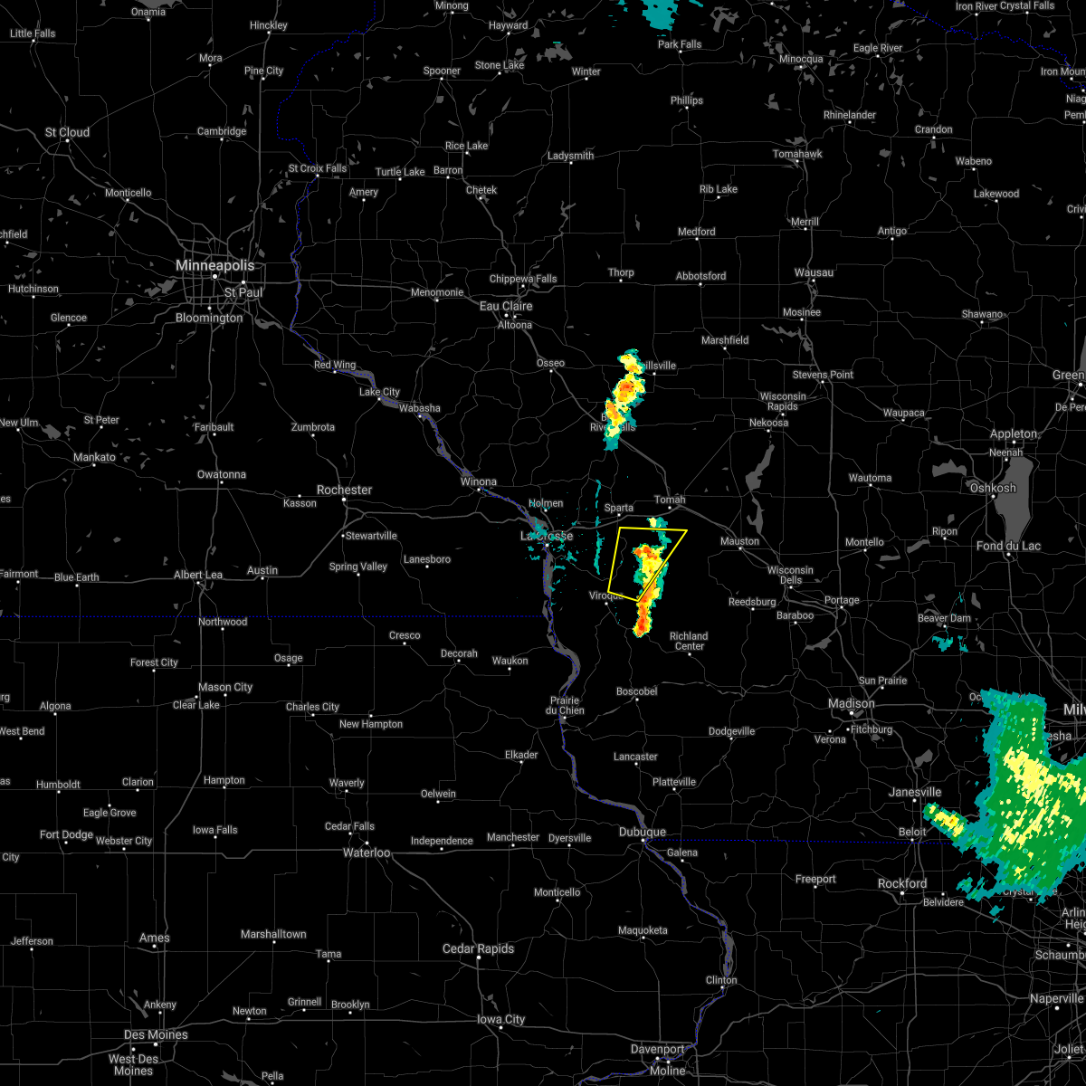 The severe thunderstorm warning for north central vernon and southern monroe counties will expire at 715 pm cdt, the storm which prompted the warning has weakened below severe limits, and no longer poses an immediate threat to life or property. therefore, the warning will be allowed to expire. however gusty winds are still possible with this thunderstorm. The severe thunderstorm warning for north central vernon and southern monroe counties will expire at 715 pm cdt, the storm which prompted the warning has weakened below severe limits, and no longer poses an immediate threat to life or property. therefore, the warning will be allowed to expire. however gusty winds are still possible with this thunderstorm.
|
| 6/11/2021 6:48 PM CDT |
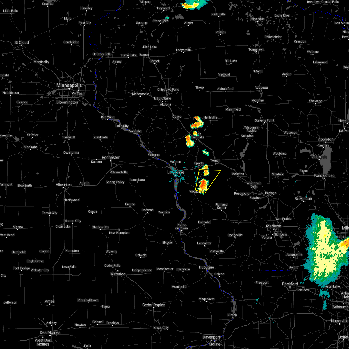 At 648 pm cdt, a severe thunderstorm was located near cashton, or 15 miles southeast of sparta, moving northeast at 30 mph (radar indicated). Hazards include 60 mph wind gusts and penny size hail. Expect damage to roofs, siding, and trees. Locations impacted include, westby, cashton, norwalk, ontario, wilton, ridgeville, melvina, oil city, jersey valley county park, st marys, avalanche, county roads d and p, highway 82 and county d, irish ridge, potts corners, newry and bloomingdale. At 648 pm cdt, a severe thunderstorm was located near cashton, or 15 miles southeast of sparta, moving northeast at 30 mph (radar indicated). Hazards include 60 mph wind gusts and penny size hail. Expect damage to roofs, siding, and trees. Locations impacted include, westby, cashton, norwalk, ontario, wilton, ridgeville, melvina, oil city, jersey valley county park, st marys, avalanche, county roads d and p, highway 82 and county d, irish ridge, potts corners, newry and bloomingdale.
|
| 6/11/2021 6:38 PM CDT |
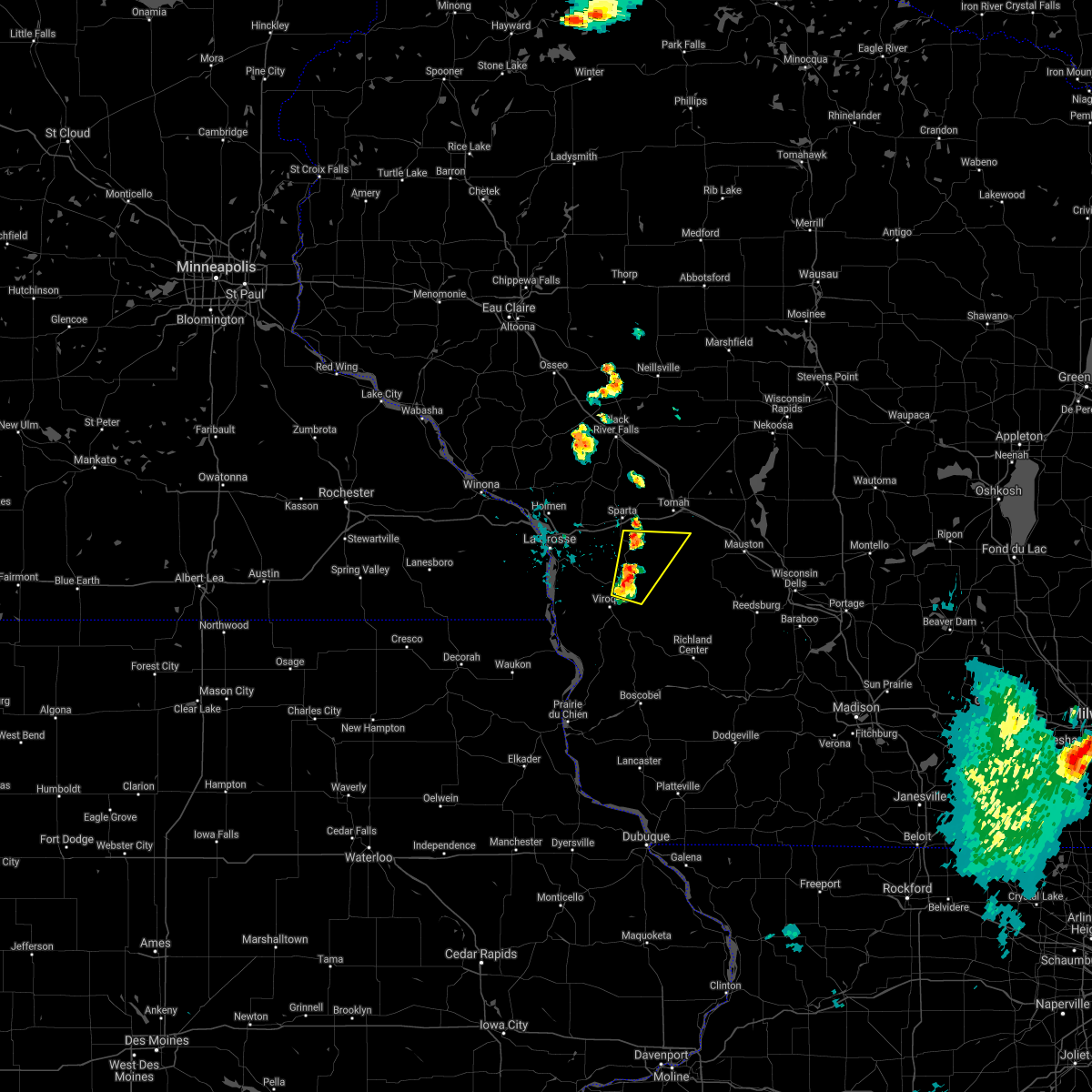 At 637 pm cdt, a severe thunderstorm was located near cashton, or 11 miles northeast of viroqua, moving northeast at 30 mph (radar indicated). Hazards include 60 mph wind gusts and quarter size hail. Hail damage to vehicles is expected. expect wind damage to roofs, siding, and trees. This severe thunderstorm will remain over mainly rural areas of north central vernon and southern monroe counties, including the following locations, oil city, jersey valley county park, st marys, wilton, avalanche, norwalk and melvina. At 637 pm cdt, a severe thunderstorm was located near cashton, or 11 miles northeast of viroqua, moving northeast at 30 mph (radar indicated). Hazards include 60 mph wind gusts and quarter size hail. Hail damage to vehicles is expected. expect wind damage to roofs, siding, and trees. This severe thunderstorm will remain over mainly rural areas of north central vernon and southern monroe counties, including the following locations, oil city, jersey valley county park, st marys, wilton, avalanche, norwalk and melvina.
|
| 5/2/2021 7:25 PM CDT |
 The severe thunderstorm warning for northeastern vernon and southeastern monroe counties will expire at 730 pm cdt, the storm which prompted the warning has weakened below severe limits, and no longer poses an immediate threat to life or property. therefore, the warning will be allowed to expire. however gusty winds and locally heavy rain are still possible with other storms. The severe thunderstorm warning for northeastern vernon and southeastern monroe counties will expire at 730 pm cdt, the storm which prompted the warning has weakened below severe limits, and no longer poses an immediate threat to life or property. therefore, the warning will be allowed to expire. however gusty winds and locally heavy rain are still possible with other storms.
|
| 5/2/2021 7:07 PM CDT |
 At 707 pm cdt, a severe thunderstorm was located 8 miles west of elroy, or 15 miles south of tomah, moving east at 20 mph (radar indicated). Hazards include quarter size hail. Damage to vehicles is expected. this severe storm will be near, hillsboro around 720 pm cdt. Other locations impacted by this severe thunderstorm include rockton, oil city, wildcat mountain state park, bartons corners, wilton, clifton and glendale. At 707 pm cdt, a severe thunderstorm was located 8 miles west of elroy, or 15 miles south of tomah, moving east at 20 mph (radar indicated). Hazards include quarter size hail. Damage to vehicles is expected. this severe storm will be near, hillsboro around 720 pm cdt. Other locations impacted by this severe thunderstorm include rockton, oil city, wildcat mountain state park, bartons corners, wilton, clifton and glendale.
|
| 5/2/2021 6:52 PM CDT |
 At 652 pm cdt, a severe thunderstorm was located 12 miles east of cashton, or 15 miles south of tomah, moving east at 20 mph (radar indicated). Hazards include quarter size hail. Damage to vehicles is expected. this severe thunderstorm will be near, hillsboro around 720 pm cdt. Other locations impacted by this severe thunderstorm include rockton, oil city, wildcat mountain state park, bartons corners, wilton, clifton and glendale. At 652 pm cdt, a severe thunderstorm was located 12 miles east of cashton, or 15 miles south of tomah, moving east at 20 mph (radar indicated). Hazards include quarter size hail. Damage to vehicles is expected. this severe thunderstorm will be near, hillsboro around 720 pm cdt. Other locations impacted by this severe thunderstorm include rockton, oil city, wildcat mountain state park, bartons corners, wilton, clifton and glendale.
|
| 7/6/2020 7:39 PM CDT |
 The severe thunderstorm warning for southwestern monroe county will expire at 745 pm cdt, the storm which prompted the warning has weakened below severe limits, and no longer poses an immediate threat to life or property. therefore, the warning will be allowed to expire. The severe thunderstorm warning for southwestern monroe county will expire at 745 pm cdt, the storm which prompted the warning has weakened below severe limits, and no longer poses an immediate threat to life or property. therefore, the warning will be allowed to expire.
|
| 7/6/2020 7:15 PM CDT |
 At 715 pm cdt, a severe thunderstorm was located near sparta, moving east at 25 mph (radar indicated). Hazards include 60 mph wind gusts. Expect damage to roofs, siding, and trees. This severe thunderstorm will remain over mainly rural areas of southwestern monroe county, including the following locations, i 90 exit 25, highway 33 and county y, st marys, norwalk, jackson pass, melvina and wilton. At 715 pm cdt, a severe thunderstorm was located near sparta, moving east at 25 mph (radar indicated). Hazards include 60 mph wind gusts. Expect damage to roofs, siding, and trees. This severe thunderstorm will remain over mainly rural areas of southwestern monroe county, including the following locations, i 90 exit 25, highway 33 and county y, st marys, norwalk, jackson pass, melvina and wilton.
|
| 7/6/2020 7:07 PM CDT |
 At 707 pm cdt, a severe thunderstorm was located near bangor, or near sparta, moving east at 25 mph (radar indicated). Hazards include 60 mph wind gusts. Expect damage to roofs, siding, and trees. this severe thunderstorm will be near, sparta around 720 pm cdt. Other locations impacted by this severe thunderstorm include st marys, jackson pass, wilton, rockland, tunnel city, middle ridge and i 90 exit 25. At 707 pm cdt, a severe thunderstorm was located near bangor, or near sparta, moving east at 25 mph (radar indicated). Hazards include 60 mph wind gusts. Expect damage to roofs, siding, and trees. this severe thunderstorm will be near, sparta around 720 pm cdt. Other locations impacted by this severe thunderstorm include st marys, jackson pass, wilton, rockland, tunnel city, middle ridge and i 90 exit 25.
|
| 6/2/2020 6:51 PM CDT |
 At 649 pm cdt, severe thunderstorms were located along a line extending from near necedah to 6 miles southeast of tomah to 9 miles northeast of cashton, moving southeast at 50 mph (radar indicated). Hazards include 60 mph wind gusts and quarter size hail. Hail damage to vehicles is expected. expect wind damage to roofs, siding, and trees. these severe storms will be near, necedah around 655 pm cdt. new lisbon around 705 pm cdt. elroy around 710 pm cdt. Other locations impacted by these severe thunderstorms include new miner, shamrock, stevenstown, potters flowage, county roads d e and e, johnson hill and glendale. At 649 pm cdt, severe thunderstorms were located along a line extending from near necedah to 6 miles southeast of tomah to 9 miles northeast of cashton, moving southeast at 50 mph (radar indicated). Hazards include 60 mph wind gusts and quarter size hail. Hail damage to vehicles is expected. expect wind damage to roofs, siding, and trees. these severe storms will be near, necedah around 655 pm cdt. new lisbon around 705 pm cdt. elroy around 710 pm cdt. Other locations impacted by these severe thunderstorms include new miner, shamrock, stevenstown, potters flowage, county roads d e and e, johnson hill and glendale.
|
| 6/2/2020 6:25 PM CDT |
 At 624 pm cdt, severe thunderstorms were located along a line extending from 10 miles east of millston to near fort mc coy to near sparta, moving east at 55 mph (radar indicated). Hazards include 60 mph wind gusts and quarter size hail. Hail damage to vehicles is expected. expect wind damage to roofs, siding, and trees. severe thunderstorms will be near, tomah around 635 pm cdt. necedah around 650 pm cdt. new lisbon around 655 pm cdt. elroy around 700 pm cdt. Other locations impacted by these severe thunderstorms include new miner, franklin, shamrock, the black river correctional center, camp decorah, stevenstown and potters flowage. At 624 pm cdt, severe thunderstorms were located along a line extending from 10 miles east of millston to near fort mc coy to near sparta, moving east at 55 mph (radar indicated). Hazards include 60 mph wind gusts and quarter size hail. Hail damage to vehicles is expected. expect wind damage to roofs, siding, and trees. severe thunderstorms will be near, tomah around 635 pm cdt. necedah around 650 pm cdt. new lisbon around 655 pm cdt. elroy around 700 pm cdt. Other locations impacted by these severe thunderstorms include new miner, franklin, shamrock, the black river correctional center, camp decorah, stevenstown and potters flowage.
|
| 7/20/2019 10:22 AM CDT |
 At 1021 am cdt, severe thunderstorms were located along a line extending from near lake wazeecha to 8 miles south of new rome to near new lisbon, moving east at 50 mph (radar indicated). Hazards include 70 mph wind gusts and penny size hail. Expect considerable tree damage. damage is likely to mobile homes, roofs, and outbuildings. severe thunderstorms will be near, new rome around 1025 am cdt. dellwood around 1035 am cdt. friendship and adams around 1045 am cdt. Other locations impacted by these severe thunderstorms include new miner, highways 13 and 21, county roads g and o, county roads g and m, johnson hill, jellystone park near warrens and highway 13 and county e. At 1021 am cdt, severe thunderstorms were located along a line extending from near lake wazeecha to 8 miles south of new rome to near new lisbon, moving east at 50 mph (radar indicated). Hazards include 70 mph wind gusts and penny size hail. Expect considerable tree damage. damage is likely to mobile homes, roofs, and outbuildings. severe thunderstorms will be near, new rome around 1025 am cdt. dellwood around 1035 am cdt. friendship and adams around 1045 am cdt. Other locations impacted by these severe thunderstorms include new miner, highways 13 and 21, county roads g and o, county roads g and m, johnson hill, jellystone park near warrens and highway 13 and county e.
|
| 7/20/2019 10:13 AM CDT |
 At 1012 am cdt, severe thunderstorms were located along a line extending from near pittsville to near babcock to 9 miles east of tomah, moving east at 55 mph (radar indicated. at 947 am 60 mph winds and building damage was reported in ft mc coy). Hazards include 70 mph wind gusts and penny size hail. Expect considerable tree damage. damage is likely to mobile homes, roofs, and outbuildings. these severe storms will be near, necedah around 1025 am cdt. dellwood around 1030 am cdt. Other locations impacted by these severe thunderstorms include new miner, shamrock, the black river correctional center, potters flowage, perry creek recreation area, rockland and johnson hill. At 1012 am cdt, severe thunderstorms were located along a line extending from near pittsville to near babcock to 9 miles east of tomah, moving east at 55 mph (radar indicated. at 947 am 60 mph winds and building damage was reported in ft mc coy). Hazards include 70 mph wind gusts and penny size hail. Expect considerable tree damage. damage is likely to mobile homes, roofs, and outbuildings. these severe storms will be near, necedah around 1025 am cdt. dellwood around 1030 am cdt. Other locations impacted by these severe thunderstorms include new miner, shamrock, the black river correctional center, potters flowage, perry creek recreation area, rockland and johnson hill.
|
| 7/20/2019 9:55 AM CDT |
 At 954 am cdt, severe thunderstorms were located along a line extending from 9 miles east of shortville to 10 miles east of millston to near fort mc coy, moving east at 55 mph (radar indicated). Hazards include 70 mph wind gusts and penny size hail. Expect considerable tree damage. damage is likely to mobile homes, roofs, and outbuildings. these severe storms will be near, necedah around 1025 am cdt. dellwood around 1030 am cdt. Other locations impacted by these severe thunderstorms include new miner, franklin, shamrock, potters flowage, rockland, county roads d e and e and johnson hill. At 954 am cdt, severe thunderstorms were located along a line extending from 9 miles east of shortville to 10 miles east of millston to near fort mc coy, moving east at 55 mph (radar indicated). Hazards include 70 mph wind gusts and penny size hail. Expect considerable tree damage. damage is likely to mobile homes, roofs, and outbuildings. these severe storms will be near, necedah around 1025 am cdt. dellwood around 1030 am cdt. Other locations impacted by these severe thunderstorms include new miner, franklin, shamrock, potters flowage, rockland, county roads d e and e and johnson hill.
|
| 7/20/2019 9:37 AM CDT |
 At 937 am cdt, severe thunderstorms were located along a line extending from near hatfield to near sparta, moving east at 40 mph (radar indicated. multiple reports of trees down across northern la crosse county). Hazards include 70 mph wind gusts and penny size hail. Expect considerable tree damage. damage is likely to mobile homes, roofs, and outbuildings. these severe storms will be near, hatfield around 940 am cdt. fort mc coy around 950 am cdt. new lisbon around 1025 am cdt. mauston around 1030 am cdt. Other locations impacted by these severe thunderstorms include new miner, franklin, shamrock, potters flowage, rockland, county roads d e and e and johnson hill. At 937 am cdt, severe thunderstorms were located along a line extending from near hatfield to near sparta, moving east at 40 mph (radar indicated. multiple reports of trees down across northern la crosse county). Hazards include 70 mph wind gusts and penny size hail. Expect considerable tree damage. damage is likely to mobile homes, roofs, and outbuildings. these severe storms will be near, hatfield around 940 am cdt. fort mc coy around 950 am cdt. new lisbon around 1025 am cdt. mauston around 1030 am cdt. Other locations impacted by these severe thunderstorms include new miner, franklin, shamrock, potters flowage, rockland, county roads d e and e and johnson hill.
|
| 7/20/2019 9:22 AM CDT |
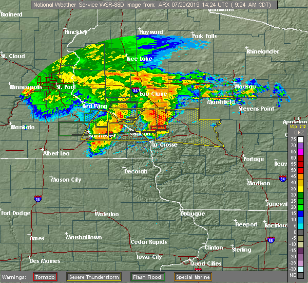 At 922 am cdt, severe thunderstorms were located along a line extending from 10 miles northwest of black river falls to west salem, moving east at 45 mph (radar indicated). Hazards include 70 mph wind gusts and penny size hail. Expect considerable tree damage. damage is likely to mobile homes, roofs, and outbuildings. severe thunderstorms will be near, bangor around 930 am cdt. sparta and black river falls around 940 am cdt. hatfield around 945 am cdt. fort mc coy around 950 am cdt. tomah around 1000 am cdt. new lisbon around 1025 am cdt. mauston, necedah and dellwood around 1030 am cdt. other locations impacted by these severe thunderstorms include new miner, franklin, shamrock, potters flowage, rockland. People attending the la crosse interstate fair, and ussa summerfest should seek safe shelter immediately!. At 922 am cdt, severe thunderstorms were located along a line extending from 10 miles northwest of black river falls to west salem, moving east at 45 mph (radar indicated). Hazards include 70 mph wind gusts and penny size hail. Expect considerable tree damage. damage is likely to mobile homes, roofs, and outbuildings. severe thunderstorms will be near, bangor around 930 am cdt. sparta and black river falls around 940 am cdt. hatfield around 945 am cdt. fort mc coy around 950 am cdt. tomah around 1000 am cdt. new lisbon around 1025 am cdt. mauston, necedah and dellwood around 1030 am cdt. other locations impacted by these severe thunderstorms include new miner, franklin, shamrock, potters flowage, rockland. People attending the la crosse interstate fair, and ussa summerfest should seek safe shelter immediately!.
|
| 6/27/2019 2:26 PM CDT |
 The severe thunderstorm warning for central monroe county will expire at 230 pm cdt, the storms which prompted the warning have weakened below severe limits, and no longer pose an immediate threat to life or property. therefore, the warning will be allowed to expire. however gusty winds of 30 to 45 mph and brief heavy rains are still possible with these thunderstorms. a severe thunderstorm watch remains in effect until 700 pm cdt for west central wisconsin. to report severe weather, contact your nearest law enforcement agency. they will relay your report to the national weather service la crosse. The severe thunderstorm warning for central monroe county will expire at 230 pm cdt, the storms which prompted the warning have weakened below severe limits, and no longer pose an immediate threat to life or property. therefore, the warning will be allowed to expire. however gusty winds of 30 to 45 mph and brief heavy rains are still possible with these thunderstorms. a severe thunderstorm watch remains in effect until 700 pm cdt for west central wisconsin. to report severe weather, contact your nearest law enforcement agency. they will relay your report to the national weather service la crosse.
|
| 6/27/2019 2:11 PM CDT |
 At 210 pm cdt, severe thunderstorms were located along a line extending from near fort mc coy to near cashton, moving east at 35 mph (trained weather spotters. at 209 pm, trees and branches were reported down in and north of sparta). Hazards include 60 mph wind gusts and quarter size hail. Hail damage to vehicles is expected. expect wind damage to roofs, siding, and trees. these severe storms will be near, tomah around 225 pm cdt. Other locations impacted by these severe thunderstorms include oil city, st marys, county roads i and i i, jackson pass, wilton, tunnel city and i 94 exit 143. At 210 pm cdt, severe thunderstorms were located along a line extending from near fort mc coy to near cashton, moving east at 35 mph (trained weather spotters. at 209 pm, trees and branches were reported down in and north of sparta). Hazards include 60 mph wind gusts and quarter size hail. Hail damage to vehicles is expected. expect wind damage to roofs, siding, and trees. these severe storms will be near, tomah around 225 pm cdt. Other locations impacted by these severe thunderstorms include oil city, st marys, county roads i and i i, jackson pass, wilton, tunnel city and i 94 exit 143.
|
| 6/27/2019 2:00 PM CDT |
 At 159 pm cdt, severe thunderstorms were located along a line extending from near cataract to cashton, moving east at 35 mph (radar indicated). Hazards include 60 mph wind gusts. Expect damage to roofs, siding, and trees. these severe storms will be near, fort mc coy around 210 pm cdt. tomah around 225 pm cdt. Other locations impacted by these severe thunderstorms include oil city, st marys, portland, county roads i and i i, jackson pass, wilton and tunnel city. At 159 pm cdt, severe thunderstorms were located along a line extending from near cataract to cashton, moving east at 35 mph (radar indicated). Hazards include 60 mph wind gusts. Expect damage to roofs, siding, and trees. these severe storms will be near, fort mc coy around 210 pm cdt. tomah around 225 pm cdt. Other locations impacted by these severe thunderstorms include oil city, st marys, portland, county roads i and i i, jackson pass, wilton and tunnel city.
|
| 6/27/2019 1:49 PM CDT |
 At 135 pm cdt, severe thunderstorms were located along a line extending from near north bend to near coon valley, moving east at 35 mph (emergency managment. at 130 pm trees and power lines were reported down in the city of la crosse. a boat was flipped on french island). Hazards include 60 mph wind gusts. Expect damage to roofs, siding, and trees. severe thunderstorms will be near, sparta and cashton around 200 pm cdt. fort mc coy around 210 pm cdt. tomah around 225 pm cdt. Other locations impacted by these severe thunderstorms include county roads g and h, portland, highways 14 61 and county m m, rockland, county roads d e and e, highway 33 and county y and i 90 exit 12. At 135 pm cdt, severe thunderstorms were located along a line extending from near north bend to near coon valley, moving east at 35 mph (emergency managment. at 130 pm trees and power lines were reported down in the city of la crosse. a boat was flipped on french island). Hazards include 60 mph wind gusts. Expect damage to roofs, siding, and trees. severe thunderstorms will be near, sparta and cashton around 200 pm cdt. fort mc coy around 210 pm cdt. tomah around 225 pm cdt. Other locations impacted by these severe thunderstorms include county roads g and h, portland, highways 14 61 and county m m, rockland, county roads d e and e, highway 33 and county y and i 90 exit 12.
|
| 6/27/2019 1:37 PM CDT |
 At 135 pm cdt, severe thunderstorms were located along a line extending from near north bend to near coon valley, moving east at 35 mph (emergency managment. at 130 pm trees and power lines were reported down in the city of la crosse. a boat was flipped on french island). Hazards include 60 mph wind gusts. Expect damage to roofs, siding, and trees. severe thunderstorms will be near, sparta and cashton around 200 pm cdt. fort mc coy around 210 pm cdt. tomah around 225 pm cdt. Other locations impacted by these severe thunderstorms include county roads g and h, portland, highways 14 61 and county m m, rockland, county roads d e and e, highway 33 and county y and i 90 exit 12. At 135 pm cdt, severe thunderstorms were located along a line extending from near north bend to near coon valley, moving east at 35 mph (emergency managment. at 130 pm trees and power lines were reported down in the city of la crosse. a boat was flipped on french island). Hazards include 60 mph wind gusts. Expect damage to roofs, siding, and trees. severe thunderstorms will be near, sparta and cashton around 200 pm cdt. fort mc coy around 210 pm cdt. tomah around 225 pm cdt. Other locations impacted by these severe thunderstorms include county roads g and h, portland, highways 14 61 and county m m, rockland, county roads d e and e, highway 33 and county y and i 90 exit 12.
|
| 5/24/2019 9:25 PM CDT |
 At 925 pm cdt, a severe thunderstorm capable of producing a tornado was located 10 miles southeast of sparta, moving northeast at 30 mph (radar indicated rotation). Hazards include tornado. Flying debris will be dangerous to those caught without shelter. mobile homes will be damaged or destroyed. damage to roofs, windows, and vehicles will occur. tree damage is likely. Locations impacted include, cashton, portland, norwalk, wilton, ridgeville, melvina, st marys, jackson pass and farmers valley. At 925 pm cdt, a severe thunderstorm capable of producing a tornado was located 10 miles southeast of sparta, moving northeast at 30 mph (radar indicated rotation). Hazards include tornado. Flying debris will be dangerous to those caught without shelter. mobile homes will be damaged or destroyed. damage to roofs, windows, and vehicles will occur. tree damage is likely. Locations impacted include, cashton, portland, norwalk, wilton, ridgeville, melvina, st marys, jackson pass and farmers valley.
|
| 5/24/2019 9:17 PM CDT |
 At 916 pm cdt, a severe thunderstorm capable of producing a tornado was located near cashton, or 8 miles southeast of sparta, moving northeast at 30 mph (radar indicated rotation). Hazards include tornado. Flying debris will be dangerous to those caught without shelter. mobile homes will be damaged or destroyed. damage to roofs, windows, and vehicles will occur. tree damage is likely. This tornadic thunderstorm will remain over mainly rural areas of southwestern monroe county, including the following locations, highway 33 and county y, st marys, portland, norwalk, jackson pass, melvina and wilton. At 916 pm cdt, a severe thunderstorm capable of producing a tornado was located near cashton, or 8 miles southeast of sparta, moving northeast at 30 mph (radar indicated rotation). Hazards include tornado. Flying debris will be dangerous to those caught without shelter. mobile homes will be damaged or destroyed. damage to roofs, windows, and vehicles will occur. tree damage is likely. This tornadic thunderstorm will remain over mainly rural areas of southwestern monroe county, including the following locations, highway 33 and county y, st marys, portland, norwalk, jackson pass, melvina and wilton.
|
| 5/24/2019 9:03 PM CDT |
 At 902 pm cdt, a severe thunderstorm capable of producing a tornado was located near cashton, or 11 miles south of sparta, moving northeast at 30 mph (radar indicated rotation). Hazards include tornado. Flying debris will be dangerous to those caught without shelter. mobile homes will be damaged or destroyed. damage to roofs, windows, and vehicles will occur. tree damage is likely. this dangerous storm will be near, cashton around 910 pm cdt. Other locations impacted by this tornadic thunderstorm include highway 33 and county y, st marys, portland, norwalk, jackson pass, melvina and wilton. At 902 pm cdt, a severe thunderstorm capable of producing a tornado was located near cashton, or 11 miles south of sparta, moving northeast at 30 mph (radar indicated rotation). Hazards include tornado. Flying debris will be dangerous to those caught without shelter. mobile homes will be damaged or destroyed. damage to roofs, windows, and vehicles will occur. tree damage is likely. this dangerous storm will be near, cashton around 910 pm cdt. Other locations impacted by this tornadic thunderstorm include highway 33 and county y, st marys, portland, norwalk, jackson pass, melvina and wilton.
|
| 8/28/2018 1:54 PM CDT |
 At 154 pm cdt, severe thunderstorms were located along a line extending from 8 miles southeast of tomah to 8 miles southwest of hillsboro, moving east at 40 mph (radar indicated). Hazards include 60 mph wind gusts. Expect damage to roofs, siding, and trees. severe thunderstorms will be near, elroy around 200 pm cdt. new lisbon around 210 pm cdt. mauston and wonewoc around 215 pm cdt. Other locations impacted by these severe thunderstorms include glendale, lemonweir, lindina, camp douglas and wilton. At 154 pm cdt, severe thunderstorms were located along a line extending from 8 miles southeast of tomah to 8 miles southwest of hillsboro, moving east at 40 mph (radar indicated). Hazards include 60 mph wind gusts. Expect damage to roofs, siding, and trees. severe thunderstorms will be near, elroy around 200 pm cdt. new lisbon around 210 pm cdt. mauston and wonewoc around 215 pm cdt. Other locations impacted by these severe thunderstorms include glendale, lemonweir, lindina, camp douglas and wilton.
|
| 7/12/2017 6:38 PM CDT |
 At 638 pm cdt, a severe thunderstorm was located 10 miles northwest of hillsboro, or 18 miles south of tomah, moving northeast at 45 mph (radar indicated). Hazards include 60 mph wind gusts and quarter size hail. Hail damage to vehicles is expected. expect wind damage to roofs, siding, and trees. this severe storm will be near, hillsboro around 645 pm cdt. wonewoc around 650 pm cdt. elroy around 655 pm cdt. mauston and new lisbon around 700 pm cdt. Other locations impacted by this severe thunderstorm include glendale, lindina, camp douglas, ontario and wilton. At 638 pm cdt, a severe thunderstorm was located 10 miles northwest of hillsboro, or 18 miles south of tomah, moving northeast at 45 mph (radar indicated). Hazards include 60 mph wind gusts and quarter size hail. Hail damage to vehicles is expected. expect wind damage to roofs, siding, and trees. this severe storm will be near, hillsboro around 645 pm cdt. wonewoc around 650 pm cdt. elroy around 655 pm cdt. mauston and new lisbon around 700 pm cdt. Other locations impacted by this severe thunderstorm include glendale, lindina, camp douglas, ontario and wilton.
|
| 7/12/2017 6:30 PM CDT |
 At 629 pm cdt, a severe thunderstorm was located 7 miles north of la farge, or 14 miles northeast of viroqua, moving northeast at 40 mph (radar indicated). Hazards include ping pong ball size hail and 60 mph wind gusts. People and animals outdoors will be injured. expect hail damage to roofs, siding, windows, and vehicles. expect wind damage to roofs, siding, and trees. this severe storm will be near, hillsboro around 650 pm cdt. mauston, elroy and new lisbon around 700 pm cdt. Other locations impacted by this severe thunderstorm include glendale, lindina, camp douglas, ontario and wilton. At 629 pm cdt, a severe thunderstorm was located 7 miles north of la farge, or 14 miles northeast of viroqua, moving northeast at 40 mph (radar indicated). Hazards include ping pong ball size hail and 60 mph wind gusts. People and animals outdoors will be injured. expect hail damage to roofs, siding, windows, and vehicles. expect wind damage to roofs, siding, and trees. this severe storm will be near, hillsboro around 650 pm cdt. mauston, elroy and new lisbon around 700 pm cdt. Other locations impacted by this severe thunderstorm include glendale, lindina, camp douglas, ontario and wilton.
|
| 7/12/2017 6:19 PM CDT |
 At 619 pm cdt, a severe thunderstorm was located near westby, or 8 miles northeast of viroqua, moving northeast at 40 mph (radar indicated). Hazards include golf ball size hail and 60 mph wind gusts. People and animals outdoors will be injured. expect hail damage to roofs, siding, windows, and vehicles. expect wind damage to roofs, siding, and trees. this severe storm will be near, la farge around 625 pm cdt. hillsboro around 650 pm cdt. mauston, elroy and new lisbon around 700 pm cdt. Other locations impacted by this severe thunderstorm include glendale, springville, lindina, viola and camp douglas. At 619 pm cdt, a severe thunderstorm was located near westby, or 8 miles northeast of viroqua, moving northeast at 40 mph (radar indicated). Hazards include golf ball size hail and 60 mph wind gusts. People and animals outdoors will be injured. expect hail damage to roofs, siding, windows, and vehicles. expect wind damage to roofs, siding, and trees. this severe storm will be near, la farge around 625 pm cdt. hillsboro around 650 pm cdt. mauston, elroy and new lisbon around 700 pm cdt. Other locations impacted by this severe thunderstorm include glendale, springville, lindina, viola and camp douglas.
|
| 7/12/2017 6:11 PM CDT |
 At 611 pm cdt, a severe thunderstorm was located near viroqua, moving northeast at 45 mph (radar indicated). Hazards include ping pong ball size hail and 60 mph wind gusts. People and animals outdoors will be injured. expect hail damage to roofs, siding, windows, and vehicles. expect wind damage to roofs, siding, and trees. this severe thunderstorm will be near, la farge around 620 pm cdt. hillsboro around 640 pm cdt. elroy and wonewoc around 650 pm cdt. mauston and new lisbon around 700 pm cdt. Other locations impacted by this severe thunderstorm include glendale, springville, lindina, viola and camp douglas. At 611 pm cdt, a severe thunderstorm was located near viroqua, moving northeast at 45 mph (radar indicated). Hazards include ping pong ball size hail and 60 mph wind gusts. People and animals outdoors will be injured. expect hail damage to roofs, siding, windows, and vehicles. expect wind damage to roofs, siding, and trees. this severe thunderstorm will be near, la farge around 620 pm cdt. hillsboro around 640 pm cdt. elroy and wonewoc around 650 pm cdt. mauston and new lisbon around 700 pm cdt. Other locations impacted by this severe thunderstorm include glendale, springville, lindina, viola and camp douglas.
|
| 6/16/2017 8:11 PM CDT |
 The severe thunderstorm warning for eastern vernon and monroe counties will expire at 815 pm cdt, the storms which prompted the warning have weakened below severe limits, and no longer pose an immediate threat to life or property. therefore the warning will be allowed to expire. a severe thunderstorm watch remains in effect until 1000 pm cdt for central, southwestern and west central wisconsin. The severe thunderstorm warning for eastern vernon and monroe counties will expire at 815 pm cdt, the storms which prompted the warning have weakened below severe limits, and no longer pose an immediate threat to life or property. therefore the warning will be allowed to expire. a severe thunderstorm watch remains in effect until 1000 pm cdt for central, southwestern and west central wisconsin.
|
| 6/16/2017 7:52 PM CDT |
 At 751 pm cdt, severe thunderstorms were located along a line extending from 6 miles southeast of millston to 7 miles south of tomah to near la farge, moving northeast at 30 mph (public. this line of storms has a history of producing damaging wind gusts). Hazards include 60 mph wind gusts. Expect damage to roofs, siding, and trees. these severe storms will be near, tomah around 755 pm cdt. hillsboro around 815 pm cdt. Other locations impacted by these severe thunderstorms include glendale, viola, norwalk, ontario and liberty. At 751 pm cdt, severe thunderstorms were located along a line extending from 6 miles southeast of millston to 7 miles south of tomah to near la farge, moving northeast at 30 mph (public. this line of storms has a history of producing damaging wind gusts). Hazards include 60 mph wind gusts. Expect damage to roofs, siding, and trees. these severe storms will be near, tomah around 755 pm cdt. hillsboro around 815 pm cdt. Other locations impacted by these severe thunderstorms include glendale, viola, norwalk, ontario and liberty.
|
| 6/16/2017 7:26 PM CDT |
 At 725 pm cdt, severe thunderstorms were located along a line extending from 6 miles northwest of sparta to near cashton to near viroqua, moving northeast at 50 mph (radar indicated). Hazards include 60 mph wind gusts. Expect damage to roofs, siding, and trees. severe thunderstorms will be near, sparta around 730 pm cdt. cataract around 735 pm cdt. la farge and fort mc coy around 740 pm cdt. tomah around 750 pm cdt. hillsboro around 800 pm cdt. Other locations impacted by these severe thunderstorms include glendale, viola, norwalk, ontario and liberty. At 725 pm cdt, severe thunderstorms were located along a line extending from 6 miles northwest of sparta to near cashton to near viroqua, moving northeast at 50 mph (radar indicated). Hazards include 60 mph wind gusts. Expect damage to roofs, siding, and trees. severe thunderstorms will be near, sparta around 730 pm cdt. cataract around 735 pm cdt. la farge and fort mc coy around 740 pm cdt. tomah around 750 pm cdt. hillsboro around 800 pm cdt. Other locations impacted by these severe thunderstorms include glendale, viola, norwalk, ontario and liberty.
|
| 6/14/2017 1:23 PM CDT |
 At 121 pm cdt, a line of thunderstorms with wind gusts of 40 to 60 mph was moving through the area, along with producing heavy rains. spotters have reported wind gusts of 40 to 50 mph with trees being blown around (radar indicated). Hazards include 60 mph wind gusts. Expect possible damage to roofs, siding, and trees. These severe thunderstorms will remain over mainly rural areas of northeastern vernon, eastern richland and southeastern monroe counties, including the following locations: germantown, glendale, lone rock, rockbridge and avoca. At 121 pm cdt, a line of thunderstorms with wind gusts of 40 to 60 mph was moving through the area, along with producing heavy rains. spotters have reported wind gusts of 40 to 50 mph with trees being blown around (radar indicated). Hazards include 60 mph wind gusts. Expect possible damage to roofs, siding, and trees. These severe thunderstorms will remain over mainly rural areas of northeastern vernon, eastern richland and southeastern monroe counties, including the following locations: germantown, glendale, lone rock, rockbridge and avoca.
|
| 6/14/2017 1:04 PM CDT |
 At 104 pm cdt, severe thunderstorms were located along a line extending from 8 miles north of la farge to 12 miles south of hillsboro to near richland center, moving east at 50 mph (radar indicated). Hazards include 60 mph wind gusts. Expect damage to roofs, siding, and trees. severe thunderstorms will be near, hillsboro around 120 pm cdt. Sextonville around 120 pm cdt other locations impacted by these severe thunderstorms include germantown, glendale, lone rock, rockbridge and norwalk. At 104 pm cdt, severe thunderstorms were located along a line extending from 8 miles north of la farge to 12 miles south of hillsboro to near richland center, moving east at 50 mph (radar indicated). Hazards include 60 mph wind gusts. Expect damage to roofs, siding, and trees. severe thunderstorms will be near, hillsboro around 120 pm cdt. Sextonville around 120 pm cdt other locations impacted by these severe thunderstorms include germantown, glendale, lone rock, rockbridge and norwalk.
|
| 5/17/2017 8:23 PM CDT |
 At 823 pm cdt, severe thunderstorms were located along a line extending from near fort mc coy to near baraboo, moving north at 80 mph (law enforcement. trees damage has been reported in hillsboro and winds estimated at 50 to 60 mph in melvina in monroe county). Hazards include 70 mph wind gusts. Expect considerable tree damage. damage is likely to mobile homes, roofs, and outbuildings. locations impacted include, sparta, hillsboro, norwalk, ontario, wilton, melvina, wildcat mountain state park, trippville, hoffman corners, oil city, st marys, farmers valley, bartons corners, mount tabor, dilly, i 90 exit 28 and benders corners. A tornado watch remains in effect until 1100 pm cdt for central, southwestern and west central wisconsin. At 823 pm cdt, severe thunderstorms were located along a line extending from near fort mc coy to near baraboo, moving north at 80 mph (law enforcement. trees damage has been reported in hillsboro and winds estimated at 50 to 60 mph in melvina in monroe county). Hazards include 70 mph wind gusts. Expect considerable tree damage. damage is likely to mobile homes, roofs, and outbuildings. locations impacted include, sparta, hillsboro, norwalk, ontario, wilton, melvina, wildcat mountain state park, trippville, hoffman corners, oil city, st marys, farmers valley, bartons corners, mount tabor, dilly, i 90 exit 28 and benders corners. A tornado watch remains in effect until 1100 pm cdt for central, southwestern and west central wisconsin.
|
| 5/17/2017 8:16 PM CDT |
 At 814 pm cdt, severe thunderstorms were located along a line extending from near cashton to near sauk city, moving northeast at 60 mph (law enforcement. many power lines and trees are downed in richland county in southwest wisconsin. winds further north toward viroqua and la crosse have been measured in the 40- 50 mph range). Hazards include 70 mph wind gusts. Expect considerable tree damage. damage is likely to mobile homes, roofs, and outbuildings. these severe thunderstorms will remain over mainly rural areas of northeastern vernon, northeastern richland and southern monroe counties, including the following locations: germantown, leon, portland, lone rock and rockbridge. A tornado watch remains in effect until 1100 pm cdt for central, southwestern and west central wisconsin. At 814 pm cdt, severe thunderstorms were located along a line extending from near cashton to near sauk city, moving northeast at 60 mph (law enforcement. many power lines and trees are downed in richland county in southwest wisconsin. winds further north toward viroqua and la crosse have been measured in the 40- 50 mph range). Hazards include 70 mph wind gusts. Expect considerable tree damage. damage is likely to mobile homes, roofs, and outbuildings. these severe thunderstorms will remain over mainly rural areas of northeastern vernon, northeastern richland and southern monroe counties, including the following locations: germantown, leon, portland, lone rock and rockbridge. A tornado watch remains in effect until 1100 pm cdt for central, southwestern and west central wisconsin.
|
| 5/17/2017 8:10 PM CDT |
 At 808 pm cdt, severe thunderstorms were located along a line extending from west salem to 8 miles south of hillsboro to spring green, moving northeast at 60 mph (law enforcement. many power lines and trees are downed in richland county in southwest wisconsin. winds further north toward la crosse have been measured in the 40-50 mph range). Hazards include 70 mph wind gusts. Expect considerable tree damage. damage is likely to mobile homes, roofs, and outbuildings. these severe storms will be near, sparta and hillsboro around 815 pm cdt. other locations impacted by these severe thunderstorms include germantown, medary, springville, leon and portland. A tornado watch remains in effect until 1100 pm cdt for southeastern minnesota, and central, southwestern and west central wisconsin. At 808 pm cdt, severe thunderstorms were located along a line extending from west salem to 8 miles south of hillsboro to spring green, moving northeast at 60 mph (law enforcement. many power lines and trees are downed in richland county in southwest wisconsin. winds further north toward la crosse have been measured in the 40-50 mph range). Hazards include 70 mph wind gusts. Expect considerable tree damage. damage is likely to mobile homes, roofs, and outbuildings. these severe storms will be near, sparta and hillsboro around 815 pm cdt. other locations impacted by these severe thunderstorms include germantown, medary, springville, leon and portland. A tornado watch remains in effect until 1100 pm cdt for southeastern minnesota, and central, southwestern and west central wisconsin.
|
| 5/17/2017 7:52 PM CDT |
 At 751 pm cdt, severe thunderstorms were located along a line extending from near brownsville to 8 miles west of richland center to near dodgeville, moving north at 65 mph (law enforcement. 45 mph winds were reported in desoto in vernon county and 65 mph winds were reported in eastman in crawford county at 745 pm). Hazards include 70 mph wind gusts. Expect considerable tree damage. damage is likely to mobile homes, roofs, and outbuildings. these severe storms will be near, richland center, stoddard and coon valley around 755 pm cdt. la crosse around 800 pm cdt. west salem, onalaska, bangor and la farge around 805 pm cdt. hillsboro around 815 pm cdt. other locations impacted by these severe thunderstorms include germantown, westport, newton, excelsior and medary. A tornado watch remains in effect until 1100 pm cdt for northeastern iowa, southeastern minnesota, and central, southwestern and west central wisconsin. At 751 pm cdt, severe thunderstorms were located along a line extending from near brownsville to 8 miles west of richland center to near dodgeville, moving north at 65 mph (law enforcement. 45 mph winds were reported in desoto in vernon county and 65 mph winds were reported in eastman in crawford county at 745 pm). Hazards include 70 mph wind gusts. Expect considerable tree damage. damage is likely to mobile homes, roofs, and outbuildings. these severe storms will be near, richland center, stoddard and coon valley around 755 pm cdt. la crosse around 800 pm cdt. west salem, onalaska, bangor and la farge around 805 pm cdt. hillsboro around 815 pm cdt. other locations impacted by these severe thunderstorms include germantown, westport, newton, excelsior and medary. A tornado watch remains in effect until 1100 pm cdt for northeastern iowa, southeastern minnesota, and central, southwestern and west central wisconsin.
|
| 5/17/2017 7:37 PM CDT |
 At 735 pm cdt, severe thunderstorms were located along a line extending from 6 miles north of houston, to near boscobel to cuba city, moving north at 60 mph (law enforcement. in southwest wisconsin...65-75 mph winds have caused extensive damage to trees and outbuildings. further north toward the minnesota-iowa border, 50-60 mph winds have been reported). Hazards include 70 mph wind gusts. Expect considerable tree damage. damage is likely to mobile homes, roofs, and outbuildings. these severe storms will be near, clayton around 750 pm cdt. la farge around 805 pm cdt. hillsboro around 815 pm cdt. other locations impacted by these severe thunderstorms include germantown, westport, newton, excelsior and medary. A tornado watch remains in effect until 1100 pm cdt for northeastern iowa, southeastern minnesota, and central, southwestern and west central wisconsin. At 735 pm cdt, severe thunderstorms were located along a line extending from 6 miles north of houston, to near boscobel to cuba city, moving north at 60 mph (law enforcement. in southwest wisconsin...65-75 mph winds have caused extensive damage to trees and outbuildings. further north toward the minnesota-iowa border, 50-60 mph winds have been reported). Hazards include 70 mph wind gusts. Expect considerable tree damage. damage is likely to mobile homes, roofs, and outbuildings. these severe storms will be near, clayton around 750 pm cdt. la farge around 805 pm cdt. hillsboro around 815 pm cdt. other locations impacted by these severe thunderstorms include germantown, westport, newton, excelsior and medary. A tornado watch remains in effect until 1100 pm cdt for northeastern iowa, southeastern minnesota, and central, southwestern and west central wisconsin.
|
| 5/17/2017 7:31 PM CDT |
 At 730 pm cdt, severe thunderstorms were located along a line extending from caledonia to platteville, moving north at 80 mph (law enforcement. 75 mph winds were reported at patch grove southwet wisconsin and 70 mph winds in glen haven sconsin between 710 and 720 pm). Hazards include 70 mph wind gusts. Expect considerable tree damage. damage is likely to mobile homes, roofs, and outbuildings. severe thunderstorms will be near, la crosse around 745 pm cdt. onalaska and west salem around 750 pm cdt. muscoda around 755 pm cdt. other locations impacted by these severe thunderstorms include germantown, westport, newton, excelsior and medary. A tornado watch remains in effect until 1100 pm cdt for northeastern iowa, southeastern minnesota, and central, southwestern and west central wisconsin. At 730 pm cdt, severe thunderstorms were located along a line extending from caledonia to platteville, moving north at 80 mph (law enforcement. 75 mph winds were reported at patch grove southwet wisconsin and 70 mph winds in glen haven sconsin between 710 and 720 pm). Hazards include 70 mph wind gusts. Expect considerable tree damage. damage is likely to mobile homes, roofs, and outbuildings. severe thunderstorms will be near, la crosse around 745 pm cdt. onalaska and west salem around 750 pm cdt. muscoda around 755 pm cdt. other locations impacted by these severe thunderstorms include germantown, westport, newton, excelsior and medary. A tornado watch remains in effect until 1100 pm cdt for northeastern iowa, southeastern minnesota, and central, southwestern and west central wisconsin.
|
| 5/17/2017 6:07 PM CDT |
 At 606 pm cdt, severe thunderstorms were located along a line extending from near tomah to near wonewoc, moving northeast at 50 mph (law enforcement. reports of 55-60 mph winds are being reported near tomah). Hazards include 70 mph wind gusts and penny size hail. some rotation is seen near north of tomah and a tornado may be possible. Expect considerable tree damage. damage is likely to mobile homes, roofs, and outbuildings. these severe storms will be near, mauston and new lisbon around 615 pm cdt. other locations impacted by these severe thunderstorms include glendale, lindina, norwalk, camp douglas and ontario. A tornado watch remains in effect until 1100 pm cdt for central, southwestern and west central wisconsin. At 606 pm cdt, severe thunderstorms were located along a line extending from near tomah to near wonewoc, moving northeast at 50 mph (law enforcement. reports of 55-60 mph winds are being reported near tomah). Hazards include 70 mph wind gusts and penny size hail. some rotation is seen near north of tomah and a tornado may be possible. Expect considerable tree damage. damage is likely to mobile homes, roofs, and outbuildings. these severe storms will be near, mauston and new lisbon around 615 pm cdt. other locations impacted by these severe thunderstorms include glendale, lindina, norwalk, camp douglas and ontario. A tornado watch remains in effect until 1100 pm cdt for central, southwestern and west central wisconsin.
|
| 5/17/2017 5:55 PM CDT |
 At 555 pm cdt, severe thunderstorms were located along a line extending from near fort mc coy to near hillsboro, moving northeast at 45 mph (law enforcement). Hazards include 60 mph wind gusts and penny size hail. Expect damage to roofs, siding, and trees. severe thunderstorms will be near, wonewoc around 600 pm cdt. elroy around 605 pm cdt. tomah around 610 pm cdt. mauston and new lisbon around 615 pm cdt. necedah around 630 pm cdt. other locations impacted by these severe thunderstorms include glendale, lindina, norwalk, camp douglas and ontario. A tornado watch remains in effect until 1100 pm cdt for central, southwestern and west central wisconsin. At 555 pm cdt, severe thunderstorms were located along a line extending from near fort mc coy to near hillsboro, moving northeast at 45 mph (law enforcement). Hazards include 60 mph wind gusts and penny size hail. Expect damage to roofs, siding, and trees. severe thunderstorms will be near, wonewoc around 600 pm cdt. elroy around 605 pm cdt. tomah around 610 pm cdt. mauston and new lisbon around 615 pm cdt. necedah around 630 pm cdt. other locations impacted by these severe thunderstorms include glendale, lindina, norwalk, camp douglas and ontario. A tornado watch remains in effect until 1100 pm cdt for central, southwestern and west central wisconsin.
|
| 3/6/2017 9:16 PM CST |
 At 916 pm cst, severe thunderstorms were located along a line extending from near millston to near tomah to 7 miles west of hillsboro, moving east at 65 mph (radar indicated). Hazards include 60 mph wind gusts. Expect damage to roofs, siding, and trees. These severe thunderstorms will remain over mainly rural areas of northeastern vernon and monroe counties, including the following locations: glendale, norwalk, ontario, wilton and ridgeville. At 916 pm cst, severe thunderstorms were located along a line extending from near millston to near tomah to 7 miles west of hillsboro, moving east at 65 mph (radar indicated). Hazards include 60 mph wind gusts. Expect damage to roofs, siding, and trees. These severe thunderstorms will remain over mainly rural areas of northeastern vernon and monroe counties, including the following locations: glendale, norwalk, ontario, wilton and ridgeville.
|
| 3/6/2017 8:55 PM CST |
 At 854 pm cst, severe thunderstorms were located along a line extending from near north bend to 7 miles southeast of bangor to near viroqua, moving east at 65 mph (trained weather spotters have reported 50 mph winds with this line of storms between 830 and 850 pm). Hazards include 60 mph wind gusts. Expect damage to roofs, siding, and trees. severe thunderstorms will be near, sparta and cashton around 900 pm cst. cataract and la farge around 905 pm cst. fort mc coy around 910 pm cst. tomah around 915 pm cst. Hillsboro around 920 pm cst. At 854 pm cst, severe thunderstorms were located along a line extending from near north bend to 7 miles southeast of bangor to near viroqua, moving east at 65 mph (trained weather spotters have reported 50 mph winds with this line of storms between 830 and 850 pm). Hazards include 60 mph wind gusts. Expect damage to roofs, siding, and trees. severe thunderstorms will be near, sparta and cashton around 900 pm cst. cataract and la farge around 905 pm cst. fort mc coy around 910 pm cst. tomah around 915 pm cst. Hillsboro around 920 pm cst.
|
| 8/4/2016 4:04 PM CDT |
 At 403 pm cdt, severe thunderstorms were located along a line extending from 7 miles southwest of tomah to 8 miles northeast of la farge to viroqua, moving east at 45 mph (public). Hazards include 60 mph wind gusts. Expect damage to roofs. siding. and trees. These severe thunderstorms will remain over mainly rural areas of southeastern monroe and north central vernon counties, including the following locations: springville, norwalk, ontario, wilton and ridgeville. At 403 pm cdt, severe thunderstorms were located along a line extending from 7 miles southwest of tomah to 8 miles northeast of la farge to viroqua, moving east at 45 mph (public). Hazards include 60 mph wind gusts. Expect damage to roofs. siding. and trees. These severe thunderstorms will remain over mainly rural areas of southeastern monroe and north central vernon counties, including the following locations: springville, norwalk, ontario, wilton and ridgeville.
|
| 8/4/2016 3:59 PM CDT |
 At 358 pm cdt, severe thunderstorms were located along a line extending from 9 miles south of tomah to viroqua, moving east at 60 mph (public. this line of storms has a history of confirmed wind damage and torrential rainfall). Hazards include 60 mph wind gusts. Expect damage to roofs. siding. and trees. These severe thunderstorms will remain over mainly rural areas of southern monroe, east central la crosse and northwestern vernon counties, including the following locations: newton, springville, leon, portland and burns. At 358 pm cdt, severe thunderstorms were located along a line extending from 9 miles south of tomah to viroqua, moving east at 60 mph (public. this line of storms has a history of confirmed wind damage and torrential rainfall). Hazards include 60 mph wind gusts. Expect damage to roofs. siding. and trees. These severe thunderstorms will remain over mainly rural areas of southern monroe, east central la crosse and northwestern vernon counties, including the following locations: newton, springville, leon, portland and burns.
|
| 8/4/2016 3:42 PM CDT |
 At 339 pm cdt, severe thunderstorms were located along a line extending from near sparta to near cashton to stoddard, moving east at 45 mph (this storm is producing widespread winds of 60 to 65 mph and tree damage. many reports of tree damage have been received in west salem and the city of la crosse). Hazards include 60 to 65 mph measured wind gusts. Expect damage to roofs. siding. and trees. these severe storms will be near, sparta and cashton around 345 pm cdt. viroqua and westby around 400 pm cdt. la farge around 415 pm cdt. Other locations impacted by these severe thunderstorms include newton, springville, leon, portland and burns. At 339 pm cdt, severe thunderstorms were located along a line extending from near sparta to near cashton to stoddard, moving east at 45 mph (this storm is producing widespread winds of 60 to 65 mph and tree damage. many reports of tree damage have been received in west salem and the city of la crosse). Hazards include 60 to 65 mph measured wind gusts. Expect damage to roofs. siding. and trees. these severe storms will be near, sparta and cashton around 345 pm cdt. viroqua and westby around 400 pm cdt. la farge around 415 pm cdt. Other locations impacted by these severe thunderstorms include newton, springville, leon, portland and burns.
|
| 8/4/2016 3:31 PM CDT |
 At 330 pm cdt, severe thunderstorms were located along a line extending from near bangor to near brownsville, moving southeast at 50 mph (law enforcement). Hazards include 60 mph wind gusts. Expect damage to roofs. siding. and trees. severe thunderstorms will be near, sparta around 335 pm cdt. coon valley around 340 pm cdt. cashton around 345 pm cdt. westby around 350 pm cdt. viroqua around 355 pm cdt. la farge around 405 pm cdt. Other locations impacted by these severe thunderstorms include newton, springville, leon, portland and burns. At 330 pm cdt, severe thunderstorms were located along a line extending from near bangor to near brownsville, moving southeast at 50 mph (law enforcement). Hazards include 60 mph wind gusts. Expect damage to roofs. siding. and trees. severe thunderstorms will be near, sparta around 335 pm cdt. coon valley around 340 pm cdt. cashton around 345 pm cdt. westby around 350 pm cdt. viroqua around 355 pm cdt. la farge around 405 pm cdt. Other locations impacted by these severe thunderstorms include newton, springville, leon, portland and burns.
|
| 7/21/2016 4:14 PM CDT |
 At 413 pm cdt, severe thunderstorms were located along a line extending from near friendship to 6 miles northwest of hillsboro, moving east at 40 mph (law enforcement). Hazards include 60 mph wind gusts and penny size hail. Expect damage to roofs. siding. and trees. severe thunderstorms will be near, friendship and adams around 420 pm cdt. new lisbon around 430 pm cdt. mauston around 435 pm cdt. other locations impacted by these severe thunderstorms include glendale, lemonweir, lindina, camp douglas and wilton. This warning replaces the previous warning for northern juneau and northern adams counties. At 413 pm cdt, severe thunderstorms were located along a line extending from near friendship to 6 miles northwest of hillsboro, moving east at 40 mph (law enforcement). Hazards include 60 mph wind gusts and penny size hail. Expect damage to roofs. siding. and trees. severe thunderstorms will be near, friendship and adams around 420 pm cdt. new lisbon around 430 pm cdt. mauston around 435 pm cdt. other locations impacted by these severe thunderstorms include glendale, lemonweir, lindina, camp douglas and wilton. This warning replaces the previous warning for northern juneau and northern adams counties.
|
| 7/5/2016 10:33 PM CDT |
 At 1033 pm cdt, severe thunderstorms were located along a line extending from 8 miles southeast of millston to 7 miles southwest of viroqua, moving east at 55 mph (trained weather spotters). Hazards include 70 mph wind gusts. Expect considerable tree damage. damage is likely to mobile homes, roofs, and outbuildings. these severe storms will be near, tomah around 1040 pm cdt. la farge around 1045 pm cdt. Other locations impacted by these severe thunderstorms include newton, springville, leon, portland and burns. At 1033 pm cdt, severe thunderstorms were located along a line extending from 8 miles southeast of millston to 7 miles southwest of viroqua, moving east at 55 mph (trained weather spotters). Hazards include 70 mph wind gusts. Expect considerable tree damage. damage is likely to mobile homes, roofs, and outbuildings. these severe storms will be near, tomah around 1040 pm cdt. la farge around 1045 pm cdt. Other locations impacted by these severe thunderstorms include newton, springville, leon, portland and burns.
|
| 7/5/2016 10:25 PM CDT |
 At 1024 pm cdt, severe thunderstorms were located along a line extending from near millston to 9 miles southeast of stoddard, moving east at 60 mph (trained weather spotters). Hazards include 70 mph wind gusts. Expect considerable tree damage. damage is likely to mobile homes, roofs, and outbuildings. these severe storms will be near, tomah and fort mc coy around 1030 pm cdt. la farge around 1045 pm cdt. Other locations impacted by these severe thunderstorms include newton, medary, springville, leon and portland. At 1024 pm cdt, severe thunderstorms were located along a line extending from near millston to 9 miles southeast of stoddard, moving east at 60 mph (trained weather spotters). Hazards include 70 mph wind gusts. Expect considerable tree damage. damage is likely to mobile homes, roofs, and outbuildings. these severe storms will be near, tomah and fort mc coy around 1030 pm cdt. la farge around 1045 pm cdt. Other locations impacted by these severe thunderstorms include newton, medary, springville, leon and portland.
|
| 7/5/2016 10:12 PM CDT |
 At 1010 pm cdt, severe thunderstorms were located along a line extending from near cataract to near new albin, moving east at 60 mph (spotters reported). Hazards include 70 mph wind gusts. Expect considerable tree damage. damage is likely to mobile homes, roofs, and outbuildings. these severe storms will be near, sparta and cataract around 1015 pm cdt. fort mc coy around 1020 pm cdt. tomah and coon valley around 1030 pm cdt. viroqua and westby around 1035 pm cdt. la farge around 1045 pm cdt. Other locations impacted by these severe thunderstorms include newton, medary, springville, leon and portland. At 1010 pm cdt, severe thunderstorms were located along a line extending from near cataract to near new albin, moving east at 60 mph (spotters reported). Hazards include 70 mph wind gusts. Expect considerable tree damage. damage is likely to mobile homes, roofs, and outbuildings. these severe storms will be near, sparta and cataract around 1015 pm cdt. fort mc coy around 1020 pm cdt. tomah and coon valley around 1030 pm cdt. viroqua and westby around 1035 pm cdt. la farge around 1045 pm cdt. Other locations impacted by these severe thunderstorms include newton, medary, springville, leon and portland.
|
| 7/5/2016 10:00 PM CDT |
 At 959 pm cdt, severe thunderstorms were located along a line extending from north bend to near spring grove, moving east at 60 mph (radar indicated). Hazards include 60 mph wind gusts. Expect damage to roofs. siding. and trees. these severe storms will be near, sparta, cataract, stoddard and brownsville around 1015 pm cdt. fort mc coy around 1020 pm cdt. coon valley around 1025 pm cdt. Viroqua and tomah around 1030 pm cdt. At 959 pm cdt, severe thunderstorms were located along a line extending from north bend to near spring grove, moving east at 60 mph (radar indicated). Hazards include 60 mph wind gusts. Expect damage to roofs. siding. and trees. these severe storms will be near, sparta, cataract, stoddard and brownsville around 1015 pm cdt. fort mc coy around 1020 pm cdt. coon valley around 1025 pm cdt. Viroqua and tomah around 1030 pm cdt.
|
| 7/5/2016 9:49 PM CDT |
 At 949 pm cdt, severe thunderstorms were located along a line extending from galesville to mabel, moving east at 60 mph (radar indicated). Hazards include 60 mph wind gusts. Expect damage to roofs. siding. and trees. severe thunderstorms will be near, brice prairie, holmen and onalaska around 955 pm cdt. new albin around 1010 pm cdt. sparta, cataract, stoddard and brownsville around 1015 pm cdt. fort mc coy around 1020 pm cdt. Other locations impacted by these severe thunderstorms include newton, medary, springville, leon and portland. At 949 pm cdt, severe thunderstorms were located along a line extending from galesville to mabel, moving east at 60 mph (radar indicated). Hazards include 60 mph wind gusts. Expect damage to roofs. siding. and trees. severe thunderstorms will be near, brice prairie, holmen and onalaska around 955 pm cdt. new albin around 1010 pm cdt. sparta, cataract, stoddard and brownsville around 1015 pm cdt. fort mc coy around 1020 pm cdt. Other locations impacted by these severe thunderstorms include newton, medary, springville, leon and portland.
|
| 6/26/2016 1:14 AM CDT |
 At 113 am cdt, severe thunderstorms were located along a line extending from 12 miles northeast of tomah to 8 miles west of hillsboro, moving east at 50 mph (law enforcement). Hazards include 60 mph wind gusts. Expect damage to roofs. siding. and trees. these severe thunderstorms will remain over mainly rural areas of eastern monroe and northeastern vernon counties, including the following locations: glendale, ontario, wilton, ridgeville and kendall. People attending the tomah super national truck and tractor pull should seek safe shelter immediately!. At 113 am cdt, severe thunderstorms were located along a line extending from 12 miles northeast of tomah to 8 miles west of hillsboro, moving east at 50 mph (law enforcement). Hazards include 60 mph wind gusts. Expect damage to roofs. siding. and trees. these severe thunderstorms will remain over mainly rural areas of eastern monroe and northeastern vernon counties, including the following locations: glendale, ontario, wilton, ridgeville and kendall. People attending the tomah super national truck and tractor pull should seek safe shelter immediately!.
|
| 6/26/2016 1:01 AM CDT |
 At 100 am cdt, severe thunderstorms were located along a line extending from 6 miles north of tomah to near la farge, moving east at 50 mph (law enforcement). Hazards include 60 mph wind gusts. Expect damage to roofs. siding. and trees. these severe storms will be near, tomah around 105 am cdt. hillsboro around 120 am cdt. other locations impacted by these severe thunderstorms include glendale, norwalk, ontario, wilton and ridgeville. People camping the tomah super national truck and tractor pull should seek safe shelter immediately!. At 100 am cdt, severe thunderstorms were located along a line extending from 6 miles north of tomah to near la farge, moving east at 50 mph (law enforcement). Hazards include 60 mph wind gusts. Expect damage to roofs. siding. and trees. these severe storms will be near, tomah around 105 am cdt. hillsboro around 120 am cdt. other locations impacted by these severe thunderstorms include glendale, norwalk, ontario, wilton and ridgeville. People camping the tomah super national truck and tractor pull should seek safe shelter immediately!.
|
| 6/26/2016 12:56 AM CDT |
 At 1256 am cdt, severe thunderstorms were located along a line extending from 6 miles north of tomah to near la farge, moving east at 60 mph (law enforcement). Hazards include 60 mph wind gusts. Expect damage to roofs. siding. and trees. these severe storms will be near, tomah around 100 am cdt. hillsboro around 115 am cdt. other locations impacted by these severe thunderstorms include glendale, leon, portland, burns and norwalk. People camping at the tomah super national truck and tractor pull should seek safe shelter immediately!. At 1256 am cdt, severe thunderstorms were located along a line extending from 6 miles north of tomah to near la farge, moving east at 60 mph (law enforcement). Hazards include 60 mph wind gusts. Expect damage to roofs. siding. and trees. these severe storms will be near, tomah around 100 am cdt. hillsboro around 115 am cdt. other locations impacted by these severe thunderstorms include glendale, leon, portland, burns and norwalk. People camping at the tomah super national truck and tractor pull should seek safe shelter immediately!.
|
| 6/26/2016 12:46 AM CDT |
 At 1244 am cdt, severe thunderstorms were located along a line extending from near cataract to near viroqua, moving east at 50 mph. at 1220 am cdt, la crosse police department reported trees and power lines down in the city (law enforcement). Hazards include 60 mph wind gusts. Expect damage to roofs. siding. and trees. these severe storms will be near, fort mc coy around 1255 am cdt. la farge around 100 am cdt. tomah around 105 am cdt. hillsboro around 120 am cdt. other locations impacted by these severe thunderstorms include glendale, leon, portland, burns and norwalk. People camping the tomah super national truck and tractor pull should seek safe shelter immediately!. At 1244 am cdt, severe thunderstorms were located along a line extending from near cataract to near viroqua, moving east at 50 mph. at 1220 am cdt, la crosse police department reported trees and power lines down in the city (law enforcement). Hazards include 60 mph wind gusts. Expect damage to roofs. siding. and trees. these severe storms will be near, fort mc coy around 1255 am cdt. la farge around 100 am cdt. tomah around 105 am cdt. hillsboro around 120 am cdt. other locations impacted by these severe thunderstorms include glendale, leon, portland, burns and norwalk. People camping the tomah super national truck and tractor pull should seek safe shelter immediately!.
|
| 6/26/2016 12:39 AM CDT |
 At 1238 am cdt, severe thunderstorms were located along a line extending from 6 miles northwest of sparta to near westby, moving east at 50 mph (radar indicated). Hazards include 60 mph wind gusts. Expect damage to roofs. siding. and trees. severe thunderstorms will be near, sparta around 1245 am cdt. cashton around 1250 am cdt. fort mc coy and la farge around 1255 am cdt. tomah around 105 am cdt. hillsboro around 110 am cdt. other locations impacted by these severe thunderstorms include glendale, leon, portland, burns and norwalk. People attending the tomah super national truck and tractor pull should seek safe shelter immediately!. At 1238 am cdt, severe thunderstorms were located along a line extending from 6 miles northwest of sparta to near westby, moving east at 50 mph (radar indicated). Hazards include 60 mph wind gusts. Expect damage to roofs. siding. and trees. severe thunderstorms will be near, sparta around 1245 am cdt. cashton around 1250 am cdt. fort mc coy and la farge around 1255 am cdt. tomah around 105 am cdt. hillsboro around 110 am cdt. other locations impacted by these severe thunderstorms include glendale, leon, portland, burns and norwalk. People attending the tomah super national truck and tractor pull should seek safe shelter immediately!.
|
| 7/13/2015 8:03 PM CDT |
 At 8 pm, wind gusts of 45 to 55 mph were reported in the tomah area as this line of storms moves through. these storms extend from near tomah to sparta, along and just north of interstate 90. they continue to move southeast (trained weather spotters). Hazards include wind gusts of 50 mph and hail. Crops could be damaged and large branches could be blown down. locations impacted include, sparta, tomah, fort mc coy, glendale, norwalk, wilton, ridgeville, and kendall. 0. 75in <50mph. At 8 pm, wind gusts of 45 to 55 mph were reported in the tomah area as this line of storms moves through. these storms extend from near tomah to sparta, along and just north of interstate 90. they continue to move southeast (trained weather spotters). Hazards include wind gusts of 50 mph and hail. Crops could be damaged and large branches could be blown down. locations impacted include, sparta, tomah, fort mc coy, glendale, norwalk, wilton, ridgeville, and kendall. 0. 75in <50mph.
|
| 7/13/2015 7:57 PM CDT |
 At 755 pm cdt, severe thunderstorms were located along a line extending from 13 miles northwest of new lisbon to near tomah to near sparta, moving southeast at 40 mph. more dime size hail was reported with these storms southeast of the cataract area (trained weather spotters). Hazards include hail and gusty winds. Trees could be blown down and hail could damage vehicles. these severe thunderstorms will remain over mainly rural areas of northeastern monroe county, including the following locations, glendale, norwalk, wilton, ridgeville and kendall. 0. 75in <50mph. At 755 pm cdt, severe thunderstorms were located along a line extending from 13 miles northwest of new lisbon to near tomah to near sparta, moving southeast at 40 mph. more dime size hail was reported with these storms southeast of the cataract area (trained weather spotters). Hazards include hail and gusty winds. Trees could be blown down and hail could damage vehicles. these severe thunderstorms will remain over mainly rural areas of northeastern monroe county, including the following locations, glendale, norwalk, wilton, ridgeville and kendall. 0. 75in <50mph.
|
| 7/13/2015 7:41 PM CDT |
 At 738 pm, dime size hail was reported about 4 miles north of cataract, near the monroe and jackson county line. at 739 pm cdt, severe thunderstorms were located along a line extending from 11 miles east of millston to 6 miles northwest of tomah to near cataract, moving southeast at 50 mph (trained weather spotters). Hazards include dime sized hail. Large hail could damage vehicles and roofs. these severe storms will be near, tomah around 745 pm cdt. other locations impacted by these severe thunderstorms include glendale, norwalk, wilton, ridgeville and kendall. 0. 75in <50mph. At 738 pm, dime size hail was reported about 4 miles north of cataract, near the monroe and jackson county line. at 739 pm cdt, severe thunderstorms were located along a line extending from 11 miles east of millston to 6 miles northwest of tomah to near cataract, moving southeast at 50 mph (trained weather spotters). Hazards include dime sized hail. Large hail could damage vehicles and roofs. these severe storms will be near, tomah around 745 pm cdt. other locations impacted by these severe thunderstorms include glendale, norwalk, wilton, ridgeville and kendall. 0. 75in <50mph.
|
| 7/13/2015 7:28 PM CDT |
 At 728 pm cdt, severe thunderstorms were located along a line extending from 14 miles southeast of hatfield to near millston to 6 miles northeast of north bend, moving southeast at 55 mph (radar indicated). Hazards include 60 mph wind gusts and quarter size hail. Hail damage to vehicles is expected. expect wind damage to roofs, siding and trees. severe thunderstorms will be near, tomah and sparta around 745 pm cdt. fort mc coy around 750 pm cdt. Other locations impacted by these severe thunderstorms include glendale, norwalk, wilton, ridgeville and kendall. At 728 pm cdt, severe thunderstorms were located along a line extending from 14 miles southeast of hatfield to near millston to 6 miles northeast of north bend, moving southeast at 55 mph (radar indicated). Hazards include 60 mph wind gusts and quarter size hail. Hail damage to vehicles is expected. expect wind damage to roofs, siding and trees. severe thunderstorms will be near, tomah and sparta around 745 pm cdt. fort mc coy around 750 pm cdt. Other locations impacted by these severe thunderstorms include glendale, norwalk, wilton, ridgeville and kendall.
|
| 7/13/2015 5:27 PM CDT | The severe thunderstorm warning for southeastern monroe county will expire at 530 pm cdt, the storm which prompted the warning has moved out of the area. therefore the warning will be allowed to expire. |
| 7/13/2015 5:00 PM CDT |
 At 459 pm cdt, a severe thunderstorm was located south of tomah, moving east at 55 mph (trained weather spotters). Hazards include 60 mph wind gusts and quarter size hail. Hail damage to vehicles is expected. expect wind damage to roofs, siding and trees. Locations impacted include, cashton, portland, norwalk, wilton, ridgeville, kendall, melvina, tunnel trail campground, st marys, highway 131 and county a, oil city and hoffman corners. At 459 pm cdt, a severe thunderstorm was located south of tomah, moving east at 55 mph (trained weather spotters). Hazards include 60 mph wind gusts and quarter size hail. Hail damage to vehicles is expected. expect wind damage to roofs, siding and trees. Locations impacted include, cashton, portland, norwalk, wilton, ridgeville, kendall, melvina, tunnel trail campground, st marys, highway 131 and county a, oil city and hoffman corners.
|
| 7/13/2015 4:43 PM CDT |
 At 443 pm cdt, a severe thunderstorm was located 7 miles southeast of sparta, moving east at 40 mph. this storm has produced large (trained weather spotters). Hazards include 60 mph wind gusts and quarter size hail. Hail damage to vehicles is expected. expect wind damage to roofs, siding and trees. This severe thunderstorm will remain over mainly rural areas of southern monroe county, including the following locations, leon, portland, norwalk, rockland and wilton. At 443 pm cdt, a severe thunderstorm was located 7 miles southeast of sparta, moving east at 40 mph. this storm has produced large (trained weather spotters). Hazards include 60 mph wind gusts and quarter size hail. Hail damage to vehicles is expected. expect wind damage to roofs, siding and trees. This severe thunderstorm will remain over mainly rural areas of southern monroe county, including the following locations, leon, portland, norwalk, rockland and wilton.
|
| 7/13/2015 4:28 PM CDT |
 At 427 pm cdt, a severe thunderstorm was located near bangor, or near sparta, moving east at 15 mph. this storm has produced 1 inch hail and gusty winds (trained weather spotters). Hazards include 60 mph wind gusts and quarter size hail. Hail damage to vehicles is expected. expect wind damage to roofs, siding and trees. this severe thunderstorm will be near, sparta around 450 pm cdt. cashton around 500 pm cdt. Other locations impacted by this severe thunderstorm include leon, portland, norwalk, rockland and wilton. At 427 pm cdt, a severe thunderstorm was located near bangor, or near sparta, moving east at 15 mph. this storm has produced 1 inch hail and gusty winds (trained weather spotters). Hazards include 60 mph wind gusts and quarter size hail. Hail damage to vehicles is expected. expect wind damage to roofs, siding and trees. this severe thunderstorm will be near, sparta around 450 pm cdt. cashton around 500 pm cdt. Other locations impacted by this severe thunderstorm include leon, portland, norwalk, rockland and wilton.
|
| 1/1/0001 12:00 AM | Trees down on power lines. power ou in monroe county WI, 0.4 miles N of Wilton, WI |
Hail Maps for Wilton, WI
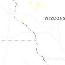


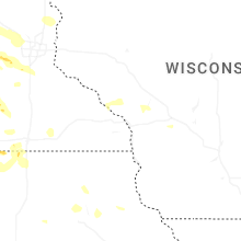


Connect with Interactive Hail Maps