

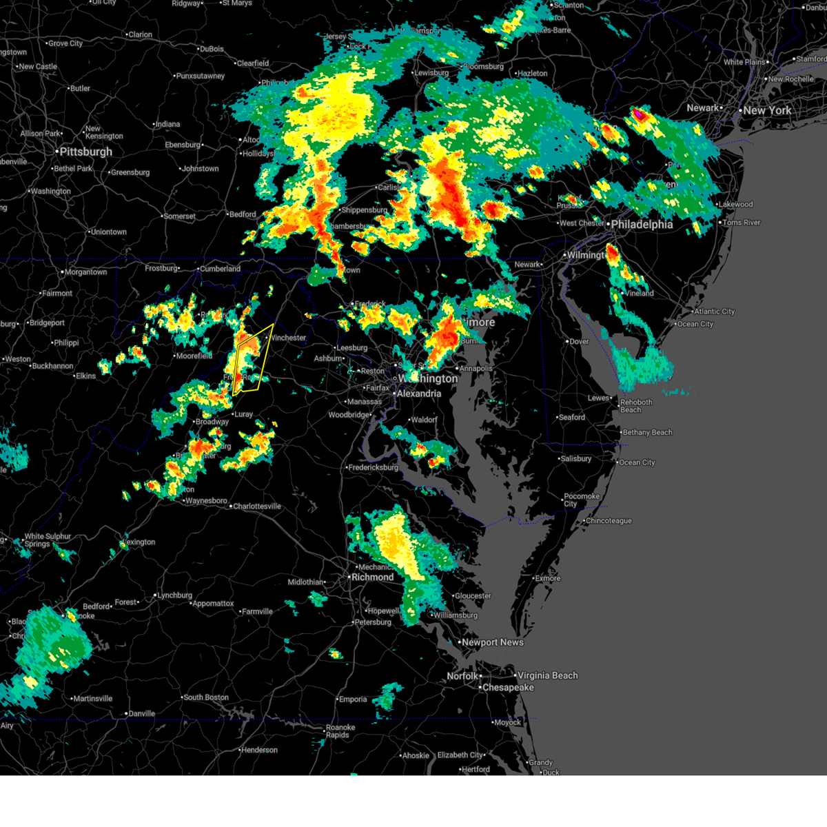
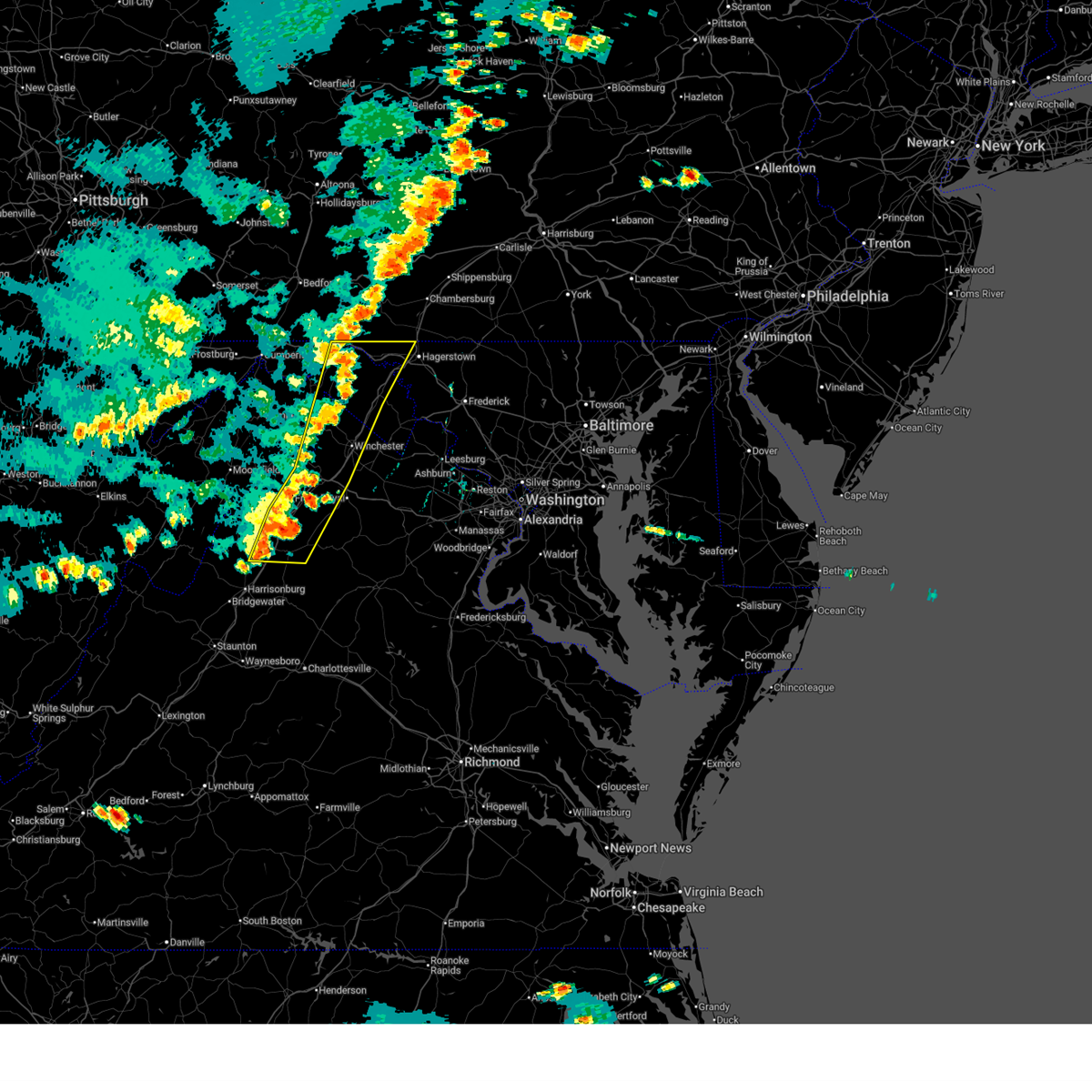
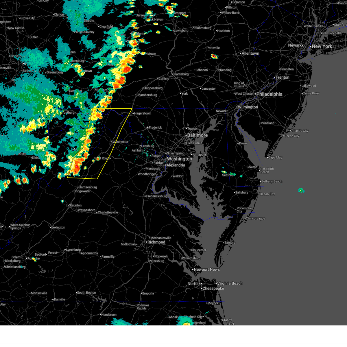
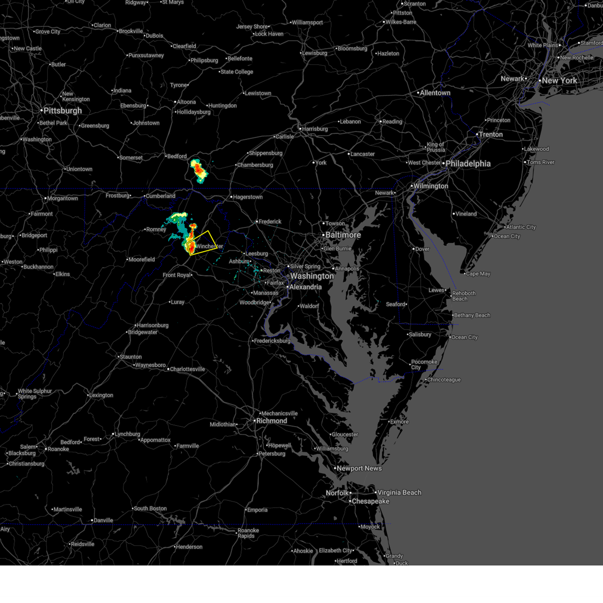
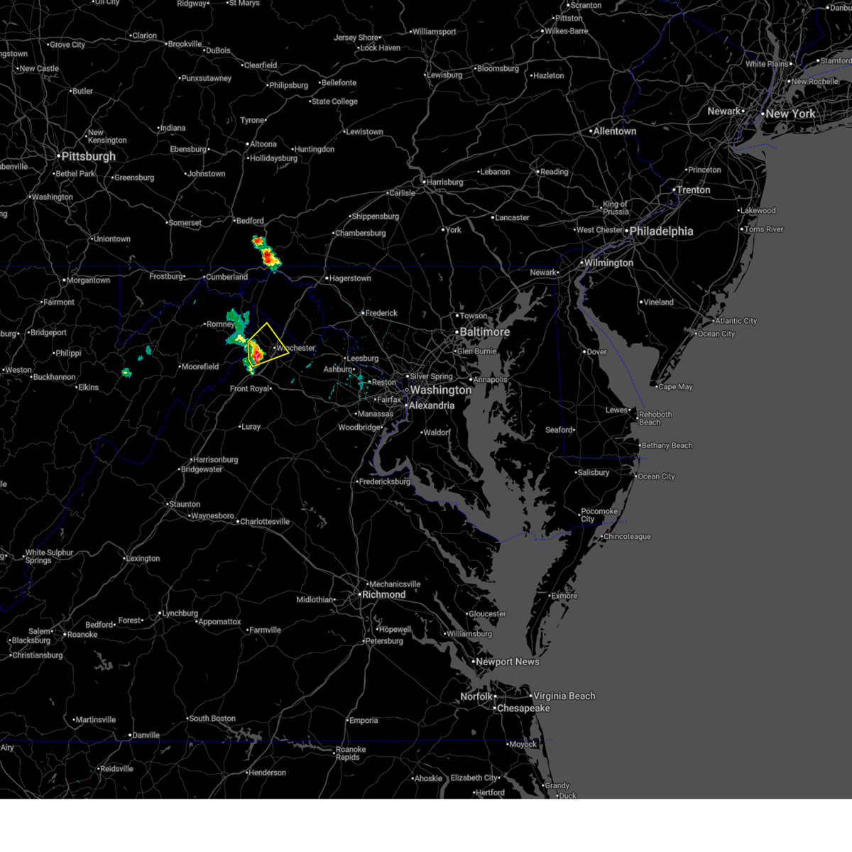
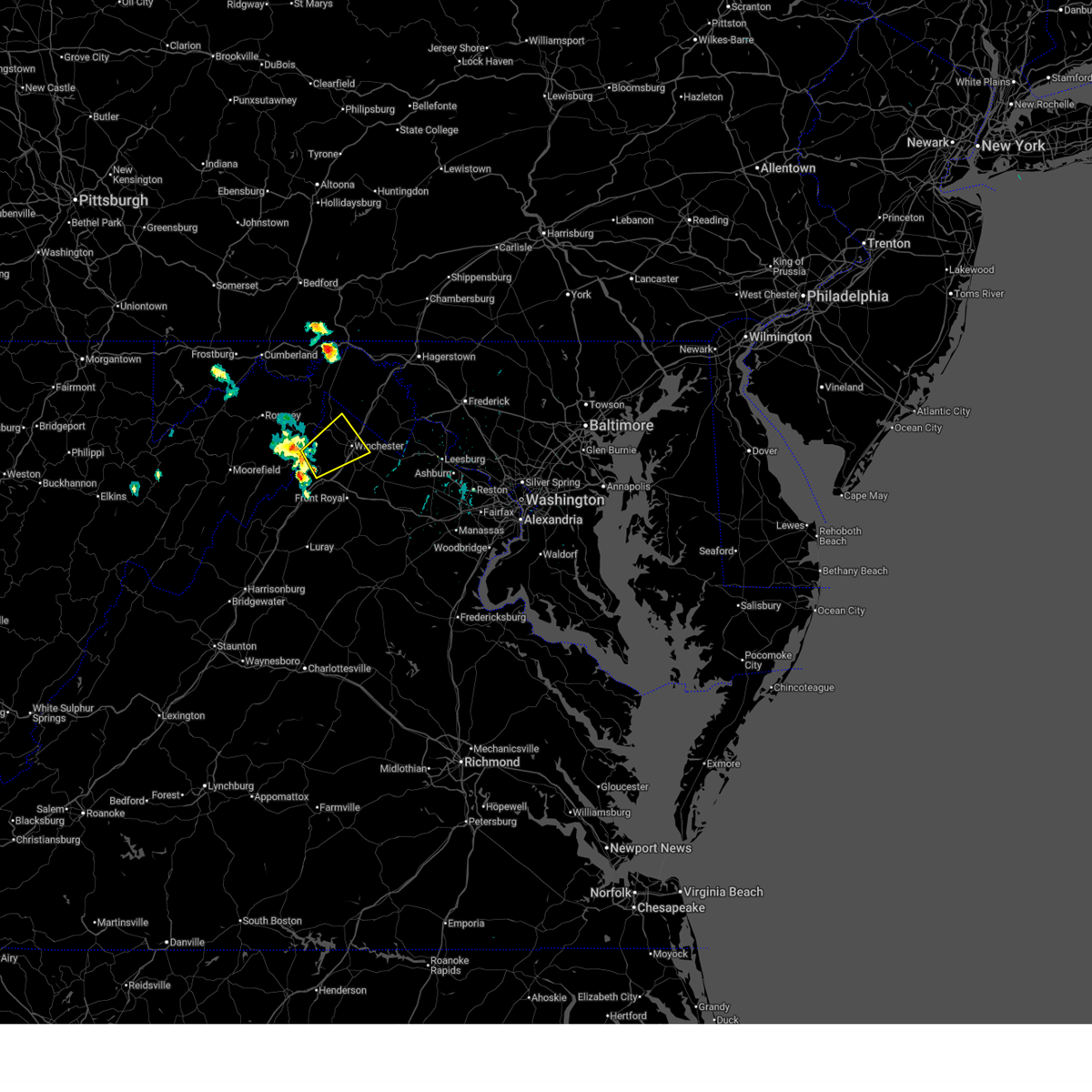
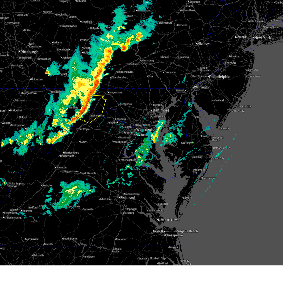
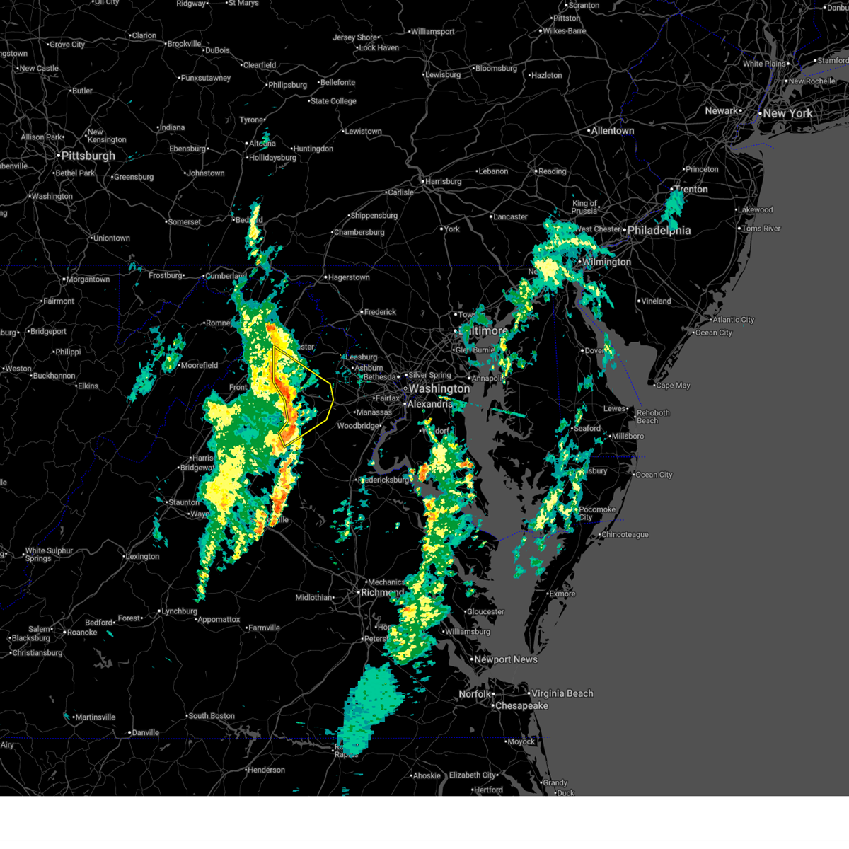
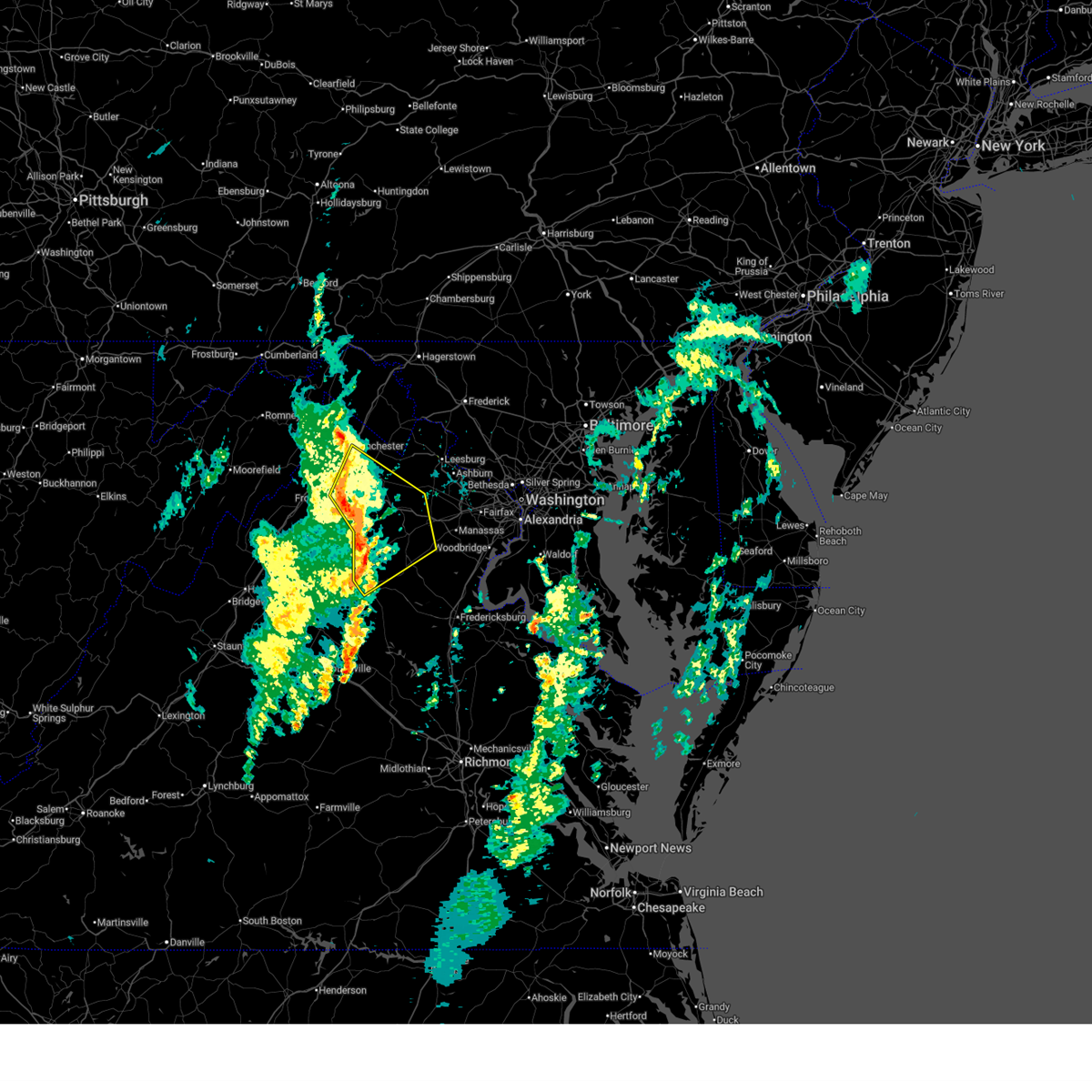
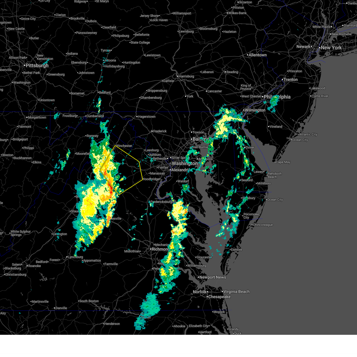
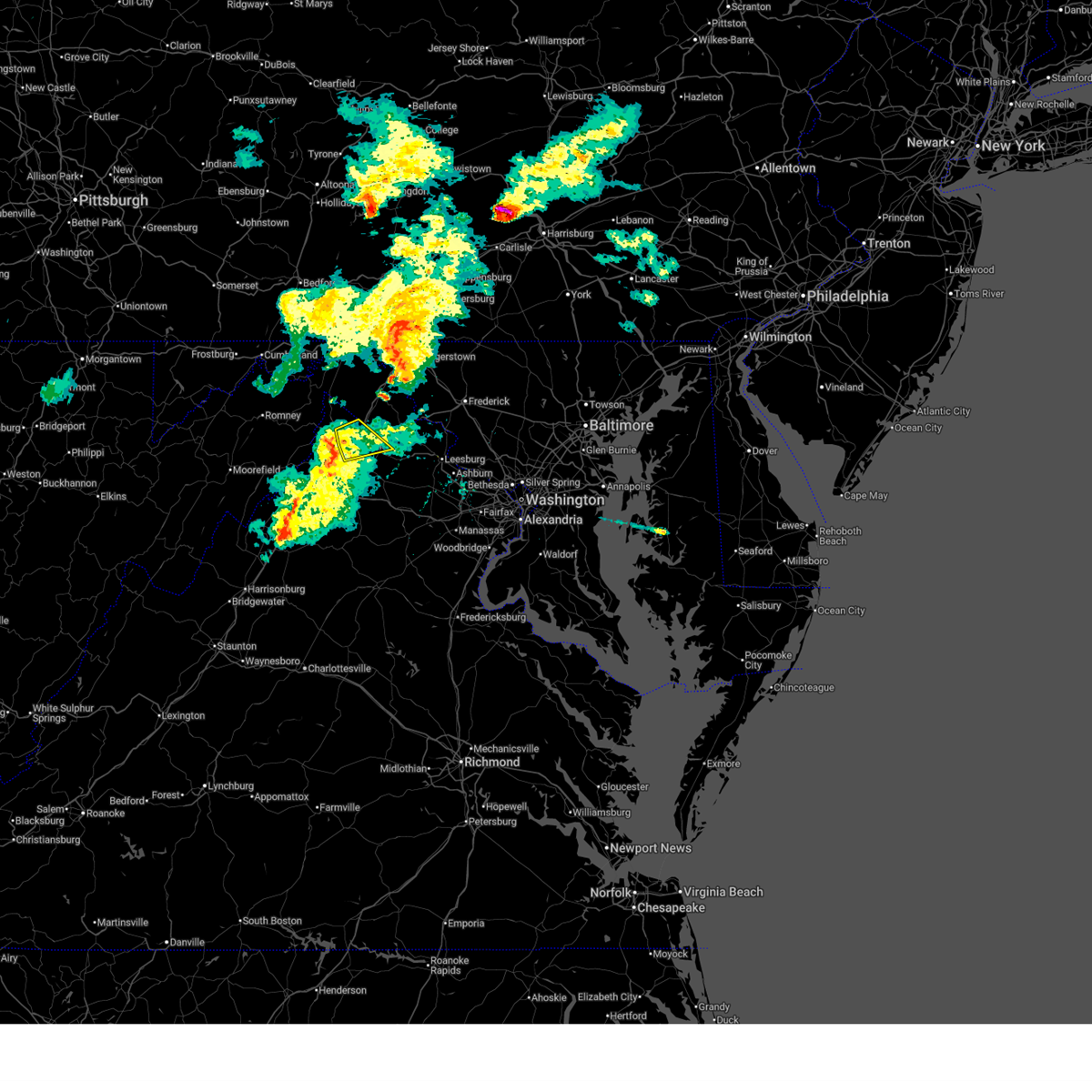
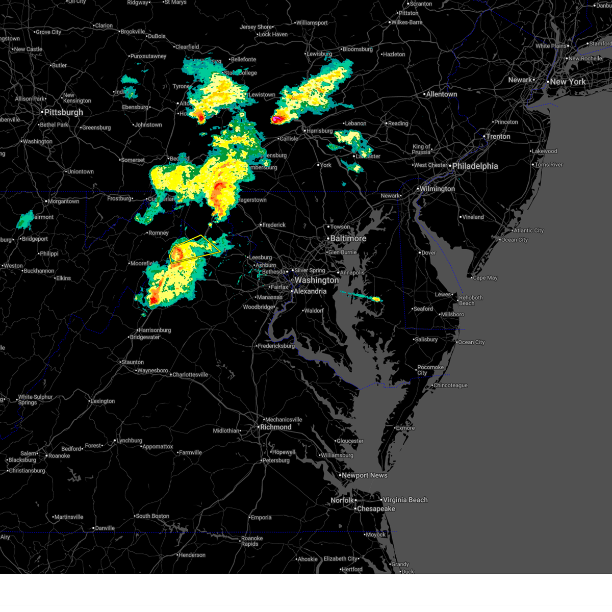
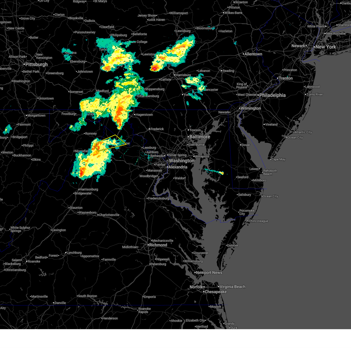
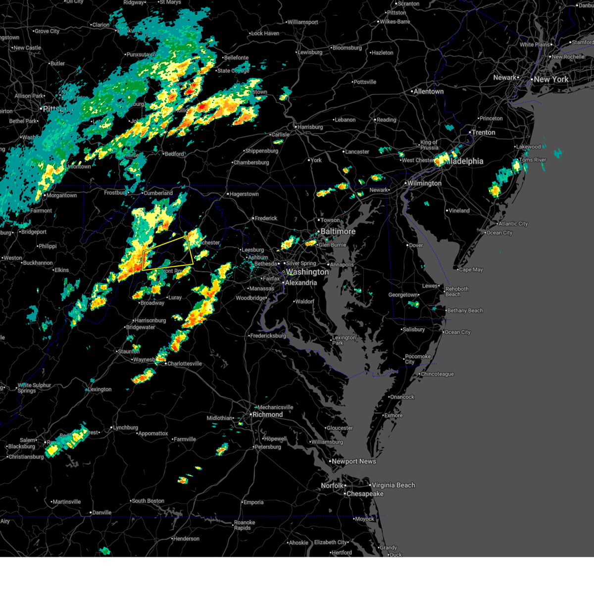
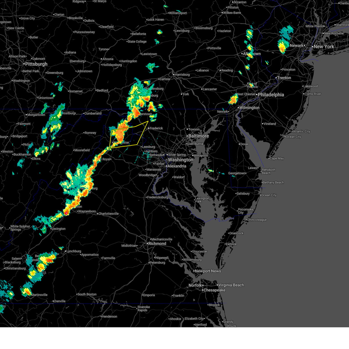
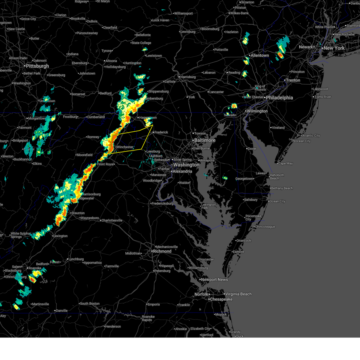
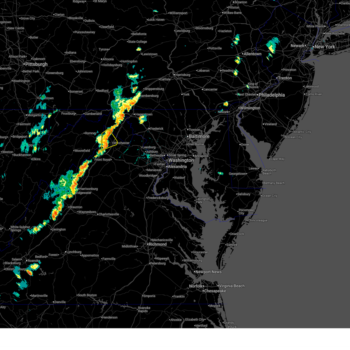
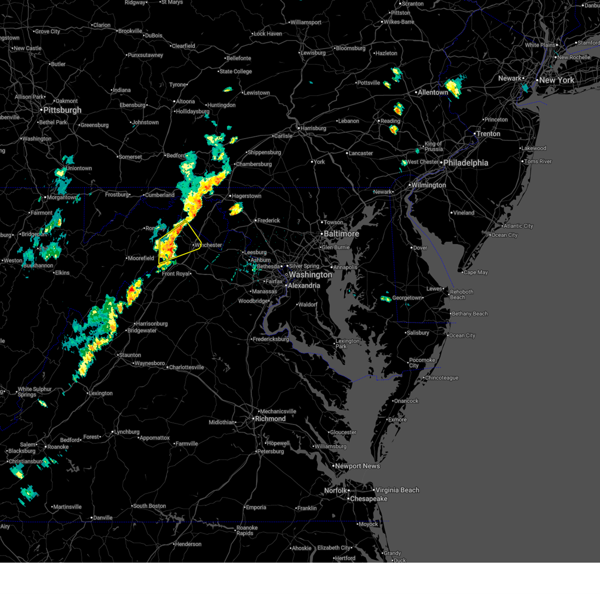
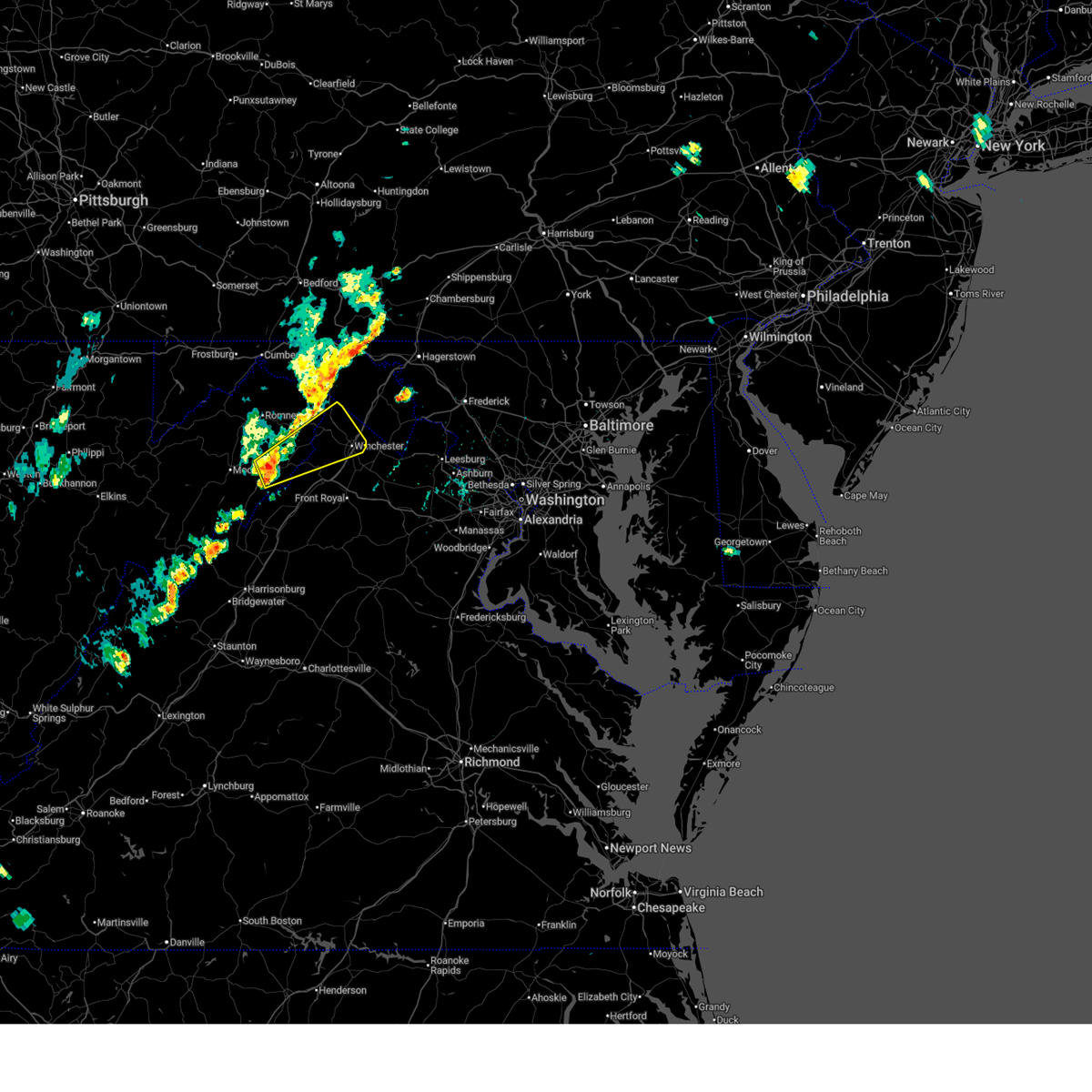
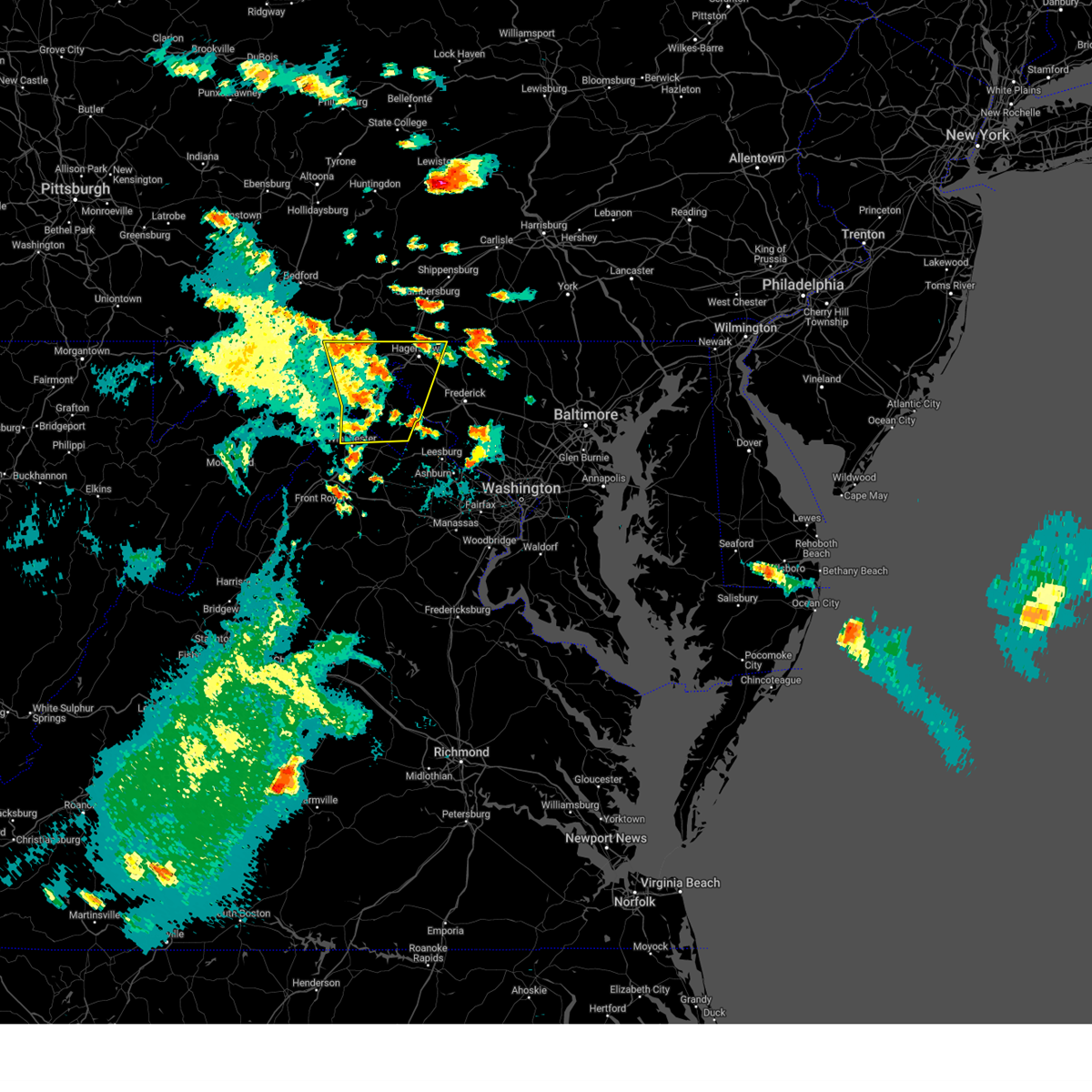
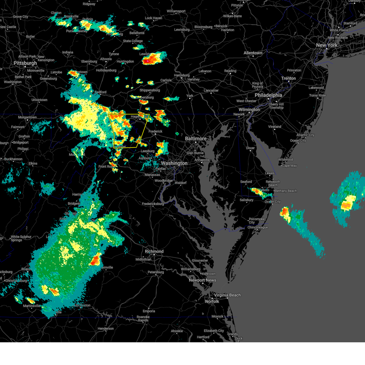
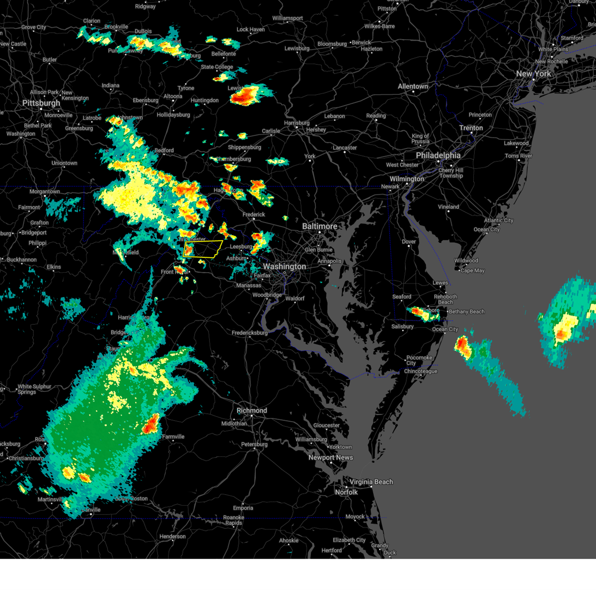
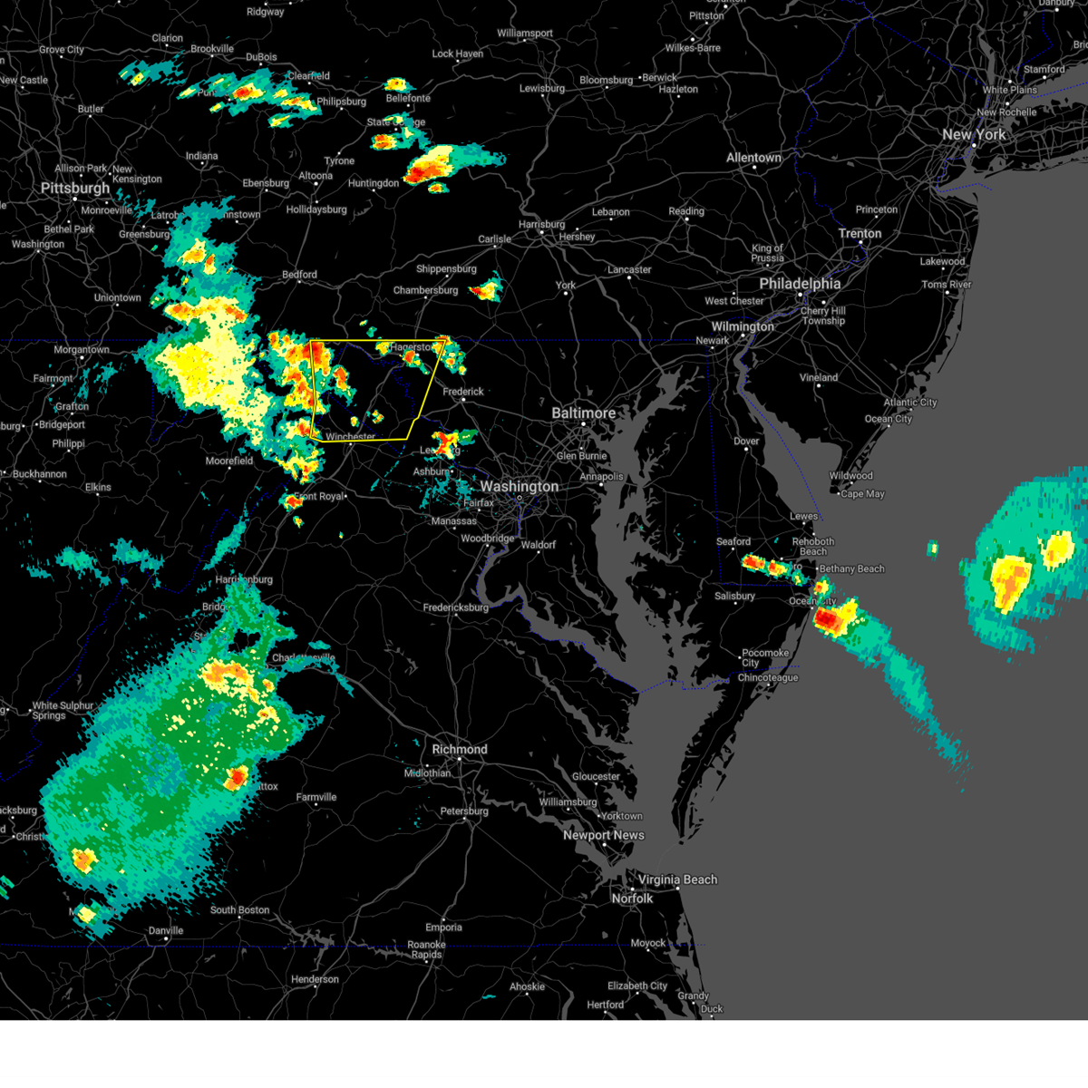
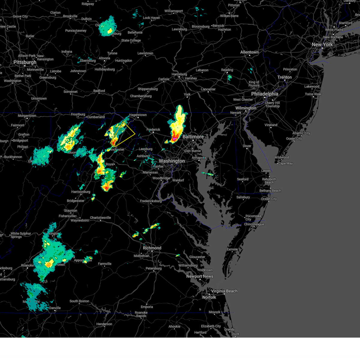
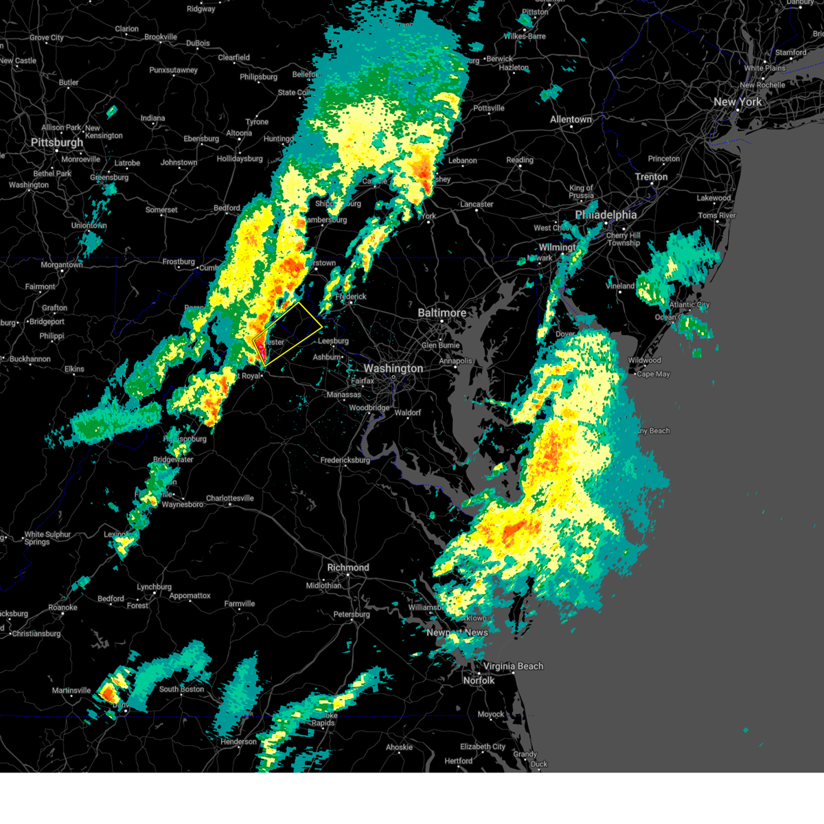
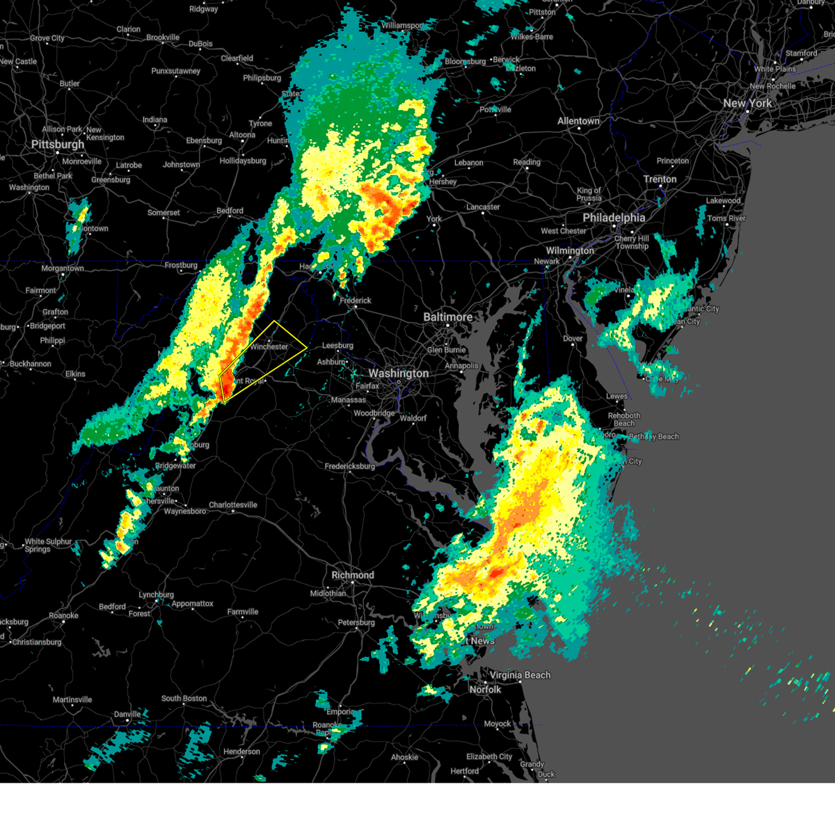
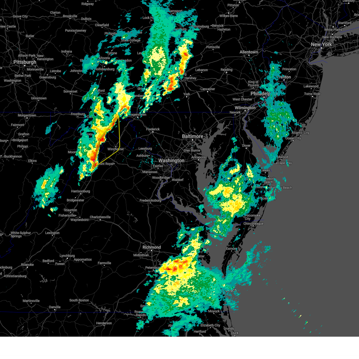
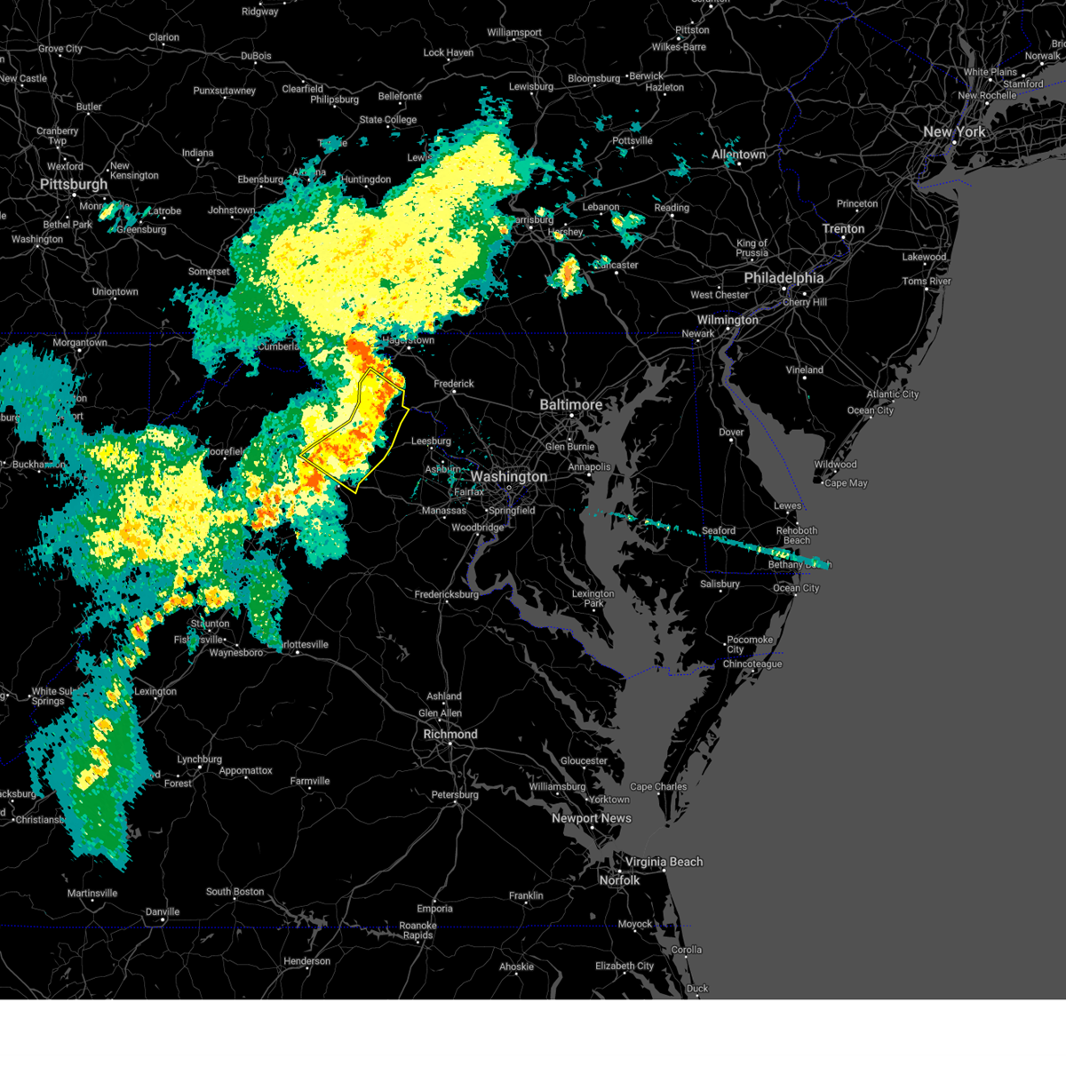
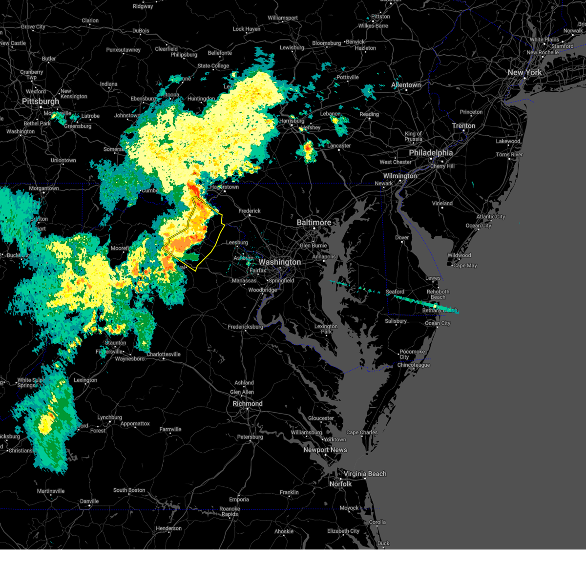
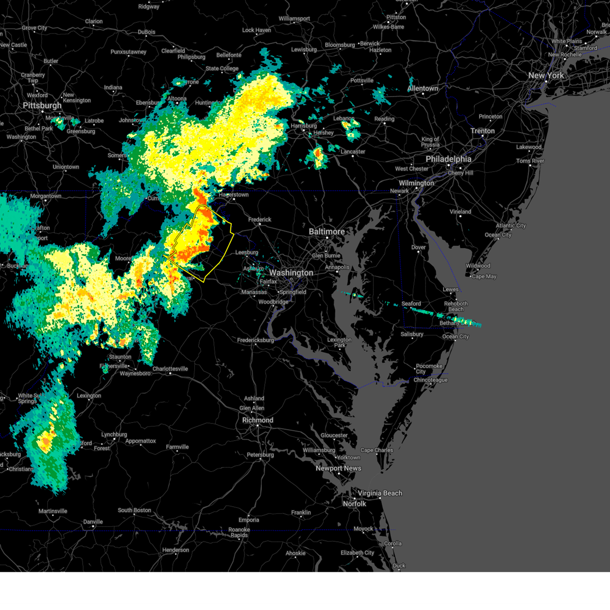
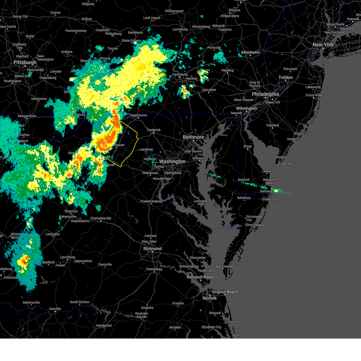
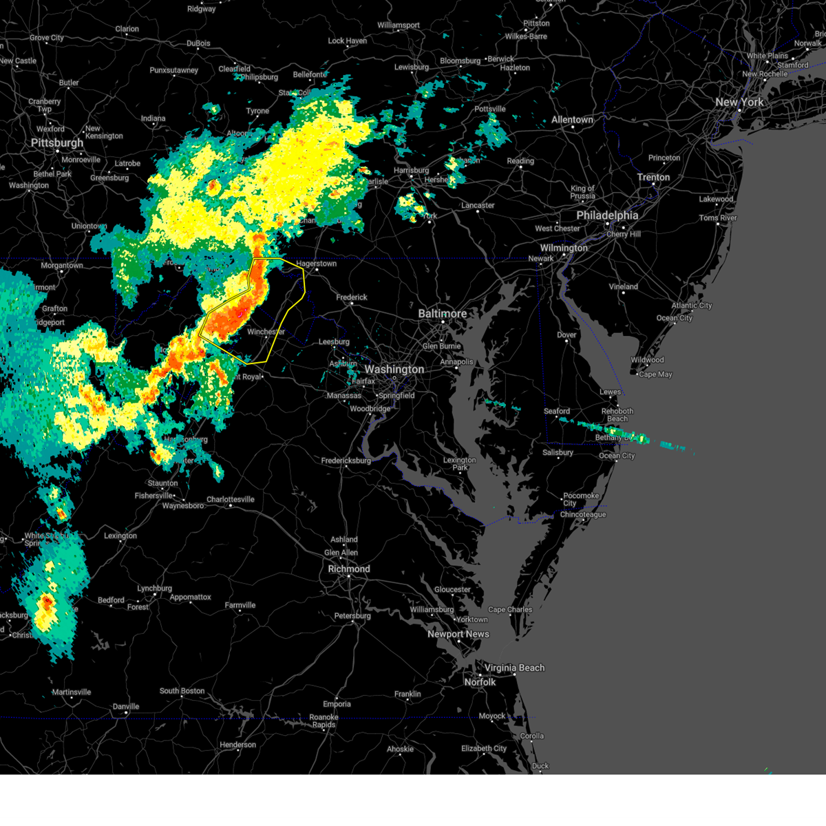
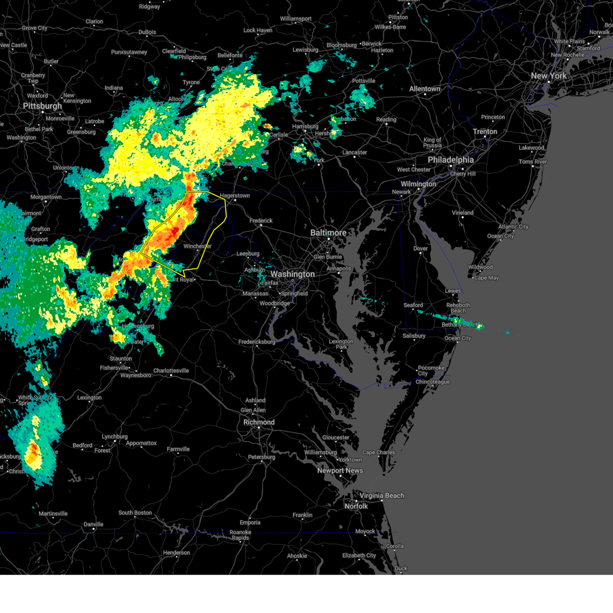
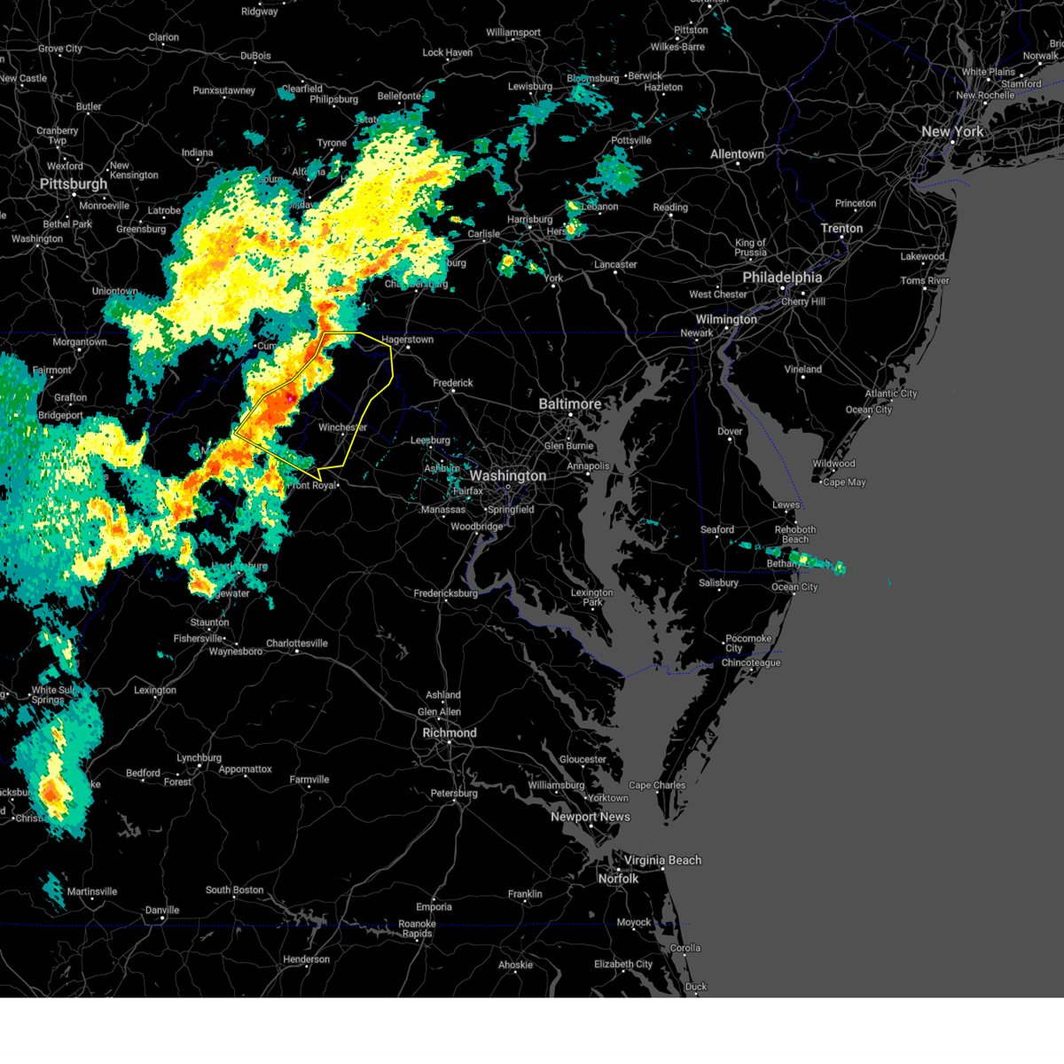
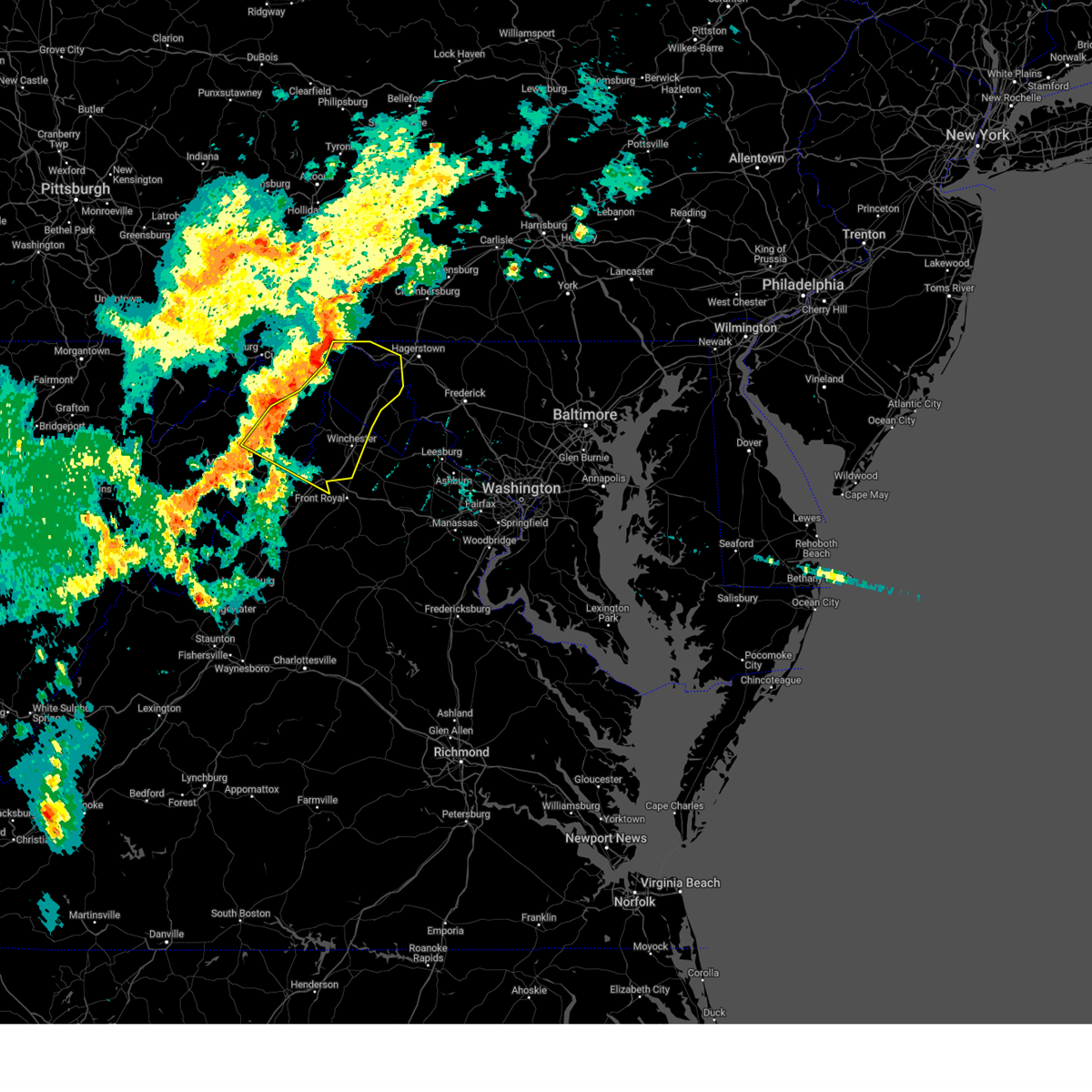
Hail Map for Winchester, VA
The Winchester, VA area has had 17 reports of on-the-ground hail by trained spotters, and has been under severe weather warnings 22 times during the past 12 months. Doppler radar has detected hail at or near Winchester, VA on 49 occasions, including 3 occasions during the past year.
| Name: | Winchester, VA |
| Where Located: | 84.5 miles W of Baltimore, MD |
| Map: | Google Map for Winchester, VA |
| Population: | 26203 |
| Housing Units: | 11872 |
| More Info: | Search Google for Winchester, VA |
0
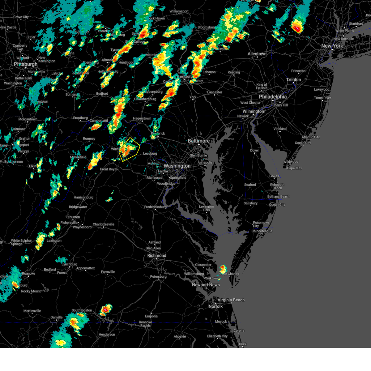
The Top Recent Hail Date for Winchester, VA is Saturday, July 4, 2026 (25th out of 49)

Hail and Wind Damage Spotted near Winchester, VA
| Date / Time | Report Details |
|---|---|
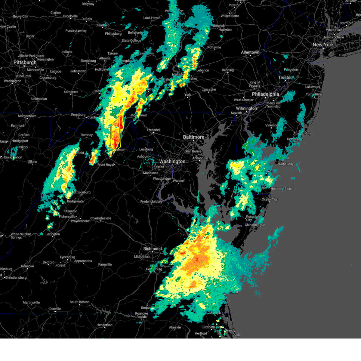
| 7/5/2026 8:43 PM EDT |
 At 842 pm edt, severe thunderstorms were located along a line extending from near star tannery to near woodstock, moving northeast at 15 mph (radar indicated). Hazards include 60 mph wind gusts. Damaging winds will cause some trees and large branches to fall. this could injure those outdoors, as well as damage homes and vehicles. roadways may become blocked by downed trees. localized power outages are possible. unsecured light objects may become projectiles. Locations impacted include, winchester, front royal, strasburg, millwood pike, stephens city, middletown, toms brook, fort valley, seven fountains, high view manor, dilbeck, reliance, karo, saint davids church, bentonville, fishers hill, albin, clary, and buckton. At 842 pm edt, severe thunderstorms were located along a line extending from near star tannery to near woodstock, moving northeast at 15 mph (radar indicated). Hazards include 60 mph wind gusts. Damaging winds will cause some trees and large branches to fall. this could injure those outdoors, as well as damage homes and vehicles. roadways may become blocked by downed trees. localized power outages are possible. unsecured light objects may become projectiles. Locations impacted include, winchester, front royal, strasburg, millwood pike, stephens city, middletown, toms brook, fort valley, seven fountains, high view manor, dilbeck, reliance, karo, saint davids church, bentonville, fishers hill, albin, clary, and buckton.
|
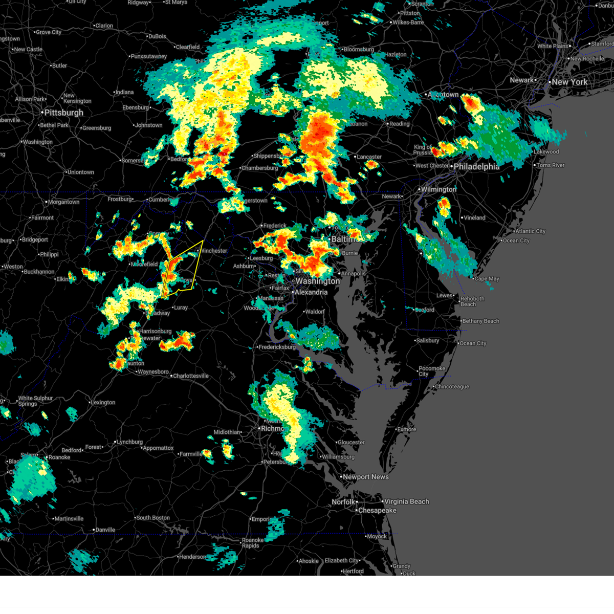
| 7/5/2026 8:33 PM EDT | Quarter sized hail reported 0.4 miles W of Winchester, VA, report from mping: quarter (1.00 in.). |
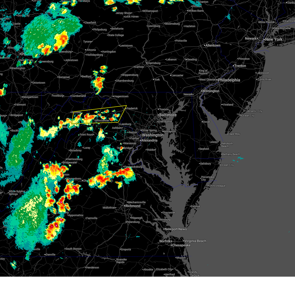
| 7/5/2026 8:15 PM EDT |
 Svrlwx the national weather service in sterling virginia has issued a * severe thunderstorm warning for, northeastern shenandoah county in northwestern virginia, southern frederick county in northwestern virginia, northwestern warren county in northwestern virginia, northeastern page county in northwestern virginia, the city of winchester in northwestern virginia, * until 900 pm edt. * at 815 pm edt, severe thunderstorms were located along a line extending from near star tannery to 6 miles south of woodstock, moving northeast at 15 mph (radar indicated). Hazards include 60 mph wind gusts. Damaging winds will cause some trees and large branches to fall. this could injure those outdoors, as well as damage homes and vehicles. roadways may become blocked by downed trees. localized power outages are possible. Unsecured light objects may become projectiles. Svrlwx the national weather service in sterling virginia has issued a * severe thunderstorm warning for, northeastern shenandoah county in northwestern virginia, southern frederick county in northwestern virginia, northwestern warren county in northwestern virginia, northeastern page county in northwestern virginia, the city of winchester in northwestern virginia, * until 900 pm edt. * at 815 pm edt, severe thunderstorms were located along a line extending from near star tannery to 6 miles south of woodstock, moving northeast at 15 mph (radar indicated). Hazards include 60 mph wind gusts. Damaging winds will cause some trees and large branches to fall. this could injure those outdoors, as well as damage homes and vehicles. roadways may become blocked by downed trees. localized power outages are possible. Unsecured light objects may become projectiles.
|
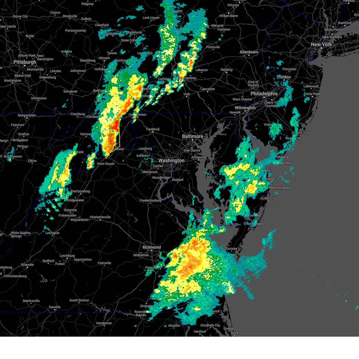
| 7/4/2026 5:22 PM EDT |
 At 521 pm edt, a severe thunderstorm was located 7 miles northwest of stephens city, or 7 miles west of winchester, moving east at 30 mph (radar indicated). Hazards include 60 mph wind gusts and quarter size hail. Damaging winds will cause some trees and large branches to fall. this could injure those outdoors, as well as damage homes and vehicles. roadways may become blocked by downed trees. localized power outages are possible. unsecured light objects may become projectiles. Locations impacted include, frederick, winchester, charles town, shepherdstown, millwood pike, ballenger creek, purcellville, brunswick, ranson, berryville, inwood, braddock heights, harpers ferry, corporation of ranson, kearneysville, clover hill, point of rocks, jefferson, lovettsville, and bolivar. At 521 pm edt, a severe thunderstorm was located 7 miles northwest of stephens city, or 7 miles west of winchester, moving east at 30 mph (radar indicated). Hazards include 60 mph wind gusts and quarter size hail. Damaging winds will cause some trees and large branches to fall. this could injure those outdoors, as well as damage homes and vehicles. roadways may become blocked by downed trees. localized power outages are possible. unsecured light objects may become projectiles. Locations impacted include, frederick, winchester, charles town, shepherdstown, millwood pike, ballenger creek, purcellville, brunswick, ranson, berryville, inwood, braddock heights, harpers ferry, corporation of ranson, kearneysville, clover hill, point of rocks, jefferson, lovettsville, and bolivar.
|
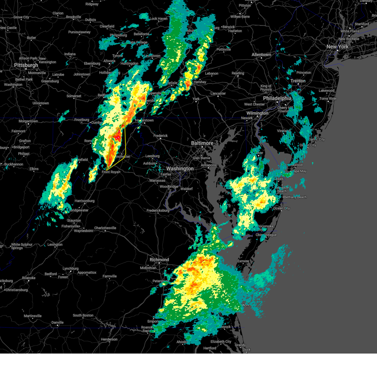
| 6/11/2026 6:45 PM EDT |
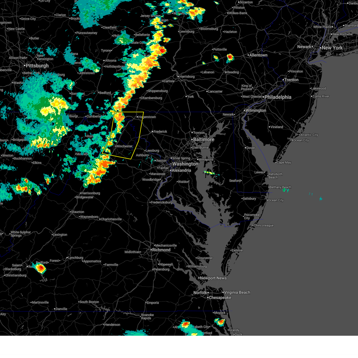 Svrlwx the national weather service in sterling virginia has issued a * severe thunderstorm warning for, washington county in north central maryland, southwestern frederick county in north central maryland, northwestern loudoun county in northern virginia, northeastern shenandoah county in northwestern virginia, frederick county in northwestern virginia, north central warren county in northwestern virginia, clarke county in northwestern virginia, north central fauquier county in northern virginia, the city of winchester in northwestern virginia, jefferson county in the panhandle of west virginia, eastern morgan county in the panhandle of west virginia, berkeley county in the panhandle of west virginia, * until 730 pm edt. * at 645 pm edt, severe thunderstorms were located along a line extending from near hancock to 7 miles west of inwood to near star tannery, moving east at 35 mph (radar indicated). Hazards include 60 mph wind gusts. Damaging winds will cause some trees and large branches to fall. this could injure those outdoors, as well as damage homes and vehicles. roadways may become blocked by downed trees. localized power outages are possible. Unsecured light objects may become projectiles. Svrlwx the national weather service in sterling virginia has issued a * severe thunderstorm warning for, washington county in north central maryland, southwestern frederick county in north central maryland, northwestern loudoun county in northern virginia, northeastern shenandoah county in northwestern virginia, frederick county in northwestern virginia, north central warren county in northwestern virginia, clarke county in northwestern virginia, north central fauquier county in northern virginia, the city of winchester in northwestern virginia, jefferson county in the panhandle of west virginia, eastern morgan county in the panhandle of west virginia, berkeley county in the panhandle of west virginia, * until 730 pm edt. * at 645 pm edt, severe thunderstorms were located along a line extending from near hancock to 7 miles west of inwood to near star tannery, moving east at 35 mph (radar indicated). Hazards include 60 mph wind gusts. Damaging winds will cause some trees and large branches to fall. this could injure those outdoors, as well as damage homes and vehicles. roadways may become blocked by downed trees. localized power outages are possible. Unsecured light objects may become projectiles.
|
| 6/11/2026 6:33 PM EDT |
 At 632 pm edt, severe thunderstorms were located along a line extending from near hancock to near star tannery to near timberville, moving east at 30 mph (radar indicated). Hazards include 60 mph wind gusts. Damaging winds will cause some trees and large branches to fall. this could injure those outdoors, as well as damage homes and vehicles. roadways may become blocked by downed trees. localized power outages are possible. unsecured light objects may become projectiles. Locations impacted include, winchester, martinsburg, strasburg, woodstock, hancock, millwood pike, luray, broadway, inwood, timberville, wilson-conococheague, williamsport, mount jackson, stephens city, stanley, berkeley springs, star tannery, basye-bryce mountain, berkeley, and maugansville. At 632 pm edt, severe thunderstorms were located along a line extending from near hancock to near star tannery to near timberville, moving east at 30 mph (radar indicated). Hazards include 60 mph wind gusts. Damaging winds will cause some trees and large branches to fall. this could injure those outdoors, as well as damage homes and vehicles. roadways may become blocked by downed trees. localized power outages are possible. unsecured light objects may become projectiles. Locations impacted include, winchester, martinsburg, strasburg, woodstock, hancock, millwood pike, luray, broadway, inwood, timberville, wilson-conococheague, williamsport, mount jackson, stephens city, stanley, berkeley springs, star tannery, basye-bryce mountain, berkeley, and maugansville.
|
| 6/11/2026 6:15 PM EDT |
 Svrlwx the national weather service in sterling virginia has issued a * severe thunderstorm warning for, northwestern washington county in north central maryland, northeastern allegany county in western maryland, shenandoah county in northwestern virginia, frederick county in northwestern virginia, northern rockingham county in western virginia, western warren county in northwestern virginia, northern page county in northwestern virginia, the city of winchester in northwestern virginia, morgan county in the panhandle of west virginia, central hardy county in eastern west virginia, berkeley county in the panhandle of west virginia, hampshire county in eastern west virginia, * until 645 pm edt. * at 615 pm edt, severe thunderstorms were located along a line extending from near barnes gap to near wardensville to 6 miles northwest of broadway, moving east at 35 mph (radar indicated). Hazards include 60 mph wind gusts. Damaging winds will cause some trees and large branches to fall. this could injure those outdoors, as well as damage homes and vehicles. roadways may become blocked by downed trees. localized power outages are possible. Unsecured light objects may become projectiles. Svrlwx the national weather service in sterling virginia has issued a * severe thunderstorm warning for, northwestern washington county in north central maryland, northeastern allegany county in western maryland, shenandoah county in northwestern virginia, frederick county in northwestern virginia, northern rockingham county in western virginia, western warren county in northwestern virginia, northern page county in northwestern virginia, the city of winchester in northwestern virginia, morgan county in the panhandle of west virginia, central hardy county in eastern west virginia, berkeley county in the panhandle of west virginia, hampshire county in eastern west virginia, * until 645 pm edt. * at 615 pm edt, severe thunderstorms were located along a line extending from near barnes gap to near wardensville to 6 miles northwest of broadway, moving east at 35 mph (radar indicated). Hazards include 60 mph wind gusts. Damaging winds will cause some trees and large branches to fall. this could injure those outdoors, as well as damage homes and vehicles. roadways may become blocked by downed trees. localized power outages are possible. Unsecured light objects may become projectiles.
|
| 5/18/2026 5:50 PM EDT |
 At 550 pm edt, a severe thunderstorm was located near winchester, moving northeast at 25 mph (radar indicated). Hazards include 60 mph wind gusts. Damaging winds will cause some trees and large branches to fall. this could injure those outdoors, as well as damage homes and vehicles. roadways may become blocked by downed trees. localized power outages are possible. unsecured light objects may become projectiles. Locations impacted include, winchester, millwood pike, berryville, stephens city, middleway, brucetown, greenwood, gaylord, clear brook, stephenson, wadesville, summit point, albin, stringtown, and cedar hill. At 550 pm edt, a severe thunderstorm was located near winchester, moving northeast at 25 mph (radar indicated). Hazards include 60 mph wind gusts. Damaging winds will cause some trees and large branches to fall. this could injure those outdoors, as well as damage homes and vehicles. roadways may become blocked by downed trees. localized power outages are possible. unsecured light objects may become projectiles. Locations impacted include, winchester, millwood pike, berryville, stephens city, middleway, brucetown, greenwood, gaylord, clear brook, stephenson, wadesville, summit point, albin, stringtown, and cedar hill.
|
| 5/18/2026 5:48 PM EDT | City of winchester em reported trees and wires down at intersection of brick kiln rd and smithfield ave. time estimated from rada in frederick county VA, 2.6 miles SW of Winchester, VA |
| 5/18/2026 5:26 PM EDT |
 At 525 pm edt, a severe thunderstorm was located near winchester, moving northeast at 30 mph (radar indicated). Hazards include 70 mph wind gusts and quarter size hail. Damaging winds will cause some trees and large branches to fall. this could injure those outdoors, as well as damage homes and vehicles. roadways may become blocked by downed trees. localized power outages are possible. unsecured light objects may become projectiles. Locations impacted include, winchester, millwood pike, stephens city, greenwood, high view manor, gainesboro, cedar grove, rock enon springs, albin, and gore. At 525 pm edt, a severe thunderstorm was located near winchester, moving northeast at 30 mph (radar indicated). Hazards include 70 mph wind gusts and quarter size hail. Damaging winds will cause some trees and large branches to fall. this could injure those outdoors, as well as damage homes and vehicles. roadways may become blocked by downed trees. localized power outages are possible. unsecured light objects may become projectiles. Locations impacted include, winchester, millwood pike, stephens city, greenwood, high view manor, gainesboro, cedar grove, rock enon springs, albin, and gore.
|
| 5/18/2026 5:20 PM EDT | County 911 reports tree down onto the roadway at the 400th block of fishel ave. time estimated from rada in frederick county VA, 8.7 miles E of Winchester, VA |
| 5/18/2026 5:20 PM EDT | Tree down on fishel road near back mountain roa in frederick county VA, 9.3 miles E of Winchester, VA |
| 5/18/2026 5:17 PM EDT |
 At 516 pm edt, a severe thunderstorm was located 7 miles northwest of stephens city, or 7 miles west of winchester, moving northeast at 30 mph (radar indicated). Hazards include 60 mph wind gusts and quarter size hail. Damaging winds will cause some trees and large branches to fall. this could injure those outdoors, as well as damage homes and vehicles. roadways may become blocked by downed trees. localized power outages are possible. unsecured light objects may become projectiles. Locations impacted include, winchester, millwood pike, stephens city, star tannery, greenwood, high view manor, gainesboro, wilde acres, cedar grove, rock enon springs, albin, gore, and lehew. At 516 pm edt, a severe thunderstorm was located 7 miles northwest of stephens city, or 7 miles west of winchester, moving northeast at 30 mph (radar indicated). Hazards include 60 mph wind gusts and quarter size hail. Damaging winds will cause some trees and large branches to fall. this could injure those outdoors, as well as damage homes and vehicles. roadways may become blocked by downed trees. localized power outages are possible. unsecured light objects may become projectiles. Locations impacted include, winchester, millwood pike, stephens city, star tannery, greenwood, high view manor, gainesboro, wilde acres, cedar grove, rock enon springs, albin, gore, and lehew.
|
| 5/18/2026 5:10 PM EDT | Quarter sized hail reported 12 miles E of Winchester, VA, mping report of 1 inch hail |
| 5/18/2026 5:10 PM EDT |
 Svrlwx the national weather service in sterling virginia has issued a * severe thunderstorm warning for, northeastern shenandoah county in northwestern virginia, central frederick county in northwestern virginia, northwestern clarke county in northwestern virginia, the city of winchester in northwestern virginia, southeastern hampshire county in eastern west virginia, * until 545 pm edt. * at 510 pm edt, a severe thunderstorm was located near star tannery, or 10 miles north of strasburg, moving northeast at 30 mph (radar indicated). Hazards include 60 mph wind gusts. Damaging winds will cause some trees and large branches to fall. this could injure those outdoors, as well as damage homes and vehicles. roadways may become blocked by downed trees. localized power outages are possible. Unsecured light objects may become projectiles. Svrlwx the national weather service in sterling virginia has issued a * severe thunderstorm warning for, northeastern shenandoah county in northwestern virginia, central frederick county in northwestern virginia, northwestern clarke county in northwestern virginia, the city of winchester in northwestern virginia, southeastern hampshire county in eastern west virginia, * until 545 pm edt. * at 510 pm edt, a severe thunderstorm was located near star tannery, or 10 miles north of strasburg, moving northeast at 30 mph (radar indicated). Hazards include 60 mph wind gusts. Damaging winds will cause some trees and large branches to fall. this could injure those outdoors, as well as damage homes and vehicles. roadways may become blocked by downed trees. localized power outages are possible. Unsecured light objects may become projectiles.
|
| 5/13/2026 6:37 PM EDT |
 Svrlwx the national weather service in sterling virginia has issued a * severe thunderstorm warning for, frederick county in northwestern virginia, northwestern clarke county in northwestern virginia, the city of winchester in northwestern virginia, central jefferson county in the panhandle of west virginia, southeastern morgan county in the panhandle of west virginia, berkeley county in the panhandle of west virginia, southeastern hampshire county in eastern west virginia, * until 700 pm edt. * at 636 pm edt, severe thunderstorms were located along a line extending from 6 miles northeast of greenwood to 9 miles northwest of winchester to near wardensville, moving east at 40 mph (radar indicated). Hazards include 60 mph wind gusts and quarter size hail. Damaging winds will cause some trees and large branches to fall. this could injure those outdoors, as well as damage homes and vehicles. roadways may become blocked by downed trees. localized power outages are possible. Unsecured light objects may become projectiles. Svrlwx the national weather service in sterling virginia has issued a * severe thunderstorm warning for, frederick county in northwestern virginia, northwestern clarke county in northwestern virginia, the city of winchester in northwestern virginia, central jefferson county in the panhandle of west virginia, southeastern morgan county in the panhandle of west virginia, berkeley county in the panhandle of west virginia, southeastern hampshire county in eastern west virginia, * until 700 pm edt. * at 636 pm edt, severe thunderstorms were located along a line extending from 6 miles northeast of greenwood to 9 miles northwest of winchester to near wardensville, moving east at 40 mph (radar indicated). Hazards include 60 mph wind gusts and quarter size hail. Damaging winds will cause some trees and large branches to fall. this could injure those outdoors, as well as damage homes and vehicles. roadways may become blocked by downed trees. localized power outages are possible. Unsecured light objects may become projectiles.
|
| 3/16/2026 10:46 AM EDT |
 the severe thunderstorm warning has been cancelled and is no longer in effect the severe thunderstorm warning has been cancelled and is no longer in effect
|
| 3/16/2026 10:46 AM EDT |
 At 1046 am edt, severe thunderstorms were located along a line extending from near linden to 7 miles south of hume to near culpeper, moving east at 55 mph (radar indicated). Hazards include 60 mph wind gusts. Damaging winds will cause some trees and large branches to fall. this could injure those outdoors, as well as damage homes and vehicles. roadways may become blocked by downed trees. localized power outages are possible. unsecured light objects may become projectiles. Locations impacted include, winchester, warrenton, millwood pike, middleburg, the plains, delaplane, linden, hume, gainesville, new baltimore, marshall, boyce, castleton, white post, broken hill, hackleys crossroads, amissville, jeffersonton, cresthill, and turnbull. At 1046 am edt, severe thunderstorms were located along a line extending from near linden to 7 miles south of hume to near culpeper, moving east at 55 mph (radar indicated). Hazards include 60 mph wind gusts. Damaging winds will cause some trees and large branches to fall. this could injure those outdoors, as well as damage homes and vehicles. roadways may become blocked by downed trees. localized power outages are possible. unsecured light objects may become projectiles. Locations impacted include, winchester, warrenton, millwood pike, middleburg, the plains, delaplane, linden, hume, gainesville, new baltimore, marshall, boyce, castleton, white post, broken hill, hackleys crossroads, amissville, jeffersonton, cresthill, and turnbull.
|
| 3/16/2026 10:39 AM EDT |
 At 1038 am edt, severe thunderstorms were located along a line extending from near front royal to 7 miles east of sperryville to 6 miles west of culpeper, moving northeast at 55 mph (radar indicated). Hazards include 60 mph wind gusts. Damaging winds will cause some trees and large branches to fall. this could injure those outdoors, as well as damage homes and vehicles. roadways may become blocked by downed trees. localized power outages are possible. unsecured light objects may become projectiles. Locations impacted include, winchester, culpeper, front royal, warrenton, millwood pike, bealeton, stephens city, haymarket, middleburg, the plains, hume, delaplane, linden, gainesville, new baltimore, marshall, nokesville, chester gap, opal, and boyce. At 1038 am edt, severe thunderstorms were located along a line extending from near front royal to 7 miles east of sperryville to 6 miles west of culpeper, moving northeast at 55 mph (radar indicated). Hazards include 60 mph wind gusts. Damaging winds will cause some trees and large branches to fall. this could injure those outdoors, as well as damage homes and vehicles. roadways may become blocked by downed trees. localized power outages are possible. unsecured light objects may become projectiles. Locations impacted include, winchester, culpeper, front royal, warrenton, millwood pike, bealeton, stephens city, haymarket, middleburg, the plains, hume, delaplane, linden, gainesville, new baltimore, marshall, nokesville, chester gap, opal, and boyce.
|
| 3/16/2026 10:39 AM EDT |
 the severe thunderstorm warning has been cancelled and is no longer in effect the severe thunderstorm warning has been cancelled and is no longer in effect
|
| 3/16/2026 10:27 AM EDT |
 Svrlwx the national weather service in sterling virginia has issued a * severe thunderstorm warning for, southwestern loudoun county in northern virginia, east central shenandoah county in northwestern virginia, southeastern frederick county in northwestern virginia, warren county in northwestern virginia, southwestern clarke county in northwestern virginia, northeastern page county in northwestern virginia, rappahannock county in northwestern virginia, fauquier county in northern virginia, northwestern culpeper county in northern virginia, northwestern prince william county in northern virginia, the southeastern city of winchester in northwestern virginia, * until 1115 am edt. * at 1027 am edt, severe thunderstorms were located along a line extending from 10 miles northeast of luray to near sperryville to madison, moving northeast at 55 mph (radar indicated). Hazards include 60 mph wind gusts. Damaging winds will cause some trees and large branches to fall. this could injure those outdoors, as well as damage homes and vehicles. roadways may become blocked by downed trees. localized power outages are possible. Unsecured light objects may become projectiles. Svrlwx the national weather service in sterling virginia has issued a * severe thunderstorm warning for, southwestern loudoun county in northern virginia, east central shenandoah county in northwestern virginia, southeastern frederick county in northwestern virginia, warren county in northwestern virginia, southwestern clarke county in northwestern virginia, northeastern page county in northwestern virginia, rappahannock county in northwestern virginia, fauquier county in northern virginia, northwestern culpeper county in northern virginia, northwestern prince william county in northern virginia, the southeastern city of winchester in northwestern virginia, * until 1115 am edt. * at 1027 am edt, severe thunderstorms were located along a line extending from 10 miles northeast of luray to near sperryville to madison, moving northeast at 55 mph (radar indicated). Hazards include 60 mph wind gusts. Damaging winds will cause some trees and large branches to fall. this could injure those outdoors, as well as damage homes and vehicles. roadways may become blocked by downed trees. localized power outages are possible. Unsecured light objects may become projectiles.
|
| 3/11/2026 6:03 PM EDT |
 At 603 pm edt, a severe thunderstorm was located over millwood pike, moving east at 45 mph (radar indicated). Hazards include 60 mph wind gusts. Damaging winds will cause some trees and large branches to fall. this could injure those outdoors, as well as damage homes and vehicles. roadways may become blocked by downed trees. localized power outages are possible. unsecured light objects may become projectiles. Locations impacted include, winchester, millwood pike, berryville, brucetown, greenwood, cedar grove, gaylord, clear brook, stephenson, wadesville, cedar hill, albin, and stringtown. At 603 pm edt, a severe thunderstorm was located over millwood pike, moving east at 45 mph (radar indicated). Hazards include 60 mph wind gusts. Damaging winds will cause some trees and large branches to fall. this could injure those outdoors, as well as damage homes and vehicles. roadways may become blocked by downed trees. localized power outages are possible. unsecured light objects may become projectiles. Locations impacted include, winchester, millwood pike, berryville, brucetown, greenwood, cedar grove, gaylord, clear brook, stephenson, wadesville, cedar hill, albin, and stringtown.
|
| 3/11/2026 6:03 PM EDT |
 the severe thunderstorm warning has been cancelled and is no longer in effect the severe thunderstorm warning has been cancelled and is no longer in effect
|
| 3/11/2026 5:54 PM EDT |
 the severe thunderstorm warning has been cancelled and is no longer in effect the severe thunderstorm warning has been cancelled and is no longer in effect
|
| 3/11/2026 5:54 PM EDT |
 At 554 pm edt, a severe thunderstorm was located near winchester, moving east at 40 mph (radar indicated). Hazards include 60 mph wind gusts. Damaging winds will cause some trees and large branches to fall. this could injure those outdoors, as well as damage homes and vehicles. roadways may become blocked by downed trees. localized power outages are possible. unsecured light objects may become projectiles. Locations impacted include, winchester, millwood pike, berryville, brucetown, greenwood, high view manor, wilde acres, cedar grove, gaylord, clear brook, stephenson, wadesville, cedar hill, rock enon springs, albin, and stringtown. At 554 pm edt, a severe thunderstorm was located near winchester, moving east at 40 mph (radar indicated). Hazards include 60 mph wind gusts. Damaging winds will cause some trees and large branches to fall. this could injure those outdoors, as well as damage homes and vehicles. roadways may become blocked by downed trees. localized power outages are possible. unsecured light objects may become projectiles. Locations impacted include, winchester, millwood pike, berryville, brucetown, greenwood, high view manor, wilde acres, cedar grove, gaylord, clear brook, stephenson, wadesville, cedar hill, rock enon springs, albin, and stringtown.
|
| 3/11/2026 5:51 PM EDT |
 At 551 pm edt, a severe thunderstorm was located near stephens city, or 7 miles west of winchester, moving east at 45 mph (radar indicated). Hazards include 60 mph wind gusts. Damaging winds will cause some trees and large branches to fall. this could injure those outdoors, as well as damage homes and vehicles. roadways may become blocked by downed trees. localized power outages are possible. unsecured light objects may become projectiles. Locations impacted include, winchester, millwood pike, berryville, star tannery, brucetown, gravel springs, greenwood, high view manor, wilde acres, cedar grove, gaylord, clear brook, stephenson, wadesville, cedar hill, rock enon springs, albin, capon springs, stringtown, and lehew. At 551 pm edt, a severe thunderstorm was located near stephens city, or 7 miles west of winchester, moving east at 45 mph (radar indicated). Hazards include 60 mph wind gusts. Damaging winds will cause some trees and large branches to fall. this could injure those outdoors, as well as damage homes and vehicles. roadways may become blocked by downed trees. localized power outages are possible. unsecured light objects may become projectiles. Locations impacted include, winchester, millwood pike, berryville, star tannery, brucetown, gravel springs, greenwood, high view manor, wilde acres, cedar grove, gaylord, clear brook, stephenson, wadesville, cedar hill, rock enon springs, albin, capon springs, stringtown, and lehew.
|
| 3/11/2026 5:45 PM EDT |
 Svrlwx the national weather service in sterling virginia has issued a * severe thunderstorm warning for, northeastern shenandoah county in northwestern virginia, central frederick county in northwestern virginia, northern clarke county in northwestern virginia, the city of winchester in northwestern virginia, southeastern hampshire county in eastern west virginia, * until 615 pm edt. * at 545 pm edt, a severe thunderstorm was located near star tannery, or 11 miles north of strasburg, moving east at 45 mph (radar indicated). Hazards include 60 mph wind gusts. Damaging winds will cause some trees and large branches to fall. this could injure those outdoors, as well as damage homes and vehicles. roadways may become blocked by downed trees. localized power outages are possible. Unsecured light objects may become projectiles. Svrlwx the national weather service in sterling virginia has issued a * severe thunderstorm warning for, northeastern shenandoah county in northwestern virginia, central frederick county in northwestern virginia, northern clarke county in northwestern virginia, the city of winchester in northwestern virginia, southeastern hampshire county in eastern west virginia, * until 615 pm edt. * at 545 pm edt, a severe thunderstorm was located near star tannery, or 11 miles north of strasburg, moving east at 45 mph (radar indicated). Hazards include 60 mph wind gusts. Damaging winds will cause some trees and large branches to fall. this could injure those outdoors, as well as damage homes and vehicles. roadways may become blocked by downed trees. localized power outages are possible. Unsecured light objects may become projectiles.
|
| 7/1/2025 1:22 PM EDT |
 Svrlwx the national weather service in sterling virginia has issued a * severe thunderstorm warning for, northeastern shenandoah county in northwestern virginia, southwestern frederick county in northwestern virginia, northwestern warren county in northwestern virginia, the southwestern city of winchester in northwestern virginia, east central hardy county in eastern west virginia, southeastern hampshire county in eastern west virginia, * until 200 pm edt. * at 121 pm edt, a severe thunderstorm was located near wardensville, or 14 miles northwest of woodstock, moving east at 45 mph (radar indicated). Hazards include 60 mph wind gusts. Damaging winds will cause some trees and large branches to fall. this could injure those outdoors, as well as damage homes and vehicles. roadways may become blocked by downed trees. localized power outages are possible. Unsecured light objects may become projectiles. Svrlwx the national weather service in sterling virginia has issued a * severe thunderstorm warning for, northeastern shenandoah county in northwestern virginia, southwestern frederick county in northwestern virginia, northwestern warren county in northwestern virginia, the southwestern city of winchester in northwestern virginia, east central hardy county in eastern west virginia, southeastern hampshire county in eastern west virginia, * until 200 pm edt. * at 121 pm edt, a severe thunderstorm was located near wardensville, or 14 miles northwest of woodstock, moving east at 45 mph (radar indicated). Hazards include 60 mph wind gusts. Damaging winds will cause some trees and large branches to fall. this could injure those outdoors, as well as damage homes and vehicles. roadways may become blocked by downed trees. localized power outages are possible. Unsecured light objects may become projectiles.
|
| 6/28/2025 9:28 PM EDT | A powerpoll was snapped along green spring roa in frederick county VA, 13.3 miles S of Winchester, VA |
| 6/28/2025 8:35 PM EDT | A few trees were down along wardensville grade and mcdonald roa in frederick county VA, 4.4 miles ESE of Winchester, VA |
| 6/28/2025 7:18 PM EDT | A powerpoll was snapped along green spring roa in frederick county VA, 13.3 miles S of Winchester, VA |
| 6/19/2025 2:34 PM EDT |
 At 233 pm edt, a severe thunderstorm was located near charles town, moving east at 35 mph (radar indicated). Hazards include 60 mph wind gusts. Damaging winds will cause some trees and large branches to fall. this could injure those outdoors, as well as damage homes and vehicles. roadways may become blocked by downed trees. localized power outages are possible. unsecured light objects may become projectiles. Locations impacted include, winchester, charles town, millwood pike, purcellville, brunswick, ranson, berryville, inwood, braddock heights, stephens city, round hill, harpers ferry, corporation of ranson, kearneysville, jefferson, lovettsville, shenandoah junction, middleway, rosemont, and rohrersville. At 233 pm edt, a severe thunderstorm was located near charles town, moving east at 35 mph (radar indicated). Hazards include 60 mph wind gusts. Damaging winds will cause some trees and large branches to fall. this could injure those outdoors, as well as damage homes and vehicles. roadways may become blocked by downed trees. localized power outages are possible. unsecured light objects may become projectiles. Locations impacted include, winchester, charles town, millwood pike, purcellville, brunswick, ranson, berryville, inwood, braddock heights, stephens city, round hill, harpers ferry, corporation of ranson, kearneysville, jefferson, lovettsville, shenandoah junction, middleway, rosemont, and rohrersville.
|
| 6/19/2025 2:19 PM EDT | Tree reported down on the 600 block of woods mill roa in frederick county VA, 5.2 miles WSW of Winchester, VA |
| 6/19/2025 2:15 PM EDT | Tree reported down into a house on dunlap street between bruce street and green stree in frederick county VA, 2.1 miles SW of Winchester, VA |
| 6/19/2025 2:07 PM EDT |
 Svrlwx the national weather service in sterling virginia has issued a * severe thunderstorm warning for, southeastern washington county in north central maryland, southwestern frederick county in north central maryland, northwestern loudoun county in northern virginia, eastern frederick county in northwestern virginia, northern clarke county in northwestern virginia, the city of winchester in northwestern virginia, jefferson county in the panhandle of west virginia, southern berkeley county in the panhandle of west virginia, * until 245 pm edt. * at 207 pm edt, a severe thunderstorm was located near winchester, moving east at 45 mph (radar indicated). Hazards include 60 mph wind gusts. Damaging winds will cause some trees and large branches to fall. this could injure those outdoors, as well as damage homes and vehicles. roadways may become blocked by downed trees. localized power outages are possible. Unsecured light objects may become projectiles. Svrlwx the national weather service in sterling virginia has issued a * severe thunderstorm warning for, southeastern washington county in north central maryland, southwestern frederick county in north central maryland, northwestern loudoun county in northern virginia, eastern frederick county in northwestern virginia, northern clarke county in northwestern virginia, the city of winchester in northwestern virginia, jefferson county in the panhandle of west virginia, southern berkeley county in the panhandle of west virginia, * until 245 pm edt. * at 207 pm edt, a severe thunderstorm was located near winchester, moving east at 45 mph (radar indicated). Hazards include 60 mph wind gusts. Damaging winds will cause some trees and large branches to fall. this could injure those outdoors, as well as damage homes and vehicles. roadways may become blocked by downed trees. localized power outages are possible. Unsecured light objects may become projectiles.
|
| 6/19/2025 2:03 PM EDT |
 the severe thunderstorm warning has been cancelled and is no longer in effect the severe thunderstorm warning has been cancelled and is no longer in effect
|
| 6/19/2025 2:03 PM EDT |
 At 203 pm edt, a severe thunderstorm was located near winchester, moving northeast at 45 mph (radar indicated). Hazards include 60 mph wind gusts. Damaging winds will cause some trees and large branches to fall. this could injure those outdoors, as well as damage homes and vehicles. roadways may become blocked by downed trees. localized power outages are possible. unsecured light objects may become projectiles. Locations impacted include, winchester, millwood pike, greenwood, high view manor, gainesboro, cedar grove, stephenson, cross junction, rock enon springs, albin, gore, whitacre, and timber ridge. At 203 pm edt, a severe thunderstorm was located near winchester, moving northeast at 45 mph (radar indicated). Hazards include 60 mph wind gusts. Damaging winds will cause some trees and large branches to fall. this could injure those outdoors, as well as damage homes and vehicles. roadways may become blocked by downed trees. localized power outages are possible. unsecured light objects may become projectiles. Locations impacted include, winchester, millwood pike, greenwood, high view manor, gainesboro, cedar grove, stephenson, cross junction, rock enon springs, albin, gore, whitacre, and timber ridge.
|
| 6/19/2025 2:02 PM EDT | Tree reported down on the 1300 block of north hayfield roa in frederick county VA, 7.8 miles SE of Winchester, VA |
| 6/19/2025 1:52 PM EDT |
 At 151 pm edt, a severe thunderstorm was located 7 miles north of star tannery, or 13 miles west of winchester, moving northeast at 45 mph (radar indicated). Hazards include 60 mph wind gusts. Damaging winds will cause some trees and large branches to fall. this could injure those outdoors, as well as damage homes and vehicles. roadways may become blocked by downed trees. localized power outages are possible. unsecured light objects may become projectiles. Locations impacted include, winchester, millwood pike, star tannery, capon bridge, yellow spring, gravel springs, high view, greenwood, gainesboro, high view manor, wilde acres, cedar grove, stephenson, cross junction, rock enon springs, gore, whitacre, albin, timber ridge, and capon springs. At 151 pm edt, a severe thunderstorm was located 7 miles north of star tannery, or 13 miles west of winchester, moving northeast at 45 mph (radar indicated). Hazards include 60 mph wind gusts. Damaging winds will cause some trees and large branches to fall. this could injure those outdoors, as well as damage homes and vehicles. roadways may become blocked by downed trees. localized power outages are possible. unsecured light objects may become projectiles. Locations impacted include, winchester, millwood pike, star tannery, capon bridge, yellow spring, gravel springs, high view, greenwood, gainesboro, high view manor, wilde acres, cedar grove, stephenson, cross junction, rock enon springs, gore, whitacre, albin, timber ridge, and capon springs.
|
| 6/19/2025 1:52 PM EDT |
 the severe thunderstorm warning has been cancelled and is no longer in effect the severe thunderstorm warning has been cancelled and is no longer in effect
|
| 6/19/2025 1:35 PM EDT |
 Svrlwx the national weather service in sterling virginia has issued a * severe thunderstorm warning for, north central shenandoah county in northwestern virginia, frederick county in northwestern virginia, the city of winchester in northwestern virginia, northeastern hardy county in eastern west virginia, southwestern berkeley county in the panhandle of west virginia, southeastern hampshire county in eastern west virginia, * until 215 pm edt. * at 134 pm edt, a severe thunderstorm was located near wardensville, or 16 miles east of moorefield, moving northeast at 45 mph (radar indicated). Hazards include 60 mph wind gusts. Damaging winds will cause some trees and large branches to fall. this could injure those outdoors, as well as damage homes and vehicles. roadways may become blocked by downed trees. localized power outages are possible. Unsecured light objects may become projectiles. Svrlwx the national weather service in sterling virginia has issued a * severe thunderstorm warning for, north central shenandoah county in northwestern virginia, frederick county in northwestern virginia, the city of winchester in northwestern virginia, northeastern hardy county in eastern west virginia, southwestern berkeley county in the panhandle of west virginia, southeastern hampshire county in eastern west virginia, * until 215 pm edt. * at 134 pm edt, a severe thunderstorm was located near wardensville, or 16 miles east of moorefield, moving northeast at 45 mph (radar indicated). Hazards include 60 mph wind gusts. Damaging winds will cause some trees and large branches to fall. this could injure those outdoors, as well as damage homes and vehicles. roadways may become blocked by downed trees. localized power outages are possible. Unsecured light objects may become projectiles.
|
| 5/16/2025 4:17 PM EDT |
 At 417 pm edt, severe thunderstorms were located along a line extending from near hancock to 7 miles north of martinsburg to 6 miles southwest of inwood, moving east at 45 mph (law enforcement reported trees down in eastern allegany county in maryland). Hazards include 60 mph wind gusts and quarter size hail. Damaging winds will cause some trees and large branches to fall. this could injure those outdoors, as well as damage homes and vehicles. roadways may become blocked by downed trees. localized power outages are possible. unsecured light objects may become projectiles. Locations impacted include, winebrenners cross, municipal stadium, johnsontown, valley view, berkeley, ridgeway, oakland, big spring, fairplay, bridgeport, keedysville, robinwood, san mar, pleasantville, falling waters, jones springs, williamsport, albin, millville, and new hope. At 417 pm edt, severe thunderstorms were located along a line extending from near hancock to 7 miles north of martinsburg to 6 miles southwest of inwood, moving east at 45 mph (law enforcement reported trees down in eastern allegany county in maryland). Hazards include 60 mph wind gusts and quarter size hail. Damaging winds will cause some trees and large branches to fall. this could injure those outdoors, as well as damage homes and vehicles. roadways may become blocked by downed trees. localized power outages are possible. unsecured light objects may become projectiles. Locations impacted include, winebrenners cross, municipal stadium, johnsontown, valley view, berkeley, ridgeway, oakland, big spring, fairplay, bridgeport, keedysville, robinwood, san mar, pleasantville, falling waters, jones springs, williamsport, albin, millville, and new hope.
|
| 5/16/2025 4:17 PM EDT |
 the severe thunderstorm warning has been cancelled and is no longer in effect the severe thunderstorm warning has been cancelled and is no longer in effect
|
| 5/16/2025 4:12 PM EDT |
 Svrlwx the national weather service in sterling virginia has issued a * severe thunderstorm warning for, southeastern frederick county in northwestern virginia, clarke county in northwestern virginia, the city of winchester in northwestern virginia, south central jefferson county in the panhandle of west virginia, * until 445 pm edt. * at 412 pm edt, a severe thunderstorm was located over millwood pike, moving east at 35 mph (radar indicated). Hazards include 60 mph wind gusts. Damaging winds will cause some trees and large branches to fall. this could injure those outdoors, as well as damage homes and vehicles. roadways may become blocked by downed trees. localized power outages are possible. Unsecured light objects may become projectiles. Svrlwx the national weather service in sterling virginia has issued a * severe thunderstorm warning for, southeastern frederick county in northwestern virginia, clarke county in northwestern virginia, the city of winchester in northwestern virginia, south central jefferson county in the panhandle of west virginia, * until 445 pm edt. * at 412 pm edt, a severe thunderstorm was located over millwood pike, moving east at 35 mph (radar indicated). Hazards include 60 mph wind gusts. Damaging winds will cause some trees and large branches to fall. this could injure those outdoors, as well as damage homes and vehicles. roadways may become blocked by downed trees. localized power outages are possible. Unsecured light objects may become projectiles.
|
| 5/16/2025 4:06 PM EDT | Tree down near the intersection of cedar hill rd. and welltown r in frederick county VA, 7.4 miles SSW of Winchester, VA |
| 5/16/2025 3:53 PM EDT |
 Svrlwx the national weather service in sterling virginia has issued a * severe thunderstorm warning for, washington county in north central maryland, northeastern allegany county in western maryland, central frederick county in northwestern virginia, north central clarke county in northwestern virginia, the northwestern city of winchester in northwestern virginia, jefferson county in the panhandle of west virginia, morgan county in the panhandle of west virginia, berkeley county in the panhandle of west virginia, east central hampshire county in eastern west virginia, * until 445 pm edt. * at 353 pm edt, severe thunderstorms were located along a line extending from near barnes gap to near greenwood to 12 miles north of star tannery, moving east at 50 mph (radar indicated). Hazards include 60 mph wind gusts and quarter size hail. Damaging winds will cause some trees and large branches to fall. this could injure those outdoors, as well as damage homes and vehicles. roadways may become blocked by downed trees. localized power outages are possible. Unsecured light objects may become projectiles. Svrlwx the national weather service in sterling virginia has issued a * severe thunderstorm warning for, washington county in north central maryland, northeastern allegany county in western maryland, central frederick county in northwestern virginia, north central clarke county in northwestern virginia, the northwestern city of winchester in northwestern virginia, jefferson county in the panhandle of west virginia, morgan county in the panhandle of west virginia, berkeley county in the panhandle of west virginia, east central hampshire county in eastern west virginia, * until 445 pm edt. * at 353 pm edt, severe thunderstorms were located along a line extending from near barnes gap to near greenwood to 12 miles north of star tannery, moving east at 50 mph (radar indicated). Hazards include 60 mph wind gusts and quarter size hail. Damaging winds will cause some trees and large branches to fall. this could injure those outdoors, as well as damage homes and vehicles. roadways may become blocked by downed trees. localized power outages are possible. Unsecured light objects may become projectiles.
|
| 5/3/2025 4:24 PM EDT |
 Svrlwx the national weather service in sterling virginia has issued a * severe thunderstorm warning for, northeastern frederick county in northwestern virginia, northern clarke county in northwestern virginia, the north central city of winchester in northwestern virginia, central jefferson county in the panhandle of west virginia, central berkeley county in the panhandle of west virginia, * until 515 pm edt. * at 423 pm edt, a severe thunderstorm was located 7 miles north of winchester, moving northeast at 30 mph (radar indicated). Hazards include 60 mph wind gusts and quarter size hail. Damaging winds will cause some trees and large branches to fall. this could injure those outdoors, as well as damage homes and vehicles. roadways may become blocked by downed trees. localized power outages are possible. Unsecured light objects may become projectiles. Svrlwx the national weather service in sterling virginia has issued a * severe thunderstorm warning for, northeastern frederick county in northwestern virginia, northern clarke county in northwestern virginia, the north central city of winchester in northwestern virginia, central jefferson county in the panhandle of west virginia, central berkeley county in the panhandle of west virginia, * until 515 pm edt. * at 423 pm edt, a severe thunderstorm was located 7 miles north of winchester, moving northeast at 30 mph (radar indicated). Hazards include 60 mph wind gusts and quarter size hail. Damaging winds will cause some trees and large branches to fall. this could injure those outdoors, as well as damage homes and vehicles. roadways may become blocked by downed trees. localized power outages are possible. Unsecured light objects may become projectiles.
|
| 3/16/2025 8:15 PM EDT |
 Svrlwx the national weather service in sterling virginia has issued a * severe thunderstorm warning for, north central loudoun county in northern virginia, southeastern frederick county in northwestern virginia, northeastern warren county in northwestern virginia, clarke county in northwestern virginia, the city of winchester in northwestern virginia, jefferson county in the panhandle of west virginia, south central berkeley county in the panhandle of west virginia, * until 845 pm edt. * at 814 pm edt, a severe thunderstorm was located near stephens city, or near millwood pike, moving northeast at 55 mph (radar indicated). Hazards include 60 mph wind gusts. Damaging winds will cause some trees and large branches to fall. this could injure those outdoors, as well as damage homes and vehicles. roadways may become blocked by downed trees. localized power outages are possible. Unsecured light objects may become projectiles. Svrlwx the national weather service in sterling virginia has issued a * severe thunderstorm warning for, north central loudoun county in northern virginia, southeastern frederick county in northwestern virginia, northeastern warren county in northwestern virginia, clarke county in northwestern virginia, the city of winchester in northwestern virginia, jefferson county in the panhandle of west virginia, south central berkeley county in the panhandle of west virginia, * until 845 pm edt. * at 814 pm edt, a severe thunderstorm was located near stephens city, or near millwood pike, moving northeast at 55 mph (radar indicated). Hazards include 60 mph wind gusts. Damaging winds will cause some trees and large branches to fall. this could injure those outdoors, as well as damage homes and vehicles. roadways may become blocked by downed trees. localized power outages are possible. Unsecured light objects may become projectiles.
|
| 3/16/2025 7:51 PM EDT |
 Svrlwx the national weather service in sterling virginia has issued a * severe thunderstorm warning for, northeastern shenandoah county in northwestern virginia, southeastern frederick county in northwestern virginia, northwestern warren county in northwestern virginia, clarke county in northwestern virginia, the city of winchester in northwestern virginia, * until 815 pm edt. * at 751 pm edt, severe thunderstorms were located along a line extending from near star tannery to near strasburg to near woodstock, moving northeast at 65 mph (radar indicated). Hazards include 60 mph wind gusts. Damaging winds will cause some trees and large branches to fall. this could injure those outdoors, as well as damage homes and vehicles. roadways may become blocked by downed trees. localized power outages are possible. Unsecured light objects may become projectiles. Svrlwx the national weather service in sterling virginia has issued a * severe thunderstorm warning for, northeastern shenandoah county in northwestern virginia, southeastern frederick county in northwestern virginia, northwestern warren county in northwestern virginia, clarke county in northwestern virginia, the city of winchester in northwestern virginia, * until 815 pm edt. * at 751 pm edt, severe thunderstorms were located along a line extending from near star tannery to near strasburg to near woodstock, moving northeast at 65 mph (radar indicated). Hazards include 60 mph wind gusts. Damaging winds will cause some trees and large branches to fall. this could injure those outdoors, as well as damage homes and vehicles. roadways may become blocked by downed trees. localized power outages are possible. Unsecured light objects may become projectiles.
|
| 3/16/2025 7:00 PM EDT |
 the severe thunderstorm warning has been cancelled and is no longer in effect the severe thunderstorm warning has been cancelled and is no longer in effect
|
| 3/16/2025 6:52 PM EDT |
 the severe thunderstorm warning has been cancelled and is no longer in effect the severe thunderstorm warning has been cancelled and is no longer in effect
|
| 3/16/2025 6:52 PM EDT |
 At 652 pm edt, severe thunderstorms were located along a line extending from 7 miles east of berkeley springs to near winchester, moving northeast at 80 mph (radar indicated). Hazards include 60 mph wind gusts and quarter size hail. Damaging winds will cause some trees and large branches to fall. this could injure those outdoors, as well as damage homes and vehicles. roadways may become blocked by downed trees. localized power outages are possible. unsecured light objects may become projectiles. Locations impacted include, johnsons mill, glengary, shanghai, greenwood, gerrardstown, gainesboro, cedar grove, clear brook, oakland, spruce pine hollow, stotlers crossroads, stephenson, highland ridge, cedar hill, jones springs, valley high, millwood pike, albin, unger, and new hope. At 652 pm edt, severe thunderstorms were located along a line extending from 7 miles east of berkeley springs to near winchester, moving northeast at 80 mph (radar indicated). Hazards include 60 mph wind gusts and quarter size hail. Damaging winds will cause some trees and large branches to fall. this could injure those outdoors, as well as damage homes and vehicles. roadways may become blocked by downed trees. localized power outages are possible. unsecured light objects may become projectiles. Locations impacted include, johnsons mill, glengary, shanghai, greenwood, gerrardstown, gainesboro, cedar grove, clear brook, oakland, spruce pine hollow, stotlers crossroads, stephenson, highland ridge, cedar hill, jones springs, valley high, millwood pike, albin, unger, and new hope.
|
| 3/16/2025 6:43 PM EDT |
 the severe thunderstorm warning has been cancelled and is no longer in effect the severe thunderstorm warning has been cancelled and is no longer in effect
|
| 3/16/2025 6:43 PM EDT |
 At 643 pm edt, severe thunderstorms were located along a line extending from near greenwood to near woodstock, moving northeast at 50 mph (radar indicated). Hazards include 60 mph wind gusts and quarter size hail. Damaging winds will cause some trees and large branches to fall. this could injure those outdoors, as well as damage homes and vehicles. roadways may become blocked by downed trees. localized power outages are possible. unsecured light objects may become projectiles. Locations impacted include, johnsons mill, cedar grove, clear brook, oakland, strasburg, stephenson, cross junction, cedar hill, jones springs, millwood pike, albin, unger, gore, new hope, clary, glengary, greenwood, shanghai, gerrardstown, and high view manor. At 643 pm edt, severe thunderstorms were located along a line extending from near greenwood to near woodstock, moving northeast at 50 mph (radar indicated). Hazards include 60 mph wind gusts and quarter size hail. Damaging winds will cause some trees and large branches to fall. this could injure those outdoors, as well as damage homes and vehicles. roadways may become blocked by downed trees. localized power outages are possible. unsecured light objects may become projectiles. Locations impacted include, johnsons mill, cedar grove, clear brook, oakland, strasburg, stephenson, cross junction, cedar hill, jones springs, millwood pike, albin, unger, gore, new hope, clary, glengary, greenwood, shanghai, gerrardstown, and high view manor.
|
| 3/16/2025 6:29 PM EDT |
 Svrlwx the national weather service in sterling virginia has issued a * severe thunderstorm warning for, northeastern shenandoah county in northwestern virginia, frederick county in northwestern virginia, the city of winchester in northwestern virginia, central morgan county in the panhandle of west virginia, east central hardy county in eastern west virginia, western berkeley county in the panhandle of west virginia, southeastern hampshire county in eastern west virginia, * until 715 pm edt. * at 629 pm edt, severe thunderstorms were located along a line extending from 14 miles north of star tannery to near mount jackson, moving northeast at 50 mph (radar indicated). Hazards include 60 mph wind gusts and quarter size hail. Damaging winds will cause some trees and large branches to fall. this could injure those outdoors, as well as damage homes and vehicles. roadways may become blocked by downed trees. localized power outages are possible. Unsecured light objects may become projectiles. Svrlwx the national weather service in sterling virginia has issued a * severe thunderstorm warning for, northeastern shenandoah county in northwestern virginia, frederick county in northwestern virginia, the city of winchester in northwestern virginia, central morgan county in the panhandle of west virginia, east central hardy county in eastern west virginia, western berkeley county in the panhandle of west virginia, southeastern hampshire county in eastern west virginia, * until 715 pm edt. * at 629 pm edt, severe thunderstorms were located along a line extending from 14 miles north of star tannery to near mount jackson, moving northeast at 50 mph (radar indicated). Hazards include 60 mph wind gusts and quarter size hail. Damaging winds will cause some trees and large branches to fall. this could injure those outdoors, as well as damage homes and vehicles. roadways may become blocked by downed trees. localized power outages are possible. Unsecured light objects may become projectiles.
|
| 8/31/2024 5:39 PM EDT |
 At 539 pm edt, severe thunderstorms were located along a line extending from near kearneysville to near berryville to near stephens city, moving southeast at 35 mph (radar indicated). Hazards include 60 mph wind gusts. Damaging winds will cause some trees and large branches to fall. this could injure those outdoors, as well as damage homes and vehicles. roadways may become blocked by downed trees. localized power outages are possible. unsecured light objects may become projectiles. Locations impacted include, winchester, martinsburg, front royal, charles town, shepherdstown, millwood pike, ranson, berryville, inwood, stephens city, harpers ferry, corporation of ranson, kearneysville, linden, star tannery, berkeley, middletown, bolivar, shenandoah junction, and boyce. At 539 pm edt, severe thunderstorms were located along a line extending from near kearneysville to near berryville to near stephens city, moving southeast at 35 mph (radar indicated). Hazards include 60 mph wind gusts. Damaging winds will cause some trees and large branches to fall. this could injure those outdoors, as well as damage homes and vehicles. roadways may become blocked by downed trees. localized power outages are possible. unsecured light objects may become projectiles. Locations impacted include, winchester, martinsburg, front royal, charles town, shepherdstown, millwood pike, ranson, berryville, inwood, stephens city, harpers ferry, corporation of ranson, kearneysville, linden, star tannery, berkeley, middletown, bolivar, shenandoah junction, and boyce.
|
| 8/31/2024 5:31 PM EDT |
 At 531 pm edt, severe thunderstorms were located along a line extending from kearneysville to berryville to near stephens city, moving southeast at 40 mph (radar indicated). Hazards include 60 mph wind gusts. Damaging winds will cause some trees and large branches to fall. this could injure those outdoors, as well as damage homes and vehicles. roadways may become blocked by downed trees. localized power outages are possible. unsecured light objects may become projectiles. Locations impacted include, winchester, martinsburg, front royal, charles town, shepherdstown, millwood pike, ranson, berryville, inwood, stephens city, harpers ferry, corporation of ranson, kearneysville, linden, star tannery, berkeley, middletown, bolivar, shenandoah junction, and boyce. At 531 pm edt, severe thunderstorms were located along a line extending from kearneysville to berryville to near stephens city, moving southeast at 40 mph (radar indicated). Hazards include 60 mph wind gusts. Damaging winds will cause some trees and large branches to fall. this could injure those outdoors, as well as damage homes and vehicles. roadways may become blocked by downed trees. localized power outages are possible. unsecured light objects may become projectiles. Locations impacted include, winchester, martinsburg, front royal, charles town, shepherdstown, millwood pike, ranson, berryville, inwood, stephens city, harpers ferry, corporation of ranson, kearneysville, linden, star tannery, berkeley, middletown, bolivar, shenandoah junction, and boyce.
|
| 8/31/2024 5:31 PM EDT |
 the severe thunderstorm warning has been cancelled and is no longer in effect the severe thunderstorm warning has been cancelled and is no longer in effect
|
| 8/31/2024 5:24 PM EDT |
 At 524 pm edt, severe thunderstorms were located along a line extending from martinsburg to near berryville to near stephens city, moving southeast at 35 mph (radar indicated). Hazards include 70 mph wind gusts. Damaging winds will cause some trees and large branches to fall. this could injure those outdoors, as well as damage homes and vehicles. roadways may become blocked by downed trees. localized power outages are possible. unsecured light objects may become projectiles. Locations impacted include, winchester, martinsburg, front royal, strasburg, charles town, shepherdstown, millwood pike, ranson, berryville, inwood, stephens city, harpers ferry, corporation of ranson, kearneysville, linden, star tannery, berkeley, middletown, bolivar, and shenandoah junction. At 524 pm edt, severe thunderstorms were located along a line extending from martinsburg to near berryville to near stephens city, moving southeast at 35 mph (radar indicated). Hazards include 70 mph wind gusts. Damaging winds will cause some trees and large branches to fall. this could injure those outdoors, as well as damage homes and vehicles. roadways may become blocked by downed trees. localized power outages are possible. unsecured light objects may become projectiles. Locations impacted include, winchester, martinsburg, front royal, strasburg, charles town, shepherdstown, millwood pike, ranson, berryville, inwood, stephens city, harpers ferry, corporation of ranson, kearneysville, linden, star tannery, berkeley, middletown, bolivar, and shenandoah junction.
|
| 8/31/2024 5:24 PM EDT |
 the severe thunderstorm warning has been cancelled and is no longer in effect the severe thunderstorm warning has been cancelled and is no longer in effect
|
| 8/31/2024 5:10 PM EDT |
 Svrlwx the national weather service in sterling virginia has issued a * severe thunderstorm warning for, northeastern shenandoah county in northwestern virginia, frederick county in northwestern virginia, northeastern warren county in northwestern virginia, clarke county in northwestern virginia, the city of winchester in northwestern virginia, jefferson county in the panhandle of west virginia, southeastern morgan county in the panhandle of west virginia, northeastern hardy county in eastern west virginia, berkeley county in the panhandle of west virginia, southeastern hampshire county in eastern west virginia, * until 545 pm edt. * at 510 pm edt, severe thunderstorms were located along a line extending from 6 miles northwest of martinsburg to near winchester to near star tannery, moving southeast at 35 mph (radar indicated). Hazards include 70 mph wind gusts. Damaging winds will cause some trees and large branches to fall. this could injure those outdoors, as well as damage homes and vehicles. roadways may become blocked by downed trees. localized power outages are possible. Unsecured light objects may become projectiles. Svrlwx the national weather service in sterling virginia has issued a * severe thunderstorm warning for, northeastern shenandoah county in northwestern virginia, frederick county in northwestern virginia, northeastern warren county in northwestern virginia, clarke county in northwestern virginia, the city of winchester in northwestern virginia, jefferson county in the panhandle of west virginia, southeastern morgan county in the panhandle of west virginia, northeastern hardy county in eastern west virginia, berkeley county in the panhandle of west virginia, southeastern hampshire county in eastern west virginia, * until 545 pm edt. * at 510 pm edt, severe thunderstorms were located along a line extending from 6 miles northwest of martinsburg to near winchester to near star tannery, moving southeast at 35 mph (radar indicated). Hazards include 70 mph wind gusts. Damaging winds will cause some trees and large branches to fall. this could injure those outdoors, as well as damage homes and vehicles. roadways may become blocked by downed trees. localized power outages are possible. Unsecured light objects may become projectiles.
|
| 8/31/2024 5:03 PM EDT |
 At 502 pm edt, severe thunderstorms were located along a line extending from near berkeley springs to 6 miles west of martinsburg to 8 miles northwest of winchester to 7 miles north of star tannery, moving southeast at 40 mph (radar indicated). Hazards include 70 mph wind gusts. Damaging winds will cause some trees and large branches to fall. this could injure those outdoors, as well as damage homes and vehicles. roadways may become blocked by downed trees. localized power outages are possible. unsecured light objects may become projectiles. Locations impacted include, winchester, martinsburg, strasburg, hancock, millwood pike, inwood, wilson-conococheague, stephens city, berkeley springs, star tannery, berkeley, middletown, falling waters, great cacapon, clear spring, capon bridge, hedgesville, pecktonville, big spring, and big pool. At 502 pm edt, severe thunderstorms were located along a line extending from near berkeley springs to 6 miles west of martinsburg to 8 miles northwest of winchester to 7 miles north of star tannery, moving southeast at 40 mph (radar indicated). Hazards include 70 mph wind gusts. Damaging winds will cause some trees and large branches to fall. this could injure those outdoors, as well as damage homes and vehicles. roadways may become blocked by downed trees. localized power outages are possible. unsecured light objects may become projectiles. Locations impacted include, winchester, martinsburg, strasburg, hancock, millwood pike, inwood, wilson-conococheague, stephens city, berkeley springs, star tannery, berkeley, middletown, falling waters, great cacapon, clear spring, capon bridge, hedgesville, pecktonville, big spring, and big pool.
|
| 8/31/2024 4:53 PM EDT |
 At 453 pm edt, severe thunderstorms were located along a line extending from berkeley springs to near greenwood to 14 miles south of paw paw to 7 miles north of wardensville, moving southeast at 30 mph (radar indicated). Hazards include 70 mph wind gusts and quarter size hail. Damaging winds will cause some trees and large branches to fall. this could injure those outdoors, as well as damage homes and vehicles. roadways may become blocked by downed trees. localized power outages are possible. unsecured light objects may become projectiles. Locations impacted include, winchester, martinsburg, strasburg, hancock, millwood pike, inwood, wilson-conococheague, stephens city, berkeley springs, wardensville, star tannery, berkeley, middletown, falling waters, great cacapon, clear spring, capon bridge, hedgesville, pecktonville, and big spring. At 453 pm edt, severe thunderstorms were located along a line extending from berkeley springs to near greenwood to 14 miles south of paw paw to 7 miles north of wardensville, moving southeast at 30 mph (radar indicated). Hazards include 70 mph wind gusts and quarter size hail. Damaging winds will cause some trees and large branches to fall. this could injure those outdoors, as well as damage homes and vehicles. roadways may become blocked by downed trees. localized power outages are possible. unsecured light objects may become projectiles. Locations impacted include, winchester, martinsburg, strasburg, hancock, millwood pike, inwood, wilson-conococheague, stephens city, berkeley springs, wardensville, star tannery, berkeley, middletown, falling waters, great cacapon, clear spring, capon bridge, hedgesville, pecktonville, and big spring.
|
| 8/31/2024 4:44 PM EDT |
 At 444 pm edt, severe thunderstorms were located along a line extending from near berkeley springs to near greenwood to 10 miles south of paw paw to 10 miles north of wardensville, moving southeast at 35 mph (radar indicated). Hazards include 70 mph wind gusts and quarter size hail. Damaging winds will cause some trees and large branches to fall. this could injure those outdoors, as well as damage homes and vehicles. roadways may become blocked by downed trees. localized power outages are possible. unsecured light objects may become projectiles. Locations impacted include, winchester, martinsburg, strasburg, romney, hancock, millwood pike, inwood, wilson-conococheague, stephens city, berkeley springs, wardensville, star tannery, berkeley, middletown, falling waters, great cacapon, clear spring, capon bridge, hedgesville, and pecktonville. At 444 pm edt, severe thunderstorms were located along a line extending from near berkeley springs to near greenwood to 10 miles south of paw paw to 10 miles north of wardensville, moving southeast at 35 mph (radar indicated). Hazards include 70 mph wind gusts and quarter size hail. Damaging winds will cause some trees and large branches to fall. this could injure those outdoors, as well as damage homes and vehicles. roadways may become blocked by downed trees. localized power outages are possible. unsecured light objects may become projectiles. Locations impacted include, winchester, martinsburg, strasburg, romney, hancock, millwood pike, inwood, wilson-conococheague, stephens city, berkeley springs, wardensville, star tannery, berkeley, middletown, falling waters, great cacapon, clear spring, capon bridge, hedgesville, and pecktonville.
|
| 8/31/2024 4:37 PM EDT |
 Svrlwx the national weather service in sterling virginia has issued a * severe thunderstorm warning for, northwestern washington county in north central maryland, northeastern shenandoah county in northwestern virginia, frederick county in northwestern virginia, the city of winchester in northwestern virginia, morgan county in the panhandle of west virginia, northeastern hardy county in eastern west virginia, berkeley county in the panhandle of west virginia, hampshire county in eastern west virginia, * until 515 pm edt. * at 437 pm edt, severe thunderstorms were located along a line extending from near barnes gap to near greenwood to 7 miles south of paw paw to 9 miles southeast of romney, moving southeast at 35 mph (radar indicated). Hazards include 70 mph wind gusts. Damaging winds will cause some trees and large branches to fall. this could injure those outdoors, as well as damage homes and vehicles. roadways may become blocked by downed trees. localized power outages are possible. Unsecured light objects may become projectiles. Svrlwx the national weather service in sterling virginia has issued a * severe thunderstorm warning for, northwestern washington county in north central maryland, northeastern shenandoah county in northwestern virginia, frederick county in northwestern virginia, the city of winchester in northwestern virginia, morgan county in the panhandle of west virginia, northeastern hardy county in eastern west virginia, berkeley county in the panhandle of west virginia, hampshire county in eastern west virginia, * until 515 pm edt. * at 437 pm edt, severe thunderstorms were located along a line extending from near barnes gap to near greenwood to 7 miles south of paw paw to 9 miles southeast of romney, moving southeast at 35 mph (radar indicated). Hazards include 70 mph wind gusts. Damaging winds will cause some trees and large branches to fall. this could injure those outdoors, as well as damage homes and vehicles. roadways may become blocked by downed trees. localized power outages are possible. Unsecured light objects may become projectiles.
|
| 8/3/2024 2:10 PM EDT |
 Svrlwx the national weather service in sterling virginia has issued a * severe thunderstorm warning for, southeastern frederick county in northwestern virginia, clarke county in northwestern virginia, jefferson county in the panhandle of west virginia, south central berkeley county in the panhandle of west virginia, * until 245 pm edt. * at 210 pm edt, a severe thunderstorm was located near berryville, or near millwood pike, moving northeast at 20 mph (radar indicated). Hazards include 60 mph wind gusts and quarter size hail. Damaging winds will cause some trees and large branches to fall. this could injure those outdoors, as well as damage homes and vehicles. roadways may become blocked by downed trees. localized power outages are possible. Unsecured light objects may become projectiles. Svrlwx the national weather service in sterling virginia has issued a * severe thunderstorm warning for, southeastern frederick county in northwestern virginia, clarke county in northwestern virginia, jefferson county in the panhandle of west virginia, south central berkeley county in the panhandle of west virginia, * until 245 pm edt. * at 210 pm edt, a severe thunderstorm was located near berryville, or near millwood pike, moving northeast at 20 mph (radar indicated). Hazards include 60 mph wind gusts and quarter size hail. Damaging winds will cause some trees and large branches to fall. this could injure those outdoors, as well as damage homes and vehicles. roadways may become blocked by downed trees. localized power outages are possible. Unsecured light objects may become projectiles.
|
| 8/1/2024 3:14 PM EDT |
 The storm which prompted the warning has moved out of the area. therefore, the warning will be allowed to expire. to report severe weather, contact your nearest law enforcement agency. they will relay your report to the national weather service sterling virginia. The storm which prompted the warning has moved out of the area. therefore, the warning will be allowed to expire. to report severe weather, contact your nearest law enforcement agency. they will relay your report to the national weather service sterling virginia.
|
| 8/1/2024 3:05 PM EDT |
 At 305 pm edt, a severe thunderstorm was located near millwood pike, moving east at 20 mph (radar indicated). Hazards include 60 mph wind gusts and quarter size hail. Damaging winds will cause some trees and large branches to fall. this could injure those outdoors, as well as damage homes and vehicles. roadways may become blocked by downed trees. localized power outages are possible. unsecured light objects may become projectiles. Locations impacted include, winchester, millwood pike, stephens city, and armel. At 305 pm edt, a severe thunderstorm was located near millwood pike, moving east at 20 mph (radar indicated). Hazards include 60 mph wind gusts and quarter size hail. Damaging winds will cause some trees and large branches to fall. this could injure those outdoors, as well as damage homes and vehicles. roadways may become blocked by downed trees. localized power outages are possible. unsecured light objects may become projectiles. Locations impacted include, winchester, millwood pike, stephens city, and armel.
|
| 8/1/2024 2:57 PM EDT | A couple trees and large branches down on hampstead drive and dandridge boulevar in frederick county VA, 5 miles NE of Winchester, VA |
| 8/1/2024 2:44 PM EDT |
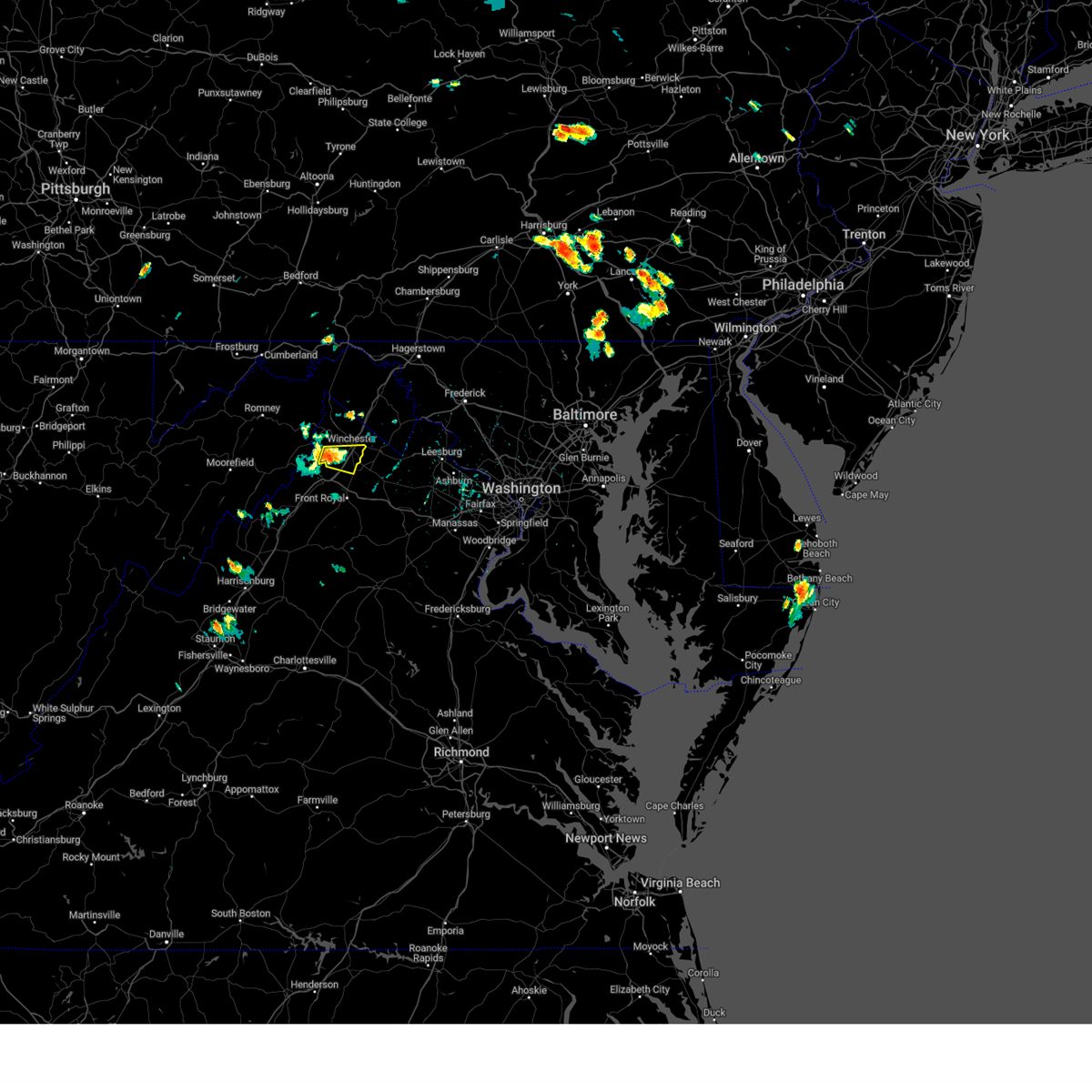 At 244 pm edt, a severe thunderstorm was located near stephens city, or near winchester, moving east at 20 mph (radar indicated). Hazards include 60 mph wind gusts and quarter size hail. Damaging winds will cause some trees and large branches to fall. this could injure those outdoors, as well as damage homes and vehicles. roadways may become blocked by downed trees. localized power outages are possible. unsecured light objects may become projectiles. Locations impacted include, winchester, millwood pike, stephens city, armel, greenwood, and high view manor. At 244 pm edt, a severe thunderstorm was located near stephens city, or near winchester, moving east at 20 mph (radar indicated). Hazards include 60 mph wind gusts and quarter size hail. Damaging winds will cause some trees and large branches to fall. this could injure those outdoors, as well as damage homes and vehicles. roadways may become blocked by downed trees. localized power outages are possible. unsecured light objects may become projectiles. Locations impacted include, winchester, millwood pike, stephens city, armel, greenwood, and high view manor.
|
| 8/1/2024 2:35 PM EDT |
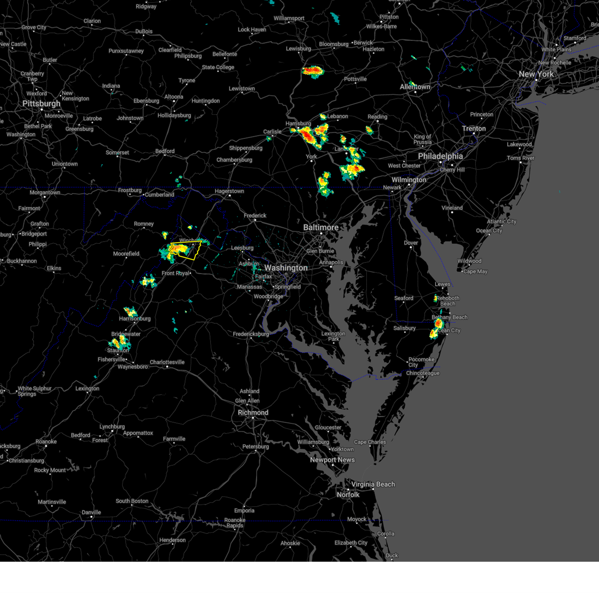 Svrlwx the national weather service in sterling virginia has issued a * severe thunderstorm warning for, southern frederick county in northwestern virginia, the city of winchester in northwestern virginia, * until 315 pm edt. * at 235 pm edt, a severe thunderstorm was located near star tannery, or 9 miles west of winchester, moving east at 20 mph (radar indicated). Hazards include 60 mph wind gusts. Damaging winds will cause some trees and large branches to fall. this could injure those outdoors, as well as damage homes and vehicles. roadways may become blocked by downed trees. localized power outages are possible. Unsecured light objects may become projectiles. Svrlwx the national weather service in sterling virginia has issued a * severe thunderstorm warning for, southern frederick county in northwestern virginia, the city of winchester in northwestern virginia, * until 315 pm edt. * at 235 pm edt, a severe thunderstorm was located near star tannery, or 9 miles west of winchester, moving east at 20 mph (radar indicated). Hazards include 60 mph wind gusts. Damaging winds will cause some trees and large branches to fall. this could injure those outdoors, as well as damage homes and vehicles. roadways may become blocked by downed trees. localized power outages are possible. Unsecured light objects may become projectiles.
|
| 6/26/2024 8:42 PM EDT |
 The storms which prompted the warning have moved out of the area. therefore, the warning will be allowed to expire. The storms which prompted the warning have moved out of the area. therefore, the warning will be allowed to expire.
|
| 6/26/2024 8:27 PM EDT |
 At 826 pm edt, severe thunderstorms were located along a line extending from near stephens city to front royal to 11 miles north of sperryville, moving east at 55 mph (radar indicated). Hazards include 60 mph wind gusts. Damaging winds will cause some trees and large branches to fall. this could injure those outdoors, as well as damage homes and vehicles. roadways may become blocked by downed trees. localized power outages are possible. unsecured light objects may become projectiles. Locations impacted include, winchester, front royal, millwood pike, stephens city, linden, middletown, chester gap, boyce, huntly, white post, riverton, karo, glen echo, bentonville, blue mountain, nineveh, bethel, arco, howellsville, and greenwood. At 826 pm edt, severe thunderstorms were located along a line extending from near stephens city to front royal to 11 miles north of sperryville, moving east at 55 mph (radar indicated). Hazards include 60 mph wind gusts. Damaging winds will cause some trees and large branches to fall. this could injure those outdoors, as well as damage homes and vehicles. roadways may become blocked by downed trees. localized power outages are possible. unsecured light objects may become projectiles. Locations impacted include, winchester, front royal, millwood pike, stephens city, linden, middletown, chester gap, boyce, huntly, white post, riverton, karo, glen echo, bentonville, blue mountain, nineveh, bethel, arco, howellsville, and greenwood.
|
| 6/26/2024 8:27 PM EDT |
 the severe thunderstorm warning has been cancelled and is no longer in effect the severe thunderstorm warning has been cancelled and is no longer in effect
|
| 6/26/2024 8:10 PM EDT |
 Svrlwx the national weather service in sterling virginia has issued a * severe thunderstorm warning for, northeastern shenandoah county in northwestern virginia, southern frederick county in northwestern virginia, warren county in northwestern virginia, southwestern clarke county in northwestern virginia, northeastern page county in northwestern virginia, north central rappahannock county in northwestern virginia, northwestern fauquier county in northern virginia, the city of winchester in northwestern virginia, east central hardy county in eastern west virginia, southeastern hampshire county in eastern west virginia, * until 845 pm edt. * at 810 pm edt, severe thunderstorms were located along a line extending from near wardensville to 7 miles south of strasburg to 7 miles north of luray, moving east at 55 mph (radar indicated). Hazards include 60 mph wind gusts. Damaging winds will cause some trees and large branches to fall. this could injure those outdoors, as well as damage homes and vehicles. roadways may become blocked by downed trees. localized power outages are possible. Unsecured light objects may become projectiles. Svrlwx the national weather service in sterling virginia has issued a * severe thunderstorm warning for, northeastern shenandoah county in northwestern virginia, southern frederick county in northwestern virginia, warren county in northwestern virginia, southwestern clarke county in northwestern virginia, northeastern page county in northwestern virginia, north central rappahannock county in northwestern virginia, northwestern fauquier county in northern virginia, the city of winchester in northwestern virginia, east central hardy county in eastern west virginia, southeastern hampshire county in eastern west virginia, * until 845 pm edt. * at 810 pm edt, severe thunderstorms were located along a line extending from near wardensville to 7 miles south of strasburg to 7 miles north of luray, moving east at 55 mph (radar indicated). Hazards include 60 mph wind gusts. Damaging winds will cause some trees and large branches to fall. this could injure those outdoors, as well as damage homes and vehicles. roadways may become blocked by downed trees. localized power outages are possible. Unsecured light objects may become projectiles.
|
| 6/14/2024 6:50 PM EDT | Tree down on misty meadow driv in frederick county VA, 8.4 miles S of Winchester, VA |
| 6/14/2024 6:44 PM EDT | Tree down on cattail roa in frederick county VA, 9.1 miles S of Winchester, VA |
| 6/14/2024 6:30 PM EDT | Tree down on glengary roa in frederick county VA, 13.9 miles S of Winchester, VA |
| 5/26/2024 10:21 PM EDT |
 the severe thunderstorm warning has been cancelled and is no longer in effect the severe thunderstorm warning has been cancelled and is no longer in effect
|
| 5/26/2024 10:21 PM EDT |
 At 1019 pm edt, severe thunderstorms were located along a line extending from near needmore to 8 miles north of martinsburg to near ranson to near berryville, moving east at 40 mph (radar indicated). Hazards include 60 mph wind gusts. Damaging winds will cause some trees and large branches to fall. this could injure those outdoors, as well as damage homes and vehicles. roadways may become blocked by downed trees. localized power outages are possible. unsecured light objects may become projectiles. Locations impacted include, hagerstown, winchester, martinsburg, charles town, shepherdstown, hancock, millwood pike, purcellville, ranson, berryville, inwood, wilson-conococheague, williamsport, round hill, harpers ferry, corporation of ranson, kearneysville, delaplane, bluemont, and saint james. At 1019 pm edt, severe thunderstorms were located along a line extending from near needmore to 8 miles north of martinsburg to near ranson to near berryville, moving east at 40 mph (radar indicated). Hazards include 60 mph wind gusts. Damaging winds will cause some trees and large branches to fall. this could injure those outdoors, as well as damage homes and vehicles. roadways may become blocked by downed trees. localized power outages are possible. unsecured light objects may become projectiles. Locations impacted include, hagerstown, winchester, martinsburg, charles town, shepherdstown, hancock, millwood pike, purcellville, ranson, berryville, inwood, wilson-conococheague, williamsport, round hill, harpers ferry, corporation of ranson, kearneysville, delaplane, bluemont, and saint james.
|
| 5/26/2024 9:56 PM EDT |
 Svrlwx the national weather service in sterling virginia has issued a * severe thunderstorm warning for, washington county in north central maryland, western frederick county in north central maryland, northeastern allegany county in western maryland, northwestern loudoun county in northern virginia, eastern frederick county in northwestern virginia, north central rappahannock county in northwestern virginia, northwestern fauquier county in northern virginia, northeastern warren county in northwestern virginia, clarke county in northwestern virginia, the city of winchester in northwestern virginia, jefferson county in the panhandle of west virginia, morgan county in the panhandle of west virginia, berkeley county in the panhandle of west virginia, * until 1045 pm edt. * at 956 pm edt, severe thunderstorms were located along a line extending from near barnes gap to greenwood to near winchester to near front royal, moving northeast at 40 mph (radar indicated). Hazards include 60 mph wind gusts. Damaging winds will cause some trees and large branches to fall. this could injure those outdoors, as well as damage homes and vehicles. roadways may become blocked by downed trees. localized power outages are possible. Unsecured light objects may become projectiles. Svrlwx the national weather service in sterling virginia has issued a * severe thunderstorm warning for, washington county in north central maryland, western frederick county in north central maryland, northeastern allegany county in western maryland, northwestern loudoun county in northern virginia, eastern frederick county in northwestern virginia, north central rappahannock county in northwestern virginia, northwestern fauquier county in northern virginia, northeastern warren county in northwestern virginia, clarke county in northwestern virginia, the city of winchester in northwestern virginia, jefferson county in the panhandle of west virginia, morgan county in the panhandle of west virginia, berkeley county in the panhandle of west virginia, * until 1045 pm edt. * at 956 pm edt, severe thunderstorms were located along a line extending from near barnes gap to greenwood to near winchester to near front royal, moving northeast at 40 mph (radar indicated). Hazards include 60 mph wind gusts. Damaging winds will cause some trees and large branches to fall. this could injure those outdoors, as well as damage homes and vehicles. roadways may become blocked by downed trees. localized power outages are possible. Unsecured light objects may become projectiles.
|
| 5/26/2024 9:55 PM EDT | Tree down on milburn road near intersection with mccann's roa in frederick county VA, 4.7 miles SW of Winchester, VA |
| 5/26/2024 9:52 PM EDT |
 At 952 pm edt, severe thunderstorms were located along a line extending from barnes gap to near greenwood to near stephens city to 9 miles northeast of sperryville to 8 miles northwest of spotsylvania, moving east at 35 mph (radar indicated). Hazards include 60 mph wind gusts. Damaging winds will cause some trees and large branches to fall. this could injure those outdoors, as well as damage homes and vehicles. roadways may become blocked by downed trees. localized power outages are possible. unsecured light objects may become projectiles. Locations impacted include, winchester, fredericksburg, culpeper, front royal, warrenton, hancock, paw paw, millwood pike, bealeton, inwood, stephens city, berkeley springs, delaplane, linden, massaponax, hume, spotsylvania, falmouth, marshall, and middletown. At 952 pm edt, severe thunderstorms were located along a line extending from barnes gap to near greenwood to near stephens city to 9 miles northeast of sperryville to 8 miles northwest of spotsylvania, moving east at 35 mph (radar indicated). Hazards include 60 mph wind gusts. Damaging winds will cause some trees and large branches to fall. this could injure those outdoors, as well as damage homes and vehicles. roadways may become blocked by downed trees. localized power outages are possible. unsecured light objects may become projectiles. Locations impacted include, winchester, fredericksburg, culpeper, front royal, warrenton, hancock, paw paw, millwood pike, bealeton, inwood, stephens city, berkeley springs, delaplane, linden, massaponax, hume, spotsylvania, falmouth, marshall, and middletown.
|
| 5/26/2024 9:52 PM EDT |
 the severe thunderstorm warning has been cancelled and is no longer in effect the severe thunderstorm warning has been cancelled and is no longer in effect
|
| 5/26/2024 9:05 PM EDT |
 Svrlwx the national weather service in sterling virginia has issued a * severe thunderstorm warning for, northwestern washington county in north central maryland, northeastern allegany county in western maryland, southwestern stafford county in northern virginia, southwestern loudoun county in northern virginia, northeastern shenandoah county in northwestern virginia, frederick county in northwestern virginia, orange county in central virginia, the city of fredericksburg in central virginia, rappahannock county in northwestern virginia, central fauquier county in northern virginia, culpeper county in northern virginia, central madison county in northwestern virginia, warren county in northwestern virginia, western clarke county in northwestern virginia, northeastern page county in northwestern virginia, the city of winchester in northwestern virginia, spotsylvania county in central virginia, west central jefferson county in the panhandle of west virginia, morgan county in the panhandle of west virginia, northeastern mineral county in eastern west virginia, northeastern hardy county in eastern west virginia, western berkeley county in the panhandle of west virginia, hampshire county in eastern west virginia, * until 1000 pm edt. * at 905 pm edt, severe thunderstorms were located along a line extending from near la vale to 6 miles south of romney to 6 miles north of basye-bryce mountain to near mount jackson to 6 miles north of boswells tavern, moving east at 35 mph (radar indicated). Hazards include 60 mph wind gusts. Damaging winds will cause some trees and large branches to fall. this could injure those outdoors, as well as damage homes and vehicles. roadways may become blocked by downed trees. localized power outages are possible. Unsecured light objects may become projectiles. Svrlwx the national weather service in sterling virginia has issued a * severe thunderstorm warning for, northwestern washington county in north central maryland, northeastern allegany county in western maryland, southwestern stafford county in northern virginia, southwestern loudoun county in northern virginia, northeastern shenandoah county in northwestern virginia, frederick county in northwestern virginia, orange county in central virginia, the city of fredericksburg in central virginia, rappahannock county in northwestern virginia, central fauquier county in northern virginia, culpeper county in northern virginia, central madison county in northwestern virginia, warren county in northwestern virginia, western clarke county in northwestern virginia, northeastern page county in northwestern virginia, the city of winchester in northwestern virginia, spotsylvania county in central virginia, west central jefferson county in the panhandle of west virginia, morgan county in the panhandle of west virginia, northeastern mineral county in eastern west virginia, northeastern hardy county in eastern west virginia, western berkeley county in the panhandle of west virginia, hampshire county in eastern west virginia, * until 1000 pm edt. * at 905 pm edt, severe thunderstorms were located along a line extending from near la vale to 6 miles south of romney to 6 miles north of basye-bryce mountain to near mount jackson to 6 miles north of boswells tavern, moving east at 35 mph (radar indicated). Hazards include 60 mph wind gusts. Damaging winds will cause some trees and large branches to fall. this could injure those outdoors, as well as damage homes and vehicles. roadways may become blocked by downed trees. localized power outages are possible. Unsecured light objects may become projectiles.
|
| 5/22/2024 3:44 PM EDT | Trees down at the 1300 block of stony hill roa in frederick county VA, 9.1 miles SSE of Winchester, VA |
| 4/15/2024 1:27 PM EDT |
 Svrlwx the national weather service in sterling virginia has issued a * severe thunderstorm warning for, east central frederick county in northwestern virginia, clarke county in northwestern virginia, the city of winchester in northwestern virginia, * until 200 pm edt. * at 127 pm edt, a severe thunderstorm was located near winchester, moving east at 35 mph (radar indicated). Hazards include 60 mph wind gusts and half dollar size hail. Damaging winds will cause some trees and large branches to fall. this could injure those outdoors, as well as damage homes and vehicles. roadways may become blocked by downed trees. localized power outages are possible. Unsecured light objects may become projectiles. Svrlwx the national weather service in sterling virginia has issued a * severe thunderstorm warning for, east central frederick county in northwestern virginia, clarke county in northwestern virginia, the city of winchester in northwestern virginia, * until 200 pm edt. * at 127 pm edt, a severe thunderstorm was located near winchester, moving east at 35 mph (radar indicated). Hazards include 60 mph wind gusts and half dollar size hail. Damaging winds will cause some trees and large branches to fall. this could injure those outdoors, as well as damage homes and vehicles. roadways may become blocked by downed trees. localized power outages are possible. Unsecured light objects may become projectiles.
|
| 4/15/2024 1:20 PM EDT |
 At 120 pm edt, a severe thunderstorm was located 9 miles northwest of winchester, moving southeast at 30 mph (radar indicated). Hazards include 60 mph wind gusts and quarter size hail. Damaging winds will cause some trees and large branches to fall. this could injure those outdoors, as well as damage homes and vehicles. roadways may become blocked by downed trees. localized power outages are possible. unsecured light objects may become projectiles. Locations impacted include, winchester, millwood pike, stephenson, gainesboro, cedar hill, cedar grove, clear brook, albin, and gore. At 120 pm edt, a severe thunderstorm was located 9 miles northwest of winchester, moving southeast at 30 mph (radar indicated). Hazards include 60 mph wind gusts and quarter size hail. Damaging winds will cause some trees and large branches to fall. this could injure those outdoors, as well as damage homes and vehicles. roadways may become blocked by downed trees. localized power outages are possible. unsecured light objects may become projectiles. Locations impacted include, winchester, millwood pike, stephenson, gainesboro, cedar hill, cedar grove, clear brook, albin, and gore.
|
| 4/15/2024 1:20 PM EDT |
 the severe thunderstorm warning has been cancelled and is no longer in effect the severe thunderstorm warning has been cancelled and is no longer in effect
|
| 4/15/2024 1:07 PM EDT |
 Svrlwx the national weather service in sterling virginia has issued a * severe thunderstorm warning for, central frederick county in northwestern virginia, the city of winchester in northwestern virginia, east central hampshire county in eastern west virginia, * until 130 pm edt. * at 107 pm edt, a severe thunderstorm was located 14 miles north of star tannery, or 15 miles southwest of greenwood, moving southeast at 30 mph (radar indicated). Hazards include 60 mph wind gusts and quarter size hail. Damaging winds will cause some trees and large branches to fall. this could injure those outdoors, as well as damage homes and vehicles. roadways may become blocked by downed trees. localized power outages are possible. Unsecured light objects may become projectiles. Svrlwx the national weather service in sterling virginia has issued a * severe thunderstorm warning for, central frederick county in northwestern virginia, the city of winchester in northwestern virginia, east central hampshire county in eastern west virginia, * until 130 pm edt. * at 107 pm edt, a severe thunderstorm was located 14 miles north of star tannery, or 15 miles southwest of greenwood, moving southeast at 30 mph (radar indicated). Hazards include 60 mph wind gusts and quarter size hail. Damaging winds will cause some trees and large branches to fall. this could injure those outdoors, as well as damage homes and vehicles. roadways may become blocked by downed trees. localized power outages are possible. Unsecured light objects may become projectiles.
|
| 9/7/2023 1:19 PM EDT |
 At 119 pm edt, a severe thunderstorm was located over stephens city, or near millwood pike, moving northeast at 15 mph (radar indicated). Hazards include 60 mph wind gusts. Damaging winds will cause some trees and large branches to fall. this could injure those outdoors, as well as damage homes and vehicles. roadways may become blocked by downed trees. localized power outages are possible. unsecured light objects may become projectiles. locations impacted include, winchester, millwood pike, stephens city, boyce, millwood, white post, greenwood, nineveh, albin, armel, and briggs. hail threat, radar indicated max hail size, <. 75 in wind threat, radar indicated max wind gust, 60 mph. At 119 pm edt, a severe thunderstorm was located over stephens city, or near millwood pike, moving northeast at 15 mph (radar indicated). Hazards include 60 mph wind gusts. Damaging winds will cause some trees and large branches to fall. this could injure those outdoors, as well as damage homes and vehicles. roadways may become blocked by downed trees. localized power outages are possible. unsecured light objects may become projectiles. locations impacted include, winchester, millwood pike, stephens city, boyce, millwood, white post, greenwood, nineveh, albin, armel, and briggs. hail threat, radar indicated max hail size, <. 75 in wind threat, radar indicated max wind gust, 60 mph.
|
| 9/7/2023 12:46 PM EDT |
 At 1245 pm edt, a severe thunderstorm was located near stephens city, or near strasburg, moving northeast at 20 mph (radar indicated). Hazards include 60 mph wind gusts and quarter size hail. Damaging winds will cause some trees and large branches to fall. this could injure those outdoors, as well as damage homes and vehicles. roadways may become blocked by downed trees. localized power outages are possible. Unsecured light objects may become projectiles. At 1245 pm edt, a severe thunderstorm was located near stephens city, or near strasburg, moving northeast at 20 mph (radar indicated). Hazards include 60 mph wind gusts and quarter size hail. Damaging winds will cause some trees and large branches to fall. this could injure those outdoors, as well as damage homes and vehicles. roadways may become blocked by downed trees. localized power outages are possible. Unsecured light objects may become projectiles.
|
| 9/6/2023 9:10 PM EDT |
 The severe thunderstorm warning for northeastern shenandoah, southeastern frederick, northeastern warren and southwestern clarke counties in northwestern virginia, northwestern fauquier in northern virginia and the southern city of winchester will expire at 915 pm edt, the storm which prompted the warning has moved out of the area. therefore, the warning will be allowed to expire. to report severe weather, contact your nearest law enforcement agency. they will relay your report to the national weather service sterling virginia. The severe thunderstorm warning for northeastern shenandoah, southeastern frederick, northeastern warren and southwestern clarke counties in northwestern virginia, northwestern fauquier in northern virginia and the southern city of winchester will expire at 915 pm edt, the storm which prompted the warning has moved out of the area. therefore, the warning will be allowed to expire. to report severe weather, contact your nearest law enforcement agency. they will relay your report to the national weather service sterling virginia.
|
| 9/6/2023 9:00 PM EDT |
 At 900 pm edt, a severe thunderstorm was located near front royal, moving northeast at 15 mph (radar indicated). Hazards include 60 mph wind gusts and penny size hail. Damaging winds will cause some trees and large branches to fall. this could injure those outdoors, as well as damage homes and vehicles. roadways may become blocked by downed trees. localized power outages are possible. unsecured light objects may become projectiles. locations impacted include, front royal, stephens city, middletown, howellsville, nineveh, riverton, reliance, armel, cedarville, and buckton. hail threat, radar indicated max hail size, 0. 75 in wind threat, radar indicated max wind gust, 60 mph. At 900 pm edt, a severe thunderstorm was located near front royal, moving northeast at 15 mph (radar indicated). Hazards include 60 mph wind gusts and penny size hail. Damaging winds will cause some trees and large branches to fall. this could injure those outdoors, as well as damage homes and vehicles. roadways may become blocked by downed trees. localized power outages are possible. unsecured light objects may become projectiles. locations impacted include, front royal, stephens city, middletown, howellsville, nineveh, riverton, reliance, armel, cedarville, and buckton. hail threat, radar indicated max hail size, 0. 75 in wind threat, radar indicated max wind gust, 60 mph.
|
| 9/6/2023 8:52 PM EDT |
 At 852 pm edt, a severe thunderstorm was located near front royal, moving northeast at 15 mph (radar indicated). Hazards include 60 mph wind gusts and penny size hail. Damaging winds will cause some trees and large branches to fall. this could injure those outdoors, as well as damage homes and vehicles. roadways may become blocked by downed trees. localized power outages are possible. unsecured light objects may become projectiles. locations impacted include, front royal, strasburg, stephens city, middletown, fort valley, howellsville, riverton, reliance, armel, nineveh, cedarville, clary, and buckton. hail threat, radar indicated max hail size, 0. 75 in wind threat, radar indicated max wind gust, 60 mph. At 852 pm edt, a severe thunderstorm was located near front royal, moving northeast at 15 mph (radar indicated). Hazards include 60 mph wind gusts and penny size hail. Damaging winds will cause some trees and large branches to fall. this could injure those outdoors, as well as damage homes and vehicles. roadways may become blocked by downed trees. localized power outages are possible. unsecured light objects may become projectiles. locations impacted include, front royal, strasburg, stephens city, middletown, fort valley, howellsville, riverton, reliance, armel, nineveh, cedarville, clary, and buckton. hail threat, radar indicated max hail size, 0. 75 in wind threat, radar indicated max wind gust, 60 mph.
|
| 9/6/2023 8:42 PM EDT |
 At 839 pm edt, a severe thunderstorm was located near strasburg, moving northeast at 10 mph (radar indicated). Hazards include 60 mph wind gusts. Damaging winds will cause some trees and large branches to fall. this could injure those outdoors, as well as damage homes and vehicles. roadways may become blocked by downed trees. localized power outages are possible. Unsecured light objects may become projectiles. At 839 pm edt, a severe thunderstorm was located near strasburg, moving northeast at 10 mph (radar indicated). Hazards include 60 mph wind gusts. Damaging winds will cause some trees and large branches to fall. this could injure those outdoors, as well as damage homes and vehicles. roadways may become blocked by downed trees. localized power outages are possible. Unsecured light objects may become projectiles.
|
| 9/6/2023 8:27 PM EDT |
 At 827 pm edt, a severe thunderstorm was located over strasburg, moving northeast at 15 mph (radar indicated). Hazards include 60 mph wind gusts. Damaging winds will cause some trees and large branches to fall. this could injure those outdoors, as well as damage homes and vehicles. roadways may become blocked by downed trees. localized power outages are possible. unsecured light objects may become projectiles. locations impacted include, strasburg, stephens city, middletown, reliance, armel, and clary. hail threat, radar indicated max hail size, <. 75 in wind threat, radar indicated max wind gust, 60 mph. At 827 pm edt, a severe thunderstorm was located over strasburg, moving northeast at 15 mph (radar indicated). Hazards include 60 mph wind gusts. Damaging winds will cause some trees and large branches to fall. this could injure those outdoors, as well as damage homes and vehicles. roadways may become blocked by downed trees. localized power outages are possible. unsecured light objects may become projectiles. locations impacted include, strasburg, stephens city, middletown, reliance, armel, and clary. hail threat, radar indicated max hail size, <. 75 in wind threat, radar indicated max wind gust, 60 mph.
|
| 9/6/2023 8:06 PM EDT |
 At 806 pm edt, a severe thunderstorm was located near strasburg, moving northeast at 10 mph (radar indicated). Hazards include 60 mph wind gusts. Damaging winds will cause some trees and large branches to fall. this could injure those outdoors, as well as damage homes and vehicles. roadways may become blocked by downed trees. localized power outages are possible. Unsecured light objects may become projectiles. At 806 pm edt, a severe thunderstorm was located near strasburg, moving northeast at 10 mph (radar indicated). Hazards include 60 mph wind gusts. Damaging winds will cause some trees and large branches to fall. this could injure those outdoors, as well as damage homes and vehicles. roadways may become blocked by downed trees. localized power outages are possible. Unsecured light objects may become projectiles.
|
| 8/7/2023 4:08 PM EDT |
 At 408 pm edt, severe thunderstorms were located along a line extending from near winchester to near strasburg, moving east at 35 mph (radar indicated). Hazards include 60 mph wind gusts. Damaging winds will cause some trees and large branches to fall. this could injure those outdoors, as well as damage homes and vehicles. roadways may become blocked by downed trees. localized power outages are possible. Unsecured light objects may become projectiles. At 408 pm edt, severe thunderstorms were located along a line extending from near winchester to near strasburg, moving east at 35 mph (radar indicated). Hazards include 60 mph wind gusts. Damaging winds will cause some trees and large branches to fall. this could injure those outdoors, as well as damage homes and vehicles. roadways may become blocked by downed trees. localized power outages are possible. Unsecured light objects may become projectiles.
|
| 8/7/2023 4:03 PM EDT | Multiple reports of downed trees in gainesbor in frederick county VA, 8.8 miles SSE of Winchester, VA |
| 8/7/2023 4:02 PM EDT | A couple calls for downed trees and wires in cross junctio in frederick county VA, 0.4 miles W of Winchester, VA |
| 8/7/2023 4:01 PM EDT | Trees down on wardensville grade road... singhass road... dicks hollow road... and us-5 in frederick county VA, 0.4 miles W of Winchester, VA |
| 8/7/2023 4:00 PM EDT | Trees down on indian hollow road. road close in frederick county VA, 5.7 miles SE of Winchester, VA |
| 8/7/2023 3:56 PM EDT |
 At 356 pm edt, a severe thunderstorm was located 8 miles north of star tannery, or 12 miles west of winchester, moving east at 55 mph (radar indicated). Hazards include 70 mph wind gusts and quarter size hail. Damaging winds will cause some trees and large branches to fall. this could injure those outdoors, as well as damage homes and vehicles. roadways may become blocked by downed trees. localized power outages are possible. Unsecured light objects may become projectiles. At 356 pm edt, a severe thunderstorm was located 8 miles north of star tannery, or 12 miles west of winchester, moving east at 55 mph (radar indicated). Hazards include 70 mph wind gusts and quarter size hail. Damaging winds will cause some trees and large branches to fall. this could injure those outdoors, as well as damage homes and vehicles. roadways may become blocked by downed trees. localized power outages are possible. Unsecured light objects may become projectiles.
|
| 8/7/2023 3:51 PM EDT | Tree down on powerlines near the 200 block of aspen trail in frederick county VA, 8.4 miles ESE of Winchester, VA |
| 7/28/2023 6:25 PM EDT |
 At 625 pm edt, a severe thunderstorm was located over winchester, moving east at 20 mph (radar indicated). Hazards include 60 mph wind gusts and penny size hail. Damaging winds will cause some trees and large branches to fall. this could injure those outdoors, as well as damage homes and vehicles. roadways may become blocked by downed trees. localized power outages are possible. unsecured light objects may become projectiles. locations impacted include, winchester, millwood pike, berryville, stephens city, brucetown, greenwood, cedar grove, gaylord, clear brook, stephenson, wadesville, cedar hill, albin and stringtown. hail threat, radar indicated max hail size, 0. 75 in wind threat, radar indicated max wind gust, 60 mph. At 625 pm edt, a severe thunderstorm was located over winchester, moving east at 20 mph (radar indicated). Hazards include 60 mph wind gusts and penny size hail. Damaging winds will cause some trees and large branches to fall. this could injure those outdoors, as well as damage homes and vehicles. roadways may become blocked by downed trees. localized power outages are possible. unsecured light objects may become projectiles. locations impacted include, winchester, millwood pike, berryville, stephens city, brucetown, greenwood, cedar grove, gaylord, clear brook, stephenson, wadesville, cedar hill, albin and stringtown. hail threat, radar indicated max hail size, 0. 75 in wind threat, radar indicated max wind gust, 60 mph.
|
| 7/28/2023 6:14 PM EDT |
 At 614 pm edt, a severe thunderstorm was located near winchester, moving east at 20 mph (radar indicated). Hazards include 60 mph wind gusts and quarter size hail. Damaging winds will cause some trees and large branches to fall. this could injure those outdoors, as well as damage homes and vehicles. roadways may become blocked by downed trees. localized power outages are possible. unsecured light objects may become projectiles. locations impacted include, winchester, millwood pike, berryville, stephens city, brucetown, greenwood, high view manor, cedar grove, gaylord, clear brook, stephenson, wadesville, cedar hill, albin and stringtown. hail threat, radar indicated max hail size, 1. 00 in wind threat, radar indicated max wind gust, 60 mph. At 614 pm edt, a severe thunderstorm was located near winchester, moving east at 20 mph (radar indicated). Hazards include 60 mph wind gusts and quarter size hail. Damaging winds will cause some trees and large branches to fall. this could injure those outdoors, as well as damage homes and vehicles. roadways may become blocked by downed trees. localized power outages are possible. unsecured light objects may become projectiles. locations impacted include, winchester, millwood pike, berryville, stephens city, brucetown, greenwood, high view manor, cedar grove, gaylord, clear brook, stephenson, wadesville, cedar hill, albin and stringtown. hail threat, radar indicated max hail size, 1. 00 in wind threat, radar indicated max wind gust, 60 mph.
|
| 7/28/2023 6:11 PM EDT | Frederick county 911 reported a couple trees... numerous branches... and wires down in the vicinity of albi in frederick county VA, 3.3 miles SSE of Winchester, VA |
| 7/28/2023 6:02 PM EDT |
 At 602 pm edt, a severe thunderstorm was located 7 miles west of winchester, moving east at 15 mph (radar indicated). Hazards include 60 mph wind gusts and quarter size hail. Damaging winds will cause some trees and large branches to fall. this could injure those outdoors, as well as damage homes and vehicles. roadways may become blocked by downed trees. localized power outages are possible. Unsecured light objects may become projectiles. At 602 pm edt, a severe thunderstorm was located 7 miles west of winchester, moving east at 15 mph (radar indicated). Hazards include 60 mph wind gusts and quarter size hail. Damaging winds will cause some trees and large branches to fall. this could injure those outdoors, as well as damage homes and vehicles. roadways may become blocked by downed trees. localized power outages are possible. Unsecured light objects may become projectiles.
|
| 7/28/2023 5:09 PM EDT |
 At 509 pm edt, a severe thunderstorm was located near inwood, or 8 miles northwest of charles town, moving east at 10 mph (radar indicated). Hazards include 70 mph wind gusts and ping pong ball size hail. Damaging winds will cause some trees and large branches to fall. this could injure those outdoors, as well as damage homes and vehicles. roadways may become blocked by downed trees. localized power outages are possible. unsecured light objects may become projectiles. locations impacted include, winchester, charles town, ranson, inwood, harpers ferry, kearneysville, corporation of ranson, bolivar, shenandoah junction, middleway, gaylord, clear brook, ridgeway, bunker hill, stephenson, cedar hill, albin, millville, stringtown and rippon. thunderstorm damage threat, considerable hail threat, radar indicated max hail size, 1. 50 in wind threat, radar indicated max wind gust, 70 mph. At 509 pm edt, a severe thunderstorm was located near inwood, or 8 miles northwest of charles town, moving east at 10 mph (radar indicated). Hazards include 70 mph wind gusts and ping pong ball size hail. Damaging winds will cause some trees and large branches to fall. this could injure those outdoors, as well as damage homes and vehicles. roadways may become blocked by downed trees. localized power outages are possible. unsecured light objects may become projectiles. locations impacted include, winchester, charles town, ranson, inwood, harpers ferry, kearneysville, corporation of ranson, bolivar, shenandoah junction, middleway, gaylord, clear brook, ridgeway, bunker hill, stephenson, cedar hill, albin, millville, stringtown and rippon. thunderstorm damage threat, considerable hail threat, radar indicated max hail size, 1. 50 in wind threat, radar indicated max wind gust, 70 mph.
|
| 7/28/2023 5:05 PM EDT |
 At 505 pm edt, a severe thunderstorm was located near inwood, or 8 miles west of charles town, moving east at 10 mph (radar indicated). Hazards include 60 mph wind gusts and quarter size hail. Damaging winds will cause some trees and large branches to fall. this could injure those outdoors, as well as damage homes and vehicles. roadways may become blocked by downed trees. localized power outages are possible. Unsecured light objects may become projectiles. At 505 pm edt, a severe thunderstorm was located near inwood, or 8 miles west of charles town, moving east at 10 mph (radar indicated). Hazards include 60 mph wind gusts and quarter size hail. Damaging winds will cause some trees and large branches to fall. this could injure those outdoors, as well as damage homes and vehicles. roadways may become blocked by downed trees. localized power outages are possible. Unsecured light objects may become projectiles.
|
| 7/27/2023 5:23 PM EDT |
 At 522 pm edt, a severe thunderstorm was located over millwood pike, moving east at 20 mph. a wind gust to 69 mph was observed at the winchester airport (radar indicated). Hazards include 70 mph wind gusts and quarter size hail. Damaging winds will cause some trees and large branches to fall. this could injure those outdoors, as well as damage homes and vehicles. roadways may become blocked by downed trees. localized power outages are possible. unsecured light objects may become projectiles. locations impacted include, winchester, millwood pike, berryville, boyce, millwood, greenwood, armel, briggs and stringtown. thunderstorm damage threat, considerable hail threat, radar indicated max hail size, 1. 00 in wind threat, observed max wind gust, 70 mph. At 522 pm edt, a severe thunderstorm was located over millwood pike, moving east at 20 mph. a wind gust to 69 mph was observed at the winchester airport (radar indicated). Hazards include 70 mph wind gusts and quarter size hail. Damaging winds will cause some trees and large branches to fall. this could injure those outdoors, as well as damage homes and vehicles. roadways may become blocked by downed trees. localized power outages are possible. unsecured light objects may become projectiles. locations impacted include, winchester, millwood pike, berryville, boyce, millwood, greenwood, armel, briggs and stringtown. thunderstorm damage threat, considerable hail threat, radar indicated max hail size, 1. 00 in wind threat, observed max wind gust, 70 mph.
|
| 7/27/2023 5:17 PM EDT | A wind gust of 60 knots (69 mph) was measured by the awos at winchester regional airport (kokv in frederick county VA, 2.9 miles NW of Winchester, VA |
| 7/27/2023 5:14 PM EDT | Several trees blew down in the city of wincheste in frederick county VA, 1.2 miles SW of Winchester, VA |
| 7/27/2023 5:13 PM EDT |
 At 513 pm edt, a severe thunderstorm was located over millwood pike, moving east at 20 mph (radar indicated). Hazards include 60 mph wind gusts and quarter size hail. Damaging winds will cause some trees and large branches to fall. this could injure those outdoors, as well as damage homes and vehicles. roadways may become blocked by downed trees. localized power outages are possible. unsecured light objects may become projectiles. locations impacted include, winchester, millwood pike, berryville, stephens city, boyce, millwood, greenwood, armel, briggs and stringtown. hail threat, radar indicated max hail size, 1. 00 in wind threat, radar indicated max wind gust, 60 mph. At 513 pm edt, a severe thunderstorm was located over millwood pike, moving east at 20 mph (radar indicated). Hazards include 60 mph wind gusts and quarter size hail. Damaging winds will cause some trees and large branches to fall. this could injure those outdoors, as well as damage homes and vehicles. roadways may become blocked by downed trees. localized power outages are possible. unsecured light objects may become projectiles. locations impacted include, winchester, millwood pike, berryville, stephens city, boyce, millwood, greenwood, armel, briggs and stringtown. hail threat, radar indicated max hail size, 1. 00 in wind threat, radar indicated max wind gust, 60 mph.
|
| 7/27/2023 5:02 PM EDT |
 At 502 pm edt, a severe thunderstorm was located near winchester, moving east at 20 mph (radar indicated). Hazards include 60 mph wind gusts and quarter size hail. Damaging winds will cause some trees and large branches to fall. this could injure those outdoors, as well as damage homes and vehicles. roadways may become blocked by downed trees. localized power outages are possible. Unsecured light objects may become projectiles. At 502 pm edt, a severe thunderstorm was located near winchester, moving east at 20 mph (radar indicated). Hazards include 60 mph wind gusts and quarter size hail. Damaging winds will cause some trees and large branches to fall. this could injure those outdoors, as well as damage homes and vehicles. roadways may become blocked by downed trees. localized power outages are possible. Unsecured light objects may become projectiles.
|
| 7/14/2023 3:30 PM EDT |
 At 330 pm edt, a severe thunderstorm was located near winchester, moving east at 20 mph (trained weather spotters). Hazards include 60 mph wind gusts and half dollar size hail. Damaging winds will cause some trees and large branches to fall. this could injure those outdoors, as well as damage homes and vehicles. roadways may become blocked by downed trees. localized power outages are possible. Unsecured light objects may become projectiles. At 330 pm edt, a severe thunderstorm was located near winchester, moving east at 20 mph (trained weather spotters). Hazards include 60 mph wind gusts and half dollar size hail. Damaging winds will cause some trees and large branches to fall. this could injure those outdoors, as well as damage homes and vehicles. roadways may become blocked by downed trees. localized power outages are possible. Unsecured light objects may become projectiles.
|
| 7/14/2023 3:27 PM EDT | Half Dollar sized hail reported 6.6 miles SSE of Winchester, VA, half dollar sized hail near the intersection of 522 north and hunting ridge road. |
| 7/14/2023 3:26 PM EDT |
 At 326 pm edt, a severe thunderstorm was located near winchester, moving east at 20 mph (trained weather spotters). Hazards include 60 mph wind gusts and half dollar size hail. Damaging winds will cause some trees and large branches to fall. this could injure those outdoors, as well as damage homes and vehicles. roadways may become blocked by downed trees. localized power outages are possible. Unsecured light objects may become projectiles. At 326 pm edt, a severe thunderstorm was located near winchester, moving east at 20 mph (trained weather spotters). Hazards include 60 mph wind gusts and half dollar size hail. Damaging winds will cause some trees and large branches to fall. this could injure those outdoors, as well as damage homes and vehicles. roadways may become blocked by downed trees. localized power outages are possible. Unsecured light objects may become projectiles.
|
| 11/30/2022 1:53 PM EST |
 The severe thunderstorm warning for north central washington county in north central maryland, shenandoah, frederick, northwestern warren and northwestern clarke counties in northwestern virginia, northwestern jefferson and central morgan counties in the panhandle of west virginia, southeastern hardy county in eastern west virginia, berkeley county in the panhandle of west virginia and southeastern hampshire counties in eastern west virginia and the city of winchester will expire at 200 pm est, the storms which prompted the warning have moved out of the area. therefore, the warning will be allowed to expire. however gusty winds are still possible with these thunderstorms. The severe thunderstorm warning for north central washington county in north central maryland, shenandoah, frederick, northwestern warren and northwestern clarke counties in northwestern virginia, northwestern jefferson and central morgan counties in the panhandle of west virginia, southeastern hardy county in eastern west virginia, berkeley county in the panhandle of west virginia and southeastern hampshire counties in eastern west virginia and the city of winchester will expire at 200 pm est, the storms which prompted the warning have moved out of the area. therefore, the warning will be allowed to expire. however gusty winds are still possible with these thunderstorms.
|
| 11/30/2022 1:15 PM EST |
 At 115 pm est, severe thunderstorms were located along a line extending from 7 miles southeast of berkeley springs to near star tannery to near mathias, moving east at 45 mph (radar indicated). Hazards include 60 mph wind gusts. Damaging winds will cause some trees and large branches to fall. this could injure those outdoors, as well as damage homes and vehicles. roadways may become blocked by downed trees. localized power outages are possible. Unsecured light objects may become projectiles. At 115 pm est, severe thunderstorms were located along a line extending from 7 miles southeast of berkeley springs to near star tannery to near mathias, moving east at 45 mph (radar indicated). Hazards include 60 mph wind gusts. Damaging winds will cause some trees and large branches to fall. this could injure those outdoors, as well as damage homes and vehicles. roadways may become blocked by downed trees. localized power outages are possible. Unsecured light objects may become projectiles.
|
| 9/25/2022 1:43 PM EDT |
 The severe thunderstorm warning for northeastern shenandoah, frederick, north central warren and northwestern clarke counties in northwestern virginia, south central berkeley county in the panhandle of west virginia and southeastern hampshire counties in eastern west virginia and the city of winchester will expire at 145 pm edt, the storms which prompted the warning have moved out of the area. therefore, the warning will be allowed to expire. a severe thunderstorm watch remains in effect until 700 pm edt for northwestern virginia, and eastern and the panhandle of west virginia. to report severe weather, contact your nearest law enforcement agency. they will relay your report to the national weather service sterling virginia. The severe thunderstorm warning for northeastern shenandoah, frederick, north central warren and northwestern clarke counties in northwestern virginia, south central berkeley county in the panhandle of west virginia and southeastern hampshire counties in eastern west virginia and the city of winchester will expire at 145 pm edt, the storms which prompted the warning have moved out of the area. therefore, the warning will be allowed to expire. a severe thunderstorm watch remains in effect until 700 pm edt for northwestern virginia, and eastern and the panhandle of west virginia. to report severe weather, contact your nearest law enforcement agency. they will relay your report to the national weather service sterling virginia.
|
| 9/25/2022 1:39 PM EDT |
 At 139 pm edt, severe thunderstorms were located along a line extending from near inwood to near millwood pike to near stephens city, moving east at 55 mph (radar indicated). Hazards include 70 mph wind gusts and quarter size hail. Damaging winds will cause some trees and large branches to fall. this could injure those outdoors, as well as damage homes and vehicles. roadways may become blocked by downed trees. localized power outages are possible. Unsecured light objects may become projectiles. At 139 pm edt, severe thunderstorms were located along a line extending from near inwood to near millwood pike to near stephens city, moving east at 55 mph (radar indicated). Hazards include 70 mph wind gusts and quarter size hail. Damaging winds will cause some trees and large branches to fall. this could injure those outdoors, as well as damage homes and vehicles. roadways may become blocked by downed trees. localized power outages are possible. Unsecured light objects may become projectiles.
|
| 9/25/2022 1:37 PM EDT | Tree down onto powerlines along airport rd in frederick county VA, 3.4 miles NW of Winchester, VA |
| 9/25/2022 1:33 PM EDT | A tree blew down near the 500 block of old bethel church r in frederick county VA, 5 miles SE of Winchester, VA |
| 9/25/2022 1:29 PM EDT | A power pole snapped in half on hunting r in frederick county VA, 6.9 miles SE of Winchester, VA |
| 9/25/2022 1:27 PM EDT | Large tree down near intersection of round hill rd and northwestern pike in frederick county VA, 4.4 miles ESE of Winchester, VA |
| 9/25/2022 1:23 PM EDT | Tree down near intersection of back mountain rd and homestead farm ln in frederick county VA, 8.3 miles E of Winchester, VA |
| 9/25/2022 1:23 PM EDT | A tree blew down near cherokee trail and shenandoah trai in frederick county VA, 8.8 miles E of Winchester, VA |
| 9/25/2022 1:23 PM EDT |
 At 123 pm edt, severe thunderstorms were located along a line extending from 11 miles southwest of greenwood to near star tannery, moving east at 60 mph (radar indicated). Hazards include 60 mph wind gusts and quarter size hail. Damaging winds will cause some trees and large branches to fall. this could injure those outdoors, as well as damage homes and vehicles. roadways may become blocked by downed trees. localized power outages are possible. unsecured light objects may become projectiles. Locations impacted include, winchester, strasburg, millwood pike, stephens city, star tannery, middletown, high view, cedar grove, clear brook, stephenson, cross junction, cedar hill, nineveh, albin, gore, clary, brucetown, gravel springs, greenwood and high view manor. At 123 pm edt, severe thunderstorms were located along a line extending from 11 miles southwest of greenwood to near star tannery, moving east at 60 mph (radar indicated). Hazards include 60 mph wind gusts and quarter size hail. Damaging winds will cause some trees and large branches to fall. this could injure those outdoors, as well as damage homes and vehicles. roadways may become blocked by downed trees. localized power outages are possible. unsecured light objects may become projectiles. Locations impacted include, winchester, strasburg, millwood pike, stephens city, star tannery, middletown, high view, cedar grove, clear brook, stephenson, cross junction, cedar hill, nineveh, albin, gore, clary, brucetown, gravel springs, greenwood and high view manor.
|
| 9/25/2022 1:16 PM EDT |
 At 115 pm edt, severe thunderstorms were located along a line extending from 13 miles southeast of romney to near wardensville, moving east at 60 mph (radar indicated). Hazards include 60 mph wind gusts and quarter size hail. Damaging winds will cause some trees and large branches to fall. this could injure those outdoors, as well as damage homes and vehicles. roadways may become blocked by downed trees. localized power outages are possible. unsecured light objects may become projectiles. locations impacted include, winchester, strasburg, millwood pike, stephens city, wardensville, star tannery, middletown, capon bridge, toms brook, yellow spring, high view, cedar grove, clear brook, stephenson, cross junction, cedar hill, nineveh, albin, gore and clary. hail threat, radar indicated max hail size, 1. 00 in wind threat, radar indicated max wind gust, 60 mph. At 115 pm edt, severe thunderstorms were located along a line extending from 13 miles southeast of romney to near wardensville, moving east at 60 mph (radar indicated). Hazards include 60 mph wind gusts and quarter size hail. Damaging winds will cause some trees and large branches to fall. this could injure those outdoors, as well as damage homes and vehicles. roadways may become blocked by downed trees. localized power outages are possible. unsecured light objects may become projectiles. locations impacted include, winchester, strasburg, millwood pike, stephens city, wardensville, star tannery, middletown, capon bridge, toms brook, yellow spring, high view, cedar grove, clear brook, stephenson, cross junction, cedar hill, nineveh, albin, gore and clary. hail threat, radar indicated max hail size, 1. 00 in wind threat, radar indicated max wind gust, 60 mph.
|
| 9/25/2022 1:05 PM EDT |
 At 105 pm edt, severe thunderstorms were located along a line extending from 7 miles southeast of romney to 8 miles northeast of mathias, moving east at 60 mph (radar indicated). Hazards include 60 mph wind gusts and quarter size hail. Damaging winds will cause some trees and large branches to fall. this could injure those outdoors, as well as damage homes and vehicles. roadways may become blocked by downed trees. localized power outages are possible. Unsecured light objects may become projectiles. At 105 pm edt, severe thunderstorms were located along a line extending from 7 miles southeast of romney to 8 miles northeast of mathias, moving east at 60 mph (radar indicated). Hazards include 60 mph wind gusts and quarter size hail. Damaging winds will cause some trees and large branches to fall. this could injure those outdoors, as well as damage homes and vehicles. roadways may become blocked by downed trees. localized power outages are possible. Unsecured light objects may become projectiles.
|
| 8/30/2022 1:57 PM EDT | Numerous wooden power poles snapped on greenwood road between senseny and dump roa in frederick county VA, 3.2 miles WNW of Winchester, VA |
| 8/30/2022 1:51 PM EDT | Tree down onto power lines near the intersection of york avenue and sorrell cour in city of winchester county VA, 1.5 miles NNE of Winchester, VA |
| 8/22/2022 5:06 PM EDT | At 506 pm edt, a severe thunderstorm was located over winchester, moving east at 15 mph (radar indicated). Hazards include 60 mph wind gusts and quarter size hail. Damaging winds will cause some trees and large branches to fall. this could injure those outdoors, as well as damage homes and vehicles. roadways may become blocked by downed trees. localized power outages are possible. unsecured light objects may become projectiles. locations impacted include, winchester, millwood pike, berryville, boyce, stephenson, wadesville, greenwood, briggs and stringtown. hail threat, radar indicated max hail size, 1. 00 in wind threat, radar indicated max wind gust, 60 mph. |
| 8/22/2022 5:06 PM EDT | At 506 pm edt, a severe thunderstorm was located over winchester, moving east at 15 mph (radar indicated). Hazards include 60 mph wind gusts and quarter size hail. Damaging winds will cause some trees and large branches to fall. this could injure those outdoors, as well as damage homes and vehicles. roadways may become blocked by downed trees. localized power outages are possible. unsecured light objects may become projectiles. locations impacted include, winchester, millwood pike, berryville, boyce, stephenson, wadesville, greenwood, briggs and stringtown. hail threat, radar indicated max hail size, 1. 00 in wind threat, radar indicated max wind gust, 60 mph. |
| 8/22/2022 4:49 PM EDT | Tree down on front royal pike near bufflick roa in frederick county VA, 1.7 miles NW of Winchester, VA |
| 8/22/2022 4:49 PM EDT | At 449 pm edt, a severe thunderstorm was located over winchester, moving east at 15 mph (radar indicated). Hazards include 60 mph wind gusts and quarter size hail. Damaging winds will cause some trees and large branches to fall. this could injure those outdoors, as well as damage homes and vehicles. roadways may become blocked by downed trees. localized power outages are possible. Unsecured light objects may become projectiles. |
| 8/22/2022 4:49 PM EDT | At 449 pm edt, a severe thunderstorm was located over winchester, moving east at 15 mph (radar indicated). Hazards include 60 mph wind gusts and quarter size hail. Damaging winds will cause some trees and large branches to fall. this could injure those outdoors, as well as damage homes and vehicles. roadways may become blocked by downed trees. localized power outages are possible. Unsecured light objects may become projectiles. |
| 8/10/2022 2:52 PM EDT |
 At 251 pm edt, a severe thunderstorm was located near inwood, or near charles town, and is drifting east (radar indicated). Hazards include localized 60 mph wind gusts. Damaging winds will cause some trees and large branches to fall. this could injure those outdoors, as well as damage homes and vehicles. roadways may become blocked by downed trees. localized power outages are possible. unsecured light objects may become projectiles. locations impacted include, winchester, charles town, ranson, berryville, inwood, corporation of ranson, middleway, brucetown, greenwood, gaylord, clear brook, ridgeway, bunker hill, briggs, halltown, stephenson, wickliffe, wadesville, summit point and cedar hill. hail threat, radar indicated max hail size, <. 75 in wind threat, radar indicated max wind gust, 60 mph. At 251 pm edt, a severe thunderstorm was located near inwood, or near charles town, and is drifting east (radar indicated). Hazards include localized 60 mph wind gusts. Damaging winds will cause some trees and large branches to fall. this could injure those outdoors, as well as damage homes and vehicles. roadways may become blocked by downed trees. localized power outages are possible. unsecured light objects may become projectiles. locations impacted include, winchester, charles town, ranson, berryville, inwood, corporation of ranson, middleway, brucetown, greenwood, gaylord, clear brook, ridgeway, bunker hill, briggs, halltown, stephenson, wickliffe, wadesville, summit point and cedar hill. hail threat, radar indicated max hail size, <. 75 in wind threat, radar indicated max wind gust, 60 mph.
|
| 8/10/2022 2:39 PM EDT |
 At 238 pm edt, a severe thunderstorm was located near inwood, or 8 miles west of charles town, and is drifting east (radar indicated). Hazards include localized 60 mph wind gusts. Damaging winds will cause some trees and large branches to fall. this could injure those outdoors, as well as damage homes and vehicles. roadways may become blocked by downed trees. localized power outages are possible. Unsecured light objects may become projectiles. At 238 pm edt, a severe thunderstorm was located near inwood, or 8 miles west of charles town, and is drifting east (radar indicated). Hazards include localized 60 mph wind gusts. Damaging winds will cause some trees and large branches to fall. this could injure those outdoors, as well as damage homes and vehicles. roadways may become blocked by downed trees. localized power outages are possible. Unsecured light objects may become projectiles.
|
| 8/4/2022 4:25 PM EDT | Downed tree near the intersection of sulphur springs rd and landfill r in frederick county VA, 4.4 miles WNW of Winchester, VA |
| 8/4/2022 4:25 PM EDT | Several downed trees near the 100 block of mill race d in frederick county VA, 4.2 miles W of Winchester, VA |
| 8/4/2022 4:25 PM EDT | Trees down near the 2400 block of berryville pik in frederick county VA, 4.4 miles WSW of Winchester, VA |
| 8/4/2022 4:17 PM EDT |
 At 417 pm edt, a severe thunderstorm was located over stephens city, or near millwood pike, moving northeast at 10 mph (radar indicated). Hazards include 60 mph wind gusts and quarter size hail. Damaging winds will cause some trees and large branches to fall. this could injure those outdoors, as well as damage homes and vehicles. roadways may become blocked by downed trees. localized power outages are possible. unsecured light objects may become projectiles. locations impacted include, winchester, millwood pike, berryville, stephens city, middletown, boyce, white post, greenwood, nineveh, reliance, armel and briggs. hail threat, radar indicated max hail size, 1. 00 in wind threat, radar indicated max wind gust, 60 mph. At 417 pm edt, a severe thunderstorm was located over stephens city, or near millwood pike, moving northeast at 10 mph (radar indicated). Hazards include 60 mph wind gusts and quarter size hail. Damaging winds will cause some trees and large branches to fall. this could injure those outdoors, as well as damage homes and vehicles. roadways may become blocked by downed trees. localized power outages are possible. unsecured light objects may become projectiles. locations impacted include, winchester, millwood pike, berryville, stephens city, middletown, boyce, white post, greenwood, nineveh, reliance, armel and briggs. hail threat, radar indicated max hail size, 1. 00 in wind threat, radar indicated max wind gust, 60 mph.
|
| 8/4/2022 4:02 PM EDT |
 At 402 pm edt, a severe thunderstorm was located near stephens city, or 7 miles northeast of strasburg, moving northeast at 10 mph (radar indicated). Hazards include 60 mph wind gusts and quarter size hail. Damaging winds will cause some trees and large branches to fall. this could injure those outdoors, as well as damage homes and vehicles. roadways may become blocked by downed trees. localized power outages are possible. Unsecured light objects may become projectiles. At 402 pm edt, a severe thunderstorm was located near stephens city, or 7 miles northeast of strasburg, moving northeast at 10 mph (radar indicated). Hazards include 60 mph wind gusts and quarter size hail. Damaging winds will cause some trees and large branches to fall. this could injure those outdoors, as well as damage homes and vehicles. roadways may become blocked by downed trees. localized power outages are possible. Unsecured light objects may become projectiles.
|
| 7/18/2022 2:16 PM EDT |
 At 216 pm edt, a severe thunderstorm was located over winchester, moving east at 30 mph (radar indicated). Hazards include 60 mph wind gusts. Damaging winds will cause some trees and large branches to fall. this could injure those outdoors, as well as damage homes and vehicles. roadways may become blocked by downed trees. localized power outages are possible. unsecured light objects may become projectiles. locations impacted include, winchester, millwood pike, berryville, inwood, middleway, brucetown, greenwood, cedar grove, gaylord, clear brook, ridgeway, bunker hill, stephenson, wadesville, summit point, cedar hill, albin and stringtown. hail threat, radar indicated max hail size, <. 75 in wind threat, radar indicated max wind gust, 60 mph. At 216 pm edt, a severe thunderstorm was located over winchester, moving east at 30 mph (radar indicated). Hazards include 60 mph wind gusts. Damaging winds will cause some trees and large branches to fall. this could injure those outdoors, as well as damage homes and vehicles. roadways may become blocked by downed trees. localized power outages are possible. unsecured light objects may become projectiles. locations impacted include, winchester, millwood pike, berryville, inwood, middleway, brucetown, greenwood, cedar grove, gaylord, clear brook, ridgeway, bunker hill, stephenson, wadesville, summit point, cedar hill, albin and stringtown. hail threat, radar indicated max hail size, <. 75 in wind threat, radar indicated max wind gust, 60 mph.
|
| 7/18/2022 2:06 PM EDT |
 At 205 pm edt, a severe thunderstorm was located near stephens city, or 7 miles west of winchester, moving east at 30 mph (radar indicated). Hazards include 60 mph wind gusts. Damaging winds will cause some trees and large branches to fall. this could injure those outdoors, as well as damage homes and vehicles. roadways may become blocked by downed trees. localized power outages are possible. unsecured light objects may become projectiles. locations impacted include, winchester, millwood pike, berryville, inwood, middleway, high view, cedar grove, gaylord, clear brook, ridgeway, bunker hill, stephenson, cedar hill, albin, gore, stringtown, brucetown, greenwood, high view manor and gainesboro. hail threat, radar indicated max hail size, <. 75 in wind threat, radar indicated max wind gust, 60 mph. At 205 pm edt, a severe thunderstorm was located near stephens city, or 7 miles west of winchester, moving east at 30 mph (radar indicated). Hazards include 60 mph wind gusts. Damaging winds will cause some trees and large branches to fall. this could injure those outdoors, as well as damage homes and vehicles. roadways may become blocked by downed trees. localized power outages are possible. unsecured light objects may become projectiles. locations impacted include, winchester, millwood pike, berryville, inwood, middleway, high view, cedar grove, gaylord, clear brook, ridgeway, bunker hill, stephenson, cedar hill, albin, gore, stringtown, brucetown, greenwood, high view manor and gainesboro. hail threat, radar indicated max hail size, <. 75 in wind threat, radar indicated max wind gust, 60 mph.
|
| 7/18/2022 1:59 PM EDT |
 At 159 pm edt, a severe thunderstorm was located near star tannery, or 10 miles west of winchester, moving east at 30 mph (radar indicated). Hazards include 60 mph wind gusts. Damaging winds will cause some trees and large branches to fall. this could injure those outdoors, as well as damage homes and vehicles. roadways may become blocked by downed trees. localized power outages are possible. Unsecured light objects may become projectiles. At 159 pm edt, a severe thunderstorm was located near star tannery, or 10 miles west of winchester, moving east at 30 mph (radar indicated). Hazards include 60 mph wind gusts. Damaging winds will cause some trees and large branches to fall. this could injure those outdoors, as well as damage homes and vehicles. roadways may become blocked by downed trees. localized power outages are possible. Unsecured light objects may become projectiles.
|
| 7/12/2022 4:23 PM EDT |
 At 423 pm edt, a severe thunderstorm was located near berryville, or near millwood pike, moving east at 55 mph (radar indicated). Hazards include 70 mph wind gusts and quarter size hail. Damaging winds will cause some trees and large branches to fall. this could injure those outdoors, as well as damage homes and vehicles. roadways may become blocked by downed trees. localized power outages are possible. unsecured light objects may become projectiles. Locations impacted include, winchester, strasburg, millwood pike, berryville, stephens city, middletown, boyce, howellsville, white post, greenwood, high view manor, gaylord, reliance, armel, briggs, wickliffe, blue mountain, millwood, nineveh and albin. At 423 pm edt, a severe thunderstorm was located near berryville, or near millwood pike, moving east at 55 mph (radar indicated). Hazards include 70 mph wind gusts and quarter size hail. Damaging winds will cause some trees and large branches to fall. this could injure those outdoors, as well as damage homes and vehicles. roadways may become blocked by downed trees. localized power outages are possible. unsecured light objects may become projectiles. Locations impacted include, winchester, strasburg, millwood pike, berryville, stephens city, middletown, boyce, howellsville, white post, greenwood, high view manor, gaylord, reliance, armel, briggs, wickliffe, blue mountain, millwood, nineveh and albin.
|
| 7/12/2022 4:14 PM EDT | Storm damage reported in frederick county VA, 4.4 miles ENE of Winchester, VA |
| 7/12/2022 4:11 PM EDT |
 At 409 pm edt, a severe thunderstorm was located near stephens city, or 7 miles southwest of winchester, moving east at 55 mph. this is a destructive storm for portions of northern virginia especially including the city of winchester and stephens city (radar indicated). Hazards include 90 mph wind gusts and tennis ball size hail. You are in a life-threatening situation. flying debris may be deadly to those caught without shelter. many mobile homes will be heavily damaged or destroyed. many homes and businesses will have substantial roof and window damage. expect extensive tree damage and power outages. Locations impacted include, winchester, strasburg, millwood pike, berryville, stephens city, star tannery, middletown, boyce, high view, white post, gaylord, blue mountain, nineveh, albin, bethel, clary, capon springs, stringtown, gravel springs and howellsville. At 409 pm edt, a severe thunderstorm was located near stephens city, or 7 miles southwest of winchester, moving east at 55 mph. this is a destructive storm for portions of northern virginia especially including the city of winchester and stephens city (radar indicated). Hazards include 90 mph wind gusts and tennis ball size hail. You are in a life-threatening situation. flying debris may be deadly to those caught without shelter. many mobile homes will be heavily damaged or destroyed. many homes and businesses will have substantial roof and window damage. expect extensive tree damage and power outages. Locations impacted include, winchester, strasburg, millwood pike, berryville, stephens city, star tannery, middletown, boyce, high view, white post, gaylord, blue mountain, nineveh, albin, bethel, clary, capon springs, stringtown, gravel springs and howellsville.
|
| 7/12/2022 3:54 PM EDT |
 At 352 pm edt, a severe thunderstorm was located near wardensville, or 15 miles southeast of romney, moving east at 55 mph. this is a destructive storm for portions of frederick county, shenandoah county, warren county, and clarke county in va including the city of winchester (radar indicated). Hazards include 80 mph wind gusts and tennis ball size hail. Expect considerable damage to trees and power lines. your life is at significant risk if outdoors. In addition to some trees falling into homes, wind damage is possible to roofs, sheds, open garages, and mobile homes. At 352 pm edt, a severe thunderstorm was located near wardensville, or 15 miles southeast of romney, moving east at 55 mph. this is a destructive storm for portions of frederick county, shenandoah county, warren county, and clarke county in va including the city of winchester (radar indicated). Hazards include 80 mph wind gusts and tennis ball size hail. Expect considerable damage to trees and power lines. your life is at significant risk if outdoors. In addition to some trees falling into homes, wind damage is possible to roofs, sheds, open garages, and mobile homes.
|
| 7/1/2022 4:05 PM EDT |
 At 405 pm edt, a severe thunderstorm was located near inwood, or near charles town, moving northeast at 30 mph (radar indicated). Hazards include 60 mph wind gusts and quarter size hail. Damaging winds will cause some trees and large branches to fall. this could injure those outdoors, as well as damage homes and vehicles. roadways may become blocked by downed trees. localized power outages are possible. unsecured light objects may become projectiles. locations impacted include, winchester, millwood pike, berryville, middleway, brucetown, greenwood, cedar grove, gaylord, clear brook, ridgeway, briggs, stephenson, wickliffe, wadesville, summit point, cedar hill, albin, stringtown and rippon. hail threat, radar indicated max hail size, 1. 00 in wind threat, radar indicated max wind gust, 60 mph. At 405 pm edt, a severe thunderstorm was located near inwood, or near charles town, moving northeast at 30 mph (radar indicated). Hazards include 60 mph wind gusts and quarter size hail. Damaging winds will cause some trees and large branches to fall. this could injure those outdoors, as well as damage homes and vehicles. roadways may become blocked by downed trees. localized power outages are possible. unsecured light objects may become projectiles. locations impacted include, winchester, millwood pike, berryville, middleway, brucetown, greenwood, cedar grove, gaylord, clear brook, ridgeway, briggs, stephenson, wickliffe, wadesville, summit point, cedar hill, albin, stringtown and rippon. hail threat, radar indicated max hail size, 1. 00 in wind threat, radar indicated max wind gust, 60 mph.
|
| 7/1/2022 3:44 PM EDT | Multiple large tree limbs... trees and wires blew down on east side of the city of wincheste in city of winchester county VA, 1.2 miles SW of Winchester, VA |
| 7/1/2022 3:44 PM EDT |
 At 343 pm edt, a severe thunderstorm was located near winchester, moving northeast at 30 mph (radar indicated). Hazards include 60 mph wind gusts and quarter size hail. Damaging winds will cause some trees and large branches to fall. this could injure those outdoors, as well as damage homes and vehicles. roadways may become blocked by downed trees. localized power outages are possible. Unsecured light objects may become projectiles. At 343 pm edt, a severe thunderstorm was located near winchester, moving northeast at 30 mph (radar indicated). Hazards include 60 mph wind gusts and quarter size hail. Damaging winds will cause some trees and large branches to fall. this could injure those outdoors, as well as damage homes and vehicles. roadways may become blocked by downed trees. localized power outages are possible. Unsecured light objects may become projectiles.
|
| 7/1/2022 3:38 PM EDT | Wires and tree branches down on east side of wincheste in city of winchester county VA, 1.2 miles SW of Winchester, VA |
| 7/1/2022 3:34 PM EDT |
 At 333 pm edt, a severe thunderstorm was located near winchester, moving east at 40 mph (radar indicated). Hazards include 60 mph wind gusts and quarter size hail. Damaging winds will cause some trees and large branches to fall. this could injure those outdoors, as well as damage homes and vehicles. roadways may become blocked by downed trees. localized power outages are possible. unsecured light objects may become projectiles. locations impacted include, winchester, millwood pike, stephenson, high view, high view manor, gainesboro, wilde acres, cedar grove, rock enon springs, albin, gore and lehew. hail threat, radar indicated max hail size, 1. 00 in wind threat, radar indicated max wind gust, 60 mph. At 333 pm edt, a severe thunderstorm was located near winchester, moving east at 40 mph (radar indicated). Hazards include 60 mph wind gusts and quarter size hail. Damaging winds will cause some trees and large branches to fall. this could injure those outdoors, as well as damage homes and vehicles. roadways may become blocked by downed trees. localized power outages are possible. unsecured light objects may become projectiles. locations impacted include, winchester, millwood pike, stephenson, high view, high view manor, gainesboro, wilde acres, cedar grove, rock enon springs, albin, gore and lehew. hail threat, radar indicated max hail size, 1. 00 in wind threat, radar indicated max wind gust, 60 mph.
|
| 7/1/2022 3:21 PM EDT |
 At 320 pm edt, a severe thunderstorm was located 9 miles northwest of winchester, moving east at 30 mph (radar indicated). Hazards include 60 mph wind gusts and quarter size hail. Damaging winds will cause some trees and large branches to fall. this could injure those outdoors, as well as damage homes and vehicles. roadways may become blocked by downed trees. localized power outages are possible. unsecured light objects may become projectiles. locations impacted include, winchester, millwood pike, yellow spring, high view, high view manor, gainesboro, wilde acres, cedar grove, stephenson, rock enon springs, albin, gore, capon springs and lehew. hail threat, radar indicated max hail size, 1. 00 in wind threat, radar indicated max wind gust, 60 mph. At 320 pm edt, a severe thunderstorm was located 9 miles northwest of winchester, moving east at 30 mph (radar indicated). Hazards include 60 mph wind gusts and quarter size hail. Damaging winds will cause some trees and large branches to fall. this could injure those outdoors, as well as damage homes and vehicles. roadways may become blocked by downed trees. localized power outages are possible. unsecured light objects may become projectiles. locations impacted include, winchester, millwood pike, yellow spring, high view, high view manor, gainesboro, wilde acres, cedar grove, stephenson, rock enon springs, albin, gore, capon springs and lehew. hail threat, radar indicated max hail size, 1. 00 in wind threat, radar indicated max wind gust, 60 mph.
|
| 7/1/2022 3:05 PM EDT |
 At 305 pm edt, a severe thunderstorm was located 9 miles north of star tannery, or 13 miles west of winchester, moving east at 40 mph (radar indicated). Hazards include 60 mph wind gusts and quarter size hail. Damaging winds will cause some trees and large branches to fall. this could injure those outdoors, as well as damage homes and vehicles. roadways may become blocked by downed trees. localized power outages are possible. Unsecured light objects may become projectiles. At 305 pm edt, a severe thunderstorm was located 9 miles north of star tannery, or 13 miles west of winchester, moving east at 40 mph (radar indicated). Hazards include 60 mph wind gusts and quarter size hail. Damaging winds will cause some trees and large branches to fall. this could injure those outdoors, as well as damage homes and vehicles. roadways may become blocked by downed trees. localized power outages are possible. Unsecured light objects may become projectiles.
|
| 6/22/2022 4:58 PM EDT |
 At 457 pm edt, a severe thunderstorm was located over stephens city, or near millwood pike, moving south at 30 mph (radar indicated). Hazards include 70 mph wind gusts and quarter size hail. Damaging winds will cause some trees and large branches to fall. this could injure those outdoors, as well as damage homes and vehicles. roadways may become blocked by downed trees. localized power outages are possible. Unsecured light objects may become projectiles. At 457 pm edt, a severe thunderstorm was located over stephens city, or near millwood pike, moving south at 30 mph (radar indicated). Hazards include 70 mph wind gusts and quarter size hail. Damaging winds will cause some trees and large branches to fall. this could injure those outdoors, as well as damage homes and vehicles. roadways may become blocked by downed trees. localized power outages are possible. Unsecured light objects may become projectiles.
|
| 6/22/2022 4:53 PM EDT |
 At 453 pm edt, a severe thunderstorm was located near berryville, or near millwood pike, moving southeast at 35 mph (radar indicated). Hazards include 70 mph wind gusts and quarter size hail. Damaging winds will cause some trees and large branches to fall. this could injure those outdoors, as well as damage homes and vehicles. roadways may become blocked by downed trees. localized power outages are possible. unsecured light objects may become projectiles. locations impacted include, winchester, millwood pike, stephenson, greenwood, cedar grove, valley high, albin and unger. thunderstorm damage threat, considerable hail threat, radar indicated max hail size, 1. 00 in wind threat, radar indicated max wind gust, 70 mph. At 453 pm edt, a severe thunderstorm was located near berryville, or near millwood pike, moving southeast at 35 mph (radar indicated). Hazards include 70 mph wind gusts and quarter size hail. Damaging winds will cause some trees and large branches to fall. this could injure those outdoors, as well as damage homes and vehicles. roadways may become blocked by downed trees. localized power outages are possible. unsecured light objects may become projectiles. locations impacted include, winchester, millwood pike, stephenson, greenwood, cedar grove, valley high, albin and unger. thunderstorm damage threat, considerable hail threat, radar indicated max hail size, 1. 00 in wind threat, radar indicated max wind gust, 70 mph.
|
| 6/22/2022 4:52 PM EDT |
 At 452 pm edt, a severe thunderstorm was located 10 miles southwest of greenwood, moving south at 30 mph (radar indicated). Hazards include 60 mph wind gusts and quarter size hail. Damaging winds will cause some trees and large branches to fall. this could injure those outdoors, as well as damage homes and vehicles. roadways may become blocked by downed trees. localized power outages are possible. unsecured light objects may become projectiles. locations impacted include, winchester, stephens city, star tannery, gravel springs, cross junction, high view manor, gainesboro, wilde acres, rock enon springs, gore and whitacre. hail threat, radar indicated max hail size, 1. 00 in wind threat, radar indicated max wind gust, 60 mph. At 452 pm edt, a severe thunderstorm was located 10 miles southwest of greenwood, moving south at 30 mph (radar indicated). Hazards include 60 mph wind gusts and quarter size hail. Damaging winds will cause some trees and large branches to fall. this could injure those outdoors, as well as damage homes and vehicles. roadways may become blocked by downed trees. localized power outages are possible. unsecured light objects may become projectiles. locations impacted include, winchester, stephens city, star tannery, gravel springs, cross junction, high view manor, gainesboro, wilde acres, rock enon springs, gore and whitacre. hail threat, radar indicated max hail size, 1. 00 in wind threat, radar indicated max wind gust, 60 mph.
|
| 6/22/2022 4:51 PM EDT |
 At 451 pm edt, a severe thunderstorm was located near winchester, moving south at 20 mph (radar indicated). Hazards include 60 mph wind gusts and quarter size hail. Damaging winds will cause some trees and large branches to fall. this could injure those outdoors, as well as damage homes and vehicles. roadways may become blocked by downed trees. localized power outages are possible. unsecured light objects may become projectiles. locations impacted include, winchester, millwood pike, stephenson, greenwood, cedar grove, valley high, albin and unger. hail threat, radar indicated max hail size, 1. 00 in wind threat, radar indicated max wind gust, 60 mph. At 451 pm edt, a severe thunderstorm was located near winchester, moving south at 20 mph (radar indicated). Hazards include 60 mph wind gusts and quarter size hail. Damaging winds will cause some trees and large branches to fall. this could injure those outdoors, as well as damage homes and vehicles. roadways may become blocked by downed trees. localized power outages are possible. unsecured light objects may become projectiles. locations impacted include, winchester, millwood pike, stephenson, greenwood, cedar grove, valley high, albin and unger. hail threat, radar indicated max hail size, 1. 00 in wind threat, radar indicated max wind gust, 60 mph.
|
| 6/22/2022 4:45 PM EDT | A couple dozen trees and wires blew down across the city of wincheste in city of winchester county VA, 0.4 miles W of Winchester, VA |
| 6/22/2022 4:45 PM EDT | Trees and wires blew down in the 2900 block of us-50 northwestern pik in frederick county VA, 3.1 miles ESE of Winchester, VA |
| 6/22/2022 4:43 PM EDT |
 At 443 pm edt, a severe thunderstorm was located near winchester, moving southeast at 35 mph (radar indicated). Hazards include 60 mph wind gusts and quarter size hail. Damaging winds will cause some trees and large branches to fall. this could injure those outdoors, as well as damage homes and vehicles. roadways may become blocked by downed trees. localized power outages are possible. unsecured light objects may become projectiles. locations impacted include, winchester, millwood pike, berryville, brucetown, glengary, greenwood, cedar grove, clear brook, stephenson, cedar hill, valley high, albin and unger. hail threat, radar indicated max hail size, 1. 00 in wind threat, radar indicated max wind gust, 60 mph. At 443 pm edt, a severe thunderstorm was located near winchester, moving southeast at 35 mph (radar indicated). Hazards include 60 mph wind gusts and quarter size hail. Damaging winds will cause some trees and large branches to fall. this could injure those outdoors, as well as damage homes and vehicles. roadways may become blocked by downed trees. localized power outages are possible. unsecured light objects may become projectiles. locations impacted include, winchester, millwood pike, berryville, brucetown, glengary, greenwood, cedar grove, clear brook, stephenson, cedar hill, valley high, albin and unger. hail threat, radar indicated max hail size, 1. 00 in wind threat, radar indicated max wind gust, 60 mph.
|
| 6/22/2022 4:41 PM EDT |
 At 441 pm edt, a severe thunderstorm was located near greenwood, moving south at 30 mph (radar indicated). Hazards include 60 mph wind gusts and quarter size hail. Damaging winds will cause some trees and large branches to fall. this could injure those outdoors, as well as damage homes and vehicles. roadways may become blocked by downed trees. localized power outages are possible. Unsecured light objects may become projectiles. At 441 pm edt, a severe thunderstorm was located near greenwood, moving south at 30 mph (radar indicated). Hazards include 60 mph wind gusts and quarter size hail. Damaging winds will cause some trees and large branches to fall. this could injure those outdoors, as well as damage homes and vehicles. roadways may become blocked by downed trees. localized power outages are possible. Unsecured light objects may become projectiles.
|
| 6/22/2022 4:27 PM EDT |
 At 427 pm edt, a severe thunderstorm was located near inwood, or near greenwood, moving southeast at 35 mph (radar indicated). Hazards include 60 mph wind gusts and quarter size hail. Damaging winds will cause some trees and large branches to fall. this could injure those outdoors, as well as damage homes and vehicles. roadways may become blocked by downed trees. localized power outages are possible. Unsecured light objects may become projectiles. At 427 pm edt, a severe thunderstorm was located near inwood, or near greenwood, moving southeast at 35 mph (radar indicated). Hazards include 60 mph wind gusts and quarter size hail. Damaging winds will cause some trees and large branches to fall. this could injure those outdoors, as well as damage homes and vehicles. roadways may become blocked by downed trees. localized power outages are possible. Unsecured light objects may become projectiles.
|
| 6/22/2022 4:20 PM EDT |
 At 420 pm edt, severe thunderstorms were located along a line extending from inwood to middleburg, moving southwest at 30 mph (radar indicated). Hazards include 60 mph wind gusts and quarter size hail. Damaging winds will cause some trees and large branches to fall. this could injure those outdoors, as well as damage homes and vehicles. roadways may become blocked by downed trees. localized power outages are possible. unsecured light objects may become projectiles. locations impacted include, winchester, millwood pike, berryville, middleburg, the plains, delaplane, bluemont, marshall, boyce, gaylord, clear brook, ridgeway, stephenson, halfway, cedar hill, philomont, stringtown, rippon, saint louis and brucetown. hail threat, radar indicated max hail size, 1. 00 in wind threat, radar indicated max wind gust, 60 mph. At 420 pm edt, severe thunderstorms were located along a line extending from inwood to middleburg, moving southwest at 30 mph (radar indicated). Hazards include 60 mph wind gusts and quarter size hail. Damaging winds will cause some trees and large branches to fall. this could injure those outdoors, as well as damage homes and vehicles. roadways may become blocked by downed trees. localized power outages are possible. unsecured light objects may become projectiles. locations impacted include, winchester, millwood pike, berryville, middleburg, the plains, delaplane, bluemont, marshall, boyce, gaylord, clear brook, ridgeway, stephenson, halfway, cedar hill, philomont, stringtown, rippon, saint louis and brucetown. hail threat, radar indicated max hail size, 1. 00 in wind threat, radar indicated max wind gust, 60 mph.
|
| 6/22/2022 4:08 PM EDT |
 At 407 pm edt, severe thunderstorms were located along a line extending from near martinsburg to near oatlands, moving southwest at 30 mph (radar indicated). Hazards include 60 mph wind gusts and quarter size hail. Damaging winds will cause some trees and large branches to fall. this could injure those outdoors, as well as damage homes and vehicles. roadways may become blocked by downed trees. localized power outages are possible. Unsecured light objects may become projectiles. At 407 pm edt, severe thunderstorms were located along a line extending from near martinsburg to near oatlands, moving southwest at 30 mph (radar indicated). Hazards include 60 mph wind gusts and quarter size hail. Damaging winds will cause some trees and large branches to fall. this could injure those outdoors, as well as damage homes and vehicles. roadways may become blocked by downed trees. localized power outages are possible. Unsecured light objects may become projectiles.
|
| 6/22/2022 3:54 PM EDT |
 At 354 pm edt, severe thunderstorms were located along a line extending from martinsburg to near harpers ferry, moving southwest at 35 mph (radar indicated). Hazards include 70 mph wind gusts. Damaging winds will cause some trees and large branches to fall. this could injure those outdoors, as well as damage homes and vehicles. roadways may become blocked by downed trees. localized power outages are possible. unsecured light objects may become projectiles. locations impacted include, winchester, martinsburg, charles town, shepherdstown, purcellville, brunswick, ranson, berryville, inwood, round hill, harpers ferry, kearneysville, corporation of ranson, bluemont, berkeley, lovettsville, bolivar, shenandoah junction, middleway and rosemont. thunderstorm damage threat, considerable hail threat, radar indicated max hail size, <. 75 in wind threat, radar indicated max wind gust, 70 mph. At 354 pm edt, severe thunderstorms were located along a line extending from martinsburg to near harpers ferry, moving southwest at 35 mph (radar indicated). Hazards include 70 mph wind gusts. Damaging winds will cause some trees and large branches to fall. this could injure those outdoors, as well as damage homes and vehicles. roadways may become blocked by downed trees. localized power outages are possible. unsecured light objects may become projectiles. locations impacted include, winchester, martinsburg, charles town, shepherdstown, purcellville, brunswick, ranson, berryville, inwood, round hill, harpers ferry, kearneysville, corporation of ranson, bluemont, berkeley, lovettsville, bolivar, shenandoah junction, middleway and rosemont. thunderstorm damage threat, considerable hail threat, radar indicated max hail size, <. 75 in wind threat, radar indicated max wind gust, 70 mph.
|
| 6/22/2022 3:42 PM EDT |
 At 341 pm edt, severe thunderstorms were located along a line extending from 6 miles northeast of martinsburg to brunswick, moving southwest at 35 mph (radar indicated). Hazards include 70 mph wind gusts. Damaging winds will cause some trees and large branches to fall. this could injure those outdoors, as well as damage homes and vehicles. roadways may become blocked by downed trees. localized power outages are possible. unsecured light objects may become projectiles. locations impacted include, winchester, martinsburg, charles town, shepherdstown, purcellville, brunswick, ranson, berryville, inwood, round hill, harpers ferry, corporation of ranson, kearneysville, bluemont, berkeley, lovettsville, bolivar, falling waters, sharpsburg and shenandoah junction. thunderstorm damage threat, considerable hail threat, radar indicated max hail size, <. 75 in wind threat, radar indicated max wind gust, 70 mph. At 341 pm edt, severe thunderstorms were located along a line extending from 6 miles northeast of martinsburg to brunswick, moving southwest at 35 mph (radar indicated). Hazards include 70 mph wind gusts. Damaging winds will cause some trees and large branches to fall. this could injure those outdoors, as well as damage homes and vehicles. roadways may become blocked by downed trees. localized power outages are possible. unsecured light objects may become projectiles. locations impacted include, winchester, martinsburg, charles town, shepherdstown, purcellville, brunswick, ranson, berryville, inwood, round hill, harpers ferry, corporation of ranson, kearneysville, bluemont, berkeley, lovettsville, bolivar, falling waters, sharpsburg and shenandoah junction. thunderstorm damage threat, considerable hail threat, radar indicated max hail size, <. 75 in wind threat, radar indicated max wind gust, 70 mph.
|
| 6/22/2022 3:37 PM EDT |
 At 337 pm edt, severe thunderstorms were located along a line extending from near williamsport to near brunswick, moving southwest at 35 mph (radar indicated). Hazards include 60 mph wind gusts. Damaging winds will cause some trees and large branches to fall. this could injure those outdoors, as well as damage homes and vehicles. roadways may become blocked by downed trees. localized power outages are possible. Unsecured light objects may become projectiles. At 337 pm edt, severe thunderstorms were located along a line extending from near williamsport to near brunswick, moving southwest at 35 mph (radar indicated). Hazards include 60 mph wind gusts. Damaging winds will cause some trees and large branches to fall. this could injure those outdoors, as well as damage homes and vehicles. roadways may become blocked by downed trees. localized power outages are possible. Unsecured light objects may become projectiles.
|
| 6/16/2022 3:05 PM EDT |
 At 305 pm edt, a severe thunderstorm was located near winchester, moving east at 25 mph (radar indicated). Hazards include 60 mph wind gusts. Damaging winds will cause some trees and large branches to fall. this could injure those outdoors, as well as damage homes and vehicles. roadways may become blocked by downed trees. localized power outages are possible. unsecured light objects may become projectiles. locations impacted include, winchester, inwood, stephenson, brucetown, wadesville, cedar hill, cedar grove, clear brook, ridgeway, albin and bunker hill. hail threat, radar indicated max hail size, <. 75 in wind threat, radar indicated max wind gust, 60 mph. At 305 pm edt, a severe thunderstorm was located near winchester, moving east at 25 mph (radar indicated). Hazards include 60 mph wind gusts. Damaging winds will cause some trees and large branches to fall. this could injure those outdoors, as well as damage homes and vehicles. roadways may become blocked by downed trees. localized power outages are possible. unsecured light objects may become projectiles. locations impacted include, winchester, inwood, stephenson, brucetown, wadesville, cedar hill, cedar grove, clear brook, ridgeway, albin and bunker hill. hail threat, radar indicated max hail size, <. 75 in wind threat, radar indicated max wind gust, 60 mph.
|
| 6/16/2022 2:51 PM EDT |
 At 251 pm edt, a severe thunderstorm was located 8 miles northwest of winchester, moving east at 25 mph (radar indicated). Hazards include 60 mph wind gusts and quarter size hail. Damaging winds will cause some trees and large branches to fall. this could injure those outdoors, as well as damage homes and vehicles. roadways may become blocked by downed trees. localized power outages are possible. Unsecured light objects may become projectiles. At 251 pm edt, a severe thunderstorm was located 8 miles northwest of winchester, moving east at 25 mph (radar indicated). Hazards include 60 mph wind gusts and quarter size hail. Damaging winds will cause some trees and large branches to fall. this could injure those outdoors, as well as damage homes and vehicles. roadways may become blocked by downed trees. localized power outages are possible. Unsecured light objects may become projectiles.
|
| 5/27/2022 7:23 PM EDT |
 At 722 pm edt, a severe thunderstorm was located near winchester, moving northeast at 25 mph (radar indicated). Hazards include 60 mph wind gusts and quarter size hail. Damaging winds will cause some trees and large branches to fall. this could injure those outdoors, as well as damage homes and vehicles. roadways may become blocked by downed trees. localized power outages are possible. Unsecured light objects may become projectiles. At 722 pm edt, a severe thunderstorm was located near winchester, moving northeast at 25 mph (radar indicated). Hazards include 60 mph wind gusts and quarter size hail. Damaging winds will cause some trees and large branches to fall. this could injure those outdoors, as well as damage homes and vehicles. roadways may become blocked by downed trees. localized power outages are possible. Unsecured light objects may become projectiles.
|
| 3/31/2022 5:35 PM EDT |
 At 535 pm edt, severe thunderstorms were located along a line extending from near greenwood to 11 miles west of inwood to 6 miles northwest of winchester to star tannery, moving east at 45 mph (radar indicated). Hazards include 60 mph wind gusts and quarter size hail. Damaging winds will cause some trees and large branches to fall. this could injure those outdoors, as well as damage homes and vehicles. roadways may become blocked by downed trees. localized power outages are possible. unsecured light objects may become projectiles. locations impacted include, winchester, martinsburg, charles town, ranson, inwood, middleway, cedar grove, clear brook, ridgeway, bunker hill, stephenson, cross junction, arden, cedar hill, jones springs, albin, unger, stringtown, brucetown and glengary. hail threat, radar indicated max hail size, 1. 00 in wind threat, radar indicated max wind gust, 60 mph. At 535 pm edt, severe thunderstorms were located along a line extending from near greenwood to 11 miles west of inwood to 6 miles northwest of winchester to star tannery, moving east at 45 mph (radar indicated). Hazards include 60 mph wind gusts and quarter size hail. Damaging winds will cause some trees and large branches to fall. this could injure those outdoors, as well as damage homes and vehicles. roadways may become blocked by downed trees. localized power outages are possible. unsecured light objects may become projectiles. locations impacted include, winchester, martinsburg, charles town, ranson, inwood, middleway, cedar grove, clear brook, ridgeway, bunker hill, stephenson, cross junction, arden, cedar hill, jones springs, albin, unger, stringtown, brucetown and glengary. hail threat, radar indicated max hail size, 1. 00 in wind threat, radar indicated max wind gust, 60 mph.
|
| 3/31/2022 5:19 PM EDT |
 At 519 pm edt, severe thunderstorms were located along a line extending from 7 miles south of paw paw to 8 miles north of star tannery to near wardensville, moving east at 50 mph (radar indicated). Hazards include 60 mph wind gusts and quarter size hail. Damaging winds will cause some trees and large branches to fall. this could injure those outdoors, as well as damage homes and vehicles. roadways may become blocked by downed trees. localized power outages are possible. Unsecured light objects may become projectiles. At 519 pm edt, severe thunderstorms were located along a line extending from 7 miles south of paw paw to 8 miles north of star tannery to near wardensville, moving east at 50 mph (radar indicated). Hazards include 60 mph wind gusts and quarter size hail. Damaging winds will cause some trees and large branches to fall. this could injure those outdoors, as well as damage homes and vehicles. roadways may become blocked by downed trees. localized power outages are possible. Unsecured light objects may become projectiles.
|
| 8/28/2021 4:37 PM EDT | Tree down in the 1100 block of north frederick pik in city of winchester county VA, 0.4 miles W of Winchester, VA |
| 8/13/2021 2:54 PM EDT |
 The severe thunderstorm warning for northeastern shenandoah, southern frederick counties in northwestern virginia and east central hardy counties in eastern west virginia and the city of winchester will expire at 300 pm edt, the storms which prompted the warning have weakened below severe limits, and no longer pose an immediate threat to life or property. therefore, the warning will be allowed to expire. however gusty winds are still possible with these thunderstorms. a severe thunderstorm watch remains in effect until 800 pm edt for northwestern virginia. The severe thunderstorm warning for northeastern shenandoah, southern frederick counties in northwestern virginia and east central hardy counties in eastern west virginia and the city of winchester will expire at 300 pm edt, the storms which prompted the warning have weakened below severe limits, and no longer pose an immediate threat to life or property. therefore, the warning will be allowed to expire. however gusty winds are still possible with these thunderstorms. a severe thunderstorm watch remains in effect until 800 pm edt for northwestern virginia.
|
| 8/13/2021 2:45 PM EDT |
 At 244 pm edt, severe thunderstorms were located along a line extending from 7 miles northeast of winchester to near wardensville, moving southeast at 15 mph (radar indicated). Hazards include 60 mph wind gusts. Damaging winds will cause some trees and large branches to fall. this could injure those outdoors, as well as damage homes and vehicles. roadways may become blocked by downed trees. localized power outages are possible. unsecured light objects may become projectiles. locations impacted include, winchester, millwood pike, stephens city, wardensville, star tannery, stephenson, brucetown, gravel springs, greenwood and clear brook. hail threat, radar indicated max hail size, <. 75 in wind threat, radar indicated max wind gust, 60 mph. At 244 pm edt, severe thunderstorms were located along a line extending from 7 miles northeast of winchester to near wardensville, moving southeast at 15 mph (radar indicated). Hazards include 60 mph wind gusts. Damaging winds will cause some trees and large branches to fall. this could injure those outdoors, as well as damage homes and vehicles. roadways may become blocked by downed trees. localized power outages are possible. unsecured light objects may become projectiles. locations impacted include, winchester, millwood pike, stephens city, wardensville, star tannery, stephenson, brucetown, gravel springs, greenwood and clear brook. hail threat, radar indicated max hail size, <. 75 in wind threat, radar indicated max wind gust, 60 mph.
|
| 8/13/2021 2:30 PM EDT | Trees blew down in the 4100 block of va-622 cedar creek grad in frederick county VA, 7.1 miles ENE of Winchester, VA |
| 8/13/2021 2:20 PM EDT | Large tree limbs blew down on va-600 north hayfield roa in frederick county VA, 7.4 miles SE of Winchester, VA |
| 8/13/2021 2:19 PM EDT | A wind gust of 55 knots (63 mph) was measured by a mesonet near high view mano in frederick county VA, 7.1 miles ENE of Winchester, VA |
| 8/13/2021 2:18 PM EDT |
 At 218 pm edt, severe thunderstorms were located along a line extending from 7 miles north of winchester to near wardensville, moving south at 5 mph (radar indicated). Hazards include 60 mph wind gusts and quarter size hail. Damaging winds will cause some trees and large branches to fall. this could injure those outdoors, as well as damage homes and vehicles. roadways may become blocked by downed trees. localized power outages are possible. Unsecured light objects may become projectiles. At 218 pm edt, severe thunderstorms were located along a line extending from 7 miles north of winchester to near wardensville, moving south at 5 mph (radar indicated). Hazards include 60 mph wind gusts and quarter size hail. Damaging winds will cause some trees and large branches to fall. this could injure those outdoors, as well as damage homes and vehicles. roadways may become blocked by downed trees. localized power outages are possible. Unsecured light objects may become projectiles.
|
| 8/11/2021 3:50 PM EDT | A tree blew down in the 2400 block of va-629 laurel grove roa in frederick county VA, 9.1 miles ENE of Winchester, VA |
| 8/11/2021 3:46 PM EDT |
 At 346 pm edt, a severe thunderstorm was located near star tannery, or 9 miles north of strasburg, moving east at 20 mph (radar indicated). Hazards include 60 mph wind gusts and quarter size hail. Damaging winds will cause some trees and large branches to fall. this could injure those outdoors, as well as damage homes and vehicles. roadways may become blocked by downed trees. localized power outages are possible. Unsecured light objects may become projectiles. At 346 pm edt, a severe thunderstorm was located near star tannery, or 9 miles north of strasburg, moving east at 20 mph (radar indicated). Hazards include 60 mph wind gusts and quarter size hail. Damaging winds will cause some trees and large branches to fall. this could injure those outdoors, as well as damage homes and vehicles. roadways may become blocked by downed trees. localized power outages are possible. Unsecured light objects may become projectiles.
|
| 7/17/2021 6:27 PM EDT |
 At 627 pm edt, severe thunderstorms were located along a line extending from near ranson to near berryville to 6 miles southeast of millwood pike, moving east at 35 mph (radar indicated). Hazards include 70 mph wind gusts. Damaging winds will cause some trees and large branches to fall. this could injure those outdoors, as well as damage homes and vehicles. roadways may become blocked by downed trees. localized power outages are possible. unsecured light objects may become projectiles. Locations impacted include, winchester, charles town, millwood pike, ranson, berryville, inwood, kearneysville, corporation of ranson, shenandoah junction, boyce, middleway, gaylord, clear brook, ridgeway, bunker hill, stephenson, cedar hill, millville, stringtown and rippon. At 627 pm edt, severe thunderstorms were located along a line extending from near ranson to near berryville to 6 miles southeast of millwood pike, moving east at 35 mph (radar indicated). Hazards include 70 mph wind gusts. Damaging winds will cause some trees and large branches to fall. this could injure those outdoors, as well as damage homes and vehicles. roadways may become blocked by downed trees. localized power outages are possible. unsecured light objects may become projectiles. Locations impacted include, winchester, charles town, millwood pike, ranson, berryville, inwood, kearneysville, corporation of ranson, shenandoah junction, boyce, middleway, gaylord, clear brook, ridgeway, bunker hill, stephenson, cedar hill, millville, stringtown and rippon.
|
| 7/17/2021 6:12 PM EDT |
 At 611 pm edt, severe thunderstorms were located along a line extending from near inwood to millwood pike to near strasburg, moving east at 35 mph (radar indicated). Hazards include 70 mph wind gusts. Damaging winds will cause some trees and large branches to fall. this could injure those outdoors, as well as damage homes and vehicles. roadways may become blocked by downed trees. localized power outages are possible. unsecured light objects may become projectiles. Locations impacted include, winchester, charles town, millwood pike, ranson, berryville, inwood, kearneysville, corporation of ranson, shenandoah junction, boyce, middleway, white post, gaylord, clear brook, ridgeway, bunker hill, stephenson, blue mountain, cedar hill and nineveh. At 611 pm edt, severe thunderstorms were located along a line extending from near inwood to millwood pike to near strasburg, moving east at 35 mph (radar indicated). Hazards include 70 mph wind gusts. Damaging winds will cause some trees and large branches to fall. this could injure those outdoors, as well as damage homes and vehicles. roadways may become blocked by downed trees. localized power outages are possible. unsecured light objects may become projectiles. Locations impacted include, winchester, charles town, millwood pike, ranson, berryville, inwood, kearneysville, corporation of ranson, shenandoah junction, boyce, middleway, white post, gaylord, clear brook, ridgeway, bunker hill, stephenson, blue mountain, cedar hill and nineveh.
|
| 7/17/2021 6:03 PM EDT | Tree down at 120 lambden av in city of winchester county VA, 0.4 miles W of Winchester, VA |
| 7/17/2021 6:03 PM EDT | Tree down at 120 lambden av in city of winchester county VA, 0.4 miles W of Winchester, VA |
| 7/17/2021 6:03 PM EDT |
 At 603 pm edt, severe thunderstorms were located along a line extending from 7 miles south of greenwood to near stephens city to near strasburg, moving east at 35 mph (radar indicated). Hazards include 60 mph wind gusts. Damaging winds will cause some trees and large branches to fall. this could injure those outdoors, as well as damage homes and vehicles. roadways may become blocked by downed trees. localized power outages are possible. Unsecured light objects may become projectiles. At 603 pm edt, severe thunderstorms were located along a line extending from 7 miles south of greenwood to near stephens city to near strasburg, moving east at 35 mph (radar indicated). Hazards include 60 mph wind gusts. Damaging winds will cause some trees and large branches to fall. this could injure those outdoors, as well as damage homes and vehicles. roadways may become blocked by downed trees. localized power outages are possible. Unsecured light objects may become projectiles.
|
| 7/17/2021 6:00 PM EDT | Large tree in roadway at the corner of ft collier rd and berryville av in city of winchester county VA, 2.5 miles SW of Winchester, VA |
| 7/12/2021 5:12 PM EDT |
 At 512 pm edt, severe thunderstorms were located along a line extending from 8 miles northwest of winchester to near stephens city, moving east at 15 mph (radar indicated). Hazards include 60 mph wind gusts and quarter size hail. Damaging winds will cause some trees and large branches to fall. this could injure those outdoors, as well as damage homes and vehicles. roadways may become blocked by downed trees. localized power outages are possible. unsecured light objects may become projectiles. Locations impacted include, winchester, millwood pike, stephens city, boyce, middleway, brucetown, white post, greenwood, high view manor, clear brook, armel, stephenson, wadesville, cedar hill and albin. At 512 pm edt, severe thunderstorms were located along a line extending from 8 miles northwest of winchester to near stephens city, moving east at 15 mph (radar indicated). Hazards include 60 mph wind gusts and quarter size hail. Damaging winds will cause some trees and large branches to fall. this could injure those outdoors, as well as damage homes and vehicles. roadways may become blocked by downed trees. localized power outages are possible. unsecured light objects may become projectiles. Locations impacted include, winchester, millwood pike, stephens city, boyce, middleway, brucetown, white post, greenwood, high view manor, clear brook, armel, stephenson, wadesville, cedar hill and albin.
|
| 7/12/2021 4:59 PM EDT |
 At 459 pm edt, severe thunderstorms were located along a line extending from 9 miles northwest of winchester to near star tannery, moving east at 15 mph (radar indicated). Hazards include 60 mph wind gusts and quarter size hail. Damaging winds will cause some trees and large branches to fall. this could injure those outdoors, as well as damage homes and vehicles. roadways may become blocked by downed trees. localized power outages are possible. Unsecured light objects may become projectiles. At 459 pm edt, severe thunderstorms were located along a line extending from 9 miles northwest of winchester to near star tannery, moving east at 15 mph (radar indicated). Hazards include 60 mph wind gusts and quarter size hail. Damaging winds will cause some trees and large branches to fall. this could injure those outdoors, as well as damage homes and vehicles. roadways may become blocked by downed trees. localized power outages are possible. Unsecured light objects may become projectiles.
|
| 7/12/2021 4:39 PM EDT | Power line down on graywolf trail in wincheste in frederick county VA, 8.6 miles ESE of Winchester, VA |
| 7/7/2021 4:13 PM EDT | Tree down in the 1200 block of shockeysville roa in frederick county VA, 15 miles SSE of Winchester, VA |
| 6/21/2021 4:38 PM EDT |
 The severe thunderstorm warning for northeastern shenandoah, southeastern frederick, northeastern warren, and southwestern clarke counties in northwestern virginia and the south central city of winchester will expire at 445 pm edt, the storm which prompted the warning has moved out of the area. therefore, the warning will be allowed to expire. a severe thunderstorm watch remains in effect until 1000 pm edt for northwestern virginia. to report severe weather, contact your nearest law enforcement agency. they will relay your report to the national weather service sterling virginia. The severe thunderstorm warning for northeastern shenandoah, southeastern frederick, northeastern warren, and southwestern clarke counties in northwestern virginia and the south central city of winchester will expire at 445 pm edt, the storm which prompted the warning has moved out of the area. therefore, the warning will be allowed to expire. a severe thunderstorm watch remains in effect until 1000 pm edt for northwestern virginia. to report severe weather, contact your nearest law enforcement agency. they will relay your report to the national weather service sterling virginia.
|
| 6/21/2021 4:17 PM EDT |
 At 417 pm edt, a severe thunderstorm was located over stephens city, or near millwood pike, moving east at 45 mph (radar indicated). Hazards include 70 mph wind gusts and quarter size hail. Damaging winds will cause some trees and large branches to fall. this could injure those outdoors, as well as damage homes and vehicles. roadways may become blocked by downed trees. localized power outages are possible. unsecured light objects may become projectiles. Locations impacted include, winchester, stephens city, middletown, boyce, millwood, white post, nineveh, reliance, armel, bethel and briggs. At 417 pm edt, a severe thunderstorm was located over stephens city, or near millwood pike, moving east at 45 mph (radar indicated). Hazards include 70 mph wind gusts and quarter size hail. Damaging winds will cause some trees and large branches to fall. this could injure those outdoors, as well as damage homes and vehicles. roadways may become blocked by downed trees. localized power outages are possible. unsecured light objects may become projectiles. Locations impacted include, winchester, stephens city, middletown, boyce, millwood, white post, nineveh, reliance, armel, bethel and briggs.
|
| 6/21/2021 4:10 PM EDT |
 The severe thunderstorm warning for southeastern frederick, and northwestern clarke counties in northwestern virginia and the city of winchester will expire at 415 pm edt, the storm which prompted the warning has moved out of the area. therefore, the warning will be allowed to expire. a severe thunderstorm watch remains in effect until 1000 pm edt for northwestern virginia. to report severe weather, contact your nearest law enforcement agency. they will relay your report to the national weather service sterling virginia. The severe thunderstorm warning for southeastern frederick, and northwestern clarke counties in northwestern virginia and the city of winchester will expire at 415 pm edt, the storm which prompted the warning has moved out of the area. therefore, the warning will be allowed to expire. a severe thunderstorm watch remains in effect until 1000 pm edt for northwestern virginia. to report severe weather, contact your nearest law enforcement agency. they will relay your report to the national weather service sterling virginia.
|
| 6/21/2021 4:06 PM EDT |
 At 406 pm edt, a severe thunderstorm was located near star tannery, or near strasburg, moving east at 40 mph (radar indicated). Hazards include 60 mph wind gusts and quarter size hail. Damaging winds will cause some trees and large branches to fall. this could injure those outdoors, as well as damage homes and vehicles. roadways may become blocked by downed trees. localized power outages are possible. Unsecured light objects may become projectiles. At 406 pm edt, a severe thunderstorm was located near star tannery, or near strasburg, moving east at 40 mph (radar indicated). Hazards include 60 mph wind gusts and quarter size hail. Damaging winds will cause some trees and large branches to fall. this could injure those outdoors, as well as damage homes and vehicles. roadways may become blocked by downed trees. localized power outages are possible. Unsecured light objects may become projectiles.
|
| 6/21/2021 4:01 PM EDT |
 At 401 pm edt, a severe thunderstorm was located over millwood pike, moving east at 25 mph (radar indicated). Hazards include 60 mph wind gusts. Damaging winds will cause some trees and large branches to fall. this could injure those outdoors, as well as damage homes and vehicles. roadways may become blocked by downed trees. localized power outages are possible. unsecured light objects may become projectiles. Locations impacted include, winchester, millwood pike, stephens city, stephenson, brucetown, greenwood, cedar hill, cedar grove, clear brook and albin. At 401 pm edt, a severe thunderstorm was located over millwood pike, moving east at 25 mph (radar indicated). Hazards include 60 mph wind gusts. Damaging winds will cause some trees and large branches to fall. this could injure those outdoors, as well as damage homes and vehicles. roadways may become blocked by downed trees. localized power outages are possible. unsecured light objects may become projectiles. Locations impacted include, winchester, millwood pike, stephens city, stephenson, brucetown, greenwood, cedar hill, cedar grove, clear brook and albin.
|
| 6/21/2021 3:46 PM EDT |
 At 345 pm edt, a severe thunderstorm was located near winchester, moving northeast at 30 mph (radar indicated). Hazards include 60 mph wind gusts. Damaging winds will cause some trees and large branches to fall. this could injure those outdoors, as well as damage homes and vehicles. roadways may become blocked by downed trees. localized power outages are possible. unsecured light objects may become projectiles. Locations impacted include, winchester, millwood pike, stephens city, brucetown, greenwood, high view manor, gainesboro, cedar grove, clear brook, stephenson, cedar hill, rock enon springs and albin. At 345 pm edt, a severe thunderstorm was located near winchester, moving northeast at 30 mph (radar indicated). Hazards include 60 mph wind gusts. Damaging winds will cause some trees and large branches to fall. this could injure those outdoors, as well as damage homes and vehicles. roadways may become blocked by downed trees. localized power outages are possible. unsecured light objects may become projectiles. Locations impacted include, winchester, millwood pike, stephens city, brucetown, greenwood, high view manor, gainesboro, cedar grove, clear brook, stephenson, cedar hill, rock enon springs and albin.
|
| 6/21/2021 3:30 PM EDT |
 At 330 pm edt, a severe thunderstorm was located near star tannery, or 10 miles north of strasburg, moving northeast at 30 mph (radar indicated). Hazards include 60 mph wind gusts. Damaging winds will cause some trees and large branches to fall. this could injure those outdoors, as well as damage homes and vehicles. roadways may become blocked by downed trees. localized power outages are possible. Unsecured light objects may become projectiles. At 330 pm edt, a severe thunderstorm was located near star tannery, or 10 miles north of strasburg, moving northeast at 30 mph (radar indicated). Hazards include 60 mph wind gusts. Damaging winds will cause some trees and large branches to fall. this could injure those outdoors, as well as damage homes and vehicles. roadways may become blocked by downed trees. localized power outages are possible. Unsecured light objects may become projectiles.
|
| 6/3/2021 3:23 PM EDT |
 At 322 pm edt, a severe thunderstorm was located near winchester, moving east at 30 mph (radar indicated). Hazards include 60 mph wind gusts and quarter size hail. Damaging winds will cause some trees and large branches to fall. this could injure those outdoors, as well as damage homes and vehicles. roadways may become blocked by downed trees. localized power outages are possible. unsecured light objects may become projectiles. Locations impacted include, winchester, inwood, middleway, brucetown, cedar grove, vanville, clear brook, ridgeway, bunker hill, stephenson, wadesville, summit point, cedar hill, albin and rippon. At 322 pm edt, a severe thunderstorm was located near winchester, moving east at 30 mph (radar indicated). Hazards include 60 mph wind gusts and quarter size hail. Damaging winds will cause some trees and large branches to fall. this could injure those outdoors, as well as damage homes and vehicles. roadways may become blocked by downed trees. localized power outages are possible. unsecured light objects may become projectiles. Locations impacted include, winchester, inwood, middleway, brucetown, cedar grove, vanville, clear brook, ridgeway, bunker hill, stephenson, wadesville, summit point, cedar hill, albin and rippon.
|
| 6/3/2021 3:10 PM EDT |
 At 309 pm edt, a severe thunderstorm was located near winchester, moving east at 25 mph (radar indicated). Hazards include 60 mph wind gusts and quarter size hail. Damaging winds will cause some trees and large branches to fall. this could injure those outdoors, as well as damage homes and vehicles. roadways may become blocked by downed trees. localized power outages are possible. Unsecured light objects may become projectiles. At 309 pm edt, a severe thunderstorm was located near winchester, moving east at 25 mph (radar indicated). Hazards include 60 mph wind gusts and quarter size hail. Damaging winds will cause some trees and large branches to fall. this could injure those outdoors, as well as damage homes and vehicles. roadways may become blocked by downed trees. localized power outages are possible. Unsecured light objects may become projectiles.
|
| 5/26/2021 6:39 PM EDT |
 At 639 pm edt, severe thunderstorms were located along a line extending from 6 miles west of inwood to near millwood pike, moving east at 45 mph (radar indicated). Hazards include 70 mph wind gusts. Damaging winds will cause some trees and large branches to fall. this could injure those outdoors, as well as damage homes and vehicles. roadways may become blocked by downed trees. localized power outages are possible. unsecured light objects may become projectiles. Locations impacted include, winchester, charles town, millwood pike, ranson, berryville, inwood, kearneysville, corporation of ranson, shenandoah junction, middleway, cedar grove, gaylord, clear brook, ridgeway, bunker hill, stephenson, cedar hill, millville, stringtown and rippon. At 639 pm edt, severe thunderstorms were located along a line extending from 6 miles west of inwood to near millwood pike, moving east at 45 mph (radar indicated). Hazards include 70 mph wind gusts. Damaging winds will cause some trees and large branches to fall. this could injure those outdoors, as well as damage homes and vehicles. roadways may become blocked by downed trees. localized power outages are possible. unsecured light objects may become projectiles. Locations impacted include, winchester, charles town, millwood pike, ranson, berryville, inwood, kearneysville, corporation of ranson, shenandoah junction, middleway, cedar grove, gaylord, clear brook, ridgeway, bunker hill, stephenson, cedar hill, millville, stringtown and rippon.
|
| 5/26/2021 6:35 PM EDT |
 At 634 pm edt, severe thunderstorms were located along a line extending from 6 miles south of greenwood to millwood pike, moving east at 45 mph (radar indicated). Hazards include 60 mph wind gusts. Damaging winds will cause some trees and large branches to fall. this could injure those outdoors, as well as damage homes and vehicles. roadways may become blocked by downed trees. localized power outages are possible. unsecured light objects may become projectiles. Locations impacted include, winchester, charles town, millwood pike, ranson, berryville, inwood, kearneysville, corporation of ranson, shenandoah junction, middleway, cedar grove, gaylord, clear brook, ridgeway, bunker hill, stephenson, cedar hill, albin, millville and stringtown. At 634 pm edt, severe thunderstorms were located along a line extending from 6 miles south of greenwood to millwood pike, moving east at 45 mph (radar indicated). Hazards include 60 mph wind gusts. Damaging winds will cause some trees and large branches to fall. this could injure those outdoors, as well as damage homes and vehicles. roadways may become blocked by downed trees. localized power outages are possible. unsecured light objects may become projectiles. Locations impacted include, winchester, charles town, millwood pike, ranson, berryville, inwood, kearneysville, corporation of ranson, shenandoah junction, middleway, cedar grove, gaylord, clear brook, ridgeway, bunker hill, stephenson, cedar hill, albin, millville and stringtown.
|
| 5/26/2021 6:27 PM EDT |
 At 627 pm edt, severe thunderstorms were located along a line extending from 8 miles southwest of greenwood to near stephens city, moving east at 45 mph (radar indicated). Hazards include 60 mph wind gusts. Damaging winds will cause some trees and large branches to fall. this could injure those outdoors, as well as damage homes and vehicles. roadways may become blocked by downed trees. localized power outages are possible. unsecured light objects may become projectiles. Locations impacted include, winchester, charles town, millwood pike, ranson, berryville, inwood, kearneysville, corporation of ranson, shenandoah junction, middleway, cedar grove, gaylord, clear brook, ridgeway, bunker hill, stephenson, cross junction, cedar hill, albin and gore. At 627 pm edt, severe thunderstorms were located along a line extending from 8 miles southwest of greenwood to near stephens city, moving east at 45 mph (radar indicated). Hazards include 60 mph wind gusts. Damaging winds will cause some trees and large branches to fall. this could injure those outdoors, as well as damage homes and vehicles. roadways may become blocked by downed trees. localized power outages are possible. unsecured light objects may become projectiles. Locations impacted include, winchester, charles town, millwood pike, ranson, berryville, inwood, kearneysville, corporation of ranson, shenandoah junction, middleway, cedar grove, gaylord, clear brook, ridgeway, bunker hill, stephenson, cross junction, cedar hill, albin and gore.
|
| 5/26/2021 6:15 PM EDT |
 At 615 pm edt, severe thunderstorms were located along a line extending from 14 miles southwest of greenwood to near star tannery, moving east at 45 mph (radar indicated). Hazards include 60 mph wind gusts. Damaging winds will cause some trees and large branches to fall. this could injure those outdoors, as well as damage homes and vehicles. roadways may become blocked by downed trees. localized power outages are possible. Unsecured light objects may become projectiles. At 615 pm edt, severe thunderstorms were located along a line extending from 14 miles southwest of greenwood to near star tannery, moving east at 45 mph (radar indicated). Hazards include 60 mph wind gusts. Damaging winds will cause some trees and large branches to fall. this could injure those outdoors, as well as damage homes and vehicles. roadways may become blocked by downed trees. localized power outages are possible. Unsecured light objects may become projectiles.
|
| 5/26/2021 3:24 PM EDT |
 At 324 pm edt, a severe thunderstorm was located near stephens city, or near strasburg, moving east at 20 mph (radar indicated). Hazards include 60 mph wind gusts. Damaging winds will cause some trees and large branches to fall. this could injure those outdoors, as well as damage homes and vehicles. roadways may become blocked by downed trees. localized power outages are possible. Unsecured light objects may become projectiles. At 324 pm edt, a severe thunderstorm was located near stephens city, or near strasburg, moving east at 20 mph (radar indicated). Hazards include 60 mph wind gusts. Damaging winds will cause some trees and large branches to fall. this could injure those outdoors, as well as damage homes and vehicles. roadways may become blocked by downed trees. localized power outages are possible. Unsecured light objects may become projectiles.
|
| 5/26/2021 3:19 PM EDT | Numerous trees down near the intersection of adam drive and south pleasant valley road in city of winchester county VA, 0.8 miles NNW of Winchester, VA |
| 5/26/2021 3:17 PM EDT | Numerous trees down in the vicinity of the apple blossom mall in city of winchester county VA, 0.8 miles NNW of Winchester, VA |
| 5/26/2021 3:17 PM EDT | Powerlines down and traffic lights down near the intersection of hillcrest avenue and massanutten terrace in city of winchester county VA, 0.9 miles NE of Winchester, VA |
| 5/26/2021 3:06 PM EDT |
 At 306 pm edt, severe thunderstorms were located along a line extending from near stephens city to near strasburg, moving east at 15 mph (radar indicated). Hazards include 60 mph wind gusts. Damaging winds will cause some trees and large branches to fall. this could injure those outdoors, as well as damage homes and vehicles. roadways may become blocked by downed trees. localized power outages are possible. unsecured light objects may become projectiles. Locations impacted include, winchester, front royal, strasburg, millwood pike, stephens city, middletown, fort valley, greenwood, riverton, reliance, armel, karo, nineveh, fishers hill, cedarville, clary and buckton. At 306 pm edt, severe thunderstorms were located along a line extending from near stephens city to near strasburg, moving east at 15 mph (radar indicated). Hazards include 60 mph wind gusts. Damaging winds will cause some trees and large branches to fall. this could injure those outdoors, as well as damage homes and vehicles. roadways may become blocked by downed trees. localized power outages are possible. unsecured light objects may become projectiles. Locations impacted include, winchester, front royal, strasburg, millwood pike, stephens city, middletown, fort valley, greenwood, riverton, reliance, armel, karo, nineveh, fishers hill, cedarville, clary and buckton.
|
| 5/26/2021 2:54 PM EDT |
 At 254 pm edt, severe thunderstorms were located along a line extending from near stephens city to near strasburg, moving east at 15 mph (radar indicated). Hazards include 60 mph wind gusts. Damaging winds will cause some trees and large branches to fall. this could injure those outdoors, as well as damage homes and vehicles. roadways may become blocked by downed trees. localized power outages are possible. unsecured light objects may become projectiles. Locations impacted include, winchester, front royal, strasburg, millwood pike, stephens city, star tannery, middletown, maurertown, toms brook, riverton, karo, nineveh, clary, fort valley, gravel springs, greenwood, high view manor, dilbeck, wilde acres and reliance. At 254 pm edt, severe thunderstorms were located along a line extending from near stephens city to near strasburg, moving east at 15 mph (radar indicated). Hazards include 60 mph wind gusts. Damaging winds will cause some trees and large branches to fall. this could injure those outdoors, as well as damage homes and vehicles. roadways may become blocked by downed trees. localized power outages are possible. unsecured light objects may become projectiles. Locations impacted include, winchester, front royal, strasburg, millwood pike, stephens city, star tannery, middletown, maurertown, toms brook, riverton, karo, nineveh, clary, fort valley, gravel springs, greenwood, high view manor, dilbeck, wilde acres and reliance.
|
| 5/26/2021 2:48 PM EDT |
 At 248 pm edt, severe thunderstorms were located along a line extending from 6 miles northeast of star tannery to near strasburg, moving east at 15 mph (radar indicated). Hazards include 60 mph wind gusts. Damaging winds will cause some trees and large branches to fall. this could injure those outdoors, as well as damage homes and vehicles. roadways may become blocked by downed trees. localized power outages are possible. Unsecured light objects may become projectiles. At 248 pm edt, severe thunderstorms were located along a line extending from 6 miles northeast of star tannery to near strasburg, moving east at 15 mph (radar indicated). Hazards include 60 mph wind gusts. Damaging winds will cause some trees and large branches to fall. this could injure those outdoors, as well as damage homes and vehicles. roadways may become blocked by downed trees. localized power outages are possible. Unsecured light objects may become projectiles.
|
| 11/15/2020 5:26 PM EST |
 At 525 pm est, severe thunderstorms were located along a line extending from near rouzerville to near shepherdstown to 6 miles northeast of winchester, moving east at 30 mph (radar indicated). Hazards include 60 mph wind gusts. Damaging winds will cause some trees and large branches to fall. this could injure those outdoors, as well as damage homes and vehicles. roadways may become blocked by downed trees. localized power outages are possible. unsecured light objects may become projectiles. Locations impacted include, hagerstown, winchester, martinsburg, thurmont, charles town, emmitsburg, shepherdstown, municipal stadium, millwood pike, robinwood, brunswick, fountainhead-orchard hills, ranson, berryville, boonsboro, smithsburg, inwood, braddock heights, paramount-long meadow and williamsport. At 525 pm est, severe thunderstorms were located along a line extending from near rouzerville to near shepherdstown to 6 miles northeast of winchester, moving east at 30 mph (radar indicated). Hazards include 60 mph wind gusts. Damaging winds will cause some trees and large branches to fall. this could injure those outdoors, as well as damage homes and vehicles. roadways may become blocked by downed trees. localized power outages are possible. unsecured light objects may become projectiles. Locations impacted include, hagerstown, winchester, martinsburg, thurmont, charles town, emmitsburg, shepherdstown, municipal stadium, millwood pike, robinwood, brunswick, fountainhead-orchard hills, ranson, berryville, boonsboro, smithsburg, inwood, braddock heights, paramount-long meadow and williamsport.
|
| 11/15/2020 5:16 PM EST | Tree down on cedar hill road in frederick county VA, 8 miles SSW of Winchester, VA |
| 11/15/2020 5:16 PM EST | Tree down on apple pie ridge road in frederick county VA, 7.7 miles S of Winchester, VA |
| 11/15/2020 4:56 PM EST |
 At 455 pm est, severe thunderstorms were located along a line extending from near mont alto to near wilson-conococheague to near greenwood, moving east at 40 mph (radar indicated). Hazards include 60 mph wind gusts. Damaging winds will cause some trees and large branches to fall. this could injure those outdoors, as well as damage homes and vehicles. roadways may become blocked by downed trees. localized power outages are possible. Unsecured light objects may become projectiles. At 455 pm est, severe thunderstorms were located along a line extending from near mont alto to near wilson-conococheague to near greenwood, moving east at 40 mph (radar indicated). Hazards include 60 mph wind gusts. Damaging winds will cause some trees and large branches to fall. this could injure those outdoors, as well as damage homes and vehicles. roadways may become blocked by downed trees. localized power outages are possible. Unsecured light objects may become projectiles.
|
| 8/28/2020 5:08 PM EDT |
 The severe thunderstorm warning for east central frederick in northwestern virginia and the city of winchester will expire at 515 pm edt, the storm which prompted the warning has weakened below severe limits, and no longer poses an immediate threat to life or property. therefore, the warning will be allowed to expire. however small hail and gusty winds are still possible with this thunderstorm. a severe thunderstorm watch remains in effect until 800 pm edt for northwestern virginia, and the panhandle of west virginia. The severe thunderstorm warning for east central frederick in northwestern virginia and the city of winchester will expire at 515 pm edt, the storm which prompted the warning has weakened below severe limits, and no longer poses an immediate threat to life or property. therefore, the warning will be allowed to expire. however small hail and gusty winds are still possible with this thunderstorm. a severe thunderstorm watch remains in effect until 800 pm edt for northwestern virginia, and the panhandle of west virginia.
|
| 8/28/2020 4:59 PM EDT |
 At 455 pm edt, a severe thunderstorm was located near winchester, moving east at 20 mph (radar indicated). Hazards include 60 mph wind gusts and quarter size hail. Damaging winds will cause some trees and large branches to fall. this could injure those outdoors, as well as damage homes and vehicles. roadways may become blocked by downed trees. localized power outages are possible. unsecured light objects may become projectiles. Locations impacted include, winchester, millwood pike, stephenson, brucetown, greenwood, cedar hill, cedar grove, clear brook, albin and gore. At 455 pm edt, a severe thunderstorm was located near winchester, moving east at 20 mph (radar indicated). Hazards include 60 mph wind gusts and quarter size hail. Damaging winds will cause some trees and large branches to fall. this could injure those outdoors, as well as damage homes and vehicles. roadways may become blocked by downed trees. localized power outages are possible. unsecured light objects may become projectiles. Locations impacted include, winchester, millwood pike, stephenson, brucetown, greenwood, cedar hill, cedar grove, clear brook, albin and gore.
|
| 8/28/2020 4:56 PM EDT |
 At 455 pm edt, a severe thunderstorm was located near winchester, moving east at 20 mph (radar indicated). Hazards include 60 mph wind gusts and quarter size hail. Damaging winds will cause some trees and large branches to fall. this could injure those outdoors, as well as damage homes and vehicles. roadways may become blocked by downed trees. localized power outages are possible. unsecured light objects may become projectiles. Locations impacted include, winchester, millwood pike, stephenson, brucetown, greenwood, cedar hill, cedar grove, clear brook, albin and gore. At 455 pm edt, a severe thunderstorm was located near winchester, moving east at 20 mph (radar indicated). Hazards include 60 mph wind gusts and quarter size hail. Damaging winds will cause some trees and large branches to fall. this could injure those outdoors, as well as damage homes and vehicles. roadways may become blocked by downed trees. localized power outages are possible. unsecured light objects may become projectiles. Locations impacted include, winchester, millwood pike, stephenson, brucetown, greenwood, cedar hill, cedar grove, clear brook, albin and gore.
|
| 8/28/2020 4:39 PM EDT |
 At 439 pm edt, a severe thunderstorm was located 10 miles west of winchester, moving east at 20 mph (radar indicated). Hazards include 60 mph wind gusts and quarter size hail. Damaging winds will cause some trees and large branches to fall. this could injure those outdoors, as well as damage homes and vehicles. roadways may become blocked by downed trees. localized power outages are possible. unsecured light objects may become projectiles. Locations impacted include, winchester, millwood pike, stephens city, brucetown, high view, greenwood, high view manor, cedar grove, clear brook, stephenson, cedar hill, rock enon springs, albin, gore and lehew. At 439 pm edt, a severe thunderstorm was located 10 miles west of winchester, moving east at 20 mph (radar indicated). Hazards include 60 mph wind gusts and quarter size hail. Damaging winds will cause some trees and large branches to fall. this could injure those outdoors, as well as damage homes and vehicles. roadways may become blocked by downed trees. localized power outages are possible. unsecured light objects may become projectiles. Locations impacted include, winchester, millwood pike, stephens city, brucetown, high view, greenwood, high view manor, cedar grove, clear brook, stephenson, cedar hill, rock enon springs, albin, gore and lehew.
|
| 8/28/2020 4:34 PM EDT |
 At 434 pm edt, a severe thunderstorm was located 10 miles north of star tannery, or 12 miles west of winchester, moving east at 20 mph (radar indicated). Hazards include 60 mph wind gusts and quarter size hail. Damaging winds will cause some trees and large branches to fall. this could injure those outdoors, as well as damage homes and vehicles. roadways may become blocked by downed trees. localized power outages are possible. Unsecured light objects may become projectiles. At 434 pm edt, a severe thunderstorm was located 10 miles north of star tannery, or 12 miles west of winchester, moving east at 20 mph (radar indicated). Hazards include 60 mph wind gusts and quarter size hail. Damaging winds will cause some trees and large branches to fall. this could injure those outdoors, as well as damage homes and vehicles. roadways may become blocked by downed trees. localized power outages are possible. Unsecured light objects may become projectiles.
|
| 8/25/2020 6:06 PM EDT |
 At 606 pm edt, a severe thunderstorm was located near millwood pike, moving southeast at 25 mph (radar indicated). Hazards include 60 mph wind gusts and quarter size hail. Damaging winds will cause some trees and large branches to fall. this could injure those outdoors, as well as damage homes and vehicles. roadways may become blocked by downed trees. localized power outages are possible. Unsecured light objects may become projectiles. At 606 pm edt, a severe thunderstorm was located near millwood pike, moving southeast at 25 mph (radar indicated). Hazards include 60 mph wind gusts and quarter size hail. Damaging winds will cause some trees and large branches to fall. this could injure those outdoors, as well as damage homes and vehicles. roadways may become blocked by downed trees. localized power outages are possible. Unsecured light objects may become projectiles.
|
| 8/25/2020 5:41 PM EDT |
 At 541 pm edt, severe thunderstorms were located along a line extending from 6 miles southwest of greenwood to 10 miles southeast of romney to 12 miles northwest of wardensville, moving southeast at 35 mph (radar indicated). Hazards include 60 mph wind gusts. Damaging winds will cause some trees and large branches to fall. this could injure those outdoors, as well as damage homes and vehicles. roadways may become blocked by downed trees. localized power outages are possible. Unsecured light objects may become projectiles. At 541 pm edt, severe thunderstorms were located along a line extending from 6 miles southwest of greenwood to 10 miles southeast of romney to 12 miles northwest of wardensville, moving southeast at 35 mph (radar indicated). Hazards include 60 mph wind gusts. Damaging winds will cause some trees and large branches to fall. this could injure those outdoors, as well as damage homes and vehicles. roadways may become blocked by downed trees. localized power outages are possible. Unsecured light objects may become projectiles.
|
| 7/22/2020 2:38 PM EDT |
 The severe thunderstorm warning for east central frederick county in northwestern virginia will expire at 245 pm edt, the storm which prompted the warning has moved out of the area. therefore, the warning will be allowed to expire. a severe thunderstorm watch remains in effect until 700 pm edt for northwestern virginia, and the panhandle of west virginia. to report severe weather, contact your nearest law enforcement agency. they will relay your report to the national weather service sterling virginia. The severe thunderstorm warning for east central frederick county in northwestern virginia will expire at 245 pm edt, the storm which prompted the warning has moved out of the area. therefore, the warning will be allowed to expire. a severe thunderstorm watch remains in effect until 700 pm edt for northwestern virginia, and the panhandle of west virginia. to report severe weather, contact your nearest law enforcement agency. they will relay your report to the national weather service sterling virginia.
|
| 7/22/2020 2:25 PM EDT |
 At 225 pm edt, a severe thunderstorm was located 7 miles south of inwood, or 7 miles northeast of winchester, moving east at 35 mph (radar indicated). Hazards include 60 mph wind gusts. Damaging winds will cause some trees and large branches to fall. this could injure those outdoors, as well as damage homes and vehicles. roadways may become blocked by downed trees. localized power outages are possible. unsecured light objects may become projectiles. Locations impacted include, winchester, stephenson, brucetown, cedar hill, cedar grove, clear brook and albin. At 225 pm edt, a severe thunderstorm was located 7 miles south of inwood, or 7 miles northeast of winchester, moving east at 35 mph (radar indicated). Hazards include 60 mph wind gusts. Damaging winds will cause some trees and large branches to fall. this could injure those outdoors, as well as damage homes and vehicles. roadways may become blocked by downed trees. localized power outages are possible. unsecured light objects may become projectiles. Locations impacted include, winchester, stephenson, brucetown, cedar hill, cedar grove, clear brook and albin.
|
| 7/22/2020 2:22 PM EDT |
 The severe thunderstorm warning for northeastern shenandoah, southern frederick and northwestern warren counties in northwestern virginia, east central hardy and southeastern hampshire counties in eastern west virginia and the city of winchester will expire at 230 pm edt, the storms which prompted the warning have moved out of the area. therefore, the warning will be allowed to expire. a severe thunderstorm watch remains in effect until 700 pm edt for northwestern virginia, and eastern west virginia. to report severe weather, contact your nearest law enforcement agency. they will relay your report to the national weather service sterling virginia. The severe thunderstorm warning for northeastern shenandoah, southern frederick and northwestern warren counties in northwestern virginia, east central hardy and southeastern hampshire counties in eastern west virginia and the city of winchester will expire at 230 pm edt, the storms which prompted the warning have moved out of the area. therefore, the warning will be allowed to expire. a severe thunderstorm watch remains in effect until 700 pm edt for northwestern virginia, and eastern west virginia. to report severe weather, contact your nearest law enforcement agency. they will relay your report to the national weather service sterling virginia.
|
| 7/22/2020 2:22 PM EDT |
 At 222 pm edt, severe thunderstorms were located along a line extending from 6 miles northwest of berryville to near front royal, moving east at 10 mph (radar indicated). Hazards include 60 mph wind gusts. Damaging winds will cause some trees and large branches to fall. this could injure those outdoors, as well as damage homes and vehicles. roadways may become blocked by downed trees. localized power outages are possible. Unsecured light objects may become projectiles. At 222 pm edt, severe thunderstorms were located along a line extending from 6 miles northwest of berryville to near front royal, moving east at 10 mph (radar indicated). Hazards include 60 mph wind gusts. Damaging winds will cause some trees and large branches to fall. this could injure those outdoors, as well as damage homes and vehicles. roadways may become blocked by downed trees. localized power outages are possible. Unsecured light objects may become projectiles.
|
| 7/22/2020 2:07 PM EDT |
 At 207 pm edt, a severe thunderstorm was located near winchester, moving east at 35 mph (radar indicated). Hazards include 60 mph wind gusts. Damaging winds will cause some trees and large branches to fall. this could injure those outdoors, as well as damage homes and vehicles. roadways may become blocked by downed trees. localized power outages are possible. Unsecured light objects may become projectiles. At 207 pm edt, a severe thunderstorm was located near winchester, moving east at 35 mph (radar indicated). Hazards include 60 mph wind gusts. Damaging winds will cause some trees and large branches to fall. this could injure those outdoors, as well as damage homes and vehicles. roadways may become blocked by downed trees. localized power outages are possible. Unsecured light objects may become projectiles.
|
| 7/22/2020 1:54 PM EDT | Tree down near the intersection of back mountain road and copperhead lane in frederick county VA, 11.6 miles E of Winchester, VA |
| 7/22/2020 1:50 PM EDT |
 At 149 pm edt, severe thunderstorms were located along a line extending from 16 miles southeast of romney to near star tannery to near wardensville, moving east at 30 mph (radar indicated). Hazards include 60 mph wind gusts. Damaging winds will cause some trees and large branches to fall. this could injure those outdoors, as well as damage homes and vehicles. roadways may become blocked by downed trees. localized power outages are possible. Unsecured light objects may become projectiles. At 149 pm edt, severe thunderstorms were located along a line extending from 16 miles southeast of romney to near star tannery to near wardensville, moving east at 30 mph (radar indicated). Hazards include 60 mph wind gusts. Damaging winds will cause some trees and large branches to fall. this could injure those outdoors, as well as damage homes and vehicles. roadways may become blocked by downed trees. localized power outages are possible. Unsecured light objects may become projectiles.
|
| 7/22/2020 12:58 PM EDT | Tree down at 896 old baltimore r in frederick county VA, 7 miles S of Winchester, VA |
| 7/6/2020 6:06 PM EDT |
 The severe thunderstorm warning for southeastern frederick in northwestern virginia and the city of winchester will expire at 615 pm edt, the storms which prompted the warning have moved out of the area. therefore, the warning will be allowed to expire. however gusty winds are still possible with these thunderstorms. The severe thunderstorm warning for southeastern frederick in northwestern virginia and the city of winchester will expire at 615 pm edt, the storms which prompted the warning have moved out of the area. therefore, the warning will be allowed to expire. however gusty winds are still possible with these thunderstorms.
|
| 7/6/2020 5:49 PM EDT |
 At 549 pm edt, severe thunderstorms were located along a line extending from 9 miles northwest of winchester to near millwood pike, moving northeast at 15 mph (radar indicated). Hazards include 60 mph wind gusts and quarter size hail. Damaging winds will cause some trees and large branches to fall. this could injure those outdoors, as well as damage homes and vehicles. roadways may become blocked by downed trees. localized power outages are possible. unsecured light objects may become projectiles. Locations impacted include, winchester, millwood pike, stephens city, brucetown, greenwood, high view manor, gainesboro, cedar grove, clear brook, armel, stephenson, cedar hill, albin and gore. At 549 pm edt, severe thunderstorms were located along a line extending from 9 miles northwest of winchester to near millwood pike, moving northeast at 15 mph (radar indicated). Hazards include 60 mph wind gusts and quarter size hail. Damaging winds will cause some trees and large branches to fall. this could injure those outdoors, as well as damage homes and vehicles. roadways may become blocked by downed trees. localized power outages are possible. unsecured light objects may become projectiles. Locations impacted include, winchester, millwood pike, stephens city, brucetown, greenwood, high view manor, gainesboro, cedar grove, clear brook, armel, stephenson, cedar hill, albin and gore.
|
| 7/6/2020 5:32 PM EDT |
 At 532 pm edt, severe thunderstorms were located along a line extending from 7 miles northwest of winchester to stephens city, moving northeast at 15 mph (radar indicated). Hazards include 60 mph wind gusts and quarter size hail. Damaging winds will cause some trees and large branches to fall. this could injure those outdoors, as well as damage homes and vehicles. roadways may become blocked by downed trees. localized power outages are possible. Unsecured light objects may become projectiles. At 532 pm edt, severe thunderstorms were located along a line extending from 7 miles northwest of winchester to stephens city, moving northeast at 15 mph (radar indicated). Hazards include 60 mph wind gusts and quarter size hail. Damaging winds will cause some trees and large branches to fall. this could injure those outdoors, as well as damage homes and vehicles. roadways may become blocked by downed trees. localized power outages are possible. Unsecured light objects may become projectiles.
|
| 4/13/2020 12:49 PM EDT |
 At 1249 pm edt, severe thunderstorms were located along a line extending from near inwood to near stephens city, moving east at 40 mph (radar indicated). Hazards include 60 mph wind gusts. Damaging winds will cause some trees and large branches to fall. this could injure those outdoors, as well as damage homes and vehicles. roadways may become blocked by downed trees. localized power outages are possible. unsecured light objects may become projectiles. Locations impacted include, winchester, martinsburg, charles town, millwood pike, ranson, berryville, inwood, stephens city, kearneysville, boyce, middleway, winebrenners cross, gaylord, clear brook, ridgeway, bunker hill, stephenson, arden, cedar hill and albin. At 1249 pm edt, severe thunderstorms were located along a line extending from near inwood to near stephens city, moving east at 40 mph (radar indicated). Hazards include 60 mph wind gusts. Damaging winds will cause some trees and large branches to fall. this could injure those outdoors, as well as damage homes and vehicles. roadways may become blocked by downed trees. localized power outages are possible. unsecured light objects may become projectiles. Locations impacted include, winchester, martinsburg, charles town, millwood pike, ranson, berryville, inwood, stephens city, kearneysville, boyce, middleway, winebrenners cross, gaylord, clear brook, ridgeway, bunker hill, stephenson, arden, cedar hill and albin.
|
| 4/13/2020 12:36 PM EDT |
 At 1236 pm edt, severe thunderstorms were located along a line extending from near greenwood to star tannery, moving east at 45 mph (radar indicated). Hazards include 60 mph wind gusts. Damaging winds will cause some trees and large branches to fall. this could injure those outdoors, as well as damage homes and vehicles. roadways may become blocked by downed trees. localized power outages are possible. unsecured light objects may become projectiles. Locations impacted include, winchester, martinsburg, charles town, millwood pike, ranson, berryville, inwood, stephens city, kearneysville, star tannery, middletown, boyce, middleway, winebrenners cross, white post, cedar grove, gaylord, clear brook, ridgeway and bunker hill. At 1236 pm edt, severe thunderstorms were located along a line extending from near greenwood to star tannery, moving east at 45 mph (radar indicated). Hazards include 60 mph wind gusts. Damaging winds will cause some trees and large branches to fall. this could injure those outdoors, as well as damage homes and vehicles. roadways may become blocked by downed trees. localized power outages are possible. unsecured light objects may become projectiles. Locations impacted include, winchester, martinsburg, charles town, millwood pike, ranson, berryville, inwood, stephens city, kearneysville, star tannery, middletown, boyce, middleway, winebrenners cross, white post, cedar grove, gaylord, clear brook, ridgeway and bunker hill.
|
| 4/13/2020 12:27 PM EDT |
 At 1227 pm edt, severe thunderstorms were located along a line extending from 7 miles southwest of greenwood to wardensville, moving east at 40 mph (radar indicated). Hazards include 60 mph wind gusts. Damaging winds will cause some trees and large branches to fall. this could injure those outdoors, as well as damage homes and vehicles. roadways may become blocked by downed trees. localized power outages are possible. Unsecured light objects may become projectiles. At 1227 pm edt, severe thunderstorms were located along a line extending from 7 miles southwest of greenwood to wardensville, moving east at 40 mph (radar indicated). Hazards include 60 mph wind gusts. Damaging winds will cause some trees and large branches to fall. this could injure those outdoors, as well as damage homes and vehicles. roadways may become blocked by downed trees. localized power outages are possible. Unsecured light objects may become projectiles.
|
| 4/9/2020 11:44 AM EDT |
 At 1144 am edt, severe thunderstorms were located along a line extending from 6 miles south of inwood to near millwood pike, moving east at 40 mph (radar indicated). Hazards include 60 mph wind gusts. Damaging winds will cause some trees and large branches to fall. this could injure those outdoors, as well as damage homes and vehicles. roadways may become blocked by downed trees. localized power outages are possible. Unsecured light objects may become projectiles. At 1144 am edt, severe thunderstorms were located along a line extending from 6 miles south of inwood to near millwood pike, moving east at 40 mph (radar indicated). Hazards include 60 mph wind gusts. Damaging winds will cause some trees and large branches to fall. this could injure those outdoors, as well as damage homes and vehicles. roadways may become blocked by downed trees. localized power outages are possible. Unsecured light objects may become projectiles.
|
| 4/9/2020 11:29 AM EDT | A few trees down southeast of winchester in frederick county VA, 6.5 miles ESE of Winchester, VA |
| 3/3/2020 10:48 PM EST |
 At 1048 pm est, severe thunderstorms were located along a line extending from near rouzerville to 6 miles northeast of winchester, moving east at 75 mph (emergency management). Hazards include 60 mph wind gusts. Damaging winds will cause some trees and large branches to fall. this could injure those outdoors, as well as damage homes and vehicles. roadways may become blocked by downed trees. localized power outages are possible. unsecured light objects may become projectiles. Locations impacted include, hagerstown, winchester, martinsburg, thurmont, charles town, emmitsburg, shepherdstown, municipal stadium, robinwood, brunswick, fountainhead-orchard hills, ranson, berryville, boonsboro, smithsburg, inwood, paramount-long meadow, wilson-conococheague, williamsport and mount aetna. At 1048 pm est, severe thunderstorms were located along a line extending from near rouzerville to 6 miles northeast of winchester, moving east at 75 mph (emergency management). Hazards include 60 mph wind gusts. Damaging winds will cause some trees and large branches to fall. this could injure those outdoors, as well as damage homes and vehicles. roadways may become blocked by downed trees. localized power outages are possible. unsecured light objects may become projectiles. Locations impacted include, hagerstown, winchester, martinsburg, thurmont, charles town, emmitsburg, shepherdstown, municipal stadium, robinwood, brunswick, fountainhead-orchard hills, ranson, berryville, boonsboro, smithsburg, inwood, paramount-long meadow, wilson-conococheague, williamsport and mount aetna.
|
| 3/3/2020 10:47 PM EST |
 At 1047 pm est, severe thunderstorms were located along a line extending from near wardensville to 7 miles south of rough run, moving southeast at 45 mph (trained weather spotters). Hazards include 60 mph wind gusts. Damaging winds will cause some trees and large branches to fall. this could injure those outdoors, as well as damage homes and vehicles. roadways may become blocked by downed trees. localized power outages are possible. unsecured light objects may become projectiles. Locations impacted include, winchester, front royal, strasburg, woodstock, millwood pike, berryville, broadway, timberville, mount jackson, stephens city, wardensville, basye-bryce mountain, mathias, star tannery, new market, middletown, basye, edinburg, maurertown and boyce. At 1047 pm est, severe thunderstorms were located along a line extending from near wardensville to 7 miles south of rough run, moving southeast at 45 mph (trained weather spotters). Hazards include 60 mph wind gusts. Damaging winds will cause some trees and large branches to fall. this could injure those outdoors, as well as damage homes and vehicles. roadways may become blocked by downed trees. localized power outages are possible. unsecured light objects may become projectiles. Locations impacted include, winchester, front royal, strasburg, woodstock, millwood pike, berryville, broadway, timberville, mount jackson, stephens city, wardensville, basye-bryce mountain, mathias, star tannery, new market, middletown, basye, edinburg, maurertown and boyce.
|
| 3/3/2020 10:46 PM EST | Downed tree in the 430 block of hopewell rd in frederick county VA, 7 miles SSW of Winchester, VA |
| 3/3/2020 10:45 PM EST | Downed tree near the 700 block of woods mill rd in frederick county VA, 5.2 miles WSW of Winchester, VA |
| 3/3/2020 10:40 PM EST |
 At 1040 pm est, severe thunderstorms were located along a line extending from paramount-long meadow to 7 miles northwest of winchester, moving east at 75 mph (emergency management). Hazards include 60 mph wind gusts. Damaging winds will cause some trees and large branches to fall. this could injure those outdoors, as well as damage homes and vehicles. roadways may become blocked by downed trees. localized power outages are possible. unsecured light objects may become projectiles. Locations impacted include, hagerstown, winchester, martinsburg, thurmont, charles town, emmitsburg, shepherdstown, municipal stadium, robinwood, brunswick, fountainhead-orchard hills, ranson, berryville, boonsboro, smithsburg, inwood, paramount-long meadow, wilson-conococheague, williamsport and mount aetna. At 1040 pm est, severe thunderstorms were located along a line extending from paramount-long meadow to 7 miles northwest of winchester, moving east at 75 mph (emergency management). Hazards include 60 mph wind gusts. Damaging winds will cause some trees and large branches to fall. this could injure those outdoors, as well as damage homes and vehicles. roadways may become blocked by downed trees. localized power outages are possible. unsecured light objects may become projectiles. Locations impacted include, hagerstown, winchester, martinsburg, thurmont, charles town, emmitsburg, shepherdstown, municipal stadium, robinwood, brunswick, fountainhead-orchard hills, ranson, berryville, boonsboro, smithsburg, inwood, paramount-long meadow, wilson-conococheague, williamsport and mount aetna.
|
| 3/3/2020 10:28 PM EST |
 At 1028 pm est, severe thunderstorms were located along a line extending from 11 miles southwest of romney to 6 miles north of upper tract, moving southeast at 45 mph (trained weather spotters). Hazards include 60 mph wind gusts. Damaging winds will cause some trees and large branches to fall. this could injure those outdoors, as well as damage homes and vehicles. roadways may become blocked by downed trees. localized power outages are possible. Unsecured light objects may become projectiles. At 1028 pm est, severe thunderstorms were located along a line extending from 11 miles southwest of romney to 6 miles north of upper tract, moving southeast at 45 mph (trained weather spotters). Hazards include 60 mph wind gusts. Damaging winds will cause some trees and large branches to fall. this could injure those outdoors, as well as damage homes and vehicles. roadways may become blocked by downed trees. localized power outages are possible. Unsecured light objects may become projectiles.
|
| 3/3/2020 10:26 PM EST |
 At 1026 pm est, severe thunderstorms were located along a line extending from 6 miles southwest of claylick to 11 miles southeast of romney, moving east at 75 mph (emergency management). Hazards include 60 mph wind gusts. Damaging winds will cause some trees and large branches to fall. this could injure those outdoors, as well as damage homes and vehicles. roadways may become blocked by downed trees. localized power outages are possible. Unsecured light objects may become projectiles. At 1026 pm est, severe thunderstorms were located along a line extending from 6 miles southwest of claylick to 11 miles southeast of romney, moving east at 75 mph (emergency management). Hazards include 60 mph wind gusts. Damaging winds will cause some trees and large branches to fall. this could injure those outdoors, as well as damage homes and vehicles. roadways may become blocked by downed trees. localized power outages are possible. Unsecured light objects may become projectiles.
|
| 10/31/2019 6:46 PM EDT |
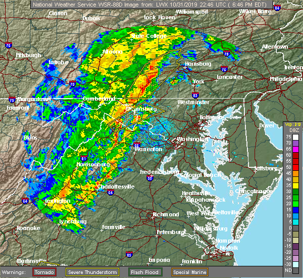 At 645 pm edt, a severe thunderstorm was located near inwood, or 9 miles northeast of winchester, moving northeast at 55 mph (radar indicated). Hazards include 60 mph wind gusts. Damaging winds will cause some trees and large branches to fall. this could injure those outdoors, as well as damage homes and vehicles. roadways may become blocked by downed trees. localized power outages are possible. Unsecured light objects may become projectiles. At 645 pm edt, a severe thunderstorm was located near inwood, or 9 miles northeast of winchester, moving northeast at 55 mph (radar indicated). Hazards include 60 mph wind gusts. Damaging winds will cause some trees and large branches to fall. this could injure those outdoors, as well as damage homes and vehicles. roadways may become blocked by downed trees. localized power outages are possible. Unsecured light objects may become projectiles.
|
| 9/11/2019 3:39 PM EDT |
 The severe thunderstorm warning for northeastern shenandoah, southeastern frederick, southwestern clarke, and northern warren counties in northwestern virginia and the southwestern city of winchester will expire at 345 pm edt, the storm which prompted the warning has moved out of the area. therefore, the warning will be allowed to expire. The severe thunderstorm warning for northeastern shenandoah, southeastern frederick, southwestern clarke, and northern warren counties in northwestern virginia and the southwestern city of winchester will expire at 345 pm edt, the storm which prompted the warning has moved out of the area. therefore, the warning will be allowed to expire.
|
| 9/11/2019 3:09 PM EDT |
 At 308 pm edt, a severe thunderstorm was located over stephens city, or 7 miles southwest of millwood pike, moving east at 15 mph (radar indicated). Hazards include 60 mph wind gusts and quarter size hail. Damaging winds will cause some trees and large branches to fall. this could injure those outdoors, as well as damage homes and vehicles. roadways may become blocked by downed trees. localized power outages are possible. unsecured light objects may become projectiles. Locations impacted include, winchester, front royal, strasburg, stephens city, middletown, boyce, howellsville, white post, riverton, reliance, armel, blue mountain, millwood, nineveh, bethel, cedarville and buckton. At 308 pm edt, a severe thunderstorm was located over stephens city, or 7 miles southwest of millwood pike, moving east at 15 mph (radar indicated). Hazards include 60 mph wind gusts and quarter size hail. Damaging winds will cause some trees and large branches to fall. this could injure those outdoors, as well as damage homes and vehicles. roadways may become blocked by downed trees. localized power outages are possible. unsecured light objects may become projectiles. Locations impacted include, winchester, front royal, strasburg, stephens city, middletown, boyce, howellsville, white post, riverton, reliance, armel, blue mountain, millwood, nineveh, bethel, cedarville and buckton.
|
| 9/11/2019 3:06 PM EDT |
 At 253 pm edt, a severe thunderstorm was located 11 miles northwest of winchester, moving east at 10 mph (radar indicated). Hazards include 60 mph wind gusts and quarter size hail. Damaging winds will cause some trees and large branches to fall. this could injure those outdoors, as well as damage homes and vehicles. roadways may become blocked by downed trees. localized power outages are possible. Unsecured light objects may become projectiles. At 253 pm edt, a severe thunderstorm was located 11 miles northwest of winchester, moving east at 10 mph (radar indicated). Hazards include 60 mph wind gusts and quarter size hail. Damaging winds will cause some trees and large branches to fall. this could injure those outdoors, as well as damage homes and vehicles. roadways may become blocked by downed trees. localized power outages are possible. Unsecured light objects may become projectiles.
|
| 9/11/2019 3:06 PM EDT |
 At 306 pm edt, a severe thunderstorm was located near berryville, or 7 miles northeast of millwood pike, moving east at 20 mph (radar indicated). Hazards include 60 mph wind gusts and quarter size hail. Damaging winds will cause some trees and large branches to fall. this could injure those outdoors, as well as damage homes and vehicles. roadways may become blocked by downed trees. localized power outages are possible. unsecured light objects may become projectiles. Locations impacted include, winchester, millwood pike, middleway, stephenson, brucetown, wadesville, greenwood, cedar hill, clear brook and ridgeway. At 306 pm edt, a severe thunderstorm was located near berryville, or 7 miles northeast of millwood pike, moving east at 20 mph (radar indicated). Hazards include 60 mph wind gusts and quarter size hail. Damaging winds will cause some trees and large branches to fall. this could injure those outdoors, as well as damage homes and vehicles. roadways may become blocked by downed trees. localized power outages are possible. unsecured light objects may become projectiles. Locations impacted include, winchester, millwood pike, middleway, stephenson, brucetown, wadesville, greenwood, cedar hill, clear brook and ridgeway.
|
| 9/11/2019 3:00 PM EDT | Multiple trees reported down on stephenson roa in frederick county VA, 6.4 miles SW of Winchester, VA |
| 9/11/2019 3:00 PM EDT | Multiple trees reported down on jordan springs road in the stephens are in frederick county VA, 6.3 miles SW of Winchester, VA |
| 9/11/2019 2:57 PM EDT |
 The national weather service in sterling virginia has issued a * severe thunderstorm warning for. northeastern shenandoah county in northwestern virginia. southeastern frederick county in northwestern virginia. southwestern clarke county in northwestern virginia. Northern warren county in northwestern virginia. The national weather service in sterling virginia has issued a * severe thunderstorm warning for. northeastern shenandoah county in northwestern virginia. southeastern frederick county in northwestern virginia. southwestern clarke county in northwestern virginia. Northern warren county in northwestern virginia.
|
| 9/11/2019 2:54 PM EDT | Tree reported down on stony hill road near northwestern turnpik in frederick county VA, 9.9 miles SE of Winchester, VA |
| 9/11/2019 2:53 PM EDT |
 The national weather service in sterling virginia has issued a * severe thunderstorm warning for. central frederick county in northwestern virginia. northwestern clarke county in northwestern virginia. the city of winchester in northwestern virginia. West central jefferson county in the panhandle of west virginia. The national weather service in sterling virginia has issued a * severe thunderstorm warning for. central frederick county in northwestern virginia. northwestern clarke county in northwestern virginia. the city of winchester in northwestern virginia. West central jefferson county in the panhandle of west virginia.
|
| 9/11/2019 2:53 PM EDT |
 At 253 pm edt, a severe thunderstorm was located 11 miles northwest of winchester, moving east at 10 mph (radar indicated). Hazards include 60 mph wind gusts and quarter size hail. Damaging winds will cause some trees and large branches to fall. this could injure those outdoors, as well as damage homes and vehicles. roadways may become blocked by downed trees. localized power outages are possible. Unsecured light objects may become projectiles. At 253 pm edt, a severe thunderstorm was located 11 miles northwest of winchester, moving east at 10 mph (radar indicated). Hazards include 60 mph wind gusts and quarter size hail. Damaging winds will cause some trees and large branches to fall. this could injure those outdoors, as well as damage homes and vehicles. roadways may become blocked by downed trees. localized power outages are possible. Unsecured light objects may become projectiles.
|
| 7/22/2019 1:47 PM EDT |
 At 146 pm edt, a severe thunderstorm was located near stephens city, or near winchester, moving east at 30 mph (radar indicated). Hazards include 60 mph wind gusts. Damaging winds will cause some trees and large branches to fall. this could injure those outdoors, as well as damage homes and vehicles. roadways may become blocked by downed trees. localized power outages are possible. unsecured light objects may become projectiles. Locations impacted include, winchester, millwood pike, stephens city, middletown, boyce, brucetown, white post, greenwood, high view manor, clear brook, armel, briggs, stephenson, wadesville, millwood, albin and bethel. At 146 pm edt, a severe thunderstorm was located near stephens city, or near winchester, moving east at 30 mph (radar indicated). Hazards include 60 mph wind gusts. Damaging winds will cause some trees and large branches to fall. this could injure those outdoors, as well as damage homes and vehicles. roadways may become blocked by downed trees. localized power outages are possible. unsecured light objects may become projectiles. Locations impacted include, winchester, millwood pike, stephens city, middletown, boyce, brucetown, white post, greenwood, high view manor, clear brook, armel, briggs, stephenson, wadesville, millwood, albin and bethel.
|
| 7/22/2019 1:33 PM EDT |
 At 133 pm edt, a severe thunderstorm was located over star tannery, or 7 miles north of strasburg, moving east at 30 mph (radar indicated). Hazards include 60 mph wind gusts. Damaging winds will cause some trees and large branches to fall. this could injure those outdoors, as well as damage homes and vehicles. roadways may become blocked by downed trees. localized power outages are possible. Unsecured light objects may become projectiles. At 133 pm edt, a severe thunderstorm was located over star tannery, or 7 miles north of strasburg, moving east at 30 mph (radar indicated). Hazards include 60 mph wind gusts. Damaging winds will cause some trees and large branches to fall. this could injure those outdoors, as well as damage homes and vehicles. roadways may become blocked by downed trees. localized power outages are possible. Unsecured light objects may become projectiles.
|
| 7/21/2019 5:44 PM EDT |
 At 544 pm edt, a severe thunderstorm was located over stephens city, or near millwood pike, and is nearly stationary (radar indicated). Hazards include 60 mph wind gusts. Damaging winds will cause some trees and large branches to fall. this could injure those outdoors, as well as damage homes and vehicles. roadways may become blocked by downed trees. localized power outages are possible. Unsecured light objects may become projectiles. At 544 pm edt, a severe thunderstorm was located over stephens city, or near millwood pike, and is nearly stationary (radar indicated). Hazards include 60 mph wind gusts. Damaging winds will cause some trees and large branches to fall. this could injure those outdoors, as well as damage homes and vehicles. roadways may become blocked by downed trees. localized power outages are possible. Unsecured light objects may become projectiles.
|
| 7/20/2019 9:36 PM EDT | Tree down on gough r in frederick county VA, 7.1 miles ENE of Winchester, VA |
| 7/20/2019 7:25 PM EDT |
 At 725 pm edt, severe thunderstorms were located along a line extending from near millwood pike to near stephens city to strasburg, moving east at 20 mph (radar indicated). Hazards include 60 mph wind gusts and quarter size hail. Damaging winds will cause some trees and large branches to fall. this could injure those outdoors, as well as damage homes and vehicles. roadways may become blocked by downed trees. localized power outages are possible. Unsecured light objects may become projectiles. At 725 pm edt, severe thunderstorms were located along a line extending from near millwood pike to near stephens city to strasburg, moving east at 20 mph (radar indicated). Hazards include 60 mph wind gusts and quarter size hail. Damaging winds will cause some trees and large branches to fall. this could injure those outdoors, as well as damage homes and vehicles. roadways may become blocked by downed trees. localized power outages are possible. Unsecured light objects may become projectiles.
|
| 7/20/2019 7:11 PM EDT | Tree down on gough rd. corrected event tim in frederick county VA, 7.1 miles ENE of Winchester, VA |
| 6/29/2019 10:28 PM EDT |
 The severe thunderstorm warning for central frederick in northwestern virginia and the city of winchester will expire at 1030 pm edt, the storm which prompted the warning has weakened below severe limits, and has exited the warned area. therefore, the warning will be allowed to expire. to report severe weather, contact your nearest law enforcement agency. they will relay your report to the national weather service sterling virginia. The severe thunderstorm warning for central frederick in northwestern virginia and the city of winchester will expire at 1030 pm edt, the storm which prompted the warning has weakened below severe limits, and has exited the warned area. therefore, the warning will be allowed to expire. to report severe weather, contact your nearest law enforcement agency. they will relay your report to the national weather service sterling virginia.
|
| 6/29/2019 10:14 PM EDT | Power lines down in clear broo in frederick county VA, 7.5 miles SSW of Winchester, VA |
| 6/29/2019 10:05 PM EDT |
 At 1005 pm edt, a severe thunderstorm was located near inwood, or 9 miles northeast of winchester, moving southeast at 40 mph (radar indicated). Hazards include 60 mph wind gusts. Damaging winds will cause some trees and large branches to fall. this could injure those outdoors, as well as damage homes and vehicles. roadways may become blocked by downed trees. localized power outages are possible. unsecured light objects may become projectiles. Locations impacted include, winchester, millwood pike, stephens city, brucetown, greenwood, gainesboro, cedar grove, clear brook, armel, stephenson, cross junction, cedar hill, albin, gore and whitacre. At 1005 pm edt, a severe thunderstorm was located near inwood, or 9 miles northeast of winchester, moving southeast at 40 mph (radar indicated). Hazards include 60 mph wind gusts. Damaging winds will cause some trees and large branches to fall. this could injure those outdoors, as well as damage homes and vehicles. roadways may become blocked by downed trees. localized power outages are possible. unsecured light objects may become projectiles. Locations impacted include, winchester, millwood pike, stephens city, brucetown, greenwood, gainesboro, cedar grove, clear brook, armel, stephenson, cross junction, cedar hill, albin, gore and whitacre.
|
| 6/29/2019 9:46 PM EDT |
 At 946 pm edt, a severe thunderstorm was located near greenwood, moving southeast at 40 mph (radar indicated). Hazards include 60 mph wind gusts. Damaging winds will cause some trees and large branches to fall. this could injure those outdoors, as well as damage homes and vehicles. roadways may become blocked by downed trees. localized power outages are possible. Unsecured light objects may become projectiles. At 946 pm edt, a severe thunderstorm was located near greenwood, moving southeast at 40 mph (radar indicated). Hazards include 60 mph wind gusts. Damaging winds will cause some trees and large branches to fall. this could injure those outdoors, as well as damage homes and vehicles. roadways may become blocked by downed trees. localized power outages are possible. Unsecured light objects may become projectiles.
|
| 6/28/2019 5:25 PM EDT |
 At 525 pm edt, a severe thunderstorm was located over stephens city, or near winchester, moving southeast at 10 mph (radar indicated). Hazards include 60 mph wind gusts and quarter size hail. Damaging winds will cause some trees and large branches to fall. this could injure those outdoors, as well as damage homes and vehicles. roadways may become blocked by downed trees. localized power outages are possible. Unsecured light objects may become projectiles. At 525 pm edt, a severe thunderstorm was located over stephens city, or near winchester, moving southeast at 10 mph (radar indicated). Hazards include 60 mph wind gusts and quarter size hail. Damaging winds will cause some trees and large branches to fall. this could injure those outdoors, as well as damage homes and vehicles. roadways may become blocked by downed trees. localized power outages are possible. Unsecured light objects may become projectiles.
|
| 5/3/2019 8:04 PM EDT | Tree down near the intersection of cedar hill road and brown lan in frederick county VA, 7.8 miles SSW of Winchester, VA |
| 5/3/2019 3:58 PM EDT |
 At 358 pm edt, a severe thunderstorm was located over millwood pike, moving east at 15 mph (radar indicated). Hazards include 60 mph wind gusts and quarter size hail. Damaging winds will cause some trees and large branches to fall. this could injure those outdoors, as well as damage homes and vehicles. roadways may become blocked by downed trees. localized power outages are possible. unsecured light objects may become projectiles. Locations impacted include, winchester, millwood pike, stephenson, brucetown, wadesville, greenwood, clear brook and briggs. At 358 pm edt, a severe thunderstorm was located over millwood pike, moving east at 15 mph (radar indicated). Hazards include 60 mph wind gusts and quarter size hail. Damaging winds will cause some trees and large branches to fall. this could injure those outdoors, as well as damage homes and vehicles. roadways may become blocked by downed trees. localized power outages are possible. unsecured light objects may become projectiles. Locations impacted include, winchester, millwood pike, stephenson, brucetown, wadesville, greenwood, clear brook and briggs.
|
| 5/3/2019 3:53 PM EDT | Quarter sized hail reported 5.3 miles SSW of Winchester, VA |
| 5/3/2019 3:42 PM EDT |
 At 341 pm edt, a severe thunderstorm was located over winchester, moving east at 15 mph (radar indicated). Hazards include 60 mph wind gusts and quarter size hail. Damaging winds will cause some trees and large branches to fall. this could injure those outdoors, as well as damage homes and vehicles. roadways may become blocked by downed trees. localized power outages are possible. Unsecured light objects may become projectiles. At 341 pm edt, a severe thunderstorm was located over winchester, moving east at 15 mph (radar indicated). Hazards include 60 mph wind gusts and quarter size hail. Damaging winds will cause some trees and large branches to fall. this could injure those outdoors, as well as damage homes and vehicles. roadways may become blocked by downed trees. localized power outages are possible. Unsecured light objects may become projectiles.
|
| 5/3/2019 3:37 PM EDT |
 At 336 pm edt, a severe thunderstorm was approaching the western side of winchester, moving east at 15 mph (radar indicated). Hazards include 60 mph wind gusts and half dollar size hail. Damaging winds will cause some trees and large branches to fall. this could injure those outdoors, as well as damage homes and vehicles. roadways may become blocked by downed trees. localized power outages are possible. unsecured light objects may become projectiles. Locations impacted include, winchester, millwood pike, albin and high view manor. At 336 pm edt, a severe thunderstorm was approaching the western side of winchester, moving east at 15 mph (radar indicated). Hazards include 60 mph wind gusts and half dollar size hail. Damaging winds will cause some trees and large branches to fall. this could injure those outdoors, as well as damage homes and vehicles. roadways may become blocked by downed trees. localized power outages are possible. unsecured light objects may become projectiles. Locations impacted include, winchester, millwood pike, albin and high view manor.
|
| 5/3/2019 3:21 PM EDT |
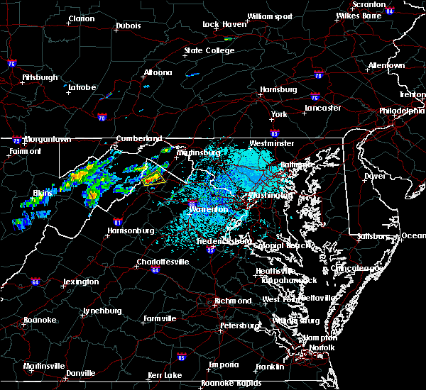 At 320 pm edt, a severe thunderstorm was located northwest of stephens city, or 7 miles west of winchester, moving northeast at 15 mph (radar indicated). Hazards include 60 mph wind gusts and half dollar size hail. Damaging winds will cause some trees and large branches to fall. this could injure those outdoors, as well as damage homes and vehicles. roadways may become blocked by downed trees. localized power outages are possible. unsecured light objects may become projectiles. Locations impacted include, winchester, millwood pike, albin, high view manor and wilde acres. At 320 pm edt, a severe thunderstorm was located northwest of stephens city, or 7 miles west of winchester, moving northeast at 15 mph (radar indicated). Hazards include 60 mph wind gusts and half dollar size hail. Damaging winds will cause some trees and large branches to fall. this could injure those outdoors, as well as damage homes and vehicles. roadways may become blocked by downed trees. localized power outages are possible. unsecured light objects may become projectiles. Locations impacted include, winchester, millwood pike, albin, high view manor and wilde acres.
|
| 5/3/2019 3:06 PM EDT |
 At 306 pm edt, a severe thunderstorm was located near star tannery, or 10 miles north of strasburg, moving northeast at 15 mph (radar indicated). Hazards include 60 mph wind gusts and quarter size hail. Damaging winds will cause some trees and large branches to fall. this could injure those outdoors, as well as damage homes and vehicles. roadways may become blocked by downed trees. localized power outages are possible. Unsecured light objects may become projectiles. At 306 pm edt, a severe thunderstorm was located near star tannery, or 10 miles north of strasburg, moving northeast at 15 mph (radar indicated). Hazards include 60 mph wind gusts and quarter size hail. Damaging winds will cause some trees and large branches to fall. this could injure those outdoors, as well as damage homes and vehicles. roadways may become blocked by downed trees. localized power outages are possible. Unsecured light objects may become projectiles.
|
| 9/1/2018 4:30 PM EDT | Large limbs down near the intersection of inverlee way and taggart driv in frederick county VA, 2.6 miles WNW of Winchester, VA |
| 9/1/2018 4:28 PM EDT |
 At 428 pm edt, a severe thunderstorm was located over winchester, moving east at 15 mph (radar indicated). Hazards include 60 mph wind gusts. Damaging winds will cause some trees and large branches to fall. this could injure those outdoors, as well as damage homes and vehicles. roadways may become blocked by downed trees. localized power outages are possible. unsecured light objects may become projectiles. Locations impacted include, winchester, charles town, millwood pike, ranson, berryville, boyce, middleway, brucetown, greenwood, cedar grove, gaylord, clear brook, ridgeway, briggs, stephenson, wadesville, wickliffe, summit point, cedar hill and albin. At 428 pm edt, a severe thunderstorm was located over winchester, moving east at 15 mph (radar indicated). Hazards include 60 mph wind gusts. Damaging winds will cause some trees and large branches to fall. this could injure those outdoors, as well as damage homes and vehicles. roadways may become blocked by downed trees. localized power outages are possible. unsecured light objects may become projectiles. Locations impacted include, winchester, charles town, millwood pike, ranson, berryville, boyce, middleway, brucetown, greenwood, cedar grove, gaylord, clear brook, ridgeway, briggs, stephenson, wadesville, wickliffe, summit point, cedar hill and albin.
|
| 9/1/2018 4:24 PM EDT |
 At 424 pm edt, a severe thunderstorm was located over winchester, moving east at 15 mph (radar indicated). Hazards include 60 mph wind gusts. Damaging winds will cause some trees and large branches to fall. this could injure those outdoors, as well as damage homes and vehicles. roadways may become blocked by downed trees. localized power outages are possible. Unsecured light objects may become projectiles. At 424 pm edt, a severe thunderstorm was located over winchester, moving east at 15 mph (radar indicated). Hazards include 60 mph wind gusts. Damaging winds will cause some trees and large branches to fall. this could injure those outdoors, as well as damage homes and vehicles. roadways may become blocked by downed trees. localized power outages are possible. Unsecured light objects may become projectiles.
|
| 9/1/2018 4:05 PM EDT | Tree down near the intersection of dicks hollow road and herman lewis lan in frederick county VA, 4.4 miles SE of Winchester, VA |
| 8/21/2018 8:27 PM EDT |
 At 826 pm edt, severe thunderstorms were located along a line extending from 6 miles west of greenwood to near star tannery, moving east at 30 mph (radar indicated). Hazards include 60 mph wind gusts. Damaging winds will cause some trees and large branches to fall. this could injure those outdoors, as well as damage homes and vehicles. roadways may become blocked by downed trees. localized power outages are possible. unsecured light objects may become projectiles. Locations impacted include, winchester, greenwood, tomahawk, johnsontown, cedar grove, oakland, rock gap, bloomery, cross junction, jones springs, albin, unger, gore, glengary, omps, shanghai, high view manor, gainesboro, stotlers crossroads and highland ridge. At 826 pm edt, severe thunderstorms were located along a line extending from 6 miles west of greenwood to near star tannery, moving east at 30 mph (radar indicated). Hazards include 60 mph wind gusts. Damaging winds will cause some trees and large branches to fall. this could injure those outdoors, as well as damage homes and vehicles. roadways may become blocked by downed trees. localized power outages are possible. unsecured light objects may become projectiles. Locations impacted include, winchester, greenwood, tomahawk, johnsontown, cedar grove, oakland, rock gap, bloomery, cross junction, jones springs, albin, unger, gore, glengary, omps, shanghai, high view manor, gainesboro, stotlers crossroads and highland ridge.
|
| 8/21/2018 8:27 PM EDT |
 A severe thunderstorm warning remains in effect until 845 pm edt for northeastern shenandoah and central frederick counties in northwestern virginia. southern morgan. western berkeley counties in the panhandle of west virginia and east central hampshire counties in eastern west virginia and the northwestern city of winchester. At 826 pm edt, severe thunderstorms were located along a line. A severe thunderstorm warning remains in effect until 845 pm edt for northeastern shenandoah and central frederick counties in northwestern virginia. southern morgan. western berkeley counties in the panhandle of west virginia and east central hampshire counties in eastern west virginia and the northwestern city of winchester. At 826 pm edt, severe thunderstorms were located along a line.
|
| 8/21/2018 8:25 PM EDT |
 At 825 pm edt, severe thunderstorms were located along a line extending from near berkeley springs to near strasburg, moving northeast at 45 mph (radar indicated). Hazards include 60 mph wind gusts. Damaging winds will cause some trees and large branches to fall. this could injure those outdoors, as well as damage homes and vehicles. roadways may become blocked by downed trees. localized power outages are possible. Unsecured light objects may become projectiles. At 825 pm edt, severe thunderstorms were located along a line extending from near berkeley springs to near strasburg, moving northeast at 45 mph (radar indicated). Hazards include 60 mph wind gusts. Damaging winds will cause some trees and large branches to fall. this could injure those outdoors, as well as damage homes and vehicles. roadways may become blocked by downed trees. localized power outages are possible. Unsecured light objects may become projectiles.
|
| 8/21/2018 8:25 PM EDT |
 The national weather service in sterling virginia has issued a * severe thunderstorm warning for. central washington county in north central maryland. northwestern loudoun county in northern virginia. eastern frederick county in northwestern virginia. Northeastern warren county in northwestern virginia. The national weather service in sterling virginia has issued a * severe thunderstorm warning for. central washington county in north central maryland. northwestern loudoun county in northern virginia. eastern frederick county in northwestern virginia. Northeastern warren county in northwestern virginia.
|
| 8/21/2018 8:25 PM EDT |
 At 825 pm edt, severe thunderstorms were located along a line extending from near berkeley springs to near strasburg, moving northeast at 45 mph (radar indicated). Hazards include 60 mph wind gusts. Damaging winds will cause some trees and large branches to fall. this could injure those outdoors, as well as damage homes and vehicles. roadways may become blocked by downed trees. localized power outages are possible. Unsecured light objects may become projectiles. At 825 pm edt, severe thunderstorms were located along a line extending from near berkeley springs to near strasburg, moving northeast at 45 mph (radar indicated). Hazards include 60 mph wind gusts. Damaging winds will cause some trees and large branches to fall. this could injure those outdoors, as well as damage homes and vehicles. roadways may become blocked by downed trees. localized power outages are possible. Unsecured light objects may become projectiles.
|
| 8/21/2018 8:13 PM EDT |
 At 813 pm edt, severe thunderstorms were located along a line extending from 7 miles south of paw paw to wardensville, moving east at 30 mph (radar indicated). Hazards include 60 mph wind gusts. Damaging winds will cause some trees and large branches to fall. this could injure those outdoors, as well as damage homes and vehicles. roadways may become blocked by downed trees. localized power outages are possible. unsecured light objects may become projectiles. Locations impacted include, winchester, greenwood, star tannery, capon bridge, tomahawk, yellow spring, high view, johnsontown, cedar grove, oakland, rock gap, bloomery, cross junction, jones springs, albin, unger, gore, capon springs, gravel springs and glengary. At 813 pm edt, severe thunderstorms were located along a line extending from 7 miles south of paw paw to wardensville, moving east at 30 mph (radar indicated). Hazards include 60 mph wind gusts. Damaging winds will cause some trees and large branches to fall. this could injure those outdoors, as well as damage homes and vehicles. roadways may become blocked by downed trees. localized power outages are possible. unsecured light objects may become projectiles. Locations impacted include, winchester, greenwood, star tannery, capon bridge, tomahawk, yellow spring, high view, johnsontown, cedar grove, oakland, rock gap, bloomery, cross junction, jones springs, albin, unger, gore, capon springs, gravel springs and glengary.
|
| 8/21/2018 8:02 PM EDT |
 At 802 pm edt, severe thunderstorms were located along a line extending from 9 miles southwest of paw paw to near wardensville, moving east at 30 mph (radar indicated). Hazards include 60 mph wind gusts. Damaging winds will cause some trees and large branches to fall. this could injure those outdoors, as well as damage homes and vehicles. roadways may become blocked by downed trees. localized power outages are possible. Unsecured light objects may become projectiles. At 802 pm edt, severe thunderstorms were located along a line extending from 9 miles southwest of paw paw to near wardensville, moving east at 30 mph (radar indicated). Hazards include 60 mph wind gusts. Damaging winds will cause some trees and large branches to fall. this could injure those outdoors, as well as damage homes and vehicles. roadways may become blocked by downed trees. localized power outages are possible. Unsecured light objects may become projectiles.
|
| 8/21/2018 8:02 PM EDT |
 The national weather service in sterling virginia has issued a * severe thunderstorm warning for. north central shenandoah county in northwestern virginia. frederick county in northwestern virginia. the northwestern city of winchester in northwestern virginia. Southern morgan county in the panhandle of west virginia. The national weather service in sterling virginia has issued a * severe thunderstorm warning for. north central shenandoah county in northwestern virginia. frederick county in northwestern virginia. the northwestern city of winchester in northwestern virginia. Southern morgan county in the panhandle of west virginia.
|
| 8/17/2018 3:32 PM EDT |
 At 332 pm edt, a severe thunderstorm was located near stephens city, or near strasburg, moving northeast at 25 mph (radar indicated). Hazards include 60 mph wind gusts. Damaging winds will cause some trees and large branches to fall. this could injure those outdoors, as well as damage homes and vehicles. roadways may become blocked by downed trees. localized power outages are possible. Unsecured light objects may become projectiles. At 332 pm edt, a severe thunderstorm was located near stephens city, or near strasburg, moving northeast at 25 mph (radar indicated). Hazards include 60 mph wind gusts. Damaging winds will cause some trees and large branches to fall. this could injure those outdoors, as well as damage homes and vehicles. roadways may become blocked by downed trees. localized power outages are possible. Unsecured light objects may become projectiles.
|
| 8/17/2018 2:57 PM EDT |
 At 232 pm edt, a severe thunderstorm was located 7 miles north of star tannery, or 11 miles west of winchester, moving east at 25 mph (radar indicated). Hazards include 60 mph wind gusts. Damaging winds will cause some trees and large branches to fall. this could injure those outdoors, as well as damage homes and vehicles. roadways may become blocked by downed trees. localized power outages are possible. unsecured light objects may become projectiles. Locations impacted include, winchester, millwood pike, stephens city, star tannery, gravel springs, high view manor, gainesboro, wilde acres, cedar grove, cross junction, rock enon springs, albin, gore and greenwood. At 232 pm edt, a severe thunderstorm was located 7 miles north of star tannery, or 11 miles west of winchester, moving east at 25 mph (radar indicated). Hazards include 60 mph wind gusts. Damaging winds will cause some trees and large branches to fall. this could injure those outdoors, as well as damage homes and vehicles. roadways may become blocked by downed trees. localized power outages are possible. unsecured light objects may become projectiles. Locations impacted include, winchester, millwood pike, stephens city, star tannery, gravel springs, high view manor, gainesboro, wilde acres, cedar grove, cross junction, rock enon springs, albin, gore and greenwood.
|
| 8/17/2018 2:53 PM EDT | Branch down blocking road at 3400 block of north frederick pik in frederick county VA, 5.8 miles SSE of Winchester, VA |
| 8/17/2018 2:42 PM EDT | Tree down near the intersection of stony hill road and farmer jebs lan in frederick county VA, 9.5 miles SE of Winchester, VA |
| 8/17/2018 2:32 PM EDT |
 At 218 pm edt, a severe thunderstorm was located near star tannery, or 13 miles northwest of strasburg, moving east at 25 mph (radar indicated). Hazards include 70 mph wind gusts and half dollar size hail. Damaging winds will cause some trees and large branches to fall. this could injure those outdoors, as well as damage homes and vehicles. roadways may become blocked by downed trees. localized power outages are possible. unsecured light objects may become projectiles. Locations impacted include, winchester, millwood pike, stephens city, star tannery, gravel springs, yellow spring, high view, high view manor, gainesboro, wilde acres, cedar grove, cross junction, rock enon springs, albin, gore, capon springs, lehew and greenwood. At 218 pm edt, a severe thunderstorm was located near star tannery, or 13 miles northwest of strasburg, moving east at 25 mph (radar indicated). Hazards include 70 mph wind gusts and half dollar size hail. Damaging winds will cause some trees and large branches to fall. this could injure those outdoors, as well as damage homes and vehicles. roadways may become blocked by downed trees. localized power outages are possible. unsecured light objects may become projectiles. Locations impacted include, winchester, millwood pike, stephens city, star tannery, gravel springs, yellow spring, high view, high view manor, gainesboro, wilde acres, cedar grove, cross junction, rock enon springs, albin, gore, capon springs, lehew and greenwood.
|
| 8/17/2018 2:32 PM EDT |
 At 232 pm edt, a severe thunderstorm was located 7 miles north of star tannery, or 11 miles west of winchester, moving east at 25 mph (radar indicated). Hazards include 60 mph wind gusts. Damaging winds will cause some trees and large branches to fall. this could injure those outdoors, as well as damage homes and vehicles. roadways may become blocked by downed trees. localized power outages are possible. unsecured light objects may become projectiles. Locations impacted include, winchester, millwood pike, stephens city, star tannery, gravel springs, high view manor, gainesboro, wilde acres, cedar grove, cross junction, rock enon springs, albin, gore and greenwood. At 232 pm edt, a severe thunderstorm was located 7 miles north of star tannery, or 11 miles west of winchester, moving east at 25 mph (radar indicated). Hazards include 60 mph wind gusts. Damaging winds will cause some trees and large branches to fall. this could injure those outdoors, as well as damage homes and vehicles. roadways may become blocked by downed trees. localized power outages are possible. unsecured light objects may become projectiles. Locations impacted include, winchester, millwood pike, stephens city, star tannery, gravel springs, high view manor, gainesboro, wilde acres, cedar grove, cross junction, rock enon springs, albin, gore and greenwood.
|
| 8/17/2018 2:19 PM EDT |
 At 218 pm edt, a severe thunderstorm was located near star tannery, or 13 miles northwest of strasburg, moving east at 25 mph (radar indicated). Hazards include 70 mph wind gusts and half dollar size hail. Damaging winds will cause some trees and large branches to fall. this could injure those outdoors, as well as damage homes and vehicles. roadways may become blocked by downed trees. localized power outages are possible. unsecured light objects may become projectiles. Locations impacted include, winchester, millwood pike, stephens city, star tannery, gravel springs, yellow spring, high view, high view manor, gainesboro, wilde acres, cedar grove, cross junction, rock enon springs, albin, gore, capon springs, lehew and greenwood. At 218 pm edt, a severe thunderstorm was located near star tannery, or 13 miles northwest of strasburg, moving east at 25 mph (radar indicated). Hazards include 70 mph wind gusts and half dollar size hail. Damaging winds will cause some trees and large branches to fall. this could injure those outdoors, as well as damage homes and vehicles. roadways may become blocked by downed trees. localized power outages are possible. unsecured light objects may become projectiles. Locations impacted include, winchester, millwood pike, stephens city, star tannery, gravel springs, yellow spring, high view, high view manor, gainesboro, wilde acres, cedar grove, cross junction, rock enon springs, albin, gore, capon springs, lehew and greenwood.
|
| 8/17/2018 2:16 PM EDT |
 At 216 pm edt, a severe thunderstorm was located near wardensville, or 13 miles northwest of strasburg, moving east at 25 mph (radar indicated). Hazards include 60 to 70 mph wind gusts. Damaging winds will cause some trees and large branches to fall. this could injure those outdoors, as well as damage homes and vehicles. roadways may become blocked by downed trees. localized power outages are possible. unsecured light objects may become projectiles. Locations impacted include, winchester, millwood pike, stephens city, star tannery, gravel springs, yellow spring, high view, high view manor, gainesboro, wilde acres, cedar grove, cross junction, rock enon springs, albin, gore, capon springs, lehew and greenwood. At 216 pm edt, a severe thunderstorm was located near wardensville, or 13 miles northwest of strasburg, moving east at 25 mph (radar indicated). Hazards include 60 to 70 mph wind gusts. Damaging winds will cause some trees and large branches to fall. this could injure those outdoors, as well as damage homes and vehicles. roadways may become blocked by downed trees. localized power outages are possible. unsecured light objects may become projectiles. Locations impacted include, winchester, millwood pike, stephens city, star tannery, gravel springs, yellow spring, high view, high view manor, gainesboro, wilde acres, cedar grove, cross junction, rock enon springs, albin, gore, capon springs, lehew and greenwood.
|
| 8/17/2018 2:06 PM EDT |
 At 206 pm edt, a severe thunderstorm was located near wardensville, or 16 miles northwest of strasburg, moving east at 25 mph (radar indicated). Hazards include 60 mph wind gusts. Damaging winds will cause some trees and large branches to fall. this could injure those outdoors, as well as damage homes and vehicles. roadways may become blocked by downed trees. localized power outages are possible. Unsecured light objects may become projectiles. At 206 pm edt, a severe thunderstorm was located near wardensville, or 16 miles northwest of strasburg, moving east at 25 mph (radar indicated). Hazards include 60 mph wind gusts. Damaging winds will cause some trees and large branches to fall. this could injure those outdoors, as well as damage homes and vehicles. roadways may become blocked by downed trees. localized power outages are possible. Unsecured light objects may become projectiles.
|
| 8/1/2018 7:56 PM EDT |
 The severe thunderstorm warning for southeastern frederick, northeastern warren, clarke counties in northwestern virginia and southwestern jefferson counties in the panhandle of west virginia and the city of winchester will expire at 800 pm edt, the storm which prompted the warning has weakened below severe limits, and no longer pose an immediate threat to life or property. therefore the warning will be allowed to expire. The severe thunderstorm warning for southeastern frederick, northeastern warren, clarke counties in northwestern virginia and southwestern jefferson counties in the panhandle of west virginia and the city of winchester will expire at 800 pm edt, the storm which prompted the warning has weakened below severe limits, and no longer pose an immediate threat to life or property. therefore the warning will be allowed to expire.
|
| 8/1/2018 7:37 PM EDT |
 At 737 pm edt, a severe thunderstorm was located near millwood pike, moving northeast at 35 mph (law enforcement). Hazards include 60 mph wind gusts. Damaging winds will cause some trees and large branches to fall. this could injure those outdoors, as well as damage homes and vehicles. roadways may become blocked by downed trees. localized power outages are possible. unsecured light objects may become projectiles. Locations impacted include, winchester, millwood pike, berryville, stephens city, boyce, white post, greenwood, gaylord, armel, briggs, wadesville, wickliffe, millwood, summit point, nineveh, bethel, cedarville, stringtown and rippon. At 737 pm edt, a severe thunderstorm was located near millwood pike, moving northeast at 35 mph (law enforcement). Hazards include 60 mph wind gusts. Damaging winds will cause some trees and large branches to fall. this could injure those outdoors, as well as damage homes and vehicles. roadways may become blocked by downed trees. localized power outages are possible. unsecured light objects may become projectiles. Locations impacted include, winchester, millwood pike, berryville, stephens city, boyce, white post, greenwood, gaylord, armel, briggs, wadesville, wickliffe, millwood, summit point, nineveh, bethel, cedarville, stringtown and rippon.
|
| 8/1/2018 7:15 PM EDT |
 At 715 pm edt, a severe thunderstorm was located over strasburg, moving northeast at 35 mph (radar indicated). Hazards include 60 mph wind gusts. Damaging winds will cause some trees and large branches to fall. this could injure those outdoors, as well as damage homes and vehicles. roadways may become blocked by downed trees. localized power outages are possible. Unsecured light objects may become projectiles. At 715 pm edt, a severe thunderstorm was located over strasburg, moving northeast at 35 mph (radar indicated). Hazards include 60 mph wind gusts. Damaging winds will cause some trees and large branches to fall. this could injure those outdoors, as well as damage homes and vehicles. roadways may become blocked by downed trees. localized power outages are possible. Unsecured light objects may become projectiles.
|
| 7/4/2018 4:39 PM EDT |
 The severe thunderstorm warning for southeastern frederick, and western clarke counties in northwestern virginia and the city of winchester will expire at 445 pm edt, the storm which prompted the warning has weakened below severe limits, and no longer pose an immediate threat to life or property. therefore the warning will be allowed to expire. however heavy rain is still possible with this thunderstorm. to report severe weather, contact your nearest law enforcement agency. they will relay your report to the national weather service sterling virginia. The severe thunderstorm warning for southeastern frederick, and western clarke counties in northwestern virginia and the city of winchester will expire at 445 pm edt, the storm which prompted the warning has weakened below severe limits, and no longer pose an immediate threat to life or property. therefore the warning will be allowed to expire. however heavy rain is still possible with this thunderstorm. to report severe weather, contact your nearest law enforcement agency. they will relay your report to the national weather service sterling virginia.
|
| 7/4/2018 4:22 PM EDT |
 At 421 pm edt, a severe thunderstorm was located over winchester, moving south at 15 mph (radar indicated. at 420 pm...dime-sized hail was reported in the city of winchester). Hazards include 60 mph wind gusts and quarter size hail. Damaging winds will cause some trees and large branches to fall. this could injure those outdoors, as well as damage homes and vehicles. roadways may become blocked by downed trees. localized power outages are possible. unsecured light objects may become projectiles. Locations impacted include, winchester, millwood pike, stephens city, boyce, brucetown, white post, greenwood, high view manor, gainesboro, wilde acres, cedar grove, clear brook, armel, stephenson, cedar hill and albin. At 421 pm edt, a severe thunderstorm was located over winchester, moving south at 15 mph (radar indicated. at 420 pm...dime-sized hail was reported in the city of winchester). Hazards include 60 mph wind gusts and quarter size hail. Damaging winds will cause some trees and large branches to fall. this could injure those outdoors, as well as damage homes and vehicles. roadways may become blocked by downed trees. localized power outages are possible. unsecured light objects may become projectiles. Locations impacted include, winchester, millwood pike, stephens city, boyce, brucetown, white post, greenwood, high view manor, gainesboro, wilde acres, cedar grove, clear brook, armel, stephenson, cedar hill and albin.
|
| 7/4/2018 4:17 PM EDT | Numerous trees down along north frederick pik in frederick county VA, 2.9 miles SSE of Winchester, VA |
| 7/4/2018 4:02 PM EDT |
 At 402 pm edt, a severe thunderstorm was located near winchester, moving south at 10 mph (radar indicated). Hazards include 60 mph wind gusts. Damaging winds will cause some trees and large branches to fall. this could injure those outdoors, as well as damage homes and vehicles. roadways may become blocked by downed trees. localized power outages are possible. Unsecured light objects may become projectiles. At 402 pm edt, a severe thunderstorm was located near winchester, moving south at 10 mph (radar indicated). Hazards include 60 mph wind gusts. Damaging winds will cause some trees and large branches to fall. this could injure those outdoors, as well as damage homes and vehicles. roadways may become blocked by downed trees. localized power outages are possible. Unsecured light objects may become projectiles.
|
| 6/9/2018 6:35 PM EDT |
 The severe thunderstorm warning for southeastern frederick and western clarke counties in northwestern virginia, southwestern jefferson and south central berkeley counties in the panhandle of west virginia and the city of winchester will expire at 645 pm edt, the storms which prompted the warning have weakened below severe limits, and no longer pose an immediate threat to life or property. therefore the warning will be allowed to expire. however gusty winds and heavy rain are still possible with these thunderstorms. The severe thunderstorm warning for southeastern frederick and western clarke counties in northwestern virginia, southwestern jefferson and south central berkeley counties in the panhandle of west virginia and the city of winchester will expire at 645 pm edt, the storms which prompted the warning have weakened below severe limits, and no longer pose an immediate threat to life or property. therefore the warning will be allowed to expire. however gusty winds and heavy rain are still possible with these thunderstorms.
|
| 6/9/2018 5:55 PM EDT | Tree down along the 400 block of marple roa in frederick county VA, 5.2 miles SSE of Winchester, VA |
| 6/9/2018 5:55 PM EDT |
 At 555 pm edt, severe thunderstorms were located along a line extending from near inwood to 6 miles north of millwood pike to near winchester, moving southeast at 20 mph (radar indicated). Hazards include 60 mph wind gusts and quarter size hail. Damaging winds will cause some trees and large branches to fall. this could injure those outdoors, as well as damage homes and vehicles. roadways may become blocked by downed trees. localized power outages are possible. Unsecured light objects may become projectiles. At 555 pm edt, severe thunderstorms were located along a line extending from near inwood to 6 miles north of millwood pike to near winchester, moving southeast at 20 mph (radar indicated). Hazards include 60 mph wind gusts and quarter size hail. Damaging winds will cause some trees and large branches to fall. this could injure those outdoors, as well as damage homes and vehicles. roadways may become blocked by downed trees. localized power outages are possible. Unsecured light objects may become projectiles.
|
| 5/26/2018 4:06 PM EDT |
 The severe thunderstorm warning for northeastern shenandoah, southern frederick, and west central clarke counties in northwestern virginia and the city of winchester will expire at 415 pm edt, the storm which prompted the warning has weakened below severe limits, and no longer pose an immediate threat to life or property. therefore the warning will be allowed to expire. The severe thunderstorm warning for northeastern shenandoah, southern frederick, and west central clarke counties in northwestern virginia and the city of winchester will expire at 415 pm edt, the storm which prompted the warning has weakened below severe limits, and no longer pose an immediate threat to life or property. therefore the warning will be allowed to expire.
|
| 5/26/2018 3:46 PM EDT |
 At 346 pm edt, a severe thunderstorm was located near star tannery, or 8 miles north of strasburg, moving east at 15 mph (radar indicated). Hazards include 60 mph wind gusts and quarter size hail. Damaging winds will cause some trees and large branches to fall. this could injure those outdoors, as well as damage homes and vehicles. roadways may become blocked by downed trees. localized power outages are possible. unsecured light objects may become projectiles. Locations impacted include, winchester, millwood pike, stephens city, star tannery, boyce, white post, greenwood, high view manor, wilde acres and armel. At 346 pm edt, a severe thunderstorm was located near star tannery, or 8 miles north of strasburg, moving east at 15 mph (radar indicated). Hazards include 60 mph wind gusts and quarter size hail. Damaging winds will cause some trees and large branches to fall. this could injure those outdoors, as well as damage homes and vehicles. roadways may become blocked by downed trees. localized power outages are possible. unsecured light objects may become projectiles. Locations impacted include, winchester, millwood pike, stephens city, star tannery, boyce, white post, greenwood, high view manor, wilde acres and armel.
|
| 5/26/2018 3:30 PM EDT | Trees down on the 4300 block of wardensville grade in frederick county VA, 10 miles ENE of Winchester, VA |
| 5/26/2018 3:29 PM EDT |
 At 329 pm edt, a severe thunderstorm was located near stephens city, or near winchester, moving east at 15 mph (radar indicated). Hazards include 60 mph wind gusts and quarter size hail. Damaging winds will cause some trees and large branches to fall. this could injure those outdoors, as well as damage homes and vehicles. roadways may become blocked by downed trees. localized power outages are possible. Unsecured light objects may become projectiles. At 329 pm edt, a severe thunderstorm was located near stephens city, or near winchester, moving east at 15 mph (radar indicated). Hazards include 60 mph wind gusts and quarter size hail. Damaging winds will cause some trees and large branches to fall. this could injure those outdoors, as well as damage homes and vehicles. roadways may become blocked by downed trees. localized power outages are possible. Unsecured light objects may become projectiles.
|
| 5/14/2018 5:56 PM EDT |
 The severe thunderstorm warning for southeastern washington and western frederick counties in north central maryland, southeastern shenandoah, southeastern frederick, warren, clarke and northern page counties in northwestern virginia, jefferson and southeastern berkeley counties in the panhandle of west virginia and the city of winchester will expire at 600 pm edt, the storms which prompted the warning have moved out of the area. therefore the warning will be allowed to expire. a severe thunderstorm watch remains in effect until 900 pm edt for north central maryland, northwestern virginia, and the panhandle of west virginia. The severe thunderstorm warning for southeastern washington and western frederick counties in north central maryland, southeastern shenandoah, southeastern frederick, warren, clarke and northern page counties in northwestern virginia, jefferson and southeastern berkeley counties in the panhandle of west virginia and the city of winchester will expire at 600 pm edt, the storms which prompted the warning have moved out of the area. therefore the warning will be allowed to expire. a severe thunderstorm watch remains in effect until 900 pm edt for north central maryland, northwestern virginia, and the panhandle of west virginia.
|
| 5/14/2018 5:39 PM EDT |
 At 539 pm edt, severe thunderstorms were located along a line extending from near brunswick to near stanley, moving southeast at 20 mph (radar indicated). Hazards include 60 mph wind gusts and quarter size hail. Damaging winds will cause some trees and large branches to fall. this could injure those outdoors, as well as damage homes and vehicles. roadways may become blocked by downed trees. localized power outages are possible. unsecured light objects may become projectiles. Locations impacted include, winchester, front royal, strasburg, charles town, woodstock, shepherdstown, millwood pike, luray, ranson, berryville, mount jackson, stephens city, stanley, harpers ferry, corporation of ranson, kearneysville, new market, middletown, keedysville and bolivar. At 539 pm edt, severe thunderstorms were located along a line extending from near brunswick to near stanley, moving southeast at 20 mph (radar indicated). Hazards include 60 mph wind gusts and quarter size hail. Damaging winds will cause some trees and large branches to fall. this could injure those outdoors, as well as damage homes and vehicles. roadways may become blocked by downed trees. localized power outages are possible. unsecured light objects may become projectiles. Locations impacted include, winchester, front royal, strasburg, charles town, woodstock, shepherdstown, millwood pike, luray, ranson, berryville, mount jackson, stephens city, stanley, harpers ferry, corporation of ranson, kearneysville, new market, middletown, keedysville and bolivar.
|
| 5/14/2018 5:22 PM EDT |
 At 521 pm edt, severe thunderstorms were located along a line extending from near shepherdstown to near mount jackson, moving southeast at 20 mph (radar indicated. at 521 pm, golfball sized hail was reported in kearneysville). Hazards include two inch hail and 70 mph wind gusts. Expect wind damage to trees and power lines. hail is large enough to dent and damage vehicles. some hail damage to roofs, siding, and windows is possible. Locations impacted include, winchester, front royal, strasburg, charles town, woodstock, shepherdstown, millwood pike, luray, ranson, berryville, mount jackson, stephens city, stanley, harpers ferry, corporation of ranson, kearneysville, new market, middletown, keedysville and bolivar. At 521 pm edt, severe thunderstorms were located along a line extending from near shepherdstown to near mount jackson, moving southeast at 20 mph (radar indicated. at 521 pm, golfball sized hail was reported in kearneysville). Hazards include two inch hail and 70 mph wind gusts. Expect wind damage to trees and power lines. hail is large enough to dent and damage vehicles. some hail damage to roofs, siding, and windows is possible. Locations impacted include, winchester, front royal, strasburg, charles town, woodstock, shepherdstown, millwood pike, luray, ranson, berryville, mount jackson, stephens city, stanley, harpers ferry, corporation of ranson, kearneysville, new market, middletown, keedysville and bolivar.
|
| 5/14/2018 5:16 PM EDT |
 At 516 pm edt, severe thunderstorms were located along a line extending from near harpers ferry to near strasburg, moving southeast at 40 mph (radar indicated). Hazards include 60 mph wind gusts and quarter size hail. Damaging winds will cause some trees and large branches to fall. this could injure those outdoors, as well as damage homes and vehicles. roadways may become blocked by downed trees. localized power outages are possible. unsecured light objects may become projectiles. Locations impacted include, winchester, martinsburg, strasburg, millwood pike, ranson, inwood, stephens city, kearneysville, star tannery, shenandoah junction, middleway, winebrenners cross, cedar grove, clear brook, ridgeway, bunker hill, stephenson, arden, cedar hill and albin. At 516 pm edt, severe thunderstorms were located along a line extending from near harpers ferry to near strasburg, moving southeast at 40 mph (radar indicated). Hazards include 60 mph wind gusts and quarter size hail. Damaging winds will cause some trees and large branches to fall. this could injure those outdoors, as well as damage homes and vehicles. roadways may become blocked by downed trees. localized power outages are possible. unsecured light objects may become projectiles. Locations impacted include, winchester, martinsburg, strasburg, millwood pike, ranson, inwood, stephens city, kearneysville, star tannery, shenandoah junction, middleway, winebrenners cross, cedar grove, clear brook, ridgeway, bunker hill, stephenson, arden, cedar hill and albin.
|
| 5/14/2018 5:15 PM EDT | Tree down in the 2400 block of wardensville grad in frederick county VA, 7.1 miles E of Winchester, VA |
| 5/14/2018 5:13 PM EDT |
 At 513 pm edt, severe thunderstorms were located along a line extending from shepherdstown to near mount jackson, moving southeast at 20 mph (radar indicated). Hazards include 60 mph wind gusts and quarter size hail. Damaging winds will cause some trees and large branches to fall. this could injure those outdoors, as well as damage homes and vehicles. roadways may become blocked by downed trees. localized power outages are possible. Unsecured light objects may become projectiles. At 513 pm edt, severe thunderstorms were located along a line extending from shepherdstown to near mount jackson, moving southeast at 20 mph (radar indicated). Hazards include 60 mph wind gusts and quarter size hail. Damaging winds will cause some trees and large branches to fall. this could injure those outdoors, as well as damage homes and vehicles. roadways may become blocked by downed trees. localized power outages are possible. Unsecured light objects may become projectiles.
|
| 5/14/2018 4:51 PM EDT |
 At 451 pm edt, severe thunderstorms were located along a line extending from near martinsburg to near wardensville, moving southeast at 40 mph (radar indicated). Hazards include 70 mph wind gusts and quarter size hail. Damaging winds will cause some trees and large branches to fall. this could injure those outdoors, as well as damage homes and vehicles. roadways may become blocked by downed trees. localized power outages are possible. Unsecured light objects may become projectiles. At 451 pm edt, severe thunderstorms were located along a line extending from near martinsburg to near wardensville, moving southeast at 40 mph (radar indicated). Hazards include 70 mph wind gusts and quarter size hail. Damaging winds will cause some trees and large branches to fall. this could injure those outdoors, as well as damage homes and vehicles. roadways may become blocked by downed trees. localized power outages are possible. Unsecured light objects may become projectiles.
|
| 9/5/2017 3:54 PM EDT |
 At 354 pm edt, severe thunderstorms were located along a line extending from near harpers ferry to near stephens city, moving east at 35 mph (radar indicated). Hazards include 60 mph wind gusts. Damaging winds will cause some trees and large branches to fall. this could injure those outdoors, as well as damage homes and vehicles. roadways may become blocked by downed trees. localized power outages are possible. unsecured light objects may become projectiles. Locations impacted include, winchester, charles town, millwood pike, ranson, berryville, stephens city, harpers ferry, corporation of ranson, bolivar, boyce, middleway, white post, gaylord, clear brook, stephenson, cedar hill, albin, millville, stringtown and rippon. At 354 pm edt, severe thunderstorms were located along a line extending from near harpers ferry to near stephens city, moving east at 35 mph (radar indicated). Hazards include 60 mph wind gusts. Damaging winds will cause some trees and large branches to fall. this could injure those outdoors, as well as damage homes and vehicles. roadways may become blocked by downed trees. localized power outages are possible. unsecured light objects may become projectiles. Locations impacted include, winchester, charles town, millwood pike, ranson, berryville, stephens city, harpers ferry, corporation of ranson, bolivar, boyce, middleway, white post, gaylord, clear brook, stephenson, cedar hill, albin, millville, stringtown and rippon.
|
| 9/5/2017 3:31 PM EDT |
 At 331 pm edt, severe thunderstorms were located along a line extending from 8 miles west of inwood to near stephens city, moving northeast at 45 mph (radar indicated). Hazards include 60 mph wind gusts. Damaging winds will cause some trees and large branches to fall. this could injure those outdoors, as well as damage homes and vehicles. roadways may become blocked by downed trees. localized power outages are possible. Unsecured light objects may become projectiles. At 331 pm edt, severe thunderstorms were located along a line extending from 8 miles west of inwood to near stephens city, moving northeast at 45 mph (radar indicated). Hazards include 60 mph wind gusts. Damaging winds will cause some trees and large branches to fall. this could injure those outdoors, as well as damage homes and vehicles. roadways may become blocked by downed trees. localized power outages are possible. Unsecured light objects may become projectiles.
|
| 9/5/2017 3:25 PM EDT | Trees down near cedar creek glade in frederick county VA, 5.1 miles ENE of Winchester, VA |
| 9/5/2017 3:22 PM EDT |
 At 322 pm edt, severe thunderstorms were located along a line extending from 7 miles southwest of claylick to near winchester, moving southeast at 30 mph (radar indicated). Hazards include 60 mph wind gusts and quarter size hail. Damaging winds will cause some trees and large branches to fall. this could injure those outdoors, as well as damage homes and vehicles. roadways may become blocked by downed trees. localized power outages are possible. unsecured light objects may become projectiles. Locations impacted include, winchester, martinsburg, millwood pike, inwood, wilson-conococheague, berkeley, falling waters, clear spring, hedgesville, pecktonville, big spring, big pool, tomahawk, high view, johnsontown, cedar grove, clear brook, ridgeway, bunker hill and stephenson. At 322 pm edt, severe thunderstorms were located along a line extending from 7 miles southwest of claylick to near winchester, moving southeast at 30 mph (radar indicated). Hazards include 60 mph wind gusts and quarter size hail. Damaging winds will cause some trees and large branches to fall. this could injure those outdoors, as well as damage homes and vehicles. roadways may become blocked by downed trees. localized power outages are possible. unsecured light objects may become projectiles. Locations impacted include, winchester, martinsburg, millwood pike, inwood, wilson-conococheague, berkeley, falling waters, clear spring, hedgesville, pecktonville, big spring, big pool, tomahawk, high view, johnsontown, cedar grove, clear brook, ridgeway, bunker hill and stephenson.
|
| 9/5/2017 3:10 PM EDT | Trees down along apple pie ridge rd north of us 522 in frederick county VA, 3.5 miles S of Winchester, VA |
| 9/5/2017 3:10 PM EDT |
 At 310 pm edt, severe thunderstorms were located along a line extending from near hancock to 9 miles northwest of winchester, moving east at 45 mph (radar indicated). Hazards include 70 mph wind gusts and quarter size hail. Damaging winds will cause some trees and large branches to fall. this could injure those outdoors, as well as damage homes and vehicles. roadways may become blocked by downed trees. localized power outages are possible. unsecured light objects may become projectiles. Locations impacted include, winchester, martinsburg, hancock, millwood pike, inwood, wilson-conococheague, berkeley springs, berkeley, falling waters, clear spring, capon bridge, hedgesville, pecktonville, big spring, big pool, johnsontown, valley view, ridgeway, oakland and cross junction. At 310 pm edt, severe thunderstorms were located along a line extending from near hancock to 9 miles northwest of winchester, moving east at 45 mph (radar indicated). Hazards include 70 mph wind gusts and quarter size hail. Damaging winds will cause some trees and large branches to fall. this could injure those outdoors, as well as damage homes and vehicles. roadways may become blocked by downed trees. localized power outages are possible. unsecured light objects may become projectiles. Locations impacted include, winchester, martinsburg, hancock, millwood pike, inwood, wilson-conococheague, berkeley springs, berkeley, falling waters, clear spring, capon bridge, hedgesville, pecktonville, big spring, big pool, johnsontown, valley view, ridgeway, oakland and cross junction.
|
| 9/5/2017 2:55 PM EDT |
 At 254 pm edt, severe thunderstorms were located along a line extending from near barnes gap to 10 miles southeast of romney, moving southeast at 30 mph (radar indicated). Hazards include 70 mph wind gusts and quarter size hail. Damaging winds will cause some trees and large branches to fall. this could injure those outdoors, as well as damage homes and vehicles. roadways may become blocked by downed trees. localized power outages are possible. unsecured light objects may become projectiles. Locations impacted include, winchester, martinsburg, hancock, millwood pike, inwood, wilson-conococheague, berkeley springs, berkeley, falling waters, great cacapon, clear spring, capon bridge, hedgesville, pecktonville, big spring, big pool, johnsontown, valley view, ridgeway and fishers bridge. At 254 pm edt, severe thunderstorms were located along a line extending from near barnes gap to 10 miles southeast of romney, moving southeast at 30 mph (radar indicated). Hazards include 70 mph wind gusts and quarter size hail. Damaging winds will cause some trees and large branches to fall. this could injure those outdoors, as well as damage homes and vehicles. roadways may become blocked by downed trees. localized power outages are possible. unsecured light objects may become projectiles. Locations impacted include, winchester, martinsburg, hancock, millwood pike, inwood, wilson-conococheague, berkeley springs, berkeley, falling waters, great cacapon, clear spring, capon bridge, hedgesville, pecktonville, big spring, big pool, johnsontown, valley view, ridgeway and fishers bridge.
|
| 9/5/2017 2:49 PM EDT |
 At 248 pm edt, severe thunderstorms were located along a line extending from near barnes gap to 10 miles southeast of romney, moving southeast at 30 mph (radar indicated). Hazards include 60 mph wind gusts and quarter size hail. Damaging winds will cause some trees and large branches to fall. this could injure those outdoors, as well as damage homes and vehicles. roadways may become blocked by downed trees. localized power outages are possible. Unsecured light objects may become projectiles. At 248 pm edt, severe thunderstorms were located along a line extending from near barnes gap to 10 miles southeast of romney, moving southeast at 30 mph (radar indicated). Hazards include 60 mph wind gusts and quarter size hail. Damaging winds will cause some trees and large branches to fall. this could injure those outdoors, as well as damage homes and vehicles. roadways may become blocked by downed trees. localized power outages are possible. Unsecured light objects may become projectiles.
|
| 8/3/2017 8:29 PM EDT | Six uprooted trees and several snapped on dale cour in frederick county VA, 2.7 miles WSW of Winchester, VA |
| 7/14/2017 2:27 PM EDT |
 At 226 pm edt, a severe thunderstorm was located 9 miles north of star tannery, or 13 miles west of winchester, moving east at 25 mph. quarter-sized hail was reported at 220 pm at camp rim rock (radar indicated). Hazards include 60 mph wind gusts and quarter size hail. Damaging winds will cause some trees and large branches to fall. this could injure those outdoors, as well as damage homes and vehicles. roadways may become blocked by downed trees. localized power outages are possible. unsecured light objects may become projectiles. Locations impacted include, winchester, millwood pike, high view, cross junction, gainesboro, high view manor, rock enon springs, cedar grove, gore, albin and lehew. At 226 pm edt, a severe thunderstorm was located 9 miles north of star tannery, or 13 miles west of winchester, moving east at 25 mph. quarter-sized hail was reported at 220 pm at camp rim rock (radar indicated). Hazards include 60 mph wind gusts and quarter size hail. Damaging winds will cause some trees and large branches to fall. this could injure those outdoors, as well as damage homes and vehicles. roadways may become blocked by downed trees. localized power outages are possible. unsecured light objects may become projectiles. Locations impacted include, winchester, millwood pike, high view, cross junction, gainesboro, high view manor, rock enon springs, cedar grove, gore, albin and lehew.
|
| 7/14/2017 2:16 PM EDT |
 At 216 pm edt, a severe thunderstorm was located 8 miles north of star tannery, or 15 miles northwest of strasburg, moving east at 20 mph (radar indicated). Hazards include 60 mph wind gusts and quarter size hail. Damaging winds will cause some trees and large branches to fall. this could injure those outdoors, as well as damage homes and vehicles. roadways may become blocked by downed trees. localized power outages are possible. Unsecured light objects may become projectiles. At 216 pm edt, a severe thunderstorm was located 8 miles north of star tannery, or 15 miles northwest of strasburg, moving east at 20 mph (radar indicated). Hazards include 60 mph wind gusts and quarter size hail. Damaging winds will cause some trees and large branches to fall. this could injure those outdoors, as well as damage homes and vehicles. roadways may become blocked by downed trees. localized power outages are possible. Unsecured light objects may become projectiles.
|
| 7/11/2017 5:28 PM EDT |
 At 528 pm edt, a severe thunderstorm was located near berryville, or 7 miles east of millwood pike, moving east at 20 mph (radar indicated). Hazards include 60 mph wind gusts and quarter size hail. Damaging winds will cause some trees and large branches to fall. this could injure those outdoors, as well as damage homes and vehicles. roadways may become blocked by downed trees. localized power outages are possible. unsecured light objects may become projectiles. Locations impacted include, winchester, millwood pike, berryville, boyce, white post, millwood, greenwood, armel, bethel, briggs and stringtown. At 528 pm edt, a severe thunderstorm was located near berryville, or 7 miles east of millwood pike, moving east at 20 mph (radar indicated). Hazards include 60 mph wind gusts and quarter size hail. Damaging winds will cause some trees and large branches to fall. this could injure those outdoors, as well as damage homes and vehicles. roadways may become blocked by downed trees. localized power outages are possible. unsecured light objects may become projectiles. Locations impacted include, winchester, millwood pike, berryville, boyce, white post, millwood, greenwood, armel, bethel, briggs and stringtown.
|
| 7/11/2017 5:14 PM EDT |
 At 514 pm edt, a severe thunderstorm was located over millwood pike, moving east at 20 mph (radar indicated). Hazards include 60 mph wind gusts and quarter size hail. Damaging winds will cause some trees and large branches to fall. this could injure those outdoors, as well as damage homes and vehicles. roadways may become blocked by downed trees. localized power outages are possible. Unsecured light objects may become projectiles. At 514 pm edt, a severe thunderstorm was located over millwood pike, moving east at 20 mph (radar indicated). Hazards include 60 mph wind gusts and quarter size hail. Damaging winds will cause some trees and large branches to fall. this could injure those outdoors, as well as damage homes and vehicles. roadways may become blocked by downed trees. localized power outages are possible. Unsecured light objects may become projectiles.
|
| 7/11/2017 4:58 PM EDT |
 At 457 pm edt, a severe thunderstorm was located near millwood pike, moving east at 25 mph (radar indicated). Hazards include 60 mph wind gusts and quarter size hail. Damaging winds will cause some trees and large branches to fall. this could injure those outdoors, as well as damage homes and vehicles. roadways may become blocked by downed trees. localized power outages are possible. unsecured light objects may become projectiles. Locations impacted include, winchester, millwood pike, berryville, stephens city, boyce, white post, greenwood, gaylord, armel, briggs, stephenson, wickliffe, millwood, bethel and stringtown. At 457 pm edt, a severe thunderstorm was located near millwood pike, moving east at 25 mph (radar indicated). Hazards include 60 mph wind gusts and quarter size hail. Damaging winds will cause some trees and large branches to fall. this could injure those outdoors, as well as damage homes and vehicles. roadways may become blocked by downed trees. localized power outages are possible. unsecured light objects may become projectiles. Locations impacted include, winchester, millwood pike, berryville, stephens city, boyce, white post, greenwood, gaylord, armel, briggs, stephenson, wickliffe, millwood, bethel and stringtown.
|
| 7/11/2017 4:50 PM EDT | Trees down on woodstock lane... gray avenue... and liberty avenue in city of winchester county VA, 0.4 miles W of Winchester, VA |
| 7/11/2017 4:48 PM EDT | Trees down on woodstock lane... gray avenue... and liberty avenue in city of winchester county VA, 0.4 miles W of Winchester, VA |
| 7/11/2017 4:45 PM EDT |
 At 445 pm edt, a severe thunderstorm was located over winchester, moving east at 25 mph (radar indicated). Hazards include 60 mph wind gusts and quarter size hail. Damaging winds will cause some trees and large branches to fall. this could injure those outdoors, as well as damage homes and vehicles. roadways may become blocked by downed trees. localized power outages are possible. Unsecured light objects may become projectiles. At 445 pm edt, a severe thunderstorm was located over winchester, moving east at 25 mph (radar indicated). Hazards include 60 mph wind gusts and quarter size hail. Damaging winds will cause some trees and large branches to fall. this could injure those outdoors, as well as damage homes and vehicles. roadways may become blocked by downed trees. localized power outages are possible. Unsecured light objects may become projectiles.
|
| 5/30/2017 5:53 PM EDT |
 At 552 pm edt, a severe thunderstorm was located near berryville, or near millwood pike, moving southeast at 20 mph (radar indicated). Hazards include 60 mph wind gusts and quarter size hail. Damaging winds will cause some trees and large branches to fall. this could injure those outdoors, as well as damage homes and vehicles. roadways may become blocked by downed trees. localized power outages are possible. Unsecured light objects may become projectiles. At 552 pm edt, a severe thunderstorm was located near berryville, or near millwood pike, moving southeast at 20 mph (radar indicated). Hazards include 60 mph wind gusts and quarter size hail. Damaging winds will cause some trees and large branches to fall. this could injure those outdoors, as well as damage homes and vehicles. roadways may become blocked by downed trees. localized power outages are possible. Unsecured light objects may become projectiles.
|
| 5/30/2017 5:50 PM EDT | Trees down in neighborhood between rt 7 and rt 65 in frederick county VA, 4.8 miles W of Winchester, VA |
| 5/30/2017 5:46 PM EDT | Few large trees onto trailers in a trailer park near the intersection of rt 7 and woods mill rd in frederick county VA, 4.2 miles W of Winchester, VA |
| 4/30/2017 4:43 PM EDT |
 At 442 pm edt, a severe thunderstorm was located 12 miles southwest of greenwood, moving east at 20 mph (radar indicated). Hazards include 60 mph wind gusts and quarter size hail. Damaging winds will cause some trees and large branches to fall. this could injure those outdoors, as well as damage homes and vehicles. roadways may become blocked by downed trees. localized power outages are possible. Unsecured light objects may become projectiles. At 442 pm edt, a severe thunderstorm was located 12 miles southwest of greenwood, moving east at 20 mph (radar indicated). Hazards include 60 mph wind gusts and quarter size hail. Damaging winds will cause some trees and large branches to fall. this could injure those outdoors, as well as damage homes and vehicles. roadways may become blocked by downed trees. localized power outages are possible. Unsecured light objects may become projectiles.
|
| 4/30/2017 4:43 PM EDT |
 The national weather service in sterling virginia has issued a * severe thunderstorm warning for. central frederick county in northwestern virginia. the north central city of winchester in northwestern virginia. south central morgan county in the panhandle of west virginia. West central berkeley county in the panhandle of west virginia. The national weather service in sterling virginia has issued a * severe thunderstorm warning for. central frederick county in northwestern virginia. the north central city of winchester in northwestern virginia. south central morgan county in the panhandle of west virginia. West central berkeley county in the panhandle of west virginia.
|
| 3/1/2017 12:53 PM EST |
 At 1252 pm est, severe thunderstorms were located along a line extending from near claylick to near stephens city, moving east at 50 mph (radar indicated). Hazards include 60 mph wind gusts. Damaging winds will cause some trees and large branches to fall. this could injure those outdoors, as well as damage homes and vehicles. roadways may become blocked by downed trees. localized power outages are possible. unsecured light objects may become projectiles. Locations impacted include, frederick, leesburg, hagerstown, winchester, martinsburg, lansdowne, thurmont, charles town, emmitsburg, shepherdstown, municipal stadium, harry grove stadium, millwood pike, ballenger creek, purcellville, robinwood, brunswick, fountainhead-orchard hills, ranson and berryville. At 1252 pm est, severe thunderstorms were located along a line extending from near claylick to near stephens city, moving east at 50 mph (radar indicated). Hazards include 60 mph wind gusts. Damaging winds will cause some trees and large branches to fall. this could injure those outdoors, as well as damage homes and vehicles. roadways may become blocked by downed trees. localized power outages are possible. unsecured light objects may become projectiles. Locations impacted include, frederick, leesburg, hagerstown, winchester, martinsburg, lansdowne, thurmont, charles town, emmitsburg, shepherdstown, municipal stadium, harry grove stadium, millwood pike, ballenger creek, purcellville, robinwood, brunswick, fountainhead-orchard hills, ranson and berryville.
|
| 3/1/2017 12:42 PM EST |
 At 1241 pm est, severe thunderstorms were located along a line extending from 7 miles east of hancock to near strasburg, moving east at 50 mph (radar indicated). Hazards include 60 mph wind gusts. Damaging winds will cause some trees and large branches to fall. this could injure those outdoors, as well as damage homes and vehicles. roadways may become blocked by downed trees. localized power outages are possible. Unsecured light objects may become projectiles. At 1241 pm est, severe thunderstorms were located along a line extending from 7 miles east of hancock to near strasburg, moving east at 50 mph (radar indicated). Hazards include 60 mph wind gusts. Damaging winds will cause some trees and large branches to fall. this could injure those outdoors, as well as damage homes and vehicles. roadways may become blocked by downed trees. localized power outages are possible. Unsecured light objects may become projectiles.
|
| 3/1/2017 12:38 PM EST | Tree down on wilkins drive in city of winchester county VA, 0.4 miles W of Winchester, VA |
| 3/1/2017 12:30 PM EST |
 At 1230 pm est, severe thunderstorms were located along a line extending from near berkeley springs to near wardensville, moving east at 60 mph (radar indicated). Hazards include 60 mph wind gusts. Damaging winds will cause some trees and large branches to fall. this could injure those outdoors, as well as damage homes and vehicles. roadways may become blocked by downed trees. localized power outages are possible. unsecured light objects may become projectiles. Locations impacted include, winchester, martinsburg, strasburg, hancock, paw paw, millwood pike, inwood, stephens city, berkeley springs, wardensville, star tannery, middletown, great cacapon, clear spring, capon bridge, hedgesville, pecktonville, big spring, big pool and little orleans. At 1230 pm est, severe thunderstorms were located along a line extending from near berkeley springs to near wardensville, moving east at 60 mph (radar indicated). Hazards include 60 mph wind gusts. Damaging winds will cause some trees and large branches to fall. this could injure those outdoors, as well as damage homes and vehicles. roadways may become blocked by downed trees. localized power outages are possible. unsecured light objects may become projectiles. Locations impacted include, winchester, martinsburg, strasburg, hancock, paw paw, millwood pike, inwood, stephens city, berkeley springs, wardensville, star tannery, middletown, great cacapon, clear spring, capon bridge, hedgesville, pecktonville, big spring, big pool and little orleans.
|
| 3/1/2017 12:12 PM EST |
 At 1212 pm est, severe thunderstorms were located along a line extending from 8 miles northeast of lake gordon to 7 miles west of wardensville, moving east at 50 mph (radar indicated). Hazards include 60 mph wind gusts. Damaging winds will cause some trees and large branches to fall. this could injure those outdoors, as well as damage homes and vehicles. roadways may become blocked by downed trees. localized power outages are possible. Unsecured light objects may become projectiles. At 1212 pm est, severe thunderstorms were located along a line extending from 8 miles northeast of lake gordon to 7 miles west of wardensville, moving east at 50 mph (radar indicated). Hazards include 60 mph wind gusts. Damaging winds will cause some trees and large branches to fall. this could injure those outdoors, as well as damage homes and vehicles. roadways may become blocked by downed trees. localized power outages are possible. Unsecured light objects may become projectiles.
|
| 2/12/2017 10:40 PM EST |
 The severe thunderstorm warning for eastern washington county in north central maryland, northwestern montgomery county in central maryland, frederick and northwestern carroll counties in north central maryland, northern loudoun county in northern virginia, northeastern shenandoah and frederick counties in northwestern virginia, northwestern fauquier county in northern virginia, northern warren and clarke counties in northwestern virginia, jefferson county in the panhandle of west virginia, northeastern hardy county in eastern west virginia, southern berkeley county in the panhandle of west virginia and southern hampshire counties in eastern west virginia and the city of winchester will expire at 1045 pm est, the storms which prompted the warning have moved out of the area. therefore the warning will be allowed to expire. to report severe weather, contact your nearest law enforcement agency. they will relay your report to the national weather service sterling virginia. The severe thunderstorm warning for eastern washington county in north central maryland, northwestern montgomery county in central maryland, frederick and northwestern carroll counties in north central maryland, northern loudoun county in northern virginia, northeastern shenandoah and frederick counties in northwestern virginia, northwestern fauquier county in northern virginia, northern warren and clarke counties in northwestern virginia, jefferson county in the panhandle of west virginia, northeastern hardy county in eastern west virginia, southern berkeley county in the panhandle of west virginia and southern hampshire counties in eastern west virginia and the city of winchester will expire at 1045 pm est, the storms which prompted the warning have moved out of the area. therefore the warning will be allowed to expire. to report severe weather, contact your nearest law enforcement agency. they will relay your report to the national weather service sterling virginia.
|
| 2/12/2017 10:36 PM EST | Tree on house in 100 block of dots wa in city of winchester county VA, 2.1 miles NNW of Winchester, VA |
| 2/12/2017 10:33 PM EST | Tree down 2300 blk rt 7 in city of winchester county VA, 2.2 miles WSW of Winchester, VA |
| 2/12/2017 10:30 PM EST | Trees down 4500 blk of middle rd in frederick county VA, 5.2 miles NE of Winchester, VA |
| 2/12/2017 10:25 PM EST | Tree and power line down on witch hazel trl in frederick county VA, 8.4 miles ESE of Winchester, VA |
| 2/12/2017 10:23 PM EST | Storm damage reported in frederick county VA, 2 miles NW of Winchester, VA |
| 2/12/2017 10:22 PM EST |
 At 1020 pm est, severe thunderstorms were located along a line extending from near taneytown to near corporation of ranson to wardensville, moving southeast at 50 mph (radar indicated). Hazards include 60 mph wind gusts. Damaging winds will cause some trees and large branches to fall. this could injure those outdoors, as well as damage homes and vehicles. roadways may become blocked by downed trees. localized power outages are possible. unsecured light objects may become projectiles. locations impacted include, frederick, leesburg, hagerstown, winchester, westminster, martinsburg, lansdowne, strasburg, thurmont, charles town, poolesville, emmitsburg, shepherdstown, harry grove stadium, millwood pike, ballenger creek, mount airy, purcellville, robinwood and taneytown. There have been numerous reports of downed trees across berkeley county. At 1020 pm est, severe thunderstorms were located along a line extending from near taneytown to near corporation of ranson to wardensville, moving southeast at 50 mph (radar indicated). Hazards include 60 mph wind gusts. Damaging winds will cause some trees and large branches to fall. this could injure those outdoors, as well as damage homes and vehicles. roadways may become blocked by downed trees. localized power outages are possible. unsecured light objects may become projectiles. locations impacted include, frederick, leesburg, hagerstown, winchester, westminster, martinsburg, lansdowne, strasburg, thurmont, charles town, poolesville, emmitsburg, shepherdstown, harry grove stadium, millwood pike, ballenger creek, mount airy, purcellville, robinwood and taneytown. There have been numerous reports of downed trees across berkeley county.
|
| 2/12/2017 10:20 PM EST | Trees and power lines down 1200 block of back mtn rd in frederick county VA, 7.6 miles ESE of Winchester, VA |
| 2/12/2017 10:01 PM EST |
 At 1001 pm est, severe thunderstorms were located along a line extending from hagerstown to near inwood to 6 miles south of romney, moving southeast at 45 mph (radar indicated). Hazards include 60 mph wind gusts. Damaging winds will cause some trees and large branches to fall. this could injure those outdoors, as well as damage homes and vehicles. roadways may become blocked by downed trees. localized power outages are possible. Unsecured light objects may become projectiles. At 1001 pm est, severe thunderstorms were located along a line extending from hagerstown to near inwood to 6 miles south of romney, moving southeast at 45 mph (radar indicated). Hazards include 60 mph wind gusts. Damaging winds will cause some trees and large branches to fall. this could injure those outdoors, as well as damage homes and vehicles. roadways may become blocked by downed trees. localized power outages are possible. Unsecured light objects may become projectiles.
|
| 7/25/2016 4:40 PM EDT | Storm damage reported in frederick county VA, 2 miles NW of Winchester, VA |
| 7/25/2016 3:27 PM EDT |
 At 327 pm edt, a severe thunderstorm was located near winchester, moving east at 20 mph (radar indicated). Hazards include 60 mph wind gusts and quarter size hail. Damaging winds will cause some trees and large branches to fall. this could injure those outdoors, as well as damage homes and vehicles. roadways may become blocked by downed trees. localized power outages are possible. unsecured light objects may become projectiles. Locations impacted include, winchester, berryville, middleway, albin, ridgeway, brucetown, cedar hill, summit point, wadesville, stringtown, gaylord, cedar grove, greenwood, clear brook and stephenson. At 327 pm edt, a severe thunderstorm was located near winchester, moving east at 20 mph (radar indicated). Hazards include 60 mph wind gusts and quarter size hail. Damaging winds will cause some trees and large branches to fall. this could injure those outdoors, as well as damage homes and vehicles. roadways may become blocked by downed trees. localized power outages are possible. unsecured light objects may become projectiles. Locations impacted include, winchester, berryville, middleway, albin, ridgeway, brucetown, cedar hill, summit point, wadesville, stringtown, gaylord, cedar grove, greenwood, clear brook and stephenson.
|
| 7/25/2016 3:16 PM EDT | Several large trees snapped and uprooted in area. some into homes. carport wind damag in frederick county VA, 4.5 miles SSE of Winchester, VA |
| 7/25/2016 3:14 PM EDT |
 At 313 pm edt, a severe thunderstorm was located near winchester, moving east at 20 mph (radar indicated). Hazards include 60 mph wind gusts. Damaging winds will cause some trees and large branches to fall. this could injure those outdoors, as well as damage homes and vehicles. roadways may become blocked by downed trees. localized power outages are possible. Unsecured light objects may become projectiles. At 313 pm edt, a severe thunderstorm was located near winchester, moving east at 20 mph (radar indicated). Hazards include 60 mph wind gusts. Damaging winds will cause some trees and large branches to fall. this could injure those outdoors, as well as damage homes and vehicles. roadways may become blocked by downed trees. localized power outages are possible. Unsecured light objects may become projectiles.
|
| 7/24/2016 7:59 PM EDT | Large tree into a house at 175 shields dr. minor damage. no injurie in frederick county VA, 5.5 miles E of Winchester, VA |
| 7/24/2016 7:57 PM EDT | Large tree onto power lines near 3400 block of cedar creek grade in frederick county VA, 5.9 miles ENE of Winchester, VA |
| 7/24/2016 7:56 PM EDT | Large tree knocked down onto road near 1900 block of wardensville grade in frederick county VA, 6.6 miles E of Winchester, VA |
| 7/24/2016 7:55 PM EDT | Large tree down onto road near 2000 block of wardensville grade in frederick county VA, 6.6 miles E of Winchester, VA |
| 7/18/2016 2:48 PM EDT |
 At 248 pm edt, severe thunderstorms were located along a line extending from boonsboro to near stephens city, moving east at 30 mph (radar indicated). Hazards include 60 mph wind gusts. Damaging winds will cause some trees and large branches to fall. this could injure those outdoors, as well as damage homes and vehicles. roadways may become blocked by downed trees. localized power outages are possible. unsecured light objects may become projectiles. Locations impacted include, frederick, winchester, charles town, shepherdstown, millwood pike, brunswick, ranson, berryville, boonsboro, inwood, braddock heights, stephens city, harpers ferry, clover hill, bluemont, kearneysville, corporation of ranson, jefferson, myersville and lovettsville. At 248 pm edt, severe thunderstorms were located along a line extending from boonsboro to near stephens city, moving east at 30 mph (radar indicated). Hazards include 60 mph wind gusts. Damaging winds will cause some trees and large branches to fall. this could injure those outdoors, as well as damage homes and vehicles. roadways may become blocked by downed trees. localized power outages are possible. unsecured light objects may become projectiles. Locations impacted include, frederick, winchester, charles town, shepherdstown, millwood pike, brunswick, ranson, berryville, boonsboro, inwood, braddock heights, stephens city, harpers ferry, clover hill, bluemont, kearneysville, corporation of ranson, jefferson, myersville and lovettsville.
|
| 7/18/2016 2:23 PM EDT |
 At 223 pm edt, severe thunderstorms were located along a line extending from williamsport to near star tannery, moving east at 35 mph (radar indicated). Hazards include 60 mph wind gusts. Damaging winds will cause some trees and large branches to fall. this could injure those outdoors, as well as damage homes and vehicles. roadways may become blocked by downed trees. localized power outages are possible. Unsecured light objects may become projectiles. At 223 pm edt, severe thunderstorms were located along a line extending from williamsport to near star tannery, moving east at 35 mph (radar indicated). Hazards include 60 mph wind gusts. Damaging winds will cause some trees and large branches to fall. this could injure those outdoors, as well as damage homes and vehicles. roadways may become blocked by downed trees. localized power outages are possible. Unsecured light objects may become projectiles.
|
| 6/21/2016 4:31 PM EDT |
 At 430 pm edt, a severe thunderstorm was located near millwood pike, moving southeast at 25 mph (radar indicated). Hazards include 60 mph wind gusts and quarter size hail. Damaging winds will cause some trees and large branches to fall. this could injure those outdoors, as well as damage homes and vehicles. roadways may become blocked by downed trees. localized power outages are possible. Unsecured light objects may become projectiles. At 430 pm edt, a severe thunderstorm was located near millwood pike, moving southeast at 25 mph (radar indicated). Hazards include 60 mph wind gusts and quarter size hail. Damaging winds will cause some trees and large branches to fall. this could injure those outdoors, as well as damage homes and vehicles. roadways may become blocked by downed trees. localized power outages are possible. Unsecured light objects may become projectiles.
|
| 6/21/2016 2:05 PM EDT |
 At 204 pm edt, a severe thunderstorm was located 9 miles northwest of winchester, moving southeast at 35 mph (radar indicated). Hazards include 60 mph wind gusts and quarter size hail. Damaging winds will cause some trees and large branches to fall. this could injure those outdoors, as well as damage homes and vehicles. roadways may become blocked by downed trees. localized power outages are possible. Unsecured light objects may become projectiles. At 204 pm edt, a severe thunderstorm was located 9 miles northwest of winchester, moving southeast at 35 mph (radar indicated). Hazards include 60 mph wind gusts and quarter size hail. Damaging winds will cause some trees and large branches to fall. this could injure those outdoors, as well as damage homes and vehicles. roadways may become blocked by downed trees. localized power outages are possible. Unsecured light objects may become projectiles.
|
| 6/16/2016 7:36 PM EDT | Tree down in the 300 block of morgan mill roa in frederick county VA, 3.9 miles WSW of Winchester, VA |
| 6/16/2016 7:24 PM EDT |
 At 724 pm edt, severe thunderstorms were located along a line extending from near greenwood to near winchester to 6 miles southwest of star tannery, moving east at 45 mph (radar indicated). Hazards include 60 mph wind gusts and quarter size hail. Damaging winds will cause some trees and large branches to fall. this could injure those outdoors, as well as damage homes and vehicles. roadways may become blocked by downed trees. localized power outages are possible. unsecured light objects may become projectiles. Locations impacted include, winchester, martinsburg, front royal, strasburg, charles town, millwood pike, ranson, berryville, inwood, stephens city, star tannery, kearneysville, corporation of ranson, middletown, maurertown, shenandoah junction, boyce, middleway, toms brook and gainesboro. At 724 pm edt, severe thunderstorms were located along a line extending from near greenwood to near winchester to 6 miles southwest of star tannery, moving east at 45 mph (radar indicated). Hazards include 60 mph wind gusts and quarter size hail. Damaging winds will cause some trees and large branches to fall. this could injure those outdoors, as well as damage homes and vehicles. roadways may become blocked by downed trees. localized power outages are possible. unsecured light objects may become projectiles. Locations impacted include, winchester, martinsburg, front royal, strasburg, charles town, millwood pike, ranson, berryville, inwood, stephens city, star tannery, kearneysville, corporation of ranson, middletown, maurertown, shenandoah junction, boyce, middleway, toms brook and gainesboro.
|
| 6/16/2016 6:59 PM EDT |
 At 659 pm edt, severe thunderstorms were located along a line extending from paw paw to 11 miles southeast of romney to 6 miles northwest of wardensville, moving east at 45 mph (radar indicated). Hazards include 60 mph wind gusts and quarter size hail. Damaging winds will cause some trees and large branches to fall. this could injure those outdoors, as well as damage homes and vehicles. roadways may become blocked by downed trees. localized power outages are possible. Unsecured light objects may become projectiles. At 659 pm edt, severe thunderstorms were located along a line extending from paw paw to 11 miles southeast of romney to 6 miles northwest of wardensville, moving east at 45 mph (radar indicated). Hazards include 60 mph wind gusts and quarter size hail. Damaging winds will cause some trees and large branches to fall. this could injure those outdoors, as well as damage homes and vehicles. roadways may become blocked by downed trees. localized power outages are possible. Unsecured light objects may become projectiles.
|
| 9/2/2015 3:17 PM EDT |
 At 316 pm edt, doppler radar indicated a severe thunderstorm capable of producing quarter size hail and damaging winds in excess of 60 mph. this storm was located over millwood pike, moving southeast at 10 mph. locations impacted include, winchester, millwood pike, berryville, stephens city, boyce, white post, briggs, millwood, greenwood and armel. At 316 pm edt, doppler radar indicated a severe thunderstorm capable of producing quarter size hail and damaging winds in excess of 60 mph. this storm was located over millwood pike, moving southeast at 10 mph. locations impacted include, winchester, millwood pike, berryville, stephens city, boyce, white post, briggs, millwood, greenwood and armel.
|
| 9/2/2015 2:58 PM EDT | Half Dollar sized hail reported 9.2 miles SSW of Winchester, VA, estimated to be a little bigger than a quarter |
| 9/2/2015 2:56 PM EDT |
 At 256 pm edt, doppler radar indicated a severe thunderstorm capable of producing quarter size hail and damaging winds in excess of 60 mph. this storm was located over winchester, and moving southeast at 10 mph. At 256 pm edt, doppler radar indicated a severe thunderstorm capable of producing quarter size hail and damaging winds in excess of 60 mph. this storm was located over winchester, and moving southeast at 10 mph.
|
| 8/4/2015 3:44 AM EDT |
 At 343 am edt, doppler radar indicated a severe thunderstorm capable of producing quarter size hail and damaging winds in excess of 60 mph. this storm was located over winchester, and moving east at 45 mph. At 343 am edt, doppler radar indicated a severe thunderstorm capable of producing quarter size hail and damaging winds in excess of 60 mph. this storm was located over winchester, and moving east at 45 mph.
|
| 7/14/2015 5:55 PM EDT |
 At 554 pm edt, doppler radar indicated a severe thunderstorm capable of producing quarter size hail and damaging winds in excess of 60 mph. this storm was located over millwood pike, moving east at 20 mph. locations impacted include, winchester, millwood pike, berryville, stephens city, boyce, albin, brucetown, white post, briggs, cedar hill, summit point, wadesville, rippon, stringtown, middleway, millwood, gaylord, greenwood, clear brook and armel. At 554 pm edt, doppler radar indicated a severe thunderstorm capable of producing quarter size hail and damaging winds in excess of 60 mph. this storm was located over millwood pike, moving east at 20 mph. locations impacted include, winchester, millwood pike, berryville, stephens city, boyce, albin, brucetown, white post, briggs, cedar hill, summit point, wadesville, rippon, stringtown, middleway, millwood, gaylord, greenwood, clear brook and armel.
|
| 7/14/2015 5:55 PM EDT |
 A severe thunderstorm warning remains in effect until 615 pm edt for southeastern frederick. clarke. south central berkeley and southwestern jefferson counties and the city of winchester. at 554 pm edt. doppler radar indicated a severe thunderstorm capable of producing quarter size hail and damaging winds in excess of 60 mph. this storm was located over millwood pike. Moving east at 20. A severe thunderstorm warning remains in effect until 615 pm edt for southeastern frederick. clarke. south central berkeley and southwestern jefferson counties and the city of winchester. at 554 pm edt. doppler radar indicated a severe thunderstorm capable of producing quarter size hail and damaging winds in excess of 60 mph. this storm was located over millwood pike. Moving east at 20.
|
| 7/14/2015 5:50 PM EDT |
 At 549 pm edt, doppler radar indicated a severe thunderstorm capable of producing quarter size hail and damaging winds in excess of 60 mph. this storm was located over millwood pike, and moving east at 20 mph. At 549 pm edt, doppler radar indicated a severe thunderstorm capable of producing quarter size hail and damaging winds in excess of 60 mph. this storm was located over millwood pike, and moving east at 20 mph.
|
| 6/20/2015 6:17 PM EDT |
 At 616 pm edt, doppler radar indicated a line of severe thunderstorms capable of producing damaging winds in excess of 60 mph. these storms were located along a line extending from paw paw to 11 miles southwest of greenwood to 6 miles northeast of star tannery, moving northeast at 40 mph. locations impacted include, paw paw, greenwood, berkeley springs, capon bridge, levels, gainesboro, glengary, new hope, forest park, berryville, fishers bridge, ridge, omps, rock enon springs, wilde acres, valley view, valley high, lineburg, bellegrove and slanesville. At 616 pm edt, doppler radar indicated a line of severe thunderstorms capable of producing damaging winds in excess of 60 mph. these storms were located along a line extending from paw paw to 11 miles southwest of greenwood to 6 miles northeast of star tannery, moving northeast at 40 mph. locations impacted include, paw paw, greenwood, berkeley springs, capon bridge, levels, gainesboro, glengary, new hope, forest park, berryville, fishers bridge, ridge, omps, rock enon springs, wilde acres, valley view, valley high, lineburg, bellegrove and slanesville.
|
| 6/20/2015 6:17 PM EDT | At 616 pm edt, doppler radar indicated a line of severe thunderstorms capable of producing damaging winds in excess of 60 mph. these storms were located along a line extending from paw paw to 11 miles southwest of greenwood to 6 miles northeast of star tannery, moving northeast at 40 mph. locations impacted include, paw paw, greenwood, berkeley springs, capon bridge, levels, gainesboro, glengary, new hope, forest park, berryville, fishers bridge, ridge, omps, rock enon springs, wilde acres, valley view, valley high, lineburg, bellegrove and slanesville. |
| 6/8/2015 3:46 PM EDT |
 At 346 pm edt, doppler radar indicated a severe thunderstorm capable of producing quarter size hail and damaging winds in excess of 60 mph. this storm was located near winchester, and moving northeast at 40 mph. At 346 pm edt, doppler radar indicated a severe thunderstorm capable of producing quarter size hail and damaging winds in excess of 60 mph. this storm was located near winchester, and moving northeast at 40 mph.
|
| 5/16/2015 4:09 PM EDT | At 408 pm edt, doppler radar indicated a severe thunderstorm capable of producing damaging winds in excess of 60 mph. this storm was located over greenwood, and moving east at 35 mph. |
| 5/16/2015 4:09 PM EDT | At 408 pm edt, doppler radar indicated a severe thunderstorm capable of producing damaging winds in excess of 60 mph. this storm was located over greenwood, and moving east at 35 mph. |
| 5/16/2015 3:57 PM EDT | Several trees and large tree limbs down on route 7 near morgan mill roa in frederick county VA, 3.9 miles WSW of Winchester, VA |
| 5/6/2015 4:11 PM EDT | At 411 pm edt, doppler radar indicated a line of severe thunderstorms capable of producing quarter size hail and damaging winds in excess of 60 mph. these storms were located along a line extending from near greenwood to near millwood pike to near stephens city, moving south at 10 mph. locations impacted include, winchester, greenwood, millwood pike, timber ridge, stephens city, inwood, capon bridge, gainesboro, ridgeway, wadesville, rock enon springs, wilde acres, clear brook, high view manor, stephenson, albin, brucetown, bunker hill, cedar hill and hayfield. |
| 5/6/2015 4:11 PM EDT | At 411 pm edt, doppler radar indicated a line of severe thunderstorms capable of producing quarter size hail and damaging winds in excess of 60 mph. these storms were located along a line extending from near greenwood to near millwood pike to near stephens city, moving south at 10 mph. locations impacted include, winchester, greenwood, millwood pike, timber ridge, stephens city, inwood, capon bridge, gainesboro, ridgeway, wadesville, rock enon springs, wilde acres, clear brook, high view manor, stephenson, albin, brucetown, bunker hill, cedar hill and hayfield. |
| 5/6/2015 4:09 PM EDT | A tree was reported down on a home in regency lake in frederick county VA, 3.4 miles WSW of Winchester, VA |
| 5/6/2015 3:56 PM EDT | A tree was reported down in the roadway at 481 old baltimore roa in frederick county VA, 6.9 miles S of Winchester, VA |
| 5/6/2015 3:56 PM EDT | At 356 pm edt, doppler radar indicated a line of severe thunderstorms capable of producing quarter size hail and damaging winds in excess of 60 mph. these storms were located along a line extending from near inwood to 8 miles north of winchester to timber ridge, and moving south at 10 mph. |
| 5/6/2015 3:56 PM EDT | At 356 pm edt, doppler radar indicated a line of severe thunderstorms capable of producing quarter size hail and damaging winds in excess of 60 mph. these storms were located along a line extending from near inwood to 8 miles north of winchester to timber ridge, and moving south at 10 mph. |
| 5/6/2015 3:45 PM EDT | A tree was reported down in the roadway at 2841 hunting ridge roa in city of winchester county VA, 0.4 miles W of Winchester, VA |
| 7/8/2014 5:45 PM EDT | Large tree branch down on house on e hart s in city of winchester county VA, 0.4 miles W of Winchester, VA |
| 7/3/2014 2:45 PM EDT | Hen Egg sized hail reported 5.7 miles NNW of Winchester, VA, two-inch diameter hail. |
| 6/11/2014 6:49 PM EDT | Ping Pong Ball sized hail reported 5 miles E of Winchester, VA |
| 6/11/2014 6:35 PM EDT | Half Dollar sized hail reported 6.5 miles SE of Winchester, VA, at residence on day dr near rt 50 and hwy 614. |
| 11/18/2013 12:55 AM EST | Wires down in clarke county VA, 4.9 miles WNW of Winchester, VA |
| 10/7/2013 8:25 AM EDT | Large tree down on senseny rd near winchester country club in frederick county VA, 2 miles W of Winchester, VA |
| 10/7/2013 8:22 AM EDT | Eighteen-wheeler flipped over on its side on southbound i-81 near exit 31 in city of winchester county VA, 1.2 miles NW of Winchester, VA |
| 10/7/2013 8:20 AM EDT | Several hvac units on roof of apple blossom mall toppled ove in city of winchester county VA, 1.2 miles NW of Winchester, VA |
| 10/7/2013 8:20 AM EDT | Several trees down on valley ave near treetops ln in city of winchester county VA, 1.5 miles NNE of Winchester, VA |
| 8/9/2012 6:55 PM EDT | Trees down along punkin ridge rd in frederick county VA, 7 miles SSW of Winchester, VA |
| 8/9/2012 5:30 PM EDT | Quarter sized hail reported 4.9 miles S of Winchester, VA |
| 8/5/2012 2:01 PM EDT | Tree knocked down onto guardrail of i-81 southbound near mile marker 31 in city of winchester county VA, 1.2 miles NW of Winchester, VA |
| 8/5/2012 1:57 PM EDT | Tree limb onto power lines. lines brought down near 100 block of w north ave in city of winchester county VA, 1.5 miles SSW of Winchester, VA |
| 7/18/2012 1:46 PM EDT | Multiple trees down on 400 block of woods mill rd in frederick county VA, 4.4 miles WSW of Winchester, VA |
| 7/18/2012 1:33 PM EDT | Quarter sized hail reported 7.4 miles ENE of Winchester, VA |
| 7/18/2012 1:20 PM EDT | Tree down near intersection of round hill rd and limestone ln in frederick county VA, 2.7 miles ESE of Winchester, VA |
| 7/8/2012 5:31 PM EDT | Chimney knocked off house in 100 block of brookland c in city of winchester county VA, 1 miles W of Winchester, VA |
| 7/8/2012 5:27 PM EDT | Tree down at the intersection of sensory rd and sensory glen dr in frederick county VA, 2 miles NW of Winchester, VA |
| 7/8/2012 5:10 PM EDT | Quarter sized hail reported 1 miles W of Winchester, VA |
| 7/3/2012 7:17 PM EDT | Tree down at cedar grove rd and mountain laurel ln from strong thunderstorm wind in frederick county VA, 8.3 miles S of Winchester, VA |
| 6/29/2012 11:16 PM EDT | 2 foot diameter tree into a house with 1 entrapment along indian hollow rd in frederick county VA, 3.7 miles SSE of Winchester, VA |
| 6/29/2012 9:55 PM EDT | Storm damage reported in frederick county VA, 2 miles NW of Winchester, VA |
| 6/29/2012 9:48 PM EDT | Five trees down near intersection of wolfe and washingto in city of winchester county VA, 0.8 miles SSW of Winchester, VA |
| 6/29/2012 9:45 PM EDT | Tree knocked over onto tractor trailer along us 5 in frederick county VA, 1.6 miles WNW of Winchester, VA |
| 6/29/2012 9:44 PM EDT | Tree down on house on washington stree in city of winchester county VA, 0.8 miles SSW of Winchester, VA |
| 6/29/2012 9:44 PM EDT | Tree on house in city of winchester county VA, 0.8 miles SSW of Winchester, VA |
| 6/29/2012 9:44 PM EDT | Few trees knocked down onto trailer homes near rt 37 and us 52 in frederick county VA, 3 miles SSE of Winchester, VA |
| 6/29/2012 9:40 PM EDT | 2 foot diameter tree into a house with 1 entrapment along indian hollow rd in frederick county VA, 3.7 miles SSE of Winchester, VA |
| 6/29/2012 9:40 PM EDT | Tree on house in frederick county VA, 2 miles W of Winchester, VA |
| 6/29/2012 9:39 PM EDT | Storm damage reported in frederick county VA, 2 miles W of Winchester, VA |
| 6/29/2012 9:39 PM EDT | Tree over tasker road in city of winchester county VA, 0.4 miles W of Winchester, VA |
| 6/22/2012 5:49 PM EDT | Branches and some trees 6-12 inches in diameter blown down by strong thunderstorm wind in frederick county VA, 3.1 miles W of Winchester, VA |
| 5/2/2012 4:48 PM EDT | Quarter sized hail reported 4.9 miles S of Winchester, VA, relayed by nssl shave |
| 5/2/2012 4:47 PM EDT | Quarter sized hail reported 4.3 miles SSW of Winchester, VA, relayed from nssl shave |
| 3/19/2012 7:08 PM EDT | One tree down at jim barnett par in city of winchester county VA, 1.7 miles WSW of Winchester, VA |
| 3/19/2012 6:42 PM EDT | One tree down at jim barnett par in city of winchester county VA, 1.7 miles WSW of Winchester, VA |
| 8/19/2011 5:28 PM EDT | Quarter sized hail reported 9.1 miles S of Winchester, VA |
| 1/1/0001 12:00 AM | Trees down on merrimans lane and amherst street in city of winchester county VA, 0.7 miles E of Winchester, VA |
| 1/1/0001 12:00 AM | 4 dozen trees destroyed. roof torn off rock harbor golf course pavilion. 1 injured in city of winchester county VA, 0.7 miles E of Winchester, VA |
| 1/1/0001 12:00 AM | Trees down west of wincheste in frederick county VA, 2.8 miles E of Winchester, VA |
| 1/1/0001 12:00 AM | Trees down on stephenson r in frederick county VA, 5.9 miles SW of Winchester, VA |
| 1/1/0001 12:00 AM | Quarter sized hail reported 6.5 miles ESE of Winchester, VA |
| 5/17/2011 4:17 PM EDT | Quarter sized hail reported 7.9 miles ESE of Winchester, VA |
| 1/1/0001 12:00 AM | Quarter sized hail reported 7.1 miles E of Winchester, VA |
Hail Maps for Winchester, VA
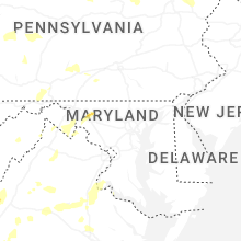


Connect with Interactive Hail Maps