

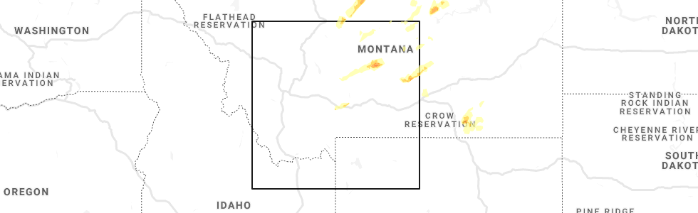
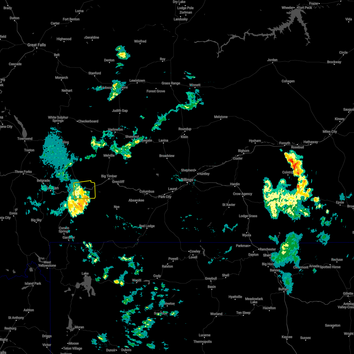
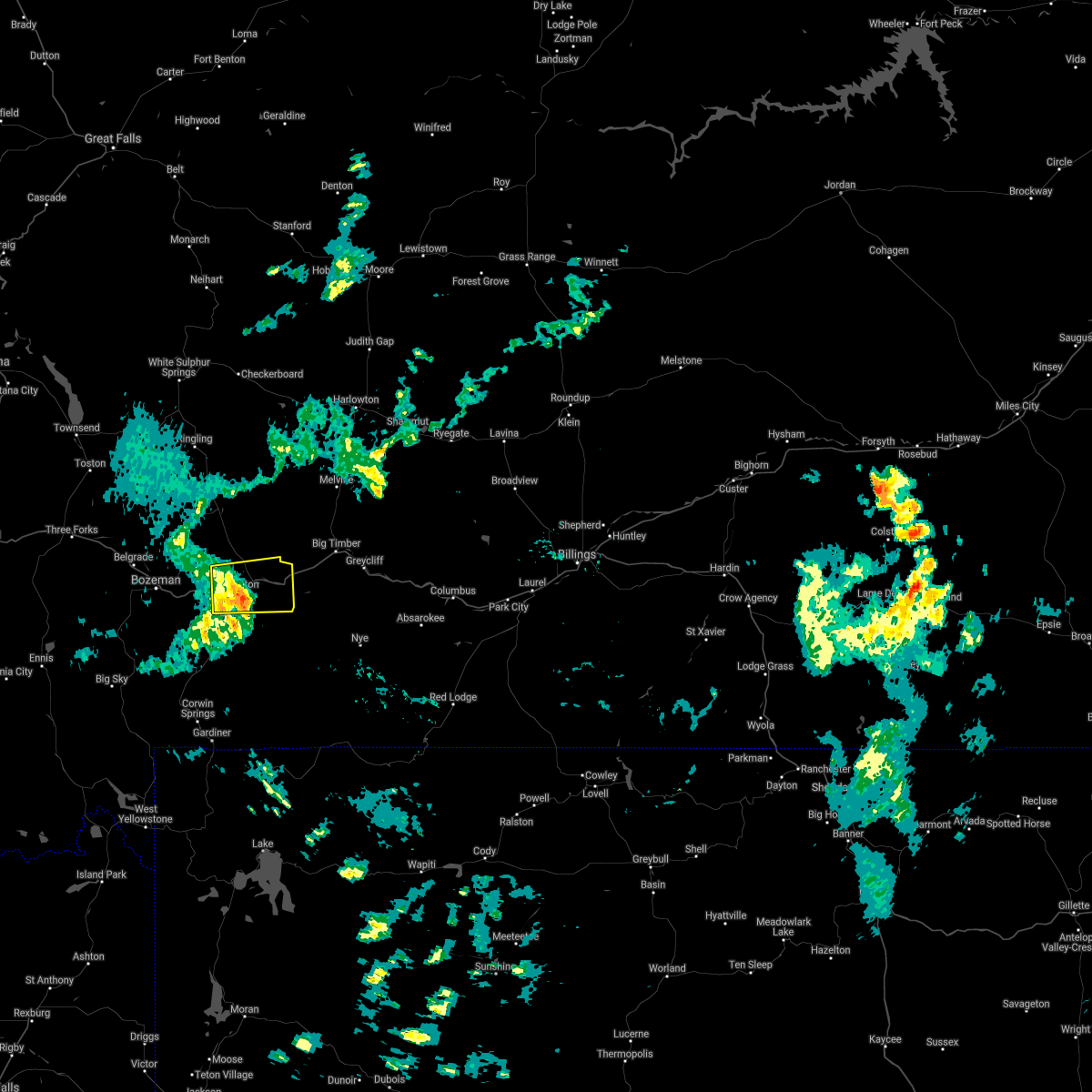
Hail Map for Wineglass, MT
The Wineglass, MT area has had 0 reports of on-the-ground hail by trained spotters, and has been under severe weather warnings 4 times during the past 12 months. Doppler radar has detected hail at or near Wineglass, MT on 5 occasions.
| Name: | Wineglass, MT |
| Where Located: | 20.6 miles E of Bozeman, MT |
| Map: | Google Map for Wineglass, MT |
| Population: | 256 |
| Housing Units: | 120 |
| More Info: | Search Google for Wineglass, MT |
0
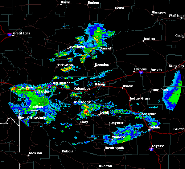
The Top Recent Hail Date for Wineglass, MT is Tuesday, July 7, 2020 (4th out of 5)
Hail and Wind Damage Spotted near Wineglass, MT
| Date / Time | Report Details |
|---|---|
| 7/1/2023 3:55 PM MDT |
 The severe thunderstorm warning for southwestern stillwater, southwestern sweet grass and central park counties will expire at 400 pm mdt, the storms which prompted the warning have weakened below severe limits, and no longer pose an immediate threat to life or property. therefore, the warning will be allowed to expire. however gusty winds are still possible with these thunderstorms. The severe thunderstorm warning for southwestern stillwater, southwestern sweet grass and central park counties will expire at 400 pm mdt, the storms which prompted the warning have weakened below severe limits, and no longer pose an immediate threat to life or property. therefore, the warning will be allowed to expire. however gusty winds are still possible with these thunderstorms.
|
| 7/1/2023 3:46 PM MDT |
 At 346 pm mdt, severe thunderstorms were located along a line extending from 7 miles south of big timber to 9 miles north of cooke city, moving east at 55 mph (radar indicated). Hazards include 60 mph wind gusts. Expect damage to roofs, siding, and trees. locations impacted include, livingston, big timber, springdale, nye, mc leod and greycliff. hail threat, radar indicated max hail size, <. 75 in wind threat, observed max wind gust, 60 mph. At 346 pm mdt, severe thunderstorms were located along a line extending from 7 miles south of big timber to 9 miles north of cooke city, moving east at 55 mph (radar indicated). Hazards include 60 mph wind gusts. Expect damage to roofs, siding, and trees. locations impacted include, livingston, big timber, springdale, nye, mc leod and greycliff. hail threat, radar indicated max hail size, <. 75 in wind threat, observed max wind gust, 60 mph.
|
| 7/1/2023 3:25 PM MDT |
 At 323 pm mdt, severe thunderstorms were located along a line extending from 10 miles southeast of clyde park to 21 miles north of floating island lake, moving southeast at 55 mph. a mesonet near pine creek measured a wind gust of 64 mph at 3:15 pm mdt (mesonet). Hazards include 60 mph wind gusts. Expect damage to roofs, siding, and trees. locations impacted include, livingston, big timber, clyde park, chico hot springs, pine creek, springdale, chico, greycliff, wilsall, nye, mc leod and emigrant. hail threat, radar indicated max hail size, <. 75 in wind threat, observed max wind gust, 60 mph. At 323 pm mdt, severe thunderstorms were located along a line extending from 10 miles southeast of clyde park to 21 miles north of floating island lake, moving southeast at 55 mph. a mesonet near pine creek measured a wind gust of 64 mph at 3:15 pm mdt (mesonet). Hazards include 60 mph wind gusts. Expect damage to roofs, siding, and trees. locations impacted include, livingston, big timber, clyde park, chico hot springs, pine creek, springdale, chico, greycliff, wilsall, nye, mc leod and emigrant. hail threat, radar indicated max hail size, <. 75 in wind threat, observed max wind gust, 60 mph.
|
| 7/1/2023 3:02 PM MDT |
 At 302 pm mdt, severe thunderstorms were located along a line extending from 7 miles west of clyde park to 20 miles north of gardiner, moving southeast at 55 mph (radar indicated). Hazards include 60 mph wind gusts. expect damage to roofs, siding, and trees At 302 pm mdt, severe thunderstorms were located along a line extending from 7 miles west of clyde park to 20 miles north of gardiner, moving southeast at 55 mph (radar indicated). Hazards include 60 mph wind gusts. expect damage to roofs, siding, and trees
|
| 7/7/2021 5:03 PM MDT |
 At 501 pm mdt, severe thunderstorms were located along a line extending from near clyde park to 20 miles south of livingston, moving northeast at 40 mph (radar indicated). Hazards include 60 mph wind gusts. Expect damage to roofs, siding, and trees. Locations impacted include, livingston, clyde park, sportsman lake, slide lake, rainbow lake, electric peak, gardiner, crescent lake, north entrance, chico hot springs, springdale, pine creek, chico, corwin springs, wilsall, emigrant and jardine. At 501 pm mdt, severe thunderstorms were located along a line extending from near clyde park to 20 miles south of livingston, moving northeast at 40 mph (radar indicated). Hazards include 60 mph wind gusts. Expect damage to roofs, siding, and trees. Locations impacted include, livingston, clyde park, sportsman lake, slide lake, rainbow lake, electric peak, gardiner, crescent lake, north entrance, chico hot springs, springdale, pine creek, chico, corwin springs, wilsall, emigrant and jardine.
|
| 7/7/2021 4:43 PM MDT |
 At 441 pm mdt, severe thunderstorms were located along a line extending from 8 miles west of clyde park to 16 miles north of crescent lake, moving east at 45 mph (radar indicated). Hazards include 60 mph wind gusts and dime size hail. expect damage to roofs, siding, and trees At 441 pm mdt, severe thunderstorms were located along a line extending from 8 miles west of clyde park to 16 miles north of crescent lake, moving east at 45 mph (radar indicated). Hazards include 60 mph wind gusts and dime size hail. expect damage to roofs, siding, and trees
|
| 7/4/2021 7:16 PM MDT |
 At 714 pm mdt, a severe thunderstorm was located 5 miles east of livingston, moving east at 60 mph (mesonet station. a gust as high as 64 mph was measured on the west side of livingston, and 63 mph at the airport). Hazards include 60 to 65 mph wind gusts. Expect damage to roofs, siding, and trees. Locations impacted include, livingston and springdale. At 714 pm mdt, a severe thunderstorm was located 5 miles east of livingston, moving east at 60 mph (mesonet station. a gust as high as 64 mph was measured on the west side of livingston, and 63 mph at the airport). Hazards include 60 to 65 mph wind gusts. Expect damage to roofs, siding, and trees. Locations impacted include, livingston and springdale.
|
| 7/4/2021 7:03 PM MDT |
 At 702 pm mdt, a severe thunderstorm was located over livingston, moving east at 40 mph (radar indicated). Hazards include 60 to 70 mph wind gusts. Expect damage to roofs, siding, and trees. This will impact travel on i-90 from livingston to springdale. At 702 pm mdt, a severe thunderstorm was located over livingston, moving east at 40 mph (radar indicated). Hazards include 60 to 70 mph wind gusts. Expect damage to roofs, siding, and trees. This will impact travel on i-90 from livingston to springdale.
|
| 8/3/2020 7:26 PM MDT |
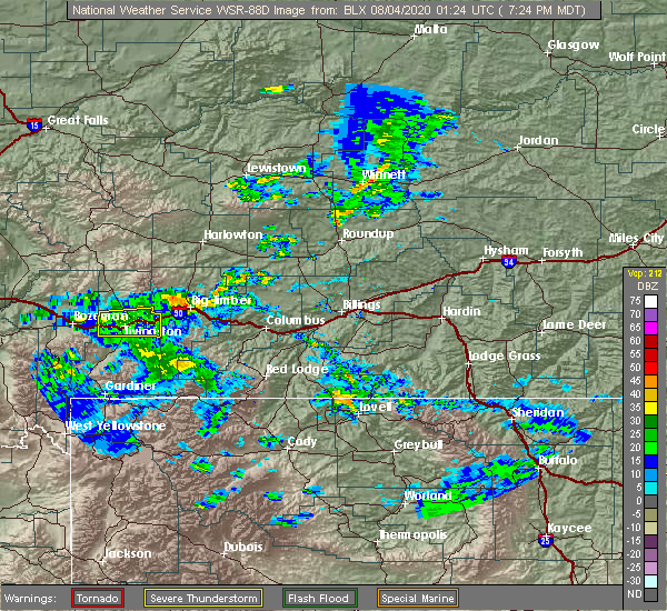 The severe thunderstorm warning for central park county will expire at 730 pm mdt, the storm which prompted the warning has weakened below severe limits, and has exited the warned area. therefore, the warning will be allowed to expire. however gusty winds up to 50 mph are still possible with these thunderstorms over the next hour. The severe thunderstorm warning for central park county will expire at 730 pm mdt, the storm which prompted the warning has weakened below severe limits, and has exited the warned area. therefore, the warning will be allowed to expire. however gusty winds up to 50 mph are still possible with these thunderstorms over the next hour.
|
| 8/3/2020 7:13 PM MDT |
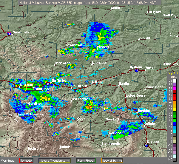 At 711 pm mdt, a severe thunderstorm was located near livingston, moving east at 35 mph (weather station. at 655 pm mdt, a 75 mph wind gust was reported at the livingston airport). Hazards include 80 mph wind gusts. Flying debris will be dangerous to those caught without shelter. mobile homes will be heavily damaged. expect considerable damage to roofs, windows, and vehicles. extensive tree damage and power outages are likely. Locations impacted include, livingston and springdale. At 711 pm mdt, a severe thunderstorm was located near livingston, moving east at 35 mph (weather station. at 655 pm mdt, a 75 mph wind gust was reported at the livingston airport). Hazards include 80 mph wind gusts. Flying debris will be dangerous to those caught without shelter. mobile homes will be heavily damaged. expect considerable damage to roofs, windows, and vehicles. extensive tree damage and power outages are likely. Locations impacted include, livingston and springdale.
|
| 8/3/2020 6:54 PM MDT |
 At 652 pm mdt, a severe thunderstorm was located near livingston, moving east at 35 mph (trained weather spotters. at 644 pm mdt, a 72 mph wind gust was reported at the livingston airport). Hazards include 70 mph wind gusts. Expect considerable tree damage. Damage is likely to mobile homes, roofs, and outbuildings. At 652 pm mdt, a severe thunderstorm was located near livingston, moving east at 35 mph (trained weather spotters. at 644 pm mdt, a 72 mph wind gust was reported at the livingston airport). Hazards include 70 mph wind gusts. Expect considerable tree damage. Damage is likely to mobile homes, roofs, and outbuildings.
|
| 7/7/2020 1:44 PM MDT |
 At 143 pm mdt, a severe thunderstorm was located 9 miles northwest of livingston, moving northeast at 50 mph (radar indicated). Hazards include 60 mph wind gusts and quarter size hail. Hail damage to vehicles is expected. Expect wind damage to roofs, siding, and trees. At 143 pm mdt, a severe thunderstorm was located 9 miles northwest of livingston, moving northeast at 50 mph (radar indicated). Hazards include 60 mph wind gusts and quarter size hail. Hail damage to vehicles is expected. Expect wind damage to roofs, siding, and trees.
|
| 8/2/2018 6:30 PM MDT |
 At 628 pm mdt, a severe thunderstorm was located near livingston, moving northeast at 20 mph (trained weather spotters. wind gusts up to 57 mph were reported earlier in the paradise valley. gusts to 54 mph have been reported in the livingston area so far). Hazards include 60 mph wind gusts. Expect damage to roofs, siding, and trees. Locations impacted include, livingston, clyde park and springdale. At 628 pm mdt, a severe thunderstorm was located near livingston, moving northeast at 20 mph (trained weather spotters. wind gusts up to 57 mph were reported earlier in the paradise valley. gusts to 54 mph have been reported in the livingston area so far). Hazards include 60 mph wind gusts. Expect damage to roofs, siding, and trees. Locations impacted include, livingston, clyde park and springdale.
|
| 8/2/2018 5:58 PM MDT |
 At 557 pm mdt, a thunderstorm producing damaging wind gusts was located 12 miles south of livingston, moving east at 35 mph (trained weather spotters. at 545 pm a wind gust of 57 mph was reported at pray in the paradise valley). Hazards include 60 mph wind gusts. expect damage to roofs, siding, and trees At 557 pm mdt, a thunderstorm producing damaging wind gusts was located 12 miles south of livingston, moving east at 35 mph (trained weather spotters. at 545 pm a wind gust of 57 mph was reported at pray in the paradise valley). Hazards include 60 mph wind gusts. expect damage to roofs, siding, and trees
|
| 6/28/2018 6:57 PM MDT |
 The severe thunderstorm warning for central park county will expire at 700 pm mdt. the storm which prompted the warning has weakened below severe limits, and no longer poses an immediate threat to life or property. therefore, the warning will be allowed to expire. However gusty winds are still possible with this thunderstorm. The severe thunderstorm warning for central park county will expire at 700 pm mdt. the storm which prompted the warning has weakened below severe limits, and no longer poses an immediate threat to life or property. therefore, the warning will be allowed to expire. However gusty winds are still possible with this thunderstorm.
|
| 6/28/2018 6:52 PM MDT |
 At 651 pm mdt, a severe thunderstorm was located near livingston, moving northeast at 40 mph (radar indicated). Hazards include 60 mph wind gusts and penny size hail. Expect damage to roofs, siding, and trees. Locations impacted include, livingston and pine creek. At 651 pm mdt, a severe thunderstorm was located near livingston, moving northeast at 40 mph (radar indicated). Hazards include 60 mph wind gusts and penny size hail. Expect damage to roofs, siding, and trees. Locations impacted include, livingston and pine creek.
|
| 6/28/2018 6:41 PM MDT |
 At 641 pm mdt, a severe thunderstorm was located 11 miles south of livingston, moving northeast at 45 mph (radar indicated). Hazards include 60 mph wind gusts and quarter size hail. Hail damage to vehicles is expected. expect wind damage to roofs, siding, and trees. Locations impacted include, livingston and pine creek. At 641 pm mdt, a severe thunderstorm was located 11 miles south of livingston, moving northeast at 45 mph (radar indicated). Hazards include 60 mph wind gusts and quarter size hail. Hail damage to vehicles is expected. expect wind damage to roofs, siding, and trees. Locations impacted include, livingston and pine creek.
|
| 6/28/2018 6:30 PM MDT |
 At 629 pm mdt, a severe thunderstorm was located 18 miles southwest of livingston, moving northeast at 40 mph (radar indicated). Hazards include 60 mph wind gusts and quarter size hail. Hail damage to vehicles is expected. Expect wind damage to roofs, siding, and trees. At 629 pm mdt, a severe thunderstorm was located 18 miles southwest of livingston, moving northeast at 40 mph (radar indicated). Hazards include 60 mph wind gusts and quarter size hail. Hail damage to vehicles is expected. Expect wind damage to roofs, siding, and trees.
|
| 5/31/2018 3:06 PM MDT |
 At 304 pm mdt, a severe thunderstorm was located near clyde park, or 10 miles north of livingston, moving east northeast at 30 mph. most of the impacts from the storm will be for areas north of livingston (radar indicated). Hazards include 60 mph wind gusts and quarter size hail. Hail damage to vehicles is expected. expect wind damage to roofs, siding, and trees. Locations impacted include, livingston, big timber, clyde park, springdale, melville, mc leod and greycliff. At 304 pm mdt, a severe thunderstorm was located near clyde park, or 10 miles north of livingston, moving east northeast at 30 mph. most of the impacts from the storm will be for areas north of livingston (radar indicated). Hazards include 60 mph wind gusts and quarter size hail. Hail damage to vehicles is expected. expect wind damage to roofs, siding, and trees. Locations impacted include, livingston, big timber, clyde park, springdale, melville, mc leod and greycliff.
|
| 5/31/2018 2:38 PM MDT |
 At 237 pm mdt, a severe thunderstorm was located 10 miles northwest of livingston, moving east northeast at 45 mph. most of the impacts from the storm will be for areas north of livingston (radar indicated). Hazards include 60 mph wind gusts and quarter size hail. Hail damage to vehicles is expected. Expect wind damage to roofs, siding, and trees. At 237 pm mdt, a severe thunderstorm was located 10 miles northwest of livingston, moving east northeast at 45 mph. most of the impacts from the storm will be for areas north of livingston (radar indicated). Hazards include 60 mph wind gusts and quarter size hail. Hail damage to vehicles is expected. Expect wind damage to roofs, siding, and trees.
|
| 6/29/2015 5:45 PM MDT | Storm damage reported in park county MT, 9.4 miles ESE of Wineglass, MT |
Hail Maps for Wineglass, MT


Connect with Interactive Hail Maps