

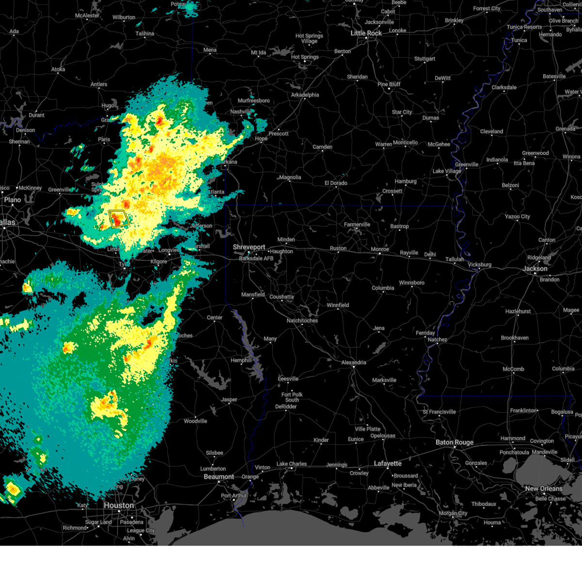
Hail Map for Winnsboro, TX
The Winnsboro, TX area has had 22 reports of on-the-ground hail by trained spotters, and has been under severe weather warnings 12 times during the past 12 months. Doppler radar has detected hail at or near Winnsboro, TX on 59 occasions, including 4 occasions during the past year.
| Name: | Winnsboro, TX |
| Where Located: | 88.4 miles E of Dallas, TX |
| Map: | Google Map for Winnsboro, TX |
| Population: | 3434 |
| Housing Units: | 1535 |
| More Info: | Search Google for Winnsboro, TX |
1
The Top Recent Hail Date for Winnsboro, TX is Wednesday, April 29, 2026 (3rd out of 59)
Hail and Wind Damage Spotted near Winnsboro, TX
| Date / Time | Report Details |
|---|---|
| 6/7/2026 12:43 AM CDT |
 At 1243 am cdt, a severe thunderstorm was located near purley, or 10 miles northwest of leesburg, moving northeast at 25 mph (radar indicated). Hazards include 60 mph wind gusts and quarter size hail. Hail damage to vehicles is expected. expect wind damage to roofs, siding, and trees. Locations impacted include, winnsboro, scroggins and rocky mound. At 1243 am cdt, a severe thunderstorm was located near purley, or 10 miles northwest of leesburg, moving northeast at 25 mph (radar indicated). Hazards include 60 mph wind gusts and quarter size hail. Hail damage to vehicles is expected. expect wind damage to roofs, siding, and trees. Locations impacted include, winnsboro, scroggins and rocky mound.
|
| 6/7/2026 12:30 AM CDT |
 At 1230 am cdt, a severe thunderstorm was located near purley, or 5 miles north of winnsboro, moving northeast at 25 mph (radar indicated). Hazards include 60 mph wind gusts and quarter size hail. Hail damage to vehicles is expected. expect wind damage to roofs, siding, and trees. Locations impacted include, winnsboro, mount vernon, purley, scroggins, rocky mound, cypress and hopewell. At 1230 am cdt, a severe thunderstorm was located near purley, or 5 miles north of winnsboro, moving northeast at 25 mph (radar indicated). Hazards include 60 mph wind gusts and quarter size hail. Hail damage to vehicles is expected. expect wind damage to roofs, siding, and trees. Locations impacted include, winnsboro, mount vernon, purley, scroggins, rocky mound, cypress and hopewell.
|
| 6/7/2026 12:17 AM CDT |
 At 1217 am cdt, a severe thunderstorm was located over winnsboro, moving northeast at 25 mph (radar indicated). Hazards include 60 mph wind gusts and quarter size hail. Hail damage to vehicles is expected. expect wind damage to roofs, siding, and trees. Locations impacted include, winnsboro, mount vernon, scroggins, purley, pleasant grove, rocky mound, cypress and hopewell. At 1217 am cdt, a severe thunderstorm was located over winnsboro, moving northeast at 25 mph (radar indicated). Hazards include 60 mph wind gusts and quarter size hail. Hail damage to vehicles is expected. expect wind damage to roofs, siding, and trees. Locations impacted include, winnsboro, mount vernon, scroggins, purley, pleasant grove, rocky mound, cypress and hopewell.
|
| 6/7/2026 12:11 AM CDT | Tree down and blocking hwy 37 near cr483 in wood county TX, 2.9 miles NE of Winnsboro, TX |
| 6/7/2026 12:00 AM CDT |
 Svrshv the national weather service in shreveport has issued a * severe thunderstorm warning for, northwestern camp county in northeastern texas, southern franklin county in northeastern texas, southwestern titus county in northeastern texas, northeastern wood county in northeastern texas, * until 100 am cdt. * at midnight cdt, a severe thunderstorm was located over pleasant grove, or 7 miles west of winnsboro, moving northeast at 25 mph (radar indicated). Hazards include 60 mph wind gusts and quarter size hail. Hail damage to vehicles is expected. Expect wind damage to roofs, siding, and trees. Svrshv the national weather service in shreveport has issued a * severe thunderstorm warning for, northwestern camp county in northeastern texas, southern franklin county in northeastern texas, southwestern titus county in northeastern texas, northeastern wood county in northeastern texas, * until 100 am cdt. * at midnight cdt, a severe thunderstorm was located over pleasant grove, or 7 miles west of winnsboro, moving northeast at 25 mph (radar indicated). Hazards include 60 mph wind gusts and quarter size hail. Hail damage to vehicles is expected. Expect wind damage to roofs, siding, and trees.
|
| 5/23/2026 5:25 AM CDT |
 Svrshv the national weather service in shreveport has issued a * severe thunderstorm warning for, northern camp county in northeastern texas, franklin county in northeastern texas, western morris county in northeastern texas, southern red river county in northeastern texas, titus county in northeastern texas, * until 630 am cdt. * at 525 am cdt, severe thunderstorms were located along a line from 23 miles west of bogata to near pleasant grove, or along a line from 27 miles northwest of hagansport to 9 miles west of winnsboro, moving east at 30 mph (radar indicated). Hazards include 60 mph wind gusts and half dollar size hail. Hail damage to vehicles is expected. Expect wind damage to roofs, siding, and trees. Svrshv the national weather service in shreveport has issued a * severe thunderstorm warning for, northern camp county in northeastern texas, franklin county in northeastern texas, western morris county in northeastern texas, southern red river county in northeastern texas, titus county in northeastern texas, * until 630 am cdt. * at 525 am cdt, severe thunderstorms were located along a line from 23 miles west of bogata to near pleasant grove, or along a line from 27 miles northwest of hagansport to 9 miles west of winnsboro, moving east at 30 mph (radar indicated). Hazards include 60 mph wind gusts and half dollar size hail. Hail damage to vehicles is expected. Expect wind damage to roofs, siding, and trees.
|
| 5/23/2026 5:13 AM CDT |
 Svrshv the national weather service in shreveport has issued a * severe thunderstorm warning for, southwestern camp county in northeastern texas, northern cherokee county in northeastern texas, southern franklin county in northeastern texas, eastern smith county in northeastern texas, western upshur county in northeastern texas, eastern wood county in northeastern texas, * until 615 am cdt. * at 513 am cdt, severe thunderstorms were located along a line from 13 miles west of purley to near maydelle, or along a line from 17 miles northwest of winnsboro to 9 miles southwest of jacksonville, moving east at 15 mph (radar indicated). Hazards include 60 mph wind gusts and quarter size hail. Hail damage to vehicles is expected. Expect wind damage to roofs, siding, and trees. Svrshv the national weather service in shreveport has issued a * severe thunderstorm warning for, southwestern camp county in northeastern texas, northern cherokee county in northeastern texas, southern franklin county in northeastern texas, eastern smith county in northeastern texas, western upshur county in northeastern texas, eastern wood county in northeastern texas, * until 615 am cdt. * at 513 am cdt, severe thunderstorms were located along a line from 13 miles west of purley to near maydelle, or along a line from 17 miles northwest of winnsboro to 9 miles southwest of jacksonville, moving east at 15 mph (radar indicated). Hazards include 60 mph wind gusts and quarter size hail. Hail damage to vehicles is expected. Expect wind damage to roofs, siding, and trees.
|
| 5/10/2026 2:20 PM CDT | A tree was downed near the intersection of highway 154 and cr 397 in wood county TX, 12.8 miles NNW of Winnsboro, TX |
| 5/8/2026 11:45 PM CDT | Quarter sized hail reported 0.5 miles S of Winnsboro, TX, one inch hail reported at a gas station in winnsboro... texas. |
| 5/8/2026 11:45 PM CDT |
 Svrshv the national weather service in shreveport has issued a * severe thunderstorm warning for, camp county in northeastern texas, southern cass county in northeastern texas, northern gregg county in northeastern texas, northwestern harrison county in northeastern texas, western marion county in northeastern texas, southern morris county in northeastern texas, upshur county in northeastern texas, northeastern wood county in northeastern texas, * until 1245 am cdt. * at 1145 pm cdt, severe thunderstorms were located along a line from near jenkins to near winnsboro, or along a line from 19 miles east of pittsburg to near winnsboro, moving east at 35 mph (radar indicated). Hazards include 60 mph wind gusts and quarter size hail. Hail damage to vehicles is expected. Expect wind damage to roofs, siding, and trees. Svrshv the national weather service in shreveport has issued a * severe thunderstorm warning for, camp county in northeastern texas, southern cass county in northeastern texas, northern gregg county in northeastern texas, northwestern harrison county in northeastern texas, western marion county in northeastern texas, southern morris county in northeastern texas, upshur county in northeastern texas, northeastern wood county in northeastern texas, * until 1245 am cdt. * at 1145 pm cdt, severe thunderstorms were located along a line from near jenkins to near winnsboro, or along a line from 19 miles east of pittsburg to near winnsboro, moving east at 35 mph (radar indicated). Hazards include 60 mph wind gusts and quarter size hail. Hail damage to vehicles is expected. Expect wind damage to roofs, siding, and trees.
|
| 5/8/2026 11:00 PM CDT |
 Svrshv the national weather service in shreveport has issued a * severe thunderstorm warning for, camp county in northeastern texas, southern franklin county in northeastern texas, southwestern morris county in northeastern texas, northern upshur county in northeastern texas, northeastern wood county in northeastern texas, * until 1145 pm cdt. * at 1100 pm cdt, a severe thunderstorm was located over scroggins, or near winnsboro, moving southeast at 30 mph (radar indicated). Hazards include quarter size hail. damage to vehicles is expected Svrshv the national weather service in shreveport has issued a * severe thunderstorm warning for, camp county in northeastern texas, southern franklin county in northeastern texas, southwestern morris county in northeastern texas, northern upshur county in northeastern texas, northeastern wood county in northeastern texas, * until 1145 pm cdt. * at 1100 pm cdt, a severe thunderstorm was located over scroggins, or near winnsboro, moving southeast at 30 mph (radar indicated). Hazards include quarter size hail. damage to vehicles is expected
|
| 4/29/2026 12:15 PM CDT |
 At 1215 pm cdt, a severe thunderstorm was located near newsome, or 5 miles southwest of leesburg, moving east at 40 mph. another severe thunderstorm was indicated along the franklin and titus county line 8 miles northeast of mount vernon, also moving east at 40 mph (radar indicated). Hazards include two inch hail. People and animals outdoors will be injured. expect damage to roofs, siding, windows, and vehicles. Locations impacted include, mount pleasant, gilmer, pittsburg, winnsboro, leesburg, hagansport, mount vernon, daingerfield, lone star, naples, ore city, omaha, newsome, scroggins, cason, cookville, purley, rocky branch, cedar springs and us 259 and i 30 intersection. At 1215 pm cdt, a severe thunderstorm was located near newsome, or 5 miles southwest of leesburg, moving east at 40 mph. another severe thunderstorm was indicated along the franklin and titus county line 8 miles northeast of mount vernon, also moving east at 40 mph (radar indicated). Hazards include two inch hail. People and animals outdoors will be injured. expect damage to roofs, siding, windows, and vehicles. Locations impacted include, mount pleasant, gilmer, pittsburg, winnsboro, leesburg, hagansport, mount vernon, daingerfield, lone star, naples, ore city, omaha, newsome, scroggins, cason, cookville, purley, rocky branch, cedar springs and us 259 and i 30 intersection.
|
| 4/29/2026 12:08 PM CDT | Quarter sized hail reported 0.2 miles NNE of Winnsboro, TX, social media report of approx. quarter sized hail in winnsboro. |
| 4/29/2026 12:00 PM CDT |
 Svrshv the national weather service in shreveport has issued a * severe thunderstorm warning for, camp county in northeastern texas, franklin county in northeastern texas, morris county in northeastern texas, titus county in northeastern texas, northern upshur county in northeastern texas, northern wood county in northeastern texas, * until 1245 pm cdt. * at noon cdt, a severe thunderstorm was located over winnsboro, moving east at 40 mph (radar indicated). Hazards include half dollar size hail. damage to vehicles is expected Svrshv the national weather service in shreveport has issued a * severe thunderstorm warning for, camp county in northeastern texas, franklin county in northeastern texas, morris county in northeastern texas, titus county in northeastern texas, northern upshur county in northeastern texas, northern wood county in northeastern texas, * until 1245 pm cdt. * at noon cdt, a severe thunderstorm was located over winnsboro, moving east at 40 mph (radar indicated). Hazards include half dollar size hail. damage to vehicles is expected
|
| 4/24/2026 9:34 PM CDT |
 Svrshv the national weather service in shreveport has issued a * severe thunderstorm warning for, camp county in northeastern texas, southwestern cass county in northeastern texas, franklin county in northeastern texas, morris county in northeastern texas, southwestern red river county in northeastern texas, titus county in northeastern texas, northern upshur county in northeastern texas, northern wood county in northeastern texas, * until 1045 pm cdt. * at 934 pm cdt, severe thunderstorms were located along a line from 6 miles west of us 259 and i 30 intersection to 22 miles northwest of pleasant grove, or along a line from 11 miles south of boxelder to 25 miles northwest of winnsboro, moving south at 30 mph (radar indicated). Hazards include golf ball size hail and 70 mph wind gusts. People and animals outdoors will be injured. expect hail damage to roofs, siding, windows, and vehicles. expect considerable tree damage. Wind damage is also likely to mobile homes, roofs, and outbuildings. Svrshv the national weather service in shreveport has issued a * severe thunderstorm warning for, camp county in northeastern texas, southwestern cass county in northeastern texas, franklin county in northeastern texas, morris county in northeastern texas, southwestern red river county in northeastern texas, titus county in northeastern texas, northern upshur county in northeastern texas, northern wood county in northeastern texas, * until 1045 pm cdt. * at 934 pm cdt, severe thunderstorms were located along a line from 6 miles west of us 259 and i 30 intersection to 22 miles northwest of pleasant grove, or along a line from 11 miles south of boxelder to 25 miles northwest of winnsboro, moving south at 30 mph (radar indicated). Hazards include golf ball size hail and 70 mph wind gusts. People and animals outdoors will be injured. expect hail damage to roofs, siding, windows, and vehicles. expect considerable tree damage. Wind damage is also likely to mobile homes, roofs, and outbuildings.
|
| 8/1/2025 6:32 PM CDT | Tree down at fm 1647 near fm 85 in wood county TX, 9 miles NW of Winnsboro, TX |
| 8/1/2025 6:26 PM CDT |
 Svrshv the national weather service in shreveport has issued a * severe thunderstorm warning for, camp county in northeastern texas, southern franklin county in northeastern texas, southwestern titus county in northeastern texas, northwestern upshur county in northeastern texas, northeastern wood county in northeastern texas, * until 715 pm cdt. * at 626 pm cdt, a severe thunderstorm was located near scroggins, or near winnsboro, moving northeast at 15 mph (radar indicated). Hazards include quarter size hail. damage to vehicles is expected Svrshv the national weather service in shreveport has issued a * severe thunderstorm warning for, camp county in northeastern texas, southern franklin county in northeastern texas, southwestern titus county in northeastern texas, northwestern upshur county in northeastern texas, northeastern wood county in northeastern texas, * until 715 pm cdt. * at 626 pm cdt, a severe thunderstorm was located near scroggins, or near winnsboro, moving northeast at 15 mph (radar indicated). Hazards include quarter size hail. damage to vehicles is expected
|
| 6/8/2025 11:38 PM CDT |
 At 1135 pm cdt, severe thunderstorms were located along a line extending from near mount pleasant to 6 miles south of scroggins to near grand saline to near kaufman, moving east at 50 mph. these are destructive storms including the cities of and areas around gilmer, tx and pittsburg, tx (radar indicated). Hazards include 80 mph wind gusts and half dollar size hail. Flying debris will be dangerous to those caught without shelter. mobile homes will be heavily damaged. expect considerable damage to roofs, windows, and vehicles. extensive tree damage and power outages are likely. Locations impacted include, tyler, longview, mount pleasant, kilgore, whitehouse, white oak, gladewater, gilmer, mineola, pittsburg, winnsboro, leesburg, lindale, mount vernon, daingerfield, overton, bullard, troup, quitman, and lone star. At 1135 pm cdt, severe thunderstorms were located along a line extending from near mount pleasant to 6 miles south of scroggins to near grand saline to near kaufman, moving east at 50 mph. these are destructive storms including the cities of and areas around gilmer, tx and pittsburg, tx (radar indicated). Hazards include 80 mph wind gusts and half dollar size hail. Flying debris will be dangerous to those caught without shelter. mobile homes will be heavily damaged. expect considerable damage to roofs, windows, and vehicles. extensive tree damage and power outages are likely. Locations impacted include, tyler, longview, mount pleasant, kilgore, whitehouse, white oak, gladewater, gilmer, mineola, pittsburg, winnsboro, leesburg, lindale, mount vernon, daingerfield, overton, bullard, troup, quitman, and lone star.
|
| 6/8/2025 10:59 PM CDT |
 Svrshv the national weather service in shreveport has issued a * severe thunderstorm warning for, smith county in northeastern texas, western marion county in northeastern texas, southwestern cass county in northeastern texas, northwestern harrison county in northeastern texas, franklin county in northeastern texas, northwestern rusk county in northeastern texas, wood county in northeastern texas, upshur county in northeastern texas, southern morris county in northeastern texas, southern titus county in northeastern texas, camp county in northeastern texas, gregg county in northeastern texas, * until 1215 am cdt. * at 1058 pm cdt, severe thunderstorms were located along a line extending from 9 miles northeast of cooper lake state park to near sulphur springs to near hawk cove to near dallas, moving southeast at 50 mph (radar indicated). Hazards include 70 mph wind gusts and half dollar size hail. Hail damage to vehicles is expected. expect considerable tree damage. Wind damage is also likely to mobile homes, roofs, and outbuildings. Svrshv the national weather service in shreveport has issued a * severe thunderstorm warning for, smith county in northeastern texas, western marion county in northeastern texas, southwestern cass county in northeastern texas, northwestern harrison county in northeastern texas, franklin county in northeastern texas, northwestern rusk county in northeastern texas, wood county in northeastern texas, upshur county in northeastern texas, southern morris county in northeastern texas, southern titus county in northeastern texas, camp county in northeastern texas, gregg county in northeastern texas, * until 1215 am cdt. * at 1058 pm cdt, severe thunderstorms were located along a line extending from 9 miles northeast of cooper lake state park to near sulphur springs to near hawk cove to near dallas, moving southeast at 50 mph (radar indicated). Hazards include 70 mph wind gusts and half dollar size hail. Hail damage to vehicles is expected. expect considerable tree damage. Wind damage is also likely to mobile homes, roofs, and outbuildings.
|
| 5/20/2025 2:33 AM CDT |
 Svrshv the national weather service in shreveport has issued a * severe thunderstorm warning for, franklin county in northeastern texas, morris county in northeastern texas, titus county in northeastern texas, northwestern camp county in northeastern texas, * until 315 am cdt. * at 232 am cdt, a severe thunderstorm was located near purley, or 10 miles northwest of winnsboro, moving east at 55 mph (radar indicated). Hazards include 60 mph wind gusts and quarter size hail. Hail damage to vehicles is expected. Expect wind damage to roofs, siding, and trees. Svrshv the national weather service in shreveport has issued a * severe thunderstorm warning for, franklin county in northeastern texas, morris county in northeastern texas, titus county in northeastern texas, northwestern camp county in northeastern texas, * until 315 am cdt. * at 232 am cdt, a severe thunderstorm was located near purley, or 10 miles northwest of winnsboro, moving east at 55 mph (radar indicated). Hazards include 60 mph wind gusts and quarter size hail. Hail damage to vehicles is expected. Expect wind damage to roofs, siding, and trees.
|
| 5/6/2025 12:55 PM CDT |
 Svrshv the national weather service in shreveport has issued a * severe thunderstorm warning for, northern smith county in northeastern texas, southwestern franklin county in northeastern texas, wood county in northeastern texas, upshur county in northeastern texas, southwestern morris county in northeastern texas, southern camp county in northeastern texas, west central gregg county in northeastern texas, * until 145 pm cdt. * at 1255 pm cdt, a severe thunderstorm was located over tyler, moving north at 60 mph (radar indicated). Hazards include 60 mph wind gusts and quarter size hail. Hail damage to vehicles is expected. Expect wind damage to roofs, siding, and trees. Svrshv the national weather service in shreveport has issued a * severe thunderstorm warning for, northern smith county in northeastern texas, southwestern franklin county in northeastern texas, wood county in northeastern texas, upshur county in northeastern texas, southwestern morris county in northeastern texas, southern camp county in northeastern texas, west central gregg county in northeastern texas, * until 145 pm cdt. * at 1255 pm cdt, a severe thunderstorm was located over tyler, moving north at 60 mph (radar indicated). Hazards include 60 mph wind gusts and quarter size hail. Hail damage to vehicles is expected. Expect wind damage to roofs, siding, and trees.
|
| 5/6/2025 11:04 AM CDT |
 At 1104 am cdt, a severe thunderstorm was located near leesburg, moving northeast at 35 mph (radar indicated). Hazards include 60 mph wind gusts and quarter size hail. Hail damage to vehicles is expected. expect wind damage to roofs, siding, and trees. Locations impacted include, mount pleasant, gilmer, pittsburg, winnsboro, leesburg, mount vernon, daingerfield, hughes springs, lone star, naples, omaha, newsome, scroggins, cason, cookville, purley, rosewood, rocky branch, jenkins and winfield. At 1104 am cdt, a severe thunderstorm was located near leesburg, moving northeast at 35 mph (radar indicated). Hazards include 60 mph wind gusts and quarter size hail. Hail damage to vehicles is expected. expect wind damage to roofs, siding, and trees. Locations impacted include, mount pleasant, gilmer, pittsburg, winnsboro, leesburg, mount vernon, daingerfield, hughes springs, lone star, naples, omaha, newsome, scroggins, cason, cookville, purley, rosewood, rocky branch, jenkins and winfield.
|
| 5/6/2025 11:04 AM CDT |
 the severe thunderstorm warning has been cancelled and is no longer in effect the severe thunderstorm warning has been cancelled and is no longer in effect
|
| 5/6/2025 10:47 AM CDT |
 Svrshv the national weather service in shreveport has issued a * severe thunderstorm warning for, camp county in northeastern texas, west central cass county in northeastern texas, franklin county in northeastern texas, morris county in northeastern texas, northwestern smith county in northeastern texas, titus county in northeastern texas, northwestern upshur county in northeastern texas, wood county in northeastern texas, * until 1130 am cdt. * at 1047 am cdt, a severe thunderstorm was located near newsome, or 6 miles southwest of leesburg, moving northeast at 35 mph (radar indicated). Hazards include 60 mph wind gusts and quarter size hail. Hail damage to vehicles is expected. Expect wind damage to roofs, siding, and trees. Svrshv the national weather service in shreveport has issued a * severe thunderstorm warning for, camp county in northeastern texas, west central cass county in northeastern texas, franklin county in northeastern texas, morris county in northeastern texas, northwestern smith county in northeastern texas, titus county in northeastern texas, northwestern upshur county in northeastern texas, wood county in northeastern texas, * until 1130 am cdt. * at 1047 am cdt, a severe thunderstorm was located near newsome, or 6 miles southwest of leesburg, moving northeast at 35 mph (radar indicated). Hazards include 60 mph wind gusts and quarter size hail. Hail damage to vehicles is expected. Expect wind damage to roofs, siding, and trees.
|
| 4/30/2025 2:20 PM CDT |
 Svrshv the national weather service in shreveport has issued a * severe thunderstorm warning for, camp county in northeastern texas, southwestern cass county in northeastern texas, south central franklin county in northeastern texas, gregg county in northeastern texas, northwestern harrison county in northeastern texas, western marion county in northeastern texas, southern morris county in northeastern texas, northwestern rusk county in northeastern texas, central smith county in northeastern texas, upshur county in northeastern texas, wood county in northeastern texas, * until 315 pm cdt. * at 220 pm cdt, severe thunderstorms were located along a line from near pittsburg to 11 miles southwest of mineola, moving east at 35 mph (radar indicated). Hazards include 60 mph wind gusts and small hail. expect damage to roofs, siding, and trees Svrshv the national weather service in shreveport has issued a * severe thunderstorm warning for, camp county in northeastern texas, southwestern cass county in northeastern texas, south central franklin county in northeastern texas, gregg county in northeastern texas, northwestern harrison county in northeastern texas, western marion county in northeastern texas, southern morris county in northeastern texas, northwestern rusk county in northeastern texas, central smith county in northeastern texas, upshur county in northeastern texas, wood county in northeastern texas, * until 315 pm cdt. * at 220 pm cdt, severe thunderstorms were located along a line from near pittsburg to 11 miles southwest of mineola, moving east at 35 mph (radar indicated). Hazards include 60 mph wind gusts and small hail. expect damage to roofs, siding, and trees
|
| 4/4/2025 3:19 PM CDT |
 At 318 pm cdt, a confirmed tornado was located near grand saline, or 10 miles northeast of canton, moving northeast at 35 mph (law enforcement confirmed tornado). Hazards include damaging tornado and quarter size hail. Flying debris will be dangerous to those caught without shelter. mobile homes will be damaged or destroyed. damage to roofs, windows, and vehicles will occur. tree damage is likely. this tornado will be near, golden around 330 pm cdt. lake fork reservoir around 335 pm cdt. pleasant grove around 400 pm cdt. Other locations impacted by this tornadic thunderstorm include alba, yantis, and forest hill. At 318 pm cdt, a confirmed tornado was located near grand saline, or 10 miles northeast of canton, moving northeast at 35 mph (law enforcement confirmed tornado). Hazards include damaging tornado and quarter size hail. Flying debris will be dangerous to those caught without shelter. mobile homes will be damaged or destroyed. damage to roofs, windows, and vehicles will occur. tree damage is likely. this tornado will be near, golden around 330 pm cdt. lake fork reservoir around 335 pm cdt. pleasant grove around 400 pm cdt. Other locations impacted by this tornadic thunderstorm include alba, yantis, and forest hill.
|
| 4/4/2025 3:13 PM CDT |
 Torshv the national weather service in shreveport has issued a * tornado warning for, northwestern smith county in northeastern texas, central wood county in northeastern texas, * until 415 pm cdt. * at 312 pm cdt, a severe thunderstorm capable of producing a tornado was located near canton, moving northeast at 35 mph (radar indicated rotation). Hazards include tornado and quarter size hail. Flying debris will be dangerous to those caught without shelter. mobile homes will be damaged or destroyed. damage to roofs, windows, and vehicles will occur. tree damage is likely. this dangerous storm will be near, golden around 330 pm cdt. lake fork reservoir around 335 pm cdt. pleasant grove around 400 pm cdt. Other locations impacted by this tornadic thunderstorm include alba, yantis, and forest hill. Torshv the national weather service in shreveport has issued a * tornado warning for, northwestern smith county in northeastern texas, central wood county in northeastern texas, * until 415 pm cdt. * at 312 pm cdt, a severe thunderstorm capable of producing a tornado was located near canton, moving northeast at 35 mph (radar indicated rotation). Hazards include tornado and quarter size hail. Flying debris will be dangerous to those caught without shelter. mobile homes will be damaged or destroyed. damage to roofs, windows, and vehicles will occur. tree damage is likely. this dangerous storm will be near, golden around 330 pm cdt. lake fork reservoir around 335 pm cdt. pleasant grove around 400 pm cdt. Other locations impacted by this tornadic thunderstorm include alba, yantis, and forest hill.
|
| 3/4/2025 7:42 AM CST |
 At 742 am cst, severe thunderstorms were located along a line from 8 miles west of arkinda to near cedar springs, or along a line from 13 miles west of foreman to 10 miles northeast of gilmer, moving northeast at 65 mph (radar indicated). Hazards include 60 mph wind gusts and small hail. Expect damage to roofs, siding, and trees. Locations impacted include, tyler, longview, mount pleasant, white oak, gladewater, gilmer, mineola, pittsburg, winnsboro, leesburg, lindale, daingerfield, hughes springs, de kalb, lone star, naples, big sandy, hawkins, ore city and omaha. At 742 am cst, severe thunderstorms were located along a line from 8 miles west of arkinda to near cedar springs, or along a line from 13 miles west of foreman to 10 miles northeast of gilmer, moving northeast at 65 mph (radar indicated). Hazards include 60 mph wind gusts and small hail. Expect damage to roofs, siding, and trees. Locations impacted include, tyler, longview, mount pleasant, white oak, gladewater, gilmer, mineola, pittsburg, winnsboro, leesburg, lindale, daingerfield, hughes springs, de kalb, lone star, naples, big sandy, hawkins, ore city and omaha.
|
| 3/4/2025 7:12 AM CST |
 Svrshv the national weather service in shreveport has issued a * severe thunderstorm warning for, western bowie county in northeastern texas, camp county in northeastern texas, western cass county in northeastern texas, franklin county in northeastern texas, northwestern gregg county in northeastern texas, northwestern harrison county in northeastern texas, western marion county in northeastern texas, morris county in northeastern texas, southeastern red river county in northeastern texas, central smith county in northeastern texas, titus county in northeastern texas, upshur county in northeastern texas, wood county in northeastern texas, * until 800 am cst. * at 712 am cst, severe thunderstorms were located along a line from 8 miles northwest of wilkerson to 7 miles south of hawkins, or along a line from 9 miles west of boxelder to 13 miles northeast of tyler, moving northeast at 65 mph (radar indicated). Hazards include 60 mph wind gusts and quarter size hail. Hail damage to vehicles is expected. Expect wind damage to roofs, siding, and trees. Svrshv the national weather service in shreveport has issued a * severe thunderstorm warning for, western bowie county in northeastern texas, camp county in northeastern texas, western cass county in northeastern texas, franklin county in northeastern texas, northwestern gregg county in northeastern texas, northwestern harrison county in northeastern texas, western marion county in northeastern texas, morris county in northeastern texas, southeastern red river county in northeastern texas, central smith county in northeastern texas, titus county in northeastern texas, upshur county in northeastern texas, wood county in northeastern texas, * until 800 am cst. * at 712 am cst, severe thunderstorms were located along a line from 8 miles northwest of wilkerson to 7 miles south of hawkins, or along a line from 9 miles west of boxelder to 13 miles northeast of tyler, moving northeast at 65 mph (radar indicated). Hazards include 60 mph wind gusts and quarter size hail. Hail damage to vehicles is expected. Expect wind damage to roofs, siding, and trees.
|
| 3/4/2025 6:29 AM CST |
 Svrshv the national weather service in shreveport has issued a * severe thunderstorm warning for, western camp county in northeastern texas, franklin county in northeastern texas, northern smith county in northeastern texas, western titus county in northeastern texas, western upshur county in northeastern texas, wood county in northeastern texas, * until 715 am cst. * at 629 am cst, severe thunderstorms were located along a line from 19 miles northwest of golden to 30 miles northwest of reese, or along a line from 25 miles west of winnsboro to 33 miles west of tyler, moving northeast at 55 mph (radar indicated). Hazards include 60 mph wind gusts and quarter size hail. Hail damage to vehicles is expected. Expect wind damage to roofs, siding, and trees. Svrshv the national weather service in shreveport has issued a * severe thunderstorm warning for, western camp county in northeastern texas, franklin county in northeastern texas, northern smith county in northeastern texas, western titus county in northeastern texas, western upshur county in northeastern texas, wood county in northeastern texas, * until 715 am cst. * at 629 am cst, severe thunderstorms were located along a line from 19 miles northwest of golden to 30 miles northwest of reese, or along a line from 25 miles west of winnsboro to 33 miles west of tyler, moving northeast at 55 mph (radar indicated). Hazards include 60 mph wind gusts and quarter size hail. Hail damage to vehicles is expected. Expect wind damage to roofs, siding, and trees.
|
| 6/26/2024 12:03 PM CDT |
 Svrshv the national weather service in shreveport has issued a * severe thunderstorm warning for, southwestern hempstead county in southwestern arkansas, lafayette county in southwestern arkansas, southeastern little river county in southwestern arkansas, miller county in southwestern arkansas, northwestern caddo parish in northwestern louisiana, northwestern bossier parish in northwestern louisiana, marion county in northeastern texas, franklin county in northeastern texas, southeastern bowie county in northeastern texas, upshur county in northeastern texas, titus county in northeastern texas, cass county in northeastern texas, northern harrison county in northeastern texas, eastern wood county in northeastern texas, morris county in northeastern texas, camp county in northeastern texas, north central gregg county in northeastern texas, * until 100 pm cdt. * at 1202 pm cdt, severe thunderstorms were located along a line extending from near fulton to 9 miles north of queen city to near rocky branch to near mount vernon, moving south at 45 mph (radar indicated). Hazards include 70 mph wind gusts and penny size hail. Expect considerable tree damage. Damage is likely to mobile homes, roofs, and outbuildings. Svrshv the national weather service in shreveport has issued a * severe thunderstorm warning for, southwestern hempstead county in southwestern arkansas, lafayette county in southwestern arkansas, southeastern little river county in southwestern arkansas, miller county in southwestern arkansas, northwestern caddo parish in northwestern louisiana, northwestern bossier parish in northwestern louisiana, marion county in northeastern texas, franklin county in northeastern texas, southeastern bowie county in northeastern texas, upshur county in northeastern texas, titus county in northeastern texas, cass county in northeastern texas, northern harrison county in northeastern texas, eastern wood county in northeastern texas, morris county in northeastern texas, camp county in northeastern texas, north central gregg county in northeastern texas, * until 100 pm cdt. * at 1202 pm cdt, severe thunderstorms were located along a line extending from near fulton to 9 miles north of queen city to near rocky branch to near mount vernon, moving south at 45 mph (radar indicated). Hazards include 70 mph wind gusts and penny size hail. Expect considerable tree damage. Damage is likely to mobile homes, roofs, and outbuildings.
|
| 6/3/2024 7:11 PM CDT |
 Svrshv the national weather service in shreveport has issued a * severe thunderstorm warning for, northwestern smith county in northeastern texas, wood county in northeastern texas, * until 815 pm cdt. * at 709 pm cdt, severe thunderstorms were located along a line extending from near lake fork reservoir to near quitman to near hoard, moving northeast at 35 mph. another severe thunderstorm was indicated near edgewood in northern van zandt county, moving east east at 35 mph (radar indicated). Hazards include 60 mph wind gusts and quarter size hail. Hail damage to vehicles is expected. Expect wind damage to roofs, siding, and trees. Svrshv the national weather service in shreveport has issued a * severe thunderstorm warning for, northwestern smith county in northeastern texas, wood county in northeastern texas, * until 815 pm cdt. * at 709 pm cdt, severe thunderstorms were located along a line extending from near lake fork reservoir to near quitman to near hoard, moving northeast at 35 mph. another severe thunderstorm was indicated near edgewood in northern van zandt county, moving east east at 35 mph (radar indicated). Hazards include 60 mph wind gusts and quarter size hail. Hail damage to vehicles is expected. Expect wind damage to roofs, siding, and trees.
|
| 6/2/2024 7:27 PM CDT |
 At 726 pm cdt, severe thunderstorms were located along a line extending from near idabel to de kalb to near leesburg, moving east at 40 mph (radar indicated). Hazards include 60 mph wind gusts and nickel size hail. Expect damage to roofs, siding, and trees. Locations impacted include, mount pleasant, new boston, pittsburg, winnsboro, foreman, leesburg, boxelder, idabel, daingerfield, de kalb, naples, omaha, cason, us 259 and i 30 intersection, arkinda, cookville, scroggins, rocky branch, wilkerson, and newsome. At 726 pm cdt, severe thunderstorms were located along a line extending from near idabel to de kalb to near leesburg, moving east at 40 mph (radar indicated). Hazards include 60 mph wind gusts and nickel size hail. Expect damage to roofs, siding, and trees. Locations impacted include, mount pleasant, new boston, pittsburg, winnsboro, foreman, leesburg, boxelder, idabel, daingerfield, de kalb, naples, omaha, cason, us 259 and i 30 intersection, arkinda, cookville, scroggins, rocky branch, wilkerson, and newsome.
|
| 6/2/2024 7:11 PM CDT |
 Svrshv the national weather service in shreveport has issued a * severe thunderstorm warning for, western little river county in southwestern arkansas, southern mccurtain county in southeastern oklahoma, northwestern cass county in northeastern texas, franklin county in northeastern texas, northeastern wood county in northeastern texas, western bowie county in northeastern texas, morris county in northeastern texas, titus county in northeastern texas, camp county in northeastern texas, eastern red river county in northeastern texas, * until 800 pm cdt. * at 711 pm cdt, severe thunderstorms were located along a line extending from near idabel to 7 miles west of de kalb to near purley, moving east at 40 mph (radar indicated). Hazards include 60 mph wind gusts and nickel size hail. expect damage to roofs, siding, and trees Svrshv the national weather service in shreveport has issued a * severe thunderstorm warning for, western little river county in southwestern arkansas, southern mccurtain county in southeastern oklahoma, northwestern cass county in northeastern texas, franklin county in northeastern texas, northeastern wood county in northeastern texas, western bowie county in northeastern texas, morris county in northeastern texas, titus county in northeastern texas, camp county in northeastern texas, eastern red river county in northeastern texas, * until 800 pm cdt. * at 711 pm cdt, severe thunderstorms were located along a line extending from near idabel to 7 miles west of de kalb to near purley, moving east at 40 mph (radar indicated). Hazards include 60 mph wind gusts and nickel size hail. expect damage to roofs, siding, and trees
|
| 6/2/2024 6:57 PM CDT |
 Svrshv the national weather service in shreveport has issued a * severe thunderstorm warning for, central smith county in northeastern texas, wood county in northeastern texas, western upshur county in northeastern texas, southern camp county in northeastern texas, * until 800 pm cdt. * at 657 pm cdt, severe thunderstorms were located along a line extending from 8 miles northwest of lake fork reservoir to near purtis creek state park, moving east at 40 mph (radar indicated). Hazards include 60 mph wind gusts and quarter size hail. Hail damage to vehicles is expected. Expect wind damage to roofs, siding, and trees. Svrshv the national weather service in shreveport has issued a * severe thunderstorm warning for, central smith county in northeastern texas, wood county in northeastern texas, western upshur county in northeastern texas, southern camp county in northeastern texas, * until 800 pm cdt. * at 657 pm cdt, severe thunderstorms were located along a line extending from 8 miles northwest of lake fork reservoir to near purtis creek state park, moving east at 40 mph (radar indicated). Hazards include 60 mph wind gusts and quarter size hail. Hail damage to vehicles is expected. Expect wind damage to roofs, siding, and trees.
|
| 5/28/2024 7:40 AM CDT |
 Svrshv the national weather service in shreveport has issued a * severe thunderstorm warning for, smith county in northeastern texas, southwestern franklin county in northeastern texas, wood county in northeastern texas, northwestern cherokee county in northeastern texas, * until 830 am cdt. * at 739 am cdt, severe thunderstorms were located along a line extending from near emory to near van to near athens, moving east at 45 mph (radar indicated). Hazards include 70 mph wind gusts and half dollar size hail. Hail damage to vehicles is expected. expect considerable tree damage. Wind damage is also likely to mobile homes, roofs, and outbuildings. Svrshv the national weather service in shreveport has issued a * severe thunderstorm warning for, smith county in northeastern texas, southwestern franklin county in northeastern texas, wood county in northeastern texas, northwestern cherokee county in northeastern texas, * until 830 am cdt. * at 739 am cdt, severe thunderstorms were located along a line extending from near emory to near van to near athens, moving east at 45 mph (radar indicated). Hazards include 70 mph wind gusts and half dollar size hail. Hail damage to vehicles is expected. expect considerable tree damage. Wind damage is also likely to mobile homes, roofs, and outbuildings.
|
| 5/22/2024 5:32 PM CDT | Quarter sized hail reported 2.9 miles SW of Winnsboro, TX, trained spotter reports quarter size hail 1 mile ne of downtown winnsboro on fm 1448. |
| 5/22/2024 5:32 PM CDT | Tennis Ball sized hail reported 3 miles WNW of Winnsboro, TX, public photo via kltv facebook of hail on county road 4420 near the winnsboro and scroggins area. |
| 5/22/2024 5:30 PM CDT |
 At 530 pm cdt, severe thunderstorms were located along a line extending from near purley to newsome to near winnsboro, moving east at 30 mph (radar indicated). Hazards include ping pong ball size hail and 60 mph wind gusts. People and animals outdoors will be injured. expect hail damage to roofs, siding, windows, and vehicles. expect wind damage to roofs, siding, and trees. Locations impacted include, mount pleasant, pittsburg, winnsboro, leesburg, mount vernon, scroggins, newsome, purley, winfield, miller's cove, rocky mound, perryville, hopewell, monticello, cypress, and grice. At 530 pm cdt, severe thunderstorms were located along a line extending from near purley to newsome to near winnsboro, moving east at 30 mph (radar indicated). Hazards include ping pong ball size hail and 60 mph wind gusts. People and animals outdoors will be injured. expect hail damage to roofs, siding, windows, and vehicles. expect wind damage to roofs, siding, and trees. Locations impacted include, mount pleasant, pittsburg, winnsboro, leesburg, mount vernon, scroggins, newsome, purley, winfield, miller's cove, rocky mound, perryville, hopewell, monticello, cypress, and grice.
|
| 5/22/2024 5:01 PM CDT |
 Svrshv the national weather service in shreveport has issued a * severe thunderstorm warning for, franklin county in northeastern texas, northern wood county in northeastern texas, northwestern upshur county in northeastern texas, southwestern titus county in northeastern texas, western camp county in northeastern texas, * until 600 pm cdt. * at 501 pm cdt, severe thunderstorms were located along a line extending from near como to near pleasant grove to near lake fork reservoir, moving east at 25 mph (radar indicated). Hazards include 60 mph wind gusts and quarter size hail. Hail damage to vehicles is expected. Expect wind damage to roofs, siding, and trees. Svrshv the national weather service in shreveport has issued a * severe thunderstorm warning for, franklin county in northeastern texas, northern wood county in northeastern texas, northwestern upshur county in northeastern texas, southwestern titus county in northeastern texas, western camp county in northeastern texas, * until 600 pm cdt. * at 501 pm cdt, severe thunderstorms were located along a line extending from near como to near pleasant grove to near lake fork reservoir, moving east at 25 mph (radar indicated). Hazards include 60 mph wind gusts and quarter size hail. Hail damage to vehicles is expected. Expect wind damage to roofs, siding, and trees.
|
| 5/8/2024 10:19 PM CDT |
 Svrshv the national weather service in shreveport has issued a * severe thunderstorm warning for, southeastern franklin county in northeastern texas, northeastern wood county in northeastern texas, northwestern upshur county in northeastern texas, southern morris county in northeastern texas, southern titus county in northeastern texas, camp county in northeastern texas, * until 1115 pm cdt. * at 1018 pm cdt, severe thunderstorms were located along a line extending from near scroggins to near winnsboro to quitman to golden, moving east at 40 mph (radar indicated). Hazards include 70 mph wind gusts and ping pong ball size hail. People and animals outdoors will be injured. expect hail damage to roofs, siding, windows, and vehicles. expect considerable tree damage. Wind damage is also likely to mobile homes, roofs, and outbuildings. Svrshv the national weather service in shreveport has issued a * severe thunderstorm warning for, southeastern franklin county in northeastern texas, northeastern wood county in northeastern texas, northwestern upshur county in northeastern texas, southern morris county in northeastern texas, southern titus county in northeastern texas, camp county in northeastern texas, * until 1115 pm cdt. * at 1018 pm cdt, severe thunderstorms were located along a line extending from near scroggins to near winnsboro to quitman to golden, moving east at 40 mph (radar indicated). Hazards include 70 mph wind gusts and ping pong ball size hail. People and animals outdoors will be injured. expect hail damage to roofs, siding, windows, and vehicles. expect considerable tree damage. Wind damage is also likely to mobile homes, roofs, and outbuildings.
|
| 5/8/2024 9:43 PM CDT |
 At 943 pm cdt, a severe thunderstorm was located near como, or 12 miles west of winnsboro, moving east at 25 mph (radar indicated). Hazards include 70 mph wind gusts and ping pong ball size hail. People and animals outdoors will be injured. expect hail damage to roofs, siding, windows, and vehicles. expect considerable tree damage. wind damage is also likely to mobile homes, roofs, and outbuildings. Locations impacted include, winnsboro, scroggins, pleasant grove, lake fork reservoir, yantis, perryville, and cypress. At 943 pm cdt, a severe thunderstorm was located near como, or 12 miles west of winnsboro, moving east at 25 mph (radar indicated). Hazards include 70 mph wind gusts and ping pong ball size hail. People and animals outdoors will be injured. expect hail damage to roofs, siding, windows, and vehicles. expect considerable tree damage. wind damage is also likely to mobile homes, roofs, and outbuildings. Locations impacted include, winnsboro, scroggins, pleasant grove, lake fork reservoir, yantis, perryville, and cypress.
|
| 5/8/2024 9:24 PM CDT |
 Svrshv the national weather service in shreveport has issued a * severe thunderstorm warning for, southern franklin county in northeastern texas, northern wood county in northeastern texas, * until 1030 pm cdt. * at 923 pm cdt, a severe thunderstorm was located 9 miles south of sulphur springs, moving east at 35 mph (radar indicated). Hazards include 70 mph wind gusts and ping pong ball size hail. People and animals outdoors will be injured. expect hail damage to roofs, siding, windows, and vehicles. expect considerable tree damage. Wind damage is also likely to mobile homes, roofs, and outbuildings. Svrshv the national weather service in shreveport has issued a * severe thunderstorm warning for, southern franklin county in northeastern texas, northern wood county in northeastern texas, * until 1030 pm cdt. * at 923 pm cdt, a severe thunderstorm was located 9 miles south of sulphur springs, moving east at 35 mph (radar indicated). Hazards include 70 mph wind gusts and ping pong ball size hail. People and animals outdoors will be injured. expect hail damage to roofs, siding, windows, and vehicles. expect considerable tree damage. Wind damage is also likely to mobile homes, roofs, and outbuildings.
|
| 4/26/2024 7:55 PM CDT |
 Svrshv the national weather service in shreveport has issued a * severe thunderstorm warning for, southeastern franklin county in northeastern texas, northeastern wood county in northeastern texas, central morris county in northeastern texas, titus county in northeastern texas, northwestern camp county in northeastern texas, * until 845 pm cdt. * at 755 pm cdt, a severe thunderstorm was located over newsome, or near leesburg, moving northeast at 40 mph (radar indicated). Hazards include 60 mph wind gusts and quarter size hail. Hail damage to vehicles is expected. Expect wind damage to roofs, siding, and trees. Svrshv the national weather service in shreveport has issued a * severe thunderstorm warning for, southeastern franklin county in northeastern texas, northeastern wood county in northeastern texas, central morris county in northeastern texas, titus county in northeastern texas, northwestern camp county in northeastern texas, * until 845 pm cdt. * at 755 pm cdt, a severe thunderstorm was located over newsome, or near leesburg, moving northeast at 40 mph (radar indicated). Hazards include 60 mph wind gusts and quarter size hail. Hail damage to vehicles is expected. Expect wind damage to roofs, siding, and trees.
|
| 4/26/2024 7:52 PM CDT |
 the severe thunderstorm warning has been cancelled and is no longer in effect the severe thunderstorm warning has been cancelled and is no longer in effect
|
| 4/26/2024 7:52 PM CDT |
 At 751 pm cdt, a severe thunderstorm was located over winnsboro, moving northeast at 30 mph (radar indicated). Hazards include 60 mph wind gusts and quarter size hail. Hail damage to vehicles is expected. expect wind damage to roofs, siding, and trees. Locations impacted include, winnsboro. At 751 pm cdt, a severe thunderstorm was located over winnsboro, moving northeast at 30 mph (radar indicated). Hazards include 60 mph wind gusts and quarter size hail. Hail damage to vehicles is expected. expect wind damage to roofs, siding, and trees. Locations impacted include, winnsboro.
|
| 4/26/2024 7:08 PM CDT |
 Svrshv the national weather service in shreveport has issued a * severe thunderstorm warning for, wood county in northeastern texas, western upshur county in northeastern texas, * until 800 pm cdt. * at 708 pm cdt, a severe thunderstorm was located over golden, or 7 miles northwest of mineola, moving northeast at 35 mph (radar indicated). Hazards include 60 mph wind gusts and quarter size hail. Hail damage to vehicles is expected. Expect wind damage to roofs, siding, and trees. Svrshv the national weather service in shreveport has issued a * severe thunderstorm warning for, wood county in northeastern texas, western upshur county in northeastern texas, * until 800 pm cdt. * at 708 pm cdt, a severe thunderstorm was located over golden, or 7 miles northwest of mineola, moving northeast at 35 mph (radar indicated). Hazards include 60 mph wind gusts and quarter size hail. Hail damage to vehicles is expected. Expect wind damage to roofs, siding, and trees.
|
| 4/26/2024 7:00 PM CDT |
 Svrshv the national weather service in shreveport has issued a * severe thunderstorm warning for, southern franklin county in northeastern texas, northeastern wood county in northeastern texas, northwestern upshur county in northeastern texas, central morris county in northeastern texas, titus county in northeastern texas, camp county in northeastern texas, * until 745 pm cdt. * at 700 pm cdt, a severe thunderstorm was located over scroggins, or near winnsboro, moving northeast at 40 mph (radar indicated). Hazards include 60 mph wind gusts and quarter size hail. Hail damage to vehicles is expected. Expect wind damage to roofs, siding, and trees. Svrshv the national weather service in shreveport has issued a * severe thunderstorm warning for, southern franklin county in northeastern texas, northeastern wood county in northeastern texas, northwestern upshur county in northeastern texas, central morris county in northeastern texas, titus county in northeastern texas, camp county in northeastern texas, * until 745 pm cdt. * at 700 pm cdt, a severe thunderstorm was located over scroggins, or near winnsboro, moving northeast at 40 mph (radar indicated). Hazards include 60 mph wind gusts and quarter size hail. Hail damage to vehicles is expected. Expect wind damage to roofs, siding, and trees.
|
| 4/26/2024 6:41 PM CDT |
 At 639 pm cdt, a severe thunderstorm was located near pleasant grove, or 8 miles southwest of winnsboro, moving northeast at 35 mph (radar indicated). Hazards include 70 mph wind gusts and quarter size hail. Hail damage to vehicles is expected. expect considerable tree damage. wind damage is also likely to mobile homes, roofs, and outbuildings. Locations impacted include, mineola, winnsboro, quitman, scroggins, lake fork reservoir, pleasant grove, newsome, hainesville, golden, forest hill, alba, yantis, perryville, cypress, and grice. At 639 pm cdt, a severe thunderstorm was located near pleasant grove, or 8 miles southwest of winnsboro, moving northeast at 35 mph (radar indicated). Hazards include 70 mph wind gusts and quarter size hail. Hail damage to vehicles is expected. expect considerable tree damage. wind damage is also likely to mobile homes, roofs, and outbuildings. Locations impacted include, mineola, winnsboro, quitman, scroggins, lake fork reservoir, pleasant grove, newsome, hainesville, golden, forest hill, alba, yantis, perryville, cypress, and grice.
|
| 4/26/2024 6:11 PM CDT |
 Svrshv the national weather service in shreveport has issued a * severe thunderstorm warning for, northwestern smith county in northeastern texas, southern franklin county in northeastern texas, wood county in northeastern texas, northwestern upshur county in northeastern texas, southwestern camp county in northeastern texas, * until 700 pm cdt. * at 610 pm cdt, a severe thunderstorm was located near grand saline, or 10 miles west of mineola, moving northeast at 40 mph (radar indicated). Hazards include 70 mph wind gusts and quarter size hail. Hail damage to vehicles is expected. expect considerable tree damage. Wind damage is also likely to mobile homes, roofs, and outbuildings. Svrshv the national weather service in shreveport has issued a * severe thunderstorm warning for, northwestern smith county in northeastern texas, southern franklin county in northeastern texas, wood county in northeastern texas, northwestern upshur county in northeastern texas, southwestern camp county in northeastern texas, * until 700 pm cdt. * at 610 pm cdt, a severe thunderstorm was located near grand saline, or 10 miles west of mineola, moving northeast at 40 mph (radar indicated). Hazards include 70 mph wind gusts and quarter size hail. Hail damage to vehicles is expected. expect considerable tree damage. Wind damage is also likely to mobile homes, roofs, and outbuildings.
|
| 4/26/2024 5:35 PM CDT |
 At 535 pm cdt, severe thunderstorms were located along a line extending from near pleasant grove to near hoard, moving northeast at 40 mph (radar indicated). Hazards include 70 mph wind gusts and quarter size hail. Hail damage to vehicles is expected. expect considerable tree damage. wind damage is also likely to mobile homes, roofs, and outbuildings. Locations impacted include, mineola, winnsboro, leesburg, quitman, big sandy, hawkins, rosewood, hoard, scroggins, lake fork reservoir, pleasant grove, newsome, hainesville, rocky mound, perryville, and grice. At 535 pm cdt, severe thunderstorms were located along a line extending from near pleasant grove to near hoard, moving northeast at 40 mph (radar indicated). Hazards include 70 mph wind gusts and quarter size hail. Hail damage to vehicles is expected. expect considerable tree damage. wind damage is also likely to mobile homes, roofs, and outbuildings. Locations impacted include, mineola, winnsboro, leesburg, quitman, big sandy, hawkins, rosewood, hoard, scroggins, lake fork reservoir, pleasant grove, newsome, hainesville, rocky mound, perryville, and grice.
|
| 4/26/2024 5:07 PM CDT |
 Svrshv the national weather service in shreveport has issued a * severe thunderstorm warning for, northern smith county in northeastern texas, southern franklin county in northeastern texas, wood county in northeastern texas, western upshur county in northeastern texas, southwestern titus county in northeastern texas, western camp county in northeastern texas, * until 600 pm cdt. * at 507 pm cdt, a severe thunderstorm was located near grand saline, or 11 miles northeast of canton, moving northeast at 40 mph (radar indicated). Hazards include 70 mph wind gusts and quarter size hail. Hail damage to vehicles is expected. expect considerable tree damage. Wind damage is also likely to mobile homes, roofs, and outbuildings. Svrshv the national weather service in shreveport has issued a * severe thunderstorm warning for, northern smith county in northeastern texas, southern franklin county in northeastern texas, wood county in northeastern texas, western upshur county in northeastern texas, southwestern titus county in northeastern texas, western camp county in northeastern texas, * until 600 pm cdt. * at 507 pm cdt, a severe thunderstorm was located near grand saline, or 11 miles northeast of canton, moving northeast at 40 mph (radar indicated). Hazards include 70 mph wind gusts and quarter size hail. Hail damage to vehicles is expected. expect considerable tree damage. Wind damage is also likely to mobile homes, roofs, and outbuildings.
|
| 4/26/2024 5:05 PM CDT | Power poles downed across the southern part of franklin county... texa in franklin county TX, 3.4 miles SSW of Winnsboro, TX |
| 4/26/2024 5:05 PM CDT | Trees downed on two structures between mount vernon and winnsbor in franklin county TX, 4.7 miles SSW of Winnsboro, TX |
| 4/26/2024 4:36 PM CDT |
 Svrshv the national weather service in shreveport has issued a * severe thunderstorm warning for, western franklin county in northeastern texas, wood county in northeastern texas, * until 530 pm cdt. * at 435 pm cdt, a severe thunderstorm was located near emory, or 16 miles northwest of mineola, moving northeast at 40 mph (radar indicated). Hazards include 70 mph wind gusts and quarter size hail. Hail damage to vehicles is expected. expect considerable tree damage. Wind damage is also likely to mobile homes, roofs, and outbuildings. Svrshv the national weather service in shreveport has issued a * severe thunderstorm warning for, western franklin county in northeastern texas, wood county in northeastern texas, * until 530 pm cdt. * at 435 pm cdt, a severe thunderstorm was located near emory, or 16 miles northwest of mineola, moving northeast at 40 mph (radar indicated). Hazards include 70 mph wind gusts and quarter size hail. Hail damage to vehicles is expected. expect considerable tree damage. Wind damage is also likely to mobile homes, roofs, and outbuildings.
|
| 10/4/2023 10:28 PM CDT |
 At 1026 pm cdt, severe thunderstorms were located along a line extending from 9 miles southwest of hagansport to near purley to near pleasant grove to near golden, moving east at 30 mph (radar indicated). Hazards include 60 mph wind gusts. expect damage to roofs, siding, and trees At 1026 pm cdt, severe thunderstorms were located along a line extending from 9 miles southwest of hagansport to near purley to near pleasant grove to near golden, moving east at 30 mph (radar indicated). Hazards include 60 mph wind gusts. expect damage to roofs, siding, and trees
|
| 10/4/2023 9:31 PM CDT |
 At 931 pm cdt, severe thunderstorms were located along a line extending from klondike to near cumby to hawk cove, moving east at 45 mph (radar indicated). Hazards include 60 mph wind gusts and penny size hail. expect damage to roofs, siding, and trees At 931 pm cdt, severe thunderstorms were located along a line extending from klondike to near cumby to hawk cove, moving east at 45 mph (radar indicated). Hazards include 60 mph wind gusts and penny size hail. expect damage to roofs, siding, and trees
|
| 7/16/2023 12:34 PM CDT |
 At 1233 pm cdt, severe thunderstorms were located along a line extending from near manchester to near mount pleasant to near hawkins, moving east at 30 mph (radar indicated). Hazards include 60 mph wind gusts and quarter size hail. Hail damage to vehicles is expected. Expect wind damage to roofs, siding, and trees. At 1233 pm cdt, severe thunderstorms were located along a line extending from near manchester to near mount pleasant to near hawkins, moving east at 30 mph (radar indicated). Hazards include 60 mph wind gusts and quarter size hail. Hail damage to vehicles is expected. Expect wind damage to roofs, siding, and trees.
|
| 7/16/2023 12:33 PM CDT | Tree down across roa in wood county TX, 3.7 miles N of Winnsboro, TX |
| 7/16/2023 12:10 PM CDT |
 At 1209 pm cdt, a severe thunderstorm was located over golden, or near mineola, moving east at 25 mph (radar indicated). Hazards include 60 mph wind gusts and quarter size hail. Hail damage to vehicles is expected. Expect wind damage to roofs, siding, and trees. At 1209 pm cdt, a severe thunderstorm was located over golden, or near mineola, moving east at 25 mph (radar indicated). Hazards include 60 mph wind gusts and quarter size hail. Hail damage to vehicles is expected. Expect wind damage to roofs, siding, and trees.
|
| 6/16/2023 3:10 AM CDT |
 At 310 am cdt, severe thunderstorms were located along a line extending from near como to near emory to near wills point, moving southeast at 60 mph (radar indicated). Hazards include 60 mph wind gusts and half dollar size hail. Hail damage to vehicles is expected. Expect wind damage to roofs, siding, and trees. At 310 am cdt, severe thunderstorms were located along a line extending from near como to near emory to near wills point, moving southeast at 60 mph (radar indicated). Hazards include 60 mph wind gusts and half dollar size hail. Hail damage to vehicles is expected. Expect wind damage to roofs, siding, and trees.
|
| 6/16/2023 1:50 AM CDT |
 At 150 am cdt, a severe thunderstorm was located near emory, or 18 miles northwest of mineola, moving east at 45 mph (radar indicated). Hazards include ping pong ball size hail and 60 mph wind gusts. People and animals outdoors will be injured. expect hail damage to roofs, siding, windows, and vehicles. Expect wind damage to roofs, siding, and trees. At 150 am cdt, a severe thunderstorm was located near emory, or 18 miles northwest of mineola, moving east at 45 mph (radar indicated). Hazards include ping pong ball size hail and 60 mph wind gusts. People and animals outdoors will be injured. expect hail damage to roofs, siding, windows, and vehicles. Expect wind damage to roofs, siding, and trees.
|
| 6/16/2023 12:08 AM CDT |
 At 1207 am cdt, severe thunderstorms were located along a line extending from near wilkerson to rosewood, moving east at 50 mph. these are destructive storms for mount pleasant, pittsburg, and gilmer (radar indicated). Hazards include 80 mph wind gusts and ping pong ball size hail. Flying debris will be dangerous to those caught without shelter. mobile homes will be heavily damaged. expect considerable damage to roofs, windows, and vehicles. extensive tree damage and power outages are likely. Locations impacted include, mount pleasant, gilmer, pittsburg, winnsboro, leesburg, hagansport, mount vernon, naples, bogata, omaha, cason, us 259 and i 30 intersection, cookville, scroggins, pleasant grove, rosewood, wilkerson, newsome, purley and dalby springs. At 1207 am cdt, severe thunderstorms were located along a line extending from near wilkerson to rosewood, moving east at 50 mph. these are destructive storms for mount pleasant, pittsburg, and gilmer (radar indicated). Hazards include 80 mph wind gusts and ping pong ball size hail. Flying debris will be dangerous to those caught without shelter. mobile homes will be heavily damaged. expect considerable damage to roofs, windows, and vehicles. extensive tree damage and power outages are likely. Locations impacted include, mount pleasant, gilmer, pittsburg, winnsboro, leesburg, hagansport, mount vernon, naples, bogata, omaha, cason, us 259 and i 30 intersection, cookville, scroggins, pleasant grove, rosewood, wilkerson, newsome, purley and dalby springs.
|
| 6/15/2023 11:47 PM CDT | Numerous trees and power lines down in the winnsboro area... including some trees on home in wood county TX, 0.5 miles S of Winnsboro, TX |
| 6/15/2023 11:43 PM CDT |
 At 1142 pm cdt, severe thunderstorms were located along a line extending from near hagansport to near quitman, moving southeast at 45 mph. these are destructive storms for bogata, talco, mount vernon, mount pleasant, and winnsboro (radar indicated). Hazards include 80 mph wind gusts and ping pong ball size hail. Flying debris will be dangerous to those caught without shelter. mobile homes will be heavily damaged. expect considerable damage to roofs, windows, and vehicles. Extensive tree damage and power outages are likely. At 1142 pm cdt, severe thunderstorms were located along a line extending from near hagansport to near quitman, moving southeast at 45 mph. these are destructive storms for bogata, talco, mount vernon, mount pleasant, and winnsboro (radar indicated). Hazards include 80 mph wind gusts and ping pong ball size hail. Flying debris will be dangerous to those caught without shelter. mobile homes will be heavily damaged. expect considerable damage to roofs, windows, and vehicles. Extensive tree damage and power outages are likely.
|
| 6/15/2023 11:17 PM CDT |
 At 1117 pm cdt, a severe thunderstorm was located over fruitvale, or 9 miles northeast of canton, moving east at 60 mph (radar indicated). Hazards include ping pong ball size hail and 60 mph wind gusts. People and animals outdoors will be injured. expect hail damage to roofs, siding, windows, and vehicles. Expect wind damage to roofs, siding, and trees. At 1117 pm cdt, a severe thunderstorm was located over fruitvale, or 9 miles northeast of canton, moving east at 60 mph (radar indicated). Hazards include ping pong ball size hail and 60 mph wind gusts. People and animals outdoors will be injured. expect hail damage to roofs, siding, windows, and vehicles. Expect wind damage to roofs, siding, and trees.
|
| 6/13/2023 6:49 PM CDT | Half Dollar sized hail reported 1.1 miles WNW of Winnsboro, TX, report from mping: half dollar (1.25 in.). |
| 6/13/2023 6:26 PM CDT |
 At 626 pm cdt, a severe thunderstorm was located near lake fork reservoir, or 12 miles north of mineola, moving east at 65 mph (radar indicated). Hazards include golf ball size hail. People and animals outdoors will be injured. Expect damage to roofs, siding, windows, and vehicles. At 626 pm cdt, a severe thunderstorm was located near lake fork reservoir, or 12 miles north of mineola, moving east at 65 mph (radar indicated). Hazards include golf ball size hail. People and animals outdoors will be injured. Expect damage to roofs, siding, windows, and vehicles.
|
| 6/13/2023 7:10 AM CDT | Trees down near scroggin in franklin county TX, 6.6 miles WSW of Winnsboro, TX |
| 6/13/2023 7:06 AM CDT |
 At 705 am cdt, a severe thunderstorm was located over newsome, or near leesburg, moving southeast at 50 mph (radar indicated). Hazards include 70 mph wind gusts and half dollar size hail. Hail damage to vehicles is expected. expect considerable tree damage. Wind damage is also likely to mobile homes, roofs, and outbuildings. At 705 am cdt, a severe thunderstorm was located over newsome, or near leesburg, moving southeast at 50 mph (radar indicated). Hazards include 70 mph wind gusts and half dollar size hail. Hail damage to vehicles is expected. expect considerable tree damage. Wind damage is also likely to mobile homes, roofs, and outbuildings.
|
| 6/13/2023 7:03 AM CDT |
 At 702 am cdt, a severe thunderstorm was located over scroggins, or near leesburg, moving southeast at 35 mph (radar indicated). Hazards include ping pong ball size hail and 60 mph wind gusts. People and animals outdoors will be injured. expect hail damage to roofs, siding, windows, and vehicles. expect wind damage to roofs, siding, and trees. locations impacted include, mount pleasant, winnsboro, leesburg, mount vernon, scroggins, pleasant grove, newsome, purley, winfield, talco, miller`s cove, rocky mound, perryville, hopewell, monticello, cypress and harvard. hail threat, radar indicated max hail size, 1. 50 in wind threat, radar indicated max wind gust, 60 mph. At 702 am cdt, a severe thunderstorm was located over scroggins, or near leesburg, moving southeast at 35 mph (radar indicated). Hazards include ping pong ball size hail and 60 mph wind gusts. People and animals outdoors will be injured. expect hail damage to roofs, siding, windows, and vehicles. expect wind damage to roofs, siding, and trees. locations impacted include, mount pleasant, winnsboro, leesburg, mount vernon, scroggins, pleasant grove, newsome, purley, winfield, talco, miller`s cove, rocky mound, perryville, hopewell, monticello, cypress and harvard. hail threat, radar indicated max hail size, 1. 50 in wind threat, radar indicated max wind gust, 60 mph.
|
| 6/13/2023 6:08 AM CDT |
 At 607 am cdt, a severe thunderstorm was located near cooper lake state park, or 14 miles north of sulphur springs, moving southeast at 40 mph (radar indicated). Hazards include ping pong ball size hail and 60 mph wind gusts. People and animals outdoors will be injured. expect hail damage to roofs, siding, windows, and vehicles. Expect wind damage to roofs, siding, and trees. At 607 am cdt, a severe thunderstorm was located near cooper lake state park, or 14 miles north of sulphur springs, moving southeast at 40 mph (radar indicated). Hazards include ping pong ball size hail and 60 mph wind gusts. People and animals outdoors will be injured. expect hail damage to roofs, siding, windows, and vehicles. Expect wind damage to roofs, siding, and trees.
|
| 4/28/2023 7:19 PM CDT |
 At 719 pm cdt, a severe thunderstorm was located near pleasant grove, or 10 miles west of winnsboro, moving northeast at 20 mph (radar indicated). Hazards include 60 mph wind gusts and half dollar size hail. Hail damage to vehicles is expected. expect wind damage to roofs, siding, and trees. locations impacted include, winnsboro, quitman, pleasant grove and lake fork reservoir. hail threat, radar indicated max hail size, 1. 25 in wind threat, radar indicated max wind gust, 60 mph. At 719 pm cdt, a severe thunderstorm was located near pleasant grove, or 10 miles west of winnsboro, moving northeast at 20 mph (radar indicated). Hazards include 60 mph wind gusts and half dollar size hail. Hail damage to vehicles is expected. expect wind damage to roofs, siding, and trees. locations impacted include, winnsboro, quitman, pleasant grove and lake fork reservoir. hail threat, radar indicated max hail size, 1. 25 in wind threat, radar indicated max wind gust, 60 mph.
|
| 4/28/2023 6:29 PM CDT |
 At 629 pm cdt, a severe thunderstorm was located over emory, or 19 miles northwest of mineola, moving northeast at 20 mph (radar indicated). Hazards include 60 mph wind gusts and half dollar size hail. Hail damage to vehicles is expected. Expect wind damage to roofs, siding, and trees. At 629 pm cdt, a severe thunderstorm was located over emory, or 19 miles northwest of mineola, moving northeast at 20 mph (radar indicated). Hazards include 60 mph wind gusts and half dollar size hail. Hail damage to vehicles is expected. Expect wind damage to roofs, siding, and trees.
|
| 3/16/2023 7:10 PM CDT |
 At 709 pm cdt, a severe thunderstorm was located near grand saline, or 15 miles east of wills point, moving east at 55 mph (radar indicated). Hazards include 60 mph wind gusts and quarter size hail. Hail damage to vehicles is expected. Expect wind damage to roofs, siding, and trees. At 709 pm cdt, a severe thunderstorm was located near grand saline, or 15 miles east of wills point, moving east at 55 mph (radar indicated). Hazards include 60 mph wind gusts and quarter size hail. Hail damage to vehicles is expected. Expect wind damage to roofs, siding, and trees.
|
| 3/2/2023 8:41 PM CST |
 At 840 pm cst, severe thunderstorms were located along a line extending from omaha to near tyler, moving east at 50 mph (radar indicated). Hazards include 60 mph wind gusts and penny size hail. expect damage to roofs, siding, and trees At 840 pm cst, severe thunderstorms were located along a line extending from omaha to near tyler, moving east at 50 mph (radar indicated). Hazards include 60 mph wind gusts and penny size hail. expect damage to roofs, siding, and trees
|
| 3/2/2023 7:45 PM CST |
 At 744 pm cst, severe thunderstorms were located along a line extending from near cumby to near cottonwood, moving east at 75 mph (radar indicated). Hazards include 60 mph wind gusts and penny size hail. expect damage to roofs, siding, and trees At 744 pm cst, severe thunderstorms were located along a line extending from near cumby to near cottonwood, moving east at 75 mph (radar indicated). Hazards include 60 mph wind gusts and penny size hail. expect damage to roofs, siding, and trees
|
| 3/2/2023 4:33 PM CST |
 At 432 pm cst, a confirmed tornado was located near purley, or 10 miles north of winnsboro, moving northeast at 35 mph (weather spotters confirmed tornado. at 430 pm cst, a tornado was reported by a trained spotter near pickton). Hazards include damaging tornado and quarter size hail. Flying debris will be dangerous to those caught without shelter. mobile homes will be damaged or destroyed. damage to roofs, windows, and vehicles will occur. tree damage is likely. the tornado will be near, purley around 435 pm cst. mount vernon around 445 pm cst. hagansport around 500 pm cst. Other locations impacted by this tornadic thunderstorm include winfield, talco, cypress, hopewell, harts bluff, johntown and miller`s cove. At 432 pm cst, a confirmed tornado was located near purley, or 10 miles north of winnsboro, moving northeast at 35 mph (weather spotters confirmed tornado. at 430 pm cst, a tornado was reported by a trained spotter near pickton). Hazards include damaging tornado and quarter size hail. Flying debris will be dangerous to those caught without shelter. mobile homes will be damaged or destroyed. damage to roofs, windows, and vehicles will occur. tree damage is likely. the tornado will be near, purley around 435 pm cst. mount vernon around 445 pm cst. hagansport around 500 pm cst. Other locations impacted by this tornadic thunderstorm include winfield, talco, cypress, hopewell, harts bluff, johntown and miller`s cove.
|
| 12/13/2022 12:13 PM CST |
 At 1213 pm cst, severe thunderstorms were located along a line extending from 6 miles northeast of clarksville to 7 miles east of bogata to near hagansport to near purley to near quitman, moving east at 25 mph (radar indicated). Hazards include 60 mph wind gusts and quarter size hail. Hail damage to vehicles is expected. expect wind damage to roofs, siding, and trees. Locations impacted include, mount pleasant, winnsboro, clarksville, hagansport, boxelder, mount vernon, bogata, scroggins, pleasant grove, wilkerson, newsome, purley, winfield, talco, avery, yantis, annona, miller`s cove, rocky mound and johntown. At 1213 pm cst, severe thunderstorms were located along a line extending from 6 miles northeast of clarksville to 7 miles east of bogata to near hagansport to near purley to near quitman, moving east at 25 mph (radar indicated). Hazards include 60 mph wind gusts and quarter size hail. Hail damage to vehicles is expected. expect wind damage to roofs, siding, and trees. Locations impacted include, mount pleasant, winnsboro, clarksville, hagansport, boxelder, mount vernon, bogata, scroggins, pleasant grove, wilkerson, newsome, purley, winfield, talco, avery, yantis, annona, miller`s cove, rocky mound and johntown.
|
| 12/13/2022 11:31 AM CST |
 At 1131 am cst, severe thunderstorms were located along a line extending from 6 miles east of blossom to near deport to 10 miles east of cooper lake park south sulphur to 6 miles west of como to near emory, moving east at 25 mph (radar indicated). Hazards include 60 mph wind gusts and quarter size hail. Hail damage to vehicles is expected. Expect wind damage to roofs, siding, and trees. At 1131 am cst, severe thunderstorms were located along a line extending from 6 miles east of blossom to near deport to 10 miles east of cooper lake park south sulphur to 6 miles west of como to near emory, moving east at 25 mph (radar indicated). Hazards include 60 mph wind gusts and quarter size hail. Hail damage to vehicles is expected. Expect wind damage to roofs, siding, and trees.
|
| 5/15/2022 11:48 PM CDT |
 At 1147 pm cdt, a severe thunderstorm was located 8 miles northwest of rosewood, or 10 miles southeast of winnsboro, moving southeast at 35 mph (radar indicated. numerous trees and tree limbs were reported downed across franklin county with this storm). Hazards include 60 mph wind gusts and quarter size hail. Hail damage to vehicles is expected. expect wind damage to roofs, siding, and trees. locations impacted include, pittsburg, winnsboro, leesburg, mount vernon, lone star, rosewood, scroggins, newsome, purley, midway, rocky mound, perryville, hopewell, holly springs, monticello, harvard, lafayette, cypress, center point and bettie. hail threat, radar indicated max hail size, 1. 00 in wind threat, radar indicated max wind gust, 60 mph. At 1147 pm cdt, a severe thunderstorm was located 8 miles northwest of rosewood, or 10 miles southeast of winnsboro, moving southeast at 35 mph (radar indicated. numerous trees and tree limbs were reported downed across franklin county with this storm). Hazards include 60 mph wind gusts and quarter size hail. Hail damage to vehicles is expected. expect wind damage to roofs, siding, and trees. locations impacted include, pittsburg, winnsboro, leesburg, mount vernon, lone star, rosewood, scroggins, newsome, purley, midway, rocky mound, perryville, hopewell, holly springs, monticello, harvard, lafayette, cypress, center point and bettie. hail threat, radar indicated max hail size, 1. 00 in wind threat, radar indicated max wind gust, 60 mph.
|
| 5/15/2022 11:06 PM CDT |
 At 1105 pm cdt, a severe thunderstorm was located 7 miles northwest of mount vernon, or 10 miles southwest of hagansport, moving southeast at 35 mph (radar indicated). Hazards include 60 mph wind gusts and quarter size hail. Hail damage to vehicles is expected. Expect wind damage to roofs, siding, and trees. At 1105 pm cdt, a severe thunderstorm was located 7 miles northwest of mount vernon, or 10 miles southwest of hagansport, moving southeast at 35 mph (radar indicated). Hazards include 60 mph wind gusts and quarter size hail. Hail damage to vehicles is expected. Expect wind damage to roofs, siding, and trees.
|
| 4/13/2022 1:26 PM CDT |
 At 126 pm cdt, severe thunderstorms were located along a line extending from 7 miles north of boxelder to near pleasant grove, moving east at 40 mph (radar indicated). Hazards include 60 mph wind gusts and quarter size hail. Hail damage to vehicles is expected. expect wind damage to roofs, siding, and trees. locations impacted include, winnsboro, mount vernon, quitman, wilkerson, pleasant grove, purley, forest hill, winfield, talco, alba, yantis, miller`s cove, hopewell and cypress. hail threat, radar indicated max hail size, 1. 00 in wind threat, radar indicated max wind gust, 60 mph. At 126 pm cdt, severe thunderstorms were located along a line extending from 7 miles north of boxelder to near pleasant grove, moving east at 40 mph (radar indicated). Hazards include 60 mph wind gusts and quarter size hail. Hail damage to vehicles is expected. expect wind damage to roofs, siding, and trees. locations impacted include, winnsboro, mount vernon, quitman, wilkerson, pleasant grove, purley, forest hill, winfield, talco, alba, yantis, miller`s cove, hopewell and cypress. hail threat, radar indicated max hail size, 1. 00 in wind threat, radar indicated max wind gust, 60 mph.
|
| 4/13/2022 1:23 PM CDT |
 At 123 pm cdt, severe thunderstorms were located along a line extending from near wilkerson to near como, moving east at 40 mph (radar indicated). Hazards include 60 mph wind gusts and quarter size hail. Hail damage to vehicles is expected. Expect wind damage to roofs, siding, and trees. At 123 pm cdt, severe thunderstorms were located along a line extending from near wilkerson to near como, moving east at 40 mph (radar indicated). Hazards include 60 mph wind gusts and quarter size hail. Hail damage to vehicles is expected. Expect wind damage to roofs, siding, and trees.
|
| 4/13/2022 12:47 PM CDT |
 At 1247 pm cdt, severe thunderstorms were located along a line extending from near deport to east tawakoni, moving east at 40 mph (radar indicated). Hazards include 60 mph wind gusts and quarter size hail. Hail damage to vehicles is expected. Expect wind damage to roofs, siding, and trees. At 1247 pm cdt, severe thunderstorms were located along a line extending from near deport to east tawakoni, moving east at 40 mph (radar indicated). Hazards include 60 mph wind gusts and quarter size hail. Hail damage to vehicles is expected. Expect wind damage to roofs, siding, and trees.
|
| 4/13/2022 10:30 AM CDT |
 At 1030 am cdt, severe thunderstorms were located along a line extending from near wilkerson to near cookville to near pittsburg, moving east at 50 mph (radar indicated). Hazards include 60 mph wind gusts. expect damage to roofs, siding, and trees At 1030 am cdt, severe thunderstorms were located along a line extending from near wilkerson to near cookville to near pittsburg, moving east at 50 mph (radar indicated). Hazards include 60 mph wind gusts. expect damage to roofs, siding, and trees
|
| 4/13/2022 10:13 AM CDT |
 At 1012 am cdt, severe thunderstorms were located along a line extending from 7 miles northeast of mount vernon to scroggins, moving east at 60 mph. other strong to severe thunderstorms were indicated farther west along a line from como to yantis and alba, also moving east at 60 mph (radar indicated). Hazards include 60 mph wind gusts. Expect damage to roofs, siding, and trees. locations impacted include, mount pleasant, pittsburg, winnsboro, leesburg, mount vernon, quitman, cason, cookville, scroggins, pleasant grove, newsome, purley, forest hill, winfield, alba, yantis, midway, miller`s cove, rocky mound and roeder. hail threat, radar indicated max hail size, <. 75 in wind threat, radar indicated max wind gust, 60 mph. At 1012 am cdt, severe thunderstorms were located along a line extending from 7 miles northeast of mount vernon to scroggins, moving east at 60 mph. other strong to severe thunderstorms were indicated farther west along a line from como to yantis and alba, also moving east at 60 mph (radar indicated). Hazards include 60 mph wind gusts. Expect damage to roofs, siding, and trees. locations impacted include, mount pleasant, pittsburg, winnsboro, leesburg, mount vernon, quitman, cason, cookville, scroggins, pleasant grove, newsome, purley, forest hill, winfield, alba, yantis, midway, miller`s cove, rocky mound and roeder. hail threat, radar indicated max hail size, <. 75 in wind threat, radar indicated max wind gust, 60 mph.
|
| 4/13/2022 9:46 AM CDT |
 At 945 am cdt, a severe thunderstorm was located 10 miles southwest of como, or 13 miles south of sulphur springs, moving east northeast at 65 mph (radar indicated). Hazards include 60 mph wind gusts. expect damage to roofs, siding, and trees At 945 am cdt, a severe thunderstorm was located 10 miles southwest of como, or 13 miles south of sulphur springs, moving east northeast at 65 mph (radar indicated). Hazards include 60 mph wind gusts. expect damage to roofs, siding, and trees
|
| 3/30/2022 6:50 AM CDT |
 At 649 am cdt, severe thunderstorms were located along a line extending from near mount vernon to 6 miles northeast of hainesville, moving northeast at 50 mph (radar indicated). Hazards include 60 mph wind gusts. expect damage to roofs, siding, and trees At 649 am cdt, severe thunderstorms were located along a line extending from near mount vernon to 6 miles northeast of hainesville, moving northeast at 50 mph (radar indicated). Hazards include 60 mph wind gusts. expect damage to roofs, siding, and trees
|
| 3/21/2022 9:33 PM CDT |
 At 933 pm cdt, severe thunderstorms were located along a line extending from 6 miles east of emory to near golden, moving northeast at 65 mph (radar indicated). Hazards include 60 mph wind gusts and quarter size hail. Hail damage to vehicles is expected. Expect wind damage to roofs, siding, and trees. At 933 pm cdt, severe thunderstorms were located along a line extending from 6 miles east of emory to near golden, moving northeast at 65 mph (radar indicated). Hazards include 60 mph wind gusts and quarter size hail. Hail damage to vehicles is expected. Expect wind damage to roofs, siding, and trees.
|
| 3/14/2022 7:56 PM CDT |
 At 756 pm cdt, severe thunderstorms were located along a line extending from near pleasant grove to 7 miles northeast of quitman to near mineola, moving east at 25 mph (radar indicated). Hazards include 60 mph wind gusts and quarter size hail. Hail damage to vehicles is expected. Expect wind damage to roofs, siding, and trees. At 756 pm cdt, severe thunderstorms were located along a line extending from near pleasant grove to 7 miles northeast of quitman to near mineola, moving east at 25 mph (radar indicated). Hazards include 60 mph wind gusts and quarter size hail. Hail damage to vehicles is expected. Expect wind damage to roofs, siding, and trees.
|
| 11/10/2021 10:46 PM CST |
 At 1045 pm cst, severe thunderstorms were located along a line extending from 9 miles west of mount vernon to near winnsboro to near quitman, moving east at 45 mph (radar indicated). Hazards include 60 mph wind gusts and nickel size hail. expect damage to roofs, siding, and trees At 1045 pm cst, severe thunderstorms were located along a line extending from 9 miles west of mount vernon to near winnsboro to near quitman, moving east at 45 mph (radar indicated). Hazards include 60 mph wind gusts and nickel size hail. expect damage to roofs, siding, and trees
|
| 10/11/2021 12:33 AM CDT |
 At 1232 am cdt, severe thunderstorms were located along a line extending from mount vernon to near hainesville to near chandler, moving east at 50 mph (radar indicated). Hazards include 60 mph wind gusts and quarter size hail. Hail damage to vehicles is expected. Expect wind damage to roofs, siding, and trees. At 1232 am cdt, severe thunderstorms were located along a line extending from mount vernon to near hainesville to near chandler, moving east at 50 mph (radar indicated). Hazards include 60 mph wind gusts and quarter size hail. Hail damage to vehicles is expected. Expect wind damage to roofs, siding, and trees.
|
| 10/10/2021 11:35 PM CDT |
 At 1135 pm cdt, severe thunderstorms were located along a line extending from near cooper lake park doctors creek to near emory to near canton, moving east at 40 mph (radar indicated). Hazards include 60 mph wind gusts and quarter size hail. Hail damage to vehicles is expected. Expect wind damage to roofs, siding, and trees. At 1135 pm cdt, severe thunderstorms were located along a line extending from near cooper lake park doctors creek to near emory to near canton, moving east at 40 mph (radar indicated). Hazards include 60 mph wind gusts and quarter size hail. Hail damage to vehicles is expected. Expect wind damage to roofs, siding, and trees.
|
| 5/10/2021 12:58 PM CDT | Half Dollar sized hail reported 5.3 miles WSW of Winnsboro, TX, half dollar hail reported in scroggins. |
| 5/10/2021 12:40 PM CDT | Half Dollar sized hail reported 5.3 miles WSW of Winnsboro, TX, corrects previous time hail report from 6 e winnsboro. half dollar hail reported in scroggins. |
| 5/10/2021 12:15 PM CDT |
 At 1214 pm cdt, a severe thunderstorm was located 7 miles northeast of como, or 12 miles east of sulphur springs, moving east at 40 mph (radar indicated). Hazards include hail up to ping pong ball size. People and animals outdoors will be injured. Expect damage to roofs, siding, windows, and vehicles. At 1214 pm cdt, a severe thunderstorm was located 7 miles northeast of como, or 12 miles east of sulphur springs, moving east at 40 mph (radar indicated). Hazards include hail up to ping pong ball size. People and animals outdoors will be injured. Expect damage to roofs, siding, windows, and vehicles.
|
| 5/3/2021 11:24 PM CDT | Trees and power lines down in winnsbor in wood county TX, 0.8 miles SE of Winnsboro, TX |
| 5/3/2021 11:10 PM CDT |
 At 1110 pm cdt, severe thunderstorms were located along a line extending from 11 miles east of cooper lake park south sulphur to 6 miles southwest of como to near quitman to near mineola, moving northeast at 45 mph. these are very dangerous storms (radar indicated. at 1105 pm, the sulphur spring airport in hopkins county recorded an 87 mph wind gust). Hazards include 80 mph wind gusts and quarter size hail. Flying debris will be dangerous to those caught without shelter. mobile homes will be heavily damaged. expect considerable damage to roofs, windows, and vehicles. extensive tree damage and power outages are likely. Locations impacted include, mount pleasant, gilmer, mineola, pittsburg, winnsboro, leesburg, hagansport, lindale, mount vernon, quitman, big sandy, hawkins, bogata, scroggins, pleasant grove, hainesville, golden, rosewood, hoard and wilkerson. At 1110 pm cdt, severe thunderstorms were located along a line extending from 11 miles east of cooper lake park south sulphur to 6 miles southwest of como to near quitman to near mineola, moving northeast at 45 mph. these are very dangerous storms (radar indicated. at 1105 pm, the sulphur spring airport in hopkins county recorded an 87 mph wind gust). Hazards include 80 mph wind gusts and quarter size hail. Flying debris will be dangerous to those caught without shelter. mobile homes will be heavily damaged. expect considerable damage to roofs, windows, and vehicles. extensive tree damage and power outages are likely. Locations impacted include, mount pleasant, gilmer, mineola, pittsburg, winnsboro, leesburg, hagansport, lindale, mount vernon, quitman, big sandy, hawkins, bogata, scroggins, pleasant grove, hainesville, golden, rosewood, hoard and wilkerson.
|
| 5/3/2021 10:55 PM CDT |
 At 1055 pm cdt, severe thunderstorms were located along a line extending from near cooper lake park south sulphur to near emory to van, moving east northeast at 45 mph (radar indicated). Hazards include 60 mph wind gusts and quarter size hail. Hail damage to vehicles is expected. Expect wind damage to roofs, siding, and trees. At 1055 pm cdt, severe thunderstorms were located along a line extending from near cooper lake park south sulphur to near emory to van, moving east northeast at 45 mph (radar indicated). Hazards include 60 mph wind gusts and quarter size hail. Hail damage to vehicles is expected. Expect wind damage to roofs, siding, and trees.
|
| 4/9/2021 11:47 PM CDT |
 At 1146 pm cdt, severe thunderstorms were located along a line extending from near newsome to 6 miles southeast of grand saline, moving southeast at 60 mph (radar indicated). Hazards include 60 mph wind gusts and penny size hail. expect damage to roofs, siding, and trees At 1146 pm cdt, severe thunderstorms were located along a line extending from near newsome to 6 miles southeast of grand saline, moving southeast at 60 mph (radar indicated). Hazards include 60 mph wind gusts and penny size hail. expect damage to roofs, siding, and trees
|
| 3/24/2021 7:11 PM CDT |
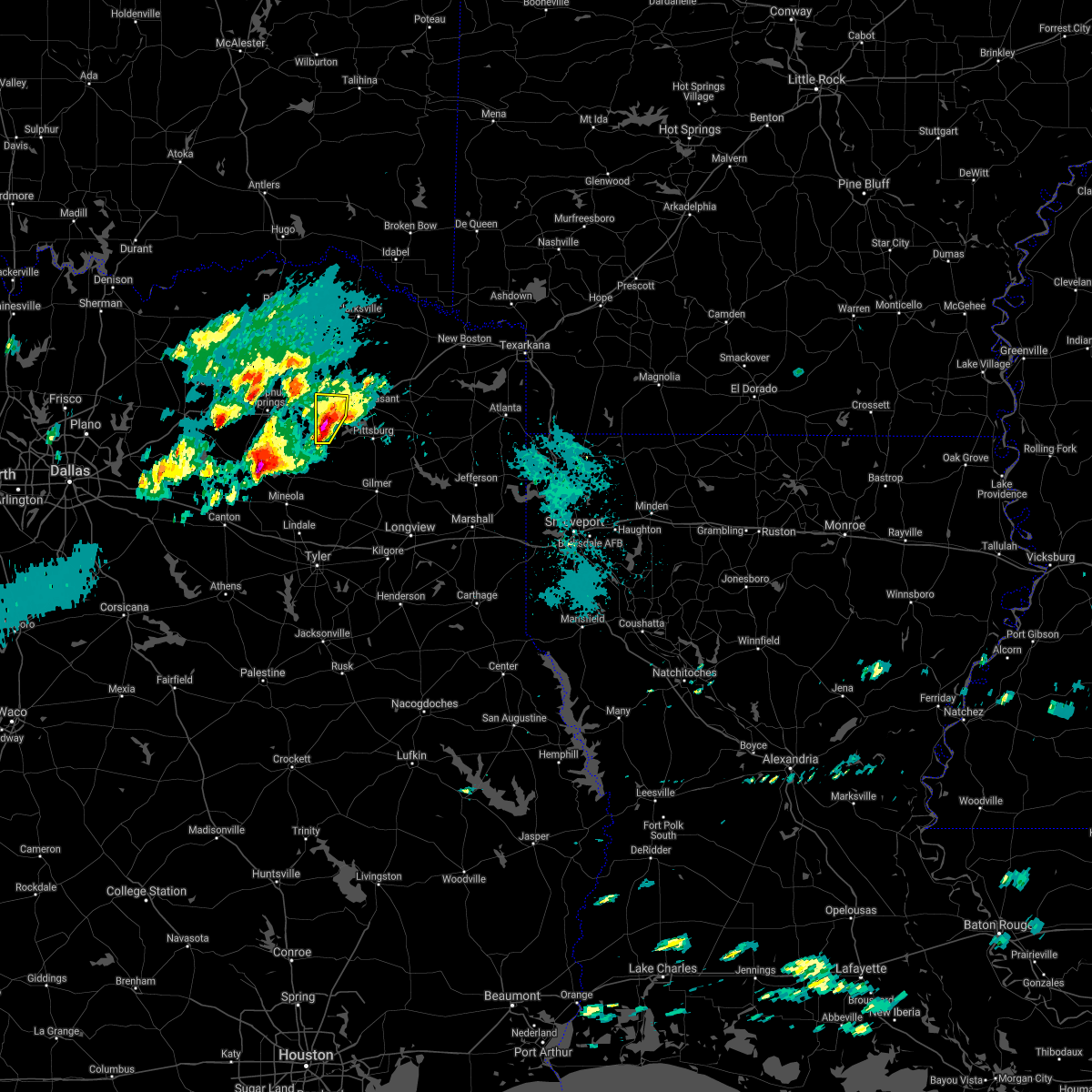 At 710 pm cdt, a severe thunderstorm was located near purley, or 7 miles north of winnsboro, moving northeast at 30 mph (radar indicated). Hazards include ping pong ball size hail and 60 mph wind gusts. People and animals outdoors will be injured. expect hail damage to roofs, siding, windows, and vehicles. expect wind damage to roofs, siding, and trees. Locations impacted include, winnsboro, mount vernon, purley, cypress and hopewell. At 710 pm cdt, a severe thunderstorm was located near purley, or 7 miles north of winnsboro, moving northeast at 30 mph (radar indicated). Hazards include ping pong ball size hail and 60 mph wind gusts. People and animals outdoors will be injured. expect hail damage to roofs, siding, windows, and vehicles. expect wind damage to roofs, siding, and trees. Locations impacted include, winnsboro, mount vernon, purley, cypress and hopewell.
|
| 3/24/2021 6:49 PM CDT |
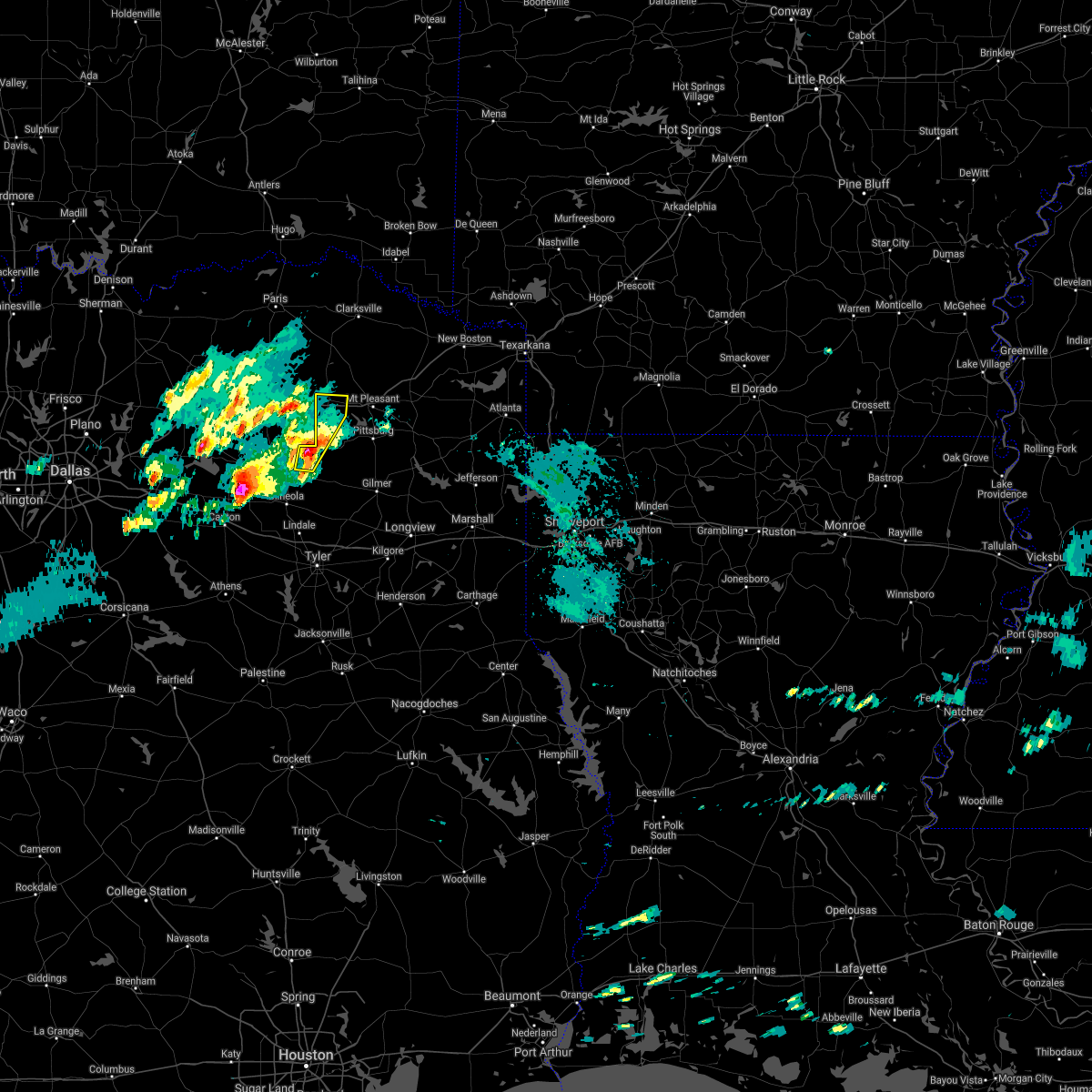 At 648 pm cdt, a severe thunderstorm was located over pleasant grove, or just west of winnsboro, moving northeast at 25 mph (radar indicated). Hazards include 60 mph wind gusts and half dollar size hail. Hail damage to vehicles is expected. Expect wind damage to roofs, siding, and trees. At 648 pm cdt, a severe thunderstorm was located over pleasant grove, or just west of winnsboro, moving northeast at 25 mph (radar indicated). Hazards include 60 mph wind gusts and half dollar size hail. Hail damage to vehicles is expected. Expect wind damage to roofs, siding, and trees.
|
| 3/17/2021 6:58 AM CDT |
 At 611 am cdt, severe thunderstorms were located along a line extending from east tawakoni to near canton to near purtis creek state park, moving northeast at 55 mph (radar indicated). Hazards include 70 mph wind gusts and penny size hail. Expect considerable tree damage. Damage is likely to mobile homes, roofs, and outbuildings. At 611 am cdt, severe thunderstorms were located along a line extending from east tawakoni to near canton to near purtis creek state park, moving northeast at 55 mph (radar indicated). Hazards include 70 mph wind gusts and penny size hail. Expect considerable tree damage. Damage is likely to mobile homes, roofs, and outbuildings.
|
| 3/17/2021 6:12 AM CDT |
 At 611 am cdt, severe thunderstorms were located along a line extending from east tawakoni to near canton to near purtis creek state park, moving northeast at 55 mph (radar indicated). Hazards include 70 mph wind gusts and penny size hail. Expect considerable tree damage. Damage is likely to mobile homes, roofs, and outbuildings. At 611 am cdt, severe thunderstorms were located along a line extending from east tawakoni to near canton to near purtis creek state park, moving northeast at 55 mph (radar indicated). Hazards include 70 mph wind gusts and penny size hail. Expect considerable tree damage. Damage is likely to mobile homes, roofs, and outbuildings.
|
| 5/24/2020 4:21 PM CDT |
 At 421 pm cdt, severe thunderstorms were located along a line extending from near scroggins to near pittsburg to near rocky branch, moving north at 45 mph (radar indicated. large hail and damaging winds have been reported throughout upshur county with these storms). Hazards include 60 mph wind gusts and quarter size hail. Hail damage to vehicles is expected. Expect wind damage to roofs, siding, and trees. At 421 pm cdt, severe thunderstorms were located along a line extending from near scroggins to near pittsburg to near rocky branch, moving north at 45 mph (radar indicated. large hail and damaging winds have been reported throughout upshur county with these storms). Hazards include 60 mph wind gusts and quarter size hail. Hail damage to vehicles is expected. Expect wind damage to roofs, siding, and trees.
|
| 5/24/2020 4:16 PM CDT |
 At 415 pm cdt, severe thunderstorms were located along a line extending from near cason to newsome to near winnsboro, moving north at 40 mph (radar indicated. at 410 pm, large hail was reported in gilmer, and a tree was on a vehicle in the harmony community). Hazards include 60 mph wind gusts and quarter size hail. Hail damage to vehicles is expected. expect wind damage to roofs, siding, and trees. Locations impacted include, gilmer, pittsburg, winnsboro, leesburg, rosewood, newsome, midway, rocky mound, perryville, holly springs, lafayette, center point, bettie and grice. At 415 pm cdt, severe thunderstorms were located along a line extending from near cason to newsome to near winnsboro, moving north at 40 mph (radar indicated. at 410 pm, large hail was reported in gilmer, and a tree was on a vehicle in the harmony community). Hazards include 60 mph wind gusts and quarter size hail. Hail damage to vehicles is expected. expect wind damage to roofs, siding, and trees. Locations impacted include, gilmer, pittsburg, winnsboro, leesburg, rosewood, newsome, midway, rocky mound, perryville, holly springs, lafayette, center point, bettie and grice.
|
| 5/24/2020 3:59 PM CDT | A tree was down on fm 2869 about 1 mile south of highway 15 in wood county TX, 15.1 miles NNW of Winnsboro, TX |
| 5/24/2020 3:43 PM CDT |
 At 343 pm cdt, severe thunderstorms were located along a line extending from near east mountain to near gladewater to 9 miles west of liberty city to near brownsboro, moving north at 35 mph (radar indicated. at 340 pm, trees were downed east of kilgore with these storms). Hazards include 60 mph wind gusts and nickel size hail. expect damage to roofs, siding, and trees At 343 pm cdt, severe thunderstorms were located along a line extending from near east mountain to near gladewater to 9 miles west of liberty city to near brownsboro, moving north at 35 mph (radar indicated. at 340 pm, trees were downed east of kilgore with these storms). Hazards include 60 mph wind gusts and nickel size hail. expect damage to roofs, siding, and trees
|
| 5/8/2020 4:51 AM CDT |
 At 450 am cdt, severe thunderstorms were located along a line extending from near mount vernon to near mount pleasant to omaha, moving south at 55 mph (radar indicated). Hazards include 60 mph wind gusts and quarter size hail. Hail damage to vehicles is expected. Expect wind damage to roofs, siding, and trees. At 450 am cdt, severe thunderstorms were located along a line extending from near mount vernon to near mount pleasant to omaha, moving south at 55 mph (radar indicated). Hazards include 60 mph wind gusts and quarter size hail. Hail damage to vehicles is expected. Expect wind damage to roofs, siding, and trees.
|
| 5/8/2020 4:34 AM CDT |
 At 433 am cdt, severe thunderstorms were located along a line extending from 8 miles southwest of new boston to near dalby springs to near wilkerson to 8 miles southwest of deport, moving southeast at 55 mph (radar indicated). Hazards include 60 mph wind gusts and quarter size hail. Hail damage to vehicles is expected. expect wind damage to roofs, siding, and trees. Locations impacted include, mount pleasant, pittsburg, winnsboro, clarksville, leesburg, hagansport, boxelder, mount vernon, daingerfield, hughes springs, naples, bogata, omaha, cason, us 259 and i 30 intersection, cookville, scroggins, rocky branch, wilkerson and jenkins. At 433 am cdt, severe thunderstorms were located along a line extending from 8 miles southwest of new boston to near dalby springs to near wilkerson to 8 miles southwest of deport, moving southeast at 55 mph (radar indicated). Hazards include 60 mph wind gusts and quarter size hail. Hail damage to vehicles is expected. expect wind damage to roofs, siding, and trees. Locations impacted include, mount pleasant, pittsburg, winnsboro, clarksville, leesburg, hagansport, boxelder, mount vernon, daingerfield, hughes springs, naples, bogata, omaha, cason, us 259 and i 30 intersection, cookville, scroggins, rocky branch, wilkerson and jenkins.
|
| 5/8/2020 3:58 AM CDT |
 At 358 am cdt, a severe thunderstorm was located near clarksville, moving southeast at 60 mph (radar indicated). Hazards include 60 mph wind gusts and quarter size hail. Hail damage to vehicles is expected. Expect wind damage to roofs, siding, and trees. At 358 am cdt, a severe thunderstorm was located near clarksville, moving southeast at 60 mph (radar indicated). Hazards include 60 mph wind gusts and quarter size hail. Hail damage to vehicles is expected. Expect wind damage to roofs, siding, and trees.
|
| 4/29/2020 12:07 AM CDT |
 At 1207 am cdt, severe thunderstorms were located along a line extending from near emory to 7 miles southwest of como to near winnsboro to newsome to near lone star, moving south at 50 mph (radar indicated). Hazards include 60 mph wind gusts and quarter size hail. Hail damage to vehicles is expected. Expect wind damage to roofs, siding, and trees. At 1207 am cdt, severe thunderstorms were located along a line extending from near emory to 7 miles southwest of como to near winnsboro to newsome to near lone star, moving south at 50 mph (radar indicated). Hazards include 60 mph wind gusts and quarter size hail. Hail damage to vehicles is expected. Expect wind damage to roofs, siding, and trees.
|
| 4/28/2020 11:54 PM CDT |
 At 1154 pm cdt, severe thunderstorms were located along a line extending from 7 miles northwest of purley to near mount pleasant to near omaha to near naples to 8 miles northeast of queen city, moving southeast at 60 mph (radar indicated). Hazards include 70 mph wind gusts and quarter size hail. Hail damage to vehicles is expected. expect considerable tree damage. wind damage is also likely to mobile homes, roofs, and outbuildings. Locations impacted include, mount pleasant, atlanta, pittsburg, winnsboro, leesburg, mount vernon, daingerfield, linden, hughes springs, lone star, queen city, naples, omaha, bivins, cason, us 259 and i 30 intersection, cookville, scroggins, pleasant grove and rocky branch. At 1154 pm cdt, severe thunderstorms were located along a line extending from 7 miles northwest of purley to near mount pleasant to near omaha to near naples to 8 miles northeast of queen city, moving southeast at 60 mph (radar indicated). Hazards include 70 mph wind gusts and quarter size hail. Hail damage to vehicles is expected. expect considerable tree damage. wind damage is also likely to mobile homes, roofs, and outbuildings. Locations impacted include, mount pleasant, atlanta, pittsburg, winnsboro, leesburg, mount vernon, daingerfield, linden, hughes springs, lone star, queen city, naples, omaha, bivins, cason, us 259 and i 30 intersection, cookville, scroggins, pleasant grove and rocky branch.
|
| 4/28/2020 11:26 PM CDT |
 At 1125 pm cdt, severe thunderstorms were located along a line extending from 8 miles west of hagansport to 6 miles southeast of bogata to near boxelder to near hooks, moving south at 45 mph (radar indicated). Hazards include 60 mph wind gusts and quarter size hail. Hail damage to vehicles is expected. Expect wind damage to roofs, siding, and trees. At 1125 pm cdt, severe thunderstorms were located along a line extending from 8 miles west of hagansport to 6 miles southeast of bogata to near boxelder to near hooks, moving south at 45 mph (radar indicated). Hazards include 60 mph wind gusts and quarter size hail. Hail damage to vehicles is expected. Expect wind damage to roofs, siding, and trees.
|
| 10/21/2019 2:29 AM CDT |
 At 228 am cdt, severe thunderstorms were located along a line extending from winnsboro to near quitman to 7 miles west of canton, moving east at 35 mph (radar indicated). Hazards include 60 mph wind gusts and quarter size hail. Hail damage to vehicles is expected. Expect wind damage to roofs, siding, and trees. At 228 am cdt, severe thunderstorms were located along a line extending from winnsboro to near quitman to 7 miles west of canton, moving east at 35 mph (radar indicated). Hazards include 60 mph wind gusts and quarter size hail. Hail damage to vehicles is expected. Expect wind damage to roofs, siding, and trees.
|
| 10/21/2019 2:12 AM CDT |
 At 212 am cdt, severe thunderstorms were located along a line extending from 13 miles south of idabel to near boxelder to near purley, moving east at 50 mph (radar indicated). Hazards include 60 mph wind gusts and quarter size hail. Hail damage to vehicles is expected. expect wind damage to roofs, siding, and trees. Locations impacted include, mount pleasant, winnsboro, clarksville, hagansport, boxelder, mount vernon, de kalb, bogata, wilkerson, purley, scroggins, winfield, talco, avery, annona, miller`s cove, beaverdams, lydia, johntown and almont. At 212 am cdt, severe thunderstorms were located along a line extending from 13 miles south of idabel to near boxelder to near purley, moving east at 50 mph (radar indicated). Hazards include 60 mph wind gusts and quarter size hail. Hail damage to vehicles is expected. expect wind damage to roofs, siding, and trees. Locations impacted include, mount pleasant, winnsboro, clarksville, hagansport, boxelder, mount vernon, de kalb, bogata, wilkerson, purley, scroggins, winfield, talco, avery, annona, miller`s cove, beaverdams, lydia, johntown and almont.
|
| 10/21/2019 1:35 AM CDT |
 At 135 am cdt, severe thunderstorms were located along a line extending from 9 miles west of manchester to 7 miles southwest of deport to hawk cove, moving east at 50 mph (radar indicated). Hazards include 60 mph wind gusts and quarter size hail. Hail damage to vehicles is expected. Expect wind damage to roofs, siding, and trees. At 135 am cdt, severe thunderstorms were located along a line extending from 9 miles west of manchester to 7 miles southwest of deport to hawk cove, moving east at 50 mph (radar indicated). Hazards include 60 mph wind gusts and quarter size hail. Hail damage to vehicles is expected. Expect wind damage to roofs, siding, and trees.
|
| 10/21/2019 12:21 AM CDT | Quarter sized hail reported 7 miles SW of Winnsboro, TX |
| 10/20/2019 11:24 PM CDT |
 At 1124 pm cdt, severe thunderstorms were located along a line extending from 9 miles south of sulphur springs to near golden to near fruitvale, moving east at 40 mph (radar indicated). Hazards include 70 mph wind gusts and half dollar size hail. Hail damage to vehicles is expected. expect considerable tree damage. Wind damage is also likely to mobile homes, roofs, and outbuildings. At 1124 pm cdt, severe thunderstorms were located along a line extending from 9 miles south of sulphur springs to near golden to near fruitvale, moving east at 40 mph (radar indicated). Hazards include 70 mph wind gusts and half dollar size hail. Hail damage to vehicles is expected. expect considerable tree damage. Wind damage is also likely to mobile homes, roofs, and outbuildings.
|
| 6/19/2019 11:30 PM CDT |
 At 1130 pm cdt, a severe thunderstorm was located near hainesville, or 10 miles northeast of mineola, moving east at 35 mph (radar indicated). Hazards include ping pong ball size hail and 60 mph wind gusts. People and animals outdoors will be injured. expect hail damage to roofs, siding, windows, and vehicles. Expect wind damage to roofs, siding, and trees. At 1130 pm cdt, a severe thunderstorm was located near hainesville, or 10 miles northeast of mineola, moving east at 35 mph (radar indicated). Hazards include ping pong ball size hail and 60 mph wind gusts. People and animals outdoors will be injured. expect hail damage to roofs, siding, windows, and vehicles. Expect wind damage to roofs, siding, and trees.
|
| 6/19/2019 11:05 PM CDT |
 At 1104 pm cdt, a severe thunderstorm was located 9 miles northeast of hainesville, or 9 miles south of winnsboro, moving east at 45 mph (radar indicated). Hazards include golf ball size hail and 60 mph wind gusts. People and animals outdoors will be injured. expect hail damage to roofs, siding, windows, and vehicles. expect wind damage to roofs, siding, and trees. Locations impacted include, gilmer, pittsburg, winnsboro, leesburg, quitman, rosewood, scroggins, pleasant grove, newsome, west mountain, purley, hainesville, forest hill, alba, yantis, midway, rocky mound, perryville, lafayette and cypress. At 1104 pm cdt, a severe thunderstorm was located 9 miles northeast of hainesville, or 9 miles south of winnsboro, moving east at 45 mph (radar indicated). Hazards include golf ball size hail and 60 mph wind gusts. People and animals outdoors will be injured. expect hail damage to roofs, siding, windows, and vehicles. expect wind damage to roofs, siding, and trees. Locations impacted include, gilmer, pittsburg, winnsboro, leesburg, quitman, rosewood, scroggins, pleasant grove, newsome, west mountain, purley, hainesville, forest hill, alba, yantis, midway, rocky mound, perryville, lafayette and cypress.
|
| 6/19/2019 10:35 PM CDT |
 At 1034 pm cdt, a severe thunderstorm was located 9 miles east of emory, or 15 miles south of sulphur springs, moving east at 45 mph (radar indicated). Hazards include golf ball size hail and 60 mph wind gusts. People and animals outdoors will be injured. expect hail damage to roofs, siding, windows, and vehicles. Expect wind damage to roofs, siding, and trees. At 1034 pm cdt, a severe thunderstorm was located 9 miles east of emory, or 15 miles south of sulphur springs, moving east at 45 mph (radar indicated). Hazards include golf ball size hail and 60 mph wind gusts. People and animals outdoors will be injured. expect hail damage to roofs, siding, windows, and vehicles. Expect wind damage to roofs, siding, and trees.
|
| 6/19/2019 9:55 PM CDT |
 At 954 pm cdt, a severe thunderstorm was located 8 miles northwest of purley, or 13 miles east of sulphur springs, moving east at 40 mph (radar indicated). Hazards include golf ball size hail and 60 mph wind gusts. People and animals outdoors will be injured. expect hail damage to roofs, siding, windows, and vehicles. Expect wind damage to roofs, siding, and trees. At 954 pm cdt, a severe thunderstorm was located 8 miles northwest of purley, or 13 miles east of sulphur springs, moving east at 40 mph (radar indicated). Hazards include golf ball size hail and 60 mph wind gusts. People and animals outdoors will be injured. expect hail damage to roofs, siding, windows, and vehicles. Expect wind damage to roofs, siding, and trees.
|
| 6/19/2019 7:22 PM CDT |
 At 721 pm cdt, severe thunderstorms were located along a line extending from 6 miles east of mount vernon to scroggins to pleasant grove, moving southeast at 25 mph (radar indicated). Hazards include golf ball size hail and 60 mph wind gusts. People and animals outdoors will be injured. expect hail damage to roofs, siding, windows, and vehicles. expect wind damage to roofs, siding, and trees. Locations impacted include, mount pleasant, pittsburg, winnsboro, leesburg, mount vernon, scroggins, pleasant grove, newsome, purley, winfield, midway, miller`s cove, rocky mound, perryville, hopewell, monticello, roeder, harvard, cypress and grice. At 721 pm cdt, severe thunderstorms were located along a line extending from 6 miles east of mount vernon to scroggins to pleasant grove, moving southeast at 25 mph (radar indicated). Hazards include golf ball size hail and 60 mph wind gusts. People and animals outdoors will be injured. expect hail damage to roofs, siding, windows, and vehicles. expect wind damage to roofs, siding, and trees. Locations impacted include, mount pleasant, pittsburg, winnsboro, leesburg, mount vernon, scroggins, pleasant grove, newsome, purley, winfield, midway, miller`s cove, rocky mound, perryville, hopewell, monticello, roeder, harvard, cypress and grice.
|
| 6/19/2019 7:15 PM CDT | Two large trees down just east of county road 4430 and fm 852 in wood count in wood county TX, 4.1 miles NW of Winnsboro, TX |
| 6/19/2019 7:10 PM CDT | Several large trees down blocking the roadwa in wood county TX, 0.2 miles NNE of Winnsboro, TX |
| 6/19/2019 7:02 PM CDT |
 At 701 pm cdt, severe thunderstorms were located along a line extending from near mount vernon to near winnsboro to 8 miles west of pleasant grove, moving southeast at 25 mph (radar indicated). Hazards include 60 mph wind gusts and half dollar size hail. Hail damage to vehicles is expected. Expect wind damage to roofs, siding, and trees. At 701 pm cdt, severe thunderstorms were located along a line extending from near mount vernon to near winnsboro to 8 miles west of pleasant grove, moving southeast at 25 mph (radar indicated). Hazards include 60 mph wind gusts and half dollar size hail. Hail damage to vehicles is expected. Expect wind damage to roofs, siding, and trees.
|
| 6/19/2019 6:21 PM CDT |
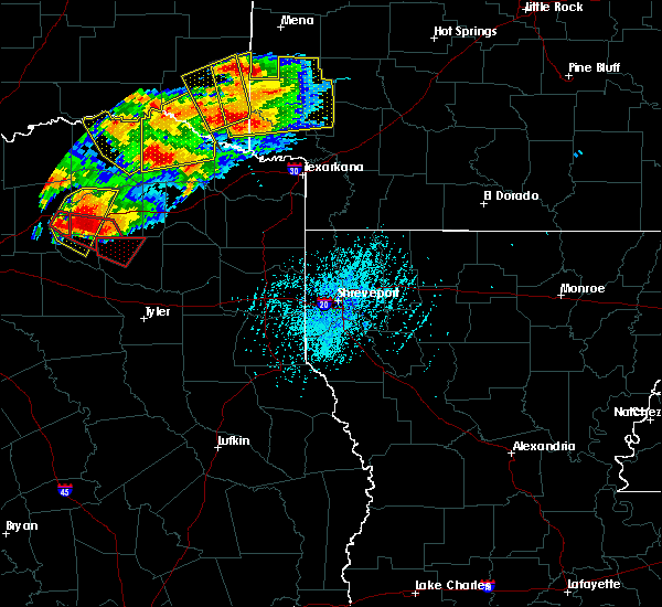 At 620 pm cdt, a severe thunderstorm capable of producing a tornado was located 7 miles north of emory, or 13 miles southwest of sulphur springs, moving southeast at 35 mph (radar indicated rotation). Hazards include tornado. Flying debris will be dangerous to those caught without shelter. mobile homes will be damaged or destroyed. damage to roofs, windows, and vehicles will occur. tree damage is likely. this dangerous storm will be near, quitman and pleasant grove around 700 pm cdt. Other locations impacted by this tornadic thunderstorm include yantis and forest hill. At 620 pm cdt, a severe thunderstorm capable of producing a tornado was located 7 miles north of emory, or 13 miles southwest of sulphur springs, moving southeast at 35 mph (radar indicated rotation). Hazards include tornado. Flying debris will be dangerous to those caught without shelter. mobile homes will be damaged or destroyed. damage to roofs, windows, and vehicles will occur. tree damage is likely. this dangerous storm will be near, quitman and pleasant grove around 700 pm cdt. Other locations impacted by this tornadic thunderstorm include yantis and forest hill.
|
| 5/29/2019 5:42 PM CDT | Trees reported down cr 4460 and hwy 11 blocking the roa in wood county TX, 5.2 miles W of Winnsboro, TX |
| 5/29/2019 5:19 PM CDT |
 At 519 pm cdt, a severe thunderstorm was located near scroggins, or near winnsboro, moving northeast at 35 mph (radar indicated). Hazards include 60 mph wind gusts and quarter size hail. Hail damage to vehicles is expected. expect wind damage to roofs, siding, and trees. Locations impacted include, winnsboro, leesburg, scroggins, newsome, winfield, miller`s cove, rocky mound, harvard, perryville, hopewell and monticello. At 519 pm cdt, a severe thunderstorm was located near scroggins, or near winnsboro, moving northeast at 35 mph (radar indicated). Hazards include 60 mph wind gusts and quarter size hail. Hail damage to vehicles is expected. expect wind damage to roofs, siding, and trees. Locations impacted include, winnsboro, leesburg, scroggins, newsome, winfield, miller`s cove, rocky mound, harvard, perryville, hopewell and monticello.
|
| 5/29/2019 5:02 PM CDT | Fm 115 about a quarter mile before the railroad track in scroggins a mobile home has a tree on it... and another home has a tree on it as well. no injuries reported as in franklin county TX, 6.4 miles W of Winnsboro, TX |
| 5/29/2019 4:56 PM CDT |
 At 455 pm cdt, a severe thunderstorm was located near pleasant grove, or 8 miles south of winnsboro, moving northeast at 35 mph (radar indicated). Hazards include 60 mph wind gusts and quarter size hail. Hail damage to vehicles is expected. Expect wind damage to roofs, siding, and trees. At 455 pm cdt, a severe thunderstorm was located near pleasant grove, or 8 miles south of winnsboro, moving northeast at 35 mph (radar indicated). Hazards include 60 mph wind gusts and quarter size hail. Hail damage to vehicles is expected. Expect wind damage to roofs, siding, and trees.
|
| 5/29/2019 4:55 PM CDT | Wind damage to chicken houses cr 446 in wood county TX, 5.4 miles WNW of Winnsboro, TX |
| 5/29/2019 4:48 PM CDT |
 At 447 pm cdt, a confirmed tornado was located over winnsboro, moving northeast at 35 mph (emergency management confirmed tornado). Hazards include damaging tornado and quarter size hail. Flying debris will be dangerous to those caught without shelter. mobile homes will be damaged or destroyed. damage to roofs, windows, and vehicles will occur. tree damage is likely. Locations impacted include, winnsboro, leesburg, scroggins, newsome, winfield, miller`s cove, rocky mound, hopewell and monticello. At 447 pm cdt, a confirmed tornado was located over winnsboro, moving northeast at 35 mph (emergency management confirmed tornado). Hazards include damaging tornado and quarter size hail. Flying debris will be dangerous to those caught without shelter. mobile homes will be damaged or destroyed. damage to roofs, windows, and vehicles will occur. tree damage is likely. Locations impacted include, winnsboro, leesburg, scroggins, newsome, winfield, miller`s cove, rocky mound, hopewell and monticello.
|
| 5/29/2019 4:34 PM CDT |
 At 434 pm cdt, a confirmed tornado was located near purley, or near winnsboro, moving northeast at 40 mph (law enforcement confirmed tornado). Hazards include damaging tornado and quarter size hail. Flying debris will be dangerous to those caught without shelter. mobile homes will be damaged or destroyed. damage to roofs, windows, and vehicles will occur. tree damage is likely. Locations impacted include, winnsboro. At 434 pm cdt, a confirmed tornado was located near purley, or near winnsboro, moving northeast at 40 mph (law enforcement confirmed tornado). Hazards include damaging tornado and quarter size hail. Flying debris will be dangerous to those caught without shelter. mobile homes will be damaged or destroyed. damage to roofs, windows, and vehicles will occur. tree damage is likely. Locations impacted include, winnsboro.
|
| 5/29/2019 4:32 PM CDT |
 At 432 pm cdt, a confirmed tornado was located near pleasant grove, or near winnsboro, moving northeast at 35 mph (emergency management confirmed tornado). Hazards include damaging tornado and quarter size hail. Flying debris will be dangerous to those caught without shelter. mobile homes will be damaged or destroyed. damage to roofs, windows, and vehicles will occur. Tree damage is likely. At 432 pm cdt, a confirmed tornado was located near pleasant grove, or near winnsboro, moving northeast at 35 mph (emergency management confirmed tornado). Hazards include damaging tornado and quarter size hail. Flying debris will be dangerous to those caught without shelter. mobile homes will be damaged or destroyed. damage to roofs, windows, and vehicles will occur. Tree damage is likely.
|
| 5/29/2019 4:27 PM CDT |
 At 427 pm cdt, a confirmed tornado was located north of quitman, moving northeast at 40 mph (law enforcement confirmed tornado). Hazards include damaging tornado and quarter size hail. Flying debris will be dangerous to those caught without shelter. mobile homes will be damaged or destroyed. damage to roofs, windows, and vehicles will occur. tree damage is likely. Locations impacted include, winnsboro, quitman and pleasant grove. At 427 pm cdt, a confirmed tornado was located north of quitman, moving northeast at 40 mph (law enforcement confirmed tornado). Hazards include damaging tornado and quarter size hail. Flying debris will be dangerous to those caught without shelter. mobile homes will be damaged or destroyed. damage to roofs, windows, and vehicles will occur. tree damage is likely. Locations impacted include, winnsboro, quitman and pleasant grove.
|
| 5/29/2019 4:10 PM CDT |
 At 410 pm cdt, a severe thunderstorm capable of producing a tornado was located near quitman, or 12 miles southwest of winnsboro, moving northeast at 40 mph (weather spotters reported a funnel cloud). Hazards include tornado and quarter size hail. Flying debris will be dangerous to those caught without shelter. mobile homes will be damaged or destroyed. damage to roofs, windows, and vehicles will occur. tree damage is likely. Locations impacted include, winnsboro, quitman, pleasant grove and forest hill. At 410 pm cdt, a severe thunderstorm capable of producing a tornado was located near quitman, or 12 miles southwest of winnsboro, moving northeast at 40 mph (weather spotters reported a funnel cloud). Hazards include tornado and quarter size hail. Flying debris will be dangerous to those caught without shelter. mobile homes will be damaged or destroyed. damage to roofs, windows, and vehicles will occur. tree damage is likely. Locations impacted include, winnsboro, quitman, pleasant grove and forest hill.
|
| 5/29/2019 3:59 PM CDT |
 At 359 pm cdt, a severe thunderstorm capable of producing a tornado was located over golden, or 7 miles northwest of mineola, moving northeast at 40 mph (weather spotters reported funnel cloud). Hazards include tornado and quarter size hail. Flying debris will be dangerous to those caught without shelter. mobile homes will be damaged or destroyed. damage to roofs, windows, and vehicles will occur. Tree damage is likely. At 359 pm cdt, a severe thunderstorm capable of producing a tornado was located over golden, or 7 miles northwest of mineola, moving northeast at 40 mph (weather spotters reported funnel cloud). Hazards include tornado and quarter size hail. Flying debris will be dangerous to those caught without shelter. mobile homes will be damaged or destroyed. damage to roofs, windows, and vehicles will occur. Tree damage is likely.
|
| 5/29/2019 3:32 PM CDT |
 At 332 pm cdt, a confirmed tornado was located over grand saline, or 10 miles west of mineola, moving northeast at 50 mph (emergency management confirmed tornado). Hazards include damaging tornado and golf ball size hail. Flying debris will be dangerous to those caught without shelter. mobile homes will be damaged or destroyed. damage to roofs, windows, and vehicles will occur. Tree damage is likely. At 332 pm cdt, a confirmed tornado was located over grand saline, or 10 miles west of mineola, moving northeast at 50 mph (emergency management confirmed tornado). Hazards include damaging tornado and golf ball size hail. Flying debris will be dangerous to those caught without shelter. mobile homes will be damaged or destroyed. damage to roofs, windows, and vehicles will occur. Tree damage is likely.
|
| 5/18/2019 5:49 PM CDT |
 At 512 pm cdt, severe thunderstorms were located along a line extending from near scroggins to hainesville to near van, moving east at 35 mph (radar indicated). Hazards include 60 mph wind gusts and penny size hail. expect damage to roofs, siding, and trees At 512 pm cdt, severe thunderstorms were located along a line extending from near scroggins to hainesville to near van, moving east at 35 mph (radar indicated). Hazards include 60 mph wind gusts and penny size hail. expect damage to roofs, siding, and trees
|
| 5/18/2019 5:42 PM CDT |
 At 541 pm cdt, severe thunderstorms were located along a line extending from near purley to near leesburg to 7 miles north of rosewood, moving northeast at 50 mph (radar indicated). Hazards include 60 mph wind gusts and quarter size hail. Hail damage to vehicles is expected. Expect wind damage to roofs, siding, and trees. At 541 pm cdt, severe thunderstorms were located along a line extending from near purley to near leesburg to 7 miles north of rosewood, moving northeast at 50 mph (radar indicated). Hazards include 60 mph wind gusts and quarter size hail. Hail damage to vehicles is expected. Expect wind damage to roofs, siding, and trees.
|
| 5/18/2019 5:12 PM CDT |
 At 512 pm cdt, severe thunderstorms were located along a line extending from near scroggins to hainesville to near van, moving east at 35 mph (radar indicated). Hazards include 60 mph wind gusts and penny size hail. expect damage to roofs, siding, and trees At 512 pm cdt, severe thunderstorms were located along a line extending from near scroggins to hainesville to near van, moving east at 35 mph (radar indicated). Hazards include 60 mph wind gusts and penny size hail. expect damage to roofs, siding, and trees
|
| 5/18/2019 4:54 PM CDT |
 At 454 pm cdt, severe thunderstorms were located along a line extending from 11 miles west of hagansport to 6 miles northwest of purley to near winnsboro, moving east at 55 mph (radar indicated). Hazards include 70 mph wind gusts and quarter size hail. Hail damage to vehicles is expected. expect considerable tree damage. Wind damage is also likely to mobile homes, roofs, and outbuildings. At 454 pm cdt, severe thunderstorms were located along a line extending from 11 miles west of hagansport to 6 miles northwest of purley to near winnsboro, moving east at 55 mph (radar indicated). Hazards include 70 mph wind gusts and quarter size hail. Hail damage to vehicles is expected. expect considerable tree damage. Wind damage is also likely to mobile homes, roofs, and outbuildings.
|
| 5/18/2019 4:48 PM CDT |
 At 448 pm cdt, severe thunderstorms were located along a line extending from 9 miles east of sulphur springs to near como to near quitman to golden to van, moving east at 55 mph. these are very dangerous storms (radar indicated. numerous trees and power lines have been blown down across kaufman, van zandt, and rains counties with these storms). Hazards include 80 mph wind gusts and quarter size hail. Flying debris will be dangerous to those caught without shelter. mobile homes will be heavily damaged. expect considerable damage to roofs, windows, and vehicles. extensive tree damage and power outages are likely. Locations impacted include, mineola, winnsboro, lindale, mount vernon, quitman, hawkins, hoard, scroggins, pleasant grove, purley, hainesville, golden, forest hill, alba, yantis, red springs, perryville, carroll and cypress. At 448 pm cdt, severe thunderstorms were located along a line extending from 9 miles east of sulphur springs to near como to near quitman to golden to van, moving east at 55 mph. these are very dangerous storms (radar indicated. numerous trees and power lines have been blown down across kaufman, van zandt, and rains counties with these storms). Hazards include 80 mph wind gusts and quarter size hail. Flying debris will be dangerous to those caught without shelter. mobile homes will be heavily damaged. expect considerable damage to roofs, windows, and vehicles. extensive tree damage and power outages are likely. Locations impacted include, mineola, winnsboro, lindale, mount vernon, quitman, hawkins, hoard, scroggins, pleasant grove, purley, hainesville, golden, forest hill, alba, yantis, red springs, perryville, carroll and cypress.
|
| 5/18/2019 4:26 PM CDT |
 At 426 pm cdt, severe thunderstorms were located along a line extending from 7 miles northeast of east tawakoni to near emory to 6 miles north of grand saline to near canton to 9 miles northeast of purtis creek state park, moving east at 50 mph. these are very dangerous storms (radar indicated. widespread wind damage has been reported with these storms across kaufman and western van zandt counties with these storms). Hazards include 80 mph wind gusts and quarter size hail. Flying debris will be dangerous to those caught without shelter. mobile homes will be heavily damaged. expect considerable damage to roofs, windows, and vehicles. Extensive tree damage and power outages are likely. At 426 pm cdt, severe thunderstorms were located along a line extending from 7 miles northeast of east tawakoni to near emory to 6 miles north of grand saline to near canton to 9 miles northeast of purtis creek state park, moving east at 50 mph. these are very dangerous storms (radar indicated. widespread wind damage has been reported with these storms across kaufman and western van zandt counties with these storms). Hazards include 80 mph wind gusts and quarter size hail. Flying debris will be dangerous to those caught without shelter. mobile homes will be heavily damaged. expect considerable damage to roofs, windows, and vehicles. Extensive tree damage and power outages are likely.
|
| 5/1/2019 10:19 PM CDT |
 At 1019 pm cdt, severe thunderstorms were located along a line extending from 6 miles northwest of mount pleasant to near hainesville, moving east at 40 mph (radar indicated). Hazards include quarter size hail. damage to vehicles is expected At 1019 pm cdt, severe thunderstorms were located along a line extending from 6 miles northwest of mount pleasant to near hainesville, moving east at 40 mph (radar indicated). Hazards include quarter size hail. damage to vehicles is expected
|
| 4/6/2019 12:09 PM CDT |
 At 1209 pm cdt, a line of severe thunderstorms was located near emory, or 14 miles south of sulphur springs, moving east at 35 mph (radar indicated). Hazards include 60 mph wind gusts. expect damage to roofs, siding, and trees At 1209 pm cdt, a line of severe thunderstorms was located near emory, or 14 miles south of sulphur springs, moving east at 35 mph (radar indicated). Hazards include 60 mph wind gusts. expect damage to roofs, siding, and trees
|
| 3/25/2019 1:45 AM CDT | Quarter sized hail reported 0.5 miles S of Winnsboro, TX, social media report. |
| 3/25/2019 1:20 AM CDT | Golf Ball sized hail reported 9.9 miles NW of Winnsboro, TX, golfball size hail reported in perryville. |
| 3/25/2019 1:07 AM CDT | Ping Pong Ball sized hail reported 0.9 miles N of Winnsboro, TX, ping pong ball sized hail fell on the south side of winnsboro. report via mping. |
| 3/25/2019 1:07 AM CDT | Quarter sized hail reported 0.5 miles S of Winnsboro, TX, corrects previous hail report from winnsboro. social media report. |
| 3/25/2019 1:03 AM CDT |
 At 103 am cdt, a severe thunderstorm capable of producing a tornado was located over pleasant grove, or near winnsboro, moving east at 35 mph (radar indicated rotation). Hazards include tornado and golf ball size hail. Flying debris will be dangerous to those caught without shelter. mobile homes will be damaged or destroyed. damage to roofs, windows, and vehicles will occur. tree damage is likely. this dangerous storm will be near, scroggins around 120 am cdt. Other locations impacted by this tornadic thunderstorm include perryville and cypress. At 103 am cdt, a severe thunderstorm capable of producing a tornado was located over pleasant grove, or near winnsboro, moving east at 35 mph (radar indicated rotation). Hazards include tornado and golf ball size hail. Flying debris will be dangerous to those caught without shelter. mobile homes will be damaged or destroyed. damage to roofs, windows, and vehicles will occur. tree damage is likely. this dangerous storm will be near, scroggins around 120 am cdt. Other locations impacted by this tornadic thunderstorm include perryville and cypress.
|
| 3/25/2019 1:02 AM CDT | Hen Egg sized hail reported 0.5 miles S of Winnsboro, TX, golf ball to hen egg size hail in city limits of winnsboro. |
| 3/25/2019 12:47 AM CDT |
 At 1247 am cdt, a severe thunderstorm capable of producing a tornado was located near como, or 12 miles west of winnsboro, moving east at 35 mph (radar indicated rotation). Hazards include tornado and golf ball size hail. Flying debris will be dangerous to those caught without shelter. mobile homes will be damaged or destroyed. damage to roofs, windows, and vehicles will occur. tree damage is likely. this dangerous storm will be near, pleasant grove around 100 am cdt. winnsboro around 110 am cdt. scroggins around 120 am cdt. Other locations impacted by this tornadic thunderstorm include perryville and cypress. At 1247 am cdt, a severe thunderstorm capable of producing a tornado was located near como, or 12 miles west of winnsboro, moving east at 35 mph (radar indicated rotation). Hazards include tornado and golf ball size hail. Flying debris will be dangerous to those caught without shelter. mobile homes will be damaged or destroyed. damage to roofs, windows, and vehicles will occur. tree damage is likely. this dangerous storm will be near, pleasant grove around 100 am cdt. winnsboro around 110 am cdt. scroggins around 120 am cdt. Other locations impacted by this tornadic thunderstorm include perryville and cypress.
|
| 3/14/2019 1:56 AM CDT |
 At 155 am cdt, severe thunderstorms were located along a line extending from near winnsboro to 6 miles west of edom, moving east at 35 mph (radar indicated). Hazards include 60 mph wind gusts and quarter size hail. Hail damage to vehicles is expected. Expect wind damage to roofs, siding, and trees. At 155 am cdt, severe thunderstorms were located along a line extending from near winnsboro to 6 miles west of edom, moving east at 35 mph (radar indicated). Hazards include 60 mph wind gusts and quarter size hail. Hail damage to vehicles is expected. Expect wind damage to roofs, siding, and trees.
|
| 3/14/2019 1:42 AM CDT |
 At 142 am cdt, severe thunderstorms were located along a line extending from 9 miles south of idabel to near como, moving east at 35 mph (radar indicated). Hazards include 60 mph wind gusts and penny size hail. expect damage to roofs, siding, and trees At 142 am cdt, severe thunderstorms were located along a line extending from 9 miles south of idabel to near como, moving east at 35 mph (radar indicated). Hazards include 60 mph wind gusts and penny size hail. expect damage to roofs, siding, and trees
|
| 3/9/2019 8:41 AM CST |
 At 840 am cst, severe thunderstorms were located along a line extending from near bogata to near fruitvale, moving east at 70 mph (radar indicated). Hazards include 60 mph wind gusts and quarter size hail. Hail damage to vehicles is expected. Expect wind damage to roofs, siding, and trees. At 840 am cst, severe thunderstorms were located along a line extending from near bogata to near fruitvale, moving east at 70 mph (radar indicated). Hazards include 60 mph wind gusts and quarter size hail. Hail damage to vehicles is expected. Expect wind damage to roofs, siding, and trees.
|
| 12/1/2018 12:07 AM CST |
 At 1206 am cst, a severe thunderstorm was located near emory, or 15 miles northwest of mineola, moving east at 45 mph (radar indicated). Hazards include 60 mph wind gusts and quarter size hail. Hail damage to vehicles is expected. Expect wind damage to roofs, siding, and trees. At 1206 am cst, a severe thunderstorm was located near emory, or 15 miles northwest of mineola, moving east at 45 mph (radar indicated). Hazards include 60 mph wind gusts and quarter size hail. Hail damage to vehicles is expected. Expect wind damage to roofs, siding, and trees.
|
| 11/30/2018 11:44 PM CST |
 At 1143 pm cst, severe thunderstorms were located along a line extending from near bogata to 6 miles east of hagansport to near mount vernon to near como, moving east at 45 mph (radar indicated). Hazards include 60 mph wind gusts and penny size hail. Expect damage to roofs, siding, and trees. Locations impacted include, mount pleasant, winnsboro, clarksville, hagansport, boxelder, mount vernon, bogata, omaha, us 259 and i 30 intersection, wilkerson, cookville, purley, winfield, talco, annona, miller`s cove, hopewell, harts bluff, monticello and cuthand. At 1143 pm cst, severe thunderstorms were located along a line extending from near bogata to 6 miles east of hagansport to near mount vernon to near como, moving east at 45 mph (radar indicated). Hazards include 60 mph wind gusts and penny size hail. Expect damage to roofs, siding, and trees. Locations impacted include, mount pleasant, winnsboro, clarksville, hagansport, boxelder, mount vernon, bogata, omaha, us 259 and i 30 intersection, wilkerson, cookville, purley, winfield, talco, annona, miller`s cove, hopewell, harts bluff, monticello and cuthand.
|
| 11/30/2018 11:23 PM CST |
 At 1123 pm cst, a severe thunderstorm was located 7 miles east of sulphur springs, moving northeast at 60 mph (radar indicated). Hazards include 60 mph wind gusts and penny size hail. expect damage to roofs, siding, and trees At 1123 pm cst, a severe thunderstorm was located 7 miles east of sulphur springs, moving northeast at 60 mph (radar indicated). Hazards include 60 mph wind gusts and penny size hail. expect damage to roofs, siding, and trees
|
| 7/6/2018 3:15 PM CDT |
 At 314 pm cdt, severe thunderstorms were located along a line extending from 6 miles north of leesburg to van, moving west at 20 mph (radar indicated). Hazards include 60 mph wind gusts and quarter size hail. Hail damage to vehicles is expected. expect wind damage to roofs, siding, and trees. Locations impacted include, winnsboro, quitman, scroggins, pleasant grove, golden, forest hill, alba and yantis. At 314 pm cdt, severe thunderstorms were located along a line extending from 6 miles north of leesburg to van, moving west at 20 mph (radar indicated). Hazards include 60 mph wind gusts and quarter size hail. Hail damage to vehicles is expected. expect wind damage to roofs, siding, and trees. Locations impacted include, winnsboro, quitman, scroggins, pleasant grove, golden, forest hill, alba and yantis.
|
| 7/6/2018 2:58 PM CDT |
 At 258 pm cdt, severe thunderstorms were located along a line extending from near pittsburg to near van, moving west at 15 mph (radar indicated). Hazards include 60 mph wind gusts and quarter size hail. Hail damage to vehicles is expected. expect wind damage to roofs, siding, and trees. Locations impacted include, mineola, pittsburg, winnsboro, leesburg, quitman, scroggins, pleasant grove, newsome, hainesville, golden, forest hill, alba, yantis, rocky mound and perryville. At 258 pm cdt, severe thunderstorms were located along a line extending from near pittsburg to near van, moving west at 15 mph (radar indicated). Hazards include 60 mph wind gusts and quarter size hail. Hail damage to vehicles is expected. expect wind damage to roofs, siding, and trees. Locations impacted include, mineola, pittsburg, winnsboro, leesburg, quitman, scroggins, pleasant grove, newsome, hainesville, golden, forest hill, alba, yantis, rocky mound and perryville.
|
| 7/6/2018 2:44 PM CDT |
 At 243 pm cdt, severe thunderstorms were located along a line extending from near pittsburg to near van, moving west at 20 mph (radar indicated). Hazards include 60 mph wind gusts. Expect damage to roofs, siding, and trees. Locations impacted include, mineola, pittsburg, winnsboro, leesburg, quitman, hoard, scroggins, pleasant grove, newsome, hainesville, golden, forest hill, alba, yantis, rocky mound, perryville and carroll. At 243 pm cdt, severe thunderstorms were located along a line extending from near pittsburg to near van, moving west at 20 mph (radar indicated). Hazards include 60 mph wind gusts. Expect damage to roofs, siding, and trees. Locations impacted include, mineola, pittsburg, winnsboro, leesburg, quitman, hoard, scroggins, pleasant grove, newsome, hainesville, golden, forest hill, alba, yantis, rocky mound, perryville and carroll.
|
| 7/6/2018 2:30 PM CDT |
 At 229 pm cdt, severe thunderstorms were located along a line extending from near leesburg to near lindale, moving west at 20 mph (radar indicated). Hazards include 60 mph wind gusts. expect damage to roofs, siding, and trees At 229 pm cdt, severe thunderstorms were located along a line extending from near leesburg to near lindale, moving west at 20 mph (radar indicated). Hazards include 60 mph wind gusts. expect damage to roofs, siding, and trees
|
| 5/23/2018 4:43 PM CDT |
 At 443 pm cdt, a severe thunderstorm was located near purley, or 7 miles northeast of winnsboro, moving west at 10 mph (radar indicated). Hazards include 60 mph wind gusts and quarter size hail. Hail damage to vehicles is expected. Expect wind damage to roofs, siding, and trees. At 443 pm cdt, a severe thunderstorm was located near purley, or 7 miles northeast of winnsboro, moving west at 10 mph (radar indicated). Hazards include 60 mph wind gusts and quarter size hail. Hail damage to vehicles is expected. Expect wind damage to roofs, siding, and trees.
|
| 4/13/2018 10:57 PM CDT |
 At 1057 pm cdt, severe thunderstorms were located along a line extending from near wilkerson to near pittsburg to 7 miles north of gilmer to near white oak to near joinerville, moving northeast at 85 mph (radar indicated). Hazards include golf ball size hail and 60 mph wind gusts. People and animals outdoors will be injured. expect hail damage to roofs, siding, windows, and vehicles. Expect wind damage to roofs, siding, and trees. At 1057 pm cdt, severe thunderstorms were located along a line extending from near wilkerson to near pittsburg to 7 miles north of gilmer to near white oak to near joinerville, moving northeast at 85 mph (radar indicated). Hazards include golf ball size hail and 60 mph wind gusts. People and animals outdoors will be injured. expect hail damage to roofs, siding, windows, and vehicles. Expect wind damage to roofs, siding, and trees.
|
| 4/13/2018 10:40 PM CDT |
 At 1039 pm cdt, severe thunderstorms were located along a line extending from scroggins to 6 miles southwest of liberty city to near turnertown to near maydelle, moving northeast at 45 mph (trained weather spotters). Hazards include golf ball size hail and 60 mph wind gusts. People and animals outdoors will be injured. expect hail damage to roofs, siding, windows, and vehicles. expect wind damage to roofs, siding, and trees. locations impacted include, tyler, longview, nacogdoches, jacksonville, henderson, kilgore, whitehouse, white oak, gladewater, rusk, gilmer, mineola, winnsboro, lindale, chandler, overton, bullard, troup, quitman and big sandy. A tornado watch remains in effect until 600 am cdt for eastern and northeastern texas. At 1039 pm cdt, severe thunderstorms were located along a line extending from scroggins to 6 miles southwest of liberty city to near turnertown to near maydelle, moving northeast at 45 mph (trained weather spotters). Hazards include golf ball size hail and 60 mph wind gusts. People and animals outdoors will be injured. expect hail damage to roofs, siding, windows, and vehicles. expect wind damage to roofs, siding, and trees. locations impacted include, tyler, longview, nacogdoches, jacksonville, henderson, kilgore, whitehouse, white oak, gladewater, rusk, gilmer, mineola, winnsboro, lindale, chandler, overton, bullard, troup, quitman and big sandy. A tornado watch remains in effect until 600 am cdt for eastern and northeastern texas.
|
| 4/13/2018 10:24 PM CDT |
 At 1023 pm cdt, severe thunderstorms were located along a line extending from near quitman to near tyler to near elkhart, moving east at 50 mph (trained weather spotters). Hazards include 60 mph wind gusts and quarter size hail. Hail damage to vehicles is expected. expect wind damage to roofs, siding, and trees. locations impacted include, tyler, longview, nacogdoches, jacksonville, henderson, kilgore, whitehouse, white oak, gladewater, rusk, gilmer, mineola, winnsboro, lindale, chandler, overton, bullard, troup, quitman and big sandy. A tornado watch remains in effect until 600 am cdt for eastern and northeastern texas. At 1023 pm cdt, severe thunderstorms were located along a line extending from near quitman to near tyler to near elkhart, moving east at 50 mph (trained weather spotters). Hazards include 60 mph wind gusts and quarter size hail. Hail damage to vehicles is expected. expect wind damage to roofs, siding, and trees. locations impacted include, tyler, longview, nacogdoches, jacksonville, henderson, kilgore, whitehouse, white oak, gladewater, rusk, gilmer, mineola, winnsboro, lindale, chandler, overton, bullard, troup, quitman and big sandy. A tornado watch remains in effect until 600 am cdt for eastern and northeastern texas.
|
| 4/13/2018 10:00 PM CDT |
 At 959 pm cdt, severe thunderstorms were located along a line extending from near grand saline to near chandler to 13 miles northeast of buffalo, moving east at 65 mph (radar indicated). Hazards include 60 mph wind gusts and quarter size hail. Hail damage to vehicles is expected. Expect wind damage to roofs, siding, and trees. At 959 pm cdt, severe thunderstorms were located along a line extending from near grand saline to near chandler to 13 miles northeast of buffalo, moving east at 65 mph (radar indicated). Hazards include 60 mph wind gusts and quarter size hail. Hail damage to vehicles is expected. Expect wind damage to roofs, siding, and trees.
|
| 3/11/2018 4:40 AM CDT |
 At 440 am cdt, severe thunderstorms were located along a line extending from near scroggins to near emory, moving southeast at 25 mph (radar indicated). Hazards include 60 mph wind gusts and quarter size hail. Hail damage to vehicles is expected. Expect wind damage to roofs, siding, and trees. At 440 am cdt, severe thunderstorms were located along a line extending from near scroggins to near emory, moving southeast at 25 mph (radar indicated). Hazards include 60 mph wind gusts and quarter size hail. Hail damage to vehicles is expected. Expect wind damage to roofs, siding, and trees.
|
| 1/21/2018 8:37 PM CST |
 The tornado warning for north central wood county will expire at 845 pm cst, the storm which prompted the warning has moved out of the area. therefore the warning will be allowed to expire. a tornado watch remains in effect until 1100 pm cst for northeastern texas. The tornado warning for north central wood county will expire at 845 pm cst, the storm which prompted the warning has moved out of the area. therefore the warning will be allowed to expire. a tornado watch remains in effect until 1100 pm cst for northeastern texas.
|
| 1/21/2018 8:27 PM CST | Numerous trees down... power lines down on north side of winnsboro and north of winnsbor in franklin county TX, 2.5 miles S of Winnsboro, TX |
| 1/21/2018 8:24 PM CST |
 At 823 pm cst, a severe thunderstorm capable of producing a tornado was located over winnsboro, moving northeast at 40 mph (radar indicated rotation). Hazards include tornado. Flying debris will be dangerous to those caught without shelter. mobile homes will be damaged or destroyed. damage to roofs, windows, and vehicles will occur. Tree damage is likely. At 823 pm cst, a severe thunderstorm capable of producing a tornado was located over winnsboro, moving northeast at 40 mph (radar indicated rotation). Hazards include tornado. Flying debris will be dangerous to those caught without shelter. mobile homes will be damaged or destroyed. damage to roofs, windows, and vehicles will occur. Tree damage is likely.
|
| 1/21/2018 8:13 PM CST |
 At 813 pm cst, a severe thunderstorm capable of producing a tornado was located over pleasant grove, or 8 miles southwest of winnsboro, moving northeast at 30 mph (radar indicated rotation). Hazards include tornado and quarter size hail. Flying debris will be dangerous to those caught without shelter. mobile homes will be damaged or destroyed. damage to roofs, windows, and vehicles will occur. Tree damage is likely. At 813 pm cst, a severe thunderstorm capable of producing a tornado was located over pleasant grove, or 8 miles southwest of winnsboro, moving northeast at 30 mph (radar indicated rotation). Hazards include tornado and quarter size hail. Flying debris will be dangerous to those caught without shelter. mobile homes will be damaged or destroyed. damage to roofs, windows, and vehicles will occur. Tree damage is likely.
|
| 4/29/2017 9:15 PM CDT |
 At 914 pm cdt, severe thunderstorms were located along a line extending from near winnsboro to near chandler, moving northeast at 55 mph (radar indicated). Hazards include 60 mph wind gusts and quarter size hail. Hail damage to vehicles is expected. Expect wind damage to roofs, siding, and trees. At 914 pm cdt, severe thunderstorms were located along a line extending from near winnsboro to near chandler, moving northeast at 55 mph (radar indicated). Hazards include 60 mph wind gusts and quarter size hail. Hail damage to vehicles is expected. Expect wind damage to roofs, siding, and trees.
|
| 4/29/2017 8:08 PM CDT |
 At 807 pm cdt, a severe thunderstorm was located near golden, or 8 miles west of mineola, moving northeast at 40 mph (radar indicated). Hazards include 70 mph wind gusts and quarter size hail. Hail damage to vehicles is expected. expect considerable tree damage. wind damage is also likely to mobile homes, roofs, and outbuildings. locations impacted include, mineola, winnsboro, quitman, pleasant grove, hainesville, golden, forest hill, alba and yantis. A tornado watch remains in effect until 1000 pm cdt for northeastern texas. At 807 pm cdt, a severe thunderstorm was located near golden, or 8 miles west of mineola, moving northeast at 40 mph (radar indicated). Hazards include 70 mph wind gusts and quarter size hail. Hail damage to vehicles is expected. expect considerable tree damage. wind damage is also likely to mobile homes, roofs, and outbuildings. locations impacted include, mineola, winnsboro, quitman, pleasant grove, hainesville, golden, forest hill, alba and yantis. A tornado watch remains in effect until 1000 pm cdt for northeastern texas.
|
| 4/29/2017 7:59 PM CDT |
 At 759 pm cdt, a severe thunderstorm was located near mount vernon, or 8 miles south of hagansport, moving northeast at 45 mph (radar indicated). Hazards include 70 mph wind gusts and quarter size hail. Hail damage to vehicles is expected. expect considerable tree damage. Wind damage is also likely to mobile homes, roofs, and outbuildings. At 759 pm cdt, a severe thunderstorm was located near mount vernon, or 8 miles south of hagansport, moving northeast at 45 mph (radar indicated). Hazards include 70 mph wind gusts and quarter size hail. Hail damage to vehicles is expected. expect considerable tree damage. Wind damage is also likely to mobile homes, roofs, and outbuildings.
|
| 4/29/2017 7:47 PM CDT |
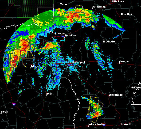 At 746 pm cdt, a severe thunderstorm was located over pleasant grove, or 7 miles west of winnsboro, moving east northeast at 55 mph. this is a very dangerous storm (radar indicated). Hazards include 80 mph wind gusts and quarter size hail. Flying debris will be dangerous to those caught without shelter. mobile homes will be heavily damaged. expect considerable damage to roofs, windows, and vehicles. Extensive tree damage and power outages are likely. At 746 pm cdt, a severe thunderstorm was located over pleasant grove, or 7 miles west of winnsboro, moving east northeast at 55 mph. this is a very dangerous storm (radar indicated). Hazards include 80 mph wind gusts and quarter size hail. Flying debris will be dangerous to those caught without shelter. mobile homes will be heavily damaged. expect considerable damage to roofs, windows, and vehicles. Extensive tree damage and power outages are likely.
|
| 2/27/2017 5:45 PM CST |
 At 545 pm cst, a severe thunderstorm was located near scroggins, or near leesburg, moving east at 30 mph (radar indicated). Hazards include golf ball size hail and 60 mph wind gusts. People and animals outdoors will be injured. expect hail damage to roofs, siding, windows, and vehicles. expect wind damage to roofs, siding, and trees. Locations impacted include, pittsburg, winnsboro, leesburg, scroggins, newsome, rocky mound and perryville. At 545 pm cst, a severe thunderstorm was located near scroggins, or near leesburg, moving east at 30 mph (radar indicated). Hazards include golf ball size hail and 60 mph wind gusts. People and animals outdoors will be injured. expect hail damage to roofs, siding, windows, and vehicles. expect wind damage to roofs, siding, and trees. Locations impacted include, pittsburg, winnsboro, leesburg, scroggins, newsome, rocky mound and perryville.
|
| 2/27/2017 5:31 PM CST |
 At 530 pm cst, a severe thunderstorm was located near winnsboro, moving east at 30 mph (radar indicated). Hazards include golf ball size hail and 60 mph wind gusts. People and animals outdoors will be injured. expect hail damage to roofs, siding, windows, and vehicles. expect wind damage to roofs, siding, and trees. This storm produced golfball sized hail and strong winds earlier over lake fork. At 530 pm cst, a severe thunderstorm was located near winnsboro, moving east at 30 mph (radar indicated). Hazards include golf ball size hail and 60 mph wind gusts. People and animals outdoors will be injured. expect hail damage to roofs, siding, windows, and vehicles. expect wind damage to roofs, siding, and trees. This storm produced golfball sized hail and strong winds earlier over lake fork.
|
| 2/27/2017 5:02 PM CST |
 At 502 pm cst, a severe thunderstorm was located near pleasant grove, or 12 miles southwest of winnsboro, moving east at 30 mph (radar indicated). Hazards include golf ball size hail and 60 mph wind gusts. People and animals outdoors will be injured. expect hail damage to roofs, siding, windows, and vehicles. expect wind damage to roofs, siding, and trees. Locations impacted include, winnsboro, pleasant grove and yantis. At 502 pm cst, a severe thunderstorm was located near pleasant grove, or 12 miles southwest of winnsboro, moving east at 30 mph (radar indicated). Hazards include golf ball size hail and 60 mph wind gusts. People and animals outdoors will be injured. expect hail damage to roofs, siding, windows, and vehicles. expect wind damage to roofs, siding, and trees. Locations impacted include, winnsboro, pleasant grove and yantis.
|
| 2/27/2017 4:44 PM CST |
 At 444 pm cst, a severe thunderstorm was located 7 miles east of emory, or 16 miles northwest of mineola, moving northeast at 40 mph (radar indicated). Hazards include 60 mph wind gusts and quarter size hail. Hail damage to vehicles is expected. Expect wind damage to roofs, siding, and trees. At 444 pm cst, a severe thunderstorm was located 7 miles east of emory, or 16 miles northwest of mineola, moving northeast at 40 mph (radar indicated). Hazards include 60 mph wind gusts and quarter size hail. Hail damage to vehicles is expected. Expect wind damage to roofs, siding, and trees.
|
| 1/2/2017 6:31 AM CST |
 At 631 am cst, severe thunderstorms were located along a line extending from near campbell to near fruitvale to 7 miles west of edom to 11 miles west of frankston to 10 miles west of elkhart, moving east at 60 mph (radar indicated). Hazards include 60 mph wind gusts and quarter size hail. Hail damage to vehicles is expected. Expect wind damage to roofs, siding, and trees. At 631 am cst, severe thunderstorms were located along a line extending from near campbell to near fruitvale to 7 miles west of edom to 11 miles west of frankston to 10 miles west of elkhart, moving east at 60 mph (radar indicated). Hazards include 60 mph wind gusts and quarter size hail. Hail damage to vehicles is expected. Expect wind damage to roofs, siding, and trees.
|
| 7/15/2016 3:23 PM CDT |
 At 322 pm cdt, a severe thunderstorm was located over scroggins, or near winnsboro, moving east at 25 mph (radar indicated). Hazards include 60 mph wind gusts and quarter size hail. Hail damage to vehicles is expected. expect wind damage to roofs, siding, and trees. Locations impacted include, winnsboro, leesburg, newsome, scroggins, rocky mound, perryville and monticello. At 322 pm cdt, a severe thunderstorm was located over scroggins, or near winnsboro, moving east at 25 mph (radar indicated). Hazards include 60 mph wind gusts and quarter size hail. Hail damage to vehicles is expected. expect wind damage to roofs, siding, and trees. Locations impacted include, winnsboro, leesburg, newsome, scroggins, rocky mound, perryville and monticello.
|
| 7/15/2016 3:10 PM CDT | Tree down on hwy 11 west in wood county TX, 1.9 miles ESE of Winnsboro, TX |
| 7/15/2016 3:10 PM CDT |
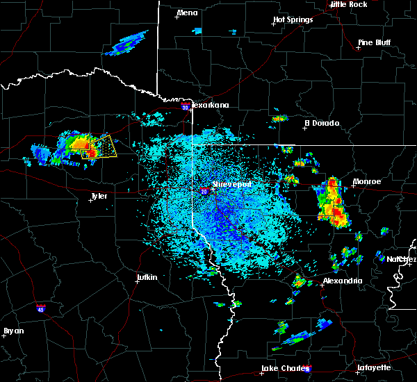 At 310 pm cdt, a severe thunderstorm was located over winnsboro, moving east northeast at 25 mph (radar indicated). Hazards include 60 mph wind gusts and quarter size hail. Hail damage to vehicles is expected. expect wind damage to roofs, siding, and trees. Locations impacted include, winnsboro, leesburg, newsome, scroggins, rocky mound, perryville and monticello. At 310 pm cdt, a severe thunderstorm was located over winnsboro, moving east northeast at 25 mph (radar indicated). Hazards include 60 mph wind gusts and quarter size hail. Hail damage to vehicles is expected. expect wind damage to roofs, siding, and trees. Locations impacted include, winnsboro, leesburg, newsome, scroggins, rocky mound, perryville and monticello.
|
| 7/15/2016 2:57 PM CDT |
 At 256 pm cdt, a severe thunderstorm was located near pleasant grove, or near winnsboro, moving east northeast at 30 mph (radar indicated). Hazards include 60 mph wind gusts and quarter size hail. Hail damage to vehicles is expected. Expect wind damage to roofs, siding, and trees. At 256 pm cdt, a severe thunderstorm was located near pleasant grove, or near winnsboro, moving east northeast at 30 mph (radar indicated). Hazards include 60 mph wind gusts and quarter size hail. Hail damage to vehicles is expected. Expect wind damage to roofs, siding, and trees.
|
| 4/29/2016 1:37 PM CDT |
 At 136 pm cdt, a severe thunderstorm was located near hainesville, or 11 miles northeast of mineola, moving northeast at 40 mph (radar indicated). Hazards include 60 mph wind gusts and quarter size hail. Hail damage to vehicles is expected. Expect wind damage to roofs, siding, and trees. At 136 pm cdt, a severe thunderstorm was located near hainesville, or 11 miles northeast of mineola, moving northeast at 40 mph (radar indicated). Hazards include 60 mph wind gusts and quarter size hail. Hail damage to vehicles is expected. Expect wind damage to roofs, siding, and trees.
|
| 4/29/2016 12:22 PM CDT |
 At 1222 pm cdt, a severe thunderstorm was located near lindale, or 9 miles south of mineola, moving northeast at 50 mph (radar indicated). Hazards include 60 mph wind gusts and half dollar size hail. Hail damage to vehicles is expected. Expect wind damage to roofs, siding, and trees. At 1222 pm cdt, a severe thunderstorm was located near lindale, or 9 miles south of mineola, moving northeast at 50 mph (radar indicated). Hazards include 60 mph wind gusts and half dollar size hail. Hail damage to vehicles is expected. Expect wind damage to roofs, siding, and trees.
|
| 4/27/2016 12:43 AM CDT |
 At 1243 am cdt, severe thunderstorms were located along a line extending from near pleasant grove to 6 miles northwest of edom to near trinidad, moving east at 45 mph (radar indicated). Hazards include 60 mph wind gusts and quarter size hail. Hail damage to vehicles is expected. Expect wind damage to roofs, siding, and trees. At 1243 am cdt, severe thunderstorms were located along a line extending from near pleasant grove to 6 miles northwest of edom to near trinidad, moving east at 45 mph (radar indicated). Hazards include 60 mph wind gusts and quarter size hail. Hail damage to vehicles is expected. Expect wind damage to roofs, siding, and trees.
|
| 4/11/2016 6:50 PM CDT | Baseball sized hail reported 8.5 miles N of Winnsboro, TX, public post photo of baseball size hail in east point community on kltv facebook. |
| 4/11/2016 6:48 PM CDT | Ping Pong Ball sized hail reported 6.4 miles W of Winnsboro, TX, public post photo of ping pong size hail in scroggins community on kltv facebook page. |
| 4/11/2016 6:03 PM CDT | Half Dollar sized hail reported 9.5 miles WNW of Winnsboro, TX, trained spotter reports half dollar sized hail... |
| 4/11/2016 5:53 PM CDT | Tennis Ball sized hail reported 6.2 miles WNW of Winnsboro, TX, between two and three inch diameter size hail fell in the pineview community near the wood...camp...and upshur county line. |
| 4/11/2016 5:50 PM CDT | Hen Egg sized hail reported 5.8 miles N of Winnsboro, TX, public post photo of 2 inch hail in the stout community on kltv facebook. |
| 4/11/2016 5:50 PM CDT | Baseball sized hail reported 8.5 miles N of Winnsboro, TX, public post photo of baseball size hail in east point community on kltv facebook. |
| 4/11/2016 5:48 PM CDT | Ping Pong Ball sized hail reported 6.4 miles W of Winnsboro, TX, public post photo of ping pong size hail in scroggins community on kltv facebook page. |
| 4/11/2016 5:48 PM CDT |
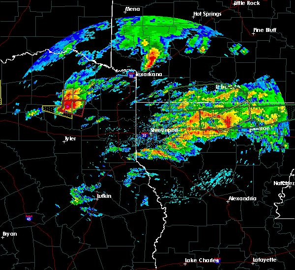 At 547 pm cdt, a severe thunderstorm capable of producing a tornado was located over scroggins, or near winnsboro, moving east at 40 mph (radar indicated rotation). Hazards include tornado and half dollar size hail. Flying debris will be dangerous to those caught without shelter. mobile homes will be damaged or destroyed. damage to roofs, windows, and vehicles will occur. tree damage is likely. this dangerous storm will be near, leesburg around 600 pm cdt. pittsburg around 610 pm cdt. Other locations impacted by this tornadic thunderstorm include rocky mound and perryville. At 547 pm cdt, a severe thunderstorm capable of producing a tornado was located over scroggins, or near winnsboro, moving east at 40 mph (radar indicated rotation). Hazards include tornado and half dollar size hail. Flying debris will be dangerous to those caught without shelter. mobile homes will be damaged or destroyed. damage to roofs, windows, and vehicles will occur. tree damage is likely. this dangerous storm will be near, leesburg around 600 pm cdt. pittsburg around 610 pm cdt. Other locations impacted by this tornadic thunderstorm include rocky mound and perryville.
|
| 4/11/2016 5:41 PM CDT | Hen Egg sized hail reported 0.5 miles S of Winnsboro, TX, a picture was posted to the kltv facebook page of large hail estimated to be between 2 and 2 1/2 inches in diameter that fell in winnsboro. |
| 4/11/2016 5:40 PM CDT | Golf Ball sized hail reported 5.1 miles NE of Winnsboro, TX, public post photo of golfball size hail near lake winnsboro on kltv facebook page. |
| 4/11/2016 5:29 PM CDT |
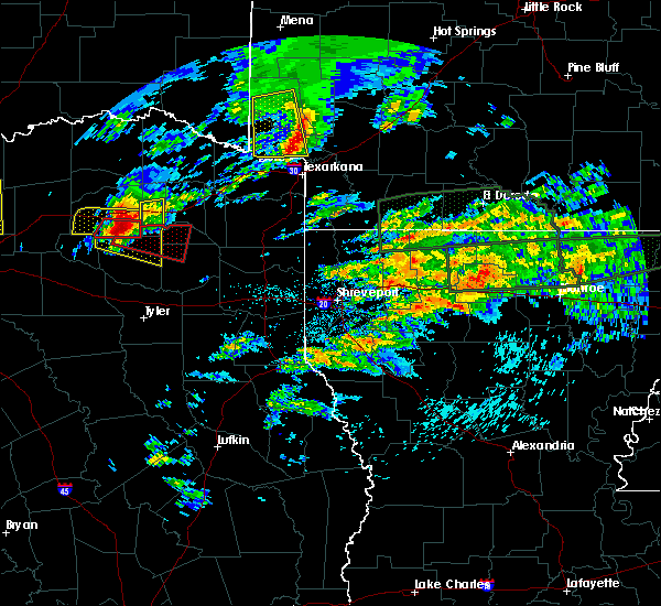 At 528 pm cdt, a severe thunderstorm capable of producing a tornado was located near pleasant grove, or 9 miles west of winnsboro, moving east at 40 mph (radar indicated rotation). Hazards include tornado and quarter size hail. Flying debris will be dangerous to those caught without shelter. mobile homes will be damaged or destroyed. damage to roofs, windows, and vehicles will occur. tree damage is likely. this dangerous storm will be near, winnsboro around 545 pm cdt. scroggins around 555 pm cdt. leesburg and newsome around 600 pm cdt. pittsburg around 610 pm cdt. Other locations impacted by this tornadic thunderstorm include rocky mound and perryville. At 528 pm cdt, a severe thunderstorm capable of producing a tornado was located near pleasant grove, or 9 miles west of winnsboro, moving east at 40 mph (radar indicated rotation). Hazards include tornado and quarter size hail. Flying debris will be dangerous to those caught without shelter. mobile homes will be damaged or destroyed. damage to roofs, windows, and vehicles will occur. tree damage is likely. this dangerous storm will be near, winnsboro around 545 pm cdt. scroggins around 555 pm cdt. leesburg and newsome around 600 pm cdt. pittsburg around 610 pm cdt. Other locations impacted by this tornadic thunderstorm include rocky mound and perryville.
|
| 4/11/2016 5:02 PM CDT |
 At 459 pm cdt, a severe thunderstorm was located around 15 miles northwest of yantis, moving east at 30 mph (radar indicated). Hazards include 60 mph wind gusts and quarter size hail. Hail damage to vehicles is expected. Expect wind damage to roofs, siding, and trees. At 459 pm cdt, a severe thunderstorm was located around 15 miles northwest of yantis, moving east at 30 mph (radar indicated). Hazards include 60 mph wind gusts and quarter size hail. Hail damage to vehicles is expected. Expect wind damage to roofs, siding, and trees.
|
| 3/30/2016 6:14 PM CDT |
 At 614 pm cdt, a severe thunderstorm capable of producing a tornado was located near hainesville, or 10 miles northeast of mineola, moving northeast at 45 mph (radar indicated rotation). Hazards include tornado and quarter size hail. Flying debris will be dangerous to those caught without shelter. mobile homes will be damaged or destroyed. damage to roofs, windows, and vehicles will occur. tree damage is likely. this dangerous storm will be near, winnsboro around 630 pm cdt. newsome and scroggins around 640 pm cdt. leesburg around 645 pm cdt. Other locations impacted by this tornadic thunderstorm include grice and perryville. At 614 pm cdt, a severe thunderstorm capable of producing a tornado was located near hainesville, or 10 miles northeast of mineola, moving northeast at 45 mph (radar indicated rotation). Hazards include tornado and quarter size hail. Flying debris will be dangerous to those caught without shelter. mobile homes will be damaged or destroyed. damage to roofs, windows, and vehicles will occur. tree damage is likely. this dangerous storm will be near, winnsboro around 630 pm cdt. newsome and scroggins around 640 pm cdt. leesburg around 645 pm cdt. Other locations impacted by this tornadic thunderstorm include grice and perryville.
|
| 3/30/2016 6:00 PM CDT |
 At 600 pm cdt, a severe thunderstorm was located near mineola, moving northeast at 45 mph (radar indicated). Hazards include 60 mph wind gusts and quarter size hail. Hail damage to vehicles is expected. Expect wind damage to roofs, siding, and trees. At 600 pm cdt, a severe thunderstorm was located near mineola, moving northeast at 45 mph (radar indicated). Hazards include 60 mph wind gusts and quarter size hail. Hail damage to vehicles is expected. Expect wind damage to roofs, siding, and trees.
|
| 3/24/2016 1:03 AM CDT |
 At 103 am cdt, severe thunderstorms were located along a line extending from near cookville to near scroggins to near hainesville, moving east southeast at 30 mph. these storms continue to show a weakening trend, and additional weakening is expected during the next 15 minutes (radar indicated). Hazards include 60 mph wind gusts. Expect damage to roofs. siding. and trees. Locations impacted include, mount pleasant, gladewater, gilmer, pittsburg, winnsboro, leesburg, big sandy, hawkins, cookville, west mountain, newsome, hainesville, rosewood, scroggins, winfield, midway, miller`s cove, rocky mound, bettie and lafayette. At 103 am cdt, severe thunderstorms were located along a line extending from near cookville to near scroggins to near hainesville, moving east southeast at 30 mph. these storms continue to show a weakening trend, and additional weakening is expected during the next 15 minutes (radar indicated). Hazards include 60 mph wind gusts. Expect damage to roofs. siding. and trees. Locations impacted include, mount pleasant, gladewater, gilmer, pittsburg, winnsboro, leesburg, big sandy, hawkins, cookville, west mountain, newsome, hainesville, rosewood, scroggins, winfield, midway, miller`s cove, rocky mound, bettie and lafayette.
|
| 3/24/2016 12:20 AM CDT |
 At 1220 am cdt, severe thunderstorms were located along a line extending from 8 miles southeast of cooper lake park south sulphur to 7 miles southwest of como to near golden, moving east at 45 mph (radar indicated). Hazards include 60 mph wind gusts and quarter size hail. Hail damage to vehicles is expected. Expect wind damage to roofs, siding, and trees. At 1220 am cdt, severe thunderstorms were located along a line extending from 8 miles southeast of cooper lake park south sulphur to 7 miles southwest of como to near golden, moving east at 45 mph (radar indicated). Hazards include 60 mph wind gusts and quarter size hail. Hail damage to vehicles is expected. Expect wind damage to roofs, siding, and trees.
|
| 3/8/2016 2:06 PM CST |
 The tornado warning for southwestern camp, northeastern wood, northwestern upshur and southwestern franklin counties will expire at 215 pm cst, the tornado threat has diminished and the tornado warning has been cancelled. however, hail and damaging winds remain likely and a severe thunderstorm warning remains in effect for the area. a tornado watch remains in effect until 600 pm cst for northeastern texas. remember, a severe thunderstorm warning still remains in effect until 300 pm cst. The tornado warning for southwestern camp, northeastern wood, northwestern upshur and southwestern franklin counties will expire at 215 pm cst, the tornado threat has diminished and the tornado warning has been cancelled. however, hail and damaging winds remain likely and a severe thunderstorm warning remains in effect for the area. a tornado watch remains in effect until 600 pm cst for northeastern texas. remember, a severe thunderstorm warning still remains in effect until 300 pm cst.
|
| 3/8/2016 1:58 PM CST |
 At 158 pm cst, severe thunderstorms were located along a line extending from near winnsboro to near rosewood to near big sandy, moving northeast at 35 mph (radar indicated). Hazards include 70 mph wind gusts and nickel size hail. Expect considerable tree damage. Damage is likely to mobile homes, roofs, and outbuildings. At 158 pm cst, severe thunderstorms were located along a line extending from near winnsboro to near rosewood to near big sandy, moving northeast at 35 mph (radar indicated). Hazards include 70 mph wind gusts and nickel size hail. Expect considerable tree damage. Damage is likely to mobile homes, roofs, and outbuildings.
|
| 3/8/2016 1:54 PM CST |
 At 154 pm cst, a severe thunderstorm capable of producing a tornado was located over scroggins, or near winnsboro, moving northeast at 60 mph (radar indicated rotation). Hazards include tornado. Flying debris will be dangerous to those caught without shelter. mobile homes will be damaged or destroyed. damage to roofs, windows, and vehicles will occur. tree damage is likely. Locations impacted include, winnsboro, newsome, scroggins and perryville. At 154 pm cst, a severe thunderstorm capable of producing a tornado was located over scroggins, or near winnsboro, moving northeast at 60 mph (radar indicated rotation). Hazards include tornado. Flying debris will be dangerous to those caught without shelter. mobile homes will be damaged or destroyed. damage to roofs, windows, and vehicles will occur. tree damage is likely. Locations impacted include, winnsboro, newsome, scroggins and perryville.
|
| 3/8/2016 1:44 PM CST |
 At 144 pm cst, a severe thunderstorm capable of producing a tornado was located near hainesville, or 11 miles south of winnsboro, moving northeast at 55 mph (radar indicated rotation). Hazards include tornado. Flying debris will be dangerous to those caught without shelter. mobile homes will be damaged or destroyed. damage to roofs, windows, and vehicles will occur. Tree damage is likely. At 144 pm cst, a severe thunderstorm capable of producing a tornado was located near hainesville, or 11 miles south of winnsboro, moving northeast at 55 mph (radar indicated rotation). Hazards include tornado. Flying debris will be dangerous to those caught without shelter. mobile homes will be damaged or destroyed. damage to roofs, windows, and vehicles will occur. Tree damage is likely.
|
| 3/8/2016 1:40 PM CST |
 At 140 pm cst, severe thunderstorms were located along a line extending from near pleasant grove to near hainesville to 6 miles southwest of hawkins to 7 miles north of bullard, moving northeast at 45 mph (radar indicated). Hazards include 70 mph wind gusts. Expect considerable tree damage. damage is likely to mobile homes, roofs, and outbuildings. locations impacted include, tyler, whitehouse, mineola, winnsboro, lindale, quitman, big sandy, hawkins, hoard, newsome, hainesville, rosewood, pleasant grove, scroggins, noonday, new chapel hill, winona, pritchett, grice and red springs. A tornado watch remains in effect until 600 pm cst for northeastern texas. At 140 pm cst, severe thunderstorms were located along a line extending from near pleasant grove to near hainesville to 6 miles southwest of hawkins to 7 miles north of bullard, moving northeast at 45 mph (radar indicated). Hazards include 70 mph wind gusts. Expect considerable tree damage. damage is likely to mobile homes, roofs, and outbuildings. locations impacted include, tyler, whitehouse, mineola, winnsboro, lindale, quitman, big sandy, hawkins, hoard, newsome, hainesville, rosewood, pleasant grove, scroggins, noonday, new chapel hill, winona, pritchett, grice and red springs. A tornado watch remains in effect until 600 pm cst for northeastern texas.
|
| 3/8/2016 1:11 PM CST |
 At 110 pm cst, severe thunderstorms were located along a line extending from near grand saline to van to near edom to 9 miles northwest of frankston, moving northeast at 50 mph (radar indicated). Hazards include 70 mph wind gusts. Expect considerable tree damage. Damage is likely to mobile homes, roofs, and outbuildings. At 110 pm cst, severe thunderstorms were located along a line extending from near grand saline to van to near edom to 9 miles northwest of frankston, moving northeast at 50 mph (radar indicated). Hazards include 70 mph wind gusts. Expect considerable tree damage. Damage is likely to mobile homes, roofs, and outbuildings.
|
| 12/26/2015 4:16 PM CST |
 At 414 pm cst, a severe thunderstorm capable of producing a tornado was located near grand saline, or 14 miles northwest of mineola, moving northeast at 35 mph (radar indicated rotation). Hazards include tornado and quarter size hail. Mobile homes will be damaged or destroyed. damage to roofs, windows, and vehicles will occur. tree damage is likely. This tornadic thunderstorm will remain over mainly rural areas of northwestern wood county, including the following locations: forest hill, alba and yantis and the lake fork reservoir. At 414 pm cst, a severe thunderstorm capable of producing a tornado was located near grand saline, or 14 miles northwest of mineola, moving northeast at 35 mph (radar indicated rotation). Hazards include tornado and quarter size hail. Mobile homes will be damaged or destroyed. damage to roofs, windows, and vehicles will occur. tree damage is likely. This tornadic thunderstorm will remain over mainly rural areas of northwestern wood county, including the following locations: forest hill, alba and yantis and the lake fork reservoir.
|
| 12/12/2015 4:18 PM CST |
 At 417 pm cst, a severe thunderstorm capable of producing a tornado was located near winnsboro, moving north at 50 mph (radar indicated rotation). Hazards include tornado. Flying debris will be dangerous to those caught without shelter. mobile homes will be damaged or destroyed. damage to roofs, windows, and vehicles will occur. tree damage is likely. Locations impacted include, winnsboro, mount vernon, purley and cypress. At 417 pm cst, a severe thunderstorm capable of producing a tornado was located near winnsboro, moving north at 50 mph (radar indicated rotation). Hazards include tornado. Flying debris will be dangerous to those caught without shelter. mobile homes will be damaged or destroyed. damage to roofs, windows, and vehicles will occur. tree damage is likely. Locations impacted include, winnsboro, mount vernon, purley and cypress.
|
| 12/12/2015 3:56 PM CST |
 At 355 pm cst, a severe thunderstorm capable of producing a tornado was located 3 miles east of quitman, or 11 miles southwest of winnsboro, moving north at 45 mph (radar indicated rotation). Hazards include tornado. Flying debris will be dangerous to those caught without shelter. mobile homes will be damaged or destroyed. damage to roofs, windows, and vehicles will occur. Tree damage is likely. At 355 pm cst, a severe thunderstorm capable of producing a tornado was located 3 miles east of quitman, or 11 miles southwest of winnsboro, moving north at 45 mph (radar indicated rotation). Hazards include tornado. Flying debris will be dangerous to those caught without shelter. mobile homes will be damaged or destroyed. damage to roofs, windows, and vehicles will occur. Tree damage is likely.
|
| 11/5/2015 10:54 PM CST |
 At 1054 pm cst, severe thunderstorms were located along a line extending from near dalby springs to near us 259 and i 30 intersection to 6 miles northwest of omaha to cookville to near cason to near pittsburg, moving east at 45 mph (radar indicated). Hazards include 60 mph wind gusts and penny size hail. Expect damage to roofs. siding and trees. These severe thunderstorms will remain over mainly rural areas of southern red river, morris, camp, titus, southwestern bowie, northern wood, northwestern upshur and franklin counties, including the following locations, cypress, talco, holly springs, yantis, lafayette, miller`s cove, winfield, monticello, roeder and johntown. At 1054 pm cst, severe thunderstorms were located along a line extending from near dalby springs to near us 259 and i 30 intersection to 6 miles northwest of omaha to cookville to near cason to near pittsburg, moving east at 45 mph (radar indicated). Hazards include 60 mph wind gusts and penny size hail. Expect damage to roofs. siding and trees. These severe thunderstorms will remain over mainly rural areas of southern red river, morris, camp, titus, southwestern bowie, northern wood, northwestern upshur and franklin counties, including the following locations, cypress, talco, holly springs, yantis, lafayette, miller`s cove, winfield, monticello, roeder and johntown.
|
| 11/5/2015 10:16 PM CST |
 At 1015 pm cst, severe thunderstorms were located along a line extending from 7 miles southeast of bogata to near hagansport to near mount vernon to near purley to near como to near pleasant grove, moving east at 45 mph (radar indicated). Hazards include 60 mph wind gusts and penny size hail. Expect damage to roofs. siding and trees. severe thunderstorms will be near, hagansport and mount vernon around 1020 pm cst. scroggins and wilkerson around 1035 pm cst. mount pleasant and newsome around 1040 pm cst. leesburg around 1045 pm cst. pittsburg around 1050 pm cst. dalby springs, us 259 and i 30 intersection and cookville around 1055 pm cst. omaha, cason and rocky branch around 1105 pm cst. new boston, daingerfield, lone star, naples and jenkins around 1110 pm cst. Other locations impacted by these severe thunderstorms include cypress, talco, holly springs, yantis, lafayette, miller`s cove, winfield, monticello, roeder and johntown. At 1015 pm cst, severe thunderstorms were located along a line extending from 7 miles southeast of bogata to near hagansport to near mount vernon to near purley to near como to near pleasant grove, moving east at 45 mph (radar indicated). Hazards include 60 mph wind gusts and penny size hail. Expect damage to roofs. siding and trees. severe thunderstorms will be near, hagansport and mount vernon around 1020 pm cst. scroggins and wilkerson around 1035 pm cst. mount pleasant and newsome around 1040 pm cst. leesburg around 1045 pm cst. pittsburg around 1050 pm cst. dalby springs, us 259 and i 30 intersection and cookville around 1055 pm cst. omaha, cason and rocky branch around 1105 pm cst. new boston, daingerfield, lone star, naples and jenkins around 1110 pm cst. Other locations impacted by these severe thunderstorms include cypress, talco, holly springs, yantis, lafayette, miller`s cove, winfield, monticello, roeder and johntown.
|
| 5/30/2015 8:14 AM CDT | At 813 am cdt, severe thunderstorms were located along a line extending from near east tawakoni to near grand saline to 6 miles north of van to near edom to near chandler, moving east at 40 mph (radar indicated). Hazards include 60 mph wind gusts and quarter size hail. Hail damage to vehicles is expected. expect wind damage to roofs, siding and trees. severe thunderstorms will be near, golden around 825 am cdt. mineola and lindale around 830 am cdt. hoard around 835 am cdt. whitehouse, quitman and hainesville around 840 am cdt. tyler around 845 am cdt. hawkins around 850 am cdt. big sandy, arp and pleasant grove around 855 am cdt. overton and rosewood around 905 am cdt. Other locations impacted by these severe thunderstorms include pritchett, alba, noonday, yantis, grice, red springs, winona, new chapel hill, forest hill and perryville. |
| 5/25/2015 5:28 PM CDT | At 527 pm cdt, severe thunderstorms were located along a line extending from 6 miles southeast of clarksville to near mount pleasant to near leesburg, moving east at 60 mph (radar indicated). Hazards include 60 mph wind gusts and quarter size hail. Hail damage to vehicles is expected. Expect wind damage to roofs, siding and trees. |
| 5/25/2015 5:28 PM CDT | At 527 pm cdt, severe thunderstorms were located along a line extending from 6 miles southeast of clarksville to near mount pleasant to near leesburg, moving east at 60 mph (radar indicated). Hazards include 60 mph wind gusts and quarter size hail. Hail damage to vehicles is expected. Expect wind damage to roofs, siding and trees. |
| 5/25/2015 5:28 PM CDT | At 527 pm cdt, severe thunderstorms were located along a line extending from 6 miles southeast of clarksville to near mount pleasant to near leesburg, moving east at 60 mph (radar indicated). Hazards include 60 mph wind gusts and quarter size hail. Hail damage to vehicles is expected. Expect wind damage to roofs, siding and trees. |
| 5/25/2015 5:22 PM CDT | Trees down in wood county TX, 0.5 miles S of Winnsboro, TX |
| 5/25/2015 5:15 PM CDT | Siding damage to homes and large wooden pool enclosure destroyed in camp county TX, 8.1 miles W of Winnsboro, TX |
| 5/25/2015 4:46 PM CDT | At 446 pm cdt, severe thunderstorms were located along a line extending from 9 miles northeast of cooper to 9 miles southwest of como to near canton, moving east at 85 mph (radar indicated). Hazards include 60 mph wind gusts and quarter size hail. Hail damage to vehicles is expected. Expect wind damage to roofs, siding and trees. |
| 5/25/2015 4:46 PM CDT | At 446 pm cdt, severe thunderstorms were located along a line extending from 9 miles northeast of cooper to 9 miles southwest of como to near canton, moving east at 85 mph (radar indicated). Hazards include 60 mph wind gusts and quarter size hail. Hail damage to vehicles is expected. Expect wind damage to roofs, siding and trees. |
| 5/10/2015 11:14 PM CDT | At 1114 pm cdt, severe thunderstorms were located along a line extending from near pleasant grove to near hawkins to near lindale, moving northeast at 25 mph (radar indicated). Hazards include 60 mph wind gusts and half dollar size hail. Hail damage to vehicles is expected. expect wind damage to roofs, siding and trees. severe thunderstorms will be near, winnsboro around 1125 pm cdt. rosewood around 1140 pm cdt. newsome around 1145 pm cdt. leesburg around 1150 pm cdt. gilmer and big sandy around 1155 pm cdt. pittsburg around 1205 am cdt. other locations impacted by these severe thunderstorms include pritchett, noonday, bettie, grice, midway, harvard, red springs, winona, new chapel hill and rocky mound. a tornado watch remains in effect until midnight cdt for northeastern texas. 1. 25in. |
| 4/24/2015 7:59 PM CDT | At 758 pm cdt, severe thunderstorms were located along a line extending from near como to near canton, moving east at 45 mph (radar indicated). Hazards include 60 mph wind gusts and quarter size hail. Hail damage to vehicles is expected. Expect wind damage to roofs, siding and trees. |
| 4/16/2015 6:17 PM CDT | At 616 pm cdt, a severe thunderstorm was located over golden, or near mineola, moving east at 15 mph. another severe thunderstorm was located near yantis or over lake fork this storm was moving northeast at 10 mph (radar indicated). Hazards include 60 mph wind gusts and quarter size hail. Hail damage to vehicles is expected. Expect wind damage to roofs, siding and trees. |
| 9/11/2013 5:15 PM CDT | Trees down across southern part of the county south of interstate 30 in franklin county TX, 6.6 miles SW of Winnsboro, TX |
| 8/31/2013 6:25 PM CDT | Tree down southeast of winnsboro along hwy 852e and cr 449 in wood county TX, 5 miles NW of Winnsboro, TX |
| 2/10/2013 5:15 AM CST | Power line down in wood county TX, 0.5 miles S of Winnsboro, TX |
| 1/29/2013 6:45 PM CST | A couple trees down in tow in wood county TX, 0.5 miles S of Winnsboro, TX |
| 8/9/2012 7:45 PM CDT | Numerous trees and powerlines downed in wood county TX, 0.5 miles S of Winnsboro, TX |
| 8/9/2012 7:25 PM CDT | Tree fell into house in winnsboro...chainsaws had to be used to access the residenc in wood county TX, 0.5 miles S of Winnsboro, TX |
| 6/12/2012 2:23 AM CDT | Tree downed on county road 4878 in wood county TX, 6 miles NE of Winnsboro, TX |
| 5/30/2012 4:30 AM CDT | Large tree branch fell on house roof causing damage to the roo in wood county TX, 0.5 miles S of Winnsboro, TX |
| 4/3/2012 5:45 PM CDT | Numerous trees reported down across highway 11 northwest of winnsbor in franklin county TX, 1.3 miles SSE of Winnsboro, TX |
| 1/1/0001 12:00 AM | Numerous trees down throughout northern wood county...especially in the yantis and winnsboro communitie in wood county TX, 0.5 miles S of Winnsboro, TX |
| 1/1/0001 12:00 AM | Large tree uprooted in front in franklin county TX, 6.9 miles SSW of Winnsboro, TX |
| 1/1/0001 12:00 AM | Large tree uprooted in front in franklin county TX, 6.9 miles SSW of Winnsboro, TX |
Hail Maps for Winnsboro, TX
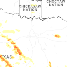
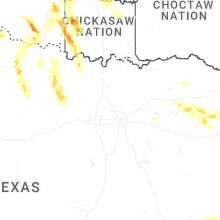
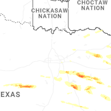
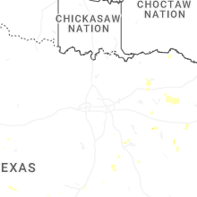
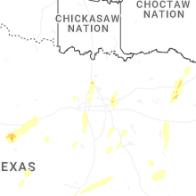


Connect with Interactive Hail Maps